sineco’s services in the airport sector - gruppo sina · sineco boasts a considerable know-how in...
TRANSCRIPT

Sineco’s services in the airport Sector
Sineco boasts a considerable know-how in the supply of specialist consultancy services in the airport sector, in particular:
“Bearing capacity tests” of airport pavements (aprons, runways, taxyways, etc.) through non-destructive testing and Acn/Pcn parameters calculation in compliance with Annex 14 of icAo rule and enAc’s “Rules for Airport Building and operation”.
“Longitudinal/transversal roughness tests” of runways’ surface, taxiway, etc., in compliance with Annex 14 of icAo rule and enAc’s “Rules for Airport Building and operation”.
“Surface distress conditions tests” of airport pavements (rest areas, runways, slip roads, etc.) and calculation of Pave-ment condition index (Pci) in compliance with ASTM D5340 rule and FAA 150/5380-6b and 150/5380-7 circulars.
“Bearing capacity tests of safety strips” and the existence of the requisites contained in the enAc rules set forth by way of letter of 7/2/2008, index no. 0008375/DiRGen/cAP.
“Retroreflection RL tests” of horizontal signals and the existence of the requisites contained in the enAc’s “Rules for Airport Building and operation” and enAc’s APT24 circular of 28.7.2006.
“Phonometric tests and critical areas mapping” regarding sound pollution caused by airport activities, all in compliance with what set forth by enAc’s APT26 circular of 3.7.2007.
“Air pollution tests” both regarding particulate matter (PTS and fine PM10 and PM2,5) and gas pollutants (nitrogen dioxide, carbon monoxide and ozone).
“Pavement stratigraphic tests” through Ground Penetrating Radar (GPR) tools for quantitative characterisation of thickness in different airport superstructure layering and possible identification of subservices and underground holes.
“Dimensional and topographic surveys of airside infrastructures” through dynamic (Lynx Mobile Mapper) and static (iLRiS 3D) laser scanner tools for the measurement of transversal and longitudinal gradient, steady gradients and for the acquisition of topographic and plano-altimetric data for projects and tests of compliance with enAc’s “Rules for Airport Building and operation”.
“Airport Modelling Services”, 3D modelling through laser scanning techniques for the realisation of Digital Terrain Models (DTM) and Surface Models (DSM), topographic point groups of airport grounds.
“Lab controls while work is in progress” on building materials used in rigid and flexible pavement requalification works through our own “Materials Test Lab” and, if necessary, using appropriately equipped Mobile Labs.
Sineco is Uni-en iSo 9001:2000 certified and has its own test lab accredited in compliance with iSo/Uni-en 17025 rule “General requisites
for the competence of test labs and measurement”.

HeadquarterViale Isonzo, 14/1 - 20135 Milano
tel. 02-5425901 - fax [email protected]
www.sinecoing.it
Registered Office Via Felice Casati,1/A - 20124 MILANO
TEL.02 29404513 - FAX 02 29412003
Material Test LabS. c. Savonesa, 9 - 15050 RIVALTA SCRIVIA, (AL)
TEL.0131 860216 - FAX 0131 860226

Airport Facilities
Co
ntr
ol
en
gin
ee
rin
g
SINAGROUP

aboUt SinecoSINECO is a limited company engaged in control and
maintenance engineering of large transport infrastruc-
tures. The company has been established in 1987 by
SINA – Società Iniziative Nazionali Autostradali – in
compliance with sector experienced partners, mainly
major tolled motorways, bridges and tunnel Companies.
SINECO is a subsidiary of ASTM group - Autostrade
Torino Milano - leader in asset management of transport
facilities, controlling over 1500 km of the Italian national
motorway network.
The company is highly qualified in the diversified
operational field of diagnostic study cases, systems
and procedures and hold specific knowledge in the road
and airport pavement maintenance engineering field,
quality control of materials exploited in maintenance and
construction and, finally, in the setting up of planned
maintenance management integrated systems.
The distinguished and qualified features of SINECO pro-
ducts and services are customer market opportunities
arising from a continuous yearly investment plan to
gain excellence in innovation and further development
through daily effort.
A continuous improvement involving and effecting
SINECO team at all, both technicians and engineers.
Airport Facilities
Sineco offers specialist consultancy services in the airport sector, aimed at carrying out diagnostic tests of flight
infrastructures through highly technological equipment as well as in maintenance engineering.

Dealing over the years its own unique simultaneous engineering, SINECO has designed and offered various software applications for computer aided management of airport and road networks.
The Company mission is to provide customized application to management companies in terms of tools easy to be dealt: intuitive but at the same time provided with effective graphic interface,
or such one as to allow immediate access to all relevant information.
In particular, the Arc Utilities Airport® software has been implemented and conceived as an ESRI basic software application. Thematic mapping, geocoding and consultation functions are
guaranteed by ArcView directly and this allows the publication of a georeferred mapping of flight infrastructures and relating, associated data, such as anagraphic, structural (PCN, Modules,
etc.), functional (PCI, IRI, ruts, etc.) data, periodical inspections, data on maintenance works and so forth.
Computer Aided Management of Flight Facilities and Pavement Management System
Gp
r
Ground penetrating radar (Gpr)
Sineco avails itself of GSSI’s GPR Mod. Sir 10H georadar equipment, with antennas having different acquisition frequencies, which allows to determine and calculate stratigraphy in airport super-
structures, identify any faults and, if necessary, map subservices.
A 2500 MHz bistatic antenna, kept 45 cm above pavement level, because of reduced wavelength allows better resolutions (approximately 2-3 cm) in the most superficial layers (asphalt concrete
-or slab- and foundation layer), with a penetration capacity of approximately 50-60 cm. A 400 MHz monostatic antenna allows to survey up to a depth of 3.0-3.5 m, with a resolution slightly above
10 cm. After partial reflections in discontinuous surfaces, reflected signals are detected by a receiving antenna and sent to the central unit, where they can be amplified and/or subjected to filtering.
Detection is continuously carried out at a maximum speed of approximately 80 Km/h, with a spatial
resolution of 50 cm and, if acquisition speed is reduced, at centimetric resolutions as well.
While acquisition is in progress, a radargram can be viewed on a special display, representing the
received signals according to the arrival time and the relative distance travelled by the antenna,
measured through a specific precision odometer.
Equipment is employed both while tests are performed on the thickness of materials used compared to the values contained in the technical specifications and for the purposes of structural characterisation of pavements in use, where strata composition and nature is unknown.
Dealing over the years its own unique simultaneous engineering, SINECO has designed and offered various software applications for computer aided management of airport and road networks.
The Company mission is to provide customized application to management companies in terms of tools easy to be dealt: intuitive but at the same time provided with effective graphic interface,
or such one as to allow immediate access to all relevant information.
In particular, the Arc Utilities Airport® software has been implemented and conceived as an ESRI basic software application. Thematic mapping, geocoding and consultation functions are
guaranteed by ArcView directly and this allows the publication of a georeferred mapping of flight infrastructures and relating, associated data, such as anagraphic, structural (PCN, Modules,
etc.), functional (PCI, IRI, ruts, etc.) data, periodical inspections, data on maintenance works and so forth.
Computer Aided Management of Flight Facilities and Pavement Management System
w
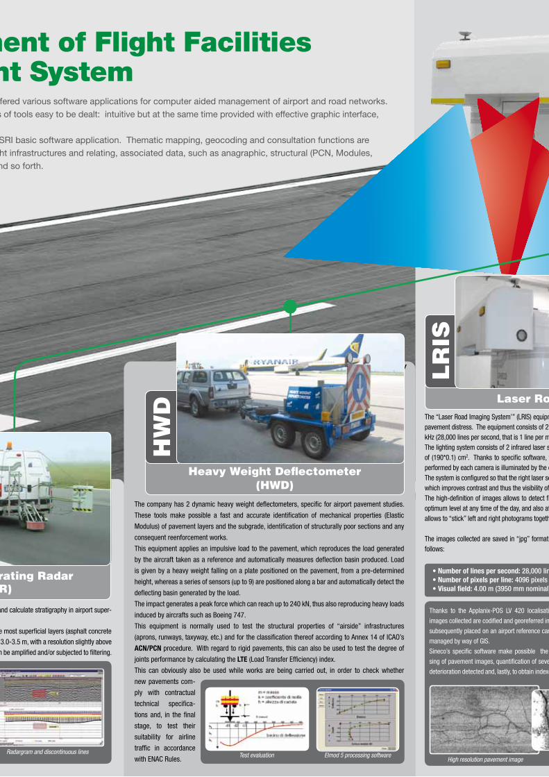
The company has 2 dynamic heavy weight deflectometers, specific for airport pavement studies.
These tools make possible a fast and accurate identification of mechanical properties (Elastic
Modulus) of pavement layers and the subgrade, identification of structurally poor sections and any
consequent reenforcement works.
This equipment applies an impulsive load to the pavement, which reproduces the load generated
by the aircraft taken as a reference and automatically measures deflection basin produced. Load
is given by a heavy weight falling on a plate positioned on the pavement, from a pre-determined
height, whereas a series of sensors (up to 9) are positioned along a bar and automatically detect the
deflecting basin generated by the load.
The impact generates a peak force which can reach up to 240 kN, thus also reproducing heavy loads
induced by aircrafts such as Boeing 747.
This equipment is normally used to test the structural properties of “airside” infrastructures
(aprons, runways, taxyway, etc.) and for the classification thereof according to Annex 14 of ICAO’s
ACN/PCN procedure. With regard to rigid pavements, this can also be used to test the degree of
joints performance by calculating the LTE (Load Transfer Efficiency) index.
This can obviously also be used while works are being carried out, in order to check whether
new pavements com-
ply with contractual
technical specifica-
tions and, in the final
stage, to test their
suitability for airline
traffic in accordance
with ENAC Rules.
Heavy Weight Deflectometer (HWD)
HW
D
• Number of lines per second: 28,000 lines• Number of pixels per line: 4096 pixels• Visual field: 4.00 m (3950 mm nominal)
Thanks to the Applanix-POS LV 420 localisation system, all the
images collected are codified and georeferred in space, so as to be
subsequently placed on an airport reference cartographic map and
managed by way of GIS.
Sineco’s specific software make possible the automatic proces-
sing of pavement images, quantification of severity of each type of
deterioration detected and, lastly, to obtain indexes for common use.
High resolution pavement image
Laser road imaging System (LriS)
Lr
iSThe “Laser Road Imaging System’” (LRIS) equipment is installed at the back of the ARAN vehicle and is specifically aimed at detecting pavement distress. The equipment consists of 2 linear scanning digital cameras, capable of acquisition at a maximum frequency of 28 kHz (28,000 lines per second, that is 1 line per mm at a speed of 100 km/h).The lighting system consists of 2 infrared laser sensors (one for each camera) having a 250 W power ( 808 nm), with fingerprint area of (190*0.1) cm2. Thanks to specific software, the two systems (camera and laser) are perfectly synchronised so that the scanning performed by each camera is illuminated by the corresponding laser.The system is configured so that the right laser serves the left camera and vice versa and illumination is achieved with an incident angle which improves contrast and thus the visibility of cracks in pavement.The high-definition of images allows to detect fine cracks up to a width of 1 mm and, thanks to laser lighting, detection reaches an optimum level at any time of the day, and also at night time. The two cameras (right and left) are synchronised and sensitive software allows to “stick” left and right photograms together so as to have a single view of the whole detected breadth (4.00 metres).
The images collected are saved in “jpg” format onto an appropriate 300 Gb removable hard disk. The system specifications are as follows:
Ground penetrating radar (Gpr)
Sineco avails itself of GSSI’s GPR Mod. Sir 10H georadar equipment, with antennas having different acquisition frequencies, which allows to determine and calculate stratigraphy in airport super-
structures, identify any faults and, if necessary, map subservices.
A 2500 MHz bistatic antenna, kept 45 cm above pavement level, because of reduced wavelength allows better resolutions (approximately 2-3 cm) in the most superficial layers (asphalt concrete
-or slab- and foundation layer), with a penetration capacity of approximately 50-60 cm. A 400 MHz monostatic antenna allows to survey up to a depth of 3.0-3.5 m, with a resolution slightly above
10 cm. After partial reflections in discontinuous surfaces, reflected signals are detected by a receiving antenna and sent to the central unit, where they can be amplified and/or subjected to filtering.
Detection is continuously carried out at a maximum speed of approximately 80 Km/h, with a spatial
resolution of 50 cm and, if acquisition speed is reduced, at centimetric resolutions as well.
While acquisition is in progress, a radargram can be viewed on a special display, representing the
received signals according to the arrival time and the relative distance travelled by the antenna,
measured through a specific precision odometer.
Equipment is employed both while tests are performed on the thickness of materials used compared to the values contained in the technical specifications and for the purposes of structural characterisation of pavements in use, where strata composition and nature is unknown.
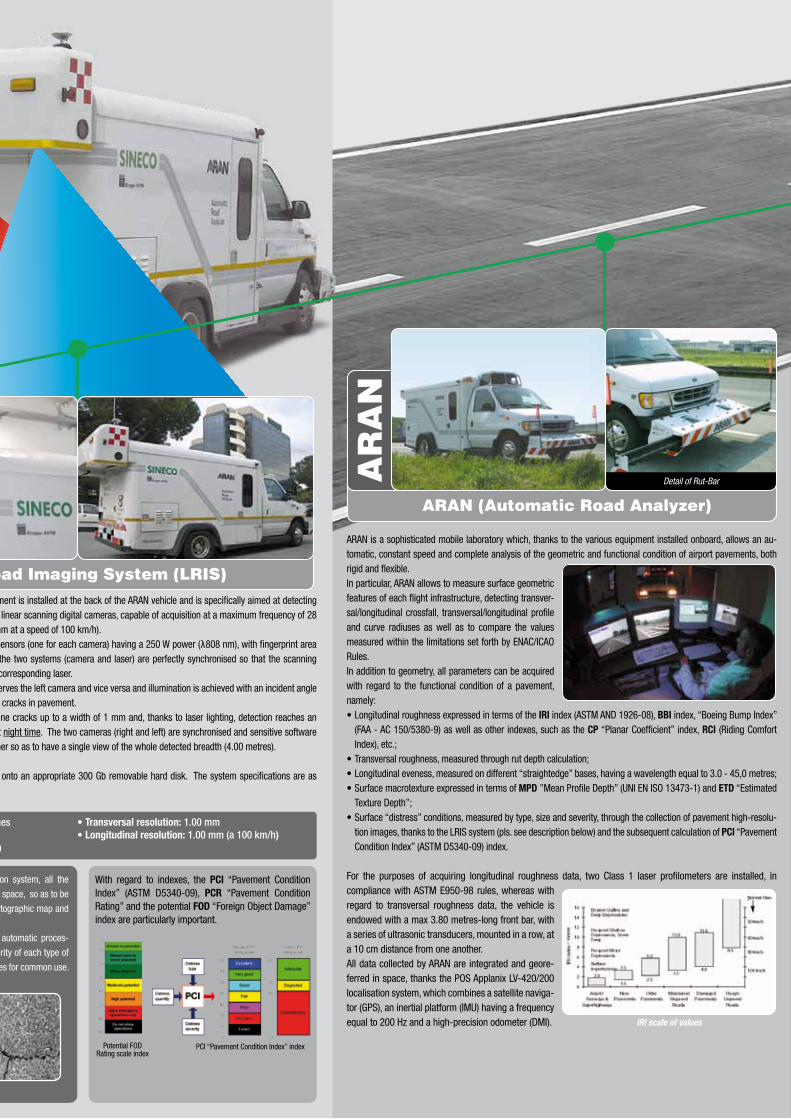
ARAN is a sophisticated mobile laboratory which, thanks to the various equipment installed onboard, allows an au-tomatic, constant speed and complete analysis of the geometric and functional condition of airport pavements, both rigid and flexible.In particular, ARAN allows to measure surface geometric features of each flight infrastructure, detecting transver-sal/longitudinal crossfall, transversal/longitudinal profile and curve radiuses as well as to compare the values measured within the limitations set forth by ENAC/ICAO Rules. In addition to geometry, all parameters can be acquired with regard to the functional condition of a pavement, namely:• Longitudinal roughness expressed in terms of the IRI index (ASTM AND 1926-08), BBI index, “Boeing Bump Index”
(FAA - AC 150/5380-9) as well as other indexes, such as the CP “Planar Coefficient” index, RCI (Riding Comfort Index), etc.;
• Transversal roughness, measured through rut depth calculation;• Longitudinal eveness, measured on different “straightedge” bases, having a wavelength equal to 3.0 - 45,0 metres;• Surface macrotexture expressed in terms of MPD ”Mean Profile Depth” (UNI EN ISO 13473-1) and ETD “Estimated
Texture Depth”;• Surface “distress” conditions, measured by type, size and severity, through the collection of pavement high-resolu-
tion images, thanks to the LRIS system (pls. see description below) and the subsequent calculation of PCI “Pavement Condition Index” (ASTM D5340-09) index.
For the purposes of acquiring longitudinal roughness data, two Class 1 laser profilometers are installed, in compliance with ASTM E950-98 rules, whereas with regard to transversal roughness data, the vehicle is endowed with a max 3.80 metres-long front bar, with a series of ultrasonic transducers, mounted in a row, at a 10 cm distance from one another.All data collected by ARAN are integrated and geore-ferred in space, thanks the POS Applanix LV-420/200 localisation system, which combines a satellite naviga-tor (GPS), an inertial platform (IMU) having a frequency equal to 200 Hz and a high-precision odometer (DMI).
• Number of lines per second: 28,000 lines• Number of pixels per line: 4096 pixels• Visual field: 4.00 m (3950 mm nominal)
• Transversal resolution: 1.00 mm• Longitudinal resolution: 1.00 mm (a 100 km/h)
Thanks to the Applanix-POS LV 420 localisation system, all the
images collected are codified and georeferred in space, so as to be
subsequently placed on an airport reference cartographic map and
managed by way of GIS.
Sineco’s specific software make possible the automatic proces-
sing of pavement images, quantification of severity of each type of
deterioration detected and, lastly, to obtain indexes for common use.
IRI scale of values
With regard to indexes, the PCI “Pavement Condition Index” (ASTM D5340-09), PCR “Pavement Condition Rating” and the potential FOD “Foreign Object Damage” index are particularly important.
Potential FOD Rating scale index
PCI “Pavement Condition Index” index
aran (automatic road analyzer)
ar
an
Detail of Rut-Bar
Laser road imaging System (LriS)The “Laser Road Imaging System’” (LRIS) equipment is installed at the back of the ARAN vehicle and is specifically aimed at detecting pavement distress. The equipment consists of 2 linear scanning digital cameras, capable of acquisition at a maximum frequency of 28 kHz (28,000 lines per second, that is 1 line per mm at a speed of 100 km/h).The lighting system consists of 2 infrared laser sensors (one for each camera) having a 250 W power ( 808 nm), with fingerprint area of (190*0.1) cm2. Thanks to specific software, the two systems (camera and laser) are perfectly synchronised so that the scanning performed by each camera is illuminated by the corresponding laser.The system is configured so that the right laser serves the left camera and vice versa and illumination is achieved with an incident angle which improves contrast and thus the visibility of cracks in pavement.The high-definition of images allows to detect fine cracks up to a width of 1 mm and, thanks to laser lighting, detection reaches an optimum level at any time of the day, and also at night time. The two cameras (right and left) are synchronised and sensitive software allows to “stick” left and right photograms together so as to have a single view of the whole detected breadth (4.00 metres).
The images collected are saved in “jpg” format onto an appropriate 300 Gb removable hard disk. The system specifications are as follows:
y

arcUtilities airport®
Lynx Mobile Mapper performes a georeferred scan of airside&landside infrastructures and territory in dynamic mode, also during night time, reaching a speed of up to 100 Km/h.In short, its functioning consists of: 2 last generation Lidar sensors, positioned on top of the vehicle, emitting laser beams with a frequency of up to 400,000 impulses per second, rotating at a maximum speed of 12000 rotations per minute. Laser beams are reflected by the objects present in a strip of over 200 metres and thus read by a receiver which measures their distance. The totality of points reproduce the airport infrastructure and the territory as a high den-sity “Point Clouds” (1,000 – 4,500 points per square metre) each of whom, thanks to the presence of an Applanix-POS LV 420 locali-sation module, is georeferred in space with a high precision, according to the WGS84 coordination system.Fields of usage are very varied, from flight infra-structure 3D Modelling to transversal/longitu-dinal section/profile extraction, contour lines, geometric dimensional tests, tests on potential water puddle areas, tests on the correct positioning of horizontal signals with respect to plans, etc.
This is an application running on the ArcGis (Esri) platform, built in collaboration with One Team Srl (Milan), specifically designed for the management of airport networks, both for the “airside” and for the “landside” infrastructures.The software allows the automatic insertion, viewing, constant update and ex-traction of the structural and functional information of each single entity forming part of the airport network. It is thus possible to manage different types of information, such as indexes typically characteri-sing pavements maintenance (PCN, PCI, IRI, FOD, etc.), geometric/topographic infrastructure data (sections, crossfalls, contour lines, etc.), inspection data (alphanumeric and photographic) acquired on-site through GPS/hand-held device, data on maintenance works, photographic images of pavements acquired by the LRIS system described above and so forth.This application allows to obtain detailed alphanumeric and graphic reports, with prin-touts, including printouts on a scale, to directly intervene on a geodatabase, through fun-ctions allowing a “real time” data updates and data pro-cessing.Lastly, through the PMDS® (Pavement Maintenance Decision System) module addition, a simple and effective planning of pavement maintenance is possible. In particular, thanks to the implementation of specific algorithms and starting from typical state indexes, the module prioritises airport sections which require assistance in the short and medium term, identifying the best recovery type for each of them, the relating expense budgets and the consequential analy-sis of alternatives. The modu-les follows the instructions set forth in the Federal Aviation Administration AC-150/5380-7 and AC-150/5380-6b rules.
Representation pattern contours - Check areas of potential stagnation of water
Runway - Head 30: Point cloud laser
LYnX Mobile Mapper
LYn
X
PCI index of sample units
Distress viewing
Network of the airside infrastructures
Particolare Sensore Laser
IRI Regularity PCI degradation
Friction
Database building up and pMS
Carrying capacity (NCP)
Other Data: Traffic, Thicknesses, Historical Data, etc..
OptimizationBudget
What, Where, When
State Exercise