small rpas operations near regional airports operational
TRANSCRIPT

Small RPAS Operations Near Regional Airports
Operational Description, Impacts, and Issues
January 15, 2015
ProSky, Inc.
45300 Catalina Court, Suite 101
Dulles, VA 20166

Small RPAS Operations Near Regional Airports ProSky
i
TABLE OF CONTENTS
1 INTRODUCTION ............................................................................................................ 1
1.1 OBJECTIVES .................................................................................................................. 1
1.2 DEFINITION OF REGIONAL AIRPORT ............................................................................. 1
2 RPAS OPERATIONAL SCENARIOS................................................................................. 3
2.1 SCENARIO 1: RURAL SEARCH AND RESCUE, FIXED-WING RPAS ................................. 3
2.2 SCENARIO 2: SUBURBAN ALARM MONITORING ............................................................ 9
2.3 SCENARIO 3: URBAN HOSTAGE SURVEILLANCE, VERTICAL TAKEOFF AND LANDING
RPAS ......................................................................................................................... 13
2.4 SCENARIO 4: MONITORING EMISSIONS FROM BURNING COAL .................................... 17
2.5 SCENARIO 5: SMALL PACKAGE DELIVERY .................................................................. 26
3 DISCUSSION OF IMPACTS, ISSUES, AND CONCERNS ....................................................... 30
3.1 AIRWORTHINESS CERTIFICATION ................................................................................ 30
3.2 DETECT AND AVOID ................................................................................................... 31
3.3 COMMAND AND CONTROL .......................................................................................... 34
3.4 SECURITY ................................................................................................................... 37
3.5 AIR TRAFFIC CONTROL ............................................................................................... 38
3.6 TRAFFIC FLOW MANAGEMENT ................................................................................... 42
3.7 PILOT/OPERATOR ....................................................................................................... 45
3.8 PRIVACY ..................................................................................................................... 46
4 STATE OF RPAS INTEGRATION ISSUES AROUND THE WORLD ....................................... 49
4.1 WORLD TRENDS BY COUNTRY ................................................................................... 49
4.2 REGULATORY STATUS IN EUROPE .............................................................................. 51
4.3 RECENT EVENTS ......................................................................................................... 52
GRAPHICS AVAILABLE AT TRANSPORT CANADA’S WEBSITE.................................................... 58
5 REFERENCES ............................................................................................................ 61
APPENDIX A SMALL RPAS ATTRIBUTES ................................................................... 62
APPENDIX B U.S. FEDERAL AVIATION REGULATIONS ................................................. 69
APPENDIX C ACRONYMS ......................................................................................... 73
APPENDIX D GLOSSARY .......................................................................................... 76

Small RPAS Operations Near Regional Airports ProSky
ii
LIST OF TABLES
Table 1: Regulatory status in European countries ......................................................... 51
Table 2: Attributes of a Raven-like RPAS ...................................................................... 62
Table 3: Attributes of a Super Bat-like RPAS ................................................................ 63
Table 4: Attributes of a quadcopter RPAS ..................................................................... 64
Table 5: Attributes of a Puma-like RPAS ....................................................................... 65
Table 6: Attributes of a Skate-like RPAS ....................................................................... 66
Table 7: Attributes of an Aerosonde-like RPAS ............................................................. 67
Table 8: Acronyms and definitions ................................................................................ 73
Table 9: Terms and definitions ...................................................................................... 76

Small RPAS Operations Near Regional Airports ProSky
iii
LIST OF FIGURES
Figure 1: Rural search and rescue scenario high-level operational concept ................... 4
Figure 2: Suburban alarm monitoring scenario high-level operational concept ............. 10
Figure 3: Urban hostage surveillance scenario high-level operational concept ............. 14
Figure 4: Emissions monitoring scenario high-level operational concept ...................... 18
Figure 5: Emissions monitoring scenario planned mission route ................................... 20
Figure 6: Line of sight means within radio line of sight, not visual line of sight. ............. 35

Small RPAS Operations Near Regional Airports ProSky
iv
EXECUTIVE SUMMARY
This document discusses issues associated with the integration of Remotely Piloted Aircraft
Systems (RPAS) into the airspace system. Special attention is paid to small RPAS (under 25
kg/55 lbs) and their operation near regional airports.
Operational scenarios are presented to provide insight into the potential applications for RPAS.
The scenarios provided are:
Rural search and rescue
Suburban home alarm monitoring
Urban hostage surveillance
Monitoring emissions from burning coal
Small package delivery
Aside from package delivery, virtually all RPAS applications involve some type of surveillance
mission. Other notable missions we could have outlined include aerial photography,
environmental monitoring, sporting events, and infrastructure inspection (pipelines, power lines,
bridges, and railroads).
We highlight in those scenarios the operational challenges and integration issues. Then we
summarize the integration issues and why they are challenging to operators and air navigation
service providers.
The integration issues we identified are summarized below.
Airworthiness Certification – An airworthiness certificate is a government-issued document that
grants authorization to operate an aircraft. Currently, RPAS operations are covered by a
Certificate of Waiver or Authorization (COA) and are registered on a case-by-case basis. Current
airworthiness certification assumes a pilot is onboard. Regulators will need to define all
requirements for certification of RPAS in order to streamline the process compared to the COA
case-by-case basis. Airworthiness certification for RPAS will need to establish requirements
assuming that a pilot is not onboard the aircraft. Affected areas that need research into
requirements for successful airworthiness certification are control station (equipment and
software), control station security (e.g., cabin door locks), airframe, and data link (C2).
Detect and Avoid – Detect and Avoid (DAA) is the capability of a RPAS to remain well clear
from and avoid collisions with other airborne traffic. For manned aircraft, this is satisfied by the
onboard pilot’s visual capabilities and by traffic alert/avoidance algorithms (e.g. TCAS). Detect-
and-avoid technology for RPAS may involve a combination of artificial intelligence and
synthetic vision (fed back to the remote pilot). TCAS compatibility is also a factor, because slow
RPAS will not be able to apply TCAS logic, for various reasons. These technologies are still in
the research and development stage and have yet to be approved by regulators.

Small RPAS Operations Near Regional Airports ProSky
v
Command and Control (C2) – Unlike with manned aircraft, the RPAS pilot must depend on a
data link for control of the aircraft. This affects the aircraft’s response to revised ATC
clearances, other ATC instructions, or unplanned contingencies (e.g., maneuvering aircraft). C2
technologies are fairly mature, but their performance varies widely. Regulators must set
standards for C2 in terms of technical standards, interoperability requirements, latency
acceptability, and radio/data link security requirements.
Spectrum Allocation and Security – RPAS operators require radio spectrum to control the
aircraft, often through a satellite relay. This presents safety and security concerns. Specifically,
radio contact can be lost or intercepted, spoofed, or hacked by a third party. Some of the radio
spectrums upon which RPAS are operated are also used by common hand-held devices. There is
also a concern that there will not be sufficient spectrum allocated to accommodate all the RPAS
who may require spectrum. The World Radio Conference (WRC) is addressing the spectrum
allocation issue, but regulators will have to set security standards and provide standard message
definitions.
Security of Physical Systems – As a result of the 9/11 terrorist attacks in the U.S., standards for
cockpit security for manned aircraft were raised, but regulators have yet to set standards for
RPAS. One of the advantages of RPAS is that the analog of the “cockpit” is highly flexible – it
could be a segregated control station (secure room), or it could be wherever the pilot has created
the portable station (e.g. laptop computer controls operated in the field). The issue is how to set
standards for physical security of these systems.
Interaction with Air Traffic Control – RPAS are being operated in controlled airspace today, but
are handled as special exceptions. In order for them to integrate smoothly with the overall air
traffic system, policies and procedures must be set for how air traffic control will interact with
RPAS without creating burdensome workloads. In particular, separation standards need to be
reviewed and potentially altered; policies must be set for launch and recovery methods when
departing/arriving airports; ground RPAS personnel must be trained in ATC procedures and
expectations; communications performance requirements necessary to meet safety requirements
are needed; training must be provided for air traffic controllers; and standardized methods must
be established for how to pass RPAS performance characteristics and mission information to
controllers. Procedures for emergency and/or degraded operations also need to be established.
Interaction with Traffic Flow Management – Traffic flow managers will need methods to assess
the potential impact of RPAS operation, especially when their operation is potentially disruptive
or requires special monitoring or segregated airspace. They must be able to assess the
approximate workload impact on air traffic controllers. Also, the interaction (or lack thereof) of
RPAS with traffic management initiatives (ground delay programs, traffic spacing programs)
must be evaluated in real time.
Pilot Qualifications – For manned aircraft, pilot qualifications are well established, but this has
not been done for pilots (operators) of RPAS. For operation of large RPAS in integrated

Small RPAS Operations Near Regional Airports ProSky
vi
airspace, it seems reasonable to adopt similar standards for RPAS that are in place for unmanned
aircraft. But it is less clear what the standards should be for operation of small RPAS.
Privacy – Given the growing demand for RPAS and their widespread application, the public is
concerned that RPAS will be used for surveillance purposes (e.g. photography) without the
consent of the subjects. In the U.S., privacy advocates, such as the American Civil Liberties
Union (ACLU) and Epic.org, have insisted that RPAS not be allowed to operate in the U.S. until
the FAA first says how it intends to address privacy concerns. This may be an extreme position.
Traditionally, privacy has not fallen under the jurisdiction of airspace regulators. Nonetheless,
they will have to find ways to assure the public that their privacy concerns will be addressed
while still allowing RPAS operators to conduct their missions, which often include surveillance.
While all of the foregoing issues are important, the ones that are generally cited as being the
main impediments to RPAS integration are detect-and-avoid and airworthiness certification.
This report also provides a snapshot of how RPAS integration issues are being addressed by
airspace regulators around the world. We conducted an informal review of RPAS integration
progress in the member countries of the EU and several other countries around the world. About
half (12/28) of the EU countries have in place some type of regulation for RPAS, but these are
only for vehicles below 25kg or below 150kg. Only two countries, Czech Republic and France,
have regulations in place for beyond line of sight. Overall, countries are grappling with the same
integration issues. The U.S. and Israel are at the forefront of RPAS technology development but
are not necessarily farther along in establishing regulations. A common approach to regulation is
to create a special set of rules for small RPAS (e.g. under 25kg) that are much less stringent than
those for large RPAS. The reasoning is that air traffic control does not (and will not) provide
separation services for small RPAS at low altitudes, so they have to be self-separating.

Small RPAS Operations Near Regional Airports ProSky
1
1 Introduction
This report was produced under the TEMPAERIS (Testing Emergency Procedures in Approach
and En Route Integration Simulation) project.
In developing this paper, we significantly relied upon the U.S. Joint Planning and Development
Office (JPDO) draft UAS Operational Scenarios (2012) [2] because of its comprehensive
examination of the requirements, capabilities, issues, and policy matters that need to be
addressed to conduct Unmanned Aircraft System (UAS) operations safely in non-segregated
airspace. While there are some differences in how various nations and governing bodies are
addressing such operations, there is much commonality in both what must be done and what the
outcomes must be for safe flight by UAS.
For the purposes of this paper, we will confine the discussion to Remotely Piloted Aircraft
Systems (RPAS), which are a subset of the UAS family. The additional requirements and issues
associated with other types of UAS, such as those that fly autonomously, are still maturing and
too complex to address at this time.
The France Directorate General for Civil Aviation (DGAC) has taken a leadership role in
establishing regulations for RPAS operations.
1.1 Objectives
The objective of this paper is to foster understanding of the requirements and challenges of
conducting small RPAS operations, especially in the vicinity of regional airports.
1.2 Definition of Regional Airport
This paper’s focus on RPAS operations at or near a “regional airport” warrants a discussion of
what is considered a regional airport. To some extent, that definition will vary depending on
where it is viewed. In the U.S., such airports would generally be in the “small hub” category,
defined by the FAA1 as an airport with between 0.05% and 0.25% of national total passenger
enplanements. The term “regional” usually refers to the geographic area served, although flights
from regional airports may cross international boundaries that are nearby.
The items most relevant to RPAS operations are the airspace classification for such airports and
the associated operating requirements for that airspace. Typically, small hubs would have an
associated approach control and Class C airspace. In contrast, airports with Class B airspace
typically have 1% or greater of national passenger enplanements, and non-hub airports that have
1 http://www.faa.gov/airports/planning_capacity/passenger_allcargo_stats/categories/

Small RPAS Operations Near Regional Airports ProSky
2
ATC services typically have Class D airspace. Some examples of the current 77 U.S. small hub
airports are Albany International (KALB), Atlantic City International (KACY), Key West
International (KEYW), Long Island MacArthur (KISP), Norfolk International (KORF), and
Tucson International (KTUS).
As a comparison, Bordeaux-Merignac Airport (LFBD), where some RPAS flight demonstrations
are occurring, would be typical of a medium or large hub airport, being in the top 10 airports in
France in terms of passenger enplanements and having associated Class C airspace.

Small RPAS Operations Near Regional Airports ProSky
3
2 RPAS Operational Scenarios
In this section, we provide operational scenarios to provide examples of how RPAS may be used
and to highlight integration issues that will arise in the operation of RPAS.
Though the focus of the report is operational issues associated with regional airports, we have
deliberately kept these scenarios broad, to maintain awareness all
of the major integration issues.
We use highlight boxes to provide easy extraction of the
integration issues. Many of the integration issues arise in more
than one scenario. We provide less elaboration of the issue once
it has already been highlighted.
Several of the scenarios are based on RTCA Special Committee 203 DO-320, Operational
Services and Environmental Definition (OSED) for Unmanned Aircraft Systems (UAS), dated
June 10, 2010 [1]. In places, we have abbreviated the scenarios or shifted their focus to be more
relevant to operations in or near airports. Large sections of text have been taken from RTCA and
JPDO documents, but we have tailored the material to needs of this report.
These first three scenarios address a range of operational environments: rural, suburban, and
urban operations. The rural RPAS mission involves search and rescue support for locating a lost
hiker. The suburban RPAS segment involves response to a home security system alarm and
associated house fire. The urban RPAS segment involves monitoring a hostage situation. All
three segments reflect an on-demand need for surveillance where tactical mission requirements
dictate the route of flight and airspace environments where the RPAS will operate.
2.1 Scenario 1: Rural Search and Rescue, Fixed-Wing RPAS
Scenario at a Glance: Rural Search and Rescue
Nature of the Mission Emergency response to locate a lost hiker
Aircraft Type Fixed wing. Small RPAS, much like Raven. 4.2 lbs, wingspan
4.3 feet. Super Bat RPAS, 34 lbs., wingspan 8.5 feet.
Flight Operator Local government law enforcement aviation unit.
Flight duration 3-4 hours
Altitude 400 feet to 2,000 feet Above Ground Level (AGL).
Classes of Airspace Affected B, C, D, E, and G.
Line of Sight Both VLOS and BVLOS
Throughout this section, boxes like this one highlight integration issues being raised by the scenarios.

Small RPAS Operations Near Regional Airports ProSky
4
Scenario at a Glance: Rural Search and Rescue
Flight Planning Determined tactically as the mission unfolds.
Launch Mechanism Raven: By hand; Super BAT: Bungee catapult
Lost Link Procedure Control of the RPAS is provided through a LOS link between
the RPAS pilot’s portable control console and the RPAS. In the
event of a control link failure, the RPAS is programmed to
circle over its current position if the control is not reestablished
within a parameter time. The engine is then shut off and the
RPAS makes a controlled spiral to the ground.
Los Angeles (LA) County law enforcement is notified that a young hiker became separated from
his hiking party in a park north of San Fernando, CA. The county sheriff calls upon the LA
County Law Enforcement aviation unit, who decide to begin a search mission. They have a
Raven RPAS that can be transported to the search site in a patrol vehicle and hand-launched
from that location. The high-level operational concept for this scenario segment is depicted in
Figure 1.
Figure 1: Rural search and rescue scenario high-level operational concept

Small RPAS Operations Near Regional Airports ProSky
5
Before beginning the flight, the RPAS pilot becomes familiar with all available information
concerning the flight. He determines that
Weather conditions are clear
There are no NOTAMs in effect
Immediate coordination with Air Traffic
Control (ATC) and a flight plan are not
required, because the surveillance location is
within the Los Angeles Class B Veil area but
outside of Class B, C, or D airspace.
The Raven has the required equipage to operate in the Class B Veil area, as well as DAA
technology for detecting other aviation operations, terrain, and weather, allowing it to operate
under VFR.
The Raven RPAS team drives to a location adjacent to the targeted surveillance area, and the
RPAS pilot hand-launches the Raven RPAS. The RPAS pilot flies the aircraft to an altitude of
2,000–4,500 feet MSL, an altitude where the surveillance search pattern is high enough to meet
minimum altitude regulatory requirements over the varying terrain of the search area. The terrain
varies between the lower launch point of 1,500 feet and a peak of 4,000 feet.
During the launch and climb to the search altitude, the RPAS observer maintains a constant view
of the RPAS and its surroundings to ensure the
RPAS remains clear of other airborne operations
and does not come too close to people or property.
If the RPAS pilot control station is so equipped,
the RPAS pilot is provided terrain and aeronautical
information as well as cooperative aircraft target
activity information relevant to the flight in
graphical and textual format. Such information can
be provided from ADS-B Information Broadcast
Services, control station mapping and database capabilities, and appropriate service-oriented
architectures, such as System Wide Information Management (SWIM).
Once the Raven RPAS proceeds past where the observer is authorized to provide LOS support,
the observer function ceases, and DAA capabilities on
the RPAS perform the collision avoidance and right-of-
way functionality required by federal regulations. The
RPAS pilot can navigate the Raven RPAS by either
providing Global Positioning System (GPS) coordinates or by “hand flying” it as an alternate
navigation capability. However, the RPAS does not have VHF Omnidirectional Range
(VOR)/Tactical Aircraft Control (VORTAC) capabilities. The RPAS pilot plans to fly close to
Ground Observer Requirements: Agencies must clarify the circumstances under which visual (ground) observers must be used. How many are required? Are they allowed to use vision aids, e.g. cameras? What communication protocols (with the pilot) are allowable? What qualifications must observers meet?
DAA System Certification: Certification and requirements for detect-and-avoid (DAA) systems must be established.
RPAS weather sensitivity: RPAS are often more susceptible to adverse weather than comparably sized manned aircraft. Having reliable/ updated forecasts will be critical.
NOTAMS: Under what circumstances will NOTAMS be required for RPAS?
Flight Plans: Under what circumstances must flight plans be submitted for RPAS?

Small RPAS Operations Near Regional Airports ProSky
6
the terrain to maximize the camera resolution of the terrain, hoping this will allow the hiker to
notice the RPAS and signal his presence.
The RPAS flies over the north side of the search area where the hiking party indicated they
believed the hiker may be. The search team observes the terrain below via the RPAS surveillance
video. As the Raven RPAS flies over the search area,
the onboard DAA system detects a hang glider that was
launched near the ridge line and is gliding to the valley
adjacent to the search area. Following detection of the
hang glider, the DAA system ascertains that, based on
their current trajectories, the RPAS will soon be close
to the hang glider, and it initiates a change in trajectory to give way to the hang glider. The
RPAS pilot is alerted to the DAA actions and notices the change in trajectory. Following
resolution of the conflict, the RPAS automatically returns to its original track and resumes the
programmed search pattern.
After approximately an hour of flight, the Raven
RPAS is flown back to the launch site to have
another battery installed. The RPAS pilot turns the
Raven RPAS motor off and maneuvers it into a
deep stall condition near the ground. The Raven is
recovered by the Raven RPAS team. The battery is
replaced in the Raven RPAS, ready for the subsequent flight.
The RPAS pilot launches the Raven RPAS again and
begins another search pattern using similar procedures as
the first launch. Throughout the day, the RPAS flies
additional search patterns, each lasting about one hour. The
search area is widened, and it is decided that a higher flight
path will allow for better views of the terrain valleys. The
RPAS pilot determines that the expanded search area may
infringe on the Bob Hope Burbank Airport (KBUR) Class
C and the Whiteman (KWHP) Class D airspace, depending
on the search pattern segment being flown. The KBUR Class C area affecting the south portion
of the search pattern is between 3,000’ and 4,800’ MSL, and the KWHP Class D extends from
the airport elevation of 1,003’ to 2,500’ AGL (3,503’ MSL).
The RPAS pilot contacts BUR Approach Control and
advises the KBUR ATC controller responsible for
that area of the search mission. The pilot provides
the Raven RPAS registration callsign information
and requests to fly a U-shaped pattern through the
north portion of the Class C at 4,500’ MSL. The
KBUR Approach controller and the RPAS pilot exchange the beacon code and additional
DAA Capabilities: Will DAA systems acknowledge, and stay clear of, restricted airspace? How would DAA work in conjunction with an airspace penetration warning tool (geofence)?
Aircraft Endurance: Will there be standard procedures or regulations to determine an emergency landing procedure, should a small RPAS have insufficient power to complete its mission?
Communication with air traffic control: The method of communication available may differ depending on the communication capabilities available to different types and levels of ATC facilities.
IFR Certification: If the UAS has to operate IFR, the terrain in the area would necessitate that the flight be 7,000-9,000’ MSL, somewhat degrading the ability to adequately observe the terrain. A small RPAS will have difficulty in meeting IFR certification requirements.

Small RPAS Operations Near Regional Airports ProSky
7
information so that the controller can identify the surveillance target of the aircraft and its
associated flight information on the controller display. Once that process is completed, the
controller clears the RPAS to maintain 4,500’ MSL
while in Class C. The RPAS completes the search
pattern circuit that infringes on the Class C. The BUR
ATC controller instructs the RPAS to maintain
appropriate VFR altitudes. Since the RPAS will be
reentering the Class C airspace later, the controller also instructs the RPAS to maintain the same
beacon code and report prior to reentering the Class C airspace.
As the afternoon progresses, clouds begin to form, reducing the altitude at which the RPAS can
operate and still maintain Visual Meteorological Conditions (VMC) and operate under VFR. The
search pattern is modified so that the RPAS will be able to fly over all but the highest portion of
the terrain and remain at least 500’ below the clouds while in Class E and C airspace; the search
altitude is reduced to 3,500’ MSL. For the Class G portion of the search pattern, the RPAS pilot
ensures that the Raven remains clear of clouds and at least one statute mile flight visibility. The
Raven RPAS onboard DAA capabilities are able to alert the pilot if VFR cloud clearance
requirements are projected not to be met.
When the RPAS first approaches the Class C airspace after changing to a lower altitude, the
BUR Approach controller instructs the Raven RPAS to remain clear of the Class C area while
they coordinate with the WHP Tower for the RPAS to fly through the WHP Class D. Once the
controller has completed the coordination, they approve the RPAS to fly the U-shaped pattern
through the Class C at 3,500’ MSL.
The hiker is still not located by late afternoon, and the search leader decides they should increase
their surveillance capabilities. It is determined
that another RPAS, one that allows increased
flight time and has infrared (IR) sensor
capability to detect heat signatures, is required
in case the search proceeds into the night
hours. The aviation unit responds by
transporting their Super Bat RPAS to the
search site. Because that RPAS has different
characteristics and a different control station,
the aviation unit provides another RPAS pilot
that has been qualified to fly that particular
type of RPAS.
On the last circuit into the Class C before landing, the RPAS pilot notifies BUR Approach that
the RPAS will be changed to a different model and callsign for the next flight. After leaving the
Class C, BUR Approach instructs the RPAS to change to a VFR code and says that surveillance
services are terminated.
Multiple RPAS in the same airspace: In this scenario, they replace one RPAS with another. What if they wanted to operate two or more RPAS (with one pilot per aircraft) in the same airspace? Is safe separation entirely up to them?
Multiple RPAS operated by one pilot: Under what circumstances could the pilot operate more than one RPAS simultaneously?
Transponder Codes: Under what circumstances will transponder (beacon) codes be required for RPAS?

Small RPAS Operations Near Regional Airports ProSky
8
The RPAS pilot ascertains that launching the Super Bat
RPAS will not interfere with other aircraft operations in the
vicinity. The new Super Bat RPAS is launched using a
bungee cord with the help of the ground observer. As with
the Raven launch, the ground observer supports collision
avoidance during the launch and initial flight, and DAA
capabilities take over once the aircraft is BLOS. When the
Super Bat RPAS approaches the Class C, the RPAS pilot contacts BUR Approach requesting
flight through the Class C, similar to the previous RPAS flight. The BUR Approach controller
and RPAS pilot exchange information by similar means as before. Identification of the new
RPAS is established and the RPAS flight through the Class C at 3,500’ MSL is approved.
The search pattern has been extended in a way that infringes on lateral boundaries of Class D
airspace extended upwards. As the flight approaches the Class C, visibility deteriorates to below
VFR weather minima because of a rain shower; continued flight would result in below-VFR
conditions at that altitude. The RPAS pilot contacts the BUR Approach and requests a Special
VFR clearance to continue the flight above the Class D surface area. BUR Approach requests
that the RPAS remain clear of the Class C airspace while it coordinates with the Tower
concerning existing traffic. The IFR facility issues the RPAS a Special VFR clearance with
altitude restrictions to stay below other traffic. While the Super Bat RPAS is in the Class C area,
the BUR has stopped conflicting departure traffic within the Class C surface area because of the
potential conflict of the RPAS search pattern and airport departure path from WHP. When the
rain shower passes, the Super Bat RPAS climbs back to its search pattern altitude.
During the night hours, the RPAS IR sensors detect heat signatures that are believed to be that of
a person and not an animal. The RPAS pilot sets up a circular holding pattern centered on the
heat signature location. He maintains persistent surveillance until a ground team is dispatched
and reaches the site. In the holding pattern, the Super Bat RPAS orbit penetrates the corner of the
BUR Class C; contact with BUR Approach is maintained throughout the orbit.
After the ground search party reaches the site and finds the hiker immobilized with a broken leg
from a fall, the Super Bat RPAS starts a return to the
launch location, notifying BUR Approach that the mission
has been terminated. The RPAS is instructed to change to a
VFR code and congratulated by ATC on their successful
mission.
Landing and recovery of the Super Bat RPAS is
accomplished in a manner similar to the Raven RPAS.
Determination of Interference: What procedures must the pilot follow to determine his operation will not interfere with other aircraft? What tools are at his disposal?
Launch and Recovery Procedures: Will launch and recovery regulations, policies, or procedures be created for small RPAS, or at these left to the discretion of the operator?

Small RPAS Operations Near Regional Airports ProSky
9
2.2 Scenario 2: Suburban Alarm Monitoring
Scenario at a Glance: Suburban Alarm Monitoring
Nature of the Mission RPAS provides surveillance support for a team responding to a
potential home break-in.
Aircraft Type Small RPAS: Quadcopter and Puma
Flight Operator Home security monitoring company
Flight duration Less than an hour
Altitude 0-400 feet
Classes of Airspace Affected G
Line of Sight VLOS for quadcopter, BLOS for Puma
Flight Planning Determined tactically as mission unfolds
Launch Mechanism Hand launch
Lost Link Procedure The RPAS is programmed to orbit at its current position if the
control is not reestablished within a parameter time. The
engine is then shut off and the RPAS makes a controlled spiral
to the ground.
A home security monitoring firm in Santa Monica, California, has acquired a number of small
RPAS to provide surveillance to mitigate potential risks to their incident response teams. They
receive an alarm indicating a break-in at a residence in Van Nuys, a suburb of Los Angeles.
After several unsuccessful attempts to contact anyone at the property, the firm dispatches a patrol
vehicle to investigate. Upon arrival, the security officer finds the house dark. He performs an
exterior check of the property before attempting to enter the building and then, in accordance
with company protocol, launches a quadcopter RPAS to survey the property before doing a
physical walk around the building. The high-level operational concept for this scenario segment
is depicted in Figure 2.

Small RPAS Operations Near Regional Airports ProSky
10
Figure 2: Suburban alarm monitoring scenario high-level operational concept
Since the planned use of the quadcopter will be within VLOS, no flight planning is performed.
The alarm company has certified all its patrol
personnel as RPAS pilots for VLOS operations of the
quadcopter. The RPAS patrol security officer on the
scene verifies that the quadcopter can be operated
under VFR and that there are no restrictions to its
flight in that area, because it is not within Class B, C,
or D airspace. The RPAS pilot becomes familiar with
all available information concerning the flight. No
coordination with ATC is expected, nor is a flight
plan required. The RPAS has the required equipage to operate in the Class B Veil, but it does not
have DAA technology because of the VLOS nature of the operation.
Because of the small size and limited nature of this type of RPAS flight, a separate observer is
not required. The RPAS pilot surveys the area for other
aviation activities, determines that there is no
conflicting traffic, and decides the RPAS can be
launched. Control of the RPAS is provided through a
Pilot Information Gathering: How does the RPAS pilot become familiar with the necessary information before the flight? Can he use any mobile device (e.g. smartphone), or does he need a specific connection to an ANSP data source?
Ground Observer Requirements: Who determined the conditions under which ground observers are required?

Small RPAS Operations Near Regional Airports ProSky
11
LOS link between the RPAS pilot’s portable control console and the RPAS.
The RPAS pilot hand-launches the quadcopter and flies it to an altitude of less than 400’ above
the ground. During the launch and climb to the operating altitude, the RPAS pilot maintains a
constant view of the RPAS and its surroundings to ensure the RPAS remains clear of other
airborne operations and does not pose harm to people or property.
As the RPAS pilot flies the quadcopter around the residence, he notices smoke coming from a
broken back door window. Again, following company
protocol, the security officer notifies his company
offices, who in turn report the potential fire and break-in
to the emergency call center. Since there is a likelihood
of a crime in progress, the security officer maintains
RPAS surveillance of the situation, but does not enter
the property, waiting for a response team to arrive.
The local fire station dispatches an engine company to the subject location. As the firemen suit
up and prepare to leave the fire station, other firemen prepare to launch a small RPAS from the
fire station roof. Experience has shown that a RPAS can usually arrive on site before the engine
company and can provide valuable early information about the situation.
Since RPAS are routinely used as part of fire and rescue missions, each fire station maintains a
status monitor of the weather and flight restrictions over their area of responsibility. A quick
check verifies that the station’s Puma RPAS can be deployed to support this incident and
satisfies the pre-flight planning requirements of 14 CFR 91.1032. The fire station’s Puma RPAS
has DAA capabilities, and selected firemen have been trained to act as RPAS pilots. The fire
station’s RPAS pilot notes that he must contact Van Nuys Tower as soon as practical after the
Puma RPAS is airborne. They also note that the most direct route of flight will underlie the
Costal Route VFR Flyway.
The Puma pilot ascertains that launching the Puma RPAS will not interfere with other aircraft
operations in the vicinity. The pilot hand-launches the Puma RPAS and flies it to an initial
altitude of 2,000’ MSL.
En route to the incident location, the RPAS pilot flies the Puma RPAS at an altitude that
complies with minimum altitude requirements of 14 CFR 91.1193. Since the flight path is along
the same area as the Costal Route VFR Flyway, the Puma RPAS is flown at 2,000’ MSL in order
to be 500’ below the altitude of the flyway.
2 14 CFR 91.103 covers Preflight Actions. See Appendix B.
3 Minimum safe altitudes. See Appendix B.
Pilot Distractions: In this scenario, the pilot is performing other activities in addition to flying the RPAS. Will there be regulations restricting his activities? (Analogous to “no texting while driving” policies for automobile operators.)

Small RPAS Operations Near Regional Airports ProSky
12
While the intent is to fly the Puma RPAS on the most direct course to the incident site, on
occasion the RPAS pilot has to adjust its course to avoid buildings within a 2,000’ distance for
compliance with 14 CFR 91.119.
The route of flight takes the Puma RPAS by the Van Nuys Class D airport (KVNY). The RPAS
pilot contacts the KVNY Tower for approval to transit the Class D area. (The method of
communication available may differ depending on the communication capabilities available to
different types and levels of ATC facilities.) The Tower and the RPAS pilot exchange
information about the RPAS and its anticipated flight path. The Tower provides information
about other aircraft operating in the vicinity and approves the Puma RPAS flight through the
Class D airspace. The RPAS pilot refers to the traffic display and attempts to correlate the
information provided by the Tower with what is observed on his traffic display.
The Puma RPAS overflies a residential neighborhood where a civil RPAS is being flown by a
real estate company taking aerial pictures of
properties being listed for sale. The first
responder community is familiar with the real
estate company RPAS flights because they have
received numerous complaints from residents in
the neighborhoods where they were flying. The
complaints included concerns about low flight
over their houses, disturbing the peace, invasion
of privacy, and fear that the RPAS is going to
crash into their property.
With the Puma RPAS approaching the incident location, the onboard DAA capabilities detect the
alarm company’s RPAS that is operating over the incident location. As a result, the fire station
Puma RPAS alters its course to avoid the quadcopter RPAS.
The fire station’s Puma RPAS provides incident site video to the fire trucks that are en route.
When the fire trucks arrive at the incident location, the firemen coordinate with the alarm
company’s security officer about the current situation.
Since the fire station’s RPAS pilot does not have direct
communications with the alarm company’s security
officer operating its quadcopter RPAS, the fire station’s
RPAS pilot requests that the on-site firemen ask the
security officer to land the quadcopter RPAS so as to not
interfere with the fire station’s Puma RPAS.
The fire station’s RPAS pilot flies the Puma RPAS into a close holding pattern over the incident
location. The Puma RPAS continues to be controlled from the fire station location, because none
of the firemen at the incident site have been certified as RPAS pilots. The Puma RPAS continues
to provide video to the firemen on the ground throughout the incident response.
Coordination Across Private Organizations: How does the Puma RPAS pilot interact with the real estate company pilots? How can they tell if real estate RPAS are actively flying at the same time? Should they have checked on this before taking off? How does this compare to interactions with KVNY Tower?
Multiple RPAS in the Same Airspace: There was a potential here for both RPAS to be operating over the same house at the same time. How will emergency responders coordinate with each other?
Small RPAS Operations Near Regional Airports ProSky
13
When the incident response is completed, the lead fireman on the ground advises the RPAS pilot
that the Puma RPAS is no longer needed, and can
return to the fire station. The Puma RPAS is flown
back to the fire station roof, avoiding the Van Nuys
Class D airspace and the need to coordinate with ATC.
2.3 Scenario 3: Urban Hostage Surveillance, Vertical Takeoff and Landing
RPAS
Scenario at a Glance: Urban Hostage Surveillance
Nature of the Mission Surveillance of an urban hostage situation as support to law
enforcement officers on the scene
Aircraft Type Skate, which is a small RPAS with vertical takeoff and landing
Flight Operator Law Enforcement Aviation Unit
Flight duration 0-2 hours
Altitude 0 – 100 feet
Classes of Airspace Affected G
Line of Sight VLOS
Flight Planning Determined tactically as the mission unfolds
Launch Mechanism Hand launch
Lost Link Procedure Vehicle will return to base
Scenario 3 presents an urban hostage surveillance mission, where a vertical takeoff and landing
(VTOL) RPAS is used to assist with a hostage situation. Table 6 in Appendix A depicts the
physical characteristics, equipage, and flight-performance characteristics of the type of RPAS
discussed in this segment, Skate.
Local law enforcement has pursued a group of criminals to a warehouse in the Los Angeles Port
area, where hostages have been taken. The commander on the scene requests that the aviation
unit provide surveillance of the area. The aviation unit assesses its available aviation assets to
determine the best aircraft to employ. Options include one of the unit’s helicopters, one of the
mobile hand-launched RPAS units deployed to various precincts, or a higher performance,
larger, and heavier RPAS that can be catapult-launched from the unit’s headquarters. Because of
the location and timeliness requirements of the mission, the unit elects to use a hand-launched
Skate RPAS unit from a precinct near the hostage site. The high-level operational concept for
this scenario is depicted in Figure 3.
Nested Missions: The RPAS could be called away to another incident before returning to base. In that case, the missions would become joined.

Small RPAS Operations Near Regional Airports ProSky
14
Figure 3: Urban hostage surveillance scenario high-level operational concept
Prior to beginning the flight, the RPAS pilot becomes
familiar with all available information concerning that
flight, consistent with 14 CFR 91.1034 requirements.
The RPAS pilot determines that the weather condition,
NOTAMs, and other information are conducive for
conducting a RPAS surveillance mission flight. The
RPAS unit determines that the surveillance location is
outside of Class B, C, or D airspace, so immediate coordination with ATC and a flight plan are
not required. The unit drives to the area near where surveillance is to be conducted and verifies
that the weather meets VFR flight requirements. The RPAS observer surveys the area for other
aviation activities, determines that there is no conflicting traffic, and advises the RPAS pilot that
the RPAS can be launched.
4 Preflight action. See Appendix B.
Pilot Location: Is the pilot stationed at the Aviation Unit building or at the local police station where the vehicle is being launched? Does the pilot have to be at the launch/recovery site?

Small RPAS Operations Near Regional Airports ProSky
15
The RPAS pilot hand-launches the RPAS and flies the aircraft to a location where a surveillance
holding pattern can be established at an appropriate altitude. The altitude is below the overlying
Class B airspace shelf but less than the minimum altitude regulatory requirements, because this
type of RPAS has been exempted from 91.119 minimum
altitude requirements. During the flight, the RPAS
observer maintains a constant view of the RPAS and its
surroundings to ensure the RPAS remains clear of other
airborne operations and does not come too close to
people or property.
The Skate RPAS enters a holding pattern over the warehouse to provide the first responders
continuous surveillance. Other law enforcement personnel arrive in the area and surround the
building. Local news media outlets, who have been monitoring law enforcement
communications over radio frequencies, decide that the
hostage situation is newsworthy and scurry to provide
on-site coverage. Some local TV stations and
newspapers have replaced their helicopters and fixed-
wing aircraft with RPAS to increase the number of
airborne resources and reduce costs. A couple of the
media outlets launch RPAS from their rooftop
heliports—using news crews as pilots and using cameramen as observers—as their news vans
proceed to the hostage location. Being first on the scene is an objective of the competing news
crews.
Other media crews bring their RPAS to the hostage location and launch them once they arrive.
Still other news organizations dispatch helicopters with reporters onboard. Altogether, there are
over a dozen news crews, RPAS, and a couple of manned helicopters operating near the hostage
location. Because there is a nearby beach, both manned and RPAS banner towing are occurring.
A number of hobbyists who have been flying model
aircraft from the beach area decide to route their model
aircraft to the area so they can also have a look. With
the large number of RPAS and model aircraft in the
area, it becomes increasingly difficult for observers
and model aircraft hobbyists to maintain identification of their aircraft and to ensure there are no
collisions. A number of near-collisions occur. Some RPAS appear to not be fully responsive to
control inputs, and video from their cameras is
occasionally garbled—potentially a result of saturation
and related interference within the frequency bands
used for RPAS control and sensor downlink due to the
number of different aircraft operating in proximity to
each other.
Detect and Avoid Other RPAS: How can the RPAS detect and avoid each other? They could use a system such as FLARM to detect potential collisions.
Ground Observer Qualifications: is the ground observer dedicated to this mission, or does he have concurrent (non-aviation) responsibilities?
Coordination Across Multiple RPAS Operators: A news media “frenzy” could lead to numerous RPAS competing for airspace. How is coordination handled? Should the first responders get priority?
Radio Spectrum Interference: There could be significant competition for radio spectrum, or interference between RPAS.
Small RPAS Operations Near Regional Airports ProSky
16
Local law enforcement determines that their tactical situation is being impacted. Their RPAS has
to maneuver to avoid the other RPAS, model aircraft, and helicopters. They request their FAA
point of contact to put a Temporary Flight Restriction (TFR) into effect over the hostage area.
After the FAA completes internal coordination to
secure approval to issue a TFR, FAA issues a NOTAM
in accordance with 14 CFR 91.1375 to limit flight
within three miles of the hostage location. However,
since many of the RPAS and model aircraft operators
are not required to maintain constant communications with FAA data sources, it takes some time
for local law enforcement to locate all the people flying RPAS and model aircraft to tell them
about the TFR. The various RPAS and model aircraft are flown outside of the TFR area or
recovered to the ground.
Because 14 CFR 91.137 TFRs generally have provisions that let aircraft carrying properly
accredited news representatives operate within the TFR, but require that they file a flight plan
with the “appropriate FSS or ATC facility specified in
the NOTAM,” the media organizations quickly
comply with that requirement and reenter the TFR
area. They have interpreted the CFR requirement that
if the RPAS is carrying their camera equipment, then the provision of carrying properly
accredited news representatives applies. The news media fly in a manner that best seeks not to
interfere with the law enforcement RPAS, while still meeting their individual business objectives
to provide the best coverage of the ground situation.
There is less congestion than before, but there are still
many aircraft operating closely to each other.
If the suspects are captured at that point, the RPAS is
flown to a vacant area and recovered by the RPAS pilot
and observer.
Another possible outcome involves the suspects boarding a boat and fleeing. As the boat moves
farther away from shore, the RPAS observer is no longer able to see the RPAS and support
collision avoidance. As a result, the RPAS pilot has to stop the surveillance and return the RPAS
to the support vehicle, unless the RPAS has DAA capabilities. With DAA capabilities, it can
continue to pursue the suspects, relying on onboard capabilities to avoid other aircraft, aviation
operations, buildings, people, clouds, and below-VFR visibility conditions.
5 Temporary Flight Restrictions. See Appendix B.
Timely Flight Restriction Notification: How will the RPAS pilots receive timely notification of flight restrictions once they are already airborne?
Flight Restriction Exemptions: Under what circumstances are RPAS operators exempt from flight restrictions?
News Media Surveillance Rights: Can the news media follow the police cars all the way back to the police station? At what point do they become a nuisance to police operations?

Small RPAS Operations Near Regional Airports ProSky
17
2.4 Scenario 4: Monitoring Emissions from Burning Coal
Scenario at a Glance:
Nature of the Mission Surveillance of industrial emissions
Aircraft Type Medium-sized RPAS, operating in tandem
Flight Operator Commercial RPAS operators (RPAS for hire)
Flight duration 12 hours
Altitude 1,500–4,500 feet AGL
Classes of Airspace Affected B, G
Line of Sight BVLOS
Flight Planning Performed one week in advance
Launch Mechanism Catapult
Lost Link Procedure The RPAS will return to its departure/arrival airport and try to
reestablish communications with the control station.
The mission sponsor plans to use RPAS for a 12-hour
period during the upcoming week to monitor coal
emissions from factories. The sponsor wants to use a
pair of medium-sized RPAS that are separated
vertically by 500 feet, flying pre-determined patterns
over the local area of the plants. The high-level
operational concept for this scenario is depicted in
Figure 4.
Security and Privacy Concerns: Is this mission conducted with the consent of the coal plant owner/operator? What if this were a nuclear power plant? Are there blanket restrictions in place for flight over these types of facilities?

Small RPAS Operations Near Regional Airports ProSky
18
Figure 4: Emissions monitoring scenario high-level operational concept
The sponsor plans for the aircraft to fly the pattern in sets of
incremental altitude bands of 500 feet between altitudes of
1,500–4,500 feet AGL. From the flight track plot depiction,
the sponsor determined that the large altitude references
indicated the highest terrain/obstruction in the flight area
was 2,100 feet MSL, and that the northeast corner of the
flight pattern infringed on the Class B airspace surrounding
Pittsburgh International Airport (KPIT) between 3,000–
8,000 feet MSL.
The sponsor contracted with an operator of medium-sized RPAS to conduct the mission,
providing both a description of the mission and a plot of the mission flight patterns. The week
before the planned mission, the RPAS pilots reviewed the sponsor’s mission information and
determined that some adjustments in the flight profile were needed, because the terrain in the
actual flight pattern area is 1,000–1,200 feet MSL, with obstructions in the area as high as 1,700
Separation Requirements: What are the separation requirements for this sized RPAS? Are unmanned-unmanned requirements the same as for unmanned-manned?

Small RPAS Operations Near Regional Airports ProSky
19
feet MSL, and because of 14 CFR 91.179 altitude for direction of flight requirements.6 The pilots
recommended to the sponsor that the most appropriate altitude range would be 4,000–6,000 feet
MSL instead of 3,500–6,500 feet MSL, with operations above 4,000 feet MSL conforming to
CFR 91.179 cardinal altitude requirements. Complying with those requirements would also
necessitate increasing the vertical separation between the two RPAS.
The pilots plotted the flight profile using an FAA Aeronautical Charting database (see Figure 5)
and determined that a number of operational issues needed to be addressed. When looking at an
area larger than the plot provided by the sponsor, the pilots observed that the entire flight profile
area was within the geographical limits of the KPIT Class B airspace at 4,000 feet MSL and
above, in addition to the northeast pattern corner within the Class B airspace at 3,000 feet MSL.
The pilots determined that the flight track intersected the main runway centerlines at KPIT.
Further analysis revealed that the principal Required Navigational Performance (RNP) arrival
paths to those runways also overlapped the flight pattern, as did two of the Instrument Approach
Procedures (IAP) for Wheeling Ohio County Airport (KHLG). The pilots noted the proximity of
the KHLG Class D airspace to the transit route between the operating base at Jefferson County
Airpark (2G2) and the flight work area. Their last operational observation was that the eastern
portion of the flight area is close to a designated
parachuting jump area. In addition to filing an IFR flight
plan, the pilots also determined that they would recommend
pre-coordination with the IFR facility managing the KPIT
Class B airspace to determine if they could accommodate
the operation and if there would be any restrictions on the flight7.
6 14 CFR 91.179 - IFR cruising altitude refers to odd or even altitudes for flights above 3,000 feet AGL. For IFR flight
rules, eastbound are odd 1000-foot altitudes and westbound are even 1000-foot altitudes. See Appendix B.
7 Without pre-coordination, there was concern that the facility managing the Class B airspace might not be able to
tactically accommodate the mission because of the overlap with traffic arriving and departing KPIT, especially within typical resource availability to affect the non-standard coordination and flight services.
Coordination Requirements: What criteria did the pilots use to determine they need to coordinate with the IFR facility?

Small RPAS Operations Near Regional Airports ProSky
20
Figure 5: Emissions monitoring scenario planned mission route
A multi-party communications session between the
pilots, operator, and ATC was held to pre-coordinate the
mission. In reviewing the proposed flight trajectory
during coordination with ATC, it was determined that
even at the RPAS maximum speed of 60 knots, as the
RPAS crossed the arrival path to KPIT, it could occupy
the protected airspace of the arrival procedures for 15
minutes or longer—depending on winds—and would involve extensive coordination associated
with the separate ATC controllers responsible for operations on runways 10L and 10C/10R. ATC
also determined that providing a large gap in the arrival rate to the airport to accommodate the
RPAS flight track as it crossed the runway centerlines was not practical. All parties agreed that
when KPIT was in an Eastern Flow, the RPAS would move to the northern edge of the survey
tracks no closer than 3 miles south of the KPIT runway 10R centerline for tracks in the 4,000-
5,000 foot MSL range. ATC agreed that it would use its discretionary authority to assign lower
than normal crossing altitudes on the arrival procedures as needed, so the RPAS could cross the
final approach courses at 5,000 feet and above. Because of IFR separation requirements, it was
decided that the two RPAS would operate on flight tracks with 1,000 feet vertical separation
instead of 500 feet as proposed by the sponsor.
Pre-coordination: When is this type of coordination required, and when is it merely advisable? When does coordination and intent sharing imply approval to operate?

Small RPAS Operations Near Regional Airports ProSky
21
At 5:00 a.m. on the day of the monitoring flight, the ground crew at the 2G2 airport prepares
both RPAS for flight. The RPAS pilots for both aircraft
check out each ground control station and satellite
communications link that will be used for the flight.
Because adequate LOS coverage will not be available
for the lower portions of the flight, satellite
communications are necessary. Should control link
interruptions occur for more than a short period of time,
procedures have been established to advise ATC of the
interruption. If the control link is restored, the RPAS can continue its flight. If the link is not
restored, the RPAS is programmed to return toward its departure/arrival airport and try to
reestablish communications with the control station. If communications are restored, the RPAS
will be allowed to retry flight for its primary mission. If communications are not restored, the
RPAS will land at its departure/arrival airport.
Contingency airports were not included in the flight
planning because of the need to survey the airport and
provide adequate control-link response for airport
vicinity and surface operations to support landings
without VLOS observation and control links. After each
ground crew states that its RPAS is ready, one of the
crew members from each RPAS ground team switches roles and becomes the visual observer for
the RPAS he or she was supporting.
Start and Taxi
Each of the RPAS pilots confirms with their respective visual observers that the RPAS can be
safely started. When ready, each RPAS visual observer instructs the ground crew to yell “Clear
Prop” and the pilot remotely starts the first RPAS (RPAS A). One of the RPAS pilots contacts
the ANSP ATC facility with responsibility for KPIT, or the flight service station, to get their IFR
clearances. The method of communication depends on
what is most appropriate for the situation, including
digital messages and VoIP. The ATC-assigned ADS-B
codes are entered into the RPAS control stations to
indicate that the flight will be operating under IFR. The RPAS are now ready for launch.
Launch and Departure
These particular RPAS are launched via a catapult
that is located adjacent to the active runway. RPAS
activities at the airport, including locating the
catapult, are consistent with approved FAA Advisory
Circulars and guidance for airport activities. The
pilot of RPAS A ascertains by coordination with the observer that launching the RPAS will not
interfere with other aircraft operations on the airport or during initial departure, and broadcasts
ATC Procedures for Control Link Interruptions: Procedures must be established for how and when to advise ATC of control-link interruptions. What constitutes a “short interruption”?
ADS-B Mandate: Has ADS-B usage been mandated by the airspace regulator?
Launch Procedures: Are these catapult devices regulated? Presumably, they would be considered part of the remotely piloted system, and therefore, regulated.
Flight Plan Limitations: Current flight planning systems with the ANSP may not be able to accommodate complex descriptions. Fixes or other points of reference may not be meaningful to ATC.

Small RPAS Operations Near Regional Airports ProSky
22
on the 2G2 Common Traffic Advisory Frequency (CTAF) that the RPAS is being launched
along RWY 14, the active runway. The pilot issues the command to the ground control crew to
launch the RPAS. The pilot climbs the RPAS to a pattern altitude of 2,000 feet MSL as the
aircraft flies a standard left airport traffic pattern.
The second RPAS (RPAS B) is started and launched using the same procedures as RPAS A.
Once RPAS B is airborne, it also climbs to traffic pattern
altitude and sequences behind RPAS A in the traffic
pattern. Once the aircraft is airborne, the observer
support function ceases. Both RPAS use onboard Detect-
and-Avoid (DAA) capabilities to ensure they are properly integrated with any other airport
traffic. At an appropriate point in the pattern, the first and then the second RPAS exit the pattern,
following standard pattern procedures, and start their flight plan route. The control link is
transitioned from LOS to satellite.
En Route
The RPAS pilots contact the KPIT radar approach control on departure. The ATC facility
acknowledges surveillance contact and then instructs the RPAS to proceed southeast along the
predefined first-course segment, with RPAS A assigned to climb to 5,000 feet MSL and RPAS B
assigned to climb to 4,000 feet MSL. Since RPAS B is able to level off and transition to cruise
speed before RPAS A, RPAS B is directly underneath RPAS A by the time it reaches cruising
altitude. The two pilots coordinate to make sure the flights remain vertically sequenced.
Aerial Work
As the flights follow their predefined course and
cross the Ohio River, the RPAS pilot watches for
traffic operating along the natural flyway along the
river and for other aircraft operating to/from
KHLG, which is about five miles south of their
crossing location. The RPAS pilot can navigate the
RPAS by providing GPS coordinates. However,
should a GPS interruption occur, the RPAS pilot
does not have an alternate navigation capability and must request assistance from ATC using
local radar capabilities. With a transponder, the RPAS would be detected by primary radar. The
flights turn northeast and prepare to enter the western leg of the flight pattern. At the cruising
speed of these RPAS, each leg of the trip will take approximately 12 minutes to fly, with a
complete pattern taking slightly less than one hour.
As the two aircraft turn northbound, RPAS A contacts the ANSP ATC facility with
responsibility for KPIT and requests permission to enter the Class B airspace and, if possible, to
maintain 3,000 feet MSL for the initial circuit, which would allow it to get at least one set of
environmental sample data set at 3,000 feet MSL. The method of communication depends on
Airport Traffic Avoidance: Note the dependency on onboard DAA devices to avoid other airport traffic.
Visual Technology: What technology is the pilot allowed to use to watch for other traffic? Is this part of the certified system?
Transponder Requirements: Which RPAS are required to carry a transponder?

Small RPAS Operations Near Regional Airports ProSky
23
what is most appropriate for the situation, with options including digital messages, VoIP, or VHF
radio. The controller establishes identification of the RPAS through its ADS-B aircraft-specific
code and associates information about the flight characteristics (e.g., IFR in coordination with an
ATC facility). The controller coordinates with the controller responsible for the North Departure
area (flights departing RWY 28R) and, after receiving approval, clears the RPAS through the
Class B airspace at 3,000 feet. IFR aircraft, including RPAS, are provided sequencing and
separation from other aircraft while operating within Class B airspace. KPIT is currently on a
west-flow configuration, and the KPIT departures can easily climb above the flight track at either
altitude. (Alternatively, it could be restricted below the RPAS or the RPAS held away from the
departure corridor.) Because of the relatively short time that the RPAS will be in the north
departure controller’s airspace, the two controllers agree that a frequency change will not be
required for the north controller.
ATC advises the pilot that the RPAS is leaving Class B
airspace. By pre-arranged agreement, the RPAS remains
on the controller’s frequency and is provided basic radar
services (e.g., safety alerts and traffic advisories) when
outside of Class B; separation services are not provided.
The flights complete the eastern flight segment and turn west. RPAS A advises ATC of its
request to climb to 5,000 feet MSL and enter the Class B airspace. ATC clears RPAS A to enter
the Class B airspace and to climb to 4,500 feet MSL. RPAS A initiates a climb to 4,500 feet
MSL and RPAS B starts climbing to 3,500 feet MSL. As RPAS A has a greater altitude range to
climb than RPAS B, it is still climbing when RPAS B reaches 3,500 feet MSL. RPAS B remains
at climb speed until RPAS A has reached 4,500 feet MSL. At that point they both accelerate to
cruise speed to stay in vertical sync. Both flights turn north on the western-most flight segment
and fly the flight pattern for a second time.
Following the RPAS aircraft turning north onto the third
flight segment, RPAS B contacts ATC and requests
clearance to fly through the Class B airspace at 3,500
feet MSL. Following previous coordination procedures
between the two departure-area controllers, ATC clears
RPAS B to enter Class B airspace.
As the aircraft are turning east transitioning between segments 3 and 4, the South Departure
controller at KPIT is given an alert that the trajectory of RPAS A will conflict with an airline
turbojet aircraft that is about to depart. The RNP departure procedure includes a 30-degree left
turn off RWY 28L (the turn in the procedures is to support simultaneous departures from parallel
runways). The controller is given a conflict-resolution advisory for the departing flight to
maintain 4,000 feet MSL until it is clear of RPAS A. The controller issues traffic information to
the departure about both RPAS A at 4,500 feet MSL and RPAS B at 3,500 feet MSL, and
requests the pilot advise when he gets the 4,500 feet traffic in sight. Because the departing flight
is equipped with ADS-B In capabilities, it observes the remotely piloted aircraft on its flight deck
Cockpit Display of Traffic Information (CDTI). The controller planned to instruct the aircraft to
ATC Agreements: with whom did the pilot agree that the RPAS would be provided basic radar services even though it is outside Class B airspace?
Multiple RPAS: Under what circumstances could these two aircraft be treated as a single entity? Is formation flight feasible? Could a block altitude request be a solution?

Small RPAS Operations Near Regional Airports ProSky
24
provide visual separation if the aircraft was seen, because use of CDTI for separation has not yet
been approved for application of visual separation. Additionally, because of the small visual
profile of the RPAS, the departure flight crew does not see either of them. Once the departure
has passed RPAS A, ATC clears the departing flight to resume its departure flight profile.
Following the departure passing the RPAS, RPAS B encounters turbulence with vertical
velocities and roll rates greater than what the autopilot can handle. The RPAS executes
appropriate recovery procedures and alerts the pilot and ATC of the altitude and heading non-
conformance incident. The aircraft recovery procedures involve certification-based maneuvers
and procedures that will have an expected deviation from altitude and track conformance. Once
the RPAS has regained adequate control authority for the autopilot to re-engage, it notifies the
pilot and vectors back to its interrupted flight plan. The RPAS pilot notifies the ANSP ATC
facility that aircraft control has been reestablished. If the autopilot cannot regain control
authority, the recovery procedures configure the RPAS into a flight termination mode that would
minimize damage to life and property, and appropriate location and incident warning messages
are broadcast.
The flights complete the eastern flight segment and turn west. RPAS A advises ATC that it
wants to climb to 6,000 – 7,000 feet MSL. RPAS B requests to climb to 4,500 feet MSL and
enter Class B airspace. ATC clears both aircraft as requested, and they climb to the requested
altitudes following the same tracks as before.
Once on the third flight circuit, the flights request lower altitudes and receive similar clearances
as before, but for descent. As they start the bottom set of circuits, ATC requests that RPAS A
limit its lower altitude to 4,000 feet MSL because traffic levels are getting heavier, and because
ATC needs the 3,000 feet MSL IFR altitude to be available for an approach into KHLG.
During the lowest altitude flight circuit, winds have increased from the southeast and KPIT is
changing its operation to an east flow. Arrivals will be using RWY 10L and RWY 10R, and
departures will be using RWY 10C and RWY 10L. ATC advises the RPAS that, because of the
arrival flows, the northern edge of their flight patterns in Class B airspace be limited south of the
runway-extended centerlines, as previously coordinated. Since it is important to the emission
collection process that both RPAS aircraft stay vertically synchronized, both RPAS fly the
shortened pattern. As the runway reconfiguration occurs, the RPAS are switched to a different
frequency, because the airspace in which they are going to be operating has transferred to the
South Arrival control function.
The RPAS flight segments proceed in a similar manner as during the first set of flight circuits.
One difference is that the RNP arrival procedure from the southwest crosses much of the RPAS
flight path. On numerous occasions, arrival aircraft are instructed to level off in their descent
trajectories to ensure tactical separation from the RPAS. The RPAS also experience more
encounters with wake turbulence.

Small RPAS Operations Near Regional Airports ProSky
25
During one of the eastern-most flight segments, ATC advises the RPAS of parachute operations
in their vicinity and suggest they use caution. The RPAS pilots are aware of the NOTAMs
concerning parachute operations, which they obtained through their digital connection to a
service-oriented architecture, such as SWIM. They also have subscribed to the ADS-B Traffic
Information Service-Broadcast (TIS-B), which provides them with target information about the
jump aircraft, but not of the actual parachutists.
Both RPAS complete the second series of climb and descent maneuvers, and are flying
southbound on the last flight segment leg. Upon leaving the Class B airspace segment that
extends down to 4,000 feet MSL, ATC informs the RPAS that they are leaving Class B airspace,
and to remain on their ADS-B assigned IFR code and to change frequency to KPIT TRACON.
The RPAS contact KPIT TRACON and follow the predetermined routes back to the 2G2 airport,
flying at 2,500 feet MSL to ensure they meet minimum obstacle-clearance requirements as they
overfly the congested area of Wellsburg, WV.
En Route Return
On its return flight, as it approaches the river north of the KHLG airport, RPAS B’s onboard
DAA capabilities detect a potential collision with an aircraft flying south along the river and
advises ATC. The pilot of RPAS B is alerted to the pending conflict and advises ATC it will
follow the DAA directions to avoid the other aircraft.
Once past the river, both RPAS are assigned descent to 2,000 feet MSL, which is the pattern
altitude for the 2G2 airport.
Approach and Landing
As RPAS A approaches 2G2 airport, ATC clears the RPAS for an approach to the active runway
at 2G2 and provides the local wind and the altimeter setting. It is likely that ATC will lose
surveillance, in which case ATC will advise the RPAS that surveillance is lost and a change to
the advisory frequency is approved. RPAS A announces
on the CTAF that it is approaching and will enter a left
downwind for RWY 14. When within LOS of the
control station, the control link is transitioned from
satellite to LOS. The RPAS A pilot hears on the CTAF
that another aircraft is in the pattern on the crosswind leg. Although RPAS A has ADS-B
capabilities to detect other ADS-B equipped aircraft, 2G2 is beyond the area where ADS-B is
required, and a number of the older aircraft in the area—gliders, Light Sport Aircraft (LSA), and
weight-shift aircraft—are not similarly equipped. Since the unequipped aircraft would be a
potential conflict, RPAS A searches for the traffic and advises ATC it is using its onboard DAA
to detect the other aircraft. RPAS A adjusts its flight track to fall in behind the pattern aircraft.
RPAS B announces that it is also entering the pattern and following RPAS A. The RPAS pilots
announce their positions as they turn on to each pattern leg. RPAS A provides continued visual
spacing on the aircraft ahead and follows it, paralleling the runway final for its intended
Merging Traffic Types: There could be an issue merging with VFR traffic off an instrument approach, especially if circling ensues.

Small RPAS Operations Near Regional Airports ProSky
26
established landing area near the catapult
location. The RPAS pilot coordinates with the
visual observer to determine that the landing
area is clear and acceptable for landings. The
RPAS pilot terminates the flight in the landing
area.
Post Landing
After landing, the pilot of RPAS A performs a safe shutdown. RPAS B follows in kind, using the
same techniques between its pilot and visual observer. The RPAS pilots contact flight service or
the ATC facility to close their IFR flight plan. Although the RPAS have airborne collision-
avoidance capabilities, the multitude of unrelated operations on the surface and sensor clutter
precludes this medium class of RPAS from having effective surface collision-avoidance
capabilities.
2.5 Scenario 5: Small Package Delivery
Scenario at a Glance:
Nature of the Mission Medical supply delivery to a remote village
Aircraft Type Fleet of quadcopters
Flight Operator Private package delivery company
Flight duration 4 hours
Altitude 0-400 feet
Classes of Airspace Affected G
Visual Line of Sight BVLOS
Flight Planning Automated route without notification to Air Traffic Control
Launch Mechanism Automated
Lost Link Procedure Divert to nearest way station
Matternet Medical Supply Delivery
Matternet is a startup company founded in 2011. According to Matternet CEO Andreas
Raptopolous, there are one billion people in the world today who do not have reliable access to
Airport Surface Observers: Under what circumstances are observers required for landing or takeoff? Can the RPAS maneuver safely around an airport surface?
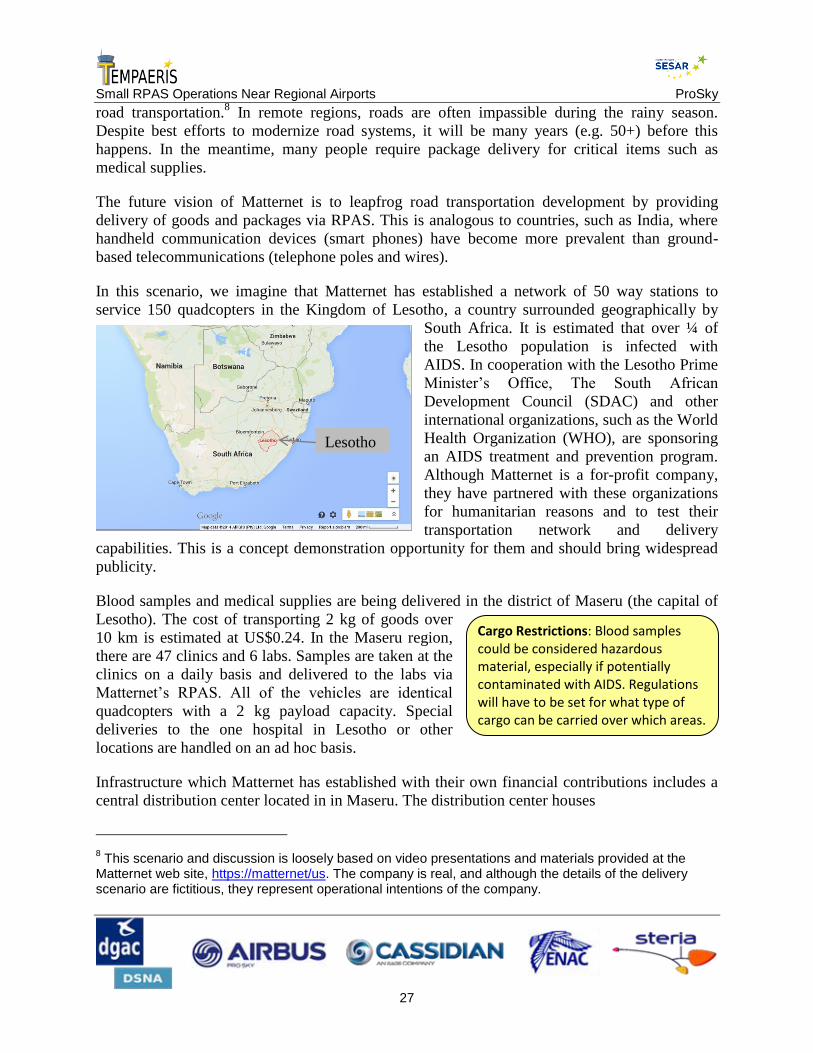
Small RPAS Operations Near Regional Airports ProSky
27
road transportation.8 In remote regions, roads are often impassible during the rainy season.
Despite best efforts to modernize road systems, it will be many years (e.g. 50+) before this
happens. In the meantime, many people require package delivery for critical items such as
medical supplies.
The future vision of Matternet is to leapfrog road transportation development by providing
delivery of goods and packages via RPAS. This is analogous to countries, such as India, where
handheld communication devices (smart phones) have become more prevalent than ground-
based telecommunications (telephone poles and wires).
In this scenario, we imagine that Matternet has established a network of 50 way stations to
service 150 quadcopters in the Kingdom of Lesotho, a country surrounded geographically by
South Africa. It is estimated that over ¼ of
the Lesotho population is infected with
AIDS. In cooperation with the Lesotho Prime
Minister’s Office, The South African
Development Council (SDAC) and other
international organizations, such as the World
Health Organization (WHO), are sponsoring
an AIDS treatment and prevention program.
Although Matternet is a for-profit company,
they have partnered with these organizations
for humanitarian reasons and to test their
transportation network and delivery
capabilities. This is a concept demonstration opportunity for them and should bring widespread
publicity.
Blood samples and medical supplies are being delivered in the district of Maseru (the capital of
Lesotho). The cost of transporting 2 kg of goods over
10 km is estimated at US$0.24. In the Maseru region,
there are 47 clinics and 6 labs. Samples are taken at the
clinics on a daily basis and delivered to the labs via
Matternet’s RPAS. All of the vehicles are identical
quadcopters with a 2 kg payload capacity. Special
deliveries to the one hospital in Lesotho or other
locations are handled on an ad hoc basis.
Infrastructure which Matternet has established with their own financial contributions includes a
central distribution center located in in Maseru. The distribution center houses
8 This scenario and discussion is loosely based on video presentations and materials provided at the
Matternet web site, https://matternet/us. The company is real, and although the details of the delivery scenario are fictitious, they represent operational intentions of the company.
Cargo Restrictions: Blood samples could be considered hazardous material, especially if potentially contaminated with AIDS. Regulations will have to be set for what type of cargo can be carried over which areas.
Lesotho

Small RPAS Operations Near Regional Airports ProSky
28
Quadcopter parts and repair services
Local administrative offices
An operations center, replete with RPAS pilots and dispatchers.
In addition, the distribution center serves as home base for the quadcopters, where they return
every night.
The creation of the way stations was the biggest
infrastructure investment. The way stations are 75-100
feet high and often placed in remote sections of the
countryside. They have solar powered batteries, which
maintain a small supply of freshly charged batteries for
the quadcopters (3–5 batteries per tower). To guard
against unauthorized entry, the towers have been designed
to be tall enough and secure enough that they are not
easily scaled. (Ironically, their primary weakness is attack
from the air. For instance, an alien quadcopter could
perform some malicious activities on the landing pad. RPAS are not prevalent enough in Lesotho
to present any serious threat.) Towers located in more urban areas of villages have been placed
just on the outskirts to minimize interference with
humans or livestock.
The RPAS are fully automated, meaning that once they
leave the distribution center, they can navigate to any of
the way stations on a pre-programmed route. The battery
swaps are completely automated. The only part of the
deliveries that requires human intervention is acceptance
and acknowledgement of deliveries, which take place
only at the base of the way stations. The recipients
manually disengage the package from the vehicle and press a small button to acknowledge
delivery, at which point the vehicle returns to a way station or to the distribution center. Routes
are predefined to stay clear of trees, houses, and other terrestrial objects.
Eventually, the way stations will become hubs in a larger
network, which would be optimized to make maximal
utility of the vehicles and to minimize delays in
deliveries. For now, the network was optimized for static
routes and regular deliveries, using simplistic
optimization software. Later, more sophisticated software
will be used to manage dynamic routes and delivery requests.
The RPAS pilots generally remain in the operations center, acting as humans over the loop in
piloting of the vehicles. (Occasionally, they are called to the field or special operations.) They
have more of a monitoring role, sometimes with as many as 32 RPAS at a time, but four to five
Way Station Regulation: The way stations are analogous to cell phone towers. Regulators would have to decide if they are to be considered “airports” or as part of the remotely piloted aircraft system. If the latter, then they would be certified along with the other system components.
Pre-programmed Routes: Creation of established RPAS delivery routes may increase safety and predictability, the way it does for manned aviation. However, flight between the route and an ad hoc delivery point could still be problematic.
RPAS Airports: Research has already begun to design airports devoted strictly to RPAS. Regulation would have to be constructed to guide their development and location.

Small RPAS Operations Near Regional Airports ProSky
29
being more common. The dispatchers are primarily
responsible for the timing and coordination of
deliveries and troubleshooting problems.
The delivery network has been in operation
successfully for five months. There have been a few
vehicles lost. They may have been stolen, but this is
generally not a concern because the local inhabitants
are recipients of the services and act as monitors. Quadcopter landings in the villages or urban
environments are still a notable event, and a small crowd generally gathers to watch.
There has been some talk of extending the cargo to
include other types of supplies or goods, but as of
yet, there is no way to fund the deliveries. Only a
small proportion of the population could afford such
services, and they generally live in the urban region
where road transportation is already sufficient.
Eventually, Matternet envisions establishing RPAS delivery networks in urban environments,
such as major metropolises. These large cities usually have mature road networks, but traffic
congestion has become highly problematic. A network of aerial routes would be created and
operate in the backdrop, much the way the internet does
today. (Hence the name, “Matternet”.)
Extent of Automation: Many RPAS, even large ones, are capable of autonomous takeoff and landing. The question is how much of the flight can be automated before it is considered “fully automated”. In the U.S., the FAA is not even considering these types of operations.
Restrictions on Scope of Operations: In principle, deliveries could be requested for any locale. Policies or regulations must be set to limit operations (e.g. away from a school zone).
Detect and Avoid: In this delivery scenario, there was no air traffic to be considered. Such would not be the case in a dynamic, urban environment.
Scope of pilot duties: In this scenario one pilot is operating several RPAS. Is this appropriate, given the level of autonomy of the RPAS? How can safety level be demonstrated?

Small RPAS Operations Near Regional Airports ProSky
30
3 Discussion of impacts, issues, and concerns
In this section, we discuss the issues surrounding integration of RPAS with existing air traffic.
Each of the sub-sections will address an issue, including a brief description of the issue, the
major stakeholders concerned, and an outline of the next steps to be taken to resolve the issue.
3.1 Airworthiness Certification
The Issues
An airworthiness certificate grants authorization to operate an aircraft in flight. In the U.S., the
FAA provides information regarding the definition of the term “airworthy” in FAA Order
8130.2, Airworthiness Certification of Aircraft and Related Products. Currently, RPAS
operations are covered by a Certificate of Waiver or Authorization (COA) and are registered on a
case-by-case basis. U.S. military RPAS operations are currently certified via airworthiness
criteria specified in the Department of Defense Handbook.
Airworthiness certification currently assumes a pilot is onboard. Regulators will need to define
all requirements for certification of RPAS in order to streamline the process compared to the
COA case-by-case basis. Airworthiness certification for RPAS will need to establish
requirements assuming that a pilot is not onboard the aircraft. Areas that need research into
requirements for successful airworthiness certification are control station (equipment and
software), control station security (e.g., cabin door locks), airframe, and data link (C2).
Stakeholders
ANSP: Air Navigation Service Providers will have to validate the requirements relative to
the equipment and operation rules of a RPAS, as far as these requirements have an impact
upon ATC.
Regulating Authorities (e.g. FAA, DGAC, CAA): these authorities will have to develop and/
or enforce suitable regulations for RPAS certification and operations.
International bodies (e.g. ICAO, EASA, JARUS, RTCA, EUROCAE) will produce basic
documentation and do some rulemaking.
Domestic organizations: DoD already has a certification process for their RPAS. NASA and
other research organizations are researching control station human factors, ground-based
DAA, and airborne DAA.
Private sector entities: RPAS designers with Type Certification (e.g. Insitu, AeroVironment)
have been through the FAA’s Type Certification process.

Small RPAS Operations Near Regional Airports ProSky
31
RPAS operators will have to ensure that their procedures for operating RPAS are
compliant with regulations including ATC procedures.
RPAS manufacturers will work together with regulators in order to establish Type
Certification process.
The Road Forward
Short-term steps
First, allowing existing RPAS designs to operate with strict airworthiness and operational
limitations to gain operational experience and determine their reliability in very controlled
circumstances, either under the existing COA concept or through regulations specific to RPAS.
Next, developing design standards tailored to a specific RPAS application and proposed
operating environment. This step would enable the development of useful unmanned aircraft and
system design and operational standards for the RPAS to facilitate safe operation, without
addressing all potential RPAS designs and applications. This would lead to type certificates (TC)
and production certificates with appropriate limitations documented in the aircraft flight manual.
Lastly, defining standards for repeatable and predictable FAA type certification of a RPAS
designed with the redundancy, reliability, and safety necessary to allow repeated safe access to
the NAS, including seamless integration with existing air traffic.
Mid-term
The FAA will work with the RPAS community in defining policy and standards that facilitate
agreement on an acceptable RPAS certification basis for each applicant. This may involve the
development of new policy, guidance, rulemaking, special conditions, and methods of
compliance.
Far-term
Certification of RPAS will evolve as future technologies evolve and will be consistent with all
other aircraft airworthiness and operational approval processes, adding more capability to the
RPAS through data analyses and trending, which will identify areas for change and improvement
in operations, human factors, communication links, and maintenance.
3.2 Detect and Avoid
Detect and Avoid (DAA) is the capability of a RPAS to remain well clear from and avoid
collisions with other airborne traffic. DAA – sometimes called “Sense and Avoid”, as in the
graphic below – provides the functions of self-separation and collision avoidance to establish an
analogous capability to see-and-avoid required of manned aircraft.

Small RPAS Operations Near Regional Airports ProSky
32
The Issues
Policy, Guidance, and Regulatory Product Challenges: Need to define minimum standards
for DAA to meet new or existing operational and regulatory requirements for specified
airspace.
Air Traffic Operational Challenges: Need to establish procedures involving DAA.
Technical challenges: RPAS pilots do not have the ability to directly comply with see-and-
avoid, and RPAS DAA systems do not meet current operational rules. DAA system standards
must be developed to assure both self-separation and collision avoidance capability for
RPAS. Interoperability constraints must be also defined for safe and secure interactions
between DAA-enabled RPAS and other airborne and ground-based collision systems.
Stakeholders
ANSP: Seamless insertion of airborne and ground based DAA techniques into ATM
procedures
Regulating Authorities: Approval of the Airborne Collision Avoidance System (ACAS);
Unmanned Aircraft Integration; Concept of operations, policy, standards, requirements
RTCA: SC-228 (Minimum Operational Performance Standards for Unmanned Aircraft
Systems) developing MASPS and MOPS; standards, requirements
SESAR JU, FAA-NextGEN together with research partners (e.g. NASA, DLR, ONERA,
ENAC). Development of:
New sensors
Airborne DAA algorithm/software/hardware design and flight tests
Separation Assurance/Sense and Avoid Interoperability (SSI) and Interoperability with
ATC environment (TCAS, HITL, etc.), adapted to RPAS mission and performance
characteristics

Small RPAS Operations Near Regional Airports ProSky
33
Air and Ground forces: Ground-based DAA technology development, Airborne DAA
technology development
RPAS manufacturers, avionics manufacturers: industrialization of
Airborne DAA algorithms, modeling and simulation
Ground-based DAA algorithms, modeling and simulation
ACAS X, DAA algorithms, modeling, simulation
The Road Forward
Short-term steps
Establishment of DAA system definitions and performance levels
Assessment of DAA system multi-sensor use and other technologies
Minimum DAA information set required for collision avoidance maneuvering
Ground Based DAA: Concept-of-use demonstration under way
Airborne DAA: Research is under way, but significant progress not expected until mid-term.
Mid-term
Flight demonstration of self-separation and collision avoidance algorithms, with multiple
sensors and intruders
Assessment of the performance of various self-separation concepts as a function of
surveillance data configurations, and evaluation of risk-based self-separation algorithms and
policy issues
Assessment of the performance of various separation assurance concepts, and flight
demonstration of separation assurance algorithms, with criteria-based separation
Assessment of RPAS performance for delegated spacing applications (e.g. defined interval
clearances)
Fully certified RPAS-based collision avoidance solutions may not be feasible until the long-
term and are deemed to be a necessary component for full RPAS NAS integration. This
includes research on safe and efficient terminal airspace and ground operations, followed by
ground demonstrations of autonomous airfield navigation and ATC interaction.
Far-term
DAA research that focuses on algorithm development and compatibility with current and
future manned aircraft collision avoidance systems such as TCAS II/ACAS X and
surveillance systems (e.g. ADS-B), as well as compatibility with ARC separation
management procedures and tools.

Small RPAS Operations Near Regional Airports ProSky
34
Detailed research on DAA flight operations, using certified sensor systems, could allow
aircraft to maintain safe distances from other aircraft during flight conditions that would not
be appropriate for visual flight in a manned aircraft. This capability would rely heavily on
network-enabled information, precision navigation, and cooperative surveillance and would
require the development and integration of NextGen-representative technologies for traffic,
weather, and terrain avoidance. This conceptual model will be enlarged with sensors that
expand the ability to maintain separation from other aircraft past the current visual spectrum
and flight conditions restrictions.
3.3 Command and Control
The Issues
Unlike with manned aircraft, the RPAS pilot must depend on a data link for command and
control (C2) of the aircraft. This affects the aircraft’s response to revised ATC clearances, other
ATC instructions, or unplanned contingencies (e.g., maneuvering aircraft). Issues to be resolved
include:
Policy
Certification Requirements
Technical Standards
Airworthiness Standards
Interoperability Requirements
Guidance Material
Coordinated Aviation Radio Frequency Spectrum
Standardized Control Architectures
Measures of Performance
Radio/Data Link Security Requirements

Small RPAS Operations Near Regional Airports ProSky
35
Control
Station
Air Traffic
Control
Unmanned
Aircraft
Control
Station
Air Traffic
Control
Unmanned
Aircraft
Radio Line-of-Sight (LOS) Beyond Line-of-Sight (BLOS)
Satellite
Figure 6: Line of sight means within radio line of sight, not visual line of sight.
Stakeholders
International bodies: International Telecommunications Union (ITU) – World Radio
Communications Conference (WRC) is part of ITU. ITU delegates the management of the
spectrum for aeronautical frequencies to ICAO which, in turns delegates it to National
regulating authorities.
Aeronautical Regulating Authorities: Flight standards – C2 standards and certification
requirements. Air traffic – C2 controller training requirements, impact on air traffic, etc.
Policy – Setting frequency.
RPAS Operators: Need to understand C2 requirements and comply with them.
National Telecommunications Regulating Authorities: various regulating bodies organize the
management of the spectrum at local or national level. This is an important factor as small
RPAS may use non aeronautical frequencies for C2, which could result in an improper
protection from jamming.
Domestic organizations: RTCA, NASA; National Telecommunications and Information
Administration (NTIA) manages and authorizes all federal use of the radio frequency
spectrum; Federal Communications Commission (FCC) manages and authorizes all non-
federal use of the radio frequency spectrum, including state and local government as well as
public safety.

Small RPAS Operations Near Regional Airports ProSky
36
Private sector communication service providers: Harris Corp., ARINC, SITA, etc.
What Needs to Happen
C2 system performance requirements are needed – RTCA is developing consensus-based
recommendations for the FAA to consider in C2 policy, program, and regulatory decisions.
The resulting C2 requirements need to support the minimum performance required to achieve
RPAS level performance and safety requirements.
Third-party communication service providers are common today (e.g., ARINC, Harris) and
the FAA has experience with setting and monitoring performance of third parties.
The use of third parties is dependent on the RPAS architecture chosen, but these are still
being evaluated in terms of feasibility from a performance, cost, and safety perspective.
C2 Certification: The FAA shall establish acceptable thresholds for control link latency (time
from initiation of a command to the RPAS until a measurable response). The FAA shall establish
acceptable thresholds for communications latency (time from issuance of an ATC instruction
until acknowledgement by the RPAS flight crew).
C2 Operations: The FAA shall provide “party line” communications services to RPAS in
addition to manned aircraft. The FAA shall exchange ATC messages and instructions with RPAS
flight crews via data communications for those RPAS who elect to equip with this capability.
C2 Policy: The FAA shall assign frequency spectrum for RPAS command, control, and
communications.
C2 Training: FAA shall provide training for ATC and TFM personnel on RPAS specific topics,
such as RPAS flight envelope characteristics, typical operational profiles, communications and
control link latency, contingency procedures (e.g., lost link), and automation support tools.
The Road Forward
Short-term
A primary goal of C2 research is the development of an appropriate C2 link between the
RPAS and the control station to support the required performance of the RPAS in the NAS
and to ensure that the pilot always maintains a threshold level of control of the aircraft.
Research will be conducted for RPAS control data link communications to determine values
for latency, availability, integrity, continuity, and other performance measures.
RPAS contingency and emergency scenarios also require research (e.g., how will a RPAS in
the NAS respond when the command link is lost, through either equipment malfunction or
malicious jamming, etc.).

Small RPAS Operations Near Regional Airports ProSky
37
This research will drive standards that are being established through: Development and
validation of RPAS control link prototype; vulnerability analysis of RPAS safety critical
communications; completion of large-scale simulations and flight testing of initial
performance requirements.
Mid-term
Advanced research is required in data link management, spectrum analysis, and frequency
management.
Efforts will focus on completing development of C2 link assurance and mitigation
technologies and methods for incorporating them into the development of certification of the
RPAS. This will include identification of satellite communication spectrum from the ITU
through its WRC; verification and validation of control communication final performance
requirements; establishment of RPAS control link national/international standards; and
development and validation of technologies to mitigate vulnerabilities.
Complete characterization of the capacity, performance, and security impacts of RPAS on
ATC communication systems will be completed.
Far-term
Research on new tools and techniques to support avionics and control software development and
certification, to ensure their safety and reliability. FAA Goals established for Command and
Control are:
Goal 1: International agreements, industry standards, and FAA regulations established by 2015
for civil RPAS C2 capabilities such that C2 subsystems can be certified by the FAA.
Goal 2: Beyond-Line-of-Sight (radio, not visual) C2 links and capabilities are addressed in
international agreements, industry standards, and FAA regulations.
Goal 3: Adequate spectrum is available for both radio LOS and BLOS C2 links to meet the
demand generated by civil RPAS operations in the NAS. International spectrum identified for
LOS and BLOS RPAS C2 links reviewed at WRC by 2020.
3.4 Security
The Issues
Communications link between control station and RPAS. An attacker could gain control by
hacking the communications channel, and crash the RPAS, fly it into a building, subtly
interfere with its navigation so it thinks it’s somewhere it’s not (spoofing, jamming), or
capture the RPAS – i.e. steal it by flying it to their own location.
Security of control station: An attacker could break into the control station, if secure cockpit
door standards for commercial flights not extended to RPAS. They could then do any of the
things a remote hacker could.

Small RPAS Operations Near Regional Airports ProSky
38
Data or information collected by RPAS. Someone could remotely copy all this data, possibly
without the operator’s knowledge. Corporate espionage is another potential problem. Privacy
risk: interceptor might not follow the privacy policy of the RPAS operator.
Operator Security: With the anticipated increase in number of RPAS operations, screening
and vetting of RPAS pilots will be important. Many operators will not have been pilots
before. Any RPAS operator could choose to turn rogue and use RPAS as a weapon. Any pilot
could do this today, but threat to his or her own safety usually deters this. With that factor
removed, the question is how to keep would-be terrorists from acquiring and arming RPAS.
If a RPAS causes damage, what methods are available to track it? Possible solutions may
include electronic signatures or trails or an analog to automobile registration.
Defense against rogue RPAS: What if one or more RPAS appear in the sky flying toward
strategic objectives (government buildings, nuclear plants, etc.)? RPAS are small and fly low
– truly “under the radar”. Need a method for detecting potential rogue RPAS before they
reach their destination and also a method for diverting or disarming them.
Control station security should be addressed. Need to define what constitutes a “cockpit” in
RPAS context. It is OK to treat small RPAS differently?
Stakeholders
RPAS manufacturers
Communications researchers
Security experts
Test site operators (in the U.S.)
RPAS operators
Aeronautical Regulating Authorities: Need registry of all owners / operators / pilots of
RPAS. Similar to license / registration for cars and trucks. Could there be an analog to the
state or province level department of motor vehicles?
Defense departments
IATA / ICAO
3.5 Air Traffic Control
The Issues
Separation standards
Separation standards need to be reviewed and potentially altered. Identify policies and
requirements for RPAS to comply with ATC clearances and instructions to the degree they are
for manned aircraft. Identify high-risk areas when a mixed environment is present. Provide
controllers with better tools to distinguish separation standards that will vary with situations.

Small RPAS Operations Near Regional Airports ProSky
39
Policy
Establish policy and guidance for Ground and Local control. Launch and recovery methods when
departing/arriving airports. Assess impact to other operations. Introduction of more vehicles on
airport surface provides opportunities for incursions. Training for ground RPAS personnel in
ATC procedures and expectations. Communications with the tower and with airport operators.
Communications
Performance requirements that support minimum performance required to meet safety
requirements are needed. RTCA is developing consensus-based recommendations for the FAA to
consider in C2 policy, program, and regulatory decisions. These must be established before
separation standards can be established. Third-party communication service providers are
common today (e.g., ARINC, Harris, EUROCAE) and the FAA/EASA/DGAC/CAA has
experience with setting and monitoring performance of third parties. Separation standards
increased in these scenarios?
Training
Establish new training for ATC. RPAS performance characteristics. Establish techniques for
handling UA. Simulation in the radar environment displaying realistic performance is limited –
advances needed. What to expect from pilots of RPAS. PIC training and certifications
understood by ATC. Cultural and mindset changes.
Contingency Procedures (e.g. lost communication, security)
ATC already has contingency procedures in place for all aircraft (e.g. loss of radio, loss of
power). When communication with the pilot is broken, it can be assumed that the aircraft will
maintain its filed flight path to its destination. However, for RPAS, it is not clear what the
vehicle is programmed to do. Since it is usually not a transit mission, the notion of a destination
may have no meaning. Some vehicles will return to home base, while others will loiter hoping to
regain communication with the pilot (if that be the problem), while other will perform a spiral
descent (a controlled crash). The main issue is that ATC needs to know which of these options
the vehicle will adopt. A primary issue is how the controller can access this information.
Airport Surface Integration
Will RPAS be able to operate on the airport surface? Will the technology to stay clear of objects
and vehicles be the same as it is for en route? Will ground observers be required, and if so, what
qualifications must they have?
Latency
Latency in pilot responses during communications and latency in response of the aircraft to
controller instructions are often cited as two areas of concern. According to the most experienced
RPAS operators (specifically, the US Air Force), latency is a minor nuisance at best (fractions of
a second), somewhat akin to a slight hesitation in verbal conversations. Other sources have
estimated latency (in aircraft response) to be on the order of 3 seconds, which could be
problematic in evasive or other emergency procedures. Standards must be set for how much
latency can be tolerated by controllers.
Stakeholders

Small RPAS Operations Near Regional Airports ProSky
40
ANSP:
System Operations
Procedures to ensure safety
ATC – management and labor
Access/ Reservation of airspace: must be optimized to maintain flight efficiency at an
acceptable level
Access to airports: to ensure optimal flight efficiency
Aeronautical Information: to guarantee an acceptable level of safety and performance
Aeronautical Regulating Authorities: edit rules and survey that performances are in line with
objectives in the following topics (at least)
System Operations
Homologation/ Certification
Safety
Access to airspace
Access to airports
International bodies
ICAO
IATA
Domestic organizations
NATCA
PASS
AOPA
Airlines for America
DoD
Airport Operators
RTCA
NASA

Small RPAS Operations Near Regional Airports ProSky
41
National Telecommunications and Information Administration (NTIA) manages and
authorizes all federal use of the radio frequency spectrum.
Federal Communications Commission (FCC) manages and authorizes all non-federal use
of the radio frequency spectrum, including state and local government as well as public
safety.
State government aviation organizations
Airspace users will express their requirements in terms of mission definition and required
level of performance
o Drone operators and their representative bodies
o AOPA/ EBAA/ national associations or federations: represent private pilots
o Airlines for America, European Low Fare Airlines Association, Association of
European Airlines, etc. represent “legacy” airlines
o Departments of Defense: express the military point of view
o Airport Operators: considered as airspace users, as the concerns they address are
mostly those that impact airlines
ITU and organizations responsible for allocating the spectrum (at a national level, or local
or for specific purposes): avoid datalink, radio and C2 jamming
Other professional organizations:
o ATCO Unions
o Pilots Unions
o RTCA, EUROCAE
The Road Forward
Short-term
Determine facility Position usage and ensure staffing available for opening additional
positions
Determine administrative workload for planning and coordination. Consider administrative
tasks assigned to operational management detract from primary responsibility of overall
supervision of the current operation.
Assess availability of beacon codes
Clearly define access expectations and priority
Define operations in SFRA

Small RPAS Operations Near Regional Airports ProSky
42
R&D Activities:
Develop tools to assist controllers with primary responsibility of a safe orderly operation.
Possible data block revision to include weight class.
RPAS contingency and emergency scenarios require research (e.g., how will a RPAS in the
NAS respond when the command link is lost through either equipment malfunction or
malicious jamming, etc.). Develop scenarios and conduct tabletop exercises.
Research will drive separation standards and communications expectations:
Development and validation of RPAS control link prototype
Wake turbulence studies
Vulnerability analysis of RPAS safety critical communications
Completion of scenarios, simulations to determine CPC training and indoctrination on the
revised standards needs.
Mid-term
Apply current prioritization policies to RPAS. Determine if equal level of safety exists.
Traffic Flow Management: Give facilities some idea of expected demand. Assess impact.
Develop TMIs suited to RPAS operation
Alter internal airspace boundaries to establish parallel corridors for low performance aircraft
if frequent impact exists. There are environmental implications.
R&D Activities:
Advanced research is required in data link management, spectrum analysis, frequency
management, and wake and vortex turbulence.
Efforts will focus on completing development of Communications assurance and
mitigation technologies and incorporating them into the development of ATC
requirements. Development and validate technologies to mitigate vulnerabilities.
Complete characterization of the capacity, performance, and security impacts of RPAS
on ATC communication systems will be completed.
Far-term
Re-define “immediate communication”
Alter airspace based on frequent impact
R&D Activities: Research on new tools and techniques to support avionics and control
software development and certification, to ensure their safety and reliability.
3.6 Traffic Flow Management
The Issues
Small RPAS Operations Near Regional Airports ProSky
43
Traffic flow managers will need methods and assess the potential impact of RPAS operation,
especially when their operation is potentially disruptive or requires special monitoring or
segregated airspace. They must be able to assess impact approximate workload on air traffic
controllers. If RPAS require larger separation standards than manned aircraft, then the impact on
controllers and traffic flow must be assessed in real time.
Currently, all RPAS operations in controlled airspace are considered potentially disruptive and
allowed only via special permission. Mission descriptions and flight plans are submitted 24 hours
or even days in advance. In the future, policies must be set for how far in advance these flight
plans should be submitted and what format they will take. Ideally, RPAS operators would like to
have the same file-and-fly privileges as manned aircraft, and will be concerned that they are
being singled out, if they are required to give long lead times on their intentions.
Under some circumstances, RPAS will still require reserved airspace for their operation.
Also, the interaction (or lack thereof) of RPAS with traffic management initiatives (ground delay
programs, traffic spacing programs) must be evaluated in real time. Will RPAS be able to
comply with and participate in these programs (e.g. in the U.S., collaborative decision making)?
Stakeholders
ANSP
Systems Operations (central flow units – responsible for all air traffic management
activities in the considered airspace)
ATC – helps execute traffic management plans
International organizations
ICAO RPAS Study Group – focal point for international RPAS developments
Domestic organizations
Flight Operators – RPAS, passenger, cargo
Universities – Ongoing RPAS research, test sites
Military – RPAS operators, NAS users
The Road Forward
Short-term
Case-by-case approvals.

Small RPAS Operations Near Regional Airports ProSky
44
Modeling and Simulation: FAA and other government agencies and industry are developing
a collaborative RPAS modeling and simulation environment to explore key challenges to
RPAS integration. Near-term goals include: Validate current mitigation proposals; Establish
a baseline of end-to-end RPAS performance measures; Establish thresholds for sage and
efficient introduction of RPAS into the NAS; Develop NextGen concepts, including 4D
trajectory utilizing RPAS technology.
Mid-term
Develop procedures, standards, and regulations that support integration efforts
DAA research in self-separation concepts and assessment of RPAS performance for
delegated spacing applications
C2 research to develop and validate technologies designed to mitigate vulnerabilities
Human factors data will be collected to determine the safest technologies and best procedures
for pilots and ATC controllers to interact with each other and with the aircraft. For separation
and collision avoidance, human decision making versus automation must be identified.
Far-term
Improved technologies
DAA research focuses on algorithm development and compatibility with current and future
manned aircraft collision avoidance systems (TCAS) and surveillance systems (ADS-B)
Research on new tools and techniques to support avionics and control software development
Early Intent
Increased coordination required for RPAS operations, especially if operations cross
boundaries
No process in place to accept a flight plan with an unknown destination
Nature of RPAS operations may prevent notice of early intent
Traffic Management Initiatives
RPAS operators vs Major operators
How responsive will RPAS be to speed control mechanisms
Demand estimation becomes a challenge with circuitous flight plans
Weather-related
Weather avoidance – If you can’t communicate with the RPAS pilot during a weather
event, then you can’t tell what the RPAS is going to do
Weather Availability – RPAS operators may not have the same weather information once
the RPAS is airborne
Weather Translation – Models use very different flight characteristics for RPAS

Small RPAS Operations Near Regional Airports ProSky
45
Off-nominal operations: Aborted missions, Jamming/Spoofing; Diversions; Pilot errors
3.7 Pilot/Operator
The Issues
Operator approval is done on a case-by-case basis and often restricts operators to special use
airspace
Pilot certification is based on certificates for manned aircraft – there is no direct path to
RPAS operation.
Pilot training requirements are defined by each individual operator and approved by the FAA
on a case-by-case basis
Example: DoD RPAS pilot classifications
No defined types or classes of RPAS in current policy – handheld RPAS subject to the same
requirements as a Predator (Upcoming RPAS may help)
Currency requirements require pilots to maintain both RPAS and manned aircraft currency (3
takeoffs and landings within the preceding 90 days, IFR currency, biennial flight reviews)
Stakeholders
Regulators (e.g. FAA, EASA, DGAC, CAA): Responsible for actually writing the certification
requirements, practical test standards, and FARs
Operators: Government Agencies including military, Local/State Government, Agriculture,
Survey, other civil operators. Many of these organizations have developed in-house training
standards. These groups pay for training the pilots to whatever standard is implemented.
Pilot Unions: ALPA, etc. represent manned aircraft pilots that may have concerns over RPAS
standards. May represent RPAS pilots in the future.
Pilot Advocacy: AOPA, EBAA, etc. advocate for GA pilot issues. Concerned with airspace
access and proper training of RPAS pilots.
Private RPAS Pilot Training Institutions. Already have RPAS curriculum that may be used as
input. Private RPAS pilot courses will have to meet FAA requirements.
The Road Forward
Short-term
RPAS training standards will mirror manned aircraft training standards to the maximum extent
possible, including appropriate security and vetting requirements.

Small RPAS Operations Near Regional Airports ProSky
46
Mid-term
Emphasis will shift toward integration of RPAS through the implementation of civil standards
for unmanned aircraft pilots and new or revised operational rules, together with necessary policy
guidance and operational procedures.
Far-term
As new RPAS evolve, more specific training will be developed for RPAS pilots, crew members,
and certified flight instructors based on lessons learned and data collection.
Standards for airmen will proceed following the RPAS regulation. The FAA will issue RPAS
airman certificates and support activities to enable RPAS operations to include:
Development of practical test standards (PTS) and RPAS airmen knowledge test question
banks
Development of a RPAS handbook for airmen
Training of aviation safety inspectors (ASI) at the FSDO level to provide practical test
oversight
Identification of designated pilot examiners (DPE) to assist the FSDOs
Development of a RPAS handbook for pilot and instructors
Development of PTS and RPAS pilot knowledge test question banks
Development of RPAS mechanic training and certificate process
Development of flight crew security requirements by the relevant United States
Government agencies
Pilot endorsements may be developed for specific RPAS makes and models to permit
commercial operations. Pilot qualifications by make and model will be built into training and
will be expanded based on pilot experience.
3.8 Privacy
The Issues
RPAS have brought about many opportunities for revenue and the pursuit of business models.
These range from very small RPAS used, as they are today, for photography, real estate,
surveying, inspecting – some of these activities are for personal use, but many are intended as
commercial enterprises, where the product (photos or video) is sold to the client(s). This is
especially true for small RPAS.
The FAA intends to publish a notice of proposed rule making for small RPAS. That publication
has been stalled for several years for a variety of reasons (e.g. safety, insurance, security). More
recently, a major obstacle was the need to address privacy concerns.
Small RPAS Operations Near Regional Airports ProSky
47
Specifically, the public is concerned that RPAS will be used for surveillance purposes (e.g.
photography) without the consent of the subjects. For purposes of discussion here, we will call
these uses “unwarranted,” meaning that is it against the wishes of the person being surveilled.
The unwarranted uses fall into two basic categories: (1) those conducted by a non-government
(civil) entity, such as a neighbor spying on another neighbor through their bedroom window, and
(2) those conducted by a government entity, such as the U.S. National Security Agency (NSA)
listening to a private conversation between two individuals in a public park. Protection against
the latter concern is safeguarded by the Fourth Amendment to the U.S. Constitution. Privacy
advocates, such as the American Civil Liberties Union (ACLU) and Epic.org, have insisted that
RPAS not be allowed to operate in the U.S. until the FAA first says how it intends to address
privacy concerns. However, this is not the traditional purview of the FAA. Initially, the FAA
argued that, just as with manned aircraft, if someone is using an RPAS to perform unwarranted
or illegal activities, it is the responsibility of the Department of Justice or some other legal entity
to address it. (What would be under the FAA purview is to address someone operating an aircraft
carelessly or recklessly.)
Some counterarguments to the privacy concerns are that virtually all the unwarranted activity can
be conducted now using manned aircraft, so RPAS are not really introducing anything new.
However, privacy advocates point out that the ease with which RPAS can now be adopted for
these uses makes it much more likely they will take place.
No matter whether the FAA should rightfully be addressing the privacy concerns regarding
RPAS, it seems that they have been forced into addressing it. This caused a significant delay of
the small RPAS rules.
Europe has a comprehensive framework of privacy and data protection legislations. The Charter
of Fundamental Rights of the EU establishes, in particular, the rights to respect private and
family life, home, and communications (Article 7) and addresses the protection of personal data
(Article 8). These rights are implemented through specific EU and national regulations (Article
16 of the Treaty on the Functioning of the European Union, Directive 95/46/EC, national laws on
data protection, video surveillance, etc.). RPAS operators must also comply with this regulatory
framework.
In France, many of the privacy concerns seem to have been quelled by assuring the public that
RPAS use will be primarily by public servants. Also, European laws tend to be much stricter
than in the U.S. regarding photographing someone against their wishes. For instance, the
paparazzi are strongly controlled in Europe, whereas in the U.S. they have nearly free rein. This
addresses much of the concern regarding non-government unwarranted use. As for government
unwarranted use, the French public seems to be more trusting that their government will act
responsibly. In the U.S., however, this type of assurance backfires. There is a stronger tendency
in the U.S. than in other countries to challenge and curtail central authority.

Small RPAS Operations Near Regional Airports ProSky
48
No matter which government entity is responsible for restricting unwarranted use of RPAS
surveillance, the issue has added another layer of complication to the integration of RPAS into
the airspace.
Stakeholders
Privacy advocates: EPIC, ACLU, EFF, Rutherford Institute, national institutions dedicated to
protecting privacy for citizens
RPAS operators: Public, Civil (will be concerned about onus of having to establish policies and
curtail certain operations due to privacy concerns).
Test site operators (6 sites in the U.S., one in the U.K., plus some others in Scandinavia, France,
and Italy). Each must produce a privacy policy. Will be used as trial balloons for what future
privacy policies should be.
Airspace regulators

Small RPAS Operations Near Regional Airports ProSky
49
4 State of RPAS Integration Issues Around the World
4.1 World Trends by Country
In this section, we present trends that are taking place around the world with respect to
integration of RPAS.
We conducted an informal review of RPAS integration progress in the member countries of the
European Union and several other countries around the world. Overall, countries are grappling
with the same integration issues. The U.S. and Israel are at the forefront of RPAS technology
development but are not necessarily further along in establishing regulations. A common
approach to regulation is to create a special set of rules for small RPAS (e.g. under 25kg) that are
must less stringent than for large RPAS. The reasoning is that air traffic control does not (and
will not) provide separation services for small RPAS at low altitudes, so they have to be self-
separating.
Australia has been proactive in attempts to regulate and permit RPAS operations. They have
published guidelines for RPAS operators. This website contains training information for
prospective RPAS operators in Australia.
Canada has been proactive to the extent of providing restricted airspace for RPAS operations
and testing, and Transport Canada has issued Knowledge Requirements for pilots of RPAS 25 kg
or less, operating within visual line of sight. This website has information about flying an
unmanned aircraft in Canada.
China has issued the first pilot licenses for RPAS operations, but civil aviation in China lags
behind the Western nations. Recently, China used armed helicopters to shoot down an
unauthorized RPAS involved in mapping operations.
England appears willing to allow RPAS operations and is actively examining regulations to
oversee operations.
Europe, the EU specifically, has taken steps to define, regulate, and integrate RPAS.
Successful integration tests in France will have to be coordinated with EU decisions.
Germany: The German Parliament is about to approve a new law to include unmanned aircraft
in air traffic laws.
India: The Directorate General of Civil Aviation (DGCA) in India has started formulating rules
and regulations for the operation of RPAS. However, the aviation regulator has declared that
until the policies are announced, the use of RPAS is prohibited.
Small RPAS Operations Near Regional Airports ProSky
50
Ireland, along with the rest of Europe, is taking a measured approach that seems to assume
RPAS are here to stay. The Irish Aviation Authority has issued 22 RPAS permits.
Israel has tested urban warfare observation RPAS.
The RPAS sector is now regulated in Italy, and this new regulation, which is in line with the
European RPAS vision, is expected to have a very positive influence on the growth of the Italian
RPAS market (aeronautical products and services).
New Zealand has issued a Notice of Proposed Rule Making and is receiving comments on new
rules for RPAS.
In Russia, Moscow hosted the 2nd
international workshop on experimental RPAS.
Singapore is reviewing RPAS regulations.
In South Africa, the Commercial Aviation Association (CAA) in December 2014 published
RPAS legislation for public comment. CAA reached agreement with the Commercial Unmanned
Aircraft Association of Southern Africa (CUAASA) and industry on the details of these Phase 1
RPAS Regulations. The goal is to have legislation in place by the end of March 2015.
In Spain, drones are banned as of April 2014. The first BLOS RPAS test was in 2014.
Turkey is building RPAS capabilities.
The UAE has held a Drones for Good Award competition. The winner was an application that
used cell phone location to direct an autonomous UAS with an Automatic External Defibrillator
to a person in need.
In the United States, the Federal Aviation Administration has created test sites for RPAS
experimentation. Currently, individual Certificates of Authorization are issued for non-
commercial use, and also some permits for the film industry. The big unknown in the U.S.
remains in the area of enforcement. A notice of proposed rule making for small RPAS is
expected soon.
Uzbekistan has banned the import, sale, and use of pilotless drone aircraft, citing air safety and
security concerns.

Small RPAS/UAS Operations Near Regional Airports Airbus ProSky
51
4.2 Regulatory Status in Europe
About half (12/28) of the EU countries have in place some type of regulation for RPAS, but
these are only for vehicles below 25kg or below 150kg. Only two countries, Czech Republic and
France, have regulations in place for beyond line of sight.
Table 1: Regulatory status in European countries
Country In Place In Preparation Operations Facilitated
EU countries
Austria <150 kg, VLOS Yes
Belgium <150 kg, VLOS Yes
Bulgaria
Croatia
Cyprus
Czech Republic <150 kg, VLOS, BLOS Yes
Denmark <150 kg, VLOS Yes
Estonia
Finland <150 kg, VLOS Yes
France <25 kg, VLOS, BLOS VLOS, BLOS Yes
Germany <25 kg, VLOS
Greece Yes
Hungary <150 kg Yes
Ireland <20 kg, VLOS Yes
Italy <25 kg, VLOS Yes
Latvia
Lithuania <25 kg, VLOS <150 kg, VLOS Yes
Luxembourg
Malta <150 kg, VLOS Yes
Netherlands <25 kg, VLOS <150 kg, VLOS Yes
Poland <150 kg, VLOS Yes
Portugal
Romania Yes
Slovakia
Slovenia Yes

Small RPAS/UAS Operations Near Regional Airports Airbus ProSky
52
Country In Place In Preparation Operations Facilitated
Spain <25 kg, VLOS Yes
Sweden <150 kg, VLOS Yes
UK <20 kg, VLOS Yes
non-EU countries
Iceland
Norway <150 kg, VLOS, BLOS Yes
Switzerland Yes
4.3 Recent Events
In this section, we present excerpts from reports and articles describing recent events relevant to
increasing worldwide use of RPAS.
ICAO UAS Circular attempts to provide the fundamental regulatory framework
Taken from ICAO Circular 328, “Unmanned Aircraft Systems (UAS)”, 2011
Civil aviation has to this point been based on the notion of a pilot operating the aircraft from
within the aircraft itself and more often than not with passengers on board. Removing the pilot
from the aircraft raises important technical and operational issues, the extent of which is being
actively studied by the aviation community. Many of these issues will be identified in this
circular.
Unmanned aircraft systems (UAS) are a new component of the aviation system, one which
ICAO, states, and the aerospace industry are working to understand, define, and ultimately
integrate. These systems are based on cutting edge developments in aerospace technologies,
offering advancements which may open new and improved civil/commercial applications as well
as improvements to the safety and efficiency of all civil aviation. The safe integration of UAS
into non-segregated airspace will be a long-term activity with many stakeholders adding their
expertise on such diverse topics as licensing and medical qualification of UAS crew,
technologies for detect and avoid systems, frequency spectrum (including its protection from
unintentional or unlawful interference), separation standards from other aircraft, and
development of a robust regulatory framework.
The goal of ICAO in addressing unmanned aviation is to provide the fundamental international
regulatory framework through Standards and Recommended Practices (SARPs), with supporting
Procedures for Air Navigation Services (PANS) and guidance material, to underpin routine
operation of UAS throughout the world in a safe, harmonized, and seamless manner comparable
to that of manned operations. This circular is the first step in reaching that goal.

Small RPAS/UAS Operations Near Regional Airports Airbus ProSky
53
ICAO anticipates that information and data pertaining to UAS will evolve rapidly as states and
the aerospace industry advance their work. This circular therefore serves as a first snapshot of the
subject.
A Kitty Hawk moment – the start of an era in which RPAS will change the world
Popular Science, August 2014, “25 Reasons to Love Drones and 5 Reasons to Fear Them”
Once the U.S. Federal Aviation Administration (FAA) establishes airspace rules, which is likely
to happen in 2015, the drone industry could fuel a decade-long, $82-billion economic
boom, according to a study done by the industry’s leading trade group. Already, one analyst
estimates the global market for small unmanned aerial vehicles (UAVs) at $250 million to $300
million. The truth is, we’re witnessing a Kitty Hawk moment—the start of an era in which
drones will change the world and the way we live in it. They’ve saved lives overseas; at home,
they will make our cities and grids smarter, keep people safer, and help save our planet.
Some opposing views
From the same article, the “5 reasons to fear” RPAS:
In the wrong hands, drones could be deployed in unintended—and sinister—ways. Here’s why
we shouldn’t rush headlong into this new age without careful deliberation about how and where
drones can be used.
1) Global warfare. Remotely controlled vehicles keep human operators out of harm’s way. This,
of course, means that world leaders can be tempted to engage in a kind of combat with almost no
on-the-ground risks—creating a new kind of geopolitical calculus that everyone from President
Obama to George R.R. Martin, the author of Game of Thrones, has puzzled over.
2) Blowback. Drones have been a powerful tool in the battle against terrorism; they are
responsible for the deaths of 58 high-ranking members of the Taliban and al-Qaeda and its
affiliates in Pakistan alone. But drone strikes have also killed civilians and fueled a wellspring of
anger. The would-be Times Square bomber became a terrorist out of his rage over drone strikes
overseas.
3) Misuse. Hobbyists love quadcopters and their ilk because they’re easy to use, but that quality
also makes them appealing to people with undesirable motives. Terrorists have started to use the
technology as cheap aerial improvised explosive devices (IEDs), while criminals use them to
smuggle contraband over prison walls and across international borders.
4) Accidents. More flying objects with less-experienced human operators (or even no human
pilot at all) has created a new category of personal risk. In April, a drone fell out of the sky and

Small RPAS/UAS Operations Near Regional Airports Airbus ProSky
54
hit a triathlete at a race in Australia; a month later, an American Airlines jet nearly hit an
unmanned aircraft about 2,300 feet over Florida—an incident the FAA is now investigating.
5) Loss of privacy. In a world where drone operators will include police and paparazzi, it will be
hard to escape from probing eyes in the sky. California lawmakers are likely to pass a measure
this summer that would curb drone-based surveillance—a law pointedly created to deter
overzealous celebrity-chasing photographers.
Air traffic management system for RPAS
UAS Vision, 10/17/2014, citing MIT Technology Review
A startup called Airware is working with NASA on a project exploring how to manage the
swarms of commercial drones expected to start appearing in U.S. skies. The four-year program
will create a series of prototype air traffic management systems and could shape how widely
commercial drones can be used. Airware’s main business is selling control software and
hardware to drone manufacturers and operators.
The first prototype to be developed under NASA’s project will be an Internet-based system.
Drone operators will file flight plans for approval. The system will use what it knows about other
drone flights, weather forecasts, and physical obstacles such as radio masts to give the go-ahead.
Later phases of the project will build more sophisticated systems that can actively manage drone
traffic by sending out commands to drones in flight. That could mean directing them to spread
out when craft from multiple operators are flying in the same area, or taking action when
something goes wrong, such as a drone losing contact with its operator.
RPAS out-perform satellite-based system for monitoring the Amazon
UAS Vision, 04/27/2014, citing Mongabay
Brazilian municipalities are planning to use UAS to map properties and monitor forest cover as
they move to step up enforcement of the country’s Forest Code, reports The Financial Times.
The municipality of Altamira in the state of Pará recently purchased a UAS for a pilot
monitoring project that aims to support the development of the Cadastro Ambiental Rural
(CAR), a government-managed database that will contain details on all properties in the Amazon
region. The CAR underpins Brazil’s recently revised Forest Code by establishing who owns
what land and is therefore legally liable for complying with environmental laws.
Altamira says the UAS has become a necessity because Brazil’s current satellite-based system
isn’t timely or accurate enough to ensure implementation at a property-level scale.

Small RPAS/UAS Operations Near Regional Airports Airbus ProSky
55
China Eyes UAS for Civilian Use
UAS Vision, 07/16/2014, citing Want China Times
UAS for civilian use are proving increasingly popular in China, but a dearth of innovation is
hindering domestic producers, experts said at an international UAS exhibition that concluded last
week. Although the unmanned aerial vehicle (UAV) industry is just a few years into its
development, UAVs are now extensively applied in China for civilian purposes, according to Li
Yong, vice president of Wuhan Ewatt Aerospace Technology Company, which specializes in
making drones. “UAVs are increasingly used in a variety of fields, including electric power
industries, disaster-relief work, as well as shooting TV programs,” Li said at the fifth UAV
China Conference & Exhibition in Beijing. In the latest example, remote sensing drones, known
for their safety and high efficiency, were employed to help with rescue efforts following a
mudslide in southwestern China’s Yunnan province that left 17 people missing on Wednesday.
The domestic drone industry lacks the talent and technology needed to innovate, and instead
tends to imitate other countries, said Xu Huaying, a retired official from the Aviation Industry
Corporation of China. According to Xu, a UAV market must be fostered in which small private
firms compete with those with state backing, with the competition hopefully driving up
standards. The government should support the industry by issuing more preferential policies,
encouraging the cultivation of skilled personnel and enhancing international exchanges, he said.
“Only in this way can we truly bring the industry to the next level.”
Facebook Expands Drone Team, intends to use RPAS to provide universal internet access
UAS Vision, 11/26/2014, citing Capital Wired, WQAD
Facebook is bulking up its drone team.
The company has posted more than a dozen jobs for aeronautical engineers, technicians and
other specialists for its drone business. It’s all part of Facebook’s plan to connect the whole
world to the Internet using drones, lasers and satellites.
Facebook wants to know: Are you an avionics engineer who can create an autopilot system?
How about a thermal engineer who can keep a drone cool during long flights? Or a systems
engineer who can manage lasers in outer space?
They’ll all be members of Facebook’s Connectivity Lab, where the company is researching ways
to bring an Internet connection to everyone on the planet. An estimated two-thirds of the world’s
population doesn’t currently have access to the Internet.
Most of the positions are based in California, split between Facebook’s Menlo Park headquarters
and the Los Angeles suburb of Woodland Hills. The rest are in London, where they’ll likely
work with the engineers that Facebook brought on board from the small aviation company

Small RPAS/UAS Operations Near Regional Airports Airbus ProSky
56
Ascenta earlier this year. Ascenta’s founders were behind the early versions of Zephr, which
claimed the record as the longest-flying solar-powered unmanned aircraft.
Mark Zuckerberg, the CEO of Facebook, informed that the firm plans to build a satellite, drones,
and special lasers in order to make internet service available to everyone. The social networking
service company will launch its first drone airborne in the middle of 2015.
Critical missions: DHL RPA delivers needed goods when no other option available
UAS Vision 09/25/2014, citing Reuters
Logistics firm DHL is using a quadcopter to fly parcels to the German island of Juist, in what it
says is the first time an unmanned aircraft has been authorized to deliver goods in Europe. The
company, owned by Germany’s Deutsche Post, has developed the “parcelcopter” which can fly
at up to 65 km (40 miles) an hour. It will deliver medication and other urgently needed goods to
the car-free island of Juist, off Germany’s northern coast, at times when other modes of transport
such as flights or ferries are not operating. If the trial is successful, the craft could be used to
deliver such packages to other remote areas or in emergencies.
For the Juist project, Deutsche Post has received permission from the German transport ministry
and air traffic control authority for a restricted flight area that will be used only by its
parcelcopter. The drone will also not fly over any houses, a spokeswoman for DHL Parcel told
Reuters. The craft has four rotors, weighs around 5 kg and can carry loads of up to 1.2 kg. Its
flight is completely automated, although it will be monitored from the ground and, depending on
weather conditions, the 12 km trip to Juist will take 15-30 minutes. Flights to the North Sea
island, home to around 1,700 people, will start from Friday, weather permitting, and will
continue until the middle or end of October, the spokeswoman said.

Small RPAS/UAS Operations Near Regional Airports Airbus ProSky
57
Canada issues info-graphic for flying RPAS

Small RPAS/UAS Operations Near Regional Airports Airbus ProSky
58
Graphics available at Transport Canada’s website

Small RPAS/UAS Operations Near Regional Airports Airbus ProSky
59
Don’t Fly Drones Here – U.K. Edition
UAS Vision, 11/18/2014, citing NoFlyDrones website
UK drone enthusiast James Harvey has created a free site, not for profit, called NoFlyDrones that
just highlights the areas in the UK that RPAS operators should not operate in. He made it after he
saw numerous complaints and difficulties that non-aviation related people were having when
reading aviation maps. So this puts the same information pertinent to RPAS operators on a
simple interface.
Drone Regulations in the UK are extremely mature when compared to the rest of the world, they
are fair and proportionate enough to allow us to fly drones in some stunning locations across
the country. The rules and regulations that do exist are in place to ensure the safety of other
airspace users, third parties on the ground as well as locations of national security, such as high
security prisons, royal residences and military danger areas. Breaches of these regulations are not
taken lightly by the CAA and ignorance of the law is no excuse, so learn from the lessons of
others and check the airspace before you fly.

Small RPAS/UAS Operations Near Regional Airports Airbus ProSky
60
This website’s sole purpose is to provide drone operators with a quick and easy means of
determining where they should and shouldn’t be flying based on the airspace above them.
SESAR 2020 Civil RPAS, Research and Development activities must be undertaken
Press Release, 09/15/2014
It is well understood that Remotely Piloted Aircraft Systems (RPAS) have great potential for
civil application, however, in order for Europe to take advantages of these benefits, civil RPAS
Research and Development (R&D) activities must be undertaken in full alignment with ongoing
ATM R&D activities and meet existing requirements for manned aviation – as described in the
Roadmap for the integration of civil RPAS into the European Aviation System– particularly
within the context of the European Single European Sky (SES) initiative.
Against this background, the SESAR Joint Undertaking (SJU) has initiated a “Definition Phase”
to shape an R&D Programme on civil RPAS integration, for implementation as part of the
SESAR 2020 Programme. The RPAS Definition Phase will detail essential R&D activities
taking into account the following:
The EU RPAS Roadmap handed over by RPAS stakeholders to the EC
Current developments in SESAR Research and Innovation (R&I) Programme
Experience of the RPAS European industry, research organisations and the relevant actor
in the field
Delivered outlined actions, policy paper and existing results available from EU and other
initiatives
Previous studies and projects on RPAS establishing good and solid R&D baseline
Input to the next ATM Master Plan update (June 2015)

Small RPAS/UAS Operations Near Regional Airports Airbus ProSky
61
5 References
Ref # Reference Document
1 Operational Services and Environmental Definition (OSED) for UAS (DO-320) – RTCA SC-203 (2010)
2 Joint Planning and Development Office, “UAS Operational Scenarios”, Draft (2012)
2 NASA Input for the UAS Annex to the NextGen ConOps – NASA (2011)
3 NASA Consolidated UAS ConOps for NAS Integration – NASA (2010)
4 All Weather Sense and Avoid System for UAS Report, R3 Engineering – Office of Naval Research (2009)
5 Recommendations for UAS Regulatory Development – RPAS Aviation Rulemaking Committee (2009)
6 Unmanned Systems Integrated Roadmap FY2011-2036 – DOD (2011)
7 NextGen ConOps (v3.2) – JPDO (2010)
8 Targeted NextGen Capabilities for 2025 (v3.2) – JPDO (2011)
9 Joint Planning and Development Office, “Unmanned Aircraft Systems (UAS) Comprehensive Plan: A Report on the Nation’s UAS Path Forward”, Sept. 2013.
10 U.S. Department of Transportation, Federal Aviation Administration, “Integration of Civil Unmanned Aircraft Systems (UAS) in the National Airspace System (NAS) Roadmap”, First Edition (2013)
11 Wesson, K., and T. Humphreys, “Better Security Measures Are Needed Before Drones Roam the U.S. Airspace,” Scientific American 309:5, Nov. 1, 2013.
12 European RPAS Steering Group, “Roadmap for the integration of civil Remotely-Piloted Aircraft Systems into the European Aviation System,” final report, June 2013.
13 Finn, R.L., D. Wright, A. Donovan, L. Jacques, and P. De Hert, “Privacy, data protection and ethical risks in civil RPAS operations,” final report for the European Commission, Nov. 7, 2014.
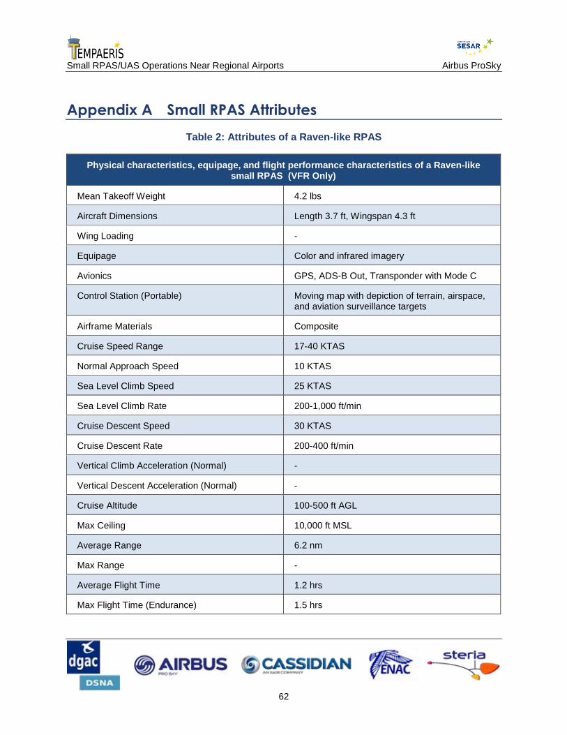
Small RPAS/UAS Operations Near Regional Airports Airbus ProSky
62
Appendix A Small RPAS Attributes
Table 2: Attributes of a Raven-like RPAS
Physical characteristics, equipage, and flight performance characteristics of a Raven-like small RPAS (VFR Only)
Mean Takeoff Weight 4.2 lbs
Aircraft Dimensions Length 3.7 ft, Wingspan 4.3 ft
Wing Loading -
Equipage Color and infrared imagery
Avionics GPS, ADS-B Out, Transponder with Mode C
Control Station (Portable) Moving map with depiction of terrain, airspace, and aviation surveillance targets
Airframe Materials Composite
Cruise Speed Range 17-40 KTAS
Normal Approach Speed 10 KTAS
Sea Level Climb Speed 25 KTAS
Sea Level Climb Rate 200-1,000 ft/min
Cruise Descent Speed 30 KTAS
Cruise Descent Rate 200-400 ft/min
Vertical Climb Acceleration (Normal) -
Vertical Descent Acceleration (Normal) -
Cruise Altitude 100-500 ft AGL
Max Ceiling 10,000 ft MSL
Average Range 6.2 nm
Max Range -
Average Flight Time 1.2 hrs
Max Flight Time (Endurance) 1.5 hrs

Small RPAS/UAS Operations Near Regional Airports Airbus ProSky
63
Table 3: Attributes of a Super Bat-like RPAS
Physical characteristics, equipage, and flight performance characteristics of a Super Bat-like small RPAS (VFR Only)
Mean Takeoff Weight 34 lbs
Aircraft Dimensions Length 5.0 ft, Wingspan 8.5 ft
Wing Loading -
Equipage Video and still color and infrared imagery
Avionics GPS, ADS-B Out, Transponder with Mode C
Control Station (Portable) Moving map with depiction of terrain, airspace, and aviation surveillance targets
Airframe Materials Composite
Cruise Speed Range 35-65 KTAS
Normal Approach Speed 30 KTAS
Sea Level Climb Speed 30 KTAS
Sea Level Climb Rate 200-1,000 ft/min
Cruise Descent Speed 30 KTAS
Cruise Descent Rate 200-400 ft/min
Vertical Climb Acceleration (Normal) -
Vertical Descent Acceleration (Normal) -
Cruise Altitude 200-3,000 ft AGL
Max Ceiling 10,000 ft MSL
Average Range 6.2 nm
Max Range 10 nm
Average Flight Time 6-8 hrs
Max Flight Time (Endurance) 10 hrs
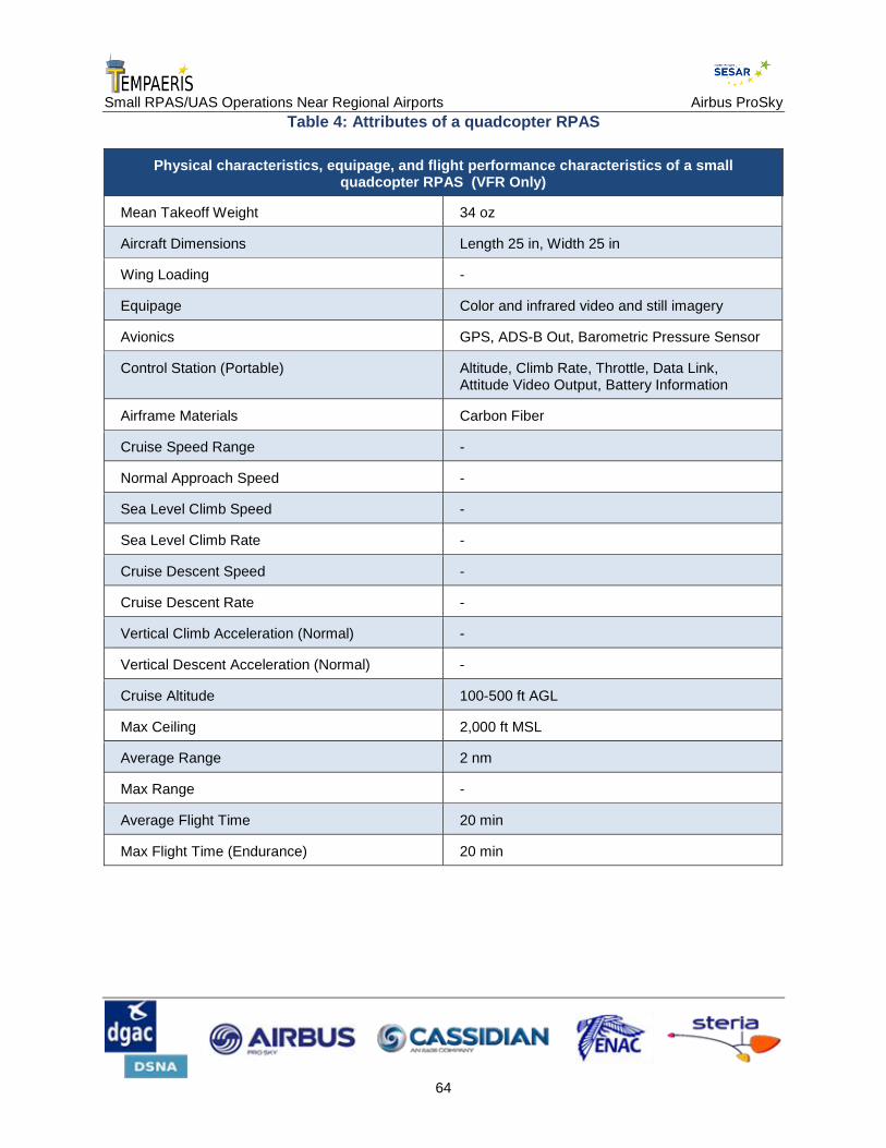
Small RPAS/UAS Operations Near Regional Airports Airbus ProSky
64
Table 4: Attributes of a quadcopter RPAS
Physical characteristics, equipage, and flight performance characteristics of a small quadcopter RPAS (VFR Only)
Mean Takeoff Weight 34 oz
Aircraft Dimensions Length 25 in, Width 25 in
Wing Loading -
Equipage Color and infrared video and still imagery
Avionics GPS, ADS-B Out, Barometric Pressure Sensor
Control Station (Portable) Altitude, Climb Rate, Throttle, Data Link, Attitude Video Output, Battery Information
Airframe Materials Carbon Fiber
Cruise Speed Range -
Normal Approach Speed -
Sea Level Climb Speed -
Sea Level Climb Rate -
Cruise Descent Speed -
Cruise Descent Rate -
Vertical Climb Acceleration (Normal) -
Vertical Descent Acceleration (Normal) -
Cruise Altitude 100-500 ft AGL
Max Ceiling 2,000 ft MSL
Average Range 2 nm
Max Range -
Average Flight Time 20 min
Max Flight Time (Endurance) 20 min

Small RPAS/UAS Operations Near Regional Airports Airbus ProSky
65
Table 5: Attributes of a Puma-like RPAS
Physical characteristics, equipage, and flight performance characteristics of a Puma-like small RPAS (VFR Only)
Mean Takeoff Weight 13 lbs
Aircraft Dimensions Length 4.6 ft, Wingspan 9.2 ft
Wing Loading -
Equipage Color and infrared imagery
Avionics GPS, ADS-B Out, Transponder with Mode C
Control Station (Portable) Moving map with depiction of terrain, airspace, and aviation surveillance targets
Airframe Materials Composite
Cruise Speed Range 20-40 KTAS
Normal Approach Speed 10 KTAS
Sea Level Climb Speed 25 KTAS
Sea Level Climb Rate 200-1,000 ft/min
Cruise Descent Speed 30 KTAS
Cruise Descent Rate 200-400 ft/min
Vertical Climb Acceleration (Normal) -
Vertical Descent Acceleration (Normal) -
Cruise Altitude 100-500 ft AGL
Max Ceiling 5,000 ft MSL
Average Range 7 nm
Max Range 9 nm
Average Flight Time 1.5 hrs
Max Flight Time (Endurance) 2.0 hrs

Small RPAS/UAS Operations Near Regional Airports Airbus ProSky
66
Table 6: Attributes of a Skate-like RPAS
Physical characteristics, equipage, and flight performance characteristics of a Skate-like small RPAS (VFR Only)
Mean Takeoff Weight 2.0 lbs
Aircraft Dimensions Length 1.6 ft, Wingspan 2.0 ft
Wing Loading -
Equipage Color and infrared imagery
Avionics GPS, ADS-B Out, Transponder with Mode C
Control Station (Portable) Moving map with depiction of terrain, airspace, and aviation surveillance targets
Airframe Materials Composite
Cruise Speed Range Hover: 50 KTAS / Cruise: 20 KTAS
Normal Approach Speed -
Sea Level Climb Speed -
Sea Level Climb Rate -
Cruise Descent Speed -
Cruise Descent Rate -
Vertical Climb Acceleration (Normal) -
Vertical Descent Acceleration (Normal) -
Cruise Altitude 300-500 ft AGL
Max Ceiling 13,000 ft MSL
Average Range 2.0 nm
Max Range 3.1 nm
Average Flight Time 1.0 hrs
Max Flight Time (Endurance) 1.5 hrs

Small RPAS/UAS Operations Near Regional Airports Airbus ProSky
67
Table 7: Attributes of an Aerosonde-like RPAS
Physical characteristics, equipage, and flight performance
characteristics of an Aerosonde-like small RPAS (IFR Capable)
Mean Takeoff Weight 55 lbs
Aircraft Dimensions Length 7.1 ft, Height 2.6 ft, Wingspan 11.3 ft
Wing Loading 7.2 lbs/sq ft
Equipage Forward field of vision cameras ,color and infrared imagery, magnetometer
Avionics GPS, WAAS, ADS-B Out, Transponder with Mode C, VHF aviation band communications radios, Sense and Avoid –Airborne, including weather (clouds and visibility) and terrain
Control Station (Fixed) Moving map with depiction of terrain, airspace, and aviation surveillance targets, CDTI capability
Airframe Materials Carbon fiber, fiberglass, balsa
Cruise Speed Range 880 miles
Normal Approach Speed 50 KEAS
Sea Level Climb Speed 45 KEAS
Sea Level Climb Rate 580 ft/min
Cruise Descent Speed 50 KEAS
Cruise Descent Rate 337 ft/min – Clean
Unavailable ft./min – Full Flap
Vertical Climb Acceleration (Normal) Altitude (ft)
0
2,000
4,000
6,000
8,000
10,000
12,000
14,000
16,000
Vertical Climb Acceleration (ft/sec
2)
4.26
3.83
3.39
2.95
2.52
2.09
1.67
1.25
0.83

Small RPAS/UAS Operations Near Regional Airports Airbus ProSky
68
Vertical Descent Acceleration (Normal) -
Cruise Altitude 3,000 ft MSL
Max Ceiling 20,000 ft MSL
Average Range 7 nm
Max Range 850 nm
Average Flight Time 11.1 hrs
Max Flight Time (Endurance) >11.1 hrs

Small RPAS/UAS Operations Near Regional Airports Airbus ProSky
69
Appendix B U.S. Federal Aviation Regulations
This section gives a brief explanation of the some of the federal aviation regulations (FARs)
cited in this document. Source: http://www.ecfr.gov.
Title 14 of the Code of Federal Regulations (CFR) covers aeronautics and space. Within Title 14,
Part 91 covers general operating and flight rules.
§91.103 Preflight action.
Each pilot in command shall, before beginning a flight, become familiar with all available
information concerning that flight. This information must include—
(a) For a flight under IFR or a flight not in the vicinity of an airport, weather reports and
forecasts, fuel requirements, alternatives available if the planned flight cannot be completed, and
any known traffic delays of which the pilot in command has been advised by ATC;
(b) For any flight, runway lengths at airports of intended use, and the following takeoff and
landing distance information:
(1) For civil aircraft for which an approved Airplane or Rotorcraft Flight Manual
containing takeoff and landing distance data is required, the takeoff and landing distance
data contained therein; and
(2) For civil aircraft other than those specified in paragraph (b)(1) of this section, other
reliable information appropriate to the aircraft, relating to aircraft performance under
expected values of airport elevation and runway slope, aircraft gross weight, and wind
and temperature.
§91.119 Minimum safe altitudes: General.
Except when necessary for takeoff or landing, no person may operate an aircraft below the
following altitudes:
(a) Anywhere. An altitude allowing, if a power unit fails, an emergency landing without undue
hazard to persons or property on the surface.
(b) Over congested areas. Over any congested area of a city, town, or settlement, or over any
open air assembly of persons, an altitude of 1,000 feet above the highest obstacle within a
horizontal radius of 2,000 feet of the aircraft.
(c) Over other than congested areas. An altitude of 500 feet above the surface, except over open
water or sparsely populated areas. In those cases, the aircraft may not be operated closer than 500
feet to any person, vessel, vehicle, or structure.

Small RPAS/UAS Operations Near Regional Airports Airbus ProSky
70
(d) Helicopters, powered parachutes, and weight-shift-control aircraft. If the operation is
conducted without hazard to persons or property on the surface—
(1) A helicopter may be operated at less than the minimums prescribed in paragraph (b)
or (c) of this section, provided each person operating the helicopter complies with any
routes or altitudes specifically prescribed for helicopters by the FAA; and
(2) A powered parachute or weight-shift-control aircraft may be operated at less than the
minimums prescribed in paragraph (c) of this section.
§91.137 Temporary flight restrictions in the vicinity of disaster/hazard areas.
(a) The Administrator will issue a Notice to Airmen (NOTAM) designating an area within which
temporary flight restrictions apply and specifying the hazard or condition requiring their
imposition, whenever he determines it is necessary in order to—
(1) Protect persons and property on the surface or in the air from a hazard associated with
an incident on the surface;
(2) Provide a safe environment for the operation of disaster relief aircraft; or
(3) Prevent an unsafe congestion of sightseeing and other aircraft above an incident or
event which may generate a high degree of public interest.
The Notice to Airmen will specify the hazard or condition that requires the imposition of
temporary flight restrictions.
(b) When a NOTAM has been issued under paragraph (a)(1) of this section, no person may
operate an aircraft within the designated area unless that aircraft is participating in the hazard
relief activities and is being operated under the direction of the official in charge of on scene
emergency response activities.
(c) When a NOTAM has been issued under paragraph (a)(2) of this section, no person may
operate an aircraft within the designated area unless at least one of the following conditions are
met:
(1) The aircraft is participating in hazard relief activities and is being operated under the
direction of the official in charge of on scene emergency response activities.
(2) The aircraft is carrying law enforcement officials.
(3) The aircraft is operating under the ATC approved IFR flight plan.
(4) The operation is conducted directly to or from an airport within the area, or is
necessitated by the impracticability of VFR flight above or around the area due to
weather, or terrain; notification is given to the Flight Service Station (FSS) or ATC
facility specified in the NOTAM to receive advisories concerning disaster relief aircraft
operations; and the operation does not hamper or endanger relief activities and is not
conducted for the purpose of observing the disaster.

Small RPAS/UAS Operations Near Regional Airports Airbus ProSky
71
(5) The aircraft is carrying properly accredited news representatives, and, prior to
entering the area, a flight plan is filed with the appropriate FAA or ATC facility specified
in the Notice to Airmen and the operation is conducted above the altitude used by the
disaster relief aircraft, unless otherwise authorized by the official in charge of on scene
emergency response activities.
(d) When a NOTAM has been issued under paragraph (a)(3) of this section, no person may
operate an aircraft within the designated area unless at least one of the following conditions is
met:
(1) The operation is conducted directly to or from an airport within the area, or is
necessitated by the impracticability of VFR flight above or around the area due to
weather or terrain, and the operation is not conducted for the purpose of observing the
incident or event.
(2) The aircraft is operating under an ATC approved IFR flight plan.
(3) The aircraft is carrying incident or event personnel, or law enforcement officials.
(4) The aircraft is carrying properly accredited news representatives and, prior to entering
that area, a flight plan is filed with the appropriate FSS or ATC facility specified in the
NOTAM.
(e) Flight plans filed and notifications made with an FSS or ATC facility under this section shall
include the following information:
(1) Aircraft identification, type and color.
(2) Radio communications frequencies to be used.
(3) Proposed times of entry of, and exit from, the designated area.
(4) Name of news media or organization and purpose of flight.
(5) Any other information requested by ATC.
§91.179 IFR cruising altitude or flight level
Unless otherwise authorized by ATC, the following rules apply—
(a) In controlled airspace. Each person operating an aircraft under IFR in level cruising flight in
controlled airspace shall maintain the altitude or flight level assigned that aircraft by ATC.
However, if the ATC clearance assigns “VFR conditions on-top,” that person shall maintain an
altitude or flight level as prescribed by §91.159.
(b) In uncontrolled airspace. Except while in a holding pattern of 2 minutes or less or while
turning, each person operating an aircraft under IFR in level cruising flight in uncontrolled
airspace shall maintain an appropriate altitude as follows:
(1) When operating below 18,000 feet MSL and—

Small RPAS/UAS Operations Near Regional Airports Airbus ProSky
72
(i) On a magnetic course of zero degrees through 179 degrees, any odd thousand
foot MSL altitude (such as 3,000, 5,000, or 7,000); or
(ii) On a magnetic course of 180 degrees through 359 degrees, any even thousand
foot MSL altitude (such as 2,000, 4,000, or 6,000).
(2) When operating at or above 18,000 feet MSL but below flight level 290, and—
(i) On a magnetic course of zero degrees through 179 degrees, any odd flight level
(such as 190, 210, or 230); or
(ii) On a magnetic course of 180 degrees through 359 degrees, any even flight
level (such as 180, 200, or 220).
(3) When operating at flight level 290 and above in non-RVSM airspace, and—
(i) On a magnetic course of zero degrees through 179 degrees, any flight level, at
4,000-foot intervals, beginning at and including flight level 290 (such as flight
level 290, 330, or 370); or
(ii) On a magnetic course of 180 degrees through 359 degrees, any flight level, at
4,000-foot intervals, beginning at and including flight level 310 (such as flight
level 310, 350, or 390).
(4) When operating at flight level 290 and above in airspace designated as Reduced
Vertical Separation Minimum (RVSM) airspace and—
(i) On a magnetic course of zero degrees through 179 degrees, any odd flight
level, at 2,000-foot intervals beginning at and including flight level 290 (such as
flight level 290, 310, 330, 350, 370, 390, 410); or
(ii) On a magnetic course of 180 degrees through 359 degrees, any even flight
level, at 2000-foot intervals beginning at and including flight level 300 (such as
300, 320, 340, 360, 380, 400).

Small RPAS/UAS Operations Near Regional Airports Airbus ProSky
73
Appendix C Acronyms
Table 8: Acronyms and definitions
Term Definition
AD Airworthiness Directive
ADS-B In/Out Automatic Dependent Surveillance-Broadcast In/Out
AGL Above Ground Level
ANSP Air Navigation Service Provider
ATC Air Traffic Control
ATIS Automated Terminal Information Service
ATM Air Traffic Management
AW Airworthiness
BVLOS Beyond Visual Line of Sight
CA Collision Avoidance
CBP Customs and Border Protection
CDTI Cockpit Display of Traffic Information
CFR Code of Federal Regulations
CG Coast Guard
ConOps Concept of Operations
CTAF Common Traffic Advisory Frequency
DAA Detect and Avoid
DoD Department of Defense
DST Decision Support Tool
FAF Final Approach Fix
FL Flight Level
FMS Flight Management System
GBAS Ground-Based Augmentation System
GC Ground Control
GPS Global Positioning System

Small RPAS/UAS Operations Near Regional Airports Airbus ProSky
74
Term Definition
IAP Instrument Approach Procedure
ICAO International Civil Aviation Organization
IFR Instrument Flight Rules
IMC Instrument Meteorological Conditions
IR Infrared
IS Information Services
JPDO Joint Planning and Development Office
LAWS Low Airspeed Warning System
LC Local Control
LOS Line of Sight
LSA Light Sport Aircraft
MOA Military Operations Area
MON Minimum Operational Network
MSL Mean Sea Level
MTR Military Training Route
NAS National Airspace System (U.S.)
NAVAID Navigation(al) Aid
NextGen Next Generation Air Transportation System
nm Nautical Mile
NOTAM Notice to Airmen
NRS Navigation Reference System
NVS NextGen Voice Switch
OSED Operational Services and Environmental Definition
PBN Performance-Based Navigation
RNAV Area Navigation
RNP Required Navigation Performance
RTCA Radio Technical Commission for Aeronautics
RVSM Reduced Vertical Separation Minimum
RWY Runway

Small RPAS/UAS Operations Near Regional Airports Airbus ProSky
75
Term Definition
S&A Sense-and-Avoid
SAA Special Activity Airspace
SME Subject Matter Expert
SOA Service-Oriented Architecture
STBO Surface Trajectory-Based Operations
sUAS Small Unmanned Aircraft System
SWIM System-Wide Information Management
TBO Trajectory-Based Operations
TFDM Tower Flight Data Manager
TFR Temporary Flight Restriction
TIS-B Traffic Information Service-Broadcast
UAS Unmanned Aircraft System
VFR Visual Flight Rules
VHF Very High Frequency
VMC Visual Meteorological Conditions
VoIP Voice over Internet Protocol
VOR VHF Omnidirectional Range
VORTAC VHF Omnidirectional Range/Tactical Aircraft Control
VTOL Vertical Takeoff and Landing
WAAS Wide Area Augmentation System

Small RPAS/UAS Operations Near Regional Airports Airbus ProSky
76
Appendix D Glossary
Table 9: Terms and definitions
Term Definition
Air Navigation Service Provider (ANSP)
The organization, personnel, and automation that provide separation assurance, traffic management, infrastructure management, meteorological & aeronautical information, navigation, surveillance services, clearances, airspace management, and aviation assistance services for airspace users.
Air Traffic Control (ATC)
A service operated by appropriate authority to promote the safe, orderly, and expeditious flow of air traffic.
Air Traffic Management (ATM)
The aggregation of functions, comprising variously those of air traffic services, airspace management, and air traffic flow management, including their interacting aircraft functional capabilities, required to ensure the safe and efficient movement of aircraft during all phases of operations.
Aircraft Any machine that can derive support in the atmosphere from the reactions of the air other than the reactions of the air against the earth’s surface. An aircraft can include a fixed-wing structure, rotorcraft, lighter-than-air vehicle, or a vehicle capable of leaving the atmosphere for space flight.
Airport A defined area on land or water (including any buildings, installations, and equipment) intended to be used either wholly or in part for the arrival, departure, and surface movement of aircraft.
Airspace Any portion of the atmosphere sustaining aircraft flight and which has defined boundaries and specified dimensions. Airspace may be classified as to the specific types of flight allowed, rules of operation, and restrictions in accordance with ICAO standards or State regulation.
Airworthiness (AW)
The aircraft must conform to its type certificate (TC). Conformity to type design is considered attained when the aircraft configuration and the components installed are consistent with the drawings, specifications, and other data that are part of the TC, which includes any supplemental type certificate (STC) and field approved alterations incorporated into the aircraft. The aircraft must be in a condition for safe operation. This refers to the condition of the aircraft relative to wear and deterioration, for example, skin corrosion, window delamination/crazing, fluid leaks, and tire wear.
Alternate Airport An airport at which an aircraft may land if landing at the intended airport becomes inadvisable.

Small RPAS/UAS Operations Near Regional Airports Airbus ProSky
77
Term Definition
Alternate Navigation
Aircraft using GPS navigation equipment under IFR must be equipped with an approved and operational alternate means of navigation appropriate to the flight. Active monitoring of alternative navigation equipment is not required if the GPS receiver uses Receiver Autonomous Integrity Monitoring (RAIM) for integrity monitoring. Active monitoring of an alternate means of navigation is required when the RAIM capability of the GPS equipment is lost.
Area Navigation (RNAV)
A method of navigation that permits aircraft operation on any desired flight path within the coverage of ground- or space-based navigation aids or within the limits of the capability of self-contained aids, or a combination of these. Due to the different levels of performance, area navigational capabilities can satisfy different levels of required navigation performance (RNP).
Automatic Dependent Surveillance-Broadcast (ADS-B) In/Out
A surveillance system in which an aircraft or vehicle to be detected is fitted with cooperative equipment in the form of a data link transmitter. The aircraft or vehicle periodically broadcasts its GPS-derived position and other information such as velocity over the data link, which is received by a ground-based transmitter/receiver (transceiver) for processing and display at an air traffic control facility. The ADS-B OUT portion is the broadcast of the position. The ADS-B IN portion provides the OUT broadcast of position information to other aircraft and vehicles that are equipped with ADS-B IN.
Autonomous Not controlled by others or outside forces; independent judgment.
Beyond Visual Line of Sight (BVLOS)
RPAS operations where direct radio frequency (RF) communication with a UA is not possible due to it being obscured by the earth's curvature (i.e. over the horizon (OTH)) or terrain or by man-made features. BVLOS requires a relay, e.g., satellite, to transmit a signal.
Class A Airspace Generally, that airspace from 18,000 feet MSL up to and including FL 600, including the airspace overlying the waters within 12 nautical miles of the coast of the 48 contiguous States and Alaska. In Class A Airspace, unless otherwise authorized, all persons must operate their aircraft under IFR.
Class B Airspace Generally, that airspace from the surface to 10,000 feet MSL surrounding the nation's busiest airports in terms of airport operations or passenger enplanements. The configuration of each Class B airspace area is individually tailored and consists of a surface area and two or more layers (some Class B airspaces areas resemble upside-down wedding cakes), and is designed to contain all published instrument procedures once an aircraft enters the airspace. An ATC clearance is required for all aircraft to operate in the area, and all aircraft that are so cleared receive separation services within the airspace. The cloud clearance requirement for VFR operations is "clear of clouds."

Small RPAS/UAS Operations Near Regional Airports Airbus ProSky
78
Term Definition
Class C Airspace Generally, that airspace from the surface to 4,000 feet above the airport elevation (charted in MSL) surrounding those airports that have an operational control Tower, are serviced by a radar approach control, and that have a certain number of IFR operations or passenger enplanements. Although the configuration of each Class C area is individually tailored, the airspace usually consists of a surface area with a 5 nautical mile (NM) radius, a circle with a 10NM radius that extends no lower than 1,200 feet up to 4,000 feet above the airport elevation, and an outer area that is not charted. Each person must establish two-way radio communications with the ATC facility providing air traffic services prior to entering the airspace and thereafter maintain those communications while within the airspace. VFR aircraft are only separated from IFR aircraft within the airspace.
Class D Airspace Generally, that airspace from the surface to 2,500 feet above the airport elevation (charted in MSL) surrounding those airports that have an operational control Tower. The configuration of each Class D airspace area is individually tailored, and when instrument procedures are published, the airspace will normally be designed to contain the procedures. Arrival extensions for instrument approach procedures may be Class D or Class E airspace. Unless otherwise authorized, each person must establish two-way radio communications with the ATC facility providing air traffic services prior to entering the airspace and thereafter maintain those communications while in the airspace. No separation services are provided to VFR aircraft.
Class E Airspace Generally, if the airspace is not Class A, Class B, Class C, or Class D, and it is controlled airspace, it is Class E airspace. Class E airspace extends upward from either the surface or a designated altitude to the overlying or adjacent controlled airspace. Included in the Class E designation is the airspace extending upward from 14,500 feet MSL to, but not including, 18,000 feet MSL, and above FL 600, excluding the airspace below 1,500 feet above the surface unless so designated. When designated as a surface area, the airspace will be configured to contain all instrument approaches. Also in this class are Federal airways, airspace used to transition to/from the terminal or en route environment beginning at either 700 or 1,200 feet above the surface, and en route domestic and offshore airspace areas designated below 18,000 feet MSL.
Class G Airspace All airspace that is not classified as Class A, B, C, D, or E. Commonly referred to as uncontrolled airspace.
Collision Avoidance (CA)
The sense and avoid (SAA) system function where the unmanned aircraft system (RPAS) takes appropriate action to prevent an intruder from penetrating a volume of airspace centered on the unmanned aircraft (UA).
Communicate To inform others or to be informed. Communicating is both the conveying of intent and the receiving of instructions. (Note: This refers to voice communication and transponder-like operations; it does not encompass command/control of the UA.)
Communication Link
The voice or data relay of instructions or information between the RPAS pilot and the air traffic controller and other national airspace users.

Small RPAS/UAS Operations Near Regional Airports Airbus ProSky
79
Term Definition
Conflict Any situation involving an aircraft and a hazard in which the applicable separation minimums may be compromised.
Control Link The combination of the telecommand link (uplink) and the telemetry link (downlink).
Control Link Failure
When the UA detects a control link interruption, it typically begins a countdown sequence. If the control link interruption is not restored by the end of the countdown, "link failure" occurs and link failure contingency procedures begin.
Control Link Interruption
Control link interruption occurs when either the UA or UA control station detects lost reception of information, even momentarily, from the command link, status link or both links. The interruption may be the result of a hardware/software malfunction, satellite signal interruption/blockage, weather, or some temporary condition.
Control Station The equipment used to maintain control of, communicate with, guide, or otherwise pilot an unmanned aircraft.
Cooperative Aircraft
Aircraft that have an electronic means of identification (i.e., a transponder) aboard and operating.
Crew member A person assigned to perform duties during the operation of the RPAS. This term can be further qualified as "ground crew member" or "flight crew member."
Data Communication
The transfer of information between functional units by means of data transmission according to a protocol.
Data Link A ground-to-air communications system that transmits information via digital coded pulses.
Detect and Avoid (DAA)
The capability of a RPAS to remain well clear from, and avoid collisions with, other airborne traffic. DAA provides the functions of self-separation (SS) and collision avoidance (CA) to fulfill the regulatory requirement to see and avoid.
Elevation The height above a fixed reference point, often the mean sea level.
Event An occurrence whose origin is distinct from the aircraft, such as atmospheric conditions, runway conditions, or cabin and baggage fires. The term is not intended to cover sabotage.
Failure A loss of function, or malfunction, of a system or part thereof resulting in the inability of an item to perform its intended function.
Flight Crew The individual or group of individuals responsible for the control of an individual aircraft while it is moving on the surface or while airborne.
Flight Level (FL) A level of constant atmospheric pressure related to a reference datum of 29.92 inches of mercury. Each is stated in three digits that represent hundreds of feet (e.g., FL180 represents a barometric altimeter indication of 18,000 feet).
Small RPAS/UAS Operations Near Regional Airports Airbus ProSky
80
Term Definition
Flight Object The representation of the relevant information about a particular instance of a flight. The information in a flight object includes (1) aircraft capabilities, including the level of navigation, communications, and surveillance performance (e.g., FMS capabilities); (2) aircraft flight performance parameters; (3) flight crew capabilities, including level of training received to enable special procedures; (4) 4DT profile and intent, containing the “cleared” 4DT profile plus any desired or proposed 4DTs; and (5) aircraft position information and near-term intent. Standards for the definition of a flight object are in development.
Flight Plan Specified information relating to the intended flight of an aircraft that is filed orally or in writing with FAA or an ATC facility.
Flight Planning A series of activities preformed before a flight that includes, but is not limited to, reviewing airspace and navigation restrictions, developing the route, obtaining a weather briefing, completing a navigation log, filing a flight plan, and inspecting the aircraft.
Function The action or actions that an item is designed to perform.
Global Positioning System (GPS)
A space-based radio positioning, navigation, and time-transfer system. The system provides highly accurate position and velocity information, and precise time, on a continuous global basis, to an unlimited number of properly equipped users. The system is unaffected by weather, and provides a worldwide common grid reference system. The GPS concept is predicated upon accurate and continuous knowledge of the spatial position of each satellite in the system with respect to time and distance from a transmitting satellite to the user. The GPS receiver automatically selects appropriate signals from the satellites in view and translates these into three-dimensional position, velocity, and time. System accuracy for civil users is normally 100 meters horizontally.
Information Services
A service that provides data and information to subscribers when and where needed in a common format. Ensures questions raised by data consumers are answered correctly and consistently.
Instrument Flight Rules (IFR)
Rules governing the procedures for conducting instrument flight. Also a term used by pilots and controllers to indicate type of flight plan.
Instrument Meteorological Conditions (IMC)
IFR flight conditions. Weather conditions below the minimum for flight under visual flight rules.
International Civil Aviation Organization (ICAO)
A specialized agency of the United Nations whose objective is to develop the principles and techniques of international air navigation and to foster planning and development of international civil air transport.
Latency The time incurred between two particular interfaces. The total latency is the delay between the true time of applicability of a measurement and the time that the measurement is reported at a particular interface (the latter minus the former).
Line of Sight (LOS)
The condition where two systems, usually the control station and the UA, are within electronic point-to-point link.

Small RPAS/UAS Operations Near Regional Airports Airbus ProSky
81
Term Definition
Lost Link The loss of telecommand or telemetry link between a pilot and an unmanned aircraft (UA).
Maneuver The ability to move to a position of advantage in all environments in order to generate or enable the generation of effects in all domains and the information environment.
Manned Aircraft Aircraft piloted by a human onboard.
Military Operations Area (MOA)
Airspace established outside Class A airspace to separate or segregate certain non-hazardous military activities from IFR traffic and to identify for VFR traffic where these activities are conducted.
Minimum Operational Network (MON)
In 2020, the MON will consist of roughly half of today’s VHF Omnidirectional Range (VOR) systems to serve as a backup navigation system in the event of a GPS outage. The MON would enable aircraft anywhere in the CONUS to proceed safely to a destination with a GPS-independent approach within 100 nm. MON coverage is planned to be provided at altitudes above 5,000 feet above ground level (AGL).
Mission Plan The route planning, payload planning, data link planning (including frequency planning), and emergency recovery planning (rules of safety) for a RPAS.
Mode C Veil The airspace within 30 nautical miles of an airport listed in Appendix D, Section 1 of 14 Code of Federal Regulations (CFR) Part 91 (generally primary airports within Class B airspace areas), from the surface upward to 10,000 feet mean sea level (MSL). Unless otherwise authorized by Air Traffic Control, aircraft operating within this airspace must be equipped with automatic pressure altitude reporting equipment having Mode C capability. However, an aircraft that was not originally certificated with an engine-driven electrical system or which has not subsequently been certified with a system installed may conduct operations within a Mode C Veil provided the aircraft remains outside Class A, B, or C airspace and below the altitude of the ceiling of a Class B or Class C airspace area designated for an airport or 10,000 feet MSL, whichever is lower.
Monitor The ability to adequately observe and assess events/effects of a decision.
National Airspace System (NAS)
The common network of U.S. airspace; air navigation facilities, equipment and services, airports or landing areas; aeronautical charts, information and services; rules, regulations and procedures, technical information, and manpower and material. Included are system components shared jointly with the military.
Navigate The directing of the aircraft’s flight path to a desired location. The ability to navigate implies the RPAS is capable of maintaining navigational control, which involves maintaining knowledge of the current position, the destination, and the four-dimensional path (latitude, longitude, altitude, time) to the destination.
Non-Cooperative Aircraft
Aircraft that do not have an electronic means of identification (i.e., a transponder) aboard or not operating such equipment due to malfunction or deliberate action.

Small RPAS/UAS Operations Near Regional Airports Airbus ProSky
82
Term Definition
Non-Cooperative Traffic
Traffic that does not broadcast position or other information that assists in detecting and assessing conflict potential.
Operate With respect to aircraft, means use, cause to use or authorize to use aircraft, for the purpose (except as provided in 14 CFR 91) of air navigation including the piloting of aircraft, with or without the right of legal control (as owner, lessee, or otherwise).
Operator The organization or individual who uses, causes to use, or authorizes to use aircraft, for the purpose (except as provided in 14 CFR 91.13) of air navigation including the piloting of aircraft, with or without the right of legal control (as owner, lessee, or otherwise).
Performance Requirements
Set of requirements that define a function’s performance, and expressed by a set of characteristics/attributes associated to all or part of a system. Those include transaction and expiration times, continuity, availability, and integrity characteristics.
Performance-Based Navigation (PBN)
RNAV based on performance requirements for aircraft operating along an ATS route, on an IAP, or in a designated airspace. Note: Performance requirements are expressed in navigation specifications (RNAV specification, RNP specification) in terms of accuracy, integrity, continuity, availability, and functionality needed for the proposed operation in the context of a particular airspace concept.
Phase of Flight A distinct stage of flight that includes ground operations or taxiing, takeoff, climb, en route, mission operations, descent, approach, or landing.
Pilot The individual that monitors, controls, and maneuvers the RPAS through the real-time issuance of command and control input to the aircraft and possesses the applicable FAA pilot certifications and ratings.
Reduced Vertical Separation Minimum (RVSM)
The decrease in vertical separation distance between aircraft from 2,000 feet to 1,000 when flying between FL 290 and FL 410.
Remotely Piloted Aircraft System (RPAS)
A RPAS is a UAS whose vehicle is piloted remotely by a human. This is distinct from UAS that operate autonomously.
Required Navigation Performance (RNP)
A statement of navigation system performance accuracy, integrity, continuity, and availability necessary for operations within a defined airspace.
Requirement An identifiable statement of a specification that can be validated and against which an implementation can be verified.
Route The flight path of HALE ROA from the departure airport to the arrival airport, excluding any mission route and mission area, and where course changes have no impact on the mission objectives.

Small RPAS/UAS Operations Near Regional Airports Airbus ProSky
83
Term Definition
Safety Freedom from unacceptable risk of harm.
Semi-Autonomous
Mode of control of a RPAS where the pilot executes changes and conducts the mission through a flight management system interface. Without this input, the RPAS will perform pre-programmed automatic operations. This can, but might not, include some fully autonomous functions (like takeoff, landing, and collision avoidance).
Separation The minimum distance between aircraft/vehicles allowed by regulations.
Service Oriented Architecture (SOA)
A design for linking computational resources (principally, applications and data) on demand to achieve the desired results for service consumers (which can be end users or other services). The Organization for the Advancement of Structured Information Standards (OASIS) defines SOA as the following: A paradigm for organizing and utilizing distributed capabilities that may be under the control of different ownership domains. It provides a uniform means to offer, discover, interact with, and use capabilities to produce desired effects consistent with measurable preconditions and expectations.
Situational Awareness
A service provider or operator’s ability to identify, process, and comprehend important information about what is happening with regard to the operation. Airborne traffic situational awareness is an aspect of overall situational awareness for the flight crew of an aircraft operating in proximity to other aircraft.
Small Unmanned Aircraft System (small RPAS)
RPAS with a maximum gross takeoff weight of 55 lb. or less.
Special Activity Airspace (SAA)
Any airspace with defined dimensions within the National Airspace System wherein limitations may be imposed upon aircraft operations. This airspace may be restricted areas, prohibited areas, military operations areas, ATC assigned airspace, or any other designated airspace areas. The dimensions of this airspace can be designated as either active or inactive. Aircraft trajectories are constantly tested against the dimensions of active areas and alerts issued to the applicable sectors when violations are predicted.
Surveillance The systematic observation of aerospace, surface, or subsurface areas, places, persons, or things, by visual, aural, electronic, photographic, or other means.
Surveillance Services
This service integrates cooperative and non-cooperative airport surface and airspace surveillance systems, fostering real-time air and airport situational awareness and enhancing safety and security.
Traffic All aircraft/vehicles that are within the operational vicinity of own-ship.
Trajectory-Based Operations (TBO)
The use of 4D trajectories as the basis for planning and executing all flight operations supported by the Air Navigation Service Provider.
Unmanned Aircraft System (UAS)
A system consisting of an unmanned aircraft and its associated elements required for operation.

Small RPAS/UAS Operations Near Regional Airports Airbus ProSky
84
Term Definition
Visual Flight Rules (VFR)
Rules that govern the procedures for conducting flight under visual conditions. The term “VFR” is also used in the United States to indicate weather conditions that are equal to or greater than minimum VFR requirements. In addition, it is used by pilots and controllers to indicate type of flight plan.
Visual Meteorological Conditions (VMC)
Weather conditions in which visual flight rules apply; expressed in terms of visibility, ceiling height, and aircraft clearance from clouds along the path of flight.