smart technology-based parking...smart technology-based parking an interactive qualifying project...
TRANSCRIPT

SMART
TECHNOLOGY-BASED
PARKING
An Interactive Qualifying Project Report Submitted to the Faculty of
WORCESTER POLYTECHNIC INSTITUTE In partial fulfillment of the requirements for the
Degree of Bachelor of Science
Report Submitted To:
Advisor: Professor Mohamed Eltabakh
Co-advisor: Professor Emmanuel Agu Submitted By: Shawn Yoon
Date: March 9th 2015
This report represents the work of one WPI
undergraduate students submitted to the faulty
as evidence of completion of a degree
requirement. WPI routinely publishes these
reports on its website without editorial or peer
review. For more information about the
projects, please see http://www.wpi.edu/Academics/Project
WORCESTER POLYTECHNIC INSTITUTE
i
Abstract
Downtown parking problems are majorly caused by combination of recent increase in
number of motor vehicles with limited amounts of physical parking spaces. Parking problems
promote unsatisfied motor vehicle drivers communities and downtown residents. Despite multiple
mobile applications designed for locating parking spaces, it is still an open problem, and the
available solutions cannot solve it to a satisfactory level. Our goal is to survey the demands in
finding parking space (availability) and design a mobile application for finding parking spaces. In
order to achieve our goal, we developed and conducted a public survey in collaboration with
Worcester Polytechnic Institute. Based on the results of approximate 120 electronic survey
responses, we developed an innovative parking system that features a mobile application, and
future proposals to support and relieve parking conflicts in downtown regions.

ii
Acknowledgements
I would like to acknowledge the following individuals who have made this project possible:
� Professor Eltabakh for his quick and invaluable feedback, assistance and cooperation.
� Professor Agu, for his invaluable, support, time, advice, and mentorship
� Hannah Lee for her great insights, recommendations, and proofreading skills.

iii
Executive Summary
Downtown parking problems in Boston area started after mid-1960s, when the number of
automobiles increased drastically. Coupled with rapid urbanization and complicating downtown
road maps, automobile drivers from the suburb and rural area and the residents in downtown area
suffered from the extreme traffic and parking problems. Due to the relatively small size of Boston
compared to other cities, with only wide 4-lane driveways, the city cannot sustain the rise in the
number of automobile drivers because it lacks adequate affordable parking spaces and driveways,
especially for the commuters who live in rural or suburb area. Consequently, there are poor roads
and parking conditions in many of the downtown Boston areas. These parking spaces are poorly
managed with limited number of spaces, creating a massive devastation during rush hours and
weekends for the travelers, commuters and residents in Boston.
There are significant number of companies and offices located and available in the
downtown areas. Many companies are mostly located in the heart of downtown in order to
physically serve influx of customers face to face. Since the job market is heavily skewed in the
downtown area, the employees have to commute to the downtown area. Consequently, the
companies in downtown area are force to reserve spaces for office spaces and parking spaces, thus
creating a busy and crowded downtown. Not only the employees have to drive to the busy sector
in downtown, but also the customers have to travel to the downtown to purchase various kinds of
services and products. These are factors that contribute to the significant parking problems
manifested in the downtown area of Boston. Therefore, the mayor of Boston and the city council
are currently attempting to resolve the myriad of problems. The city council recently installed
couple of smart parking sensors on public parking streets and released a mobile application called
Parker in attempt to aid motor vehicle drivers who desire to find parking spots (Streetline, 2014).

iv
Because the mobile application is relatively new to the community, more research is required to
understand the demands from the mobile application users.
The goal of this project was to create a smart parking system for motor vehicle drivers
around downtown Boston area while simultaneously collecting information from the current
downtown parking situation. In order to meet this goal, we achieve the following milestones. We
surveyed the public to understand the current demands of mobile application features and designed
both the user interface of the mobile application with those chosen features, and entire concept of
the smart parking system in downtown area.
We achieved our objectives and milestone by examining government document and
regulations, by using online surveying tools, and exploring various mobile applications that are on
the market. By utilizing Worcester Polytechnic Institute Qualtrics, surveying the university
population served as a helpful tool to further analyze the parking problems encountered by daily
commuter. We have set multiple choice questions as well as open response questions so that the
surveyors can easily communicate back to us with their inputs. We have created this survey to be
anonymous because we did not need to identify personal information to conduct interviews. By
utilizing the survey approach, our team was able to identify various findings such as residential
location and work location of the general population. Once a general pattern or consensus is
discovered, we record them and contribute those ideas towards the mobile application design.
By designing the entire smart parking system as well as the mobile application user
interfaces and initial core features, we were able to create a conceptualization of the entire system.
Although the mobile application does not currently have a running prototype, this survey result

v
could ultimately help the current Parker application, and help other people or organizations that
currently attempt to solve the downtown parking problems.
vi
TABLE OF CONTENTS
ABSTRACT ................................................................................................................................i
ACKNOWLEDGEMENTS............................................................................................................ii
EXECUTIVE SUMMARY............................................................................................................iii
TABLE OF CONTENTS...............................................................................................................vi
TABLE OF FIGURES..................................................................................................................vii
TABLE OF TABLES....................................................................................................................ix
CHAPTER 1. INTRODUCTION....................................................................................................1
CHAPTER 2. BACKGROUND......................................................................................................4
2.1 Overview of Parking Problems......................................................................................4
2.2 Origins of Parking Problems..........................................................................................5
2.2.1 Limitations of Public Transportation System..................................................6
2.2.2 Limited Parking Spaces……………......................................................................8
2.2.3 Limitations of Public Information...................................................................9
2.3 Importance of Finding Parking Space in Boston...........................................................11
2.4 Current Parking System in Boston...............................................................................13
2.4.1 Various Types of Public Parking Systems......................................................13
2.4.2 Commuter Population in Boston..................................................................15
2.5 Previous Solutions to Parking Problems......................................................................17
2.5.1 Rental Bike in Boston....................................................................................17
2.5.2 Efforts in Improving Public Transportation Systems.....................................18
2.5.3 Uber and Taxi in Boston................................................................................19
2.5.4 Findings and Discovery from Institutional Research.....................................20
2.5.5 Parking Assistance Mobile Application.........................................................22
CHAPTER 3. METHODOLOGY..................................................................................................28
3.1 Surveying the Demands from Potential Users.............................................................28
3.2 Identification of Boston Urban Planning......................................................................30
3.1.1 Addressing Existing Problems in M.B.T.A......................................................30
3.1.2 Identifying Current Problems in Boston Road Maps.....................................30
CHAPTER 4. ANALYSIS AND DISCOVERY..................................................................................32
4.1 Conceptualization of Smart Parking System................................................................32
4.2 Results and Findings from the Survey..........................................................................35
4.3 User Interface Design of Smart Mobile Application.....................................................41
CHAPTER 5. Recommendations .............................................................................................46
5.1 Recommendations for Surveys and Data………………………………………………………….……..46
5.2 Recommendations for Smart Parking System………………………………………………….………48
CHAPTER 6.Conclusion.................................................................................................................50
BIBLIOGRAPHY...................................................................................................................... 52
APPENDIX A: PARKING PROBLEM ANALYSIS SURVEY..............................................................53

vii
Table of Figures
Figure 1 Solution Overview……………………………………………………………………….4
Figure 2 Boston Traffic…………………………………………………………………………...5
Figure 3 Boston Public Transportation System Map………………………………………….…..6
Figure 4 South Korea subway Map………………………………………………………….…….7
Figure 5 South Korea subway system during Rush hours……………………………………..…..7
Figure 6 Causes of limited parking spaces…………………………………………………..…….8
Figure 7 Newbury Street………………………………………………………………….……...13
Figure 8 Coin Based Meter Parking………………………………………………………….…..13
Figure 9 Electronic Parking Meters………………………………………………………….…..14
Figure 10 Typical Weekday Morning Traffic……………………………………………….…...15
Figure 11 Typical Weekday Afternoon Traffic…………………………………………….……15
Figure 12 Hubway in Boston………………………………………………………………….…17
Figure 13 M.B.T.A……………………………………………………………………….. …….18
Figure 14 Uber and Taxi………………………………………………………………………....19
Figure 15 Mobile Solution…………………………………………………………………….…22
Figure 16 Parker Finding Spot Screen……………………………………………………….…..23
Figure 17 Parker Filtering Search…………………………………………………………….….23
Figure 18 Parker Saving My Car Location………………………………………………….…...23
Figure 19 SpotHero Main Screen…………………………………………………………….…..24
Figure 20 SpotHero Detailed Information………………………………………………….……24
Figure 21 Waze Navigation Screen……………………………………………………….……..25
Figure 22 Waze Current Traffic…………………………………………………………….……25
viii
Figure 23 Smart Parking System Simple View…………………………………………….……32
Figure 24 Gender Distribution……………………………………………………………….…..36
Figure 25 Survey Age Distribution………………………………………………………….…...36
Figure 26 Main Screen……………………………………………………………………….…..41
Figure 27 Public Parking Filter……………………………………………………………….….42
Figure 28 Private Parking Filter…………………………………………………………….……43
Figure 29 All Filters On……………………………………………………………………….....44

ix
Table of Tables
Table 1 Mobile Application vs Features………………………………………………………....26
Table 2 Mobile Applications Advantages and Disadvantages…………………………….….….27
Table 3 Core Features of EZPark……………………………………………………………...…34
Table 4 Gender Distribution………………………………………………………………..……36
Table 5 Home Location Distribution……………………………………………………….……37
Table 6 Work Location Distribution………………………………………………………….….37
Table 7 Commute Option Distribution……………………………………………………….….38
Table 8 Downtown Travel Frequency……………………………………………………….…...38
Table 9 Parking Types Distribution……………………………………………………………...39
Table 10 Desired Smartphone Feature Distribution………………………………………….…..40

1
1. Introduction
Limited Parking spaces and general parking problems are persistent problems in many
downtown areas. Majority of the jobs and offices are located in the heart of downtown areas,
which draws travelers and people from other rural, and suburb areas (Doyle, 2012). Despite
of large job and office numbers, downtown cities do not always have enough parking spaces
for the large number of population (Woolsey, 2008). Limited parking spaces leads to increase
in private parking rates. As a consequence, a large number of people are forced to wander in
order to find a parking space or pay significant amount to park in downtown area. In downtown
areas such as Boston, more and more people are experiencing parking difficulties.
Downtown areas experience serious lack of parking spaces because of both residents
of downtown areas and drivers from outer cities desire to park in the downtown area.
Downtown areas are not only designated for working people, but also home for a lot of people.
In order to reserve some parking spaces for downtown residents, residential parking spaces
were created. Only those who live in downtown areas can get residential parking permit, and
those who do not have permit are not allowed to park in residential only spaces. Life in
downtown area is not easy because residential lots do not adequately supply the current
population. Both residents and travelers contribute towards current parking problems in
downtown areas (Walsh, 2015).
There are not effective and fast ways to go into the downtown areas from rural or
suburb areas. If there were other options than driving to downtown areas, many people would
utilize them over driving to downtown because those options can save those people from the
parking headaches. The public transportation system around Boston area, including commuter

2
rails, are seriously limited and undeveloped. Not many busses and trains operate beyond rush
hours and transit times are usually longer than 15 minutes. Although improvements in public
transportation can be seen recently, many rural areas beyond I-95 areas still have almost no
access to public transportation system (Massachusetts Bay Transportation Authority, 2014).
Information about parking spaces are not readily available for those who are in need
of it. Although private parking space information is somewhat available on multiple websites,
public parking space information is hardly searchable. In order to find a public parking space,
users would have to either explore around for a 2-hour or more free parking sign or zoom on
maximum level in Google map satellite view in order to find the parking meters (Conti, 2014).
Since the information for public parking spaces is not available and not broadcasted to those
who actually need them, the searchers slowly wander around in narrow streets in downtown
area and slow down the faster traffic.
While researching and surveying on the current demands of mobile application for
searching parking space, the concept of the entire smart parking system was developed. The
smart phone mobile application is a broadcast medium, we had to conceptualize how to capture
various data and save it on a central database before broadcasting the data to multiple people
and general public (Annear, 2013).
The goal of this project is to conceptualize a smart parking system, design a user
interface for mobile application, and understand general user demand in mobile application
features that would guide future smart parking mobile application. The project could provide
statistical data of the current parking problems and will suggest and recommend potential
solution to alleviate the parking problems in downtown areas. In order to achieve this goal,
key objectives were identified: (1) Conceptualize the hardware and data component of the

3
smart parking system. (2) Survey the general public in order to understand their current
situation and environment as well as demands in smart phone mobile application. (3) Design
the user interface and core features reflecting the user feedbacks for initial mobile application
release on the app store. In order to meet these requirements, we finalized the initial research,
utilized the tools readily available for us, designed the survey questions aimed for general
public, surveyed various groups of individuals in the university, analyzed and collected data
from the survey results, and designed the smart parking system as well as user interface for
mobile application. Based on the research findings, the general population desired a mobile
application that could assist them in downtown areas, thus improving their lives in the future.
4
2. Background
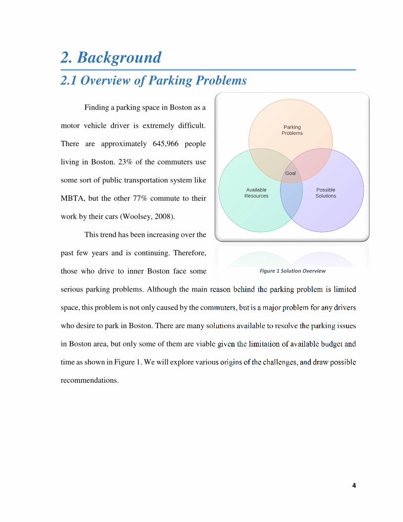
2.1 Overview of Parking Problems
Finding a parking space in Boston as a
motor vehicle driver is extremely difficult.
There are approximately 645,966 people
living in Boston. 23% of the commuters use
some sort of public transportation system like
MBTA, but the other 77% commute to their
work by their cars (Woolsey, 2008).
This trend has been increasing over the
past few years and is continuing. Therefore,
those who drive to inner Boston face some
serious parking problems. Although the main reason behind the parking problem is limited
space, this problem is not only caused by the commuters, but is a major problem for any drivers
who desire to park in Boston. There are many solutions available to resolve the parking issues
in Boston area, but only some of them are viable given the limitation of available budget and
time as shown in Figure 1. We will explore various origins of the challenges, and draw possible
recommendations.
Figure 1 Solution Overview

5
2.2 Origins of Parking Problems
Boston is a big city with huge
amount of traffic flow. Numerous
commuters travel the inner Boston daily
as shown in Figure 2. Parking problems
are expected in consequence of large
population injection in Boston (Doyle,
2012). Those who commute to inner
Boston usually utilize one of efficient
public transportation systems from
following three categories: public transportations, automobiles, and biking or walking (Fiske,
2015). If companies provide parking spaces for their employees, large portion of the
employees will drive to work because each individual live in different cities. Generally,
employees tend to prefer driving to work because having their own cars at work allows them
to gain flexibility compared to coming to work without a car.
Figure 2 Boston Traffic (Sheridan,n.d)

6
2.2.1 Limitations of Public Transportation System
Although many companies
provide some sort of public
transportation services, such as shuttle
bus from nearby “T-stations”, public
transportation system in Boston is still
not effective compared to other public
transportation systems around the globe
as shown in Figure 3. For example,
people living in New York can
commute to the major areas of the city
with the subway system. They can get to
work from their home without facing too much difficulty because there are a lot of subways
and busses available to the public in order to alleviate traffic problems. Compare to the rush
hours in Boston, rush hour in New York is in a totally different scale. Therefore, utilizing
public transportation system is usually faster and much more efficient than driving and getting
trapped in a rush hour in New York.
Figure 3 Boston Public Transportation System Map (MBTA,
2014)

7
Similar situation can be observed in
South Korea as well. Seoul is a smaller version
of New York. People living in South Korea can
get to almost anywhere with public
transportation as shown as on Figure 4 (Ro,
2002). Although the public transportation
system alleviates some of the traffic problems,
public transportation system alone cannot
support the growing population. People who
utilize the subways and busses to commute still
experience the rush hour. Commuters sometimes
have to wait for 3 busses or subways to pass in
order to find some space to squeeze in as shown
in Figure 5 (Ba Tran, 2014).
However, people living around Boston
cannot easily utilize the public transportation system because the public transportation system
is very limited to those who live in the rural area. Although commuter rail is an option for
rural public transportation commuters, majority of the population still do not have direct access
to commuter rails because they are simply too far away (Fiske, 2015). Although there are
reasonable numbers of subway stations and bus stations available in the inner city, there are
not many subway stations or bus stations around the rural side of the city (Massachusetts Bay
Transportation Authority, 2014). Furthermore not many busses operate on the rural
Figure 5 South Korea subway system during Rush hours
(Photobucket, n.d)
Figure 4 South Korea subway Map (Shaw, 2012)

8
community, and subways systems are not accessible from I-95 areas. For those people, who
do not have an option to utilize public transportations, are forced to drive into the city.
2.2.2 Limited Parking Spaces
Boston has extremely
limited space for any public
parking spaces. Various kinds of
regulations on the streets limit
the public parking spaces. Some
of parking problem factors can
be shown in Figure 6. Patrick
from Boston Magazine says the
following: “You see, the average car is driven only about 5 percent of each day. The rest of
the time—when the owner is at work, at home, or in a store—that car is parked. In a small city
with limited space like ours, this creates a major problem,” (Doyle, 2012). Various regulations
on the street such as residential parking spaces, no parking streets, and day only parking streets
create many problems. First of all, Boston roadmaps are very old and not effective. Patrick
from Boston Magazine states: “Those of us who live here are well equipped to deliver detailed
lectures on the reasons why: one-way streets derived from 17th-century cow paths; the lack,
for the most part, of a grid; poor to nonexistent signage; and the general willingness of citizens
on foot, on bike, and behind the wheel to dart out recklessly into traffic.” Furthermore, the
city previously banned private garage in order to comply with the Clean Air Act. (Doyle, 2012).
However, banning garages did not reduce the number of cars, but increased the parking and
traffic problems in Boston. Furthermore, the coin meter parking price was only increased by
Figure 6 Causes of limited parking spaces
9
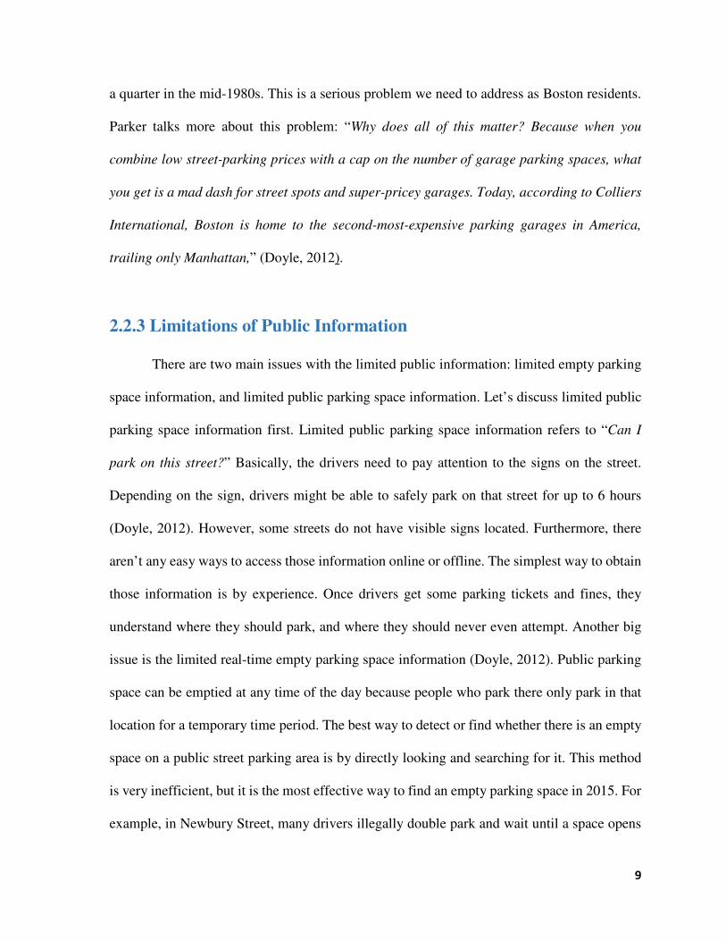
a quarter in the mid-1980s. This is a serious problem we need to address as Boston residents.
Parker talks more about this problem: “Why does all of this matter? Because when you
combine low street-parking prices with a cap on the number of garage parking spaces, what
you get is a mad dash for street spots and super-pricey garages. Today, according to Colliers
International, Boston is home to the second-most-expensive parking garages in America,
trailing only Manhattan,” (Doyle, 2012).
2.2.3 Limitations of Public Information
There are two main issues with the limited public information: limited empty parking
space information, and limited public parking space information. Let’s discuss limited public
parking space information first. Limited public parking space information refers to “Can I
park on this street?” Basically, the drivers need to pay attention to the signs on the street.
Depending on the sign, drivers might be able to safely park on that street for up to 6 hours
(Doyle, 2012). However, some streets do not have visible signs located. Furthermore, there
aren’t any easy ways to access those information online or offline. The simplest way to obtain
those information is by experience. Once drivers get some parking tickets and fines, they
understand where they should park, and where they should never even attempt. Another big
issue is the limited real-time empty parking space information (Doyle, 2012). Public parking
space can be emptied at any time of the day because people who park there only park in that
location for a temporary time period. The best way to detect or find whether there is an empty
space on a public street parking area is by directly looking and searching for it. This method
is very inefficient, but it is the most effective way to find an empty parking space in 2015. For
example, in Newbury Street, many drivers illegally double park and wait until a space opens

10
up so that they can park in those empty spaces. This not only hinders the traffic, but also can
lead to devastating accidents for the bikers and the people on the sidewalk.
11
2.3 Importance of Finding Parking Space in Boston
Commuters who commute to inner Boston get less headaches because their employers
usually have solutions to the parking problems. Many companies have their own parking
spaces, so employees can drive to work, but not many people drive to work simply because
there’s too much traffic. The companies without the parking spaces usually offer some
compensation such as monthly T-pass.
Limited parking spaces lead to limited in-city mobility (Fiske, 2015). Mobility within
the inner city of Boston is severely limited by the available public parking spaces. One of the
major issues of Boston parking problems is due to limited public parking spaces (Ba Tran,
2014). Boston is one of major cities in United States of America. However, it is a small city
with a huge amount of population. Numerous people live and work in Boston. Consequently,
a lot of businesses are located in Boston. Different kinds of businesses like clothes shops,
malls, restaurants, hotels, IT services and many others thrive and are clustered in small amount
of spaces. Despite the limited space, those businesses usually require the customers to
physically come to the office for the service customer wants (Walsh, 2015).
Although large percentage of those customers are commuters who can reach the
businesses in Boston by either walking or by public transportation, majority of the people are
from outside of Boston (Walsh, 2015). Majority of those customers need various kinds of
services. Like mentioned above, those services are more likely available in Boston due to
greater amount of businesses in Boston. Furthermore, those businesses usually provide more
professional services compare to the local shops or stores. Those customers usually drive into
the city before or after rush hours to avoid traffic, but they still face the parking problems in
the city (Broshanan, n.d).

12
Parking problems are essential obstacles tourists must overcome. In 2013, “Average
length of stay for domestic visitors was 2.5 nights; Average total spend for leisure visitors was
$572 per night; Average party size for leisure visitors was 2.1; approximately 40% of visitors'
spend was for accommodations and 60% was for dining, entertainment, shopping and
sightseeing,” (Boston Statistics, 2014). As mentioned before, tourists have some serious
difficulties navigating around in Boston. There are lots of one-way streets with confusing signs
that hinder tourists from finding the correct places. Furthermore, navigating with public
transportation system such as MBTA is not so easy due to confusing system.

13
2.4 Current Parking System in Boston
2.4.1 Various Types of Public Parking Systems As mentioned before, the public parking
spaces are very limited in the city. For example,
parking in Newbury Street in Figure 7 is
extremely difficult. However, there are a lot of
private parking space available in Boston as well.
Private parking spaces are usually moderately
maintained, but are very expensive compare to
public parking spaces maintained by the
government (Conti, 2014). Private parking spaces
are more expensive due to the expensive land and
maintenance price, but they are usually available
for anyone who needs them. Since private
parking is expensive, drivers prefer public
parking spaces.
There are couple different types of public
parking available in Boston: coin parking meters,
electronic parking meters, hour based street
parking, and public lots. Coin parking, as shown
in Figure8, accepts 25 cents coins and each coin can add certain amount of parking time. Coin
parking also has designated parking space, so drivers must park on a specific space. Coin
Figure 7 Newbury Street (AGIM, n.d)
Figure 8 Coin Based Meter Parking (Silva, 2014)

14
parking meters existed since a long time ago, and are still widely used throughout Boston area
(Broshanan, n.d).
Electronic parking meters, in Figure 9, are one of
the new parking payment systems. Electronic parking
meters allow drivers to pay with cash or credit card, so it is
much more convenient. However, Electronic parking
meters do not have a designated parking space (Conti,
2014). As long as drivers pay for the parking time, they can
choose to park anywhere on that street, but with the printed
parking receipt visibly displayed on the side window of the
car. For example, Newbury Street utilizes electronic
parking meters. Newbury Street is always crowded and is
difficult to find a parking space in most time of the day.
Many great restaurants and various kinds of shops are on
Newbury Street, so a lot of people attempt to park on Newbury Street. However, limited
parking space does not allow all people to find the parking space around Newbury Street.
Usually, there are no empty spaces due to cars filling up the spaces immediately once someone
leaves.
Hour-based street parking also has a long history. Hour-based street parking spaces are
completely free, but usually there’s a time limit for a parking time (Broshanan, n.d). There are
no designated spots for street parking. However, there are not many hour based street parking
spaces available in Boston. Hour-based street parking does not produce any revenue, but the
city has to maintain the street; therefore the city does not want to have many of them
Figure 9 Electronic Parking Meters
(Thorsen, 2012)

15
(Broshanan, n.d). Hour-based street parking is more of a burden for the city whereas it is
extremely beneficial for the automobile drivers.
2.4.2 Commuter Population in Boston
Google map provides a typical traffic
of a specific day of the week and specific time
of the day. Figure 10 on the right shows the
typical workday morning traffic. This shows
that a lot of people are going towards the
“inner-Boston” area and creating a huge
traffic congestion problem in highways I-90
(Known as Mass Pike), I-95, and I-93. The
exact opposite situation happens around
typical weekday around 5pm. Figure 11 shows
a typical traffic situation on a typical weekday
around 5pm. Commuters start going back to
their home located in various suburbs around
Boston. This creates a huge traffic congestion
in the opposite direction in the same highway
systems. There’s a huge floating population
around Boston area that experience this huge
traffic problem. Driving from outside Boston (I-95) area to inside Boston typically takes
around 30 minutes, but the traffic congestion can delay this up to 2 hours or more. Commuters
from Rhode Island sometimes choose to drive to work after 9am because they would arrive at
Figure 11 Typical Weekday Afternoon Traffic (Google, 2015)
Figure 10 Typical Weekday Morning Traffic (Google, 2015)

16
work around 10am no matter when they leave to work. If they choose to go to work at 8am,
the traffic delays them for about two hours, so that driving to work at 9am without the traffic
is effectively same for them.

17
2.5 Previous Solutions to Parking Problems
2.5.1 Rental Bike in Boston Boston is a small city with
numerous small roads. Boston city map
does not resemble the chessboard and is
not as neat as that of in New York or
other cities in the World. Because most
of the roads and buildings were planned
very long ago, the city plans are not
suitable for current population.
Excessive amounts of one-way streets
and small roads block big truck and van drivers. However, Bicycle can go almost anywhere.
Anyone can go anywhere by bicycles in Boston. There are a lot of ways people utilize
bicycle in Boston, especially around college campus. A lot of inner Boston residents are
actually students (City of Boston, 2015). Students usually utilize the public transportation
system to get to their classes, but bicycle is one of cheap, and effective transportation system
for them. There are bicycle lanes in Boston, but the cyclists usually do not have to worry about
finding a bicycle lane because they can simply occupy a car lane and bother them (Hubway,
2015).
Because bicycles are effective modes of transportation in Boston, the city created a
nice plan called the “Hubway”, Figure 12. “Hubway” partially comes from a word “Subway”,
combined with a “Hub”, meaning connecting different places. Hubway is essentially a bike
sharing system. Currently there are more than 1,300 bikes in 140 different stations in Boston,
Brookline, Cambridge, and Somerville (Hubway, 2015). Those cities are the major cities that
Figure 12 Hubway in Boston

18
people visit often. If anyone needs to go to a grocery shop that is about 5-miles away, Hubway
is a great solution for them. Although the Hubway system is mostly closed in the winter season,
it is an effective way to navigate in Boston without any automobiles. Currently Mass
Department of Transportation and the Massachusetts government are continuing to expand
this service to other nearby cities in order to reduce traffic congestions.
2.5.2 Efforts in improving Public Transportation Systems Officials and the public transportation
department of Boston are trying to make some
changes in order to improve the public
transportation systems, Figure 13. Current
public transportation systems in Boston are
not so great. 20 minutes by driving distance
can be an hour long by public transportation
system because of the transit wait time, (Birbuam, 2013). However, many people utilize and
rely on public transportations to get to their schools and work places. Recently the state
invested about $200 million into MBTA renovation project. This Fairmount commuter rail
line project connects from Hyde Park, Dorchester, Mattapan, and Roxbury to South Station,
(Birbuam, 2013) there will be more stations opening with rapid transits. The mayor, Walsh,
and Rick Dimino, the president of “A Better City” are planning to help and aid this project.
Walsh, especially, wants to improve the bus line as well. He mentioned: "We’ve also got to
look at additional service, bus lines, and more frequent bus lines. And the way I would do that
as mayor of Boston is to work with MassDOT and the MBTA, Figure 13, to get that additional
Figure 13 M.B.T.A (MBTA, 2014)

19
service." Furthermore, he mentioned about the parking problems and wanted to address the
frustration, (Birbuam, 2013).
Not only the city officials, but the MBTA is also trying to improve various bus routes.
In 2013, the MBTA pointed 15 of the busiest bus routes as the “Key Bus Routes”. Each one
of those key bus routes operates very frequently, 7 days in a week, in order to meet the
passenger demand. The impressive part of the operation is that the service frequency.
Sometimes the busses operate every 10 minutes (DeLeuca, 2015). MBTA designed this project
in order to improve the overall quality of the service. MBTA wanted to enhance customer
comfort, convenience, safety, and, especially, accessibility. MBTA improved the bust stop
locations by eliminating or relocating them. MBTA also extended some curbs and
implemented queue jump lanes with transit signal priority (MBTA, 2014).
2.5.3 Uber and Taxi in Boston Taxi used to be another major form
of transportation around Boston area, but
personal drivers from Uber started to
overtake taxi in Boston market. In order to
understand the reasons behind decline in
taxi market, Uber, in Figure 14, system
must be understood first. Uber is an app-
based transportation network and taxi
company. Uber provides smartphone applications to receive ride requests and distribute those
request among the Uber drivers. Uber drivers can be anyone who signed up on Uber
application. Depending on the vehicle size and type, different classes are offered to those
Figure 14 Uber and Taxi (Uber, 2014)

20
drivers. Types range from UberX, Taxi, Black, Suv, and Lux and users can choose which type
they prefer for a quick ride (Pilieci, 2014). The invasion of Uber drivers significantly damaged
the taxi industry in Boston. Because Uber drivers are much cheaper compare to taxi fare, many
people prefer Uber instead of taxi. Furthermore, Uber is more readily available for faster
service compare to taxi because Uber drivers are more prevalent than taxi drivers. Despite
some advantages, Uber poses some disadvantages for the customers as well. There are no
requirements or regulations for Uber drivers; anyone can be an uber driver which is very
dangerous (Pilieci, 2014). Furthermore, Uber fares vary depending on different circumstances.
If there’s a significant demand in Uber drivers in a certain area, the Uber fare sometimes
doubles which approximately equals taxi fare. In this way, Uber can monopolize the taxi
industry and regulate the fare afterwards (Dungca, 2015). There are couple advantages and
disadvantages to Uber and Taxi drivers. It is crucial to understand that both Uber and Taxi
need to present and compete each other to meet the reasonable price for the travelers in Boston
(Dungca, 2015).
2.5.4 Findings and Discovery from Institutional Research Finding parking spaces in Boston is important, but collecting the parking space
statistics is also equally important. The ParkNet paper, (Mathur, 2013) presents various
techniques to collect road-side parking statistics and data. The author also agrees that
information is really key factor in finding parking spaces: “One key factor contributing to
excess parking vehicle miles is a lack of information about roadside parking availability.
While occupancy data for parking garages is relatively straightforward to obtain through
entry/exit counters, data is generally unavailable for road-side parking.” It is easy to
determine number of spots in a garage, but road-side parking is really hard to collect data from.

21
The author presents a “Drive-by Parking Monitoring” technique which the drivers
automatically send parking space data by driving around the city. This knowledge can be
transferred back to the drivers who are in need to parking spaces because “Finding street-side
parking in a crowded urban area is a problematic task and one that most drivers dread.
Finding a parking space near one’s destination could be much easier if there were a way to
know ahead of time which areas have available parking spaces. Often times, a street only a
few blocks away might have vacant parking spaces but a driver looking for parking has no
way of knowing this,” (Mathur, 2013).
Excessive parking space is not a solution to a current parking problems. Just by
creating more parking spaces in Boston is definitely not a great solution because the demand
for public parking spaces varies by the region of the city and by the time of the day and of the
week. A recent study from Northeastern University professor, Stephanie Pollack, revealed
some interesting characteristics about the residents in Boston. She studied gentrification
around transit stops across the country. She discovered that one of the biggest mistakes
municipalities make is requiring too much parking. Her data shows that residents will self-
select based off of the situation, meaning those who drive a lot choose to live in a home with
parking spaces, but those who do not drive a lot choose transit-oriented homes with no parking
spaces. In her conclusion, the answer to urban parking solution is not just creating more
parking spaces. She mentioned that parking demand is not monolithic (McMorrow, 2014).

22
2.5.5 Parking Assistance Mobile Application There are couple mobile
solutions available in order to help
drivers to find parking spaces
effectively. No one likes to wait to
find a parking space. It is a painful
process for drivers who want to park
and drivers who want to drive
through the parkers. In order to
eliminate the annoyance of drivers
who cruise the public parking meters
to park their cars, Boston’s
Department of Transportation
recently released a mobile
application that helps the users to
find empty parking spaces. Figure
15 shows that mobile solution is one of the solutions that we will focus on.
Boston recently installed 330 “Smart Parking Sensors” and activated them in the
“innovation District” in order to alleviate the traffic congestion and flow in the waterfront
areas in Boston. The former Mayor Tom Menino said: “The installation of this new equipment
will now ensure a quicker and more pleasant trip to this neighborhood for those commuters
and visitors who choose to drive,” (Annear, 2013). The parking sensors send continuous signal
to the database of Parker smartphone app to alert the empty parking spaces for the drivers to
hunt. Those sensors are installed along “stretches of Seaport Boulevard, Congress Street,
Figure 15 Mobile Solution

23
Summer Street, and Boston Wharf Road as part of a partnership with California-based
Streetline, Inc.” (Annear, 2013). Although not a great amount of streets are covered with this
innovative sensors, Boston city and the government are trying to address the parking issues
and problems in Boston.
“Parker” provides notable core features. Figure 16 shows one of the major features
and unique feature of the application: searching and finding public parking spaces as well as
private parking spaces. This feature is unique because there are no current applications that
help users to identify free public parking spaces. Figure 17 shows different set of filters that
users can easilly check in order to find certain types of parking spaces such as coin meters or
private garages. In figure 18, parker application presents another unique feature of the
Figure 16 Parker Finding Spot Screen
(Streetline Inc, 2014)
Figure 17 Parker Filtering Search
(Streetline Inc, 2014)
Figure 18 Parker Saving My Car Location
(Streetline Inc, 2014)

24
application: saving and recognizing my parked car location. This feature also allows the users
to set the timer if the parking space has a time limit.
“Spot Hero” is another mobile solution and platform available for the vehicle drivers
in Boston. A mobile app called “Spot Hero” shows multiple parking garage locations. In
Figure 19, SpotHero shows multiple parking garage locations as well as their prices. In Figure
20, detailed information of a selected parking garage is shown. SpotHero shows a great
detailed of information to the users effectively by including the time window, contact info as
Figure 19 SpotHero Main Screen
(SpotHero, 2015) Figure 20 SpotHero Detailed Information
(SpotHero, 2015)

25
well as presenting parking reservation system. The prices for those lots are not as cheap
compare to the prices for the parking meters, but the prices are cheaper than a normal private
parking lots.
“Waze” is a traffic database mobile application. The mobile application takes all of
the traffic data from nearby location and informs the drivers the most effective path from one
location to another location. As shown in Figure 22, Waze outsources traffic information from
the users and re-routes them if the current route is too crowded just like in Figure 21. This
mobile solution provides a great service in order to alleviate both traffic congestion problem
and the parking space problem (Waze, 2015).
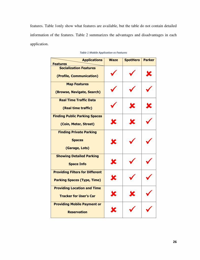
Each one of the mobile applications contains different set of features. However, none
of the mobile application has all the features. Table 1 displays the analyzed mobile applications
Figure 21 Waze Navigation Screen
(Waze, 2014) Figure 22 Waze Current Traffic
(Waze, 2014)
26
features. Table 1only show what features are available, but the table do not contain detailed
information of the features. Table 2 summarizes the advantages and disadvantages in each
application.
Table 1 Mobile Application vs Features
Applications
Features
Waze SpotHero Parker
Socialization Features
(Profile, Communication) ���� ���� ����
Map Features
(Browse, Navigate, Search) ���� ���� ����
Real Time Traffic Data
(Real time traffic) ���� ���� ����
Finding Public Parking Spaces
(Coin, Meter, Street) ���� ���� ����
Finding Private Parking
Spaces
(Garage, Lots) ���� ���� ����
Showing Detailed Parking
Space Info ���� ���� ����
Providing Filters for Different
Parking Spaces (Type, Time) ���� ���� ����
Providing Location and Time
Tracker for User’s Car ���� ���� ����
Providing Mobile Payment or
Reservation ���� ���� ����

27
Table 2 Mobile Applications Advantages and Disadvantages
Rating
APP Advantages Disadvantages
Waze
• Shows real-time traffic
data with high accuracy.
• Social features allow
interaction between
different users for greater
community
• Does not have parking spot
searching ability.
SpotHero
• Shows great detailed
information for the parking
spaces such as contact
info, price, direction, and
websites.
• Allows reservation on the
mobile device.
• Does not have public parking
spot searching ability.
• Does not have effective traffic-
navigation ability.
• Social aspect of this application
lacks interaction compare to
Waze
Parker
• Shows combination of
private and public parking
space information.
• Provides time and location
tracker for user’s car.
• Contains a great filter for
finding private, public,
coin, street, and accessible
parking spaces.
• Compare to SpotHero’s
detailed information, Perker’s
detailed parking space info
lacks detail.
• Social aspect of this application
lacks interaction compare to
Waze.
• Not many public parking space
information is included.
Although there are different features available in different mobile application, none of
those applications solve the customers’ needs completely. In order to understand the customers
and provide various sets of features for them to utilize in a crucial parking situation, we will
combine some of the features listed above and redesign some of the features for increased
usability.

28
3. METHODOLOGY
The goal of this project is to propose and produce effective public parking system in
Boston for both residents of New England and tourists. The key objectives identified in order
to complete the original goals are:
1. Surveying the Demands from Potential Users.
2. Understanding and identifying issues from Boston Urban Planning.
3. Analyzing & Designing an innovative Smart Parking System.
In the following sections, we present how each objective is addressed.
3.1 Surveying the Demands from Potential Users
In order to better understand the community’s knowledge regarding the Boston parking
problems, accurate data for detailed statistical analysis is crucial. For this process, we collected
multiple statistical data from the potential user groups and gathered requirements from them.
The collected data contains various kinds of data such as home location, work location, inner-
Boston travel frequency and time, gender, age, handicap level, public parking space frequency,
private parking space frequency, number of parking violation per-year, and desired features
for the mobile application.
We surveyed multiple users from various sources using Qualtrics software. University
level students and faculty members were selected including Worcester Polytechnic Institute
community members. In order to measure and analyze the data gathered, appropriate questions
were included to capture the similarity within certain groups. Questions were designed so that
the users can pick from the categories so that it is easier to perform the data analytics on those

29
dataset. The exact survey that was used to measure the parking problem is shown in Appendix
A.
In order to analyze the collected data from the multiple online, specific responses and
preferences regarding unique characteristics of parking designation were analyzed. Each
surveyors possessed different types of characteristics and parking problems in Boston and thus
can categorizing the responses from the users were useful for highlighting important discovery
in this survey data.
This survey served as a foundation for the entire project. Gathering requirements for
any product is essential. This survey provided some very important aspect of the problem and
was especially beneficial when creating a list of requirements and recommendations for
different groups to consider. The information and knowledge gained during the survey process
served as a strong foundation for the remainder of the project. The surveys not only supplied
relevant information pertaining to Boston parking problems, but also offered additional
insightful resources for the technical implementation stages of this project. Surveys also
provided feedback and suggestions for the overall direction of the parking problems. This
invaluable information served as a key component in the development of the Smart Parking
Mobile Application.

30
3.2 Identification of Boston Urban Planning
3.2.1 Addressing Existing Problems in M.B.T.A Understanding the underlying causes and critical issues in M.B.T.A is significantly
important for identifying one of the key objects in this project. M.B.T.A provides three
different kinds of public transportation system around New England area: Commuter rails,
subway systems, and bus lines. From the data provided by M.B.T.A, there were not enough
numbers of busses and trains for the people to use it. Consequently, the wait time for the
transportation means to arrive to a given station was longer compare to other major cities with
good public transportation systems. Although M.B.T.A provides reasonable services in the
rush hours, the service is very limited in the holidays and weekends. M.B.T.A does cover a
large portion of the community, but it does not cover all the rural areas in Massachusetts.
Furthermore, the M.B.T.A covers the important section of the cities, so the M.B.T.A customers
would have to walk to the limited stations in their hometown if available. Furthermore,
M.B.T.A transit and service combination greatly increased the travel time because of the long
transit time between different service lines, (MBTA, 2014). Resources from online feedback
sources such as journals and articles were analyzed. Information collected from MBTA
websites such as MBTA coverage map, and transit time tables were combined for the analysis.
3.2.2 Identifying Current Problems in Boston Road Maps Boston urban road planning has some serious issues. Not only the roads are narrow
and confusing to navigate, but also are dangerously planned. Back in the 90s, the road maps
were not a big problem. With the recent increase in number of automobiles and traffic
congestion, Boston now faces some serious problem. There are lots of one way streets in the
downtown area. This confuses many drivers without any sort of navigation system attached to

31
their cars. On a crowded Newbury Street, every other street is a same direction one way street.
This system is very confusing not only for the tourists, but also for Massachusetts residents.
Furthermore, there are some section of the streets that are virtually impossible to come back
without taking a huge detour. Poor road maps also cause some navigational problems. There
are many multi-merge lanes in Boston that are very dangerous. Those lanes are very dangerous
mainly because multiple lanes merge into one or two lanes. Furthermore, some traffic lane
must cross four consecutive lanes in order to make a very sharp left turn. The current road
maps are a great danger for a long-lived Boston residents as well.
32
4. Analyses and Discovery
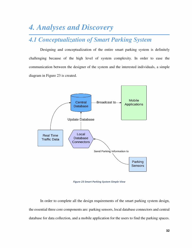
4.1 Conceptualization of Smart Parking System Designing and conceptualization of the entire smart parking system is definitely
challenging because of the high level of system complexity. In order to ease the
communication between the designer of the system and the interested individuals, a simple
diagram in Figure 23 is created.
Figure 23 Smart Parking System Simple View
In order to complete all the design requirements of the smart parking system design,
the essential three core components are: parking sensors, local database connectors and central
database for data collection, and a mobile application for the users to find the parking spaces.

33
Boston recently installed couple smart parking sensors on their street to collect parking
status data in certain side of public street parking spaces. Collecting real-time parking status
information in certain locations are extremely important because that information is the
important information for the mobile application users.
Parking sensors will detect and determine the status of the parking spot. If there’s a car
parked in the lot, the sensor will send a request to the local database connectors to update the
central database. If there’s no car, the parking sensor will still tell the local database connectors
to updated the central database, but with “no” instead of “yes”.
Central database will maintain all the parking spot information and real time traffic
data. The database will have couple of tables for traffic data, public parking space information,
private parking space information, parking ban status information, restricted public parking
space information, and couple other information. Most parking sensor data will compromise
the public parking space information, but most of the private parking data will come from
individual vendors or from website scrapers. Traffic data will originate from waze, different
types of parking bans data, including winter parking ban status, will get scraped from
government’s database, and different types of parking types such as residential only parking
will also get scraped from government’s database.
Once a mobile application user opens up the mobile application, the user’s current
approximated location will be determined and a request is sent to the central database for
nearby traffic and parking information. Once the central database receives the location data
from the user, the database sends back nearby parking information with real-time traffic data
as well as parking type and ban status data back to the mobile device. Once the user receives
34
those data, the mobile device renders those data nicely on a map for the user so that the user
can find an appropriate parking space.
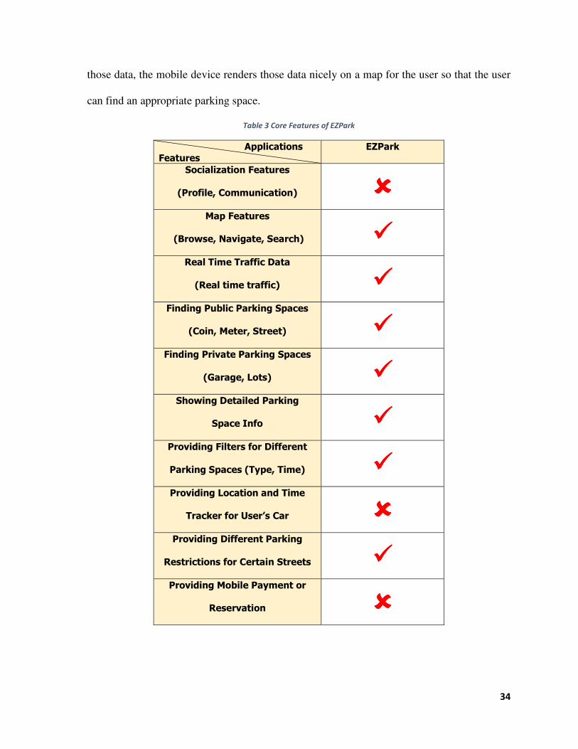
Table 3 Core Features of EZPark
Applications
Features
EZPark
Socialization Features
(Profile, Communication) ����
Map Features
(Browse, Navigate, Search) ����
Real Time Traffic Data
(Real time traffic) ����
Finding Public Parking Spaces
(Coin, Meter, Street) ����
Finding Private Parking Spaces
(Garage, Lots) ����
Showing Detailed Parking
Space Info ����
Providing Filters for Different
Parking Spaces (Type, Time) ����
Providing Location and Time
Tracker for User’s Car ����
Providing Different Parking
Restrictions for Certain Streets ���� Providing Mobile Payment or
Reservation ����

35
With the features analyzed from different mobile applications, including Waze, Parker,
and SpotHero, new smart parking system mobile application “EZPark” is created. The EZPark
mobile application implements core features from each mobile application, but mobile
reservation or payment feature was not included. Instead, providing different types of
restriction on parking space feature was included. The table 3 below summarizes the core
features of the EZPark mobile application.
4.2 Results and Findings from the Survey
Electronically surveying WPI faculty and students definitely provided great insight for
this project. The university population was electronically surveyed for approximately for 2
days long starting on the February 20th 2015. There were 122 participants in this voluntary
survey. Some of the participants did not choose to answer all of the questions.
Basic Distribution
Among 122 participants, about 51% were male and 49% were female (Figure 24)
Although there are more male student population in Worcester Polytechnic Institute, the
female population in the faculty balanced and produced a nice even distribution of the gender.

36
Table 4 Gender Distribution
The age distribution ranged from
18 to 80 years old because most of
Worcester Polytechnic Institute students
are ages of early 20s. Despite major
student population, a nice even
distribution of age can be observed in the
faculty population as shown in Figure 25.
Although the professors represent groups of age of 40s and 50s, we could observe a nice even
distribution of population.
About 70% of the surveyed population lived in either suburb or rural area as shown in
Table 5. Interestingly, 27% of the population lived in downtown Worcester. We wanted to
capture the traffic difficulty from those who live outside of the downtown area, so we
successfully captured majority of those population.
# What is your gender? Gender Distribution
Response %
1 Male
62 51%
2 Female
59 49%
Total 121 100%
0
2
4
6
8
18 21 25 28 31 35 39 42 45 48 51 55 58 61 66 71
Age Distribution
Count
Figure 24 Gender Distribution
Figure 25 Survey Age Distribution

37
Table 5 Home Location Distribution
# Home Location Home Location Distribution
Response %
1 Downtown Boston
2 2%
2 Downtown Springfield
0 0%
3 Downtown Worcester
33 27%
4 Other Downtown area
2 2%
5 Suburb area
66 54%
6 Rural area
19 16%
Total 122 100%
For the work location, majority of the respondent answered downtown Worcester as
their work location. About 15% of the population answered that they work in suburb area.
Because there are more jobs and workspaces available in the downtown area, people tend to
get jobs in the downtown area. Total of 84% of the responses represent general downtown
area. This shows a lot of population is traveling to downtown as shown in Table 6.
Table 6 Work Location Distribution
# Work Location Work Location Distribution
Response %
1 Downtown Boston
1 1%
2 Downtown Springfield
0 0%
3 Downtown Worcester
94 77%
4 Other Downtown area
7 6%
5 Suburb area
18 15%
6 Rural area
2 2%
Total 122 100%
About 84% of the population reported that they use some sort of private as a mean of
transportation for their work. This is a huge portion of the population. In order to commute
from the suburb or rural area, personal vehicle is required. About only 2% indicated that they
utilize public transportation system. If this survey was sent to people in downtown Boston, it
is likely that more people would have indicated that they utilize public transportation because
it is more readily available than in Worcester. 14% of the population indicated that they utilize

38
neither public transportation nor private vehicle. It is likely that those population represent on
campus students who walk or bike to the school as shown in Table 7.
Table 7 Commute Option Distribution
# Commute Options Commute Option Distribution
Response %
1
By Public
transportation
system
3 2%
2 By Cars(including
carpool)
102 84%
3 Others
17 14%
Total 122 100%
About 61% of the population indicated that they drive to the downtown area at least 5
times in a month. 39% of the population indicated that they only drive up to 5 times into the
downtown area in a month. 47% of the population indicated that they drive more than 15 times
to downtown area in a month. We wanted to capture the working class and non-working class
for our dataset. Those who drive to downtown area more than 15 times a month probably
represent the working class. Those who do not drive as much probably represent student or
other groups of population as shown in Table 8.
Table 8 Downtown Travel Frequency
# Travel Time in a Month Downtown Travel Frequency
Response %
1 0 to 5
48 39%
2 5 to 10
11 9%
3 10 to 15
6 5%
4 15 or many
57 47%
Total 122 100%
33% of the survey population responded that they utilize public parking spaces. It is
likely that those population do not commute as a work, but commute as a student because
public parking spaces are usually unreliable during parking bans and busy rush hours. 55% of
the population indicated that they utilize private parking garages or lots. It is likely that those

39
population represent working class who desire reliable parking spots and can afford the private
parking spaces. 12% of the population indicated that they do not drive to downtown. It might
be wise to simply not drive to downtown area to avoid any traffic problems. Consequently,
average value of parking difficulty level in a downtown area, on a scale 1 to 5, was 2.75. The
average level indicates that parking problem does exist, but not to the extreme level.
Interestingly, 99% of the population indicated that they get less than 5 parking violation per
year. This showed that many people do understand and follow state, city, and government
regulations as shown in Table 9.
Table 9 Parking Types Distribution
# Parking Types Parking Type Distribution
Response %
1 Street parking(meters,
coin, free parking)
40 33%
2 Private parking garage or
lots
67 55%
3 I do not drive to
downtown
15 12%
Total 122 100%
Utilizing Smart Data
96% of the population responded that they do not utilize smartphone apps to find
parking spots. This response seriously shows that people do not know how to utilize
smartphone application to find something they need in their everyday situation. We asked
them what features they would like on their smartphone mobile application to find a parking
space. The top 5 features the users most wanted were (Table 10):
1. Finding Public Parking Spaces(Coin, Meter, Street)
2. Map features(Browse, Navigate, Search)
3. Real Time Traffic Data(Real time traffic)
4. Finding Private Parking Spaces(Garage, Lots)
5. Showing Detailed Parking Space Info

40
Table 10 Desired Smartphone Feature Distribution
# Desired Mobile Application Features Feature Distribution
Response %
1 Finding Public Parking Spaces(Coin,
Meter, Street)
91 74.59%
2 Map features(Browse, Navigate,
Search)
84 68.85%
3 Real Time Traffic Data(Real time
traffic)
79 64.75%
4 Finding Private Parking
Spaces(Garage, Lots)
76 62.30%
5 Showing Detailed Parking Space Info
58 47.54%
6 Providing Mobile Payment or
Reservation
51 41.80%
7 Providing Filters for Different Parking
Spaces (Type, Time)
49 40.16%
8 Providing Location and Time Tracker
for User’s Car
32 26.23%
9 Social interaction features with other
users
17 13.93%
The least favorable feature was the social interaction features. The respondents wants
the mobile application for their convenience, but not for the social interaction device. The
second most unwanted feature was the location and time tracker. Because location and time
tracking can be done by individuals without any assistance, not many people desired the
feature.
About 73% of the respondents responded that they would use a mobile app if all the
features they selected are implemented. This is a positive response from the respondents. The
people did not know the mobile application existed, but they desired a lot of those features.
41
4.3 U.I Design of EZPark Application
After surveying Worcester Polytechnic Institute professors and students, we could
narrow down initial core features for the EZPark mobile application. Understanding the
demands and behaviors from the users are critical in user interface design. From the survey,
we were able to understand and narrow down the top 5 most desired features of the EZPark
mobile application. Therefore, we decided to remove some of the features for later releases
and build the mobile application with the core desired features for the initial release.
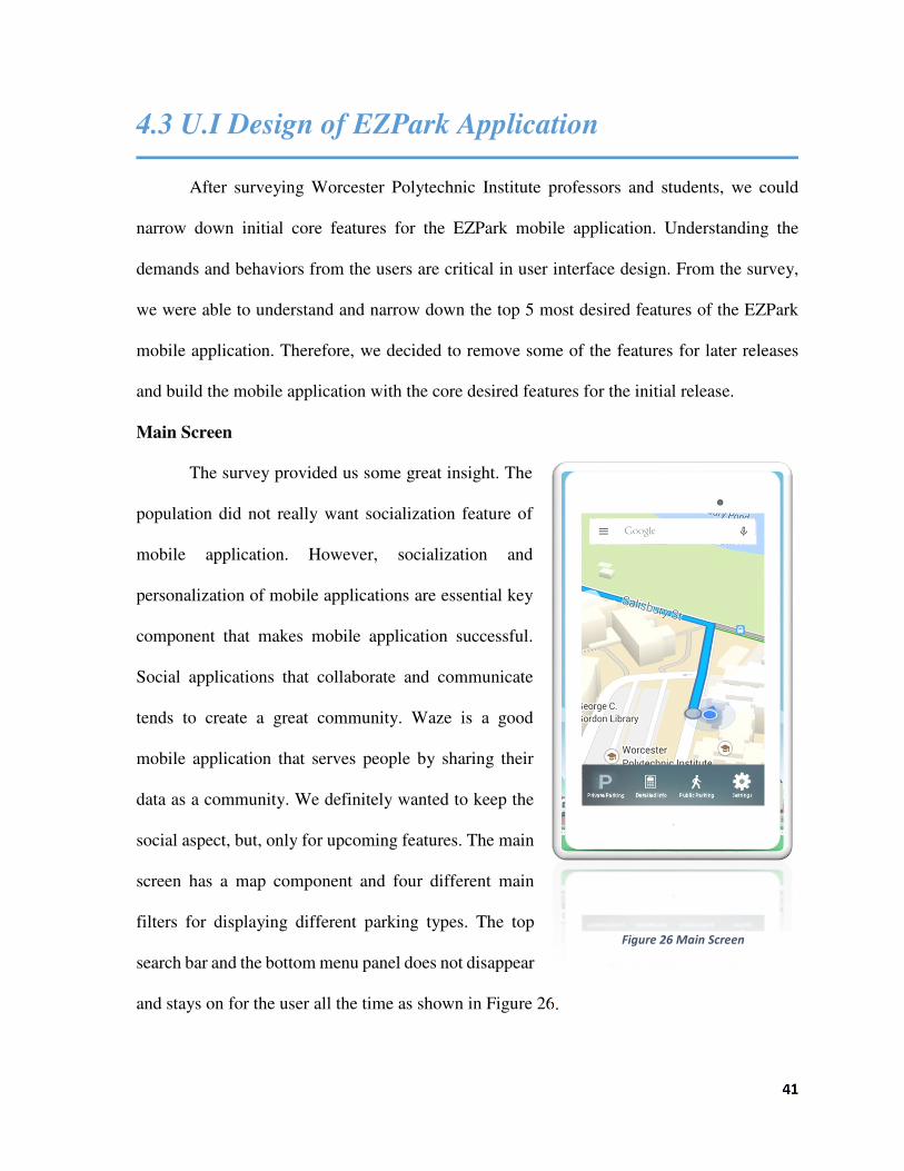
Main Screen
The survey provided us some great insight. The
population did not really want socialization feature of
mobile application. However, socialization and
personalization of mobile applications are essential key
component that makes mobile application successful.
Social applications that collaborate and communicate
tends to create a great community. Waze is a good
mobile application that serves people by sharing their
data as a community. We definitely wanted to keep the
social aspect, but, only for upcoming features. The main
screen has a map component and four different main
filters for displaying different parking types. The top
search bar and the bottom menu panel does not disappear
and stays on for the user all the time as shown in Figure 26.
Figure 26 Main Screen

42
Public Parking Filter
Many users need locate some public parking
space information. The mobile application
communicates with the central database and updates the
map based with data provided by Public Street parking,
coin meter and electronic meter locations just like shown
in Figure 27. Each side of the street could be a public
parking space, but sometimes only one side of the street
can be public parking space. In order for the users to
easily understand which side of the street is allowed for
public parking space, we designed the user interface to
have one green line on each side of the street if the street
is allowed and reserved for public parking spaces. Once
user taps the public parking filter on the bottom menu
panel, those green lines will appear on the map. If a user desires to disable them and search
for a private parking spaces or turn other filters on, the user can simple tap the same filter to
turn it off and turn other features on by tapping them.
Figure 27 Public Parking Filter
43
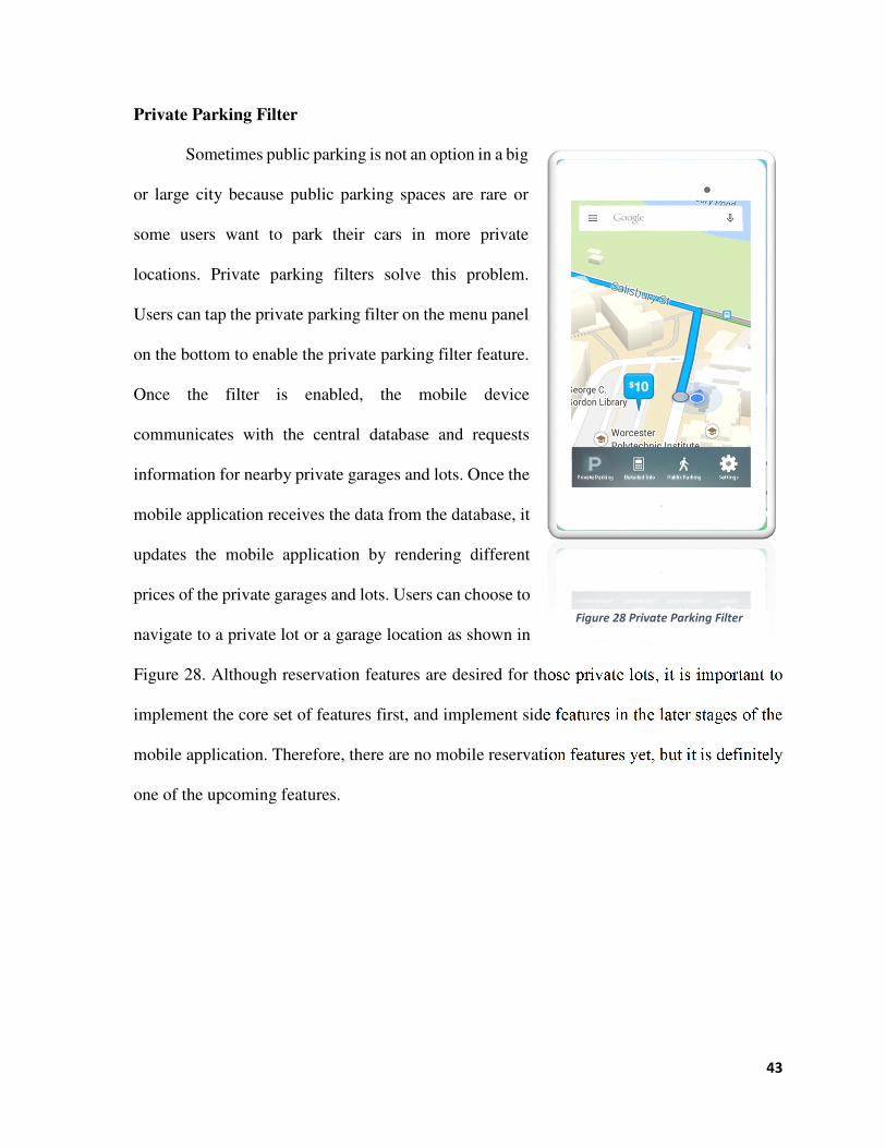
Private Parking Filter
Sometimes public parking is not an option in a big
or large city because public parking spaces are rare or
some users want to park their cars in more private
locations. Private parking filters solve this problem.
Users can tap the private parking filter on the menu panel
on the bottom to enable the private parking filter feature.
Once the filter is enabled, the mobile device
communicates with the central database and requests
information for nearby private garages and lots. Once the
mobile application receives the data from the database, it
updates the mobile application by rendering different
prices of the private garages and lots. Users can choose to
navigate to a private lot or a garage location as shown in
Figure 28. Although reservation features are desired for those private lots, it is important to
implement the core set of features first, and implement side features in the later stages of the
mobile application. Therefore, there are no mobile reservation features yet, but it is definitely
one of the upcoming features.
Figure 28 Private Parking Filter

44
Detailed Info
Downtown parking restrictions change by the
time of the day and weather condition. Downtown
Boston has “timed residential parking spaces”. Those
spaces are reserved for Boston residents on certain time
of the day. Some streets are resident parking only. Some
streets have no signs of parking availability. Snow
parking bans are not announced properly. Unless the
users lived in the downtown area for more than 5 years,
it is extremely difficult to find out a certain street for
public parking. In order to assist users who do not
understand confusing rules in the downtown area, we
have created detailed info filter for them to understand
various restrictions for parking in downtown area.
Streets with yellow lines mean those streets could be public parking spaces. Streets with timed
residential parking could be an example, meaning drivers could park on those streets until
6:00pm. Once the time passes, the street will automatically turn red. Streets with red lines
indicate those streets are not available for public parking. Residential parking, no parking and
snow parking ban are examples. Although residential parking allows public parking on
Sundays and other holidays, those parking spaces are generally not available for public parking.
Snow parking bans are declared, but not well announced for travelers. Providing those
information would be extremely valuable for the users as shown in Figure 29.
Figure 29 All Filters On

45
Settings
Other features are upcoming features for future releases. The initial mobile application
will not have many options such as turning on traffic status and finding a parking space in
specific time frame, but those features are definitely desirable in near future. Therefore,
settings page is extremely important. Once there are more than three filters and more features
available, settings page will contain set of those filters and features as a group control format.

46
5. Recommendations
Based on the findings and analysis of the survey, we created some recommendations
that could potentially improve the survey structure and data collections methods for future
surveys. Furthermore, multiple great feedback from the surveyed population at the university
was included for future suggestions which could improve the future survey methods and
design.
5.1 Recommendations for Surveys and Data
The recommendations proposed in this section are based on the survey and data
collection techniques presented during the project. In the near future, survey or interview
questions could re-phrased more concisely and clearly in order to avoid possible
misunderstanding and confusion from participants. Furthermore, some of the options were
not available in multiple-choice question. For example a question asking whether a person
would utilize smartphone application for navigating and finding parking space had only yes
or no for possible answers. Some of the respondents wanted maybe as an option. Allowing
these changes will reduce the burden on interviewers and surveyors while increasing the
response rate. In the future, we could potentially design couple interview sessions for one on
one face interview, so that we could easily capture the details of their responses and analyze
them. Furthermore, mail-in survey could be utilized instead of electronic surveys. Although
the data processing is more difficult for mail-in surveys, the method allows larger group of
population including those who do not utilize electronic devices.

47
Usage of Worcester Polytechnic Institute Qualtrics online survey tool was helpful, but
there were some challenges presented in the software. We wanted to categorize the survey
result to find patterns or general consensus. For example, we wanted to find out whether there
were some pattern in some age group that experience heavy parking problems. In order to
perform these kinds of analysis, deep drilldown techniques are required. Although Worcester
Polytechnic Institute Qualtrics does offer some of the drilldown features, the features were
extremely minimal. We wanted to drilldown based off of multiple questions such as residential
location and work location, but the drilldown feature was only available for one question.
Furthermore, Qualtrics does not aggregate user integer input into categories, so we had to use
excel for separate age group analysis. Qualtrics also had poor chart rendering systems. Labels
on the pie-charts were cut off and not visible for the users, so we could not utilize pie charts
on the analysis. Qualtrics can improve its software based on the feedback we produced.

48
5.2 Recommendations for Smart Parking System
We strongly recommend to produce a functioning prototype with the core set of
features for various user testing. The analysis and survey results indicate that more than half
of the surveyed population is willing to use the mobile application. Although not all the mobile
application features were desirable, the core set of features was moderately enticing and
desirable for the users because more than 50% of the population desired those core set of
features. Despite these statistical findings, we strongly recommend that socialization feature
is extremely necessary for increasing user return rate. Because mobile applications that have
socialization features generally have higher return rate. The mobile application exist to
broadcast relevant information to the users, but, the interaction and communication feature
keeps them coming back to check other relevant information for the users. Therefore
socialization feature is extremely important despite the fact that feature was least desired.
We also strongly recommend designing smart parking sensors. Currently there are
smart parking sensors available in the downtown area, but designing a different version of
smart parking sensors is definitely an option. Because those parking sensors do not record
various data, but only the information about vehicle presence, new parking sensors can capture
various data such as parking time, parking date, parking weather condition and so on. Those
captured data can be uploaded into the central database to create a pattern of parking heat map
in order to better understand the current parking patterns.
We recommend the city of Boston to update parking bans through mobile applications.
Although the survey results suggest that not many people receive parking violation,
understanding parking ban could be extremely difficult for remote people. Because the city

49
updates parking bans without the details of the parking ban, many motor vehicle operators get
confused and have to behave intuitively. Therefore displaying those flash parking bans on a
mobile device and announcing them through broadcast from the central database can be
extremely helpful.

50
6. Conclusion
The survey conducted in this project helped to confirm the demands for parking
navigation tools and relieve the suspicions of possible misunderstanding of the mobile
application features. Because downtown Boston is a very small region of Massachusetts,
understanding details of the current parking spaces and problems and analyzing possible viable
solutions are vital. In an age when community and societies are filled with motor vehicles,
understanding the core heart of the problem is the fastest and most effective way to solve the
parking problem. The questions and methods involved in the survey have been modified and
refined so that appropriate responses can be gathered and collected from a broad demographic
and population group. Recommendations were created in order to aid and improve the survey
quality for future research and studies to be conducted in both university and government
institutions. Other various recommendations were also generated for improving both survey
and data collection methods. Providing a navigation route for parking spaces by incorporating
real-time traffic data must be effective. Various parking locations must be identified with
different types such as public or private parking spaces. Presenting relevant and useful parking
information is extremely important for drivers in downtown area. Similar smart parking
system can be utilized in various section of the world including cities in other nations. The
surveyed population was very small, so the same survey can be electronically sent out to
multiple universities or offices in downtown area to gather more data. A larger survey can be
conducted to assess a greater demographic over a broader area. Similar researches or study
can be performed and examined in the future in other traffic heavy locations where little of
parking problem is understood in order to prepare for the future transportation system or plan
to change the current issues or problems in that area. Once the parking problems of a certain

51
area is identified and understood, the government or a third party can start to develop smart
parking system to address the parking problems. Developing effective parking system is
extremely important in conserving valuable spaces in downtown area. As stated previously, a
significant portion of the downtown areas in the World experience parking problems and
traffic problems. Without proper solutions to the parking problems in those areas, individuals
will not be able to effectively utilize the limited spaces in those areas, potentially leading to
severe discomfort and frustration. Although the parking problems in downtown areas are
difficult to address and understand, the efforts from public transportation system, and the
government has been improving overtime as more population raises concerns. As study and
research are conducted on parking problems, various possible solutions can properly evolve
to maximize and utilize the limited parking spaces in downtown areas.

52
Bibliography
"Massachusetts Bay Transportation Authority." MBTA.com Official Website for Greater Boston's Public Transportation System. Massachusetts Bay Transportation Authority, n.d. Web. 29 Jan. 2015.
"Statistics & Reports." Boston Statistics. Greater Boston Convention and Visitors Bureau, 2014. Web. 29 Jan. 2015.
"Using Bicycles: Mixed-Mode Commuting in Boston." Using Bicycles: Mixed-Mode Commuting in Boston. N.p., 25 Apr. 2008. Web. 29 Jan. 2015.
Annear, Steve. "What the Tech?: You Can Now Find Parking In the Innovation District Using An App." Boston. Metrocorp, 11 Dec. 2013. Web. 3 Feb. 2015.
Ba Tran, Andrew. "How Bad Is Turnpike Traffic Compared to Last Year? - The Boston Globe." BostonGlobe.com. Boston Globe, 02 Oct. 2014. Web. 29 Jan. 2015.
Broshanan, Tom. "Car Parking in Boston, Massachusetts." Car Parking in Boston, Massachusetts. New England Travel Planner, n.d. Web. 29 Jan. 2015.
Conti, Kathleen. "Solution to Parking Problems in Suburban Centers May Not Be More Parking - The Boston Globe." BostonGlobe.com. 13 July 2014. Web. 03 Feb. 2015.
Doyle, Patrick. "The Take: Parking In Boston Should Be More Expensive | Boston Magazine." Boston Magazine. N.p., 30 Oct. 2012. Web. 29 Jan. 2015.
Fiske, Brian. "Best Cities For Cycling: Boston." - Bicycling.com. N.p., n.d. Web. 29 Jan. 2015.
McGrow, Paul. "Boston’s Parking Solution Is Not More Parking - The Boston Globe." BostonGlobe.com. Boston Globe, 15 Apr. 2014. Web. 03 Feb. 2015.
Ro, Jaebong. "Rural Development in South Korea." Asian Affairs 6.3 (2002): 148-63. Web. 3 Feb. 2015.
Walsh, Greg. "Boston Commuters Are Back after Blizzard's Blast - Boston Business Journal." Boston Business Journal. American City Business Journal, 29 Jan. 2015. Web. 03 Feb. 2015.
WAZE. "Free Community-based Mapping, Traffic & Navigation App." Free Community-based Mapping, Traffic & Navigation App. WAZE, n.d. Web. 03 Feb. 2015.
Woolsey, Matt. "Best And Worst Cities For Commuters." Forbes. Forbes Magazine, 28 Apr. 2008. Web. 29 Jan. 2015.

53
Appendix A: PARKING PROBLEM ANALYSIS SURVEY

54

55