socio- hydrological spaces in the jamuna river floodplain ... · as a methodological and...
TRANSCRIPT

1
Socio-hydrological spaces in the Jamuna River floodplain in Bangladesh Md Ruknul Ferdous1, Anna Wesselink1, Luigia Brandimarte2, Kymo Slager3, Margreet Zwarteveen1, Giuliano Di. Baldassarre4 1Department of Integrated Water Systems & Governance, IHE Delft Institute for Water Education, 2611 AX, Delft, The 5 Netherlands 2Kungliga Tekniska Högskolan (KTH), SE-100 44, Stockholm, Sweden 3Deltares, 2600 MH, Delft, The Netherlands 4Department of Earth Sciences, Uppsala University, 75236 Uppsala, Sweden
Correspondence to: Md Ruknul Ferdous ([email protected]) 10
Abstract. In this paper, we propose a concept that captures the different socio-hydrological patterns that result from different
societal choices on how to deal with rivers, floods and erosion: ‘socio-hydrological spaces’. Socio-hydrology aims to
understand the dynamics and co-evolution of coupled human-water systems. Our proposed concept will help to understand
the detailed human-water interactions in a specific location. This paper uses a socio-hydrological approach to describe
human-flood interactions in the Jamuna floodplain, Bangladesh. In this vast space (a braided river bed of 6-16 km) the 15
differences between land and water are temporary and shifting. To illustrate how the concept can be used, we first classified
and identified socio-hydrological spaces and then validated through the analysis of primary data (household surveys and
focus group discussions) and secondary data (statistics, maps etc.) that were collected in 2015 and 2016. The principal set of
primary data consists of approx. 900 questionnaires on several themes: flooding, riverbank erosion, social processes of the
study area. The concept of SHS draws attention to how historical patterns in the co-evolution of social behaviour, natural 20
processes and technological adoptions give rise to different landscapes, different style of living, and different ways of
organizing livelihoods. However, we contend that this concept could be used in other places and for other socio-hydrological
systems than floodplains.
1 Introduction
Socio-hydrology has recently been launched by the hydrological sciences community as the research theme for the current 25
scientific decade of the International Association of Hydrological Sciences (IAHS) “Panta Rhei – Everything Flows” (2013-
2022) which aspires to ‘advance the science of hydrology for the benefit of society’ (Montanari et al., 2013 p.1257). Socio-
hydrology aims to understand the dynamics and co-evolution of coupled human-water systems. In traditional hydrology,
humans are either conceptualised as an external force to the system under study, or taken into account as boundary
conditions (Milly et al., 2008; Peel and Bloschl, 2011). In socio-hydrology, human factors are considered an integral part of 30
Hydrol. Earth Syst. Sci. Discuss., https://doi.org/10.5194/hess-2017-748Manuscript under review for journal Hydrol. Earth Syst. Sci.Discussion started: 3 January 2018c© Author(s) 2018. CC BY 4.0 License.
2
the system. Understanding such coupled system dynamics is expected to be of high interest to governments who are dealing
with strategic and long term water management and governance decisions (Sivapalan et al., 2012).
One type of situation that is relatively well studied by socio-hydrologists is the co-evolution of human and water systems in
floodplains. After all, the existence of interdependencies between societies and their natural environment is particularly
obvious in floodplains. Since the beginning of human civilization, many societies have developed in floodplains along major 5
rivers (Vis et al., 2003). In spite of periodical inundations, a distinct preference for floodplain areas as places to settle and
live in stems from their favourable conditions for agricultural production and transportation, enabling trade and economic
growth (Di Baldassarre et al., 2010). Yet, floodplain societies have to learn how to deal and live with periodic floods and the
relocation of river channels by erosion and deposition (Sarker et al., 2003). In general terms, floodplain societies do this by
evaluating the costs of flooding and erosion against the benefits that rivers bring, and by deciding whether to try to mitigate 10
the risks by defending themselves against floods or to adjust to living with them (Di Baldassarre, et al., 2013a,b). For flood
mitigation, societies have usually relied on engineering measures like embankments or levees to prevent flooding, and spurs
or guide bunds stretching into the river channel to prevent floods and erosion. These measures can be seasonal (temporary)
or permanent (Sultana et al., 2008). In order to adapt to flood risks, societies may limit costly investments in property or
make them movable, and adjust cropping patterns or choose crops that cope with flooding. The construction of flood control 15
measures or changing land-use patterns might in turn alter the frequency and severity of floods, leading to a dynamic
interaction between the river and the society living alongside it (Hofer and Messerli, 2006).
In the case of a choice for mitigation, societies are liable to enter in a near-vicious circle of path dependency, which has been
described as a lock-in (Wesselink et al., 2007). Already in 1945 White described how the construction of embankments to
protect property in the USA gave rise to what he called ‘the levee effect’ (White, 1945) where better protection leads to more 20
investment, in turn increasing vulnerability, leading to better protection, etc. Understanding such dynamics interactions
between water and people in floodplain areas have become the focus of attention of an emerging analytical approach, socio-
hydrology (Sivapalan et al., 2012; Blair and Buytaert, 2016), resulting in a number of studies. These will be discussed in
more detail below (Section 2). However, in spite of this and more recent research, the specific dynamics produced by the
interactions and feedback mechanisms between hydrological and social processes in floodplains remain largely unexplored 25
and poorly understood (Di Baldassarre et al., 2013a).
In this paper, we propose a new concept to help fill this gap: ‘socio-hydrological spaces’. The concept captures the different
socio-hydrological patterns that result from different societal choices on how to deal with rivers, floods and erosion, which is
turn produce different living conditions and watery environments. The concept thus helps trace and show how flood-society
dynamics are differently patterned depending on the different societal and hydrological characteristics of different locations. 30
In this sense it is largely a descriptive concept, rather than an explanatory one. Yet, we contend that the systematic and
comparative identification of socio-hydrological spaces over time or over flood plains may reveal patterns or systemic
characteristics that allow the concept to become predictive of future events. After a discussion of its definition and its
usefulness (Section 2), we show how ‘socio-hydrological spaces’ can be used to describe the human-water dynamics the
Hydrol. Earth Syst. Sci. Discuss., https://doi.org/10.5194/hess-2017-748Manuscript under review for journal Hydrol. Earth Syst. Sci.Discussion started: 3 January 2018c© Author(s) 2018. CC BY 4.0 License.

3
Jamuna River (local name of Brahmaputra River) floodplain of Bangladesh (Sections 4 to 5). We introduce the concept here
as a methodological and theoretical advance in the socio-hydrology of floodplains. However, we suggest that its usefulness
to other contexts such as irrigated catchments or urban water systems should also be investigated.
2 Socio-hydrological spaces defined
The study of floodplains using a socio-hydrological approach has advanced rapidly in the last few years (Di Baldassarre et 5
al., 2013a,b; O’Connell and O’Donnell, 2014; Viglione et al., 2014). This approach is aimed at furthering understanding of
‘how different sociotechnical approaches in floodplains are formed, adapted, and reformed through social, political,
technical, and economic processes; how they require and/or entail a reordering of social relations leading to shifts in
governance and creating new institutions, organizations, and knowledge; and how these societal shifts then impact floodplain
hydrology and flooding patterns’ (Di Baldassarre et al., 2014a, p.137). Two different methodologies to the study of 10
floodplains can be broadly distinguished, in parallel with general trends in socio-hydrology found by Wesselink et al. (2017).
First, some publications present a narrative of the floodplain’s socio-hydrological system and its development based on
qualitative research. This approach identifies historical patterns in the co-evolution of river dynamics, settlement patterns
and technological choices (Di Baldassarre et al., 2013a, 2014a) (see also similar work by Staveren and Tatenhove, 2016,
Staveren et al., 2017a, 2017b). The second approach focusses on the development and use of a generic conceptual model of 15
human-nature interactions in a floodplain which is subsequently expressed in terms of differential equations (e.g. Di
Baldassarre et al., 2013b, 2015). This generic model is then used to explore scenarios of floodplain development (Di
Baldassarre et al., 2013b; Viglione et al., 2014).
We introduce here the concept of ‘socio-hydrological space’ (SHS) that takes an intermediary (statistical) position between
the purely qualitative narratives and the deterministic, data-demanding mathematical-conceptual models. We define a socio-20
hydrological space as a geographic area with distinct hydrological and social features that gives rise to the emergence of
distinct interactions and dynamics between society and water, which also vary with time. The concept draws attention to the
historical patterns in the co-evolution of settlement patterns and technological choices, showing how these give rise to
different landscapes and different ways of organizing livelihoods. The concept’s importance lies in its emphasis on how the
interactions between society and water are always place-bound: these interactions therefore defy straightforward 25
generalizations in either hydrological or social terms. We therefore propose the socio-hydrological space as a useful concept
for advancing socio-hydrology: distinguishing different socio-hydrological spaces helps to understand the spatially distinct
dynamics of water-society interactions, while also providing a relatively straightforward and easy to use tool to describe and
analyse and perhaps predict human-water systems in floodplains or elsewhere. The concept provides a way to bring local
specificity to the study of socio-hydrology of floodplains, and we contend, socio-hydrology in general, though its usefulness 30
in other situations than floodplains remains to be explored.
Hydrol. Earth Syst. Sci. Discuss., https://doi.org/10.5194/hess-2017-748Manuscript under review for journal Hydrol. Earth Syst. Sci.Discussion started: 3 January 2018c© Author(s) 2018. CC BY 4.0 License.
4
To use the concept of SHS, we propose a two-step approach. First, a thorough understanding of a specific floodplain system
(geography, history, technology, societal occupation etc.) results in a preliminary classification of the study area into distinct
SHS. Second, the classification is tested for statistical significance using available or newly collected data. If the
classification is not statistically significant, merging or splitting of categories should be considered (repeat step 1).
By proposing this definition, SHS neatly fits socio-hydrology’s ontology of human-water dynamics in terms of interacting 5
social and hydrological systems. As mentioned above, SHS takes an intermediary position between the purely qualitative
narratives and the deterministic, data-demanding mathematical-conceptual models. Its understanding (step 1) is more
detailed than a general narrative, but its evidence (step 2) is less data-demanding and complicated than running a model
based on differential equations.
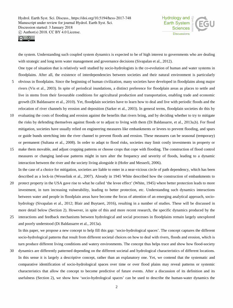
It is interesting to note that some of the earlier socio-hydrological research on floodplains can be said to implicitly employ 10
something resembling the SHS concept (Fig. 1). In their study, which is partly based on the Po floodplain, Di Baldassarre et
al. (2013a, 2014a) identify two patterns of society-river interactions. In the ‘adaptation effect’ pattern the use of flood
defence technology is limited, resulting in frequent flooding which is in turn associated with decreasing vulnerability (see
also Kreibich et al., 2017). The ‘levee effect’ pattern results when flood protection structures lead to less frequent but more
severe flooding, which is in turn associated with increasing vulnerability (Di Baldassarre et al., 2015) (already identified by 15
White, 1945; see also Kates et al., 2006). These two patterns can be rendered in terms of SHS, yielding a classification of:
• the SHS ‘adaptation space’ where the use of flood defense technology is limited, resulting in frequent flooding, less
economic development and lower population density and other human adjustments;
• the SHS ‘levee effect space’ where flood protection structures lead to less frequent but more severe flooding, more
economic development and higher population density and other human adjustments. 20
Figure 1: Schematic of human adjustments to flooding: (a) adaptation: settling away from the river, and (b) levee effect: raising levees or dikes (Di Baldassarre et al., 2013b).
In these first conceptualizations, one floodplain is assumed to show one or the other pattern at one point in time (while
allowing shifts over time from adaptation to levee effect; Di Baldassarre et al., 2013a). While it does not allow for spatial 25
differentiation within the floodplain, this classification nevertheless results in a distinction of socio-hydrological spaces but
this time between different floodplains, since it connects the specific floodplain space with a specific socio-hydrological
interaction. Because the study classifies each floodplain in terms of one type of SHS only, it is able to use these two patterns
Hydrol. Earth Syst. Sci. Discuss., https://doi.org/10.5194/hess-2017-748Manuscript under review for journal Hydrol. Earth Syst. Sci.Discussion started: 3 January 2018c© Author(s) 2018. CC BY 4.0 License.

5
to classify socio-hydrological interactions in floodplains worldwide (Di Baldassarre et al., 2015). For example, the study
classifies Bangladesh as a whole into the ‘adaptation’ type. In what follows, we illustrate how the concept can be used in a
more detailed and refined analysis of the Jamuna floodplain in Bangladesh. We show how its use can provide nuances to the
broad-sweep overall classification by showing that within this overall characterisation some areas to some extent exhibit a
‘levee effect’, while other areas do not fit the two-way classification. 5
3 Research approach
3.1 Case study area
The Ganges/Brahmaputra/Meghna delta encompasses 230 rivers and covers most of Bangladesh (Mirza et al., 2003). It is the
largest delta in the world draining almost all of the Himalayas which are the most sediment-producing mountains in the
world (Goodbred et al., 2003). The combined flows of the Ganges, Brahmaputra and Meghna Rivers are delivered to the Bay 10
of Bengal through the Lower Meghna River, a total of 1 trillion cubic meter per year of water and 1 billion tonnes per year of
sediment (Allison, 1998). It is also a very densely populated country with more than 140 million of people (964 persons per
square km); around 80% of the population lives in floodplain areas (Tingsanchali and Karim, 2005) and depends on
agriculture and fisheries (BBS, 2011). Normally, 25-30% of the floodplain area is inundated by the seasonal monsoon
(Brammer, 2004). These ‘normal’ floods are valued by rural people, because they are beneficial to land fertility, provide 15
ecosystem services (fish), and transportation (Huq, 2014). Extreme flood events (defined by flood duration, exposure, depths
etc.) were observed in 1954, 1955, 1974, 1987, 1988, 1998, 2004 and 2007. Subsequently, successive governments have
developed and implemented flood control measures to protect agriculture and populations from floods (Sultana et al., 2008).
Riverbank erosion is associated with flooding in many areas of the country. The extremely poor people who live on the chars
(islands in the big rivers) are most exposed and affected by flood hazards and riverbank erosion. During the 1973 to 2015, 20
the net erosion and accretion along the 220 km long Brahamaputra was about 90,413 ha and 16,497 ha respectively (CEGIS,
2016). During 1981-1993, about 0.7 million char-land dwellers were displaced in Bangladesh. Among half of them were
from chars in the Brahamaputra (FAP 16/19 1993). Every year about 50,000 to 200,000 people are displaced by riverbank
erosion (IOM, 2010). Hence, it is clear that hydrological processes (flooding and riverbank erosion) play a vital role in the
way people in Bangladesh organize their lives, as manifested among others in patterns of migration, livelihoods and land 25
use.
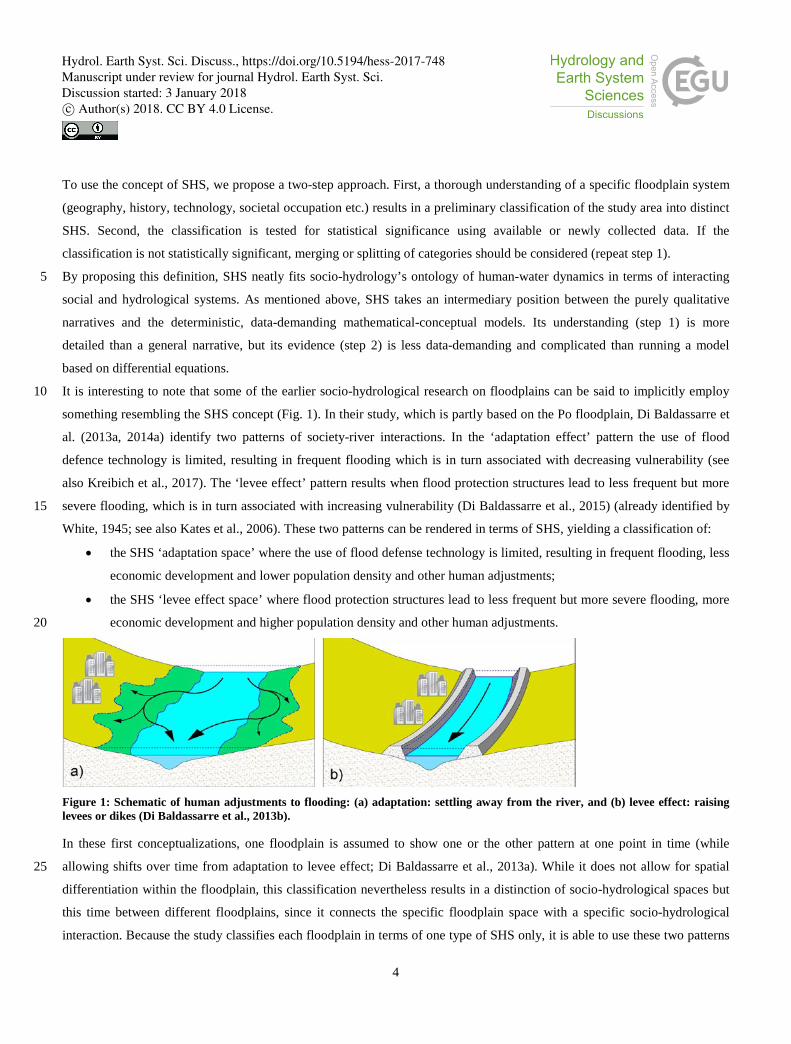
To evidence and understand how this happens, this study focusses on a small area along approx. 30 km of the Jamuna River
in the north of Bangladesh (Fig. 2). The total area is about 500 square km and the total population is approximately 0.36
million (BBS, 2011). In the early 18th century, the main course of the current Jamuna was flowing through what is now the
Old Brahmaputra, but sometime between 1776 and 1830 the course of the Brahmaputra shifted from east to west, and the 30
river took the name Jamuna. Since then, the Jamuna has shown progressive westward migration and widening, meanwhile
transforming from a meandering river to a braided one (CEGIS, 2007). Taking this westward migration into account, the
Hydrol. Earth Syst. Sci. Discuss., https://doi.org/10.5194/hess-2017-748Manuscript under review for journal Hydrol. Earth Syst. Sci.Discussion started: 3 January 2018c© Author(s) 2018. CC BY 4.0 License.
6
government built groynes and spurs on the west side of the river in order to try to stabilize the position of the river, with
limited success.
The case study area includes parts of Gaibandha district and parts of Jamalpur district (Fig. 2). The total width of the case
study area is around 24 km, of which the braided river bed takes approx. 12-16 km. The braided river bed measures approx.
4-8 km; this includes many inhabited river islands (chars) that flood with varying frequency (every year to only with severe 5
floods). The area to the west is protected by an embankment (the Brahmaputra Right Embankment, BRE) constructed in the
1960s to limit flooding and increase the agricultural production of that area. Its maintenance in the study area has been
sporadic. When constructed, the average height was 4.5m, width 6m and slope 1:3 on both sides (CEGIS, 2007). Though
extreme discharges could not overtop this embankment, breaches have occurred which caused catastrophic floods and
damages (FICHTNER and nhc, 2015). In the 2016 flood (observed during the field survey), BRE was breached in 10
Gaibandha district resulting in a large portion of the area being flooded. On the left bank there is no human-made protection,
but there is a natural levee that has been deposited by the river.
Figure 2: Bangladesh map with case study area and SHS.
Hydrol. Earth Syst. Sci. Discuss., https://doi.org/10.5194/hess-2017-748Manuscript under review for journal Hydrol. Earth Syst. Sci.Discussion started: 3 January 2018c© Author(s) 2018. CC BY 4.0 License.

7
3.2 Step 1: preliminary classification and identification
As flood control measures were only developed along some rivers or river banks, the study area is characterized by different
degrees of protection, giving rise to the development of different socio-hydrological relationships in the same floodplain.
This forms the basis for distinguishing different SHS in the landscape. We thus started out identification of SHS based on
differences in geophysical characteristics and flood protection measures, yielding a distinction in three SHS: SHS1 are areas 5
protected by the BRE (west bank); SHS2 refers to the char areas (in the river bed); and SHS3, the areas with a natural levee
(east bank). We categorized all administrative areas at the lowest level (unions) in the case study area into one of these three
SHS.
3.3 Step 2: evidence
The categorization of unions into SHS was validated through the analysis of primary data (household surveys and focus 10
group discussions) and secondary data (statistics, maps etc.) that were collected in 2015 and 2016. The principal set of
primary data consists of approx. 900 questionnaires dealing with several themes: general information (location of settlement
and agricultural land, main occupation, age, income and expenditures, wealth and origin of the households), information on
different flood experiences (depth of floods, frequency, duration, flood damages, effects on agricultural income and
expenditures, adaptation options, migration etc.) and experiences with river erosion (frequency, damages, migration, 15
adaptation options etc.). We also did focus group discussions in different unions of the case study area to validate and
contextualize our survey data.
A cross-sectional method was used to gather the primary data of the case study area. Cross-sectional research involves using
different groups of people, both male and female (farmer, fisherman, day-labor, service holder etc.) who differ in the
variables of interest but share other characteristics, such as socio-economic status and ethnicity. We aimed to collect 20
approximately the same number of surveys in each of the three SHS. Due to the rural character, most of respondents were
farmers. We introduced an age bias because we wanted to collect historical information on flooding, riverbank erosion,
livelihood etc. The household surveys were implemented with a combination of purposive sampling and quota sampling.
Purposive sampling is a method where individuals are selected because they meet specific criteria (e.g., farmer, fisherman,
day labour etc.). The quota sampling method selects a specific number of respondents with particular qualities (like farmer’s 25
age should be 40 or above). We use the Raosoft sample size calculator to determine the required sample size for the surveys
by union (the lowest administrative unit of Bangladesh government). This calculator allowed to enter values including
acceptable margin of error, response distribution, confidence level and size of the population that is to be surveyed. We
accepted a 5% margin of error with 95% confidence level to determine the sample size, which is 1% households (863
household surveys) of the case study area. In total 15 Unions were surveyed along the study area. The questionnaire of the 30
surveys is provided in supplementary materials (ESM1).
Hydrol. Earth Syst. Sci. Discuss., https://doi.org/10.5194/hess-2017-748Manuscript under review for journal Hydrol. Earth Syst. Sci.Discussion started: 3 January 2018c© Author(s) 2018. CC BY 4.0 License.

8
In addition, we performed 12 focus group discussions in the case study area, four meetings in each SHS in different unions.
About 20 participants were present in each of the meetings. Participants were selected based on occupation and location of
the households (i.e. guaranteeing a uniform spread over the union area). The topics of the discussions were: how flood is
affecting the livelihood group and what are the coping strategies; the relation of the household members’ occupation to the
floods; migration pattern; human activities against the flooding; river bank erosion and coping strategies; human influences 5
on riverbank erosion; governmental initiatives against flooding and riverbank erosion etc. The agenda of the focus group
discussion is provided in the supplementary materials (ESM2).
In addition, we collected secondary data like time series satellite images to analyse the morphological dynamics of the
Jamuna, census population data to analyse population density from different governmental and non-governmental
organisations of Bangladesh. We also present frequency analyses for the three spaces SHS1, SHS2, and SHS3. The 10
significance of frequency differences between spaces was tested by an analysis of variance.
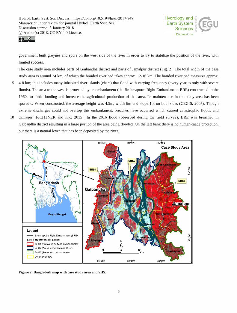
4 Results step 1: Identification of socio-hydrological spaces along the Jamuna River
As noted, in our study area along the Jamuna, three distinct socio-hydrological spaces can be identified; SHS1: areas
protected by the BRE (west bank), SHS2: char areas (in the river bed) and SHS3: areas with a natural levee (east bank).
These are depicted in a schematized fashion in Fig. 3. 15
The SHS are delineated based on physical conditions and related occupation patterns. Different local geomorphology and
flood management measures influence the level of flood frequency and extent, as well as the level of river bank erosion.
Inhabitants of the areas adapt to these physical conditions, which is apparent e.g. in investment levels and cropping patterns.
4.1 Areas protected with flood embankment (west bank) (SHS1)
This socio-hydrological space is protected from ‘normal floods’ by flood embankments along the main river Jamuna (BRE) 20
and some smaller Jamuna tributaries. However, different parts of the area are still frequently ponded with excess rainwater,
due to limited drainage capacity. Further, smaller rivers (Ghagot and Alai) inundate unprotected areas yearly in the western
part of the area. The BRE effectively protects the area against frequent largescale riverine flooding from the Jamuna and as a
result, inhabitants feel relatively confident enough to invest in businesses and homesteads. Yet, the BRE sometimes
breaches. Inhabitants build their houses on artificially raised platform – often several metres above ground level – to reduce 25
their vulnerability to such floods. River bank erosion in this area is not widespread, but does occur in several locations.
4.2 Floodplain outside embankment (west bank) and chars (SHS2)
This is a very dynamic environment. The Jamuna is a braided river, where multiple channels crisscross within the outer
boundary of the river. When considered over decades, channels more and more move into a westward direction (CEGIS,
2007). The ‘chars’ – or river islands – are also moving, progressing or disappearing, due to local erosion and flooding 30
Hydrol. Earth Syst. Sci. Discuss., https://doi.org/10.5194/hess-2017-748Manuscript under review for journal Hydrol. Earth Syst. Sci.Discussion started: 3 January 2018c© Author(s) 2018. CC BY 4.0 License.

9
processes. Chars have different ages, which have a direct relation to the height level. As the river still deposits sediment on
chars, some older chars have higher elevations than the areas in SHS1, and have shown to remain dry in extreme flood
conditions.
If a newly developed char does not erode very quickly it is first colonized by grass, which accelerates deposition of silt
during the next flooding. Consequently, people start to occupy the char, planting fast growing trees and laying out 5
agricultural fields. In the course of time, all kind of facilities like schools, mosques, small shops, bazars etc. are established.
Since the chars are not stable, most of the houses built in the chars are semi-permanent and easy to take apart and move:
kutcha (wood, straw and bamboo mats) or jhupri (straw). Many people raise the plinth levels of their houses to avoid flood
damages, but this is not very effective.
At the ‘chars’, inhabitants regularly face agricultural as well as homestead damages from flooding and river bank erosion, 10
often leading to complete destruction. Temporary migration during the flood season to safer places, for example the
embankment or on railway lines, is therefore very common. Permanent migration occurs only the land that people live and
farm on simply disappears. With migration, and the fluctuations provoked by floods, people also often change their
occupation temporarily or permanently. As char dwellers’ life styles are defined by flood and erosion, they appear to be able
to cope with the harsh conditions. Yet, most of them become poorer through time, because of landlessness, unreliable and 15
changing sources of employment and income and frequent temporary or permanent migration.
4.3 Eastbank (areas with natural levee) (SHS3)
The natural levee on the east bank of the Jamuna protects this area from normal riverine flooding, although flooding occurs
more frequently than in SHS1. A few areas are flooded by smaller rivers like the Old Brahmaputra and Jinjira. High water
levels in these rivers sometimes occur independent of high water levels of the Jamuna, as these are not part of the same 20
drainage basin.
River bank erosion is prominent in this area. Even though the river overall shifts westwards, due to the presence of highly
erodible bank materials on the left bank, erosion is still severe in SHS3. For example, 75 ha of land eroded in 2015 in this
area, of which 4 ha with housing (CEGIS, 2016). People build cross structures (like small spurs), made from bamboo and
wood to stop erosion. However, while these encourage sedimentation at a local scale, they are not sufficient to stop 25
largescale erosion. Like behind the BRE, most houses are built on artificially raised mounds, substantially reducing potential
for flood impacts. Flooding and riverbank erosion causes damage to agriculture, homesteads and businesses, in turn
impoverishing people. Migration is one of their coping strategies, while several farm households also adapt their cropping
pattern to accommodate flooding and cultivate fast growing crops after the flood season.
Hydrol. Earth Syst. Sci. Discuss., https://doi.org/10.5194/hess-2017-748Manuscript under review for journal Hydrol. Earth Syst. Sci.Discussion started: 3 January 2018c© Author(s) 2018. CC BY 4.0 License.
10
Figure 3: A typical planform and cross-section with distinct SHS along the Jamuna.
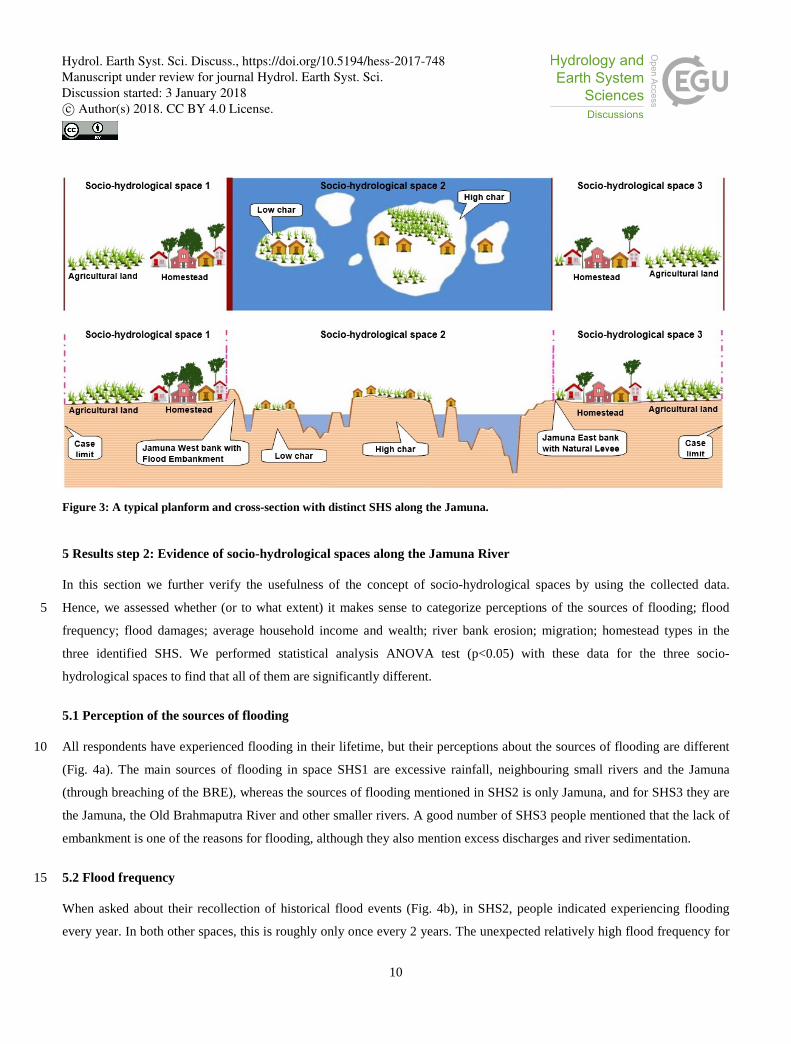
5 Results step 2: Evidence of socio-hydrological spaces along the Jamuna River
In this section we further verify the usefulness of the concept of socio-hydrological spaces by using the collected data.
Hence, we assessed whether (or to what extent) it makes sense to categorize perceptions of the sources of flooding; flood 5
frequency; flood damages; average household income and wealth; river bank erosion; migration; homestead types in the
three identified SHS. We performed statistical analysis ANOVA test (p<0.05) with these data for the three socio-
hydrological spaces to find that all of them are significantly different.
5.1 Perception of the sources of flooding
All respondents have experienced flooding in their lifetime, but their perceptions about the sources of flooding are different 10
(Fig. 4a). The main sources of flooding in space SHS1 are excessive rainfall, neighbouring small rivers and the Jamuna
(through breaching of the BRE), whereas the sources of flooding mentioned in SHS2 is only Jamuna, and for SHS3 they are
the Jamuna, the Old Brahmaputra River and other smaller rivers. A good number of SHS3 people mentioned that the lack of
embankment is one of the reasons for flooding, although they also mention excess discharges and river sedimentation.
5.2 Flood frequency 15
When asked about their recollection of historical flood events (Fig. 4b), in SHS2, people indicated experiencing flooding
every year. In both other spaces, this is roughly only once every 2 years. The unexpected relatively high flood frequency for
Hydrol. Earth Syst. Sci. Discuss., https://doi.org/10.5194/hess-2017-748Manuscript under review for journal Hydrol. Earth Syst. Sci.Discussion started: 3 January 2018c© Author(s) 2018. CC BY 4.0 License.

11
the protected SHS1 may be attributed to the frequent failure of the embankment, or to the fact that the area is flooded from
the regional Ghagot River.
Figure 4: Comparison in between different socio-hydrological spaces (HH = household).
5.3 Flood damages 5
From analysing the flood damage information for extreme events in 1987, 1988 and 2007 and normal conditions in 2015, it
becomes clear that 1988 was the most severe year for all three spaces (ranging from 800 USD per household in SHS3 to
1200 USD in SHS2) (Fig. 4c). In other years, average damages where significantly less. In 1987, damages in SHS1 was
highest (~600 USD), compared to the other zones and damages in 2007 and 2015 were of equal size without large variety
Hydrol. Earth Syst. Sci. Discuss., https://doi.org/10.5194/hess-2017-748Manuscript under review for journal Hydrol. Earth Syst. Sci.Discussion started: 3 January 2018c© Author(s) 2018. CC BY 4.0 License.

12
between the spaces (around ~200 USD). The relatively high damage in SHS1, may be attributed to poor drainage capacity in
these times, as well as that the average land elevation is lower than in the other zones.
5.4 River bank erosion
Riverbank erosion is experienced in each zone, but mainly by inhabitants in the dynamic SHS2. However, erosion rates in
SHS3 is also very high (> 50% of the interviewed people have experienced it themselves). In SHS1 expected rates are 5
lowest, but still considerable, as 30% has experienced it. Almost an identical distribution is found (Fig. 4d) in that
households had to move due the riverbank erosion.
5.5 Average household income and wealth
The average wealth distribution (Fig. 4e) shows clearly the economic differences between the households in the three spaces.
In the protected areas, people have much more wealth (on an average about 19,000 USD). About 80% of the people in the 10
case study area are farmers, thus their income and wealth mostly depends on their agricultural production. Their starting
position and subsequent losses depend to a large extent on where they live.
As per our surveys there were 7% large farmer households (lands> 3 hectares) in 1960 in SHS1 but after consecutive
flooding events, this was reduced to only 2% in 2015 (Fig. 5). Those who owned more land in the past (> 3 hectares)
gradually saw a decline in their farm land to become medium (from 1 to 2.99 hectares) or small farmers (lands from 0.2 to 15
0.99 hectare), with some even becoming landless. There were only 16% landless households in 1960, but this increased to
28% in 2015.
In SHS2 and SHS3, a comparable pattern can be observed. The number of large farm households reduced from 18% to 1 %
and landless farmer households increased from 7% to 48% in SHS2. On the other hand, the land owned and farmed by large
farmers reduced from 10% to 2 % and the proportion of landless farmers increased from 18% to 41% in SHS3. More than 20
80% of the respondents from SHS2 told that they could not recover from the losses due to flooding and riverbank erosion.
Many of them had to change their occupation temporarily, with 3% of the respondents in SHS2 changing their occupation
permanently from farmer to day labourer.
There is a possibility that some respondents exaggerated reported losses in the hope that the research would help to mobilize
funds. This is why we arranged focus group discussions to verify the outcomes from the household surveys. These revealed 25
that the cropping patterns of the protected areas in SHS1 and the unprotected areas SHS2 are different. Respondents in SHS1
are cultivating three crops per year. In the SHS3 areas people used to cultivate three crops earlier, but due to flooding they
now cultivate either two crops or only one crop per year because they cultivate only in the dry season after floods have
subsided. From the survey data it appears that in SHS1 only 15% of the respondents changed cropping patterns between the
1960s and the 2010s, against 53% in SHS3 and 40% in SHS2. A very small number of people have changed land use 30
completely, for example from agriculture to homestead, from low elevation land to high elevation land by filling silts, or
from agriculture to fallow etc.
Hydrol. Earth Syst. Sci. Discuss., https://doi.org/10.5194/hess-2017-748Manuscript under review for journal Hydrol. Earth Syst. Sci.Discussion started: 3 January 2018c© Author(s) 2018. CC BY 4.0 License.

13
Figure 5: Agricultural land changes with time of the different types of farmer (% of HH respondents).
5.6 Migration
The population density in the three spaces from census data show much higher densities in SHS1 than in SHS2 and SHS3. In
SHS1 it is 1,500 person/km2 (varying between 1,000 to 3,000 person/km2), while population density in SHS3 is 800 5
person/km2 (between 100 to 2,000 person/km2). It is lowest in SHS2 at 400 person/km2.
The population data from BBS 2011 show that population density has increased in most of the unions in the spaces, except in
SHS2. Unfortunately, there are no official records of the exact number of people who migrate long or a short distances. From
our survey, we found that the people are mostly migrating from SHS2. Most of the migration occurs from SHS2 to SHS1
and SHS3. From 1988 to 2015, 17% of respondents had migrated to SHS1 and 8% to SHS3. 10
Riverbank erosion is one of the main reasons for moving from their place of origin (Fig. 4f). We found that 80% of the
households in SHS2 had moved at least once. Most of them moved within 5 km, but in focus groups it was said that about
25% of people of that area had migrated away to other districts. About 68% of respondents were born in SHS1 and still live
there, while 25% migrated to SHS1 from other places due to riverbank erosion. In SHS3, about 58% were born locally and
the rest immigrated, again mostly due to riverbank erosion. The respondents who immigrated to new places mostly knew that 15
their new places are flood prone and also experience riverbank erosion. However, the lack of available land is a major
problem and the reason why they move to a risk-prone area.
Hydrol. Earth Syst. Sci. Discuss., https://doi.org/10.5194/hess-2017-748Manuscript under review for journal Hydrol. Earth Syst. Sci.Discussion started: 3 January 2018c© Author(s) 2018. CC BY 4.0 License.

14
5.7 Homestead types
The construction of the houses is different between the spaces (Fig. 6). Most of the pucca houses (well-constructed buildings
using modern masonry materials) and semi-pucca or half pucca houses (made of brick and tin) are within the SHS1 and
SHS3, where people feel comparatively safe against flooding and erosion. As a result, they invest more in their
accommodation. In SHS2 a high proportion of kutcha (wood, straw and bamboo mats) and jhupri (straw) is observed, since 5
these are easy to take apart and move in case of flooding or erosion.
Figure 6: Homestead type of households.
6 Discussion
We introduced the concept of socio-hydrological spaces (SHS) and applied it to a test area along the Jamuna River in 10
Bangladesh. We found it convenient and useful for categorizing and specifying the interaction between sociological and
hydrological processes in the three identified SHS we distinguished in this location. The concept draws attention to the
historical patterns of the hydrological processes of the Jamuna River and as well as different social processes along the three
spaces. Each SHS shows distinct features when comparing flood-society interactions, proving that the dynamic interaction of
floods and society is depending on different hydrological and societal characteristics along the Jamuna River. 15
A key point in the application of the proposed methodology is the initial identification of potential SHS. This step has to do
with the difficulty -and somehow subjectivity- to initially determine the boundaries of the identified spaces. In our example,
we started by fixing the boundaries of three spaces based on the presence of distinct physical features in the landscape: the
embankment on the west bank, the natural levee on the east bank, and the area in between. This is of course an arbitrary
selection. The second step of the methodology aims at proving whether the selection has a statistical meaning, which means 20
that the identified SHS do show distinct and unique dynamics when selected variables are compared. If not, an iteration of
the boundary selection needs to be made and verified.
Hydrol. Earth Syst. Sci. Discuss., https://doi.org/10.5194/hess-2017-748Manuscript under review for journal Hydrol. Earth Syst. Sci.Discussion started: 3 January 2018c© Author(s) 2018. CC BY 4.0 License.

15
Furthermore, the initially selected boundaries might show SHS in the present, but if the identified SHS boundaries are not
fixed over time they need to be redefined. This is for example the case in our test area: an analysis over time of the physical
characteristics of the SHS boundaries show that they are quite dynamic due to continuing bank erosion along both banks of
the Jamuna (Fig. 7). In particular, by analysing satellite images of the case study area from the late 1960s up to now, one can
easily check that the west bank has been migrating westward and the east bank has been migrating eastward. As a result, the 5
length-averaged width of the river has increased from 8.17 km to 11.68 km (CEGIS, 2007). Since the construction of the
BRE in the 1960s, many breaches have occurred due to river bank erosion, forcing relocation of the embankment in many
places (FICHTNER and nhc, 2015). At the same time due to erosion of the east bank the natural levee also moved somewhat
over time. Thus the physical boundary lines between SHS1-SHS2 and SHS2-SHS3 are not fixed in time, showing mobility
of the SHS boundaries. 10
Figure 7: Time series dry season satellite images of the case study area.
It should also be noted that in this specific application, the social boundaries of the SHS are not fixed either. In fact, as
emerges from the data collection, migration in the Jamuna floodplain is not rare, thus people mobility within the SHS might
change the social features of those currently living in each SHS. For our analysis, we have surveyed households according to 15
their current locations. However, in every extreme event some migration occurs among the spaces (see Section 5.6). That
social and physical boundaries to the SHS shift in time is unavoidable and indeed intrinsic to the highly dynamic socio-
hydrology of the floodplain system. Thus, Step 1 in the methodology, identification of SHS, should explicitly and in a
transparent way illustrate the criteria for setting up the initial (spatio-temporal) boundaries of SHS and thus highlight under
what circumstances SHS boundaries should be revised or update. 20
We tested the SHS concept in a quick changing socio-physical environment, namely a floodplain in Bangladesh, and find
that the concept provides a methodological and theoretical advance in the socio-hydrology of floodplains as it helps
identifying and categorizing human-water dynamics in specific geographical locations. We believe that the concept has a
broader validity and can be applied to identify micro-socio—hydrological contexts in other floodplains, characterized by
different socio-physical features. 25
Hydrol. Earth Syst. Sci. Discuss., https://doi.org/10.5194/hess-2017-748Manuscript under review for journal Hydrol. Earth Syst. Sci.Discussion started: 3 January 2018c© Author(s) 2018. CC BY 4.0 License.

16
Finally, a step forward in this research topic is the application of the SHS methodology shown here for the Jamuna
floodplain to analyse physical processes other than floods, such as drought, salt intrusion, irrigated catchments or urban
systems.
7 Conclusions
Socio-hydrological space (SHS) is a concept that enriches the study of socio-hydrology because it helps understand the 5
detailed human-water interactions in a specific location. We demonstrated its use in a small area along the Jamuna floodplain
in Bangladesh. The concept draws attention to how historical patterns in the co-evolution of social behaviour, natural
processes and technological adoptions give rise to different landscapes, different styles of living, and different ways of
organizing livelihoods. The concept suggests that the interactions between society and water are place bound because of
differences in social processes and river dynamics. Rather than a generalized model for understanding how such interactions 10
occur, the concept draws analytical attention to how flood dynamics co-evolve with societal dynamics. Such attention is
useful anywhere in the world and for other socio-hydrological systems than floodplains. This usefulness does not only result
from what it allows to see, as explained above, but also from the relative ease of application in situations where data are too
sparse to use fully deterministic models (as is the case nearly anywhere in the world). Compared with existing approaches in
socio-hydrology, the concept allows taking an intermediary (statistical) position between purely qualitative narratives and 15
deterministic, data-demanding mathematical-conceptual models. Its understanding is more detailed than a general narrative,
but its substantiation is less data-demanding and complicated than running a model based on differential equations. Because
SHS are place bound, and can only be found (literally) on the ground, the use of SHS forces the researcher to actually go to
the field, talk to inhabitants and officials, and obtain a thorough understanding of the specifics of the location. This also
means that the use of SHS will make socio-hydrological analyses more policy-relevant. In terms of practical use, it can for 20
instance be added as additional element to rapid rural appraisals, or other social assessments, to draw attention to how
material conditions (hydrological and technical/infrastructure) co-shape social situations. This would be useful for
developing interventions under disaster management, but also other development goals. In summary, SHS provides a new
way of looking at and analysing socio-hydrological systems.
References 25
Allison, M. A.: Historical Changes in the Ganges-Brahmaputra Delta Front, Journal of Coastal Research, pp. 1269–1275,
1998.
Bangladesh Bureau of Statistics: Population & Housing Census-2011, available at: http://www.bbs.gov.bd/, last access: 10
July 2017.
Hydrol. Earth Syst. Sci. Discuss., https://doi.org/10.5194/hess-2017-748Manuscript under review for journal Hydrol. Earth Syst. Sci.Discussion started: 3 January 2018c© Author(s) 2018. CC BY 4.0 License.
17
Blair, P. and Buytaert, W.: Socio-hydrological modelling: A review asking “why, what and how?, Hydrology and Earth
System Sciences, 20(1), pp. 443–478, doi: 10.5194/hess-20-443-2016, 2016.
Brammer, H.: Can Bangladesh be Protected from floods?, University Press Ltd, Dhaka, 2004.
CEGIS: Long-term Erosion Process of the Jamuna River, Jamuna-Meghna River Erosion Mitigation Project, Bangladesh
Water Development Board. Dhaka, Bangladesh, 2007. 5
CEGIS: Prediction of River Bank Erosion along the Jamuna, the Ganges and the Padma Rivers in 2016, Bangladesh Water
Development Board, Dhaka, Bangladesh, 2016.
Di Baldassarre, G., Montanari, A., Lins, H., Koutsoyiannis, D., Brandimarte, L. and Blschl, G.: Flood fatalities in Africa:
From diagnosis to mitigation, Geophysical Research Letters, 37(22), pp. 2–6. doi: 10.1029/2010GL045467, 2010.
Di Baldassarre, G., Kooy, M., Kemerink, J. S. and Brandimarte, L.: Towards understanding the dynamic behaviour of 10
floodplains as human-water systems, Hydrology and Earth System Sciences, 17(8), pp. 3235–3244, doi: 10.5194/hess-17-
3235-2013, 2013a.
Di Baldassarre, G., Viglione, A., Carr, G., Kuil, L., Salinas, J. L. and Blöschl, G.: Socio-hydrology: Conceptualising human-
flood interactions, Hydrology and Earth System Sciences, 17(8), pp. 3295–3303, doi: 10.5194/hess-17-3295-2013, 2013b.
Di Baldassarre, G., Kemerink, J. S., Kooy, M. and Brandimarte, L.: Floods and societies: the spatial distribution of water-15
related disaster risk and its dynamics, Wiley Interdisciplinary Reviews: Water, 1(April), pp. 133–139, doi:
10.1002/wat2.1015, 2014a.
Di Baldassarre, G., Yan, K., Ferdous, M. R. and Brandimarte, L.: The interplay between human population dynamics and
flooding in Bangladesh: a spatial analysis, Proceedings of the International Association of Hydrological Sciences, 364(June),
pp. 188–191, doi: 10.5194/piahs-364-188-2014, 2014b. 20
Di Baldassarre, G., Viglione, A., Carr, G., Kuil, L., Yan, K., Brandimarte, L. and Blöschl, G.: Debates - Perspectives on
socio-hydrology: Capturing feedbacks between physical and social processes, Water Resources Research, 51(6), pp. 4770–
4781, doi: 10.1002/2014WR016416, 2015.
FAP 16/19: Charland Study Overview: Summary Report. (prepared by Irrigation Support Project for Asia and the Near East
- Flood Action Plan components 16&19)’, Flood Plan Coordination Organisation, Ministry of Irrigation Water Development 25
and Flood Control, Dhaka, 1993.
FICHTNER and nhc: Morphology: Feasibility Report and Detailed Design Priority Reach: Final Report, Annex A, Vol 1
River Bank Improvement Program. Report prepared by FICHTNER & Northwest Hydraulic Consultants (nhc) in association
with Resource Planning & Managment Consultants Ltd; AQUA Consultant & Associates Ltd; IWM and CEGIS for the
BWDB; funded by the World Bank, Dhaka, Bangladesh, 2015. 30
Goodbred, S. L., Kuehl, S. A., Steckler, M. S. and Sarker, M. H.: Controls on facies distribution and stratigraphic
preservation in the Ganges – Brahmaputra delta sequence, Sedimentary Geology, 155(3), pp. 301–316, 2003.
Hofer, T. and Messerli, B.: Floods in Bangladesh: History, dynamics and rethinking the role of the Himalayas, United
Nations University Press, United Nations University, 53-70, Jingumae 5-chome,Shibuya-ku, Tokyo, 150-8925, Japan, 2006.
Hydrol. Earth Syst. Sci. Discuss., https://doi.org/10.5194/hess-2017-748Manuscript under review for journal Hydrol. Earth Syst. Sci.Discussion started: 3 January 2018c© Author(s) 2018. CC BY 4.0 License.

18
Huq, H.: Flood action plan and NGO protests in Bangladesh: An assessment. In N. C. Narayanan, S. Parasuraman, & R.
Ariyabandu (Eds.), Water governance and civil society responses in South Asia. New Delhi, India: Routlege, 2014.
IOM: Assessing the evidence: environment, climate change and migration in Bangladesh, International Organization for
Migration, Dhaka, 2010.
Kates, R. W., C. E. Colten, S. Laska, and S. P. L.: Reconstruction of New Orleans after Hurricane Katrina : A research 5
perspective, Natl. Acad. Sci., 103(40), pp. 14653–14660, doi: 10.1073/pnas.0605726103, 2006.
Kreibich, H., Di Baldassarre, G., Vorogushyn, S., Aerts, J. C. J. H., Apel, H., Aronica, G. T., Arnbjerg-Nielsen, K., Bouwer,
L. M., Bubeck, P., Caloiero, T., Chinh, D. T., Cortès, M., Gain, A. K., Giampá, V., Kuhlicke, C., Kundzewicz, Z. W., Llasat,
M. C, B.: Adaptation to flood risk – results of international paired flood event studies, Earth’s Future, doi:
10.1002/2017EF000606, 2017. 10
Milly, P. C. D., Betancourt, J., Falkenmark, M., Hirsch, R. M., Kundzewicz, Z. W., Lettenmaier, D. P. and Stouffer, R. J.:
Climate change. Stationarity is dead: whither water management?, Science (New York, N.Y.), 319(5863), pp. 573–574, doi:
10.1126/science.1151915, 2008.
Mirza, M.M.Q, Warrick, R. A., and Ericksen, N. J.: The implications of climate change on floods of the Ganges,
Brahmaputra and Meghna rivers in Bangladesh, Climatic Change, 57(3), pp. 287–318, 2003. 15
Montanari, A., Young, G., Savenije, H. H. G., Hughes, D., Wagener, T., Ren, L. L., Koutsoyiannis, D., Cudennec, C., Toth,
E., Grimaldi, S., Blöschl, G., Sivapalan, M., Beven, K., Gupta, H., Hipsey, M., Schaefli, B., Arheimer, B., Boegh, E.,
Schymanski, S. J., Di Baldassarre, G., Yu, B., Hubert, P., Huang, Y., Schumann, A., Post, D. A., Srinivasan, V., Harman,
C., Thompson, S., Rogger, M., Viglione, A., McMillan, H., Characklis, G., Pang, Z. and Belyaev, V.: Panta Rhei—
Everything Flows: Change in hydrology and society—The IAHS Scientific Decade 2013–2022, Hydrological Sciences 20
Journal, 58(6), pp. 1256–1275, doi: 10.1080/02626667.2013.809088, 2013.
O’Connell, P. E. and O’Donnell, G.: Towards modelling flood protection investment as a coupled human and natural system,
Hydrology and Earth System Sciences, 18(1), pp. 155–171, doi: 10.5194/hess-18-155-2014, 2014.
Peel, M. C. and Bloschl, G.: Hydrological modelling in a changing world, Progress in Physical Geography, 35(2), pp. 249–
261, doi: 10.1177/0309133311402550, 2011. 25
Sarker, M. H., Huque, I., Alam, M. and Koudstaal, R.: Rivers, chars and char dwellers of Bangladesh, International Journal
of River Basin Management, 1(1), pp. 61–80, doi: 10.1080/15715124.2003.9635193, 2003.
Sivapalan, M., Savenije, H. H. G. and Blöschl, G.: Socio-hydrology: A new science of people and water, Hydrological
Processes, 26(8), pp. 1270–1276, doi: 10.1002/hyp.8426, 2012.
Sultana, P., Johnson, C. and Thompson, P.: The impact of major floods on flood risk policy evolution: Insights from 30
Bangladesh, International Journal of River Basin Management, 6(4), pp. 339–348, doi: 10.1080/15715124.2008.9635361,
2008.
Tingsanchali, T. and Karim, M. F.: Flood hazard and risk analysis in the southwest region of Bangladesh, Hydrological
Processes, 19(10), pp. 2055–2069, doi: 10.1002/hyp.5666, 2005.
Hydrol. Earth Syst. Sci. Discuss., https://doi.org/10.5194/hess-2017-748Manuscript under review for journal Hydrol. Earth Syst. Sci.Discussion started: 3 January 2018c© Author(s) 2018. CC BY 4.0 License.

19
van Staveren, M. F., and van Tatenhove, J. P. M.: Hydraulic engineering in the social-ecological delta: understanding the
interplay between social, ecological, and technological systems in the Dutch delta by means of “delta trajectories”, Ecology
and Society, 21(1):8, http://dx.doi.org/10.5751/ES-08168-210108, 2016.
van Staveren, M. F., van Tatenhove, J. P. M. and Warner, J. F.: The tenth dragon : controlled seasonal flooding in long-term
policy plans for the Vietnamese Mekong delta, Journal of Environmental Policy & Planning, Taylor & Francis, 0(0), pp. 1–5
15, doi: 10.1080/1523908X.2017.1348287, 2017.
van Staveren, M. F., Warner, J. F. and Khan, M. S. A.: Bringing in the tides. From closing down to opening up delta polders
via Tidal River Management in the southwest delta of Bangladesh, 19, pp. 147–164, doi: 10.2166/wp.2016.029, 2017.
Viglione, A., Di Baldassarre, G., Brandimarte, L., Kuil, L., Carr, G., Salinas, J. L., Scolobig, A. and Blo¨schl, G.: Insights
from socio-hydrology modelling on dealing with flood risk - Roles of collective memory, risk-taking attitude and trust, 10
Journal of Hydrology, Elsevier B.V., 518(PA), pp. 71–82, doi: 10.1016/j.jhydrol.2014.01.018, 2014.
Vis, M., Klijn, F., De Bruijn, K. M. and Van Buuren, M.: Resilience strategies for flood risk management in the Netherlands,
International Journal of River Basin Management, 1(1), pp. 33–40, doi: 10.1080/15715124.2003.9635190, 2003.
Wesselink, A. J., Bijker, W. E., de Vriend, H. J. and Krol, M. S.: Dutch dealings with the Delta, Nature and Culture, 2(2),
pp. 188–209, doi: 10:3167/nc2007.020203, 2007. 15
Wesselink, A., Kooy, M. and Warner, J.: Socio-hydrology and hydrosocial analysis : toward dialogues across disciplines’,
4(April), pp. 1–14, doi: 10.1002/wat2.1196, 2017.
White, G. F.: Human adjustment to floods, Department of Geography Research, The University of Chicago, Chicago, Paper
20(29), 1945.
Hydrol. Earth Syst. Sci. Discuss., https://doi.org/10.5194/hess-2017-748Manuscript under review for journal Hydrol. Earth Syst. Sci.Discussion started: 3 January 2018c© Author(s) 2018. CC BY 4.0 License.