soil survey report of a portion of the lair, augrabies
TRANSCRIPT

Attachment 1: Soil code
SOIL SURVEY REPORT OF A PORTION OF
THE LAIR, AUGRABIES
August 2016
Report compiled by:
B Schloms
Pr. Sci. Nat. (registration Number 400059)

Attachment 1: Soil code
Attachment 1: Soil code
Contents
1 Terms of reference 1
2 Allocation of responsibilities 1
3 Description and classification of soil profiles 1
4 Map legend and soil map 2
5 Physical soil limitations for the production of crops 6
6 Soil suitability for agriculture 7
7 General comments and recommendations 9
8 References 11
Annexures
Annexure A: Structure of soil code and explanation of symbols
Annexure B: Soil Map
Attachment 1: Soil code
1 INTRODUCTION
The soil survey of a portion of the farm The Lair, Augrabies was instructed by Mr Pieter
Badenhorst (Environmental and Water License Consultant) during August 2016. Soil profile
pits were dug by machine during August 2016 and the soil survey was done in the same
week. The soil survey report is an essential document of information for the application of
a plough certificate on this portion of The Lair, Augrabies.
The terms of reference regarding the form of the survey and report were as follow:
A detail soil survey of a portion of the farm The Lair to determine the inherent
properties, mainly physical and morphological, of the soils.
Compilation of a soil map at scale large enough to describe the natural distribution of
the soils.
Description of the soils in the different map units in terms of their physical and
morphological properties.
Evaluation of the general suitability of the soils in terms of agricultural potential
according to the guidelines of Lambrechts et al and the National Department of
Agriculture published in 2004.
2 ALLOWCATION OF RESPONSIBILITIES
The following individuals were responsible for the various actions during the soil survey:
The soil surveyor for providing a base map with contours and the management of
The Lair for the digging of soil pits. Initially a fixed grid spacing of 120 m x 120 m
was recommended and in total 16 profile pits were dug. Due to the net cover over
the whole study area, it was impossible to dig the profile pits on a grid except for a
middle road where two pits (1and 2) were made. The rest of the soil profiles were
dug on the outer boundary of the study area.
The soil surveyor (soil specialist and compiler of this report) for describing and
classifying the soil profiles in the field.
The surveyor was be responsible for compilation of the soils map and a report on the
properties, limitations and relative suitability of the soils for table grapes. A contour
map with an aerial photograph background drawn and the GPS coordinates were
used to pin point the exact position of the profile pits.

Attachment 1: Soil code
The final soil and potential map was compiled by Vinpro using Arc GIS software.
Interpolation of soil potential was done by using the spatial analyst extension
3 DESCRIPTION AND CLASSIFICATION OF SOIL PROFILES
A total of 16 profile pits were described during the field study that took place. The soil
profiles were investigated in the field and the important properties were described following
standard procedures.
Based on recognizable, as well as inferred properties, the soils were classified according to
Soil Classification: A Taxonomic system for South Africa (Soil Classification Working
Group, 1991) into soil forms and soil families. This system is based on the recognition of
diagnostic soil horizons and materials.
Soil forms are defined in terms of the type and vertical sequence of diagnostic horizons or
materials. For communication, soil forms are given locality names, e.g. Glenrosa and
Oakleaf. These names are abbreviated to two-letter symbols, e.g.Gs for Glenrosa and Oa for
Oakleaf forms.
Soil forms are subdivided into soil families using properties that are not used in the definition
of diagnostic horizons or materials. Reference to a soil family is by combining the soil form
abbreviation and a four-digit symbol, e.g. Gs1211 is family number 1211 of the Glenrosa
form. In Tables 1 & 2 all the soil forms and families identified during the soil survey are
briefly described according to the soil code.
Depending on the purpose of the soil survey, soil families can be subdivided on an ad hoc
basis into soil phases using properties such as soil and horizon depths, stoniness etc.
Phase subdivision is achieved by detail coding of individual soil profiles (see Annexure A:
Structure of Soil Code and Explanation of Symbols).
During the survey 4 different soil forms and 4 soil families were identified (see Annexure C:
Soil forms and Families on The Lair.
Attachment 1: Soil code
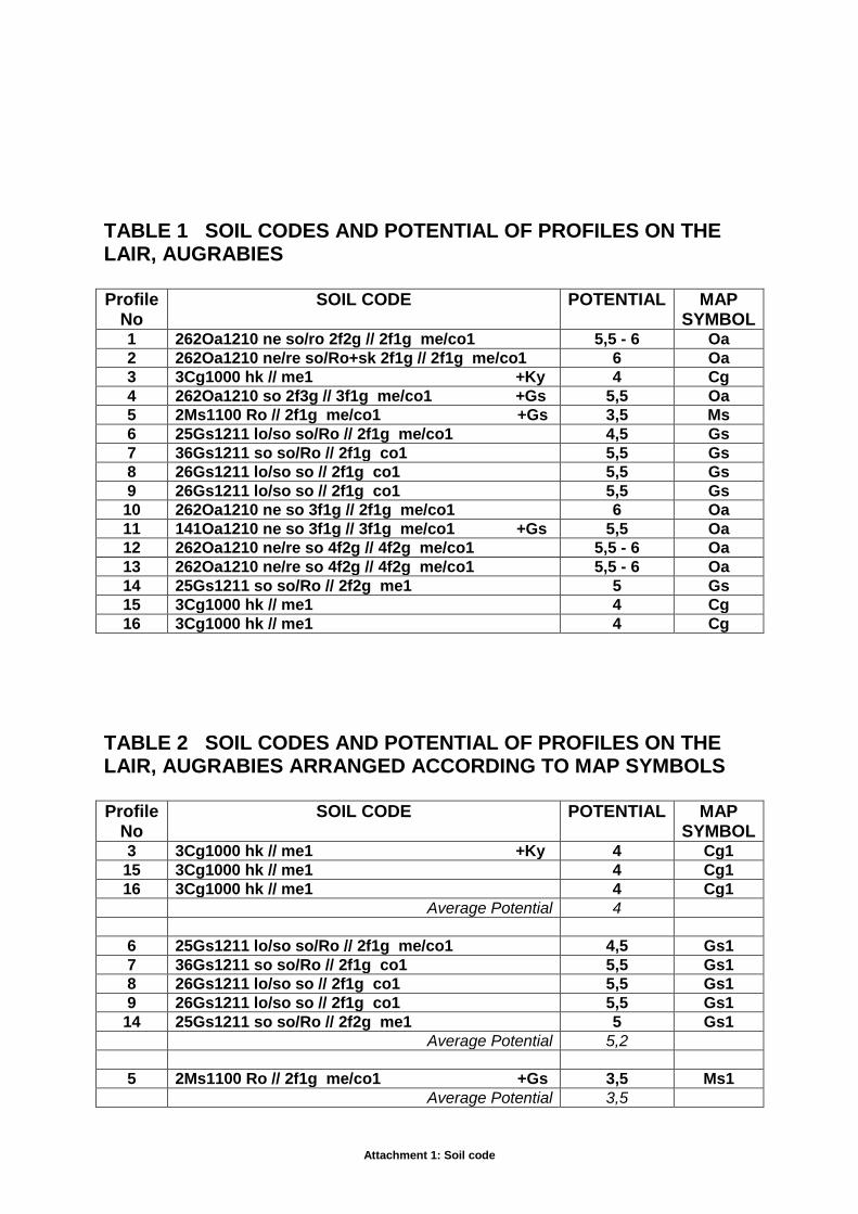
TABLE 1 SOIL CODES AND POTENTIAL OF PROFILES ON THE LAIR, AUGRABIES Profile
No SOIL CODE POTENTIAL MAP
SYMBOL 1 262Oa1210 ne so/ro 2f2g // 2f1g me/co1 5,5 - 6 Oa
2 262Oa1210 ne/re so/Ro+sk 2f1g // 2f1g me/co1 6 Oa
3 3Cg1000 hk // me1 +Ky 4 Cg
4 262Oa1210 so 2f3g // 3f1g me/co1 +Gs 5,5 Oa
5 2Ms1100 Ro // 2f1g me/co1 +Gs 3,5 Ms
6 25Gs1211 lo/so so/Ro // 2f1g me/co1 4,5 Gs
7 36Gs1211 so so/Ro // 2f1g co1 5,5 Gs
8 26Gs1211 lo/so so // 2f1g co1 5,5 Gs
9 26Gs1211 lo/so so // 2f1g co1 5,5 Gs
10 262Oa1210 ne so 3f1g // 2f1g me/co1 6 Oa
11 141Oa1210 ne so 3f1g // 3f1g me/co1 +Gs 5,5 Oa
12 262Oa1210 ne/re so 4f2g // 4f2g me/co1 5,5 - 6 Oa
13 262Oa1210 ne/re so 4f2g // 4f2g me/co1 5,5 - 6 Oa
14 25Gs1211 so so/Ro // 2f2g me1 5 Gs
15 3Cg1000 hk // me1 4 Cg
16 3Cg1000 hk // me1 4 Cg
TABLE 2 SOIL CODES AND POTENTIAL OF PROFILES ON THE LAIR, AUGRABIES ARRANGED ACCORDING TO MAP SYMBOLS Profile
No SOIL CODE POTENTIAL MAP
SYMBOL 3 3Cg1000 hk // me1 +Ky 4 Cg1
15 3Cg1000 hk // me1 4 Cg1
16 3Cg1000 hk // me1 4 Cg1
Average Potential 4
6 25Gs1211 lo/so so/Ro // 2f1g me/co1 4,5 Gs1
7 36Gs1211 so so/Ro // 2f1g co1 5,5 Gs1
8 26Gs1211 lo/so so // 2f1g co1 5,5 Gs1
9 26Gs1211 lo/so so // 2f1g co1 5,5 Gs1
14 25Gs1211 so so/Ro // 2f2g me1 5 Gs1
Average Potential 5,2
5 2Ms1100 Ro // 2f1g me/co1 +Gs 3,5 Ms1
Average Potential 3,5

Attachment 1: Soil code
1 262Oa1210 ne so/ro 2f2g // 2f1g me/co1 5,5 – 6 Oa1
2 262Oa1210 ne/re so/Ro+sk 2f1g // 2f1g me/co1 6 Oa1
10 262Oa1210 ne so 3f1g // 2f1g me/co1 6 Oa1
12 262Oa1210 ne/re so 4f2g // 4f2g me/co1 5,5 – 6 Oa1
13 262Oa1210 ne/re so 4f2g // 4f2g me/co1 5,5 – 6 Oa1
Average Potential 5,85
4 262Oa1210 so 2f3g // 3f1g me/co1 +Gs 5,5 Oa2
11 141Oa1210 ne so 3f1g // 3f1g me/co1 +Gs 5,5 Oa2
Average Potential 5,5
In Table 2 codes of all the profiles described are listed alphanumerical according to the soil
map legend. Average suitability is also calculated for each map unit type.
4 MAP LEGEND AND SOIL MAP
A basic mapping legend was compiled to accommodate the variation in soil properties.
soil form, and
diagnostic horizons
Additional soil properties such as:
family criteria;
clay content of A horizon (topsoil);
depth to B horizon;
depth to and nature of lower subsoil horizons/materials;
coarse fragments in top-soils and/or upper sub-soil horizons, and
effective depth
are listed for each map unit. Additional properties may be deduced from the detail soil code.
With reference to the accuracy of the soil map, the following aspects should be kept in mind:
According to the original recommendation the grid spacing of the profile pits should
be 120 m x 120 m. This means that the minimum size of a map unit that can be
identified is approximately 1.44 ha. Soil units smaller than these limits could
therefore be included in larger soil units on the map.
In situations where the boundaries between map units coincide with relatively
Attachment 1: Soil code
prominent changes in slope or other soil surface features, the soil boundaries are
should be fairly accurate. On The Lair, however, the slope is virtually near level
(<2%) and the soil boundaries are therefore only approximate divisions.
The soil map units are shown on the Soil Map (Annexure A) and are identified by means of
a symbol that consists of the abbreviation for the soil form combined with an Arabic number
(e.g. Gs 1). The number suffix has no intrinsic meaning. It is only serves as an identifier for
different map units that consist of soils belonging to the same soil form, but differ in one or
more important soil properties.
5 PHYSICAL SOIL LIMITATIONS
The minimum useable soil depth required for good root development and water and nutrient
uptake to ensure healthy and productive plants differ greatly between different plant types
and rootstocks. In addition, the tolerance of different plants to soil wetness and soil borne
diseases may also vary. In the following paragraphs the most important soil properties on
The Lair which might affect infiltration, root development, and nutrient and water uptake will
be discussed.
5.1 Low clay content in upper part of profile
The ability of soils to store water and plant nutrients for use by plants is determined mainly
by the clay content, particularly when the soils has a low organic matter content (<1 %
organic carbon). At a clay content of less than 8 - 10 % the water storage capacity is
already so low that it can be considered a limitation for crop production; the lower the clay
content, the greater the limitation.
A low clay content is regarded as a limitation because such soils become very warm and dry
out quickly. It is therefore difficult to maintain plant available water at an optimal level during
warm summer months.
Sandy soils are normally permeable with a very rapid hydraulic conductivity and they are
leached very quickly. It is therefore difficult to maintain the concentration of soluble plant
nutrients (particularly nitrogen and potassium) at an acceptable level for optimal growth and
development.
Another limitation of sandy top soils with low organic matter content is their susceptibility for
water and wind erosion; the latter especially when the surface is bare during warm, dry
Attachment 1: Soil code
periods. Wind transported sand grains can also cause serious mechanical damage to young
plants. At The Lair however this is a minor problem due to the irrigation and trellising
practices applied to table grapes. The practice of covering table grape blocks with netting will
eliminate this potential problem as well.
It is important that irrigation systems on such soils are well designed and must be able to
supplement water loss during periods with exceptionally high evapotranspiration. With
regular soil water monitoring, above average irrigation management and other measures
such as organic mulches, these limitations can largely be overcome. The same comments
are applicable to fertilization.
Another problem of sandy top soils is that topsoil structures, e.g. ridges are extremely
unstable and need regular maintenance. Sandy ridges dry our very quickly and become
extremely warm.
5.2 Dense subsoil layers
Dense subsoil layers such as partly weathered granitic gneiss occur at different depths over
virtually the whole surveyed area. This material is both diagnostic and non-diagnostic in the
South African Soil Classification System and noted in the soil code as either lo or so. Un
weathered rock is noted as Ro in the code.
With a clear to abrupt (sharp) increase in clay from the overlying horizon to the gneiss layer,
free water may accumulate in the overlying, lighter textured horizon during as a result of
over-irrigation. Under conditions of water saturation, reduction and loss of iron leads to the
development of a bleached E horizon in the overlying sandy material.
The effective depth of soils with dense subsoil layer can be increased by deep ripping of the
soil. This is however a general soil preparation practice along the Lower Orange River which
not only increases soil rooting depth but also the water holding capacity of the profile.
6 SUITABILITY OF SOIL TYPES FOR TABLE GRAPE PRODUCTION
The most common limitations for crop production of the soils in the study area are the
following:
• low clay content

Attachment 1: Soil code
dense subsoil layers
During the field soil survey the individual soil pits were evaluated by the surveyors in terms
of its suitability for the commercial production of irrigated perennial crops, e.g. table grapes.
The suitability rating ranges from 1 to 10, with 1 the lowest and 10 equal to the highest or
best suitability. The suitability rating refers to vigour and potential production potential
without considering product quality. Although fairly subjective, suitability ratings by
experienced soil scientists with many years of field experience are a handy tool to group soil
types into production potential classes and for land use recommendations. The ratings can
be interpreted according to the guidelines in Table 3.
Table 3 Interpretation of suitability ratings
Rating General suitability
2 Very low Not recommended
2 - 3 Low
3 - 4 Low-medium Marginally recommended
4 - 5 Medium Conditionally recommended
5 - 6 Medium-high Recommended
6 High Highly recommended
The suitability ratings for irrigated perennial crops largely depend on limiting soil
properties/features such as dense subsoil clay pans, seasonal wetness, cemented
hardpans, low clay content in top- and upper subsoil and coarse fragments. The average
rating for each map unit in Table 2 was calculated from the individual profile ratings.
Table 4 Average suitability rating (Lambrechts) of soil types for the
production of irrigated table grapes
Map symbol
% Of total profiles
Average suitability
Recommendation for irrigated deciduous fruit
Cg1 18,7 4 Marginally recommended
Gs1 31,3 5,2 Recommended
Ms1 6,2 3,5 Marginally recommended

Attachment 1: Soil code
Oa1 31,3 5,85 Recommended
Oa2 12,5 5,5 Recommended
7 AGRICULTURAL LAND POTENTIAL (NATIONAL DEPARTMENT of
AGRICULTURE)
The National Department of Agriculture published a report in which the criteria for
high potential agricultural land in South Africa were defined (Schoeman, 2004). In
the report a number of concepts and terminology applicable to the evaluation of
agricultural land potential were defined. These definitions include inter alia the
following:
Agricultural means land zoned for agricultural use.
Land means the total natural environment of the exposed part of the earth’s
surface, including atmosphere, climate, soils, vegetation and the cultural
environment.
Arable means land that can produce crops requiring tillage; land so located
and constituted that production of cultivated crops is economical and
practical.
Effective soil depth means the depth of soil material that plant roots can
penetrate readily to obtain water and plant nutrients; the depth to a layer that
differs sufficiently from the overlying material in physical or chemical
properties to prevent or seriously retard the growth of roots.
High potential means prime or unique.
Permanent irrigation means the availability for, and regular artificial
application of, water to the soil for the benefit of growing crops. Application
may be seasonal.

Attachment 1: Soil code
Prime means the best land available, primarily from the national perspective,
but with allowance of provincial perspectives; land best suited to, and capable
of, consistently producing acceptable yields of a wide range of crops (food,
feed, forage, fibre and oilseed), with acceptable expenditure of energy and
economic resources and minimal damage to the environment (and is
available for these uses);
Topsoil clay content means the average percentage clay-sized material
(<0.002 mm) in the uppermost part of the soil; that is, the part ordinarily
moved in tillage, or its equivalent in uncultivated soils, ranging in depth from
about 100 to 300 mm; frequently designated as the plough layer or the Ap
horizon;
Unique agricultural land means land that is or can be used for producing
specific high-value crops. It is usually not prime, but important to agriculture
due to a specific combination of location, climate or soil properties that make
it highly suited for a specific crop when managed with specific farming or
conservation methods. Included is agricultural land of high local importance
where it is useful and environmentally sound to encourage continued
agricultural production, even if some or most of the land is of mediocre quality
for agriculture and is not used for particularly high-value crops.
Schoeman (2004) defined a range of soil forms for the Western Cape that qualify for
high potential agricultural land. A minimum effective depth of 30 cm and a topsoil
clay content of >5 - <35 % were used as additional criteria for the identification of
high potential agricultural land.
In the agricultural land potential evaluation system of Schoeman (2004), only one
minimum effective depth (viz. >30 cm) is specified irrespective of the growing season
of the crop. The effective depth of all the soils in the Lower Orange River area are
>300mm after soil preparation which increases the water holding capacity as well
as the cation exchange capacity.
Due to the unique climatic conditions of the Lower Orange River high value crops
such as table grapes can be grown which reaches the European markets in the peak

Attachment 1: Soil code
season. The soils can thus be classified as unique agricultural land according to the
National Department of Agriculture.
8 REFERENCES
Lambrechts, JJN; Van Zyl, J; Ellis, F and Schloms, BHA. 1978. Grondkode en kaartsimbool
vir detail kartering in die Winterreënstreek. Technical Communication No. 165, Dept. Agric.
Tech. Services, Pretoria.
Schoeman, JL, 2004. Criteria for high potential agricultural land. National Department of
Agriculture, Pretoria. Report Number GW/A/2002/21.
Soil Classification Working Group. 1991. Soil Classification: A Taxonomic System for South
Africa. Mem. Natural Agric. Resources for S.A. No. 15.

Attachment 1: Soil code
Annexure A
Structure of soil code and explanation of symbols
Contents
1 Structure of soil code
2 Classes and symbols for properties above the line
2.1 Horizon and/or effective depths
2.2 Soil Form
2.3 Soil family
2.4 Subsoil limitations and properties
Hardpans; irreversibly cemented
Hardpans; reversibly cemented
Moderate to strongly structured, unconsolidated material without signs of wetness
Weaker than moderately structured, unconsolidated material without signs of wetness
Unconsolidated material with signs of wetness; predominantly gleyed
Unconsolidated material with signs of wetness; predominantly plinthic
Unconsolidated material with weakly developed signs of wetness
Diagnostic and non-diagnostic material with signs of weathering residual rock
Textural stratification in diagnostic and non-diagnostic unconsolidated material
Predominantly gravelly, stony, or bouldery diagnostic and non-diagnostic horizons or materials
Additional properties in diagnostic and non-diagnostic horizons or materials
3 Classes and symbols for properties below the line
3.1 Coarse fragments in topsoil horizon and outcrops
3.2 Texture of topsoil and directly underlying E or apedal B1 horizon
3.3 Soil water conditions
3.4 Changes in soil properties and conditions
Recent deposits on the A horizon
Water or wind erosion
Phenomena on or in the A horizon or plough layer
Deep soil cultivation
Attachment 1: Soil code
Other changes
4 Examples of a fully coded soil description
Structure of soil code
The code consists of two series of letter-number symbols, separated by a horizontal line, arranged in the following order:
Position to horizontal line For description
refer to section
Above the line
Depth of horizons and/or materials Soil form Soil family Subsoil limitations or properties
2.1 2.2 2.3 2.4
Below the line
Coarse fragments in the topsoil horizon and outcrops Texture of topsoil horizon and underlying E or apedal B1 Soil water conditions Changes in soil properties and conditions
3.1 3.2 3.3 3.4
In a Microsoft Word or Excel table the letter-number symbols can be written in a single line with the “above the line” letter-number symbols followed by the “below the line” letter-number symbols.
In uncultivated soils the term topsoil horizon refers to the natural A horizon, while for cultivated soils it refers to the upper 150 - 300 mm of the soil profile affected by tillage.
2 Classes and symbols for properties above the line
2.1 Horizon and/or effective depths
The depths of all the diagnostic as well as non-diagnostic horizons and/or materials encountered in a profile are coded with a number symbol in front of the soil form symbol. Depth classes and symbols used are:
Depth class (mm) Symbol
Depth class (mm) Symbol
0 - 150 1 750 - 950 7
150 - 250 2 950 - 1 150 8
250 - 350 3 1 150 - 1 350 9
350 - 450 4 1 350 - 1 550 0
450 - 550 5 >1 550 no symbol 550 - 750 6
Depth symbols for diagnostic horizons or materials specified in a particular soil form are arranged from shallow (topsoil transition) to deep (deepest subsoil transition) before the form
Attachment 1: Soil code
symbol (e.g. 3 5 Es 1100, where 3 refers to the A/E transition and 5 to the E/B transition). Depth symbols for subsoil limitations or properties (arranged from shallow to deep) appear between the depth symbols for diagnostic horizon transitions and the form symbol (e.g. 3 5 3 Es 1100; the second 3 indicates the depth of a subsoil limitation or property.)
2.2 Soil Form
Soil forms and abbreviations used in the soil code are explained by the Soil Classification Working Group (1991). For example Tu is the abbreviation for a Tukulu form soil.
2.3 Soil family
Soil families are identified by a locality name or coded by means of a four-digit symbol (Soil Classification Working Group, 1991). For example 1120 is the four-digit symbol for the Olivedale soil family of the Tukulu soil form. In the code the four-digit symbol is used directly after the soil form abbreviation symbol; e.g. Tu 1120.
2.4 Subsoil limitations and properties
The depth of soil utilized by plant roots is determined by a variety of soil materials and factors. For example, in the Estcourt soil form the maximum effective root depth is determined by the prismacutanic B. In the Avalon form the depth is restricted seasonally by a fluctuating free water table that leads to the development of the soft plinthic B horizon. In other forms, e.g. Mispah, weathering rock determines the effective depth.
In those forms where the limiting horizon is part of the defined sequence of horizons that is diagnostic of the soil form, the symbol for the limiting material or horizon do not have to be coded. It is, however, recommended that symbols for all diagnostic horizons are included in the code. If the limiting horizon or material is not included in the sequence of diagnostic horizons, the symbol for the specific horizon or material must be specified after the family number in the code. The depth symbol for such horizons is written between the depth symbol for diagnostic horizons and the soil form symbol.
The more important materials that may affect root penetration and water infiltration to a greater or lesser extent are one or more of the following:
Hardpans; irreversibly cemented
This is soil material cemented by one or more compounds to such an extent that it does not soften in water.
ba - Bauxite pan: cemented by aluminium hydroxides, e.g. gibbsite.
db - Dorbank: cemented by silica. Calcium carbonate and iron oxide are permissible as secondary cementing agents. It meets the requirements of a diagnostic dorbank horizon.
hg - Gypsic pan: cemented or indurated by gypsum (calcium sulphate), with or without other cementing agents. It must contain at least 5 % gypsum. It meets the requirements of petrogypsic horizon as defined in Soil Taxonomy.

Attachment 1: Soil code
hk - Calcrete: cemented by calcium and/or magnesium carbonate. It meets the requirements of a hardpan carbonate horizon.
hp - Ferricrete: cemented by iron and/or manganese oxides/hydroxides. It meets the requirements of hard plinthite. If the colour of the ferricrete is predominantly black due manganese accumulation, it should be specified with the symbol mn, e.g. hp1/mn
or - Ortstein: cemented by organic matter, with or without iron and/or aluminium hydroxides. It meets the requirements of an indurated ortstein podzol B horizon.
pp - Ironpan: a material which largely meets the requirements of a diagnostic placic pan.
si - Silcrete: cemented by silica; no other cementing agent(s) is present.
ms - Hardpans: cemented by compounds other than those mentioned above.
Hardpans; reversibly cemented
These are pans that appear cemented when dry, but soften when left in water overnight.
xp - Fragipan (Afr. brosbank): a subsurface material, usualy mottled, low in organic material with a high bulk density. It appears cemented when dry. It is usually polygonal with bleached fracture planes. It is slowly permeable to water. When moist it shows a moderate to weak brittleness.
The degree of cementation is distinguished in terms of the intensity and continuity of cementation:
1 - Hard: Numerous vertical fracture planes, or vesicular; moderate degree of cementation; more than 25% of the layer is accessible and penetrable to roots; sufficient fracture planes for free drainage through the pan under normal conditions.
2 - Very hard: Platy and/or massive with occasional vertical fracture planes; moderate to high degree of cementation; predominantly impenetrable to roots; locally (<25% over a horizontal section) soft enough for root penetration; sporadic accumulation of free water on the pan.
3 - Extremely hard: Massive and/or continuously platy with no fracture planes in which root development can occur; under normal conditions impermeable to water; regular accumulation of free water on the pan.
Example: A hardpan cemented primarily by iron with vertical cracks approximately 10 mm to 15 mm apart is coded by the symbol hp2.
Attachment 1: Soil code
Moderate to strongly structured, unconsolidated material without signs of wetness
pr - Prismatic clay: a non-gleyed material with a strong prismatic or columnar structure. It largely meets the requirements of a prismacutanic B horizon.
ve - Coarse blocky clay with vertic properties; numerous slickensides and cracks when dry. It largely meets the requirements of a vertic A horizon.
vp - Blocky clay: a non-gleyed soil material with a non-uniform non-red colour and a moderate or stronger structure when moist. It largely meets the requirements of a pedocutanic B horizon
vr - Blocky clay: a non-gleyed soil material with a uniform red colour and a moderate or stronger structure when moist. It largely meets the requirements of a red structured B horizon
Weaker than moderately structured, unconsolidated material without signs of wetness
al - Alluvial material.
nc - Calcareous unconsolidated material with signs of soil development, e.g. aggregation, clay illuviation and/or disappearance of original stratification. It largely meets the requirements of a neocarbonate B horizon. Red as well as non-red variants occur.
ne - Non-calcareous unconsolidated material with signs of soil formation, e.g. aggregation, clay illuviation and/or disappearance of original stratification. It largely meets the requirements of a neocutanic B horizon. Its colour must not qualify for diagnostic red or yellow-brown apedal, although red and yellow-brown variants occur.
ng - An illuvial horizon in which secondary gypsum (calcium sulphate) has accumulated to a significant extent. It contains at least 5 % total gypsum and 1 % or more secondary visible gypsum crystals. It may be calcareous and has other signs of soil formation, e.g. aggregation, clay illuviation and/or disappearance of original stratification. It largely meets the requirements of a gypsic horizon as defined in Soil Taxonomy. Its colour must not qualify for diagnostic red or yellow-brown apedal, although red and yellow-brown variants occur.
pd - Material which largely meets the requirements of a podzol B horizon.
re - Red, non-calcareous soil material with a structure weaker than moderate blocky or prismatic. It largely meets the requirements of a red apedal B horizon.
rp - A material in which accumulation of sesquioxides in the form of mottles (usually red, dark brown, black; occasionally yellow) and/or concretions occur. There are no signs of gleying in the material or the horizon; the matrix is usually red or yellow. In exceptional cases the concretions form a continuous, vesicular indurated layer that can be confused with hardpan ferricrete. Locally such material is described as relic plinthite and are associated with high-lying incised landscapes.
Attachment 1: Soil code
rs - Sandy material which largely meets the requirements of diagnostic regic sand.
sk - Calcareous material which largely meets the requirements of a soft carbonate horizon.
ye - Brown or yellow-brown, non-calcareous soil material with a structure weaker than moderate blocky or prismatic. It largely meets the requirements of a yellow-brown apedal B horizon.
Note: The colour of certain of these horizons/materials (e.g. nc and ne) might be important for land use interpretation and soil suitability evaluation. In such cases the dominant colour should be coded by using the following colour abbreviation symbols: br = brown; brye = brownish yellow; dkbr = dark brown; gr = grey; pl = pale; re = red; rebr = reddish brown; reye = reddish yellow; stbr = strong brown; ye = yellow; yebr = yellowish brown and yere = yellowish red.
For example the combined symbol ne/yere (horizon/material symbol linked to the colour symbol with forward slash) refers to a yellowish red neocutanic horizon/material.
Unconsolidated material with signs of wetness; predominantly gleyed
gc - Gleyed clay, usually with a firm or firmer consistency; it is firmer than the overlying horizon. If the structure is prismatic or columnar, it is usually weakly developed; moderate to strong blocks are permitted. It largely meets the requirements of a G horizon.
gl - Gleyed loam, usually with a consistency not firmer than firm; it is usually not firmer than the overlying horizon. If the structure is prismatic or columnar, it is usually weakly developed; moderate to strong blocks are not permitted. It largely meets the requirements of a G horizon.
gs - Gleyed, coarse textured material, usually friable, non-sticky and non-plastic. It largely meets the requirements of a sandy E horizon.
Unconsolidated material with signs of wetness; predominantly plinthic
sp - A material in which accumulation of sesquioxides in the form of mottles (usually yellow, brown; sometimes red, black) and/or concretions occur. The matrix usually has light grey colours because of gleying. It largely meets the requirements of a soft plinthic B horizon.
Unconsolidated material with weakly developed signs of wetness
In certain soils with a sandy to loamy diagnostic red or yellow-brown apedal B horizon or with a red or yellow coloured neocutanic B horizon overlying a gleyed loam (gl), gleyed clay (gc) or saprolite with prominent signs of wetness (lw or sw), the colour value and chroma of the apedal material below the diagnostic B horizon may decrease significantly. Colour values of 7 to 8 and chromas of 6 to 8 in the dry and moist state are common. Although the lighter colour is an indication of a decrease in free iron, there is no evidence of bleaching and mottling typical of many diagnostic E horizons. These horizons are therefore considered to be more suitable for root development than layers that qualify for gs.

Attachment 1: Soil code
ys - Coarsely textured material, always friable, non-sticky and non-plastic, underlying apedal chromatic horizons, with a uniform pink to yellow colour with colour values of 7 to 8 and chromas of 6 to 8. It does not show the bleaching and mottling diagnostic for E horizons.
Diagnostic and non-diagnostic material with signs of weathering residual rock
Material in various stages of weathering and alteration that ranges from hard rock to completely homogenized soil that has cutanic character expressed as tongues or prominent colour variegation resulting from residual soil formation and illuviation occurs in many soils. It may occur in soils as diagnostic (e.g. lithocutanic B horizon, saprolite, hard rock) or non-diagnostic horizons or materials. Such materials should always be coded when it occur as a non-diagnostic horizon of material in a soil. At times it may be essential to code it as a diagnostic horizon or material.
Depending on the degree of weathering two kinds of weathering rock are recognized, viz:
Saprolite (or lithocutanic B) is a horizon of weathering rock with general organization in respect of colour, structure or consistence that is clearly related to the underlying parent rock. With depth it grades into relatively unweathered rock and eventually fresh rock. It does not qualify as a diagnostic soft or hardpan carbonate horizon, dorbank or hard rock.
Hard rock is, in contrast with saprolite, a continuous hard layer of rock, that even in the wet state, cannot be cut with a spade. The most important examples are igneous, metamorphic and indurated sedimentary rock and silcrete. It is a material that does not qualify as a hard plinthic B horizon, as a hardpan carbonate horizon or as a dorbank.
The following variants are recognized in terms of degree of weathering and wetness:
lo - It conforms to the requirements of saprolite (or lithocutanic B horizon). Less than 70 % of the volume of such a horizon or material consists of rock, fresh or partially weathered, with at least a hard consistence in the dry, moist and wet state. No signs of wetness are present.
lw - Material as defined for lo, except that it contains signs of wetness.
so - It conforms to the requirements of saprolite (or lithocutanic B horizon). More than 70 % of the volume of such a horizon or material consists of rock, fresh or partially weathered, with at least a hard consistence in the dry, moist and wet state. No signs of wetness is present.
sw - Material as defined for so, except that it contains signs of wetness.
Ro - It conforms to the requirements of hard rock. No signs of wetness are present.
Rw - Material as defined for Ro, except that it contains signs of wetness.
Textural stratification in diagnostic and non-diagnostic unconsolidated material
Depending on the mode of transport (water or wind) and deposition, some

Attachment 1: Soil code
unconsolidated materials are texturally stratified. However, with time soil development may result in the disappearance of the stratification. However, in certain young soils stratification can still be detected. Since textural stratification is an important characteristic in land use, it has to be indicated in the code in the following way:
Description Symbol
Textural stratification prominent
Alternating sand and silt layers U1
Alternating sand and clay layers U2
Alternating silt and clay layers U3
Alternating sand, silt and clay layers U4
Textural stratification non-prominent or absent
Predominantly sandy U5
Predominantly loamy or porous silt U6
Predominantly clayey or dense silt U7
Non-red stratified alluvium is qualified in terms of accumulation of organic matter and/or degree of bleaching by one of the following symbols:
bl - Highly bleached; pale coloured material; usually sandy.
hu - Dark, organic rich without signs of periodic wetness in or below the horizon.
pt - Dark, peaty, organic rich layer with signs of periodic wetness in or below the horizon.
These symbols are linked to the symbol for the type of non-red stratified alluvium by a hyphen (-). For example, the code for a highly bleached, predominantly sandy alluvium with poorly visible textural stratification is U5 - bl.
Predominantly gravelly, stony, or bouldery diagnostic and non-diagnostic horizons or materials
Coarse fragments (> 2 mm) can occur in varying quantities either in a part of or throughout a horizon or layer. Such coarse material can seriously affect root development, water infiltration and water holding capacity and must be indicated in the soil code in terms of size and quantity (volume percentage).
The predominant size classes and symbols for coarse fragments used in the code are as follows:
Class name Size Symbol
Fine gravel 2 - 25 mm f
Coarse gravel 25 – 75 mm g
Stones 75 - 250 mm k
Boulders > 250 mm r
The volume percent of coarse fragment classes is qualified by the following numerals:
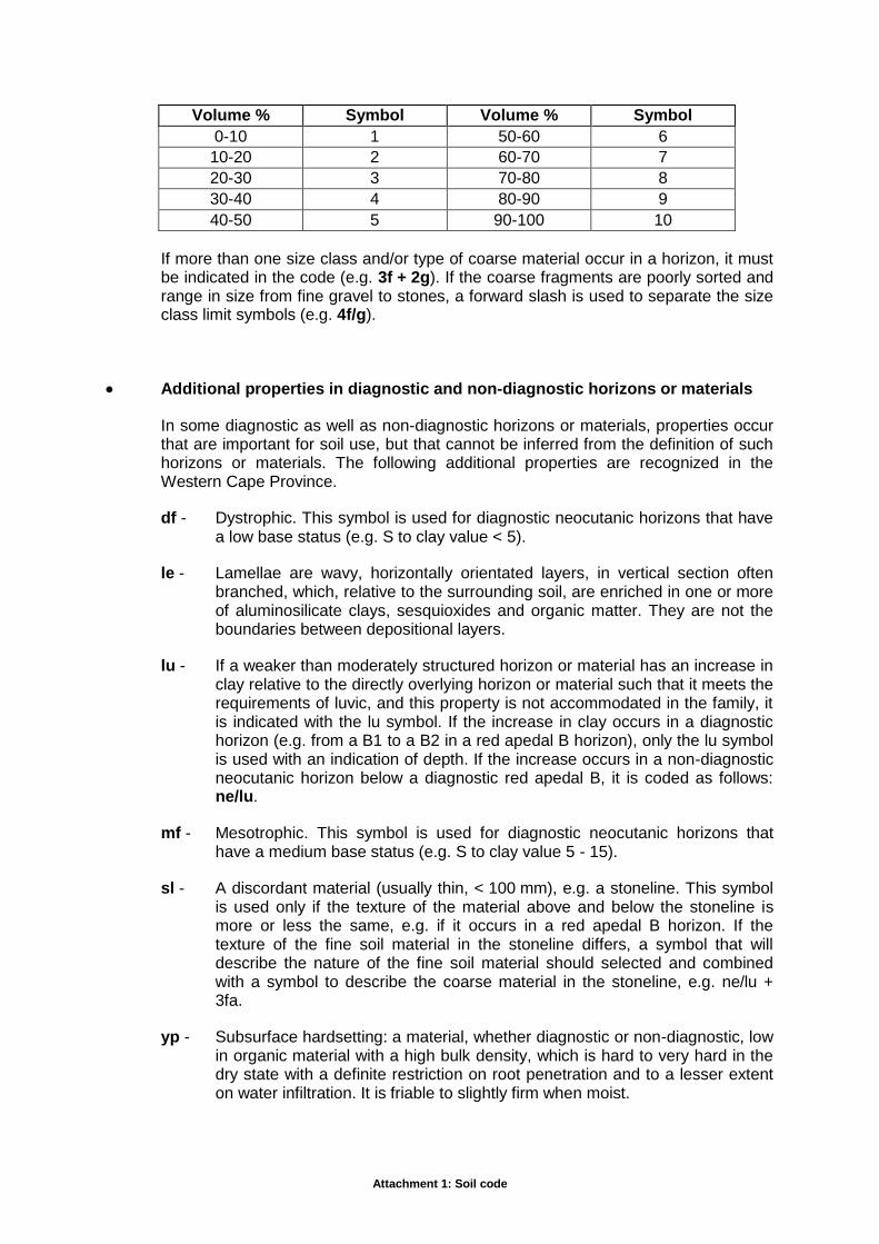
Attachment 1: Soil code
Volume % Symbol Volume % Symbol
0-10 1 50-60 6
10-20 2 60-70 7
20-30 3 70-80 8
30-40 4 80-90 9
40-50 5 90-100 10
If more than one size class and/or type of coarse material occur in a horizon, it must be indicated in the code (e.g. 3f + 2g). If the coarse fragments are poorly sorted and range in size from fine gravel to stones, a forward slash is used to separate the size class limit symbols (e.g. 4f/g).
Additional properties in diagnostic and non-diagnostic horizons or materials
In some diagnostic as well as non-diagnostic horizons or materials, properties occur that are important for soil use, but that cannot be inferred from the definition of such horizons or materials. The following additional properties are recognized in the Western Cape Province.
df - Dystrophic. This symbol is used for diagnostic neocutanic horizons that have a low base status (e.g. S to clay value < 5).
le - Lamellae are wavy, horizontally orientated layers, in vertical section often branched, which, relative to the surrounding soil, are enriched in one or more of aluminosilicate clays, sesquioxides and organic matter. They are not the boundaries between depositional layers.
lu - If a weaker than moderately structured horizon or material has an increase in clay relative to the directly overlying horizon or material such that it meets the requirements of luvic, and this property is not accommodated in the family, it is indicated with the lu symbol. If the increase in clay occurs in a diagnostic horizon (e.g. from a B1 to a B2 in a red apedal B horizon), only the lu symbol is used with an indication of depth. If the increase occurs in a non-diagnostic neocutanic horizon below a diagnostic red apedal B, it is coded as follows: ne/lu.
mf - Mesotrophic. This symbol is used for diagnostic neocutanic horizons that have a medium base status (e.g. S to clay value 5 - 15).
sl - A discordant material (usually thin, < 100 mm), e.g. a stoneline. This symbol is used only if the texture of the material above and below the stoneline is more or less the same, e.g. if it occurs in a red apedal B horizon. If the texture of the fine soil material in the stoneline differs, a symbol that will describe the nature of the fine soil material should selected and combined with a symbol to describe the coarse material in the stoneline, e.g. ne/lu + 3fa.
yp - Subsurface hardsetting: a material, whether diagnostic or non-diagnostic, low in organic material with a high bulk density, which is hard to very hard in the dry state with a definite restriction on root penetration and to a lesser extent on water infiltration. It is friable to slightly firm when moist.

Attachment 1: Soil code
3 Classes and symbols for properties below the line
3.1 Coarse fragments in topsoil horizon and outcrops
The presence of coarse fragments (>2 mm) in the topsoil horizon or rock outcrops has an important effect on several physical (e.g. water holding capacity) and chemical (e.g. exchangeable cation content) properties, as well as on tillage and landuse.
3.1.1 The size and quantity of coarse fragments in the topsoil horizon (or plough layer) are indicated with the same symbols as those used to describe such materials as Subsoil limitations or properties.
3.1.2 The presence of rock outcrops is coded as follows:
Quantity (percentage of land surface occupied by
exposed rock)
Symbol
5 – 25 % R1
25 – 50 % R2
> 50 % R3
Example: A land surface with 40 % exposed granite outcrops is coded by the symbol R 2.
3.2 Texture of topsoil and directly underlying E or apedal B1 horizon
The texture is coded in terms of the:
sand grade for soils with less than 20% clay and
clay content (percentage).
Classes and abbreviations for sand grade clay content are the following:
Sand grade Symbol
coarse co
medium me
fine fi
Clay content Symbol
0 - 5 1
5 – 10 2
10 – 15 3
15 – 20 4
20 – 35 5
35 – 55 6
> 55 7

Attachment 1: Soil code
Examples:
A topsoil developed from granite parent material with 13 % clay and coarse sand grade is coded by the symbol co 3.
In cases where the clay content is on or near the boundary between two classes, e.g. 11 % or 23 %, it should be coded as co 2/3 and co 4/5 respectively.
In soil forms with an A horizon directly on a structured B or hardpan (e.g. hard plinthite, hardpan carbonate, petrogypsic or dorbank) horizon, it is sufficient only to code the texture of the topsoil.
The clay content of the E horizon in soil forms with an A – E – B/G profile morphology (e.g. Kroonstad, Estcourt, Klapmuts) is usually similar to or less than the clay content in the overlying topsoil. In certain profiles, however, the clay content of the E horizon can be significantly higher than that of the topsoil, especially in cases where the E horizon is very gravelly. From a land use point of view the clay increase is important and should be specified in the code. For example, the texture of a coarse sandy Kroonstad form soil developed from granite with 3 % clay in the topsoil and 10 % clay in the E horizon is coded as co 1 – co 2/3. The texture codes for the topsoil and E horizon are separated with a hyphen (-).
In the case of soil forms with an apedal B horizon directly below the topsoil (e.g. Oakleaf, Hutton, Tukulu) the clay increase from the topsoil to the B1 horizon is used as a family criteria to distinguish between non-luvic and luvic families. In non-luvic families the clay content of the topsoil and B1 horizon is fairly similar. According to the luvic definition an Oakleaf 2120 soil family with 5 clay in the topsoil may have a clay content in the B1 horizon that range from as low as 11 % to as high as 20 % and more. These differences might have a significant influence on soil suitability and land use. The clay content of the topsoil and B1 horizon should be coded in the same way as for soils with an E horizon. For example the texture code for an Oakleaf soil developed from clayey, medium grade sandstone with 5 % clay in the topsoil and 17 % clay in the B1 horizon, will be me 1/2 - me 3.
3.3 Soil water conditions
A wetness classification was developed based on the number of days and depth of saturation with water. Profile morphology is used to determine the depth of water saturation and the maximum height of signs of hydromorphy is used as depth limit. Climate, locality, aspect, vegetation and water conditions during the survey as well as profile morphology are used to evaluate the duration of water saturation. The expected number of days of saturation during the rainy season in "wet" years is used to determine duration. It is essential for free water to occur in the profile continuously for at least seven (7) days. However, the total number of days with free water need not be continuous.
Diagram for the determination of wetness classes
Depth range of upper boundary Wetness symbol of free water surface (mm)
0 - 300 6 7 8 9
300- 700 3 6 7 8
700 – 1 200 2 3 4 5
> 1 500 1
Attachment 1: Soil code
0 30 90 180 365 Cumulative number of days with free water
Note: The numeral 1 is not used in the code.
Example: A soil with a wetness class symbol of 6 implies that the upper boundary of the free water surface can either be 0 – 300 mm with a maximum cumulative number of 30 days with free water, or a free surface depth of 300 – 700 mm with a cumulative duration of 30 – 90 days with free water.
3.4 Changes in soil properties and conditions
Soils as natural phenomena are subjected at their surface to recent geological processes, such as erosion by wind or water, as well as the deposition of material transported by water, wind or gravity. As a natural agricultural resource soil can also be affected by man for shorter or longer periods. Activities such as grazing of natural veld, normal soil tillage, deep soil preparation and drainage, etc., can cause soils to change to a greater or lesser extent. The changes can vary in permanence and can benefit or adversely affect crop production. It is therefore essential that such phenomena be described and indicated in the soil code.
Recent deposits on the A horizon
al - Recent alluvial material on the A horizon.
ko - Recent colluvium on the A horizon.
ob - A recent geological deposit on the A horizon which does not qualify for al, rs or ko.
rs - Recent aeolian material on the A horizon.
The thickness of the deposit can be indicated after the letter symbol with a depth numerical symbol (refer to Section 2.1), e.g. rs 2 for a 200 mm thick recent aeolian deposit.
Water or wind erosion
wa - The topsoil has been removed by water erosion.
wi - The topsoil has been removed by wind erosion.
Phenomena on or in the A horizon or plough layer
ah - Dark, organic rich surface horizon, without signs of wetness in or directly below it, on stratified alluvium.
cr - Surface crust: it refers to the tendency of some soils to puddle at the surface during rain or irrigation and to form a dense, compact crust when dry. Such crusts are unfavourable for water infiltration, air exchange and germination and emergence of seedlings. This phenomenon also occurs in untilled soils with a natural veld cover.
em - A thin (usually thinner than 50 mm), bleached layer which develops directly beneath a surface organic litter layer (lr) in the upper part of the A horizon. It largely meets the requirements of an E horizon.
Attachment 1: Soil code
lr - Layer of organic litter, e.g. pine needles, at the soil surface which is not subject to prolonged wetness. The thickness of such a layer is coded with the same symbols as those used for horizon depths, e.g. a 300mm thick organic litter is indicated by lr 3.
oo - Dark, peaty, organic rich surface horizon, with signs of periodic wetness in or below it, on stratified alluvium.
pb - Ploughsole: a hard, compacted layer directly beneath the plough layer as a result of tillage.
pl - Desert pavement
Deep soil cultivation
It refers to soils that have been mechanically cultivated deeper than 350 mm by means of some implement. The following cultivation types are based on implement type and mixing action:
ex - Complete mixing of the soil by a mechanical digger or excavator.
hd - Complete mixing of the soil by hand (Afr. handdol)
ld - Complete mixing of the soil with a bulldozer blade (Afr. lemdol).
md - Complete mixing of the soil with a delve plough (Afr. mengdol).
rd - Loosening of the soil with a ripper (Afr. skeurploegbewerking).
sd - Shifting (lateral displacement) without mixing the soil (Afr. skuifdol)
tr - Trenching with a mechanical digger (Afr. slootgrawerbewerking).
xd - Type of cultivation unknown or uncertain.
The cultivation depth must be coded with a depth numerical symbol (refer to Section 2.1) after the letter symbol, e.g. rd 7 for ripper cultivation to a depth of 900 mm.
Other changes
These include changes not accommodated by the classes mentioned above.
as - Scraped off soil surface.
dr - Artificial drained soil.
er - Ridged or bedded topsoil. The height of the ridge should be coded with a depth numerical symbol (refer to Section 2.1) after the letter symbol; e.g. re 2 for a ridge with a height of approximately 20 cm.
ik - Clay introduced and partially mixed with classifiable soil.
lm - The subsoil (or parts thereof) has been limed to such an extent that the base status has been drastically changed (e.g. dystrophic to eutrophic, etc.).
is - Sand introduced and partially mixed with classifiable soil.

Attachment 1: Soil code
op - Aggradition (of a channel, donga) with material other than the classifiable filled in soil.
te - Terraced land.
4 Examples of a fully coded soil description
Although the sequential position of the symbols for certain components used in the soil code is fixed, the sequence of non-diagnostic subsoil limitations and their respective depth symbols can be coded in more than one way. The detail that soil surveyors want to include in the code may also differ. For this reason a few examples will discussed as guidelines for individuals that is not familiar with the code.
Example 1:
Dystrophic, luvic Hutton form soil with an A/B transition at 300 mm, extremely hard ferricrete (hard plinthite) at 850 mm and stoneline at 500 mm. The topsoil contains 15 % coarse gravel and 35 % stones, 15 – 20 % clay, and has a coarse sand grade. The clay content of the B is constant with depth. The code for this soil may be written in one of the following ways
Field code 1 3 7 5 Hu1200 re hp2 sl 2g+4k co4
Field code 2 3 5 7 Hu1200 sl hp2 2g+4k co4
Word/Excel format 1 3 7 5 Hu1200 re hp2 sl followed in same line by a double forward slash and then 2g+4k co4
Word/Excel format 2 3 7 5 Hu1200 hp2 sl followed in same line by a double forward slash and then 2g+4k co4
Example 2:
Estcourt form soil with a “grey” and non-black cutans in the B. The A/B transition is at 200 mm, E/B at 500 mm, soft saprolite with weakly developed signs of wetness at 750 mm and hard rock with strong signs of wetness at 1 000 mm. The topsoil contains 15 % fine and 25 % coarse gravel, 10 – 15 % clay, has a fine to medium sand grade and forms a crust on drying. The E horizon contains 35 % coarse gravel and 35 % stones and sets very hard when dry. The upper boundary of free water is 200 mm and the cumulative number of days with free water is between 90 and 180. The code for this soil may be written in one of the following ways
Field code 1 2 5 6/7 8 2 2 Es1100 pr lo/lw Rw yp 2f+3g 4g+4k fi/me 3 7 cr
Field code 2 2 5 6/7 8 Es1100 gl+yp+2f+3g pr lo/lw Rw 4g+4k fi/me 3 7 cr
Word/Excel format 1 2 5 6/7 8 2 2 Es1100 pr lo/lw Rw yp 2f+3g followed in same line by a double forward slash and then 4g+4k fi/me 3 7 cr

Attachment 1: Soil code
Word/Excel format 2 2 5 6/7 8 Es1100 gl+yp+2f+3g pr lo/lw Rw followed in same line by a double forward slash and then 4g+4k fi/me 3 7 cr
Note: In both examples Field code 1 and Word/Excel format 1 is the preferred way of coding.
It is recommended that when the code is captured in a Word or Excel format table, the separate items of the code should each constitute a separate column. The following can be used as an example of a Word format table:
Profile numbe
r
Depth codes
Soil form and
family
Subsoil limitations/properties Topsoil Wetness
class
Changed
proper- ties or
condition
Upper subsoil
Middle subsoi
l
Lower subsoi
l
Coarse
frag- ments
Coarse
frag- ments
Sand
grade
Clay class
1 2 4 6 2
Tu 2110
ne/ye
gs+4g
vp 3f+2g
2f co 3 3 md 7
2 3 6 8 3
Es 1100
pr Sw 6f 4f fi 2/3 6 dr
The subsoil limitations/properties are sequentially linked to the depth codes from right to left. For example:
Profile 1
Depth codes 2 4 6 2 Subsoil limitations/properties
ne/ye gs+4g vp 3f + 2g
Upper and lower depth of subsoil limitation/property
20 - 40 cm 40 - 60 cm 60 cm and deeper
20 – 40 cm
Profile 2
Depth codes 3 6 8 3 Subsoil limitations/properties
pr sw 6f
Upper and lower depth of subsoil limitation/property
30 - 60 cm 60 - 85 cm 85 cm and deeper
30 – 60 cm
The first 3 in the depth code refer to the boundary between the orthic A and the E horizon.

Attachment 1: Soil code
Annexure C
SOIL FORMS AND FAMILIES FOUND ON THE LAIR, AUGRABIES
SOIL FORM SOIL FAMILY
MAP SYMBOL
DESCRIPTION
Coega 1000 Cg1 Orthic A horison on hardpan calcrete
Glenrosa 1211 Gs1,Gs2 Orhic A horizon on a lithocutanic B horison
1212 Gs2
Mispah 1100 Ms1 Orthic A horison on hard rock
1200 Ms1
Oakleaf 1220 Oa1 Orthic A horizon on a neocutanic B horizon on unspecified material