somalia meda
TRANSCRIPT
National Marine Ecosystem Diagnostic Analysis (MEDA)
Agulhas and Somali Current Large Marine Ecosystems (ASCLME) Project
ASCLME Agulhas and Somali Current
Large Marine Ecosystems Project
S o m a l i a
Baki
Dolo Bay
Wajir
MahaddayWeym
Togwajaale
Berbera
Maydh LaasqorayQandala
Butyaalo
Hurdiyo
DudoQardho
Taxeex
Iskushuban
Xudun
Gori Rit
Buuhoodle
Kiridh
Garadag
Oodweyne
XamureSeemadeBeyra
Berdaale
War Galoh
MirsaaleBaxdoMereer-Gur
Ceel Buur
DerriBuulobarde
Tayeeglow
BalcadAfgooye
WanlaweynBuurhakabaDiinsoor
Qoryooley
Haaway
JilibAfmadow
Bilis Qooqaani
Luuq
El Beru Hagia
Baardheere
Werder
Shilabo
K'ebri Dahar
Degeh Bur
Gode
Hargele
ImiMegalo
Asayita
Nazret
Dire Dawa
Jijiga
Dikhil
Garsen
Harer
Ferfer
Bu'aale
Hargeysa
Burco (Burao)
BakiCeerigaabo (Erigavo)
Garoowe
Gaalkacyo (Galcaio)
Dhuusamarreeb(Dusa Marreb)
Beledweyne
Xuddur(Oddur)
Garbahaarrey Baydhabo (Baidoa)
Laascaanood
Boorama
GEDO
BAY
BAKOOLHIRAAN
GALGUDUUD
M U D U G
NUGAAL
S O O L
AWDAL B A R IS A N A A G
TOGDHEER
WOQOOYIGALBEED
SHABELLEHOOSE
JUBAHOOSE
JUBADHEXE
DJIBOUTI
KENYA
Karkaar Mountains
Silil
Der
Dahot Darro
Jaceel
Eyl
Webi Shabeelle
Webi Jubba
Boorama
Dolo Bay
Wajir
CadaleMahadday
Weym
Saylac
Togwajaale
Bullaxaar Berbera
Karin Xiis Maydh LaasqorayQandala
Butyaalo
Bandar Murcaayo
CaluulaBreeda
Bargaal
Hurdiyo
Xaafuun
BandarbeylaDudoQardho
Taxeex
Iskushuban
Xudun
Gori Rit
Buuhoodle
Kiridh
Garadag
Oodweyne
Eyl
Garacad
XamureSeemadeBeyra
Berdaale
War Galoh
HilalayaMirsaale
Hobyo
BaxdoMereer-Gur
Ceel BuurXarardheere
DerriBuulobarde CeeldheereTayeeglow
Ceel Huur
BalcadAfgooye
WanlaweynBuurhakabaDiinsoor
Qoryooley
Baraawe
Haaway
Jilib
Jamaame
Afmadow
Bilis Qooqaani
Luuq
El Beru Hagia
Buur Gaabo
Baardheere
Werder
Shilabo
K'ebri Dahar
Degeh Bur
Gode
Hargele
ImiMegalo
Asayita
Nazret
Dire Dawa
Jijiga
Dikhil
Garsen Lamu
Harer
Ferfer
Bu'aale
Hargeysa
Burco (Burao)
BakiCeerigaabo (Erigavo)
Boosaaso (Bender Cassim)
Garoowe
Gaalkacyo (Galcaio)
Dhuusamarreeb(Dusa Marreb)
Beledweyne
Xuddur(Oddur)
Garbahaarrey Baydhabo (Baidoa)
Marka (Merca)
Jawhar (Giohar)
Kismaayo (Chisimayu)
Laascaanood
Boorama
Muqdisho (Mogadishu)
Djibouti
GEDO
BAY
BAKOOLHIRAAN
GALGUDUUD
M U D U G
NUGAAL
S O O L
AWDAL B A R IS A N A A G
TOGDHEER
WOQOOYIGALBEED
SHABELLEDHEXE
BANADIRSHABELLE
HOOSE
JUBAHOOSE
JUBADHEXE
ETHIOPIA
DJIBOUTI
KENYA
Raas MaskanRaas
Khansiir
RaasSurud
GeesGwardafuy
RaasBinna
RaasXaafuun
RaasGabbac
RaasKaambooni
IsoleGiuba
Karkaar Mountains
G U L F O F A D E N
I N D I A N O C E A N
Silil
Der
Dahot Darro
Jaceel
Eyl
Webi Shabeelle
Webi Jubba
SOMALIA
Department of Field SupportCartographic Section
Map No. 3690 Rev. 10 UNITED NATIONSDecember 2011
The boundaries and names shown and the designations used on this map do not imply official endorsement or acceptance by the United Nations.
SOMALIA
0
0
100 200 km
50
50 150
100 mi
National capitalRegional capitalTown, villageAirportInternational boundaryRegional boundaryUndetermined boundaryMain roadTrackRailroad
- -
The GEF unites 182 countries in partnership with international institutions, non-governmental organizations (NGOs), and the private sector to address global environmental issues while supporting national sustainable development initiatives. Today the GEF is the largest public funder of projects to improve the global environment. An independently operating financial organization, the GEF provides grants for projects related to biodiversity, climate change, international waters, land degradation, the ozone layer, and persistent organic pollutants. Since 1991, GEF has achieved a strong track record with developing countries and countries with economies in transition, providing $9.2 billion in grants and leveraging $40 billion in co-financing for over 2,700 projects in over 168 countries. www.thegef.org
UNDP partners with people at all levels of society to help build nations that can withstand crisis, and drive and sustain the kind of growth that improves the quality of life for everyone. On the ground in 177 countries and territories, we offer global perspective and local insight to help empower lives and build resilient nations. www.undp.org
This document may be cited as: ASCLME 2012. National Marine Ecosystem Diagnostic Analysis. Somalia. Contribution to the Agulhas and Somali Current Large Marine Ecosystems Project (supported by UNDP with GEF grant financing).
The contributions of the Western Indian Ocean Marine Science Association (WIOMSA) in supporting this publication are gratefully acknowledged.
The contributions of the Ocean Data Information Network of Africa (ODINAFRICA) in supporting this publication are gratefully acknowledged.
The views expressed in this publication may not necessarily reflect those of the GEF, UNDP, or other UN agencies or project partner institutions/organisations. Neither does it imply any opinion whatsoever as to the legal status of any country, territory, city or area, of its authorities, or of the delineation of its territories or boundaries.
101010010101010101010101010101010100101010010101001010101011010101010101
1010100
1010
1010
101010101010101010100101010010101001010101011010101010101
101010010101010101010101010101010100101010010101001010101011010101010101
1010100
1010
1010
101010101010101010100101010010101001010101011010101010101
ODINAFRICA
Baki
Dolo Bay
Wajir
MahaddayWeym
Togwajaale
Berbera
Maydh LaasqorayQandala
Butyaalo
Hurdiyo
DudoQardho
Taxeex
Iskushuban
Xudun
Gori Rit
Buuhoodle
Kiridh
Garadag
Oodweyne
XamureSeemadeBeyra
Berdaale
War Galoh
MirsaaleBaxdoMereer-Gur
Ceel Buur
DerriBuulobarde
Tayeeglow
BalcadAfgooye
WanlaweynBuurhakabaDiinsoor
Qoryooley
Haaway
JilibAfmadow
Bilis Qooqaani
Luuq
El Beru Hagia
Baardheere
Werder
Shilabo
K'ebri Dahar
Degeh Bur
Gode
Hargele
ImiMegalo
Asayita
Nazret
Dire Dawa
Jijiga
Dikhil
Garsen
Harer
Ferfer
Bu'aale
Hargeysa
Burco (Burao)
BakiCeerigaabo (Erigavo)
Garoowe
Gaalkacyo (Galcaio)
Dhuusamarreeb(Dusa Marreb)
Beledweyne
Xuddur(Oddur)
Garbahaarrey Baydhabo (Baidoa)
Laascaanood
Boorama
GEDO
BAY
BAKOOLHIRAAN
GALGUDUUD
M U D U G
NUGAAL
S O O L
AWDAL B A R IS A N A A G
TOGDHEER
WOQOOYIGALBEED
SHABELLEHOOSE
JUBAHOOSE
JUBADHEXE
DJIBOUTI
KENYA
Karkaar Mountains
Silil
Der
Dahot Darro
Jaceel
Eyl
Webi Shabeelle
Webi Jubba
Boorama
Dolo Bay
Wajir
CadaleMahadday
Weym
Saylac
Togwajaale
Bullaxaar Berbera
Karin Xiis Maydh LaasqorayQandala
Butyaalo
Bandar Murcaayo
CaluulaBreeda
Bargaal
Hurdiyo
Xaafuun
BandarbeylaDudoQardho
Taxeex
Iskushuban
Xudun
Gori Rit
Buuhoodle
Kiridh
Garadag
Oodweyne
Eyl
Garacad
XamureSeemadeBeyra
Berdaale
War Galoh
HilalayaMirsaale
Hobyo
BaxdoMereer-Gur
Ceel BuurXarardheere
DerriBuulobarde CeeldheereTayeeglow
Ceel Huur
BalcadAfgooye
WanlaweynBuurhakabaDiinsoor
Qoryooley
Baraawe
Haaway
Jilib
Jamaame
Afmadow
Bilis Qooqaani
Luuq
El Beru Hagia
Buur Gaabo
Baardheere
Werder
Shilabo
K'ebri Dahar
Degeh Bur
Gode
Hargele
ImiMegalo
Asayita
Nazret
Dire Dawa
Jijiga
Dikhil
Garsen Lamu
Harer
Ferfer
Bu'aale
Hargeysa
Burco (Burao)
BakiCeerigaabo (Erigavo)
Boosaaso (Bender Cassim)
Garoowe
Gaalkacyo (Galcaio)
Dhuusamarreeb(Dusa Marreb)
Beledweyne
Xuddur(Oddur)
Garbahaarrey Baydhabo (Baidoa)
Marka (Merca)
Jawhar (Giohar)
Kismaayo (Chisimayu)
Laascaanood
Boorama
Muqdisho (Mogadishu)
Djibouti
GEDO
BAY
BAKOOLHIRAAN
GALGUDUUD
M U D U G
NUGAAL
S O O L
AWDAL B A R IS A N A A G
TOGDHEER
WOQOOYIGALBEED
SHABELLEDHEXE
BANADIRSHABELLE
HOOSE
JUBAHOOSE
JUBADHEXE
ETHIOPIA
DJIBOUTI
KENYA
Raas MaskanRaas
Khansiir
RaasSurud
GeesGwardafuy
RaasBinna
RaasXaafuun
RaasGabbac
RaasKaambooni
IsoleGiuba
Karkaar Mountains
G U L F O F A D E N
I N D I A N O C E A N
Silil
Der
Dahot Darro
Jaceel
Eyl
Webi Shabeelle
Webi Jubba
SOMALIA
Department of Field SupportCartographic Section
Map No. 3690 Rev. 10 UNITED NATIONSDecember 2011
The boundaries and names shown and the designations used on this map do not imply official endorsement or acceptance by the United Nations.
SOMALIA
0
0
100 200 km
50
50 150
100 mi
National capitalRegional capitalTown, villageAirportInternational boundaryRegional boundaryUndetermined boundaryMain roadTrackRailroad
- -
S o m a l i a
National Marine Ecosystem Diagnostic Analysis (MEDA)
Baki
Dolo Bay
Wajir
MahaddayWeym
Togwajaale
Berbera
Maydh LaasqorayQandala
Butyaalo
Hurdiyo
DudoQardho
Taxeex
Iskushuban
Xudun
Gori Rit
Buuhoodle
Kiridh
Garadag
Oodweyne
XamureSeemadeBeyra
Berdaale
War Galoh
MirsaaleBaxdoMereer-Gur
Ceel Buur
DerriBuulobarde
Tayeeglow
BalcadAfgooye
WanlaweynBuurhakabaDiinsoor
Qoryooley
Haaway
JilibAfmadow
Bilis Qooqaani
Luuq
El Beru Hagia
Baardheere
Werder
Shilabo
K'ebri Dahar
Degeh Bur
Gode
Hargele
ImiMegalo
Asayita
Nazret
Dire Dawa
Jijiga
Dikhil
Garsen
Harer
Ferfer
Bu'aale
Hargeysa
Burco (Burao)
BakiCeerigaabo (Erigavo)
Garoowe
Gaalkacyo (Galcaio)
Dhuusamarreeb(Dusa Marreb)
Beledweyne
Xuddur(Oddur)
Garbahaarrey Baydhabo (Baidoa)
Laascaanood
Boorama
GEDO
BAY
BAKOOLHIRAAN
GALGUDUUD
M U D U G
NUGAAL
S O O L
AWDAL B A R IS A N A A G
TOGDHEER
WOQOOYIGALBEED
SHABELLEHOOSE
JUBAHOOSE
JUBADHEXE
DJIBOUTI
KENYA
Karkaar Mountains
Silil
Der
Dahot Darro
Jaceel
Eyl
Webi Shabeelle
Webi Jubba
Boorama
Dolo Bay
Wajir
CadaleMahadday
Weym
Saylac
Togwajaale
Bullaxaar Berbera
Karin Xiis Maydh LaasqorayQandala
Butyaalo
Bandar Murcaayo
CaluulaBreeda
Bargaal
Hurdiyo
Xaafuun
BandarbeylaDudoQardho
Taxeex
Iskushuban
Xudun
Gori Rit
Buuhoodle
Kiridh
Garadag
Oodweyne
Eyl
Garacad
XamureSeemadeBeyra
Berdaale
War Galoh
HilalayaMirsaale
Hobyo
BaxdoMereer-Gur
Ceel BuurXarardheere
DerriBuulobarde CeeldheereTayeeglow
Ceel Huur
BalcadAfgooye
WanlaweynBuurhakabaDiinsoor
Qoryooley
Baraawe
Haaway
Jilib
Jamaame
Afmadow
Bilis Qooqaani
Luuq
El Beru Hagia
Buur Gaabo
Baardheere
Werder
Shilabo
K'ebri Dahar
Degeh Bur
Gode
Hargele
ImiMegalo
Asayita
Nazret
Dire Dawa
Jijiga
Dikhil
Garsen Lamu
Harer
Ferfer
Bu'aale
Hargeysa
Burco (Burao)
BakiCeerigaabo (Erigavo)
Boosaaso (Bender Cassim)
Garoowe
Gaalkacyo (Galcaio)
Dhuusamarreeb(Dusa Marreb)
Beledweyne
Xuddur(Oddur)
Garbahaarrey Baydhabo (Baidoa)
Marka (Merca)
Jawhar (Giohar)
Kismaayo (Chisimayu)
Laascaanood
Boorama
Muqdisho (Mogadishu)
Djibouti
GEDO
BAY
BAKOOLHIRAAN
GALGUDUUD
M U D U G
NUGAAL
S O O L
AWDAL B A R IS A N A A G
TOGDHEER
WOQOOYIGALBEED
SHABELLEDHEXE
BANADIRSHABELLE
HOOSE
JUBAHOOSE
JUBADHEXE
ETHIOPIA
DJIBOUTI
KENYA
Raas MaskanRaas
Khansiir
RaasSurud
GeesGwardafuy
RaasBinna
RaasXaafuun
RaasGabbac
RaasKaambooni
IsoleGiuba
Karkaar Mountains
G U L F O F A D E N
I N D I A N O C E A N
Silil
Der
Dahot Darro
Jaceel
Eyl
Webi Shabeelle
Webi Jubba
SOMALIA
Department of Field SupportCartographic Section
Map No. 3690 Rev. 10 UNITED NATIONSDecember 2011
The boundaries and names shown and the designations used on this map do not imply official endorsement or acceptance by the United Nations.
SOMALIA
0
0
100 200 km
50
50 150
100 mi
National capitalRegional capitalTown, villageAirportInternational boundaryRegional boundaryUndetermined boundaryMain roadTrackRailroad
- -
i
Table of Contents
Table of ConTenTsexecutive summary . . . . . . . . . . . . . . . . . . . . . . . . . . . . . . . . . . . . . . . . . . . . . . . . . . . . . . . . . . . . . . . . . . iii
acknowledgements . . . . . . . . . . . . . . . . . . . . . . . . . . . . . . . . . . . . . . . . . . . . . . . . . . . . . . . . . . . . . . . . . .v
Contributing Institutions . . . . . . . . . . . . . . . . . . . . . . . . . . . . . . . . . . . . . . . . . . . . . . . . . . . . . . . . . . . . .vii
acronyms . . . . . . . . . . . . . . . . . . . . . . . . . . . . . . . . . . . . . . . . . . . . . . . . . . . . . . . . . . . . . . . . . . . . . . . . . . viii
1 . Country overview . . . . . . . . . . . . . . . . . . . . . . . . . . . . . . . . . . . . . . . . . . . . . . . . . . . . . . . . . . . . . . . . . .1
2 . biophysical environment . . . . . . . . . . . . . . . . . . . . . . . . . . . . . . . . . . . . . . . . . . . . . . . . . . . . . . . . . . .4Description of the coast and distinctive features ................................................................................................................4General description of the climate .....................................................................................................................................5
Monsoon seasons .................................................................................................................................................................................................................... 6Temperatures .......................................................................................................................................................................................................................... 6Rainfall .................................................................................................................................................................................................................................... 7
Marine and coastal geology...............................................................................................................................................7Soils ........................................................................................................................................................................................................................................ 8Freshwater resources and drainage ......................................................................................................................................................................................... 9Groundwater (Figure 9) ......................................................................................................................................................................................................... 11Wetlands ............................................................................................................................................................................................................................... 12
Physical Oceanography ................................................................................................................................................... 14Coastal hydrodynamics and offshore currents ....................................................................................................................................................................... 14Tidal regime and waves ......................................................................................................................................................................................................... 15Sea level change ................................................................................................................................................................................................................... 16Ocean temperature ............................................................................................................................................................................................................... 16Salinity patterns .................................................................................................................................................................................................................... 18Ocean-atmosphere interaction .............................................................................................................................................................................................. 19Ekman pumping velocities and thermocline variability ......................................................................................................................................................... 21
Chemical and Biological Oceanography ............................................................................................................................ 23Nutrients ............................................................................................................................................................................................................................... 23Persistent organic pollutants ................................................................................................................................................................................................. 24Primary production .............................................................................................................................................................................................................. 25Secondary production ........................................................................................................................................................................................................... 26
Coastal zone and continental shelf .................................................................................................................................. 27Description of Coastal and Marine Habitats .......................................................................................................................................................................... 27Productivity of the coastal zone (corals, mangroves, seagrass beds) ..................................................................................................................................... 29Mangroves ............................................................................................................................................................................................................................ 30Seagrass Beds ....................................................................................................................................................................................................................... 30Microfauna and meiofauna ................................................................................................................................................................................................... 31Macrofauna .......................................................................................................................................................................................................................... 31Fish and Fish Resources ........................................................................................................................................................................................................ 32Mammals .............................................................................................................................................................................................................................. 34Reptiles ................................................................................................................................................................................................................................. 34Birds ..................................................................................................................................................................................................................................... 34Long term predicted Climate change..................................................................................................................................................................................... 36
3 . Human environment . . . . . . . . . . . . . . . . . . . . . . . . . . . . . . . . . . . . . . . . . . . . . . . . . . . . . . . . . . . . . 37Coastal populations ....................................................................................................................................................... 37
Sites of religious or cultural significance ................................................................................................................................................................................ 38Human health ....................................................................................................................................................................................................................... 39Water and Sanitation ............................................................................................................................................................................................................ 39Education .............................................................................................................................................................................................................................. 39Infrastructure ........................................................................................................................................................................................................................ 41
4 . Planning and management . . . . . . . . . . . . . . . . . . . . . . . . . . . . . . . . . . . . . . . . . . . . . . . . . . . . . . . 45National Disaster Management Plans .............................................................................................................................. 45
Areas under special management ......................................................................................................................................................................................... 46
ii
Table of Contents
Monitoring, Control and Surveillance .................................................................................................................................................................................. 48
5 . Coastal livelihoods assessment . . . . . . . . . . . . . . . . . . . . . . . . . . . . . . . . . . . . . . . . . . . . . . . . . . . 49I. Small-Scale Fisheries ................................................................................................................................................... 49II. Tourism ...................................................................................................................................................................... 49III. Mariculture ............................................................................................................................................................... 49IV. Agriculture and Forestry ............................................................................................................................................ 50V. Energy ........................................................................................................................................................................ 50VI. Ports and Coastal Transport ....................................................................................................................................... 51VII. Coastal Mining ......................................................................................................................................................... 51Conclusions .................................................................................................................................................................... 51
6 . References . . . . . . . . . . . . . . . . . . . . . . . . . . . . . . . . . . . . . . . . . . . . . . . . . . . . . . . . . . . . . . . . . . . . . . . 53
anneXes
I Extended bibliographyII. Metadata recordsIII. Capacity building and training review and work programmeIV. Areas of Concern (extracted from each of the MEDA chapters)V. Coastal Livelihoods Assessment ReportVI. Requirements for data collection, analysis (processing/modeling/integration) or repatriation to inform the national MEDA.VII. National projects recently undertaken or currently underway which are relevant to the ASCLME MEDA, TDA or SAP. VIII. Inshore Oceanographic Monitoring PlanIX. National Data and Information Management PlanX. National Causal Chain Analysis Report
iii
Executive Summary
eXeCuTIve summaRy
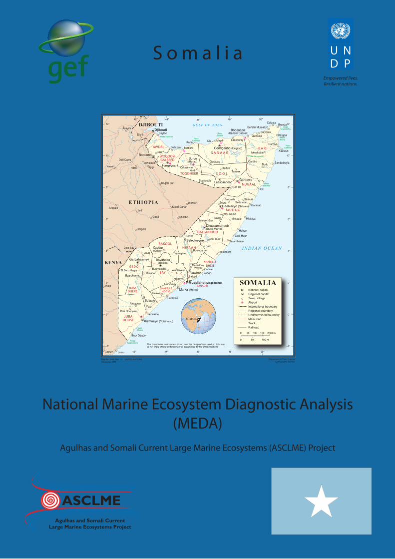
The Republic of Somalia, located in the Horn of Africa, covers a total surface area of 637,657 km2 with an estimated population of 10 million people from six (6) major clans and various minor clans. The country has been without a central Government since 1991. Years of political instability and war have resulted in over 1 million deaths, both as a direct result of the fighting and due to the country’s inability to cope with recurrent droughts, devastating floods and diseases. The GDP is estimated to be USD 5,023 billion and Income per Capita is less than USD 400. The primary sectors include agriculture, livestock and fisheries.
The coastline of Somalia can be divided up into 5 zones characterised by diverse coastal features and ecosystems. Ecologically, the coast is split into two distinct zones: (i) the Gulf of Aden which encompasses the Somaliland and northern Puntland coastline, and (ii) the Indian Ocean coastline of northern Puntland and Central and South Somalia. The coastline covers a distance of 3,330 Km. The continental shelf area (depth 0–200 m) covers a surface area of 32,500 Km2. The continental shelf is generally narrow being around 15km wide with a steep drop off into the deeper water. However, between Ras Aseyr and Ras Hafun in the north-east coast, the shelf extends for almost 80km in some places.
The climate of the Somali coast is generally hot and humid while the interior of the country is mainly hot and dry semi-arid to arid. There are four seasons consisting of two rainy seasons and two dry seasons. The first rainy season occurs in the period between April and June while the second one occurs from October to November. The country is semi-arid and rainfall is less than 250mm per annum. Two permanent rivers which originate from Ethiopian Highlands flow across Somalia: the Jubba and the Shabelle, and the rest of the country is crossed by ephemeral streams which remain dry for most of the year except during major rainfall events. The tides are of mixed type with a tidal range of 3.5 m in the South and about 1.5 m in the North. Ocean currents along the coast of Somalia are strongly influenced by the two distinct monsoon seasons, namely North-East and South-West Monsoons. The dominant currents are the Somali current, North Equatorial Current and Equatorial Counter current. The narrow Somali current which runs close to the shore is however the main current system flowing along the coast of Somalia. During the North-East monsoon, the Somali current flows southward and during the South-West monsoon it flows northward. During the South West monsoon, the current attains velocities in the range 2.0-3.5 ms-1 causing an intense upwelling off Somalia’s coast. The reversal of the current due to the North-East monsoon causes the coastal upwelling to cease. The upwelling of cold bottom waters along the northern coast of Somalia results in large amounts of nutrients being brought to the surface, greatly enhancing the productivity of the coastal waters. In the Gulf of Aden and the Somali upwelling area, nitrate concentrations reach maximums of up to 81 µM. Also, during this period, the mean zooplankton biomass may be as high as 38.0 ml/m3.
The coast of Somalia has fringing coral reefs in the Bajuni Archipelago and patches of coral reefs along the Gulf of Aden coastline. The types of corals include Porites, Acropora and Stylophora pistillata. Others include Millepora, soft corals, Rhodactis rhodostoma, Pocillopora damicornis, Galaxea astreata, Goniastrea retiformis, Lobophyllia sp, Tubastrea micranthus and T. Aurea. Coral reefs are widely distributed along the Indian Ocean coastline between Adale and the Somalia-Kenya border. Coral communities are well developed consisting of 27 genera and 63 species. The main threats to coral reefs are the use of destructive fishing practices, over-fishing, global warming, and smothering due to sedimentation and pollution. Somalia has six mangrove species consisting of Avicennia marina, Bruguiera gymnorrhiza, Ceriops tagal, Lumnitzera racemosa, Rhizophora mucronata, Sonneratia alba. Most of the mangroves in Somalia are found along the southwest coast although isolated pockets of Avicennia marina grow on the northern coast behind sand spits and along the Gulf of Aden. The main threats to mangroves are coastal erosion, over-exploitation and flooding. Seagrass beds in Somalia are limited to an extensive area along the southern coast from Adale to Ras Chiamboni and few beds along the North coast. Thalassodendron beds cover large areas of the shallow continental shelf. In the Bajuni Archipelago, seagrasses form carpets of small Thalassodendron and Syringodium. The main threats to seagrass include destructive fishing practices and smothering due to siltation.
Four turtle species have been recorded in Somali waters, namely loggerhead (Caretta caretta), hawksbill (Eretmochelys imbricata), olive ridley (Lepidochelys olivacea) and leatherback (Dermochelys coriacea). The main threats to turtles in Somalia include harpooning, gill net entrapments, targeting of nesting females and egg
iv
Executive Summary
harvesting. Degradation of nesting sites through pollution, coastal erosion and coastal development also threaten turtle populations. In addition to turtles, there are three endemic species of marine birds which are found on the coastal plains of the Somali coast. Ten bird species are threatened in Somalia of which two are critically endangered.
Somali marine waters also have enormous fisheries potential. The large pelagic fish are mainly tunas and big mackerels such as yellowfin tuna (Thunnus albacares), bigeye tuna (T. obesus), longtail tuna (T. tonggol), bonito (Sarda orientalis), skipjack tuna (Katsuwonus pelamis) and Spanish mackerel (Scomberomorus commerson). These stocks are heavily exploited by the industrial sector and lightly exploited by the artisanal sector. For small pelagic stocks, the dominant species are the Indian oil sardine (Sardinella longiceps), rainbow sardine (Dussumieria acuta), scads (Decaptrus spp.), chub mackerel (Scomber japonicus), and horse mackerel (Trachurus indicus). Anchovies (Engraulis japonicus, Stolephorus spp.) also occur but in smaller quantities. These species are mainly caught off the northeast coast of Somalia by both artisanal and commercial fleets. In case of demersal species, several hundred species are exploited by artisanal fishermen. The main commercial groups include scavengers (Lethrinidae), groupers (Serranidae), snappers (Lutjanidae), grunts (Pomadasyidae), and seabreams (Nemipteridae), lizard fishes (Synodontidae) and goatfishes (Mullidae). Stocks in the 1970s were estimated at 40 000 tonnes for large demersal species, and 30 000 tonnes for demersal sharks and rays. Elasmobranchs such as sharks and rays represent 40% of the artisanal catches. These stocks are heavily exploited in both artisanal and industrial sectors.
In the case of large crustaceans, spiny lobsters of the genus Panulirus are the main species exploited by artisanal fishermen. The commercial sector exploits two species of deep-sea lobster, Puerulus swelli, and P. carrinatus, found at depth of 150 to 400m. The artisanal lobster production is exclusively based on the spiny lobsters of the genus Panulirus which is represented by five species namely, Panulirus ornatus, P. longipes, P. homarus, P. versicolor and P. penicillatus. While the fishery is multi species off the southern coastline (where the highest densities are found among the coral reefs), the production along the northeast coast between Adale and Ras Asayr (Cape Guardfui) is based on a single sub species of P. homarus megasculptus which often constitutes the entire catch. On the Gulf of Aden Coast, however, P. versicolor is the most important lobster in the artisanal catches, though other species are also harvested.
A large segment of the population of Somalia is involved in artisanal and subsistence fishing either directly or indirectly. Deepwater fisheries are fished by distant fishing fleets from Europe and East Asia. It is estimated that the fisheries sector contributes more than 2% of GDP. However, high exploitation and the use of destructive fishing gear such as dynamite, seine nets, poisons and selective fishing on certain species and juveniles are threatening fisheries in the Somali coastal and marine waters.
The Somali Government does not have the capacity for the management of the coastal and marine environment. The government also lacks capacity to control foreign fishing incursions into the Exclusive Economic Zone (EEZ). This has meant that offshore waters are largely open to foreign fishing vessels that exploit its abundant fisheries resources. Also, lack of legislation for coastal and marine environmental management, planning and development has limited monitoring, control and surveillance. The problems of over exploitation of fisheries resources are expected to persist into the future due to a lack of capacity for effective control and surveillance.
Climate change will definitely have significant impacts in Somalia. Some of the impacts include reduction in coastal fisheries production, degradation of coral reefs due to bleaching, salt water intrusion, increased flooding of low-lying areas, famine, displacement of coastal populations and loss of coastal infrastructure. Unfortunately, studies are yet to be undertaken to determine the magnitude of the impacts of climate change. There is therefore a need for research on the impacts of climate change on the coastal and marine systems in Somalia.
v
Acknowledgements
aCknowledgemenTs
We would like to thank the following individuals and institutions for providing support in the preparation of this report:
government bodies:H.E. Abdirahman Sheikh Ibrahim: The Minister of Fisheries, Marine Resources and Environment of the Transitional Federal Government of Somalia who provided encouragement, kind assistance and moral support in the preparation of the MEDA.
Dr. Ahmed Mohamed Iman: The Director-General of the Ministry of Fisheries, Marine Resources and Environment of the Transitional Federal Government of Somalia and ASCLME National Focal Point for Somalia, for the coordination of ASCLME Project activities in Somalia and also for organizing meetings to discuss various drafts of MEDA. The Director-General is also thanked for attending MEDA meetings organized by ASCLME inside and outside of the country.
Mr. Ali Salad Sabriye: The ASCLME National Coordinator for Somalia and Technical Advisor of the Ministry of Fisheries, Marine Resources and Environment of the Transitional Federal Government of Somalia for managing and coordinating data and information collection and analysis and also for consolidating contributions received from various experts. Mr. Sabriye is also thanked for organizing all meetings to discuss the MEDA.
Regional bodies:Dr. David Vousden: The ASCLME Project Director for his valuable support and kind assistance throughout the duration of the preparation of MEDA.
Ms. Lucy Scott: The ASCLME Data and Science Coordinator for her valuable assistance and coordination of day-to-day activities related to the preparation of the MEDA, as well as reviewing and editing several versions.
Ms. Helen Mackenzie and Ms. Betty Itangishaka: For assisting with administration and financial issues related to the implementation of the ASCLME project and in particular the preparation of the Somali MEDA.
Mr. Daahir Mohamed Burale - Fisheries Sector Coordinator of the FAO-Somalia and Mr. Jorge Torrens – FAO Somalia Fisheries Specialist for their valuable assistance and kind support during data and information collection process.
National consultants who authored various chapters of the MEDA Report: Eng. Omar Abdulla Halle for drafting the sections on the ‘Climate and Environment of Somalia’.
Eng. Abdi Ali Yare for drafting the sections on the ‘Description of the Coast and Distinctive features and Coastal Zone and Continental Shelf ’.
Eng. Shukri Hilowle Addawe for drafting the sections on the ‘Marine and Coastal Geology and Geomorphology’.
Mr Tim Foggin and Mrs Nadifo Mohamud Yusuf for drafting the sections on ‘Coastal Tourism Product of the Inshore Fisheries and Associated Activities in Somalia’.
Dr. Abdirahman Jama Kulmiye for drafting the sections on the ‘Physical, Chemical and Biological Oceanography and the sections on Micro fauna and Macro-fauna of Somalia’.
Dr. Peter Fielding and Nadifo Mohamud Yusuf for drafting the sections on ‘Small-scale Fisheries and Overview of the Fishery-livelihoods of Somalia’.
vi
Acknowledgements
Dr. Elizabeth Ann Daley for drafting the section on ‘Agriculture and Forestry of Somalia’.
Mr. Thomas Cushman for drafting the sections on ‘Coastal Mining in Somalia’.
Dr. Abdulahi Adan Isak and Prof. Hassan Mohamud Meyre for drafting the section on the ‘National Fishery Training Plan of Somalia’.
WIOMSA for coordinating the review of MEDA at regional level.
Dr. Johnson U. Kitheka of South Eastern University College, Kenya for reviewing and editing a version of the MEDA.
Capt. Mohamud Husein Mohge, Dr. Muse Qaboobe, Mr. Mohamed Burale and Mr. Zahro Salteye for their assistance and contribution during the Casual Chain Analysis workshop held in Nairobi, Kenya.
Dr. Abdirahaman Nur Qeiliye - Director General of the Livestock, Forestry and Range and Dr. Mohamud Mohamed Mohamud -Director General of the Agriculture for their tireless effort and participation in MEDA meetings in Somalia.
vii
Contributing Institutions
ConTRIbuTIng InsTITuTIons
The following are the institutions that played a central role in the preparation of this report.Ministry of Marine Transport and Port AuthorityMinistry of Agriculture, Livestock, Forestry and RangeMinistry of Information Telecommunication and TourismMinistry of Water, Mining and Energy Ministry of Fisheries, Marine Transport and Marine Resources of the Puntland Regional Authority of Somalia
viii
Acronyms
aCRonyms
ASCLME: UNDP-GEF Agulhas and Somali Current Large Marine Ecosystems ProjectBBC: British Broadcasting CorporationCBO: Community Based OrganisationEEZ: Exclusive Economic ZoneENEE: Ente Nazionale Energia ElettricaENSO: El Nino–Southern Oscillation phenomenonFAO: Food and Agriculture OrganizationGDP: Gross Domestic ProductHABs: Harmful Algal Blooms HEP: Hydro-Electric PowerIBAs: Important Bird AreasICZM: Integrated Coastal Zone ManagementIOD: Indian Ocean DipoleITCZ: Inter-Tropical Convergence ZoneIUCN: The World Conservation UnionIUU: Illegal, Unregulated and Unreported FishingLME: Large Marine EcosystemMPAs: Marine Protected AreasMCS: Monitoring, Control and Surveillance NGO: Non-Governmental OrganisationPSU: Practical Salinity UnitsPOPs: Persistent Organic PollutantsSST: Sea Surface TemperatureSWALIM: Somalia Water and Land Information ManagementTB: Tuberculosis UNDP: United Nations Development ProgrammeUNEP: United Nations Environment ProgrammeUNESCO: United Nations Educational, Scientific and Cultural OrganisationUNICEF: United Nations Children Education FundUSAID: United States Agency for International DevelopmentUSD: United States DollarVTMS: Vessel Tracking Management System WCS: World Conservation SocietyWHO: World Health OrganizationWIO: western Indian OceanWWF-EAME: Worldwide Fund for Nature – Eastern Africa Marine Ecoregion
1
1. Country Overview
1 . CounTRy oveRvIew
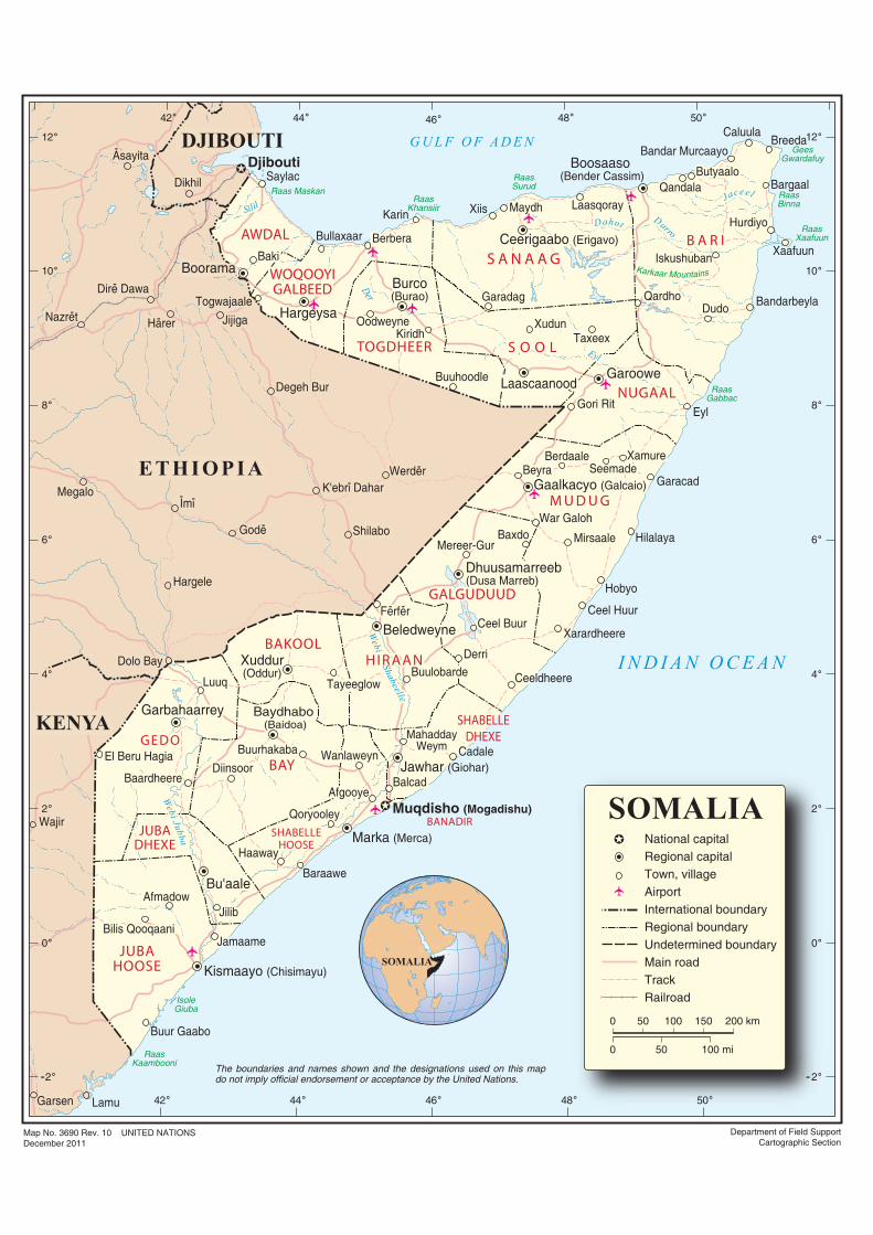
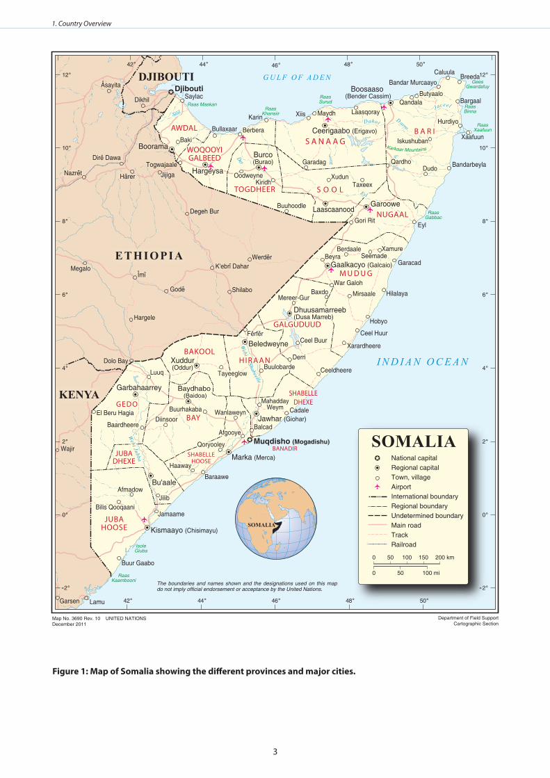
Somalia is located in the Horn of Africa and is bordered by the Gulf of Aden to the North, the Western Indian Ocean to the East, Ethiopia and Kenya to the West and Djibouti to the North-West (UNEP 2005). The capital city is Mogadishu which is located on the Indian Ocean coast. The country covers a surface area of 637,657 km2. It has an estimated population of 10 million comprising six major clans and various minor clans (IUCN 2006). The national language is Somali though Arabic, Italian and English are also spoken in major urban centres.
Somalia has been without a central Government since 1991 when President Siad Barre’s regime was overthrown. Years of political instability and war have resulted in over one million deaths, both as a direct result of the fighting and due to the country’s inability to cope with recurrent droughts, devastating floods and diseases. The country is divided into 18 regions, each subdivided into districts (Figure 1). These regions tend to be clustered into a number of zones or politico-geographical areas, which are listed below (Bennaars et al 1996):
The Northwest Zone: This region is better known as “Somaliland” and is a self-proclaimed republic with Hargeisa as its main city. This zone consists of five regions, Awdal, West Galbeed, Toghdeer, Sanaag and Sool.
The Northeast Zone: This is a sparsely populated area, made up of two regions - Bari and Nugaal. The important centres in this region are Bossaso, Gardo and Garowe.
The Central Zone: This consists of two regions, Mudug and Galgaduud, with Galcaio as the main town.
The South Zones: These are subdivided into the South Central Zone, consisting of four regions: Middle and Lower Shabelle, Hiraan and Benaadir. This area which had great wealth and power is now characterized by constant conflicts. The main town in this region is Mogadishu. The Southwest Zone is made up of three regions namely, Bay, Bakool and Gedo. Like the South Central Zone, this area is also characterized by conflicts and civil strife. Baidoa is the main town in this region. Lastly, there is the South Zone, which consists of two regions, Middle and Lower Juba. The main town in this region is Kismayo.
The country can be divided into five distinct physio-geographical zones differentiated by topography:• The Northern Coastal Plains;• The Golis Mountain Range and Plateaus in the north;• The Central Coastal Plains with a wide sand dune system;• The Broad Limestone-Sandstone Plateau of Central and Southern Somalia;• The Flood Plains of the Jubba and Shabelle rivers in the south.
The dominant vegetation is savanna with scattered trees and grasslands that are used for livestock grazing and fuel production in the form of charcoal. Only 13% of the land is considered arable of which only an eighth is regularly cropped. The arable areas are mainly found in the Jubba - Shabelle river valleys in the south. Rich fishing grounds lie off the coast due to upwelling of nutrient rich waters (IAS 2009).
In terms of economy, Somalia has a robust informal economy which is mainly based on telecommunications, remittance and money transfer companies and livestock trade which functions despite the civil unrest in the country. The GDP is USD 5,023 billion (Hare 2007). Since the fall of the Government in 1991, the private sector has grown, especially in the areas of commerce, transport, trade, remittance and construction. The primary sectors including agriculture, livestock and fisheries, have also increased as well as the service industry. This is thought to be due to the Somali customary law which has resulted in an environment conducive to businesses despite civil unrest and war (Afripedia 2010).
The agricultural sector is the most important economic sector. It has, however, been severely affected by the recent ban on Somali livestock by Saudi Arabia due to Rift Valley Fever (Hare 2007). Other main products are fish, charcoal, and bananas. Sugar, sorghum and maize are produced for sale on the domestic market. Somalia is also one of the global suppliers of frankincense and myrrh.
2
1. Country Overview
There are only two permanent rivers which flow across Somalia: the Jubba and the Shabelle (Chapin Metz 1992, Hughes and Hughes 1992, UNEP 2005). There are also permanent swamps and floodplains on the Shabelle River and additional swamps on the Jubba River. The rest of the country is drained by ephemeral streams locally known as wadis, which remain dry throughout the year except during rainy season events (FAO – SWALIM 2009).
In summer, the prevailing winds from the southwest accelerate the Somali Current that flows north of the Equator along the coast. The deflection of the current eastward by the south west wind trade results in the upwelling of cold, nutrient-rich waters along the Somali coast. This leads to high productivity (McClanahan 1988, Muir et al. 2004) that supports fisheries off Somalia.
The coastal population of Somalia is to some extent reliant on artisanal and subsistence fishing. Between 90,000 and 100,000 people are thought to be involved directly or indirectly in this sector. Most of the fishing takes place in inshore waters. Fishing gear consists of both demersal and drift gill nets, long lines, traps, cast nets and handlines. Deep sea fisheries are mainly dominated by distant fishing fleets from Europe and East Asia (Heileman and Scott 2009). The fisheries sector contributes more than 2% of GDP (FAO 2005).
There are policies and legislation concerning the environment in Somalia, but the little that exists is mostly outdated. A number of international agreements and Multilateral Environment Agreements (MEAs) were signed by the previous government, although there has been little progress in implementation. As a result Somalia lacks the capacity to deal with disasters of all types including climate change (IUCN 2006).
3
1. Country Overview
figure 1: map of somalia showing the different provinces and major cities .
Baki
Dolo Bay
Wajir
MahaddayWeym
Togwajaale
Berbera
Maydh LaasqorayQandala
Butyaalo
Hurdiyo
DudoQardho
Taxeex
Iskushuban
Xudun
Gori Rit
Buuhoodle
Kiridh
Garadag
Oodweyne
XamureSeemadeBeyra
Berdaale
War Galoh
MirsaaleBaxdoMereer-Gur
Ceel Buur
DerriBuulobarde
Tayeeglow
BalcadAfgooye
WanlaweynBuurhakabaDiinsoor
Qoryooley
Haaway
JilibAfmadow
Bilis Qooqaani
Luuq
El Beru Hagia
Baardheere
Werder
Shilabo
K'ebri Dahar
Degeh Bur
Gode
Hargele
ImiMegalo
Asayita
Nazret
Dire Dawa
Jijiga
Dikhil
Garsen
Harer
Ferfer
Bu'aale
Hargeysa
Burco (Burao)
BakiCeerigaabo (Erigavo)
Garoowe
Gaalkacyo (Galcaio)
Dhuusamarreeb(Dusa Marreb)
Beledweyne
Xuddur(Oddur)
Garbahaarrey Baydhabo (Baidoa)
Laascaanood
Boorama
GEDO
BAY
BAKOOLHIRAAN
GALGUDUUD
M U D U G
NUGAAL
S O O L
AWDAL B A R IS A N A A G
TOGDHEER
WOQOOYIGALBEED
SHABELLEHOOSE
JUBAHOOSE
JUBADHEXE
DJIBOUTI
KENYA
Karkaar Mountains
Silil
Der
Dahot Darro
Jaceel
Eyl
Webi Shabeelle
Webi Jubba
Boorama
Dolo Bay
Wajir
CadaleMahadday
Weym
Saylac
Togwajaale
Bullaxaar Berbera
Karin Xiis Maydh LaasqorayQandala
Butyaalo
Bandar Murcaayo
CaluulaBreeda
Bargaal
Hurdiyo
Xaafuun
BandarbeylaDudoQardho
Taxeex
Iskushuban
Xudun
Gori Rit
Buuhoodle
Kiridh
Garadag
Oodweyne
Eyl
Garacad
XamureSeemadeBeyra
Berdaale
War Galoh
HilalayaMirsaale
Hobyo
BaxdoMereer-Gur
Ceel BuurXarardheere
DerriBuulobarde CeeldheereTayeeglow
Ceel Huur
BalcadAfgooye
WanlaweynBuurhakabaDiinsoor
Qoryooley
Baraawe
Haaway
Jilib
Jamaame
Afmadow
Bilis Qooqaani
Luuq
El Beru Hagia
Buur Gaabo
Baardheere
Werder
Shilabo
K'ebri Dahar
Degeh Bur
Gode
Hargele
ImiMegalo
Asayita
Nazret
Dire Dawa
Jijiga
Dikhil
Garsen Lamu
Harer
Ferfer
Bu'aale
Hargeysa
Burco (Burao)
BakiCeerigaabo (Erigavo)
Boosaaso (Bender Cassim)
Garoowe
Gaalkacyo (Galcaio)
Dhuusamarreeb(Dusa Marreb)
Beledweyne
Xuddur(Oddur)
Garbahaarrey Baydhabo (Baidoa)
Marka (Merca)
Jawhar (Giohar)
Kismaayo (Chisimayu)
Laascaanood
Boorama
Muqdisho (Mogadishu)
Djibouti
GEDO
BAY
BAKOOLHIRAAN
GALGUDUUD
M U D U G
NUGAAL
S O O L
AWDAL B A R IS A N A A G
TOGDHEER
WOQOOYIGALBEED
SHABELLEDHEXE
BANADIRSHABELLE
HOOSE
JUBAHOOSE
JUBADHEXE
ET H IOP IA
DJIBOUTI
KENYA
Raas MaskanRaas
Khansiir
RaasSurud
GeesGwardafuy
RaasBinna
RaasXaafuun
RaasGabbac
RaasKaambooni
IsoleGiuba
Karkaar Mountains
G U L F O F A D E N
I N D I A N O C E A N
Silil
Der
Dahot Darro
Jaceel
Eyl
Webi Shabeelle
Webi Jubba
SOMALIA
Department of Field SupportCartographic Section
Map No. 3690 Rev. 10 UNITED NATIONSDecember 2011
The boundaries and names shown and the designations used on this map do not imply official endorsement or acceptance by the United Nations.
SOMALIA
0
0
100 200 km
50
50 150
100 mi
National capitalRegional capitalTown, villageAirportInternational boundaryRegional boundaryUndetermined boundaryMain roadTrackRailroad
- -
4
2. Biophysical environment
2 . bIoPHysICal envIRonmenT
description of the coast and distinctive features
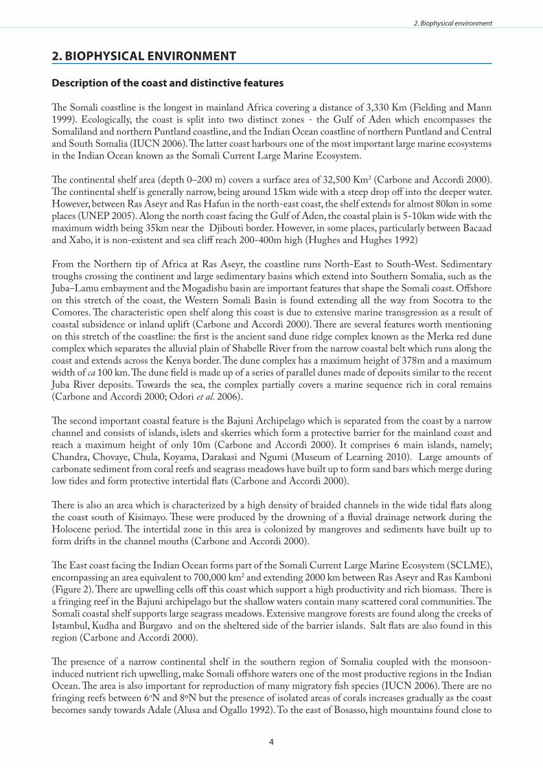
The Somali coastline is the longest in mainland Africa covering a distance of 3,330 Km (Fielding and Mann 1999). Ecologically, the coast is split into two distinct zones - the Gulf of Aden which encompasses the Somaliland and northern Puntland coastline, and the Indian Ocean coastline of northern Puntland and Central and South Somalia (IUCN 2006). The latter coast harbours one of the most important large marine ecosystems in the Indian Ocean known as the Somali Current Large Marine Ecosystem.
The continental shelf area (depth 0–200 m) covers a surface area of 32,500 Km2 (Carbone and Accordi 2000). The continental shelf is generally narrow, being around 15km wide with a steep drop off into the deeper water. However, between Ras Aseyr and Ras Hafun in the north-east coast, the shelf extends for almost 80km in some places (UNEP 2005). Along the north coast facing the Gulf of Aden, the coastal plain is 5-10km wide with the maximum width being 35km near the Djibouti border. However, in some places, particularly between Bacaad and Xabo, it is non-existent and sea cliff reach 200-400m high (Hughes and Hughes 1992)
From the Northern tip of Africa at Ras Aseyr, the coastline runs North-East to South-West. Sedimentary troughs crossing the continent and large sedimentary basins which extend into Southern Somalia, such as the Juba–Lamu embayment and the Mogadishu basin are important features that shape the Somali coast. Offshore on this stretch of the coast, the Western Somali Basin is found extending all the way from Socotra to the Comores. The characteristic open shelf along this coast is due to extensive marine transgression as a result of coastal subsidence or inland uplift (Carbone and Accordi 2000). There are several features worth mentioning on this stretch of the coastline: the first is the ancient sand dune ridge complex known as the Merka red dune complex which separates the alluvial plain of Shabelle River from the narrow coastal belt which runs along the coast and extends across the Kenya border. The dune complex has a maximum height of 378m and a maximum width of ca 100 km. The dune field is made up of a series of parallel dunes made of deposits similar to the recent Juba River deposits. Towards the sea, the complex partially covers a marine sequence rich in coral remains (Carbone and Accordi 2000; Odori et al. 2006).
The second important coastal feature is the Bajuni Archipelago which is separated from the coast by a narrow channel and consists of islands, islets and skerries which form a protective barrier for the mainland coast and reach a maximum height of only 10m (Carbone and Accordi 2000). It comprises 6 main islands, namely; Chandra, Chovaye, Chula, Koyama, Darakasi and Ngumi (Museum of Learning 2010). Large amounts of carbonate sediment from coral reefs and seagrass meadows have built up to form sand bars which merge during low tides and form protective intertidal flats (Carbone and Accordi 2000).
There is also an area which is characterized by a high density of braided channels in the wide tidal flats along the coast south of Kisimayo. These were produced by the drowning of a fluvial drainage network during the Holocene period. The intertidal zone in this area is colonized by mangroves and sediments have built up to form drifts in the channel mouths (Carbone and Accordi 2000).
The East coast facing the Indian Ocean forms part of the Somali Current Large Marine Ecosystem (SCLME), encompassing an area equivalent to 700,000 km2 and extending 2000 km between Ras Aseyr and Ras Kamboni (Figure 2). There are upwelling cells off this coast which support a high productivity and rich biomass. There is a fringing reef in the Bajuni archipelago but the shallow waters contain many scattered coral communities. The Somali coastal shelf supports large seagrass meadows. Extensive mangrove forests are found along the creeks of Istambul, Kudha and Burgavo and on the sheltered side of the barrier islands. Salt flats are also found in this region (Carbone and Accordi 2000).
The presence of a narrow continental shelf in the southern region of Somalia coupled with the monsoon-induced nutrient rich upwelling, make Somali offshore waters one of the most productive regions in the Indian Ocean. The area is also important for reproduction of many migratory fish species (IUCN 2006). There are no fringing reefs between 6oN and 8ºN but the presence of isolated areas of corals increases gradually as the coast becomes sandy towards Adale (Alusa and Ogallo 1992). To the east of Bosasso, high mountains found close to
5
2. Biophysical environment
the shore influence rainfall patterns in this area. The marine environment in this area is also highly productive due to upwelling, high turbidity, and complex seasonal currents (IUCN 2006).
The northern part of the coast along the Gulf of Aden has a relatively straight coastline stretching over 1300km in length (IUCN 2006). This coast mainly consists of a series of sandy bays interrupted by rocky formations extending down into the sea.
figure 2: Coast of somalia and its main physiographic features . The map shows Pliocene ±Quaternary sedimentary cover, the extension of two large marine ecosystems of the somali coast, the somali Current (dashes) and arabian sea (dotted shading), and the annual mean sea surface isotherms . The dashed part along the 100 m isobath encloses the area colonized by coral reefs (Carbone and accordi 2000) .
i) Issues of concernThe Somali Government does not have the capacity to control foreign fishing incursions into the Exclusive Economic Zone (EEZ). This has meant that offshore waters are largely open to foreign fishing vessels that exploit its abundant fisheries resources. At the same time, there is also lack of legislation for coastal and marine environmental management, planning and development. The problems of over exploitation of fisheries resources is expected to persist even in the future due to a lack of capacity for effective control and surveillance. The country also lacks capacity to conduct stock assessments within its territorial waters and EEZ. There is a lack of current data, information and knowledge on the current status of the coastal and marine environment and the natural resources contained therein. Also, little is known of the geological history of the Somali coastline although some geological and morphological studies were carried out in the past. Only few fragmented data exist on the northern part of the Somali Indian Ocean belt.
general description of the climate
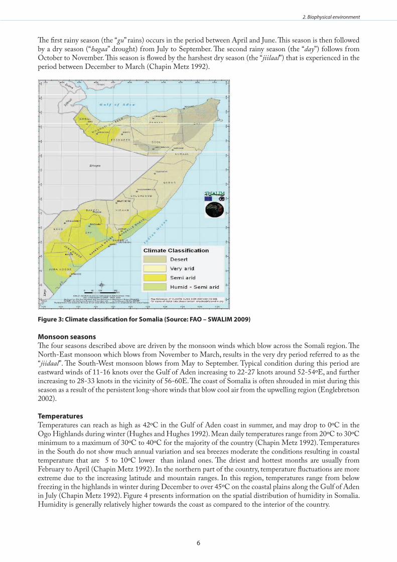
Somalia experiences varied climatic conditions with seasonal monsoons, irregular rainfall and recurring droughts (TID 2008). Different locations experience tropical, sub-tropical, arid and semi-arid conditions (Figure 3). The coast is generally hot and humid while the interior of the country is mainly hot and dry (UNEP 2005). There are four seasons - two rainy seasons (known locally as “gu’ and “day”) and two dry seasons (“jiilaal” and “hagaa”).
6
2. Biophysical environment
The first rainy season (the “gu” rains) occurs in the period between April and June. This season is then followed by a dry season (“hagaa” drought) from July to September. The second rainy season (the “day”) follows from October to November. This season is flowed by the harshest dry season (the “jiilaal”) that is experienced in the period between December to March (Chapin Metz 1992).
figure 3: Climate classification for somalia (source: fao – swalIm 2009)
monsoon seasonsThe four seasons described above are driven by the monsoon winds which blow across the Somali region. The North-East monsoon which blows from November to March, results in the very dry period referred to as the “jiidaal”. The South-West monsoon blows from May to September. Typical condition during this period are eastward winds of 11-16 knots over the Gulf of Aden increasing to 22-27 knots around 52-54ºE, and further increasing to 28-33 knots in the vicinity of 56-60E. The coast of Somalia is often shrouded in mist during this season as a result of the persistent long-shore winds that blow cool air from the upwelling region (Englebretson 2002).
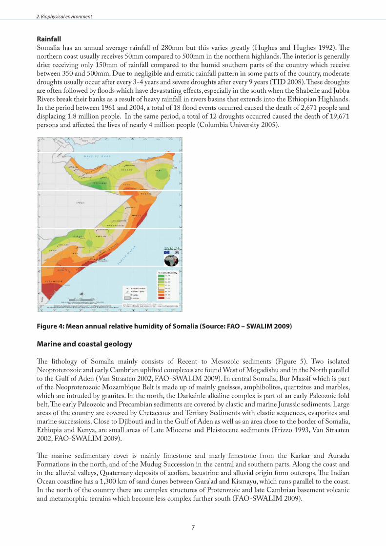
TemperaturesTemperatures can reach as high as 42ºC in the Gulf of Aden coast in summer, and may drop to 0ºC in the Ogo Highlands during winter (Hughes and Hughes 1992). Mean daily temperatures range from 20ºC to 30ºC minimum to a maximum of 30ºC to 40ºC for the majority of the country (Chapin Metz 1992). Temperatures in the South do not show much annual variation and sea breezes moderate the conditions resulting in coastal temperature that are 5 to 10ºC lower than inland ones. The driest and hottest months are usually from February to April (Chapin Metz 1992). In the northern part of the country, temperature fluctuations are more extreme due to the increasing latitude and mountain ranges. In this region, temperatures range from below freezing in the highlands in winter during December to over 45ºC on the coastal plains along the Gulf of Aden in July (Chapin Metz 1992). Figure 4 presents information on the spatial distribution of humidity in Somalia. Humidity is generally relatively higher towards the coast as compared to the interior of the country.
7
2. Biophysical environment
RainfallSomalia has an annual average rainfall of 280mm but this varies greatly (Hughes and Hughes 1992). The northern coast usually receives 50mm compared to 500mm in the northern highlands. The interior is generally drier receiving only 150mm of rainfall compared to the humid southern parts of the country which receive between 350 and 500mm. Due to negligible and erratic rainfall pattern in some parts of the country, moderate droughts usually occur after every 3-4 years and severe droughts after every 9 years (TID 2008). These droughts are often followed by floods which have devastating effects, especially in the south when the Shabelle and Jubba Rivers break their banks as a result of heavy rainfall in rivers basins that extends into the Ethiopian Highlands. In the period between 1961 and 2004, a total of 18 flood events occurred caused the death of 2,671 people and displacing 1.8 million people. In the same period, a total of 12 droughts occurred caused the death of 19,671 persons and affected the lives of nearly 4 million people (Columbia University 2005).
figure 4: mean annual relative humidity of somalia (source: fao – swalIm 2009)
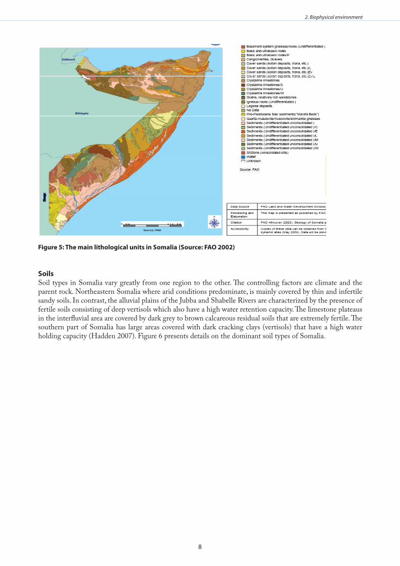
marine and coastal geology
The lithology of Somalia mainly consists of Recent to Mesozoic sediments (Figure 5). Two isolated Neoproterozoic and early Cambrian uplifted complexes are found West of Mogadishu and in the North parallel to the Gulf of Aden (Van Straaten 2002, FAO-SWALIM 2009). In central Somalia, Bur Massif which is part of the Neoproterozoic Mozambique Belt is made up of mainly gneisses, amphibolites, quartzites and marbles, which are intruded by granites. In the north, the Darkainle alkaline complex is part of an early Paleozoic fold belt. The early Paleozoic and Precambian sediments are covered by clastic and marine Jurassic sediments. Large areas of the country are covered by Cretaceous and Tertiary Sediments with clastic sequences, evaporites and marine successions. Close to Djibouti and in the Gulf of Aden as well as an area close to the border of Somalia, Ethiopia and Kenya, are small areas of Late Miocene and Pleistocene sediments (Frizzo 1993, Van Straaten 2002, FAO-SWALIM 2009).
The marine sedimentary cover is mainly limestone and marly-limestone from the Karkar and Auradu Formations in the north, and of the Mudug Succession in the central and southern parts. Along the coast and in the alluvial valleys, Quaternary deposits of aeolian, lacustrine and alluvial origin form outcrops. The Indian Ocean coastline has a 1,300 km of sand dunes between Gara’ad and Kismayu, which runs parallel to the coast. In the north of the country there are complex structures of Proterozoic and late Cambrian basement volcanic and metamorphic terrains which become less complex further south (FAO-SWALIM 2009).
8
2. Biophysical environment
figure 5: The main lithological units in somalia (source: fao 2002)
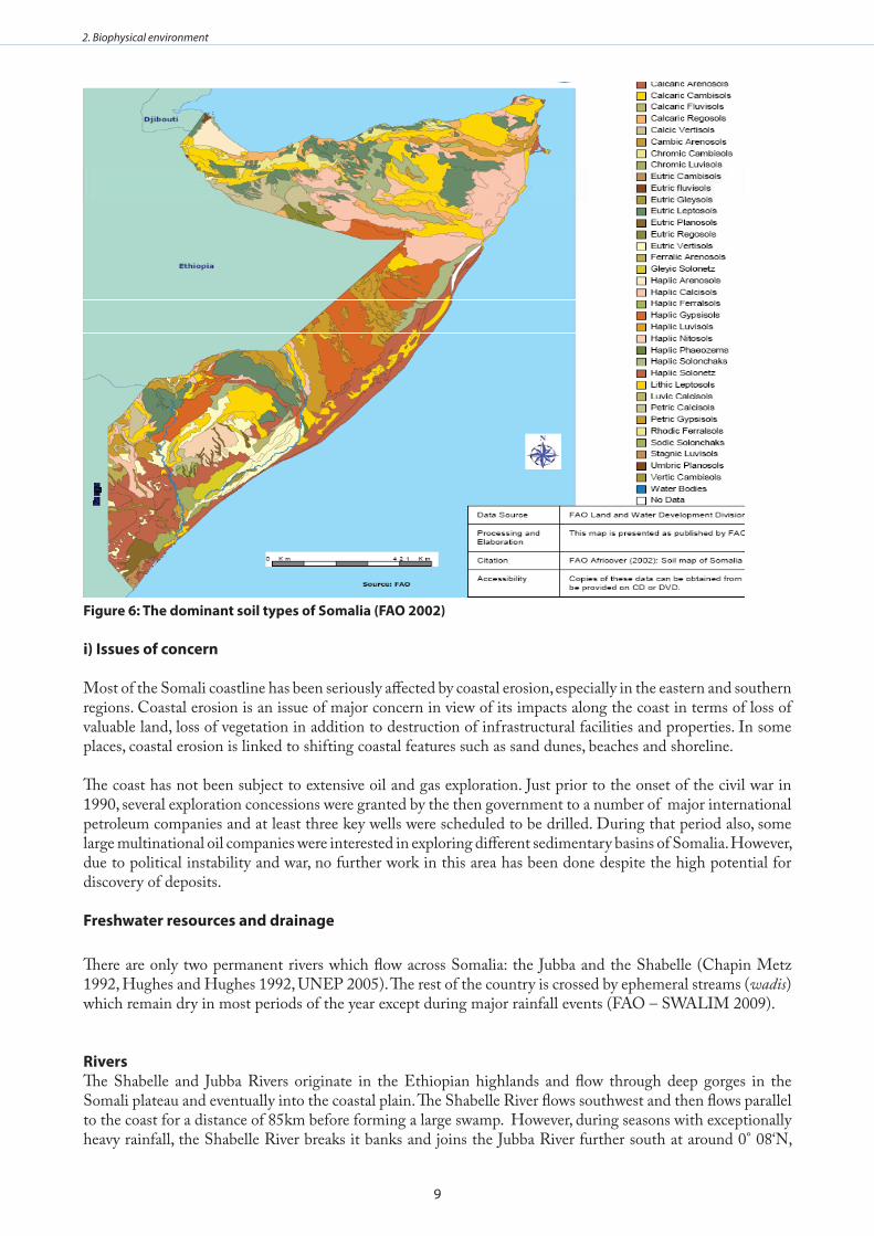
soils Soil types in Somalia vary greatly from one region to the other. The controlling factors are climate and the parent rock. Northeastern Somalia where arid conditions predominate, is mainly covered by thin and infertile sandy soils. In contrast, the alluvial plains of the Jubba and Shabelle Rivers are characterized by the presence of fertile soils consisting of deep vertisols which also have a high water retention capacity. The limestone plateaus in the interfluvial area are covered by dark grey to brown calcareous residual soils that are extremely fertile. The southern part of Somalia has large areas covered with dark cracking clays (vertisols) that have a high water holding capacity (Hadden 2007). Figure 6 presents details on the dominant soil types of Somalia.
9
2. Biophysical environment
figure 6: The dominant soil types of somalia (fao 2002)
i) Issues of concern
Most of the Somali coastline has been seriously affected by coastal erosion, especially in the eastern and southern regions. Coastal erosion is an issue of major concern in view of its impacts along the coast in terms of loss of valuable land, loss of vegetation in addition to destruction of infrastructural facilities and properties. In some places, coastal erosion is linked to shifting coastal features such as sand dunes, beaches and shoreline. The coast has not been subject to extensive oil and gas exploration. Just prior to the onset of the civil war in 1990, several exploration concessions were granted by the then government to a number of major international petroleum companies and at least three key wells were scheduled to be drilled. During that period also, some large multinational oil companies were interested in exploring different sedimentary basins of Somalia. However, due to political instability and war, no further work in this area has been done despite the high potential for discovery of deposits.
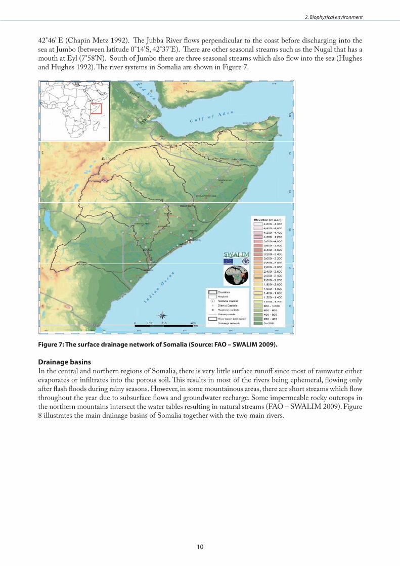
freshwater resources and drainage
There are only two permanent rivers which flow across Somalia: the Jubba and the Shabelle (Chapin Metz 1992, Hughes and Hughes 1992, UNEP 2005). The rest of the country is crossed by ephemeral streams (wadis) which remain dry in most periods of the year except during major rainfall events (FAO – SWALIM 2009).
RiversThe Shabelle and Jubba Rivers originate in the Ethiopian highlands and flow through deep gorges in the Somali plateau and eventually into the coastal plain. The Shabelle River flows southwest and then flows parallel to the coast for a distance of 85km before forming a large swamp. However, during seasons with exceptionally heavy rainfall, the Shabelle River breaks it banks and joins the Jubba River further south at around 0° 08‘N,
10
2. Biophysical environment
42°46’ E (Chapin Metz 1992). The Jubba River flows perpendicular to the coast before discharging into the sea at Jumbo (between latitude 0°14’S, 42°37’E). There are other seasonal streams such as the Nugal that has a mouth at Eyl (7°58’N). South of Jumbo there are three seasonal streams which also flow into the sea (Hughes and Hughes 1992). The river systems in Somalia are shown in Figure 7.
figure 7: The surface drainage network of somalia (source: fao – swalIm 2009) .
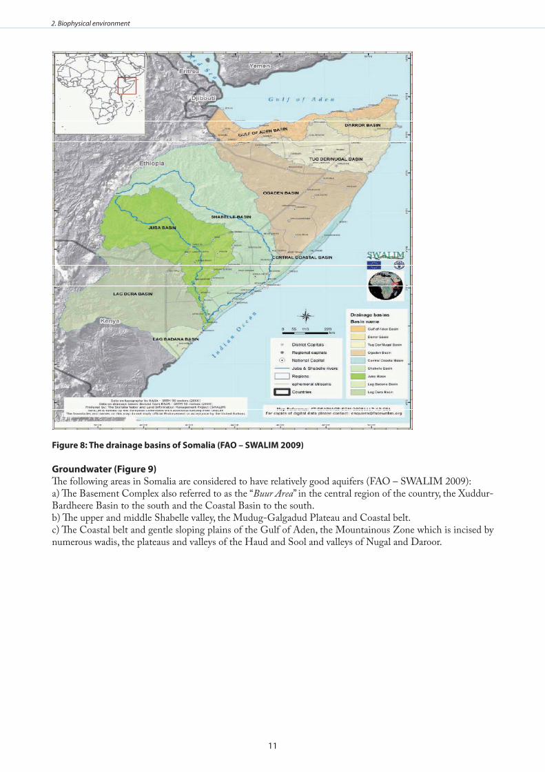
drainage basinsIn the central and northern regions of Somalia, there is very little surface runoff since most of rainwater either evaporates or infiltrates into the porous soil. This results in most of the rivers being ephemeral, flowing only after flash floods during rainy seasons. However, in some mountainous areas, there are short streams which flow throughout the year due to subsurface flows and groundwater recharge. Some impermeable rocky outcrops in the northern mountains intersect the water tables resulting in natural streams (FAO – SWALIM 2009). Figure 8 illustrates the main drainage basins of Somalia together with the two main rivers.
11
2. Biophysical environment
figure 8: The drainage basins of somalia (fao – swalIm 2009)
groundwater (figure 9)The following areas in Somalia are considered to have relatively good aquifers (FAO – SWALIM 2009):a) The Basement Complex also referred to as the “Buur Area” in the central region of the country, the Xuddur-Bardheere Basin to the south and the Coastal Basin to the south.b) The upper and middle Shabelle valley, the Mudug-Galgadud Plateau and Coastal belt.c) The Coastal belt and gentle sloping plains of the Gulf of Aden, the Mountainous Zone which is incised by numerous wadis, the plateaus and valleys of the Haud and Sool and valleys of Nugal and Daroor.
12
2. Biophysical environment
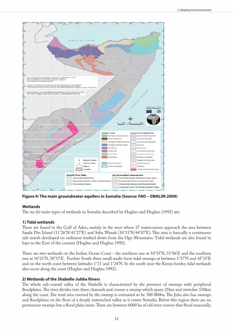
figure 9: The main groundwater aquifers in somalia (source: fao – swalIm 2009)
wetlandsThe six (6) main types of wetlands in Somalia described by Hughes and Hughes (1992) are:
1) Tidal wetlandsThese are found in the Gulf of Aden, mainly in the west where 27 watercourses approach the area between Saada Din Island (11°26’N/43°27’E) and Saba Wanak (10°33’N/44°07’E). This area is basically a continuous salt-marsh developed on sediment washed down from the Ogo Mountains. Tidal wetlands are also found in bays in the East of the country (Hughes and Hughes 1992).
There are two wetlands on the Indian Ocean Coast - the northern one at 10°35’N, 51°06’E and the southern one at 10°21’N, 50°57’E. Further South three small wadis form tidal swamps at between 1°57’N and 45°15’E and on the north coast between latitudes 1°11’ and 1°24’N. In the south near the Kenya border, tidal wetlands also occur along the coast (Hughes and Hughes 1992).
2) wetlands of the shabelle-Jubba RiversThe whole sub-coastal valley of the Shabelle is characterized by the presence of swamps with peripheral floodplains. The river divides into three channels and crosses a swamp which spans 25km and stretches 150km along the coast. The total area covered by the swamp is estimated to be 300 000ha. The Juba also has swamps and floodplains on the floor of a deeply entrenched valley as it enters Somalia. Below this region there are no permanent swamps but a flood plain exists. There are however 6000 ha of old river courses that flood seasonally.
13
2. Biophysical environment
Where the two rivers meet there is a floodplain after which they cross marshy land and drain into a mangrove fringed estuary at Jumba (Hughes and Hughes 1992).
3) wetlands of the lachs districtTemporary large water courses (lachs) drain into southern Somalia. The principle ones are Lach Awaro (Bor) and Lach Dheere (Dera) which flood into broad floodplains during rainy seasons. Lach Awaro has created a 55km long and 10km wide floodplain covering a surface area of 33,000ha. Most of the water from this river joins that of of Lach Dheere resulting into a large pan. Lach Dheere has several permanent swamps along its course, covering a surface area of nearly 6,000ha in its upper reaches and 5,000ha along its midsection, before joining the Juba River 40km from the estuary. Another large pan, 63km in length and 9km wide covering a surface area of 33,000ha, is situated on the plateau 120km north of the Awaro and Dheere wetlands. More than 20 small watercourses feed the pan which is flooded annually for a short period (Hughes and Hughes 1992).
4) bullehs, Tugs and dholosA bulleh is a small endorheic depression which is filled by runoff after a storm. These have distinct soil types which retain moisture and as a result have richer vegetation than surrounding areas. Tugs are small temporary watercourses with low gradient. When in flood their waters spread over a wide area and cause broad alluvium deposits. Tugs often end in inland deltas which are known as dholos. These are often set in the valley of a larger watercourse or may spread over raised coral reefs along the coast. These systems also have dense vegetation (Hughes and Hughes 1992).
5) The Central districtsNo major wetlands exist in this area but various sink holes are present and a small lake at 4°15’N, 46°30’E. The caves off this lake shelter the endemic blind fish Phreatichthys andruzzii. There are also several large pans towards the coast which seldom hold water and when they do it is only for brief periods (Hughes and Hughes 1992).
6) artificial Impoundments240 reservoirs have been constructed to water livestock (Hughes and Hughes 1992).
i) Issues and gapsSalinisation is a serious problem in the irrigated areas along the Jubba and Shabelle river valleys. The two • rivers have high salt content even during periods of high flows (Markakis 1998). This to a certain extent limits the extent to which the waters of the two rivers can be used for irrigation. Developments and land use change in the Ethiopian Highlands can interfere with the flow of the two • rivers, thus severely impacting Somalia. River embankments are used for agriculture which causes frequent flooding (FAO – SWALIM 2009). The • major flood channels that the former Government used to maintain have also fallen into disrepair due to civil war. This has increased the possibility of flooding especially in the lower and middle Shabelle valleys (FAO – SWALIM 2009). People are also settling in flood prone areas due to increased population pressure. This is increasing the • vulnerability of the local communities to flooding with high possibility for loss of life and property during flood events (FAO – SWALIM 2009).Lastly, it is important to note that very little research has been carried out on the hydrology of Jubba and • Shebelle rivers and as such there is very limited data and information on the ground water aquifers.
14
2. Biophysical environment
Physical oceanography
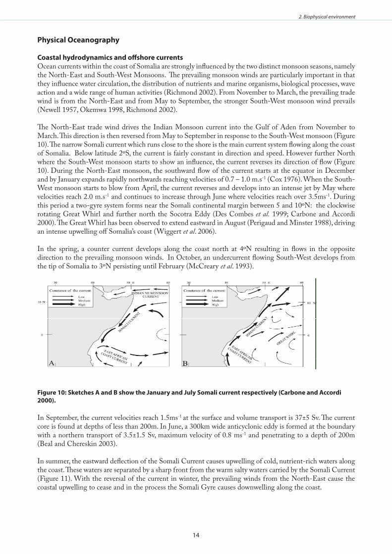
Coastal hydrodynamics and offshore currentsOcean currents within the coast of Somalia are strongly influenced by the two distinct monsoon seasons, namely the North-East and South-West Monsoons. The prevailing monsoon winds are particularly important in that they influence water circulation, the distribution of nutrients and marine organisms, biological processes, wave action and a wide range of human activities (Richmond 2002). From November to March, the prevailing trade wind is from the North-East and from May to September, the stronger South-West monsoon wind prevails (Newell 1957, Okemwa 1998, Richmond 2002).
The North-East trade wind drives the Indian Monsoon current into the Gulf of Aden from November to March. This direction is then reversed from May to September in response to the South-West monsoon (Figure 10). The narrow Somali current which runs close to the shore is the main current system flowing along the coast of Somalia. Below latitude 2ºS, the current is fairly constant in direction and speed. However further North where the South-West monsoon starts to show an influence, the current reverses its direction of flow (Figure 10). During the North-East monsoon, the southward flow of the current starts at the equator in December and by January expands rapidly northwards reaching velocities of 0.7 – 1.0 m.s-1 (Cox 1976). When the South-West monsoon starts to blow from April, the current reverses and develops into an intense jet by May where velocities reach 2.0 m.s-1 and continues to increase through June where velocities reach over 3.5ms-1. During this period a two-gyre system forms near the Somali continental margin between 5 and 10ºN: the clockwise rotating Great Whirl and further north the Socotra Eddy (Des Combes et al. 1999; Carbone and Accordi 2000). The Great Whirl has been observed to extend eastward in August (Perigaud and Minster 1988), driving an intense upwelling off Somalia’s coast (Wiggert et al. 2006).
In the spring, a counter current develops along the coast north at 4ºN resulting in flows in the opposite direction to the prevailing monsoon winds. In October, an undercurrent flowing South-West develops from the tip of Somalia to 3ºN persisting until February (McCreary et al. 1993).
figure 10: sketches a and b show the January and July somali current respectively (Carbone and accordi 2000) .
In September, the current velocities reach 1.5ms-1 at the surface and volume transport is 37±5 Sv. The current
core is found at depths of less than 200m. In June, a 300km wide anticyclonic eddy is formed at the boundary with a northern transport of 3.5±1.5 Sv, maximum velocity of 0.8 ms-1 and penetrating to a depth of 200m (Beal and Chereskin 2003).
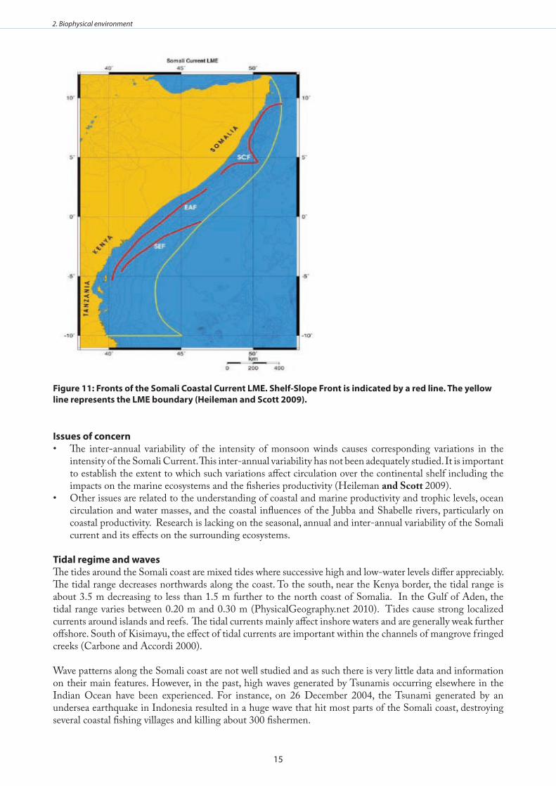
In summer, the eastward deflection of the Somali Current causes upwelling of cold, nutrient-rich waters along the coast. These waters are separated by a sharp front from the warm salty waters carried by the Somali Current (Figure 11). With the reversal of the current in winter, the prevailing winds from the North-East cause the coastal upwelling to cease and in the process the Somali Gyre causes downwelling along the coast.
15
2. Biophysical environment
figure 11: fronts of the somali Coastal Current lme . shelf-slope front is indicated by a red line . The yellow line represents the lme boundary (Heileman and scott 2009) .
Issues of concernThe inter-annual variability of the intensity of monsoon winds causes corresponding variations in the • intensity of the Somali Current. This inter-annual variability has not been adequately studied. It is important to establish the extent to which such variations affect circulation over the continental shelf including the impacts on the marine ecosystems and the fisheries productivity (Heileman and Scott 2009).Other issues are related to the understanding of coastal and marine productivity and trophic levels, ocean • circulation and water masses, and the coastal influences of the Jubba and Shabelle rivers, particularly on coastal productivity. Research is lacking on the seasonal, annual and inter-annual variability of the Somali current and its effects on the surrounding ecosystems.
Tidal regime and wavesThe tides around the Somali coast are mixed tides where successive high and low-water levels differ appreciably. The tidal range decreases northwards along the coast. To the south, near the Kenya border, the tidal range is about 3.5 m decreasing to less than 1.5 m further to the north coast of Somalia. In the Gulf of Aden, the tidal range varies between 0.20 m and 0.30 m (PhysicalGeography.net 2010). Tides cause strong localized currents around islands and reefs. The tidal currents mainly affect inshore waters and are generally weak further offshore. South of Kisimayu, the effect of tidal currents are important within the channels of mangrove fringed creeks (Carbone and Accordi 2000).
Wave patterns along the Somali coast are not well studied and as such there is very little data and information on their main features. However, in the past, high waves generated by Tsunamis occurring elsewhere in the Indian Ocean have been experienced. For instance, on 26 December 2004, the Tsunami generated by an undersea earthquake in Indonesia resulted in a huge wave that hit most parts of the Somali coast, destroying several coastal fishing villages and killing about 300 fishermen.
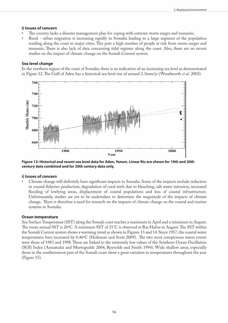
16
2. Biophysical environment
i) Issues of concernThe country lacks a disaster management plan for coping with extreme storm surges and tsunamis.• Rural - urban migration is increasing rapidly in Somalia leading to a large segment of the population • residing along the coast in major cities. This puts a high number of people at risk from storm surges and tsunamis. There is also lack of data concerning tidal regimes along the coast. Also, there are no recent studies on the impact of climate change on the Somali Current system.
sea level changeIn the northern region of the coast of Somalia, there is an indication of an increasing sea level as demonstrated in Figure 12. The Gulf of Aden has a historical sea level rise of around 3.3mm/yr (Woodworth et al. 2003).
figure 12: Historical and recent sea level data for aden, yemen . linear fits are shown for 19th and 20th century data combined and for 20th century data only .
i) Issues of concernClimate change will definitely have significant impacts in Somalia. Some of the impacts include reduction • in coastal fisheries production, degradation of coral reefs due to bleaching, salt water intrusion, increased flooding of lowlying areas, displacement of coastal populations and loss of coastal infrastructure. Unfortunately, studies are yet to be undertaken to determine the magnitude of the impacts of climate change. There is therefore a need for research on the impacts of climate change on the coastal and marine systems in Somalia.
ocean temperatureSea Surface Temperature (SST) along the Somali coast reaches a maximum in April and a minimum in August. The mean annual SST is 26ºC. A minimum SST of 21°C is observed at Ras Hafun in August. The SST within the Somali Current system shows a warming trend as shown in Figures 13 and 14. Since 1957, the coastal water temperatures have increased by 0.46ºC (Heileman and Scott 2009). The two most conspicuous warm events were those of 1983 and 1998. These are linked to the extremely low values of the Southern Ocean Oscillation (SOI) Index (Annamalai and Murtugudde 2004; Reynolds and Smith 1994). Wide shallow areas, especially those in the southernmost part of the Somali coast show a great variation in temperatures throughout the year (Figure 15).
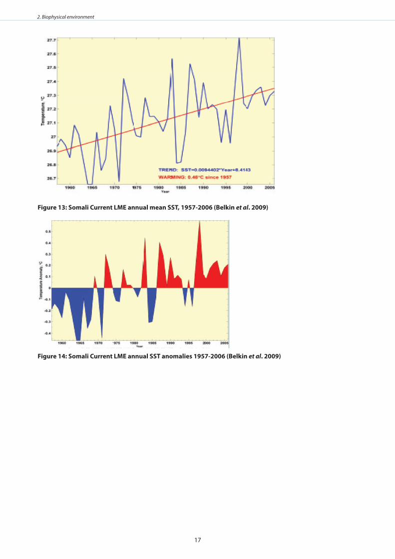
17
2. Biophysical environment
figure 13: somali Current lme annual mean ssT, 1957-2006 (belkin et al . 2009)
figure 14: somali Current lme annual ssT anomalies 1957-2006 (belkin et al . 2009)
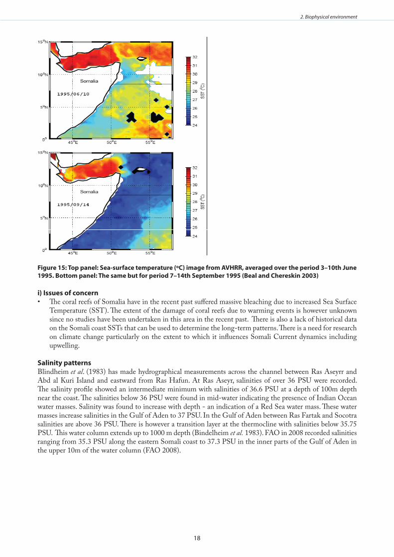
18
2. Biophysical environment
figure 15: Top panel: sea-surface temperature (ºC) image from avHRR, averaged over the period 3–10th June 1995 . bottom panel: The same but for period 7–14th september 1995 (beal and Chereskin 2003)
i) Issues of concernThe coral reefs of Somalia have in the recent past suffered massive bleaching due to increased Sea Surface • Temperature (SST). The extent of the damage of coral reefs due to warming events is however unknown since no studies have been undertaken in this area in the recent past. There is also a lack of historical data on the Somali coast SSTs that can be used to determine the long-term patterns. There is a need for research on climate change particularly on the extent to which it influences Somali Current dynamics including upwelling.
salinity patternsBlindheim et al. (1983) has made hydrographical measurements across the channel between Ras Aseyrr and Abd al Kuri Island and eastward from Ras Hafun. At Ras Aseyr, salinities of over 36 PSU were recorded. The salinity profile showed an intermediate minimum with salinities of 36.6 PSU at a depth of 100m depth near the coast. The salinities below 36 PSU were found in mid-water indicating the presence of Indian Ocean water masses. Salinity was found to increase with depth - an indication of a Red Sea water mass. These water masses increase salinities in the Gulf of Aden to 37 PSU. In the Gulf of Aden between Ras Fartak and Socotra salinities are above 36 PSU. There is however a transition layer at the thermocline with salinities below 35.75 PSU. This water column extends up to 1000 m depth (Bindelheim et al. 1983). FAO in 2008 recorded salinities ranging from 35.3 PSU along the eastern Somali coast to 37.3 PSU in the inner parts of the Gulf of Aden in the upper 10m of the water column (FAO 2008).
19
2. Biophysical environment
ocean-atmosphere interaction
local ocean–atmosphere covariabilityLarge SST gradients form off the Somali coast due to the influence of the Southwestern monsoon which triggers an intense mesoscale coupled interaction. Satellite observations reveal intense air-sea coupled feedbacks occurring over small-scale SST structures. The formation of the Great Whirl off the Horn of Africa causes one of these couplings (Seo et al. 2008). These affect the stability of the atmospheric boundary layer and the Somali Jet that blows over them in summer causing a large response in the near-surface winds and turbulent heat fluxes (Saha 1970, Seo et al. 2008). The most notable of these fluxes is the Ekman upwelling and downwelling following the cold filaments which are induced by the SST-wind covariability. This Ekman pumping usually lasts for a month with amplitudes of 1m/day which may explain the thermocline variability which is often associated with these cold filaments. Latent heat fluxes also have a dampening effect on SST as eddies substantially alter latent heat flux variability (Seo et al. 2008).
The understanding of this feedback effect on the ocean is limited however. Seo et al. (2008) using a 12-year-long high-resolution (1/4º) ocean-atmosphere coupled model simulation found that the large SST drop associated with the Great Whirl and the South-West monsoon cause maximum wind speed to be co-located with the great whirl (Figure 16 a-d). This is due to the fact that the SST modulates the atmospheric boundary layer, causing turbulence and mixing of momentum and moisture (Seo et al. 2008).
In addition the narrow SST gradients result in large wind stress curls and divergences at the sea surface. The cold wedges between the eddies off the Horn of Africa couple with the monsoon winds which blow along them result in the formation of an offshore wind stress curl maximum (Figure 16 d). In this region the vectors of wind stress and SST are parallel which results in alternating bands of wind stress convergence and divergence upwind and downwind of the filament at the northern rim of the Great Whirl (Figure 16 e). There is also variability in turbulent heat fluxes due to the variability of SST and wind speed (Figure 16c); over the Great Whirl, heat loss is greater than 220 W/m2 is areas of maximum wind speed and warm SST. However, over cold wedges, heat loss is reduced to only 40 W/m2. Sensible heat flux change also mimics the SST and air temperature changes with a greater sensible heating where the air overlies the cold filaments (Seo et al. 2008).
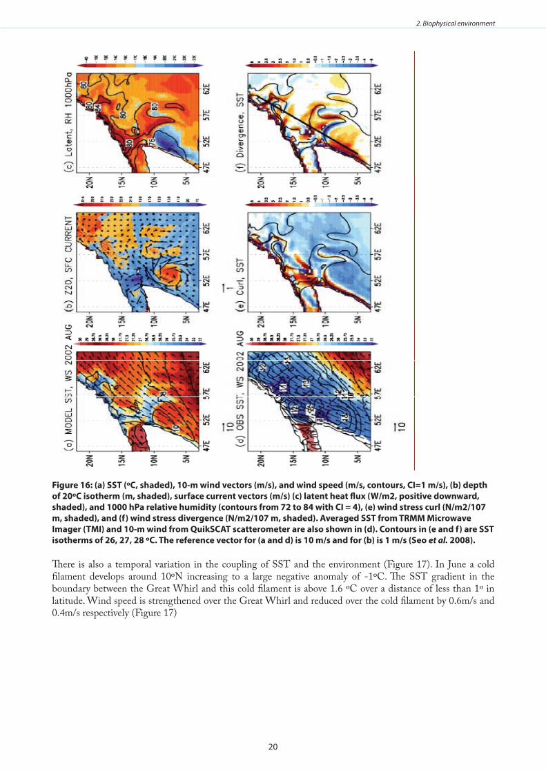
20
2. Biophysical environment
figure 16: (a) ssT (ºC, shaded), 10-m wind vectors (m/s), and wind speed (m/s, contours, CI=1 m/s), (b) depth of 20ºC isotherm (m, shaded), surface current vectors (m/s) (c) latent heat flux (w/m2, positive downward, shaded), and 1000 hPa relative humidity (contours from 72 to 84 with CI = 4), (e) wind stress curl (n/m2/107 m, shaded), and (f) wind stress divergence (n/m2/107 m, shaded) . averaged ssT from TRmm microwave Imager (TmI) and 10-m wind from QuiksCaT scatterometer are also shown in (d) . Contours in (e and f) are ssT isotherms of 26, 27, 28 ºC . The reference vector for (a and d) is 10 m/s and for (b) is 1 m/s (seo et al. 2008) .
There is also a temporal variation in the coupling of SST and the environment (Figure 17). In June a cold filament develops around 10ºN increasing to a large negative anomaly of -1ºC. The SST gradient in the boundary between the Great Whirl and this cold filament is above 1.6 ºC over a distance of less than 1º in latitude. Wind speed is strengthened over the Great Whirl and reduced over the cold filament by 0.6m/s and 0.4m/s respectively (Figure 17)
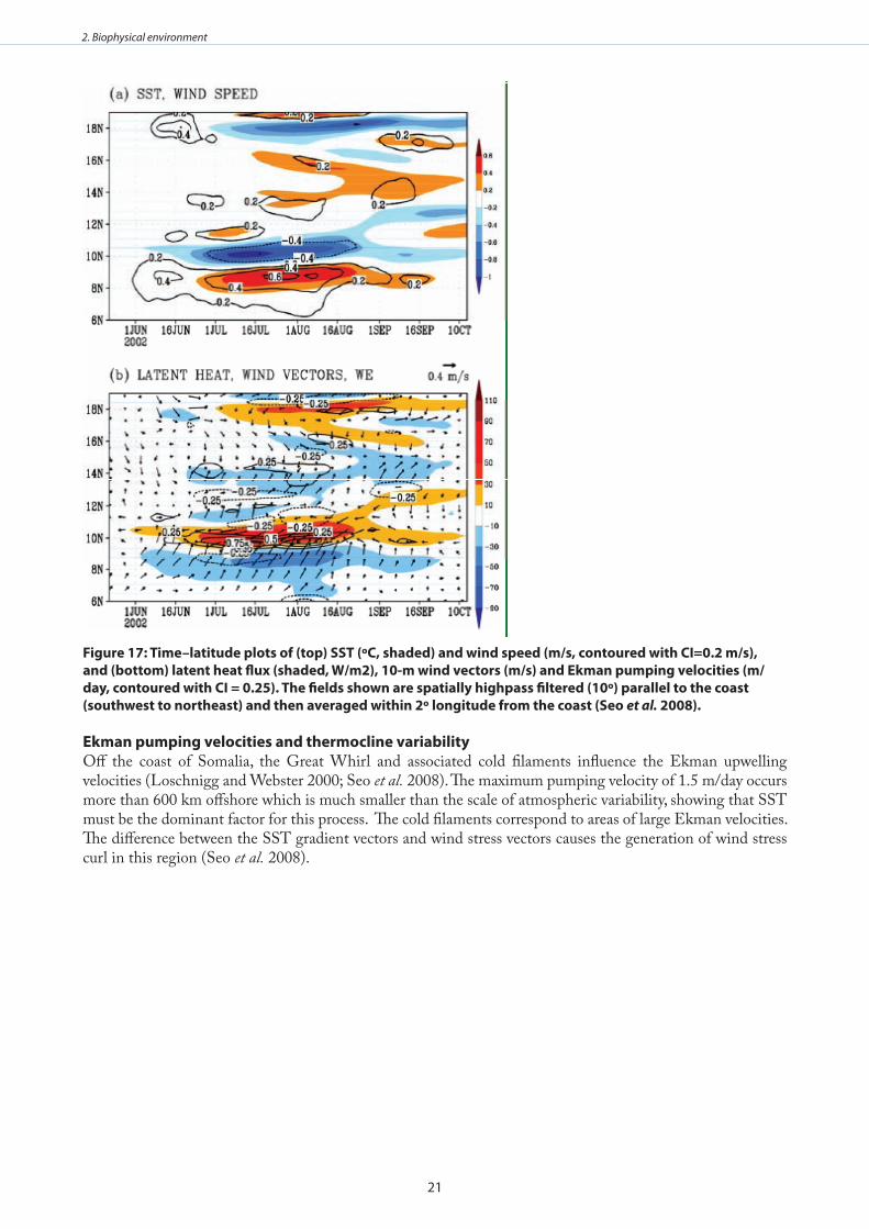
21
2. Biophysical environment
figure 17: Time–latitude plots of (top) ssT (ºC, shaded) and wind speed (m/s, contoured with CI=0 .2 m/s), and (bottom) latent heat flux (shaded, w/m2), 10-m wind vectors (m/s) and ekman pumping velocities (m/day, contoured with CI = 0 .25) . The fields shown are spatially highpass filtered (10º) parallel to the coast (southwest to northeast) and then averaged within 2º longitude from the coast (seo et al. 2008) .
ekman pumping velocities and thermocline variabilityOff the coast of Somalia, the Great Whirl and associated cold filaments influence the Ekman upwelling velocities (Loschnigg and Webster 2000; Seo et al. 2008). The maximum pumping velocity of 1.5 m/day occurs more than 600 km offshore which is much smaller than the scale of atmospheric variability, showing that SST must be the dominant factor for this process. The cold filaments correspond to areas of large Ekman velocities. The difference between the SST gradient vectors and wind stress vectors causes the generation of wind stress curl in this region (Seo et al. 2008).
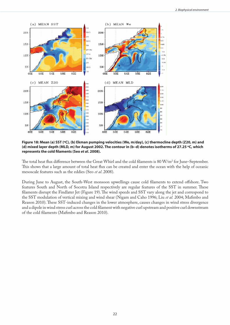
22
2. Biophysical environment
figure 18: mean (a) ssT (ºC), (b) ekman pumping velocities (we, m/day), (c) thermocline depth (Z20, m) and (d) mixed layer depth (mld, m) for august 2002 . The contour in (b–d) denotes isotherms of 27 .25 ºC, which represents the cold filaments (seo et al . 2008) .
The total heat flux difference between the Great Whirl and the cold filaments is 80 W/m2 for June–September. This shows that a large amount of total heat flux can be created and enter the ocean with the help of oceanic mesoscale features such as the eddies (Seo et al. 2008).
During June to August, the South-West monsoon upwellings cause cold filaments to extend offshore. Two features South and North of Socotra Island respectively are regular features of the SST in summer. These filaments disrupt the Findlater Jet (Figure 19). The wind speeds and SST vary along the jet and correspond to the SST modulation of vertical mixing and wind shear (Nigam and Caho 1996; Liu et al. 2004; Mafimbo and Reason 2010). These SST-induced changes in the lower atmosphere, causes changes in wind stress divergence and a dipole in wind stress curl across the cold filament with negative curl upstream and positive curl downstream of the cold filaments (Mafimbo and Reason 2010).
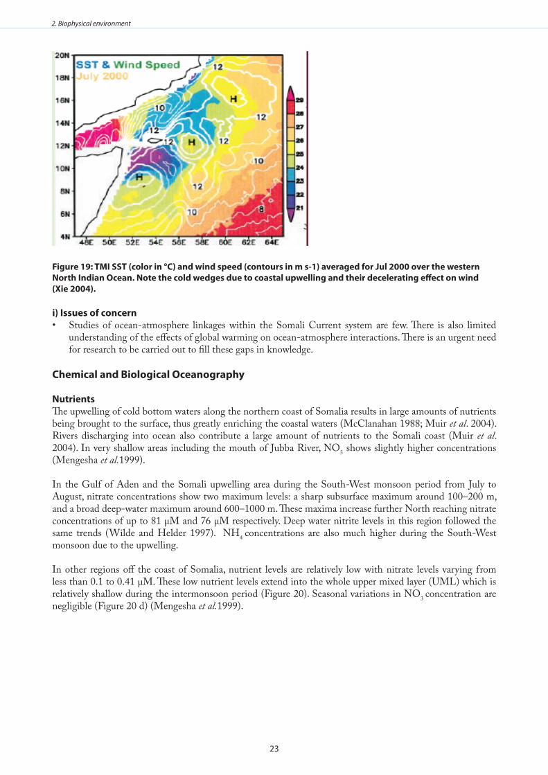
23
2. Biophysical environment
figure 19: TmI ssT (color in °C) and wind speed (contours in m s-1) averaged for Jul 2000 over the western north Indian ocean . note the cold wedges due to coastal upwelling and their decelerating effect on wind (Xie 2004) .
i) Issues of concernStudies of ocean-atmosphere linkages within the Somali Current system are few. There is also limited • understanding of the effects of global warming on ocean-atmosphere interactions. There is an urgent need for research to be carried out to fill these gaps in knowledge.
Chemical and biological oceanography nutrientsThe upwelling of cold bottom waters along the northern coast of Somalia results in large amounts of nutrients being brought to the surface, thus greatly enriching the coastal waters (McClanahan 1988; Muir et al. 2004). Rivers discharging into ocean also contribute a large amount of nutrients to the Somali coast (Muir et al. 2004). In very shallow areas including the mouth of Jubba River, NO3 shows slightly higher concentrations (Mengesha et al.1999).
In the Gulf of Aden and the Somali upwelling area during the South-West monsoon period from July to August, nitrate concentrations show two maximum levels: a sharp subsurface maximum around 100–200 m, and a broad deep-water maximum around 600–1000 m. These maxima increase further North reaching nitrate concentrations of up to 81 µM and 76 µM respectively. Deep water nitrite levels in this region followed the same trends (Wilde and Helder 1997). NH4 concentrations are also much higher during the South-West monsoon due to the upwelling.
In other regions off the coast of Somalia, nutrient levels are relatively low with nitrate levels varying from less than 0.1 to 0.41 µM. These low nutrient levels extend into the whole upper mixed layer (UML) which is relatively shallow during the intermonsoon period (Figure 20). Seasonal variations in NO3 concentration are negligible (Figure 20 d) (Mengesha et al.1999).
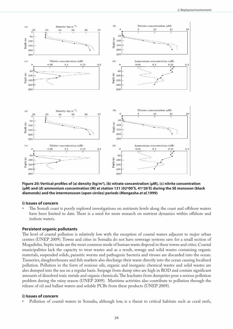
24
2. Biophysical environment
figure 20: vertical profiles of (a) density (kg/m3), (b) nitrate concentration (µm), (c) nitrite concentration (µm) and (d) ammonium concentration (m) at station 131 (02º00’s, 41º26’e) during the se monsoon (black diamonds) and the intermonsoon (open circles) periods (mengesha et al.1999)
i) Issues of concern The Somali coast is poorly explored investigations on nutrients levels along the coast and offshore waters • have been limited to date. There is a need for more research on nutrient dynamics within offshore and inshore waters.
Persistent organic pollutantsThe level of coastal pollution is relatively low with the exception of coastal waters adjacent to major urban centres (UNEP 2009). Towns and cities in Somalia do not have sewerage systems save for a small section of Mogadishu. Septic tanks are the most common mode of human waste disposal in these towns and cities. Coastal municipalities lack the capacity to treat wastes and as a result, sewage and solid wastes containing organic materials, suspended solids, parasitic worms and pathogenic bacteria and viruses are discarded into the ocean. Tanneries, slaughterhouses and fish markets also discharge their waste directly into the ocean causing localized pollution. Pollution in the form of noxious oils, organic and inorganic chemical wastes and solid wastes are also dumped into the sea on a regular basis. Seepage from dump sites are high in BOD and contain significant amounts of dissolved toxic metals and organic chemicals. The leachates from dumpsites pose a serious pollution problem during the rainy season (UNEP 2009). Maritime activities also contribute to pollution through the release of oil and ballast waters and soluble PCBs from these products (UNEP 2009).
i) Issues of concernPollution of coastal waters in Somalia, although low, is a threat to critical habitats such as coral reefs, •
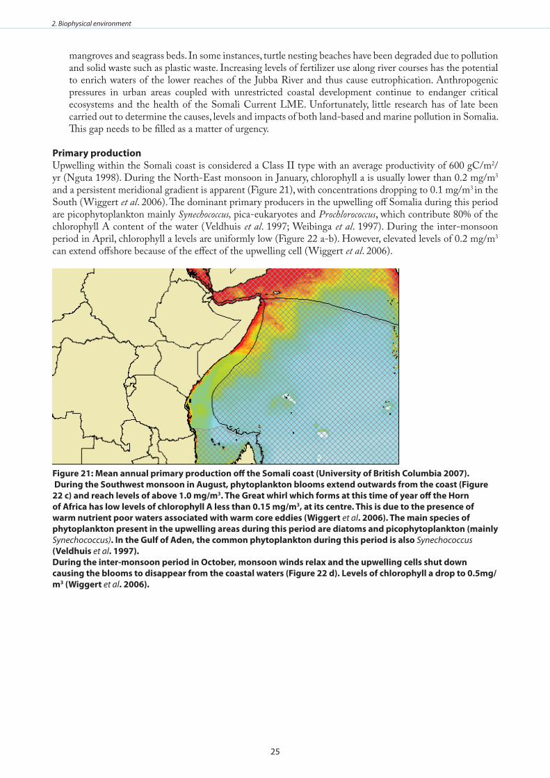
25
2. Biophysical environment
mangroves and seagrass beds. In some instances, turtle nesting beaches have been degraded due to pollution and solid waste such as plastic waste. Increasing levels of fertilizer use along river courses has the potential to enrich waters of the lower reaches of the Jubba River and thus cause eutrophication. Anthropogenic pressures in urban areas coupled with unrestricted coastal development continue to endanger critical ecosystems and the health of the Somali Current LME. Unfortunately, little research has of late been carried out to determine the causes, levels and impacts of both land-based and marine pollution in Somalia. This gap needs to be filled as a matter of urgency.
Primary production Upwelling within the Somali coast is considered a Class II type with an average productivity of 600 gC/m2/yr (Nguta 1998). During the North-East monsoon in January, chlorophyll a is usually lower than 0.2 mg/m3 and a persistent meridional gradient is apparent (Figure 21), with concentrations dropping to 0.1 mg/m3 in the South (Wiggert et al. 2006). The dominant primary producers in the upwelling off Somalia during this period are picophytoplankton mainly Synechococcus, pica-eukaryotes and Prochlorococcus, which contribute 80% of the chlorophyll A content of the water (Veldhuis et al. 1997; Weibinga et al. 1997). During the inter-monsoon period in April, chlorophyll a levels are uniformly low (Figure 22 a-b). However, elevated levels of 0.2 mg/m3 can extend offshore because of the effect of the upwelling cell (Wiggert et al. 2006).
figure 21: mean annual primary production off the somali coast (university of british Columbia 2007) . during the southwest monsoon in august, phytoplankton blooms extend outwards from the coast (figure 22 c) and reach levels of above 1 .0 mg/m3 . The great whirl which forms at this time of year off the Horn of africa has low levels of chlorophyll a less than 0 .15 mg/m3, at its centre . This is due to the presence of warm nutrient poor waters associated with warm core eddies (wiggert et al . 2006) . The main species of phytoplankton present in the upwelling areas during this period are diatoms and picophytoplankton (mainly Synechococcus) . In the gulf of aden, the common phytoplankton during this period is also Synechococcus (veldhuis et al . 1997) .during the inter-monsoon period in october, monsoon winds relax and the upwelling cells shut down causing the blooms to disappear from the coastal waters (figure 22 d) . levels of chlorophyll a drop to 0 .5mg/m3 (wiggert et al . 2006) .
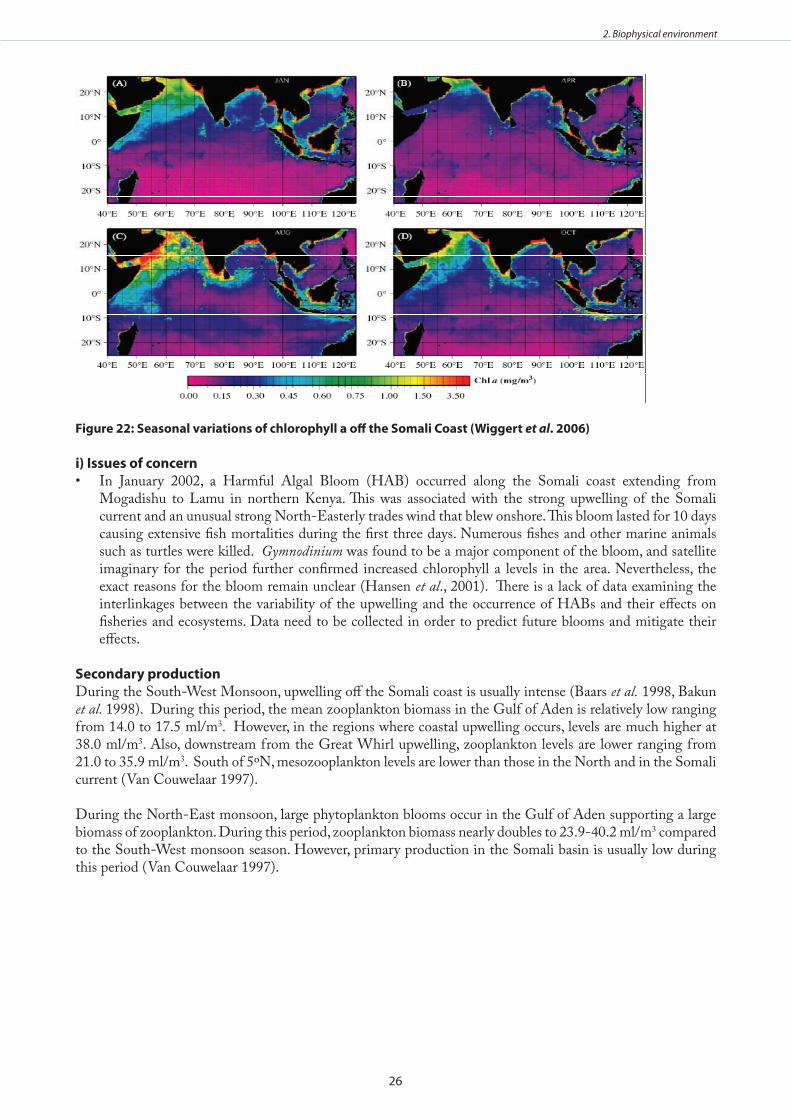
26
2. Biophysical environment
figure 22: seasonal variations of chlorophyll a off the somali Coast (wiggert et al . 2006)
i) Issues of concernIn January 2002, a Harmful Algal Bloom (HAB) occurred along the Somali coast extending from • Mogadishu to Lamu in northern Kenya. This was associated with the strong upwelling of the Somali current and an unusual strong North-Easterly trades wind that blew onshore. This bloom lasted for 10 days causing extensive fish mortalities during the first three days. Numerous fishes and other marine animals such as turtles were killed. Gymnodinium was found to be a major component of the bloom, and satellite imaginary for the period further confirmed increased chlorophyll a levels in the area. Nevertheless, the exact reasons for the bloom remain unclear (Hansen et al., 2001). There is a lack of data examining the interlinkages between the variability of the upwelling and the occurrence of HABs and their effects on fisheries and ecosystems. Data need to be collected in order to predict future blooms and mitigate their effects.
secondary productionDuring the South-West Monsoon, upwelling off the Somali coast is usually intense (Baars et al. 1998, Bakun et al. 1998). During this period, the mean zooplankton biomass in the Gulf of Aden is relatively low ranging from 14.0 to 17.5 ml/m3. However, in the regions where coastal upwelling occurs, levels are much higher at 38.0 ml/m3. Also, downstream from the Great Whirl upwelling, zooplankton levels are lower ranging from 21.0 to 35.9 ml/m3. South of 5ºN, mesozooplankton levels are lower than those in the North and in the Somali current (Van Couwelaar 1997).
During the North-East monsoon, large phytoplankton blooms occur in the Gulf of Aden supporting a large biomass of zooplankton. During this period, zooplankton biomass nearly doubles to 23.9-40.2 ml/m3 compared to the South-West monsoon season. However, primary production in the Somali basin is usually low during this period (Van Couwelaar 1997).
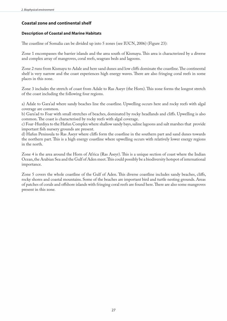
27
2. Biophysical environment
Coastal zone and continental shelf
description of Coastal and marine Habitats
The coastline of Somalia can be divided up into 5 zones (see IUCN, 2006) (Figure 23):
Zone 1 encompasses the barrier islands and the area south of Kismayu. This area is characterized by a diverse and complex array of mangroves, coral reefs, seagrass beds and lagoons.
Zone 2 runs from Kismayu to Adale and here sand dunes and low cliffs dominate the coastline. The continental shelf is very narrow and the coast experiences high energy waves. There are also fringing coral reefs in some places in this zone.
Zone 3 includes the stretch of coast from Adale to Ras Aseyr (the Horn). This zone forms the longest stretch of the coast including the following four regions.
a) Adale to Gara’ad where sandy beaches line the coastline. Upwelling occurs here and rocky reefs with algal coverage are common. b) Gara’ad to Foar with small stretches of beaches, dominated by rocky headlands and cliffs. Upwelling is also common. The coast is characterised by rocky reefs with algal coverage. c) Foar-Hurdiya to the Hafun Complex where shallow sandy bays, saline lagoons and salt marshes that provide important fish nursery grounds are present.d) Hafun Peninsula to Ras Aseyr where cliffs form the coastline in the southern part and sand dunes towards the northern part. This is a high energy coastline where upwelling occurs with relatively lower energy regions in the north.
Zone 4 is the area around the Horn of Africa (Ras Aseyr). This is a unique section of coast where the Indian Ocean, the Arabian Sea and the Gulf of Aden meet. This could possibly be a biodiversity hotspot of international importance.
Zone 5 covers the whole coastline of the Gulf of Aden. This diverse coastline includes sandy beaches, cliffs, rocky shores and coastal mountains. Some of the beaches are important bird and turtle nesting grounds. Areas of patches of corals and offshore islands with fringing coral reefs are found here. There are also some mangroves present in this zone.
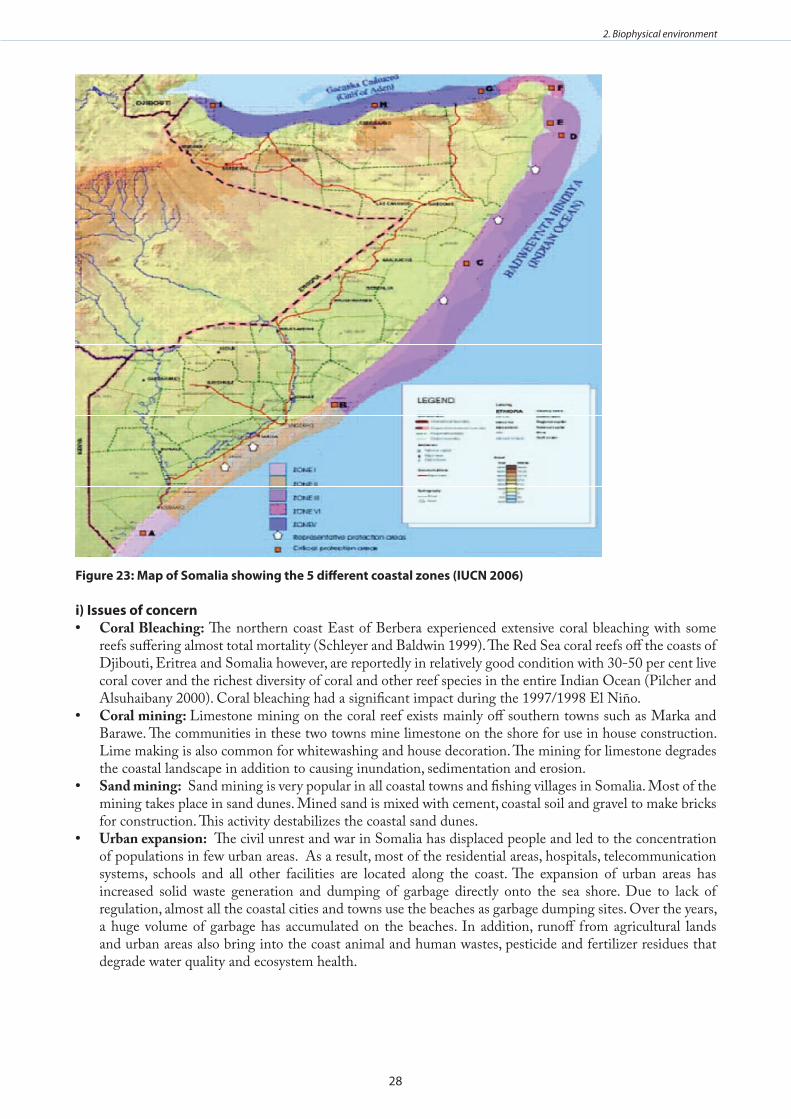
28
2. Biophysical environment
figure 23: map of somalia showing the 5 different coastal zones (IuCn 2006)
i) Issues of concernCoral Bleaching:• The northern coast East of Berbera experienced extensive coral bleaching with some reefs suffering almost total mortality (Schleyer and Baldwin 1999). The Red Sea coral reefs off the coasts of Djibouti, Eritrea and Somalia however, are reportedly in relatively good condition with 30-50 per cent live coral cover and the richest diversity of coral and other reef species in the entire Indian Ocean (Pilcher and Alsuhaibany 2000). Coral bleaching had a significant impact during the 1997/1998 El Niño.Coral mining: • Limestone mining on the coral reef exists mainly off southern towns such as Marka and Barawe. The communities in these two towns mine limestone on the shore for use in house construction. Lime making is also common for whitewashing and house decoration. The mining for limestone degrades the coastal landscape in addition to causing inundation, sedimentation and erosion. Sand mining:• Sand mining is very popular in all coastal towns and fishing villages in Somalia. Most of the mining takes place in sand dunes. Mined sand is mixed with cement, coastal soil and gravel to make bricks for construction. This activity destabilizes the coastal sand dunes. Urban expansion:• The civil unrest and war in Somalia has displaced people and led to the concentration of populations in few urban areas. As a result, most of the residential areas, hospitals, telecommunication systems, schools and all other facilities are located along the coast. The expansion of urban areas has increased solid waste generation and dumping of garbage directly onto the sea shore. Due to lack of regulation, almost all the coastal cities and towns use the beaches as garbage dumping sites. Over the years, a huge volume of garbage has accumulated on the beaches. In addition, runoff from agricultural lands and urban areas also bring into the coast animal and human wastes, pesticide and fertilizer residues that degrade water quality and ecosystem health.
29
2. Biophysical environment
Productivity of the coastal zone (corals, mangroves, seagrass beds)
The zooplankton biomass within the Somali coast is 4 g d.w.m-2 with copepods making up 75% of this value and euphausiids 25%. Calanoides carinatus and Eucalanus elongates are the dominant large copepods (Carbone and Accordi 2000). Zooplankton biomass off the Somali coast shows no significant change between the different monsoon seasons.
Coral Reefs
The coast of Somalia has fringing reefs and patches of coral reefs along the Gulf of Aden coastline (Hassan et al. 2002). However, few studies have been conducted on these reefs. A study off the northern coast East of Berbera by Schleyer and Baldwin (1999) revealed extensive coral bleaching, with some reefs suffering almost total mortality. A rapid assessment of the Saad ad-Din Islands in Awdal Region, close to the Djibouti border showed highly diverse fringing and platform coral reefs with unique fauna representing a mix of Red Sea, Arabian Sea and Indian Ocean species. Fishing pressure on reef resources was negligible (IUCN 2006).
No true reefs are found in the north-eastern Gulf of Aden coastline but high cover coral carpets have been found on hard substrate. Hard corals dominate making up 44.5 to 82.5% of the coral cover. Several types of coral identified here include Porites, Acropora and Stylophora pistillata. Others include Millepora, soft corals, Rhodactis rhodostoma, Pocillopora damicornis, Galaxea astreata, Goniastrea retiformis, Lobophyllia sp, Tubastrea micranthus and T. aurea (Benzoni et al. 2003). Coral growth in this region is severely inhibited by the seasonal upwelling of cold water off the coast (UNEP 2010). However, coral reefs are rich and complex where they do survive (UNEP 2004).
Coral reefs are widely distributed along the Indian Ocean coastline between Adale and the Somalia/Kenya border but do not flourish everywhere in this region (Carbone and Accordi 2000). Coral fauna in this area is rather poor although communities are well developed. These consist of 27 genera and 63 species (Carbone et al. 2004). The amount and type of coral cover varies, giving rise to many different coral facies such as true fringing reefs in the Bajuni Archipelago and scattered patches and knolls in the Jesira area (Carbone et al. 2004). Small scattered colonies grow in areas where there is little protection from wave action while in protected areas, knobs and patch reefs made up of several generations of coral form. The only true fringing reefs are those of the Bajuni archipelago. In this area Thalassodendron seagrass meadows compete with coral reefs for space both inshore and offshore (Carbone and Accordi 2000).
Coral colonization along the Somali shelf is fairly uniform but in the South of the Juba River, the wide continental shelf and the presence of the Bajuni barrier islands allow for major diversification. According to Carbone and Accordi (2000) the following are the main coral forms and the species found in the area south of the Juba River:
1) Coral carpets along shallow flats:These are usually made up of massive and encrusting corals found in flat areas of coastline that are not dominated by seagrass beds. The zone extends up to a depth of 10m. In these high energy areas only sparse colonies of Pocillopora eydouxi survive together with a great abundance of crustose coralline algae and soft caliculate sponges. In other areas, crustose coralline algae predominate and Halimeda tufts are also common. Corals consist only of small colonies of Psammocora contigua, Pavona decussata, Pocillopora damicornis, Acropora spp, Favites spp, and scattered large encrusting colonies of soft corals.
2) bajuni archipelago:The tidal flats around the islands are colonized by massive corals such as Favia stelligera, F. pallida, Favites abdita, F. halicora, Goniastrea pectinata, G. retiformis, G. aspera, Goniopora lobata, Porites somaliensis, Platygyra lamellina and P. daedalea and the branching coral Pocillopora eydouxi. Thickly branched corals, Porites nigrescens and Stylophora pistillata, and crustose colonies of Echinopora gemmacea are also observed.
3) True fringing Reefs:These are only found along the edge of the continental shelf of few islands within the Bajuni archipelago.
30
2. Biophysical environment
Coral pinnacles which reach the sea surface during low tides display micro-atoll topography. Porites, Goniopora, Millepora, Faviids and branching Acropora are the dominant corals. The reef fronts are very steep and densely populated throughout the middle and upper parts. Soft corals such as Sarcophyton, are common on the lower parts and crusty and plate-like corals such as Montipora, Hydnophora and Echinopora, including small branching Galaxea fascicularis and Acroporids, and domal massive corals, Favia, Favite and Porites, cover all remaining spaces. Branching Porties coral increases in abundance towards crest where P. somaliensis cover is extensive. Towards the reef flats small Acropora prolifera thickets are found, decreasing in cover towards the land.
4) fringing reefs around islands:These grow where there is water exchange between sounds and the open sea such as at Cuvumbi Island where the reef front consists of a small steep wall with vertical zonation. The reef flats close to the island mainly support species of branching corals namely Acropora and Tubipora musica. Micro-atolls of Favia stelligera and small colonies of A. abrotanoides, F. flexuosa, F. abdita and P. nigrescens are found towards the shore.
5) exposed sea floors along the barrier islands:In this zone, corals are scarce and consist mainly of massive forms of corals such as Porites somaliensis, Platygyra lamellina and Favites), flat stout colonies of branching Acropora and encrusting forms of Echinoporagemmacea and Hydnophora exesa.
6) bajuni sound:In this zone, coral knobs and patch reefs are spread sparsely amongst the seagrass beds, formed from successive colonization of many generations of corals. The central part of the crests is covered with encrusting and articulate corallinaceans and tufts of Halimeda. The elevated rims which become exposed at low tide are colonized by Acropora, Pocillopora and Millepora and the flanks support Porites and faviids in the middle part and encrusting corals like Echinopora gemmacea and Hydnophora exesa towards the lower sections. Levels of wave exposure control the coral distribution along the margins of this zone; plate like communities grow where the reef is exposed to the sea and Acropora communities on the landward side. Porites lutea grows in dense isolated colonies. A list of the species of corals and other invertebrates found off the northern Somali coast are listed by Schleyer and Baldwin (1999).
mangroves
Most of the mangroves in Somalia are found along the south-west coast although isolated pockets of Avicennia marina grow on the northern coast behind sand spits and along the Gulf of Aden (Carbone and Accordi 2000; PERSGA/GEF 2004). However, cold upwelling waters retard the growth of mangroves (Taylor et al. 2003). Avicennia marina is the dominant species along the northern coasts, and Bruguiera gymnorrhiza, Ceriops tagal, Lumnitzera racemosa and Rhizophora mucronata are found along the Indian Ocean coast. Sonneratia alba occurs in some estuaries in the south. Red mangroves - Avicennia and Rhizophora grow on intertidal flats facing the channels.
seagrass beds
Seagrass beds in Somalia are limited to an extensive area along the southern coast from Adale to Ras Chiamboni and few beds along the North coast. Thalassodendron beds cover large areas of the shallow continental shelf where their roots bind the sediment, raising the substratum of the meadows above the surrounding sea floor and playing an important role in sediment trapping. The stalks of seagrasses support a large diversity of epiphytes of both articulate and encrusting corallinaceans as well as bryozoans (Carbone and Accordi 2000).
In the Bajuni sound there are seagrass carpets of small Thalassodendron and Syringodium, partly covered by fine sediment. Small gastropods such as strombids and cypreids are found here. Among Foraminifa, soritids are common (Carbone and Accordi 2000).
i) Issues of concernExploitation of reef fishes and other organisms for food, ornamental trade and tourism causes degradation • of coral reefs and seagrass beds.
31
2. Biophysical environment
Overfishing and destructive fishing practices.• Coral bleaching due to global warming events. • Sedimentation causes smothering of coral reefs and seagrass beds.• Conversion of mangroves for agricultural, residential uses and salt and lime production, as well as over-• harvesting of mangrove wood for building, charcoal, firewood and trade purposes. Destruction of mangrove forests is also leading to heavy offshore siltation and alteration of nutrients • pathways for offshore species with concomitant reduction in fish catches. Modification of freshwater flow due to irrigation.• Sea level rise increasing vulnerability to flooding of lowlying areas.• Increasing coastal populations leading to increased demand for coastal resources.• Little research has been done on the coral reefs, intertidal flats and seagrass beds of Somalia. •
microfauna and meiofaunaAlong the coast of Somalia, high densities of micro and meiofauna are associated with seagrass beds. Nematodes and Copepods are the most common. Nematoda, Polychaeta, Turbellaria, Kinorhyncha, Rotifera and shelled animals such as Bivalvia and Ostracoda are also associated with seagrass. Patches of Syringodium isoetifolium in subtidal areas support Cnidaria (De Troch et al. 2001).
Euphausiids make up about 25% of total zooplankton biomass while copepods make up most of the remainder (Okemwa 1998). Most taxa, with the exception of Calanoides carinatus, persist throughout the northeast monsoon during which primary productivity decreases but without a substantial decrease in the zooplankton stock (Baars et al. 1998). Endemism is very high, especially among reef fishes and invertebrates, the latter including a number of dinoflagellates and euphausiids (Roberts et al. 1992; Getahun 1998).
Very little is documented about the abundance of zooplankton in the Somali Current LME, which makes it difficult to determine which species of copepods, euphausiids, salps, and doliolids dominate the continental shelf (Okemwa 1998). The planktonic foraminiferan Neogloboquadrina pachyderma is abundant off the Somali coast during the south-west monsoon upwelling and is often associated with Globigerinoides ruber, G. bulloides, G sacculifer, T. quinqueloba, Globigerina rubescens, Tenuitella iota, Dentigloborotalia anfracta and Tenuitella parkerae (Ivanova et al. 1999).
Benthic meiofauna include Nematoda, Harpacticoida, Ostracoda, Tubellaria, Kinorhyncha and Foraminifera (Parulekar et al. 1992).
macrofauna
Invertebrates Beaches along the coast of Somalia are colonized by suspension feeding molluscs such as Donax and Atactodea and high water marks often support crabs. Towards the centre of Bajuni sound, small gastropods (strombids and cypreids) are also present. Among Foraminifera, soritids are common. Along the sand flats, bioturbation is strong and holothurians are common (Carbone and Accordi 2000). Seagrass beds shelter many organisms such as whole bivalve shells (Codakia) as well as flourishing epiphyte communities of both articulate and encrusting corallinaceans, together with bryozoans (Carbone and Accordi 2000).
In mangroves, detritus-feeding bivalves such as Codakia, Anodontia, Pinnids, Pitar, Tellinids, and Modiolus, and gastropods such as Strombids, Nassarius, Conids, Cypreids, and Lambis are common. Mangrove roots are covered by Saccostrea cuccullata, barnacles, sedentary polychaetes, and boring organisms such as clionid sponges. Littorina cf. scabra lives on mangrove trunks and leaves, even when completely exposed during low tides. Cliffs along the abraided tidal flats support colonies of Saccostrea cuccullata, barnacles and the boring bivalves Lithophaga and Gastrochaena. In the sheltered muddy areas the fiddler crab, Uca, is found while the gastropod Nerita occupies the peripheral part of the mangroves. Pools among the mangroves are dominated by Terebralia palustris and Cerithidae decollata and by an infauna of polychaetes and arthropods. Generations of S. cuccullata form 1m high build ups where mangroves thin out and are associated with Nerita, barnacles, and polychaete worms (Carbone and Accordi 2000). Table 1 presents a list of macrofauna taxa and estimated number of species from littoral and sublittoral waters in the western Indian Ocean.
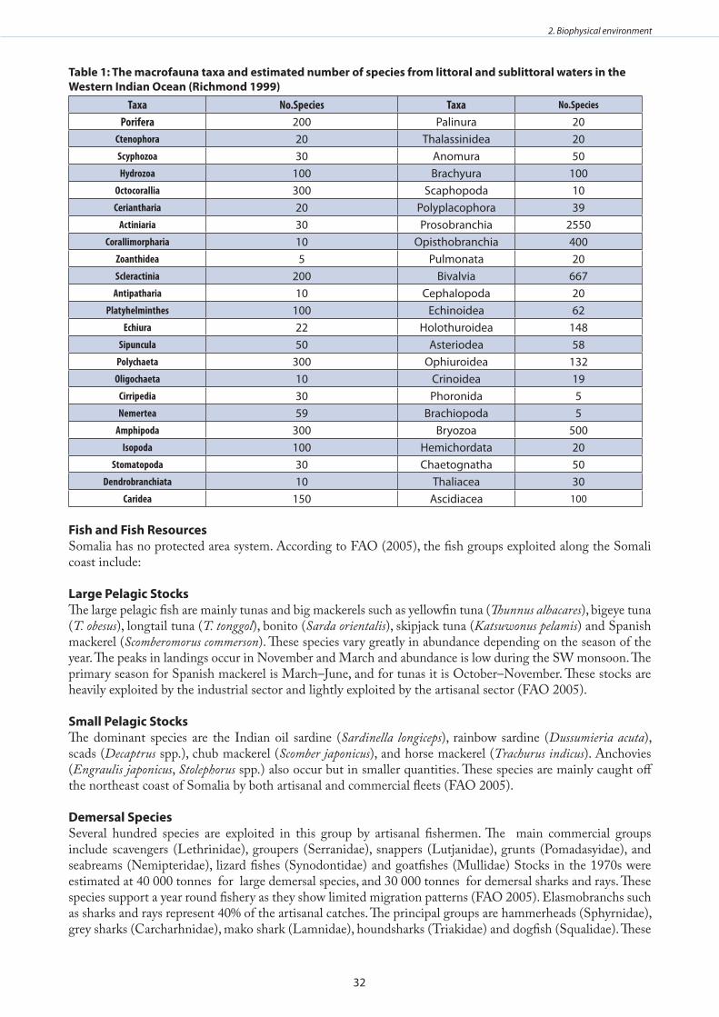
32
2. Biophysical environment
Table 1: The macrofauna taxa and estimated number of species from littoral and sublittoral waters in the western Indian ocean (Richmond 1999)
Taxa No.Species Taxa No.Species
Porifera 200 Palinura 20Ctenophora 20 Thalassinidea 20Scyphozoa 30 Anomura 50Hydrozoa 100 Brachyura 100
Octocorallia 300 Scaphopoda 10Ceriantharia 20 Polyplacophora 39
Actiniaria 30 Prosobranchia 2550Corallimorpharia 10 Opisthobranchia 400
Zoanthidea 5 Pulmonata 20Scleractinia 200 Bivalvia 667
Antipatharia 10 Cephalopoda 20Platyhelminthes 100 Echinoidea 62
Echiura 22 Holothuroidea 148Sipuncula 50 Asteriodea 58
Polychaeta 300 Ophiuroidea 132Oligochaeta 10 Crinoidea 19
Cirripedia 30 Phoronida 5Nemertea 59 Brachiopoda 5
Amphipoda 300 Bryozoa 500Isopoda 100 Hemichordata 20
Stomatopoda 30 Chaetognatha 50Dendrobranchiata 10 Thaliacea 30
Caridea 150 Ascidiacea 100
fish and fish Resources Somalia has no protected area system. According to FAO (2005), the fish groups exploited along the Somali coast include:
large Pelagic stocksThe large pelagic fish are mainly tunas and big mackerels such as yellowfin tuna (Thunnus albacares), bigeye tuna (T. obesus), longtail tuna (T. tonggol), bonito (Sarda orientalis), skipjack tuna (Katsuwonus pelamis) and Spanish mackerel (Scomberomorus commerson). These species vary greatly in abundance depending on the season of the year. The peaks in landings occur in November and March and abundance is low during the SW monsoon. The primary season for Spanish mackerel is March–June, and for tunas it is October–November. These stocks are heavily exploited by the industrial sector and lightly exploited by the artisanal sector (FAO 2005).
small Pelagic stocks The dominant species are the Indian oil sardine (Sardinella longiceps), rainbow sardine (Dussumieria acuta), scads (Decaptrus spp.), chub mackerel (Scomber japonicus), and horse mackerel (Trachurus indicus). Anchovies (Engraulis japonicus, Stolephorus spp.) also occur but in smaller quantities. These species are mainly caught off the northeast coast of Somalia by both artisanal and commercial fleets (FAO 2005). demersal species Several hundred species are exploited in this group by artisanal fishermen. The main commercial groups include scavengers (Lethrinidae), groupers (Serranidae), snappers (Lutjanidae), grunts (Pomadasyidae), and seabreams (Nemipteridae), lizard fishes (Synodontidae) and goatfishes (Mullidae) Stocks in the 1970s were estimated at 40 000 tonnes for large demersal species, and 30 000 tonnes for demersal sharks and rays. These species support a year round fishery as they show limited migration patterns (FAO 2005). Elasmobranchs such as sharks and rays represent 40% of the artisanal catches. The principal groups are hammerheads (Sphyrnidae), grey sharks (Carcharhnidae), mako shark (Lamnidae), houndsharks (Triakidae) and dogfish (Squalidae). These
33
2. Biophysical environment
stocks are heavily exploited in both artisanal and industrial sectors (FAO 2005).
large CrustaceansSpiny lobsters of the genus Panulirus are the main species exploited in this category. These are caught along the whole coastline by artisanal fishermen. The commercial sector exploits two species of deep-sea lobster, Puerulus swelli, and P. carrinatus, found at depth of 150 to 400m (FAO 2005). The artisanal lobster production is exclusively based on the spiny lobsters of the genus Panulirus which is represented by five species namely, Panulirus ornatus, P. longipes, P. homarus, P. versicolor and P. penicillatus. While the fishery is multi species off the southern coastline (where the highest densities are found among the coral reefs), the production along the northeast coast between Adale and Ras Asayr (Cape Guardfui) is based on a single sub species of P. homarus megasculptus which often constitutes the entire catch. On the Gulf of Aden Coast, however, P. versicolor is the most important lobster in the artisanal catches, though the other species are also harvested. The current status of these fishery resources especially their abundance, densities and biomasses are unknown, since the last research activities were conducted in 1984 during “Dr. Fridtjof Nansen” surveys that took place in the period 1979 to 1984 (Stromme 1984a, 1984b; Johnsen 1985).
I) Issues of concernA large segment of the population of Somalia is involved in artisanal and subsistence fishing either directly • or indirectly. Fishing is mainly done close inshore. Fishing gears consist of both demersal and drift gill nets, long lines, traps, cast nets and handlines. Deepwater fisheries are fished by distant fishing fleets from Europe and East Asia (Heileman and Scott 2009). It is estimated that the fisheries sector contributes more than 2% of GDP (FAO 2005). However, destructive fishing practices pose a threat to coastal fisheries and coral reefs. In areas around coral reefs, unsustainable exploitation is related to increasing fishing effort and use of destructive fishing gear (McClanahan 1996, Obura et al. 2000). The use of dynamite, seine nets, poisons and selective fishing on certain species and juveniles are widespread in the Somali coastal and marine waters.The fisheries of the Somali Coastal Current LME are heavily fished and studies show that many stocks are • unsustainably overexploited (Kelleher and Everett 1997; Fielding and Mann 1999). The inshore resources targeted by the artisanal fishery are declining, including the giant mangrove mud crab Scylla serrata, lobsters (Panulirus sp.) and prawns (Penaeus sp.). The average size of lobsters caught has reduced significantly over the years. Most of the lobsters are now caught before they have reached the age of maturity. Furthermore, berried females are often caught during the breeding season (Fielding and Mann 1999). Shark populations are also declining due to over- harvesting for shark for their fins (Pilcher and Alsuhaibany 2000). Tuna stocks are also fully exploited and some are overexploited or severely depleted. The problem of unsustainable exploitation is likely to continue even in the near future unless effective • management and surveillance measures are employed. Illegal fishing needs to be addressed and stock assessments need to be done to fill gaps in knowledge and information on fish stocks (Heileman and Scott 2009). A system whereby fishing pressure is reduced while promoting fisheries restoration and sustainable exploitation needs to be adopted in the artisanal sector (Okemwa 1998). The problem of Illegal, Unregulated and Unreported (IUU) fishing is particularly acute in Somalia, largely • as a result of civil wars and lack of a functioning government for the last decade (Gelchu and Pauly 2007). Foreign fishing fleets often fish close inshore and interfere with artisanal fleets causing conflicts (FAO 2005). Overharvesting is partly due to ineffective governance in the fisheries sector due to the lack of a functioning central government.Over-exploitation of prawn fisheries is due to offshore trawling and excessive by catch and discards. • Purse seines yield a high by-catch of cetaceans and shark gill nets also catch non-target species such as • turtles, dugong, dolphins and whales (Van der Elst and Salm 1998; Pilcher and Alsuhaibany 2000). The by-catch of shark gill nets in Somalia also includes sawfish (Pristis microdon), which are of global concern as they have been overexploited worldwide (IUCN 1997).While there is no evidence to suggest that the offshore stocks of the Somali Current LME are at risk of • collapse, this may well be due to the absence of adequate observations, including the lack of reliable data on fishing effort, total catch, and by catch (Heileman and Scott 2009). Surveys need to be done to assess stock status, fishery capacity and species composition of the fishery as no recent studies have been performed. There is a lack of data on catch statistics, including exploitation levels of fish stocks in general as well as specific species.
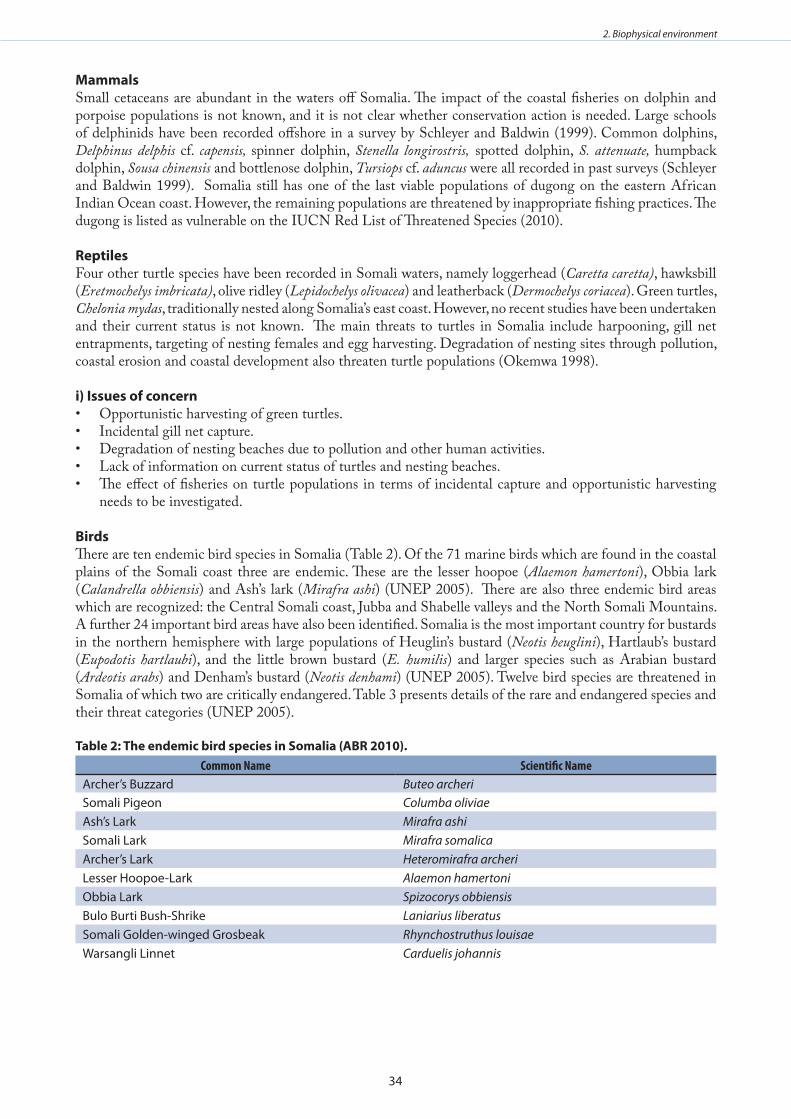
34
2. Biophysical environment
mammalsSmall cetaceans are abundant in the waters off Somalia. The impact of the coastal fisheries on dolphin and porpoise populations is not known, and it is not clear whether conservation action is needed. Large schools of delphinids have been recorded offshore in a survey by Schleyer and Baldwin (1999). Common dolphins, Delphinus delphis cf. capensis, spinner dolphin, Stenella longirostris, spotted dolphin, S. attenuate, humpback dolphin, Sousa chinensis and bottlenose dolphin, Tursiops cf. aduncus were all recorded in past surveys (Schleyer and Baldwin 1999). Somalia still has one of the last viable populations of dugong on the eastern African Indian Ocean coast. However, the remaining populations are threatened by inappropriate fishing practices. The dugong is listed as vulnerable on the IUCN Red List of Threatened Species (2010).
ReptilesFour other turtle species have been recorded in Somali waters, namely loggerhead (Caretta caretta), hawksbill (Eretmochelys imbricata), olive ridley (Lepidochelys olivacea) and leatherback (Dermochelys coriacea). Green turtles, Chelonia mydas, traditionally nested along Somalia’s east coast. However, no recent studies have been undertaken and their current status is not known. The main threats to turtles in Somalia include harpooning, gill net entrapments, targeting of nesting females and egg harvesting. Degradation of nesting sites through pollution, coastal erosion and coastal development also threaten turtle populations (Okemwa 1998).
i) Issues of concernOpportunistic harvesting of green turtles.• Incidental gill net capture.• Degradation of nesting beaches due to pollution and other human activities.• Lack of information on current status of turtles and nesting beaches.• The effect of fisheries on turtle populations in terms of incidental capture and opportunistic harvesting • needs to be investigated.
birds There are ten endemic bird species in Somalia (Table 2). Of the 71 marine birds which are found in the coastal plains of the Somali coast three are endemic. These are the lesser hoopoe (Alaemon hamertoni), Obbia lark (Calandrella obbiensis) and Ash’s lark (Mirafra ashi) (UNEP 2005). There are also three endemic bird areas which are recognized: the Central Somali coast, Jubba and Shabelle valleys and the North Somali Mountains. A further 24 important bird areas have also been identified. Somalia is the most important country for bustards in the northern hemisphere with large populations of Heuglin’s bustard (Neotis heuglini), Hartlaub’s bustard (Eupodotis hartlaubi), and the little brown bustard (E. humilis) and larger species such as Arabian bustard (Ardeotis arabs) and Denham’s bustard (Neotis denhami) (UNEP 2005). Twelve bird species are threatened in Somalia of which two are critically endangered. Table 3 presents details of the rare and endangered species and their threat categories (UNEP 2005).
Table 2: The endemic bird species in somalia (abR 2010) .Common Name Scientific Name
Archer’s Buzzard Buteo archeriSomali Pigeon Columba oliviaeAsh’s Lark Mirafra ashiSomali Lark Mirafra somalicaArcher’s Lark Heteromirafra archeriLesser Hoopoe-Lark Alaemon hamertoniObbia Lark Spizocorys obbiensisBulo Burti Bush-Shrike Laniarius liberatusSomali Golden-winged Grosbeak Rhynchostruthus louisaeWarsangli Linnet Carduelis johannis
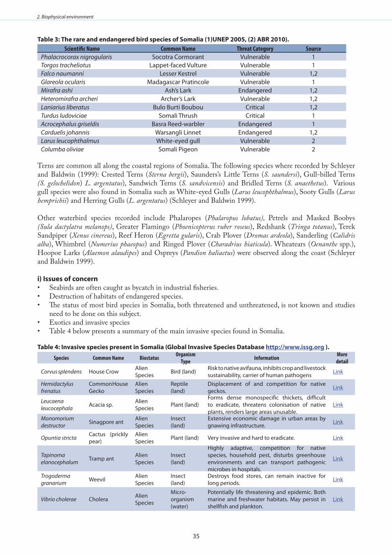
35
2. Biophysical environment
Table 3: The rare and endangered bird species of somalia (1)uneP 2005, (2) abR 2010) .Scientific Name Common Name Threat Category Source
Phalacrocorax nigrogularis Socotra Cormorant Vulnerable 1Torgos tracheliotus Lappet-faced Vulture Vulnerable 1Falco naumanni Lesser Kestrel Vulnerable 1,2Glareola ocularis Madagascar Pratincole Vulnerable 1Mirafra ashi Ash’s Lark Endangered 1,2Heteromirafra archeri Archer’s Lark Vulnerable 1,2Laniarius liberatus Bulo Burti Boubou Critical 1,2Turdus ludoviciae Somali Thrush Critical 1Acrocephalus griseldis Basra Reed-warbler Endangered 1Carduelis johannis Warsangli Linnet Endangered 1,2Larus leucophthalmus White-eyed gull Vulnerable 2Columba oliviae Somali Pigeon Vulnerable 2
Terns are common all along the coastal regions of Somalia. The following species where recorded by Schleyer and Baldwin (1999): Crested Terns (Sterna bergii), Saunders’s Little Terns (S. saundersi), Gull-billed Terns (S. gelochelidon) L. argentatus), Sandwich Terns (S. sandvicensis) and Bridled Terns (S. anaethetus). Various gull species were also found in Somalia such as White-eyed Gulls (Larus leucophthalmus), Sooty Gulls (Larus hemprichii) and Herring Gulls (L. argentatus) (Schleyer and Baldwin 1999).
Other waterbird species recorded include Phalaropes (Phalaropus lobatus), Petrels and Masked Boobys (Sula dactylatra melanops), Greater Flamingo (Phoenicopterus ruber roseus), Redshank (Tringa totanus), Terek Sandpiper (Xenus cinereus), Reef Heron (Egretta gularis), Crab Plover (Dromas ardeola), Sanderling (Calidris alba), Whimbrel (Numerius phaeopus) and Ringed Plover (Charadrius hiaticula). Wheatears (Oenanthe spp.), Hoopoe Larks (Alaemon alaudipes) and Ospreys (Pandion haliaetus) were observed along the coast (Schleyer and Baldwin 1999).
i) Issues of concernSeabirds are often caught as bycatch in industrial fisheries.• Destruction of habitats of endangered species.• The status of most bird species in Somalia, both threatened and unthreatened, is not known and studies • need to be done on this subject.Exotics and invasive species• Table 4 below presents a summary of the main invasive species found in Somalia.•
Table 4: Invasive species present in somalia (global Invasive species database http://www .issg .org ) .
Species Common Name Biostatus Organism Type Information More
detail
Corvus splendens House Crow Alien Species Bird (land) Risk to native avifauna, inhibits crop and livestock
sustainability, carrier of human pathogens Link
Hemidactylus frenatus
Common House Gecko
Alien Species
Reptile (land)
Displacement of and competition for native geckos. Link
Leucaena leucocephala Acacia sp. Alien
Species Plant (land)Forms dense monospecific thickets, difficult to eradicate, threatens colonisation of native plants, renders large areas unusable.
Link
Monomorium destructor Sinagpore ant Alien
SpeciesInsect (land)
Extensive economic damage in urban areas by gnawing infrastructure. Link
Opuntia stricta Cactus (prickly pear)
Alien Species Plant (land) Very invasive and hard to eradicate. Link
Tapinoma elanocephalum Tramp ant Alien
SpeciesInsect (land)
Highly adaptive, competition for native species, household pest, disturbs greenhouse environments and can transport pathogenic microbes in hospitals.
Link
Trogoderma granarium Weevil Alien
SpeciesInsect (land)
Destroys food stores, can remain inactive for long periods. Link
Vibrio cholerae Cholera Alien Species
Micro-organism (water)
Potentially life threatening and epidemic. Both marine and freshwater habitats. May persist in shellfish and plankton.
Link
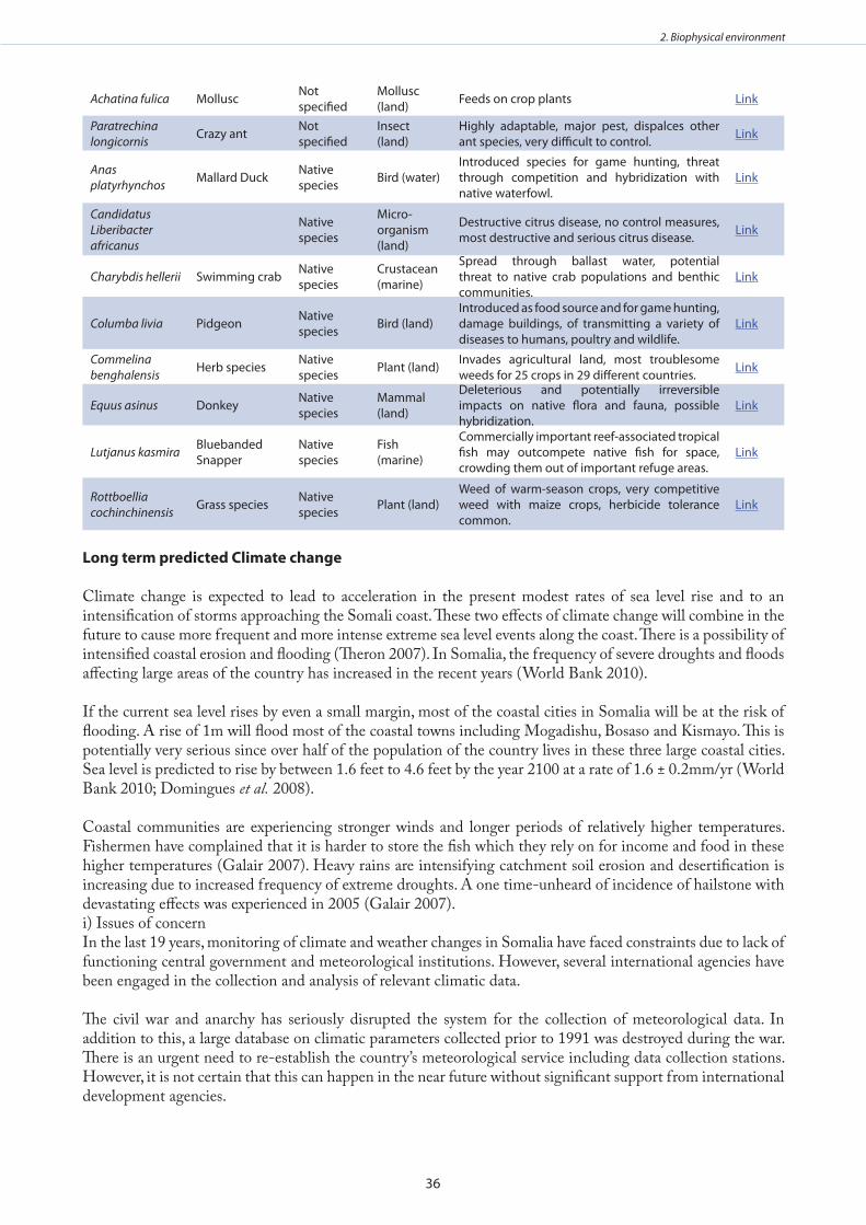
36
2. Biophysical environment
Achatina fulica Mollusc Not specified
Mollusc (land) Feeds on crop plants Link
Paratrechina longicornis Crazy ant Not
specifiedInsect (land)
Highly adaptable, major pest, dispalces other ant species, very difficult to control. Link
Anas platyrhynchos Mallard Duck Native
species Bird (water)Introduced species for game hunting, threat through competition and hybridization with native waterfowl.
Link
Candidatus Liberibacter africanus
Native species
Micro-organism (land)
Destructive citrus disease, no control measures, most destructive and serious citrus disease. Link
Charybdis hellerii Swimming crab Native species
Crustacean (marine)
Spread through ballast water, potential threat to native crab populations and benthic communities.
Link
Columba livia Pidgeon Native species Bird (land)
Introduced as food source and for game hunting, damage buildings, of transmitting a variety of diseases to humans, poultry and wildlife.
Link
Commelina benghalensis Herb species Native
species Plant (land) Invades agricultural land, most troublesome weeds for 25 crops in 29 different countries. Link
Equus asinus Donkey Native species
Mammal (land)
Deleterious and potentially irreversible impacts on native flora and fauna, possible hybridization.
Link
Lutjanus kasmira Bluebanded Snapper
Native species
Fish (marine)
Commercially important reef-associated tropical fish may outcompete native fish for space, crowding them out of important refuge areas.
Link
Rottboellia cochinchinensis Grass species Native
species Plant (land)Weed of warm-season crops, very competitive weed with maize crops, herbicide tolerance common.
Link
long term predicted Climate change
Climate change is expected to lead to acceleration in the present modest rates of sea level rise and to an intensification of storms approaching the Somali coast. These two effects of climate change will combine in the future to cause more frequent and more intense extreme sea level events along the coast. There is a possibility of intensified coastal erosion and flooding (Theron 2007). In Somalia, the frequency of severe droughts and floods affecting large areas of the country has increased in the recent years (World Bank 2010).
If the current sea level rises by even a small margin, most of the coastal cities in Somalia will be at the risk of flooding. A rise of 1m will flood most of the coastal towns including Mogadishu, Bosaso and Kismayo. This is potentially very serious since over half of the population of the country lives in these three large coastal cities. Sea level is predicted to rise by between 1.6 feet to 4.6 feet by the year 2100 at a rate of 1.6 ± 0.2mm/yr (World Bank 2010; Domingues et al. 2008).
Coastal communities are experiencing stronger winds and longer periods of relatively higher temperatures. Fishermen have complained that it is harder to store the fish which they rely on for income and food in these higher temperatures (Galair 2007). Heavy rains are intensifying catchment soil erosion and desertification is increasing due to increased frequency of extreme droughts. A one time-unheard of incidence of hailstone with devastating effects was experienced in 2005 (Galair 2007).i) Issues of concernIn the last 19 years, monitoring of climate and weather changes in Somalia have faced constraints due to lack of functioning central government and meteorological institutions. However, several international agencies have been engaged in the collection and analysis of relevant climatic data.
The civil war and anarchy has seriously disrupted the system for the collection of meteorological data. In addition to this, a large database on climatic parameters collected prior to 1991 was destroyed during the war. There is an urgent need to re-establish the country’s meteorological service including data collection stations. However, it is not certain that this can happen in the near future without significant support from international development agencies.
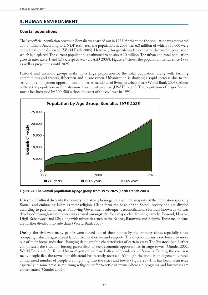
37
3. Human environment
3 . Human envIRonmenT
Coastal populations
The last official population census in Somalia was carried out in 1975. At that time the population was estimated at 3.3 million. According to UNDP estimates, the population in 2003 was 6.8 million of which 350,000 were considered to be displaced (World Bank 2005). However, this grossly under-estimates the current population which is displaced. The current population is estimated to be about 10 million. The urban and rural population growth rates are 2.1 and 1.7%, respectively (USAID 2009). Figure 24 shows the population trends since 1975 as well as projections until 2025.
Pastoral and nomadic groups make up a large proportion of the total population, along with farming communities and traders, fishermen and businessmen. Urbanization is showing a rapid increase due to the search for employment opportunities and better standards of living in urban areas (World Bank 2005). About 38% of the population in Somalia now lives in urban areas (USAID 2009). The population of major Somali towns has increased by 300-500% since the start of the civil war in 1991.
figure 24: The somali population by age group from 1975-2025 (earth Trends 2003)
In terms of cultural diversity, the country is relatively homogenous with the majority of the population speaking Somali and embracing Islam as their religion. Clans form the basis of the Somali society and are divided according to parental lineages. Following Government subsequent reconciliation, a formula known as 4.5 was developed through which power was shared amongst the four major clan families, namely Darood, Hawiye, Digil-Rahanweyn and Dir, along with minorities such as the Bantus, Barawans and Bajunis. These major clans are further divided into sub-clans (World Bank 2005).
During the civil war, many people were forced out of their homes by the stronger clans, especially those occupying valuable agricultural land, urban real estate and seaports. The displaced clans were forced to move out of their homelands thus changing demographic characteristics of certain areas. The livestock ban further complicated the situation forcing pastoralists to seek economic opportunities in large towns (Gundel 2002, World Bank 2005). Rural-Urban migration increased after independence in Somalia. During the civil war many people fled the towns but this trend has recently reversed. Although the population is generally rural, an increased number of people are migrating into the cities and towns (Figure 25). This has become an issue especially in some areas as returning refugees prefer to settle in towns where aid programs and businesses are concentrated (Gundel 2002).
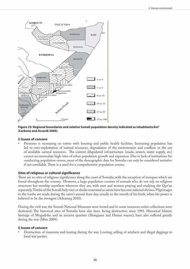
38
3. Human environment
figure 25: Regional boundaries and relative somali population density indicated as inhabitants/km2
(Carbone and accordi 2000) .
i) Issues of concernPressures is increasing on towns with housing and public health facilities. Increasing population has • led to over-exploitation of natural resources, degradation of the environment and conflicts in the use of available natural resources. The current dilapidated infrastructure (roads, sewers, water supply, etc) cannot accommodate high rates of urban population growth and expansion. Due to lack of institutions for conducting population census, most of the demographic data for Somalia can only be considered tentative if not unreliable. There is a need for a comprehensive population census.
sites of religious or cultural significanceThere are no sites of religious significance along the coast of Somalia, with the exception of mosques which are found throughout the country. However, a large population consists of nomads who do not rely on religious structures but worship anywhere wherever they are, with men and women praying and studying the Qur’an separately. Tombs of the Somali holy men or sheiks venerated as saints have become national shrines. Pilgrimages to the tombs are made during the saint’s annual feast day, usually in the month of his birth, when his power is believed to be the strongest (Advameg 2010).
During the civil war, the Somali National Museums were looted and in some instances entire collections were destroyed. The historical sites of Somalia have also been facing destruction since 1991. Historical Islamic heritage of Mogadishu and its ancient quarters (Shangaani and Hamar wayne), have also suffered greatly during the war (Mire 2009).
i) Issues of concernDestruction of museums and looting during the war. Looting, selling of artefacts and illegal diggings to • fund war parties.
39
3. Human environment
Human healthMost of the country consists of arid, semi arid and semi-desert regions. The unpredictable and harsh climate coupled with the absence of a functional government has resulted in most of the population existing in a subsistence crisis (IAS 2009). Somalia has some of the worst survival conditions in the world. The population under the age of 18 years constitutes 53% of the total population. Tribal/clan divisions, poverty and lack of effective governance structures have greatly limited access to basic health care, food security, water and education. Most of the hospitals and health care facilities are located in urban areas (Figure 26). A large segment of the rural populations does not have access to basic human needs. Life expectancy is only 47 years. The mortality rate for children under 5 is 225 per 1000 live births. The infant mortality rate is 133 and the maternal mortality ratio is 1100. 36-38% of children under 5 are malnourished (UNICEF 2009).
As compared to other countries in Eastern Africa, only a small proportion (0.9%) of the total population in Somalia is suffering from HIV/AIDS (UNICEF 2007). According to UNAIDS, between 43,000 and 100,000 people were infected with HIV/AIDS in 2002 (WHO 2005), with only 1% of all adults over the age of 15 being infected (EarthTrends 2003). Access to antiretroviral drugs is limited. In 2005, the antiretroviral site in Hargeysa found that of the 6,000 people needing antiretroviral therapy in the area, only 35 were actually receiving it (WHO 2005). However, it is important to note that Somalia is the only country in sub-Saharan Africa in which HIV/AIDS in not endemic. However, prevalence rates could increase rapidly due to relatively high prevalence rates in neighbouring countries (WHO 2005).
Malaria in Somalia is endemic and is the leading cause of death in children under the age of 5 years. Tuberculosis (TB) is another serious disease with 1 in 20 people affected. Every year, there are 25,000 new cases of TB- one of the highest numbers in the world. The prevalence of TB is particularly high among young men. Cholera and diarrhoea outbreaks are also common with over 14,000 diarrheal deaths each year (USAID 2009).
water and sanitationThe freshwater supply situation in Somalia is limited due to frequent droughts prevailing all over the country. There is however a good water and sanitation system in Somaliland and Puntland regions. In the remaining two thirds of the country including rural areas, sanitation and fresh water supplies are virtually non-existent (USAID 2009). In fact, less than 29% of the population have access to clean and sustainable (potable) water sources (UNICEF 2009, USAID 2009). Most fresh water is obtained from either boreholes or shallow wells which are often polluted due to poor waste disposal practices. This leads to frequent outbreaks of cholera and diarrheal diseases. Each year, more than 14,000 diarrheal deaths are reported in Somalia (USAID 2009).
educationThe civil war has led to almost total collapse of the education system in Somalia. Although the country has been slightly peaceful since 1999, the education system is still not fully functional (Hare 2007). The education system adopted in Somalia prior to 1991 comprised 8 years of primary education, followed by four years of secondary education and 4 years of undergraduate study at university level. The primary, secondary, technical, vocational, primary and technical teacher training and non-formal education was managed by the Ministry of Education. Six universities existed in Somalia, most of which were autonomous (Hare 2007).
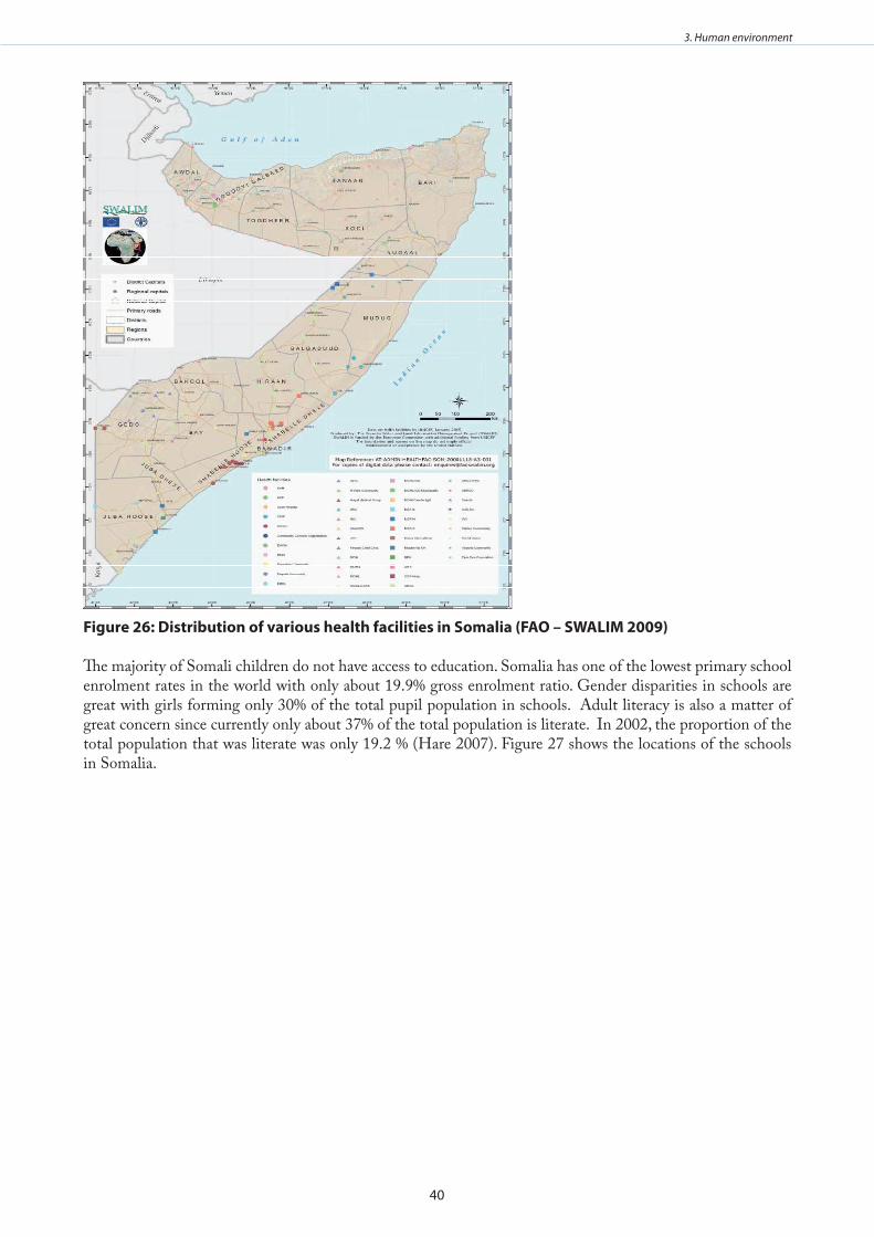
40
3. Human environment
figure 26: distribution of various health facilities in somalia (fao – swalIm 2009)
The majority of Somali children do not have access to education. Somalia has one of the lowest primary school enrolment rates in the world with only about 19.9% gross enrolment ratio. Gender disparities in schools are great with girls forming only 30% of the total pupil population in schools. Adult literacy is also a matter of great concern since currently only about 37% of the total population is literate. In 2002, the proportion of the total population that was literate was only 19.2 % (Hare 2007). Figure 27 shows the locations of the schools in Somalia.
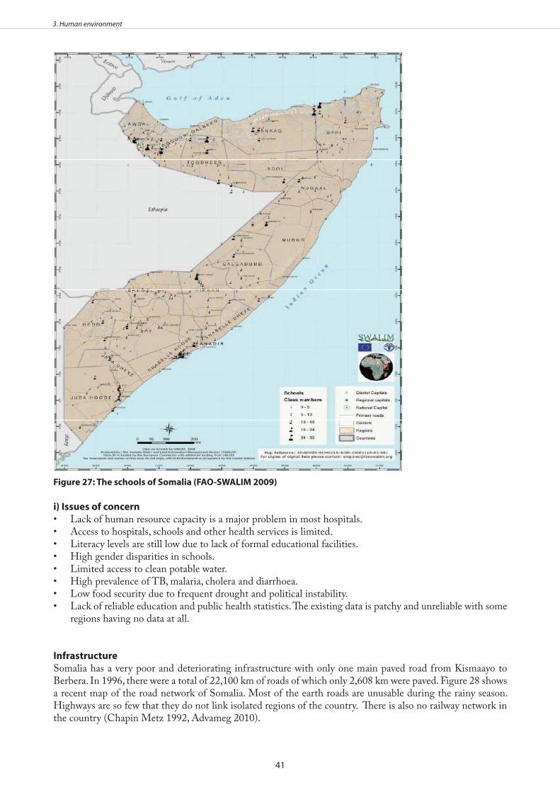
41
3. Human environment
figure 27: The schools of somalia (fao-swalIm 2009)
i) Issues of concernLack of human resource capacity is a major problem in most hospitals.• Access to hospitals, schools and other health services is limited.• Literacy levels are still low due to lack of formal educational facilities.• High gender disparities in schools.• Limited access to clean potable water.• High prevalence of TB, malaria, cholera and diarrhoea.• Low food security due to frequent drought and political instability.• Lack of reliable education and public health statistics. The existing data is patchy and unreliable with some • regions having no data at all.
InfrastructureSomalia has a very poor and deteriorating infrastructure with only one main paved road from Kismaayo to Berbera. In 1996, there were a total of 22,100 km of roads of which only 2,608 km were paved. Figure 28 shows a recent map of the road network of Somalia. Most of the earth roads are unusable during the rainy season. Highways are so few that they do not link isolated regions of the country. There is also no railway network in the country (Chapin Metz 1992, Advameg 2010).
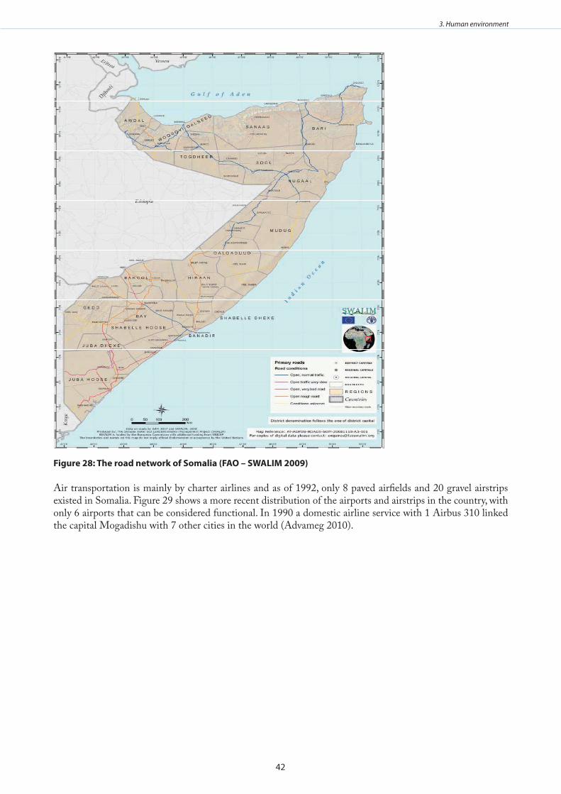
42
3. Human environment
figure 28: The road network of somalia (fao – swalIm 2009)
Air transportation is mainly by charter airlines and as of 1992, only 8 paved airfields and 20 gravel airstrips existed in Somalia. Figure 29 shows a more recent distribution of the airports and airstrips in the country, with only 6 airports that can be considered functional. In 1990 a domestic airline service with 1 Airbus 310 linked the capital Mogadishu with 7 other cities in the world (Advameg 2010).
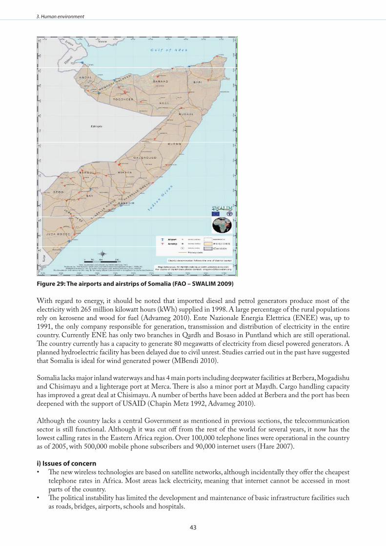
43
3. Human environment
figure 29: The airports and airstrips of somalia (fao – swalIm 2009)
With regard to energy, it should be noted that imported diesel and petrol generators produce most of the electricity with 265 million kilowatt hours (kWh) supplied in 1998. A large percentage of the rural populations rely on kerosene and wood for fuel (Advameg 2010). Ente Nazionale Energia Elettrica (ENEE) was, up to 1991, the only company responsible for generation, transmission and distribution of electricity in the entire country. Currently ENE has only two branches in Qardh and Bosaso in Puntland which are still operational. The country currently has a capacity to generate 80 megawatts of electricity from diesel powered generators. A planned hydroelectric facility has been delayed due to civil unrest. Studies carried out in the past have suggested that Somalia is ideal for wind generated power (MBendi 2010).
Somalia lacks major inland waterways and has 4 main ports including deepwater facilities at Berbera, Mogadishu and Chisimayu and a lighterage port at Merca. There is also a minor port at Maydh. Cargo handling capacity has improved a great deal at Chisimayu. A number of berths have been added at Berbera and the port has been deepened with the support of USAID (Chapin Metz 1992, Advameg 2010).
Although the country lacks a central Government as mentioned in previous sections, the telecommunication sector is still functional. Although it was cut off from the rest of the world for several years, it now has the lowest calling rates in the Eastern Africa region. Over 100,000 telephone lines were operational in the country as of 2005, with 500,000 mobile phone subscribers and 90,000 internet users (Hare 2007).
i) Issues of concernThe new wireless technologies are based on satellite networks, although incidentally they offer the cheapest • telephone rates in Africa. Most areas lack electricity, meaning that internet cannot be accessed in most parts of the country.The political instability has limited the development and maintenance of basic infrastructure facilities such • as roads, bridges, airports, schools and hospitals.

44
3. Human environment
There is a lack of information on the basic infrastructure including roads, electricity, water, airports, bridges, • schools and hospitals.
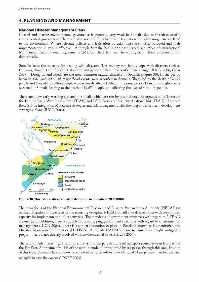
45
4. Planning and management
4 . PlannIng and managemenT
national disaster management Plans Coastal and marine environmental governance is generally very weak in Somalia due to the absence of a strong central government. There are also no specific policies and legislation for addressing issues related to the environment. Where relevant policies and legislation do exist, these are mostly outdated and their implementation is very ineffective. Although Somalia has in the past signed a number of international Multilateral Environmental Agreements (MEAs), there has been little progress in their implementation domestically.
Somalia lacks the capacity for dealing with disasters. The country can hardly cope with disasters such as tsunamis, droughts and floods let alone the mitigation of the impacts of climate change (IUCN 2006; Galar 2007). Droughts and floods are the most common natural disasters in Somalia (Figure 30). In the period between 1961 and 2004, 18 major flood events were recorded in Somalia. These led to the death of 2,671 people and lives of 1.8 million people were seriously affected. Also, in the same period 12 major drought events occurred in Somalia leading to the death of 19,671 people, and affecting the lives of 4 million people.
There are a few early warning systems in Somalia which are run by international aid organisations. These are the Famine Early Warning System (FEWS) and FAO-Food and Security Analysis Unit (FSAU). However, there is little integration of adaptive strategies and risk management with the long and short term development strategies, if any (IUCN 2006).
figure 30: The natural disaster risk distribution in somalia (uneP 2008) .
The main focus of the National Environmental Research and Disaster Preparedness Authority (NERAD) is on the mitigation of the effects of the recurring droughts. NERAD is still a weak institution with very limited capacity for implementation of its activities. The mandates of government ministries with regard to NERAD are unclear. In addition, there is a problem of overlapping government structures with regard to environmental management (IUCN 2006). There is a similar institution in place in Puntland known as Humanitarian and Disaster Management Activities (HADMA). Although HADMA plans to launch a drought mitigation programme, it is not directly involved with environmental issues (IUCN 2006).
The Gulf of Aden faces high risk of oil spills as it forms part of crude oil transport route between Europe and the Far East. Approximately 11% of the world’s crude oil transported by sea passes through this area. In spite of this threat, Somalia has no known competent national authority or National Management Plan to deal with oil spills in case they occur (ITOPF 2003).
46
4. Planning and management
areas under special managementThere are no Marine Protected Areas (MPAs) in Somalia but two new MPAs were proposed in the past at Maydh Island and its surrounding waters and Bajuni Archipelago and its adjacent coastal area (UNEP 2004). The Bajuni areas are also regarded as priority seascapes in the Eastern Africa Marine Ecoregion. Bajuni Archipelago and its adjacent coastal areas are reported to have important dungong populations and turtle nesting areas. The area also supports complex coral reefs, mangroves and seagrass beds. The Saad ad-Din Islands in Awdal Region in Somaliland, close to the Djibouti border has also been proposed as a potential MPA by PERSGA in their Strategic Action Plan (2003) (IUCN 2006).
The Shebelle river mouth is one of the priority seascapes mentioned in the Eastern Africa Marine Ecoregion and should also be considered for park development as it is not only the most northern estuary in eastern Africa, but it is also the largest estuarine-offshore ‘mud ecosystem’ and the only permanent estuarine system in Somalia.
The World Database on Protected Areas lists 26 terrestrial protected areas for Somalia. However according to UNEP (2004) there are only 14 protected areas in with only one over 100,000 Ha (Table 5, Figure 31). What is certain is that the status of these reserves is unknown (UNEP 2004, WDPA 2010). Less than 1% of the country is protected and most of this is in the Lag Badana Bush Bush National Park. There has not been any effective management and protection in these areas since 1991 (UNEP 2004).
Table 5: The areas of somalia under special management . The “site name” column contains links to more information where available .
Site Name National Designation
Marine/ Terrestrial
Existing/ Proposed
Size (km2) Number on Fig x Source
Alifuuto (Arbowerow)
Nature Reserve Terrestrial Proposed 1,800 10 1,2,3
Angole Farbiddu National Park Terrestrial Proposed 1 1,3
Awdhegle-Gandershe National Park Both Proposed 800 2 1,3
Balcad Nature Reserve 2 2
Belet Wein Partial Game Reserve Existing 13 2,3
Boja Swamps Wildlife Reserve Terrestrial 14 1
Bulo Burti Partial Game Reserve Existing 2,3
Bushbush Game Reserve Both Existing 3,340 6 1,3
Bushbush Controlled Hunting Area Both Existing 6 1,3
Daalo Forest National Park Both Proposed 2,510 3 1,3
Eji-Oobale Wildlife Reserve Terrestrial 15 1
El Hammure Wildlife Reserve Terrestrial 3
Far Libah Wildlife Reserve Terrestrial 1,3
Far Wamo Wildlife Reserve Terrestrial 17 1,3
Gaan Libaah National Park Terrestrial Proposed 500 4 1,3
Game Reserve Terrestrial Existing 104 11 1,2
Gezira Lagoon National Park Both Proposed 50 1,3
Har Yiblane National Park Terrestrial Proposed 1,2Haradere-Awale Rugno Wildlife Reserve Terrestrial 18 1,3
Harqan Dalandoole Wildlife Reserve Terrestrial 1
Hobyo Wildlife Reserve Terrestrial 20 1,3
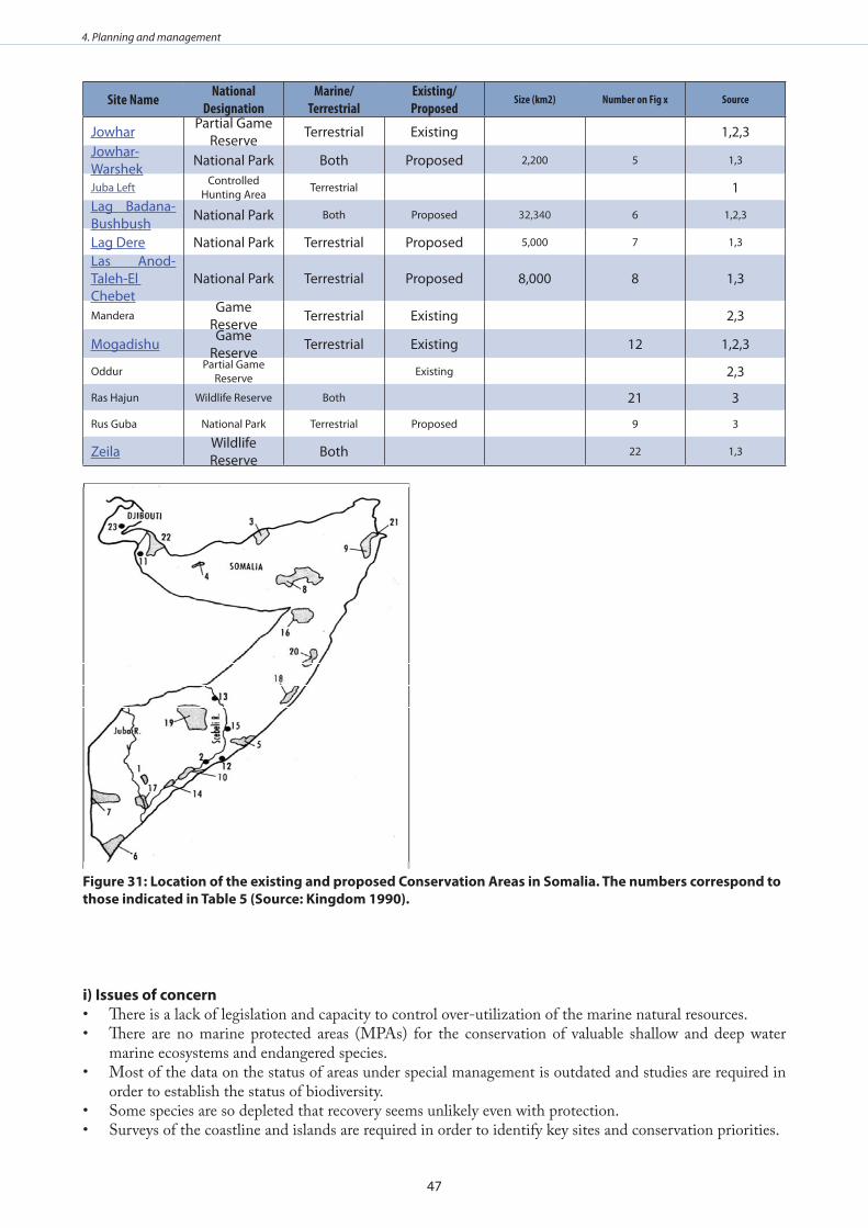
47
4. Planning and management
Site Name National Designation
Marine/ Terrestrial
Existing/ Proposed
Size (km2) Number on Fig x Source
Jowhar Partial Game Reserve Terrestrial Existing 1,2,3
Jowhar-Warshek National Park Both Proposed 2,200 5 1,3
Juba Left Controlled Hunting Area Terrestrial 1
Lag Badana-Bushbush National Park Both Proposed 32,340 6 1,2,3
Lag Dere National Park Terrestrial Proposed 5,000 7 1,3
Las Anod-Taleh-El Chebet
National Park Terrestrial Proposed 8,000 8 1,3
ManderaGame
Reserve Terrestrial Existing 2,3
Mogadishu Game Reserve Terrestrial Existing 12 1,2,3
Oddur Partial Game Reserve Existing 2,3
Ras Hajun Wildlife Reserve Both 21 3
Rus Guba National Park Terrestrial Proposed 9 3
Zeila Wildlife Reserve Both 22 1,3
figure 31: location of the existing and proposed Conservation areas in somalia . The numbers correspond to those indicated in Table 5 (source: kingdom 1990) .
i) Issues of concernThere is a lack of legislation and capacity to control over-utilization of the marine natural resources.• There are no marine protected areas (MPAs) for the conservation of valuable shallow and deep water • marine ecosystems and endangered species.Most of the data on the status of areas under special management is outdated and studies are required in • order to establish the status of biodiversity.Some species are so depleted that recovery seems unlikely even with protection.• Surveys of the coastline and islands are required in order to identify key sites and conservation priorities.•
48
4. Planning and management
monitoring, Control and surveillance The Somalia coast is not adequately monitored at present due to the lack of a central government and relevant monitoring, control and surveillance (MCS) institutions. There is at present chronic lack of capacity for effective management and policing of both offshore and inshore waters. This has led to the over-exploitation of coastal and marine resources. Critical coastal habitats such as mangroves, coral reefs and seagrass beds are already showing the effects of over-exploitation. Coastal pollution is also emerging as a major issue particularly around urban areas where there are is no system for controlling wastewater discharge into the marine waters. There are no data that can currently be used to ascertain the level of anthropogenic pressure on the coastal and marine natural resources and biodiversity (Carbone and Accordi 2000).
i) Issues of concernInadequate data on environmental impacts and rates of degradation. • Lack of capacity for effective monitoring, control and surveillance within both inshore and offshore • waters. Lack of staff and knowledge to adequately monitor resources.•
49
5. Coastal Livelihoods Assessment
5 . CoasTal lIvelIHoods assessmenT
A comprehensive coastal livelihoods assessment has been carried out. Chapter summaries are presented below, and the full Coastal Livelihoods Assessment may be found in Annex V for further information.
I . small-scale fisheriesThere is an operative small-scale fishery in Somalia with approximately 50 fishing centres and an estimated 30,000 people from coastal communities engaged. Despite rich bio-diversity and an extensive coastline, exports of fishery products only account for around 3% of total exports and contribute about 2% to GDP. Household income in the sector also fluctuates by season, with fishers earning $1.5 USD per day during monsoon season and an estimated $40 USD per day during the fishing season.
Data, law enforcement and policy development are practically non-existent in the sector, as there is currently no government, institutional infrastructure and regulatory capacity in the country. Despite the variety of fish resources, poor processing facilities, poverty, old fishing gear and the isolation of fishing communities all highlight the weaknesses prevalent in the sector. While a legitimate transitional government has been established, security remains fragile, as both the presence of piracy and an on-going insurgency have constricted economic development. Due to the lack of monitoring capacity, fishing and waste disposal by foreign vessels has also become problematic along the coast.
As a whole, potential for growth in the small-scale fishery is robust, however, there are clearly numerous constraints preventing further development. Nevertheless, opportunities, such as the development of local market places, the provision of micro-finance, improved processing facilities and the standardization of inboard and outboard engines, all highlight the prospects prevalent in the sector. While the lack of regulation and data in the sector could breed over-exploitation, particularly of species such as sharks, the potential for increases in production and domestic consumption is great. The sheer scope and extent of the country’s coast and resources should accentuate these opportunities.
II . TourismSecurity in Somalia is inevitably a constraint on tourism in the country’s coastal zone, however, its long scenic coastline, rich biodiversity and favourable climate make it an ideal region for future tourism development. The country’s close proximity to the Middle East, along with its historic Islamic culture, also make it a convenient destination for nearby travellers. All opportunities are, however, dependent on improvements in the security situation.
Unfortunately, accompanying the current security situation are the stigmas of violence and conflict attached to the country, which negatively affects both the marketability and the volume of tourist activity. Similarly, weak infrastructure, limited institutional capacity and the reluctance of NGOs to operate has severely constrained development in the sector. Again, if the security situation is improved and law and order is re-established, these constraints could be marginalized. Under these improved conditions opportunities for growth and development in the sector could spur other entrepreneurial activities in the region. Similarly, international organizations could be engaged to assist in developing the sector. Growth in the sector could also not only sensitize the population to the importance of sustaining the country’s natural habitat, but it could also reduce the over-exploitation of natural resources by creating opportunities for employment in the sector.
III . maricultureA dedicated report on mariculture has not been included in this country report due to the current difficulty in obtaining detailed information on the potential of this sector in Somalia. It has been determined though, that there are currently no mariculture activities taking place in the country. However, given the extensive coastline and strong tradition of utilizing and consuming marine products in the coastal zone, there is no reason why this kind of development should not be as attractive as it has proved to be in the other Western Indian Ocean states, once political stability returns to Somalia.
It is important to note that according the ASCLME project representatives from Somalia, the Transitional Federal Government of the Republic of Somalia sees activities such as mariculture in the coastal zone as an
50
5. Coastal Livelihoods Assessment
important alternative income generating activity that has the potential of reducing over-exploitation of coastal resources. It is recommended that at the appropriate time a dedicated assessment of the mariculture potential in Somalia be undertaken to determine the best approach to take in the development of this sector.
Iv . agriculture and forestry Accounting for an estimated 64% of GDP, agriculture and forestry is the most dominant sector in Somalia. Despite livestock movement bans, animal exports account for about 60% of Somalia’s employment opportunities, generating about 40% of GDP and 80% of foreign currency earnings. Taxation of livestock trade and export is one of the major revenue sources for the regional administrations. The main food crops are sorghum, millet, maize and rice, while the majority of cash crop exports are bananas, sugar and cotton. Bananas were once a key export and source of foreign exchange, however, the El Nino floods in 1998 largely collapsed the sector. Hence, as livestock is the main source of income and employment for the majority of the Somali population, droughts, fluctuating environmental conditions and market volatility all have a great impact on the people and the economy.
Acacia and Commiphora shrub and woodland habitat are widespread in the country and are extensively utilized for a variety of purposes. While large swaths of the resource have been cleared for agriculture, as well as fuelwood and charcoal production, woodlands still provide numerous goods, particularly in dry times. Deforestation is, however, a significant problem in the northern areas and the Jubba Valley. Forests are not predominant in the coastal zone, however, mangroves remain important, valued at around $91 million USD.
While policies for coastal zone management have been promoted in Somaliland, security and governance clearly remain predominant issues. Despite these constraints, positives can be seen. For example, IFAD is currently providing technical expertise and funding focused on food security and livelihood opportunities in the northern regions, while the opportunity to expand agriculture, forestry and livestock production has been documented. Similarly, the country’s extensive bio-diversity, particularly bird-life, hast potential for attract tourism development in the future. However, for any initiatives and opportunities to be realized, security will have to be brought under control.
v . energyThere is little activity in oil, gas and biofuels in Somalia, with the country’s only refinery closing due to the civil war. Although there is currently no hydrocarbon production, the country does have 200 billion cubic feet of proven gas reserves, as well as prospective oil fields in the northern zone and in the Nuggal and Dharoor basins. Total is the only identified agent involved in downstream activity, managing the oil terminal in Berbera and supplying fuel to the airports in Berbera and Hargeisa. While most exploration activities were suspended due to the onset of civil conflict, many companies have shown a renewed interest in the sector. For example, a consortium of companies have obtained the rights to explore the Nuggal and Dharoor basins from the Puntland government, while blocks to explore offshore of Mudug and around the coastal area of Berbera have been conceded by the national government. The validity of these agreements does, however, remain in question, particularly the agreements with the Puntland government, as ownership of the resources remains ambiguous.
Numerous constraints have been identified in the sector, the most challenging being the security situation. Not only did the civil war force the majority of companies to suspend operations, but the present security situation has made operations very difficult. The development of operations in such an unstable environment also increases the risk of spills and accidents. Governance and capacity also remains constrained, which has not only facilitated conflict between different branches of government, but has led to a lack of basic infrastructure throughout the country. Much of the country’s economic activity also remains informal, which means the state is unable to obtain revenue to contribute to basic services. Piracy also remains highly problematic, as it has not only become a principal coastal industry, but it is likely to constrain offshore operations in the near future.
Some strengths and opportunities have, however, been identified in the sector. For example, an effective government in Somaliland could potentially be conducive to sectoral development in the region, while the prospects for oil deposits throughout Somalia are very positive. Oil sector development could also be supportive of employment and contribute to the development of infrastructure, while the transitional national government has shown a willingness to support the sector. Nevertheless, any future development in the sector is largely
51
5. Coastal Livelihoods Assessment
dependent on improvements in the security situation.
vI . Ports and Coastal Transport There are four major ports in Somalia, each under the control of independent local clans. Kismaayo, the most southerly port, handles exports of charcoal and bananas from the Juba valley and receives vehicle imports from the Gulf. Merka, which lies 100 km south of Mogadishu, has no operational infrastructure, therefore, ships are forced to anchor offshore with cargo brought inshore by smaller vessels. The Mogadishu port, which was rebuilt with the US and UN finance in the early 1990’s, is largely controlled by different factions and clans. The port does, however, reportedly have some adequate warehouses that could potentially be used for imports. The port in Eyl is only noted as a stronghold for piracy. None of these four ports are considered to be fully operational.
All these ports were formerly under the control of the Somali Ports Authority, however, the collapse of the central government has led to fragmented control across the sector. The collapse of authority has also recently resulted in an increase in piracy, wherein, numerous international ships have been hijacked off the Somali coast. The waters are subsequently seen as the most dangerous in the world, which inevitably repels most foreign vessels from docking anywhere in the country.
While road transport is still semi-operational in the country, ports and shipping remain constrained by the present security situation. Thus, while some harbours are developed and the country does posses seafaring skills, any growth in the sector is directly dependent on improvements in security. Under these improved conditions, it is important to note that there is enormous potential in the ports and shipping sector, with an estimated 25 000 vessels passing the Gulf of Aden annually.
vII . Coastal mining Deposits of tin-tantalum in Puntland, simpsonite in Berbera, and deposits of salt and gemstone throughout the country, all highlight the fact that there are numerous documented opportunities for mining in the country. Similarly, despite the lack of reliable data, a US geological survey also noted that 1,500 tons of gypsum, 600 tons of marine salt and 6 tons of sepiolite was mined, each year, from 1998 to 2002. Nevertheless, data for all minerals remains constrained by the present security situation. The only reported mining activity along the coast was in cement, which was subsequently concluded in 1996. There have been no indications of mining activity in the coastal region since then. Again, similar to inland mining, the country’s security situation has inevitably constrained any mining activity in the region. While both Somaliland and Puntland have developed mineral decrees of their own, no environmental policies or coastal management techniques have been developed by the Transitional Federal Government in relation to the mining industry. Likewise, while the UN has developed a Reconstruction and Development Programme for the country, there are no indications that it will deal with mining in the coastal regions. In either case, the mining sector is likely to remain inoperable until the security situation is improved.
ConclusionsThere are many constraints that remain constant across sectors in Somalia, such as security, environmental management, and infrastructure, all of which have had a widespread impact on all of the sector’s considered in the coastal livelihoods study. Given more stability, there are also some strengths and opportunities apparent, particularly in the natural landscape of the coast, as well as the potential for improved governance and the affects it could have on all sectors. Currently, each of the sector reports have concluded that all strengths and opportunities are directly contingent on containing the security situation and re-establishing law and order.
Despite the clear constraint of security, all the sectors did document strengths and opportunities that could be furthered. For example, the potential to utilize both the country’s extensive coastline and it’s local knowledge to develop a tourism sector is clearly apparent. The country’s proximity to the Middle East could also facilitate this development. Similarly, the extent of the coast and the expected magnitude of coastal resources highlights the potential for growth in the small-scale fisheries, while opportunities to expand livestock and agriculture production has been documented. Likewise, the opportunity to restore law and order with the current transitional government highlights not only the potential to re-establish infrastructure, but also the possibility of resuming monitoring and data collection of the country’s coastal resources. The prospects for oil deposits are also very positive, as it could potentially be a source of employment, as well as revenue for the government, in
52
5. Coastal Livelihoods Assessment
the future.
Overall, the affects generated by the collapse of government and the security situation have been immense. This has clearly been the most devastating variable for all sectors, as vital services such as infrastructure and governance have collapsed, generating similar declines in all economic activity. Peace, in this respect, is the most important tool for generating economic growth at this point, as it could not only reinvigorate all the sectors covered in this report, but it could also allow the strengths and opportunities documented in the report to be utilized. This, in turn, would simultaneously allow the government to re-establish itself in the coastal region, repair infrastructure and generate international assistance through both aid and investment. Thus, despite the overwhelming consensus in the report surrounding security, the potential to rebuild and reinvigorate the country socially, economically and environmentally should also be emphasized.
53
6. References
6 . RefeRenCes
Afripedia (2010) Somalia. Available online at http://www.africa.com/somalia. Accessed [15/08/2012].Alusa AL and Ogallo LJ (1992) Implications of Expected Climate Change in the Eastern African Coastal
Region. UNEP, Nairobi.Annamalai, H., and R. Murtugudde (2004) Role of the Indian Ocean in regional climate variability, in: Earth’s
Climate: The Ocean-Atmosphere Interaction, C. Wang, S.-P. Xie, and J.A. Carton (eds.), AGU Geophysical Monograph, 147, 213-246.
Baars MA, Schalk PH and Veldhuis MJW (1998) Seasonal fluctuations in plankton biomass and productivity in the ecosystems of the Somali Current, Gulf of Aden, and Southern Red Sea. In: K Sherman K, Okemwa EN and Ntiba MJ (eds) Large Marine Ecosystems of the Indian Ocean: Assessment, Sustainability and Management., Blackwell Science: 143-175.
Bakun, A., Claude, R. and Lluch-Cota, S. (1998). Coastal upwelling and other processes regulating ecosystem productivity and fish production in the Western Indian Ocean, p 103-141 in: Sherman K., Okemwa, E.N. and Ntiba M.J. (eds), Large Marine Ecosystems of the Indian Ocean: Assessment, Sustainability and Management. Blackwell Science, Inc. Malden, U.S.
Beal LM and Chereskin TK (2003) The volume transport of the Somali Current during the 1995 southwest monsoon. Deep-Sea Research II 50: 2077-2089.
Belkin IG, Cornillona PC and Sherman K (2009) Fronts in Large Marine Ecosystems. Progress In Oceanography 81: 223-236.
Bennaars GA, Mwangi D and Seif HA (1996) The Somali case study. Mid-decade review of progress towards education for all. UNESCO, Paris.
Benzoni F, Bianchi CN, Morri C (2003) Coral communities of the North-western Gulf of Aden (Yemen): variation in framework building related to environmental factors and biotic conditions.
Coral Reefs 22:475-484.Carbone F, Accordi G (2000) The Indian Ocean coast of Somalia. In: Sheppard CRC (ed) (2000) Seas at the
millennium: an environmental evaluation: 2. Regional chapters: The Indian Ocean to The Pacific. pp 63-82.
Chapin Metz H (1992) Somalia: A Country Study. US: Federal Research Division, Library of Congress. Cox MD (1976) Equatorially trapped waves and the generation of the Somali Current. Deep-Sea Research 23:
1139-1152.Des Combes JH, Caulet J-P and Tribovillard N (1999) Pelagic productivity changes in the equatorial area of
the NW Indian Ocean during the last 350 ka. Marine Geology 158: 27-55.De Troch M, Gurdebeke S, Fiers F and Vincx M (2001) Zonation and structuring factors of meiofauna
communities in a tropical seagrass bed (Gazi Bay, Kenya). Journal of Sea Research 45: 45-61.Domingues CM, Church JA, White NJ, Gleckler PJ, Wijffels SE, Barker PM and Dunn JR (2008) Improved
estimates of upper-ocean warming and multi-decadal sea-level rise. Nature 453: 1090-1094.EarthTrends (2003) Population Health and Wellbeing – Somalia retrieved on March 20 2009 from http://earthtrends.wri.org/pdf_library/country_profiles/pop_cou_706.pdfFAO, 2005. Field Report: Second Assessment Mission. Project OSRO/SOM/501/NOR, OSRO/SOM/503/
ITA, OSRO/ SOM/505/CHA, 18 May-6 June 2005. FAO Somalia Programme.FAO – SWALIM (2009) Atlas of Somali Water and land Resources. First edition, Nairobi, KenyaFielding, P.J. and Mann, B. Q. (1999). The Somalia Inshore Lobster Resource – A Survey of the Lobster
Fishery of the North Eastern Region (Puntland) between Foar and Eyl during November 1998. IUCN Project No.6/50-82/95+6/50–83/04.
Frizzo P (1993) Ore geology of the crystalline basement of Somalia. In: Geology and mineral resources of Somalia and surrounding regions. 1st Agron. Oltremare, Firenze, Italia, Relaz. e Monogr. 113: 517-540.
Galair (2007) Climate Shock at the Somali Coast - A case study on how climate change affects the livelihood of Laskoreh fisher community, for the Regional Marine Conservation Organisation. Available at: http://www.glogov.org/images/doc/RMCO_somalia.pdf

54
6. References
Getahun, A. (1998). The Red Sea as an Extension of the Indian Ocean, p 277-283 in: Sherman, K., Gladstone, W., Tawfiq, N., Nasr, D. Andersen, I., Cheung, C., Drammeh, H., Krupp, F., Lintner, S. (1999). Sustainable use of renewable resources and conservation in the Red Sea and Gulf of Aden: Issues, needs and strategic actions. Ocean and Coastal Management 42:671-697.
Gelchu, A. and Pauly, D. (2007). Growth and distribution of part-based fishing effort withincountries’ EEZ from 1970 to 1995. Fisheries Centre Research Reports, 15(4).Gundel J (2002) The Migration–Development Nexus: Somalia Case Study. International Migration 40: 255–
281.Hadden RL (2007) The Geology of Somalia: A Selected Bibliography of Somalian Geology, Geography and Earth
Science. Engineer Research and Development Laboratories, Topographic Engineering Center.Hansen, G. et al. (eds.) 2001. Potentially harmful microalgae of the Western Indian Ocean – a guide based on
a preliminary survey. IOC Technical Series No. 41. French and English.Hare H (2007) ICT in Education in Somalia, survey of ICT and education in Africa: Somalia Country
Report. www.infodev.orgHassan M, Kotb MMA and Al-Sofyani (2002) Status of coral reefs in the Red Sea-Gulf of Aden. In: Wilkinson
CR (ed) Status of coral reefs of the world. Australian Institute of Marine Science, Townsville, Australia. Pp 42-52.
Heileman S and Scott LEP (2009) Somali Current LME. In: Sherman K and Hempel G (eds) Marine Ecosystem Report: A Perspective on Changing Conditions in LMEs of the World’s Regional Seas. UNEP Regional Seas Report and Studies 182: 145-158.
Hughes, R. H.,Hughes, J. S. (1992). “A directory of African wetlands” Gland, Switzerland, Nairobi, Kenya, and Cambridge, UK: IUCN, UNEP, and WCMC.
IUCN(2006). Country Environmental Profile For Somalia. IUCN Eastern Africa Programme. P. 74-75.Ivanova EM, Conan SM-H, Peeters FJC and Troelstra SR (1999) Living Neogloboquadrina pachyderma (sin)
and its distribution in the sediments from Oman and Somalia upwelling areas. Marine Micro-paleontology 3: 91-107.
Kelleher, K. and Everett, G.V. (1997). Approaches to Marine Fisheries Governance in Somalia. UNDP Project No.SOM/97/013/A/08/19 FAO TCP/SOM/6713.
Kingdom J (1990) Island Africa. Collins, London.Liu WT, Tang W and Xie X (2004) Long-term Variability of Ocean Surface Winds. CLIVAR workshop,
Hawaii.Loschnigg J and Webster PJ (2000) A coupled ocean-atmosphere system of SST modulation for the Indian
Ocean. Journal of Climate 13: 3342-3360.Mafimbo AJ and Reason CJC (2010) Air-sea interaction over the upwelling region of the Somali coast. Journal
of Geophysical Research 115: C01001, doi:10.1029/2009JC005439.Markakis J (1998) Resource conflicts in the Horn of Africa. Sage Publications, London.MBhendi (2010) Electrical Power in Africa. Available at: http://www.mbendi.com/indy/powr/af/p0005.htm.
[Accessed 17/8/2012]. McClanahan TR (1988) Seasonality in East Africa’s coastal waters. Marine Ecology Progress Series 44: 191-
199. McClanahan, T.R. (1996). Oceanic Ecosystems and Pelagic Fisheries, p 39-66 in: McClanahan,T.R. and Young,
T.P. (eds), East African Ecosystems and their Conservation. Oxford University Press, New York, U.S.McCreary J, Kundu P and Molinari R (1993) A numerical investigation of dynamics, thermodynamics and
mixed-layer processes in the Indian Ocean. Progress In Oceanography 31: 181-244.Mengesha S, Dehairs F, Elskens M and Goeyens L (1999) Phytoplankton nitrogen nutrition in the Western
Indian Ocean: ecophysiological adaptations of neritic and oceanic assemblages to ammonium supply. Estuarine, Coastal and Shelf Science 48: 589-598.
Muir C, Ngasaru A and Mwakanema L (2004) Towards a Western Indian Ocean Dugong Conservation Strategy. The status of Dugongs in the Western Indian Ocean region and priority conservation actions. World Wildlife Fund. Dar es Salaam, Tanzania.
55
6. References
Newell, B.S. (1957). A Preliminary Survey of the Hydrography of the British East African Coastal Waters. Colonial Office, Fishery Publication 9. Her Majesty’s Stationery Office, London, U.K.
Nguta CM (1988) an overview of the status of marine pollution in the East African region. In: Sherman K, Okemwa EN and Ntiba MJ (eds) Large Marine Ecosystems of the Indian Ocean: Assessment, Sustainability and Management. Blackwell Science, Malden, US. Pp61-71.
Nigam S and Chao Y (1996) Evolution dynamics of tropical ocean–atmosphere annual cycle variability. Journal of Climate 9: 3187–3205.
Obura, D.O., Muthiga, N.A. and Watson, M. (2000). Country Profiles of Coral Reefs: Kenya, p 199-230 in: McClanahan, T.R., Sheppard, C.R.C. and Obura, D.O. (eds), Coral Reefs of the Indian Ocean. Oxford University Press, U.K.
Oduori SM, Alim MS, and Gomes N (2006) Environmental Study of Degradation in the Gebi Valley and Sool Plateau: Sanaag Region of Northern Somalia. Horn Relief, Nairobi.
Okemwa, E.N. and Ntiba, M.J. (1998), Large Marine Ecosystems of the Indian Ocean – Assessment, Sustainability and Management. Blackwell Science, Cambridge, U.S.
Okemwa, E. (1998). Application of the Large Marine Ecosystem concept to the Somali Current, p 73-99 in: Sherman, K. Okemwa, E.N. and Ntiba, M.J. (eds), Large Marine Ecosystems of the Indian Ocean: Assessment, Sustainability and Management. Blackwell Science, Oxford, U.K.
Parulekar AH, Ingole BS, Harkantra SN and Ansari ZA (1992) Deep-sea benthos of the western and central Indian Ocean. In: Desai BN (ed) Oceonography of the Indian Ocean. Oxford Publishers, New Delhi. Pp 261-267.
Periguad C and Minister JF (1988) Variability of the Somali Current as observed from Seasat Altimetry. Journal of Physical Oceanography 18: 25–39.
PERSGA/GEF (2004) Status of Mangroves in the Red Sea and Gulf of Aden. PERSGA Technical Series No. 11. PERSGA, Jeddah.
Pilcher and Alsuhaibany (2000). The Status of coral reefs in the Red Sea and Gulf of Aden 2000, p 35 54 in: Wilkinson, C. (ed), Global Status of Coral Reefs: 2000. Australian Institute of Marine Sciences, Townsville, Australia.
PhysicalGeography.net: Dr. Michael Pidwirny, Associate Professor Unit 2: Biology and Physical Geography Irving K. Barber School of Arts and Sciences University of British Columbia Okanagan 3333 University Way Kelowna, British Columbia CANADA V1V 1V7.
Pilcher, N. and Alsuhaibany, A., 2000. Regional Status of Coral Reefs in the Red Sea and Gulf of Aden. In Wilkinson, C. Status of Coral Reefs of the World: 2000. Australian Institute of Marine Science and Global Coral Reef Monitoring Network, Townsville.
Reynolds RW and Smith TM (1994) Improved global sea surface temperature analyses using optimum interpolation. Journal of Climate 7: 929-948.
Richmond, M.D. (2002). (ed) A Field Guide to the Seashores of Eastern Africa and the Western Indian Ocean Islands. Sida/SAREC – UDSM. 461p.
Roberts, C.M., Shepherd, A.R.D. and Ormond, R.F.G. (1992). Large-scale variation in assemblage structure of Red Sea butterfly fishes and angel fishes. Journal of Biogeography 19:239-250.
Saha KR (1970) Zonal anomaly of sea surface temperature in equatorial Indian ocean and its possible effect upon monsoon circulation. Tellus 22: 403-409.
Schleyer, M.H. and Baldwin, R., 1999. Biodiversity Assessment of the Northern Somali Coast East of Berbera. IUCN Eastern Africa Programme, Nairobi.
Seoa ES, H.S. Ahna, P. Allisonc, M.G. Bagliesid, L. Barbiere, A. Barrauf, R. Bazer-Bachig, J.J. Beattyc, G. Bigongiarid, P. Boyleh, T.J. Brandtc, M. Buénerdf, J.T. Childersi, N.B. Conklinj, S. Coutuj, L. Deromef, M.A. DuVernoisi, O. Ganela, J.H. Hana, J.A. Jeonk, K.C. Kima, M.H. Leea, L. Lutza, A. Malinina, M. Mangin-Brinetf, P.S. Marrocchesid, P. Maestrod, A. Menchaca-Rochal, S. Minnickm, S.I. Mognetj, S. Namk, S. Nuttern, I.H. Parkk, N.H. Parkk, A. Putzef, R. Sinaa, S. Swordyh, S. Wakelyh, P. Walpolea, J. Wua, J. Yangk, Y.S. Yoonb, R. Zeid and S.Y. Zinn (2008) CREAM: 70 days of flight from 2 launches in Antarctica. Advances in Space Research 42: 1656-1663.
Stromme T (1984a) Cruise Report “Dr. Fridtjof Nansen” - Second Fisheries Resource Survey of the North-
56
6. References
East Coast of Somalia - 24 - 30 August 1984. Reports on Surveys with the R/V Dr. Fridtjof Nansen. UNDP FAO PROGRAMME GLO/82/001, Institute of Marine Research, Bergen.
Stromme T (1984b) The Pelagic and Demersal Fish Resources off North-East Somalia. Results of Two Surveys with R/V “Dr. Fridtjof Nansen” in 1984 - Final Report. A joint programme between NORAD and UNDP/FAO (Programme GLO/82/00). Bergen, Norway.
Taylor M, Ravilious C and Green EP (2003) Mangroves of East Africa. World Conservation Monitoring System, Cambridge, UK.
Theron M (2007) Climate change and increasing floods in Africa: Implications for Africa‟s development. Africa Watch Monthly Newsletter, 11 September. Available from http://www.consultancyafrica.com/africa-watch/newsletter/November-2007 (Accessed on 17 Aug 2012).
UNEP (2005). Mistafa, T. N. and Ali, O.M.M. The Red Sea and Gulf of Aden, GIWA Regional Assessment 48 and 49. University of Kalmar, Kalmar, Sweden.
UNEP. 2005. National rapid environmental desk assessment – Somalia. www.unep.org/tsunami/reports/TSUNAMI_SOMALIA_LAYOUT.pdf
UNICEF (2009) Somalia. Available at http://www.unicef.org/somalia/. Accessed [17/082010]van Couwelaar M (1997) Zooplankton and micronekton biomass off Somalia and in the southern Red Sea
during the SW monsoon of 1992 and the NE monsoon of 1993 Deep-Sea Research II 44: 1213-1234.Van der Elst, R.P. and Salm, R. (1998). The Protection and Sustainable Development of Somalia Marine and
Environment, Seaports and Coastal Areas Project – Overview of the Biodiversity of the Somali Coastal and Marine Environment. IMO-UNDP SOM/97/013/A/08/19, Nairobi, Kenya.
van Straaten P (2002) Rocks for Crops: Agrominerals of sub-Saharan Africa. ICRAF, Nairobi, Kenya. 338pp.WDPA (2010) 2010 World Database on Protected Areas Annual Release. Available at http://www.wdpa.org/
AnnualRelease.aspx/. [Accessed 17/8/2012].Veldhuis MJW, Cucci TL and Sieracki ME (1997) Cellular DNA content of marine phytoplankton using two
new fluorochromes: taxonomic and ecological implications. J Phycol 33:527–541.Wiggert JD, Murtugudde RG and Christian JR (2006) Annual ecosystem variability in the tropical Indian
Ocean: Results from a coupled bio-physical ocean general circulation model, Deep-Sea Research II 53: 644–676.
Woodworth PL, Aman A and Aarup T (2007) Sea Level Monitoring in Africa. African Journal of Marine Science 29: 321-330.
World Bank (2005) Green Mini Atlas. International Bank for Reconstruction and Development, Washington.World Bank (2010) Country Report Somalia. World Bank, Washington.
