southeast o‘ahu and kawainui field trip university of...
TRANSCRIPT
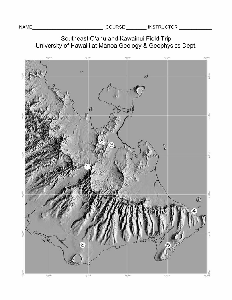
NAME____________________________ COURSE ________ INSTRUCTOR _____________
Southeast O‘ahu and Kawainui Field Trip University of Hawai‘i at Mānoa Geology & Geophysics Dept.
2
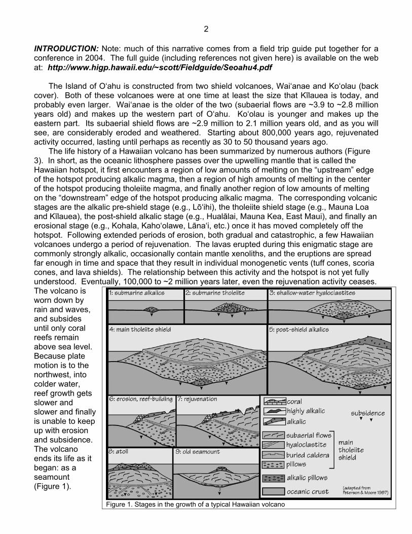
INTRODUCTION: Note: much of this narrative comes from a field trip guide put together for a conference in 2004. The full guide (including references not given here) is available on the web at: http://www.higp.hawaii.edu/~scott/Fieldguide/Seoahu4.pdf The Island of O‘ahu is constructed from two shield volcanoes, Wai‘anae and Ko‘olau (back cover). Both of these volcanoes were at one time at least the size that Kīlauea is today, and probably even larger. Wai‘anae is the older of the two (subaerial flows are ~3.9 to ~2.8 million years old) and makes up the western part of O‘ahu. Ko‘olau is younger and makes up the eastern part. Its subaerial shield flows are ~2.9 million to 2.1 million years old, and as you will see, are considerably eroded and weathered. Starting about 800,000 years ago, rejuvenated activity occurred, lasting until perhaps as recently as 30 to 50 thousand years ago. The life history of a Hawaiian volcano has been summarized by numerous authors (Figure 3). In short, as the oceanic lithosphere passes over the upwelling mantle that is called the Hawaiian hotspot, it first encounters a region of low amounts of melting on the “upstream” edge of the hotspot producing alkalic magma, then a region of high amounts of melting in the center of the hotspot producing tholeiite magma, and finally another region of low amounts of melting on the “downstream” edge of the hotspot producing alkalic magma. The corresponding volcanic stages are the alkalic pre-shield stage (e.g., Lō‘ihi), the tholeiite shield stage (e.g., Mauna Loa and Kīlauea), the post-shield alkalic stage (e.g., Hualālai, Mauna Kea, East Maui), and finally an erosional stage (e.g., Kohala, Kaho‘olawe, Lāna‘i, etc.) once it has moved completely off the hotspot. Following extended periods of erosion, both gradual and catastrophic, a few Hawaiian volcanoes undergo a period of rejuvenation. The lavas erupted during this enigmatic stage are commonly strongly alkalic, occasionally contain mantle xenoliths, and the eruptions are spread far enough in time and space that they result in individual monogenetic vents (tuff cones, scoria cones, and lava shields). The relationship between this activity and the hotspot is not yet fully understood. Eventually, 100,000 to ~2 million years later, even the rejuvenation activity ceases. The volcano is worn down by rain and waves, and subsides until only coral reefs remain above sea level. Because plate motion is to the northwest, into colder water, reef growth gets slower and slower and finally is unable to keep up with erosion and subsidence. The volcano ends its life as it began: as a seamount (Figure 1).
Figure 1. Stages in the growth of a typical Hawaiian volcano
3
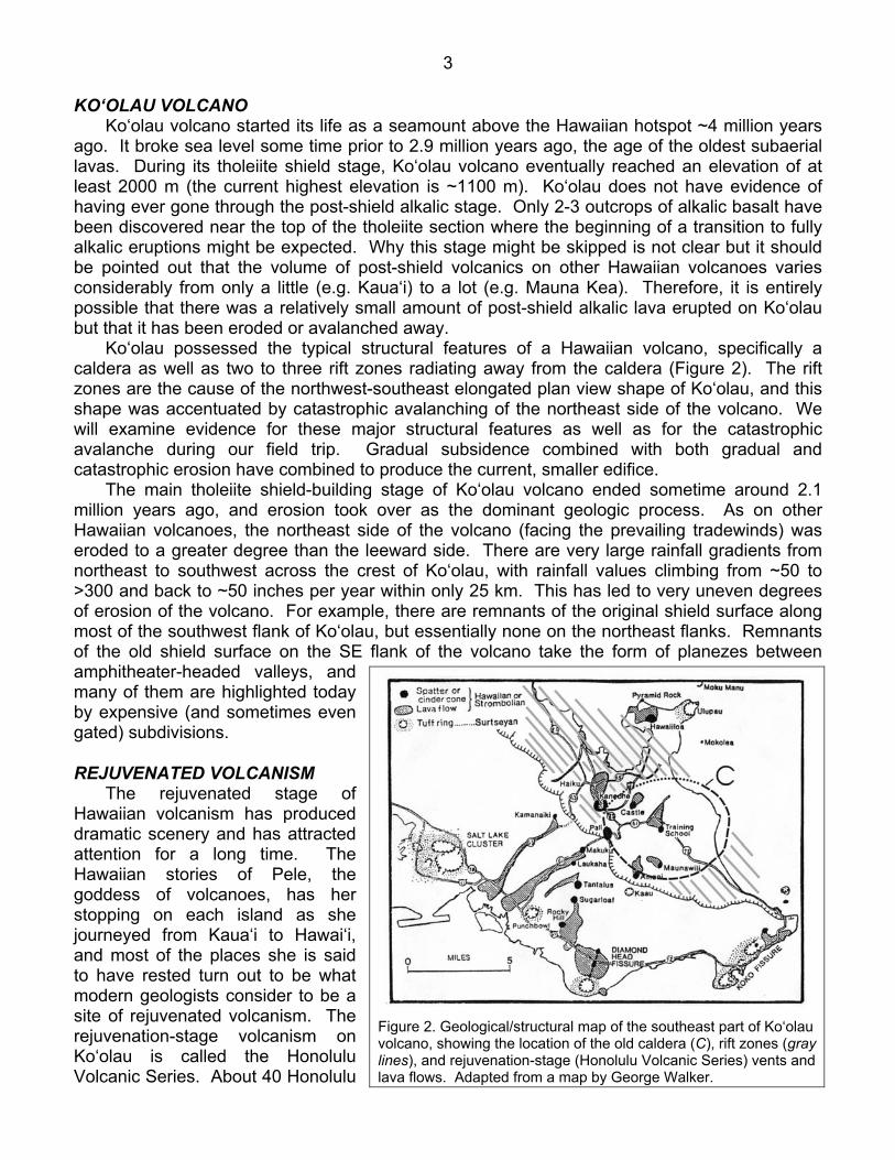
KO‘OLAU VOLCANO Ko‘olau volcano started its life as a seamount above the Hawaiian hotspot ~4 million years ago. It broke sea level some time prior to 2.9 million years ago, the age of the oldest subaerial lavas. During its tholeiite shield stage, Ko‘olau volcano eventually reached an elevation of at least 2000 m (the current highest elevation is ~1100 m). Ko‘olau does not have evidence of having ever gone through the post-shield alkalic stage. Only 2-3 outcrops of alkalic basalt have been discovered near the top of the tholeiite section where the beginning of a transition to fully alkalic eruptions might be expected. Why this stage might be skipped is not clear but it should be pointed out that the volume of post-shield volcanics on other Hawaiian volcanoes varies considerably from only a little (e.g. Kaua‘i) to a lot (e.g. Mauna Kea). Therefore, it is entirely possible that there was a relatively small amount of post-shield alkalic lava erupted on Ko‘olau but that it has been eroded or avalanched away. Ko‘olau possessed the typical structural features of a Hawaiian volcano, specifically a caldera as well as two to three rift zones radiating away from the caldera (Figure 2). The rift zones are the cause of the northwest-southeast elongated plan view shape of Ko‘olau, and this shape was accentuated by catastrophic avalanching of the northeast side of the volcano. We will examine evidence for these major structural features as well as for the catastrophic avalanche during our field trip. Gradual subsidence combined with both gradual and catastrophic erosion have combined to produce the current, smaller edifice. The main tholeiite shield-building stage of Ko‘olau volcano ended sometime around 2.1 million years ago, and erosion took over as the dominant geologic process. As on other Hawaiian volcanoes, the northeast side of the volcano (facing the prevailing tradewinds) was eroded to a greater degree than the leeward side. There are very large rainfall gradients from northeast to southwest across the crest of Ko‘olau, with rainfall values climbing from ~50 to >300 and back to ~50 inches per year within only 25 km. This has led to very uneven degrees of erosion of the volcano. For example, there are remnants of the original shield surface along most of the southwest flank of Ko‘olau, but essentially none on the northeast flanks. Remnants of the old shield surface on the SE flank of the volcano take the form of planezes between amphitheater-headed valleys, and many of them are highlighted today by expensive (and sometimes even gated) subdivisions. REJUVENATED VOLCANISM The rejuvenated stage of Hawaiian volcanism has produced dramatic scenery and has attracted attention for a long time. The Hawaiian stories of Pele, the goddess of volcanoes, has her stopping on each island as she journeyed from Kaua‘i to Hawai‘i, and most of the places she is said to have rested turn out to be what modern geologists consider to be a site of rejuvenated volcanism. The rejuvenation-stage volcanism on Ko‘olau is called the Honolulu Volcanic Series. About 40 Honolulu
Figure 2. Geological/structural map of the southeast part of Ko‘olau volcano, showing the location of the old caldera (C), rift zones (gray lines), and rejuvenation-stage (Honolulu Volcanic Series) vents and lava flows. Adapted from a map by George Walker.

4
Volcanic Series vents have been identified and they are all concentrated within the southeastern third of the elongate Ko‘olau edifice (Figure 2). Presently, there are many competing ideas for the origin of rejuvenation-stage volcanism, and it is definitely possible that more than one mechanism may be at work. Recent, careful age dating shows that within the Honolulu Volcanic Series there are two pulses of magmatism separated by a hiatus of ~250,000 years (Figure 3). The earlier pulse, which lasted from 800,000 to 360,000 years ago, may have been due to mantle upwelling downstream from the hotspot. The later pulse, from 100,000 to 30,000 years ago, may have been due to lithospheric flexure (the big island pushes the mantle down so it responds by moving up elsewhere - it is kind of squishy - and upwardly moving mantle sometimes melts as it is depressurized). Downward flexure is still occurring under Hawai‘i and 30,000 years isn’t very long ago geologically - there is the possibility that rejuvenated volcanism could occur again on Ko‘olau!
Figure 3. This is the result of a huge amount of very careful geochemical work, but it is a somewhat confusing plot. It shows most of the Honolulu Volcanic Series (Ko‘olau rejuvenation series) vents plotted. The y-axis shows age in million years, and the x axis is a rank-order, plotting oldest to youngest, left to right. Note that there is a time gap, from ~360,000 to ~100,000 years where there was only one eruption (#24 - Āliamanu). The rejuvenation-stage vents that we will visit or look at on this field trip include #5 - Pali (~600,000 years old), #29 - Kaupō (~100,000 years old), #30 - Koko (~100,000 years old), and #22 - Kaimukī (~400,000 years old).
Stop 1: the Pali lookout:
The Nu‘uanu Pali lookout is located at a very significant historic place, an interesting geologic place, a touristic place, and often a very windy place. Historically, this is where Kamehameha I defeated Kalanikūpule, and thereby added O‘ahu to his empire. Because this place is popular with tourists and rental cars, make sure you don’t leave any valuables unattended.
Figure 4: Oblique air photo looking town-ward over the pali (from Volcanoes in the Sea).

5
Nu‘uanu pali is one of the most spectacular geological features on O‘ahu. Many Hawaiian islands have pali but the Nu‘uanu pali is considered the classic example and is commonly just called “the Pali”. Some pali are along the coast (e.g., north shores of Kaua‘i and Moloka‘i) and others are inland (e.g., on O‘ahu and Ni‘ihau). A wide range of suggestions have been offered to explain the origin of Nu‘uanu (and other) pali: 1) Faulting: J.D. Dana, the first western geologist to visit Hawai‘i, proposed that great fractures were responsible for these cliffs. Such a fault would have at least 1 km of offset to have created the Nu‘uanu Pali. 2) Fluvial erosion: A young captain in the U.S. Army, George Dutton, visited Hawaii in the late 19th century. He was a keen observer and his observations led him to conclude that erosion was the main cause of the pali. 3) Marine erosion: Some subsequent geologists combined marine erosion with faulting in explaining the pali’s origin. 4) Caldera rim: This idea has been at least informally discussed based on the fact that the Ko‘olau volcano caldera boundary grazes the pali in a few places, as does the margin of a Ko‘olau rift zone, just below the Nu‘uanu pali overlook. 5) Headwall of the Nu‘uanu landslide: Marine surveys north of O‘ahu revealed that the northeast side of the Ko‘olau volcano collapsed into the ocean, removing ~40% of the old volcano (Figure 5). The location of the headwall for this landslide has been debated but some have suggested it is the pali. Hydrothermal alteration in the rift zone was thought to weaken the rocks and make them more susceptible to failure. So we have many alternative models that can explain the formation of Pali. What key observations are needed to test these hypotheses? A) The shape of the pali - it is not a linear feature. Instead, it is scalloped with many embayments. Thus, a pure fault origin is unlikely. Also, the numerous scalloped features make a pure avalanche scar explanation problematic.
Figure 5. Map of bathymetry off the north coasts of O‘ahu and Moloka‘i first used to postulate and outline the deposits of giant avalanches.
B) Length of the pali - it extends well beyond the old Ko‘olau caldera margins, so it is not the remnant of an old caldera rim although locally it coincides with the rim. C) Residual ridges, remnants of the old Ko‘olau volcano, extending northeast from the pali. These include the Mokulua islands, Olomana, Kapa‘a, and the Keolu hills. Any avalanche scarp must be oceanward of these remnants. D) Former sea level stands were never high enough. Although sea level has fluctuation greatly over the last two million years since the Ko‘olau volcano was formed, it was never high enough on O‘ahu to have eroded the base of the pali, except at the Makapu‘u end. Also, there are no relict marine features near the pali.

6
So what are we left with? The current preferred model for the origin of the Nu‘uanu pali is a combination of a head start provided by the giant avalanche followed by fluvial erosion, basically the idea proposed by Dutton in 1883! GIANT AVALANCHES Jim Moore provided evidence that much of the northeast flank of Ko‘olau volcano (as well as much of E. Moloka‘i volcano; Figure 5) avalanched onto the ocean floor. The idea was controversial at the time but recent sampling has shown that the hummocky material spread northeastward from O‘ahu does indeed consist of Ko‘olau lavas. Additionally, side-scan sonar data collected around the eight main Hawaiian islands in the 1980s identified at least 17 additional deposits from giant avalanches. We now know that the avalanche associated with Ko‘olau (named the Nu‘uanu avalanche) is one of the largest landslides on Earth, with blocks up to 40 km long and 2 km tall having slid as far as 100 km. As we noted above, any avalanche scar must be seaward of the seaward-most remnant of the Ko‘olau volcano. This puts it at least a kilometer or so oceanward of the current coastline (i.e., just northeast of the Mokulua islands). Immediately after the avalanche there would have been a cliff perhaps 2000 m high, as well as a very high submarine scarp, both of which would have been very unstable. Smaller avalanches and rapid marine and stream erosion would have caused this cliff to be eroded back (southwest). This process of “parallel retreat” has been documented at a number of locations on Earth, including along the northwest part of India. Basically it states that if a cliff is produced (e.g., by an avalanche), it will persist as a cliff as it is eroded landward. If the rocks involved are basalt lavas such as in Hawai‘i, the process is aided by the fact that almost all such flows posses roughly vertical cooling joints, that are continually exposed by erosion and weathering. Not all the retreat was parallel, however. As we noted above there is evidence that fluvial erosion resulted in the formation of amphitheater-headed valleys (Figure 4), giving the pali its scalloped form. These scallops are the coalesced heads of these valleys. The northeast-trending ridges are remnants of the ridges that once separated the valleys. Olomana, for example, is a high point on the ridge that separates Maunawili and Waimānalo valleys. How catastrophic was the Nu‘uanu avalanche? After all, there are landslides that just creep slowly downslope. The best evidence for catastrophe is that the Nu‘uanu avalanche deposit had enough momentum to flow uphill on the ocean floor. Figure 5 shows that the avalanche material flowed down off the flank of Ko‘olau, crossed the Hawaiian Deep (a moat-like depression due to the weight of the island), and managed to lap up the other side of the Hawaiian Deep. This required a climb of roughly 300 m, and remember this was against water resistance. A creeping landslide could not have achieved this. An inevitable question is how big of a tsunami would such a catastrophic avalanche cause? The answer is that it would be devastating within Hawai‘i (i.e., >200 m high) but opinions vary about whether or not it could also devastate other places such as the west coast of North America. There is currently considerable debate about whether a particular deposit on the south flank of Lāna‘i was formed by a giant-avalanche-generated tsunami or by high sea level followed by tilting of the island.
7
Question 1: Notice in Figure 4 that the Pali and Wilson tunnels are located at similar places topographically/geomorphologically. What has happened geologically to make these places so similar and so ideal for building cross-Ko‘olau roads and tunnels? (hint: it has something to do with valleys and erosion and the cost of building a tunnel)
Question 2: Draw a cross-section of the roadcut just down the old road from the lookout (spend
at least a minute on it). Label each unit. What was the order of their emplacement?
Question 3: Many people say that the Nu‘uanu Pali, right where we’re standing, is the scar from the giant avalanche that carried away the northeast half of Ko‘olau volcano. Can you see anything that might indicate problems with this idea? Hint: the following features are parts of the old Ko‘olau volcano (i.e., they are not rejuvenation-stage features): Mokulua (two islands), Ka‘iwa (the frigate bird) Hills. Other features that are also parts of the old volcano are the Kapa‘a hills (the solid - appropriate for a quarry, or the closing), and Olomana (forked hill).

8
Question 4: Here is a place where you can put your finger on a contact that represents a time break of perhaps 1.5 million years! To the right (south) are lava flows of the main Ko‘olau shield volcano (no younger than ~2.1 million years). To the left (north) are scoria layers of the Pali rejuvenation-stage vent upslope from us (~600,000 years old). List 3 ways in which the scoria layers differ visually from the lava flows.
Question 5: Notice that each of these scoria layers is coarse on the bottom, and gets finer as
you go upward. This is called “reverse grading”, because it is the opposite of what you expect to find (coarse on the bottom - “normal” grading). Can you think of any reasons why these layers might have become reverse-graded? Things to think about are that this scoria was deposited out of a high lava fountain that may or may not have had a constant height or constant orientation, and that the scoria flew high enough to solidify before landing, so that as it was deposited on the steep slope of the building scoria cone, it probably slid downward somewhat.
Stop 2: Kapa‘a Quarry: Kapa‘a Quarry is operated by a company called Ameron International. The quarry has been in operation for many years, and it is the source for much of the gravel and non-moss-rock building stone used on O‘ahu. The quarrying operation is digging out both dike rock and massive caldera-ponded lava flows, both of which are dense and non-vesicular. Much of the rock has a greenish tint due to the fact that here, in the area that was once the old caldera and therefore over the old magma chamber, the rocks have been hydrothermally altered. This hydrothermal alteration causes the formation of a secondary clay

9
mineral called chlorite, which often has a green color. It is interesting to note that this very same site was used by pre-Western-contact Hawaiians for adze material. Question 6: What are at least two products that the rock from Kapa‘a Quarry is used for?
Stop 3: Nā Pōhaku o Hauwahine: Nā Pōhaku o Hauwahine is a heiau dedicated to women and to a particular goddess who could take human female form. It is unlike most heiau, however, in that much of it was not constructed out of stones that were piled up. Instead, it makes use of some spectacular outcrops residual boulders that have been eroded into beautiful rounded shapes. The stone making up these boulders is a very interesting breccia consisting of fragments of vesicular basalt in a matrix of finer-grained material. The vesicles of the basalt clasts have been infilled by secondary minerals (mostly zeolites and opal) to form what are called amygdules. This rock unit can be found in numerous places around the Kawainui region, and has been named the Ulumawao (growth of many waters) breccia (e.g., Macdonald et al. 1983). Its geologic origin is not completely understood, and Macdonald et al. suggest that it may be remnants of mudflows that spread across an ancestral caldera floor. Doc Burrows and many many many other volunteer hands have worked tirelessly to clear these stones of invasive vegetation, and to replant the area with native species. From here there are excellent views across Kawainui (many waters, big water) marsh. This marsh is an important ecological feature, a natural flood control feature, and an important cultural feature. In pre-contact times, for example, it was a fish pond where fat mullet were grown and harvested. The book Sites of Oahu quotes a Dictionary of Hawaiian Localities in the Saturday Press, dated Oct. 6, 1883: “Many Waters.” A large fresh water pond in Kailua, and famous for the oopu kuia and for having once possessed the famous fish log Makalei. The oopu kuia was a large fat mud fish, caught by many people joining hands and dancing its waters to stir up mud, when the fish would run their heads up against the people, and so were caught. The fishes would cluster very thickly against particular individuals while leaving many others untouched, when, of course, he or she, would make a good haul and fill up his calabashes rapidly. This gave rise to the common saying of the olden times, “he ili ona ia”--“attractive skin.” Geologically, Kawainui is centered essentially where the old Ko‘olau caldera was, and it is tempting to attribute the marsh’s low-lying, flat form to having once been a caldera. However, we have to remember that much of Ko‘olau is now missing. The present surface of the marsh may once have been a caldera floor, but only temporarily. The volcano eventually would have built upwards well beyond this level. In fact, if you were standing in what is now Kawainui marsh when Ko‘olau had reached its maximum elevation, you would have been encased beneath as much as 2 km of overlying rock! How do we know that the old caldera was here? There are five lines of evidence:

10
1) The the lava flows in the caldera region are all very thick, as if they were erupted into an enclosed depression and therfore couldn’t flow away downslope. One would expect these thick intra-caldera flows to be essentially flat lying (the way water is flat-lying in a glass), and indeed many of them are. 2) There are also many intra-caldera flows that are dipping (sloping), and a projection of all their dips points to the center of Kawainui marsh. These flows are essentially sagging towards the center of the old caldera because calderas, when a volcano is active, are the locations where subsidence is greatest. 3) There are not a huge number of dikes in the Kawainui region. This is unlike the regions just outside of the caldera where the dike intensity is very high. This lack of dikes is attribute to the fact that the increased subsidence meant that no country rock was around long enough to accumulate many dikes. 4) Many of the rocks in this region show evidence of significant hydrothermal alteration. In addition to the formation of chlorite, hydrothermal fluids deposited secondary minerals in exsiting lava flow vesicles and fractures. These secondary minerals include zeolites as well s opal. 5) Careful measurements back in the 1960s showed that the force of gravity is stronger over Kawainui marsh (this is only measurable with sensitive gravimeters - it is not something that humans would notice). This is attributed to denser-than-normal rock bodies buried at depth, and the most likely candidate for dense rocks is the now-solidified magma chamber.
Figure 6. Results of a 1960s era gravity survey of O‘ahu. The lines are contours of equal gravitational intensity, and note the obvio
Question 6: Besides the great stones, what other reasons might this have been a good place to establish a heiau? us
gravitational highs centered over the old Ko‘olau caldera near Kawainui marsh and over the old Wai‘anae caldera near Lualualei and Wai‘anae valleys.
CHANGES IN SEA LEVEL The record of sea level ups and downs is very complex on O‘ahu, and the Coastal Geology Group at UH Mānoa (headed by Dr. Chip Fletcher) has numerous ongoing projects to try and

11
unwravel it. Kawainui marsh in particular records many of the ocean’s ups and downs because of its low elevation and proximity to the ocean. Figure 7 is adapted from information available onthe Coastal Geology Group’s website (a source of a huge amount of ocean and coastline information) at: http://www.soest.hawaii.edu/coasts/index.html There are a variety of reasons why sea level varies, the most well understood being changes in the Earth’s climate. Specifically, during warm times, snow and ice on land melt, and add their volume to the oceans, causing sea level to rise. Conversely, during colder times (such as ice ages), more water is sequestered on land as snow and ice, and sea level consequently drops. Another aspect of these climatic changes is the fact that liquid water expands when it is warmer and contracts when it is cooler, compounding the effects of the ice-storage (or lack of) on land.
Figure 7. Variations in the Kailua-area coastline due mainly to changes in world-wide sea level.
Much of this sea-level-rise business has been in the public consiousness because we know that worldwide the temperature is rising, as are sea levels. By studying past records of sea level (as well as with simple exercises with contour maps), we can get an idea of what our coastlines might look like if global warming continues unchecked. We will next drive through the towns of Kailua (two waters) and Waimānalo (potable water). These towns mostly overlie ancient coral reefs, and in places and calcareous sand dunes. Semi-lithified dunes are exposed along the main highway just southeast of the Waimānalo

12
shopping area. The dunes and reef in Waimānalo correspond to an older episode of higher sea level, the 106,000-136,000 year-old +3 m Waimānalo stand (Figure 8). The back of Waimānalo is bounded by an extension of the Nu‘uanu pali, and is spectacularly fluted. During heavy rains each of these flutes contains a succession of water falls and plunge pools, and they contribute to the parallel retreat of the pali.
Figure 8. Composite diagram of the different facies, ages, and profiles of limestone found both above and below sea level on O‘ahu. The ages of stages noted in the diagram above (in thousands of years ago) are as follows: Stage 7 (245,000-185,000); Stage 5e (130,000-110,000); Stage 5c (105,000-95,000); Stage 5a (90,000-75,000); Stage 3 (60,000-30,000); Stage 1 (15,000 to present). From:: http://www.soest.hawaii.edu/coasts/cgg_main.html

13
Stop 4: Kaupō lava flow, near Makapu‘u:
Figure 9: View plane diagram of Kaupō, Mānana, and other Ko‘olau features, as seen from Makapu‘u lookout. The Dept. of Transportation made a fancy new parking area up at the lookout, but buses are not allowed there. Diagram by Lorin T. Gill.
The Kaupō flow is the product of a “dry” rejuvenation-stage eruption along the Koko Rift, some 50,000 to 100,000 years ago (estimates vary). The vents for this flow are up near the green-roofed wedding chapel that Sea Life Park built (against community wishes) a few years ago. The area around the vent is now even more evident because it has become a preferred launching point for parasailers, and their foot traffic has trompled all the vegetation. Kaupō means to land a canoe at night. Makapu‘u means bulging eyes (literally, eyes like hills), and refers either to an image in a cave nearby, or to a woman who longed for her home in Kahiki (Tahiti) and said she was able to see it from here, with what must have been really good eyesight!
Figure 10: Sketch map of the Koko Rift (from Volcanoes in the Sea).
Question 7: Notice from Figures 9 and 10 (and
with your own two maka) that the Kaupō lava flow is banked up against some pretty dramatic pali (cliffs). What does this tell you about the relative ages of the pali and the Kaupō flow?

14
Question 8: Notice also all the lava flow layers exposed in these pali. Where are/were the vents that produced these lava flows?
Question 9: Notice the two islands offshore, Mānana (buoyant; the higher, lighter-toned one
that is farther offshore) and Moku Hope (island behind; the lower, darker-toned one that is closer to shore). Mānana is a tuff cone, formed by hydromagmatic eruptions, whereas Moku Hope is a scoria cone, formed by dry, high-fountaining eruptions. Do their eruption types and relative locations make sense geologically? Explain.
Stop 5: Hawai‘i Kai scenic overlook:
Figure 11: View plane drawing from Hawai’ Kai, looking West (By Lorin T. Gill)
Figure 11 shows the view back towards Honolulu from the Hawai‘i Kai/Koko Head area. The name “Koko” (blood) refers to the blood of a man who was bitten by a shark near here. The Kai part of Hawai‘i Kai does double duty as the ocean and the first part of Henry Kaiser’s name - he developed Hawai‘i Kai).

15
Question 10: There is some disagreement among geologists regarding whether or not the current profile of the ridges is the old shield surface, or, as Figure 11 suggests, the old shield surface was once higher. The lava flows exposed in the walls of the valleys had to at one time define the surface of the volcano, and one consideration would be to ask if the current topographic profile is parallel to these lava flows. Is it? (hint: you can measure the slopes of the flows and the ridge profiles using the simple clinometer)
Question 11: There are wave-cut bluffs at the downslope-ends of all the ridges. Are they
actively being cut by waves now days? Question 12: (hint, the answer to Question 10 is no) So then, how did these wave-cut bluffs form? Question 13: What other evidence would you look for to support your answer to Question 12?
Figure 12: Photo of Koko Crater from the northeast.
From here you can also see Koko Crater, a very steep-sided (and therefore somewhat unusual) hydromagmatic vent. The old name for Koko Crater was Kohelepelepe, which literally means the rim of a vagina. This comes from the story of Pele’s sister Kapo luring Kamapua‘a off of Pele with a flying vagina that landed briefly here. Question 14: Koko Crater is very
asymmetric. In fact, you can

16
actually walk into the crater from the side opposite from where we’re looking (there is a City and County of Honolulu botanical garden in there with all kinds of weird dryland plants). Why do you think the crater is so asymmetric? (Lē‘ahi shows the same asymmetry, although not as dramatically)
Stop 6: Pu‘u o Kaimukī:
Figure 13: Sketch map of most of the vents of the Honolulu Volcanic Series (by George P.L. Walker)
Question 15: Pu‘u o Kaimukī (the hill where ti (ki) roots were cooked in ovens (imu)) is a ~4000,000 year-old rejuvenation stage vent of Ko‘olau (windward) volcano (Figure 13). Figure 13 also indicates that Pu‘u o Kaimukī consists of lava. What style of eruption (high fountaining, low/no fountaing, or hydromagmatic) formed Pu‘u o Kaimukī? How do you know? Question 16: How do the slopes of Lē‘ahi (the brow of an ahi), also known as Diamond Head, compare to those of Pu‘u o Kaimukī? Question 17: What style of eruption formed Lē‘ahi? How do you know?

17
Figure 14: Stages in Hawaiian volcano erosion (from Volcanoes in the Sea).
Question 18: Figure 14 shows stages in the erosion of all or parts of a typical Hawaiian volcano surface. As you look māuka from Pu‘u o Kaimukī, which stage corresponds to the nearby slopes of Ko‘olau volcano?

18