southland murihiku conservation management strategy 2016 · 2.3 western high country mata-puke...
TRANSCRIPT
Southland Murihiku 2016, Volume 1
CMSCONSERVATION MANAGEMENT STRATEGY


Southland Murihiku 2016, Volume 1
CMSCONSERVATION MANAGEMENT STRATEGY

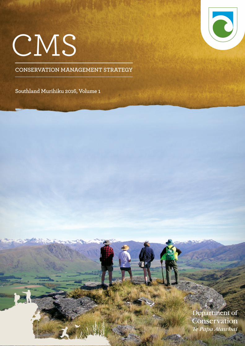
Cover image: Conservation volunteers take a break from removing wilding pines to admire the view of the Eyre Mountains from the Slate Range, Garston. Photo: John Peterson, DOC
September 2016, New Zealand Department of Conservation
ISBN: 978-0-478-15083-4 (print)ISBN: 978-0-478-15084-1 (online)
Crown copyright © 2016This work is licensed under the Creative Commons Attribution 4.0 International licence. In essence, you are free to copy, distribute and adapt the work, as long as you attribute the work to the Crown and abide by the other licence terms. To view a copy of this licence, visit https://creativecommons.org/licenses/by/4.0/
Please note that no departmental or governmental emblem, logo or Coat of Arms may be used in any way which infringes any provision of the Flags, Emblems, and Names Protection Act 1981. Attribution to the Crown should be in written form and not by reproduction of any such emblem, logo or Coat of Arms. Use the wording ‘Department of Conservation’ in your attribution, not the Department of Conservation logo.
This publication is produced using paper sourced from well-managed, renewable and legally logged forests.R97620
Contents
FOREWORD 7
INTRODUCTION 8
CMS structure 10
Interpretation 11
CMS term 12
Relationship with other Department of Conservation strategic documents and tools 12
Relationship with other planning processes 14
The Department’s legislative tools 14
Treaty of Waitangi and Ngāi Tahu Settlement Obligations 15
PART ONE 18
1.1 The Department in Southland Murihiku 18
1.2 Vision for Southland Murihiku—2066 18
1.3 Distinctive features, values and issues of Southland Murihiku 20
1.4 Treaty partnership with Ngāi Tahu 26
1.5 Southland Murihiku by 2026 34
PART TWO—PLACES 48
2.1 Takitimu Place 49
2.2 Fiordland Te Rua-o-te-moko Place 54
2.3 Western High Country Mata-puke Koikoi Place 66
2.4 Eastern High Country Mata-puke Taratara Place 77
2.5 Longwood O Hekeia Place 84
2.6 Freshwater Wai Māori Place 90
2.7 Lowlands Te Rā a Takitimu Place 98
2.8 Awarua Place 105
2.9 Foveaux Te Ara a Kiwa Place 112
2.10 Subantarctic Ngā Moutere O Murihiku Ki Tonga Place 119
PART THREE—SPECIFIC POLICY REQUIREMENTS FOR SOUTHLAND MURIHIKU 135
3.1 General 135
3.2 Vehicles 138
3.3 Mountain bikes (non-motorised vehicles) 139
3.4 Electric power-assisted pedal cycles 140
3.5 Other forms of transport 141
3.6 Aircraft 142
3.7 Animals 147
3.8 Dogs 147
3.9 Horses and pack animals 148
3.10 Structures and utilities 149
3.11 Private accommodation and related facilities 150
3.12 Marine mammal viewing 153
3.13 Commercial eeling 154
3.14 Sports fish and game bird hunting 155
3.15 Grazing and farming 156
3.16 Mining 156
3.17 Sand and shingle extraction 157
3.18 Commercial filming and photography 158
3.19 Collection of material 159
3.20 Wild animals 159
3.21 Game animals (see also Wild animals) 163
3.22 Sporting and other competitive events 164
3.23 Recreational activities using fixed anchors 165
3.24 Fire management 166
PART FOUR—IMPLEMENTATION MONITORING AND REPORTING, AND REVIEW 168
GLOSSARY 169
APPENDICES
Appendix 1: 193Work or activities of the Department of Conservation that may meet the requirements of section 4(3) of the Resource Management Act 1991 for exemptions from land use consents in Southland Murihiku
Appendix 2: 205Ecosystem and habitat types within Southland Murihiku
Appendix 3: 226Islands over 1 ha administered by the Department of Conservation in Southland Murihiku
Appendix 4: 240Priority ecosystem units on public conservation lands and waters in Southland Murihiku identified by the Department through natural heritage prioritising processes
Appendix 5: 248Threatened and at risk indigenous flora and fauna present in Southland Murihiku
Appendix 6: 260Threats or pests and wild animals present in Southland Murihiku
Appendix 7: 272Nationally iconic species in Southland Murihiku
Appendix 8: 273Marine habitats and ecosystems in Southland Murihiku
Appendix 9: 282Significant geological features, landforms and landscapes in Southland Murihiku
Appendix 10: 285Actively conserved historic places on public conservation lands and waters, or managed by the Department, in Southland Murihiku
Appendix 11: 291Icon and Gateway destinations in Southland Murihiku
Appendix 12: 293Prescriptions for the management of visitor management zones
Appendix 13: 297Ngāi Tahu Claims Settlement Act 1998 provisions relating to Southland Murihiku
Appendix 14: 315Statements of outstanding universal values for World Heritage Areas in Southland Murihiku
Appendix 15: 323Criteria for which the Awarua Wetland of International Importance was nominated
Appendix 16: 324Publicly available huts on public conservation lands and/or managed by the Department within Southland Murihiku
INDEX 329

7Southland Murihiku Conservation Management Strategy 2016
Foreword
With over half of Southland Murihiku in public ownership, conservation plays a significant role in supporting the economic, cultural, social and spiritual well-being of Southlanders.
This Southland Murihiku Conservation Management Strategy (CMS) has been prepared in consultation with Ngāi Tahu and local communities. It builds on the wisdom, skills, knowledge and experience we have collectively gained over the past decade, and sets out our aspirations for the next 10 years and beyond. It reaffirms the Department of Conservation’s desire to work alongside others, including Ngāi Tahu, other government agencies, individuals, business and the community to significantly increase our conservation efforts in Southland Murihiku.
This CMS integrates national and local conservation priorities and identifies outcomes for places that are special to Ngāi Tahu and the community.
This CMS became operative on 1 September 2016.
Dr Warren Parker
Chair, New Zealand Conservation Authority—Te Pou Atawhai Taiao O Aotearoa
John Whitehead
Chairperson, Southland Conservation Board
Allan Munn
Director, Operations Southern South Island Kaihautū Matarautaki, Department of Conservation

8 Southland Murihiku Conservation Management Strategy 2016
Introduction
Purpose of conservation management strategiesConservation, as defined under section 2 of the Conservation Act 1987 (the Act), is the ‘preservation and protection of natural and historic resources for the purpose of maintaining their intrinsic values, providing for their appreciation and recreational enjoyment by the public, and safeguarding the options of future generations’.
The functions of the Department of Conservation (the Department) are for the most part identified in section 6 of the Act and in other Acts listed in the First Schedule of the Act.
The purpose of a conservation management strategy (CMS), as defined by section 17D of the Act, is to implement statements of general policy, and to establish objectives for the integrated management of natural and historic resources, including species managed by the Department, and for recreation, tourism and other conservation purposes.
The Act creates a hierarchy of documents to guide the Department in its management. The Act is at the top, General Policy is next, and below that are the CMS and conservation management plans, and other management plans. In Southland, there is already an operative Stewart Island/Rakiura CMS 2011 (and the operative Rakiura National Park Management Plan 2011, which was prepared and approved concurrently). Therefore, this document does not apply to Stewart Island/Rakiura.1 Rather, this CMS is the result of a review of the previous Mainland Southland/West Otago CMS 1998, as well as the previous Subantarctic Islands CMS 1998. It incorporates these two CMSs into one CMS for Southland Murihiku.2
There is one operative national park management plan in Southland Murihiku, which was prepared under the National Parks Act 1980: the Fiordland National Park Management Plan 2007. There are 10 operative conservation management plans in Southland Murihiku, dating from the 1980s to 1990s, for 9 reserves and the Mavora Lakes Park.3
Statutory framework for the management of public conservation lands and waters
Conservation Act 1987
General Policy
Conservation management strategies
Conservation management plans
National Parks Act 1980
General Policy
National park management plans
1 However, it should be noted that Stewart Island/Rakiura is on occasion referred to in Part One of this CMS, in order to provide a complete Southland Murihiku context.
2 The term ‘Southland Murihiku’ within this document refers to the Southland region, including the subantarctic islands, and islands in the Foveaux Strait (Te Ara a Kiwa) and around Fiordland; but excluding Stewart Island/Rakiura and associated islands that are covered by the Stewart Island/Rakiura CMS.
3 It is intended to revoke or withdraw these plans subsequent to this CMS approval. The intent of the Conservation Amendment Act 1996 was that CMS provide any required management detail for individual areas of public conservation lands and waters.

9Southland Murihiku Conservation Management Strategy 2016
A lower order planning document cannot derogate from a higher order one; meaning that it cannot be contrary to it. The lower in order a planning document is, the greater the level of detail as to management intentions.
The general policies relevant to this CMS are the:
• Conservation General Policy 2005, which applies to all conservation lands, waters and resources managed by the Department under the following Acts: the Conservation Act 1987, the Wildlife Act 1953, the Marine Reserves Act 1971, the Reserves Act 1977, the Wild Animal Control Act 1977 and the Marine Mammals Protection Act 1978
• General Policy for National Parks 2005, which sets expectations and takes priority for national park management planning, under the National Parks Act 1980.
Other legislation for which the Minister of Conservation has a role or that is relevant to this CMS includes the Electricity Act 1992, the Freedom Camping Act 2011, the Heritage New Zealand Pouhere Taonga Act 2014, the Protected Objects Act 1975, the State-Owned Enterprises Act 1986, the Crown Minerals Act 1991, the Walking Access Act 2008, the Game Animal Council Act 2013, the Fiordland (Te Moana o Atawhenua) Marine Management Act 2005, the Manapouri–Te Anau Development Act 1963, the Ngāi Tahu (Pounamu Vesting) Act 1997, the Ngāi Tahu Claims Settlement Act 1998, the Te Rūnanga o Ngāi Tahu Act 1996, the Waitutu Block Settlement Act 1997 and the Crown Pastoral Land Act 1998.
Each CMS is prepared with public participation according to the process set out in the Conservation Act 1987. Preparation of this CMS has involved:
a) A pilot study of a self-administered online mapping interface and questionnaire method known as Public Participation Geographic Information Systems (PPGIS), jointly conducted by the Department, the University of Queensland and the University of Waikato. This was used to collect information on public values, experiences and development preferences for public conservation lands and waters within the Southland Murihiku region.
b) A series of public workshops and open days held across Southland Murihiku to discuss the CMS process, draft Place boundaries and the values that people hold regarding the draft Places. Workshops were held in Te Anau, Invercargill, Gore and Otautau and open days were held in Invercargill, Tapanui, Lumsden, Gore and Otautau.
c) A hui with Ngāi Tahu ki Murihiku held at the Te Rau Aroha Marae to discuss the CMS process, draft Place boundaries and values (particularly cultural values) that representatives of Ngāi Tahu have regarding draft Places.
d) Targeted one-on-one meetings with Kaitiaki Rōpū and other key stakeholders (e.g. district and regional councils) to discuss draft Places and issues, as required.
e) Liaison with the Southland Conservation Board (a statutory body with a conservation advisory and community liaison role within Southland Murihiku), to ensure that the Board was kept up to date throughout the whole process and was involved in the resolution of any issues raised.
f) Public notification of the CMS, with submissions sought and received, and where requested by submitters, hearings were held.
g) Consideration of the revised draft CMS by the Southland Conservation Board, which requested further revisions and sent the revised draft CMS to the New Zealand Conservation Authority for approval.
The CMS is approved by the New Zealand Conservation Authority.
10 Southland Murihiku Conservation Management Strategy 2016
Treaty partnership with Ngāi TahuNgāi Tahu are the tangata whenua with rangatiratanga or tribal authority over the area covered by this CMS. They are the Department’s primary partner under the Treaty of Waitangi. Te Rūnanga o Ngāi Tahu is the governing tribal council established by the Te Rūnanga o Ngāi Tahu Act 1996. Papatipu Rūnanga are the representative bodies of the tangata whenua who hold mana whenua in their respective traditional takiwā (boundaries). There are four Papatipu Rūnanga in Southland Murihiku (see Table 1).
Table 1: The Papatipu Rūnanga of Southland Murihiku
PAPATIPU RŪNANGA TAKIWĀ
Waihopai Rūnaka The takiwā of Waihopai Rūnaka centres on Waihopai and extends northwards to Te Matau, sharing an interest in the lakes and mountains to the western coast with other Murihiku Rūnanga and those located from Waihemo southwards.
Te Rūnanga o Awarua The takiwā of Te Rūnanga o Awarua centres on Awarua and extends to the coasts and estuaries adjoining Waihopai, sharing an interest in the lakes and mountains between Whakatipu–Waitai and Tawhititarere with other Murihiku Rūnanga and those located from Waihemo southwards.
Te Rūnanga o Oraka Aparima
The takiwā of Te Rūnanga o Oraka Aparima centres on Oraka and extends from Waimatuku to Tawhititarere, sharing an interest in the lakes and mountains from Whakatipu–Waitai to Tawhititarere with other Murihiku Rūnanga and those located from Waihemo southwards.
Hokonui Rūnaka The takiwā of Hokonui Rūnaka centres on the Hokonui region and includes a shared interest in the lakes and mountains between Whakatipu–Waitai and Tawhitarere with other Murihiku Rūnanga and those located from Waihemo southwards.
Source: Derived from Te Rūnanga o Ngāi Tahu (Declaration of Membership) Order 2001
The Treaty partnership is an enduring Treaty-based relationship between Ngāi Tahu and the Crown. This partnership is based on the principles upon which the Treaty is founded, and gives ongoing effect to the tino rangatiratanga of Ngāi Tahu alongside the requirement of the Crown to govern responsibly. With respect to conservation management, its practical application is expressed through the exercise of Ngāi Tahu kaitiakitanga (guardianship) responsibilities over their natural resources. (See 1.4 Treaty partnership with Ngāi Tahu for details.)
CMS structureThis CMS describes the conservation values present in Southland Murihiku, and provides guidance for the Department’s work in the form of a vision, objectives, outcomes for Places, policies and milestones, translating the Department’s strategic outcomes to Southland Murihiku. The Places described in Part Two of this CMS have been identified for the purposes of integrated conservation management and require some specific management direction.
This CMS has two volumes. Volume I includes:
• A vision for Southland Murihiku, and whole-region objectives, policies and milestones (Part One)
• Outcomes, policies and milestones for Places within Southland Murihiku (Part Two)
• Other specific whole-region policies and milestones that address legislative and
11Southland Murihiku Conservation Management Strategy 2016
general policy requirements (Part Three)
• Objectives for implementation monitoring and reporting, and review (Part Four)
• A glossary
• Appendices.
Volume II contains maps and a public conservation lands and waters inventory.
The various objectives, outcomes, policies and milestones in the CMS sometimes refer to information in various appendices and maps (see contents page). All other text is provided as supportive background material.
Guidance for the interpretation of this CMS is provided below and at the start of Parts One, Two and Three.
Milestones are included as specific actions that are measurable steps towards achieving the objectives, outcomes and policies. They are a means by which the Southland Conservation Board can monitor and report on CMS implementation.
Information in the Appendices and the CMS Volume II conservation land inventory maps may be amended from time to time to keep the information accurate, with consequent updates to other CMS maps. Where such amendments relate only to public conservation lands and waters, they may be able to be undertaken in accordance with section 17I(1A) of the Conservation Act 1987. Where the amendments would have implications beyond public conservation lands and waters or for statutory parts of the CMS (objectives, outcomes and policies), the Department will consider an amendment process in accordance with section 17I(2) or (4) of the Act. All amendments and a schedule of them will be made and recorded on the Department’s website.
InterpretationAll public conservation lands and waters must be managed in accordance with the legislation under which they are held. All operative provisions of this CMS must be interpreted and in accordance with that legislation.
The parts of this CMS that have legal effect are the objectives, outcomes, policies and glossary:
• Objectives describe the goals that the Department wants to achieve across Southland Murihiku, and support national directions and community aspirations to achieve integrated management.
• Outcomes describe the future state of a ‘Place’, including its values and expected changes at that Place over the 10-year term of the CMS, and will be used for conservation management and decision-making. This applies whether or not there is a relevant policy for a Place.
• Policies describe the course of action or guiding principles to be used for conservation management and decision-making.
• The glossary defines words and phrases.
The Minister’s decision-making powers are, in most cases, delegated to departmental employees. When that is the case, that person acts as the Minister’s delegate. The Director-General’s decision-making powers are also, in most cases, delegated.
12 Southland Murihiku Conservation Management Strategy 2016
POLICIES
1. Public conservation lands and waters will be managed consistently with the provisions of the relevant legislation, general policy and the purpose for which they are held.
2. The operative parts of this CMS are the objectives, outcomes, policies and glossary.
3. The policies in this section, the objectives and policies in Part One, and the policies in Part Three of this CMS apply to all lands, waters and resources administered by the Department in Southland Murihiku.
4. The outcomes and policies in each section of Part Two apply to all lands, waters and resources administered by the Department in that section.
5. Where the outcomes and policies in Part Two differ from the objectives or policies in Part One and/or the policies in Part Three, the provisions in Part Two prevail.
6. An integrated approach will be applied by the Department to its management within Southland Murihiku and to cross-boundary management of public conservation lands and waters.
7. In interpreting the policies in this CMS the words ‘will’, ‘should’ and ‘may’ have the following meanings:
a) Policies where legislation provides no discretion for decision-making or a deliberate decision has been made by the Minister to direct decision-makers, state that a particular action or actions ‘will’ be undertaken.
b) Policies that carry with them a strong expectation of outcome without diminishing the constitutional role of the Minister and other decision-makers, state that a particular action or actions ‘should’ be undertaken.
c) Policies intended to allow flexibility in decision-making, state that a particular action or actions ‘may’ be undertaken.
8. Approved national park and conservation management plans continue to have effect until they are amended, reviewed, withdrawn or revoked.
9. Approved national park and conservation management plans have primacy until such time as they are reviewed; then their review will be undertaken within the framework established by this CMS.
CMS termThis CMS will have effect for 10 years, or until formally amended or reviewed in full or in part. The term of this CMS is from 2016 to 2026 but may be extended with ministerial approval.
Relationship with other Department of Conservation strategic documents and toolsThis CMS must be read in conjunction with the Conservation and National Parks General Policies, as these are the key statutory tools directing the content of conservation management strategies. Relevant provisions of the General Policies are not repeated in this CMS.
13Southland Murihiku Conservation Management Strategy 2016
This CMS should also be read in conjunction with the Department’s Statement of Intent, 4 revised yearly.
The Conservation General Policy 2005 provides clear direction that each CMS should integrate the management of Places to achieve national conservation outcomes and coordinate planning between Places in other conservation management strategies. To help achieve this integration towards national conservation outcomes, the high-level objectives of the Department’s Statement of Intent 2015–2019 and national priorities identified through the Department’s national decision-making support tools are reflected in this CMS. These tools, including those for natural heritage management and destination management, identify national priorities for the delivery of the Department’s biodiversity, historic and recreation functions. National priorities for ecosystems and recreation are identified on Map 2 (Ecosystem priorities and recreation destinations).
In this CMS, the term ‘priority ecosystem unit’ refers to a site where conservation work will most effectively contribute to protecting the full range of indigenous ecosystems nationally. These sites have been identified through the application of the Department’s natural heritage prioritising processes. Research and increased knowledge will result in adaptations to management approaches.
Threatened and at risk species are referred to by their status according to their level of threat of extinction identified in the New Zealand Threat Classification System (2008). ‘Iconic species’ are those that the public has told the Department help define New Zealand’s identity. ‘Iconic natural features’ are places highly valued by the public for recreation, tourism, education and research.
Recreation opportunities on public conservation lands and waters have been categorised as a national suite of destinations to reflect known and potential demand, and to capture people’s outdoor leisure preferences. This is part of an approach known as Destination Management. ‘Icon destinations’ are those that the Department has identified as high-profile, popular destinations that underpin national and international tourism, and provide memorable visitor experiences in New Zealand. ‘Gateway destinations’ are places that introduce New Zealanders to the outdoors and allow them to learn about conservation. These destinations may provide for a diverse range of activities but include many traditional camping and tramping destinations. ‘Local Treasures’ are vehicle-accessible, locally valued locations that provide recreation opportunities for, and grow connections with, nearby communities. ‘Backcountry’ destinations provide for more challenging adventures, including popular walks and tramps, within the body of large-scale natural settings. Acknowledging the collective value of all these destinations is part of Destination Management.
National conservation initiatives, such as Battle for our Birds, Wilding Conifer Strategy and War on Weeds, are all operational programmes implementing the intermediate outcomes and objectives of the Statement of Intent, and the Department’s 2025 Stretch Goals (as developed in 2015).
CMSs integrate the Department’s national priorities with local priorities identified through consultation with the community, for the management of Places, business planning and the Statement of Intent, decisions on concessions and other authorisations, and identify opportunities for collaborative efforts to achieve more conservation.
4 Department of Conservation. 2015: Statement of Intent 2015–2019. www.doc.govt.nz

14 Southland Murihiku Conservation Management Strategy 2016
Relationship with other planning processesCMSs are part of a wider planning framework. In preparing a CMS, the Conservation General Policy 2005 requires that regard be given to local government planning documents. In turn, local government planning processes are required to have regard to the Department’s statutory plans when preparing documents under the Resource Management Act 1991 (RMA). Planning for natural and historic resources cannot be undertaken in isolation from wider regional, local government and Ngāi Tahu planning processes.
Te Rūnanga o Ngāi Tahu and Papatipu Rūnanga have prepared the following non-statutory documents. While they do not form part of the CMS, they are a valuable resource for the Department, concessionaires and others in providing an understanding of Ngāi Tahu cultural values:
• Te Rūnanga o Ngāi Tahu Freshwater Policy 1999. Te Rūnanga o Ngāi Tahu, Christchurch.
• Kai Tahu Ki Otago natural resources management plan 2005. Kai Tahu ki Otago, Dunedin.
• Hazardous substances and new organisms policy statement 2008. Te Rūnanga o Ngāi Tahu, Christchurch.
• Pounamu resource management plan 2002. Te Rūnanga o Ngāi Tahu, Christchurch.
• Ngāi Tahu ki Murihiku natural resource and environmental iwi management plan 2008 (Te Tangi a Tauira—The Cry of the People).
Individual nohoanga management plans are also being developed by Te Rūnanga o Ngāi Tahu and as they are being completed will be added to the Te Rūnanga o Ngāi Tahu Rūnanga website.
Integration of this planning framework will ensure that plans and policies work as building blocks to deliver good conservation and environmental outcomes at a regional scale.
An example of this is the marine protected areas process, which aims to identify and protect a range of marine habitats, ecosystems and species, based on a classification system (see Appendix 8).
Under the Biosecurity Act 1993, regional councils are responsible for preparing regional pest management strategies and pathway plans to ensure a coordinated approach to pest control is taken. The Department will work with regional councils on the preparation of these strategies and plans.
The Department’s legislative tools
Exemption from land use consents
Section 4(3) of the RMA exempts the Department from obtaining district council land use consents where activities are consistent with a CMS, conservation management plan or similar document, and do not have significant adverse effects beyond the boundary of public conservation lands and waters. Appendix 1 of this CMS lists many activities that the Department considers meet the requirements for an exemption under section 4(3)(a) and (b) of the RMA. The facilities and activities listed in Appendix 1 are listed for the sole purpose of enabling the exemption under section 4(3) of the RMA and do not represent an undertaking in terms of the provision of these facilities.

15Southland Murihiku Conservation Management Strategy 2016
Closure of areas and access restrictions
Section 13 of the Conservation Act 1987 enables the Minister of Conservation to close areas administered under that Act for reasons of public safety or emergency. This section also enables the Minister to close areas if a CMS provides for the closure for conservation purposes (see Part Three, Policy 3.1.3). Access to national parks may be restricted to preserve native plants and animals or for the general welfare of the park. Access to reserves may also be restricted under the conditions for use of the reserve by public notice, or signage.
Bylaws and regulations
Bylaws can be established for reserves under the Reserves Act 1977 or for national parks under the National Parks Act 1980, and regulations can be made for conservation areas and other conservation purposes under the Conservation Act 1987. During the life-time of this CMS, the Department intends to progress any bylaws or regulations that may be proposed by this CMS and to amend the existing Fiordland National Park Bylaws 1981 (as proposed by the Fiordland National Park Management Plan 2007).
Conservation management plans
Sections 17E and 17G of the Conservation Act 1987 provide for the preparation of conservation management plans for the purpose of implementing a CMS and establishing detailed objectives for the integrated management of natural and historic resources for a place, and for recreation, tourism or other conservation purposes. The Act provides for the intention to prepare a conservation management plan to be identified in a CMS.
Treaty of Waitangi and Ngāi Tahu Settlement ObligationsThe Conservation Act 1987 and all the Acts listed in its First Schedule must be interpreted and administered so as to give effect to the principles of the Treaty of Waitangi (Conservation Act 1987: section 4). The Department also has specific responsibilities under Treaty settlement legislation. As Southland Murihiku falls entirely within the takiwā of Ngāi Tahu, the Ngāi Tahu Claims Settlement Act 1998 applies.
In addition to the Department’s responsibilities under section 4 of the Conservation Act 1987, specific provisions in the Ngāi Tahu (Pounamu Vesting) Act 1997, Ngāi Tahu Deed of Settlement 1997 (the Deed) and Ngāi Tahu Claims Settlement Act 1998 provide further opportunity and direction for the Crown and Ngāi Tahu to work together to give effect to the principles of the Treaty of Waitangi. The Deed was signed in 1997 by representatives of Ngāi Tahu and the Crown. The settlement was later passed into law through the Ngāi Tahu Claims Settlement Act 1998, which provides for a final settlement of the Ngāi Tahu historic claims. Settlement provisions include Tōpuni, Statutory Adviser, Deeds of Recognition, nohoanga sites, taonga species and Protocols, as well as those regarding pounamu and customary use (see 1.4 Treaty partnership with Ngāi Tahu).
The Ngāi Tahu Claims Settlement Act 1998 provides a practical framework for assisting the Treaty partnership between Ngāi Tahu and the Crown. The legal mechanisms established through the Ngāi Tahu Claims Settlement Act 1998 provide a starting point for Ngāi Tahu tino rangatiratanga and its expression through kaitiakitanga, and the basis for an enduring partnership between Ngāi Tahu and the Crown.

16 Southland Murihiku Conservation Management Strategy 2016
Ngāi Tahu (Pounamu Vesting) Act 1997
The Ngāi Tahu claims settlement also includes the Ngāi Tahu (Pounamu Vesting) Act 1997. This Act returned all pounamu (otherwise known as greenstone, and including all nephrite, semi-nephrite, bowenite and specific serpentine resources) occurring in its natural state in the takiwā (tribal area) of Ngāi Tahu, which was the property of the Crown, to Te Rūnanga o Ngāi Tahu. Pounamu is managed by Te Rūnanga o Ngāi Tahu in accordance with the Ngāi Tahu Pounamu Resource Management Plan.
International obligationsNew Zealand is a signatory to many international agreements that are relevant to conservation. The Department implements these agreements in accordance with its functions and has responsibilities for a number of species under these agreements. Examples of important international agreements of most relevance within Southland Murihiku include the:
• Convention on Biological Diversity;
• Convention Concerning the Protection of the World’s Cultural and Natural Heritage (World Heritage Convention);
• Convention on International Trade in Endangered Species of Wildlife Flora and Fauna (CITES);
• International Convention for the Regulation of Whaling;
• Convention on Migratory Species;
• Convention on the Conservation of Antarctic Marine Living Resources;
• Protocol on Environmental Protection to the Antarctic Treaty;
• Convention on the Prevention of Marine Pollution by Dumping of Wastes and Other Matter;
• Convention for the Prevention of Pollution from Ships 1973, as modified by the Protocol of 1978;
• Convention on Wetlands of International Importance especially as Waterfowl Habitat (the Ramsar Convention);
• Convention for the Protection of Cultural Property in the Event of Armed Conflict; and
• Convention on the Means of Prohibiting and Preventing the Illicit Import, Export and Transfer of Ownership of Cultural Property.
World Heritage Areas
Southland Murihiku has two World Heritage Areas: Te Wāhipounamu—South West New Zealand and the New Zealand Sub-Antarctic Islands (see Appendix 14). The World Heritage Convention requires that each country prepares a tentative list of sites that could meet the criteria for nomination as additional World Heritage Areas. Of the 11 sites New Zealand submitted to the World Heritage Committee in 2007, the ‘Waters and Seabed of the Fiords of Fiordland (Te Moana o Atawhenua)’, which was proposed as an extension to the existing Te Wāhipounamu—South West New Zealand World Heritage Area, is the only proposed additional site within Southland Murihiku.

17Southland Murihiku Conservation Management Strategy 2016
Wetland of International Importance
The Awarua Wetland of International Importance within Southland Murihiku includes public conservation lands and waters, and private land (see Appendix 15). The Arawai Kākāriki wetland restoration programme, which undertakes research to improve understanding of wetland restoration issues and develop best practice wetland management and monitoring tools, is a good example of how international obligations are being met.

Part One
1.1 The Department in Southland Murihiku This section contains a vision, objectives and milestones that apply to all public conservation lands, waters and resources in Southland Murihiku (see Map 1). Where there is a more specific provision in Part Two or Part Three that more specific provision prevails.
This section, along with Part Two, guides the Department when it advocates for conservation off public conservation lands and waters.
1.2 Vision for Southland Murihiku—2066The vision sets the long-term picture for the conservation of natural and historic resources of Southland Murihiku. It goes well beyond the 10-year life of this CMS and may change over time.
The Department of Conservation also has a national longer-term Vision:
New Zealand is the greatest living space on Earth Kāore he wāhi i tua atu i a Āotearoa, hei wāhi noho i te ao
This Vision is aspirational, a great deal bigger than conservation and a great deal bigger than the Department. It challenges the Department to connect with others in order to achieve it, often in ways that expand the traditional view of the Department’s role and who its partners are, in addition to its primary Treaty partner within the Ngāi Tahu takiwā. In doing so, it requires the Department to build empathy, trust and understanding, so that both traditional and non-traditional audiences engage in a common vision.
Conservation protects New Zealand’s natural capital. Conserving and protecting our natural resources and heritage is an essential investment in New Zealand’s long-term wellbeing and prosperity. The Department provides leadership to inspire and involve others to work together to achieve more conservation than it could achieve alone.
It means changing the way people perceive a healthy environment, so that they understand and value spending on nature conservation, seeing that it delivers a broad range of benefits, such as healthy soils, clean air and fresh water. The benefits nature provides are also multi-faceted and broad—they feed our social, physical, cultural and spiritual health, and our wealth. This allows people to be drawn to making New Zealand the greatest living space on Earth through many pathways.
Working towards the longer-term Vision for the Department and the Vision for Southland Murihiku, the Department aims to increase the amount of conservation work being achieved over the life of this CMS by building a strong partnership with its primary Treaty partner Ngāi Tahu, and strong local partnerships with communities, other agencies and businesses.
Neither the ecological nor social environment of New Zealand will be the same in 100 years as they are today. The Department will adapt its management as the decades pass in response to climate and demographic changes so as to maintain relevance to New Zealanders and to demonstrate conservation leadership. Future revisions of the CMS will reflect those adaptations.
Part One
18 Southland Murihiku Conservation Management Strategy 2016

VISION FOR SOUTHLAND MURIHIKU—2066
The communities of Southland Murihiku understand that investing in conservation is essential to the environmental, cultural, social and economic well-being of both the region and New Zealand, now and into the future. Their commitment and active involvement demonstrate that the intrinsic and cherished natural heritage values of Southland Murihiku are fundamental to their identity and lifestyle.
An effective Treaty partnership between the Department and Ngāi Tahu is a key component of this vision. It creates an enduring relationship that recognises Ngāi Tahu tino rangatiratanga over their taonga tuku iho (treasured resources) and it enables the exercise of their kaitiakitanga responsibilities (cultural guardianship) and protection over them. The contribution of Ngāi Tahu resources, knowledge and values to conservation is thereby recognised, and Ngāi Tahu will actively engage in decision-making and management processes.
More conservation is achieved by working cooperatively with Ngāi Tahu, communities, businesses and other agencies; resulting in new, innovative and enduring conservation outcomes that are responsive to change, and increase the number and range of protected and thriving biodiversity refuges and species.
The combination of diverse marine areas, isolated islands, interconnected patchworks and vast unbroken areas of natural and intact ecosystems within Southland Murihiku provide havens for an abundance of indigenous species. These values continue to be recognised through the World Heritage Area status of the New Zealand Sub-Antarctic Islands and Te Wāhipounamu—South West New Zealand World Heritage Area. In many places, the natural biodiversity of Southland Murihiku is restored, healthy and functioning, benefiting ecosystem services and underpinning the region’s ecological wealth, which agriculture and other industry sectors depend upon, and showing the way for conservation throughout New Zealand.
Rivers run clean from the mountains to the sea—ki uta ki tai. Their water is drinkable, and they are a focal point for recreational activities such as swimming and fishing. Migratory species, such as tuna/eels, seabirds and whales, are abundant and their habitats are protected and enhanced.
The landscapes, natural environment, and historic and cultural heritage of Southland Murihiku are valued for their connections with past ways of life, defining who we are. Ngāi Tahu and the community are proud of their local history and heritage places, and their associated stories are shared with others. Pou whenua (cultural markers) draw attention to important Ngāi Tahu associations with whenua tūpuna (cultural landscapes).
The extensive natural playgrounds of Southland Murihiku are premier destinations for a range of recreation opportunities, which are suitable for all ages and abilities, from families with young children and the elderly, through to those seeking a wilderness experience. Visitor destinations are part of a well-managed network and are worthy of their international reputation. Visitors to Southland Murihiku are encouraged to experience everything that the region’s natural heritage has to offer, without diminishing the enjoyment of others or the environment.
Southland Murihiku’s ‘flourishing kete’ supports a range of opportunities for hunting and gathering activities that are vital to the ongoing expression of Ngāi Tahu and the community’s identity.
Part One
19Southland Murihiku Conservation Management Strategy 2016
By demonstrating a long-term commitment and delivering a measurable benefit to conservation, the commercial use of public conservation lands and waters contributes to the regional and national economies.
1.3 Distinctive features, values and issues of Southland Murihiku Southland Murihiku covers the southernmost areas of New Zealand. It is sparsely populated relative to its large land area. Invercargill is the largest population centre, with approximately 53 000 people. Southland Murihiku contains some of the most distinctive landscapes in New Zealand and a diverse range of indigenous ecosystems. Even with the ever-changing weather, Southlanders and visitors love spending time exploring the outdoors, which provides an excellent opportunity for increasing support for the conservation of New Zealand’s natural and historic resources.
All of Southland Murihiku lies within the rohe of a single iwi, Ngāi Tahu, who have had footprints here for over 800 years. Ngāi Tahu have a special relationship with the lands, waters and resources in Southland Murihiku. As tangata whenua, Ngāi Tahu have particular rights and responsibilities. They are kaitiaki and have rangatiratanga status in the management of the lands, waters and resources in the takiwā (see 1.4 Treaty partnership with Ngāi Tahu for further details).
The main themes for managing and contributing to conservation in Southland Murihiku are:
a) Collaborating with othersb) Safeguarding valuable flora and faunac) Connecting people with indigenous biodiversityd) Maintaining accessible, well-managed visitor destinationse) Valuing a rich and diverse cultural and historic heritage, including enabling Ngāi
Tahu rangatiratanga and kaitiakitanga in relation to ngā taonga tuku iho (treasured resources) in the takiwā to be exercised.
Collaborating with others
The Department has a solid history of working with others to achieve conservation gains through partnerships with Ngāi Tahu, community groups, agencies and businesses.
Some long-standing relationships are more traditional, such as working closely with Kaitiaki Rōpū, which was established in 1991 and includes representatives from the four Papatipu Rūnanga5 in Southland Murihiku, and covering all aspects of the Department’s work.
The ‘Save Manapouri’ campaign, which began in 1959, has been credited with awakening a ‘green consciousness’ in New Zealand, establishing the ‘Guardians of the Lakes’ even before the Department was formed. The Tiwai Aluminium Smelter (NZAS), originally owned by Comalco and then by Rio Tinto Alcan, supported the Nationally Critical kākāpō programme from 1990 to mid-2016; nationally, this was the longest running partnership for conservation between the Department and an external company. The kākāpō programme is now supported by Meridian Energy.
More recent examples include relationships with: the Bluff Hill/Motupōhue Environment Trust, which is restoring The Bluff/Motupōhue; the Fiordland Conservation Trust, which provides independent funding and resources to protect the natural treasures or taonga of
5 See 1.4 Treaty partnership with Ngāi Tahu.
Part One
20 Southland Murihiku Conservation Management Strategy 2016

southern New Zealand; and the Te Araroa Trust, which has developed a continuous walking trail from Cape Reinga Te Rerengawairua to The Bluff/Motupōhue. Many concessionaires are also involved in conservation projects; for example, in Milford Sound/Piopiotahi several projects are either supporting a species or restoring a special site, which benefits local biodiversity while also enhancing the experience for visitors.
There are strong working relationships between agencies in Southland Murihiku, enabling effective integrated management across jurisdictional boundaries. This means that special places are managed as a whole, regardless of the different legislative responsibilities of the agencies. Examples include:
• The Southland Coastal Heritage Inventory Project—a partnership between the Department, Southland Regional Council, the New Zealand Archaeological Association, Heritage New Zealand Pouhere Taonga, Southland District Council, Invercargill City Council and Te Aō Marama Incorporated on behalf of the Kaitiaki Rūnaka o Murihiku, which aims to update information on archaeological sites in the coastal marine environment, record new sites, and collect information about and respond to threats to these sites, particularly coastal erosion.
• The development of freedom camping policies with Southland District Council.
• The Fiordland Integrated Coastal Management Project, which involves the Department, Southland Regional Council and key stakeholders, and aims to develop a holistic outcome for Milford Sound/Piopiotahi.
• Logistical support from the Royal New Zealand Navy for management activities on the subantarctic islands.
The Department intends to continue working alongside others, helping them to achieve their own positive conservation outcomes. These partnerships enable conservation messages to reach a wider audience. For example, Fulton Hogan’s support of the takahē programme.
Barriers6 to the Department engaging and partnering with communities in Southland Murihiku include people not having enough time, having other commitments or, in some instances, not knowing how to be involved. While the Department cannot resolve all these barriers, some can be addressed in new and innovative ways to enable more people to be involved in conservation projects in Southland Murihiku.
Collaborating with others is the way of the future. Potential conservation projects could involve pest management or eradication; site and habitat restoration; construction or maintenance of facilities; indigenous species transfers; development of ecological corridors; cultural and historic site maintenance; raising awareness of conservation issues; and promotion of conservation to the wider community. Continuing to build partnerships with schools also achieves conservation outcomes.
The Department is enthusiastic about realising these potential opportunities. Existing relationships and projects provide a good platform for greater collaboration, while new, mutually beneficial relationships can achieve more conservation gains in the future.
Safeguarding valuable flora and fauna
Southland Murihiku contains some national strongholds for terrestrial indigenous ecosystem and species that are valued by Southlanders. In addition, there are vast natural areas that are rich in marine and aquatic wildlife. Some of the special characteristics of the region include:
6 From an awareness survey carried out in Southland Murihiku in 2009.
Part One
21Southland Murihiku Conservation Management Strategy 2016
• A myriad of significant ecosystems, some of which are found only within this region, including the Awarua Wetland of International Importance, and the Te Wāhipounamu—South West New Zealand World Heritage Area and New Zealand Sub-Antarctic Islands World Heritage Area
• Distinctive fauna and conservation success stories, such as the Nationally Critical takahē and kākāpō (which is also an iconic species)
• An amazing diversity of upland lizards for a temperate region; for example, the Sinbad skink (Oligosoma pikitanga) population is beginning to improve as a result of a community conservation initiative
• A large variety of marine mammals inhabiting the coast, including the Nationally Critical rāpoka/whakahao/New Zealand sea lion (formerly known as Hooker’s sea lion), and the Nationally Endangered tūpoupou/Hector’s dolphin and tohorā/southern right whale.
Terrestrial conservation focuses on indigenous ecosystem restoration of priority ecosystem units (see Appendix 4), and management of threatened and at risk species (see Appendix 5), through pest control programmes (see Appendix 6), translocations and biosecurity programmes, such as have been carried out in Eglinton River valley, the Murchison Mountains, Resolution Island and Secretary Island in Fiordland, and the subantarctic islands. This work ensures that a representative range of biodiversity is protected into the future, and that indigenous species and ecosystem strongholds are enhanced. In conjunction with other agencies, surveillance and prevention of new pest species arriving, controlling and suppressing fires, managing the effects of climate change and encouraging good land stewardship also contribute to terrestrial conservation.
The region’s valuable freshwater resources are administered by many agencies. One of the Department’s roles includes advocacy for the conservation of dynamic physical processes that protect freshwater habitats, particularly indigenous plant and animal communities; wetlands; upland water cycles; unimpeded flow of streams and rivers; fluctuating lake levels; natural flood plain ecology; and buffers along the riparian areas of streams to protect them from activities or the loss of indigenous vegetation. Other high priorities include preventing the spread of pest organisms such as didymo (Didymosphenia geminata) and halting the reduction in numbers of New Zealand’s largest indigenous freshwater fish, the Declining tuna/longfin eel.
Priorities for marine conservation include:
• Managing marine reserves to ensure that the full benefit of protection is realised, as well as investigating and achieving protection for other important marine ecosystems
• Managing biosecurity threats posed by unwanted organisms
• Ensuring, through protection measures and awareness raising, that marine wildlife such as the rāpoka/whakahao/New Zealand sea lion, tohorā/southern right whale and tūpoupou/Hector’s dolphin are flourishing within intact ecosystems.
Connecting people with indigenous biodiversity
Southland Murihiku has a number of important indigenous biodiversity refuges including: the subantarctic islands; Resolution Island and Secretary Island in Fiordland; the Murchison Mountains; Pomona Island in Lake Manapouri; Rarotoka Island in Foveaux Strait (Te Ara a Kiwa); and Eglinton River valley. Two of the Department’s primary goals are to raise awareness and understanding about the importance of these refuges, and to build connections with Southland communities, including youth, that can be passed on from generation to generation.
Part One
22 Southland Murihiku Conservation Management Strategy 2016
Because of the need to ensure that some of New Zealand’s most precious indigenous species are protected, many of these refuges are not easily accessible and people cannot be directly involved. For example, the subantarctic islands are a National Nature Reserve and a special permit is required to land on them; furthermore, these islands are not easy to access physically. Those people who are fortunate enough to visit these islands usually become enthusiastic ambassadors for their conservation values. The challenge is to encourage the wider populations of Southland Murihiku and New Zealand to also value the existence and protection of these and other refuge islands from afar. The permanent ‘Roaring Forties’ exhibit at the Southland Museum and Art Gallery is an excellent way to display interpretation about the subantarctic islands for a wider audience.
Throughout mainland Southland Murihiku, there are a large number of remnant indigenous ecosystem areas that have the potential to provide for increased community enjoyment and involvement. An example is Forest Hill Scenic Reserve, which has open public access, relatively easy physical access and is close to a population base. Many people visit Forest Hill for a short bush walk, run or picnic; however, the natural conservation values of this biodiversity hotspot could be more widely promoted.
Another way of connecting people with indigenous biodiversity is to improve access to public conservation lands and waters—particularly ‘landlocked’ areas, such as the north-western side of the Takitimu Conservation Area, where access across private land is desired by the public.
The Department can do more to increase awareness of and connect people with the important indigenous biodiversity refuges in Southland Murihiku, and developments in information technology and communications can achieve this without putting threatened species at risk.
Maintaining accessible, well-managed visitor destinations
Southlanders are more likely to visit public conservation lands and waters than the ‘average’ New Zealander (83% compared with 74%).7 The Department wishes to translate this into more people valuing conservation and greater participation in other areas such as volunteer activity.
It is possible to access a full range of recreational experiences and activities within Southland Murihiku, from easy front country sites to remote and rugged areas. Providing readily accessible information about these sites is important, so that people are aware of the variety of different front country, backcountry and remote experiences available. Short walks and sightseeing are the two most common activities undertaken by local residents on public conservation lands and waters. Hunting, fishing and tramping have also traditionally been popular activities for locals as well as international visitors, and these are particularly valued in Southland Murihiku.
One in 10 Southland Murihiku residents over the age of 16 years actively participates in mountain biking, compared with one in 15 New Zealanders overall. Currently, most mountain biking activity occurs on private land or land administered by other agencies, but more opportunities could be provided on public conservation lands and waters. Southlanders are also more likely to participate in jogging/running and canoeing/kayaking than other New Zealanders.
7 Survey of New Zealanders 2014.
Part One
23Southland Murihiku Conservation Management Strategy 2016
The five Icon destinations found in Southland Murihiku are all within Fiordland National Park:
• Milford Sound/Piopiotahi, which attracts the most visitors annually and offers views of Mitre Peak
• The Milford Road Journey, which includes a number of popular short walks and scenic spots along the Milford Sound Highway, such as Mirror Lake, The Chasm and Mackay Creek, complementing the visitor experience at Milford Sound/Piopiotahi
• Three Great Walks (the Milford, Kepler and Routeburn (part) Tracks), which provide some of New Zealand’s premier tramping opportunities.
Other locations that attract large numbers of visitors include the Fiordland National Park Visitor Centre in Te Anau, The Bluff/Motupōhue (a Gateway destination), Doubtful Sound/Patea, Curio Bay/Porpoise Bay (a Gateway destination) and Waipapa Point.
These locations contrast with:
• Large tracts of public conservation lands and waters, such as the Takitimu and Eyre Mountains, and much of Fiordland National Park, which receive far less use and are valued for the traditional, backcountry and remote experiences they provide
• The subantarctic islands, for which conservation management requires limits on the number of visitors and access, is only available to a few intensively managed sites, in order to protect the high natural values of these islands.
Providing for an aging population is a particular challenge for the Department. People aged 65 years and over accounted for 12% of New Zealand’s population in 2006 and this is projected to increase to 25% by the late 2040s. Improvements in overall health and life expectancy mean that many older people are remaining fitter, healthier and more active for longer. The Department also needs to cater for an increase in visitors seeking easily accessible opportunities.
There is increased interest from community groups and businesses in providing recreational facilities and expanding the range of opportunities that are available to the public. For example, there are a number of proposals for cycleways or mountain bike tracks throughout Southland Murihiku. There is also potential for businesses and the community to maintain existing facilities on public conservation lands and waters. Actively involving others in the management of recreation opportunities and their effects, increases the sense of ownership and responsibility, thereby increasing support for conservation and all it has to offer.
In all cases, given the nature of the landscapes and natural processes that have shaped Southland, the Department also needs to manage the natural hazards and risks posed by them when providing safe access for visitors to public conservation lands and waters.
Valuing a rich and diverse cultural and historic heritage
Early Māori settlement of the south dates back to the earliest records of occupation in New Zealand, and the rich cultural traditions of Ngāi Tahu keep connections between the people and the land alive. Known archaeological sites reinforce the cultural traditions of seasonal collection of mahinga kai (traditional food), and demonstrate that Māori ancestors had an extensive knowledge of both the land and sea and their resources in all corners of Southland Murihiku and as far south as the subantarctic islands. Less tangible are the numerous important ara tawhito (ancestral trails) distinctive to the Southland Murihiku cultural and historic landscape, some by land and others by sea. These include pathways to pounamu (greenstone). The seasonal harvest of tītī (muttonbirds), which continues as a living cultural practice, is another distinctive feature of the south, and related sites can be found
Part One
24 Southland Murihiku Conservation Management Strategy 2016

at departure points and resting places en route to the Titi/Muttonbird Islands, as well as on the islands themselves. Much remains to be learned of the early human history of Southland Murihiku through the study of these places.
Early European visitors have also left a distinctive heritage in the south. The most notable of these is Captain James Cook, who anchored the Resolution in Dusky Sound for 5 weeks. Cook was followed closely by the first European sealers in Luncheon Cove, and then the first shipwreck, the Endeavour, in nearby Facile Harbour. Foveaux Strait (Te Ara a Kiwa) was a favourite spot for early whalers and Cuttle Cove in Preservation Inlet was one of the first two whaling bases to be set up in New Zealand when shore-based whaling became established. There was a great deal of interaction and trade between new arrivals and local Māori, which was associated with sealing and whaling, and ultimately led to New Zealand’s first multi-cultural families and settlements.
These early interactions and blending of cultures have had a strong influence on the character and identity of southern New Zealand, and also leave a legacy of important historic and cultural sites. This includes sites associated with early farming, timber milling, gold mining, hunting, aviation, road building and tourism.
The history of conservation science is often overlooked even though it is integral to the Department’s role. The pioneering work of Richard Henry, who transferred native birds to sanctuary islands in Dusky Sound over 100 years ago, was internationally ground breaking, and his observations continue to have value for indigenous species management. Furthermore, several notable expeditions and numerous individual scientists from as early as the 1840s have visited the subantarctic islands, and these and other expeditions within Southland Murihiku have laid the foundation upon which much of the modern conservation and scientific knowledge of these areas is built.
Archaeological sites are legally protected under the Heritage New Zealand Pouhere Taonga Act 2014, and archaeological and historic sites are protected under conservation legislation. It is important to physically protect these sites from threats and this is done in a manner that is consistent with their importance and the viability of conservation work. A large portion of the sites in Southland Murihiku is relatively remote and therefore difficult to access for conservation work. Access costs are often the largest component of maintenance, and this is particularly true for the subantarctic islands. Transport is at times shared with other programmes, and can be supported by the Royal New Zealand Navy and by paying volunteers8 who are keen to visit places that are otherwise inaccessible to them.
Erosion affects about 70% of recorded sites in the coastal environment across all land tenures.9 Given that a large proportion of historic sites fall within this area, including the earliest occupation and settlement sites of both Māori and Europeans, this is a serious issue that is likely to be exacerbated as the sea level rises. In response, the Department has been working in partnership with others on the Southland Coastal Heritage Inventory Project, which has made considerable knowledge gains and saved information from a number of important sites that are under severe threat. Rescue and site monitoring work is ongoing.
To date, the Department has had a strong focus on conserving historic sites, protecting the physical fabric associated with historic and cultural stories, and providing visitor access and interpretation. While great progress has been made, both the fabric and the stories have a better chance of survival if the individuals, communities and groups who value
8 ‘Paying volunteers’ are volunteers that contribute towards the cost of their volunteer experience.
9 Brooks, E.; Jacomb, C.; Walter, R. 2008: Southland Coastal Heritage Inventory Project. Waiparau Head to Rowallan Burn. Southern Pacific Archaeological Research. 14 p.
Part One
25Southland Murihiku Conservation Management Strategy 2016
them are aware of, connected with and engaged in the conservation process. Therefore, the Department aims to work more closely with the community to increase their engagement with cultural and historic values.
Southland Murihiku has a strong heritage community, with over 200 small groups focused on all aspects of heritage, from small museums and vintage machinery clubs, to oral history and genealogy groups. By increasing the interaction with these groups, connections can be made between their areas of interest and the heritage that is managed by the Department. Despite the heritage community having a small population base in relation to the breadth of heritage values, there is a great potential for future success in working together.
1.4 Treaty partnership with Ngāi TahuNgāi Tahu are the tangata whenua of Southland Murihiku and as such are the primary Treaty partner with the Department of Conservation. Under this kākahu (cloak) of partnership, the parties are committed to strengthening their relationship to ensure they stand side by side to protect and manage ngā taonga tuku iho, recognise Ngāi Tahu rangatiratanga over these taonga and enable the iwi to exercise their kaitiakitanga obligations accordingly.
Ngāi Tahu – mana whenua
Ngāi Tahu are the mana whenua of this region. They are a resilient, entrepreneurial people who have lived in Te Waipounamu for over 800 years. Ngāi Tahu means ‘people of Tahu’ and is the iwi comprised of Ngāi Tahu Whānui, the collective of the individuals who descend from the five primary hapū: Ngāti Kurī, Ngāti Irakehu, Kāti Huirapa, Ngāi Tūāhuriri and Ngāi Te Ruahikihiki. Post-Settlement, these five hapū are represented by 18 Papatipu Rūnanga.
The Ngāi Tahu takiwā extends over 80% of Te Waipounamu, and the traditions of Ngāi Tahu tūpuna (ancestors) are embedded in the landscape. Tūpuna left markers of their identity as they journeyed across and occupied the whenua of Te Waipounamu. These markers included tangible additions to the landscape such as pā and kainga, and less tangible reminders such as the place names, and stories of peaks, lakes, rivers and oceans.
The Ngāi Tahu relationship with the land, waters and resources in their takiwā is derived from whakapapa. Whakapapa explains the relationship between all elements of the natural and spiritual world, including humans, and links Ngāi Tahu to geographical areas and natural resources through common ancestors. To Ngāi Tahu, Southland Murihiku is whenua tūpuna (a cultural landscape), which is treasured for its natural features, physical formations, cultural features, ara tawhito (traditional trails), mahinga kai (resource gathering places and practices), mātauranga (knowledge), wāhi tapu (sacred places), taonga (treasures), spiritual values, cultural values, traditions and associations.
Ngāi Tahu are kaitiaki over the natural resources in Murihiku covered by this CMS. The kaitiaki responsibility of Ngāi Tahu is an expression of rangatiratanga, and one of their responsibilities as mana whenua. This role is reliant on mātauranga tuku iho (traditional knowledge and understanding) to care for natural resources and leave them in a better state for generations to come, as reflected in the tribal whakataukī:
mō tātou, ā, mō kā uri ā muri ake nei.
Mahinga kai in particular is central to Ngāi Tahu resource management practices, and was a strong component of the grievances that were recognised in the Ngāi Tahu Claims Settlement Act 1998. Customary practices have evolved over time to adapt to the changing
Part One
26 Southland Murihiku Conservation Management Strategy 2016

needs of Ngāi Tahu Whānui and the changing environment. The ability to make use of mahinga kai and cultural materials, and the ability to continue and evolve cultural practices to meet changing needs, are crucial to enable Ngāi Tahu to maintain their identity, traditional knowledge, cultural traditions and wellbeing into the future.
Responsibilities under specific legislation relating to Ngāi Tahu
(Refer to the Introduction regarding the Ngāi Tahu Claims Settlement Act 1998.) The key components of the Act included an apology from the Crown, tribal redress, economic redress and cultural redress through provisions for Ngāi Tahu to express its traditional kaitiaki relationship with the environment. The Act included a number of specific mechanisms for active involvement by Ngāi Tahu in management of conservation lands and resources, as summarised below.
Tōpuni
The concept of Tōpuni derives from the traditional Ngāi Tahu tikanga (customary values and practices) of persons of rangatira (chiefly) status, extending their mana and protection over a person or area by placing their cloak over them or it. In its new application, a Tōpuni confirms and places an overlay of Ngāi Tahu values on specific pieces of public conservation lands and waters. A Tōpuni does not override or alter the underlying land status (e.g. national park), but ensures that Ngāi Tahu values in relation to Tōpuni are also recognised, acknowledged and provided for.
The Tōpuni addressed in this CMS, as identified and described in Appendix 13.1, are:
• Motupōhue (Bluff Hill) (see 2.8 Awarua Place)
• Takitimu Range (see 2.1 Takitimu Place)
• Tūtoko (see 2.2 Fiordland Te Rua-o-te-moko Place).
Statutory Adviser
Te Rūnanga o Ngāi Tahu is also Statutory Adviser for the above Tōpuni sites, which enables Te Rūnanga o Ngāi Tahu to have greater input into the management of each site. The Minister of Conservation must have particular regard to any advice received directly from Te Rūnanga o Ngāi Tahu in relation to these sites when considering any draft CMS, conservation management plan or national park management plan affecting that site, or when making written recommendations to the New Zealand Conservation Authority in respect of that site.
Deed of Recognition
There are 12 Deed of Recognition sites within Southland Murihiku, which are listed in Appendix 13.2. A Deed of Recognition provides for Ngāi Tahu input into the decision-making processes of the Crown body responsible for the administration of each named area. A Deed of Recognition recognises the particular Ngāi Tahu cultural, spiritual, historic and traditional association with each area. A Deed of Recognition obliges the Department to consult with Te Rūnanga o Ngāi Tahu and to have particular regard to its views in relation to the management of each area.
Nohoanga entitlements
The term nohoanga literally means ‘a place to sit’ and traditionally referred to the seasonal occupation sites that were an integral part of the mobile lifestyle of Ngāi Tahu tūpuna (ancestors) as they moved around in pursuit of various foods and other natural resources,
Part One
27Southland Murihiku Conservation Management Strategy 2016

such as pounamu. This traditional concept has been given contemporary effect in the Ngāi Tahu Claims Settlement Act 1998. Ngāi Tahu have been granted 72 nohoanga entitlements (campsites) to temporarily and exclusively occupy land that is close to waterways, on a non-commercial basis, for the purposes of lawful customary fishing and gathering of other natural resources. Seven of these nohoanga entitlement sites are located on public conservation lands within Southland Murihiku (see Appendix 13.3).
The nohoanga entitlement sites provide Ngāi Tahu with an opportunity to experience the landscape as their tūpuna did, and to rekindle the traditional practices of gathering of food and other natural resources, which are an essential part of Ngāi Tahu culture. The Department supports and encourages the utilisation of these sites.
The sites may be used for up to 210 days each year between mid-August and the end of April. Camping shelters or similar temporary dwellings can be erected during this period. The sites are approximately 1 hectare in size, are set back from marginal strips, and were chosen to not unreasonably impair existing public access or use at the time of granting. They are subject to all legislation, bylaws, regulations, and land and water management practices, such as pest and river control.
Taonga species management
Taonga species are animals and plants treasured by Ngāi Tahu.10 Although Ngāi Tahu consider all natural resources as ‘taonga’, specific species (see Appendix 13.4) are identified as taonga species under the Ngāi Tahu Claims Settlement Act 1998 (the Act) for the purposes of sections 288–296, 298–302 and 304 of the Act.
Through sections 288 and 298 of the Act, the Crown acknowledges the cultural, spiritual, historic and traditional association of Ngāi Tahu with the taonga species. These include species of birds, plants, marine mammals, fish and shellfish, many of which the Department is actively managing. The Act also provides for participation by Ngāi Tahu in consultation processes connected with the Minister of Conservation’s or the Director-General of Conservation’s decision over the management of certain taonga species, as well as participation in some species recovery groups.11
For example, Ngāi Tahu has a representative on the kiwi and takahē recovery groups, which advise on the management of those species within Fiordland National Park and beyond.
Department of Conservation and Ngāi Tahu protocols
The Minister of Conservation has issued protocols in relation to how the Department of Conservation and Ngāi Tahu will work together on specified matters of cultural importance to Ngāi Tahu. Appendix 13.5 provides a copy of the protocols. A number of documents produced by the Department and Ngāi Tahu provide guidance on the implementation of these protocols, all of which need reviewing.
10 For indigenous species not listed as taonga under the Act, Ngāi Tahu still have a kaitiaki responsibility for them, including involvement in species translocations and management.
11 ‘Species recovery groups’, as referred to in the Ngāi Tahu Claims Settlement Act 1998, have been replaced by alternative species management systems within the Department. The Department is engaging with Ngāi Tahu to ensure these new management systems provide for the interests and representation of Ngāi Tahu.
Part One
28 Southland Murihiku Conservation Management Strategy 2016

Pounamu management
The Ngāi Tahu Pounamu Resource Management Plan allows the public to fossick for small amounts of pounamu on the beaches of Te Tai o Poutini (the West Coast of the South Island) and to take however much an individual can carry on their person or in a backpack within a 24-hour period. Fossicking may also occur in other areas (excluding public conservation lands and waters) where the kaitiaki rūnanga have not placed a rāhui (restriction).
Where any pounamu is discovered outside the public fossicking areas and/or is larger than an individual can carry (e.g. a boulder), Te Rūnanga o Ngāi Tahu should be notified of the find. Te Rūnanga o Ngāi Tahu should also be contacted, in the first instance, about all other enquiries and matters relating to pounamu.
Customary use
Applications for the customary use of animals and plants can be made under the Conservation Act 1987, the National Parks Act 1980, the Wildlife Act 1953, the Marine Mammals Protection Act 1978 and the Reserves Act 1977. Through the Ngāi Tahu Claims Settlement Act 1998, Ngāi Tahu do not require a permit to hold specimens12 that are protected by the Wildlife Act 1953. However, authorisations are required to hold whalebone and to take plant materials and clays from public conservation lands and waters. Authorisations to take indigenous fish are only required for reserves and national parks. The Department and Te Rūnanga o Ngāi Tahu have developed the Allocation of Cultural Materials Guidelines 2007 for the Ngāi Tahu takiwā to guide staff and applicants in the processing of applications. Although the commercial component of the customary right of Ngāi Tahu to take tuna/eels was settled in the Treaty of Waitangi (Fisheries Claims) Settlement Act 1992, the customary right of Ngāi Tahu to take tuna/eels on a non-commercial basis remains.
A living Treaty partnership
Te Tiriti o Waitangi and its principles provide the foundation for the relationship between the Department and Ngāi Tahu. A meaningful Treaty partnership between the Department and Ngāi Tahu respects the Department’s conservation responsibilities, whilst protecting the authority of Ngāi Tahu in relation to ancestral lands and taonga.
The Ngāi Tahu Claims Settlement Act 1998 (the Settlement) provided a framework for partnership through a number of legal mechanisms. In the years immediately post-Settlement, the Department and Ngāi Tahu worked closely together to implement the Settlement and build a close working relationship. Much has changed since, both within the Department and Ngāi Tahu, and concerning the challenges and opportunities in managing natural resources in partnership. Both parties are committed to building on the platform established by the Settlement to develop and strengthen a partnership that fully realises the Department’s section 4 (Conservation Act 1987) responsibilities and actively provides for Ngāi Tahu tino rangatiratanga and its expression through kaitiakitanga. This includes:
• Active and shared management and decision-making with Ngāi Tahu (consistent with legislation) in management of public conservation lands, waters and resources of importance to Ngāi Tahu
• Recognition of the kaitiaki responsibility and associated mātauranga of Papatipu Rūnanga in regard to whenua tūpuna and ngā taonga tuku iho (treasured resources)
12 The dead bodies or any part of the dead bodies of any species of wildlife are absolutely protected pursuant to section 3 of the Wildlife Act 1953 or partially protected pursuant to section 5 of that Act.
Part One
29Southland Murihiku Conservation Management Strategy 2016

• Enabling Ngāi Tahu ability to undertake customary practices, including access to and use of cultural materials and mahinga kai, consistent with legislation
• Protection of Ngāi Tahu values and the historic and continuing presence of Ngāi Tahu in the whenua tūpuna (cultural landscape)
• Enabling Ngāi Tahu to explore and develop opportunities to support intergenerational wellbeing
• Implementing the Ngāi Tahu Claims Settlement Act 1998.
Implementation of the above requires a framework to manage the partnership at governance, management and operational levels. The Department and Ngāi Tahu will work together to co-design a partnership framework that sets out the principles and mechanisms for strengthening the partnership and maintaining it on an ongoing basis at all levels. Identifying projects of strategic priority to Ngāi Tahu that the Department can support is one mechanism to achieve this.
An active partnership requires acknowledgement that changes may occur over time. The Department and Ngāi Tahu will work together to regularly monitor and review the effectiveness of the partnership framework, and adapt it as necessary to strengthen the relationship.
The Department and Ngāi Tahu have developed some guidelines and documents to cover customary use, species recovery, historic and cultural heritage, concessions and relationship matters. The Department and Ngāi Tahu will work together to regularly review and improve these existing documents and co-develop new processes and protocols, where necessary, to ensure that Ngāi Tahu Treaty rights and kaitiaki responsibilities are recognised and provided for. This includes: the involvement of community and business groups in activities on public conservation lands and waters; and management of sites and species of significance to Ngāi Tahu.
Achieving a sustainable, living Treaty partnership between the Department and Ngāi Tahu underpins this CMS. The objectives and policies that follow apply to all of the Department’s activities across the Southland Murihiku region.
1.4.1 OBJECTIVES
1.4.1.1 To maintain and strengthen the partnership between the Department of Conservation and Ngāi Tahu so as to enhance conservation of natural resources through the administrative processes of the Department and the exercise of traditional tino rangatiratanga and kaitiakitanga practices of the iwi. This partnership is to be based on mutual good faith and active engagement and transparency in decision making processes.
1.4.1.2 To formalise and support, through agreement between the Department and Ngāi Tahu, the enhancement of those relationships.
1.4.1.3 To ensure that the Department actively consults at all times with Ngāi Tahu in a timely, informed and effective way.
1.4.1.4 To enable Ngāi Tahu to pursue their customary practices, and the customary use of traditional materials and indigenous species, in a manner consistent with their kaitiakitanga obligations, the relevant legislation, regulations, general policies, and the purposes for which the land is held.
1.4.1.5 To encourage increased Ngāi Tahu involvement and participation in the conservation management of public conservation lands and waters.
Part One
30 Southland Murihiku Conservation Management Strategy 2016

1.4.1.6 To promote integrated conservation management for areas adjoining public conservation lands or waters that have been returned to Ngāi Tahu through Treaty of Waitangi claims settlements.
1.4.1.7 To work with Ngāi Tahu, where the Department has a common interest, to advocate for the protection of mahinga kai, wāhi tapu and other cultural resources located outside public conservation lands and waters in accordance with the Ngāi Tahu (Pounamu Vesting) Act 1997, Ngāi Tahu Deed of Settlement 1997 and Ngāi Tahu Claims Settlement Act 1998.
1.4.1.8 To work with Ngāi Tahu to establish and review formal protocols to:
a) provide for the customary use of traditional materials and indigenous species; b) guide the management of marine mammal strandings;c) recognise the rangatira and kaitiaki role of Ngāi Tahu in regard to
management of taonga species; andd) recognise the rangatira and kaitiaki responsibilities of Ngāi Tahu with regard
to translocations of other indigenous species.
1.4.1.9 Promote authenticity in the use of Ngāi Tahu stories, terms and images, and provide for the development of protocols around the use of these by business and community groups involved in conservation projects and activities on public conservation lands and waters.
1.4.1.10 Explore and develop opportunities for intergenerational Ngāi Tahu wellbeing.
1.4.1.11 Acknowledge the ownership of pounamu by Te Rūnanga o Ngāi Tahu and ensure relevant legislation is given effect to when activities associated with pounamu occur.
1.4.2 POLICIES
1.4.2.1 Ensure Department staff are aware of, and implement, the Department’s responsibilities under the Ngāi Tahu Deed of Settlement 1997 and the Ngāi Tahu Claims Settlement Act 1998 provisions, and associated protocols and guidance documents.
1.4.2.2 Work with Ngāi Tahu to develop and implement a partnership framework that identifies the principles and mechanisms to strengthen and maintain an enduring partnership at all levels.
1.4.2.3 Work with Ngāi Tahu to explore, identify and implement:
a) opportunities for co-management of sites and species of significance to Ngāi Tahu;
b) measures to improve Ngāi Tahu access to and customary use of mahinga kai and other cultural materials; and
c) opportunities for shared decision-making consistent with legislation.
1.4.2.4 Work with Ngāi Tahu to develop, where necessary, review and implement guidelines and protocols for Department engagement with Papatipu Rūnanga and Te Rūnanga o Ngāi Tahu.
1.4.2.5 Maintain effective communication between Papatipu Rūnanga and the Department.
Part One
31Southland Murihiku Conservation Management Strategy 2016

1.4.2.6 Provide for the non-commercial customary take of tuna/eels and other indigenous freshwater fish from public conservation waters where:
a) the effects of the harvest are understood, and adverse effects on indigenous species or ecosystems within those waters are avoided or otherwise minimised;
b) the activity is consistent with the outcome for the Place and, where the activity is in the national park, the Fiordland National Park Management Plan 2007;
c) there is an established tradition of such customary use at the site; andd) it is consistent with section 50 of the Reserves Act 1977, in the case of reserves
under that Act.
1.4.2.7 Consult with Papatipu Rūnanga on proposals for the taking of and/or research relating to taonga species.
1.4.2.8 Explore with Ngāi Tahu how customary Ngāi Tahu conservation practices, such as rāhui (restriction on resources), may be used and supported to achieve shared conservation goals.
1.4.2.9 Work with Ngāi Tahu to review and implement the Department of Conservation and Ngāi Tahu Guidelines for Management of Wāhi Tapu and Wāhi Taonga: Protection and Management of Historical and Cultural Heritage on Public Conservation Lands and Waters.
1.4.2.10 Engage with Ngāi Tahu when developing partnerships with others to ensure the rights and values of Ngāi Tahu in relation to such partnerships are fully considered.
1.4.2.11 Work with Ngāi Tahu to develop and implement guidelines to ensure cultural sensitivity regarding the use of taonga species and sites of significance to Ngāi Tahu within advertising and promotional material.
1.4.2.12 Ensure that the three Tōpuni and seven nohoanga entitlement sites on public conservation lands within Southland Murihiku are managed in accordance with sections 237–252 and 255–268 of the Ngāi Tahu Claims Settlement Act 1998.
1.4.2.13 Work with Ngāi Tahu to review and implement decision-making processes for authorisation applications, to maximise opportunities for the involvement of Ngāi Tahu and ensure provision is made for Ngāi Tahu rights and values.
1.4.2.14 Ensure that Ngāi Tahu tikanga and kawa (protocols) are upheld where iwi or hapū from outside of the Ngāi Tahu takiwā are involved in conservation projects within the Ngāi Tahu takiwā.
1.4.2.15 Ensure that concessions for guiding, or otherwise taking visitors onto public conservation lands and waters, include provisions to recognise and provide for Ngāi Tahu values and the respectful use of Ngāi Tahu cultural information.
1.4.2.16 Support the erection of mutually agreed to Ngāi Tahu cultural markers (pou whenua) on or beside public conservation lands and waters.
1.4.2.17 Develop, with Ngāi Tahu, guidelines for consultation regarding land reclassification, disposal or exchanges and provide for reviews of those guidelines.
1.4.2.18 Help ensure the protection of pounamu by advising concessionaires and the public that pounamu belongs to Ngāi Tahu.
Part One
32 Southland Murihiku Conservation Management Strategy 2016
MILESTONES—OUTPUTS
Achieved by the end of Year 3 after CMS approval (2019)
• An agreed ‘partnership framework’ has been developed with Ngāi Tahu to implement and monitor the Treaty partnership with respect to the management of conservation lands in Southland Murihiku.
• A process has been established between the Department and Ngāi Tahu to prioritise, review, develop and implement protocols and guidance documents addressing Ngāi Tahu Claims Settlement Act 1998, Conservation Protocols and section 4 Conservation Act 1987 matters.
• Measures to protect, encourage respect for, and provide for active involvement of Ngāi Tahu in the management of sites and species of significance to Ngāi Tahu have been formally put in place.
• Guidelines on the use of taonga species and sites of significance to Ngāi Tahu within advertising and promotional material have been mutually formalised and implemented.
• A process has been mutually agreed to, and implemented, that will enable the Department to identify and support conservation-related projects of strategic priority to Ngāi Tahu.
Achieved by the end of Year 5 after CMS approval (2021)
• Regular monitoring of the ‘partnership framework’, including relevant protocols and guidance documents, has been firmly implanted in the ongoing relationship between the Department and Ngāi Tahu and, when required, any changes are mutually agreed to and implemented.
• Regular monitoring of the measures to protect, encourage respect for, and provide for active involvement of Ngāi Tahu in the management of sites and species of significance to Ngāi Tahu has become firmly implanted in the ongoing relationship between the Department and Ngāi Tahu, and that any necessary changes are mutually agreed to and implemented.
• Success of advocacy undertaken to protect mahinga kai, wāhi tapu and other Ngāi Tahu cultural resources and values.
• Progress made on agreed projects of strategic priority to Ngāi Tahu.
Achieved by the end of Year 10 after CMS approval (2026)
• Monitoring of the Treaty partnership in accordance with the ‘partnership framework’, including relevant protocols and guidance documents, and required changes agreed and implemented.
• All existing protocols and guidance documents reviewed, and new protocols and guidance documents developed as required.
• Satisfaction with measures to protect, encourage respect for, and provide for active involvement of Ngāi Tahu in the management of sites and species of significance to Ngāi Tahu.
• Progress made on agreed projects of strategic priority to Ngāi Tahu.
Part One
33Southland Murihiku Conservation Management Strategy 2016
1.5 Southland Murihiku by 2026This section outlines national and regional conservation objectives for natural heritage, history, recreation, public engagement and conservation gains from business partnerships to be delivered by management of conservation resources within Southland Murihiku over the next 10 years (see Introduction).
The national conservation objectives in this Part are linked to the intermediate outcomes and their objectives in the Department’s Outcome Statement and longer-term vision, as detailed in the Department’s Statement of Intent 2015–2019. The wording of the headings for sections 1.5.1–1.5.5 mirrors that used for the intermediate outcomes.
Map 2 demonstrates the ecosystem priorities (see Appendix 4) and Icon and Gateway destinations (see Appendix 11) in Southland Murihiku as part of the jigsaw of national ecosystem and recreation outcomes identified by the Department.
Regional objectives are consistent with the national objectives but identify specific goals for Southland Murihiku.
1.5.1 Natural heritage
Places the Department considers nationally important for natural heritage management in Southland Murihiku include:
• National strongholds—for indigenous species, such as the kākāpō on Anchor Island, the kākā in Waitutu Forest and the takahē in the Murchison Mountains, all in Fiordland.
• Indigenous alpine ecosystems—home to robust populations of alpine birds, such as the Nationally Endangered pīwauwau/rock wren and kea.
• Diverse marine habitats and ecosystems—which support a variety of seabirds and marine mammals, such as the rāpoka/whakahao/New Zealand sea lion, tūpoupou/Hector’s dolphin and tohorā/southern right whale. Of particular note are biogenic reefs, which are hidden under the surface in Foveaux Strait (Te Ara a Kiwa). The clean, high-current and exposed waters around these reefs produce habitats of high biological value, which not only drive the productivity of the region’s fisheries, but also provide foraging habitats and food sources for many birds, such as the Nationally Vulnerable hoiho/yellow-eyed penguin.
• Bog pine shrublands—a naturally rare indigenous ecosystem that has survived since the last glaciation period. Examples include the Wilderness Scientific Reserve, the Dale/Takaro Conservation Area and the terraces of the Waiau River.
• Intact dune systems—which have retained their natural and indigenous values due to active control of marram grass (Ammophila arenaria). Examples include Sand Hill Point; Toetoes Harbour Spit Conservation Area (Fortrose Spit), with its extensive and unusual Raoulia aff. hookerii (AK239529) (Declining) coastal mat daisy cushionfield; and the Coal River dune system in Fiordland, which contains several indigenous sandbinding plants such as the Declining pīngao.
• Upland tussock grasslands—an extensive ecosystem that ranges from the moist, raised, undulating tablelands of the Garvie Mountains, through the drier Eyre and Takitimu Mountains, to the wet but rich tussock grassland mosaics of Fiordland (which contains a number of priority ecosystem units). All of these sites contain a rich diversity of indigenous plant and invertebrate species, including several endemic species, such as Takitimu speedwell and a ngaokeoke/velvet worm (Ooperipatellus nanus) in the Takitimu Mountains.
• The subantarctic islands—incorporated by New Zealand’s continental geography,
Part One
34 Southland Murihiku Conservation Management Strategy 2016
which extends to 55° south. They have had minimal human impact and rise above the ocean, retaining an ancient and significant terrestrial biodiversity, as well as seabirds and marine mammals, including the Nationally Endangered Bounty Island shag and rāpoka/whakahao/New Zealand sea lion.
• Lake Manapouri and Lake Te Anau—where complex indigenous vegetation communities and sequences surround the fluctuating riparian areas of these lakes, which contain at least 30 threatened or at risk species.
• Wetlands—the region is fortunate to retain a diversity of wetlands that have intact hydrological functions and integrated ecological settings. The most notable example is the Awarua Wetland of International Importance (part of a priority ecosystem unit). Others are the peat bogs at Bayswater Peatland Scenic Reserve, Borland Mire Scientific Reserve and Kepler Mire Conservation Area.
• Dramatic and distinctive landforms and landscapes—giving Southland Murihiku its visual identity, and resulting from millions of years of geological processes that have shaped the land.
The Department implements its responsibilities under the Forest and Rural Fires Act 1977, the Fire Service Act 1975, and the Forest and Rural Fires Regulations 2005 through its National Fire Plan.
Threatened species, priority ecosystem units and nationally iconic species
Nationally, the Department is managing a representative range of indigenous terrestrial and freshwater ecosystems, as well as threatened and at risk flora and fauna. Appendices 2, 4 and 5 identify the rich diversity of indigenous ecosystems, and the threatened and at risk flora and fauna that are present, and the Department’s priority ecosystem units on public conservation lands and waters in Southland Murihiku. In addition, eight nationally iconic species (see Appendix 7) are found in the region: kākāpō, kiwi, kea, tūī (Prosthemadera novaeseelandiae), rimu (Dacrydium cupressinum), ferns, kōwhai (Sophora microphylla) and tuatara (Sphenodon punctatus).
The kākāpō, which is primarily nocturnal, is the only flightless parrot, the heaviest parrot and the only parrot to have a lek breeding system (where males compete for ‘calling posts’ in specially dug-out bowls and produce ‘booming’ calls to attract female mates) in the world. It is also one of the world’s longest-lived birds. Because of its vulnerability to pest animals, the species has been reduced from a common forest bird to Nationally Critical status. Individuals are now confined to a few island havens and rely on intensive management. Therefore, their presence is a special feature of the region and highly valued.
The Nationally Vulnerable Fiordland tokoeka/brown kiwi are still widespread across Fiordland in unknown numbers, but they are becoming reliant on pest animal management programmes for their survival. The Fiordland National Park population probably represents one of the largest and most extensive that remains in the country. Offshore islands within the region also provide security for the Recovering little spotted kiwi, which was once widespread across the South Island before pest animals exterminated it from the mainland.
The cheeky kea is familiar to those that travel into the mountains within mainland Southland Murihiku. The extroverted nature of these birds can be amusing, but is a concern when they damage property. Although they have declined in number and are classified as Nationally Endangered, they remain widespread in Fiordland.
The tūī is well known within the region, mainly due to its ability to live within a built environment and residential gardens. Its call is often melodious and easily recognisable.
Part One
35Southland Murihiku Conservation Management Strategy 2016
Rimu, one of the forest giants, is widespread across the lowlands of mainland Southland Murihiku. However, rimu-dominated forests are now an uncommon feature as they have been reduced by past forest clearance and timber harvest.
Only one of the eight New Zealand kōwhai species, the South Island kōwhai, is found on mainland Southland Murihiku, where it is quite widespread and grows as a riparian tree along some rivers, streams and lakes. It is a well-recognised species, with profuse flowering signalling the arrival of spring and providing an important seasonal nectar source for tūī.
There are in excess of 100 ferns in the region, of which six are threatened or at risk, found from the coast to above the treeline. However, they are most common in indigenous forest habitats, with sheltered, moist, lowland forest areas being home to the greatest diversity. These ferns vary from tiny, ground-hugging plants to ponga/poka/tree ferns that can grow to over 10 metres tall. Ferns provide the characteristic lush appearance of the rainforests in Southland Murihiku.
Lastly, tuatara are known to have been present in Southland Murihiku from undated records of sub-fossil remains. Tuatara are now found only in captivity. The Southland Museum and Art Gallery runs a successful breeding programme and is also a popular local attraction.
OBJECTIVES
1.5.1.1 The diversity of New Zealand’s natural heritage is maintained and restored with priority given to:
a) conserving a full range of New Zealand’s ecosystems to a healthy functioning state, with an emphasis on the priority ecosystem units in Appendix 4;
b) supporting the work of others to maintain and restore ecosystem types selected from Appendix 2;
c) conserving threatened species to ensure persistence13, with an emphasis on those species listed in Appendix 5;
d) maintaining or restoring populations of nationally iconic species that occur locally, with an emphasis on those species listed in Appendix 7; and
e) conserving significant geological features, landforms and landscapes, including those identified in Appendix 9, where they are on public conservation lands and waters.
1.5.1.2 Build partnerships with others to maintain or restore the species, natural features and ecosystems that collectively are valued by a local community as defining their locality.
1.5.1.3 Engage in collaborative processes to build a nationally representative network of marine reserves and other marine protected areas, taking into account the marine ecosystems listed in Appendix 8.
1.5.1.4 Advocate for the protection of priority natural heritage, such as: priority ecosystem units and threatened species; and significant geological features, landforms and landscapes at risk of permanent degradation selected from Appendix 9.
1.5.1.5 Raise community awareness of fire threat, in partnership with other fire-fighting authorities and at sites where this will achieve conservation benefits.
13 Persistence is achieved when there is a 95% probability of a species surviving over the next 50 years or three generations (whichever is longer).
Part One
36 Southland Murihiku Conservation Management Strategy 2016
1.5.1.6 Work with landowners, Ministry for Primary Industries, Fish and Game Councils, local government and other agencies, and advocate for the:
a) protection of freshwater fisheries, fish habitat and fish passage;b) preservation of threatened indigenous freshwater species; and c) maintenance and improvement of habitat connectivity and water quality from
the headwaters of waterways to the coast.
1.5.1.7 Contain or control pest plants and animals and wild animals, including those identified in Appendix 6, through a targeted strategic and sustainable multi-threat management approach.
1.5.1.8 Foster management action on pest plants and animals and wild animal control involving inter-agency, concessionaire and community involvement.
1.5.1.9 Work with others to manage or avoid threats to marine mammals, particularly tohorā/southern right whales, tūpoupou/Hector’s dolphins and terehu/bottlenose dolphins, to ensure their recovery and protection.
1.5.1.10 Manage all islands administered by the Department in accordance with the purposes for which they are held and the guidance provided and issues identified in Appendix 3.
1.5.1.11 Contribute to Crown tenure review processes to seek the protection of significant inherent values.14
1.5.1.12 Support relevant agencies in the implementation of the Regional Pest Management Strategy.
1.5.1.13 Engender an appreciation and understanding of Southland Murihiku’s indigenous biodiversity and ecosystem values, locally, nationally and internationally.
1.5.1.14 Work with businesses and others to foster greater engagement and support for conservation and the management of natural resources through the application of best conservation and environmental management practices.
1.5.1.15 Work with others to safeguard the integrity, functioning and resilience of the coastal environments and indigenous ecosystems, including marine and intertidal areas, estuaries and dune systems.
1.5.1.16 Maintain and re-establish permanent populations of threatened indigenous species along the coastline.
1.5.1.17 Support and encourage the development of ecological corridors linking areas of conservation value.
1.5.1.18 Interpret and protect nationally and internationally important geological features, landforms and landscapes.
1.5.1.19 Support research into the ecosystem services that are provided by public conservation lands and waters to better understand and quantify these services and their benefits, and convey this information to the public.
14 ‘Significant inherent value’ in the Crown Pastoral Land Act 1998, in relation to any land, means inherent value of such importance, nature, quality or rarity that the land deserves the protection of management under the Reserves Act 1977 or the Conservation Act 1987.
Part One
37Southland Murihiku Conservation Management Strategy 2016
1.5.1.20 Progress the nomination of World Heritage Areas on New Zealand’s tentative list in Southland Murihiku in accordance with government priorities, by working with Ngāi Tahu and the community, including relevant agencies.
1.5.1.21 Contribute to multi-agency management of water bodies.
MILESTONES—OUTPUTS
Achieved by the end of Year 3 after CMS approval (2019)
• A baseline report on the condition of the priority ecosystem units in Southland Murihiku, as listed in Appendix 4.
• Scheduled outputs identified in approved work programmes for priority ecosystem units in Southland Murihiku.
• Scheduled outputs identified for threatened species outside priority ecosystem units for which a work programme is underway in Southland Murihiku.
• Identification of collaborative restoration opportunities for ecosystems and species in Southland Murihiku, in conjunction with Ngāi Tahu and the community.
• Control of wilding conifers in Southland Murihiku in accordance with the New Zealand Wilding Conifer Management Strategy 2015–2030.
Achieved by the end of Year 5 after CMS approval (2021)
• Scheduled outputs identified in approved work programmes for priority ecosystem units in Southland Murihiku.
• Scheduled outputs identified for threatened species outside priority ecosystem units for which a work programme is underway in Southland Murihiku.
• No increase in the range and populations of pest animals and plants, and wild animals in Southland Murihiku.
• Control and containment of wilding conifers in Southland Murihiku in accordance with the New Zealand Wilding Conifer Management Strategy 2015–2030.
• Processes underway to increase marine protected areas in Southland Murihiku.
Achieved by the end of Year 10 after CMS approval (2026)
• Scheduled outputs identified in approved work programmes for priority ecosystem units in Southland Murihiku.
• Scheduled outputs identified for threatened species outside priority ecosystem units for which a work programme is underway in Southland Murihiku.
• Identification of the outcomes of collaborative restoration projects in Southland Murihiku.
• Progress regarding nominations for additions to the Te Wāhipounamu—South West New Zealand World Heritage Area.
• A decrease in the range and populations of pest animals and plants, and wild animals in Southland Murihiku.
• Containment and eradication of wilding conifers in Southland Murihiku in accordance with the New Zealand Wilding Conifer Management Strategy 2015–2030.
• Increased marine protected areas in Southland Murihiku.
Part One
38 Southland Murihiku Conservation Management Strategy 2016
1.5.2 Historic and cultural heritage
There are approximately 700 recorded archaeological sites on public conservation lands and waters in Southland Murihiku, and a number of buildings, structures, airstrips and tracks that also have some historic value. Furthermore, it is likely that many more sites remain undiscovered. Pre-1900 archaeological sites are protected under the Heritage New Zealand Pouhere Taonga Act 2014, and all historic values are protected by the Heritage New Zealand Pouhere Taonga, Conservation, National Parks and Reserves Acts.
Given their large number, it is not possible to undertake active conservation on all recorded archaeological sites and historic places. In the 1990s, the Department undertook an evaluation of all archaeological sites and historic places on public conservation lands and waters in Southland Murihiku, in order to establish a list of priority places for active conservation. A range of places was selected representing all aspects of human history through time, and all aspects of life, activities and cultures, by considering historic, physical and cultural significance, threats and conservation needs, accessibility and interpretative value, and relative representativeness or rarity. This formed the basis for the list of actively conserved historic places in Appendix 10.
Heritage New Zealand Pouhere Taonga (HNZPT) maintains a register of nationally significant historic places. There are three registered places on public conservation lands and waters in the region: Waipapa Point; Port Craig School; and the site of Richard Henry’s house on Pigeon Island, in Dusky Sound. These places are included on the list of actively conserved historic places (Appendix 10) and HNZPT is consulted over their management.
Places of significance to Ngāi Tahu are often culturally sensitive and so only a few have been identified in the list of actively conserved historic places (Appendix 10). The Department works with Ngāi Tahu to identify places that are under threat and to undertake protection or management where necessary.
The Department is actively seeking to better understand what people and communities value and why, in order to better manage historic and cultural heritage. Helping people to connect with their historic places is essential for conservation and the vitality of heritage and culture.
Wherever possible, the Department provides access to actively conserved historic places, and interpretation15 to help visitors to understand and appreciate the historic and cultural heritage in Southland Murihiku. A number of the actively conserved historic places that are easily accessible to visitors have already been developed to enhance the visitor experience and to bring heritage to life. These include Port Craig, Waipapa Point and sites along the Milford Track Great Walk (an Icon destination). Some actively conserved places are more difficult to reach, however (e.g. sites in coastal Fiordland), so they are brought to life in other ways, such as through publications or, in the case of the subantarctic island sites, through the ‘Roaring Forties’ exhibition at the Southland Museum and Art Gallery.
OBJECTIVES
1.5.2.1 Historic and cultural heritage on public conservation lands and waters is valued by New Zealanders.
15 It is acknowledged that some of this interpretation is Ngāi Tahu interpretation, and so appropriate liaison should take place with Ngāi Tahu.
Part One
39Southland Murihiku Conservation Management Strategy 2016

1.5.2.2 Understand the location, value, significance and condition of historic places on public conservation lands and waters, and ensure that records of the location, value, significance and condition of these places are up to date.
1.5.2.3 Profile any historic Icon sites and the selected actively conserved historic places listed in Appendix 10, through quality interpretation, both on- and off-site, to enable visitors to identify with historic sites and their stories.
1.5.2.4 Prioritise for protection and conservation the actively conserved historic places listed in Appendix 10 on the basis of their historical, cultural and physical significance, their value to Ngāi Tahu and the community, and their conservation requirements.
1.5.2.5 Understand the expectations of Ngāi Tahu, the community and others regarding the conservation and management of historic places on public conservation lands and waters.
1.5.2.6 Build relationships with Ngāi Tahu, the community and business to increase understanding, skill, active management and support for historic places.
1.5.2.7 Undertake conservation work (repair and maintenance) at actively conserved historic places having regard to conservation plans, national and international best practice and the International Council on Monuments and Sites (ICOMOS) New Zealand Charter.
1.5.2.8 Work with Ngāi Tahu to identify and manage places of importance to them according to the values of those places, and where there is a common interest, support Papatipu Rūnanga to lead management.
1.5.2.9 Work with Ngāi Tahu to implement and update interpretation that tells their history on public conservation lands and waters, at places of importance to Ngāi Tahu, including ara tawhito (ancestral trails).
1.5.2.10 Work with Ngāi Tahu to protect cultural sites and whenua tūpuna on public conservation lands and waters from adverse effects of development.
1.5.2.11 Contribute to Crown tenure review processes to seek the protection of historic heritage values.
1.5.2.12 Support or undertake work to add to and improve historic records through general surveys and site monitoring.
1.5.2.13 Undertake research to improve knowledge about actively conserved historic places, alongside thematic research to provide context for those places.
1.5.2.14 Improve or maintain existing, physical access to actively conserved historic places (where public access can be provided for), and enhance the visitor experience to make the places safe, interesting, attractive and engaging.
1.5.2.15 Work collaboratively with Ngāi Tahu and agencies to identify, protect, conserve and correctly interpret historic and cultural heritage, including cultural markers within the landscape, such as through the Southland Coastal Heritage Inventory Project.
1.5.2.16 Work with community heritage interest groups to further shared goals, and support each other to build skills and knowledge.
Part One
40 Southland Murihiku Conservation Management Strategy 2016
1.5.2.17 Recognise the interconnectedness of diverse elements of tangible and intangible heritage, and living cultural traditions.
MILESTONES—OUTPUTS
Achieved by the end of Year 3 after CMS approval (2019)
• A baseline report on the condition of actively conserved historic places listed in Appendix 10, including identification of Ngāi Tahu values.
• Identification of new sites for inclusion in Appendix 10, including sites important to Ngāi Tahu.
• Information on actively conserved historic places is available on the Department’s website.
Achieved by the end of Year 5 after CMS approval (2021)
• An increase in the number of actively conserved historic places listed in Appendix 10 that are stable and not deteriorating.
• Relationships developed with Ngāi Tahu, the community and businesses to support historic and cultural heritage in Southland Murihiku.
• Progress in actively interpreting and promoting sites in Southland Murihiku to connect people with historic and cultural heritage.
Achieved by the end of Year 10 after CMS approval (2026)
• An increase in the number of actively conserved historic places listed in Appendix 10 that are stable and not deteriorating.
• Relationships maintained with Ngāi Tahu, the community and businesses to support historic and cultural heritage in Southland Murihiku.
• An increase in the number of sites in Southland Murihiku where active interpretation and promotion connect people with historic and cultural heritage.
1.5.3 Recreation
The Department uses a combination of approaches to manage recreation, including destination management, visitor management zones, and visitor groups. The intent of destination management (see Glossary and Appendix 11) is to increase recreational use on public conservation lands and waters. It is a holistic approach that considers marketing and the contribution of community and business to the visitor experience, and focuses on the predominant visitor groups accessing different destinations (see Glossary for a full definition of destination categories):
• Icon destinations—people travelling on holiday
• Gateway destinations—new participants
• Local Treasure destinations—the recreation needs of local communities
• Backcountry destinations—the recreation needs of the backcountry community.
The Department has identified Icon and Gateway destinations in Southland Murihiku (see Appendix 11).
Part One
41Southland Murihiku Conservation Management Strategy 2016
The purpose of visitor management zones (see Map 3 and Appendix 12), which use the Recreation Opportunity Spectrum (ROS), 16 is to plan for a range of recreation opportunities from short stops next to main highways, to multi-day wilderness experiences. Visitor groups are described in the 1996 Visitor Strategy17 and used to guide the application of visitor management zones and destination categories. They ensure that visitors are able to seek out different locations to suit the type of experience that they want to experience.
The Department uses other operational tools to manage individual facilities at a more detailed level, taking into account visitor management zones, destination categories and visitor groups, while recognising that certain locations with long-standing patterns of use may not fit typical or desired descriptors or categories assigned under a particular approach. For example, there may be a Local Treasure destination in a backcountry or remote zone where day visitors are known to venture often, such as the Southern Sounds historic sites in Fiordland.
Where possible, the Department seeks to collaborate or partner with others to maintain or better develop visitor opportunities on public conservation lands and waters, and elsewhere.
The heritage and/or historic value of backcountry facilities is highly regarded by New Zealanders and internationally, and to assist their retention an agreement has been reached between outdoor recreation clubs and the Department to facilitate shared management arrangements for these facilities.
Visitor destinations on public conservation lands and waters in Southland Murihiku that are the focus of the Department’s effort are:
• The Icon destinations of the Kepler Track, Milford Sound/Piopiotahi, the Milford Road Journey, the Milford Track and the Routeburn Track (part)
• The Gateway destinations of The Bluff/Motupōhue, Croydon Bush, Forest Hill, the Hollyford Track, Mavora Lakes, Curio Bay/Porpoise Bay and the Greenstone/Caples Track (part)
• Other sites that are identified in Part Two as recreation opportunities that are highly valued by Southlanders, and which include a range of opportunities that enable the development and expansion of skills and experiences in the outdoors (such as the Kiwi Burn Track and the Mavora-Greenstone walkway).
OBJECTIVES
1.5.3.1 Understand demand for outdoor recreation and provide recreation opportunities where:
a) the recreational opportunities are consistent with:i) the protection of indigenous natural, historic and cultural values; andii) the purposes for which the lands and waters concerned are held;
b) demand is evident; andc) demand is expected to be maintained.
1.5.3.2 Contribute to a national network of visitor opportunities by promoting the Icon and Gateway destinations identified in Appendix 11 as strategic attractions within the network of opportunities offered in Southland Murihiku.
16 Hillary Commission and Department of Conservation. 1993: The New Zealand Recreation Spectrum: guidelines for users.
17 Department of Conservation. 1996: Visitor Strategy. www.doc.govt.nz
Part One
42 Southland Murihiku Conservation Management Strategy 2016

1.5.3.3 Contribute to a national network of visitor opportunities by promoting the Local Treasures and Backcountry destinations, as locally important locations and as more challenging attractions respectively, within the network of opportunities offered in Southland Murihiku.
1.5.3.4 Recognise the historic and/or heritage value of the network of huts (identified in Appendix 16) and tracks in Southland Murihiku, and its ongoing value for backcountry and front country recreation. To achieve this, work with outdoor recreation groups and the Southland Conservation Board to assist with management and retention of the network, while recognising that some parts of the network may need to adapt in response to changes in the community that uses them.
1.5.3.5 Build partnerships with others to plan for, maintain and/or better develop recreation destinations.
1.5.3.6 Provide visitors with the opportunity for a positive social, physical and learning experience on public conservation lands and waters.
1.5.3.7 Work with the New Zealand Walking Access Commission to achieve priorities for improved access to public conservation lands and waters for recreation, and to enhance public access to the coastal margin and rivers.
1.5.3.8 Contribute to Crown tenure review processes and work with the New Zealand Walking Access Commission and leaseholders to enhance public access to public conservation lands and waters and to seek the provision of recreation opportunities.
1.5.3.9 Seek to avoid or otherwise minimise conflicts between visitors undertaking different types of activities in the same location.
1.5.3.10 Enhance visitors’ understanding and appreciation of natural, historic and cultural values, particularly at Icon and Gateway destinations and at major concessionaire destinations.
1.5.3.11 Understand and encourage visitor desires to undertake voluntary conservation work as recreation, including when initiated by concessionaires.
1.5.3.12 Encourage recreation opportunities on public conservation lands and waters that are consistent with outcomes for a Place, and that meet one or more of the following:
a) emphasise access close to urban and holiday accommodation areas, and State Highways;
b) integrate recreation opportunities on and off public conservation lands and waters;
c) integrate recreation opportunities across Southland Murihiku, and with neighbouring public conservation lands and waters;
d) integrate recreation opportunities with objectives in 1.5.1 to 1.5.5; e) provide education benefits to schools and educational groups; f) have been subjected to thorough environmental impact assessment and
landscape design processes, and are likely to have minimal environmental and landscape impacts; and
g) are supported or enabled by facilities that able to be maintained into the future.
1.5.3.13 Ensure that the natural, historic and cultural values, and a full spectrum of visitor experiences, including natural quiet, solitude, self-reliance and remoteness, on public conservation lands and waters are protected, while providing a range of quality recreation opportunities and facilities.
Part One
43Southland Murihiku Conservation Management Strategy 2016
1.5.3.14 Undertake long-term monitoring of visitor numbers, characteristics, experiences and satisfaction at the Icon and Gateway destinations identified in Appendix 11, and at other selected visitor destinations, and make this information available to other agencies and businesses that also provide visitor facilities.
1.5.3.15 Work with others to understand the needs, barriers and demand for disabled visitors to public conservation lands and waters, and seek to provide opportunities to enable them to participate.
MILESTONES—OUTPUTS
Achieved by the end of Year 3 after CMS approval (2019)
• A baseline report on the number and condition of huts, tracks and other visitor facilities in Southland Murihiku, and on the numbers and satisfaction of people using these facilities.
• Progress in building partnerships with the community to maintain and develop Local Treasure and Backcountry destinations in Southland Murihiku.
Achieved by the end of Year 5 after CMS approval (2021)
• Success in increasing the number and/or the quality of experience of people recreating on public conservation lands and waters at Icon, Gateway, Local Treasure and Backcountry destinations in Southland Murihiku.
• Progress in improving public access to and from public conservation lands and waters in Southland Murihiku.
• Progress in building and maintaining partnerships with the community to maintain and develop Local Treasure and Backcountry destinations in Southland Murihiku.
Achieved by the end of Year 10 after CMS approval (2026)
• Success in increasing the number and/or quality of experience of people recreating on public conservation lands and waters at Icon, Gateway, Local Treasure and Backcountry destinations in Southland Murihiku.
• Maintained and improved public access to and from public conservation lands and waters in Southland Murihiku.
• Partnerships with the community to maintain and develop Local Treasure and Backcountry destinations in Southland Murihiku.
1.5.4 Community engagement
The Department recognises that it has an important role in facilitating partnerships and supporting others to engage in conservation. As such, the Department is keen to work with a range of partners throughout the community, including youth, and for these relationships to be enduring, mutually beneficial and able to achieve ongoing conservation results. It is important that all partners are inspired and empowered to do conservation through their own initiatives, and that their input is valued and they are satisfied with their involvement.
Part One
44 Southland Murihiku Conservation Management Strategy 2016

There are numerous opportunities for new projects to be initiated or for partnerships, including with Papatipu Rūnanga and their educational initiatives, to be further developed to enhance conservation. Examples of places where communities have signalled an interest in initiating or leading conservation programmes include:
• The development of recreational facilities within the Longwood O Hekeia Place, and at Croydon Bush Scenic Reserve and the Hokonui Hills within the Lowlands Te Rā a Takitimu Place
• The development and promotion of values surrounding smaller settlements, such as Tapanui within the Eastern High Country Mata-puke Taratara Place, and Bluff and Omaui within the Awarua Place
• The development of a sanctuary at Forest Hill Scenic Reserve within the Lowlands Te Rā a Takitimu Place
• Opportunities to get involved with conservation within the Subantarctic Ngā Moutere O Murihiku Ki Tonga Place
• Involvement in the management of the Awarua wetland complex, including the Waituna Lagoon, in the Awarua Place.
The Department works with a wide range of other statutory agencies to achieve common objectives and mutually agreed priorities. Examples include: the New Zealand Transport Agency on roading; the New Zealand Walking Access Commission on access; TBfree New Zealand (see TBfree website) on possum control; regional councils on biodiversity and pest management; Heritage New Zealand Pouhere Taonga on historic heritage management; the Southland Fish and Game Council on sports fish and game bird-related issues; the Police and search and rescue on emergency response; the Royal New Zealand Navy on conservation management and compliance; and the Game Animal Council on improving hunting opportunities.
Business partnerships that support a variety of creative and innovative conservation projects could be developed across Southland Murihiku.
OBJECTIVES
1.5.4.1 Increase community understanding, technical skill and active management and support for conservation in Southland Murihiku.
1.5.4.2 Seek opportunities that connect more people to conservation values.
1.5.4.3 Work with a range of partners (such as statutory agencies, regional and local authorities, businesses, tertiary and research providers, schools and the community) in enduring relationships to achieve ongoing conservation outcomes.
1.5.4.4 Focus relationship building in those areas where cooperative relationships support priority conservation outcomes.
1.5.4.5 Achieve recognition of the contribution that public conservation lands and waters within Southland Murihiku make to the well-being and economic prosperity of Southland and New Zealand.
1.5.4.6 Raise public awareness that intact, functioning ecosystems underpin New Zealand’s economy, both directly and indirectly.
1.5.4.7 Adopt a coordinated approach for the management and protection of sites where multiple agencies have a role, such as for the Awarua Wetland of International Importance within the Awarua Place.
Part One
45Southland Murihiku Conservation Management Strategy 2016
1.5.4.8 Seek opportunities to integrate conservation values into messaging from other agencies (such as visitor information) where it can increase the number of people who engage with conservation and value its benefits.
MILESTONES—OUTPUTS
Achieved by the end of Year 3 after CMS approval (2019)
• Identification of initiatives aimed at increasing the amount of conservation achieved with community partners in Southland Murihiku.
• Stakeholder satisfaction with community engagement in Southland Murihiku.
Achieved by the end of Year 5 after CMS approval (2021)
• An increase in the amount of conservation achieved with community partners in Southland Murihiku.
• Stakeholder satisfaction with community engagement in Southland Murihiku.
Achieved by the end of Year 10 after CMS approval (2026)
• An increase in the amount of conservation achieved with community partners in Southland Murihiku.
• Stakeholder satisfaction with community engagement in Southland Murihiku.
1.5.5 Business partnerships
The Department is seeking to double the amount of conservation achieved over the next 20 years by working with others. Business opportunities and partnerships that help deliver conservation gains are part of that objective.
Engaging in conservation offers progressive businesses the opportunity to contribute to the protection of New Zealand’s natural, historic and cultural heritage, and to add to their business’ worth, value and reputation.
Southland Murihiku has a large variety of concessionaires and other businesses, from those that provide tourism opportunities on public conservation lands and waters, such as guided walks or helicopter access, to those that use resources, such as hydroelectric power generation. Many of these concessionaires and other businesses already make a significant contribution not only to the regional and national economies, but also to conservation, through their support of a variety of projects, including pest control programmes and providing transportation for conservation volunteers.
Businesses are, and can be, an integral part of the conservation community in Southland Murihiku. As with the community involvement outlined above, there are also a number of opportunities where even greater conservation outcomes could be achieved by new business partnerships (see Part Two).
For business opportunities requiring various authorisations, such as concessions (under the Conservation Act 1987) and resource consents (under the Resource Management Act 1991), the Department and other agencies are keen to reduce duplication of regulatory controls and to streamline statutory processes.
Part One
46 Southland Murihiku Conservation Management Strategy 2016

OBJECTIVES
1.5.5.1 Work with concessionaires and other businesses to enhance the conservation experience of their customers and others, build support for conservation and deliver conservation gains consistent with the purposes for which the land is held.
1.5.5.2 Work with regional tourism organisations, other promotional groups, and businesses to create and develop opportunities to promote conservation initiatives, products and services.
1.5.5.3 Seek opportunities to work with businesses that are looking for ways to demonstrate their commitment to and engagement with conservation.
1.5.5.4 Work with relevant agencies to seek ways to reduce duplication of regulatory controls on public conservation lands and waters, and to streamline and seek efficiencies in statutory processes.
MILESTONES—OUTPUTS
Achieved by the end of Year 3 after CMS approval (2019)
• Identification and assessment of programmes and their outcomes aimed at increasing the amount of conservation achieved with business partners in Southland Murihiku.
Achieved by the end of Year 5 after CMS approval (2021)
• An increase in the amount of conservation achieved with business partners in Southland Murihiku.
Achieved by the end of Year 10 after CMS approval (2026)
• An increase in the amount of conservation achieved with business partners in Southland Murihiku.
Part One
47Southland Murihiku Conservation Management Strategy 2016
Part Two—Places
This section addresses Places in Southland Murihiku (see Map 5) that have been identified for the purposes of integrated conservation management and which require some specific management direction. Each Place has a description, an outcome statement (outcome), policies and milestones:
• Outcomes describe the future state of a Place, including its values, and reflect the expected changes at that Place over the 10-year term of the CMS. They will be used for conservation management and when making decisions, including in the absence of a relevant specific policy for a Place.
• Policies describe the course of action or guiding principles to be used for conservation management and when making decisions. Policies refer to public conservation lands and waters within a Place unless they are addressing matters of advocacy.
• Milestones are specific actions that are measurable steps towards achieving the outcomes and policies.
Part Two must be read in conjunction with Parts One and Three. Where the provisions in Part Two are more specific than the provisions in Part One and/or Part Three, the more specific provisions of Part Two prevail.
The Places in Southland Murihiku are:
2.1 Takitimu Place
2.2 Fiordland Te Rua-o-te-moko Place
2.3 Western High Country Mata-puke Koikoi Place
2.4 Eastern High Country Mata-puke Taratara Place
2.5 Longwood O Hekeia Place
2.6 Freshwater Wai Māori Place
2.7 Lowlands Te Rā a Takitimu Place
2.8 Awarua Place
2.9 Foveaux Te Ara a Kiwa Place
2.10 Subantarctic Ngā Moutere O Murihiku Ki Tonga Place
Part Two—Places
48 Southland Murihiku Conservation Management Strategy 2016
2.1 Takitimu PlaceThe Takitimu Conservation Area (45 510 ha) makes up the majority of this Place, along with a number of smaller marginal strips that are also managed by the Department (see Map 5.1).
The Takitimu Place is strongly connected to the surrounding Lowlands Te Rā a Takitimu Place due to the high visibility between these two Places and the downstream influence of the high-country environment.
Description
The Takitimu Place is of special significance to Ngāi Tahu and is mostly covered by a Tōpuni (see 1.4 Treaty partnership with Ngāi Tahu). The maunga (mountains) were named by the legendary Tamatea, the captain of the Takitimu waka, in memory of the waka after it struck trouble in Te Waewae Bay and was eventually wrecked. The Takitimu maunga are symbolic reminders of the famous exploits of Tamatea in the south and the tūpuna waka Takitimu; they are forever locked into the whenua tūpuna of the western Southland Murihiku landscape.
This Place contains the headwaters of the Aparima River, which has historic, spiritual and traditional values that are important to Ngāi Tahu, and is a Deed of Recognition area (see 1.4 Treaty partnership with Ngāi Tahu). The Department is keen to work closely with Ngāi Tahu on the management of the Takitimu Place, to ensure that the important cultural values present are protected and celebrated. Te Kōawa Turoa o Takitimu/Jericho Valley (Redcliff and Windy Creeks) is an important mahinga kai resource managed by Ngāi Tahu, which provides a strong point of connection and entry to the Takitimu maunga.
The historic New Zealand Forest Service (NZFS) wild animal control hut in the Takitimu Place represents an important aspect of the region’s history. A heritage assessment has recommended that the intact network of huts be retained and managed consistently to protect their values. Community partnerships could help retain and manage these huts. There are also a few other historic sites within the Takitimu Place; however none of these are actively conserved.
The Takitimu Place is highly valued by the community for the range of traditional recreation opportunities it offers, such as hunting, fishing and tramping.
The public conservation lands and waters within this Place are primarily accessible from the Princhester Creek and Aparima River valleys. Te Araroa Trail provides access across private and Crown pastoral lease land, and public conservation lands and waters on the eastern edge of the Takitimu Conservation Area. Public access is one of the main issues in this Place, with large areas of public conservation lands and waters being virtually ‘landlocked’ by adjoining freehold pastoral land and accessible only by crossing the rugged interior or following scrubby river banks. This is especially true on the north-western side of the Takitimu Conservation Area. Consequently, the community would like the Department to work with adjoining landowners and the New Zealand Walking Access Commission to facilitate improved access to the public conservation lands and waters within this Place.
Historically, there were no commercial or recreational aircraft landings on the public conservation lands and waters within this Place, to protect the important cultural and remote recreational values present. However, a very low number of aircraft landings can now be authorised at a few designated sites to help improve access, particularly in the north-western and southern parts of this Place. In addition, aircraft can facilitate hunter access for the purpose of wild animal control activities (see Part Three). Monitoring is important
Part Two—Places
49Southland Murihiku Conservation Management Strategy 2016
to ensure that the cultural and remote recreational values are protected. If these values are being adversely impacted, the Department could reduce the number of landings, or cease recreational and tourism aircraft activity altogether.
Most of the Takitimu Place is managed for a remote visitor experience, with visitors only encountering a few people at most during their visit and, almost without exception, experiencing natural quiet. The fringes of this Place can receive more use than the western central area and is managed for a backcountry experience, where visitors can expect some interactions with others, while still experiencing areas of natural quiet.
Some business opportunities within this Place can occur where they are consistent with the traditional recreational use of the Place, such as guided fishing or guided hunting, or where they support cultural initiatives. This Place is one of the few in Southland Murihiku that is still being specifically managed for its traditional recreational experiences, significant cultural values and high natural values. Therefore, any commercial activity is at a scale that ensures that these values continue to dominate.
The Takitimu Mountains are a distinctive, mountainous part of Southland Murihiku. The mountains are rugged, have ancient volcanic origins and are geologically very important, with two sites having international significance (see Table A9.1, Appendix 9). They dominate the view from most locations in Southland Murihiku and represent an important and culturally valuable landscape both locally and nationally. The Takitimu Mountains have been identified as having outstanding qualities, 18 due to their relative natural state, high natural quiet and significance within the Southland Murihiku landscape (see Table A9.2, Appendix 9).
Public conservation lands and waters within the Takitimu Place remain virtually undeveloped, with only a few tracks and 11 basic NZFS huts. Any future development has the potential to adversely affect the values present and needs to be carefully managed to ensure that the traditional, remote recreational experience, outstanding natural character and cultural traditions are protected.
The Takitimu Mountains contain extensive indigenous forest areas, with intact altitudinal sequences evident, and alpine tussocklands, shrublands, wetlands, screes, rocky areas and fellfields. The forest is dominated by tawai/silver beech (Lophozonia menziesii), though there are also localised stands of mixed hardwood forest containing abundant kōwhai, and a range of threatened and at risk plants, such as the Declining fragrant tree daisy, Coprosma obconica, bloodwood and Melicytus flexuosus, and the Naturally Uncommon fierce lancewood. Many indigenous animals are found throughout these forest systems, including threatened and at risk species such as the Nationally Critical pekapeka/long-tailed bat (South Island), the Nationally Endangered barrier skink, the Nationally Vulnerable Takitimu gecko, the Naturally Uncommon endemic ngaokeoke/velvet worm, and the Recovering kārearea/eastern falcon. This Place is home to a valuable and distinctive lizard community, within which many species have extremely restricted geographic ranges and are vulnerable to pest animals and loss of habitat as a result of wilding conifers (mainly Pinus contorta). The alpine areas contain a rich diversity of indigenous plants and invertebrates, including the Declining scree buttercup Ranunculus pilifera, and the Naturally Uncommon Hebe dilatata and Takitimu speedwell, a sub-shrub endemic to the north-western Takitimu Mountains.
18 Southland Regional Landscape Assessment 1997.
Part Two—Places
50 Southland Murihiku Conservation Management Strategy 2016

The mosaic of freshwater systems that drain the sides of the mountains are relatively pristine—particularly those that originate from the Takitimu Conservation Area—and contain a variety of indigenous species. Non-migratory galaxiids, such as the Declining southern flathead galaxias and the Nationally Vulnerable Gollum galaxias, abound in the small tributary streams, which are important refuge habitats for these species. The braided rivers are nesting sites for threatened species like the Nationally Endangered tarapirohe/black-fronted tern and Nationally Vulnerable pohowera/banded dotterel. There are also a number of important and intact valley floor wetland systems, some of which are on private land and the largest of which are found in the Aparima River, Waterloo Burn and Wairaki River catchments. The Aparima River originates within this Place and is one of the four major rivers that drain across the Southland plains.
High-country areas play an important role in providing water yield and good quality water to downstream freshwater systems, such as in the Lowlands Te Rā a Takitimu Place. Therefore, it is important that water yield and quality within the Takitimu Place is protected. The management of freshwater systems is covered in section 2.6—Freshwater Wai Māori Place.
One of the biggest threats to the Takitimu Place is wilding conifers from nearby forestry blocks, which have the potential to invade the protected indigenous forest and tussock grassland systems. Therefore, it is important for the Department to work with adjoining landowners to ensure that this threat is minimised, wilding conifers are removed, and the vulnerable indigenous ecosystems and landscapes are protected.
Red deer (Cervus elaphus scoticus), fallow deer (Dama dama), goats (Capra hircus), pigs (Sus scrofa) and possums (Trichosurus vulpecula) are present within the Takitimu Place. These introduced animals can adversely affect indigenous forest and alpine ecosystems, and in recent years their control within this Place has been carried out by recreational hunters and the Department’s wild animal control operations.
The Department seeks to continue working with Ngāi Tahu and the community, including adjoining landowners, on the management of this Place, with an emphasis on celebrating the cultural and historic values present, as well as protecting the significant natural, landscape, ecological and recreational values.
Outcome, policies and milestones for the Takitimu Place
OUTCOME
The natural and distinctively rugged forested and alpine landscapes of the Takitimu Place are intact and dominate viewpoints throughout Southland Murihiku.
The traditional cultural journeys and associated stories that weave across Takitimu are revealed through interpretation. Visitors and locals appreciate and understand the natural landscapes as cultural landscapes, and their part in the Southland Murihiku identity. Ngāi Tahu are actively involved in the management of this Place, and are supported in showcasing and celebrating their cultural heritage values.
Traditional activities, such as hunting, fishing and tramping, are the main recreational uses of this Place. A number of Backcountry destinations provide easy access by foot, but there are limited opportunities for motorised vehicles. Aircraft landings occasionally occur at a few designated sites, while being sensitive to cultural values and protecting the traditional remote experience; the wider Place is free from aircraft activity. Natural quiet prevails in this expansive and remote setting.
Part Two—Places
51Southland Murihiku Conservation Management Strategy 2016

Through working in partnership with the community, the historic values of the Backcountry destinations of the former and intact New Zealand Forest Service wild animal control hut network are recognised, protected and enjoyed.
Tawai/silver beech and tussocklands dominate the extensive indigenous forest and alpine areas. The intact altitudinal indigenous vegetation sequences are maintained in a healthy and functioning state. This Place is a showcase for endemic species, with managed populations of threatened and at risk species recovering. The community appreciates the ecological values of this Place and is actively involved in its protection. The spread of wilding plant species is no longer a threat. Important braided river and wetland ecosystems on private land are retained and protected. The mountainous environment and freshwater ecosystems provide plentiful high-quality water downstream to the adjoining Lowlands Te Rā a Takitimu Place.
Commercial recreational activity supports cultural initiatives or is otherwise indistinguishable from traditional recreational use. Limited structural development, with minimal artificial noise and light, is of such a scale that the natural and cultural landscapes retain their dominance, and adverse effects on the Takitimu Mountains ecosystems are avoided.
POLICIES
2.1.1 Work with Ngāi Tahu and the community to:
a) increase awareness of the conservation, historic and cultural values of the Takitimu Place;
b) protect the traditional remote experience of the Takitimu Place; andc) prevent the spread of pest plants onto public conservation lands and waters
within the Takitimu Place, in conjunction with adjoining landowners and relevant agencies.
2.1.2 Support community initiatives that celebrate the historic and cultural values of the Takitimu Place where these are consistent with the outcome for the Place, including working with Ōraka Aparima Rūnaka on their management of Te Kōawa Turoa o Takitimu/Jericho Valley (Redcliff and Windy Creeks).
2.1.3 Should not grant authorisations for structures and utilities within the Takitimu Place unless:
a) the criteria in Policy 3.10.1 are complied with;b) the structure or utility is consistent with the outcome for this Place; c) adverse effects on the Takitimu Mountains ecosystems, natural landscapes,
cultural and historic values, and traditional remote recreational values are avoided; and
d) indigenous vegetation sequences are not fragmented.
2.1.4 May grant concessions for aircraft landings and take-offs within the Takitimu Place where the activity is consistent with Policy 3.6.6 or 3.6.7 or in accordance with the following criteria:
a) landings only occur at the Cheviot Downs Hut, Telford Hut, Whare Creek Hut or Spence Hut (as shown on Map 5.1);
b) there are no more than two landings per hut site per week; c) the activity is consistent with Ngāi Tahu Protocols (see Appendix 13.5); and
Part Two—Places
52 Southland Murihiku Conservation Management Strategy 2016
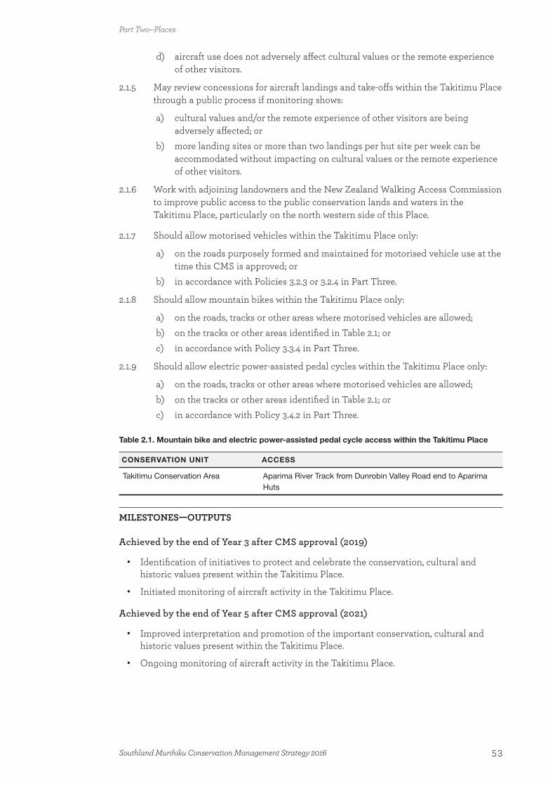
d) aircraft use does not adversely affect cultural values or the remote experience of other visitors.
2.1.5 May review concessions for aircraft landings and take-offs within the Takitimu Place through a public process if monitoring shows:
a) cultural values and/or the remote experience of other visitors are being adversely affected; or
b) more landing sites or more than two landings per hut site per week can be accommodated without impacting on cultural values or the remote experience of other visitors.
2.1.6 Work with adjoining landowners and the New Zealand Walking Access Commission to improve public access to the public conservation lands and waters in the Takitimu Place, particularly on the north western side of this Place.
2.1.7 Should allow motorised vehicles within the Takitimu Place only:
a) on the roads purposely formed and maintained for motorised vehicle use at the time this CMS is approved; or
b) in accordance with Policies 3.2.3 or 3.2.4 in Part Three.
2.1.8 Should allow mountain bikes within the Takitimu Place only:
a) on the roads, tracks or other areas where motorised vehicles are allowed;b) on the tracks or other areas identified in Table 2.1; or c) in accordance with Policy 3.3.4 in Part Three.
2.1.9 Should allow electric power-assisted pedal cycles within the Takitimu Place only:
a) on the roads, tracks or other areas where motorised vehicles are allowed;b) on the tracks or other areas identified in Table 2.1; orc) in accordance with Policy 3.4.2 in Part Three.
Table 2.1. Mountain bike and electric power-assisted pedal cycle access within the Takitimu Place
CONSERVATION UNIT ACCESS
Takitimu Conservation Area Aparima River Track from Dunrobin Valley Road end to Aparima Huts
MILESTONES—OUTPUTS
Achieved by the end of Year 3 after CMS approval (2019)
• Identification of initiatives to protect and celebrate the conservation, cultural and historic values present within the Takitimu Place.
• Initiated monitoring of aircraft activity in the Takitimu Place.
Achieved by the end of Year 5 after CMS approval (2021)
• Improved interpretation and promotion of the important conservation, cultural and historic values present within the Takitimu Place.
• Ongoing monitoring of aircraft activity in the Takitimu Place.
Part Two—Places
53Southland Murihiku Conservation Management Strategy 2016
Achieved by the end of Year 10 after CMS approval (2026)
• Provision of additional, practical-to-use public access points to public conservation lands and waters within the Takitimu Place, and readily available information describing these access points to the public.
• An assessment of the effects of aircraft activity in the Takitimu Place.
2.2 Fiordland Te Rua-o-te-moko PlaceThe Fiordland Te Rua-o-te-moko Place encompasses: the Arawhata (southern part), Pyke Forest, Dean Forest and Rowallan Forest conservation areas, Fiordland National Park (the Park), the Diggers Ridge, Lillburn, Waikoau and Lindsay ecological areas, plus some smaller areas of public conservation lands and waters; South Island Landless Natives Act 1906 (SILNA) land on the southern coast, some of which is protected by conservation covenants; and the associated marine area (out to 12 nautical miles), from Awarua Point in the north to Sand Hill Point in the south, and including Solander Island (Hautere) (see Maps 5.2, 5.2.1 and 5.2.2). The international significance of this Place as one of the world’s most special natural and cultural sites was recognised in 1990, when all but a small area in the south-east was identified as part of the Te Wāhipounamu—South West New Zealand World Heritage Area (see Appendix 14).
The Park is managed under the Fiordland National Park Management Plan 2007; the marine area under the Fiordland (Te Moana o Atawhenua) Marine Management Act 2005 and the Regional Coastal Plan for Southland 2013. Management of the waters of lakes Manapouri and Te Anau, the tributaries of the Waiau River, and all other rivers flowing into the lakes, are also subject to the Manapouri–Te Anau Development Act 1963. The north-eastern part of this Place adjoins the Te Wāhipounamu Place in the West Coast Tai Poutini CMS; and the Mount Aspiring National Park/Tititea Place and the Western Lakes and Mountains/Ngā Puna Wai Karikari a Rākaihautū Place in the Otago CMS.
Description
The Māori history of the Fiordland Te Rua-o-te-moko Place reaches back to its traditional creation, and the associated stories explain land formations and name areas in recognition of this. Tamatea, a chief who voyaged around the fiords in his waka Takitimu, gave the chiselled terrain the name ‘Te Rua-o-te-moko’, likening the deep gouges adorning the impressive cliff faces of the fiords to the tattoos on a chief’s face.
The Fiordland Te Rua-o-te-moko Place was a regular seasonal home for southern Māori, and a place for collection of pounamu and food. The coastline and the margins of a number of lakes provided important waka landing sites and campsites, which were utilised during coastal voyages and visits to the area for mahinga kai. All of these values remain important to Ngāi Tahu today.
Wāhi tapu, rock art and urupā reflect the long use of the area by Māori, and many related sites have been recorded in conjunction with the Ngāi Tahu Rock Art Trust and local Rūnanga, some of which are actively conserved historic places (see Appendix 10). The northern fiords require further survey work.
Mt Tūtoko, which is in the Park, is a Tōpuni, Statutory Adviser and Deed of Recognition area (see 1.4 Treaty partnership with Ngāi Tahu). In addition, Lake Manapouri (Moturau), Lake Te Anau (Te Ana-au), Lake Hauroko and the Waiau River are Deed of Recognition areas.
Part Two—Places
54 Southland Murihiku Conservation Management Strategy 2016
Fiordland was also a focus for some of New Zealand’s earliest European industry, in the form of sealing and whaling. More recent history includes mining, timber milling, shipwrecks, lighthouses, some attempts at settlement, and aerial venison recovery. Fiordland has a large number of actively conserved historic places (see Appendix 10), including two sites in Dusky Sound: internationally significant Astronomer Point, where James Cook’s astronomer William Wales determined the latitude and longitude of New Zealand; and the nationally significant house site of the early conservation pioneer Richard Henry on Pigeon Island. While there is no historic site associated with it, Dusky Sound is also important for the indigenous wildlife recorded by early naturalists on board James Cook’s Resolution in 1773. The first indigenous New Zealand fish known to European science was collected from Lake Forster, which drains into Pickersgill Harbour; because the spotted pattern of the fish resembled a galaxy of stars, the fish later became known as Galaxias argenteus (the taiwharu/giant kōkopu).
The Fiordland Te Rua-o-te-moko Place covers a diverse range of outstanding landscapes, including over 40 000 hectares of islands, fiords, cliffs, mountains, lakes, rivers, sand dunes and estuaries. The basement geology of Fiordland is dominated by hard crystalline plutonic rocks, which have risen up as mountains and been shaped, and continue to be shaped, by water, ice, avalanches and erosion. Northern Fiordland has high, steep mountains and deep fiords, which contrast with the more subdued relief of southern Fiordland. The whole of Fiordland receives high rainfall, with parts having some of the highest annual rainfall in New Zealand. The landscape and character of the Fiordland Te Rua-o-te-moko Place is highly valued by visitors and locals alike, with words like ‘pristine’, ‘unspoilt’, ‘stunning’ and ‘outstanding’ being used to describe this Place. There are opportunities for this beauty to be enjoyed in areas that are uncrowded and where natural quiet prevails, allowing visitors to step back in time.
The Fiordland Te Rua-o-te-moko Place is one of the most expansive natural areas of New Zealand and contains 18 priority ecosystem units, including:
• Extensive tawai/silver beech forests, and areas of diverse podocarp, hardwood and mixed tawai/beech-hardwood-podocarp forest
• An impressive vastness of upland and alpine tussocklands, rock, shrub, herbfields, wetland and rockfell ecosystems
• Intact wetlands, lakes and rivers
• A dramatic and diverse coastline that includes important dune systems, herbfields and shrublands.
Fiordland is biologically diverse, containing over one-third of New Zealand’s indigenous plant species, some of which are only found in this Place. It is a national stronghold for many threatened and at risk plants, including the Nationally Vulnerable heart-leaved kōhūhū; the Declining waiū-atua/shore spurge, Coprosma pedicellata, Melicytus flexuosus, linear-leaved tree daisy, and four mistletoe species; and two endemic, Naturally Uncommon snow tussocks (Chionochloa nivifera and C. spiralis) and four speargrass species (Aciphylla congesta, A. crosby-smithiana, A. leighii and A. takahea). The Nationally Critical takahē and kākāpō are both back from the brink of extinction and living in Fiordland. Ancient indigenous animal associations also include species of pekapeka/bats, lizards, numerous birds, fish, wētā and many other invertebrates.
This Place contains hundreds of islands that range in size from small rock stacks to larger islands over 1 hectare (see Appendix 3), the largest of which is Resolution Island (20 860 ha). Many of the islands are possum-free, some are rat-free (Rattus spp.), and there is the
Part Two—Places
55Southland Murihiku Conservation Management Strategy 2016

potential to eradicate or control stoats (Mustela erminea) and other pest and wild animals in the long term. Some islands provide valuable refuges for a number of New Zealand’s threatened species, such as kākāpō on Anchor Island.
Some community groups and businesses are actively involved in the management of the Fiordland Te Rua-o-te-moko Place, carrying out biodiversity work and maintaining recreational assets. The continuation and growth of these relationships is essential for the long term management of this Place to increase the number of areas that are secure from the effects of pest and wild animal species;19 improve the ongoing viability of indigenous biodiversity; enhance recreation opportunities; and protect historic and cultural heritage.
This Place provides a wide variety of recreation opportunities for everybody, from short walks through to multi-day mountaineering trips, hunting and mountain biking. Within this Place, visitors can experience high-use areas such as the Icon destination of Milford Sound/Piopiotahi, as well as remote areas like Big Bay and the gazetted Glaisnock and Pembroke wilderness areas. This Place also includes the Icon destinations of the Milford, Routeburn (part) and Kepler Great Walks, and the Gateway destinations of the Hollyford and Greenstone/Caples (part) Tracks. These tracks give thousands of visitors each year a chance to experience Fiordland. The Hump Ridge Track is managed by the community and is also highly valued, offering visitors the opportunity to be immersed in a more remote experience. Hunting is a popular recreational activity within this Place, particularly during the roar, with hunters travelling from all over the country to hunt in this magnificent, remote and wild environment. Hunters use this area to hunt for trophy deer, venison, chamois (Rupicapra rupicapra), pigs and game birds. The Fiordland Te Rua-o-te-moko Place is also popular for fishing, diving and climbing. Aircraft are often used to enable these recreational activities to occur.
Fiordland coastal marine area
In recognition of its ‘local, national, and international importance, unique marine environment, distinctive biological diversity, and outstanding landscape and cultural heritage’, the Fiordland (Te Moana o Atawhenua) Marine Management Act 2005 (the Act) established the Fiordland (Te Moana o Atawhenua) Marine Area and eight marine reserves. The Fiordland (Te Moana o Atawhenua) Marine Area encompasses all of the coastal marine area of the Fiordland Te Rua-o-te–moko Place, except around Solander Island (Hautere). The eight marine reserves cover areas of inner fiord and fiord entrance habitats that were not previously represented within the two existing marine reserves (Piopiotahi (Milford Sound); and Te Awaatu Channel (The Gut), in Doubtful Sound/Patea), which were gazetted in 1993. The Act also established the Fiordland Marine Guardians, a statutory stakeholder advisory group with a number of functions including providing advice and recommendations to the management agencies and Ministers responsible for the Fiordland (Te Moana o Atawhenua) Marine Area, and facilitating and promoting the integrated management of the area. The Guardians’ vision is ‘That the quality of Fiordland’s marine environment and fisheries, including the wider fishery experience, be maintained or improved for future generations to use and enjoy’.
The marine reserves are the only ones located along the mainland coastline of Southland Murihiku, encompassing over 10 000 hectares and protecting a diverse range of species. Monitoring is undertaken in the marine reserves and the wider Fiordland (Te Moana o Atawhenua) Marine Area to track changes in key species such as rāwaru/blue cod
19 Such as deer, possums, hares (Lepus europaeus), tahr (Hemitragus jemlahicus), feral goats, pigs, hedgehogs (Erinaceus europaeus), ferrets (Mustela putorius), feral cats (Felis catus) and stoats.
Part Two—Places
56 Southland Murihiku Conservation Management Strategy 2016

(Parapercis colias) and kōura papatea/rock lobster (Jasus edwardsii), and other biodiversity values over time. Freshwater that is discharged into Deep Cove, Doubtful Sound/Patea from the Manapouri Power Scheme has altered the hydrographic environment in this area resulting in some changes to the marine communities.
Deep, glacially carved fiords penetrate an average of 20 kilometres inland along the western coastline of the Fiordland Te Rua-o-te-moko Place. There are 15 main fiords extending from Milford Sound/Piopiotahi in the north to Preservation Inlet in the south. The waters of the fiords are unique from a global perspective, because it is possible to see species that are usually deep-dwelling, such as red and black corals and sea pens, at shallow depths. This phenomenon is known as deep-water emergence and occurs in the fiords due to the light-limiting, tannin-stained freshwater layer that sits on top of the seawater. The fiords are home to a diverse range of marine species, and the rock wall communities are amongst some of the most diverse marine communities in the world. Due to the extent of the values present within the fiords, they are on New Zealand’s tentative list to be nominated for inclusion in the Te Wāhipounamu—South West New Zealand World Heritage Area.
The southern coast from Puysegur Point to Sand Hill Point is characterised by a series of marine terraces that were formed over a period of 600 000 years. Exposed craggy stacks and reefs produce a highly scenic seascape of national importance.
Some threatened and at risk seabirds and marine mammals are found within the Fiordland coastal marine area, such as the Nationally Endangered tawaki/Fiordland crested penguin, for which coastal Fiordland is an important stronghold. The Relict tītī/mottled petrel also breeds along the coast.
Nationally Endangered tohorā/southern right whales can sometimes be seen during winter and spring throughout the fiords and into Te Waewae Bay in the Foveaux Te Ara a Kiwa Place, and this population appears to be increasing. However, careful management of the coastal marine area is required to ensure that this population is not affected by increasing activity or development. Extension of the marine mammal sanctuary at Te Waewae Bay along the south coast and into Preservation and Chalky Inlets would allow the tohorā/southern right whale population to re-establish its historic breeding grounds.
Nationally Endangered terehu/bottlenose dolphins can also be found within the Fiordland coastal marine area. There are three populations of resident terehu/bottlenose dolphins: one that ranges between the northern fiords and is commonly seen in Milford Sound/Piopiotahi, one in Doubtful Sound/Patea and one in the Dusky/Breaksea Sound complex. Many visitors enjoy the opportunity to observe the dolphins in their natural environment. However, research indicates that in recent years the population of terehu/bottlenose dolphins in Doubtful Sound/Patea has been declining, and so the Department is working with stakeholders, including Ngāi Tahu, the Fiordland Marine Guardians, Southland Regional Council, the science community and the community to ensure their ongoing presence into the future.
Kekeno/New Zealand fur seals (Arctocephalus forsteri) have been increasing in numbers since the early 1800s when they were hunted for their skins, and there are now many breeding colonies throughout the coastal areas of the Fiordland Te Rua-o-te-moko Place.
While the internal waters of the fiords are closed to commercial fishing, the Fiordland Te Rua-o-te-moko Place is home to an established and successful coastal and offshore fishing industry. There is also a very successful sea-based tourism industry, with a number of commercial tourism vessels operating within the fiords offering sightseeing tours and access to some of the more remote parts of this Place. Milford Sound/Piopiotahi receives the majority of tourism use within the Fiordland coastal marine area, with visitor numbers
Part Two—Places
57Southland Murihiku Conservation Management Strategy 2016
declining the further south and north travelled. This enables visitors to experience a range of different environments, from high-use areas in parts of Milford Sound/Piopiotahi, to the less-visited areas of Doubtful Sound/Patea and the isolation of the southern fiords.20 A number of recreational vessels also use the fiords, particularly in Doubtful Sound/Patea.
The Fiordland coastal marine area has very few aquatic pests. However it is under threat from a number of invasive species from across the globe, most notably the Japanese kelp Undaria pinnatifida, which is present in most ports throughout New Zealand. This species was found in Sunday Cove, Breaksea Sound, in 2010, and poses a major threat to the ecological integrity of the fiords due to its colonising characteristics and ability to outcompete indigenous seaweeds. Other aquatic pest species also pose a considerable threat to this relatively intact environment. Therefore, the Department intends to continue working with all relevant agencies and interested parties to ensure that effective biosecurity measures are implemented to protect the integrity of the nationally important ecosystems within the Fiordland coastal marine area.
Because of the values associated with the coastal margin of Fiordland National Park and the need to improve integrated management across the foreshore, the Department has identified investigating the addition of the area between the mean high and low water marks to the Park.
Milford Sound/Piopiotahi and Doubtful Sound/Patea
Milford Sound/Piopiotahi is one of the four Icon destinations within the Fiordland Te Rua-o-te-moko Place. It is a major tourism drawcard for Southland Murihiku as well as New Zealand. Milford Sound/Piopiotahi is the most accessible of the fiords, with State Highway 94, which is known as the ‘Milford Road Journey’ (another Icon destination), travelling directly to it. Visitors can also fly directly to the Milford aerodrome, which is in Fiordland National Park. Milford Sound/Piopiotahi is highly valued locally, nationally and internationally for its outstanding landscapes, pockets of tranquillity and marine wildlife. Visitors to this area can partake in a number of different activities, including cruising on the fiord, diving and kayaking.
Doubtful Sound/Patea is less accessible; however it is another popular site for day and overnight cruises, kayaking and fishing. The small population of terehu/bottlenose dolphins found predominantly in Doubtful Sound/Patea lives at one of the southernmost locations in the world for this species. A number of measures are in place to protect this population, including the ‘Doubtful Sound Marine Mammal Code of Management’.
Fiordland National Park
Fiordland National Park has its own management plan, which contains the outcomes planned for the Park and more detailed management directions, as required by the National Parks Act 1980 and the General Policy for National Parks 2005. This information is not repeated in this CMS and can be viewed in the Fiordland National Park Management Plan 2007 (the Plan), or any successor to it. However, this CMS also contains a number of provisions that are not addressed in the Plan and may affect the management of the National Park, including:
a) Addition of part of the Arawhata Conservation Area to the National Park (see Policy 2.2.4)
b) New mountain biking opportunities in the National Park (see Policy 2.2.10)
20 The ‘southern fiords’ refers to all fiords south of Doubtful Sound/Patea within the Fiordland Te Rua-o-te-moko Place.
Part Two—Places
58 Southland Murihiku Conservation Management Strategy 2016
c) New electric power-assisted pedal cycling opportunities on existing roads in the National Park (see Policy 3.4.1).
Arawhata and Pyke Forest conservation areas
The Arawhata (southern part) and Pyke Forest conservation areas are located to the north of Fiordland National Park. These areas are warmer and wetter than the Park, but just as biologically rich. They have strong affinities with South Westland, and include the priority ecosystem unit at Big Bay, which contains podocarp-dominated forest, the Waiuna Lagoon and associated wetlands, a diversity of other wetlands, dunes, and a gravel beach.
This area predominantly offers a remote setting for users seeking a back-to-basics experience, particularly within the south-eastern part of Arawhata Conservation Area, which acts as a buffer to the adjoining Olivine Wilderness Area within the adjacent Mount Aspiring National Park. The Alabaster airstrip, adjacent to the Pyke River (in Pyke Forest Conservation Area), is the main access point to this area for aircraft. Therefore, aircraft landings can be expected during the roar.
There is a small settlement of private huts at Big Bay, which are historically associated with whitebaiting in the area. A number of these are authorised (see ‘Private accommodation and related facilities’ in Part 3) and were originally permitted by the New Zealand Forest Service. There are historic and cultural values associated with these huts.
Dean and Rowallan forests
The Dean and Rowallan forests, at the south-east end of Fiordland National Park, include the Dean Forest and Rowallan Forest conservation areas, the Diggers Ridge, Lillburn, Waikoau and Lindsay ecological areas, plus a number of other conservation areas and reserves. They contain extensive tawai/beech forest and a priority ecosystem unit, Dean Burn-Mangapiri, which contains podocarp forest, frost flats and some wetland areas. The Diggers Ridge Ecological Area preserves the major forest types of the northern portion of Dean Forest, ranging from kahikatea swamp to montane forest; the Lillburn Ecological Area protects and preserves an example of tawai/silver beech forest on limestone; the Waikoau Ecological Area protects and preserves all of the forest types within the catchment of the Waikoau River North Branch; and the Lindsay Ecological Area protects and preserves tawai/silver beech within the Rowallan Forest. Threatened species, such as the Nationally Vulnerable mohua/yellowhead and the Declining scarlet mistletoe and pirita/white mistletoe, can be found in the tawai/beech-podocarp forests. The giant tōtara (Podocarpus totara) stand along the Waiau River valley in the Diggers Ridge Ecological Area is a key feature of this area, containing some of the largest tōtara in Southland Murihiku.
These areas offer a backcountry experience, with mechanised access, including aircraft landings. They are a popular location for a number of recreational activities, particularly recreational hunting and four-wheel driving.
The Arawhata (southern part), Pyke Forest, Dean Forest and Rowallan Forest conservation areas, and the Diggers Ridge, Lillburn and Waikoau ecological areas complement the values of Fiordland National Park. An investigation to add them to the Park is an option, not only due to their contiguous nature with the Park, but also because of their complementary conservation and heritage values.
Part Two—Places
59Southland Murihiku Conservation Management Strategy 2016

Outcome, policies and milestones for the Fiordland Te Rua-o-te-moko Place
OUTCOME
The Te Wāhipounamu—South West New Zealand World Heritage Area status of much of the Fiordland Te Rua-o-te-moko Place is internationally renowned. The vast and spectacular natural landscapes of this Place remain intact, and the biologically diverse, uninterrupted altitudinal ecosystem sequences function naturally, providing habitats for ancient and unique biota.
Extensive, indigenous alpine ecosystems support an exceptional range of indigenous plants and animals, including flourishing wild populations of takahē in the Murchison Mountains. Fiordland continues to be a stronghold for threatened and at risk indigenous bird and plant species that were once common across New Zealand, and the ongoing viability of these species is strongly linked to the managed priority ecosystem units found throughout this Place.
The pristine nature of the majority of the lakes and their indigenous aquatic and shoreline flora are maintained, with indigenous vegetation dominating their catchments. There are few barriers to indigenous migratory species journeying between these lakes and the sea.
The nature of the landscape and integrated pest control programmes allow some areas to remain virtually free of deer and possums, with the greater extent of this Place also free of hares, tahr, feral goats, pigs and other pest animals including hedgehogs, ferrets and feral cats. Reduced deer numbers enable vulnerable indigenous vegetation to recover. Indigenous ecosystems on numerous island refuges, including Breaksea, Resolution, Secretary and Solander (Hautere) Islands, are secure from the effects of pests and wild animals, and populations of translocated threatened and at risk birds continue to thrive.
Although stoats and rats are still found throughout mainland Fiordland, they are controlled in large tracts of indigenous forest with the support of community and business projects, enabling populations of indigenous species to improve.
This Place offers an array of experiences, from popular, easily accessible locations that visitors can drive into and be instantly immersed in nature, to expansive, awe-inspiring landscapes and areas of extensive, untouched wilderness and natural tranquillity for the more adventurous. Visitors can undertake a range of activities, the most common being camping, picnicking, tramping, walking, climbing, sports fishing, hunting, boating, sailing, rafting, kayaking, caving, sightseeing, bird watching, photography and painting.
Mountain biking opportunities are available in some locations where conservation values are not adversely affected and effects on other users can be managed.
Aircraft landings within Fiordland National Park mainly occur at designated high-use sites, with limited landings beyond those sites to protect natural and recreational values. Within the Dean and Rowallan forests, aircraft landings frequently occur in areas that are more inaccessible by foot or motorised vehicles, while in the Pyke Forest and Arawhata (southern part) conservation areas there are only occasional aircraft landings to protect the remote nature of these areas.
Milford Sound/Piopiotahi is an Icon destination that leaves a lasting impression on hundreds of thousands of visitors each year. Visitors can take the inspiring journey into Milford by road, boat or air, with seasonal and weather variations bringing new dimensions to the journey every day. Numerous short walks along the Icon destination of the Milford
Part Two—Places
60 Southland Murihiku Conservation Management Strategy 2016

Road Journey enable visitors to be awed by the grandeur of this area. Visitors learn about the special indigenous flora and fauna, the factors that threaten them, and the opportunities to contribute to their conservation.
The Icon destinations of the Milford, Kepler and Routeburn Tracks continue to be regarded as ‘must do’ Great Walks—offering visitors the opportunity to enjoy breathtaking mountain views, enchanted forests, cascading waterfalls and peaceful lakes, and to learn about Ngāi Tahu culture, history and traditions, and other history. The Gateway destinations of the Hollyford and Greenstone/Caples Tracks provide visitors with the chance to have a safe but more challenging backcountry experience.
The cultural values associated with the outstanding landscapes of this Place are better known. Sites of importance to Ngāi Tahu are respected and managed in partnership with them, ensuring the protection of places and the continuation of their cultural connections.
Historic and cultural values are brought to life through interpretation, giving visitors an enhanced appreciation of the heritage values and leaving them with a connection to the lives of previous generations. The outstanding stories associated with Captain Cook, pioneering conservationist Richard Henry, and the sealing and whaling industries are highlighted, alongside the locally important stories of pioneer settlements, gold mining, sawmilling and the fishing industry.
The natural and wild character of the Fiordland Te Rua-o-te-moko Place prevails, including the ability to view a clear night sky that is unaffected by artificial light.
Commercial activity actively promotes and enhances conservation and recreational values, and does not diminish the outstanding natural character and natural quiet within the greater part of this Place. Structural development is clustered around existing facilities, such as near townships or along State Highway 94, and enhances these sites.
The Fiordland coastal marine area
The interdependence of the indigenous terrestrial and marine ecosystems is acknowledged and recognised. Working closely with Ngāi Tahu, the Fiordland Marine Guardians, relevant agencies, commercial interests and the community, integrated management and protection is achieved across the land and marine interface, and the introduction and establishment of invasive species is prevented.
Wild, rugged landscapes dominate, and natural character increases the further south and west people venture, with the southern fiords offering a near-wilderness experience. The marine environment is thriving, with ample opportunities for visitors to observe marine mammals and other marine wildlife from the water, air and land in a way that does not adversely affect the wildlife. Tohorā/southern right whales, terehu/bottlenose dolphins, and tawaki/Fiordland crested penguins are regular sights, with populations stable or increasing.
An enhanced representative range of marine ecosystems and species are protected across this environment, and the marine reserves are managed to preserve and improve their natural habitat values. People are aware of and appreciate the importance of the Fiordland coastal marine area, and are actively involved in its protection.
Structural development within the Fiordland coastal marine area does not detract from the outstanding natural character and natural quiet of this Place, particularly in the southern fiords, where the only modifications are those necessary to support visitor access, scientific research and monitoring, or the fishing industry, and artificial light does not prevent viewing of the night sky. Commercial recreational activities promote the values of the Fiordland
Part Two—Places
61Southland Murihiku Conservation Management Strategy 2016
coastal marine area and all commercial activities are aware of the need for healthy marine ecosystems, avoiding impacts on important marine habitats or significant species and maintaining and enhancing visitor experiences.
Arawhata and Pyke Forest conservation areas, and Dean and Rowallan forests
The scenery, ecological systems and natural features of the Arawhata (southern part) and Pyke Forest conservation areas, and the Dean and Rowallan forests, whose mountain and lowland indigenous forests are contiguous with Fiordland National Park, are nationally recognised and acknowledged by a mechanism that integrates the management of these areas with the national park.
The Arawhata (southern part) and Pyke Forest conservation areas contribute a vast tract of lowland mixed hardwood, podocarp and tawai/beech forest, as well as a rich diversity of wetlands and open water areas with pristine hydrology and soils. The abundant birdlife along the shores of the Waiuna Lagoon and the outstanding indigenous aquatic species inhabiting the lagoon are maintained.
The Dean Forest and Rowallan Forest conservation areas and the Diggers Ridge, Lillburn, Waikoau and Lindsay ecological areas contribute tawai/beech-podocarp forests that contain threatened and at risk species. Community initiatives have reduced pig numbers in these areas, improving the indigenous understorey vegetation. Relationships with adjacent Māori landowners are strong, with the values of these lands being respected and integrated management across the boundaries being achieved.
POLICIES
2.2.1 Manage (including when considering concession applications) those parts of the Fiordland Te Rua-o-te-moko Place that are within the Te Wāhipounamu—South West New Zealand World Heritage Area in accordance with the criteria for which the World Heritage Area was nominated and the statement of outstanding universal value (Appendix 14).
2.2.2 Manage Fiordland National Park in accordance with its national park management plan, including the visitor management and aircraft provisions.
2.2.3 May grant concessions in the Glaisnock or Pembroke Wilderness Area in accordance with the Fiordland National Park Management Plan 2007 until such time as a review of that plan is approved. Beyond that time, if provision is made for concessions they are considered only where necessary or desirable for the preservation of the area’s indigenous natural resources. Concession activity that meets this test will:
a) demonstrate that the activity is necessary or that it actively benefits the preservation of the area’s indigenous natural resources;
b) not use vehicles, motorised watercraft or motorised aircraft in the area, other than in accordance with Policy 3.20.6;
c) not establish encampments or defined tracks, routes or trails;d) not involve the erection or maintenance of buildings or machinery;e) not involve the taking in or use of animals or livestock in the area;f) be consistent with the outcome and policies for the Fiordland Te Rua-o-te-
moko Place;
Part Two—Places
62 Southland Murihiku Conservation Management Strategy 2016

g) be consistent with the relevant aircraft access zones shown on Map 4, the visitor management zones as described in Appendix 12 and shown on Map 3;
h) be indistinguishable from independent users of the wilderness area; and i) be self-reliant.
2.2.4 Investigate the addition of the Arawhata (southern part), Pyke Forest, Dean Forest and Rowallan Forest conservation areas, the Diggers Ridge, Lillburn and Waikoau ecological areas, and the foreshore between the low and high mean water mark to Fiordland National Park, through a public process in accordance with section 8 of the National Parks Act 1980. In the meantime, continue to manage the conservation areas under the Conservation Act 1987, while having regard to the adjacent national park and the Fiordland National Park Management Plan 2007.
2.2.5 Investigate whether to progress the nomination for the waters and seabed of the fiords of Fiordland (Te Moana o Atawhenua) to be added to the Te Wāhipounamu—South West New Zealand World Heritage Area.
2.2.6 Work with Ngāi Tahu, relevant agencies (such as Southland Regional Council, Southland District Council, Fiordland Marine Guardians, New Zealand Transport Agency, Civil Aviation Authority and Milford Community Trust), commercial interests and the community to:
a) promote and increase awareness of the significant ecological, historic and cultural values of the Fiordland Te Rua-o-te-moko Place, including interpretation and recognition of the Māori cultural landscape;
b) develop and sustain an integrated approach to managing Milford Sound/Piopiotahi, and access to it as an Icon destination, thereby enhancing its international reputation;
c) achieve the ongoing integrated management of the Fiordland coastal marine area;
d) undertake a public process to investigate increasing the size of the Te Waewae Bay Marine Mammal Sanctuary by extending it westwards along the southern coastline into Preservation and Chalky Inlets, to protect breeding tohorā/southern right whales; and
e) ensure that structural development and commercial use within the Fiordland coastal marine area:i) is consistent with the outcome for the Fiordland Te Rua-o-te-moko Place;ii) avoids adverse effects on the values present, in particular:
A. marine reserves, marine mammal sanctuaries, and marine ecosystems;
B. marine mammals, marine wildlife (including seabirds) and their habitats;
C. natural character, including:
I. gazetted wilderness areas;
II. the extensive areas of natural quiet and the unmodified landscape values of the southern fiords, as well as the northern fiords between Doubtful Sound/Patea and Milford Sound/Piopiotahi; and
III. the relative natural quiet and landscape values of the Doubtful Sound/Patea complex; and
D. wāhi tapu, wāhi taonga and archaeological values;
iii) avoids shipping accidents and/or oil spills; and
Part Two—Places
63Southland Murihiku Conservation Management Strategy 2016
iv) avoids the introduction of new aquatic pest organisms, and has adequate surveillance and control procedures in place.
2.2.7 Should allow motorised vehicles in the Pyke Forest and Arawhata (southern part) conservation areas only:
a) on the existing roads around the whitebaiting settlement at Big Bay; orb) in accordance with Policies 3.2.3 or 3.2.4 in Part Three.
2.2.8 Should allow motorised vehicles in the Dean Forest and Rowallan Forest conservation areas and the Diggers Ridge, Lillburn and Waikoau ecological areas only:
a) on the roads purposely formed and maintained for motorised vehicle use at the time this CMS is approved; or
b) in accordance with Policies 3.2.3 or 3.2.4 in Part Three.
2.2.9 May allow the development of new roads within the Dean Forest and Rowallan Forest conservation areas and the Diggers Ridge, Lillburn and Waikoau ecological areas for motorised vehicle use in accordance with Policy 3.2.4 in Part Three and subject to, but not limited to:
a) consistency with the General Policy for National Parks 2005 and the management of Fiordland National Park, in accordance with Policies 2.2.1 and 2.2.2 above;
b) the suitability of the soil for regular motorised vehicle use;c) the avoidance of adverse effects on threatened, at risk and iconic species,
priority ecosystem units and ecological areas; d) the avoidance of adverse effects on significant geological features, landforms
and landscapes (as identified in Appendix 9);e) the avoidance, remediation or mitigation of adverse effects on other
recreational activities; andf) unrestricted public use at no charge.
2.2.10 Should allow mountain bikes within the Fiordland Te Rua-o-te-moko Place only:
a) on the roads, tracks or other areas where motorised vehicles are allowed;b) in accordance with Policy 3.3.4 in Part Three; orc) as set out in the national park management plan for Fiordland National Park,
where the activity is within the national park, and in accordance with Policies 8.6(g)–8.6(k) in the General Policy for National Parks 2005.
2.2.11 Should allow electric power-assisted pedal cycles within the Fiordland Te Rua-o-te-moko Place only:
a) on the roads, tracks or other areas where motorised vehicles are allowed; b) as set out in the national park management plan for Fiordland National Park,
where the activity is within the national park; orc) in accordance with Policy 3.4.2 in Part Three.
2.2.12 Should grant concessions for aircraft landings and take-offs within the Dean Forest and Rowallan Forest conservation areas and the Diggers Ridge, Lillburn and Waikoau ecological areas only where the activity is consistent with Policy 3.6.6 or 3.6.7, or where it is:
a) safe and practical to do so; b) consistent with the outcome for the Fiordland Te Rua-o-te-moko Place;
Part Two—Places
64 Southland Murihiku Conservation Management Strategy 2016

c) consistent with the relevant provisions in section 5.5.1 of the Fiordland National Park Management Plan 2007 for the East Fiordland Air Activity Zone; and
d) there are no adverse effects on the Diggers Ridge, Lilburn and Waikoau ecological areas.
2.2.13 Should grant concessions for aircraft landings and take-offs within the Pyke Forest and Arawhata (southern part) conservation areas only where the activity is consistent with Policy 3.6.6 or 3.6.7, or at:
a) the Alabaster airstrip (as shown on Map 5.2.1); or b) other sites, in accordance with the following criteria:
i) it is consistent with the outcome for the Fiordland Te Rua-o-te-moko Place;ii) it is consistent with the relevant provisions in section 5.5.1 of the Fiordland
National Park Management Plan 2007 for the North Fiordland Air Activity Zone;
iii) adverse effects on the remote experience within these conservation areas or the wilderness experience within the Olivine Wilderness Area (in Mount Aspiring National Park) are avoided, remedied or mitigated; and
iv) these conservation areas are not reasonably accessible by aircraft landing off public conservation lands and waters.
2.2.14 May grant authorisations for structures and utilities within the Arawhata (southern part), Pyke Forest, Dean Forest or Rowallan Forest conservation areas or the Diggers Ridge, Lillburn or Waikoau ecological areas where the criteria in Policy 3.10.1 are complied with, and the structure or utility:
a) is consistent with the outcome for the Fiordland Te Rua-o-te-moko Place;b) cannot reasonably be located off public conservation lands and waters;c) is co-located with existing structures where reasonably possible;d) does not displace visitors; ande) does not adversely affect the values present, in particular the:
i) intrinsic natural character and recreational values of these areas, including natural quiet, remote and wilderness values; and
ii) sensitive ecological values, including the integrity of indigenous ecosystems and habitats, particularly threatened and at risk species, priority ecosystem units and ecological areas, as well as the natural ecological linkages between land, freshwater and marine environments.
2.2.15 May permit commercial aerial-, land- and water-based marine mammal and other wildlife viewing operations within the Fiordland Te Rua-o-te-moko Place where any adverse effects of the operations can be avoided. Monitoring of these operations should be undertaken to understand their impact on marine mammals and other wildlife, and to inform future management.
2.2.16 Continue to advocate to relevant agencies for the protection of marine mammals within the Fiordland Te Rua-o-te-moko Place, in particular the terehu/bottlenose dolphin populations.
2.2.17 Support mechanisms to protect a full representative range of the indigenous marine ecosystems within the Fiordland Te Rua-o-te-moko Place.
Part Two—Places
65Southland Murihiku Conservation Management Strategy 2016

2.2.18 Work with Ngāi Tahu and others to improve archaeological records in the Fiordland Te Rua-o-te-moko Place, particularly in the northern fiords.
MILESTONES—OUTPUTS
Achieved by the end of Year 3 after CMS approval (2019)
• Implementation of work programmes for the marine reserves in the Fiordland Te Rua-o-te-moko Place.
• Input into Southland Regional Council planning processes to ensure that the southern fiords are being managed to retain their wild and isolated nature.
• Initiated an investigation to add the Arawhata (southern part), Pyke Forest, Dean Forest and Rowallan Forest conservation areas, the Diggers Ridge, Lillburn and Waikoau ecological areas, and the foreshore, to Fiordland National Park.
Achieved by the end of Year 5 after CMS approval (2021)
• Implementation of work programmes for the marine reserves in the Fiordland Te Rua-o-te-moko Place.
• Input into Southland Regional Council planning processes to ensure that biosecurity measures are included on coastal permits to protect island refuges and the coastal marine area in the Fiordland Te Rua-o-te-moko Place from the effects of pests and wild animals.
• Ongoing monitoring of terehu/bottlenose dolphin populations and other marine mammals in the Fiordland Te Rua-o-te-moko Place to ensure that management actions are being taken to give the populations their best possible chance to increase.
• Initiated investigations to progress increasing the size of the Te Waewae Bay Marine Mammal Sanctuary into Preservation and Chalky Inlets.
• An investigation as to whether to progress the nomination for the Fiordland coastal marine area to be added to the Te Wāhipounamu—South West New Zealand World Heritage Area.
Achieved by the end of Year 10 after CMS approval (2026)
• Implementation of work programmes for the marine reserves in the Fiordland Te Rua-o-te-moko Place.
• Identification of and investigations into mechanisms to protect the full representative range of indigenous marine ecosystems within the Fiordland Te Rua-o-te-moko Place.
• The Fiordland Marine Guardians are supported and engaged in the protection of the marine ecosystems within the Fiordland Te Rua-o-te-moko Place.
• Improved knowledge of archaeological sites in the vicinity of the northern fiords.
2.3 Western High Country Mata-puke Koikoi PlaceThe Western High Country Mata-puke Koikoi Place comprises all of the high-country land in north-western Southland (see Maps 5.3 and 5.3.1). The main blocks of public conservation lands and waters within this Place are the Eyre Mountains/Taka Ra Haka Conservation Park, Mavora Park Conservation Area and Snowdon Forest Conservation Area. There are also some smaller blocks, such as the Burwood Bush (Red Tussock) Scientific Reserve.
Part Two—Places
66 Southland Murihiku Conservation Management Strategy 2016
The Western High Country Mata-puke Koikoi Place is strongly linked to the Takitimu Place, the Eastern High Country Mata-puke Taratara Place and the Fiordland Te Rua-o-te-moko Place within this CMS, and the Western Lakes and Mountains/Ngā Puna Wai Karikari a Rākaihautū Place in the Otago CMS. Many values are shared across these Places.
Description
The Māori name ‘Mata-puke Koikoi’ refers to the rough and rugged high country that is found within this Place, including the Eyre Mountains, Snowdon Peak and the Livingstone Mountains. This name is similar in nature to that given to the Eastern High Country Mata-puke Taratara Place, illustrating the strong linkage between these two Places.
While the Western High Country Mata-puke Koikoi Place is highly valued for its ecological, cultural and historic values, the community particularly values the natural character within this Place, including the landscapes, natural quiet, and backcountry and remote recreation opportunities.
The Mavora Park and Snowdon Forest conservation areas are two of several areas of public conservation lands and waters within this Place that have been internationally recognised as part of the Te Wāhipounamu—South West New Zealand World Heritage Area (see Appendix 14). In addition, the northern portions of these conservation areas (parts of the Livingstone Mountains and the Countess and Dunton ranges) have been identified as being suitable for inclusion in Fiordland National Park.
This Place contains a diverse range of habitats that support threatened and at risk indigenous plant and animal species. There are also a number of priority ecosystem units that include areas of frost flats, bog pine (Halocarpus bidwillii) shrublands, tawai/beech forest, peat and moss bogs, ultramafic tussockland/stonefield/rockland, and freshwater lakes.
Ngāi Tahu have a special relationship with the North and South Mavora Lakes (Manawapōpōre and Hikuraki), the Mataura River and the Oreti River, recognised through Deeds of Recognition and nohoanga at two of these sites (see 1.4 Treaty partnership with Ngāi Tahu). In part, this reflects an ara tawhito (traditional trail) that extended along the Oreti River, linking with the upper Mararoa River valley wetlands, the Greenstone River valley and westward. Part 10 of the Ngāi Tahu Claims Settlement Act 1998 contains specific provisions relating to management of the leaseback conservation area that is within Southland Murihiku. This CMS must be consistent with the terms of the lease of the leaseback conservation area.
The Mataura River has a Water Conservation Order (1997) in recognition of its outstanding fisheries and angling amenity features. The Oreti River also has a Water Conservation Order (2008) because of its brown trout (Salmo trutta) and Nationally Critical tarāpunga/black-billed gull habitat, angling amenity, and significance in accordance with tikanga Māori.
The Western High Country Mata-puke Koikoi Place is near Te Anau, and is circled by the rural service towns of Mossburn, Lumsden, Athol and Garston. This, coupled with its accessibility, has resulted in it being a highly valued area for local and traditional recreational activities, including horse riding, tramping, mountain biking, hunting, fishing, climbing, kayaking, four-wheel driving and trail bike riding.
The Mavora-Greenstone walkway (which comprises part of Te Araroa Trail) is a Backcountry destination that passes through this Place and links with the Western Lakes and Mountains/Ngā Puna Wai Karikari a Rākaihautū Place in the Otago CMS. Horse riding has traditionally occurred in selected areas, such as around North and South Mavora Lakes, Eyre Creek and the upper catchment of the Mataura River, with facilities catering for overnight use by horse
Part Two—Places
67Southland Murihiku Conservation Management Strategy 2016
riders at the southern end of North Mavora Lake and at Forks Hut; there is also potential to provide for an increase in horse riding opportunities. The northern portion of the Eyre Mountains/Taka Ra Haka Conservation Park is valued by recreational hunters, as it is an important area for chamois hunting, mainly during summer months. There are specific roads designated for motorised vehicle activities such as four-wheel driving and trail bike riding. Mountain biking is already well catered for within the Western High Country Mata-puke Koikoi Place, but there are also opportunities for growth of this activity.
This Place is primarily managed for backcountry recreational experiences, with some opportunities for more remote experiences away from road ends, particularly at higher altitudes. Although recreational use of this Place has been low in the past, there is scope to increase use without affecting the backcountry and remote recreational experiences.
Historically, there was little commercial activity within this Place, which protected the traditional local ‘kiwi’ camping experience and remote recreation opportunities. However, some limited commercial activity can be allowed where it is compatible with the traditional use of this Place, such as guided hunting, fishing, walking, mountain biking and horse riding.
Some float plane landings can occur on North Mavora Lake, and there is also an unmaintained grass landing strip near Shirkers Bush that can be used for aircraft landings. Aircraft also provide access to remote locations for recreational hunting, particularly chamois hunting, and other recreational activities that are reliant on aircraft access, such as heli-skiing. However, aircraft can impact upon natural quiet and the remote experience that is sought after within parts of this Place. Therefore, to ensure that these values are not affected, aircraft landings are specifically managed at many locations within the Western High Country Mata-puke Koikoi Place.
The landscape and natural character of this Place are awe-inspiring, despite having been modified by humans lighting fires during pre-European times, and as a result of pastoralism from the late 1800s until much of the area became public conservation lands and waters. These landscapes have retained remnants of woody indigenous vegetation that were not burnt and many areas have recovered. The journey into Mavora Park Conservation Area gradually unfolds into an expansive landscape. Mavora Park Conservation Area is the heart of this Place, with clear lakes surrounded by tussocklands, forested mountains and naturally eroding peaks, and minimal signs of recent modification. Future development within this Place needs to take account of this natural character.
Beech Hut and Dog Box Bivvy, which are located in the Eyre Mountains/Taka Ra Haka Conservation Park, are former musterers’ huts dating from 1905 and 1916, respectively, and are actively conserved historic sites. Much of the remaining hut network in the Conservation Park dates from wild animal control operations carried out by the former New Zealand Forest Service in the 1960s. These huts have historic values that would benefit from community partnerships to help retain and manage them.
High-country environments throughout Southland Murihiku play an important role in maintaining water yields, quality and flow in lower catchments. Therefore, it is essential to ensure that the freshwater ecosystems within this Place are maintained, including the headwaters of rivers such as the Mataura, Oreti, Mararoa, Whitestone and Upukerora. The Department’s management directions for freshwater ecosystems are provided in section 2.6—Freshwater Wai Māori Place.
The indigenous flora within this Place is rich and represents the transition from wetter Fiordland to drier Central Otago, with intact altitudinal vegetation sequences from the valley floor to alpine habitats, such as within the Eyre Mountains/Taka Ra Haka Conservation Park. A number of indigenous plants are endemic to this Place, such as the Naturally Uncommon
Part Two—Places
68 Southland Murihiku Conservation Management Strategy 2016

Thomson’s mountain daisy, Celmisia philocremna, taramea/Eyre Mountains speargrass, and buttercup Ranunculus scrithalis. On the valley floors, fescue and copper tussock (Chionochloa rubra cuprea) are the dominant indigenous grasses with the occasional silver (Poa cita) and snow tussock. Extensive and diverse alpine communities and large areas of snow tussock grasslands can be found within this Place, which are sensitive to impacts from recreational activities where they reach lower altitude, such as in the Eyre Creek catchment.
Scree communities are also an important feature of this Place, such as along the Mt Bee track. Historically, the scree community in this area was planted with exotic vegetation, including conifers, for land stabilisation purposes, and without management these have the potential to threaten areas of indigenous vegetation through their spread, particularly on the Eyre Mountains. In general, the Western High Country Mata-puke Koikoi Place has a low invasion level of conifers that require control. However, there is potential for the levels of invasion to increase in the future at some sites, such as within the Mataura River catchment, the Livingstone Mountains and West Dome. Therefore, the Department intends to work with adjoining landowners to ensure that there is adequate control in these areas.
Nationally, 90% of New Zealand’s wetlands areas have been lost, and they continue to be under threat. Therefore, the Western High Country Mata-puke Koikoi Place, which is home to a range of wetland communities, is very important (see also sections 2.6—Freshwater Wai Māori Place, 2.7—Lowlands Te Rā a Takitimu Place and 2.8—Awarua Place). Wetland habitats are well represented along the valley floors, such as east of Lake Te Anau, including on private land; in the Mavora Lakes/upper Mararoa River valley; and at the priority ecosystem units of the Henry Creek, Lake Te Aroha, Wash Creek and Snowdon Forest wetlands. Important wetland areas also extend into alpine areas within this Place. The wetlands range from infertile, acidic peat bogs that are dominated by wire rush (Empodisma minus) and cushion-forming species, through to more fertile, nutrient-rich fens and swamp wetlands. Some of the wetlands retain species like the Nationally Vulnerable buttercup Ranunculus ternatifolius, the Declining tufted hair grass, and sedges. Some uncommon wetland types are also present, including ephemeral (seasonally wetted) wetlands, cushion bogs and snowbanks.
Well-developed turf communities can be found around the shoreline of South Mavora Lake, which is home to a number of threatened and at risk plant species, including the Nationally Vulnerable creeping herb Gratiola concinna and the Naturally Uncommon sedge Carex berggrenii. The Mavora Lakes contain tall-rooted aquatic indigenous vegetation and invertebrates, providing significant habitat for trout and the Declining tuna/longfin eel. Important populations of indigenous fish, particularly the Nationally Vulnerable alpine galaxias and Gollum galaxias, are found in the Upukerora, Whitestone, Mararoa and Oreti River catchments and streams.
Significant and celebrated geological features of this Place include North and South Mavora Lakes, which are excellent examples of moraine dammed lakes and the location of New Zealand’s only occurrence of vuagnatite. There are also exposures of ultramafic soils that occur from West Dome northwards and through to the heart of the Livingstone Mountains, including within the Coal Hill priority ecosystem unit. These ultramafic soils are toxic to many plants and so do not support forest growth. The indigenous vegetation is relatively simple but does include a number of threatened and at risk species, such as the Nationally Critical limestone myrrh Chaerophyllum basicola; the Nationally Endangered sedge Carex uncifolia; and the Naturally Uncommon Speden’s mountain daisy, forget-me-not Myosotis sp. “Mossburn” and West Dome bitter cress.
Part Two—Places
69Southland Murihiku Conservation Management Strategy 2016
This Place is also home to a diverse range of indigenous fauna, such as the Nationally Critical pekapeka/long-tailed bat; the Nationally Vulnerable South Island kākā, pohowera/banded dotterel and mohua/yellowhead; the Declining green skink; and the Recovering kārearea/eastern falcon. The giant carnivorous land snail Powelliphanta spedeni var. spedeni and weevil Lyperobius spedeni have their high-country strongholds here; and a population of the Nationally Endangered pīwauwau/rock wren, New Zealand’s only truly alpine bird species, is found within the Eyre Mountains/Taka Ra Haka Conservation Park.
Pest animals, such as hares, goats and pigs, are found throughout the Western High Country Mata-puke Koikoi Place. Ongoing monitoring and control is undertaken at priority sites. There is also the potential for tahr to spread into this Place, so monitoring is required to detect their presence and implement any necessary controls.
Burwood area
The Burwood area, which is where the Takahē Rearing Unit, an integral part of the takahē recovery programme, is located, consists of:
a) the Burwood Bush (Red Tussock) Scientific Reserve, which protects 3104 hectares of red tussock (Chionochloa rubra) and tawai/beech forest
b) the Burwood Bush (Takahē Rearing Site) Scientific Reserve.
The productivity and survival rates of the Nationally Critical takahē within the Takahē Rearing Unit are higher than at other managed sites and has resulted in the pen-rearing operations being expanded. Takahē that are bred here are transferred to other established mainland and island locations throughout New Zealand, to help bolster existing populations and to prepare the programme for a new mainland takahē population. The vegetation cover and climate at the unit are an excellent replication of the natural environment of takahē, so that any individuals reared here have the skills necessary to survive wherever they are released.
Both of these reserves are listed in Schedule 4 of the Crown Minerals Act 1991. This means that the Minister of Conservation must not accept any application for an access arrangement or enter into any access arrangement relating to any Crown-owned mineral on these reserves, except in relation to a few minor matters. Aircraft landings in the Burwood area are not allowed in order to protect the breeding population of takahē.
Mavora area
The Mavora area comprises the Mavora Park Conservation Area as well as the journey along the Mararoa River valley to South Mavora Lake and the Kiwi Burn Track loop within the Snowdon Forest Conservation Area. The Mararoa River valley sits within a backdrop of a vast, unmodified mountainous landscape, which includes the Eyre and Livingstone Mountains.
The Kiwi Burn Track is one of the best opportunities in Southland Murihiku for introducing families to tramping and the outdoors. The popular Gateway destination of Mavora Lakes receives a substantial amount of use from Southland families and school groups who camp here, as well as national and international visitors. The Mavora Lakes campsite is easily accessed by motorised vehicles and has numerous recreation opportunities that co-exist in close proximity, allowing visitors to become immediately immersed in the environment. There is potential for growth of low-impact day visitor opportunities around the Mavora area, to enable visitors to easily access the wider landscape through activities such as day walking, mountain biking and horse riding.
Part Two—Places
70 Southland Murihiku Conservation Management Strategy 2016

The North and South Mavora Lakes offer contrasting recreational experiences. South Mavora Lake is closed to motorised water activities, preserving the traditional quiet and encouraging self-sufficiency within this area. By contrast, North Mavora Lake is open to motorised water activities (excluding hovercraft and personal watercraft), 21 enabling accessible boating opportunities in a natural setting. Noise restrictions could be implemented to protect this natural setting and information provided to the public about preventing the introduction of aquatic pest plants.
Since there is already sufficient alternative access to the Mavora area, aircraft activity is only an occasional occurrence, protecting the traditional camping experience within this area. There are opportunities for float planes to land on North Mavora Lake, as well as a few designated sites within the Mavora area where other aircraft can land.
Outcome, policies and milestones for the Western High Country Mata-puke Koikoi Place
OUTCOME
Expansive mountainous and valley landscapes and natural quiet prevail in the Western High Country Mata-puke Koikoi Place.
Mavora Park Conservation Area is the hub of this Place. A network of Local Treasure and Backcountry destinations, including huts managed in partnership with community groups, provide access and accommodation facilities for visitors. The further people go from road ends, the less human activity they encounter with an increasing sense of remoteness. Recreational use of this Place changes with the topography and the seasons.
Tramping and mountaineering are popular recreational activities year round. Hunting occurs throughout this Place, particularly in the Livingstone Mountains and Snowdon Forest Conservation Area. Mountain biking, horse riding and four-wheel driving are concentrated within the Eyre Mountains and the Mavora area.
Aircraft landings are rare within the wider Western High Country Mata-puke Koikoi Place and only occur where necessary to support filming or facilitate access to more remote areas that are hard to reach by foot or vehicle.
The diverse and distinct indigenous ecosystems are healthy, particularly the priority ecosystem units that contain ultramafic communities, a variety of wetlands, bog pine shrublands and the lakeshore turf of the Mavora Lakes. The indigenous vegetation in the valley floors of this Place complements the values of the neighbouring Fiordland Te Rua-o-te-moko Place. The Eyre Mountains and the Thomson Mountains support a range of flora, including endemic species, and the open, backcountry habitats remain a stronghold for many species, particularly the diverse lizard communities that are characteristic of this Place. Managed populations of pīwauwau/rock wren continue to recover in the alpine areas, and notable invertebrates are protected from the effects of browsing pest and wild animals.
Community-supported initiatives within the Western High Country Mata-puke Koikoi Place have resulted in an increased understanding and protection of remnant populations of the pekapeka/long-tailed bat. South Island kākā can be seen throughout this Place and their connections with populations in the Fiordland Te Rua-o-te-moko Place are maintained.
21 Supported by Southland Regional Council Navigation Safety Bylaws 2009.
Part Two—Places
71Southland Murihiku Conservation Management Strategy 2016
Ngāi Tahu, landowners and the community are working together to protect important wetlands on both private and public conservation lands and waters east of Lake Te Anau, including by seeking international recognition. The Upukerora, Whitestone, Mararoa and Oreti River catchments are a stronghold for indigenous freshwater fish, and also provide prime trout fisheries within an undeveloped environment.
Stories of Māori journeys and occupation, and early European exploration, pastoralism and pioneering endeavours are told and brought to life for visitors, who gain an appreciation of the historic and cultural values present.
Commercial activity enhances the conservation and recreational values. Minimal development occurs on public conservation lands and waters, and is sympathetic to the natural and cultural landscape, biodiversity and recreational values.
Burwood area
The Takahē Rearing Unit is recognised for its excellence in intensive indigenous species management, supporting stable mainland and island populations of takahē. The red tussock grasslands are highly valued as a remnant of a once-extensive ecosystem and landscape. The rearing unit replicates the natural environment of takahē, including natural quiet, allowing them to breed and raise chicks that can readily survive in the wild. Most opportunities for people to understand and contribute to takahē conservation are off-site.
Mavora area
As a popular Gateway destination, Mavora Lakes offers a safe backcountry experience. The campsites and immediate environs provide New Zealand families with an introduction to the outdoors that they can enjoy year after year. The Kiwi Burn Track is valued by the community as one of the best backcountry, ‘first time overnight’ experiences in the region for young families and new trampers.
Throughout the warmer months, this area is a hive of activity. Visitors use the Mavora area as a base to undertake a range of day and overnight activities, the most popular being fishing, tramping, horse riding and mountain biking. Motorised vehicle and boat access does not affect the relaxed nature of the Mavora area and the surrounding environment. Aircraft landings occasionally occur at a few designated sites within this area, retaining the backcountry visitor experience.
Structural development within the Mavora area supports recreational activities and blends with the natural landscape.
The community is actively involved in the management of this area.
POLICIES
2.3.1 Manage (including when considering concession applications) those parts of the Western High Country Mata-puke Koikoi Place that are within the Te Wāhipounamu—South West New Zealand World Heritage Area in accordance with the criteria for which the World Heritage Area was nominated and the statement of outstanding universal value (see Appendix 14).
2.3.2 Investigate the addition of parts of the Livingstone Mountains and the Countess and Dunton ranges (within the Mavora Park and Snowdon Forest conservation areas), as identified in Map 4 of the Fiordland National Park Management Plan 2007,
Part Two—Places
72 Southland Murihiku Conservation Management Strategy 2016

to Fiordland National Park, through a public process in accordance with section 8 of the National Parks Act 1980. Otherwise, continue to manage the conservation areas under the Conservation Act 1987, while having regard to the adjacent National Park.
2.3.3 Should grant concessions for aircraft landings and take-offs within the Ngāi Tahu Leaseback Conservation Area, the Greenstone Conservation Area and the Taka Ra Haka Conservation Area only in accordance with the following criteria:
a) the activity is consistent with Policy 3.6.6 or 3.6.7; orb) for backcountry visitor management zones, landings do not exceed five
landings per operator per day; orc) for remote visitor management zones, landings do not exceed two landings per
operator per day; andd) Te Rūnanga o Ngāi Tahu has given its written consent to landings where the
activity is within the Ngāi Tahu Leaseback Conservation Area.
2.3.4 Should grant concessions for aircraft landings and take-offs within the Mavora area (as shown on Map 5.3.2) only on an occasional basis, where the activity is consistent with Policy 3.6.6 or 3.6.7, or at the following locations:
a) above 1000 metres in altitude from 1 June to 30 September; b) Boundary Hut and Careys Hut;c) the unmaintained airstrip near Shirkers Bush; ord) North Mavora Lake (for float planes);and in accordance with the following criteria:
i) it is consistent with the outcome for this Place;ii) it is consistent with Policy 3.6.1b)–h) in Part Three; andiii) for those parts of the Mavora area that are identified on Map 4 of the
Fiordland National Park Management Plan 2007 (the Plan), it is consistent with the relevant provisions in section 5.5.1 of the Plan for the East Fiordland Air Activity Zone.
2.3.5 Should grant concessions for aircraft landings and take-offs within the Snowdon Forest Conservation Area, other than within the Mavora area (see Policy 2.3.4), only where the activity is consistent with Policy 3.6.6 or 3.6.7, or in accordance with the following criteria:
a) no landings from 1 January to 29 February;b) no more than two landings per operator per week from 1 March to
31 December; andc) for those parts of the Snowdon Forest Conservation Area identified on Map 4 of
the Fiordland National Park Management Plan 2007 (the Plan), it is consistent with the relevant provisions in section 5.5.1 of the Plan for the East Fiordland Air Activity Zone.
2.3.6 Should grant concessions for aircraft landings and take-offs on the marginal strips adjoining Retford Stream, Dunton Creek and Bog Lake only where consultation has been undertaken with the adjacent landowners to avoid adverse effects on farming activities.
2.3.7 Should grant concessions for aircraft landings and take-offs within the Eyre Mountains/Taka Ra Haka Conservation Park only where the activity is consistent with Policy 3.6.6 or 3.6.7, or in accordance with the following criteria:
Part Two—Places
73Southland Murihiku Conservation Management Strategy 2016

a) landings only occur at the Dog Box Bivvy, Mt Bee Bunkrooms, Upper Cromel Hut or Upper Windley Hut (as shown on Map 5.3.2); and
b) there are no more than two landings per hut site per week per operator; orc) landings are above 1000 metres in altitude; andd) there are no more than four landings per operator per week.
2.3.8 May grant concessions for aircraft landings and take-offs within the remainder of the Western High Country Mata-puke Koikoi Place not covered by Policies 2.3.3 –2.3.7 where the activity is consistent with Policy 3.6.6 or 3.6.7, or in accordance with the following criteria:
a) it is consistent with the outcome for this Place;b) it is consistent with Policy 3.6.1b)–h) in Part Three;c) there are no adverse effects on the remote and backcountry visitor experience
found within this part of this Place; andd) adverse effects on ecological values are avoided.
2.3.9 Should not permit hovercraft or personal watercraft on North Mavora Lake.
2.3.10 Should not permit motorised watercraft on South Mavora Lake.
2.3.11 Should allow motorised vehicles within the Western High Country Mata-puke Koikoi Place (excluding the Ngāi Tahu Leaseback Conservation Area) only:
a) on the roads and campsites purposely formed and maintained for motorised vehicle use at the time this CMS is approved; or
b) in accordance with Policy 3.2.3 or 3.2.4 in Part Three.
2.3.12 Should allow mountain bikes within the Western High Country Mata-puke Koikoi Place (excluding the Ngāi Tahu Leaseback Conservation Area) only:
a) on the roads, tracks or other areas where motorised vehicles are allowed; b) on the roads, tracks or other areas identified in Table 2.2; orc) in accordance with Policy 3.3.4 in Part Three.
Part Two—Places
74 Southland Murihiku Conservation Management Strategy 2016

Table 2.2. Mountain bike access within the Western High Country Mata-puke Koikoi Place
CONSERVATION UNIT ACCESS CRITERIA
Eyre Mountains/Taka Ra Haka Conservation Park
Mt Bee tracks
Acton Road end to Cromel Branch/Base Hut route
West Dome forestry roads
Upper Oreti River access point to Lincoln Hut route
Shepherd Creek route to Dog Box Bivvy
Mataura River to Beech Hut route
Snowdon Forest Conservation Area
(part) North Mavora Lake Swing Bridge to Kiwi Burn Swing Bridge Track
Upper Upukerora River to Army Hut Track*
Snowdon Forest Conservation Area
Other existing tracks Subject to tracks being upgraded to mountain biking standards
Mavora Park Conservation Area Mavora Walkway to Boundary Hut road
Forks Hut Track
(part) North Mavora Lake Swing Bridge to Kiwi Burn Swing Bridge Track
Mavora Park Conservation Area Other existing tracks Subject to tracks being upgraded to mountain biking standards
Upper McLeod’s Conservation Area; Snowdon Forest Conservation Area; Marginal Strip; Eyre Mountains/Taka Ra Haka Conservation Park
Alongside the upper Oreti River from Oreti Road to Mt Nicholas Road*
Subject to track being upgraded to mountain biking standards
Te Anau Downs, Henry Creek Conservation Area; Lake Mistletoe, Te Anau Downs Conservation Area
Te Anau township (within Lowlands Te Rā a Takitimu Place) to Te Anau Downs*
Subject to new track being built to mountain biking standards
Snowdon Forest Conservation Area; Marginal Strip
Kiwi Burn Swing Bridge southwards alongside Mararoa River*
Subject to new track being built to mountain biking standards
Marginal Strip Upukerora River south of Takaro Lodge to Te Anau*
*Also requires access across land not administered by the Department
2.3.13 Should allow electric power-assisted pedal cycles within the Western High Country Mata-puke Koikoi Place only:
a) on the roads, tracks or other areas where motorised vehicles are allowed; b) on the roads, tracks or other areas identified in Table 2.3; orc) in accordance with Policy 3.4.2 in Part Three.
Part Two—Places
75Southland Murihiku Conservation Management Strategy 2016

Table 2.3. Electric power-assisted pedal cycle access within the Western High Country Mata-puke Koikoi Place
CONSERVATION UNIT ACCESS
Eyre Mountains/Taka Ra Haka Conservation Park
West Dome forestry roads
Snowdon Forest Conservation Area Upper Upukerora River to Army Hut Track*
Mavora Park Conservation Area Mavora Walkway to Boundary Hut road
Forks Hut Track
Marginal Strip Upukerora River south of Takaro Lodge to Te Anau*
* Also requires access across land not administered by the Department
2.3.14 May grant concessions for commercial activity within the Western High Country Mata-puke Koikoi Place where the activity is consistent with any relevant policies in Part 3 and in accordance with the following criteria:
a) the activity is consistent with the outcome for this Place; b) group sizes are consistent with the relevant visitor management zone (see Map
3 and Appendix 12);c) any adverse effects are avoided, remedied or mitigated;d) the backcountry and remote visitor experiences outside the Mavora area are
maintained; e) adverse effects on indigenous ecosystems, species and habitats, and historic
and cultural values are avoided; andf) Te Rūnanga o Ngāi Tahu has given its written consent where the activity is
within the Ngāi Tahu Leaseback Conservation Area.
2.3.15 May grant authorisations for structures and utilities within the Western High Country Mata-puke Koikoi Place where the criteria in Policy 3.10.1 are complied with, and the structure or utility:
a) cannot reasonably be located off public conservation lands and waters; b) is consistent with the outcome for this Place;c) has been given written consent by Te Rūnanga o Ngāi Tahu where the activity
is within the Ngāi Tahu Leaseback Conservation Area; andd) avoids adverse effects on the following values:
i) the natural, historic and cultural landscape;ii) the remote and backcountry visitor experiences of this Place; andiii) the indigenous ecosystems, species and their habitats.
2.3.16 Should allow horse riding within the Western High Country Mata-puke Koikoi Place only in accordance with Policies 3.9.1–3.9.4 in Part Three. Should encourage community initiatives to provide for this activity within this Place, particularly in the Mavora Lakes, Eyre Creek and upper Mataura River valley areas, where proposals are consistent with Policy 2.3.14 above.
2.3.17 Work with Ngāi Tahu and the community, including schools, to promote the Western High Country Mata-puke Koikoi Place, particularly the Mavora area, as a destination for traditional camping and horse riding, as well as recreation opportunities in the Eyre Mountains/Taka Ra Haka Conservation Park.
Part Two—Places
76 Southland Murihiku Conservation Management Strategy 2016
MILESTONES—OUTPUTS
Achieved by the end of Year 3 after CMS approval (2019)
• Initiated an investigation to add parts of Mavora Park and Snowdon Forest conservation areas to Fiordland National Park.
• Initiated investigations to seek improved protection of important wetlands on and off public conservation lands and waters in the Western High Country Mata-puke Koikoi Place.
Achieved by the end of Year 5 after CMS approval (2021)
• Research confirms that at least 80% of visitors to the Mavora area are satisfied with their experience.
• Improved interpretation and promotion of the conservation, historic and cultural values of the Western High Country Mata-puke Koikoi Place.
Achieved by the end of year ten after CMS approval (2026)
• Improved populations of vulnerable pekapeka/bat and bird life within the Western High Country Mata-puke Koikoi Place.
2.4 Eastern High Country Mata-puke Taratara PlaceThe Eastern High Country Mata-puke Taratara Place comprises all of the high-country land in northeastern Southland (see Map 5.4). It stretches from the eastern banks of the Clutha River/Mata-Au near the Blue Mountains, to the headwaters of the Waikaia River in the Garvie Mountains and west to State Highway 6 from Lumsden to Garston. Important areas of public conservation lands and waters within this Place include the Blue Mountains Forest, Waikaia Forest and Cupola-Mid Dome conservation areas; and the Leithen Bush, East Dome, Mid Dome and Mataura Range scenic reserves.
This Place is strongly linked with the Takitimu Place as well as the Western High Country Mata-puke Koikoi Place in this CMS (see sections 2.1 and 2.3); and the Old Man Range/Kopuwai, Old Woman Range, and Garvie Mountains Place, the Central Otago Uplands Place, the Te Papanui, Oteake and Hāwea Conservation Parks Place, the Eastern Otago and Lowlands/Maukaatua Place and the Catlins/Te Ākau Tai Toka Place in the Otago CMS.
Description
The Māori name ‘Mata-puke Taratara’ refers to the rough, rugged and rounded landscape of this Place, which is the result of periglacial processes. This name is similar in nature to that given to the Western High Country Mata-puke Koikoi Place, illustrating the strong linkages between these two Places.
The Eastern High Country Mata-puke Taratara Place is highly valued for its vast, diverse and regionally significant landscapes (see Appendix 9), its indigenous biodiversity, and its recreation opportunities. Public conservation lands and waters within this Place exist as pockets amongst expanses of forestry and pastoral land, including Crown pastoral lease land, most of which is found on the Garvie and Umbrella Mountains, the Old Woman Range and the Old Man Range/Kopuwai. Tenure review processes provide opportunities to protect natural and historic values and improve public access; which may occur by transferring some areas to the Department. The future land status of such areas would require formal
Part Two—Places
77Southland Murihiku Conservation Management Strategy 2016
consideration under the Reserves Act 1977, Conservation Act 1987 or National Parks Act 1980 once the tenure reviews are substantially completed. The most suitable conservation land status would need to take into account adjoining Places, particularly those in Otago.
Large, expansive tussocklands predominate during the warmer months, while snow-capped mountains are a feature in winter. The many rivers and streams that dissect the rolling lands are visually appealing, especially when flanked by remnant indigenous forest, shrub and tussock. The Department works with landowners and pastoral leaseholders to protect areas with important indigenous habitat and the vast landscapes within this Place; and to buffer public conservation lands and waters from the effects of development on the visual and ecological values.
The recreation opportunities within this Place are highly valued both locally and nationally. The Blue Mountains Recreational Hunting Area, designated under the Wild Animal Control Act 1977, 22 is one of New Zealand’s most popular hunting areas for fallow deer, for both novice and experienced hunters. Recreational hunting, including game bird hunting, is also undertaken on other public conservation lands and waters within this Place—for example, at Leithen Bush Scenic Reserve. Some public conservation lands and waters are landlocked by private lands, so the Department intends to continue working with adjoining landowners and the New Zealand Walking Access Commission to facilitate access into these parcels.
Piano Flat, in Waikaia Forest Conservation Area, is a popular spot for Southlanders and their families for camping, day walks, motorcycle riding, picnicking, fishing, horse riding and short walks. There is also a nohoanga entitlement site at Piano Flat, Waikaia River (see Appendix 13.3).
The seasonal differences at higher altitudes within this Place result in a wide range of recreational activities taking place. Mountain biking, tramping and fishing are popular in summer, while over-snow vehicle use, backcountry skiing, heli-skiing and even dog sledding can occur in winter. Other recreational activities that take place here throughout the year include four-wheel driving, kayaking, hunting, motorcycle riding, exploring and photography.
The public conservation lands and waters within this Place are mainly managed for an easily accessible, backcountry recreational experience—for example, by four-wheel drive—as well as to provide access to higher, more open country suitable for heli-skiing and over-snow vehicle activity. There are differing, and sometimes conflicting, values within this Place however, with some parts of the community seeking natural quiet and remoteness, while others wish to use vehicles and/or aircraft.
Vehicles, including over-snow vehicles, can be used on roads that are designated for their use within the Eastern High Country Mata-puke Taratara Place; and in winter, snowmobiles can be used off-road in limited circumstances where there are no adverse effects on conservation values or other recreational visitors. However, some parts of this Place remain accessible by foot only to protect the alpine tussocklands and extensive wetlands from damage; backcountry and remote experiences; and areas of natural quiet (particularly in winter). This also provides for a range of recreation opportunities within this Place.
Historically, demand for aircraft access within the Eastern High Country Mata-puke Taratara Place has been low. Therefore, maintaining this level of aircraft use is unlikely to impact upon the values of this Place. Visitors can expect occasional encounters with aircraft.
22 And subject to a number of conditions of use.
Part Two—Places
78 Southland Murihiku Conservation Management Strategy 2016
While most of the downlands in the Eastern High Country Mata-puke Taratara Place have been modified and developed for agricultural purposes, any structural development is in keeping with the nature of this Place and does not compromise the biodiversity, historic or outstanding landscape values.
Several rivers of significance to Ngāi Tahu, including the Nokomai, Waikaia and Pomahaka, flow through or from public conservation lands and waters in this Place and feed into the Mataura River and Clutha River/Mata-Au. All are important mahinga kai rivers. The network of archaeological sites throughout this Place reinforces Ngāi Tahu traditions regarding Māori occupation and activity in the area. The Mataura River is, in part, a Deed of Recognition area (see 1.4 Treaty partnership with Ngāi Tahu).
Archaeological sites scattered throughout this Place provide evidence of early Māori use of the area, and it is likely that many more sites are yet to be found. There is a strong gold mining history within the Eastern High Country Mata-puke Taratara Place, and as a consequence there are many protected and important sites, including goldworkings, huts and routes. This includes the Roaring Lion and Piano Flat water races. The latter is an actively conserved historic place (see Appendix 10) that was constructed in the late 1880s for gold sluicing operations and is one of the few water races in Southland Murihiku that still carries water.
The Eastern High Country Mata-puke Taratara Place showcases a number of altitudinal ecosystem sequences, from valley floors through to alpine communities, including the priority ecosystem units of the Waikaia beech forests and Gem Lake (in the Pomahaka Conservation Area). Diverse, intact alpine communities, such as extensive snow tussock environments, and upland lakes, wetlands and fellfields, can also be found here.
This Place has diverse indigenous flora and invertebrate fauna, including endemic invertebrates like the Relict Piano Flat spider, the Garvie fern weevil (Megacolobus garviensis), two species of peripatus or velvet worms (Peripatoides n. sp. and Ooperipatellus n. sp.), the Naturally Uncommon Gow chafer beetle, carabid beetles (the Nationally Critical Mecodema laeviceps and the Declining M. chiltoni), a stonefly (Vesicaperla celmisia) and a giant land snail (Powelliphanta spedeni var. spedeni). The lizard fauna is also diverse in this Place, with common (Oligosoma polychroma), cryptic (Oligosoma inconspicuum) and MacCann’s (Oligosoma maccanni) skinks being widespread and abundant, including the Declining green skink, together with a number of gecko taxa, such as the still to be described Woodworthia “Southern Mini”.
The extensive, intact sequences of indigenous alpine, gorge and forest vegetation within this Place also support a great richness of other indigenous animal species, including threatened and at risk species like the Nationally Critical pekapeka/long-tailed bat, the Nationally Endangered kea, the Nationally Vulnerable mohua/yellowhead and pohowera/banded dotterel, and the Recovering kārearea/eastern falcon. Other species of note include large land snails and the kūkupa/kererū/New Zealand wood pigeon (Hemiphaga novaeseelandiae), kākāriki/yellow-crowned parakeet (Cyanoramphus auriceps) and toutouwai/South Island robin (Petroica australis).
A number of outstanding examples of remnant tawai/beech forests and red tussocklands exist in the lower areas of hill country, such as at Leithen Bush Scenic Reserve and Cattle Flat in Mataura Range Scenic Reserve, as well as the Blue Mountains Forest Conservation Area. The south-western side of the Blue Mountains Forest Conservation Area also contains pockets of diverse hardwood forest, which is home to the largest known population of the Declining fragrant tree daisy in New Zealand, along with a number of other threatened and at risk plant species, such as the Nationally Endangered hook grass Uncinia strictissima, the Nationally Vulnerable grassy sedge Carex inopinata, and the Declining Coprosma obconica,
Part Two—Places
79Southland Murihiku Conservation Management Strategy 2016
Teucridium parvifolium and mistletoe (Peraxilla spp.) species. The upper Waikaia River and Pomahaka River contain important populations of the Nationally Endangered Hector’s tree daisy and the Nationally Vulnerable Pomahaka tree daisy.
There are a number of important upland wetlands within the Eastern High Country Mata-puke Taratara Place, both on and off public conservation lands and waters. The community particularly values the distinctive string bog and island wetlands associated with the upper Dome Burn around Mt Tennyson (referred to as the Nokomai wetland complex, as they are on Nokomai Station). This wetland complex extends into the Old Man Range/Kopuwai, Old Woman Range, and Garvie Mountains Place in the Otago CMS on the western side of the Garvie Mountains. While these wetlands are not on public conservation lands and waters, they have been identified as internationally important and a possible future site for a Wetland of International Importance. Alpine lakes, alpine seepages (bog communities) and cushion bogs are also present. It is important to work with landowners and leaseholders to protect these indigenous ecosystems.
The flowing freshwater systems in this Place, which include the Nokomai, Waikaia and Pomahaka rivers, and many tributary streams, are notable in that they contribute to two major rivers, the Mataura River and the Clutha River/Mata-Au, with the Umbrella Mountains forming the divide between the two catchments. The Mataura River has a Water Conservation Order (1997) in place over it, in recognition of its outstanding fisheries and angling amenity features (particularly for brown trout).
The freshwater ecosystems range from steep, high-country streams characterised by cascades, bedrock and pools, to lower gradient cobble/coarse gravel substrate streams with plenty of riffles and runs. These provide habitat for a typical upland indigenous fish community that includes three non-migratory fish species: the Nationally Endangered Pomahaka galaxias, found only in the Pomahaka River; the Nationally Vulnerable Gollum galaxias in the Mataura River catchment; the Declining southern flathead galaxias in the Clutha River/Mata-Au and Mataura River; and the Nationally Critical Clutha flathead galaxias in the Clutha River/Mata-Au catchment. Other fish species are the indigenous upland bully (Gobiomorphus breviceps), common bully (Gobiomorphus cotidianus), and the Declining tuna/longfin eel, plus trout. The indigenous kōura/freshwater crayfish (Paranephrops zealandicus) is also abundant in this Place. Tributary waters with waterfalls are a common feature and an important barrier to trout colonisation, providing a safe habitat upstream for the non-migratory galaxiids. The rich indigenous freshwater invertebrate fauna in this Place is reflective of the good water quality and clean substrate in many of the streams.
High-country environments throughout Southland Murihiku and Otago play an important environmental service in maintaining water quality and continuity of water supply in lower catchments; therefore, it is important to ensure that these values and the freshwater ecosystems within this Place are protected. The development of high-country areas, if not managed correctly, can impact on downstream water quality, the ability of the systems to buffer severe floods and the continuity of water supply. More information on the Department’s management of freshwater ecosystems is set out in section 2.6—Freshwater Wai Māori Place.
The control of pest plants, such as wilding conifers, requires continual effort within the Eastern High Country Mata-puke Taratara Place. The Department contributes to a wilding conifer control programme at Mid Dome coordinated by the Mid Dome Wilding Trees Charitable Trust, which is also supported by Southland Regional Council, Land Information New Zealand, local landowners and other community members. The Trust’s mission is to eradicate pines from Mid Dome and surrounding lands to the point where any re-growth can
Part Two—Places
80 Southland Murihiku Conservation Management Strategy 2016

be managed by landholders. Wilding conifers and Darwin’s barberry (Berberis darwinii) are also of concern in the Blue Mountains Forest Conservation Area. Another lesser-known pest plant is heath rush (Juncus squarrosus), which threatens upland wetlands.
There are also a number of pest and wild animals that pose a threat to the indigenous plant communities within this Place, where recreational hunting has historically been the main form of pest and wild animal control. It is important for the Department to work with adjacent landowners to reduce the spread of pest and wild animal species.
Outcome, policies and milestones for the Eastern High Country Mata-puke Taratara Place
OUTCOME
Natural quiet abounds within the extensive and wild landscapes of the mountain ranges that dominate the Eastern High Country Mata-puke Taratara Place. Recreational use reflects the changing seasons, with skiers, over-snow vehicle users and dog sledders enjoying the snow-blanketed mountains in winter, and hunters, trampers, anglers, horse riders and mountain bikers making the most of the dry tussocklands in summer.
The public conservation lands and waters within this Place are readily accessible, including through Local Treasure and Backcountry destinations, with four-wheel driving and motorbiking common on roads. Aircraft occasionally provide access to some parts of this Place that cannot be reached by vehicle or on foot.
Piano Flat is a popular family destination for Southlanders, particularly in summer when they can expect to share this space with others. The priority ecosystem unit of the Waikaia beech forests, surrounding Piano Flat, is valued for its significant indigenous fauna that includes a number of endemic species. Community-initiated pest control programmes have resulted in the return of some threatened bird species to this area.
Recreational hunters are frequent users of this Place and contribute to the control of wild animals, particularly during the roar. The Blue Mountains Recreational Hunting Area is one of the best areas for recreational hunting of fallow deer in New Zealand.
The Blue Mountains Forest Conservation Area supports significant biodiversity values, including wetlands, and is a stronghold for the Southland population of the Nationally Vulnerable mohua/yellowhead. The tops of these mountains are protected from development.
This Place continues to play a role in maintaining water quality and flow, buffering floods, and minimising erosion and sedimentation in lower catchments.
The community, including relevant agencies, landowners and leaseholders, is working together to achieve the protection of some of the richest indigenous plant biodiversity in Southland Murihiku, including alpine sequences, tussocklands and wetlands, such as the Nokomai wetland complex. The spread of wilding plant species is no longer a threat.
Historic and cultural heritage within this Place is well understood and appreciated, particularly the gold mining and pastoral heritage. Natural landscapes are recognised as cultural landscapes and part of the identity of Southland Murihiku. Ngāi Tahu and the community are actively involved in the protection of heritage values.
Part Two—Places
81Southland Murihiku Conservation Management Strategy 2016

Partnerships with the community improve the conservation and recreational values of this Place. Structural development or commercial activity is minimal and undertaken in a manner that enhances conservation values and recreational uses of this Place. The effects of artificial light are minimised.
POLICIES
2.4.1 May grant authorisations for structures and utilities or commercial activity within the Eastern High Country Mata-puke Taratara Place where:
a) the criteria in Policy 3.10.1 are complied with;b) group sizes are consistent with the relevant visitor management zone (see Map
3 and Appendix 12);c) the activity is consistent with the outcome for this Place; and d) adverse effects on the following values are avoided:
i) significant landscapes (as identified in Appendix 4), including the seasonal patterns of these landscapes;
ii) natural quiet; iii) freshwater ecosystems, including upland wetlands; iv) indigenous vegetation altitudinal sequences;v) priority ecosystem units;vi) threatened and at risk species; vii) recreational activities; andviii) cultural and historic heritage.
2.4.2 Encourage partnerships, such as with the Mid Dome Wilding Trees Charitable Trust, to achieve the suppression and control of pest plants at Mid Dome and other sites within the Eastern High Country Mata-puke Taratara Place.
2.4.3 Work with adjacent landowners, the community and the New Zealand Walking Access Commission to improve public access to landlocked public conservation lands and waters within the Eastern High Country Mata-puke Taratara Place.
2.4.4 May grant concessions for aircraft landings and take-offs within the Eastern High Country Mata-puke Taratara Place on an occasional basis where the activity is consistent with Policy 3.6.6 or 3.6.7, or in accordance with the following criteria:
a) it is consistent with the outcome for this Place;b) there are no adverse effects on other recreational users; andc) there is no alternative means of access.
2.4.5 Should allow motorised vehicles within the Eastern High Country Mata-puke Taratara Place only:
a) on the roads purposely formed and maintained for motorised vehicle use at the time this CMS is approved, to avoid adverse effects on natural quiet, freshwater ecosystems and alpine tussocklands; or
b) in accordance with Policy 2.4.6, or Policies 3.2.3 or 3.2.4 in Part Three.
2.4.6 May allow the off-road use of snowmobiles within the Eastern High Country Mata-puke Taratara Place at times and locations where the snow conditions are such that adverse effects on freshwater ecosystems, alpine tussocklands and other users can be avoided.
Part Two—Places
82 Southland Murihiku Conservation Management Strategy 2016
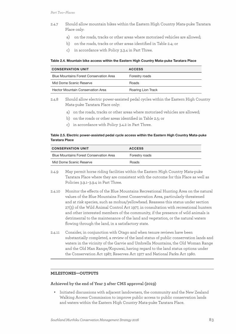
2.4.7 Should allow mountain bikes within the Eastern High Country Mata-puke Taratara Place only:
a) on the roads, tracks or other areas where motorised vehicles are allowed;b) on the roads, tracks or other areas identified in Table 2.4; orc) in accordance with Policy 3.3.4 in Part Three.
Table 2.4. Mountain bike access within the Eastern High Country Mata-puke Taratara Place
CONSERVATION UNIT ACCESS
Blue Mountains Forest Conservation Area Forestry roads
Mid Dome Scenic Reserve Roads
Hector Mountain Conservation Area Roaring Lion Track
2.4.8 Should allow electric power-assisted pedal cycles within the Eastern High Country Mata-puke Taratara Place only:
a) on the roads, tracks or other areas where motorised vehicles are allowed;b) on the roads or other areas identified in Table 2.5; orc) in accordance with Policy 3.4.2 in Part Three.
Table 2.5. Electric power-assisted pedal cycle access within the Eastern High Country Mata-puke Taratara Place
CONSERVATION UNIT ACCESS
Blue Mountains Forest Conservation Area Forestry roads
Mid Dome Scenic Reserve Roads
2.4.9 May permit horse riding facilities within the Eastern High Country Mata-puke Taratara Place where they are consistent with the outcome for this Place as well as Policies 3.9.1–3.9.4 in Part Three.
2.4.10 Monitor the effects of the Blue Mountains Recreational Hunting Area on the natural values of the Blue Mountains Forest Conservation Area, particularly threatened and at risk species, such as mohua/yellowhead. Reassess this status under section 27(3) of the Wild Animal Control Act 1977, in consultation with recreational hunters and other interested members of the community, if the presence of wild animals is detrimental to the maintenance of the land and vegetation, or the natural waters flowing through the land, in a satisfactory state.
2.4.11 Consider, in conjunction with Otago and when tenure reviews have been substantially completed, a review of the land status of public conservation lands and waters in the vicinity of the Garvie and Umbrella Mountains, the Old Woman Range and the Old Man Range/Kopuwai, having regard to the land status options under the Conservation Act 1987, Reserves Act 1977 and National Parks Act 1980.
MILESTONES—OUTPUTS
Achieved by the end of Year 3 after CMS approval (2019)
• Initiated discussions with adjacent landowners, the community and the New Zealand Walking Access Commission to improve public access to public conservation lands and waters within the Eastern High Country Mata-puke Taratara Place.
Part Two—Places
83Southland Murihiku Conservation Management Strategy 2016

• Initiated monitoring of the effects of recreational hunting and deer within the Blue Mountains Recreational Hunting Area.
Achieved by the end of Year 5 after CMS approval (2021)
• Assessment of the monitoring results on the use of the Blue Mountains Recreational Hunting Area by hunters to determine whether this activity is being maximised and whether the presence of deer is not detrimental to threatened and at risk species, such as mohua/yellowhead, or the Blue Mountains wetland priority ecosystem unit.
• Contributed to investigations to determine the best way of protecting priority indigenous ecosystems off public conservation lands and waters in the Eastern High Country Mata-puke Taratara Place, such as the Nokomai wetland complex.
• Initiated monitoring of over-snow vehicle activity during winter in the Eastern High Country Mata-puke Taratara Place.
Achieved by the end of Year 10 after CMS approval (2026)
• Improved public access to public conservation lands and waters within the Eastern High Country Mata-puke Taratara Place and information describing this access is readily available to the public.
• Assessment of over-snow vehicle activity during winter in the Eastern High Country Mata-puke Taratara Place.
• A land status review for public conservation lands and waters in the vicinity of the Garvie and Umbrella Mountains, the Old Woman Range and the Old Man Range/Kopuwai, subject to relevant tenure reviews being completed.
2.5 Longwood O Hekeia PlaceThe Longwood O Hekeia Place is dominated by the Longwood Range, which extends north to the Twinlaw and Woodlaw hills, and south to the coast from Riverton/Aparima in the east to Waihoaka in the west (see Map 5.5). The Longwood Forest Conservation Area is the major area of public conservation land and water within this Place, but there are also a number of smaller parcels of public conservation lands and waters, including the Pourakino Scenic Reserve, Pahia Hill Scenic Reserve and Woodlaw Forest Conservation Area.
The Longwood O Hekeia Place is strongly connected to the Foveaux Te Ara a Kiwa Place, and activities within the Longwood O Hekeia Place can also impact on the Lowlands Te Rā a Takitimu Place.
Description
The Māori name ‘O Hekeia’ refers to the Longwood Range being the place of Hekeia, a southern Rangatira (chief) who lived in the area. Other members of his whānau were Te Anau and Aparima, whose names are today remembered in Lake Te Anau (Te Ana-au) and the Aparima River.
The Longwood O Hekeia Place is seen as the region’s ‘playground’, particularly for people from Otautau, Riverton and Invercargill. Consequently, there is strong community interest in the management and future of this Place. Just a short drive from Invercargill, it is the ideal destination for visitors to experience many forms of recreation in a natural setting, and the focus for future growth in recreational activity within Southland Murihiku. Visitors to the foothills of the Longwood Range seek easily accessible recreation opportunities, such as day walking, four-wheel driving and mountain biking. On the tops of the range there is a
Part Two—Places
84 Southland Murihiku Conservation Management Strategy 2016

change in use to recreational activities that are associated with a remote experience, such as tramping and hunting. There is also a considerable amount of history nestled amongst the regenerating indigenous forest, which tells the story of the past uses of this land, such as gold mining and forestry.
The Pourakino Scenic Reserve picnic area is popular with local families and school groups. Te Araroa Southland Trust manages the Round Hill (Long Hilly) walking track, a day walk in Round Hill Conservation Area that highlights the area’s Chinese gold mining history. Tramping opportunities tend to be suitable for more experienced trampers, including a section of Te Araroa Trail that passes through the Longwood Forest. Fishing and hunting are popular recreational activities within this Place, with hunters visiting the area daily. Because of its proximity to Invercargill, the area is used not only by experienced hunters, but also by novice hunters seeking to gain experience.
Vehicles are only allowed within this Place on roads that are suitable for such use (see Part Three), which excludes the tops of the Longwood Range, due to the high natural values present.
There are opportunities to work with Ngāi Tahu and the community to further develop recreational use of this Place—for example, by developing mountain biking and/or horse riding tracks. However, this growth needs to be managed to ensure that the ‘playground’ nature of this Place is maintained and its natural values are not affected.
Historically, aircraft landings in the Longwood O Hekeia Place were only for management purposes. However, a low level of aircraft access to this Place can be authorised, provided the strong, ground-based recreational values are maintained. Thus, aircraft landings within this Place are focused away from high-use areas such as Te Araroa Trail, and measures put in place to minimise effects on other recreational users.
The Longwood O Hekeia Place has a strong historic association with gold mining and sawmilling use, and there are a number of actively conserved sites relating to these activities: Mores’ Top Mill site in the Pourakino Valley; Printz’s Battery; Turnbull’s water race, dam site and hut; Port’s water race; Martin’s hut and water race; and Mores’ Johnston locomotive, which has been moved from the Pourakino Valley to Riverton (see Appendix 10). The water races are important partly due to their contiguous nature and because they are essentially intact. Round Hill was the site of New Zealand’s largest, predominantly Chinese, gold mining settlement (known as Canton) in the 1880s, and evidence of Chinese gold mining still remains. However, the full historic picture of this Place is still largely unknown and any future development needs to consider the impacts on all historic sites to ensure that layers of history are not lost.
Ngāi Tahu have a historic spiritual relationship with Lake George (Uruwera), a Deed of Recognition area (see 1.4 Treaty partnership with Ngāi Tahu). Ngāi Tahu also have close connections with the coast in the Longwood O Hekeia Place, and many sites are known for their mahinga kai opportunities and cultural materials, such as takitea stone and argillite, and rimurapa (kelp used in tītī harvesting). Wāhi tapu, urupā and other archaeological evidence of occupation are also found along the coast.
The tops of the Longwood Range contain an array of indigenous vegetation, including extensive tussocklands, shrublands and a variety of wetlands. The indigenous alpine flora is relatively rich and includes several species that are at their southern or eastern limit, such as the tussock Chionochloa teretifolia, which is the dominant tussock that forms the basis of an upland peatland community.
Part Two—Places
85Southland Murihiku Conservation Management Strategy 2016
An extensive area of indigenous forest, which represents a range of different forest types, remains on the Longwood Range. Lowland broadleaved forest, broadleaved podocarp forest, broadleaved tawai/beech forest and upland tawai/beech forest are found on the western slopes, whilst tawai/beech forest is dominant on the eastern side. The Declining scarlet mistletoe is scattered at low densities through some of these forests. The Nationally Vulnerable mohua/yellowhead is also found within the Longwood Range. Surrounding land uses, such as forestry, have modified the indigenous forest over time, particularly at lower altitudes. Since some indigenous forest harvesting occurs on private land in this Place, it is important to work with adjoining landowners to protect the remaining altitudinal sequences of indigenous vegetation.
A range of pest plants and animals occur in the Longwood O Hekeia Place. Within the Longwood Forest Conservation Area, woody pest plants are largely restricted to the boundaries and along roads. Pest animal control mainly occurs through recreational hunting and possum trapping.
The coast of this Place is significant for a number of reasons. Lake George (Uruwera) within the Lake George Wildlife Management Reserve is a coastal, swampy lake that is a priority ecosystem unit. It has a trophic status of moderate nutrition for plant growth, has been affected by sedimentation and pest plants, such as grey willow (Salix cinerea), and is a remnant of what was once an extensive wetland system; however, it does include a sequence of indigenous wetland vegetation and a small area of regenerating indigenous forest, providing a link between the Longwood Range and the sea. It drains into the sea via the Ourawera (Uruwera) Stream. The lake supports a wide range of New Zealand wetland birds, waterfowl and wading species, including the Nationally Endangered matuku-hūrepo/Australasian bittern, Declining South Island mātātā/fernbird and Relict koitareke/marsh crake. Indigenous freshwater fish present include the Declining tuna/longfin eel and taiwharu/giant kōkopu, as well as tuna/shortfin eel (Anguilla australis) and common bully. The sports fish perch (Perca fluviatilis) is also found in Lake George (Uruwera). The ponds within the South Round Hill, Lake George Conservation Area, which were created as a result of mining, provide complementary habitat where sightings of rare, vagrant birds such as ruff (Philomachus pugnax) have been made.
The coastal landscapes of this Place are also of significance (see Appendix 9). The backdrop of the Longwood Range is another important landscape for locals and the many visitors that make the journey along the Southern Scenic Route.
High-altitude environments throughout Southland Murihiku play an important environmental service in providing excellent water quality and continuity of water supply in lower catchments. Therefore, it is important to ensure that the freshwater ecosystems within this Place are maintained. The development of higher-altitude areas, if not managed correctly, can impact on downstream water quality, the ability of the systems to buffer severe floods and the continuity of water supply. More information on the Department’s management of freshwater ecosystems is set out in section 2.6—Freshwater Wai Māori Place.
The Longwood O Hekeia Place has a history of gold mining and there are several mining operations on public conservation lands and waters. Any application for an access arrangement for mining and extraction is assessed on a case-by-case basis (see Part Three), and takes into account the many significant values within the Longwood O Hekeia Place that have the potential to be impacted. Of particular importance within this Place is its ‘playground’ nature, the layers of historic and cultural values, as well as the significant biodiversity values of the Lake George (Uruwera) priority ecosystem unit. A careful approach needs to be taken when considering future activities within this Place, to ensure that they are undertaken in a manner that is consistent with the values present.
Part Two—Places
86 Southland Murihiku Conservation Management Strategy 2016
Outcome, policies and milestones for the Longwood O Hekeia Place
OUTCOME
The Longwood O Hekeia Place provides opportunities for residents of Invercargill and smaller local towns to utilise Local Treasure and Backcountry destinations and enjoy the outdoors without having to travel far from home. Surrounding communities have a close connection with this Place and are actively involved in its management.
This Place is particularly valued for its range of mountain biking opportunities, as well as being an area where people can learn how to hunt. The fringes are easily accessible, while a remote experience can be found at higher altitudes. Promotion of Te Araroa Trail, including the Round Hill (Long Hilly) walking track, continues to increase the number of visitors using this Place, as well as improving their understanding of local history. Both tracks demonstrate the benefits of successful community-driven projects.
An increasing number of other community-based recreation projects provide support for the natural, historic and recreational values that are present.
The important biodiversity values within this Place, particularly the extensive indigenous forest, the tops of the Longwood Range and the priority ecosystem unit of Lake George (Uruwera), are enhanced. People are aware of and value these ecosystems and the species found within them.
The protected landscape is highly valued by visitors and locals as a backdrop to their journey along the Southern Scenic Route. The dark night sky is unaffected by artificial light.
Actively conserved historic sites associated with timber milling and gold mining within this Place are maintained and accessible. An increased awareness and understanding of this historic heritage and extensive archaeological landscape, particularly with regard to the contribution of Chinese immigrants to gold mining, provides a meaningful visitor experience. Ngāi Tahu and local communities are actively involved in the protection and sharing of stories about this Place. Archaeological sites and significant cultural values along the coastal edges are better understood and managed through joint projects, and there are mechanisms in place to save knowledge from sites that are threatened by coastal erosion.
Aircraft occasionally land in this Place, where necessary to support low-impact activities that do not disrupt the predominantly ground-based recreational experiences.
Structural development and commercial activity enhance the recreational values of this Place, while protecting historic values, the significant biodiversity values along the tops of the Longwood Range, and the wider natural and cultural landscape.
Part Two—Places
87Southland Murihiku Conservation Management Strategy 2016

POLICIES
2.5.1 Work with Ngāi Tahu and the community to:
a) actively engage them in the Department’s management of the Longwood O Hekeia Place; and
b) in conjunction with the Chinese community, gain a better understanding of the historic heritage within the Longwood O Hekeia Place.
2.5.2 Encourage the growth of recreation opportunities in the Longwood O Hekeia Place while:
a) avoiding adverse effects on cultural and historic heritage, threatened and at risk species, and the Lake George (Uruwera) priority ecosystem unit; and
b) retaining the remote nature of the tops of the Longwood Range.
2.5.3 Identify, protect and promote the historic heritage within the Longwood O Hekeia Place.
2.5.4 Continue to support and progress the Southland Coastal Heritage Inventory Project to increase understanding of the important historic and cultural values within the Longwood O Hekeia Place.
2.5.5 Should allow motorised vehicles within the Longwood O Hekeia Place only:
a) on the roads purposely formed and maintained for motorised vehicle use at the time this CMS is approved; or
b) in accordance with Policy 3.2.3 or 3.2.4 in Part Three.
2.5.6 Should allow mountain bikes within the Longwood O Hekeia Place only:
on the roads, tracks or other areas where motorised vehicles are allowed; on the roads or other areas identified in Table 2.6; or in accordance with Policy 3.3.4 in Part Three.
Table 2.6. Mountain bike access within the Longwood O Hekeia Place
CONSERVATION UNIT ACCESS
Longwood Forest Conservation Area Bald Hill forestry roads*
* Also requires access across land not administered by the Department
2.5.7 Should allow electric power-assisted pedal cycles within the Longwood O Hekeia Place only:
a) on the roads, tracks or other areas where motorised vehicles are allowed; orb) in accordance with Policy 3.4.2 in Part Three.
2.5.8 May allow the development of roads or tracks for vehicle use and/or horse riding within the Longwood O Hekeia Place, excluding the tussockland tops, in accordance with Policies 3.2.2–3.2.9, 3.3.2–3.3.8, 3.4.2–3.4.5 and/or 3.9.2–3.9.4 in Part Three, and where there are no adverse effects on:
a) threatened or at risk species;b) the priority ecosystem unit of Lake George (Uruwera); or c) areas with significant historic values.
2.5.9 May grant concessions for aircraft landings and take-offs within the Longwood O Hekeia Place on an occasional basis where the activity is consistent with Policy 3.6.6 or 3.6.7, or in accordance with the following criteria:
Part Two—Places
88 Southland Murihiku Conservation Management Strategy 2016
a) it is consistent with the outcome for this Place;b) it is consistent with Policy 3.6.1b)–h) in Part Three;c) adverse effects on the visitor experiences found within this Place are avoided;
andd) adverse effects on ecological values along the tops of the Longwood Range are
avoided.
2.5.10 May grant concessions for guided recreational activities in the Longwood O Hekeia Place in accordance with the following criteria:
a) the activity is consistent with the outcome and other policies for this Place;b) group sizes are consistent with the relevant visitor management zone (see Map
3 and Appendix 12); c) the activity does not conflict with non-commercial recreational use; andd) historic and ecological values are protected.
2.5.11 May grant authorisations for structures and utilities in the Longwood O Hekeia Place where:
a) the criteria in Policy 3.10.1 are complied with;b) the structure or utility is consistent with the outcome for this Place; andc) the structure or utility complements the values present, including the:
i) recreational use of this Place; ii) cultural and historic values; andiii) sensitive ecological values, particularly the priority ecosystem unit of Lake
George (Uruwera).
2.5.12 May enter into access arrangements to carry out mineral-related activities within the Longwood O Hekeia Place, subject to the Crown Minerals Act 1991. Applications should be considered on a case-by-case basis in accordance with Policies 3.16.1–3.16.6 in Part Three, including whether public notification should occur for significant activities, 23 and adverse effects on the following should be avoided:
a) the priority ecosystem unit of Lake George (Uruwera);b) downstream freshwater ecosystems within public conservation lands and
waters;c) threatened or at risk species;d) visitor experiences;e) historic and cultural values;f) the landscape values of the Longwood Range as a scenic backdrop for those
driving along the Southern Scenic Route; andg) community projects.
MILESTONES—OUTPUTS
Achieved by the end of Year 3 after CMS approval (2019)
• Initiated research and surveys, in partnership with others, to improve knowledge of the archaeological, cultural and historic values of the Longwood O Hekeia Place and to
23 As determined in accordance with section 61(1AAB) of the Crown Minerals Act 1991.
Part Two—Places
89Southland Murihiku Conservation Management Strategy 2016
provide a better understanding of the relative importance of sites.
Achieved by the end of Year 5 after CMS approval (2021)
• Increased numbers of people involved and actively engaged in the management of the Longwood O Hekeia Place.
• Strong and enthusiastic communities of interest committed to ensuring that history is protected within the Longwood O Hekeia Place.
Achieved by the end of Year 10 after CMS approval (2026)
• Improved water quality in Lake George (Uruwera).
• Monitoring the effects of aircraft activity on visitor experiences.
2.6 Freshwater Wai Māori PlaceThe Freshwater Wai Māori Place encompasses all freshwater ecosystems and riparian areas in Southland Murihiku, 24 including glaciers, rivers, springs, lakes and wetlands (see Map 5.6). While the Department does not directly manage freshwater ecosystems off public conservation lands and waters, it does have a strong advocacy role to preserve indigenous freshwater fisheries, and to protect recreational freshwater fisheries and freshwater fish habitats under the Conservation Act 1987. The Department also has a role under the Freshwater Fisheries Regulations 1983.
Freshwater is managed by regional councils under the Resource Management Act 1991. Southland and Otago Regional Councils are responsible for freshwater management in Southland Murihiku under their respective water plans.25 This Place provides a framework to guide the Department’s:
a) management of public conservation lands and waters; and b) advocacy direction when working with Ngāi Tahu and the community (including
relevant agencies, Southland Fish and Game Council and landowners);
to restore and maintain the health and the mauri (life force) of the freshwater ecosystems in Southland Murihiku, and the important species within them.
Description
This Place overlaps, and needs to be considered alongside, all other Places on mainland Southland Murihiku.
The freshwater ecosystems of Southland Murihiku are richly varied, providing abundant environmental services, and possessing cultural, spiritual, recreational and aesthetic values. They reflect the region’s southern temperate latitude and the interception of oceanic weather by mountains: wet on the west and in the uplands; drier in the eastern districts and away from the coast.
24 For the purposes of this Place, the subantarctic islands are not included. The Minister of Conservation is the territorial authority for the subantarctic islands under section 31A of the Resource Management Act 1991, but there is no Regional Water Plan in place because of the very small freshwater resources on these islands.
25 Activities on the surface of freshwater bodies in Southland Murihiku are managed by district councils and their respective district plans.
Part Two—Places
90 Southland Murihiku Conservation Management Strategy 2016
Rivers connect the mountains to the sea—ki uta ki tai. The river ecosystems of Fiordland National Park, such as the Eglinton, Wairaurahiri and Hollyford/Whakatipu Kā Tuka rivers, are largely in a natural state throughout their entire catchments. Other river ecosystems, some of which flow from or through public conservation lands and waters, have been modified to various degrees by hydroelectricity generation, extraction for water supply and other uses. The most important of these within Southland Murihiku are the Mataura, Oreti, Waiau, Aparima and Pomahaka rivers. Many of the beds of these rivers (and lakes), outside of public conservation lands and waters, are Crown land administered by Land Information New Zealand.
Numerous and varied wetland complexes are scattered throughout Southland Murihiku, many of which are nationally and internationally significant, such as the wetlands on the Awarua Plains, east of Lake Te Anau, in northern Southland and in Fiordland. Freshwater lakes are another important feature. These include a number of large and smaller freshwater lake ecosystems, like the great Fiordland lakes, alpine lakes, shallow coastal lakes and peat lakes. All of these freshwater ecosystems contribute to the natural character of Southland Murihiku and are a major part of Southlanders’ lives.
The Māori name for this Place, ‘Wai Māori’, means freshwater. Water is a taonga for the people of Ngāi Tahu. It is at the heart of their culture and identity, as set out in the Te Rūnanga o Ngāi Tahu Freshwater Policy (1999). The Mataura, Oreti, Waiau, and Aparima rivers, the Waituna Wetland, and lakes Manapouri (Moturau), Te Anau (Te Ana-au), Hauroko, George (Uruwera), and North and South Mavora (Manawapōpōre and Hikuraki) all include, or are, Deed of Recognition areas (see 1.4 Treaty partnership with Ngāi Tahu). There are also seven nohoanga entitlement sites associated with this Place.
Traditional routes that were walked centuries ago by the earliest Māori tūpuna from the coast to inland resources—ki uta ki tai—follow the rivers, between landmarks and nohoanga.26 There are often concentrations of archaeological sites around particular places, indicating good areas for the collection of mahinga kai. These include places where Māori made their camps (ovens and middens) and places where artefacts have been found. Unfortunately, these sites give only a limited insight into the lives of the travellers, and less is known about the inland sites than those along the coast. However, it is likely that there are many unrecorded sites that could reveal more about historic use of inland Southland Murihiku. A few of these sites are on public conservation lands and waters near rivers, but the majority are on private land.
European exploration also followed the rivers, usually with the assistance of Māori guides. Early settlements and towns established and grew as a result of pastoral settlement and the timber industry, and there are some historic ferry crossings and bridges that linked these settlements and industry. In the upper reaches of some rivers, there are large concentrations of historic sites related to gold mining, and scattered buildings associated with mustering and other aspects of pastoral farming. Some of these are on public conservation lands and waters, a few of which are actively conserved sites (see Appendix 10), and some are on pastoral leasehold and freehold land.
The Oreti and Mataura rivers are both covered by Water Conservation Order provisions. The Water Conservation (Mataura River) Order was gazetted in 1997 for its outstanding fisheries and angling amenity features. The Water Conservation (Oreti River) Order was gazetted in 2008 for its brown trout and Nationally Critical tarāpunga/black-billed gull habitat, angling amenity, and significance in accordance with tikanga Māori. The Mataura River has the only
26 There is often overlap of these values between the Lowlands Te Rā a Takitimu Place and the Freshwater Wai Māori Place.
Part Two—Places
91Southland Murihiku Conservation Management Strategy 2016
freshwater Mātaitai Reserve in New Zealand, identified to protect the customary kanakana/lamprey (Geotria australis) fishery. The Mātaitai Reserve encompasses the natural Mataura River falls (Te Au Nui) and a fish staging site (where kanakana/lamprey gather and climb the falls on their migration upstream), and has a continuing history of customary use.
Freshwater ecosystems in Southland Murihiku support an array of indigenous species, some of which are threatened or at risk. Of particular importance are the braided reaches of many Southland Murihiku rivers. Braided riverbeds are a naturally rare indigenous ecosystem. The meanders and expanses of gravel are important mahinga kai sites, and nesting and feeding grounds for the Nationally Critical tarāpunga/black-billed gull and Nationally Endangered tarapirohe/black-fronted tern. The braided rivers of Southland Murihiku are a stronghold for these birds. Other threatened and at risk braided river migratory birds found here are the Nationally Vulnerable pohowera/banded dotterel and tarāpunga/red-billed gull, and the Declining tōrea/South Island pied oystercatcher. The Department works closely with Ngāi Tahu and the community, including relevant agencies, to protect habitat areas for these birds, which can be threatened by activities such as four-wheel driving in riverbeds. During the term of this CMS, an important challenge is to ensure that these bird populations are able, as a minimum, to be maintained at their 2012 levels.
An array of indigenous fish species is also found in the rivers, including the Nationally Vulnerable Gollum galaxias and the Declining tuna/longfin eel, taiwharu/giant kōkopu and kanakana/lamprey; as well as tuna/shortfin eel, paraki/smelt (Retropinna retropinna) and bullies. Tuna/longfin eels live for up to 80 years, are slow growing, only spawn once and are coming under increasing pressure from fishing and habitat loss, which has resulted in their population being in decline. There are four species of non-migratory galaxiids found in Southland Murihiku waters: the Clutha flathead galaxias, Pomahaka galaxias, Gollum galaxias and southern flathead galaxias.
Whitebait are the young of six indigenous fish species (the Nationally Vulnerable shortjaw kōkopu; the Declining īnanga/īnaka, taiwharu/giant kōkopu and kōaro; and the banded kōkopu (Galaxias fasciatus) and paraki/smelt), which spend most of their lives in freshwater. Adults of these species spawn in a range of places, from the mouths of larger rivers to small, fast-flowing mountain streams. The eggs are left on river banks and stream bottoms until they hatch. They are affected by pollution, increased sediment and the clearing of vegetation along the banks of waterways.
Many rivers also contain populations of waterfowl, such as mallard ducks (Anas platyrhynchos), Canada geese (Branta canadensis) and pūtangitangi/paradise shelducks (Tadorna variegata), as well as introduced trout and other sports fish, making them popular for recreational hunting and fishing.
A number of the freshwater rivers in the region flow into estuarine and enclosed fiord environments, making these an important component of freshwater ecosystems within Southland Murihiku. In this CMS, estuaries are covered within the Lowlands Te Rā a Takitimu Place (section 2.7) and Awarua Place (section 2.8), and fiords are dealt with in the Fiordland Te Rua-o-te-moko Place (section 2.2).
Mainland Southland Murihiku contains many important wetland ecosystems, including:
• Approximately 30 separate wetlands east of Lake Te Anau, within the Western High Country Mata-puke Koikoi Place (see section 2.3) and the Lowlands Te Rā a Takitimu Place (see section 2.7), that are managed by the Department (such as Kepler Mire Conservation Area, Borland Mire Scientific Reserve, and Kakapo Swamp Wildlife Management Reserve), as well as others that are on private land
• The Awarua wetland complex (see 2.8 Awarua Place for more information on the
Part Two—Places
92 Southland Murihiku Conservation Management Strategy 2016
Awarua Wetland of International Importance)
• A number of wetlands within the Eastern High Country Mata-puke Taratara Place (see section 2.4), such as upland fens on the Garvie and Umbrella Mountains (all of which are located off public conservation lands and waters).
There is potential for more of the wetlands within these Places to be formally recognised as Wetlands of International Importance.
The large lakes of Fiordland include Lake Te Anau, Lake Manapouri, Lake Monowai, Lake Hauroko, Lake Poteriteri and Lake Hakapoua. Many of these lakes are significant because they are Deed of Recognition areas (see 1.4 Treaty partnership with Ngāi Tahu) and Lake Poteriteri is a priority ecosystem unit (see Appendix 4). The considerable hydroelectric generation from the Manapouri Power Scheme is a major commercial activity within this Place. The scheme is operated under the authority of the Manapouri–Te Anau Development Act 1963, which enables the water resources of lakes Manapouri and Te Anau, and the Waiau and Mararoa rivers and their tributaries, to be used to generate electricity.
The process of establishing this hydroelectric scheme was a turning point in the national conscience of New Zealanders, brokering and balancing development with nature conservation in the ‘Save Manapouri’ campaign, which gave rise to the Guardians of Lakes Manapouri, Monowai and Te Anau under section 4A of the Manapouri–Te Anau Development Act 1963 and section 6X of the Conservation Act 1987. The Guardians are one mechanism of addressing the effects of the scheme and their responsibilities include making recommendations to the Minister of Conservation on:
• the environmental, ecological and social effects on the lakes’ shorelines, and on the rivers flowing in and out of those lakes, having particular regard to the effects of the operation on social values, conservation, recreation, tourism, and related activities and amenities; and
• the gazetted operating guidelines for the levels of lakes Manapouri and Te Anau.
The inland lakes within this Place are home to an array of indigenous species, including the tuna/longfin eel, taiwharu/giant kōkopu, kōaro and paraki/smelt. Taiwharu/giant kōkopu, īnanga/īnaka/whitebait and tuna/shortfin eel can be found in the coastal lakes within this Place, such as Lake George (Uruwera), and Waituna and Waiuna Lagoons.
There are also important lakeside indigenous plant communities within this Place, such as the ephemeral riparian wetland areas of lakes and ponds, which provide habitat for a number of threatened and at risk plants. The riparian areas of lakes Manapouri (a priority ecosystem unit) and Te Anau contain approximately 30 different species, some of which are threatened or at risk, including the Nationally Critical Fiordland lakeshore daisy, the Nationally Endangered hydatella, the Declining tufted hair grass and the endemic, Naturally Uncommon buttercup Ranunculus ranceorum.
There are many marginal strips alongside rivers and streams within the Freshwater Wai Māori Place, some of which are grazed. This use of marginal strips can have adverse effects on both freshwater ecosystems and public access. Therefore, it is important that an assessment of the impacts of any use of marginal strips is undertaken prior to the granting of any concession, to ensure that freshwater values and public access are protected. A number of threatened and at risk plants are also associated with these marginal strips, including three tree daisy (Olearia) species. It is also important that impacts on these species are avoided.
Part Two—Places
93Southland Murihiku Conservation Management Strategy 2016

Public conservation lands and waters are particularly important for providing breeding habitat for an array of indigenous aquatic species, ensuring the future of their populations. However, it is also important that indigenous fish populations are protected and the regeneration of species is assisted off public conservation lands and waters. Therefore, the commercial take of tuna/eels from public conservation lands and waters is unlikely to be authorised.
There are a number of threats to the freshwater ecosystems and species in Southland Murihiku, as identified above. The Department works with Ngāi Tahu and the community, including relevant agencies and Southland Fish and Game Council, to manage these threats, and protect the freshwater ecosystems and species. For public conservation lands and waters, the Department has a management role alongside the Southland and Otago Regional Councils, while for freshwater ecosystems off public conservation lands and waters, the Department has an advocacy role.
Water quality and quantity are two important issues within Southland Murihiku, as well as nationally. Modification of freshwater ecosystems, and the development and use of adjoining land, riparian areas and wetlands can have adverse effects on freshwater ecosystems. This includes the removal of indigenous vegetation, drainage of wetlands, and land modification that affects hydrology and flow regimes. Increasing water extraction within Southland Murihiku is placing some freshwater ecosystems under threat, which, coupled with a strong connection between ground and surface water levels in some catchments, is creating a growing water quantity and quality issue in the region. These issues require careful management to maintain the multiple values of the region’s water resource.
High-country areas play an important role in water yield, quality and continuity of water supply at lower altitudes. Freshwater ecosystems need to be managed holistically, from the headwaters all the way to their outflow into the coastal environment. Aquatic pest plants, such as South African oxygen weed (Lagarosiphon major) and didymo, also affect freshwater ecosystems within Southland Murihiku. The Department works with the Southland and Otago Regional Councils and the community to prevent the spread of, and the introduction and establishment of new, aquatic pest plants in the region’s freshwater ecosystems. The importance of freshwater biosecurity is increasingly being recognised by the communities and industries in Southland Murihiku.
A number of recreational (such as whitebaiting, fishing, swimming, kayaking and boating) and business activities utilise the freshwater ecosystems of the Freshwater Wai Māori Place, particularly on the lakes within Fiordland National Park and on the many rivers throughout Southland Murihiku. The Department is responsible for administering the Whitebait Fishing Regulations 1994 and the Whitebait Fishing (West Coast) Regulations 1994 (the latter applies to all of the western coast of Southland Murihiku from Puysegur Point north). Both of these sets of regulations control when (times during the year and day) and how (e.g. restrictions on net sizes) whitebaiting can occur. There are no regulations about how much whitebait an individual can take. Sports fish are controlled and managed by the Southland Fish and Game Council.
Outcome, policies and milestones for the Freshwater Wai Māori Place
OUTCOME
The rivers within the Freshwater Wai Māori Place flow freely from the mountains to the sea—ki uta ki tai. Indigenous migratory species can journey to and from the sea.
Part Two—Places
94 Southland Murihiku Conservation Management Strategy 2016
Unmodified freshwater ecosystems within public conservation lands and waters maintain natural flows and high water quality, providing habitats for threatened and at risk aquatic and shoreline flora and fauna. Their value as an integral part of the landscape, life sources, pathways and symbols of identity are recognised. Freshwater ecosystems altered by developments of national significance are managed to protect their values.
The ecosystem services provided by, and the mauri of, the waterways in Southland Murihiku are better understood. Freshwater ecosystems on public conservation lands and waters enhance freshwater ecosystems off public conservation lands and waters.
Those lakes that are free of aquatic pest plants remain so, and Wetlands of International Importance are rehabilitated and enhanced.
Indigenous riparian habitats are healthy, and are home to a rich diversity of threatened and at risk plants, including iconic kōwhai stands. Their value in buffering the effects of agricultural influences from adjacent lands is recognised. Indigenous aquatic plant communities are also protected and enhanced.
Populations of indigenous freshwater fish are recovering, and threatened and at risk braided river and wetland birds have become more common.
Enhanced public land access to rivers, lakes and wetlands in Southland Murihiku increases opportunities for people to experience and appreciate fully functional and healthy freshwater ecosystems. Recreational activities such as fishing, swimming and other water sports can be enjoyed.
Integrated management of the region’s freshwater ecosystems is achieved by working closely with Ngāi Tahu and the community, including local authorities, the farming community, Southland Fish and Game Council and other stakeholders.
Freshwater ecosystems off public conservation lands and waters have been improving year by year and are on track to reaching the overall long-term goal of restoring them to healthy ecosystems with clean water, which can be used sustainably for recreating, drinking and production.
POLICIES
2.6.1 Work with Ngāi Tahu and the community, including relevant agencies, the Southland Fish and Game Council, adjacent landowners and relevant industries, to raise awareness about the connection between land use activities, freshwater ecosystems and the coastal environment, to ensure:
a) that the intrinsic values of wetlands, running waters, lakes and estuaries are sustained;
b) the integrated and holistic management of Southland Murihiku freshwater ecosystems;
c) the rehabilitation and restoration of the region’s freshwater ecosystems;d) that land use activities do not adversely impact on freshwater ecosystems; e) the high-quality water yields from tussocklands are retained or enhanced; andf) that the National Policy Statement for Freshwater Management 2011 is
implemented.
2.6.2 Work with Land Information New Zealand, where Crown river and lake beds extend into, or are surrounded by public conservation lands, to:
Part Two—Places
95Southland Murihiku Conservation Management Strategy 2016
a) achieve integrated management across the combined lands and waters; orb) include the river or lake beds within public conservation lands and waters.
2.6.3 Continue to raise awareness and advocate for the preservation of the habitats of threatened and at risk indigenous fauna within the Freshwater Wai Māori Place, including braided river ecosystems.
2.6.4 Continue to advocate for the protection of indigenous freshwater plant communities, particularly threatened and at risk species, within the Freshwater Wai Māori Place and increase awareness of the role that they play within freshwater ecosystems.
2.6.5 Advocate to relevant agencies that:
a) wetlands, riparian areas, uplands and flood plains should be retired from intensive grazing and farming regimes; and
b) any remaining grazing and farming of wetland, riparian areas, uplands and flood plains should reflect modern best practice to sustain and restore sensitive habitats and in-water values, and to protect cultural values.
2.6.6 Should grant authorisations for grazing and farming on public conservation lands and waters within the Freshwater Wai Māori Place only where the activity is consistent with Policy 3.15.1 in Part Three and in accordance with the following criteria:
a) it is not within an ecological area or a priority ecosystem unit;b) livestock do not have direct access to waterways;c) it will not adversely affect the conservation values present;d) the land and soil type are suitable for grazing and farming;e) the catchment is not sensitive to increased nutrient levels;f) public access to public conservation lands and waters is retained;g) there is no increased flooding risk of the land; andh) there are no adverse effects on freshwater quality.
2.6.7 Should not grant concessions for the commercial take of tuna/eels from public conservation lands and waters within the Freshwater Wai Māori Place.27
2.6.8 May grant concessions for commercially guided activities where:
a) the activity is consistent with the outcome for the Freshwater Wai Māori Place and the other associated Place(s);
b) group sizes are consistent with the relevant visitor management zone (see Map 3 and Appendix 12); and
c) the activity is compatible with non-commercial recreational activities.
2.6.9 May grant authorisations for structures and utilities within the Freshwater Wai Māori Place where:
a) the criteria in Policy 3.10.1 are complied with;b) the structure or utility is consistent with the outcome for this Place and the
other associated Place(s); and c) the structure or utility does not adversely affect:
27 For the policy direction regarding the customary take of indigenous fish (such as tuna/longfin eels) from public conservation lands and waters, see Part One, section 1.4—Treaty partnership with Ngāi Tahu.
Part Two—Places
96 Southland Murihiku Conservation Management Strategy 2016
i) the long-term water quality of freshwater ecosystems;ii) indigenous species or sports fish;iii) natural freshwater flow regimes;iv) areas of outstanding natural character and significant natural features
identified in Appendix 9; andv) areas of historic and cultural significance identified in Appendix 10 or
recognised through legislation.
2.6.10 Support Ngāi Tahu, commercial and community initiatives for freshwater conservation within the Freshwater Wai Māori Place, such as tuna/eel trap and transfer programmes, and the restoration of the freshwater Mātaitai Reserve in the Mataura River.
2.6.11 Work with Ngāi Tahu and the community to raise awareness of important wetland ecosystems within the Freshwater Wai Māori Place, such as seeking Wetland of International Importance status.
2.6.12 Support community goals for protection and conservation management of catchments and wetlands associated with the Awarua Wetland of International Importance, Lake George (Uruwera) and the Waiau River lagoon.
2.6.13 Support community initiatives to increase formal protection of natural areas within the Freshwater Wai Māori Place, including recommended areas for protection listed in the Nokomai, Umbrella, Southland Plains and Taringatura Protected Natural Areas Programme Survey Reports, and future reports for other ecological districts.
2.6.14 Support relevant agencies in their regional aquatic pest management strategies and parties undertaking biosecurity actions for pest organisms within the Freshwater Wai Māori Place.
2.6.15 Support initiatives by landowners to protect freshwater values within the Freshwater Wai Māori Place that are associated with land development programmes.
2.6.16 Seek the establishment and maintenance of fish passage for tuna/longfin eels entering and leaving the Lake Manapouri catchment.
2.6.17 Seek the maintenance of fish passage within the Freshwater Wai Māori Place, to allow fish migration between marine and freshwater environments.
MILESTONES—OUTPUTS
Achieved by the end of Year 3 after CMS approval (2019)
• Contributed to work, alongside Ngāi Tahu, regional agencies and the community, to improve the integrated management of the freshwater ecosystems in Southland Murihiku.
• Maintenance or improvement of the water quality of significant lakes and wetlands within the Freshwater Wai Māori Place.
Achieved by the end of Year 5 after CMS approval (2021)
• Improvements to the integrated management of the freshwater ecosystems in Southland Murihiku.
• Maintenance or improvement of the water quality of important freshwater catchments
Part Two—Places
97Southland Murihiku Conservation Management Strategy 2016
within the Freshwater Wai Māori Place.
• Improved management of public conservation lands near rivers or within riparian areas, and improved conservation values on lands formerly grazed and farmed.
Achieved by the end of Year 10 after CMS approval (2026)
• Improvement of the water quality of significant lakes and wetlands within the Freshwater Wai Māori Place.
• Improvement of the water quality of important freshwater catchments within the Freshwater Wai Māori Place.
• Improved management of public conservation lands near rivers or within riparian areas, and improved conservation values on lands formerly grazed and farmed.
2.7 Lowlands Te Rā a Takitimu PlaceThe Lowlands Te Rā a Takitimu Place incorporates the extensive rolling downs, plains and basins of Southland Murihiku and links the hinterland to the coast (see Map 5.7). The Taringatura and Hokonui Hills of the Southland Syncline are striking features within this Place. The majority of land within this Place is privately owned pastoral land, dotted with small rural settlements. The Lowlands Te Rā a Takitimu Place also includes the four larger population centres of Invercargill, Gore, Te Anau and Winton.
There are many distinctive, easily accessible, small parcels of public conservation lands and waters within this Place, such as ecological areas, scenic reserves, marginal strips and conservation areas, which showcase New Zealand’s biodiversity. These include the Catlins Conservation Park, Dunsdale Ecological Area, Hokonui Forest Conservation Area, Forest Hill Scenic Reserve and Croydon Bush Scenic Reserve, all of which are well-used areas of public conservation lands and waters. Nearly three-quarters of the Catlins Conservation Park is within the Catlins/Te Akau Tai Toka Place in the Otago CMS.
Description
The Māori name ‘Te Rā a Takitimu’ refers to this Place being the sails of Takitimu, the wreck of Tamatea’s waka, which links to the story of the creation of the Takitimu Mountains. Māori settlements were concentrated by major river estuaries (e.g. Toetoes Harbour) as they offered access to mahinga kai along the coast and into the forested interior. There were many more seasonal hunting camps from which food was gathered. These areas are still important mahinga kai. An ancient ara tawhito extends from Waikawa and travels the coastline through to Curio Bay and beyond.
The Mataura River is, in part, a Deed of Recognition area, there is a nohoanga entitlement site on the river at Ardlussa, and a Mātaitai Reserve near the township of Mataura for a fishery of the Nationally Vulnerable kanakana/lamprey (see 1.4 Treaty partnerships with Ngāi Tahu).
When European settlement of Southland Murihiku began in earnest, the plains and rivers were the easiest to develop for timber resources and pastoral farming. Therefore, aside from the coastal fringe, the plains have the oldest remains of European settlement. The small towns and forgotten settlements of Southland Murihiku retain many traces of these early years, but only a few are located on public conservation lands and waters, such as the actively conserved historic places of the Waipapa lighthouse settlement and the Waipohatu log hauler. Some have been registered by Heritage New Zealand Pouhere Taonga, including
Part Two—Places
98 Southland Murihiku Conservation Management Strategy 2016
residential buildings, churches, railway buildings, hotels, civic buildings and buildings from industrial works. Others are archaeological sites, which are often not visible on the surface. A number of these sites are the focus of heritage trails organised by local communities, but there are many others.
Recreation opportunities in the Lowlands Te Rā a Takitimu Place are provided predominantly by local authorities. However, the Department manages opportunities in a number of areas within this Place, including the Hokonui Forest Conservation Area, and the Gateway destinations of Forest Hill and Croydon Bush scenic reserves. The majority of these sites are easily accessible from the main population centres of Invercargill, Gore, Te Anau and Winton and are popular for short walks or jogging.
Sports fishing and game bird hunting are popular throughout this Place. Some areas also have populations of red deer and pigs, and receive a moderate level of use from local recreational hunters, such as the Hokonui Hills and Blackmount Forest (Jericho Forest Conservation Area).
Use of and access to these parcels of public conservation lands and waters are highly valued by the community. While the larger blocks (the Dunsdale Ecological Area, Hokonui Forest Conservation Area and Forest Hill Scenic Reserve) are mainly managed for a backcountry experience, they also contain front country corridors, and there are two picnic areas and two tracks within Forest Hill that are Gateway destinations. Other blocks of public conservation lands and waters within the Lowlands Te Rā a Takitimu Place are managed for a front country experience, offering relatively short tracks in small reserves that are close to busier rural or urban settings. Also, because these blocks are near developed areas, natural quiet values are not as important in these parts of this Place as they are in other Places.
Given its close proximity to population centres, there are opportunities for an increase in recreational activities such as mountain biking and horse riding within the Lowlands Te Rā a Takitimu Place. This could include the community maintaining and developing recreational facilities. While vehicles are only allowed on designated roads and tracks within this Place, new roads and tracks could be developed on public conservation lands and waters (see Part Three), one example of which is a mountain biking track linking Croydon Bush Scenic Reserve and Dolamore Park—although the majority of this proposal would not be on public conservation lands and waters. There is also potential to develop cultural trails within this Place, which would link into other Places, such as the Western High Country Mata-puke Koikoi Place and the Takitimu Place.
The Southland plains are mantled with outwash gravels and fine sediment loess associated with geologically recent mountain-building in the hinterland and multiple glacial events. Limestone features such as the Waiau Caves (near Clifden) and Forest Hill karst represent an important landscape characteristic of this Place. Another landscape feature of note is the Southland Syncline, which incorporates a series of striking ridges and valleys from western Southland through to The Catlins Te Akau tai tonga. Bare Hill in the Hokonui Hills is an internationally significant geological feature and landform (see Table A9.1, Appendix 9), and the Hokonui Hills themselves are an outstanding landscape feature that is highly valued by the community (see Table A9.2, Appendix 9); while recognising that transmission lines pass through parts of the Dunsdale Ecological Area and the Hokonui Forest Conservation Area.
While most of the Lowlands Te Rā a Takitimu Place is in pasture, small scattered remnants of indigenous forest (including tōtara, mataī (Prumnopitys taxifolia), rimu and kahikatea (Dacrycarpus dacrydioides)) as well as some larger areas remain throughout this Place, such as in the Waiau River catchment and the Hokonui district. This includes the priority ecosystem unit of the Hokonui Hills, covering the Hokonui Forest Conservation Area and the Dunsdale Ecological Area (which preserves and protects the once-common central
Part Two—Places
99Southland Murihiku Conservation Management Strategy 2016

Southland hill country podocarp-hardwood forest and associated open hill country). In the west, some areas of public conservation lands and waters, such as Kepler Mire Conservation Area, have been given international recognition through inclusion in the Te Wāhipounamu—South West New Zealand World Heritage Area (see Appendix 14).
Some of the most important indigenous ecosystems found within this Place are wetlands. A range of wetland types are present; however, peat bogs are the most common. The Borland Mire Scientific Reserve is an example of an extensive and relatively undisturbed raised bog of which there are only a few remaining in New Zealand. There are also areas of public conservation lands and waters east of Lake Te Anau that include some important wetlands and waterways. Seeking Wetland of International Importance status for the wetlands east of Lake Te Anau, both on and off public conservation lands and waters, could provide additional protection for these sites.
Naturally rare ecosystems include braided riverbeds, sand dunes and frost flat bog pine shrublands. Southland Murihiku is the national stronghold for bog pine shrublands, and the Wilderness Scientific Reserve is a notable example of this vegetation type, as it is scientifically important both locally and nationally. The Freshwater Wai Māori Place (section 2.6) details the Department’s management direction and advocacy role for freshwater resources.
Shrublands and red tussocklands are rare within this Place as a result of land development; however, some noteworthy areas are located east of the Takitimu Mountains, in the Hokonui Hills, and within the Pukerau Red Tussock Scientific Reserve. Low- to mid-altitude tussocklands are particularly vulnerable throughout Southland Murihiku, due to development and clearance at low altitudes, and woody pest plants (often kōti/gorse (Ulex europaeus) and broom (Cytisus scoparius)) at mid-altitudes. Furthermore, remaining remnants within this Place are often modified as a result of past development. The value of providing ecological corridors that link remnant areas of indigenous vegetation and assist the movement of indigenous species, such as the kūkupa/kererū/New Zealand wood pigeon, needs to be better promoted to ensure a wider understanding of how this could benefit conservation throughout the Southland plains.
There are several threatened and at risk plant species within this Place, such as scattered populations of tree daisies, two species of Declining mistletoe (yellow-flowered and scarlet) and the Nationally Vulnerable heart-leaved kōhūhū. At least 35 indigenous birds also breed within the forest remnants, including the kōparapara/korimako/bellbird (Anthornis melanura), pīwakawaka/fantail (Rhipidura fulginosa), pīpipi/brown creeper (Mohoua novaeseelandiae) and kūkupa/kererū/New Zealand wood pigeon. Wetlands, ponds and lakes, such as the Waiau River lagoon, Redcliff Wetland Reserve (in the Waiau River valley) and along the south-eastern coast from Slope Point through to Porpoise Bay, provide habitat for waterfowl, waders and other birds, including the Nationally Endangered matuku-hūrepo/Australasian bittern and the Declining South Island mātātā/fernbird. The braided riverbeds of the Mataura, Oreti, Aparima and Waiau Rivers are a national stronghold for the Nationally Critical tarāpunga/black-billed gull, and are also important for the Nationally Endangered tarapirohe/black-fronted tern and the Nationally Vulnerable pohowera/banded dotterel.
The natural values of the Lowlands Te Rā a Takitimu Place are highly valued by the community, and local areas of public conservation lands and waters enable a quick and instant immersion in nature. The community would like to see more management of pests and wild animals within this Place, particularly within Forest Hill Scenic Reserve.
There is a strong community presence throughout this Place, with a number of community groups, landowners and businesses protecting remnants and other valuable indigenous ecosystems, through habitat enhancement—for example, by fencing or covenanting.
Part Two—Places
100 Southland Murihiku Conservation Management Strategy 2016
The Catlins Te Akau tai tonga
The Catlins Te Akau tai tonga area encompasses part of the Southland Syncline and stretches from the southern coastal areas of Waikawa Harbour and Curio Bay (famous for its petrified forest) west to Fortrose, and north to State Highway 93, which connects Mataura to Clinton. The Catlins Conservation Park, which is the largest area of indigenous forest on the east coast of the South Island, crosses the boundary between Southland Murihiku and Otago (Catlins/Te Akau Tai Toka Place in the Otago CMS) and is an integral feature of The Catlins Te Akau tai tonga area.
The Slopedown Ecological Area contains altitudinal sequences of regenerating kāmahi, podocarp and mixed broadleaved forest on relatively flat to steep hill side, and is located in the northwestern section of the Catlins Conservation Park.
The Southern Scenic Route runs through this area, inviting many visitors to experience The Catlins Te Akau tai tonga each year. Curio Bay/Porpoise Bay (a Gateway destination) and Waipapa Point are popular visitor destinations within this area. There is potential to increase facilities and/or amenities within The Catlins Te Akau tai tonga, in conjunction with the local community and other stakeholders, to accommodate the growing number of visitors. It is important to support community initiatives that enhance the visitor experience within this Place, provided that adverse effects on natural values are avoided.
A major draw-card of this area is the vast number and range of marine species present (see 2.9 Foveaux Te Ara a Kiwa Place), with many opportunities for visitors to view them in their natural habitat. The Department is keen to work with the community to increase understanding and appreciation for these species, and to have this knowledge passed on to visitors.28
Outcome, policies and milestones for the Lowlands Te Rā a Takitimu Place
OUTCOME
The hundreds of indigenous ecosystem remnants within the pastoral lands of the Lowlands Te Rā a Takitimu Place are valued and respected as all that is left of the original bush-covered landscape. Their viability is being improved through focused management and community support that prevents their degradation by stock, pests and wild animals.
Recreation is a focus of this Place. The network of Local Treasure destinations and easily accessible indigenous areas allows visitors to experience instant immersion in nature. Croydon Bush, Curio Bay/Porpoise Bay and Forest Hill are popular Gateway destinations where local residents in particular are able to enjoy the outdoors. Those wishing for a slightly more peaceful experience can find this in the Backcountry destinations of the Hokonui Hills or within The Catlins Te Akau tai tonga. Aircraft only land occasionally in these two locations, and not at all on scientific reserves, but are frequently encountered elsewhere.
The integrated management of natural areas both on and off public conservation lands and waters enhances the conservation values of all areas. Intact indigenous vegetation corridors link the coast with upland areas in many parts of this Place. Recovering birdlife signals the success of communities working together to protect indigenous ecosystems.
28 For information on the marine environment, see 2.9 Foveaux Te Ara a Kiwa Place.
Part Two—Places
101Southland Murihiku Conservation Management Strategy 2016

The Catlins Te Akau tai tonga is a haven for indigenous marine, coastal and terrestrial animals, and is widely valued as a place for observing and appreciating nature on its own terms. Numerous short walks and longer walks provide many opportunities to appreciate The Catlins Te Akau tai tonga coastline and indigenous forests, its landscapes and rich history. Visitors experience the distinctive landscape features of Curio Bay and its petrified forest.
The landscapes of the Southland Syncline, Castle Rock and Clifden limestone outcrops are valued and remain intact.
Historic and cultural values within the Lowlands Te Rā a Takitimu Place are largely cared for by Ngāi Tahu and local communities. Archaeological sites are better understood and protected, and high-quality visitor facilities and interpretation enable visitors to understand the importance of actively conserved historic places and their stories.
Commercial activities, such as nature-based tourism, contribute to and facilitate learning about and support for the conservation values within this Place. Structural development does not detract from important indigenous ecosystem, landscape and recreation values.
POLICIES
2.7.1 Manage (including when considering concession applications) those parts of the Lowlands Te Rā a Takitimu Place that are within the Te Wāhipounamu—South West New Zealand World Heritage Area in accordance with the criteria for which the World Heritage Area was nominated and the statement of outstanding universal value (Appendix 14).
2.7.2 Should allow motorised vehicles within the Lowlands Te Rā a Takitimu Place only:
a) on the roads purposely formed and maintained for motorised vehicle use at the time this CMS is approved; or
b) in accordance with Policy 3.2.3 or 3.2.4 in Part Three.
2.7.3 Should allow mountain bikes within the Lowlands Te Rā a Takitimu Place only:
a) on the roads, tracks or other areas where motorised vehicles are allowed; b) on the roads, tracks or other areas identified in Table 2.7; or c) in accordance with Policy 3.3.4 in Part Three.
Table 2.7: Mountain bike access within the Lowlands Te Rā a Takitimu Place
CONSERVATION UNIT ACCESS CRITERIA
Croydon Bush Scenic Reserve Tracks* As signposted
Waiau River, Control Gates Conservation Area; Waiau River, Rainbow Reach Conservation Area
Te Anau Wildlife Centre – Control Gates – Queens Reach – Rainbow Reach – Balloon Loop – Frazers Beach*
Subject to existing tracks being upgraded, and new tracks being built, to mountain biking standards
Upukerora, Lake Te Anau Conservation Area; Eweburn, Lake Te Anau Conservation Area
Te Anau township to Te Anau Downs (within Western High Country Mata-puke Koikoi Place)*
Subject to new track being built to mountain biking standards
Molyneaux Wetland Conservation Area; Marginal Strip
Manapouri to Mararoa River along east bank of Waiau River*
Subject to new track being built to mountain biking standards
Part Two—Places
102 Southland Murihiku Conservation Management Strategy 2016
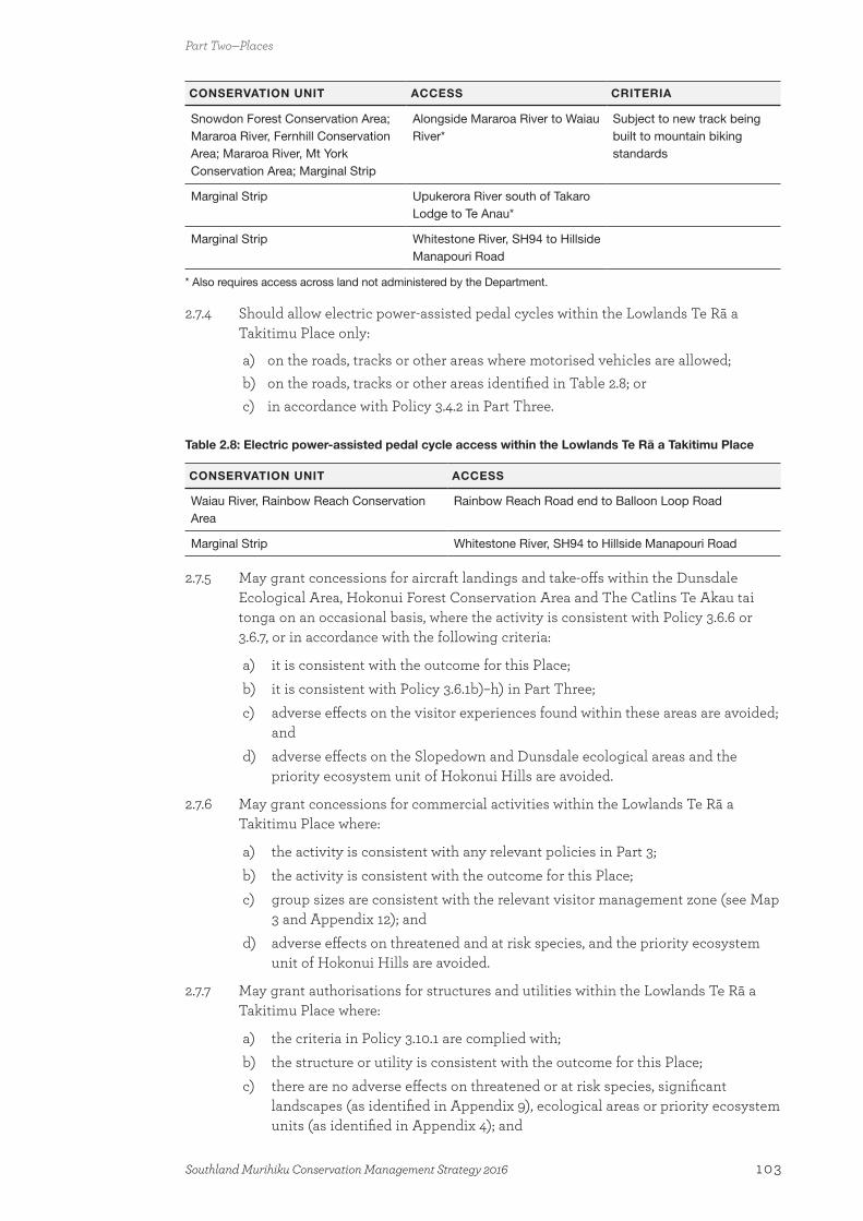
CONSERVATION UNIT ACCESS CRITERIA
Snowdon Forest Conservation Area; Mararoa River, Fernhill Conservation Area; Mararoa River, Mt York Conservation Area; Marginal Strip
Alongside Mararoa River to Waiau River*
Subject to new track being built to mountain biking standards
Marginal Strip Upukerora River south of Takaro Lodge to Te Anau*
Marginal Strip Whitestone River, SH94 to Hillside Manapouri Road
* Also requires access across land not administered by the Department.
2.7.4 Should allow electric power-assisted pedal cycles within the Lowlands Te Rā a Takitimu Place only:
a) on the roads, tracks or other areas where motorised vehicles are allowed; b) on the roads, tracks or other areas identified in Table 2.8; orc) in accordance with Policy 3.4.2 in Part Three.
Table 2.8: Electric power-assisted pedal cycle access within the Lowlands Te Rā a Takitimu Place
CONSERVATION UNIT ACCESS
Waiau River, Rainbow Reach Conservation Area
Rainbow Reach Road end to Balloon Loop Road
Marginal Strip Whitestone River, SH94 to Hillside Manapouri Road
2.7.5 May grant concessions for aircraft landings and take-offs within the Dunsdale Ecological Area, Hokonui Forest Conservation Area and The Catlins Te Akau tai tonga on an occasional basis, where the activity is consistent with Policy 3.6.6 or 3.6.7, or in accordance with the following criteria:
a) it is consistent with the outcome for this Place;b) it is consistent with Policy 3.6.1b)–h) in Part Three;c) adverse effects on the visitor experiences found within these areas are avoided;
andd) adverse effects on the Slopedown and Dunsdale ecological areas and the
priority ecosystem unit of Hokonui Hills are avoided.
2.7.6 May grant concessions for commercial activities within the Lowlands Te Rā a Takitimu Place where:
a) the activity is consistent with any relevant policies in Part 3;b) the activity is consistent with the outcome for this Place;c) group sizes are consistent with the relevant visitor management zone (see Map
3 and Appendix 12); andd) adverse effects on threatened and at risk species, and the priority ecosystem
unit of Hokonui Hills are avoided.
2.7.7 May grant authorisations for structures and utilities within the Lowlands Te Rā a Takitimu Place where:
a) the criteria in Policy 3.10.1 are complied with;b) the structure or utility is consistent with the outcome for this Place;c) there are no adverse effects on threatened or at risk species, significant
landscapes (as identified in Appendix 9), ecological areas or priority ecosystem units (as identified in Appendix 4); and
Part Two—Places
103Southland Murihiku Conservation Management Strategy 2016
d) the structure or utility complements the cultural values present, such as wāhi tapu, wāhi taonga and whenua tūpuna.
2.7.8 Work with Ngāi Tahu and the community, including relevant agencies, to:
a) increase the protection and enhancement of indigenous vegetation within the Lowlands Te Rā a Takitimu Place, through both formal and informal processes;
b) continue redevelopment of Curio Bay/Porpoise Bay as a Gateway destination; and
c) ensure that development within The Catlins Te Akau tai tonga area does not detract from the coastal landscape.
2.7.9 Promote the benefits of remnant indigenous vegetation within the Lowlands Te Rā a Takitimu Place and work with Ngāi Tahu and the community, including relevant agencies, to develop regenerating corridors within this Place to assist the movement of indigenous species.
2.7.10 Advocate to relevant agencies that land use activities within the Lowlands Te Rā a Takitimu Place should not adversely affect the freshwater values in the Freshwater Wai Māori Place, including that:
a) wetlands, riparian areas, uplands and flood plains should be retired from intensive grazing and farming regimes; and
b) any remaining grazing and farming of wetlands, riparian areas, uplands and flood plains should reflect modern best practice to sustain and restore sensitive habitats and in-water values.
2.7.11 Support community goals to create pest- and wild animal-free areas within the Lowlands Te Rā a Takitimu Place, such as at Forest Hill Scenic Reserve.
2.7.12 Promote the values of the Lowlands Te Rā a Takitimu Place to locals, schools and visitors to encourage increased use of and learning opportunities within the public conservation lands and waters of this Place.
2.7.13 Should grant authorisations for grazing and farming on public conservation lands and waters within the Lowlands Te Rā a Takitimu Place only where the activity is consistent with Policy 3.15.1 in Part Three and in accordance with the following criteria:
a) it is not within an ecological area or a priority ecosystem unit;b) livestock do not have direct access to waterways;c) it will not adversely affect the conservation values present;d) the land and soil type are suitable for grazing and farming;e) the catchment is not sensitive to increased nutrient levels;f) public access to public conservation lands and waters is retained;g) there is no increased flooding risk of the land; andh) there are no adverse effects on freshwater quality.
2.7.14 Support Ngāi Tahu and community initiatives in The Catlins Te Akau tai tonga that are consistent with the outcome for the Lowlands Te Rā a Takitimu Place and that will enhance the visitor experience in this area.
2.7.15 Continue to increase the public’s appreciation of the marine species that can be viewed at the Lowlands Te Rā a Takitimu Place and improve people’s awareness of how to behave around marine wildlife.
Part Two—Places
104 Southland Murihiku Conservation Management Strategy 2016

2.7.16 Continue to support and progress the Southland Coastal Heritage Inventory Project to increase understanding of the important historic and cultural values within the Lowlands Te Rā a Takitimu Place.
MILESTONES—OUTPUTS
Achieved by the end of Year 3 after CMS approval (2019)
• Identification, in conjunction with Ngāi Tahu, relevant agencies and the community, of improvements to visitor facilities within the Lowlands Te Rā a Takitimu Place.
Achieved by the end of Year 5 after CMS approval (2021)
• Increased community involvement and active engagement in the conservation management of the Lowlands Te Rā a Takitimu Place.
• Contributed to investigations to seek improved protection of important wetlands both on and off public conservation lands and waters in the Lowlands Te Rā a Takitimu Place.
Achieved by the end of Year 10 after CMS approval (2026)
• Increased acknowledgement and protection by pastoral landowners/leaseholders of natural heritage values on their lands within the Lowlands Te Rā a Takitimu Place.
• Improved visitor facilities within the Lowlands Te Rā a Takitimu Place.
2.8 Awarua PlaceThe Awarua Place extends from Toetoes Harbour Spit Conservation Area (Fortrose Spit) in the east, to Omaui and New River Estuary in the west, and The Bluff/Motupōhue in the south (see Map 5.8). There are a number of important parcels of public conservation lands and waters within this Place, such as Motupōhue Scenic Reserve, Omaui Scenic Reserve, Seaward Moss Conservation Area, Tiwai Conservation Area, Toetoes Conservation Area and Waituna Wetlands Scientific Reserve.
By its nature, this Place is strongly connected to the Freshwater Wai Māori Place and the Foveaux Te Ara a Kiwa Place (see sections 2.6 and 2.9). It is important for its high ecological values, including the Awarua wetland complex, and various estuaries and lagoons. In addition, Bluff is viewed as the ‘stepping-off point’ to Stewart Island/Rakiura, the subantarctic islands and coastal Fiordland. At Bluff, there is a ‘chain link’ sculpture that symbolises the connection that mainland Southland Murihiku has with Stewart Island/Rakiura, where there is a corresponding sculpture. In this way, this Place is also strongly connected with the Places within the Stewart Island/Rakiura CMS and the Rakiura National Park Management Plan 2011.
Description
The name ‘Awarua’ originated in the Pacific and was given to the Awarua area by tangata whenua, to represent their ancient connections with the Pacific. In the context of Southland Murihiku, it means two bodies of water.
Part Two—Places
105Southland Murihiku Conservation Management Strategy 2016
The Awarua Place is home to an array of values that are recognised locally, nationally and internationally. A mix of ecological, cultural and historic values and recreation opportunities contribute to the special characteristics of the Awarua Place. This Place is an ideal location for promoting and increasing awareness of conservation in Southland Murihiku, particularly given its proximity to the region’s largest population base, Invercargill.
This Place includes one of the largest wetland areas in New Zealand, the Awarua wetland complex, which contains extensive peat bogs and estuaries, some of which are within the Waituna–Awarua Plains priority ecosystem unit. Approximately 20 000 hectares of this complex is the Awarua Wetland of International Importance (see Appendix 15), covering all or part of: the Waituna Wetlands Scientific Reserve; Waituna, Waghorn and Waghorn Waituna scenic reserves; Seaward Moss, Awarua Plains, Awarua Bay, Tiwai Spit and Toetoes conservation areas; and Toetoes Harbour, Awarua Bay and New River Estuary.
In addition to peat bog, the Awarua wetland complex contains a diverse mosaic of indigenous wetland vegetation, including a number of species that are usually found in alpine habitats, such as the cushion-forming Donatia novae-zelandiae, comb sedge (Oreobolus pectinatus), sky lily (Herpolirion novae-zelandiae), four sundews (Drosera spp.), and the Naturally Uncommon gentian Gentianella lineata. There are also pockets of indigenous tussockland, rushland and harakeke/flaxland, as well as remnant forest woven into the wetland vegetation, which is dominated by mānuka shrubland and wire rushland.
There are a number of pressures on this internationally significant wetland complex, largely as a result of human modification and intensification of agriculture within the catchment. This is of particular concern around the Waituna Lagoon, where sediment and nutrient inputs are increasing algal growth and impacting on the aquatic indigenous plant communities, as well as degrading water quality. Both Ngāi Tahu and the community highly value this Place, with a number of community groups and agencies, such as the Waituna Landcare Group, the Waituna Partners Group29 and Community Investment in Water30, working hard to improve the water quality within the wetland complex. Fires, particularly as they can burn for long periods in this environment, can lead to extensive loss of ecological values and opening up areas for new invasions of pest plants. Consequently, the Department works closely with the Southern Rural Fire Authority (of which the Department is a member), focusing on prevention where possible. Pest plants and animals are another threat to the indigenous ecosystems.
The Waituna Lagoon is a highly valued component of the Awarua wetland complex and is home to a number of threatened and at risk indigenous species, such as the Nationally Vulnerable Pygmy clubrush, the Declining tufted hair grass and swamp nettle, and the Naturally Uncommon native musk, as well as important beds of the aquatic plants Ruppia megacarpa and R. polycarpa. The name ‘Waituna’ means ‘water of eels’, which highlights the value of the lagoon both as a mahinga kai/moana gathering site and as indigenous fish habitat.
The streams and creeks flowing into Bluff Harbour, Awarua Bay and Waituna Lagoon contain indigenous marine, estuarine and freshwater fish species, which include populations of the Declining taiwharu/giant kōkopu, redfin bully, īnanga/īnaka and tuna/longfin eel, plus banded kōkopu, tuna/shortfin eel, common bully and kōkopu/hawai/giant bully (Gobiomorphus gobioides), and estuarine species such as aua/yellow-eyed mullet
29 Made up of the Department, Environment Southland, Southland District Council, Te Rūnanga o Ngāi Tahu and Te Rūnanga o Awarua.
30 A joint project between the Department and Fonterra that involves working with dairy farmers, local communities and other stakeholders. It is one of five programme sites across New Zealand.
Part Two—Places
106 Southland Murihiku Conservation Management Strategy 2016

(Aldrichetta forsteri), paraki/smelt, estuarine triplefin (Grahamina sp.) and pātiki/flounder (Rhombosolea spp.). Furthermore, Waituna Lagoon is an important brown trout fishery in Southland Murihiku.
The Waituna Lagoon is opened periodically to the sea, resulting in dynamic switches between freshwater and estuarine environments, which constantly change and influence the aquatic communities found within the lagoon. It is an important interface and link between the coastal environment and the freshwater network of streams and channels. It is essential that the Department works with Ngāi Tahu and the community, particularly adjoining landowners and relevant agencies, to ensure the protection and use of this Place.
Waituna Lagoon, Awarua Bay and Toetoes Harbour, along with Jacobs River and New River Estuaries, comprise the most important bird habitats in Southland Murihiku, as well as some of the most important wading bird habitats nationally. Thousands of international migratory waders visit this area annually from the northern hemisphere, including the Declining kuaka/eastern bar-tailed godwit, as well as the Pacific golden plover (Pluvialis fulva), ruddy turnstone (Arenaria interpres) and the grey-tailed tattler (Tringa brevipes). These birds are valued by the community and bird watching is a popular activity within the area.
There are also a number of national migratory birds that utilise these habitats at various times of the year. For example, up to one-third of the Nationally Critical tūturiwhatu/southern New Zealand dotterel population, which nests on Stewart Island/Rakiura, can be found in Awarua Bay during the winter; and Waituna Lagoon is one of the few habitats in the far south that is known to support threatened and at risk species such as the Nationally Endangered matuku-hūrepo/Australasian bittern, the Declining South Island mātātā/fernbird and the Relict pūweto/spotless crake. Rabbit Island, in Bluff Harbour, has the largest nesting colony of the Naturally Uncommon kōtuku-ngutupapa/royal spoonbill in Southland Murihiku.
Game birds found within this Place include the Nationally Critical pārera/grey duck, as well as the mallard duck, pūtangitangi/paradise shelduck, Australasian shoveler (Anas rhynchotis), black swan (Cygnus atratus) and pūkeko (Porphyrio porphyrio melanotus).
Most of the estuary edges are fringed with indigenous intertidal salt marsh vegetation, which is in good condition and contains some excellent examples of jointed rushlands (Juncus articulatus) and salt marsh turfs. The Declining sea sedge and tufted hair grass, and the Naturally Uncommon dwarf mistletoe Korthalsella salicornioides can be found in the estuaries.
The Awarua Place contains two sites with important dune ecosystems: Toetoes Harbour Spit Conservation Area (Fortrose Spit) and near the Three Sisters. The former contains one of the most natural remaining dune systems along the Southland Murihiku coast. It has extensive cushionfields, which contain populations of the Nationally Vulnerable buttercup Ranunculus recens, the Declining coastal mat daisy Raoulia aff. hookerii, sand tussock and pīngao, and the Naturally Uncommon southern sand daphne. The dune system near the Three Sisters is of particular significance as it is the only remaining natural habitat in the South Island for the Nationally Critical Hamilton’s gunnera (one of the world’s rarest plants), and is also home to at least 12 other threatened and at risk species, including healthy populations of the Nationally Vulnerable creeping sand iris, plus the Declining sand tussock, coastal mat daisy and pīngao. Areas of coastal turf are also found along the coastline between Bluff and Omaui, some of which contain important populations of the Declining coastal cress Lepidium tenuicaule.
Part Two—Places
107Southland Murihiku Conservation Management Strategy 2016
Small, fragmented, remnant indigenous forest stands can be found within this Place, representing what was once much more extensive forest. These remnants provide an important seed source for indigenous forest regeneration within the Awarua wetland complex.
Tiwai Point peninsula has a mosaic of indigenous vegetation including areas that are dominated by the largest remaining expanse of red tussockland nationally, as well as lowland harakeke/flax (Phormium tenax), shrub species and rārahu/bracken (Pteridium esculentum). It is also the southern limit for several plants, such as glaucous speargrass (Aciphylla glaucescens) and tūmatakuru/matagouri (Discaria toumatou). Tōtara forests are thought to have once been the dominant indigenous vegetation cover, but this was progressively lost following the arrival of humans. However, there are stands of regenerating tōtara forest within this area. The peninsula provides habitat for several threatened and at risk species, including Libertia peregrinans, Raoulia aff. hookerii, southern sand daphne, plus the Declining forget-me-not Myosotis pygmaea and tātaraheke/sand coprosma.
The Awarua Place also supports a very rich moth fauna, including a number of threatened and at risk species such as the Nationally Endangered Asaphodes frivola (Meyrick 1913) and Meterana “Foveaux Strait”, the Declining sphagnum porina and Dasyuris partheniata (Guenée 1868), the Relict Notoreas casanova (Patrick and Hoare 2010), and the Naturally Uncommon Tmetolophota blenheimensis (Fereday 1883) and Pyrgotis pyramidias (Meyrick 1901).
The Bluff/Motupōhue and Omaui have some of the largest lowland indigenous forests remaining in Southland Murihiku, which extend right to the coast. The Bluff Hill/Motupōhue Environment Trust has undertaken extensive pest animal control in The Bluff/Motupōhue area, with a vision of restoring The Bluff/Motupōhue so that indigenous species that were once present can eventually be released back into this environment. The Trust is also looking to expand its work into the Omaui area.
Intermittently open to the sea, Waituna Lagoon was a major food basket, utilised from nearby nohoanga and permanent settlements for its wide variety of mahinga kai. The wetlands are important kohanga (spawning grounds) for indigenous fish species. Paru (black mud) was particularly sought for making dyes. The tūpuna had considerable knowledge of whakapapa, traditional trails and tauranga waka; places for gathering kai and other taonga; ways in which to use the resources of Waituna; the relationship of people with the lake and their dependence on it; and tikanga for the proper and sustainable utilisation of resources. All of these values remain important to Ngāi Tahu today.
A number of sites within this Place are of significant cultural importance. The Bluff/Motupōhue is a Tōpuni, Statutory Adviser and Deed of Recognition site (see 1.4 Treaty partnership with Ngāi Tahu). Motupōhue is an ancient name that was brought south by Ngāti Māmoe and Ngāi Tahu from the Hawke’s Bay region, where both tribes originated. The Waituna Wetland, and Mataura and Oreti rivers, which flow into this Place, also include Deed of Recognition areas.
There are many cultural sites (including wāhi tapu) and associated stories in this Place, such as at The Bluff/Motupōhue and Omaui. Archaeological evidence reinforces cultural tradition about the importance of this area for settlement, mahinga kai and stone resource use as well as urupā. Two important sites are Tiwai Point and Colyers Island, both of which were stone quarries and workshops for the production of adzes and other tools that were traded as far north as Canterbury from the earliest centuries of Māori settlement of New Zealand. Many of these sites are vulnerable to the effects of coastal erosion and land use.
Part Two—Places
108 Southland Murihiku Conservation Management Strategy 2016
The Bluff/Motupōhue is also the site of a World War II gun emplacement, battery observation post, radar and camp (an actively conserved historic place).
The Awarua Place was a focus of early cultural interaction between Māori and European sealers, whalers and traders. Settlements emerged to supply food and fibre to these European newcomers, and a few archaeological sites on and off public conservation lands and waters remain to represent this aspect of history.
The Awarua Place has a strong local focus and the proximity of this Place to Invercargill means that it has the potential to be utilised more into the future. The Waituna Lagoon walkway was built to get people into the Awarua Place and raise awareness of the significant values within it. Walking, cycling, hunting, bird watching, botanising, fishing and game bird hunting are popular recreational activities; and the nearby gravel bar at Toetoes Harbour Spit Conservation Area (Fortrose Spit) is used by four-wheel drivers and motorcyclists. It is important that the impacts of vehicles on the values of the spit are monitored to ensure that the significant natural values of this area are not adversely affected.
Bluff Hill/Motupōhue Scenic Reserve is a Gateway destination and one of the most popular sites for visitors to Southland Murihiku. Visitors are able to drive or walk (via one of two tracks) to the summit, and this reserve is the southern counterpart to Cape Reinga/Te Rerengawairua in the north, at the opposite end of State Highway 1.
Historically, there has not been a lot of commercial activity within this Place; however, there are opportunities for commercial growth, where it is sympathetic to the existing recreational use and conservation values of the Place.
There has also been little demand, to date, for aircraft access within the Awarua Place, due to the availability of other forms of mechanised access. Occasional aircraft landings within this Place are allowed, but these are managed at a level that protects the values, including natural quiet, of this Place. There could also be limited occasions where aircraft use is authorised for activities such as research and documentary filming of the Awarua wetland complex.
Outcome, policies and milestones for the Awarua Place
OUTCOME
The range of ecosystems within the Awarua Place, including the internationally recognised and priority ecosystem unit of the Waituna–Awarua Plains and the remnant indigenous coastal forests on The Bluff/Motupōhue, are treasured by Ngāi Tahu, locals and visitors from further afield.
Managed to enhance its values, the Awarua wetland complex is recovering and supports an array of threatened and at risk indigenous plant and animal species. The healthy lagoon is able to support cultural harvesting of mahinga kai and the Place is alive with birds. With community involvement, the red tussocklands at Tiwai Point peninsula have been restored.
There are opportunities for people to view and learn about a range of indigenous species in their natural habitat. School groups regularly visit and the Awarua Place is a focus for conservation in Southland Murihiku.
There is minimal development, with coastal views and low-impact recreation prevailing. The values of this Place are appreciated by the community, who enjoy it for bird watching, kayaking, walking, fishing and game bird hunting. There are also occasional opportunities to view marine mammals from the land.
Part Two—Places
109Southland Murihiku Conservation Management Strategy 2016
Bluff, the stepping-off point to the south, connects people to Stewart Island/ Rakiura, the subantarctic islands and the southern fiords. The Bluff/Motupōhue is a well-utilised Gateway destination, its cultural significance is respected and protected, and the community is strongly involved in its restoration and management.
Access to public conservation lands and waters within the Awarua Place is predominantly by foot from nearby road ends, including Local Treasure destinations, or by boat or kayak. Aircraft are occasionally used to access public conservation lands and waters. These modes of transport do not affect the experience of visitors or ecological and cultural values. In the heart of the wetland complex, nature dominates and visitors rarely encounter aircraft.
Interpretation reveals the layers of history associated with the diverse and rich range of archaeological and historic sites. Visitors to these sites understand and feel connected to this history. Place names that symbolise the relationship that Ngāi Tahu have with the landscape and associated cultural features are recognised and used. By working with Ngāi Tahu, local authorities, other agencies and the community, the natural and human processes that affect heritage are managed.
Commercial activity facilitates learning and enhances conservation values within this Place, and does not adversely affect the experience of other recreational users. Structural development does not detract from the natural and cultural landscape. Viewing of the night sky and the natural behaviour of indigenous birds are unaffected by artificial light.
Partnerships with Ngāi Tahu, relevant agencies and the community, including businesses, benefit the Awarua Place.
POLICIES
2.8.1 Manage (including when considering concession applications) those parts of the Awarua Place that are identified as the Awarua Wetland of International Importance to maintain the criteria for which it was nominated under the Convention on Wetlands of International Importance especially as Waterfowl Habitat 1971 (also referred to as the Ramsar Convention) and New Zealand’s obligations under the Convention (see Appendix 15).
2.8.2 Protect and enhance the Awarua wetland complex, including the Awarua Wetland of International Importance, the Waituna–Awarua Plains priority ecosystem unit and the water quality of the Waituna Lagoon, by working with Ngāi Tahu, relevant agencies and the community, including landowners and businesses.
2.8.3 Work with Ngāi Tahu and the community to:
a) enhance the significant ecological values within the Awarua Place, with particular priority being given to the Awarua wetland complex, the cushion bogs, the red tussockland on Tiwai Point peninsula and estuarine habitats;
b) promote and increase awareness of the significant historic and cultural values of the Awarua Place, including interpretation of the Māori cultural landscape;
c) manage The Bluff/Motupōhue as a Gateway destination and promote the cultural connections, in conjunction with the Bluff Hill/Motupōhue Environment Trust.
2.8.4 Have regard to the cultural importance of mahinga kai places and resources to Ngāi Tahu within the Awarua Place, where practicable and consistent with legislation.
Part Two—Places
110 Southland Murihiku Conservation Management Strategy 2016

2.8.5 May grant concessions and/or permits for commercial land-based marine mammal and wildlife viewing activity within the Awarua Place, where the activity:
a) does not adversely affect marine mammals or wildlife; andb) with respect to marine mammal viewing, is in accordance with Policies 3.12.1–
3.12.6 in Part Three.
2.8.6 May grant concessions for commercially guided recreational activity within the Awarua Place subject to Policy 2.8.5 and where:
a) the activity is consistent with the outcome for this Place;b) group sizes are consistent with the relevant visitor management zone (see Map
3 and Appendix 12); and c) the activity does not adversely affect non-commercial recreational use within
this Place.
2.8.7 May grant authorisations for structures and utilities within the Awarua Place where:
a) the criteria in Policy 3.10.1 are complied with;b) the structure or utility is consistent with the outcome for this Place;c) the structure or utility complements the values present, in particular the:
i) traditional recreational use of this Place; ii) sensitive ecological values, particularly the Waituna–Awarua Plains
priority ecosystem unit; andiii) cultural values such as mahinga kai, wāhi tapu, urupā, whenua tūpuna and
tauranga waka; andd) there are no more than two telecommunication towers on The Bluff/
Motupōhue and other structures or utilities are minimised.
2.8.8 May grant concessions for aircraft landings and take-offs within the Awarua Place on an occasional basis, where the activity is consistent with Policy 3.6.6 or 3.6.7, or in accordance with the following criteria:
a) it is consistent with the outcome for this Place;b) it is consistent with Policy 3.6.1b)–h) in Part Three;c) adverse effects on the visitor experience found within this Place are avoided; d) adverse effects on ecological and cultural values are avoided; ande) there is a demonstrable conservation benefit.
2.8.9 Should allow motorised vehicles within the Awarua Place only:
a) on the roads purposely formed and maintained for motorised vehicle use at the time this CMS is approved; or
b) in accordance with Policy 3.2.3 or 3.2.4 in Part Three.
2.8.10 Should allow mountain bikes within the Awarua Place only:
a) on the roads, tracks or other areas where motorised vehicles are allowed; or b) in accordance with Policy 3.3.4 in Part Three and:
i) in locations that are able to withstand this activity;ii) where there will be no adverse effects on the physical, ecological or
cultural values within this Place; andiii) in accordance with Policies 3.3.2–3.3.3 and 3.3.5–3.3.8 in Part Three.
2.8.11 Should allow electric power-assisted pedal cycles within the Awarua Place only:
Part Two—Places
111Southland Murihiku Conservation Management Strategy 2016
a) on the roads, tracks or other areas where motorised vehicles are allowed; orb) in accordance with Policy 3.4.2 in Part Three.
2.8.12 Work with the Southern Rural Fire Authority to ensure a precautionary approach is taken to preventing and minimising the risk of fires impacting on ecological values within the Awarua Place.
2.8.13 Should not grant concessions to graze the wetlands, flood plains or riparian areas within the Awarua Place.
MILESTONES—OUTPUTS
Achieved by the end of Year 3 after CMS approval (2019)
• Work underway, in conjunction with Ngāi Tahu, relevant agencies and the community, to raise awareness of the threats to important ecosystems within the Awarua Place.
• Initiated monitoring of the effects of motorised vehicle use on Toetoes Harbour Spit Conservation Area (Fortrose Spit).
Achieved by the end of Year 5 after CMS approval (2021)
• Work underway, in conjunction with Ngāi Tahu, relevant agencies and the community, to address the threats to important ecosystems within the Awarua Place.
• Sediment and nutrient inflows into Waituna Lagoon are reducing and water quality is improving.
• On-site interpretation showcasing the cultural and historic values of The Bluff/Motupōhue.
• Assessment of the monitoring results regarding the effects of motorised vehicle use on Toetoes Harbour Spit Conservation Area (Fortrose Spit).
Achieved by the end of Year 10 after CMS approval (2026)
• The Ramsar Convention Secretariat confirms that the Awarua Wetland of International Importance is well managed and continues to support a range of important species and functioning ecosystems.
• Continued reduction of sediment and nutrient inflows into Waituna Lagoon and continued improvements to water quality.
• No damage to the significant natural values of Toetoes Harbour Spit Conservation Area (Fortrose Spit) from motorised vehicle use.
2.9 Foveaux Te Ara a Kiwa PlaceThe Foveaux Te Ara a Kiwa Place incorporates the southern marine environment (out to 12 nautical miles, except where it abuts the Stewart Island/Rakiura CMS boundary) and associated coastline from Sand Hill Point in the west to Waikawa Harbour in the east, where it adjoins the Marine/Te Tai o Ārai te Uru Place within the Otago CMS (see Maps 5.9 and 5.9.1). The integrated nature of the marine environment and the coastline means that this Place needs to be considered holistically alongside other neighbouring Places within this
Part Two—Places
112 Southland Murihiku Conservation Management Strategy 2016

CMS (i.e. the Fiordland Te Rua-o-te-moko Place, the Longwood O Hekeia Place, the Lowlands Te Rā a Takitimu Place and the Awarua Place), as well as the Stewart Island/Rakiura CMS and the Otago CMS.
Southland Regional Council is responsible for the management of the coastal marine area, which it manages in accordance with the Regional Coastal Plan for Southland 2013. The Department manages a number of important islands within this Place, including Omaui Island (a Conservation Area) and Pig Island (Tīhaka) (a Scenic Reserve). There are also two marine mammal sanctuaries within this Place (one at Te Waewae Bay and the other at Porpoise Bay), which the Department is responsible for under the Marine Mammals Protection Act 1978. Under this Act, the Department also has functions relating to the protection, conservation and management of marine mammals.
Description
To Ngāi Tahu, Foveaux Strait is known as Te Ara a Kiwa (the pathway of Kiwa), the name relating to the time when the traditional ancestor Kiwa became tired of having to cross the land isthmus that then joined Murihiku (Southland) with Rakiura (Stewart Island). Kiwa requested the obedient Kewa (whale) to chew through the isthmus and create a waterway so Kiwa could cross to and fro by waka. This Kewa did, and the crumbs that fell from his mouth are the islands in Foveaux Strait. Whales still travel this path today.
The Foveaux Te Ara a Kiwa Place is a dynamic and windswept landscape that is characterised by a combination of rocky headlands and small sandy bays, bordering what is one of the roughest stretches of water in New Zealand. The character and raw nature of this landscape, along with its ecosystems and species, are highly valued by the community. It is ever changing as a result of coastal processes, as well as development within the adjoining Places.
The Foveaux Te Ara a Kiwa Place contains a number of small estuaries and harbours, which are also part of the adjacent Places (Lowlands Te Rā a Takitimu, Awarua and Longwood O Hekeia). The estuaries are threatened by increasing sedimentation, as a result of increased run-off from land use intensification. Because of its importance to Ngāi Tahu, Waikawa Harbour is protected by the Tumu Toka Mātaitai Reserve, 31 where recreational and customary fishing can still take place, but commercial fishing is not allowed. Karepō/seagrass (Zostera capricorni) habitat, which is one of the most rapidly declining habitats globally, can also be found within estuaries in this Place. Karepō/seagrass is an important component of estuarine ecosystems, particularly due to its role as a juvenile fish refuge.
Throughout the Foveaux Te Ara a Kiwa Place, areas of soft sediment provide important habitat for shellfish such as toheroa (Paphies ventricosa) and flatfish such as pātiki/flounder. Toheroa can be adversely affected by vehicles driving on beaches such as Oreti Beach (where there is a Mātaitai Reserve). Coastal erosion in the vicinity of Bluecliffs Beach Road, Te Waewae Bay is also a threat to toheroa. Therefore, it is important that the Department works with Ngāi Tahu and the community, including relevant agencies, to protect the toheroa beds within Southland Murihiku.
Exposed sites along the coastline are characterised by large forests of kelp and other brown algae in the shallow subtidal zone to depths of 4–5 m. These communities represent one of the most productive biogenic habitats in temperate marine ecosystems and are therefore of commercial, recreational and cultural importance.
31 This covers most of Waikawa Harbour plus an area that includes Curio Bay, around South Head and the southern part of Porpoise Bay.
Part Two—Places
113Southland Murihiku Conservation Management Strategy 2016
Biogenic reefs also have high species diversity, providing valuable habitat as a rāwaru/blue cod nursery and an important foraging area for the Nationally Vulnerable hoiho/yellow-eyed penguin, as well as being important for sustaining fisheries. The distribution and size of these biogenic reefs are not well understood, but it is thought that they are found throughout the Foveaux Strait Te Ara a Kiwa Place. The protection of these reefs is a priority for the Department due to their high biodiversity value and the role they play as habitat for a number of marine species. Therefore, the Department intends to work together with Ngāi Tahu, Southland Regional Council and the fisheries sector to develop a better understanding of the biogenic reefs within this Place, and to advocate through relevant regional planning processes for protection of their values.
Marine mammals are an important part of this Place, are taonga species for which Ngāi Tahu has a kaitiaki role, and are highly valued by the community. The Nationally Critical rāpoka/whakahao/New Zealand sea lion, and the Nationally Endangered tūpoupou/Hector’s dolphin, tohorā/southern right whale and terehu/bottlenose dolphin, along with the kekeno/New Zealand fur seal can all be seen at various times of the year. The rāpoka/whakahao/New Zealand sea lion population is growing within Southland Murihiku and Otago, but the species is still in decline nationally.
Marine mammal encounters, particularly with kekeno/New Zealand fur seals and rāpoka/whakahao/New Zealand sea lions, are becoming more common in Southland Murihiku. The Department is actively working with the community and visitors to increase awareness of, and encourage appropriate behaviour around, marine mammals. These growing populations of marine mammals in Southland Murihiku deserve to be celebrated and supported.
There are two significant populations of tūpoupou/Hector’s dolphins within the Foveaux Te Ara a Kiwa Place: one at Porpoise Bay and one at Te Waewae Bay. Both of these populations are protected by marine mammal sanctuaries: the Catlins Coast Marine Mammal Sanctuary and Te Waewae Bay Marine Mammal Sanctuary (see Map 5.9). Porpoise Bay is a popular location for recreational users and visitors, being located on the Southern Scenic Route.
Tohorā/southern right whales can sometimes be seen during winter and spring throughout Te Waewae Bay and into the fiords in the Fiordland Te Rua o-te-moko Place. The tohorā/southern right whale population appears to be increasing and the opportunity to be able to view these species from New Zealand’s coast is cherished. However, careful management of the coastal marine area is required to ensure that this population is not affected by increasing activity or development. One option would be to extend the marine mammal sanctuary at Te Waewae Bay along the south coast and into Preservation and Chalky Inlets, to allow the tohorā/southern right whale population to re-establish its historic breeding grounds.
Other significant marine wildlife species that can be seen within this Place include the hoiho/yellow-eyed penguin and the Declining mangō-taniwha/great white/white pointer shark and basking shark. The hoiho/yellow-eyed penguins are present along the east coast, particularly at Curio Bay and along parts of the Otago coast. Threats to the penguins include predation, disease and human interference. Mangō-taniwha/great white/white pointer sharks and basking sharks are both protected under the Wildlife Act 1953, which means it is illegal to hunt, kill or harm them. In order to manage commercial cage diving operations that interact with the mangō-taniwha/great white/white pointer shark and ensure that the sharks are not adversely affected by their encounters with humans, operators are required to have a permit and need to comply with a cage diving code of practice.
The Department is responsible for issuing marine mammal viewing permits under the Marine Mammals Protection Act 1978 and the Marine Mammals Protection Regulations 1992 to commercial operators that wish to undertake marine mammal viewing. As at the date of
Part Two—Places
114 Southland Murihiku Conservation Management Strategy 2016
CMS approval, there was one vessel-based marine mammal viewing operation in Porpoise Bay. Due to the level of activity within this environment and the small number of tūpoupou/Hector’s dolphins present, further research on the Porpoise Bay population is needed before any new vessel-based operations are authorised in this area. However, land-based marine mammal viewing is possible.
In addition to Porpoise Bay, there are other opportunities for marine mammal and wildlife viewing (aerial-, vessel- or land-based) within this Place—for example, at Waipapa Point and Te Waewae Bay. However, these opportunities, particularly vessel- and aerial-based marine mammal watching, are carefully managed to ensure that the marine mammals being viewed are not harassed or disturbed. This is especially the case within the Te Waewae Bay Marine Mammal Sanctuary, where scientific research is needed to determine the levels of marine mammal viewing operations that could occur. Until this research has been undertaken, a precautionary approach is taken, and if tohorā/southern right whales are found to be breeding in Te Waewae Bay, permits are unlikely to allow viewing during the breeding season.
Some threatened and at risk seabirds also live in and migrate to this Place, including the Nationally Vulnerable Stewart Island shag, the Relict tītī/mottled petrel, and the Naturally Uncommon toroa/southern Buller’s mollymawk and toroa/northern royal albatross. Foveaux Strait (Te Ara a Kiwa) provides important feeding grounds for the at risk-Declining tītī/sooty shearwater.
There are a number of small islands containing public conservation lands and waters within this Place. The Naturally Uncommon kōtuku-ngutupapa/royal spoonbill nests on Omaui Island and Pig Island (Tīhaka), and the Relict Herekopare giant wētā is found on Pig Island (Tīhaka). Many of these islands have potential for restoration, with the ability to become a showcase for the original indigenous ecosystems. There is strong community interest in realising some of this potential and the Department seeks to support these initiatives.
The Foveaux Te Ara a Kiwa Place is of particular importance to Ngāi Tahu, as it was traditionally the source of a range of mahinga kai, including kai moana, marine mammals, birdlife and plants. The coast was once a major highway and trade route for tangata whenua, and Foveaux Strait (Te Ara a Kiwa) was a principal thoroughfare, with regular travel between Southland Murihiku and the offshore islands, particularly Stewart Island/Rakiura. Battle sites, urupā and landscape features bearing the names of tūpuna record the Ngāi Tahu ancestral history and numerous archaeological sites are tangible reminders of the significance of the Te Ara a Kiwa area as a whenua tūpuna.
Over half of the archaeological sites in Southland Murihiku are within 1 kilometre of the coast and some of these are actively managed. These sites reflect a range of activities, representing all aspects of life for early Māori: occupation sites, stone quarries and workshops, tauranga waka, and urupā. The first European activities—sealing, whaling and trading—were also very much concentrated along the coast, and resulted in some of the earliest cultural interactions between Māori and Europeans in New Zealand. Settlements emerged to supply food (primarily potatoes) and fibre to these newcomers, and a few remnants of these settlements survive as protected archaeological sites. Other sites include early whaling bases, remains of wharves, jetties, causeways and coach routes, shipwrecks, and harakeke/flax mills. Thus, as a place of first arrival and settlement for all people, as a place of some of the earliest cultural interactions between Māori and Europeans, and as the scene of the earliest industries, the Foveaux Te Ara a Kiwa Place includes some of the region’s most important archaeological sites. However, many of these sites, which stretch between the intertidal zone, across the coastal marine environment, and onto the land, are threatened by coastal erosion.
Part Two—Places
115Southland Murihiku Conservation Management Strategy 2016
A number of different recreational activities are undertaken within the Foveaux Te Ara a Kiwa Place, including snorkelling, diving, kayaking, swimming, surfing, game bird hunting and fishing. Riverton and Colac Bay/Ōraka are popular for surfing, and numerous fishing vessels can also be seen up and down the coastline. The southern end of the Aparima River is an important site for whitebait fishing, which also occurs at other river mouths along this coast. The Catlins Te Akau tai tonga coastline, particularly the Gateway destination of Curio Bay/Porpoise Bay, and Oreti Beach, are well used areas where many visitors and locals can be seen walking, running or simply enjoying the spectacular views throughout the year. The Curio Bay Scientific Reserve is a particularly important destination for many visitors because of the fossilised remains of an ancient forest that can be seen at low tide, and the opportunity to view wildlife such as tūpoupou/Hector’s dolphins and hoiho/yellow-eyed penguins. Many of the recreation opportunities within the Foveaux Te Ara a Kiwa Place are non-facility based, with access over council or privately owned land.
There is potential for development within the Foveaux Te Ara a Kiwa Place, such as marine energy and aquaculture. However, coastal developments can affect valued landscapes, as well as marine ecosystems and indigenous species. Therefore, it is important that the Department works with Ngāi Tahu, relevant agencies and the community to ensure that adverse effects on outstanding landscapes, marine ecosystems and species, and cultural and historic places are avoided or otherwise minimised.
The Foveaux Te Ara a Kiwa Place supports a large fishing industry based in Southland Murihiku. The Department works together with Ngāi Tahu, the fisheries sector, the Ministry for Primary Industries and Southland Regional Council to achieve protection of ecosystems and species within this Place.
Outcome, policies and milestones for the Foveaux Te Ara a Kiwa Place
OUTCOME
The dynamic and wild coastal environment of the Foveaux Te Ara a Kiwa Place is a major thoroughfare for both wildlife and humans, and is managed to protect and enhance its many natural, recreational and cultural values.
Migratory and local marine mammal and other wildlife species are thriving in their natural environment. People coexist with these growing populations and appreciate the value of marine ecosystems. Locals are proud of this Place and regularly share their knowledge with visitors.
There are authorised opportunities for cage diving with mangō-taniwha/great white/white pointer sharks and for marine mammals to be viewed from the shore, air or water, while avoiding breeding tohorā/southern right whales. Commercial activity within this Place is consistent with the important ecological values present.
Working with Ngāi Tahu and the community, including the fisheries sector, important biogenic reefs within this Place are understood and protected to ensure the ongoing maintenance and enhancement of marine ecosystems. Cultural harvesting can be carried out.
The Foveaux Te Ara a Kiwa Place complements the Fiordland coastal marine area and is highly connected to the surrounding land. The interdependence of the terrestrial and marine ecosystems is recognised and protected through integrated management. Sedimentation and eutrophication from adjoining Places in the coastal environment are minimised, protecting important karepō/seagrass habitats in estuaries. Pest plant eradication measures are successful and ongoing.
Part Two—Places
116 Southland Murihiku Conservation Management Strategy 2016

Mineral exploration and structural development within this Place and the adjoining Places does not detract from the outstanding natural coastal or locally distinctive landscapes, and impacts on threatened and at risk marine species and important marine ecosystems are avoided. The effects of artificial light on marine mammals and wildlife are minimised.
Knowledge of the human history and cultural values within this Place has grown through showcasing the stories and collaborating on joint projects, particularly the Southland Coastal Heritage Inventory Project. There is a better understanding of the effects of coastal erosion processes and strategies are in place to safeguard knowledge before historic sites are lost. Ngāi Tahu, communities and landowners are actively engaged in these projects and strategies.
POLICIES
2.9.1 Manage (including when considering concession applications) those parts of the Foveaux Te Ara a Kiwa Place that are identified as the Awarua Wetland of International Importance to maintain the criteria for which it was nominated under the Convention on Wetlands of International Importance especially as Waterfowl Habitat 1971 (also referred to as the Ramsar Convention) and New Zealand’s obligations under the Convention (see Appendix 15).
2.9.2 Work with Ngāi Tahu and the community, including relevant agencies, to:
a) in conjunction with the fishing industry, increase knowledge and awareness of the biogenic habitats within the Foveaux Te Ara a Kiwa Place;
b) minimise the effects of land and freshwater use on the coastal environment within the Foveaux Te Ara a Kiwa Place, including improving freshwater quality and minimising coastal erosion; and
c) increase awareness and appreciation for the marine environment within the Foveaux Te Ara a Kiwa Place. Particular attention should be given to:i) mechanisms that protect marine ecosystems and species under threat;ii) education, to ensure that there is appropriate behaviour around marine
mammals and wildlife;iii) increasing understanding and appreciation of the importance of the
marine environment in Southland Murihiku; andiv) increasing understanding and appreciation of the role that the Southland
Murihiku marine environment plays in a New Zealand context.
2.9.3 Work with Maritime New Zealand and industry operators to monitor the permits, and compliance with the code of practice, for cage diving with mangō-taniwha/great white/white pointer sharks; and to consider the need for regulations under the Wildlife Act 1953.
2.9.4 May only grant concessions and/or permits for commercial water- or aerial-based marine mammal viewing operations in Porpoise Bay or Te Waewae Bay:
a) provided that these operations do not occur in Te Waewae Bay during the breeding season if the tohorā/southern right whale is found to be breeding in the bay; and
b) if research shows that any adverse effects of the activity can be prevented.
Monitoring of these operations should be undertaken to understand their impact on marine mammals, both individually and cumulatively.
Part Two—Places
117Southland Murihiku Conservation Management Strategy 2016

2.9.5 Should grant concessions and/or permits for passive commercial, land-based marine mammal and marine wildlife viewing within the Foveaux Te Ara a Kiwa Place only in accordance with (but not limited to) the following criteria:
a) adverse effects on marine mammals can be prevented and adverse effects on other marine species are avoided;
b) interpretation and education are provided; andc) any adverse effects on the species being viewed are monitored.
2.9.6 May grant authorisations for structures and utilities within the Foveaux Te Ara a Kiwa Place where the criteria in Policy 3.10.1 are complied with and the structure or utility:
a) is consistent with the outcome for this Place; b) avoids adverse effects on marine ecosystems, marine mammals, marine wildlife
(including seabirds) and their habitats;c) avoids adverse effects on the natural character and outstanding landscapes;d) avoids adverse effects on wāhi tapu, wāhi taonga and archaeological values;e) mitigates the risk of shipping accidents and/or oil spills; andf) avoids the introduction of new, and mitigates the spread of existing, aquatic
pest organisms, including ensuring that adequate surveillance and control options are in place.
2.9.7 Continue to support and progress the Southland Coastal Heritage Inventory Project to increase understanding of the important historic and cultural values within this Place.
MILESTONES—OUTPUTS
Achieved by the end of Year 3 after CMS approval (2019)
• Work underway, in conjunction with Ngāi Tahu, relevant agencies, the fishing industry and the community, to protect, promote and increase awareness of the important values of the Foveaux Te Ara a Kiwa Place.
• Initiated research to assess the effects of marine mammal viewing operations in the Foveaux Te Ara a Kiwa Place on marine mammals.
• Assessed the effectiveness of the permit system and code of practice for commercial cage diving with the mangō-taniwha/great white/white pointer shark.
Achieved by the end of Year 5 after CMS approval (2021)
• Initiated investigations to identify the potential for future marine protected areas within the Foveaux Te Ara a Kiwa Place.
• Increased knowledge and awareness of biogenic habitats and other important values within the Foveaux Te Ara a Kiwa Place.
Achieved by the end of Year 10 after CMS approval (2026)
• Completed research to assess the effects of marine mammal viewing operations in the Foveaux Te Ara a Kiwa Place on marine mammals and recommendations implemented.
• Completed investigations into potential marine protected areas within the Foveaux Te Ara a Kiwa Place and work underway to implement recommendations.
Part Two—Places
118 Southland Murihiku Conservation Management Strategy 2016
2.10 Subantarctic Ngā Moutere O Murihiku Ki Tonga PlaceThe Subantarctic Ngā Moutere O Murihiku Ki Tonga Place comprises five island groups and their associated marine environments (out to 12 nautical miles), which lie between latitudes 47o and 53o south: the Antipodes Island Group, Auckland Islands, Bounty Islands, Campbell Islands and Snares Islands/Tini Heke (see Maps 5.10, 5.10.1 and 5.10.2). These are all National Nature Reserves under the Reserves Act 1977, 32 which provides their indigenous biodiversity and natural features with the highest level of protection available under New Zealand legislation.
The five island groups and their coastal waters were listed collectively as a World Heritage Area in 1998. There is one marine mammal sanctuary around the Auckland Islands, and four marine reserves around (all or parts of) the Antipodes Island Group, the Auckland Islands, the Bounty Islands and Campbell Island/Motu Ihupuku.
In addition, the Minister of Conservation is the territorial authority for the subantarctic islands under section 31A of the Resource Management Act 1991. The coastal marine area is managed by the Department by way of the Proposed Regional Coastal Plan: Kermadec and Subantarctic Islands (May 2012).33
Description
The Māori name ‘Ngā Moutere o Murihiku Ki Tonga’ refers to this Place encompassing the southern islands of Murihiku (Southland).34
The intrinsic values of the Subantarctic Ngā Moutere O Murihiku Ki Tonga Place are unique. The islands lie between the Antarctic and Subtropical Convergences, and the seas have a high level of productivity, biodiversity, wildlife population densities and endemism. The combination of internationally recognised indigenous ecosystems and the array of international history and culture make this environment virtually unmatched anywhere else in the world.
The land status of the islands as National Nature Reserves protects the nationally and internationally significant values that are present down to the mean low water mark. The values of the islands and their surrounding seas are also recognised by the World Heritage Area status (see Appendix 14), particularly for the endemic, threatened and at risk indigenous species that are present, and the significant indigenous ecosystems (all except the Bounty Islands are priority ecosystem units). The Auckland Islands—Motu Maha Marine Reserve/Marine Mammal Sanctuary and the Moutere Mahue/Antipodes Island Marine Reserve cover all of the marine area around the islands out to 12 nautical miles, while the Moutere Hauriri/Bounty Islands Marine Reserve and the Moutere Ihupuku/Campbell Island Marine Reserve cover portions of the marine area around these islands out to 12 nautical miles—all providing protection to the marine life within these areas. The Moutere Ihupuku/Campbell Island Marine Reserve may be extended to include the entire marine area around the island if a review recommends this and a decision is made to do so.
This Place comprises a region of extraordinary natural diversity and abundance. It is distinct from all other subantarctic island groups around the world in having the highest diversity of indigenous and often endemic plants and birds. Some species that are found on the islands
32 In accordance with sections 13 and 20 of the Act.
33 The rules in this plan have statutory effect under section 86B(3) of the Resource Management Act 1991 even though it had not been made operative at the time of approval of this CMS.
34 But excluding Stewart Island/Rakiura.
Part Two—Places
119Southland Murihiku Conservation Management Strategy 2016
have very limited distributions, with some being found only on one island group or even only on one or two islands within an island group, making them even more vulnerable to extinction.
In recognition of these values, section 6(c)(ii) of the Conservation Act 1987 specifically identifies that one of the functions of the Department is to promote the benefits, to present and future generations, of the conservation of the natural and historic resources of the subantarctic islands.
Antipodes Island Group
The Antipodes Island Group is on the southeast margin of the Bounty Plateau and is the youngest island group within the Subantarctic Ngā Moutere O Murihiku Ki Tonga Place. The islands in this group are made up of several volcanic cones, the highest being Mt Galloway at 366 metres on the main island. With cliffs up to 150 metres high, erosion by the sea has left a ragged shoreline that is dotted with sea caves, stacks and wave-cut platforms.
The Nationally Critical toroa/Antipodean albatross nests amongst the dense grasslands and tussocks. Many species of burrowing seabirds also breed on the islands, including the soft-plumaged petrel (Pterodroma mollis) and little shearwater (Puffinus assimilis), for which the Antipodes Island Group is the only breeding site in the New Zealand subantarctic region. As with the other island groups, the Antipodes Island Group has a high level of endemism, including the Naturally Uncommon kākāriki/Antipodes Island parakeet (which is the largest of New Zealand’s kākāriki/parakeets), kākāriki/Reischek’s parakeet, hōkioi/Antipodes Island snipe and pīhoihoi/Antipodes Island pipit. Small residual colonies of the nationally critical eastern rockhopper penguin and large, but diminishing colonies of the Declining erect-crested penguin, along with the Nationally Critical ihupuku/southern elephant seal and increasing populations of the kekeno/New Zealand fur seal, can be found along the shores. At least eight species of beetle are also endemic to these islands. Mice (Mus musculus) have had a major impact on the indigenous invertebrates and plants on the main island, but have never reached any of the smaller islands.
Bounty Islands
The Bounty Islands are the very tips of the submerged Bounty Plateau. Due to their low relief and almost constant sea spray, there is a lack of soil and only one species of terrestrial plant (the Nationally Critical Bounty Island scurvy grass) has ever been recorded on these islands. The rimurapa/common bull kelp (Durvillaea antarctica) creates a continuous golden and swirling fringe around the shoreline.
The Bounty Islands are home to a diverse collection of tens of thousands of seabirds, and in many places are stained white from their guano. This includes a population of about 500–600 endemic, Nationally Endangered Bounty Island shags, the world’s rarest cormorant. The Bounty Islands are also the world capital for the Nationally Critical toroa/Salvin’s mollymawk, as well as the Declining erect-crested penguin. Many thousands of kekeno/New Zealand fur seals can also be found here, as these islands are one of their main bases. Endemic terrestrial invertebrates, such as the Naturally Uncommon flightless beetle Bountya insularis and Bounty Island wētā are only found on these islands.
The remoteness of the Bounty Islands and the lack of safe anchorages mean that these islands are rarely visited, even by scientists. This means that these are some of the most untouched islands in the world.
Part Two—Places
120 Southland Murihiku Conservation Management Strategy 2016

Snares Islands/Tini Heke
The Snares Islands/Tini Heke are the closest of the subantarctic islands to mainland New Zealand. They are the only forested islands within this Place without any history of introduced mammals—not even mice. There are only two species of introduced plants on the islands: the grass Poa annua and the chickweed Stellaria spp. There are two main forested islands (North East and Broughton Islands), and the largely unvegetated Western Chain to the south, which is composed of six smaller islands. High granite cliffs surround the two largest islands, in which deep narrow caverns, sink holes and gulches have been formed through erosion by the sea.
The islands are a stronghold for the Naturally Uncommon Lyall’s tree daisy. Other significant plant species include the Nationally Critical Snares Island scurvy grass and Snares carrot, the Nationally Endangered nau/Cook’s scurvy grass, and megaherbs like the Naturally Uncommon Stilbocarpa robusta, and several bryophyte species; a number of lichen and fungal species are also present.
The Snares Islands/Tini Heke also have dense populations of seabirds, particularly the At Risk-Declining tītī/sooty shearwater, which number in their millions; petrels (tītī/subantarctic diving petrel (Pelecanoides urinatrix) and the Relict tītī/mottled petrel); toroa/albatross (the Naturally Uncommon toroa/southern Buller’s mollymawk and the Nationally Critical toroa/Salvin’s mollymawk); and penguins (including the Naturally Uncommon and endemic pokotiwha/Snares crested penguin). Three land birds are endemic to the Snares Islands/Tini Heke: the Naturally Uncommon mātātā/Snares Island fernbird, Snares Island tomtit (Petroica macrocephala dannefaerdi) and tutukiwi/Snares Island snipe.
Auckland Islands
The Auckland Islands are the largest island group within the Subantarctic Ngā Moutere O Murihiku Ki Tonga Place. These islands are the remains of two ancient volcanoes, one of which was centred on Carnley Harbour (between Auckland and Adams Islands) and the other centred on Disappointment Island to the west. In the west, the hard volcanic rock is pounded by the sea, with cliffs up to 400 metres high. By contrast, the east coast is indented by a series of glacial features, namely bays and long fiord-like inlets, with land that slopes steadily down to headlands in the open sea.
Following the eradication of goats, cattle (Bos taurus) and rabbits (Oryctolagus cuniculus) on these islands, the only remaining introduced mammals (as at the date of CMS approval) are pigs, cats and mice on Auckland Island.
There is an amazing diversity of indigenous plant life on these islands, including shrublands, grasslands and an abundance of megaherbs in areas where pigs are absent. The twisted and tortured trunks of the red-flowering rātā, which is a major feature of the islands, form a coastal forest around the lower fringes. There is also a huge diversity of animals, including marine mammals; seabirds such as the Nationally Critical toroa/Gibson’s albatross and the Declining toroa/white-capped mollymawk (over 100 000 pairs of which nest on Disappointment Island); six endemic land birds (the Nationally Vulnerable pāteke/Auckland Island teal and Auckland Island shag, and the Naturally Uncommon hākuai/Auckland Island snipe, pohowera/Auckland Island banded dotterel, Auckland Island rail and ngirungiru/Auckland Island tomtit); and invertebrates such as the large weevil Oclandius laeviusculus, which is largely restricted to the pest animal-free islands. The Auckland Islands are the main breeding site within this Place for the Nationally Vulnerable hoiho/yellow-eyed penguins, as well as the Nationally Critical rāpoka/whakahao/New Zealand sea lion, with the majority
Part Two—Places
121Southland Murihiku Conservation Management Strategy 2016

of all pups being born there and most of those at just two sites (Dundas Island and Enderby Island). In addition, Port Ross is an important place for Nationally Endangered tohorā/southern right whales, which frequent this area in the winter for calving and mating.
Campbell Islands
The Campbell Islands lie at the southern margin of the Campbell Plateau and are the southernmost island group within the Subantarctic Ngā Moutere O Murihiku Ki Tonga Place. These islands are the remains of a volcano, which has been shaped during the ice ages by glaciers, leaving landforms such as U-shaped valleys, cirques and moraines.
The islands are mostly covered by grasslands and tussocks that are dominated by Poa litorosa and the Naturally Uncommon subantarctic snow tussock; however, the grass tree Dracophyllum longifolium is making an extensive recovery since the halting of fires and the removal of introduced mammals. There are also three species of tree daisy (Olearia spp.) and a variety of megaherbs, including three species of Pleurophyllum, two of Anisotome and large fields of Bulbinella. In addition, the Campbell Islands have one of the greatest diversities of toroa/albatross species in the world, six of which breed here, as well as a variety of endemic birds, such as the Nationally Critical Campbell Island snipe and flightless Campbell Island teal, and the Naturally Uncommon Campbell Island shag.
The subantarctic marine environment
Together, the islands and the marine environment within this Place play a vital role in the wider Southern Ocean ecosystem. Not only do many species of seabirds and marine mammals depend on the rare areas of dry land for resting and breeding, but the health of the surrounding ocean is also paramount to their survival, as they depend on inshore and offshore areas for foraging while breeding and rearing young.
The marine environment within this Place is as unique as the islands themselves. Below the surface, a rich diversity of species can be found, which are just as important as the species found above it. Notable endemic species include a rimurapa/bull kelp (Durvillaea sp.), other large kelps of the genus Lessonia, and a brown seaweed (Marginariella parsonii sp. nov) that is restricted to the Bounty Islands and Antipodes Island Group. These kelps provide habitat for a number of invertebrates including an endemic subspecies of pāua, the whitefoot or virgin pāua (Haliotis virginea), and a burrowing sea anemone (Peachia sp.). It is also likely that many new species still await discovery.
The marine mammals present are still recovering from the impacts of hunting in the 19th century. The rāpoka/whakahao/New Zealand sea lion, ihupuku/southern elephant seal and tohorā/southern right whale are amongst the threatened species that are found within this Place; the kekeno/New Zealand fur seal is also found here. The rāpoka/whakahao/New Zealand sea lion is one of the rarest, most threatened and most highly localised of the five species of sea lion globally.
Populations of tohorā/southern right whales inhabit shallow waters during the winter mating and calving season around the Auckland and Campbell Islands. Port Ross in the Auckland Islands is their most important southwest Pacific breeding ground, but Northwest Bay in Campbell Island/Motu Ihupuku is also used.
Part Two—Places
122 Southland Murihiku Conservation Management Strategy 2016

Managing the Subantarctic Ngā Moutere O Murihiku Ki Tonga Place
The land–sea connection is vital to the array of species that are present within the Subantarctic Ngā Moutere O Murihiku Ki Tonga Place, and this interdependence between the terrestrial and marine environments was recognised when the islands and marine environment around them out to 12 nautical miles were registered as a World Heritage Area in 1998.
Given the extraordinary values across all five of the island groups within this Place, the Department takes a consistent management approach to eradicate remaining pests and wild animals where possible. The aim is to sustain thriving island ecosystems, free from the pressures of invasive plants and animals.
The Department has already undertaken a range of successful pest and wild animal eradication programmes; for example, cattle, sheep (Ovis aries) and Norway rats (Rattus norvegicus) on Campbell Island/Motu Ihupuku, goats on Auckland Island, and cattle, rabbits and mice on Enderby Island. The majority of islands are free of introduced mammals, with the exception of Auckland Island (pigs, cats and mice) and Antipodes Island (mice). The Department intends to eradicate the pest and wild animals from these islands within the term of this CMS as logistics and resources allow.
The pigs on Auckland Island have potential scientific value because of their prolonged isolation and lack of exposure to disease, but they are causing significant ecological damage. Removal of the pigs would improve the value of the island as a safe haven for species such as toroa/mollymawks, which, in the presence of pigs, are forced to nest on sheer cliffs to keep their young safe. In recognition of the scientific and potential medical value of these pigs, the Department intends to explore options with interested parties to transfer live pigs to the mainland before eradicating the remaining animals.
Birds such as the Campbell Island teal and Campbell Island snipe are coming back from the brink of extinction as a result of the pest and wild animal eradication programmes. However, many years are needed, even centuries, to fully restore the islands to their natural state.
There are also introduced plants within the Subantarctic Ngā Moutere O Murihiku Ki Tonga Place, particularly on Enderby Island and Campbell Island/Motu Ihupuku, which had the longest history of farming. Some small, localised eradications have been undertaken (for example, paewhenua/dock (Rumex spp.) on Enderby Island and kōti/gorse at Hardwicke on the main Auckland Island), but most other introduced plant species are either too widespread or pose a negligible risk to indigenous species to justify eradication programmes.
A pest incursion is one of the biggest threats to the integrity of this Place. Anything from the accidental introduction of a rat, to the establishment of a pest invertebrate or plant could result in irreparable damage. A disease outbreak within a vulnerable indigenous population, such as the rāpoka/whakahao/New Zealand sea lion, is of particular concern; and although such outbreaks occur naturally, human contact is an additional risk factor. Consequently, the Department has introduced measures to minimise biosecurity risks. For example, a quarantine store is maintained on the mainland, where all researchers’ and managers’ gear is inspected for potential pest species and cleaned; and all vessels undergo quarantine inspections and cleaning, before going to the islands.
There are also potential threats to the marine environment within this Place, such as the introduction of aquatic pest species like sea squirt (Styela clava). Unfortunately, Japanese kelp (Undaria pinnatifida) was found in the marine environment surrounding the Snares Islands/Tini Heke in 2006, and this is difficult to eradicate due to the logistics involved with the distance of these islands from mainland New Zealand. Although there have been no
Part Two—Places
123Southland Murihiku Conservation Management Strategy 2016

proposals (as at the date of CMS approval) to drill around the islands, oil exploration poses another potential threat, not only from oil spills, but also from increasing demand for safe anchorages; and any increase in vessel movements would also bring an increased risk of oil spills, and introducing pests and diseases.
These issues are addressed in the Proposed Regional Coastal Plan: Kermadec and Subantarctic Islands (May 2012), prepared under the Resource Management Act 1991. This statutory plan applies to the coastal marine area, which is from mean high water springs (MHWS) to the outer limits of the territorial seas around the island groups (c. 12 nautical miles). The proposed plan contains rules that control structures, disturbance, deposition and reclamation. To help manage marine biosecurity, any vessel intending to go closer than 1000 metres from MHWS must have a certified clean hull in accordance with the plan’s rules. In recognition of the high potential impact from an oil spill, the plan prohibits the use of heavy fuel oil (or carrying it as a cargo) within the territorial seas of each island group, with a 5-year transition period for fishing vessels that use heavy fuel oil.
Ngāi Tahu associations with islands include landscape features, indigenous vegetation, habitats of fauna, and cultural and spiritual values. Ngāi Tahu desires include the ability to exercise rangatiratanga with respect to the management of the islands. Key issues for Ngāi Tahu35 include the protection of indigenous flora and fauna, support for species recovery and translocation, pest management, and the management of biosecurity threats from increasing human interaction, including tourism.
The Subantarctic Ngā Moutere O Murihiku Ki Tonga Place is of cultural and spiritual significance to Ngāi Tahu. Tangata whenua utilised this Place for food and other natural resources prior to the arrival of Europeans. The cultural significance of the Snares Islands and Campbell Island to Ngāi Tahu is recognised by the te reo Māori names of Tini Heke and Motu Ihupuku, respectively. Ngāti Mutunga and Moriori also have a historic relationship with the Auckland Islands, resulting from their settlement of the islands from 1842 to 1856. Therefore, it is important that the Department liaises and consults with Ngāi Tahu regarding sites (including wāhi tapu) of interest, to ensure that approaches to conservation and interpretation are sensitive to the cultural values.
The Department is responsible for managing an array of historic sites within this Place. These sites represent a broad range of history and culture, from utilisation by Māori, early European sealing and settlement, through to the dramatic stories of shipwrecks, New Zealand’s southernmost sheep farm, and the coastwatching era of World War II. There are 21 actively conserved historic sites within this Place (see Appendix 10), a number of which straddle the land–sea boundary. Two of these sites are below MHWS and managed by the Proposed Regional Coastal Plan: Kermadec and Subantarctic Islands (May 2012). One site, on Enderby Island, is associated with Māori occupation, and is believed to be the southernmost limit of Polynesian exploration and settlement. Most of the actively conserved historic sites are located on Auckland and Enderby Islands, and Campbell Island/Motu Ihupuku; and all but one are accessible to visitors.
In recent years, information on sites in the Auckland Islands and Campbell Islands has been improved, but there is still a lack of recorded information for the Antipodes Island Group and the Snares Islands/Tini Heke. Threats to these sites include vegetation overgrowth, damage by sea lions and elephant seals, and erosion. A precautionary approach is taken
35 Refer Te Tangi a Tauira Ngāi Tahu ki Murihiku Natural Resources and Environmental Iwi Management Plan 2008.
Part Two—Places
124 Southland Murihiku Conservation Management Strategy 2016

regarding the management of the historic sites to ensure that there are no adverse effects. There is a need to formulate a historic strategy, in consultation with interested parties, to identify future management priorities.
The World War II coastwatcher base in Tucker Stream valley on Campbell Island/Motu Ihupuku became a meteorological base at the end of the war. It was re-established near Beeman Point in 1958, but this was de-staffed in 1995 and replaced with a smaller, purpose-built, automated meteorological station. The future of the old meteorological base relies on an agreement between the Department and the Meteorological Service of New Zealand as to whether to remove or re-use all or some of the 1945 buildings.
The Subantarctic Ngā Moutere O Murihiku Ki Tonga Place is a special Place for New Zealanders. Although most New Zealanders have not made the trip south to this Place, there is a real appreciation of and eagerness to learn more about the significant values present. The Department is keen to raise awareness internationally, nationally and especially locally of this Place and its values through off-site information and interpretation.
There is a real sense of discovery for those that are fortunate enough to visit the Subantarctic Ngā Moutere O Murihiku Ki Tonga Place, with its abundance of marine wildlife, birdlife, endemic vegetation and historic sites. Every step taken in this rugged and inhospitable environment unfolds a new experience. Given the islands’ protected status and the values present, access to them is by permit only. Permits are required for people maintaining the Meteorological Service of New Zealand facilities, researchers and visitors.36 Commercial tourism operators may also require a marine mammal viewing permit.
A precautionary approach is taken to the provision of access within this Place, to avoid potential adverse effects, such as the impact of tracks and the risks of biosecurity breaches. The protection and management requirements for this World Heritage Area (see Appendix 14) recognise that there is a need to manage research and visitor access while, most importantly, ensuring the long-term protection of the islands and the immediate marine environment, and, for visitors, protecting the experiences they are seeking.
Visitor access is only permitted on the main Auckland Island, Enderby Island and the main Campbell Island/Motu Ihupuku. Guidelines are in place to manage the number of visitors permitted to access approved sites at each of these islands, in order to manage impacts on the significant natural values. There is also a limit of no more than one cruise ship in a bay or harbour at any one time, to ensure that those on board the cruise ship can experience the isolation of this Place37. While these guidelines and limits mainly focus on managing tourism access by cruise ships, part of the quota for each site has been set aside to allow small, private vessels, such as yachts, to visit. A precautionary approach to managing access to the islands is necessary because of the difficulty in monitoring the impacts of visitors due to the remoteness of these islands, and because the environment or wildlife could take many decades, or more, to recover from any adverse effects. The Department works with the commercial tourist vessel operators, such as cruise ships, to increase awareness and generate support for the ongoing protection of this Place. The visitor season is over the summer period, with cruise ships predominantly operating from Bluff and Hobart (Australia).
36 In the Subantarctic Ngā Moutere O Murihiku Ki Tonga Place, this includes those who arrive on commercial tourist vessels (such as cruise ships) and those who arrive on private vessels.
37 See also the Proposed Regional Coastal Plan: Kermadec and Subantarctic Islands (May 2012), for related policies and rules that manage this activity below MHWS.
Part Two—Places
125Southland Murihiku Conservation Management Strategy 2016

The two most visited sites in this Place are the Northern Cliffs on Enderby Island (see Map 5.10.2) and Col-Lyall on Campbell Island/Motu Ihupuku (see Map 5.10.1), both of which have had boardwalks installed to minimise visitor impacts. If further hardening of sites is needed in the future, the Department intends to work with the community, the Royal New Zealand Navy and those with commercial interests to achieve this. It is also important that the Department explores new ways of working with concessionaires to protect the conservation values of these sites, including monitoring the impacts of visitors and establishing levels of use.
A precautionary approach is also taken to the management of aircraft access to the islands within this Place. All aircraft landings require an entry permit and a concession.38 In addition, permanent restricted airspace areas have been prescribed pursuant to Civil Aviation Rules, which mean that all overflights (up to 3500 feet AMSL) over the islands require the permission of the Department. This has been set up for the purposes of protecting fauna. Aircraft landings and overflights within this Place are only authorised where they are absolutely necessary to support an activity taking place there.
Scientific research is a major activity within this Place and the Department receives a large number of applications every year, which are carefully assessed on a case-by-case basis. Some important matters to consider are the likely impact of the research on the islands, such as the biosecurity risk; physical damage, such as track formation; and disturbance to wildlife. These need to be balanced against the likely benefits of the work. The Department works with research parties to minimise the impact on the islands and to save on costs by coordinating projects, including transport where possible; for example, one party may carry out the collection of specimens for several other researchers. Two long-term projects (20 plus years) being carried out in the Subantarctic Ngā Moutere O Murihiku Ki Tonga Place are research on rāpoka/whakahao/New Zealand sea lions and toroa/wandering albatross.
Research and collection permits can be authorised for up to 5 years, with an additional permit to enter the nature reserves under the Reserves Act 1977 also being required for each expedition. Research is frequently undertaken on all of the island groups, with the exception of the Bounty Islands, due to their isolation and severe access difficulties. In 2005, the Department developed a research strategy for the subantarctic islands, 39 which identified research priorities for the islands and provided guidance on what research could be performed there. It is important to regularly update this research strategy during the term of this CMS to identify and facilitate research on priority projects within this Place.
Historically, a departmental representative has been present on every voyage where people land on the islands within the Subantarctic Ngā Moutere O Murihiku Ki Tonga Place. This has been a crucial component of ensuring that people visiting this Place understand how to behave around wildlife and that actions are taken to avoid the biosecurity risks associated with their visit. The Department intends to continue this system or a similar system into the future, to ensure the long-term protection of the intrinsic values of this Place.
There could be opportunities for the public to be involved in restoration and management activities in this Place, particularly on Auckland Island, Enderby Island and the main Campbell Island/Motu Ihupuku—for example, assistance with facilities maintenance and construction work on the Enderby and Campbell Island/Motu Ihupuku visitor boardwalks.
38 Except for departmental management purposes, or aircraft operated by the New Zealand Defence Force or the Civil Aviation Authority of New Zealand (see Aircraft in Part Three).
39 West, C.J. 2005: New Zealand Subantarctic Islands Research Strategy. Department of Conservation.
Part Two—Places
126 Southland Murihiku Conservation Management Strategy 2016
It is important to investigate further opportunities for involvement, as well as supporting business sponsorship opportunities, where they can significantly enhance conservation values of the indigenous ecosystems or maintenance of historic sites within this Place.
Outcome, policies and milestones for the Subantarctic Ngā Moutere O Murihiku Ki Tonga Place
OUTCOME
Nature dominates every corner of the Subantarctic Ngā Moutere O Murihiku Ki Tonga Place. Its wild and largely unmodified environment is consistent with its status as a National Nature Reserve and a World Heritage Area. The islands within this Place support thriving indigenous ecosystems that are free of pest mammals and wild animals, and are havens for an abundance of endemic species.
The five island groups are managed as an integrated unit, while recognising their individual and unique values. The interdependence of the indigenous terrestrial and marine ecosystems is recognised and protected. Research underpins the effective conservation management of the islands.
Antipodes Island Group, Bounty Islands and Snares Islands/Tini Heke
Indigenous ecosystems on the Antipodes Island Group are recovering to a near pristine state, and the large seabird populations on the Bounty Islands and the Snares Islands/Tini Heke are thriving.
The Antipodes Island Group, Bounty Islands and Snares Islands/Tini Heke remain some of the world’s wildest and least modified places. Virtually human-free, only departmental staff and authorised researchers land on these islands. The islands’ remarkable cultural and historic heritage, which is largely associated with sealers and castaways, is undisturbed.
Auckland Islands
Megaherbs thrive on the biologically rich Auckland Islands. The extensive range of cultural and heritage values are maintained and appreciated.
In addition to authorised researchers, limited numbers of visitors arrive by sea to visit designated sites on Enderby Island, which showcase the unique subantarctic species present, as well as heritage from pastoral and castaway days. Lower numbers of visitors can access designated sites on the main Auckland Island, where they mainly experience the early settlement and coastwatching heritage of this island.
The other islands are unmodified and largely free of structures or other human influences, with access restricted to high-priority research and management work.
Campbell Islands
The Campbell Islands have more toroa/albatross species than any of the other subantarctic islands, with six species breeding on the main island. Indigenous vegetation and endemic bird species are recovering.
In addition to authorised researchers, a limited number of visitors arrive on the main Campbell Island/Motu Ihupuku by sea, and use a boardwalk to walk amongst megaherbs and toroa/albatross that are endemic to the New Zealand subantarctic region, and to reach a viewing platform that overlooks the spectacular cliffs at Northwest Bay. There are also a
Part Two—Places
127Southland Murihiku Conservation Management Strategy 2016
few other designated sites on Campbell Island/Motu Ihupuku that have no or minimal track facilities, where a limited number of more energetic visitors can experience the natural and historic heritage of this island.
The rich human history of Campbell Island/Motu Ihupuku is represented by heritage sites that are protected and conserved.
Managing the Subantarctic Ngā Moutere O Murihiku Ki Tonga Place
The naturalness and wildness of the Subantarctic Ngā Moutere O Murihiku Ki Tonga Place, including the unpolluted night sky, are all pervasive. Redundant structures have been removed and any new development is minimal, blending in with the surrounding environment, and avoiding displacement of endemic flora and fauna or damage to historic sites. Artificial light does not impact on seabirds flying at night.
All access is by permit only and visitors (other than authorised researchers, those engaged in the maintenance of meteorological structures, or Ngāi Tahu) do not stay on the islands overnight. Visitors gain an appreciation of and do not adversely affect the natural values of these islands. The rich human history of the islands is protected and brought to life in ways that help visitors to understand the experiences of earlier inhabitants.
Stringent biosecurity measures ensure that no new pest species establish within this Place and existing pest species are eradicated or controlled. Marine mammals and wildlife, indigenous flora and fauna, and natural and historic features are not disturbed or damaged by visitors.
Opportunities for priority research ensure that the unique indigenous species and ecosystems of this Place are well understood. The islands are also an international benchmark location for research.
New Zealanders are knowledgeable about and value the Subantarctic Ngā Moutere O Murihiku Ki Tonga Place from afar. There is a shared understanding of the local and international importance of this Place. Targeted opportunities for the public to support the management of this Place are available.
POLICIES
General management
2.10.1 Manage the Subantarctic Ngā Moutere O Murihiku Ki Tonga Place in accordance with the Proposed Regional Coastal Plan: Kermadec and Subantarctic Islands (May 2012).
2.10.2 Manage (including when considering concession applications) those parts of the Subantarctic Ngā Moutere O Murihiku Ki Tonga Place that are within the New Zealand Subantarctic World Heritage Area in accordance with the criteria for which the World Heritage Area was nominated and the statement of outstanding universal value (Appendix 14).
2.10.3 Work with Ngāi Tahu, concessionaires, the public and relevant agencies to:
a) increase awareness and understanding of the values of the Subantarctic Ngā Moutere O Murihiku Ki Tonga Place, and increase the value of this Place internationally and to New Zealanders, particularly Southlanders;
Part Two—Places
128 Southland Murihiku Conservation Management Strategy 2016
b) in conjunction with the fisheries sector, protect the marine environment within the Subantarctic Ngā Moutere O Murihiku Ki Tonga Place and ensure that adverse effects are avoided. Particular attention should be given to reducing the risk of introducing pest species, and protecting:i) indigenous biodiversity, and the intrinsic values and life-supporting
capacity of indigenous ecosystems;ii) marine protected areas, particularly by ensuring that there is adequate
compliance;iii) tohorā/southern right whales, particularly by avoiding disturbance of them
at locations where they breed or nurse; and iv) rāpoka/whakahao/New Zealand sea lions, particularly by advocating for
sufficient food resources and prevention of them being a product of by-catch; and
c) identify opportunities for the public and the commercial sector to assist with the Department’s management of the Subantarctic Ngā Moutere O Murihiku Ki Tonga Place.
Management of natural values
2.10.4 Continue to develop and implement biosecurity methods to prevent the introduction of new pest species to the Subantarctic Ngā Moutere O Murihiku Ki Tonga Place, and require all visitors to take precautions against the further spread of pests within and between island groups.
2.10.5 Undertake pest and wild animal eradication programmes on the Antipodes Island Group and Auckland Islands (which may include the removal of live pigs from Auckland Island), and any other islands within the Subantarctic Ngā Moutere O Murihiku Ki Tonga Place where pest animals may be found.
2.10.6 Continue to monitor pest plants and implement eradication or control programmes if they are having an adverse effect on threatened or at risk indigenous species and/or priority ecosystem units within the Subantarctic Ngā Moutere O Murihiku Ki Tonga Place.
2.10.7 Regularly review, in consultation with Ngāi Tahu, the Southland Conservation Board and other relevant stakeholders, the Department’s Subantarctic Island Research Strategy to ensure that it provides clear direction on what the priority research projects are within the Subantarctic Ngā Moutere O Murihiku Ki Tonga Place, and keep these priorities up to date.
2.10.8 Support or encourage research that achieves the priorities identified in the Subantarctic Island Research Strategy.
Management of historic values
2.10.9 Protect and celebrate the diverse history of the Subantarctic Ngā Moutere O Murihiku Ki Tonga Place, with off-site information and interpretation being the primary means of increasing awareness and understanding about its cultural and historic values.
2.10.10 Develop a historic strategy, in consultation with Ngāi Tahu, the Southland Conservation Board and interested parties, to identify priorities for historic site management within the Subantarctic Ngā Moutere O Murihiku Ki Tonga Place.
Part Two—Places
129Southland Murihiku Conservation Management Strategy 2016

2.10.11 Support or undertake work that achieves the priorities identified in the historic strategy for the Subantarctic Ngā Moutere O Murihiku Ki Tonga Place.
Management of visitors
2.10.12 Should permit visitors to stay overnight on the islands within the Subantarctic Ngā Moutere O Murihiku Ki Tonga Place only as part of authorised research, maintenance, or Ngāi Tahu kaitiaki responsibilities or cultural activities.
2.10.13 Develop, implement and annually review a visitor monitoring programme for the Subantarctic Ngā Moutere O Murihiku Ki Tonga Place, in consultation with Ngāi Tahu, the Southland Conservation Board, concessionaires, researchers and interested parties. This programme should determine the effects of visitors on:
a) the soils, wildlife and vegetation;b) the visitor experience; andc) the historic or cultural fabric.
If the adverse effects are more than minor or these values are vulnerable to degradation, the Department may, at any time:
i) reduce the number of permitted visitors allowed at any site identified in accordance with Policies 2.10.15 and 2.10.16;
ii) remove a visitor site(s) from entry permits; and/oriii) work with concessionaires and other interested parties to protect the
natural, cultural or historic values.
2.10.14 Prepare, implement and regularly review a Subantarctic Visitor Management Plan in consultation with Ngāi Tahu, the Southland Conservation Board, concessionaires and other relevant stakeholders to:
a) assess the results of the visitor monitoring from the previous summer season(s) (carried out in accordance with Policy 2.10.13);
b) identify those sites that have not been subject to any permanent adverse effects and can be made available to visitors in the following summer season(s);
c) identify those sites that should not be made available to visitors in the following summer season(s); and
d) determine the maximum number of permitted visitors allowed at each site that can be made available the following summer season(s).
2.10.15 Should permit visitors, from vessels that are not associated with authorised research, maintenance or Ngāi Tahu kaitiaki responsibilities or cultural activities, to land on Auckland Island, Enderby Island and Campbell Island/Motu Ihupuku only:
a) in groups comprised of no more than 1 guide and up to 15 visitors; b) in accordance with the sites and guideline for maximum number of visitors per
day set out in Table 2.9 below; andc) in accordance with the guideline for maximum number of visitors per year set
out in Table 2.9 below, until such time as the Subantarctic Visitor Management Plan (see Policy 2.10.14) is implemented or visitor facilities are upgraded at a particular site to prevent adverse effects.
Part Two—Places
130 Southland Murihiku Conservation Management Strategy 2016
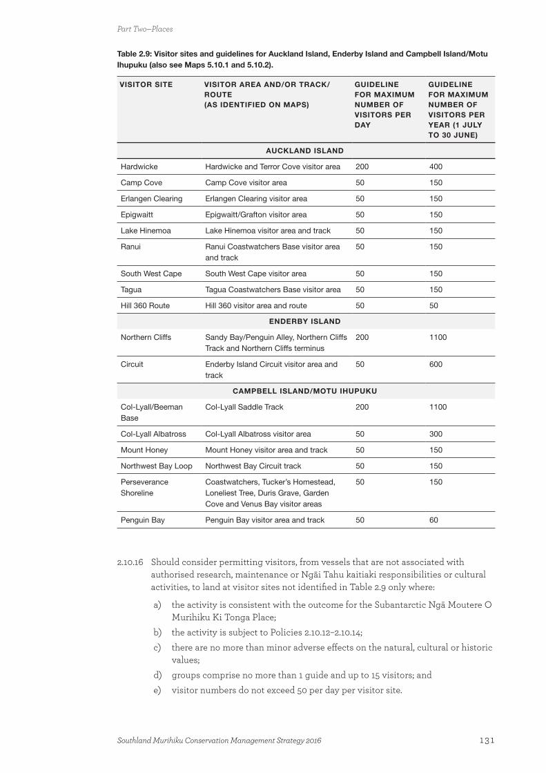
Table 2.9: Visitor sites and guidelines for Auckland Island, Enderby Island and Campbell Island/Motu Ihupuku (also see Maps 5.10.1 and 5.10.2).
VISITOR SITE VISITOR AREA AND/OR TRACK/ROUTE (AS IDENTIFIED ON MAPS)
GUIDELINE FOR MAXIMUM NUMBER OF VISITORS PER DAY
GUIDELINE FOR MAXIMUM NUMBER OF VISITORS PER YEAR (1 JULY TO 30 JUNE)
AUCKLAND ISLAND
Hardwicke Hardwicke and Terror Cove visitor area 200 400
Camp Cove Camp Cove visitor area 50 150
Erlangen Clearing Erlangen Clearing visitor area 50 150
Epigwaitt Epigwaitt/Grafton visitor area 50 150
Lake Hinemoa Lake Hinemoa visitor area and track 50 150
Ranui Ranui Coastwatchers Base visitor area and track
50 150
South West Cape South West Cape visitor area 50 150
Tagua Tagua Coastwatchers Base visitor area 50 150
Hill 360 Route Hill 360 visitor area and route 50 50
ENDERBY ISLAND
Northern Cliffs Sandy Bay/Penguin Alley, Northern Cliffs Track and Northern Cliffs terminus
200 1100
Circuit Enderby Island Circuit visitor area and track
50 600
CAMPBELL ISLAND/MOTU IHUPUKU
Col-Lyall/Beeman Base
Col-Lyall Saddle Track 200 1100
Col-Lyall Albatross Col-Lyall Albatross visitor area 50 300
Mount Honey Mount Honey visitor area and track 50 150
Northwest Bay Loop Northwest Bay Circuit track 50 150
Perseverance Shoreline
Coastwatchers, Tucker’s Homestead, Loneliest Tree, Duris Grave, Garden Cove and Venus Bay visitor areas
50 150
Penguin Bay Penguin Bay visitor area and track 50 60
2.10.16 Should consider permitting visitors, from vessels that are not associated with authorised research, maintenance or Ngāi Tahu kaitiaki responsibilities or cultural activities, to land at visitor sites not identified in Table 2.9 only where:
a) the activity is consistent with the outcome for the Subantarctic Ngā Moutere O Murihiku Ki Tonga Place;
b) the activity is subject to Policies 2.10.12–2.10.14;c) there are no more than minor adverse effects on the natural, cultural or historic
values;d) groups comprise no more than 1 guide and up to 15 visitors; ande) visitor numbers do not exceed 50 per day per visitor site.
Part Two—Places
131Southland Murihiku Conservation Management Strategy 2016
2.10.17 Should, subject to Policy 2.10.15, set aside 25 landings per year for entry by non-commercial visitors on small vessels (up to 25 metres in length) that are not associated with authorised research, maintenance or Ngāi Tahu kaitiaki responsibilities or cultural activities, to enable them to visit the Subantarctic Ngā Moutere O Murihiku Ki Tonga Place.
2.10.18 Should require every vessel that transports people that land on the islands within the Subantarctic Ngā Moutere O Murihiku Ki Tonga Place to implement a visitor monitoring/observer system, which may include having a departmental representative on board, to ensure that:
a) people understand how to behave around wildlife; b) actions are taken to avoid the biosecurity risks associated with visitors; c) adverse effects on natural values and historic sites are avoided; andd) information is made available to visitors about the conservation management
of the islands.
2.10.19 Should not permit viewing of the tohorā/southern right whale during the winter breeding season.
2.10.20 Should not permit any fire to be lit outdoors, or any smoking, anywhere within the Subantarctic Ngā Moutere O Murihiku Ki Tonga Place. Visitors to this Place should be advised of this prohibition on fires and smoking.
Aircraft
2.10.21 Should grant concessions for aircraft landings and take-offs within the Subantarctic Ngā Moutere O Murihiku Ki Tonga Place only where the landings are consistent with the outcome for this Place and necessary for:
a) research purposes, where this cannot be achieved without the use of aircraft and where it is low-impact priority research that benefits the Place;
b) the maintenance of meteorological facilities, where this cannot be achieved without the use of aircraft;
c) filming, where it can be demonstrated that this cannot be achieved without the use of aircraft and there is a benefit to the conservation values of this Place; or
d) fuel transfers to authorised fuel depots.
Structures
2.10.22 Should permit existing permanent fuel depots to be maintained within the Subantarctic Ngā Moutere O Murihiku Ki Tonga Place, provided that these meet all regulatory requirements.
2.10.23 Should not authorise new fuel depots within the Subantarctic Ngā Moutere O Murihiku Ki Tonga Place.
2.10.24 Should maintain, or remove (where retention cannot be demonstrated and there is no historic value), existing structures and facilities within the Subantarctic Ngā Moutere O Murihiku Ki Tonga Place in accordance with the outcome for this Place.
2.10.25 Should not grant authorisations for new structures or utilities within the Subantarctic Ngā Moutere O Murihiku Ki Tonga Place unless:
a) the criteria in Policy 3.10.1 are complied with;b) the structure or utility is:
Part Two—Places
132 Southland Murihiku Conservation Management Strategy 2016

i) consistent with the outcome for this Place; ii) consistent with the Proposed Regional Coastal Plan: Kermadec and
Subantarctic Islands (May 2012); and iii) necessary for authorised research purposes or the maintenance of
meteorological facilities; and c) particular consideration is given to avoiding adverse effects on:
i) indigenous ecosystems, species and their habitats; andii) historic and cultural values.
Waste
2.10.26 Should not authorise, within the Subantarctic Ngā Moutere O Murihiku Ki Tonga Place:
a) the disposal of biodegradable40 waste, unless disposed of in such a way to avoid any adverse effects; or
b) the disposal of non-biodegradable waste materials.
MILESTONES—OUTPUTS
Achieved by the end of Year 3 after CMS approval (2019)
• Reviewed the Subantarctic Island Research Strategy.
• Identified new ways that the public and businesses are able to support the management of the Subantarctic Ngā Moutere O Murihiku Ki Tonga Place.
• Initiated investigations to eradicate the remaining introduced animals from the Subantarctic Ngā Moutere O Murihiku Ki Tonga Place.
• Developed, in consultation with Ngāi Tahu, concessionaires and other relevant stakeholders, a Subantarctic Visitor Management Plan.
• Developed a historic strategy for managing historic sites within the Subantarctic Ngā Moutere O Murihiku Ki Tonga Place.
Achieved by the end of Year 5 after CMS approval (2021)
• Reviewed the Subantarctic Visitor Management Plan and the historic strategy for the Subantarctic Ngā Moutere O Murihiku Ki Tonga Place.
• Monitoring shows that pest plants are not having an adverse effect within the Subantarctic Ngā Moutere O Murihiku Ki Tonga Place.
Achieved by the end of Year 10 after CMS approval (2026)
• Improved knowledge of archaeological sites on the Antipodes Island Group and the Snares Islands/Tini Heke.
• Eradication of introduced animals from the Subantarctic Ngā Moutere O Murihiku Ki Tonga Place.
• A further review of the Subantarctic Island Research Strategy, the Subantarctic Visitor Management Plan and the historic strategy for the Subantarctic Ngā Moutere O
40 For the purposes of this policy, ‘biodegradable’ means organic material that can be broken down by microorganisms or other biological means, in the subantarctic environment, into non-toxic compounds.
Part Two—Places
133Southland Murihiku Conservation Management Strategy 2016

Murihiku Ki Tonga Place.
• Monitoring shows that pest plants are not having an adverse effect within the Subantarctic Ngā Moutere O Murihiku Ki Tonga Place.
Part Two—Places
134 Southland Murihiku Conservation Management Strategy 2016
Part Three—Specific policy requirements for Southland Murihiku
This section implements the requirements of the Conservation General Policy 2005 and other legislative requirements. The policies of this section apply to all public conservation lands and waters covered by this CMS. Where the provisions in Part Three are more specific than the provisions in Part One, or where there is any ambiguity between provisions, then the more specific provisions in Part Three prevail. Where the provisions in Part Two—Places are more specific than the provisions in Part Three, the more specific provisions in Part Two prevail.
Changes to this CMS may be required from time to time during its term. This may require changes to be made by the amendment or review processes under section 17H or 17I of the Conservation Act 1987. These situations may include where additional land area is to be managed under a CMS or limitations changed on an activity that occurs on lands or waters managed under the CMS.
3.1 General3.1.1 Will follow the relevant process under the provisions of the Conservation Act 1987
where a change to the CMS is required, including to impose or increase limits on any use or activity or to include new species or land.
3.1.2 Consider changing the classification of public conservation land and water where required for the effective management or protection of its values.
3.1.3 Restrict or close access to:
a) Fiordland National Park where necessary for the preservation of native plants and animals or the welfare in general of the park;
b) reserves where necessary, consistent with the conditions and restrictions of use of the reserve; and
c) conservation areas where necessary for reasons of public safety or emergency, or to: i) protect natural, historic or cultural values;ii) control biosecurity risks;iii) enable the control or eradication of pests using aerial bait operations;iv) allow military exercise operations; orv) allow tree felling.
3.1.4 When undertaking work or activities that are covered by Appendix 1, determine if they meet the requirements of section 4(3) of the Resource Management Act 1991 for exemption from land use consents.
3.1.5 Manage recreational opportunities, including those provided by concessionaires, in accordance with the visitor management zones as shown in Map 3, and as described in Appendix 12.
3.1.6 Establish and review bylaws and regulations where necessary to enable better management of public conservation lands and waters (including departmental wharves).
Part Three— Specific policy requirements for Southland Murihiku
135Southland Murihiku Conservation Management Strategy 2016

3.1.7 Encourage people and businesses undertaking activities on public conservation lands and waters to comply with activity-specific minimum impact codes (care codes) as notified from time to time on the Department’s website.
3.1.8 In respect of legal roads, where actual or potential activity on or near these legal roads creates difficulties in achieving integrated management of adjoining public conservation lands and waters, work with Land Information New Zealand, the New Zealand Walking Access Commission, territorial local authorities, other agencies and the public to:
a) seek that the public voluntarily manage their use of legal roads running through public conservation lands and waters in a way that it is compatible with or recognises adjoining public conservation lands and waters management;
b) enable the Department to manage the roads and facilitate recreation on them in a way that is compatible with or recognises adjoining public conservation lands and waters management;
c) seek that local authorities actively manage the roads and facilitate recreation on them in a way that is compatible with or recognises adjoining public conservation lands and waters management; or
d) stop or resume legal roads running through public conservation lands and waters, and add the stopped or resumed road lands to the adjoining public conservation lands and waters, except where the adjoining lands are stewardship areas under the Conservation Act 1987 (unless those adjoining lands are part of an action or policy to confer additional protection or preservation under section 18 of the Conservation Act 1987, or under the National Parks Act 1980 or the Reserves Act 1977).
Authorisations (General)
Unless enabled by other legislation, 41 anyone wishing to carry out a trade, occupation or business on public conservation lands and waters requires an authorisation. The most common authorisation is a concession under Part 3B of the Conservation Act 1987. The Department aims to allow for a range of authorisations that are consistent with relevant legislation and policy, the protection of natural resources and historic and cultural heritage, and the recreational settings and planned outcomes and policies for specific Places (Part Two). Authorisations can add value to visitors’ experiences by connecting them with natural, historic and cultural heritage, and providing opportunities to visit places which may not otherwise be easily accessible.
There is a range of existing authorisations in Southland Murihiku, such as for tourism activity, utilities (such as telecommunication facilities and hydroelectric power schemes) and grazing. There is scope for an increase in the number of authorised activities in some Places. However, there is less opportunity for authorised activities in those parts of Places that are managed for remote or wilderness values. For example, in the Subantarctic Ngā Moutere O Murihiku Ki Tonga Place, the Department takes a precautionary management approach to ensure that the outstanding natural values, recognised by its World Heritage Area status, are protected.
41 Examples are the Electricity Act 1992 and the Cadastral Survey Act 2002.
Part Three— Specific policy requirements for Southland Murihiku
136 Southland Murihiku Conservation Management Strategy 2016
Tourism activity in Southland Murihiku (with the exception of Fiordland National Park and, to a lesser extent, the Southern Scenic Route) has historically been low. However, there is scope for tourism growth to occur during the term of this CMS where the tourism activity is consistent with the outcome for the Place and the natural values present, and conflict with other visitors is avoided.
The monitoring of authorised activities and their impacts is required, particularly in sensitive environments such as the Subantarctic Ngā Moutere O Murihiku Ki Tonga and Awarua Places. Monitoring may also be required for authorised activities in areas that are rarely visited or managed for remote or wilderness experiences. Where emerging or cumulative effects on the environment or other users are becoming unacceptable, it may be necessary to establish limits for authorisations.
Policies
3.1.9 Process authorisations in accordance with the relevant legislation, this CMS, the provisions of the Conservation General Policy 2005 and the General Policy for National Parks 2005.
3.1.10 Monitor authorised activities and their effects, including cumulative effects, on a regular and ongoing basis.
3.1.11 Should follow the statutory amendment or review process when establishing limits for authorisations during the term of this CMS where demand approaches or exceeds the environmental or social carrying capacity of a site and/or cumulative effects are becoming unacceptable, and manage through an allocative process.
3.1.12 Should not grant authorisations that are inconsistent with the outcomes, objectives and policies in Part One, the outcomes and policies for Places in Part Two—Places, or the policies in Part Three.
3.1.13 May grant authorisations for sporting events or filming activities that do not meet the limits and/or criteria for the Green or Orange aircraft access zones and/or the prescriptions for visitor management zones in Appendix 12 based on their merits and subject to an assessment of:
a) the activity being consistent with the purposes for which the lands and waters concerned are held;
b) the activity being consistent with the outcome and policies for the Place in which it is proposed to occur;
c) the adverse effects and the extent to which it is possible to avoid, remedy or mitigate those effects—examples of mechanisms that may be used to address any adverse effects include:i) informing neighbours and potential visitors to the site that the activity is
to occur or is occurring;ii) avoiding peak visitor times; andiii) avoiding or protecting sites with high natural, historic or cultural values;
d) cumulative effects on the values at the site; e) the activity being consistent with Policy 2.2 3 if the activity is in a wilderness
area; andf) the need for public notification.
Part Three— Specific policy requirements for Southland Murihiku
137Southland Murihiku Conservation Management Strategy 2016

3.2 Vehicles Vehicle use is part of the range of recreation opportunities that are only allowed on public conservation lands and waters in locations identified in this CMS. In this context, vehicles include motorised and non-motorised land vehicles; fixed-wing, helicopter and non-powered aircraft; and motorised and non-motorised watercraft. Further discussion about vehicle use can be found in Part Two—Places.
Many public conservation lands and waters in Southland Murihiku are easily accessible by vehicle, helping to facilitate the use and enjoyment of these areas.
Motorised vehicles (other than aircraft and watercraft)
Motorised vehicle use42 is not generally allowed off formed roads on public conservation lands and waters in Southland Murihiku, unless specifically provided for in accordance with the outcomes and policies in this CMS. Motorised vehicles include over-snow vehicles. In Southland Murihiku, over-snow vehicles are dealt with in Part Two—Places, 2.4—Eastern High Country Mata-puke Taratara Place.
Rail vehicles and their associated railway line(s) are an alternative means of transportation that may, in very limited circumstances, be built and used on public conservation lands and waters. Policies 3.1.9–3.1.11 and 3.10.1 in this section, and the outcomes and policies in Part Two—Places, apply to any application to build and run a railway line.
Policies
3.2.1 Should allow motorised vehicles only on the roads (including designated parking areas) as identified in:
a) Part Two—Places; orb) the national park management plan for Fiordland National Park.
3.2.2 Consider provision for use of motorised vehicles outside areas provided for by Policy 3.2.1 only where such use is identified at sites listed in Part Two—Places and subject to Policy 3.2.4.
3.2.3 May allow motorised vehicles on public conservation lands and waters for the construction, operation and/or maintenance of authorised utilities, farming operations, and restoration activities.
3.2.4 Should follow the statutory CMS amendment or review process when considering the use of motorised vehicles on public conservation lands and waters, other than in accordance with Policies 3.2.1–3.2.3, and apply the following criteria to the activity:
a) is consistent with the purposes for which the lands and waters concerned are held;
b) is consistent with the outcome and policies for the Place where the road or site is located;
c) is consistent with the visitor management zones on Map 3 and as described in Appendix 12;
42 Any motor vehicle taken onto public conservation lands and waters must be registered and/or licensed, where it is required to be registered and/or licensed under the Land Transport Act 1998.
Part Three— Specific policy requirements for Southland Murihiku
138 Southland Murihiku Conservation Management Strategy 2016

d) adverse effects (including cumulative adverse effects) on the road or site and on surrounding natural, historic or cultural values are, or can be, avoided, remedied or mitigated;
e) adverse effects (including cumulative adverse effects) on the safety and enjoyment of other recreational users are, or can be, avoided, remedied or mitigated (including conflicts between motorised vehicles/mountain bikes and horses);
f) risks of fire and biosecurity are avoided or otherwise carefully managed; andg) the ongoing management implications of providing motorised vehicle access
(e.g. in terms of ongoing maintenance costs) are taken into account.
3.2.5 Liaise with four-wheel drive and other motorised vehicle user groups to identify opportunities for involvement with conservation programmes, and may enable these groups to maintain the roads that they are permitted to use.
3.2.6 Monitor the effects of motorised vehicles on natural, historic and cultural values, and on other recreational users.
3.2.7 Review motorised vehicle use on roads where monitoring shows that adverse effects are occurring, in consultation with relevant motorised vehicle user club(s) and the community.
3.2.8 May restrict motorised vehicle access at any time in the following situations:
a) there is a health and safety risk;b) there is a fire risk;c) adverse effects are evident, or likely, on conservation resources; d) priorities change for the provision of the road or designated vehicular route; ore) where damage to the structure of the road is evident or likely.
3.2.9 Work with councils, the New Zealand Police and other relevant agencies to manage motorised vehicle use on beaches and river beds to protect conservation values.
3.3 Mountain bikes (non-motorised vehicles)Multiple opportunities exist for mountain biking on public conservation lands and waters in mainland Southland Murihiku, using existing walking, purpose-built and vehicle tracks, including farm tracks from ex-pastoral lease lands; and to some degree, cycling across country where vegetation and topography allow and vulnerable conservation values are not threatened. There is a range of views about mixed pedestrian and cycling use of tracks, and caution is needed where visibility is restricted and with higher-speed and higher-impact downhill cycling. Where the means exist (e.g. helicopters) to easily take (shuttle) downhill mountain bikers to higher altitudes, this can result in increased adverse effects, and more caution should be exercised in considering this activity.
Given the popularity of this recreational activity, the Department could identify other potential mountain biking opportunities and intends to work with others when considering these.
Policies
3.3.1 Should allow independent mountain biking, and may allow guided mountain biking or mountain bike events, only on the tracks and roads or other areas listed for mountain biking in the following, subject to the criteria specified in Policy 3.3.4:
Part Three— Specific policy requirements for Southland Murihiku
139Southland Murihiku Conservation Management Strategy 2016
a) Tables 2.1, 2.2, 2.4, 2.6 and 2.7 in Part Two—Places; andb) Fiordland National Park Management Plan 2007.
3.3.2 Where mountain biking is restricted to identified tracks or roads, advise users that they must remain on the track or road formation at all times.
3.3.3 Promote opportunities for mountain bike use on tracks and other areas identified in this CMS as being available for mountain bike use on public conservation lands and waters via the Department’s website; and through liaison with tourism information providers and cycling advocates.
3.3.4 Should follow the statutory amendment or review process when considering further opportunities for mountain bike use on public conservation lands and waters during the term of this CMS, undertake consultation with cycling clubs, adjoining landowners, tramping clubs, other interested parties and the public, and apply the following criteria for the activity:
a) is consistent with the purposes for which the lands and waters concerned are held;
b) is consistent with the desired outcome and policies for the Place where the track or road is, or is proposed to be, located;
c) adverse effects (including cumulative effects) of mountain bike use on natural, historic or cultural values and other recreational users of the track or road are, or can be, avoided, remedied or mitigated ; and
d) measures can be applied to manage the use of mountain bikes, which may include (but are not limited to) trial periods, restricted seasons, daylight riding only, limits on numbers and one-way flow; and there is the ability to provide necessary facilities, including those that may be associated with overnight mountain bike opportunities.
3.3.5 Monitor the effects of mountain bike use on natural, historic or cultural values, and on other recreational users.
3.3.6 Review mountain bike use on tracks or at sites where monitoring shows that unacceptable adverse effects are occurring.
3.3.7 Should provide for mountain biking activities such as downhill, freestyle and dirt jumping on public conservation lands and waters only where:
a) the activity is consistent with the desired outcome and policies for a Place; andb) adverse effects, including cumulative effects, on natural, historic or cultural
values, and on other recreation users, can be avoided, remedied or mitigated.
3.3.8 Liaise with mountain bike clubs, concessionaires and other organisations to identify opportunities for involvement with conservation programmes, and may enable these groups to maintain the tracks that they are permitted to use.
3.4 Electric power-assisted pedal cycles The use of electric power-assisted pedal cycles (e-bikes), which is distinct from motorised vehicle and mountain bike use, is a relatively new activity that may be compatible with other uses at locations where non-motorised vehicles are allowed. In some circumstances, their use may be suitable to enable people with lesser cycling skills, experience and fitness to cycle tracks used by mountain bikes. However, their use is subject to factors including: compatibility with the cycling experience provided (for example, beginner mountain biking
Part Three— Specific policy requirements for Southland Murihiku
140 Southland Murihiku Conservation Management Strategy 2016
opportunities may be suitable for e-bike use); management of conflicts with other users; and where ‘enjoying nature on its own terms’ without assistance from motorised vehicles is important.
Policies
3.4.1 Should allow independent electric power-assisted pedal cycle use, and may allow for guided electric power-assisted pedal cycling, only on the tracks and roads or other areas listed in Part Two—Places, subject to Policies 3.4.2–3.4.5.
3.4.2 Should follow the statutory amendment or review process when considering further opportunities for electric power-assisted pedal cycle use on public conservation lands and waters during the term of this CMS, undertake consultation with cycling clubs, adjoining landowners, tramping clubs, other interested parties and the public, and apply the following criteria:
a) is consistent with the purposes for which the lands and waters concerned are held;
b) is consistent with the desired outcome and policies for the Place where the track or road is, or is proposed to be, located;
c) adverse effects (including cumulative effects) of electric power-assisted pedal cycle use on natural, historic or cultural values (including natural quiet) and other recreational users of the track or road are, or can be, avoided, remedied or mitigated; and
d) measures can be applied to manage the use of electric power-assisted pedal cycles, which may include (but are not limited to) trial periods, restricted seasons, daylight riding only, limits on numbers, limits on speed and one-way flow; and there is the ability to provide necessary facilities, including those that may be associated with overnight electric power-assisted pedal cycling opportunities.
3.4.3 Monitor the effects of electric power-assisted pedal cycle use on natural, historic and cultural values, and on other recreational users.
3.4.4 Review electric power-assisted pedal cycle use on tracks or at sites where monitoring shows that unacceptable adverse effects are occurring.
3.4.5 Liaise with bike clubs, concessionaires and other organisations to identify opportunities for involvement with conservation programmes, and may enable these groups to maintain the tracks that they are permitted to use.
3.5 Other forms of transportOther forms of transport that can be used to access public conservation lands and waters include motorised and non-motorised watercraft; fixed-wing, helicopter and non-motorised aircraft; and rail vehicles. These also are only allowed where identified in this CMS.
Watercraft
Given the number of navigable lakes and waterways that are located within public conservation lands and waters in Southland Murihiku, there are quite a few opportunities for non-motorised and motorised watercraft to be used. In some locations, only non-motorised watercraft are allowed (such as on South Mavora Lake and the Eglinton River); and in others, only certain motorised watercraft are allowed, subject to conditions of use (such as on North
Part Three— Specific policy requirements for Southland Murihiku
141Southland Murihiku Conservation Management Strategy 2016

Mavora Lake and most lakes in Fiordland National Park). The management of watercraft is also the responsibility of Otago Regional Council, and Southland Regional Council under its Navigation and Safety Bylaw.
Policies
3.5.1 Meet the following criteria when considering watercraft use on public conservation lands and waters:
a) is consistent with the purpose for which the lands and waters concerned are held;
b) is consistent with the outcome and policies for the Place where watercraft use is proposed to occur;
c) is consistent with the visitor management zones shown on Map 3 and as described in Appendix 12;
d) adverse effects on the natural, historic or cultural values are avoided, or otherwise remedied or mitigated; and
e) adverse effects on the safety and enjoyment of other recreational users on and off the water are avoided, or otherwise remedied or mitigated.
3.5.2 May restrict access across public conservation lands and waters for watercraft, where adverse effects associated with the watercraft use may occur to public conservation lands and waters or wildlife.
3.5.3 Advocate for the management of watercraft use on waters not managed by the Department in a manner that is consistent with Parts One and Two of this CMS.
3.5.4 Work with regional, city and district councils within Southland Murihiku to manage the use of watercraft in a way that is consistent with Policies 3.5.1–3.5.3 above.
3.6 Aircraft All aircraft require a concession to land on, take off from, or hover above (collectively referred to as landings) any public conservation lands and waters that is not a certified aerodrome, other than for a number of activities, such as: search and rescue; departmental management purposes; emergency situations; maritime navigational-aid management; land survey work; aircraft operated by the New Zealand Defence Force or the Civil Aviation Authority; or any mining activity authorised under the Crown Minerals Act 1991.43 The Department, acting under delegated authority from the Minister of Conservation, manages aircraft landing concessions under provisions of the National Parks Act 1980, the Reserves Act 1977 and the Conservation Act 1987, including in accordance with Part 3B of the Conservation Act 1987 (in particular, section 17ZF).
Both recreational and commercial aircraft can facilitate the use and enjoyment of public conservation lands and waters by providing access to difficult-to-reach places. They are also an important tool for the Department’s management of public conservation lands and waters, and for search and rescue.
Conversely, aircraft (particularly powered aircraft) activity—including scenic flights and remotely piloted aircraft that do not involve landings—can have adverse effects on public conservation lands and waters, including on its users, impacting on values such as amenity, natural quiet, wildlife and remoteness. Effects most often relate to the presence, behaviour
43 The effects of aircraft use are assessed in accordance with section 61 of the Crown Minerals Act 1991.
Part Three— Specific policy requirements for Southland Murihiku
142 Southland Murihiku Conservation Management Strategy 2016
and frequency of the activity, and for powered aircraft their noise characteristics. Aircraft landings can also cause conflicts between people and their activities where some have used aircraft for access and others have not.
Historically there has been little aircraft use on public conservation lands and waters in Southland Murihiku, with the exception of Fiordland National Park. However, aircraft access is provided for in some locations, ensuring that a range of experiences can be offered, while recognising that different locations can tolerate varying use.
In order to manage the effects of aircraft landings on public conservation lands and waters, there are four, nationally consistent, aircraft access zones (as shown on Map 4). These zones reflect the different management methodologies required, and the likelihood of granting concessions, for aircraft landings:
• Red Zone—areas where a concession application to land an aircraft would most likely be declined. However, concessions may be granted for aircraft landings associated with the construction, operation or maintenance of equipment (e.g. meteorological, seismic) or utilities (e.g. communication systems, transmission lines) that have been authorised by the Department, or to support research authorised by the Department. This zone may apply where:
i) legislation provides strong direction that concessions should not be granted for aircraft landings (e.g. gazetted wilderness areas);
ii) an area is adjacent to (parts of) a national park where there are no aircraft landings;
iii) adverse effects on conservation, including recreational, values need to be avoided (e.g. nature and scientific reserves, threatened species habitat, high-use picnic and camping areas);
iv) the area is readily accessible by other means; or
v) aircraft activity may interfere with management activities.
• Yellow Zone—areas where a concession application to land an aircraft is likely to be granted where it meets the nationally consistent limits for this zone. This zone may apply where there is a need to restrict aircraft use; either where visitors expect a low level of encounters with aircraft or where values of natural quiet predominate, particularly in backcountry and remote areas. (Note: there is no Yellow Zone in Southland Murihiku.)
• Green Zone—areas where a concession application to land an aircraft is likely to be granted, subject to any relevant outcome and/or the criteria in the relevant policies. This zone may apply where:
i) conservation, including recreation, values are unlikely to be affected by landings;
ii) there are natural limits on sites where landings can actually occur (e.g. forest cover, steep terrain); or
iii) there is likely to be little demand for aircraft access over the life of this CMS.
• Orange Zone—areas where there are complex issues to be managed, which require the use of limits and/or other criteria to guide whether concessions for aircraft landings may be granted. This zone may apply:
i) in situations that involve limited opportunities, areas of intensive aircraft activity or where a precautionary approach is required; where there are historic or legal reasons for an approach that does not fit within the other three zones;
Part Three— Specific policy requirements for Southland Murihiku
143Southland Murihiku Conservation Management Strategy 2016

ii) to provide for a specific recreational activity (e.g. heli-skiing, heli-fishing, ground-based hunting);
iii) to only allow specific types of aircraft (e.g. non-powered aircraft);
iv) where there are variations in seasonal use;
v) to protect visitor experiences; or
vi) where landings do not fit within the circumstances described in the other three zones.
The application of these aircraft access zones manages aircraft landings on public conservation lands and waters. As a result, there is a spectrum of aircraft landings and overflights (aircraft encounters) that may be experienced by visitors to public conservation lands and waters, as described in Table 3.6.1 below. Outcomes and/or policies may specify numeric limits for aircraft landings (e.g. daily, monthly, annually), or may use the words ‘rare’, ‘occasional’, ‘regular’ or ‘frequent’ to describe the overall level of aircraft encounters and therefore the visitor experience expected in each aircraft access zone (or part thereof).
Table 3.6.1. Spectrum of aircraft encounters on public conservation lands and waters
Low High
Average percentage of time that aircraft are likely to be encountered
1% or less 5% 25% 50% or more
Likely visitor management zoneRemote and/or
backcountry zonesBackcountry and/or front country zones
Word used in outcomes/policies to describe and achieve this
Rare Occasional Regular Frequent
This spectrum does not take into account aircraft landings associated with the construction, operation and/or maintenance of equipment or utilities authorised by the Department, or wild animal control activities (see section 3.20 and the associated policies). As the Department cannot directly manage overflights (while aircraft are in the airspace above public conservation lands and waters), there is a need to advocate to aircraft operators to minimise effects on users of public conservation lands and waters, consistent with the aircraft access and visitor management zones.
Within an area of public conservation land and water, aircraft may be able to land anywhere, subject to: the capabilities of the aircraft; the vegetation cover; the terrain; and the conditions of use for the relevant aircraft access zone. For example, helicopters do not need a designated landing site and some fixed-wing aircraft do not need a formed airstrip to land. However, in some areas aircraft landings may be restricted to formed airstrips and/or designated landing sites (e.g. adjacent to huts) in accordance with the aircraft access zone criteria.
A concession to land an aircraft does not include any other activities, such as vegetation removal or earthworks, associated with maintaining an airstrip or designated landing site. A separate authorisation is required for other activities, including airstrip/landing site maintenance, in accordance with provisions in Part Two—Places and any relevant Part Three policies. The construction of a new airstrip or designated landing site would also need to take into account the relevant aircraft access zone; such that, it is unlikely that a concession would be granted for a new airstrip/landing site within a Red zoned area. Former
Part Three— Specific policy requirements for Southland Murihiku
144 Southland Murihiku Conservation Management Strategy 2016
airstrips/landing sites that are no longer maintained may eventually become unusable due to vegetation growth or other changes. There are no maintained airstrips within Southland Murihiku outside of Fiordland National Park.
Policies
3.6.1 Should apply (but not be limited to) the following criteria when assessing concession applications for all aircraft landings:44
a) is consistent with the outcome and policies for the Place in which the activity is proposed to occur and Table 3.6.1;
b) is consistent with the aircraft zoning provisions in this CMS and the aircraft access zones on Map 4;
c) is consistent with the purposes for which the lands and waters concerned are held;
d) adverse effects on conservation values, including adverse effects on natural quiet, are avoided, remedied or mitigated;
e) adverse effects on other visitors (taking into account the size of the zone and the proximity of other ground users) are avoided, remedied or mitigated;
f) the need for monitoring the activity using global positioning systems and newer technologies;
g) landings near tracks, huts and car parks (unless otherwise specified in an outcome or policy for a Place) are avoided; and
h) the need to hold and comply with certification in a noise management scheme approved by the Department, in specified locations.
3.6.2 Should not grant concessions for aircraft landings in the Red Zone except:
a) for the construction, operation and/or maintenance of equipment (e.g. meteorological, seismic) or utilities (e.g. communication systems, transmission lines) authorised by the Department; or
b) to support research or collection authorised by the Department.
3.6.3 Should grant concessions for aircraft landings in the Yellow Zone45 only where the landings meet the criteria (a) and (c)–(h) in Policy 3.6.1 and are in accordance with the following limits:
a) for commercial purposes, two landings per concession per day at any one site (defined as any landing site within a 1-kilometre radius of the initial landing site) and a maximum of 20 landings per site per concession per year; or
b) for recreational purposes, two landings per aircraft per day at any one site (defined as any landing site within a 1-kilometre radius of the initial landing site) and a maximum of 20 landings per aircraft per site per year.
3.6.4 May grant concessions for aircraft landings in the Green Zone that meet the criteria (a) and (c)–(h) in Policy 3.6.1.
3.6.5 May grant concessions for aircraft landings in the Orange Zone that meet the criteria (a) and (c)–(h) in Policy 3.6.1 and as set out in Table 3.6.2.
44 This includes landings, take-offs and hovering.
45 There is no Yellow Zone within Southland Murihiku.
Part Three— Specific policy requirements for Southland Murihiku
145Southland Murihiku Conservation Management Strategy 2016
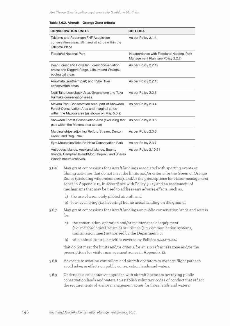
Table 3.6.2. Aircraft—Orange Zone criteria
CONSERVATION UNITS CRITERIA
Takitimu and Robertson FHF Acquisition conservation areas; all marginal strips within the Takitimu Place
As per Policy 2.1.4
Fiordland National Park In accordance with Fiordland National Park Management Plan (see Policy 2.2.2)
Dean Forest and Rowallan Forest conservation areas; and Diggers Ridge, Lillburn and Waikoau ecological areas
As per Policy 2.2.12
Arawhata (southern part) and Pyke River conservation areas
As per Policy 2.2.13
Ngāi Tahu Leaseback Area, Greenstone and Taka Ra Haka conservation areas
As per Policy 2.3.3
Mavora Park Conservation Area, part of Snowdon Forest Conservation Area and marginal strips within the Mavora area (as shown on Map 5.3.2)
As per Policy 2.3.4
Snowdon Forest Conservation Area (excluding that part within the Mavora area above)
As per Policy 2.3.5
Marginal strips adjoining Retford Stream, Dunton Creek, and Bog Lake
As per Policy 2.3.6
Eyre Mountains/Taka Ra Haka Conservation Park As per Policy 2.3.7
Antipodes Islands, Auckland Islands, Bounty Islands, Campbell Island/Motu Ihupuku and Snares Islands nature reserves
As per Policy 2.10.21
3.6.6 May grant concessions for aircraft landings associated with sporting events or filming activities that do not meet the limits and/or criteria for the Green or Orange Zones (excluding wilderness areas), and/or the prescriptions for visitor management zones in Appendix 12, in accordance with Policy 3.1.13 and an assessment of mechanisms that may be used to address any adverse effects, such as:
a) the use of a remotely piloted aircraft; andb) low-level flying (i.e. hovering) but no actual landing on the ground.
3.6.7 May grant concessions for aircraft landings on public conservation lands and waters for:
a) the construction, operation and/or maintenance of equipment (e.g. meteorological, seismic) or utilities (e.g. communication systems, transmission lines) authorised by the Department; or
b) wild animal control activities covered by Policies 3.20.1–3.20.7
that do not meet the limits and/or criteria for an aircraft access zone and/or the prescriptions for visitor management zones in Appendix 12.
3.6.8 Advocate to aviation controllers and aircraft operators to manage flight paths to avoid adverse effects on public conservation lands and waters.
3.6.9 Undertake a collaborative approach with aircraft operators overflying public conservation lands and waters, to establish voluntary codes of conduct that reflect the requirements of visitor management zones for those lands and waters.
Part Three— Specific policy requirements for Southland Murihiku
146 Southland Murihiku Conservation Management Strategy 2016

3.7 Animals Animals are not permitted to be taken onto public conservation lands and waters unless this is consistent with legislation and provided for in this CMS or conservation management plan. This may include giving authorisation by way of signage or other such public notification. Domestic animals and pets can have adverse effects on the natural, historic and cultural values of public conservation lands and waters and can detract from visitor appreciation and enjoyment. Potential effects include killing wildlife, introducing pest plants, introducing disease (such as dogs to seals), browsing indigenous vegetation, increasing erosion and conflicting with other user groups.
Policies
3.7.1 Should not permit livestock, other than horses (and pack animals) in accordance with Policies 3.9.1–3.9.4, on public conservation lands and waters unless under a grazing and farming concession or management agreement.
3.7.2 Should not permit any other types of animals, including pets, other than dogs in accordance with Policies 3.8.1–3.8.9, on public conservation lands and waters.
3.8 Dogs The Department controls the use of dogs for recreational activities, including hunting, on public conservation lands and waters to protect both indigenous wildlife and people’s rights of use and enjoyment. It is illegal to take a dog onto public conservation lands and waters, including Fiordland National Park, without a permit unless the area is identified as an ‘open dog area’ where no permit is required, pursuant to Part 5C of the Conservation Act 1987. The only dogs that do not require permits to enter onto public conservation lands and waters are those used for police, customs, management, and search and rescue purposes, and disability assist dogs. To facilitate the recognition of disability assist dogs, the Department prefers such dogs to wear a Disability Assist Dog identification tag and be registered with the New Zealand Companion Animal Register. Being accompanied by a disability assist dog does not exempt a person from obtaining a permit for entry where these are required (e.g. a nature reserve).
A dog used for hunting must be properly trained, under the control of its handler and authorised by a hunting permit. Hunting dogs, and farm dogs on properties adjacent to known habitat for ground-dwelling or nesting indigenous species, should be avian aversion trained. The use of dogs on public conservation lands and waters for hunting requires a permit, which may be subject to conditions, for example, at locations where access has been agreed with adjoining landowners and/or requiring micro-chipping, tracking collars and bird aversion training.
Taking a dog onto conservation land and water can enhance the recreational experience of the owner, but the dog needs to be well managed to prevent adverse impacts on wildlife and other people. ‘Open’ dog areas pursuant to Part 5C of the Conservation Act 1987 have yet to be established within Southland Murihiku and the Department may initiate a separate public process to determine where these areas are. In the meantime, the Department uses signage to identify where dogs can go onto public conservation lands and waters without a permit, such as within Mavora Park Conservation Area.
Part Three— Specific policy requirements for Southland Murihiku
147Southland Murihiku Conservation Management Strategy 2016

The only dogs that can be taken into the Subantarctic Ngā Moutere O Murihiku Ki Tonga Place are those associated with approved research purposes, as well as police, customs, management, and search and rescue dogs. Any dogs that are allowed on the subantarctic islands may be required to meet conditions such as vaccinations and training certification, to protect the indigenous species present.
Policies
3.8.1 Identify, through the Department’s website, and through the use of signs and provision of information, where people are permitted to take dogs (excluding disability assist dogs) onto public conservation lands and waters, and under what conditions.
3.8.2 Should ensure that, if a permit is required to take a dog onto public conservation lands and waters, the permit contains conditions that protect the values for which those lands and waters are held.
3.8.3 May include the following conditions in a permit to take a dog onto public conservation lands and waters:
a) owners must keep the dog under control at all times;b) dogs must not go into or be under public buildings, including huts;c) dogs must be currently certified by an approved avian aversion trainer where
there are ground-dwelling or ground-nesting birds (except for disability assist dogs); and
d) owners are to comply with any identified access arrangements between the Department and adjoining landowners.
3.8.4 Should allow disability assist dogs onto public conservation lands and waters without a permit, provided the person the dog is accompanying keeps the dog under control at all times and complies with reasonable conditions set in relation to the entry and presence of the disability assist dog.
3.8.5 Educate the community about the threats that dogs can pose to conservation values.
3.8.6 Work with local and regional authorities to ensure consistency in dog control in areas containing protected wildlife and important wildlife habitats.
3.8.7 Will apply the relevant provisions in the Fiordland National Park Management Plan 2007 regarding the taking of dogs into Fiordland National Park.
3.8.8 May run a public process in the future to establish controlled and open dog areas on public conservation lands and waters, in areas other than Fiordland National Park.
3.8.9 Inform the public of the location of controlled and open dog areas on public conservation lands and waters, through the Department’s website.
3.9 Horses and pack animalsIn some cases, the use of animals such as horses can enhance the recreational experience of visitors. However, they can have adverse effects, as identified above. Authorisation, which may be by way of signage or other information, is required to take horses and other pack animals onto public conservation lands and waters.
Part Three— Specific policy requirements for Southland Murihiku
148 Southland Murihiku Conservation Management Strategy 2016

At the time of CMS approval, horse riding is permitted at the Mavora lakes, and in the upper catchments of the Mataura River and Eyre Creek in the Western High Country Mata-puke Koikoi Place. New opportunities could be developed in the Eastern High Country Mata-puke Taratara, Longwood O Hekeia and Lowlands Te Rā a Takitimu Places, where such activity is consistent with the outcomes for those Places.
As a result of the public seeking more horse riding opportunities on public conservation lands and waters in Southland Murihiku, the Department intends to work with horse riding groups and other users to establish new opportunities and develop associated activities. However, these initiatives need to be consistent with the outcome for the Place, and may have additional conditions applied to minimise the adverse effects associated with horse riding on public conservation lands and waters.
Policies
3.9.1 Should allow the use of horses (and pack animals) only in accordance with the outcomes and policies in Part Two—Places.
3.9.2 Meet the requirements of the following criteria when considering activities utilising horses (and pack animals) on public conservation lands and waters:
a) is consistent with the purposes for which the lands and waters concerned are held;
b) is consistent with the outcome and policies for the Place where the road, track or site is located;
c) the potential for horses to introduce or spread pest plant species into the area is avoided;
d) the potential for horses to accelerate erosion or cause other damage to the area is avoided;
e) adverse effects on the natural, historic or cultural values are avoided, remedied or mitigated; and
f) adverse effects on the safety and enjoyment of other recreational users, and potential for conflict with other users of the area, are avoided, remedied or mitigated.
3.9.3 Liaise with horse riding groups to identify opportunities for involvement with conservation programmes, and may enable these groups to maintain the tracks or routes they are permitted to use.
3.9.4 Should monitor the scale and effects of the presence and use of horses and pack animals on public conservation lands and waters. If monitoring indicates that there are adverse effects on the natural, historic and cultural values or the experience of other users, will consider options to manage this activity so as to reduce or avoid, remedy or mitigate these effects.
3.10 Structures and utilitiesMost structures on public conservation lands and waters relate to one of the following purposes:
• the Department’s operational requirements;
• the public’s appreciation and enjoyment of the intrinsic natural, historic and cultural values consistent with the purposes for which the land concerned is held;
• utilities.
Part Three— Specific policy requirements for Southland Murihiku
149Southland Murihiku Conservation Management Strategy 2016
Utilities are facilities that provide essential public services, such as: telecommunications; energy generation and transmission; sewerage; water supply and flood control; oil and gas transmission; roads and airstrips; hydrological and weather stations; and seismic monitoring.
Structures and utilities can be temporary or intended for long-term use. They can share space (usually a public facility) or require exclusive occupation of space (usually a private facility). Both may be either commercial or non-commercial in nature. Regardless of the nature of the structure, the rationale for the establishment of a structure requiring exclusive occupation on public conservation lands and waters needs to be clearly established (section 17U(4) Conservation Act 1987).
There are a number of telecommunication facilities on public conservation lands and waters in Southland Murihiku. Suitable sites for telecommunication facilities are limited and tend to be on high-altitude land that is unmodified and has important landscape values. In addition, many high areas have significant cultural values associated within them and are important to Ngāi Tahu. As such, co-location of telecommunication sites is preferred to avoid their proliferation and any adverse effects on unmodified landscapes, particularly in the Subantarctic Ngā Moutere O Murihiku Ki Tonga Place.
Policy
3.10.1 Should apply the following criteria when considering applications to erect or retain structures or utilities or the adaptive reuse of existing structures on public conservation lands and waters:
a) the purposes for which the land concerned is held;b) the outcomes and policies for the Place where the activity is proposed to occur;c) whether the structure could reasonably be located outside public conservation
lands and waters;d) whether the structure could reasonably be located in another location where
fewer adverse effects would result from the activity;e) whether the structure adversely affects conservation, including recreational,
values;f) whether the structure is readily available for public use;g) whether the structure is consistent with the visitor management zone on Map 3
and as described in Appendix 12; h) whether the activity promotes or enhances the retention of a historic structure; i) whether the activity is an adaptive reuse of an existing structure;j) whether the policies for private accommodation and related facilities should be
applied (see Policies 3.11.1–3.11.7); andk) whether any proposed road in the Fiordland National Park is provided for by
the Fiordland National Park Management Plan 2007.
3.11 Private accommodation and related facilitiesExisting structures on public conservation lands and waters include some private accommodation and related facilities that are not available for use by the general public. Some of these structures have been authorised, but several have been erected and used unlawfully (see Table 3.11.1). Under the Conservation General Policy 2005, the use of private accommodation and related facilities, including encampments, solely for private purposes, is to be phased out, except where specifically provided for or allowed in legislation.
Part Three— Specific policy requirements for Southland Murihiku
150 Southland Murihiku Conservation Management Strategy 2016
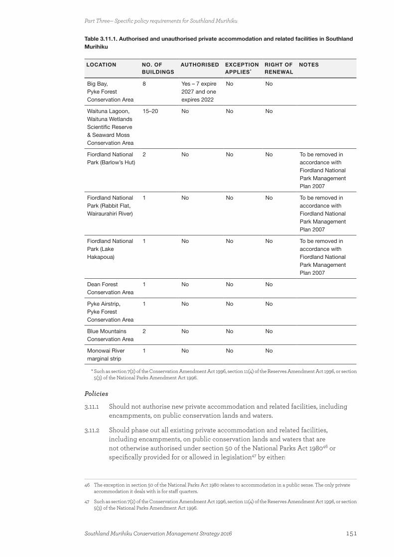
Table 3.11.1. Authorised and unauthorised private accommodation and related facilities in Southland Murihiku
LOCATION NO. OF BUILDINGS
AUTHORISED EXCEPTION APPLIES*
RIGHT OF RENEWAL
NOTES
Big Bay, Pyke Forest Conservation Area
8 Yes – 7 expire 2027 and one expires 2022
No No
Waituna Lagoon, Waituna Wetlands Scientific Reserve & Seaward Moss Conservation Area
15–20 No No No
Fiordland National Park (Barlow’s Hut)
2 No No No To be removed in accordance with Fiordland National Park Management Plan 2007
Fiordland National Park (Rabbit Flat, Wairaurahiri River)
1 No No No To be removed in accordance with Fiordland National Park Management Plan 2007
Fiordland National Park (Lake Hakapoua)
1 No No No To be removed in accordance with Fiordland National Park Management Plan 2007
Dean Forest Conservation Area
1 No No No
Pyke Airstrip, Pyke Forest Conservation Area
1 No No No
Blue Mountains Conservation Area
2 No No No
Monowai River marginal strip
1 No No No
* Such as section 7(2) of the Conservation Amendment Act 1996, section 11(4) of the Reserves Amendment Act 1996, or section 5(3) of the National Parks Amendment Act 1996.
Policies
3.11.1 Should not authorise new private accommodation and related facilities, including encampments, on public conservation lands and waters.
3.11.2 Should phase out all existing private accommodation and related facilities, including encampments, on public conservation lands and waters that are not otherwise authorised under section 50 of the National Parks Act 198046 or specifically provided for or allowed in legislation47 by either:
46 The exception in section 50 of the National Parks Act 1980 relates to accommodation in a public sense. The only private accommodation it deals with is for staff quarters.
47 Such as section 7(2) of the Conservation Amendment Act 1996, section 11(4) of the Reserves Amendment Act 1996, or section 5(3) of the National Parks Amendment Act 1996.
Part Three— Specific policy requirements for Southland Murihiku
151Southland Murihiku Conservation Management Strategy 2016

a) phasing in public use of the building(s) (see Policy 3.11.4a); orb) removing the building(s) at the end of the phase-out period (see Policy 3.11.4b),
unless retained by the Department for public use.
3.11.3 Should consult the Southland Conservation Board and the concession applicant when assessing a concession application for existing private accommodation and related facilities, including encampments, to determine whether a concession may be granted and, if so and where relevant, which of the two phase-out methods (Policy 3.11.2a or 3.11.2b) should be applied.
3.11.4 Should specify the following concession conditions if private accommodation and related facilities, including encampments, are to be authorised in accordance with Policy 3.11.2:
a) in the case of Policy 3.11.2a, the building(s) are to be made available for use by the public—with specific conditions on how this requirement will be phased in over time stated in each individual concession, including the requirement that any costs charged to the public are reasonable; or
b) in the case of Policy 3.11.2b, the building(s) are to be removed48 within 18 months of the death of the person named on the authorisation as at 26 June 2013, or within 20 years of approval of this CMS, whichever occurs first; and
c) the style and character of all buildings are to remain essentially unmodified; and
d) the floor area and footprint of all buildings are not to increase beyond that existing at the time of CMS approval; and
e) all buildings must comply with the Building Act 2004 and local authority requirements; and
f) transfer/assignment of the concession to another party should not be authorised; and
g) an indemnity to protect the Department is given by the concessionaire and the concessionaire holds adequate insurance (e.g. general public liability insurance, statutory liability insurance and for the removal of buildings) to cover this indemnity.
3.11.5 Should, where an existing authorisation contains a right of renewal, grant the renewal49 of authorisations for private accommodation and related facilities, including encampments, on public conservation lands and waters only to the existing authorisation holder50 if:
a) the right of renewal is exercised by the authorisation holder before the existing authority expires;51 and
b) (subject to the terms of the authorisation) the person holding the authorisation has complied with all of the terms and conditions of the authorisation.
3.11.6 Should not authorise the substantial repair or replacement of private accommodation and related facilities, including encampments, if:
48 Unless retained by the Department for public use / active management of historic and cultural heritage values.
49 Where the existing/previous authorisation does not contain a right of renewal and is due to expire (or has expired) and the authorisation holder applies for a new concession, the application should be considered against the other policies in this section and the relevant general policy.
50 That is, should not grant transfers/assignments to other parties.
51 In accordance with section 17ZAA of the Conservation Amendment Act 1996.
Part Three— Specific policy requirements for Southland Murihiku
152 Southland Murihiku Conservation Management Strategy 2016
a) a building falls into substantial disrepair, so that it needs work requiring a building consent under the Building Act 2004;52 or
b) a building is destroyed or so damaged by an event (e.g. fire, flood) as to render it untenantable.
3.11.7 Remove unauthorised buildings from Fiordland National Park, in accordance with section 6.12—Implementation, point 7 (p. 289) of the Fiordland National Park Management Plan 2007, notwithstanding Policies 3.11.2–3.11.6.
3.12 Marine mammal viewingMarine mammals are protected under the Marine Mammals Protection Act 1978 and the Marine Mammals Protection Regulations 1992. Commercial activities involving marine mammals must be authorised by the Director-General of Conservation.
In Southland Murihiku, a number of businesses undertake vessel-based marine mammal viewing and demand could increase as people become more aware of this opportunity. The majority of activity is concentrated in the Fiordland Te Rua-o-te-moko Place and along The Catlins Te Akau tai tonga coastline (in the Foveaux Te Ara a Kiwa Place). Various species are present within these two environments; most commonly the Nationally Endangered tūpoupou/Hector’s dolphin and terehu/bottlenose dolphin, and the kekeno/New Zealand fur seal.
The potential benefits of well-run marine viewing operations can be considerable through increased public awareness and appreciation of marine mammals. However, a precautionary approach is taken when it comes to the granting of marine mammal viewing permits to ensure the protection, conservation and management of the marine mammals, consistent with the requirements of the Marine Mammals Protection Regulations 1992.
The Department encourages the tourism concessionaires who operate vessels in parts of the Fiordland Te Rua-o-te-moko Place, such as Doubtful Sound/Patea, to have marine mammal viewing permits, so that the effects of vessel activity on terehu/bottlenose dolphins can be managed. Monitoring is ongoing and continues to inform the management approach for these dolphin populations.
Due to the level of public activity along The Catlins Te Akau tai tonga coastline, research on the tūpoupou/Hector’s dolphin population present is needed to inform whether further permits can be issued.
The marine mammal sanctuary at Te Waewae Bay receives regular visits from the Nationally Endangered tohorā/southern right whale. Therefore, this area is carefully managed to help the species to re-establish its former breeding site here. This could include restricting access at certain times. Commercial access for marine mammal viewing within the Subantarctic Ngā Moutere O Murihiku Ki Tonga Place is restricted during the winter (April–October inclusive) to protect breeding tohorā/southern right whales.
Land-based marine mammal viewing in Southland Murihiku is preferred—where any adverse effects can be avoided. From time to time, the Department receives applications to carry out aerial marine mammal viewing, and a precautionary approach is taken to avoid adverse effects.
52 Minor repair and maintenance using comparable materials do not generally require building consent under this Act.
Part Three— Specific policy requirements for Southland Murihiku
153Southland Murihiku Conservation Management Strategy 2016

Policies
3.12.1 Support research into and require monitoring of the impacts of human interactions with marine mammals.
3.12.2 Take a precautionary approach to the number of commercial operators involved in marine mammal operations in the area, including seeking a moratorium on the issuing of new permits, or suspending, revoking or amending existing permits, if research and monitoring indicate that such steps are required.
3.12.3 Require commercial operators viewing marine mammals to provide a high standard of education and interpretation to their clients.
3.12.4 Should encourage passive, land-based marine mammal viewing operations in the first instance.
3.12.5 May grant marine mammal viewing permits within Southland Murihiku in accordance with the provisions of the Marine Mammals Protection Regulations 1992, particularly where the adverse effects of the activity on the conservation, protection or management of marine mammals can be avoided, and the marine mammals will not be disturbed or harassed.53
3.12.6 Ensure that specific conditions are included on authorisations relating to encounters with marine mammals, including:
a) avoiding adverse effects on marine mammal populations and their habitats;b) avoiding breeding and nursing areas and seasons for the tohorā/southern right
whale;c) monitoring the impact on the species being viewed.
3.13 Commercial eelingThe Department is responsible for protecting and preserving tuna/eels and their habitats within public conservation lands and waters as far as practicable. Tuna/eels have an important role to play in ecosystem functioning, being the top predators in indigenous freshwater ecosystems. Commercial eeling, habitat loss and hydroelectric development can all have potential adverse effects on tuna/eels. Tuna/longfin eels are Declining.
The Ministry for Primary Industries manages commercial eeling under the Fisheries Act 1996, the Fisheries (Commercial Fishing) Regulations 2001 and other associated regulations. Commercial eel fishers require a concession to access public conservation lands and waters and/or to take tuna/eels from waters whose beds are public conservation land.
Within areas administered under the Conservation Act 1987, legislative requirements can limit the ability to lawfully grant concessions for commercial eel fishing. For example, a section 21 ecological area must be ‘managed as to protect the [ecological] value for which it is held’. Areas held under the Act in general are required to be managed so that their natural resources are protected, and tuna/eels are part of those natural resources where they are present.
53 Also see Part Two—Places, particularly the Foveaux Te Ara a Kiwa Place and Fiordland Te Rua-o-te-moko Place.
Part Three— Specific policy requirements for Southland Murihiku
154 Southland Murihiku Conservation Management Strategy 2016
The commercial take of indigenous fauna such as tuna/eels from reserves administered under the Reserves Act 1977 is also subject to exceptions contained within section 50(1) of that Act. There are no reserves in Southland Murihiku that have commercial eeling as a condition of their sale/gift.
Commercial eeling in Fiordland National Park is effectively prohibited. The Fiordland National Park Management Plan will identify any exceptional circumstances that may exist that enable the consideration of an application for commercial eeling in national park waters consistent with their preservation in the park.
Southland Murihiku is home to populations of both longfin and shortfin eels. A number of significant freshwater ecosystems within Southland Murihiku provide habitat for tuna/eels, such as the priority ecosystem units associated with the Big Bay wetlands and the Waituna Lagoon. The Department’s focus is to preserve the indigenous ecosystems and species, and associated ecological functions, on public conservation lands and waters.
Policies
3.13.1 Should not grant concessions for:
a) commercial eeling on public conservation lands and waters; orb) access over public conservation lands and waters, where it is required to reach
a proposed eeling site, to ensure the preservation of tuna/eel species.
3.13.2 Work cooperatively with Ngāi Tahu, the Ministry for Primary Industries, commercial eelers and the community to protect indigenous tuna/eel populations and their habitats on and off public conservation lands and waters.
3.14 Sports fish and game bird huntingWaters on public conservation lands are often recognised as a valuable recreational asset for anglers. Where sports fish are legally present, they may be retained. However, in certain circumstances they may be eradicated or controlled with the agreement of the relevant regional Fish and Game Council.
Sports fish (mainly brown trout) are present in most river and lake systems in Southland Murihiku, and sports fishing is an important recreational activity for many people. The protection of sports fish habitats can benefit indigenous freshwater fish; however, trout are also predators of some indigenous fish.
The Southland Fish and Game Council also manages game bird hunting. The Minister of Conservation, however, has a responsibility to regulate game bird hunting on public conservation lands and waters where such hunting is consistent with the purposes for which the lands and waters are held, and does not have adverse effects on protected indigenous species. The Awarua wetland complex in the Awarua Place is a popular location for game bird hunting within Southland Murihiku.
Hunters require a permit from the Department to hunt on public conservation lands and waters. These permits may include conditions relating to a number of associated activities, such as the hunting method and whether or not dogs can be used.
Policies
3.14.1 Work collaboratively with the Southland Fish and Game Council to:
Part Three— Specific policy requirements for Southland Murihiku
155Southland Murihiku Conservation Management Strategy 2016
a) preserve indigenous freshwater fisheries; b) protect recreational freshwater fisheries and freshwater fish habitats at risk of
loss or decline; and c) provide for sports fishing and game bird hunting on public conservation lands
and waters.
3.14.2 Should not approve the introduction of salmonid fishes to waters within Southland Murihiku where they are not already present.
3.15 Grazing and farmingA number of farmers hold authorisations allowing them to graze and farm public conservation lands and waters. These are mainly on conservation areas and marginal strips adjoining waterways such as the Mataura, Oreti and Waikaia rivers. However, grazing and farming can have adverse effects on: natural values, particularly freshwater, wetlands, and indigenous vegetation; cultural values; and public access. Therefore, any grazing and farming of public conservation lands and waters need to be consistent with the protection and maintenance of natural, recreational and cultural values of the location. In some cases, this could involve retiring the land from grazing and farming in order to protect these values. Given the degraded state of lowland indigenous ecosystems, habitats and species in Southland Murihiku, the justification for any grazing and farming of lowland public conservation lands and waters is questionable.
Policy
3.15.1 Should authorise grazing and farming on public conservation lands and waters only where adverse effects can be avoided, remedied or mitigated. Consideration should be given, but not limited, to:
a) the criteria in Policy 11.2(a) of the Conservation General Policy 2005;b) the criteria in Policy 10.2(b) of the General Policy for National Parks 2005 for
the Fiordland Te Rua-o-te-moko Place;c) the outcome and policies for the Place where the grazing and farming are
proposed to occur;d) the suitability of the lands for grazing and farming, such as the soil types and
sensitivity of the catchment to increased nutrients;e) the flooding risk; f) the ability of the authorisation holder to keep livestock out of waterways;g) adverse effects on freshwater quality, indigenous species and ecosystems;h) adverse effects on cultural values; andi) waterway protection measures in the Regional Water Plan for Southland.54
3.16 MiningUnder the Crown Minerals Act 1991, the Minister of Conservation has an approval role for access arrangements and minimum impact activities for all public conservation lands and waters. The Minister of Energy and Resources also has an approval role for access arrangements that relate to Tier 1 permits (as defined in the Act) and significant variations to those access arrangements. No access arrangements are allowable for land
54 Prepared by Environment Southland.
Part Three— Specific policy requirements for Southland Murihiku
156 Southland Murihiku Conservation Management Strategy 2016
in Schedule 4 of the Act (which includes, but is not restricted to, all national parks, nature reserves, scientific reserves, wilderness areas and marine reserves), except in very limited circumstances, which are set out in the Act.
Mining activity already exists on public conservation lands and waters in Southland Murihiku—for example, in the Longwood O Hekeia Place. Any future access arrangements for mining need to consider the legal status and the purpose for which the land concerned is held, and the outcome for the Place; as well as the adverse effects on the values present, including landscape, historic, cultural, recreational and natural values, and the ability to remediate mined sites.
Policies
3.16.1 Consider applications for access arrangements on a case-by-case basis in accordance with the criteria set out in the relevant section (i.e. section 61 or section 61A and 61B) of the Crown Minerals Act 1991.
3.16.2 Review the conditions of access arrangements under the Crown Minerals Act 1991 if monitoring reveals that the effects of mining activities on conservation values and recreation opportunities are greater than expected or additional adverse effects become apparent.
3.16.3 Should not enter into access arrangements where there is the potential to adversely affect the priority historic, cultural, natural or recreational sites identified in Appendices 4, 9, 10 and 11.
3.16.4 May enter into access arrangements where:
a) the site does not include any significant conservation values, including priority ecosystem units, or threatened or at risk species; and
b) any adverse effects of the activity can be minimised.
3.16.5 Should include specific conditions in access arrangements to:
a) require the public conservation lands and waters to be restored to as natural a condition as possible (which may be by way of a bond); and
b) manage encounters with wildlife.
3.17 Sand and shingle extractionSand and shingle extraction from riverbeds and beaches is managed and allocated by regional councils under the Resource Management Act 1991. On public conservation lands and waters, however, these activities also require authorisation from the Department.
Sand and shingle extraction can have adverse effects on natural, cultural, historic and recreational values, such as freshwater quality, fish spawning, nesting birds, landscape values, wāhi tapu and public access. However, taking sand and shingle in the vicinity of the area where it is going to be used, such as for roading, can avoid potential pest plant contamination. Careful consideration needs to be given to the site, timing, proposed extraction volume and methods to ensure that the extraction area’s values are protected.
Policies
3.17.1 Should allow sand and/or shingle extraction from public conservation lands and waters only where adverse effects can be avoided, remedied or mitigated.
Part Three— Specific policy requirements for Southland Murihiku
157Southland Murihiku Conservation Management Strategy 2016

3.17.2 Should use the following criteria when considering sand and/or shingle extraction from public conservation lands and waters:
a) is consistent with the purposes for which the lands and waters concerned are held;
b) is consistent with the outcome and policies for the Place where the activity is proposed to occur;
c) is consistent with the visitor management zone as identified in Map 3 and as described in Appendix 12;
d) adverse effects on landscape and the natural, historic or cultural values are avoided, remedied or mitigated; and
e) adverse effects on the safety and enjoyment of other recreational users of the area are avoided, remedied or mitigated.
3.17.3 Work with Southland and Otago Regional Councils to achieve integrated management of sand and/or shingle extraction on and off public conservation lands and waters.
3.17.4 May seek offsite mitigation or compensation to assist in indigenous ecosystem management.
3.18 Commercial filming and photographyCommercial filming and photography (filming activity) is any photography or filming undertaken on public conservation lands and waters for any specific gain or reward. Filming activities can include the involvement of some or all of the following – cast, crew, film equipment, vehicles, aircraft, animals, sets and special effects.
Filming involves a range of activities, which may include feature films, documentaries, television commercials or television series. Location filming typically involves different scales of activity. Filming on public conservation lands and waters tends to be of small to medium scale, with some feature films also being shot.
The Conservation General Policy 2005 states that filming should be subject to the same assessment processes and conditions as other uses, and that particular care should be taken so that filming does not adversely affect the values of sites of significance, including those of significance to tangata whenua. Issues with filming include the use of aircraft and animals, and the management of any conflict with other users of public conservation lands and waters.
In parts of Southland Murihiku, notably within Fiordland National Park, filming is an important industry that makes considerable use of the spectacular landscapes and alpine areas. Filming activities within Fiordland National Park are managed according to the Fiordland National Park Management Plan.
The policies below are additional to the policies that apply to all authorisations and do not replace them.
Policies
3.18.1 Should grant concessions for commercial filming and photography (filming activity) on public conservation lands and waters located outside national parks only where the following criteria are met:
a) any conflicts between recreation/tourism uses and filming activity are avoided (e.g. separated in space and time), remedied or mitigated;
Part Three— Specific policy requirements for Southland Murihiku
158 Southland Murihiku Conservation Management Strategy 2016
b) any adverse effects from filming and associated activities on conservation values, including sites of significance to Ngāi Tahu, are avoided, remedied or mitigated;
c) aircraft use for filming activity complies with the aircraft Policies 3.6.1–3.6.6 and 3.6.8;
d) vehicle use for filming activity complies with Policies 3.2.1–3.2.2 and 3.2.6–3.2.8 (motorised vehicles), 3.3.1–3.3.2 and 3.3.5–3.3.7 (mountain bikes) and 3.4.1 and 3.4.3–3.4.4 (electric power-assisted pedal cycles);
e) animal use for filming activity complies with Policies 3.7.1–3.7.2 (animals), 3.8.1–3.8.2, 3.8.4 and 3.8.7–3.8.8 (dogs) and 3.9.1–3.9.2 and 3.9.4 (horses and pack animals); and
f) the filming activity is consistent with the outcomes and policies for Places in which the activity is proposed to occur.
3.18.2 May grant concessions for filming activities that do not meet the prescriptions for the visitor management zones in Appendix 12 only in accordance with Policy 3.1.12.
3.18.3 Should apply the provisions in section 5.13 (p. 270) of the Fiordland National Park Management Plan 2007, to any filming activity in Fiordland National Park.
3.18.4 Should include reference to and require compliance with the latest version of the Code of Practice: Filming on Public Conservation Lands55 in all concessions for filming activities.
3.18.5 Draw the attention of filming concession applicants to A Guideline for Filming within the Takiwā of Ngāi Tahu (2010).56
3.19 Collection of material Applications for the collection of material for research and information needs are addressed in, and must be consistent with, the Conservation General Policy 2005 (section 12—Research and information needs), and the outcomes and policies for Places in Part Two of this CMS.
Policy
3.19.1 Should authorise the collection of material from public conservation lands and waters only in accordance with:
a) the Conservation General Policy 2005, section 12; andb) the outcomes and policies for Places within Part Two of this CMS.
3.20 Wild animalsWild animals are introduced animals that are managed to achieve the purpose of the Wild Animal Control Act 1977. The Minister of Conservation has responsibility for the Wild Animal Control Act 1977 through the granting of:
• concessions for commercial wild animal recovery operations involving aircraft issued under the Conservation Act 1987;
55 Jointly developed by the Department and Film New Zealand.
56 Te Rūnanga o Ngāi Tahu and Screen Producers and Directors Association of New Zealand. 2010: A guideline for filming within the takiwā of Ngāi Tahu.
Part Three— Specific policy requirements for Southland Murihiku
159Southland Murihiku Conservation Management Strategy 2016

• permits for commercial and recreational hunting; and
• permits for the holding of wild animals in captivity in safari parks or deer farms.
Where wild animals are held alive in captivity, further permits may be required from the Director-General of Conservation in accordance with the Wild Animal Control Act 1977 requirements. Permits are required to convey any deer species, chamois or tahr outside a species feral range where it is to be kept for the purposes of public display, research, private use, and keeping prior to export.
This CMS is one of several mechanisms the Minister of Conservation must consider when making a decision on applications for commercial wild animal recovery activities. The primary decision-making tool is the Wild Animal Control Act 1977. Consequently, policies in this CMS are considered alongside this Act when making decisions on applications. Any requirements or regulations promulgated under the Game Animal Council Act 2013 are also relevant.
There is a variety of commercial wild animal control activities, each with its own management issues. The Department has grouped these into three main categories according to the management issues and potential effects associated with each activity. This categorisation was developed in consultation with the industries and stakeholders involved. The three categories are:
1. Deer, pig, chamois and goat carcass recovery and live capture;2. Tahr live capture and carcass recovery (these activities do not occur in Southland
Murihiku); and3. Aerially assisted trophy hunting.
Concessions are issued separately for the three types of activity. However, all three types of activity above are assessed similarly against the criteria of the Wild Animal Control Act 1977 and other legislation. Other concessions may be required under the Conservation Act 1987; for example, for aircraft access for recreational hunting.
Policies
Deer, pig, chamois and goat live capture and carcass recovery
3.20.1 Should assess concession applications for deer, pig, chamois and goat carcass recovery, and deer and chamois live capture on public conservation lands and waters under the Wild Animal Control Act 1977 against the following criteria:
a) the contribution to concerted action to control wild animals (to achieve the purposes of the Wild Animal Control Act 1977);
b) the purposes for which the lands and waters concerned are held; c) adverse effects on conservation values, including priority ecosystem units and
species, surrounding lands, and natural quiet; d) the outcome and policies for the Place where the activity is proposed to occur; e) effects on visitors; f) cumulative effects; g) frequency, timing and location of the activity;h) the effect of granting the concession on other authorisations; andi) other relevant matters, including the applicants’ ability to obtain required
accreditations or certifications from other agencies.
Part Three— Specific policy requirements for Southland Murihiku
160 Southland Murihiku Conservation Management Strategy 2016

3.20.2 Should grant concessions under the Wild Animal Control Act 1977 for chamois live capture on public conservation lands and waters only as one-off permits.
Tahr live capture and carcass recovery
3.20.3 Should assess concession applications for tahr live capture and carcass recovery activities on public conservation lands and waters under the Wild Animal Control Act 1977 against the following criteria:
a) the contribution to concerted action to control wild animals (to achieve the purposes of the Wild Animal Control Act 1977);
b) the Himalayan Thar Control Plan (1993) made under the Wild Animal Control Act 1977;
c) the purposes for which the lands and waters concerned are held; d) adverse effects on conservation values, including priority ecosystem units and
species, surrounding lands, and natural quiet; e) the outcome and policies for the Place where the activity is proposed to occur; f) effects on visitors; g) cumulative effects; h) frequency, timing and location of the activity;i) the effect of granting the concession on other authorisations; andj) other relevant matters, including the applicants’ ability to obtain required
accreditations or certifications from other agencies.
3.20.4 Should grant concessions under the Wild Animal Control Act 1977 for tahr live capture and carcass recovery on public conservation lands and waters only as one-off permits.
Aerially assisted trophy hunting
3.20.5 Should assess concession applications for aerially assisted trophy hunting on public conservation lands and waters against the following criteria:
a) the contribution to concerted action to control wild animals (to achieve the purpose of the Wild Animal Control Act 1977);
b) the Himalayan Thar Control Plan (1993) made under the Wild Animal Control Act 1977;
c) the purposes for which the lands and waters concerned are held; d) adverse effects on conservation values, including priority ecosystem units and
species, surrounding lands, and natural quiet; e) the outcome and policies for the Place where the activity is proposed to occur; f) effects on visitors; g) cumulative effects; h) frequency, timing and location of the activity;i) the effect of granting the concession on other authorisations; andj) other relevant matters.
Part Three— Specific policy requirements for Southland Murihiku
161Southland Murihiku Conservation Management Strategy 2016
Wild animal control activities in wilderness areas
3.20.6 May grant concessions for wild animal control activities under the Wild Animal Control Act 1977 in the Glaisnock and/or Pembroke wilderness areas where necessary or desirable for the preservation of the indigenous natural resources of the area(s). A concession that meets this test will:
a) occur where the densities of deer (including wapiti), chamois, goats and/or pigs in the Glaisnock and/or Pembroke wilderness areas exceed management intervention densities in animal control plans or thresholds set for ecosystem management;
b) demonstrate its contribution to concerted action against the adverse effects of wild animals by showing that the wild animal control activity is necessary for, or will actively benefit, the preservation of the area’s indigenous natural resources;
c) consider the outcome and policies for the Fiordland Te Rua-o-te-moko Place, and the relevant provisions in the Fiordland National Park Management Plan 2007;
d) identify any sites or times where the operation should not occur; e) demonstrate that no visitor group is likely to have their wilderness experience
adversely affected by the activity, including through cumulative effects of other similar activities; and
f) demonstrate the effectiveness of the hunting by providing the Department with an assessment and analysis of estimated animal densities and numbers killed.
3.20.7 Should only allow aircraft movements for hunter access into the Glaisnock and Pembroke wilderness areas where it is necessary or desirable for the preservation of the area’s indigenous natural resources. Applications that meet this test will:
a) occur where the densities of deer (including wapiti), chamois, goats and/or pigs in the Glaisnock and/or Pembroke Wilderness Area exceed management intervention densities in animal control plans or thresholds set for ecosystem management;
b) demonstrate that the recreational hunting activity associated with the aircraft landing is necessary for, or will actively benefit, the preservation of the area’s indigenous natural resources;
c) be consistent with the outcomes and policies for the Fiordland Te Rua-o-te-moko Place, and section 5.5.1—Implementation, point 20 (p. 212) of the Fiordland National Park Management Plan 2007;
d) occur when hunting is most effective;e) not involve the taking in or use of animals in the area;f) demonstrate that there is no practical alternative access to the site;g) demonstrate that no other visitor group is likely to have their wilderness
experience adversely affected by the landings, including by cumulative effects of similar activities;
h) except for the aircraft landings, be indistinguishable from other independent users of the wilderness area(s);
i) provide for aircraft landings only at designated sites identified for the most effective animal control; and
Part Three— Specific policy requirements for Southland Murihiku
162 Southland Murihiku Conservation Management Strategy 2016
j) demonstrate the effectiveness of the hunting by providing the Department with an assessment and analysis of estimated animal densities and numbers killed.
Wild animals held in captivity
3.20.8 Should assess applications for permits in accordance with the Wild Animal Control Act 1977 to keep wild animals in captivity in safari parks, deer farms, for public display, as pets, for research, and prior to export, in accordance with some or all of the following criteria:
a) the views of the relevant regional council;b) for deer farms and safari parks, the place of captivity must be within the feral
range of tahr or chamois, and for deer species, in accordance with the most recent deer farming regulations published in the NZ Gazette;
c) the place of captivity be equipped with adequate fences for the containment of the animals; and
d) the species and number of each to be so kept.
3.21 Game animals (see also Wild animals)Game animals are those animals defined as such in the Game Animal Council Act 2013 for the purpose of the Act i.e. chamois, deer, tahr and wild pigs. Game birds are defined in Schedule 1 of the Wildlife Act 1953. The Minister of Conservation may designate any species of game animal in a specified area on public conservation lands to be a herd of special interest if the required criteria are met, including that the Minister considers that:
i) the animals are of special interest to hunters; and
ii) the animals can be managed for hunting purposes; and
iii) management of the animals for hunting purposes is consistent with the overriding considerations (see Glossary for definition).
A herd management plan is developed for each herd of special interest proposed for designation, setting out the objectives and strategies for the management of the herd to achieve the expected benefits to be gained from managing the animals for hunting purposes.
As at the date of CMS approval, no herds of special interest within Southland Murihiku have been gazetted under the Game Animal Council Act 2013.
The Game Animal Council has a range of functions associated with the hunting of game animals. In relation to herds of special interest to hunters specifically and hunting in general, the Department will work with the Council for the effective management of game animals in a manner that is compatible with the management of public conservation lands and resources generally.
Policy
3.21.1 Work with the Game Animal Council to facilitate the hunting of game animals on public conservation lands, as defined by the Game Animal Council Act 2013, 57 to achieve the purposes of the Wild Animal Control Act 1977 and the Game Animal Council Act 2013.
57 Public conservation land means land that is: a) Held, managed, or administered by the Department of Conservation under the Conservation Act 1987 or an enactment listed in Schedule 1 of that Act; and b) Owned by the Crown.
Part Three— Specific policy requirements for Southland Murihiku
163Southland Murihiku Conservation Management Strategy 2016

3.22 Sporting and other competitive eventsCompetitive sporting events, including endurance races, multi-sport or orienteering events, may traverse public conservation lands and waters. These events are part of the spectrum of recreation opportunities. Consideration of applications for these events is likely to focus on whether their effects can be managed in a way that is consistent with the outcomes for the Places. These events present an opportunity to educate participants about conservation values, such as through pre-race information and briefings.
Current knowledge about the adverse effects of competitive sporting events indicates that ground and vegetation damage tends to be minimal when the event is confined to track systems designed and well-maintained for the activity, or to open bare-gravel/rock riverbeds in dry conditions (as opposed to inappropriate conditions such as steep slopes). These ideal conditions are seldom available for a whole event on every occasion. Avoidance and remedial measures may be required; including event route change, postponement or cancellation. Adverse effects on wildlife and other users can be variable, again depending on the activities undertaken, location, size and timing of the event.
In managing such events, the goal is to avoid or minimise damage to indigenous plants and wildlife, historic and cultural values, facilities (e.g. tracks), and conflict with other users of the public conservation lands and waters. On those occasions where the event organisers do not disclose routes to participants until race day itself, additional conditions may be needed to ensure that any potential effects are fully quantified, assessed, and avoided, remedied or mitigated. Monitoring of all events is essential.
Policies
3.22.1 May authorise organised sporting or other competitive events where:
a) consistent with the purposes for which the lands and waters concerned are held;
b) consistent with the outcome and policies for the Place(s) where the activity is proposed to occur;
c) any adverse effects on natural, historic or cultural values are avoided, remedied or mitigated;
d) any adverse effects on existing recreation opportunities in the areas are avoided, remedied or mitigated;
e) the requirements of policies for associated activities (such as the use of vehicles, aircraft, animals and structures) can be met; and
f) it can be demonstrated that adequate public notification of the event can occur before the event.
3.22.2 May grant concessions for a sporting or other competitive event that do not meet the prescriptions for the visitor management zones in Appendix 12 in accordance with Policy 3.1.12.
3.22.3 May waive or reduce the requirement for public notification in circumstances where details of a sporting or other competitive event are not disclosed to participants in advance, if satisfied that the adverse effects will be minimal and following consultation with the Southland Conservation Board on a confidential basis.
3.22.4 May require the concessionaire to require participants in a sporting or other competitive event to comply with a code of conduct developed with the concessionaire.
3.22.5 Should require monitoring of effects on natural, historic and cultural values.
Part Three— Specific policy requirements for Southland Murihiku
164 Southland Murihiku Conservation Management Strategy 2016

3.22.6 Should require fire safety contingencies in high fire risk areas; such contingencies may include event authorisations being cancelled at short notice.
3.22.7 Should require opportunities for conservation advocacy and interpretation; including Ngāi Tahu cultural values in consultation with Ngāi Tahu.
3.23 Recreational activities using fixed anchorsThe practice of placing fixed anchors into rock (sometimes called bolting) is for the purpose of undertaking roped access activities such as rock climbing, abseiling, caving and canyoning. These anchor points are usually drilled or glued in place and remain permanently on the rock face. Management issues associated with this practice include:
• the impact of the activity on remote experiences, and accepted ethos of self-management of risk as part of these experiences;
• the adverse effects on natural, historic and cultural values; not necessarily from the installation of the fixed anchors themselves, but by the popularisation of areas, resulting in trampling, removal of plants, introduction of pest plants, erosion of landforms and potential for desecration of wāhi tapu;
• the potential liability of the Department and others for the safety of users where fixed anchors have been installed by members of the public
• relationships between users, the Department and others regarding the installation of fixed anchors at sites; and
• the adverse effects on recreational values and the ability to provide for a spectrum of planned recreational opportunities.
The Department works with the New Zealand Alpine Club as a representative advocate for climbers on these issues. The Club has developed a Position on Bolting (2010) and NZAC Bolting Technical Guidelines (2005) to help ensure safe and consistent bolting and environmental responsibility. Liaison with other recreation groups also occurs through authorisation processes.
Policies
3.23.1 May authorise the placement of fixed anchors for recreation on public conservation lands and waters subject to the following processes and criteria:
a) liaison with the New Zealand Alpine Club (NZAC) and other recreation groups as relevant to determine those areas where new or additional fixed anchors are either acceptable or unacceptable to the relevant recreation community and the Department, based on criteria including: i) avoidance of effects on priority ecosystem units, threatened or at risk
species, and geopreservation sites;ii) avoidance of effects on sites of significance to Ngāi Tahu;iii) the outcome and policies for the Place;iv) consideration of historical recreation use patterns;v) addressing safety concerns; andvi) providing for a range of recreational experiences.
Part Three— Specific policy requirements for Southland Murihiku
165Southland Murihiku Conservation Management Strategy 2016

b) for areas where fixed anchors are authorised for climbing, the NZAC should be informed and encouraged to take the lead on fixed anchor management in consultation with the Department and the local climbing community, and with recognition of the NZAC’s Position on Bolting (2010) and the Bolting Technical Guidelines (2005).
c) for areas where fixed anchors are authorised for uses other than climbing, a relevant organisation should be encouraged to take the lead on fixed anchor management in consultation with the Department.
3.23.2 Should remove unauthorised or unsafe fixed anchors as part of fixed anchor management.
3.24 Fire managementUnder the Forest and Rural Fires Act 1977, the Minister of Conservation is the rural fire authority for all state areas, which generally include all public conservation lands and waters, and a 1-kilometre safety margin around some state areas. Some Crown and public conservation lands and waters have been included within enlarged rural fire districts, bringing them under the jurisdiction of Rural Fire District Committees rather than the Minister, as the rural fire authority.
Fire is a significant threat to natural, cultural, historic and recreational values in Southland Murihiku. The Department is a partner in the Southern and Otago Rural Fire Authorities, which manage rural fires in Southland Murihiku. Fire-fighting is a significant operational activity for staff in support of other rural fire management agencies under a cooperative approach to fire management.
Fire fuel reduction can be a preventative measure to reduce fire threat. Climate change predictions are for drier conditions and a consequential higher fire risk in much of Southland Murihiku. Increased populations in some rural areas and increases in certain types of recreation, such as four-wheel drive vehicles, are also heightening the fire risk situation. Many small public conservation areas are extremely vulnerable to fire from neighbouring properties. An active public education programme by the Rural Fire Authorities promotes awareness of fire risk and fire permit requirements, and identifies and works with groups undertaking at-risk activities (e.g. four-wheel drive vehicle use, railway maintenance, farm fires).
Policy
3.24.1 Work cooperatively with the Southern and Otago Rural Fire Authorities, New Zealand Fire Service, landowners and the community to increase awareness of rural fire risks and mitigate them.
MILESTONES—OUTPUTS
Achieved by the end of Year 3 after CMS approval (2019)
• Initiated investigation to identify legal roads adjoining public conservation lands and waters in Southland Murihiku where improved management is required.
• Initiated investigations to address the status of unauthorised private accommodation and related facilities on public conservation lands and waters in Southland Murihiku.
• Identified locations on public conservation lands and waters in Southland Murihiku where motorised vehicle, electric power-assisted pedal cycle, mountain bike, and/or horse and pack animal use may require monitoring of effects.
Part Three— Specific policy requirements for Southland Murihiku
166 Southland Murihiku Conservation Management Strategy 2016
Achieved by the end of Year 5 after CMS approval (2021)
• Identified legal roads adjoining public conservation lands and waters in Southland Murihiku where improved management is required.
• Assessed the levels and effects, including cumulative effects, of motorised vehicles, electric power-assisted pedal cycles, mountain bikes, and horses and pack animals at identified locations on public conservation lands and waters in Southland Murihiku.
• Assessed the effectiveness of aircraft management and structures provisions within this CMS.
• Initiated investigations to identify new roads or tracks for horse riding and/or vehicle use on public conservation lands and waters in Southland Murihiku.
• Removed unauthorised private accommodation and related facilities on public conservation lands and waters in Southland Murihiku.
Achieved by the end of Year 10 after CMS approval (2026)
• Improved management of legal roads adjoining public conservation lands and waters in Southland Murihiku.
• Reviewed the levels and effects, including cumulative effects, of motorised vehicles, electric power-assisted pedal cycles, mountain bikes, and horses and pack animals at identified locations on public conservation lands and waters in Southland Murihiku if monitoring shows that unacceptable impacts are occurring.
• Assessed the effectiveness of aircraft management and structures provisions within this CMS.
• Identified new roads or tracks for horse riding and/or vehicle use on public conservation lands and waters in Southland Murihiku.
• Reviewed and implemented bylaws and/or regulations over public conservation lands and waters (including departmental wharves) in Southland Murihiku.
Part Three— Specific policy requirements for Southland Murihiku
167Southland Murihiku Conservation Management Strategy 2016
Part Four—Implementation monitoring and reporting, and review
The Department of Conservation uses many different tools to implement conservation management strategies, including:
• The Department’s business planning processes, where decisions are made about priorities and resourcing for departmental activities
• Decisions on concessions and other authorisations
• Advocacy for conservation outcomes.
Monitoring implementation assists in determining the success of the provisions of this CMS. The Department reports regularly to the Southland Conservation Board and Ngāi Tahu on the implementation of this CMS, and the Conservation Board, in turn, reports annually to the New Zealand Conservation Authority. Additional monitoring is identified in the Department’s Statement of Intent and annual reports.
This CMS will have effect for 10 years, or until formally amended or reviewed. The term of this CMS is from 2016 to 2026.
OBJECTIVES
4.1.1 To report, at least annually, on progress in achieving the milestones of the Southland Murihiku CMS to the Southland Conservation Board and Ngāi Tahu as a means of monitoring and reporting on its implementation.
4.1.2 To identify, at least annually, in a report to the Southland Conservation Board, any additional priority ecosystem units and threatened and at risk species included in this CMS for which work programmes have been approved; and report progress thereafter in meeting outputs identified in the work programme.
Part Four— Implementation monitoring and reporting, and review
168 Southland Murihiku Conservation Management Strategy 2016

Glossary
Actively conserved historic site
Historically significant site that is managed by the Department to preserve and maintain its historic features.
Activity
Includes a trade, business or occupation (Conservation Act 1987: section 2).
Aerially assisted trophy hunting
1. A wild animal recovery operation activity authorised under the Wild Animal Control Act 1977 (whether or not for hire or reward) to carry out the activity of aerially assisted trophy hunting, where an aircraft is used for all of the following purposes and no other:
a) to carry by aircraft, recreational hunter(s), their guide(s), associated firearms and ammunition;
b) the active searching by aircraft for wild animals with trophy potential; c) the on-the-ground guiding of the client and killing of the wild animals; andd) the recovery by aircraft of such wild animals.
2. The activity is still considered to be aerially assisted trophy hunting even if one or more of the above components is not actually achieved.
Note: This definition excludes the following activities:
a) The live capture and carriage of wild animals.b) The killing of any deer species during the period 23 March to 9 April plus,
when it falls outside this period, the 4 days of Easter.c) The killing and recovery of wild animals or any part thereof for supply to a
New Zealand Food Safety Authority-approved processing facility. d) The carriage or use of a shotgun.
Aircraft
Any machine that can derive support in the atmosphere from the reactions of the air otherwise than by the reactions of the air against the surface of the earth (Civil Aviation Act 1990: section 2). This includes, but is not limited to, the following types of aircraft: powered and non-powered; recreational and commercial; fixed-wing and rotary-wing; manned aircraft and remotely piloted aircraft systems; and any other aircraft that may become regulated by Civil Aviation Rules from time to time.
See also Aircraft, non-powered and Aircraft, remotely piloted.
Aircraft, control line model
A model aircraft primarily controlled in flight by a single or multiple wire system operated by the person flying the aircraft and restricted to circular flights about a central point.
Glossary
169Southland Murihiku Conservation Management Strategy 2016

Aircraft, free flight model
A model aircraft with a maximum wing loading of 62 g/dm2 (20 oz/ft2), with a flight path that, once launched, is uncontrollable.
Aircraft, non-powered
Any machine not driven by a powered device, that can derive support in the atmosphere from the reactions of the air otherwise than by the reactions of the air against the surface of the earth. This is an inclusive definition that includes non-powered gliders, non-powered hang gliders; parachutes, balloons and any other non-powered aircraft that may become regulated by Civil Aviation Rules from time to time.
See also Aircraft.
Aircraft, remotely piloted
An unmanned aircraft that is piloted from a remote station and:
a) includes a radio controlled model aircraft, butb) does not include a control line model aircraft or a free flight model aircraft;
or as regulated by Civil Aviation Rules from time to time.
Airstrip
Any specified area of public conservation land specifically maintained for the landing and take-off of fixed-wing aircraft, which may also be used by rotary-wing aircraft. It does not include a certified aerodrome as defined by the Conservation Act 1987 or an airport as defined by the Airport Authorities Act 1966.
Animal
Any mammal, bird, reptile, amphibian, fish (including shellfish) or related organism, insect, crustacean, or organism of every kind; but does not include a human being (Reserves Act 1977: section 2; National Parks Act 1980: section 2).
Any member of the animal kingdom other than a human being (Conservation Act 1987: section 2).
Archaeological site
Subject to section 42(3) Heritage New Zealand Pouhere Taonga Act 2014:
(a) any place in New Zealand, including any building or structure (or part of a building or structure), that: (i) was associated with human activity that occurred before 1900 or is the site of the
wreck of any vessel where the wreck occurred before 1900; and(ii) provides or may provide, through investigation by archaeological methods,
evidence relating to the history of New Zealand; and(b) includes a site for which a declaration is made under section 43(1). (Heritage New Zealand Pouhere Taonga Act 2014: section 6)
Glossary
170 Southland Murihiku Conservation Management Strategy 2016

At risk (species)
Taxa that do not meet the criteria for any of the ‘Threatened’ species categories, but are declining (though buffered by a large total population size and/or a slow decline rate), biologically scarce, recovering from a previously threatened status, or survive only in relictual populations (New Zealand Threat Classification System Manual 2008).
Authorisation
Collective term for all types of approvals by the Minister and the Director-General of Conservation provided for in a statutory process (Conservation General Policy 2005).
See also Concession.
Authorised
Approved in a statutory process.
Awarua wetland complex
All the wetland areas (coastal lagoons, freshwater swamps, peatlands and estuaries) comprising various land status (including public conservation lands and waters), found to the north and east of Bluff Harbour within the Awarua Place.
Backcountry destination
Destination that provides for more challenging adventures, including popular walks and tramps, within the body of a large-scale natural setting.
Biodiversity
The variability among living organisms from all sources, including terrestrial, marine and other aquatic ecosystems, and ecological complexes of which they are part. This includes diversity within species, between species and of ecosystems (Conservation General Policy 2005).
Biogenic habitat
Structures created by accumulations of organisms, usually rising from the seabed, or at least clearly forming a discrete and continuous biological assemblage, which is very different from the surrounding seabed and spans a distance of at least 10 m along a horizontal axis. The structure may be composed almost entirely of the organisms themselves and their tubes, shells or stems, or it may to some degree be composed of sediments, stones and shells bound together by the organisms. Biogenic habitat may be formed in whole or in part by bryozoan, coral, gorgonian, mollusc, tubeworm, rhodolith, seagrass, mangrove, saltmarsh, algal or sponge taxa. Examples include biogenic reefs, kelp forests and seagrass beds. (Adapted from: Coastal marine habitats and marine protected areas in the New Zealand Territorial Sea: a broad scale gap analysis 2011.)
Biogenic reefs
Elevated structures on the seabed constructed of living and dead organisms. They can include fragile erect bryozoans and other sessile suspension feeders. Examples are bryozoan beds, rhodolith beds, tube worm mounds, sponge gardens and cold-water corals. These communities develop in a range of habitats, from exposed open coasts to estuaries, marine
Glossary
171Southland Murihiku Conservation Management Strategy 2016
inlets and deeper offshore habitats, and may be found in a variety of sediment types and salinity regimes (Marine Protected Areas: Classification, Protection Standard and Implementation Guidelines 2008).
Biosecurity
The exclusion, eradication or effective management of risks posed by pests and diseases to the economy, environment and human health (Conservation General Policy 2005). The Department has functions which it performs under the Biosecurity Act 1993.
Building
Has the same meaning as given to it by sections 8 and 9 of the Building Act 2004 (Conservation General Policy 2005).
Bylaw
A bylaw made by the Minister of Conservation under section 56 of the National Parks Act 1980 or section 106 of the Reserves Act 1977. Bylaws may apply to national parks and reserves, whereas regulations may apply to reserves and conservation areas.
Commercial hunting
Hunting undertaken by professional hunters for their livelihood and intended to maximise the take or kill of animals. It does not include guided recreational hunting, transportation of recreational hunters, or other means of assistance for recreational hunting for which a consideration is paid (General Policy for National Parks 2005).
Community
Any individual or group (whether statutory or non-statutory, formal or informal, commercial or non-commercial) having an interest in a particular conservation issue.
Concession
A lease, licence, permit or easement, granted under Part 3B of the Conservation Act 1987, section 49 of the National Parks Act 1980, section 59A of the Reserves Act 1977, section 22 of the Wild Animal Control Act 1977 or section 14AA of the Wildlife Act 1953 and includes any activity authorised by the concession document.
Concessionaire
A person granted a concession by the Minister of Conservation for a lease, licence, permit or easement.
Conservation
The preservation and protection of natural and historic resources for the purpose of maintaining their intrinsic values, providing for their appreciation and recreational enjoyment by the public, and safeguarding the options of future generations (Conservation Act 1987: section 2).
Conservation board
Conservation boards are established under section 6L of the Conservation Act 1987. The primary functions and powers of conservation boards are set out in sections 6M and 6N of the Conservation Act 1987, and section 30 of the National Parks Act 1980. Their functions
Glossary
172 Southland Murihiku Conservation Management Strategy 2016
include overseeing the preparation of conservation management strategies and national park management plans for their areas, approval of conservation management plans (e.g. for conservation parks), advising the New Zealand Conservation Authority and Director-General of Conservation on conservation matters of importance in their area. They also have an important conservation advocacy role. The relevant conservation board for this CMS is the Southland Conservation Board.
Conservation General Policy
A policy prepared under section 17C of the Conservation Act 1987 to provide unified policy for the implementation of the Conservation, Wildlife, Marine Reserves, Reserves, Wild Animal and Marine Mammals Protection Acts. It provides guidance for the administration and management of all lands and waters, and all natural and historic resources managed for the purposes of those Acts, excluding reserves administered by other agencies under the Reserves Act 1977. It also provides guidance for consistent management planning for the wide range of places and resources administered or managed by the Department, including the preparation of conservation management strategies, conservation management plans and sports fish management plans.
Conservation legislation
A term that applies collectively to the statutes administered by the Department, including the Conservation Act 1987 (and the legislation listed in Schedule 1 of that Act), the Reserves Act 1977, the Wildlife Act 1953, the Marine Reserves Act 1971 and the National Parks Act 1980.
Conservation management
Any activity that is carried out by the Minister or the Director-General of Conservation (and their contractors and authorised agents) in the exercise of his or her functions, duties or powers under conservation legislation.
Conservation management plan
A plan for the management of natural and historic resources and for recreation, tourism and other conservation purposes that implements a conservation management strategy and establishes detailed objectives for integrated management within a place or places specified in a conservation management strategy (derived from Conservation Act 1987: section 17E).
Conservation management strategy (CMS)
The purpose of a conservation management strategy is to implement general policies and establish objectives for the integrated management of natural and historic resources, including any species, managed by the Department under the Wildlife Act 1953, the Marine Reserves Act 1971, the Reserves Act 1977, the Wild Animal Control Act 1977, the Marine Mammals Protection Act 1978, the National Parks Act 1980, the Hauraki Gulf Marine Park Act 2000 or the Conservation Act 1987, and for recreation, tourism, and other conservation purposes (Conservation Act 1987: section 17D).
Control line model aircraft
See Aircraft, control line model.
Glossary
173Southland Murihiku Conservation Management Strategy 2016
Convention on Biological Diversity (CBD)
An international agreement on biological diversity that came into force in December 1993 following a meeting of governments in Rio de Janiero. The objectives of the Convention are: the conservation of biological diversity; the sustainable use of its components; and the fair and equitable sharing of the benefits arising from the utilisation of genetic resources.
Convention on Wetlands of International Importance especially as Waterfowl Habitat (Ramsar Convention)
An intergovernmental treaty that provides the framework for national action and international cooperation for the conservation and wise use of wetlands and their resources.
Cruise ship
A vessel used to carry passengers, who are accommodated on-board as part of a voyage, for commercial gain, where:
a) the voyage itself and the ship’s amenities are part of the experience; andb) a guide or guides accompany the passengers.
Cultural
Societal values with an emphasis on New Zealand/European history and Māori tikanga that are handed down through the generations (General Policy for National Parks 2005).
Cumulative effect
An effect which arises over time or in combination with other effects (Resource Management Act 1991: section 3).
Customary use
Gathering and use of natural resources by tangata whenua according to tikanga (Conservation General Policy 2005).
Department, the
The Department of Conservation.
Destination management
A programme aimed at increasing the number of people enjoying public conservation lands and waters. It focuses the Department on five key areas for success: understanding what people want; delivering quality experiences; optimising resources; working with others; and improving marketing and promotion. Destinations are a geographic area and/or group of facilities that are the focus of a single typical visitor trip, and are categorised into Icon, Gateway, Local Treasure, and Backcountry destinations. Destination Management is the coordinated management of all the elements that make up a destination including its values, attractions, people, infrastructure, access, and how the destination is marketed.
Director-General
The Director-General of Conservation.
Glossary
174 Southland Murihiku Conservation Management Strategy 2016

Disability assist dog
A dog certified by one of the following organisations as being a dog trained to assist (or as being a dog in training to assist) a person with a disability:
a) Hearing Dogs for Deaf People New Zealand;b) Mobility Assistance Dogs Trust;c) New Zealand Epilepsy Assist Dogs Trust;d) Royal New Zealand Foundation of the Blind;e) Top Dog Companion Trust;f) an organisation specified in an Order in Council made under section 78D. (Dog
Control Act 1996: section 2)
Downhill
An extreme form of mountain biking involving riding down steep slopes, including over obstacles, drops and sharp turns, at maximum speed.
Ecological integrity
The full potential of indigenous biotic and abiotic factors, and natural processes, functioning in sustainable habitats, ecosystems and landscapes (Conservation General Policy 2005).
Ecosystem
A biological system comprising a community of living organisms and its associated non-living environment, interacting as an ecological unit (Conservation General Policy 2005).
An ‘indigenous ecosystem’ is comprised of indigenous species.
Ecosystem services
A wide range of conditions and processes through which natural ecosystems, and the species that are part of them, help to sustain and fulfil life (Conservation General Policy 2005).
Effect
Includes:
a) any positive or adverse effect; and b) any temporary or permanent effect; and c) any past, present or future effect; and d) any cumulative effect which arises over time or in combination with other effects—regardless of the scale, intensity, duration, or frequency of the effect and also includes—e) any potential effect of high probability; and f) any potential effect of low probability which has a high potential impact. (Conservation Act 1987: section 2 and Resource Management Act 1991: section 3)
Electric power-assisted pedal cycle
A pedal cycle to which is attached one or more auxiliary electric propulsion motors having a combined maximum power output not exceeding 300 watts.
Glossary
175Southland Murihiku Conservation Management Strategy 2016
Emergency (for an aircraft)
A situation where a concession is not required in accordance with section 17ZF of the Conservation Act 1987 only as a result of:
a) a mechanical or structural or operational defect in the aircraft or its equipment; orb) weather conditions or other causes not under the control of the pilot in command.
Encampment
Non-designated sites used for the purpose of shelter or camping on either:
a) a permanent or semi-permanent basis by private individuals or groups; or b) for more than short-term use by private individuals or groups. (Conservation General Policy 2005)
Endemic
A species that is native to, as well as restricted to, a particular natural area (General Policy for National Parks 2005).
Eradicate
To remove completely (Conservation General Policy 2005).
Facilities, recreational
Facilities erected on or adjoining public conservation lands and waters by the Department or others that enable people to enjoy a range of recreation opportunities, including (but not limited to) visitor and information centres, camping areas, tracks and walkways, bridges, backcountry huts, roads, car parking areas, toilets, picnic areas, signs and interpretation panels, viewing platforms, wharves and boat ramps (based on Conservation General Policy 2005).
Fish
Includes all species of finfish and shellfish, at any stage of their life history, whether living or dead (Fisheries Act 1996).
Fish and Game Council
Statutory body with functions pertaining to the management, maintenance and enhancement of the sports fish and game resource in the recreational interests of anglers and hunters (Conservation Act 1987: section 26Q(1)).
Fishery
One or more stocks or parts of stocks or one or more species of freshwater fish or aquatic life that can be treated as a unit for the purposes of conservation or management (Conservation Act 1987: section 2).
Foreshore
Such parts of the bed, shore, or banks of a tidal water as are covered and uncovered by the flow and ebb of the tide at mean spring tides (Conservation Act 1987: section 2).
Glossary
176 Southland Murihiku Conservation Management Strategy 2016
Four-wheel drive road
A road that can be traversed by a four-wheel drive vehicle capable of handling conditions including grade and side slopes, width, surface material, waterway fords, entry and exit angles to fords and depressions, and seasonal snow and ice without causing adverse effects to the adjoining areas or the road. The road, through maintenance and managed traffic densities and/or seasonal closures, can be retained at this four-wheel drive standard, and can be shared with other vehicles, including trail bikes and mountain bikes. See also Road.
Free flight model aircraft
See Aircraft, free flight model.
Freshwater fish
Includes all species of finfish of the classes Agnatha and Osteichthytes, and all shellfish of the classes Mollusca and Crustacea, that must, at any time in the life history of the species, inhabit freshwater and includes any part thereof and such finfish and shellfish that seasonally migrate into or out of freshwater (Conservation Act 1987: section 2).
Game (other than Game animal)
The wildlife declared to be game specified in the First Schedule to the Wildlife Act 1953. As at the date of CMS approval, all game species are birds, viz: black swan (Cygnus atratus), chukar (Alectoris chukar), kuruwhengi/Australasian shoveler (Anas rhynchotis), pārera/grey duck (Anas superciliosa), mallard duck (Anas platyrhynchos), pūtangitangi/paradise shelduck (Tadorna variegata), grey partridge (Perdix perdix), red-legged partridge (Alectoris rufa rufa), peihana/pheasant (Phasianus colchicus), pūkeko (Porphyrio porphyrio melanotus), bobwhite quail (Colinus virginianus), brown quail (Coturnix ypsilophora) and koera/Californian quail (Callipepla californica).
Game animal (for the purposes of the Game Animal Council Act 2013 only. See also Wild animal, Herd of special interest and Overriding considerations.)
(a) means—(i) any chamois, deer, or tahr;(ii) any pig that is living in a wild state and is not being herded or handled as
domestic animal or kept within an effective fence or enclosure for farming purposes; and
(b) includes the whole or any part of the carcass of the animal.(Game Animal Council Act 2013: section 4)
Gateway destination
A destination that helps to introduce New Zealanders to the outdoors and allows them to learn about conservation. These destinations may provide for a diverse range of activities and include many traditional camping and tramping destinations.
General Policy for National Parks
A policy prepared under section 44 of the National Parks Act 1980 to provide unified policy for the implementation of the Act.
Guide dog
See Disability assist dog.
Glossary
177Southland Murihiku Conservation Management Strategy 2016

Habitat
The environment within which a particular species or group of species lives. It includes the physical and biotic characteristics that are relevant to the species concerned (Conservation General Policy 2005).
Heli-skiing
Involves the use of an aircraft, usually a helicopter, to position and re-position a guided group on a mountain slope for the purpose of skiing multiple runs on a single day.
Herd of special interest
A species of game animals in a specified area designated by the Minister of Conservation as a herd of special interest under section 16 of the Game Animal Council Act 2013 (Game Animal Council Act 2013: section 4).
Historic and cultural heritage
Any building or other structure, archaeological site, natural feature, wāhi tapu or object associated with people, traditions, events or ideas, which contribute to an understanding of New Zealand’s history and cultures.
Historic area
An area of land that:
a) contains an inter-related group of historic places; andb) forms part of the historical and cultural heritage of New Zealand; andc) lies within the territorial limits of New Zealand.(Heritage New Zealand Pouhere Taonga Act 2014: section 6)
Historic place a) Means any of the following that forms part of the historic and cultural heritage of
New Zealand and that lies within the territorial limits of New Zealand: (i) Land, including an archaeological site or part of an archaeological site(ii) A building or structure (or part of a building or structure)(iii) Any combination of land, buildings, structures, or associated buildings or
structures (or parts of buildings, structures, or associated buildings or structures)b) Includes any thing that is in or fixed to land described in paragraph (a). (Heritage New Zealand Pouhere Taonga Act 2014: section 6)
Historic resource
Means a historic place within the meaning of the Heritage New Zealand Pouhere Taonga Act 2014; and includes any interest in a historic resource (Conservation Act 1987: section 2).
Hover
An aircraft flight at a constant height and position over a surface.
Hovercraft
A motorised vessel that derives full or partial support in the atmosphere from the reaction of air against the surface of the land or water over which it operates.
Glossary
178 Southland Murihiku Conservation Management Strategy 2016
Icon destination
A high-profile, popular destination that underpins national and international tourism, and provides memorable visitor experiences in New Zealand.
Indigenous species
Plants and animals that have established in New Zealand without the assistance of human beings and without the assistance of vehicles or aircraft. This includes species that are unique to New Zealand as well as those that may be found elsewhere in the world. The words ‘indigenous’ and ‘native’ have the same meaning in this CMS (based on Conservation General Policy 2005).
Integrated conservation management
The management of natural resources, and historic and cultural heritage, and existing or potential activities in a manner that ensures that priorities are clear, and that the effects of each activity on others are considered and managed accordingly (Conservation General Policy 2005).
International Council on Monuments and Sites (ICOMOS)
An international, non-governmental organisation of heritage professionals engaged in the conservation of places of cultural heritage value, and dedicated to the conservation of the world’s historic monuments and sites. ICOMOS acts as an advisory body to the World Heritage Committee (www.icomos.org.nz; viewed September 2012).
International Council on Monuments and Sites New Zealand Charter, Te Pūmanawa o ICOMOS o Aotearoa Hei Tiaki I Ngā Taonga Whenua Heke Iho o Nehe
A set of guidelines on cultural heritage conservation, produced by ICOMOS New Zealand. The New Zealand Charter is widely used in the New Zealand heritage sector and forms a recognised benchmark for conservation standards and practice. It is used by central government ministries and departments, by local bodies in district plans and heritage management, and by practitioners as guiding principles (www.icomos.org.nz/nzcharters; viewed September 2012).
Interpretation
Conveying information about the origin, meaning or values of natural, historic or cultural heritage via live, interactive or static media in a way that stimulates interest, increased understanding and support for conservation.
Intrinsic value
A concept which regards the subject under consideration as having value or worth in its own right independent of any value placed on it by humans (Conservation General Policy 2005).
Kaitiaki
Guardian (Conservation General Policy 2005).
Kaitiakitanga
The exercise of guardianship by the tangata whenua of an area in accordance with tikanga. In relation to a resource, this includes the ethic of stewardship based upon the nature of the resource itself (Conservation General Policy 2005).
Glossary
179Southland Murihiku Conservation Management Strategy 2016

Ki uta ki tai
Mountains to the sea.
Livestock
Any ass, cattle or other browsing animal (not being a deer or goat or a marine mammal, fish or shellfish), horse, mule, sheep or swine, of whatever age or sex and whether or not neutered; and includes any animal, of whatever age or sex and whether or not neutered, of a class declared to be livestock for the purposes of this Act by the Governor-General by Order in Council (Conservation Act 1987: section 2).
Local Treasure destination
Locally important, vehicle-accessible location that provides recreation opportunities for, and grows connections with, nearby communities.
Mahinga kai
The customary gathering of food and natural materials and the places where those resources are gathered (Ngāi Tahu Claims Settlement Act 1998: section 167).
Mana
Prestige; authority (Conservation General Policy 2005).
Marine mammal
A marine mammal includes—
a) any mammal which is morphologically adapted to, or which primarily inhabits, any marine environment; and
b) all species of seal (Pinnipedia), whale, dolphin, and porpoise (Cetacea), and dugong and manatee (Sirenia); and
c) the progeny of any marine mammal; andd) any part of any marine mammal.(Marine Mammals Protection Act 1978: section 2)
Marine protected area
An area of sea especially dedicated to, or achieving the protection and maintenance of, biodiversity at the habitat or ecosystem level, and managed through legal or other effective means (Conservation General Policy 2005). Includes marine reserves.
Marine reserve
A marine area constituted as a marine reserve under the Marine Reserves Act 1971 (Conservation General Policy 2005).
Mātaitai Reserve
A management tool created under Part IX of the Fisheries Act 1996 to recognise use and management practices of Māori in the exercise of non-commercial fishing rights. Tangata whenua may apply to the Minister of Fisheries to establish a Mātaitai Reserve on a traditional fishing ground for the purpose of recognising and providing for customary management practices and food gathering.
Glossary
180 Southland Murihiku Conservation Management Strategy 2016

Mātauranga Māori
Māori traditional knowledge (Conservation General Policy 2005).
Mauri
Essential life force; the spiritual power and distinctiveness that enables each thing to exist as itself (Conservation General Policy 2005).
Milestone
A specific action that is a measurable step towards achieving an objective or outcome.
Mininga) means to take, win or extract, by whatever means, —
(i) a mineral existing in its natural state in land: or (ii) a chemical substance from a mineral existing in its natural state in land; and
b) includes—(i) the injection of petroleum into an underground storage facility; and(ii) the extraction of petroleum from an underground storage facility; but
c) does not include prospecting or exploration for a mineral or chemical substance referred to in paragraph (a) (Crown Minerals Act 1991: section 2).
Motor vehicle (includes motorised vehicle)a) means a vehicle drawn or propelled by mechanical power; andb) includes a trailer, butc) does not include—
(i) a vehicle running on rails; or(ii) repealed(iii) a trailer (other than a trailer designed solely for the carriage of goods) that is
designed and used exclusively as part of the armament of the New Zealand Defence Force; or
(iv) a trailer running on 1 wheel and designed exclusively as a speed measuring device or for testing the wear of vehicle tyres; or
(v) a vehicle designed for amusement purposes and used exclusively within a place of recreation, amusement or entertainment to which the public does not have access with motor vehicles; or
(vi) a pedestrian-controlled machine; or(vii) a vehicle that the Agency has declared under section 168A is not a motor
vehicle; or(viii) a mobility device.
(Land Transport Act 1998: section 2)
For the purposes of this CMS, a motor vehicle does not include any electric power-assisted pedal cycle.
Note: Any motor vehicle (which includes trail and quad bikes, over-snow vehicles and snow mobiles) taken onto public conservation lands and waters must be registered and/or licensed, where it is required to be registered and/or licensed under the Land Transport Act 1998.
Glossary
181Southland Murihiku Conservation Management Strategy 2016
Motorised watercraft
A vessel or other watercraft that:
a) is used on or in water; andb) is not powered solely by hand, solely by sail, or solely by a combination of hand and
sail.
Mountain bike
A non-motorised bicycle that can be used off formed roads.
Nationally iconic species
A plant or animal species that New Zealanders value as nationally significant and contributing to New Zealand’s national identity.
Native (species)
Plants and animals that have established in New Zealand without the assistance of human beings, vehicles or aircraft. This includes species that are unique to New Zealand as well as those that may be found elsewhere in the world. The words ‘indigenous’ and ‘native’ have the same meaning in this CMS.
Natural
Existing in or produced by nature (Conservation General Policy 2005).
Natural character
The qualities of an area that are the result of natural processes and taken together give it a particular recognisable character. These qualities may be ecological, physical, spiritual or aesthetic in nature (Conservation General Policy 2005).
Natural quiet
Natural ambient conditions in a natural area; the sounds of nature (Conservation General Policy 2005).
Natural resources
Plants and animals of all kinds, and the air, water, and soil in or on which any plant or animal lives or may live, and landscape and landform, and geological features, and systems of interacting living organisms, and their environment, and includes any interest in a natural resource (Conservation Act 1987: section 2).
Natural state
Unmodified by human activity, or introduced plants or animals (Conservation General Policy 2005).
New Zealand Biodiversity Strategy
A government-approved national strategy (2000) providing an integrated response to New Zealand’s declining indigenous biodiversity, prepared in part to meet a commitment under the Convention on Biological Diversity (Conservation General Policy 2005).
Glossary
182 Southland Murihiku Conservation Management Strategy 2016
Ngāi Tahu
For the purposes of this CMS, includes Te Rūnanga o Ngāi Tahu and the Papatipu Rūnanga, as set out in the Te Rūnanga o Ngāi Tahu Act 1996.
Ngāi Tahu ki Murihiku
Papatipu Rūnanga of Southland Murihiku.
Nohoanga
Entitlement to occupy, temporarily and exclusively, an area of lakeshore or riverbank for the purposes of lawful fishing and the gathering of other natural resources. (See 1.4 Treaty partnerships with Ngāi Tahu, and Appendix 13.)
Non-motorised watercraft
A vessel or other watercraft that:
a) is used on or in water; andb) is powered solely by hand, solely by sail, or solely by a combination of hand and sail.
Outcome
A goal or end result of a conservation action or series of actions (Conservation General Policy 2005).
Overriding considerations (for the purposes of the Game Animal Council Act 2013)a) the welfare and management of public conservation land and resources generally;b) any statement of general policy that is made, or has effect as if it were made, under—
(i) section 17B of the Conservation Act 1987;(ii) section 44 of the National Parks Act 1980;(iii) section 15A of the Reserves Act 1977;(iv) section 14C of the Wildlife Act 1953;
c) any conservation management strategy made under section 17D of the Conservation Act 1987;
d) any conservation management plan made under—(i) section 17E of the Conservation Act 1987;(ii) section 40B of the Reserves Act 1977;
e) any management plan made under—(i) section 47 of the National Parks Act 1980;(ii) section 41 of the Reserves Act 1977;
f) any wild animal control plan made under section 5 of the Wild Animal Control Act 1977;
g) any pest management strategy, pest management plan, pathway management plan, or operational plan made under the Biosecurity Act 1993.
(Game Animal Council Act 2013: section 4)
Over-snow vehicle
A motorised vehicle that is primarily designed to travel on snow or ice by means of skis, tracks, belts, cleats, or low pressure tyres, or a combination of these means. This includes snowmobiles, snow coaches or buses, and snowcats.
See also snowmobile.
Glossary
183Southland Murihiku Conservation Management Strategy 2016

Papatipu Rūnanga
Means the Papatipu Rūnanga of Ngāi Tahu Whānui referred to in section 9 of the Te Rūnanga o Ngāi Tahu Act 1996 (see 1.4 Treaty partnerships with Ngāi Tahu in this CMS).
Participation
The contribution of effort, information and ideas towards the work of the Department (Conservation General Policy 2005).
Partnership
The relationship between individuals or groups that is characterised by mutual cooperation and responsibility for the achievement of a specific goal (Conservation General Policy 2005).
Personal mobility device
A device designed to transport one person that is propelled by hand or a propulsion system with a maximum speed of 15 km per hour, and is ridden by a disabled person (Conservation General Policy 2005). For the purposes of this CMS, this does not include electric power-assisted pedal cycles.
Personal watercraft
A motorised vessel that:
a) has a fully enclosed hull; andb) does not take on water if capsized; andc) is designed to be operated by a person standing, sitting astride or kneeling on it, but
not seated in it.
Pest
Any organism, including an animal, plant, pathogen or disease, capable or potentially capable of causing unwanted harm or posing significant risks to indigenous species, habitats and ecosystems or freshwater fisheries (Conservation General Policy 2005).
Place
An area identified in a conservation management strategy or plan for the purposes of integrated conservation management. It may include any combination of terrestrial, freshwater and marine areas and may be determined by a range of criteria including but not limited to: ecological districts, geological features, catchments, internal departmental, regional or district council or rohe/takiwā boundaries, land status, major recreation or tourism destinations, commonality of management considerations, unique management needs (Conservation General Policy 2005). For the purposes of this CMS, the Places are Takitimu Place, Fiordland Te Rua-o-te-moko Place, Western High Country Mata-puke Koikoi Place, Eastern High Country Mata-puke Taratara Place, Longwood O Hekeia Place, Freshwater Wai Māori Place, Lowlands Te Rā a Takitimu Place, Awarua Place, Foveaux Te Ara a Kiwa Place and Subantarctic Ngā Moutere O Murihiku Ki Tonga Place.
Pounamu
Pounamu means:
a) bowenite;b) nephrite, including semi-nephrite; and
Glossary
184 Southland Murihiku Conservation Management Strategy 2016
c) serpentine including that occurring in its natural condition in the land described in the Schedule of the Ngāi Tahu (Pounamu Vesting) Act 1997.
Preservation
In relation to a resource, means the maintenance, so far as is practicable, of its intrinsic values (Conservation Act 1987: section 2).
Priority ecosystem unit
An ecosystem unit, identified through the Department’s natural heritage prioritisation processes, as being one of the most effective locations to work to ensure that a representative range of ecosystems is protected.
Private accommodation
Place to live or lodge which is not available to the general public on an open basis (Conservation General Policy 2005).
Protected areas
Terrestrial, freshwater and marine areas that are protected primarily for the purposes contained in the conservation legislation, including the conservation of natural resources and historic and cultural heritage, using a range of legal mechanisms that provide long-term security of tenure, status or land use purpose; either privately or publicly owned (based on Conservation General Policy 2005).
Protection
In relation to a resource, means its maintenance, so far as is practicable, in its current state; but includes:
a) its restoration to some former state; and b) its augmentation, enhancement, or expansion.(Conservation Act 1987: section 2)
Public accommodation
A place to live or lodge in that is open to or shared by all people (General Policy for National Parks 2005).
Public conservation lands and waters
Lands and waters administered by the Department of Conservation for their respective legislative purpose, including the preservation and protection of natural and historic resources of those areas covered by this CMS. Reserves administered by other agencies are not included in this definition.
Rail vehicle
Any vehicle that runs on, or uses, a railway line; and includes:
a) a locomotive, rail carriage, rail wagon, railcar, light rail vehicle, rail maintenance vehicle (whether or not self-propelled), and any other vehicle prescribed as a rail vehicle by regulations; and
b) a vehicle designed to operate both on rails and off rails, but only when that vehicle is running on rails.
(Railways Act 2005: section 4)
Glossary
185Southland Murihiku Conservation Management Strategy 2016

Railway line
A single rail or set of rails, having a gauge of 550 mm or greater between them, laid for the purposes of transporting people or goods by rail; and includes:
a) sleepers, associated formation and ballast, tunnels, and bridges; andb) in relation to a single rail or set of rails that are laid on a road for the purposes of 1 or
more light rail vehicles, —(i) any area between the rails; and(ii) the area that extends 500 mm outside the extremity of any light rail vehicle
being used on that single rail or set of rails; andc) a set of rails, having a gauge of less than 550 mm between them, that is designated as
a railway line in regulations made under section 59(l); andd) except as provided in subparagraph (ii), any area within 5 m of a single rail or within
5 m of a line drawn midway between a set of rails; but excludes:
(i) a railway line that is part of a railway used as an amusement device as defined in section 21A(1) of the Machinery Act 1950:
(ii) a railway line excluded by regulations made under section 59(m):(iii) a railway line that exclusively serves private cable cars.
(Railways Act 2005: section 4)
Recreational freshwater fisheries
Any freshwater fisheries where the fishing of sports fish and indigenous freshwater fish is lawfully carried out for recreational purposes (Conservation General Policy 2005).
Regulation
A Regulation made by the Governor-General, by Order in Council, under the relevant section of the conservation legislation.
Related facilities
Any structure or piece of equipment that is used in conjunction or association with accommodation. Examples include garages, outhouses and outdoor showers.
Relict
Population of a species whose distribution has been severely modified and disturbed with dispersed fragments remaining.
Remotely piloted aircraft
See Aircraft, remotely piloted.
Reserve
Has the meaning given to the term reserve in section 2 of the Reserves Act 1977 and includes the following categories of reserve: recreation, historic, scenic, nature, scientific, government purpose, local purpose.
Glossary
186 Southland Murihiku Conservation Management Strategy 2016

Restoration
The active intervention and management of modified or degraded habitats, ecosystems, landforms and landscapes in order to restore indigenous natural character, ecological and physical processes, and their cultural and visual qualities; or for historic heritage, to return a place as nearly as possible to a known earlier state (Conservation General Policy 2005).
Road
Means:
a) a road that is formed and maintained for vehicle use by the public; b) a route that is marked by the Department for vehicle use by the public or identified
in a conservation management strategy or conservation management plan for use by vehicles generally or for a particular type of vehicle (for example, a bicycle) or as a vehicle parking area
(Conservation General Policy 2005).
A road may or may not pass over a defined legal road.
See also Four-wheel drive road.
Roar period
The primary recreational deer hunting period, from 23 March to 9 April (inclusive).
Rohe
Geographical territory of an iwi or hapū (Conservation General Policy 2005).
Site
A defined area within a wider place (Conservation General Policy 2005).
Snowmobile
An over-snow vehicle that:
a) has a gross weight of less than 500 kilograms; andb) is designed to transport no more than two people.
Southern Scenic Route
A road journey between Queenstown and Dunedin that is aimed at visitors who have time to explore and wish to enjoy a range of natural and cultural attractions. The Southern Scenic Route Steering Group jointly supports the website (www.southernscenicroute.co.nz), brochure and other promotional activities, and is made up of regional tourism organisations (Destination Queenstown, Destination Fiordland, Venture Southland, Clutha Country and Tourism Dunedin), the Department and the New Zealand Transport Agency.
Species
A group of organisms that has evolved distinct common inheritable features and occupies a particular geographical range, and which is capable of interbreeding freely but not with members of other species (Conservation General Policy 2005).
Glossary
187Southland Murihiku Conservation Management Strategy 2016
Sports fish
Every species of freshwater fish that the Governor-General may declare to be sports fish for the purposes of the Conservation Act 1987; examples are trout and salmon (Conservation General Policy 2005).
Statement of Intent (SOI)
A document that sets out a rolling 5-year direction for the Department. Its primary purpose is to enable Ministers, select committees, and the central and audit agencies that support them to assess the performance of government departments.
Structure
Any building, equipment, device or other facility made by people and which is fixed to land; and includes any raft (Resource Management Act 1991: section 2).
Takiwā
Place or territory used by or associated with an iwi, hapū or whānau (Conservation General Policy 2005).
Tangata whenua
Iwi or hapū that has customary authority in a place (Conservation General Policy 2005).
Taonga
Valued resources or prized possessions held by Māori, both material and non-material. It is a broad concept that includes tangible and intangible aspects of natural and historic resources of significance to Māori, including wāhi tapu and intellectual property (Conservation General Policy 2005).
Tenure review
Tenure review of pastoral leases and other Crown lands is a process run by Land Information New Zealand (LINZ). It allows for the transfer to freehold title of lands for farming or other purposes, subject to the protection of significant inherent values and the securing of public access to those lands or other public conservation lands and waters. Protection of significant inherent values is achieved by return to full Crown ownership as public conservation land, by protective covenants and, in the case of public access, by access easements.
The Department’s role in tenure review is to provide advice to LINZ on the identification of significant inherent values, including public access, and recommendations for their protection and management. The Department does not have a statutory decision-making role in the process, but the outcomes for formal protection and management of significant inherent values and public access predominantly occur under the Conservation Act 1987 and Reserves Act 1977.
Threatened (species)
Includes all species categorised as ‘Nationally Critical’, ‘Nationally Endangered’ or ‘Nationally Vulnerable’ under the New Zealand Threat Classification System 2008.
Tikanga
Māori custom, obligations and conditions (Conservation General Policy 2005).
Glossary
188 Southland Murihiku Conservation Management Strategy 2016
Tōpuni
Has a number of meanings for Ngāi Tahu, including references to both a type of dog skin cloak and the associated custom of placing such a cloak over an object or individual so as to confer the rangatiratanga of the cloak’s owner upon those things. Ngāi Tahu has adopted an additional meaning for the word ‘Tōpuni’: that of confirming and placing an ‘overlay’ of Ngāi Tahu values upon a piece of land owned and/or managed by the Crown, while not overriding the powers of land owned and or managed by the Crown, to manage that land for the purpose for which it is held from time to time.
Translocation
Movement by human intervention of a species from place to place, usually with the intention of improving the status of the species.
Urupā
Burial ground.
Utilities
Includes but not limited to these facilities based over or under the ground: structures and infrastructure for telecommunications; energy generation and transmission; sewerage; water supply and flood control; oil and gas; roads and airstrips; hydrological and weather stations (based on Conservation General Policy 2005).
Vehicle (a) means a contrivance equipped with wheels, tracks, or revolving runners on which it
moves or is moved; and(b) includes a hovercraft, a skateboard, in-line skates, and roller skates; but (c) does not include:
(i) a perambulator or pushchair:(ii) a shopping or sporting trundler not propelled by mechanical power:(iii) a wheelbarrow or hand-trolley:(iv) a pedestrian-controlled lawnmower:(v) a pedestrian-controlled agricultural machine not propelled by mechanical
power:(vi) an article of furniture:(vii) a wheelchair not propelled by mechanical power:(viii) any other contrivance specified by the rules not to be a vehicle for the purposes
of this definition:(ix) any rail vehicle.
(Based on Land Transport Act 1998: section 2)
Note: any motor vehicle (which includes trail and quad bikes, snow mobiles and other over-snow vehicles) taken onto public conservation land must be registered and licensed.
Visitor
For the purpose of this CMS, visitors are people using areas and facilities managed by the Department. They include adults and children from both New Zealand and overseas, and they may either arrange their own visit or use the services of a concessionaire.
Glossary
189Southland Murihiku Conservation Management Strategy 2016
Wāhi tapu
A place sacred to Māori in the traditional, spiritual, religious, ritual or mythological sense (Heritage New Zealand Pouhere Taonga Act 2014: section 6).
Wetlands
Permanent or intermittently wet areas, shallow water or land-water margins. They include swamps, bogs, estuaries, braided rivers and lake margins (Conservation General Policy 2005).
Wetland(s) of International Importance
A wetland designated under the Convention on Wetlands of International Importance 1971 as meeting the Criteria for Identifying Wetlands of International Importance; either sites containing representative, rare or unique wetland types, or sites of international importance for conserving biological diversity.
Whenua tūpuna
Large or small contiguous or non-contiguous areas, routes, or other linear landscapes (tangible and intangible) of significance to Ngāi Tahu who are linked to them by virtue of their whakapapa (ancestry). Attributes of whenua tūpuna include natural features, physical formations, cultural features, ara tawhito (traditional trails), mahinga kai (resource gathering places and practices), mātauranga (knowledge), wāhi tapu (sacred places), taonga (treasures), spiritual values, cultural values, traditions and associations.
Wild animal
Has the meaning set out in the Wild Animal Control Act 1977 and includes: deer, tahr, wild goats, wild pigs, and chamois. It does not include an animal that is part of a herd designated to be a herd of special interest under section 16 of the Game Animal Council Act 2013 (Wild Animal Control Act 1977: section 2).
See also Game animal.
Wilderness area
Any conservation area set aside as a wilderness area under section 18 of the Conservation Act 1987, or any part of a national park set aside as a wilderness area under section 14 of the National Parks Act 1980.
Wildlife
Any animal (as defined as in the Wildlife Act 1953) that is living in a wild state; and includes any such animal or egg or offspring of any such animal held or hatched or born in captivity, whether pursuant to an authority granted under the Wildlife Act 1953 or otherwise; but does not include wild animals subject to the Wild Animal Control Act 1977 (Wildlife Act 1953: section 2).
World Heritage Area
A site designated under the United Nations Educational, Scientific and Cultural Organisation (UNESCO) World Heritage Convention as being of outstanding universal value as a site of cultural or natural heritage (Conservation General Policy 2005).
Glossary
190 Southland Murihiku Conservation Management Strategy 2016

191Southland Murihiku Conservation Management Strategy 2016

App
endi
x 1
Wor
k or
act
iviti
es o
f the
Dep
artm
ent o
f Con
serv
atio
n th
at m
ay m
eet t
he re
quir
emen
ts o
f sec
tion
4(3)
of t
he
Reso
urce
Man
agem
ent A
ct 19
91 fo
r exe
mpt
ions
from
land
use
con
sent
s in
Sou
thla
nd M
urih
iku
This
tabl
e is
pre
sent
ed to
mee
t the
requ
irem
ents
for e
nabl
ing
exem
ptio
ns u
nder
sect
ion
4(3)
of t
he R
esou
rce
Man
agem
ent A
ct 19
91. I
t doe
s not
exc
lude
the
need
to
mee
t all
depa
rtmen
tal r
equi
rem
ents
for t
he a
sses
smen
t of e
ffect
s or r
espo
nsib
ilitie
s und
er o
ther
legi
slat
ion
(e.g
. Bui
ldin
g A
ct 2
004,
Her
itage
New
Zea
land
Pou
here
Ta
onga
Act
201
4). T
his t
able
doe
s not
impl
y th
at th
e fa
cilit
ies i
nclu
ded
with
in it
will
be
man
aged
in p
erpe
tuity
.
Act
ivity
sco
pe
Man
agem
ent a
ctio
ns
Envi
ronm
enta
l im
pact
s Lo
catio
n Tr
acks
, roa
ds a
nd c
ar p
arki
ng a
reas
for v
isito
r pur
pose
s
1. U
pgra
de o
f exi
stin
g tr
acks
an
d ro
ads
to m
eet c
urre
nt
depa
rtm
enta
l ser
vice
st
anda
rds
usin
g cu
rren
t al
ignm
ent.
2.
Serv
ice
stan
dard
upg
rade
s of
ex
istin
g tr
acks
and
road
s th
roug
h pa
rtia
l or c
ompl
ete
real
ignm
ent t
o ta
ke
adva
ntag
e of
bet
ter g
rade
s an
d te
rrai
n fe
atur
es, o
r to
inco
rpor
ate
elem
ents
of
natu
ral o
r his
toric
land
scap
e.
3.
Con
stru
ctio
n of
new
trac
ks
as a
gree
d in
con
sulta
tion
with
the
com
mun
ity.
4.
Impr
ovem
ents
to a
ny
exis
ting
trac
k as
con
side
red
nece
ssar
y to
miti
gate
any
en
viro
nmen
tal i
mpa
ct, h
ealth
an
d sa
fety
con
cern
or v
isito
r ris
k, o
r to
prov
ide
impr
oved
1. C
onst
ruct
ion
of tr
acks
and
ro
ads
usin
g cu
t to
fill
exca
vatio
n, c
ut to
was
te
exca
vatio
n an
d le
velli
ng
usin
g ha
nd to
ols,
mot
oris
ed
equi
pmen
t and
mac
hine
ry.
2.
Exca
vatio
n of
bat
ter s
lope
s to
a
max
imum
hei
ght o
f 1.5
m.
3.
Veg
etat
ion
rem
oval
from
the
full
wid
th o
f the
trac
k co
rrid
or, a
nd d
iscr
etio
nary
re
mov
al o
f any
veg
etat
ion
beyo
nd th
e tr
ack
and
road
co
rrid
or th
at is
con
side
red
haza
rdou
s or
that
may
ad
vers
ely
impa
ct u
pon
trac
k co
mpo
nent
s su
ch a
s ba
tter
slop
es, d
rain
age
or tr
ack
surf
ace
mat
eria
ls.
4.
Agg
rega
te s
urfa
cing
, in
clud
ing
plac
emen
t and
co
mpa
ctio
n of
loca
l and
1. So
il di
stur
banc
e, in
clud
ing
dist
urba
nce
of th
e du
ff la
yer
and
subs
oil.
Dis
turb
ance
and
so
il co
mpa
ctio
n in
fill
area
s. 2.
Su
rfac
e w
ater
runo
ff, in
clud
ing
mod
ifica
tion
of e
xist
ing
natu
ral
wat
erco
urse
s, an
d co
ntro
l and
re
dire
ctio
n of
sur
face
wat
er
usin
g va
rious
mea
ns s
uch
as
culv
ert p
ipes
, dra
inag
e su
mps
, cu
t-out
s an
d cr
oss
boar
ds.
3.
Alte
ratio
ns to
land
con
tour
s an
d sl
opes
dur
ing
trac
k co
nstr
uctio
n an
d up
grad
e.
4.
Rem
oval
of v
eget
atio
n fr
om th
e tr
ack
corr
idor
and
from
im
med
iate
ly a
djac
ent t
o th
e as
set c
orrid
or.
5.
Dis
turb
ance
of a
rcha
eolo
gica
l an
d hi
stor
ic fe
atur
es, i
nclu
ding
hi
stor
ic b
otan
ical
s, on
or i
n th
e im
med
iate
vic
inity
of t
he tr
ack
Exis
ting
trac
ks, r
oads
and
car
par
ks
Mur
ihik
u D
istr
ict:
• A
uckl
and
Isla
nd—
Ranu
i Coa
stw
atch
ers
Base
and
Lo
okou
t Tra
ck, L
ake
Hin
emoa
Tra
ck, T
agua
C
oast
wat
cher
s Ba
se a
nd L
ooko
ut tr
ack,
Sou
th W
est
Cap
e ro
ute
• Bl
ue M
ount
ains
and
Tap
anui
foot
hills
•
Cam
pbel
l Isl
and/
Mot
u Ih
upuk
u—C
ol-L
yall
Sadd
le
Trac
k, N
orth
Wes
t Bay
circ
uit,
Mou
nt H
oney
Tra
ck,
Coa
stw
atch
ers
trac
k, P
engu
in B
ay T
rack
•
Cat
lins
Con
serv
atio
n Pa
rk
• C
royd
on B
ush
Scen
ic R
eser
ve/D
olam
ore
Park
•
Cur
io B
ay (i
nclu
ding
the
petr
ified
fore
st)
• D
ean
Fore
st
• En
derb
y Is
land
—N
orth
ern
Clif
fs T
rack
, End
erby
Is
land
circ
uit
• Ey
re M
ount
ains
(inc
ludi
ng O
reti
Rive
r val
ley)
•
Fore
st H
ill S
ceni
c Re
serv
e, R
ound
Hill
and
Po
urak
ino
Val
ley
• Fo
rks
Flat
Tra
ck
• To
etoe
s H
arbo
ur S
pit C
onse
rvat
ion
Are
a (F
ortr
ose
Appendix 1: Work or activities of the Department of Conservation that may meet the requirements of section 4(3) of the Resource Management Act 1991 for exemptions from land use consents in Southland Murihiku
Appendices
193Southland Murihiku Conservation Management Strategy 2016

Act
ivity
sco
pe
Man
agem
ent a
ctio
ns
Envi
ronm
enta
l im
pact
s Lo
catio
n ac
cess
for a
ny m
anag
emen
t pu
rpos
e.
impo
rted
mat
eria
ls (f
rom
ap
prov
ed w
eed-
free
sou
rces
). 5.
U
se o
f loc
al m
ater
ials
in th
e vi
cini
ty o
f the
ass
et c
orrid
or
whe
re n
eces
sary
for o
btai
ning
fil
l/su
rfac
ing
mat
eria
ls.
6.
Gro
und
wor
ks o
f in-
grou
nd
timbe
r ste
ps, i
nclu
ding
fo
rmat
ion
and
leve
lling
, dr
aina
ge a
nd ti
mbe
r co
nstr
uctio
n.
7. C
onst
ruct
ion
of d
rain
age
and
redi
rect
ion
of su
rface
wat
er
from
the
track
surfa
ce to
ex
istin
g na
tura
l con
tour
s usi
ng
vario
us m
eans
such
as c
ulve
rt pi
pes,
drai
nage
sum
ps, c
ut-o
uts
and
cros
s boa
rds.
8.
Re-fo
rmat
ion
and
wid
enin
g of
ro
ads
to p
rovi
de s
afe
acce
ss
for t
wo
vehi
cles
and
road
st
abili
ty to
the
requ
ired
stan
dard
s. D
rain
age
impr
ovem
ent t
o pr
even
t er
osio
n an
d de
terio
ratio
n of
th
e ro
ad s
urfa
ce a
nd
stru
ctur
e, a
nd to
pro
vide
saf
e ve
hicl
e ac
cess
. 9.
M
aint
enan
ce o
f his
toric
he
ritag
e fe
atur
es a
ssoc
iate
d w
ith th
e tr
ack
or ro
ad to
en
sure
that
they
are
not
ad
vers
ely
impa
cted
.
or ro
ad.
Sp
it)
• H
ecto
r Mou
ntai
n C
onse
rvat
ion
Are
a •
Kin
gsw
ood
Bush
Sce
nic
Rese
rve
• Lo
ngw
ood
Fore
st C
onse
rvat
ion
Are
a •
Mon
key
Isla
nd
• Pi
ano
Flat
and
Wai
kaia
Riv
er v
alle
y •
Row
alla
n Fo
rest
•
Seaw
ard
Dow
ns
• Ta
kitim
u M
ount
ains
•
Te A
raro
a T
rail—
sect
ions
on
publ
ic c
onse
rvat
ion
land
•
The
Bluf
f/M
otup
ōhue
, and
Fov
eaux
Wal
kway
•
Tuat
aper
e D
omai
n w
alks
•
Wai
au C
aves
•
Wai
papa
Poi
nt
• W
aitu
na/A
war
ua w
etla
nds
(incl
udin
g W
agho
rn
Road
)
Fior
dlan
d D
istr
ict:
• A
ncho
r Isl
and
• Bo
rland
val
ley
(incl
udin
g Bo
rland
Roa
d an
d up
to
Perc
y Sa
ddle
) •
Boyd
Cre
ek tr
acks
•
Burw
ood
Bush
•
Cle
ddau
Riv
er v
alle
y, in
clud
ing
Milf
ord
Soun
d/
Piop
iota
hi
• D
ean
Fore
st
• D
eas
Cov
e •
Dee
p C
ove,
Old
Dou
btfu
l Sou
nd T
rack
, Hel
ena
Falls
and
Mt T
roup
•
Dor
e Pa
ss R
oute
•
Dus
ky T
rack
•
Eglin
ton
Rive
r val
ley
and
Eglin
ton
Rive
r mou
th
194 Southland Murihiku Conservation Management Strategy 2016

Act
ivity
sco
pe
Man
agem
ent a
ctio
ns
Envi
ronm
enta
l im
pact
s Lo
catio
n ac
cess
road
•
Falls
Cre
ek
• G
eorg
e So
und
• G
ertr
ude
Val
ley
• G
reen
ston
e Ri
ver v
alle
y •
Hen
ry C
reek
cam
psite
acc
ess
road
•
Hid
den
Lake
•
Hod
ge’s
stoc
k tr
ack
(Sno
wdo
n Fo
rest
Con
serv
atio
n A
rea)
•
Hol
lyfo
rd R
iver
/Wha
katip
u K
ā Tu
ka v
alle
y •
Hum
bold
t Fal
ls
• K
eple
r Tra
ck (i
nclu
ding
Iris
Bur
n, M
t Lux
mor
e, a
nd
rele
vant
sec
tions
aro
und
Lake
Te
Ana
u an
d th
e W
aiau
Riv
er)
• K
iwi B
urn
trac
ks
• La
ke H
auro
ko—
track
s and
car
par
ks a
roun
d its
pe
rimet
er (i
nclu
ding
Thi
cket
Bur
n an
d D
usky
Tra
ck)
• La
ke M
istle
toe
Wal
k •
Lake
Mon
owai
, Gre
en L
ake
and
Gre
be R
iver
val
ley
• La
ke T
e A
nau—
land
aro
und
the
perim
eter
•
Mar
aroa
Riv
er v
alle
y •
Mar
ian
Cre
ek v
alle
y •
Mav
ora
lake
s va
lley,
incl
udin
g W
indo
n Bu
rn a
nd
Mar
aroa
Riv
er tr
ibut
arie
s •
Milf
ord
Trac
k •
Mis
take
Cre
ek a
nd H
ut C
reek
val
leys
•
Mor
aine
Cre
ek
• M
urch
ison
Mou
ntai
ns (a
nd s
urro
undi
ng s
peci
ally
pr
otec
ted
area
) •
Nea
le B
urn
• O
reti
Rive
r val
ley
• Pe
arl H
arbo
ur, B
ack
Val
ley,
Hop
e A
rm, S
urpr
ise
Bay
and
Mon
umen
t
195Southland Murihiku Conservation Management Strategy 2016
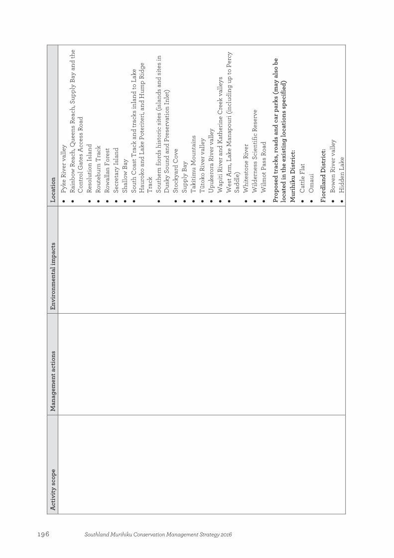
Act
ivity
sco
pe
Man
agem
ent a
ctio
ns
Envi
ronm
enta
l im
pact
s Lo
catio
n •
Pyke
Riv
er v
alle
y •
Rain
bow
Rea
ch, Q
ueen
s Re
ach,
Sup
ply
Bay
and
the
Con
trol
Gat
es A
cces
s Ro
ad
• Re
solu
tion
Isla
nd
• Ro
uteb
urn
Tra
ck
• Ro
wal
lan
Fore
st
• Se
cret
ary
Isla
nd
• Sh
allo
w B
ay
• So
uth
Coa
st T
rack
and
trac
ks in
land
to L
ake
Hau
roko
and
Lak
e Po
terit
eri,
and
Hum
p Ri
dge
Trac
k •
Sout
hern
fior
ds h
isto
ric s
ites
(isla
nds
and
site
s in
D
usky
Sou
nd a
nd P
rese
rvat
ion
Inle
t)
• St
ocky
ard
Cov
e •
Supp
ly B
ay
• Ta
kitim
u M
ount
ains
•
Tūto
ko R
iver
val
ley
• U
puke
rora
Riv
er v
alle
y •
Wap
iti R
iver
and
Kat
herin
e C
reek
val
leys
•
Wes
t Arm
, Lak
e M
anap
ouri
(incl
udin
g up
to P
ercy
Sa
ddle
) •
Whi
test
one
Rive
r •
Wild
erne
ss S
cien
tific
Res
erve
•
Wilm
ot P
ass
Road
Prop
osed
trac
ks, r
oads
and
car
par
ks (m
ay a
lso
be
loca
ted
in th
e ex
istin
g lo
cati
ons
spec
ified
) M
urih
iku
Dis
tric
t: •
Cat
tle F
lat
• O
mau
i
Fior
dlan
d D
istr
ict:
• Bo
wen
Riv
er v
alle
y •
Hid
den
Lake
196 Southland Murihiku Conservation Management Strategy 2016

Act
ivity
sco
pe
Man
agem
ent a
ctio
ns
Envi
ronm
enta
l im
pact
s
Loca
tion
Stru
ctur
es*
and
build
ings
for v
isito
r pur
pose
s
1. U
pgra
de o
f exi
stin
g st
ruct
ures
and
bui
ldin
gs to
m
eet d
epar
tmen
tal s
ervi
ce
stan
dard
s so
that
vis
itor
grou
p re
quire
men
ts a
re m
et,
such
as
min
imum
acc
ess
wid
ths
and
safe
ty b
arrie
r he
ight
s. 2.
Sc
hedu
led
‘like
for l
ike’
(s
ubst
antia
lly s
imila
r st
ruct
ures
and
bui
ldin
gs
built
on
the
sam
e fo
otpr
int o
r w
ithin
the
imm
edia
te
vici
nity
) rep
lace
men
t of
exis
ting
stru
ctur
es a
nd
build
ings
as
they
reac
h th
e en
d of
thei
r pr
ojec
ted/
econ
omic
life
. 3.
C
onst
ruct
ion
of n
ew
stru
ctur
es a
nd b
uild
ings
re
quire
d to
mee
t ser
vice
st
anda
rds
for e
xist
ing
trac
ks,
road
s, am
enity
are
as a
nd
cam
psite
s. 4.
C
onst
ruct
ion
of n
ew
stru
ctur
es a
nd b
uild
ings
as
a co
mpo
nent
of d
evel
opm
ent
wor
k fo
r new
trac
ks, r
oads
, am
enity
are
as a
nd c
amps
ites.
5.
Impr
ovem
ents
to a
ny
exis
ting
stru
ctur
e an
d bu
ildin
g co
nsid
ered
ne
cess
ary
to m
itiga
te a
ny
envi
ronm
enta
l im
pact
and
1. Pr
epar
ator
y si
te w
orks
such
as
vege
tatio
n re
mov
al, f
orm
atio
n an
d le
velli
ng o
f stru
ctur
e an
d bu
ildin
g fo
otpr
ints
, and
ex
cava
tion
of p
iles a
nd
foot
ings
. 2.
Wor
ks a
ssoc
iate
d w
ith w
ater
re
ticul
atio
n an
d se
wag
e co
ntai
nmen
t/ tr
eatm
ent.
3. C
onst
ruct
ion
of d
rain
age
and
redi
rect
ion
of su
rface
wat
er
from
stru
ctur
e an
d bu
ildin
g fo
otpr
int t
o ex
istin
g na
tura
l co
ntou
rs u
sing
var
ious
mea
ns
such
as c
ulve
rt pi
pes,
drai
nage
su
mps
and
cut
-out
s. 4.
Con
stru
ctio
n of
stru
ctur
es a
nd
build
ings
such
as b
ridge
s, bo
ardw
alks
, sta
irs, h
andr
ails
, sa
fety
bar
riers
, vie
win
g pl
atfo
rms,
huts
, she
lters
, to
ilets
, sig
nage
and
ladd
ers.
5. M
aint
enan
ce o
f his
toric
he
ritag
e fe
atur
es a
ssoc
iate
d w
ith th
e st
ruct
ure
or b
uild
ing
to e
nsur
e th
at th
eir i
nteg
rity
is
not a
dver
sely
impa
cted
.
1. So
il di
stur
banc
e, in
clud
ing
dist
urba
nce
of th
e du
ff la
yer
and
subs
oil.
Dis
turb
ance
and
so
il co
mpa
ctio
n in
fill
area
s. 2.
Su
rfac
e w
ater
runo
ff, in
clud
ing
mod
ifica
tion
of e
xist
ing
natu
ral w
ater
cour
ses,
and
cont
rol a
nd re
dire
ctio
n of
su
rfac
e w
ater
usi
ng v
ario
us
mea
ns s
uch
as c
ulve
rt p
ipes
an
d dr
aina
ge s
umps
. 3.
A
ltera
tions
to la
nd c
onto
urs
and
slop
es d
urin
g st
ruct
ure
and
build
ing
cons
truc
tion.
4.
Re
mov
al o
f veg
etat
ion
from
st
ruct
ure
and
build
ing
foot
prin
t and
imm
edia
te
surr
ound
ings
. 5.
A
esth
etic
impa
ct a
nd a
ltere
d si
ght-l
ines
from
man
-mad
e st
ruct
ures
in n
atur
al a
reas
. 6.
D
istu
rban
ce o
f arc
haeo
logi
cal
and
hist
oric
feat
ures
, inc
ludi
ng
hist
oric
bot
anic
als,
and
aest
hetic
impa
ct o
n hi
stor
ic
land
scap
es.
Exis
ting
stru
ctur
es a
nd b
uild
ings
M
urih
iku
Dis
tric
t: •
Auc
klan
d Is
land
—Er
ebus
Cov
e C
emet
ery
boar
dwal
k an
d fe
nce
• C
ampb
ell I
slan
d/M
otu
Ihup
uku—
Col
-Lya
ll bo
ardw
alk,
Nor
th W
est B
ay c
ircui
t boa
rdw
alk
and
brid
ge
• C
urio
Bay
—bu
ildin
gs a
nd s
truc
ture
s •
Ende
rby
Isla
nd—
Nor
ther
n C
liffs
Tra
ck b
oard
wal
k,
Ende
rby
Isla
nd c
ircui
t brid
ges,
Stel
la H
ut fe
nce
• Ey
re M
ount
ains
/Tak
a Ra
Hak
a C
onse
rvat
ion
Park
an
d Ta
kitim
u C
onse
rvat
ion
Are
a—hu
ts, b
uild
ings
an
d as
soci
ated
str
uctu
res
• Fo
rest
Hill
Sce
nic
Rese
rve—
build
ings
and
st
ruct
ures
•
Fove
aux
Wal
kway
, Glo
ry T
rack
, The
Bl
uff/
Mot
upōh
ue—
stru
ctur
es
• Pi
ano
Flat
—bu
ildin
gs a
nd a
ssoc
iate
d st
ruct
ures
•
Wai
tuna
/Aw
arua
wet
land
s—st
ruct
ures
and
bu
ildin
gs
Fior
dlan
d D
istr
ict:
• C
asw
ell H
ut (C
asw
ell S
ound
) •
Dor
e Pa
ss ro
ute—
asso
ciat
ed s
truc
ture
s •
Dus
ky T
rack
—hu
ts, s
truc
ture
s an
d as
soci
ated
bu
ildin
gs
• Fr
eem
an B
urn
Hut
•
Gla
isno
ck H
ut (G
lais
nock
val
ley)
•
Kep
ler T
rack
(inc
ludi
ng Ir
is B
urn,
Mt L
uxm
ore,
and
re
leva
nt s
ectio
ns a
roun
d La
ke T
e A
nau
and
the
Wai
au R
iver
)—as
soci
ated
str
uctu
res
and
build
ings
•
Kiw
i Bur
n tr
acks
—as
soci
ated
str
uctu
res
and
197Southland Murihiku Conservation Management Strategy 2016

Act
ivity
sco
pe
Man
agem
ent a
ctio
ns
Envi
ronm
enta
l im
pact
s
Loca
tion
he
alth
and
saf
ety
conc
ern,
or
to p
rovi
de im
prov
ed a
cces
s fo
r any
man
agem
ent
purp
ose.
build
ings
•
Lake
Hau
roko
—st
ruct
ures
and
bui
ldin
gs a
roun
d its
pe
rimet
er (i
nclu
ding
Thi
cket
Bur
n)
• La
ke M
onow
ai a
nd L
ake
Pote
riter
i—hu
ts, s
truc
ture
s
and
asso
ciat
ed b
uild
ings
•
Milf
ord
Trac
k—as
soci
ated
str
uctu
res
and
build
ings
•
Rout
ebur
n T
rack
—as
soci
ated
str
uctu
res
and
build
ings
•
Sout
h C
oast
Tra
ck—
huts
, str
uctu
res
and
asso
ciat
ed
build
ings
•
Wap
iti a
nd K
athe
rine
val
leys
(inc
ludi
ng G
eorg
e So
und)
—as
soci
ated
str
uctu
res
and
build
ings
•
Wor
sley
Arm
Hut
Pr
opos
ed s
truc
ture
s an
d bu
ildin
gs
Mur
ihik
u D
istr
ict:
• Re
plac
emen
t of s
truc
ture
s at
exi
stin
g lo
catio
ns s
et
out a
bove
, on
an ‘a
s re
quire
d’ b
asis
Fior
dlan
d D
istr
ict:
• Re
plac
emen
t of s
truc
ture
s at
exi
stin
g lo
catio
ns s
et
out a
bove
, on
an ‘a
s re
quire
d’ b
asis
Cam
psite
s an
d am
eniti
es fo
r vis
itor p
urpo
ses
1. U
pgra
de o
f exi
stin
g ca
mps
ites
and
amen
ities
to
mee
t dep
artm
enta
l ser
vice
st
anda
rds
so th
at v
isito
r gr
oup
requ
irem
ents
for
cam
psite
s an
d am
enity
are
as
are
met
. 2.
Sc
hedu
led
‘like
for l
ike’
(s
ubst
antia
lly s
imila
r ca
mps
ites
and
amen
ities
1. Pr
epar
ator
y si
te w
orks
suc
h as
veg
etat
ion
rem
oval
, fo
rmat
ion
and
leve
lling
of
cam
psite
and
am
enity
fo
otpr
int,
and
exca
vatio
n of
pi
les
and
foot
ings
. 2.
W
orks
ass
ocia
ted
with
wat
er
retic
ulat
ion
and
sew
age
cont
ainm
ent/
trea
tmen
t,
1. So
il di
stur
banc
e, in
clud
ing
dist
urba
nce
of th
e du
ff la
yer
and
subs
oil.
Dis
turb
ance
and
so
il co
mpa
ctio
n in
fill
area
s. 2.
Su
rfac
e w
ater
runo
ff, in
clud
ing
mod
ifica
tion
of e
xist
ing
natu
ral
wat
erco
urse
s, an
d co
ntro
l and
re
dire
ctio
n of
sur
face
wat
er
usin
g va
rious
mea
ns s
uch
as
Exis
ting
cam
psite
s an
d am
eniti
es
Mur
ihik
u D
istr
ict:
• Pi
ano
Flat
cam
psite
•
Thic
ket B
urn
cam
psite
Fior
dlan
d D
istr
ict:
• H
all A
rm c
amps
ite
• K
eple
r Tra
ck a
nd R
oute
burn
Tra
ck c
amps
ites
• La
ke M
onow
ai c
amps
ite
198 Southland Murihiku Conservation Management Strategy 2016
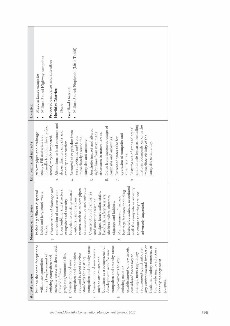
Act
ivity
sco
pe
Man
agem
ent a
ctio
ns
Envi
ronm
enta
l im
pact
s
Loca
tion
bu
ilt o
n th
e sa
me
foot
prin
t or
with
in th
e im
med
iate
vi
cini
ty) r
epla
cem
ent o
f ex
istin
g ca
mps
ites
and
amen
ity a
sset
s as
thes
e re
ach
the
end
of th
eir
proj
ecte
d/ec
onom
ic li
fe.
3.
Con
stru
ctio
n of
new
ca
mps
ites
and
amen
ities
re
quire
d to
mee
t ser
vice
st
anda
rds
for e
xist
ing
cam
psite
s an
d am
enit y
are
as.
4.
Con
stru
ctio
n of
new
ass
ets
such
as
stru
ctur
es a
nd
build
ings
as
a co
mpo
nent
of
deve
lopm
ent w
ork
for n
ew
cam
psite
s an
d am
enity
are
as.
5.
Impr
ovem
ents
to a
ny
exis
ting
asse
t or
esta
blis
hmen
t of n
ew a
sset
s co
nsid
ered
nec
essa
ry to
m
anag
e, m
eet r
egul
ator
y re
quire
men
ts, a
nd m
itiga
te
any
envi
ronm
enta
l im
pact
or
heal
th a
nd s
afet
y co
ncer
n, o
r to
pro
vide
impr
oved
acc
ess
for a
ny m
anag
emen
t pu
rpos
e.
incl
udin
g ef
fluen
t dis
pers
al
field
s an
d in
-gro
und
was
te
tank
s. 3.
C
onst
ruct
ion
of d
rain
age
and
redi
rect
ion
of s
urfa
ce w
ater
fr
om b
uild
ing
and
stru
ctur
al
cam
psite
and
am
enity
fo
otpr
int t
o ex
istin
g na
tura
l co
ntou
rs u
sing
var
ious
m
eans
, suc
h as
cul
vert
pip
es,
drai
nage
sum
ps a
nd c
ut-o
uts.
4.
Con
stru
ctio
n of
cam
psite
s an
d am
eniti
es s
uch
as
brid
ges,
boar
dwal
ks, s
tairs
, ha
ndra
ils, s
afet
y ba
rrie
rs,
shel
ters
, toi
lets
, sho
wer
s, si
gnag
e an
d la
dder
s.
5.
Mai
nten
ance
of h
isto
ric
herit
age
feat
ures
, inc
ludi
ng
hist
oric
bot
anic
als,
asso
ciat
ed
with
the
cam
psite
or a
men
ity
to e
nsur
e th
at th
ey a
re n
ot
adve
rsel
y im
pact
ed.
culv
ert p
ipes
and
dra
inag
e su
mps
. Fill
mat
eria
ls n
ot
norm
ally
foun
d on
the
site
(e.g
. sc
oria
) may
be
impo
rted
. 3.
A
ltera
tions
to la
nd c
onto
urs
and
slop
es d
urin
g ca
mps
ite a
nd
amen
ity c
onst
ruct
ion.
4.
Re
mov
al o
f veg
etat
ion
from
as
set f
ootp
rint a
nd fr
om
imm
edia
tely
aro
und
the
cam
psite
and
am
enity
. 5.
A
esth
etic
impa
ct a
nd a
ltere
d si
ght-l
ines
from
man
-mad
e st
ruct
ures
in n
atur
al a
reas
. 6.
N
oise
from
incr
ease
d us
age
of
cam
psite
and
am
eniti
es.
7. In
crea
sed
wat
er ta
ke fo
r op
erat
ion
of c
amps
ite a
nd
amen
ity s
ites.
8.
Dis
turb
ance
of a
rcha
eolo
gica
l an
d hi
stor
ic fe
atur
es, i
nclu
ding
hi
stor
ic b
otan
ical
s, on
or i
n th
e im
med
iate
vic
inity
of t
he
cam
psite
or a
men
ity.
• M
avor
a La
kes
cam
psite
•
Milf
ord
Soun
d H
ighw
ay c
amps
ites
Prop
osed
cam
psite
s an
d am
eniti
es
Mur
ihik
u D
istr
ict:
• N
one
Fior
dlan
d D
istr
ict:
• M
ilfor
d So
und/
Piop
iota
hi (L
ittle
Tah
iti)
199Southland Murihiku Conservation Management Strategy 2016
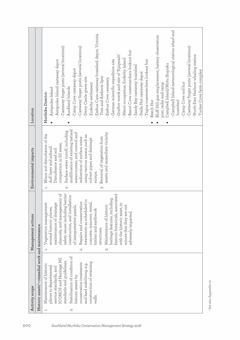
Act
ivity
sco
pe
Man
agem
ent a
ctio
ns
Envi
ronm
enta
l im
pact
s
Loca
tion
His
tori
c as
sets
1 —re
med
ial w
ork
and
mai
nten
ance
1. M
aint
enan
ce o
f his
toric
pl
aces
to d
epar
tmen
tal
serv
ice
stan
dard
s, an
d IC
OM
OS
and
Her
itage
NZ
stan
dard
s an
d gu
idel
ines
. 2.
St
abili
satio
n of
con
ditio
n of
hi
stor
ic a
sset
s by
co
nser
vatio
n tr
eatm
ents
an
d la
nd s
tabi
lisin
g, e
.g.
cons
truc
tion
of re
tain
ing
wal
ls.
1. V
eget
atio
n m
anag
emen
t ar
ound
his
toric
pla
ces,
mai
nten
ance
of d
rain
age
chan
nels
, and
man
agem
ent o
f sa
fety
issu
es in
clud
ing
barr
ier
cons
truc
tion,
and
inst
alla
tion
of in
terp
reta
tive
pane
ls.
2.
Repa
irs a
nd c
onse
rvat
ion
trea
tmen
ts a
s sc
hedu
led
to
conc
rete
, mas
onry
, met
al,
timbe
r and
ear
thw
ork
stru
ctur
es.
3.
Mai
nten
ance
of h
isto
ric
herit
age
feat
ures
, inc
ludi
ng
hist
oric
bot
anic
als,
asso
ciat
ed
with
the
hist
oric
ass
et, t
o en
sure
that
they
are
not
ad
vers
ely
impa
cted
.
1. M
inor
soi
l dis
turb
ance
of t
he
duff
laye
r and
sub
soil.
D
istu
rban
ce a
nd s
oil
com
pact
ion
in fi
ll ar
eas.
2.
Surf
ace
wat
er ru
noff,
incl
udin
g m
odifi
catio
n of
exi
stin
g na
tura
l w
ater
cour
ses,
and
cont
rol a
nd
redi
rect
ion
of s
urfa
ce w
ater
us
ing
vario
us m
eans
suc
h as
cu
lver
t pip
es a
nd d
rain
age
sum
ps.
3. R
emov
al o
f veg
etat
ion
from
as
sets
and
imm
edia
te v
icin
ity.
Mur
ihik
u D
istr
ict:
• A
ntip
odes
Isla
nd
- Ant
ipod
es Is
land
cas
taw
ay d
epot
- C
asta
way
fing
er p
osts
(sev
eral
loca
tions
) •
Auc
klan
d Is
land
s - C
amp
Cov
e ca
staw
ay d
epot
- C
asta
way
fing
er p
osts
(sev
eral
loca
tions
) - D
erry
Cas
tle g
rave
site
- E
nder
by s
ettle
men
t - E
rebu
s C
ove
cast
away
boa
tshe
d, d
epot
, Vic
toria
Tr
ee a
nd A
mhe
rst S
par
- Ere
bus
Cov
e ce
met
ery
- Ger
man
sci
entif
ic e
xped
ition
site
- G
rafto
n w
reck
and
site
of ‘
Epig
wai
tt’
- Māo
ri oc
cupa
tion,
End
erby
Isla
nd
- Ran
ui C
ove
coas
twat
cher
s lo
okou
t hut
- S
andy
Bay
cas
taw
ay b
oats
hed
- Ste
lla H
ut c
asta
way
dep
ot
- Tag
ua c
oast
wat
cher
s lo
okou
t hut
•
Beec
h H
ut
• Bl
uff H
ill g
un e
mpl
acem
ent,
batte
ry o
bser
vatio
n po
st, r
adar
and
cam
p •
Cam
pbel
l Isl
and/
Mot
u Ih
upuk
u - C
ampb
ell I
slan
d m
eteo
rolo
gica
l sta
tion
wha
rf a
nd
boat
shed
- C
amp
Cov
e so
d hu
t - C
asta
way
fing
er p
osts
(sev
eral
loca
tions
) - N
orth
-Eas
t Har
bour
wha
ling
stat
ion
- Tuc
ker C
ove
farm
com
plex
1 S
ee a
lso
App
endi
x 10
.
200 Southland Murihiku Conservation Management Strategy 2016

Act
ivity
sco
pe
Man
agem
ent a
ctio
ns
Envi
ronm
enta
l im
pact
s
Loca
tion
•
Dog
Box
Biv
vy
• M
ores
’ Joh
nsto
n lo
com
otiv
e •
Mar
tin’s
Hut
and
race
•
Mor
es’ t
op m
ill s
ite, P
oura
kino
Val
ley
• N
orth
Eas
t Isl
and,
Sna
res
Isla
nds/
Tin
i Hek
e - C
asta
way
fing
er p
osts
(sev
eral
loca
tions
) - S
nare
s Is
land
cas
taw
ay d
epot
•
Pian
o Fl
at w
ater
race
•
Port
’s w
ater
race
•
Prin
tz’s
batte
ry
• Ro
und
Hill
min
ing
• Tu
rnbu
ll’s
race
, dam
and
hut
•
Wai
papa
buc
ket d
redg
e re
mai
ns
• W
aipa
pa li
ghth
ouse
set
tlem
ent,
Tara
rua
wre
ck a
nd
Tara
rua
Acr
e
• W
aipo
hatu
log
haul
er
Fior
dlan
d D
istr
ict:
•
Alp
ha b
atte
ry a
nd q
uart
z m
ine
• A
nita
Bay
sto
ne h
ut re
mai
ns
• A
stro
nom
er P
oint
•
Beer
’s fa
rm
• C
asw
ell S
ound
Hut
•
Cla
rk H
ut
• C
ledd
au h
orse
brid
ge
• C
uttle
Cov
e w
halin
g st
atio
n
• En
deav
our w
reck
site
, Fac
ile H
arbo
ur
• Fr
eem
an B
urn
Hut
•
Gol
den
Site
bat
tery
, Wils
on R
iver
•
Hod
ge’s
stoc
k tr
ack
• H
olly
ford
bak
er’s
oven
•
Hom
er T
unne
l por
tal a
vala
nche
dam
age
201Southland Murihiku Conservation Management Strategy 2016
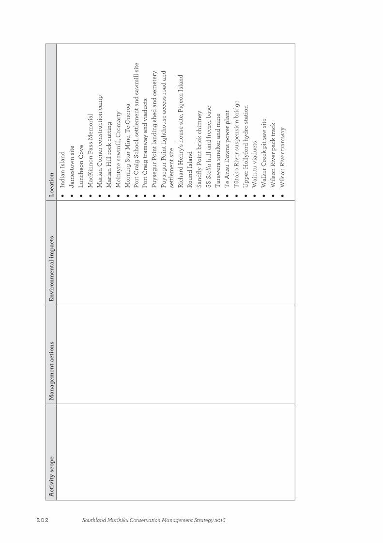
Act
ivity
sco
pe
Man
agem
ent a
ctio
ns
Envi
ronm
enta
l im
pact
s
Loca
tion
• In
dian
Isla
nd
• Ja
mes
tow
n si
te
• Lu
nche
on C
ove
• M
acK
inno
n Pa
ss M
emor
ial
• M
aria
n C
orne
r con
stru
ctio
n ca
mp
•
Mar
ian
Hill
rock
cut
ting
• M
cInt
yre
saw
mill
, Cro
mar
ty
• M
orni
ng S
tar M
ine,
Te
One
roa
• Po
rt C
raig
Sch
ool,
settl
emen
t and
saw
mill
site
•
Port
Cra
ig tr
amw
ay a
nd v
iadu
cts
•
Puys
egur
Poi
nt la
ndin
g sh
ed a
nd c
emet
ery
•
Puys
egur
Poi
nt li
ghth
ouse
acc
ess
road
and
se
ttlem
ent s
ite
• Ri
char
d H
enry
's ho
use
site
, Pig
eon
Isla
nd
• Ro
und
Isla
nd
• Sa
ndfly
Poi
nt b
rick
chim
ney
• SS
Ste
lla h
ull a
nd fr
eeze
r bas
e •
Tara
wer
a sm
elte
r and
min
e •
Te A
nau
Dow
ns p
ower
pla
nt
• Tū
toko
Riv
er s
uspe
nsio
n br
idge
•
Upp
er H
olly
ford
hyd
ro s
tatio
n •
Wai
tutu
via
duct
s •
Wal
ker C
reek
pit
saw
site
•
Wils
on R
iver
pac
k tr
ack
• W
ilson
Riv
er tr
amw
ay
202 Southland Murihiku Conservation Management Strategy 2016

Act
ivity
sco
pe
Man
agem
ent a
ctio
ns
Envi
ronm
enta
l im
pact
s
Loca
tion
Sign
s
1. Er
ectio
n of
sig
nage
on
publ
ic
cons
erva
tion
land
for t
he
purp
ose
of p
rovi
ding
in
form
atio
n an
d in
terp
reta
tion
to th
e pu
blic
. 2.
Er
ectio
n of
sig
nage
on
publ
ic
cons
erva
tion
land
for t
he
purp
ose
of in
form
ing
peop
le
abou
t fire
ligh
ting
rest
rictio
ns.
1. W
orks
ass
ocia
ted
with
the
erec
tion
of s
igna
ge.
1. A
esth
etic
impa
ct fr
om m
an-
mad
e st
ruct
ures
in n
atur
al
area
s. 2.
Re
mov
al o
f veg
etat
ion
from
si
gn fo
otpr
int a
nd im
med
iate
vi
cini
ty.
• A
ll pu
blic
con
serv
atio
n la
nd in
Sou
thla
nd
Mur
ihik
u.
Biod
iver
sity
trac
ks, r
oads
and
str
uctu
res
(inc
ludi
ng s
taff
acco
mm
odat
ion)
1. Re
fer t
o ‘A
ctiv
ity s
cope
’ for
‘T
rack
s, ro
ads
and
car p
arki
ng
area
s fo
r vis
itor p
urpo
ses’,
‘S
truc
ture
s an
d bu
ildin
gs fo
r vi
sito
r pur
pose
s’ an
d ‘C
amps
ites
and
amen
ities
for
visi
tor p
urpo
ses’.
1. Re
fer t
o ‘M
anag
emen
t ac
tions
’ for
‘Tra
cks,
road
s an
d ca
r par
king
are
as fo
r vis
itor
purp
oses
’, ‘St
ruct
ures
and
bu
ildin
gs fo
r vis
itor p
urpo
ses’
and
‘Cam
psite
s an
d am
eniti
es
for v
isito
r pur
pose
s’.
Not
e: N
ot a
ll vi
sito
r sta
ndar
ds
note
d ab
ove
will
app
ly to
bi
odiv
ersi
ty tr
acks
, roa
ds a
nd
stru
ctur
es (i
nclu
ding
sta
ff ac
com
mod
atio
n). I
n so
me
case
s a
less
er s
tand
ard
may
app
ly.
1. Re
fer t
o ‘E
nviro
nmen
tal i
mpa
cts’
for ‘
Trac
ks, r
oads
and
car
par
king
ar
eas
for v
isito
r pur
pose
s’,
‘Str
uctu
res
and
build
ings
for
visi
tor p
urpo
ses’
and
‘Cam
psite
s an
d am
eniti
es fo
r vis
itor
purp
oses
’.
• A
ll pu
blic
con
serv
atio
n la
nd in
Sou
thla
nd M
urih
iku
whe
re c
onse
rvat
ion
man
agem
ent p
rogr
amm
es a
re
bein
g un
dert
aken
.
Oth
er m
anag
emen
t-re
late
d ac
tiviti
es
1. Er
ectio
n of
fenc
es o
n pu
blic
co
nser
vatio
n la
nd a
nd it
s bo
unda
ries.
2.
Hab
itat e
nhan
cem
ent.
3.
Pest
con
trol
and
/or
1. V
eget
atio
n re
mov
al to
pro
vide
cl
ear l
ines
for f
ence
s. 2.
So
me
pest
ani
mal
ope
ratio
ns
(not
e: d
isch
arge
per
mits
will
be
requ
ired
for o
pera
tions
1. V
eget
atio
n re
mov
al.
2.
Soil
dist
urba
nce,
incl
udin
g di
stur
banc
e of
the
duff
laye
r an
d su
bsoi
l. 3.
D
eath
and
like
ly e
radi
catio
n of
• A
ll pu
blic
con
serv
atio
n la
nd in
Sou
thla
nd M
urih
iku
whe
re c
onse
rvat
ion
man
agem
ent p
rogr
amm
es a
re
bein
g un
dert
aken
.
203Southland Murihiku Conservation Management Strategy 2016

Act
ivity
sco
pe
Man
agem
ent a
ctio
ns
Envi
ronm
enta
l im
pact
s
Loca
tion
er
adic
atio
n.
4.
Airs
trip
s fo
r fire
fight
ing
purp
oses
.
utili
sing
pes
ticid
es).
3.
Ea
rthw
orks
and
veg
etat
ion
clea
ranc
e as
soci
ated
with
ha
bita
t enh
ance
men
t, i.e
. po
nd/d
rain
cre
atio
n or
re-
alig
nmen
t and
fire
m
anag
emen
t. 4.
G
ener
al a
cces
s re
quire
d to
un
dert
ake
the
activ
ity.
targ
et p
est m
amm
als;
poss
ible
de
ath
of n
on-ta
rget
spe
cies
.
Haz
ardo
us g
oods
1.
Use
, tra
nspo
rtat
ion,
sto
rage
an
d di
spos
al o
f haz
ardo
us
subs
tanc
es.
1. U
se, t
rans
port
atio
n, s
tora
ge
and
disp
osal
of h
azar
dous
su
bsta
nces
incl
udin
g, b
ut n
ot
limite
d to
, fla
mm
able
liqu
ids,
pest
icid
es, h
erbi
cide
s an
d tr
eate
d tim
ber.
1. W
ill c
ompl
y w
ith a
ll re
leva
nt
legi
slat
ive
requ
irem
ents
. •
All
publ
ic c
onse
rvat
ion
land
in S
outh
land
Mur
ihik
u w
here
con
serv
atio
n pr
ogra
mm
es a
re b
eing
un
dert
aken
.
* St
ruct
ures
for v
isito
r pur
pose
s in
clud
e vi
ewin
g pl
atfo
rms,
step
s/st
airs
, boa
rdw
alks
, brid
ges,
hand
rails
, saf
ety
fenc
es, s
tiles
, sig
nage
, etc
.
204 Southland Murihiku Conservation Management Strategy 2016
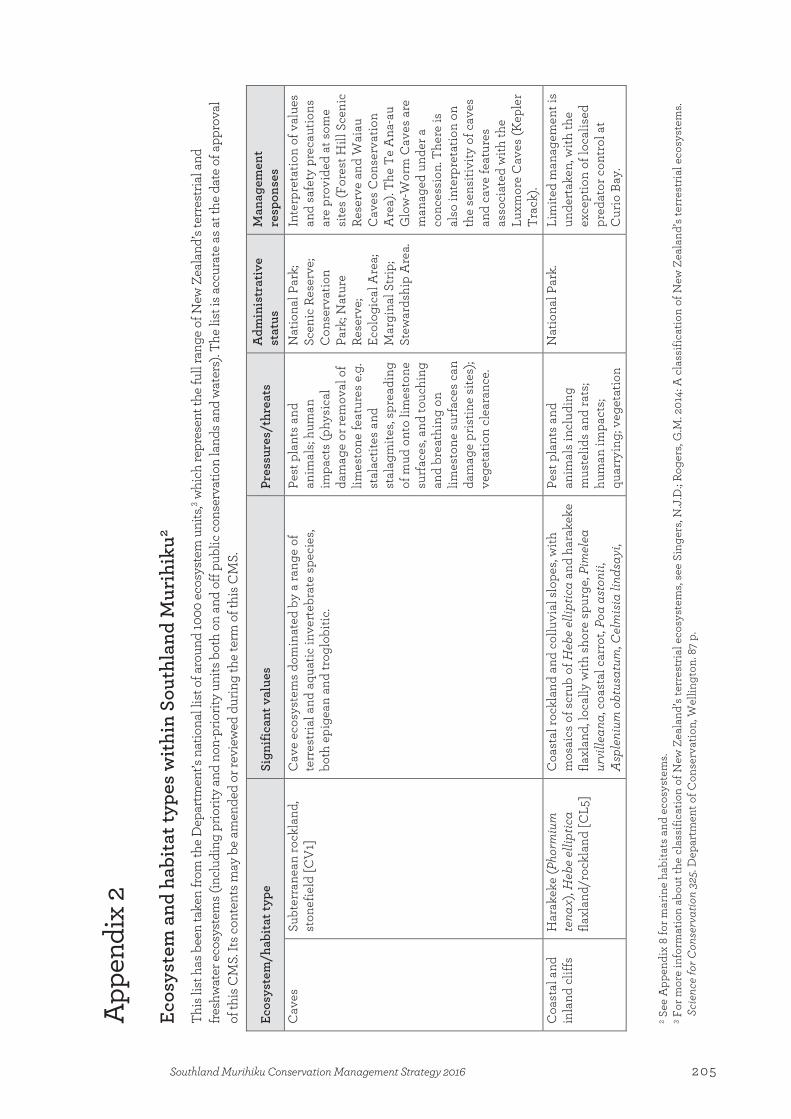
App
endi
x 2
Ecos
yste
m a
nd h
abita
t typ
es w
ithin
Sou
thla
nd M
urih
iku2
This
list
has
bee
n ta
ken
from
the
Dep
artm
ent’s
nat
iona
l lis
t of a
roun
d 10
00 e
cosy
stem
uni
ts,3 w
hich
repr
esen
t the
full
rang
e of
New
Zea
land
’s te
rres
trial
and
fre
shw
ater
eco
syst
ems (
incl
udin
g pr
iorit
y an
d no
n-pr
iorit
y un
its b
oth
on a
nd o
ff pu
blic
con
serv
atio
n la
nds a
nd w
ater
s). T
he li
st is
acc
urat
e as
at t
he d
ate
of a
ppro
val
of th
is C
MS.
Its c
onte
nts m
ay b
e am
ende
d or
revi
ewed
dur
ing
the
term
of t
his C
MS.
Ecos
yste
m/h
abita
t typ
e
Sign
ifica
nt v
alue
s Pr
essu
res/
thre
ats
Adm
inis
trat
ive
stat
us
Man
agem
ent
resp
onse
s C
aves
Su
bter
rane
an ro
ckla
nd,
ston
efie
ld [C
V1]
C
ave
ecos
yste
ms
dom
inat
ed b
y a
rang
e of
te
rres
tria
l and
aqu
atic
inve
rteb
rate
spe
cies
, bo
th e
pige
an a
nd tr
oglo
bitic
.
Pest
pla
nts
and
anim
als;
hum
an
impa
cts
(phy
sica
l da
mag
e or
rem
oval
of
limes
tone
feat
ures
e.g
. st
alac
tites
and
st
alag
mite
s, sp
read
ing
of m
ud o
nto
limes
tone
su
rfac
es, a
nd to
uchi
ng
and
brea
thin
g on
lim
esto
ne s
urfa
ces
can
dam
age
pris
tine
site
s);
vege
tatio
n cl
eara
nce.
Nat
iona
l Par
k;
Scen
ic R
eser
ve;
Con
serv
atio
n Pa
rk; N
atur
e Re
serv
e;
Ecol
ogic
al A
rea;
M
argi
nal S
trip
; St
ewar
dshi
p A
rea.
Inte
rpre
tatio
n of
val
ues
and
safe
ty p
reca
utio
ns
are
prov
ided
at s
ome
site
s (F
ores
t Hill
Sce
nic
Rese
rve
and
Wai
au
Cav
es C
onse
rvat
ion
Are
a). T
he T
e A
na-a
u G
low
-Wor
m C
aves
are
m
anag
ed u
nder
a
conc
essi
on. T
here
is
also
inte
rpre
tatio
n on
th
e se
nsiti
vity
of c
aves
an
d ca
ve fe
atur
es
asso
ciat
ed w
ith th
e Lu
xmor
e C
aves
(Kep
ler
Trac
k).
Coa
stal
and
in
land
clif
fs
Har
akek
e (P
horm
ium
te
nax)
, Heb
e el
liptic
a fla
xlan
d/ro
ckla
nd [C
L5]
Coa
stal
rock
land
and
col
luvi
al s
lope
s, w
ith
mos
aics
of s
crub
of H
ebe
ellip
tica
and
hara
keke
fla
xlan
d, lo
cally
with
sho
re s
purg
e, P
imel
ea
urvi
llean
a, c
oast
al c
arro
t, Po
a as
toni
i, A
sple
nium
obt
usat
um, C
elm
isia
lind
sayi
,
Pest
pla
nts
and
anim
als
incl
udin
g m
uste
lids
and
rats
; hu
man
impa
cts;
quar
ryin
g; v
eget
atio
n
Nat
iona
l Par
k.
Lim
ited
man
agem
ent i
s un
dert
aken
, with
the
exce
ptio
n of
loca
lised
pr
edat
or c
ontr
ol a
t C
urio
Bay
.
2 See
App
endi
x 8
for m
arin
e ha
bita
ts a
nd e
cosy
stem
s. 3 F
or m
ore
info
rmat
ion
abou
t the
cla
ssifi
catio
n of
New
Zea
land
’s te
rres
tria
l eco
syst
ems,
see
Sing
ers,
N.J
.D.; R
oger
s, G
.M. 2
014:
A c
lass
ifica
tion
of N
ew Z
eala
nd’s
terr
estr
ial e
cosy
stem
s. Sc
ienc
e fo
r Con
serv
atio
n 32
5. D
epar
tmen
t of C
onse
rvat
ion,
Wel
lingt
on. 8
7 p.
Appendix 2:Ecosystem and habitat types within Southland Murihiku
205Southland Murihiku Conservation Management Strategy 2016

Ecos
yste
m/h
abita
t typ
e
Sign
ifica
nt v
alue
s Pr
essu
res/
thre
ats
Adm
inis
trat
ive
stat
us
Man
agem
ent
resp
onse
s kā
retu
/hol
y gr
ass
(Hie
roch
loe
spp.
), Le
pidi
um
spp.
and
hal
ophy
tic h
erbs
.
clea
ranc
e.
Col
d fo
rest
an
d sc
rub
Pāha
utea
(Lib
oced
rus
bidw
illii)
, Hal
l’s tō
tara
(P
odoc
arpu
s cu
nnin
gham
ii), m
ount
ain
toat
oa/c
eler
y pi
ne
(Phy
llocl
adus
alp
inus
) an
d br
oadl
eaf f
ores
t [C
DF1
]
Podo
carp
, bro
adle
aved
fore
st o
f pāh
aute
a,
Hal
l's tō
tara
, mou
ntai
n to
atoa
/cel
ery
pine
and
br
oadl
eaf.
Pest
pla
nts
and
anim
als;
fire;
hum
an
impa
cts;
quar
ryin
g;
vege
tatio
n cl
eara
nce.
Con
serv
atio
n Pa
rk; S
tew
ards
hip
Are
a; N
atio
nal
Park
.
Pest
ani
mal
and
pla
nt
cont
rol.
Bios
ecur
ity
surv
eilla
nce
and
man
agem
ent.
Adv
ocac
y, c
onsu
ltatio
n an
d pa
rtne
rshi
ps.
Taw
aira
urik
i/m
ount
ain
beec
h (F
usco
spor
a cl
iffor
tioid
es) f
ores
t [C
DF3
]
Beec
h fo
rest
of a
bund
ant t
awai
raur
iki/
m
ount
ain
beec
h, w
ith s
mal
l-lea
ved
Cop
rosm
a sp
p., w
eepi
ng m
atip
o/ m
āpou
(Myr
sine
di
varic
ata)
, mou
ntai
n to
atoa
/cel
ery
pine
, sno
w
tōta
ra (P
odoc
arpu
s niv
alis
), br
oadl
eaf,
thre
e-fin
ger (
Pseu
dopa
nax
cole
nsoi
var
. col
enso
i),
and
puta
puta
wēt
ā (C
arpo
detu
s ser
ratu
s), a
nd
loca
lly H
all's
tōta
ra. L
ocal
ly a
lso
incl
udes
sc
atte
red
taw
ai/s
ilver
bee
ch (L
opho
zoni
a m
enzi
esii)
and
taw
aira
unui
/red
bee
ch
(Fus
cosp
ora
fusc
a) in
hum
id lo
catio
ns.
Pest
pla
nts
and
anim
als;
fire;
hum
an
impa
cts;
quar
ryin
g;
vege
tatio
n cl
eara
nce;
w
asps
.
Scen
ic R
eser
ve;
Con
serv
atio
n Pa
rk; G
over
nmen
t Pu
rpos
e Re
serv
e;
Mar
gina
l Str
ip;
Stew
ards
hip
Are
a;
Nat
iona
l Par
k.
Pest
ani
mal
and
pla
nt
cont
rol.
Bios
ecur
ity
surv
eilla
nce
and
man
agem
ent.
Adv
ocac
y, c
onsu
ltatio
n an
d pa
rtne
rshi
ps.
Ole
aria
, Pse
udop
anax
, D
raco
phyl
lum
scr
ub;
“Sub
alpi
ne s
crub
” [C
DF6
]
Shor
t for
est,
scru
b of
wid
e ra
nge
of lo
cal
varia
nts,
with
a ra
nge
of s
peci
es o
f Ole
aria
, Br
achy
glot
tis, P
seud
opan
ax, D
raco
phyl
lum
, H
ebe,
Cop
rosm
a, H
oher
ia, m
onta
ne p
odoc
arp
tree
s, m
ānuk
a (L
epto
sper
mum
scop
ariu
m) a
nd
wha
rarik
i (Ph
orm
ium
coo
kian
um).
Pest
pla
nts
and
anim
als;
hum
an
impa
cts;
quar
ryin
g;
vege
tatio
n cl
eara
nce.
Nat
ure
Rese
rve;
W
ilder
ness
Are
a;
Scen
ic R
eser
ve;
Con
serv
atio
n Pa
rk; E
colo
gica
l A
rea;
Mar
gina
l St
rip; S
tew
ards
hip
Are
a; N
atio
nal
Park
.
Pest
ani
mal
and
pla
nt
cont
rol.
Bios
ecur
ity
surv
eilla
nce
and
man
agem
ent.
Adv
ocac
y, c
onsu
ltatio
n an
d pa
rtne
rshi
ps.
Taw
aira
urik
i/m
ount
ain
beec
h, ta
wai
/silv
er b
eech
, m
onta
ne p
odoc
arp
fore
st
Taw
ai/b
eech
, pod
ocar
p an
d ta
wai
/bee
ch,
podo
carp
, bro
adle
aved
fore
st o
f at l
east
two
varia
nts:
1. So
uth
Isla
nd w
ith ta
wai
raur
iki/
Pest
pla
nts
and
anim
als;
hum
an
impa
cts;
quar
ryin
g;
Wild
erne
ss A
rea;
C
onse
rvat
ion
Park
; Eco
logi
cal
Pest
ani
mal
and
pla
nt
cont
rol.
Bios
ecur
ity
206 Southland Murihiku Conservation Management Strategy 2016

Ecos
yste
m/h
abita
t typ
e
Sign
ifica
nt v
alue
s Pr
essu
res/
thre
ats
Adm
inis
trat
ive
stat
us
Man
agem
ent
resp
onse
s [C
DF7
] m
ount
ain
and
taw
ai/s
ilver
bee
ch, y
ello
w s
ilver
pi
ne (L
epid
otha
mnu
s int
erm
ediu
s), s
outh
ern
rātā
(Met
rosi
dero
s um
bella
ta) a
nd
Dra
coph
yllu
m tr
aver
sii;
2. lo
wer
alti
tude
ta
wai
raur
iki/
mou
ntai
n be
ech
and
taw
ai/
silv
er
beec
h, lo
cally
yel
low
silv
er p
ine,
man
oao/
silv
er
pine
(Man
oao
cole
nsoi
), rim
u (D
acry
dium
cu
pres
sinu
m),
kahi
kate
a (D
acry
carp
us
dacr
ydio
ides
), m
iro (P
rum
nopi
tys f
erru
gine
a),
pāha
utea
, Hal
l's tō
tara
, pōk
ākā
(Ela
eoca
rpus
ho
oker
ianu
s).
vege
tatio
n cl
eara
nce;
w
asps
. A
rea;
Ste
war
dshi
p A
rea;
Nat
iona
l Pa
rk.
surv
eilla
nce
and
man
agem
ent.
Adv
ocac
y, c
onsu
ltatio
n an
d pa
rtne
rshi
ps.
Com
bust
ion
and/
or
volc
anic
ac
tivity
Shor
t tus
sock
tu
ssoc
klan
d [V
S11]
Sh
ort t
usso
ck g
rass
land
s pr
inci
pally
of s
ilver
tu
ssoc
k (P
oa c
ita) a
nd h
ard
tuss
ock
(Fes
tuca
no
vae-
zela
ndia
e), w
ith a
ssoc
iate
d sp
ecie
s of
Po
a, F
estu
ca, D
eyeu
xia
and
Rytid
ospe
rma,
of
ten
with
inte
r-tus
sock
pro
stra
te s
hrub
and
he
rbfie
ld s
peci
es. L
ater
suc
cess
iona
l tra
nsiti
ons
incl
ude
rāra
hu/b
rack
en (P
terid
ium
es
cule
ntum
), D
raco
phyl
lum
spp
., mān
uka,
kā
nuka
and
oth
er s
hrub
/scr
ub s
peci
es.
Pest
pla
nts
and
anim
als;
fire;
hum
an
impa
cts;
quar
ryin
g;
vege
tatio
n cl
eara
nce;
ve
hicl
es.
Nat
iona
l Par
k;
Stew
ards
hip
Are
a Pe
st a
nim
al a
nd p
lant
co
ntro
l. Bi
osec
urity
su
rvei
llanc
e an
d m
anag
emen
t. A
dvoc
acy,
con
sulta
tion
and
part
ners
hips
.
Coo
l for
est
and
scru
b H
all’s
tōta
ra fo
rest
; “D
une
fore
st” [
CLF
2]
Podo
carp
fore
st o
f abu
ndan
t tōt
ara
(Hal
l’s a
nd
low
land
) loc
ally
with
mat
aī (P
rum
nopi
tys
taxi
folia
) on
free
-dra
inin
g sa
ndy
soils
. V
ery
old
dune
s in
clud
e br
oadl
eave
d tr
ees
(pōk
ākā
and
kām
ahi (
Wei
nman
nia
race
mos
a)),
rimu
and
kahi
kate
a.
Pest
pla
nts
and
anim
als;
fire;
hum
an
impa
cts;
quar
ryin
g;
vege
tatio
n cl
eara
nce.
Scen
ic R
eser
ve;
Con
serv
atio
n Pa
rk; S
tew
ards
hip
Are
a; N
atio
nal
Park
.
Pest
ani
mal
and
pla
nt
cont
rol.
Bios
ecur
ity
surv
eilla
nce
and
man
agem
ent.
Adv
ocac
y, c
onsu
ltatio
n an
d pa
rtne
rshi
ps.
Podo
carp
, rib
bonw
ood
(Pla
gian
thus
regi
us),
kōw
hai (
Soph
ora
spp.
) fo
rest
[CLF
3]
Podo
carp
fore
st o
f abu
ndan
t kah
ikat
ea, m
ataī
an
d tō
tara
, with
ribb
onw
ood,
nar
row
leav
ed
houh
ere/
lace
bark
(Hoh
eria
ang
ustif
olia
), kō
wha
i and
a w
ide
varie
ty o
f div
aric
atin
g sh
rubs
on
free
-dra
inin
g so
ils.
Pest
pla
nts
and
anim
als;
fire;
hum
an
impa
cts;
quar
ryin
g;
vege
tatio
n cl
eara
nce.
Scen
ic R
eser
ve;
Scie
ntifi
c Re
serv
e;
Loca
l Pur
pose
Re
serv
e; M
argi
nal
Strip
; Ste
war
dshi
p A
rea;
Nat
iona
l Pa
rk.
Pest
ani
mal
and
pla
nt
cont
rol.
Bios
ecur
ity
surv
eilla
nce
and
man
agem
ent.
Adv
ocac
y, c
onsu
ltatio
n
207Southland Murihiku Conservation Management Strategy 2016
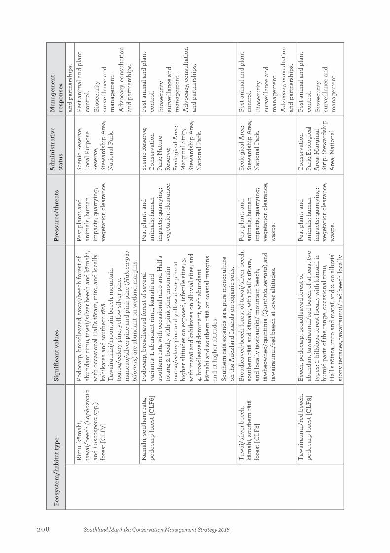
Ecos
yste
m/h
abita
t typ
e
Sign
ifica
nt v
alue
s Pr
essu
res/
thre
ats
Adm
inis
trat
ive
stat
us
Man
agem
ent
resp
onse
s an
d pa
rtne
rshi
ps.
Rim
u, k
āmah
i, ta
wai
/bee
ch (L
opho
zoni
a an
d Fu
scos
pora
spp.
) fo
rest
[CLF
7]
Podo
carp
, bro
adle
aved
, taw
ai/b
eech
fore
st o
f ab
unda
nt ri
mu,
taw
ai/s
ilver
bee
ch a
nd k
āmah
i, w
ith o
ccas
iona
l Hal
l's tō
tara
, miro
, and
loca
lly
kahi
kate
a an
d so
uthe
rn rā
tā.
Taw
aira
urik
i/m
ount
ain
beec
h, m
ount
ain
toat
oa/c
eler
y pi
ne, y
ello
w s
ilver
pin
e,
man
oao/
silv
er p
ine
and
pink
pin
e (H
aloc
arpu
s bi
form
is) a
re a
bund
ant o
n w
etla
nd m
argi
ns.
Pest
pla
nts
and
anim
als;
hum
an
impa
cts;
quar
ryin
g;
vege
tatio
n cl
eara
nce.
Scen
ic R
eser
ve;
Loca
l Pur
pose
Re
serv
e;
Stew
ards
hip
Are
a;
Nat
iona
l Par
k.
Pest
ani
mal
and
pla
nt
cont
rol.
Bios
ecur
ity
surv
eilla
nce
and
man
agem
ent.
Adv
ocac
y, c
onsu
ltatio
n an
d pa
rtne
rshi
ps.
Kām
ahi,
sout
hern
rātā
, po
doca
rp fo
rest
[CLF
6]
Podo
carp
, bro
adle
aved
fore
st o
f sev
eral
va
riant
s: 1.
abun
dant
rim
u, k
āmah
i and
so
uthe
rn rā
tā w
ith o
ccas
iona
l mir
o an
d H
all's
tō
tara
; 2. l
ocal
ly w
ith p
ink
pine
, mou
ntai
n to
atoa
/cel
ery
pine
and
yel
low
silv
er p
ine
at
high
er a
ltitu
des
on e
xpos
ed, i
nfer
tile
site
s; 3.
w
ith m
ataī
and
kah
ikat
ea o
n al
luvi
al s
ites;
and
4. b
road
leav
ed-d
omin
ant,
with
abu
ndan
t kā
mah
i and
sou
ther
n rā
tā o
n co
asta
l mar
gins
an
d at
hig
her a
ltitu
des.
Sout
hern
rātā
ext
ends
as
a pu
re m
onoc
ultu
re
on th
e A
uckl
and
Isla
nds
on o
rgan
ic s
oils
.
Pest
pla
nts
and
anim
als;
hum
an
impa
cts;
quar
ryin
g;
vege
tatio
n cl
eara
nce.
Scen
ic R
eser
ve;
Con
serv
atio
n Pa
rk; N
atur
e Re
serv
e;
Ecol
ogic
al A
rea;
M
argi
nal S
trip
; St
ewar
dshi
p A
rea;
N
atio
nal P
ark.
Pest
ani
mal
and
pla
nt
cont
rol.
Bios
ecur
ity
surv
eilla
nce
and
man
agem
ent.
Adv
ocac
y, c
onsu
ltatio
n an
d pa
rtne
rshi
ps.
Taw
ai/s
ilver
bee
ch,
kām
ahi,
sout
hern
rātā
fo
rest
[CLF
8]
Broa
dlea
ved-
beec
h fo
rest
of t
awai
/silv
er b
eech
, so
uthe
rn rā
tā a
nd k
āmah
i, w
ith H
all’s
tōta
ra,
and
loca
lly ta
wira
urik
i/ m
ount
ain
beec
h,
tāw
heow
heo/
quin
tinia
(Qui
ntin
ia se
rrat
a) a
nd
taw
aira
unui
/red
bee
ch a
t low
er a
ltitu
des.
Pest
pla
nts
and
anim
als;
hum
an
impa
cts;
quar
ryin
g;
vege
tatio
n cl
eara
nce;
w
asps
.
Ecol
ogic
al A
rea;
St
ewar
dshi
p A
rea;
N
atio
nal P
ark.
Pest
ani
mal
and
pla
nt
cont
rol.
Bios
ecur
ity
surv
eilla
nce
and
man
agem
ent.
Adv
ocac
y, c
onsu
ltatio
n an
d pa
rtne
rshi
ps.
Taw
aira
unui
/red
bee
ch,
podo
carp
fore
st [C
LF9]
Be
ech,
pod
ocar
p, b
road
leav
ed fo
rest
of
abun
dant
taw
aira
unui
/red
bee
ch o
f at l
east
two
type
s: 1.
hills
lope
fore
st lo
cally
with
kām
ahi i
n hu
mid
par
ts o
f the
rang
e, o
ccas
iona
l rim
u,
Hal
l's tō
tara
, miro
and
mat
aī; a
nd 2
. on
allu
vial
st
ony
terr
aces
, taw
aira
unui
/ re
d be
ech
loca
lly
Pest
pla
nts
and
anim
als;
hum
an
impa
cts;
quar
ryin
g;
vege
tatio
n cl
eara
nce;
w
asps
.
Con
serv
atio
n Pa
rk; E
colo
gica
l A
rea;
Mar
gina
l St
rip; S
tew
ards
hip
Are
a; N
atio
nal
Pest
ani
mal
and
pla
nt
cont
rol.
Bios
ecur
ity
surv
eilla
nce
and
man
agem
ent.
208 Southland Murihiku Conservation Management Strategy 2016

Ecos
yste
m/h
abita
t typ
e
Sign
ifica
nt v
alue
s Pr
essu
res/
thre
ats
Adm
inis
trat
ive
stat
us
Man
agem
ent
resp
onse
s w
ith ta
wai
/silv
er b
eech
, kām
ahi a
nd s
outh
ern
rātā
, and
occ
asio
nal p
odoc
arp
tree
s (r
imu,
ka
hika
tea,
mat
aī a
nd tō
tara
).
Park
. A
dvoc
acy,
con
sulta
tion
and
part
ners
hips
.
Taw
aira
unui
/red
and
ta
wai
/silv
er b
eech
fore
st
[CLF
10]
Beec
h fo
rest
and
bee
ch, p
odoc
arp,
bro
adle
aved
fo
rest
of a
bund
ant t
awai
raun
ui/r
ed a
nd
taw
ai/s
ilver
bee
ch, a
nd lo
cally
with
pod
ocar
p an
d br
oadl
eave
d sp
ecie
s w
ith a
t lea
st tw
o lo
cal
varia
nts.1
.loca
lly w
ith o
ccas
iona
l ta
wai
raur
iki/
blac
k be
ech
(Fus
cosp
ora
sola
ndri)
an
d ta
wai
raur
iki/
mou
ntai
n be
ech,
Hal
l's tō
tara
, pā
haut
ea, k
āmah
i and
taw
aira
unui
/har
d be
ech
(Fus
cosp
ora
trun
cata
), as
wel
l as
rimu,
miro
an
d m
ataī
at l
ower
alti
tude
s; an
d 2.
With
oc
casi
onal
taw
aira
urik
i/bl
ack
beec
h an
d ta
wai
raur
iki/
mou
ntai
n be
ech.
Pest
pla
nts
and
anim
als;
hum
an
impa
cts;
quar
ryin
g;
vege
tatio
n cl
eara
nce;
w
asps
.
Scen
ic R
eser
ve;
Con
serv
atio
n Pa
rk; E
colo
gica
l A
rea;
Loc
al
Purp
ose
Rese
rve;
M
argi
nal S
trip
; St
ewar
dshi
p A
rea;
N
atio
nal P
ark.
Pest
ani
mal
and
pla
nt
cont
rol.
Bios
ecur
ity
surv
eilla
nce
and
man
agem
ent.
Adv
ocac
y, c
onsu
ltatio
n an
d pa
rtne
rshi
ps.
Taw
ai/s
ilver
bee
ch fo
rest
[C
LF11
] Be
ech
fore
st o
f abu
ndan
t taw
ai/s
ilver
bee
ch o
f at
leas
t tw
o lo
cal v
aria
nts:
1. up
per m
ount
ain
slop
es, l
ocal
ly w
ith m
ount
ain
toat
oa/c
eler
y pi
ne, t
hree
-fing
er, O
lear
ia s
pp., k
ōtuk
utuk
u (F
uchs
ia e
xcor
ticat
a), b
road
leaf
and
sm
all-
leav
ed s
hrub
s; an
d 2.
low
er a
nd m
id-s
lope
s, w
ith ri
mu
and
kām
ahi,
occa
sion
al s
outh
ern
rātā
, Hal
l's tō
tara
and
miro
, and
loca
lly w
ith
kahi
kate
a on
allu
vial
terr
aces
.
Pest
pla
nts
and
anim
als;
hum
an
impa
cts;
quar
ryin
g;
vege
tatio
n cl
eara
nce;
w
asps
.
Wild
erne
ss A
rea;
Sc
enic
Res
erve
; C
onse
rvat
ion
Park
; Eco
logi
cal
Are
a; L
ocal
Pu
rpos
e Re
serv
e;
Mar
gina
l Str
ip;
Stew
ards
hip
Are
a;
Nat
iona
l Par
k.
Pest
ani
mal
and
pla
nt
cont
rol.
Bios
ecur
ity
surv
eilla
nce
and
man
agem
ent.
Adv
ocac
y, c
onsu
ltatio
n an
d pa
rtne
rshi
ps.
Taw
ai/s
ilver
bee
ch,
taw
aira
urik
i/m
ount
ain
beec
h fo
rest
[CLF
12]
Beec
h fo
rest
of a
bund
ant t
awai
/silv
er a
nd
taw
aira
urik
i/m
ount
ain
beec
h, lo
cally
with
kā
mah
i, H
all’s
tōta
ra, m
ount
ain
toat
oa/c
eler
y pi
ne, t
awai
raun
ui/r
ed b
eech
, thr
ee-fi
nger
, kō
tuku
tuku
, bro
adle
af a
nd s
mal
l-lea
ved
diva
ricat
ing
shru
bs.
Pest
pla
nts
and
anim
als;
hum
an
impa
cts;
quar
ryin
g;
vege
tatio
n cl
eara
nce;
w
asps
.
Con
serv
atio
n Pa
rk; E
colo
gica
l A
rea;
Ste
war
dshi
p A
rea;
Nat
iona
l Pa
rk.
Pest
ani
mal
and
pla
nt
cont
rol.
Bios
ecur
ity
surv
eilla
nce
and
man
agem
ent.
Adv
ocac
y, c
onsu
ltatio
n an
d pa
rtne
rshi
ps.
Pīng
ao s
edge
land
[DN
3]
Sedg
elan
d of
abu
ndan
t pīn
gao
of tw
o va
riant
s (h
umid
and
sem
i-arid
) with
occ
asio
nal
wīw
ī/kn
obby
clu
brus
h (F
icin
ia n
odos
a), C
arex
Pest
pla
nts
and
anim
als;
fire;
hum
an
impa
cts;
min
ing;
Nat
iona
l Par
k;
Scen
ic R
eser
ve;
Nat
ure
Rese
rve;
Pest
ani
mal
and
pla
nt
cont
rol.
Wee
d co
ntro
l in
209Southland Murihiku Conservation Management Strategy 2016

Ecos
yste
m/h
abita
t typ
e
Sign
ifica
nt v
alue
s Pr
essu
res/
thre
ats
Adm
inis
trat
ive
stat
us
Man
agem
ent
resp
onse
s pu
mila
, pan
ahi/
shor
e bi
ndw
eed
(Cal
yste
gia
sold
anel
la),
sand
tuss
ock,
tāta
rahe
ke/s
and
copr
osm
a an
d M
uehl
enbe
ckia
com
plex
a, a
nd
loca
lly s
hore
spu
rge,
pūh
ā/N
ew Z
eala
nd s
ow
this
tle, s
outh
ern
sand
dap
hne,
Car
ex te
stac
ea,
Aca
ena
spp.
, silv
er tu
ssoc
k (P
oa c
ita) a
nd
kāre
tu/h
oly
gras
s, gr
adin
g in
to re
ar s
emi-s
tabl
e du
nes
with
sca
ttere
d du
ne s
crub
. Gra
des
into
ab
unda
nt h
arak
eke,
mān
uka,
Ole
aria
av
icen
niifo
lia in
hum
id a
reas
, and
into
m
atag
ouri
(Dis
caria
toum
atou
), C
arm
icha
elia
sp
p., a
keak
e (D
odon
aea
visc
osa)
and
nga
io
(Myo
poru
m la
etum
) in
sem
i-arid
are
as.
quar
ryin
g; v
eget
atio
n cl
eara
nce;
veh
icle
s. Ec
olog
ical
Are
a;
Scie
ntifi
c Re
serv
e;
Gov
ernm
ent
Purp
ose
Rese
rve;
M
argi
nal S
trip
; St
ewar
dshi
p A
rea.
Fior
dlan
d an
d be
ache
s, an
d at
Toe
toes
Har
bour
Sp
it C
onse
rvat
ion
Are
a (F
ortr
ose
Spit)
. Bi
osec
urity
su
rvei
llanc
e an
d m
anag
emen
t. A
dvoc
acy,
con
sulta
tion
and
part
ners
hips
.
Oio
i (A
poda
smia
sim
ilis)
, w
īwī/
knob
by c
lubr
ush
sedg
elan
d [D
N5]
Sedg
elan
d, h
erbf
ield
of s
ever
al lo
cal v
aria
nts
with
bot
h dr
y an
d ep
hem
eral
ly w
et
com
mun
ities
of r
ange
of s
ucce
ssio
nal s
tage
s. D
omin
ant s
peci
es in
clud
e C
arex
pum
ila,
spec
ies
of G
unne
ra, S
ellie
ra, I
sole
pis,
Epilo
bium
, Ran
uncu
lus,
Lept
inel
la, L
obel
ia,
Col
oban
thus
, Ger
aniu
m a
nd H
ydro
coty
le, a
nd
loca
lly L
ilaeo
psis
nov
ae-z
elan
diae
, M
yrio
phyl
lum
vot
schi
i, Tr
iglo
chin
stria
ta,
Lim
osel
la li
neat
a an
d ot
her t
urf-f
orm
ing
spec
ies.
Old
er s
tage
s de
velo
p in
to o
ioi,
wīw
ī/kn
obby
clu
brus
h, to
etoe
(Aus
trod
eria
sp
p.) a
nd h
arak
eke,
and
loca
lly C
yper
us
ustu
latu
s, sq
uare
sed
ge (L
epid
ospe
rma
aust
rale
), si
lver
tuss
ock
and
Raou
lia s
pp.
Loca
lly in
clud
es C
opro
sma
prop
inqu
a an
d m
ānuk
a in
old
er s
ucce
ssio
ns.
Pest
pla
nts
and
anim
als;
fire;
hum
an
impa
cts;
min
ing;
qu
arry
ing;
veg
etat
ion
clea
ranc
e; v
ehic
les.
Scen
ic R
eser
ve;
Scie
ntifi
c Re
serv
e;
Mar
gina
l Str
ip;
Stew
ards
hip
Are
a;
Nat
iona
l Par
k.
Pest
ani
mal
and
pla
nt
cont
rol.
W
eed
cont
rol i
n Fi
ordl
and
and
beac
hes,
and
at T
oeto
es H
arbo
ur
Spit
Con
serv
atio
n A
rea
(For
tros
e Sp
it).
Bios
ecur
ity
surv
eilla
nce
and
man
agem
ent.
Adv
ocac
y, c
onsu
ltatio
n an
d pa
rtne
rshi
ps.
Dun
elan
ds
Past
ure
Scen
ic R
eser
ve;
Con
serv
atio
n Pa
rk; N
atur
e Re
serv
e; S
cien
tific
Pest
ani
mal
and
pla
nt
cont
rol.
Bios
ecur
ity
surv
eilla
nce
and
210 Southland Murihiku Conservation Management Strategy 2016

Ecos
yste
m/h
abita
t typ
e
Sign
ifica
nt v
alue
s Pr
essu
res/
thre
ats
Adm
inis
trat
ive
stat
us
Man
agem
ent
resp
onse
s Re
serv
e;
Gov
ernm
ent
Purp
ose
Rese
rve;
Sa
nctu
ary
Are
a;
Loca
l Pur
pose
Re
serv
e; M
argi
nal
Strip
; Ste
war
dshi
p A
rea;
Nat
iona
l Pa
rk.
man
agem
ent.
Bog
pine
(Hal
ocar
pus
bidw
illii)
, mou
ntai
n
toat
oa/c
eler
y pi
ne
scru
b/fo
rest
[TI1
]
Shor
t for
est,
scru
b of
abu
ndan
t bog
pin
e an
d/or
m
ount
ain
toat
oa/c
eler
y pi
ne, w
ith s
peci
es o
f D
raco
phyl
lum
, Leu
copo
gon,
Cop
rosm
a, H
ebe,
O
lear
ia, P
ittos
poru
m, G
aulth
eria
and
Pim
elea
, m
ount
ain
tauh
inu
(Ozo
tham
nus v
auvi
llier
sii),
ko
roki
a (C
orok
ia s
pp.),
mou
ntai
n w
ineb
erry
(A
risto
telia
frut
icos
a), s
now
tōta
ra a
nd
porc
upin
e sh
rub
(Mel
icyt
us a
lpin
us).
Early
su
cces
sion
al d
eriv
ativ
es in
clud
e sh
ort t
usso
ck
gras
slan
ds o
f spe
cies
of P
oa, F
estu
ca, D
eyeu
xia,
Ry
tidos
perm
a, w
ith in
ter-t
usso
ck p
rost
rate
he
rbfie
ld s
peci
es.
Pest
pla
nts
and
anim
als;
fire;
hum
an
impa
cts;
quar
ryin
g;
vege
tatio
n cl
eara
nce.
Nat
iona
l Par
k;
Scie
ntifi
c Re
serv
e;
Scen
ic R
eser
ve;
Con
serv
atio
n Pa
rk; M
argi
nal
Strip
; Ste
war
dshi
p A
rea.
Pest
ani
mal
and
pla
nt
cont
rol.
Bios
ecur
ity
surv
eilla
nce
and
man
agem
ent.
Adv
ocac
y, c
onsu
ltatio
n an
d pa
rtne
rshi
ps.
Fenc
ing.
Exot
ic
Bog
pine
, mou
ntai
n to
atoa
/cel
ery
pine
and
m
anoa
o/si
lver
pin
e sc
rub/
fore
st [T
I5]
Scru
b an
d sh
ort f
ores
t with
sev
eral
loca
l va
riant
s, in
clud
ing
mou
ntai
n to
atoa
/cel
ery
and
bog
pine
, loc
ally
with
man
oao/
silv
er p
ine,
pin
k pi
ne, y
ello
w s
ilver
pin
e, p
āhau
tea
and
Wes
tland
tō
tara
(Pod
ocar
pus a
cutif
oliu
s), a
nd o
ften
with
di
varic
atin
g sh
rubs
and
Dra
coph
yllu
m s
peci
es.
Pest
pla
nts
and
anim
als;
quar
ryin
g;
vege
tatio
n cl
eara
nce.
Scen
ic R
eser
ve;
Con
serv
atio
n Pa
rk; E
colo
gica
l A
rea;
Loc
al
Purp
ose
Rese
rve;
St
ewar
dshi
p A
rea;
N
atio
nal P
ark.
Pest
ani
mal
and
pla
nt
cont
rol.
Bios
ecur
ity
surv
eilla
nce
and
man
agem
ent.
Adv
ocac
y, c
onsu
ltatio
n an
d pa
rtne
rshi
ps.
Fenc
ing.
Fr
ost f
lats
(C
old
tem
pera
ture
in
vers
ion)
Cop
rosm
a, O
lear
ia s
crub
[T
I4]
Scru
b of
two
diffe
rent
var
iant
s: 1.
on fr
ee-
drai
ning
sto
ny s
oils
, with
spe
cies
incl
udin
g C
arm
icha
elia
, Cop
rosm
a, O
lear
ia, H
ebe,
C
orok
ia c
oton
east
er, m
ānuk
a, m
atag
ouri,
and
sp
ecie
s of
the
liane
s M
uehl
enbe
ckia
, Rub
us a
nd
Pest
pla
nts
and
anim
als;
fire;
hum
an
impa
cts;
quar
ryin
g;
vege
tatio
n cl
eara
nce.
Wild
erne
ss A
rea;
Sc
enic
Res
erve
; C
onse
rvat
ion
Park
; Eco
logi
cal
Are
a; S
cien
tific
Pest
ani
mal
and
pla
nt
cont
rol.
Bios
ecur
ity
surv
eilla
nce
and
211Southland Murihiku Conservation Management Strategy 2016
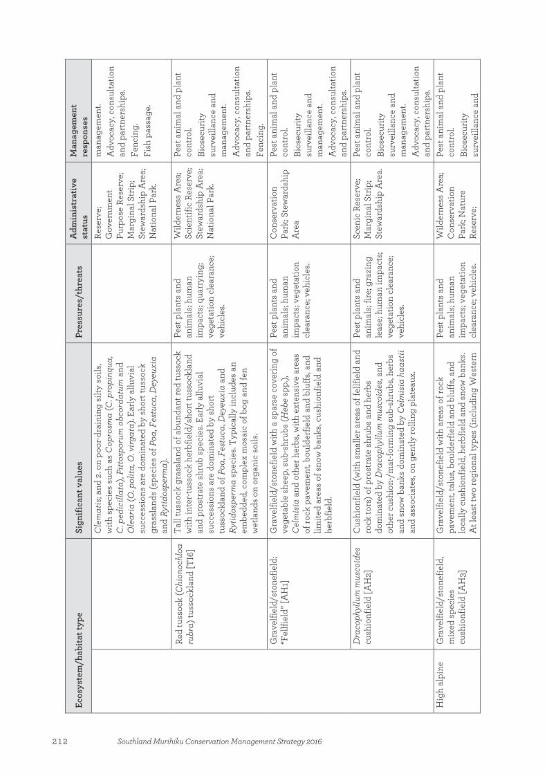
Ecos
yste
m/h
abita
t typ
e
Sign
ifica
nt v
alue
s Pr
essu
res/
thre
ats
Adm
inis
trat
ive
stat
us
Man
agem
ent
resp
onse
s C
lem
atis
; and
2. o
n po
or-d
rain
ing
silty
soi
ls,
with
spe
cies
suc
h as
Cop
rosm
a (C
. pro
pinq
ua,
C. p
edic
illat
a), P
ittos
poru
m o
bcor
datu
m a
nd
Ole
aria
(O. p
olita
, O. v
irgat
a). E
arly
allu
vial
su
cces
sion
s ar
e do
min
ated
by
shor
t tus
sock
gr
assl
ands
(spe
cies
of P
oa, F
estu
ca, D
eyeu
xia
and
Rytid
ospe
rma)
.
Rese
rve;
G
over
nmen
t Pu
rpos
e Re
serv
e;
Mar
gina
l Str
ip;
Stew
ards
hip
Are
a;
Nat
iona
l Par
k.
man
agem
ent.
Adv
ocac
y, c
onsu
ltatio
n an
d pa
rtne
rshi
ps.
Fenc
ing.
Fi
sh p
assa
ge.
Red
tuss
ock
(Chi
onoc
hloa
ru
bra)
tuss
ockl
and
[TI6
] Ta
ll tu
ssoc
k gr
assl
and
of a
bund
ant r
ed tu
ssoc
k w
ith in
ter-t
usso
ck h
erbf
ield
/sho
rt tu
ssoc
klan
d an
d pr
ostr
ate
shru
b sp
ecie
s. Ea
rly a
lluvi
al
succ
essi
ons
are
dom
inat
ed b
y sh
ort
tuss
ockl
and
of P
oa, F
estu
ca, D
eyeu
xia
and
Rytid
ospe
rma
spec
ies.
Typi
cally
incl
udes
an
embe
dded
, com
plex
mos
aic
of b
og a
nd fe
n w
etla
nds
on o
rgan
ic s
oils
.
Pest
pla
nts
and
anim
als;
hum
an
impa
cts;
quar
ryin
g;
vege
tatio
n cl
eara
nce;
ve
hicl
es.
Wild
erne
ss A
rea;
Sc
ient
ific
Rese
rve;
St
ewar
dshi
p A
rea;
N
atio
nal P
ark.
Pest
ani
mal
and
pla
nt
cont
rol.
Bios
ecur
ity
surv
eilla
nce
and
man
agem
ent.
Adv
ocac
y, c
onsu
ltatio
n an
d pa
rtne
rshi
ps.
Fenc
ing.
G
rave
lfiel
d/st
onef
ield
; “F
ellfi
eld”
[AH
1]
Gra
velfi
eld/
ston
efie
ld w
ith a
spa
rse
cove
ring
of
vege
tabl
e sh
eep,
sub
-shr
ubs
(Heb
e sp
p.),
Cel
mis
ia a
nd o
ther
her
bs, w
ith e
xten
sive
are
as
of ro
ck p
avem
ent,
boul
derf
ield
and
blu
ffs, a
nd
limite
d ar
eas
of s
now
ban
ks, c
ushi
onfie
ld a
nd
herb
field
.
Pest
pla
nts
and
anim
als;
hum
an
impa
cts;
vege
tatio
n cl
eara
nce;
veh
icle
s.
Con
serv
atio
n Pa
rk; S
tew
ards
hip
Are
a
Pest
ani
mal
and
pla
nt
cont
rol.
Bios
ecur
ity
surv
eilla
nce
and
man
agem
ent.
Adv
ocac
y, c
onsu
ltatio
n an
d pa
rtne
rshi
ps.
Dra
coph
yllu
m m
usco
ides
cu
shio
nfie
ld [A
H2]
C
ushi
onfie
ld (w
ith s
mal
ler a
reas
of f
ellfi
eld
and
rock
tors
) of p
rost
rate
shr
ubs
and
herb
s do
min
ated
by
Dra
coph
yllu
m m
usco
ides
, and
ot
her c
ushi
on-/
mat
-form
ing
sub-
shru
bs, h
erbs
an
d sn
ow b
anks
dom
inat
ed b
y C
elm
isia
haa
stii
and
asso
ciat
es, o
n ge
ntly
rolli
ng p
late
aux.
Pest
pla
nts
and
anim
als;
fire;
gra
zing
le
ase;
hum
an im
pact
s; ve
geta
tion
clea
ranc
e;
vehi
cles
.
Scen
ic R
eser
ve;
Mar
gina
l Str
ip;
Stew
ards
hip
Are
a.
Pest
ani
mal
and
pla
nt
cont
rol.
Bios
ecur
ity
surv
eilla
nce
and
man
agem
ent.
Adv
ocac
y, c
onsu
ltatio
n an
d pa
rtne
rshi
ps.
Hig
h al
pine
G
rave
lfiel
d/st
onef
ield
, m
ixed
spe
cies
cu
shio
nfie
ld [A
H3]
Gra
velfi
eld/
ston
efie
ld w
ith a
reas
of r
ock
pave
men
t, ta
lus,
boul
derf
ield
and
blu
ffs, a
nd
loca
lly c
ushi
onfie
ld, h
erbf
ield
and
sno
w b
anks
. A
t lea
st tw
o re
gion
al ty
pes
(incl
udin
g W
este
rn
Pest
pla
nts
and
anim
als;
hum
an
impa
cts;
vege
tatio
n cl
eara
nce;
veh
icle
s.
Wild
erne
ss A
rea;
C
onse
rvat
ion
Park
; Nat
ure
Rese
rve;
Pest
ani
mal
and
pla
nt
cont
rol.
Bios
ecur
ity
surv
eilla
nce
and
212 Southland Murihiku Conservation Management Strategy 2016

Ecos
yste
m/h
abita
t typ
e
Sign
ifica
nt v
alue
s Pr
essu
res/
thre
ats
Adm
inis
trat
ive
stat
us
Man
agem
ent
resp
onse
s al
ps/N
orth
ern
Fior
dlan
d), w
hich
incl
ude
a di
vers
ity o
f gra
sses
, sm
all h
erbs
and
sub
-sh
rubs
, inc
ludi
ng A
ciph
ylla
, Agr
ostis
, Br
achy
scom
e, B
rach
yglo
ttis
, Cel
mis
ia,
Dol
icho
glot
tis, E
pilo
bium
, Gau
lther
ia,
Gen
tiane
lla, H
ebe,
Our
isia
, Poa
, Ran
uncu
lus,
Tris
etum
and
cus
hion
gen
era.
Incl
udes
sno
w
bank
s of
Chi
onoc
hloa
ore
ophi
la, C
. cr
assi
uscu
la, C
. vire
ta, b
lue
tuss
ock
and
Cel
mis
ia h
ecto
rii.
Stew
ards
hip
Are
a;
Nat
iona
l Par
k.
man
agem
ent.
Adv
ocac
y, c
onsu
ltatio
n an
d pa
rtne
rshi
ps.
Perm
anen
t sno
w a
nd ic
e Pe
rman
ent s
now
and
ice.
H
uman
impa
cts.
Wild
erne
ss A
rea;
C
onse
rvat
ion
Park
; Ste
war
dshi
p A
rea;
Nat
iona
l Pa
rk.
Pest
ani
mal
and
pla
nt
cont
rol.
Bios
ecur
ity
surv
eilla
nce
and
man
agem
ent.
Adv
ocac
y, c
onsu
ltatio
n an
d pa
rtne
rshi
ps.
Lake
s G
laci
al
Sout
hlan
d M
urih
iku
has
a la
rge
num
ber o
f la
kes
and
larg
e di
vers
ity o
f lak
e ty
pes.
Man
y re
mai
n in
an
inta
ct c
ondi
tion.
Pest
pla
nts
and
anim
als;
adja
cent
land
us
es; c
atch
men
t im
pact
s; hu
man
im
pact
s; hy
drol
ogic
al
alte
ratio
n; im
pede
d fis
h pa
ssag
e; la
ke
mac
roph
ytes
; pes
t fis
h; ri
ver n
utrie
nts;
salm
onid
s; se
dim
ents
an
d nu
trie
nts;
wat
er
and
grav
el e
xtra
ctio
n.
Wild
erne
ss A
rea;
Sc
enic
Res
erve
; C
onse
rvat
ion
Park
; Nat
ure
Rese
rve;
G
over
nmen
t Pu
rpos
e Re
serv
e;
Mar
gina
l Str
ip;
Stew
ards
hip
Are
a;
Nat
iona
l Par
k.
Pest
ani
mal
and
pla
nt
cont
rol—
aqua
tic w
eeds
in
lake
s M
anap
ouri
and
Te A
nau.
Som
e w
eed
cont
rol.
Bios
ecur
ity
surv
eilla
nce
and
man
agem
ent.
Adv
ocac
y, c
onsu
ltatio
n an
d pa
rtne
rshi
ps.
Land
slid
e Pe
at
Rive
rine
Sh
orel
ine
Swam
p Te
cton
ic
Win
dfor
m
Low
alp
ine
and
suba
ntar
ctic
Nar
row
-leav
ed
(Chi
onoc
hloa
rigi
da
subs
p. ri
gida
) and
slim
(C
. mac
ra) s
now
tuss
ock
tuss
ockl
and/
shr
ubla
nd
Tall
tuss
ock
gras
slan
d, s
hrub
land
of a
bund
ant
Chi
onoc
hloa
rigi
da s
ubsp
. rig
ida,
C. m
acra
, and
sp
ecie
s of
Heb
e an
d D
raco
phyl
lum
with
are
as
of ta
lus,
boul
derf
ield
and
blu
ffs.
Pest
pla
nts
and
anim
als;
fire;
gra
zing
le
ase;
hum
an im
pact
s; ve
geta
tion
clea
ranc
e;
vehi
cles
.
Scen
ic R
eser
ve;
Con
serv
atio
n Pa
rk; G
over
nmen
t Pu
rpos
e Re
serv
e;
Mar
gina
l Str
ip;
Pest
ani
mal
and
pla
nt
cont
rol.
Bios
ecur
ity
surv
eilla
nce
and
man
agem
ent.
213Southland Murihiku Conservation Management Strategy 2016
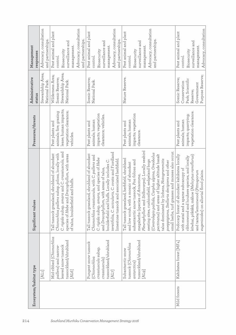
Ecos
yste
m/h
abita
t typ
e
Sign
ifica
nt v
alue
s Pr
essu
res/
thre
ats
Adm
inis
trat
ive
stat
us
Man
agem
ent
resp
onse
s [A
L1]
Stew
ards
hip
Are
a;
Nat
iona
l Par
k.
Adv
ocac
y, c
onsu
ltatio
n an
d pa
rtne
rshi
ps.
Mid
-ribb
ed (C
hion
ochl
oa
palle
ns) a
nd n
arro
w-
leav
ed s
now
tuss
ock
tuss
ockl
and/
shru
blan
d [A
L6]
Tall
tuss
ock
gras
slan
d, s
hrub
land
of a
bund
ant
Chi
onoc
hloa
pal
lens
sub
sp. p
ilosa
, loc
ally
with
C
. rig
ida
subs
p. a
mar
a an
d C
. cra
ssiu
scul
a, a
nd
spec
ies
of H
ebe
and
Dra
coph
yllu
m, w
ith a
reas
of
talu
s, bo
ulde
rfie
ld a
nd b
luffs
.
Pest
pla
nts
and
anim
als;
fire;
gra
zing
le
ase;
hum
an im
pact
s; ve
geta
tion
clea
ranc
e;
vehi
cles
.
Wild
erne
ss A
rea;
Sc
enic
Res
erve
; St
ewar
dshi
p A
rea;
N
atio
nal P
ark.
Pest
ani
mal
and
pla
nt
cont
rol.
Bios
ecur
ity
surv
eilla
nce
and
man
agem
ent.
Adv
ocac
y, c
onsu
ltatio
n an
d pa
rtne
rshi
ps.
Pung
ent s
now
tuss
ock
(Chi
onoc
hloa
cr
assi
uscu
la su
bsp.
cr
assi
uscu
la)
tuss
ockl
and/
shru
blan
d [A
L7]
Tall
tuss
ock
gras
slan
d, s
hrub
land
of a
bund
ant
Chi
onoc
hloa
cra
ssiu
scul
a, w
ith C
. pal
lens
and
C
. rig
ida
subs
p. a
mar
a, a
nd s
peci
es o
f Heb
e an
d D
raco
phyl
lum
, with
are
as o
f tal
us,
boul
derf
ield
and
blu
ffs. L
ocal
ly in
clud
es C
. te
retif
olia
, C. a
cicu
laris
, C. o
vata
and
Fio
rdla
nd
limes
tone
tuss
ock
and
asso
ciat
ed h
erbf
ield
.
Pest
pla
nts
and
anim
als;
hum
an
impa
cts;
vege
tatio
n cl
eara
nce;
veh
icle
s.
Scen
ic R
eser
ve;
Nat
iona
l Par
k.
Pest
ani
mal
and
pla
nt
cont
rol.
Bios
ecur
ity
surv
eilla
nce
and
man
agem
ent.
Adv
ocac
y, c
onsu
ltatio
n an
d pa
rtne
rshi
ps.
Suba
ntar
ctic
sno
w
tuss
ock
(Chi
onoc
hloa
an
tarc
tica)
tu
ssoc
klan
d/sh
rubl
and
[AL9
]
Tall
tuss
ock
gras
slan
d, h
erbf
ield
, shr
ubla
nd
and
low
scr
ub, w
ith a
mos
aic
of a
bund
ant
suba
ntar
ctic
sno
w tu
ssoc
k, P
oa fo
liosa
and
m
egah
erbs
(spe
cies
of A
niso
tom
e, Pl
euro
phyl
lum
and
Stil
boca
rpa)
. Loc
ally
sea
bird
ne
stin
g si
tes,
cush
ionf
ield
, sed
gela
nd b
ogs
(Cen
trol
epis
pal
lida,
Car
pha
alpi
na, O
reob
olus
pe
ctin
atus
) and
are
as o
f hig
her a
ltitu
de b
asal
t ta
lus
dom
inat
ed b
y lic
hens
, Not
ogra
mm
itis
poep
pigi
ana,
Ste
llaria
dec
ipie
ns a
nd o
ther
sm
all h
erbs
, tur
f gra
sses
and
mos
ses
also
occ
ur.
Pest
pla
nts
and
anim
als;
hum
an
impa
cts;
vege
tatio
n cl
eara
nce.
Nat
ure
Rese
rve.
Pe
st a
nim
al a
nd p
lant
co
ntro
l. Bi
osec
urity
su
rvei
llanc
e an
d m
anag
emen
t. A
dvoc
acy,
con
sulta
tion
and
part
ners
hips
.
Mild
fore
sts
Kah
ikat
ea fo
rest
[MF4
] Po
doca
rp fo
rest
of a
bund
ant k
ahik
atea
loca
lly
with
mat
aī a
nd a
spa
rse
subc
anop
y of
rib
bonw
ood
and
houh
ere
spec
ies,
and
loca
lly
kōw
hai,
pōkā
kā, m
āhoe
(Mel
icyt
us ra
mifl
orus
) an
d ta
rata
/lem
onw
ood
(Pitt
ospo
rum
eu
geni
oide
s) o
n al
luvi
al fl
ood
plai
ns.
Pest
pla
nts
and
anim
als;
hum
an
impa
cts;
quar
ryin
g;
vege
tatio
n cl
eara
nce.
Scen
ic R
eser
ve;
Con
serv
atio
n Pa
rk; S
cien
tific
Re
serv
e;
Gov
ernm
ent
Purp
ose
Rese
rve;
Pest
ani
mal
and
pla
nt
cont
rol.
Bios
ecur
ity
surv
eilla
nce
and
man
agem
ent.
Adv
ocac
y, c
onsu
ltatio
n
214 Southland Murihiku Conservation Management Strategy 2016
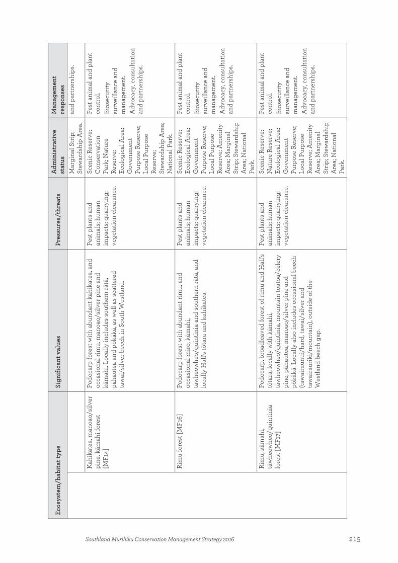
Ecos
yste
m/h
abita
t typ
e
Sign
ifica
nt v
alue
s Pr
essu
res/
thre
ats
Adm
inis
trat
ive
stat
us
Man
agem
ent
resp
onse
s M
argi
nal S
trip
; St
ewar
dshi
p A
rea.
an
d pa
rtne
rshi
ps.
Kah
ikat
ea, m
anoa
o/si
lver
pi
ne, k
āmah
i for
est
[MF1
4]
Podo
carp
fore
st w
ith a
bund
ant k
ahik
atea
, and
oc
casi
onal
rim
u, m
anoa
o/si
lver
pin
e an
d kā
mah
i. Lo
cally
incl
udes
sou
ther
n rā
tā,
pāha
utea
and
pōk
ākā,
as
wel
l as
scat
tere
d ta
wai
/silv
er b
eech
in S
outh
Wes
tland
.
Pest
pla
nts
and
anim
als;
hum
an
impa
cts;
quar
ryin
g;
vege
tatio
n cl
eara
nce.
Scen
ic R
eser
ve;
Con
serv
atio
n Pa
rk; N
atur
e Re
serv
e;
Ecol
ogic
al A
rea;
G
over
nmen
t Pu
rpos
e Re
serv
e;
Loca
l Pur
pose
Re
serv
e;
Stew
ards
hip
Are
a;
Nat
iona
l Par
k.
Pest
ani
mal
and
pla
nt
cont
rol.
Bios
ecur
ity
surv
eilla
nce
and
man
agem
ent.
Adv
ocac
y, c
onsu
ltatio
n an
d pa
rtne
rshi
ps.
Rim
u fo
rest
[MF1
6]
Podo
carp
fore
st w
ith a
bund
ant r
imu,
and
oc
casi
onal
miro
, kām
ahi,
tāw
heow
heo/
quin
tinia
and
sou
ther
n rā
tā, a
nd
loca
lly H
all's
tōta
ra a
nd k
ahik
atea
.
Pest
pla
nts
and
anim
als;
hum
an
impa
cts;
quar
ryin
g;
vege
tatio
n cl
eara
nce.
Scen
ic R
eser
ve;
Ecol
ogic
al A
rea;
G
over
nmen
t Pu
rpos
e Re
serv
e;
Loca
l Pur
pose
Re
serv
e; A
men
ity
Are
a; M
argi
nal
Strip
; Ste
war
dshi
p A
rea;
Nat
iona
l Pa
rk.
Pest
ani
mal
and
pla
nt
cont
rol.
Bios
ecur
ity
surv
eilla
nce
and
man
agem
ent.
Adv
ocac
y, c
onsu
ltatio
n an
d pa
rtne
rshi
ps.
Rim
u, k
āmah
i, tā
whe
owhe
o/qu
intin
ia
fore
st [M
F17]
Podo
carp
, bro
adle
aved
fore
st o
f rim
u an
d H
all's
tō
tara
, loc
ally
with
kām
ahi,
tāw
heow
heo/
quin
tinia
, mou
ntai
n to
atoa
/cel
ery
pine
, pāh
aute
a, m
anoa
o/si
lver
pin
e an
d pō
kākā
. Loc
ally
als
o in
clud
es o
ccas
iona
l bee
ch
(taw
aira
unui
/har
d, ta
wai
/silv
er a
nd
taw
aira
urik
i/m
ount
ain)
, out
side
of t
he
Wes
tland
bee
ch g
ap.
Pest
pla
nts
and
anim
als;
hum
an
impa
cts;
quar
ryin
g;
vege
tatio
n cl
eara
nce.
Scen
ic R
eser
ve;
Nat
ure
Rese
rve;
Ec
olog
ical
Are
a;
Gov
ernm
ent
Purp
ose
Rese
rve;
Lo
cal P
urpo
se
Rese
rve;
Am
enity
A
rea;
Mar
gina
l St
rip; S
tew
ards
hip
Are
a; N
atio
nal
Park
.
Pest
ani
mal
and
pla
nt
cont
rol.
Bios
ecur
ity
surv
eilla
nce
and
man
agem
ent.
Adv
ocac
y, c
onsu
ltatio
n an
d pa
rtne
rshi
ps.
215Southland Murihiku Conservation Management Strategy 2016

Ecos
yste
m/h
abita
t typ
e
Sign
ifica
nt v
alue
s Pr
essu
res/
thre
ats
Adm
inis
trat
ive
stat
us
Man
agem
ent
resp
onse
s O
pen
wat
er
Ope
n w
ater
Pest
pla
nts
and
anim
als;
adja
cent
land
us
es; c
atch
men
t im
pact
s; hu
man
im
pact
s; hy
drol
ogic
al
alte
ratio
n; im
pede
d fis
h pa
ssag
e; la
ke
mac
roph
ytes
; riv
er
nutr
ient
s; se
dim
ents
an
d nu
trie
nts;
wat
er
and
grav
el e
xtra
ctio
n.
Scen
ic R
eser
ve;
Con
serv
atio
n Pa
rk; N
atur
e Re
serv
e; S
cien
tific
Re
serv
e;
Gov
ernm
ent
Purp
ose
Rese
rve;
M
argi
nal S
trip
; St
ewar
dshi
p A
rea;
N
atio
nal P
ark.
Pest
ani
mal
and
pla
nt
cont
rol.
Bios
ecur
ity
surv
eilla
nce
and
man
agem
ent.
Adv
ocac
y, c
onsu
ltatio
n an
d pa
rtne
rshi
ps.
Rege
nera
ting
Mān
uka,
kān
uka
(Kun
zea
robu
sta)
scr
ub [V
S3]
Mān
uka-
kānu
ka s
crub
of a
rang
e of
var
iant
s. La
ter s
ucce
ssio
nal t
rans
ition
s in
clud
e a
wid
e ra
nge
of b
road
leav
ed a
nd p
odoc
arp
tree
s, an
d tr
ee fe
rns.
Pest
pla
nts
and
anim
als;
fire;
hum
an
impa
cts;
quar
ryin
g;
vege
tatio
n cl
eara
nce.
His
toric
Res
erve
; Sc
enic
Res
erve
; C
onse
rvat
ion
Park
; Nat
ure
Rese
rve;
Ec
olog
ical
Are
a;
Scie
ntifi
c Re
serv
e;
Gov
ernm
ent
Purp
ose
Rese
rve;
Sa
nctu
ary
Are
a;
Mar
gina
l Str
ip;
Stew
ards
hip
Are
a;
Nat
iona
l Par
k.
Pest
ani
mal
and
pla
nt
cont
rol.
Bios
ecur
ity
surv
eilla
nce
and
man
agem
ent.
Adv
ocac
y, c
onsu
ltatio
n an
d pa
rtne
rshi
ps.
Fire
man
agem
ent.
Rāra
hu/b
rack
en fe
rnla
nd
[VS1
0]
Rāra
hu/b
rack
en fe
rnla
nd w
ith a
rang
e of
as
soci
ates
, inc
ludi
ng m
ānuk
a, k
ānuk
a an
d tu
tu
(Cor
iaria
arb
orea
var
. arb
orea
), lo
cally
with
m
atag
ouri,
Cor
iaria
sarm
ento
sa, k
ōhūh
ū (P
ittos
poru
m te
nuifo
lium
) and
five
-fing
er
(Pse
udop
anax
arb
oreu
s).
Pest
pla
nts
and
anim
als;
fire;
hum
an
impa
cts;
quar
ryin
g;
vege
tatio
n cl
eara
nce;
ve
hicl
es.
Scen
ic R
eser
ve;
Stew
ards
hip
Are
a.
Pest
ani
mal
and
pla
nt
cont
rol.
Bios
ecur
ity
surv
eilla
nce
and
man
agem
ent.
Adv
ocac
y, c
onsu
ltatio
n an
d pa
rtne
rshi
ps.
Broa
dlea
ved
spec
ies
scru
b/fo
rest
[VS5
] Sc
rub/
shor
t for
est o
f a w
ide
rang
e of
var
iant
s, in
clud
ing
spec
ies
of C
opro
sma,
Cor
iaria
, Pi
ttosp
orum
, Pse
udop
anax
, Mel
icyt
us, O
lear
ia,
Pest
pla
nts
and
anim
als;
fire;
hum
an
impa
cts;
quar
ryin
g;
His
toric
Res
erve
; Sc
enic
Res
erve
; C
onse
rvat
ion
Pest
ani
mal
and
pla
nt
cont
rol.
Bios
ecur
ity
216 Southland Murihiku Conservation Management Strategy 2016
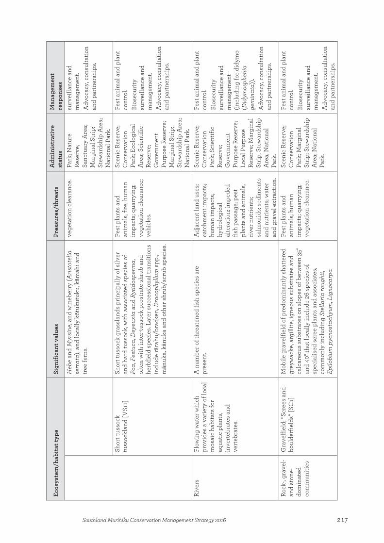
Ecos
yste
m/h
abita
t typ
e
Sign
ifica
nt v
alue
s Pr
essu
res/
thre
ats
Adm
inis
trat
ive
stat
us
Man
agem
ent
resp
onse
s H
ebe
and
Myr
sine
, and
win
eber
ry (A
risto
telia
se
rrat
a), a
nd lo
cally
kōt
ukut
uku,
kām
ahi a
nd
tree
fern
s.
vege
tatio
n cl
eara
nce.
Pa
rk; N
atur
e Re
serv
e;
Sanc
tuar
y A
rea;
M
argi
nal S
trip
; St
ewar
dshi
p A
rea;
N
atio
nal P
ark.
surv
eilla
nce
and
man
agem
ent.
Adv
ocac
y, c
onsu
ltatio
n an
d pa
rtne
rshi
ps.
Shor
t tus
sock
tu
ssoc
klan
d [V
S11]
Sh
ort t
usso
ck g
rass
land
s pr
inci
pally
of s
ilver
an
d ha
rd tu
ssoc
k, w
ith a
ssoc
iate
d sp
ecie
s of
Po
a, F
estu
ca, D
eyeu
xia
and
Rytid
ospe
rma,
of
ten
with
inte
r-tus
sock
pro
stra
te s
hrub
and
he
rbfie
ld s
peci
es. L
ater
suc
cess
iona
l tra
nsiti
ons
incl
ude
rāra
hu/b
rack
en, D
raco
phyl
lum
spp
., m
ānuk
a, k
ānuk
a an
d ot
her s
hrub
/scr
ub s
peci
es.
Pest
pla
nts
and
anim
als;
fire;
hum
an
impa
cts;
quar
ryin
g;
vege
tatio
n cl
eara
nce;
ve
hicl
es.
Scen
ic R
eser
ve;
Con
serv
atio
n Pa
rk; E
colo
gica
l A
rea;
Sci
entif
ic
Rese
rve;
G
over
nmen
t Pu
rpos
e Re
serv
e;
Mar
gina
l Str
ip;
Stew
ards
hip
Are
a;
Nat
iona
l Par
k.
Pest
ani
mal
and
pla
nt
cont
rol.
Bios
ecur
ity
surv
eilla
nce
and
man
agem
ent.
Adv
ocac
y, c
onsu
ltatio
n an
d pa
rtne
rshi
ps.
Rive
rs
Flow
ing
wat
er w
hich
pr
ovid
es a
var
iety
of l
ocal
m
osai
c ha
bita
ts fo
r aq
uatic
pla
nts,
inve
rteb
rate
s an
d ve
rteb
rate
s.
A n
umbe
r of t
hrea
tene
d fis
h sp
ecie
s ar
e pr
esen
t. A
djac
ent l
and
uses
; ca
tchm
ent i
mpa
cts;
hum
an im
pact
s; hy
drol
ogic
al
alte
ratio
n; im
pede
d fis
h pa
ssag
e; p
est
plan
ts a
nd a
nim
als;
river
nut
rient
s; sa
lmon
ids;
sedi
men
ts
and
nutr
ient
s; w
ater
an
d gr
avel
ext
ract
ion.
Scen
ic R
eser
ve;
Con
serv
atio
n Pa
rk; S
cien
tific
Re
serv
e;
Gov
ernm
ent
Purp
ose
Rese
rve;
Lo
cal P
urpo
se
Rese
rve;
Mar
gina
l St
rip, S
tew
ards
hip
Are
a, N
atio
nal
Park
.
Pest
ani
mal
and
pla
nt
cont
rol.
Bios
ecur
ity
surv
eilla
nce
and
man
agem
ent -
(in
clud
ing
for d
idym
o (D
idym
osph
enia
ge
min
ata)
). A
dvoc
acy,
con
sulta
tion
and
part
ners
hips
.
Rock
-, gr
avel
- an
d st
one-
dom
inat
ed
com
mun
ities
Gra
velfi
eld;
“Scr
ees
and
boul
derf
ield
s” [S
C1]
M
obile
gra
velfi
eld
of p
redo
min
antly
sha
ttere
d gr
eyw
acke
, arg
illite
, ign
eous
sub
stra
tes
and
calc
areo
us s
ubst
rate
s on
slo
pes
of b
etw
een
35°
and
40° t
hat l
ocal
ly in
clud
e 26
spe
cies
of
spec
ialis
ed s
cree
pla
nts
and
asso
ciat
es,
com
mon
ly in
clud
ing
Stel
laria
roug
hii,
Epilo
bium
pyc
nost
achy
um, L
igno
carp
a
Pest
pla
nts
and
anim
als;
hum
an
impa
cts;
quar
ryin
g;
vege
tatio
n cl
eara
nce.
Scen
ic R
eser
ve;
Con
serv
atio
n Pa
rk; M
argi
nal
Strip
; Ste
war
dshi
p A
rea;
Nat
iona
l Pa
rk.
Pest
ani
mal
and
pla
nt
cont
rol.
Bios
ecur
ity
surv
eilla
nce
and
man
agem
ent.
Adv
ocac
y, c
onsu
ltatio
n an
d pa
rtne
rshi
ps.
217Southland Murihiku Conservation Management Strategy 2016

Ecos
yste
m/h
abita
t typ
e
Sign
ifica
nt v
alue
s Pr
essu
res/
thre
ats
Adm
inis
trat
ive
stat
us
Man
agem
ent
resp
onse
s ca
rnos
ula
and
Heb
e ep
acrid
ea.
Fenc
ing.
Har
d tu
ssoc
k, s
cabw
eed
(Rao
ulia
spp.
) gr
avel
field
/sto
nefie
ld;
“Bra
ided
rive
rs” [
BR1]
Ston
efie
ld, g
rave
lfiel
d w
ith a
mos
aic
of
pros
trat
e he
rbfie
ld a
nd s
ub-s
hrub
s of
sca
bwee
d m
ats
and
shor
t-liv
ed h
erbs
(e.g
. spe
cies
of
Raou
lia a
nd E
pilo
bium
, Pim
elea
pro
stra
ta a
nd
Mue
hlen
beck
ia a
xilla
ris) g
radi
ng in
to s
hort
tu
ssoc
k gr
assl
ands
on
fres
h al
luvi
um w
ith
silv
er tu
ssoc
k, h
ard
tuss
ock,
blu
e w
heat
gras
s (A
ntho
sach
ne so
land
ri) a
nd lo
ng-h
air p
lum
e gr
ass
(Dic
hela
chne
crin
ita),
and
mat
agou
ri sc
rub
(inla
nd S
outh
Isla
nd) o
r kān
uka
scru
b on
ol
der,
mor
e st
able
soi
ls. L
ocal
ly in
clud
es in
land
du
nes.
Pest
pla
nts
and
anim
als;
adja
cent
land
us
es; f
ire; h
uman
im
pact
s; qu
arry
ing;
ve
geta
tion
clea
ranc
e;
vehi
cles
; wat
er a
nd
grav
el e
xtra
ctio
n.
Scen
ic R
eser
ve;
Con
serv
atio
n Pa
rk; G
over
nmen
t Pu
rpos
e Re
serv
e;
Loca
l Pur
pose
Re
serv
e; M
argi
nal
Strip
; Ste
war
dshi
p A
rea;
Nat
iona
l Pa
rk; C
row
n la
nd
(LIN
Z).
Pest
ani
mal
and
pla
nt
cont
rol.
Bios
ecur
ity
surv
eilla
nce
and
man
agem
ent.
Adv
ocac
y, c
onsu
ltatio
n an
d pa
rtne
rshi
ps.
Salin
e U
reur
e/gl
assw
ort
(Sar
coco
rnia
qu
inqu
eflo
ra),
māa
koak
o/se
a pr
imro
se
(Sam
olus
repe
ns)
herb
field
; “Sa
ltmar
sh”
[SA
3]
Her
bfie
ld o
f sea
gras
s gr
adin
g in
to
ureu
re/g
lass
wor
t and
māa
koak
o/se
a pr
imro
se,
with
rem
urem
u/ha
lf-st
ar (S
ellie
ra ra
dica
ns),
sea
blite
(Sua
eda
nova
e-ze
land
iae)
, Sch
oenu
s ni
tens
, arr
ow g
rass
(Trig
loch
in p
alus
tris
), Pu
ccin
ellia
spp
., and
sho
re c
eler
y (A
pium
pr
ostr
atum
sub
sp. p
rost
ratu
m v
ar. f
ilifo
rme)
gr
adin
g in
to o
ioi,
thre
e-sq
uare
(Sch
oeno
plec
tus
pung
ens)
and
sal
t mar
sh ri
bbon
woo
d (P
lagi
anth
us d
ivar
icat
us).
Loca
lly w
ith s
hell
barr
ier a
nd/o
r gra
vel o
r san
d be
ach
ridge
s, w
ith
silv
er tu
ssoc
k, w
īwī/
knob
by c
lubr
ush
and
squa
re s
edge
.
Pest
pla
nts
and
anim
als;
hum
an
impa
cts;
quar
ryin
g;
sedi
men
ts a
nd
nutr
ient
s; ve
geta
tion
clea
ranc
e; v
ehic
les.
Scen
ic R
eser
ve;
Gov
ernm
ent
Purp
ose
Rese
rve;
N
atio
nal P
ark.
Pest
ani
mal
and
pla
nt
cont
rol.
Bios
ecur
ity
surv
eilla
nce
and
man
agem
ent.
Adv
ocac
y, c
onsu
ltatio
n an
d pa
rtne
rshi
ps.
Fenc
ing.
Fi
sh p
assa
ge.
Hyd
rolo
gica
l m
anag
emen
t.
Pana
hi/s
hore
bin
dwee
d,
wīw
ī/kn
obby
clu
brus
h gr
avel
field
/sto
nefie
ld
[SA
4]
Ston
efie
ld, g
rave
lfiel
d w
ith h
alop
hytic
her
bs,
sedg
es a
nd v
ines
, inc
ludi
ng u
reur
e/gl
assw
ort
(Sar
coco
rnia
qui
nque
flora
sub
sp. q
uinq
ueflo
ra),
rem
urem
u/ha
lf-st
ar, s
hore
cel
ery,
arr
ow g
rass
, sh
ore
spur
ge, w
īwī/
knob
by c
lubr
ush
and
pana
hi/s
hore
bin
dwee
d gr
adin
g in
to a
coa
stal
sc
rub-
vine
land
of C
opro
sma,
Mue
hlen
beck
ia,
Pest
pla
nts
and
anim
als;
hum
an
impa
cts;
quar
ryin
g;
sedi
men
ts a
nd
nutr
ient
s; ve
geta
tion
clea
ranc
e; v
ehic
les.
Scen
ic R
eser
ve;
Nat
ure
Rese
rve;
Sc
ient
ific
Rese
rve;
G
over
nmen
t Pu
rpos
e Re
serv
e;
Loca
l Pur
pose
Re
serv
e; M
argi
nal
Pest
ani
mal
and
pla
nt
cont
rol.
Bios
ecur
ity
surv
eilla
nce
and
man
agem
ent.
Adv
ocac
y, c
onsu
ltatio
n
218 Southland Murihiku Conservation Management Strategy 2016

Ecos
yste
m/h
abita
t typ
e
Sign
ifica
nt v
alue
s Pr
essu
res/
thre
ats
Adm
inis
trat
ive
stat
us
Man
agem
ent
resp
onse
s an
d lo
cally
spe
cies
of M
elic
ytus
, Pim
elea
and
O
zoth
amnu
s, an
d ha
rake
ke.
Strip
; Ste
war
dshi
p A
rea;
Nat
iona
l Pa
rk.
and
part
ners
hips
. Fe
ncin
g.
H
erbf
ield
; “C
oast
al tu
rf”
[SA
5]
Her
bfie
ld o
f a w
ide
rang
e of
pro
stra
te s
peci
es,
incl
udin
g re
mur
emu/
half-
star
, māa
koak
o/se
a pr
imro
se, s
hore
cel
ery,
Zoy
sia
min
ima,
Isol
epis
ce
rnua
, Cen
tella
uni
flora
, Col
oban
thus
mue
lleri,
H
ydro
coty
le n
ovae
-zee
land
iae,
and
spec
ies
of
Lept
inel
la, C
rass
ula,
Ran
uncu
lus,
Myo
sotis
, Ep
ilobi
um, M
azus
and
Ner
tera
.
Pest
pla
nts
and
anim
als;
hum
an
impa
cts;
quar
ryin
g;
sedi
men
ts a
nd
nutr
ient
s; ve
geta
tion
clea
ranc
e; v
ehic
les;
wat
er a
nd g
rave
l ex
trac
tion.
Scen
ic R
eser
ve;
Nat
ure
Rese
rve;
M
argi
nal S
trip
; St
ewar
dshi
p A
rea;
N
atio
nal P
ark.
Pest
ani
mal
and
pla
nt
cont
rol.
Bios
ecur
ity
surv
eilla
nce
and
man
agem
ent.
Adv
ocac
y, c
onsu
ltatio
n an
d pa
rtne
rshi
ps.
Fenc
ing.
O
lear
ia, B
rach
yglo
ttis,
Dra
coph
yllu
m s
crub
/ he
rbfie
ld/l
oam
field
; “M
utto
n-bi
rd s
crub
” [S
A9]
Mos
aic
of s
crub
of w
ind-
shor
n so
uthe
rn rā
tā,
Heb
e el
liptic
a, D
raco
phyl
lum
long
ifoliu
m, a
nd
seve
ral s
peci
es o
f Ole
aria
and
Bra
chyg
lott
is,
and
loca
lly b
road
leaf
and
māp
ou (M
yrsi
ne
aust
ralis
). A
reas
of c
oast
al h
erbf
ield
and
bar
e gr
ound
are
ass
ocia
ted
with
pen
guin
and
se
abird
nes
ting/
burr
owin
g si
tes.
Pest
pla
nts
and
anim
als;
fire;
hum
an
impa
cts;
quar
ryin
g;
vege
tatio
n cl
eara
nce;
w
ater
and
gra
vel
extr
actio
n.
Nat
ure
Rese
rve,
N
atio
nal P
ark.
Pe
st a
nim
al a
nd p
lant
co
ntro
l. Bi
osec
urity
su
rvei
llanc
e an
d m
anag
emen
t. A
dvoc
acy,
con
sulta
tion
and
part
ners
hips
. Po
a lit
oros
a gr
assl
and/
he
rbfie
ld/l
oam
field
[S
A10
]
Mos
aic
of tu
ssoc
klan
d do
min
ated
by
Poa
litor
osa,
P. f
olio
sa a
nd a
meg
aher
bfie
ld o
f A
niso
tom
e la
tifol
ia a
nd s
uban
tarc
tic M
āori
onio
n, w
ith lo
calis
ed a
reas
of b
are
grou
nd
asso
ciat
ed w
ith p
engu
in a
nd s
eabi
rd n
estin
g si
tes.
Pest
pla
nts
and
anim
als;
hum
an
impa
cts;
quar
ryin
g;
vege
tatio
n cl
eara
nce.
Nat
ure
Rese
rve.
Pe
st a
nim
al a
nd p
lant
co
ntro
l. Bi
osec
urity
su
rvei
llanc
e an
d m
anag
emen
t. A
dvoc
acy,
con
sulta
tion
and
part
ners
hips
.
Sea
rush
(Jun
cus k
raus
sii
var.
aust
ralie
nsis
), oi
oi,
ureu
re/g
lass
wor
t, m
āako
ako/
sea
prim
rose
ru
shla
nd/h
erbf
ield
; “S
altm
arsh
” [SA
2]
Rush
land
, her
bfie
ld o
f sea
gra
ss,
ureu
re/g
lass
wor
t and
māa
koak
o/se
a pr
imro
se,
loca
lly w
ith s
hell
barr
ier a
nd/o
r gra
vel b
each
rid
ges,
grad
ing
into
sea
rush
and
oio
i. Lo
cally
M
acha
erin
a ju
ncea
and
Sch
oeno
plec
tus s
pp.
also
occ
ur, w
ith a
reas
of c
oast
al h
erbf
ield
(e.g
. sh
ore
cele
ry, r
emur
emu/
half-
star
, bac
helo
r’s
butto
n (C
otul
a co
rono
pifo
lia),
arro
w g
rass
)
Pest
pla
nts
and
anim
als;
hum
an
impa
cts;
quar
ryin
g;
sedi
men
ts a
nd
nutr
ient
s; ve
geta
tion
clea
ranc
e; v
ehic
les.
Scen
ic R
eser
ve;
Con
serv
atio
n Pa
rk; S
cien
tific
Re
serv
e;
Gov
ernm
ent
Purp
ose
Rese
rve;
Lo
cal P
urpo
se
Rese
rve;
Mar
gina
l
Pest
ani
mal
and
pla
nt
cont
rol.
Bios
ecur
ity
surv
eilla
nce
and
man
agem
ent.
Adv
ocac
y, c
onsu
ltatio
n an
d pa
rtne
rshi
ps.
219Southland Murihiku Conservation Management Strategy 2016
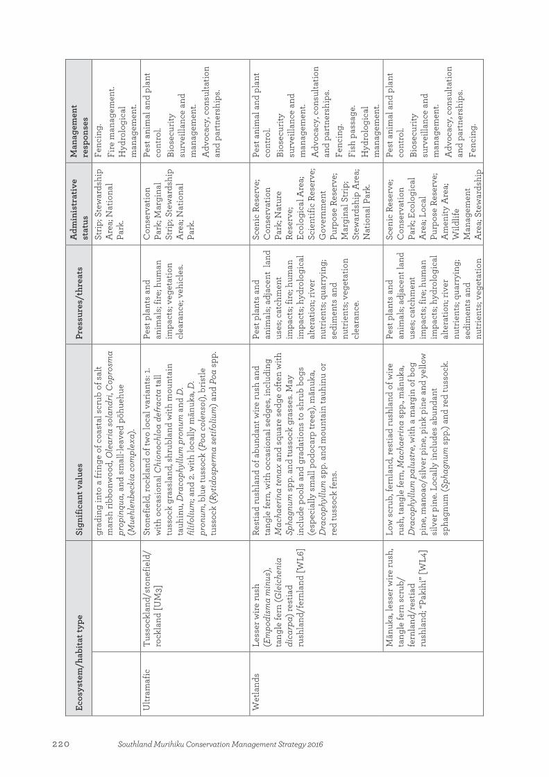
Ecos
yste
m/h
abita
t typ
e
Sign
ifica
nt v
alue
s Pr
essu
res/
thre
ats
Adm
inis
trat
ive
stat
us
Man
agem
ent
resp
onse
s gr
adin
g in
to a
frin
ge o
f coa
stal
scr
ub o
f sal
t m
arsh
ribb
onw
ood,
Ole
aria
sola
ndri,
Cop
rosm
a pr
opin
qua,
and
sm
all-l
eave
d pō
hueh
ue
(Mue
hlen
beck
ia c
ompl
exa)
.
Strip
; Ste
war
dshi
p A
rea;
Nat
iona
l Pa
rk.
Fenc
ing.
Fi
re m
anag
emen
t. H
ydro
logi
cal
man
agem
ent.
U
ltram
afic
Tu
ssoc
klan
d/st
onef
ield
/ ro
ckla
nd [U
M3]
St
onef
ield
, roc
klan
d of
two
loca
l var
iant
s: 1.
with
occ
asio
nal C
hion
ochl
oa d
efra
cta
tall
tuss
ock
gras
slan
d, s
hrub
land
with
mou
ntai
n ta
uhin
u, D
raco
phyl
lum
pro
num
and
D.
filifo
lium
; and
2. w
ith lo
cally
mān
uka,
D.
pron
um, b
lue
tuss
ock
(Poa
col
enso
i), b
ristle
tu
ssoc
k (R
ytid
ospe
rma
setif
oliu
m) a
nd P
oa s
pp.
Pest
pla
nts
and
anim
als;
fire;
hum
an
impa
cts;
vege
tatio
n cl
eara
nce;
veh
icle
s.
Con
serv
atio
n Pa
rk; M
argi
nal
Strip
; Ste
war
dshi
p A
rea;
Nat
iona
l Pa
rk.
Pest
ani
mal
and
pla
nt
cont
rol.
Bios
ecur
ity
surv
eilla
nce
and
man
agem
ent.
Adv
ocac
y, c
onsu
ltatio
n an
d pa
rtne
rshi
ps.
W
etla
nds
Le
sser
wire
rush
(E
mpo
dism
a m
inus
), ta
ngle
fern
(Gle
iche
nia
dica
rpa)
rest
iad
rush
land
/fer
nlan
d [W
L6]
Rest
iad
rush
land
of a
bund
ant w
ire ru
sh a
nd
tang
le fe
rn, w
ith o
ccas
iona
l sed
ges,
incl
udin
g M
acha
erin
a te
nax
and
squa
re s
edge
ofte
n w
ith
Spha
gnum
spp
. and
tuss
ock
gras
ses.
May
in
clud
e po
ols
and
grad
atio
ns to
shr
ub b
ogs
(esp
ecia
lly s
mal
l pod
ocar
p tr
ees)
, mān
uka,
D
raco
phyl
lum
spp
. and
mou
ntai
n ta
uhin
u or
re
d tu
ssoc
k fe
ns.
Pest
pla
nts
and
anim
als;
adja
cent
lan
d us
es; c
atch
men
t im
pact
s; fir
e; h
uman
im
pact
s; hy
drol
ogic
al
alte
ratio
n; ri
ver
nutr
ient
s; qu
arry
ing;
se
dim
ents
and
nu
trie
nts;
vege
tatio
n cl
eara
nce.
Scen
ic R
eser
ve;
Con
serv
atio
n Pa
rk; N
atur
e Re
serv
e;
Ecol
ogic
al A
rea;
Sc
ient
ific
Rese
rve;
G
over
nmen
t Pu
rpos
e Re
serv
e;
Mar
gina
l Str
ip;
Stew
ards
hip
Are
a;
Nat
iona
l Par
k.
Pest
ani
mal
and
pla
nt
cont
rol.
Bios
ecur
ity
surv
eilla
nce
and
man
agem
ent.
Adv
ocac
y, c
onsu
ltatio
n an
d pa
rtne
rshi
ps.
Fenc
ing.
Fi
sh p
assa
ge.
Hyd
rolo
gica
l m
anag
emen
t.
Mān
uka,
less
er w
ire ru
sh,
tang
le fe
rn s
crub
/ fe
rnla
nd/r
estia
d ru
shla
nd; “
Paki
hi” [
WL4
]
Low
scr
ub, f
ernl
and,
rest
iad
rush
land
of w
ire
rush
, tan
gle
fern
, Mac
haer
ina
spp.
, mān
uka,
D
raco
phyl
lum
pal
ustr
e, w
ith a
mar
gin
of b
og
pine
, man
oao/
silv
er p
ine,
pin
k pi
ne a
nd y
ello
w
silv
er p
ine.
Loc
ally
incl
udes
abu
ndan
t sp
hagn
um (S
phag
num
spp
.) an
d re
d tu
ssoc
k.
Pest
pla
nts
and
anim
als;
adja
cent
land
us
es; c
atch
men
t im
pact
s; fir
e; h
uman
im
pact
s; hy
drol
ogic
al
alte
ratio
n; ri
ver
nutr
ient
s; qu
arry
ing;
se
dim
ents
and
nu
trie
nts;
vege
tatio
n
Scen
ic R
eser
ve;
Con
serv
atio
n Pa
rk; E
colo
gica
l A
rea;
Loc
al
Purp
ose
Rese
rve;
A
men
ity A
rea;
W
ildlif
e M
anag
emen
t A
rea;
Ste
war
dshi
p
Pest
ani
mal
and
pla
nt
cont
rol.
Bios
ecur
ity
surv
eilla
nce
and
man
agem
ent.
Adv
ocac
y, c
onsu
ltatio
n an
d pa
rtne
rshi
ps.
Fenc
ing.
220 Southland Murihiku Conservation Management Strategy 2016

Ecos
yste
m/h
abita
t typ
e
Sign
ifica
nt v
alue
s Pr
essu
res/
thre
ats
Adm
inis
trat
ive
stat
us
Man
agem
ent
resp
onse
s cl
eara
nce.
A
rea;
Nat
iona
l Pa
rk.
Tall
tuss
ock
(Chi
onoc
hloa
) tu
ssoc
klan
d [W
L7]
Tuss
ockl
and,
rest
iad
rush
land
of s
ever
al
varia
nts,
loca
lly w
ith C
hion
ochl
oa a
cicu
laris
, C.
junc
ea, C
. ter
etifo
lia, a
nd a
bund
ant w
ire ru
sh
and
tang
le fe
rn. S
catte
red
shru
blan
d lo
cally
in
clud
es m
ānuk
a, p
ink
pine
, yel
low
silv
er p
ine
and
Dra
coph
yllu
m s
pp.
Pest
pla
nts
and
anim
als;
adja
cent
land
us
es; c
atch
men
t im
pact
s; fir
e; h
uman
im
pact
s; hy
drol
ogic
al
alte
ratio
n; q
uarr
ying
; se
dim
ents
and
nu
trie
nts;
vege
tatio
n cl
eara
nce;
veh
icle
s.
Nat
iona
l Par
k.
Pest
ani
mal
and
pla
nt
cont
rol.
Bios
ecur
ity
surv
eilla
nce
and
man
agem
ent.
Adv
ocac
y, c
onsu
ltatio
n an
d pa
rtne
rshi
ps.
Her
bfie
ld/m
ossf
ield
/ se
dgel
and
[WL8
] M
ossf
ield
, her
bfie
ld, s
edge
land
with
sph
agnu
m
and
othe
r mos
ses,
shor
t-sta
ture
d se
dges
(C
arex
, Iso
lepi
s spp
. and
Car
pha
alpi
na) a
nd a
ra
nge
of h
erbs
(spe
cies
of E
pilo
bium
, Eup
hras
ia
and
Gen
tiane
lla).
Ofte
n co
ntai
ns n
umer
ous
smal
l poo
ls w
ith a
ssoc
iate
d aq
uatic
spe
cies
.
Pest
pla
nts
and
anim
als;
adja
cent
land
us
es; c
atch
men
t im
pact
s; fir
e; h
uman
im
pact
s; hy
drol
ogic
al
alte
ratio
n; q
uarr
ying
; se
dim
ents
and
nu
trie
nts;
vege
tatio
n cl
eara
nce;
veh
icle
s.
Stew
ards
hip
Are
a;
Nat
iona
l Par
k.
Pest
ani
mal
and
pla
nt
cont
rol.
Bios
ecur
ity
surv
eilla
nce
and
man
agem
ent.
Adv
ocac
y, c
onsu
ltatio
n an
d pa
rtne
rshi
ps.
Fenc
ing.
C
ushi
onfie
ld [W
L9]
Cus
hion
field
with
spe
cies
of O
reob
olus
, D
onat
ia, G
aim
ardi
a, C
entr
olep
is, C
arph
a al
pina
and
Phy
llach
ne, a
nd o
ften
And
rost
oma
empe
trifo
lia, P
enta
chon
dra
pum
ila a
nd
Lepi
doth
amnu
s lax
ifoliu
s. Lo
cally
incl
udes
sc
atte
red
tree
land
, with
mān
uka,
pin
k pi
ne,
taw
aira
urik
i/m
ount
ain
beec
h, y
ello
w s
ilver
pi
ne.
Pest
pla
nts
and
anim
als;
adja
cent
land
us
es; c
atch
men
t im
pact
s; hu
man
im
pact
s; hy
drol
ogic
al
alte
ratio
n; q
uarr
ying
; se
dim
ents
and
nu
trie
nts;
vege
tatio
n cl
eara
nce;
veh
icle
s.
Scen
ic R
eser
ve;
Con
serv
atio
n Pa
rk; N
atur
e Re
serv
e; S
cien
tific
Re
serv
e;
Stew
ards
hip
Are
a;
Nat
iona
l Par
k.
Pest
ani
mal
and
pla
nt
cont
rol.
Bios
ecur
ity
surv
eilla
nce
and
man
agem
ent.
Adv
ocac
y, c
onsu
ltatio
n an
d pa
rtne
rshi
ps.
Fenc
ing.
Oio
i res
tiad
rush
land
/ re
edla
nd [W
L10]
Re
stia
d ru
shla
nd w
ith a
bund
ant o
ioi,
loca
lly
with
larg
e M
acha
erin
a, B
olbo
scho
enus
spp
., ku
ta (E
leoc
haris
spha
cela
ta) a
nd la
ke c
lubr
ush
(Sch
oeno
plec
tus t
aber
naem
onta
ni),
and
ofte
n w
ith o
ccas
iona
l rau
pō (T
ypha
orie
ntal
is) a
nd
Pest
pla
nts
and
anim
als;
adja
cent
land
us
es; h
uman
impa
cts;
hydr
olog
ical
al
tera
tion;
rive
r
His
toric
Res
erve
; Sc
enic
Res
erve
; Sc
ient
ific
Rese
rve;
G
over
nmen
t Pu
rpos
e Re
serv
e;
Pest
ani
mal
and
pla
nt
cont
rol.
Bios
ecur
ity
surv
eilla
nce
and
man
agem
ent.
221Southland Murihiku Conservation Management Strategy 2016
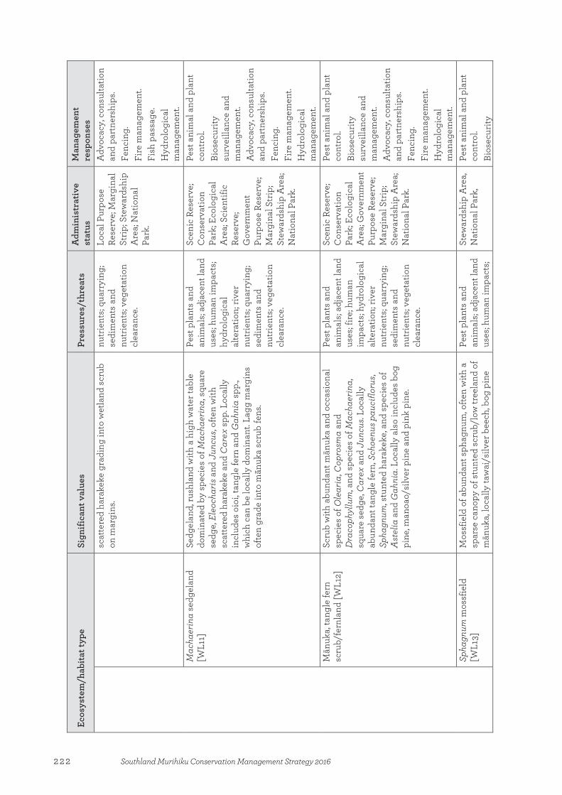
Ecos
yste
m/h
abita
t typ
e
Sign
ifica
nt v
alue
s Pr
essu
res/
thre
ats
Adm
inis
trat
ive
stat
us
Man
agem
ent
resp
onse
s sc
atte
red
hara
keke
gra
ding
into
wet
land
scr
ub
on m
argi
ns.
nutr
ient
s; qu
arry
ing;
se
dim
ents
and
nu
trie
nts;
vege
tatio
n cl
eara
nce.
Loca
l Pur
pose
Re
serv
e; M
argi
nal
Strip
; Ste
war
dshi
p A
rea;
Nat
iona
l Pa
rk.
Adv
ocac
y, c
onsu
ltatio
n an
d pa
rtne
rshi
ps.
Fenc
ing.
Fi
re m
anag
emen
t. Fi
sh p
assa
ge.
Hyd
rolo
gica
l m
anag
emen
t.
Mac
haer
ina
sedg
elan
d [W
L11]
Se
dgel
and,
rush
land
with
a h
igh
wat
er ta
ble
dom
inat
ed b
y sp
ecie
s of
Mac
haer
ina,
squ
are
sedg
e, E
leoc
haris
and
Jun
cus,
ofte
n w
ith
scat
tere
d ha
rake
ke a
nd C
arex
spp
. Loc
ally
in
clud
es o
ioi,
tang
le fe
rn a
nd G
ahni
a sp
p.,
whi
ch c
an b
e lo
cally
dom
inan
t. La
gg m
argi
ns
ofte
n gr
ade
into
mān
uka
scru
b fe
ns.
Pest
pla
nts
and
anim
als;
adja
cent
land
us
es; h
uman
impa
cts;
hydr
olog
ical
al
tera
tion;
rive
r nu
trie
nts;
quar
ryin
g;
sedi
men
ts a
nd
nutr
ient
s; ve
geta
tion
clea
ranc
e.
Scen
ic R
eser
ve;
Con
serv
atio
n Pa
rk; E
colo
gica
l A
rea;
Sci
entif
ic
Rese
rve;
G
over
nmen
t Pu
rpos
e Re
serv
e;
Mar
gina
l Str
ip;
Stew
ards
hip
Are
a;
Nat
iona
l Par
k.
Pest
ani
mal
and
pla
nt
cont
rol.
Bios
ecur
ity
surv
eilla
nce
and
man
agem
ent.
Adv
ocac
y, c
onsu
ltatio
n an
d pa
rtne
rshi
ps.
Fenc
ing.
Fi
re m
anag
emen
t. H
ydro
logi
cal
man
agem
ent.
M
ānuk
a, ta
ngle
fern
sc
rub/
fern
land
[WL1
2]
Scru
b w
ith a
bund
ant m
ānuk
a an
d oc
casi
onal
sp
ecie
s of
Ole
aria
, Cop
rosm
a an
d D
raco
phyl
lum
, and
spe
cies
of M
acha
erin
a,
squa
re s
edge
, Car
ex a
nd J
uncu
s. Lo
cally
ab
unda
nt ta
ngle
fern
, Sch
oenu
s pau
ciflo
rus,
Spha
gnum
, stu
nted
har
akek
e, a
nd s
peci
es o
f A
stel
ia a
nd G
ahni
a. L
ocal
ly a
lso
incl
udes
bog
pi
ne, m
anoa
o/si
lver
pin
e an
d pi
nk p
ine.
Pest
pla
nts
and
anim
als;
adja
cent
land
us
es; f
ire; h
uman
im
pact
s; hy
drol
ogic
al
alte
ratio
n; ri
ver
nutr
ient
s; qu
arry
ing;
se
dim
ents
and
nu
trie
nts;
vege
tatio
n cl
eara
nce.
Scen
ic R
eser
ve;
Con
serv
atio
n Pa
rk; E
colo
gica
l A
rea;
Gov
ernm
ent
Purp
ose
Rese
rve;
M
argi
nal S
trip
; St
ewar
dshi
p A
rea;
N
atio
nal P
ark.
Pest
ani
mal
and
pla
nt
cont
rol.
Bios
ecur
ity
surv
eilla
nce
and
man
agem
ent.
Adv
ocac
y, c
onsu
ltatio
n an
d pa
rtne
rshi
ps.
Fenc
ing.
Fi
re m
anag
emen
t. H
ydro
logi
cal
man
agem
ent.
Spha
gnum
mos
sfie
ld
[WL1
3]
Mos
sfie
ld o
f abu
ndan
t sph
agnu
m, o
ften
with
a
spar
se c
anop
y of
stu
nted
scr
ub/l
ow tr
eela
nd o
f m
ānuk
a, lo
cally
taw
ai/s
ilver
bee
ch, b
og p
ine
Pest
pla
nts
and
anim
als;
adja
cent
land
us
es; h
uman
impa
cts;
Stew
ards
hip
Are
a,
Nat
iona
l Par
k,
Pest
ani
mal
and
pla
nt
cont
rol.
Bios
ecur
ity
222 Southland Murihiku Conservation Management Strategy 2016
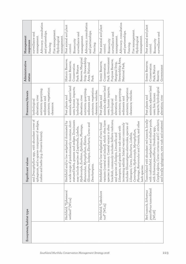
Ecos
yste
m/h
abita
t typ
e
Sign
ifica
nt v
alue
s Pr
essu
res/
thre
ats
Adm
inis
trat
ive
stat
us
Man
agem
ent
resp
onse
s an
d D
raco
phyl
lum
spp
., with
abu
ndan
t cov
er o
f sp
hagn
um, a
nd a
spa
rse
com
pone
nt o
f sed
ges,
rush
es a
nd h
erbs
(e.g
. Dro
sera
bin
ata)
.
hydr
olog
ical
al
tera
tion;
rive
r nu
trie
nts;
quar
ryin
g;
sedi
men
ts a
nd
nutr
ient
s; ve
geta
tion
clea
ranc
e.
surv
eilla
nce
and
man
agem
ent.
Adv
ocac
y, c
onsu
ltatio
n an
d pa
rtne
rshi
ps.
Fenc
ing
Fi
re m
anag
emen
t. H
ydro
logi
cal
man
agem
ent.
Her
bfie
ld; “
Ephe
mer
al
wet
land
” [W
L14]
H
erbf
ield
and
/or l
ow s
edge
land
dom
inat
ed b
y a
wid
e ra
nge
of p
redo
min
antly
mon
tane
, sho
rt-
stat
ured
her
bs, g
rass
es a
nd s
edge
s. D
omin
ants
m
ay in
clud
e sp
ecie
s of
Lep
tinel
la, L
obel
ia,
Hyd
roco
tyle
, Euc
hito
n, E
pilo
bium
, Pla
ntag
o,
Ranu
ncul
us, M
yrio
phyl
lum
, Ela
tine,
G
loss
ostig
ma,
Isol
epis
, Ele
ocha
ris, C
arex
and
D
esch
amps
ia.
Pest
pla
nts
and
anim
als;
adja
cent
land
us
es; h
uman
impa
cts;
hydr
olog
ical
al
tera
tion;
rive
r nu
trie
nts;
quar
ryin
g;
sedi
men
ts a
nd
nutr
ient
s; ve
geta
tion
clea
ranc
e; v
ehic
les.
His
toric
Res
erve
; Sc
enic
Res
erve
; C
onse
rvat
ion
Park
; Nat
ure
Rese
rve;
Mar
gina
l St
rip; S
tew
ards
hip
Are
a; N
atio
nal
Park
.
Pest
ani
mal
and
pla
nt
cont
rol.
Bios
ecur
ity
surv
eilla
nce
and
man
agem
ent.
Adv
ocac
y, c
onsu
ltatio
n an
d pa
rtne
rshi
ps.
Fenc
ing.
Her
bfie
ld; “
Lake
shor
e tu
rf” [
WL1
5]
Her
bfie
ld a
nd/o
r low
sed
gela
nd o
f tw
o br
oad
varia
nts
(coa
stal
and
inla
nd),
whi
ch o
ften
have
sp
ecie
s in
com
mon
. Coa
stal
var
iant
is o
ften
brac
kish
, com
mon
ly in
clud
es S
ellie
ra ra
dica
ns,
and
spec
ies
of Is
olep
is, L
imos
ella
and
Li
laeo
psis
, and
gra
des
into
sal
t mar
sh w
ith
incr
easi
ng s
alin
ity. I
nlan
d va
riant
com
mon
ly
incl
udes
Glo
ssos
tigm
a el
atin
oide
s, sp
ecie
s of
Li
laeo
psis
, Car
ex, E
leoc
haris
, Lob
elia
, C
entr
olep
is, H
ydro
coty
le, M
yrio
phyl
lum
, Pl
anta
go, R
anun
culu
s and
Cra
ssul
a, a
nd o
ther
he
rb s
peci
es.
Pest
pla
nts
and
anim
als;
adja
cent
land
us
es; h
uman
impa
cts;
hydr
olog
ical
al
tera
tion;
rive
r nu
trie
nts;
quar
ryin
g;
sedi
men
ts a
nd
nutr
ient
s; ve
geta
tion
clea
ranc
e; v
ehic
les.
Scen
ic R
eser
ve,
Con
serv
atio
n Pa
rk, G
over
nmen
t Pu
rpos
e Re
serv
e,
Mar
gina
l Str
ip,
Stew
ards
hip
Are
a,
Nat
iona
l Par
k,
Pest
ani
mal
and
pla
nt
cont
rol.
Bios
ecur
ity
surv
eilla
nce
and
man
agem
ent.
Adv
ocac
y, c
onsu
ltatio
n an
d pa
rtne
rshi
ps.
Fenc
ing.
Fi
re m
anag
emen
t. H
ydro
logi
cal
man
agem
ent.
Red
tuss
ock,
Sch
oenu
s pa
ucifl
orus
tuss
ockl
and
[WL1
6]
Tuss
ockl
and
with
abu
ndan
t red
tuss
ock,
loca
lly
with
cus
hion
field
, sed
gela
nd a
nd s
hallo
w p
ools
, w
ith S
choe
nus p
auci
floru
s, O
reob
olus
spp
., C
arph
a al
pina
, Car
ex c
oria
cea
and
C. s
incl
airii
, an
d lo
cally
sph
agnu
m, w
ire ru
sh a
nd s
catte
red
Pest
pla
nts
and
anim
als;
adja
cent
land
us
es; f
ire; h
uman
im
pact
s; hy
drol
ogic
al
alte
ratio
n; ri
ver
Scen
ic R
eser
ve;
Con
serv
atio
n Pa
rk; N
atur
e Re
serv
e;
Gov
ernm
ent
Pest
ani
mal
and
pla
nt
cont
rol.
Bios
ecur
ity
surv
eilla
nce
and
223Southland Murihiku Conservation Management Strategy 2016

Ecos
yste
m/h
abita
t typ
e
Sign
ifica
nt v
alue
s Pr
essu
res/
thre
ats
Adm
inis
trat
ive
stat
us
Man
agem
ent
resp
onse
s sh
rubs
(e.g
. Heb
e od
ora
and
bog
pine
).
nutr
ient
s; qu
arry
ing;
se
dim
ents
and
nu
trie
nts;
vege
tatio
n
clea
ranc
e; v
ehic
les.
Purp
ose
Rese
rve;
M
argi
nal S
trip
; St
ewar
dshi
p A
rea;
N
atio
nal P
ark.
man
agem
ent.
Adv
ocac
y, c
onsu
ltatio
n an
d pa
rtne
rshi
ps.
Fenc
ing.
Fi
sh p
assa
ge.
Hyd
rolo
gica
l m
anag
emen
t.
Flax
land
[WL1
8]
Flax
land
of a
bund
ant h
arak
eke,
ofte
n w
ith
toet
oe, s
peci
es o
f Car
ex (e
.g. p
ūkio
(C. s
ecta
))
and
Mac
haer
ina,
and
kio
kio
(Ble
chnu
m n
ovae
-ze
land
iae)
, occ
asio
nal w
etla
nd s
crub
, tre
elan
d of
tī k
ōuka
/cab
bage
tree
(Cor
dylin
e sp
p.),
Cop
rosm
a sp
p. a
nd m
ānuk
a, a
nd lo
cally
w
eepi
ng m
atip
o/m
āpou
and
twig
gy tr
ee d
aisy
(O
lear
ia v
irgat
a). A
reas
with
hig
h w
ater
tabl
es
may
be
dom
inat
ed b
y pū
kio.
May
gra
de o
r su
ccee
d in
to w
etla
nd c
arr,
with
abu
ndan
t em
erge
nt tī
kōu
ka/c
abba
ge tr
ees.
Pest
pla
nts
and
anim
als;
adja
cent
land
us
es; h
uman
impa
cts;
hydr
olog
ical
al
tera
tion;
rive
r nu
trie
nts;
quar
ryin
g;
sedi
men
ts a
nd
nutr
ient
s; ve
geta
tion
clea
ranc
e.
Scen
ic R
eser
ve;
Con
serv
atio
n Pa
rk; S
cien
tific
Re
serv
e;
Gov
ernm
ent
Purp
ose
Rese
rve;
Lo
cal P
urpo
se
Rese
rve;
Mar
gina
l St
rip; S
tew
ards
hip
Are
a; N
atio
nal
Park
.
Pest
ani
mal
and
pla
nt
cont
rol.
Bios
ecur
ity
surv
eilla
nce
and
man
agem
ent.
Adv
ocac
y, c
onsu
ltatio
n an
d pa
rtne
rshi
ps.
Fenc
ing.
Fi
re m
anag
emen
t. H
ydro
logi
cal
man
agem
ent.
Ra
upō
reed
land
[WL1
9]
Reed
land
of a
bund
ant r
aupō
, loc
ally
with
sp
ecie
s of
Bol
bosc
hoen
us, S
choe
nopl
ectu
s and
M
acha
erin
a ar
ticul
ata,
pūk
io, h
arak
eke
and
swam
p m
illet
(Isa
chne
glo
bosa
).A m
argi
n of
sc
rub
of C
opro
sma
spec
ies
and
tī kō
uka/
ca
bbag
e tr
ee, a
nd lo
cally
twig
gy tr
ee d
aisy
and
m
ānuk
a, w
ith s
catte
red
kahi
kate
a in
un
mod
ified
are
as. O
ften
occu
rs o
n la
ke
mar
gins
or i
nclu
des
smal
l pon
ds w
ith s
hallo
w
wat
er/p
ools
with
floa
ting/
rafte
d aq
uatic
s su
ch
as w
ater
milf
oils
(Myr
ioph
yllu
m s
pp.),
bu
tterc
ups
(Ran
uncu
lus s
pp.),
will
ow h
erbs
(E
pilo
bium
spp
.), s
peci
es o
f Pot
amog
eton
, Is
olep
is, A
zolla
and
Lem
na, a
nd s
pike
d se
dges
(e
.g. k
uta)
.
Pest
pla
nts
and
anim
als;
adja
cent
land
us
es; h
uman
impa
cts;
hydr
olog
ical
al
tera
tion;
rive
r nu
trie
nts;
quar
ryin
g;
sedi
men
ts a
nd
nutr
ient
s; ve
geta
tion
clea
ranc
e.
Scen
ic R
eser
ve;
Scie
ntifi
c Re
serv
e;
Gov
ernm
ent
Purp
ose
Rese
rve;
M
argi
nal S
trip
; St
ewar
dshi
p A
rea;
N
atio
nal P
ark.
Pest
ani
mal
and
pla
nt
cont
rol.
Bios
ecur
ity
surv
eilla
nce
and
man
agem
ent.
Adv
ocac
y, c
onsu
ltatio
n an
d pa
rtne
rshi
ps.
Fenc
ing.
Fi
re m
anag
emen
t. H
ydro
logi
cal
man
agem
ent.
224 Southland Murihiku Conservation Management Strategy 2016
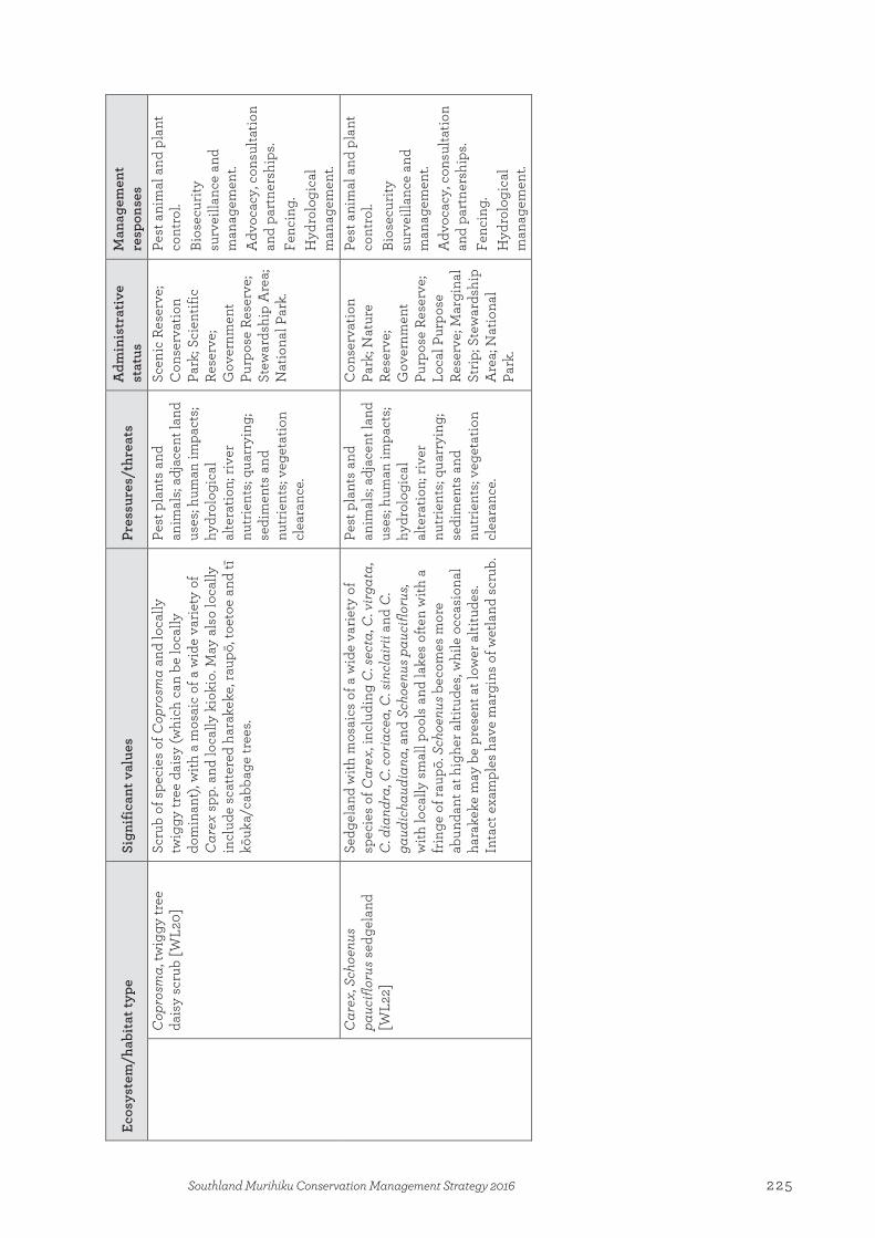
Ecos
yste
m/h
abita
t typ
e
Sign
ifica
nt v
alue
s Pr
essu
res/
thre
ats
Adm
inis
trat
ive
stat
us
Man
agem
ent
resp
onse
s C
opro
sma,
twig
gy tr
ee
dais
y sc
rub
[WL2
0]
Scru
b of
spe
cies
of C
opro
sma
and
loca
lly
twig
gy tr
ee d
aisy
(whi
ch c
an b
e lo
cally
do
min
ant),
with
a m
osai
c of
a w
ide
varie
ty o
f C
arex
spp
. and
loca
lly k
ioki
o. M
ay a
lso
loca
lly
incl
ude
scat
tere
d ha
rake
ke, r
aupō
, toe
toe
and
tī kō
uka/
cabb
age
tree
s.
Pest
pla
nts
and
anim
als;
adja
cent
land
us
es; h
uman
impa
cts;
hydr
olog
ical
al
tera
tion;
rive
r nu
trie
nts;
quar
ryin
g;
sedi
men
ts a
nd
nutr
ient
s; ve
geta
tion
clea
ranc
e.
Scen
ic R
eser
ve;
Con
serv
atio
n Pa
rk; S
cien
tific
Re
serv
e;
Gov
ernm
ent
Purp
ose
Rese
rve;
St
ewar
dshi
p A
rea;
N
atio
nal P
ark.
Pest
ani
mal
and
pla
nt
cont
rol.
Bios
ecur
ity
surv
eilla
nce
and
man
agem
ent.
Adv
ocac
y, c
onsu
ltatio
n an
d pa
rtne
rshi
ps.
Fenc
ing.
H
ydro
logi
cal
man
agem
ent.
C
arex
, Sch
oenu
s pa
ucifl
orus
sed
gela
nd
[WL2
2]
Sedg
elan
d w
ith m
osai
cs o
f a w
ide
varie
ty o
f sp
ecie
s of
Car
ex, i
nclu
ding
C. s
ecta
, C. v
irgat
a,
C. d
iand
ra, C
. cor
iace
a, C
. sin
clai
rii a
nd C
. ga
udic
haud
iana
, and
Sch
oenu
s pau
ciflo
rus,
with
loca
lly s
mal
l poo
ls a
nd la
kes
ofte
n w
ith a
fr
inge
of r
aupō
. Sch
oenu
s bec
omes
mor
e ab
unda
nt a
t hig
her a
ltitu
des,
whi
le o
ccas
iona
l ha
rake
ke m
ay b
e pr
esen
t at l
ower
alti
tude
s. In
tact
exa
mpl
es h
ave
mar
gins
of w
etla
nd s
crub
.
Pest
pla
nts
and
anim
als;
adja
cent
land
us
es; h
uman
impa
cts;
hydr
olog
ical
al
tera
tion;
rive
r nu
trie
nts;
quar
ryin
g;
sedi
men
ts a
nd
nutr
ient
s; ve
geta
tion
clea
ranc
e.
Con
serv
atio
n Pa
rk; N
atur
e Re
serv
e;
Gov
ernm
ent
Purp
ose
Rese
rve;
Lo
cal P
urpo
se
Rese
rve;
Mar
gina
l St
rip; S
tew
ards
hip
Are
a; N
atio
nal
Park
.
Pest
ani
mal
and
pla
nt
cont
rol.
Bios
ecur
ity
surv
eilla
nce
and
man
agem
ent.
Adv
ocac
y, c
onsu
ltatio
n an
d pa
rtne
rshi
ps.
Fenc
ing.
H
ydro
logi
cal
man
agem
ent.
225Southland Murihiku Conservation Management Strategy 2016
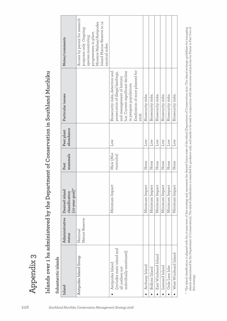
App
endi
x 3
Isla
nds
over
1 ha
adm
inis
tere
d by
the
Dep
artm
ent o
f Con
serv
atio
n in
Sou
thla
nd M
urih
iku
Suba
ntar
ctic
isla
nds
Isla
nd
Adm
inis
trat
ive
stat
us
Des
ired
isla
nd
clas
sific
atio
n
(10-
year
goa
l)*
Pest
m
amm
als
Pe
st p
lant
ab
unda
nce
Part
icul
ar is
sues
N
otes
/com
men
ts
Ant
ipod
es Is
land
Gro
up
Nat
iona
l N
atur
e Re
serv
e
A
cces
s by
per
mit
for r
esea
rch
purp
oses
onl
y. O
ngoi
ng
spec
ies
mon
itorin
g pr
ogra
mm
es in
pla
ce.
Mou
tere
Mah
ue/A
ntip
odes
Is
land
Mar
ine
Rese
rve
to 12
na
utic
al m
iles.
• A
ntip
odes
Isla
nd
(incl
udes
mai
n is
land
and
al
l out
liers
not
in
divi
dual
ly m
entio
ned)
M
inim
um Im
pact
M
ice
(Mus
m
uscu
lus)
Lo
w
Bios
ecur
ity ri
sks,
dete
ctio
n an
d pr
osec
utio
n of
ille
gal l
andi
ngs,
and
man
agem
ent o
f his
toric
hu
t. C
urre
nt s
igni
fican
t dec
line
in p
engu
in p
opul
atio
ns.
Erad
icat
ion
of m
ice
plan
ned
for
2016
.
• A
rchw
ay Is
land
Min
imum
Impa
ct
Non
e Lo
w
Bios
ecur
ity ri
sks.
•
Bollo
ns Is
land
Min
imum
Impa
ct
Non
e Lo
w
Bios
ecur
ity ri
sks.
•
East
Win
dwar
d Is
land
Min
imum
Impa
ct
Non
e Lo
w
Bios
ecur
ity ri
sks.
•
Leew
ard
Isla
nd
M
inim
um Im
pact
N
one
Low
Bi
osec
urity
risk
s.
• O
rde
Lees
Isle
t
Min
imum
Impa
ct
Non
e Lo
w
Bios
ecur
ity ri
sks.
•
Wes
t Win
dwar
d Is
land
Min
imum
Impa
ct
Non
e Lo
w
Bios
ecur
ity ri
sks.
*
The
isla
nd c
lass
ifica
tion
is a
ligne
d w
ith th
e 10
-yea
r ter
m o
f thi
s str
ateg
y an
d re
pres
ents
the
desi
red
futu
re st
ate
of th
e is
land
(Dep
artm
ent o
f Con
serv
atio
n 20
10: T
he is
land
str
ateg
y: g
uide
lines
for m
anag
ing
isla
nds
adm
inis
tere
d by
the
Dep
artm
ent o
f Con
serv
atio
n). T
he is
land
cla
ssifi
catio
n is
inte
nded
for g
uida
nce
only
, and
nee
ds to
be
read
in c
onju
nctio
n w
ith th
e ou
tcom
e an
d po
licie
s fo
r Pla
ces
in P
art T
wo
of
this
str
ateg
y.
Appendix 3:Islands over 1 ha administered by the Department of Conservation in Southland Murihiku
226 Southland Murihiku Conservation Management Strategy 2016

Isla
nd
Adm
inis
trat
ive
stat
us
Des
ired
isla
nd
clas
sific
atio
n
(10-
year
goa
l)*
Pest
m
amm
als
Pe
st p
lant
ab
unda
nce
Part
icul
ar is
sues
N
otes
/com
men
ts
Auc
klan
d Is
land
s N
atio
nal N
atur
e Re
serv
e
Bios
ecur
ity ri
sks,
incl
udin
g sp
read
of L
yall’
s tr
ee d
aisy
from
Po
rt R
oss
to a
ll is
land
s, an
d po
tent
ial p
est a
nim
al a
nd p
lant
in
trod
uctio
ns fr
om v
isito
r la
ndin
gs. P
oten
tial v
isito
r im
pact
s an
d vi
sito
r im
pact
mon
itorin
g.
Det
ectio
n an
d pr
osec
utio
n of
ill
egal
land
ings
.
Acc
ess b
y pe
rmit
only
. Pe
rmits
for t
ouris
m p
urpo
ses
at d
esig
nate
d si
tes
only
on
Auc
klan
d an
d En
derb
y Is
land
s.
Auc
klan
d Is
land
—M
otu
Mah
a M
arin
e Re
serv
e to
12 n
autic
al
mile
s. M
arin
e M
amm
al S
anct
uary
to
12 n
autic
al m
iles.
Ong
oing
sp
ecie
s m
onito
ring
in p
lace
. •
Ada
ms
Isla
nd
M
inim
um Im
pact
N
one
Low
Bi
osec
urity
risk
s an
d m
aint
enan
ce o
f man
agem
ent
huts
.
Acc
ess
by p
erm
it fo
r res
earc
h pu
rpos
es o
nly.
Lon
g-te
rm
toro
a/al
batr
oss
mon
itori
ng
site
. •
Auc
klan
d Is
land
(mai
n)
Re
fuge
Pi
gs (S
us
scro
fa),
cats
(F
elis
ca
tus)
, mic
e
Med
ium
M
anag
emen
t of h
uts
and
boar
dwal
k. M
anag
emen
t and
pr
otec
tion
of h
isto
ric s
ites.
Pote
ntia
l vis
itor i
mpa
cts
and
visi
tor i
mpa
ct m
onito
ring.
Po
tent
ial f
or in
crea
sed
dem
and
for t
ouris
m la
ndin
gs a
t exi
stin
g de
sign
ated
site
s.
Acc
ess
by p
erm
it on
ly.
Perm
its fo
r tou
rism
pur
pose
s at
des
igna
ted
site
s on
ly.
Goa
ts (C
apra
hirc
us)
erad
icat
ed in
1990
. Pro
pose
d er
adic
atio
n of
pig
s, ca
ts a
nd
mic
e.
•
Auc
klan
d Is
land
s (a
ll ou
tlier
s no
t ind
ivid
ually
m
entio
ned)
M
inim
um Im
pact
N
one
Low
Bi
osec
urity
risk
s.
• D
isap
poin
tmen
t Isl
and
M
inim
um Im
pact
N
one
Low
Bi
osec
urity
risk
s.
•
Dun
das
Isla
nd
M
inim
um Im
pact
N
one
Low
Bi
osec
urity
risk
s an
d m
aint
enan
ce o
f man
agem
ent
hut.
Prim
ary
rāpo
ka/w
haka
hao/
N
ew Z
eala
nd s
ea li
on
bree
ding
site
.
227Southland Murihiku Conservation Management Strategy 2016

Isla
nd
Adm
inis
trat
ive
stat
us
Des
ired
isla
nd
clas
sific
atio
n
(10-
year
goa
l)*
Pest
m
amm
als
Pe
st p
lant
ab
unda
nce
Part
icul
ar is
sues
N
otes
/com
men
ts
• En
derb
y Is
land
Refu
ge
Non
e H
igh
Bios
ecur
ity ri
sks,
and
man
agem
ent a
nd p
rote
ctio
n of
hi
stor
ic s
ites.
Mai
nten
ance
of
man
agem
ent h
uts
and
trac
ks,
and
visi
tor b
oard
wal
k an
d tr
acks
. Pe
st p
lant
s. D
etec
tion
and
pros
ecut
ion
of il
lega
l lan
ding
s. Po
tent
ial v
isito
r im
pact
s an
d vi
sito
r im
pact
mon
itorin
g.
Pote
ntia
l for
incr
ease
d de
man
d fo
r tou
rism
land
ings
at e
xist
ing
desi
gnat
ed s
ites.
Maj
or rā
poka
/wha
kaha
o/
New
Zea
land
sea
lion
br
eedi
ng a
nd re
sear
ch s
ite.
Perm
its fo
r tou
rism
pur
pose
s at
des
igna
ted
site
s on
ly.
Cat
tle (B
os ta
urus
), ra
bbits
(O
ryct
olag
us cu
nicu
lus)
and
m
ice
erad
icat
ed in
1993
. Key
su
bant
arct
ic b
reed
ing
site
for
yello
w-e
yed
peng
uins
.
• Ew
ing
Isla
nd
M
inim
um Im
pact
N
one
Hig
h Bi
osec
urity
risk
s.
• Fi
gure
of E
ight
Isla
nd
M
inim
um Im
pact
N
one
Low
Bi
osec
urity
risk
s. Rā
poka
/wha
kaha
o/N
ew
Zeal
and
sea
lion
bree
ding
site
. •
Fren
ch Is
land
Min
imum
Impa
ct
Non
e Lo
w
Bios
ecur
ity ri
sks.
• Fr
iday
Isla
nd
M
inim
um Im
pact
N
one
Low
Bi
osec
urity
risk
s.
•
Gre
en Is
land
Min
imum
Impa
ct
Non
e Lo
w
Bios
ecur
ity ri
sks.
• M
aske
d Is
land
Min
imum
Impa
ct
Mic
e, c
ats
and
pigs
(fro
m
Auc
klan
d Is
land
)
Low
• M
onum
enta
l Isl
and
M
inim
um Im
pact
N
one
Low
•
Oce
an Is
land
Min
imum
Impa
ct
Unk
now
n;
pote
ntia
lly
mic
e
Med
ium
Goa
ts e
radi
cate
d in
1940
.
• Ro
se Is
land
Min
imum
Impa
ct
Unk
now
n;
pote
ntia
lly
mic
e
Med
ium
Rabb
its e
radi
cate
d in
1993
.
228 Southland Murihiku Conservation Management Strategy 2016
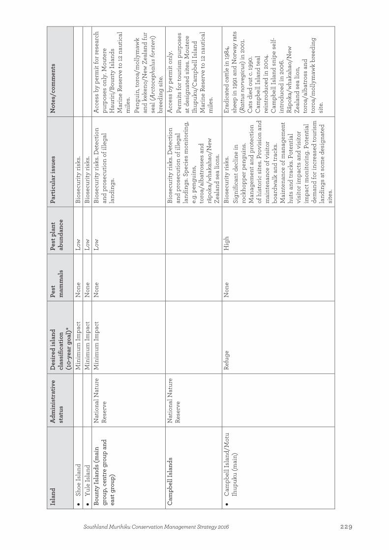
Isla
nd
Adm
inis
trat
ive
stat
us
Des
ired
isla
nd
clas
sific
atio
n
(10-
year
goa
l)*
Pest
m
amm
als
Pe
st p
lant
ab
unda
nce
Part
icul
ar is
sues
N
otes
/com
men
ts
• Sh
oe Is
land
Min
imum
Impa
ct
Non
e Lo
w
Bios
ecur
ity ri
sks.
•
Yule
Isla
nd
M
inim
um Im
pact
N
one
Low
Bi
osec
urity
risk
s.
Boun
ty Is
land
s (m
ain
grou
p, c
entr
e gr
oup
and
east
gro
up)
Nat
iona
l Nat
ure
Rese
rve
Min
imum
Impa
ct
Non
e Lo
w
Bios
ecur
ity ri
sks.
Det
ectio
n an
d pr
osec
utio
n of
ille
gal
land
ings
.
Acc
ess
by p
erm
it fo
r res
earc
h pu
rpos
es o
nly.
Mou
tere
H
aurir
i/Bo
unty
Isla
nds
Mar
ine
Rese
rve
to 12
nau
tical
m
iles.
Peng
uin,
toro
a/m
olly
maw
k an
d ke
keno
/New
Zea
land
fur
seal
(Arc
toce
phal
us fo
rste
ri)
bree
ding
site
. C
ampb
ell I
slan
ds
Nat
iona
l Nat
ure
Rese
rve
Bi
osec
urity
risk
s. D
etec
tion
and
pros
ecut
ion
of il
lega
l la
ndin
gs. S
peci
es m
onito
ring,
e.
g. p
engu
ins,
toro
a/al
batr
osse
s an
d rā
poka
/wha
kaha
o/N
ew
Zeal
and
sea
lions
.
Acc
ess
by p
erm
it on
ly.
Perm
its fo
r tou
rism
pur
pose
s at
des
igna
ted
site
s. M
oute
re
Ihup
uku/
Cam
pbel
l Isl
and
Mar
ine
Rese
rve
to 12
nau
tical
m
iles.
• C
ampb
ell I
slan
d/M
otu
Ihup
uku
(mai
n)
Re
fuge
N
one
Hig
h Bi
osec
urity
risk
s. Si
gnifi
cant
dec
line
in
rock
hopp
er p
engu
ins.
Man
agem
ent a
nd p
rote
ctio
n of
his
toric
site
s. Pr
ovis
ion
and
mai
nten
ance
of v
isito
r bo
ardw
alk
and
trac
ks.
Mai
nten
ance
of m
anag
emen
t hu
ts a
nd tr
acks
. Pot
entia
l vi
sito
r im
pact
s an
d vi
sito
r im
pact
mon
itori
ng. P
oten
tial
dem
and
for i
ncre
ased
tour
ism
la
ndin
gs a
t som
e de
sign
ated
si
tes.
Erad
icat
ed c
attle
in 19
84,
shee
p in
1991
and
Nor
way
rats
(R
attu
s nor
vegi
cus)
in 2
001.
Cat
s di
ed o
ut c
. 199
0.
Cam
pbel
l Isl
and
teal
re
intr
oduc
ed in
200
4.
Cam
pbel
l Isl
and
snip
e se
lf-in
trod
uced
in 2
006.
Rā
poka
/wha
kaha
o/N
ew
Zeal
and
sea
lion,
to
roa/
alba
tros
s an
d to
roa/
mol
lym
awk
bree
ding
si
te.
229Southland Murihiku Conservation Management Strategy 2016
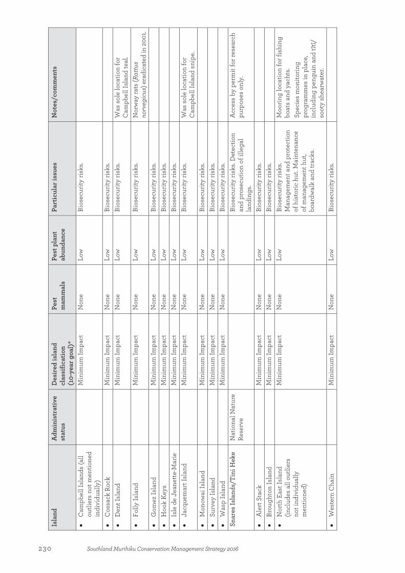
Isla
nd
Adm
inis
trat
ive
stat
us
Des
ired
isla
nd
clas
sific
atio
n
(10-
year
goa
l)*
Pest
m
amm
als
Pe
st p
lant
ab
unda
nce
Part
icul
ar is
sues
N
otes
/com
men
ts
• C
ampb
ell I
slan
ds (a
ll ou
tlier
s no
t men
tione
d in
divi
dual
ly)
M
inim
um Im
pact
N
one
Low
Bi
osec
urity
risk
s.
• C
ossa
ck R
ock
M
inim
um Im
pact
N
one
Low
Bi
osec
urity
risk
s.
• D
ent I
slan
d
Min
imum
Impa
ct
Non
e Lo
w
Bios
ecur
ity ri
sks.
Was
sol
e lo
catio
n fo
r C
ampb
ell I
slan
d te
al.
• Fo
lly Is
land
Min
imum
Impa
ct
Non
e Lo
w
Bios
ecur
ity ri
sks.
Nor
way
rats
(Rat
tus
norv
egic
us) e
radi
cate
d in
200
1. •
Gom
ez Is
land
Min
imum
Impa
ct
Non
e Lo
w
Bios
ecur
ity ri
sks.
•
Hoo
k K
eys
M
inim
um Im
pact
N
one
Low
Bi
osec
urity
risk
s.
• Is
le d
e Je
anet
te-M
arie
Min
imum
Impa
ct
Non
e Lo
w
Bios
ecur
ity ri
sks.
•
Jacq
uem
art I
slan
d
Min
imum
Impa
ct
Non
e Lo
w
Bios
ecur
ity ri
sks.
Was
sol
e lo
catio
n fo
r C
ampb
ell I
slan
d sn
ipe.
•
Mon
owai
Isla
nd
M
inim
um Im
pact
N
one
Low
Bi
osec
urity
risk
s.
• Su
rvey
Isla
nd
M
inim
um Im
pact
N
one
Low
Bi
osec
urity
risk
s.
• W
asp
Isla
nd
M
inim
um Im
pact
N
one
Low
Bi
osec
urity
risk
s.
Snar
es Is
land
s/Ti
ni H
eke
Nat
iona
l Nat
ure
Rese
rve
Bi
osec
urity
risk
s. D
etec
tion
and
pros
ecut
ion
of il
lega
l la
ndin
gs.
Acc
ess
by p
erm
it fo
r res
earc
h pu
rpos
es o
nly.
• A
lert
Sta
ck
M
inim
um Im
pact
N
one
Low
Bi
osec
urity
risk
s.
• Br
ough
ton
Isla
nd
M
inim
um Im
pact
N
one
Low
Bi
osec
urity
risk
s.
• N
orth
Eas
t Isl
and
(incl
udes
all
outli
ers
not i
ndiv
idua
lly
men
tione
d)
M
inim
um Im
pact
N
one
Low
Bi
osec
urity
risk
s. M
anag
emen
t and
pro
tect
ion
of h
isto
ric h
ut. M
aint
enan
ce
of m
anag
emen
t hut
, bo
ardw
alk
and
trac
ks.
Moo
ring
loca
tion
for f
ishi
ng
boat
s an
d ya
chts
. Sp
ecie
s m
onito
ring
pr
ogra
mm
es in
pla
ce,
incl
udin
g pe
ngui
n an
d tīt
ī/
soot
y sh
earw
ater
. •
Wes
tern
Cha
in
M
inim
um Im
pact
N
one
Low
Bi
osec
urity
risk
s.
230 Southland Murihiku Conservation Management Strategy 2016
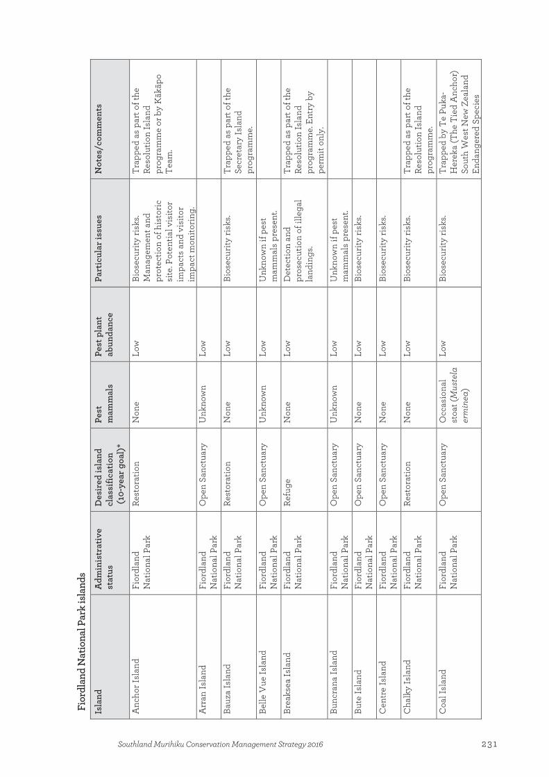
Fior
dlan
d N
atio
nal P
ark
isla
nds
Isla
nd
Adm
inis
trat
ive
stat
us
Des
ired
isla
nd
clas
sific
atio
n (1
0-ye
ar g
oal)
*
Pest
m
amm
als
Pest
pla
nt
abun
danc
e Pa
rtic
ular
issu
es
Not
es/c
omm
ents
Anc
hor I
slan
d Fi
ordl
and
Nat
iona
l Par
k Re
stor
atio
n N
one
Low
Bi
osec
urity
risk
s. M
anag
emen
t and
pr
otec
tion
of h
isto
ric
site
. Pot
entia
l vis
itor
impa
cts
and
visi
tor
impa
ct m
onito
ring
.
Trap
ped
as p
art o
f the
Re
solu
tion
Isla
nd
prog
ram
me
or b
y K
ākāp
o Te
am.
Arr
an Is
land
Fi
ordl
and
Nat
iona
l Par
k O
pen
Sanc
tuar
y U
nkno
wn
Low
Bauz
a Is
land
Fi
ordl
and
Nat
iona
l Par
k Re
stor
atio
n N
one
Low
Bi
osec
urity
risk
s. Tr
appe
d as
par
t of t
he
Secr
etar
y Is
land
pr
ogra
mm
e.
Belle
Vue
Isla
nd
Fior
dlan
d N
atio
nal P
ark
Ope
n Sa
nctu
ary
Unk
now
n Lo
w
Unk
now
n if
pest
m
amm
als
pres
ent.
Brea
ksea
Isla
nd
Fior
dlan
d N
atio
nal P
ark
Refu
ge
Non
e
Low
D
etec
tion
and
pros
ecut
ion
of il
lega
l la
ndin
gs.
Trap
ped
as p
art o
f the
Re
solu
tion
Isla
nd
prog
ram
me.
Ent
ry b
y pe
rmit
only
. Bu
ncra
na Is
land
Fi
ordl
and
Nat
iona
l Par
k O
pen
Sanc
tuar
y U
nkno
wn
Low
U
nkno
wn
if pe
st
mam
mal
s pr
esen
t.
Bute
Isla
nd
Fior
dlan
d N
atio
nal P
ark
Ope
n Sa
nctu
ary
Non
e Lo
w
Bios
ecur
ity ri
sks.
Cen
tre
Isla
nd
Fior
dlan
d N
atio
nal P
ark
Ope
n Sa
nctu
ary
Non
e
Low
Bi
osec
urity
risk
s.
Cha
lky
Isla
nd
Fior
dlan
d N
atio
nal P
ark
Rest
orat
ion
Non
e Lo
w
Bios
ecur
ity ri
sks.
Trap
ped
as p
art o
f the
Re
solu
tion
Isla
nd
prog
ram
me.
C
oal I
slan
d Fi
ordl
and
Nat
iona
l Par
k O
pen
Sanc
tuar
y O
ccas
iona
l st
oat (
Mus
tela
er
min
ea)
Low
Bi
osec
urity
risk
s. Tr
appe
d by
Te
Puka
-H
erek
a (T
he T
ied
Anc
hor)
So
uth
Wes
t New
Zea
land
En
dang
ered
Spe
cies
231Southland Murihiku Conservation Management Strategy 2016
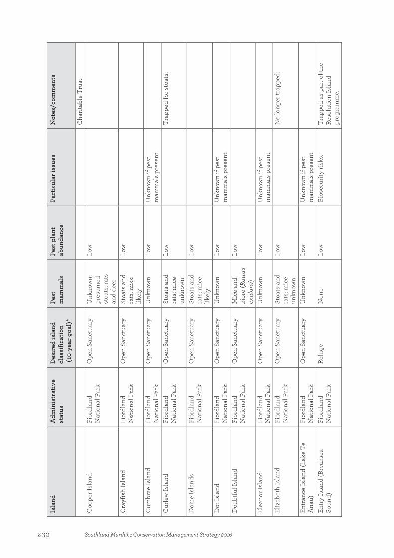
Isla
nd
Adm
inis
trat
ive
stat
us
Des
ired
isla
nd
clas
sific
atio
n (1
0-ye
ar g
oal)
*
Pest
m
amm
als
Pest
pla
nt
abun
danc
e Pa
rtic
ular
issu
es
Not
es/c
omm
ents
Cha
ritab
le T
rust
. C
oope
r Isl
and
Fior
dlan
d N
atio
nal P
ark
Ope
n Sa
nctu
ary
Unk
now
n;
pres
umed
st
oats
, rat
s an
d de
er
Low
Cra
yfis
h Is
land
Fi
ordl
and
Nat
iona
l Par
k O
pen
Sanc
tuar
y St
oats
and
ra
ts; m
ice
likel
y
Low
Cum
brae
Isla
nd
Fior
dlan
d N
atio
nal P
ark
Ope
n Sa
nctu
ary
Unk
now
n Lo
w
Unk
now
n if
pest
m
amm
als
pres
ent.
Cur
lew
Isla
nd
Fior
dlan
d N
atio
nal P
ark
Ope
n Sa
nctu
ary
Stoa
ts a
nd
rats
; mic
e un
know
n
Low
Trap
ped
for s
toat
s.
Dom
e Is
land
s Fi
ordl
and
Nat
iona
l Par
k O
pen
Sanc
tuar
y St
oats
and
ra
ts; m
ice
likel
y
Low
Dot
Isla
nd
Fior
dlan
d N
atio
nal P
ark
Ope
n Sa
nctu
ary
Unk
now
n Lo
w
Unk
now
n if
pest
m
amm
als
pres
ent.
Dou
btfu
l Isl
and
Fi
ordl
and
Nat
iona
l Par
k O
pen
Sanc
tuar
y M
ice
and
kior
e (R
attu
s ex
ulan
s)
Low
Elea
nor I
slan
d Fi
ordl
and
Nat
iona
l Par
k O
pen
Sanc
tuar
y U
nkno
wn
Low
U
nkno
wn
if pe
st
mam
mal
s pr
esen
t.
Eliz
abet
h Is
land
Fi
ordl
and
Nat
iona
l Par
k O
pen
Sanc
tuar
y St
oats
and
ra
ts; m
ice
unkn
own
Low
No
long
er tr
appe
d.
Entr
ance
Isla
nd (L
ake
Te
Ana
u)
Fior
dlan
d N
atio
nal P
ark
Ope
n Sa
nctu
ary
Unk
now
n Lo
w
Unk
now
n if
pest
m
amm
als
pres
ent.
Entr
y Is
land
(Bre
akse
a So
und)
Fi
ordl
and
Nat
iona
l Par
k Re
fuge
N
one
Lo
w
Bios
ecur
ity ri
sks.
Trap
ped
as p
art o
f the
Re
solu
tion
Isla
nd
prog
ram
me.
232 Southland Murihiku Conservation Management Strategy 2016

Isla
nd
Adm
inis
trat
ive
stat
us
Des
ired
isla
nd
clas
sific
atio
n (1
0-ye
ar g
oal)
*
Pest
m
amm
als
Pest
pla
nt
abun
danc
e Pa
rtic
ular
issu
es
Not
es/c
omm
ents
Erin
Isla
nd
Fior
dlan
d N
atio
nal P
ark
Ope
n Sa
nctu
ary
Mic
e,
occa
sion
al
stoa
t
Low
No
long
er tr
appe
d.
Ferg
usso
n Is
land
Fi
ordl
and
Nat
iona
l Par
k O
pen
Sanc
tuar
y St
oats
and
ra
ts; m
ice
unkn
own
Low
No
long
er tr
appe
d.
Gar
den
Isla
nds
Fior
dlan
d N
atio
nal P
ark
Ope
n Sa
nctu
ary
Unk
now
n U
nkno
wn
Unk
now
n if
pest
m
amm
als
pres
ent.
Girl
ies
Isla
nd
Fior
dlan
d N
atio
nal P
ark
Ope
n Sa
nctu
ary
Stoa
ts a
nd
rats
; mic
e lik
ely
Low
Gre
at Is
land
Fi
ordl
and
Nat
iona
l Par
k O
pen
Sanc
tuar
y St
oats
and
ra
ts; m
ice
likel
y
Low
Har
bour
Isla
nds
Fior
dlan
d N
atio
nal P
ark
Ope
n Sa
nctu
ary
Stoa
ts a
nd
rats
; mic
e un
know
n
Low
No
long
er tr
appe
d.
Haw
ea Is
land
Fi
ordl
and
Nat
iona
l Par
k Re
fuge
N
one
Low
Her
on Is
land
Fi
ordl
and
Nat
iona
l Par
k O
pen
Sanc
tuar
y St
oats
and
ra
ts
Low
No
long
er tr
appe
d.
Hol
mw
ood
Isla
nd
Fior
dlan
d N
atio
nal P
ark
Ope
n Sa
nctu
ary
Unk
now
n Lo
w
Unk
now
n if
pest
m
amm
als
pres
ent.
Indi
an Is
land
Fi
ordl
and
Nat
iona
l Par
k O
pen
Sanc
tuar
y N
one
Low
Bi
osec
urity
risk
s. M
anag
emen
t and
pr
otec
tion
of
arch
aeol
ogic
al s
ite.
Pote
ntia
l vis
itor i
mpa
cts
and
visi
tor i
mpa
ct
mon
itorin
g.
Trap
ped
as p
art o
f the
Re
solu
tion
Isla
nd
prog
ram
me.
Inne
r Cor
ding
Isla
nds
Fior
dlan
d O
pen
Sanc
tuar
y St
oats
and
ra
ts; m
ice
Low
Trap
ped
by T
e Pu
ka-
Her
eka
(The
Tie
d A
ncho
r)
233Southland Murihiku Conservation Management Strategy 2016

Isla
nd
Adm
inis
trat
ive
stat
us
Des
ired
isla
nd
clas
sific
atio
n (1
0-ye
ar g
oal)
*
Pest
m
amm
als
Pest
pla
nt
abun
danc
e Pa
rtic
ular
issu
es
Not
es/c
omm
ents
Nat
iona
l Par
k un
know
n So
uth
Wes
t New
Zea
land
En
dang
ered
Spe
cies
C
harit
able
Tru
st.
Inne
r Gilb
ert I
slan
ds
Fior
dlan
d N
atio
nal P
ark
Ope
n Sa
nctu
ary
Mic
e Lo
w
Tr
appe
d as
par
t of t
he
Reso
lutio
n Is
land
pr
ogra
mm
e.
Isol
de Is
land
Fi
ordl
and
Nat
iona
l Par
k O
pen
Sanc
tuar
y M
ice
Low
John
Isla
nds
Fior
dlan
d N
atio
nal P
ark
Ope
n Sa
nctu
ary
Stoa
ts a
nd
rats
; mic
e un
know
n
Low
Lee
Isla
nd
Fior
dlan
d N
atio
nal P
ark
Ope
n Sa
nctu
ary
Unk
now
n Lo
w
Unk
now
n if
pest
m
amm
als
pres
ent.
Littl
e Is
land
Fi
ordl
and
Nat
iona
l Par
k O
pen
Sanc
tuar
y St
oats
and
ra
ts; p
roba
bly
mic
e
Low
Littl
e So
land
er Is
land
Fi
ordl
and
Nat
iona
l Par
k M
inim
um Im
pact
N
one
Low
Bi
osec
urity
risk
s. D
etec
tion
and
pros
ecut
ion
of il
lega
l la
ndin
gs (p
opul
ar
com
mer
cial
fish
ing
area
).
Acc
ess
by p
erm
it fo
r re
sear
ch p
urpo
ses
only
. Sp
ecie
s m
onito
ring
, e.g
. ga
nnet
s.
Lone
Isla
nd
Fior
dlan
d N
atio
nal P
ark
Ope
n Sa
nctu
ary
Unk
now
n Lo
w
Unk
now
n if
pest
m
amm
als
pres
ent.
Long
Isla
nd
Fior
dlan
d N
atio
nal P
ark
Ope
n Sa
nctu
ary
Stoa
ts, r
ats,
mic
e an
d de
er
Low
Trap
ped
as p
art o
f the
Re
solu
tion
Isla
nd
prog
ram
me.
M
ahar
a Is
land
Fi
ordl
and
Nat
iona
l Par
k O
pen
Sanc
tuar
y U
nkno
wn
Unk
now
n U
nkno
wn
if pe
st
mam
mal
s pr
esen
t.
Man
y Is
land
s Fi
ordl
and
Ope
n Sa
nctu
ary
Non
e
Low
Bi
osec
urity
risk
s. Tr
appe
d as
par
t of t
he
234 Southland Murihiku Conservation Management Strategy 2016

Isla
nd
Adm
inis
trat
ive
stat
us
Des
ired
isla
nd
clas
sific
atio
n (1
0-ye
ar g
oal)
*
Pest
m
amm
als
Pest
pla
nt
abun
danc
e Pa
rtic
ular
issu
es
Not
es/c
omm
ents
Nat
iona
l Par
k Re
solu
tion
Isla
nd
prog
ram
me.
M
ary
Isla
nd
Fior
dlan
d N
atio
nal P
ark
Ope
n Sa
nctu
ary
Poss
ums
(Tric
hosu
rus
vulp
ecul
a),
stoa
ts, r
ats,
mic
e an
d de
er
Low
Stoa
t tra
ps s
et to
hel
p pr
otec
t Pet
rel I
slan
ds. V
ery
clos
e to
mai
nlan
d.
Nee
Isla
nd
Fior
dlan
d N
atio
nal P
ark
Refu
ge
Non
e
Low
Bi
osec
urity
risk
s.
Nom
ans
Isla
nd
Fior
dlan
d N
atio
nal P
ark
Rest
orat
ion
Non
e Lo
w
Bios
ecur
ity ri
sks.
Trap
ped
as p
art o
f the
Re
solu
tion
Isla
nd
prog
ram
me.
O
ke Is
land
Fi
ordl
and
Nat
iona
l Par
k O
pen
Sanc
tuar
y O
ccas
iona
l st
oat a
nd ra
t Lo
w
Tr
appe
d as
par
t of t
he
Reso
lutio
n Is
land
pr
ogra
mm
e.
Onl
y Is
land
s Fi
ordl
and
Nat
iona
l Par
k O
pen
Sanc
tuar
y U
nkno
wn
Low
Out
er C
ordi
ng Is
land
s Fi
ordl
and
Nat
iona
l Par
k Re
stor
atio
n St
oats
and
ra
ts; m
ice
unkn
own
Low
Trap
ped
by T
e Pu
ka-
Her
eka
(The
Tie
d A
ncho
r)
Sout
h W
est N
ew Z
eala
nd
Enda
nger
ed S
peci
es
Cha
ritab
le T
rust
. O
uter
Gilb
ert I
slan
ds
Fior
dlan
d N
atio
nal P
ark
Refu
ge
Stoa
ts a
nd
rats
; mic
e un
know
n
Low
Parr
ot Is
land
Fi
ordl
and
Nat
iona
l Par
k O
pen
Sanc
tuar
y N
one
Lo
w
Bios
ecur
ity ri
sks.
Trap
ped
as p
art o
f the
Re
solu
tion
Isla
nd
prog
ram
me.
Pa
ssag
e Is
land
s (D
usky
So
und)
Fi
ordl
and
Nat
iona
l Par
k Re
stor
atio
n N
one
Low
Bi
osec
urity
risk
s. Tr
appe
d as
par
t of t
he
Reso
lutio
n Is
land
pr
ogra
mm
e.
Pass
age
Isla
nds
(Cha
lky
Fior
dlan
d Re
stor
atio
n N
one
Low
Bi
osec
urity
risk
s. Tr
appe
d as
par
t of t
he
235Southland Murihiku Conservation Management Strategy 2016
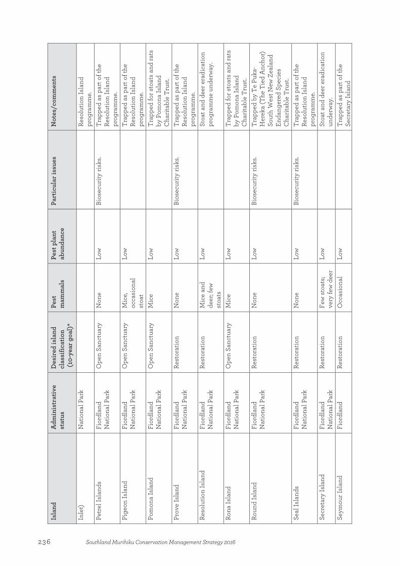
Isla
nd
Adm
inis
trat
ive
stat
us
Des
ired
isla
nd
clas
sific
atio
n (1
0-ye
ar g
oal)
*
Pest
m
amm
als
Pest
pla
nt
abun
danc
e Pa
rtic
ular
issu
es
Not
es/c
omm
ents
Inle
t)
Nat
iona
l Par
k Re
solu
tion
Isla
nd
prog
ram
me.
Pe
trel
Isla
nds
Fior
dlan
d N
atio
nal P
ark
Ope
n Sa
nctu
ary
Non
e
Low
Bi
osec
urity
risk
s. Tr
appe
d as
par
t of t
he
Reso
lutio
n Is
land
pr
ogra
mm
e.
Pige
on Is
land
Fi
ordl
and
Nat
iona
l Par
k O
pen
Sanc
tuar
y M
ice,
oc
casi
onal
st
oat
Low
Trap
ped
as p
art o
f the
Re
solu
tion
Isla
nd
prog
ram
me.
Po
mon
a Is
land
Fi
ordl
and
Nat
iona
l Par
k O
pen
Sanc
tuar
y M
ice
Low
Trap
ped
for s
toat
s an
d ra
ts
by P
omon
a Is
land
C
harit
able
Tru
st.
Prov
e Is
land
Fi
ordl
and
Nat
iona
l Par
k Re
stor
atio
n N
one
Low
Bi
osec
urity
risk
s. Tr
appe
d as
par
t of t
he
Reso
lutio
n Is
land
pr
ogra
mm
e.
Reso
lutio
n Is
land
Fi
ordl
and
Nat
iona
l Par
k Re
stor
atio
n M
ice
and
deer
; few
st
oats
Low
Stoa
t and
dee
r era
dica
tion
prog
ram
me
unde
rway
.
Rona
Isla
nd
Fior
dlan
d N
atio
nal P
ark
Ope
n Sa
nctu
ary
Mic
e Lo
w
Tr
appe
d fo
r sto
ats
and
rats
by
Pom
ona
Isla
nd
Cha
ritab
le T
rust
. Ro
und
Isla
nd
Fior
dlan
d N
atio
nal P
ark
Rest
orat
ion
Non
e Lo
w
Bios
ecur
ity ri
sks.
Trap
ped
by T
e Pu
ka-
Her
eka
(The
Tie
d A
ncho
r)
Sout
h W
est N
ew Z
eala
nd
Enda
nger
ed S
peci
es
Cha
ritab
le T
rust
. Se
al Is
land
s Fi
ordl
and
Nat
iona
l Par
k Re
stor
atio
n N
one
Low
Bi
osec
urity
risk
s. Tr
appe
d as
par
t of t
he
Reso
lutio
n Is
land
pr
ogra
mm
e.
Secr
etar
y Is
land
Fi
ordl
and
Nat
iona
l Par
k Re
stor
atio
n Fe
w s
toat
s; ve
ry fe
w d
eer
Low
Stoa
t and
dee
r era
dica
tion
unde
rway
. Se
ymou
r Isl
and
Fior
dlan
d Re
stor
atio
n O
ccas
iona
l Lo
w
Tr
appe
d as
par
t of t
he
Secr
etar
y Is
land
236 Southland Murihiku Conservation Management Strategy 2016
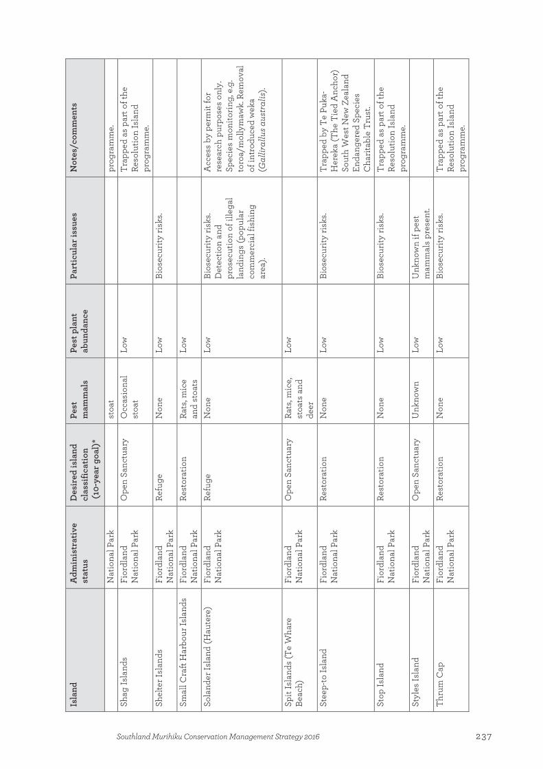
Isla
nd
Adm
inis
trat
ive
stat
us
Des
ired
isla
nd
clas
sific
atio
n (1
0-ye
ar g
oal)
*
Pest
m
amm
als
Pest
pla
nt
abun
danc
e Pa
rtic
ular
issu
es
Not
es/c
omm
ents
Nat
iona
l Par
k st
oat
prog
ram
me.
Sh
ag Is
land
s Fi
ordl
and
Nat
iona
l Par
k O
pen
Sanc
tuar
y O
ccas
iona
l st
oat
Low
Trap
ped
as p
art o
f the
Re
solu
tion
Isla
nd
prog
ram
me.
Sh
elte
r Isl
ands
Fi
ordl
and
Nat
iona
l Par
k Re
fuge
N
one
Lo
w
Bios
ecur
ity ri
sks.
Smal
l Cra
ft H
arbo
ur Is
land
s Fi
ordl
and
Nat
iona
l Par
k Re
stor
atio
n Ra
ts, m
ice
and
stoa
ts
Low
Sola
nder
Isla
nd (H
aute
re)
Fior
dlan
d N
atio
nal P
ark
Refu
ge
Non
e
Low
Bi
osec
urity
risk
s. D
etec
tion
and
pros
ecut
ion
of il
lega
l la
ndin
gs (p
opul
ar
com
mer
cial
fish
ing
area
).
Acc
ess
by p
erm
it fo
r re
sear
ch p
urpo
ses
only
. Sp
ecie
s m
onito
ring
, e.g
. to
roa/
mol
lym
awk.
Rem
oval
of
intr
oduc
ed w
eka
(Gal
liral
lus a
ustr
alis
).
Spit
Isla
nds
(Te
Wha
re
Beac
h)
Fior
dlan
d N
atio
nal P
ark
Ope
n Sa
nctu
ary
Rats
, mic
e,
stoa
ts a
nd
deer
Low
Stee
p-to
Isla
nd
Fior
dlan
d N
atio
nal P
ark
Rest
orat
ion
Non
e Lo
w
Bios
ecur
ity ri
sks.
Trap
ped
by T
e Pu
ka-
Her
eka
(The
Tie
d A
ncho
r)
Sout
h W
est N
ew Z
eala
nd
Enda
nger
ed S
peci
es
Cha
ritab
le T
rust
. St
op Is
land
Fi
ordl
and
Nat
iona
l Par
k Re
stor
atio
n N
one
Low
Bi
osec
urity
risk
s. Tr
appe
d as
par
t of t
he
Reso
lutio
n Is
land
pr
ogra
mm
e.
Styl
es Is
land
Fi
ordl
and
Nat
iona
l Par
k O
pen
Sanc
tuar
y U
nkno
wn
Low
U
nkno
wn
if pe
st
mam
mal
s pr
esen
t.
Thru
m C
ap
Fior
dlan
d N
atio
nal P
ark
Rest
orat
ion
Non
e Lo
w
Bios
ecur
ity ri
sks.
Trap
ped
as p
art o
f the
Re
solu
tion
Isla
nd
prog
ram
me.
237Southland Murihiku Conservation Management Strategy 2016

Isla
nd
Adm
inis
trat
ive
stat
us
Des
ired
isla
nd
clas
sific
atio
n (1
0-ye
ar g
oal)
*
Pest
m
amm
als
Pest
pla
nt
abun
danc
e Pa
rtic
ular
issu
es
Not
es/c
omm
ents
Two
Sist
ers
Fior
dlan
d N
atio
nal P
ark
Ope
n Sa
nctu
ary
Stoa
ts, r
ats
and
mic
e Lo
w
Tr
appe
d as
par
t of t
he
Reso
lutio
n Is
land
pr
ogra
mm
e.
Unn
amed
Isla
nd (C
liff C
ove)
Fi
ordl
and
Nat
iona
l Par
k O
pen
Sanc
tuar
y St
oats
, rat
s an
d m
ice
Low
Unn
amed
Isla
nd (C
orm
oran
t C
ove)
Fi
ordl
and
Nat
iona
l Par
k O
pen
Sanc
tuar
y M
ice
Lo
w
Tr
appe
d as
par
t of t
he
Reso
lutio
n Is
land
pr
ogra
mm
e.
Unn
amed
Isla
nd (D
usky
So
und,
E.R
. 782
772)
Fi
ordl
and
Nat
iona
l Par
k Re
fuge
U
nkno
wn
Low
U
nkno
wn
if pe
st
mam
mal
s pr
esen
t.
Unn
amed
Isla
nd (E
arsh
ell
Cov
e)
Fior
dlan
d N
atio
nal P
ark
Ope
n Sa
nctu
ary
Unk
now
n;
prob
ably
mic
e Lo
w
Tr
appe
d as
par
t of t
he
Reso
lutio
n Is
land
pr
ogra
mm
e.
Unn
amed
Isla
nd (M
uscl
e C
ove)
Fi
ordl
and
Nat
iona
l Par
k O
pen
Sanc
tuar
y St
oats
, rat
s an
d m
ice
Low
Unn
amed
Isla
nd (S
outh
Wes
t A
rm, G
eorg
e So
und)
Fi
ordl
and
Nat
iona
l Par
k O
pen
Sanc
tuar
y U
nkno
wn
Low
U
nkno
wn
if pe
st
mam
mal
s pr
esen
t.
Unn
amed
Isla
nd (T
eal B
ay)
Fior
dlan
d N
atio
nal P
ark
Ope
n Sa
nctu
ary
Occ
asio
nal
stoa
t; ra
ts a
nd
deer
like
ly
Low
Unn
amed
isla
nds
(Dee
pwat
er B
asin
) Fi
ordl
and
Nat
iona
l Par
k O
pen
Sanc
tuar
y St
oats
, rat
s an
d m
ice
Low
Use
less
Isla
nds
Fior
dlan
d N
atio
nal P
ark
Ope
n Sa
nctu
ary
Non
e Lo
w
Bios
ecur
ity ri
sks.
Trap
ped
as p
art o
f the
Re
solu
tion
Isla
nd
prog
ram
me.
U
tah
Isla
nd
Fior
dlan
d N
atio
nal P
ark
Ope
n Sa
nctu
ary
Non
e
Low
Bi
osec
urity
risk
s. Tr
appe
d as
par
t of
Secr
etar
y Is
land
pr
ogra
mm
e.
Wai
raki
Isla
nd
Fior
dlan
d N
atio
nal P
ark
Refu
ge
Non
e Lo
w
Wek
a Is
land
Fi
ordl
and
Rest
orat
ion
Non
e Lo
w
Bios
ecur
ity ri
sks.
Trap
ped
by T
e Pu
ka-
238 Southland Murihiku Conservation Management Strategy 2016

Isla
nd
Adm
inis
trat
ive
stat
us
Des
ired
isla
nd
clas
sific
atio
n (1
0-ye
ar g
oal)
*
Pest
m
amm
als
Pest
pla
nt
abun
danc
e Pa
rtic
ular
issu
es
Not
es/c
omm
ents
Nat
iona
l Par
k H
erek
a (T
he T
ied
Anc
hor)
So
uth
Wes
t New
Zea
land
En
dang
ered
Spe
cies
C
harit
able
Tru
st.
* Th
e is
land
cla
ssifi
catio
n is
alig
ned
with
the
10-y
ear t
erm
of t
his s
trat
egy
and
repr
esen
ts th
e de
sire
d fu
ture
stat
e of
the
isla
nd (D
epar
tmen
t of C
onse
rvat
ion.
201
0: T
he is
land
str
ateg
y: g
uide
lines
for m
anag
ing
isla
nds
adm
inis
tere
d by
the
Dep
artm
ent o
f Con
serv
atio
n). T
he is
land
cla
ssifi
catio
n is
inte
nded
for g
uida
nce
only
, and
nee
ds to
be
read
in c
onju
nctio
n w
ith th
e ou
tcom
e an
d po
licie
s fo
r Pla
ces
in P
art T
wo
of
this
str
ateg
y.
Oth
er is
land
s Is
land
A
dmin
istr
ativ
e st
atus
D
esir
ed is
land
cl
assi
ficat
ion
(10
year
goa
l)*
Pest
mam
mal
s
Pest
pla
nt a
bund
ance
Pa
rtic
ular
issu
es
Not
es/c
omm
ents
Mon
key
Isla
nd
Con
serv
atio
n A
rea
Ope
n Sa
nctu
ary
Unk
now
n U
nkno
wn
Unk
now
n if
pest
m
amm
als
or p
lant
s pr
esen
t.
Acc
ess
by fo
ot a
t low
tide
.
Om
aui I
slan
d C
onse
rvat
ion
Are
a Re
fuge
U
nkno
wn
Unk
now
n U
nkno
wn
if pe
st
mam
mal
s or
pla
nts
pres
ent.
Pig
Isla
nd (T
īhak
a)
Scen
ic R
eser
ve
Refu
ge
Mam
mal
ian
pest
fr
ee
Pest
pla
nts
curr
ently
un
der c
ontr
ol: m
arra
m
(Am
mop
hila
are
naria
), an
gelic
a (A
ngel
ica
pach
ycar
pa) a
nd tr
ee
mal
low
(Lav
ater
a sp
p.)
Bios
ecur
ity ri
sks.
Mai
ntai
ning
pes
t pl
ant c
ontr
ol
prog
ram
mes
.
Unn
amed
Isla
nds
(Aw
arua
Bay
) U
nallo
cate
d C
row
n La
nd—
LIN
Z4
Ope
n Sa
nctu
ary
Rode
nts,
deer
an
d m
uste
lids
Low
Key
roos
ting
area
for m
igra
tory
w
ader
s an
d tū
turiw
hatu
/ so
uthe
rn N
ew Z
eala
nd d
otte
rel.
* Th
e is
land
cla
ssifi
catio
n is
alig
ned
with
the
10-
year
ter
m o
f th
is s
trat
egy
and
repr
esen
ts t
he d
esire
d fu
ture
sta
te o
f th
e is
land
(D
epar
tmen
t of
Con
serv
atio
n. 2
010:
The
isl
and
stra
tegy
: gui
delin
es f
or
man
agin
g is
land
s ad
min
iste
red
by th
e D
epar
tmen
t of C
onse
rvat
ion)
. The
isla
nd c
lass
ifica
tion
is in
tend
ed fo
r gui
danc
e on
ly, a
nd n
eeds
to b
e re
ad in
con
junc
tion
with
the
outc
ome
and
polic
ies
for P
lace
s in
Pa
rt T
wo
of th
is s
trat
egy.
4 Whi
le th
ese
isla
nds
are
not p
ublic
con
serv
atio
n la
nds
and
wat
ers,
they
are
par
t of t
he A
war
ua W
etla
nd o
f Int
erna
tiona
l Im
port
ance
.
239Southland Murihiku Conservation Management Strategy 2016
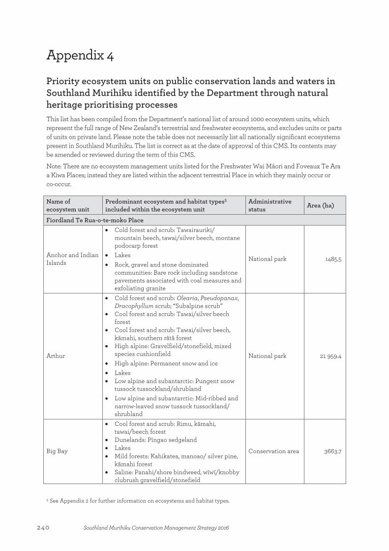
Appendix 4
Priority ecosystem units on public conservation lands and waters in Southland Murihiku identified by the Department through natural heritage prioritising processes This list has been compiled from the Department’s national list of around 1000 ecosystem units, which represent the full range of New Zealand’s terrestrial and freshwater ecosystems, and excludes units or parts of units on private land. Please note the table does not necessarily list all nationally significant ecosystems present in Southland Murihiku. The list is correct as at the date of approval of this CMS. Its contents may be amended or reviewed during the term of this CMS.
Note: There are no ecosystem management units listed for the Freshwater Wai Māori and Foveaux Te Ara a Kiwa Places; instead they are listed within the adjacent terrestrial Place in which they mainly occur or co-occur.
Name of ecosystem unit
Predominant ecosystem and habitat types5 included within the ecosystem unit
Administrative status
Area (ha)
Fiordland Te Rua-o-te-moko Place
Anchor and Indian Islands
• Cold forest and scrub: Tawairauriki/ mountain beech, tawai/silver beech, montane podocarp forest
• Lakes • Rock, gravel and stone dominated
communities: Bare rock including sandstone pavements associated with coal measures and exfoliating granite
National park 1485.5
Arthur
• Cold forest and scrub: Olearia, Pseudopanax, Dracophyllum scrub; “Subalpine scrub”
• Cool forest and scrub: Tawai/silver beech forest
• Cool forest and scrub: Tawai/silver beech, kāmahi, southern rātā forest
• High alpine: Gravelfield/stonefield, mixed species cushionfield
• High alpine: Permanent snow and ice • Lakes • Low alpine and subantarctic: Pungent snow
tussock tussockland/shrubland • Low alpine and subantarctic: Mid-ribbed and
narrow-leaved snow tussock tussockland/ shrubland
National park 21 959.4
Big Bay
• Cool forest and scrub: Rimu, kāmahi, tawai/beech forest
• Dunelands: Pīngao sedgeland • Lakes • Mild forests: Kahikatea, manoao/ silver pine,
kāmahi forest • Saline: Panahi/shore bindweed, wīwī/knobby
clubrush gravelfield/stonefield
Conservation area 3663.7
5 See Appendix 2 for further information on ecosystems and habitat types.
Appendix 4:Priority ecosystem units on public conservation lands and waters in Southland Murihiku identified by the Department through natural heritage prioritising processes
240 Southland Murihiku Conservation Management Strategy 2016
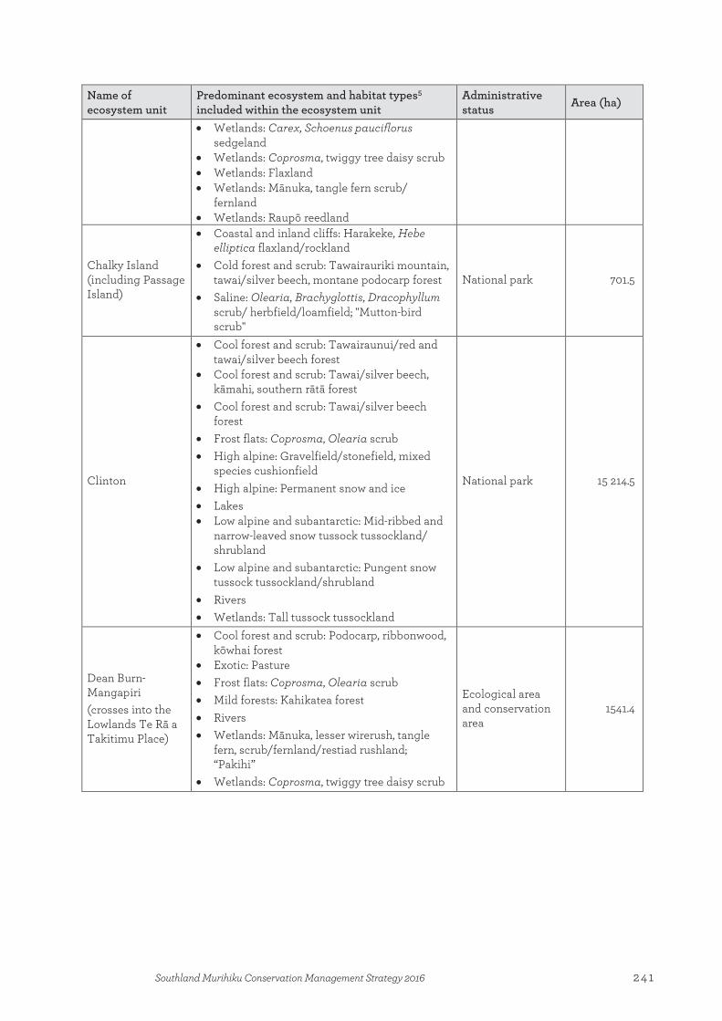
Name of ecosystem unit
Predominant ecosystem and habitat types5 included within the ecosystem unit
Administrative status
Area (ha)
• Wetlands: Carex, Schoenus pauciflorus sedgeland
• Wetlands: Coprosma, twiggy tree daisy scrub • Wetlands: Flaxland • Wetlands: Mānuka, tangle fern scrub/
fernland • Wetlands: Raupō reedland
Chalky Island (including Passage Island)
• Coastal and inland cliffs: Harakeke, Hebe elliptica flaxland/rockland
• Cold forest and scrub: Tawairauriki mountain, tawai/silver beech, montane podocarp forest
• Saline: Olearia, Brachyglottis, Dracophyllum scrub/ herbfield/loamfield; "Mutton-bird scrub"
National park 701.5
Clinton
• Cool forest and scrub: Tawairaunui/red and tawai/silver beech forest
• Cool forest and scrub: Tawai/silver beech, kāmahi, southern rātā forest
• Cool forest and scrub: Tawai/silver beech forest
• Frost flats: Coprosma, Olearia scrub • High alpine: Gravelfield/stonefield, mixed
species cushionfield • High alpine: Permanent snow and ice • Lakes • Low alpine and subantarctic: Mid-ribbed and
narrow-leaved snow tussock tussockland/ shrubland
• Low alpine and subantarctic: Pungent snow tussock tussockland/shrubland
• Rivers • Wetlands: Tall tussock tussockland
National park 15 214.5
Dean Burn-Mangapiri (crosses into the Lowlands Te Rā a Takitimu Place)
• Cool forest and scrub: Podocarp, ribbonwood, kōwhai forest
• Exotic: Pasture • Frost flats: Coprosma, Olearia scrub • Mild forests: Kahikatea forest • Rivers • Wetlands: Mānuka, lesser wirerush, tangle
fern, scrub/fernland/restiad rushland; “Pakihi”
• Wetlands: Coprosma, twiggy tree daisy scrub
Ecological area and conservation area
1541.4
241Southland Murihiku Conservation Management Strategy 2016

Name of ecosystem unit
Predominant ecosystem and habitat types5 included within the ecosystem unit
Administrative status
Area (ha)
Eglinton (crosses into the Western High Country Mata-puke Koikoi Place)
• Cold forest and scrub: Tawairauriki/mountain beech forest
• Cold forest and scrub: Olearia, Pseudopanax, Dracophyllum scrub; “Subalpine scrub”
• Combustion and/or volcanic activity: Short tussock tussockland
• Cool forest and scrub: Tawairaunui/red and tawai/silver beech forest
• Cool forest and scrub: Tawai/silver beech forest
• Frost flats: Bog pine, mountain toatoa/celery pine and manoao/silver pine scrub/forest
• High alpine: Gravelfield/stonefield, mixed species cushionfield
• Low alpine and subantarctic: Narrow-leaved and slim snow tussock tussockland/ shrubland
• Regenerating: Short tussock tussockland • Rivers • Rock, gravel and stone dominated
communities: Gravelfield; “Screes and boulderfields”
• Rock, gravel and stone dominated communities: Hard tussock, scabweed gravelfield/stonefield; “Braided rivers”
• Ultramafic: Tussockland/stonefield/ rockland • Wetlands: Lesser wire rush, tangle fern restiad
rushland/fernland • Wetlands: Cushionfield • Wetlands: Herbfield; “Ephemeral wetland” • Wetlands: Herbfield/mossfield/sedgeland • Wetlands: Mānuka, lesser tangle fern scrub/
fernland/restiad rushland • Wetlands: Red tussock, Schoenus pauciflorus
tussockland • Wetlands: Carex, Schoenus pauciflorus
sedgeland
National park 28 295.6
Fiordland South Coast • Big River • Fred Burn • Prices Harbour • Puysegur Point • Sand Hill Point • Wilson River
• Dunelands: Oioi, wīwī/knobby clubrush sedgeland
• Dunelands: Pīngao (Ficinia spiralis) sedgeland
• Saline: Shore bind weed, wīwī/knobby clubrush, gravelfield/stonefield
National park National park National park National park Historic reserve* National park
12.2 3.7 3.1
10.0 24.4
2.7
Lake Poteriteri • Lakes: Large glacial lake National park 4439.1 Manapouri lakeshore turfs • Wetlands: Herbfield; “Lakeshore turf” National park 805.3
Mount Titiroa • High alpine: Permanent snow and ice • Rock, gravel and stone dominated
National park 1229.6
242 Southland Murihiku Conservation Management Strategy 2016

Name of ecosystem unit
Predominant ecosystem and habitat types5 included within the ecosystem unit
Administrative status
Area (ha)
communities : Bare rock including sandstone pavements associated with coal measures and exfoliating granite
• Wetlands: Machaerina sedgeland
Pyke Valley (crosses into the Otago CMS area)
• Cool forest and scrub: Tawai/silver beech forest
• Lakes • Rivers • Rock, gravel and stone dominated
communities: Hard tussock, scabweed gravelfield/stonefield; “Braided rivers”
• Wetlands: Machaerina sedgeland • Wetlands: Herbfield; “Lakeshore turf” • Wetlands: Flaxland • Wetlands: Coprosma, twiggy tree daisy scrub • Wetlands: Carex, Schoenus pauciflorus
sedgeland
National park and conservation area
99.9 (in this CMS area)
Resolution Island
• Cold forest and scrub: Tawairauriki/ mountain beech, tawai/ silver beech, montane podocarp forest
• Cool forest and scrub: Rimu, kāmahi, tawai/beech forest
• Cool forest and scrub: Tawai/silver beech, kāmahi, southern rātā forest
• Cool forest and scrub: Tawai/silver beech forest
• Lakes • Low alpine and subantarctic: Pungent snow
tussock tussockland/shrubland • Rock, gravel and stone dominated
communities: Bare rock including sandstone pavements associated with coal measures and exfoliating granite
• Saline: Olearia, Brachyglottis, Dracophyllum scrub/herbfield/loamfield; “Mutton-bird scrub”
• Saline: Ureure/glasswort, māakoako/sea primrose herbfield; “Saltmarsh”
National park 21 278.5
Secretary Island
• Coastal and inland cliffs: Harakeke, Hebe elliptica flaxland/rockland
• Cold forest and scrub: Tawairauriki/ mountain beech, tawai/silver beech, montane podocarp forest
• Cold forest and scrub: Olearia, Pseudopanax, Dracophyllum scrub; “Subalpine scrub”
• Cool forest and scrub: Rimu, kāmahi tawai/beech forest
• Cool forest and scrub: Tawai/silver beech, kāmahi, southern rātā forest
• Cool forest and scrub: Tawai/silver beech forest
• Lakes
National park 8522.4
243Southland Murihiku Conservation Management Strategy 2016
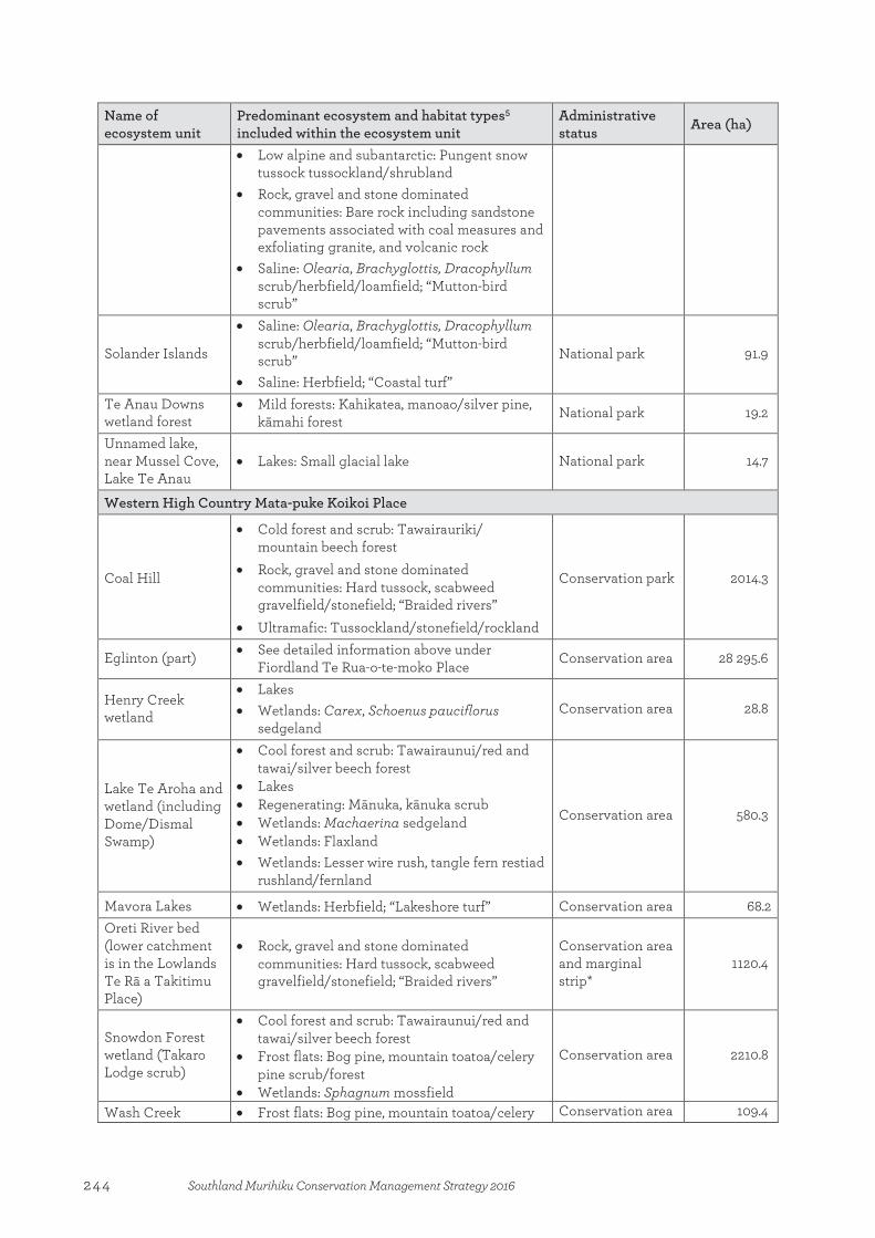
Name of ecosystem unit
Predominant ecosystem and habitat types5 included within the ecosystem unit
Administrative status
Area (ha)
• Low alpine and subantarctic: Pungent snow tussock tussockland/shrubland
• Rock, gravel and stone dominated communities: Bare rock including sandstone pavements associated with coal measures and exfoliating granite, and volcanic rock
• Saline: Olearia, Brachyglottis, Dracophyllum scrub/herbfield/loamfield; “Mutton-bird scrub”
Solander Islands
• Saline: Olearia, Brachyglottis, Dracophyllum scrub/herbfield/loamfield; “Mutton-bird scrub”
• Saline: Herbfield; “Coastal turf”
National park 91.9
Te Anau Downs wetland forest
• Mild forests: Kahikatea, manoao/silver pine, kāmahi forest National park 19.2
Unnamed lake, near Mussel Cove, Lake Te Anau
• Lakes: Small glacial lake National park 14.7
Western High Country Mata-puke Koikoi Place
Coal Hill
• Cold forest and scrub: Tawairauriki/ mountain beech forest
• Rock, gravel and stone dominated communities: Hard tussock, scabweed gravelfield/stonefield; “Braided rivers”
• Ultramafic: Tussockland/stonefield/rockland
Conservation park 2014.3
Eglinton (part) • See detailed information above under Fiordland Te Rua-o-te-moko Place Conservation area 28 295.6
Henry Creek wetland
• Lakes • Wetlands: Carex, Schoenus pauciflorus
sedgeland Conservation area 28.8
Lake Te Aroha and wetland (including Dome/Dismal Swamp)
• Cool forest and scrub: Tawairaunui/red and tawai/silver beech forest
• Lakes • Regenerating: Mānuka, kānuka scrub • Wetlands: Machaerina sedgeland • Wetlands: Flaxland • Wetlands: Lesser wire rush, tangle fern restiad
rushland/fernland
Conservation area 580.3
Mavora Lakes • Wetlands: Herbfield; “Lakeshore turf” Conservation area 68.2 Oreti River bed (lower catchment is in the Lowlands Te Rā a Takitimu Place)
• Rock, gravel and stone dominated communities: Hard tussock, scabweed gravelfield/stonefield; “Braided rivers”
Conservation area and marginal strip*
1120.4
Snowdon Forest wetland (Takaro Lodge scrub)
• Cool forest and scrub: Tawairaunui/red and tawai/silver beech forest
• Frost flats: Bog pine, mountain toatoa/celery pine scrub/forest
• Wetlands: Sphagnum mossfield
Conservation area 2210.8
Wash Creek • Frost flats: Bog pine, mountain toatoa/celery Conservation area 109.4
244 Southland Murihiku Conservation Management Strategy 2016
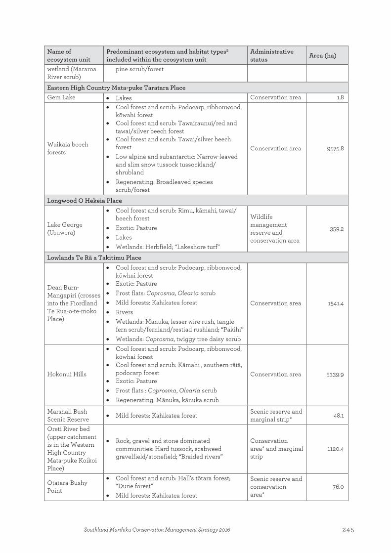
Name of ecosystem unit
Predominant ecosystem and habitat types5 included within the ecosystem unit
Administrative status
Area (ha)
wetland (Mararoa River scrub)
pine scrub/forest
Eastern High Country Mata-puke Taratara Place Gem Lake • Lakes Conservation area 1.8
Waikaia beech forests
• Cool forest and scrub: Podocarp, ribbonwood, kōwahi forest
• Cool forest and scrub: Tawairaunui/red and tawai/silver beech forest
• Cool forest and scrub: Tawai/silver beech forest
• Low alpine and subantarctic: Narrow-leaved and slim snow tussock tussockland/ shrubland
• Regenerating: Broadleaved species scrub/forest
Conservation area 9575.8
Longwood O Hekeia Place
Lake George (Uruwera)
• Cool forest and scrub: Rimu, kāmahi, tawai/ beech forest
• Exotic: Pasture • Lakes • Wetlands: Herbfield; “Lakeshore turf”
Wildlife management reserve and conservation area
359.2
Lowlands Te Rā a Takitimu Place
Dean Burn-Mangapiri (crosses into the Fiordland Te Rua-o-te-moko Place)
• Cool forest and scrub: Podocarp, ribbonwood, kōwhai forest
• Exotic: Pasture • Frost flats: Coprosma, Olearia scrub • Mild forests: Kahikatea forest • Rivers • Wetlands: Mānuka, lesser wire rush, tangle
fern scrub/fernland/restiad rushland; “Pakihi” • Wetlands: Coprosma, twiggy tree daisy scrub
Conservation area 1541.4
Hokonui Hills
• Cool forest and scrub: Podocarp, ribbonwood, kōwhai forest
• Cool forest and scrub: Kāmahi , southern rātā, podocarp forest
• Exotic: Pasture • Frost flats : Coprosma, Olearia scrub • Regenerating: Mānuka, kānuka scrub
Conservation area 5339.9
Marshall Bush Scenic Reserve • Mild forests: Kahikatea forest Scenic reserve and
marginal strip* 48.1
Oreti River bed (upper catchment is in the Western High Country Mata-puke Koikoi Place)
• Rock, gravel and stone dominated communities: Hard tussock, scabweed gravelfield/stonefield; “Braided rivers”
Conservation area* and marginal strip
1120.4
Otatara-Bushy Point
• Cool forest and scrub: Hall’s tōtara forest; “Dune forest”
• Mild forests: Kahikatea forest
Scenic reserve and conservation area*
76.0
245Southland Murihiku Conservation Management Strategy 2016
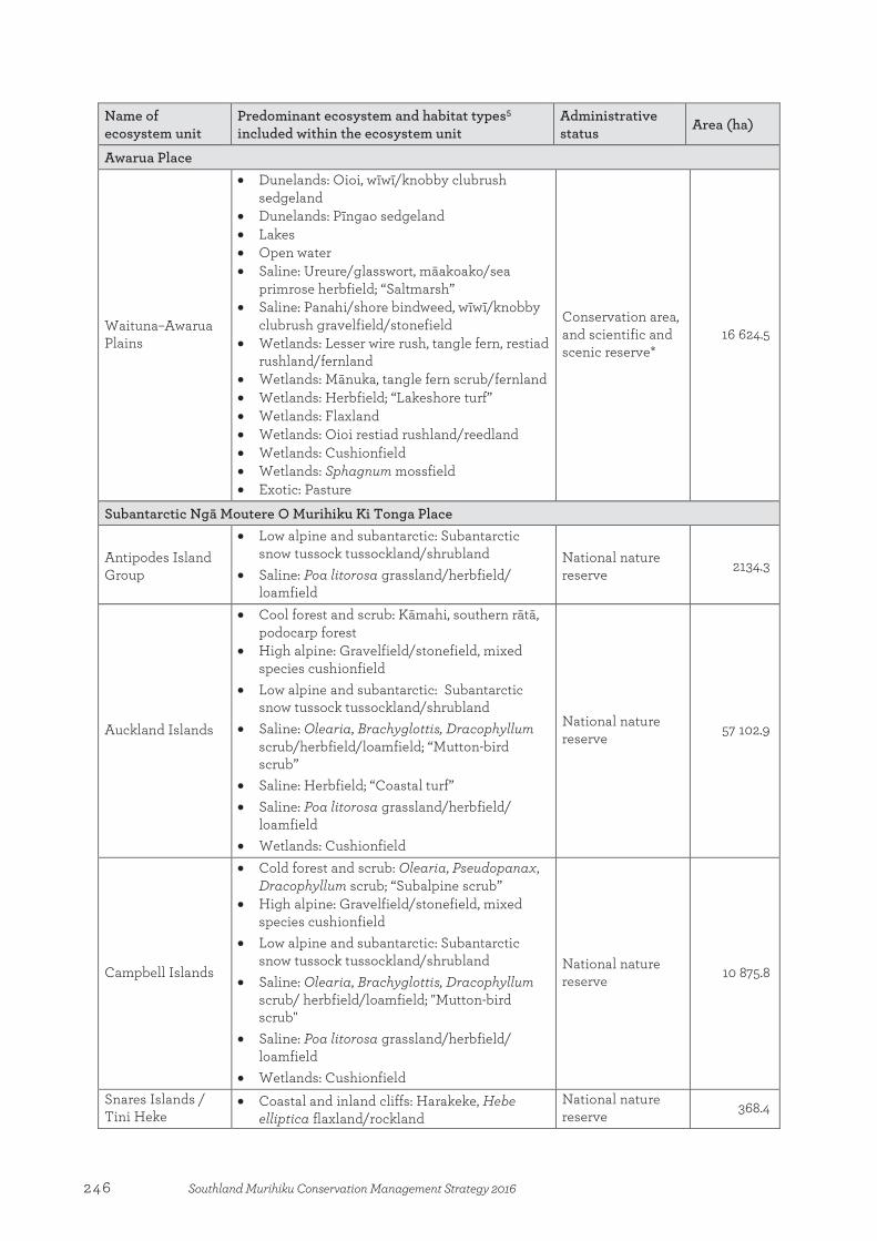
Name of ecosystem unit
Predominant ecosystem and habitat types5 included within the ecosystem unit
Administrative status
Area (ha)
Awarua Place
Waituna–Awarua Plains
• Dunelands: Oioi, wīwī/knobby clubrush sedgeland
• Dunelands: Pīngao sedgeland • Lakes • Open water • Saline: Ureure/glasswort, māakoako/sea
primrose herbfield; “Saltmarsh” • Saline: Panahi/shore bindweed, wīwī/knobby
clubrush gravelfield/stonefield • Wetlands: Lesser wire rush, tangle fern, restiad
rushland/fernland • Wetlands: Mānuka, tangle fern scrub/fernland • Wetlands: Herbfield; “Lakeshore turf” • Wetlands: Flaxland • Wetlands: Oioi restiad rushland/reedland • Wetlands: Cushionfield • Wetlands: Sphagnum mossfield • Exotic: Pasture
Conservation area, and scientific and scenic reserve*
16 624.5
Subantarctic Ngā Moutere O Murihiku Ki Tonga Place
Antipodes Island Group
• Low alpine and subantarctic: Subantarctic snow tussock tussockland/shrubland
• Saline: Poa litorosa grassland/herbfield/ loamfield
National nature reserve 2134.3
Auckland Islands
• Cool forest and scrub: Kāmahi, southern rātā, podocarp forest
• High alpine: Gravelfield/stonefield, mixed species cushionfield
• Low alpine and subantarctic: Subantarctic snow tussock tussockland/shrubland
• Saline: Olearia, Brachyglottis, Dracophyllum scrub/herbfield/loamfield; “Mutton-bird scrub”
• Saline: Herbfield; “Coastal turf” • Saline: Poa litorosa grassland/herbfield/
loamfield • Wetlands: Cushionfield
National nature reserve 57 102.9
Campbell Islands
• Cold forest and scrub: Olearia, Pseudopanax, Dracophyllum scrub; “Subalpine scrub”
• High alpine: Gravelfield/stonefield, mixed species cushionfield
• Low alpine and subantarctic: Subantarctic snow tussock tussockland/shrubland
• Saline: Olearia, Brachyglottis, Dracophyllum scrub/ herbfield/loamfield; "Mutton-bird scrub"
• Saline: Poa litorosa grassland/herbfield/ loamfield
• Wetlands: Cushionfield
National nature reserve 10 875.8
Snares Islands / Tini Heke
• Coastal and inland cliffs: Harakeke, Hebe elliptica flaxland/rockland
National nature reserve 368.4
246 Southland Murihiku Conservation Management Strategy 2016

Name of ecosystem unit
Predominant ecosystem and habitat types5 included within the ecosystem unit
Administrative status
Area (ha)
• Saline: Olearia, Brachyglottis, Dracophyllum scrub/ herbfield/loamfield; “Mutton-bird scrub”
• Saline: Poa litorosa grassland/herbfield/ loamfield
* Plus some non-public conservation lands and waters.
247Southland Murihiku Conservation Management Strategy 2016
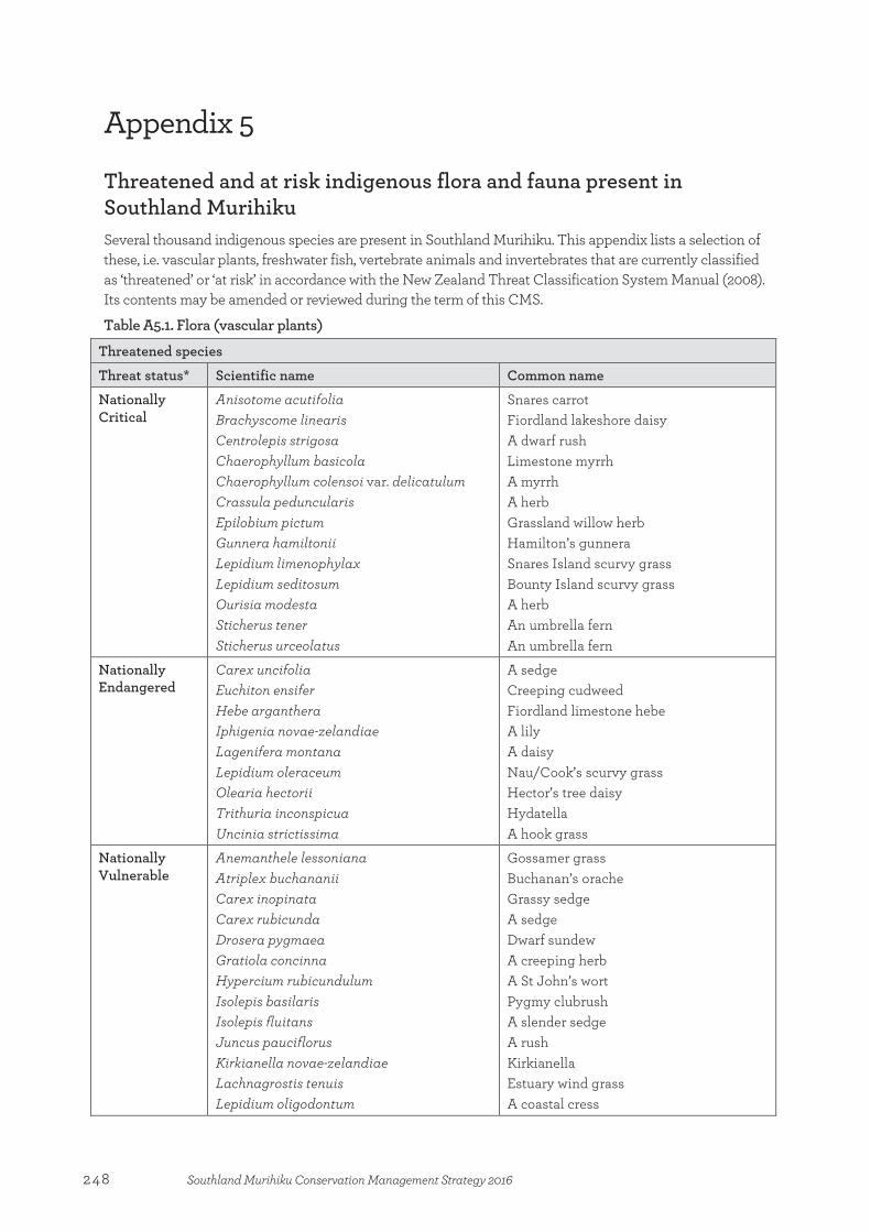
Appendix 5
Threatened and at risk indigenous flora and fauna present in Southland Murihiku Several thousand indigenous species are present in Southland Murihiku. This appendix lists a selection of these, i.e. vascular plants, freshwater fish, vertebrate animals and invertebrates that are currently classified as ‘threatened’ or ‘at risk’ in accordance with the New Zealand Threat Classification System Manual (2008). Its contents may be amended or reviewed during the term of this CMS.
Table A5.1. Flora (vascular plants)
Threatened species
Threat status* Scientific name Common name
Nationally Critical
Anisotome acutifolia Brachyscome linearis Centrolepis strigosa Chaerophyllum basicola Chaerophyllum colensoi var. delicatulum Crassula peduncularis Epilobium pictum Gunnera hamiltonii Lepidium limenophylax Lepidium seditosum Ourisia modesta Sticherus tener Sticherus urceolatus
Snares carrot Fiordland lakeshore daisy A dwarf rush Limestone myrrh A myrrh A herb Grassland willow herb Hamilton’s gunnera Snares Island scurvy grass Bounty Island scurvy grass A herb An umbrella fern An umbrella fern
Nationally Endangered
Carex uncifolia Euchiton ensifer Hebe arganthera Iphigenia novae-zelandiae Lagenifera montana Lepidium oleraceum Olearia hectorii Trithuria inconspicua Uncinia strictissima
A sedge Creeping cudweed Fiordland limestone hebe A lily A daisy Nau/Cook’s scurvy grass Hector’s tree daisy Hydatella A hook grass
Nationally Vulnerable
Anemanthele lessoniana Atriplex buchananii Carex inopinata Carex rubicunda Drosera pygmaea Gratiola concinna Hypercium rubicundulum Isolepis basilaris Isolepis fluitans Juncus pauciflorus Kirkianella novae-zelandiae Lachnagrostis tenuis Lepidium oligodontum
Gossamer grass Buchanan’s orache Grassy sedge A sedge Dwarf sundew A creeping herb A St John’s wort Pygmy clubrush A slender sedge A rush Kirkianella Estuary wind grass A coastal cress
Appendix 5:Threatened and at risk indigenous flora and fauna present in Southland Murihiku
248 Southland Murihiku Conservation Management Strategy 2016

Libertia peregrinans Myosotis brevis Myosotis glauca Olearia fimbriata Pachycladon cheesemanii Pittosporum obcordatum Ranunculus recens Ranunculus ternatifolius Senecio dunedinensis
Creeping iris Annual forget-me-not A forget-me-not Pomahaka tree daisy A cress Heart-leaved kōhūhū A buttercup A buttercup A fireweed
At risk species
Threat status* Scientific name Common name
Declining
Aciphylla subflabellata Alepis flavida Carex litorosa Carex tenuiculmis Carmichaelia uniflora Connorochloa tenuis Coprosma acerosa Coprosma obconica Coprosma pedicellata Coprosma virescens Coprosma wallii Deschampsia cespitosa Euphorbia glauca Ficinia spiralis Geranium sessiliflorum var. arenarium Gunnera arenaria Lepidium tenuicaule Lobelia ionantha Melicytus flexuosus Mentha cunninghamii Myosotis pygmaea Myriophyllum robustum Olearia fragrantissima Olearia lineata Parahebe canescens Peraxilla colensoi Peraxilla tetrapetala Poa billardierei Pterostylis tristis Ranunculus pilifera Raoulia aff. hookerii (AK239529) Sonchus kirkii Teucridium parvifolium Tupeia antarctica Urtica linearifolia Zostera muelleri subsp. novazelandica
A speargrass Yellow-flowered mistletoe Sea sedge A sedge Slender dwarf broom Prostrate blue grass Tātaraheke/sand coprosma A coprosma A coprosma A coprosma Bloodwood Tufted hair grass Waiū-atua/shore spurge Pīngao Southern sand geranium Coastal gunnera A coastal cress Hypsela A shrub Native mint A forget-me-not Stoat water milfoil Fragrant tree daisy Linear leaved tree daisy Tarn speedwell Scarlet mistletoe Pirirangi/red mistletoe Sand tussock An orchid A scree buttercup Coastal mat daisy Pūhā/New Zealand sow thistle A shrub Pirita/white mistletoe Swamp nettle Sea grass
Recovering Stilbocarpa lyallii Pūnui
249Southland Murihiku Conservation Management Strategy 2016

Naturally Uncommon
Abrotanella rostrata Abrotanella rosulata Abrotanella spathulata Acaena microphylla var. pauciglochidiata Acaena minor var. antarctica Acaena minor var. minor Acianthus viridis Aciphylla congesta Aciphylla crosby-smithii Aciphylla lecomtei Aciphylla leighii Aciphylla multisecta Aciphylla spedenii Aciphylla takahea Agrostis subulata Anemone tenuicaulis Anisotome antipoda Anisotome cauticola Anisotome lanuginosa Anisotome latifolia Anisotome lyallii Asplenium scleroprium Botrychium australe Brachyglottis bifistulosa Brachyglottis stewartiae Brachyscome humilis Bulbinella modesta Bulbinella rossii Callitriche antarctica Callitriche aucklandica Cardamine bilobata Cardamine lacustris Cardamine latior Cardamine subcarnosa Cardamine sp. “West Dome” (AK231673) Carex berggrenii Carex capillacea Carex carsei Carex edgariae Carex filamentosa Carex fretalis Carex lachenalii subsp. parkeri Carex pleiostachys Carex pterocarpa Carex sectoides Celmisia sp. aff. discolour (CHR197967) Celmisia hookeri Celmisia inaccessa Celmisia markii
A dwarf daisy A dwarf daisy A dwarf daisy A bidibid A bidibid A bidibid An orchid Fiordland dwarf speargrass Crosby Smith’s speargrass Le Comtes speargrass Darran Mountain speargrass A speargrass Taramea/Eyre Mountains speargrass Fiordland speargrass A grass Native anemone A carrot megaherb A native carrot An alpine carrot A carrot megaherb Coastal carrot A fern Parsley fern A shrub Stewart Island tree daisy A herb Dwarf Māori onion Subantarctic Māori onion A native starwort A native starwort A bitter cress A bitter cress Auckland Island bitter cress Campbell Island bitter cress West Dome bitter cress A sedge A sedge A sedge A sedge A sedge Curly sedge A sedge Fiordland sedge A sedge A sedge A daisy Hooker’s mountain daisy A daisy Mark’s mountain daisy
250 Southland Murihiku Conservation Management Strategy 2016

Celmisia philocremna Celmisia spedenii Celmisia thomsonii Centrolepis minima Chaerophyllum sp. “minute flower” (CHR364086) Chionochloa antarctica Chionochloa crassiuscula subsp. directa Chionochloa nivifera Chionochloa spiralis Chionochloa vireta Chionohebe ciliolata subsp. fiordensis Chionohebe glabra Colobanthus hookeri Coprosma perpusilla subsp. subantarctica Crassula kirkii Crassula ruamahanga Damnamenia vernicosa Deschampsia pusilla Dracophyllum cockayneanum Dracophyllum pearsonii Dracophyllum scoparium Dracophyllum uniflorum var. frondosum Drymoanthus flavus Epilobium confertifolium Epilobium aff. glabellum (CHR387893) Epilobium purpuratum Euchiton paludosus Euchiton polylepis Euphrasia integrifolia Euphrasia repens Gentianella antarctica Gentianella antipoda Gentianella cerina Gentianella concinna Gentianella lineata Geranium microphyllum Geum albiflorum Gingidia baxterae Gingidia ensyii var. ensyii Hebe annulata Hebe benthamii Hebe biggarii Hebe dilatata Hebe pauciflora Hebejeebie trifida Hierochloe brunonis Hymenophyllum atrovirens Hypolepis amaurorachis Juncus scheuchzerioides
A daisy Speden’s mountain daisy Thomson’s mountain daisy A dwarf rush Coastal myrrh Subantarctic snow tussock A snow tussock A snow tussock Fiordland limestone tussock A snow tussock A cushion herb A cushion herb A herb A prostrate coprosma A herb A herb Damnamenia A grass A grass tree A grass tree A grass tree A grass tree Little spotted moa Subantarctic willow herb A willow herb A willow herb A cudweed A cudweed An eyebright An eyebright A gentian A gentian A gentian A gentian A gentian Subantarctic geranium Auckland Island geum Baxter’s aniseed A herb A whipcord hebe Subantarctic hebe Eyre Mountains hebe A hebe A hebe A shrub A holy grass A filmy fern A fern Subantarctic rush
251Southland Murihiku Conservation Management Strategy 2016
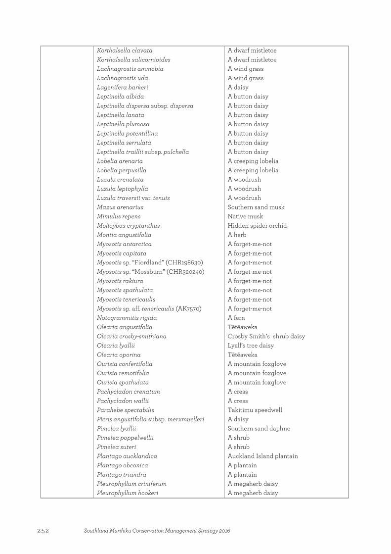
Korthalsella clavata Korthalsella salicornioides Lachnagrostis ammobia Lachnagrostis uda Lagenifera barkeri Leptinella albida Leptinella dispersa subsp. dispersa Leptinella lanata Leptinella plumosa Leptinella potentillina Leptinella serrulata Leptinella traillii subsp. pulchella Lobelia arenaria Lobelia perpusilla Luzula crenulata Luzula leptophylla Luzula traversii var. tenuis Mazus arenarius Mimulus repens Molloybas cryptanthus Montia angustifolia Myosotis antarctica Myosotis capitata Myosotis sp. “Fiordland” (CHR198630) Myosotis sp. “Mossburn” (CHR320240) Myosotis rakiura Myosotis spathulata Myosotis tenericaulis Myosotis sp. aff. tenericaulis (AK7570) Notogrammitis rigida Olearia angustifolia Olearia crosby-smithiana Olearia lyallii Olearia oporina Ourisia confertifolia Ourisia remotifolia Ourisia spathulata Pachycladon crenatum Pachycladon wallii Parahebe spectabilis Picris angustifolia subsp. merxmuelleri Pimelea lyallii Pimelea poppelwellii Pimelea suteri Plantago aucklandica Plantago obconica Plantago triandra Pleurophyllum criniferum Pleurophyllum hookeri
A dwarf mistletoe A dwarf mistletoe A wind grass A wind grass A daisy A button daisy A button daisy A button daisy A button daisy A button daisy A button daisy A button daisy A creeping lobelia A creeping lobelia A woodrush A woodrush A woodrush Southern sand musk Native musk Hidden spider orchid A herb A forget-me-not A forget-me-not A forget-me-not A forget-me-not A forget-me-not A forget-me-not A forget-me-not A forget-me-not A fern Tētēaweka Crosby Smith’s shrub daisy Lyall’s tree daisy Tētēaweka A mountain foxglove A mountain foxglove A mountain foxglove A cress A cress Takitimu speedwell A daisy Southern sand daphne A shrub A shrub Auckland Island plantain A plantain A plantain A megaherb daisy A megaherb daisy
252 Southland Murihiku Conservation Management Strategy 2016

Pleurophyllum speciosum Poa antipoda Poa aucklandica subsp. aucklandica Poa aucklandica subsp. campbellensis Poa foliosa Poa incrassata Poa ramosissima Poa senex Poa tennantiana Polyphlebium colensoi Pseudopanax ferox Puccinellia antipoda Puccinellia walkeri Ranunculus maculatus Ranunculus pinguis Ranunculus ranceorum Ranunculus scrithalis Ranunculus subscaposus Raoulia hectorii var. mollis Schizeilema exiguum Schizeilema reniforme Senecio carnosulus Senecio radiolatus subsp. antipodus Sprengelia incarnata Stellaria decipiens var. angustata Stellaria decipiens var. decipiens Stenostachys laevis Stilbocarpa polaris Stilbocarpa robusta Tetragonia tetragonoides Thelymitra formosa Uncinia aucklandica Uncinia elegans Uncinia hookeri Uncinia longifructus Uncinia obtusifolia Uncinia purpurata Uncinia viridis Urtica aspera Wahlenbergia congesta Zotovia acicularis
A megaherb daisy A grass A grass A grass A grass A grass A grass A grass A grass A filmy fern Fierce lancewood Antipodes Island saltgrass Walkers saltgrass A buttercup A buttercup A buttercup A buttercup A buttercup A mat daisy A herb A herb A groundsel A groundsel A shrub A chickweed A chickweed A grass A megaherb A megaherb Native spinach A sun orchid A hook grass A hook grass A hook grass A hook grass A hook grass A hook grass A hook grass A nettle A harebell A grass
* Threat status may change over time.
253Southland Murihiku Conservation Management Strategy 2016
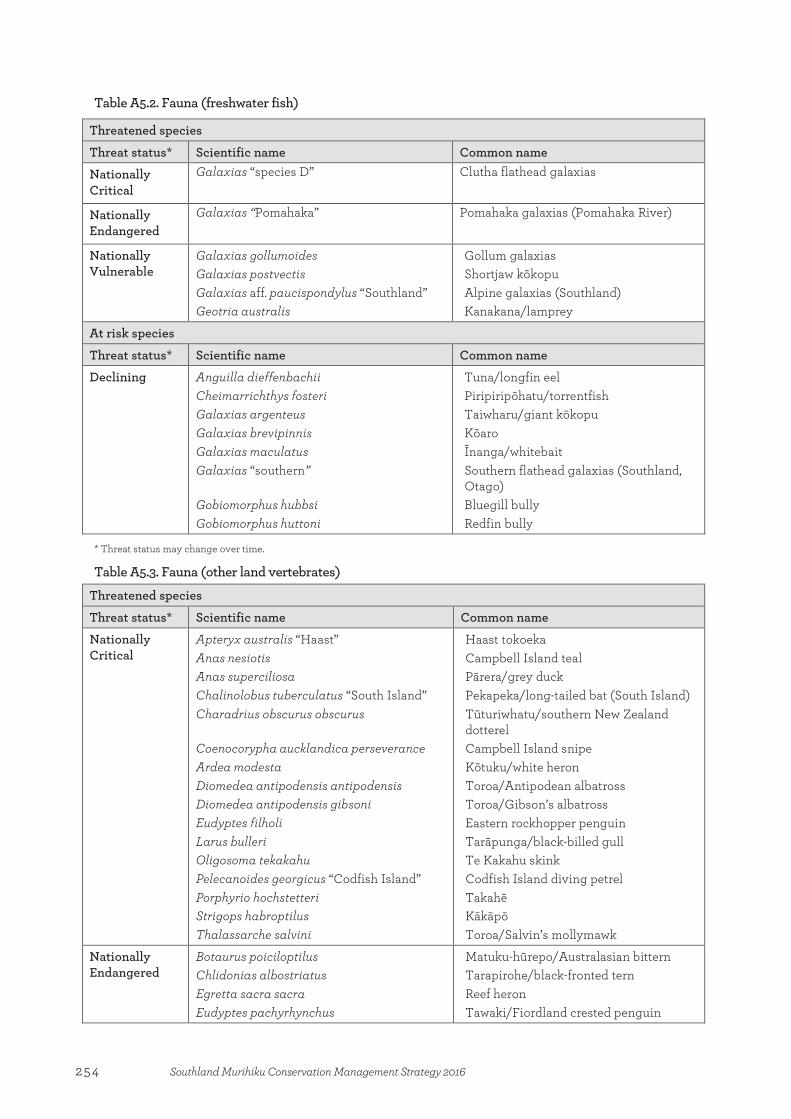
Table A5.2. Fauna (freshwater fish)
Threatened species
Threat status* Scientific name Common name
Nationally Critical
Galaxias “species D” Clutha flathead galaxias
Nationally Endangered
Galaxias “Pomahaka”
Pomahaka galaxias (Pomahaka River)
Nationally Vulnerable
Galaxias gollumoides Galaxias postvectis Galaxias aff. paucispondylus “Southland” Geotria australis
Gollum galaxias Shortjaw kōkopu Alpine galaxias (Southland) Kanakana/lamprey
At risk species
Threat status* Scientific name Common name
Declining Anguilla dieffenbachii Cheimarrichthys fosteri Galaxias argenteus Galaxias brevipinnis Galaxias maculatus Galaxias “southern” Gobiomorphus hubbsi Gobiomorphus huttoni
Tuna/longfin eel Piripiripōhatu/torrentfish Taiwharu/giant kōkopu Kōaro Īnanga/whitebait Southern flathead galaxias (Southland, Otago) Bluegill bully Redfin bully
* Threat status may change over time.
Table A5.3. Fauna (other land vertebrates)
Threatened species
Threat status* Scientific name Common name
Nationally Critical
Apteryx australis “Haast” Anas nesiotis Anas superciliosa Chalinolobus tuberculatus “South Island” Charadrius obscurus obscurus Coenocorypha aucklandica perseverance Ardea modesta Diomedea antipodensis antipodensis Diomedea antipodensis gibsoni Eudyptes filholi Larus bulleri Oligosoma tekakahu Pelecanoides georgicus “Codfish Island” Porphyrio hochstetteri Strigops habroptilus Thalassarche salvini
Haast tokoeka Campbell Island teal Pārera/grey duck Pekapeka/long-tailed bat (South Island) Tūturiwhatu/southern New Zealand dotterel Campbell Island snipe Kōtuku/white heron Toroa/Antipodean albatross Toroa/Gibson’s albatross Eastern rockhopper penguin Tarāpunga/black-billed gull Te Kakahu skink Codfish Island diving petrel Takahē Kākāpō Toroa/Salvin’s mollymawk
Nationally Endangered
Botaurus poiciloptilus Chlidonias albostriatus Egretta sacra sacra Eudyptes pachyrhynchus
Matuku-hūrepo/Australasian bittern Tarapirohe/black-fronted tern Reef heron Tawaki/Fiordland crested penguin
254 Southland Murihiku Conservation Management Strategy 2016
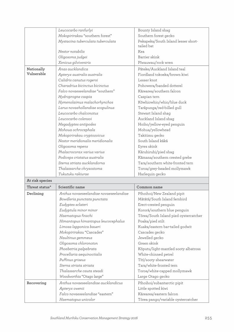
Leucocarbo ranfurlyi Mokopirirakau “southern forest” Mystacina tuberculata tuberculata Nestor notabilis Oligosoma judgei Xenicus gilviventris
Bounty Island shag Southern forest gecko Pekapeka/South Island lesser short-tailed bat Kea Barrier skink Pīwauwau/rock wren
Nationally Vulnerable
Anas aucklandica Apteryx australis australis Calidris canutus rogersi Charadrius bicinctus bicinctus Falco novaeseelandiae “southern” Hydroprogne caspia Hymenolaimus malachorhynchos Larus novaehollandiae scopulinus Leucocarbo chalconotus Leucocarbo colensoi Megadyptes antipodes Mohoua ochrocephala Mokopirirakau cryptozoicus Nestor meridionalis meridionalis Oligosoma repens Phalacrocorax varius varius Podiceps cristatus australis Sterna striata aucklandorna Thalassarche chrysostoma Tukutuku rakiurae
Pāteke/Auckland Island teal Fiordland tokoeka/brown kiwi Lesser knot Pohowera/banded dotterel Kārearea/southern falcon Caspian tern Kōwhiowhio/whio/blue duck Tarāpunga/red-billed gull Stewart Island shag Auckland Island shag Hoiho/yellow-eyed penguin Mohua/yellowhead Takitimu gecko South Island kākā Eyres skink Kāruhiruhi/pied shag Kāmana/southern crested grebe Tara/southern white-fronted tern Toroa/grey-headed mollymawk Harlequin gecko
At risk species
Threat status* Scientific name Common name
Declining Anthus novaeseelandiae novaeseelandiae Bowdleria punctata punctata Eudyptes sclateri Eudyptula minor minor Haematopus finschi Himantopus himantopus leucocephalus Limosa lapponica baueri Mokopirirakau “Cascades” Naultinus gemmeus Oligosoma chloronoton Phoebetria palpebrata Procellaria aequinoctialis Puffinus griseus Sterna striata striata Thalassarche cauta steadi Woodworthia “Otago large”
Pīhoihoi/New Zealand pipit Mātātā/South Island fernbird Erect-crested penguin Kororā/southern blue penguin Tōrea/South Island pied oystercatcher Poaka/pied stilt Kuaka/eastern bar-tailed godwit Cascades gecko Jewelled gecko Green skink Kōputu/light-mantled sooty albatross White-chinned petrel Tītī/sooty shearwater Tara/white-fronted tern Toroa/white-capped mollymawk Large Otago gecko
Recovering Anthus novaeseelandiae aucklandicus Apteryx owenii Falco novaeseelandiae “eastern” Haematopus unicolor
Pīhoihoi/subantarctic pipit Little spotted kiwi Kārearea/eastern falcon Tōrea pango/variable oystercatcher
255Southland Murihiku Conservation Management Strategy 2016
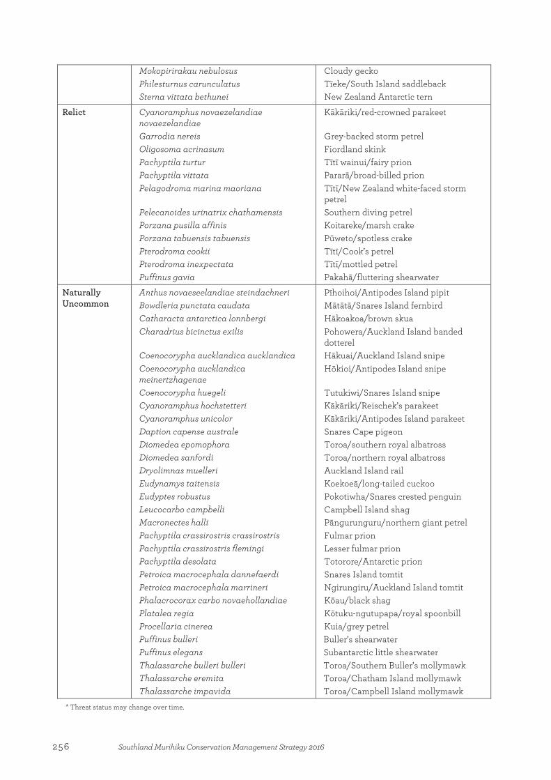
Mokopirirakau nebulosus Philesturnus carunculatus Sterna vittata bethunei
Cloudy gecko Tīeke/South Island saddleback New Zealand Antarctic tern
Relict Cyanoramphus novaezelandiae novaezelandiae Garrodia nereis Oligosoma acrinasum Pachyptila turtur Pachyptila vittata Pelagodroma marina maoriana Pelecanoides urinatrix chathamensis Porzana pusilla affinis Porzana tabuensis tabuensis Pterodroma cookii Pterodroma inexpectata Puffinus gavia
Kākāriki/red-crowned parakeet Grey-backed storm petrel Fiordland skink Tītī wainui/fairy prion Pararā/broad-billed prion Tītī/New Zealand white-faced storm petrel Southern diving petrel Koitareke/marsh crake Pūweto/spotless crake Tītī/Cook’s petrel Tītī/mottled petrel Pakahā/fluttering shearwater
Naturally Uncommon
Anthus novaeseelandiae steindachneri Bowdleria punctata caudata Catharacta antarctica lonnbergi Charadrius bicinctus exilis Coenocorypha aucklandica aucklandica Coenocorypha aucklandica meinertzhagenae Coenocorypha huegeli Cyanoramphus hochstetteri Cyanoramphus unicolor Daption capense australe Diomedea epomophora Diomedea sanfordi Dryolimnas muelleri Eudynamys taitensis Eudyptes robustus Leucocarbo campbelli Macronectes halli Pachyptila crassirostris crassirostris Pachyptila crassirostris flemingi Pachyptila desolata Petroica macrocephala dannefaerdi Petroica macrocephala marrineri Phalacrocorax carbo novaehollandiae Platalea regia Procellaria cinerea Puffinus bulleri Puffinus elegans Thalassarche bulleri bulleri Thalassarche eremita Thalassarche impavida
Pīhoihoi/Antipodes Island pipit Mātātā/Snares Island fernbird Hākoakoa/brown skua Pohowera/Auckland Island banded dotterel Hākuai/Auckland Island snipe Hōkioi/Antipodes Island snipe Tutukiwi/Snares Island snipe Kākāriki/Reischek’s parakeet Kākāriki/Antipodes Island parakeet Snares Cape pigeon Toroa/southern royal albatross Toroa/northern royal albatross Auckland Island rail Koekoeā/long-tailed cuckoo Pokotiwha/Snares crested penguin Campbell Island shag Pāngurunguru/northern giant petrel Fulmar prion Lesser fulmar prion Totorore/Antarctic prion Snares Island tomtit Ngirungiru/Auckland Island tomtit Kōau/black shag Kōtuku-ngutupapa/royal spoonbill Kuia/grey petrel Buller’s shearwater Subantarctic little shearwater Toroa/Southern Buller’s mollymawk Toroa/Chatham Island mollymawk Toroa/Campbell Island mollymawk
* Threat status may change over time.
256 Southland Murihiku Conservation Management Strategy 2016

Table A5.4. Fauna (invertebrates)
Threatened species
Threat status* Scientific name Common name
Nationally Critical
Asaphodes imperfecta (Philpott, 1905) Charopidae sp. 30 (NMNZ M.078966) Charopidae sp. 65 (NMNZ M.078965) Charopidae sp. 130 (NMNZ M.127912) Lyperobius nesidiotes Kuschel† Mecodema laeviceps Broun, 1904† Notoreas edwardsi Patrick & Hoare, 2010 Paradoxaphis aristoteliae Sunde, 1987 Pseudhelops antipodensis Watt, 1971 Sigaus homerensis Morris, 2003
A moth A microsnail A microsnail A microsnail Broughton Island weevil Ida Valley carabid beetle A moth An aphid A beetle Alpine grasshopper
Nationally Endangered
Asaphodes frivola (Meyrick, 1913) Maoricrambus oncobolus (Meyrick, 1885) Meterana “Foveaux Strait”
A moth A moth A moth
Nationally Vulnerable
Arctesthes sp. “Von” Asaphodes stinaria (Guenée, 1868) Cephalissa siria Meyrick, 1884 Declana toreuta, grey populations Guntheria (Derrickiella) apteryxi Loomis & Goff 1983 Ixodes anatis Chilton 1904 Kiwialges palametrichus Gaud & Atyeo 1979 Kiwialges phalagotrichus Gaud & Atyeo 1970 Kiwilichus cryptosikyus Gaud & Atyeo 1970 Kiwilichus delosikyus Gaud & Atyeo 1970 Maoritenes sp. “Olearia” Orthoclydon pseudostinaria (Hudson, 1918) Pasiphila sp. “Olearia” Protosynaema sp. “Olearia” Pseudhelops clandestinus Watt, 1971 Stathmopoda cf. albimaculata Philpott, 1931 Xanthorhoe frigida Howes, 1946
A moth A moth A moth A moth A feather mite A feather mite A feather mite A feather mite
A feather mite A feather mite A moth A moth A moth A moth A beetle A moth A moth
At risk species‡
Threat status* Scientific name Common name
Relict Deinacrida carinata Salmon 1950 Pianoa isolata Forster 1987
Herekopare giant wētā Piano Flat spider
Naturally Uncommon
Bountya insularis Townsend 1971 Ischyroplectron isolatum (Hutton 1895) Ooperipatellus nanus Ruhberg 1977
A flightless beetle Bounty Island wētā Ngaokeoke/perapitus, velvet worm
* Threat status may change over time. † These species are also recognised as animals in Schedule 7 of the Wildlife Act 1953. ‡ These are only some of the at risk invertebrate species found in Southland Murihiku.
257Southland Murihiku Conservation Management Strategy 2016
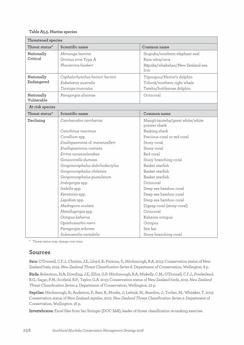
Table A5.5. Marine species
Threatened species
Threat status* Scientific name Common name
Nationally Critical
Mirounga leonina Orcinus orca Type A Phocarctos hookeri
Ihupuku/southern elephant seal Kera wēra/orca Rāpoka/whakahao/New Zealand sea lion
Nationally Endangered
Cephalorhynchus hectori hectori Eubalaena australis Tursiops truncatus
Tūpoupou/Hector’s dolphin Tohorā/southern right whale Terehu/bottlenose dolphin
Nationally Vulnerable
Paragorgia alisonae Octocoral
At risk species
Threat status* Scientific name Common name
Declining Carcharodon carcharias Cetorhinus maximus Corallium spp. Enallopsammia cf. maranzelleri Enallopsammia rostrata Errina novaezelandiae Goniocorella dumosa Gorgonocephalus dolichodactylus Gorgonocephalus chilensis Gorgonocephalus pustulatum Iridogorgia spp. Isidella spp. Keratoisis spp. Lepidisis spp. Madrepora oculata Metallogorgia spp. Octopus kaharoa Opisthoteuthis mero Paragorgia arborea Solenosmilia variabilis
Mangō-taniwha/great white/white pointer shark Basking shark Precious coral or red coral Stony coral Stony coral Red coral Stony branching coral Basket starfish Basket starfish Basket starfish Octocoral Deep sea bamboo coral Deep sea bamboo coral Deep sea bamboo coral Zigzag coral (stony coral) Octocoral Kaharoa octopus Octopus Sea fan Stony branching coral
* Threat status may change over time.
Sources Bats: O’Donnell, C.F.J.; Christie, J.E.; Lloyd, B.; Parsons, S.; Hitchmough, R.A. 2013: Conservation status of New Zealand bats, 2012. New Zealand Threat Classification Series 6. Department of Conservation, Wellington. 8 p.
Birds: Robertson, H.A; Dowding, J.E.; Elliot, G.P; Hitchmough, R.A; Miskelly, C.M.; O’Donnell, C.F.J.; Powlesland, R.G.; Sagar, P.M.; Scofield, R.P.; Taylor, G.A. 2013: Conservation status of New Zealand birds, 2012. New Zealand Threat Classification Series 4. Department of Conservation, Wellington. 22 p.
Reptiles: Hitchmough, R.; Anderson, P.; Barr, B.; Monks, J.; Lettink, M.; Reardon, J.; Tocher, M.; Whitaker, T. 2013: Conservation status of New Zealand reptiles, 2012. New Zealand Threat Classification Series 2. Department of Conservation, Wellington. 16 p.
Invertebrates: Excel files from Ian Stringer (DOC S&R), leader of threat classification re-ranking exercise.
258 Southland Murihiku Conservation Management Strategy 2016
Fish: Goodman, J.M.; Dunn, N.R.; Ravenscroft, P.J.; Boubee, J.A.T.; David, B.O.; Griffiths, M.; Nicholas Ling, N.; Hitchmough, R.A.; Rolfe, J.R. 2014: Conservation status of New Zealand freshwater fish, 2013. New Zealand Threat Classification Series 7. Department of Conservation, Wellington. 12 p.
Vascular plants: de Lange, P.J.; Rolfe, J.R.; Champion, P.D.; Courtney, S.P.; Heenan, P.B; Barkla, J.W.; Cameron, E.K.; Norton, D.A; Hitchmough, R.A. 2013: Conservation status of New Zealand indigenous vascular plants, 2012. New Zealand Threat Classification Series 3. Department of Conservation, Wellington. 70 p.
259Southland Murihiku Conservation Management Strategy 2016
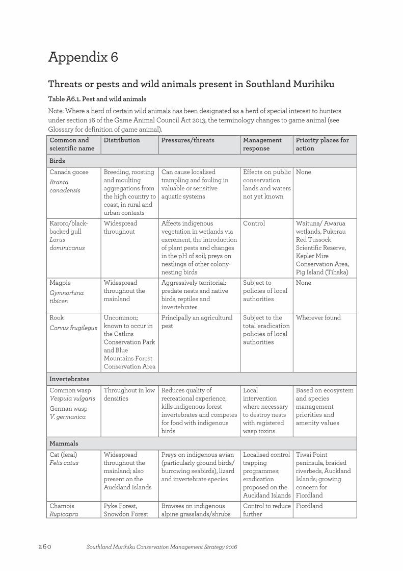
Appendix 6
Threats or pests and wild animals present in Southland Murihiku Table A6.1. Pest and wild animals
Note: Where a herd of certain wild animals has been designated as a herd of special interest to hunters under section 16 of the Game Animal Council Act 2013, the terminology changes to game animal (see Glossary for definition of game animal). Common and scientific name
Distribution Pressures/threats Management response
Priority places for action
Birds
Canada goose Branta canadensis
Breeding, roosting and moulting aggregations from the high country to coast, in rural and urban contexts
Can cause localised trampling and fouling in valuable or sensitive aquatic systems
Effects on public conservation lands and waters not yet known
None
Karoro/black-backed gull Larus dominicanus
Widespread throughout
Affects indigenous vegetation in wetlands via excrement, the introduction of plant pests and changes in the pH of soil; preys on nestlings of other colony-nesting birds
Control Waituna/ Awarua wetlands, Pukerau Red Tussock Scientific Reserve, Kepler Mire Conservation Area, Pig Island (Tīhaka)
Magpie Gymnorhina tibicen
Widespread throughout the mainland
Aggressively territorial; predate nests and native birds, reptiles and invertebrates
Subject to policies of local authorities
None
Rook Corvus frugilegus
Uncommon; known to occur in the Catlins Conservation Park and Blue Mountains Forest Conservation Area
Principally an agricultural pest
Subject to the total eradication policies of local authorities
Wherever found
Invertebrates
Common wasp Vespula vulgaris German wasp V. germanica
Throughout in low densities
Reduces quality of recreational experience, kills indigenous forest invertebrates and competes for food with indigenous birds
Local intervention where necessary to destroy nests with registered wasp toxins
Based on ecosystem and species management priorities and amenity values
Mammals
Cat (feral) Felis catus
Widespread throughout the mainland; also present on the Auckland Islands
Preys on indigenous avian (particularly ground birds/ burrowing seabirds), lizard and invertebrate species
Localised control trapping programmes; eradication proposed on the Auckland Islands
Tiwai Point peninsula, braided riverbeds, Auckland Islands; growing concern for Fiordland
Chamois Rupicapra
Pyke Forest, Snowdon Forest
Browses on indigenous alpine grasslands/shrubs
Control to reduce further
Fiordland
Appendix 6:Threats or pests and wild animals present in Southland Murihiku
260 Southland Murihiku Conservation Management Strategy 2016

Common and scientific name
Distribution Pressures/threats Management response
Priority places for action
rupicapra and Mavora Park conservation areas, Eyre and Garvie mountains; scattered low density through much of Fiordland National Park
and herbs colonisation into Fiordland, in association with Otago, as per the National Chamois Control Plan (draft); investigate options of using Judas chamois
Dog (feral and domestic) Canis lupus familiaris
Occasional wild or stray, or accompanying visitors
Predation and disturbance of ground-nesting birds, bird colonies, resting seabirds and seals
Define dog-accessible areas, exclude from national parks, may require permit-only entry and bird aversion training, public education
Based on ecosystem and species management priorities and areas where dogs not permitted by legislation or bylaws
Fallow deer Dama dama
Blue Mountains Recreational Hunting Area, Mid Dome, Waikawa, Hokonui Forest, Glenure and Caroline Bush; spreading rapidly due to illegal releases
Prevents regeneration of indigenous plants; particularly subcanopy species, e.g. broadleaf (Griselinia littoralis)
Control through ground shooting and the fostering of recreational hunting
Based on ecosystem and species management priorities and amenity values
Ferret Mustela putorius furo
Low densities throughout the mainland, especially in mosaic of farmland and forest patches
Poses a serious threat to indigenous avian, reptile and invertebrate species
Localised control trapping programmes; by-kill when trapping for cats
Tiwai Point peninsula, braided riverbeds
Goat (feral) Capra hircus
Waikawa Forest, Flagstaff Reserve, Croydon Bush Scenic Reserve, Caroline Bush, Glenure Reserve, The Cone Forest and Mataura Range, Eyre Mountains
Browses on a range of indigenous vegetation and reduces natural regeneration
Manage in accordance with the Southland Goat Control Plan
Based on ecosystem and species management priorities and amenity values
Hare Lepus capensis
Widespread in Southland especially in alpine, subalpine and coastal dune areas
Browsing pressure which reduces plant growth and inhibits regeneration in valued habitats; prey of harmful mammalian predators such as cats and mustelids
Control by shooting
Based on ecosystem and species management priorities and amenity values
Hedgehog Erinaceus
Widespread throughout the
Preys on indigenous ground-nesting birds,
Localised control Based on ecosystem and species
261Southland Murihiku Conservation Management Strategy 2016
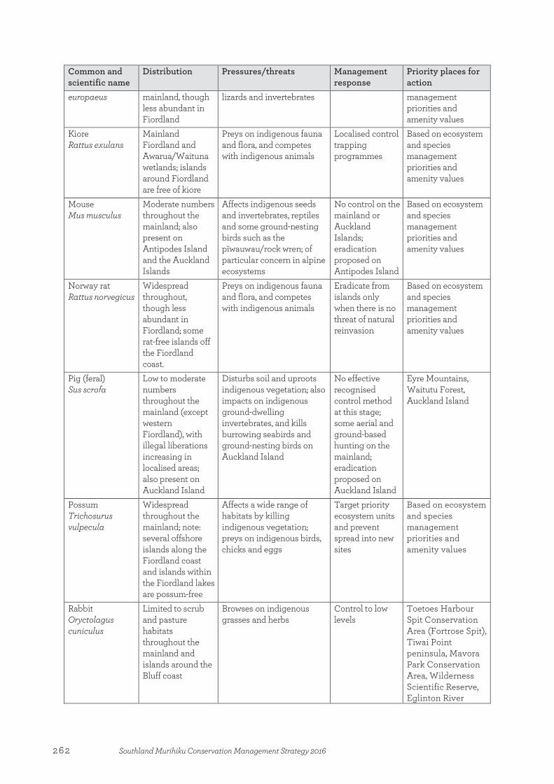
Common and scientific name
Distribution Pressures/threats Management response
Priority places for action
europaeus mainland, though less abundant in Fiordland
lizards and invertebrates management priorities and amenity values
Kiore Rattus exulans
Mainland Fiordland and Awarua/Waituna wetlands; islands around Fiordland are free of kiore
Preys on indigenous fauna and flora, and competes with indigenous animals
Localised control trapping programmes
Based on ecosystem and species management priorities and amenity values
Mouse Mus musculus
Moderate numbers throughout the mainland; also present on Antipodes Island and the Auckland Islands
Affects indigenous seeds and invertebrates, reptiles and some ground-nesting birds such as the pīwauwau/rock wren; of particular concern in alpine ecosystems
No control on the mainland or Auckland Islands; eradication proposed on Antipodes Island
Based on ecosystem and species management priorities and amenity values
Norway rat Rattus norvegicus
Widespread throughout, though less abundant in Fiordland; some rat-free islands off the Fiordland coast.
Preys on indigenous fauna and flora, and competes with indigenous animals
Eradicate from islands only when there is no threat of natural reinvasion
Based on ecosystem and species management priorities and amenity values
Pig (feral) Sus scrofa
Low to moderate numbers throughout the mainland (except western Fiordland), with illegal liberations increasing in localised areas; also present on Auckland Island
Disturbs soil and uproots indigenous vegetation; also impacts on indigenous ground-dwelling invertebrates, and kills burrowing seabirds and ground-nesting birds on Auckland Island
No effective recognised control method at this stage; some aerial and ground-based hunting on the mainland; eradication proposed on Auckland Island
Eyre Mountains, Waitutu Forest, Auckland Island
Possum Trichosurus vulpecula
Widespread throughout the mainland; note: several offshore islands along the Fiordland coast and islands within the Fiordland lakes are possum-free
Affects a wide range of habitats by killing indigenous vegetation; preys on indigenous birds, chicks and eggs
Target priority ecosystem units and prevent spread into new sites
Based on ecosystem and species management priorities and amenity values
Rabbit Oryctolagus cuniculus
Limited to scrub and pasture habitats throughout the mainland and islands around the Bluff coast
Browses on indigenous grasses and herbs
Control to low levels
Toetoes Harbour Spit Conservation Area (Fortrose Spit), Tiwai Point peninsula, Mavora Park Conservation Area, Wilderness Scientific Reserve, Eglinton River
262 Southland Murihiku Conservation Management Strategy 2016
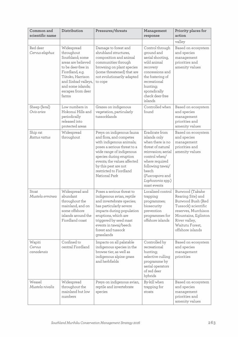
Common and scientific name
Distribution Pressures/threats Management response
Priority places for action valley
Red deer Cervus elaphus
Widespread throughout Southland; some areas are believed to be deer-free in Fiordland, e.g. Tūtoko, Harrison and Sinbad valleys, and some islands; escapes from deer farms
Damage to forest and shrubland structures, composition and animal communities through browsing on plant species (some threatened) that are not evolutionarily adapted to cope
Control through ground and aerial shooting, wild animal recovery concessions and the fostering of recreational hunting; sporadically check deer-free islands
Based on ecosystem and species management priorities and amenity values
Sheep (feral) Ovis aries
Low numbers in Hokonui Hills and periodically released into protected areas
Grazes on indigenous vegetation, particularly tussocklands
Controlled when found
Based on ecosystem and species management priorities and amenity values
Ship rat Rattus rattus
Widespread throughout
Preys on indigenous fauna and flora, and competes with indigenous animals; poses a serious threat to a wide range of indigenous species during eruption events; the values affected by this pest are not restricted to Fiordland National Park
Eradicate from islands only when there is no threat of natural reinvasion; aerial control when/ where required following tawai/ beech (Fuscospora and Lophozonia spp.) mast events
Based on ecosystem and species management priorities and amenity values
Stoat Mustela erminea
Widespread and abundant throughout the mainland, and on some offshore islands around the Fiordland coast
Poses a serious threat to indigenous avian, reptile and invertebrate species; has particularly severe impacts during population eruptions, which are triggered by seed mast events in tawai/beech forest and tussock grasslands
Localised control trapping programmes; biosecurity prevention programmes for offshore islands
Burwood (Takahe Rearing Site) and Burwood Bush (Red Tussock) scientific reserves, Murchison Mountains, Eglinton River valley, Waitutu Forest, offshore islands
Wapiti Cervus canadensis
Confined to central Fiordland
Impacts on all palatable indigenous species in the browse tier, as well as indigenous alpine grass and herbfields
Controlled by recreational hunting; selective culling programme by aerial operators of red deer hybrids
Based on ecosystem and species management priorities
Weasel Mustela nivalis
Widespread throughout the mainland but low numbers
Preys on indigenous avian, reptile and invertebrate species
By-kill when trapping for stoats
Based on ecosystem and species management priorities and amenity values
263Southland Murihiku Conservation Management Strategy 2016

Table A6.2. Pest plants
Climbers Common and scientific name
Distribution Pressures/threats Management response
Priority places for action
Blackberry Rubus fruticosus
Widespread on the mainland
Outcompetes and displaces indigenous plants by inhibiting regeneration
Target priority ecosystem units and prevent spread into new sites
Forest Hill Scenic Reserve, Dunsdale, Waituna/Awarua wetlands, Borland Road, Arthur River valley, Clinton River valley, Blue Mountains, Dunearn Scientific Reserve, Bayswater Peatland Scenic Reserve
Chilean flame creeper Tropaeolum speciosum
Localised populations on the mainland
Smothers and displaces indigenous species
Target priority ecosystem units and prevent spread into new sites
Croydon Bush Scenic Reserve, Blue Mountains, Piano Flat
Climbing Bomerea Bomarea caldasii
Localised polulations on the mainland
Smothers and kills all plants to highest canopy and prevents recruitment
Contain existing sites and prevent establishment
Based on ecosystem and species management priorities
German Ivy Senecio mikanioides
Isolated populations on the mainland
Smothers small trees and lower vegetation preventing recruitment; it often enables the establishment of more aggressive vine species
Eradication or control
Based on ecosystem and species management priorities
Japanese honeysuckle Lonicera japonica
Localised populations on the mainland
Outcompetes and displaces indigenous plants by inhibiting regeneration
Target priority ecosystem units and prevent spread into new sites
Piano Flat, Port Craig, Waituna, Glade House
Old man’s beard Clematis vitalba
Localised populations on the mainland
Smothers and displaces indigenous species
Eradication or control
Blue Mountains, Southland plains, east of Lake Te Anau
Oriental clematis Clematis tangutica
Localised populations on the mainland
Smothers and kills all plants to highest canopy and prevents recruitment
Eradication or control
Blue Mountains
Smilax Asparagus asparagoides
Isolated populations on the mainland
Effects are limited in extent or temporary
Eradication or control
Based on ecosystem and species management priorities
Grasses, rushes and sedges Common and scientific name
Distribution Pressures/threats Management response
Priority places for action
Annual poa Poa annua
Widespread on the mainland; present on all
Can form dense masses on disturbed ground
One of only two introduced plants on Snares
Snares Islands/Tini Heke
264 Southland Murihiku Conservation Management Strategy 2016
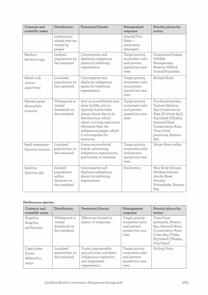
Common and scientific name
Distribution Pressures/threats Management response
Priority places for action
subantarctic islands that are visited by people
Islands/Tini Heke —eradication attempted
Bamboo Bambusa spp.
Isolated populations on the mainland
Outcompetes and displaces indigenous plants by inhibiting regeneration
Target priority ecosystem units and prevent spread into new sites
Drummond Swamp Wildlife Management Reserve, Milford Sound/Piopiotahi
Heath rush Juncus squarrosus
Localised populations on the mainland
Outcompetes and displaces indigenous plants by inhibiting regeneration
Target priority ecosystem units and prevent spread into new sites
Borland Road
Marram grass Ammophila arenaria
Widespread in coastal dunelands on the mainland
Acts as a sand-binder and dune builder, and so typically builds taller, denser dunes due to its leaf structure, which allows it to trap sand more efficiently than the indigenous pīngao, which it outcompetes for resources
Target priority ecosystem units and prevent spread into new sites
Fiordland beaches, Toetoes Harbour Spit Conservation Area (Fortrose Spit), Pig Island (Tīhaka), Seaward Moss Conservation Area, Tiwai Point peninsula, Awarua Bay
Reed sweetgrass Glyceria maxima
Localised populations on the mainland
Forms monocultural stands, preventing indigenous regeneration, particularly in wetlands
Target priority ecosystem units and prevent spread into new sites
Waiau River valley
Spartina Spartina spp.
Isolated populations within estuaries on the mainland
Outcompetes and displaces indigenous plants by inhibiting regeneration
Eradication New River Estuary, Haldane Estuary, Jacobs River Estuary, Waimahaka, Awarua Bay
Herbaceous species
Common and scientific name
Distribution Pressures/threats Management response
Priority places for action
Angelica Angelica pachycarpa
Widespread in coastal dunelands on the mainland
Effects are limited in extent or temporary
Target priority ecosystem units and prevent spread into new sites
Tiwai Point peninsula, Awarua Bay, Seaward Moss Conservation Area, Colac Bay/Ōraka, Pig Island (Tīhaka), Dog Island
Cape honey flower Melianthus major
Localised populations on the mainland
Forms impenetrable ground cover, smothers indigenous vegetation and suppresses regeneration
Target priority ecosystem units and prevent spread into new sites
Stirling Point
265Southland Murihiku Conservation Management Strategy 2016

Chickweed Stellaria media
Widespread on the mainland; present on subantarctic islands—Snares Islands/Tini Heke, Antipodes Island Group, Auckland Islands and Campbell Islands
Can form dense masses on disturbed ground
One of only two introduced plants on Snares Islands/Tini Heke —eradication attempted
Snares Islands/Tini Heke
Ice plant Carpobrotus edulis
Isolated populations on the mainland
Smothers and displaces indigenous species
Target priority ecosystem units and prevent spread into new sites
Sandy Point
Mouse-eared hawkweed Hieracium pilosella
Widespread on mainland
Invasive threat to biodiversity values, particularly in depleted tussocklands that have been modified from their natural state
No plan to carry out widespread control
Dune systems throughout mainland Southland, disturbed high country areas
Nodding thistle Carduus nutans
Isolated populations on mainland
Out-competes and displaces native plants by inhibiting regeneration
Target priority ecosystem units and prevent spread into new sites
Based on ecosystem and species management priorities
Orange hawkweed Hieracium auranticum subsp. carpathicola
Localised populations on mainland
Invasive threat to biodiversity values, particularly in depleted tussocklands that have been modified from their natural state
No plan to carry out control work
Piano Flat, Blue Mountains Forest Conservation Area
Ragwort Jacobea vulgaris
Widespread on the mainland
Outcompetes and displaces indigenous plants by inhibiting regeneration
Target priority ecosystem units and prevent spread into new sites
Eyre Mountains, Grebe River valley, Borland Road
Stonecrop Sedum acre
Isolated populations on the mainland
Outcompetes and displaces indigenous plants by inhibiting regeneration
Target priority ecosystem units and prevent spread into new sites
Mid Dome, Blue Mountains
Tussock hawkweed
Hieracium lepidulum
Localised populations on mainland
Invasive threat to biodiversity values, particularly in depleted tussocklands that have been modified from their natural state
No plan to carry out control work
Mid Dome, Piano Flat, Blue Mountains Forest Conservation Area
266 Southland Murihiku Conservation Management Strategy 2016
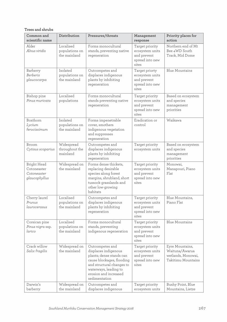
Trees and shrubs Common and scientific name
Distribution Pressures/threats Management response
Priority places for action
Alder Alnus viridis
Localised populations on the mainland
Forms monocultural stands, preventing native regeneration
Target priority ecosystem units and prevent spread into new sites
Northern end of Mt Bee 4WD South Track, Mid Dome
Barberry Berberis glaucocarpa
Isolated populations on the mainland
Outcompetes and displaces indigenous plants by inhibiting regeneration
Target priorty ecosystem units and prevent spread into new sites
Blue Mountains
Bishop pine Pinus muricata
Localised populations
Forms monocultural stands preventing native regeneration
Target priority ecosystem units and prevent spread into new sites
Based on ecosystem and species management priorities
Boxthorn Lycium ferocissimum
Isolated populations on the mainland
Forms impenetrable cover, smothers indigenous vegetation and suppresses regeneration
Eradication or control
Waikawa
Broom Cytisus scoparius
Widespread throughout the mainland
Outcompetes and displaces indigenous plants by inhibiting regeneration
Target priority ecosystem units
Based on ecosystem and species management priorities
Bright Head Cotoneaster Cotoneaster glaucophyllus
Widespread on the mainland
Forms dense thickets, replacing desirable species along forest margins, shrubland, short tussock grasslands and other low-growing habitats
Target priority ecosystem units and prevent spread into new sites
Monowai, Manapouri, Piano Flat
Cherry laurel Prunus laurocerasus
Localised populations on the mainland
Outcompetes and displaces indigenous plants by inhibiting regeneration
Target priority ecosystem units and prevent spread into new sites
Blue Mountains, Piano Flat
Corsican pine Pinus nigra ssp. larico
Localised populations on the mainland
Forms monocultural stands, preventing indigenous regeneration
Target priority ecosystem units and prevent spread into new sites
Blue Mountains
Crack willow Salix fragilis
Widespread on the mainland
Outcompetes and displaces indigenous plants; dense stands can cause blockages, flooding and structural changes to waterways, leading to erosion and increased sedimentation
Target priority ecosystem units and prevent spread into new sites
Eyre Mountains, Waituna/Awarua wetlands, Monowai, Takitimu Mountains
Darwin’s barberry
Widespread on the mainland
Outcompetes and displaces indigenous
Target priority ecosystem units
Bushy Point, Blue Mountains, Lietze
267Southland Murihiku Conservation Management Strategy 2016
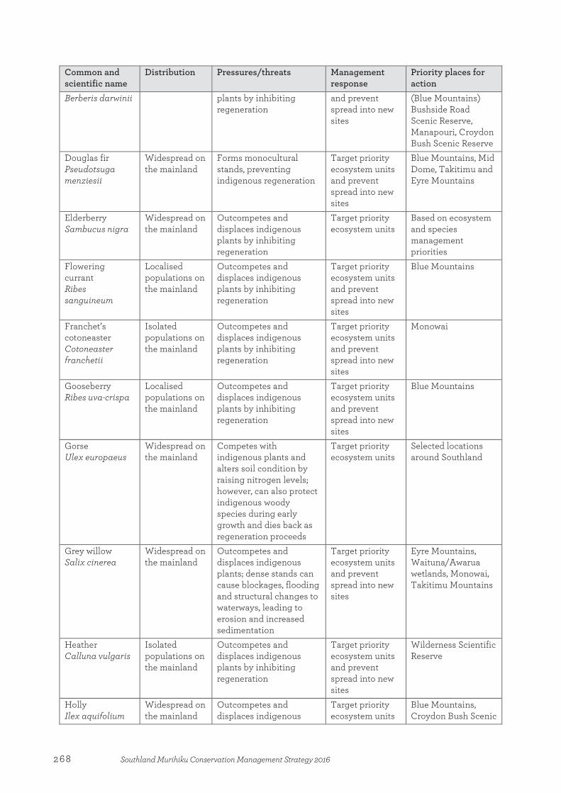
Common and scientific name
Distribution Pressures/threats Management response
Priority places for action
Berberis darwinii plants by inhibiting regeneration
and prevent spread into new sites
(Blue Mountains) Bushside Road Scenic Reserve, Manapouri, Croydon Bush Scenic Reserve
Douglas fir Pseudotsuga menziesii
Widespread on the mainland
Forms monocultural stands, preventing indigenous regeneration
Target priority ecosystem units and prevent spread into new sites
Blue Mountains, Mid Dome, Takitimu and Eyre Mountains
Elderberry Sambucus nigra
Widespread on the mainland
Outcompetes and displaces indigenous plants by inhibiting regeneration
Target priority ecosystem units
Based on ecosystem and species management priorities
Flowering currant Ribes sanguineum
Localised populations on the mainland
Outcompetes and displaces indigenous plants by inhibiting regeneration
Target priority ecosystem units and prevent spread into new sites
Blue Mountains
Franchet’s cotoneaster Cotoneaster franchetii
Isolated populations on the mainland
Outcompetes and displaces indigenous plants by inhibiting regeneration
Target priority ecosystem units and prevent spread into new sites
Monowai
Gooseberry Ribes uva-crispa
Localised populations on the mainland
Outcompetes and displaces indigenous plants by inhibiting regeneration
Target priority ecosystem units and prevent spread into new sites
Blue Mountains
Gorse Ulex europaeus
Widespread on the mainland
Competes with indigenous plants and alters soil condition by raising nitrogen levels; however, can also protect indigenous woody species during early growth and dies back as regeneration proceeds
Target priority ecosystem units
Selected locations around Southland
Grey willow Salix cinerea
Widespread on the mainland
Outcompetes and displaces indigenous plants; dense stands can cause blockages, flooding and structural changes to waterways, leading to erosion and increased sedimentation
Target priority ecosystem units and prevent spread into new sites
Eyre Mountains, Waituna/Awarua wetlands, Monowai, Takitimu Mountains
Heather Calluna vulgaris
Isolated populations on the mainland
Outcompetes and displaces indigenous plants by inhibiting regeneration
Target priority ecosystem units and prevent spread into new sites
Wilderness Scientific Reserve
Holly Ilex aquifolium
Widespread on the mainland
Outcompetes and displaces indigenous
Target priority ecosystem units
Blue Mountains, Croydon Bush Scenic
268 Southland Murihiku Conservation Management Strategy 2016
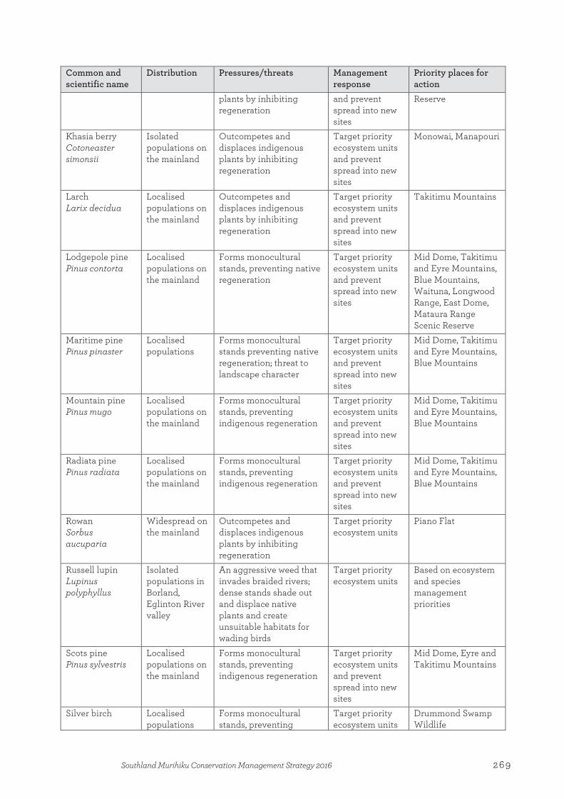
Common and scientific name
Distribution Pressures/threats Management response
Priority places for action
plants by inhibiting regeneration
and prevent spread into new sites
Reserve
Khasia berry Cotoneaster simonsii
Isolated populations on the mainland
Outcompetes and displaces indigenous plants by inhibiting regeneration
Target priority ecosystem units and prevent spread into new sites
Monowai, Manapouri
Larch Larix decidua
Localised populations on the mainland
Outcompetes and displaces indigenous plants by inhibiting regeneration
Target priority ecosystem units and prevent spread into new sites
Takitimu Mountains
Lodgepole pine Pinus contorta
Localised populations on the mainland
Forms monocultural stands, preventing native regeneration
Target priority ecosystem units and prevent spread into new sites
Mid Dome, Takitimu and Eyre Mountains, Blue Mountains, Waituna, Longwood Range, East Dome, Mataura Range Scenic Reserve
Maritime pine Pinus pinaster
Localised populations
Forms monocultural stands preventing native regeneration; threat to landscape character
Target priority ecosystem units and prevent spread into new sites
Mid Dome, Takitimu and Eyre Mountains, Blue Mountains
Mountain pine Pinus mugo
Localised populations on the mainland
Forms monocultural stands, preventing indigenous regeneration
Target priority ecosystem units and prevent spread into new sites
Mid Dome, Takitimu and Eyre Mountains, Blue Mountains
Radiata pine Pinus radiata
Localised populations on the mainland
Forms monocultural stands, preventing indigenous regeneration
Target priority ecosystem units and prevent spread into new sites
Mid Dome, Takitimu and Eyre Mountains, Blue Mountains
Rowan Sorbus aucuparia
Widespread on the mainland
Outcompetes and displaces indigenous plants by inhibiting regeneration
Target priority ecosystem units
Piano Flat
Russell lupin Lupinus polyphyllus
Isolated populations in Borland, Eglinton River valley
An aggressive weed that invades braided rivers; dense stands shade out and displace native plants and create unsuitable habitats for wading birds
Target priority ecosystem units
Based on ecosystem and species management priorities
Scots pine Pinus sylvestris
Localised populations on the mainland
Forms monocultural stands, preventing indigenous regeneration
Target priority ecosystem units and prevent spread into new sites
Mid Dome, Eyre and Takitimu Mountains
Silver birch Localised populations
Forms monocultural stands, preventing
Target priority ecosystem units
Drummond Swamp Wildlife
269Southland Murihiku Conservation Management Strategy 2016
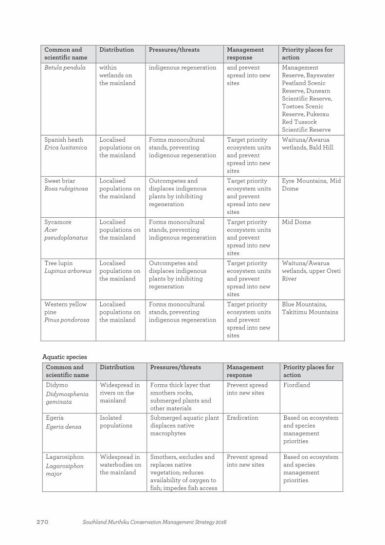
Common and scientific name
Distribution Pressures/threats Management response
Priority places for action
Betula pendula within wetlands on the mainland
indigenous regeneration and prevent spread into new sites
Management Reserve, Bayswater Peatland Scenic Reserve, Dunearn Scientific Reserve, Toetoes Scenic Reserve, Pukerau Red Tussock Scientific Reserve
Spanish heath Erica lusitanica
Localised populations on the mainland
Forms monocultural stands, preventing indigenous regeneration
Target priority ecosystem units and prevent spread into new sites
Waituna/Awarua wetlands, Bald Hill
Sweet briar Rosa rubiginosa
Localised populations on the mainland
Outcompetes and displaces indigenous plants by inhibiting regeneration
Target priority ecosystem units and prevent spread into new sites
Eyre Mountains, Mid Dome
Sycamore Acer pseudoplanatus
Localised populations on the mainland
Forms monocultural stands, preventing indigenous regeneration
Target priority ecosystem units and prevent spread into new sites
Mid Dome
Tree lupin Lupinus arboreus
Localised populations on the mainland
Outcompetes and displaces indigenous plants by inhibiting regeneration
Target priority ecosystem units and prevent spread into new sites
Waituna/Awarua wetlands, upper Oreti River
Western yellow pine Pinus pondorosa
Localised populations on the mainland
Forms monocultural stands, preventing indigenous regeneration
Target priority ecosystem units and prevent spread into new sites
Blue Mountains, Takitimu Mountains
Aquatic species Common and scientific name
Distribution Pressures/threats Management response
Priority places for action
Didymo Didymosphenia geminata
Widespread in rivers on the mainland
Forms thick layer that smothers rocks, submerged plants and other materials
Prevent spread into new sites
Fiordland
Egeria Egeria densa
Isolated populations
Submerged aquatic plant displaces native macrophytes
Eradication Based on ecosystem and species management priorities
Lagarosiphon Lagarosiphon major
Widespread in waterbodies on the mainland
Smothers, excludes and replaces native vegetation; reduces availability of oxygen to fish; impedes fish access
Prevent spread into new sites
Based on ecosystem and species management priorities
270 Southland Murihiku Conservation Management Strategy 2016
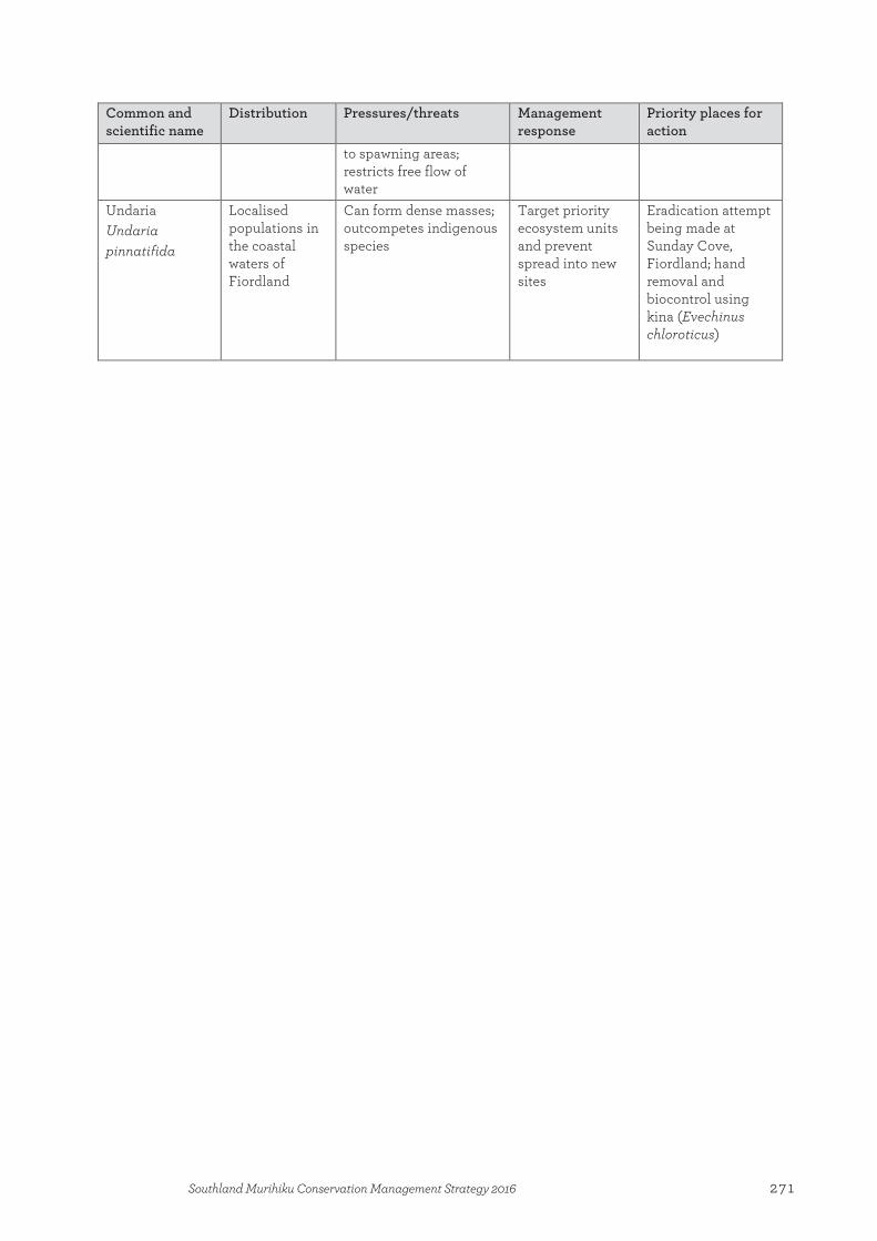
Common and scientific name
Distribution Pressures/threats Management response
Priority places for action
to spawning areas; restricts free flow of water
Undaria Undaria pinnatifida
Localised populations in the coastal waters of Fiordland
Can form dense masses; outcompetes indigenous species
Target priority ecosystem units and prevent spread into new sites
Eradication attempt being made at Sunday Cove, Fiordland; hand removal and biocontrol using kina (Evechinus chloroticus)
271Southland Murihiku Conservation Management Strategy 2016

Appendix 7
Nationally iconic species in Southland Murihiku These species were identified using a combination of web-based and phone-based public surveys in which those participating were asked what species they thought were quintessentially kiwi, contributing to their identity as New Zealanders. They are the 10 species identified most often. The table below includes only the nationally iconic species found in Southland Murihiku.
Common name Scientific name
Flora Ferns Kōwhai/kōwahi/kōhai Rimu/red pine
There are in excess of 100 fern species in Southland Murihiku Sophora microphylla Dacrydium cupressinum
Fauna Fiordland tokoeka/brown kiwi Kākāpō Kea Little spotted kiwi Tuatara* Tūī
Apteryx australis australis Strigops habroptilus Nestor notabilis Apteryx owenii Sphenodon punctatus Prosthemadera novaeseelandiae
* While currently extinct from Southland Murihiku, subfossil remains suggest that tuatara were an ancient component of
Southland Murihiku ecology.
Appendix 7:Nationally iconic species in Southland Murihiku
272 Southland Murihiku Conservation Management Strategy 2016
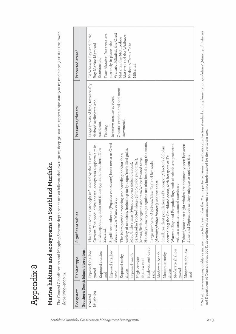
App
endi
x 8
Mar
ine
habi
tats
and
eco
syst
ems
in S
outh
land
Mur
ihik
u Th
e C
oast
al C
lass
ifica
tion
and
Map
ping
Sch
eme
dept
h zo
nes a
re a
s fol
low
s: sh
allo
w 0
–30
m; d
eep
30–2
00 m
; upp
er sl
ope
200–
500
m; m
id-s
lope
500
–100
0 m
; low
er
slop
e 10
00–4
000
m.
Ecos
yste
m
Hab
itat t
ype
Sign
ifica
nt v
alue
s Pr
essu
res/
thre
ats
Prot
ecte
d ar
eas6
Sout
hern
Sou
th Is
land
bio
regi
on:
Coa
stal
M
urih
iku
Expo
sed
shal
low
gr
avel
Th
e co
asta
l zon
e is
str
ongl
y in
fluen
ced
by th
e T
asm
an
Cur
rent
. The
pro
duct
ive
coas
tal e
cosy
stem
sup
port
s a
mix
of
wid
espr
ead
spec
ies
and
thos
e ty
pica
l of s
outh
ern
New
Ze
alan
d.
Sign
ifica
nt to
hero
a (P
aphi
es v
entr
icos
a) b
eds
occu
r at O
reti
Beac
h an
d Te
Wae
wae
Bay
.
The
isle
ts p
rovi
de ro
ostin
g an
d br
eedi
ng h
abita
t for
a
varie
ty o
f sea
bird
s, in
clud
ing
tarā
pung
a/re
d-bi
lled
gulls
, kō
au/l
ittle
sha
gs (P
hala
croc
orax
mel
anol
euco
s),
pāre
kare
ka/s
potte
d sh
ags
(Stic
toca
rbo
punc
tatu
s),
koro
rā/l
ittle
pen
guin
s an
d ta
ra/w
hite
-fron
ted
tern
s. H
oiho
/yel
low
-eye
d pe
ngui
ns a
re a
lso
foun
d al
ong
the
coas
t. La
rge
num
bers
of k
eken
o/N
ew Z
eala
nd fu
r sea
ls
(Arc
toce
phal
us fo
rste
ri) u
se th
e co
ast.
Sm
all,
resi
dent
pop
ulat
ions
of t
ūpou
pou/
Hec
tor’s
dol
phin
oc
cur a
long
the
Sout
hlan
d co
ast,
with
hot
spot
s at
Te
Wae
wae
Bay
and
Por
pois
e Ba
y, b
oth
of w
hich
are
pro
tect
ed
with
in a
mar
ine
mam
mal
san
ctua
ry.
Toho
rā/s
outh
ern
right
wha
les
are
com
mon
ly s
een
betw
een
June
and
Sep
tem
ber a
s th
ey m
igra
te to
and
from
the
Larg
e in
puts
of f
ine,
terr
estr
ially
de
rived
sed
imen
ts a
nd
nutr
ient
s. Fi
shin
g.
Inva
sive
mar
ine
spec
ies.
Coa
stal
ero
sion
and
sed
imen
t m
ovem
ent.
Te W
aew
ae B
ay a
nd C
urio
Ba
y M
arin
e M
amm
al
Sanc
tuar
ies.
Four
Māt
aita
i Res
erve
s ar
e cu
rren
tly in
pla
ce—
the
Wai
tutu
Māt
aita
i, th
e O
reti
Māt
aita
i, th
e M
otup
ōhue
M
ātai
tai a
nd th
e W
aika
wa
Har
bour
/Tum
u T
oka
Māt
aita
i.
Expo
sed
shal
low
re
ef
Expo
sed
shal
low
sa
nd
Expo
sed
rock
y sh
ore
Expo
sed
beac
h H
igh-
curr
ent
shal
low
reef
H
igh-
curr
ent d
eep
sand
M
oder
ate
beac
h M
oder
ate
rock
y sh
ore
Mod
erat
e sh
allo
w
grav
el
Mod
erat
e sh
allo
w
reef
6 Not
all
thes
e ar
eas
may
qua
lify
as m
arin
e pr
otec
ted
area
s un
der t
he ‘M
arin
e pr
otec
ted
area
s: cl
assi
ficat
ion,
pro
tect
ion
stan
dard
and
impl
emen
tatio
n gu
idel
ines
’ (M
inis
try
of F
ishe
ries
and
Dep
artm
ent o
f Con
serv
atio
n, 2
008)
, dep
endi
ng o
n th
e m
anag
emen
t con
trol
s im
plem
ente
d fo
r the
par
ticul
ar a
rea.
Appendix 8:Marine habitats and ecosystems in Southland Murihiku
273Southland Murihiku Conservation Management Strategy 2016

Ecos
yste
m
Hab
itat t
ype
Sign
ifica
nt v
alue
s Pr
essu
res/
thre
ats
Prot
ecte
d ar
eas6
Mod
erat
e sh
allo
w
sand
su
bant
arct
ic is
land
s. A
n in
crea
sing
occ
urre
nce
of s
mal
l ju
veni
les
and
calv
es is
sho
win
g a
posi
tive
sign
of
reco
loni
satio
n of
the
mai
nlan
d co
asta
l are
a.
Mai
nlan
d ha
ulou
t site
for r
āpok
a/w
haka
hao/
New
Zea
land
se
a lio
ns a
nd b
reed
ing
has
been
reco
rded
on
the
Sout
hlan
d co
ast.
Dee
p gr
avel
Dee
p re
ef
Dee
p sa
nd
Mud
flat
Shel
tere
d be
ach
Biog
enic
hab
itats
Fove
aux
Stra
it D
eep
grav
el
Fove
aux
Stra
it ha
s a
com
plex
bat
hym
etry
and
sed
imen
t di
strib
utio
n as
a re
sult
of h
igh
curr
ent a
nd ti
dal s
trea
ms
thro
ugh
the
stra
it. T
he h
igh
curr
ent a
nd e
xpos
ed n
atur
e of
th
e st
rait
prod
uces
a h
ighl
y di
vers
e bi
ogen
ic h
abita
t tha
t in
clud
es b
ryoz
oans
, spo
nges
, sea
tulip
s, la
mp
shel
ls a
nd
oyst
ers.
Thes
e ar
eas
are
som
e of
the
mos
t pro
duct
ive
and
high
ly d
iver
se h
abita
ts in
Sou
thla
nd. T
he b
ioge
nic
area
s pr
ovid
e im
port
ant h
abita
t and
nur
sery
are
as fo
r man
y sp
ecie
s of
fish
, par
ticul
arly
the
blue
cod
(Par
aper
cis c
olia
s),
an im
port
ant c
omm
erci
al a
nd re
crea
tiona
l fis
h sp
ecie
s in
So
uthl
and.
Larg
e in
puts
of f
ine,
terr
estr
ially
de
rived
sed
imen
ts a
nd
nutr
ient
s.
Fish
ing.
G
roun
d fis
hing
met
hods
suc
h as
oy
ster
dre
dgin
g an
d bo
ttom
tr
awlin
g ha
ve m
odifi
ed th
e bi
ogen
ic fe
atur
es o
f Fov
eaux
St
rait,
and
ong
oing
fish
ing
activ
ity c
ontin
ues
to th
reat
en
the
dive
rsity
and
str
uctu
re o
f the
bi
ogen
ic re
efs.
Dee
p re
ef
Dee
p sa
nd
Expo
sed
shal
low
gr
avel
Expo
sed
shal
low
re
ef
Expo
sed
shal
low
sa
nd
Mod
erat
e sh
allo
w
grav
el
Biog
enic
hab
itats
Aw
arua
W
etla
nd
Com
plex
(J
acob
s Ri
ver
Estu
ary,
New
Ri
ver
Estu
ary/
M
okom
oko
Biog
enic
sa
ltmar
sh
A h
ighl
y si
gnifi
cant
are
a, w
ith th
e A
war
ua w
etla
nd b
eing
re
cogn
ised
und
er th
e C
onve
ntio
n on
Wet
land
s of
In
tern
atio
nal I
mpo
rtan
ce.
Muc
h of
the
shal
low
mud
/san
d fla
t are
as w
ere
trad
ition
ally
do
min
ated
by
the
aqua
tic p
lant
s Ru
ppia
spp
. and
ka
repō
/sea
gras
s (Z
oste
ra c
apric
orni
); ho
wev
er, b
oth
of
thes
e ha
ve u
nder
gone
con
side
rabl
e de
clin
e.
Coa
stal
dev
elop
men
t. In
fillin
g by
fine
sed
imen
ts.
Nut
rient
and
sed
imen
t run
off
from
land
use
(sig
nific
ant
deve
lopm
ent o
f dai
ryin
g ov
er
the
last
dec
ade)
.
Wai
tuna
Wet
land
s Sc
ient
ific
Rese
rve
(par
t of t
he A
war
ua
Wet
land
of I
nter
natio
nal
Impo
rtan
ce).
Biog
enic
sea
gras
s
Estu
arin
e be
ach
Estu
arin
e sa
nd
Expo
sed
beac
h Ex
pose
d sh
allo
w
274 Southland Murihiku Conservation Management Strategy 2016

Ecos
yste
m
Hab
itat t
ype
Sign
ifica
nt v
alue
s Pr
essu
res/
thre
ats
Prot
ecte
d ar
eas6
Inle
t, Bl
uff
Har
bour
/ A
war
ua B
ay,
Wai
tuna
La
goon
, To
etoe
s H
arbo
ur)
sand
Th
e w
etla
nd c
ompl
ex p
rovi
des
exte
nsiv
e sp
awni
ng a
nd
nurs
ery
area
s fo
r bot
h m
arin
e an
d fr
eshw
ater
fish
spe
cies
, su
ch a
s th
e ta
iwha
ru/g
iant
kōk
opu,
ban
ded
kōko
pu
(Gal
axia
s fas
ciat
us),
īnan
ga (G
alax
ias m
acul
atus
), tu
na/l
ongf
in e
el, t
una/
shor
tfin
eel (
Ang
uilla
aus
tral
is),
kana
kana
/lam
prey
, aua
/yel
low
-eye
d m
ulle
t (A
ldric
hetta
fo
rste
ri), k
ahaw
ai (A
rrip
is tr
utta
), an
d sp
ecie
s of
sta
rgaz
er
and
pātik
i/flo
unde
r (Rh
ombo
sole
a sp
p.).
The
wet
land
com
plex
is o
ne o
f the
five
mos
t im
port
ant
wat
erfo
wl a
nd w
adin
g bi
rd h
abita
ts in
New
Zea
land
, and
is
part
icul
arly
impo
rtan
t for
bot
h lo
cal a
nd in
tern
atio
nal
mig
rato
ry s
hore
bird
s.
Art
ifici
al o
peni
ng o
f the
W
aitu
na L
agoo
n ha
s th
e po
tent
ial t
o ca
use
adve
rse
effe
cts
on R
uppi
a sp
p.
Path
ogen
s an
d ot
her
cont
amin
ants
in p
oint
sou
rce
and
non-
poin
t sou
rce
disc
harg
es.
Inva
sive
mar
ine
spec
ies.
Chr
onic
dis
turb
ance
to w
ildlif
e.
Mud
flat
Shel
tere
d be
ach
Fior
dlan
d bi
oreg
ion:
Fior
dlan
d D
eep
mud
Fi
ordl
and
enco
mpa
sses
13 fi
ords
. The
pro
file
of e
ach
fiord
is
typi
cally
a s
helte
red,
ste
ep-s
ided
bas
in th
at is
sep
arat
ed
from
the
expo
sed
rugg
ed o
uter
coa
st b
y a
subm
arin
e si
ll or
ro
ck m
orai
ne. H
owev
er, t
he b
iolo
gy d
iffer
s bo
th a
long
a
latit
udin
al g
radi
ent b
etw
een
the
fiord
s an
d al
ong
an
expo
sure
gra
dien
t with
in th
e fio
rds.
The
rock
y ou
ter c
oast
com
mun
ities
refle
ct th
e hi
gh-w
ave-
ener
gy e
nviro
nmen
t, w
ith th
e in
tert
idal
zon
e do
min
ated
by
the
periw
inkl
e (L
ittor
ina
cinc
ta),
encr
ustin
g al
gae
(Bos
tryc
hia
arbu
scul
a), b
arna
cles
(Cha
mae
siph
o co
lum
na)
and
bull
kelp
(Dur
villa
ea a
ntar
ctic
a).
Th
e ou
ter c
oast
sub
tidal
reef
are
as s
uppo
rt a
var
iety
of
spec
ies
of la
rge
brow
n al
gae,
incl
udin
g se
a w
rack
(Les
soni
a va
riega
ta),
bull
kelp
, com
mon
kel
p (E
cklo
nia
radi
ata)
, X
ipho
phor
a gl
adia
ta, C
ysto
phor
a sp
p., L
ands
burg
ia
quer
cifo
lia a
nd M
argi
narie
lla s
pp.
The
wel
l-veg
etat
ed c
atch
men
t is
resp
onsi
ble
for l
ow ra
tes
of
sedi
men
t dep
ositi
on w
ithin
the
fiord
sys
tem
. Th
e su
btid
al c
omm
uniti
es li
ving
on
the
fiord
wal
ls a
re
uniq
ue in
New
Zea
land
, and
are
dom
inat
ed b
y se
ssile
Dou
btfu
l Sou
nd/P
atea
has
bee
n he
avily
mod
ified
by
the
esta
blis
hmen
t of t
he M
anap
ouri
Pow
er S
chem
e, w
hich
has
bee
n de
posi
ting
a la
rge
volu
me
of
fresh
wat
er in
to th
e he
ad o
f the
so
und
sinc
e th
e ea
rly 19
70s.
Incr
ease
s hav
e be
en a
llow
ed
thro
ugh
cons
ent p
roce
sses
and
w
ill c
ontin
ue to
influ
ence
the
fiord
rock
wal
l com
mun
ities
.
Mon
itorin
g to
dat
e ha
s sho
wn
little
ong
oing
cha
nge
in th
e ec
olog
y of
the
fiord
. W
hile
com
mer
cial
fish
ing
no
long
er o
ccur
s with
in th
e in
tern
al
wat
ers o
f the
fior
ds, c
omm
erci
al
fishi
ng o
n th
e ou
ter c
oast
has
the
pote
ntia
l to
impa
ct o
n in
ner f
iord
ec
osys
tem
s. Th
ere
has b
een
som
e re
sear
ch to
sugg
est t
hat o
uter
Ther
e ar
e 10
mar
ine
rese
rves
w
ithin
the
fiord
s: Te
Hap
ua
(Sut
herla
nd S
ound
), H
awea
(C
lio R
ocks
), K
ahuk
ura
(Gol
d A
rm),
Kut
u Pa
rera
(Gae
r A
rm),
Taip
ari R
oa (E
lizab
eth
Isla
nd),
Moa
na U
ta (W
et
Jack
et A
rm),
Tau
moa
na
(Fiv
e Fi
nger
Pen
insu
la),
Te
Tapu
wae
o H
ua (L
ong
Soun
d), P
iopi
otah
i (M
ilfor
d So
und)
and
Te
Aw
aatu
C
hann
el (T
he G
ut) M
arin
e Re
serv
es. A
ll bu
t the
last
two
wer
e cr
eate
d un
der t
he
Fior
dlan
d (T
e M
oana
o
Ata
whe
nua)
Mar
ine
Man
agem
ent A
ct 2
005.
Ther
e is
lim
ited
prot
ectio
n fo
r eco
syst
ems
and
spec
ies
in th
e m
ore
expo
sed
habi
tats
Dee
p sa
nd
Dee
p re
ef
Estu
arin
e be
ach
Estu
arin
e m
ud
Estu
arin
e re
ef
Estu
arin
e ro
cky
shor
e
Estu
arin
e sa
nd
Expo
sed
beac
h
Expo
sed
rock
y sh
ore
Expo
sed
shal
low
re
ef
Expo
sed
shal
low
sa
nd
Low
er s
lope
275Southland Murihiku Conservation Management Strategy 2016
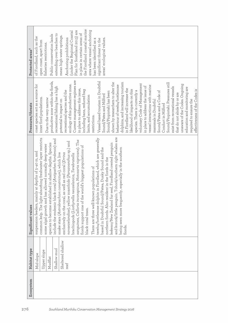
Ecos
yste
m
Hab
itat t
ype
Sign
ifica
nt v
alue
s Pr
essu
res/
thre
ats
Prot
ecte
d ar
eas6
Mid
-slo
pe
susp
ensi
on fe
eder
s, m
ainl
y at
dep
ths
of 5
–40
m, a
nd
com
mon
kel
p. T
he li
ght-a
bsor
bing
fres
hwat
er la
yer r
estr
icts
so
me
alga
l gro
wth
and
has
allo
wed
nor
mal
ly d
eep-
wat
er
spec
ies
to b
ecom
e es
tabl
ishe
d in
sha
llow
dep
ths.
Spec
ies
incl
ude
the
ende
mic
bla
ck c
oral
(Ant
ipat
hes f
iord
ensi
s) a
nd
snak
e st
ars
(Ast
robr
achi
on c
onst
rictu
m),
whi
ch li
ve
excl
usiv
ely
on th
e co
ral,
as w
ell a
s re
d co
ral (
Errin
a no
vaez
elan
diae
), ye
llow
zoa
nthi
ds (P
araz
oant
hus s
p.) a
nd
brac
hiop
ods
(Lio
thyr
ella
neo
zela
nica
, Ter
ebra
tella
sa
ngui
nea,
Cal
loria
inco
nspi
cua,
Not
osar
ia n
igric
ans)
. The
fio
rds
supp
ort o
ne o
f the
wor
ld’s
bigg
est p
opul
atio
ns o
f bl
ack
cora
l tre
es.
Ther
e ar
e th
ree
wel
l-kno
wn
popu
latio
ns o
f te
rehu
/bot
tleno
se d
olph
in in
Fio
rdla
nd, w
hich
are
gen
eral
ly
base
d in
Dou
btfu
l Sou
nd/P
atea
, Dus
ky S
ound
and
the
nort
hern
fior
ds. A
lso
resi
dent
in th
e fio
rds
is th
e ke
keno
/New
Zea
land
fur s
eal,
Fior
dlan
d cr
este
d pe
ngui
n an
d ko
rorā
/litt
le p
engu
in. T
ohor
ā/so
uthe
rn ri
ght w
hale
s ar
e be
ing
seen
mor
e fr
eque
ntly
, esp
ecia
lly in
the
sout
hern
fio
rds.
coas
t spe
cies
act
as a
sour
ce fo
r in
ner f
iord
pop
ulat
ions
.
Due
to th
e ve
ry n
arro
w
prod
uctiv
e zo
ne w
ithin
the
fiord
s, re
crea
tiona
l fis
hing
has
a h
igh
pote
ntia
l to
impa
ct o
n re
crea
tiona
l spe
cies
and
the
ecol
ogy
of th
is p
rodu
ctiv
e zo
ne.
Cur
rent
man
agem
ent r
egim
es a
re
in p
lace
to a
ddre
ss th
is is
sue,
incl
udin
g ba
ns, r
educ
ed b
ag
limits
, and
acc
umul
atio
n re
stric
tions
. V
esse
l-bas
ed to
uris
m in
Dou
btfu
l So
und/
Pate
a an
d M
ilfor
d So
und/
Piop
iota
hi h
as b
een
show
n by
rese
arch
ers t
o al
ter t
he
beha
viou
r of t
ereh
u/bo
ttlen
ose
dolp
hins
, and
incr
easi
ng to
uris
m
in F
iord
land
will
incr
ease
the
likel
ihoo
d of
impa
cts o
n th
is
spec
ies.
Ther
e is
cur
rent
ly a
vo
lunt
ary
Cod
e of
Man
agem
ent
in p
lace
to a
ddre
ss th
e is
sue
of
vess
el in
tera
ctio
ns w
ith m
arin
e m
amm
als i
n D
oubt
ful
Soun
d/Pa
tea
and
a C
ode
of
Con
duct
in M
ilfor
d So
und/
Piop
iota
hi. P
ress
ures
still
ex
ist f
rom
recr
eatio
nal v
esse
ls
that
do
not a
bide
by
or a
re
unaw
are
of th
e C
odes
. Ong
oing
ed
ucat
ion
and
mon
itorin
g ar
e re
quire
d to
ens
ure
the
effe
ctiv
enes
s of t
he C
odes
is
of F
iord
land
, suc
h as
the
open
coa
st, a
part
from
fis
herie
s re
stric
tions
.
Publ
ic c
onse
rvat
ion
land
s ex
tend
ing
over
bea
ches
to
mea
n hi
gh w
ater
spr
ings
. A
ncho
ring
proh
ibiti
ons
(und
er th
e Re
gion
al C
oast
al
Plan
for S
outh
land
201
3) a
re
in p
lace
in c
erta
in a
reas
of
the
Fior
dlan
d co
asta
l mar
ine
area
whe
re v
esse
l anc
horin
g ha
s be
en id
entif
ied
as a
si
gnifi
cant
thre
at to
the
area
s’ ec
olog
ical
val
ues.
Upp
er s
lope
Mud
flat
Shal
low
mud
Shel
tere
d sh
allo
w
reef
276 Southland Murihiku Conservation Management Strategy 2016

Ecos
yste
m
Hab
itat t
ype
Sign
ifica
nt v
alue
s Pr
essu
res/
thre
ats
Prot
ecte
d ar
eas6
mai
ntai
ned.
In
vasi
ve m
arin
e sp
ecie
s hav
e be
en id
entif
ied
as th
e gr
eate
st
thre
at to
the
fiord
s by
the
Gua
rdia
ns’ F
iord
land
Mar
ine
Con
serv
atio
n St
rate
gy 2
003
and
man
agem
ent o
f thi
s thr
eat
rem
ains
a h
igh
prio
rity.
In
crea
sing
cru
ise
ship
act
ivity
w
ithin
the
fiord
s has
the
pote
ntia
l to
hav
e ad
vers
e im
pact
s on
the
sign
ifica
nt v
alue
s thr
ough
an
chor
ing
dam
age,
the
risk
of o
il sp
ills a
nd in
trodu
ctio
n of
inva
sive
sp
ecie
s. A
ncho
ring
is c
urre
ntly
m
anag
ed b
y th
e So
uthl
and
Regi
onal
Cou
ncil
thro
ugh
the
Regi
onal
Coa
stal
Pla
n fo
r So
uthl
and
2013
and
Dee
d of
A
gree
men
t with
the
Cru
ise
Ship
In
dust
ry. H
owev
er, t
his
agre
emen
t doe
s not
rem
ove
the
pote
ntia
l adv
erse
effe
cts
asso
ciat
ed w
ith th
is a
ctiv
ity. A
n al
tern
ativ
e ar
ea h
as b
een
set a
side
fo
r anc
horin
g by
cru
ise
ship
s in
Dou
btfu
l Sou
nd/P
atea
to m
ove
the
pote
ntia
l dam
age
due
to
anch
orin
g fro
m a
n ar
ea fo
und
to
have
frag
ile sp
ecie
s, to
an
area
th
ough
t to
cont
ain
mai
nly
soft
sedi
men
t com
mun
ities
.
Sola
nder
Is
land
s D
eep
reef
A
larg
e br
eedi
ng c
olon
y of
kek
eno/
New
Zea
land
fur s
eal
lives
on
the
isla
nds.
Fi
shin
g th
roug
h by
catc
h an
d be
nthi
c di
stur
banc
e.
Dee
p sa
nd
277Southland Murihiku Conservation Management Strategy 2016

Ecos
yste
m
Hab
itat t
ype
Sign
ifica
nt v
alue
s Pr
essu
res/
thre
ats
Prot
ecte
d ar
eas6
Expo
sed
beac
h N
early
hal
f of t
he k
now
n po
pula
tion
of to
roa/
sout
hern
Bu
ller’s
mol
lym
awk
also
live
s on
the
isla
nds,
as w
ell a
s si
gnifi
cant
num
bers
of c
omm
on d
ivin
g pe
trel
s (P
elec
anoi
des u
rinat
rix).
Litt
le S
olan
der I
slan
d m
ay b
e th
e so
uthe
rnm
ost A
ustr
alas
ian
gann
et (M
orus
serr
ator
) col
ony
in th
e w
orld
. O
ffsho
re, t
he b
enth
ic in
vert
ebra
te c
omm
uniti
es in
clud
e th
e la
rge
kuha
kuha
/dog
coc
kle
(Tuc
eton
a la
ticos
tata
) and
the
pūrim
u/pu
rple
coc
kle
(Pur
puro
card
ia p
urpu
rata
); th
e tr
ough
she
lls S
calp
omac
tra
scal
pellu
m a
nd M
aorim
actr
a or
dina
ria; t
he m
orni
ng s
tar s
hell/
zigz
ag c
ockl
e (T
awer
a sp
issa
) and
the
biva
lve
mol
lusc
Dip
lodo
nta
glob
us.
Expo
sed
rock
y sh
ore
Expo
sed
shal
low
re
ef
Snar
es b
iore
gion
:
Snar
es
Isla
nds/
Tini
H
eke
Dee
p gr
avel
Th
e Sn
ares
Isla
nds/
Tini
Hek
e co
mpr
ise
thei
r ow
n, d
istin
ct
biog
eogr
aphi
c re
gion
. The
mar
ine
biot
a co
ntai
ns c
ool t
o co
ld te
mpe
rate
spe
cies
, and
a n
umbe
r of c
omm
on s
peci
es,
such
as
the
kina
(Eve
chin
us c
hlor
otic
us),
reac
h th
eir
sout
hern
mos
t lim
it in
New
Zea
land
wat
ers
here
. Th
e Sn
ares
Isla
nds/
Tini
Hek
e co
ntai
n a
dive
rse
and
uniq
ue
asse
mbl
age
of s
eabi
rds
and
othe
r bio
ta. T
oroa
/alb
atro
sses
, sh
earw
ater
s, pe
trel
s an
d pe
ngui
ns a
re a
ll ab
unda
nt h
ere
(toro
a/so
uthe
rn B
ulle
r’s m
olly
maw
k, tī
tī/so
oty
shea
rwat
er,
com
mon
div
ing
petr
el, t
ītī/m
ottle
d pe
trel
(Pte
rodr
oma
inex
pect
ata)
, par
arā/
broa
d-bi
lled
prio
n, tī
tī w
ainu
i/fa
iry
prio
n, fu
lmar
prio
n, h
ākoa
koa/
brow
n sk
ua (C
atha
ract
a an
tarc
tica
lonn
berg
i), S
nare
s C
ape
pige
on, p
okot
iwha
/ Sn
ares
cre
sted
pen
guin
). K
eken
o/N
ew Z
eala
nd fu
r sea
ls b
reed
on
the
expo
sed
coas
ts
of th
e Sn
ares
Isla
nds/
Tin
i Hek
e, a
nd a
larg
e nu
mbe
r of
rāpo
ka/w
haka
hao/
New
Zea
land
sea
lion
s ut
ilise
the
isla
nd.
Dire
ct a
nd in
dire
ct e
ffect
s of
fis
hing
, inc
ludi
ng b
ycat
ch fr
om
com
mer
cial
fish
erie
s. O
il sp
ill ri
sk fr
om v
isiti
ng c
ruis
e sh
ips a
nd fi
shin
g ve
ssel
s.
Bios
ecur
ity is
sues
are
one
of t
he
mai
n th
reat
s to
the
suba
ntar
ctic
is
land
eco
syst
ems.
The
incr
easi
ng d
eman
d fr
om th
e to
uris
m in
dust
ry, a
nd u
se o
f the
Sn
ares
Isla
nds/
Tini
Hek
e as
a
safe
anc
hora
ge fo
r fis
hing
ve
ssel
s, in
crea
ses
the
risk
of
inci
dent
al tr
ansf
er o
f mar
ine
pest
spe
cies
. V
isito
r im
pact
s, su
ch a
s di
stur
banc
e of
mar
ine
wild
life
and
anch
or d
amag
e to
sea
bed
habi
tats
.
Inte
rtid
al a
rea
is w
ithin
the
Snar
es Is
land
s N
atur
e Re
serv
e.
Dee
p re
ef
Expo
sed
rock
y sh
ore
Expo
sed
shal
low
gr
avel
Expo
sed
shal
low
re
ef
Mid
-slo
pe
Mod
erat
e ro
cky
shor
e
Mod
erat
e sh
allo
w
grav
el
Mod
erat
e sh
allo
w
reef
Upp
er s
lope
278 Southland Murihiku Conservation Management Strategy 2016
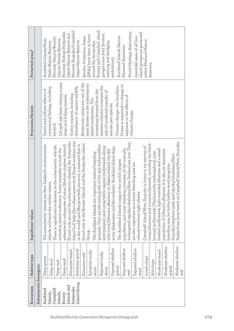
Ecos
yste
m
Hab
itat t
ype
Sign
ifica
nt v
alue
s Pr
essu
res/
thre
ats
Prot
ecte
d ar
eas6
Suba
ntar
ctic
bio
regi
on:
Auc
klan
d Is
land
s, C
ampb
ell
Isla
nds,
Boun
ty
Isla
nds
and
Ant
ipod
es
Isla
nd G
roup
Dee
p gr
avel
Th
e su
bant
arct
ic is
land
s ar
e N
ew Z
eala
nd’s
sout
hern
mos
t is
land
s an
d ha
ve th
e co
oles
t wat
ers.
Ther
e is
sig
nific
ant e
ndem
ism
in th
e su
bant
arct
ic is
land
s, in
clud
ing
isla
nd e
ndem
ism
. Som
e ex
ampl
es in
clud
e th
e su
bant
arct
ic s
ubsp
ecie
s of
pāu
a (H
alio
tis v
irgin
ea h
utto
ri)
(foun
d on
ly a
roun
d th
e su
bant
arct
ic is
land
s), t
he A
ntip
odes
Is
land
bul
l kel
p (D
urvi
llaea
ant
arct
ica)
(fou
nd n
owhe
re e
lse
in th
e w
orld
) and
Mar
gina
riella
par
soni
i, a
seaw
eed
that
is
foun
d on
ly a
t the
Bou
nty
Isla
nds
and
the
Ant
ipod
es Is
land
G
roup
.
The
Auc
klan
d Is
land
s ar
e im
port
ant s
eabi
rd b
reed
ing
grou
nds.
They
are
the
stro
ngho
ld o
f the
rare
hoi
ho/y
ello
w-
eyed
pen
guin
and
toro
a/w
hite
-cap
ped
mol
lym
awk,
alo
ng
with
toro
a/G
ibso
n's
alba
tros
s on
Ada
ms
Isla
nd, t
he tī
tī/
soot
y sh
earw
ater
and
the
ende
mic
Auc
klan
d Is
land
sha
g.
The
Auc
klan
d Is
land
s su
ppor
t the
wor
ld’s
larg
est
popu
latio
n, a
nd m
ain
bree
ding
col
onie
s, of
the
criti
cally
en
dang
ered
rāpo
ka/w
haka
hao/
New
Zea
land
sea
lion
. The
y ar
e al
so im
port
ant a
s a
win
ter b
reed
ing
area
for
toho
rā/s
outh
ern
right
wha
les.
Cam
pbel
l Isl
and/
Mot
u Ih
upuk
u is
hom
e to
six
spe
cies
of
toro
a/al
batr
oss
and
toro
a/m
olly
maw
k, in
clud
ing
the
blac
k-br
owed
mol
lym
awk
(Tha
lass
arch
e m
elan
ophr
ys),
grey
-he
aded
mol
lym
awk,
ligh
t-man
tled
alba
tros
s an
d a
smal
l po
pula
tion
of G
ibso
n’s
alba
tros
s. It
is a
lso
an im
port
ant
bree
ding
are
a fo
r hoi
ho/y
ello
w-e
yed
peng
uins
. Ih
upuk
u/el
epha
nt s
eals
and
rāpo
ka/w
haka
hao/
New
Ze
alan
d se
a lio
ns b
reed
on
Cam
pbel
l Isl
and/
Mot
u Ih
upuk
u.
Dire
ct a
nd in
dire
ct e
ffect
s of
co
mm
erci
al fi
shin
g, in
clud
ing
byca
tch.
O
il sp
ill ri
sk fr
om v
isiti
ng c
ruis
e sh
ips
and
fishi
ng v
esse
ls.
Vis
itor i
mpa
cts,
incl
udin
g di
stur
banc
e of
mar
ine
wild
life.
Bios
ecur
ity is
sues
are
one
of t
he
mai
n th
reat
s to
the
suba
ntar
ctic
is
land
eco
syst
ems.
The
incr
easi
ng d
eman
d fr
om th
e to
uris
m in
dust
ry in
crea
ses
the
risk
of in
cide
ntal
tran
sfer
of
mar
ine
pest
spe
cies
. C
limat
e ch
ange
—th
e So
uthe
rn
Oce
an is
exp
ecte
d to
cha
nge
in
resp
onse
to th
e ef
fect
s of
cl
imat
e ch
ange
.
Auc
klan
d Is
land
s/M
otu
Mah
a M
arin
e Re
serv
e,
Mou
tere
Hau
riri/
Boun
ty
Isla
nds
Mar
ine
Rese
rve,
M
oute
re M
ahue
/Ant
ipod
es
Isla
nd M
arin
e Re
serv
e an
d M
oute
re Ih
upuk
u/C
ampb
ell
Isla
nd M
arin
e Re
serv
e.
Bent
hic
Prot
ectio
n A
reas
(B
PAs)
hav
e be
en in
forc
e ar
ound
the
Ant
ipod
es,
Boun
ty a
nd C
ampb
ell i
slan
d gr
oups
sin
ce 2
007
(bot
tom
tr
awlin
g an
d dr
edgi
ng
proh
ibiti
on).
Auc
klan
d Is
land
s M
arin
e M
amm
al S
anct
uary
.
Wor
ld H
erita
ge A
rea
stat
us.
Inte
rtid
al a
reas
of a
ll fo
ur
isla
nd g
roup
s ar
e pr
otec
ted
with
in N
atio
nal N
atur
e Re
serv
es.
Dee
p m
ud
Dee
p re
ef
Dee
p sa
nd
Estu
arin
e be
ach
Estu
arin
e gr
avel
Estu
arin
e re
ef
Estu
arin
e ro
cky
shor
e
Expo
sed
rock
y sh
ore
Expo
sed
shal
low
gr
avel
Expo
sed
shal
low
re
ef
Expo
sed
shal
low
sa
nd
Low
er s
lope
Mid
-slo
pe
Mod
erat
e be
ach
Mod
erat
e sh
allo
w
grav
el
Mod
erat
e sh
allo
w
reef
279Southland Murihiku Conservation Management Strategy 2016
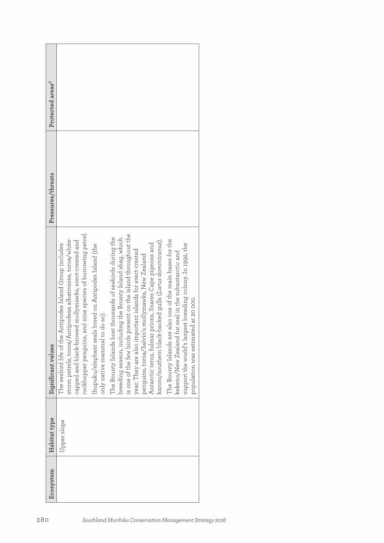
Ecos
yste
m
Hab
itat t
ype
Sign
ifica
nt v
alue
s Pr
essu
res/
thre
ats
Prot
ecte
d ar
eas6
Upp
er s
lope
Th
e se
abird
life
of t
he A
ntip
odes
Isla
nd G
roup
incl
udes
st
orm
pet
rels
, tor
oa/A
ntip
odea
n al
batr
osse
s, to
roa/
whi
te-
capp
ed a
nd b
lack
-bro
wed
mol
lym
awks
, ere
ct-c
rest
ed a
nd
rock
hopp
er p
engu
ins,
and
nine
spe
cies
of b
urro
win
g pe
trel
.
Ihup
uku/
elep
hant
sea
ls b
reed
on
Ant
ipod
es Is
land
(the
on
ly n
ativ
e m
amm
al to
do
so).
The
Boun
ty Is
land
s ho
st th
ousa
nds
of s
eabi
rds
durin
g th
e br
eedi
ng s
easo
n, in
clud
ing
the
Boun
ty Is
land
sha
g, w
hich
is
one
of t
he fe
w b
irds
pres
ent o
n th
e is
land
thro
ugho
ut th
e ye
ar. T
hey
are
also
impo
rtan
t isl
ands
for e
rect
-cre
sted
pe
ngui
ns, t
oroa
/Sal
vin’
s m
olly
maw
ks, N
ew Z
eala
nd
Ant
arct
ic te
rns,
fulm
ar p
rion
s, Sn
ares
Cap
e pi
geon
s an
d ka
roro
/sou
ther
n bl
ack-
back
ed g
ulls
(Lar
us d
omin
ican
us).
Th
e Bo
unty
Isla
nds
are
also
one
of t
he m
ain
base
s fo
r the
ke
keno
/New
Zea
land
fur s
eal i
n th
e su
bant
arct
ic a
nd
supp
ort t
he w
orld
’s la
rges
t bre
edin
g co
lony
. In
1992
, the
po
pula
tion
was
est
imat
ed a
t 20
000.
280 Southland Murihiku Conservation Management Strategy 2016
References Arnold, A. (ed.) 2004: Shining a spotlight on the biodiversity of New Zealand’s marine ecology: experts
workshop on marine biodiversity, 27–28 May 2003, Wellington, New Zealand. WWF-New Zealand, Wellington.
Batham, E.J. 1965: Rocky shore ecology of a southern New Zealand fiord. Transactions of the Royal Society of New Zealand, Zoology 6: 215–227.
Booth, J.D. 2004: The marine ecosystem of the New Zealand subantarctic islands and their surrounding plateaus. Report for the Department of Conservation. NIWA Client Report: WLG2004-47.
Carbines, G.D. 1998: Determination of movement of blue cod in Southland. NIWA Report No. BCO09702. National Institute of Water and Atmospheric Research, Wellington.
Cranfield, J.H.; Carbines, G.; Michael, K.P.; Dunn, A.; Stotter, D.R.; Smith, D.J. 2001: Promising signs of regeneration of blue cod and oyster habitat changed by dredging in Foveaux Strait, southern New Zealand. New Zealand Journal of Marine and Freshwater Research 35: 897–908.
Cranfield, J.H.; Michael, K.P. 2001: A summary of the fishery, commercial landings, and biology of the New Zealand Queen Scallop, Zygochlamys delicatula (Hutton, 1873). Ministry of Fisheries, Wellington.
Darby, J.; Fordyce, R.E.; Mark, A.; Probert, K.; Townsend, C. 2003: The natural history of southern New Zealand. University of Otago Press, Dunedin.
Grange, K.R. 1985: Distribution, standing crop, population structure, and growth rates of black coral in southern fiords of New Zealand. New Zealand Journal of Marine and Freshwater Research 19(4): 467–475.
Grange, K.R. 1985: The intertidal ecology of soft shores of Freshwater Basin, Milford Sound. Department of Scientific and Industrial Research, Wellington.
Grange, K.R. 1990: Macrobenthic communities of the New Zealand continental shelf. NZOI Investigation No. S3050/36. New Zealand Oceanographic Institute, Wellington.
Grange, K.R. 1990: Unique marine habitats in the New Zealand fiords: a case for preservation. Report for the Department of Conservation, Wellington. New Zealand Oceanographic Institute, Wellington.
Grange, K.R. 1991: The underwater environment of Doubtful Sound. Department of Scientific and Industrial Research, Wellington.
Grange, K.R.; Singleton, R.J.; Richardson, J.R.; Hill, P.J.; del Main, W. 1981: Shallow rock-wall biological associations of some southern fiords of New Zealand. New Zealand Journal of Zoology 8: 209–227.
Hare, J.; Hayes, S.; King, S.; Pillai, A. (Comps) 1990: Coastal resource inventory: first order survey, Southland Conservancy. Department of Conservation, Wellington.
Hume, T.; Herdendorf, C.E. 1988: A geomorphic classification of estuaries and its application to coastal resource management: a New Zealand example. Ocean and Shoreline Management 11: 249–274.
Paulin, C.D. 1991: The fiordland fish fauna: a survey. Report on planning workshop, fiords marine research, 26–27 August 1991, Wellington, New Zealand. New Zealand Oceanographic Institute, Wellington.
Peat, N. 1997: Subantarctic island heritage: nomination of the New Zealand subantarctic islands by the government of New Zealand for inclusion in the World Heritage List. Department of Conservation, Wellington.
Schiel, D.R.; Hickford, M.J. 2001: Biological structure of nearshore rocky subtidal habitats in southern New Zealand. Science for Conservation 182. Department of Conservation, Wellington.
Wilson, G.J. 1981: Distribution and abundance of the New Zealand fur seal (Arctocephalus forsteri). Fisheries Research Division Occasional Publication No. 20. New Zealand Ministry of Agriculture and Fisheries, Wellington.
281Southland Murihiku Conservation Management Strategy 2016
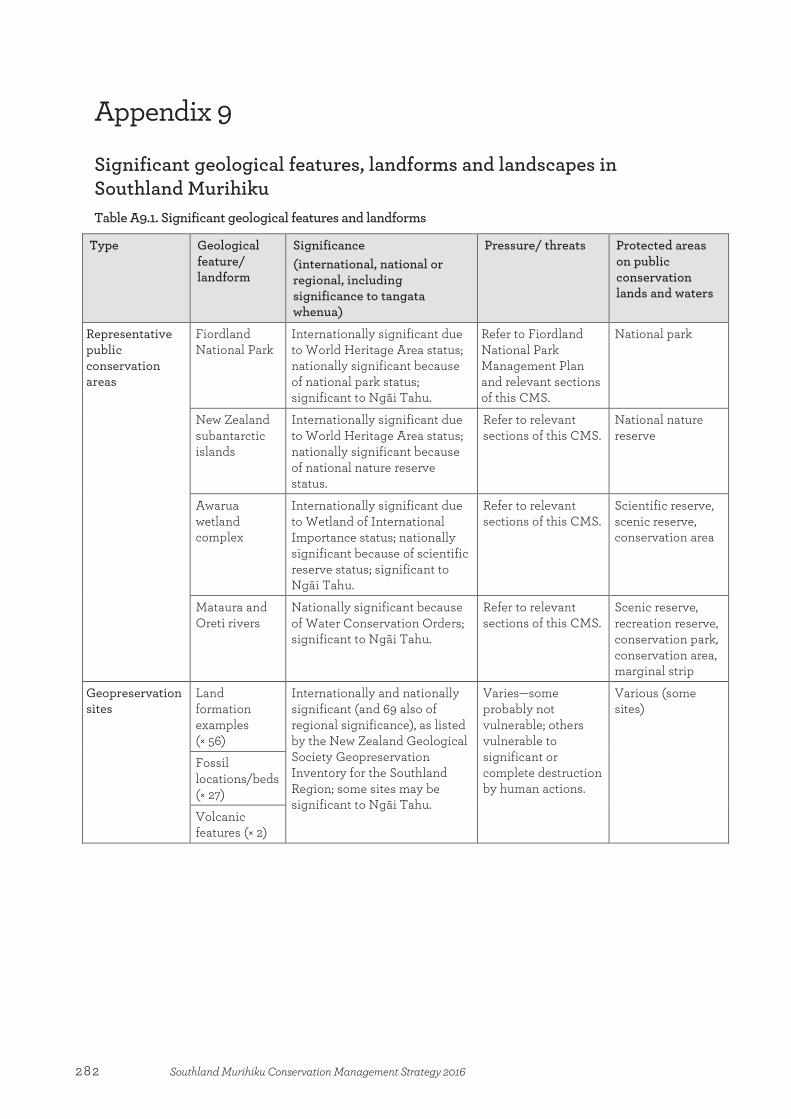
Appendix 9
Significant geological features, landforms and landscapes in Southland Murihiku Table A9.1. Significant geological features and landforms
Type Geological feature/ landform
Significance (international, national or regional, including significance to tangata whenua)
Pressure/ threats Protected areas on public conservation lands and waters
Representative public conservation areas
Fiordland National Park
Internationally significant due to World Heritage Area status; nationally significant because of national park status; significant to Ngāi Tahu.
Refer to Fiordland National Park Management Plan and relevant sections of this CMS.
National park
New Zealand subantarctic islands
Internationally significant due to World Heritage Area status; nationally significant because of national nature reserve status.
Refer to relevant sections of this CMS.
National nature reserve
Awarua wetland complex
Internationally significant due to Wetland of International Importance status; nationally significant because of scientific reserve status; significant to Ngāi Tahu.
Refer to relevant sections of this CMS.
Scientific reserve, scenic reserve, conservation area
Mataura and Oreti rivers
Nationally significant because of Water Conservation Orders; significant to Ngāi Tahu.
Refer to relevant sections of this CMS.
Scenic reserve, recreation reserve, conservation park, conservation area, marginal strip
Geopreservation sites
Land formation examples (× 56)
Internationally and nationally significant (and 69 also of regional significance), as listed by the New Zealand Geological Society Geopreservation Inventory for the Southland Region; some sites may be significant to Ngāi Tahu.
Varies—some probably not vulnerable; others vulnerable to significant or complete destruction by human actions.
Various (some sites)
Fossil locations/beds (× 27)
Volcanic features (× 2)
Appendix 9:Significant geological features, landforms and landscapes in Southland Murihiku
282 Southland Murihiku Conservation Management Strategy 2016

Table A9.2. Significant landscapes
Landscape Significance (international, national, regional)
Pressure/threats Protected areas on public conservation lands and waters
Lake Gunn Nationally and regionally significant, as identified within section 5.6 of the Southland Regional Policy Statement 1997; some sites significant to Ngāi Tahu.
Modification or intensification of use. Also refer to relevant sections of this CMS.
National park
Lake Hauroko National park
Lake Manapouri National park
Lake McKerrow/ Whakatipu Waitai
National park
Lake Monowai National park
Lake Poteriteri National park
Lake Te Anau National park
North and South Mavora Lakes
Conservation area
Hokonui Hills Regionally significant, as identified in the Gore District Plan, July 2006.
Modification or intensification of use. Also refer to relevant sections of this CMS.
Scientific reserve, scenic reserve, conservation area, marginal strip
Te Anau Basin Identified in the Southland Regional Landscape Assessment (Boffa Miskell Limited, August 1997); some sites significant to Ngāi Tahu.
Modification or intensification of use. Also refer to relevant sections of this CMS.
National park, wildlife management reserve, recreation reserve, conservation area, marginal strip
The inland mountains, including the Takitimu, Livingstone, Eyre, Garvie and Umbrella mountains
Scenic reserve, conservation park, conservation area
The Southland coast National park, scientific reserve, scenic reserve, historic reserve, recreation reserve, government purpose reserve, conservation area, marginal strip
Riverton Identified in the Southland Coastal Landscape Study (Boffa Miskell Limited, August 2006).
Modification or intensification of use. Also refer to relevant sections of this CMS.
Scenic reserve, wildlife management reserve, government purpose reserve, conservation area, marginal strip
Southwest Catlins Scientific reserve, recreation reserve, conservation area, marginal strip
South Coast estuaries
Scientific reserve, scenic reserve, recreation reserve, conservation area
Te Waewae Conservation area, marginal strip
283Southland Murihiku Conservation Management Strategy 2016
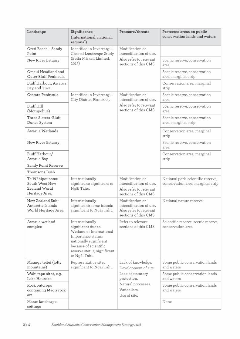
Landscape Significance (international, national, regional)
Pressure/threats Protected areas on public conservation lands and waters
Oreti Beach – Sandy Point
Identified in Invercargill Coastal Landscape Study (Boffa Miskell Limited, 2013)
Modification or intensification of use. Also refer to relevant sections of this CMS.
New River Estuary Scenic reserve, conservation area
Omaui Headland and Outer Bluff Peninsula
Scenic reserve, conservation area, marginal strip
Bluff Harbour, Awarua Bay and Tiwai
Conservation area, marginal strip
Otatara Peninsula Identified in Invercargill City District Plan 2005
Modification or intensification of use. Also refer to relevant sections of this CMS.
Scenic reserve, conservation area
Bluff Hill (Motupōhue)
Scenic reserve, conservation area
Three Sisters -Bluff Dunes System
Scenic reserve, conservation area, marginal strip
Awarua Wetlands Conservation area, marginal strip
New River Estuary Scenic reserve, conservation area
Bluff Harbour/ Awarua Bay
Conservation area, marginal strip
Sandy Point Reserve
Thomsons Bush
Te Wāhipounamu—South West New Zealand World Heritage Area
Internationally significant; significant to Ngāi Tahu.
Modification or intensification of use. Also refer to relevant sections of this CMS.
National park, scientific reserve, conservation area, marginal strip
New Zealand Sub-Antarctic Islands World Heritage Area
Internationally significant; some islands significant to Ngāi Tahu.
Modification or intensification of use. Also refer to relevant sections of this CMS.
National nature reserve
Awarua wetland complex
Internationally significant due to Wetland of International Importance status; nationally significant because of scientific reserve status; significant to Ngāi Tahu.
Refer to relevant sections of this CMS.
Scientific reserve, scenic reserve, conservation area
Maunga teitei (lofty mountains)
Representative sites significant to Ngāi Tahu.
Lack of knowledge. Development of site. Lack of statutory protection. Natural processes. Vandalism. Use of site.
Some public conservation lands and waters
Wāhi tapu sites, e.g. Lake Hauroko
Some public conservation lands and waters
Rock outcrops containing Māori rock art
Some public conservation lands and waters
Marae landscape settings
None
284 Southland Murihiku Conservation Management Strategy 2016

Appendix 10
Actively conserved historic places on public conservation lands and waters, or managed by the Department, in Southland Murihiku
Place Location Heritage topics and significance*
Pressures/ threats
Destination management category/access
Alpha battery and quartz mine
Preservation Inlet, Fiordland
Gold mining Locally significant
Natural decay; vegetation
Backcountry destination/accessible by boat and unmarked route
Anita Bay stone hut remains
Milford Sound/ Piopiotahi, Fiordland
Gold mining Locally significant
Natural decay; disaster (earthquakes); vegetation; visitor impacts
Backcountry destination/accessible by boat
Antipodes Island castaway depot
Antipodes Island Maritime Nationally significant
Natural decay; disaster (landslip); vegetation
No public access
Astronomer Point
Dusky Sound, Fiordland
European discovery Internationally significant
Natural decay; visitor impacts
Local Treasure/ accessible by boat
Beech Hut Upper Mataura River, Eyre Mountains
Pastoralism Locally significant
Natural decay Backcountry destination/accessible via an unmarked route
Beer’s farm Upper Waiau River valley, Kepler Mountains, Fiordland
Pastoralism Locally significant
Natural decay Backcountry destination/accessible via an unmarked route
Bluff Hill gun emplacement, battery observation post, radar and camp
The Bluff/ Motupōhue
Coastal defence Nationally significant
Natural decay (spalling); vegetation; visitor impacts
Gateway destination/ accessible by road and walking track
Camp Cove castaway depot
Carnley Harbour, Auckland Island
Maritime Nationally significant
Natural decay; vegetation; animals
Backcountry destination/accessible by boat, by permit only
Camp Cove sod hut
Campbell Island/ Motu Ihupuku
Sealing and whaling Locally significant
Natural decay; vegetation; animals
Backcountry destination/accessible by boat, by permit only
Castaway finger posts (several locations)
Snares Islands/Tini Heke, Auckland Islands, Campbell Islands and Antipodes Island Group
Maritime Locally significant
Natural decay; vegetation; erosion (wind and sea)
Backcountry destination/some accessible by boat, by permit only
Appendix 10:Actively conserved historic places on public conservation lands and waters, or managed by the Department, in Southland Murihiku
285Southland Murihiku Conservation Management Strategy 2016

Place Location Heritage topics and significance*
Pressures/ threats
Destination management category/access
Caswell Sound Hut
Caswell Sound, Fiordland
Wild animal control Locally significant
Natural decay; vegetation; disaster (fire)
Backcountry destination/accessible by boat or via an unmarked route
Clark Hut Grebe River valley, Fiordland
Wild animal control Locally significant
Natural decay; vegetation; disaster (fire)
Backcountry destination/accessible via tramping track
Cleddau horse bridge
Grave-Talbot Route, Fiordland
Tourism and recreation Nationally significant
Natural decay Backcountry destination/accessible via an unmarked route from Milford Sound Highway
Cuttle Cove whaling station
Preservation Inlet, Fiordland
Sealing and whaling Nationally significant
Natural decay Backcountry destination/accessible by boat
Derry Castle grave site
Enderby Island, Auckland Islands
Maritime Locally significant
Natural decay Backcountry destination/accessible by boat and via walking track, by permit only
Dog Box Bivvy
Eyre Mountains Pastoralism Locally significant
Natural decay; disaster (fire)
Backcountry destination/accessible via an unmarked route
Endeavour wreck site, Facile Harbour
Dusky Sound, Fiordland
Maritime Nationally significant
Natural decay; visitor impacts (fossicking)
Backcountry destination/accessible by boat
Enderby settlement
Erebus Cove, Auckland Island
European settlement (Enderby Company) Nationally significant
Natural decay; visitor impacts (fossicking); vegetation
Backcountry destination/accessible by boat, by permit only
Erebus Cove castaway boatshed, depot, Victoria Tree and Amherst Spar
Erebus Cove, Auckland Island
Maritime Nationally significant
Natural decay; animals; erosion; vegetation
Backcountry destination/accessible by boat, by permit only
Erebus Cove cemetery
Erebus Cove, Auckland Island
Maritime/European settlement Nationally significant
Natural decay; vegetation
Backcountry destination/accessible by boat, by permit only
Freeman Burn Hut
Lake Manapouri, Fiordland
Tourism and recreation Locally significant
Natural decay; vegetation; disaster (fire)
Backcountry destination/accessible by boat
German scientific expedition site
Terror Cove, Auckland Island
Science Internationally significant
Natural decay; visitor impacts (fossicking); vegetation
Backcountry destination/accessible by boat, by permit only
Golden Site battery, Wilson River
Preservation Inlet, Fiordland
Gold mining Locally significant
Natural decay; vegetation; disaster (flooding)
Backcountry destination /accessible by boat and via historic track
286 Southland Murihiku Conservation Management Strategy 2016

Place Location Heritage topics and significance*
Pressures/ threats
Destination management category/access
Grafton wreck and site of ‘Epigwaitt’
Carnley Harbour (North Arm), Auckland Island
Maritime Nationally significant
Natural decay; vegetation; visitor impacts (anchoring and fossicking)
Backcountry destination/accessible by boat, by permit only
Hodge’s stock track
Te Anau Downs, Snowdon Forest Conservation Area, Fiordland
Pastoralism Locally significant
Natural decay; vegetation
Backcountry destination/accessible via an unmarked route
Hollyford baker’s oven
Milford Sound Highway, Fiordland
Tourism and recreation Locally significant
Vegetation; land use (roading)
Accessible from Icon destination—car on Milford Sound Highway
Homer Tunnel portal avalanche damage
Milford Sound Highway, Fiordland
Tourism and recreation Locally significant
Land use (roading) Accessible from Icon destination—car on Milford Sound Highway
Indian Island Dusky Sound, Fiordland
Māori occupation/ contact Nationally significant
Natural decay; vegetation
Backcountry destination/accessible by boat
Jamestown site
Lake McKerrow/ Whakatipu Waitai, Fiordland
European colonial settlement Locally significant
Natural decay; vegetation; visitor impacts (fossicking)
Gateway destination/ accessible via Hollyford Track
Luncheon Cove
Dusky Sound, Fiordland
Sealing and whaling Nationally significant
Natural decay; vegetation
Backcountry destination/accessible by boat
MacKinnon Pass Memorial
Milford Track, Fiordland
Tourism and recreation Nationally significant
Natural decay Icon destination/ accessible via Milford Track Great Walk
Māori occupation
Enderby Island, Auckland Islands
Māori occupation Internationally significant
Natural decay; erosion; animals; land use (DOC work programmes)
Backcountry destination/accessible by boat and via walking track, by permit only
Marian Corner construction camp
Milford Sound Highway, Fiordland
Tourism and recreation Locally significant
Land use (roading); vegetation; natural decay; visitor impacts (fossicking)
Accessible from Icon destination—car on Milford Sound Highway
Marian Hill rock cutting
Milford Sound Highway, Fiordland
Tourism and recreation. Locally significant.
Land use (roading); disaster (rock fall).
Accessible from Icon destination—car on Milford Sound Highway
Martin’s Hut and race
Longwood Range Gold mining Locally significant
Natural decay; visitor impacts (vandalism); disaster (fire)
Backcountry destination/accessible via tramping track
287Southland Murihiku Conservation Management Strategy 2016

Place Location Heritage topics and significance*
Pressures/ threats
Destination management category/access
McIntyre sawmill, Cromarty
Preservation Inlet, Fiordland
Timber milling Locally significant
Natural decay; vegetation; visitor impacts (fossicking)
Backcountry destination/accessible by boat
Mores’ Johnston locomotive
Riverton township Timber milling Nationally significant
Visitor impacts (vandalism); loss of cultural connection; natural decay
Accessible by car
Mores’ top mill site, Pourakino Valley
Longwood Range Timber milling Nationally significant
Visitor impacts (vandalism); loss of cultural connection (lack of use); vegetation
Local Treasure/ accessible by car
Morning Star Mine, Te Oneroa
Preservation Inlet, Fiordland
Gold mining Locally significant
Natural decay; vegetation; visitor impacts (fossicking)
Backcountry destination/accessible by boat and via an unmarked route
North-East Harbour whaling station
Campbell Island/ Motu Ihupuku
Sealing and whaling Locally significant
Natural decay; erosion
No public access
Piano Flat water race
Waikaia Forest Conservation Area
Gold mining Locally significant
Natural decay; vegetation; land use
Backcountry destination/accessible via tramping track
Port Craig School, settlement and sawmill site
Port Craig, Fiordland Timber milling Nationally significant
Natural decay; vegetation; visitor impacts (fossicking); erosion; disaster (landslip and fire)
Backcountry destination/accessible via South Coast Track tramping track
Port Craig tramway and viaducts†
South-east Fiordland Timber milling Nationally significant
Natural decay; vegetation; erosion; disaster (landslip); land use (DOC work programmes)
Backcountry destination/accessible via South Coast Track tramping track
Port’s water race
Longwood Range Gold mining Nationally significant
Natural decay; vegetation; land use (logging); visitor impacts (bikes); erosion; disaster (landslip)
Local Treasure/ accessible via Round Hill and Port’s Water Race tracks
Printz’s battery
Longwood Range Gold mining Locally significant
Natural decay; land use (logging); vegetation; visitor impacts (fossicking)
Backcountry destination/accessible via tramping track
Puysegur Point landing
Preservation Inlet, Fiordland
Maritime Locally significant
Natural decay; vegetation; visitor
Local Treasure/ accessible by boat
288 Southland Murihiku Conservation Management Strategy 2016

Place Location Heritage topics and significance*
Pressures/ threats
Destination management category/access
shed and cemetery
impacts; disaster (fire)
Puysegur Point lighthouse access road and settlement site
Puysegur Point, Fiordland
Maritime Locally significant
Natural decay; vegetation; erosion
Local Treasure/ accessible by boat and via historic Puysegur Point Road
Ranui coastwatchers lookout hut
Ranui Cove, Auckland Island
Defence Nationally significant
Natural decay; vegetation
Backcountry destination/accessible by boat, by permit only
Richard Henry's house site, Pigeon Island
Dusky Sound, Fiordland
Conservation Nationally significant
Natural decay; vegetation; visitor impacts (trampling and fossicking)
Backcountry destination/accessible by boat
Round Island Preservation Inlet, Fiordland
Māori occupation Locally significant
Natural decay; visitor impacts (trampling and fossicking)
Backcountry destination/accessible by boat
Sandfly Point brick chimney
Milford Track, Fiordland
Tourism and recreation Locally significant
Natural decay; vegetation
Icon destination/ accessible via Milford Track Great Walk
Sandy Bay castaway boatshed
Enderby Island, Auckland Islands
Maritime/conservation Nationally significant
Natural decay; land use (DOC work programmes); erosion
Backcountry destination/accessible by boat, by permit only
Snares Island castaway depot
North East Island, Snares Islands/Tini Heke
Maritime Nationally significant
Natural decay; vegetation
No public access
S.S. Stella hull and freezer base
Chalky Inlet, Fiordland
Maritime/fishing Nationally significant
Natural decay; visitor impacts (rubbish); vegetation; erosion
Backcountry destination/accessible by boat
Stella Hut castaway depot
Enderby Island, Auckland Islands
Maritime Nationally significant
Natural decay; vegetation
Backcountry destination/accessible by boat, by permit only
Tagua coastwatchers lookout hut
Tagua Bay, Auckland Island
Defence Nationally significant
Natural decay; vegetation
Backcountry destination/accessible by boat and via walking track, by permit only
Tarawera smelter and mine
Preservation Inlet, Fiordland
Gold mining Nationally significant
Natural decay; vegetation
Backcountry destination/accessible by boat
Te Anau Downs power plant
Te Anau Downs, Fiordland
Pastoralism Locally significant
Natural decay; vegetation
Accessible from Icon destination—car on Milford Sound Highway
289Southland Murihiku Conservation Management Strategy 2016
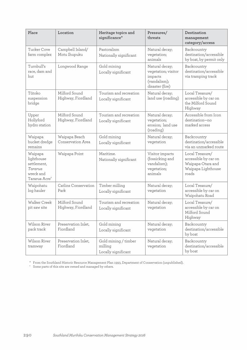
Place Location Heritage topics and significance*
Pressures/ threats
Destination management category/access
Tucker Cove farm complex
Campbell Island/ Motu Ihupuku
Pastoralism Nationally significant
Natural decay; vegetation; animals
Backcountry destination/accessible by boat, by permit only
Turnbull’s race, dam and hut
Longwood Range Gold mining Locally significant
Natural decay; vegetation; visitor impacts (vandalism); disaster (fire)
Backcountry destination/accessible via tramping track
Tūtoko suspension bridge
Milford Sound Highway, Fiordland
Tourism and recreation Locally significant
Natural decay; land use (roading)
Local Treasure/ accessible by car on the Milford Sound Highway
Upper Hollyford hydro station
Milford Sound Highway, Fiordland
Tourism and recreation Locally significant
Natural decay; vegetation; erosion; land use (roading)
Accessible from Icon destination—no marked access
Waipapa bucket dredge remains
Waipapa Beach Conservation Area
Gold mining Locally significant
Natural decay; vegetation
Backcountry destination/accessible via an unmarked route
Waipapa lighthouse settlement, Tararua wreck and Tararua Acre†
Waipapa Point Maritime. Nationally significant
Visitor impacts (fossicking and vandalism); vegetation; animals
Local Treasure/ accessible by car on Waipapa-Otara and Waipapa Lighthouse roads
Waipohatu log hauler
Catlins Conservation Park
Timber milling Locally significant
Natural decay; vegetation
Local Treasure/ accessible by car on Waipohatu Road
Walker Creek pit saw site
Milford Sound Highway, Fiordland
Tourism and recreation Locally significant
Natural decay; vegetation
Local Treasure/ accessible by car on Milford Sound Highway
Wilson River pack track
Preservation Inlet, Fiordland
Gold mining Locally significant
Natural decay; vegetation
Backcountry destination/accessible by boat
Wilson River tramway
Preservation Inlet, Fiordland
Gold mining / timber milling Locally significant
Natural decay; vegetation
Backcountry destination/accessible by boat
* From the Southland Historic Resource Management Plan 1993, Department of Conservation (unpublished). † Some parts of this site are owned and managed by others.
290 Southland Murihiku Conservation Management Strategy 2016
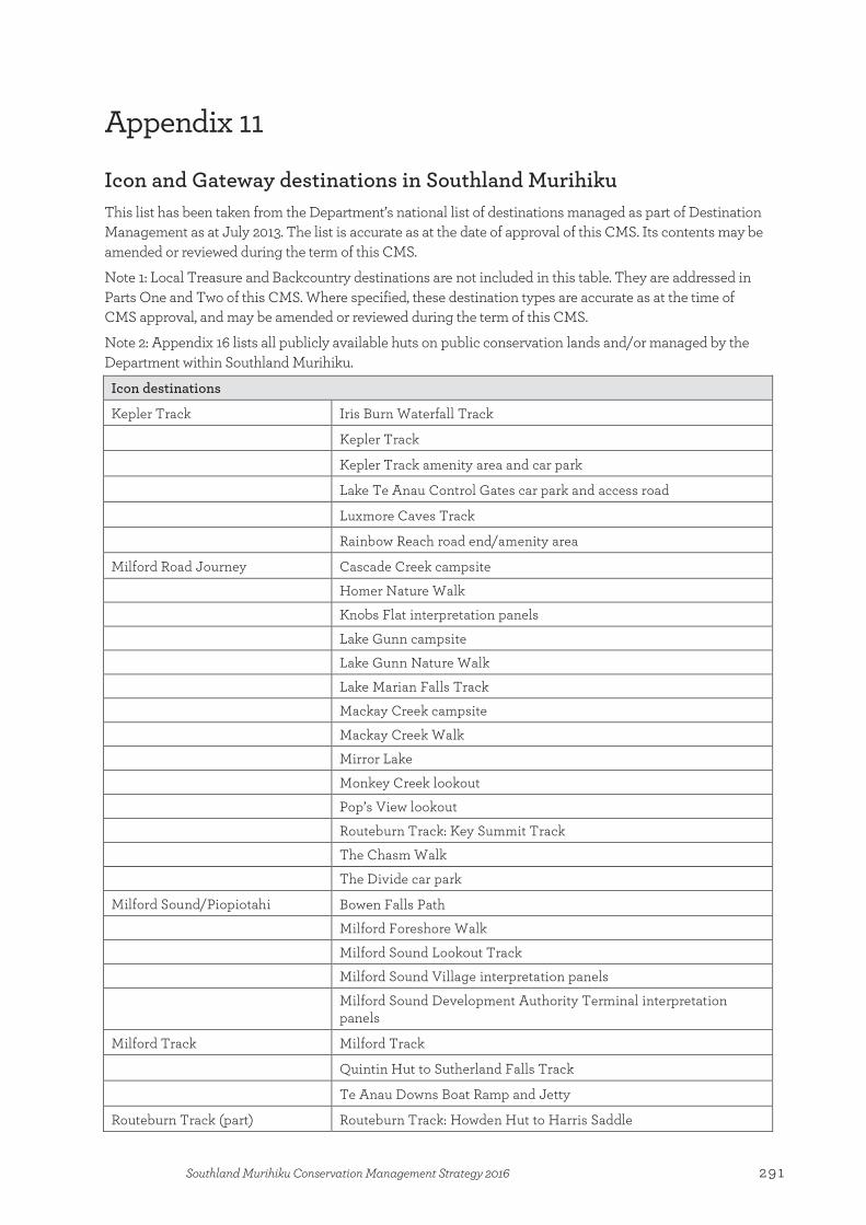
Appendix 11
Icon and Gateway destinations in Southland Murihiku This list has been taken from the Department’s national list of destinations managed as part of Destination Management as at July 2013. The list is accurate as at the date of approval of this CMS. Its contents may be amended or reviewed during the term of this CMS.
Note 1: Local Treasure and Backcountry destinations are not included in this table. They are addressed in Parts One and Two of this CMS. Where specified, these destination types are accurate as at the time of CMS approval, and may be amended or reviewed during the term of this CMS.
Note 2: Appendix 16 lists all publicly available huts on public conservation lands and/or managed by the Department within Southland Murihiku.
Icon destinations
Kepler Track Iris Burn Waterfall Track
Kepler Track
Kepler Track amenity area and car park
Lake Te Anau Control Gates car park and access road
Luxmore Caves Track
Rainbow Reach road end/amenity area
Milford Road Journey Cascade Creek campsite
Homer Nature Walk
Knobs Flat interpretation panels
Lake Gunn campsite
Lake Gunn Nature Walk
Lake Marian Falls Track
Mackay Creek campsite
Mackay Creek Walk
Mirror Lake
Monkey Creek lookout
Pop’s View lookout
Routeburn Track: Key Summit Track
The Chasm Walk
The Divide car park
Milford Sound/Piopiotahi Bowen Falls Path
Milford Foreshore Walk
Milford Sound Lookout Track
Milford Sound Village interpretation panels
Milford Sound Development Authority Terminal interpretation panels
Milford Track Milford Track
Quintin Hut to Sutherland Falls Track
Te Anau Downs Boat Ramp and Jetty
Routeburn Track (part) Routeburn Track: Howden Hut to Harris Saddle
Appendix 11:Icon and Gateway destinations in Southland Murihiku
291Southland Murihiku Conservation Management Strategy 2016

Gateway destinations
The Bluff/Motupōhue Foveaux Walkway
Glory Track
The Bluff/Motupōhue viewpoint
Croydon Bush Dolomore Track
Whisky Creek and Popplewells Tracks
Curio Bay/Porpoise Bay Curio Bay Walk
Curio Bay picnic area
Forest Hill Tussock Creek picnic area
Crossing Road picnic area
Tussock Creek road end to Lookout Track
Crossing Road end to Lookout Track
Greenstone/Caples Track (part) Greenstone Track: Howden Hut to head of Lake McKellar
Hollyford Track Hollyford Road end carpark
Hollyford Track: road end to Alabaster Hut
Hollyford Track: north end Lake McKerrow/Whakatipu Waitai to Martins Bay Hut
Mavora Lakes Mavora Lakes campsite and amenity area
Mavora Lakes Road
292 Southland Murihiku Conservation Management Strategy 2016
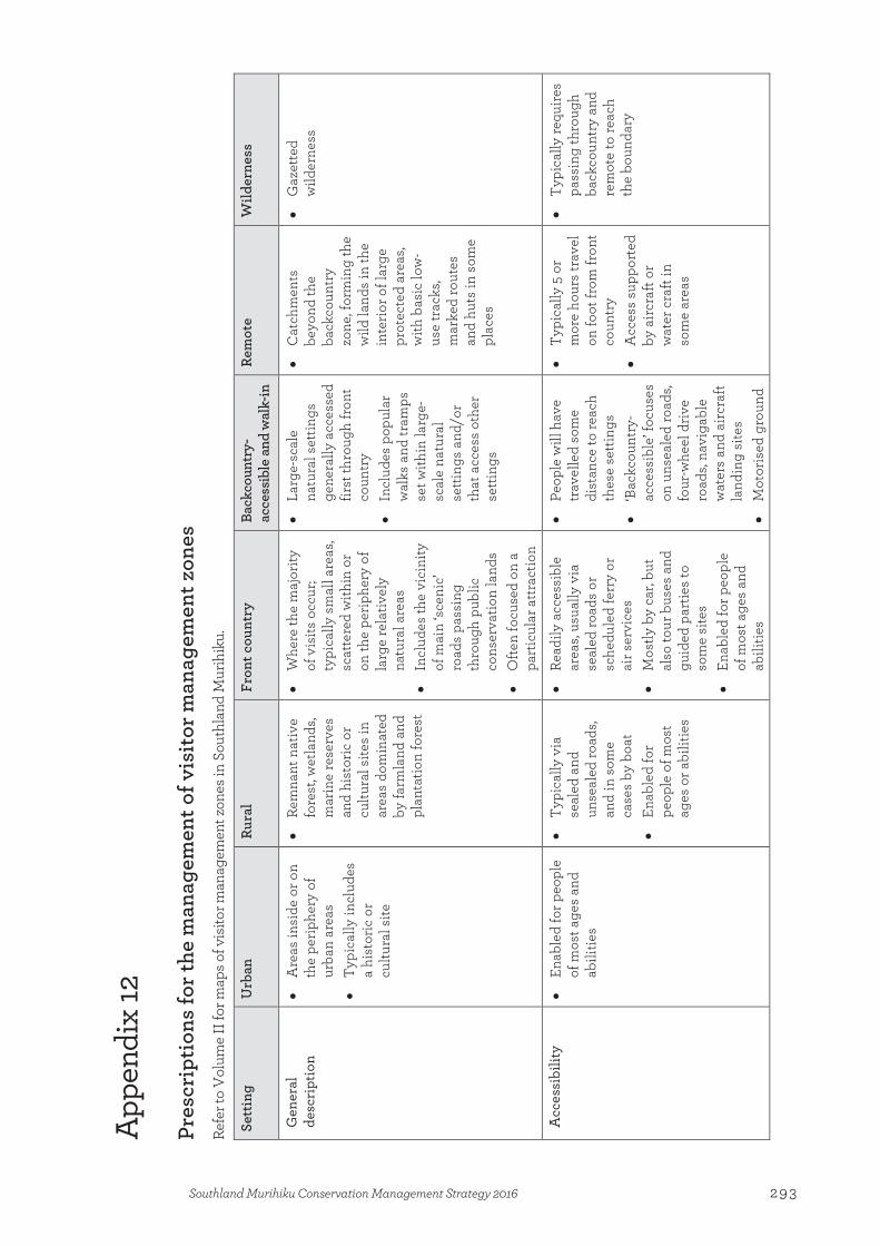
App
endi
x 12
Pres
crip
tions
for t
he m
anag
emen
t of v
isito
r man
agem
ent z
ones
Re
fer t
o V
olum
e II
for m
aps o
f vis
itor m
anag
emen
t zon
es in
Sou
thla
nd M
urih
iku.
Sett
ing
U
rban
Ru
ral
Fron
t cou
ntry
Ba
ckco
untr
y-ac
cess
ible
and
wal
k-in
Re
mot
e W
ilder
ness
Gen
eral
de
scri
ptio
n •
Are
as in
side
or o
n th
e pe
riphe
ry o
f ur
ban
area
s •
Typi
cally
incl
udes
a
hist
oric
or
cultu
ral s
ite
• Re
mna
nt n
ativ
e fo
rest
, wet
land
s, m
arin
e re
serv
es
and
hist
oric
or
cultu
ral s
ites
in
area
s do
min
ated
by
farm
land
and
pl
anta
tion
fore
st
• W
here
the
maj
ority
of
vis
its o
ccur
; ty
pica
lly s
mal
l are
as,
scat
tere
d w
ithin
or
on th
e pe
riphe
ry o
f la
rge
rela
tivel
y na
tura
l are
as
• In
clud
es th
e vi
cini
ty
of m
ain
‘scen
ic’
road
s pa
ssin
g th
roug
h pu
blic
co
nser
vatio
n la
nds
• O
ften
focu
sed
on a
pa
rtic
ular
attr
actio
n
• La
rge-
scal
e na
tura
l set
tings
ge
nera
lly a
cces
sed
first
thro
ugh
fron
t co
untr
y
• In
clud
es p
opul
ar
wal
ks a
nd tr
amps
se
t with
in la
rge-
scal
e na
tura
l se
tting
s an
d/or
th
at a
cces
s ot
her
setti
ngs
• C
atch
men
ts
beyo
nd th
e ba
ckco
untr
y zo
ne, f
orm
ing
the
wild
land
s in
the
inte
rior o
f lar
ge
prot
ecte
d ar
eas,
with
bas
ic lo
w-
use
trac
ks,
mar
ked
rout
es
and
huts
in s
ome
plac
es
• G
azet
ted
wild
erne
ss
Acc
essi
bilit
y •
Enab
led
for p
eopl
e of
mos
t age
s an
d ab
ilitie
s
• Ty
pica
lly v
ia
seal
ed a
nd
unse
aled
road
s, an
d in
som
e ca
ses
by b
oat
• En
able
d fo
r pe
ople
of m
ost
ages
or a
bilit
ies
• Re
adily
acc
essi
ble
area
s, us
ually
via
se
aled
road
s or
sc
hedu
led
ferr
y or
ai
r ser
vice
s •
Mos
tly b
y ca
r, bu
t al
so to
ur b
uses
and
gu
ided
par
ties
to
som
e si
tes
• En
able
d fo
r peo
ple
of m
ost a
ges
and
abili
ties
• Pe
ople
will
hav
e tr
avel
led
som
e di
stan
ce to
reac
h th
ese
setti
ngs
• ‘B
ackc
ount
ry-
acce
ssib
le’ f
ocus
es
on u
nsea
led
road
s, fo
ur-w
heel
driv
e ro
ads,
navi
gabl
e w
ater
s an
d ai
rcra
ft la
ndin
g si
tes
• M
otor
ised
gro
und
• Ty
pica
lly 5
or
mor
e ho
urs
trav
el
on fo
ot fr
om fr
ont
coun
try
•
Acc
ess
supp
orte
d by
airc
raft
or
wat
er c
raft
in
som
e ar
eas
• Ty
pica
lly re
quire
s pa
ssin
g th
roug
h ba
ckco
untr
y an
d re
mot
e to
reac
h th
e bo
unda
ry
Appendix 12:Prescriptions for the management of visitor management zones
293Southland Murihiku Conservation Management Strategy 2016
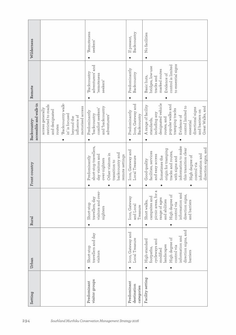
Sett
ing
U
rban
Ru
ral
Fron
t cou
ntry
Ba
ckco
untr
y-ac
cess
ible
and
wal
k-in
Re
mot
e W
ilder
ness
acce
ss g
ener
ally
re
stric
ted
to ro
ads
and
desi
gnat
ed
rout
es
• ‘B
ackc
ount
ry w
alk-
in’ i
s fo
cuse
d be
yond
the
influ
ence
of
mot
oris
ed a
cces
s
Pred
omin
ant
visi
tor g
roup
s •
Shor
t-sto
p tr
avel
lers
and
day
vi
sito
rs
• Sh
ort-s
top
trav
elle
rs, d
ay
visi
tors
and
ove
r-ni
ghte
rs
• Pr
edom
inan
tly
shor
t-sto
p tr
avel
lers
, da
y vi
sito
rs a
nd
over
-nig
hter
s •
Oth
er v
isito
rs in
tr
ansi
tion
to
back
coun
try
and
rem
ote
setti
ngs
• Pr
edom
inan
tly
‘bac
kcou
ntry
co
mfo
rt s
eeke
rs’
and
‘bac
kcou
ntry
ad
vent
urer
s’
• ‘B
ackc
ount
ry
adve
ntur
ers’
and
‘rem
oten
ess
seek
ers’
• ‘R
emot
enes
s se
eker
s’
Pred
omin
ant
dest
inat
ion
cate
gori
es
• Ic
on, G
atew
ay a
nd
Loca
l Tre
asur
e •
Icon
, Gat
eway
an
d Lo
cal
Trea
sure
• Ic
on, G
atew
ay a
nd
Loca
l Tre
asur
e •
Pred
omin
antly
Ic
on, G
atew
ay a
nd
Back
coun
try
• Pr
edom
inan
tly
Back
coun
try
• If
pre
sent
, Ba
ckco
untr
y
Faci
lity
sett
ing
• H
igh-
stan
dard
fo
otpa
ths,
cycl
eway
s an
d m
odifi
ed
land
scap
es
• H
igh
degr
ee o
f co
ntro
l via
in
form
atio
n an
d di
rect
ion
sign
s, an
d ba
rrie
rs
• Sh
ort w
alks
, ca
mps
ites
and
picn
ic a
reas
, for
a
rang
e of
age
s an
d ab
ilitie
s •
Hig
h de
gree
of
cont
rol v
ia
info
rmat
ion
and
dire
ctio
n si
gns,
and
barr
iers
• G
ood-
qual
ity
faci
litie
s, se
rvic
es
and
easy
acc
ess
• So
met
imes
the
orig
in fo
r tra
mpi
ng
trac
ks a
nd ro
utes
, w
ith s
igns
and
in
form
atio
n to
mak
e th
is tr
ansi
tion
clea
r •
Hig
h de
gree
of
cont
rol v
ia
info
rmat
ion
and
dire
ctio
n si
gns,
and
• A
rang
e of
faci
lity
stan
dard
s, in
clud
ing
any
desi
gnat
ed v
ehic
le
rout
es, a
nd
popu
lar w
alks
and
tr
ampi
ng tr
acks
•
Evid
ence
of
cont
rol l
imite
d to
es
sent
ial
dire
ctio
nal s
igns
an
d ba
rrie
rs o
n G
reat
Wal
ks, a
nd
• Ba
sic
huts
, br
idge
s, lo
w-u
se
trac
ks a
nd
mar
ked
rout
es
• Ev
iden
ce o
f co
ntro
l is
limite
d to
ess
entia
l sig
ns
• N
o fa
cilit
ies
294 Southland Murihiku Conservation Management Strategy 2016

Sett
ing
U
rban
Ru
ral
Fron
t cou
ntry
Ba
ckco
untr
y-ac
cess
ible
and
wal
k-in
Re
mot
e W
ilder
ness
barr
iers
w
here
ther
e ar
e si
gnifi
cant
ha
zard
s
Des
ired
vis
itor
expe
rien
ce a
nd
inte
ract
ions
• V
aryi
ng, f
rom
act
iviti
es w
ith la
rge
grou
ps, t
ime
with
sm
all
grou
ps/f
amili
es, s
ome
time
away
from
oth
er g
roup
s an
d, in
som
e ca
ses,
solit
ude
• G
ener
ally
som
e tim
e aw
ay fr
om
othe
r gro
ups
and,
in
som
e ca
ses,
solit
ude
• O
ccas
iona
l en
coun
ters
with
or
gani
sed
grou
ps
• G
ener
ally
ac
cept
ing
of
occa
sion
al
intr
usio
n of
noi
se
• Re
ason
able
ex
pect
atio
n of
is
olat
ion
from
si
ghts
, sou
nds
and
activ
ities
of
othe
r peo
ple
• In
tera
ctio
n w
ith
few
oth
er g
roup
s •
Con
side
rabl
e se
lf-re
lianc
e on
ba
ckco
untr
y sk
ills
• C
ompl
ete
isol
atio
n fr
om
sigh
ts, s
ound
s an
d ac
tiviti
es o
f ot
her p
eopl
e •
Max
imum
in
tera
ctio
n w
ith
only
one
oth
er
grou
p is
gen
eral
ly
acce
ptab
le
Pref
erre
d m
axim
um p
arty
si
ze
• W
hat i
s so
cial
ly
appr
opria
te
• C
onfo
rmin
g co
nces
sion
s sc
hedu
le—
15
• 50
•
Con
form
ing
conc
essi
ons
sche
dule
—15
• 15
•
50 fo
r per
iodi
c to
ur
part
ies
• C
onfo
rmin
g co
nces
sion
s sc
hedu
le—
15
• 15
•
8 •
4
Typi
cal v
isito
r in
tera
ctio
n le
vels
• W
hat i
s so
cial
ly
appr
opria
te
• 20
or l
ess
peop
le
seen
per
hou
r •
30 o
r les
s pe
ople
se
en p
er v
isit
dura
tion
• 15
or l
ess
othe
r pe
ople
see
n pe
r da
y fo
r ‘b
ackc
ount
ry
adve
ntur
er’ t
rack
s •
40 o
r les
s pe
ople
se
en p
er d
ay fo
r ‘b
ackc
ount
ry
com
fort
see
ker’
trac
ks
• O
ne o
ther
par
ty
seen
per
day
•
Less
than
1 ot
her
part
y se
en p
er
wee
k
295Southland Murihiku Conservation Management Strategy 2016
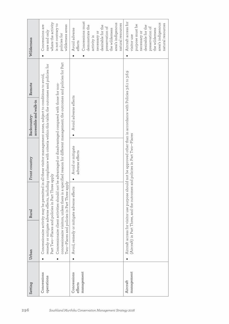
Sett
ing
U
rban
Ru
ral
Fron
t cou
ntry
Ba
ckco
untr
y-ac
cess
ible
and
wal
k-in
Re
mot
e W
ilder
ness
Con
cess
ions
op
erat
ions
•
Con
cess
iona
ire a
ctiv
ity m
ay b
e pe
rmitt
ed in
all
thes
e vi
sito
r man
agem
ent z
ones
, sub
ject
to c
ondi
tions
to a
void
, re
med
y or
miti
gate
adv
erse
effe
cts,
incl
udin
g co
mpl
ianc
e w
ith c
riter
ia w
ithin
this
tabl
e; th
e ou
tcom
es a
nd p
olic
ies
for
Part
Tw
o—Pl
aces
and
pol
icie
s in
Par
t Thr
ee a
pply
•
Con
cess
iona
ire c
lient
act
iviti
es s
houl
d no
t be
adva
ntag
ed o
r dis
adva
ntag
ed c
ompa
red
with
thos
e fo
r non
-co
nces
sion
aire
vis
itors
, unl
ess
ther
e is
a s
peci
fied
reas
on fo
r diff
eren
t man
agem
ent;
the
outc
omes
and
pol
icie
s fo
r Par
t Tw
o—Pl
aces
and
pol
icie
s in
Par
t Thr
ee a
pply
• C
once
ssio
ns a
re
rare
and
onl
y w
here
the
activ
ity
is n
ot c
ontr
ary
to
polic
ies
for
wild
erne
ss a
reas
Con
cess
ions
ef
fect
s m
anag
emen
t
• A
void
, rem
edy
or m
itiga
te a
dver
se e
ffect
s •
Avo
id o
r miti
gate
ad
vers
e ef
fect
s
• A
void
adv
erse
effe
cts
•
Avo
id a
dver
se
effe
cts
• C
once
ssio
ns m
ust
dem
onst
rate
the
activ
ity is
ne
cess
ary
or
desi
rabl
e fo
r the
pr
eser
vatio
n of
th
e w
ilder
ness
ar
ea’s
indi
geno
us
natu
ral r
esou
rces
Air
craf
t m
anag
emen
t •
Airc
raft
acce
ss fo
r vis
itor u
se p
urpo
se s
houl
d no
t be
appr
oved
oth
er th
an in
acc
orda
nce
with
Pol
icie
s 3.
6.1 t
o 3.
6.9
(Airc
raft)
in P
art T
hree
, and
the
outc
omes
and
pol
icie
s in
Par
t Tw
o—Pl
aces
•
Airc
raft
acce
ss fo
r vi
sito
r use
pu
rpos
e m
ust b
e ne
cess
ary
or
desi
rabl
e fo
r the
pr
eser
vatio
n of
th
e w
ilder
ness
ar
ea’s
indi
geno
us
natu
ral r
esou
rces
296 Southland Murihiku Conservation Management Strategy 2016
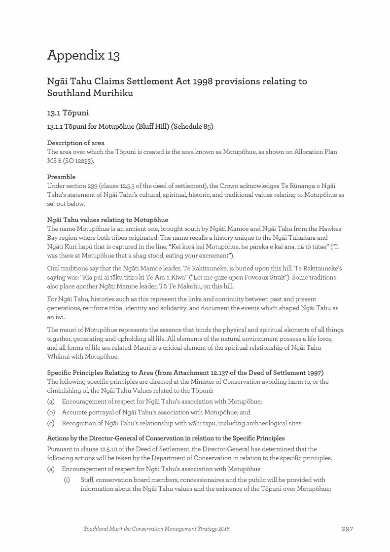
Appendix 13
Ngāi Tahu Claims Settlement Act 1998 provisions relating to Southland Murihiku
13.1 Tōpuni 13.1.1 Tōpuni for Motupōhue (Bluff Hill) (Schedule 85)
Description of area The area over which the Tōpuni is created is the area known as Motupōhue, as shown on Allocation Plan MS 8 (SO 12233).
Preamble Under section 239 (clause 12.5.3 of the deed of settlement), the Crown acknowledges Te Rūnanga o Ngāi Tahu’s statement of Ngāi Tahu’s cultural, spiritual, historic, and traditional values relating to Motupōhue as set out below.
Ngāi Tahu values relating to Motupōhue The name Motupōhue is an ancient one, brought south by Ngāti Mamoe and Ngāi Tahu from the Hawkes Bay region where both tribes originated. The name recalls a history unique to the Ngāi Tuhaitara and Ngāti Kurī hapū that is captured in the line, “Kei korā kei Motupōhue, he pāreka e kai ana, nā tō tūtae” (“It was there at Motupōhue that a shag stood, eating your excrement”).
Oral traditions say that the Ngāti Mamoe leader, Te Rakitauneke, is buried upon this hill. Te Rakitauneke’s saying was: “Kia pai ai tāku titiro ki Te Ara a Kiwa” (“Let me gaze upon Foveaux Strait”). Some traditions also place another Ngāti Mamoe leader, Tū Te Makohu, on this hill.
For Ngāi Tahu, histories such as this represent the links and continuity between past and present generations, reinforce tribal identity and solidarity, and document the events which shaped Ngāi Tahu as an iwi.
The mauri of Motupōhue represents the essence that binds the physical and spiritual elements of all things together, generating and upholding all life. All elements of the natural environment possess a life force, and all forms of life are related. Mauri is a critical element of the spiritual relationship of Ngāi Tahu Whānui with Motupōhue.
Specific Principles Relating to Area (from Attachment 12.137 of the Deed of Settlement 1997) The following specific principles are directed at the Minister of Conservation avoiding harm to, or the diminishing of, the Ngāi Tahu Values related to the Tōpuni: (a) Encouragement of respect for Ngāi Tahu’s association with Motupōhue; (b) Accurate portrayal of Ngāi Tahu’s association with Motupōhue; and (c) Recognition of Ngāi Tahu’s relationship with wāhi tapu, including archaeological sites.
Actions by the Director-General of Conservation in relation to the Specific Principles Pursuant to clause 12.5.10 of the Deed of Settlement, the Director-General has determined that the following actions will be taken by the Department of Conservation in relation to the specific principles: (a) Encouragement of respect for Ngāi Tahu’s association with Motupōhue
(i) Staff, conservation board members, concessionaires and the public will be provided with information about the Ngāi Tahu values and the existence of the Tōpuni over Motupōhue;
Appendix 13:Ngāi Tahu Claims Settlement Act 1998 provisions relating to Southland Murihiku
297Southland Murihiku Conservation Management Strategy 2016

(ii) Educational material will be made available to visitors to Motupōhue asking that they picnic only in designated areas as there are urupā in the reserve which are tapu to Ngāi Tahu;
(iii) A review of conditions to be applied generally to new concessions will be undertaken; (iv) The removal of all rubbish and wastes from Motupōhue will be encouraged; and (v) Te Rūnanga will be consulted about the siting and design of new structures, and particular
regard had to its views. (b) Accurate portrayal of Ngāi Tahu’s association with Motupōhue
(i) The Department will ensure, as far as reasonably practicable, that Ngāi Tahu’s association with Motupōhue is accurately portrayed in all of its new public information and interpretative material; and
(ii) The Department will consult with Te Rūnanga in the provision of its new public information or interpretative material, and as far as reasonably practicable, will only use Ngāi Tahu cultural information with the consent of Te Rūnanga.
(c) Recognition of Ngāi Tahu’s relationship with wāhi tapu and wāhi taonga, including archaeological sites (i) Significant earthworks and disturbances of soil and/or vegetation will be minimised wherever
possible; and (ii) Where significant earthworks and disturbances of soil and/or vegetation cannot be avoided,
Te Rūnanga will be consulted and particular regard will be had to its relevant policies, including those relating to Koiwi Tangata (unidentified human remains) and Archaeological and Rock Art Sites.
13.1.2 Tōpuni for Takitimu Range, Southland (Schedule 89)
Description of area The area over which the Tōpuni is created is the area known as Takitimu Range located in Murihiku (Southland), as shown on Allocation Plan MS 5 (SO 12232).
Preamble Under section 239 (clause 12.5.3 of the deed of settlement), the Crown acknowledges Te Rūnanga o Ngāi Tahu’s statement of Ngāi Tahu’s cultural, spiritual, historic, and traditional values relating to Takitimu as set out below.
Ngāi Tahu values relating to Takitimu The Takitimu maunga (mountains) were named by Tamatea, the captain of the Takitimu waka (canoe) in memory of the waka after it struck trouble in Te Waewae Bay, and was eventually wrecked near the mouth of the Waimeha Stream.
Tradition states that the Takitimu waka was overtaken by three large waves known as Ō-te-wao, Ō-roko and Ō-kaka, followed by a cross wave, which resulted in the Takitimu being hurled well inland, with its cargo being strewn about. In some accounts the ranges inland from Te Waewae Bay are likened to the huge waves that caused the demise of the waka Takitimu. In other accounts the Takitimu maunga are considered to be the upturned hull of the waka.
For Ngāi Tahu, traditions such as this represent the links between the cosmological world of the gods and present generations, these histories reinforce tribal identity and solidarity, and continuity between generations, and document the events that have shaped the environment of Te Wai Pounamu and Ngāi Tahu as an iwi.
Tamatea and his crew made their way overland from the site of the wreck. Tamatea likened the majestic and upright Takitimu maunga when he viewed them from the south coast, to the crew of the Takitimu
298 Southland Murihiku Conservation Management Strategy 2016
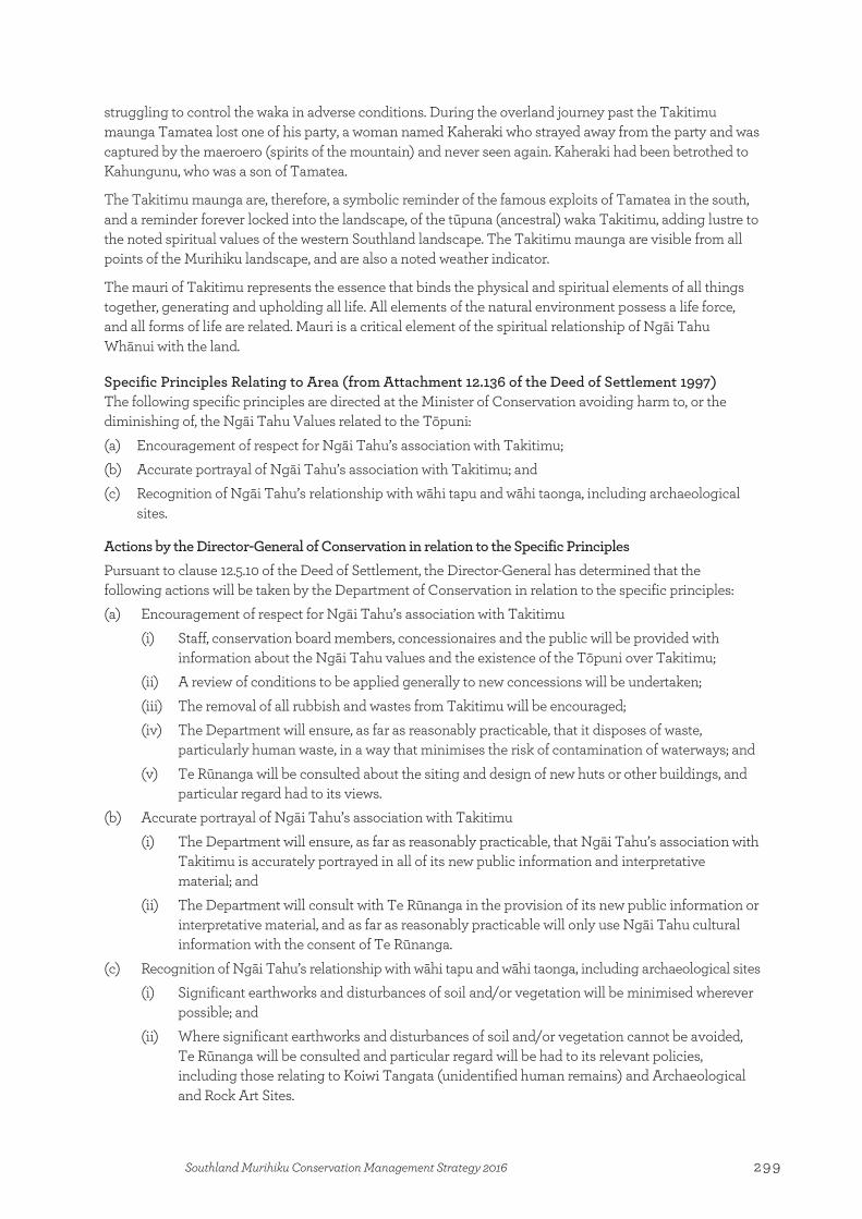
struggling to control the waka in adverse conditions. During the overland journey past the Takitimu maunga Tamatea lost one of his party, a woman named Kaheraki who strayed away from the party and was captured by the maeroero (spirits of the mountain) and never seen again. Kaheraki had been betrothed to Kahungunu, who was a son of Tamatea.
The Takitimu maunga are, therefore, a symbolic reminder of the famous exploits of Tamatea in the south, and a reminder forever locked into the landscape, of the tūpuna (ancestral) waka Takitimu, adding lustre to the noted spiritual values of the western Southland landscape. The Takitimu maunga are visible from all points of the Murihiku landscape, and are also a noted weather indicator.
The mauri of Takitimu represents the essence that binds the physical and spiritual elements of all things together, generating and upholding all life. All elements of the natural environment possess a life force, and all forms of life are related. Mauri is a critical element of the spiritual relationship of Ngāi Tahu Whānui with the land.
Specific Principles Relating to Area (from Attachment 12.136 of the Deed of Settlement 1997) The following specific principles are directed at the Minister of Conservation avoiding harm to, or the diminishing of, the Ngāi Tahu Values related to the Tōpuni: (a) Encouragement of respect for Ngāi Tahu’s association with Takitimu; (b) Accurate portrayal of Ngāi Tahu’s association with Takitimu; and (c) Recognition of Ngāi Tahu’s relationship with wāhi tapu and wāhi taonga, including archaeological
sites.
Actions by the Director-General of Conservation in relation to the Specific Principles Pursuant to clause 12.5.10 of the Deed of Settlement, the Director-General has determined that the following actions will be taken by the Department of Conservation in relation to the specific principles: (a) Encouragement of respect for Ngāi Tahu’s association with Takitimu
(i) Staff, conservation board members, concessionaires and the public will be provided with information about the Ngāi Tahu values and the existence of the Tōpuni over Takitimu;
(ii) A review of conditions to be applied generally to new concessions will be undertaken; (iii) The removal of all rubbish and wastes from Takitimu will be encouraged; (iv) The Department will ensure, as far as reasonably practicable, that it disposes of waste,
particularly human waste, in a way that minimises the risk of contamination of waterways; and (v) Te Rūnanga will be consulted about the siting and design of new huts or other buildings, and
particular regard had to its views. (b) Accurate portrayal of Ngāi Tahu’s association with Takitimu
(i) The Department will ensure, as far as reasonably practicable, that Ngāi Tahu’s association with Takitimu is accurately portrayed in all of its new public information and interpretative material; and
(ii) The Department will consult with Te Rūnanga in the provision of its new public information or interpretative material, and as far as reasonably practicable will only use Ngāi Tahu cultural information with the consent of Te Rūnanga.
(c) Recognition of Ngāi Tahu’s relationship with wāhi tapu and wāhi taonga, including archaeological sites (i) Significant earthworks and disturbances of soil and/or vegetation will be minimised wherever
possible; and (ii) Where significant earthworks and disturbances of soil and/or vegetation cannot be avoided,
Te Rūnanga will be consulted and particular regard will be had to its relevant policies, including those relating to Koiwi Tangata (unidentified human remains) and Archaeological and Rock Art Sites.
299Southland Murihiku Conservation Management Strategy 2016

13.1.3 Tōpuni for Tūtoko (Schedule 93)
Description of area The area over which the Tōpuni is created is the area known as Tūtoko located in Fiordland National Park, as shown on Allocation Plan MS 3 (SO 24747 (Otago Land District) and SO 12231 (Southland Land District)).
Preamble Under section 239 (clause 12.5.3 of the deed of settlement), the Crown acknowledges Te Rūnanga o Ngāi Tahu’s statement of Ngāi Tahu’s cultural, spiritual, historic, and traditional values relating to Tūtoko, as set out below.
Ngāi Tahu values relating to Tūtoko The Fiordland area, within which Tūtoko stands, represents, in tradition, the raised up sides of Te Waka o Aoraki, after it foundered on a submerged reef and its occupants, Aoraki and his brothers, were turned to stone. These people are now manifested in the highest peaks in Kā Tiritiri o Te Moana (the Southern Alps). The fiords at the southern end of the Alps were carved out of the raised side of the wrecked Waka o Aoraki by Tū Te Rakiwhānoa, so as to make the waka (canoe) habitable by humans. The deep gorges and long waterways that are the fiords were provided as safe havens on this rugged coast, and stocked with fish, forest and birds to sustain humans.
For Ngāi Tahu, traditions such as this represent the links between the cosmological world of the gods and present generations; these histories reinforce tribal identity and solidarity, and continuity between generations, and document the events that have shaped the environment of Te Wai Pounamu and Ngāi Tahu as an iwi.
Tūtoko is not, in fact, the original name of the maunga (mountain), but was applied by Dr J. Hector in 1863 after he met the old rangatira (chief) Tūtoko and his two daughters, Sara and May. The hills to the north of the Kōtuku River are named the Sara Hills, and those to the south, May Hills, after these daughters. The use of this name is seen as appropriate to Ngāi Tahu, as Tūtoko was an important rangatira of this region at that time, and is represented by the mountain.
Tūtoko is the kaitiaki (guardian) of Whakatipuwaitai, the westernmost creation of Rakaihautu and the southernmost kāinga (settlement) of Te Tai Poutini (West Coast) pounamu trails, which provides access to koko-takiwai (a type of pounamu) at Piopiotahi (Milford Sound) and Poison Bay further to the south. The kāinga was also an important staging post for travel into the Lake Wakatipu area via the Hollyford Valley. All of these trails, whether by land or by sea, lie under the shadow of Mt Tūtoko.
The tūpuna had considerable knowledge of whakapapa, traditional trails and tauranga waka, places for gathering kai and other taonga, ways in which to use the resources of the land, the relationship of people with the land and their dependence on it, and tikanga for the proper and sustainable utilisation of resources. All of these values remain important to Ngāi Tahu today.
Mountains such as Tūtoko are linked in whakapapa to the gods, and being the closest earthly elements to Raki the sky father, they are likened to the children of Raki and Papa, reaching skyward. The mauri of Tūtoko represents the essence that binds the physical and spiritual elements of all things together, generating and upholding all life. All elements of the natural environment possess a life force, and all forms of life are related. Mauri is a critical element of the spiritual relationship of Ngāi Tahu Whānui with the land.
Specific Principles Relating to Area (from Attachment 12.134 of the Deed of Settlement 1997) The following specific principles are directed at the Minister of Conservation avoiding harm to, or the diminishing of, the Ngāi Tahu Values related to the Tōpuni: (a) Encouragement of respect for Ngāi Tahu’s association with Tūtoko; (b) Accurate portrayal of Ngāi Tahu’s association with Tūtoko; and
300 Southland Murihiku Conservation Management Strategy 2016
(c) Recognition of Ngāi Tahu’s relationship with wāhi tapu and wāhi taonga, including archaeological sites.
Actions by the Director-General of Conservation in relation to the Specific Principles Pursuant to clause 12.5.10 of the Deed of Settlement, the Director-General has determined that the following actions will be taken by the Department of Conservation in relation to the specific principles: (a) Encouragement of respect for Ngāi Tahu’s association with Tūtoko
(i) Staff, conservation board members, concessionaires and the public will be provided with information about the Ngāi Tahu values and the existence of the Tōpuni over Tūtoko;
(ii) Educational material will be made available to climbers and all climbing guides explaining that, to Ngāi Tahu, standing on the very top of the mountain denigrates its tapu status.
(iii) A review of conditions to be applied generally to new concessions will be undertaken; (iv) The removal of all rubbish and wastes from Tūtoko will be encouraged; (v) The Department will ensure, as far as reasonably practicable, that it disposes of waste,
particularly human waste, in a way that minimises the risk of contamination of waterways; and (vi) Te Rūnanga will be consulted about the siting and design of new huts or other buildings, and
particular regard had to its views. (b) Accurate portrayal of Ngāi Tahu’s association with Tūtoko
(i) The Department will ensure, as far as reasonably practicable, that Ngāi Tahu’s association with Tūtoko is accurately portrayed in all of its new public information and interpretative material; and
(ii) The Department will consult with Te Rūnanga in the provision of its new public information or interpretative material, and as far as reasonably practicable will only use Ngāi Tahu cultural information with the consent of Te Rūnanga.
(c) Recognition of Ngāi Tahu’s relationship with wāhi tapu and wāhi taonga, including archaeological sites (i) Significant earthworks and disturbances of soil and/or vegetation will be minimised wherever
possible; and (ii) Where significant earthworks and disturbances of soil and/or vegetation cannot be avoided,
Te Rūnanga will be consulted and particular regard will be had to its relevant policies, including those relating to Koiwi Tangata (unidentified human remains) and Archaeological and Rock Art Sites.
13.2 Deed of Recognition sites that include public conservation lands and waters • Aparima River (Schedule 15)
• Lake George (Uruwera) (Schedule 68)
• Lake Hauroko (Schedule 29)
• Lake Manapouri (Moturau) (Schedule 45)
• Lake Te Anau (Te Ana-au) (Schedule 58)
• Mataura River (Schedule 42)
• Mavora Lakes (Manawapōpōre/Hikuraki) (Schedule 39)
• Oreti River (Schedule 50)
• The Bluff/Motupōhue (Schedule 44)
• Tūtoko (Schedule 66)
• Waiau River (Schedule 69)
• Waituna Wetland (Schedule 73)
301Southland Murihiku Conservation Management Strategy 2016

13.3 Nohoanga entitlements on public conservation lands (Schedule 95)
Sites over which nohoanga entitlements have been granted
Site No Waterway Site 46 Lake Te Anau Lake Mistletoe
47 Lake Te Anau Lake Te Anau (9 Mile Creek)
48 Mataura River Ardlussa
49 Mavora Lakes Mavora Lakes
52 Waiau River and Lagoon Waiau River (No 2)
53 Waiau River Queen’s Reach
54 Waikaia River Piano Flat
13.4 Taonga species as per Schedules 97 and 98 of the Ngāi Tahu Claims Settlement Act 1998
Taonga species: Birds
Name in Māori Name in English Scientific name
Hoiho Yellow-eyed penguin Megadyptes antipodes
Kāhu Australasian harrier Circus approximans
Kākā South Island kākā Nestor meridionalis meridionalis
Kākāpō Kākāpō Strigops habroptilus
Kākāriki New Zealand parakeet Cyanoramphus spp.
Kakaruai South Island robin Petroica australis australis
Kakī Black stilt Himantopus novaezelandiae
Kāmana Crested grebe Podiceps cristatus
Kārearea New Zealand falcon Falco novaeseelandiae
Karoro Black-backed gull Larus dominicanus
Kea Kea Nestor notabilis
Kōau Black shag Phalacrocorax carbo
Pied shag Phalacrocorax varius varius
Little shag Phalacrocorax melanoleucos brevirostris
Koekoeā Long-tailed cuckoo Eudynamys taitensis
Kōparapara or Korimako Bellbird Anthornis melanura melanura
Kororā Blue penguin Eudyptula minor
Kōtare Kingfisher Halcyon sancta
Kōtuku White heron Egretta alba
Kōwhiowhio Blue duck Hymenolaimus malacorhynchos
Kūaka Bar-tailed godwit Limosa lapponica
Kūkupa/Kererū New Zealand wood pigeon Hemiphaga novaeseelandiae
Kuruwhengu/Kuruwhengi New Zealand shoveller Anas rhynchotis
302 Southland Murihiku Conservation Management Strategy 2016

Name in Māori Name in English Scientific name
Mātā Fernbird Bowdleria punctata punctata and Bowdleria punctata stewartiana and Bowdleria punctata wilsoni and Bowdleria punctata candata
Matuku moana Reef heron Egretta sacra
Miromiro South Island tomtit Petroica macrocephala macrocephala
Miromiro Snares Island tomtit Petroica macrocephala dannefaerdi
Mohua Yellowhead Mohoua ochrocephala
Pākura/Pūkeko Swamp hen/Pūkeko Porphyrio porphyrio
Pārera Grey duck Anas superciliosa
Pateke Brown teal Anas aucklandica
Pīhoihoi New Zealand pipit Anthus novaeseelandiae
Pīpīwharauroa Shining cuckoo Chrysococcyx lucidus
Pīwakawaka South Island fantail Rhipidura fuliginosa fuliginosa
Poaka Pied stilt Himantopus himantopus
Pokotiwha Snares crested penguin Eudyptes robustus
Pūtakitaki Paradise shelduck Tadorna variegata
Riroriro Grey warbler Gerygone igata
Roroa Great spotted kiwi Apteryx haastii
Rowi Ōkārito brown kiwi Apteryx mantelli
Ruru koukou Morepork Ninox novaeseelandiae
Takahē Takahē Porphyrio mantelli
Tara Terns Sterna spp.
Tawaki Fiordland crested penguin Eudyptes pachyrhynchus
Tete Grey teal Anas gracilis
Tīeke South Island saddleback Philesturnus carunculatus carunculatus
Tītī Sooty shearwater/ Muttonbird/Hutton's shearwater Common diving petrel South Georgian diving petrel Westland petrel Fairy prion Broad-billed prion White-faced storm petrel Cook’s petrel Mottled petrel
Puffinus griseus and Puffinus huttoni and Pelecanoides urinatrix and Pelecanoides georgicus and Procellaria westlandica and Pachyptila turtur and Pachyptila vittata and Pelagodroma marina and Pterodroma cookii and Pterodroma inexpectata
Tītitipounamu South Island rifleman Acanthisitta chloris chloris
Tokoeka South Island brown kiwi Apteryx australis
Toroa Albatrosses and Mollymawks Diomedea spp.
Toutouwai Stewart Island robin Petroica australis rakiura
Tūī Tūī Prosthemadera novaeseelandiae
Tutukiwi Snares Island snipe Coenocorypha aucklandica huegeli
Weka Western weka Gallirallus australis australis
303Southland Murihiku Conservation Management Strategy 2016

Name in Māori Name in English Scientific name
Weka Stewart Island weka Gallirallus australis scotti
Weka Buff weka Gallirallus australis hectori Taonga species: Plants
Name in Māori Name in English Scientific name
Akatorotoro White rata Metrosideros perforata
Aruhe Fernroot (bracken) Pteridium aquilinum var. esculentum
Harakeke Flax Phormium tenax
Horoeka Lancewood Pseudopanax crassifolius
Houhi Mountain ribbonwood Hoheria lyalli and H. glabata
Kahikatea Kahikatea/White pine Dacrycarpus dacrydioides
Kāmahi Kāmahi Weinmannia racemosa
Kānuka Kānuka Kunzia ericoides
Kāpuka Broadleaf Griselinia littoralis
Karaeopirita Supplejack Ripogonum scandens
Karaka New Zealand laurel/Karaka Corynocarpus laevigata
Karamū Coprosma Coprosma robusta, coprosma lucida, coprosma foetidissima
Kātote Tree fern Cyathea smithii
Kiekie Kiekie Freycinetia baueriana subsp. banksii
Kōhia NZ Passionfruit Passiflora tetranda
Korokio Korokio Wire-netting bush Corokia cotoneaster
Koromiko/Kōkōmuka Koromiko Hebe salicifolia
Kōtukutuku Tree fuchsia Fuchsia excorticata
Kōwahi/Kōhai Kōwhai Sophora microphylla
Mamaku Tree fern Cyathea medullaris
Mānia Sedge Carex flagellifera
Mānuka Kahikātoa Tea-tree Leptospermum scoparium
Māpou Red matipo Myrsine australis
Mataī Mataī/Black pine Prumnopitys taxifolia
Miro Miro/Brown pine Podocarpus ferrugineus
Ngaio Ngaio Myoporum laetum
Nīkau New Zealand palm Rhopalostylis sapida
Pānako (Species of fern) Asplenium obtusatum
Pānako (Species of fern) Botrychium australe and B. biforme
Pātōtara Dwarf mingimingi Leucopogon fraseri
Pīngao Pīngao Desmoschoenus spiralis
Pōkākā Pōkākā Elaeocarpus hookerianus
Ponga/Poka Tree fern Cyathea dealbata
Rātā Southern rātā Metrosideros umbellata
304 Southland Murihiku Conservation Management Strategy 2016

Name in Māori Name in English Scientific name
Raupō Bulrush Typha angustifolia
Rautāwhiri/Kōhūhū Black matipo/Māpou Pittosporum tenuifolium
Rimu Rimu/Red pine Dacrydium cypressinum
Rimurapa Bull kelp Durvillaea antarctica
Taramea Speargrass, spaniard Aciphylla spp.
Tarata Lemonwood Pittosporum eugenioides
Tawai Beech Nothofagus spp.
Tētēaweka Muttonbird scrub Olearia angustifolia
Tī rākau/Tī kōuka Cabbage tree Cordyline australis
Tīkumu Mountain daisy Celmisia spectabilis and C. semicordata
Tītoki New Zealand ash Alectryon excelsus
Toatoa Mountain Toatoa, Celery pine Phyllocladus alpinus
Toetoe Toetoe Cortaderia richardii
Tōtara Tōtara Podocarpus tōtara
Tutu Tutu Coriaria spp.
Wharariki Mountain flax Phormium cookianum
Whīnau Hīnau Elaeocarpus dentatus
Wī Silver tussock Poa cita
Wīwī Rushes Juncus all indigenous Juncus spp. and J. maritimus
Marine mammals
Name in Māori Name in English Scientific name
Ihupuku Southern elephant seal Mirounga leonina
Kekeno New Zealand fur seals Arctocephalus forsteri
Paikea Humpback whales Megaptera novaeangliae
Parāoa Sperm whale Physeter macrocephalus
Rāpoka/Whakahao New Zealand sea lion/Hooker’s sea lion
Phocarctos hookeri
Tohorā Southern right whale Balaena australis Fish
Name in Māori Name in English Scientific name
Kāeo Sea tulip Pyura pachydermatum
Koeke Common shrimp Palaemon affinis
Kōkopu/Hawai Giant bully Gobiomorphus gobioides
Parki/Ngaiore Common smelt Retropinna retropinna
Piripiripōhatu Torrentfish Cheimarrichthys fosteri
Taiwharu Giant kōkopu Galaxias argenteus
305Southland Murihiku Conservation Management Strategy 2016
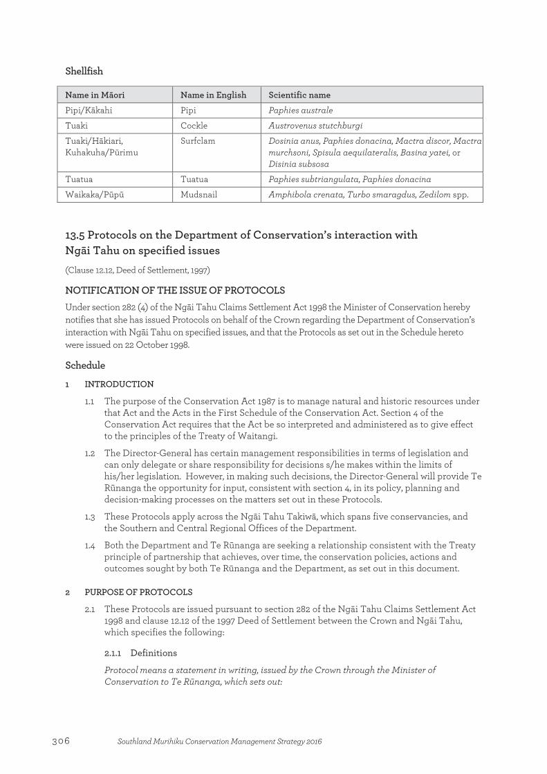
Shellfish
Name in Māori Name in English Scientific name
Pipi/Kākahi Pipi Paphies australe
Tuaki Cockle Austrovenus stutchburgi
Tuaki/Hākiari, Kuhakuha/Pūrimu
Surfclam Dosinia anus, Paphies donacina, Mactra discor, Mactra murchsoni, Spisula aequilateralis, Basina yatei, or Disinia subsosa
Tuatua Tuatua Paphies subtriangulata, Paphies donacina
Waikaka/Pūpū Mudsnail Amphibola crenata, Turbo smaragdus, Zedilom spp. 13.5 Protocols on the Department of Conservation’s interaction with Ngāi Tahu on specified issues (Clause 12.12, Deed of Settlement, 1997)
NOTIFICATION OF THE ISSUE OF PROTOCOLS Under section 282 (4) of the Ngāi Tahu Claims Settlement Act 1998 the Minister of Conservation hereby notifies that she has issued Protocols on behalf of the Crown regarding the Department of Conservation’s interaction with Ngāi Tahu on specified issues, and that the Protocols as set out in the Schedule hereto were issued on 22 October 1998.
Schedule
1 INTRODUCTION
1.1 The purpose of the Conservation Act 1987 is to manage natural and historic resources under that Act and the Acts in the First Schedule of the Conservation Act. Section 4 of the Conservation Act requires that the Act be so interpreted and administered as to give effect to the principles of the Treaty of Waitangi.
1.2 The Director-General has certain management responsibilities in terms of legislation and can only delegate or share responsibility for decisions s/he makes within the limits of his/her legislation. However, in making such decisions, the Director-General will provide Te Rūnanga the opportunity for input, consistent with section 4, in its policy, planning and decision-making processes on the matters set out in these Protocols.
1.3 These Protocols apply across the Ngāi Tahu Takiwā, which spans five conservancies, and the Southern and Central Regional Offices of the Department.
1.4 Both the Department and Te Rūnanga are seeking a relationship consistent with the Treaty principle of partnership that achieves, over time, the conservation policies, actions and outcomes sought by both Te Rūnanga and the Department, as set out in this document.
2 PURPOSE OF PROTOCOLS
2.1 These Protocols are issued pursuant to section 282 of the Ngāi Tahu Claims Settlement Act 1998 and clause 12.12 of the 1997 Deed of Settlement between the Crown and Ngāi Tahu, which specifies the following:
2.1.1 Definitions
Protocol means a statement in writing, issued by the Crown through the Minister of Conservation to Te Rūnanga, which sets out:
306 Southland Murihiku Conservation Management Strategy 2016
(a) how the Department of Conservation will exercise its functions, powers, and duties in relation to specified matters within the Ngāi Tahu Claim Area; and
(b) how the Department of Conservation will, on a continuing basis, interact with Te Rūnanga and provide for Te Rūnanga’s input into its decision-making process.
2.1.2 Authority to Issue, Amend or Cancel Protocols
Pursuant to section 282 of the Ngāi Tahu Claims Settlement Act 1998, the Minister of Conservation may, from time to time issue, amend, and cancel Protocols.
2.1.3 Issue of Protocols
On the Settlement Date (as defined in section 8 of the Ngāi Tahu Claims Settlement Act 1998) the Crown has agreed through the Minister of Conservation to issue Protocols in this form on the following matters:
(a) cultural materials;
(b) freshwater fisheries;
(c) culling of species of interest to Ngāi Tahu;
(d) historic resources;
(e) Resource Management Act 1991 involvement; and
(f) visitor and public information.
2.1.4 Protocols subject to Crown Obligations
Pursuant to section 283 of the Ngāi Tahu Claims Settlement Act 1998, the Protocols are issued and amended, subject to, and without restriction upon:
(a) the obligations of the Minister of Conservation and the Department of Conservation to discharge their respective functions, powers, and duties in accordance with existing law and Government policy from time to time; and
(b) the Crown’s powers to amend policy, and introduce legislation amending existing law.
This clause is not intended to indicate, and should not be interpreted as indicating, any agreement by Te Rūnanga to any amendment to policy which would adversely affect the redress provided by the Crown pursuant to the Settlement Deed or the ability of either party to fulfil its obligations expressed in the Settlement Deed.
2.1.5 Noting of Protocols on CMS
Pursuant to section 284 of the Ngāi Tahu Claims Settlement Act 1998:
(a) The existence of Protocols, once issued, and as amended from time to time, including a definition of Protocols as set out in section 281 of the Ngāi Tahu Claims Settlement Act 1998 and a summary of the terms of issue of Protocols, must be noted in conservation management strategies, conservation management plans and national park management plans affecting the Ngāi Tahu Claim Area; and
(b) Noting of Protocols pursuant to section 284(1) of the Ngāi Tahu Claims Settlement Act 1998 is for the purpose of public notice only and is not an amendment to the relevant strategies or plans for the purposes of section 17I of the Conservation Act 1987 or section 46 of the National Parks Act 1980.
2.1.6 Enforceability of Protocols
Pursuant to section 285 of the Ngāi Tahu Claims Settlement Act 1998:
(a) The Minister of Conservation must comply with a Protocol as long as it remains in force;
307Southland Murihiku Conservation Management Strategy 2016
(b) If the Minister of Conservation fails unreasonably to comply with a Protocol, Te Rūnanga may, subject to the Crown Proceedings Act 1950, enforce the Protocol by way of public law action against the Minister of Conservation;
(c) Notwithstanding paragraph (b), damages are not available as a remedy for a failure to comply with a Protocol; and
(d) This clause does not apply to any guidelines which are developed pursuant to a Protocol.
2.1.7 Limitation of Rights
Pursuant to section 286 of the Ngāi Tahu Claims Settlement Act 1998, except as expressly provided in the Deed of Settlement, the Ngāi Tahu Claims Settlement Act 1998, or in a Protocol, a Protocol does not, of itself, have the effect of granting, creating, or providing evidence of any estate or interest in, or any rights of any kind whatsoever relating to, land held, managed, or administered under the Conservation Act 1987 or a statute listed in the First Schedule of that Act.
3 IMPLEMENTATION AND COMMUNICATION
3.1 The Department will seek to establish and maintain communication with Te Rūnanga and its Papatipu Rūnanga on a continuing basis by:
(a) maintaining at the conservancy level, with the assistance of Te Rūnanga, information provided on Papatipu Rūnanga, their office holders and addresses; and
(b) providing reasonable opportunities for Te Rūnanga and Papatipu Rūnanga to meet with Department managers and staff.
3.2 The Protocols provide for ongoing implementation of a range of matters, as well as Specific Projects which will require resourcing. It is not intended that all of the Specific Projects listed in these Protocols will be implemented in any one year. Implementation will be over time. Where these Protocols refer to Specific Projects that require resourcing, their implementation will be subject to provision being made in the relevant conservancy business plan. The process for the Department implementing any particular Specific Project in a business year will be as follows:
(a) The Department will meet with Te Rūnanga in each conservancy and at Regional level annually to identify priorities for undertaking Specific Projects as listed in these protocols for the upcoming business year;
(b) The identified priorities will be taken forward by the Department into its business planning process at the conservancy and regional levels and considered along with other priorities;
(c) The decision on whether any Specific Projects will be funded in any business year will be made by the Conservator and the Regional General Manager;
(d) The Department will advise Te Rūnanga of the outcome of this process; and
(e) Te Rūnanga and the Department will then meet again, if required, to finalise a work plan for implementation of the Specific Projects in that business year, in accordance with the resources which have been allocated in the business plan. The Department will apply the allocated resources to give effect to that work plan, subject to unforeseen management requirements which may arise from time to time, such as emergencies, adverse weather, staff shortages or reallocation of resources directed by the Minister.
3.3 The Department will:
(a) Meet with Te Rūnanga to review implementation of these Protocols and to deal with the matters in clause 3.2; four times per annum, unless otherwise agreed, in each
308 Southland Murihiku Conservation Management Strategy 2016

conservancy, twice per annum at regional level, and at least once per annum at Chief Executive level;
(b) As far as reasonably practicable, train relevant staff on these Protocols and provide ongoing training as required; and
(c) As far as reasonably practicable, brief Conservation Board and NZCA members on these Protocols and the Ngāi Tahu Settlement, and provide ongoing information as required.
4 CULTURAL MATERIALS
4.1 For the purpose of these Protocols, cultural materials are defined as:
(i) plants, plant materials; and
(ii) materials derived from animals, marine mammals or birds,
to the extent to which the Department holds and is responsible for them, and which are important to Ngāi Tahu in maintaining their culture.
4.2 Current legislation means that generally some form of concession or permit is required for any gathering of cultural materials.
4.3 The Department will:
(a) Have particular regard to Te Rūnanga’s cultural use policy (Kawa Hua Taiao) as it relates to the Department’s activities, and other relevant Te Rūnanga statements of policy produced from time to time.
(b) Consider requests from members of Ngāi Tahu Whānui for the customary use of cultural materials in accordance with the appropriate legislation.
(c) Agree, where reasonably practicable, for Ngāi Tahu to have access to cultural materials which become available as a result of Departmental operations such as track maintenance or clearance or culling of species.
(d) Consult with Te Rūnanga in circumstances where there are competing requests from non-Ngāi Tahu persons or entities for the use of cultural materials, for example for scientific research purposes, to see if the cultural and scientific or other needs can be reconciled before the Department makes a decision in respect of those requests.
4.4 Specific projects
The Department will, subject to clause 3.2, work with Te Rūnanga to:
(a) Develop and implement guidelines for each conservancy within the Ngāi Tahu Takiwā that help define levels of customary use of cultural materials, and set conditions, after consideration of tikanga, to be met for gathering;
(b) Identify local sources of plants and provide advice to Te Rūnanga with respect to the establishment by Te Rūnanga of cultivation sites; and
(c) Establish Departmental cultural materials banks for cultural materials which have come into the Department’s possession, and guidelines for their use.
5 FRESHWATER FISHERIES
5.1 The Department has a statutory role in advocating the conservation of aquatic life and freshwater fisheries generally. Its advocacy for freshwater biota, aquatic habitats and fish passage in all areas is primarily taken via statutory planning processes provided by the Resource Management Act 1991.
5.2 Section 48B of the Conservation Act 1987 (inserted by section 305 of the Ngāi Tahu Claims Settlement Act 1998) provides the power to promulgate regulations providing for customary
309Southland Murihiku Conservation Management Strategy 2016
Māori fishing rights with respect to freshwater fisheries within South Island Fisheries Waters. Pursuant to clause 12.14.11(e) of the Deed of Settlement such regulations are to be promulgated as soon as practicable, and in any event no later than two years after Settlement Date. Besides generally consulting with Te Rūnanga and providing for its participation in the conservation and management of customary freshwater fisheries and freshwater fish habitats, the Department will consult with, and have particular regard to the advice of, Te Rūnanga in its capacity as an Advisory Committee appointed under section 56 of the Conservation Act in all matters concerning the management and conservation by the Department of Conservation of Taonga Fish Species (as defined in section 297 of the Ngāi Tahu Claims Settlement Act 1998) within the Ngāi Tahu Claim Area. This obligation does not derogate from the obligations of the Department under section 4 of the Conservation Act 1998 to give effect to the Treaty of Waitangi.
5.3 Advisory Committee
The Department will, in relation to the Taonga Fish Species and as far as reasonably practicable, provide the Advisory Committee with all relevant information to enable it to give informed advice, and will meet with the Advisory Committee at conservancy level as necessary to give effect to the Deed of Settlement and the Ngāi Tahu Claims Settlement Act 1998.
5.4 Customary freshwater fisheries regulations
The Department will work with Te Rūnanga at Regional and conservancy levels to:
(a) Provide for Te Rūnanga participation in the development and promulgation of customary freshwater fishing regulations by:
(i) Establishing a joint working group;
(ii) Setting terms of reference for that working group;
(iii) Setting timelines for progress; and
(iv) Providing information to Te Rūnanga in a timely manner and allowing Te Rūnanga an opportunity to comment.
5.5 Specific Projects
The Department will, subject to clause 3.2, work with Te Rūnanga to:
(a) Develop and implement guidelines for the Department with respect to the promotion of compliance with customary freshwater fisheries regulations;
(b) Develop and implement guidelines for the Department with respect to monitoring the efficacy of the customary freshwater fisheries regulations at regular intervals; and
(c) Develop and implement guidelines for the Department with respect to sharing accumulated management information and research data on customary freshwater fisheries with Te Rūnanga.
5.6 Other matters
The Department will work with Te Rūnanga at Regional and conservancy levels to provide for active participation by Te Rūnanga in the conservation, management and research of customary freshwater fisheries and freshwater fish habitats by:
(a) Seeking to identify areas for cooperation in advocacy, consistent with clause 9, focusing on fish passage, minimum flows, protection of riparian vegetation and habitats, water quality improvement and in the restoration, rehabilitation or enhancement of customary freshwater fisheries and their freshwater habitats; and
(b) Consulting with Te Rūnanga in developing or contributing to research programmes that aim to improve the understanding of the biology of customary freshwater fisheries
310 Southland Murihiku Conservation Management Strategy 2016

and their environmental and habitat requirements. The Department confirms that it regards Te Rūnanga as a possible science provider or collaborator for research projects funded or promoted by the Department in the same manner as other potential providers or collaborators.
5.7 Specific Projects
The Department will, subject to clause 3.2, work with Te Rūnanga to:
(a) Conduct research to establish and address ecosystem threats to specified customary freshwater fisheries including barriers to migration, habitat loss and exotic species interaction;
(b) Contribute to the resolution of eel management issues, in particular, the administration of the fish passage regulations in the Freshwater Fisheries Regulations, the promotion of the installation of effective fish passes where necessary and monitoring of their effects, by participating in discussions with Te Rūnanga and Te Waka a Māui me ona Toka Mahi Tuna; and
(c) Identify the need for, and where necessary prepare, management plans for freshwater fisheries management.
6 CULLING OF SPECIES OF INTEREST TO NGĀI TAHU
6.1 As part of an integrated management regime, or because a species population has risen to become an ecological pest, it may from time to time be necessary for the Department to carry out a cull of a protected species under the Wildlife Act 1953. The Department recognises that Te Rūnanga is interested in such operations in the following ways:
(a) the carrying out of such a cull where the species to be culled is causing or is likely to cause ecological damage to species or habitats of particular significance to Ngāi Tahu;
(b) the methods to be used in such culls; and
(c) cultural materials arising from the cull.
6.2 The Department will:
(a) Have regard to any requests initiated by Te Rūnanga for the carrying out of culling operations;
(b) Consult with, and have particular regard to the views of, Te Rūnanga before deciding to carry out a cull of protected species on land administered by the Department, in respect of the reasons for the cull and the method proposed to be used; and
(c) In situations where either a Fish and Game Council or a Regional Council intend to carry out a cull of protected species or game bird and the Department has a statutory role in the process, request the relevant body to consult with Te Rūnanga before carrying out any such cull.
7 HISTORIC RESOURCES
7.1 The Minister acknowledges the importance to Ngāi Tahu of their wāhi tapu, wāhi taonga and other places of historic significance to them. Liaison with Te Rūnanga is important in the management of those places containing sites of historic and cultural significance to Ngāi Tahu, including places of settlement, horticulture, natural resource harvesting, warfare, communication, and places of cultural and spiritual connection.
7.2 The Department notes that non-disclosure of locations of places known to Ngāi Tahu is a practice used by Ngāi Tahu to preserve the sanctity of a place. Respecting the principle of confidentiality brings management difficulties of a particular kind. Where information is not available, management practices which (unintentionally) contravene the cultural value associated with a specific site, may be put in place. Where reasonably practicable, the
311Southland Murihiku Conservation Management Strategy 2016

Department will respect the principle of confidentiality that applies to wāhi tapu, wāhi taonga and places of historic significance to Ngāi Tahu. The primary responsibility for identifying and assessing Ngāi Tahu heritage values rests with Te Rūnanga.
7.3 The Department will work with Te Rūnanga at Regional and conservancy levels to:
(a) Ensure, as far as reasonably practicable, that Ngāi Tahu values attaching to identified wāhi tapu, wāhi taonga and places of historic significance to Ngāi Tahu managed by the Department are respected by the Department, for example, by the Department giving consideration to impacts from visitor numbers, facilities and services;
(b) Manage, as far as reasonably practicable, wāhi tapu, wāhi taonga and places of historic significance to Ngāi Tahu according to the standards of conservation practice outlined in the ICOMOS New Zealand Charter 1993;
(c) Ensure, as far as reasonably practicable, that when issuing concessions giving authority for other parties to manage land administered by the Department, those parties manage the land according to the standards of conservation practice outlined in the ICOMOS New Zealand Charter 1993;
(d) Have particular regard to relevant Te Rūnanga policies, including those relating to Koiwi Tangata (unidentified human remains) and Archaeological and Rock Art Sites;
(e) Ensure, as far as reasonably practicable, that it uses Ngāi Tahu’s cultural information only with the consent of Te Rūnanga; and
(f) When issuing concessions to carry out activities on the land administered by the Department, request that the concessionaire consult with Te Rūnanga before using Ngāi Tahu’s cultural information.
7.4 Specific Projects
The Department will, subject to clause 3.2, work with Te Rūnanga at Regional and conservancy levels to:
(a) Develop and implement guidelines for the identification, inventory and management by the Department of wāhi tapu, wāhi taonga and other places of historic significance to Ngāi Tahu that take into consideration the traditional uses and practices of Ngāi Tahu and are, where reasonably practicable, consistent with Ngāi Tahu tikanga;
(b) Identify and actively protect specified wāhi tapu, wāhi taonga or other places of historic significance to Ngāi Tahu on land administered by the Department;
(c) Develop and implement guidelines for the active protection of wāhi tapu, wāhi taonga and other places of historic significance to Ngāi Tahu;
(d) Identify cooperative projects covering a range of options for the protection and management of wāhi tapu, wāhi taonga and other places of historic significance to Ngāi Tahu;
(e) Develop and implement guidelines relating to the use of Ngāi Tahu’s knowledge of wāhi tapu, wāhi taonga and other places of historic significance of Ngāi Tahu, including the use of this information by the Department; and
(f) Consult with and seek participation from Te Rūnanga with respect to research, survey or inventory projects that relate specifically to wāhi tapu, wāhi taonga and other places of historic significance to them.
8 VISITOR AND PUBLIC INFORMATION
8.1 In providing public information and interpretation services and facilities for visitors on the land it manages, the Department recognises the importance to Ngāi Tahu of their cultural, spiritual, traditional and historic values.
312 Southland Murihiku Conservation Management Strategy 2016
8.2 The Department will work with Te Rūnanga at Regional and conservancy levels to encourage respect for Ngāi Tahu values by:
(a) As far as reasonably practicable, seeking to raise public awareness of positive conservation partnerships developed between Te Rūnanga, the Department and other stakeholders, for example, by way of publications, presentations and seminars;
(b) Consulting on the provision of interpretation and visitor facilities (if any) at wāhi tapu, wāhi taonga and other places of historic or cultural significance to Ngāi Tahu;
(c) Ensuring, as far as reasonably practicable, that Department information on new panels, signs, and visitor publications includes Te Rūnanga perspectives and references to the significance of the sites to Ngāi Tahu, where appropriate, including the use of traditional Ngāi Tahu place names; and
(d) Encouraging Te Rūnanga participation in the Department’s volunteer and conservation events programmes.
8.3 Specific Projects
The Department will, subject to clause 3.2, work with Te Rūnanga at Regional and conservancy levels to:
(a) Develop and implement guidelines on the provision of information and interpretation facilities and services for visitors, so as to identify and consider issues of concern to Te Rūnanga;
(b) Consider possibilities for Te Rūnanga to contribute to visitor appreciation of the cultural value of sites of cultural and historic significance to Ngāi Tahu managed by the Department; and
(c) Provide information to education providers, including kohanga reo and kura kaupapa Māori, for the development of educational resources on conservation issues and associated Ngāi Tahu values.
9 RESOURCE MANAGEMENT ACT
9.1 Te Rūnanga and the Department both have concerns with the effects of activities controlled and managed under the Resource Management Act. These include effects on:
(a) wetlands;
(b) riparian management;
(c) effects on freshwater fish habitat;
(d) water quality management;
(e) protection of historic resources; and
(f) protection of indigenous vegetation and habitats.
9.2 From time to time, Te Rūnanga and the Department will seek to identify further issues of mutual interest for discussion. It is recognised that their concerns in relation to any particular resource management issue may diverge and that each of them will continue to make separate submissions.
9.3 The Department will work with Te Rūnanga at Regional and conservancy levels to discuss the general approach that will be taken by each of Te Rūnanga and the Department in respect of advocacy under the Resource Management Act, and seek to identify their respective priorities and issues of mutual concern.
9.4 The Department will:
(a) Have regard to the priorities and issues of mutual concern identified in clause 9.3(a) in making decisions in respect of advocacy under the Resource Management Act;
313Southland Murihiku Conservation Management Strategy 2016
(b) Make non-confidential resource information available to Te Rūnanga to assist in improving the effectiveness of Resource Management Act advocacy work at the Papatipu Rūnanga level.
10 AMENDMENT AND REVIEW PROVISIONS FROM THE DEED
10.1 Amendment and Cancellation of Protocols
(a) Protocols may be amended or cancelled by the Minister of Conservation, from time to time at the initiative of either the Crown or Te Rūnanga;
(b) The Minister of Conservation may amend or cancel Protocols only after consulting Te Rūnanga and having regard to its views; and
(c) As soon as reasonably practicable after the amendment, or cancellation of a Protocol, the Minister of Conservation must notify such amendment, or cancellation in the Gazette.
Dated at Wellington this 26 day of July 2001 MATT ROBSON, for SANDRA LEE, Minister of Conservation. (NZ Gazette 2001, page 2171)
314 Southland Murihiku Conservation Management Strategy 2016
Appendix 14
Statements of outstanding universal values for World Heritage Areas in Southland Murihiku
Te Wāhipounamu—South West New Zealand Statement of outstanding universal value (UNESCO)
Brief synthesis
Located in the south-west corner of New Zealand’s South Island, Te Wāhipounamu—South West New Zealand covers 10% of New Zealand’s landmass (2.6 million hectares) and is spread over a 450km strip extending inland 40–-90 km from the Tasman Sea. The property exhibits many classic examples of the tectonic, climatic, and glacial processes that have shaped the earth. The great Alpine Fault divides the region and marks the contact zone of the Indo-Australian and Pacific continental plates making it one of only three segments of the world’s major plate boundaries on land. Collision between the two tectonic plates constructs the main mountain range, known as the Southern Alps/Kā Tiritiri o te Moana, which rise to nearly 4 000m altitude within a mere 30km from the sea.
Overwhelmingly a mountainous wilderness, including significant piedmont surfaces in the north-west glaciation, both historic and modern, is a dominant landscape feature. Spectacular landforms include: the 15 fiords which deeply indent the Fiordland coastline; a sequence of 13 forested marine terraces progressively uplifted more than 1000m along the Waitutu coastline over the past million years; a series of large lake-filled glacial troughs along the south-eastern margin; the Franz Josef and Fox Glaciers which descend into temperate rainforest; and spectacular moraines of ultramafic rock extending to the Tasman coastline.
As the largest and least modified area of New Zealand’s natural ecosystems, the flora and fauna has become the world’s best intact modern representation of the ancient biota of Gondwana. The distribution of these plants and animals is inextricably linked to the dynamic nature of the physical processes at work in the property. The region contains outstanding examples of plant succession after glaciation, with sequences along altitudinal (sea level to permanent snowline), latitudinal (wet west to the dry east), and chronological gradients (fresh post-glacial surfaces to old Pleistocene moraines).
It is the combination of geological and climatic processes, the resultant landforms, the unique biota displaying evolutionary adaptation over a diverse range of climatic and altitudinal gradients, all in a relatively pristine state, that give Te Wāhipounamu – South West New Zealand its exceptional and outstanding natural characteristics.
Criterion (vii): Te Wāhipounamu – South West New Zealand contains many of the natural features which contribute to New Zealand's international reputation for superlative landscapes: its highest mountains, longest glaciers, tallest forests, wildest rivers and gorges, most rugged coastlines and deepest fiords and lakes, as well as the remnant of an extinct volcano in Solander Island. The temperate rainforests of the property are unmatched in their composition, extent and intactness by any such forests anywhere in the world.
From the vast wilderness of Fiordland in the south to the spectacular upthrust of the Southern Alps in the north, the landscapes are world class for the sheer excellence of their scenic beauty. It is an area of magnificent primeval vistas: snow-capped mountains, glaciers, forests, tussock grasslands, lakes, rivers, wetlands and over 1000km of wilderness coastline. Only traces of human influence are evident and then mainly in peripheral areas.
Appendix 14:Statements of outstanding universal values for World Heritage Areas in Southland Murihiku
315Southland Murihiku Conservation Management Strategy 2016
Criterion (viii): Te Wāhipounamu – South West New Zealand is considered to be the best modern example of the primitive taxa of Gondwanaland seen in modern ecosystems – and as such the property is of global significance. The progressive break-up of the southern super-continent of Gondwanaland is considered one of the most important events in the earth’s evolutionary history. New Zealand’s separation before the appearance of marsupials and other mammals, and its long isolation since, were key factors enabling the survival of the ancient Gondwanan biota on the islands of New Zealand to a greater degree than elsewhere. The living representatives of this ancient biota include flightless kiwis, carnivorous land snails, 14 species of podocarp and genera of beech.
The South West is also an outstanding example of the impact of the Pleistocene epoch of earth history. Ice-carved landforms created by these “Ice Age” glaciers dominate the mountain lands, and are especially well-preserved in the harder, plutonic igneous rocks of Fiordland. Glacier-cut fiords, lakes, deep U-shaped valleys, hanging valleys, cirques, and ice-shorn spurs are graphic illustrations of the powerful influence of these glaciers on the landscape. Depositional landforms of Pleistocene glacial origin are also important, especially in Westland, west of the Alpine Fault. Chronological sequences of outwash gravels, and moraine ridges in elegant curves and loops, outline the shapes of both former piedmont glaciers and Holocene “post-glacial” valley glaciers.
Criterion (ix): A continuum of largely unmodified habitats, the property exhibits a high degree of geodiversity and biodiversity. Fresh-water, temperate rainforest and alpine ecosystems are all outstandingly well represented over an extensive array of landforms and across wide climatic and altitudinal gradients. Notable examples of on-going biological processes can be found in the large expanses of temperate rainforest, the plant succession after glacial retreat, soil/plant chronosequences on beach ridges, plant succession on alluvial terraces, vegetation gradients around the margins of glacial lakes and ecotypic differentiation of plants on ultramafic soils. The extensive and little modified freshwater habitats, the impressive diversity of alpine ecosystems, extensive alpine plant endemism, and on-going evolution associated with long-standing geographical isolation of animal populations, like the kiwi taxa of South Westland, are further examples of on-going biological evolution.
While there is little permanent physical evidence of past human interaction with the natural environment, tangata whenua (the indigenous people who have customary authority in a place) have long associations with the area which was significant to them for natural resources, particularly pounamu (nephrite). European associations are more recent and initially based on natural resource exploitation. The predominant human uses today are associated with sustainable tourism.
Criterion (x): The habitats of Te Wāhipounamu contain an extensive range of New Zealand’s unusual endemic fauna, a fauna which reflects its long evolutionary isolation and absence of mammalian predators. The property contains the entire wild population of the rare and endangered takahē (Notornis mantelli), the entire population of the South Island subspecies of brown kiwi (Apteryx australis), New Zealand’s rarest Kiwi, the rowi (Apteryx rowi), the only significant remaining populations of the seriously declining mohua/yellowhead (Mohoua ochrocephala), the only large populations remaining of kākā and kākāriki/yellow-crowned parakeet, the only remaining population of pateke/Fiordland brown teal in the South Island.
The world’s rarest and heaviest parrot, kākāpō (Strigops habroptilus) survived in Fiordland until the early 1980s. It is now thought to be extinct on the mainland and its survival depends on careful management of a limited number of offshore island populations.
Integrity
Te Wāhipounamu encompasses many complete ‘mountains-to-the-sea’ or ‘mountains-to-inland basins’ landscape sequences. These landscapes cover the full range of erosion and deposition landforms of Pleistocene and modern glacial origin. The 2.6 million hectare property represents the 10 percent of New Zealand that is least disturbed or modified by human settlement, and is largely in its natural state giving it a high degree of integrity. The property boundaries encompass all the values of the property which comprises a nearly contiguous network of reserved land covering much of the south-west of the South
316 Southland Murihiku Conservation Management Strategy 2016
Island. The boundaries are closely and realistically aligned with the main features of the area. The property includes four national parks (Fiordland, Mount Aspiring, Mount Cook and Westland) covering 1,725,437 ha, two nature reserves, three scientific reserves, 13 scenic reserves, four wildlife management reserves, five ecological areas, conservation areas and one private reserve (20 ha). Bordered by other protected public conservation land the property has an effective buffer zone providing further protection for the natural values.
The property contains nearly 2 million hectares of temperate rainforest on an extraordinary range of landforms and soils including altitudinal, latitudinal, west-to-east rainfall gradients, and age sequences associated with glacial retreat, prograding coastlines and marine terraces uplifted progressively over the last million years. In particular, the rainforest contains the best examples in the Southern Hemisphere of one of the most ancient groups of gymnosperms, the Podocarpaceae, which range from the densely-packed 50m-high rimus of the South Westland terraces to the world’s smallest conifer, the prostrate pygmy pine.
The relatively recent introductions of alien browsing mammals and predators, such as rodents and mustelids, have resulted in localised extinctions, range reductions, and significant declines in abundance of some indigenous biota. These threats will remain, but with ongoing intervention can be managed and should not impact significantly on the integrity of the area. There is some evidence of the effects of global warming on the permanent icefields and glaciers in the region.
The international profile of the area as a visitor destination places pressure on some of the main tourist attractions within the wider site. These pressures are being managed to provide visitor access but only where the conservation values at these sites are protected.
Protection and management requirements
A comprehensive array of statutes and regulations protect the property, the most important being the National Parks Act 1980 and the Conservation Act 1987. These two pieces of legislation along with the Reserves Act 1977 are the principal means of ensuring legal protection for the property. The land encompassed by the boundaries of the property, with one small exception, is Crown (Government and the people of New Zealand) owned and it is administered by the Department of Conservation. The property is a reformulation of two previous property inscribed on the World Heritage List in 1986; Fiordland National Park and Westlands /Mt Cook National Park. This property adds 1.2 million ha of the intervening land, almost doubling the size of the area inscribed in 1986 and including almost 70% of the area under national park status, and greatly adding to the overall universal value, wilderness quality and integrity of the property.
The Department of Conservation has a legislative mandate for the preservation and protection of natural and historic resources for the purpose of maintaining their intrinsic values, providing for their appreciation and recreational enjoyment by the public, and safeguarding the options of future generations.
The Department of Conservation is obligated through its legislation to give effect to the principles of the Treaty of Waitangi. In practice this implies a partnership agreement with tangata whenua that have manawhenua (prestige, authority over the land) over the area. This involves an annual business planning process with the Ngāi Tahu iwi (the overarching tribal authority for tangata whenua). This process gives Ngāi Tahu the opportunity to engage in and contribute to the operational management of the property.
The particularly high natural values of the property, along with the World Heritage status, mean that this area is a priority area for ongoing management. The Area covers four separate Conservancies, although they all report to one Manager. The Department’s organisational structure therefore also provides for integrated management of the area.
There is no single management strategy for the area, although under the National Parks Act, each national park is required to have a national park management plan and there are also a number of conservancy conservation strategies that acknowledge the values of the regions comprising the large site, as well as the property’s World Heritage status. Together these planning documents set strategic directions for the integrated management of this property. These are statutory documents formulated through a public
317Southland Murihiku Conservation Management Strategy 2016

consultation process. The national park management plans are prepared by the Department of Conservation (the administering authority for all national parks in NZ) and approved by the New Zealand Conservation Authority, in accordance with the General Policy for National Parks (a policy document that guides the implementation of the National Parks Act, also prepared and administered by the Department of Conservation).
The principal uses of the property are nature conservation, nature based recreation and tourism and sustainable small-scale natural resource utilisation. Impacts from tourism at key sites and introduced species are being addressed by management actions and continue to be a concern. Traditional use of vegetation by native Māori people, fishing for whitebait, recreational hunting and short-term pastoral leases are closely regulated and do not result in significant impacts.
Invasive species are the biggest impact on the property, despite their impacts being restricted to small areas of the property. Population increases of red deer as well as impacts from other browsing mammals such as wapiti, fallow deer, goat, chamois and tahr have caused severe damage in some parts of the property, in particular threatening the integrity of the forest and alpine ecosystems. Commercial hunting activities have assisted in reducing numbers and impacts from these species. Australian brush-tailed possum, rabbits, mustelids and rodents also impact habitats and indigenous birds. The Department of Conservation has control programmes in place and National Parks general policy seeks to eradicate new incursions and eradicate (where possible) or reduce the range of existing invasive species.
Areas of public conservation lands and waters
NaPALIS number Conservation Unit name Place 2801633 Fiordland National Park Fiordland Te Rua-o-te-moko Place 2801645 Conservation Area (FNP Addition—
Cromarty Sections) Fiordland Te Rua-o-te-moko Place
2801648 Conservation Area (FNP—Milford Road Stopped)
Fiordland Te Rua-o-te-moko Place
2801657 Conservation Area—Dean Forest Fiordland Te Rua-o-te-moko Place 2801659 Conservation Area—Rowallan Forest Fiordland Te Rua-o-te-moko Place 2801667 Marginal Strip (non movable) Fiordland Te Rua-o-te-moko Place 2801668 Conservation Area—Bryce Burn, Dean Fiordland Te Rua-o-te-moko Place 2801669 Conservation Area—Dean Forest Access Fiordland Te Rua-o-te-moko Place 2801669 Conservation Area—Rowallan Forest
Access Fiordland Te Rua-o-te-moko Place
2801501 Conservation Area—Pyke Forest Fiordland Te Rua-o-te-moko Place 2801489 Conservation Area—Arawhata Fiordland Te Rua-o-te-moko Place 2801521 Conservation Area—Te Anau Downs,
Henry Creek Western High Country Mata-puke Koikoi Place
2801523 Conservation Area—Te Anau Downs Western High Country Mata-puke Koikoi Place
2801524 Conservation Area—Snowdon Forest Western High Country Mata-puke Koikoi Place
2801525 Conservation Area—Mavora Park Western High Country Mata-puke Koikoi Place
2801526 Marginal Strip Western High Country Mata-puke Koikoi Place
2801527 Marginal Strip Western High Country Mata-puke Koikoi Place
2801528 Marginal Strip Western High Country Mata-puke Koikoi Place
318 Southland Murihiku Conservation Management Strategy 2016

NaPALIS number Conservation Unit name Place 2801529 Marginal Strip Western High Country Mata-puke
Koikoi Place 2801530 Marginal Strip Western High Country Mata-puke
Koikoi Place 2801514 Marginal Strip Western High Country Mata-puke
Koikoi Place 2801560 Conservation Area—Kepler Mire Lowlands Te Rā a Takitimu Place 2801561 Conservation Area—Stevens Wildlife Area Lowlands Te Rā a Takitimu Place 2801568 Conservation Area—Home Creek Lowlands Te Rā a Takitimu Place 2801585 Conservation Area—Margin Forest Western High Country Mata-puke
Koikoi Place 2801589 Conservation Area—Mararoa River,
Wilderness Lowlands Te Rā a Takitimu Place
2801590 Wilderness Scientific Reserve Lowlands Te Rā a Takitimu Place 2801592 Conservation Area—Mount Prospect Western High Country Mata-puke
Koikoi Place 2801596 Burwood Bush (Red Tussock) Scientific
Reserve Western High Country Mata-puke Koikoi Place
2801597 Conservation Area—Weydon Burn, Centre Hill
Western High Country Mata-puke Koikoi Place
2801599 Burwood (Takahe Rearing Site) Scientific Reserve
Western High Country Mata-puke Koikoi Place
2801600 Conservation Area—Chewings Road Western High Country Mata-puke Koikoi Place / Lowlands Te Rā a Takitimu Place
2801620 Marginal Strip Lowlands Te Rā a Takitimu Place 2802777 Marginal Strip Western High Country Mata-puke
Koikoi Place 2802778 Marginal Strip Western High Country Mata-puke
Koikoi Place 2802799 Marginal Strip Western High Country Mata-puke
Koikoi Place 2802805 Marginal Strip Western High Country Mata-puke
Koikoi Place 2802812 Marginal Strip Western High Country Mata-puke
Koikoi Place 2803989 Conservation Area—Taylors Bush Forest Fiordland Te Rua-o-te-moko Place /
Lowlands Te Rā a Takitimu Place 2804042 Conservation Area—Mangapiri Forest Fiordland Te Rua-o-te-moko Place /
Lowlands Te Rā a Takitimu Place 2800808 Marginal Strip Western High Country Mata-puke
Koikoi Place 2800796 Marginal Strip Western High Country Mata-puke
Koikoi Place 2800797 Marginal Strip Western High Country Mata-puke
Koikoi Place
319Southland Murihiku Conservation Management Strategy 2016
New Zealand Sub-antarctic Islands Statement of outstanding universal value (UNESCO)
Brief synthesis The New Zealand Sub-antarctic Islands (NZSAI) encompasses five island groups that lie between latitudes 47o and 53o south; Snares Islands/Tini Heke, Bounty Islands, Antipodes Islands, Auckland Islands/Motu Maha and Campbell Island/Motu Ihupuku and the islands surrounding it. The World Heritage status also applies to the marine environment out to 12 nautical miles from each group. Including a total land area of 76,458ha, the marine area takes in 1,400,000 ha and constitutes one of New Zealand’s remotest protected natural areas, including some of the world’s least-modified islands.
The property lies between the Antarctic and Subtropical Convergences and the seas have a high level of productivity, biodiversity, wildlife population densities and endemism. While the NZSAI are all located on the Pacific Tectonic Plate, the different geological history and age of each island group, and their geographical isolation from mainland New Zealand and from each other, has shaped the unique and remarkable biodiversity of the islands including distinctive plants, birds, invertebrates, marine mammals, fish and marine algae assemblages. The biota contains numerous endemic and/or rare elements, and some extraordinary examples of adaptation.
Particularly notable is the abundance and diversity of pelagic seabirds and penguins that utilise the islands for breeding. The property supports the most diverse community of breeding seabirds in the Southern Ocean. There are 126 species of birds, including 40 seabirds, eight of which breed nowhere else in the world. The islands support major populations of 10 of the world’s 22 species of albatross and almost 2 million sooty shearwaters nest on Snares Island alone. Land birds also display a surprising diversity, considering the limited land area available, with a large number of threatened endemics including one of the world’s rarest ducks. More than 95% of the world’s population of New Zealand sea lion (formerly known as Hooker’s sea lion) breed here and the marine environment provides critical breeding areas for the southern right whale.
The plant life of the NZSAI is notable for its diversity, special forms and unique communities, yet another outstanding example of the biological and ecological processes significant in the property. The Snares Islands and two islands in the Auckland group (Adams and Disappointment), are among the last substantial areas in the world harbouring vegetation essentially unmodified by humans or alien species. Another notable feature about the NZSAI is the land-sea interface and the close inter-dependence of both environments for many of the species – the inclusion of the marine environment out to 12 nautical miles in the world heritage property recognises this.
Criterion (ix): Isolation, climatic factors, and seven degrees of latitudinal spread have combined to significantly influence the biota of the islands. Consequently they provide scientific insights into the evolutionary processes affecting widely-spread oceanic islands, varying from relatively mature endemic forms to relatively immature taxa, constituting a fascinating laboratory for the study of genetic variation, speciation and adaptation, particularly in the insulantarctic biogeographic province.
Evolutionary processes, such as the loss of flight in birds and invertebrates, offer unique opportunities for research into island dynamics and ecology. Another outstanding feature is the preponderance of ‘megaherbs’ within the plant biodiversity. These large herbs, often with brightly coloured flowers are considered to display unique evolutionary adaptation to the distinctive sub-antarctic climate – with its cloud cover (and lack of solar radiation), lack of frosts, strong winds, and high nutrient levels (derived from seabird transference of nutrients).
Criterion (x): The NZSAI, and the ocean that surrounds and links them, support an extraordinary and outstanding array of endemic and threatened species among the marine fauna, land birds, and invertebrates. As a group they are distinct from all other island groups, having the highest diversity of indigenous plants and birds. Of particular significance: the most diverse community of seabirds in the world with eight species endemic to the region; including four species of albatross, three species of cormorants (one of which, the Bounty Island Shag, is the world’s rarest cormorant) and one species of penguin; 15 endemic land birds including snipe, parakeets and teal; breeding sites of the world’s rarest sea
320 Southland Murihiku Conservation Management Strategy 2016
lion (the New Zealand (or Hooker’s) sea lion); and a significant breeding population of the southern right whale.
Together with neighbouring Macquarie Island, the NZSAI represent a Centre of Plant Diversity and have the richest flora of all the sub-antarctic islands with 35 endemic taxa. The ‘megaherbs’ are unique to the NZSAI and Macquarie Island. The Snares Group and two of the Auckland Islands are of particular biodiversity conservation significance due to the absence of any human and exotic species modification.
Integrity The NZSAI have benefited from their remoteness providing them with a high degree of natural protection. With their geographical isolation from mainland New Zealand and from each other, the NZSAI include some of the world’s most unmodified islands. In particular; the Snares and two islands in the Auckland group (Adams and Disappointment), are among the last substantial areas in the world harbouring vegetation essentially unmodified by human impacts. Many of the islands remain in virtually pristine condition, being rat and cat free and rarely visited by humans. The Antipodes group have undergone minimal modification from a pristine state despite sealers once being active there. The boundaries of the property include all land area of these island groups and are sufficient to protect the core natural values of the property. The geological and biological integrity of the terrestrial component of the NZSAI is considered high with conservation actions underway to reduce the impact of exotic species.
One of the island groups (Auckland Islands) is surrounded by an overlapping no-take marine reserve and marine mammal sanctuary out to 12 nautical miles. In 2008, a stakeholder forum was convened to consider additional marine protection measures in the Sub-Antarctic region. As a result of that process, three new marine reserves have been approved and are awaiting implementation. These reserves will protect 100% of the territorial sea surrounding Antipodes Island, approximately 58% of the territorial sea around the Bounty Islands and approximately 39% of the territorial sea around Campbell Island. In addition, restrictions on fishing methods will be in place in the remaining territorial sea areas around these island groups. These protection measures significantly enhance the integrity of the islands’ marine environments, and complement the protection afforded to the islands themselves. Bycatch of pinnipeds and seabirds remain important issues in the Subantarctic marine environment, and the fishing industry, New Zealand Government and environmental groups continue to work together to address these issues.
Protection and management requirements Managed by the Department of Conservation on behalf of the Government and the people of New Zealand the comprehensive application of legal, administrative and management systems in place ensure the areas of the NZSAI that are above mean high water have the highest level of protection under New Zealand legislation, being classified as Nature Reserves under the Reserves Act 1977. In addition, the five island groups have each been identified as National Reserves, which acknowledges “values of national or international significance” (section 13 Reserves Act 1977). The islands are also covered under the Wildlife Act 1953; the Wild Animal Control Act 1977; the Resource Management Act 1991; the Marine and Coastal Area (Takutai Moana) Act 2011; the Marine Mammals Protection Act 1978; and the Fisheries Act 1996. The existing no-take marine reserve and marine mammal sanctuary around the Auckland Islands are managed by the Department of Conservation. Proposed marine reserves around Antipodes, Bounty and Campbell Islands will also be managed by the Department of Conservation.
Under section 4 of the Conservation Act 1987 the Department is required to give effect to the principles of the Treaty of Waitangi. In practice this implies a partnership agreement with tāngata whenua (Iwi or hapū that has customary authority in a place) that have manawhenua (prestige, authority) over the area. As a part of the Crown’s settlement with Ngāi Tahu, protocols have been developed on how the Department and Ngāi Tahu will work together on specified matters of cultural significance to Ngāi Tahu. Ngāi ai Tahu ki Murihiku are kaitiaki (guardians) of the Southland region, including the Sub-antarctic Islands. They have prepared a management plan: Te Tangi a Tauira—the Cry of the People, which consolidates Ngāi Tahu ki Murihiku values, knowledge and perspectives on natural resource and environmental management issues.
The range of legislation relating to the NZSAI is aimed at the protection and conservation of the species and ecosystems within the property. The Resource Management Act 1991 requires a Regional Coastal Plan to be developed, with the aim of promoting the sustainable management of natural and physical resources
321Southland Murihiku Conservation Management Strategy 2016
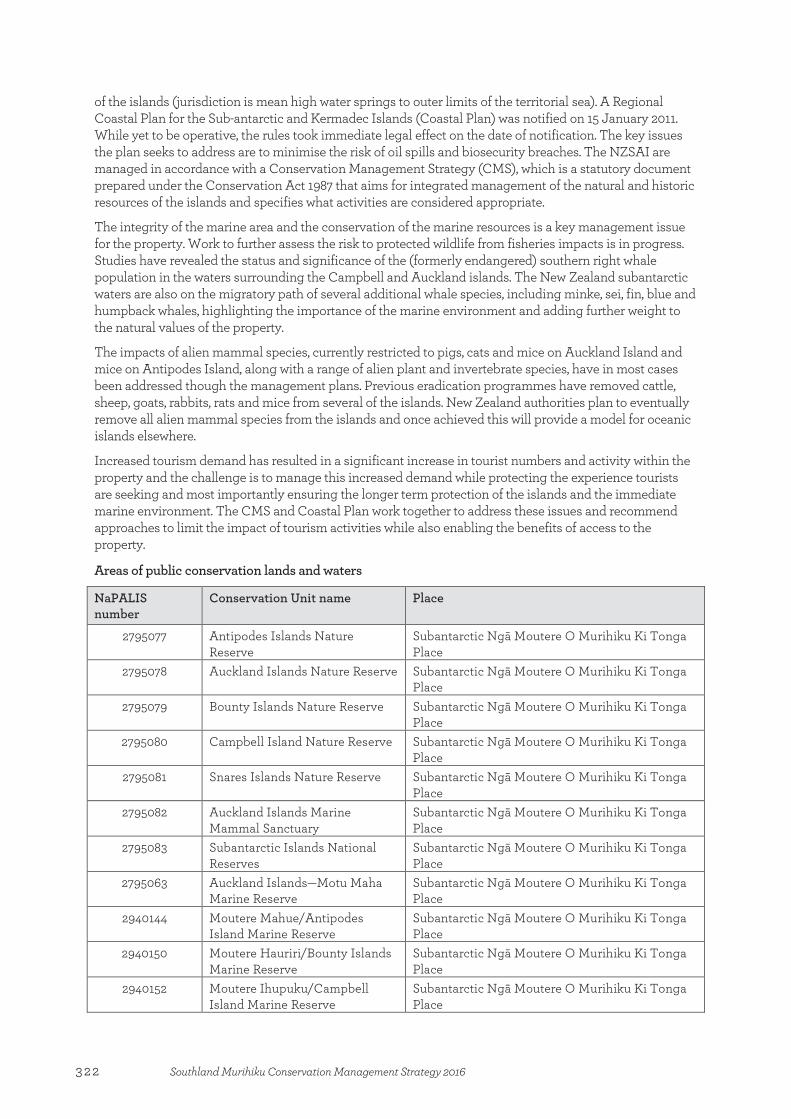
of the islands (jurisdiction is mean high water springs to outer limits of the territorial sea). A Regional Coastal Plan for the Sub-antarctic and Kermadec Islands (Coastal Plan) was notified on 15 January 2011. While yet to be operative, the rules took immediate legal effect on the date of notification. The key issues the plan seeks to address are to minimise the risk of oil spills and biosecurity breaches. The NZSAI are managed in accordance with a Conservation Management Strategy (CMS), which is a statutory document prepared under the Conservation Act 1987 that aims for integrated management of the natural and historic resources of the islands and specifies what activities are considered appropriate.
The integrity of the marine area and the conservation of the marine resources is a key management issue for the property. Work to further assess the risk to protected wildlife from fisheries impacts is in progress. Studies have revealed the status and significance of the (formerly endangered) southern right whale population in the waters surrounding the Campbell and Auckland islands. The New Zealand subantarctic waters are also on the migratory path of several additional whale species, including minke, sei, fin, blue and humpback whales, highlighting the importance of the marine environment and adding further weight to the natural values of the property.
The impacts of alien mammal species, currently restricted to pigs, cats and mice on Auckland Island and mice on Antipodes Island, along with a range of alien plant and invertebrate species, have in most cases been addressed though the management plans. Previous eradication programmes have removed cattle, sheep, goats, rabbits, rats and mice from several of the islands. New Zealand authorities plan to eventually remove all alien mammal species from the islands and once achieved this will provide a model for oceanic islands elsewhere.
Increased tourism demand has resulted in a significant increase in tourist numbers and activity within the property and the challenge is to manage this increased demand while protecting the experience tourists are seeking and most importantly ensuring the longer term protection of the islands and the immediate marine environment. The CMS and Coastal Plan work together to address these issues and recommend approaches to limit the impact of tourism activities while also enabling the benefits of access to the property.
Areas of public conservation lands and waters
NaPALIS number
Conservation Unit name Place
2795077 Antipodes Islands Nature Reserve
Subantarctic Ngā Moutere O Murihiku Ki Tonga Place
2795078 Auckland Islands Nature Reserve Subantarctic Ngā Moutere O Murihiku Ki Tonga Place
2795079 Bounty Islands Nature Reserve Subantarctic Ngā Moutere O Murihiku Ki Tonga Place
2795080 Campbell Island Nature Reserve Subantarctic Ngā Moutere O Murihiku Ki Tonga Place
2795081 Snares Islands Nature Reserve Subantarctic Ngā Moutere O Murihiku Ki Tonga Place
2795082 Auckland Islands Marine Mammal Sanctuary
Subantarctic Ngā Moutere O Murihiku Ki Tonga Place
2795083 Subantarctic Islands National Reserves
Subantarctic Ngā Moutere O Murihiku Ki Tonga Place
2795063 Auckland Islands—Motu Maha Marine Reserve
Subantarctic Ngā Moutere O Murihiku Ki Tonga Place
2940144 Moutere Mahue/Antipodes Island Marine Reserve
Subantarctic Ngā Moutere O Murihiku Ki Tonga Place
2940150 Moutere Hauriri/Bounty Islands Marine Reserve
Subantarctic Ngā Moutere O Murihiku Ki Tonga Place
2940152 Moutere Ihupuku/Campbell Island Marine Reserve
Subantarctic Ngā Moutere O Murihiku Ki Tonga Place
322 Southland Murihiku Conservation Management Strategy 2016
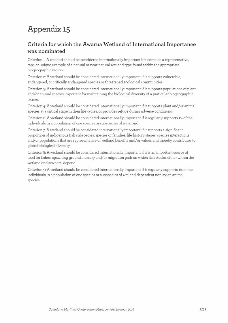
Appendix 15
Criteria for which the Awarua Wetland of International Importance was nominated Criterion 1: A wetland should be considered internationally important if it contains a representative, rare, or unique example of a natural or near-natural wetland type found within the appropriate biogeographic region.
Criterion 2: A wetland should be considered internationally important if it supports vulnerable, endangered, or critically endangered species or threatened ecological communities.
Criterion 3: A wetland should be considered internationally important if it supports populations of plant and/or animal species important for maintaining the biological diversity of a particular biogeographic region.
Criterion 4: A wetland should be considered internationally important if it supports plant and/or animal species at a critical stage in their life cycles, or provides refuge during adverse conditions.
Criterion 6: A wetland should be considered internationally important if it regularly supports 1% of the individuals in a population of one species or subspecies of waterbird.
Criterion 7: A wetland should be considered internationally important if it supports a significant proportion of indigenous fish subspecies, species or families, life-history stages, species interactions and/or populations that are representative of wetland benefits and/or values and thereby contributes to global biological diversity.
Criterion 8: A wetland should be considered internationally important if it is an important source of food for fishes, spawning ground, nursery and/or migration path on which fish stocks, either within the wetland or elsewhere, depend.
Criterion 9: A wetland should be considered internationally important if it regularly supports 1% of the individuals in a population of one species or subspecies of wetland-dependent non-avian animal species.
Appendix 15:Criteria for which the Awarua Wetland of International Importance was nominated
323Southland Murihiku Conservation Management Strategy 2016
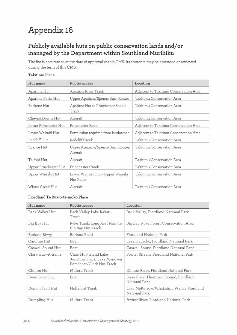
Appendix 16
Publicly available huts on public conservation lands and/or managed by the Department within Southland Murihiku The list is accurate as at the date of approval of this CMS. Its contents may be amended or reviewed during the term of this CMS.
Takitimu Place
Hut name Public access Location
Aparima Hut Aparima River Track Adjacent to Takitimu Conservation Area
Aparima Forks Hut Upper Aparima/Spence Burn Routes Takitimu Conservation Area
Becketts Hut Aparima Hut to Princhester Saddle Track
Takitimu Conservation Area
Cheviot Downs Hut Aircraft Takitimu Conservation Area
Lower Princhester Hut Princhester Road Adjacent to Takitimu Conservation Area
Lower Wairaki Hut Permission required from landowner Adjacent to Takitimu Conservation Area
Redcliff Hut Redcliff Creek Takitimu Conservation Area
Spence Hut Upper Aparima/Spence Burn Routes; Aircraft
Takitimu Conservation Area
Telford Hut Aircraft Takitimu Conservation Area
Upper Princhester Hut Princhester Creek Takitimu Conservation Area
Upper Wairaki Hut Lower Wairaki Hut – Upper Wairaki Hut Route
Takitimu Conservation Area
Whare Creek Hut Aircraft Takitimu Conservation Area
Fiordland Te Rua-o-te-moko Place
Hut name Public access Location
Back Valley Hut Back Valley Lake Rakatu Track
Back Valley, Fiordland National Park
Big Bay Hut Pyke Track; Long Reef Point to Big Bay Hut Track
Big Bay, Pyke Forest Conservation Area
Borland Bivvy Borland Road Fiordland National Park
Caroline Hut Boat Lake Hauroko, Fiordland National Park
Caswell Sound Hut Boat Caswell Sound, Fiordland National Park
Clark Hut—A-frame Clark Hut/Island Lake Junction Track; Lake Monowai Foreshore/Clark Hut Track
Fowler Stream, Fiordland National Park
Clinton Hut Milford Track Clinton River, Fiordland National Park
Deas Cove Hut Boat Deas Cove, Thompson Sound, Fiordland National Park
Demon Trail Hut Hollyford Track Lake McKerrow/Whakatipu Waitai, Fiordland National Park
Dumpling Hut Milford Track Arthur River, Fiordland National Park
Appendix 16:Publicly available huts on public conservation lands and/or managed by the Department within Southland Murihiku
324 Southland Murihiku Conservation Management Strategy 2016
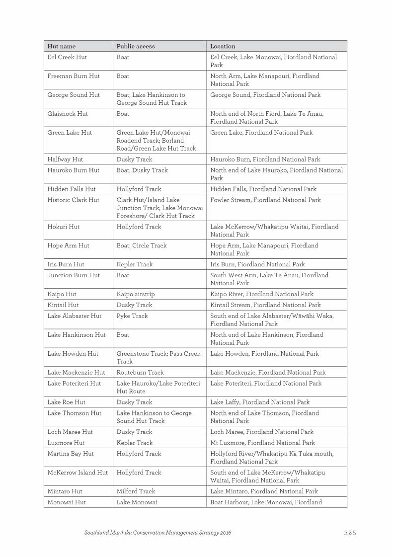
Hut name Public access Location
Eel Creek Hut Boat Eel Creek, Lake Monowai, Fiordland National Park
Freeman Burn Hut Boat North Arm, Lake Manapouri, Fiordland National Park
George Sound Hut Boat; Lake Hankinson to George Sound Hut Track
George Sound, Fiordland National Park
Glaisnock Hut Boat North end of North Fiord, Lake Te Anau, Fiordland National Park
Green Lake Hut Green Lake Hut/Monowai Roadend Track; Borland Road/Green Lake Hut Track
Green Lake, Fiordland National Park
Halfway Hut Dusky Track Hauroko Burn, Fiordland National Park
Hauroko Burn Hut Boat; Dusky Track North end of Lake Hauroko, Fiordland National Park
Hidden Falls Hut Hollyford Track Hidden Falls, Fiordland National Park
Historic Clark Hut Clark Hut/Island Lake Junction Track; Lake Monowai Foreshore/ Clark Hut Track
Fowler Stream, Fiordland National Park
Hokuri Hut Hollyford Track Lake McKerrow/Whakatipu Waitai, Fiordland National Park
Hope Arm Hut Boat; Circle Track Hope Arm, Lake Manapouri, Fiordland National Park
Iris Burn Hut Kepler Track Iris Burn, Fiordland National Park
Junction Burn Hut Boat South West Arm, Lake Te Anau, Fiordland National Park
Kaipo Hut Kaipo airstrip Kaipo River, Fiordland National Park
Kintail Hut Dusky Track Kintail Stream, Fiordland National Park
Lake Alabaster Hut Pyke Track South end of Lake Alabaster/Wāwāhi Waka, Fiordland National Park
Lake Hankinson Hut Boat North end of Lake Hankinson, Fiordland National Park
Lake Howden Hut Greenstone Track; Pass Creek Track
Lake Howden, Fiordland National Park
Lake Mackenzie Hut Routeburn Track Lake Mackenzie, Fiordland National Park
Lake Poteriteri Hut Lake Hauroko/Lake Poteriteri Hut Route
Lake Poteriteri, Fiordland National Park
Lake Roe Hut Dusky Track Lake Laffy, Fiordland National Park
Lake Thomson Hut Lake Hankinson to George Sound Hut Track
North end of Lake Thomson, Fiordland National Park
Loch Maree Hut Dusky Track Loch Maree, Fiordland National Park
Luxmore Hut Kepler Track Mt Luxmore, Fiordland National Park
Martins Bay Hut Hollyford Track Hollyford River/Whakatipu Kā Tuka mouth, Fiordland National Park
McKerrow Island Hut Hollyford Track South end of Lake McKerrow/Whakatipu Waitai, Fiordland National Park
Mintaro Hut Milford Track Lake Mintaro, Fiordland National Park
Monowai Hut Lake Monowai Boat Harbour, Lake Monowai, Fiordland
325Southland Murihiku Conservation Management Strategy 2016
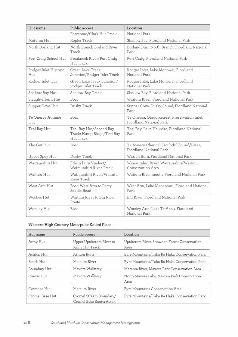
Hut name Public access Location Foreshore/Clark Hut Track National Park
Moturau Hut Kepler Track Shallow Bay, Fiordland National Park
North Borland Hut North Branch Borland River Track
Borland Burn North Branch, Fiordland National Park
Port Craig School Hut Breakneck River/Port Craig Hut Track
Port Craig, Fiordland National Park
Rodger Inlet Historic Hut
Green Lake Track Junction/Rodger Inlet Track
Rodger Inlet, Lake Monowai, Fiordland National Park
Rodger Inlet Hut Green Lake Track Junction/ Rodger Inlet Track
Rodger Inlet, Lake Monowai, Fiordland National Park
Shallow Bay Hut Shallow Bay Track Shallow Bay, Fiordland National Park
Slaughterburn Hut Boat Waitutu River, Fiordland National Park
Supper Cove Hut Dusky Track Supper Cove, Dusky Sound, Fiordland National Park
Te Oneroa A-frame Hut
Boat Te Oneroa, Otago Retreat, Preservation Inlet, Fiordland National Park
Teal Bay Hut Teal Bay Hut/Second Bay Track; Hump Ridge/Teal Bay Hut Track
Teal Bay, Lake Hauroko, Fiordland National Park
The Gut Hut Boat Te Awaatu Channel, Doubtful Sound/Patea, Fiordland National Park
Upper Spey Hut Dusky Track Warren Burn, Fiordland National Park
Wairaurahiri Hut Edwin Burn Viaduct/ Wairaurahiri River Track
Wairaurahiri River, Wairaurahiri/Waitutu Conservation Area
Waitutu Hut Wairaurahiri River/Waitutu River Track
Waitutu River mouth, Fiordland National Park
West Arm Hut Boat; West Arm to Percy Saddle Road
West Arm, Lake Manapouri, Fiordland National Park
Westies Hut Waitutu River to Big River Route
Big River, Fiordland National Park
Worsley Hut Boat Worsley Arm, Lake Te Anau, Fiordland National Park
Western High Country Mata-puke Koikoi Place
Hut name Public access Location
Army Hut Upper Upukerora River to Army Hut Track
Upukerora River, Snowdon Forest Conservation Area
Ashton Hut Ashton Burn Eyre Mountains/Taka Ra Haka Conservation Park
Beech Hut Mataura River Eyre Mountains/Taka Ra Haka Conservation Park
Boundary Hut Mavora Walkway Mararoa River, Mavora Park Conservation Area
Careys Hut Mavora Walkway North Mavora Lake, Mavora Park Conservation Area
Cowshed Hut Mataura River Eyre Mountains Conservation Area
Cromel Base Hut Cromel Stream Boundary/ Cromel Base Route; Acton
Eyre Mountains/Taka Ra Haka Conservation Park
326 Southland Murihiku Conservation Management Strategy 2016

Hut name Public access Location Hut Site – Cromel Base Hut Junction Route
Cromel Branch Hut Acton/Cromel Route Junction - Cromel Branch Hut
Eyre Mountains/Taka Ra Haka Conservation Park
Dog Box Bivvy Eyre Creek Eyre Mountains/Taka Ra Haka Conservation Park
Forks Hut Forks Hut Tramping Track The Forks, Mavora Park Conservation Area
Irthing Hut Cromel Stream Junction to Irthing Hut Route
Eyre Mountains/Taka Ra Haka Conservation Park
Islands Hut Island Hut Route Eyre Mountains/Taka Ra Haka Conservation Park
Kiwi Burn Hut Kiwi Burn Hut Track Snowdon Forest Conservation Area
Lincoln Hut Oreti River Eyre Mountains/Taka Ra Haka Conservation Park
Lower Windley Hut Windley River Eyre Mountains/Taka Ra Haka Conservation Park
Mansion Hut Irthing Stream-Mansion Hut Route
Eyre Mountains/Taka Ra Haka Conservation Park
Mt Bee Bunkrooms Mt Bee 4WD South Track Eyre Mountains/Taka Ra Haka Conservation Park
Oreti Hut Oreti River Eyre Mountains/Taka Ra Haka Conservation Park
Shepherd Creek Hut Eyre Creek Eyre Mountains/Taka Ra Haka Conservation Park
Taipo Hut Mavora Walkway Ngāi Tahu Leaseback Conservation Area
Upper Cromel Hut Upper Cromel Hut Route Eyre Mountains/Taka Ra Haka Conservation Park
Upper Oreti Hut Oreti River Eyre Mountains/Taka Ra Haka Conservation Park
Upper Windley Hut Windley River Eyre Mountains/Taka Ra Haka Conservation Park
West Burn Hut Boat North Mavora Lake, Mavora Park Conservation Area
Eastern High Country Mata-puke Taratara Place
Hut name Public access Location
Dome Burn Sod Hut Dome Burn Muddy Gully Historic Reserve
Garston Ski Hut Nevis Road Hector Mountain Conservation Area
Longwood O Hekeia Place
Hut name Public access Location
Martin’s Hut Ports Race/Merrivale Woodlaw Forest Track; Turnbull’s Tramping Track
Cascade Stream, Longwood Forest Conservation Area
Turnbull’s (Big Dam) Hut
Turnbull’s Tramping Track Longwood Forest Conservation Area
327Southland Murihiku Conservation Management Strategy 2016

328 Southland Murihiku Conservation Management Strategy 2016

Index
Index
Aactive management 40, 45, 115, 136, 187
adverse effects 14, 51, 53, 93, 94, 106, 109, 113, 125, 128, 129, 130, 131, 139, 140, 141, 142, 147, 150, 154, 156, 157, 158, 160, 161, 164, 165, 175 See also cumulative effects
addressing 32, 40, 50, 52, 65, 76, 78, 93, 104, 116, 117, 118, 130, 133, 134, 137, 139, 140, 141, 142, 145, 146, 149, 156, 157, 158, 159, 162, 164avoiding 52, 53, 61, 63, 64, 65, 73, 74, 76, 78, 82, 88,
89, 95, 96, 101, 103, 104, 110, 111, 114, 118, 125, 129, 133, 143, 146, 147, 150, 153, 154, 155, 165, 177
advocacy 18, 36, 37, 48, 65, 90, 94, 96, 100, 104, 114, 129, 142, 144, 146, 165, 168, 173
agriculture 19, 79, 95, 106
air activity zones 65, 73
aircraft 53, 54, 71, 90, 167, 169–170, 176, 178access 62, 68, 78, 110, 126, 160, 162access zones 63, 137, 143–146activities with 55, 56, 65, 68, 78, 81, 115, 117, 135, 153,
158, 159, 161, 162, 169, 178landings 49, 51, 52, 53, 58, 59, 60, 65, 68, 70, 71, 72,
73–74, 82, 85, 87, 88, 101, 103, 109, 111, 126, 132, 142–146, 162, 170
operators 144, 146airstrips 39, 59, 65, 68, 73, 144–145, 150, 170
albatross. See toroa/albatross
alpine environments 50, 52, 55, 68, 69, 71, 78, 79, 80, 158
Anchor Island 34, 56
angling amenity 67, 80, 91
Antipodes Island Group 119, 120, 122, 124, 127, 129, 133
Aparima River 49, 51, 84, 91, 100, 116
ara tawhito 24, 26, 40, 67, 98
Arawhata 54, 58, 59, 60, 62, 63, 64, 65, 66
archaeological sites 21, 24, 25, 39, 63, 66, 79, 85, 87, 91, 99, 102, 108, 109, 110, 115, 118, 133, 178
artificial light 52, 61, 82, 87, 110, 117, 128
at risk species 171 See also threatened and at risk species
Auckland Island 121, 123, 124, 125, 126, 129, 130
Auckland Islands 119, 121–122, 124, 127, 129 Motu Maha Marine Reserve/Marine Mammal
Sanctuary 119
Australasian bittern. See matuku-hūrepo/Australasian bittern
authorisations 13, 29, 32, 46, 52, 65, 76, 82, 89, 96, 103, 104, 111, 118, 132, 136, 137, 143, 144, 145, 147, 151, 152, 154, 156, 157, 158, 159, 160, 161, 165, 168, 171 See also concessions
AwaruaBay 106, 107Place 105–112, 113, 137Plains 91, 106–109, 110, 111wetland complex 45, 105, 106, 108, 109, 110, 171Wetland of International Importance 17, 22, 35, 45,
93, 97, 106, 110, 112, 117
Bbackcountry 42, 43, 71, 73, 143
experience 23, 24, 50, 59, 61, 67, 68, 72, 74, 76, 78, 99Backcountry destinations 13, 41, 43, 44, 51, 52, 67, 71,
81, 87, 101, 171
bats. See pekapeka/bat
beech. See tawai/beech
Big Bay 56, 59, 64, 155
biodiversity 35, 57, 72, 79, 81, 86, 98, 114, 119, 171addressing 19, 21, 22, 45, 56, 81, 87, 129, 182indigenous 23, 37, 56, 77, 129, 182
biogenic reefs 34, 113–114, 116, 117, 118, 171
biosecurity 22, 58, 66, 94, 97, 123, 124, 125, 126, 128, 129, 132, 135, 139, 172
Biosecurity Act 1993 14, 172, 183
birds 28, 62, 77, 86, 107, 109, 115, 148, 157 See also seabirdsalpine 34, 70endemic 119, 120, 121, 122, 127game 45, 56, 78, 92, 107, 155, 156, 163, 177indigenous 55, 79, 100, 101threatened and at risk 51, 60, 67, 81, 91, 92, 95, 107,
120, 121, 123wading 86, 100, 107wetland 86, 95
bird watching 60, 107, 109
Blue MountainsForest 77, 79, 81, 83Recreational Hunting Area 78, 81, 83, 84
Bluff 105, 110, 125
Bluff/Motupōhue, The 24, 27, 42, 45, 108, 109, 110, 111, 112
boating 60, 71, 94, 110
Borland Mire 35, 92, 100
bottlenose dolphin. See terehu/bottlenose dolphin
Bounty Islands 119, 120, 122, 126, 127
329Southland Murihiku Conservation Management Strategy 2016
Index
Breaksea Sound 57, 58
breeding 35grounds 57, 94, 100, 114, 115, 120, 121, 122, 127, 129,
153, 154programmes 36, 70, 72season 115, 117, 132
Building Act 2004 152, 153, 172
buildings 62, 99, 170, 172, 178
Burwood 66, 70, 72
businesses 24, 31, 44, 50 See also commercial activity; concessionairescontribution of 30, 41, 47, 56, 60, 61, 97, 100, 127, 129,
133working with 18, 19, 20, 37, 41, 45, 46–47, 61, 63, 110,
126bylaws 15, 28, 135, 142, 167, 172
CCampbell Island/Motu Ihupuku 119, 123, 124, 125, 126,
127–128, 130
Campbell Islands 122, 124, 127, 128
camping 60, 68, 70, 71, 76, 78, 177
campsites 70, 72, 74Māori 54
Catlins Coast Marine Mammal Sanctuary 114
Catlins Conservation Park 98, 101
Catlins Te Akau tai tonga, The 101, 102, 103, 104, 116, 153
caving 60, 165
chamois 56, 68, 160, 162, 163
Chinese history 85, 87, 88
Civil Aviation Authority 63, 142
climate 20, 34, 55, 60, 68, 70, 90change 18, 22, 166
climbing 56, 60, 67, 166 See also mountaineering
Clutha River/Mata-Au 79, 80
coastal environments 21, 25, 37, 57, 94, 95, 101, 107, 118
coastal marine area 58, 62, 63, 66, 113, 114, 116, 119, 124
coastline 37, 54, 55, 56, 63, 102, 112, 113, 153
coastwatching 109, 124, 125, 127
codes of conduct 114, 117, 118, 146, 159, 164
collaboration 13, 21, 36, 38, 40, 42, 117, 146, 155
commercial activity 20, 50, 52, 61, 62, 63, 65, 68, 72, 76,
82, 87, 93, 94, 96, 102, 103, 109, 110, 111, 115, 116, 136, 142, 155, 160 See also businesses; concessionaires; concessions; fishing; hunting; industry; watercraft
community 13, 19, 36, 43, 83, 148, 172, 180contribution of 19, 22, 24, 26, 30, 37, 41, 46, 52, 56,
60, 62, 71, 72, 76, 81, 84, 87, 88, 97, 99, 101, 102, 104, 105, 109, 110, 115, 117, 127, 129, 133
groups 21, 24, 26, 31, 40, 56, 63, 71, 80, 82, 85, 100, 106, 108, 110
values 13, 19, 21, 23, 26, 36, 39, 40, 42, 49, 52, 55, 56, 67, 72, 78, 80, 99, 100, 102, 106, 107, 113, 114, 116
working with 18, 21, 22, 26, 38, 41, 46, 49, 51, 52, 57, 61, 63, 68, 76, 82, 85, 88, 90, 92, 94, 95, 97, 101, 104, 105, 107, 110, 112, 113, 116, 117, 118, 126, 139, 155, 166
compliance 45, 52, 65, 76, 82, 89, 96, 103, 111, 117, 118, 129, 132, 148, 152, 159
concessionaires 14, 32, 46, 135, 140, 141, 152, 153, 164, 172, 189consulting 130, 133contribution of 21, 37, 43working with 47, 126, 128, 130
concessions 13, 30, 46, 53, 63, 65, 74, 76, 82, 89, 93, 96, 102, 103, 110, 111, 112, 117, 118, 128, 132, 136, 143, 146, 147, 152, 154, 155, 162, 164, 168, 172, 176
conflicts of use 43, 78, 137, 139, 141, 143, 147, 149, 158, 164
conservationactive 39–41, 54, 55, 68, 79, 85, 87, 91, 98, 102, 109,
124, 169awareness 20, 21, 22, 23, 26, 93, 96, 106, 125, 177, 179concept of 8, 18, 172contributing to 20, 61, 82, 90, 139, 140, 141, 149science 25support for 23, 24, 37, 45, 46, 47, 102, 125, 179
Conservation Act 1987 8, 9, 11, 15, 29, 33, 39, 46, 63, 73, 78, 83, 90, 93, 120, 135, 136, 142, 147, 150, 154, 159, 160, 170, 172, 173, 176, 183, 188, 190
Conservation General Policy 2005 9, 12, 13, 14, 135, 137, 150, 156, 158, 159, 173
conservation management plans 8, 14, 15, 27, 173, 187
conservation management strategies (CMSs) 8, 13–15, 173, 187
consultation 13, 30, 32, 73, 124, 125, 129, 130, 133, 139, 140, 141, 152, 160, 164, 165, 166
Convention Concerning the Protection of the World’s Cultural and Natural Heritage. See World Heritage Convention
Convention on Biological Diversity 16, 174, 182
Convention on Wetlands of International Importance especially as Waterfowl Habitat. See Ramsar Convention
330 Southland Murihiku Conservation Management Strategy 2016
Index
Cook, James 25, 61
corals 57
Countess Range 67, 72
covenants 54, 188
Crown Minerals Act 1991 9, 70, 89, 142, 156, 157
Crown Pastoral Land Act 1998 9
Croydon Bush 42, 45, 98, 99, 101
cruise ships 58, 125, 174
cultural and historic heritage 24
cultural harvesting 109, 116
cultural heritage. See historic and cultural heritage
cultural initiatives 50, 52, 99
cultural resources 31, 85
cultural sites 25, 54, 97, 108, 116, 124, 150, 157, 179, 190 See also landscapes
cultural traditions 24, 41, 50, 108, 130, 131, 132
cumulative effects 117, 137, 139, 140, 141, 160, 161, 162, 167, 174, 175
Curio Bay 98, 101, 102, 114
Curio Bay/Porpoise Bay 24, 42, 101, 104, 116
customary use 15, 28, 29, 30, 31, 32, 92, 113, 174
DDean Forest 54, 59, 60, 62, 63, 64, 65, 66
Deed of Recognition areas 15, 27, 49, 54, 67, 79, 85, 91, 93, 98, 108
deep-water emergence 57
deer 51, 56, 60, 78, 81, 84, 99, 160, 162, 163, 169, 187
departmental staff 31, 126, 127, 132, 166
destination management 13, 41, 174
development 40, 50, 57, 68, 72, 78, 79, 80, 81, 85, 86, 88, 94, 95, 97, 100, 104, 109, 113, 114, 116, 128, 154structural 52, 61, 63, 72, 79, 82, 87, 102, 110, 117
Diggers Ridge 54, 59, 62, 63, 64, 65, 66
Director-General of Conservation 11, 28, 153, 160, 171, 173
disabled people 44, 147, 148, 175, 184
disease 114, 123, 124, 147, 172
diving 56, 58, 116cage 114, 116, 117, 118
dogs 147–148, 155, 175
domestic animals 147
dotterel 51, 70, 79, 92, 100, 107, 121
Doubtful Sound/Patea 24, 57–58, 63, 153
Dunsdale 98, 99, 103
Dunton Range 67, 72
Dusky Sound 25, 39, 55, 57
Eeastern falcon. See kārearea/eastern falcon
Eastern High Country Mata-puke Taratara Place 67, 77–84, 93, 149
ecological areas 64, 65, 96, 98, 103, 104, 154
ecological resources 19, 35, 62, 105, 110awareness of 52, 63corridors 21, 37, 100protecting 22, 51, 52, 65, 74, 78, 89, 110, 111, 112, 116,
155threats to 58, 106, 123
economy 20, 45, 46
ecosystems 34–45, 51, 55, 100, 113, 123, 175alpine 34, 51, 52, 60dune 34, 37, 55, 100, 107enhancing 22, 61, 87, 95, 116, 127freshwater 35, 51, 52, 68, 80, 82, 86, 89, 98, 154, 155indigenous 20, 22, 23, 34, 35, 37, 51, 60, 65, 66, 71, 76,
80, 84, 92, 100, 101, 102, 115, 119, 127, 129, 133, 154, 155, 156, 158, 175
interdependent 61, 116, 123, 127managing 95, 97, 112, 158, 162marine 22, 34, 36, 61, 62, 63, 65, 66, 113, 116, 117, 118,
122protecting 32, 51, 52, 58, 76, 80, 82, 84, 86, 89, 94, 95,
100, 101, 102, 116, 117, 118, 129, 133, 155, 156, 185restoring 22, 36, 38, 95, 115, 187services 19, 37, 95, 175threats to 112, 116, 184wetland 52, 84, 92–93, 97, 100
education 13, 32, 43, 45, 61, 102, 104, 109, 110, 117, 118, 125, 148, 154, 164, 166, 177
eeling 154–155
eels. See eeling; tuna/eel
Eglinton River 22, 91, 141
Electricity Act 1992 9
electric power-assisted pedal cycles 53, 59, 64, 75–76, 83, 88, 103, 111, 140–141, 166, 167, 175
emergencies 15, 45, 135, 142, 176
endemic species 34, 50, 55, 68, 71, 79, 81, 119, 120, 121, 122, 127, 128, 176threatened and at risk 50, 52, 93, 119, 120, 121
Enderby Island 122, 123, 124, 125, 126, 127, 130
engagement 30, 32, 34, 44–46, 88, 90, 105, 117
environmental services 19, 37, 80, 81, 86, 90
331Southland Murihiku Conservation Management Strategy 2016
Index

erosion 21, 25, 55, 68, 81, 87, 108, 113, 115, 117, 120, 124, 147, 149, 165
estuaries 37, 92, 95, 105, 106, 107, 110, 113
Europeanshistory of 25, 55, 72, 79, 91, 109, 115, 174settlement of 25, 55, 61, 91, 98, 124
extraction 157, 158
Eyre Creek 67
Eyre Mountains 24, 34, 67, 69, 70, 71
Eyre Mountains/Taka Ra Haka Conservation Park 66, 68, 70, 73, 76
Ffacilities 21, 24, 42, 43, 44, 45, 61, 71, 99, 101, 102, 105,
125, 130, 140, 141, 164, 166, 167, 176
families 19, 70, 72, 78, 81, 85
farming 25, 73, 96, 98, 104, 123, 124, 147, 156, 188pastoral 49, 68, 72, 77, 81, 91, 98, 99, 101, 127
fauna 22, 95, 126endemic 34, 50, 79, 81, 120indigenous 81, 96, 102, 155introduced 51, 121, 122, 123, 133, 159, 182threatened and at risk 36, 95, 96, 108
fernbird. See mātātā/fernbird
filming 71, 109, 132, 137, 146, 158, 159
fiord 92
Fiordland Marine Guardians 56, 57, 61, 63, 66
Fiordland National Park 24, 28, 35, 54, 58, 59, 60, 62, 64, 91, 94, 135, 137, 142, 143, 145, 147, 153, 158Management Plan 8, 15, 32, 58, 62, 63, 64, 65, 73, 138,
140, 148, 150, 153, 155, 158, 159, 162possible additions to 58, 59, 63, 66, 67, 73, 77
Fiordland (Te Moana o Atawhenua) Marine Area. See coastal marine area
Fiordland (Te Moana o Atawhenua) Marine Management Act 2005 9, 54, 56
Fiordland Te Rua-o-te-moko Place 54–66, 67, 71, 113, 153, 156, 162
fiords 54, 57, 58, 61, 63, 66, 110, 114, 121
fires 22, 36, 68, 106, 112, 122, 132, 139, 153, 165, 166
Fire Service Act 1975 35
fish 28, 56, 106, 107, 113, 176freshwater 32, 72, 86, 90, 92, 93, 94, 95, 106, 155, 156,
176, 177, 186indigenous 22, 29, 32, 55, 69, 72, 80, 86, 92, 93, 94,
95, 97, 106, 108, 155marine 106, 114passage 37, 97
sports 86, 92, 94, 97, 155, 156, 173, 188Fish and Game Councils 37, 155, 176. See also
Southland Fish and Game Council
fisheries 67, 98, 107, 114, 176freshwater 37, 72, 80, 90, 92, 156, 184, 186
Fisheries Act 1996 154, 176, 180
fishing 28, 56, 58, 72, 183commercial 68, 154, 155industry 57, 61, 113, 114, 116, 117, 118, 129recreational 19, 23, 49, 50, 51, 67, 78, 81, 92, 94, 109,
116sports 60, 99, 176, 186
fixed anchors 165, 166
flax. See harakeke/flax
flood plains 22, 96, 104, 112
floods 150, 153buffering 80, 81, 86risk of 96, 104, 156
flora 28alpine 85, 106aquatic 60, 69, 95, 96, 106coastal 34, 107endemic 50, 55, 68, 71, 93, 119, 125estuarine 107, 113, 116indigenous 22, 34, 35, 50, 55, 60, 62, 68, 69, 71, 79, 81,
85, 86, 93, 95, 96, 100, 101, 104, 106, 107, 108, 120, 121, 124, 127, 147, 156
introduced 69, 121, 123, 182island 119, 120, 121, 122shoreline 60, 69, 95threatened and at risk 50, 55, 59, 60, 69, 79, 93, 95,
100, 106, 107, 108, 113, 116, 120wetland 86, 106
Forest and Rural Fires Act 1977 35, 166
Forest Hill 23, 42, 45, 98, 99, 100, 101, 104
forestry 36, 51, 77, 85, 86
forests 36, 116, 121indigenous 36, 50, 51, 52, 55, 59, 60, 62, 78, 79, 81, 85,
86, 87, 99, 101, 102, 108, 109petrified 101, 102regenerating 85, 86, 101, 108
four-wheel driving 59, 67, 68, 71, 78, 81, 84, 92, 109, 166, 177
Foveaux Strait (Te Ara a Kiwa) 22, 25, 34, 113, 115
Foveaux Te Ara a Kiwa Place 84, 105, 112–118
freedom camping 21
Freedom Camping Act 2011 9
freshwater environments 22, 37, 57, 67, 80, 100, 104, 107, 156 See also ecosystems; fish; fisheries
332 Southland Murihiku Conservation Management Strategy 2016
Index

downstream influence 49, 51, 52, 57, 80, 86, 89, 104, 117
Freshwater Wai Māori Place 90–98, 104, 105
frontcountry 23, 43, 99
frost flats 59, 67, 100
fuel depots 132
fur seal. See kekeno/New Zealand fur seal
Ggalaxiids 51, 55, 69, 80, 92
Game Animal Council 45, 163
Game Animal Council Act 2013 9, 163, 178, 190
game bird 155
Garvie Mountains 77, 80, 83, 84, 93
Gateway destinations 13, 24, 41, 42, 43, 44, 56, 61, 70, 72, 99, 101, 104, 109, 110, 116, 177
General Policy for National Parks 2005 9, 12, 58, 64, 137, 156, 177
geology 35, 50, 55, 99features 36, 37, 64, 69, 99, 182
glacial processes 57, 77, 99, 121, 122
Glaisnock 56, 62, 163
goats 51, 60, 70, 121, 123, 160, 162
gold mining 25, 61, 79, 81, 85, 86, 87, 91
grazing 93, 96, 98, 104, 112, 136, 147, 156
Great Walks 24, 39, 42, 56, 61
group sizes 76, 82, 89, 96, 103, 111
Guardians of Lakes Manapouri, Monowai and Te Anau 93
guiding 32, 46, 50, 68, 89, 96, 111, 139, 141, 174, 178
Hhabitat enhancement 19, 100
harakeke/flax 106, 108, 115
Hector’s dolphin. See tūpoupou/Hector’s dolphin
Hekeia, Rangatira 84
helicopters 46, 139, 144
heli-skiing 68, 78, 178
Henry, Richard 25, 61house 39, 55
Heritage New Zealand Pouhere Taonga 21, 39, 45, 98
Heritage New Zealand Pouhere Taonga Act 2014 9, 25, 39, 170, 178
high-country environments 49, 51, 66–84, 94
historic and cultural heritage 19, 24–26, 30, 39–41, 45, 46, 49, 51, 59, 68, 72, 86, 110, 118, 119, 127, 128, 178, 179, 190conservation 49, 50, 56, 82, 88, 89, 102, 110, 127, 136,
179, 185protecting 88, 89, 90restoring 187understanding 61, 81, 87, 88, 89, 102, 105, 110, 112,
117, 128, 129historic sites 25, 26, 39–41, 42, 54, 55, 68, 79, 85, 87, 91,
97, 98, 102, 109, 110, 116, 117, 124, 125, 127, 128, 157, 169nationally significant 39strategy 129, 130, 133
history 25, 39, 55, 85, 98, 99, 108, 109, 115, 124, 128
Hobart 125
hoiho/yellow-eyed penguin 34, 114, 116, 121
HokonuiForest 98, 99, 103Hills 45, 98, 99, 100, 101, 103
Hooker’s sea lion. See rāpoka/whakahao/New Zealand sea lion
horse riding 67, 68, 70, 71, 72, 76, 78, 81, 83, 85, 88, 99, 139, 148, 149, 166, 167
human activity 57, 92, 108, 114, 153, 170, 182 See also commercial activity; development
hunters 49, 51, 81, 83, 85
hunting 19, 23, 25, 45, 84, 122, 147, 160commercial 68, 160, 172game animal 163, 178game bird 99, 109, 116, 155, 156recreational 49, 50, 51, 56, 59, 60, 67, 68, 71, 78, 81,
84, 85, 86, 87, 92, 109, 147, 160, 176, 187trophy 56, 161, 169
huts 43, 44, 49, 50, 52, 53, 59, 68, 71, 73, 74, 144, 148
hydroelectricity 46, 57, 91, 93, 136, 154
hydrology 35, 62, 94
IIcon destinations 13, 24, 39, 41, 42, 43, 44, 56, 58, 60, 61,
63, 179
Iconic species 13, 22, 35, 36, 64, 182
Icon sites 40
identity 13, 19, 25, 35, 51, 81, 95, 182Ngāi Tahu 27, 91
īnanga/īnaka/whitebait 92, 93 See also whitebaiting
indigenous species 22, 51, 62, 67, 106, 109, 179 See also biodiversity; birds; ecosystems; fauna; fish; flora; forests
333Southland Murihiku Conservation Management Strategy 2016
Index
managing 21, 25, 31populations 34, 35, 36, 37, 52, 60, 71, 107protecting 32, 61, 76, 94, 104, 124, 128, 129, 135, 147,
155, 156, 164threats to 61, 116, 120, 123, 184
industry 19, 55, 57, 61, 91, 94, 95 See also commercial activityoperators 117
integrated management 8, 10, 11, 15, 21, 31, 48, 56, 58, 61, 62, 63, 95, 96, 97, 101, 116, 127, 136, 158, 173, 179, 184
interaction, human–animal 104, 114, 117, 123, 124, 126, 132, 154, 157
international agreements 16, 17, 174
International Council on Monuments and Sites New Zealand Charter 40, 179
international significance 37, 50, 54, 55, 80, 91, 99, 106, 119, 128 See also Wetlands of International Importance; World Heritage Areas
interpretation 23, 25, 39, 40, 41, 51, 53, 61, 63, 77, 102, 110, 112, 118, 124, 125, 129, 154, 165, 179
invasive species 58, 61, 69, 123
Invercargill 20, 84, 85, 98, 99, 106, 109
invertebrates 50, 55, 69, 70, 71, 80, 120, 121, 122endemic 34, 50, 79, 120, 122
islands 35, 37, 55, 60, 66, 113, 115 See also subantaractic islands
iwi 32
Kkaitiaki 20
Kaitiaki Rōpū 9, 20
kaitiakitanga 10, 15, 19, 20, 26, 27, 29, 30, 31, 114, 130, 179
kākā 34, 70, 71
kākāpō 22, 34, 35, 56programme 20
kārearea/eastern falcon 50, 70, 79
kayaking 23, 58, 60, 67, 78, 94, 109, 110, 116
kea 34, 35, 79
kekeno/New Zealand fur seal 57, 114, 120, 122, 153
kelp 85, 113, 120, 122, 171pest 58, 123
Kepler Mire 35, 92, 100
Kepler Track. See Great Walks
Kiwa 113
kiwi 28, 35
Kiwi Burn Track 42, 70, 72
kōkopu 55, 86, 92, 93, 106
kōwhai 35, 36, 50, 95
LLake George (Uruwera) 85, 86, 87, 88, 89, 90, 91, 93, 97
Lake Hauroko 54, 91, 93
Lake Manapouri 22, 35, 54, 91, 93, 97
lakes 22, 54, 55, 60, 67, 68, 69, 79, 91, 93, 94, 95, 97, 98, 155levels of 93
Lake Te Anau 35, 54, 84, 91, 93
landfreehold 49, 91pastoral lease 49, 77, 91, 139private 23, 49, 51, 52, 69, 72, 78, 86, 91, 92, 98, 116status 27, 77, 83, 84, 119, 135, 157, 171
landforms 35, 36, 37, 64, 99, 122, 165, 182, 187
Land Information New Zealand 80, 91, 95, 136, 188
landowners 73, 83, 141, 147, 148contribution of 62, 72, 80, 81, 97, 100, 105, 117working with 37, 49, 51, 52, 53, 69, 78, 80, 81, 82, 86,
90, 95, 107, 110, 166landscapes 19, 20, 35, 51, 52, 55, 58, 60, 61, 67, 68, 70, 71,
77, 81, 86, 95, 99, 102, 110, 113, 116, 150, 157, 158, 182, 187cultural 24, 50, 51, 52, 61, 63, 72, 76, 81, 87, 110, 115,
124 See also whenua tūpuna
protecting 36, 37, 43, 51, 52, 63, 64, 72, 76, 78, 79, 82, 87, 89, 102, 103, 104, 110, 116, 117, 118
Land Transport Act 1998 181
land use 85, 86, 94, 95, 104, 108, 117consents 14, 46, 135intensification 106, 113practices 22, 104
latitude 55, 90, 119
leaseholders 43, 78, 80, 81, 105
lighthouses 55, 98
Lillburn 54, 59, 62, 63, 64, 65, 66
limestone 59, 99, 102
Lindsay 54, 59, 62
livestock 62, 96, 101, 104, 121, 123, 147, 156, 180 See also grazing
Livingstone Mountains 67, 69, 70, 71, 72
lizards 22, 50, 55, 71, 79
334 Southland Murihiku Conservation Management Strategy 2016
Index

local authorities 14, 21, 37, 45, 95, 99, 110, 136, 142, 148
local residents 23, 51, 55, 84, 85, 86, 87, 99, 101, 104, 109, 116
Local Treasure destinations 13, 41, 43, 44, 71, 81, 87, 101, 110, 180
Longwood O Hekeia Place 45, 84–90, 113, 149, 157
Longwood Range 84, 85, 86, 87, 88, 89
Lowlands Te Rā a Takitimu Place 49, 51, 52, 84, 92, 98–105, 113, 149
Mmahinga kai 24, 26, 30, 31, 33, 49, 54, 79, 85, 91, 92, 98,
106, 108, 109, 110, 111, 115, 180
maintenance 23, 24, 25, 40, 87, 132, 133, 139access for 125, 128, 130, 132, 138, 143, 144, 145, 146contribution to 21, 24, 44, 56, 99, 126, 139, 140, 141,
149Manapouri Power Scheme 57, 93
Manapouri–Te Anau Development Act 1963 9, 54, 93
mana whenua 10, 26
Māori See also iwi; Ngāi Tahu; tangata whenuacultural landscape 63history 24, 54, 72, 79, 91, 108, 115landowners 62place names 54, 67, 77, 84, 91, 98, 106, 108, 110, 119,
124settlements 24, 25, 98, 108, 115, 124
Mararoa River 67, 68, 69, 70, 72, 93
marginal strips 28, 49, 73, 93, 98, 156
marine environments 37, 57, 61, 112, 134
marine mammals 22, 28, 31, 34, 35, 37, 57, 63, 66, 114, 115, 116, 120, 121, 122, 124, 180behaviour around 114, 117, 154code of management 58populations 57, 61, 66, 114protecting 65, 113, 128sanctuaries 57, 63, 66, 114, 115, 119, 153viewing 61, 65, 109, 111, 114, 115, 116, 117, 118, 132,
153, 154marine mammal sanctuaries 113
Marine Mammals Protection Act 1978 9, 29, 113, 114, 153, 173
marine protected areas 14, 36, 38, 129, 180
marine reserves 22, 36, 56, 57, 61, 63, 66, 119, 156, 180
Marine Reserves Act 1971 9, 173, 180
marine wildlife 21, 22, 57, 58, 61, 63, 65, 114, 116, 119, 125, 128 See also birds; fish; marine mammals
behaviour around 104, 114, 117threatened and at risk 115, 117viewing 101, 104, 111, 115, 116, 118
Maritime New Zealand 117
Mātaitai Reserves 92, 97, 98, 113, 180
mātātā/fernbird 86, 100, 107, 121
Mataura River 67, 68, 69, 76, 79, 80, 91, 98, 100, 108, 149, 156
matuku-hūrepo/Australasian bittern 86, 100, 107
mauri 90, 95, 181
Mavora-Greenstone walkway 42, 67
Mavora Lakes 8, 42, 67, 69, 70, 71, 72, 73, 74, 76, 91, 141, 149
Mavora Park 66, 67, 68, 71, 77, 147
megaherbs 121, 122, 127
meteorological base 125
Meteorological Service of New Zealand 125
mice 120, 121, 123
migratory species 19, 60, 92, 94, 107, 116
milestones 11, 33, 38, 41, 44, 46, 47, 48, 53, 54, 66, 77, 83, 84, 89, 90, 97, 98, 105, 112, 118, 134, 166, 167, 181
Milford Road Journey 24, 42, 58, 61
Milford Sound/Piopiotahi 21, 24, 42, 56, 57, 58, 60, 63
Milford Track. See Great Walks
minerals exploration 117
mining 55, 142access 70, 86, 89, 156, 157
Minister of Conservation 9, 11, 12, 15, 27, 28, 70, 93, 119, 142, 155, 156, 159, 160, 163, 166, 171, 172, 173, 178
Minister of Energy and Resources 156
Ministry for Primary Industries 37, 116, 154, 155
modification 61, 68, 79, 86, 91, 94, 100, 106, 186, 187
mohua/yellowhead 59, 70, 79, 81, 83, 84, 86
mollymawk. See toroa/mollymawk
monitoring 11, 30, 33, 40, 44, 49, 53, 56, 61, 65, 66, 70, 83, 84, 90, 112, 117, 118, 125, 126, 130, 132, 133, 134, 137, 139, 140, 141, 145, 149, 153, 154, 157, 164, 166, 167, 168
Moriori 124
moths 108
mountain biking 23, 56, 58, 60, 67, 68, 70, 71, 72, 78, 81, 87, 99, 139, 166, 167, 175, 177access 24, 53, 64, 74, 75, 83, 84, 85, 88, 102, 103, 111,
139, 140tracks 24, 53, 64, 74, 83, 85, 88, 102, 111, 139, 140
mountaineering 56, 71
335Southland Murihiku Conservation Management Strategy 2016
Index
Mt Tūtoko 27, 54
Murchison Mountains 22, 34, 60
Nnaming 49, 54, 67, 77, 84, 91, 98, 105, 106, 108, 110, 113,
119, 124
National Nature Reserves 23, 119, 127
national park management plans 8, 27, 105, 173 See also Fiordland National Park
National Parks Act 1980 8, 9, 29, 39, 58, 63, 73, 78, 83, 136, 142, 151, 172, 173, 177, 183, 190
national significance 37, 39, 55, 57, 58, 91, 95, 100, 107, 119, 182
natural character 50, 61, 63, 65, 67, 68, 91, 97, 118, 182, 187
natural heritage 13, 19, 34–38, 46, 105, 185, 190
natural quiet 50, 51, 55, 67, 71, 72, 78, 81, 99, 142, 143, 182protecting 43, 61, 63, 65, 68, 78, 82, 109, 141, 145, 160,
161natural resources 10, 18, 26, 29, 179, 182
conservation 62, 136, 154, 162, 185gathering 19, 28, 54, 106, 108, 124, 174, 183
nesting sites 51, 92, 107, 123
New Zealand Alpine Club 165
New Zealand Conservation Authority 9, 27, 168, 173
New Zealand Defence Force 142
New Zealand Fire Service 166
New Zealand Forest Service 49, 50, 52, 59, 68
New Zealand fur seal. See kekeno/New Zealand fur seal
New Zealand Police 139, 147, 148
New Zealand sea lion. See rāpoka/whakahao/New Zealand sea lion
New Zealand Threat Classification System 13, 188
New Zealand Transport Agency 45, 63, 187
New Zealand Walking Access Commission 43, 45, 49, 53, 78, 82, 83, 136
Ngāi Tahu 15, 19, 26–33, 91, 168, 183 See also Te Rūnanga o Ngāi Tahuaccess 31, 128, 130consulting 30, 124, 129, 130, 133, 165contribution of 19, 20, 26, 27, 30, 32, 33, 51, 54, 72, 81,
87, 88, 97, 102, 104, 117heritage 20, 27, 108Leaseback Conservation Area 67, 73, 74, 76links to areas 19, 20, 24, 26, 27, 32, 33, 39, 40, 41, 49,
54, 61, 67, 79, 85, 106, 109, 110, 113, 115, 124, 150,
159, 165, 189, 190place names 26, 113protocols 15, 28, 30, 31, 32, 33, 52stories 19, 26, 31, 51, 87traditions 61, 79, 108working with 9, 10, 14, 15, 18, 19, 31, 32, 38, 39, 40, 41,
49, 51, 52, 57, 61, 63, 66, 76, 85, 88, 90, 92, 94, 95, 97, 104, 105, 107, 110, 112, 113, 114, 116, 117, 118, 128, 155
Ngāi Tahu Claims Settlement Act 1998 9, 15, 26, 27, 28, 29, 31, 33, 67
Ngāi Tahu Deed of Settlement 1997 15, 31
Ngāi Tahu (Pounamu Vesting) Act 1997 9, 16, 31, 185
Ngāti Māmoe 108
Ngāti Mutunga 124
night sky 61, 87, 128
nohoanga sites 14, 15, 28, 32, 67, 78, 91, 98, 108, 183
NokomaiRiver 79, 80wetland complex 80, 81, 84
nutrient inputs 96, 104, 106, 112, 116, 156
Oobjectives 11, 12, 30, 31, 34, 36–38, 39–41, 42–44, 45–46,
47, 168
oilexploration 124spills 63, 118, 124
older people 19, 24
Old Man Range/Kopuwai 77, 83, 84
Old Woman Range 77, 83, 84
Olivine 59, 65
Omaui 45, 108
Omaui Island 113, 115
Ōraka Aparima Rūnaka 52
OretiBeach 113, 116River 67, 68, 69, 72, 91, 100, 108, 156
Otago 80, 83, 114CMS 113CMS Places 54, 67, 77, 78, 80, 98, 101, 112Regional Council 90, 94, 142, 158Rural Fire Authority 166
outcomes 11, 12, 34, 48, 51, 52, 60–62, 71, 72, 81, 82, 87, 94, 95, 98, 101, 102, 109, 110, 116, 117, 127, 128, 183national 13
PPapatipu Rūnanga 10, 20, 29, 31, 32, 40, 45, 183, 184
336 Southland Murihiku Conservation Management Strategy 2016
Index

partnerships 18, 21, 36, 42, 43, 44–47, 49, 52, 61, 68, 71, 82, 89, 110, 166, 184 See also Treaty of Waitangi
peat bogs 35, 67, 69, 100, 106
pekapeka/bat 55, 77long-tailed 50, 70, 71, 79
Pembroke 56, 62, 163
penguins 34, 57, 61, 120, 121 See also hoiho/yellow-eyed penguin
permits 23, 29, 66, 111, 114, 115, 117, 118, 125, 126, 128, 130, 147, 148, 153, 154, 155, 160, 166
pest animals 35, 50, 60, 70, 71, 81, 106, 120 See also wild animalsareas free of 104, 121, 122, 123, 127control of 35, 45, 56, 60, 70, 80, 81, 86, 108eradicating 56, 121, 122, 123, 129, 133
pest plants 81, 86, 100, 106, 123, 147aquatic 94, 95control of 52, 71, 80, 81, 82, 94, 95, 129, 133, 134, 149,
157eradicating 80, 116, 123, 129introducing 165
pests 123, 124, 172, 184aquatic 22, 58, 64, 71, 97, 118, 123control of 14, 21, 22, 37, 38, 45, 46, 64, 66, 81, 97, 100,
101, 118, 123, 124, 128, 129, 135, 183eradicating 21, 123, 128, 135surveillance for 22, 64, 118
petrels 57, 115, 120, 121
photography 60, 78, 159
Piano Flat 78, 79, 81
picnic areas 85, 99
Pig Island (Tīhaka) 113, 115
pigs 51, 56, 60, 62, 70, 99, 121, 123, 129, 160, 162, 163
pīwauwau/rock wren 34, 70, 71
plains 51, 98, 99
podocarps 55, 59, 62, 86, 101
Police 45
policies 9, 11, 12, 31, 32, 48, 52, 53, 62–66, 72–76, 82, 83, 88, 89, 95–97, 102–105, 110–112, 117, 118, 128–133, 135–166
pollution 92
Pomahaka River 79, 80, 91
population, humancentres 9, 20, 98, 99, 106trends 20, 24, 166
Porpoise Bay 100, 114, 117 See also Curio Bay/Porpoise Bay
Port Craig School 39
Port Ross 122
possums 45, 51, 55, 60, 86
pounamu 15, 16, 24, 28, 29, 31, 32, 54, 184
Pourakino 85
pou whenua 19, 32
predators 114, 154, 155
priority ecosystem units 13, 22, 34, 35, 36, 38, 55, 59, 60, 64, 65, 67, 69, 71, 79, 81, 82, 84, 86, 87, 88, 89, 93, 96, 99, 103, 104, 106, 109, 110, 111, 119, 129, 155, 157, 160, 161, 165, 168, 185
private accommodation 59, 150–153, 166, 167, 185
Proposed Regional Coastal PlanKermadec and Subantarctic Islands 119, 124, 128,
133Protected Objects Act 1975 9
public access 23, 24, 25, 28, 40, 43, 44, 45, 48, 49, 53, 54, 61, 77, 78, 82, 83, 84, 93, 95, 96, 99, 104, 109, 110, 116, 124, 125, 126, 147, 148, 156, 157, 188ease of 23, 24, 25, 39, 51, 57, 58, 60, 65, 67, 68, 71, 78,
81, 84, 87, 120, 126, 136, 138, 142, 143limits to 15, 24, 127, 128–132, 135, 155
public benefit 18, 37, 45, 120
public notification 9, 89, 137, 147, 164
public safety 15, 24, 40, 135, 139, 158, 165
Pyke Forest 54, 59, 60, 62, 63, 64, 65, 66
Rrailway 138, 186
rainforests 36
Ramsar Convention 16, 110, 112, 117, 174
rangatiratanga 20, 26, 124, 189 See also tino rangatiratanga
rāpoka/whakahao/New Zealand sea lion 22, 34, 35, 114, 121, 122, 123, 126, 129
rats 55, 60, 123
recoveryoperations 55, 159–161, 169species 28, 37, 52, 60, 71, 95, 101, 122, 124, 125, 127
recreation 8, 13, 19, 23, 24, 41–44, 49, 50, 56, 59, 60, 61, 67, 68, 70, 71, 72, 76, 77, 78, 81, 84, 85, 99, 101, 102, 109, 114, 116, 144, 155, 164, 172, 180future opportunities 24, 42, 43, 56, 58, 70, 82, 84, 85,
88, 99, 111, 149groups 42, 43, 139, 140, 141, 165impacts of 24, 43, 52, 69, 72, 109, 166, 167managing 135, 136, 165, 173protecting 50, 51, 52, 64, 65, 71, 72, 82, 85, 87, 89, 93,
337Southland Murihiku Conservation Management Strategy 2016
Index
96, 102, 109, 110, 111, 139, 141, 142, 149, 158, 164refuges 19, 23, 51, 56, 60, 66, 113
Regional Coastal Plan for Southland 54, 113
regional councils 14, 45, 90, 142, 148, 157, 163
Regional Pest Management Strategy 37
Regional Water Plan for Southland 156
regulations 15, 28, 35, 90, 94, 114, 117, 135, 153, 154, 160, 167, 172
remoteness 51, 78, 120, 125, 136, 142, 143experience 23, 24, 50, 56, 59, 65, 67, 68, 71, 76, 85, 87,
137, 165protecting 43, 49, 50, 52, 53, 60, 65, 68, 73, 74, 76, 78,
88reporting 11, 38, 41, 44, 97, 168
research 13, 25, 32, 37, 40, 61, 89, 109, 115, 117, 118, 123, 125, 126, 127, 130, 132, 133, 143, 145, 148, 153, 154, 159, 160, 163contribution of 127, 128, 129strategy 126, 129, 133
researchers 45, 125, 127, 128, 130 See also scientists
Reserves Act 1977 15, 29, 32, 39, 78, 83, 126, 136, 142, 155, 172, 173, 183, 186, 188
Resolution 25, 55
Resolution Island 22, 55, 60
Resource Management Act 1991 14, 46, 90, 119, 124, 135, 157, 174
restoration 17, 19, 20, 21, 38, 96, 97, 104, 108, 109, 110, 138, 157, 187 See also ecosystems; historic and cultural heritageisland 115, 123, 126
rimu 35, 36, 99
riparian areas 22, 35, 90, 93, 94, 95, 96, 98, 104, 112
rivers 19, 22, 43, 54, 55, 78, 79, 80, 91–93, 94, 95, 98, 155braided 51, 52, 92, 95, 96, 100
Riverton 84, 85, 116
roads 45, 53, 59, 64, 68, 74, 75, 78, 81, 82, 83, 85, 88, 99, 102, 103, 110, 111, 112, 136, 138, 139, 140, 141, 150, 166, 167, 177, 187
roar period 56, 59, 81, 187
rock wren. See pīwauwau/rock wren
Round Hill 85, 87
Routeburn Track. See Great Walks
Rowallan Forest 54, 59, 60, 62, 63, 64, 65, 66
Royal New Zealand Navy 21, 25, 45
SSave Manapouri campaign 20, 93
sawmilling 61, 85
schools 21, 43, 45, 70, 76, 85, 104, 109
scientific reserves 101
scientists 25, 57, 120 See also researchers
scree environments 50, 69
seabirds 19, 34, 35, 57, 63, 67, 91, 92, 100, 115, 118, 120, 121, 122, 123, 125, 127, 128
sealing 25, 55, 57, 61, 109, 115, 124, 127
search and rescue 45, 142, 147, 148
seascape 57
Secretary Island 22, 60
sedimentation 81, 86, 92, 106, 112, 113, 116
sharks 114, 116, 117, 118
shellfish 28, 113, 177
shipwrecks 25, 49, 55, 98, 115, 124, 170
shrublands 50, 55, 85, 100bog pine 34, 67, 71, 100
sightseeing 23, 57, 60
signage 15, 147, 148
skinks 22, 50, 70, 79
Snares Islands/Tini Heke 121, 123, 124, 127, 133
Snowdon Forest 66, 67, 69, 71, 73, 77
soils 62, 64, 69, 96, 104, 120, 130, 156
southern right whale. See tohorā/southern right whale
Southern Rural Fire Authority 106, 112, 166
Southern Scenic Route 86, 87, 89, 101, 114, 137, 187
Southland Coastal Heritage Inventory Project 25, 40, 105, 112, 117, 118
Southland Conservation Board 9, 11, 43, 129, 130, 152, 164, 168, 173
Southland District Council 21, 63
Southland Fish and Game Council 45, 90, 94, 95, 155
Southland Museum and Art Gallery 23, 36, 39
Southland Regional Council 21, 57, 63, 66, 80, 90, 94, 113, 114, 116, 142, 158
Southland Syncline 99, 101, 102
South Westland 59
spawning 92, 108, 157
sporting events 137, 139, 146, 164, 165
338 Southland Murihiku Conservation Management Strategy 2016
Index

Statement of Intent 13, 34, 168, 188
statements of outstanding universal value 62, 72, 102, 128
State-Owned Enterprises Act 1986 9
Statutory Adviser 15, 27, 54, 108
Stewart Island/Rakiura 8, 105, 107, 110, 113, 115CMS 8, 112, 113CMS Places 105
stoats 56, 60
stone 108, 115
structures 39, 52, 65, 76, 82, 89, 96, 103, 111, 118, 126, 127, 128, 132, 133, 149–153, 170, 178, 188unauthorised 150–153, 166, 167
subantarctic islands 21, 22, 23, 24, 25, 35, 39, 105, 110, 119–134historic strategy 129, 133research strategy 126, 129, 133visitor management plan 130, 133World Heritage Area 16, 19, 22, 119, 123, 125, 127,
128, 136Subantarctic Ngā Moutere O Murihiku Ki Tonga
Place 134, 137, 148, 150, 153
surveying 40, 54, 89 See also research
Ttahr 60, 70, 160, 161, 163
takahē 22, 34, 60programme 21, 28, 70, 72
Takitimu 23, 49, 51Mountains 24, 27, 34, 49, 50, 51, 52, 98Place 49–54, 67, 77, 99
Takitimu waka 49, 54, 98
Tamatea 49, 54, 98
tangata whenua 10, 20, 26, 105, 115, 124, 158, 174, 179, 180, 188
taonga 19, 20, 26, 29, 91, 108, 188 See also wāhi taongaspecies 15, 28, 31, 32, 33, 114
tarapirohe/black-fronted tern 51, 92
tauranga waka 108, 111, 115
tawai/beech 50, 52, 55, 59, 62, 67, 79, 86
TBfree New Zealand 45
Te Araroa Trail 49, 67, 85, 87
Te Kōawa Turoa o Takitimu/Jericho Valley 49, 52
telecommunications 111, 136, 150
tenure reviews 37, 40, 43, 77, 78, 83, 84, 188
terehu/bottlenose dolphin 37, 57, 58, 61, 65, 66, 114, 153
Te Rūnanga o Ngāi Tahu 10, 14, 16, 27, 29, 31, 73, 76, 183Freshwater Policy 14, 91
Te Rūnanga o Ngāi Tahu Act 1996 9, 10, 183, 184
Te Waewae Bay 49, 57, 114, 115, 117Marine Mammal Sanctuary 57, 63, 66, 114, 115, 153
Te Wāhipounamu—South West New Zealand World Heritage Area 16, 19, 22, 38, 54, 57, 60, 62, 63, 66, 67, 72, 100, 102
threatened and at risk species 13, 79, 84, 106, 109, 122, 168, 188conservation 22, 35, 36, 37, 38, 52, 56, 60habitats 35, 36, 50, 59, 62, 67protecting 36, 64, 65, 82, 83, 88, 89, 103, 129, 157, 165
tikanga 27, 32, 67, 91, 108, 174, 188
timber milling 25, 55, 87, 91
tino rangatiratanga 10, 15, 19, 29, 30
tītī (muttonbirds), harvest of 24, 85
Tiwai Aluminium Smelter 20
Tiwai Point 108, 109, 110
Toetoes Harbour 98, 106, 107
Toetoes Harbour Spit (Fortrose Spit) 34, 107, 109, 112
tohorā/southern right whale 22, 34, 37, 57, 61, 63, 114, 115, 116, 117, 122, 129, 132, 153, 154
Tōpuni 15, 27, 32, 49, 54, 108, 189
toroa/albatross 115, 120, 121, 122, 126, 127
toroa/mollymawk 115, 120, 121, 123
tōtara 59, 99, 108
tourism 8, 13, 25, 46, 47, 50, 57, 58, 93, 102, 124, 125, 136, 137, 153, 158, 173, 179sector 140, 187
tracks 39, 42, 43, 44, 50, 53, 56, 61, 62, 64, 69, 75, 83, 85, 87, 88, 99, 103, 109, 112, 125, 126, 128, 141, 164, 167 See also Great Walks
trade, historical 108, 109, 115
trails 21, 62, 99, 108
tramping 23, 24, 49, 51, 60, 67, 70, 71, 72, 78, 81, 85, 171, 177
translocations 21, 22, 25, 60, 70, 124, 189
transport 25, 46, 110, 126
Treaty of Waitangi 15, 31partnership 10, 15, 18, 19, 26–33
339Southland Murihiku Conservation Management Strategy 2016
Index

Treaty of Waitangi (Fisheries Claims) Settlement Act 1992 29
tree daisies 50, 55, 79, 80, 93, 100, 122
tribal authority 10
trout 67, 69, 72, 80, 91, 92, 107, 155, 188
tuatara 35, 36
tūī 35, 36
tuna/eel 19, 29, 32, 94, 96, 97, 155longfin 22, 69, 80, 86, 92, 93, 97, 106, 154, 155shortfin 86, 92, 93, 106, 155
tūpoupou/Hector’s dolphin 22, 34, 37, 114, 116, 153
tussocklands 34, 50, 52, 55, 68, 69, 72, 78, 79, 81, 85, 88, 100, 106, 108, 109, 110protecting 51, 70, 78, 81, 82
UUmbrella Mountains 77, 80, 83, 84, 93
upland environments 22, 34, 55, 79, 80, 81, 82, 90, 93, 96, 101, 104
Upukerora River 68, 69, 72
urupā 54, 85, 108, 111, 115, 189
utilities 52, 65, 76, 82, 89, 96, 99, 103, 111, 118, 132, 136, 143, 144, 145, 146, 149, 150, 189
Vvegetation sequences 52
altitudinal 50, 52, 60, 68, 79, 81, 82, 86, 101vehicles 78, 109, 113, 159, 177, 189
access 13, 51, 53, 59, 60, 62, 64, 70, 71, 72, 74, 78, 82, 85, 88, 99, 102, 111, 138–146, 180, 187
motorised 51, 53, 60, 64, 68, 70, 72, 74, 82, 88, 102, 111, 112, 138, 139, 166, 167, 181
over-snow 78, 81, 82, 84, 183user groups 139
vessels. See watercraft
visitor destinations 19, 24, 44
visitor groups 41, 42
visitor management zones 41, 42, 63, 73, 76, 82, 89, 96, 103, 111, 135, 137, 138, 142, 144, 146, 150, 158, 159, 164
visitors 51, 55, 57, 72, 86, 87, 109, 114, 116, 124, 125, 137, 189experience 19, 21, 23, 24, 39, 40, 41, 43, 44, 50, 56, 58,
60, 61, 62, 70, 76, 84, 87, 101, 102, 104, 125, 127, 128, 136, 144, 147, 148, 179
impacts of 61, 125, 126, 128, 129, 130, 131, 132impacts on 53, 74, 76, 89, 90, 103, 110, 111, 125, 130,
160, 161, 162international 23, 70links to conservation 43, 72, 110
number of 24, 44, 57, 60, 87, 101, 127, 130, 131satisfaction 77
volcanic environments 50, 120, 121, 122
volunteers 23, 25, 43, 46
vulnerability 35, 50, 51, 60, 77, 100, 108, 120, 123, 130, 139, 166
Wwāhi taonga 63, 104, 118
wāhi tapu 26, 31, 33, 54, 63, 85, 104, 108, 111, 118, 124, 157, 165, 188, 190
Waiau River 34, 54, 59, 91, 93, 97, 99, 100
Waikaia River 78, 79, 80, 156
Waikawa Harbour 113
Waikoau 54, 59, 62, 63, 64, 65, 66
Waipapa Point 24, 39, 98, 101, 115
Waituna–Awarua Plains 109, 110, 111
Waituna Lagoon, Awarua 45, 93, 106, 107, 108, 109, 110, 112, 155
Waituna Wetland 91, 106, 108
Waitutu Block Settlement Act 1997 9
Waiuna Lagoon, Big Bay 59, 62, 93
waka 49, 54, 113 See also tauranga waka
Wales, William 55
walking 21, 23, 56, 60, 68, 70, 78, 84, 85, 99, 102, 109, 116, 171
Walking Access Act 2008 9
waste 133
waterConservation Order 67, 80, 91extraction 91, 94quality 19, 37, 51, 52, 68, 80, 81, 86, 90, 94, 95, 96, 97,
98, 104, 106, 110, 112, 117, 156, 157races 79, 85supply 80, 86, 91, 94, 150yield 51, 68, 94, 95
watercraft 123, 124, 183 See also cruise shipsaccess 62, 72, 125, 127, 130–132, 141, 142commercial 57, 115, 125, 130–132, 153fishing 116, 124motorised 71, 74, 178, 182, 184recreational 58, 132
West Coast Tai Poutini Places 54
Western High Country Mata-puke Koikoi Place 66–77, 92, 99, 149
340 Southland Murihiku Conservation Management Strategy 2016
Index

wētā 55, 115, 120
wetlands 35, 50, 51, 55, 59, 62, 67, 69, 71, 72, 79, 80, 81, 85, 100, 108, 155, 174, 190 See also Awaruaprotecting 22, 77, 78, 81, 82, 84, 95, 96, 97, 98, 100,
104, 105, 110, 112, 156Wetlands of International Importance 80, 93, 95, 97,
100, 190 See also Awarua; birds; ecosystems; flora
whakapapa 26, 108
whales 19, 113 See also tohorā/southern right whale
whaling 25, 55, 61, 109, 115
whenua tūpuna 19, 26, 29, 40, 49, 104, 111, 115, 190
whitebaiting 59, 64, 94, 116 See also īnanga/īnaka/whitebaitregulations 94
Whitestone River 68, 69, 72
Wild Animal Control Act 1977 9, 78, 83, 159–162, 163, 169, 172, 173, 183
wild animals 51, 71, 81, 83, 190areas free of 104, 127control of 37, 49, 52, 56, 60, 66, 68, 81, 100, 101, 144,
146, 159–163, 169, 183eradicating 123, 129in captivity 160, 163
wilderness 60, 65, 136areas 56, 59, 62, 63, 65, 137, 143, 162, 163experience 19, 42, 61, 65, 137, 162
Wilderness Scientific Reserve 34, 100
wilding conifers 38, 50, 51, 52, 80
wildlife 190 See also marine wildlifebehaviour around 126, 132, 157impacts on 126, 130, 142, 147, 164protecting 147, 148
Wildlife Act 1953 9, 29, 114, 117, 163, 172, 173, 183, 190
World Heritage Areas 16, 19, 38, 190
World Heritage Convention 16, 190
World War II 109, 124, 125
Yyellow-eyed penguin. See hoiho/yellow-eyed penguin
yellowhead. See mohua/yellowhead
youth 22, 44
341Southland Murihiku Conservation Management Strategy 2016
Index

344 Southland Murihiku Conservation Management Strategy 2016