southwest hoboken redevelopment plan - city of … outhwest h oboken r edevelopment p lan southwest...
TRANSCRIPT

Southwest Hoboken
Redevelopment Plan
For the Southwest Rehabilitation Area
Blocks 3, 3.1, 3.2, 139.1, 4, 5, 6, 8.1, 9, 10, 11, 12, 14, 23
City of Hoboken
Hudson County, NJ
Plan Date: May 16, 2017
As Introduced by City Council: May 24, 2017
Recommended by the Hoboken Planning Board: May 31, 2017
Adopted by the Hoboken City Council: June 7, 2017
David G. Roberts, PP, AICP, LLA, LEED AP ND
Professional Planner LI #33LI00308100
Brandy Forbes, PP, AICP
Professional Planner LI #33LI00595300


Southwest Hoboken Redevelopment Plan
Acknowledgements
Mayor and Council
Mayor Dawn Zimmer
Ravinder Bhalla, Council-at-Large
James Doyle, Council-at-Large
David Mello, Council-at-Large
Michael DeFusco, Councilman, 1st Ward
Tiffanie Fisher, Councilwoman, 2nd Ward
Michael Russo, Councilman, 3rd Ward
Ruben Ramos, Jr., Councilman, 4th Ward
Peter Cunningham, Councilman, 5th Ward
Jennifer Giattino, Council President, 6th Ward
Planning Board
Frank Magaletta, Chairman, Class IV
Ryan Peene, Vice Chairman, Class IV
Caleb Stratton, Mayoral Designee, Class I
Brandy Forbes, Community Development Director, Class II
James Doyle, Class III Member (Council appointee)
Ann Graham, Class IV
Gary Holtzman, Class IV
Rami Pinchevsky, Class IV
Caleb McKenzie, Class IV
Tom Jacobson, 1st Alternate
Kelly O’Connor, 2nd Alternate
City of Hoboken
Brandy Forbes, AICP, PP, Director of Community Development
Stephen D. Marks, AICP, PP, CFM, LEED GA, Business Administrator

City of Hoboken
Redevelopment Consultants
Maser Consulting P.A.
David G. Roberts, AICP, PP, LLA, LEED AP ND, Project Manager
Daniel Bloch, AICP, PP, GIS Mapping
Kristin Russell, AICP, PP, Redevelopment Planner
Zachary Zeilman, Planner
John J. Jahr, TSOS, Transportation Planner
Gerald DeFelicis, LLA, PP, Green Infrastructure
Joseph J. Layton, AICP, PP, Quality Assurance
Camoin Associates
Michael N’dolo, Economic Market Analyst
Thomas Dworetsky, Economic Market Analyst
Maverick & Boutique – Meeting Facilitation
Abby Straus, MDiv, Public Engagement
John Findlay, Meeting Facilitator

Southwest Hoboken Redevelopment Plan
Southwest Hoboken Redevelopment Plan | Introduction i
Contents
1. Introduction 1 2. Rehabilitation Area 3
2.1 Property Description 6
2.2 Existing Zoning 22
3. The Need for Rehabilitation 29 4. Visions, Goals and Objectives 31
4.1 Master Plan Visioning 31
4.2 Redevelopment Visioning Process 32
5. Traffic & Circulation Recommendations 36
5.1 Traffic Improvements Authorized for Southwest Hoboken 36
5.2 Additional Pedestrian Safety Improvements Adjacent to the Area 39
5.3 Subregional Recommendations for Long Term Circulation Improvements 40
5.4 Additional Traffic Concepts Part of Redevelopment Plan 41
6. Redevelopment Plan 42
6.1 General Plan Components 42
6.2 Rear Alley and Supplemental Accesses 43
6.3 Expansion of the Southwest Resiliency Park 47
6.4 Land Uses - General 48
6.5 Plan Subareas 49
6.6 Parking Regulations 67
6.7 Affordable Housing 67
6.8 Flood Damage Prevention 67
6.9 Design Standards for Rehabilitation & New Construction 67
6.10 Guidelines for Buildings, Structures, and Related Elements 68
6.11 Guidelines for the Subareas 69
6.12 Signage 70
6.13 Sustainability 70
6.14 Design Standards for Green Infrastructure 71
7. Implementation 76
7.1 Relationship to Zoning - Overlay 76
7.2 Redevelopment in Accordance with the Plan 76
7.3 Acquisition 76
7.4 Other Actions 76
7.5 Role of City 77
7.6 City Designation of Redeveloper 77
7.7 Approvals Process 79
7.8 Relocation Plan 81

City of Hoboken
ii Introduction | Southwest Hoboken Redevelopment Plan
7.9 Tax Abatement Program 81
7.10 Other Superseding Provisions 82
7.11 Non-Discrimination Provisions 82
7.12 Amendments to the Redevelopment Plan 82
7.13 Duration of Plan - Certificates of Completion & Compliance 83
7.14 Infrastructure 83
7.15 Affordable Housing Requirements 83
8. Relationship to Local Objectives 86
8.1 2004 Master Plan 86
8.2 2010 Reexamination Report 96
8.3 2010 Hoboken Bicycle and Pedestrian Plan 98
8.4 Green Infrastructure Strategic Plan 101
9. Relationship to Other Plans 104
9.1 Plans of Adjacent Communities 104
9.2 Hudson County Master Plan 104
9.3 New Jersey State Plan 106
10. APPENDICES 110
10.1 Summary of Online Survey 111
10.2 Meeting Notes – Stakeholders’ Meeting of August 18, 2015 131
10.3 Presentation PowerPoint – Public Meeting #2 of October 18, 2016 136
10.4 Description of Scenarios from Comment Sheets and Summary of Comments 146
10.5 Hoboken Maker Industries & Industrial Redevelopment Analysis – July 3, 2015 Prepared By Recast City 150

Southwest Hoboken Redevelopment Plan
Southwest Hoboken Redevelopment Plan | Introduction 1
1. Introduction
This Redevelopment Plan has been prepared for the Southwest Rehabilitation Area
(“Rehabilitation Area”) within the City of Hoboken, Hudson County, New Jersey pursuant to the
New Jersey Local Redevelopment and Housing Law (“LRHL” codified at N.J.S.A. 40A:12A-1 et
seq.). The Rehabilitation Area includes 14 blocks located in the southwest corner of Hoboken
adjacent to Jersey City. The area is generally south and west of Paterson Avenue extending
from Paterson Avenue to the Jersey City border.
The Rehabilitation Area is characterized by various uses representing different eras of
development. These include offices, vehicle storage, auto services, industrial, manufacturing,
and a small number of residences. The conditions of the properties are equally varied, ranging
from class “A” office space to dilapidated vacant industrial buildings. It is a popular gateway to
Hoboken from Jersey City and serves as a conduit for vehicular traffic seeking to travel to and
through Hoboken. Although there has been relatively recent development nearby in the form
of high-rise residential condominiums (i.e., Hoboken Grand, The Skyline), there are remnants of
the City’s industrial past in the area.
This Redevelopment Plan is designed to build upon some of the existing uses of the
Rehabilitation Area, from wallpaper manufacturing to art galleries to gyms and dance studios to
co-working business spaces. The Redevelopment Plan envisions a dynamic neighborhood in
which to live, work, and play. The area is to have additional open space to bring people
together and retail and microbrewery type of businesses for gathering. As well, circulation
improvements will ensure safe travel for all modes of transportation.
In 2006 the City of Hoboken Council initially directed the City’s Planning Board to study the area
in order to determine whether it was an “Area in Need of Redevelopment” in accordance with
the criteria specified at N.J.S.A. 40A:12A-5. The City Council then renewed its authorization on
October 21, 2009 to have the Planning Board undertake a Preliminary Investigation and
conduct a public hearing in order to determine whether the area of the City known as the
“Southwest Area” fulfilled the criteria for declaration as an “area in need of redevelopment”.
In 2011 Clarke Caton Hintz was retained by the Hoboken Planning Board to conduct a study in
order to determine whether the properties within the Study Area met the statutory
requirements for designation as an “area in need of redevelopment” pursuant to the LRHL.
Additionally, the scope of the studies was expanded to include a determination of whether the
properties within the Study Area met the statutory requirements for an “area in need of

City of Hoboken
2 Introduction | Southwest Hoboken Redevelopment Plan
rehabilitation” pursuant to the LRHL. Although the Clarke Caton Hintz study concluded that
only 26.7% of the acreage in the Study Area satisfied the criteria for a determination of an area
in need of redevelopment, the study also concluded that the entire Study Area meets the
criteria for an area in need of rehabilitation As such, the City Council directed the Planning
Board to consider this southwest area as an Area in Need of Rehabilitation. On June 5, 2012,
the Planning Board found that the area satisfied the criteria to be designated as an Area in
Need of Rehabilitation under Section 14 of the Redevelopment Law N.J.S.A. 40:12A-14(a). By
resolution on June 20, 2012, the City Council then designated the area as an Area in Need of
Rehabilitation.
This Southwest Hoboken Redevelopment Plan (“Redevelopment Plan” or “Plan”) provides a
framework for the redevelopment of properties in the southwest portion of the City south of
Paterson Avenue. The Redevelopment Plan sets forth standards and guidelines for land use and
design; circulation and parking; and open space and recreation. The Redevelopment Plan is an
overlay of the existing zoning, so the underlying zoning and existing uses, such as the Hoboken
Business Center and Academy Bus, among many others, continue to be permitted.

Southwest Hoboken Redevelopment Plan
Southwest Hoboken Redevelopment Plan | Rehabilitation Area 3
2. Rehabilitation Area
The Rehabilitation Area encompasses 14 blocks in the southwest corner of Hoboken directly
adjacent to the Jersey City border, including Blocks 3, 3.1, 3.2, 139.1, 4, 5, 6, 8.1, 9, 10, 11, 12,
14 and 23.
Figure 1: Map of Southwest Rehabilitation Area
Generally the Rehabilitation Area lies south and west of Paterson Avenue extending to the
Jersey City border and lies south of Newark Street between the Jersey City border and
Henderson Street. Twelve blocks of the rehabilitation area are within the confines as described
above with two other blocks (Blocks 11 and 8.1) lying on the north side of Paterson Avenue and
Newark Street. Block 11 is bounded by Paterson Avenue, First Street and Harrison Street while
Block 8.1 is bounded by Newark Street, Madison Street and Observer Highway. However, this
Redevelopment Plan only applies to the blocks to the south of First Street and Paterson
Avenue, as Block 11 is already zoned R-3, which permits mixed use development; Block 23, a
portion of which is the light rail ROW and the remainder is trailer storage; and Block 8.1 is the
historic firehouse that will remain unchanged. Blocks 11, 23, and 8.1 will be covered by the
existing zoning and not this Redevelopment Plan.

City of Hoboken
4 Rehabilitation Area | Southwest Hoboken Redevelopment Plan
The Rehabilitation Area contains numerous small lots, many of which are 25’ x 100’. There are
a total of 157 lots in the 14 blocks in the Rehabilitation Area. However, many of the lots are in
common ownership such that there are approximately 20 separate ownerships that can be
identified. In total there are approximately 17.64 acres within the full Rehabilitation Area.
This area of Hoboken serves as the gateway to the City from the south via Newark Street, Grove
Street and Henderson Street that connect to Jersey City by crossing under the NJ Transit tracks
leading to and from Hoboken Terminal. Observer Highway also connects to Jersey City to the
west while Paterson Avenue provides a connection to Jersey City and Union City to the west. All
told, these access points in the southwest corner of Hoboken represent five of the nine street
access points between Hoboken and surrounding communities. Rail travelers also enter
Hoboken through this area on the NJ Transit main lines and the Hudson Bergen Light Rail Line.
Therefore the land uses and development pattern in the southwest help to form the first
impression for many travelers arriving in Hoboken which makes the Southwest Hoboken
Redevelopment Plan that much more significant.

Southwest Hoboken Redevelopment Plan
Southwest Hoboken Redevelopment Plan | Rehabilitation Area 5
Figure 2: Tax Map for Southwest Rehabilitation Area
9
11
10
12 6
4
5
14
3
3.1
3.2
139.1
8.1
23

City of Hoboken
6 Rehabilitation Area | Southwest Hoboken Redevelopment Plan
Although the City of Hoboken has experienced a development boom in the last two decades,
much of the southwest area of the City has not, and there are still some remnants of the City’s
industrial past in the form of small, antiquated industrial buildings. There are also large areas
either underutilized or devoted to surface parking. Immediately adjacent to the Rehabilitation
Area, new multi-family high rise buildings have been constructed in both Hoboken and nearby
areas of Jersey City.
2.1 Property Description
A more detailed description of the properties within the Rehabilitation Area is best presented in
relation to the streets on which the properties front. Most of the smaller properties are on the
periphery of the Rehabilitation Area and front on either Newark Street or Paterson Avenue.
These same properties were ultimately the ones identified in the Clarke Caton Hintz study as
the ones that qualified as being in need of redevelopment. Therefore the following description
of properties is organized by street, with use of the tax map in Figure 2 to assist in identifying
Block and Lot numbers.
Newark Street
Newark Street is the southernmost street in the Rehabilitation Area. It connects to Jersey
Avenue in Jersey City and serves as one of three links between Hoboken and Jersey City to the
south across the NJ Transit rail lines that feed into Hoboken Terminal. In fact, the other two
links, Grove Street and Henderson Street, intersect Newark Street. Newark Street runs parallel
to the boundary between Hoboken and Jersey City. The lots on the south side of Newark Street
back up to the Jersey City boundary and have a depth of only 86 ft. The lots are also only 25 ft.
wide although there are groups of lots under the same ownership which can achieve additional
potential site width. For example, Block 3, Lots 3-11 are all under the same ownership.
Although the lots are each 25 feet wide, the total site under this one ownership is 225 feet
wide.
As a result of the shallow depth and generally small size of the lots on the south side of Newark
Street, the lots have been previously developed with small scale uses. The zoning of all lots is I-2
Mixed Use Industrial, and most lots are developed consistent with the zoning. Most of the
opposite (north side) of Newark Street is not within the Rehabilitation Area as new, high
residential developments have been constructed on the two blocks bounded by Jackson Street,
Madison Street, Observer Highway, and Newark Street. Only the westernmost block on the
north side of Newark Street, between Harrison Street and Jackson Street, is within the
Rehabilitation Area.

Southwest Hoboken Redevelopment Plan
Southwest Hoboken Redevelopment Plan | Rehabilitation Area 7
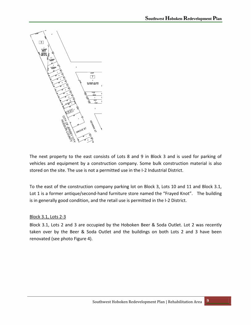
Block 3, Lots 1, 1.01 and 2
Beginning at the south side of the western end of Newark Street, as it emerges from Jersey City
under the NJ Transit Rail overpasses, there is a vacant ½ acre triangular area owned by NJ
Transit. This area is comprised of three lots and is partially wooded and is described as a park
(Your Park or Gateway Park) on various maps. However it is not an official park of the City of
Hoboken and it has no facilities.
Block 6, Lots 1-7
Across the street from the “park”, on the north side of Newark Street between Harrison Street
and Jackson Street, is a series of one-story buildings owned by one entity and occupied by uses
including auto repair, metal working, and building contractor management. Parking and
loading for these uses have direct access from Newark Street with no delineated driveways or
sidewalks (see photo Figure 3). Although the uses are permitted by the current zoning, the
design and arrangement is obsolete with access that conflicts with pedestrians and vehicular
traffic on Newark Street.

City of Hoboken
8 Rehabilitation Area | Southwest Hoboken Redevelopment Plan
Figure 3: North side of Newark Street between Harrison Street and Jackson Street
Block 3, Lots 3-11 and Block 3.1, Lot 1
Continuing back along the south side of Newark Street, proceeding to the east beyond the
vacant NJ Transit “park” parcel is an approximately ½ acre group of lots under the same
ownership; Block 3, Lots 3-11 and Block 3.1, Lot 1. The building on Block 3, Lot 3 is a one-story
structure with corrugated metal siding and a sloping roof. The building on Block 3, Lot 4 is a
three-story brick building with wood interior structure. Portions of the interior have collapsed.
Loading docks open directly on the front sidewalk. Several of the upper windows are missing.
The building on Block 3, Lots 5, 6 and 7 is a one-story brick building, also with wood interior
structure. The roof and roof structure are in extremely poor condition. The structures have
been vacant since at least 2007, and they have been subject to vandalism.
Southwest Hoboken Redevelopment Plan
Southwest Hoboken Redevelopment Plan | Rehabilitation Area 9
The next property to the east consists of Lots 8 and 9 in Block 3 and is used for parking of
vehicles and equipment by a construction company. Some bulk construction material is also
stored on the site. The use is not a permitted use in the I-2 Industrial District.
To the east of the construction company parking lot on Block 3, Lots 10 and 11 and Block 3.1,
Lot 1 is a former antique/second-hand furniture store named the “Frayed Knot”. The building
is in generally good condition, and the retail use is permitted in the I-2 District.
Block 3.1, Lots 2-3
Block 3.1, Lots 2 and 3 are occupied by the Hoboken Beer & Soda Outlet. Lot 2 was recently
taken over by the Beer & Soda Outlet and the buildings on both Lots 2 and 3 have been
renovated (see photo Figure 4).

City of Hoboken
10 Rehabilitation Area | Southwest Hoboken Redevelopment Plan
Figure 4: The Beer & Soda Outlet on Newark Street. The building on the right was recently added to the Outlet and the entire property
was renovated.
The building on Lot 2 was formerly used as an auto service establishment and had become
substandard before its renovation by the Beer & Soda Outlet. The Beer & Soda Outlet occupies
the southwest corner of Newark Street and Grove Street.
Block 3.2, Lots 1-5
Moving to the east across Grove Street, Block 3.2, Lots 1 through 5 consisting of 0.25 acres are
under one ownership, occupied by a valet parking lot associated with the Skyline Condominium
building across Newark Street on Block 7 (Block 7 is no longer in the Rehabilitation Area). The
entire valet parking lot is paved and enclosed by a metal picket fence.

Southwest Hoboken Redevelopment Plan
Southwest Hoboken Redevelopment Plan | Rehabilitation Area 11
Block 3.2, Lots 6-11
Beyond the Skyline Condominium valet parking lot, the remainder of Block 3.2 is under one
ownership. The next four lots (Block 3.2, Lots 6-9) consisting of 0.2 acres contains the former
Rey Foods buildings. A tall one-story building occupies Lots 6, 7, and 8; and a two-story building
(which is actually of less height then the adjacent one-story building) occupies Lot 9. The one-
story building was used as a warehouse for wholesale food distribution while the two-story
building was used for meat packing. The exterior of these buildings are in fair to good condition,
but the buildings have been unoccupied. This property was included within a plan for a 12-
story, 78 dwelling unit condominium building known as 511-521 Newark. The application (use
variance and site plan) was approved by the Zoning Board of Adjustment in November of 2009.
In March of 2010, the City Council overturned the decision of the Zoning Board of Adjustment.
The City Council’s action was upheld in court and the approval is void.

City of Hoboken
12 Rehabilitation Area | Southwest Hoboken Redevelopment Plan
Figure 5: Block 3.2, Lots 9 (Rey Foods), 10 and 11
To the east of Rey Foods, Lots 10 and 11 in Block 3.2 (under the same ownership as Rey Foods)
each contain a late 19th century Italianate structure. The building on Lot 10 is four stories and
the building on Lot 11 is three stories. Both buildings are vacant and windows have been filled
in with brick or concrete block (see photo Figure 5)
These two lots were included in the 511-521 Newark application whose Zoning Board of
Adjustment approval was overturned by the City Council. These properties are directly across
Newark Street from a restored 19th Century brick firehouse owned and operated by the City of
Hoboken.
Block 8.1
The firehouse sits on Block 8.1, which is a small triangular block formed by the intersections of
Newark Street, Madison Street and Observer Highway. The firehouse occupies the entire lot
and block and is a very attractive restoration (see photo Figure 6).
Because the firehouse is City-owned and occupies the entire tiny triangular block, this
Redevelopment Plan simply designates it under the “Community Facility” land use category, but
there are no overlay regulations for Community Facility, and the property would continue to fall
under the existing I-2 Zoning District standards.

Southwest Hoboken Redevelopment Plan
Southwest Hoboken Redevelopment Plan | Rehabilitation Area 13
Figure 6: Restored Firehouse on Block 8.1, Lot 1
Block 3.2, Lots 12-15 and Block 139.1, Lots 1-4
Blocks 3.2, Lots 12-15 and Block 139.1, Lots 1-3 are all under the same ownership. Lots 12 and
13 of Block 3.2 at 507-509 Newark Street contain a paved parking area which until recently was
the site of a two-story brick commercial building with two loading doors opening onto Newark
Street. Google Streetview photos show several moving company trucks parked on the lot. The
paved parking area adjoins a paved parking area on Lots 14 and 15 that serves a four-story
commercial office building on adjacent Block 139.1, Lots 1 and 2. This property, including the

City of Hoboken
14 Rehabilitation Area | Southwest Hoboken Redevelopment Plan
commercial building and adjacent parking, is on the southwest corner of Newark Street and
Henderson Street. The building is an adaptive reuse of a former industrial building into offices
with the exterior and interior having been renovated.
Behind the commercial office building are two irregular shaped lots (Lots 3 and 4 of Block
139.1) that front on Henderson Street. Lot 3 consists of 0.26 acres and contains several
structures, including a two-story brick structure and a one-story concrete block structure. The
brick structure is in good condition and has most recently been used as an office. The one-story
concrete block building is without windows and has a loading dock and steel entry door facing
Henderson Street. It is used as accessory storage. The building uses are permitted in the I-2
district. Block 139.1 Lot 4 (under separate ownership) is a small wedge of vacant land adjacent
to the boundary with Jersey City. Lot 4 is only four feet wide and contains approximately 60
square feet in total. The lots at the corner of Henderson Street represent the eastern extent of
the Rehabilitation Area along Newark Street.
Paterson Avenue
Paterson Avenue, which runs in a northwest-southeast direction, generally forms the northern
and eastern border of the Rehabilitation Area. At its western end Paterson Avenue connects to
Paterson Plank Road in Jersey City. At its eastern end Paterson Avenue terminates at Observer
Highway at its intersection with Monroe Street. Only the properties to the south and west of
Paterson Avenue fall within the Rehabilitation Area with the exception of Block 11, a triangular
block bounded by Paterson Avenue, First Street, and Harrison Street.
As Paterson Avenue enters Hoboken from the west it crosses the Hudson-Bergen Light Rail Line
located just inside the Jersey City-Hoboken border.
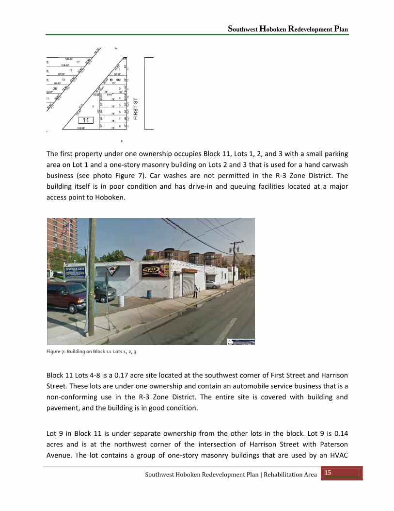
Block 11
Heading from west to east, the first developed block to the north of Paterson Avenue is Block
11, which contains three properties. Block 11 is within the City’s R-3 Residential District and is
the only block in the Rehabilitation Area not in the I-2 Mixed Use Industrial Zone.
Southwest Hoboken Redevelopment Plan
Southwest Hoboken Redevelopment Plan | Rehabilitation Area 15
The first property under one ownership occupies Block 11, Lots 1, 2, and 3 with a small parking
area on Lot 1 and a one-story masonry building on Lots 2 and 3 that is used for a hand carwash
business (see photo Figure 7). Car washes are not permitted in the R-3 Zone District. The
building itself is in poor condition and has drive-in and queuing facilities located at a major
access point to Hoboken.
Figure 7: Building on Block 11 Lots 1, 2, 3
Block 11 Lots 4-8 is a 0.17 acre site located at the southwest corner of First Street and Harrison
Street. These lots are under one ownership and contain an automobile service business that is a
non-conforming use in the R-3 Zone District. The entire site is covered with building and
pavement, and the building is in good condition.
Lot 9 in Block 11 is under separate ownership from the other lots in the block. Lot 9 is 0.14
acres and is at the northwest corner of the intersection of Harrison Street with Paterson
Avenue. The lot contains a group of one-story masonry buildings that are used by an HVAC

City of Hoboken
16 Rehabilitation Area | Southwest Hoboken Redevelopment Plan
contractor. The condition of the structures range from poor to fair. Graffiti is on the exterior of
the buildings, and rust is evident on the exterior doors. Some on-site surface parking is located
on this property also. The site is bounded by a combination of permanent metal picket fencing
and temporary chain link fencing. The property is unkept, and the use is prohibited in the R-3
Zone District.
For purposes of this Redevelopment Plan, the entirety of Block 11 will remain governed under
the R-3 regulations, which already permit mixed-use development.
Block 23
On the south side of Paterson Avenue as one enters Hoboken from the west is a small lot (Block
23, Lot 1) which is part of a property mostly in Jersey City. Block 23, Lot 1 contains only 0.08
acres and is used for trailer storage. Adjacent Lot 2 in Block 23 is only 734 sq. ft. and is part of
the Hudson-Bergen Light Rail right-of-way. Both lots are separated from other lots in Hoboken
to the west by the First Street right-of-way and are essentially unusable except for their current
use. These are the only two lots in Block 23.
For the purposes of this Redevelopment Plan, the entirety of Block 23 will remain governed
under the I-2 regulations.
Blocks 9 and 10
To the west of the NJ Transit Hudson Bergen-Light Rail Line right-of-way lies Lot 6 in Block 9. Lot
6 is associated with Block 23, Lot 1 (same ownership), and like in Block 23, Lot 6 of Block 9 is
also used for trailer storage for a principal use in Jersey City. It is separated from the rest of
Block 9 and Hoboken by the Hudson-Bergen Light Rail Line which is located on Lots 5.1 and 5.2
in Block 9.

Southwest Hoboken Redevelopment Plan
Southwest Hoboken Redevelopment Plan | Rehabilitation Area 17
Across the Hudson-Bergen Light Rail Line as one proceeds east on Paterson Avenue, on the
south side of Paterson Avenue are a number of lots in both Blocks 9 and 10 owned by Academy
Bus which occupy most of the area bounded by Hudson-Bergen Light Rail, Paterson Avenue,
Harrison Street and Observer Highway. The property owned by Academy Bus (Block 9, Lots 2, 3,
4, 7 and Block 10, Lots 1-37) is the largest in the Southwest Rehabilitation Area at 3.55 acres.
There are several buildings on the property used for offices, vehicle storage, and vehicle
maintenance. The offices are in an attractive two-story building. All buildings and the grounds
are well-maintained.
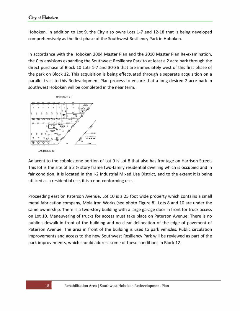
Block 12
The next block to the east along Paterson Avenue within the Rehabilitation Area is Block 12
bounded by Paterson Avenue, Harrison Street, Observer Highway and Jackson Street. At the
intersection of Harrison Street with Paterson Avenue there is a small triangular lot (Lot 9) that
contains both a curbed area of trees and grass as well as a cobblestone paved area some 50
feet in length that connects Harrison Street and Paterson Avenue. Lot 9 is owned by the City of
City of Hoboken
18 Rehabilitation Area | Southwest Hoboken Redevelopment Plan
Hoboken. In addition to Lot 9, the City also owns Lots 1-7 and 12-18 that is being developed
comprehensively as the first phase of the Southwest Resiliency Park in Hoboken.
In accordance with the Hoboken 2004 Master Plan and the 2010 Master Plan Re-examination,
the City envisions expanding the Southwest Resiliency Park to at least a 2 acre park through the
direct purchase of Block 10 Lots 1-7 and 30-36 that are immediately west of this first phase of
the park on Block 12. This acquisition is being effectuated through a separate acquisition on a
parallel tract to this Redevelopment Plan process to ensure that a long-desired 2-acre park in
southwest Hoboken will be completed in the near term.
Adjacent to the cobblestone portion of Lot 9 is Lot 8 that also has frontage on Harrison Street.
This lot is the site of a 2 ½ story frame two-family residential dwelling which is occupied and in
fair condition. It is located in the I-2 Industrial Mixed Use District, and to the extent it is being
utilized as a residential use, it is a non-conforming use.
Proceeding east on Paterson Avenue, Lot 10 is a 25 foot wide property which contains a small
metal fabrication company, Mola Iron Works (see photo Figure 8). Lots 8 and 10 are under the
same ownership. There is a two-story building with a large garage door in front for truck access
on Lot 10. Maneuvering of trucks for access must take place on Paterson Avenue. There is no
public sidewalk in front of the building and no clear delineation of the edge of pavement of
Paterson Avenue. The area in front of the building is used to park vehicles. Public circulation
improvements and access to the new Southwest Resiliency Park will be reviewed as part of the
park improvements, which should address some of these conditions in Block 12.

Southwest Hoboken Redevelopment Plan
Southwest Hoboken Redevelopment Plan | Rehabilitation Area 19
Figure 8: Mola Iron Works, Block 12 Lot 10 with Block 12 Lot 8 on the right and Block 12 Lot 11 on left.
To the east side of Mola Iron Works is a two-story wood frame dwelling on Lot 11 under
separate ownership. This dwelling is in fair condition. On this block the Mola Iron Works is
positioned between two residential properties.
Block 14
Proceeding east the next block encountered on the south side on Paterson Avenue within the
Rehabilitation Area is Block 14. Block 14 is a small triangular block formed by the intersection of
Paterson Avenue with Jackson Street and Observer Highway. This block contains only one lot
and one use - Jack’s Cabin restaurant/bar. The building was recently refurbished and expanded
and is in excellent condition.
City of Hoboken
20 Rehabilitation Area | Southwest Hoboken Redevelopment Plan
Observer Highway
Observer Highway is the third street in the Rehabilitation Area that provides a linkage to Jersey
City. It runs east-west through the heart of the Southwest Rehabilitation Area from the Jersey
City boundary to Block 14, as discussed above.
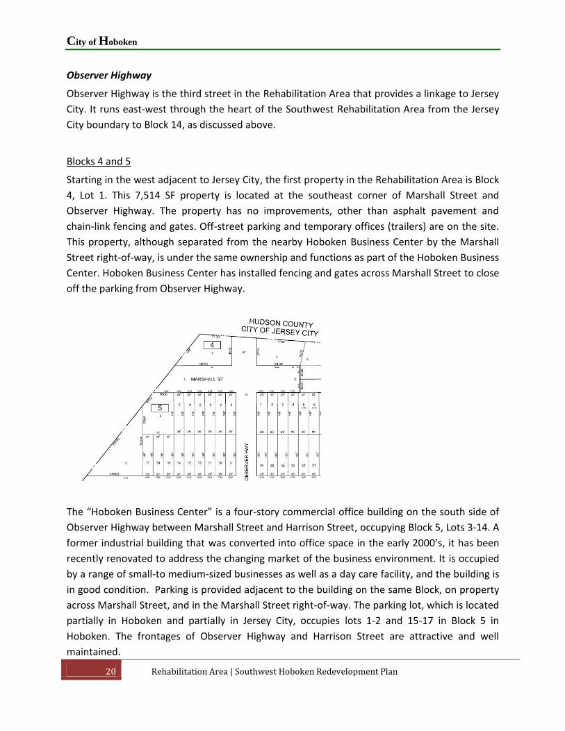
Blocks 4 and 5
Starting in the west adjacent to Jersey City, the first property in the Rehabilitation Area is Block
4, Lot 1. This 7,514 SF property is located at the southeast corner of Marshall Street and
Observer Highway. The property has no improvements, other than asphalt pavement and
chain-link fencing and gates. Off-street parking and temporary offices (trailers) are on the site.
This property, although separated from the nearby Hoboken Business Center by the Marshall
Street right-of-way, is under the same ownership and functions as part of the Hoboken Business
Center. Hoboken Business Center has installed fencing and gates across Marshall Street to close
off the parking from Observer Highway.
The “Hoboken Business Center” is a four-story commercial office building on the south side of
Observer Highway between Marshall Street and Harrison Street, occupying Block 5, Lots 3-14. A
former industrial building that was converted into office space in the early 2000’s, it has been
recently renovated to address the changing market of the business environment. It is occupied
by a range of small-to medium-sized businesses as well as a day care facility, and the building is
in good condition. Parking is provided adjacent to the building on the same Block, on property
across Marshall Street, and in the Marshall Street right-of-way. The parking lot, which is located
partially in Hoboken and partially in Jersey City, occupies lots 1-2 and 15-17 in Block 5 in
Hoboken. The frontages of Observer Highway and Harrison Street are attractive and well
maintained.

Southwest Hoboken Redevelopment Plan
Southwest Hoboken Redevelopment Plan | Rehabilitation Area 21
Block 6
Beyond the Hoboken Business Center to the east along the south side of Observer Highway is
Block 6, which is 1.7 acres. The entire block is under one ownership and contains five buildings.
The building on the southernmost portion of this block, fronting on Newark Street (Block 6, Lots
1-7) was described earlier. Contamination has been documented on the property. There has
been localized impact to the soils by hydrocarbons (fuels) from underground storage tanks;
however no target environmental compounds are above New Jersey Department of
Environmental Protection Soil Remediation Standards.
The remainder of Block 6 is described in the following paragraphs based on the buildings
located in each.
Block 6, Lots 8 to 16 contain a three story brick structure known as "Chambord Center". The
building, fronting on Harrison Street, appears to have been built in the late 19th century. The
interior structure consists of heavy timber columns and joists with steel reinforcing. This
structure contains a number of retail, artisan, artist, light industrial uses, gyms, and dance
studios. The exterior brickwork shows some damage and the need for re-pointing. The exterior
wood windows are in poor condition. There is no on-site parking to serve the building. Various
extensions of the loading docks extend into the public right-of-way. Loading occurs on public
sidewalks.
Lots 17 to 21 of Block 6 contain a five-story building that fronts on Observer Highway. The
ground floor is primarily a series of loading docks protected by a steel awning. The exterior of
the building is brick and concrete. The interior has large open spaces with reinforced concrete
columns and floor structure. The exterior of the building is in fair to poor condition. There is

City of Hoboken
22 Rehabilitation Area | Southwest Hoboken Redevelopment Plan
spalling of the concrete at most of the windows. The windows themselves are in poor
condition; most are not operable and are leaky. Loading door and vehicular access is located
directly on Observer Highway. Most of the building is occupied by "Chambord" and "Studio
Printworks”, manufacturers of designer wall paper and graphics. The top floor has been
nominally divided into studio spaces.
The structure on Lots 22 through 27 of Block 6 fronts onto Jackson Street. It is primarily two
stories with a tan brick exterior; there is a portion that is four stories and clad with metal siding.
Parking and loading occurs on public sidewalks. The interior has a steel frame structure with
concrete floors. There are several permitted uses in the building, including "Carpet Smart" and
a gym. Portions of the structure are vacant, particularly on the upper floors.
The building on Block 6, Lots 28 and 29 faces Jackson Street. It is five stories with a tan brick
exterior. The building is partially occupied with small commercial tenants occupying each floor
or a portion of a floor. The existing retail goods and service uses are permitted in the zone
district. The overall structure appears to be in fair to good condition, although the interior is in
poor shape with peeling paint. The building occupies the entire lot area.
2.2 Existing Zoning
The current zoning in the Rehabilitation Area consists of two designations - the I-2 Mixed-Use
Industrial District and the R-3 Redevelopment Residential District. All blocks in the
Rehabilitation Area, except for Block 11, are within the I-2 Mixed Use Industrial District. Block
11 (bounded by First Street, Harrison Street, and Paterson Ave.) is within the R-3 Residential
District. It is the intent of this Redevelopment Plan to retain the underlying zoning districts and
create an overlay of additional land uses as presented in the Redevelopment Plan section of
this document.
As mentioned above, Block 11 is the only tax block within the Rehabilitation Area that is within
the R-3 zoning district. As this Redevelopment Plan will only affect (and be an overlay on top of)
the portion of the Rehabilitation Area zoned I-2, there is no need to modify the zoning on Block
11.

Southwest Hoboken Redevelopment Plan
Southwest Hoboken Redevelopment Plan | Rehabilitation Area 23
I-2 Mixed Use Industrial District
The City’s Municipal Code Chapter 196 states that the purpose of this district is to establish
appropriate standards and uses for rail and other transportation-related commercial and light
industrial activities; to provide criteria for off-street parking and loading; and to otherwise
facilitate the movement of vehicular traffic and materials transshipment.
Principal permitted uses are as follows:
Food processing and related storage and distributive activities.
Manufacturing, processing, or fabricating operations carried on within enclosed
buildings with no outside storage of materials.
Retail business or service.
Public buildings and uses.
Wireless telecommunications towers.
Accessory uses are:
Off-street parking, loading, and unloading.
Accessory uses customarily incidental to principal permitted uses and on the same tract.
Signs.
Wireless telecommunications antennas.
Conditional uses are as follows:
Automotive sales.
Automobile service stations.
Automobile laundries.
Bars.
City of Hoboken
24 Rehabilitation Area | Southwest Hoboken Redevelopment Plan
Commercial [parking] garages.
Public parking facilities.
Railroad-related shipping terminals.
Manufacturing and processing operations that comply with minimum performance
standards as set forth in Article XII.
Accessory use customarily incidental to a principal permitted use, but not located on the
same lot or parcel or, if contiguous, within the same zoning district.
Bulk Requirements are as follows:
Lot area, minimum: 5,000 square feet.
Lot width, minimum: 50 feet.
Lot depth, minimum: 100 feet.
Lot coverage, maximum:
o For principal buildings: 60%.
o For accessory buildings: 10%.
Building height, maximum:
o For principal buildings, two stories, but not more than 40 feet.
o For accessory buildings, 1 1/2 stories, but not more than 30 feet.
Floor area ratio, maximum: 1.25.
Yard dimensions, minimum:
o Front: five feet.
o Side: five feet each side.
o Rear: 15 feet.

Southwest Hoboken Redevelopment Plan
Southwest Hoboken Redevelopment Plan | Rehabilitation Area 25
R-3 Residential District
The City’s Municipal Code Chapter 196 states that the purpose of this district is to advance the
achievement of a viable residential neighborhood; to encourage conservation and rehabilitation
of existing sound residential blocks; to support residential revitalization by a variety of housing
types and related uses; and to otherwise reinforce the residential characteristics of this district
by regulating uses and structures not compatible with district objectives.
Principal permitted uses are as follows:
Residential buildings.
Places of worship and associated residences, meeting places, and schools.
Public buildings and uses, such as schools, recreation centers, places of assembly, parks,
and playgrounds.
Retail businesses and services where:
o The block frontage on which the proposed activity wishes to be situated contains
at least two other retail businesses.
o If located in a building of two or more stories, the retail business or service will,
except as otherwise specified in this chapter, be located on the ground floor or
basement of the building with a separate exterior entryway permitting access
only to the retail area.
o It will contain no more than 1,000 square feet of customer sales or service area.
Accessory uses are as follows:
Garages.
Home occupations.
Signs.
Other uses customarily incidental to principal uses and on the same lot.
Other uses customarily incidental to hospital uses (such as related clinics, health
treatment and administrative uses; offices and labs for private doctors and/or health

City of Hoboken
26 Rehabilitation Area | Southwest Hoboken Redevelopment Plan
maintenance organizations, pharmacies, flower and gift shops) located on a lot within
100 feet of the lot on which the principal use is located.
Pedestrian bridge.
Wireless telecommunications antennas.
Conditional uses are as follows:
Bars.
Clubs and community centers.
Essential utility or public services.
Clinics and nursing homes.
Loft buildings.
Planned unit residential developments.
Public parking facilities.
Restaurants.
Accessory uses customarily incident to principal permitted uses, but not on the same
lot.
Bulk Requirements are as follows:
Lot area, minimum: 2,500 square feet.
Lot width, minimum: 25 feet.
Lot depth, minimum: 100 feet.
Lot coverage, maximum: 60% for principal buildings
Building height for principal buildings:

Southwest Hoboken Redevelopment Plan
Southwest Hoboken Redevelopment Plan | Rehabilitation Area 27
o A maximum height of 40 feet is allowed above design flood elevation as
established pursuant to Chapter 104, Flood Damage Prevention, of the Municipal
Code. The number of stories shall not be applied to determine building height,
but a minimum floor-to-floor height of 10 feet shall be required of all stories
above design flood elevation on new construction, including additions to existing
structures.
o Where adjacent grade exceeds the design flood elevation, building height shall
be permitted up to 40 feet above the elevation of finished grade surrounding the
structure.
o On a lot where no more than 50 feet of frontage exists between two existing
adjacent buildings that both exceed the maximum height permitted for the
district (as measured in feet), the new structure may match but shall not exceed
the height of the lower of the two buildings. Final height in such a case shall
include any front parapet.
o In all areas of special flood hazard, as established in Chapter 104 [of the City’s
Municipal Code], Flood Damage Prevention, enclosed areas below design flood
elevation of a new or substantially improved structure shall be usable only for
vehicle parking (where otherwise permitted by this chapter), building access, and
storage. Where otherwise permitted pursuant to this chapter, a commercial use
may also occupy the ground floor, provided that the floor meets the
floodproofing standards set forth in Chapter 104.
Density: residential density of development of a site will be determined by site area per
dwelling unit and maximum number of dwelling units adjusted where necessary for
other on-site principal uses as calculated below:
o Site area per dwelling unit (SA/DU), minimum: 660 square feet per dwelling unit.
o Dwelling units, maximum: site area divided by 660.
o Where principal uses in addition to residential are proposed for the subject
building (such as retail or office), the percentage of total permitted floor area
occupied by the nonresidential use shall be applied against the maximum
number of dwelling units and the residential units shall be reduced thereby,
except as specified below. Any fraction shall be equivalent to a whole dwelling
unit. On First Street, Newark Street and Observer Highway, nonresidential
principal uses located on the ground floor and basement (as permitted

City of Hoboken
28 Rehabilitation Area | Southwest Hoboken Redevelopment Plan
elsewhere in this chapter) shall not be deducted from the maximum permitted
number of residential units.
Yard dimension, minimum:
o Front: Front yard setback shall be either 0 feet or shall match the setback of the
adjoining lots on either side except that no front yard setback shall exceed 10
feet. On a lot with less than 50 feet of frontage between two existing adjacent
buildings that both have a front yard setback greater than 0 feet but equal to or
less than 10 feet, the new structure shall match the lesser setback of the two
adjacent buildings. Where the lot frontage of a new building is 50 feet or more,
the front yard setback may match the lesser adjacent setback or be 0 feet. In any
instance, if there are no adjacent structures or both are set back more than 10
feet, the new structure shall be set back 0 feet.
Any fencing, landscaping, architectural feature or stoop extending beyond the
property line is subject to the requirements set forth in Chapter 168, Streets and
Sidewalks. Where a front yard setback exists or is created, fencing, landscaping,
architectural features and stoops within the setback shall not be counted as lot
coverage.
o Side: zero or five feet.
o Rear: 30 feet or 30% of the lot depth, whichever is less. In no event shall the rear
wall of the principal building, whether created by new construction or an
extension to an existing building, be permitted at a depth greater than 70 feet
from the front lot line. Rear yard areas are to be landscaped and accessible to
occupants and for maintenance purposes.
Southwest Hoboken Redevelopment Plan
Southwest Hoboken Redevelopment Plan | The Need for Rehabilitation 29
3. The Need for Rehabilitation
This Redevelopment Plan has been prepared in accordance with N.J.S.A. 40A:12A-7A, which
provides that redevelopment projects may only be undertaken or carried out in accordance
with a redevelopment plan adopted by ordinance of the municipal governing body, upon its
findings that the specifically delineated project area is an area in need of redevelopment or in
an area in need of rehabilitation, according to the criteria set forth in Section 5 of the LRHL.
In 2006 the City of Hoboken Council initially directed the City’s Planning Board to study the area
in order to determine whether it was an “Area in Need of Redevelopment” in accordance with
the criteria specified at N.J.S.A. 40A:12A-5. On October 21, 2009, City Council renewed its
authorization of the Planning Board to undertake a Preliminary Investigation and conduct a
public hearing in order to determine whether the area of the City known as the “Southwest
Area” fulfilled the criteria for declaration as an “area in need of redevelopment”. This
resolution expanded the Study Area to include additional properties (Tax Block 11) that were
not included in the 2006 authorization. Further, on October 20, 2010, City Council again passed
a resolution that modified the extent of the lands subject to the Planning Board’s evaluation.
This modification removed Tax Blocks 7 and 8 from the Study Area since both of these blocks
had recently been developed with mid-rise residential condominiums. The current
Rehabilitation Area reflects these changes.
In 2011 Clarke Caton Hintz was retained by the Hoboken Planning Board to conduct a study in
order to determine whether the properties within the Study Area met the statutory
requirements for designation as an “area in need of redevelopment” pursuant to the LRHL.
Additionally, the scope of the studies was expanded to include a determination of whether the
properties within the Study Area met the statutory requirements for an “area in need of
rehabilitation” pursuant to the LRHL. The Clarke Caton Hintz study concluded that 26 of 35
properties in the Study Area satisfied the criteria for a determination of an area in need of
redevelopment. These properties represented 26.7% of the property acreage within the Study
Area. The study also concluded that the entire Study Area meets the criteria for an area in need
of rehabilitation based on the fact that the water and sewer infrastructure in the Study Area is
more than 50 years old and in need of repair and/or substantial maintenance. Also the entire
City was previously determined to be an area that qualified as being in need of rehabilitation by
P.L. 1975, c 104 and P.L. 1977, c 12.
As a result of the determinations made above, the City Council adopted a resolution on May 16,
2012 directing the Planning Board to consider this southwest area as an Area in Need of
Rehabilitation. On June 5, 2012, the Planning Board found that the area satisfied the criteria to

City of Hoboken
30 The Need for Rehabilitation | Southwest Hoboken Redevelopment Plan
be designated as an Area in Need of Rehabilitation under Section 14 of the Redevelopment Law
N.J.S.A. 40:12A-14(a). The City then adopted a resolution on June 20, 2012, designating the
entire Study Area as an area in need of rehabilitation and did not designate any part of the area
as an area in need of redevelopment. This Redevelopment Plan is therefore intended to apply
to the designated Southwest Rehabilitation Area.
Southwest Hoboken Redevelopment Plan
Southwest Hoboken Redevelopment Plan | Visions, Goals and Objectives 31
4. Visions, Goals and Objectives
The vision of this Redevelopment Plan is to create a mixed use urban neighborhood that builds
on existing uses, such as industrial arts and art galleries, create an environment with more open
space and retail amenities, improve safety for all modes of transportation making it a walkable
neighborhood, and preserve and create jobs.
4.1 Master Plan Visioning
The 2004 Hoboken Master Plan and 2010 Master Plan Reexamination Report presented a
variety of recommendations regarding Southwest Hoboken, including the preservation of
urbanized industry and industrial arts, the need for more public park space, and the potential
for transit-oriented, mixed use development given the proximity of the area to the Hudson-
Bergen Light Rail (HBLR) connection at the Hoboken Terminal at the eastern end of Observer
Highway, as well as at the Second Street station just north of the Southwest Rehabilitation
Area.
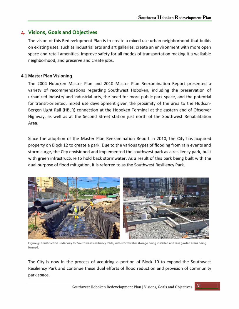
Since the adoption of the Master Plan Reexamination Report in 2010, the City has acquired
property on Block 12 to create a park. Due to the various types of flooding from rain events and
storm surge, the City envisioned and implemented the southwest park as a resiliency park, built
with green infrastructure to hold back stormwater. As a result of this park being built with the
dual purpose of flood mitigation, it is referred to as the Southwest Resiliency Park.
Figure 9: Construction underway for Southwest Resiliency Park, with stormwater storage being installed and rain garden areas being
formed.
The City is now in the process of acquiring a portion of Block 10 to expand the Southwest
Resiliency Park and continue these dual efforts of flood reduction and provision of community
park space.

City of Hoboken
32 Visions, Goals and Objectives | Southwest Hoboken Redevelopment Plan
Additionally, the City is implementing traffic improvement measures to ensure that connections
throughout this area are safer and more effective, including pedestrian access to the new park.
Figure 10: Landscape Architect's rendering of Southwest Resiliency Park and diagram of flood storage design.
4.2 Redevelopment Visioning Process
The City engaged in several meetings and surveys to gain community input on the vision for the
Redevelopment Plan. These public engagement activities included an online survey (June/July
2015), a stakeholder focus group meeting (Aug 2015), public open house (March 2016), public
meeting (Oct 2016), and online comments regarding scenarios (Oct 2016). Descriptions of these
efforts are provided in the following subsections.
ONLINE SURVEY SUMMARY
During a period from June 25 to July 22 during the summer of 2015 (approximately 4 weeks), a
comprehensive interactive survey was posted on the City of Hoboken’s website to get feedback
from the community on the vision for southwest Hoboken. When the survey was closed there
were 673 responses that provide a wide range of public input and insight. A summary of the
results is found in Appendix 10.1 at the end of this document.
Southwest Hoboken Redevelopment Plan
Southwest Hoboken Redevelopment Plan | Visions, Goals and Objectives 33
STAKEHOLDER FOCUS GROUP MEETING
As the second step in the public engagement strategy of this Plan, letters were sent to all
property owners within the Southwest Rehabilitation Area based on the most current listing
available from the City to invite them to an interactive focus group meeting organized and
facilitated by Maverick & Boutique (M&B). The meeting was held on August 18, 2015 and was
attended by approximately 30 property owners and/or their representatives. The meeting was
facilitated by John Findlay of M&B, using their innovative “Zing” methodology. Zing employs
multiple keyboards, and the stakeholders were grouped around multiple tables and their
comments were entered by keyboard and displayed as various questions were discussed so
that all of the comments were visible by the other groups simultaneously. The questions
delved into what the stakeholders thought was good about the neighborhood and what was
missing and needed to be addressed. They were also asked what existing conditions in the
neighborhood should be “abandoned”. The summary of the stakeholder input is found in
Appendix 10.2 at the end of this document.
Also, throughout the planning process for this Redevelopment Plan, all property owners were
provided with the opportunity to share their concerns and ideas with the planning professionals
working on the Plan.
PUBLIC MEETING –STRENGTHS, WEAKNESSES, OPPORTUNITIES, AND THREATS
On March 10, 2016, the City conducted an Open House employing several topic-oriented
“stations,” including a station that demonstrated the “Synchro” computer model for analyzing
traffic patterns, flows, and performance. The general station topics were based on “SWOT”
(Strengths – Weaknesses – Opportunities – Threats). Community participants were provided a
guidesheet and were encouraged to provide written comment regarding each station.
PUBLIC MEETING – ALTERNATIVE CONCEPT DEVELOPMENT SCENARIOS
During the summer of 2016, while Maser Consulting was conducting a traffic circulation study,
the planning team developed four alternative concept development scenarios. These concept
plans were reviewed at an advertised public meeting on October 13, 2016. After the public
meeting, the comment sheet was transferred to an interactive online version, and the online
response comment period was extended through October 26, 2016. While the public meeting
was attended by approximately 40 people, through the extended online survey period the City
received a total of 100 comment sheet responses.

City of Hoboken
34 Visions, Goals and Objectives | Southwest Hoboken Redevelopment Plan
The description of each alternative development scenario was provided on the comment sheet
and a key aerial map with block and lot lines shown and labeled. Common themes of all of the
scenarios included the following:
Circulation Improvements – Short term GPS syncing of traffic signals and longer term
improvements with additional signals and creation of a “loop” circulation pattern.
Park Expansion – A desire to acquire part of Block 10 to expand SW Park to the west
(Park Expansion Area 1).
Density Controls – Use of traditional Hoboken neighborhood density – calculating the
permissible number of dwelling units by dividing the lot area square footage by 660 and
limiting structures to a height of 40 ft above DFE with a minimum lot size of 2500 SF.
This residential option is common to all scenarios for the 86 ft deep strip between
Newark Street and the Jersey City border to the south and could be accessed by a
common rear alleyway.
Preserve Urban Manufacturing and Encourage Commercial Uses – The introduction of a
mixture of residential, hotel, and neighborhood retail to the existing industrial and office
uses through the adoption of a redevelopment plan as an “overlay” will provide optional
land uses to property owners who choose to participate in the implementation of the
Plan.
The descriptions of each alternative development scenario presented at the October 13, 2016
public meeting and the full summary of comments are available in Appendix 10.4.
There were several common threads running through the comments:
The majority of respondents favored the scenarios with the expansion of the SW Park to
include all of Block 10. Based on the overall number of responses, Scenario #2 received
the most responses as the “preferred” scenario (this scenario is the basis of the
Redevelopment Plan).
There was strong support for the concept of the alleyways for the properties on the
south side of Newark Street.
There was strong support for the concept of “pocket neighborhoods”.

Southwest Hoboken Redevelopment Plan
Southwest Hoboken Redevelopment Plan | Visions, Goals and Objectives 35
There was strong support for the one-way “loop” circulation system proposed in the
Maser traffic study.
There was strong support for the clustering of density in taller buildings on Block 9 in
exchange for park expansion to the rest of Block 10. Some suggested that the buildings
on Block 9 be allowed be higher than 80 feet above DFE if it meant expanding the park
to include all of Block 10.
There was strong support for the parking structure behind the Hoboken Business
Center, with some suggestions that it include street level retail and residential on the
upper floors.
The City has chosen Scenario #2 as the concept on which to base this Southwest
Redevelopment Plan. This scenario best meets the vision, goals, and aspirations of a proposed
redevelopment plan.
STAKEHOLDER GROUP MEETING
An additional stakeholder meeting with property owners was held on April 27, 2017 to conduct
a review of the Plan concepts and to hear out additional ideas from property owners. This
meeting was well attended, with approximately 30 attendees representing various property
owners in the Rehabilitation Area.

City of Hoboken
36 Traffic & Circulation Recommendations | Southwest Hoboken Redevelopment Plan
5. Traffic & Circulation Recommendations
Seeking to ensure the Southwest Rehabilitation Area is safe for all modes of transportation and
that residents will be able to safely access the first phase of the new Southwest Resiliency Park,
the City as part of this Plan authorized Maser Consulting’s Municipal Traffic and Transportation
Group to conduct a traffic study in May of 2016 in order to improve circulation while ensuring
safety of pedestrians, bicyclists, and cars. These roadways support regional commuter travel to
and from the City. These roadways also provide a direct connection to Jersey City. The study
was conducted during the period immediately after the new traffic signals were activated by
Hudson County along Observer Highway, but before the end of the school year, so as to get the
most accurate results.
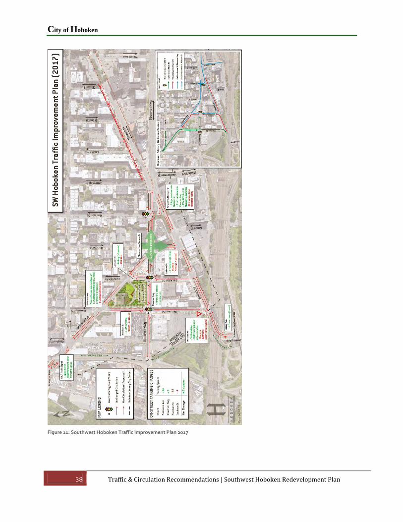
5.1 Traffic Improvements Authorized for Southwest Hoboken
Newark Street is the primary entrance and exit gateway point at the southwest quadrant of
Hoboken. Motorists entering Hoboken use Newark Street eastbound to traverse to
Jackson Street northbound, Paterson Avenue westbound, or Observer Highway eastbound.
Motorists exiting Hoboken use Monroe Street or Harrison Street to traverse to Newark Street
westbound. Newark Street is bound by commercial properties and Harrison Street, Jackson
Street, and Monroe Street are bound by commercial and residential properties.
Improvement alternatives were analyzed to mitigate congestion while improving safety for all
modes of transportation. Based on the analysis recommendations, the improvements approved
by the City that will be installed starting in 2017 include the following (note: the plans to
address gridlock at Monroe with the directional changes to Paterson Avenue must be approved
by Hudson County):
Opening up Jackson Street to two lanes by removing on-street parking and the bicycle
lane.
Creating safe pedestrian access to the Southwest Resiliency Park, businesses, and
residences in the area while improving traffic flow by adding new traffic signals at
Jackson Street at Observer Highway, Harrison Street at Observer Highway, and Madison
Street at Observer Highway.
Fixing the gridlock at Monroe Street and Observer Highway that affects the entire
southwest area. The three-way intersection of Monroe Street, Observer Highway, and
Paterson Avenue requires longer traffic signal cycle lengths, creating significant traffic

Southwest Hoboken Redevelopment Plan
Southwest Hoboken Redevelopment Plan | Traffic & Circulation Recommendations 37
backups. By converting Paterson Avenue to one-way westbound between Monroe
Street and Harrison Street, the intersection is simplified and allows for adding 20% more
green time for Monroe Street and Observer Highway. This recommendation from the
Hoboken-Jersey City Subregional Connectivity Study commissioned by Hudson County
and funded by the North Jersey Transportation Planning Authority (“NJTPA”) in 2011
was confirmed with traffic modeling by Hoboken’s engineer.
Opening Madison Street to create more options for entering Hoboken. The addition of a
second turning lane on Madison Street between Newark Street and Observer Highway
and allowing vehicles to go left, right, or straight from Madison Street by removing the
existing bollards, will create a new option for entering Hoboken and greatly reduce
vehicular volumes turning onto Jackson Street.
Converting the Jersey Avenue/Newark Street gateway into Hoboken from two to four
lanes to improve circulation into and out of Hoboken, adding a dedicated right turn lane
from Harrison Street onto Newark Street, and creating a second lane on Harrison Street
for traffic turning east onto Observer Highway.
Optimizing the Hudson-Bergen Light Rail signal at the intersection of Paterson Avenue
and Marshall Street to improve coordination with other southwest traffic signals and
reduce delays caused by light rail crossings.
Adding parking along the south side of Paterson Avenue and west side of Jackson Street
will help buffer the Southwest Resiliency Park from traffic.
City of Hoboken
38 Traffic & Circulation Recommendations | Southwest Hoboken Redevelopment Plan
Figure 11: Southwest Hoboken Traffic Improvement Plan 2017

Southwest Hoboken Redevelopment Plan
Southwest Hoboken Redevelopment Plan | Traffic & Circulation Recommendations 39
5.2 Additional Pedestrian Safety Improvements Adjacent to the Area
Near the Rehabilitation Area, just to the east, the City has approved pedestrian improvements
along Newark Street between Willow Avenue and Jefferson Street. These improvements are
aligned with the Southwest Traffic Improvements noted above.
Currently in this area, a low percentage of drivers are stopping for pedestrians in crosswalks.
There are skewed intersection geometries with wide pedestrian crossings, missing crosswalks
(especially across Newark Street), no dedicated bicycle facilities, and no loading zones for
deliveries. To address this, there are several proposed improvements, including the following:
Studies show that curb extensions (concrete, landscaped, and painted) achieve the
following:
o Increase the rate of drivers stopping for pedestrians in crosswalks by 34%-43%
o Improve visibility (for pedestrians and drivers)
o Reduce pedestrian crossing distances (less exposure to traffic)
o Slow vehicular turning movements (without impeding them)
o Help beautify the street (with landscaping)
o Improve visibility of signs
Pedestrian island w/mid-block crosswalk (between Jefferson St. and Adams St.) to
create an Observer Hwy crossing at Henderson St
o Pedestrian islands are one of Federal Highway Administration's proven
countermeasures
o Studies have shown that pedestrian collisions are reduced by as much as 46%
New crosswalks (3)
Physically separated bike lane on the south side of the street
o Increase function of underutilized curbside space on the south side of Newark
o Decrease frequency of cyclists feeling need to ride bikes on the sidewalk

City of Hoboken
40 Traffic & Circulation Recommendations | Southwest Hoboken Redevelopment Plan
o No change in parking spaces (no existing parking on south side of Newark -
cannot fit)
Loading zones (2)
Rectangular Rapid Flashing Beacon (RRFB) signs (2 locations – mid-block crosswalk east
of Jefferson St and Grand St)
o Studies have shown that RRFBs increase the rate of drivers stopping for
pedestrians in crosswalks to between 80-90%
o They are only activated when a pedestrian is in a crosswalk, so it avoids drivers
becoming desensitized to permanent flashing
All-way stop sign at Newark/Grand (pending Hudson County study)
5.3 Subregional Recommendations for Long Term Circulation Improvements
In 2011, a Jersey City/Hoboken Connectivity Study was prepared for Hudson County and NJTPA
by Eng-Wong, Taub & Associates. One of the “long term recommendations” in the Hoboken-
Jersey City Connectivity Study is to construct a new connector road that would link Coles Street
to Paterson Plank Road/Mountain Road along the Hoboken-Jersey City border. Such a new
connector road could go under the railroad tracks and would then follow the alignment of the
light rail staying west of the light rail tracks. Because of clearance issues, Hoboken Avenue
would need to be realigned so that it is perpendicular to Coles Street, creating a safer 90 degree
intersection. The new connector roadway could have nine foot sidewalks and five foot bicycle
lanes on either side adding a new north/south bicycle and pedestrian connection.
To make the connector road more attractive for motorist with origins and destinations outside
the Rehabilitation Area, the Hoboken-Jersey City Connectivity Study also recommends
constructing new ramps to the major highways, including an exit ramp from I-78 eastbound to
Hoboken Avenue, an entrance ramp either from Hoboken Avenue to I-78 westbound or from
Coles Street to I-78 westbound, and an entrance ramp from Coles Street to Route 1 & 9
southbound.
Although such a connector road would be a long term improvement project and is a costly
alternative, the City, working with Jersey City and Hudson County, can pursue funding sources
to eventually implement such a project.

Southwest Hoboken Redevelopment Plan
Southwest Hoboken Redevelopment Plan | Traffic & Circulation Recommendations 41
Figure 12: Jersey City/Hoboken Connectivity Study long term traffic improvement recommendation.
5.4 Additional Traffic Concepts Part of Redevelopment Plan
It should be noted that the traffic analysis and both the short and long term solutions were
intended to mitigate congestion and improve pedestrian and bicycle mobility based on existing
conditions. The Redevelopment Plan recommends rear alleyways and supplemental accesses to
minimize curb cuts and loading along Newark Street and other neighborhood streets. These
traffic concepts are intended to enable access for new infill redevelopment without interfering
with the traffic patterns recommended for vehicular mobility through the neighborhood as
noted above.

City of Hoboken
42 Redevelopment Plan | Southwest Hoboken Redevelopment Plan
6. Redevelopment Plan
6.1 General Plan Components
This Redevelopment Plan is designed to build upon some of the existing uses of the Southwest
Rehabilitation Area, from wallpaper manufacturing to art galleries to gyms and dance studios to
co-working business spaces. The Plan envisions a dynamic neighborhood in which to live, work,
and play. The area is to have additional open space to bring people together and retail and
microbrewery type of businesses for gathering. As well, circulation improvements will ensure
safe travel for all modes of transportation.
The final development scenario of this Redevelopment Plan is based on Alternative Scenario #2,
which is outlined as follows:
Expansion of Southwest Resiliency Park
Retention of urban manufacturing and commercial uses
Increase neighborhood retail opportunities
Minimize vehicular conflicts and congestion impacts on pedestrian-bicycle mobility
through alleyways and supplemental accesses/streets.
Limit residential intensity to be consistent with typical Hoboken neighborhoods, with a
density of 660 SF of lot area per unit (66 du per acre), but allow building heights to be
increased to address site constraints such as accommodating access to alleyways or
enabling the expansion of Southwest Resiliency Park.

Southwest Hoboken Redevelopment Plan
Southwest Hoboken Redevelopment Plan | Redevelopment Plan 43
Figure 13: Redevelopment Plan Concept Map
6.2 Rear Alley and Supplemental Accesses
ALLEYWAY FOR SUBAREAS A AND B (SEE FIGURE 18 FOR SUBAREAS)
The alleyway concept was conceived as a solution to the impact of multiple curb cuts from new
development along Newark Street and originally focused on Subareas A and B (Blocks 3, 3.01,
3.02, and 139.1). Grove Street (CR 635) would be the crossing point of the rear alley, which
would be a private road, but controlled by a redevelopment agreement(s) with adjoining
property owners.
The irregular development condition in this Rehabilitation Area provides an important
opportunity to craft a creative solution for the provision of vehicular and pedestrian access.
While Hoboken has a largely regular street grid pattern, the historic grid layout includes alleys.
For example, Court Street’s right-of-way is 20 feet wide and runs from Newark Street
northward to 7th Street (Figure 15). A number of structures front the alleyway, which runs

City of Hoboken
44 Redevelopment Plan | Southwest Hoboken Redevelopment Plan
through the block, though accessory uses such as garages and other types of off-street parking
are common. This alleyway is an important community asset and identifying feature of the
neighborhood. As evident in the photos in Figure 14 and 16, the alleyway can be an attractive
streetscape feature with interesting paving patterns, sunlight, and an intimate scale. The
pocket neighborhood concept would use the alleyway as a linear open space.
Blocks 3, 3.01, 3.02, and 139.1 consist mostly of lots 25 feet wide and 86 feet deep in the I-2
zone. Some lots have been combined with adjacent lots, while others are irregular. The 25’x86’
lots do not meet the minimum size requirements of the I-2 zone.
Moreover, the intersection of two heavily-trafficked streets in the Rehabilitation Area results in
significant congestion. When these Subareas undergo redevelopment, curb cuts along Newark
Street should be avoided to prevent any additional congestion or unsafe traffic conditions.
However, the absence of curb cuts along Newark Street does not foreclose upon access to new
developments. As a result, vehicular access to the alley may be allowed at periodic intervals
along the street frontage and increased building heights may be allowed to accommodate the
allowed density where these accesses are allowed, as negotiated in a redevelopment
agreement. As well, concentrating parking into multiple levels on one portion of a project site in
this area may be allowed to optimize the building square footage for mixed use, as negotiated
in a redevelopment agreement.
Figure 14: Illustrations of the design concept for the alleyway behind residential buildings along Newark Street that doubles as
neighborhood open space.
Southwest Hoboken Redevelopment Plan
Southwest Hoboken Redevelopment Plan | Redevelopment Plan 45
Figure 15: Court Street streetscape (Image © Google). The alley would provide access to parking or retail, but would also serve as a
linear open space for a “pocket neighborhood”.
The combination of short blocks and heavy volume of traffic cutting through the Rehabilitation
Area to get to Paterson (Plank) Avenue results in significant congestion at the intersection of
Newark Street and Jackson Street. As a result, the idea of the rear access alley or service road to
prevent curb cuts along Newark Street (a similar concept as was employed in the Hoboken Yard
Redevelopment Plan) was expanded to other blocks to create the pocket green spaces and
additional potential to expand the Southwest Resiliency Park through clustering density to
higher buildings in exchange for parkland.
Because the Redevelopment Plan applies to a Rehabilitation Area, the implementation of the
alley or service road would need to be addressed as private property owners pursue
development approvals after the Redevelopment Plan is adopted. Other issues include:
The neighborhood alleyway will be privately owned and maintained, although the alley’s
access to Newark Street would likely be adjacent to property owned by New Jersey
Transit that is furthest west along Newark Street. The redevelopment agreement(s)
would need to include a shared access/shared services agreement and ensure proper
maintenance of the alleyway area.
Alley access to Newark Street, Grove Street, and Henderson Street should discourage
through traffic from those streets through the use of pedestrian-friendly streetscape
design and “private road” markings.

City of Hoboken
46 Redevelopment Plan | Southwest Hoboken Redevelopment Plan
Figure 16: Image illustrating one approach to a pocket neighborhood pedestrian alley or "mews". The alleyway in this Redevelopment
Plan is to be designed to accommodate cars for the purpose of this Plan.
On-site redevelopment might not occur simultaneously, so the alleyway may need to be
constructed on a project by project basis. To accommodate this, vehicular access to the
alley may be allowed to be provided to a project from Newark Street, as negotiated in a
redevelopment agreement.
o It is encouraged for groupings of lots to be developed together to minimize these
instances.
o For redevelopment projects under this Redevelopment Plan, no private driveway
accesses are allowed on Newark Street, only shared alleyway accesses. Existing
driveways for current uses may remain and any application for underlying I-2
zoning purposes may request such private driveways.
The provision of a 20’ wide alleyway and 6 foot wide landscaped walkway would result
in a small private space of about 10’ depth and general building depth of approximately
52’ (considering percentage of lot coverage).

Southwest Hoboken Redevelopment Plan
Southwest Hoboken Redevelopment Plan | Redevelopment Plan 47
A pocket neighborhood alleyway running the length of Subareas A and B is feasible given the
conditions to be described in this section. The alleyway would effectively begin near the
intersection with Jackson Street and Newark Street. Rather than intersect directly with the
streets, the alleyway’s westernmost access point from Newark Street would be located due
west of the Jackson Street intersection. The alley would then run for about 100 feet due south
to the Jersey City border, whereby it would make a sharp turn towards the east and run along
the southern boundary of the parcels in Blocks 3 and 3.01 to the intersection with Grove Street
(representing a distance of about 400 feet). The eastern section of the alleyway would consist
of roughly 450 linear feet from Grove Street east to Marin Boulevard. The majority of this
section of the alley would run in line with the western section of the alleyway, parallel to
Newark Street to Block 3.02, Lot 13. At that lot, the alleyway would follow the municipal
boundary line to intersect Henderson Street at a right angle at the furthest distance possible
from the intersection of Henderson Street and Newark Street. Again, alternative access points
to the alleyway may be allowed to address the multiple ownerships of property in these
Subareas, as negotiated in a redevelopment agreement.
SUPPLEMENTAL ACCESSES FOR SUBAREAS C AND D (SEE FIGURE 18 FOR SUBAREAS)
The feedback from stakeholders recognized the need for truck circulation and loading zone
improvements if the urban industrial uses and commercial office uses are to remain viable. The
development of the Southwest Resiliency Park and the lack of parking, generally, for business
owners, employees, and visitors is a challenge for the neighborhood, with most all existing
street parking being monopolized by residential unit owners.
As a result of the input from such stakeholders, the Redevelopment Plan allows for access to
neighborhood parking in the residential areas, reservation for loading behind/adjacent to the
Chambord Place Building and Hoboken Business Center buildings on supplemental accesses,
and a shared parking structure behind the Hoboken Business Center that may be used to serve
infill development within Block 6, any expansion of the Hoboken Business Center on Block 5,
and general parking demand. The details of the supplemental accesses may be negotiated in a
redevelopment agreement.
6.3 Expansion of the Southwest Resiliency Park
The Southwest Resiliency Park is currently under construction, and the City is actively pursuing
the expansion of the park in the future to provide a more diverse combination of recreational
opportunities. The City is currently pursuing the acquisition of Block 10, Lots 1-7 and 30-36
(0.80 acres) through direct purchase on a parallel process to the redevelopment process. This

City of Hoboken
48 Redevelopment Plan | Southwest Hoboken Redevelopment Plan
portion of Block 10 is shown as PARK EXPANSION AREA 1 in Figure 13: Redevelopment Plan
Concept Map.
Additional expansion of the Southwest Resiliency Park on Block 10 would be required if
residential development were proposed under this Redevelopment Plan in Subarea E described
later in this Chapter. Density from the land area in the former Marshall Street ROW: Block 10,
Lot 37 and Block 9, Lot 7, shown on the Redevelopment Plan Concept Map (Figure 13) as PARK
EXPANSION AREA 2 and density from Block 10 Lots 8-29, shown on the Redevelopment Plan
Concept Map as PARK EXPANSION AREA 3, will be required to be clustered to the remainder of
Block 9 with additional height to be permitted to achieve the otherwise allowable number of
units. As part of a redevelopment project through this Redevelopment Plan, the PARK
EXPANSION AREA 2 may be considered for park or other public use (e.g., roadway or access), as
negotiated in a redevelopment agreement.
Figure 17: Rendering of potential park expansion and development per Redevelopment Plan
6.4 Land Uses - General
The Redevelopment Plan is separated out into different Subareas, and each has its own mix of
uses. The Redevelopment Plan employs a different approach regarding each of the following
land uses.
Low Density Mixed Use (Based generally on R-3 density, height, and building depth)

Southwest Hoboken Redevelopment Plan
Southwest Hoboken Redevelopment Plan | Redevelopment Plan 49
Clustered Density Mixed Use (Based on same R-3 density, but shifted into taller
buildings on Block 9 to enable expansion of Southwest Resiliency Park on Block 10).
Park Space (Southwest Resiliency Park and neighborhood parks and mews)
Urban Industrial
o The Redevelopment Plan incorporates provision of loading behind/adjacent to
the Chambord Place Building and Hoboken Business Center buildings on
supplemental accesses, and the possibility of shared/neighborhood parking in a
parking garage at the Hoboken Business Center site.
Neighborhood Commercial/Hotel
Neighborhood Commercial/Retail
Office-Commercial
Parking Garage
Community Facilities (Firehouse)
6.5 Plan Subareas
Due to the variety of site constraints and opportunities, the Rehabilitation Area has been
divided into Subareas to address those site features. The Subareas are as follows:
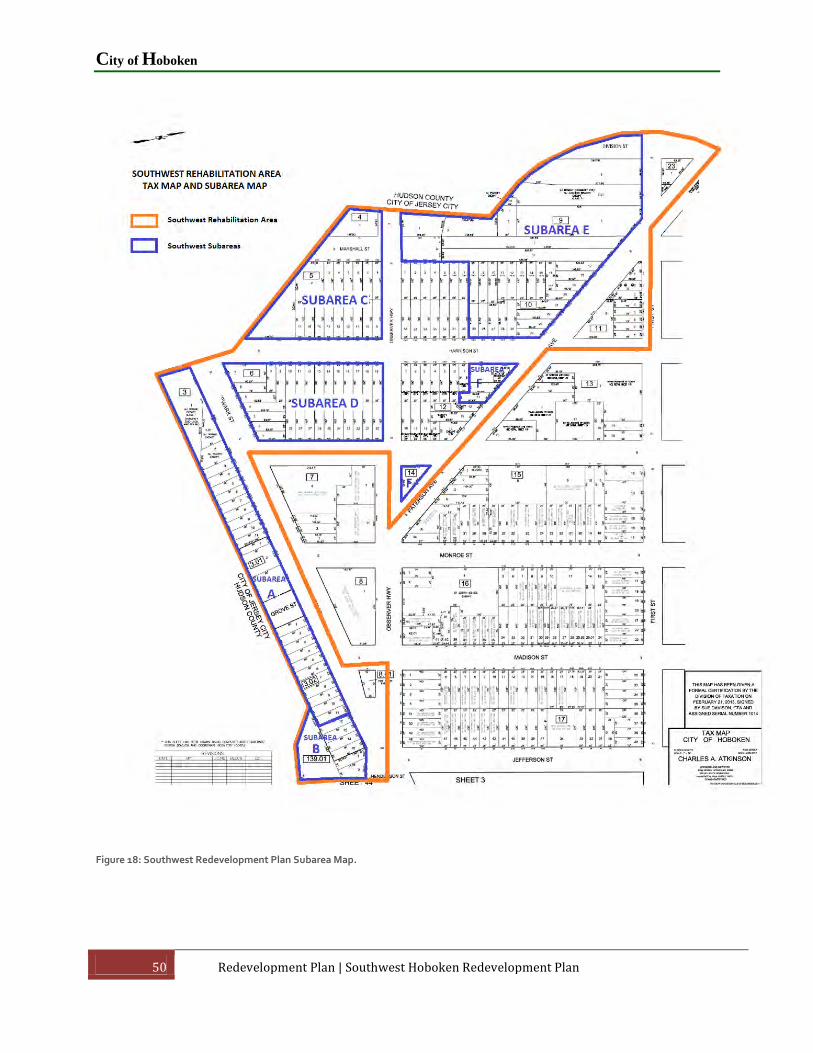
City of Hoboken
50 Redevelopment Plan | Southwest Hoboken Redevelopment Plan
Figure 18: Southwest Redevelopment Plan Subarea Map.
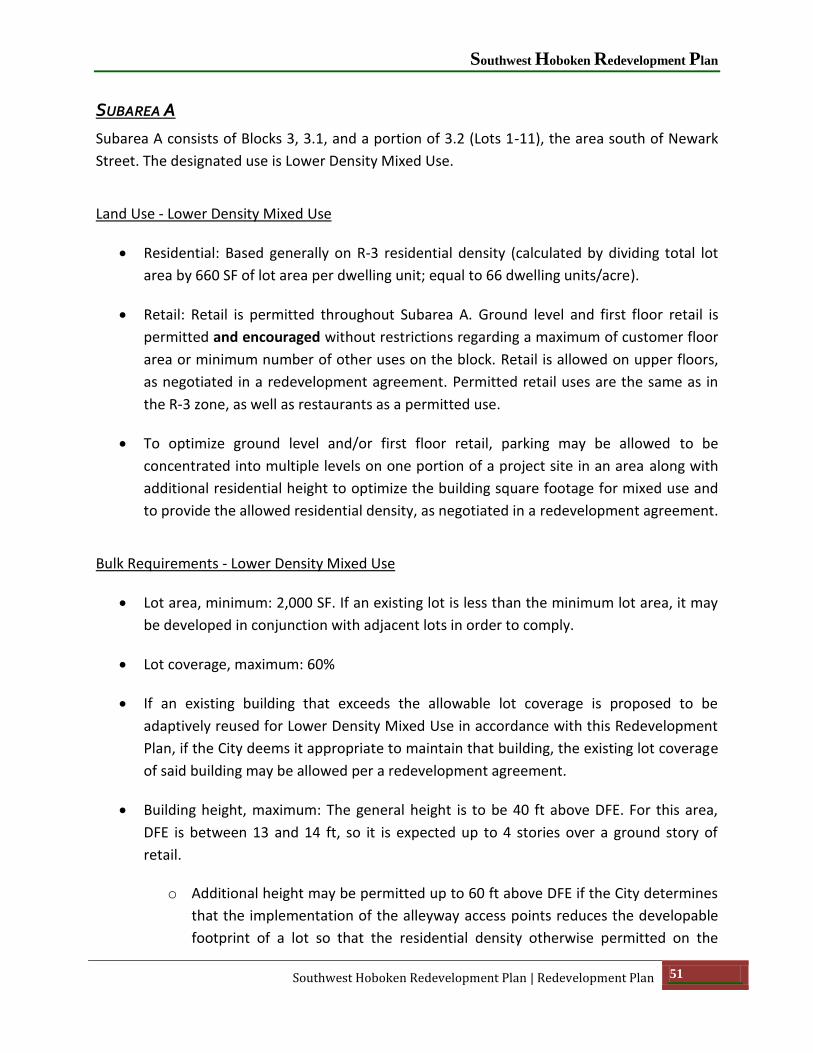
Southwest Hoboken Redevelopment Plan
Southwest Hoboken Redevelopment Plan | Redevelopment Plan 51
SUBAREA A
Subarea A consists of Blocks 3, 3.1, and a portion of 3.2 (Lots 1-11), the area south of Newark
Street. The designated use is Lower Density Mixed Use.
Land Use - Lower Density Mixed Use
Residential: Based generally on R-3 residential density (calculated by dividing total lot
area by 660 SF of lot area per dwelling unit; equal to 66 dwelling units/acre).
Retail: Retail is permitted throughout Subarea A. Ground level and first floor retail is
permitted and encouraged without restrictions regarding a maximum of customer floor
area or minimum number of other uses on the block. Retail is allowed on upper floors,
as negotiated in a redevelopment agreement. Permitted retail uses are the same as in
the R-3 zone, as well as restaurants as a permitted use.
To optimize ground level and/or first floor retail, parking may be allowed to be
concentrated into multiple levels on one portion of a project site in an area along with
additional residential height to optimize the building square footage for mixed use and
to provide the allowed residential density, as negotiated in a redevelopment agreement.
Bulk Requirements - Lower Density Mixed Use
Lot area, minimum: 2,000 SF. If an existing lot is less than the minimum lot area, it may
be developed in conjunction with adjacent lots in order to comply.
Lot coverage, maximum: 60%
If an existing building that exceeds the allowable lot coverage is proposed to be
adaptively reused for Lower Density Mixed Use in accordance with this Redevelopment
Plan, if the City deems it appropriate to maintain that building, the existing lot coverage
of said building may be allowed per a redevelopment agreement.
Building height, maximum: The general height is to be 40 ft above DFE. For this area,
DFE is between 13 and 14 ft, so it is expected up to 4 stories over a ground story of
retail.
o Additional height may be permitted up to 60 ft above DFE if the City determines
that the implementation of the alleyway access points reduces the developable
footprint of a lot so that the residential density otherwise permitted on the

City of Hoboken
52 Redevelopment Plan | Southwest Hoboken Redevelopment Plan
property cannot be accommodated on the lot(s) within the base height
limitation, as negotiated in a redevelopment agreement.
o Where retail is proposed below DFE or on the first level above DFE, additional
height may be allowed for taller ceilings in the retail space, as negotiated in a
redevelopment agreement. This additional height would be in addition to any
additional amount allowed for residential as noted above.
o If an existing building that exceeds the allowable building height is proposed to
be adaptively reused for Lower Density Mixed Use in accordance with this
Redevelopment Plan, if the City deems it appropriate to maintain that building,
the existing height of said building may be allowed per a redevelopment
agreement.
Dwelling units, maximum: Site area square footage divided by 660.
General Observations
Under these regulations, the maximum floor area would be 56,116 SF of lot area * 60% lot
coverage * 4 stories, or up to approximately 134,678 SF of residential.
Maximum allowable residential in entirety of Subarea A is 85 dwelling units, calculated by
dividing total lot area (56,116 SF) by 660 SF of lot area per dwelling unit. At an average unit size
of 1,200 SF and assuming a building efficiency of 85%, the residential component would consist
of approximately 120,000 SF of floor space, although larger dwelling units are allowed and
could be accommodate in the Subarea. Nine of the 85 dwelling units would be treated as
affordable units.
If 120,000 SF were to be used to accommodate the residential above DFE, this would leave
14,678 SF of floor area for non-residential retail use. Additional space below DFE on the ground
level may also be used for retail.
SUBAREA B
Subarea B consists of Blocks 139.1 and the remaining portion of 3.2 (Lots 12-15), on the corner
of Newark Street and Henderson Street. The designated use is Neighborhood
Commercial/Hotel.

Southwest Hoboken Redevelopment Plan
Southwest Hoboken Redevelopment Plan | Redevelopment Plan 53
Land Use - Neighborhood Commercial/Hotel
Hotel: The land use allowed in this subarea at the corner of Henderson and Newark
Streets is a specialized hotel (somewhat like an extended stay format) that may be
combined with a “we-work” style office environment.
Neighborhood Commercial: Commercial and retail uses in accordance with the non-
residential uses permitted in the CBD Zoning District.
Permitted Accessory Uses:
o Restaurants/Bars.
o Retail Business & Services.
o Business & Professional Offices – except on ground floor.
o Meeting and Conference Facilities
Bulk Requirements – Neighborhood Commercial/Hotel
Lot area, minimum: 5,000 SF. If an existing lot is less than the minimum lot area, it may
be developed in conjunction with adjacent lots in order to comply.
Lot coverage, maximum: 80% for principal buildings, 10% for accessory buildings
Building height, maximum:
o For Neighborhood Commercial, not more than 40 ft above DFE.
o For Hotel without ground-level retail or office, 80 ft above DFE.
o For Hotel with both ground-level retail and three levels of office space, 160 ft
above DFE (incentive if providing complementary office space as part of
development).
Floor area ratio (FAR), maximum:
o Neighborhood Commercial: 1.25
o Hotel without retail or office: 4.00

City of Hoboken
54 Redevelopment Plan | Southwest Hoboken Redevelopment Plan
o Hotel with ground level retail and at least three levels of office space: 8.00
Figure 19: Rendering of Subarea B with maximum height in comparison to adjacent existing residential building in Jersey City and
potential development of Subarea A.
General Observations
The total lot area of Subarea B is 24,661 SF, all under the same ownership. Under these
constraints, the maximum developable lot area would be 24,661 SF * 80%, or about 19,729 SF.
Assuming the use for this area to be a hotel with both ground-level retail and 3 levels of office
space, with an applicable building FAR of 8.00, this would allow for 197,288 SF of floor area.
Assumptions for square footage by use are as follows:
Ground-Level Retail: 19,729 SF
Office Space (3 stories): 59,187 SF
Hotel: 118,374 SF (6 stories). Assuming a building efficiency ratio of 75% and an average
room size of 500 SF, this would accommodate approximately 178 rooms.
The applicable FAR for a hotel without retail/office space is 4.00, allowing for 98,644 SF
of floor area. Using the same efficiency ratio of 75% and average room size of 500 SF,
the hotel could accommodate approximately 148 rooms.
SUBAREA C
Subarea C consists of Block 4 (Lot 1) and Block 5 (Lots 1-17), the site of the Hoboken Business
Center. In the Redevelopment Plan, this area is designated as Office-Commercial and would
also be the site of a parking garage in addition to the existing Hoboken Business Center facility.
This area would permit all uses permitted in the Urban Manufacturing/Industrial land use

Southwest Hoboken Redevelopment Plan
Southwest Hoboken Redevelopment Plan | Redevelopment Plan 55
category, as well as conventional office use, technology and research, studios, retail, business
and professional, and educational space.
In April 2016 the Hoboken Business Center received Zoning Board Approval for additional
height totaling 77 feet, added stories (5 proposed), reduced setbacks, increase FAR of 2.28, and
ground level retail. The property owner may choose to develop this portion of the site as
approved by the Zoning Board.
It is assumed that the Hoboken Business Center (the “northern portion” of Block 5, consisting of
Lots 3-14 / total lot area of 30,000 SF) would remain as is or redesigned in conjunction with the
Zoning Board Approval. Block 5, Lots 1-2 and 15-17 (the “southern portion” / total lot area of
25,275 SF) and Block 4 Lot 1 (total area of 7,514 SF) could be developed as a parking garage /
loading zone with some Lower Density Mixed Use development allowed on the Block 4 site and
on the “southern portion” in conjunction with the parking garage, as described below.
Land Use - Office-Commercial
Office-Commercial is proposed for the site that currently includes the Hoboken Business
Center complex: Block 5, Lots 3-14. This land use category would permit the uses
permitted in the Urban Manufacturing/Industrial land use category (see Subarea D
below for Urban Manufacturing/Industrial uses), as well as conventional office use and
the following:
o Specialty Services: provision of services related to an area of special expertise,
such as electronics, communications, security, audio-video recording studios,
entertainment, cinema, or similar fields involving technology or applied sciences,
in accordance with performance standards for noise, dust and emissions.
o Technology & Research: businesses oriented to research and development of
technology, such as electronic, mechanical, medical, sustainable (green), or
climate change and adaptation practices and products.
o Studios for design professionals such as architects, landscape architects,
engineers, interior designers, graphic artists, musicians, dancers, sculptors,
model makers, photographers, or videographers.
o Retail Business and Services, as well as restaurants as a permitted use.
o Business and Professional Offices

City of Hoboken
56 Redevelopment Plan | Southwest Hoboken Redevelopment Plan
o Educational Space: Inclusive of educational activities of a public or private
primary or secondary school, charter school, or of a college or university.
Bulk Requirements Office-Commercial
Lot area, minimum: 5,000 SF. If an existing lot is less than the minimum lot area, it may
be developed in conjunction with adjacent lots in order to comply.
Lot coverage, maximum: 90% for principal buildings with onsite parking; 70% for
principal buildings without onsite parking; 10% for accessory buildings
Building height, maximum: for commercial and/or office – 80 ft above DFE
FAR, maximum: commercial/office – 4.00
If the redeveloper is maintaining the existing structure and that structure does not
comply with the bulk requirements, the existing building may be permitted to remain
with the current bulk dimensions, as negotiated in a redevelopment agreement.
Land Use - Parking Garage with Lower Density Mixed Use
A public parking garage use is permitted on Block 5, Lots 1-2 and 15-17 and Block 4 Lot
1. The public garage is expected to serve not just on-site uses, but it also is to be large
enough to accommodate commuters and some other neighborhood residential and
retail parking demand.
Additional Commercial-Office space may be permitted on top of the parking garage, up
to two stories. Commercial-Office Uses permitted in Subarea C are defined above.
Alternatively to additional Commercial-Office above the parking garage, residential may
be permitted on top of the parking garage on Block 5, Lots 1-2 and 15-17, up to three
stories.
o The residential density maximum for all of Subarea C would be the site area for
this southern portion (25,275 SF) and Block 4, Lot 1 (7,514 SF) divided by 660. A
total number of units allowed on the Subarea would be 49 units. If the project is
proposed as one development, these may be built in the additional stories above
the parking garage and/or in a structure on Block 4, Lot 1. The details (e.g.,
height, distribution between Blocks, etc.) of such mix of uses would be
negotiated in a redevelopment agreement.
Southwest Hoboken Redevelopment Plan
Southwest Hoboken Redevelopment Plan | Redevelopment Plan 57
Retail is required to wrap the ground level of the garage. If residential development is
proposed on Block 4, Lot 1, retail is required to be provided in that structure. Permitted
retail uses are the same as in the R-3 zone, as well as restaurants as a permitted use.
Rooftop uses may be allowed, in line with the Commercial-Office and Retail Uses
allowed in this Subarea, as deemed appropriate by the City and negotiated in a
redevelopment agreement.
Bulk Requirements – Parking Garage with Mixed Uses
Lot area, minimum: 5,000 square feet. If an existing lot is less than the minimum lot
area, it may be developed in conjunction with adjacent lots in order to comply.
Lot coverage, maximum: 90% for principal buildings with onsite parking; 70% for
principal buildings without onsite parking; 10% for accessory buildings. For the purposes
of this site, the existing Hoboken Business Center and the Parking Garage Structure
would both be considered principal buildings.
If commercial or residential is permitted above the Parking Garage Structure, those
floors would be allowed the same lot coverage percentage as the Parking Garage
Structure.
Building height, maximum: 80 feet.
o Office-Commercial uses may be permitted for an additional two stories over the
parking garage, to be negotiated in a redevelopment agreement.
o Residential use may be permitted for an additional three stories over the parking
garage in lieu of any Office-Commercial above the garage, to be negotiated in a
redevelopment agreement.
General Observations
The total lot area of the southern portion of Block 5 is approximately 25,275 SF, plus another
7,514 SF for Block 4 Lot 1; however, there is additional lot area constituting the existing surface
parking lot onsite that is within Jersey City. It is assumed that the parking garage would be built
on the 25,275 SF of Block 5, but recognize that it may be allowed to straddle the two
municipalities to best take advantage of the site topography, which would require necessary
approvals from Hoboken and Jersey City. The Plan was modeled considering 500 parking
spaces.
City of Hoboken
58 Redevelopment Plan | Southwest Hoboken Redevelopment Plan
As noted previously, there is a recognized need for parking access circulation and loading zone
improvements for the commercial office uses to remain viable in Subarea C. The
Redevelopment Plan allows for access for these purposes via supplemental accesses; the details
of the supplemental accesses are to be negotiated in a redevelopment agreement.
Maximum allowable residential density in Subarea C is 49 dwelling units, calculated by dividing
total allowable lot area (25,275SF + 7,514 SF) by 660 SF of lot area per dwelling unit. Of these
units, 5 would be affordable (10%) and 44 would be market rate.
SUBAREA D
This subarea consists of the entirety of Block 6. Only the northern part of the block (Lots 14-25 /
30,000 SF) would be dedicated to Urban Manufacturing/Industrial uses, while the remainder of
the block (Lots 1-13 and 26-29 / 43,600 SF) would be Lower Density Mixed Use (similar bulk
requirements as Subarea A).
Land Use - Urban Manufacturing/Industrial
Urban Manufacturing/Industrial use is proposed for various locations in the
Rehabilitation Area. In Subarea D, this use is designated for the Observer Highway
portion of Subarea D, where the existing building(s) would be designated for Urban
Manufacturing/Industrial uses.

Southwest Hoboken Redevelopment Plan
Southwest Hoboken Redevelopment Plan | Redevelopment Plan 59
Figure 20: The retention and attraction of businesses like wallpaper manufacturer at Chambord Place at 38 Jackson Street is an objective
of this Redevelopment Plan
Permitted Uses include those uses permitted in the I-2 Industrial Zone.
The following additional uses shall be permitted in the areas designated for Urban
Manufacturing/Industrial, subject to compliance with the requirements of this
Redevelopment Plan:
o Industrial Arts Space/Urban Manufacturing: a place of work for small scale
machinists, woodworkers, craftsmen, or similar businesses engaged in working
with raw materials to create finished products for sale, such as furniture,
cabinetry, glass, musical instruments, models, theater sets, food products, or a
similar creative or modern manufacturing use including persons engaged in the
application, teaching, or performance of such endeavor; such space shall not
include residential occupancy but may include a very limited area for accessory
office space (i.e. accessory exclusively to the on-site activity, not to an off-site
activity) as well as limited toilet and washroom installation.
o Hydroponic Gardening and Rooftop Gardening
o Indoor Recreation:

City of Hoboken
60 Redevelopment Plan | Southwest Hoboken Redevelopment Plan
Recreation, Commercial – Recreation facilities operated as a business and
open to the general public for a fee; and
Recreation, Public – Recreation facilities open to the general public with
or without a fee.
o Artist Studio – A place of work for an artist, artisan, craftsperson, dancer,
designer, musician, photographer, videographer, or a similar creative or light
manufacturing use including persons engaged in the application, teaching, or
performance of such endeavor; such space shall not include residential
occupancy but may include a very limited area for accessory office space (i.e.
accessory exclusively to the on-site activity, not to an off-site activity) as well as
limited toilet and washroom installation.
o Artist Galleries – Facilities for showcasing artwork or industrial artwork.
o Microbrewery (“Brewpub”) – defined as a brewery that produces small amounts
of beer, typically much smaller than large-scale corporate breweries, and is
independently owned. Such breweries are generally characterized by their
emphasis on quality, flavor, and brewing technique. A microbrewery in
association with a tavern, beer garden or restaurant in the same building is
considered a “brewpub”.
Retail: Ground level and first floor retail is permitted and encouraged without
restrictions regarding a maximum of customer floor area or minimum number of other
uses on the block. Permitted retail uses in Block 6, Lots 14-25 are the same as in Central
Business District (CBD) Zoning District, as well as restaurants as a permitted use.

Southwest Hoboken Redevelopment Plan
Southwest Hoboken Redevelopment Plan | Redevelopment Plan 61
Figure 21: Example of a brewpub.
Bulk Requirements - Urban Manufacturing/Industrial
Maximum Urban Manufacturing/Industrial floor area under this alternative would be 30,000 SF
* 1.25 FAR = 37,500 SF. Any ground or first floor retail is excluded from this calculation.
Lot area, minimum: 5,000 square feet. If an existing lot is less than the minimum lot
area, it may be developed in conjunction with adjacent lots in order to comply.
Lot coverage, maximum:
o For principal buildings: 60%.
o For accessory buildings: 10%.
Building height, maximum:
o For principal buildings, not more than 40 feet above Design Flood Elevation.
o For accessory buildings, not more than 30 feet above Design Flood Elevation.
o Where retail is proposed at the ground level or first floor, additional height may
be allowed for taller ceilings in the retail space, as negotiated in a
redevelopment agreement.
Floor area ratio, maximum: 1.25 for Urban Manufacturing/Industrial use.
City of Hoboken
62 Redevelopment Plan | Southwest Hoboken Redevelopment Plan
If the redeveloper is maintaining the existing structure and that structure does not
comply with the bulk requirements, the existing building may be permitted to remain
with the current bulk dimensions, as negotiated in a redevelopment agreement.
Land Use - Low Density Mixed Use
Residential: Based generally on R-3 residential density (calculated by dividing total lot
area by 660 SF of lot area per dwelling unit; equal to 66 dwelling units/acre).
Retail: Ground level and first floor retail is permitted and encouraged without
restrictions regarding a maximum of customer floor area or minimum number of other
uses on the block. Non-residential/retail is allowed on upper floors, as negotiated in a
redevelopment agreement. Permitted retail uses are the same as in the R-3 zone, as
well as restaurants as a permitted use.
o Urban Manufacturing/Industrial uses are permitted and encouraged on the
ground level and first floor, and possibly on upper floors where suitable, as
appropriate and negotiated in a redevelopment agreement. It is important to
maintain existing and similar uses that are in the Subarea.
To optimize ground level and/or first floor retail, parking may be allowed to be
concentrated into multiple levels on one portion of a project site in an area to provide
the allowed residential density and to optimize non-residential/retail space, as
negotiated in a redevelopment agreement.
Bulk Requirements - Low Density Mixed Use
Lot area, minimum: 2,000 SF. If an existing lot is less than the minimum lot area, it may
be developed in conjunction with adjacent lots in order to comply.
Lot coverage, maximum: 60%
Building height, maximum: The general height is to be 40 ft above Design Flood
Elevation (DFE). For this area, DFE is between 13 and 14 ft, so it is expected up to 4
stories over a ground story of non-residential/retail.
o Where non-residential/retail is proposed, additional height may be allowed for
taller ceilings in the non-residential/retail space, as negotiated in a
redevelopment agreement.
Southwest Hoboken Redevelopment Plan
Southwest Hoboken Redevelopment Plan | Redevelopment Plan 63
Dwelling units, maximum: Site area square footage divided by 660.
General Observations
Maximum developable area on the residential portion would be 43,600 SF * 60% maximum
coverage * 4 stories = 104,640 SF.
The maximum allowable residential is 66 dwelling units, calculated by dividing total lot area
(43,600 SF) by 660 SF of lot area per dwelling unit. At an average unit size of 1,200 SF and
assuming a building efficiency of 85%, the residential component would consist of
approximately 93,175 SF of floor space, although larger dwelling units are allowed and could be
accommodated in the Subarea. Seven of the 66 dwelling units would be treated as affordable
units.
If 93,175 SF were to be used to accommodate the residential above DFE, this would leave
11,465 SF of floor area for non-residential/retail use. Additional space below DFE on the ground
level may also be used for non-residential/retail.
SUBAREA E
Subarea E consists of all of Block 9 and a portion of Block 10 (Lots 8-29 and 37). The portion of
Block 10 not included in Subarea E is Block 10, Lots 1-7 and 30-36 that the City intends to
acquire directly for additional park land. Block 9, Lots 1-4 would be designated Clustered
Density Mixed Use developable area. The density of the portion of Block 10 within Subarea E
(Lots 8-29 and 37) and Block 9, Lot 7 can be clustered with the developable area of Block 9, so
that this portion of Block 10 may be utilized as public use/open space.
Block 9, Lot 6 (west of the rail ROW), is designated as Urban Manufacturing/Industrial uses, as
defined in Subarea D.
Land Use - Clustered Density Mixed Use
Residential: Based generally on R-3 residential density (calculated by dividing total lot
area by 660 SF of lot area per dwelling unit; equal to 66 dwelling units/acre), but must
be consolidated/shifted into taller buildings on Block 9 to enable expansion of
Southwest Resiliency Park on Block 10 Lots 8-29 and 37 and Block 9, Lot 7 for public use
and/or open space.

City of Hoboken
64 Redevelopment Plan | Southwest Hoboken Redevelopment Plan
Retail: Ground level and first floor retail is permitted and encouraged without
restrictions regarding a maximum of customer floor area or minimum number of other
uses on the block. Retail is allowed on upper floors, as negotiated in a redevelopment
agreement. Permitted retail uses are the same as in the R-3 zone, as well as restaurants
as a permitted use.
Office-Commercial, as defined in Subarea C, may be allowed to maintain/relocate
existing businesses in the Subarea. Additional height/square footage could be allowed
to accommodate this use on the developable portion of Block 9, as negotiated in a
redevelopment agreement.
Bulk Requirements – Clustered Density Mixed Use
Lot area, minimum: 2,500 SF. If an existing lot is less than the minimum lot area, it may
be developed in conjunction with adjacent lots in order to comply.
Lot coverage, maximum: 60%
Building height, maximum: 110 feet of residential above DFE, since dwelling units
generated by land area in Block 10 (excluding the portion the City will be acquiring
directly in Lots 1-7 and 30-36) to be clustered to Block 9.
o Additional height may be permitted through height averaging across the
development if such additional height provides for architectural design that
appreciates the view corridor of the palisades, to be negotiated in a
redevelopment agreement. This does not increase density as calculated based
on the discussion above.
o Where retail is proposed below DFE or on the first level above DFE, additional
height may be allowed for taller ceilings in the retail space, as negotiated in a
redevelopment agreement. The retail height would be in addition to any
additional amount allowed for residential height averaging as noted above.
Residential density: 660 SF of lot area per dwelling unit, with allowable units from the
portion of Block 10 consolidated/shifted to Block 9 (excluding the portion of Block 10
the City will be acquiring directly).
Southwest Hoboken Redevelopment Plan
Southwest Hoboken Redevelopment Plan | Redevelopment Plan 65
Access points and curb cuts should be minimized from existing roadways. This may be
accommodated by an alleyway or supplemental access, to be negotiated in a
redevelopment agreement.
General Observations
The total lot area of Subarea E, excluding Block 9, Lot 6 and Block 10 Lots 1-7 and 30-36, is
126,533 SF. The maximum allowable residential in this subarea is 192 dwelling units, calculated
by dividing total developable lot area (126,533 SF) by 660 SF of lot area per dwelling unit. At an
average unit size of 1,200 SF and assuming a building efficiency of 85%, the residential
component would consist of 271,059 SF of floor space. Of these units, 19 would be treated as
affordable units.
All residential would occupy Block 9 Lots 1-4, a total lot area of 43,103 SF. Under the bulk
requirements, the maximum floor area would be 43,103 SF of lot area * 60% lot coverage * 11
stories, or 284,480SF.
If only 271,059 SF were to be used to accommodate the residential above DFE, this would leave
13,420 SF of floor area for retail use. Additional space below DFE on the ground level may also
be used for retail.
Land Use - Urban Manufacturing/Industrial
Urban Manufacturing/Industrial uses on Block 9, Lot 6, could occupy up to 22,844 SF of floor
area (18,275 SF of lot area * 1.25 FAR).
Bulk Requirements – Urban Manufacturing/Industrial
Lot area, minimum: 5,000 square feet. If an existing lot is less than the minimum lot
area, it may be developed in conjunction with adjacent lots in order to comply.
Lot coverage, maximum:
o For principal buildings: 60%.
o For accessory buildings: 10%.
Building height, maximum:

City of Hoboken
66 Redevelopment Plan | Southwest Hoboken Redevelopment Plan
o For principal buildings, not more than 40 feet above Design Flood Elevation.
o For accessory buildings, not more than 30 feet above Design Flood Elevation.
Floor area ratio, maximum: 1.25.
SUBAREA F NEIGHBORHOOD COMMERCIAL/RETAIL
Block 14 is a small triangular block which currently has low scale neighborhood retail and is
included in this Redevelopment Plan as a permitted use. The remaining portion of Block 12 that
was not acquired as part of the Southwest Resiliency Park identified for this land use, with
restrictions to street level and upper level commercial and retail in accordance with the non-
residential uses permitted in the Central Business District (CBD) Zoning District, as well as
restaurants as a permitted use.
Bulk Requirements Neighborhood Commercial/Retail:
Lot area, minimum: 5,000 square feet. If an existing lot is less than the minimum lot
area, it may be developed in conjunction with adjacent lots in order to comply.
Lot width, minimum: 50 feet.
Lot depth, minimum: 100 feet.
Lot coverage, maximum:
o For principal buildings: 80%.
o For accessory buildings: 10%.
Building height, maximum:
o For Neighborhood Commercial, not more than 40 feet above Design Flood
Elevation.
FIREHOUSE - COMMUNITY FACILITY
The Community Facility land use is proposed for the firehouse on Block 8.1, under the
underlying zoning requirements, except that existing height, bulk, setback and FAR shall be
deemed to be conforming for purposes of preservation of the existing historic building.

Southwest Hoboken Redevelopment Plan
Southwest Hoboken Redevelopment Plan | Redevelopment Plan 67
6.6 Parking Regulations
The following parking ratios are required:
Residential – 1 space per dwelling unit after first 5 units
Retail – 1 space per 1,000 SF of gross floor area beyond the first 10,000 SF of the project
Office-Commercial – 1 space per 1,000 SF of gross floor area
Hotel – .25 space per rentable unit (room)
Urban Manufacturing/Industrial – assumed 1 space per 1,500 SF of gross floor area to
be conservative, but fewer spaces would likely be required based on use.
The City’s regulations require at least 300 SF of gross area per parking space based on a
self-park design.
Parking may be reduced if warranted by a Transportation Demand Management (TDM) Plan
(the City may take into consideration proposed long term, off-site lease agreements as a part of
a TDM Plan) and as negotiated in a redevelopment agreement.
6.7 Affordable Housing
The development of residential, market-rate units as part of a proposed redevelopment project
in the Southwest Rehabilitation Area shall meet the affordable housing requirements of the
applicable ordinances of the City. Affordable units equal to but not less than 10% of the total
proposed residential units, including Live-Work units, shall be provided.
6.8 Flood Damage Prevention
All new construction and substantial rehabilitation shall comply with the Hoboken Flood
Damage Prevention Ordinance, Chapter 104 of the Hoboken Municipal Code. A review by the
City of Hoboken Flood Plain Administrator shall be required prior to submission to the Hoboken
Planning Board of an application for development approval of a redevelopment project.
6.9 Design Standards for Rehabilitation & New Construction
Compatible Design: Redevelopment planning seeks to stabilize the prominent industrial
environment, as well as the economic environment. New permitted uses, including retail,
recreational and office use, may be incorporated in adaptive reuse of existing structures. The
coexistence of varied uses will add vitality and livability to the Southwest Rehabilitation Area.
Required compatibility will allow new buildings to coexist in aesthetic and spatial harmony with
existing structures without destroying character.

City of Hoboken
68 Redevelopment Plan | Southwest Hoboken Redevelopment Plan
6.10 Guidelines for Buildings, Structures, and Related Elements
The existing industrial buildings within the Southwest Rehabilitation Area offer opportunities,
through rehabilitation, adaptive reuse and sensitive redevelopment, to support a sense of place
and history, enrich civic pride, and develop collective memory. Strategies are simple:
Retain selective industrial structures and original elements;
Enhance historic industrial character; and
Provide quality new development incorporating materials, scale, rhythm, form, and
detail that complement original built fabric and character.
1. Guiding Principles
a. Buildings that are being adaptively reused shall be designed to be compatible with
new construction.
b. Existing buildings, structures, and features to remain shall be maintained.
“Demolition by neglect” is not permitted.
c. Industrial elements and historic components that define the practical and historical
use of the site are encouraged to be integrated into the design of redevelopment
projects, including but not limited to smokestacks, vents, fire escapes, loading docks,
original sliding warehouse doors, roof mounted structures, water towers, hydrants,
hardware, signage (including all painted and ghost signs), and other defining
architectural features.
d. Retain framing structures and other original built elements, even if no longer in use,
to the greatest extent possible for continued service or as interpretive features to
describe and mark the history of use.
e. Where a Subarea has buildings being adaptively reused, any new buildings in that
Subarea shall be compatible in design with, but not replicate, historic fabric and shall
include: facades of rational composition that respect and complement original
industrial facades; massing that frames or contrasts with adjacent adaptively reused
structures; windows and doors that reflect the regular rhythm of fenestration found
in existing structures, as appropriate to the uses within the new buildings; screening
of new rooftop equipment; sustainable design including stormwater detention
systems and engineered green roofs and terraces; door hardware, railings, and
lighting fixtures of finish and style appropriate to the character of the site; wood and
steel configurations scaled to and compatible with industrial references.

Southwest Hoboken Redevelopment Plan
Southwest Hoboken Redevelopment Plan | Redevelopment Plan 69
f. At new buildings, window fenestration shall be regular and rhythmic, with
proportions that are compatible with existing industrial fabric.
6.11 Guidelines for the Subareas
The Redevelopment Plan envisions improved streetscapes along municipal frontages; new
circulation patterns to allow for safe and welcoming pedestrian access, and clear delineation of
pedestrian and vehicular circulation; and flexible use of new open space, parks and plazas
which support varied coexisting uses. Design strategies should address the practical working
requirements of varied uses.
1. Guiding Principles
a. Provision of visually pleasing, inviting, and safe pedestrian circulation.
b. Provision of clear delineation between vehicular/ loading access and pedestrian
access.
c. Provision of expanded flexible, varied outdoor open space, and landscaped green
space at grade levels and at roof and balcony levels.
d. Site improvements shall incorporate and support bicycle use and public transit.
2. Requirements
a. When adaptively reusing buildings, original historic features of interpretive value
shall be preserved, replaced-in-kind, and be retained or relocated to the extent
possible for continued use or creative interpretation.
b. Materials and finishes should be consistent with historic context when adaptively
reusing buildings.
c. Pedestrian access along interior site pathways and pathways to interior frontages
shall be well lit and secure.
d. New street furnishings, lighting, awnings, and signage, etc., shall be compatible with
the historic character of any adaptively reused buildings in design, materials, color,
and scale. Loading docks, alleys, remnants of rails, and other historical features
should be preserved in place or expressed in rehabilitated conditions.
e. Creative use of materials should be implemented to provide pedestrian scale in the
texture and form of hardscape and softscape, in pavement, trees and plantings,
amenities (i.e. transit shelters, site lighting, benches, bicycle racks, furnishings,
planters, bollards, waste receptacles, etc.), along all municipal street frontages to
protect and enhance safe and pleasant pedestrian movement, and in the interior
site as appropriate. Street trees shall not obscure entryways.

City of Hoboken
70 Redevelopment Plan | Southwest Hoboken Redevelopment Plan
f. Original building entries are to be maintained and improved when adaptively reusing
buildings and clearly define primary points of access and use. Loading areas and
truck accesses should be clearly delineated. All pathways shall incorporate measures
for pedestrian and vehicular safety and shall comply with State and Federally
mandated ADA requirements.
g. Open space shall be provided with park-like features for shade and passive
enjoyment, support for new non-residential activity, play space, and flexible
gathering and event use.
6.12 Signage
Existing historic signs can contribute to the character of the redevelopment project and may be
maintained and preserved, as deemed appropriate in the redevelopment agreement. New
signage should respond to context in compliance with municipal regulations. Deviations from
the signage may be permitted to address the size and scale of buildings and to address project-
wide signage that may be developed in accordance with this Redevelopment Plan, as
negotiated as a signage plan in a redevelopment agreement(s).
1. Guiding Principals
a. Preserve historic signage when appropriate.
b. Respect historic context; utilize historically appropriate materials when adaptively
reusing buildings.
c. Reinforce pedestrian scale.
d. Avoid sign clutter.
2. Requirements
a. New signage shall comply with municipal standards but shall be fabricated in
materials and styles consistent with and compatible to the historic industrial
character of any adaptively reused buildings.
b. No new signage shall obscure historic features.
c. New directional signage and public signage shall comply with the City of Hoboken
adopted Wayfinding Signage Guidelines.
6.13 Sustainability
Environmentally conscious strategies and the adaptive reuse of existing buildings reduce the
consumption of resources and support municipal policies for sustainability.
Southwest Hoboken Redevelopment Plan
Southwest Hoboken Redevelopment Plan | Redevelopment Plan 71
1. Guiding Principals
a. Retain and rehabilitate existing buildings within the Redevelopment Area when
consistent with the Goals and Objectives of this Redevelopment Plan.
b. Provide new construction for buildings and structures that advance high
performance reduction in energy use and address sustainability in all aspects of
design.
2. Requirements
a. Design for rehabilitation and redevelopment shall be consistent with referenced
standards and LEED for Neighborhood Development Sustainability Checklist
appendix, and shall address: reduction of wastewater and storm water and contain
strategies for obtaining minimum standards to achieve credits, such as: Certified
Green Building, Minimum Building Energy Efficiency and Innovation Credits.
b. All new buildings shall be designed to the Silver standard or better under the LEED
for New Construction and Major Renovation Rating System.
c. New construction shall incorporate the use of salvaged materials, recycled materials,
regionally produced materials, renewable materials, and materials with low or no
VOCs in accordance with referenced standards.
d. Design shall incorporate appropriate areas for collection and storage of recyclable
materials and refuse.
e. Parking garage areas shall accommodate alternate energy vehicles and secure
bicycle racks. Bicycle racks should also be located in open site areas convenient to
primary entries. Weather protection/shelters shall be provided as integrated site
elements, to support public transit and alternative transportation modes.
6.14 Design Standards for Green Infrastructure
As is common in many older cities, the existing sewer collection system in Hoboken handles
both stormwater and sewage in the same pipes, and is known as a combined sewer overflow
(CSO) system. When it rains, the volume of stormwater falling on exposed surfaces and running
into storm inlets is added to the sanitary sewer aspects of the system and eventually fills the
pipes to a greater capacity. As a result, some of this sewage-stormwater can be discharged
directly into local waterways through an overflow system.
One of the major goals of stormwater management is an attempt to retain and/or infiltrate the
first 1” inch of rainfall in the immediate area. This can be achieved by numerous methods to
integrate green streets concepts into the redesign of urban corridors and spaces, and to
improve infrastructure sustainability and assist the regional utility authority in its attempt to

City of Hoboken
72 Redevelopment Plan | Southwest Hoboken Redevelopment Plan
reduce peak stormwater flows into the combined system. This includes using a variety of
applications to divert and reduce the volume of stormwater flowing initially into the system,
such as underground storage, permeable pavement, and green roof structures.
As stated earlier; the intent is that the Redevelopment Plan will retain rather than increase
stormwater from the site, lessening site and localized flood conditions; with remediation of the
site to the extent necessary. The Rehabilitation Area is a prime location for flood water
retention and to incorporate engineered solutions to achieve retention and discharge,
incorporating green street technology to all redevelopment-related street improvements to aid
infiltration of excess stormwater.
The first step is to investigate the level of stormwater management initiatives and techniques in
conjunction with the appropriate improvements associated with redevelopment. This provides
an approach that incorporates green infrastructure design standards that can be fully
integrated with the redesign of the entire area.
The planning process must include an evaluation of the existing sewer utilities throughout the
designated area, and an evaluation of the ability of the runoff to be stored or infiltrate the
ground within the existing rights of way. The use of Test Borings and percolation testing should
be done within any project area to determine both the current conditions of the subgrade
material and the potential to provide storage and infiltration.
Redevelopment and rehabilitation areas are generally in the lower portions of the city, and
previous investigations have indicated little to no ability of the subgrade to provide storage and
infiltration. Therefore, new redevelopment projects, street reconstruction and park design will
need to provide storage volumes through methods such as green roof applications and surface
and subsurface storage systems in cisterns or stone trenches capable of slow release of
stormwater back into the CSO system at non-peak flow times.
For the Southwest Rehabilitation Area, this Redevelopment Plan also anticipates that
redevelopment will provide an opportunity to combine flood resiliency design with green
infrastructure so roadways or supplemental accesses, at minimum, can be
developed/reconstructed in such a way to separate the storm from the sanitary lines and
become part of the underground flood storage strategy.

Southwest Hoboken Redevelopment Plan
Southwest Hoboken Redevelopment Plan | Redevelopment Plan 73
The following are general design criteria and methodology to be used to determine the
volumes to be addressed, and the ability of an area to support green infrastructure and to
provide for effective stormwater management.
Methodology
It has been the intent of most green stormwater systems to evaluate the possibility of
intercepting the initial 1” to 1 ½” of rainfall, and divert it to an alternative drain system that can
infiltrate and / or store the potential runoff.
Present design standards encourage the introduction of innovative approaches as to how this
can be achieved, but have generally led to the installation of green roof systems, combined
with porous and pervious surface systems, which include rain garden areas, shade trees and
landscaping to mitigate stormwater prior to it reaching the existing inlets and CSO systems.
Figure 22: Sketch of “green” trench design for intercepting stormwater.
These standards encourage the introduction of green inlets, which can capture water for
distribution to a trench stone or other manufactured drain system, such as, storm crates,
upstream of existing City inlets (which are connected to the citywide CSO system), to divert and

City of Hoboken
74 Redevelopment Plan | Southwest Hoboken Redevelopment Plan
intercept runoff. As illustrated in Figure 22, the general idea is to intercept rainfall and to
develop sufficient systems for storage and potential reuse of the stormwater.
Typically the calculations have been based upon the capacity of any given area to handle
volumes generated by a 1½” of rain from a storm event, but for planning purposes both 1” and
2” events should be considered by the following formula:
SF impervious x rainfall = cf to be mitigated:
Amount of square footage of impervious area (sf) to be mitigated x rainfall amount (1” =
0.083, 1½” = 0.125, 2” = 0.166) equals cubic feet (cf) of stormwater to be retained and
handled by the green infrastructure.
General Infiltration / Detention Guidelines
Infiltration testing must be completed for all green stormwater facilities.
Under drains are installed in all systems.
Under drains shall connect to a control structures/orifices in systems with a measured
infiltration rate of less than 0.25 inches per hour or if the storage bed would not drain
within 72 hours.
Systems should be lined and under drained if there are any geotechnical or
contamination issues that contraindicate infiltration.
Infiltration loading ratios (drainage area to infiltration area) should be minimized to the
maximum extent feasible. The target for green applications should be 10:1, but higher
loading ratios can be evaluated on a case by case basis.
The maximum effective head on an infiltration system should not exceed 2 feet.
Effective head is calculated as the depth of storage divided by the void ratio of the
storage material.
Due to high water tables and poor soil types, the systems in this area will most likely be
designed as drain through systems which will allow the water to be held and used for
watering the plant material, and remainder to be slowly released into the corner storm
drains. The addition of tree pits in areas with Shade Trees will be strongly recommended
as a means to attenuating additional water.

Southwest Hoboken Redevelopment Plan
Southwest Hoboken Redevelopment Plan | Redevelopment Plan 75
General Design Constraints and Recommendations
A 5’ distance should be maintained from any telephone poles or other large poles
(street lights, etc.).
Excavation should not occur within the drip line of existing trees.
Whenever possible, systems should be located directly upstream from existing inlets.
A recommended 3’ should be maintained from the right-of-way line.
Systems should not cross sewer laterals. For infiltration systems, 3’ should be
maintained between systems and sewer laterals. For detention / slow-release systems
that include an impermeable liner, adequate trenching width should be maintained.
Infiltration systems should be at least 10’ from buildings.
Over the length of the trench, it is desirable to maintain less than 1’ of elevation change.
In general, trenches should be no more than 4’ deep at the low (shallow) end.
A perforated distribution pipe will run the length of the system. This pipe is typically 8”
in diameter, but can be larger to achieve greater storage. The distribution pipe should
be sloped toward the inlet at 0.5%.
A perforated under drain pipe should be included in all designs. This pipe is normally 8”
in diameter. This pipe should extend for 20’ within the trench where possible.
Water stops should be included for all pipes that enter and exit systems or sections of
systems.
Clean-outs should be included every 100’ and at the end of all pipes.
Orifices for slow-release / detention systems should not be less than 0.5” in diameter.
One observation well should be included per system.
Maintain sufficient cover on all pipes.
The soil in tree pits should be a minimum of 3’ deep from the sidewalk elevation.
It is important with this Redevelopment Plan to retain rather than increase stormwater from
the various sites, lessening site and localized flood conditions, with remediation of the site to
the extent necessary.
City of Hoboken
76 Implementation | Southwest Hoboken Redevelopment Plan
7. Implementation
7.1 Relationship to Zoning - Overlay
The Southwest Hoboken Redevelopment Plan constitutes an overlay to permit the
redevelopment of the Southwest Rehabilitation Area. The provisions of this Redevelopment
Plan shall not apply to any other use other than those allowed in this Plan. The underlying I-2
Industrial and R-3 Residential Zones shall continue to subsist and act as the primary zoning
designation for the Southwest Rehabilitation Area.
Because this Redevelopment Plan constitutes an overlay and does not supersede the
underlying zoning, the Official Zoning Map of the City of Hoboken is not required to be
amended. However, in order to differentiate the Southwest Rehabilitation Area from
surrounding areas, the zoning map is hereby amended to illustrate the Rehabilitation Area in its
entirety as the “Southwest Redevelopment Plan Overlay Zone.”
7.2 Redevelopment in Accordance with the Plan
Repair, rehabilitation, and redevelopment, as well as other improvements, will take place as set
forth in this Redevelopment Plan. The designated redeveloper(s) shall adhere to the
parameters for development presented in Section 5 of this Redevelopment Plan and refine the
design concepts presented therein in developing an innovative and high-quality project
proposal. Once a redeveloper is designated by the City, the redeveloper will be required to
enter into a redevelopment agreement with the City that addresses, among other things, the
precise nature and extent of the improvements to be made and their timing and phasing as
permitted there.
7.3 Acquisition
Private property included within the Southwest Rehabilitation Area and covered by this
Redevelopment Plan is not subject to acquisition by Eminent Domain action for private
redevelopment purposes as authorized by the Local Redevelopment and Housing Law. (N.J.S.A.
40A:12A-15). Nevertheless, the other Eminent Domain powers of the City to acquire private
property for public purposes will remain un-diminished by this Plan.
7.4 Other Actions
Other actions may be taken by the City to further the goals of the Plan. These actions may
include, but shall not be limited to: (1) provisions for public infrastructure necessary to service
new development; and (2) vacation of public utility easements and other easements and rights

Southwest Hoboken Redevelopment Plan
Southwest Hoboken Redevelopment Plan | Implementation 77
of ways necessary for redevelopment. The costs for these actions shall be borne by the
designated redeveloper(s) in accordance with the provisions of a negotiated redevelopment
agreement.
7.5 Role of City
The City of Hoboken acting as the Redevelopment Entity will be solely responsible for the
implementation of this Redevelopment Plan as set forth below.
7.6 City Designation of Redeveloper
Only redevelopers designated by the City may proceed to implement the redevelopment
projects set forth in this Redevelopment Plan. In order to assure that the vision of the this
Redevelopment Plan will be successfully implemented in an effective, comprehensive and
timely way, and in order to promptly achieve the public purpose goals of the Plan, the City,
acting as the Redevelopment Entity, will select the redeveloper(s) in all areas governed by this
Redevelopment Plan. Anytime the word "developer" is utilized in this Redevelopment Plan, the
same shall mean the redeveloper or redeveloper(s) that have been designated by the City of
Hoboken in accordance with the Redeveloper Selection Process set forth in this Redevelopment
Plan.
Redevelopment Agreement
All designated redeveloper(s) will be required to negotiate and execute a redevelopment
agreement acceptable to the Mayor and authorized by resolution of the City Council. The
procedural standards described here will guide redeveloper selection. The City, acting as the
Redevelopment Entity, may, at any time, proactively solicit potential redevelopers by utilizing
appropriate methods of advertisement and other forms of communication, or may, in its
discretion, entertain unsolicited proposal(s) from a prospective redeveloper(s) for
redevelopment of one or more redevelopment parcels. The City may require the information to
be submitted on forms that it may prepare from time to time. Any owner or contract purchaser
of property situated within the Rehabilitation Area may seek designation by the City, in
accordance with this chapter, as a redeveloper of said property. A prospective redeveloper will
be required to submit materials to the City that specify their qualifications, financial resources,
experience and design approach to the proposed redevelopment project. The selection process
will likely include the submission of some or all of the following materials (additional
submission materials may be requested by the City as deemed appropriate to the particular
project sites.):
City of Hoboken
78 Implementation | Southwest Hoboken Redevelopment Plan
Conceptual plans and elevations sufficient in scope to demonstrate that the design
approach, architectural concepts, number, estimated size, and type of dwelling units,
retail and or non-residential uses, parking, traffic circulation, transportation
infrastructure improvements or funding for same, flood mitigation, landscaping,
recreational space and other elements are consistent with the objectives and standards
of this Redevelopment Plan as well as anticipated construction schedule, including
estimated pre-construction time period to secure permits and approvals, and other
elements that are consistent with the objectives and standards of this Redevelopment
Plan.
Documentation evidencing the financial responsibility and capability of the proposed
redeveloper with respect to carrying out the proposed redevelopment including but not
limited to: type of ownership entity, disclosure of ownership interest list of comparable
projects successfully completed, list of references with name, address, and phone
information, list of any general or limited partners, financing plan, and financial profile
of the redeveloper entity and its parent, if applicable, as well as such other information
as may from time to time be requested by the City in its discretion.
Typically, the City will identify a conditional redeveloper pending the negotiation of the
redevelopment agreement. In such case, an Interim Cost and Conditional Designation
Agreement will be approved by the City Council for such purpose.
The following provisions regarding redevelopment are included in connection with the
designation of redeveloper(s) for any property or properties included in the Redevelopment
Plan and shall be addressed in a negotiated redevelopment agreement and shall apply
notwithstanding the provisions of any zoning or building ordinance or other regulations to the
contrary:
The redeveloper and its successor and/or assigns shall develop the property in
accordance with the uses and building requirements specified in the Redevelopment
Plan and shall comply with all the terms and obligations of a redevelopment agreement.
Until the required improvements are completed and a Certificate of Completion is
issued by the Redevelopment Entity, the redeveloper covenants provided for in N.J.S.A.
40A:12A-9 and imposed in any redevelopment agreement, lease, deed, or other
instrument shall remain in full force and effect.

Southwest Hoboken Redevelopment Plan
Southwest Hoboken Redevelopment Plan | Implementation 79
Any redevelopment agreement(s) shall include a provision that requires the redeveloper
to provide all inclusionary affordable housing in accordance with applicable ordinances
of the City, law or regulation or as required by the Redevelopment Plan to the extent
that the Redevelopment Plan requires inclusionary affordable housing units in excess of
the minimum requirements of such laws.
Any redevelopment agreement(s) shall contain provisions to assure the timely
construction of the redevelopment project, the qualifications, financial capability, and
financial guarantees of the redeveloper(s) and any other provisions to assure the
successful completion of the project.
The designated redeveloper(s) shall be responsible for any installation or upgrade of
infrastructure whether on-site or offsite. Infrastructure items include, but are not
limited to, parks, recreational and open space, traffic and transportation infrastructure
improvements and facilities, gas, electric, water, sanitary and storm sewers, flood
mitigation, telecommunications, streets, curbs, sidewalks, street lighting, street trees, or
other improvements.
All infrastructure improvements shall comply with applicable local, state and federal law
and regulations. All utilities shall be placed underground.
In addition to the provisions set forth herein, any redevelopment agreement may provide that
the redeveloper(s) will agree to provide amenities, benefits, fees, and payments in addition to
those authorized under the Municipal Land Use Law. At a minimum, any redevelopment
agreement shall provide that the redeveloper shall be responsible to post sufficient escrows to
cover any and all costs of the City and the professional consultants retained by the City to
review the proposed redevelopment project and advise the City on any and all aspects of the
redevelopment process and as otherwise set forth in such a redevelopment agreement.
7.7 Approvals Process
This Redevelopment Plan changes the process by which approvals for the development of land
are typically granted. For a typical development application, a property owner submits plans
and an application to the Planning Board or Zoning Board of Adjustment, and the board
schedules a hearing on the application. However, in order to comply with this Redevelopment
Plan and to maximize the effectiveness of the review process, the following procedure will be
followed:

City of Hoboken
80 Implementation | Southwest Hoboken Redevelopment Plan
City Review
The City, acting as the Redevelopment Entity, shall review all proposed redevelopment projects
within the Rehabilitation Area to ensure that such project(s) is consistent with the
Redevelopment Plan and relevant redevelopment agreement(s). Such review shall occur prior
to the submission of an application for Site Plan and/or subdivision approval of the
redevelopment project(s) to the Planning Board. As part of its review, the City may require the
redeveloper(s) to submit proposed site plan applications to the City Administration prior to the
submission of such applications to the Planning Board. In undertaking its review, the City shall
determine whether the proposal is consistent with this Redevelopment Plan and relevant
redevelopment agreement(s). In addition, the review may address the site and building design
elements of the project to ensure that the project adequately addresses the goals and
objectives of this Redevelopment Plan.
Planning Board Review Process
Thereafter, all development applications shall be submitted to the City of Hoboken Planning
Board through the established site plan and subdivision procedures as outlined in N.J.S.A.
40:55D-1 et seq. The Planning Board shall deem any application for redevelopment for any
property for which uses authorized pursuant to overlay zoning provided in this Redevelopment
Plan incomplete, if the applicant has not been designated by the City as a redeveloper(s), a
redevelopment agreement has not been fully executed, and the application has not been found
by the City to be consistent with the Redevelopment Plan and a redevelopment agreement.
Variances Not to be Considered
Neither the Planning Board nor the Zoning Board of Adjustment shall grant any deviations from
the terms and requirements of this Redevelopment Plan, including the granting of any “c” or
“d” variances. Any proposed changes to the Redevelopment Plan shall be in the form of an
amendment to the Redevelopment Plan adopted by the City Council in accordance with the
procedures set forth in the Local Redevelopment and Housing Law, N.J.S.A. 40A:12A-1 et seq.
Easements
No building, parking, or vehicle circulation area shall be constructed over a public easement or
public right-of-way in the Rehabilitation Area without prior written approval of the City of
Hoboken.

Southwest Hoboken Redevelopment Plan
Southwest Hoboken Redevelopment Plan | Implementation 81
Approvals by Other Agencies
Any designated redeveloper shall be required to provide the City with copies of all permit
applications made to federal, state, and county agencies upon filing such applications as are be
required by the redevelopment agreement to be executed between the redeveloper and the
City.
Certificate of Completion and Compliance
Upon the inspection, verification, and approval by the City Council that the redevelopment of a
parcel subject to a redevelopment agreement has been completed and that all obligations of
such redevelopment agreement have been satisfied, a Certificate of Completion and
Compliance will be issued to the redeveloper, and such parcel will be deemed no longer in need
of redevelopment.
7.8 Relocation Plan
Much of the Southwest Rehabilitation Area consists of existing, mixed-industrial uses. One tax
block is zoned for residential use. This Redevelopment Plan provides for uses that may be
compatible with the reuse of existing buildings. To the extent that any residents or businesses
will need to be relocated, the redeveloper of the Subarea within which the residents or
businesses are located will be responsible for relocation. Prior to the undertaking of any
voluntary acquisition of property by the designated redeveloper(s), to the extent required by
law, a Workable Relocation Assistance Plan shall be submitted to and approved by the
Department of Community Affairs in accordance with the requirements of N.J.A.C. 5:11-1.1 et
seq. The City of Hoboken will not use its power of eminent domain to acquire property in this
Rehabilitation Area at this time, and, therefore, will not be responsible for relocation. The
Workable Relocation Assistance Plan shall also be submitted to be approved by the City of
Hoboken and will be included in any related redevelopment agreement.
7.9 Tax Abatement Program
The City of Hoboken adopted the Commercial and Industrial Improvement Projects Ordinance
in 1979 (ord. C-127), which gives the City authority to enter into agreements with developers
for tax abatement on commercial, industrial, or residential improvements or projects, pursuant
to the provisions of N.J.S.A. 54:4-3.95 (P.L. 1977, c. 12), providing for the exemption from real
property taxation on improvements or projects for a period of five years. Any tax abatement(s)
or exemptions for redevelopment projects in the Rehabilitation Area would need to be
addressed as part of a redevelopment agreement, inclusive of a comparative financial analysis
pursuant to City Council Resolution No. 09-496, adopted April 15, 2009.

City of Hoboken
82 Implementation | Southwest Hoboken Redevelopment Plan
7.10 Other Superseding Provisions
Terms and Definitions
Any terms or definitions not addressed within this Redevelopment Plan shall rely on the
applicable terms and conditions set forth in the Zoning Ordinance of the City of Hoboken.
Other Applicable Design and Performance Standards
Any design or performance standards not addressed within this Redevelopment Plan shall rely
on the applicable design and performance standards set forth in the Land Development
Ordinance of the City of Hoboken. No use or reuse shall be permitted that, when conducted
under proper and adequate conditions and safeguards, will produce corrosive, toxic or noxious
fumes, glare, electromagnetic disturbance, radiation, smoke, cinders, odors, dust or waste,
undue noise or vibration, or other objectionable features so as to be detrimental to the public
health, safety, or general welfare.
7.11 Non-Discrimination Provisions
No covenant, lease, conveyance, or other instrument shall be effected or executed by the City
Council or by a developer or any of his successors or assignees, whereby land within the
Redevelopment Area is restricted by the City Council, or the developer, upon the basis of race,
creed, color, national origin, ancestry, age, marital status, affectional or sexual orientation,
familial status, disability, nationality, sex, gender identity or expression, or source of lawful
income in the sale, lease, use, or occupancy thereof. Appropriate covenants, running with the
land forever, will prohibit such restrictions and shall be included in the disposition instruments.
There shall be no restrictions of occupancy or use of any part of the Redevelopment Area on
the basis of race, creed, color, national origin, ancestry, age, marital status, affectional or sexual
orientation, familial status, disability, nationality, sex, gender identity or expression, or source
of lawful income.
7.12 Amendments to the Redevelopment Plan
This Redevelopment Plan may be amended from time to time in a manner in compliance with
the requirements of state law. A nonrefundable application fee shall be paid by the party
requesting such amendment, unless the request is issued from an agency of the City. The City,
at its sole discretion, may require the party requesting the amendments to prepare a study of
the impact of such amendments, which study must be prepared by a professional planner

Southwest Hoboken Redevelopment Plan
Southwest Hoboken Redevelopment Plan | Implementation 83
licensed in the State of New Jersey and other additional professionals as may be required by
the City.
7.13 Duration of Plan - Certificates of Completion & Compliance
Upon the inspection and verification to the satisfaction of the Redevelopment Entity that the
redevelopment of a parcel in this Rehabilitation Area that is subject to a redevelopment
agreement has been completed, a Certificate of Completion and Compliance will be issued to
the redeveloper, and such parcel will be deemed no longer in need of
rehabilitation/redevelopment. This Redevelopment Plan will remain in effect until Certificates
of Completion have been issued for the entirety of the Rehabilitation Area, or until the
Redevelopment Plan is deemed no longer necessary for the public interest and is repealed by
Ordinance of the Mayor and Council.
7.14 Infrastructure
The redeveloper, at the redeveloper's cost and expense, shall provide all necessary engineering
studies for, and construct or install all on- and off-site municipal infrastructure improvements
and capacity enhancements or upgrades required in connection with, the provision of open
space or parks, traffic, water, sanitary sewer, flood mitigation measures, and stormwater sewer
service to the project, in addition to all required tie-in or connection fees. The redeveloper may
also be responsible for providing, at the redeveloper's cost and expense, all sidewalks, curbs,
streetscape improvements (street trees and other landscaping), street lighting, and on- and off-
site traffic controls and road improvements for the project or as required as a result of the
impacts of the project. The redevelopment agreement between the City and the redeveloper
will contain the terms, conditions, specifications, and a description of required performance
guarantees (such as performance bonds, parent guarantee, or other acceptable performance
security) pertaining to a redeveloper's obligation to provide the infrastructure and
improvements required for the project.
Nothing in this Plan shall limit the ability of the City to negotiate a redevelopment agreement
with the designated redeveloper that requires that the designated redeveloper provide benefits
and amenities for the City that do not directly relate to the needs generated by its
redevelopment project.
7.15 Affordable Housing Requirements
The development of residential, market-rate units as part of a proposed redevelopment project
in the Southwest Rehabilitation Area shall meet the affordable housing requirements of the

City of Hoboken
84 Implementation | Southwest Hoboken Redevelopment Plan
applicable ordinances of the City. Affordable units equal to but not less than 10% of the total
proposed residential units, including Live-Work units, shall be provided.
N.J.S.A. 40A:12A-7(a)(6) and N.J.S.A. 40A:12A-7(a)(7) require that a redevelopment plan include
(i) as of the date of the adoption of the resolution finding the area to be in need of
redevelopment, an inventory of all existing affordable housing units that are to be removed as a
result of implementation of the redevelopment plan; and (ii) a plan for the provision, through
new construction or substantial rehabilitation of one comparable, affordable replacement
housing unit for each affordable housing unit that has been occupied at any time within the last
18 months, that is subject to affordability controls, and that is identified as to be removed as a
result of the redevelopment plan.
The following subsections (1) and (2) satisfy the affordable housing “inventory” and
“replacement unit plan” requirements of the law.
(1) Inventory of Affordable Housing:
As of June 20, 2012, which is the date upon which the Council of the City of Hoboken adopted a
resolution finding the subject properties to be in need of rehabilitation, there were a total of
three housing units in the Redevelopment Area. These include:
Block 12 Lot 11 is a one dwelling unit residential structure.
Block 12 Lot 8 is a two dwelling unit residential structure.
These are all rent controlled residential units.
(2) Plan for the Provision of Affordable Replacement Housing:
The Redevelopment Plan envisions that the three identified housing units will remain in place.
7.16 Conflict/Severability
Any word, phrase, clause, section, or provision of this Redevelopment Plan found by a court or
other jurisdiction to be invalid, illegal, or unconstitutional, such word, phrase, section, or

Southwest Hoboken Redevelopment Plan
Southwest Hoboken Redevelopment Plan | Implementation 85
provision shall be deemed servable, and the remainder of the Redevelopment Plan shall remain
in full force and effect.

City of Hoboken
86 Relationship to Local Objectives | Southwest Hoboken Redevelopment Plan
8. Relationship to Local Objectives
In addition to the redevelopment area-specific goals and objectives, the LRHL requires that the
Redevelopment Plan indicate its relationship to definite local objectives regarding land uses,
population density, traffic and public transportation, public utilities, recreational and
community facilities, and other public improvements. This will ensure that the goals and
objectives of the Redevelopment Plan are consistent with or will support the broader
community-wide goals of the Master Plan.
The 2004 Master Plan and 2010 Master Plan Reexamination Report provide the basis for the
long-range planning and zoning efforts for the City. The information provided in these
documents provides insight into the Rehabilitation Area with both specific and general
recommendations.
The following statements from the City of Hoboken’s 2004 Master Plan and the 2010
Reexamination Report are relative to the Southwest Rehabilitation Area:
8.1 2004 Master Plan
In 2004, the Planning Board adopted a comprehensive Master Plan. The 2004 Master Plan
made general and specific references to issues relevant to the Rehabilitation Area. Excerpts of
the 2004 Master Plan are provided by the element in which they appeared. The selected
excerpts are those portions of the Master Plan relevant to this Redevelopment Plan.
Open Space, Recreation, and Conservation Element
This element recommends the following:
Maximize park and recreation opportunities for residents. Hoboken has a severe shortage of
open space and recreation facilities. The City should aggressively pursue the creation of new
parks, open space, and recreation facilities. Possible sites to be acquired for open space
purposes, as well as other recreation facilities, were shown on the Open Space Concept Map.
Notable park sites in the project area shown on the Master Plan Open Space Concept Map
include all of Blocks 10, 12 and 14 between Paterson Avenue and Observer highway.
Involve the private sector in creating open space. Possible methods include requiring the
provision of mini-parks and other publicly accessible open space amenities in any new
development.

Southwest Hoboken Redevelopment Plan
Southwest Hoboken Redevelopment Plan | Relationship to Local Objectives 87
Require street trees as part of development applications. Developers of new buildings or
applicants completing substantial rehabilitations of existing buildings should be required to
plant trees on the sidewalk in front of these projects.
Provide more recreation and parks through better utilization of land. Addressing the City’s
open space deficit requires creative thinking and intelligent use of limited resources. Possible
ways to increase open space in conjunction with new development and redevelopment include
creating parks and recreation over parking garages, requiring “green” rooftops of new, large
buildings, and requiring developers to provide new public open space as part of new
construction.
Create a green circuit in the City to link recreational and other amenities. The City should take
a bold step by creating a multi-use path around Hoboken’s periphery that would eventually
connect a series of parks, as shown on the Open Space Concept map. A portion of this effort is
the completion of the Hudson River waterfront walkway in the City, which would be linked to
new paths and open spaces created on City property and private land, as well as New Jersey
Transit’s property adjacent to the light rail tracks.
In the Southwest Rehabilitation Area, Observer Highway and Paterson Avenue are shown as
links in the “Green Circuit” on the Open Space Concept Map.
Promote public acquisition of undeveloped parcels on the circuit. There are opportunities to
construct new parks, particularly in the northwest section of the City. The City should identify
which properties are appropriate for open space, as well as determined methods of acquisition.
Priority should be given to vacant or underutilized sites adjacent to the proposed trail network.
The parks proposed on the Open Space Concept Map adjacent to Paterson Avenue are on the
proposed “Green Circuit”.
Community Facilities Element
This element recommends the following:
Encourage environmentally sensitive and sustainable design. Consider incorporating the US
Green Building Council’s LEED (Leadership in Energy and Environment Design) Rating System in
the development application checklist. Such a system would promote building and site design

City of Hoboken
88 Relationship to Local Objectives | Southwest Hoboken Redevelopment Plan
that reduces environmental impacts and encourage applicants and approving authorities to
consider these impacts when preparing and evaluating site plans.
Promote the creation of green roofs and parking lots. Roofs planted with vegetation collect
runoff, provide shade, decrease glare and mitigate the urban “heat island” effect. The City
should work with local developers to investigate the most cost-effective and technologically
advanced specifications for such roofs, as well as for large exposed parking areas.
Address drainage problems in the City’s flood zones. The City should rigorously enforce
requirements that new development in areas prone to flooding mitigate flooding problems and
improve drainage. In areas where systems are failing, innovative solutions such as tax increment
financing for sewer and drainage improvements should be considered.
The Southwest Rehabilitation Area is an area that experiences such flooding.
Develop a set of stormwater management policies and regulations for new development.
Consider requiring that all site plans and redevelopment plans include stormwater management
plans. Require that underground stormwater detention facilities be created in new parks to
handle runoff from new development surrounding the parks.
Encourage the replacement of the existing combined sanitary and storm sewer system. The
existing system is currently being upgraded to reduce the amount of waste that escapes into the
Hudson River during storm events. Over the long term, consideration should be given to creating
separate storm and sanitary sewer systems in portions of the system.
Due to its age and design, Hoboken’s sewer system poses a number of challenges. The system
was originally designed to handle both stormwater and sanitary sewage, which it carried
without treatment directly into the Hudson River. When the first treatment plant was
constructed in 1958, a system of interceptor sewers and pump stations was built to direct
wastewater to the plan, and a system of regulator chambers was installed to reduce the
amount of waste that drains into the river during storms. The regulators are currently being
consolidated and upgraded in accordance with the Long Term Solids/Floatables Facilities Plan.
Hoboken’s sewers are quite old - in many cases, they date to the Civil War era. The sewerage
authority is engaged in a program to clean-out and rehabilitate these wooden sewers to
prevent backups.

Southwest Hoboken Redevelopment Plan
Southwest Hoboken Redevelopment Plan | Relationship to Local Objectives 89
Circulation Plan Element
The Circulation Plan recommends the following:
Pedestrian/Bicycle
Enhance walkability throughout the City. Hoboken’s pedestrian-friendly character is one of its
greatest assets, and should be emphasized. Any and all transportation improvements should
improve, not detract from, the pedestrian experience.
Require bicycle storage facilities in new development. Maintaining a balanced transportation
network requires encouraging all modes of transportation. Bicycle storage facilities in new
buildings can help promote cycling as a means of transportation.
Create a multi-use circuit around the City, if possible adjacent to the light rail tracks.
Information regarding this recommendation is included in the Open Space, Recreation, and
Conservation Plan Element.
Part of this circuit would pass through the Southwest Rehabilitation Area along Observer
Highway and Paterson Avenue.
Parking
Promote shared parking for multiple uses. The use of existing parking spaces can be increased
by opening them up for use at more times by more groups. These methods should also include
shared off-site parking and provision of public parking spaces in new private development.
Single-use private parking over a minimum size should be prohibited in the future.
Consider promoting the construction of additional remote parking facilities in areas not
located proximate to existing public parking garages. The Midtown and Garden Street garages
have added parking spaces for residents in neighborhoods where there were no large-scale off-
street parking options. Residents in areas proximate to the three older garages located on lower
Hudson and River Streets already had this option available. The Hoboken Parking Utility should
look for additional opportunities to create garages in other areas.
Create additional resident off-street parking through public/private partnerships. This
approach would likely involve the Hoboken Parking Utility working with property owners to
create structured parking on existing surface parking lots.

City of Hoboken
90 Relationship to Local Objectives | Southwest Hoboken Redevelopment Plan
Traffic
Reduce the ability of traffic to cut through Hoboken. Some traffic congestion in Hoboken is
caused in part by vehicles cutting through the City. Reducing this cut-through traffic could
improve conditions for Hoboken residents and workers trying to get in and out of the City. This
objective could be accomplished through improved signage, but could likely primarily require
cooperative efforts with adjacent municipalities, Hudson County, and the Port Authority, which
currently has signs directing traffic between the Holland and Lincoln Tunnels via Hoboken.
In the Southwest Area the linkage of Jersey Avenue in Jersey City with Newark Street and then
via Jackson Street to Paterson Avenue is particularly problematic during the evening rush hour,
requiring traffic control officers. The City is implementing improvements.
Promote methods of diverting traffic around Hoboken. Whether or not cut-through traffic is
the primary cause of traffic congestion in Hoboken, the limited number of vehicular access
points to and from Hoboken clearly limits the amount of traffic that can enter and leave the City
at certain times.
A majority of the access points to the City are located in the Southwest Rehabilitation Area.
Specifically lobby for the creation of a road to connect Paterson Avenue to Coles Street in
Jersey City. This connection would further the above recommendations by siphoning off traffic
now passing through southwest Hoboken on its way to Newport or the Holland Tunnel. It could
be made on the west side of the light rail tracks, and would require assistance from New Jersey
Transit, Hudson County, and Jersey City.
Keep non-local trucks off Hoboken’s streets. Signage can be used to direct non-local truck
traffic, particularly large tractor-trailers, to routes outside Hoboken, and to prohibit large trucks
from certain streets.
Employ traffic calming. These techniques help to reduce speeding and limit the amount of
through-traffic on residential streets. Particular attention should be paid to areas where traffic
enters residential areas from major roads, such as the streets that intersect with Observer
Highway (east of the Rehabilitation Area) or Fourteenth Street. This approach also should be

Southwest Hoboken Redevelopment Plan
Southwest Hoboken Redevelopment Plan | Relationship to Local Objectives 91
focused on Madison, Monroe and Jackson Streets, which often handle cut-through traffic
avoiding the eastern part of the City.
Revise traffic patterns in the southwest corner of the City. The series of streets and
intersections in this area are currently a confusing mess that is burdened with a number of
unsafe conflicting traffic movements. A redesign of this area should be undertaken with the
following three goals: improving safety for drivers and pedestrians, reducing congestion for
drivers, and discouraging non-local traffic from entering the interior Hoboken street system. A
possible series of improvement is shown in the Land Use Plan Element.
Economic Development Element
The Economic Development Element recommends the following:
Mandate street level retail in "Retail Core" areas. Maintaining street life is a key to retail
vitality, and maintaining interesting and active uses at street level is important to keeping life
on the street. The definition of "retail" for the purposes of this recommendation should include
restaurants, bars, and real estate offices, as they add to street life.
Continue to permit street level retail uses to occupy upper floors in specified areas. There is
limited space at street level in most buildings in Hoboken’s retail areas. Allowing ground floor
retail to be combined with space on upper floors allows for larger stores without negatively
impacting the historic character at sidewalk level.
Consider increasing the maximum permitted floor area of ground floor retail uses in certain
mixed-use areas. The Zoning Ordinance currently limits retail or restaurant area to 1,000 square
feet in most areas of the City. Allowing somewhat larger floor areas for these uses could help
make provide a broader mix of commercial uses and allow existing businesses to expand within
Hoboken.
Promote convenience retail at the new light rail transit stops. Transit stations are appropriate
locations for commercial development, both to serve transit riders as well as the increased
concentrations of population in the surrounding area. The area around the planned light rail
stations at Second Street and Ninth Street are therefore logical places for small business districts
to be created.

City of Hoboken
92 Relationship to Local Objectives | Southwest Hoboken Redevelopment Plan
Encourage additional office space in appropriate locations. The land use mix in Hoboken is
skewed towards residential and other non-commercial uses. Even with the recent growth in
office space, it appears the office market in the Hoboken area can accommodate additional
space. The mix of spaces should include larger, "prime" office space around Hoboken Terminal,
as well as smaller scale offices around light rail stations and in other commercial areas.
Encourage a mix of uses in new developments to provide supporting services to workers and
residents. Housing and offices alone do not make a city. Retail space and services are an
integral part of a community that has not been included in many new developments. The City
should encourage a mix of uses in any larger scale new development.
Promote overnight accommodations. The generalized distribution of these uses is as follows:
business hotels within walking distance of Hoboken Terminal, extended stay hotels north of
Fourteenth Street, and bed and breakfasts in a limited area close to the Terminal in accordance
with the specific regulations outlined in Part II of the Land Use Plan Element.
Housing Element (2004 Master Plan—the 2005 Element did not have recommendations)
The Housing Element of the 2004 Master Plan has the following recommendations:
Protect and increase the City’s existing affordable housing stock. Hoboken already has a
significant number of affordable dwelling units. However, the supply of affordable housing units
is threatened to be reduced as affordability controls expire. Maintaining the affordable housing
stock requires vigilance on the part of the City and community to ensure that affordability
controls remain in place.
Provide additional affordable units in new residential developments. As noted above, the City
currently requires the provision of affordable units, or payment in lieu of creation, for most
residential new construction or substantial rehabilitation. These regulations should be enforced,
particularly for larger developments.
Require a minimum average unit size in new developments. This would allow developers to
choose the mix of apartments, without permitting only smaller units that are not conducive to
families.
Southwest Hoboken Redevelopment Plan
Southwest Hoboken Redevelopment Plan | Relationship to Local Objectives 93
Historic Preservation Element
The Historic Preservation Element has the following recommendations:
Listed State and National Register Properties:
Firehouse - Company #3, Truck #2, Observer Highway between Madison and Jefferson Streets.
Potential National Register Eligible
507-515 Newark Street
601-605 Newark Street
613-617 Newark Street
Properties Needing Further Investigation for Potential National Register and State Register
Eligibility, Local Recognition or Neighborhood Rehabilitation Program Eligibility
701-715 Observer Highway
851 Observer Highway
Safeguard the heritage of Hoboken by preserving buildings and other features within the City
that reflect elements of its cultural, social, economic, and architectural history. Hoboken’s
historic character is one of its defining elements, and provides a window to its past. The City
should continue and expand its efforts to protect existing historic sites and districts.
Encourage contemporary building designs for new construction that complement Hoboken’s
historic buildings without mimicking them. New development and redevelopment should take
into account the surrounding context. However, it is not always desirable to have new
construction consist solely of faux historical reconstructions.
Encourage the continued use of historic and/or noteworthy buildings, structures, objects, and
sites and facilitate their appropriate reuse. When possible, structures should continue to be
used for their original functions. When not possible, adaptive reuse should be strongly
encouraged.

City of Hoboken
94 Relationship to Local Objectives | Southwest Hoboken Redevelopment Plan
Land Use Plan Element
The Land Use Plan Element has the following recommendations:
Promote and enhance Hoboken's historic character and design image. One of Hoboken’s
defining traits is its compact grid lined with many attractive older buildings. It is this character
that contributes to the City’s neighborliness and its desirability as a place both to visit and to
live, as well as to its walkability. Additional detailed recommendations are provided throughout
this plan that address this general concept, but the overall objective should be for the City to do
all it can to ensure Hoboken reinforces what separates it from suburban communities, or even
from other urban areas that no longer have these traits.
Continue to promote a pedestrian-friendly environment. Hoboken is a walkable community.
According to the US Census, residents of fully one-third of Pedestrian-friendly design involves
paying more attention to details. Leaving this hydrant in its original location blocked the
sidewalk and cut into green space along a newly constructed building. Hoboken’s households do
not have an automobile available, and over two-thirds of Hoboken residents take public
transportation or walk to work. But nearly all Hoboken residents—including those who own
cars—are pedestrians as well. The policies of the Master Plan should encourage development
and government actions that continue to make the City a safe and inviting place to walk.
Maintain an appropriate mix of land uses. For much of the Twentieth Century, it was common
planning practice to promote the separation of incompatible land uses from one another. But
most older communities, particularly those in urban areas, were developed with a mix of uses.
Hoboken is proof that a wide range of land uses can coexist in a small area, with certain
limitations. New development in Hoboken should generally continue this type of arrangement,
with uses limited to those permitted in the zone district in which a project is located.
Coordinate development decisions with adjacent municipalities and Hudson County.
Hoboken’s location in a densely populated county just outside the nation’s largest city, with
significant access limitations, makes it dependent on what happens outside its borders.
Cooperation with the three neighboring municipalities and the County is vital to ensuring that
the development decisions of one community do not adversely impact the quality of life in
another one.
Enact "green architecture" requirements for new construction. Small changes to building
design can go a long way to creating sustainable development in Hoboken; that is, construction
Southwest Hoboken Redevelopment Plan
Southwest Hoboken Redevelopment Plan | Relationship to Local Objectives 95
that reduces energy use and impacts such as stormwater runoff. Additional detail is provided in
the Utility Service section of the Community Facilities Plan Element.
Restrict new curb cuts. The creation of new curb cuts (or driveway openings) is limited by the
Zoning Ordinance. These regulations have been helpful in limiting creation of new driveways,
but consideration should be given to expanding their reach.
Redesign the street system in the southwest corner of the City. This area is a bottleneck due to
the confluence of five of the nine vehicular access points to Hoboken here. The objectives of any
modifications to traffic patterns are to reduce conflicts and improve traffic flow, yet to
discourage vehicles from entering Hoboken to cut through the City. A schematic design of
possible changes is included on the Southwest Area Concept Plan.
This map shows four new traffic signals while Observer Highway and Newark Street becomes a
one-way pair west of Madison Street and the firehouse.
Recognize Paterson Plank Road as a historic road. As described in the Historic Preservation Plan
Element, this road was Hoboken’s original connection to inland New Jersey. Increased
recognition of its history would recognize a landmark in this portion of the City.
Promote redevelopment that is more industrial in character. The design standards for any new
construction in this area should not be the same as in other, more historically residential areas
of the City. Good design can also be more industrial in nature, and it would be more in keeping
with the historic uses in the west side of Hoboken.
Reuse existing older buildings in the area when possible. Although this section of the City may
not have a large number or concentration of historic buildings, there are some notable
structures in the area. Reusing these where possible would help to maintain some connections
to the area’s industrial past.
Provide additional open space and community facilities as other development occurs. As
discussed elsewhere in the Master Plan, Hoboken is in need of additional open space and
community facilities. To the greatest extent possible, new development - particularly in this
section of the City - should contribute to the provision of these elements. Providing open space

City of Hoboken
96 Relationship to Local Objectives | Southwest Hoboken Redevelopment Plan
and community facilities in this area also would make this area more balanced for residents of
new (and existing) buildings in the area.
8.2 2010 Reexamination Report
The 2010 Reexamination Report, which included a revised Open Space Plan, was adopted in
March of 2011. The 2010 Reexamination Report notes changes to the City since the 2004
Master Plan and makes specific recommendations for both the City and the Rehabilitation Area.
As to the extent to which 2004 Master Plan problems and objectives have been reduced or
increased, the 2010 Reexamination Report reports as follows:
Transportation
Make it safer to walk and bicycle with new facilities, intersection improvements, etc.
Dedicated bike lanes, sharrows, pavement changes, intersection improvements have been made
around town.
Redesign the street system in the southwest corner of the city; recognize Paterson Plank
Road as a historic road.
The City is participating in a Jersey City/Hoboken Sub-Regional Transportation Study sponsored
by Hudson County to improve the connectivity between the two cities in this area.
Community Facilities
Make parks the focal points of neighborhoods with community and cultural facilities grouped
around them.
Open space and recreational fields and possible school facilities are still being pursued
Parks
Unify the entire park system via a pedestrian and bicycle “circuit” – an urban greenway.
The waterfront portion of such a circuit is almost complete. A bicycle/pedestrian connectivity
study is under way, funded by the New Jersey Department of Transportation.
Provide additional open space and community facilities wherever development occurs.
No zoning or redevelopment plan amendments have been adopted to date to accomplish this
objective

Southwest Hoboken Redevelopment Plan
Southwest Hoboken Redevelopment Plan | Relationship to Local Objectives 97
Economic Development
Permit retail uses above street level in the Retail Core area and permit larger maximum floor
area where permitted above the ground floor.
No zoning amendments or zoning map amendments have been adopted to date to accomplish
this objective.
Encourage additional neighborhood retail on Secondary Retail Streets.
No zoning amendments or zoning map amendments have been adopted to date to accomplish
this objective.
Promote ground floor retail around Light Rail Transit stops; encourage additional office space
in appropriate locations; encourage a mix of uses in new developments; promote a better
mix of retail uses.
No zoning amendments have been adopted to date to accomplish this objective.
Land Use and Zoning
Ensure that any new development in former industrial areas in the western section of the City
takes the form of residential neighborhoods, with mixed-use development and shopping at
the transit stops.
To develop "neighborhoods" it takes a redevelopment plan rather than zoning; the Western
Edge Redevelopment Plan (drafted in 2007 but not adopted) has a new consultant and has been
rewritten and is under review prior to referral to the Planning Board; and the Southwest Area
has a new consultant to re-start the investigation study which had been re-done but not
completed.
Promote redevelopment that is more industrial in character; reuse existing older buildings in
the area when possible; save and highlight remaining industrial features; encourage use of
cobblestone streets.
No regulations have been put into place which would protect existing buildings and features,
encourage their preservation and reuse or require new buildings to be designed in an industrial
style.

City of Hoboken
98 Relationship to Local Objectives | Southwest Hoboken Redevelopment Plan
In the section of the Reexamination Report that deals with changes in Assumptions, Policies
and Objectives it states:
Land Use
Eliminate the previously recommended Industrial Transition (IT) zone districts and maintain the
existing Industrial (I-1, I-2) zone designations. Over the past six years there has been no action
to change the zoning. The recommendations of the 2004 Master Plan to create transitional
zones with high-rise residential and mixed-use has been called into question and is no longer
recommended. However, changes to the industrial zoning definitions and ordinances are
recommended to include uses such as industrial arts and artisans, many of whom are currently
not recognized in the ordinance.
With regard to redevelopment initiatives the Reexamination Report recommends to bring to
fruition the Southwest Redevelopment Investigation Study.
Open Space
The Appendix to the Reexamination Report includes information on the parks proposed in the
Southwest Rehabilitation Area as originally discussed in the 2004 Master Plan. A map in the
Appendix shows the proposed park areas that are referred to as the Southwest Six, and the
location and area are as follows:
NAME LOCATION SIZE - Acres
SOUTHWEST SIX (SW 6) w/s/o Marshall St., First St. to boundary 2.18
Harrison to Marshall, Observer to Paterson 2.37
Paterson to First St., w/o Harrison 0.43
Jackson to Harrison, Observer to Peterson 0.95
65-69 Paterson Avenue 0.05
Observer to Paterson w/o Monroe 0.08
8.3 2010 Hoboken Bicycle and Pedestrian Plan
The City of Hoboken adopted a Bicycle and Pedestrian Plan in 2010. The Bicycle and Pedestrian
Plan was prepared through the NJDOT Office of Bicycle and Pedestrian Program’s Local
Technical Assistance (LTA) Program to address concerns of walking and bicycling within
Hoboken.

Southwest Hoboken Redevelopment Plan
Southwest Hoboken Redevelopment Plan | Relationship to Local Objectives 99
Within the Rehabilitation Area the Bicycle and Pedestrian Plan indicates that there are seven
intersections that are difficult for bicycles and pedestrians, more than any other area of the City
with the exception of the Terminal Area. These difficult intersections include every intersection
along Paterson Avenue and three intersections along Observer highway within the
Rehabilitation Area.
The Action Implementation Menu in the 2010 Bicycle and Pedestrian Plan includes the
following action items specific to the Rehabilitation Area:
Gateways. Enhance gateway treatments into Hoboken and use to coordinate linkages to
bicycle and pedestrian accommodations in Jersey City, Union City and Weehawken.
Gateway treatments should be established at the following entrances to Hoboken
located in the Rehabilitation Area:
o Marin Boulevard
o Grove Street
o Jersey Avenue
o Observer Highway
o Paterson Plank Road
A two-way bike path or cycle track should be constructed along the north side of
Newark Street between Grove Street and Madison Street. The balance of Newark Street
should have a 5 foot wide bike lane.
Madison Street between Newark Street and Observer Highway. Extend the
northbound bicycle lane along Madison Street from Newark Street to connect with the
existing bicycle lane beginning at Observer Highway. The parking configuration adjacent
to the firehouse should be formalized with striping and designed to avoid conflicts with
the new bicycle lane segment. Wayfinding signs should be installed leading from the
Grove Street and Marin Boulevard gateways from Jersey City.
Madison Street between Newark Street and Observer Highway. Install bollards or a
large curb extension to replace the existing temporary fencing and more permanently
restrict motor vehicle traffic from entering Madison Street from Newark Street.

City of Hoboken
100 Relationship to Local Objectives | Southwest Hoboken Redevelopment Plan
Paterson Avenue at Hudson Bergen Light Rail. Relocate crosswalks and stop lines, and
provide pavement treatments. Coordinate with other on-going efforts.
South side of Paterson Avenue between Harrison Street and Jackson Street. Construct
sidewalk along the south side of Paterson Avenue between Harrison Street and Jackson
Street.
Priority Intersection Improvements. The priority intersection improvements identified
include the intersections of Paterson and Marshall, Paterson and Harrison, Paterson and
Jackson, and Marin Boulevard and Observer Highway.
Concept level plans were presented in the 2010 Bicycle and Pedestrian Plan for four target
areas in Hoboken, two of which were in the Southwest Rehabilitation Area. One concept plan
was presented for Paterson Avenue between the Jersey City border and Marshall Street. This
area was chosen because of issues with high pedestrian and bicycle activities that conflict with
vehicular traffic. The concept plan included the re-striping of existing crosswalks and stop bars,
adding new crosswalks, using colorized and/or textured pavement, and continuing sidewalks
across wide driveway aprons.
A second concept plan in the Southwest Area was developed for Madison Street between
Newark Street and Observer Highway, and for Newark Street between Grove Street and
Madison Street. The concept plan for this area was developed to illustrate better connectivity
to the Madison Street bicycle facility from Jersey City. The proposed design solutions include:
Extend the northbound bicycle lane on Madison Street south to Newark Street.
Formalize and design the parking configuration adjacent to the firehouse to avoid
conflicts with the proposed bicycle lane segment.
Widen the sidewalk along the north side of Newark Street between Grove Street and
Madison Street to create a side path to accommodate bicyclists accessing the proposed
bicycle lane segment.
Install wayfinding signs leading from the Jersey City gateways along Grove Street and
Marin Boulevard/Henderson Street.

Southwest Hoboken Redevelopment Plan
Southwest Hoboken Redevelopment Plan | Relationship to Local Objectives 101
8.4 Green Infrastructure Strategic Plan
The City was selected by Together North Jersey to receive technical consulting services to
prepare a comprehensive Green Infrastructure Strategic Plan (GISP), which was completed in
October of 2013. The GISP divides the City into three “zones”, Blue, Green, and Gray. The Blue
zone wraps around the western and southern edges of the City, the Green Zone is in the center
and the Gray zone covers the downtown area and riverfront.
Figure 23: Map from Green Infrastructure Plan
The Rehabilitation Area is located entirely in the Blue Zone where constructed wetlands along
the foot of the Palisades are shown as an example of the stormwater retention strategy. The
Blue Zone emphasizes retention best practices; whereas the Green Zone emphasizes infiltration
best practices. Subsurface storage is emphasized in this Redevelopment Plan both in park
development and through required retention of stormwater. More details are found in the
Section 6.14, Design Standards for Green Infrastructure.
The City has acquired and is currently constructing the Southwest Resiliency Park on Block 12 as
a first phase for a new park within the Rehabilitation Area. With Hoboken’s growing population
including more young families and senior citizens, additional park space is viewed as essential
to accommodate an active community. The Block 12 site not only represents a significant
potential open space resource but also provides an excellent opportunity to increase the
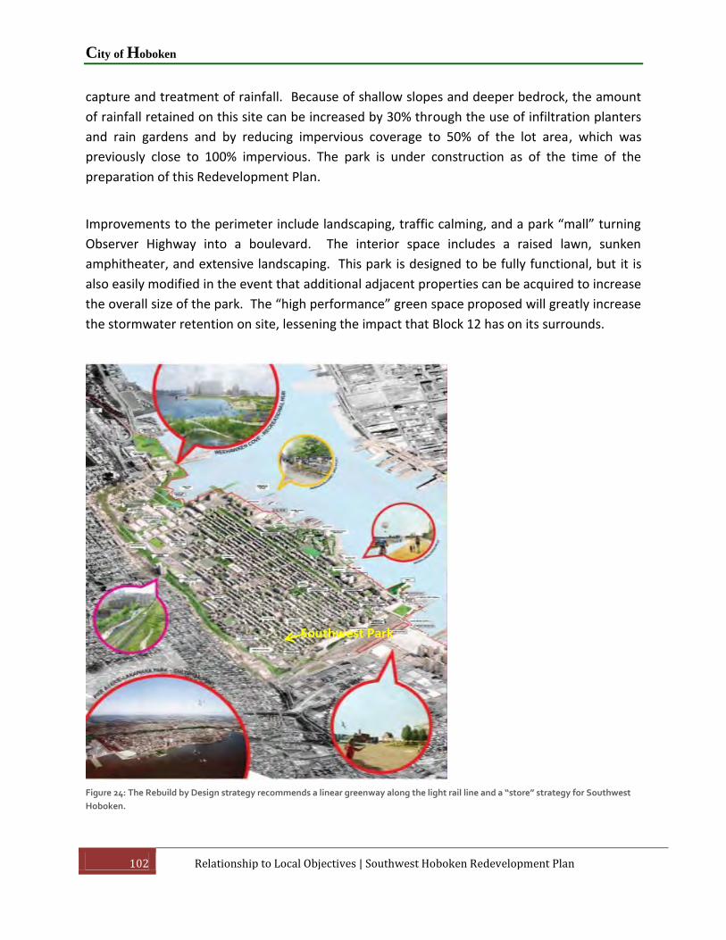
City of Hoboken
102 Relationship to Local Objectives | Southwest Hoboken Redevelopment Plan
capture and treatment of rainfall. Because of shallow slopes and deeper bedrock, the amount
of rainfall retained on this site can be increased by 30% through the use of infiltration planters
and rain gardens and by reducing impervious coverage to 50% of the lot area, which was
previously close to 100% impervious. The park is under construction as of the time of the
preparation of this Redevelopment Plan.
Improvements to the perimeter include landscaping, traffic calming, and a park “mall” turning
Observer Highway into a boulevard. The interior space includes a raised lawn, sunken
amphitheater, and extensive landscaping. This park is designed to be fully functional, but it is
also easily modified in the event that additional adjacent properties can be acquired to increase
the overall size of the park. The “high performance” green space proposed will greatly increase
the stormwater retention on site, lessening the impact that Block 12 has on its surrounds.
Figure 24: The Rebuild by Design strategy recommends a linear greenway along the light rail line and a “store” strategy for Southwest
Hoboken.
Southwest Park

Southwest Hoboken Redevelopment Plan
Southwest Hoboken Redevelopment Plan | Relationship to Local Objectives 103
In the aftermath of Superstorm Sandy, a comprehensive water management “Resist, Delay,
Store, Discharge” strategy was developed to protect Hoboken from flooding as a result of storm
surges and flash flooding as part of the Housing and Urban Development (HUD) sponsored
Rebuild by Design competition. In June 2014, the Hoboken Rebuilding by Design project was
awarded $230 million in federal funding. The comprehensive urban water strategy deploys
programmed hard infrastructure and soft landscape for coastal defense (resist); policy
recommendations, guidelines, and urban infrastructure to slow rainwater runoff (delay); a
circuit of interconnected green infrastructure to store and direct excess rainwater (store); and
water pumps and alternative routes to support drainage (discharge). The recommendation in
Rebuild by Design replicates that of the Green Infrastructure Strategies Plan by designating
Block 12 as a stormwater park.

City of Hoboken
104 Relationship to Other Plans | Southwest Hoboken Redevelopment Plan
9. Relationship to Other Plans
This section of the report discusses any significant relationship of the Redevelopment Plan to
the master plans of contiguous municipalities, the master plan of Hudson County, and the State
Development and Redevelopment Plan. This is a requirement of the LRHL intended to link
redevelopment planning to the regional planning goals and objectives.
9.1 Plans of Adjacent Communities
The Southwest Rehabilitation Area is located at the western edge of Hoboken, adjacent to
Jersey City. Jersey City is to the south and west of the Rehabilitation Area. A master plan for
Jersey City was adopted in 2001 along with subsequent amendments and re-examination
reports. The Redevelopment Plan is compatible with the Land Use and Circulation Elements of
Jersey City’s Master Plan. The adjacent properties in Jersey City are zoned R-3 Residential Multi-
Family Mid-Rise and have similar uses permitted.
9.2 Hudson County Master Plan
Hudson County adopted a master plan reexamination in August 2008, which updates, amends
and supplements the 2002 Hudson County Master Plan to address issues, such as climate
change, flooding, sustainability, etc., that have arisen since 2002. The County adopted the 2016
Master Plan Reexamination Report in February 2017.
The Redevelopment Plan promotes the following goals of the Hudson County Master Plan:
Land Use Goals
LU-7 Promote a street-level small businesses Vibrancy Program to activate sidewalks,
attract prospect businesses, and catalyze public spaces.
LU-8 Encourage municipalities to incentivize green stormwater solutions through
strategies such as performance zoning that would allow greater densities in exchange
for implementing BMPs on-site.
LU-10 Encourage zoning and land uses that are compatible with flood zone designations
and regulations.

Southwest Hoboken Redevelopment Plan
Southwest Hoboken Redevelopment Plan | Relationship to Other Plans 105
LU-14 Promote increased density and transit-oriented development around key
transportation hubs such as Secaucus Junction, Journal Square, and stations along the
HBLRT.
Circulation
C-9 Provide technical guidance and financial resources through grants to Hudson County
municipalities to encourage the integration of green stormwater infrastructure into
streetscape design.
C-10 Encourage flexibility in roadway design from NJDOT standards and incorporate
National Association City Transportation Official (NACTO) design guidelines where
possible. Use the Urban Street Design Guide, Urban Bikeway Design Guide, and Transit
Share Design Guide as resources.
C-19 Ensure county roads are well maintained, including stormwater drains, to mitigate
the impacts of flooding and can be utilized for emergency access and evacuation.
C-44 Ensure that roadway improvements include at least the minimum provisions for
bicyclists, such as “sharrows” or signage like “Share the Road” or “Bikes may use full
lane”.
C-45 Continue to advance projects that address missing links for key greenways
throughout Hudson County. These greenways include the Hudson River Waterfront
Walkway, Hackensack River Waterfront Greenway, Passaic River Waterfront Walkway,
East Coast Greenway, and the Liberty-Watergap Trail.
C-48 Encourage the inclusion of secure bicycle racks/lockers/depots at major
employment centers and development nodes. Consideration should also be given to
provide secure and/or indoor storage as well and shower and changing facilities for
commercial and institutional uses.
Infrastructure Recommendations
I-2 Identify areas where current utility infrastructure is not sufficient for future
development.
I-3 Encourage the use of new technologies and GSI techniques to improve infiltration of
ground water.
City of Hoboken
106 Relationship to Other Plans | Southwest Hoboken Redevelopment Plan
Conservation Checklist
CO-21 Encourage the development and certification of LEED certified buildings to help
reduce consumption and energy usage.
CO-22 Discourage development or disturbance in floodplains and flood hazard areas.
CO-27 Increase the number of trees planted throughout Hudson County.
Historic Preservation Goals
HP-4 Maximize access to cultural and historic facilities and districts through public
transportation and pedestrian walkway improvements through the implementation of
Street Typologies in Historic Districts and at historic sites.
HP-10 Encourage the adaptive reuse of historically significant structures, districts and
sites.
Economic Goals
E-10 Encourage the construction of additional cultural and recreational amenities such
as hotels, convention centers and waterfront walkways to build on the region’s tourist
industry.
E-40 Promote the use of flood-resistant material and construction above ABFE by new
businesses locating within a flood hazard area.
9.3 New Jersey State Plan
2001 State Development and Redevelopment Plan
The City of Hoboken, including the Rehabilitation Area, is designated within the Metropolitan
Planning Area (PA-1) of the 2001 State Development and Redevelopment Plan (SDRP). The
intent of PA-1 is to provide for much of the state’s future redevelopment; revitalize cities and
towns; promote growth in compact forms; stabilize older suburbs; redesign areas of sprawl;
and protect the character of existing stable communities. This Redevelopment Plan has a
significant relationship to the SDRP by advancing many of the following objectives of the PA-1
Metropolitan Planning Area, including:

Southwest Hoboken Redevelopment Plan
Southwest Hoboken Redevelopment Plan | Relationship to Other Plans 107
1. Land Use: Promote redevelopment and development in Cores and neighborhoods of
Centers and in Nodes that have been identified through cooperative regional planning
efforts. Promote diversification of land uses, including housing where appropriate, in
single-use developments and enhance their linkages to the rest of the community.
Ensure efficient and beneficial utilization of scarce land resources throughout the
Planning Area to strengthen its existing diversified and compact nature.
2. Housing: Provide a full range of housing choices through redevelopment, new
construction, rehabilitation, adaptive reuse of nonresidential buildings, and the
introduction of new housing into appropriate nonresidential settings. Preserve the
existing housing stock through maintenance, rehabilitation and flexible regulation.
3. Economic Development: Promote economic development by encouraging strategic land
assembly, site preparation and infill development, public/private partnerships and
infrastructure improvements that support an identified role for the community within
the regional marketplace. Encourage job training and other incentives to retain and
attract businesses. Encourage private sector investment through supportive
government regulations, policies and programs, including tax policies and expedited
review of proposals that support appropriate redevelopment.
4. Transportation: Maintain and enhance a transportation system that capitalizes on high-
density settlement patterns by encouraging the use of public transit systems, walking
and alternative modes of transportation to reduce automobile dependency, link Centers
and Nodes, and create opportunities for transit oriented redevelopment. Facilitate
efficient goods movement through strategic investments and intermodal linkages.
Preserve and stabilize general aviation airports and, where appropriate, encourage
community economic development and promote complementary uses for airport
property such as business centers.
5. Redevelopment: Encourage redevelopment at intensities sufficient to support transit, a
broad range of uses and efficient use of infrastructure. Promote design that enhances
public safety, encourages pedestrian activity and reduces dependency on the
automobile.
6. Public Facilities and Services: Complete, repair or replace existing infrastructure
systems to eliminate deficiencies and provide capacity for sustainable development and
redevelopment in the region. Encourage the concentration of public facilities and
services in Centers and Cores.

City of Hoboken
108 Relationship to Other Plans | Southwest Hoboken Redevelopment Plan
Secondly, the Redevelopment Plan has the potential to advance the following three of the eight
goals of the SDRP:
Revitalize the State’s Cities and Town Centers – Revitalize New Jersey’s cities and
towns by investing wisely and sufficiently in improvements in their infrastructure
systems, public spending programs, tax incentives and regulatory programs to leverage
private investment and to encourage infill and redevelopment in ways that are
consistent with the State Plan’s vision and goals.
Conserve the State’s Natural Resources and Systems – Conserve the State’s natural
resources and systems by planning the location and intensity of growth in ways to
maintain natural resources and systems capacities and make the necessary
infrastructure investments to protect natural resources and systems in ways that guide
growth and development that are consistent with the State Plan’s vision and goals.
Promote Beneficial Economic Growth – Promote beneficial economic growth in
locations and in ways that improve the quality of life and the standard of living for all
New Jersey residents. Provide infrastructure in advance of, or concurrent with, the
impacts of new development sufficient to maintain adequate facility standards.
Encourage partnerships and collaborative planning with the private sector and capitalize
on the State’s strategic location, and economic strengths including its existing business
enterprises, entrepreneurship, the research and development capacity of its institutions
of higher learning, skilled workforce, cultural diversity and logistic facilities in ways that
are consistent with the State Plan’s vision and goals.
2012 Draft Final State Strategic Plan
The 2012 State Strategic Plan (SSP) is New Jersey’s revised State Development and
Redevelopment Plan designed to meet the statutory charges of the State Planning Act. The SSP
was intended to be adopted by the State Planning Commission in November 2012, but a vote
on its adoption was postponed as a result of Super Storm Sandy. The SPC is revising the SSP to
incorporate disaster planning goals in light of Super Storm Sandy.
The overall goal of the SSP is to guide future growth by balancing development and
conservation objectives best suited to meet the needs of New Jersey.
Goal 2 of the SSP is to “guide and inform regional planning, enabling each region of the State to
experience appropriate growth, preservation and protection based on its assets and desires.”

Southwest Hoboken Redevelopment Plan
Southwest Hoboken Redevelopment Plan | Relationship to Other Plans 109
The SSP no longer relies on the 2001 SDRP Policy Map. Instead, the SSP has developed a system
of investment areas to identify areas for the growth, agriculture, open space conservation and
other appropriate designations.
Priority Growth Investment Areas are where more significant development and redevelopment
is preferred to occur and where public and private investment to support such development
and redevelopment will be prioritized. Priority Growth Investment Areas include former PA1
areas, transfer of development rights receiving areas, urban enterprise zones, designated areas
in need of rehabilitation or redevelopment, foreign trade zones, transit villages, urban transit
hubs, and other identified areas. The Goal 2 objectives and strategies direct various state
agencies to focus their investments and planning efforts into the Priority Growth Investment
Areas.

City of Hoboken
110 APPENDICES | Southwest Hoboken Redevelopment Plan
10. APPENDICES
10.1 Summary of Online Survey
10.2 Meeting Notes – Stakeholders’ Meeting of August 18, 2015
10.3 PowerPoint Presentation – Public Meeting #2 – October 18, 2016
10.4 Description of Scenarios from Comment Sheets and Summary of Comments
10.5 Hoboken Maker Industries & Industrial Redevelopment Analysis – July 3, 2015 Prepared
By Recast City
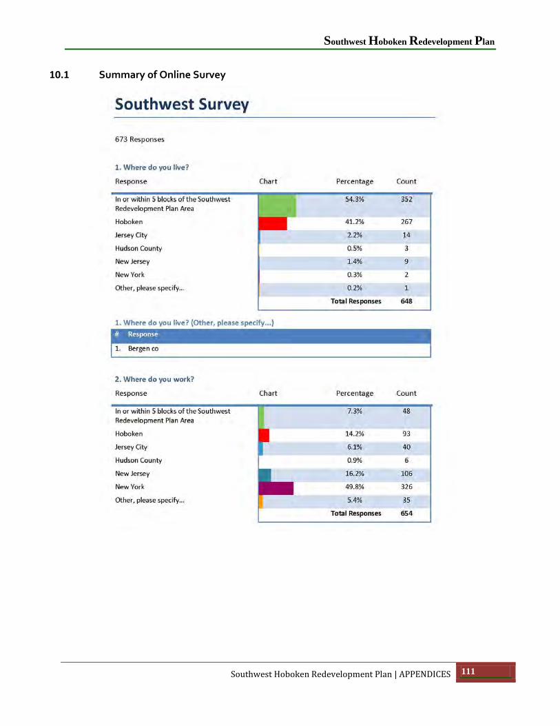
Southwest Hoboken Redevelopment Plan
Southwest Hoboken Redevelopment Plan | APPENDICES 111
10.1 Summary of Online Survey

City of Hoboken
112 APPENDICES | Southwest Hoboken Redevelopment Plan

Southwest Hoboken Redevelopment Plan
Southwest Hoboken Redevelopment Plan | APPENDICES 113

City of Hoboken
114 APPENDICES | Southwest Hoboken Redevelopment Plan

Southwest Hoboken Redevelopment Plan
Southwest Hoboken Redevelopment Plan | APPENDICES 115
City of Hoboken
116 APPENDICES | Southwest Hoboken Redevelopment Plan

Southwest Hoboken Redevelopment Plan
Southwest Hoboken Redevelopment Plan | APPENDICES 117

City of Hoboken
118 APPENDICES | Southwest Hoboken Redevelopment Plan
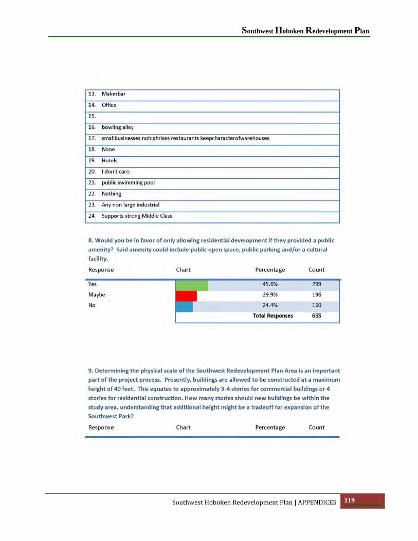
Southwest Hoboken Redevelopment Plan
Southwest Hoboken Redevelopment Plan | APPENDICES 119

City of Hoboken
120 APPENDICES | Southwest Hoboken Redevelopment Plan
Southwest Hoboken Redevelopment Plan
Southwest Hoboken Redevelopment Plan | APPENDICES 121

City of Hoboken
122 APPENDICES | Southwest Hoboken Redevelopment Plan

Southwest Hoboken Redevelopment Plan
Southwest Hoboken Redevelopment Plan | APPENDICES 123

City of Hoboken
124 APPENDICES | Southwest Hoboken Redevelopment Plan

Southwest Hoboken Redevelopment Plan
Southwest Hoboken Redevelopment Plan | APPENDICES 125

City of Hoboken
126 APPENDICES | Southwest Hoboken Redevelopment Plan

Southwest Hoboken Redevelopment Plan
Southwest Hoboken Redevelopment Plan | APPENDICES 127

City of Hoboken
128 APPENDICES | Southwest Hoboken Redevelopment Plan

Southwest Hoboken Redevelopment Plan
Southwest Hoboken Redevelopment Plan | APPENDICES 129

City of Hoboken
130 APPENDICES | Southwest Hoboken Redevelopment Plan

Southwest Hoboken Redevelopment Plan
Southwest Hoboken Redevelopment Plan | APPENDICES 131
10.2 Meeting Notes – Stakeholders’ Meeting of August 18, 2015
Meeting Notes
Stakeholders’ Meeting 8-18-15
1. The context: What is happening globally, nationally and locally that has significant impact
on our redevelopment efforts in this area of Hoboken, e.g. lifestyle trends, hurricane Sandy?
Please give as much detail as you can.
Rising value of the dollar
Influx of $ into NYC tri state area; rise in communal workspaces; preservation of industrial and
manufacturing buildings;
More families want to live in the city.
Uncertainty in land use
Technology is changing the way we live and work and move/commute
Vehicle traffic increase
The city needs more ratable properties.
Manufacturing is being pushed out because of rising $ prices
The region of greater NYC including Hoboken is somewhat more insulated from the ups and
downs of the national economy
Flooding has always been a challenge in Hoboken specifically the west and southwest. Reality is
it is not every day and periodic
More housing in the are
The Skyclub was impactful in the infill housing that grew around that higher density building.
People have asked, since the development of the buildings in the southwest are still concerned
with the sketchy feel of the area

City of Hoboken
132 APPENDICES | Southwest Hoboken Redevelopment Plan
The street system is not on the grid and is not pedestrian friendly
A destination has to be created similar to the Beirgarten which made north of the viaduct a
destination to go to and infill housing then took place. This needs to happen in the southwest
Traffic signals need to be synchronized
The trend is residential but I believe that we should maintain the industrial buildings that are
left in Hoboken and to subsidize with residential
NJ Transit is building 16-storey building that flow into the rehab area.
The Hudson County traffic plan needs to be implemented
Themes: increasing traffic, industrial flavor could be maintained, value of dollar is going up
and has impacts, need neighborhoods. Sea level rise, waterfront access, education:
strengthening it, overpopulation, illegal housing, diminished municipal services, lack of
parking, transportation needs...lack of trans., need for entertainment, millennials moving to
urban centers, telecommuting: people are able to live in places far from their work, changing
nature of the workforce
2. What are we doing well we would like to KEEP? What is getting in our way that we would
like to ABANDON? What might we INVENT or REINVENT that, if we did, would make us more
successful and enhance the vibrancy/economic success of the SW area of Hoboken?
KEEP:
Small business
Industrial flavor
Some of the industrial businesses
The traffic guards during peak commuting hours
Residential
ABANDON
Flooding issues
Falling down, unused commercial and industrial buildings

Southwest Hoboken Redevelopment Plan
Southwest Hoboken Redevelopment Plan | APPENDICES 133
Surface parking lots
Crumbling facades
Dilapidated buildings
Loading and unloading in the streets
Street loading docks
The abandoned buildings
INVENT
Retail destinations, markets
Entertainment, restaurants, bars, more housing
The fusion of industrial with residential
REINVENT
Parking facilities
Traffic patterns
Access to the Recycling plants located in JC that gain access with 53' trailers driving over the
sidewalks
Zoning that will be built by the property owners
Traffic patterns to ease congestion
3. From what we have learned today & our experience with other redevelopments in
Hoboken, what new/enhanced/maintained activity would we like to see in the rehab area?
Refer to your handouts e.g. the report on retail leakage from Hoboken to surrounding areas
Retail underneath with housing above
More uniform looking buildings
Create some sort of land partnership where no one property owner feels slighted as we all
want to maximize our properties.

City of Hoboken
134 APPENDICES | Southwest Hoboken Redevelopment Plan
A blend of residential, commercial, and industrial to maintain the identity of Hoboken
more mixed use
A good blend of buildings and greenspace. A look that is new but still feels like Hoboken
Residential extension of LCOR project, office space, retail, restaurants, perimeter parking,
park(recreational use)
Mix of retail, industrial/Tribeca/downtown feel, residential and artist lofts
Most property owners historically have attempted to get residential zoning approved due to
demand. Who bears the burden of mixed use unknown demand?
Better balance of entertainment and residential use
Theme: Keep some of the old plus the new, more residential and retail, and industrial
4. Thinking about the park area, what facilities/features should this area have and how
should it connect/relate to the immediate neighborhood?
Business in the park
A lake, children’s play area, workout stations
I don’t think the current street grid, traffic signals and pedestrian walkways make this park safe
to get to
The park going vertical with multiple floors with agriculture and playgrounds
I like the passive features of the park like sheep meadow in central park
it should have a mix of covered and open space
Access to the park is critical
The location close to the light rail could attract loitering, how will that be managed
Outdoor adult space with jogging track, benches, trees, etc.
There is a Catch 22 of traffic calming for the park and the heavy traffic on the surrounding
streets

Southwest Hoboken Redevelopment Plan
Southwest Hoboken Redevelopment Plan | APPENDICES 135
5. What could be done to improve the gateways to Hoboken through the redevelopment of
properties along Newark Street, Harrison Street and Paterson Avenue?
"I did it my way"
Specific architecture that is unique to Hoboken. Brightly lit and vibrant buildings
Walking arcades in front of residential buildings.
distinctive street lighting
Out of the 8 vehicular access points 5 are in the southwest and out of the 5 in the southwest, all
are visually unappealing. Monument? Pocket Park? Signage? At minimum no vacant buildings
Commercial with renovated industrial and residential
Lampposts with Frank Sinatra's song titles
For Hoboken’s known status that it keeps getting throughout different media sources when you
enter in the southwest it’s disgraceful
Encourage new mixed use, newer buildings that look more appealing than the current
Improve traffic flow

City of Hoboken
136 APPENDICES | Southwest Hoboken Redevelopment Plan
10.3 Presentation PowerPoint – Public Meeting #2 of October 18, 2016

Southwest Hoboken Redevelopment Plan
Southwest Hoboken Redevelopment Plan | APPENDICES 137

City of Hoboken
138 APPENDICES | Southwest Hoboken Redevelopment Plan

Southwest Hoboken Redevelopment Plan
Southwest Hoboken Redevelopment Plan | APPENDICES 139

City of Hoboken
140 APPENDICES | Southwest Hoboken Redevelopment Plan

Southwest Hoboken Redevelopment Plan
Southwest Hoboken Redevelopment Plan | APPENDICES 141

City of Hoboken
142 APPENDICES | Southwest Hoboken Redevelopment Plan

Southwest Hoboken Redevelopment Plan
Southwest Hoboken Redevelopment Plan | APPENDICES 143

City of Hoboken
144 APPENDICES | Southwest Hoboken Redevelopment Plan
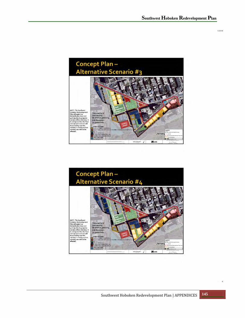
Southwest Hoboken Redevelopment Plan
Southwest Hoboken Redevelopment Plan | APPENDICES 145

City of Hoboken
146 APPENDICES | Southwest Hoboken Redevelopment Plan
10.4 Description of Scenarios from Comment Sheets and Summary of Comments
SCENARIO #1
This Scenario provides for the option of clustering residential units on Block 9 property under
common ownership based on the land area of a portion of Block 10 that would be dedicated for
the further expansion of the Southwest Resiliency Park (Park Expansion Area 3). The Chambord
block (Block 6) is shown as to be infilled with urban manufacturing and office uses.
SCENARIO #2
This Scenario differs from Scenario 1 only in that a portion of the Chambord block (Block 6) is
shown as an extension of the “low density” residential. This residential infill would be oriented
around an interior green space opposite “Our Park” as a “pocket neighborhood”.

Southwest Hoboken Redevelopment Plan
Southwest Hoboken Redevelopment Plan | APPENDICES 147
SCENARIO #3
This Scenario assumes that the residential clustering from the northern portion of Block 10 to
Block 9 does not occur and that northern portion of Block 10 is developed as a low density
“pocket neighborhood” adjacent to the expanded SW Park and Block 9 is developed for office
uses. The Chambord block (Block 6) is shown as expanded urban manufacturing and office.
SCENARIO #4

City of Hoboken
148 APPENDICES | Southwest Hoboken Redevelopment Plan
Scenario 4 is similar to Scenario 3 except that the uses on the northern half of Block 10 remain
designated for office use, which is the current use. The Chambord block (Block 6) is shown as a
pocket neighborhood (as in Scenario 2).
SUMMARY OF COMMENTS
There were several common threads running through the comments:
The majority of respondents favored either Scenario 1 or 2 because of the expansion of
the SW Park to include all of Block 10. Based on the overall number of responses,
Scenario #2 received the most responses as the “preferred” scenario.
Of the respondents who disfavored the expansion of the park, there was a split between
those favoring Scenario 3 and 4 depending on their feelings about additional residential
in the SW area.
Those favoring Scenarios #4 liked the pocket neighborhood behind the Chambord
Building on Block 6.
There was strong support for the concept of the alleyways.
There was strong support for the concept of “pocket neighborhoods”.
There was strong support for the one-way “loop” circulation system proposed in the
Maser traffic study.
There was strong support for the clustering of density in taller buildings on Block 9 in
exchange for park expansion to include all of Block 10. Some suggested that the

Southwest Hoboken Redevelopment Plan
Southwest Hoboken Redevelopment Plan | APPENDICES 149
buildings on Block 9 be allowed be higher than 80 feet above DFE if it meant expanding
the park to include all of Block 10.
For those favoring either Scenario #3 or #4 there was a dissenting opinion that they
prefer less of a park expansion (half of Block 10) and lower buildings to more park
expansion and higher buildings (from clustering).
There was strong support for the parking structure behind the Hoboken Business
Center, although some suggested that it include street level retail and residential on the
upper floors.
Those that favored Scenario #1 over #2 the most common comment was the expansion
of the park with minimal additional residential development because the City is already
“congested”.
Those that favored Scenario #2 over #1 the expanded park was coupled with the
creation of new residential neighborhoods (“pocket neighborhoods”).
Those that preferred Scenario #3 stated the balance between expanded park, office and
mixed-use that would add more services and conveniences to the area.
Those that preferred Scenario #4 stated that the limited size of the park expansion
would make it less likely to be used for large recreational fields that only a few residents
would use as opposed to more traditional park space. They attributed a greater amount
of commercial and office space to minimizing school expenses and increasing activity
during the day.
Of those favoring either Scenario #3 or #4, several indicated that they would favor more
mixed-use, low density residential if it were condo rather than rental.
The City has chosen Scenario #2 as the concept on which to base the Southwest Hoboken
Redevelopment Plan.

City of Hoboken
150 APPENDICES | Southwest Hoboken Redevelopment Plan
10.5 Hoboken Maker Industries & Industrial Redevelopment Analysis – July 3, 2015
Prepared By Recast City

Southwest Hoboken Redevelopment Plan
Southwest Hoboken Redevelopment Plan | APPENDICES 151

City of Hoboken
152 APPENDICES | Southwest Hoboken Redevelopment Plan

Southwest Hoboken Redevelopment Plan
Southwest Hoboken Redevelopment Plan | APPENDICES 153

City of Hoboken
154 APPENDICES | Southwest Hoboken Redevelopment Plan
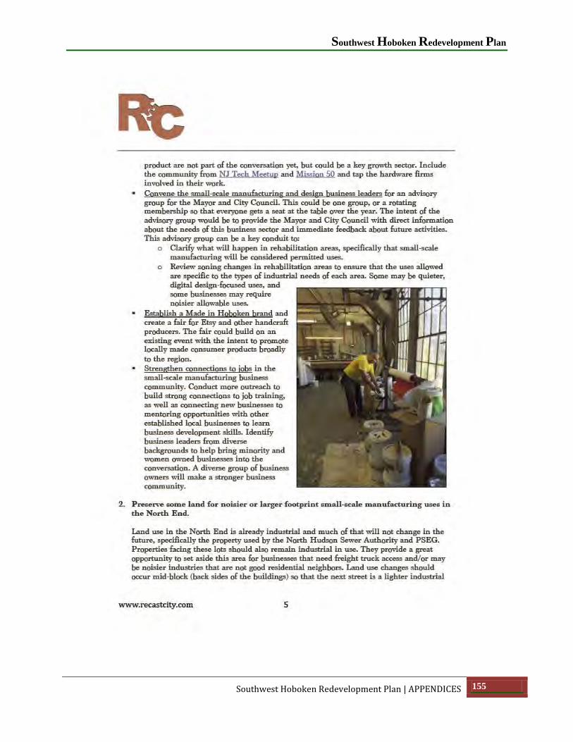
Southwest Hoboken Redevelopment Plan
Southwest Hoboken Redevelopment Plan | APPENDICES 155

City of Hoboken
156 APPENDICES | Southwest Hoboken Redevelopment Plan

Southwest Hoboken Redevelopment Plan
Southwest Hoboken Redevelopment Plan | APPENDICES 157

City of Hoboken
158 APPENDICES | Southwest Hoboken Redevelopment Plan

Southwest Hoboken Redevelopment Plan
Southwest Hoboken Redevelopment Plan | APPENDICES 159