sparta mountain wma forest stewardship plan
TRANSCRIPT

1
Forest Stewardship Plan
Sparta Mountain Wildlife Management Area
Prepared for New Jersey Department of Environmental Protection Division of Fish and
Wildlife
P.O. Box 420 MC 501-03C
Trenton, NJ 08625
Property Location:
Sparta, Ogdensburg and Hardyston Townships in Sussex County
Jefferson Township in Morris County
Plan Acreage: 3,461.198
Plan Timeframe: 2016 – 2026
Prepared by NJ Approved Foresters:
Jeremy M. Caggiano & Donald Donnelly
GIS Contributions by: Gylla MacGregor New Jersey Audubon Society, Wattles Stewardship Center
1024 Anderson Road, Port Murray, NJ 07865
(908) 837-9570 Fax: (908) 837-9569
Prepared Date: October 2014 (revised November 2015)
_________________________________________
Approved Forester Signature
Jeremy M. Caggiano
_________________________________________
Approved Forester Signature
Donald Donnelly

2
TABLE OF CONTENTS
1. INTRODUCTION .......................................................................................................................................... 3
1.1 - LANDOWNER GOALS AND OBJECTIVES................................................................................................... 3
1.2 - PROCEDURES FOR INVENTORYING GROWTH AND DYNAMICS ................................................................. 4
1.3 - DESCRIPTION OF STAKEHOLDER CONSULTATION PROCESS .................................................................... 5
2. GENERAL PROPERTY DESCRIPTION ..................................................................................................... 6
2.1 - PROPERTY LOCATION ............................................................................................................................. 6
2.2 - PROPERTY BOUNDARIES ........................................................................................................................ 6
2.3 - DEED AND TAX INFORMATION ............................................................................................................... 7
2.4 - FOREST STEWARDSHIP PLAN MAPS ........................................................................................................ 8
2.5 - ROAD AND ACCESS SYSTEM ................................................................................................................. 11
2.6 - BEDROCK GEOLOGY ............................................................................................................................. 12
2.7 - SURFICIAL GEOLOGY ............................................................................................................................ 12
2.8 - NJ BEST MANAGEMENT PRACTICES FOR FORESTRY AND WETLANDS .................................................. 13
2.9 - HYDROLOGY ........................................................................................................................................ 13
Ponds ....................................................................................................................................................... 14
Streams .................................................................................................................................................... 14
Wetlands .................................................................................................................................................. 15
Vernal Pools ............................................................................................................................................ 15
2.10 - LAND USE HISTORY ........................................................................................................................... 15
2.11 - LANDSCAPE LEVEL CONSIDERATIONS ................................................................................................ 16
2.12 - AREAS OF ARCHEOLOGICAL, CULTURAL AND TRIBAL SIGNIFICANCE ................................................ 17
3. SOCIOECONOMIC IMPACTS OF FORESTRY ....................................................................................... 18
4. MAJOR FOREST TYPES ........................................................................................................................... 19
5. WILDLIFE ................................................................................................................................................... 19
5.1 - DESCRIPTION OF WILDLIFE ON SPARTA MOUNTAIN WMA .................................................................. 19
5.2 - CONSERVATION OF RARE, THREATENED AND ENDANGERED SPECIES .................................................. 20
Rare Wildlife ........................................................................................................................................... 20
Structural Change .................................................................................................................................... 23
Old Growth .............................................................................................................................................. 23
Hemlock Ravines .................................................................................................................................... 24
Rare Plants .............................................................................................................................................. 25
Early Successional Habitat ...................................................................................................................... 28
6. RECREATION AND AESTHETICS .......................................................................................................... 29
7. FOREST HEALTH AND ECOLOGY ........................................................................................................ 30
7.1 - PRESENT AND POTENTIAL FOREST HEALTH ISSUES ............................................................................. 30
7.2 - DEER HERBIVORY ................................................................................................................................ 31
7.3 - HERBACEOUS LAYER ........................................................................................................................... 32
7.4 - PLANT STEWARDSHIP INDEX (PSI) ...................................................................................................... 32
7.5 - INVASIVE SPECIES ................................................................................................................................ 33
8. RATIONALE FOR RATE OF ANNUAL HARVEST AND SPECIES SELECTION ............................... 33
9. REPRESENTATIVE SAMPLE AREAS (RSAs) ........................................................................................ 33
10. NON-TIMBER FOREST PRODUCTS (NTFPS) ..................................................................................... 34
11. DESCRIPTION OF HARVESTING TECHNIQUES AND EQUIPMENT .............................................. 34
12. CARBON STOCKS ................................................................................................................................... 36
13. STAND DESCRIPTIONS AND PRESCRIPTIONS ................................................................................. 36
14. TEN YEAR MANAGEMENT SCHEDULE ............................................................................................. 68
15. FOREST INVENTORY STATISTICS ..................................................................................................... 72
16. REFERENCES AND LITERATURE CITED ........................................................................................... 83
17. APPENDICES: View or download online:

3
https://drive.google.com/file/d/0B_3KjtnowPbRZlc2VXpjTk1aTWs/view?usp=sharing
17.1 - NJDEP Natural Heritage Program Report
17.2 - NRCS Custom Soil Resource Report
17.3 - SMWMA NED 2 Inventory Data
17.4 - Bowman’s Hill Wildflower Preserve PSI Report
17.5 - Forest Certification Explained
17.6 - Forest Stewardship Council (FSC) Group Member Agreement
17.7 - NJA Group Hazardous Materials and Pesticides Policy
17.8a - Wild Ridge, LLC Sparta Mountain WMA Rare Plants Survey Reports, 2013
17.8b - Wild Ridge, LLC Sparta Mountain WMA Rare Plants Survey Reports, 2014
17.9 - FSC 2007 Pesticides Policy
17.91 - FSC Standards V.1 July 8th
2010
17.92 - NJ BMP Manual for Forestry and Wetlands
17.93 - Forest Health Report
17.94 – Vernal Pool Location Map
1. INTRODUCTION
The intent of this plan is to provide the overall goals and objectives for the management of Sparta
Mountain Wildlife Management Area and to outline the general areas (stands), practices,
conservation measures, and a proposed timeline in which to achieve those goals and objectives
during the 10-year duration of the plan.
Because this plan was initiated prior to the State Forest Service’s 14-step process to create a forest
steward plan on state lands, the implementation of the plan will follow a more detailed site-specific
plan, also known as a practice plan or operational plan, which will be drafted as conditions allow
for a management activity to occur. Each practice plan will include the management prescriptions
for each individual project site location within a stand, which are guided by the umbrella
recommendations provided in this forest stewardship plan for that designated forest stand, and
apply more specific conservation measures for rare species that may be impacted from the
management conducted at that project site location. This plan is envisioned as the first stage of a
larger management vision designed to be implemented over a period of 60 years.
Under this system, each practice plan will need to undergo a NJDEP Lands Management Review
Process, which means it will be reviewed internally by certain bureaus within NJDEP’s Natural and
Historic Resources prior to implementation. However, these bureaus will be consulted during the
creation of each practice plan to discuss concerns prior to the official activity review.
1.1 - LANDOWNER GOALS AND OBJECTIVES
1. Maintain ecosystem health, diversity and integrity
Create greater balance among the stages of forest succession throughout the property
Establish up to 10% of property as young forest stands
Favor trees with exfoliating bark and cavities for nesting birds and roosting bats
Minimize further distribution of invasive exotic species
Implement responsible silviculture to enhance biological diversity of native wildlife
Enhance forest’s vertical structure by mimicking natural “gap disturbances”
2. Protect and enhance hydrologic resources
Adhere to NJ Forestry and Wetlands BMP Manual when managing in and around riparian
areas
Selectively remove portions of wetland overstory canopy to improve habitat for basking
4
turtles
3. Inventory and monitor priority wildlife populations and habitat
Utilize data to support adaptive management decision making
Monitor wildlife responses to habitat improvement activities and adjust as necessary
Identify Rare, Threatened and Endangered (RT&E) species present and manage property to
ensure their existence
4. Provide compatible wildlife related recreational opportunities and facilities
Prevent illegal use on the property and employ more signs, barricades and gates
Protect and maintain views around vistas and important locations including actively
managed areas
5. Continue management in a manner compliant with Forest Stewardship Council
(FSC) Principles and Criteria
While funding exists satisfy requirements of annual, third party audits and five year re-
assessments
Ensure protection of environmental, social and economic high conservation values as
defined by FSC
Adhere to Montreal Process criteria and indicators as described in Montreal Process
2014, from which FSC standards are derived.
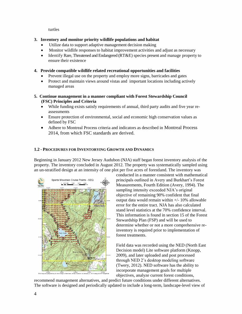
1.2 - PROCEDURES FOR INVENTORYING GROWTH AND DYNAMICS
Beginning in January 2012 New Jersey Audubon (NJA) staff began forest inventory analysis of the
property. The inventory concluded in August 2012. The property was systematically sampled using
an un-stratified design at an intensity of one plot per five acres of forestland. The inventory was
conducted in a manner consistent with mathematical
principals outlined in Avery and Burkhart’s Forest
Measurements, Fourth Edition (Avery, 1994). The
sampling intensity exceeded NJA’s original
objective of remaining 90% confident that final
output data would remain within +/- 10% allowable
error for the entire tract. NJA has also calculated
stand level statistics at the 70% confidence interval.
This information is found in section 15 of the Forest
Stewardship Plan (FSP) and will be used to
determine whether or not a more comprehensive re-
inventory is required prior to implementation of
forest treatments.
Field data was recorded using the NED (North East
Decision model) Lite software platform (Knopp,
2009), and later uploaded and post processed
through NED 2’s desktop modeling software
(Twery, 2012). NED software has the ability to
incorporate management goals for multiple
objectives, analyze current forest conditions,
recommend management alternatives, and predict future conditions under different alternatives.
The software is designed and periodically updated to include a long-term, landscape-level view of

5
the forest as an interconnected ecosystem.
Information recorded during the inventory included the identification of overstory, shrub and
ground layer species. Fixed radius plots of 1/100 and 1/500 of an acre were used to collect shrub
and ground cover data respectively. Overstory data was collected using 15 basal area factor prisms
on variable radius plots. Attributes collected during the inventory include tree diameter, height, size
class, live crown ratio, quality, vigor, product, and defect. Other features such as geographic areas
of interest, trails, and riparian crossings were also noted. Small portions of the property were not
inventoried due to inaccessibility caused by standing water or extremely dense vegetation (utility
corridors). Although vegetation tied to these features is not necessarily detailed in this plan, future
management of these sites is also unlikely.
The property was divided into thirty-three forest stands based on the inventory. A summary of the
Stand level data is located within the Stand Descriptions and Prescriptions section. In some
instances, computer modeling was used to project data out to 2022, offering a snapshot of forest
conditions under various treatment regimes. Modeling different scenarios allows for the tracking of
conservation values and sustainable growth.
Sparta Mountain Wildlife Management Area (SMWMA) receives Forest Stewardship Council
(FSC) certification via the Rainforest Alliance (RA) through NJA’s Group Certificate. The
property will continue to remain monitored by the NJ Division of Fish and Wildlife (NJDFW),
NJA, and RA for changing conditions to ensure conformance with this plan. NJA and the NJDFW
make annual visits to the property to complete FSC approved forest monitoring checklists and
annual conformance reports, which are reviewed by RA’s third party auditors. If issues arise
through this monitoring or during stakeholder consultation, they can be quickly addressed.
1.3 - DESCRIPTION OF STAKEHOLDER CONSULTATION PROCESS
Recently, the NJ State Forest Service (SFS) proposed a 14-step process in the creation of forest
stewardship plans on state lands with guidance from stakeholders throughout the planning process.
This plan was initiated years prior to this process; therefore it has not observed all 14 steps.
However, measures have been taken to consult stakeholders during the early phases of this plan,
and in recognition of this new process, measures will continue to be taken to solicit stakeholder
comments prior to implementation of management activities.
NJA worked together with staff members of the NJDFW to create an exhaustive stakeholder list.
The chosen stakeholders represented a range of interests, and they typically maintained direct
contact with the public as it pertained to their area of expertise. Stakeholder communications are
conducted by either NJA or NJDFW via email, however, in some cases telephone calls were also
used. At times, representatives of the RA also contacted stakeholders directly. Results and findings
from the stakeholder consultation processes were recorded, stored, and are publically available at
NJA’s central office location at Wattles Stewardship Center. Planning documents and supporting
data are also available for viewing at NJA’s Wattles Stewardship Center.
Beyond compliance with FSC indicators 4.4d and 9.2a, NJA consulted with stakeholders during
preparatory stages of this plan (See FSC Standards in Appendix 17.91). First, stakeholders were
extended the opportunity to comment or share concerns regarding the forest inventory procedures
to be used for raw data collection, and for areas of High Conservation Value. Second, interested
parties were allotted time to comment on the proposed outline and content. The third opportunity
for stakeholder input and comments will be upon completion of the draft plan before it becomes a
final document.

6
Stakeholders and the general public may express concerns and grievances during the NJA
Stakeholder Input Process, or by contacting NJA staff foresters at: Wattles Stewardship Center,
1024 Anderson Road, Port Murray, NJ 07865. All questions will be addressed and documented. If
conformance with the FSC standards is in question, NJA will issue an internal Non-Conformance
Report (NCR) to NJDFW. The internal NCR will provide a description and timeframe outlining the
necessary steps required to resume conformance. Typically the NCR will need to be addressed
before the next RA audit. Failure of the NJDFW to adequately address the NCR within the
documented timeframe may result in temporary and/or permanent suspension from FSC certified
status. Internal NCR’s are shared with RA at the time of NJA’s annual audit. If the stakeholder
does not feel NJA has addressed the issue satisfactorily, they may contact RA directly via phone at
802.434.5491. At that point RA will guide the stakeholder through their formal grievance process
and contact NJA and NJDFW to further investigate.
2. GENERAL PROPERTY DESCRIPTION
2.1 - PROPERTY LOCATION
The SMWMA spreads through two counties and four townships. In Morris County it sits within
Jefferson Township, and in Sussex County it lies within Sparta Township, Hardyston Township,
and the Borough of Ogdensburg.
The property is generally bound by the following features; in the north by NJ Route 23 near the
highway’s intersection with Beaver Lake Road, in the south by Glen Road (Sussex County Route
620), in the west by the New York Susquehanna and Western Railroad Company (NYSW) tracks,
and in the east by the communities of Tamarack Lake and Lake Stockholm.
The most frequented sections of SMWMA are in the vicinity of Ryker Lake and Edison Monument,
which are both along Edison Road.
2.2 - PROPERTY BOUNDARIES
Well-maintained boundary lines are important to meeting the standards of forest certification and
for the management of forest assets. The boundary line is the definitive and legal declaration of the
limits of what is owned. A clear deed description and survey map provide the basis for accurate,
well-marked boundaries.
As per FSC Indicator 1.5a and 2.1c property boundaries of land ownership and use rights must be
clearly identified on the ground and on maps prior to commencing management activities within
the vicinity of the boundaries. Boundary designations, by FSC standards, do not necessarily have to
be comprehensive, but must be adequate to assure that management activities are implemented
where intended. If the boundary cannot be established, then the manager shall postpone
management until the boundaries are established and marked either by legal survey or through
mutual agreement with the adjacent property owner.
NJA recommends that NJDFW establish well marked and maintained boundaries regardless of
proposed future management to prevent illegal activities, such as timber trespass and unauthorized
vehicular use. Additionally, when proposed activities are within close proximity to a property line,
that line shall be confirmed for accuracy prior to commencing management.

7
2.3 - DEED AND TAX INFORMATION
Table 1. Lot and blocks within Sparta Mountain WMA by county and township with total acreages.
Ogdensburg Township Sparta Township Hardyston Township Jefferson Township Sussex County Sussex County Sussex County Morris County
Block 1; Lot 2 Block 1; Lot 2, 3,
1.01, 1.02, 1.03, 16 Block 1; Lot 1.04 Block 555; Lot 9
Block 11; Lot 21 Block 3; Lot 1,
20.03 Block 59; Lot 12 Block 59; Lot 1
Block 7; Lot 3, 4,
88 Block 60 ; Lot 1,
1.01, 17, 2.01, 3.02, Block 1.02; Lot 45 Block 60; Lot 2.02
19.75 Acres 1,842.558Acres 1,542.89 Acres 56.0 Acres
3,461.198 Acres

8
2.4 - FOREST STEWARDSHIP PLAN MAPS
Figure 1. Aerial imagery map depicting Sparta Mountain Wildlife Management Area (yellow)

9
Figure 2. Topographic map depicting Sparta Mountain Wildlife Management Area (yellow)
10
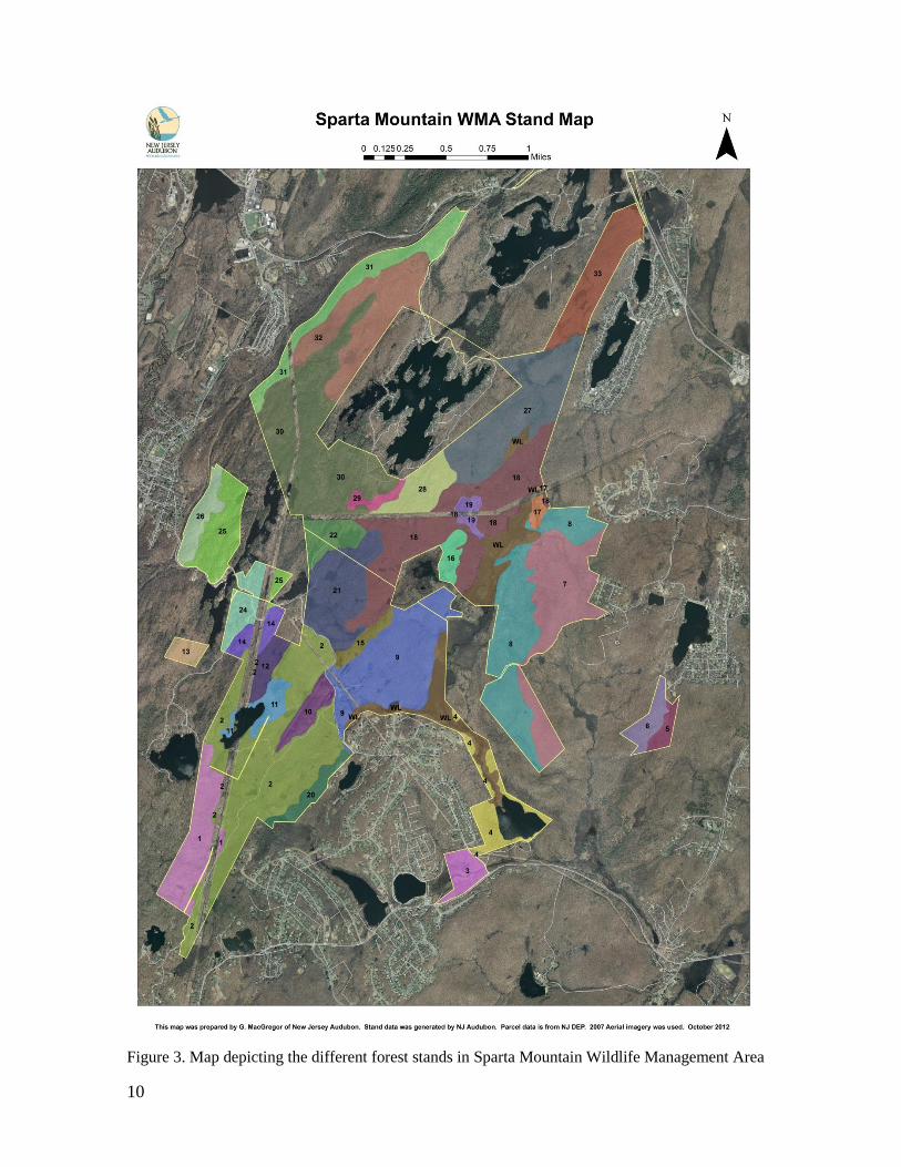
Figure 3. Map depicting the different forest stands in Sparta Mountain Wildlife Management Area
11
2.5 - ROAD AND ACCESS SYSTEM
Because of the land use history as an industrial site, SMWMA has an extensive preexisting road
network throughout the property. However, many of the roads have become degraded and are in
need of improvements to minimize continued erosion. In order to employ the Best Management
Practices (BMP) guidelines and protect against excessive erosion, some projects may require
altering the location of existing roads or creating temporary access lanes stemming from these
roads. The NJ Forestry and Wetlands BMP Manual (further detailed in the General Property
Description section) will be the guidance tool for constructing or improving access roads, landings,
and stream crossings to minimize environmental impact. While specific guidance is provided in the
BMP manual, roads will generally follow the contour of the land and avoid traversing slopes
greater than 10% when possible. Water bars, ditches, and other erosion control measures will be
constructed as needed, and revisited after use to assess the need for repair.
The main arteries of Ridge Road and an unnamed road extending north from the Edison Monument
provide access to most of the property. Almost all areas that are not directly accessible from these
major arteries can be reached from other un-named trails, paved municipal roads, or utility
easements. Below is a basic description of the existing road network and how project sites may be
most easily accessed.
Ridge Road is a Sparta Township road that bisects the southwest corner of the property from
southwest to northeast. It originates from County Route 620 (Glen Road) and turns into a dirt road
when it enters the property in Stand 2. It follows the border of Stands 1 and 2, and then heads
northwest into the heart of Stand 2. It eventually meets Edison Road just south of the Edison
Monument parking lot. Enhanced erosion control measures were put in place on the lower half of
Ridge Road prior to it being used as logging truck access for the spring 2012 timber harvest. The
upper half remains less improved due to a few steep sections of eroded bedrock. There are a few
unimproved roads that branch off to the Public Service Electric & Gas Company (PSE&G)
easement. These provide access to Stand 1, and Stands 11 and 12 on the west side of Collins Pond.
Stands 11 and 12 can also be accessed from the old railroad bed that extends south from Edison
Road.
Edison Road is also a Sparta Township road that bisects the southwestern end of the property. It is
a paved road, with connections to numerous unimproved roads that access the forest interior to the
north and south. Edison road provides direct access into Stands 2, 3, 4, 9, 10, 14, 15, 20, 21, 24, 25
and 26. There are also a number of telephone and utility line easements that are accessible from
Edison Road. The primary access to Ryker Lake is also from Edison Road.
There are a few significant unimproved roads that extend north and east from Edison Road near the
Edison Monument. Collectively, these roads provide access into Stands 9, 16, 18, 19, 21 and 22.
The most stable of these roads is an old mining roadbed, which is relatively flat and straight. It
received some minor erosion control improvements prior to the 2012-2013 work conducted north
of the Edison Bog. In addition to PSE&G, Jersey Central Power & Light (JCP&L) maintains some
access roads connecting to their utility easements in this region.
Stands 5 and 6 are part of a non-contiguous parcel on the southeast side of the WMA, and are only
accessible through the private Lake Stockholm community. Stand 5 can be accessed from a forest
road that extends from a private driveway on Lakeside Avenue in Lake Stockholm.
Hawthorne Lake Road is a private improved road that could potentially be used to access Stands
13, 14 and 24.

12
Rock Lodge Road is a Hardyston Township road on the eastern side of the property. It extends into
Stand 7 from a paved cul-de-sac into the WMA as a dirt road. The dirt road is passable only with a
four wheel drive vehicle, but also does provide entry into Stand 8.
Beaver Lake is a private lake community within the northern portion of SMWMA. Its main point of
entry is Beaver Lake Road, a paved road extending south from Route 23. This road could be used
to access Stands 31 and 32. The lake community also contains a number of other roads that, with
permission, could potentially be used to access Stands 27, 28, 29 and 30.
The NYSW freight rail lines that bound northern portions of SMWMA connect Bergen County, NJ
to Syracuse, NY. The feasibility of utilizing a train as an effective means of transporting logs
and/or milled lumber will be explored as an option. New Jersey Transit has been working on
restoring the historic Lackawanna Cut-Off railroad between metropolitan New York and
northeastern Pennsylvania. The Lake Hopatcong and Andover section is only twelve miles from
SMWMA, and might also be a possible way to transport forest products in the future.
2.6 - BEDROCK GEOLOGY
SMWMA sits within the New Jersey Highlands, which contain some of the oldest rock in New
Jersey. Primary bedrock materials are Pre-Cambrian granites, and Paleozoic clastic/carbonate
rocks. Kittatinny and Franklin formations overlie Hardyston Quartzite throughout the region. The
hard granite created steep mountains and hillsides which have been mostly resistant to the impacts
of erosion. The area is considered mountainous, with an elevations reaching upwards of 1,500 feet.
Sparta Mountain has an elevation of 1,232 feet.
Because of its rich mineral deposits, the Highlands were mined extensively. Iron, zinc, and marble
were commonly mined from the area, and Franklinite was first discovered at nearby Sterling Hill
Mine. More information regarding the areas recent geologic history is in the Land Use History
portion of this plan.
2.7 - SURFICIAL GEOLOGY
Most soils at SMWMA are a coarse-loamy till developed from granite and gneiss. They are
typically rocky and well-drained. The most common soil occurring here is the Rockaway-
Chatfield-Rock complex (RokD), which covers about 57% (1,860 acres) of the WMA. This
complex consists of three individual soil types within a matrix of such small inclusions that they are
not shown separately on a map. The general percentage of each soil type is: Rockaway fragipan at
45%, Chatfield at 25%, Rock outcrop at 20% and other minor components at 10%.
The second most abundant soil group in SMWMA is the Chatfield-Hollis-Rock outcrop complex
(ChkC) covering about 9% of the area. It has very similar qualities to RokD except that it is found
on gentler slopes, ranging from 0-15%. ChkC is most abundant in the southwest portion of the
WMA, near stands 2 and 10, but other large patches are located in Stands 8 and 30.
The third most abundant soil is Catden mucky peat (CatbA) covering about 7% of the WMA.
Unlike the aforementioned soils, CatbA is a poorly drained soil that experiences frequent ponding
and inundation. These soils are always associated with wetlands, and are located in depressions or
on nearly level ground. Because of this, they have a high organic content. Small clusters of CatbA
are found scattered throughout SMWMA.
More detailed information on the soil characteristics can be located within the Custom Soil
Resource Report for SMWMA (USDA NRCS WSS, 2013).

13
2.8 - NJ BEST MANAGEMENT PRACTICES FOR FORESTRY AND WETLANDS
The New Jersey Forestry and Wetlands Best Management Practices Manual (hereafter referred to
as the BMPs) is a practical, comprehensive guide outlining the best methods for minimizing
adverse effects to soil and water quality while implementing forest management practices. While
the manual was developed in 1995 specifically for use in New Jersey, it incorporates well
established practices that have been mirrored from widely accepted strategies for mitigating soil
and water concerns across the United States. The BMPs will be referenced throughout this Plan
when discussing particular situations. A copy of the BMPs can be obtained by contacting NJDEP
directly or by visiting the website:
http://www.state.nj.us/dep/parksandforests/forest/nj_bmp_manual1995.pdf
2.9 - HYDROLOGY
Hydrology and the impact of active management can be viewed through multiple lenses at
SMWMA. At the micro level, individual water bodies can be directly impacted through physical
manipulation and destabilization by equipment. At this level, resource concerns are generally
addressed by employing the proper BMPs described earlier. Examples of resource degradation
occurring from forestry activities can usually be traced back to improper BMP implementation. The
second lens for viewing forest hydrology is the possible indirect effects that forestry activities
might have on down-slope water chemistry, sediment loads, and water temperatures at a watershed,
or sub-watershed scale. These effects tend to be less tangible because they are more difficult to
measure, and they may occur over long periods of time. Fortunately, an extensive amount of long
term research has been done to better understand the effects of forest management practices on
watershed health. Some of the best available science comes from the Coweta Hydrologic
Laboratory, which was established in 1934 as a research facility of the USDA Forest Service,
Southern Research Station. Other notable watershed research areas include the Fernow
Experimental Forest in Parsons West Virginia, and the Hubbard Brook Experimental Forest in
central New Hampshire. A synthesis of the comprehensive data coming from years of monitoring
the long term effects of silvicultural, particularly clear-cutting, at these research facilities was
recently published (Swank, W.T., and J.R. Webster, 2014). The study areas include a number of
similar forest types to those found at SMWMA, and present a reasonable comparison to the
expected conditions at SMWMA. In fact, given that most of the research clear-cut areas are
exponentially larger (upwards of 150 acres in size) than typical projects in New Jersey, the data
gleaned from these studies could be viewed as a conservative estimate of what would occur at the
WMA. While many values and conditions have been measured and described in the synthesis of
research, some extraordinary consistencies occur.
Clear-cutting generally resulted in short-term water yield increases due to decreased
evapotranspiration, but returned to pre-harvest levels within a few years as regeneration
became established.
The greatest sediment load problems arose from poor road construction delivering
suspended material directly to streams. Overland flows were rarely observed.
Selection method harvesting had no obvious effect on watershed stream temperatures. In
clear-cuts where no vegetated buffer was maintained along streams, stream temperatures
generally were a few degrees higher during the growing season and a few degrees lower
during the dormant season, but returned to pretreatment levels with 3-5 years. When a 50-
foot-wide buffer strip was maintained, clear-cutting had no effect on stream temperature.
This would imply that subsurface groundwater down-slope of a clear-cut treatment with a
vegetated buffer would also maintain a stable, pre-harvest temperature.
Within the larger watershed of SMWMA are varied hydrologic features including natural and

14
manmade ponds, streams, wetlands, flooded forests and vernal pools. Any proposed work in the
vicinity of these features will integrate the appropriate conservation measures and
recommendations outlined in the BMP manual, which have proven to be effective when properly
implemented. Conducting forestry activities within wetlands and the riparian zones of streams can
be exempt from having individual permits issued from NJ Division of Land Use Regulation
(DLUR), provided the following criteria are met:
1.) The activities are prescribed in a Forest Management or Stewardship Plan that has been
approved by the NJ Forest Service (NJFS) prior to the activities taking place.
2.) The activities are conducted in accordance with the BMP Manual.
3.) The activities are small in scale and they do not obstruct the water flow.
4.) The work does not consist of “clear-cuts” in a wetland, exempt under certain circumstances
deemed necessary by the NJFS to regenerate the stand.
5.) Any potential impacts to Threatened or Endangered species are addressed.
For all management activities occurring along bodies of water, a Streamside Management Zone
(SMZ) will be established prior to commencing work. Equipment use will be limited or restricted
in the SMZ. As deemed appropriate, temporary bridges and other conservation measures will be
employed to reduce erosion and sedimentation into the water body in accordance with the BMPs.
The width of the SMZ is determined based on the erodibility of neighboring soils and slopes. The
SMZs referenced below are general sizes ascertained from the BMPs based on the general
surrounding conditions. However, given the variability found within each site, the actual SMZ will
be adjusted according to field conditions at the time of practice implementation. The list below
focuses on the primary hydrologic features found at SMWMA. Other smaller water features not
included on this list will receive identical considerations and buffers per the BMPs prior to
management. Bodies of water that are directly adjacent to the property will also receive the same
BMP considerations.
Ponds
Collins Pond: Located in the southwestern portion of the WMA just east of Hawthorne
Lake Road, directly underneath the PSE&G Utility ROW. Surrounding slopes range
between 11-20 percent, requiring a minimum 40 foot SMZ.
Edison Pond: Located in the southeastern portion of the WMA less than 0.1 miles east of
Edison Road. The pond is a manmade product of mining, and is located near the Edison
Monument. Surrounding slopes range between 0-10 percent, requiring a minimum of 25
foot SMZ.
Ryker Lake: Located in the southeastern corner of the WMA directly north of Glen Road,
with access from Edison Road. The lake is categorized as a bass and perch conservation
lake by NJDFW. The surrounding slopes range from 0-20 percent, requiring a minimum 40
foot SMZ.
Streams
Russia Brook: The headwaters of Russia Brook are found in a series of tributaries and
wetlands in the southeastern portion of the WMA. Russia Brook is classified by NJDEP as
an FW2-TP, meaning it has trout production waters with reproducing trout. The
surrounding slopes range from 0-20 percent, requiring a minimum 40 foot SMZ.
Unnamed stream between Lake Gerard and Beaver Lake: Surrounding slopes range from 0-
10 percent, requiring a minimum 25 foot SMZ.

15
Unnamed stream west of Tamarack Lake: Surrounding slopes ranging from 0-10 percent,
requiring a minimum 25 foot SMZ.
Wetlands
Southeast Wetland: The wetland encompasses the stream that flows from the north into
Ryker Lake. This wetland has exceptional resource value since it is known to harbor
several Rare, Threatened, or Endangered Species (RTEs).
Hawthorn Lake Road Wetland: Narrow strip of wetlands lying near the intersection of
Hawthorne Lake Road and Edison Road. It contains evidence of ephemeral streams that
were completely dry during the summer months.
Other Small Forested Wetlands: There are several other small wetlands pockets on the
WMA that are generally less than two acres in size. They are typically forested with an
overstory of red maple and/or yellow birch. The understory is often swamp azalea and
highbush blueberry.
Vernal Pools
Vernal pools are temporary bodies of water that provide habitat for a rich diversity of vegetative,
aquatic, and amphibious species. After being inundated with the winter-spring precipitation, the
pools dry up for a portion of the year, eliminating fish and other predators that are dependent on
year round water.
A map detailing the known or suspected locations of vernal pools (NJDEP GIS layer) on SMWMA
is included in the attachments to this plan. The property may contain other vernal pools that are not
mapped, but will be addressed during the layout phase prior to implementation of management
activities at project sites. Although vernal pool recommendations may be adjusted by NJDFW’s
Endangered and Nongame Species Program (ENSP) staff at specific locations in accordance with
the site conditions encountered, the default conservation measures employed at vernal pools will be
the management recommendations provided for “Pool Depressions, Protection Zones, and Life
Zones” detailed in the NRCS - Vernal Pool Habitat in Conservation Planning document (Vermont
Biology Technical Note 1., 2010).
2.10 - LAND USE HISTORY
Hunter-gatherer tribes roamed this region of New Jersey as early as the first retreat of the glaciers.
The extent of their impact on the land continues to be debated, although there seems to be
agreement that they did manipulate the environment through purposeful burning and selective tree
cutting. Anthropogenic influences continued to increase with the development of slash and burn
agriculture and the establishment of semi-permanent villages along streams and lakes. Landscape
level changes were firmly established with European settlement, as forests were converted to
pastures and cultivated fields. Timber was utilized to build homes and supply warmth. Then, the
fuel needs of the industrial revolution in the late 19th and early 20
th centuries further enhanced the
conversion of forests to barren land. Maximum deforestation of New Jersey is thought to have
occurred around 1850. The state had been essentially cleared of trees, with very few isolated
pockets of forests escaping untouched. Today, New Jersey has fewer than 2,000 acres of forest
remaining intact since before the deforestation occurred. SMWMA does not contain any of these
pockets.
Old stone home foundations, rock walls, apple trees, and old barbed wire fencing can be found in
various locations throughout the property - providing evidence of past farming activities. However,

16
it was Thomas Edison who had the greatest impact on this region. In the 1890's he purchased much
of the land in the area, including most of SMWMA, where he established an iron mining and
processing company. Here, a large scale iron processing plant converted the ore from five local
mines into briquettes for iron smelters. Today the five mines are known collectively as the Edison
Mines. Edison also built a railroad system on the property to ship the briquettes to Pittsburgh.
The property also contains the remains of two large strip mines where limestone was extracted.
Significant amounts of zinc and Franklinite were also mined from the area. Several smaller mines
are either still exposed, or have caved-in over time. Despite all of the mining, the property has
reverted to woodland, and is primarily covered by mid-succession forests that are less than one
hundred years old (NPS, 2014).
2.11 - LANDSCAPE LEVEL CONSIDERATIONS
Management activities proposed within this FSP will conserve landscape level biological diversity,
water resources, soils and other high conservation values within the New Jersey Highlands in
multiple ways. Landscape considerations include general uses and trends, forest types and
conditions, waterways crossing SMWMA, diversity of habitats, and wildlife species affected by
habitat changes.
Objectives are aimed at maintaining, enhancing, or restoring under-represented ecological
conditions that would naturally occur on sites with appropriate conditions. Habitat connectivity at
the multi-stand and multi-ownership scale has been considered. Sections of SMWMA where old
growth plant communities would have likely occurred will be managed to enhance old growth
characteristics. Other areas might be managed for different attributes. While some
recommendations may seem to focus on individual species, it should be recognized that these
“umbrella” species are used to demonstrate why a particular condition is under-represented on the
landscape, and that management for these species will benefit a suite of species requiring similar
habitat, but are of no less importance. A relevant example is management directed towards the
Golden-winged warbler (GWWA). The Golden-winged Warbler Working Group designated focal
areas to target management for GWWAs based on forest cover and proximity to known GWWA
breeding locations. Public and private parcels in northwestern NJ were further prioritized for
GWWA management based upon elevation, size, and distance to known GWWA breeding
locations. SMWMA is within the focal area and all parcels in the WMA ranked highest for GWWA
suitability.
According to a recent Forest Stewardship Plan developed for nearby Weldon Brook WMA
(Kallesser 2013), there is greater than 14,000 acres of public land within relative proximity to
SMWMA, as depicted in the table below.
Rockaway River WMA 2,800 acres
Weldon Brook WMA 1,550 acres
Sparta Mountain WMA 3461 acres
Mt. Paul tract (Division Parks & Forestry) 1,165 acres
Other DEP or Natural Lands Trust 290 acres
Mahlon Dickerson Reservation 3,805 acres
Newton Water Commission & Sparta Glen 900 acres
Other county & municipal lands 340 acres
Subtotal known public lands 14,311 acres
Using the 2007 Land Use/Land Cover GIS data, NJDFW examined the amount of known habitat
available to GWWA within the roughly 14,000 acre landscape. Habitat considered usable by
17
GWWA includes: Deciduous Brush/Shrubland, Deciduous Forest (10-50% canopy closure), Mixed
Scrub/Shrub, Mixed Forest (10-50% canopy closure), and Old Field (<25% brush) (State of NJ,
1996-2013). The total area usable to GWWA within the landscape is 831 acres, amounting to less
than 3% of the forest and wetland land mass (Kallesser 2013). Based on the GWWA Habitat
requirements outlined in the Appalachian Region GWWA BMPs, we believe there is even less
usable acreage. The GIS data layer did not consider elevation, or surrounding landscape matrix –
GWWAs prefer young forest that is surrounded by at least 70% deciduous forest. Further, the data
range of 10-50% canopy closure includes acreage beyond the more typical 30% canopy cover
associated with GWWA habitat, and it is impossible to determine the amount or species of shrubs
with this GIS data layer.
The GWWA focal area within the Highlands Region also includes private forests. While some are
of substantial size, the average private forest parcel in NJ is 12 acres (U.S. Forest Service 2011).
The management occurring on these family forests has been driven during the past few decades by
the tax abatement requirements of the Farmland Assessment Act (FLA). FLA requires landowners
to produce annual income from forest products, which has proven to reduce the ability of small
landowners to employ even-aged management techniques that produce early successional forests
and promote certain forest types. This, along with other social perceptions of forest management in
New Jersey has significantly contributed to reduced habitat diversity throughout the region.
Because of these limitations, managing for species like GWWA rests almost entirely on the
management of public lands. Despite this, NJDFW has made efforts to work with nearby private
landowners to incorporate landscape management concerns when possible. Outreach to forestry
consultants managing other nearby tracts has yielded positive results towards collective
management efforts. Since 2009, several GWWA management projects have been implemented on
surrounding properties through collective management. NJA manages the adjacent Sparta
Mountain Preserve with the same issues in mind. This collective landscape management effort
helps to concentrate (or distribute) management efforts more effectively.
Catastrophic landscape level natural disturbances occur infrequently, but can significantly alter
ecosystems when they happen. American chestnut blight, Dutch elm disease, and most recently
Hemlock Wooly Adelgid are all evidence of how this can happen. With the continued emergence of
new threats (Emerald Ash Borer and Beech Bark Disease to name a few), a more proactive
approach is needed to buffer concentrated stresses. This requires landscape level approaches.
Under most climate change models the frequency of extreme weather events is projected to
increase, presenting additional implications for forest health. We saw in 2012 how Hurricane Sandy
affected certain forest types more than others. A forest managed for landscape level diversity will
be more resistant to these influences. Management prescriptions in this plan incorporate elements
of enhancing age class diversity and forest species diversity to meet this goal.
2.12 - AREAS OF ARCHEOLOGICAL, CULTURAL AND TRIBAL SIGNIFICANCE
Following stakeholder consultation with municipalities and research using the New Jersey
Geographic Information Network, there were no areas of archeological significance identified on
SMWMA. Like many other undeveloped forests in the region, there are old stone foundations and
rock walls on the property. Any such structures in the vicinity of stewardship activities will be
identified and preserved.
Areas of cultural significance are limited to the area around Edison Monument. Edison Monument
and Edison Pond are located on the east side of Edison Road, roughly two miles north of the
intersection with Glen Road in Sparta Township. There are no planned management activities that
will disturb these cultural features.

18
The Native American Lenni-Lenape people are known to have had a historical presence in New
Jersey. There are two state recognized bands of the Lenni-Lenape tribe located within the region of
SMWMA; the Nanticoke and the Ramapough. To date, only the Nanticoke band is federally
acknowledged. In January of 2012, phone calls and correspondence were sent to both bands
soliciting information on the tribal significance of the SMWMA lands, to which only the
Ramapough Nation responded. Their response, coupled with on-the-ground research, stakeholder
input, and a GIS database search, concluded that there are no areas of tribal importance within the
SMWMA or on adjacent properties. Per FSC standards it has been determined that the means in
which inquiries were made with the tribe were culturally appropriate.
3. SOCIOECONOMIC IMPACTS OF FORESTRY
Approximately 35% of the land in New Jersey is forested (~2 million acres). While the total
amount of forest has remained relatively constant since recovery from maximum deforestation in
the late nineteenth century, the ownership and use patterns have changed dramatically. Today,
roughly 63% of the forestland is privately owned and 37% is public (U.S. Forest Service 2011).
In the earlier part of the 20th century, much of Sussex County’s economy had been based around
agriculture and mining. Areas that weren’t farmed were heavily logged to produce charcoal for
forges and furnaces. Wood and charcoal was also freighted by rail to nearby cities where it was
burned by homeowners as their primary source of heat. The logging activities were unsustainable,
and eventually the industries crawled to a standstill when trees were no longer available for harvest.
As the New Jersey economy shifted from agrarian to industrial, many farms were abandoned as
workers took jobs in urban centers. Abandoned lands and lands logged for fuel gradually reverted
back to the forests that we see today. Despite these changes, much of NJ remained rural. Then, as
development pressure increased in the 1960s, New Jersey began aggressively acquiring open space
through public bond initiatives such as the Green Acres program. Along with similar funding
initiatives on the local level, thousands of acres have since been preserved from development.
While resources were concentrated on preservation efforts, little attention was afforded to the
impacts of converting this much land to public ownership in such a short time. The public’s attitude
towards “preserving” public land became ingrained on passive ownership, and local industries
associated with the harvesting and processing of forest products from these properties declined
steadily. The industry decline was compounded by the increased availability of lucrative land
clearing work associated with the large scale development clearing. While development has slowed
some, the industry dynamics remain, and very much affect stewardship possibilities. The absence
of a viable market for forest products eliminates any income potential from wood products to offset
the costs associated with stewardship work. It creates a financial burden that prevents landowners
from enacting practices to enhance forest heath and resiliency. Because of this, it is important for
leaders in conservation to find environmentally sustainable and socially responsible ways to utilize
New Jersey’s renewable forest resource as a way to offset costs associated with stewardship on a
meaningful level. With public land occupying a significant proportion of New Jersey’s forests, it is
imperative that public officials consider the socioeconomic impacts of their actions, as well as how
this impacts surrounding private forest lands. A decision to do nothing can have many
consequences that are equal to, or greater than, the consequences of taking a management action.
Management activities in this plan are recommended based on ecological criteria, but they also
create opportunities to generate revenue by capturing some of the inevitable mortality of trees. This
revenue can help offset the costs of stewardship, making it sustainable. Public land management
that does not consider the monetary value of natural resources within the long term stewardship
framework is not only irresponsible, but should be considered a violation of the public trust. This
19
should be an easy task, since there is overwhelming public support of using locally sourced
products to decrease carbon footprints and promote “green” jobs.
4. MAJOR FOREST TYPES
SMWMA contains an array of forest types. Most of the forestland is mixed hardwoods, but there
are also areas dominated by declining eastern hemlock, pure red maple, or pure black birch (mostly
occurring in scattered pockets too small to be considered their own stand). The mixed hardwood
stands may be split into two main categories based on soil type and hydrology. On drier upland
sites, oak and hickory species dominate. These include red, scarlet, black, white and chestnut oaks,
along with mockernut, pignut and shagbark hickories. On the more mesic sites, red maple, sugar
maple, sweet birch, yellow birch and white ash are more common, with lesser amounts of tulip
poplar, basswood and black cherry. The utility easements are managed regularly by the power
companies and tend to be dominated by a mix of primary successional species including gray birch
and sassafras. Aside from the easements, most of the co-dominant overstory trees on SMWMA are
within the range of 65 to 100 years old (as determined by tree ring coring completed during the
inventory).
5. WILDLIFE
5.1 - DESCRIPTION OF WILDLIFE ON SPARTA MOUNTAIN WMA
Because of the relatively large size of SMWMA and its position within a larger forested landscape,
it is reasonable to expect that suitable habitat should be available for a wide range of wildlife. A
number of species were observed daily during the forest inventory process. Most are considered
common in New Jersey and are not unique to SMWMA. Typical examples include white-tailed
deer, black bear, eastern wild turkey, gray squirrel, chipmunk, coyote, red fox, beaver, several types
of turtles and snakes, bats, and a variety of song birds. Other less common species have been
documented on the property by others, many of which are labeled as threatened, endangered, or
species of special concern. They are documented in the Natural Heritage Program database report
for SMWMA. Ruffed grouse is a species that has become increasingly rare and was documented
during seasonal monitoring efforts.
The mission statement of the NJDFW is to: protect and manage the State's fish and wildlife to
maximize their long-term biological, recreational and economic values for all New Jerseyans. With
this mandate there is an obligation to maintain, to the extent possible, existing wildlife populations
at levels that are viable and sustainable. For some species that thrive under the existing
environmental conditions in New Jersey, this task requires no effort. However, given the
fragmented landscape and anthropogenic influences on New Jersey forests, for other species this
requires more than passive land acquisition efforts.
On the roughly 63% of NJ forests that are private property, the only tools available to maintain
stable wildlife populations are via regulatory controls; e.g.: setting bag limits for game species,
enforcement of laws related to the “take” of an endangered species, or the enforcement of laws
surrounding habitat degradation for wetland obligate species. While these actions have their place,
they do not enhance conditions for any species that may be declining. Therefore, the burden of
counteracting the negative influences of having over 8 million people residing within an area of
8,729 square miles rests largely on managing public forest land. Given the varied and sometimes
conflicting objectives for different publically owned tracts, it is clear that in regard to NJDFW, the
best opportunity to manipulate or curtail population declines reside within the wildlife management
areas that they control.

20
Declines associated with wildlife populations on SMWMA are not easily attributed to one factor,
especially since the species involved do not all share the same habitat requirements. It is likely that
a combination of influences have a cumulative negative effect on certain species. However, recent
research projects are beginning to illustrate that many species thought to be obligates to a particular
ecological community, also require additional communities for less well understood phases of their
life (nesting, post fledging, foraging, breeding, raising young, etc.). It is this complexity of habitat
types within a larger forest matrix that supports and sustains biologically rich environments. While
other factors may also play a role, it is difficult to otherwise explain the continually declining
populations of such a varied compilation of species in what is otherwise considered large,
protected, undeveloped tracts of land. This phenomenon is not exclusive to SMWMA, but is
present throughout New Jersey.
With a more proactive management approach for declining wildlife species, SMWMA should be
capable of harboring larger populations of those species that have been known to occupy the site in
the past, while maintaining suitable strongholds for those species that are currently stable and can
persist in larger forest blocks of uniform age and character. This is especially true given the
landscape considerations described earlier.
5.2 - CONSERVATION OF RARE, THREATENED AND ENDANGERED SPECIES
Portions of section 5.2 have been adapted and reprinted from Land Dimension Engineering’s 2009
FSP, written by Robert Williams (Williams 2009). Specific material referenced by Williams is
cited within text of the 2009 FSP. Specifically, an updated Natural Heritage Program data report
for this property was requested in 2013 and is included in Appendix 17.1.
Rare Wildlife Forty-one wildlife species listed as state endangered, threatened, or special concern, were identified
at Sparta Mountain WMA based on the Natural Heritage report. The list of wildlife species
included in the report is summarized in Table 2.
Table 2. Endangered, Threatened, and Special Concern Wildlife, Sparta Mountain WMA.
E=Endangered, T=Threatened, SC=Special Concern, D=Delisted, P=Petitioned
Common Name Scientific Name State Status
Federal Status
Arrowhead Spiketail Cordulegaster obliqua SC
Bald Eagle Haliaeetus leucocephalus E D
Barred Owl Strix varia T
Black-billed Cuckoo Coccyzus erthropthalmus SC
Blackburnian Warbler Dendroica fusca SC
Black-throated Blue Warbler Dendroica caerulescens SC
Black-throated Green Warbler Dendroice virens SC
Blue-headed Vireo Vireo solitarius SC
Bobcat Lynx rufus E
Bog Turtle Glyptemys muhlenbergii E T
Broad-winged Hawk Buteo platypterus SC
Bronze Copper Lycaena hyllus E
Brown Thrasher Toxostoma rufum SC
Brush-tipped Emerald Somatochlora walshii SC

21
Canada Warbler Wilsonia canadensis SC
Cerulean Warbler Dendroica cerulea SC
Cooper's Hawk Accipiter cooperii SC
Eastern Box Turtle Terrapene carolina carolina SC
Golden-winged Warbler Vermivora chrysoptera E P
Great Blue Heron Ardea herodias SC
Harris' Checkerspot Chlosyne harrisii SC
Hooded Warbler Wilsonia citrina SC
Indiana Bat Myotis sodalis E E
Jefferson Salamander Ambystoma jeffersonianum SC
Least Bittern Ixobrychus exilis SC
Least Flycatcher Empidonax minimus SC
Longtail Salamander Euycea longicauda longicauda T
Northern Copperhead Agkistrodon contortrix mokasen SC
Northern Goshawk Accipiter gentilis E
Northern Parula Parula americana SC
Pied-billed Grebe Podilymbus podiceps E
Red-shouldered Hawk Buteo lineatus E
Spatterdock Darner Rhionaeschna mutata SC
Timber Rattlesnake Crotalus horridus horridus E
Veery Catharus fuscescens SC
Whip-poor-will Caprimulgus vociferus SC
Williamson's Emerald Somatochlora williamsoni SC
Winter Wren Troglodytes troglodytes SC
Wood Thrush Hylocichla mustelina SC
Wood Turtle Glyptemis insculpta T
Worm-eating Warbler Helmitheros vermivorum SC
If the proposed treatment schedule is adhered to, at the end of this plan period SMWMA will have
between 110 – 310 acres (3% – 9% of its total), being managed in various stages as “Early
Successional Habitat” and 140 – 335 acres (4% – 10% of its total) being managed in various stages
for the development of “Old Growth” conditions, or in some cases, “Climax Forest” conditions.
This balance will ensure the longevity of species breeding in mature forests while allowing for the
eventual recovery of species breeding in young forests.
Treatments that involve vegetation or tree removal can potentially have a negative impact, either
directly or indirectly, on rare, threatened, and endangered species that occupy the site (see
Appendix 17.1). For federally-listed species, a summer bat survey that follows the most recent
Service guidelines will be conducted by ENSP in 2015 and again at year five of the FSP. If any
potential winter habitat (mines) occurs at SMWMA, winter surveys will be conducted in
coordination with the USFWS. While our field surveys for rare plant species found no evidence
of Isotria medeoloides on Sparta Mountain WMA, this federally-listed plant species has been
documented within 1 mile of the property. Therefore, we will work closely with the Office of
Natural Lands Management (ONLM) during the development of our forestry practice plans to
ensure that this species is not impacted during the implementation of our forestry activities.
22
To further minimize any risks to rare species or their habitat, heavy machinery will be washed
offsite before use and the following conservation measures will be employed on SMWMA where
applicable:
1. Mechanical removal of woody or herbaceous vegetation will occur between
November 15 and April 1. a. According to ENSP, currently there are no known or documented active raptor
nests within SMWMA, but there are documented nests near SMWMA. If an active
nest, or territorial behavior is observed indicating a nest, is nearby, work in the area
will cease from January 1 through November 15 for bald eagle nests and March 1
through November 15 for all other raptor nests.
b. Areas with un-even aged management prescriptions will retain at least 60% canopy
cover. Areas with even-aged regeneration management prescriptions will be < 30
acres in size and irregular in shape as the topography allows. Stumps ≥ 1.5m in
height will be retained. Trees to be retained vs. removed will be clearly
demarcated. Large diameter (≥ 11 inches dbh) shagbark hickory trees will
be retained. Snags and trees with cavities will be retained. Select trees will
be girdled if necessary. c. All known primary or secondary roost trees used by Indiana bats or northern long-
eared bats will be retained with a 500-foot forested (>60% canopy cover) buffer.
d. Selective foliar herbicide will be avoided between May 1 and August 15 to
minimize possible bioaccumulation in bats and impacts to nesting birds.
2. Wetlands:
a. A 100-foot forested buffer from all wetlands as well as a minimum 50-foot
undisturbed vegetated buffer between all rare plants (S1-S3) and intense
management activities will be retained. Any trees and snags ≥ 5 inches dbh with
exfoliating bark will be retained within 300 feet of all wetlands. If
necessary, motorized equipment will only be used in wetlands (not vernal
pools or wood turtle streams) between November 1 and March 31.
i. Motorized equipment, selective foliar and radiarc herbicide
applications will not be used within 900 feet from a vernal pool between
March 1 and August 31 ii. Motorized equipment will not be used within 300 feet from wood
turtle streams
iii. If forest management is to be done near bog turtle habitat, temporary
flagging will be used to mark a 100-foot buffer from bog turtle habitat
during forestry activities and removed when completed.
iv. No heavy machinery will be used within 100 feet of bog turtle habitat,
including the creation of logging roads or skid trails.
v. Only hand application of glyphosate or other wetland-approved herbicide
to control invasive plant species will be used within 100 feet of bog turtle
habitat, if needed.
b. According to ENSP, currently there are no known nesting colonies of great blue
herons or other colonial waterbirds. If an active nest or nesting colony is observed
work will cease in that area from March 1 through November 15
c. Pesticides are not proposed to be used in this FSP, but select herbicides may be
used as needed. No broadcast herbicide application will be done within 100 feet of
wetlands, vernal pools, or ephemeral ponds.
3. Provided the area does not meet any of the instances above, mechanical removal of
herbaceous or low woody vegetation may be done any time of year in areas with
sparse vegetation, such as logging roads and skid trails. If so, caution will be used

23
while using motorized equipment to avoid hitting basking snakes.
Although active habitat manipulation has been a fixture of game management for decades, the
concept is more novel when considered for nongame wildlife or rare plants. As mentioned earlier,
our strategy here is to promote managing for habitat types that will benefit a wide range of species
using examples of rare species commonly thought to be indicative of those underrepresented
habitats. The following is a discussion of how the SMWMA forest of today differs from past
conditions, and a description of key ecological conditions that are currently under represented and
might be targeted for management.
Structural Change
Pre-Columbian era SMWMA would have looked similar to today’s forest in the context of overall
cover, but it would most certainly have looked different on the stand level than it does now.
Obviously, this is largely attributed to the direct anthropogenic influences of the last century. Mass
deforestation and a simultaneous regrowth created a homogenous forest that now contains a narrow
age class distribution, unlike any former forest composition would have been. This is true at the
regional landscape level also, as 75% of New Jersey’s forests fall within the ages of 40 – 99 years
old (US Forest Service 2011). In comparison, pre-settlement New Jersey would have contained a
much less homogenous age class distribution due to relatively frequent natural disturbance patterns
(Lorimer and White, 2003). Now however, development fragmentation has skewed how natural
disturbances affect forests. For example; numerous studies have demonstrated that forest fire
played a natural role in perpetuating oak forests throughout the eastern US in pre-settlement times,
and that those processes have been short-circuited by a number of human induced factors since then
(US Forest Service 2005). The simplest example being that today, fires are extinguished or
controlled long before they affect significant acreage. Even if we consider disturbance factors
beyond fire (i.e. severe storms, flood scouring, beaver activity, etc.) human development has
altered the frequency with which these factors affect the remaining undeveloped forests in New
Jersey. Today, New Jersey has about 35% of the forests that occurred before European settlement,
and the probability of a disturbance element affecting a house or a farm is twice that of a forest.
This probability may be even further skewed when we consider that certain landscape features have
a higher predisposition to being affected (coastal forests for hurricanes and severe storms, riparian
corridors for flooding and scouring, xeric ridge-tops for forest fires), and these same areas have
been the most highly developed in New Jersey. Clearly, a more diversified forest mosaic containing
varied ecological successional stages would be more representative of prior conditions when
ecosystem function was more effective. Therefore, we need to explore management techniques that
purposefully mimic those conditions on specific sites in order to restore ecosystem balance and
function.
Old Growth
Because the values we associate with old growth (i.e. larger diameter trees, stand complexity, and
copious amounts of coarse woody debris in various stages of decay) are similar across different
forest types despite their age, old growth forests are probably best defined by these characteristics
rather than an absolute age. Embedded within this complexity is the simple fact that all trees
eventually die, and in the absence of a stand replacement disturbance event, they do so at different
times. Therefore, an old forest must continually recruit new trees under a relatively continuous
canopy through a process known as gap-phase replacement, whereas trees become established in
the small canopy gaps occurring as individual trees die. As such, old growth forests contain a
complex of many different aged trees. In forestry terms, these forests are referred to as uneven-aged
forests. The key to understanding uneven-aged growth dynamics is that certain suites of species are
favored under this process, and that most other species cannot germinate or grow well under the
limited light conditions created by small canopy gaps. The limited number of overstory tree species
that have evolved enough shade tolerance to persist in these conditions are therefore self-
24
perpetuating, and over a protracted period of time, tend to develop into what is otherwise known as
a climax forest. Conversely, large scale disturbances cause significant tree mortality and subsequent
stand-wide replacement with new trees. Because of this, old growth forests are unlikely to occur in
places that are subject to relatively frequent, large scale disturbance factors. This explains why old
growth historically dominated places such as inland New England, New York and Canada, which
are less prone to large scale disturbances than New Jersey is (Lorimer and White, 2003).
When considering the geography and topography at SMWMA, old growth stands would have most
likely been associated with ravines and moist coves that are protected from both fire and excessive
wind events. The overstory tree species that are typical of these sites are hemlock, beech, yellow
birch, red maple and sugar maple. These species continue to exist at SMWMA, and should be
favored in sites that are most conducive to their long term success, where old growth stands can be
maintained.
The current dominance of even-aged forests on SMWMA greatly diminishes the habitat quality of
those species generally considered old growth obligates, or at least those showing preferences for
nesting among large trees. At least three species matching this description are found on the
SMWMA: the Northern goshawk, Barred owl and Cerulean warbler. While they all seemingly have
a nesting preference for large trees, the forest composition, structure and mosaic of habitats are
equally important. For example, in a study conducted on goshawk populations in the southwest, it
was demonstrated that goshawk habitat can be categorized into three critical spatial components:
nesting habitat, post fledging areas, and foraging areas (Reynolds et al. 1992). Reynolds noted that
while nesting habitat is dominated by large trees and old growth characteristics, the other two
critical habitats contain a mosaic of forest structures and age classes that better support prey
species. While the forage base is different for ceruleans, similar habitat variations exist as reported
in the Management Guidelines for enhancing Cerulean Warbler Breeding Habitat in Appalachian
Hardwood Forests (Wood et al. 2013). The varied forest structure that comes with this mosaic of
habitats could also benefit another suite of species that nest in dense midstory and understory (e.g.,
Wood thrush, Kentucky warbler, Indigo bunting, Hooded warbler, and Worm eating warbler).
Habitat for these species is greatly limited in SMWMA also, mostly due to the lack of vertical
structure in the mid-successional even-aged forest.
Clearly, old growth stands are important components of forest ecosystems, and although it may
seem counterintuitive to actively manage for old growth, certain silvicultural techniques can be
used to enhance old growth attributes by accelerating individual tree diameters, creating canopy
gaps to build vertical stand structure, and leaving behind residual coarse woody material. As we
begin to better understand the importance of stand heterogeneity with regards to forest interior
species within large areas of contiguous forest, it becomes clear that if we are to keep certain rare
species on the landscape at SMWMA, there is a need to maintain a matrix of varied forest
conditions in relative proximity to developing old growth areas.
Hemlock Ravines
One of the most disastrous examples of the impact that invasive species can have on an entire
ecosystem can be seen in the hemlock ravines found on SMWMA. For many rare species found at
SMWMA, hemlock ravines may be the only habitats they nest in (Northern Goshawk, Winter
Wren, Blackthroated Green Warbler, Broad-winged Hawk, and Blue-headed Vireo) and their
future survival in the region is certainly in doubt. Without something to effectively counteract the
impact of the hemlock Woolly Adelgid, many of these species will disappear from the region. In
addition to the decline of habitat for rare plants and animals, the loss of hemlock from SMWMA
will have other far-reaching results. Given the cooling shade and soil stabilization qualities of
hemlocks along riparian corridors, trout stream temperatures may rise and siltation is likely to
increase. This will affect overall water quality within the watershed. The options available to

25
mitigate hemlock loss are currently limited, but could include strategies that concentrate growth on
the best existing individuals that exhibit some possible genetic resistance. This will maintain seed
sources until biological controls are identified. Another option could be introducing alternate
conifer species that could serve as an ecological surrogate.
Rare Plants
A Natural Heritage Database report prepared on January 3, 2013 identified eight species of rare
plants, three of which are state endangered, documented from within or in the immediate vicinity of
Sparta Mountain WMA. An additional nine state endangered rare plant species were reported
within the one mile search requested for projects subject to the Flood Hazard Control Act (FHCA)
Rule. The one mile search results are limited to only those state endangered, wetland plant species
that are covered by the FHCA rules.
In a separate effort, DFW and NJ Audubon contracted out an extensive field survey for rare plants.
Between July and October 2013 and again between May and June 2014 plant surveys were
performed by Wild Ridge Plants, LLC (Rosenbaum 2013 and 2014; See Appendix 17.8). Due to
financial constraints, the entire 3,000-acre WMA could not be inventoried. Therefore, NJA and
DFW provided guidance to the botanists contracted to conduct the surveys in stands where forestry
activities are likely to occur as well as any areas likely to contain rare plants based on past surveys,
historical sightings, and the botanists' expertise on the ecological niches NJ's rare plants are known
to occupy. Based on the completed survey reports, it appears that these areas primarily consisted of
either mesic forests around wetlands (both forested and emergent), or xeric environments (open
areas along the utility corridors, thin soil outcrops and road edges).
This effort resulted in 32 additional species of rare plants, six of which are state endangered. The
specific findings of the Heritage Database review and the rare plant field surveys are included in
Appendices 17.1 and 17.8, respectively, and are summarized in Table 3.
Table 3. State Endangered Plant Species and Plant Species of Concern, Sparta Mountain WMA.
Scientific Name Common Name S-
Rank
State
Status
Anemone cylindrica Long-head Anemone S1 E
Aplectrum hyemale Puttyroot S1 E
Asclepias quadrifolia Four-leaf Milkweed S3
Aster urophyllus Arrow-leaf Aster S2
Bromus ciliatus var. ciliatus Fringed Brome S2
Calla palustris Wild Calla S3
Carex aggregata Glomerate Sedge S2
Ceratophyllum echinatum Spiny Coontail S2S3 E
Chenopodium simplex Maple-leaf Goosefoot S2
Desmodium cuspidatum var. cuspidatum Toothed Tick-trefoil S2
Dicentra canadensis Squirrel-corn S1 E
Doellingeria infirma Cornel-leaf Aster S2
Elymus trachycaulus Slender Wheatgrass S1 E
Epilobium leptophyllum Bog Willowherb S2
Equisetum sylvaticum Woodland Horsetail S3
Eragrostis frankii Frank's Love Grass S2

26
Galium trifidum var. trifidum Small Bedstraw S2
Glyceria grandis var. grandis American Manna Grass S2 E
Juncus articulatus Jointed Rush S2
Juniperus communis var. depressa Dwarf Juniper S1
Kalmia polifolia Pale-laurel S1 E
Lactuca hirsuta var. sanguinea Red-stem Hairy Lettuce S2
Lechea intermedia var. intermedia Large-pod Pinweed S2
Lilium philadelphicum var. philadelphicum Wood Lily S2
Lycopodium hickeyi Hickey's Ground-pine S3
Lysimachia thyrsiflora Tufted Loosestrife S3
Milium effusum Tall Millet Grass SH.1 E
Panicum oligosanthes var. scribnerianum Scribner's Panic Grass S2
Phegopteris connectilis Northern Beech Fern S2
Platanthera psycodes Purple Fringed Orchid S2
Poa languida Drooping Spear Grass S2
Potamogeton obtusifolius Blunt-leaf Pondweed S1 E
Potamogeton robbinsii Robbin's Pondweed S2
Salix lucida ssp. lucida Shining Willow S1
Selaginella rupestris Rock Spike-moss S2
Sphagnum angustifolium Narrow-leaf Burr-reed S1 E
Sphagnum fuscum Sphagnum S2
Sphagnum subsecundum Sphagnum S1 E
Sphagnum teres Sphagnum S2
Spiranthes ochroleuca Yellowish Nodding Ladies'-tresses S3
Utricularia intermedia Flat-leaf Bladderwort S3
Utricularia minor Lesser Bladderwort S1 E
Vaccinium oxycoccos Small Cranberry S2
The survey report provides details that will be incorporated into the specific management activities
with input from ONLM and other stakeholders prior to implementation. All plants with a
conservation value of S1-S3 will be considered during the implementation of this plan, which will
occur during the development/implementation of practice plans. By consulting with the ONLM and
by submitting Practice Plans through the NJDEP Lands Management Review Process, our forestry
work will minimize impacts and maximize benefits for these plants species to the maximum extent
practical. In situations where existing data sources do not provide a high degree of confidence that
RTE plants are accounted for, the acreage in question may be re-inventoried for increased certainty.
Otherwise, if a treatment is to take place in a stand(s) known to have a plant or plant community
actively listed on the NHP report, then that area will receive one of three high conservation value
considerations explained below. More information about Representative Sample Areas (RSAs) and
PSI may be found in subsequent sections within this FSP or within FSC-US FM Standard v.1.0,
Criterion 6.4, found at: http://us.fsc.org/download.fsc-us-forest-management-standard-v1-0.95.pdf
Consideration 1: A state endangered plant or plant community is found within the treatment stand
and treatment is expected to enhance habitat suitability for said plant or plant community.
An RSA preserved in a fixed location, within the eco-region, of similar size, distribution and
abundance will be established, maintained and documented as per FSC Criterion 6.4.
27
Consideration 2: A state endangered plant or plant community is found within the treatment stand
and treatment is not expected to enhance habitat suitability for said plant or plant community.
An RSA preserved in a fixed location, within the Forest Management Unit (FMU), of similar size,
distribution and abundance will be established, maintained and documented as per FSC Criterion
6.4.
Consideration 3: A federally threatened or endangered plant or plant community is found within the
treatment stand. The specific location of the endangered plant or plant community will be
determined, delineated and buffered, as necessary from any treatment activities.
Existing threats to rare species vary, but include changes in habitat, habitat fragmentation, invasion
by non-native species, and deer herbivory. The information obtained from the plant surveys
contracted out, while not comprehensive, indicated that most of the rare plants found were located
in open environmental conditions along the utility rights-of-way (ROWs). The fact that these plants
continue to persist in the face of repeated manipulation and herbicide treatments by the power
companies is a testament to their ability to thrive in highly disturbed environments. However, as
regulations promulgated by the Board of Public Utilities increase pressure on companies to more
effectively limit woody vegetation growth within the ROWs, these plants may succumb to intense
herbicide use and much more frequent maintenance measures. Instead of leaving their existence to
the fate of the utility companies, we can manage areas outside of the ROWs near existing source
populations to become reservoirs for these plants by mimicking conditions on the ROW. That
strategy may be easier said than done, given that little is known about the life cycle for many of
these plants. However, it seems certain that the current conditions outside of the ROWs are largely
not conducive to their growth, and the first step to manage these plants is to create similar habitat
nearby, and employ adaptive management strategies to better understand what does and does not
work.
Other rare plants known to be in SMWMA are located in wetlands, or in moist woodlands near
hydrological features. Effective protection of these species will be taken into account before
initiation of any stewardship activities. Since hydrology seems a key feature associated with these
plants, management activities that significantly alter soil moisture and temperature around these
plants will be avoided. Fortunately there have been long-term watershed monitoring studies
conducted in conjunction with large scale forestry projects at the Coweta, Fernow, and Hubbard
Brook Experiment stations that have examined how watersheds react to intense silvicultural
treatments (Swank, W.T., and J.R. Webster, 2014). We can look to these studies to understand
conditions that cause significant water temperature fluctuations that might affect these species. As
mentioned earlier, partial cutting scenarios showed no detectable changes in downstream water
temperatures, nor did clear-cuts that maintain a 50-foot-wide buffer to surface water. It would be
assumed then, that plants suspected of being sensitive to soil moisture would not be affected by
selection method harvesting systems, or larger stand openings that are buffered by at least 50 feet.
In this plan, however, a 100-foot forested buffer from all wetlands will be retained.
While there is generally little known about the reproductive needs of many of these plants, for
some of them, moderately small increases of sunlight might enhance flowering and seeding
potential. Spring ephemerals are clear evidence of this, since by definition they emerge, flower and
store reserves during a seasonal period that affords them more sunlight than they would otherwise
receive during different growing times. This must occur within a small window of time between the
last frost and full overstory canopy emergence. While we may not be able to suggest succinct
forestry techniques that would indisputably expand that growth window for these plants, there is
literature available for some of them suggesting increased flowering and seeding success with small
increases in filtered light. Using the extensive watershed studies as the basis for management
recommendations around moisture sensitive plants, we might be able to enhance conditions that are
28
more favorable for some of these species to reproduce. The obvious preferred silvicultural
techniques would consist of specific thinning or partial cutting. Should this be implemented, the
specific strategy for each plant will be addressed during development of individual practice plans
for those sites, and be done in concert with knowledgeable botanists. In the instances where we are
not attempting to target these species, maintaining a minimum 50-foot undisturbed vegetated buffer
between moisture-sensitive plants and intense management activities, in addition to a 100-foot
forested buffer around all wetlands, will avoid significant fluctuations in soil moisture temperature
and protect those populations.
Early Successional Habitat
Early successional habitats (ESH) are not simply open areas; they are transitional stages between
open conditions and a closed forest canopy. They are typically associated with some sort of
disturbance, but in some cases ESH is perpetually free of large amounts of tree cover because of
site constraints (e.g. excessively hydric or xeric soils). Regardless of their origin, they are
characterized by a mix of grasses, forbs, shrubs and young trees. On SMWMA, ESH includes
beaver ponds, shrub-dominated riparian corridors, bogs and utility ROWs. The ROWs are by far
the most common type, and they are probably the least desirable form of ESH because of their
linear nature. These features create permanent forest fragmentation that enhances predation on
many species. Also, the manner in which they are currently maintained is problematic; as power
companies become more efficient at eliminating woody vegetation with herbicides, these
environments become increasingly less diverse and useful for a diversity of wildlife.
The signature species for early successional habitat on the SMWMA is GWWA, which has very
specific nesting habitat needs. Management emphasizing these needs will benefit numerous other
species, including those not generally considered dependent on ESH. Studies are now finding that
many forest interior species utilize ESH during post fledging periods because of the increased
insect and forage diversity found there (Stoleson 2013).
During the past 45 years, the GWWA has experienced one of the steepest declines of any North
American songbird. This decline is attributed to the loss of habitat and regional land use changes
(GWWA Working Group 2013). Despite the widespread decline, localized GWWA populations
have positively responded in recent years to deliberate habitat manipulation in central Pennsylvania
(Larkin pers. comm. 2014), so it is possible to increase breeding success if high quality habitat is
purposefully created.
Another problem for GWWA has been invasion of its habitat by the closely related Blue-winged
Warbler (BWWA). BWWA populations have expanded as historic GWWA shrub-scrub habitats
have succeeded into young forest. GWWA and BWWA hybridize readily, and BWWA can often
out-compete GWWA to claim nesting sites on marginal GWWA habitat. Two significant
differences between the species are an elevation threshold (BWWA generally preferring below 900
feet), and the overall forest cover within the landscape (GWWA preferring greater than 70%
overall forest). Therefore, to maintain habitat for GWWA, sites must be located in a largely
forested landscape of relatively high elevation. Additionally, because of the narrow ecological
window where the proper complex of vegetation exists, sites must either be continually
manipulated to hold back succession, or new territories of sufficient acreage need to be recruited
regularly. Utility ROWs have offset some habitat loss in the past, as vegetation maintenance
intervals were typically very irregular, sometimes extended upwards of 20+ years between re-entry.
This allowed for natural succession and woody stem development to occur. However, recent
regulatory changes accompanied by stiff fines for non-compliance have made power companies
more aggressive about preventing woody vegetation development within easements. This
increasingly reduces habitat availability for GWWA and other ESH dependent species. If we are to
stabilize or restore ESH dependent wildlife populations, we need to have ESH on the landscape at a

29
sustainable level, and if that no longer occurs naturally (due to anthropogenic influences discussed
earlier), then we need to purposefully create it. Maintaining approximately 7-15 % of the forest
matrix in early successional habitat at any given time would mimic natural disturbance patterns for
age class distributions within the New Jersey region (Lorimer and White 2003). This could be
accomplished by periodically setting back succession in the same locations, or by continually
recruiting new acreage and allowing disturbed areas to transition to more mature forests. The latter
option provides greater age class and habitat diversification on a landscape level.
The following recommendations are meant to broadly describe target treatments using GWWA as
an umbrella species for ESH creation. Actual implementation will follow the guidelines set forth by
the GWWA Working Group - Best Management Practices for GWWA in the Appalachian Region
2013.
The silvicultural treatment used to establish regeneration associated with ESH is dependent on a
number of factors including the species involved, the size of the treatment area, and the size of the
overstory trees. With poor outlets existing for forest products in New Jersey, we anticipate that
treatment areas will generally be much smaller than those being implemented in other states –
probably on the order of 5 – 10 acres at a time. The preferred silvicultural technique for cuts of this
size is referred to as: Seed Tree with Wildlife Reserves harvesting. Areas targeted for treatment
preferably should be within ½ mile of the power lines or other GWWA habitat, and should be
spaced at least ¼ mile apart to avoid having too much open area in relation to overall forest cover
and to avoid territory overlap (Larkin pers. comm. 2014). Treatment areas should be five or more
acres in size and have a residual 10% - 30% tree canopy cover (generally greater 9” inches DBH).
A high degree of heterogeneity is important, so treatments may leave small clusters to make up the
proper residual stocking rather than having it uniformly spaced. If cuts are adjacent to the ROW, a
tree buffer will be maintained between the two in order to avoid expanses that lack a forested edge
or residual tree cover. Ideally, treatments should be transitioned into more mature forest by creating
a feathered edge with heavy thinning or shelter-wood harvesting to provide enhanced shrub
structure and a gradual transition from the more intense seed tree harvest. This mature forest/dense
shrub adjacency is important GWWA fledgling habitat (Larkin pers. comm. 2014).
The ideal vegetation structure generally takes three to five years post treatment to develop into
suitable GWWA habitat, and may remain so for up to ten years. The treatment area may receive
prescribed fire near the end of its lifespan to reduce woody stem density and extend suitability for
GWWA (GWWA Working Group, 2013).
6. RECREATION AND AESTHETICS
The SMWMA offers many opportunities for public recreation including; hunting, hiking, mountain
biking, running, fishing, cross country skiing, and wildlife viewing. Although wildlife management
should be the primary emphasis for any Wildlife Management Area, it is paramount to balance
habitat treatments at SMWMA with the recreational needs that users have grown to expect from
this property. This balance will be achieved by treating small acreages at a time (where public use
might be restricted for safety concerns), leaving most of the property undisturbed and completely
open to the public. Management activities proposed throughout this FSP will improve recreational
experiences by enhancing ecosystem services. However, silvicultural treatments may be
temporarily unattractive to many. This can be mitigated to some degree through the use of leave-
tree buffers around treatment areas known to receive more use, like well-known trails and vistas.
Educating the public to the idea that an open park-like understory is less ecologically valuable than
dense forest with downed trees and slash, may help to redefine the public’s view of forest
aesthetics. This could be accomplished through strategic interpretive station placement.
30
Unpermitted motorized vehicle use (ATV’s, cars, and dirt bikes) are causing noticeable negative
impacts to the forest resource (e.g. trail erosion and watercourse sedimentation, introduction of
invasive plants). This pressure will only increase as the human population increases. Illegal
motorized vehicle use may be curtailed through enhanced law enforcement efforts, additional
signage informing riders that vehicle use is not permitted, and strategic installation or repair of
forest gates.
7. FOREST HEALTH AND ECOLOGY
7.1 - PRESENT AND POTENTIAL FOREST HEALTH ISSUES
The SMWMA has several current forest health related issues. This section presents the most
prevalent problems. Strategies to deal with forest health issues are embedded within the Stand
Prescriptions.
Hemlock decline was discussed earlier, but is worth mentioning again here. Eastern hemlock is
found mostly in northwestern stands of the SMWMA, and has been decimated by the Hemlock
Woolly Adelgid (HWA). Elongated hemlock scale is another persistent pest of hemlock that is
often found in association with HWA. Affected trees turn from healthy dark green to a yellow–
green color with a grayish hue, and have sparse foliage. Tree mortality typically occurs four to ten
years following initial infestation. There are very effective controls available for controlling HWA
on individual trees, but stand-wide treatments are financially and logistically impractical. Several
biological controls have been developed, and may eventually prove successful at keeping HWA at
moderate levels.
Gypsy moth outbreaks have also occurred in the region and continue to present a concern.
Although Gypsy moth they are known to feed on over 300 tree species, they prefer oak. While they
don’t always kill trees outright, repeated defoliations can make trees highly susceptible to other
stressors, such as drought and pathogens. When this occurs, entire stands may be killed
simultaneously. In recent years, gypsy moth outbreaks have been less frequent due to two
biological control agents; the first is Nucleopolyhedrosis Virus (NPV), and the second is
Entomophaga maimaiga fungus. NPV and the fungus control normally lag slightly behind
caterpillar development, which often allows for some level of defoliation to occur. A key to
combating this problem is maintaining tree vigor, which can be an issue for heavily stocked stands.
Emerald Ash Borer (EAB) was identified in New Jersey in 2014, prior to the final draft of this plan.
Since its first occurrence in Michigan in 2002, it has quickly spread into many states, causing near
100% mortality among ash trees. By the time the insect is found, population levels have typically
already reached infestation levels, and quarantines have been unsuccessful. Mitigation strategies
include reducing the amount of ash in ash dominated stands in order to convert them to other stand
types, and favoring mid-sized vigorous stems that have shown the best resilience to EAB. Several
systemic insecticides are effective at controlling EAB, but their use in forest settings is not
applicable. Fortunately, SMWMA does not have any significant ash dominated stands, but ash is a
component of the forest, and EAB impacts will need to be considered when implementing habitat
treatments. Generally, it is recommended that ash not be favored as leave trees in silvicultural
treatments.
American beech groves throughout the SMWMA periodically display signs of Beech Bark Disease,
however, the disease is not widespread. The vector for Beech bark disease in the United States is
the beech scale insect, Cryptococcus fagisuga. As the insect feeds through the tree’s thin bark, it
exposes the host to two different fungi (Nectria coccinea var. faginata and Nectria galligena) that
cause a canker to form. As the canker expands in size, it disrupts nutrient transport through the
31
phloem and the tree eventually dies. Some beech trees are believed to be genetically resistant to the
fungus and will be carefully favored through management. Affected beech trees commonly respond
to infection by asexual propagation through root sprouts, which also will be genetically predisposed
to the disease and may further exacerbate its spread.
Forest type conversion is a threat to the overall ecosystem health at SMWMA. Much of SMWMA
is considered oak-hickory forest type, and those species play an important role in the ecology of
northern New Jersey. In fact, oak forests in the region have been remarkably stable over the past
9,000 years (Maenza-Gmelch 1997), allowing oak dependent species to co-evolve with the forests.
The recent anthropogenic disruption of natural disturbance (particularly fire) creates a positive
feedback loop that promotes the natural conversion from oak-hickory overstory, to a shade tolerant
northern hardwood mix that is dominated by maple-beech-birch. Most shade tolerant northern
hardwood species evolved in the absence of fire and are relatively thin-barked, making them
susceptible to scorching by low intensity ground fire. Regular, low intensity ground fires will
remove shade tolerant regeneration from the understory, creating more open conditions conducive
to oak regeneration, thus preventing that forest type conversion from occurring. Today, red maple
is the second most numerous tree species statewide, and the most numerous tree species in northern
New Jersey (U.S. Forest Service 2013). The vast majority of these red maple stems are small
diameter understory trees, which over the last 25 years have increased from saplings size to pole
sized trees fourfold (U.S. Forest Service 2013), pointing to a maturation and conversion to shade
tolerant dominance. Considering that the current conversion trend favors forest composition that is
projected to be less suitable for this region under all climate change models, bigger implications
may be realized in the future. If fire cannot be effectively utilized in suburban landscapes to
maintain natural species composition, then we must either accept the inevitable decline of oak and
its companion species, or purposefully manipulate sites to mimic fire to extent possible.
7.2 - DEER HERBIVORY
White-tailed deer have historically been part of this landscape, and continue to exist within
SMWMA. As such, some level of herbivory should be expected within the forest, and evidence of
deer browse can be found in the areas most likely to harbor deer. During the course of collecting
data for this plan, actual observations of deer were relatively infrequent compared to other forests
in the central portion of New Jersey. When the ground is snow covered, large expanses of forest
can be traversed without crossing a set of deer tracks. The general condition of the understory,
including herbivory indicators, is also better than those found in the central portion of the state.
Anecdotal support of these observations were also provided through discussions with people
hunting on the SMWMA, who generally felt that hunting here was more difficult than the
agricultural areas in central New Jersey, because there are fewer deer. While deer herbivory must
always be a concern for forest stewardship, current impacts from deer on SMWMA do not appear
to be as detrimental to natural tree regeneration and a healthy herbaceous layer as do other factors.
Overall on SMWMA, species richness of herbaceous plants is high, but plant robustness (flowering
and fruiting) is generally considered as low (Section 7.3: Herbaceous Layer). The extent to which
deer are the major factor for this lack of robustness is debatable. Some might argue that site
conditions correlating to plant community development under changing successional stages are an
equal, if not greater factor than deer. An indication of this is that in pockets where site conditions
are otherwise favorable, robustness is high. In these locations, tree regeneration (including oak) is
also robust and diverse in height. Regeneration on these sites has exceeded normal browse height.
Where site conditions are less than optimum, most of the understory is stagnant and low in height,
making it more susceptible to browse. These observations imply that SMWMA likely experiences
adequate hunting pressure to maintain a deer population that is compatible with the resource. It is
important that deer browse be carefully analyzed on a parcel by parcel basis in order to alter

32
management strategies when necessary. FSC certification requires annual forest health monitoring
of this property. Data will be collected during annual site visitations, and evidence of deer browse
will be recorded and tracked. If it becomes necessary during the term of this plan, NJDEP will
ensure the SMWMA’s deer herd has not exceeded its ecological carrying capacity or has become
detrimental to forest regeneration.
7.3 - HERBACEOUS LAYER
The herbaceous layer at SMWMA was inventoried systematically throughout the 3,281 acres with
1/500 acre fixed radius sample plots. Several professional ecologists and staff from Bowman’s Hill
Wildflower Preserve helped NJA field staff strengthen their herbaceous layer identification skills
during the inventory. Observations were recorded from July 24, 2012 to August 6, 2012.
Percent coverage and density of groundcover was variable throughout the property. Forested plots
had a relatively low groundcover diversity and density, while plots located near power line
easements and in wetlands had significantly higher amounts. Overall, 250 plant species (71 of
which are native herbs), were recorded during the 2012 inventory process. Common species that
were found include: Pennsylvania sedge, striped wintergreen, goldenrods, asters, partridgeberry,
Christmas fern, cinnamon fern, false Solomon’s seal, Canada mayflower, Virginia creeper,
sensitive fern, wild sarsaparilla, bedstraw, poison ivy, woodland sedge, mapleleaf viburnum, and
common cinquefoil. Other interesting flowering herbaceous plants that were observed outside of
inventory plots include pink lady slipper, yellow lady slipper, and cardinal flower.
An additional vegetation study was conducted by M. Van Clef et al. (2013) (See Appendix 17.93
for full report). This study covered 1,904 of the roughly 3,200 acres that make up the SMWMA,
and did not utilize the same inventory design or stands as presented within this FSP. The report
notes that optimal woody cover within the deer browse zone at SMWMA is presently less than half
of his targeted threshold values.
Additional information on herbaceous species may be found in Section 5.2 – Conservation of Rare,
Threatened and Endangered Species, Rare Plants.
7.4 - PLANT STEWARDSHIP INDEX (PSI)
The SMWMA PSI (Bowman’s Hill Wildflower Preserve) was calculated on overall plant data from
all 33 stands (Table 4). NJA’s aggregated PSI site report is available in Appendix 17.4 of this plan.
The data is publically available from NJA for future stand or treatment comparisons.
Table 4.Summary of the Plant Stewardship Index at Sparta Mountain WMA.
Site Summary
This list contains 127 plants, of which 86% (109) are native to
New Jersey
Average statistics
Plant Stewardship Index Total
Mean C Native
Mean C Floristic
Quality Index 27.04 5.31 5.51 28.15
Aggregate statistics
Plant Stewardship Index Total
Mean C Native
Mean C Floristic
Quality Index 47.10 4.51 5.26 54.88

33
7.5 - INVASIVE SPECIES
Invasive exotic species pose a threat to the native plants and wildlife of the SMWMA. Although
invasive plants are not abundant throughout the property, there are some occurrences and they will
be closely monitored to minimize future spread. Invasive, non-native plants observed at SMWMA
are mostly concentrated along roads and the most frequently traveled trails. The most prevalent
species of concern found on the property include Japanese barberry, multi-flora rose, Japanese
stiltgrass, Japanese knotweed and garlic mustard. (See Appendix 17.3 for NED Ground Vegetation
Reports). The general observation is that these plants are not outcompeting native plants on a scale
large enough to warrant management independent of other activities.
Before implementing management proposed in this plan, invasive species populations will be
evaluated at project sites, and when more than five percent of the vegetation consists of invasive
plants, the site will be pre-treated with mechanical or herbicide applications deemed most
appropriate for the species in question. Post management project evaluation for invasive species
will occur at a frequency no less than: after year one to assess immediate resource concerns, again
at year three to assess newly emerging concerns resulting from the project, and at year ten to
evaluate long term success of the project with respect to minimizing the proliferation of invasive
plants. Should the population of invasive vegetation exceed five percent of the total during an
evaluation period, then the subject plants will be treated with a combination of mechanical or
herbicide treatments deemed most appropriate to the species in question. While treating invasive
plants, compliance with all NJ Forestry and Wetland BMPs will occur. Herbicides may be applied
in the form of soil spots, basal sprays, hack and squirts, stem injections, or direct foliar sprays. It is
paramount to choose the proper time of year for application, and any chemicals used shall not be
found on FSC’s Highly Hazardous List.
8. RATIONALE FOR RATE OF ANNUAL HARVEST AND SPECIES SELECTION
The management activities that are prescribed in this plan are compliant with all NJ State laws and
BMPs, and they conform to the principals and criteria of the FSC. Harvesting considerations
include: species regional occurrence, maintaining vegetative biological diversity, and overall health
and vigor. Rates and methods of timber harvest are driven by desired future conditions, and are
expected to improve or maintain health across SMWMA. Stocking levels that are below or above
optimum, regardless of the cause, will be managed to achieve desired stocking levels and
composition at the earliest practicable time. The rate of annual harvest at the SMWMA shall never
exceed levels that can’t be permanently sustained per FSC Criteria 5.6.
The term “sustained yield” harvest refers to harvesting at a rate that does not exceed growth over
successive harvests, and harvesting in a manner that contributes directly to achieving desired future
conditions in a way that does not diminish the long term ecological integrity and productivity of the
site.
The maximum sustainable yield of SMWMA is 1,197 cords per year. This volume had been
mathematically determined using USFS Forest Inventory Analysis (FIA) Data for New Jersey (US
Forest Service 2013). FIA data provides average in-growth volume annually for each forest type,
which was applied on a per acre basis to the individual forest types in SMWMA. Since 2011, a
total of 639 cords of wood were harvested from the property as part of habitat improvement
projects. This three year total is roughly half of the annual sustainable yield allowed.
9. REPRESENTATIVE SAMPLE AREAS (RSAs)

34
RSAs are areas of a property that are preserved due to their unique, regionally un-duplicated
vegetative characteristics. These unique ecosystems (within the landscape) shall be protected in
their natural state and recorded on maps, appropriate to the scale and intensity of operations and the
uniqueness of the affected resources per FSC Criterion 6.4. They are established as ecologically
viable representative samples to serve one or more of the following purposes:
1) To establish and/or maintain an ecological reference condition
2) To create or maintain an under-represented ecological condition
3) To serve as a set of protected areas or refugia for species, communities, and community types
not captured in other FSC standards; as to prevent them from becoming rare
Those RSAs fulfilling purposes one and three will generally be fixed in location. RSAs serving
purpose two may move across the landscape as under-represented conditions change, or may be
fixed in area and manipulated to maintain the desired conditions.
SMWMA consists of one naturally occurring major ecosystem, classified as: Mid-Atlantic Mixed
Hardwoods, which is not regionally unique or uncommon. All minor forest types found in this
ecosystem are also found in several state parks (including Wawayanda State Park less than five
miles away), which are all preserved from conversion to non-forest use, and are not actively
managed. Therefore an RSA on SMWMA is not required. More information on Wawayanda State
Park may be found on NJ DEP’s website:
http://www.nj.gov/dep/parksandforests/parks/wawayanda.html
10. NON-TIMBER FOREST PRODUCTS (NTFPS)
NTFPs are considered all commercially harvested forest products except timber, including other
materials obtained from trees such as resins and leaves, as well as other plant and animal products.
There are no NTFPs harvested commercially from SMWMA.
11. DESCRIPTION OF HARVESTING TECHNIQUES AND EQUIPMENT
As per FSC requirements, management plans must discuss harvesting techniques, and how timber
will be extracted from the property. This section explains the regulatory framework, potential
equipment that might be used, and the potential silviculture employed.
All NJDEP timber sales are legal contracts governed by state law, and all NJDFW timber sale
contracts require that employees and contractors adhere to the 1995 Forestry and Wetlands BMP
manual. Embedded within that BMP manual, among other things, is required compliance with
freshwater wetlands laws, flood hazard control act laws, and threatened & endangered species laws.
Noncompliance with the provisions of these laws is considered a breach of contract, subject to fines
or other penalties to the extent allowed under New Jersey law for each offense.
The trees designated for harvest are always delineated in some fashion, typically using paint to
mark a harvest boundary and individual trees. Trees may be felled by hand using a chainsaw, or by
mechanical shears and cutters. Site operability, harvest complexity, and size of the timber harvest
dictate the appropriate equipment and contractor. The logger and their agents must always carry
solvent insurance and be adequately trained in case of an emergency or hazardous spill.
Skidders are the most common piece of equipment used on timber harvests in northern New Jersey.
There are two types of skidders that have specific benefits. Cable skidders, oftentimes smaller in
size, allow the logger to drag or winch logs around obstacles using metal cables to minimize
residual damage while accessing hard to reach spots. Grapple skidders have one large grappling

35
claw on the back, and tend to be larger than cable skidders. The grapple skidder is oftentimes too
large for the slopes and rocky outcrops indicative of SMWMA.
The common trade terminology used in silvicultural operations is often unfamiliar to those without
formal training in forest ecosystem sciences. Below is an explanation for the four silvicultural
systems applied within this FSP.
1. Seed Tree with Reserves - A form of even-aged management, where the objective is to
regenerate a single cohort of trees that are the same age. Almost all trees, regardless of size are
harvested. Traditional seed tree harvests only retain widely scattered individuals to supply future
seed for regeneration. Normally, about 10-30% of the canopy is retained. On smaller projects (less
than 5 acres) residual canopy cover is typically closer to 10%, and when projects are greater than
10 acres in size, 30% canopy will be maintained. Trees selected to be retained will have the best
phenotype characteristics to pass on desirable genetic attributes. “Reserves” refers to trees that are
retained for reasons beyond phenotype characteristics. Reserve trees that have been retained in past
treatments at SMWMA are used as wildlife den trees, roost habitat for bats, and to maintain mast or
seed crop diversity. Seed trees can be harvested once regeneration stocking is achieved in a final
overstory removal (OSR) to further release the young trees. Alternatively, seed trees can also be
left as future legacy trees. Given that projects implemented at SMWMA are not driven by the need
to capture maximum financial returns from timber, it is unlikely that an OSR would be considered
in the future.
2. Shelterwood - Another even-aged management system in which existing trees within the stand
are harvested in a series of two or three of cuts. The purpose of the shelterwood system is to foster
even-aged natural regeneration under the shelter of retained trees. Normally, about 40%-60% of the
canopy is retained during the first cut, which removes suppressed and undesirable stems to make
conditions suitable for regeneration to develop. After regeneration has reached adequate stocking
density, an OSR is implemented to fully release those young trees (often 10 – 15 years later).
Without an OSR, the new stand will eventually become suppressed under the existing canopy. The
negative aspects to the shelterwood method are the increased likelihood of damage to regeneration
during the OSR, and the higher operating costs for implementation and follow-up. By virtue of the
fact that a significant portion of the stand remains intact during all stages of a shelterwood harvest,
maintaining “Reserves” is implicit, and the word is not commonly used to describe the system.
3. Single Tree Selection - An un-even aged silvicultural technique which results in a forest with
multiple ages and sizes. These are considered low intensity harvest activities, and are often
distributed over a large area. To properly implement this system, trees must be removed from all
size classes to more evenly distribute residual basal area among different size groups, and the
residual stand must be compromised of stems that are of equal or better quality to those that were
removed. If done properly, this will improve the overall vigor of retained trees. However, this
harvesting system is not appropriate for all forest types, since many species cannot regenerate
under the conditions created during single tree selection. It is not usually appropriate for oak-
hickory types, and when employed in non-compatible forest types, it can exacerbate invasive
species problems and result in a high-graded forest. As it pertains to SMWMA, this system can
enhance understory conditions in existing shade tolerant stand types by allowing more filtered light
to reach the forest floor. Single tree selection can be applied multiple times in a stand over a period
of time. By virtue of the fact that a significant portion of the stand remains intact during all stages
of a shelterwood harvest, maintaining “Reserves” is implicit, and the word is not commonly used to
describe the system.
4. Group Selection with Reserves - Another uneven aged silvicultural system that focuses on
creating small openings that can mimic natural gap disturbances caused by events like windthrow
36
and snow storms. Small groups of trees are removed to create openings that may be large enough to
allow for some shade intolerant species to regenerate. The size of an opening varies, but is usually
at least 1-2 times the height of the canopy trees, and less than an acre. Group Selection is the best
application at SMWMA for areas being impacted by HWA. Group selection can be used to expand
the openings around hemlock mortality so that conditions would allow for the incorporation of
surrogate softwood species, or at least a variety of vegetation can become established in the
absence of hemlock. The word “Reserves” here has the same meaning as explained for seed tree
with reserves.
12. CARBON STOCKS
A main goal of this plan is to sustain a healthy, vigorously growing forest, capable of providing
ecosystem services indefinitely. Healthy, vigorously growing forests sequester carbon more rapidly
than stressed, slowly growing forests. Conventional thinking has been that as trees age, their rate of
sequestration drops. However, a recent study has documented that trees continue to accumulate
carbon at high rates even as they mature (Stephenson 2014). The study indicates that in the absence
of disease, pests, and other stresses that hamper growth and cause eventual mortality, trees have the
ability to continuously sequester carbon. Even with stress, large trees can proportionally sequester
more carbon than small trees, even though the incremental growth appears slower. However, the
same study recognizes that the additional carbon stored in fewer large trees does not outweigh the
cumulative storage in many younger trees that can otherwise occupy the same amount of growing
space in forest settings (Stephenson 2014). The authors further acknowledge that this age-related
reduction in tree population density within forests is well documented in many other studies (Ryan,
Binkly & Fownes 1997). Therefore, silvicultural recommendations that focus on concentrating
growth on individual trees in areas designated for old growth development (uneven aged
management) may be the most effective carbon sequestration techniques in those areas, while
treatments designed to recruit new young stands with high stem densities (evenaged management)
in other areas will serve to maximize carbon sequestration across the entire parcel. The NED
software used to compile data for this plan calculates and tracks forest carbon sequestration.
Accordingly, young forest carbon sequestration stabilizes at approximately 1.5 metric tons per acre
per year in the region. To date, the forests of the SMWMA have actively sequestered
approximately 126,981 metric tons of carbon in both dead and live standing vegetation (See
Appendix 17.3 SMWMA NED 2 Inventory Data). Forest products removed during management
activities are always utilized at their highest and best use, with much of it used as durable goods
that trap sequestered carbon for extended periods.
13. STAND DESCRIPTIONS AND PRESCRIPTIONS
To best interpret this section of the FSP, the reader should also refer to the plan’s Ten Year
Management Schedule and Stand Map. The Ten Year Management Schedule can be used as a tool
to quickly guide readers to prescriptions of particular interest for any given year. Below are
abbreviated data summaries for each of the 32 stands. More comprehensive data is provided for
each stand in appendix 17.3.
Silviculture by definition is the “art and science of controlling the establishment, growth,
composition, health, and quality of forests and woodlands to meet the diverse needs and values of
landowners and society on a sustainable basis” (Helms, 1998). The primary goal of any silvicultural
recommendation contained in this plan is to enhance habitat for wildlife. The specific forestry
practices are well documented, scientifically proven methods of vegetation management that have
been employed extensively throughout similar forests elsewhere. Each prescription below refers to
an aforementioned silvicultural treatment (i.e. - Seed Tree, Single Tree Selection, Group Selection
and Shelterwood). The prescriptions outline the preferred treatment using the science behind

37
silviculture, while the art is usually applied in the field according to the conditions encountered.
Embedded within the prescriptions are secondary goals such as the retention of large cavity trees,
increasing mast production, maintaining plant diversity, and increasing the amount of coarse woody
material on the forest floor. To avoid the redundancy of providing the same prescription details for
multiple stands, once a prescription is initially explained, it is then referred to in subsequent
instances where the same details are applicable.
Stocking levels referenced within the prescriptions are evaluated in relation to the appropriate
species stocking charts found within the 2008 Edition of the Timber Management Field Book,
published by the USDA Forest Service, Northeast Area State and Private Forestry, Newtown
Square PA. Cordwood volume has been estimated from solid cubic foot volumes by dividing an
average of 80 ft3 to adjust for the air voids contained in stacked firewood (Avery & Burkhardt
1994). Cordwood volume was then rounded to the nearest whole number integer.
Stand 1 Description
Size: 100.4 acres
Age: ~ 75 years
This is a mixed upland central hardwood forest type. It is considered overstocked for optimum
individual tree growth based on the basal area in comparison to the number of trees per acre and
average DBH. The forest is middle aged, and exhibits stem exclusion characteristics. Very little
light reaches the forest floor, which inhibits natural regeneration and understory development. The
average live crown ratio for co-dominant stems is less than 30% and the height to DBH ratio is
high, indicating elevated inter-tree competition for sunlight. The stand is experiencing a moderately
high degree of overstory mortality as a result of over-crowding. NED 2’s Stand Visualization
Simulator depicts the canopy cover at approximately 87%.
Operability: Excellent, gentle slopes in the west and stable soils allow for good access.
Species Composition - Top Three Species by % of Stand Basal Area
Overstory: northern red oak, sugar maple, chestnut oak
Understory: sweet birch, American witchhazel, pignut hickory
Basal Area/Ac & Quad. Mean DBH:
Red oak: 19.2 ft2
-7.7”
Sugar maple: 18.3 ft2-6.3”
Chestnut oak: 12.5 ft2-14.1”
Total stand: 97.5 ft2-5.3”
Net Board Feet / Ac: 3,642 bdft
Net Pulpwood Cubic Feet (cuft) / Ac: 1,035 cuft
Net Pulpwood Cords / Ac: 13 cords
Net Total Cubic Feet (cuft) / Ac: 1,537 cuft
Total Cords / Ac: 19 cords
Stems / Ac: 633
Unique and/or High Conservation Value Features: Stand 1 is bound by a PSE&G power line
easement in the east. Stand 1 is also one of the locations where a small GWWA habitat
improvement harvest took place in late 2011 into early 2012.
*Stand 1 Prescription:
Portions of this stand will receive a Seed Tree
with Wildlife Reserves treatment to increase age
class diversification on the landscape scale. Other
portions of the stand will receive a heavy uniform
crown thinning to reduce crowding stress on co-
dominant stems, enhance residual tree vigor, and
enhance understory development. At seed tree
Image 1: SMWMA Post Seed Tree Conditions

38
management locations, widely spaced seed-bearing reserves of the best phenotype will remain to
serve as a seed source for the new even-aged forest community. The management goal is to
regenerate a cohort of shade intolerant species that are similar in terms of composition to the
existing overstory. Non-target species that are otherwise well suited to wildlife uses may be
retained for attributes such as den or roost trees, mast production, or to maintain under-represented
species. Depending on the site conditions and the target species seed dispersal mechanisms,
residual tree cover may be evenly distributed, or clumped in groups. The primary treatment goal is
to create ESH targeting GWWA while regenerating shade intolerant oak species and other common
associates, however, many other wildlife species are expected to benefit equally. Figure 5 below
depicts the stand prior to being treated, and Figure 6 depicts the stand following the seed tree
treatment. In treatments where the distance to a forested edge will exceed 250 meters, optimal
GWWA tree retention is 10-15 trees per acre (TPA) – compromised of stems greater than 9” DBH.
Where possible, large diameter trees with exfoliating bark will be retained as roost habitat for bats.
The young forest regenerating after the seed tree harvest will develop into suitable GWWA habitat
roughly 4-5 years post harvest, and will remain suitable for another 5-10 years. This timeframe may
be lengthened by continued mechanical, herbicide, or prescribed burning treatments used to keep
sapling stocking between 1,000 and 3,000 TPA and the shrub layer between 100 – 300 stems per
acre. During the course of a recent adaptive management review of the 2011-2012 harvest blocks
with GWWA experts, it was observed that treatment areas connected directly to the large utility
easement at SMWMA may be too expansive to provide preferred GWWA habitat - when
considered in the macro landscape context (Larkin, J. pers. Comm. 2014.). It is therefore suggested
that a forested buffer is maintained between the easement and future treatment blocks to break the
continuity between the two. The buffer can simultaneously be treated with a heavy thinning or
shelterwood harvest to enhance understory development that has been found to be critical post
fledging habitat for a number of bird species (Sheehan et. al. 2014.).
Figure 5: Stand 1 Overhead View Pre-treatment Figure 6: Stand 1 Overhead View Post-treatment

39
Figure 7: Stand 1 Overstory Conditions Post Seed Tree Treatment
Where needed, interfering understory plants that inhibit seedling development will be thinned from
below mechanically during the seed cut, or treated with FSC compliant herbicide in conjunction
with the cutting. Slash will remain on the ground to create favorable micro-climates for
germination, protect new seedlings from browsing forest mammals, buffer soil erosion, and return
nutrients back into the soil as they decompose. Some seed trees may be cut at a future time if they
begin to inhibit new forest development, but more likely they will be left as “legacy” trees.
Inventory observations conclude that the majority of invasive species within SMWMA are near
roads, easements, streams and heavily traveled foot trails. Each harvest area will be evaluated for
invasive species outbreaks and treated accordingly. As funding allows, a 100 foot corridor along all
roads within this stand will be treated for invasive species as needed. Based on inventory
observations, species of specific concern are multiflora rose, Japanese barberry, winged euonymus
and Japanese knotweed.
Herbicides are generally the most effective treatment method for invasive plants. Herbicides will be
selected based on their efficacy for the plants in question, and be applied by a licensed applicator in
accordance with the manufacturer’s label. When possible, directed foliar and basal bark sprays can
be used to minimize effect on non-target species.
Stand 2 Description
Size: 291.2 acres
Age: ~ 75 years
Stand 2 is classified as an upland oak stand type. It has a quadratic mean diameter of 7.9” and an
average basal area per acre of 102ft2. According to NED 2 projection models, within ten years the
stand will be overstocked; with a predicted 124 ft2 of basal area and roughly 1,400 TPA. At that
time the stand’s second most dominant species, chestnut oak, will be overtaken by sugar maple
indicating a stand species shift towards a shade tolerant northern hardwood species composition as
illustrated in the table below.
Table 5. Shade tolerance versus stratum by basal area in Stand 2.
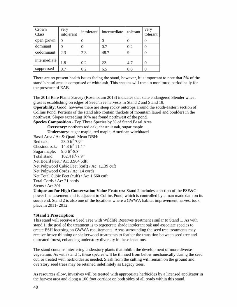
40
There are no present health issues facing the stand, however, it is important to note that 5% of the
stand’s basal area is comprised of white ash. This species will remain monitored periodically for
the presence of EAB.
The 2013 Rare Plants Survey (Rosenbaum 2013) indicates that state endangered Slender wheat
grass is establishing on edges of Seed Tree harvests in Stand 2 and Stand 18.
Operability: Good; however there are steep rocky outcrops around the south-eastern section of
Collins Pond. Portions of the stand also contain thickets of mountain laurel and boulders in the
northwest. Slopes exceeding 10% are found northwest of the pond.
Species Composition - Top Three Species by % of Stand Basal Area
Overstory: northern red oak, chestnut oak, sugar maple
Understory: sugar maple, red maple, American witchhazel
Basal Area / Ac & Quad. Mean DBH:
Red oak: 23.0 ft2-7.9”
Chestnut oak: 14.3 ft2-11.4”
Sugar maple: 9.6 ft2-8.8”
Total stand: 102.4 ft2-7.9”
Net Board Feet / Ac: 3,964 bdft
Net Pulpwood Cubic Feet (cuft) / Ac: 1,139 cuft
Net Pulpwood Cords / Ac: 14 cords
Net Total Cubic Feet (cuft) / Ac: 1,660 cuft
Total Cords / Ac: 21 cords
Stems / Ac: 301
Unique and/or High Conservation Value Features: Stand 2 includes a section of the PSE&G
power line easement and is adjacent to Collins Pond, which is controlled by a man made dam on its
south end. Stand 2 is also one of the locations where a GWWA habitat improvement harvest took
place in 2011- 2012.
*Stand 2 Prescription:
This stand will receive a Seed Tree with Wildlife Reserves treatment similar to Stand 1. As with
stand 1, the goal of the treatment is to regenerate shade intolerant oak and associate species to
create ESH focusing on GWWA requirements. Areas surrounding the seed tree treatments may
receive heavy thinning or shelterwood treatments to feather the transition between seed tree and
untreated forest, enhancing understory diversity in these locations.
The stand contains interfering understory plants that inhibit the development of more diverse
vegetation. As with stand 1, these species will be thinned from below mechanically during the seed
cut, or treated with herbicides as needed. Slash from the cutting will remain on the ground and
overstory seed trees may be retained indefinitely as Legacy trees.
As resources allow, invasives will be treated with appropriate herbicides by a licensed applicator in
the harvest area and along a 100 foot corridor on both sides of all roads within this stand.
Crown
Class very
intolerant intolerant intermediate tolerant
very
tolerant
open grown 0 0 0 0 0
dominant 0 0 0.7 0.2 0
codominant 2.3 2.3 48.7 9 0
intermediate 1.8 0.2 22 4.7 0
suppressed 0.7 0.2 6.5 0.8 0
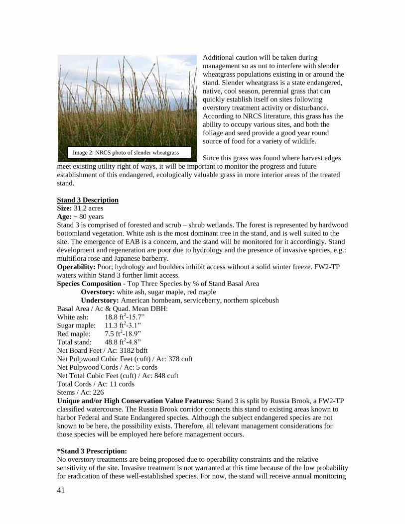
41
Additional caution will be taken during
management so as not to interfere with slender
wheatgrass populations existing in or around the
stand. Slender wheatgrass is a state endangered,
native, cool season, perennial grass that can
quickly establish itself on sites following
overstory treatment activity or disturbance.
According to NRCS literature, this grass has the
ability to occupy various sites, and both the
foliage and seed provide a good year round
source of food for a variety of wildlife.
Since this grass was found where harvest edges
meet existing utility right of ways, it will be important to monitor the progress and future
establishment of this endangered, ecologically valuable grass in more interior areas of the treated
stand.
Stand 3 Description
Size: 31.2 acres
Age: ~ 80 years
Stand 3 is comprised of forested and scrub – shrub wetlands. The forest is represented by hardwood
bottomland vegetation. White ash is the most dominant tree in the stand, and is well suited to the
site. The emergence of EAB is a concern, and the stand will be monitored for it accordingly. Stand
development and regeneration are poor due to hydrology and the presence of invasive species, e.g.:
multiflora rose and Japanese barberry.
Operability: Poor; hydrology and boulders inhibit access without a solid winter freeze. FW2-TP
waters within Stand 3 further limit access.
Species Composition - Top Three Species by % of Stand Basal Area
Overstory: white ash, sugar maple, red maple
Understory: American hornbeam, serviceberry, northern spicebush
Basal Area / Ac & Quad. Mean DBH:
White ash: 18.8 ft2-15.7”
Sugar maple: 11.3 ft2-3.1”
Red maple: 7.5 ft2-18.9”
Total stand: 48.8 ft2-4.8”
Net Board Feet / Ac: 3182 bdft
Net Pulpwood Cubic Feet (cuft) / Ac: 378 cuft
Net Pulpwood Cords / Ac: 5 cords
Net Total Cubic Feet (cuft) / Ac: 848 cuft
Total Cords / Ac: 11 cords
Stems / Ac: 226
Unique and/or High Conservation Value Features: Stand 3 is split by Russia Brook, a FW2-TP
classified watercourse. The Russia Brook corridor connects this stand to existing areas known to
harbor Federal and State Endangered species. Although the subject endangered species are not
known to be here, the possibility exists. Therefore, all relevant management considerations for
those species will be employed here before management occurs.
*Stand 3 Prescription:
No overstory treatments are being proposed due to operability constraints and the relative
sensitivity of the site. Invasive treatment is not warranted at this time because of the low probability
for eradication of these well-established species. For now, the stand will receive annual monitoring
Image 2: NRCS photo of slender wheatgrass
42
for EAB. Invasive understory treatments may become warranted if EAB affects the stand, as the
subsequent ash mortality exacerbates their proliferation.
Stand 4 Description
Size: 49.4 acres
Age: ~ 80 years
Stand 4 includes a transition area between upland hardwoods and cove bottomland species found
along the riparian corridor of the creek flowing south from the Bog to Ryker Lake. It contains the
SMWMA’s most significant areas of hydrology. Beaver dams and dens can be found throughout
the wetland corridor, and have affected pockets of trees that are unable to tolerate the wet
conditions in newly inundated areas. There are a few natural eskers within the wetland where the
overstory vegetation flourishes. The rocky steep edges in the stand hold a few groves of American
beech with minor signs of scale insect and Beech Bark Disease. Some of the Beech regeneration
from root sprouts is undoubtedly a response to the disease.
Operability: Poor; wet areas, SMZ’s, boulders and highly erodible soils limit the access potential
to this stand.
Species Composition - Top Three Species by % of Stand Basal Area
Overstory: sugar maple, chestnut oak, northern red oak
Understory: American beech, serviceberry, sweet birch
Basal Area / Ac & Quad. Mean DBH:
sugar maple: 20.0 ft2-12.7”
chestnut oak: 15.0 ft2-16.4”
red oak: 12.5 ft2-10.6”
total stand: 85.0 ft2-9.9”
Net Board Feet / Ac: 3920 bdft
Net Pulpwood Cubic Feet (cuft) / Ac: 972 cuft
Net Pulpwood Cords / Ac: 12 cords
Net Total Cubic Feet (cuft) / Ac: 1492 cuft
Total Cords / Ac: 19 cords
Stems / Ac: 158
Unique and/or High Conservation Value Features: Stand 4 is bound in the east by the 319 acre
Sparta Mountain Preserve owned by NJA. The wetlands of Stand 4 are known to contain rare
species. The stream that divides the stand is the headwaters for Russia Brook, and is classified as an
FW2-TP watercourse. The stand also contains a substantial component of trees with exfoliating
bark, such as red maple and shagbark hickory. These species, coupled with an abundant insect food
source along the riparian corridor, may provide good roosting and foraging habitat for the Indiana
bat and northern long-eared bat.
*Stand 4 Prescription:
Due to site conditions as well as species composition, this stand will contribute to the percentage of
SMWMA acreage dedicated towards developing at least 10% of the property into an old growth
stage of forest succession; balancing the 10% of the property (maximum) proposed to be managed
in early successional stages at all times. It will remain integral that this stand receives regular
monitoring throughout the term of this plan as to ensure its continued health and transition towards
old growth.
The development of large diameter trees in a riparian corridor will enhance mature forest attributes
and provide for the habitat needs of old growth obligates like Barred Owl, Cerulean Warbler and
Northern Goshawk. Within the slotted treatment year, this stand will undergo a comprehensive FSC
compliant Forest Health Checklist prepared by NJA; including among other things, sections on
insects, disease, vigor, regeneration, stocking, riparian zones, roads, trails, and wildlife. The
American beech component of this stand will require ongoing monitoring for evaluation of beech

43
bark disease, and those affected by the disease could be harvested and removed to help slow the
spread of the disease. Stumps will be immediately treated with an appropriate herbicide to kill the
susceptible root stock.
The modeled tables below depict the shift towards shade tolerant old growth stand structure
characteristics between 2012 and 2063. The numerical values assigned reference species basal area.
It would be expected that a more rapid basal area increase in shade tolerant species in comparison
to shade intolerants, as well as recruitment of additional shade tolerant species exceeding the 2”
DBH overstory threshold, will be observed in 2063.
Table 6. 2013 basal area vs. shade tolerance in Stand 4
species very
intolerant intolerant intermediate tolerant
very
tolerant sugar maple 0 0 0 20 0 chestnut oak 0 0 15 0 0 northern red
oak 0 0 12.5 0 0 sweet birch 0 0 7.5 0 0 American
beech 0 0 0 7.5 0 scarlet oak 0 5 0 0 0
red maple 0 0 5 0 0 hophornbeam 0 0 0 5 0 mockernut
hickory 0 0 2.5 0 0
white ash 0 0 2.5 0 0 shagbark
hickory 0 0 2.5 0 0
Table 7. 2063 basal area vs. shade tolerance in Stand 4
species very
intolerant intolerant intermediate tolerant
very
tolerant sugar maple 0 0 0 23.2 0 chestnut oak 0 0 18.39 0 0 northern red
oak 0 0 16.62 0 0 sweet birch 0 0 10.26 0 0 American
beech 0 0 0 10.04 0 hophornbeam 0 0 0 8.25 0
scarlet oak 0 5.71 0 0 0 red maple 0 0 5.2 0 0
white ash 0 0 4.05 0 0 mockernut
hickory 0 0 2.9 0 0 shagbark
hickory 0 0 2.34 0 0
American 0 0 0.96 0 0

44
witch hazel
pignut
hickory 0.5 0 0 0 0 highbush
blueberry 0 0 0 0.27 0 serviceberry 0 0 0 0 0
Stand 5 Description
Size: 16.9 acres
Age: ~ 65 years
Stand 5 is fully stocked with a northern hardwood mixture of species that are generally shade
tolerant and well suited to be positioned on the northwest facing aspect of a 1,355 foot mountain.
By the end of this plan’s 10 year term, the stand will be considered overstocked with a basal area of
roughly 125 ft2. White ash occupies a significant proportion of the basal area, and will be
monitored for future EAB outbreaks. Although not typically inventoried as a tree, American
witchhazel has reached significant size here, and accounts for over 7% of the basal area. While it
has limited value for a broad range of wildlife species, witchhazel serves an important ecological
function for several insects, including certain migrating moths and butterflies.
Currently, the stand also has a healthy herbaceous layer and is mostly devoid of invasive species.
However, the quantity of witchhazel, coupled with hayscented fern covering 13% of the ground,
may begin to compete excessively and inhibit other plant development at some point - even those
species considered somewhat shade tolerant.
Table 8. Understory Species Occurrence and Abundance Live Stems Only Stand 5 SMWMA
Table 9. Ground Species Occurrence and Abundance Live Stems Only Stand 5 SMWMA
Species Density Rel
Density Frequency
Rel
Frequency Percent
cover
Rel
Percent
cover
Importance
Value
northern
spicebush 1400 37.33 50 11.11 20 25 24.48 highbush
blueberry 500 13.33 50 11.11 15 18.75 14.4
American
witch hazel 400 10.67 50 11.11 15 18.75 13.51
huckleberry 450 12 50 11.11 5 6.25 9.79
serviceberry 250 6.67 50 11.11 5 6.25 8.01
sugar maple 100 2.67 50 11.11 5 6.25 6.68
yellow and
sweet birch 50 1.33 50 11.11 2.5 3.13 5.19
Species Density Rel
Density Frequency
Rel
Frequency Percent
cover
Rel
Percent
cover
Importance
Value

45
Operability: Good, mostly limited by primary road frontage. Although the stand has steep
sections, the soils are not very vulnerable to erosion and degradation due to the high rock content.
There is a network of former mining trails that have been converted to ATV trails and being used
illegally. These trails stem from the Lake Stockholm community in the north.
Species Composition - Top Three Species by % of Stand Basal Area (plus witchhazel)
Overstory: yellow birch & sugar maple, white ash, American witchhazel
Understory: red maple, sugar maple, serviceberry
Basal Area / Ac & Quad. Mean DBH:
yellow birch: 22.5 ft2-12.9”
sugar maple: 22.5 ft2-14.8”
white ash: 15.0 ft2-20.0”
witchhazel: 7.5 ft2-3.0”
total stand: 97.5 ft2-4.9”
Net Board Feet / Ac: 3344 bdft
Net Pulpwood Cubic Feet (cuft) / Ac: 662 cuft
Net Pulpwood Cords / Ac: 8 cords
Net Total Cubic Feet (cuft) / Ac: 1106 cuft
Total Cords / Ac: 14 cords
Stems / Ac: 741
Unique and/or High Conservation Value Features: None
*Stand 5 Prescription: None, management of this stand will be deferred to a later period.
Stand 6 Description
Size: 31.1 acres
Age: ~ 60 years
Canada
mayflower 9000.00 43.48 100.00 8.33 10.00 13.33 21.71
Hay-scented
fern 2000.00 9.66 100.00 8.33 10.00 13.33 10.44
Pennsylvania
sedge 3000.00 14.49 100.00 8.33 5.00 6.67 9.83
Japanese
barberry 1000.00 4.83 100.00 8.33 10.00 13.33 8.83
violet 1500.00 7.25 100.00 8.33 5.00 6.67 7.42
partridgeberry 1000.00 4.83 100.00 8.33 5.00 6.67 6.61
cinnamon fern 1000.00 4.83 100.00 8.33 5.00 6.67 6.61
skunk cabbage 500.00 2.42 100.00 8.33 5.00 6.67 5.81
royal fern 500.00 2.42 100.00 8.33 5.00 6.67 5.81
common
goldstar 500.00 2.42 100.00 8.33 5.00 6.67 5.81
aster 400.00 1.93 100.00 8.33 5.00 6.67 5.64
Jack in the
pulpit 300.00 1.45 100.00 8.33 5.00 6.67 5.48

46
Stand 6 has many representative characteristics of an overstocked oak-hickory upland forest stand.
While the present species composition is well suited for the site and a southeastern aspect, live
crown ratio is low, and little light reaches the forest floor – limiting understory diversity and
development. With the exception of Pennsylvania sedge and wild sarsaparilla, herbaceous layer
biodiversity is moderate. The stand is slowly reverting to shade tolerant species as indicative in
reports modeled by NED for 2022 where the hickory component is projected to be outcompeted by
sugar maple.
Operability: Good, but also limited by primary road frontage. Although the stand has steep areas,
the soils are rocky and stable. There is also a network of existing mining trails that are illegally
being used as ATV trails.
Species Composition - Top Three Species by % of Stand Basal Area
Overstory: northern red oak, scarlet oak, pignut hickory
Understory: sugar maple, white oak, serviceberry
Basal Area / Ac & Quad. Mean DBH:
red oak: 30.0 ft2-12.8”
scarlet oak: 30.0 ft2-9.2”
pignut hick: 15.0 ft2-8.0”
total stand: 120.0 ft2-7.4”
Net Board Feet / Ac: 3734 bdft
Net Pulpwood Cubic Feet (cuft) / Ac: 1329 cuft
Net Pulpwood Cords / Ac: 17 cords
Net Total Cubic Feet (cuft) / Ac: 1823 cuft
Total Cords / Ac: 23 cords
Stems / Ac: 397
Unique and/or High Conservation Value Features: None
*Stand 6 Prescription: None, management of this stand will be deferred to a later period.
Stand 7 Description
Size: 182.0 acres
Age: ~ 75 years
Stand 7 is contained on a hilltop at an elevation from 1,300 to 1,382 feet above sea level. It is an
upland site, composed of mostly oak and hickory species. Presently, it is overstocked by nearly 20
square feet of basal area. Most of the overstory has complete canopy closure, with live crown ratios
of 30% or less. There is minimal advance regeneration over 1” DBH, and smaller trees found
regenerating are moderately shade tolerant species including red maple, sugar maple and birch.
Over 60% of the stand’s ground cover is Pennsylvania sedge. NED modeling predicts that in less
than 10 years, red maple basal area will exceed that of mockernut hickory, making it the third most
dominant species in the stand.
Operability: Good. Even though the stand has portions which are steep, may slopes are less than
10% and soils are not highly erodible. There is a drivable road extending west from Rock Lodge
Road that passes through the stand. The initial quarter mile of road is bound to the south by the
Passaic River Coalition before crossing entirely onto the SMWMA. There are portions of the
eastern facing aspect that will be inoperable due to steepness, as well as wetlands in the north. It is
expected that less than 20% of the stand is inoperable.
Species Composition - Top Three Species by % of Stand Basal Area
Overstory: northern red oak, sugar maple, mockernut hickory
Understory: American witchhazel, hophornbeam, sugar maple
Basal Area / Ac & Quad. Mean DBH:
red oak: 25.0 ft2-13.9”
sugar maple: 15.0 ft2-7.3”
mockernut: 13.5 ft2-7.3”

47
total stand: 122.5 ft2-8.5”
Net Board Feet / Ac: 3930 bdft
Net Pulpwood Cubic Feet (cuft) / Ac: 1467 cuft
Net Pulpwood Cords / Ac: 18 cords
Net Total Cubic Feet (cuft) / Ac: 2019 cuft
Total Cords / Ac: 25 cords
Stems / Ac: 312
Unique and/or High Conservation Value Features: Stand 7 contains the headwaters for Ryker
Lake and into Russia Brook. On the west facing aspect of the northern most hill there is an old
home site with a dried up well, potential remnants of past mining workers. These sites will be
identified ahead of any management to determine their historical significance (if any), and
protected from disturbance during management activities as needed.
*Stand 7 Prescription:
This stand will receive a seed tree system with wildlife reserves treatment that will be similar to the
recommendations provided for stands 1 & 2. Stand 7 and 8 are adjacent to one another and share
the same prescription. Because of that, they may receive a simultaneous treatment at some point.
The treatment will be applied near to the PSE&G power line easement that runs east to west or
close to the NJA property where other similar management is occurring.
Below are a series of SVS images. The first depicts current conditions in 2013. The next image
shows conditions immediately following the 2021 Seed Tree treatment. The following two SVS
views offer a glimpse of conditions 20 and 40 years following the 2021 treatment.
2013 Stand Conditions Post Seed Tree Cut in 2021
Post Seed Tree Conditions 2041 Post Seed Tree Conditions 2061
Figure 8. Stand 7 Overstory Conditions Pre- and Post- Seed Tree Treatment
Stand 8 Description

48
Size: 205.3 acres
Age: ~ 70 years
Stand 8 is an oak-hickory stand that is about 15% overstocked for optimum tree growth based on
existing stem densities. More than 50% of the overstory volume is from oak; however, oak is only
the twelfth most common understory species found regenerating. The stand has over 500 American
witchhazel shrubs per acre, and similar to adjacent Stand 7, over 50% of the ground cover is
Pennsylvania sedge. There is a rapidly declining eastern hemlock component along the western
edge of the stand next to the large wetland owned by NJA. In the openings where hemlocks once
stood, there are many small pockets of more diverse vegetation comprised of woody seedlings,
asters, blackberry and jewelweed. The stand also has scattered pockets of American beech, which
show signs of beech bark disease.
Operability: Fair. While the stand contains a passable access road stemming from Rock Lodge,
maneuverability in the woods is challenged by rock outcrops, boulders and localized soil
hydrology. Operability is also restricted along the significant wetlands buffer within the western
edge of the stand.
Species Composition - Top Three Species by % of Stand Basal Area
Overstory: northern red oak, chestnut oak, sugar maple
Understory: American witchhazel, red maple, sugar maple
Basal Area / Ac & Quad. Mean DBH:
red oak: 22.1 ft2-14.8”
chestnut oak: 20.3 ft2-10.3”
sugar maple: 15.4 ft2-6.9”
total stand: 120.9 ft2-7.6”
Net Board Feet / Ac: 4357 bdft
Net Pulpwood Cubic Feet (cuft) / Ac: 1365 cuft
Net Pulpwood Cords / Ac: 17 cords
Net Total Cubic Feet (cuft) / Ac: 1964 cuft
Total Cords / Ac: 25 cords
Stems / Ac: 386
Unique and/or High Conservation Value Features: None
*Stand 8 Prescription:
This stand will receive a seed tree system with wildlife reserves treatment that will be similar to the
recommendations provided for stands 1, 2 & 7.
Stand 9 Description
Size: 207.5 acres
Age: ~ 70 years
Stand 9 is an oak-hickory stand type. It is fully stocked and experiencing many of the same, age
related - population density issues noted for the other stands previously described at SMWMA. The
understory is currently dominated by one to three foot red maple, with lesser amounts of sweet
birch and sugar maple also present. The stand has a patchy shrub layer, which in some areas is very
densely stocked with serviceberry and American witchhazel.
Stand 9 is the second most frequented portion of the SMWMA by recreationists due to the parking
lot for the Edison Monument and pond. There is an access road that splits off to the north-northeast
from Edison Road that receives heavy foot traffic and has been a pathway for increased amounts of
invasive species in this area. Japanese barberry, multiflora rose, Norway maple and other invasive
species are all found near the parking lot and trail corridors, but are less common and at much more
manageable levels with increasing distance from the parking lot. Generally these species are not
widespread throughout the stand. White ash represents six percent of the stand’s basal area, and is

49
therefore a lower concern for EAB outbreaks than in other stands.
Operability: Excellent. Caution will be taken around abandoned mining pits found near Edison
Road.
Species Composition - Top Three Species by % of Stand Basal Area
Overstory: northern red oak, sweet birch, scarlet oak
Understory: red maple, serviceberry, sweet birch
Basal Area / Ac & Quad. Mean DBH:
red oak: 35.4 ft2-14.2”
sweet birch: 9.2 ft2-6.1”
scarlet oak: 8.8 ft2-13.8”
total stand: 110.0 ft2-8.3”
Net Board Feet / Ac: 5190 bdft
Net Pulpwood Cubic Feet (cuft) / Ac: 1154 cuft
Net Pulpwood Cords / Ac: 14 cords
Net Total Cubic Feet (cuft) / Ac: 1863 cuft
Total Cords / Ac: 23 cords
Stems / Ac: 296
Unique and/or High Conservation Value Features: Edison Pond and Edison Monument
*Stand 9 Prescription:
This stand’s prescription will employ prescribed fire (as possible in accordance with applicable
burning policies) and shelterwood harvesting to promote understory development and regeneration
while maintaining an open oak forest type for a period of time. The northern portion of this stand is
directly adjacent to existing wetland habitat. Shelterwood treatments will begin outside of the
appropriate wetland buffer and progress south and westward towards the interior of the stand while
feathering into the untreated forest. As with the other treatments, overstory species besides oak will
be retained; especially those that contain significant amounts of exfoliating bark, such as shagbark
hickory, to provide roost habitat for bats. The first harvest in this shelterwood system should reduce
the stand’s overstory by approximately 50 percent of the current stocking. Priority will be given to
removing trees of lower crown positions leaving roughly 50 -100 trees per acre (TPA). This cut
will stimulate understory development while creating an open oak forest condition that will favor
certain wildlife species such as Red-headed woodpecker (RHWO) - which has been observed
successfully nesting nearby in 2013 & 2014.
If possible within a few years following the cut, prescribed fire will be used to kill young trees and
shrubs like red maple that are poorly adapted to fire in the understory. This will favor a cohort of
regeneration that may look different than in other unburned treatment areas, and provide an
opportunity to evaluate the effectiveness of prescribed burning as a tool for maintaining oak forest
types. The stand will be monitored and treated as needed over subsequent years for regeneration
response, browse pressure and invasive species. The usefulness of this treatment for RHWO
habitat, or as an underrepresented habitat type on the WMA may be extended with periodic burning
every few years. If repeated burning is not an option or is deemed ineffective, then future
management should emphasize the release of the regeneration that becomes established. The final
“Overstory Removal Cutting” (OSR) should not occur until after approximately 500 oak saplings
per acre, that are about five feet in height or greater, become established. It is possible that these
parameters may take more than ten years to develop.
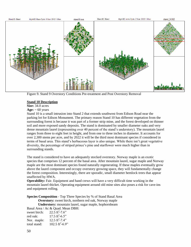
50
Figure 9. Stand 9 Overstory Conditions Pre-treatment and Post Overstory Removal
Stand 10 Description
Size: 34.0 acres
Age: ~ 60 years
Stand 10 is a small intrusion into Stand 2 that extends southwest from Edison Road near the
parking lot for Edison Monument. The primary reason Stand 10 has different vegetation from the
surrounding forest is because it was part of a former strip mine, and the forest developed on thinner
soil and more exposed sandy deposits. The stand is dominated by smaller diameter oaks and very
dense mountain laurel (representing over 40 percent of the stand’s understory). The mountain laurel
ranges from three to eight feet in height, and from one to three inches in diameter. It accounts for
over 2,300 stems per acre, and by 2022 it will be the third most dominant species if considered in
terms of basal area. This stand’s herbaceous layer is also unique. While there isn’t great vegetative
diversity, the percentage of striped prince’s pine and starflower were much higher than in
surrounding stands.
The stand is considered to have an adequately stocked overstory. Norway maple is an exotic
species that comprises 12 percent of the basal area. After mountain laurel, sugar maple and Norway
maple are the most dominant species found naturally regenerating. If these maples eventually grow
above the laurel component and occupy overstory growing space, they will fundamentally change
the forest composition. Interestingly, there are sporadic, small diameter hemlock trees that appear
unaffected by HWA.
Operability: Fair. Equipment and hand crews will have a very difficult time working in the
mountain laurel thicket. Operating equipment around old mine sites also poses a risk for cave-ins
and equipment rolling.
Species Composition - Top Three Species by % of Stand Basal Area
Overstory: sweet birch, northern red oak, Norway maple
Understory: mountain laurel, sugar maple, hophornbeam
Basal Area / Ac & Quad. Mean DBH:
sweet birch: 22.5 ft2-7.6”
red oak: 17.5 ft2-6.5”
Nor. maple: 12.5 ft2-7.4”
total stand: 102.5 ft2-6.9”
51
Net Board Feet / Ac: 1012 bdft
Net Pulpwood Cubic Feet (cuft) / Ac: 1063 cuft
Net Pulpwood Cords / Ac: 13 cords
Net Total Cubic Feet (cuft) / Ac: 1211 cuft
Total Cords / Ac: 15 cords
Stems / Ac: 397
Unique and/or High Conservation Value Features: Former mining area may hold some
historical artifacts.
*Stand 10 Prescription: None, management of this stand will be deferred to a later period.
Stand 11 Description
Size: 31.1 acres
Age: ~ 70 years
Stand 11 is adjacent to Collins Pond. It has high herbaceous species richness, probably due to its
complex of rocky ground intermixed with low areas of significant hydrology. The eastern bank of
the pond is rocky and steep and contains thickets of mountain laurel. The northern portion of the
stand is a rocky forested wetland that holds wetland obligates like sensitive fern and skunk
cabbage. These areas have relatively high concentrations of spicebush. On the drier ground closer
to the PSE&G power line easement the stand contains more witch hazel than spicebush. The stand
contains approximately 25 white ash stems per acre, which could significantly impact the stand
composition if they are affected by an EAB outbreak.
Operability: Very Poor. The western portion of this stand is very steep leading to Collin’s Pond.
The stand has large boulders throughout, and an ephemeral creek was observed flowing in a
wetland area in the north during the inventory in March. Collin’s Pond requires a buffer, and the
surrounding thickets of laurel make skidding and hand felling trees very challenging. There is a
network of forest trails and roads leading around the southern edge of the pond that then parallel its
western edge before tying back into the right of way on the north end of the pond.
Species Composition - Top Three Species by % of Stand Basal Area
Overstory: northern red oak, chestnut oak, white ash
Understory: mountain laurel, serviceberry, red maple
Basal Area / Ac & Quad. Mean DBH:
red oak: 32.1 ft2-11.9”
chestnut oak: 21.4 ft2-12.2”
white ash: 10.7 ft2-8.9”
total stand: 107.1 ft2-9.1”
Net Board Feet / Ac: 3641 bdft
Net Pulpwood Cubic Feet (cuft) / Ac: 1260 cuft
Net Pulpwood Cords / Ac: 16 cords
Net Total Cubic Feet (cuft) / Ac: 1766 cuft
Total Cords / Ac: 22 cords
Stems / Ac: 235
Unique and/or High Conservation Value Features: The stand partially surrounds Collin’s Pond
and has the PSE&G power line easement bisecting the pond itself.
*Stand 11 Prescription: None, management of this stand will be deferred to a later period.
Stand 12 Description
Size: 28.5 acres
Age: ~ 75 years
Stand 12 is an overstocked oak-hickory upland forest. Over 50 percent of the stand’s basal area is
comprised of well-formed northern red oak sawlogs with little to no apparent defect. While the

52
present species composition is well suited for the site, inventory observations depict low live crown
ratios with little light reaching the forest floor. There is minimal shade intolerant regeneration, and
in this case, oak regeneration is the ninth by relative abundance. This stand is also trending towards
an eventual species composition that is more shade tolerant, predominantly sugar maple. By 2022
sugar maple will make up 25 percent of the trees per acre. It is estimated that there are over 180
shagbark hickory trees per acre that average less than five inches in diameter. Although they are
currently too small to provide significant bat habitat now, they might be more significant in the
future if they are favored during forestry treatments.
Operability: Good. Stand 12 can be accessed by the PSE&G power line right of way.
Species Composition - Top Three Species by % of Stand Basal Area
Overstory: northern red oak, shagbark hickory, pignut hickory
Understory: sugar maple, American witchhazel, sweet birch
Basal Area / Ac & Quad. Mean DBH:
red oak: 69.0 ft2-12.4”
shagbark: 21.0 ft2-4.6”
pignut: 18 ft2-7.1”
total stand: 132.0 ft2-8.0”
Net Board Feet / Ac: 4504 bdft
Net Pulpwood Cubic Feet (cuft) / Ac: 1507 cuft
Net Pulpwood Cords / Ac: 19 cords
Net Total Cubic Feet (cuft) / Ac: 2154 cuft
Total Cords / Ac: 27 cords
Stems / Ac: 376
Unique and/or High Conservation Value Features: The stand is bound in the west by the
PSE&G power line right of way.
*Stand 12 Prescription: This stand will receive a seed tree system similar to stands 1, 2, 7 & 8.
Stand 13 Description
Size: 18.4 acres
Age: ~ 70 years
Stand 13 is non-contiguous portion of the SMWMA located southwest of Heaters Pond on the
western side of the tract. The stand is predominately oak – hickory with insignificant quantities of
sweet birch mixed in throughout. Beavers have flooded Heaters Pond in the south and wetlands are
subsequently encroaching into the northeastern corner of the stand. Flooding damage decreases
westward from Heaters Pond as the elevation increases. Although the stand is heavily stocked,
there are localized concentrations of oak regeneration throughout the stand.
Operability: Inoperable. There is no legal access to this stand. Hawthorn Lake Road turns into a
private road before crossing the stream south of Heaters Pond hence making the stand inaccessible.
Species Composition - Top Three Species by % of Stand Basal Area
Overstory: mockernut hickory, northern red oak, sweet birch
Understory: northern red oak, chestnut oak, sweet birch
Basal Area / Ac & Quad. Mean DBH:
mockernut: 40.0 ft2-6.1”
red oak: 20.0 ft2-3.7”
total stand: 60.0 ft2-4.8”
Net Board Feet / Ac: 362 bdft
Net Pulpwood Cubic Feet (cuft) / Ac: 575 cuft
Net Pulpwood Cords / Ac: 7 cords
Net Total Cubic Feet (cuft) / Ac: 627 cuft
Total Cords / Ac: 8 cords
Stems / Ac: 472.6
53
Unique and/or High Conservation Value Features: Expanding Heaters Pond in the northeast
corner of the stand.
*Stand 13 Prescription: None, management of this stand will be deferred until access has been
established.
Stand 14 Description
Size: 26.0 acres
Age: ~ 70 years
The stand is adequately stocked with a mixture of hardwoods. The site is a little more mesic than
some of the surrounding ridges, and species such as red maple and yellow birch seem to be doing
fairly well on the site. Sugar maple, sweet birch and American witchhazel dominate the majority of
the understory.
Operability: Good.
Species Composition - Top Three Species by % of Stand Basal Area
Overstory: northern red oak, chestnut oak, red maple
Understory: American witchhazel, sugar maple, sweet birch
Basal Area / Ac & Quad. Mean DBH:
red oak: 37.5 ft2-13.1”
sweet birch: 22.5 ft2-12.8”
red maple: 18.8 ft2-7.7”
total stand: 105.0 ft2-8.7”
Net Board Feet / Ac: 4814 bdft
Net Pulpwood Cubic Feet (cuft) / Ac: 1112 cuft
Net Pulpwood Cords / Ac: 14 cords
Net Total Cubic Feet (cuft) / Ac: 1784 cuft
Total Cords / Ac: 22 cords
Stems / Ac: 252
Unique and/or High Conservation Value Features: Stand 14 is split in half by the PSE&G
power line right of way.
*Stand 14 Prescription: None, management of this stand will be deferred to a later period.
Stand 15 Description
Size: 21.1 acres
Age: ~ 60 years
Stand 15 is similar to Stand 10 in that it was significantly altered during the former mining
operations. It also has thin soils and dense mountain laurel in spots. There are several dirt bike and
hiking trails in the stand; stemming from the old mining roads on the property. Compared to the
rest of SMWMA, Stand 15 has more invasive species; especially along the road and trails. The
overstory is dominated by oak and there is a significant amount of pole size eastern hemlock that
remains alive in the lower canopy strata. Red oak was observed regenerating along trails and near
gaps maintained by dirt bikers and ATV users. Currently there is an average of 260 northern red
oak seedlings per acre, most of which are between one and three feet in height.
Operability: Very Good. Caution will be taken around Edison Pond and the monument. As
always, equipment operators will be mindful of potential cave-in and settling around old mining
sites. The former mining road was improved to address erosion issues in 2012, making it drivable
to the JCP&L power line easement in the north. The matrix of pre-existing dirt bike/ATV trails will
be considered for skidding before new skid trails are established.
Species Composition - Top Three Species by % of Stand Basal Area
Overstory: chestnut oak, northern red oak, eastern hemlock
Understory: mountain laurel, American witchhazel, northern red oak

54
Basal Area / Ac & Quad. Mean DBH:
chestnut oak: 33.0 ft2-14.0”
red oak: 18.0 ft2-11.6”
hemlock: 12.0 ft2-8.6”
total stand: 102.0 ft2-8.9”
Net Board Feet / Ac: 4014 bdft
Net Pulpwood Cubic Feet (cuft) / Ac: 1148 cuft
Net Pulpwood Cords / Ac: 14 cords
Net Total Cubic Feet (cuft) / Ac: 1690 cuft
Total Cords / Ac: 21 cords
Stems / Ac: 239
Unique and/or High Conservation Value Features: None known, possible historical significance
from past mining operations.
*Stand 15 Prescription: None, management of this stand will be deferred to a later period.
Stand 16 Description
Size: 22.2 acres
Age: ~ 65 years
This small stand is situated on high ground between two large wetlands. The stand has a thick
component of mountain laurel beneath a mature, well-formed chestnut oak and red oak overstory.
The overstory is well stocked, and will approach the maximum optimum stocking capacity by
2022. The stand has an average of 366 chestnut oak seedlings per acre. Red maple encroachment
into this oak stand is less of an issue that elsewhere on the WMA.
Operability: Fair. The only access to the stand is from the recently improved road running through
Stand 18. Appropriate wetland buffers will need to be established prior to implementing
management here.
Species Composition - Top Three Species by % of Stand Basal Area
Overstory: chestnut oak, northern red oak, red maple
Understory: mountain laurel, chestnut oak, sweet birch
Basal Area / Ac & Quad. Mean DBH:
chestnut oak: 35.0 ft2-6.7”
red oak: 30.0 ft2-6.3”
red maple: 10.0 ft2-6.4”
total stand: 90.0 ft2-4.9”
Net Board Feet / Ac: 1352 bdft
Net Pulpwood Cubic Feet (cuft) / Ac: 886 cuft
Net Pulpwood Cords / Ac: 11 cords
Net Total Cubic Feet (cuft) / Ac: 1064 cuft
Total Cords / Ac: 13 cords
Stems / Ac: 688
Unique and/or High Conservation Value Features: The stand is surrounded in the south and
west by forested wetlands.
*Stand 16 Prescription: None, management of this stand will be deferred to a later period.
Stand 17 Description
Size: 9.7 acres
Age: ~ 55 years
Stand 17 is a small, fully stocked stand adjacent to wetlands in the east and west, with the PSE&G
power line easement cutting through it in the north. It contains a declining hemlock grove just south
of the easement. The stand contains a significant percentage of potential wetland species like red

55
maple and yellow birch in the overstory, with roughly 2,000 spicebush stems per acre in the
understory. American beech represents roughly 15 square feet of basal area per acre, mostly found
in intermittent groves. It is anticipated that the beech population will increase significantly over
time, and will reduce the stand’s bio-diversity in the long-term. There is 10 square feet of pole size
white ash which could be lost when EAB arrives.
Operability: Poor. Over 75 percent of the stand’s soils are Catden Mucky Peats, which are hydric
and very prone to rutting. The only access to the stand is from the JCP&L power line easement.
There were no existing trails or mining roads observed in the stand. Operability along the western
boundary will also be inhibited by wetland buffers.
Species Composition - Top Three Species by % of Stand Basal Area
Overstory: yellow birch, red maple, northern red oak
Understory: northern spicebush, yellow birch, red maple
Basal Area / Ac & Quad. Mean DBH:
yellow birch: 25.0 ft2-7.8”
red maple: 25.0 ft2-9.1”
red oak: 20.0 ft2-25.9”
total stand: 120.0 ft2-7.8”
Net Board Feet / Ac: 4070 bdft
Net Pulpwood Cubic Feet (cuft) / Ac: 1384 cuft
Net Pulpwood Cords / Ac: 17 cords
Net Total Cubic Feet (cuft) / Ac: 1909 cuft
Total Cords / Ac: 24 cords
Stems / Ac: 365
Unique and/or High Conservation Value Features: Stand 17 has the JCP&L power line
easement cutting through its northern most section and is bound in the west by an exceptional
resource value wetland.
*Stand 17 Prescription: None, management of this stand will be deferred to a later period.
Stand 18 Description
Size: 250.0 acres
Age: ~ 70 years
Stand 18 is a large oak-hickory site roughly split in half by the JCP&L power line easement. The
eastern half of the stand is adjacent to the large wetland that drains south into Ryker Lake. The
stand is fully stocked with 99 square feet of basal area per acre; 60% of which is derived from red,
chestnut, scarlet, white and black oaks. Figure 8 represents a view of a one acre representative
block of the stand as well as DBH and height vs. number of trees graphs.

56
Figure 10: Stand 18 Present Overstory Conditions
Red maple is the third most abundant species (by basal area and trees per acre), and is twice as
numerous as hickory in terms of stems per acre. By 2022, witchhazel and serviceberry are projected
to occupy roughly 10 square feet of growing space per acre.
Throughout the stand are pockets of co-dominant white ash that may be susceptible to EAB
outbreaks. The “edge effect” occurring on the south side of the easement has increased the number
of early successional species in these areas. Sassafras and gray birch are found in the overstory
along this corridor, as well as aster and goldenrod in the herbaceous layer.
Operability: Very Good. This upland site is accessible from the improved road that splits north
northeast from Edison Road. There are several spur trails coming from this road into the stand.
Species Composition - Top Three Species by % of Stand Basal Area
Overstory: northern red oak, chestnut oak, red maple
Understory: serviceberry, northern red oak, red maple
Basal Area / Ac & Quad. Mean DBH:
red oak: 31.6 ft2-7.4”
chestnut oak: 13.7 ft2-8.4”
red maple: 10.5 ft2-8.1”
total stand: 99.3 ft2-7.4”
Net Board Feet / Ac: 2489 bdft
Net Pulpwood Cubic Feet (cuft) / Ac: 1175 cuft
Net Pulpwood Cords / Ac: 15 cords
Net Total Cubic Feet (cuft) / Ac: 1517 cuft
Total Cords / Ac: 19 cords
Stems / Ac: 336
Unique and/or High Conservation Value Features: The eastern portion of the southern half of
this stand is bound by an exceptional resource value wetland.
*Stand 18 Prescription:
This stand will receive a seed tree system with wildlife reserves treatment similar to what was

57
prescribed for earlier stands. As with Stand 2, awareness of the location of slender wheatgrass
populations will help to inform management decisions.
Stand 19 Description
Size: 14.8 acres
Age: ~ 55 years
Stand 19 is a young Allegheny hardwood mixture that contains a variety of upland species
including white ash, cherry, birch and beech. The stand is split in half by the JCP&L easement. The
north-west portion of the stand contains hydric pockets where concentrations of wetland plant
communities occur. Mountain laurel is locally dense in places, and there is little to no tree
regeneration with the exception of small amounts of sweet birch.
Operability: Inoperable. Rocky outcrops, boulders and wetlands make this stand inoperable with
heavy equipment.
Species Composition - Top Three Species by % of Stand Basal Area
Overstory: chestnut oak, northern red oak, white ash
Understory: northern red oak, American beech, red maple
Basal Area / Ac & Quad. Mean DBH:
chestnut oak: 45.0 ft2-10.5”
red oak: 18.8 ft2-4.6”
white ash: 11.3 ft2-5.8”
total stand: 105.0 ft2-6.9”
Net Board Feet / Ac: 1932 bdft
Net Pulpwood Cubic Feet (cuft) / Ac: 1131 cuft
Net Pulpwood Cords / Ac: 14 cords
Net Total Cubic Feet (cuft) / Ac: 1389 cuft
Total Cords / Ac: 17 cords
Stems / Ac: 405
Unique and/or High Conservation Value Features: The stand is split by the JCP&L easement
and is bound in the south by the SMWMA’s exceptional resource value wetland.
*Stand 19 Prescription: None, management of this stand will be deferred to a later period.
Stand 20 Description
Size: 29.6 acres
Age: ~ 50 years
This is a small, well stocked, pole size stand that is just over 400 feet across at its widest point. It is
predominantly composed of sweet birch, with some scattered larger diameter red oak. Occasional
groves of beech are intermittent throughout the stand also. It is situated to the west of private
property surrounding Lake Acquackanonk in the southern end of the WMA. A small stream makes
up the stand’s western boundary.
Operability: Fair. Access to the stand is from the north via Stands 2 & 9 near Edison Road.
Careful attention to the application of BMP’s are required to ensure that erosion control measures
minimize sedimentation into tributaries of Fox Trail Lake.
Species Composition - Top Three Species by % of Stand Basal Area
Overstory: sweet birch, northern red oak, red maple
Understory: northern red oak, red maple, sweet birch
Basal Area / Ac & Quad. Mean DBH:
sweet birch: 27.0 ft2-5.5”
red oak: 21.0 ft2-15.8”
red maple: 21.0 ft2-5.3”
total stand: 111.0 ft2-6.9”
Net Board Feet / Ac: 2809 bdft
58
Net Pulpwood Cubic Feet (cuft) / Ac: 1141 cuft
Net Pulpwood Cords / Ac: 14 cords
Net Total Cubic Feet (cuft) / Ac: 1531 cuft
Total Cords / Ac: 19 cords
Stems / Ac: 428
Unique and/or High Conservation Value Features: None
*Stand 20 Prescription: None, management of this stand will be deferred to a later period.
Stand 21 Description
Size: 129.3 acres
Age: 70 years
Stand 21 is a heavily stocked mixed hardwood stand that contains roughly 120 square feet of basal
area. It includes large areas of forested wetlands. Red oak represents 12 percent of the stand’s
overall basal area, and is largely confined within the northwest facing slope on the eastern side of
the stand. The stand contains a substantial component of shade tolerant species. Table 5 depicts the
stand’s shrub density in percent cover. Most of this stand’s tree regeneration is between one and
three feet tall and there are no significant signs of deer browse, which might otherwise account for
the limited seedling height. White ash is only a small component of the stand, so concerns
regarding the effects of EAB in this stand should be limited. The stand contains shagbark hickory
that average 13 inches DBH, and will be favored when possible for bat habitat.
Operability: Fair. The stand can be accessed directly from Edison Road, or via the 2012 improved
road in Stand 18. Since the stand contains significant acreage that is forested wetlands, equipment
will be limited to times of the year when the ground is firm and well drained, if not frozen.
Corduroy and other applicable BMPs will be used as needed depending on localized site
conditions.
Table 10: Shrub Layer Density of Stand 21
Species Composition - Top Three Species by % of
Stand Basal Area
Overstory: sugar maple, sweet birch,
northern red oak
Understory: American witchhazel, sweet
birch, northern red oak
Basal Areas / Ac & Quad. Mean DBH:
sugar maple: 23.2 ft2-7.0”
sweet birch: 18.4 ft2-7.2”
red oak: 15.0 ft2-7.3”
total stand: 119.3 ft2-7.2”
Net Board Feet / Ac: 3771 bdft
Net Pulpwood Cubic Feet (cuft) / Ac: 1282 cuft
Net Pulpwood Cords / Ac: 16 cords
Net Total Cubic Feet (cuft) / Ac: 1810 cuft
Total Cords / Ac: 23 cords
Stems / Ac: 419
Unique and/or High Conservation Value Features:
None
*Stand 21 Prescription:
This stand will be treated with an uneven aged
Species
Shrub <10'
Percent
Cover
Shrub
>10'
Percent
Cover
witchhazel 24.72 33.33
sweet birch 19.1 10.34
chestnut oak 5.62 2.3
red oak 1.12 11.49
spicebush 24.72 0
sugar maple 3.37 5.75
hophornbeam 6.74 6.9
A. hornbeam 6.74 4.6
red maple 0 8.05
serviceberry 2.25 0 mountain
laurel 1.12 0
white ash 0 2.3
Totals: 95.5 85.06

59
management approach known as Single-tree Selection with Wildlife Reserves. The management
objective is to accelerate old growth attributes within a forest type that is better suited to developing
a climax forest. This system mimics the natural regeneration processes of an old-growth forest
through a concept known as “gap-phase replacement”. Gap-phase replacement means that the small
canopy gaps created via the death (natural or anthropogenic) of individual or small groups of trees
provide opportunities to release preexisting shade tolerant trees, or to stimulate some new shade
tolerant regeneration. The proposed treatment of this stand is aimed at maintaining its ecological
integrity; specifically the shade tolerant and potentially moisture sensitive species composition.
Uneven-aged management entails the continual recruitment of new cohorts of trees into the stand,
eventually having three or more age classes existing at any given time. Proper implementation
requires removal of trees from all size classes to avoid skewing the residual tree distribution into a
singular stand structure. Trees targeted for removal are those declining in health, or those unlikely
to persist under the site conditions that are perpetuated under a climax forest ecosystem. The small
openings also present opportunities for moisture sensitive herbaceous plants to benefit from
additional, but moderate amounts of light that are often associated with increased flowering and
seed production. In short, this system enhances stand complexity while buffering the short-term,
but extreme, changes to the site conditions experienced under some other silvicultural and natural
disturbances. Proactively manipulating the stand, rather than waiting for natural mortality to occur,
helps to increase the forest’s resilience to the sometimes more severe impacts resulting from natural
causes (e.g. severe storm events or widespread pathogen outbreaks).
Stand 21 Before Treatment Stand 21 Post Single Tree Selection Treatment
Figure 9. Stand 21 Overstory Conditions Pre- and Post-treatment
To improve herbaceous layer conditions on the forest floor, the treatment should mechanically
reduce dense monoculture shrub pockets from 95.5% percent to approximately 70%. The stand also
contains clumps of hay-scented fern which makes up over 11% percent of the stand’s forest floor.
Within the treatment area, as funding allows, it is recommended that large expanses of hay-scented
fern are reduced using foliar applications of glyphosate to enhance the opportunities for other
herbaceous plants to flourish in their place. Table 6 depicts common plant densities within the
herbaceous layer. The table is quite representative of the herbaceous layer found growing under
other similar shade tolerant overstory stands in SMWMA.
Table 11: Ground Cover Species Occurrence and Abundance Stand 21
Species Density Rel Density Frequency Rel
Frequency
Percent
cover
Rel Percent
cover
Importance
Value
Pennsylvania sedge 2285.71 41.03 71.43 15.15 13.57 27.94 28.04
hay-scented fern 1000 17.95 14.29 3.03 11.43 23.53 14.84
Canada mayflower 628.57 11.28 28.57 6.06 1.43 2.94 6.76
60
deer tongue 257.14 4.62 42.86 9.09 2.14 4.41 6.04
wild sarsaparilla 128.57 2.31 42.86 9.09 2.14 4.41 5.27
manna grass 242.86 4.36 28.57 6.06 2.14 4.41 4.94
Virginia creeper 114.29 2.05 28.57 6.06 2.14 4.41 4.17
Virginia strawberry 214.29 3.85 14.29 3.03 1.43 2.94 3.27
feathery false lily
of the valley 42.86 0.77 28.57 6.06 1.43 2.94 3.26
common gold star 42.86 0.77 28.57 6.06 1.43 2.94 3.26
unidentified plant 185.71 3.33 14.29 3.03 1.43 2.94 3.1
aster 114.29 2.05 14.29 3.03 1.43 2.94 2.67
cinnamon fern 42.86 0.77 14.29 3.03 1.43 2.94 2.25
wild yam 71.43 1.28 14.29 3.03 0.71 1.47 1.93
Jack in the pulpit 71.43 1.28 14.29 3.03 0.71 1.47 1.93
violet 28.57 0.51 14.29 3.03 0.71 1.47 1.67
spotted geranium 28.57 0.51 14.29 3.03 0.71 1.47 1.67
sensitive fern 28.57 0.51 14.29 3.03 0.71 1.47 1.67
maple leaf
viburnum 28.57 0.51 14.29 3.03 0.71 1.47 1.67
striped prince's pine 14.29 0.26 14.29 3.03 0.71 1.47 1.59
Control of invasive plants will be initiated during post treatment monitoring under the same
parameters as described for earlier treatments.
Stand 22 Description
Size: 44.3 acres
Age: ~ 70 years
Stand 22 sits along the southwestern side of the east to west utility easement that bisects the WMA.
It is a mixed upland oak stand that has exceeded its optimum stocking by approximately five square
feet of basal area. Aside from oak, red maple is the next most common species occurring here. The
understory has approximately 3,000 stems per acre, mostly comprised of witch hazel, mountain
laurel and serviceberry. In locations where the shrub layer is less thick, oak and hickory
regeneration can be found up to four inches DBH - exceeding 10 feet in height. Six percent of the
basal area is comprised of HWA infested eastern hemlock. The stems that are less than 10 inches
DBH appear to be less affected, and many have LCR’s between 40 and 70 percent.
Operability: Good. It can be reached using an existing road that meets Edison Road approximately
0.4 miles north of the road improved in 2012.
Species Composition - Top Three Species by % of Stand Basal Area
Overstory: northern red oak, chestnut oak, red maple
Understory: serviceberry, mockernut hickory, northern red oak
Basal Areas / Ac & Quad. Mean DBH:
red oak: 21.8 ft2-9.3”
chestnut oak: 20.5 ft2-12.3”
red maple: 16.4 ft2-9.3”
total stand: 113.2 ft2-8.3”
Net Board Feet / Ac: 3495 bdft
Net Pulpwood Cubic Feet (cuft) / Ac: 1333 cuft
Net Pulpwood Cords / Ac: 17 cords
Net Total Cubic Feet (cuft) / Ac: 1822 cuft
Total Cords / Ac: 23 cords

61
Stems / Ac: 299
Unique and/or High Conservation Value Features: Stand 22 is bound by the JCP&L power line
easement in the north.
*Stand 22 Prescription:
This stand will receive a heavy thinning / modified shelterwood type cut as described for Stand 9.
The objective of the treatment is two-fold. Because of its close proximity to successful RHWO
breeding sites, some portions of the stand will be treated to enhance conditions for RHWO habitat.
In places where intermediate sized hemlocks appear to be minimally affected by HWA, a crown
thinning technique will be employed to release those trees so that they are free to grow. This
silvicultural technique has been pioneered through research conducted by Dr. Mary Ann Fajvan
with the USFS in Morgantown West Virginia. The purpose of the release cut is to concentrate
resources and improve vigor on stems that are not already over-taxed by HWA, thereby allowing
them to be more resistant to moderate insect feeding in the future as emerging biological controls
keep HWA at acceptable levels.
Stand 23WL – Wetlands
See “Hydrology” section of the Forest Stewardship Plan
*Stand 23WL Prescription:
At one time this site was largely an open emergent wetland, and it had been known to historically
harbor Bog turtles. Over time, much of it has succeeded into a young red maple/alder swamp,
which is not optimal open habitat required for bog turtles. Bog turtles spend substantial periods of
their life basking in the sun, and like all reptiles, their ability to thermo-regulate internal body
temperature is essential for controlling various metabolic processes. Additionally, shaded wetlands
also inhibit warmer temperatures required for egg incubation. In order to restore suitable Bog turtle
habitat, it is recommended that small openings of roughly 0.5 acres in size are created in the dense
vegetation along the bank of open waters. This will mimic NJA activities on their adjacent part of
this same wetland. Progressing slowly through the stand during the entire management period will
minimize any drastic site alterations that might affect other important species. As funding allows,
one half acre may be treated annually, commencing in the north and progressing southward in
subsequent years.
Stand 24 Description
Size: 43.0 acres
Age: ~ 70 years
Stand 24 was a heavily stocked, mixed hardwood - hemlock stand up until about 2003. HWA has
since devastated the eastern hemlock component, which now only makes up 12 percent of the
stand’s basal area. Most of the remaining hemlock that is over 10 inches DBH shows symptoms of
HWA decline, often having LCR’s of less than 10 percent. Hemlock and oak seedlings have
regenerated in the gaps resulting from the loss of this species at a rate of over 200 and 150 stems
per acre respectively. Current overstory stocking is 246 stems per acre within 100 sq. ft. of basal
area per acre. The optimum residual basal area to promote the release and continued growth of the
stand is roughly 80 square feet.
It is also important to note that the stream flowing south from Heaters Pond has active beaver dams,
and the suite of species in this part of the forest are not well suited to inundation as the area floods.
Operability: Good. The stand can be accessed directly from Edison Road. The public section of
Hawthorne Lake Road also cuts directly into Stand 24 and acts as the stand’s southeastern
boundary.
Species Composition - Top Three Species by % of Stand Basal Area
Overstory: northern red oak, sugar maple, eastern hemlock
62
Understory: eastern hemlock, American witchhazel, sugar maple
Basal Area / Ac & Quad. Mean DBH:
red oak: 22.5 ft2-11.4”
sugar maple: 17.5 ft2-11.8”
hemlock: 12.5 ft2-6.4”
total stand: 102.5 ft2-8.7”
Net Board Feet / Ac: 3304 bdft
Net Pulpwood Cubic Feet (cuft) / Ac: 1120 cuft
Net Pulpwood Cords / Ac: 14 cords
Net Total Cubic Feet (cuft) / Ac: 1589 cuft
Total Cords / Ac: 20 cords
Stems / Ac: 246
Unique and/or High Conservation Value Features: Stand 24 is less than 100 feet from Heaters
Pond.
*Stand 24 Prescription: None, management of this stand will be deferred to a later period.
Stand 25 Description
Size: 74.0 acres
Age: ~ 65 years
Stand 25 is similar to Stand 24 in that it has lost significant quantities of eastern hemlock due to
HWA. The major difference is that the stand contains significantly higher concentrations of shade
intolerant species (overstory and understory regeneration). Besides hemlock, the overstory is
comprised of chestnut oak, red oak, red maple, tulip tree and white oak (respectively by percentage
of basal area). The stand contains thickets of mountain laurel and a dense ground cover of
Pennsylvania sedge. Regeneration has been extremely limited in comparison to stand 24, probably
due to the unfavorable conditions for existing overstory species to germinate in.
The stand’s western boundary is a rocky ridge that overlooks the old New York – Susquehanna
Railroad as it passes through the town of Ogdensburg. An interesting note is that pitch pine is found
growing along this ridge top, providing what may be the only alternate conifer species to hemlock
in the immediate area.
Operability: Fair. Although a quarter mile section of Edison Road acts as the southern boundary of
this stand, there aren’t any well-established roads into the stand for access into the interior.
Species Composition - Top Three Species by % of Stand Basal Area
Overstory: chestnut oak, eastern hemlock, northern red oak
Understory: eastern hemlock, northern red oak, mountain laurel
Basal Area / Ac & Quad. Mean DBH:
chestnut oak: 31.9 ft2-12.0”
hemlock: 30.0 ft2-6.2”
red oak: 20.6 ft2-13.9”
total stand: 106.9 ft2-8.0”
Net Board Feet / Ac: 1901 bdft
Net Pulpwood Cubic Feet (cuft) / Ac: 1265 cuft
Net Pulpwood Cords / Ac: 16 cords
Net Total Cubic Feet (cuft) / Ac: 1522 cuft
Total Cords / Ac: 19 cords
Stems / Ac: 307
Unique and/or High Conservation Value Features: None
*Stand 25 Prescription:

63
The goal for this stand is to maintain a softwood component on the WMA as hemlock decline
continues. With only minimally successful strategies to mitigate the effects of HWA, the
introduction of a surrogate alternate softwood species may be the only solid short term option to
continue providing conifer habitat at SMWMA. In fact, historical accounts indicate that the region
held significant quantities of conifers other than hemlock prior to the widespread clearing of the
early 1900’s. White pine, black and red spruce, larch and pitch pine are among the former
softwoods known to exist in the region. In order to
enhance the softwood component, Stand 25 should
receive a series of hybrid uneven aged management
treatments that include both single-tree selection and
group selections. Using the group selection method in
areas that have been heavily impacted by HWA will
enhance conditions to better allow for inter-planted
softwood trees to grow well, since most are much less
shade tolerant than hemlock, and they require more
open conditions to do well. To treat the entire stand in
a timely fashion, roughly 60 acres should be
implemented annually over the course of five years. The harvest treatment should be coupled with
inter-planting of native softwoods such as White pine, Pitch pine, Red spruce, and possibly Red
cedar or even Atlantic white cedar if the site permits.
One problem with this treatment is that most native softwoods have drastically different silvic
characteristics than hemlock, and could do poorly on the same site, or might not serve the same
function. Some, like Red spruce (a state endangered plant species) and larch, have declined in the
region and are expected to do worse under future climate change scenarios. Although it is non-
native, Norway spruce has not normally been considered invasive, and it has some similar silvic
characteristics to hemlock. It may present the best option as a surrogate for hemlock. If a non-
native like Norway spruce is considered, it will be vetted through a stakeholder input process
before being used. The planted seedlings should be spaced roughly 7 to 8 feet apart from one
another, equating to a rate of approximately seven to nine hundred seedlings per acre. The dense
stocking regime will help to mimic natural conifer regeneration. As to further enhance
survivability, seedlings should be planted in the early spring just before native vegetation begins to
grow, on a day with a temperature between 35 and 60 degrees Fahrenheit, more than 40 percent
relative humidity, and with winds less than 10 mph.
In portions of the stand where hemlock is less concentrated, single-tree selection silviculture will be
the operative system that is applied. Trees favored in these areas will be shade tolerant, well
formed, and contain the best phenotype characteristics to avoid high grading the stand. Preferred
species to favor include healthy hemlock, sugar maple and yellow birch.
Stand 26 Description
Size: 39.1 acres
Age: ~ 80 years
Stand 26 is one of the oldest oak-hickory stands of the SMWMA, most likely because it is not
easily accessible due to its steep slopes. It is situated adjacent to the New York Susquehanna
Railroad, which acts as the stand’s western boundary on a west-northwest facing hillside. The stand
is predominately stocked with larger diameter co-dominant chestnut oak. The overall basal area is
145 square feet per acre. Approximately 20 percent of the stand’s basal area consists of declining
eastern hemlock. The majority of regeneration present is one to three foot sweet birch, with
occasional pockets of white ash. As with other oak stands on the SMWMA, this stand contains
approximately 10 square feet of well-established red maple basal area/acre that will likely persist at
the expense of other intolerant species over time.
Image 3: Hemlock Woolly Adelgid Egg
Masses
64
Operability: Inoperable. The likely access to Stand 26 would be from the railroad grade. The
steepness of the stand, and lack of existing roads, makes the stand inoperable for traditional forestry
equipment.
Species Composition - Top Three Species by % of Stand Basal Area
Overstory: chestnut oak, eastern hemlock, northern red oak
Understory: eastern hemlock, sweet birch, chestnut oak
Basal Area / Ac & Quad. Mean DBH:
chestnut oak: 47.5 ft2-12.9”
hemlock: 20.0 ft2-12.9”
red oak: 20.0 ft2-16.0”
total stand: 145.0 ft2-9.5”
Net Board Feet / Ac: 6092 bdft
Net Pulpwood Cubic Feet (cuft) / Ac: 1742 cuft
Net Pulpwood Cords / Ac: 22 cords
Net Total Cubic Feet (cuft) / Ac: 2522 cuft
Total Cords / Ac: 32 cords
Stems / Ac: 293
Unique and/or High Conservation Value Features: None
*Stand 26 Prescription: None, management of this stand will be deferred to a later period.
Stand 27 Description
Size: 191.8 acres
Age: ~ 70 years
Stand 27 is a well-drained, upland oak – red maple stand. Oak species make up roughly 40 square
feet of basal area. In ten years, it is projected that the red maple will double in numbers, out-
competing other shade intolerant species in the understory. Similar to other stands throughout
SMWMA, ground cover is dominated by Pennsylvania sedge and Hayscented fern, which together
occupy approximately 45 percent of the herbaceous stratum. The shrub layer is very thick, with
nearly 700 American witchhazel stems per acre. The stand is bound in the north by a stream
flowing from a forested wetland in the northwestern end into Tamarack Lake. Pockets of northern
hardwoods are scattered within the more mesic and wet areas. There are roughly 30 mature white
ash per acre throughout the stand, mostly in the northwest. Management of these trees in advance
of EAB will be incorporated into any treatments here.
Operability: Very Good. The stand may be accessed by the 2012 improved road in Stand 18, and
then by crossing the JCP&L easement. Access may also be possibly secured from the private
communities of Beaver Lake and Tamarack Lake; where many of the existing trails (hiking and
ATV) originate from.
Species Composition - Top Three Species by % of Stand Basal Area
Overstory: chestnut oak, northern red oak, red maple
Understory: serviceberry, American witchhazel, red maple
Basal Area / Ac & Quad. Mean DBH:
chestnut oak: 19.1 ft2-11.3”
red oak: 15.0 ft2-9.4”
red maple: 14.5 ft2-6.7”
total stand: 105.5 ft2-7.3”
Net Board Feet / Ac: 3601 bdft
Net Pulpwood Cubic Feet (cuft) / Ac: 1146 cuft
Net Pulpwood Cords / Ac: 14 cords
Net Total Cubic Feet (cuft) / Ac: 1645 cuft
Total Cords / Ac: 21 cords
Stems / Ac: 361

65
Unique and/or High Conservation Value Features: None
*Stand 27 Prescription:
This stand will receive a seed tree system with wildlife reserves treatment similar to that proposed
for earlier stands.
Stand 28 Description
Size: 56.5 acres
Age: 70 years
The stand is predominantly oak, with a significant ash component. White ash is the third most
common species in the stand, but most stems are less than 9 inches DBH; so the impact of EAB on
the stand would be less drastic than in other stands where more mature ash are prevalent. The
stocking is near the upper extent of the optimum level, and it is expected to exceed that level before
2022.
Operability: Good. This stand is bordered by the utility easement which could serve as an access
area. The stand is characterized by a westward facing slope with some steeper, rocky areas at the
top of the ridge to the east. Care will be taken when constructing roads or skid trails on the steeper,
rockier portions of this stand.
Species Composition – Top Three Species by % of Stand Basal Area
Overstory: northern red oak, chestnut oak, white ash
Understory: red maple, white ash, pignut hickory
Basal Area / Ac & Quad. Mean DBH:
red oak: 30.0 ft2-6.8”
chestnut oak: 17.5 ft2-7.7”
white ash: 10.0 ft2-4.7”
total stand: 90.0 ft2-6.5”
Net Board Feet / Ac: 1,413 bdft
Net Pulpwood Cubic Feet (cuft) / Ac: 898 cuft
Net Pulpwood Cords / Ac: 11 cords
Net Total Cubic Feet (cuft) / Ac: 1092 cuft
Total Cords / Ac: 14 cords
Unique and/or High Conservation Value Features: None
*Stand 28 Prescription:
This stand will receive a seed tree system with wildlife reserves treatment similar to that proposed
for other stands earlier.
Stand 29 Description
Size: 15.6 acres
Age: 60 years
This stand contains cove hardwoods, including yellow birch maple and tulip poplar. It is currently
overstocked, and considered within the stem exclusion stage. Witchhazel and mountain laurel are
the primary shrubs in an otherwise limited understory.
Operability: Good. This stand includes a wetland with a stream which may limit operability to the
winter months. The southern border of this stand is close to the utility easement, and could provide
potential access.
Species Composition – Top Three Species by % of Stand Basal Area
Overstory: yellow birch, red maple, tuliptree
Understory: American witchhazel, northern spicebush, white ash
Basal Area / Ac & Quad. Mean DBH:
Yellow birch: 42.0 ft2-9.2”
Red maple: 42.0 ft2-12.1”
66
Tuliptree: 12.0 ft2-17.6”
total stand: 147.0 ft2-8.3”
Net Board Feet / Ac: 5,644 bdft
Net Pulpwood Cubic Feet (cuft) / Ac: 1,790 cuft
Net Pulpwood Cords / Ac: 22 cords
Net Total Cubic Feet (cuft) / Ac: 2,551 cuft
Total Cords / Ac: 32 cords
Stems / Ac: 391
Unique and/or High Conservation Value Features: None.
*Stand 29 Prescription: None, management of this stand will be deferred to a later period.
Stand 30 Description
Size: 287.6 acres
Age: 70 years
This is a hemlock – hardwood stand located in the northwest end of the WMA. Eastern hemlock
represents 29 percent of the basal area, and is severely impacted by HWA. All of the hemlock
appear to be infected, and approximately 27 percent of the trees have already been killed. Despite
the recent mortality, the stand remains adequately stocked with 120 sq. ft of BA/acre, and is
projected to be overstocked again by 2022. The stocking data provides some insight into how
overstocked the stand had been before HWA, and how that crowding may have impacted the
susceptibility to total infestation as compared to the stocking in other hemlock stands that weren’t
as severely impacted.
There are extensive amounts of Hayscented fern in the groundcover that may need to be treated
during management of the stand. Sporadic clusters of Japanese barberry are also found here,
suggesting this stand could be susceptible to larger invasive species problems later on.
Operability: Excellent. The PSE&G power line easement runs through the stand providing
potential areas for access. On the east side of this easement is a series of roads leading in and out of
the stand. Access to the stand is limited is some respects by the overall distance from a paved road
and occasional rough terrain along the utility easement.
Species Composition – Top Three Species by % of Stand Basal Area
Overstory: eastern hemlock, chestnut oak, red maple
Understory: eastern hemlock, red maple, northern red oak
Basal Area / Ac & Quad. Mean DBH:
hemlock: 29.1 ft2-7.2”
chestnut oak: 24.0 ft2-12.0”
red maple: 14.4 ft2-7.0”
total stand: 120.0 ft2-8.2”
Net Board Feet / Ac: 3,526 bdft
Net Pulpwood Cubic Feet (cuft) / Ac: 1,304 cuft
Net Pulpwood Cords / Ac: 16 cords
Net Total Cubic Feet (cuft) / Ac: 1,786 cuft
Total Cords / Ac: 22 cords
Stems / Ac: 325
Unique and/or High Conservation Value Features: Wetlands are present in the southwestern
portion of the stand. Some are larger than labeled on the map likely due to beaver activity.
*Stand 30 Prescription:
This stand will receive the same hybrid group selection treatment (and subsequent inter-planting) as
prescribed for stand 25, at roughly the same rate of implementation: 60 acres per year for five
years.
67
Stand 31 Description
Size: 75.7 acres
Age: 70 years
Stand 31 is another oak stand with a significant witchhazel and mountain laurel understory
component. It is currently fully stocked, and faces many of the same issues detailed for other
similar oak stands in SMWMA; including a large amount of Hayscented fern.
Operability: Poor. It is characterized by a steep western facing slope that is rocky in many areas.
Species Composition – Top Three Species by % of Stand Basal Area
Overstory: chestnut oak, northern red oak, sweet birch
Understory: white ash, sugar maple, red maple
Basal Area / Ac & Quad. Mean DBH:
chestnut oak: 32.5 ft2-7.0”
red oak: 26.3 ft2-13.7”
sweet birch: 12.5 ft2-5.9”
total stand: 96.3 ft2-7.8”
Net Board Feet / Ac: 3,363 bdft
Net Pulpwood Cubic Feet (cuft) / Ac: 1,007 cuft
Net Pulpwood Cords / Ac: 13 cords
Net Total Cubic Feet (cuft) / Ac: 1,462 cuft
Total Cords / Ac: 18 cords
Stems / Ac: 292
Unique and/or High Conservation Value Features: Pitch pine was observed on this stand’s
ridge.
*Stand 31 Prescription: None, management of this stand will be deferred to a later period.
Stand 32 Description
Size: 160.7 acres
Age: ~70 years
The stand is predominantly mixed oak with red maple. Portions of the stand have a moderately
dense layer of witchhazel, mountain laurel and serviceberry. The stand is considered overstocked,
which is visually evident by the tightly closed canopy and sparse understory.
Operability: Good. The southwestern tip of the stand borders the PSE&G power line easement and
could be used for access. Some trails enter the stand from Beaver Lake Road, which will be
considered for future forestry access. Operability is more challenging in some parts of the stand that
contain steep, rocky slopes.
Species Composition – Top Three Species by % of Stand Basal Area
Overstory: northern red oak, chestnut oak, red maple
Understory: American witchhazel, red maple, northern red oak
Basal Area / Ac & Quad. Mean DBH:
red oak: 34.4 ft2-9.5”
chestnut oak: 21.3 ft2-9.1”
red maple: 15.2 ft2-6.1”
total stand: 123.7 ft2-6.4”
Net Board Feet / Ac: 3,813 bdft
Net Pulpwood Cubic Feet (cuft) / Ac: 1,150 cuft
Net Pulpwood Cords / Ac: 14 cords
Net Total Cubic Feet (cuft) / Ac: 1,676 cuft
Total Cords / Ac: 21 cords
Stems / Ac: 1,671
68
Unique and/or High Conservation Value Features: None
*Stand 32 Prescription:
This stand will receive a seed tree system with wildlife reserves treatment similar to that proposed
for earlier stands.
Stand 33 Description
Size: 103.6 acres
Age: ~ 70 years
Stand 33 is the northeastern most stand of SMWMA, bound by New Jersey State Route 23 to the
north. It is a well-drained upland oak - hickory stand, positioned along a series of hilltops with a
maximum elevation of roughly 1,300 feet. The red maple component represents almost 10 percent
of the stand’s basal area, and is projected to nearly double by 2022. The stand also contains beech
groves in the lower elevations. Some beech are exhibiting root sprouting symptoms that may be
linked to Beech Bark Disease. This will be monitored and further evaluated to assess if the disease
becomes more prolific. If so, sanitation treatments may be warranted.
Most of the existing regeneration is shade tolerant sugar maple.
Operability: Very Good. Access can be established via Route 23, Lake Gerald or Tamarack Lake.
Species Composition - Top Three Species by % of Stand Basal Area
Overstory: northern red oak, chestnut oak, red maple
Understory: American witchhazel, red maple, American beech
Basal Area / Ac & Quad. Mean DBH:
red oak: 38.1 ft2-9.0”
chestnut oak: 31.2 ft2-11.0”
red maple: 9.2 ft2-7.5”
total stand: 110.8 ft2-8.7”
Net Board Feet / Ac: 3772 bdft
Net Pulpwood Cubic Feet (cuft) / Ac: 1332 cuft
Net Pulpwood Cords / Ac: 17 cords
Net Total Cubic Feet (cuft) / Ac: 1846 cuft
Total Cords / Ac: 23 cords
Stems / Ac: 270.5
Unique and/or High Conservation Value Features: None
*Stand 33 Prescription:
This site will contribute to the percentage of SMWMA acreage dedicated to developing “Old
Growth” attributes. The stand will be treated with an un-even aged management approach using
both single-tree selection and group selection with wildlife reserves to mimic “gap-phase
replacement”. The treatment will be similar to the prescription for stand 21.
14. TEN YEAR MANAGEMENT SCHEDULE
The prior section entitled “Stand Descriptions and Prescriptions” should be consulted for specific
stand treatments and silvicultural information. All treatment areas will be monitored by NJA and
NJDEP in accordance to FSC Principal 8, to demonstrate progress towards the management
objectives. The proposed treatment schedule is intended to be flexible and adaptive to changing
conditions. Generally, individual practice plans will be generated for each treatment to address site
specific concerns prior to implementation, and submitted through the NJDEP vetting process.
Natural disturbances, such as windstorms or forest fires, could occur at a scale that meets the goals
and objectives set forth to increase age class diversification through even-aged management
techniques. In those instances, it may be warranted to forgo the scheduled treatments, even if the
disturbance occurred in areas that were not slated for management. Additionally, monitoring of the
69
site and treatments may reveal unexpected responses that would warrant modifications to the
proposed treatment schedule. This type of “adaptive management” will be employed throughout the
10 year plan.
If the proposed treatment schedule is adhered to, at the end of this plan period SMWMA will have
between 110 – 310 acres (3% – 9% of its total), being managed in various stages as “Early
Successional Habitat”. This level approximates what has been estimated to have naturally occurred
as a result of stand replacement disturbance events historically in New Jersey (Lorimer and White
2003). Based on existing conditions, this level can be sustainably maintained in perpetuity while
establishing a more evenly distributed age class representation throughout the SMWMA. However,
even at these levels, early successional habitat will be severely under-represented at the regional
landscape level.
Under the proposed treatment schedule, at the end of this plan period SMWMA will have between
140 – 335 acres (4% – 10% of its total), being managed in various stages for the development of
“Old Growth” conditions, or in some cases, “Climax Forest” conditions. This percentage probably
exceeds the amount of Old Growth forests that historically occurred in New Jersey (Lorimer and
White 2003).
Year 1 - 2016 Total Treatment Acreage: 15.0-40.0 acres
Stand: 18
Acreage: 5-10
Prescription: Seed tree with wildlife reserves.
Acreage: 5-10
Prescription: Shelterwood cut with wildlife reserves.
Stand: 33
Acreage: 5-20
Prescription: Single tree improvement cutting with wildlife reserves.
Year 2 – 2017 Total Treatment Acreage: 44-99 acres
Stand: 8
Acreage: 5-10
Prescription: Seed tree with wildlife reserves
Stand: 21
Acreage: 25-75
Prescription: Single tree selection improvement cutting with wildlife reserves
Stand: 3
Acreage: 13
Prescription: Monitor for invasive species
Stand: 23WL (Wetlands)
Acreage: .5
Prescription: Annual overstory removal to promote habitat for basking turtles.
Year 3 – 2018 Total Treatment Acreage: 39-79 acres
Stand: 3
Acreage: 18
Prescription: Monitor for invasive species

70
Stand: 22
Acreage: 10-30
Prescription: Crown thinning / shelterwood
Stand: 12
Acreage: 10-30
Prescription: Seed tree with wildlife reserves
Stand: 23WL (Wetlands) Optional - Edge of Edison Bog wetlands that flow into Ryker Lake.
Acreage: .5
Prescription: Annual overstory removal to promote habitat for basking turtles.
Year 4 – 2019 Total Treatment Acreage: 16-51 acres
Stand: 9
Acreage: 10-30
Prescription: Shelterwood cut with wildlife reserves. Schedule follow up prescribed burn for 2019.
Stand: 4
Acreage: 5-20
Prescription: Monitor stand’s transition to Old Growth
Stand: 23WL (Wetlands) Optional - Edge of Edison Bog wetlands that flow into Ryker Lake.
Acreage: .5
Prescription: Annual overstory removal to promote habitat for basking turtles.
Year 5 – 2020 Total Treatment Acreage: 41-111 acres
Stand: 22
Acreage: 10-30
Prescription: Crown thinning / shelterwood
Stand: 30
Acreage: 15-40
Prescription: Hemlock groves receive group selection other hardwoods receive single tree selection
cuts.
Stand: 30
Acreage: 15-40
Prescription: Interplant native softwood species (i.e.: pitch pine, Atlantic white cedar, red spruce) in
group selection openings. Treat thick pockets of hayscented fern and other unacceptable growing
stock in group selection openings with FSC compliant pesticides to promote successful planting.
Stand: 23WL (Wetlands)
Acreage: .5
Prescription: Annual overstory removal to promote habitat for basking turtles.
Year 6 – 2021 Total Treatment Acreage: 31-91 acres
Stand: 18
Acreage: 10-30
Prescription: Seed tree with wildlife reserves
Stand: 9

71
Acreage: 10-30
Prescription: Shelterwood cut with wildlife reserves. Schedule follow up prescribed burn for 2021.
Stand: 9 (2019 harvest area)
Acreage: 10-30
Prescription: Prescribed burn to kill back young trees and shrubs in understory and foster oak
seedling sprouts.
Stand: 23WL (Wetlands)
Acreage: .5
Prescription: Annual overstory removal to promote habitat for basking turtles.
Year 7 – 2022 Total Treatment Acreage: 45-120 acres
Stand: 30
Acreage: 15-40
Prescription: Hemlock groves receive group selection other hardwoods receive single tree selection
cuts.
Stand: 30
Acreage: 15-40
Prescription: Interplant native softwood species (i.e.: pitch pine, Atlantic white cedar, red spruce) in
group selection openings. Treat thick pockets of hayscented fern and other unacceptable growing
stock in group selection openings with FSC compliant pesticides to promote successful planting.
Stands: 7 and/or 8
Acreage: 5-10
Prescription: Seed tree with wildlife reserves.
Stand: 33
Acreage: 10-30
Prescription: Single tree improvement cutting with wildlife reserves.
Year 8 – 2023 Total Treatment Acreage: 40-120 acres
Stands: 1 and/or 2
Acreage: 10-30
Prescription: Seed tree with wildlife reserves.
Stand: 25
Acreage: 10-30
Prescription: Hemlock groves receive group selection other hardwoods receive single tree selection
cuts.
Stand: 25
Acreage: 10-30
Prescription: Interplant native softwood species (i.e.: pitch pine, Atlantic white cedar, red spruce) in
group selection openings. Treat thick pockets of hayscented fern and other unacceptable growing
stock in group selection openings with FSC compliant pesticides to promote successful planting.
Stand: 9 (2021 harvest area)
Acreage: 10-30
Prescription: Prescribed burn to kill back young trees and shrubs in understory and foster oak
seedling sprouts.

72
Year 9 – 2024 Total Treatment Acreage: 30-90 acres
Stand: 33
Acreage: 10-30
Prescription: Single tree improvement cutting with wildlife reserves.
Stand: 32
Acreage: 10-30
Prescription: Seed tree with wildlife reserves.
Stand: 27
Acreage: 10-30
Prescription: Seed tree with wildlife reserves.
Year 10 – 2025 Total Treatment Acreage: 60.0-100.0 acres
Stand: 21
Acreage: 50-70
Prescription: Single tree improvement cutting with wildlife reserves.
Stands: 18 and/or 28
Acreage: 10-30
Prescription: Seed tree with wildlife reserves.
15. FOREST INVENTORY STATISTICS
NJA utilized NED 2 to process and evaluate the quantitative forest inventory information. A great
number of Stand Visualization scenarios were produced as well as tables which aided in the
preparation of this plan. NJA and NJDEP maintain the raw inventory data, and can produce specific
reports upon request.
To interpret confidence interval values: Using the numbers for the Basal area column at the 70%
percent confidence interval, NED estimates with 70% confidence that the true mean lies between
the upper and lower limit values. Under similar conditions, about 70% of repeated samples in this
stand (using the same number of plots) will contain the true mean. If the variation between the
existing sample plots is representative of the whole stand, than the amount of sample plots listed is
required to ensure that the calculated mean is within 15 or 10 percent of the true mean with 70
percent confidence.
Stand 1: degrees of freedom = 18
alpha = 0.300
t-value = 1.067
70% confidence interval
Basal area
(sq.ft/ac)
Net bdft vol
(bd.ft/ac/ac)
Net pulp vol
(cu.ft/ac/ac)
Rel. dens.
(%/ac)
Stems/area
(stems/ac)
70% c.i. mean lower
limit 81.72 2894.26 851.18 69.62 453.06
70% c.i. mean upper
limit 113.28 4370.07 1219.79 96.13 813.52
70% c.i. # plots for
w/in 15% 21 34 26 21 65
70% c.i. # plots for 48 75 58 47 146

73
70% confidence interval
Basal area
(sq.ft/ac)
Net bdft vol
(bd.ft/ac/ac)
Net pulp vol
(cu.ft/ac/ac)
Rel. dens.
(%/ac)
Stems/area
(stems/ac)
w/in 10%
Stand 2: degrees of freedom = 69
alpha = 0.300
t-value = 1.044
70% confidence interval
Basal area
(sq.ft/ac)
Net bdft vol
(bd.ft/ac/ac)
Net pulp vol
(cu.ft/ac/ac)
Rel. dens.
(%/ac)
Stems/area
(stems/ac)
70% c.i. mean lower
limit 96.72 3873.92 966.32 79.97 268.40
70% c.i. mean upper
limit 108.07 4604.03 1088.45 89.28 332.65
70% c.i. # plots for
w/in 15% 10 23 11 10 36
70% c.i. # plots for
w/in 10% 22 52 25 21 79
Stand 3: degrees of freedom = 3
alpha = 0.300
t-value = 1.250
70% confidence interval
Basal area
(sq.ft/ac)
Net bdft vol
(bd.ft/ac/ac)
Net pulp vol
(cu.ft/ac/ac)
Rel. dens.
(%/ac)
Stems/area
(stems/ac)
70% c.i. mean lower
limit 11.75 499.52 97.90 6.72 0.00
70% c.i. mean upper
limit 85.75 6159.70 610.71 52.17 452.68
70% c.i. # plots for
w/in 15% 103 129 94 106 181
70% c.i. # plots for
w/in 10% 231 289 210 239 406
Stand 3: degrees of freedom = 5
alpha = 0.300
t-value = 1.156
70% confidence interval
Basal area
(sq.ft/ac)
Net bdft vol
(bd.ft/ac/ac)
Net pulp vol
(cu.ft/ac/ac)
Rel. dens.
(%/ac)
Stems/area
(stems/ac)
70% c.i. mean lower
limit 63.69 2992.58 640.88 50.21 79.67
70% c.i. mean upper
limit 106.31 5425.14 1124.81 86.45 237.03
70% c.i. # plots for
w/in 15% 17 23 21 19 66
70% c.i. # plots for
w/in 10% 38 51 46 43 149

74
Stand 4: degrees of freedom = 1
alpha = 0.300
t-value = 1.930
70% confidence interval
Basal area
(sq.ft/ac)
Net bdft vol
(bd.ft/ac/ac)
Net pulp vol
(cu.ft/ac/ac)
Rel. dens.
(%/ac)
Stems/area
(stems/ac)
70% c.i. mean lower
limit 25.14 0.00 0.00 54.00 96.37
70% c.i. mean upper
limit 169.86 9764.88 1705.47 114.00 1384.59
70% c.i. # plots for
w/in 15% 49 331 260 12 68
70% c.i. # plots for
w/in 10% 111 745 583 26 152
Stand 5: degrees of freedom = 3
alpha = 0.300
t-value = 1.250
70% confidence interval
Basal area
(sq.ft/ac)
Net bdft vol
(bd.ft/ac/ac)
Net pulp vol
(cu.ft/ac/ac)
Rel. dens.
(%/ac)
Stems/area
(stems/ac)
70% c.i. mean lower
limit 101.26 2667.45 1043.50 88.39 226.33
70% c.i. mean upper
limit 138.74 5572.35 1431.90 125.77 568.20
70% c.i. # plots for
w/in 15% 5 23 5 6 33
70% c.i. # plots for
w/in 10% 10 50 10 13 75
Stand 6: degrees of freedom = 3
alpha = 0.300
t-value = 1.250
70% confidence interval
Basal area
(sq.ft/ac)
Net bdft vol
(bd.ft/ac/ac)
Net pulp vol
(cu.ft/ac/ac)
Rel. dens.
(%/ac)
Stems/area
(stems/ac)
70% c.i. mean lower
limit 101.26 2667.45 1043.50 88.39 226.33
70% c.i. mean upper
limit 138.74 5572.35 1431.90 125.77 568.20
70% c.i. # plots for
w/in 15% 5 23 5 6 33
70% c.i. # plots for
w/in 10% 10 50 10 13 75
Stand 7: degrees of freedom = 29
alpha = 0.300
t-value = 1.055
70% confidence interval
Basal area
(sq.ft/ac)
Net bdft vol
(bd.ft/ac/ac)
Net pulp vol
(cu.ft/ac/ac)
Rel. dens.
(%/ac)
Stems/area
(stems/ac)
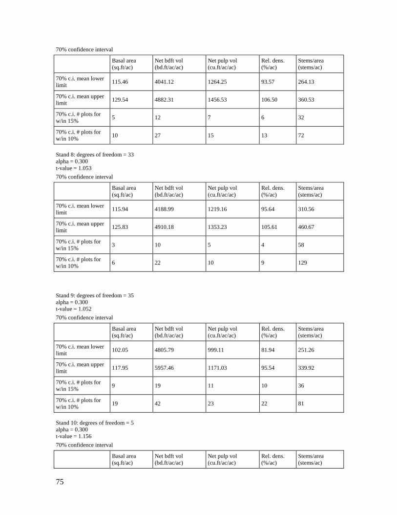
75
70% confidence interval
Basal area
(sq.ft/ac)
Net bdft vol
(bd.ft/ac/ac)
Net pulp vol
(cu.ft/ac/ac)
Rel. dens.
(%/ac)
Stems/area
(stems/ac)
70% c.i. mean lower
limit 115.46 4041.12 1264.25 93.57 264.13
70% c.i. mean upper
limit 129.54 4882.31 1456.53 106.50 360.53
70% c.i. # plots for
w/in 15% 5 12 7 6 32
70% c.i. # plots for
w/in 10% 10 27 15 13 72
Stand 8: degrees of freedom = 33
alpha = 0.300
t-value = 1.053
70% confidence interval
Basal area
(sq.ft/ac)
Net bdft vol
(bd.ft/ac/ac)
Net pulp vol
(cu.ft/ac/ac)
Rel. dens.
(%/ac)
Stems/area
(stems/ac)
70% c.i. mean lower
limit 115.94 4188.99 1219.16 95.64 310.56
70% c.i. mean upper
limit 125.83 4910.18 1353.23 105.61 460.67
70% c.i. # plots for
w/in 15% 3 10 5 4 58
70% c.i. # plots for
w/in 10% 6 22 10 9 129
Stand 9: degrees of freedom = 35
alpha = 0.300
t-value = 1.052
70% confidence interval
Basal area
(sq.ft/ac)
Net bdft vol
(bd.ft/ac/ac)
Net pulp vol
(cu.ft/ac/ac)
Rel. dens.
(%/ac)
Stems/area
(stems/ac)
70% c.i. mean lower
limit 102.05 4805.79 999.11 81.94 251.26
70% c.i. mean upper
limit 117.95 5957.46 1171.03 95.54 339.92
70% c.i. # plots for
w/in 15% 9 19 11 10 36
70% c.i. # plots for
w/in 10% 19 42 23 22 81
Stand 10: degrees of freedom = 5
alpha = 0.300
t-value = 1.156
70% confidence interval
Basal area
(sq.ft/ac)
Net bdft vol
(bd.ft/ac/ac)
Net pulp vol
(cu.ft/ac/ac)
Rel. dens.
(%/ac)
Stems/area
(stems/ac)

76
70% confidence interval
Basal area
(sq.ft/ac)
Net bdft vol
(bd.ft/ac/ac)
Net pulp vol
(cu.ft/ac/ac)
Rel. dens.
(%/ac)
Stems/area
(stems/ac)
70% c.i. mean lower
limit 78.64 968.75 704.71 64.32 312.99
70% c.i. mean upper
limit 126.36 2496.17 1234.21 107.56 480.47
70% c.i. # plots for
w/in 15% 15 52 20 17 12
70% c.i. # plots for
w/in 10% 33 117 45 38 27
Stand 11: degrees of freedom = 6
alpha = 0.300
t-value = 1.134
70% confidence interval
Basal area
(sq.ft/ac)
Net bdft vol
(bd.ft/ac/ac)
Net pulp vol
(cu.ft/ac/ac)
Rel. dens.
(%/ac)
Stems/area
(stems/ac)
70% c.i. mean lower
limit 87.35 3343.20 952.77 70.53 170.86
70% c.i. mean upper
limit 126.94 5157.89 1352.73 101.97 299.92
70% c.i. # plots for
w/in 15% 11 15 10 11 24
70% c.i. # plots for
w/in 10% 24 32 22 24 53
Stand 12: degrees of freedom = 4
alpha = 0.300
t-value = 1.190
70% confidence interval
Basal area
(sq.ft/ac)
Net bdft vol
(bd.ft/ac/ac)
Net pulp vol
(cu.ft/ac/ac)
Rel. dens.
(%/ac)
Stems/area
(stems/ac)
70% c.i. mean lower
limit 121.60 4832.02 1170.15 107.22 172.94
70% c.i. mean upper
limit 142.40 8259.13 1286.22 133.59 578.72
70% c.i. # plots for
w/in 15% 2 16 1 3 65
70% c.i. # plots for
w/in 10% 4 35 2 6 146
Stand 13: degrees of freedom = 2
alpha = 0.300
t-value = 1.385
70% confidence interval
Basal area
(sq.ft/ac)
Net bdft vol
(bd.ft/ac/ac)
Net pulp vol
(cu.ft/ac/ac)
Rel. dens.
(%/ac)
Stems/area
(stems/ac)
70% c.i. mean lower
limit 18.46 0.00 321.66 14.94 0.00

77
70% confidence interval
Basal area
(sq.ft/ac)
Net bdft vol
(bd.ft/ac/ac)
Net pulp vol
(cu.ft/ac/ac)
Rel. dens.
(%/ac)
Stems/area
(stems/ac)
70% c.i. mean upper
limit 101.54 912.85 848.85 105.07 1023.81
70% c.i. # plots for
w/in 15% 64 256 28 76 182
70% c.i. # plots for
w/in 10% 144 576 61 170 409
Stand 14: degrees of freedom = 3
alpha = 0.300
t-value = 1.250
70% confidence interval
Basal area
(sq.ft/ac)
Net bdft vol
(bd.ft/ac/ac)
Net pulp vol
(cu.ft/ac/ac)
Rel. dens.
(%/ac)
Stems/area
(stems/ac)
70% c.i. mean lower
limit 61.04 2568.77 648.65 50.27 84.98
70% c.i. mean upper
limit 148.96 7058.51 1575.30 124.86 418.83
70% c.i. # plots for
w/in 15% 32 39 31 33 79
70% c.i. # plots for
w/in 10% 71 87 70 73 176
Stand 15: degrees of freedom = 4
alpha = 0.300
t-value = 1.190
70% confidence interval
Basal area
(sq.ft/ac)
Net bdft vol
(bd.ft/ac/ac)
Net pulp vol
(cu.ft/ac/ac)
Rel. dens.
(%/ac)
Stems/area
(stems/ac)
70% c.i. mean lower
limit 83.80 3488.28 837.58 62.11 155.64
70% c.i. mean upper
limit 120.20 5523.28 1223.97 97.10 321.76
70% c.i. # plots for
w/in 15% 8 12 8 11 27
70% c.i. # plots for
w/in 10% 16 26 18 25 61
Stand 16: degrees of freedom = 2
alpha = 0.300
t-value = 1.385
70% confidence interval
Basal area
(sq.ft/ac)
Net bdft vol
(bd.ft/ac/ac)
Net pulp vol
(cu.ft/ac/ac)
Rel. dens.
(%/ac)
Stems/area
(stems/ac)
70% c.i. mean lower
limit 58.27 811.57 707.72 52.62 114.67
70% c.i. mean upper
limit 121.73 1803.75 1068.23 125.65 1261.74

78
70% confidence interval
Basal area
(sq.ft/ac)
Net bdft vol
(bd.ft/ac/ac)
Net pulp vol
(cu.ft/ac/ac)
Rel. dens.
(%/ac)
Stems/area
(stems/ac)
70% c.i. # plots for
w/in 15% 17 20 6 23 93
70% c.i. # plots for
w/in 10% 38 44 13 51 209
Stand 17: degrees of freedom = 2
alpha = 0.300
t-value = 1.385
70% confidence interval
Basal area
(sq.ft/ac)
Net bdft vol
(bd.ft/ac/ac)
Net pulp vol
(cu.ft/ac/ac)
Rel. dens.
(%/ac)
Stems/area
(stems/ac)
70% c.i. mean lower
limit 260.23 1170.77 86.60 170.17
70% c.i. mean upper
limit 7672.84 1459.56 99.88 559.31
70% c.i. # plots for
w/in 15% 117 2 1 38
70% c.i. # plots for
w/in 10% 262 4 2 86
Stand 18: degrees of freedom = 47
alpha = 0.300
t-value = 1.048
70% confidence interval
Basal area
(sq.ft/ac)
Net bdft vol
(bd.ft/ac/ac)
Net pulp vol
(cu.ft/ac/ac)
Rel. dens.
(%/ac)
Stems/area
(stems/ac)
70% c.i. mean lower
limit 92.58 2588.71 1016.68 78.68 282.89
70% c.i. mean upper
limit 105.93 3173.77 1185.10 90.88 389.83
70% c.i. # plots for
w/in 15% 10 22 13 11 53
70% c.i. # plots for
w/in 10% 22 49 28 25 119
Stand 19: degrees of freedom = 3
alpha = 0.300
t-value = 1.250
70% confidence interval
Basal area
(sq.ft/ac)
Net bdft vol
(bd.ft/ac/ac)
Net pulp vol
(cu.ft/ac/ac)
Rel. dens.
(%/ac)
Stems/area
(stems/ac)
70% c.i. mean lower
limit 87.89 782.76 809.22 73.97 240.41
70% c.i. mean upper
limit 122.11 2959.02 1417.20 110.28 569.59
70% c.i. # plots for
w/in 15% 5 61 14 7 30

79
70% confidence interval
Basal area
(sq.ft/ac)
Net bdft vol
(bd.ft/ac/ac)
Net pulp vol
(cu.ft/ac/ac)
Rel. dens.
(%/ac)
Stems/area
(stems/ac)
70% c.i. # plots for
w/in 10% 11 136 30 16 67
Stand 20: degrees of freedom = 4
alpha = 0.300
t-value = 1.190
70% confidence interval
Basal area
(sq.ft/ac)
Net bdft vol
(bd.ft/ac/ac)
Net pulp vol
(cu.ft/ac/ac)
Rel. dens.
(%/ac)
Stems/area
(stems/ac)
70% c.i. mean lower
limit 106.63 1875.98 1035.30 90.52 298.03
70% c.i. mean upper
limit 115.37 4180.87 1161.38 101.24 557.24
70% c.i. # plots for
w/in 15% 1 33 1 1 21
70% c.i. # plots for
w/in 10% 1 73 2 2 46
Stand 21: degrees of freedom = 21
alpha = 0.300
t-value = 1.063
70% confidence interval
Basal area
(sq.ft/ac)
Net bdft vol
(bd.ft/ac/ac)
Net pulp vol
(cu.ft/ac/ac)
Rel. dens.
(%/ac)
Stems/area
(stems/ac)
70% c.i. mean lower
limit 109.91 3343.07 1091.86 88.38 350.76
70% c.i. mean upper
limit 128.73 4563.80 1341.23 103.49 488.09
70% c.i. # plots for
w/in 15% 7 24 11 7 27
70% c.i. # plots for
w/in 10% 14 53 24 14 59
Stand 22: degrees of freedom = 10
alpha = 0.300
t-value = 1.093
70% confidence interval
Basal area
(sq.ft/ac)
Net bdft vol
(bd.ft/ac/ac)
Net pulp vol
(cu.ft/ac/ac)
Rel. dens.
(%/ac)
Stems/area
(stems/ac)
70% c.i. mean lower
limit 97.97 2925.55 1054.84 76.16 224.53
70% c.i. mean upper
limit 128.40 4580.22 1458.65 97.09 372.98
70% c.i. # plots for
w/in 15% 9 24 13 8 31
70% c.i. # plots for
w/in 10% 20 54 29 17 68

80
Stand 23: degrees of freedom = 3
alpha = 0.300
t-value = 1.250
70% confidence interval
Basal area
(sq.ft/ac)
Net bdft vol
(bd.ft/ac/ac)
Net pulp vol
(cu.ft/ac/ac)
Rel. dens.
(%/ac)
Stems/area
(stems/ac)
70% c.i. mean lower
limit 13.75 502.52 97.90 7.72 0.00
70% c.i. mean upper
limit 98.75 6459.80 610.71 52.17 452.68
70% c.i. # plots for
w/in 15% 107 129 104 104 181
70% c.i. # plots for
w/in 10% 231 289 210 239 406
Stand 24: degrees of freedom = 6
alpha = 0.300
t-value = 1.134
70% confidence interval
Basal area
(sq.ft/ac)
Net bdft vol
(bd.ft/ac/ac)
Net pulp vol
(cu.ft/ac/ac)
Rel. dens.
(%/ac)
Stems/area
(stems/ac)
70% c.i. mean lower
limit 76.62 1824.41 844.53 55.51 169.12
70% c.i. mean upper
limit 128.38 5084.71 1265.75 97.91 322.06
70% c.i. # plots for
w/in 15% 17 60 11 21 26
70% c.i. # plots for
w/in 10% 39 134 24 46 59
Stand 25: degrees of freedom = 9
alpha = 0.300
t-value = 1.100
70% confidence interval
Basal area
(sq.ft/ac)
Net bdft vol
(bd.ft/ac/ac)
Net pulp vol
(cu.ft/ac/ac)
Rel. dens.
(%/ac)
Stems/area
(stems/ac)
70% c.i. mean lower
limit 86.70 1246.10 937.98 60.11 229.29
70% c.i. mean upper
limit 127.05 2743.66 1474.03 91.11 384.08
70% c.i. # plots for
w/in 15% 13 51 18 15 23
70% c.i. # plots for
w/in 10% 29 113 40 34 51
Stand 26: degrees of freedom = 5
alpha = 0.300
t-value = 1.156
70% confidence interval

81
Basal area
(sq.ft/ac)
Net bdft vol
(bd.ft/ac/ac)
Net pulp vol
(cu.ft/ac/ac)
Rel. dens.
(%/ac)
Stems/area
(stems/ac)
70% c.i. mean lower
limit 137.69 5004.50 1412.84 97.10 160.89
70% c.i. mean upper
limit 152.31 6943.78 1890.14 118.20 424.72
70% c.i. # plots for
w/in 15% 1 8 6 3 55
70% c.i. # plots for
w/in 10% 2 16 13 6 122
Stand 27: degrees of freedom = 32
alpha = 0.300
t-value = 1.054
70% confidence interval
Basal area
(sq.ft/ac)
Net bdft vol
(bd.ft/ac/ac)
Net pulp vol
(cu.ft/ac/ac)
Rel. dens.
(%/ac)
Stems/area
(stems/ac)
70% c.i. mean lower
limit 98.63 3532.04 980.92 76.94 300.56
70% c.i. mean upper
limit 112.28 4343.94 1146.04 87.22 421.30
70% c.i. # plots for
w/in 15% 7 16 9 6 42
70% c.i. # plots for
w/in 10% 14 36 20 13 93
Stand 28: degrees of freedom = 11
alpha = 0.300
t-value = 1.088
70% confidence interval
Basal area
(sq.ft/ac)
Net bdft vol
(bd.ft/ac/ac)
Net pulp vol
(cu.ft/ac/ac)
Rel. dens.
(%/ac)
Stems/area
(stems/ac)
70% c.i. mean lower
limit 78.64 1204.83 660.29 69.62 295.43
70% c.i. mean upper
limit 101.36 2578.50 994.04 91.55 481.91
70% c.i. # plots for
w/in 15% 9 71 22 10 31
70% c.i. # plots for
w/in 10% 20 159 49 23 70
Stand 29: degrees of freedom = 4
alpha = 0.300
t-value = 1.190
70% confidence interval
Basal area
(sq.ft/ac)
Net bdft vol
(bd.ft/ac/ac)
Net pulp vol
(cu.ft/ac/ac)
Rel. dens.
(%/ac)
Stems/area
(stems/ac)
70% c.i. mean lower
limit 129.70 4899.60 1427.99 88.78 203.29
70% c.i. mean upper 164.30 7338.21 1920.53 114.70 578.04

82
70% confidence interval
Basal area
(sq.ft/ac)
Net bdft vol
(bd.ft/ac/ac)
Net pulp vol
(cu.ft/ac/ac)
Rel. dens.
(%/ac)
Stems/area
(stems/ac)
limit
70% c.i. # plots for
w/in 15% 4 9 5 4 52
70% c.i. # plots for
w/in 10% 7 20 11 9 116
Stand 30: degrees of freedom = 49
alpha = 0.300
t-value = 1.048
70% confidence interval
Basal area
(sq.ft/ac)
Net bdft vol
(bd.ft/ac/ac)
Net pulp vol
(cu.ft/ac/ac)
Rel. dens.
(%/ac)
Stems/area
(stems/ac)
70% c.i. mean lower
limit 112.03 3532.74 1111.73 77.86 285.92
70% c.i. mean upper
limit 127.97 4355.57 1276.08 89.43 364.95
70% c.i. # plots for
w/in 15% 10 25 11 11 33
70% c.i. # plots for
w/in 10% 23 55 24 24 74
Stand 31: degrees of freedom = 11
alpha = 0.300
t-value = 1.088
70% confidence interval
Basal area
(sq.ft/ac)
Net bdft vol
(bd.ft/ac/ac)
Net pulp vol
(cu.ft/ac/ac)
Rel. dens.
(%/ac)
Stems/area
(stems/ac)
70% c.i. mean lower
limit 83.32 2636.76 789.23 69.29 194.38
70% c.i. mean upper
limit 109.18 4552.12 1076.92 93.39 390.04
70% c.i. # plots for
w/in 15% 10 38 13 12 60
70% c.i. # plots for
w/in 10% 22 86 29 27 135
Stand 32: degrees of freedom = 36
alpha = 0.300
t-value = 1.052
70% confidence interval
Basal area
(sq.ft/ac)
Net bdft vol
(bd.ft/ac/ac)
Net pulp vol
(cu.ft/ac/ac)
Rel. dens.
(%/ac)
Stems/area
(stems/ac)
70% c.i. mean lower
limit 95.11 3347.79 885.29 79.91 358.81
70% c.i. mean upper
limit 107.60 4065.98 1032.85 90.65 558.47

83
70% confidence interval
Basal area
(sq.ft/ac)
Net bdft vol
(bd.ft/ac/ac)
Net pulp vol
(cu.ft/ac/ac)
Rel. dens.
(%/ac)
Stems/area
(stems/ac)
70% c.i. # plots for
w/in 15% 7 16 10 7 78
70% c.i. # plots for
w/in 10% 15 35 22 15 176
Stand 33: degrees of freedom = 12
alpha = 0.300
t-value = 1.083
70% confidence interval
Basal area
(sq.ft/ac)
Net bdft vol
(bd.ft/ac/ac)
Net pulp vol
(cu.ft/ac/ac)
Rel. dens.
(%/ac)
Stems/area
(stems/ac)
70% c.i. mean lower
limit 99.65 3768.32 1039.71 83.71 210.39
70% c.i. mean upper
limit 121.89 5422.89 1336.44 103.52 330.61
70% c.i. # plots for
w/in 15% 6 19 10 7 29
70% c.i. # plots for
w/in 10% 14 43 21 15 65
16. REFERENCES AND LITERATURE CITED
While preparing the SMWMA FSP many documented resources and studies were reviewed as to
ensure recommendations made within came from sound scientific case studies. The references
below were considered throughout the development of this FSP.
Avery, T.E. and H.E. Burkhardt, Fourth Edition, 1994. Forest Measurements. McGraw Hill, Inc.,
New York, NY.
Buehler, D.A., A.M. Roth, R. Vallender, T. C. Will, J. L. Confer, R. A. Canterbury, S. Barker
Swarthout, K.V. Rosenberg, and L.P. Bulluck. 2007. Status and Conservation Priorities of
Golden-Winged Warblers (Vermivora Chrysoptera) In North America. The Auk:
124:1439-1445.
Bowman's Hill Wildflower Preserve, New Hope PA. www.bhtp.org Plant Stewardship Index.
http://www.bhwp.org/psi /
Confer, J.L. 1992. Golden-winged Warbler (Vermivora chrysoptera). In The Birds of North
America, No. 20 (A. Poole, P. Stettenheim, and F. Gill, editors). Philadelphia: The
Academy of Natural Sciences; Washington, D.C.: The American Ornithologists’ Union.
Confer, J. L., K. W. Barnes, and E. C. Alvery. 2010. Golden- and Blue-winged Warblers:
distribution, nesting success, and genetic differences in two habitats. Wilson Journal of
Ornithology 122:273 – 278.
DEPDPF. 2010. New Jersey Statewide Forest Resource Assessment and Resource Strategies. NJ
Department of Environmental Protection, Trenton, NJ. (found at:
84
http://www.stateforesters.org/files/NJ-Assess-Strategy-20100810.pdf)
Forest Stewardship Council. 2010. FSC-US Forest Management Standard v1.0 (without FF
Indicators or Guidance). [email protected]
Gill, F.B. 1980. Historical aspects of hybridization between Blue-winged and Golden-winged
Warblers. Auk 97:1-18.
Gill, F.B. 1992. Golden-winged Warbler. Pages 300-301 in Atlas of breeding birds in Pennsylvania
(D. W. Brauning, Ed.). University of Pittsburgh Press, Pittsburgh, PA.
Golden-winged Warbler (GWWA) Working Group. Best Management Practices for GWWA in the
Appalachian Region. 2013. www.gwwa.org
Golden-winged Warbler (GWWA) Working Group. Best Management Practices for GWWA in the
Great Lakes Region. 2013. www.gwwa.org
Hamel, P.B., K.V. Rosenberg, D.A. Buehler. 2005. Is management for golden-winged warblers and
cerulean warblers compatible? USDA Forest Service Gen. Tech. Rep. PSW-GTR-191.
Helms, J.A. (ed.) 1998. The dictionary of forestry. Society of American Foresters, Bethesda,
MD. 210pp.
Kallesser, S. 2013. Gracie and Harrigan Consulting Foresters, Inc. Weldon Brook WMA Forest
Stewardship Plan. Trenton, NJ
http://www.njfishandwildlife.com/pdf/2013/weldonbrook_plan.pdf
Klaus, N. A. and D. A. Buehler. 2001. Golden-winged Warbler breeding habitat characteristics and
nest success in clearcuts in the southern Appalachian mountains. Wilson Bulletin 113:297-
301.
Knopp, P.D., Twery, M.J. (2009). North East decision model lite for windows CE/Mobile
[Computer software]. Northern research station. Newtown Square, PA: USDA Forest
Service. Retrieved from http://www.nrs.fs.fed.us/tools/ned/products/nedlite_win_ce/
Kubel, J.E. 2005. Breeding ecology of Golden-winged Warblers in managed habitats of central
Pennsylvania. Masters Thesis, Pennsylvania State University, State College, PA, USA.
Larkin, J. 2014. Personal communication. Indiana University of Pennsylvania.
Lehnen, S. E. and A. D. Rodewald. 2009. Dispersal, interpatch movements, and survival in a
shrubland breeding community. Journal of Field Ornithology 80:240-252.
Lorimer, C.G. and A. S. White. 2003. Scale and frequency of natural disturbance in north eastern
US: implications for early successional forest habitats and regional age distribution. Journal
of Forest ecology and Management 185: 41-64.
Maenza-Gmelch T.E. 1997. Late-glacial-early Holocene vegetation, climate, and fire at Sutherland
Pond, Hudson Highlands, Southeastern NY. Can. Journal of Botany 75: 431-439.
National Park Service (NPS). Thomas Edison National Historical Park. 2013. History and Culture.
http://www.nps.gov/edis/index.htm

85
Montreal Process, 2014. Retrieved from http://www.montrealprocess.org/
New Jersey Department of Environmental Protection. State Forestry Services – Forest Health
Services. Found at:
http://www.state.nj.us/dep/parksandforests/forest/njfs_forest_health.html
New Jersey Department of Environmental Protection. Land Use / Land Cover. 2007.
www.nj.gov/dep/gis/lulc07shp.html
Nyland D. Ralph. Silviculture – Concepts and Applications, Second Edition, 2002. McGraw-Hill
Series in Forest Resources, Inc., New York, N.Y.
Orndorff, S. and T. Patten. 2007. Management guidelines for barrens communities in Pennsylvania.
Report for State Wildlife Grant. The Nature Conservancy, Harrisburg, PA.
Patton L.L., S. Vorisek and J.L. Larkin. 2004. Golden-winged Warbler on surface mines in
Kentucky. Kentucky Warbler 80:73-75.
Reinert, Howard K., Gylla A. MacGregor, Mackenzie Esch, Lauretta M. Bushar, and Robert T.
Zappalorti (2011) Foraging Ecology of Timber Rattlesnakes, Crotalus horridus. Copeia:
October 2011, Vol. 2011, No. 3, pp. 430-442.
Reynolds et. al. 1992. Management recommendations for the Northern Goshawk in the
Southwestern United States. General Technical Report RM-217, 90 pp. USDA Forest
Service, Rocky Mountain Forest and Range Experiment Station, Fort Collins, CO, USA.
Rosenbaum, Jared. 2013. Sparta Mountain Rare Plants Survey Report. Wild Ridge Plants, LLC,
Hillsborough, NJ. Published in this Forest Stewardship Plan.
http://www.wildridgeplants.com/
Rossell, C. R., Jr. 2001. Song perch characteristics of Golden-winged Warblers in a mountain
wetland. Wilson Bulletin 113:246-248.
Ryan, M. G., Binkley, D. & Fownes, J. H. 1997. Age-related decline in forest productivity: pattern
and process. Adv. Ecol. Res. 27, 213–262
Sauer, J.R., J.E. Hines, and J. Fallon. 2008. The North American Breeding Bird Survey, Results
and Analysis 1966-2007, version 6.2.2006, U.S. Geological Survey, Patuxent Wildlife
Research Center, Laurel, Maryland, USA.
Sheehan, J., P.B. Wood, D.A. Buehler, P.D. Keyser, J.L. Larkin, A.D. Rodewald, T.B. Wigley, T.J.
Boves, G.A. George, M.H. Bakermans, T.A. Beachy, A. Evans, M.E. McDermott, F.L.
Newell, K.A. Perkins, and M. White. 2014. Avian response to timber harvesting applied
experimentally to manage Cerulean warbler breeding populations. Journal of Forest
ecology and Management 321: 5-18.
Status and conservation priorities of Golden-winged Warbler (Vermivora chrysoptera) in North
America. Auk 124:1439-1445.
Stevens, M.A., and R.E. Barry. 2002. Selection, sizes, site, and use of home range of the
Appalachian cottontail, Sylvilagus obscurus. Canadian Field- Naturalist 116:529-535.

86
Stephenson N.L. et.al. 2014. Rate of tree carbon accumulation increases continuously with tree
size. Nature 507, 90-93
Stoleson, S.H. 2013. Conditions Varies with Habitat Choice in Postbreeding Forest Birds. Auk
130(3):417-428.
Swank, W.T., and J.R. Webster, eds. Long-Term Response of a Forest Watershed Ecosystem:
Clearcutting in the Southern Appalachians. Oxford University Press, 2014. Print.
Tallamy, D. W. 2010. Bringing nature home: How you can sustain wildlife with native plants.
Timber Press, Portland, OR.
The New Jersey Natural Heritage Program, Natural Heritage Database and Landscape Project
Search. New Jersey Department of Environmental Protection, Trenton, NJ.
http://www.nj.gov/dep/parksandforests/natural/heritage/
Twery, M.J., P.D. Knopp, S.A. Thomasma, and D.E. Nute. 2011. NED-2 user’s guide. USDA
Forest Service, Northern research station. Newtown Square, PA. Gen. Tech. Rep. NRS-85.
193pp. (found at: http://nrs.fs.fed.us/pubs/39537)
Twery, M.J., Rauscher, M.H., Nute, D., Thomasma, S.A., & Knopp, P.D. (2012). North East
decision model-2: Ecosystem decision management support (Version 2.60.2) [Computer
software]. South Burlington, VT: USDA Forest Service. Retrieved from
http://www.nrs.fs.fed.us/tools/ned/products/ned2/
USDA Natural Resource Conservation Service. 2013. NJ Fact Sheet: Emerald Ash Borer
http://www.nj.nrcs.usda.gov/technical/forestry/documents/Emerald_Ash_Borer_Fact_Sheet
_NJAS.pdf
USDA Web Soil Survey. 2013. http://websoilsurvey.sc.egov.usda.gov/App/HomePage.htm
U.S. Forest Service. 2005. Fire in Eastern Oak Forests: Delivering Science to Land managers. Gen.
Tech. Bull. NRS-P-1. Newtown Square, PA: U.S. Department of Agriculture, Forest
Service, Northern Research Station. 52 p. www.nrs.fs.fed.us/pubs/gtr/nrs_gtrp1.pdf
U.S. Forest Service. 2011. New Jersey’s Forests 2008. Resour. Bull. NRS-59. Newtown Square,
PA: U.S. Department of Agriculture, Forest Service, Northern Research Station. 52 p.
www.nrs.fs.fed.us/pubs/rb/rb_nrs59.pdf
U.S. Forest Service. 2013. Northern Research Station. Forest Inventory and Analysis extracted
from http://apps.fs.fed.us/fia/fido/index.html
Van Clef, Michael. 2012. Sparta Mountain Forest Health Monitoring Summary of Baseline
Monitoring. Ecological Solutions, LLC, Great Meadows, NJ.
www.njecologicalsolutions.com Published in this Forest Stewardship Plan
Vermont Biology Technical Note 1. 2010. Vernal Pool Habitat in Conservation Planning. Vermont
NRCS.
Washburn, M.P. and N.E. Block, Comparing Forest Management Certification Systems and the
Montreal Process Criteria and Indicators (October 2001). Retrieved from

87
http://www.pinchot.org/pubs/c78/?startnum=21
Williams, Robert. 2009. Sparta Mountain Forest Stewardship / Woodland Management Plan
January 2009. Land Dimensions Engineering, 6 East High Street, Glassboro, NJ 08028
Wood, P.B., J. Sheehan, P. Keyser, D. Buehler, J. Larkin, A. Rodewald, S. Stoleson, T.B. Wigley, J.
Mizel, T.J. Boves, G. George, M. Bakermans, T. Beachy, A. Evans, M. McDermott, F. Newell,
K. Perkins, and M. White. 2013. Management guidelines for enhancing Cerulean Warbler
breeding habitat in Appalachian hardwood forests. American Bird Conservancy. The Plains,
Virginia. 28 pp.