spatial data infrastructures in hungary: state of play...
TRANSCRIPT
Spatial Data Infrastructures in Hungary: State of play Spring 2003
Country repor t on SDI e laborated in the context of a s tudy commiss ioned by the EC (EUROSTAT & DGENV) in the f ramework of the INSPIRE in i t ia t ive August 2003
SPATIAL APPLICATIONS DIVISION K.U.LEUVEN RESEARCH & DEVELOPMENT
Vital Decosterstraat 102, B-3000 LEUVEN TEL.: 32 16 32 97 32 FAX: 32 16 32 97 60 URL: http://www.sadl.kuleuven.ac.be
Report meta-information Title The state of play of the spatial data infrastructure in Hungary
Creator Thérèse Steenberghen (SADL) & Peter Beusen (ICRI)
Date Issued 2002-11-05
Subject INSPIRE State of Play – Activities 1 & 3
Publisher K.U.Leuven (SADL + ICRI) + Margaret Hall consultant
Description The report is summarising the review of SDI in Hungary
Contributor Danny Vandenbroucke (SADL), Jos Van Orshoven (SADL)
Format MS Word 97/2000
Audience
Identifier rcrHUv5.doc
Language EN
Coverage Snapshot at 2003-07-31
Version number
Date Modified by Comments
1.0 2002-11-05 Thérèse Steenberghen (SADL) & Peter Beusen (ICRI)
First version
2.0 2002-12-10 Thérèse Steenberghen (SADL)
Completion according to new outline
3.0 2002-12-20 Jos Van Orshoven (SADL)
Harmonization with 31 other country reports
4.0 2003-08-01 Danny Vandenbroucke (SADL)
Consolidation and integration of revisions and additions received from Mr. Szabolcs Mihály (Fömi) and Mr. Gábor Remetey-Fülöpp (MoARD) Addition of - Report meta-information - Executive summary - Abbreviations and acronyms and final review
5.0 2003-08-17 Jos Van Orshoven (SADL)
Harmonisation with updated version of the 31 other country reports
EC-INSPIRE: Spatial Data Infrastructures in Europe: State of play Spring 2003 Hungary
K.U.Leuven (SADL-ICRI) + Hall 1
Executive Summary Building the information society was acknowledged as a priority by the Hungarian Government already in the early 1990’s. The Co-ordination Office on Informatics at the Prime Minister's Office formulated and advocated Hungary's National Informatics Strategy. Under this strategy an Action Plan for the establishment of a National Spatial Data Infrastructure was formulated in 1996. This Action Plan was the basis for the Prime Minister's Office, several ministries, national institutions and the GIS Foundation, HUNGIS to formulate in 1997 a National Spatial Data Strategy (NSDS). In 2002 the responsibilities with respect to the NSDS and NSDI have been transferred from the Prime Minister’s Office to the Ministry of Informatics and Communication.
The key executive player in the elaboration of the NSDI is the Institute of Geodesy, Cartography and Remote Sensing (FÖMI). FÖMI is operating a website which aims at providing access to metadata catalogues, some geodatasets and other spatial data services.
FÖMI is subordinate to the Ministry for Agriculture and Regional Development which is the main producer of GI in Hungary. Besides the FÖMI, the Ministry’s institutional network includes 136 District and County Land Offices. The Hungarian Institute for Town and Regional Planning, which also belongs to the Ministry of Agriculture and Regional Development, is responsible for data related to regional development, an increasingly important area of policy in all the accession countries. Other key providers are the Mapping Agency of the Home Defense Forces, the Central Statistical Office, and the Ministry of Environmental protection.
Hungary has a national Association for Geo-Information, HUNAGI (www.hunagi.hu), which is a non-profit, interdisciplinary umbrella association.
All surveying, mapping and related activities in Hungary are governed by a single Act, i.e. Act LVXXI of 1996 on land surveying and mapping activities and GIS.
EC-INSPIRE: Spatial Data Infrastructures in Europe: State of play Spring 2003 Hungary
K.U.Leuven (SADL-ICRI) + Hall 2
Table of Contents EXECUTIVE SUMMARY .......................................................................................................................... 1
TABLE OF CONTENTS............................................................................................................................. 2
ABBREVIATIONS AND ACRONYMS..................................................................................................... 3
1. GENERAL INFORMATION.................................................................................................... 5 1.1 METHOD........................................................................................................................................ 5 1.2 THE HUNGARIAN GI-SCENE: NSDS AND NSDI............................................................................. 5
2. DETAILS OF THE HUNGARIAN NSDI ................................................................................ 7 2.1 GENERAL INFORMATION ............................................................................................................... 7 2.2 COMPONENT 1: LEGAL FRAMEWORK AND FUNDING...................................................................... 7 2.3 COMPONENT 2: REFERENCE DATA AND CORE THEMATIC DATA ..................................................... 9 2.4 COMPONENT 3: METADATA FOR REFERENCE DATA AND CORE THEMATIC DATA ......................... 17 2.5 COMPONENT 4: ACCESS AND OTHER SERVICES FOR REFERENCE DATA, CORE THEMATIC DATA AND
THEIR METADATA ........................................................................................................................ 19 2.6 COMPONENT 5: STANDARDS ....................................................................................................... 20 2.7 COMPONENT 6: THEMATIC ENVIRONMENTAL DATA .................................................................... 22 2.8 USE AND EFFICIENCY OF SDI....................................................................................................... 22
3. ANNEXES................................................................................................................................. 23 3.1 BUILDING BLOCKS OF THE HUNGARIAN SDI ............................................................................... 23 3.2 LIST OF SDI ADDRESSES / CONTACTS FOR HUNGARY .................................................................. 26 3.3 LIST OF REFERENCES FOR HUNGARY ........................................................................................... 27
EC-INSPIRE: Spatial Data Infrastructures in Europe: State of play Spring 2003 Hungary
K.U.Leuven (SADL-ICRI) + Hall 3
Abbreviations and acronyms ABDS Administrative Boundary Data Services CT Core Thematic Data DAT Digital Base Map Standard DEM Digital Terrain Model DLM Department of Land and Mapping DTA Digital Topographic Base Map EC European Commission EOMA Uniform National Height System EOVA Uniform National Horizontal Network EUROGI European Umbrella organisation for geographical information FIR Further Investigation Required FOI Freedom of Information FÖMI Institute of Geodesy, Cartography and Remote Sensing GEOX Hungarian Private Company Ltd. Name GI Geographical Information GINIE Geographic Information Network in Europe GIS Geographical Information System GPS Ground Positioning System GSDI Global Spatial Data Infrastructure HAS Hungarian Academy of Sciences HCSO Hungarian Central Statistical Office HSO Hungarian Statistical Office HUNAGI Hungarian Association for Geo-Information INSPIRE INfrastructure for SPatial InfoRmation in Europe MADOP Hungarian Digital OrtoPhoto MARD Ministry of Agriculture and Rural Development ME Ministry of Environment MIT Ministry if Informatics and Telecommunication MKH Hungarian Administrative Boundary Database MoD Ministry of Defense NSDI National Spatial Data Infrastructure NSDS National Spatial Data Strategy OGPSH National GPS Network PMO Prime Ministers Office PPP Public-Private Partnerships PSI Policy and legislation on access to public sector information

EC-INSPIRE: Spatial Data Infrastructures in Europe: State of play Spring 2003 Hungary
K.U.Leuven (SADL-ICRI) + Hall 4
REF Reference data SABE Seamless Administrative Boundaries of Europe SDI Spatial Data Infrastructures
EC-INSPIRE: Spatial Data Infrastructures in Europe: State of play Spring 2003 Hungary
K.U.Leuven (SADL-ICRI) + Hall 5
1. GENERAL INFORMATION
1.1 Method This report is summarizing the review of the SDI in Hungary, and reflects the degree to which the SDI situation in Hungary is similar to the ideas set out in the INSPIRE position papers1.
The report is based on the analysis of various documents, project references and web sites readily accessible in English.
The report has further been completed by the integration and consolidation of comments received from representatives of the NSDI initiatives. Those comments were provided either in written form or through interviews organized in the framework of Activity 2 of the State-of-Play project.
1.2 The Hungarian GI-scene: NSDS and NSDI In Hungary a National Spatial Data Strategy has been formulated to define the lines along which a nation-wide SDI, dominated by the public sector, is currently being elaborated. Several specific SDI-initiatives are being undertaken or have already been finalised realised.
The National Spatial Data Strategy was formulated by a working group composed of representatives of the Prime Minister's Office, several ministries, national institutions and the GIS Foundation, HUNGIS. It involved the elaboration of the concept of the NSDS, a survey of the current situation both at national and international level, the specification of requirements, the elaboration of potential ways of development and of variants of strategy and the elaboration of detailed action plans. Six issues were addressed in detail:
macro-economic relationships, legal issues related to mapping data and map-based information, regulatory issues, spatial data management issues, quality-assurance and related standards, marketing and PR issues.
Based on the implementation plan for the NSDS, the Hungarian SDI is becoming operational but will be further developed and it will integrate more and more stakeholders from the national up to the local level.
The Hungarian SDI can be considered to consist of a series of building blocks including data and metadata initiatives, services and the like. The complete list of ongoing
1 INSPIRE position papers, final versions: RDM, ETC, DPLI, ASF, IST, IAS (latest version).
EC-INSPIRE: Spatial Data Infrastructures in Europe: State of play Spring 2003 Hungary
K.U.Leuven (SADL-ICRI) + Hall 6
initiatives is listed in Section 3.1. Regional and local initiatives are integrated in and part of the national initiative.
In addition a myriad of GIS projects (in various qualities) exist in Hungary which to a certain extent are integrated in the NSDI.
Key providers of GI in Hungary are the Ministry of Agriculture and Rural Development, the Ministry of Informatics and Communicaiton, the Mapping Agency of the Ministry of Home Defence Forces, the Central Statistical Office, and the Ministry of Environmental Protection and Water Management, the Hungarian State Geological Institute and the Eötvös Loránd Institute of Geophysics. Some supporting institutions behind certain ministries are owners or users of thematic reference data, e.g. the Environment Management Institute, the State Road Centre, the National Water Management Office, the Hungarian Office for Mining.
All the mentioned institutions are data-producers, transformers, and data users at the same time, being authorities, research institute and entrepreneurs as well. In this field, there exist a lot of parallel activities and also competence-division. It can be stated that the organisational order of the players in the public sector is inadequate. All these make the data management, the development of data market, the elaboration of adequate regulations very difficult.
Hungary has a national Association for Geo-Information, HUNAGI (www.hunagi.hu), which is a non-profit, interdisciplinary umbrella association. It was established in order to achieve competitiveness of the Hungarian players in the rapidly growing European GI content market. It was founded in 1994 and registered by the court in 1996. It has full member status in EUROGI and has been acknowledged as an Advisory Board member by the steering committee of GSDI. Its 80 member institutions are providers of data, value added products and services; data brokers; academic institutions; governmental agencies and users in many disciplines and application areas.
EC-INSPIRE: Spatial Data Infrastructures in Europe: State of play Spring 2003 Hungary
K.U.Leuven (SADL-ICRI) + Hall 7
2. DETAILS OF THE HUNGARIAN NSDI
2.1 General Information (www.hunagi.hu), Official address: Overall contact person: Gábor Remetey-Fülöpp Ministry of Agriculture and Rural Development Department of Lands and Mapping H-1860 Budapest Pf.1. H-1055 Budapest Kossuth Lajos tér 11.
2.2 Component 1: Legal framework and funding
2.2.1 Legal framework and organisational issues Act LVXXI of 1996 on Surveying and Mapping and the related Ministerial decrees provide the core of the legal background of GIS-related issues. All official surveying, mapping and related activities are governed by this Act. The basic aim of the Act is to ensure that base maps covering the total area of the country are available, as to enable land registration, development of geographic information systems, and a wide range of applications on various economic, scientific and social subjects. The Act makes it compulsory to use the governmental base map data to create GIS.
The Joint Decree no 21/1997 “On execution of some rules defined by the Law LXXVI of 1996 on Activities in Surveying and Mapping” regulates. the co-operation between the ministers responsible for surveying and mapping activities and the rules and conditions for the operation of a Map Supply Coordination Committee.
The Resolution No. 13 from 1997 of the Governmental Commission on Informatics and Telecommunications provides further steps toward the set up of an NSDI.
Another important law is the Act on land registration. According to this law, municipalities, courts, notaries and lawyers are allowed to link to the TAKARNET wide area transmission network, operated by the Land Offices. TAKARNET is the extranet of the land registry, which is now operational.
The National Board of Technical Development and the Prime Minister’s Office (PMO) used to play a significant coordinating role with respect to the NSDI and projects contributing to it. Today, besides the Ministry of Informatics and Communication, the dominant driving ministry is the Ministry of Agriculture and Rural Development, which is the main provider of GI in Hungary. The Ministry is responsible and co-ordinates the
EC-INSPIRE: Spatial Data Infrastructures in Europe: State of play Spring 2003 Hungary
K.U.Leuven (SADL-ICRI) + Hall 8
integrated land registration and cadastral mapping, land use and large-scale topographic mapping. Its institutional network includes 136 District and County Land Offices and the Institute of Geodesy, Cartography and Remote Sensing (FÖMI), a leading R&D institute in GI.
2.2.2 Public-private partnerships (PPP’s) Private commercial firms are indirectly involved in helping to implement the NSDS as subcontractor e.g. in the implementation of the National Cadastral Program in a competitive environment. For the surveying and mapping, there is a partnership supported by the Chamber of Engineers, the Hungarian Society of Surveying, Mapping and Remote Sensing, the HUNGIS Foundation, etc.
2.2.3 Policy and legislation on access to public sector information (PSI)
The Constitution of Hungary states that “in the Republic of Hungary everyone has the right …to know and to disseminate data of public interest”. This fundamental right was elaborated in the Act on the Protection of Personal Data and Accessibility of Public Data, which requires all government agencies at national or local level to facilitate access to information in their possession, and to make accessible data concerning their activities, data types held by them, and acts concerning their operation.
The 1992 Act is overseen by the Parliamentary Commissioner for Data Protection (DP) and Freedom of Information (FOI). Besides acting as an ombudsman for both data protection and freedom of information, the Commissioner’s tasks include maintaining the Data Protection Register and providing opinions on DP and FOI-related draft legislation as well as all categories of official secrets.
2.2.4 Legal protection of GI by intellectual property rights The most important rule of the Hungarian copyright-related legislation is the Law II (1969) on Copyright, which was modified during the past decade several times. In 2000, the decision was taken by the Government in the Law Approximation Program to revise the copyright and related laws in order to ensure the harmonization with the copyright directives of the European Union, and to meet the requirement needed for the Hungarian adoption of the Copyright Agreement in the institutional framework of the WIPO. Preparations were also made to introduce the sui generis protection of databases in 2001.
2.2.5 Restricted access to GI further to the legal protection of privacy The protection of personal data is assured by Act LXIII of 1992 on protection of personal data and the disclosure of data of public interest. The purpose of this Act is to guarantee the right of everyone to exercise control over his or her personal data and to have access to data of public interest, except as otherwise provided by law under this Act. The Parliamentary Commissioner for Data Protection and Freedom of Information plays the

EC-INSPIRE: Spatial Data Infrastructures in Europe: State of play Spring 2003 Hungary
K.U.Leuven (SADL-ICRI) + Hall 9
same role concerning the protection of personal data as he does for the access to public sector documents.
2.2.6 Licensing framework No information has been found nor provided.
2.2.7 Funding model for SDI and pricing policy Funding
Resources for the implementation of the NSDS come from both government budgets and cost recovery. Funding by the European Commission (PHARE, Tempus) is not negligible.
In addition to government funding, the NSDI is also funded by user fees.
Pricing
The prices of the data for different users are the same in general. The earlier referred ministerial decree declares the exceptional cases..
2.3 Component 2: Reference data and core thematic data 2.3.1 Scale and resolution: European, National, Regional, Local,
Other Maps and spatial data are produced for the following major scale and resolution levels
Scale Resolution Prime data provider 1:500 10 cm Private Sector AM/FM applications
1:1.000 (old 1:1.440 also used)
20 cm DLM MARD Cadastre, Urban Planning, Local Governments
1:2.000 (old 1:2880 also used)
40 cm DLM MARD Cadastre
1:4.000 80 cm DLM MARD Multipurpose cadastre 1:10.000 2 m DLM MARD CAP, multipurpose 1:50.000 and smaller
10 m and less Mapping Service, MoD
Multipurpose
EC-INSPIRE: Spatial Data Infrastructures in Europe: State of play Spring 2003 Hungary
K.U.Leuven (SADL-ICRI) + Hall 10
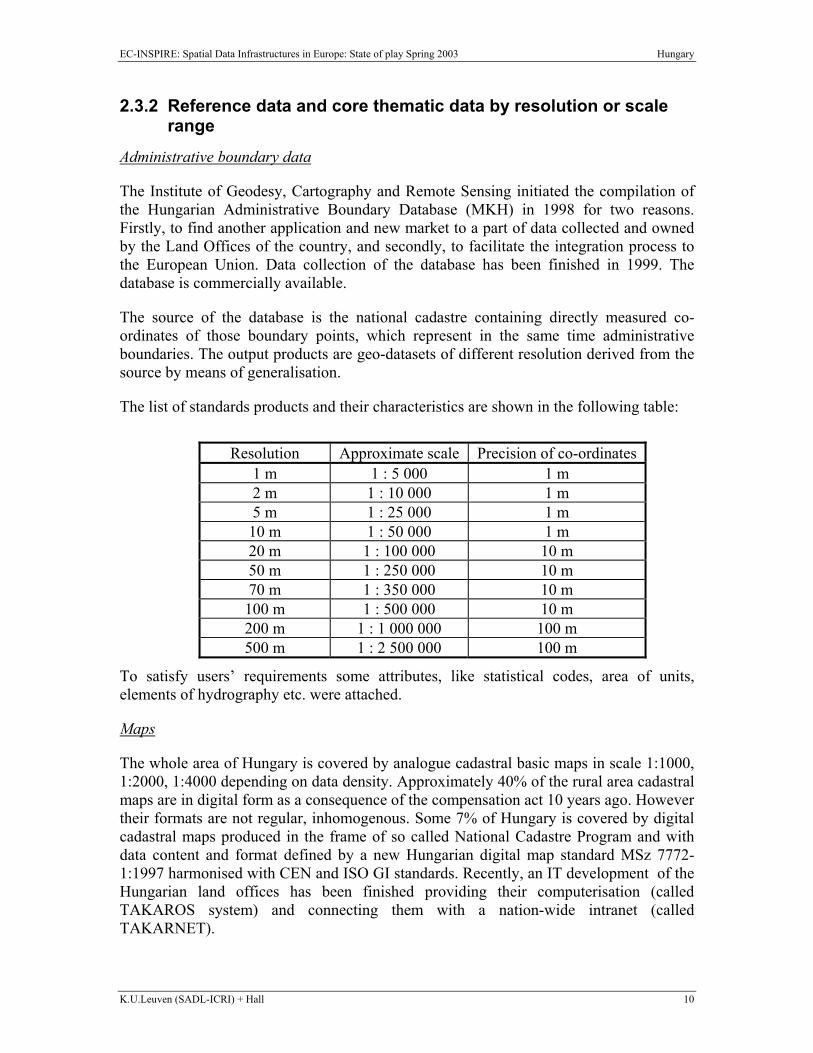
2.3.2 Reference data and core thematic data by resolution or scale range
Administrative boundary data
The Institute of Geodesy, Cartography and Remote Sensing initiated the compilation of the Hungarian Administrative Boundary Database (MKH) in 1998 for two reasons. Firstly, to find another application and new market to a part of data collected and owned by the Land Offices of the country, and secondly, to facilitate the integration process to the European Union. Data collection of the database has been finished in 1999. The database is commercially available.
The source of the database is the national cadastre containing directly measured co-ordinates of those boundary points, which represent in the same time administrative boundaries. The output products are geo-datasets of different resolution derived from the source by means of generalisation.
The list of standards products and their characteristics are shown in the following table:
Resolution Approximate scale Precision of co-ordinates
1 m 1 : 5 000 1 m 2 m 1 : 10 000 1 m 5 m 1 : 25 000 1 m 10 m 1 : 50 000 1 m 20 m 1 : 100 000 10 m 50 m 1 : 250 000 10 m 70 m 1 : 350 000 10 m 100 m 1 : 500 000 10 m 200 m 1 : 1 000 000 100 m 500 m 1 : 2 500 000 100 m
To satisfy users’ requirements some attributes, like statistical codes, area of units, elements of hydrography etc. were attached.
Maps
The whole area of Hungary is covered by analogue cadastral basic maps in scale 1:1000, 1:2000, 1:4000 depending on data density. Approximately 40% of the rural area cadastral maps are in digital form as a consequence of the compensation act 10 years ago. However their formats are not regular, inhomogenous. Some 7% of Hungary is covered by digital cadastral maps produced in the frame of so called National Cadastre Program and with data content and format defined by a new Hungarian digital map standard MSz 7772-1:1997 harmonised with CEN and ISO GI standards. Recently, an IT development of the Hungarian land offices has been finished providing their computerisation (called TAKAROS system) and connecting them with a nation-wide intranet (called TAKARNET).

EC-INSPIRE: Spatial Data Infrastructures in Europe: State of play Spring 2003 Hungary
K.U.Leuven (SADL-ICRI) + Hall 11
As basic data, the digital topographic map at scales of 1:50 000 and 1:100 000 is serviceable, together with the related digital terrain models and various datasets, obtained from the traditional data acquisition methods. The 1:10 000 scale topographic maps are under digitalisation. Recently a Hungarian Topographic Program has been proposed to carry out modernisation of digital topographic datasets.
A non-exhaustive list of core thematic geo-datasets includes:
TeIR, a Territorial Information System covering the whole of Hungary (owner: VÁTI, a settlement planning institution);
Budapest Base Map in 1:25 000 scale (owner: Topolisz Ltd.) Population Census Data of Hungary (owner: KSH, Central Statistical Office) Digital geological maps (Zala County Complex Database, Minor Plain Database,
Paks Atomic Energy Plant Geological Database, Geology of Budapest, Uniform Geological Digital Database, River Danube Geological Database), (owner: MÁFI, a Hungarian State Geological institute)
Soil Scientific Database of Hungary (owner: TAKI, a Soil research institute) Settlement Addresses Database (owner: Geogroup Infograph Ltd.) OTAB as a 1:200.000 scale digital geographical map database (owner: Geometria
Ltd.) Budapest-4000 database (owner: Infograph Ltd.) Budapest CD Atlas (owner: Cartographia Ltd.) HALIS database of the Budapest water supply (owner: Budapest Water Works
Company) Database of the Optical Backbone Network of Hungary (owner: MATÁV) KIR and KÖFIR electric supply database (owner: Budapest Electric Works
Company) TIGÁZ database on gas supply Voting District Database (owner: the Gallup Institute) Environmental Protection Sample District of the Lake Balaton and the Hortobágy Local Government Managing and Geoinformation systems for the settlement
Zugló, Szombathely, Debrecen, Hajdúszoboszló, Nyíregyháza, Pilis, Orosháza, Szeged, Pécs
Budapest Green Area Cadaster.
The next table gives overview on reference and core thematic data.
EC-INSPIRE: Spatial Data Infrastructures in Europe: State of play Spring 2003 Hungary
K.U.Leuven (SADL-ICRI) + Hall 12
Geographical location Type Inspire priority
European National Regional Local VERY SMALL
Geodetic reference system
REF H Geodetic reference system (FÖMI)
Geographical names REF H HCSO Geographical grid CT H Altimetry DEM grid
Administrative units Official administrative
units REF H Hungarian
Administrative Boundary Database (MKH) from FOMI
Hungarian Administrative
Boundary Database (MKH) from FOMI
Hungarian Administrative
Boundary Database (MKH) from FOMI
Hungarian Administrative
Boundary Database (MKH) from FOMI
Hungarian Administrative
Boundary Database (MKH) from FOMI
Blocks and census districts
REF M TAKAROS (Hungarian Land Administration)
X
Properties, buildings and addresses Properties REF L TAKAROS
(Hungarian Land Administration)
X
Buildings REF L TAKAROS (Hungarian Land Administration)
X
Addresses REF H HCSO Elevation
Elevation REF H FÖMI, DEM grid, DEM vector
Bathymetry REF H Coastline REF H
Hydrography Hydrography, river,
lake…. REF H FÖMI, layer of the
topographic map in vector and grid format
Land surface Ortho-images REF H FÖMI
Unclassified satellite images
CT M FÖMI
Natural resource Water catchments CT H
Groundwater bodies CT H Soil CT H
Bedrock geology CT L Climatic regions/data CT L
Bio-ecological regions CT M Acquis National Programme
X
Vegetation CT L Acquis National X
EC-INSPIRE: Spatial Data Infrastructures in Europe: State of play Spring 2003 Hungary
K.U.Leuven (SADL-ICRI) + Hall 13
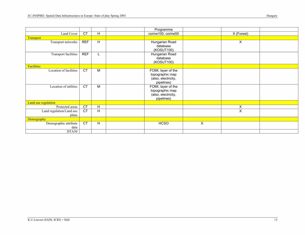
Programme Land Cover CT H corine100, corine50 X (Forest)
Transport Transport networks REF H Hungarian Road
database (KOSUT100)
X
Transport facilities REF L Hungarian Road database
(KOSUT100)
Facilities Location of facilities CT M FOMI, layer of the
topographic map (also, electricity,
pipelines)
Location of utilities CT M FOMI, layer of the topographic map (also, electricity,
pipelines)
Land use regulation Protected areas CT H X
Land regulation/Land use plans
CT H X
Demography Demographic attribute
data CT H HCSO X
DTA50
EC-INSPIRE: Spatial Data Infrastructures in Europe: State of play Spring 2003 Hungary
K.U.Leuven (SADL-ICRI) + Hall 14
2.3.3 Geodetic reference systems and projections A reference system called Hungarian Datum 1972 (HD-72) was introduced in 1972 based on independent adjustment of Hungary’s astrogeodetic network. Its reference ellipsoid is the IUGG Geodetic Reference System 1967 (GRS67: a = 6378160m, b = 6356774.516m, f=1/298.247167). The HD-72 is located and oriented relatively at the terrestrial point Szõlõhegy.
Based on HD-72, Hungary established the
Uniform National Horizontal System (in Hungarian called: EOVA), Uniform National Height System (in Hungarian called: EOMA) Uniform National Mapping System (in Hungarian called: EOTR).
A projection system for civil use called EOV (Uniform National Projection system) was introduced also in 1972. The reference ellipsoid of EOV is the IUGG GRS67. The projection is of the oblique-axis reduced (secant) cylindrical type. The whole territory of the country is represented on one strip of cylindrical projection.
Projection systems of former times are still in use: three oblique-axis cylindrical projection systems: North, Median and South and a stereographic projection for cadastral maps at scale 1:2.880, 1:1.440 and 1:7.20.
To meet the requirements of the domestic and international professional communities, a Description Directory of Hungarian Reference and Projection Systems has been issued in 1995 by FÖMI. The Description gives an overview on the EOV parameters, the HD-72 definition, the Hungarian vertical system and the relation of HD-72 to the WGS-72 and the EUREF-89 (WGS-84) systems. A revised version of the transformation parameters has been computed, harmonised in the frame of the EUREF Working Group of EuroGeographics and IAG, as well as disseminated for GI use in 2000. This version became part of the Hungarian GI standard.
The Uniform National Horizontal Network (EOVA)
The EOVA is based on the Hungarian Datum 1972, the network orientation is provided by 40 Laplace-points and the scale is maintained by 23 EDM lines.
Parameters connecting the Hungarian control network to the EUREF-89 and ED-87 systems have already been measured, computed and finalised.
For high order scaling, a 864-m long Standard Baseline at Gödöllõ town (about 30 km from Budapest) has been measured with Väisälä interferometric method and Kern Mekometer in co-operation with Finnish Geodetic Institute in 1987 and re-measured in 1999. This very stable baseline with 5 pillars is accredited for EDM calibrations for national and international use.

EC-INSPIRE: Spatial Data Infrastructures in Europe: State of play Spring 2003 Hungary
K.U.Leuven (SADL-ICRI) + Hall 15
An EOVA Database was created and is operated by the Institute of Geodesy, Cartography and Remote Sensing (FÖMI), containing the positional and descriptive data of horizontal control sites (1st, 3rd and 4th order) as well as their sketching.
The Uniform National Height System (EOMA)
The EOMA has normal heights with Baltic Sea level. The reference point is Nadap with height in the EOMA system H=173,1638 above Baltic Sea level; (H= 173,8385 above the Adriatic Sea level, in which the height system of Hungary was given earlier.)
EOMA consists of:
41 principal fundamental benchmarks (16 established on rock, others are well-based benchmarks situated in sedimentary area),
800 of 1st order special benchmarks based in 3-5.5 m deep, 5778 sites of 1st order, 4449 sites of 2nd order (ready at 75%), 8325 sites of 3rd order (ready at 80%) (GPS technique for the replacement of the
classical 3rd order levelling is introduced in 2000), Hungary has a kinematic network containing about 1100 points along the 1st
order levelling lines to study the recent crustal movements, 23 connecting levelling lines to the neighbouring countries.
Upon the 1994 call of IAG/EUREF subcommission, Hungary has prepared data expressed in geopotential index numbers for the purpose of connecting the Hungarian vertical network to the UELN frame. Hungary participated at the EUVN 97 campaign with successful GPS observations as well as levelling and gravity measurements of 4 special benchmarks.
An efficient technique has been elaborated at FÖMI for the replacement of the 3rd order levelling with GPS and geoid. This technique is successfully applied in the practice for the completion of the EOMA 3rd order network in the TransDanubian region, and operating recently.
A Database of Vertical Network containing the data of height control sites (1st, 2nd and 3rd order) was created and is operated by FÖMI. Items in this database are number of the sites, vertical co-ordinates, location of the sites (county, settlement, sheet number), date of determination, measurement and control of the sites, textual and scanned description of the surroundings.
The National GPS Network (OGPSH)
The Satellite Geodetic Observatory of FÖMI, Penc is the centre for the Hungarian GPS Network activities given below:
7 sites of Hungarian part determined in EUREF Network (1991 and 1997),
EC-INSPIRE: Spatial Data Infrastructures in Europe: State of play Spring 2003 Hungary
K.U.Leuven (SADL-ICRI) + Hall 16
24 sites of the OGPSH (frame network) measured both in EOVA and ETRS-89 (1991),
1153 sites of the OGPSH measured all over the country.
The 3D spatial co-ordinates of the OGPSH sites are referred to the EUREF-89 reference frame, as well as determined in EOV projection system for home mapping purposes. The superior accuracy of the OGPSH allows to analyse the traditional EOVA network as a whole.
An OGPSH Database was created and is operated by FÖMI. The database contains the most important data of GPS control sites. These data are: number of the sites, the EUREF and the EOV vertical and horizontal co-ordinates as well as the location of the sites (county, settlement, and sheet number), textual and scanned sketch approach
The Hungarian Active GPS Network
The Hungarian Active GPS Network is being established in two phases. In the first phase, the average distance between the stations will be 100 km. It can be achieved with 12 permanent stations. At present, three stations are operational. The 12 stations network will be able to serve the cm precise geodetic GPS measurements in the whole country with post processing, and the sub meter precise real-time applications
In the second phase, 17 stations will be installed. The complete network will be suitable to serve the cm precise real-time kinematic (RTK) applications as well. The data transfer between the base station and the rover receiver is planned to be based on GPRS service of GSM networks.
Concerning the reference systems, forming the basis of the countrywide space-related data infrastructure and technical-measuring systems: the reference system data and the basic control networks are existing and convenient in use, they are accessible through servicing, also in on-line mode (horizontal and vertical geodetic controls, controls of the National GPS Network, integrated into European reference systems). However, their product-profile and prices have not been calculated in a way that would stimulate their use.
2.3.4 Quality of the reference data & core thematic data Quality assessment by the major data producers includes: positional accuracy, positional precision, logical consistency, completeness of objects, temporal characteristics.
Quality advice is documented through meta-data provided on-line.
2.3.5 Interoperability Major GIS-software encompass ESRI-products (ArcView (3.0, 3.2), Arcinfo (7.1, 8.0), MapObject 2.0, ArcView Internet Map Server), Erdas (Imagine, Essential, Professional, Ortobase 8.4), Bentley Microstation (J 7.0, - Geographics 7.0,- Descartes 7.0, - Descartes
EC-INSPIRE: Spatial Data Infrastructures in Europe: State of play Spring 2003 Hungary
K.U.Leuven (SADL-ICRI) + Hall 17
4.0), Microstation SE 5.0, Bentley Geo-outlook, Mapinfo Prof. (6.5, 5.5), Bentley Model Server Discovery, Different Hungarian GIS softwares, Autodesk MapGuide 4.
Converters and interchange formats are available.
2.3.6 Language and culture Metadata and accompanying documents are provided in Hungarian and mostly also in English (see reference list).
2.3.7 Data Content No information has been found nor provided.
2.3.8 Geographical names The gazetteer-database under responsibility of FÖMI contains 39 types of geographical names including the names of settlements, parts of settlement, landscapes, large units of the land, woods, nature conservation areas, relief and hydrography, names of remarkable points (ruin, look-out tower etc.) as well as the names of the most important objects of traffic. This is a Database of Geographical Names (FNT – Földrajzinév-tár).
The database has two versions. The first one (FNT1) corresponds in quantity of names approximately to a topographic map in scale 1:40.000. This database was produced by the use of 300 sources (maps, geographical literature, economical, statistical sources), and each municipality had the chance to complete, modify the database reflecting the local use of names. FNT1 covers the whole territory of Hungary, and is continuously updated.
The second version (FNT2) corresponds with respect to quantity and types of names roughly to the topographic map scale 1:10.000, with a readiness of 35%. It comprises the names of the database FNT1 with additions taken from large-scale topographic maps, cadastral maps, and other sources. The two parts of the database comprise 105.000 records.
2.3.9 Character sets No information has been found nor provided.
2.4 Component 3: Metadata for reference data and core thematic data
2.4.1 Availability of metadata Metadata are produced for a significant part of the spatial datasets.
EC-INSPIRE: Spatial Data Infrastructures in Europe: State of play Spring 2003 Hungary
K.U.Leuven (SADL-ICRI) + Hall 18
2.4.2 Metadata catalogues availability + standard A metadata catalogue is available at the Institute of Geodesy, Cartography and Remote Sensing since 1997. It is organized according to the DAT- Standard (Digital Base Map), based on ISO TC211 and CEN TC 287.
Another catalogue has been set up at the Geological Institute of Hungary: METATER. It contains metadata of the framework basic data; the territorial information system data; and the geological thematic data. The owners of this metadataset are the Prime Minister's Office, the Institute of Geodesy, Cartography and Remote Sensing, the Hungarian State Geographical Institute and the Urban Development Institute.
At the Prime Minister's Office, the building up of the metadatabase called KIKERES (Search) for public administration is under way. It is going to take over the METATÉR and will include metadata of geodatasets belonging to governmental agencies, local governments and public administration.
2.4.3 Dublin core metadata standards for GI-discovery The DUBLIN-core set of metadata was used for the development of the Metatér.
2.4.4 Metadata implementation No information has been found nor provided.
EC-INSPIRE: Spatial Data Infrastructures in Europe: State of play Spring 2003 Hungary
K.U.Leuven (SADL-ICRI) + Hall 19
2.5 Component 4: Access and other services for reference data, core thematic data and their metadata Such on-line access and other services are provided by The Institute of Geodesy, Cartography and Remote Sensing (FÖMI) via http://www.fomi.hu . The aim of FÖMI’s web site is to support a wide spectrum of customers with land related data and information services.
2.5.1 On-line access service for metadata of reference data & core thematic data
The Institute of Geodesy, Cartography and Remote Sensing (FÖMI) serves metadata of the data components of the NSDI to the Internet: geodetic control networks, cadastral maps, topographic maps, aerial photographs and satellite imagery, as well as data about the institutional network of the Lands and Mapping Agency of Hungary. Metadata and accompanying documents are available in Hungarian and mostly also in English.
2.5.2 On-line access service for reference data & core thematic data Data which are available on-line include geodetic control points, central land-ownership data, analogue and digital maps, aerial photos and satellite images:
2.5.3 Inter-linkages of on-line access services for metadata and reference data resp. core thematic data Access to geodatasets is organised through the metadata.
2.5.4 OpenSource software and access services No information has been found nor provided.
2.5.5 Availability of web mapping service(s) and WebMap server interface
No information has been found nor provided.
2.5.6 Availability of catalogue services to regulate access
No information has been found nor provided.
2.5.7 Availability of catalogue services that perform payment operations No information has been found nor provided.
EC-INSPIRE: Spatial Data Infrastructures in Europe: State of play Spring 2003 Hungary
K.U.Leuven (SADL-ICRI) + Hall 20
2.5.8 Availability of catalogue services to extract and send data to a user application
No information has been found nor provided.
2.5.9 SDI user applications www.fomi.hu is set up to provide to citizens and institutions services such as precise scanning and geocoding, data transformations, thematic mapping, professional plotting etc. It is not clear however how these services are delivered to the users.
2.5.10 Availability of geo-processing services
No information has been found nor provided.
2.6 Component 5: Standards Within the framework of the Hungarian Standardisation Board, a Technical Committee on GIS Standardisation started to work in 1994. As a result of this standardisation activity, the following documents were elaborated:
a) General requirements on military digital topographic maps, 1996 b) Hungarian GIS data exchange standard, 1997 c) Conceptual model of the digital base map, 1997 d) Definition of digital topographic database, 2000.
The regulation system of digital base maps is built on the Digital Base Map Standard (DAT), 1997. The regulation system of digital topographic map is based on the Digital Topographic Database Standard.
The introduction of digital technology for the management of cadastral map requires standards. Appropriate standards and instructions are created in Hungary for the definition of map content, their acceptance and quality control, and the digital exchange of this information, mostly harmonised with the respective CEN TC 287 and ISO TC 211 GIS standards. Issued standards and regulations are the following:
National Standard MSZ 7772-1:1997 on Digital Base Map, Conceptual Model (often referred as DAT standard) has been prepared by FÖMI and issued by the GIS Standardisation Committee (MB818) of the Hungarian Body of Standards and with support of MARD/DLM. This standardises the digital cadastral maps.
National standard MSZ 7771:1997 Hungarian Data Exchange Format for GIS has been issued by Hungarian Body of Standards based on the respective CEN TC 287 pre-standard.
Derived from the MSZ 7772-1:1997 standard, a series of technical instructions (often referred as DAT instructions) has been issued by DLM/MARD in 1997. They prescribe the certification and quality acceptance of cadastral maps, as well
EC-INSPIRE: Spatial Data Infrastructures in Europe: State of play Spring 2003 Hungary
K.U.Leuven (SADL-ICRI) + Hall 21
as the regulation for planning, creating and renewing maps, database content and structure, data exchange format, quality control and certifying of DAT (Digitális AlapTérkép - Digital Base Map).
National Standard MSZ 7772-2:2002 on Definition of Digital Topographic Database, has been prepared by FÖMI and MS HDF, issued by the GIS Standardisation Committee (MB818) of the Hungarian Body of Standards.
A modified version of the earlier regulation No. F2 on performing certain cadastral survey works using cadastral base maps and related public proceedings, as well as on the institutional background and data supply in public land administration has been issued by DLM/MARD in 2002.
EC-INSPIRE: Spatial Data Infrastructures in Europe: State of play Spring 2003 Hungary
K.U.Leuven (SADL-ICRI) + Hall 22
2.7 Component 6: Thematic environmental data The Ministry of Environmental Protection and Water Management is an important producer of environmental GI. It is involved in the implementation of the NSDS and the elaboration of the NSDI but it is not clear how this proceeds in reality. A general statement is that the legal framework and funding principles set out in section 2.2 are also applicable to thematic environmental data.
2.8 Use and efficiency of SDI A NSDI exists in Hungary, although in its early stage of development. There is significant coordination between different spatial data providers and users. Some geodatasets can be downloaded from or ordered through the internet. Special services can be provided upon request. The development of the information society is one of the driving forces for the NSDI.
EC-INSPIRE: Spatial Data Infrastructures in Europe: State of play Spring 2003 Hungary
K.U.Leuven (SADL-ICRI) + Hall 23
3. ANNEXES
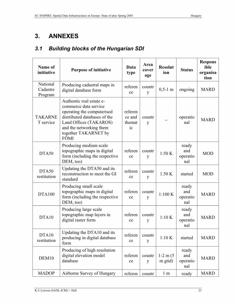
3.1 Building blocks of the Hungarian SDI
Name of initiative Purpose of initiative Data
type
Area coverage
Resolution Status
Responsible
organisation
National Cadastre Program
Producing cadastral maps in digital database form
reference
country 0,5-1 m ongoing MARD
TAKARNET service
Authentic real estate e-commerce data service operating the computerised distributed databases of the Land Offices (TAKAROS) and the networking them together TAKARNET by FÖMI
reference and themat
ic
country − operatio
nal MARD
DTA50
Producing medium scale topographic maps in digital form (including the respective DEM, too)
reference
country 1:50 K
ready and
operational
MOD
DTA50 restitution
Updating the DTA50 and its reconstruction to meet the GI standard
reference
country 1.50 K started MOD
DTA100
Producing small scale topographic maps in digital form (including the respective DEM, too)
reference
country 1:100 K
ready and
operational
MARD
DTA10
Producing large scale topographic map layers in digital raster form
reference
country 1:10 K
ready and
operational
MARD
DTA10 restitution
Updating the DTA10 and its producing in digital database form
reference
country 1:10 K started MARD
DEM10
Producing of high resolution digital elevation model database
reference
country
1-2 m (5 m gtid)
ready and
operational
MARD
MADOP Airborne Survey of Hungary referen countr 1 m ready MARD
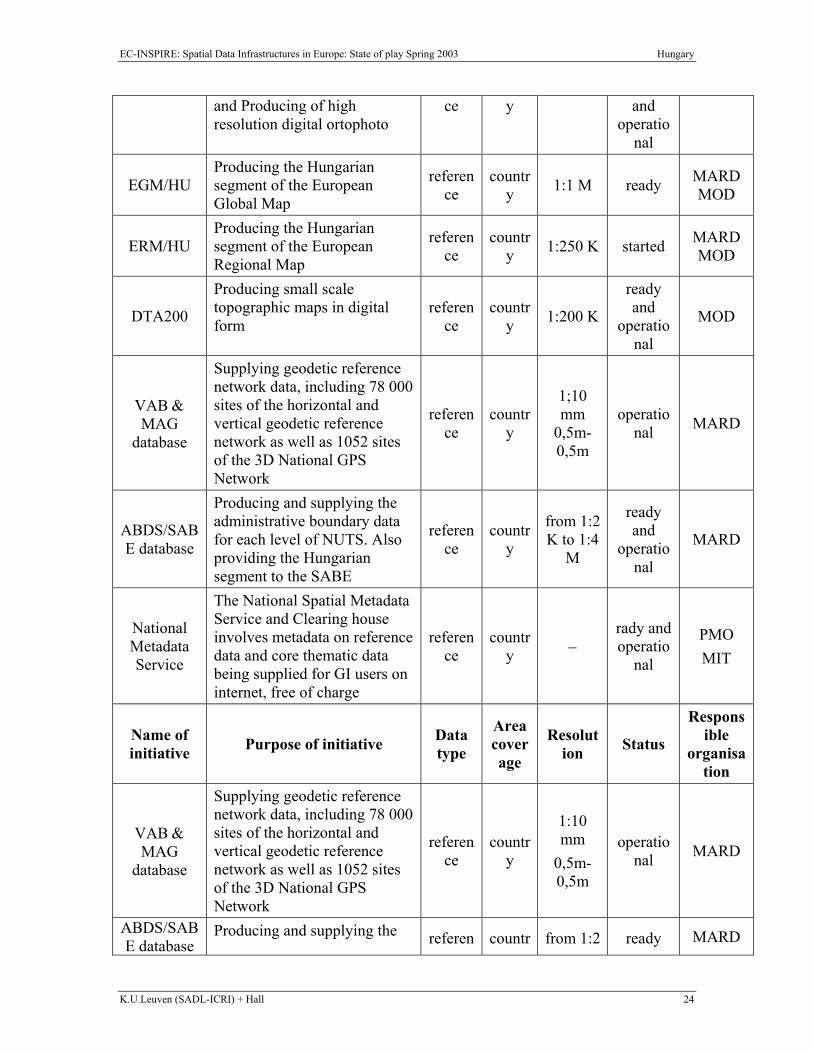
EC-INSPIRE: Spatial Data Infrastructures in Europe: State of play Spring 2003 Hungary
K.U.Leuven (SADL-ICRI) + Hall 24
and Producing of high resolution digital ortophoto
ce y and operatio
nal
EGM/HU Producing the Hungarian segment of the European Global Map
reference
country 1:1 M ready MARD
MOD
ERM/HU Producing the Hungarian segment of the European Regional Map
reference
country 1:250 K started MARD
MOD
DTA200
Producing small scale topographic maps in digital form
reference
country 1:200 K
ready and
operational
MOD
VAB & MAG
database
Supplying geodetic reference network data, including 78 000 sites of the horizontal and vertical geodetic reference network as well as 1052 sites of the 3D National GPS Network
reference
country
1;10 mm
0,5m-0,5m
operational MARD
ABDS/SABE database
Producing and supplying the administrative boundary data for each level of NUTS. Also providing the Hungarian segment to the SABE
reference
country
from 1:2 K to 1:4
M
ready and
operational
MARD
National Metadata Service
The National Spatial Metadata Service and Clearing house involves metadata on reference data and core thematic data being supplied for GI users on internet, free of charge
reference
country −
rady and operatio
nal
PMO MIT
Name of initiative Purpose of initiative Data
type
Area coverage
Resolution Status
Responsible
organisation
VAB & MAG
database
Supplying geodetic reference network data, including 78 000 sites of the horizontal and vertical geodetic reference network as well as 1052 sites of the 3D National GPS Network
reference
country
1:10 mm
0,5m-0,5m
operational MARD
ABDS/SABE database
Producing and supplying the referen countr from 1:2 ready MARD
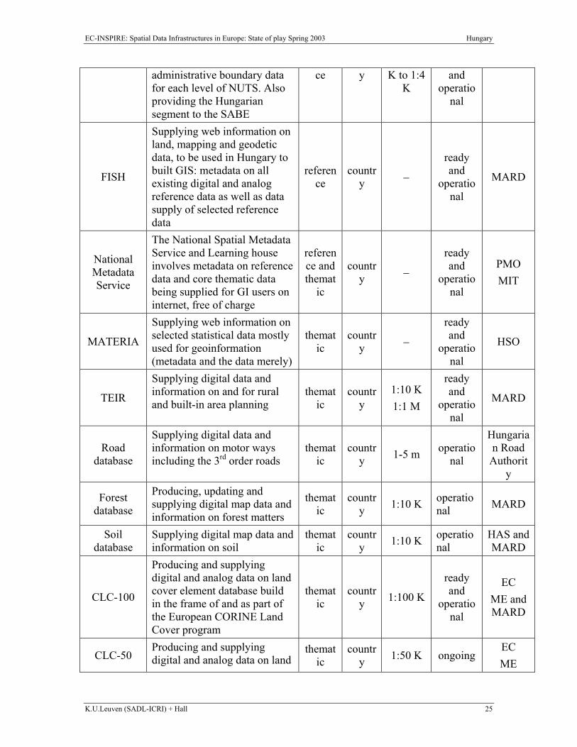
EC-INSPIRE: Spatial Data Infrastructures in Europe: State of play Spring 2003 Hungary
K.U.Leuven (SADL-ICRI) + Hall 25
administrative boundary data for each level of NUTS. Also providing the Hungarian segment to the SABE
ce y K to 1:4 K
and operatio
nal
FISH
Supplying web information on land, mapping and geodetic data, to be used in Hungary to built GIS: metadata on all existing digital and analog reference data as well as data supply of selected reference data
reference
country −
ready and
operational
MARD
National Metadata Service
The National Spatial Metadata Service and Learning house involves metadata on reference data and core thematic data being supplied for GI users on internet, free of charge
reference and themat
ic
country −
ready and
operational
PMO MIT
MATERIA
Supplying web information on selected statistical data mostly used for geoinformation (metadata and the data merely)
thematic
country −
ready and
operational
HSO
TEIR
Supplying digital data and information on and for rural and built-in area planning
thematic
country
1:10 K 1:1 M
ready and
operational
MARD
Road database
Supplying digital data and information on motor ways including the 3rd order roads
thematic
country 1-5 m operatio
nal
Hungarian Road
Authority
Forest database
Producing, updating and supplying digital map data and information on forest matters
thematic
country 1:10 K operatio
nal MARD
Soil database
Supplying digital map data and information on soil
thematic
country 1:10 K operatio
nal HAS and MARD
CLC-100
Producing and supplying digital and analog data on land cover element database build in the frame of and as part of the European CORINE Land Cover program
thematic
country 1:100 K
ready and
operational
EC ME and MARD
CLC-50 Producing and supplying digital and analog data on land
thematic
country 1:50 K ongoing
EC ME
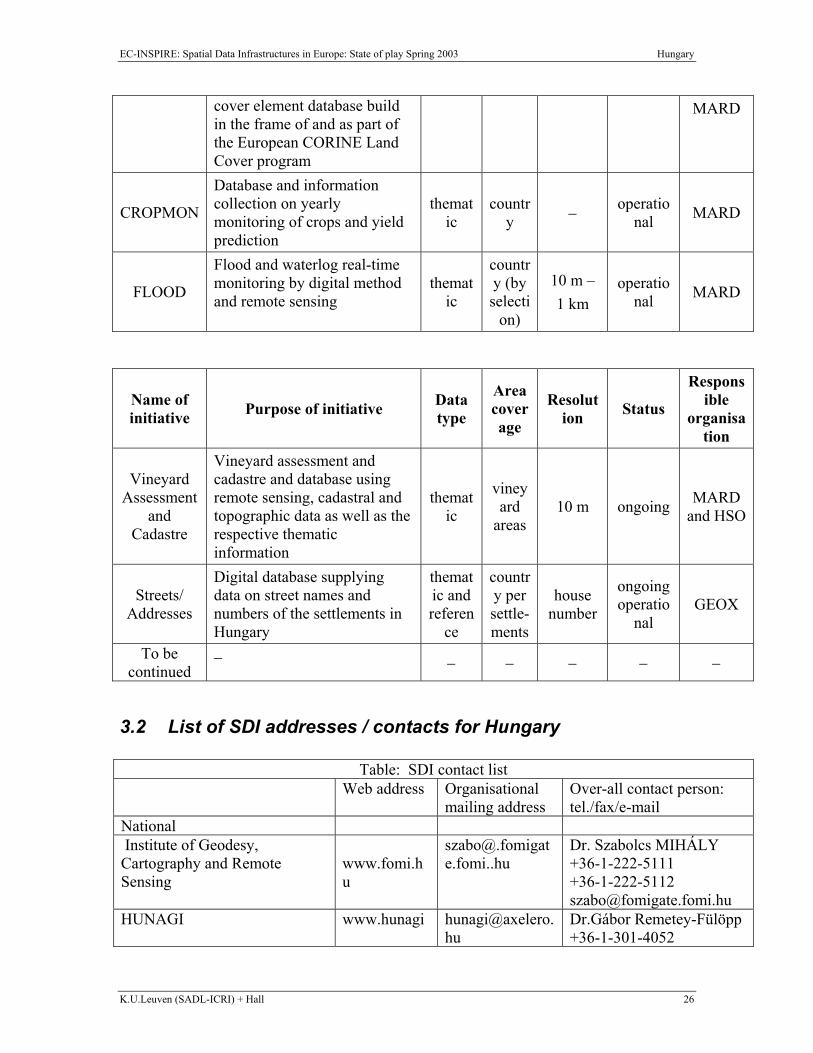
EC-INSPIRE: Spatial Data Infrastructures in Europe: State of play Spring 2003 Hungary
K.U.Leuven (SADL-ICRI) + Hall 26
cover element database build in the frame of and as part of the European CORINE Land Cover program
MARD
CROPMON
Database and information collection on yearly monitoring of crops and yield prediction
thematic
country − operatio
nal MARD
FLOOD
Flood and waterlog real-time monitoring by digital method and remote sensing
thematic
country (by selecti
on)
10 m – 1 km
operational MARD
Name of initiative Purpose of initiative Data
type
Area coverage
Resolution Status
Responsible
organisation
Vineyard Assessment
and Cadastre
Vineyard assessment and cadastre and database using remote sensing, cadastral and topographic data as well as the respective thematic information
thematic
vineyard
areas 10 m ongoing MARD
and HSO
Streets/ Addresses
Digital database supplying data on street names and numbers of the settlements in Hungary
thematic and referen
ce
country per settle-ments
house number
ongoing operatio
nal GEOX
To be continued
− − − − − −
3.2 List of SDI addresses / contacts for Hungary
Table: SDI contact list Web address Organisational
mailing address Over-all contact person: tel./fax/e-mail
National Institute of Geodesy, Cartography and Remote Sensing
www.fomi.hu
Dr. Szabolcs MIHÁLY +36-1-222-5111 +36-1-222-5112 [email protected]
HUNAGI www.hunagi [email protected]
Dr.Gábor Remetey-Fülöpp +36-1-301-4052
EC-INSPIRE: Spatial Data Infrastructures in Europe: State of play Spring 2003 Hungary
K.U.Leuven (SADL-ICRI) + Hall 27
+36-1-301-4719 [email protected]
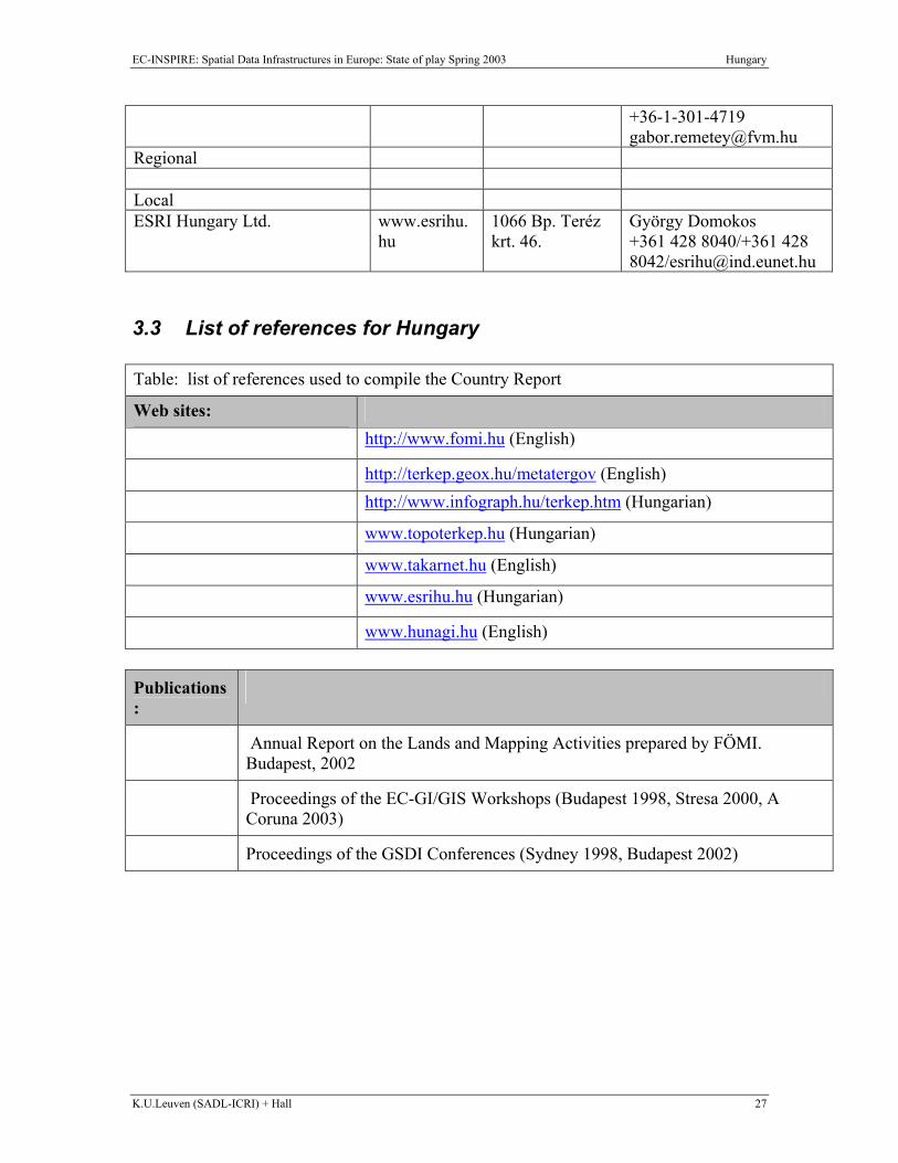
Regional Local ESRI Hungary Ltd. www.esrihu.
hu 1066 Bp. Teréz krt. 46.
György Domokos +361 428 8040/+361 428 8042/[email protected]
3.3 List of references for Hungary Table: list of references used to compile the Country Report
Web sites:
http://www.fomi.hu (English)
http://terkep.geox.hu/metatergov (English)
http://www.infograph.hu/terkep.htm (Hungarian)
www.topoterkep.hu (Hungarian)
www.takarnet.hu (English)
www.esrihu.hu (Hungarian)
www.hunagi.hu (English) Publications:
Annual Report on the Lands and Mapping Activities prepared by FÖMI. Budapest, 2002
Proceedings of the EC-GI/GIS Workshops (Budapest 1998, Stresa 2000, A Coruna 2003)
Proceedings of the GSDI Conferences (Sydney 1998, Budapest 2002)