specification document of unified cadastral system model
TRANSCRIPT

Specification Document
Of
Unified Cadastral System
Model
For
Reforming and Modernization of Cadaster System in Pakistan
Survey of Pakistan
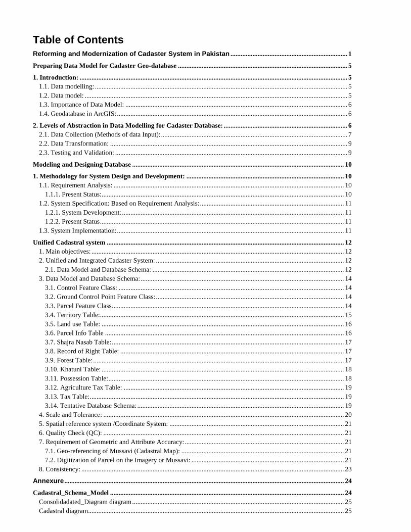
Table of Contents
Reforming and Modernization of Cadaster System in Pakistan ..................................................................... 1
Preparing Data Model for Cadaster Geo-database .................................................................................................... 5
1. Introduction: .............................................................................................................................................................. 5 1.1. Data modelling: ..................................................................................................................................................... 5 1.2. Data model: ........................................................................................................................................................... 5 1.3. Importance of Data Model: ................................................................................................................................... 6 1.4. Geodatabase in ArcGIS: ........................................................................................................................................ 6
2. Levels of Abstraction in Data Modelling for Cadaster Database: ......................................................................... 6 2.1. Data Collection (Methods of data Input): .............................................................................................................. 7 2.2. Data Transformation: ............................................................................................................................................ 9 2.3. Testing and Validation: ......................................................................................................................................... 9
Modeling and Designing Database ............................................................................................................................. 10
1. Methodology for System Design and Development: ............................................................................................. 10 1.1. Requirement Analysis: ........................................................................................................................................ 10
1.1.1. Present Status: ............................................................................................................................................... 10 1.2. System Specification: Based on Requirement Analysis: ..................................................................................... 11
1.2.1. System Development: ................................................................................................................................... 11 1.2.2. Present Status ................................................................................................................................................ 11
1.3. System Implementation: ...................................................................................................................................... 11
Unified Cadastral system ............................................................................................................................................ 12 1. Main objectives: ..................................................................................................................................................... 12 2. Unified and Integrated Cadaster System: ............................................................................................................... 12
2.1. Data Model and Database Schema: ................................................................................................................. 12 3. Data Model and Database Schema: ........................................................................................................................ 14
3.1. Control Feature Class: ..................................................................................................................................... 14 3.2. Ground Control Point Feature Class: ............................................................................................................... 14 3.3. Parcel Feature Class ......................................................................................................................................... 14 3.4. Territory Table: ................................................................................................................................................ 15 3.5. Land use Table: ............................................................................................................................................... 16 3.6. Parcel Info Table ............................................................................................................................................. 16 3.7. Shajra Nasab Table: ......................................................................................................................................... 17 3.8. Record of Right Table: .................................................................................................................................... 17 3.9. Forest Table: .................................................................................................................................................... 17 3.10. Khatuni Table: ............................................................................................................................................... 18 3.11. Possession Table: ........................................................................................................................................... 18 3.12. Agriculture Tax Table: .................................................................................................................................. 19 3.13. Tax Table: ...................................................................................................................................................... 19 3.14. Tentative Database Schema: .......................................................................................................................... 19
4. Scale and Tolerance: .............................................................................................................................................. 20 5. Spatial reference system /Coordinate System: ....................................................................................................... 21 6. Quality Check (QC): .............................................................................................................................................. 21 7. Requirement of Geometric and Attribute Accuracy: .............................................................................................. 21
7.1. Geo-referencing of Mussavi (Cadastral Map): ................................................................................................ 21 7.2. Digitization of Parcel on the Imagery or Mussavi: .......................................................................................... 21
8. Consistency: ........................................................................................................................................................... 23
Annexure ..................................................................................................................................................................... 24
Cadastral_Schema_Model .......................................................................................................................................... 24 Consolidadated_Diagram diagram ............................................................................................................................. 25 Cadastral diagram....................................................................................................................................................... 25

ParcelTerritoryDiagram diagram ............................................................................................................................... 27 LandUse diagram ....................................................................................................................................................... 28 Landuse_Subtypes diagram ........................................................................................................................................ 29 ROR diagram ............................................................................................................................................................. 30 Forest diagram ............................................................................................................................................................ 31 Agriculture diagram ................................................................................................................................................... 32 ControlPointDiagram diagram ................................................................................................................................... 32 Agriculture diagram ................................................................................................................................................... 33 ControlPointDiagram diagram ................................................................................................................................... 34 AgricultureLand ......................................................................................................................................................... 34 AgricultureTaxTable .................................................................................................................................................. 37 BarrenLand ................................................................................................................................................................. 40 Bridge ......................................................................................................................................................................... 43 CommunicationV ....................................................................................................................................................... 46 CommunityFacilities .................................................................................................................................................. 47 ControlType ............................................................................................................................................................... 55 Control_Point ............................................................................................................................................................. 57 Crossing ..................................................................................................................................................................... 59 EducationalFacility .................................................................................................................................................... 60 ForestCategoryV ........................................................................................................................................................ 61 ForestTable ................................................................................................................................................................. 64 ForestTypeV ............................................................................................................................................................... 67 GenderV ..................................................................................................................................................................... 69 GroundWater .............................................................................................................................................................. 70 Historical .................................................................................................................................................................... 72 IndustrialArea ............................................................................................................................................................. 73 IntiqalType ................................................................................................................................................................. 75 KhatuniTable .............................................................................................................................................................. 76 LandUseTable ............................................................................................................................................................ 78 LandUseType ............................................................................................................................................................. 80 Landform .................................................................................................................................................................... 85 MedicalFacility .......................................................................................................................................................... 86 MineCavePass ............................................................................................................................................................ 88 NaturalVegetation ...................................................................................................................................................... 90 OwnershipType .......................................................................................................................................................... 91 Parcel .......................................................................................................................................................................... 92 Parcel_InfoTable ........................................................................................................................................................ 96 Pipeline..................................................................................................................................................................... 100 PossessionTable ....................................................................................................................................................... 101 PossessionType ........................................................................................................................................................ 102 Railway .................................................................................................................................................................... 104 RecordOfRightsTable .............................................................................................................................................. 105 RecreationalFacility ................................................................................................................................................. 108 ReligiousPlaces ........................................................................................................................................................ 112 Reservoir .................................................................................................................................................................. 115 Residence ................................................................................................................................................................. 117 RiversCanalLakes .................................................................................................................................................... 122 Road ......................................................................................................................................................................... 125 ShajraNasabTable .................................................................................................................................................... 128 SourceOfIrrigation ................................................................................................................................................... 132 Strategic ................................................................................................................................................................... 132 Stream ...................................................................................................................................................................... 135 TaxTable .................................................................................................................................................................. 138 TerritoryTable .......................................................................................................................................................... 139

TransmissionLine ..................................................................................................................................................... 143 TreeCover ................................................................................................................................................................. 145 Tunnel ...................................................................................................................................................................... 147 Urban_RuralV .......................................................................................................................................................... 148 Wetland .................................................................................................................................................................... 148

Preparing Data Model for Cadaster Geo-database
1. Introduction:
1.1. Data modelling: It is a process that creates a data model for the data to be stored in a database. This data model is a
conceptual representation of datasets, its associations between different datasets and the rules. The main
purpose of data modelling is that it helps in the visual representation of data and enforces rules,
regulatory compliances, and government policies on the data. The data models also certifies consistency
in naming conventions, semantics, default values and security while guaranteeing data quality.
1.2. Data model: Data models are fundamental entities, which defines the connections among the datasets along with its
processing and storage inside a system. It organizes data description, data semantics and consistency
constraints of data. The data model emphasizes on what data is needed and how it should be organized
instead of what operations will be performed on the data. Data model ensures the appropriate way in
which database management systems are structured in order to optimize the data handling. The
modelling team is using geographic data to be organized in a Geographic Information System (GIS)
domain. A tentative conceptual model for designing a geo-database is prepared which can be seen as a
schema in the annexures. Its refinement is a continuous process, however, the provided geo-database
design is readily enough for collection/preparation of data usable for GIS purpose. The data developed
based on the provided template will be validated, refined, and transformed into the final geo-database.
In order to create digital maps that will be used in any GIS, it is critically important that a data modeling
process has been undertaken. Data modeling provides the set of rules on how spatial information can be
intelligently structured as the basis for map production in a GIS.

1.3. Importance of Data Model: The vital goals of using a data model are as follows:
It makes sure that all datasets required by the database are accurately represented. Any data
omission will lead to creation of incorrect results
It assists in the design of database at physical, conceptual and logical levels
Its structure aids to define the relational tables, primary and foreign keys and stored processes
It provides a clear picture of the base data
It is helpful in the identification of missing and redundant data
Although the initial creation of data model is time consuming but in long run, it makes the IT infrastructure
to upgrade and the maintenance is faster.
1.4. Geodatabase in ArcGIS: An ArcGIS geodatabase is an assembly of geographic datasets of numerous forms held in a common file
system folder, or a multiuser relational database management system (DBMS) such as Oracle, Microsoft
SQL Server, Post-GreSQL, or IBM DB2. The geodatabase is the native data structure for ArcGIS and is the
primary data format used for editing and data management. While ArcGIS works with geographic
information in numerous geographic information system (GIS) file formats, it is designed to work with and
leverage the capabilities of the geodatabase. It is the physical store of geographic information, primarily
using a DBMS or file system. You can access and work with this physical instance of your collection of
datasets either through ArcGIS or through a database management system using SQL. Geodatabase have
a comprehensive information model for representing and managing geographic information. This
information model is implemented as a series of tables holding feature classes and attributes.
2. Levels of Abstraction in Data Modelling for Cadaster Database: There are different levels of abstraction of cadaster database in data modelling. These levels are classified
on the basis of necessary tasks to be undertaken in a systematic way that will initiate the development of
a conceptual model. These levels will also help in the development of a conceptual schema and a data
model for the development of spatial database. The main levels of abstractions area as follows:
First level: Understanding the existing system
Second level: Conceptual model
Third level: Logical model / Data structure
Fourth level: Physical model / Acute file structure
Fifth level: Creation of digital maps

If data modeling has been done well, the maps should have the necessary intelligence to be optimally
used for GIS purposes.
2.1. Data Collection (Methods of data Input): The methods for data collection and input will be used to prepare a GIS based cadaster database. The
different methods are as follows:
i. Scanning
ii. Geo-referencing
iii. Digitizing
iv. Field Work
v. Keyboard data entry
vi. Data Validation
After the preparation of GIS data adopting the proposed methodology for mapping in urban areas and
state land, the next stage is to assemble the GIS data into a GIS-based cadaster database to support the
existing Land Records Management & Information Systems (LRIMS). The conceptual flow of data from its
actual collection and preparation towards GIS-based cadaster database is shown in Figure 1.

Figure 1: Conceptual flow of data
Figure 1 shows that after preparation of the Topo-based cadaster map into digital format (shape file), it
must be ensured that the collected data is Up-to-date and accurate. The process of data refinement will
include validating, editing, and correcting the data and lastly the data would need to be transformed or
stored into an organized form (database designed based on prepared data model).

2.2. Data Transformation: The Data transformation processes will be performed after the data collection techniques. The following
steps will be executed in the process of data transformation.
i. After the collection of data and preparation of the topo-based cadaster map into digital
format (shape file), it must be ensured that the collected data is Up-to-date and accurate.
ii. The data would need to be transformed /stored into an organized form (database designed
based on prepared data model).
iii. Data refinement will include validating, editing, and correcting the data, and may also
require other manipulations such as data transformations or reclassifications. I.e. that may
be necessary to transform data so that the data can be used for specific GIS-based Cadaster
Management System.
iv. The GIS data would be examined for typical topological errors caused during the map
digitizing process like overshoots, undershoots, loops or knots, duplicate lines, etc.
2.3. Testing and Validation: The system testing, validation and removal of any deficiency will track the following process:
i. The System testing and implementation will be an iterative process that will be continued till the
completion /after of the project for ensuring its sustainability.
ii. After the completion of the project, data will also be held in custody of Survey of Pakistan (SoP)
therefore, the development of a support system will also be planned for ensuring its sustainability.
iii. Include the development of a procedure to integrate the existing cadastral system with the newly
developed system.
iv. Technical and support documents will also be drafted.
v. Technical guidelines for managing data in the SoP data center should be developed.

Modeling and Designing Database The team employed on the task of developing conceptual model and designing geo-database has already
been working on the given task since the preliminary preparation phase of the project. The following tasks
has been planned / are being carried out during the execution of the project.
1. Methodology for System Design and Development:
1.1. Requirement Analysis: o Review of the current system Cadaster database/system to comprehend the business process
o Assess the user needs of a digital Cadaster database
o Analyze issues related to the existing Manual System
1.1.1. Present Status:
Review of the current system Cadaster database/system that will be continuous study and the
regional directorates are expected to provide assistance for coordination with the relevant
stakeholders in all province including AJ&K.
The SoP’s team also intends to meet and discuss with the technical teams of PLRA and other data
custodians preferably database users for detailed requirement analysis in order to understand
their data requirements, and the functional requirements including user-defined operations or
transaction like division, merging and registration of the Parcels, record retrievals, updates, etc.,
that are to be applied on the database.
With the in-depth study of existing digital system being run or under plan in all the provinces will
be utilized for modelling the system for its re-designing and re-engineering as per international
standards and practices to make it compatible with GIS data (Cadaster maps).
The team is being studying and assessing the user needs of a digital Cadaster database for finalizing
the deliverable to be shared with stakeholders including revenue authorities.

1.2. System Specification: Based on Requirement Analysis:
1.2.1. System Development:
o Undertake systems re-designing and re-engineering as per international standards and practices
o UML (Enterprise Architect)
o XML Schemas
o Development of a prototype and its evaluation
1.2.2. Present Status
i. During the pilot projects undertaken by DPO/NO, 08 party, a prototype based conceptual model
has already been developed and all the data prepared in the pilot projects are based on the geo-
database template provided by the team.
ii. The GIS data prepared on the draft template in G-6 Sector is implemented on developing Digital
Cadaster by converting it into cadaster using parcel Fabrics (ArcGIS platform). The cadaster data
will be handled at SoP using ArcGIS /Arc-SDE platform. The final data will be handed over/shared
with the stakeholders in the shape of geo-database designed on the SoP developed Model and the
stakeholders will have to decide on their own either to use already developed tools or customized
tools for handling the cadaster data and integrating it into their existing LRMIS.
iii. The base geo-database template will be provided by the team to start work on data received from
stakeholders. The data developed based on the provided template will be validated after its
submission to the project secretariat.
1.3. System Implementation: i. The tentative Cadastral Conceptual Schema, Basic Data Model and geo-database design
has been framed is ready to share with the directorates.
ii. The base data developed in the provided geo-database after verification be submitted to
the Project Secretariat there in it will be converted into usable cadaster database before
handing over the same to the partner users.

Unified Cadastral system The lack of interoperability (i.e. combining of cadaster information data from various stakeholders in a
consistent way without involving any effort) and quality of cadaster data is a great challenge. In order to
solve these problems it is necessary to take measures of coordination between the stakeholders of
cadaster system. The Directive of the honorable Prime Minister (PM) is to establish an infrastructure for
unified cadaster system.
The unified cadaster system will be based on already developed analog provincial cadaster system. To
ensure cadaster data quality and interoperability, method and rules addressing these challenges of the
infrastructure are being specified.
The participation of stakeholders is very crucial for improvement and implementation of the tentative
cadaster model. For this reason, to reach on consensus Survey of Pakistan team met with various
stakeholders.
1. Main objectives: The main objectives of the formation of unified cadastral system are as follows:
1. To promote and facilitate sharing, exchange, dissemination and use of cadaster information
among stakeholders
2. To ensure accuracy, correctness and consistency of cadaster information
2. Unified and Integrated Cadaster System: To integrate cadaster information, a number of aspects are to be considered as shown in Figure 2.
2.1. Data Model and Database Schema:
a. Data Model
b. Scale
c. Database Schema/ Structure
2.2. Spatial Reference System (Coordinate System):
The main commonly used spatial reference systems in Pakistan are WGS 1984, LCC, and UTM. Moreover,
the UTM zones for Pakistan are 41N, 42N and 43N as Pakistan lies to the north of the equator.
2.3. Quality Check
The quality check consists of the following two main process:
a) Accuracy

b) Consistency
Database Schema/ Structure
Data Model and Database Schema
Scale Data Model
Spatial Reference System/ Coordinate
SystemQuality Check
Accuracy Consistency
Core Aspects of Cadaster systems
Integration
Figure 2: Conceptual Model for Unified Cadaster System
The objectives are to propose a design of a Spatio-textual database (both in Xml format and platform
based database)
To make all the parcel based registration operations
To fulfill the requirements for querying spatial, and tenure based textual record for cadastral data,
To connect Surveys, GIS and MIS for cadaster management

3. Data Model and Database Schema: The tentative Database schema is shown in Figure 14. The detailed cadastral schema model can also be
seen in the annexures. The tentative database schema consists of the following table and feature classes:
3.1. Control Feature Class:
It represents the control points that are used during the process of geo-referencing. They can include the
ground control points that are acquired through the survey team. It is important to first plot all ground
control points and enter proper description in the area of interest. The main attributes in Control feature
class are shown in Figure 3.
Figure 3: The main attributes in Control feature class
3.2. Ground Control Point Feature Class:
It represents the control points that are used during the process of geo-referencing. They can include the
ground control points that are acquired through the survey team. It is important to first plot all ground
control points and enter proper description in the area of interest. The main attributes in Control feature
class are shown in Figure 4.
Figure 4: The main attributes in ground control point feature class
3.3. Parcel Feature Class
It represents the parcel of any village/Municipality that represents the land type field according to
revenue records. After plotting control points parcel data have to be digitized and all relevant information
needs to be entered. This process could be classified as follow:

Territory Information record creation for area of interest
Digitization of Parcels
Proper land classification
Parcel specific information entry
Before parcel digitization, territory table creation is very important.
This table contains administrative boundaries information e.g., Province, District, Tehsil, etc.
Specific administrate unit could be access using “territory_ID”
The main attributes in Parcel feature class are shown in Figure 5.
Figure 5: The main attributes in Parcel feature class
3.4. Territory Table:
Territory table is used for recording administrative units’ information like name of a village, its tehsil,
district, province name etc. Territory ID segregates the administrative area unit. The main attributes in
territory table are shown in Figure 6.
Figure 6: The main attributes in territory table
Territory ID is in the following format.
Territory ID
Province Division District Tehsil Urban/ Rural
Revenue Village ID/ Municipal
0 / 1
To understand the territory ID let’s take an example, suppose we have tarlai village of Tehsil & Distt.
Rawalpindi, and tarlai village hadbast number is 41, for this the territory ID will be in the form
“01110101041”, in this code the first two digit “01” represents the Punjab province, next two digit “11”

represent the Rawalpindi division, next two digit “01” represents the Rawalpindi district, next two digit
represents “01” represents Rawalpindi tehsil, and the “0” represent rural area and “41” represents village
“Tarlai”.
3.5. Land use Table:
The land use table is for recording land use information like residential, medical facility etc. The main
attributes in land use table are shown in Figure 7.
Figure 7: The main attributes in land use table
3.6. Parcel Info Table
Parcel information table records complementary information about parcel like, house number, street
number, sector number etc. The main attributes in parcel info table are shown in Figure 8.
Figure 8: The main attributes in Parcel info table

3.7. Shajra Nasab Table:
The main use of shajra nasab table is to record personal (name, id, profession etc.) and family related
information. The main attributes in Shajra nasab table are shown in Figure 9.
Figure 9: The main attributes in Shajra nasab table
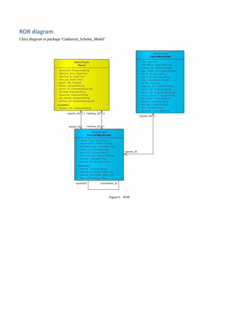
3.8. Record of Right Table:
This table is used to record ownership record of any parcel. The main attributes in record of rights table
are shown in Figure 10.
Figure 10: The main attributes in Record of rights table
3.9. Forest Table:
The forest table is used to record forest related information such as forest name, forest type, forest
category etc. The main attributes in forest table are shown in Figure 11.
Figure 11: The main attributes in Forest table

3.10. Khatuni Table:
The main purpose of the Khatuni table is to represent farmer information of parcel. The main attributes
in Khatuni table are shown in Figure 12.
Figure 12: The main attributes in Khatuni table
3.11. Possession Table:
The main purpose of the possession table is to represent possession information of parcel according to
the person information. The main attributes in Possession table are shown in Figure 13.
Figure 13: The main attributes in Possession table

3.12. Agriculture Tax Table:
Since the existing cadastral system is agriculture specific therefore the developed system is designed to
cope with the agriculture system needs and can be joined with existing system. The main attributes in
Agriculture tax table are shown in Figure 14.
Figure 14: The main attributes in Agriculture tax table
3.13. Tax Table:
The tax table represent tax to be collected from an individual person. The main attributes in Tax table are
shown in Figure 15.
Figure 15: The main attributes in Tax table
3.14. Tentative Database Schema:
The tentative database schema represent the relationship between different tables that are used in the
cadastral system. The main attributes in each table in the tentative database schema are shown in Figure
16.
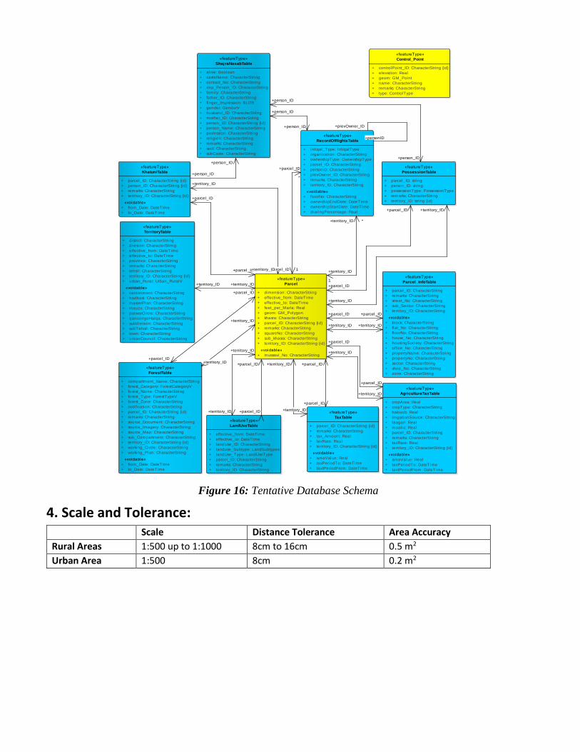
Figure 16: Tentative Database Schema
4. Scale and Tolerance: Scale Distance Tolerance Area Accuracy
Rural Areas 1:500 up to 1:1000 8cm to 16cm 0.5 m2
Urban Area 1:500 8cm 0.2 m2
«featureType»
AgricultureTaxTable
+ cropArea: Real
+ cropType: CharacterString
+ haboob: Real
+ irrigationSource: CharacterString
+ laagan: Real
+ maalia: Real
+ parcel_ID: CharacterString
+ remarks: CharacterString
+ taxRate: Real
+ territory_ID: CharacterString {id}
«voidable»
+ areaValue: Real
+ taxPeriodTo: DateTime
+ taxtPeriodFrom: DateTime
«featureType»
ForestTable
+ compartment_Name: CharacterString
+ forest_Category: ForestCategoryV
+ forest_Name: CharacterString
+ forest_Type: ForestTypeV
+ forest_Zone: CharacterString
+ notification: CharacterString
+ parcel_ID: CharacterString {id}
+ remarks: CharacterString
+ source_Document: CharacterString
+ source_Imagery: CharacterString
+ source_Map: CharacterString
+ sub_Compartment: CharacterString
+ territory_ID: CharacterString {id}
+ working_Circle: CharacterString
+ working_Plan: CharacterString
«voidable»
+ from_Date: DateTime
+ to_Date: DateTime
«featureType»
KhatuniTable
+ parcel_ID: CharacterString {id}
+ person_ID: CharacterString {id}
+ remarks: CharacterString
+ territory_ID: CharacterString {id}
«voidable»
+ from_Date: DateTime
+ to_Date: DateTime
«featureType»
LandUseTable
+ effective_from: DateTime
+ effective_to: DateTime
+ landUse_ID: CharacterString
+ landuse_Subtype: LandSubtypes
+ landUse_Type: LandUseType
+ parcel_ID: CharacterString
+ remarks: CharacterString
+ territory_ID: CharacterString
«featureType»
Parcel
+ dimension: CharacterString
+ effective_from: DateTime
+ effective_to: DateTime
+ feet_per_Marla: Real
+ geom: GM_Polygon
+ khasra: CharacterString
+ parcel_ID: CharacterString {id}
+ remarks: CharacterString
+ squareNo: CharacterString
+ sub_khasra: CharacterString
+ territory_ID: CharacterString {id}
«voidable»
+ mussavi_No: CharacterString
«featureType»
Parcel_InfoTable
+ parcel_ID: CharacterString
+ remarks: CharacterString
+ street_No: CharacterString
+ sub_Sector: CharacterString
+ territory_ID: CharacterString
«voidable»
+ block: CharacterString
+ flat_No: CharacterString
+ floorNo: CharacterString
+ house_No: CharacterString
+ housingSociety: CharacterString
+ office_No: CharacterString
+ propertyName: CharacterString
+ propertyNo: CharacterString
+ sector: CharacterString
+ shop_No: CharacterString
+ zone: CharacterString
«featureType»
RecordOfRightsTable
+ intiqal_Type: IntiqalType
+ organization: CharacterString
+ ownershipType: OwnershipType
+ parcel_ID: CharacterString
+ personID: CharacterString
+ prevOwner_ID: CharacterString
+ remarks: CharacterString
+ territory_ID: CharacterString
«voidable»
+ floorNo: CharacterString
+ ownershipEndDate: DateTime
+ ownershipStartDate: DateTime
+ sharingPercentage: Real
«featureType»
PossessionTable
+ parcel_ID: string
+ person_ID: string
+ possessionType: PossessionType
+ remarks: CharacterString
+ territory_ID: string {id}
«featureType»
TerritoryTable
+ district: CharacterString
+ division: CharacterString
+ effective_from: DateTime
+ effective_to: DateTime
+ province: CharacterString
+ remarks: CharacterString
+ tehsil: CharacterString
+ territory_ID: CharacterString {id}
+ urban_Rural: Urban_RuralV
«voidable»
+ cantonment: CharacterString
+ hadbast: CharacterString
+ masterPlan: CharacterString
+ mauza: CharacterString
+ patwarCircle: CharacterString
+ qanoongoHalqa: CharacterString
+ subdivision: CharacterString
+ subTehsil: CharacterString
+ town: CharacterString
+ unionCouncil: CharacterString
«featureType»
TaxTable
+ parcel_ID: CharacterString {id}
+ remarks: CharacterString
+ tax_Amount: Real
+ taxRate: Real
+ territory_ID: CharacterString {id}
«voidable»
+ areaValue: Real
+ taxPeriodTo: DateTime
+ taxtPeriodFrom: DateTime
«featureType»
ShajraNasabTable
+ alive: Boolean
+ casteName: CharacterString
+ contact_No: CharacterString
+ dep_Person_ID: CharacterString
+ family: CharacterString
+ father_ID: CharacterString
+ finger_Impression: BLOB
+ gender: GenderV
+ husband_ID: CharacterString
+ mother_ID: CharacterString
+ person_ID: CharacterString {id}
+ person_Name: CharacterString
+ profession: CharacterString
+ religion: CharacterString
+ remarks: CharacterString
+ sect: CharacterString
+ subCaste: CharacterString
«featureType»
Control_Point
+ controlPoint_ID: CharacterString {id}
+ elevation: Real
+ geom: GM_Point
+ name: CharacterString
+ remarks: CharacterString
+ type: ControlType
+territory_ID +territory_ID
+person_ID
+person_ID
+parcel_ID
*
+parcel_ID 1
+territory_ID+territory_ID
+parcel_ID
+parcel_ID
+parcel_ID
+parcel_ID
+parcel_ID
+parcel_ID
+territory_ID
1
+territory_ID *
+parcel_ID
+parcel_ID
+person_ID
+person_ID
+person_ID
+person_ID
+parcel_ID
+parcel_ID
+territory_ID
+territory_ID
+parcel_ID +parcel_ID
+territory_ID
+territory_ID
+territory_ID
+territory_ID
+territory_ID
+territory_ID
+personID
+prevOwner_ID
+territory_ID
+territory_ID
+parcel_ID
+parcel_ID
+territory_ID
+territory_ID

5. Spatial reference system /Coordinate System: The UTM projection coordinate system should be used for unified cadaster system. The UTM zones for
Pakistan are 41N, 42N and 43N as Pakistan lies to the north of the equator.
6. Quality Check (QC): To get the required data the QC has very crucial role, it ensures accuracy and consistency of the data populated in
the system. The two important components of the QC are as follow:
1. Accuracy
a. Geometric Accuracy
b. Attribute Accuracy
2. Consistency
7. Requirement of Geometric and Attribute Accuracy:
7.1. Geo-referencing of Mussavi (Cadastral Map):
Digitize parcel accuracy is influenced by Georeferencing RMS (Root Mean Square) error therefore the RMS
error should be less than the tolerance distance.
7.2. Digitization of Parcel on the Imagery or Mussavi:
The main processes performed in the digitization of parcel on the imagery or Mussavi are as follows:
1. Digitization of satellite imagery shall be performed as database schema with attribute
information related to the parcel of land. While storing the attribute information, the textual
details on the plan shall be converted into English language and stored in the GIS database.
2. Digitize all the features present on plan i.e. parcel, roads, water channels, graveyards, and
other similar features.
3. Parcels should be properly digitizes, e.g., while digitization line segments centerline of feature
should be digitize
4. Parcel segment must be larger than the tolerance distance

5. There should be no any gaps between parcels;
6. Parcels must not overlap
7. While parcel digitization unwanted Back loop and spike must not occur

8. The attribute should be properly entered
8. Consistency: The geometry and attributes should be consistent with respect to the other parcel and Mussavis.

Annexure
Cadastral_Schema_Model Package «applicationSchema» in package 'Cadastral Parcels Consolidated UML Model'
-- Name --
Cadastral
-- Definition --
The application schema CadastralParcels contains the feature types CadastralParcel

Consolidadated_Diagram diagram Class diagram in package 'Cadastral_Schema_Model'
Figure 1: Consolidadated_Diagram
Cadastral diagram
«featureType»
AgricultureTaxTable
+ cropArea: Real
+ cropType: CharacterString
+ haboob: Real
+ irrigationSource: CharacterString
+ laagan: Real
+ maalia: Real
+ parcel_ID: CharacterString
+ remarks: CharacterString
+ taxRate: Real
+ territory_ID: CharacterString {id}
«voidable»
+ areaValue: Real
+ taxPeriodTo: DateTime
+ taxtPeriodFrom: DateTime
«featureType»
ForestTable
+ compartment_Name: CharacterString
+ forest_Category: ForestCategoryV
+ forest_Name: CharacterString
+ forest_Type: ForestTypeV
+ forest_Zone: CharacterString
+ notification: CharacterString
+ parcel_ID: CharacterString {id}
+ remarks: CharacterString
+ source_Document: CharacterString
+ source_Imagery: CharacterString
+ source_Map: CharacterString
+ sub_Compartment: CharacterString
+ territory_ID: CharacterString {id}
+ working_Circle: CharacterString
+ working_Plan: CharacterString
«voidable»
+ from_Date: DateTime
+ to_Date: DateTime
«featureType»
KhatuniTable
+ parcel_ID: CharacterString {id}
+ person_ID: CharacterString {id}
+ remarks: CharacterString
+ territory_ID: CharacterString {id}
«voidable»
+ from_Date: DateTime
+ to_Date: DateTime
«featureType»
LandUseTable
+ effective_from: DateTime
+ effective_to: DateTime
+ landUse_ID: CharacterString
+ landuse_Subtype: LandSubtypes
+ landUse_Type: LandUseType
+ parcel_ID: CharacterString
+ remarks: CharacterString
+ territory_ID: CharacterString
«featureType»
Parcel
+ dimension: CharacterString
+ effective_from: DateTime
+ effective_to: DateTime
+ feet_per_Marla: Real
+ geom: GM_Polygon
+ khasra: CharacterString
+ parcel_ID: CharacterString {id}
+ remarks: CharacterString
+ squareNo: CharacterString
+ sub_khasra: CharacterString
+ territory_ID: CharacterString {id}
«voidable»
+ mussavi_No: CharacterString
«featureType»
Parcel_InfoTable
+ parcel_ID: CharacterString
+ remarks: CharacterString
+ street_No: CharacterString
+ sub_Sector: CharacterString
+ territory_ID: CharacterString
«voidable»
+ block: CharacterString
+ flat_No: CharacterString
+ floorNo: CharacterString
+ house_No: CharacterString
+ housingSociety: CharacterString
+ office_No: CharacterString
+ propertyName: CharacterString
+ propertyNo: CharacterString
+ sector: CharacterString
+ shop_No: CharacterString
+ zone: CharacterString
«featureType»
RecordOfRightsTable
+ intiqal_Type: IntiqalType
+ organization: CharacterString
+ ownershipType: OwnershipType
+ parcel_ID: CharacterString
+ personID: CharacterString
+ prevOwner_ID: CharacterString
+ remarks: CharacterString
+ territory_ID: CharacterString
«voidable»
+ floorNo: CharacterString
+ ownershipEndDate: DateTime
+ ownershipStartDate: DateTime
+ sharingPercentage: Real
«featureType»
PossessionTable
+ parcel_ID: string
+ person_ID: string
+ possessionType: PossessionType
+ remarks: CharacterString
+ territory_ID: string {id}
«featureType»
TerritoryTable
+ district: CharacterString
+ division: CharacterString
+ effective_from: DateTime
+ effective_to: DateTime
+ province: CharacterString
+ remarks: CharacterString
+ tehsil: CharacterString
+ territory_ID: CharacterString {id}
+ urban_Rural: Urban_RuralV
«voidable»
+ cantonment: CharacterString
+ hadbast: CharacterString
+ masterPlan: CharacterString
+ mauza: CharacterString
+ patwarCircle: CharacterString
+ qanoongoHalqa: CharacterString
+ subdivision: CharacterString
+ subTehsil: CharacterString
+ town: CharacterString
+ unionCouncil: CharacterString
«featureType»
TaxTable
+ parcel_ID: CharacterString {id}
+ remarks: CharacterString
+ tax_Amount: Real
+ taxRate: Real
+ territory_ID: CharacterString {id}
«voidable»
+ areaValue: Real
+ taxPeriodTo: DateTime
+ taxtPeriodFrom: DateTime
«featureType»
ShajraNasabTable
+ alive: Boolean
+ casteName: CharacterString
+ contact_No: CharacterString
+ dep_Person_ID: CharacterString
+ family: CharacterString
+ father_ID: CharacterString
+ finger_Impression: BLOB
+ gender: GenderV
+ husband_ID: CharacterString
+ mother_ID: CharacterString
+ person_ID: CharacterString {id}
+ person_Name: CharacterString
+ profession: CharacterString
+ religion: CharacterString
+ remarks: CharacterString
+ sect: CharacterString
+ subCaste: CharacterString
«featureType»
Control_Point
+ controlPoint_ID: CharacterString {id}
+ elevation: Real
+ geom: GM_Point
+ name: CharacterString
+ remarks: CharacterString
+ type: ControlType
+territory_ID +territory_ID
+person_ID
+person_ID
+parcel_ID
*
+parcel_ID 1
+territory_ID+territory_ID
+parcel_ID
+parcel_ID
+parcel_ID
+parcel_ID
+parcel_ID
+parcel_ID
+territory_ID
1
+territory_ID *
+parcel_ID
+parcel_ID
+person_ID
+person_ID
+person_ID
+person_ID
+parcel_ID
+parcel_ID
+territory_ID
+territory_ID
+parcel_ID +parcel_ID
+territory_ID
+territory_ID
+territory_ID
+territory_ID
+territory_ID
+territory_ID
+personID
+prevOwner_ID
+territory_ID
+territory_ID
+parcel_ID
+parcel_ID
+territory_ID
+territory_ID

Class diagram in package 'Cadastral_Schema_Model'
Figure 2: Cadastral
«featureType»
RecordOfRightsTable
+ intiqal_Type: IntiqalType
+ organization: CharacterString
+ ownershipType: OwnershipType
+ parcel_ID: CharacterString
+ personID: CharacterString
+ prevOwner_ID: CharacterString
+ remarks: CharacterString
+ territory_ID: CharacterString
«voidable»
+ floorNo: CharacterString
+ ownershipEndDate: DateTime
+ ownershipStartDate: DateTime
+ sharingPercentage: Real
«featureType»
ShajraNasabTable
+ alive: Boolean
+ casteName: CharacterString
+ contact_No: CharacterString
+ dep_Person_ID: CharacterString
+ family: CharacterString
+ father_ID: CharacterString
+ finger_Impression: BLOB
+ gender: GenderV
+ husband_ID: CharacterString
+ mother_ID: CharacterString
+ person_ID: CharacterString {id}
+ person_Name: CharacterString
+ profession: CharacterString
+ religion: CharacterString
+ remarks: CharacterString
+ sect: CharacterString
+ subCaste: CharacterString
«codeList»
OwnershipType
+ other
+ patti
+ private
+ shamilat-e-Deh
+ state
+ taraf
«featureType»
Parcel
+ dimension: CharacterString
+ effective_from: DateTime
+ effective_to: DateTime
+ feet_per_Marla: Real
+ geom: GM_Polygon
+ khasra: CharacterString
+ parcel_ID: CharacterString {id}
+ remarks: CharacterString
+ squareNo: CharacterString
+ sub_khasra: CharacterString
+ territory_ID: CharacterString {id}
«voidable»
+ mussavi_No: CharacterString
«featureType»
Parcel_InfoTable
+ parcel_ID: CharacterString
+ remarks: CharacterString
+ street_No: CharacterString
+ sub_Sector: CharacterString
+ territory_ID: CharacterString
«voidable»
+ block: CharacterString
+ flat_No: CharacterString
+ floorNo: CharacterString
+ house_No: CharacterString
+ housingSociety: CharacterString
+ office_No: CharacterString
+ propertyName: CharacterString
+ propertyNo: CharacterString
+ sector: CharacterString
+ shop_No: CharacterString
+ zone: CharacterString
«featureType»
TerritoryTable
+ district: CharacterString
+ division: CharacterString
+ effective_from: DateTime
+ effective_to: DateTime
+ province: CharacterString
+ remarks: CharacterString
+ tehsil: CharacterString
+ territory_ID: CharacterString {id}
+ urban_Rural: Urban_RuralV
«voidable»
+ cantonment: CharacterString
+ hadbast: CharacterString
+ masterPlan: CharacterString
+ mauza: CharacterString
+ patwarCircle: CharacterString
+ qanoongoHalqa: CharacterString
+ subdivision: CharacterString
+ subTehsil: CharacterString
+ town: CharacterString
+ unionCouncil: CharacterString
«featureType»
Control_Point
+ controlPoint_ID: CharacterString {id}
+ elevation: Real
+ geom: GM_Point
+ name: CharacterString
+ remarks: CharacterString
+ type: ControlType
«codeList»
ControlType
+ benchmark
+ boundaryPillar
+ canalBenchmark
+ distanceStone
+ distanceStoneCanal
+ gtBenchmark
+ other
+ spotHeight
+ standardBenchmark
+ traverseStation
+ trigonometricIP
+ trigonometricStation
«featureType»
TaxTable
+ parcel_ID: CharacterString {id}
+ remarks: CharacterString
+ tax_Amount: Real
+ taxRate: Real
+ territory_ID: CharacterString {id}
«voidable»
+ areaValue: Real
+ taxPeriodTo: DateTime
+ taxtPeriodFrom: DateTime
«codeList»
IntiqalType
+ bai
+ government_Allotted
+ hibba
+ other
+ vasiyat
+ wirasat
«featureType»
LandUseTable
+ effective_from: DateTime
+ effective_to: DateTime
+ landUse_ID: CharacterString
+ landuse_Subtype: LandSubtypes
+ landUse_Type: LandUseType
+ parcel_ID: CharacterString
+ remarks: CharacterString
+ territory_ID: CharacterString
«codeList»
Urban_RuralV
+ rural
+ urban
«codeList»
GenderV
+ female
+ male
+ transgender
+territory_ID
+territory_ID
+territory_ID
+territory_ID +parcel_ID
+parcel_ID
+territory_ID
1
+territory_ID
*
+territory_ID
+territory_ID
+parcel_ID
+parcel_ID
+parcel_ID
+parcel_ID
+territory_ID
+territory_ID
+personID+prevOwner_ID
+person_ID
+person_ID
+parcel_ID
*
+parcel_ID
1

ParcelTerritoryDiagram diagram Class diagram in package 'Cadastral_Schema_Model'
Figure 3: ParcelTerritoryDiagram
«featureType»
Parcel
+ dimension: CharacterString
+ effective_from: DateTime
+ effective_to: DateTime
+ feet_per_Marla: Real
+ geom: GM_Polygon
+ khasra: CharacterString
+ parcel_ID: CharacterString {id}
+ remarks: CharacterString
+ squareNo: CharacterString
+ sub_khasra: CharacterString
+ territory_ID: CharacterString {id}
«voidable»
+ mussavi_No: CharacterString
«featureType»
Parcel_InfoTable
+ parcel_ID: CharacterString
+ remarks: CharacterString
+ street_No: CharacterString
+ sub_Sector: CharacterString
+ territory_ID: CharacterString
«voidable»
+ block: CharacterString
+ flat_No: CharacterString
+ floorNo: CharacterString
+ house_No: CharacterString
+ housingSociety: CharacterString
+ office_No: CharacterString
+ propertyName: CharacterString
+ propertyNo: CharacterString
+ sector: CharacterString
+ shop_No: CharacterString
+ zone: CharacterString
«featureType»
LandUseTable
+ effective_from: DateTime
+ effective_to: DateTime
+ landUse_ID: CharacterString
+ landuse_Subtype: LandSubtypes
+ landUse_Type: LandUseType
+ parcel_ID: CharacterString
+ remarks: CharacterString
+ territory_ID: CharacterString
«featureType»
TerritoryTable
+ district: CharacterString
+ division: CharacterString
+ effective_from: DateTime
+ effective_to: DateTime
+ province: CharacterString
+ remarks: CharacterString
+ tehsil: CharacterString
+ territory_ID: CharacterString {id}
+ urban_Rural: Urban_RuralV
«voidable»
+ cantonment: CharacterString
+ hadbast: CharacterString
+ masterPlan: CharacterString
+ mauza: CharacterString
+ patwarCircle: CharacterString
+ qanoongoHalqa: CharacterString
+ subdivision: CharacterString
+ subTehsil: CharacterString
+ town: CharacterString
+ unionCouncil: CharacterString
+territory_ID +territory_ID
+parcel_ID
+parcel_ID
+territory_ID
+territory_ID
+parcel_ID +parcel_ID
+territory_ID
+territory_ID

LandUse diagram Class diagram in package 'Cadastral_Schema_Model'
Figure 4: LandUse
«featureType»
LandUseTable
+ effective_from: DateTime
+ effective_to: DateTime
+ landUse_ID: CharacterString
+ landuse_Subtype: LandSubtypes
+ landUse_Type: LandUseType
+ parcel_ID: CharacterString
+ remarks: CharacterString
+ territory_ID: CharacterString
«codeList»
LandUseType
+ Barren Land: BarrenLand
+ Medical Facility: MedicalFacility
+ Mine, Cave and Pass: MineCavePass
+ Pipeline: Pipeline
+ Railway: Railway
+ Recreational Facility: RecreationalFacility
+ Religious Places: ReligiousPlaces
+ Reservoir: Reservoir
+ Residence: Residence
+ Rivers, Canal, Lakes: RiversCanalLakes
+ Road: Road
+ Bridge: Bridge
+ Strategic: Strategic
+ Stream: Stream
+ Transmission Line: TransmissionLine
+ Tree Cover: TreeCover
+ Tunnel: Tunnel
+ Wetland: Wetland
+ Agriculture Land Type: AgricultureLand
+ Natural Vegetation: NaturalVegetation
+ Other: CharacterString
+ Community Facilities: CommunityFacilities
+ Crossing: Crossing
+ Educational Facility: EducationalFacility
+ Ground Water: GroundWater
+ Historical: Historical
+ Industrial Area: IndustrialArea
+ Landform: Landform
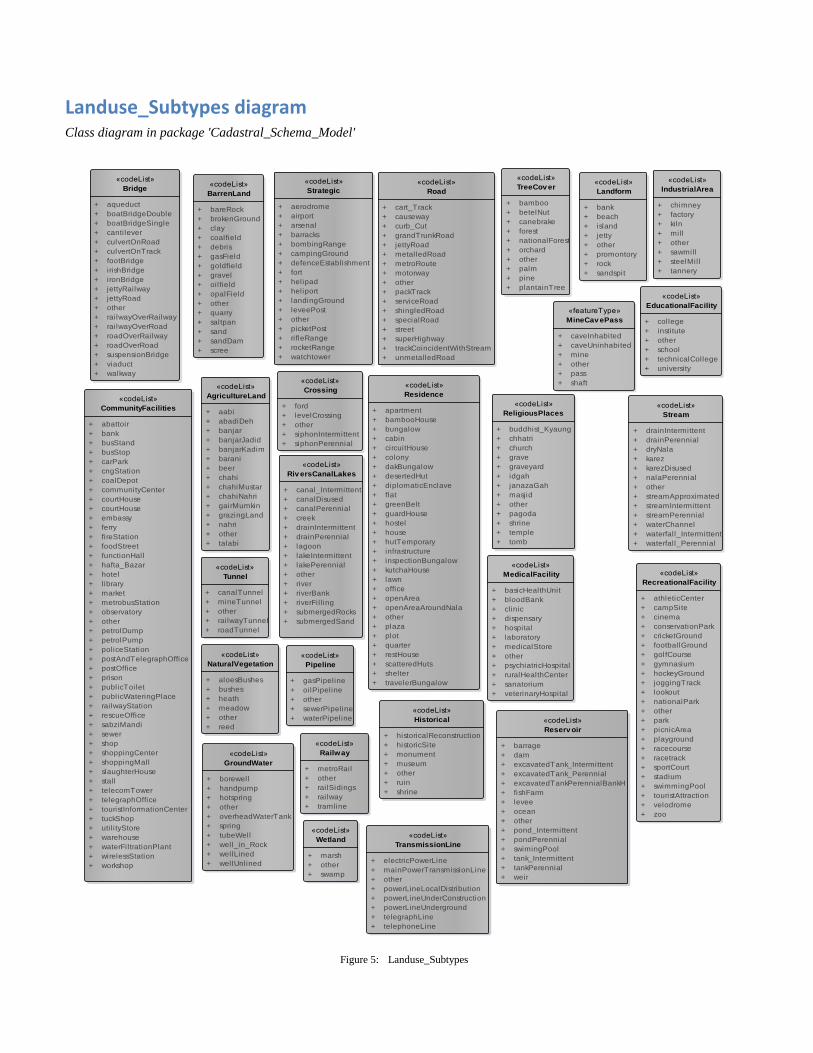
Landuse_Subtypes diagram Class diagram in package 'Cadastral_Schema_Model'
Figure 5: Landuse_Subtypes
«codeList»
BarrenLand
+ bareRock
+ brokenGround
+ clay
+ coalfield
+ debris
+ gasField
+ goldfield
+ gravel
+ oilfield
+ opalField
+ other
+ quarry
+ saltpan
+ sand
+ sandDam
+ scree
«codeList»
Bridge
+ aqueduct
+ boatBridgeDouble
+ boatBridgeSingle
+ cantilever
+ culvertOnRoad
+ culvertOnTrack
+ footBridge
+ irishBridge
+ ironBridge
+ jettyRailway
+ jettyRoad
+ other
+ railwayOverRailway
+ railwayOverRoad
+ roadOverRailway
+ roadOverRoad
+ suspensionBridge
+ viaduct
+ walkway
«codeList»
CommunityFacilities
+ abattoir
+ bank
+ busStand
+ busStop
+ carPark
+ cngStation
+ coalDepot
+ communityCenter
+ courtHouse
+ courtHouse
+ embassy
+ ferry
+ fireStation
+ foodStreet
+ functionHall
+ hafta_Bazar
+ hotel
+ library
+ market
+ metrobusStation
+ observatory
+ other
+ petrolDump
+ petrolPump
+ policeStation
+ postAndTelegraphOffice
+ postOffice
+ prison
+ publicToilet
+ publicWateringPlace
+ railwayStation
+ rescueOffice
+ sabziMandi
+ sewer
+ shop
+ shoppingCenter
+ shoppingMall
+ slaughterHouse
+ stall
+ telecomTower
+ telegraphOffice
+ touristInformationCenter
+ tuckShop
+ util ityStore
+ warehouse
+ waterFiltrationPlant
+ wirelessStation
+ workshop
«codeList»
Crossing
+ ford
+ levelCrossing
+ other
+ siphonIntermittent
+ siphonPerennial
«codeList»
EducationalFacility
+ college
+ institute
+ other
+ school
+ technicalCollege
+ university
«codeList»
GroundWater
+ borewell
+ handpump
+ hotspring
+ other
+ overheadWaterTank
+ spring
+ tubeWell
+ well_in_Rock
+ wellLined
+ wellUnlined
«codeList»
Historical
+ historicalReconstruction
+ historicSite
+ monument
+ museum
+ other
+ ruin
+ shrine
«codeList»
IndustrialArea
+ chimney
+ factory
+ kiln
+ mill
+ other
+ sawmill
+ steelMill
+ tannery
«codeList»
Landform
+ bank
+ beach
+ island
+ jetty
+ other
+ promontory
+ rock
+ sandspit
«codeList»
MedicalFacility
+ basicHealthUnit
+ bloodBank
+ clinic
+ dispensary
+ hospital
+ laboratory
+ medicalStore
+ other
+ psychiatricHospital
+ ruralHealthCenter
+ sanatorium
+ veterinaryHospital
«featureType»
MineCav ePass
+ caveInhabited
+ caveUninhabited
+ mine
+ other
+ pass
+ shaft
«codeList»
Pipeline
+ gasPipeline
+ oilPipeline
+ other
+ sewerPipeline
+ waterPipeline
«codeList»
Railway
+ metroRail
+ other
+ railSidings
+ railway
+ tramline
«codeList»
RecreationalFacility
+ athleticCenter
+ campSite
+ cinema
+ conservationPark
+ cricketGround
+ footballGround
+ golfCourse
+ gymnasium
+ hockeyGround
+ joggingTrack
+ lookout
+ nationalPark
+ other
+ park
+ picnicArea
+ playground
+ racecourse
+ racetrack
+ sportCourt
+ stadium
+ swimmingPool
+ touristAttraction
+ velodrome
+ zoo
«codeList»
ReligiousPlaces
+ buddhist_Kyaung
+ chhatri
+ church
+ grave
+ graveyard
+ idgah
+ janazaGah
+ masjid
+ other
+ pagoda
+ shrine
+ temple
+ tomb
«codeList»
Reserv oir
+ barrage
+ dam
+ excavatedTank_Intermittent
+ excavatedTank_Perennial
+ excavatedTankPerennialBankH
+ fishFarm
+ levee
+ ocean
+ other
+ pond_Intermittent
+ pondPerennial
+ swimingPool
+ tank_Intermittent
+ tankPerennial
+ weir
«codeList»
Residence
+ apartment
+ bambooHouse
+ bungalow
+ cabin
+ circuitHouse
+ colony
+ dakBungalow
+ desertedHut
+ diplomaticEnclave
+ flat
+ greenBelt
+ guardHouse
+ hostel
+ house
+ hutTemporary
+ infrastructure
+ inspectionBungalow
+ kutchaHouse
+ lawn
+ office
+ openArea
+ openAreaAroundNala
+ other
+ plaza
+ plot
+ quarter
+ restHouse
+ scatteredHuts
+ shelter
+ travelerBungalow
«codeList»
Riv ersCanalLakes
+ canal_Intermittent
+ canalDisused
+ canalPerennial
+ creek
+ drainIntermittent
+ drainPerennial
+ lagoon
+ lakeIntermittent
+ lakePerennial
+ other
+ river
+ riverBank
+ riverFill ing
+ submergedRocks
+ submergedSand
«codeList»
Road
+ cart_Track
+ causeway
+ curb_Cut
+ grandTrunkRoad
+ jettyRoad
+ metalledRoad
+ metroRoute
+ motorway
+ other
+ packTrack
+ serviceRoad
+ shingledRoad
+ specialRoad
+ street
+ superHighway
+ trackCoincidentWithStream
+ unmetalledRoad
«codeList»
Strategic
+ aerodrome
+ airport
+ arsenal
+ barracks
+ bombingRange
+ campingGround
+ defenceEstablishment
+ fort
+ helipad
+ heliport
+ landingGround
+ leveePost
+ other
+ picketPost
+ rifleRange
+ rocketRange
+ watchtower
«codeList»
Stream
+ drainIntermittent
+ drainPerennial
+ dryNala
+ karez
+ karezDisused
+ nalaPerennial
+ other
+ streamApproximated
+ streamIntermittent
+ streamPerennial
+ waterChannel
+ waterfall_Intermittent
+ waterfall_Perennial
«codeList»
TransmissionLine
+ electricPowerLine
+ mainPowerTransmissionLine
+ other
+ powerLineLocalDistribution
+ powerLineUnderConstruction
+ powerLineUnderground
+ telegraphLine
+ telephoneLine
«codeList»
TreeCov er
+ bamboo
+ betelNut
+ canebrake
+ forest
+ nationalForest
+ orchard
+ other
+ palm
+ pine
+ plantainTree
«codeList»
Tunnel
+ canalTunnel
+ mineTunnel
+ other
+ railwayTunnel
+ roadTunnel
«codeList»
Wetland
+ marsh
+ other
+ swamp
«codeList»
NaturalVegetation
+ aloesBushes
+ bushes
+ heath
+ meadow
+ other
+ reed
«codeList»
AgricultureLand
+ aabi
+ abadiDeh
+ banjar
+ banjarJadid
+ banjarKadim
+ barani
+ beer
+ chahi
+ chahiMustar
+ chahiNahri
+ gairMumkin
+ grazingLand
+ nahri
+ other
+ talabi
ROR diagram Class diagram in package 'Cadastral_Schema_Model'
Figure 6: ROR
«featureType»
RecordOfRightsTable
+ intiqal_Type: IntiqalType
+ organization: CharacterString
+ ownershipType: OwnershipType
+ parcel_ID: CharacterString
+ personID: CharacterString
+ prevOwner_ID: CharacterString
+ remarks: CharacterString
+ territory_ID: CharacterString
«voidable»
+ floorNo: CharacterString
+ ownershipEndDate: DateTime
+ ownershipStartDate: DateTime
+ sharingPercentage: Real
«featureType»
ShajraNasabTable
+ alive: Boolean
+ casteName: CharacterString
+ contact_No: CharacterString
+ dep_Person_ID: CharacterString
+ family: CharacterString
+ father_ID: CharacterString
+ finger_Impression: BLOB
+ gender: GenderV
+ husband_ID: CharacterString
+ mother_ID: CharacterString
+ person_ID: CharacterString {id}
+ person_Name: CharacterString
+ profession: CharacterString
+ religion: CharacterString
+ remarks: CharacterString
+ sect: CharacterString
+ subCaste: CharacterString
«featureType»
Parcel
+ dimension: CharacterString
+ effective_from: DateTime
+ effective_to: DateTime
+ feet_per_Marla: Real
+ geom: GM_Polygon
+ khasra: CharacterString
+ parcel_ID: CharacterString {id}
+ remarks: CharacterString
+ squareNo: CharacterString
+ sub_khasra: CharacterString
+ territory_ID: CharacterString {id}
«voidable»
+ mussavi_No: CharacterString
+personID +prevOwner_ID
+person_ID
+person_ID+territory_ID 1
+territory_ID *+parcel_ID *
+parcel_ID 1

Forest diagram Class diagram in package 'Cadastral_Schema_Model'
Figure 7: Forest
«featureType»
ForestTable
+ compartment_Name: CharacterString
+ forest_Category: ForestCategoryV
+ forest_Name: CharacterString
+ forest_Type: ForestTypeV
+ forest_Zone: CharacterString
+ notification: CharacterString
+ parcel_ID: CharacterString {id}
+ remarks: CharacterString
+ source_Document: CharacterString
+ source_Imagery: CharacterString
+ source_Map: CharacterString
+ sub_Compartment: CharacterString
+ territory_ID: CharacterString {id}
+ working_Circle: CharacterString
+ working_Plan: CharacterString
«voidable»
+ from_Date: DateTime
+ to_Date: DateTime
«codeList»
ForestTypeV
+ coniferous
+ deciduousForest
+ desert_Forest
+ irrigated_Plantation
+ naturalForest
+ other
+ riverainForest
+ roadSidePlantation
+ scrubForest
+ swampForest
«codeList»
ForestCategoryV
+ community_Forest
+ government-Managed
+ guzaraCumResume
+ guzaraForest
+ leasehold_Forest
+ national_Forest
+ other
+ private_Forest
+ protected_Forest
+ rangeland_Forest
+ religious_Forest
+ resumed_Land
+ section38
+ unclassed_Forest
«featureType»
Parcel
+ dimension: CharacterString
+ effective_from: DateTime
+ effective_to: DateTime
+ feet_per_Marla: Real
+ geom: GM_Polygon
+ khasra: CharacterString
+ parcel_ID: CharacterString {id}
+ remarks: CharacterString
+ squareNo: CharacterString
+ sub_khasra: CharacterString
+ territory_ID: CharacterString {id}
«voidable»
+ mussavi_No: CharacterString
«featureType»
TerritoryTable
+ district: CharacterString
+ division: CharacterString
+ effective_from: DateTime
+ effective_to: DateTime
+ province: CharacterString
+ remarks: CharacterString
+ tehsil: CharacterString
+ territory_ID: CharacterString {id}
+ urban_Rural: Urban_RuralV
«voidable»
+ cantonment: CharacterString
+ hadbast: CharacterString
+ masterPlan: CharacterString
+ mauza: CharacterString
+ patwarCircle: CharacterString
+ qanoongoHalqa: CharacterString
+ subdivision: CharacterString
+ subTehsil: CharacterString
+ town: CharacterString
+ unionCouncil: CharacterString+territory_ID
+territory_ID
+parcel_ID
+parcel_ID
+territory_ID +territory_ID

Agriculture diagram Class diagram in package 'Cadastral_Schema_Model'
Figure 8: Agriculture
ControlPointDiagram diagram Class diagram in package 'Cadastral_Schema_Model'
Figure 9: ControlPointDiagram
«featureType»
KhatuniTable
+ parcel_ID: CharacterString {id}
+ person_ID: CharacterString {id}
+ remarks: CharacterString
+ territory_ID: CharacterString {id}
«voidable»
+ from_Date: DateTime
+ to_Date: DateTime
«featureType»
Parcel
+ dimension: CharacterString
+ effective_from: DateTime
+ effective_to: DateTime
+ feet_per_Marla: Real
+ geom: GM_Polygon
+ khasra: CharacterString
+ parcel_ID: CharacterString {id}
+ remarks: CharacterString
+ squareNo: CharacterString
+ sub_khasra: CharacterString
+ territory_ID: CharacterString {id}
«voidable»
+ mussavi_No: CharacterString
«featureType»
AgricultureTaxTable
+ cropArea: Real
+ cropType: CharacterString
+ haboob: Real
+ irrigationSource: CharacterString
+ laagan: Real
+ maalia: Real
+ parcel_ID: CharacterString
+ remarks: CharacterString
+ taxRate: Real
+ territory_ID: CharacterString {id}
«voidable»
+ areaValue: Real
+ taxPeriodTo: DateTime
+ taxtPeriodFrom: DateTime
«featureType»
PossessionTable
+ parcel_ID: string
+ person_ID: string
+ possessionType: PossessionType
+ remarks: CharacterString
+ territory_ID: string {id}
«codeList»
PossessionType
+ aadrehan
+ ghairDakhildar
+ ghairMarusi
+ khudkast
+ marusi
+ other
+ rehan
+ siri: string
«codeList»
AgricultureLandV
+ aabi
+ abadiDeh
+ banjar
+ banjarJadid
+ banjarKadim
+ barani
+ beer
+ chahi
+ chahiMustar
+ chahiNahri
+ gairMumkin
+ grazingLand
+ nahri
+ other
+ talabi
+territory_ID+territory_ID
+territory_ID
+territory_ID
+parcel_ID
+parcel_ID
+territory_ID
+territory_ID
+parcel_ID+parcel_ID
+parcel_ID
+parcel_ID
«featureType»
Control_Point
+ controlPoint_ID: CharacterString {id}
+ elevation: Real
+ geom: GM_Point
+ name: CharacterString
+ remarks: CharacterString
+ type: ControlType
«codeList»
ControlType
+ benchmark
+ boundaryPillar
+ canalBenchmark
+ distanceStone
+ distanceStoneCanal
+ gtBenchmark
+ other
+ spotHeight
+ standardBenchmark
+ traverseStation
+ trigonometricIP
+ trigonometricStation

Agriculture diagram Class diagram in package 'Cadastral_Schema_Model'
Agriculture
Version 1.0
Arshad created on 1/29/2021. Last modified 5/5/2021
Figure 10: Agriculture
«featureType»
KhatuniTable
+ parcel_ID: CharacterString {id}
+ person_ID: CharacterString {id}
+ remarks: CharacterString
+ territory_ID: CharacterString {id}
«voidable»
+ from_Date: DateTime
+ to_Date: DateTime
«featureType»
Parcel
+ dimension: CharacterString
+ effective_from: DateTime
+ effective_to: DateTime
+ feet_per_Marla: Real
+ geom: GM_Polygon
+ khasra: CharacterString
+ parcel_ID: CharacterString {id}
+ remarks: CharacterString
+ squareNo: CharacterString
+ sub_khasra: CharacterString
+ territory_ID: CharacterString {id}
«voidable»
+ mussavi_No: CharacterString
«featureType»
AgricultureTaxTable
+ cropArea: Real
+ cropType: CharacterString
+ haboob: Real
+ irrigationSource: CharacterString
+ laagan: Real
+ maalia: Real
+ parcel_ID: CharacterString
+ remarks: CharacterString
+ taxRate: Real
+ territory_ID: CharacterString {id}
«voidable»
+ areaValue: Real
+ taxPeriodTo: DateTime
+ taxtPeriodFrom: DateTime
«featureType»
PossessionTable
+ parcel_ID: string
+ person_ID: string
+ possessionType: PossessionType
+ remarks: CharacterString
+ territory_ID: string {id}
«codeList»
PossessionType
+ aadrehan
+ ghairDakhildar
+ ghairMarusi
+ khudkast
+ marusi
+ other
+ rehan
+ siri: string
«codeList»
AgricultureLand
+ aabi
+ abadiDeh
+ banjar
+ banjarJadid
+ banjarKadim
+ barani
+ beer
+ chahi
+ chahiMustar
+ chahiNahri
+ gairMumkin
+ grazingLand
+ nahri
+ other
+ talabi
+territory_ID+territory_ID
+territory_ID
+territory_ID
+territory_ID
+territory_ID
+parcel_ID
+parcel_ID
+parcel_ID+parcel_ID
+parcel_ID
+parcel_ID

ControlPointDiagram diagram Class diagram in package 'Cadastral_Schema_Model'
ControlPointDiagram
Version 1.0
786 created on 1/31/2021. Last modified 5/5/2021
Figure 11: ControlPointDiagram
AgricultureLand Class «codeList» in package 'Cadastral_Schema_Model'
-- Name --
Agriculture Land
-- Definition --
represents land type used in analog agriculture revenue system
AgricultureLand
Version 1.0 Phase 1.0 Proposed
ATTRIBUTES
aabi : Public
-- Name --
aabi
-- Definition --
Land irrigated with means other than canal or well.
[ Is static False. Containment is Not Specified. ]
abadiDeh : Public
-- Name --
abadiDeh (Abadi Deh)
-- Definition --
inhabited area of a village.
«featureType»
Control_Point
+ controlPoint_ID: CharacterString {id}
+ elevation: Real
+ geom: GM_Point
+ name: CharacterString
+ remarks: CharacterString
+ type: ControlType
«codeList»
ControlType
+ benchmark
+ boundaryPillar
+ canalBenchmark
+ distanceStone
+ distanceStoneCanal
+ gtBenchmark
+ other
+ spotHeight
+ standardBenchmark
+ traverseStation
+ trigonometricIP
+ trigonometricStation

ATTRIBUTES
[ Is static False. Containment is Not Specified. ]
banjar : Public
-- Name --
banjar
-- Definition --
Uncultivable land.
[ Is static False. Containment is Not Specified. ]
banjarJadid : Public
-- Name --
banjarJadid (Banjar Jadid)
-- Definition --
new fallow. Land not cultivated for continuous four harvests though it was cultivated earlier.
[ Is static False. Containment is Not Specified. ]
banjarKadim : Public
-- Name --
banjarKadim (Banjar Kadim)
-- Definition --
old fallow. Land not cultivated for continuous eight harvests though it was cultivated earlier.
[ Is static False. Containment is Not Specified. ]
barani : Public
-- Name --
barani
-- Definition --
dependent on rainfall.
[ Is static False. Containment is Not Specified. ]
beer : Public
-- Name --
beer
-- Definition --
Area reserved for growing grass.
[ Is static False. Containment is Not Specified. ]
chahi : Public
-- Name --
chahi
-- Definition --
irrigated from well.
[ Is static False. Containment is Not Specified. ]
chahiMustar : Public

ATTRIBUTES
-- Name --
chahiMustar (chahi Mustar)
-- Definition --
irrigated from purchased water.
[ Is static False. Containment is Not Specified. ]
chahiNahri : Public
-- Name --
chahiNahri (chahi Nahri)
-- Definition --
irrigated partly from a well and partly from canal.
[ Is static False. Containment is Not Specified. ]
gairMumkin : Public
-- Name --
gairMumkin
-- Definition --
Unculturable land (land unfit for cultivation).
[ Is static False. Containment is Not Specified. ]
grazingLand : Public
-- Name --
grassLand
-- Definition --
According to almost all Wajib-ul-Arz the village community
has time-honored right to graze its cattle and flocks in state-owned forests,
unless any part is closed for regeneration purposes. In every village there is a
common land or community land or Shamilat which is set apart for purpose of
pasturage, graveyard, drinking of water by men or cattle.This land is called
grazing land.
[ Is static False. Containment is Not Specified. ]
nahri : Public
-- Name --
nahri
-- Definition --
Irrigated from canal.
[ Is static False. Containment is Not Specified. ]
other : Public
-- Name --
other
-- Definition --
Areas with no clear connection to the specified revenue land type
[ Is static False. Containment is Not Specified. ]

ATTRIBUTES
talabi : Public
-- Name --
talabi
-- Definition --
Irrigated by tank.
[ Is static False. Containment is Not Specified. ]
AgricultureTaxTable Class «featureType» in package 'Cadastral_Schema_Model'
-- Name --
AgricultureTaxTable
-- Definition --
Is the tax payable on the former.
AgricultureTaxTable
Version 1.0 Phase 1.0 Proposed
ATTRIBUTES
areaValue : Real Public
-- Name --
areaValue
-- Definition --
Recorded area value providing an area quantification.
[ Stereotype is «voidable». Is static False. Containment is Not Specified. ]
cropArea : Real Public
-- Name --
cropArea
-- Definition --
represents area covered by specific crop.
[ Is static False. Containment is Not Specified. ]
cropType : CharacterString Public
-- Name --
cropType
-- Definition --
represents the cultivated crops.
[ Is static False. Containment is Not Specified. ]
haboob : Real Public
-- Name --
haboob
-- Definition --
It is used to save the rent/tax that is applied on this khewat by the government. haboob is the type of maalia.
[ Is static False. Containment is Not Specified. ]

ATTRIBUTES
irrigationSource : CharacterString Public
-- Name --
irrigationSource
-- Definition --
Represents source op irrigation
[ Is static False. Containment is Not Specified. ]
laagan : Real Public
-- Name --
laagan
-- Definition --
Revenue/ Tax collected from the Tenant Cultivator.
[ Is static False. Containment is Not Specified. ]
maalia : Real Public
-- Name --
maalia
-- Definition --
It is used to save the rent/tax that is applied on this khewat by the government.
[ Is static False. Containment is Not Specified. ]
parcel_ID : CharacterString Public
-- Name --
Parcel_ID
-- Definition --
represents the unique id of a parcel in the Pakistan.
[ Is static False. Containment is Not Specified. ]
remarks : CharacterString Public
-- Name --
remarks
-- Definition --
Represents any additional remarks
[ Is static False. Containment is Not Specified. ]
taxPeriodTo : DateTime Public
-- Name --
taxPeriodTo
-- Definition --
represents the date up to which tax due.
[ Stereotype is «voidable». Is static False. Containment is Not Specified. ]
taxRate : Real Public

ATTRIBUTES
-- Name --
taxRate
-- Definition --
it represents tax rate
[ Is static False. Containment is Not Specified. ]
taxtPeriodFrom : DateTime Public
-- Name --
taxPeriodFrom
-- Definition --
represents the date from which tax due.
[ Stereotype is «voidable». Is static False. Containment is Not Specified. ]
territory_ID : CharacterString Public
-- Name --
territory_ID
-- Definition --
represents the unique id of a territory in the Pakistan.
[ Is static False. Containment is Not Specified. ]
ASSOCIATIONS
Association (direction: Bi-Directional)
Source: Public territory_ID (Class) AgricultureTaxTable
«featureType»
Target: Public territory_ID (Class) Parcel
«featureType»
Association (direction: Bi-Directional)
Source: Public parcel_ID (Class) AgricultureTaxTable
«featureType»
Target: Public parcel_ID (Class) Parcel
«featureType»
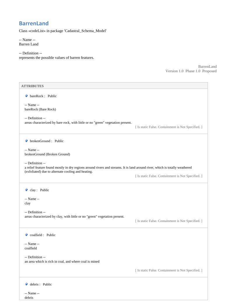
BarrenLand Class «codeList» in package 'Cadastral_Schema_Model'
-- Name --
Barren Land
-- Definition --
represents the possible values of barren features.
BarrenLand
Version 1.0 Phase 1.0 Proposed
ATTRIBUTES
bareRock : Public
-- Name --
bareRock (Bare Rock)
-- Definition --
areas characterized by bare rock, with little or no "green" vegetation present.
[ Is static False. Containment is Not Specified. ]
brokenGround : Public
-- Name --
brokenGround (Broken Ground)
-- Definition --
a relief feature found mostly in dry regions around rivers and streams. It is land around river, which is totally weathered
(exfoliated) due to alternate cooling and heating.
[ Is static False. Containment is Not Specified. ]
clay : Public
-- Name --
clay
-- Definition --
areas characterized by clay, with little or no "green" vegetation present.
[ Is static False. Containment is Not Specified. ]
coalfield : Public
-- Name --
coalfield
-- Definition --
an area which is rich in coal, and where coal is mined
[ Is static False. Containment is Not Specified. ]
debris : Public
-- Name --
debris

ATTRIBUTES
-- Definition --
areas characterized by debris(scattered pieces of waste or remains), with little or no "green" vegetation present.
[ Is static False. Containment is Not Specified. ]
gasField : Public
-- Name --
gasField (Gas Field)
-- Definition --
a gas field is an area of natural gas underground, produced by decay of organic material.
[ Is static False. Containment is Not Specified. ]
goldfield : Public
-- Name --
goldfield
-- Definition --
an area which is rich in gold, and where gold is mined
[ Is static False. Containment is Not Specified. ]
gravel : Public
-- Name --
gravel
-- Definition --
areas characterized by gravel, with little or no "green" vegetation present.
[ Is static False. Containment is Not Specified. ]
oilfield : Public
-- Name --
oilfield
-- Definition --
an area of land or seabed underlain by strata yielding petroleum, especially in amounts that justify commercial exploitation.
[ Is static False. Containment is Not Specified. ]
opalField : Public
-- Name --
opalField (Opal Field)
-- Definition --
an area which is rich in opal, and where opal is mined
[ Is static False. Containment is Not Specified. ]
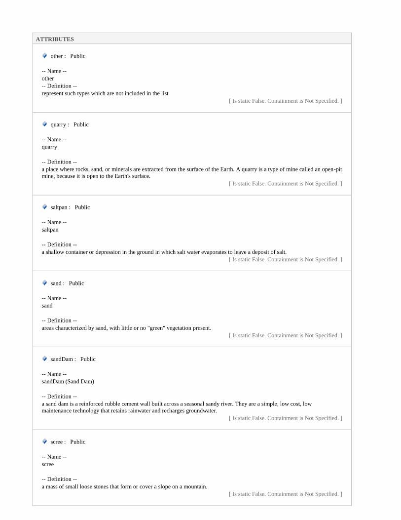
ATTRIBUTES
other : Public
-- Name --
other
-- Definition --
represent such types which are not included in the list
[ Is static False. Containment is Not Specified. ]
quarry : Public
-- Name --
quarry
-- Definition --
a place where rocks, sand, or minerals are extracted from the surface of the Earth. A quarry is a type of mine called an open-pit
mine, because it is open to the Earth's surface.
[ Is static False. Containment is Not Specified. ]
saltpan : Public
-- Name --
saltpan
-- Definition --
a shallow container or depression in the ground in which salt water evaporates to leave a deposit of salt.
[ Is static False. Containment is Not Specified. ]
sand : Public
-- Name --
sand
-- Definition --
areas characterized by sand, with little or no "green" vegetation present.
[ Is static False. Containment is Not Specified. ]
sandDam : Public
-- Name --
sandDam (Sand Dam)
-- Definition --
a sand dam is a reinforced rubble cement wall built across a seasonal sandy river. They are a simple, low cost, low
maintenance technology that retains rainwater and recharges groundwater.
[ Is static False. Containment is Not Specified. ]
scree : Public
-- Name --
scree
-- Definition --
a mass of small loose stones that form or cover a slope on a mountain.
[ Is static False. Containment is Not Specified. ]
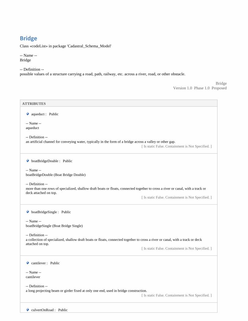
Bridge Class «codeList» in package 'Cadastral_Schema_Model'
-- Name --
Bridge
-- Definition --
possible values of a structure carrying a road, path, railway, etc. across a river, road, or other obstacle.
Bridge
Version 1.0 Phase 1.0 Proposed
ATTRIBUTES
aqueduct : Public
-- Name --
aqueduct
-- Definition --
an artificial channel for conveying water, typically in the form of a bridge across a valley or other gap.
[ Is static False. Containment is Not Specified. ]
boatBridgeDouble : Public
-- Name --
boatBridgeDouble (Boat Bridge Double)
-- Definition --
more than one rows of specialized, shallow draft boats or floats, connected together to cross a river or canal, with a track or
deck attached on top.
[ Is static False. Containment is Not Specified. ]
boatBridgeSingle : Public
-- Name --
boatBridgeSingle (Boat Bridge Single)
-- Definition --
a collection of specialized, shallow draft boats or floats, connected together to cross a river or canal, with a track or deck
attached on top.
[ Is static False. Containment is Not Specified. ]
cantilever : Public
-- Name --
cantilever
-- Definition --
a long projecting beam or girder fixed at only one end, used in bridge construction.
[ Is static False. Containment is Not Specified. ]
culvertOnRoad : Public

ATTRIBUTES
-- Name --
culvertOnRoad (Culvert on Road)
-- Definition --
a structure that allows water to flow under a road. Typically embedded so as to be surrounded by soil, a culvert may be made
from a pipe, reinforced concrete or other material.
[ Is static False. Containment is Not Specified. ]
culvertOnTrack : Public
-- Name --
culvertOnTrack (Culvert on Track)
-- Definition --
a structure that allows water to flow under a track. Typically embedded so as to be surrounded by soil, a culvert may be made
from a pipe, reinforced concrete or other material.
[ Is static False. Containment is Not Specified. ]
footBridge : Public
-- Name --
footBridge (Foot Bridge)
-- Definition --
a bridge designed for pedestrians and in some cases cyclists, animal traffic, and horse riders, instead of vehicular traffic.
[ Is static False. Containment is Not Specified. ]
irishBridge : Public
-- Name --
irishBridge (Irish Bridge)
-- Definition --
a low-water crossing, under high-flow conditions, water runs over the roadway and precludes vehicular traffic.
[ Is static False. Containment is Not Specified. ]
ironBridge : Public
-- Name --
ironBridge (Iron Bridge)
-- Definition --
a bridge formed by iron lattice girders
[ Is static False. Containment is Not Specified. ]
jettyRailway : Public
-- Name --
jettyRailway (Jetty Railway)
-- Definition --
represents railway on jetty
[ Is static False. Containment is Not Specified. ]

ATTRIBUTES
jettyRoad : Public
-- Name --
jettyRoad (Jetty Road)
-- Definition --
represents road on jetty
[ Is static False. Containment is Not Specified. ]
other : Public
-- Name --
other
-- Definition --
represent such types which are not included in the list
[ Is static False. Containment is Not Specified. ]
railwayOverRailway : Public
-- Name --
railwayOverRailway (Railway over Railway)
-- Definition --
railway flyover crossing another railway track
[ Is static False. Containment is Not Specified. ]
railwayOverRoad : Public
-- Name --
railwayOverRoad (Railway over Road)
-- Definition --
railway flyover crossing road
[ Is static False. Containment is Not Specified. ]
roadOverRailway : Public
-- Name --
roadOverRailway (Road over Railway)
-- Definition --
road flyover crossing railway track.
[ Is static False. Containment is Not Specified. ]
roadOverRoad : Public
-- Name --
roadOverRoad (Road over Road)
-- Definition --
road flyover crossing another road.
[ Is static False. Containment is Not Specified. ]
suspensionBridge : Public

ATTRIBUTES
-- Name --
suspensionBridge (Suspension Bridge)
-- Definition --
a bridge in which the weight of the deck is supported by vertical cables suspended from further cables that run between towers
and are anchored in abutments at each end.
[ Is static False. Containment is Not Specified. ]
viaduct : Public
-- Name --
viaduct
-- Definition --
a long bridge like structure, typically a series of arches, carrying a road or railway across a valley or other low ground.
[ Is static False. Containment is Not Specified. ]
walkway : Public
-- Name --
walkway
-- Definition --
A passage or path for walking along, especially a raised passageway connecting different sections of a building or a wide path
in a park or garden
[ Is static False. Containment is Not Specified. ]
CommunicationV Class «codeList» in package 'Cadastral_Schema_Model'
-- Name --
CommunicationV (Communication Value)
-- Definition --
represents possible values of communication feature
CommunicationV
Version 1.0 Phase 1.0 Proposed
ATTRIBUTES
broadcastingStation : Public
-- Name --
broadcastingStation (Broadcasting Station)
-- Definition --
a station equipped to broadcast radio or television programs.
[ Is static False. Containment is Not Specified. ]
lighthouse : Public

ATTRIBUTES
-- Name --
lighthouse
-- Definition --
a large coastal tower exhibiting a major light source serving as an aid to navigation.
[ Is static False. Containment is Not Specified. ]
telecomTower : Public
-- Name --
telecomTower (Telecommunications Tower)
-- Definition --
telecommunications tower is the generic description of Radio masts and towers built primarily to hold telecommunications
antennas
[ Is static False. Containment is Not Specified. ]
CommunityFacilities Class «codeList» in package 'Cadastral_Schema_Model'
-- Name --
Community Facilities
-- Definition --
Represents possible values of community facilities.
CommunityFacilities
Version 1.0 Phase 1.0 Proposed
ATTRIBUTES
abattoir : Public
-- Name --
abattoir
-- Definition --
a slaughterhouse, a place where animals are butchered
[ Is static False. Containment is Not Specified. ]
bank : Public
-- Name --
bank
-- Definition --
a commercial bank is a financial institution that provides various financial service, such as accepting deposits and issuing
loans.
[ Is static False. Containment is Not Specified. ]
busStand : Public
-- Name --

ATTRIBUTES
busStand (Bus Stand)
-- Definition --
bus stop inside bus station.
[ Is static False. Containment is Not Specified. ]
busStop : Public
-- Name --
busStop (Bus Stop)
-- Definition --
a designated place where buses stop for passengers to board or alight from a bus.
[ Is static False. Containment is Not Specified. ]
carPark : Public
-- Name --
carPark
-- Definition --
Green-areas in cities and densely populated areas facilitated for recreational use. Characterized by lawns, benches, walkways,
planting, water fountains etc.
[ Is static False. Containment is Not Specified. ]
cngStation : Public
-- Name --
cngStation (CNG Station)
-- Definition --
a retail station for servicing vehicles with CNG
[ Is static False. Containment is Not Specified. ]
coalDepot : Public
-- Name --
coalDepot (Coal Depot)
-- Definition --
a place at which coal may be deposited, stored, etc.
[ Is static False. Containment is Not Specified. ]
communityCenter : Public
-- Name --
Community Center
-- Definition --
a place where people from a particular neighbourhood can meet for social events, education classes, or recreational activities.
[ Is static False. Containment is Not Specified. ]
courtHouse : Public
-- Name --

ATTRIBUTES
courtHouse (Court House)
-- Definition --
a facility used for holding courts of law and the operation or administration of judicial authorities and commissions.
[ Is static False. Containment is Not Specified. ]
courtHouse : Public
-- Name --
courtHouse (Court House)
-- Definition --
a facility used for holding courts of law and the operation or administration of judicial authorities and commissions.
[ Is static False. Containment is Not Specified. ]
embassy : Public
-- Name --
embassy
-- Definition --
a facility for the provision of Consular and Diplomatic Services.
[ Is static False. Containment is Not Specified. ]
ferry : Public
-- Name --
ferry
-- Definition --
a boat or ship for conveying passengers and goods, especially over a relatively short distance and as a regular service.
[ Is static False. Containment is Not Specified. ]
fireStation : Public
-- Name --
fireStation (Fire Station)
-- Definition --
a building or set of buildings used as a base for a fire brigade and its equipment.
[ Is static False. Containment is Not Specified. ]
foodStreet : Public
-- Name --
foodStreet
-- Definition --
A food street is a pedestrianised area that has been designated for restaurants and cafes.
[ Is static False. Containment is Not Specified. ]
functionHall : Public
-- Name --
functionHall

ATTRIBUTES
-- Definition --
a room or building for the purpose of hosting a party, banquet, wedding or other reception, or other social event.
[ Is static False. Containment is Not Specified. ]
hafta_Bazar : Public
-- Name --
hafta_Bazar
-- Definition --
represents weekly market
[ Is static False. Containment is Not Specified. ]
hotel : Public
-- Name --
hotel
-- Definition --
a building constructed and maintained for the accommodation of travelers.
[ Is static False. Containment is Not Specified. ]
library : Public
-- Name --
library
-- Definition --
a building or room containing collections of books, periodicals, for use or borrowing by the public or the members of an
institution.
[ Is static False. Containment is Not Specified. ]
market : Public
-- Name --
market
-- Definition --
an area in which commercial dealings are conducted
[ Is static False. Containment is Not Specified. ]
metrobusStation : Public
-- Name --
metrobusStation (Metro Bus Station)
-- Definition --
a public rapid transit system in Pakistan
[ Is static False. Containment is Not Specified. ]
observatory : Public
-- Name --
observatory

ATTRIBUTES
-- Definition --
a room or building housing an astronomical telescope or other scientific equipment for the study of natural phenomena.
[ Is static False. Containment is Not Specified. ]
other : Public
-- Name --
other
-- Definition --
represent such types which are not included in the list
[ Is static False. Containment is Not Specified. ]
petrolDump : Public
-- Name --
petrol dump
-- Definition --
represent a petrol dump
[ Is static False. Containment is Not Specified. ]
petrolPump : Public
-- Name --
petrolPump (Petrol Pump)
-- Definition --
a retail station for servicing vehicles with petrol
[ Is static False. Containment is Not Specified. ]
policeStation : Public
-- Name --
policeStation (Police Station)
-- Definition --
the office or headquarters of a local police force.
[ Is static False. Containment is Not Specified. ]
postAndTelegraphOffice : Public
-- Name --
postAndTelegraphOffice (Post and Telegraph Office)
-- Definition --
the building where postal services and telegram services are delivered.
[ Is static False. Containment is Not Specified. ]
postOffice : Public
-- Name --
postOffice (Post Office)
-- Definition --
The building where postal services are delivered.
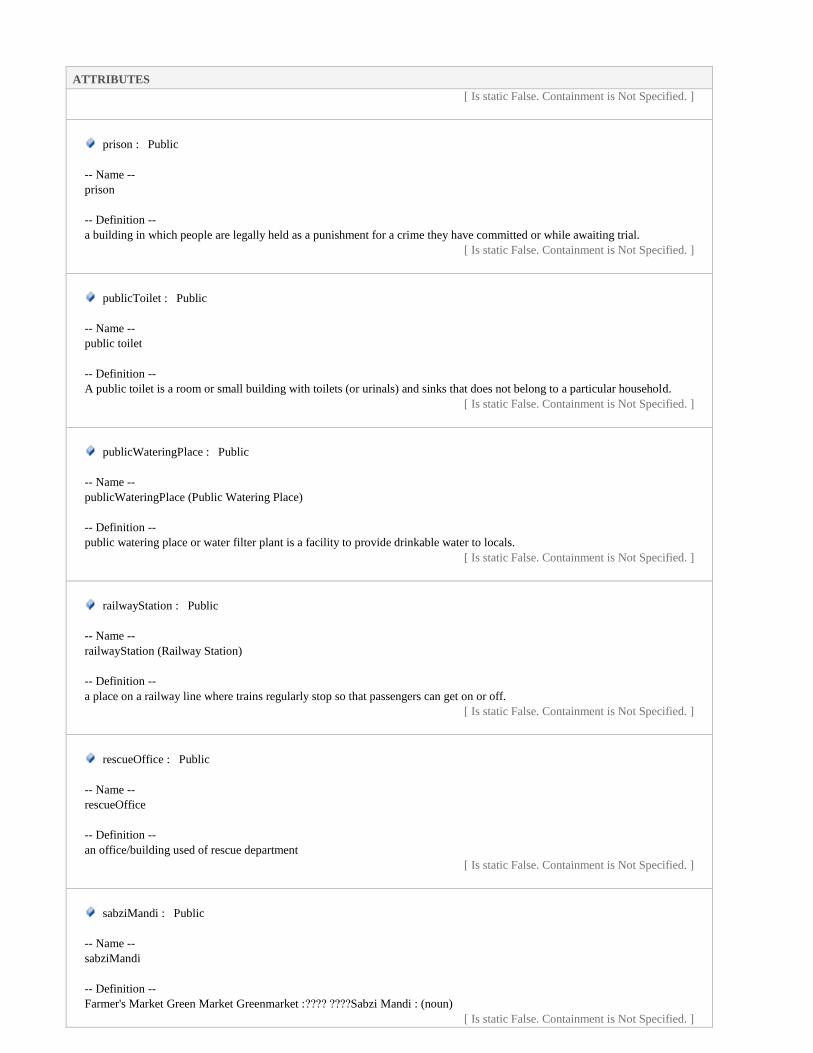
ATTRIBUTES
[ Is static False. Containment is Not Specified. ]
prison : Public
-- Name --
prison
-- Definition --
a building in which people are legally held as a punishment for a crime they have committed or while awaiting trial.
[ Is static False. Containment is Not Specified. ]
publicToilet : Public
-- Name --
public toilet
-- Definition --
A public toilet is a room or small building with toilets (or urinals) and sinks that does not belong to a particular household.
[ Is static False. Containment is Not Specified. ]
publicWateringPlace : Public
-- Name --
publicWateringPlace (Public Watering Place)
-- Definition --
public watering place or water filter plant is a facility to provide drinkable water to locals.
[ Is static False. Containment is Not Specified. ]
railwayStation : Public
-- Name --
railwayStation (Railway Station)
-- Definition --
a place on a railway line where trains regularly stop so that passengers can get on or off.
[ Is static False. Containment is Not Specified. ]
rescueOffice : Public
-- Name --
rescueOffice
-- Definition --
an office/building used of rescue department
[ Is static False. Containment is Not Specified. ]
sabziMandi : Public
-- Name --
sabziMandi
-- Definition --
Farmer's Market Green Market Greenmarket :???? ????Sabzi Mandi : (noun)
[ Is static False. Containment is Not Specified. ]

ATTRIBUTES
sewer : Public
-- Name --
sewer
-- Definition --
an underground conduit for carrying off drainage water and waste matter.
[ Is static False. Containment is Not Specified. ]
shop : Public
-- Name --
shop
-- Definition --
represents shop
[ Is static False. Containment is Not Specified. ]
shoppingCenter : Public
-- Name --
shoppingCenter (Shopping Center)
-- Definition --
an area where shops are concentrated.
[ Is static False. Containment is Not Specified. ]
shoppingMall : Public
-- Name --
Shopping Mall
-- Definition --
a large enclosed shopping area from which traffic is excluded.
[ Is static False. Containment is Not Specified. ]
slaughterHouse : Public
-- Name --
slaughterHouse
-- Definition --
represents slaughter house
[ Is static False. Containment is Not Specified. ]
stall : Public
-- Name --
stall
-- Definition --
a stand, booth, or compartment for the sale of goods in a market or large covered area.
[ Is static False. Containment is Not Specified. ]

ATTRIBUTES
telecomTower : Public
-- Name --
telecomTower
-- Definition --
a mast or tower built primarily to hold telecommunications antennas
[ Is static False. Containment is Not Specified. ]
telegraphOffice : Public
-- Name --
telegraphOffice (Telegraph Office)
-- Definition --
the department responsible for telegraph services.
[ Is static False. Containment is Not Specified. ]
touristInformationCenter : Public
-- Name --
touristInformationCenter (Tourist Information Center)
-- Definition --
a facility used for providing information to persons who travel for pleasure.
[ Is static False. Containment is Not Specified. ]
tuckShop : Public
-- Name --
tuckShop
-- Definition --
a shop, typically one on school premises, that sells confectionery, snacks, and soft drinks.
[ Is static False. Containment is Not Specified. ]
utilityStore : Public
-- Name --
Utility Store
-- Definition --
is a Pakistani state-owned enterprise that operates chain stores throughout the country that provide basic commodities to the
general public at prices which are lower than the open market because the government subsidizes them
[ Is static False. Containment is Not Specified. ]
warehouse : Public
-- Name --
warehouse
-- Definition --
a large building where raw materials or manufactured goods may be stored before their export or distribution for sale.
[ Is static False. Containment is Not Specified. ]
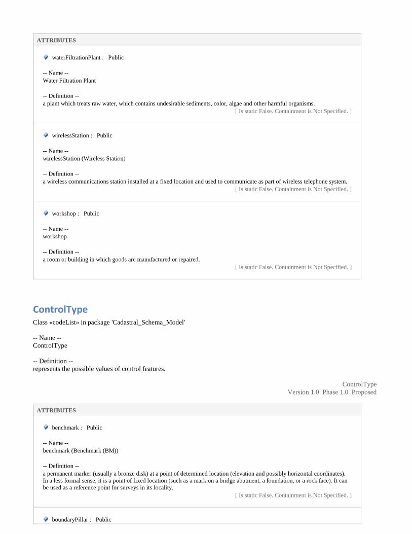
ATTRIBUTES
waterFiltrationPlant : Public
-- Name --
Water Filtration Plant
-- Definition --
a plant which treats raw water, which contains undesirable sediments, color, algae and other harmful organisms.
[ Is static False. Containment is Not Specified. ]
wirelessStation : Public
-- Name --
wirelessStation (Wireless Station)
-- Definition --
a wireless communications station installed at a fixed location and used to communicate as part of wireless telephone system.
[ Is static False. Containment is Not Specified. ]
workshop : Public
-- Name --
workshop
-- Definition --
a room or building in which goods are manufactured or repaired.
[ Is static False. Containment is Not Specified. ]
ControlType Class «codeList» in package 'Cadastral_Schema_Model'
-- Name --
ControlType
-- Definition --
represents the possible values of control features.
ControlType
Version 1.0 Phase 1.0 Proposed
ATTRIBUTES
benchmark : Public
-- Name --
benchmark (Benchmark (BM))
-- Definition --
a permanent marker (usually a bronze disk) at a point of determined location (elevation and possibly horizontal coordinates).
In a less formal sense, it is a point of fixed location (such as a mark on a bridge abutment, a foundation, or a rock face). It can
be used as a reference point for surveys in its locality.
[ Is static False. Containment is Not Specified. ]
boundaryPillar : Public

ATTRIBUTES
-- Name --
boundaryPillar (boundary pillar)
-- Definition --
a robust physical marker that identifies the start of a land boundary or the change in a boundary, especially a change in
direction of a boundary.
[ Is static False. Containment is Not Specified. ]
canalBenchmark : Public
-- Name --
canalBenchmark (canal benchmark)
-- Definition --
it is fixed point of reference with known elevation
[ Is static False. Containment is Not Specified. ]
distanceStone : Public
-- Name --
distanceStone (distance stone)
-- Definition --
is one of a series of numbered markers placed along a road or railway at particular intervals
[ Is static False. Containment is Not Specified. ]
distanceStoneCanal : Public
-- Name --
distanceStoneCanal (distance stone canal)
-- Definition --
is one of a series of numbered markers placed along a canal at particular intervals
[ Is static False. Containment is Not Specified. ]
gtBenchmark : Public
-- Name --
gtBenchmark (G.T Benchmark)
-- Definition --
the high precision benchmarks established during the great trigonometrical survey.
[ Is static False. Containment is Not Specified. ]
other : Public
-- Name --
other
-- Definition --
control type which is not listed
[ Is static False. Containment is Not Specified. ]
spotHeight : Public

ATTRIBUTES
-- Name --
spotHeight (Spot Height)
-- Definition --
represents height of spots.
[ Is static False. Containment is Not Specified. ]
standardBenchmark : Public
-- Name --
Standard Benchmark (SBM)
-- Definition --
it is a ground planed monument built for stability to minimized the probability of disturbance. The SBM are established within
the precise leveling network to provide a stable benchmark system that will control the leveling network.
[ Is static False. Containment is Not Specified. ]
traverseStation : Public
-- Name --
traverseStation (Traverse Station)
-- Definition --
a geodetic point whose position on the earth's surface within a given system of coordinates is determined by the method of
traversing. It may be stabilized by a large concrete monument set into the ground or by a geodetic beacon erected on the
surface.
[ Is static False. Containment is Not Specified. ]
trigonometricIP : Public
-- Name --
trigonometricIP
-- Definition --
represents trigonometric intersected point
[ Is static False. Containment is Not Specified. ]
trigonometricStation : Public
-- Name --
trigonometricStation (trig station)
-- Definition --
is a fixed surveying station with known coordinates, established through trigonometric instruments and methods.
[ Is static False. Containment is Not Specified. ]
Control_Point Class «featureType» in package 'Cadastral_Schema_Model'
-- Name --
Control_Point

-- Definition --
represents vertical and horizontal control points. Control points are used for the basis of the topographic survey measurements
Control_Point
Version 1.0 Phase 1.0 Proposed
ATTRIBUTES
controlPoint_ID : CharacterString Public
-- Name --
controlPoint_ID (control Point ID)
-- Definition --
control Point ID represents the unique identification of the control point feature.
[ Is static False. Containment is Not Specified. ]
elevation : Real Public
-- Name --
elevation
-- Definition --
represents the elevation of the control
[ Is static False. Containment is Not Specified. ]
geom : GM_Point Public
-- Name --
geom: (geometry)
-- Definition --
represents geometry of spatial object to be represented
[ Is static False. Containment is Not Specified. ]
name : CharacterString Public
-- Name --
name
-- Definition --
Represents the name of the topographic feature
[ Is static False. Containment is Not Specified. ]
remarks : CharacterString Public
-- Name --
remarks
-- Definition --
Represents any additional remarks (if any)
[ Is static False. Containment is Not Specified. ]
type : ControlType Public
-- Name --
type

ATTRIBUTES
-- Definition --
represents the specific type of control feature.
[ Is static False. Containment is Not Specified. ]
Crossing Class «codeList» in package 'Cadastral_Schema_Model'
-- Name --
Crossing
-- Definition --
represents the possible values of crossing feature type.
Crossing
Version 1.0 Phase 1.0 Proposed
ATTRIBUTES
ford : Public
-- Name --
ford
-- Definition --
a shallow place in a river or stream allowing one to walk or drive across.
[ Is static False. Containment is Not Specified. ]
levelCrossing : Public
-- Name --
levelCrossing (Level Crossing)
-- Definition --
a place where a railway and a road, or two railway lines, cross at the same level.
[ Is static False. Containment is Not Specified. ]
other : Public
-- Name --
other
-- Definition --
represent such types which are not included in the list
[ Is static False. Containment is Not Specified. ]
siphonIntermittent : Public
-- Name --
siphonIntermittent (Siphon Intermittent)
-- Definition --
a pipe or tube in the form of an upside-down U, filled with water and arranged so that the pressure of the atmosphere forces
water to flow upward from a container through the tube, over a barrier, and into a lower container.

ATTRIBUTES
[ Is static False. Containment is Not Specified. ]
siphonPerennial : Public
-- Name --
siphonPerennial (Siphon Perennial)
-- Definition --
a pipe or tube in the form of an upside-down U, filled with perennial water and arranged so that the pressure of the atmosphere
forces perennial water to flow upward from a container through the tube, over a barrier, and into a lower container.
[ Is static False. Containment is Not Specified. ]
EducationalFacility Class «codeList» in package 'Cadastral_Schema_Model'
-- Name --
Educational Facility
-- Definition --
represents the possible values of educational facility
EducationalFacility
Version 1.0 Phase 1.0 Proposed
ATTRIBUTES
college : Public
-- Name --
college
-- Definition --
an establishment for learning at post-secondary level
[ Is static False. Containment is Not Specified. ]
institute : Public
-- Name --
institute
-- Definition --
a building in which work of a literary, scientific or educational character is carried out.
[ Is static False. Containment is Not Specified. ]
other : Public
-- Name --
other
-- Definition --
represent such types which are not included in the list
[ Is static False. Containment is Not Specified. ]

ATTRIBUTES
school : Public
-- Name --
school
-- Definition --
an establishment for primary or secondary education
[ Is static False. Containment is Not Specified. ]
technicalCollege : Public
-- Name --
technicalCollege (Technical College)
-- Definition --
an establishment for learning technical education at post-secondary level
[ Is static False. Containment is Not Specified. ]
university : Public
-- Name --
university
-- Definition --
a tertiary educational institution with the power to award postgraduate research degrees.
[ Is static False. Containment is Not Specified. ]
ForestCategoryV Class «codeList» in package 'Cadastral_Schema_Model'
-- Name --
Forest Category Value
-- Definition --
represents possible category values of forest
ForestCategoryV
Version 1.0 Phase 1.0 Proposed
ATTRIBUTES
community_Forest : Public
-- Name --
community_Forest
-- Definition --
National forests that have been entrusted to user groups (as defined in clause 25 of the act) for development, conservation and
utilization in the interest of the community.
[ Is static False. Containment is Not Specified. ]
government-Managed : Public

ATTRIBUTES
-- Name --
Government-Managed
-- Definition --
National forests managed by the government.
[ Is static False. Containment is Not Specified. ]
guzaraCumResume : Public
-- Name --
Guzara Cum Resume forest
-- Definition --
land has been given to locals as a result of land reforms or or evacuee property and have not yet been classified for the purpose
provide the daily needs for a locality to sustain themselves
[ Is static False. Containment is Not Specified. ]
guzaraForest : Public
-- Name --
Guzara Forest
-- Definition --
Forests on communal land that has not been divided and is
meant for collective use to satisfy the requirements of all the village community are known as Guzara forests.
[ Is static False. Containment is Not Specified. ]
leasehold_Forest : Public
-- Name --
leasehold_Forest
-- Definition --
National forests that have been leased (according to clause 32 of the act) for specified purpose(s) to a legally defined
institution, forest-based industry or community.
[ Is static False. Containment is Not Specified. ]
national_Forest : Public
-- Name --
National_Forest
-- Definition --
All forests other than private forest, regardless of the demarcation of their boundaries and including cultivated or uncultivated
land, roads, ponds, lakes, rivers, streams and the shingly land that is surrounded by or in the vicinity of a forest.
[ Is static False. Containment is Not Specified. ]
other : Public
-- Name --
other
-- Definition --
forest category which is not given in a list
[ Is static False. Containment is Not Specified. ]
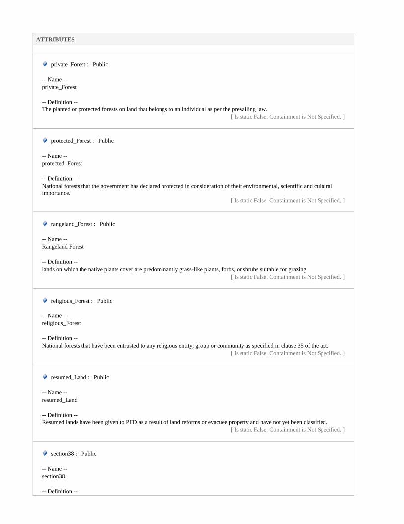
ATTRIBUTES
private_Forest : Public
-- Name --
private_Forest
-- Definition --
The planted or protected forests on land that belongs to an individual as per the prevailing law.
[ Is static False. Containment is Not Specified. ]
protected_Forest : Public
-- Name --
protected_Forest
-- Definition --
National forests that the government has declared protected in consideration of their environmental, scientific and cultural
importance.
[ Is static False. Containment is Not Specified. ]
rangeland_Forest : Public
-- Name --
Rangeland Forest
-- Definition --
lands on which the native plants cover are predominantly grass-like plants, forbs, or shrubs suitable for grazing
[ Is static False. Containment is Not Specified. ]
religious_Forest : Public
-- Name --
religious_Forest
-- Definition --
National forests that have been entrusted to any religious entity, group or community as specified in clause 35 of the act.
[ Is static False. Containment is Not Specified. ]
resumed_Land : Public
-- Name --
resumed_Land
-- Definition --
Resumed lands have been given to PFD as a result of land reforms or evacuee property and have not yet been classified.
[ Is static False. Containment is Not Specified. ]
section38 : Public
-- Name --
section38
-- Definition --

ATTRIBUTES
Section 38 forests are privately owned lands that have been voluntarily and temporarily put under the control of PFD for the
conservation and preservation of soil and vegetation. These are notified under section 38 of the 1927 Forest Act on the written
request of the individual owner or of
a two-thirds majority of the owners in cases of joint property, for periods of 25 or 30 years.
[ Is static False. Containment is Not Specified. ]
unclassed_Forest : Public
-- Name --
Unclassed_Forest
-- Definition --
are areas that have been transferred to forest department pending final legal classification.
[ Is static False. Containment is Not Specified. ]
ForestTable Class «featureType» in package 'Cadastral_Schema_Model'
-- Name --
TaxTable
-- Definition --
Represents tax to be collected from formers
ForestTable
Version 1.0 Phase 1.0 Proposed
ATTRIBUTES
compartment_Name : CharacterString Public
-- Name --
compartment_Name
-- Definition --
A permanent, geographically recognisable unit of forest land forming the basis of prescription and permanent record of all
forest operations.
[ Is static False. Containment is Not Specified. ]
forest_Category : ForestCategoryV Public
-- Name --
Legal_Status
-- Definition --
represents legal status of the forest
[ Is static False. Containment is Not Specified. ]
forest_Name : CharacterString Public
-- Name --
Forest Name

ATTRIBUTES
-- Definition --
it represents forest name
[ Is static False. Containment is Not Specified. ]
forest_Type : ForestTypeV Public
-- Name --
Forest Type
-- Definition --
it represents the forest tpes
[ Is static False. Containment is Not Specified. ]
forest_Zone : CharacterString Public
-- Name --
Forest_Zone
-- Definition --
Forest areas are used to identify the dominant values of certain forest areas and their management.
[ Is static False. Containment is Not Specified. ]
from_Date : DateTime Public
-- Name --
from
-- Definition --
represents the date from which forest exist.
[ Stereotype is «voidable». Is static False. Containment is Not Specified. ]
notification : CharacterString Public
-- Name --
notification
-- Definition --
represents forest notifications
[ Is static False. Containment is Not Specified. ]
parcel_ID : CharacterString Public
-- Name --
Parcel_ID
-- Definition --
represents the unique id of a parcel in the Pakistan.
[ Is static False. Containment is Not Specified. ]
remarks : CharacterString Public
-- Name --
remarks
-- Definition --
Represents any additional remarks

ATTRIBUTES
[ Is static False. Containment is Not Specified. ]
source_Document : CharacterString Public
-- Name --
source_Document
-- Definition --
Represents all materials used to extract information.
[ Is static False. Containment is Not Specified. ]
source_Imagery : CharacterString Public
-- Name --
source_Imagery
-- Definition --
is a source imagery used to identify forests.
[ Is static False. Containment is Not Specified. ]
source_Map : CharacterString Public
-- Name --
source_Map
-- Definition --
is a source map used for forests digitization.
[ Is static False. Containment is Not Specified. ]
sub_Compartment : CharacterString Public
-- Name --
sub_Compartment
-- Definition --
A sub-division of a compartment, sometimes temporary, where because of particular characteristics an area of forest has a
special description and requires separate silvicultural treatment.
[ Is static False. Containment is Not Specified. ]
territory_ID : CharacterString Public
-- Name --
territory_ID
-- Definition --
represents the unique id of a territory in the Pakistan.
[ Is static False. Containment is Not Specified. ]
to_Date : DateTime Public
-- Name --
To Date
-- Definition --
represents the date at which the forest breaks down.
[ Stereotype is «voidable». Is static False. Containment is Not Specified. ]

ATTRIBUTES
working_Circle : CharacterString Public
-- Name --
Working Circle
-- Definition --
One or more parts of a working plan area, not necessarily adjoining, having the same objectives, silvicultural system and
prescriptions.
[ Is static False. Containment is Not Specified. ]
working_Plan : CharacterString Public
-- Name --
working_Plan
-- Definition --
A document that regulates wood production, silviculture and tending activities for a specific period of time through the
application of prescriptions specifying targets, action and control arrangements. A Working Plan is not synonymous with a
Forest Management Plan.
[ Is static False. Containment is Not Specified. ]
ASSOCIATIONS
Association (direction: Bi-Directional)
Source: Public territory_ID (Class) ForestTable «featureType»
Target: Public territory_ID (Class) Parcel
«featureType»
Association (direction: Bi-Directional)
Source: Public parcel_ID (Class) ForestTable «featureType»
Target: Public parcel_ID (Class) Parcel
«featureType»
ForestTypeV Class «codeList» in package 'Cadastral_Schema_Model'
-- Name --
ForestTypeV
-- Definition --
represents possible types values of the forest
ForestTypeV
Version 1.0 Phase 1.0 Proposed
ATTRIBUTES
coniferous : Public
-- Name --
Coniferous

ATTRIBUTES
-- Definition --
trees composed primarily of cone bearing needle leaved evergreen trees found in moderate to high precipitation areas
[ Is static False. Containment is Not Specified. ]
deciduousForest : Public
-- Name --
Deciduous Forest
-- Definition --
These are forests of low or moderate height consisting almost entirely of deciduous species. Their canopy is typically light
though it may appear fairly dense and complete during the short rainy season.
[ Is static False. Containment is Not Specified. ]
desert_Forest : Public
-- Name --
Desert_Forest
-- Definition --
A forest which consist of thorny and bushes natural vegetation, such forest are found in regions with less than 70cm of rainfall
[ Is static False. Containment is Not Specified. ]
irrigated_Plantation : Public
-- Name --
Irrigated Plantation
-- Definition --
These are man-made forests and are in the shape of blocks of tree plantations in the canal irrigated tract.
[ Is static False. Containment is Not Specified. ]
naturalForest : Public
-- Name --
Natural Forest
-- Definition --
a forest which is not planted and exist in nature
[ Is static False. Containment is Not Specified. ]
other : Public
-- Name --
other
-- Definition --
forest type which is not given in a list
[ Is static False. Containment is Not Specified. ]
riverainForest : Public
-- Name --

ATTRIBUTES
Riverain Forest
-- Definition --
Riverine forest is located adjacent to the rivers and their major tributaries, and is generally denser and has bigger trees than the
savanna.
[ Is static False. Containment is Not Specified. ]
roadSidePlantation : Public
-- Name --
Road Side Plantation
-- Definition --
tree cover along road
[ Is static False. Containment is Not Specified. ]
scrubForest : Public
-- Name --
Scrub Forests
-- Definition --
consist of open woodland with thorny trees with short trunks and low, branching crowns; spiny and xerophytic shrubs; and dry
grassland.
[ Is static False. Containment is Not Specified. ]
swampForest : Public
-- Name --
Swamp Forests
-- Definition --
These are more or less gregarious forests of low height which occur in the Arabian sea around the coast of Karachi and Pasni
in Balochistan. The main species is Avicennia marina (99%). Other species like Rhizophora have disappeared over a period of
time due to heavy cutting. According to latest estimates, these forest cover an area of 207,000 ha
[ Is static False. Containment is Not Specified. ]
GenderV Class «codeList» in package 'Cadastral_Schema_Model'
-- Name --
GenderV
-- Definition --
represents the whether the person is male , female or transgender
GenderV
Version 1.0 Phase 1.0 Proposed
ATTRIBUTES
female : Public
-- Name --

ATTRIBUTES
urban
-- Definition --
represents female gender
[ Is static False. Containment is Not Specified. ]
male : Public
-- Name --
male
-- Definition --
represents male gender
[ Is static False. Containment is Not Specified. ]
transgender : Public
-- Name --
transgender
-- Definition --
Transgender people are people whose gender identity is different from the gender they were thought to be at birth. “Trans” is
often used as shorthand for transgender
[ Is static False. Containment is Not Specified. ]
GroundWater Class «codeList» in package 'Cadastral_Schema_Model'
-- Name --
Ground Water
-- Definition --
groundwater is the water found underground in the cracks and spaces in soil, sand and rock.
GroundWater
Version 1.0 Phase 1.0 Proposed
ATTRIBUTES
borewell : Public
-- Name --
borewell (Bore Well)
-- Definition --
A deep vertical hole of a small diameter drilled to obtain water.
[ Is static False. Containment is Not Specified. ]
handpump : Public
-- Name --
handpump (Hand Pump)

ATTRIBUTES
-- Definition --
water pump operated by hand
[ Is static False. Containment is Not Specified. ]
hotspring : Public
-- Name --
hotspring (Hot Spring)
-- Definition --
A naturally heated mineral spring.
[ Is static False. Containment is Not Specified. ]
other : Public
-- Name --
other
-- Definition --
represent such types which are not included in the list
[ Is static False. Containment is Not Specified. ]
overheadWaterTank : Public
-- Name --
overheadWaterTank (Overhead Water Tank)
-- Definition --
an overhead tank for holding water.
[ Is static False. Containment is Not Specified. ]
spring : Public
-- Name --
spring
-- Definition --
A place at which a flow of water issues naturally from the ground, either continuously or intermittently.
[ Is static False. Containment is Not Specified. ]
tubeWell : Public
-- Name --
tubeWell (Tube Well)
-- Definition --
A tube well is a type of water well in which a long 100–200 millimetres wide stainless steel tube or pipe is bored into an
underground aquifer.
[ Is static False. Containment is Not Specified. ]
well_in_Rock : Public
-- Name --
well_in_Rock

ATTRIBUTES
-- Definition --
represents a well which is located in rock
[ Is static False. Containment is Not Specified. ]
wellLined : Public
-- Name --
wellLined (Well Lined)
-- Definition --
an excavation or structure created in the ground by digging, driving, boring, or drilling to access groundwater in underground
aquifers. The well water is drawn by a pump, or using containers, such as buckets, that are raised mechanically or by hand.
[ Is static False. Containment is Not Specified. ]
wellUnlined : Public
-- Name --
wellUnlined (Well Unlined)
-- Definition --
a coarse well, which is not properly lined
[ Is static False. Containment is Not Specified. ]
Historical Class «codeList» in package 'Cadastral_Schema_Model'
-- Name --
Historical
-- Definition --
represents possible values of historical features
Historical
Version 1.0 Phase 1.0 Proposed
ATTRIBUTES
historicalReconstruction : Public
-- Name --
historicalReconstruction (Historical Reconstruction)
-- Definition --
an area or precinct which was at one time an area with recognized name and purpose and which has now been redeveloped to
recognize its past.
[ Is static False. Containment is Not Specified. ]
historicSite : Public
-- Name --
historicSite (Historic Site)
-- Definition --

ATTRIBUTES
a specific place or site which has at one time been the site of an event or activity which is remembered.
[ Is static False. Containment is Not Specified. ]
monument : Public
-- Name --
monument
-- Definition --
an obelisk, statue or building erected to commemorate a person or event.
[ Is static False. Containment is Not Specified. ]
museum : Public
-- Name --
museum
-- Definition --
a building for keeping and exhibiting objects of historical, scientific or artistic interest.
[ Is static False. Containment is Not Specified. ]
other : Public
-- Name --
other
-- Definition --
represent such types which are not included in the list
[ Is static False. Containment is Not Specified. ]
ruin : Public
-- Name --
ruin
-- Definition --
a fallen and derelict building.
[ Is static False. Containment is Not Specified. ]
shrine : Public
-- Name --
shrine
-- Definition --
a place or site venerated for its association with a famous person or event.
[ Is static False. Containment is Not Specified. ]
IndustrialArea Class «codeList» in package 'Cadastral_Schema_Model'
-- Name --
Industrial Area

-- Definition --
Represents the possible values of the industry types.
IndustrialArea
Version 1.0 Phase 1.0 Proposed
ATTRIBUTES
chimney : Public
-- Name --
chimney
-- Definition --
represents factory chimney.
[ Is static False. Containment is Not Specified. ]
factory : Public
-- Name --
factory
-- Definition --
a building or group of buildings where goods are manufactured or assembled chiefly by machine.
[ Is static False. Containment is Not Specified. ]
kiln : Public
-- Name --
kiln
-- Definition --
a construction in which bricks are baked or burned.
[ Is static False. Containment is Not Specified. ]
mill : Public
-- Name --
mill
-- Definition --
a place where some grinding work is taking place such as a flour mill or rice mill.
[ Is static False. Containment is Not Specified. ]
other : Public
-- Name --
other
-- Definition --
represent such types which are not included in the list
[ Is static False. Containment is Not Specified. ]

ATTRIBUTES
sawmill : Public
-- Name --
sawmill
-- Definition --
a facility where logs are cut into lumber.
[ Is static False. Containment is Not Specified. ]
steelMill : Public
-- Name --
steelMill (Steel Mill)
-- Definition --
an industrial plant for the manufacture of steel. It may be an integrated steel works carrying out all steps of steel making from
smelting iron ore to rolled product, but may also describe plants where steel semi-finished casting products (blooms, ingots,
slabs, billets) are made, from molten pig iron or from scrap.
[ Is static False. Containment is Not Specified. ]
tannery : Public
-- Name --
tannery
-- Definition --
a place where the skins are processed. Tanning hide into leather involves a process which permanently alters the protein
structure of skin, making it more durable and less susceptible to decomposition, and also possibly coloring it.
[ Is static False. Containment is Not Specified. ]
IntiqalType Class «codeList» in package 'Cadastral_Schema_Model'
-- Name --
IntiqalType
-- Definition --
represents type of intiqal/ mutation
IntiqalType
Version 1.0 Phase 1.0 Proposed
ATTRIBUTES
bai : Public
-- Name --
bai
-- Definition --
Whenever a person sells his land either completely or partially, to another person, this type of mutation is known as Bai or
Sale.
[ Is static False. Containment is Not Specified. ]
government_Allotted : Public

ATTRIBUTES
-- Name --
government_Allotted
-- Definition --
the land allotted by the government
[ Is static False. Containment is Not Specified. ]
hibba : Public
-- Name --
hibba
-- Definition --
A Gift, Present. Whenever a part of complete land is gifted to some person, the mutation is called Hibba or Gift.
[ Is static False. Containment is Not Specified. ]
other : Public
-- Name --
other
-- Definition --
Type which is not listed
[ Is static False. Containment is Not Specified. ]
vasiyat : Public
-- Name --
vasiyat
-- Definition --
transfer of land through will(testament)
[ Is static False. Containment is Not Specified. ]
wirasat : Public
-- Name --
wirasat
-- Definition --
the inherited land
[ Is static False. Containment is Not Specified. ]
KhatuniTable Class «featureType» in package 'Cadastral_Schema_Model'
-- Name --
TaxTable
-- Definition --
Represents tax to be collected from formers
KhatuniTable
Version 1.0 Phase 1.0 Proposed

ATTRIBUTES
from_Date : DateTime Public
-- Name --
from
-- Definition --
represents the date from which tax due.
[ Stereotype is «voidable». Is static False. Containment is Not Specified. ]
parcel_ID : CharacterString Public
-- Name --
Parcel_ID
-- Definition --
represents the unique id of a parcel in the Pakistan.
[ Is static False. Containment is Not Specified. ]
person_ID : CharacterString Public
-- Name --
person_ID (Personal ID)
-- Definition --
represents the NIC number/ form B number.
[ Is static False. Containment is Not Specified. ]
remarks : CharacterString Public
-- Name --
remarks
-- Definition --
Represents any additional remarks
[ Is static False. Containment is Not Specified. ]
territory_ID : CharacterString Public
-- Name --
territory_ID
-- Definition --
represents the unique id of a territory in the Pakistan.
[ Is static False. Containment is Not Specified. ]
to_Date : DateTime Public
-- Name --
to
-- Definition --
represents the date up to which tax due.
[ Stereotype is «voidable». Is static False. Containment is Not Specified. ]

ASSOCIATIONS
Association (direction: Source -> Destination)
Source: Public person_ID (Class) KhatuniTable «featureType»
Target: Public person_ID (Class) ShajraNasabTable
«featureType»
Association (direction: Bi-Directional)
Source: Public parcel_ID (Class) KhatuniTable «featureType»
Target: Public parcel_ID (Class) Parcel
«featureType»
Association (direction: Bi-Directional)
Source: Public territory_ID (Class) KhatuniTable «featureType»
Target: Public territory_ID (Class) Parcel
«featureType»
LandUseTable Class «featureType» in package 'Cadastral_Schema_Model'
-- Name --
LandUseTable
-- Definition --
represents land use table
LandUseTable
Version 1.0 Phase 1.0 Proposed
ATTRIBUTES
effective_from : DateTime Public
-- Name --
effective_from
-- Definition --
Official date and time the cadastral parcel was/will be legally established.
-- Description --
NOTE This is the date and time the national cadastral reference can be used in legal acts.
[ Is static False. Containment is Not Specified. ]
effective_to : DateTime Public
-- Name --
effective_to
-- Definition --
Date and time at which the cadastral parcel legally ceased/will cease to be used.
-- Description --
NOTE This is the date and time the national cadastral reference can no longer be used in legal acts.
[ Is static False. Containment is Not Specified. ]
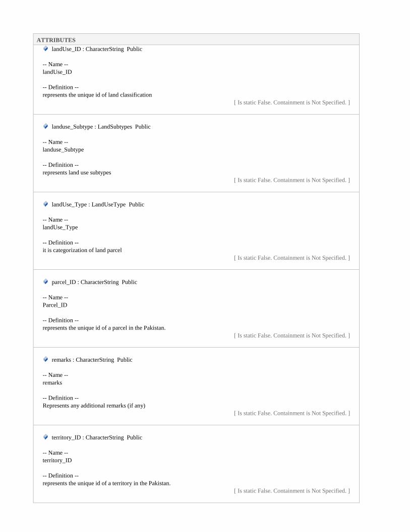
ATTRIBUTES
landUse_ID : CharacterString Public
-- Name --
landUse_ID
-- Definition --
represents the unique id of land classification
[ Is static False. Containment is Not Specified. ]
landuse_Subtype : LandSubtypes Public
-- Name --
landuse_Subtype
-- Definition --
represents land use subtypes
[ Is static False. Containment is Not Specified. ]
landUse_Type : LandUseType Public
-- Name --
landUse_Type
-- Definition --
it is categorization of land parcel
[ Is static False. Containment is Not Specified. ]
parcel_ID : CharacterString Public
-- Name --
Parcel_ID
-- Definition --
represents the unique id of a parcel in the Pakistan.
[ Is static False. Containment is Not Specified. ]
remarks : CharacterString Public
-- Name --
remarks
-- Definition --
Represents any additional remarks (if any)
[ Is static False. Containment is Not Specified. ]
territory_ID : CharacterString Public
-- Name --
territory_ID
-- Definition --
represents the unique id of a territory in the Pakistan.
[ Is static False. Containment is Not Specified. ]
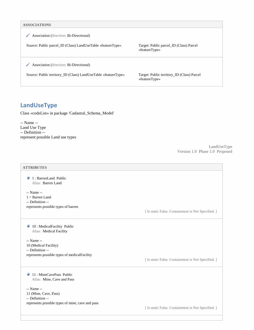
ASSOCIATIONS
Association (direction: Bi-Directional)
Source: Public parcel_ID (Class) LandUseTable «featureType»
Target: Public parcel_ID (Class) Parcel
«featureType»
Association (direction: Bi-Directional)
Source: Public territory_ID (Class) LandUseTable «featureType»
Target: Public territory_ID (Class) Parcel
«featureType»
LandUseType Class «codeList» in package 'Cadastral_Schema_Model'
-- Name --
Land Use Type
-- Definition --
represent possible Land use types
LandUseType
Version 1.0 Phase 1.0 Proposed
ATTRIBUTES
1 : BarrenLand Public
Alias: Barren Land
-- Name --
1 = Barren Land
-- Definition --
represents possible types of barren
[ Is static False. Containment is Not Specified. ]
10 : MedicalFacility Public
Alias: Medical Facility
-- Name --
10 (Medical Facility)
-- Definition --
represents possible types of medicalFacility
[ Is static False. Containment is Not Specified. ]
11 : MineCavePass Public
Alias: Mine, Cave and Pass
-- Name --
11 (Mine, Cave, Pass)
-- Definition --
represents possible types of mine, cave and pass
[ Is static False. Containment is Not Specified. ]

ATTRIBUTES
12 : Pipeline Public
Alias: Pipeline
-- Name --
12 (Pipeline)
-- Definition --
represents possible types of pipeline
[ Is static False. Containment is Not Specified. ]
13 : Railway Public
Alias: Railway
-- Name --
13 (Railway)
-- Definition --
represents possible types of railway
[ Is static False. Containment is Not Specified. ]
14 : RecreationalFacility Public
Alias: Recreational Facility
-- Name --
14 (Recreational Facility)
-- Definition --
represents possible types of recreational facility
[ Is static False. Containment is Not Specified. ]
15 : ReligiousPlaces Public
Alias: Religious Places
-- Name --
15 (Religious Places)
-- Definition --
represents possible types of religious places
[ Is static False. Containment is Not Specified. ]
16 : Reservoir Public
Alias: Reservoir
-- Name --
16 (Reservoir)
-- Definition --
represents possible types of reservoir
[ Is static False. Containment is Not Specified. ]
17 : Residence Public
Alias: Residence
-- Name --
17 (Residence)
-- Definition --
Area with high degree of residential development, also including areas with functions connected to residential areas
[ Is static False. Containment is Not Specified. ]

ATTRIBUTES
18 : RiversCanalLakes Public
Alias: Rivers, Canal, Lakes
-- Name --
18 (Rivers, Canal, Lakes)
-- Definition --
represents possible types of rivers, canal and lakes
[ Is static False. Containment is Not Specified. ]
19 : Road Public
Alias: Road
-- Name --
19 (Road)
-- Definition --
represents possible types of road
[ Is static False. Containment is Not Specified. ]
2 : Bridge Public
Alias: Bridge
-- Name --
2(Bridge)
-- Definition --
represents possible types of bridge
[ Is static False. Containment is Not Specified. ]
20 : Strategic Public
Alias: Strategic
-- Name --
20 (Strategic)
-- Definition --
represents possible types of strategic
[ Is static False. Containment is Not Specified. ]
21 : Stream Public
Alias: Stream
-- Name --
21 (Stream)
-- Definition --
represents possible types of stream
[ Is static False. Containment is Not Specified. ]
22 : TransmissionLine Public
Alias: Transmission Line
-- Name --
22 (Transmission Line)
-- Definition --
represents possible types of transmission line
[ Is static False. Containment is Not Specified. ]
23 : TreeCover Public

ATTRIBUTES
Alias: Tree Cover
-- Name --
treeCover
-- Definition --
represents possible types of tree cover
[ Is static False. Containment is Not Specified. ]
24 : Tunnel Public
Alias: Tunnel
-- Name --
24 (Tunnel)
-- Definition --
represents possible types of tunnel
[ Is static False. Containment is Not Specified. ]
25 : Wetland Public
Alias: Wetland
-- Name --
25 (Wetland)
-- Definition --
represents possible types of wetland
[ Is static False. Containment is Not Specified. ]
26 : AgricultureLand Public
Alias: Agriculture Land Type
[ Is static False. Containment is Not Specified. ]
27 : NaturalVegetation Public
Alias: Natural Vegetation
-- Name --
27 (Natural Vegetation)
-- Definition --
Represents the possible values of the natural vegetation.
[ Is static False. Containment is Not Specified. ]
28 : CharacterString Public
Alias: Other
-- Name --
28 (Other)
-- Definition --
represent such types which are not included in the list
[ Is static False. Containment is Not Specified. ]
3 : CommunityFacilities Public
Alias: Community Facilities
-- Name --
3 (Community Facilities)
-- Definition --

ATTRIBUTES
represents possible types of community facilities
[ Is static False. Containment is Not Specified. ]
4 : Crossing Public
Alias: Crossing
-- Name --
4 (Crossing)
-- Definition --
represents the possible values of crossing feature type.
[ Is static False. Containment is Not Specified. ]
5 : EducationalFacility Public
Alias: Educational Facility
-- Name --
educational facility
-- Definition --
represents possible types of educational facility
[ Is static False. Containment is Not Specified. ]
6 : GroundWater Public
Alias: Ground Water
-- Name --
6 (Ground Water)
-- Definition --
represents possible types of ground water
[ Is static False. Containment is Not Specified. ]
7 : Historical Public
Alias: Historical
-- Name --
7 (Historical)
-- Definition --
represents possible types of historical
[ Is static False. Containment is Not Specified. ]
8 : IndustrialArea Public
Alias: Industrial Area
-- Name --
8 (industrialArea)
-- Definition --
represents possible types of industrial area
[ Is static False. Containment is Not Specified. ]
9 : Landform Public
Alias: Landform
-- Name --
9 (Landform)
-- Definition --

ATTRIBUTES
represents possible types of landform
[ Is static False. Containment is Not Specified. ]
Landform Class «codeList» in package 'Cadastral_Schema_Model'
-- Name --
Landform
-- Definition --
represents possible values of Landform
Landform
Version 1.0 Phase 1.0 Proposed
ATTRIBUTES
bank : Public
-- Name --
bank
-- Definition --
a stream bank or river bank is the terrain alongside the bed of a river, creek, or stream. The bank consists of the sides of the
channel, between which the flow is confined.
[ Is static False. Containment is Not Specified. ]
beach : Public
-- Name --
beach
-- Definition --
a sloping shore of a lake or a low stretch of river’s edge, usually covered with sand or gravel.
[ Is static False. Containment is Not Specified. ]
island : Public
-- Name --
island
-- Definition --
an area of land completely surrounded by the waters of a lake or other inland body of water.
[ Is static False. Containment is Not Specified. ]
jetty : Public
-- Name --
jetty
-- Definition --
a structure that projects from the land out into water.
[ Is static False. Containment is Not Specified. ]

ATTRIBUTES
other : Public
-- Name --
other
-- Definition --
represent such types which are not included in the list
[ Is static False. Containment is Not Specified. ]
promontory : Public
-- Name --
promontory
-- Definition --
an elevated protrusion of land into a lake or other inland body of water.
[ Is static False. Containment is Not Specified. ]
rock : Public
-- Name --
rock
-- Definition --
a large rocky formation surrounded by the waters of an inland body of water.
[ Is static False. Containment is Not Specified. ]
sandspit : Public
-- Name --
sandspit
-- Definition --
a small bank of low land projecting into a lake or other inland body of water from the shore.
[ Is static False. Containment is Not Specified. ]
MedicalFacility Class «codeList» in package 'Cadastral_Schema_Model'
-- Name --
Medical Facility
-- Definition --
represents possible values of medical facility.
MedicalFacility
Version 1.0 Phase 1.0 Proposed
ATTRIBUTES
basicHealthUnit : Public

ATTRIBUTES
-- Name --
Basic Health Unit
-- Definition --
It is the first level of health care considered to be necessary to maintain adequate health and protection from disease.
[ Is static False. Containment is Not Specified. ]
bloodBank : Public
-- Name --
Blood Bank
-- Definition --
a place where supplies of blood or plasma for transfusion are stored.
[ Is static False. Containment is Not Specified. ]
clinic : Public
-- Name --
clinic
-- Definition --
an establishment or hospital department where outpatients are given medical treatment or advice, especially of a specialist
nature
[ Is static False. Containment is Not Specified. ]
dispensary : Public
-- Name --
dispensary
-- Definition --
a room where medicines are prepared and provided.
[ Is static False. Containment is Not Specified. ]
hospital : Public
-- Name --
hospital
-- Definition --
an institution providing medical and surgical treatment and nursing care for sick or injured people.
[ Is static False. Containment is Not Specified. ]
laboratory : Public
-- Name --
laboratory
-- Definition --
a room or building equipped for scientific experiments, research, or teaching, or for the manufacture of drugs or chemicals.
[ Is static False. Containment is Not Specified. ]
medicalStore : Public
-- Name --
medicalStore
-- Definition --

ATTRIBUTES
is a retail shop which provides pharmaceutical drugs
[ Is static False. Containment is Not Specified. ]
other : Public
-- Name --
other
-- Definition --
represent such types which are not included in the list
[ Is static False. Containment is Not Specified. ]
psychiatricHospital : Public
-- Name --
psychiatricHospital (Psychiatric Hospital)
-- Definition --
a hospital for the care and treatment of patients affected with acute or chronic mental illness
[ Is static False. Containment is Not Specified. ]
ruralHealthCenter : Public
-- Name --
ruralHealthCenter (Rural Health Center)
-- Definition --
is a clinic located in a rural, medically under-served area
[ Is static False. Containment is Not Specified. ]
sanatorium : Public
-- Name --
sanatorium
-- Definition --
an establishment for the medical treatment of people who are convalescing or have a chronic illness.
[ Is static False. Containment is Not Specified. ]
veterinaryHospital : Public
-- Name --
veterinaryHospital (Veterinary Hospital)
-- Definition --
of or relating to veterinary medicine; concerned or connected with the medical or surgical treatment of animals, especially
domestic animals.
[ Is static False. Containment is Not Specified. ]
MineCavePass Class «featureType» in package 'Cadastral_Schema_Model'
-- Name --

MineCavePass (Mine, Cave and Pass)
-- Definition --
represents the possible values of mines,caves, pass features.
MineCavePass
Version 1.0 Phase 1.0 Proposed
ATTRIBUTES
caveInhabited : Public
-- Name --
caveInhabited (Cave Inhabited)
-- Definition --
a cave where human or animal are living
[ Is static False. Containment is Not Specified. ]
caveUninhabited : Public
-- Name --
caveUninhabited (Cave Uninhabited)
-- Definition --
a cave where no one is living
[ Is static False. Containment is Not Specified. ]
mine : Public
-- Name --
mine
-- Definition --
a hole or tunnel dug into the earth from which ore or minerals are extracted.
[ Is static False. Containment is Not Specified. ]
other : Public
-- Name --
other
-- Definition --
represent such types which are not included in the list
[ Is static False. Containment is Not Specified. ]
pass : Public
-- Name --
pass
-- Definition --
A route through a mountain range or over a ridge.
[ Is static False. Containment is Not Specified. ]
shaft : Public
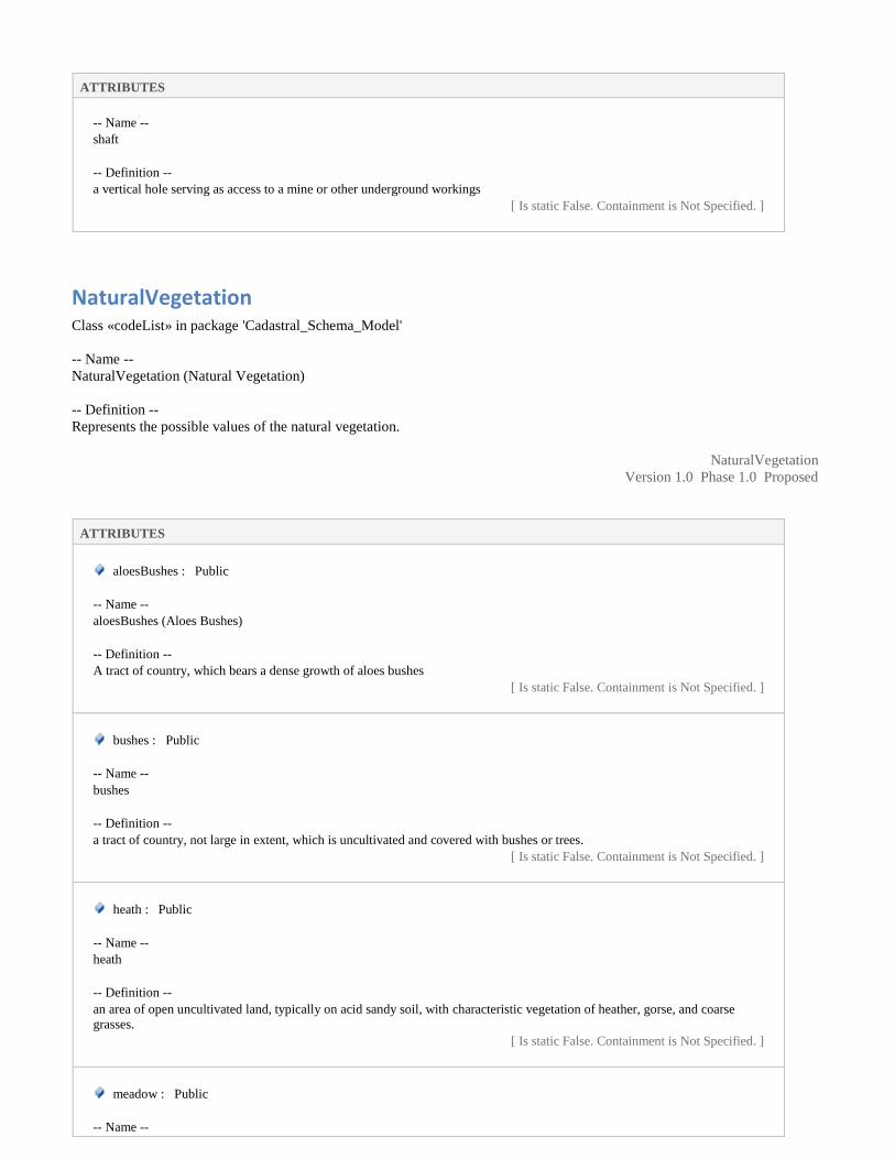
ATTRIBUTES
-- Name --
shaft
-- Definition --
a vertical hole serving as access to a mine or other underground workings
[ Is static False. Containment is Not Specified. ]
NaturalVegetation Class «codeList» in package 'Cadastral_Schema_Model'
-- Name --
NaturalVegetation (Natural Vegetation)
-- Definition --
Represents the possible values of the natural vegetation.
NaturalVegetation
Version 1.0 Phase 1.0 Proposed
ATTRIBUTES
aloesBushes : Public
-- Name --
aloesBushes (Aloes Bushes)
-- Definition --
A tract of country, which bears a dense growth of aloes bushes
[ Is static False. Containment is Not Specified. ]
bushes : Public
-- Name --
bushes
-- Definition --
a tract of country, not large in extent, which is uncultivated and covered with bushes or trees.
[ Is static False. Containment is Not Specified. ]
heath : Public
-- Name --
heath
-- Definition --
an area of open uncultivated land, typically on acid sandy soil, with characteristic vegetation of heather, gorse, and coarse
grasses.
[ Is static False. Containment is Not Specified. ]
meadow : Public
-- Name --

ATTRIBUTES
meadow
-- Definition --
a piece of grassland, especially one used for hay.
[ Is static False. Containment is Not Specified. ]
other : Public
-- Name --
other
-- Definition --
represent such types which are not included in the list
[ Is static False. Containment is Not Specified. ]
reed : Public
-- Name --
reed
-- Definition --
reed is a common name for several tall, grass-like plants of wetlands.
[ Is static False. Containment is Not Specified. ]
OwnershipType Class «codeList» in package 'Cadastral_Schema_Model'
-- Name --
OwnershipType
-- Definition --
represents the ownerships type e.g., state owned, individual , or shamilat-e-deh
OwnershipType
Version 1.0 Phase 1.0 Proposed
ATTRIBUTES
other : Public
-- Name --
other
-- Definition --
ownership type which is not listed
[ Is static False. Containment is Not Specified. ]
patti : Public
-- Name --
patti
-- Definition --
land used for specific community of villagers based on clans, caste, sect, area etc.
[ Is static False. Containment is Not Specified. ]

ATTRIBUTES
private : Public
-- Name --
private
-- Definition --
parcel owned by the country citizen
[ Is static False. Containment is Not Specified. ]
shamilat-e-Deh : Public
-- Name --
shamilat-e-Deh
-- Definition --
land in a village held for the common purposes of the village, i.e. graveyards, grazing grounds, community buildings,places of
worship, schools, dispensaries, playgrounds, wells etc.
[ Is static False. Containment is Not Specified. ]
state : Public
-- Name --
state
-- Definition --
state owned parcel
[ Is static False. Containment is Not Specified. ]
taraf : Public
-- Name --
taraf
-- Definition --
land used for specific community of villagers based on clans, caste, sect, area etc.
[ Is static False. Containment is Not Specified. ]
Parcel Class «featureType» in package 'Cadastral_Schema_Model'
-- Name --
Parcel
-- Definition --
Represents a parcel/ khasra of a village of the Pakistan
Parcel
Version 1.0 Phase 1.0 Proposed
created on 7/27/2019. Last modified 5/5/2021
ATTRIBUTES
dimension : CharacterString Public

ATTRIBUTES
-- Name --
dimension
-- Definition --
represents dimension of the khasra
[ Is static False. Containment is Not Specified. ]
effective_from : DateTime Public
-- Name --
effective_from
-- Definition --
Official date and time the cadastral parcel was/will be legally established.
-- Description --
NOTE This is the date and time the national cadastral reference can be used in legal acts.
[ Is static False. Containment is Not Specified. ]
effective_to : DateTime Public
-- Name --
effective_to
-- Definition --
Date and time at which the cadastral parcel legally ceased/will cease to be used.
-- Description --
NOTE This is the date and time the national cadastral reference can no longer be used in legal acts.
[ Is static False. Containment is Not Specified. ]
feet_per_Marla : Real Public
-- Name --
feet_per_Marla
-- Definition --
This field is used to Enter total Feet in a Marla. Different Feet/Marla are being used in Districts of Punjab like 225, 272,
272.25 and 270. Area calculation of a Mauza based on this selection.
[ Is static False. Containment is Not Specified. ]
geom : GM_Polygon Public
-- Name --
geom (Geometry)
-- Definition --
represents the geometry of the parcel.
[ Is static False. Containment is Not Specified. ]
khasra : CharacterString Public
-- Name --
khasra
-- Definition --

ATTRIBUTES
represents the unique khasra number in the village.
[ Is static False. Containment is Not Specified. ]
mussavi_No : CharacterString Public
-- Name --
mussavi_No
-- Definition --
Represents the unique mussavi number of mussavi map
[ Stereotype is «voidable». Is static False. Containment is Not Specified. ]
parcel_ID : CharacterString Public
-- Name --
Parcel_ID
-- Definition --
represents the unique id of a parcel in the Pakistan.
[ Is static False. Containment is Not Specified. ]
remarks : CharacterString Public
-- Name --
remarks
-- Definition --
Represents any additional remarks (if any)
[ Is static False. Containment is Not Specified. ]
squareNo : CharacterString Public
-- Name --
squareNo
-- Definition --
represents the unique square number in the village.
[ Is static False. Containment is Not Specified. ]
sub_khasra : CharacterString Public
-- Name --
sub_khasra
-- Definition --
represents the sub khasra number in the village.
[ Is static False. Containment is Not Specified. ]
territory_ID : CharacterString Public
-- Name --
territory_ID
-- Definition --
represents the unique id of a territory in the Pakistan.
[ Is static False. Containment is Not Specified. ]

ATTRIBUTES
ASSOCIATIONS
Association (direction: Bi-Directional)
Source: Public territory_ID (Class) Parcel «featureType»
Cardinality: [1]
Target: Public territory_ID (Class)
RecordOfRightsTable «featureType»
Cardinality: [*]
Association (direction: Bi-Directional)
Source: Public parcel_ID (Class) Parcel «featureType»
Target: Public parcel_ID (Class) Parcel_InfoTable
«featureType»
Association (direction: Bi-Directional)
Source: Public territory_ID (Class) Parcel «featureType»
Target: Public territory_ID (Class)
Parcel_InfoTable «featureType»
Association (direction: Bi-Directional)
Source: Public territory_ID (Class) Parcel «featureType»
Target: Public territory_ID (Class) PossessionTable
«featureType»
Association (direction: Bi-Directional)
Source: Public territory_ID (Class) Parcel «featureType»
Target: Public territory_ID (Class) TaxTable
«featureType»
Association (direction: Bi-Directional)
Source: Public territory_ID (Class) Parcel «featureType»
Target: Public territory_ID (Class) TerritoryTable
«featureType»
Association (direction: Bi-Directional)
Source: Public parcel_ID (Class) Parcel «featureType»
Target: Public parcel_ID (Class) PossessionTable
«featureType»
Association (direction: Bi-Directional)
Source: Public parcel_ID (Class) LandUseTable «featureType»
Target: Public parcel_ID (Class) Parcel
«featureType»
Association (direction: Bi-Directional)
Source: Public territory_ID (Class) AgricultureTaxTable
«featureType»
Target: Public territory_ID (Class) Parcel
«featureType»
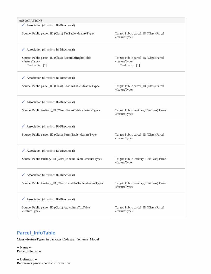
ASSOCIATIONS
Association (direction: Bi-Directional)
Source: Public parcel_ID (Class) TaxTable «featureType»
Target: Public parcel_ID (Class) Parcel
«featureType»
Association (direction: Bi-Directional)
Source: Public parcel_ID (Class) RecordOfRightsTable
«featureType»
Cardinality: [*]
Target: Public parcel_ID (Class) Parcel
«featureType»
Cardinality: [1]
Association (direction: Bi-Directional)
Source: Public parcel_ID (Class) KhatuniTable «featureType»
Target: Public parcel_ID (Class) Parcel
«featureType»
Association (direction: Bi-Directional)
Source: Public territory_ID (Class) ForestTable «featureType»
Target: Public territory_ID (Class) Parcel
«featureType»
Association (direction: Bi-Directional)
Source: Public parcel_ID (Class) ForestTable «featureType»
Target: Public parcel_ID (Class) Parcel
«featureType»
Association (direction: Bi-Directional)
Source: Public territory_ID (Class) KhatuniTable «featureType»
Target: Public territory_ID (Class) Parcel
«featureType»
Association (direction: Bi-Directional)
Source: Public territory_ID (Class) LandUseTable «featureType»
Target: Public territory_ID (Class) Parcel
«featureType»
Association (direction: Bi-Directional)
Source: Public parcel_ID (Class) AgricultureTaxTable
«featureType»
Target: Public parcel_ID (Class) Parcel
«featureType»
Parcel_InfoTable Class «featureType» in package 'Cadastral_Schema_Model'
-- Name --
Parcel_InfoTable
-- Definition --
Represents parcel specific information

Parcel_InfoTable
Version 1.0 Phase 1.0 Proposed
ATTRIBUTES
block : CharacterString Public
-- Name --
block
-- Definition --
represents the block or phase number/ name
[ Stereotype is «voidable». Is static False. Containment is Not Specified. ]
flat_No : CharacterString Public
-- Name --
flat No
-- Definition --
Represents the flat number
[ Stereotype is «voidable». Is static False. Containment is Not Specified. ]
floorNo : CharacterString Public
-- Name --
floorNo
-- Definition --
represents the floor number
[ Stereotype is «voidable». Is static False. Containment is Not Specified. ]
house_No : CharacterString Public
-- Name --
house_No
-- Definition --
Represents the house number
[ Stereotype is «voidable». Is static False. Containment is Not Specified. ]
housingSociety : CharacterString Public
-- Name --
housingSociety
-- Definition --
Housing society is a membership based legal entity made of one or more residential buildings.
[ Stereotype is «voidable». Is static False. Containment is Not Specified. ]
office_No : CharacterString Public
-- Name --
office No
-- Definition --

ATTRIBUTES
Represents the office number
[ Stereotype is «voidable». Is static False. Containment is Not Specified. ]
parcel_ID : CharacterString Public
-- Name --
parcel_ID
-- Definition --
represents the unique id of a parcel in the Pakistan.
[ Is static False. Containment is Not Specified. ]
propertyName : CharacterString Public
-- Name --
propertyName
-- Definition --
represents name of the property if any
[ Stereotype is «voidable». Is static False. Containment is Not Specified. ]
propertyNo : CharacterString Public
-- Name --
propertyNo
-- Definition --
represents the property number
[ Stereotype is «voidable». Is static False. Containment is Not Specified. ]
remarks : CharacterString Public
-- Name --
remarks
-- Definition --
Represents any additional remarks (if any)
[ Is static False. Containment is Not Specified. ]
sector : CharacterString Public
-- Name --
sector
-- Definition --
represents the sector number/ name
[ Stereotype is «voidable». Is static False. Containment is Not Specified. ]
shop_No : CharacterString Public
-- Name --
Shop No
-- Definition --
Represents the shop number

ATTRIBUTES
[ Stereotype is «voidable». Is static False. Containment is Not Specified. ]
street_No : CharacterString Public
-- Name --
street_No
-- Definition --
represents the street number/ name
[ Is static False. Containment is Not Specified. ]
sub_Sector : CharacterString Public
-- Name --
sub_Sector
-- Definition --
represents the sub sector number/ name
[ Is static False. Containment is Not Specified. ]
territory_ID : CharacterString Public
-- Name --
territory_ID
-- Definition --
represents the unique id of a territory in the Pakistan.
[ Is static False. Containment is Not Specified. ]
zone : CharacterString Public
-- Name --
zone
-- Definition --
represents the zone number/ name
[ Stereotype is «voidable». Is static False. Containment is Not Specified. ]
ASSOCIATIONS
Association (direction: Bi-Directional)
Source: Public parcel_ID (Class) Parcel «featureType»
Target: Public parcel_ID (Class) Parcel_InfoTable
«featureType»
Association (direction: Bi-Directional)
Source: Public territory_ID (Class) Parcel «featureType»
Target: Public territory_ID (Class)
Parcel_InfoTable «featureType»

Pipeline Class «codeList» in package 'Cadastral_Schema_Model'
-- Name --
Pipeline
-- Definition --
represents possible values of pipeline
Pipeline
Version 1.0 Phase 1.0 Proposed
ATTRIBUTES
gasPipeline : Public
-- Name --
gasPipeline (Gas Pipeline)
-- Definition --
a pipeline connecting a gas appliance to the main supply of natural gas for the apartment, office or building.
[ Is static False. Containment is Not Specified. ]
oilPipeline : Public
-- Name --
oilPipeline (Oil Pipeline)
-- Definition --
Oil Pipeline is used to transport oil
[ Is static False. Containment is Not Specified. ]
other : Public
-- Name --
other
-- Definition --
represent such types which are not included in the list
[ Is static False. Containment is Not Specified. ]
sewerPipeline : Public
-- Name --
sewerPipeline (Sewer Pipeline)
-- Definition --
a sanitary sewer or "foul sewer" is an underground carriage system specifically for transporting sewage from houses and
commercial buildings through pipes to treatment or disposal. Sanitary sewers are part of an overall system called sewerage or
sewage system.
[ Is static False. Containment is Not Specified. ]
waterPipeline : Public
-- Name --
waterPipeline (Water Pipeline)

ATTRIBUTES
-- Definition --
a pipeline for conveying water.
[ Is static False. Containment is Not Specified. ]
PossessionTable Class «featureType» in package 'Cadastral_Schema_Model'
-- Name --
Possession
-- Definition --
represents Possession of the parcel
PossessionTable
Version 1.0 Phase 1.0 Proposed
ATTRIBUTES
parcel_ID : string Public
-- Name --
Parcel_ID
-- Definition --
represents the unique id of a parcel in the Pakistan.
[ Is static False. Containment is Not Specified. ]
person_ID : string Public
-- Name --
Person_ID (Personal ID)
-- Definition --
represents the NIC number/ form B number.
[ Is static False. Containment is Not Specified. ]
possessionType : PossessionType Public
-- Name --
possessionType
-- Definition --
represents possession type
[ Is static False. Containment is Not Specified. ]
remarks : CharacterString Public
-- Name --
remarks
-- Definition --

ATTRIBUTES
Represents any additional remarks
[ Is static False. Containment is Not Specified. ]
territory_ID : string Public
-- Name --
territory_ID
-- Definition --
represents the unique id of a territory in the Pakistan.
[ Is static False. Containment is Not Specified. ]
ASSOCIATIONS
Association (direction: Bi-Directional)
Source: Public person_ID (Class) PossessionTable «featureType»
Target: Public person_ID (Class) ShajraNasabTable
«featureType»
Association (direction: Bi-Directional)
Source: Public territory_ID (Class) Parcel «featureType»
Target: Public territory_ID (Class) PossessionTable
«featureType»
Association (direction: Bi-Directional)
Source: Public parcel_ID (Class) Parcel «featureType»
Target: Public parcel_ID (Class) PossessionTable
«featureType»
PossessionType Class «codeList» in package 'Cadastral_Schema_Model'
-- Name --
PossessionType
-- Definition --
represents the ownerships type e.g., state owned, individual , or shamilat-e-deh
PossessionType
Version 1.0 Phase 1.0 Proposed
ATTRIBUTES
aadrehan : Public
-- Name --
aadrehan
-- Definition --
Mortgagor, one who mortgages his land. Whenever a land is mortgaged, completely or partially, to another person or party,
mutation is of Rahin type. The deal can be either verbal or through Registry. The land mortgaged without possession.

ATTRIBUTES
[ Is static False. Containment is Not Specified. ]
ghairDakhildar : Public
-- Name --
ghairDakhildar
-- Definition --
represents permanent unauthorized possession
[ Is static False. Containment is Not Specified. ]
ghairMarusi : Public
-- Name --
ghairMarusi
-- Definition --
represents temporary unauthorized possession (Kache mujahire)
[ Is static False. Containment is Not Specified. ]
khudkast : Public
-- Name --
khudkast
-- Definition --
Self cultivated land
[ Is static False. Containment is Not Specified. ]
marusi : Public
-- Name --
marusi
-- Definition --
Permanent Tenant Cultivator who pays revenue to the land owner.
[ Is static False. Containment is Not Specified. ]
other : Public
-- Name --
other
-- Definition --
possession type which is not listed
[ Is static False. Containment is Not Specified. ]
rehan : Public
-- Name --
rehan
-- Definition --
Mortgagor, one who mortgages his land. Whenever a land is mortgaged, completely or partially, to another person or party,
mutation is of Rahin type. The deal can be either verbal or through Registry. The land mortgaged with possession.

ATTRIBUTES
[ Is static False. Containment is Not Specified. ]
siri : string Public
-- Name --
siri
-- Definition --
Sometimes possessions are given intentionally to the workers (called as SIRIs) to avoid to come under land ceiling act. But the
title is not clear in such cases.
[ Is static False. Containment is Not Specified. ]
Railway Class «codeList» in package 'Cadastral_Schema_Model'
-- Name --
Railway
-- Definition --
represents possible values of train transport features
Railway
Version 1.0 Phase 1.0 Proposed
ATTRIBUTES
metroRail : Public
-- Name --
metroRail (Metro Rail)
-- Definition --
Metro rail is transit system using wheeled vehicles running on rails, especially in a large city
[ Is static False. Containment is Not Specified. ]
other : Public
-- Name --
other
-- Definition --
represent such types which are not included in the list
[ Is static False. Containment is Not Specified. ]
railSidings : Public
-- Name --
railSidings (Rail Sidings)
-- Definition --
A siding, in rail terminology, is a low-speed track section distinct from a running line or through route such as a main line or
branch line . It may connect to through track or to other sidings at either end.
[ Is static False. Containment is Not Specified. ]

ATTRIBUTES
railway : Public
-- Name --
railway (Railway)
-- Definition --
A railway is a line of communication made up by rail exclusively for the use of railway vehicles.
[ Is static False. Containment is Not Specified. ]
tramline : Public
-- Name --
tramline (Tramline)
-- Definition --
the tracks on which a tram runs.
[ Is static False. Containment is Not Specified. ]
RecordOfRightsTable Class «featureType» in package 'Cadastral_Schema_Model'
-- Name --
RecordOfRightsTab (Record of Rights Table)
-- Definition --
represents the ownership of the parcel.
RecordOfRightsTable
Version 1.0 Phase 1.0 Proposed
ATTRIBUTES
floorNo : CharacterString Public
-- Name --
floorNo
-- Definition --
represents the floor number
[ Stereotype is «voidable». Is static False. Containment is Not Specified. ]
intiqal_Type : IntiqalType Public
-- Name --
iintiqal_Type
-- Definition --
represents intiqal type
[ Is static False. Containment is Not Specified. ]
organization : CharacterString Public

ATTRIBUTES
-- Name --
organization
-- Definition --
the organization which owned/ use the parcel
[ Is static False. Containment is Not Specified. ]
ownershipEndDate : DateTime Public
-- Name --
ownershipEndDate
-- Definition --
The official Date and time when the ownership is transferred to someone else
[ Stereotype is «voidable». Is static False. Containment is Not Specified. ]
ownershipStartDate : DateTime Public
-- Name --
ownershipStartDate
-- Definition --
the official ownership establishment date
[ Stereotype is «voidable». Is static False. Containment is Not Specified. ]
ownershipType : OwnershipType Public
-- Name --
ownershipType
-- Definition --
represents the ownerships type e.g., state owned, individual , or shamilat-e-deh
[ Is static False. Containment is Not Specified. ]
parcel_ID : CharacterString Public
-- Name --
parcel_ID
-- Definition --
represents the unique id of a parcel in the Pakistan.
[ Is static False. Containment is Not Specified. ]
personID : CharacterString Public
-- Name --
person_ID (Personal ID)
-- Definition --
represents the NIC/ form B number.
[ Is static False. Containment is Not Specified. ]
prevOwner_ID : CharacterString Public
-- Name --
prevOwner_ID (Previous Owner ID)

ATTRIBUTES
-- Definition --
represents the NIC number of previous owner
[ Is static False. Containment is Not Specified. ]
remarks : CharacterString Public
-- Name --
remarks
-- Definition --
Represents any additional remarks (if any)
[ Is static False. Containment is Not Specified. ]
sharingPercentage : Real Public
-- Name --
sharingPercentage (Sharing Percentage)
-- Definition --
represents ownership share in percentage
[ Stereotype is «voidable». Is static False. Containment is Not Specified. ]
territory_ID : CharacterString Public
-- Name --
territory_ID
-- Definition --
represents the unique id of a territory in the Pakistan.
[ Is static False. Containment is Not Specified. ]
ASSOCIATIONS
Association (direction: Bi-Directional)
Source: Public parcel_ID (Class) RecordOfRightsTable
«featureType»
Cardinality: [*]
Target: Public parcel_ID (Class) Parcel
«featureType»
Cardinality: [1]
Association (direction: Unspecified)
Source: Public personID (Class) RecordOfRightsTable
«featureType»
Target: Public prevOwner_ID (Class)
RecordOfRightsTable «featureType»
Association (direction: Bi-Directional)
Source: Public person_ID (Class) RecordOfRightsTable
«featureType»
Target: Public person_ID (Class) ShajraNasabTable
«featureType»
Association (direction: Bi-Directional)

ASSOCIATIONS
Source: Public territory_ID (Class) Parcel «featureType»
Cardinality: [1]
Target: Public territory_ID (Class)
RecordOfRightsTable «featureType»
Cardinality: [*]
Association (direction: Unspecified)
Source: Public personID (Class) RecordOfRightsTable
«featureType»
Target: Public prevOwner_ID (Class)
RecordOfRightsTable «featureType»
RecreationalFacility Class «codeList» in package 'Cadastral_Schema_Model'
-- Name --
RecreationalFacility (Recreational Facility)
-- Definition --
represents possible values of recreational facility
RecreationalFacility
Version 1.0 Phase 1.0 Proposed
ATTRIBUTES
athleticCenter : Public
-- Name --
athleticCenter (Athletic Center)
-- Definition --
a sports facility devoted to track and field events.
[ Is static False. Containment is Not Specified. ]
campSite : Public
-- Name --
campSite (Camp Site)
-- Definition --
a place where tourists and holiday makers can stay, in tents, cabins or vans.
[ Is static False. Containment is Not Specified. ]
cinema : Public
-- Name --
cinema
-- Definition --
a theatre where films are shown for public entertainment.
[ Is static False. Containment is Not Specified. ]

ATTRIBUTES
conservationPark : Public
-- Name --
conservationPark (Conservation Park)
-- Definition --
an area set aside for the conservation of fauna and flora, usually with restricted access.
[ Is static False. Containment is Not Specified. ]
cricketGround : Public
-- Name --
cricketGround
-- Definition --
A cricket field is a large grass field on which the game of cricket is played.
[ Is static False. Containment is Not Specified. ]
footballGround : Public
-- Name --
footballGround
-- Definition --
A football field is a large grass field on which the game of football is played.
[ Is static False. Containment is Not Specified. ]
golfCourse : Public
-- Name --
golfCourse (Golf Course)
-- Definition --
an area of ground laid out for the playing of golf.
[ Is static False. Containment is Not Specified. ]
gymnasium : Public
-- Name --
gymnasium
-- Definition --
a room or building equipped for gymnastics, games, and other physical exercise.
[ Is static False. Containment is Not Specified. ]
hockeyGround : Public
-- Name --
Hockey Ground
-- Definition --
A hockey field is a large grass field on which the game of hockey is played.
[ Is static False. Containment is Not Specified. ]
joggingTrack : Public

ATTRIBUTES
-- Name --
jogging track
-- Definition --
a track reserved for jogging
[ Is static False. Containment is Not Specified. ]
lookout : Public
-- Name --
lookout
-- Definition --
a viewing point on the side of a hill or mountain, maintained to provide a view of the surrounding terrain
[ Is static False. Containment is Not Specified. ]
nationalPark : Public
-- Name --
nationalPark (National Park)
-- Definition --
a tract of land set apart by a Federal, State or Territory authority to be preserved in its natural state for the benefit of the public.
[ Is static False. Containment is Not Specified. ]
other : Public
-- Name --
other
-- Definition --
represent such types which are not included in the list
[ Is static False. Containment is Not Specified. ]
park : Public
-- Name --
park
-- Definition --
an area of land, either in its natural state or improved, set aside for recreational use by the public.
[ Is static False. Containment is Not Specified. ]
picnicArea : Public
-- Name --
picnicArea (Picnic Area)
-- Definition --
a tract of ground maintained with amenities suitable for people to bring food for outdoor eating
[ Is static False. Containment is Not Specified. ]
playground : Public
-- Name --

ATTRIBUTES
playground
-- Definition --
an outdoor area provided for children to play in, especially at a school or public park.
[ Is static False. Containment is Not Specified. ]
racecourse : Public
-- Name --
racecourse
-- Definition --
a place with a track which has been licensed by government for the holding of horse races.
[ Is static False. Containment is Not Specified. ]
racetrack : Public
-- Name --
racetrack
-- Definition --
a circuit or course used for motor racing.
[ Is static False. Containment is Not Specified. ]
sportCourt : Public
-- Name --
sportCourt (Sport Court)
-- Definition --
sports facility consisting of constructed courts for tennis, netball etc.
[ Is static False. Containment is Not Specified. ]
stadium : Public
-- Name --
stadium
-- Definition --
an area for sports contests, enclosed by grandstands and tiered seating.
[ Is static False. Containment is Not Specified. ]
swimmingPool : Public
-- Name --
swimmingPool (Swimming Pool)
-- Definition --
an enclosed or artificial pool, for swimming in, for public use. ie. Not a domestic swimming Pool.
[ Is static False. Containment is Not Specified. ]
touristAttraction : Public
-- Name --
touristAttraction (Tourist Attraction)

ATTRIBUTES
-- Definition --
land used for non-residential premises designed to attract tourists, including but not limited to tourist accommodation
associated with any of the uses. Examples: artifacts display and sale, feature building, fun park, hand weaving and sales,
historic buildings and machinery, pioneer village, plantation with tour facilities, pottery works and sales, rural industry display
and sale, sanctuary and animal park and ski slope.
[ Is static False. Containment is Not Specified. ]
velodrome : Public
-- Name --
velodrome
-- Definition --
an arena with a banked track, usually oval in shape, constructed for cycle races.
[ Is static False. Containment is Not Specified. ]
zoo : Public
-- Name --
zoo
-- Definition --
an establishment which maintains a collection of wild animals, typically in a park or gardens, for study, conservation, or
display to the public.
[ Is static False. Containment is Not Specified. ]
ReligiousPlaces Class «codeList» in package 'Cadastral_Schema_Model'
-- Name --
ReligiousPlaces (Religious Places)
-- Definition --
represents possible values of religious places
ReligiousPlaces
Version 1.0 Phase 1.0 Proposed
ATTRIBUTES
buddhist_Kyaung : Public
-- Name --
buddhist_Kyaung
-- Definition --
a buddhist place of worship.
[ Is static False. Containment is Not Specified. ]
chhatri : Public
-- Name --

ATTRIBUTES
chhatri
-- Definition --
chhatris are elevated, dome-shaped pavilions used as an element in Pakistani architecture. They are widely used, in palaces, in
forts, or to demarcate funerary sites.
[ Is static False. Containment is Not Specified. ]
church : Public
-- Name --
church
-- Definition --
a building for Christian public worship
[ Is static False. Containment is Not Specified. ]
grave : Public
-- Name --
grave
-- Definition --
a place of burial for a dead body, typically a hole dug in the ground and marked by a stone or mound.
[ Is static False. Containment is Not Specified. ]
graveyard : Public
-- Name --
graveyard
-- Definition --
a large burial ground
[ Is static False. Containment is Not Specified. ]
idgah : Public
-- Name --
idgah
-- Definition --
Eidgah or Idgah is the term used in south Asian Islamic culture for the open-air gathering place usually outside the city (or at
the outskirts) to perform the Salat al Eid (Eid prayers) for Eid ul-Fitr and Eid al-Adha. It is usually a public place that isn't used
as a mosque at other times of the year.
[ Is static False. Containment is Not Specified. ]
janazaGah : Public
-- Name --
janazaGah
-- Definition --
an open or in a place built for The Funeral Prayer
[ Is static False. Containment is Not Specified. ]

ATTRIBUTES
masjid : Public
-- Name --
masjid
-- Definition --
a Muslim place of worship.
[ Is static False. Containment is Not Specified. ]
other : Public
-- Name --
other
-- Definition --
represent such types which are not included in the list
[ Is static False. Containment is Not Specified. ]
pagoda : Public
-- Name --
pagoda
-- Definition --
a Hindu or Buddhist temple, typically in the form of a many-tiered tower.
[ Is static False. Containment is Not Specified. ]
shrine : Public
-- Name --
shrine
-- Definition --
a place regarded as holy because of its associations with a divinity or a sacred person or relic, marked by a building or other
construction.
[ Is static False. Containment is Not Specified. ]
temple : Public
-- Name --
temple
-- Definition --
a building used for worship in some religions (e.g. Christianity)
[ Is static False. Containment is Not Specified. ]
tomb : Public
-- Name --
tomb
-- Definition --
a monument to the memory of a dead person, erected over their burial place.
[ Is static False. Containment is Not Specified. ]

Reservoir Class «codeList» in package 'Cadastral_Schema_Model'
-- Name --
Reservoir
-- Definition --
represents possible value of the reservoir features
Reservoir
Version 1.0 Phase 1.0 Proposed
ATTRIBUTES
barrage : Public
-- Name --
barrage
-- Definition --
a structure built to constrain the limit of tidal influence in a river or estuary, or to retain water for irrigation purposes.
[ Is static False. Containment is Not Specified. ]
dam : Public
-- Name --
dam
-- Definition --
a wall or barrier constructed of earth, masonry etc., to impound water.
[ Is static False. Containment is Not Specified. ]
excavatedTank_Intermittent : Public
-- Name --
excavatedTank_Intermittent
-- Definition --
it represents non perennial excavated tank
[ Is static False. Containment is Not Specified. ]
excavatedTank_Perennial : Public
-- Name --
excavatedTank_Perennial
-- Definition --
it represents perennial excavated tank
[ Is static False. Containment is Not Specified. ]
excavatedTankPerennialBankH : Public
-- Name --
excavatedTankPerennialBankH

ATTRIBUTES
-- Definition --
it represents excavated perennial tank having high bank
[ Is static False. Containment is Not Specified. ]
fishFarm : Public
-- Name --
fish Farm
-- Definition --
it represents fish farm
[ Is static False. Containment is Not Specified. ]
levee : Public
-- Name --
levee
-- Definition --
an embankment built to confine a stream to its bed.
[ Is static False. Containment is Not Specified. ]
ocean : Public
-- Name --
ocean
-- Definition --
a very large expanse of sea, in particular each of the main areas into which the sea is divided geographically.
[ Is static False. Containment is Not Specified. ]
other : Public
-- Name --
other
-- Definition --
represent such types which are not included in the list
[ Is static False. Containment is Not Specified. ]
pond_Intermittent : Public
-- Name --
pond_Intermittent (Pond Intermittent)
-- Definition --
a small body of still non perennial water in a natural hollow.
[ Is static False. Containment is Not Specified. ]
pondPerennial : Public
-- Name --
pondPerennial (Pond Perennial)
-- Definition --
A small body of still perennial water in a natural hollow.

ATTRIBUTES
[ Is static False. Containment is Not Specified. ]
swimingPool : Public
-- Name --
swimingPool (Swiming Pool)
-- Definition --
an artificial pool for swimming in.
[ Is static False. Containment is Not Specified. ]
tank_Intermittent : Public
-- Name --
tank_Intermittent (Tank Intermittent)
-- Definition --
a tank for holding non perennial water.
[ Is static False. Containment is Not Specified. ]
tankPerennial : Public
-- Name --
tankPerennial (Tank Perennial)
-- Definition --
a tank for holding perennial water.
[ Is static False. Containment is Not Specified. ]
weir : Public
-- Name --
weir
-- Definition --
a barrier erected across a stream to impound and raise the water level for the purpose of maintaining it at the level required for
irrigation or navigation purposes.
[ Is static False. Containment is Not Specified. ]
Residence Class «codeList» in package 'Cadastral_Schema_Model'
-- Name --
Residence
-- Definition --
A residential area is a land used in which housing predominates, as opposed to industrial and commercial areas.
Residence
Version 1.0 Phase 1.0 Proposed

ATTRIBUTES
apartment : Public
-- Name --
apartment
-- Definition --
a flat, typically one that is well appointed or used for holidays.
[ Is static False. Containment is Not Specified. ]
bambooHouse : Public
-- Name --
BambooHouse
-- Definition --
a house made of wood
[ Is static False. Containment is Not Specified. ]
bungalow : Public
-- Name --
bungalow
-- Definition --
bungalow is a large home used as a solitary family unit.
[ Is static False. Containment is Not Specified. ]
cabin : Public
-- Name --
cabin
-- Definition --
a small wooden shelter or house in a wild or remote area
[ Is static False. Containment is Not Specified. ]
circuitHouse : Public
-- Name --
Circuit house
-- Definition --
represent a circuit hous
[ Is static False. Containment is Not Specified. ]
colony : Public
-- Name --
colony
-- Definition --
represents residential colony
[ Is static False. Containment is Not Specified. ]
dakBungalow : Public
-- Name --
Dak Bungalow

ATTRIBUTES
-- Definition --
Dak Bungalow was a government building in British India under Company Rule and the Raj. The buildings provided free
accommodation for government officials and, upon their permission, "incomparably cheap" lodging for other travelers The
structures are therefore sometimes also known as prostheses, restless, or travelers bungalows.
[ Is static False. Containment is Not Specified. ]
desertedHut : Public
-- Name --
desertedHut (Deserted Hut)
-- Definition --
an abandoned hut
[ Is static False. Containment is Not Specified. ]
diplomaticEnclave : Public
-- Name --
Diplomatic Enclave
-- Definition --
is a secure zone in Islamabad, Pakistan which contains diplomatic missions.
[ Is static False. Containment is Not Specified. ]
flat : Public
-- Name --
flat
-- Definition --
flat is a self-contained housing unit that occupies only part of a building, generally on a single story
[ Is static False. Containment is Not Specified. ]
greenBelt : Public
-- Name --
Green Belt
-- Definition --
A green belt is a land-use zone designation used in land-use planning to retain areas of largely undeveloped, wild, or
agricultural land surrounding or neighboring urban areas.
[ Is static False. Containment is Not Specified. ]
guardHouse : Public
-- Name --
guardHouse (Guard House)
-- Definition --
a building accommodating a guard who controls entrance to the grounds of a house, housing development, school, or other
facility.
[ Is static False. Containment is Not Specified. ]
hostel : Public

ATTRIBUTES
-- Name --
hostel
-- Definition --
an establishment which provides inexpensive food and lodging for a specific group of people, such as students, workers, or
travellers
[ Is static False. Containment is Not Specified. ]
house : Public
-- Name --
house
-- Definition --
a building for human habitation, especially one that consists of a ground floor and one or more upper storeys.
[ Is static False. Containment is Not Specified. ]
hutTemporary : Public
-- Name --
hutTemporary (Hut Temporary)
-- Definition --
A hut is a primitive dwelling, which may be constructed of various local materials. Temporary hut is only used for temporary
accommodation, usually located in wilderness areas,
[ Is static False. Containment is Not Specified. ]
infrastructure : Public
-- Name --
infrastructure
-- Definition --
infrastructure. Public services and facilities like sewage-disposal systems, water-supply systems, other
utility systems
[ Is static False. Containment is Not Specified. ]
inspectionBungalow : Public
-- Name --
Inspection bungalow
-- Definition --
represent an Inspection bungalow
[ Is static False. Containment is Not Specified. ]
kutchaHouse : Public
-- Name --
Kutcha House
-- Definition --
a house prepared of wood, straw, mud and dried out leaves. A hut is a kutcha house.
[ Is static False. Containment is Not Specified. ]
lawn : Public

ATTRIBUTES
-- Name --
lawn
-- Definition --
represents lawn
[ Is static False. Containment is Not Specified. ]
office : Public
-- Name --
office
-- Definition --
a room, set of rooms, or building used as a place for commercial, professional, or bureaucratic work.
[ Is static False. Containment is Not Specified. ]
openArea : Public
-- Name --
open Area
-- Definition --
Open area means any lands excluding enclosed structures.
[ Is static False. Containment is Not Specified. ]
openAreaAroundNala : Public
-- Name --
open Area
-- Definition --
Open area means any surrounding land around anala that does not have closed structures.
[ Is static False. Containment is Not Specified. ]
other : Public
-- Name --
other
-- Definition --
represent such types which are not included in the list
[ Is static False. Containment is Not Specified. ]
plaza : Public
-- Name --
plaza
-- Definition --
a public square, marketplace, or similar open space in a built-up area.
[ Is static False. Containment is Not Specified. ]
plot : Public
-- Name --
plot
-- Definition --
plot is a tract or parcel of land owned or meant to be owned by some owner (s).
[ Is static False. Containment is Not Specified. ]

ATTRIBUTES
quarter : Public
-- Name --
quarter
-- Definition --
A place for people to live, especially if they're in the military, can be called quarters
[ Is static False. Containment is Not Specified. ]
restHouse : Public
-- Name --
Rest House
-- Definition --
a building used for shelter by travelers (especially in areas where there are no hotels).
[ Is static False. Containment is Not Specified. ]
scatteredHuts : Public
-- Name --
scatteredHuts (Scattered Huts)
-- Definition --
huts scattered around the area
[ Is static False. Containment is Not Specified. ]
shelter : Public
-- Name --
shelter
-- Definition --
a shelter is a basic architectural structure or building that provides protection from the local environment.
[ Is static False. Containment is Not Specified. ]
travelerBungalow : Public
-- Name --
Traveler’s bungalow
-- Definition --
represent a Traveler’s bungalow
[ Is static False. Containment is Not Specified. ]
RiversCanalLakes Class «codeList» in package 'Cadastral_Schema_Model'
-- Name --
RiversCanalLakes (Rivers, Canal and Lakes)

-- Definition --
represents possible values of rivers, canals and lakes
RiversCanalLakes
Version 1.0 Phase 1.0 Proposed
ATTRIBUTES
canal_Intermittent : Public
-- Name --
canal_Intermittent (Canal Intermittent)
-- Definition --
Non-perennial canals, which only run in monsoon and summer, they get their water from the rains, e.g. Sutlej canal.
[ Is static False. Containment is Not Specified. ]
canalDisused : Public
-- Name --
canalDisused (Canal Disused)
-- Definition --
canal which is not in use.
[ Is static False. Containment is Not Specified. ]
canalPerennial : Public
-- Name --
canalPerennial (Canal Perennial)
-- Definition --
canal that ensure regular supply of water all the year around, e.g. chenab canal
[ Is static False. Containment is Not Specified. ]
creek : Public
-- Name --
creek
-- Definition --
a natural watercourse, greater than a gully but of lesser size and length relative to a river and ultimately flowing into another
creek or a river.
[ Is static False. Containment is Not Specified. ]
drainIntermittent : Public
-- Name --
drainIntermittent (Drain Intermittent)
-- Definition --
an intermittent channel constructed so that water is drained or gradually carried away.
[ Is static False. Containment is Not Specified. ]

ATTRIBUTES
drainPerennial : Public
-- Name --
drainPerennial (Drain Perennial)
-- Definition --
a perennial channel constructed so that water is drained or gradually carried away.
[ Is static False. Containment is Not Specified. ]
lagoon : Public
-- Name --
lagoon
-- Definition --
a small body of open fresh water, smaller than a lake, possibly appearing only seasonally.
[ Is static False. Containment is Not Specified. ]
lakeIntermittent : Public
-- Name --
lakeIntermittent (Lake Intermittent)
-- Definition --
some lakes can disappear seasonally. These are called intermittent lakes, ephemeral lakes, or seasonal lakes
[ Is static False. Containment is Not Specified. ]
lakePerennial : Public
-- Name --
lakePerennial (Lake Perennial)
-- Definition --
a lake that retains water in its basin throughout the year and is not usually subject to extreme water-level fluctuations.
[ Is static False. Containment is Not Specified. ]
other : Public
-- Name --
other
-- Definition --
represent such types which are not included in the list
[ Is static False. Containment is Not Specified. ]
river : Public
-- Name --
river
-- Definition --
a major natural stream, usually perennial, in a large catchment basin, which carries water to another river, a lake or the sea.
[ Is static False. Containment is Not Specified. ]
riverBank : Public

ATTRIBUTES
-- Name --
riverBank (River Bank)
-- Definition --
an area of low-lying ground adjacent to a river, formed mainly of river sediments and subject to flooding.
[ Is static False. Containment is Not Specified. ]
riverFilling : Public
-- Name --
riverFilling (River Filling)
-- Definition --
river filing is sediments deposited in bottom.
[ Is static False. Containment is Not Specified. ]
submergedRocks : Public
-- Name --
submergedRocks (Submerged Rocks)
-- Definition --
submerged rocks in the river or lake bed.
[ Is static False. Containment is Not Specified. ]
submergedSand : Public
-- Name --
submergedSand (Submerged Sand)
-- Definition --
submerged sand in the river bed.
[ Is static False. Containment is Not Specified. ]
Road Class «codeList» in package 'Cadastral_Schema_Model'
-- Name --
Road
-- Definition --
represents possible values of road
Road
Version 1.0 Phase 1.0 Proposed
ATTRIBUTES
cart_Track : Public
-- Name --
cart_Track (Cart Track)
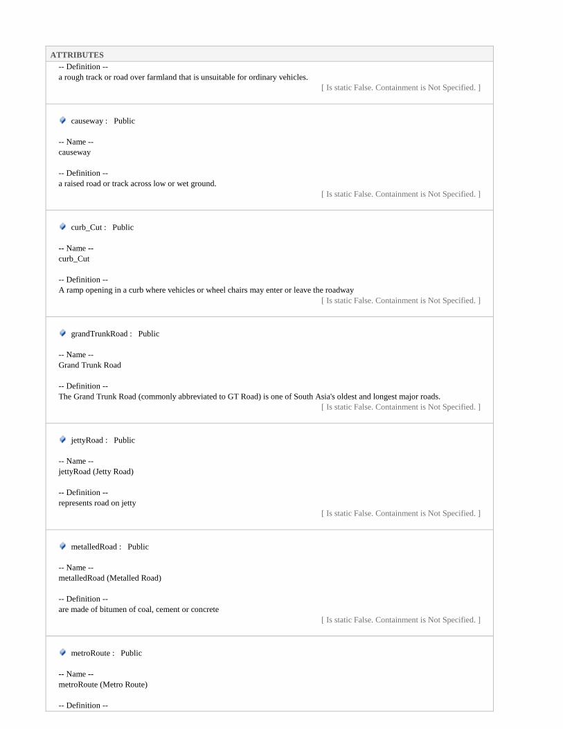
ATTRIBUTES
-- Definition --
a rough track or road over farmland that is unsuitable for ordinary vehicles.
[ Is static False. Containment is Not Specified. ]
causeway : Public
-- Name --
causeway
-- Definition --
a raised road or track across low or wet ground.
[ Is static False. Containment is Not Specified. ]
curb_Cut : Public
-- Name --
curb_Cut
-- Definition --
A ramp opening in a curb where vehicles or wheel chairs may enter or leave the roadway
[ Is static False. Containment is Not Specified. ]
grandTrunkRoad : Public
-- Name --
Grand Trunk Road
-- Definition --
The Grand Trunk Road (commonly abbreviated to GT Road) is one of South Asia's oldest and longest major roads.
[ Is static False. Containment is Not Specified. ]
jettyRoad : Public
-- Name --
jettyRoad (Jetty Road)
-- Definition --
represents road on jetty
[ Is static False. Containment is Not Specified. ]
metalledRoad : Public
-- Name --
metalledRoad (Metalled Road)
-- Definition --
are made of bitumen of coal, cement or concrete
[ Is static False. Containment is Not Specified. ]
metroRoute : Public
-- Name --
metroRoute (Metro Route)
-- Definition --

ATTRIBUTES
a dedicated route for metro bus system
[ Is static False. Containment is Not Specified. ]
motorway : Public
-- Name --
motorway
-- Definition --
a fenced highway is known as motorway
[ Is static False. Containment is Not Specified. ]
other : Public
-- Name --
other
-- Definition --
represent such types which are not included in the list
[ Is static False. Containment is Not Specified. ]
packTrack : Public
-- Name --
packTrack (Pack Track)
-- Definition --
track formed by animal movements, especially in the mountain.
[ Is static False. Containment is Not Specified. ]
serviceRoad : Public
-- Name --
serviceRoad
-- Definition --
represents service road
[ Is static False. Containment is Not Specified. ]
shingledRoad : Public
-- Name --
shingledRoad (Shingled Road)
-- Definition --
a road formed by shingle (a mass of small rounded pebbles).
[ Is static False. Containment is Not Specified. ]
specialRoad : Public
-- Name --
specialRoad (Special Road)
-- Definition --
a road dedicated to special purposes, e.g. taxi lane, bus lane, etc.
[ Is static False. Containment is Not Specified. ]
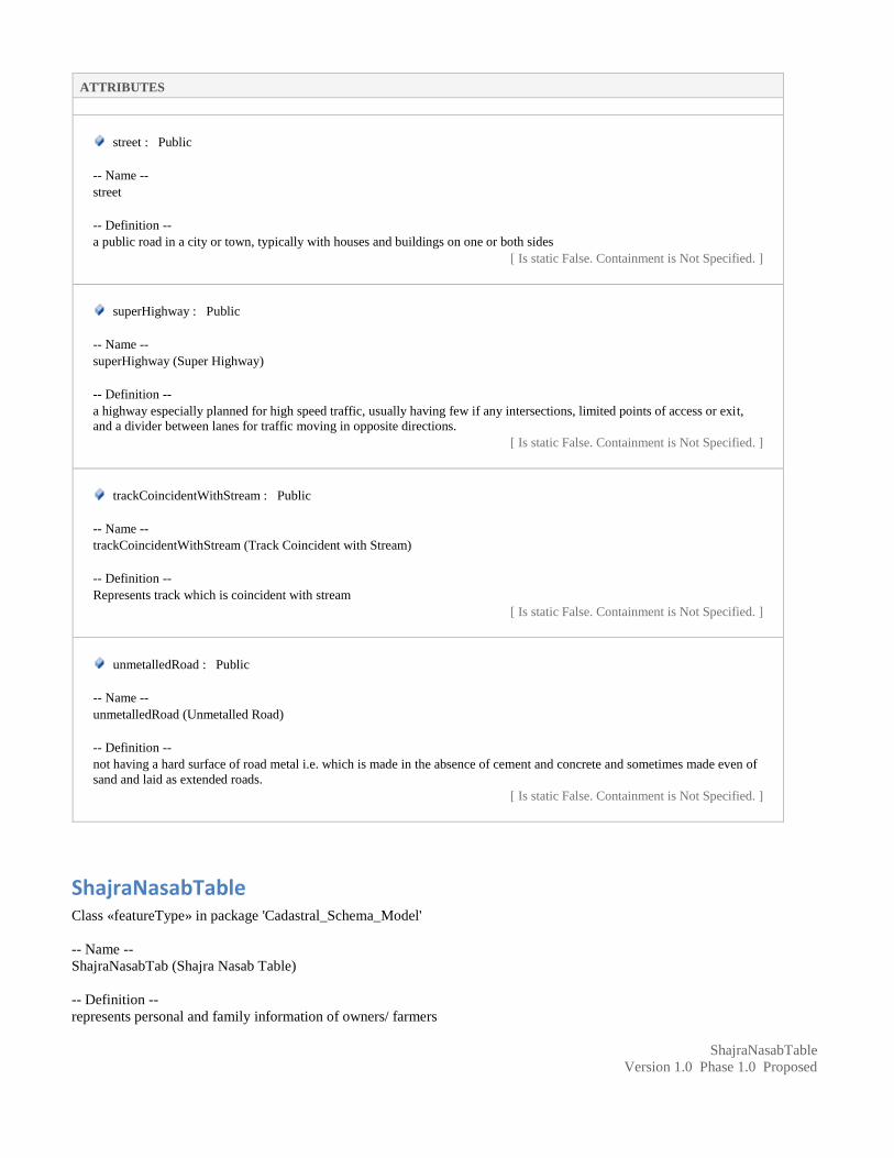
ATTRIBUTES
street : Public
-- Name --
street
-- Definition --
a public road in a city or town, typically with houses and buildings on one or both sides
[ Is static False. Containment is Not Specified. ]
superHighway : Public
-- Name --
superHighway (Super Highway)
-- Definition --
a highway especially planned for high speed traffic, usually having few if any intersections, limited points of access or exit,
and a divider between lanes for traffic moving in opposite directions.
[ Is static False. Containment is Not Specified. ]
trackCoincidentWithStream : Public
-- Name --
trackCoincidentWithStream (Track Coincident with Stream)
-- Definition --
Represents track which is coincident with stream
[ Is static False. Containment is Not Specified. ]
unmetalledRoad : Public
-- Name --
unmetalledRoad (Unmetalled Road)
-- Definition --
not having a hard surface of road metal i.e. which is made in the absence of cement and concrete and sometimes made even of
sand and laid as extended roads.
[ Is static False. Containment is Not Specified. ]
ShajraNasabTable Class «featureType» in package 'Cadastral_Schema_Model'
-- Name --
ShajraNasabTab (Shajra Nasab Table)
-- Definition --
represents personal and family information of owners/ farmers
ShajraNasabTable
Version 1.0 Phase 1.0 Proposed

ATTRIBUTES
alive : Boolean Public
-- Name --
alive
-- Definition --
represents whether the person is alive or dead
[ Is static False. Containment is Not Specified. ]
casteName : CharacterString Public
-- Name --
casteName
-- Definition --
represent caste name like yousafzai, Nawab, etc
[ Is static False. Containment is Not Specified. ]
contact_No : CharacterString Public
-- Name --
contact_No
-- Definition --
represents contact number of the person
[ Is static False. Containment is Not Specified. ]
dep_Person_ID : CharacterString Public
-- Name --
Dependant Person ID
-- Definition --
the person ID on whom dependent
[ Is static False. Containment is Not Specified. ]
family : CharacterString Public
-- Name --
family
-- Definition --
represents family of the owner/ farmer.
[ Is static False. Containment is Not Specified. ]
father_ID : CharacterString Public
-- Name --
father_ID
-- Definition --
represents the father NIC number of the owner/ farmer.
[ Is static False. Containment is Not Specified. ]
finger_Impression : BLOB Public

ATTRIBUTES
-- Name --
finger_Impression
-- Definition --
represents finger impression of the person
[ Is static False. Containment is Not Specified. ]
gender : GenderV Public
-- Name --
gender
-- Definition --
represents gender of the person
[ Is static False. Containment is Not Specified. ]
husband_ID : CharacterString Public
-- Name --
husband_ID
-- Definition --
represents NIC number of the husband of owner/ farmer.
[ Is static False. Containment is Not Specified. ]
mother_ID : CharacterString Public
-- Name --
mother_ID
-- Definition --
represents the mother National ID number
[ Is static False. Containment is Not Specified. ]
person_ID : CharacterString Public
-- Name --
person_ID (Personal ID)
-- Definition --
represents the NIC number/ form B number.
[ Is static False. Containment is Not Specified. ]
person_Name : CharacterString Public
-- Name --
person_Name
-- Definition --
represents the name of the owner/ farmer.
[ Is static False. Containment is Not Specified. ]
profession : CharacterString Public

ATTRIBUTES
-- Name --
profession
-- Definition --
represents profession of the owner/ farmer.
[ Is static False. Containment is Not Specified. ]
religion : CharacterString Public
-- Name --
religion
-- Definition --
represents religion of the owner/ farmer.
[ Is static False. Containment is Not Specified. ]
remarks : CharacterString Public
-- Name --
remarks
-- Definition --
Represents any additional remarks (if any)
[ Is static False. Containment is Not Specified. ]
sect : CharacterString Public
-- Name --
sect
-- Definition --
represents sect of the owner/ farmer.
[ Is static False. Containment is Not Specified. ]
subCaste : CharacterString Public
-- Name --
subCaste
-- Definition --
represents sub caste name
[ Is static False. Containment is Not Specified. ]
ASSOCIATIONS
Association (direction: Source -> Destination)
Source: Public person_ID (Class) KhatuniTable «featureType»
Target: Public person_ID (Class) ShajraNasabTable
«featureType»
Association (direction: Bi-Directional)
Source: Public person_ID (Class) PossessionTable «featureType»
Target: Public person_ID (Class) ShajraNasabTable
«featureType»

ASSOCIATIONS
Association (direction: Bi-Directional)
Source: Public person_ID (Class) RecordOfRightsTable
«featureType»
Target: Public person_ID (Class) ShajraNasabTable
«featureType»
SourceOfIrrigation Class «codeList» in package 'Cadastral_Schema_Model'
-- Name --
AgricultureLandCatgeory
-- Definition --
represents land type used in analog agriculture revenue system
SourceOfIrrigation
Version 1.0 Phase 1.0 Proposed
ATTRIBUTES
rainWater : int Private
[ Is static False. Containment is Not Specified. ]
tubeWell : int Private
[ Is static False. Containment is Not Specified. ]
Strategic Class «codeList» in package 'Cadastral_Schema_Model'
-- Name --
Strategic
-- Definition --
represents possible values the strategic objects
Strategic
Version 1.0 Phase 1.0 Proposed
ATTRIBUTES
aerodrome : Public
-- Name --
aerodrome
-- Definition --
any licensed airfield or government airfield other than those designated airports.
[ Is static False. Containment is Not Specified. ]

ATTRIBUTES
airport : Public
-- Name --
airport
-- Definition --
a defined area of land or water used for landing, take-off and movement of aircraft including associated buildings and facilities
[ Is static False. Containment is Not Specified. ]
arsenal : Public
-- Name --
arsenal
-- Definition --
a repository for military arms and stores.
[ Is static False. Containment is Not Specified. ]
barracks : Public
-- Name --
barracks
-- Definition --
a military building for housing armed services personnel.
[ Is static False. Containment is Not Specified. ]
bombingRange : Public
-- Name --
bombingRange (Bombing Range)
-- Definition --
a tract of land set aside for military bombing practice.
[ Is static False. Containment is Not Specified. ]
campingGround : Public
-- Name --
camping ground
-- Definition --
it represents camping ground
[ Is static False. Containment is Not Specified. ]
defenceEstablishment : Public
-- Name --
defenceEstablishment (Defence Establishment)
-- Definition --
a facility constructed and established by the Defence Force.
[ Is static False. Containment is Not Specified. ]

ATTRIBUTES
fort : Public
-- Name --
fort
-- Definition --
a fortified building or strategic position.
[ Is static False. Containment is Not Specified. ]
helipad : Public
-- Name --
helipad
-- Definition --
a landing place for helicopters.
[ Is static False. Containment is Not Specified. ]
heliport : Public
-- Name --
heliport
-- Definition --
an airport specifically designed for helicopters.
[ Is static False. Containment is Not Specified. ]
landingGround : Public
-- Name --
landingGround (Landing Ground)
-- Definition --
a level tract of land, usually without a hard-surfaced runway or maintenance facilities, but otherwise suitable for landing and
take-off by light aircraft.
[ Is static False. Containment is Not Specified. ]
leveePost : Public
-- Name --
leveePost (Levee Post)
-- Definition --
a post of levee force
[ Is static False. Containment is Not Specified. ]
other : Public
-- Name --
other
-- Definition --
represent such types which are not included in the list
[ Is static False. Containment is Not Specified. ]

ATTRIBUTES
picketPost : Public
-- Name --
picketPost (Picket Post)
-- Definition --
a picket (picquet) is a soldier, or small unit of soldiers, placed on a line forward of a position to provide warning of an enemy
advance.
[ Is static False. Containment is Not Specified. ]
rifleRange : Public
-- Name --
rifleRange (Rifle Range)
-- Definition --
an area designated for target practice with rifles.
[ Is static False. Containment is Not Specified. ]
rocketRange : Public
-- Name --
rocketRange (Rocket Range)
-- Definition --
an area designated for the launching of rockets.
[ Is static False. Containment is Not Specified. ]
watchtower : Public
-- Name --
watchtower
-- Definition --
a tower built to create an elevated observation point.
[ Is static False. Containment is Not Specified. ]
Stream Class «codeList» in package 'Cadastral_Schema_Model'
-- Name --
Stream
-- Definition --
represents the possible value of the stream feature class
Stream
Version 1.0 Phase 1.0 Proposed
ATTRIBUTES
drainIntermittent : Public

ATTRIBUTES
-- Name --
drainIntermittent (Drain Non Perennial)
-- Definition --
an intermittent channel constructed so that water is drained or gradually carried away.
[ Is static False. Containment is Not Specified. ]
drainPerennial : Public
-- Name --
drainPerennial (Drain Perennial)
-- Definition --
a perennial channel constructed so that water is drained or gradually carried away.
[ Is static False. Containment is Not Specified. ]
dryNala : Public
-- Name --
dryNala (Dry Nala)
-- Definition --
a rain water fed intermittent watercourse
[ Is static False. Containment is Not Specified. ]
karez : Public
-- Name --
karez
-- Definition --
an indigenous method of irrigation in which groundwater is tapped by a tunnel. After running for some distance the tunnel
comes out in the open and the water is conducted to the command area.
[ Is static False. Containment is Not Specified. ]
karezDisused : Public
-- Name --
karezDisused (Karez Disused)
-- Definition --
karez which is not in use.
[ Is static False. Containment is Not Specified. ]
nalaPerennial : Public
-- Name --
nalaPerennial (Nala Perennial)
-- Definition --
represents perennial watercourse
[ Is static False. Containment is Not Specified. ]
other : Public

ATTRIBUTES
-- Name --
other
-- Definition --
represent such types which are not included in the list
[ Is static False. Containment is Not Specified. ]
streamApproximated : Public
-- Name --
Stream Approximated
-- Definition --
it represents a stream which is approximately surveyed
[ Is static False. Containment is Not Specified. ]
streamIntermittent : Public
-- Name --
streamIntermittent (Stream Non Perennial)
-- Definition --
a body of non perennial water flowing in a channel or bed.
[ Is static False. Containment is Not Specified. ]
streamPerennial : Public
-- Name --
streamPerennial (Stream Perennial)
-- Definition --
a body of perennial water flowing in a channel or bed.
[ Is static False. Containment is Not Specified. ]
waterChannel : Public
-- Name --
waterChannel (Water Channel)
-- Definition --
an artificial watercourse used for drainage or irrigation purposes.
[ Is static False. Containment is Not Specified. ]
waterfall_Intermittent : Public
-- Name --
waterfall_Intermittent (Waterfall Non Perennial)
-- Definition --
a sudden steep descent of non perennial water over a natural step in the bed of a stream.
[ Is static False. Containment is Not Specified. ]
waterfall_Perennial : Public
-- Name --
waterfall_Perennial (Waterfall Perennial)

ATTRIBUTES
-- Definition --
a sudden steep descent of perennial water over a natural step in the bed of a stream.
[ Is static False. Containment is Not Specified. ]
TaxTable Class «featureType» in package 'Cadastral_Schema_Model'
-- Name --
TaxTable
-- Definition --
Is the tax payable on the former.
TaxTable
Version 1.0 Phase 1.0 Proposed
ATTRIBUTES
areaValue : Real Public
-- Name --
areaValue
-- Definition --
Recorded area value providing an area quantification.
[ Stereotype is «voidable». Is static False. Containment is Not Specified. ]
parcel_ID : CharacterString Public
-- Name --
Parcel_ID
-- Definition --
represents the unique id of a parcel in the Pakistan.
[ Is static False. Containment is Not Specified. ]
remarks : CharacterString Public
-- Name --
remarks
-- Definition --
Represents any additional remarks (if any)
[ Is static False. Containment is Not Specified. ]
tax_Amount : Real Public
-- Name --
tax_Amount
-- Definition --
tax to be collected from owner
[ Is static False. Containment is Not Specified. ]

ATTRIBUTES
taxPeriodTo : DateTime Public
-- Name --
taxPeriodTo
-- Definition --
represents the date up to which tax due.
[ Stereotype is «voidable». Is static False. Containment is Not Specified. ]
taxRate : Real Public
-- Name --
taxRate
-- Definition --
represents tax rates at that specific period
[ Is static False. Containment is Not Specified. ]
taxtPeriodFrom : DateTime Public
-- Name --
taxPeriodFrom
-- Definition --
represents the date from which tax due.
[ Stereotype is «voidable». Is static False. Containment is Not Specified. ]
territory_ID : CharacterString Public
-- Name --
territory_ID
-- Definition --
represents the unique id of a territory in the Pakistan.
[ Is static False. Containment is Not Specified. ]
ASSOCIATIONS
Association (direction: Bi-Directional)
Source: Public parcel_ID (Class) TaxTable «featureType»
Target: Public parcel_ID (Class) Parcel
«featureType»
Association (direction: Bi-Directional)
Source: Public territory_ID (Class) Parcel «featureType»
Target: Public territory_ID (Class) TaxTable
«featureType»
TerritoryTable Class «featureType» in package 'Cadastral_Schema_Model'

-- Name --
TerritoryTable
-- Definition --
represents an administrative area boundary
TerritoryTable
Version 1.0 Phase 1.0 Proposed
ATTRIBUTES
cantonment : CharacterString Public
-- Name --
cantonment
-- Definition --
Represents an area of cantonment.
[ Stereotype is «voidable». Is static False. Containment is Not Specified. ]
district : CharacterString Public
-- Name --
district
-- Definition --
Represents name of district.
[ Is static False. Containment is Not Specified. ]
division : CharacterString Public
-- Name --
division
-- Definition --
Represents name of division.
[ Is static False. Containment is Not Specified. ]
effective_from : DateTime Public
-- Name --
effective_from
-- Definition --
Official date and time the parcel zone was/will be legally established.
-- Description --
NOTE This is the date and time the parcel zone reference can be used in legal acts.
[ Is static False. Containment is Not Specified. ]
effective_to : DateTime Public
-- Name --
effective_to
-- Definition --
Date and time at which the parcel zone legally ceased/will cease to be used.
-- Description --

ATTRIBUTES
NOTE This is the date and time the parcel zone reference can no longer be used in legal acts.
[ Is static False. Containment is Not Specified. ]
hadbast : CharacterString Public
-- Name --
hadbast
-- Definition --
Hadbast number (it is the number of boundary of revenue village)
[ Stereotype is «voidable». Is static False. Containment is Not Specified. ]
masterPlan : CharacterString Public
-- Name --
masterPlan
-- Definition --
Represents the master plan name like malir master plan
[ Stereotype is «voidable». Is static False. Containment is Not Specified. ]
mauza : CharacterString Public
-- Name --
mauza
-- Definition --
Represents the mauza/ village name .
[ Stereotype is «voidable». Is static False. Containment is Not Specified. ]
patwarCircle : CharacterString Public
-- Name --
patwarCircle
-- Definition --
Represents the patwar circle.
[ Stereotype is «voidable». Is static False. Containment is Not Specified. ]
province : CharacterString Public
-- Name --
province
-- Definition --
Represents name of province.
[ Is static False. Containment is Not Specified. ]
qanoongoHalqa : CharacterString Public
-- Name --
Qanoongo Halqa
-- Definition --
Represents the Qanoongo Halqa name.
[ Stereotype is «voidable». Is static False. Containment is Not Specified. ]

ATTRIBUTES
remarks : CharacterString Public
-- Name --
remarks
-- Definition --
Represents any additional remarks (if any)
[ Is static False. Containment is Not Specified. ]
subdivision : CharacterString Public
-- Name --
subdivision
-- Definition --
Represents name of subdivision.
[ Stereotype is «voidable». Is static False. Containment is Not Specified. ]
subTehsil : CharacterString Public
-- Name --
subTehsil
-- Definition --
Represents the subTehsil name.
[ Stereotype is «voidable». Is static False. Containment is Not Specified. ]
tehsil : CharacterString Public
-- Name --
tehsil
-- Definition --
Represents the tehsil name.
[ Is static False. Containment is Not Specified. ]
territory_ID : CharacterString Public
-- Name --
territory_ID
-- Definition --
represents the unique id of a territory in the Pakistan.
[ Is static False. Containment is Not Specified. ]
town : CharacterString Public
-- Name --
town
-- Definition --
Represents the town name.
[ Stereotype is «voidable». Is static False. Containment is Not Specified. ]

ATTRIBUTES
unionCouncil : CharacterString Public
-- Name --
unionCouncil
-- Definition --
Represents the union Council name.
[ Stereotype is «voidable». Is static False. Containment is Not Specified. ]
urban_Rural : Urban_RuralV Public
-- Name --
urban_Rural
-- Definition --
Represents an urban or rural region
[ Is static False. Containment is Not Specified. ]
ASSOCIATIONS
Association (direction: Bi-Directional)
Source: Public territory_ID (Class) Parcel «featureType»
Target: Public territory_ID (Class) TerritoryTable
«featureType»
TransmissionLine Class «codeList» in package 'Cadastral_Schema_Model'
-- Name --
TransmissionLine (Transmission Line)
-- Definition --
represents possible values of transmission line
TransmissionLine
Version 1.0 Phase 1.0 Proposed
ATTRIBUTES
electricPowerLine : Public
-- Name --
electricPowerLine (Electric Power Line)
-- Definition --
cable wires to transmit electric power from one place to other
[ Is static False. Containment is Not Specified. ]
mainPowerTransmissionLine : Public

ATTRIBUTES
-- Name --
mainPowerTransmissionLine (Main Power Transmission Line)
-- Definition --
are used to carry electric power over relatively long distances from central generating station to the main station.
[ Is static False. Containment is Not Specified. ]
other : Public
-- Name --
other
-- Definition --
represent such types which are not included in the list
[ Is static False. Containment is Not Specified. ]
powerLineLocalDistribution : Public
-- Name --
powerLineLocalDistribution (Power Line Local Distribution)
-- Definition --
power line which is used for distribution of electric power locally.
[ Is static False. Containment is Not Specified. ]
powerLineUnderConstruction : Public
-- Name --
powerlineUnderConstruction (Power Line Under Construction)
-- Definition --
power line which is under construction.
[ Is static False. Containment is Not Specified. ]
powerLineUnderground : Public
-- Name --
powerlineUnderground (Power Line Underground)
-- Definition --
Power line which distributes electric power underground.
[ Is static False. Containment is Not Specified. ]
telegraphLine : Public
-- Name --
telegraphLine (Telegraph Line)
-- Definition --
cable wires to transmit radio signals for providing telegraph services to subscribers.
[ Is static False. Containment is Not Specified. ]
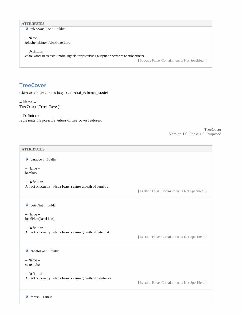
ATTRIBUTES
telephoneLine : Public
-- Name --
telephoneLine (Telephone Line)
-- Definition --
cable wires to transmit radio signals for providing telephone services to subscribers.
[ Is static False. Containment is Not Specified. ]
TreeCover Class «codeList» in package 'Cadastral_Schema_Model'
-- Name --
TreeCover (Trees Cover)
-- Definition --
represents the possible values of tree cover features.
TreeCover
Version 1.0 Phase 1.0 Proposed
ATTRIBUTES
bamboo : Public
-- Name --
bamboo
-- Definition --
A tract of country, which bears a dense growth of bamboo
[ Is static False. Containment is Not Specified. ]
betelNut : Public
-- Name --
betelNut (Betel Nut)
-- Definition --
A tract of country, which bears a dense growth of betel nut.
[ Is static False. Containment is Not Specified. ]
canebrake : Public
-- Name --
canebrake
-- Definition --
A tract of country, which bears a dense growth of canebrake
[ Is static False. Containment is Not Specified. ]
forest : Public

ATTRIBUTES
-- Name --
forest
-- Definition --
Uncultivated tree-covered land of considerable extent.
[ Is static False. Containment is Not Specified. ]
nationalForest : Public
-- Name --
nationalForest (National Forest)
-- Definition --
An area of land proclaimed to be a managed forest under a Forest Act or equivalent legislation.
[ Is static False. Containment is Not Specified. ]
orchard : Public
-- Name --
orchard
-- Definition --
A piece of land planted with fruit trees.
[ Is static False. Containment is Not Specified. ]
other : Public
-- Name --
other
-- Definition --
represents type of trees which is not enlisted
[ Is static False. Containment is Not Specified. ]
palm : Public
-- Name --
palm
-- Definition --
A tract of country, which bears a dense growth of palm trees
[ Is static False. Containment is Not Specified. ]
pine : Public
-- Name --
pine
-- Definition --
A tract of country, which bears a dense growth of pine trees
[ Is static False. Containment is Not Specified. ]
plantainTree : Public
-- Name --

ATTRIBUTES
plantainTree (Plantain Tree)
-- Definition --
A tract of country, which bears a dense growth of plantain tree
[ Is static False. Containment is Not Specified. ]
Tunnel Class «codeList» in package 'Cadastral_Schema_Model'
-- Name --
Tunnel
-- Definition --
represents possible values of tunnel feature type.
Tunnel
Version 1.0 Phase 1.0 Proposed
ATTRIBUTES
canalTunnel : Public
-- Name --
canalTunnel (Canal Tunnel)
-- Definition --
a waterway used to divert water from its natural course.
[ Is static False. Containment is Not Specified. ]
mineTunnel : Public
-- Name --
mineTunnel (Mine Tunnel)
-- Definition --
a passage or opening to mine for the purpose of excavation of the valuable geological materials, it may be open to the surface
at one end and used for drainage, ventilation, or haulage from the mine workings.
[ Is static False. Containment is Not Specified. ]
other : Public
-- Name --
other
-- Definition --
represent such types which are not included in the list
[ Is static False. Containment is Not Specified. ]
railwayTunnel : Public
-- Name --
railwayTunnel (Railway Tunnel)
-- Definition --

ATTRIBUTES
an underground passage for rail traffic.
[ Is static False. Containment is Not Specified. ]
roadTunnel : Public
-- Name --
roadTunnel (Road Tunnel)
-- Definition --
an underground passage for vehicular road traffic
[ Is static False. Containment is Not Specified. ]
Urban_RuralV Class «codeList» in package 'Cadastral_Schema_Model'
-- Name --
Urban_RuralV
-- Definition --
represents the whether the territory is urban or rural
Urban_RuralV
Version 1.0 Phase 1.0 Proposed
ATTRIBUTES
rural : Public
-- Name --
rural
-- Definition --
represents rural territory
[ Is static False. Containment is Not Specified. ]
urban : Public
-- Name --
urban
-- Definition --
represents urban territory
[ Is static False. Containment is Not Specified. ]
Wetland Class «codeList» in package 'Cadastral_Schema_Model'
-- Name --
Wetland
-- Definition --

represents the possible values of the wetland features
Wetland
Version 1.0 Phase 1.0 Proposed
ATTRIBUTES
marsh : Public
-- Name --
marsh
-- Definition --
A tract of land normally saturated with water, having little or no drainage and characterized by a growth of grass or reeds.
[ Is static False. Containment is Not Specified. ]
other : Public
-- Name --
other
-- Definition --
represent such types which are not included in the list
[ Is static False. Containment is Not Specified. ]
swamp : Public
-- Name --
swamp
-- Definition --
A tract of land normally saturated with water, having little or no drainage and characterized by a growth of grass or reeds.
[ Is static False. Containment is Not Specified. ]

XML Schema for Cadastral Database
<?xml version="1.0" encoding="ISO-8859-1"?>
<xs:schema version="1.0" xmlns:xs="http://www.w3.org/2001/XMLSchema"
targetNamespace="CadastralSystem.com">
- <xs:annotation>
<xs:documentation>-- Name -- Cadastral -- Definition -- The application schema
CadastralParcels contains the feature types CadastralParcel</xs:documentation>
</xs:annotation>
<xs:include/>
<xs:include/>
<xs:include/>
<xs:include/>
<xs:element type="Parcel_InfoTable" name="Parcel_InfoTable"/>
- <xs:complexType name="Parcel_InfoTable">
- <xs:annotation>
<xs:documentation>-- Name -- Parcel_InfoTable -- Definition -- Represents parcel specific
information</xs:documentation>
</xs:annotation>
- <xs:sequence>
- <xs:element type="CharacterString" name="block" maxOccurs="1" minOccurs="1">
- <xs:annotation>
<xs:documentation>-- Name -- block -- Definition -- represents the block or phase number/
name</xs:documentation>
</xs:annotation>
</xs:element>
- <xs:element type="CharacterString" name="flat_No" maxOccurs="1" minOccurs="1">
- <xs:annotation>
<xs:documentation>-- Name -- flat No -- Definition -- Represents the flat number
</xs:documentation>
</xs:annotation>
</xs:element>
- <xs:element type="CharacterString" name="floorNo" maxOccurs="1" minOccurs="1">
- <xs:annotation>
<xs:documentation>-- Name -- floorNo -- Definition -- represents the floor number
</xs:documentation>
</xs:annotation>
</xs:element>
- <xs:element type="CharacterString" name="house_No" maxOccurs="1" minOccurs="1">
- <xs:annotation>
<xs:documentation>-- Name -- house_No -- Definition -- Represents the house number
</xs:documentation>
</xs:annotation>
</xs:element>
- <xs:element type="CharacterString" name="housingSociety" maxOccurs="1" minOccurs="1">
- <xs:annotation>

<xs:documentation>-- Name -- housingSociety -- Definition -- Housing society is a membership
based legal entity made of one or more residential buildings.</xs:documentation>
</xs:annotation>
</xs:element>
- <xs:element type="CharacterString" name="office_No" maxOccurs="1"
minOccurs="1">
- <xs:annotation>
<xs:documentation>-- Name -- office No -- Definition -- Represents the office number
</xs:documentation>
</xs:annotation>
</xs:element>
- <xs:element type="CharacterString" name="parcel_ID" maxOccurs="1" minOccurs="1">
- <xs:annotation>
<xs:documentation>-- Name -- parcel_ID -- Definition -- represents the unique id of a parcel in
the Pakistan.</xs:documentation>
</xs:annotation>
</xs:element>
- <xs:element type="CharacterString" name="propertyName" maxOccurs="1"
minOccurs="1">
- <xs:annotation>
<xs:documentation>-- Name -- propertyName -- Definition -- represents name of the property if
any</xs:documentation>
</xs:annotation>
</xs:element>
- <xs:element type="CharacterString" name="propertyNo" maxOccurs="1"
minOccurs="1">
- <xs:annotation>
<xs:documentation>-- Name -- propertyNo -- Definition -- represents the property number
</xs:documentation>
</xs:annotation>
</xs:element>
- <xs:element type="CharacterString" name="remarks" maxOccurs="1"
minOccurs="1">
- <xs:annotation>
<xs:documentation>-- Name -- remarks -- Definition -- Represents any additional
remarks (if any)</xs:documentation>
</xs:annotation>
</xs:element>
- <xs:element type="CharacterString" name="sector" maxOccurs="1" minOccurs="1">
- <xs:annotation>
<xs:documentation>-- Name -- sector -- Definition -- represents the sector number/
name</xs:documentation>
</xs:annotation>
</xs:element>
- <xs:element type="CharacterString" name="shop_No" maxOccurs="1"
minOccurs="1">
- <xs:annotation>
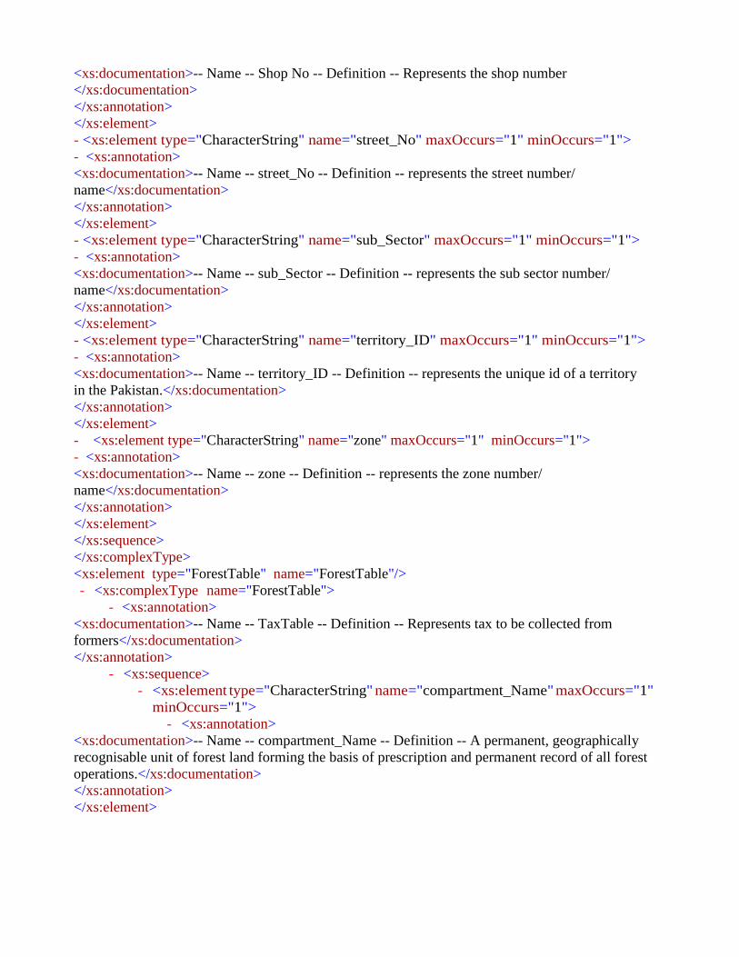
<xs:documentation>-- Name -- Shop No -- Definition -- Represents the shop number
</xs:documentation>
</xs:annotation>
</xs:element>
- <xs:element type="CharacterString" name="street_No" maxOccurs="1" minOccurs="1">
- <xs:annotation>
<xs:documentation>-- Name -- street_No -- Definition -- represents the street number/
name</xs:documentation>
</xs:annotation>
</xs:element>
- <xs:element type="CharacterString" name="sub_Sector" maxOccurs="1" minOccurs="1">
- <xs:annotation>
<xs:documentation>-- Name -- sub_Sector -- Definition -- represents the sub sector number/
name</xs:documentation>
</xs:annotation>
</xs:element>
- <xs:element type="CharacterString" name="territory_ID" maxOccurs="1" minOccurs="1">
- <xs:annotation>
<xs:documentation>-- Name -- territory_ID -- Definition -- represents the unique id of a territory
in the Pakistan.</xs:documentation>
</xs:annotation>
</xs:element>
- <xs:element type="CharacterString" name="zone" maxOccurs="1" minOccurs="1">
- <xs:annotation>
<xs:documentation>-- Name -- zone -- Definition -- represents the zone number/
name</xs:documentation>
</xs:annotation>
</xs:element>
</xs:sequence>
</xs:complexType>
<xs:element type="ForestTable" name="ForestTable"/>
- <xs:complexType name="ForestTable">
- <xs:annotation>
<xs:documentation>-- Name -- TaxTable -- Definition -- Represents tax to be collected from
formers</xs:documentation>
</xs:annotation>
- <xs:sequence>
- <xs:element type="CharacterString" name="compartment_Name" maxOccurs="1"
minOccurs="1">
- <xs:annotation>
<xs:documentation>-- Name -- compartment_Name -- Definition -- A permanent, geographically
recognisable unit of forest land forming the basis of prescription and permanent record of all forest
operations.</xs:documentation>
</xs:annotation>
</xs:element>

- <xs:element type="ForestCategoryV" name="forest_Category" maxOccurs="1"
minOccurs="1">
- <xs:annotation>
<xs:documentation>-- Name -- Legal_Status -- Definition -- represents legal status of the
forest</xs:documentation>
</xs:annotation>
</xs:element>
- <xs:element type="CharacterString" name="forest_Name" maxOccurs="1"
minOccurs="1">
- <xs:annotation>
<xs:documentation>-- Name -- Forest Name -- Definition -- it represents forest
name</xs:documentation>
</xs:annotation>
</xs:element>
- <xs:element type="ForestTypeV" name="forest_Type" maxOccurs="1"
minOccurs="1">
- <xs:annotation>
<xs:documentation>-- Name -- Forest Type -- Definition -- it represents the forest
tpes</xs:documentation>
</xs:annotation>
</xs:element>
- <xs:element type="CharacterString" name="forest_Zone" maxOccurs="1"
minOccurs="1">
- <xs:annotation>
<xs:documentation>-- Name -- Forest_Zone -- Definition -- Forest areas are used to identify
the dominant values of certain forest areas and their management.</xs:documentation>
</xs:annotation>
</xs:element>
- <xs:element type="xs:dateTime" name="from_Date" maxOccurs="1" minOccurs="1">
- <xs:annotation>
<xs:documentation>-- Name -- from -- Definition -- represents the date from which forest
exist.</xs:documentation>
</xs:annotation>
</xs:element>
- <xs:element type="CharacterString" name="notification" maxOccurs="1"
minOccurs="1">
- <xs:annotation>
<xs:documentation>-- Name -- notification -- Definition -- represents forest
notifications</xs:documentation>
</xs:annotation>
</xs:element>
- <xs:element type="CharacterString" name="parcel_ID" maxOccurs="1"
minOccurs="1">
- <xs:annotation>
<xs:documentation>-- Name -- Parcel_ID -- Definition -- represents the unique id of a parcel in
the Pakistan.</xs:documentation>
</xs:annotation>
</xs:element>

- <xs:element type="CharacterString" name="remarks" maxOccurs="1"
minOccurs="1">
- <xs:annotation>
<xs:documentation>-- Name -- remarks -- Definition -- Represents any additional
remarks</xs:documentation>
</xs:annotation>
</xs:element>
- <xs:element type="CharacterString" name="source_Document" maxOccurs="1"
minOccurs="1">
- <xs:annotation>
<xs:documentation>-- Name -- source_Document -- Definition -- Represents all materials used
to extract information. </xs:documentation>
</xs:annotation>
</xs:element>
- <xs:element type="CharacterString" name="source_Imagery" maxOccurs="1"
minOccurs="1">
- <xs:annotation>
<xs:documentation>-- Name -- source_Imagery -- Definition -- is a source imagery used to
identify forests.</xs:documentation>
</xs:annotation>
</xs:element>
- <xs:element type="CharacterString" name="source_Map" maxOccurs="1"
minOccurs="1">
- <xs:annotation>
<xs:documentation>-- Name -- source_Map -- Definition -- is a source map used for forests
digitization.</xs:documentation>
</xs:annotation>
</xs:element>
- <xs:element type="CharacterString" name="sub_Compartment" maxOccurs="1"
minOccurs="1">
- <xs:annotation>
<xs:documentation>-- Name -- sub_Compartment -- Definition -- A sub- division of a
compartment, sometimes temporary, where because of particular characteristics an area of
forest has a special description and requires separate silvicultural
treatment.</xs:documentation>
</xs:annotation>
</xs:element>
- <xs:element type="CharacterString" name="territory_ID" maxOccurs="1"
minOccurs="1">
- <xs:annotation>
<xs:documentation>-- Name -- territory_ID -- Definition -- represents the unique id of a
territory in the Pakistan.</xs:documentation>
</xs:annotation>
</xs:element>
- <xs:element type="xs:dateTime" name="to_Date" maxOccurs="1" minOccurs="1">
- <xs:annotation>
<xs:documentation>-- Name -- To Date -- Definition -- represents the date at which the forest
breaks down.</xs:documentation>
</xs:annotation>

</xs:element>
- <xs:element type="CharacterString" name="working_Circle" maxOccurs="1"
minOccurs="1">
- <xs:annotation>
<xs:documentation>-- Name -- Working Circle -- Definition -- One or more parts of a working plan
area, not necessarily adjoining, having the same objectives, silvicultural system and
prescriptions.</xs:documentation>
</xs:annotation>
</xs:element>
- <xs:element type="CharacterString" name="working_Plan" maxOccurs="1"
minOccurs="1">
- <xs:annotation>
<xs:documentation>-- Name -- working_Plan -- Definition -- A document that regulates wood
production, silviculture and tending activities for a specific period of time through the application of
prescriptions specifying targets, action and control arrangements. A Working Plan is not synonymous
with a Forest Management Plan.</xs:documentation>
</xs:annotation>
</xs:element>
<xs:element type="Parcel" name="parcel_ID" maxOccurs="1" minOccurs="1"/>
<xs:element type="Parcel" name="territory_ID" maxOccurs="1" minOccurs="1"/>
</xs:sequence>
</xs:complexType>
<xs:element type="RecordOfRightsTable" name="RecordOfRightsTable"/>
- <xs:complexType name="RecordOfRightsTable">
- <xs:annotation>
<xs:documentation>-- Name -- RecordOfRightsTab (Record of Rights Table) -- Definition --
represents the ownership of the parcel.</xs:documentation>
</xs:annotation>
- <xs:sequence>
- <xs:element type="CharacterString" name="floorNo" maxOccurs="1"
minOccurs="1">
- <xs:annotation>
<xs:documentation>-- Name -- floorNo -- Definition -- represents the floor number
</xs:documentation>
</xs:annotation>
</xs:element>
- <xs:element type="IntiqalType" name="intiqal_Type" maxOccurs="1"
minOccurs="1">
- <xs:annotation>
<xs:documentation>-- Name -- iintiqal_Type -- Definition -- represents intiqal
type</xs:documentation>
</xs:annotation>
</xs:element>
- <xs:element type="CharacterString" name="organization" maxOccurs="1"
minOccurs="1">
- <xs:annotation>
<xs:documentation>-- Name -- organization -- Definition -- the organization which owned/ use the
parcel</xs:documentation>

</xs:annotation>
</xs:element>
- <xs:element type="xs:dateTime" name="ownershipEndDate" maxOccurs="1"
minOccurs="1">
- <xs:annotation>
<xs:documentation>-- Name -- ownershipEndDate -- Definition -- The official Date and time
when the ownership is transferred to someone else</xs:documentation>
</xs:annotation>
</xs:element>
- <xs:element type="xs:dateTime" name="ownershipStartDate" maxOccurs="1"
minOccurs="1">
- <xs:annotation>
<xs:documentation>-- Name -- ownershipStartDate -- Definition -- the official ownership
establishment date</xs:documentation>
</xs:annotation>
</xs:element>
- <xs:element type="OwnershipType" name="ownershipType" maxOccurs="1"
minOccurs="1">
- <xs:annotation>
<xs:documentation>-- Name -- ownershipType -- Definition -- represents the ownerships type
e.g., state owned, individual , or shamilat-e- deh</xs:documentation>
</xs:annotation>
</xs:element>
- <xs:element type="CharacterString" name="parcel_ID" maxOccurs="1"
minOccurs="1">
- <xs:annotation>
<xs:documentation>-- Name -- parcel_ID -- Definition -- represents the unique id of a parcel in
the Pakistan.</xs:documentation>
</xs:annotation>
</xs:element>
- <xs:element type="CharacterString" name="personID" maxOccurs="1"
minOccurs="1">
- <xs:annotation>
<xs:documentation>-- Name -- person_ID (Personal ID) -- Definition -- represents the
NIC/ form B number.</xs:documentation>
</xs:annotation>
</xs:element>
- <xs:element type="CharacterString" name="prevOwner_ID" maxOccurs="1"
minOccurs="1">
- <xs:annotation>
<xs:documentation>-- Name -- prevOwner_ID (Previous Owner ID) -- Definition --
represents the NIC number of previous owner</xs:documentation>
</xs:annotation>
</xs:element>
- <xs:element type="CharacterString" name="remarks" maxOccurs="1"
minOccurs="1">

- <xs:annotation>
<xs:documentation>-- Name -- remarks -- Definition -- Represents any additional remarks (if
any)</xs:documentation>
</xs:annotation>
</xs:element>
- <xs:element type="Real" name="sharingPercentage" maxOccurs="1" minOccurs="1">
- <xs:annotation>
<xs:documentation>-- Name -- sharingPercentage (Sharing Percentage) -- Definition --
represents ownership share in percentage</xs:documentation>
</xs:annotation>
</xs:element>
- <xs:element type="CharacterString" name="territory_ID" maxOccurs="1"
minOccurs="1">
- <xs:annotation>
<xs:documentation>-- Name -- territory_ID -- Definition -- represents the unique id of a territory
in the Pakistan.</xs:documentation>
</xs:annotation>
</xs:element>
<xs:element type="Parcel" name="parcel_ID" maxOccurs="1" minOccurs="1"/>
<xs:element type="ShajraNasabTable" name="person_ID" maxOccurs="1"
minOccurs="1"/>
<xs:element type="RecordOfRightsTable" name="prevOwner_ID" maxOccurs="1" minOccurs="1"/>
</xs:sequence>
</xs:complexType>
<xs:element type="Parcel" name="Parcel"/>
- <xs:complexType name="Parcel">
- <xs:annotation>
<xs:documentation>-- Name -- Parcel -- Definition -- Represents a parcel/ khasra of a village of
the Pakistan </xs:documentation>
</xs:annotation>
- <xs:sequence>
- <xs:element type="CharacterString" name="dimension" maxOccurs="1"
minOccurs="1">
- <xs:annotation>
<xs:documentation>-- Name -- dimension -- Definition -- represents dimension of the
khasra</xs:documentation>
</xs:annotation>
</xs:element>
- <xs:element type="xs:dateTime" name="effective_from" maxOccurs="1"
minOccurs="1">
- <xs:annotation>
<xs:documentation>-- Name -- effective_from -- Definition -- Official date and time the cadastral
parcel was/will be legally established. -- Description -- NOTE This is the date and time the national
cadastral reference can be used in legal acts.</xs:documentation>
</xs:annotation>
</xs:element>

- <xs:element type="xs:dateTime" name="effective_to" maxOccurs="1" minOccurs="1">
- <xs:annotation>
<xs:documentation>-- Name -- effective_to -- Definition -- Date and time at which the cadastral
parcel legally ceased/will cease to be used. -- Description -- NOTE This is the date and time the
national cadastral reference can no longer be used in legal acts.</xs:documentation>
</xs:annotation>
</xs:element>
- <xs:element type="Real" name="feet_per_Marla" maxOccurs="1" minOccurs="1">
- <xs:annotation>
<xs:documentation>-- Name -- feet_per_Marla -- Definition -- This field is used to Enter total
Feet in a Marla. Different Feet/Marla are being used in Districts of Punjab like 225, 272, 272.25
and 270. Area calculation of a Mauza based on this selection.</xs:documentation>
</xs:annotation>
</xs:element>
- <xs:element type="GM_Polygon" name="geom" maxOccurs="1" minOccurs="1">
- <xs:annotation>
<xs:documentation>-- Name -- geom (Geometry) -- Definition -- represents the geometry of the
parcel.</xs:documentation>
</xs:annotation>
</xs:element>
- <xs:element type="CharacterString" name="khasra" maxOccurs="1" minOccurs="1">
- <xs:annotation>
<xs:documentation>-- Name -- khasra -- Definition -- represents the unique khasra number in
the village.</xs:documentation>
</xs:annotation>
</xs:element>
- <xs:element type="CharacterString" name="mussavi_No" maxOccurs="1"
minOccurs="1">
- <xs:annotation>
<xs:documentation>-- Name -- mussavi_No -- Definition -- Represents the unique mussavi
number of mussavi map</xs:documentation>
</xs:annotation>
</xs:element>
- <xs:element type="CharacterString" name="parcel_ID" maxOccurs="1"
minOccurs="1">
- <xs:annotation>
<xs:documentation>-- Name -- Parcel_ID -- Definition -- represents the unique id of a parcel in
the Pakistan.</xs:documentation>
</xs:annotation>
</xs:element>
- <xs:element type="CharacterString" name="remarks" maxOccurs="1"
minOccurs="1">
- <xs:annotation>
<xs:documentation>-- Name -- remarks -- Definition -- Represents any additional
remarks (if any)</xs:documentation>
</xs:annotation>
</xs:element>

- <xs:element type="CharacterString" name="squareNo" maxOccurs="1"
minOccurs="1">
- <xs:annotation>
<xs:documentation>-- Name -- squareNo -- Definition -- represents the unique square number in the
village.</xs:documentation>
</xs:annotation>
</xs:element>
- <xs:element type="CharacterString" name="sub_khasra" maxOccurs="1"
minOccurs="1">
- <xs:annotation>
<xs:documentation>-- Name -- sub_khasra -- Definition -- represents the sub khasra number in the
village.</xs:documentation>
</xs:annotation>
</xs:element>
- <xs:element type="CharacterString" name="territory_ID" maxOccurs="1"
minOccurs="1">
- <xs:annotation>
<xs:documentation>-- Name -- territory_ID -- Definition -- represents the unique id of a territory
in the Pakistan.</xs:documentation>
</xs:annotation>
</xs:element>
<xs:element type="TerritoryTable" name="territory_ID" maxOccurs="1"
minOccurs="1"/>
<xs:element type="PossessionTable" name="parcel_ID" maxOccurs="1" minOccurs="1"/>
<xs:element type="TaxTable" name="territory_ID" maxOccurs="1" minOccurs="1"/>
<xs:element type="RecordOfRightsTable" name="territory_ID"
maxOccurs="unbounded" minOccurs="0"/>
<xs:element type="PossessionTable" name="territory_ID" maxOccurs="1" minOccurs="1"/>
<xs:element type="Parcel_InfoTable" name="territory_ID" maxOccurs="1" minOccurs="1"/>
<xs:element type="Parcel_InfoTable" name="parcel_ID" maxOccurs="1" minOccurs="1"/>
</xs:sequence>
</xs:complexType>
<xs:element type="TerritoryTable" name="TerritoryTable"/>
- <xs:complexType name="TerritoryTable">
- <xs:annotation>
<xs:documentation>-- Name -- TerritoryTable -- Definition -- represents an administrative area
boundary</xs:documentation>
</xs:annotation>
- <xs:sequence>
- <xs:element type="CharacterString" name="cantonment" maxOccurs="1"
minOccurs="1">
- <xs:annotation>
<xs:documentation>-- Name -- cantonment -- Definition -- Represents an area of
cantonment.</xs:documentation>
</xs:annotation>

</xs:element>
- <xs:element type="CharacterString" name="district" maxOccurs="1" minOccurs="1">
- <xs:annotation>
<xs:documentation>-- Name -- district -- Definition -- Represents name of
district.</xs:documentation>
</xs:annotation>
</xs:element>
- <xs:element type="CharacterString" name="division" maxOccurs="1"
minOccurs="1">
- <xs:annotation>
<xs:documentation>-- Name -- division -- Definition -- Represents name of
division.</xs:documentation>
</xs:annotation>
</xs:element>
- <xs:element type="xs:dateTime" name="effective_from" maxOccurs="1"
minOccurs="1">
- <xs:annotation>
<xs:documentation>-- Name -- effective_from -- Definition -- Official date and time the parcel
zone was/will be legally established. -- Description -- NOTE This is the date and time the parcel
zone reference can be used in legal acts.</xs:documentation>
</xs:annotation>
</xs:element>
- <xs:element type="xs:dateTime" name="effective_to" maxOccurs="1" minOccurs="1">
- <xs:annotation>
<xs:documentation>-- Name -- effective_to -- Definition -- Date and time at which the parcel
zone legally ceased/will cease to be used. -- Description -
- NOTE This is the date and time the parcel zone reference can no longer
be used in legal acts.</xs:documentation>
</xs:annotation>
</xs:element>
- <xs:element type="CharacterString" name="hadbast" maxOccurs="1"
minOccurs="1">
- <xs:annotation>
<xs:documentation>-- Name -- hadbast -- Definition -- Hadbast number (it is the number of
boundary of revenue village)</xs:documentation>
</xs:annotation>
</xs:element>
- <xs:element type="CharacterString" name="masterPlan" maxOccurs="1"
minOccurs="1">
- <xs:annotation>
<xs:documentation>-- Name -- masterPlan -- Definition -- Represents the master plan name
like malir master plan</xs:documentation>
</xs:annotation>
</xs:element>
- <xs:element type="CharacterString" name="mauza" maxOccurs="1" minOccurs="1">
- <xs:annotation>
<xs:documentation>-- Name -- mauza -- Definition -- Represents the mauza/ village name
.</xs:documentation>

</xs:annotation>
</xs:element>
- <xs:element type="CharacterString" name="patwarCircle" maxOccurs="1"
minOccurs="1">
- <xs:annotation>
<xs:documentation>-- Name -- patwarCircle -- Definition -- Represents the patwar
circle.</xs:documentation>
</xs:annotation>
</xs:element>
- <xs:element type="CharacterString" name="province" maxOccurs="1"
minOccurs="1">
- <xs:annotation>
<xs:documentation>-- Name -- province -- Definition -- Represents name of
province.</xs:documentation>
</xs:annotation>
</xs:element>
- <xs:element type="CharacterString" name="qanoongoHalqa" maxOccurs="1"
minOccurs="1">
- <xs:annotation>
<xs:documentation>-- Name -- Qanoongo Halqa -- Definition -- Represents the Qanoongo Halqa
name.</xs:documentation>
</xs:annotation>
</xs:element>
- <xs:element type="CharacterString" name="remarks" maxOccurs="1"
minOccurs="1">
- <xs:annotation>
<xs:documentation>-- Name -- remarks -- Definition -- Represents any additional
remarks (if any)</xs:documentation>
</xs:annotation>
</xs:element>
- <xs:element type="CharacterString" name="subdivision" maxOccurs="1"
minOccurs="1">
- <xs:annotation>
<xs:documentation>-- Name -- subdivision -- Definition -- Represents name of
subdivision.</xs:documentation>
</xs:annotation>
</xs:element>
- <xs:element type="CharacterString" name="subTehsil" maxOccurs="1"
minOccurs="1">
- <xs:annotation>
<xs:documentation>-- Name -- subTehsil -- Definition -- Represents the subTehsil
name.</xs:documentation>
</xs:annotation>
</xs:element>
- <xs:element type="CharacterString" name="tehsil" maxOccurs="1" minOccurs="1">
- <xs:annotation>
<xs:documentation>-- Name -- tehsil -- Definition -- Represents the tehsil
name.</xs:documentation>
</xs:annotation>

</xs:element>
- <xs:element type="CharacterString" name="territory_ID" maxOccurs="1"
minOccurs="1">
- <xs:annotation>
<xs:documentation>-- Name -- territory_ID -- Definition -- represents the unique id of a territory
in the Pakistan.</xs:documentation>
</xs:annotation>
</xs:element>
- <xs:element type="CharacterString" name="town" maxOccurs="1" minOccurs="1">
- <xs:annotation>
<xs:documentation>-- Name -- town -- Definition -- Represents the town
name.</xs:documentation>
</xs:annotation>
</xs:element>
- <xs:element type="xs:string" name="unionCouncil" maxOccurs="1" minOccurs="1">
- <xs:annotation>
<xs:documentation>-- Name -- unionCouncil -- Definition -- Represents the union Council
name.</xs:documentation>
</xs:annotation>
</xs:element>
- <xs:element type="Urban_RuralV" name="urban_Rural" maxOccurs="1"
minOccurs="1">
- <xs:annotation>
<xs:documentation>-- Name -- urban_Rural -- Definition -- Represents an urban or rural
region</xs:documentation>
</xs:annotation>
</xs:element>
</xs:sequence>
</xs:complexType>
<xs:element type="PossessionTable" name="PossessionTable"/>
- <xs:complexType name="PossessionTable">
- <xs:annotation>
<xs:documentation>-- Name -- Possession -- Definition -- represents Possession of the parcel
</xs:documentation>
</xs:annotation>
- <xs:sequence>
- <xs:element type="string" name="parcel_ID" maxOccurs="1" minOccurs="1">
- <xs:annotation>
<xs:documentation>-- Name -- Parcel_ID -- Definition -- represents the unique id of a parcel in the
Pakistan.</xs:documentation>
</xs:annotation>
</xs:element>
- <xs:element type="string" name="person_ID" maxOccurs="1" minOccurs="1">
- <xs:annotation>
<xs:documentation>-- Name -- Person_ID (Personal ID) -- Definition -- represents the NIC
number/ form B number.</xs:documentation>
</xs:annotation>
</xs:element>

- <xs:element type="PossessionType" name="possessionType" maxOccurs="1"
minOccurs="1">
- <xs:annotation>
<xs:documentation>-- Name -- possessionType -- Definition -- represents possession
type</xs:documentation>
</xs:annotation>
</xs:element>
- <xs:element type="CharacterString" name="remarks" maxOccurs="1"
minOccurs="1">
- <xs:annotation>
<xs:documentation>-- Name -- remarks -- Definition -- Represents any additional
remarks</xs:documentation>
</xs:annotation>
</xs:element>
- <xs:element type="string" name="territory_ID" maxOccurs="1" minOccurs="1">
- <xs:annotation>
<xs:documentation>-- Name -- territory_ID -- Definition -- represents the unique id of a territory
in the Pakistan.</xs:documentation>
</xs:annotation>
</xs:element>
<xs:element type="ShajraNasabTable" name="person_ID" maxOccurs="1"
minOccurs="1"/>
</xs:sequence>
</xs:complexType>
<xs:element type="PossessionType" name="PossessionType"/>
- <xs:complexType name="PossessionType">
- <xs:annotation>
<xs:documentation>-- Name -- PossessionType -- Definition -- represents the ownerships type e.g.,
state owned, individual , or shamilat-e-deh</xs:documentation>
</xs:annotation>
- <xs:sequence>
- <xs:element name="aadrehan" maxOccurs="1" minOccurs="1">
- <xs:annotation>
<xs:documentation>-- Name -- aadrehan -- Definition -- Mortgagor, one who mortgages his land.
Whenever a land is mortgaged, completely or partially, to another person or party, mutation is of
Rahin type. The deal can be either verbal or through Registry. The land mortgaged without
possession.</xs:documentation>
</xs:annotation>
</xs:element>
- <xs:element name="ghairDakhildar" maxOccurs="1" minOccurs="1">
- <xs:annotation>
<xs:documentation>-- Name -- ghairDakhildar -- Definition -- represents permanent
unauthorized possession </xs:documentation>
</xs:annotation>
</xs:element>
- <xs:element name="ghairMarusi" maxOccurs="1" minOccurs="1">
- <xs:annotation>

<xs:documentation>-- Name -- ghairMarusi -- Definition -- represents temporary unauthorized
possession (Kache mujahire)</xs:documentation>
</xs:annotation>
</xs:element>
- <xs:element name="khudkast" maxOccurs="1" minOccurs="1">
- <xs:annotation>
<xs:documentation>-- Name -- khudkast -- Definition -- Self cultivated
land</xs:documentation>
</xs:annotation>
</xs:element>
- <xs:element name="marusi" maxOccurs="1" minOccurs="1">
- <xs:annotation>
<xs:documentation>-- Name -- marusi -- Definition -- Permanent Tenant Cultivator who pays revenue
to the land owner.</xs:documentation>
</xs:annotation>
</xs:element>
- <xs:element name="other" maxOccurs="1" minOccurs="1">
- <xs:annotation>
<xs:documentation>-- Name -- other -- Definition -- possession type which is not listed
</xs:documentation>
</xs:annotation>
</xs:element>
- <xs:element name="rehan" maxOccurs="1" minOccurs="1">
- <xs:annotation>
<xs:documentation>-- Name -- rehan -- Definition -- Mortgagor, one who mortgages his land.
Whenever a land is mortgaged, completely or partially, to another person or party, mutation is of
Rahin type. The deal can be either verbal or through Registry. The land mortgaged with
possession.</xs:documentation>
</xs:annotation>
</xs:element>
- <xs:element type="xs:string" name="siri" maxOccurs="1" minOccurs="1">
- <xs:annotation>
<xs:documentation>-- Name -- siri -- Definition -- Sometimes possessions are given intentionally to
the workers (called as SIRIs) to avoid to come under land ceiling act. But the title is not clear in such
cases.</xs:documentation>
</xs:annotation>
</xs:element>
</xs:sequence>
</xs:complexType>
<xs:element type="TaxTable" name="TaxTable"/>
- <xs:complexType name="TaxTable">
- <xs:annotation>
<xs:documentation>-- Name -- TaxTable -- Definition -- Is the tax payable on the
former.</xs:documentation>
</xs:annotation>
- <xs:sequence>
- <xs:element type="Real" name="areaValue" maxOccurs="1" minOccurs="1">

- <xs:annotation>
<xs:documentation>-- Name -- areaValue -- Definition -- Recorded area value providing an area
quantification.</xs:documentation>
</xs:annotation>
</xs:element>
- <xs:element type="CharacterString" name="parcel_ID" maxOccurs="1"
minOccurs="1">
- <xs:annotation>
<xs:documentation>-- Name -- Parcel_ID -- Definition -- represents the unique id of a parcel in
the Pakistan.</xs:documentation>
</xs:annotation>
</xs:element>
- <xs:element type="CharacterString" name="remarks" maxOccurs="1"
minOccurs="1">
- <xs:annotation>
<xs:documentation>-- Name -- remarks -- Definition -- Represents any additional
remarks (if any)</xs:documentation>
</xs:annotation>
</xs:element>
- <xs:element type="Real" name="tax_Amount" maxOccurs="1" minOccurs="1">
- <xs:annotation>
<xs:documentation>-- Name -- tax_Amount -- Definition -- tax to be collected from
owner</xs:documentation>
</xs:annotation>
</xs:element>
- <xs:element type="xs:dateTime" name="taxPeriodTo" maxOccurs="1"
minOccurs="1">
- <xs:annotation>
<xs:documentation>-- Name -- taxPeriodTo -- Definition -- represents the date up to which tax
due.</xs:documentation>
</xs:annotation>
</xs:element>
- <xs:element type="Real" name="taxRate" maxOccurs="1" minOccurs="1">
- <xs:annotation>
<xs:documentation>-- Name -- taxRate -- Definition -- represents tax rates at that specific
period</xs:documentation>
</xs:annotation>
</xs:element>
- <xs:element type="xs:dateTime" name="taxtPeriodFrom" maxOccurs="1"
minOccurs="1">
- <xs:annotation>
<xs:documentation>-- Name -- taxPeriodFrom -- Definition -- represents the date from which
tax due.</xs:documentation>
</xs:annotation>
</xs:element>
- <xs:element type="CharacterString" name="territory_ID" maxOccurs="1"
minOccurs="1">
- <xs:annotation>

<xs:documentation>-- Name -- territory_ID -- Definition -- represents the unique id of a territory
in the Pakistan.</xs:documentation>
</xs:annotation>
</xs:element>
<xs:element type="Parcel" name="parcel_ID" maxOccurs="1" minOccurs="1"/>
</xs:sequence>
</xs:complexType>
<xs:element type="LandUseType" name="LandUseType"/>
- <xs:complexType name="LandUseType">
- <xs:annotation>
<xs:documentation>-- Name -- Land Use Type -- Definition -- represent possible Land use
types</xs:documentation>
</xs:annotation>
- <xs:sequence>
- <xs:element type="BarrenLand" name="1" maxOccurs="1" minOccurs="1">
- <xs:annotation>
<xs:documentation>-- Name -- 1 = Barren Land -- Definition -- represents possible types of
barren</xs:documentation>
</xs:annotation>
</xs:element>
- <xs:element type="MedicalFacility" name="10" maxOccurs="1" minOccurs="1">
- <xs:annotation>
<xs:documentation>-- Name -- 10 (Medical Facility) -- Definition -- represents possible types of
medicalFacility</xs:documentation>
</xs:annotation>
</xs:element>
- <xs:element type="MineCavePass" name="11" maxOccurs="1" minOccurs="1">
- <xs:annotation>
<xs:documentation>-- Name -- 11 (Mine, Cave, Pass) -- Definition -- represents possible types of
mine, cave and pass</xs:documentation>
</xs:annotation>
</xs:element>
- <xs:element type="Pipeline" name="12" maxOccurs="1" minOccurs="1">
- <xs:annotation>
<xs:documentation>-- Name -- 12 (Pipeline) -- Definition -- represents possible types of
pipeline</xs:documentation>
</xs:annotation>
</xs:element>
- <xs:element type="Railway" name="13" maxOccurs="1" minOccurs="1">
- <xs:annotation>
<xs:documentation>-- Name -- 13 (Railway) -- Definition -- represents possible types of
railway</xs:documentation>
</xs:annotation>
</xs:element>
- <xs:element type="RecreationalFacility" name="14" maxOccurs="1" minOccurs="1">
- <xs:annotation>
<xs:documentation>-- Name -- 14 (Recreational Facility) -- Definition -- represents possible
types of recreational facility </xs:documentation>
</xs:annotation>

</xs:element>
- <xs:element type="ReligiousPlaces" name="15" maxOccurs="1" minOccurs="1">
- <xs:annotation>
<xs:documentation>-- Name -- 15 (Religious Places) -- Definition -- represents possible types of
religious places</xs:documentation>
</xs:annotation>
</xs:element>
- <xs:element type="Reservoir" name="16" maxOccurs="1" minOccurs="1">
- <xs:annotation>
<xs:documentation>-- Name -- 16 (Reservoir) -- Definition -- represents possible types of
reservoir</xs:documentation>
</xs:annotation>
</xs:element>
- <xs:element type="Residence" name="17" maxOccurs="1" minOccurs="1">
- <xs:annotation>
<xs:documentation>-- Name -- 17 (Residence) -- Definition -- Area with high degree of
residential development, also including areas with functions connected to residential
areas</xs:documentation>
</xs:annotation>
</xs:element>
- <xs:element type="RiversCanalLakes" name="18" maxOccurs="1" minOccurs="1">
- <xs:annotation>
<xs:documentation>-- Name -- 18 (Rivers, Canal, Lakes) -- Definition -- represents possible
types of rivers, canal and lakes</xs:documentation>
</xs:annotation>
</xs:element>
- <xs:element type="Road" name="19" maxOccurs="1" minOccurs="1">
- <xs:annotation>
<xs:documentation>-- Name -- 19 (Road) -- Definition -- represents possible types of
road</xs:documentation>
</xs:annotation>
</xs:element>
- <xs:element type="Bridge" name="2" maxOccurs="1" minOccurs="1">
- <xs:annotation>
<xs:documentation>-- Name -- 2(Bridge) -- Definition -- represents possible types of
bridge</xs:documentation>
</xs:annotation>
</xs:element>
- <xs:element type="Strategic" name="20" maxOccurs="1" minOccurs="1">
- <xs:annotation>
<xs:documentation>-- Name -- 20 (Strategic) -- Definition -- represents possible types of
strategic</xs:documentation>
</xs:annotation>
</xs:element>
- <xs:element type="Stream" name="21" maxOccurs="1" minOccurs="1">
- <xs:annotation>
<xs:documentation>-- Name -- 21 (Stream) -- Definition -- represents possible types of
stream</xs:documentation>
</xs:annotation>

</xs:element>
- <xs:element type="TransmissionLine" name="22" maxOccurs="1" minOccurs="1">
- <xs:annotation>
<xs:documentation>-- Name -- 22 (Transmission Line) -- Definition -- represents
possible types of transmission line</xs:documentation>
</xs:annotation>
</xs:element>
- <xs:element type="TreeCover" name="23" maxOccurs="1" minOccurs="1">
- <xs:annotation>
<xs:documentation>-- Name -- treeCover -- Definition -- represents possible types of tree
cover</xs:documentation>
</xs:annotation>
</xs:element>
- <xs:element type="Tunnel" name="24" maxOccurs="1" minOccurs="1">
- <xs:annotation>
<xs:documentation>-- Name -- 24 (Tunnel) -- Definition -- represents possible types of
tunnel</xs:documentation>
</xs:annotation>
</xs:element>
- <xs:element type="Wetland" name="25" maxOccurs="1" minOccurs="1">
- <xs:annotation>
<xs:documentation>-- Name -- 25 (Wetland) -- Definition -- represents possible types of
wetland</xs:documentation>
</xs:annotation>
</xs:element>
<xs:element type="AgricultureLand" name="26" maxOccurs="1" minOccurs="1"/>
- <xs:element type="NaturalVegetation" name="27" maxOccurs="1" minOccurs="1">
- <xs:annotation>
<xs:documentation>-- Name -- 27 (Natural Vegetation) -- Definition -- Represents the possible
values of the natural vegetation.</xs:documentation>
</xs:annotation>
</xs:element>
- <xs:element type="xs:string" name="28" maxOccurs="1" minOccurs="1">
- <xs:annotation>
<xs:documentation>-- Name -- 28 (Other) -- Definition -- represent such types which are not
included in the list</xs:documentation>
</xs:annotation>
</xs:element>
- <xs:element type="CommunityFacilities" name="3" maxOccurs="1" minOccurs="1">
- <xs:annotation>
<xs:documentation>-- Name -- 3 (Community Facilities) -- Definition -- represents possible
types of community facilities</xs:documentation>
</xs:annotation>
</xs:element>
- <xs:element type="Crossing" name="4" maxOccurs="1" minOccurs="1">
- <xs:annotation>
<xs:documentation>-- Name -- 4 (Crossing) -- Definition -- represents the possible values of
crossing feature type.</xs:documentation>

</xs:annotation>
</xs:element>
- <xs:element type="EducationalFacility" name="5" maxOccurs="1" minOccurs="1">
- <xs:annotation>
<xs:documentation>-- Name -- educational facility -- Definition -- represents possible types of
educational facility</xs:documentation>
</xs:annotation>
</xs:element>
- <xs:element type="GroundWater" name="6" maxOccurs="1" minOccurs="1">
- <xs:annotation>
<xs:documentation>-- Name -- 6 (Ground Water) -- Definition -- represents possible types of ground
water</xs:documentation>
</xs:annotation>
</xs:element>
- <xs:element type="Historical" name="7" maxOccurs="1" minOccurs="1">
- <xs:annotation>
<xs:documentation>-- Name -- 7 (Historical) -- Definition -- represents possible types of
historical</xs:documentation>
</xs:annotation>
</xs:element>
- <xs:element type="IndustrialArea" name="8" maxOccurs="1" minOccurs="1">
- <xs:annotation>
<xs:documentation>-- Name -- 8 (industrialArea) -- Definition -- represents possible types of
industrial area</xs:documentation>
</xs:annotation>
</xs:element>
- <xs:element type="Landform" name="9" maxOccurs="1" minOccurs="1">
- <xs:annotation>
<xs:documentation>-- Name -- 9 (Landform) -- Definition -- represents possible types of
landform</xs:documentation>
</xs:annotation>
</xs:element>
</xs:sequence>
</xs:complexType>
<xs:element type="ForestTypeV" name="ForestTypeV"/>
- <xs:complexType name="ForestTypeV">
- <xs:annotation>
<xs:documentation>-- Name -- ForestTypeV -- Definition -- represents possible types values of the
forest</xs:documentation>
</xs:annotation>
- <xs:sequence>
- <xs:element name="coniferous" maxOccurs="1" minOccurs="1">
- <xs:annotation>
<xs:documentation>-- Name -- Coniferous -- Definition -- trees composed primarily of cone bearing
needle leaved evergreen trees found in moderate to high precipitation areas</xs:documentation>
</xs:annotation>
</xs:element>
- <xs:element name="deciduousForest" maxOccurs="1" minOccurs="1">
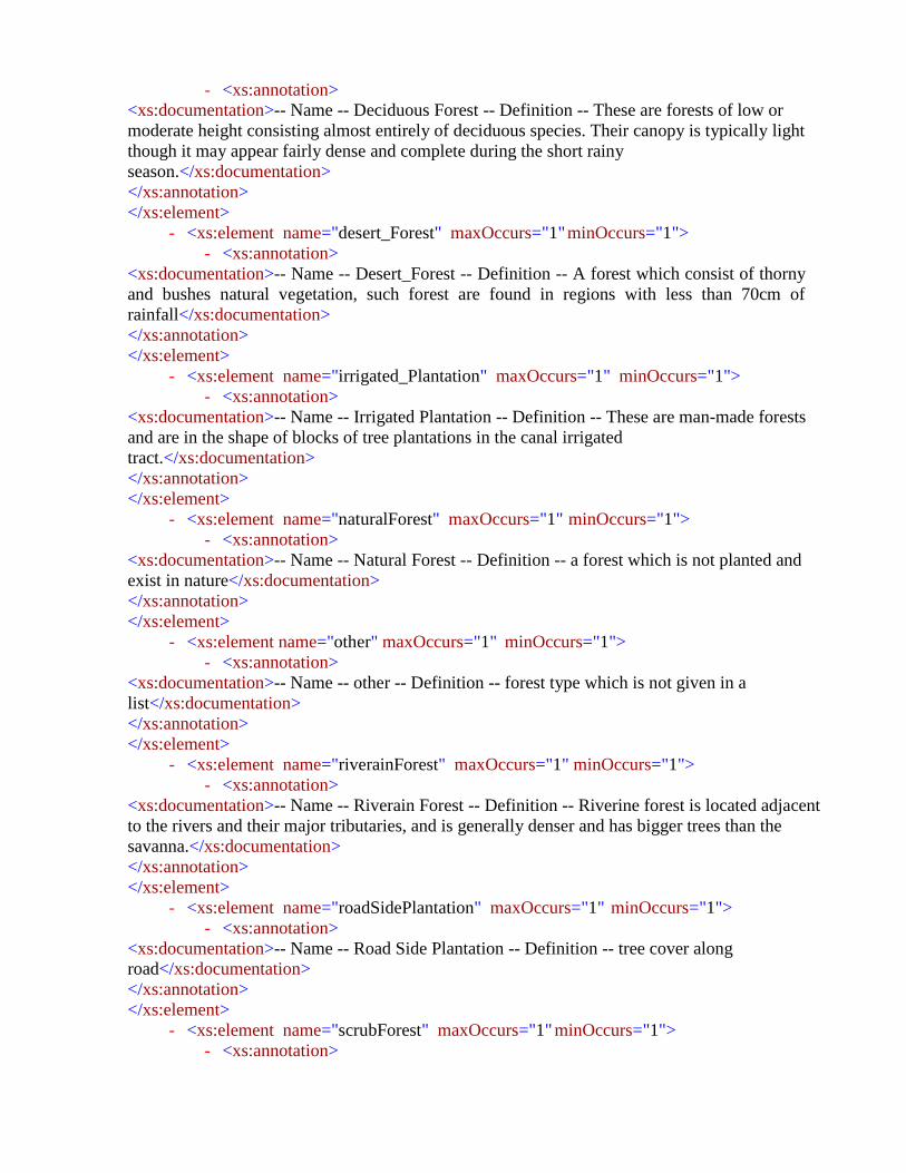
- <xs:annotation>
<xs:documentation>-- Name -- Deciduous Forest -- Definition -- These are forests of low or
moderate height consisting almost entirely of deciduous species. Their canopy is typically light
though it may appear fairly dense and complete during the short rainy
season.</xs:documentation>
</xs:annotation>
</xs:element>
- <xs:element name="desert_Forest" maxOccurs="1" minOccurs="1">
- <xs:annotation>
<xs:documentation>-- Name -- Desert_Forest -- Definition -- A forest which consist of thorny
and bushes natural vegetation, such forest are found in regions with less than 70cm of
rainfall</xs:documentation>
</xs:annotation>
</xs:element>
- <xs:element name="irrigated_Plantation" maxOccurs="1" minOccurs="1">
- <xs:annotation>
<xs:documentation>-- Name -- Irrigated Plantation -- Definition -- These are man-made forests
and are in the shape of blocks of tree plantations in the canal irrigated
tract.</xs:documentation>
</xs:annotation>
</xs:element>
- <xs:element name="naturalForest" maxOccurs="1" minOccurs="1">
- <xs:annotation>
<xs:documentation>-- Name -- Natural Forest -- Definition -- a forest which is not planted and
exist in nature</xs:documentation>
</xs:annotation>
</xs:element>
- <xs:element name="other" maxOccurs="1" minOccurs="1">
- <xs:annotation>
<xs:documentation>-- Name -- other -- Definition -- forest type which is not given in a
list</xs:documentation>
</xs:annotation>
</xs:element>
- <xs:element name="riverainForest" maxOccurs="1" minOccurs="1">
- <xs:annotation>
<xs:documentation>-- Name -- Riverain Forest -- Definition -- Riverine forest is located adjacent
to the rivers and their major tributaries, and is generally denser and has bigger trees than the
savanna.</xs:documentation>
</xs:annotation>
</xs:element>
- <xs:element name="roadSidePlantation" maxOccurs="1" minOccurs="1">
- <xs:annotation>
<xs:documentation>-- Name -- Road Side Plantation -- Definition -- tree cover along
road</xs:documentation>
</xs:annotation>
</xs:element>
- <xs:element name="scrubForest" maxOccurs="1" minOccurs="1">
- <xs:annotation>
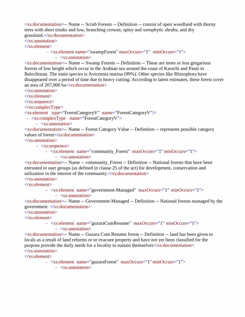
<xs:documentation>-- Name -- Scrub Forests -- Definition -- consist of open woodland with thorny
trees with short trunks and low, branching crowns; spiny and xerophytic shrubs; and dry
grassland.</xs:documentation>
</xs:annotation>
</xs:element>
- <xs:element name="swampForest" maxOccurs="1" minOccurs="1">
- <xs:annotation>
<xs:documentation>-- Name -- Swamp Forests -- Definition -- These are more or less gregarious
forests of low height which occur in the Arabian sea around the coast of Karachi and Pasni in
Balochistan. The main species is Avicennia marina (99%). Other species like Rhizophora have
disappeared over a period of time due to heavy cutting. According to latest estimates, these forest cover
an area of 207,000 ha</xs:documentation>
</xs:annotation>
</xs:element>
</xs:sequence>
</xs:complexType>
<xs:element type="ForestCategoryV" name="ForestCategoryV"/>
- <xs:complexType name="ForestCategoryV">
- <xs:annotation>
<xs:documentation>-- Name -- Forest Category Value -- Definition -- represents possible category
values of forest</xs:documentation>
</xs:annotation>
- <xs:sequence>
- <xs:element name="community_Forest" maxOccurs="1" minOccurs="1">
- <xs:annotation>
<xs:documentation>-- Name -- community_Forest -- Definition -- National forests that have been
entrusted to user groups (as defined in clause 25 of the act) for development, conservation and
utilization in the interest of the community.</xs:documentation>
</xs:annotation>
</xs:element>
- <xs:element name="government-Managed" maxOccurs="1" minOccurs="1">
- <xs:annotation>
<xs:documentation>-- Name -- Government-Managed -- Definition -- National forests managed by the
government. </xs:documentation>
</xs:annotation>
</xs:element>
- <xs:element name="guzaraCumResume" maxOccurs="1" minOccurs="1">
- <xs:annotation>
<xs:documentation>-- Name -- Guzara Cum Resume forest -- Definition -- land has been given to
locals as a result of land reforms or or evacuee property and have not yet been classified for the
purpose provide the daily needs for a locality to sustain themselves</xs:documentation>
</xs:annotation>
</xs:element>
- <xs:element name="guzaraForest" maxOccurs="1" minOccurs="1">
- <xs:annotation>

<xs:documentation>-- Name -- Guzara Forest -- Definition -- Forests on communal land that has
not been divided and is meant for collective use to satisfy the requirements of all the village
community are known as Guzara forests. </xs:documentation>
</xs:annotation>
</xs:element>
- <xs:element name="leasehold_Forest" maxOccurs="1" minOccurs="1">
- <xs:annotation>
<xs:documentation>-- Name -- leasehold_Forest -- Definition -- National forests that have been
leased (according to clause 32 of the act) for specified purpose(s) to a legally defined institution,
forest-based industry or community.</xs:documentation>
</xs:annotation>
</xs:element>
- <xs:element name="national_Forest" maxOccurs="1" minOccurs="1">
- <xs:annotation>
<xs:documentation>-- Name -- National_Forest -- Definition -- All forests other than private
forest, regardless of the demarcation of their boundaries and including cultivated or uncultivated
land, roads, ponds, lakes, rivers, streams and the shingly land that is surrounded by or in the
vicinity of a forest. </xs:documentation>
</xs:annotation>
</xs:element>
- <xs:element name="other" maxOccurs="1" minOccurs="1">
- <xs:annotation>
<xs:documentation>-- Name -- other -- Definition -- forest category which is not given in a
list</xs:documentation>
</xs:annotation>
</xs:element>
- <xs:element name="private_Forest" maxOccurs="1" minOccurs="1">
- <xs:annotation>
<xs:documentation>-- Name -- private_Forest -- Definition -- The planted or protected forests on
land that belongs to an individual as per the prevailing law.</xs:documentation>
</xs:annotation>
</xs:element>
- <xs:element name="protected_Forest" maxOccurs="1" minOccurs="1">
- <xs:annotation>
<xs:documentation>-- Name -- protected_Forest -- Definition -- National forests that the
government has declared protected in consideration of their environmental, scientific and cultural
importance. </xs:documentation>
</xs:annotation>
</xs:element>
- <xs:element name="rangeland_Forest" maxOccurs="1" minOccurs="1">
- <xs:annotation>
<xs:documentation>-- Name -- Rangeland Forest -- Definition -- lands on which the native plants
cover are predominantly grass-like plants, forbs, or shrubs suitable for
grazing</xs:documentation>
</xs:annotation>

</xs:element>
- <xs:element name="religious_Forest" maxOccurs="1" minOccurs="1">
- <xs:annotation>
<xs:documentation>-- Name -- religious_Forest -- Definition -- National forests that have been
entrusted to any religious entity, group or community as specified in clause 35 of the act.
</xs:documentation>
</xs:annotation>
</xs:element>
- <xs:element name="resumed_Land" maxOccurs="1" minOccurs="1">
- <xs:annotation>
<xs:documentation>-- Name -- resumed_Land -- Definition -- Resumed lands have been given to
PFD as a result of land reforms or evacuee property and have not yet been classified.
</xs:documentation>
</xs:annotation>
</xs:element>
- <xs:element name="section38" maxOccurs="1" minOccurs="1">
- <xs:annotation>
<xs:documentation>-- Name -- section38 -- Definition -- Section 38 forests are privately owned lands
that have been voluntarily and temporarily put under the control of PFD for the conservation and
preservation of soil and vegetation. These are notified under section 38 of the 1927 Forest Act on the
written request of the individual owner or of a two-thirds majority of the owners in cases of joint
property, for periods of 25 or 30 years.
</xs:documentation>
</xs:annotation>
</xs:element>
- <xs:element name="unclassed_Forest" maxOccurs="1" minOccurs="1">
- <xs:annotation>
<xs:documentation>-- Name -- Unclassed_Forest -- Definition -- are areas that have been transferred
to forest department pending final legal classification. </xs:documentation>
</xs:annotation>
</xs:element>
</xs:sequence>
</xs:complexType>
<xs:element type="AgricultureLand" name="AgricultureLand"/>
- <xs:complexType name="AgricultureLand">
- <xs:annotation>
<xs:documentation>-- Name -- Agriculture Land -- Definition -- represents land type used in analog
agriculture revenue system</xs:documentation>
</xs:annotation>
- <xs:sequence>
- <xs:element name="aabi" maxOccurs="1" minOccurs="1">
- <xs:annotation>
<xs:documentation>-- Name -- aabi -- Definition -- Land irrigated with means other than canal or
well.</xs:documentation>
</xs:annotation>
</xs:element>
- <xs:element name="abadiDeh" maxOccurs="1" minOccurs="1">

- <xs:annotation>
<xs:documentation>-- Name -- abadiDeh (Abadi Deh) -- Definition -- inhabited area of a
village.</xs:documentation>
</xs:annotation>
</xs:element>
- <xs:element name="banjar" maxOccurs="1" minOccurs="1">
- <xs:annotation>
<xs:documentation>-- Name -- banjar -- Definition -- Uncultivable
land.</xs:documentation>
</xs:annotation>
</xs:element>
- <xs:element name="banjarJadid" maxOccurs="1" minOccurs="1">
- <xs:annotation>
<xs:documentation>-- Name -- banjarJadid (Banjar Jadid) -- Definition -- new fallow. Land not
cultivated for continuous four harvests though it was cultivated earlier.</xs:documentation>
</xs:annotation>
</xs:element>
- <xs:element name="banjarKadim" maxOccurs="1" minOccurs="1">
- <xs:annotation>
<xs:documentation>-- Name -- banjarKadim (Banjar Kadim) -- Definition -- old fallow. Land not
cultivated for continuous eight harvests though it was cultivated earlier.</xs:documentation>
</xs:annotation>
</xs:element>
- <xs:element name="barani" maxOccurs="1" minOccurs="1">
- <xs:annotation>
<xs:documentation>-- Name -- barani -- Definition -- dependent on
rainfall.</xs:documentation>
</xs:annotation>
</xs:element>
- <xs:element name="beer" maxOccurs="1" minOccurs="1">
- <xs:annotation>
<xs:documentation>-- Name -- beer -- Definition -- Area reserved for growing
grass.</xs:documentation>
</xs:annotation>
</xs:element>
- <xs:element name="chahi" maxOccurs="1" minOccurs="1">
- <xs:annotation>
<xs:documentation>-- Name -- chahi -- Definition -- irrigated from
well.</xs:documentation>
</xs:annotation>
</xs:element>
- <xs:element name="chahiMustar" maxOccurs="1" minOccurs="1">
- <xs:annotation>
<xs:documentation>-- Name -- chahiMustar (chahi Mustar) -- Definition -- irrigated from
purchased water.</xs:documentation>
</xs:annotation>
</xs:element>

- <xs:element name="chahiNahri" maxOccurs="1" minOccurs="1">
- <xs:annotation>
<xs:documentation>-- Name -- chahiNahri (chahi Nahri) -- Definition -- irrigated partly from a
well and partly from canal.</xs:documentation>
</xs:annotation>
</xs:element>
- <xs:element name="gairMumkin" maxOccurs="1" minOccurs="1">
- <xs:annotation>
<xs:documentation>-- Name -- gairMumkin -- Definition -- Unculturable land (land unfit for
cultivation).</xs:documentation>
</xs:annotation>
</xs:element>
- <xs:element name="grazingLand" maxOccurs="1" minOccurs="1">
- <xs:annotation>
<xs:documentation>-- Name -- grassLand -- Definition -- According to almost all Wajib-ul-Arz the
village community has time-honored right to graze its cattle and flocks in state-owned forests, unless
any part is closed for regeneration purposes. In every village there is a common land or community land
or Shamilat which is set apart for purpose of pasturage, graveyard, drinking of water by men or
cattle.This land is called grazing land.</xs:documentation>
</xs:annotation>
</xs:element>
- <xs:element name="nahri" maxOccurs="1" minOccurs="1">
- <xs:annotation>
<xs:documentation>-- Name -- nahri -- Definition -- Irrigated from
canal.</xs:documentation>
</xs:annotation>
</xs:element>
- <xs:element name="other" maxOccurs="1" minOccurs="1">
- <xs:annotation>
<xs:documentation>-- Name -- other -- Definition -- Areas with no clear connection to the specified
revenue land type</xs:documentation>
</xs:annotation>
</xs:element>
- <xs:element name="talabi" maxOccurs="1" minOccurs="1">
- <xs:annotation>
<xs:documentation>-- Name -- talabi -- Definition -- Irrigated by
tank.</xs:documentation>
</xs:annotation>
</xs:element>
</xs:sequence>
</xs:complexType>
<xs:element type="IntiqalType" name="IntiqalType"/>
- <xs:complexType name="IntiqalType">
- <xs:annotation>
<xs:documentation>-- Name -- IntiqalType -- Definition -- represents type of intiqal/
mutation</xs:documentation>
</xs:annotation>

- <xs:sequence>
- <xs:element name="bai" maxOccurs="1" minOccurs="1">
- <xs:annotation>
<xs:documentation>-- Name -- bai -- Definition -- Whenever a person sells his land either completely
or partially, to another person, this type of mutation is known as Bai or Sale.</xs:documentation>
</xs:annotation>
</xs:element>
- <xs:element name="government_Allotted" maxOccurs="1" minOccurs="1">
- <xs:annotation>
<xs:documentation>-- Name -- government_Allotted -- Definition -- the land allotted by the
government </xs:documentation>
</xs:annotation>
</xs:element>
- <xs:element name="hibba" maxOccurs="1" minOccurs="1">
- <xs:annotation>
<xs:documentation>-- Name -- hibba -- Definition -- A Gift, Present. Whenever a part of complete land
is gifted to some person, the mutation is called Hibba or Gift.</xs:documentation>
</xs:annotation>
</xs:element>
- <xs:element name="other" maxOccurs="1" minOccurs="1">
- <xs:annotation>
<xs:documentation>-- Name -- other -- Definition -- Type which is not listed
</xs:documentation>
</xs:annotation>
</xs:element>
- <xs:element name="vasiyat" maxOccurs="1" minOccurs="1">
- <xs:annotation>
<xs:documentation>-- Name -- vasiyat -- Definition -- transfer of land through
will(testament)</xs:documentation>
</xs:annotation>
</xs:element>
- <xs:element name="wirasat" maxOccurs="1" minOccurs="1">
- <xs:annotation>
<xs:documentation>-- Name -- wirasat -- Definition -- the inherited
land</xs:documentation>
</xs:annotation>
</xs:element>
</xs:sequence>
</xs:complexType>
<xs:element type="AgricultureTaxTable" name="AgricultureTaxTable"/>
- <xs:complexType name="AgricultureTaxTable">
- <xs:annotation>
<xs:documentation>-- Name -- AgricultureTaxTable -- Definition -- Is the tax payable on the
former.</xs:documentation>
</xs:annotation>
- <xs:sequence>
- <xs:element type="Real" name="areaValue" maxOccurs="1" minOccurs="1">
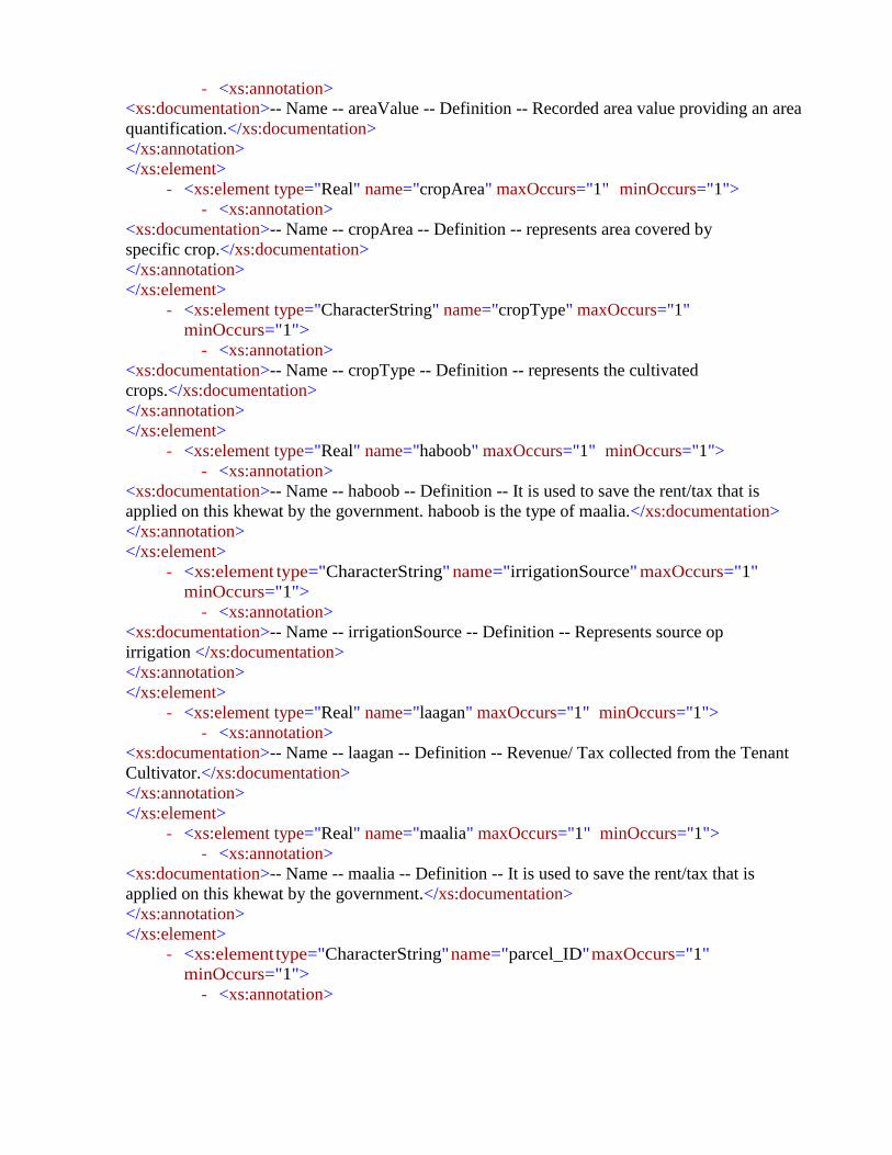
- <xs:annotation>
<xs:documentation>-- Name -- areaValue -- Definition -- Recorded area value providing an area
quantification.</xs:documentation>
</xs:annotation>
</xs:element>
- <xs:element type="Real" name="cropArea" maxOccurs="1" minOccurs="1">
- <xs:annotation>
<xs:documentation>-- Name -- cropArea -- Definition -- represents area covered by
specific crop.</xs:documentation>
</xs:annotation>
</xs:element>
- <xs:element type="CharacterString" name="cropType" maxOccurs="1"
minOccurs="1">
- <xs:annotation>
<xs:documentation>-- Name -- cropType -- Definition -- represents the cultivated
crops.</xs:documentation>
</xs:annotation>
</xs:element>
- <xs:element type="Real" name="haboob" maxOccurs="1" minOccurs="1">
- <xs:annotation>
<xs:documentation>-- Name -- haboob -- Definition -- It is used to save the rent/tax that is
applied on this khewat by the government. haboob is the type of maalia.</xs:documentation>
</xs:annotation>
</xs:element>
- <xs:element type="CharacterString" name="irrigationSource" maxOccurs="1"
minOccurs="1">
- <xs:annotation>
<xs:documentation>-- Name -- irrigationSource -- Definition -- Represents source op
irrigation </xs:documentation>
</xs:annotation>
</xs:element>
- <xs:element type="Real" name="laagan" maxOccurs="1" minOccurs="1">
- <xs:annotation>
<xs:documentation>-- Name -- laagan -- Definition -- Revenue/ Tax collected from the Tenant
Cultivator.</xs:documentation>
</xs:annotation>
</xs:element>
- <xs:element type="Real" name="maalia" maxOccurs="1" minOccurs="1">
- <xs:annotation>
<xs:documentation>-- Name -- maalia -- Definition -- It is used to save the rent/tax that is
applied on this khewat by the government.</xs:documentation>
</xs:annotation>
</xs:element>
- <xs:element type="CharacterString" name="parcel_ID" maxOccurs="1"
minOccurs="1">
- <xs:annotation>

<xs:documentation>-- Name -- Parcel_ID -- Definition -- represents the unique id of a parcel in the
Pakistan.</xs:documentation>
</xs:annotation>
</xs:element>
- <xs:element type="CharacterString" name="remarks" maxOccurs="1"
minOccurs="1">
- <xs:annotation>
<xs:documentation>-- Name -- remarks -- Definition -- Represents any additional
remarks</xs:documentation>
</xs:annotation>
</xs:element>
- <xs:element type="xs:dateTime" name="taxPeriodTo" maxOccurs="1"
minOccurs="1">
- <xs:annotation>
<xs:documentation>-- Name -- taxPeriodTo -- Definition -- represents the date up to which tax
due.</xs:documentation>
</xs:annotation>
</xs:element>
- <xs:element type="Real" name="taxRate" maxOccurs="1" minOccurs="1">
- <xs:annotation>
<xs:documentation>-- Name -- taxRate -- Definition -- it represents tax
rate</xs:documentation>
</xs:annotation>
</xs:element>
- <xs:element type="xs:dateTime" name="taxtPeriodFrom" maxOccurs="1"
minOccurs="1">
- <xs:annotation>
<xs:documentation>-- Name -- taxPeriodFrom -- Definition -- represents the date from which tax
due.</xs:documentation>
</xs:annotation>
</xs:element>
- <xs:element type="CharacterString" name="territory_ID" maxOccurs="1"
minOccurs="1">
- <xs:annotation>
<xs:documentation>-- Name -- territory_ID -- Definition -- represents the unique id of a territory
in the Pakistan.</xs:documentation>
</xs:annotation>
</xs:element>
<xs:element type="Parcel" name="parcel_ID" maxOccurs="1" minOccurs="1"/>
<xs:element type="Parcel" name="territory_ID" maxOccurs="1" minOccurs="1"/>
</xs:sequence>
</xs:complexType>
<xs:element type="Pipeline" name="Pipeline"/>
- <xs:complexType name="Pipeline">
- <xs:annotation>
<xs:documentation>-- Name -- Pipeline -- Definition -- represents possible values of
pipeline</xs:documentation>
</xs:annotation>
- <xs:sequence>

- <xs:element name="gasPipeline" maxOccurs="1" minOccurs="1">
- <xs:annotation>
<xs:documentation>-- Name -- gasPipeline (Gas Pipeline) -- Definition -- a pipeline connecting a
gas appliance to the main supply of natural gas for the apartment, office or
building.</xs:documentation>
</xs:annotation>
</xs:element>
- <xs:element name="oilPipeline" maxOccurs="1" minOccurs="1">
- <xs:annotation>
<xs:documentation>-- Name -- oilPipeline (Oil Pipeline) -- Definition -- Oil Pipeline is used to
transport oil </xs:documentation>
</xs:annotation>
</xs:element>
- <xs:element name="other" maxOccurs="1" minOccurs="1">
- <xs:annotation>
<xs:documentation>-- Name -- other -- Definition -- represent such types which are not included
in the list</xs:documentation>
</xs:annotation>
</xs:element>
- <xs:element name="sewerPipeline" maxOccurs="1" minOccurs="1">
- <xs:annotation>
<xs:documentation>-- Name -- sewerPipeline (Sewer Pipeline) -- Definition -- a sanitary sewer or
"foul sewer" is an underground carriage system specifically for transporting sewage from houses and
commercial buildings through pipes to treatment or disposal. Sanitary sewers are part of an overall
system called sewerage or sewage system.</xs:documentation>
</xs:annotation>
</xs:element>
- <xs:element name="waterPipeline" maxOccurs="1" minOccurs="1">
- <xs:annotation>
<xs:documentation>-- Name -- waterPipeline (Water Pipeline) -- Definition -- a pipeline for conveying
water.</xs:documentation>
</xs:annotation>
</xs:element>
</xs:sequence>
</xs:complexType>
<xs:element type="BarrenLand" name="BarrenLand"/>
- <xs:complexType name="BarrenLand">
- <xs:annotation>
<xs:documentation>-- Name -- Barren Land -- Definition -- represents the possible values of
barren features.</xs:documentation>
</xs:annotation>
- <xs:sequence>
- <xs:element name="bareRock" maxOccurs="1" minOccurs="1">
- <xs:annotation>
<xs:documentation>-- Name -- bareRock (Bare Rock) -- Definition -- areas characterized by bare
rock, with little or no "green" vegetation present.</xs:documentation>

</xs:annotation>
</xs:element>
- <xs:element name="brokenGround" maxOccurs="1" minOccurs="1">
- <xs:annotation>
<xs:documentation>-- Name -- brokenGround (Broken Ground) -- Definition -- a relief feature
found mostly in dry regions around rivers and streams. It is land around river, which is totally
weathered (exfoliated) due to alternate cooling and heating. </xs:documentation>
</xs:annotation>
</xs:element>
- <xs:element name="clay" maxOccurs="1" minOccurs="1">
- <xs:annotation>
<xs:documentation>-- Name -- clay -- Definition -- areas characterized by clay, with little or no
"green" vegetation present.</xs:documentation>
</xs:annotation>
</xs:element>
- <xs:element name="coalfield" maxOccurs="1" minOccurs="1">
- <xs:annotation>
<xs:documentation>-- Name -- coalfield -- Definition -- an area which is rich in coal, and where
coal is mined</xs:documentation>
</xs:annotation>
</xs:element>
- <xs:element name="debris" maxOccurs="1" minOccurs="1">
- <xs:annotation>
<xs:documentation>-- Name -- debris -- Definition -- areas characterized by debris(scattered
pieces of waste or remains), with little or no "green" vegetation present.</xs:documentation>
</xs:annotation>
</xs:element>
- <xs:element name="gasField" maxOccurs="1" minOccurs="1">
- <xs:annotation>
<xs:documentation>-- Name -- gasField (Gas Field) -- Definition -- a gas field is an area of
natural gas underground, produced by decay of organic material.</xs:documentation>
</xs:annotation>
</xs:element>
- <xs:element name="goldfield" maxOccurs="1" minOccurs="1">
- <xs:annotation>
<xs:documentation>-- Name -- goldfield -- Definition -- an area which is rich in gold, and
where gold is mined</xs:documentation>
</xs:annotation>
</xs:element>
- <xs:element name="gravel" maxOccurs="1" minOccurs="1">
- <xs:annotation>
<xs:documentation>-- Name -- gravel -- Definition -- areas characterized by gravel, with little
or no "green" vegetation present.</xs:documentation>
</xs:annotation>
</xs:element>
- <xs:element name="oilfield" maxOccurs="1" minOccurs="1">

- <xs:annotation>
<xs:documentation>-- Name -- oilfield -- Definition -- an area of land or seabed underlain by
strata yielding petroleum, especially in amounts that justify commercial
exploitation.</xs:documentation>
</xs:annotation>
</xs:element>
- <xs:element name="opalField" maxOccurs="1" minOccurs="1">
- <xs:annotation>
<xs:documentation>-- Name -- opalField (Opal Field) -- Definition -- an area which is rich in
opal, and where opal is mined</xs:documentation>
</xs:annotation>
</xs:element>
- <xs:element name="other" maxOccurs="1" minOccurs="1">
- <xs:annotation>
<xs:documentation>-- Name -- other -- Definition -- represent such types which are not
included in the list</xs:documentation>
</xs:annotation>
</xs:element>
- <xs:element name="quarry" maxOccurs="1" minOccurs="1">
- <xs:annotation>
<xs:documentation>-- Name -- quarry -- Definition -- a place where rocks, sand, or minerals are
extracted from the surface of the Earth. A quarry is a type of mine called an open-pit mine,
because it is open to the Earth's surface.</xs:documentation>
</xs:annotation>
</xs:element>
- <xs:element name="saltpan" maxOccurs="1" minOccurs="1">
- <xs:annotation>
<xs:documentation>-- Name -- saltpan -- Definition -- a shallow container or depression in the
ground in which salt water evaporates to leave a deposit of salt.</xs:documentation>
</xs:annotation>
</xs:element>
- <xs:element name="sand" maxOccurs="1" minOccurs="1">
- <xs:annotation>
<xs:documentation>-- Name -- sand -- Definition -- areas characterized by sand, with little or
no "green" vegetation present.</xs:documentation>
</xs:annotation>
</xs:element>
- <xs:element name="sandDam" maxOccurs="1" minOccurs="1">
- <xs:annotation>
<xs:documentation>-- Name -- sandDam (Sand Dam) -- Definition -- a sand dam is a reinforced
rubble cement wall built across a seasonal sandy river. They are a simple, low cost, low
maintenance technology that retains rainwater and recharges groundwater.</xs:documentation>
</xs:annotation>
</xs:element>
- <xs:element name="scree" maxOccurs="1" minOccurs="1">
- <xs:annotation>

<xs:documentation>-- Name -- scree -- Definition -- a mass of small loose stones that form or
cover a slope on a mountain.</xs:documentation>
</xs:annotation>
</xs:element>
</xs:sequence>
</xs:complexType>
<xs:element type="Bridge" name="Bridge"/>
- <xs:complexType name="Bridge">
- <xs:annotation>
<xs:documentation>-- Name -- Bridge -- Definition -- possible values of a structure carrying a
road, path, railway, etc. across a river, road, or other obstacle.</xs:documentation>
</xs:annotation>
- <xs:sequence>
- <xs:element name="aqueduct" maxOccurs="1" minOccurs="1">
- <xs:annotation>
<xs:documentation>-- Name -- aqueduct -- Definition -- an artificial channel for conveying water,
typically in the form of a bridge across a valley or other gap.</xs:documentation>
</xs:annotation>
</xs:element>
- <xs:element name="boatBridgeDouble" maxOccurs="1" minOccurs="1">
- <xs:annotation>
<xs:documentation>-- Name -- boatBridgeDouble (Boat Bridge Double) -- Definition -- more than
one rows of specialized, shallow draft boats or floats, connected together to cross a river or canal,
with a track or deck attached on top.</xs:documentation>
</xs:annotation>
</xs:element>
- <xs:element name="boatBridgeSingle" maxOccurs="1" minOccurs="1">
- <xs:annotation>
<xs:documentation>-- Name -- boatBridgeSingle (Boat Bridge Single) -- Definition -- a collection of
specialized, shallow draft boats or floats, connected together to cross a river or canal, with a track or
deck attached on top.</xs:documentation>
</xs:annotation>
</xs:element>
- <xs:element name="cantilever" maxOccurs="1" minOccurs="1">
- <xs:annotation>
<xs:documentation>-- Name -- cantilever -- Definition -- a long projecting beam or girder fixed at
only one end, used in bridge construction.</xs:documentation>
</xs:annotation>
</xs:element>
- <xs:element name="culvertOnRoad" maxOccurs="1" minOccurs="1">
- <xs:annotation>
<xs:documentation>-- Name -- culvertOnRoad (Culvert on Road) -- Definition
-- a structure that allows water to flow under a road. Typically embedded

so as to be surrounded by soil, a culvert may be made from a pipe, reinforced concrete or
other material.</xs:documentation>
</xs:annotation>
</xs:element>
- <xs:element name="culvertOnTrack" maxOccurs="1" minOccurs="1">
- <xs:annotation>
<xs:documentation>-- Name -- culvertOnTrack (Culvert on Track) -- Definition
-- a structure that allows water to flow under a track. Typically embedded so as to be surrounded
by soil, a culvert may be made from a pipe, reinforced concrete or other
material.</xs:documentation>
</xs:annotation>
</xs:element>
- <xs:element name="footBridge" maxOccurs="1" minOccurs="1">
- <xs:annotation>
<xs:documentation>-- Name -- footBridge (Foot Bridge) -- Definition -- a bridge designed for
pedestrians and in some cases cyclists, animal traffic, and horse riders, instead of vehicular
traffic.</xs:documentation>
</xs:annotation>
</xs:element>
- <xs:element name="irishBridge" maxOccurs="1" minOccurs="1">
- <xs:annotation>
<xs:documentation>-- Name -- irishBridge (Irish Bridge) -- Definition -- a low- water crossing,
under high-flow conditions, water runs over the roadway and precludes vehicular
traffic.</xs:documentation>
</xs:annotation>
</xs:element>
- <xs:element name="ironBridge" maxOccurs="1" minOccurs="1">
- <xs:annotation>
<xs:documentation>-- Name -- ironBridge (Iron Bridge) -- Definition -- a bridge formed by
iron lattice girders</xs:documentation>
</xs:annotation>
</xs:element>
- <xs:element name="jettyRailway" maxOccurs="1" minOccurs="1">
- <xs:annotation>
<xs:documentation>-- Name -- jettyRailway (Jetty Railway) -- Definition -- represents
railway on jetty</xs:documentation>
</xs:annotation>
</xs:element>
- <xs:element name="jettyRoad" maxOccurs="1" minOccurs="1">
- <xs:annotation>
<xs:documentation>-- Name -- jettyRoad (Jetty Road) -- Definition -- represents road
on jetty</xs:documentation>
</xs:annotation>
</xs:element>
- <xs:element name="other" maxOccurs="1" minOccurs="1">
- <xs:annotation>
<xs:documentation>-- Name -- other -- Definition -- represent such types which are not
included in the list</xs:documentation>
</xs:annotation>
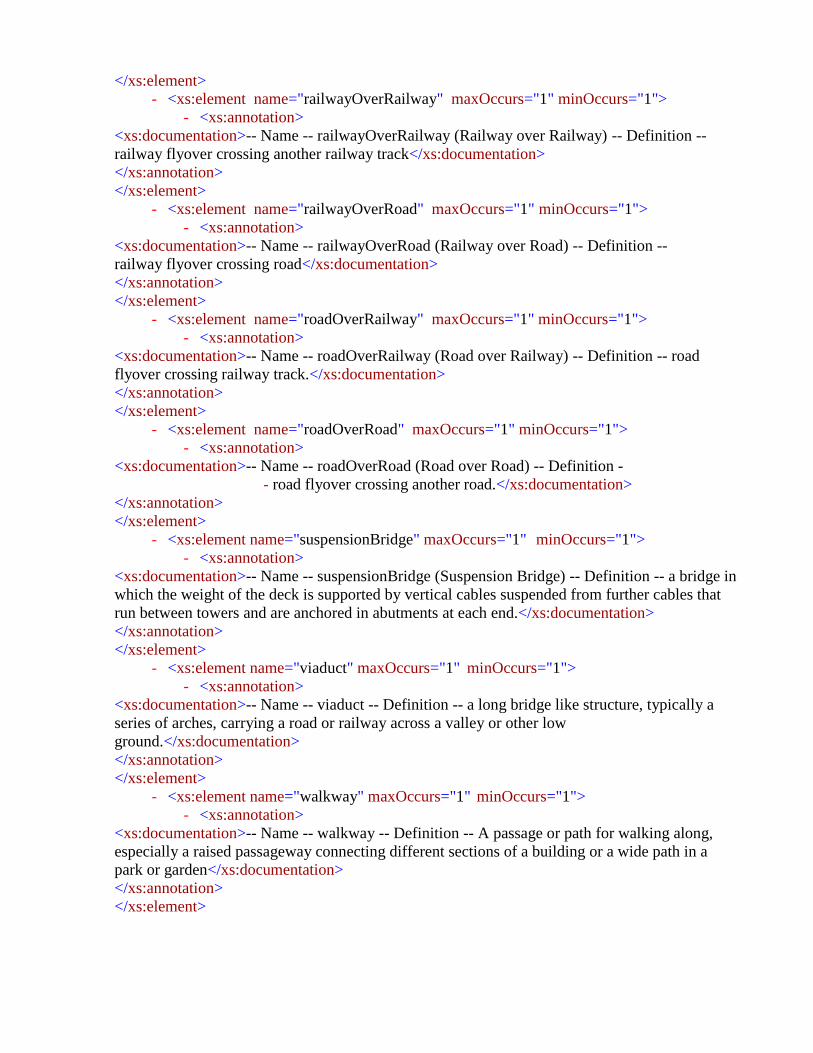
</xs:element>
- <xs:element name="railwayOverRailway" maxOccurs="1" minOccurs="1">
- <xs:annotation>
<xs:documentation>-- Name -- railwayOverRailway (Railway over Railway) -- Definition --
railway flyover crossing another railway track</xs:documentation>
</xs:annotation>
</xs:element>
- <xs:element name="railwayOverRoad" maxOccurs="1" minOccurs="1">
- <xs:annotation>
<xs:documentation>-- Name -- railwayOverRoad (Railway over Road) -- Definition --
railway flyover crossing road</xs:documentation>
</xs:annotation>
</xs:element>
- <xs:element name="roadOverRailway" maxOccurs="1" minOccurs="1">
- <xs:annotation>
<xs:documentation>-- Name -- roadOverRailway (Road over Railway) -- Definition -- road
flyover crossing railway track.</xs:documentation>
</xs:annotation>
</xs:element>
- <xs:element name="roadOverRoad" maxOccurs="1" minOccurs="1">
- <xs:annotation>
<xs:documentation>-- Name -- roadOverRoad (Road over Road) -- Definition -
- road flyover crossing another road.</xs:documentation>
</xs:annotation>
</xs:element>
- <xs:element name="suspensionBridge" maxOccurs="1" minOccurs="1">
- <xs:annotation>
<xs:documentation>-- Name -- suspensionBridge (Suspension Bridge) -- Definition -- a bridge in
which the weight of the deck is supported by vertical cables suspended from further cables that
run between towers and are anchored in abutments at each end.</xs:documentation>
</xs:annotation>
</xs:element>
- <xs:element name="viaduct" maxOccurs="1" minOccurs="1">
- <xs:annotation>
<xs:documentation>-- Name -- viaduct -- Definition -- a long bridge like structure, typically a
series of arches, carrying a road or railway across a valley or other low
ground.</xs:documentation>
</xs:annotation>
</xs:element>
- <xs:element name="walkway" maxOccurs="1" minOccurs="1">
- <xs:annotation>
<xs:documentation>-- Name -- walkway -- Definition -- A passage or path for walking along,
especially a raised passageway connecting different sections of a building or a wide path in a
park or garden</xs:documentation>
</xs:annotation>
</xs:element>

</xs:sequence>
</xs:complexType>
<xs:element type="KhatuniTable" name="KhatuniTable"/>
- <xs:complexType name="KhatuniTable">
- <xs:annotation>
<xs:documentation>-- Name -- TaxTable -- Definition -- Represents tax to be collected from
formers</xs:documentation>
</xs:annotation>
- <xs:sequence>
- <xs:element type="xs:dateTime" name="from_Date" maxOccurs="1" minOccurs="1">
- <xs:annotation>
<xs:documentation>-- Name -- from -- Definition -- represents the date from which tax
due.</xs:documentation>
</xs:annotation>
</xs:element>
- <xs:element type="CharacterString" name="parcel_ID" maxOccurs="1"
minOccurs="1">
- <xs:annotation>
<xs:documentation>-- Name -- Parcel_ID -- Definition -- represents the unique id of a parcel in the
Pakistan.</xs:documentation>
</xs:annotation>
</xs:element>
- <xs:element type="CharacterString" name="person_ID" maxOccurs="1"
minOccurs="1">
- <xs:annotation>
<xs:documentation>-- Name -- person_ID (Personal ID) -- Definition -- represents the NIC
number/ form B number.</xs:documentation>
</xs:annotation>
</xs:element>
- <xs:element type="CharacterString" name="remarks" maxOccurs="1"
minOccurs="1">
- <xs:annotation>
<xs:documentation>-- Name -- remarks -- Definition -- Represents any additional
remarks</xs:documentation>
</xs:annotation>
</xs:element>
- <xs:element type="CharacterString" name="territory_ID" maxOccurs="1"
minOccurs="1">
- <xs:annotation>
<xs:documentation>-- Name -- territory_ID -- Definition -- represents the unique id of a territory
in the Pakistan.</xs:documentation>
</xs:annotation>
</xs:element>
- <xs:element type="xs:dateTime" name="to_Date" maxOccurs="1" minOccurs="1">
- <xs:annotation>
<xs:documentation>-- Name -- to -- Definition -- represents the date up to which tax
due.</xs:documentation>
</xs:annotation>
</xs:element>

<xs:element type="Parcel" name="parcel_ID" maxOccurs="1" minOccurs="1"/>
<xs:element type="ShajraNasabTable" name="person_ID" maxOccurs="1" minOccurs="1"/>
<xs:element type="Parcel" name="territory_ID" maxOccurs="1" minOccurs="1"/>
</xs:sequence>
</xs:complexType>
<xs:element type="LandUseTable" name="LandUseTable"/>
- <xs:complexType name="LandUseTable">
- <xs:annotation>
<xs:documentation>-- Name -- LandUseTable -- Definition -- represents land use
table</xs:documentation>
</xs:annotation>
- <xs:sequence>
- <xs:element type="xs:dateTime" name="effective_from" maxOccurs="1"
minOccurs="1">
- <xs:annotation>
<xs:documentation>-- Name -- effective_from -- Definition -- Official date and time the cadastral
parcel was/will be legally established. -- Description -- NOTE This is the date and time the national
cadastral reference can be used in legal acts.</xs:documentation>
</xs:annotation>
</xs:element>
- <xs:element type="xs:dateTime" name="effective_to" maxOccurs="1" minOccurs="1">
- <xs:annotation>
<xs:documentation>-- Name -- effective_to -- Definition -- Date and time at which the cadastral parcel
legally ceased/will cease to be used. -- Description -- NOTE This is the date and time the national
cadastral reference can no longer be used in legal acts.</xs:documentation>
</xs:annotation>
</xs:element>
- <xs:element type="CharacterString" name="landUse_ID" maxOccurs="1"
minOccurs="1">
- <xs:annotation>
<xs:documentation>-- Name -- landUse_ID -- Definition -- represents the unique id of land
classification</xs:documentation>
</xs:annotation>
</xs:element>
- <xs:element type="xs:string" name="landuse_Subtype" maxOccurs="1"
minOccurs="1">
- <xs:annotation>
<xs:documentation>-- Name -- landuse_Subtype -- Definition -- represents land use
subtypes</xs:documentation>
</xs:annotation>
</xs:element>
- <xs:element type="LandUseType" name="landUse_Type" maxOccurs="1"
minOccurs="1">
- <xs:annotation>
<xs:documentation>-- Name -- landUse_Type -- Definition -- it is categorization of land
parcel</xs:documentation>

</xs:annotation>
</xs:element>
- <xs:element type="CharacterString" name="parcel_ID" maxOccurs="1"
minOccurs="1">
- <xs:annotation>
<xs:documentation>-- Name -- Parcel_ID -- Definition -- represents the unique id of a parcel in the
Pakistan.</xs:documentation>
</xs:annotation>
</xs:element>
- <xs:element type="CharacterString" name="remarks" maxOccurs="1"
minOccurs="1">
- <xs:annotation>
<xs:documentation>-- Name -- remarks -- Definition -- Represents any additional remarks (if
any)</xs:documentation>
</xs:annotation>
</xs:element>
- <xs:element type="CharacterString" name="territory_ID" maxOccurs="1"
minOccurs="1">
- <xs:annotation>
<xs:documentation>-- Name -- territory_ID -- Definition -- represents the unique id of a territory
in the Pakistan.</xs:documentation>
</xs:annotation>
</xs:element>
<xs:element type="Parcel" name="parcel_ID" maxOccurs="1" minOccurs="1"/>
<xs:element type="Parcel" name="territory_ID" maxOccurs="1" minOccurs="1"/>
</xs:sequence>
</xs:complexType>
<xs:element type="SourceOfIrrigation" name="SourceOfIrrigation"/>
- <xs:complexType name="SourceOfIrrigation">
- <xs:annotation>
<xs:documentation>-- Name -- AgricultureLandCatgeory -- Definition -- represents land type used in
analog agriculture revenue system</xs:documentation>
</xs:annotation>
- <xs:sequence>
<xs:element type="xs:int" name="rainWater" maxOccurs="1" minOccurs="1"/>
<xs:element type="xs:int" name="tubeWell" maxOccurs="1" minOccurs="1"/>
</xs:sequence>
</xs:complexType>
<xs:element type="TransmissionLine" name="TransmissionLine"/>
- <xs:complexType name="TransmissionLine">
- <xs:annotation>
<xs:documentation>-- Name -- TransmissionLine (Transmission Line) -- Definition -- represents
possible values of transmission line </xs:documentation>
</xs:annotation>
- <xs:sequence>
- <xs:element name="electricPowerLine" maxOccurs="1" minOccurs="1">
- <xs:annotation>

<xs:documentation>-- Name -- electricPowerLine (Electric Power Line) -- Definition --
cable wires to transmit electric power from one place to other</xs:documentation>
</xs:annotation>
</xs:element>
- <xs:element name="mainPowerTransmissionLine" maxOccurs="1" minOccurs="1">
- <xs:annotation>
<xs:documentation>-- Name -- mainPowerTransmissionLine (Main Power Transmission Line) -
- Definition -- are used to carry electric power over relatively long distances from central
generating station to the main station.</xs:documentation>
</xs:annotation>
</xs:element>
- <xs:element name="other" maxOccurs="1" minOccurs="1">
- <xs:annotation>
<xs:documentation>-- Name -- other -- Definition -- represent such types which are not
included in the list</xs:documentation>
</xs:annotation>
</xs:element>
- <xs:element name="powerLineLocalDistribution" maxOccurs="1" minOccurs="1">
- <xs:annotation>
<xs:documentation>-- Name -- powerLineLocalDistribution (Power Line Local Distribution) --
Definition -- power line which is used for distribution of electric power locally.
</xs:documentation>
</xs:annotation>
</xs:element>
- <xs:element name="powerLineUnderConstruction" maxOccurs="1" minOccurs="1">
- <xs:annotation>
<xs:documentation>-- Name -- powerlineUnderConstruction (Power Line Under
Construction) -- Definition -- power line which is under construction.</xs:documentation>
</xs:annotation>
</xs:element>
- <xs:element name="powerLineUnderground" maxOccurs="1" minOccurs="1">
- <xs:annotation>
<xs:documentation>-- Name -- powerlineUnderground (Power Line Underground) -- Definition --
Power line which distributes electric power underground.</xs:documentation>
</xs:annotation>
</xs:element>
- <xs:element name="telegraphLine" maxOccurs="1" minOccurs="1">
- <xs:annotation>
<xs:documentation>-- Name -- telegraphLine (Telegraph Line) -- Definition -- cable wires to
transmit radio signals for providing telegraph services to subscribers. </xs:documentation>
</xs:annotation>
</xs:element>
- <xs:element name="telephoneLine" maxOccurs="1" minOccurs="1">
- <xs:annotation>
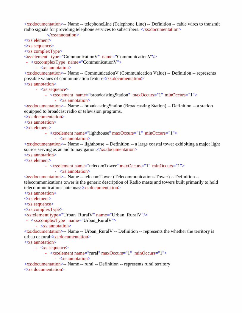
<xs:documentation>-- Name -- telephoneLine (Telephone Line) -- Definition -- cable wires to transmit
radio signals for providing telephone services to subscribers. </xs:documentation>
</xs:annotation>
</xs:element>
</xs:sequence>
</xs:complexType>
<xs:element type="CommunicationV" name="CommunicationV"/>
- <xs:complexType name="CommunicationV">
- <xs:annotation>
<xs:documentation>-- Name -- CommunicationV (Communication Value) -- Definition -- represents
possible values of communication feature</xs:documentation>
</xs:annotation>
- <xs:sequence>
- <xs:element name="broadcastingStation" maxOccurs="1" minOccurs="1">
- <xs:annotation>
<xs:documentation>-- Name -- broadcastingStation (Broadcasting Station) -- Definition -- a station
equipped to broadcast radio or television programs.
</xs:documentation>
</xs:annotation>
</xs:element>
- <xs:element name="lighthouse" maxOccurs="1" minOccurs="1">
- <xs:annotation>
<xs:documentation>-- Name -- lighthouse -- Definition -- a large coastal tower exhibiting a major light
source serving as an aid to navigation.</xs:documentation>
</xs:annotation>
</xs:element>
- <xs:element name="telecomTower" maxOccurs="1" minOccurs="1">
- <xs:annotation>
<xs:documentation>-- Name -- telecomTower (Telecommunications Tower) -- Definition --
telecommunications tower is the generic description of Radio masts and towers built primarily to hold
telecommunications antennas</xs:documentation>
</xs:annotation>
</xs:element>
</xs:sequence>
</xs:complexType>
<xs:element type="Urban_RuralV" name="Urban_RuralV"/>
- <xs:complexType name="Urban_RuralV">
- <xs:annotation>
<xs:documentation>-- Name -- Urban_RuralV -- Definition -- represents the whether the territory is
urban or rural</xs:documentation>
</xs:annotation>
- <xs:sequence>
- <xs:element name="rural" maxOccurs="1" minOccurs="1">
- <xs:annotation>
<xs:documentation>-- Name -- rural -- Definition -- represents rural territory
</xs:documentation>

</xs:annotation>
</xs:element>
- <xs:element name="urban" maxOccurs="1" minOccurs="1">
- <xs:annotation>
<xs:documentation>-- Name -- urban -- Definition -- represents urban territory
</xs:documentation>
</xs:annotation>
</xs:element>
</xs:sequence>
</xs:complexType>
<xs:element type="GenderV" name="GenderV"/>
- <xs:complexType name="GenderV">
- <xs:annotation>
<xs:documentation>-- Name -- GenderV -- Definition -- represents the whether the person is
male , female or transgender</xs:documentation>
</xs:annotation>
- <xs:sequence>
- <xs:element name="female" maxOccurs="1" minOccurs="1">
- <xs:annotation>
<xs:documentation>-- Name -- urban -- Definition -- represents female
gender</xs:documentation>
</xs:annotation>
</xs:element>
- <xs:element name="male" maxOccurs="1" minOccurs="1">
- <xs:annotation>
<xs:documentation>-- Name -- male -- Definition -- represents male
gender</xs:documentation>
</xs:annotation>
</xs:element>
- <xs:element name="transgender" maxOccurs="1" minOccurs="1">
- <xs:annotation>
<xs:documentation>-- Name -- transgender -- Definition -- Transgender people are people whose
gender identity is different from the gender they were thought to be at birth. “Trans” is often used as
shorthand for transgender</xs:documentation>
</xs:annotation>
</xs:element>
</xs:sequence>
</xs:complexType>
<xs:element type="Railway" name="Railway"/>
- <xs:complexType name="Railway">
- <xs:annotation>
<xs:documentation>-- Name -- Railway -- Definition -- represents possible values of train
transport features</xs:documentation>
</xs:annotation>
- <xs:sequence>
- <xs:element name="metroRail" maxOccurs="1" minOccurs="1">
- <xs:annotation>

<xs:documentation>-- Name -- metroRail (Metro Rail) -- Definition -- Metro rail is transit system
using wheeled vehicles running on rails, especially in a large city</xs:documentation>
</xs:annotation>
</xs:element>
- <xs:element name="other" maxOccurs="1" minOccurs="1">
- <xs:annotation>
<xs:documentation>-- Name -- other -- Definition -- represent such types which are not included
in the list</xs:documentation>
</xs:annotation>
</xs:element>
- <xs:element name="railSidings" maxOccurs="1" minOccurs="1">
- <xs:annotation>
<xs:documentation>-- Name -- railSidings (Rail Sidings) -- Definition -- A siding, in rail
terminology, is a low-speed track section distinct from a running line or through route such as a
main line or branch line . It may connect to through track or to other sidings at either
end.</xs:documentation>
</xs:annotation>
</xs:element>
- <xs:element name="railway" maxOccurs="1" minOccurs="1">
- <xs:annotation>
<xs:documentation>-- Name -- railway (Railway) -- Definition -- A railway is a line of communication
made up by rail exclusively for the use of railway vehicles.</xs:documentation>
</xs:annotation>
</xs:element>
- <xs:element name="tramline" maxOccurs="1" minOccurs="1">
- <xs:annotation>
<xs:documentation>-- Name -- tramline (Tramline) -- Definition -- the tracks on which a tram
runs.</xs:documentation>
</xs:annotation>
</xs:element>
</xs:sequence>
</xs:complexType>
<xs:element type="OwnershipType" name="OwnershipType"/>
- <xs:complexType name="OwnershipType">
- <xs:annotation>
<xs:documentation>-- Name -- OwnershipType -- Definition -- represents the ownerships type e.g.,
state owned, individual , or shamilat-e-deh</xs:documentation>
</xs:annotation>
- <xs:sequence>
- <xs:element name="other" maxOccurs="1" minOccurs="1">
- <xs:annotation>
<xs:documentation>-- Name -- other -- Definition -- ownership type which is not listed
</xs:documentation>
</xs:annotation>
</xs:element>
- <xs:element name="patti" maxOccurs="1" minOccurs="1">

- <xs:annotation>
<xs:documentation>-- Name -- patti -- Definition -- land used for specific community of
villagers based on clans, caste, sect, area etc.</xs:documentation>
</xs:annotation>
</xs:element>
- <xs:element name="private" maxOccurs="1" minOccurs="1">
- <xs:annotation>
<xs:documentation>-- Name -- private -- Definition -- parcel owned by the country
citizen</xs:documentation>
</xs:annotation>
</xs:element>
- <xs:element name="shamilat-e-Deh" maxOccurs="1" minOccurs="1">
- <xs:annotation>
<xs:documentation>-- Name -- shamilat-e-Deh -- Definition -- land in a village held for the common
purposes of the village, i.e. graveyards, grazing grounds, community buildings,places of worship,
schools, dispensaries, playgrounds, wells etc.</xs:documentation>
</xs:annotation>
</xs:element>
- <xs:element name="state" maxOccurs="1" minOccurs="1">
- <xs:annotation>
<xs:documentation>-- Name -- state -- Definition -- state owned
parcel</xs:documentation>
</xs:annotation>
</xs:element>
- <xs:element name="taraf" maxOccurs="1" minOccurs="1">
- <xs:annotation>
<xs:documentation>-- Name -- taraf -- Definition -- land used for specific community of
villagers based on clans, caste, sect, area etc.</xs:documentation>
</xs:annotation>
</xs:element>
</xs:sequence>
</xs:complexType>
<xs:element type="CommunityFacilities" name="CommunityFacilities"/>
- <xs:complexType name="CommunityFacilities">
- <xs:annotation>
<xs:documentation>-- Name -- Community Facilities -- Definition -- Represents possible values of
community facilities. </xs:documentation>
</xs:annotation>
- <xs:sequence>
- <xs:element name="abattoir" maxOccurs="1" minOccurs="1">
- <xs:annotation>
<xs:documentation>-- Name -- abattoir -- Definition -- a slaughterhouse, a place where animals
are butchered </xs:documentation>
</xs:annotation>
</xs:element>
- <xs:element name="bank" maxOccurs="1" minOccurs="1">

- <xs:annotation>
<xs:documentation>-- Name -- bank -- Definition -- a commercial bank is a financial
institution that provides various financial service, such as accepting deposits and issuing
loans.</xs:documentation>
</xs:annotation>
</xs:element>
- <xs:element name="busStand" maxOccurs="1" minOccurs="1">
- <xs:annotation>
<xs:documentation>-- Name -- busStand (Bus Stand) -- Definition -- bus stop inside bus
station.</xs:documentation>
</xs:annotation>
</xs:element>
- <xs:element name="busStop" maxOccurs="1" minOccurs="1">
- <xs:annotation>
<xs:documentation>-- Name -- busStop (Bus Stop) -- Definition -- a designated place where
buses stop for passengers to board or alight from a bus.</xs:documentation>
</xs:annotation>
</xs:element>
- <xs:element name="carPark" maxOccurs="1" minOccurs="1">
- <xs:annotation>
<xs:documentation>-- Name -- carPark -- Definition -- Green-areas in cities and densely
populated areas facilitated for recreational use. Characterized by lawns, benches, walkways,
planting, water fountains etc.</xs:documentation>
</xs:annotation>
</xs:element>
- <xs:element name="cngStation" maxOccurs="1" minOccurs="1">
- <xs:annotation>
<xs:documentation>-- Name -- cngStation (CNG Station) -- Definition -- a retail station for
servicing vehicles with CNG</xs:documentation>
</xs:annotation>
</xs:element>
- <xs:element name="coalDepot" maxOccurs="1" minOccurs="1">
- <xs:annotation>
<xs:documentation>-- Name -- coalDepot (Coal Depot) -- Definition -- a place at which coal
may be deposited, stored, etc.</xs:documentation>
</xs:annotation>
</xs:element>
- <xs:element name="communityCenter" maxOccurs="1" minOccurs="1">
- <xs:annotation>
<xs:documentation>-- Name -- Community Center -- Definition -- a place where people from a
particular neighbourhood can meet for social events, education classes, or recreational
activities.</xs:documentation>
</xs:annotation>
</xs:element>
- <xs:element name="courtHouse" maxOccurs="1" minOccurs="1">
- <xs:annotation>

<xs:documentation>-- Name -- courtHouse (Court House) -- Definition -- a facility used for
holding courts of law and the operation or administration of judicial authorities and
commissions.</xs:documentation>
</xs:annotation>
</xs:element>
- <xs:element name="courtHouse" maxOccurs="1" minOccurs="1">
- <xs:annotation>
<xs:documentation>-- Name -- courtHouse (Court House) -- Definition -- a facility used for
holding courts of law and the operation or administration of judicial authorities and
commissions.</xs:documentation>
</xs:annotation>
</xs:element>
- <xs:element name="embassy" maxOccurs="1" minOccurs="1">
- <xs:annotation>
<xs:documentation>-- Name -- embassy -- Definition -- a facility for the provision of
Consular and Diplomatic Services. </xs:documentation>
</xs:annotation>
</xs:element>
- <xs:element name="ferry" maxOccurs="1" minOccurs="1">
- <xs:annotation>
<xs:documentation>-- Name -- ferry -- Definition -- a boat or ship for conveying
passengers and goods, especially over a relatively short distance and as a regular
service.</xs:documentation>
</xs:annotation>
</xs:element>
- <xs:element name="fireStation" maxOccurs="1" minOccurs="1">
- <xs:annotation>
<xs:documentation>-- Name -- fireStation (Fire Station) -- Definition -- a building or set of
buildings used as a base for a fire brigade and its equipment.</xs:documentation>
</xs:annotation>
</xs:element>
- <xs:element name="foodStreet" maxOccurs="1" minOccurs="1">
- <xs:annotation>
<xs:documentation>-- Name -- foodStreet -- Definition -- A food street is a pedestrianised area
that has been designated for restaurants and cafes.</xs:documentation>
</xs:annotation>
</xs:element>
- <xs:element name="functionHall" maxOccurs="1" minOccurs="1">
- <xs:annotation>
<xs:documentation>-- Name -- functionHall -- Definition -- a room or building for the purpose of
hosting a party, banquet, wedding or other reception, or other social event. </xs:documentation>
</xs:annotation>
</xs:element>
- <xs:element name="hafta_Bazar" maxOccurs="1" minOccurs="1">
- <xs:annotation>

<xs:documentation>-- Name -- hafta_Bazar -- Definition -- represents weekly market
</xs:documentation>
</xs:annotation>
</xs:element>
- <xs:element name="hotel" maxOccurs="1" minOccurs="1">
- <xs:annotation>
<xs:documentation>-- Name -- hotel -- Definition -- a building constructed and maintained for
the accommodation of travelers.</xs:documentation>
</xs:annotation>
</xs:element>
- <xs:element name="library" maxOccurs="1" minOccurs="1">
- <xs:annotation>
<xs:documentation>-- Name -- library -- Definition -- a building or room containing
collections of books, periodicals, for use or borrowing by the public or the members of an
institution.</xs:documentation>
</xs:annotation>
</xs:element>
- <xs:element name="market" maxOccurs="1" minOccurs="1">
- <xs:annotation>
<xs:documentation>-- Name -- market -- Definition -- an area in which commercial
dealings are conducted</xs:documentation>
</xs:annotation>
</xs:element>
- <xs:element name="metrobusStation" maxOccurs="1" minOccurs="1">
- <xs:annotation>
<xs:documentation>-- Name -- metrobusStation (Metro Bus Station) -- Definition -- a public
rapid transit system in Pakistan</xs:documentation>
</xs:annotation>
</xs:element>
- <xs:element name="observatory" maxOccurs="1" minOccurs="1">
- <xs:annotation>
<xs:documentation>-- Name -- observatory -- Definition -- a room or building housing an
astronomical telescope or other scientific equipment for the study of natural
phenomena.</xs:documentation>
</xs:annotation>
</xs:element>
- <xs:element name="other" maxOccurs="1" minOccurs="1">
- <xs:annotation>
<xs:documentation>-- Name -- other -- Definition -- represent such types which are not
included in the list</xs:documentation>
</xs:annotation>
</xs:element>
- <xs:element name="petrolDump" maxOccurs="1" minOccurs="1">
- <xs:annotation>
<xs:documentation>-- Name -- petrol dump -- Definition -- represent a petrol
dump</xs:documentation>
</xs:annotation>
</xs:element>
- <xs:element name="petrolPump" maxOccurs="1" minOccurs="1">
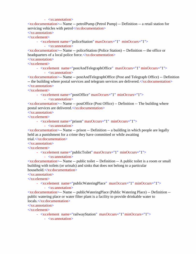
- <xs:annotation>
<xs:documentation>-- Name -- petrolPump (Petrol Pump) -- Definition -- a retail station for
servicing vehicles with petrol</xs:documentation>
</xs:annotation>
</xs:element>
- <xs:element name="policeStation" maxOccurs="1" minOccurs="1">
- <xs:annotation>
<xs:documentation>-- Name -- policeStation (Police Station) -- Definition -- the office or
headquarters of a local police force.</xs:documentation>
</xs:annotation>
</xs:element>
- <xs:element name="postAndTelegraphOffice" maxOccurs="1" minOccurs="1">
- <xs:annotation>
<xs:documentation>-- Name -- postAndTelegraphOffice (Post and Telegraph Office) -- Definition
-- the building where postal services and telegram services are delivered.</xs:documentation>
</xs:annotation>
</xs:element>
- <xs:element name="postOffice" maxOccurs="1" minOccurs="1">
- <xs:annotation>
<xs:documentation>-- Name -- postOffice (Post Office) -- Definition -- The building where
postal services are delivered.</xs:documentation>
</xs:annotation>
</xs:element>
- <xs:element name="prison" maxOccurs="1" minOccurs="1">
- <xs:annotation>
<xs:documentation>-- Name -- prison -- Definition -- a building in which people are legally
held as a punishment for a crime they have committed or while awaiting
trial.</xs:documentation>
</xs:annotation>
</xs:element>
- <xs:element name="publicToilet" maxOccurs="1" minOccurs="1">
- <xs:annotation>
<xs:documentation>-- Name -- public toilet -- Definition -- A public toilet is a room or small
building with toilets (or urinals) and sinks that does not belong to a particular
household.</xs:documentation>
</xs:annotation>
</xs:element>
- <xs:element name="publicWateringPlace" maxOccurs="1" minOccurs="1">
- <xs:annotation>
<xs:documentation>-- Name -- publicWateringPlace (Public Watering Place) -- Definition --
public watering place or water filter plant is a facility to provide drinkable water to
locals.</xs:documentation>
</xs:annotation>
</xs:element>
- <xs:element name="railwayStation" maxOccurs="1" minOccurs="1">
- <xs:annotation>

<xs:documentation>-- Name -- railwayStation (Railway Station) -- Definition -
- a place on a railway line where trains regularly stop so that passengers
can get on or off.</xs:documentation>
</xs:annotation>
</xs:element>
- <xs:element name="rescueOffice" maxOccurs="1" minOccurs="1">
- <xs:annotation>
<xs:documentation>-- Name -- rescueOffice -- Definition -- an office/building used of rescue
department </xs:documentation>
</xs:annotation>
</xs:element>
- <xs:element name="sabziMandi" maxOccurs="1" minOccurs="1">
- <xs:annotation>
<xs:documentation>-- Name -- sabziMandi -- Definition -- Farmer's Market Green Market
Greenmarket :???? ????Sabzi Mandi : (noun)
</xs:documentation>
</xs:annotation>
</xs:element>
- <xs:element name="sewer" maxOccurs="1" minOccurs="1">
- <xs:annotation>
<xs:documentation>-- Name -- sewer -- Definition -- an underground conduit for carrying off
drainage water and waste matter.</xs:documentation>
</xs:annotation>
</xs:element>
- <xs:element name="shop" maxOccurs="1" minOccurs="1">
- <xs:annotation>
<xs:documentation>-- Name -- shop -- Definition -- represents
shop</xs:documentation>
</xs:annotation>
</xs:element>
- <xs:element name="shoppingCenter" maxOccurs="1" minOccurs="1">
- <xs:annotation>
<xs:documentation>-- Name -- shoppingCenter (Shopping Center) -- Definition
-- an area where shops are concentrated. </xs:documentation>
</xs:annotation>
</xs:element>
- <xs:element name="shoppingMall" maxOccurs="1" minOccurs="1">
- <xs:annotation>
<xs:documentation>-- Name -- Shopping Mall -- Definition -- a large enclosed shopping area from
which traffic is excluded.</xs:documentation>
</xs:annotation>
</xs:element>
- <xs:element name="slaughterHouse" maxOccurs="1" minOccurs="1">
- <xs:annotation>
<xs:documentation>-- Name -- slaughterHouse -- Definition -- represents slaughter
house</xs:documentation>
</xs:annotation>
</xs:element>
- <xs:element name="stall" maxOccurs="1" minOccurs="1">

- <xs:annotation>
<xs:documentation>-- Name -- stall -- Definition -- a stand, booth, or compartment for
the sale of goods in a market or large covered area.</xs:documentation>
</xs:annotation>
</xs:element>
- <xs:element name="telecomTower" maxOccurs="1" minOccurs="1">
- <xs:annotation>
<xs:documentation>-- Name -- telecomTower -- Definition -- a mast or tower built primarily to
hold telecommunications antennas</xs:documentation>
</xs:annotation>
</xs:element>
- <xs:element name="telegraphOffice" maxOccurs="1" minOccurs="1">
- <xs:annotation>
<xs:documentation>-- Name -- telegraphOffice (Telegraph Office) -- Definition
-- the department responsible for telegraph services.</xs:documentation>
</xs:annotation>
</xs:element>
- <xs:element name="touristInformationCenter" maxOccurs="1" minOccurs="1">
- <xs:annotation>
<xs:documentation>-- Name -- touristInformationCenter (Tourist Information Center) --
Definition -- a facility used for providing information to persons who travel for
pleasure.</xs:documentation>
</xs:annotation>
</xs:element>
- <xs:element name="tuckShop" maxOccurs="1" minOccurs="1">
- <xs:annotation>
<xs:documentation>-- Name -- tuckShop -- Definition -- a shop, typically one on school
premises, that sells confectionery, snacks, and soft drinks.</xs:documentation>
</xs:annotation>
</xs:element>
- <xs:element name="utilityStore" maxOccurs="1" minOccurs="1">
- <xs:annotation>
<xs:documentation>-- Name -- Utility Store -- Definition -- is a Pakistani state- owned enterprise
that operates chain stores throughout the country that provide basic commodities to the general
public at prices which are lower than the open market because the government subsidizes
them</xs:documentation>
</xs:annotation>
</xs:element>
- <xs:element name="warehouse" maxOccurs="1" minOccurs="1">
- <xs:annotation>
<xs:documentation>-- Name -- warehouse -- Definition -- a large building where raw
materials or manufactured goods may be stored before their export or distribution for
sale.</xs:documentation>
</xs:annotation>
</xs:element>
- <xs:element name="waterFiltrationPlant" maxOccurs="1" minOccurs="1">

- <xs:annotation>
<xs:documentation>-- Name -- Water Filtration Plant -- Definition -- a plant which treats raw water,
which contains undesirable sediments, color, algae and other harmful organisms.</xs:documentation>
</xs:annotation>
</xs:element>
- <xs:element name="wirelessStation" maxOccurs="1" minOccurs="1">
- <xs:annotation>
<xs:documentation>-- Name -- wirelessStation (Wireless Station) -- Definition
-- a wireless communications station installed at a fixed location and used to communicate as part of
wireless telephone system.</xs:documentation>
</xs:annotation>
</xs:element>
- <xs:element name="workshop" maxOccurs="1" minOccurs="1">
- <xs:annotation>
<xs:documentation>-- Name -- workshop -- Definition -- a room or building in which goods are
manufactured or repaired.</xs:documentation>
</xs:annotation>
</xs:element>
</xs:sequence>
</xs:complexType>
<xs:element type="Crossing" name="Crossing"/>
- <xs:complexType name="Crossing">
- <xs:annotation>
<xs:documentation>-- Name -- Crossing -- Definition -- represents the possible values of crossing
feature type.</xs:documentation>
</xs:annotation>
- <xs:sequence>
- <xs:element name="ford" maxOccurs="1" minOccurs="1">
- <xs:annotation>
<xs:documentation>-- Name -- ford -- Definition -- a shallow place in a river or stream allowing one to
walk or drive across.</xs:documentation>
</xs:annotation>
</xs:element>
- <xs:element name="levelCrossing" maxOccurs="1" minOccurs="1">
- <xs:annotation>
<xs:documentation>-- Name -- levelCrossing (Level Crossing) -- Definition -- a place where a railway
and a road, or two railway lines, cross at the same level.</xs:documentation>
</xs:annotation>
</xs:element>
- <xs:element name="other" maxOccurs="1" minOccurs="1">
- <xs:annotation>
<xs:documentation>-- Name -- other -- Definition -- represent such types which are not included
in the list</xs:documentation>
</xs:annotation>
</xs:element>
- <xs:element name="siphonIntermittent" maxOccurs="1" minOccurs="1">
- <xs:annotation>

<xs:documentation>-- Name -- siphonIntermittent (Siphon Intermittent) -- Definition -- a pipe or
tube in the form of an upside-down U, filled with water and arranged so that the pressure of the
atmosphere forces water to flow upward from a container through the tube, over a barrier, and into a
lower container.</xs:documentation>
</xs:annotation>
</xs:element>
- <xs:element name="siphonPerennial" maxOccurs="1" minOccurs="1">
- <xs:annotation>
<xs:documentation>-- Name -- siphonPerennial (Siphon Perennial) -- Definition -- a pipe or tube in
the form of an upside-down U, filled with perennial water and arranged so that the pressure of the
atmosphere forces perennial water to flow upward from a container through the tube, over a barrier,
and into a lower container.</xs:documentation>
</xs:annotation>
</xs:element>
</xs:sequence>
</xs:complexType>
<xs:element type="EducationalFacility" name="EducationalFacility"/>
- <xs:complexType name="EducationalFacility">
- <xs:annotation>
<xs:documentation>-- Name -- Educational Facility -- Definition -- represents the possible
values of educational facility</xs:documentation>
</xs:annotation>
- <xs:sequence>
- <xs:element name="college" maxOccurs="1" minOccurs="1">
- <xs:annotation>
<xs:documentation>-- Name -- college -- Definition -- an establishment for learning at post-
secondary level</xs:documentation>
</xs:annotation>
</xs:element>
- <xs:element name="institute" maxOccurs="1" minOccurs="1">
- <xs:annotation>
<xs:documentation>-- Name -- institute -- Definition -- a building in which work of a literary,
scientific or educational character is carried out.</xs:documentation>
</xs:annotation>
</xs:element>
- <xs:element name="other" maxOccurs="1" minOccurs="1">
- <xs:annotation>
<xs:documentation>-- Name -- other -- Definition -- represent such types which are not included
in the list</xs:documentation>
</xs:annotation>
</xs:element>
- <xs:element name="school" maxOccurs="1" minOccurs="1">
- <xs:annotation>
<xs:documentation>-- Name -- school -- Definition -- an establishment for primary or secondary
education </xs:documentation>
</xs:annotation>

</xs:element>
- <xs:element name="technicalCollege" maxOccurs="1" minOccurs="1">
- <xs:annotation>
<xs:documentation>-- Name -- technicalCollege (Technical College) -- Definition -- an
establishment for learning technical education at post- secondary level</xs:documentation>
</xs:annotation>
</xs:element>
- <xs:element name="university" maxOccurs="1" minOccurs="1">
- <xs:annotation>
<xs:documentation>-- Name -- university -- Definition -- a tertiary educational institution with the
power to award postgraduate research degrees.</xs:documentation>
</xs:annotation>
</xs:element>
</xs:sequence>
</xs:complexType>
<xs:element type="GroundWater" name="GroundWater"/>
- <xs:complexType name="GroundWater">
- <xs:annotation>
<xs:documentation>-- Name -- Ground Water -- Definition -- groundwater is the water found
underground in the cracks and spaces in soil, sand and rock.</xs:documentation>
</xs:annotation>
- <xs:sequence>
- <xs:element name="borewell" maxOccurs="1" minOccurs="1">
- <xs:annotation>
<xs:documentation>-- Name -- borewell (Bore Well) -- Definition -- A deep vertical hole of a small
diameter drilled to obtain water.</xs:documentation>
</xs:annotation>
</xs:element>
- <xs:element name="handpump" maxOccurs="1" minOccurs="1">
- <xs:annotation>
<xs:documentation>-- Name -- handpump (Hand Pump) -- Definition -- water pump operated by
hand</xs:documentation>
</xs:annotation>
</xs:element>
- <xs:element name="hotspring" maxOccurs="1" minOccurs="1">
- <xs:annotation>
<xs:documentation>-- Name -- hotspring (Hot Spring) -- Definition -- A naturally heated mineral
spring. </xs:documentation>
</xs:annotation>
</xs:element>
- <xs:element name="other" maxOccurs="1" minOccurs="1">
- <xs:annotation>
<xs:documentation>-- Name -- other -- Definition -- represent such types which are not included
in the list</xs:documentation>
</xs:annotation>

</xs:element>
- <xs:element name="overheadWaterTank" maxOccurs="1" minOccurs="1">
- <xs:annotation>
<xs:documentation>-- Name -- overheadWaterTank (Overhead Water Tank) -- Definition -- an
overhead tank for holding water.</xs:documentation>
</xs:annotation>
</xs:element>
- <xs:element name="spring" maxOccurs="1" minOccurs="1">
- <xs:annotation>
<xs:documentation>-- Name -- spring -- Definition -- A place at which a flow of water issues
naturally from the ground, either continuously or intermittently.</xs:documentation>
</xs:annotation>
</xs:element>
- <xs:element name="tubeWell" maxOccurs="1" minOccurs="1">
- <xs:annotation>
<xs:documentation>-- Name -- tubeWell (Tube Well) -- Definition -- A tube well is a type of water
well in which a long 100–200 millimetres wide stainless steel tube or pipe is bored into an
underground aquifer.</xs:documentation>
</xs:annotation>
</xs:element>
- <xs:element name="well_in_Rock" maxOccurs="1" minOccurs="1">
- <xs:annotation>
<xs:documentation>-- Name -- well_in_Rock -- Definition -- represents a well which is located in
rock</xs:documentation>
</xs:annotation>
</xs:element>
- <xs:element name="wellLined" maxOccurs="1" minOccurs="1">
- <xs:annotation>
<xs:documentation>-- Name -- wellLined (Well Lined) -- Definition -- an excavation or structure
created in the ground by digging, driving, boring, or drilling to access groundwater in underground
aquifers. The well water is drawn by a pump, or using containers, such as buckets, that are raised
mechanically or by hand.</xs:documentation>
</xs:annotation>
</xs:element>
- <xs:element name="wellUnlined" maxOccurs="1" minOccurs="1">
- <xs:annotation>
<xs:documentation>-- Name -- wellUnlined (Well Unlined) -- Definition -- a coarse well, which is
not properly lined </xs:documentation>
</xs:annotation>
</xs:element>
</xs:sequence>
</xs:complexType>
<xs:element type="Road" name="Road"/>
- <xs:complexType name="Road">
- <xs:annotation>

<xs:documentation>-- Name -- Road -- Definition -- represents possible values of
road</xs:documentation>
</xs:annotation>
- <xs:sequence>
- <xs:element name="cart_Track" maxOccurs="1" minOccurs="1">
- <xs:annotation>
<xs:documentation>-- Name -- cart_Track (Cart Track) -- Definition -- a rough track or road over
farmland that is unsuitable for ordinary vehicles.</xs:documentation>
</xs:annotation>
</xs:element>
- <xs:element name="causeway" maxOccurs="1" minOccurs="1">
- <xs:annotation>
<xs:documentation>-- Name -- causeway -- Definition -- a raised road or track across low or wet
ground.</xs:documentation>
</xs:annotation>
</xs:element>
- <xs:element name="curb_Cut" maxOccurs="1" minOccurs="1">
- <xs:annotation>
<xs:documentation>-- Name -- curb_Cut -- Definition -- A ramp opening in a curb where vehicles
or wheel chairs may enter or leave the roadway</xs:documentation>
</xs:annotation>
</xs:element>
- <xs:element name="grandTrunkRoad" maxOccurs="1" minOccurs="1">
- <xs:annotation>
<xs:documentation>-- Name -- Grand Trunk Road -- Definition -- The Grand Trunk Road
(commonly abbreviated to GT Road) is one of South Asia's oldest and longest major
roads.</xs:documentation>
</xs:annotation>
</xs:element>
- <xs:element name="jettyRoad" maxOccurs="1" minOccurs="1">
- <xs:annotation>
<xs:documentation>-- Name -- jettyRoad (Jetty Road) -- Definition -- represents road
on jetty</xs:documentation>
</xs:annotation>
</xs:element>
- <xs:element name="metalledRoad" maxOccurs="1" minOccurs="1">
- <xs:annotation>
<xs:documentation>-- Name -- metalledRoad (Metalled Road) -- Definition -- are made of
bitumen of coal, cement or concrete</xs:documentation>
</xs:annotation>
</xs:element>
- <xs:element name="metroRoute" maxOccurs="1" minOccurs="1">
- <xs:annotation>
<xs:documentation>-- Name -- metroRoute (Metro Route) -- Definition -- a dedicated route
for metro bus system</xs:documentation>
</xs:annotation>
</xs:element>

- <xs:element name="motorway" maxOccurs="1" minOccurs="1">
- <xs:annotation>
<xs:documentation>-- Name -- motorway -- Definition -- a fenced highway is known as
motorway</xs:documentation>
</xs:annotation>
</xs:element>
- <xs:element name="other" maxOccurs="1" minOccurs="1">
- <xs:annotation>
<xs:documentation>-- Name -- other -- Definition -- represent such types which are not
included in the list</xs:documentation>
</xs:annotation>
</xs:element>
- <xs:element name="packTrack" maxOccurs="1" minOccurs="1">
- <xs:annotation>
<xs:documentation>-- Name -- packTrack (Pack Track) -- Definition -- track formed by animal
movements, especially in the mountain.
</xs:documentation>
</xs:annotation>
</xs:element>
- <xs:element name="serviceRoad" maxOccurs="1" minOccurs="1">
- <xs:annotation>
<xs:documentation>-- Name -- serviceRoad -- Definition -- represents service
road</xs:documentation>
</xs:annotation>
</xs:element>
- <xs:element name="shingledRoad" maxOccurs="1" minOccurs="1">
- <xs:annotation>
<xs:documentation>-- Name -- shingledRoad (Shingled Road) -- Definition -- a road formed by
shingle (a mass of small rounded pebbles).</xs:documentation>
</xs:annotation>
</xs:element>
- <xs:element name="specialRoad" maxOccurs="1" minOccurs="1">
- <xs:annotation>
<xs:documentation>-- Name -- specialRoad (Special Road) -- Definition -- a road dedicated to
special purposes, e.g. taxi lane, bus lane, etc.</xs:documentation>
</xs:annotation>
</xs:element>
- <xs:element name="street" maxOccurs="1" minOccurs="1">
- <xs:annotation>
<xs:documentation>-- Name -- street -- Definition -- a public road in a city or town, typically
with houses and buildings on one or both sides</xs:documentation>
</xs:annotation>
</xs:element>
- <xs:element name="superHighway" maxOccurs="1" minOccurs="1">
- <xs:annotation>
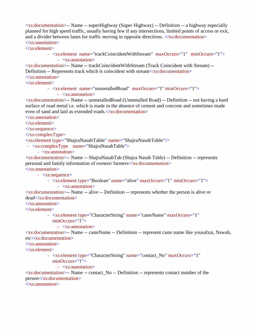
<xs:documentation>-- Name -- superHighway (Super Highway) -- Definition -- a highway especially
planned for high speed traffic, usually having few if any intersections, limited points of access or exit,
and a divider between lanes for traffic moving in opposite directions. </xs:documentation>
</xs:annotation>
</xs:element>
- <xs:element name="trackCoincidentWithStream" maxOccurs="1" minOccurs="1">
- <xs:annotation>
<xs:documentation>-- Name -- trackCoincidentWithStream (Track Coincident with Stream) --
Definition -- Represents track which is coincident with stream</xs:documentation>
</xs:annotation>
</xs:element>
- <xs:element name="unmetalledRoad" maxOccurs="1" minOccurs="1">
- <xs:annotation>
<xs:documentation>-- Name -- unmetalledRoad (Unmetalled Road) -- Definition -- not having a hard
surface of road metal i.e. which is made in the absence of cement and concrete and sometimes made
even of sand and laid as extended roads.</xs:documentation>
</xs:annotation>
</xs:element>
</xs:sequence>
</xs:complexType>
<xs:element type="ShajraNasabTable" name="ShajraNasabTable"/>
- <xs:complexType name="ShajraNasabTable">
- <xs:annotation>
<xs:documentation>-- Name -- ShajraNasabTab (Shajra Nasab Table) -- Definition -- represents
personal and family information of owners/ farmers</xs:documentation>
</xs:annotation>
- <xs:sequence>
- <xs:element type="Boolean" name="alive" maxOccurs="1" minOccurs="1">
- <xs:annotation>
<xs:documentation>-- Name -- alive -- Definition -- represents whether the person is alive or
dead</xs:documentation>
</xs:annotation>
</xs:element>
- <xs:element type="CharacterString" name="casteName" maxOccurs="1"
minOccurs="1">
- <xs:annotation>
<xs:documentation>-- Name -- casteName -- Definition -- represent caste name like yousafzai, Nawab,
etc</xs:documentation>
</xs:annotation>
</xs:element>
- <xs:element type="CharacterString" name="contact_No" maxOccurs="1"
minOccurs="1">
- <xs:annotation>
<xs:documentation>-- Name -- contact_No -- Definition -- represents contact number of the
person</xs:documentation>
</xs:annotation>
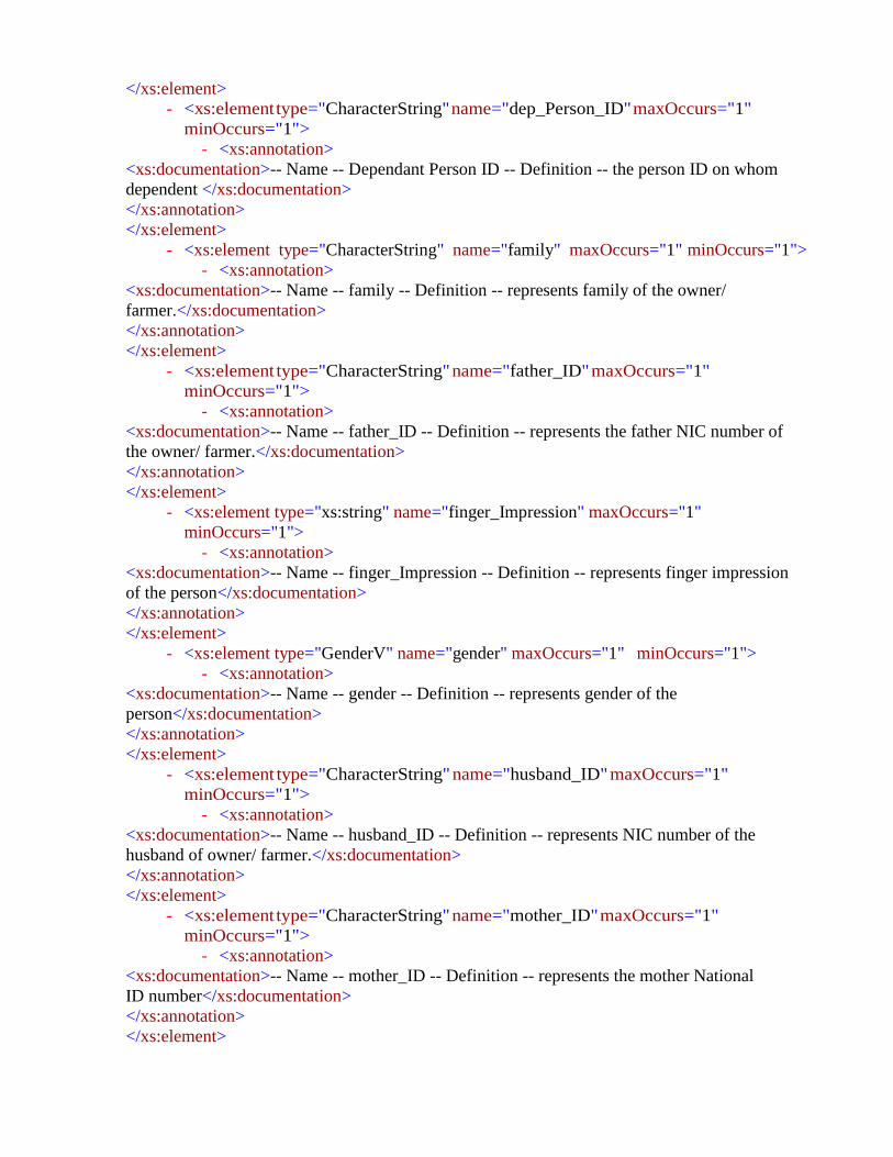
</xs:element>
- <xs:element type="CharacterString" name="dep_Person_ID" maxOccurs="1"
minOccurs="1">
- <xs:annotation>
<xs:documentation>-- Name -- Dependant Person ID -- Definition -- the person ID on whom
dependent </xs:documentation>
</xs:annotation>
</xs:element>
- <xs:element type="CharacterString" name="family" maxOccurs="1" minOccurs="1">
- <xs:annotation>
<xs:documentation>-- Name -- family -- Definition -- represents family of the owner/
farmer.</xs:documentation>
</xs:annotation>
</xs:element>
- <xs:element type="CharacterString" name="father_ID" maxOccurs="1"
minOccurs="1">
- <xs:annotation>
<xs:documentation>-- Name -- father_ID -- Definition -- represents the father NIC number of
the owner/ farmer.</xs:documentation>
</xs:annotation>
</xs:element>
- <xs:element type="xs:string" name="finger_Impression" maxOccurs="1"
minOccurs="1">
- <xs:annotation>
<xs:documentation>-- Name -- finger_Impression -- Definition -- represents finger impression
of the person</xs:documentation>
</xs:annotation>
</xs:element>
- <xs:element type="GenderV" name="gender" maxOccurs="1" minOccurs="1">
- <xs:annotation>
<xs:documentation>-- Name -- gender -- Definition -- represents gender of the
person</xs:documentation>
</xs:annotation>
</xs:element>
- <xs:element type="CharacterString" name="husband_ID" maxOccurs="1"
minOccurs="1">
- <xs:annotation>
<xs:documentation>-- Name -- husband_ID -- Definition -- represents NIC number of the
husband of owner/ farmer.</xs:documentation>
</xs:annotation>
</xs:element>
- <xs:element type="CharacterString" name="mother_ID" maxOccurs="1"
minOccurs="1">
- <xs:annotation>
<xs:documentation>-- Name -- mother_ID -- Definition -- represents the mother National
ID number</xs:documentation>
</xs:annotation>
</xs:element>

- <xs:element type="CharacterString" name="person_ID" maxOccurs="1"
minOccurs="1">
- <xs:annotation>
<xs:documentation>-- Name -- person_ID (Personal ID) -- Definition -- represents the
NIC number/ form B number.</xs:documentation>
</xs:annotation>
</xs:element>
- <xs:element type="CharacterString" name="person_Name" maxOccurs="1"
minOccurs="1">
- <xs:annotation>
<xs:documentation>-- Name -- person_Name -- Definition -- represents the name of the
owner/ farmer.</xs:documentation>
</xs:annotation>
</xs:element>
- <xs:element type="CharacterString" name="profession" maxOccurs="1"
minOccurs="1">
- <xs:annotation>
<xs:documentation>-- Name -- profession -- Definition -- represents profession of the owner/
farmer.</xs:documentation>
</xs:annotation>
</xs:element>
- <xs:element type="CharacterString" name="religion" maxOccurs="1"
minOccurs="1">
- <xs:annotation>
<xs:documentation>-- Name -- religion -- Definition -- represents religion of the owner/
farmer.</xs:documentation>
</xs:annotation>
</xs:element>
- <xs:element type="CharacterString" name="remarks" maxOccurs="1"
minOccurs="1">
- <xs:annotation>
<xs:documentation>-- Name -- remarks -- Definition -- Represents any additional
remarks (if any)</xs:documentation>
</xs:annotation>
</xs:element>
- <xs:element type="CharacterString" name="sect" maxOccurs="1" minOccurs="1">
- <xs:annotation>
<xs:documentation>-- Name -- sect -- Definition -- represents sect of the owner/
farmer.</xs:documentation>
</xs:annotation>
</xs:element>
- <xs:element type="CharacterString" name="subCaste" maxOccurs="1"
minOccurs="1">
- <xs:annotation>
<xs:documentation>-- Name -- subCaste -- Definition -- represents sub caste
name</xs:documentation>
</xs:annotation>
</xs:element>
</xs:sequence>
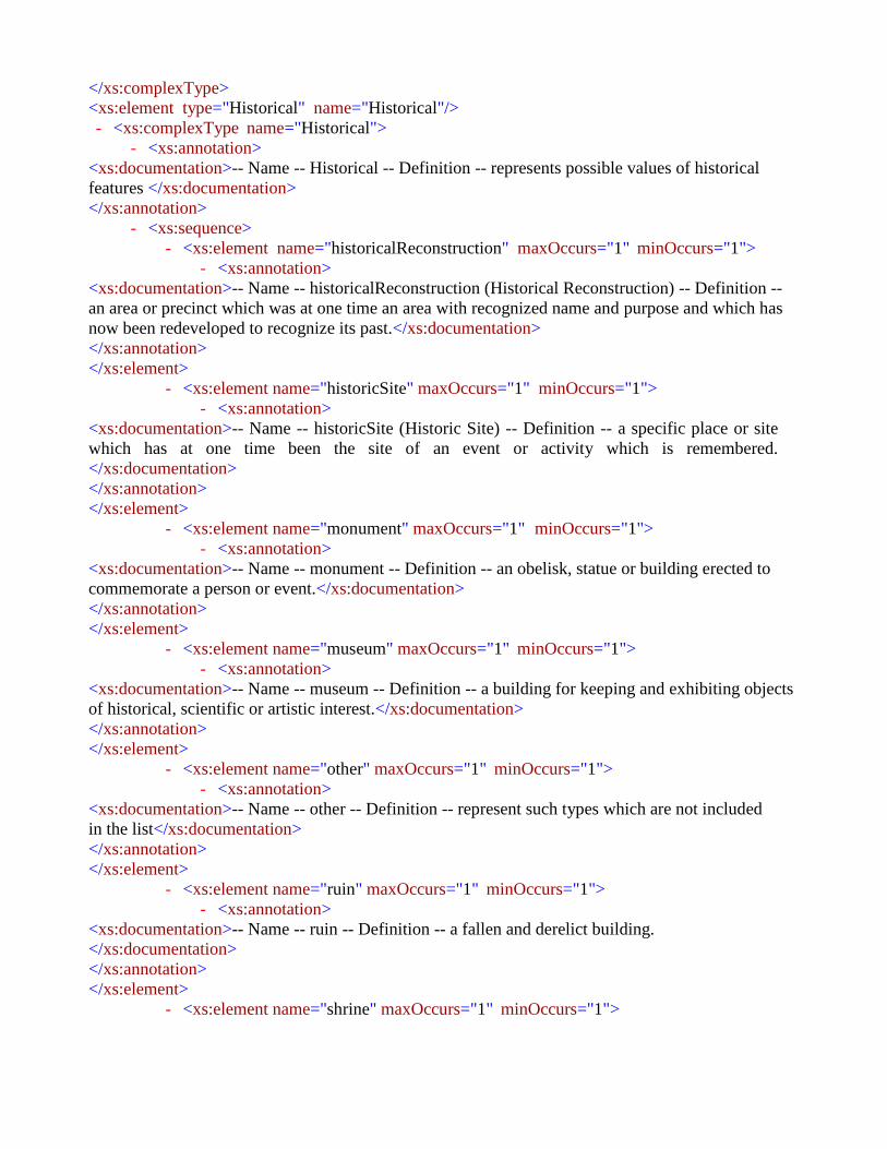
</xs:complexType>
<xs:element type="Historical" name="Historical"/>
- <xs:complexType name="Historical">
- <xs:annotation>
<xs:documentation>-- Name -- Historical -- Definition -- represents possible values of historical
features </xs:documentation>
</xs:annotation>
- <xs:sequence>
- <xs:element name="historicalReconstruction" maxOccurs="1" minOccurs="1">
- <xs:annotation>
<xs:documentation>-- Name -- historicalReconstruction (Historical Reconstruction) -- Definition --
an area or precinct which was at one time an area with recognized name and purpose and which has
now been redeveloped to recognize its past.</xs:documentation>
</xs:annotation>
</xs:element>
- <xs:element name="historicSite" maxOccurs="1" minOccurs="1">
- <xs:annotation>
<xs:documentation>-- Name -- historicSite (Historic Site) -- Definition -- a specific place or site
which has at one time been the site of an event or activity which is remembered.
</xs:documentation>
</xs:annotation>
</xs:element>
- <xs:element name="monument" maxOccurs="1" minOccurs="1">
- <xs:annotation>
<xs:documentation>-- Name -- monument -- Definition -- an obelisk, statue or building erected to
commemorate a person or event.</xs:documentation>
</xs:annotation>
</xs:element>
- <xs:element name="museum" maxOccurs="1" minOccurs="1">
- <xs:annotation>
<xs:documentation>-- Name -- museum -- Definition -- a building for keeping and exhibiting objects
of historical, scientific or artistic interest.</xs:documentation>
</xs:annotation>
</xs:element>
- <xs:element name="other" maxOccurs="1" minOccurs="1">
- <xs:annotation>
<xs:documentation>-- Name -- other -- Definition -- represent such types which are not included
in the list</xs:documentation>
</xs:annotation>
</xs:element>
- <xs:element name="ruin" maxOccurs="1" minOccurs="1">
- <xs:annotation>
<xs:documentation>-- Name -- ruin -- Definition -- a fallen and derelict building.
</xs:documentation>
</xs:annotation>
</xs:element>
- <xs:element name="shrine" maxOccurs="1" minOccurs="1">

- <xs:annotation>
<xs:documentation>-- Name -- shrine -- Definition -- a place or site venerated for its association with
a famous person or event.</xs:documentation>
</xs:annotation>
</xs:element>
</xs:sequence>
</xs:complexType>
<xs:element type="IndustrialArea" name="IndustrialArea"/>
- <xs:complexType name="IndustrialArea">
- <xs:annotation>
<xs:documentation>-- Name -- Industrial Area -- Definition -- Represents the possible values of the
industry types. </xs:documentation>
</xs:annotation>
- <xs:sequence>
- <xs:element name="chimney" maxOccurs="1" minOccurs="1">
- <xs:annotation>
<xs:documentation>-- Name -- chimney -- Definition -- represents factory
chimney.</xs:documentation>
</xs:annotation>
</xs:element>
- <xs:element name="factory" maxOccurs="1" minOccurs="1">
- <xs:annotation>
<xs:documentation>-- Name -- factory -- Definition -- a building or group of buildings where goods
are manufactured or assembled chiefly by machine.</xs:documentation>
</xs:annotation>
</xs:element>
- <xs:element name="kiln" maxOccurs="1" minOccurs="1">
- <xs:annotation>
<xs:documentation>-- Name -- kiln -- Definition -- a construction in which bricks are baked or
burned.</xs:documentation>
</xs:annotation>
</xs:element>
- <xs:element name="mill" maxOccurs="1" minOccurs="1">
- <xs:annotation>
<xs:documentation>-- Name -- mill -- Definition -- a place where some grinding work is
taking place such as a flour mill or rice mill.</xs:documentation>
</xs:annotation>
</xs:element>
- <xs:element name="other" maxOccurs="1" minOccurs="1">
- <xs:annotation>
<xs:documentation>-- Name -- other -- Definition -- represent such types which are not included
in the list</xs:documentation>
</xs:annotation>
</xs:element>
- <xs:element name="sawmill" maxOccurs="1" minOccurs="1">
- <xs:annotation>

<xs:documentation>-- Name -- sawmill -- Definition -- a facility where logs are cut into lumber.
</xs:documentation>
</xs:annotation>
</xs:element>
- <xs:element name="steelMill" maxOccurs="1" minOccurs="1">
- <xs:annotation>
<xs:documentation>-- Name -- steelMill (Steel Mill) -- Definition -- an industrial plant for the
manufacture of steel. It may be an integrated steel works carrying out all steps of steel making from
smelting iron ore to rolled product, but may also describe plants where steel semi-finished casting
products (blooms, ingots, slabs, billets) are made, from molten pig iron or from
scrap.</xs:documentation>
</xs:annotation>
</xs:element>
- <xs:element name="tannery" maxOccurs="1" minOccurs="1">
- <xs:annotation>
<xs:documentation>-- Name -- tannery -- Definition -- a place where the skins are processed. Tanning
hide into leather involves a process which permanently alters the protein structure of skin, making it
more durable and less susceptible to decomposition, and also possibly coloring
it.</xs:documentation>
</xs:annotation>
</xs:element>
</xs:sequence>
</xs:complexType>
<xs:element type="Landform" name="Landform"/>
- <xs:complexType name="Landform">
- <xs:annotation>
<xs:documentation>-- Name -- Landform -- Definition -- represents possible values of
Landform</xs:documentation>
</xs:annotation>
- <xs:sequence>
- <xs:element name="bank" maxOccurs="1" minOccurs="1">
- <xs:annotation>
<xs:documentation>-- Name -- bank -- Definition -- a stream bank or river bank is the terrain
alongside the bed of a river, creek, or stream. The bank consists of the sides of the channel, between
which the flow is confined.</xs:documentation>
</xs:annotation>
</xs:element>
- <xs:element name="beach" maxOccurs="1" minOccurs="1">
- <xs:annotation>
<xs:documentation>-- Name -- beach -- Definition -- a sloping shore of a lake or a low stretch of
river’s edge, usually covered with sand or gravel.</xs:documentation>
</xs:annotation>
</xs:element>
- <xs:element name="island" maxOccurs="1" minOccurs="1">
- <xs:annotation>

<xs:documentation>-- Name -- island -- Definition -- an area of land completely surrounded by
the waters of a lake or other inland body of water.</xs:documentation>
</xs:annotation>
</xs:element>
- <xs:element name="jetty" maxOccurs="1" minOccurs="1">
- <xs:annotation>
<xs:documentation>-- Name -- jetty -- Definition -- a structure that projects from the land out into
water.</xs:documentation>
</xs:annotation>
</xs:element>
- <xs:element name="other" maxOccurs="1" minOccurs="1">
- <xs:annotation>
<xs:documentation>-- Name -- other -- Definition -- represent such types which are not included
in the list</xs:documentation>
</xs:annotation>
</xs:element>
- <xs:element name="promontory" maxOccurs="1" minOccurs="1">
- <xs:annotation>
<xs:documentation>-- Name -- promontory -- Definition -- an elevated protrusion of land into
a lake or other inland body of water.
</xs:documentation>
</xs:annotation>
</xs:element>
- <xs:element name="rock" maxOccurs="1" minOccurs="1">
- <xs:annotation>
<xs:documentation>-- Name -- rock -- Definition -- a large rocky formation surrounded by the waters
of an inland body of water.</xs:documentation>
</xs:annotation>
</xs:element>
- <xs:element name="sandspit" maxOccurs="1" minOccurs="1">
- <xs:annotation>
<xs:documentation>-- Name -- sandspit -- Definition -- a small bank of low land projecting into a
lake or other inland body of water from the shore.</xs:documentation>
</xs:annotation>
</xs:element>
</xs:sequence>
</xs:complexType>
<xs:element type="MedicalFacility" name="MedicalFacility"/>
- <xs:complexType name="MedicalFacility">
- <xs:annotation>
<xs:documentation>-- Name -- Medical Facility -- Definition -- represents possible values of
medical facility. </xs:documentation>
</xs:annotation>
- <xs:sequence>
- <xs:element name="basicHealthUnit" maxOccurs="1" minOccurs="1">
- <xs:annotation>

<xs:documentation>-- Name -- Basic Health Unit -- Definition -- It is the first level of health care
considered to be necessary to maintain adequate health and protection from
disease.</xs:documentation>
</xs:annotation>
</xs:element>
- <xs:element name="bloodBank" maxOccurs="1" minOccurs="1">
- <xs:annotation>
<xs:documentation>-- Name -- Blood Bank -- Definition -- a place where supplies of blood
or plasma for transfusion are stored.</xs:documentation>
</xs:annotation>
</xs:element>
- <xs:element name="clinic" maxOccurs="1" minOccurs="1">
- <xs:annotation>
<xs:documentation>-- Name -- clinic -- Definition -- an establishment or hospital
department where outpatients are given medical treatment or advice, especially of a
specialist nature</xs:documentation>
</xs:annotation>
</xs:element>
- <xs:element name="dispensary" maxOccurs="1" minOccurs="1">
- <xs:annotation>
<xs:documentation>-- Name -- dispensary -- Definition -- a room where medicines are
prepared and provided.</xs:documentation>
</xs:annotation>
</xs:element>
- <xs:element name="hospital" maxOccurs="1" minOccurs="1">
- <xs:annotation>
<xs:documentation>-- Name -- hospital -- Definition -- an institution providing medical and
surgical treatment and nursing care for sick or injured people.</xs:documentation>
</xs:annotation>
</xs:element>
- <xs:element name="laboratory" maxOccurs="1" minOccurs="1">
- <xs:annotation>
<xs:documentation>-- Name -- laboratory -- Definition -- a room or building equipped for
scientific experiments, research, or teaching, or for the manufacture of drugs or
chemicals.</xs:documentation>
</xs:annotation>
</xs:element>
- <xs:element name="medicalStore" maxOccurs="1" minOccurs="1">
- <xs:annotation>
<xs:documentation>-- Name -- medicalStore -- Definition -- is a retail shop which provides
pharmaceutical drugs</xs:documentation>
</xs:annotation>
</xs:element>
- <xs:element name="other" maxOccurs="1" minOccurs="1">
- <xs:annotation>
<xs:documentation>-- Name -- other -- Definition -- represent such types which are not
included in the list</xs:documentation>

</xs:annotation>
</xs:element>
- <xs:element name="psychiatricHospital" maxOccurs="1" minOccurs="1">
- <xs:annotation>
<xs:documentation>-- Name -- psychiatricHospital (Psychiatric Hospital) -- Definition -- a hospital for
the care and treatment of patients affected with acute or chronic mental illness </xs:documentation>
</xs:annotation>
</xs:element>
- <xs:element name="ruralHealthCenter" maxOccurs="1" minOccurs="1">
- <xs:annotation>
<xs:documentation>-- Name -- ruralHealthCenter (Rural Health Center) -- Definition -- is a clinic
located in a rural, medically under-served area</xs:documentation>
</xs:annotation>
</xs:element>
- <xs:element name="sanatorium" maxOccurs="1" minOccurs="1">
- <xs:annotation>
<xs:documentation>-- Name -- sanatorium -- Definition -- an establishment for the medical treatment
of people who are convalescing or have a chronic illness.</xs:documentation>
</xs:annotation>
</xs:element>
- <xs:element name="veterinaryHospital" maxOccurs="1" minOccurs="1">
- <xs:annotation>
<xs:documentation>-- Name -- veterinaryHospital (Veterinary Hospital) -- Definition -- of or relating
to veterinary medicine; concerned or connected with the medical or surgical treatment of animals,
especially domestic animals.</xs:documentation>
</xs:annotation>
</xs:element>
</xs:sequence>
</xs:complexType>
<xs:element type="MineCavePass" name="MineCavePass"/>
- <xs:complexType name="MineCavePass">
- <xs:annotation>
<xs:documentation>-- Name -- MineCavePass (Mine, Cave and Pass) -- Definition -- represents the
possible values of mines,caves, pass features.</xs:documentation>
</xs:annotation>
- <xs:sequence>
- <xs:element name="caveInhabited" maxOccurs="1" minOccurs="1">
- <xs:annotation>
<xs:documentation>-- Name -- caveInhabited (Cave Inhabited) -- Definition -- a cave where human
or animal are living</xs:documentation>
</xs:annotation>
</xs:element>
- <xs:element name="caveUninhabited" maxOccurs="1" minOccurs="1">
- <xs:annotation>

<xs:documentation>-- Name -- caveUninhabited (Cave Uninhabited) -- Definition -- a cave
where no one is living</xs:documentation>
</xs:annotation>
</xs:element>
- <xs:element name="mine" maxOccurs="1" minOccurs="1">
- <xs:annotation>
<xs:documentation>-- Name -- mine -- Definition -- a hole or tunnel dug into the earth from which
ore or minerals are extracted.</xs:documentation>
</xs:annotation>
</xs:element>
- <xs:element name="other" maxOccurs="1" minOccurs="1">
- <xs:annotation>
<xs:documentation>-- Name -- other -- Definition -- represent such types which are not included
in the list</xs:documentation>
</xs:annotation>
</xs:element>
- <xs:element name="pass" maxOccurs="1" minOccurs="1">
- <xs:annotation>
<xs:documentation>-- Name -- pass -- Definition -- A route through a mountain range or over a
ridge.</xs:documentation>
</xs:annotation>
</xs:element>
- <xs:element name="shaft" maxOccurs="1" minOccurs="1">
- <xs:annotation>
<xs:documentation>-- Name -- shaft -- Definition -- a vertical hole serving as access to a mine or
other underground workings</xs:documentation>
</xs:annotation>
</xs:element>
</xs:sequence>
</xs:complexType>
<xs:element type="NaturalVegetation" name="NaturalVegetation"/>
- <xs:complexType name="NaturalVegetation">
- <xs:annotation>
<xs:documentation>-- Name -- NaturalVegetation (Natural Vegetation) -- Definition -- Represents
the possible values of the natural vegetation.</xs:documentation>
</xs:annotation>
- <xs:sequence>
- <xs:element name="aloesBushes" maxOccurs="1" minOccurs="1">
- <xs:annotation>
<xs:documentation>-- Name -- aloesBushes (Aloes Bushes) -- Definition -- A tract of country, which
bears a dense growth of aloes bushes</xs:documentation>
</xs:annotation>
</xs:element>
- <xs:element name="bushes" maxOccurs="1" minOccurs="1">
- <xs:annotation>
<xs:documentation>-- Name -- bushes -- Definition -- a tract of country, not large in extent, which is
uncultivated and covered with bushes or trees.</xs:documentation>

</xs:annotation>
</xs:element>
- <xs:element name="heath" maxOccurs="1" minOccurs="1">
- <xs:annotation>
<xs:documentation>-- Name -- heath -- Definition -- an area of open uncultivated land, typically on
acid sandy soil, with characteristic vegetation of heather, gorse, and coarse
grasses.</xs:documentation>
</xs:annotation>
</xs:element>
- <xs:element name="meadow" maxOccurs="1" minOccurs="1">
- <xs:annotation>
<xs:documentation>-- Name -- meadow -- Definition -- a piece of grassland, especially one used for
hay.</xs:documentation>
</xs:annotation>
</xs:element>
- <xs:element name="other" maxOccurs="1" minOccurs="1">
- <xs:annotation>
<xs:documentation>-- Name -- other -- Definition -- represent such types which are not included
in the list</xs:documentation>
</xs:annotation>
</xs:element>
- <xs:element name="reed" maxOccurs="1" minOccurs="1">
- <xs:annotation>
<xs:documentation>-- Name -- reed -- Definition -- reed is a common name for several tall, grass-like
plants of wetlands.</xs:documentation>
</xs:annotation>
</xs:element>
</xs:sequence>
</xs:complexType>
<xs:element type="Control_Point" name="Control_Point"/>
- <xs:complexType name="Control_Point">
- <xs:annotation>
<xs:documentation>-- Name -- Control_Point -- Definition -- represents vertical and horizontal
control points. Control points are used for the basis of the topographic survey
measurements</xs:documentation>
</xs:annotation>
- <xs:sequence>
- <xs:element type="CharacterString" name="controlPoint_ID" maxOccurs="1"
minOccurs="1">
- <xs:annotation>
<xs:documentation>-- Name -- controlPoint_ID (control Point ID) -- Definition
-- control Point ID represents the unique identification of the control point
feature.</xs:documentation>
</xs:annotation>
</xs:element>
- <xs:element type="Real" name="elevation" maxOccurs="1" minOccurs="1">
- <xs:annotation>
<xs:documentation>-- Name -- elevation -- Definition -- represents the elevation of the
control</xs:documentation>

</xs:annotation>
</xs:element>
- <xs:element type="GM_Point" name="geom" maxOccurs="1" minOccurs="1">
- <xs:annotation>
<xs:documentation>-- Name -- geom: (geometry) -- Definition -- represents geometry of spatial
object to be represented </xs:documentation>
</xs:annotation>
</xs:element>
- <xs:element type="CharacterString" name="name" maxOccurs="1" minOccurs="1">
- <xs:annotation>
<xs:documentation>-- Name -- name -- Definition -- Represents the name of the topographic
feature</xs:documentation>
</xs:annotation>
</xs:element>
- <xs:element type="CharacterString" name="remarks" maxOccurs="1"
minOccurs="1">
- <xs:annotation>
<xs:documentation>-- Name -- remarks -- Definition -- Represents any additional remarks (if
any)</xs:documentation>
</xs:annotation>
</xs:element>
- <xs:element type="ControlType" name="type" maxOccurs="1" minOccurs="1">
- <xs:annotation>
<xs:documentation>-- Name -- type -- Definition -- represents the specific type of control
feature.</xs:documentation>
</xs:annotation>
</xs:element>
</xs:sequence>
</xs:complexType>
<xs:element type="ControlType" name="ControlType"/>
- <xs:complexType name="ControlType">
- <xs:annotation>
<xs:documentation>-- Name -- ControlType -- Definition -- represents the possible values of
control features.</xs:documentation>
</xs:annotation>
- <xs:sequence>
- <xs:element name="benchmark" maxOccurs="1" minOccurs="1">
- <xs:annotation>
<xs:documentation>-- Name -- benchmark (Benchmark (BM)) -- Definition -- a permanent marker
(usually a bronze disk) at a point of determined location (elevation and possibly horizontal
coordinates). In a less formal sense, it is a point of fixed location (such as a mark on a bridge
abutment, a foundation, or a rock face). It can be used as a reference point for surveys in its locality.
</xs:documentation>
</xs:annotation>
</xs:element>
- <xs:element name="boundaryPillar" maxOccurs="1" minOccurs="1">
- <xs:annotation>

<xs:documentation>-- Name -- boundaryPillar (boundary pillar) -- Definition -- a robust physical
marker that identifies the start of a land boundary or the change in a boundary, especially a
change in direction of a boundary.</xs:documentation>
</xs:annotation>
</xs:element>
- <xs:element name="canalBenchmark" maxOccurs="1" minOccurs="1">
- <xs:annotation>
<xs:documentation>-- Name -- canalBenchmark (canal benchmark) -- Definition -- it is
fixed point of reference with known elevation
</xs:documentation>
</xs:annotation>
</xs:element>
- <xs:element name="distanceStone" maxOccurs="1" minOccurs="1">
- <xs:annotation>
<xs:documentation>-- Name -- distanceStone (distance stone) -- Definition -- is one of a series of
numbered markers placed along a road or railway at particular intervals</xs:documentation>
</xs:annotation>
</xs:element>
- <xs:element name="distanceStoneCanal" maxOccurs="1" minOccurs="1">
- <xs:annotation>
<xs:documentation>-- Name -- distanceStoneCanal (distance stone canal) -- Definition -- is one
of a series of numbered markers placed along a canal at particular intervals</xs:documentation>
</xs:annotation>
</xs:element>
- <xs:element name="gtBenchmark" maxOccurs="1" minOccurs="1">
- <xs:annotation>
<xs:documentation>-- Name -- gtBenchmark (G.T Benchmark) -- Definition -- the high precision
benchmarks established during the great trigonometrical survey.</xs:documentation>
</xs:annotation>
</xs:element>
- <xs:element name="other" maxOccurs="1" minOccurs="1">
- <xs:annotation>
<xs:documentation>-- Name -- other -- Definition -- control type which is not
listed</xs:documentation>
</xs:annotation>
</xs:element>
- <xs:element name="spotHeight" maxOccurs="1" minOccurs="1">
- <xs:annotation>
<xs:documentation>-- Name -- spotHeight (Spot Height) -- Definition -- represents height
of spots.</xs:documentation>
</xs:annotation>
</xs:element>
- <xs:element name="standardBenchmark" maxOccurs="1" minOccurs="1">
- <xs:annotation>

<xs:documentation>-- Name -- Standard Benchmark (SBM) -- Definition -- it is a ground planed
monument built for stability to minimized the probability of disturbance. The SBM are established
within the precise leveling network to provide a stable benchmark system that will control the
leveling network. </xs:documentation>
</xs:annotation>
</xs:element>
- <xs:element name="traverseStation" maxOccurs="1" minOccurs="1">
- <xs:annotation>
<xs:documentation>-- Name -- traverseStation (Traverse Station) -- Definition
-- a geodetic point whose position on the earth's surface within a given system of coordinates is
determined by the method of traversing. It may be stabilized by a large concrete monument set into the
ground or by a geodetic beacon erected on the surface.</xs:documentation>
</xs:annotation>
</xs:element>
- <xs:element name="trigonometricIP" maxOccurs="1" minOccurs="1">
- <xs:annotation>
<xs:documentation>-- Name -- trigonometricIP -- Definition -- represents trigonometric intersected
point</xs:documentation>
</xs:annotation>
</xs:element>
- <xs:element name="trigonometricStation" maxOccurs="1" minOccurs="1">
- <xs:annotation>
<xs:documentation>-- Name -- trigonometricStation (trig station) -- Definition
-- is a fixed surveying station with known coordinates, established through trigonometric instruments
and methods.</xs:documentation>
</xs:annotation>
</xs:element>
</xs:sequence>
</xs:complexType>
<xs:element type="RecreationalFacility" name="RecreationalFacility"/>
- <xs:complexType name="RecreationalFacility">
- <xs:annotation>
<xs:documentation>-- Name -- RecreationalFacility (Recreational Facility) -- Definition -
- represents possible values of recreational facility </xs:documentation>
</xs:annotation>
- <xs:sequence>
- <xs:element name="athleticCenter" maxOccurs="1" minOccurs="1">
- <xs:annotation>
<xs:documentation>-- Name -- athleticCenter (Athletic Center) -- Definition -- a sports facility
devoted to track and field events.</xs:documentation>
</xs:annotation>
</xs:element>
- <xs:element name="campSite" maxOccurs="1" minOccurs="1">
- <xs:annotation>
<xs:documentation>-- Name -- campSite (Camp Site) -- Definition -- a place where tourists and
holiday makers can stay, in tents, cabins or vans.</xs:documentation>
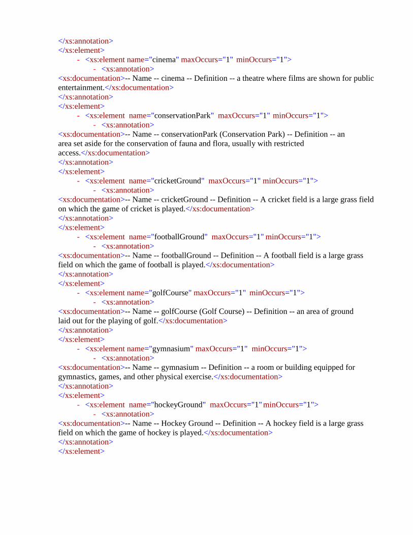
</xs:annotation>
</xs:element>
- <xs:element name="cinema" maxOccurs="1" minOccurs="1">
- <xs:annotation>
<xs:documentation>-- Name -- cinema -- Definition -- a theatre where films are shown for public
entertainment.</xs:documentation>
</xs:annotation>
</xs:element>
- <xs:element name="conservationPark" maxOccurs="1" minOccurs="1">
- <xs:annotation>
<xs:documentation>-- Name -- conservationPark (Conservation Park) -- Definition -- an
area set aside for the conservation of fauna and flora, usually with restricted
access.</xs:documentation>
</xs:annotation>
</xs:element>
- <xs:element name="cricketGround" maxOccurs="1" minOccurs="1">
- <xs:annotation>
<xs:documentation>-- Name -- cricketGround -- Definition -- A cricket field is a large grass field
on which the game of cricket is played.</xs:documentation>
</xs:annotation>
</xs:element>
- <xs:element name="footballGround" maxOccurs="1" minOccurs="1">
- <xs:annotation>
<xs:documentation>-- Name -- footballGround -- Definition -- A football field is a large grass
field on which the game of football is played.</xs:documentation>
</xs:annotation>
</xs:element>
- <xs:element name="golfCourse" maxOccurs="1" minOccurs="1">
- <xs:annotation>
<xs:documentation>-- Name -- golfCourse (Golf Course) -- Definition -- an area of ground
laid out for the playing of golf.</xs:documentation>
</xs:annotation>
</xs:element>
- <xs:element name="gymnasium" maxOccurs="1" minOccurs="1">
- <xs:annotation>
<xs:documentation>-- Name -- gymnasium -- Definition -- a room or building equipped for
gymnastics, games, and other physical exercise.</xs:documentation>
</xs:annotation>
</xs:element>
- <xs:element name="hockeyGround" maxOccurs="1" minOccurs="1">
- <xs:annotation>
<xs:documentation>-- Name -- Hockey Ground -- Definition -- A hockey field is a large grass
field on which the game of hockey is played.</xs:documentation>
</xs:annotation>
</xs:element>

- <xs:element name="joggingTrack" maxOccurs="1" minOccurs="1">
- <xs:annotation>
<xs:documentation>-- Name -- jogging track -- Definition -- a track reserved for
jogging</xs:documentation>
</xs:annotation>
</xs:element>
- <xs:element name="lookout" maxOccurs="1" minOccurs="1">
- <xs:annotation>
<xs:documentation>-- Name -- lookout -- Definition -- a viewing point on the side of a hill or
mountain, maintained to provide a view of the surrounding terrain</xs:documentation>
</xs:annotation>
</xs:element>
- <xs:element name="nationalPark" maxOccurs="1" minOccurs="1">
- <xs:annotation>
<xs:documentation>-- Name -- nationalPark (National Park) -- Definition -- a tract of land set
apart by a Federal, State or Territory authority to be preserved in its natural state for the benefit
of the public.
</xs:documentation>
</xs:annotation>
</xs:element>
- <xs:element name="other" maxOccurs="1" minOccurs="1">
- <xs:annotation>
<xs:documentation>-- Name -- other -- Definition -- represent such types which are not
included in the list</xs:documentation>
</xs:annotation>
</xs:element>
- <xs:element name="park" maxOccurs="1" minOccurs="1">
- <xs:annotation>
<xs:documentation>-- Name -- park -- Definition -- an area of land, either in its natural state or
improved, set aside for recreational use by the public.</xs:documentation>
</xs:annotation>
</xs:element>
- <xs:element name="picnicArea" maxOccurs="1" minOccurs="1">
- <xs:annotation>
<xs:documentation>-- Name -- picnicArea (Picnic Area) -- Definition -- a tract of ground
maintained with amenities suitable for people to bring food for outdoor
eating</xs:documentation>
</xs:annotation>
</xs:element>
- <xs:element name="playground" maxOccurs="1" minOccurs="1">
- <xs:annotation>
<xs:documentation>-- Name -- playground -- Definition -- an outdoor area provided for
children to play in, especially at a school or public park.</xs:documentation>
</xs:annotation>
</xs:element>
- <xs:element name="racecourse" maxOccurs="1" minOccurs="1">

- <xs:annotation>
<xs:documentation>-- Name -- racecourse -- Definition -- a place with a track which has been
licensed by government for the holding of horse races.</xs:documentation>
</xs:annotation>
</xs:element>
- <xs:element name="racetrack" maxOccurs="1" minOccurs="1">
- <xs:annotation>
<xs:documentation>-- Name -- racetrack -- Definition -- a circuit or course used for motor
racing.</xs:documentation>
</xs:annotation>
</xs:element>
- <xs:element name="sportCourt" maxOccurs="1" minOccurs="1">
- <xs:annotation>
<xs:documentation>-- Name -- sportCourt (Sport Court) -- Definition -- sports facility consisting
of constructed courts for tennis, netball etc.</xs:documentation>
</xs:annotation>
</xs:element>
- <xs:element name="stadium" maxOccurs="1" minOccurs="1">
- <xs:annotation>
<xs:documentation>-- Name -- stadium -- Definition -- an area for sports contests, enclosed by
grandstands and tiered seating.</xs:documentation>
</xs:annotation>
</xs:element>
- <xs:element name="swimmingPool" maxOccurs="1" minOccurs="1">
- <xs:annotation>
<xs:documentation>-- Name -- swimmingPool (Swimming Pool) -- Definition
-- an enclosed or artificial pool, for swimming in, for public use. ie. Not a domestic swimming
Pool. </xs:documentation>
</xs:annotation>
</xs:element>
- <xs:element name="touristAttraction" maxOccurs="1" minOccurs="1">
- <xs:annotation>
<xs:documentation>-- Name -- touristAttraction (Tourist Attraction) -- Definition -- land used for
non-residential premises designed to attract tourists, including but not limited to tourist
accommodation associated with any of the uses. Examples: artifacts display and sale, feature
building, fun park, hand weaving and sales, historic buildings and machinery, pioneer village,
plantation with tour facilities, pottery works and sales, rural industry display and sale, sanctuary
and animal park and ski slope.</xs:documentation>
</xs:annotation>
</xs:element>
- <xs:element name="velodrome" maxOccurs="1" minOccurs="1">
- <xs:annotation>
<xs:documentation>-- Name -- velodrome -- Definition -- an arena with a banked track,
usually oval in shape, constructed for cycle races.</xs:documentation>

</xs:annotation>
</xs:element>
- <xs:element name="zoo" maxOccurs="1" minOccurs="1">
- <xs:annotation>
<xs:documentation>-- Name -- zoo -- Definition -- an establishment which maintains a collection of
wild animals, typically in a park or gardens, for study, conservation, or display to the
public.</xs:documentation>
</xs:annotation>
</xs:element>
</xs:sequence>
</xs:complexType>
<xs:element type="ReligiousPlaces" name="ReligiousPlaces"/>
- <xs:complexType name="ReligiousPlaces">
- <xs:annotation>
<xs:documentation>-- Name -- ReligiousPlaces (Religious Places) -- Definition -- represents
possible values of religious places</xs:documentation>
</xs:annotation>
- <xs:sequence>
- <xs:element name="buddhist_Kyaung" maxOccurs="1" minOccurs="1">
- <xs:annotation>
<xs:documentation>-- Name -- buddhist_Kyaung -- Definition -- a buddhist place of
worship.</xs:documentation>
</xs:annotation>
</xs:element>
- <xs:element name="chhatri" maxOccurs="1" minOccurs="1">
- <xs:annotation>
<xs:documentation>-- Name -- chhatri -- Definition -- chhatris are elevated, dome-shaped pavilions
used as an element in Pakistani architecture. They are widely used, in palaces, in forts, or to demarcate
funerary sites.</xs:documentation>
</xs:annotation>
</xs:element>
- <xs:element name="church" maxOccurs="1" minOccurs="1">
- <xs:annotation>
<xs:documentation>-- Name -- church -- Definition -- a building for Christian public
worship</xs:documentation>
</xs:annotation>
</xs:element>
- <xs:element name="grave" maxOccurs="1" minOccurs="1">
- <xs:annotation>
<xs:documentation>-- Name -- grave -- Definition -- a place of burial for a dead body, typically a
hole dug in the ground and marked by a stone or mound.</xs:documentation>
</xs:annotation>
</xs:element>
- <xs:element name="graveyard" maxOccurs="1" minOccurs="1">
- <xs:annotation>
<xs:documentation>-- Name -- graveyard -- Definition -- a large burial ground</xs:documentation>

</xs:annotation>
</xs:element>
- <xs:element name="idgah" maxOccurs="1" minOccurs="1">
- <xs:annotation>
<xs:documentation>-- Name -- idgah -- Definition -- Eidgah or Idgah is the term used in south
Asian Islamic culture for the open-air gathering place usually outside the city (or at the outskirts)
to perform the Salat al Eid (Eid prayers) for Eid ul-Fitr and Eid al-Adha. It is usually a public
place that isn't used as a mosque at other times of the year.</xs:documentation>
</xs:annotation>
</xs:element>
- <xs:element name="janazaGah" maxOccurs="1" minOccurs="1">
- <xs:annotation>
<xs:documentation>-- Name -- janazaGah -- Definition -- an open or in a place built for The
Funeral Prayer</xs:documentation>
</xs:annotation>
</xs:element>
- <xs:element name="masjid" maxOccurs="1" minOccurs="1">
- <xs:annotation>
<xs:documentation>-- Name -- masjid -- Definition -- a Muslim place of
worship.</xs:documentation>
</xs:annotation>
</xs:element>
- <xs:element name="other" maxOccurs="1" minOccurs="1">
- <xs:annotation>
<xs:documentation>-- Name -- other -- Definition -- represent such types which are not
included in the list</xs:documentation>
</xs:annotation>
</xs:element>
- <xs:element name="pagoda" maxOccurs="1" minOccurs="1">
- <xs:annotation>
<xs:documentation>-- Name -- pagoda -- Definition -- a Hindu or Buddhist temple, typically in the
form of a many-tiered tower.</xs:documentation>
</xs:annotation>
</xs:element>
- <xs:element name="shrine" maxOccurs="1" minOccurs="1">
- <xs:annotation>
<xs:documentation>-- Name -- shrine -- Definition -- a place regarded as holy because of its
associations with a divinity or a sacred person or relic, marked by a building or other
construction.</xs:documentation>
</xs:annotation>
</xs:element>
- <xs:element name="temple" maxOccurs="1" minOccurs="1">
- <xs:annotation>
<xs:documentation>-- Name -- temple -- Definition -- a building used for worship in some
religions (e.g. Christianity)</xs:documentation>
</xs:annotation>
</xs:element>
- <xs:element name="tomb" maxOccurs="1" minOccurs="1">

- <xs:annotation>
<xs:documentation>-- Name -- tomb -- Definition -- a monument to the memory of a dead
person, erected over their burial place.</xs:documentation>
</xs:annotation>
</xs:element>
</xs:sequence>
</xs:complexType>
<xs:element type="Reservoir" name="Reservoir"/>
- <xs:complexType name="Reservoir">
- <xs:annotation>
<xs:documentation>-- Name -- Reservoir -- Definition -- represents possible value of the reservoir
features</xs:documentation>
</xs:annotation>
- <xs:sequence>
- <xs:element name="barrage" maxOccurs="1" minOccurs="1">
- <xs:annotation>
<xs:documentation>-- Name -- barrage -- Definition -- a structure built to constrain the limit of tidal
influence in a river or estuary, or to retain water for irrigation purposes.</xs:documentation>
</xs:annotation>
</xs:element>
- <xs:element name="dam" maxOccurs="1" minOccurs="1">
- <xs:annotation>
<xs:documentation>-- Name -- dam -- Definition -- a wall or barrier constructed of earth, masonry
etc., to impound water.</xs:documentation>
</xs:annotation>
</xs:element>
- <xs:element name="excavatedTank_Intermittent" maxOccurs="1" minOccurs="1">
- <xs:annotation>
<xs:documentation>-- Name -- excavatedTank_Intermittent -- Definition -- it represents non perennial
excavated tank</xs:documentation>
</xs:annotation>
</xs:element>
- <xs:element name="excavatedTank_Perennial" maxOccurs="1" minOccurs="1">
- <xs:annotation>
<xs:documentation>-- Name -- excavatedTank_Perennial -- Definition -- it represents perennial
excavated tank </xs:documentation>
</xs:annotation>
</xs:element>
- <xs:element name="excavatedTankPerennialBankH" maxOccurs="1"
minOccurs="1">
- <xs:annotation>
<xs:documentation>-- Name -- excavatedTankPerennialBankH -- Definition -- it represents excavated
perennial tank having high bank</xs:documentation>
</xs:annotation>
</xs:element>
- <xs:element name="fishFarm" maxOccurs="1" minOccurs="1">

- <xs:annotation>
<xs:documentation>-- Name -- fish Farm -- Definition -- it represents fish
farm</xs:documentation>
</xs:annotation>
</xs:element>
- <xs:element name="levee" maxOccurs="1" minOccurs="1">
- <xs:annotation>
<xs:documentation>-- Name -- levee -- Definition -- an embankment built to confine a stream
to its bed.</xs:documentation>
</xs:annotation>
</xs:element>
- <xs:element name="ocean" maxOccurs="1" minOccurs="1">
- <xs:annotation>
<xs:documentation>-- Name -- ocean -- Definition -- a very large expanse of sea, in particular
each of the main areas into which the sea is divided geographically.</xs:documentation>
</xs:annotation>
</xs:element>
- <xs:element name="other" maxOccurs="1" minOccurs="1">
- <xs:annotation>
<xs:documentation>-- Name -- other -- Definition -- represent such types which are not
included in the list</xs:documentation>
</xs:annotation>
</xs:element>
- <xs:element name="pond_Intermittent" maxOccurs="1" minOccurs="1">
- <xs:annotation>
<xs:documentation>-- Name -- pond_Intermittent (Pond Intermittent) -- Definition -- a
small body of still non perennial water in a natural hollow.</xs:documentation>
</xs:annotation>
</xs:element>
- <xs:element name="pondPerennial" maxOccurs="1" minOccurs="1">
- <xs:annotation>
<xs:documentation>-- Name -- pondPerennial (Pond Perennial) -- Definition -- A small body of
still perennial water in a natural hollow.</xs:documentation>
</xs:annotation>
</xs:element>
- <xs:element name="swimingPool" maxOccurs="1" minOccurs="1">
- <xs:annotation>
<xs:documentation>-- Name -- swimingPool (Swiming Pool) -- Definition -- an artificial pool for
swimming in.</xs:documentation>
</xs:annotation>
</xs:element>
- <xs:element name="tank_Intermittent" maxOccurs="1" minOccurs="1">
- <xs:annotation>
<xs:documentation>-- Name -- tank_Intermittent (Tank Intermittent) -- Definition -- a tank for
holding non perennial water.</xs:documentation>
</xs:annotation>

</xs:element>
- <xs:element name="tankPerennial" maxOccurs="1" minOccurs="1">
- <xs:annotation>
<xs:documentation>-- Name -- tankPerennial (Tank Perennial) -- Definition -- a tank for holding
perennial water.</xs:documentation>
</xs:annotation>
</xs:element>
- <xs:element name="weir" maxOccurs="1" minOccurs="1">
- <xs:annotation>
<xs:documentation>-- Name -- weir -- Definition -- a barrier erected across a stream to impound and
raise the water level for the purpose of maintaining it at the level required for irrigation or navigation
purposes.</xs:documentation>
</xs:annotation>
</xs:element>
</xs:sequence>
</xs:complexType>
<xs:element type="Residence" name="Residence"/>
- <xs:complexType name="Residence">
- <xs:annotation>
<xs:documentation>-- Name -- Residence -- Definition -- A residential area is a land used in which
housing predominates, as opposed to industrial and commercial areas.</xs:documentation>
</xs:annotation>
- <xs:sequence>
- <xs:element name="apartment" maxOccurs="1" minOccurs="1">
- <xs:annotation>
<xs:documentation>-- Name -- apartment -- Definition -- a flat, typically one that is well appointed
or used for holidays.</xs:documentation>
</xs:annotation>
</xs:element>
- <xs:element name="bambooHouse" maxOccurs="1" minOccurs="1">
- <xs:annotation>
<xs:documentation>-- Name -- BambooHouse -- Definition -- a house made of
wood</xs:documentation>
</xs:annotation>
</xs:element>
- <xs:element name="bungalow" maxOccurs="1" minOccurs="1">
- <xs:annotation>
<xs:documentation>-- Name -- bungalow -- Definition -- bungalow is a large home used as a solitary
family unit.</xs:documentation>
</xs:annotation>
</xs:element>
- <xs:element name="cabin" maxOccurs="1" minOccurs="1">
- <xs:annotation>
<xs:documentation>-- Name -- cabin -- Definition -- a small wooden shelter or house in a wild or
remote area</xs:documentation>
</xs:annotation>
</xs:element>

- <xs:element name="circuitHouse" maxOccurs="1" minOccurs="1">
- <xs:annotation>
<xs:documentation>-- Name -- Circuit house -- Definition -- represent a circuit
hous</xs:documentation>
</xs:annotation>
</xs:element>
- <xs:element name="colony" maxOccurs="1" minOccurs="1">
- <xs:annotation>
<xs:documentation>-- Name -- colony -- Definition -- represents residential
colony</xs:documentation>
</xs:annotation>
</xs:element>
- <xs:element name="dakBungalow" maxOccurs="1" minOccurs="1">
- <xs:annotation>
<xs:documentation>-- Name -- Dak Bungalow -- Definition -- Dak Bungalow was a government
building in British India under Company Rule and the Raj. The buildings provided free
accommodation for government officials and, upon their permission, "incomparably cheap"
lodging for other travelers The structures are therefore sometimes also known as prostheses,
restless, or travelers bungalows. </xs:documentation>
</xs:annotation>
</xs:element>
- <xs:element name="desertedHut" maxOccurs="1" minOccurs="1">
- <xs:annotation>
<xs:documentation>-- Name -- desertedHut (Deserted Hut) -- Definition -- an abandoned
hut</xs:documentation>
</xs:annotation>
</xs:element>
- <xs:element name="diplomaticEnclave" maxOccurs="1" minOccurs="1">
- <xs:annotation>
<xs:documentation>-- Name -- Diplomatic Enclave -- Definition -- is a secure zone in
Islamabad, Pakistan which contains diplomatic missions.</xs:documentation>
</xs:annotation>
</xs:element>
- <xs:element name="flat" maxOccurs="1" minOccurs="1">
- <xs:annotation>
<xs:documentation>-- Name -- flat -- Definition -- flat is a self-contained housing unit that
occupies only part of a building, generally on a single story</xs:documentation>
</xs:annotation>
</xs:element>
- <xs:element name="greenBelt" maxOccurs="1" minOccurs="1">
- <xs:annotation>
<xs:documentation>-- Name -- Green Belt -- Definition -- A green belt is a land-use zone
designation used in land-use planning to retain areas of largely undeveloped, wild, or agricultural
land surrounding or neighboring urban areas.</xs:documentation>
</xs:annotation>

</xs:element>
- <xs:element name="guardHouse" maxOccurs="1" minOccurs="1">
- <xs:annotation>
<xs:documentation>-- Name -- guardHouse (Guard House) -- Definition -- a building
accommodating a guard who controls entrance to the grounds of a house, housing development,
school, or other facility.</xs:documentation>
</xs:annotation>
</xs:element>
- <xs:element name="hostel" maxOccurs="1" minOccurs="1">
- <xs:annotation>
<xs:documentation>-- Name -- hostel -- Definition -- an establishment which provides
inexpensive food and lodging for a specific group of people, such as students, workers, or
travellers</xs:documentation>
</xs:annotation>
</xs:element>
- <xs:element name="house" maxOccurs="1" minOccurs="1">
- <xs:annotation>
<xs:documentation>-- Name -- house -- Definition -- a building for human habitation,
especially one that consists of a ground floor and one or more upper
storeys.</xs:documentation>
</xs:annotation>
</xs:element>
- <xs:element name="hutTemporary" maxOccurs="1" minOccurs="1">
- <xs:annotation>
<xs:documentation>-- Name -- hutTemporary (Hut Temporary) -- Definition -- A hut is a
primitive dwelling, which may be constructed of various local materials. Temporary hut is only
used for temporary accommodation, usually located in wilderness areas,</xs:documentation>
</xs:annotation>
</xs:element>
- <xs:element name="infrastructure" maxOccurs="1" minOccurs="1">
- <xs:annotation>
<xs:documentation>-- Name -- infrastructure -- Definition -- infrastructure.
Public services and facilities like sewage-disposal systems, water-supply systems, other utility
systems</xs:documentation>
</xs:annotation>
</xs:element>
- <xs:element name="inspectionBungalow" maxOccurs="1" minOccurs="1">
- <xs:annotation>
<xs:documentation>-- Name -- Inspection bungalow -- Definition -- represent an Inspection
bungalow</xs:documentation>
</xs:annotation>
</xs:element>
- <xs:element name="kutchaHouse" maxOccurs="1" minOccurs="1">
- <xs:annotation>
<xs:documentation>-- Name -- Kutcha House -- Definition -- a house prepared of wood, straw,
mud and dried out leaves. A hut is a kutcha house.</xs:documentation>
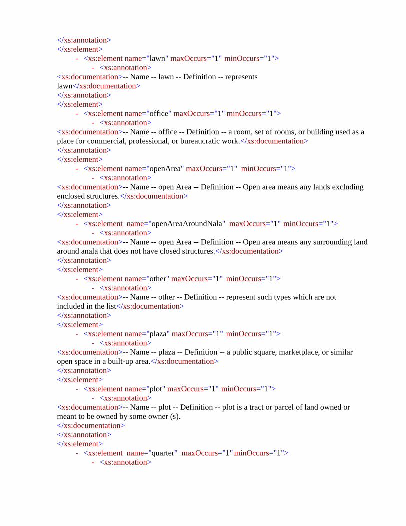
</xs:annotation>
</xs:element>
- <xs:element name="lawn" maxOccurs="1" minOccurs="1">
- <xs:annotation>
<xs:documentation>-- Name -- lawn -- Definition -- represents
lawn</xs:documentation>
</xs:annotation>
</xs:element>
- <xs:element name="office" maxOccurs="1" minOccurs="1">
- <xs:annotation>
<xs:documentation>-- Name -- office -- Definition -- a room, set of rooms, or building used as a
place for commercial, professional, or bureaucratic work.</xs:documentation>
</xs:annotation>
</xs:element>
- <xs:element name="openArea" maxOccurs="1" minOccurs="1">
- <xs:annotation>
<xs:documentation>-- Name -- open Area -- Definition -- Open area means any lands excluding
enclosed structures.</xs:documentation>
</xs:annotation>
</xs:element>
- <xs:element name="openAreaAroundNala" maxOccurs="1" minOccurs="1">
- <xs:annotation>
<xs:documentation>-- Name -- open Area -- Definition -- Open area means any surrounding land
around anala that does not have closed structures.</xs:documentation>
</xs:annotation>
</xs:element>
- <xs:element name="other" maxOccurs="1" minOccurs="1">
- <xs:annotation>
<xs:documentation>-- Name -- other -- Definition -- represent such types which are not
included in the list</xs:documentation>
</xs:annotation>
</xs:element>
- <xs:element name="plaza" maxOccurs="1" minOccurs="1">
- <xs:annotation>
<xs:documentation>-- Name -- plaza -- Definition -- a public square, marketplace, or similar
open space in a built-up area.</xs:documentation>
</xs:annotation>
</xs:element>
- <xs:element name="plot" maxOccurs="1" minOccurs="1">
- <xs:annotation>
<xs:documentation>-- Name -- plot -- Definition -- plot is a tract or parcel of land owned or
meant to be owned by some owner (s).
</xs:documentation>
</xs:annotation>
</xs:element>
- <xs:element name="quarter" maxOccurs="1" minOccurs="1">
- <xs:annotation>

<xs:documentation>-- Name -- quarter -- Definition -- A place for people to live, especially if
they're in the military, can be called quarters</xs:documentation>
</xs:annotation>
</xs:element>
- <xs:element name="restHouse" maxOccurs="1" minOccurs="1">
- <xs:annotation>
<xs:documentation>-- Name -- Rest House -- Definition -- a building used for shelter by travelers
(especially in areas where there are no hotels).</xs:documentation>
</xs:annotation>
</xs:element>
- <xs:element name="scatteredHuts" maxOccurs="1" minOccurs="1">
- <xs:annotation>
<xs:documentation>-- Name -- scatteredHuts (Scattered Huts) -- Definition -- huts scattered around
the area</xs:documentation>
</xs:annotation>
</xs:element>
- <xs:element name="shelter" maxOccurs="1" minOccurs="1">
- <xs:annotation>
<xs:documentation>-- Name -- shelter -- Definition -- a shelter is a basic architectural structure or
building that provides protection from the local environment.</xs:documentation>
</xs:annotation>
</xs:element>
- <xs:element name="travelerBungalow" maxOccurs="1" minOccurs="1">
- <xs:annotation>
<xs:documentation>-- Name -- Traveler’s bungalow -- Definition -- represent a Traveler’s
bungalow</xs:documentation>
</xs:annotation>
</xs:element>
</xs:sequence>
</xs:complexType>
<xs:element type="RiversCanalLakes" name="RiversCanalLakes"/>
- <xs:complexType name="RiversCanalLakes">
- <xs:annotation>
<xs:documentation>-- Name -- RiversCanalLakes (Rivers, Canal and Lakes) -- Definition --
represents possible values of rivers, canals and lakes</xs:documentation>
</xs:annotation>
- <xs:sequence>
- <xs:element name="canal_Intermittent" maxOccurs="1" minOccurs="1">
- <xs:annotation>
<xs:documentation>-- Name -- canal_Intermittent (Canal Intermittent) -- Definition -- Non-
perennial canals, which only run in monsoon and summer, they get their water from the rains,
e.g. Sutlej canal.</xs:documentation>
</xs:annotation>
</xs:element>

- <xs:element name="canalDisused" maxOccurs="1" minOccurs="1">
- <xs:annotation>
<xs:documentation>-- Name -- canalDisused (Canal Disused) -- Definition -- canal which is
not in use.</xs:documentation>
</xs:annotation>
</xs:element>
- <xs:element name="canalPerennial" maxOccurs="1" minOccurs="1">
- <xs:annotation>
<xs:documentation>-- Name -- canalPerennial (Canal Perennial) -- Definition -
- canal that ensure regular supply of water all the year around, e.g. chenab
canal</xs:documentation>
</xs:annotation>
</xs:element>
- <xs:element name="creek" maxOccurs="1" minOccurs="1">
- <xs:annotation>
<xs:documentation>-- Name -- creek -- Definition -- a natural watercourse, greater than a gully
but of lesser size and length relative to a river and ultimately flowing into another creek or a
river.</xs:documentation>
</xs:annotation>
</xs:element>
- <xs:element name="drainIntermittent" maxOccurs="1" minOccurs="1">
- <xs:annotation>
<xs:documentation>-- Name -- drainIntermittent (Drain Intermittent) -- Definition -- an
intermittent channel constructed so that water is drained or gradually carried away.
</xs:documentation>
</xs:annotation>
</xs:element>
- <xs:element name="drainPerennial" maxOccurs="1" minOccurs="1">
- <xs:annotation>
<xs:documentation>-- Name -- drainPerennial (Drain Perennial) -- Definition -- a perennial
channel constructed so that water is drained or gradually carried away.</xs:documentation>
</xs:annotation>
</xs:element>
- <xs:element name="lagoon" maxOccurs="1" minOccurs="1">
- <xs:annotation>
<xs:documentation>-- Name -- lagoon -- Definition -- a small body of open fresh water,
smaller than a lake, possibly appearing only seasonally.
</xs:documentation>
</xs:annotation>
</xs:element>
- <xs:element name="lakeIntermittent" maxOccurs="1" minOccurs="1">
- <xs:annotation>
<xs:documentation>-- Name -- lakeIntermittent (Lake Intermittent) -- Definition -- some lakes
can disappear seasonally. These are called intermittent lakes, ephemeral lakes, or seasonal
lakes</xs:documentation>
</xs:annotation>
</xs:element>
- <xs:element name="lakePerennial" maxOccurs="1" minOccurs="1">

- <xs:annotation>
<xs:documentation>-- Name -- lakePerennial (Lake Perennial) -- Definition -- a lake that retains water
in its basin throughout the year and is not usually subject to extreme water-level
fluctuations.</xs:documentation>
</xs:annotation>
</xs:element>
- <xs:element name="other" maxOccurs="1" minOccurs="1">
- <xs:annotation>
<xs:documentation>-- Name -- other -- Definition -- represent such types which are not included
in the list</xs:documentation>
</xs:annotation>
</xs:element>
- <xs:element name="river" maxOccurs="1" minOccurs="1">
- <xs:annotation>
<xs:documentation>-- Name -- river -- Definition -- a major natural stream, usually perennial, in a
large catchment basin, which carries water to another river, a lake or the sea.</xs:documentation>
</xs:annotation>
</xs:element>
- <xs:element name="riverBank" maxOccurs="1" minOccurs="1">
- <xs:annotation>
<xs:documentation>-- Name -- riverBank (River Bank) -- Definition -- an area of low-lying ground
adjacent to a river, formed mainly of river sediments and subject to flooding.</xs:documentation>
</xs:annotation>
</xs:element>
- <xs:element name="riverFilling" maxOccurs="1" minOccurs="1">
- <xs:annotation>
<xs:documentation>-- Name -- riverFilling (River Filling) -- Definition -- river filing is sediments
deposited in bottom.</xs:documentation>
</xs:annotation>
</xs:element>
- <xs:element name="submergedRocks" maxOccurs="1" minOccurs="1">
- <xs:annotation>
<xs:documentation>-- Name -- submergedRocks (Submerged Rocks) -- Definition -- submerged
rocks in the river or lake bed.</xs:documentation>
</xs:annotation>
</xs:element>
- <xs:element name="submergedSand" maxOccurs="1" minOccurs="1">
- <xs:annotation>
<xs:documentation>-- Name -- submergedSand (Submerged Sand) -- Definition -- submerged sand
in the river bed.</xs:documentation>
</xs:annotation>
</xs:element>
</xs:sequence>
</xs:complexType>
<xs:element type="Strategic" name="Strategic"/>
- <xs:complexType name="Strategic">

- <xs:annotation>
<xs:documentation>-- Name -- Strategic -- Definition -- represents possible values the
strategic objects</xs:documentation>
</xs:annotation>
- <xs:sequence>
- <xs:element name="aerodrome" maxOccurs="1" minOccurs="1">
- <xs:annotation>
<xs:documentation>-- Name -- aerodrome -- Definition -- any licensed airfield or government
airfield other than those designated airports.</xs:documentation>
</xs:annotation>
</xs:element>
- <xs:element name="airport" maxOccurs="1" minOccurs="1">
- <xs:annotation>
<xs:documentation>-- Name -- airport -- Definition -- a defined area of land or water used for
landing, take-off and movement of aircraft including associated buildings and
facilities</xs:documentation>
</xs:annotation>
</xs:element>
- <xs:element name="arsenal" maxOccurs="1" minOccurs="1">
- <xs:annotation>
<xs:documentation>-- Name -- arsenal -- Definition -- a repository for military arms and
stores.</xs:documentation>
</xs:annotation>
</xs:element>
- <xs:element name="barracks" maxOccurs="1" minOccurs="1">
- <xs:annotation>
<xs:documentation>-- Name -- barracks -- Definition -- a military building for housing armed
services personnel.</xs:documentation>
</xs:annotation>
</xs:element>
- <xs:element name="bombingRange" maxOccurs="1" minOccurs="1">
- <xs:annotation>
<xs:documentation>-- Name -- bombingRange (Bombing Range) -- Definition
-- a tract of land set aside for military bombing
practice.</xs:documentation>
</xs:annotation>
</xs:element>
- <xs:element name="campingGround" maxOccurs="1" minOccurs="1">
- <xs:annotation>
<xs:documentation>-- Name -- camping ground -- Definition -- it represents camping
ground</xs:documentation>
</xs:annotation>
</xs:element>
- <xs:element name="defenceEstablishment" maxOccurs="1" minOccurs="1">
- <xs:annotation>
<xs:documentation>-- Name -- defenceEstablishment (Defence Establishment)
-- Definition -- a facility constructed and established by the Defence
Force.</xs:documentation>
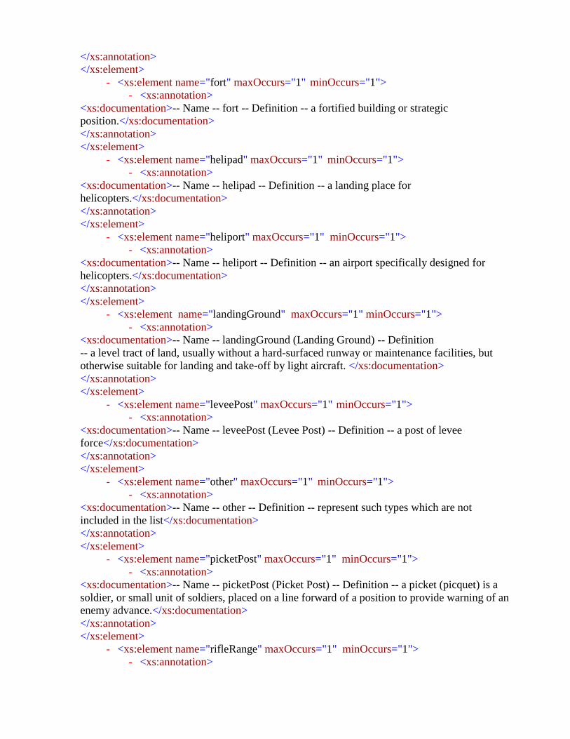
</xs:annotation>
</xs:element>
- <xs:element name="fort" maxOccurs="1" minOccurs="1">
- <xs:annotation>
<xs:documentation>-- Name -- fort -- Definition -- a fortified building or strategic
position.</xs:documentation>
</xs:annotation>
</xs:element>
- <xs:element name="helipad" maxOccurs="1" minOccurs="1">
- <xs:annotation>
<xs:documentation>-- Name -- helipad -- Definition -- a landing place for
helicopters.</xs:documentation>
</xs:annotation>
</xs:element>
- <xs:element name="heliport" maxOccurs="1" minOccurs="1">
- <xs:annotation>
<xs:documentation>-- Name -- heliport -- Definition -- an airport specifically designed for
helicopters.</xs:documentation>
</xs:annotation>
</xs:element>
- <xs:element name="landingGround" maxOccurs="1" minOccurs="1">
- <xs:annotation>
<xs:documentation>-- Name -- landingGround (Landing Ground) -- Definition
-- a level tract of land, usually without a hard-surfaced runway or maintenance facilities, but
otherwise suitable for landing and take-off by light aircraft. </xs:documentation>
</xs:annotation>
</xs:element>
- <xs:element name="leveePost" maxOccurs="1" minOccurs="1">
- <xs:annotation>
<xs:documentation>-- Name -- leveePost (Levee Post) -- Definition -- a post of levee
force</xs:documentation>
</xs:annotation>
</xs:element>
- <xs:element name="other" maxOccurs="1" minOccurs="1">
- <xs:annotation>
<xs:documentation>-- Name -- other -- Definition -- represent such types which are not
included in the list</xs:documentation>
</xs:annotation>
</xs:element>
- <xs:element name="picketPost" maxOccurs="1" minOccurs="1">
- <xs:annotation>
<xs:documentation>-- Name -- picketPost (Picket Post) -- Definition -- a picket (picquet) is a
soldier, or small unit of soldiers, placed on a line forward of a position to provide warning of an
enemy advance.</xs:documentation>
</xs:annotation>
</xs:element>
- <xs:element name="rifleRange" maxOccurs="1" minOccurs="1">
- <xs:annotation>

<xs:documentation>-- Name -- rifleRange (Rifle Range) -- Definition -- an area designated for target
practice with rifles.</xs:documentation>
</xs:annotation>
</xs:element>
- <xs:element name="rocketRange" maxOccurs="1" minOccurs="1">
- <xs:annotation>
<xs:documentation>-- Name -- rocketRange (Rocket Range) -- Definition -- an area designated for the
launching of rockets. </xs:documentation>
</xs:annotation>
</xs:element>
- <xs:element name="watchtower" maxOccurs="1" minOccurs="1">
- <xs:annotation>
<xs:documentation>-- Name -- watchtower -- Definition -- a tower built to create an elevated
observation point.</xs:documentation>
</xs:annotation>
</xs:element>
</xs:sequence>
</xs:complexType>
<xs:element type="Stream" name="Stream"/>
- <xs:complexType name="Stream">
- <xs:annotation>
<xs:documentation>-- Name -- Stream -- Definition -- represents the possible value of the stream
feature class</xs:documentation>
</xs:annotation>
- <xs:sequence>
- <xs:element name="drainIntermittent" maxOccurs="1" minOccurs="1">
- <xs:annotation>
<xs:documentation>-- Name -- drainIntermittent (Drain Non Perennial) -- Definition -- an intermittent
channel constructed so that water is drained or gradually carried away. </xs:documentation>
</xs:annotation>
</xs:element>
- <xs:element name="drainPerennial" maxOccurs="1" minOccurs="1">
- <xs:annotation>
<xs:documentation>-- Name -- drainPerennial (Drain Perennial) -- Definition -- a perennial channel
constructed so that water is drained or gradually carried away.</xs:documentation>
</xs:annotation>
</xs:element>
- <xs:element name="dryNala" maxOccurs="1" minOccurs="1">
- <xs:annotation>
<xs:documentation>-- Name -- dryNala (Dry Nala) -- Definition -- a rain water fed intermittent
watercourse</xs:documentation>
</xs:annotation>
</xs:element>
- <xs:element name="karez" maxOccurs="1" minOccurs="1">
- <xs:annotation>
<xs:documentation>-- Name -- karez -- Definition -- an indigenous method of irrigation in which
groundwater is tapped by a tunnel. After running for

some distance the tunnel comes out in the open and the water is conducted to the command
area.</xs:documentation>
</xs:annotation>
</xs:element>
- <xs:element name="karezDisused" maxOccurs="1" minOccurs="1">
- <xs:annotation>
<xs:documentation>-- Name -- karezDisused (Karez Disused) -- Definition -- karez which is
not in use.</xs:documentation>
</xs:annotation>
</xs:element>
- <xs:element name="nalaPerennial" maxOccurs="1" minOccurs="1">
- <xs:annotation>
<xs:documentation>-- Name -- nalaPerennial (Nala Perennial) -- Definition -- represents
perennial watercourse</xs:documentation>
</xs:annotation>
</xs:element>
- <xs:element name="other" maxOccurs="1" minOccurs="1">
- <xs:annotation>
<xs:documentation>-- Name -- other -- Definition -- represent such types which are not
included in the list</xs:documentation>
</xs:annotation>
</xs:element>
- <xs:element name="streamApproximated" maxOccurs="1" minOccurs="1">
- <xs:annotation>
<xs:documentation>-- Name -- Stream Approximated -- Definition -- it represents a stream
which is approximately surveyed</xs:documentation>
</xs:annotation>
</xs:element>
- <xs:element name="streamIntermittent" maxOccurs="1" minOccurs="1">
- <xs:annotation>
<xs:documentation>-- Name -- streamIntermittent (Stream Non Perennial) -- Definition -- a
body of non perennial water flowing in a channel or bed.
</xs:documentation>
</xs:annotation>
</xs:element>
- <xs:element name="streamPerennial" maxOccurs="1" minOccurs="1">
- <xs:annotation>
<xs:documentation>-- Name -- streamPerennial (Stream Perennial) -- Definition -- a body
of perennial water flowing in a channel or bed.
</xs:documentation>
</xs:annotation>
</xs:element>
- <xs:element name="waterChannel" maxOccurs="1" minOccurs="1">
- <xs:annotation>
<xs:documentation>-- Name -- waterChannel (Water Channel) -- Definition -- an artificial
watercourse used for drainage or irrigation purposes.</xs:documentation>
</xs:annotation>
</xs:element>

- <xs:element name="waterfall_Intermittent" maxOccurs="1" minOccurs="1">
- <xs:annotation>
<xs:documentation>-- Name -- waterfall_Intermittent (Waterfall Non Perennial) -- Definition -- a
sudden steep descent of non perennial water over a natural step in the bed of a stream.
</xs:documentation>
</xs:annotation>
</xs:element>
- <xs:element name="waterfall_Perennial" maxOccurs="1" minOccurs="1">
- <xs:annotation>
<xs:documentation>-- Name -- waterfall_Perennial (Waterfall Perennial) -- Definition -- a sudden
steep descent of perennial water over a natural step in the bed of a stream. </xs:documentation>
</xs:annotation>
</xs:element>
</xs:sequence>
</xs:complexType>
<xs:element type="TreeCover" name="TreeCover"/>
- <xs:complexType name="TreeCover">
- <xs:annotation>
<xs:documentation>-- Name -- TreeCover (Trees Cover) -- Definition -- represents the possible values
of tree cover features.</xs:documentation>
</xs:annotation>
- <xs:sequence>
- <xs:element name="bamboo" maxOccurs="1" minOccurs="1">
- <xs:annotation>
<xs:documentation>-- Name -- bamboo -- Definition -- A tract of country, which bears a dense growth
of bamboo</xs:documentation>
</xs:annotation>
</xs:element>
- <xs:element name="betelNut" maxOccurs="1" minOccurs="1">
- <xs:annotation>
<xs:documentation>-- Name -- betelNut (Betel Nut) -- Definition -- A tract of country, which bears a
dense growth of betel nut.</xs:documentation>
</xs:annotation>
</xs:element>
- <xs:element name="canebrake" maxOccurs="1" minOccurs="1">
- <xs:annotation>
<xs:documentation>-- Name -- canebrake -- Definition -- A tract of country, which bears a dense
growth of canebrake</xs:documentation>
</xs:annotation>
</xs:element>
- <xs:element name="forest" maxOccurs="1" minOccurs="1">
- <xs:annotation>
<xs:documentation>-- Name -- forest -- Definition -- Uncultivated tree-covered land of considerable
extent.</xs:documentation>
</xs:annotation>
</xs:element>
- <xs:element name="nationalForest" maxOccurs="1" minOccurs="1">
- <xs:annotation>
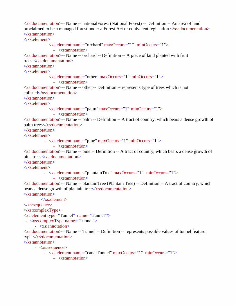
<xs:documentation>-- Name -- nationalForest (National Forest) -- Definition -- An area of land
proclaimed to be a managed forest under a Forest Act or equivalent legislation.</xs:documentation>
</xs:annotation>
</xs:element>
- <xs:element name="orchard" maxOccurs="1" minOccurs="1">
- <xs:annotation>
<xs:documentation>-- Name -- orchard -- Definition -- A piece of land planted with fruit
trees.</xs:documentation>
</xs:annotation>
</xs:element>
- <xs:element name="other" maxOccurs="1" minOccurs="1">
- <xs:annotation>
<xs:documentation>-- Name -- other -- Definition -- represents type of trees which is not
enlisted</xs:documentation>
</xs:annotation>
</xs:element>
- <xs:element name="palm" maxOccurs="1" minOccurs="1">
- <xs:annotation>
<xs:documentation>-- Name -- palm -- Definition -- A tract of country, which bears a dense growth of
palm trees</xs:documentation>
</xs:annotation>
</xs:element>
- <xs:element name="pine" maxOccurs="1" minOccurs="1">
- <xs:annotation>
<xs:documentation>-- Name -- pine -- Definition -- A tract of country, which bears a dense growth of
pine trees</xs:documentation>
</xs:annotation>
</xs:element>
- <xs:element name="plantainTree" maxOccurs="1" minOccurs="1">
- <xs:annotation>
<xs:documentation>-- Name -- plantainTree (Plantain Tree) -- Definition -- A tract of country, which
bears a dense growth of plantain tree</xs:documentation>
</xs:annotation>
</xs:element>
</xs:sequence>
</xs:complexType>
<xs:element type="Tunnel" name="Tunnel"/>
- <xs:complexType name="Tunnel">
- <xs:annotation>
<xs:documentation>-- Name -- Tunnel -- Definition -- represents possible values of tunnel feature
type.</xs:documentation>
</xs:annotation>
- <xs:sequence>
- <xs:element name="canalTunnel" maxOccurs="1" minOccurs="1">
- <xs:annotation>

<xs:documentation>-- Name -- canalTunnel (Canal Tunnel) -- Definition -- a waterway used to divert
water from its natural course.</xs:documentation>
</xs:annotation>
</xs:element>
- <xs:element name="mineTunnel" maxOccurs="1" minOccurs="1">
- <xs:annotation>
<xs:documentation>-- Name -- mineTunnel (Mine Tunnel) -- Definition -- a passage or opening to
mine for the purpose of excavation of the valuable geological materials, it may be open to the surface
at one end and used for drainage, ventilation, or haulage from the mine workings.</xs:documentation>
</xs:annotation>
</xs:element>
- <xs:element name="other" maxOccurs="1" minOccurs="1">
- <xs:annotation>
<xs:documentation>-- Name -- other -- Definition -- represent such types which are not included
in the list</xs:documentation>
</xs:annotation>
</xs:element>
- <xs:element name="railwayTunnel" maxOccurs="1" minOccurs="1">
- <xs:annotation>
<xs:documentation>-- Name -- railwayTunnel (Railway Tunnel) -- Definition -- an underground
passage for rail traffic.</xs:documentation>
</xs:annotation>
</xs:element>
- <xs:element name="roadTunnel" maxOccurs="1" minOccurs="1">
- <xs:annotation>
<xs:documentation>-- Name -- roadTunnel (Road Tunnel) -- Definition -- an underground passage for
vehicular road traffic</xs:documentation>
</xs:annotation>
</xs:element>
</xs:sequence>
</xs:complexType>
<xs:element type="Wetland" name="Wetland"/>
- <xs:complexType name="Wetland">
- <xs:annotation>
<xs:documentation>-- Name -- Wetland -- Definition -- represents the possible values of the wetland
features</xs:documentation>
</xs:annotation>
- <xs:sequence>
- <xs:element name="marsh" maxOccurs="1" minOccurs="1">
- <xs:annotation>
<xs:documentation>-- Name -- marsh -- Definition -- A tract of land normally saturated with water,
having little or no drainage and characterized by a growth of grass or reeds.</xs:documentation>
</xs:annotation>
</xs:element>
- <xs:element name="other" maxOccurs="1" minOccurs="1">

240 | P a g e
- <xs:annotation>
<xs:documentation>-- Name -- other -- Definition -- represent such types which are not
included in the list</xs:documentation>
</xs:annotation>
</xs:element>
- <xs:element name="swamp" maxOccurs="1" minOccurs="1">
- <xs:annotation>
<xs:documentation>-- Name -- swamp -- Definition -- A tract of land normally saturated with
water, having little or no drainage and characterized by a growth of grass or
reeds.</xs:documentation>
</xs:annotation>
</xs:element>
</xs:sequence>
</xs:complexType>
</xs:schema>