spirit leveling in arkansas - usgs8 spirit leveling in arkansas, 1896 to 1915. from fayetteville...
TRANSCRIPT
DEPARTMENT OF THE INTERIOR' FRANKLIN K. 'LANE, Secretary
UNITED STATES GEOLOGICAL SURVEYGEORGE OTIS SMITH, Director
___ *'V/ Bulletin 636
SPIRIT LEVELING IN ARKANSAS
1896 TO 1915, INCLUSIVE
R. B. MARSHALL, CHIEF GEOGRAPHER
WASHINGTONGOVERNMENT PRINTING OFFICE
1916
ADDITIONAL COPIES
OF THIS PUBLICATION MAY BE PROCURED FROM
THE SUPERINTENDENT OF DOCUMENTS
GOVERNMENT PRINTING OFFICE
WASHINGTON, D. C.
AT
SCENTS PER COPY
CONTENTS.
Page. Introduction.............................................................. 5
Previous publication.................................................. 5Personnel.'............................................................ 5Classification.......................................................... 5Bench marks......................................................... 5Datum............................................................... 6Topographic maps.................................................... 7
Primary leveling....................................:...................... 7Eureka Springs, Fayetteville, Harrison, Siloam Springs, and Winslow
quadrangles (Benton, Boone, Carroll, Crawford, Madison, Newton, and Washington counties).............................................. 7
Arkaclelphia, Benton, Caddo Gap, Camden, Dalark, Gurdon, Hope, Hot Springs special, Little Rock, Lucky, and Malvern quadrangles (Calhoun, Clark, Dallas, Garland, Hempstead, Hot Springs, Howard, Montgomery, Nevada, Ouachita, Pike. Polk, Pulaski. and Saline counties)........... 15
De Queen and Lockesburg quadrangles (Howard, Polk, and Sevier counties) 24 Atlanta and Texarkana quadrangles (Miller County)..................... 28Memphis quadrangle (Crittenden County)............................... 29
Appendix A: Elevations adjusted by the Coast and Geodetic Survey from pre cise leveling............................................................. 31
Appendix B: Secondary elevations......................................... 52Index.................................................................... 53
ILLUSTKATION.
Page. PLATE I. Geological Survey bench marks.................................. 5
3


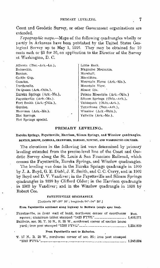
U. 6. GEOLOGICAL SURVEY BULLETIN 636 PLATE I
GEOLOGICAL SURVEY BENCH MARKS.
A, Tablet used in cooperating States. The State name is inserted at G.B and J), Copper temporary bench mark, consisting of a nail and copper washer.A, C\ and E, Tablets for stone or concrete structures.F, Iron post used where there is no rock.

SPIRIT LEVELING IN ARKANSAS, 1896 TO 1915, - ' INCLUSIVE.
R. B. MARSHALL, Chief Geographer.
INTRODUCTION.
Previous publication L\\ results of spirit leveling in Arkansaspublished by the United States Geological Survey in Bulletin 458 and all the results of later work are included in this report. Eleva tions are based on heights of bench marks along precise-level lines of the Coast and Geodetic Survey and of the Corps of Engineers, United States Army, as adjusted in 1912 by the Coast and Geodetic Survey, and are likely to be changed but slightly by any future adjustment.
Personnel. The field work before 1903 was done under the general direction of J. H. Eenshawe, geographer; that for 1903 to 1906, in clusive, under H. M. Wilson, geographer; and the later work under W. H. Herron, geographer, and since 1908 under the general super vision of R. B. Marshall, chief geographer. The names of the vari ous levelmen are given in the introductions to the several lists. The office work of computation, adjustment, and preparation of lists was clone mainly by S. S. Gannett, geographer, under the general direc tion- of E. M. Douglas, geographer.
Classification. No precise leveling has been done by the United States Geological Survey in Arkansas. For primary lines standard Y levels are used; lines are run in circuits or are close on precise lines, with an allowable closing error in feet represented by 0.05 VD 5 in which B is the length of the circuit in miles, sufficient care being given to the work to maintain this standard. For levels of this class careful office adjustments are made, the circuit errors Being distributed over the lines.
Bench marks. The standard bench marks are of two forms. The first form is a circular bronze or aluminum tablet (C and E, PL I), 3^ inches in diameter and one-quarter inch thick, having a 3-inch stem, which is cemented in a drill hole in solid rock in the wall of some public building, a bridge abutment, or other substantial masonry structure. The second form (F, PL I), used where masonry or rock is not available, consists of a hollow wrought-iron post 3£ inches in
5

6 SPIRIT LEVELING IN ARKANSAS, 1896 TO 1915.
outer diameter and 4 feet in length. The bottom is spread out to a width of 10 inches in order to give a firm bearing on the earth. A bronze or aluminum-bronze cap is riveted over the top of the post, which is set about 3 feet in the ground. A third style of bench mark with abbreviated lettering (B and Z>, PL I) is used for unim portant points. This consists of a special copper nail 1^ inches in length driven through a copper washer seven-eighths inch in diameter. The tablets, as well as the caps on the iron posts, are appropriately lettered, and cooperation by States is indicated by the addition of the State name (£, PL I).
The numbers stamped on the bench marks described in the follow ing pages represent the elevations to the nearest foot as determined by the levelman. These numbers are stamped with T3̂ -inch steel dies on the tablets or post caps, to the left of the word " feet." The office adjustment of the notes and the reduction to mean sea-level datum may so change some of the figures that the original markings are 1 or 2 feet in error. It is assumed that engineers and others who have occasion to use the bench-mark elevations will apply to the Director of the United States Geological Survey, at Washington, D. C., for the adjusted values, and will use the markings as identifi cation numbers only.
Datum. All elevations determined by the United States Geologi cal Survey and the United States Coast and Geodetic Survey are re ferred to mean sea level, which is the level that the sea would assume if the influence of winds and tides were eliminated. This level is not the elevation determined from the mean of the highest and the lowest tides, nor is it the half sum of the mean of all the high tides and the mean of all the low tides, which is called the half-tide level. Medn sea level is the average height of the water, all stages of the tide being considered. It is determined from observations made by means of tidal gages placed at stations where local conditions, such as long, narrow bays, rivers, and like features, will not affect the height of the water. To obtain even approximately correct results these observations must extend over at least one lunar month, and ifaccuracv is desired they must extend over several years. At ocean" " <stations the half-tide level and the mean sea level usually differ but little. It is assumed that there is no difference between the mean sea level as determined from observations in the Atlantic Ocean, the Gulf of Mexico, or the Pacific Ocean.
The connection with tidal stations for bench marks in certain areas that lie at some distance from the seacoast is still uncertain, and this fact is indicated by the addition of a letter or word to the right of the word " datum " on tablets or posts. For such areas corrections for published results will be made from time to time as the precise- level lines of the United States Geological Survey, the United States
PRIMARY LEVELING. 7
Coast and Geodetic Survey, or other Government organizations are extended.
Topographic maps. Maps of the following quadrangles wholly or partly in Arkansas have been published by the United States Geo logical Survey up to May 1, 1916. They may be obtained for 10 cents each or $3 for 50, on application to the Director of the Survey at Washington, D. C.
Atlanta (Tex.-Ark.-La.).Batesville.Benton.Caddo Gap.Camclen.Dardanelle.De Queen (Ark.-Okla.).Eureka Springs (Ark-Mo.).Fayetteville (Ark.-Mo.).Fort Smith (Ark.-Okla.).Gurdon.Harrison (Ark.-Mo.).Hot Springs.Hot Springs special.
Little Rock.Magazine Mountain.Marshall.Morrillton.Mountain Home (Ark.-Mo.).Mountain View.Mount Ida.Poteau Mountain (Ark.-Okla.)Siloam Springs (Okla.-Ark.). Tahlequah (Okla.-Ark.). Texarkana (Tex.-Ark.). Winslow (Ark.-Okla.). Yellville (Ark.-Mo.).
PRIMARY LEVELING.
Eureka Springs, Fayetteville, Harrison, Siloam Springs, and Winslow quadrangles.BENTON, BOONE, CABBOLL, CBAWFOBD, MADISON, NEWTON, AND WASHINGTON COUNTIES.
The elevations in the following list were determined by primary leveling extended from the precise-level line of the Coast and Geo detic Survey along the St. Louis & San Francisco Railroad, which crosses the Fayetteville, Eureka Springs, and Winslow quadrangles.
The leveling was done in the Eureka Springs quadrangle in L900 by J. A. Boyd, G. E. Diehl, J. E. Smith, and C. C. Curry, and in 1902 by Boyd and D. V. Vandiver; in the Fayetteville and Siloam Springs quadrangles in 1899 by Clifford Older; in the Harrison quadrangle in 1902 by Vandiver; and in the Winslow quadrangle in 1898 by Robert Coe.
FAYETTEVILLE QTIADHANGLE.
[Latitude 36°-36° 30'; longitude 04°-94° 30'.]
From Fayetteville southeast along highway to Baldwin (single spur line).
Fayetteville, in front wall of bank, northwest corner of courthouse Feet.square; aluminum tablet stamped "1425 FTVL"____________ 1,426.571
Baldwin, sec. 20, T. 16 N., R. 29 W., southwest corner of section houseyard; iron post stamped "1233 FTVL"_ 1 ________________________ 1,234.809
From Fayetteville east to Haberton.
T. 17 N., R. 29 W., northwest corner of sec. 35; iron post stamped"1242 FTVL"____________________________________ 1,243.834
8 SPIRIT LEVELING IN ARKANSAS, 1896 TO 1915.
From Fayetteville west and north via Farmington to Robinson schoolhouse, thence east to Spriugdale.
Farmington, sec. 26, T. 16 N., R. 31 W., opposite church; iron post Feet.stamped "1202 FTVL"___________________________ 1,203.216
T. 17 N., R. 32 N., NE. i sec. 11, at Robinson' schoolhouse; iron poststamped "1082 FTVL"_________________________.._ 1,083.350
Elm Springs, near center of sec. 25, T. 18 N., R. 31 W.; iron poststamped "1167 FTVL"___________________________ 1,168.528
From Springdale east along highway 5 miles (single spur line).
T. 18 N., R. 29 W., northwest corner of sec. 27, 250 feet west of church; iron post stamped "1399 FTVL"________________ 1,400.539
From Robinson schoolhouse southeast along highway to Wheeler (single spurline).
Wheeler, near northwest corner of sec. 28, T. 17 N., R. 31 W.; iron post stamped "1274 FTVL"________________________ 1,275.310
From Robinson schoolhouse southwest along highway to Cincinnati, thence north via Siloam Springs along highway and railroad to Gravette, thence east to Rogers (portion of line).
Wedington Gap, NE. J sec. 5, T. 16 N., R. 32 W.; iron post stamped"1366 FTVL"__________________*________________ 1,367.567
Gravette, sec. 12, T. 20 N., R. 33 W., in northwest corner of stonebuilding east of station; aluminum tablet stamped, "1226 FTVL"__' 1,227.348
T. 20 N., R. 32 W., SW. I sec. 2, Banks school house; iron post stamped" 1287 FTVL "______________________________. _ ._ 1, 287. 821
Seba, in front of J. A. Corley's store; iron post stamped " 1320 FTVL "_ 1, 320. 938 Bentonville, northwest corner of new office building of courthouse;
aluminum tablet stamped " 1303 FTVL "_________..______ 1, 304. 689
From Gentry (Orchard) east along highway to Springtown (single spur line).
Orchard, near center of sec. 3, T. 18 N., R. 33 W., 1 block west ofpublic well; iron post stamped "1237 FTVL"___________._ 1,238.449
Springtown, northwest corner of sec 8, T. 18 N., R. 32 W.; iron poststamped "1259 FTVL"____________________________ 1,260.001
From Decatur east along highway to Eagle schoolhouse (single spur line).
Decatur, near northwest corner of sec. 13, T. 19 N., R. 33 W.; iron" post stamped " 124S FTVL "_______________________ 1, 249. 246T. 19 N., R. 32 W., northwest corner of sec. 26, Eagle schoolhouse;
iron post stamped "1415 FTVL'V____:_____________ 1,416.320'
From Gravette north along highway to Sulphur Springs (single spur line).
Sulphur Springs, sec. 23, T. 21 N., R. 33 W., in east wall of Joplin's store, 4 i'eet above ground; aluminum tablet stamped " 929 FTVL."_ 930.163
Fro.m Hiwassee north along highway to Gordon Hollow (single spur line).
Gordon Hollow, SE. £ sec. 25, T. 21 N., R. 32 .W., at crossroads; iron post stamped "1083 FTVL"__.______________________ 1,084.482
From Bentonville south along highway to Osage Mills (single spur line).
Osage Mills, sec. 34, T. 19 N., R. 31 W., southwest corner of Rous's store; iron post stamped "1334 FTVL"_______________ 1,335.632
PRIMABY LEVELING. 9
From Bentonville north along highway to Finon Hollow (single spur line).
Pinon Hollow, NE. i sec. 26, T. 21 N., R. 31 W., forks of road near Feet, mouth of; iron post stamped "995 FTVL"____________ 996.279
From Bentonville northeast along highway to Brightwater,
T. 21 N., R. 30 W., northwest corner of sec. 26; iron post stamped " 1315 FTVL"_.______________________________ 1, 316,604
T. 21 N., R. 29 W., northwest corner of sec. 33; iron post stamped " 1348 FTVL "______________________. __________ 1, 349. 623
From Rogers east along highway to White River (single spur line).
T. 19 N., R. 29 W., east side of sec. 1, on bank of White River; iron post stamped " 1064 FTVL "____________________ 1,065. 207
From Rogers southwest along highway 4.5 miles (single spur line).
T. 19 N., R. 30 W., northwest corner of sec. 22; iron- post stamped " 1301 FTVL "_______________________________ 1, 301. 919
SILOAM SPRINGS QUADRANGLE.
[Latitude 36°-36° 30'; longitude 04° 30'-95°.]
From Robinson schoolhouse southwest along highway to Cincinnati, thence north via Siloam Springs along highway and railroad to Gravette, thence east to Rogers (portion of line).
Cincinnati, northwest end of town, sec. 29, T. 16 N., R. 33 W., west' side of main road; iron post stamped " 1039 FTVL "_______ 1, 040. 639
Siloam Springs, at railroad station, southwest corner of platform; iron post stamped " 1148;6" (Indian Territory levels)_______ 1,154. 312
EUREKA SPRINGS QUADRANGLE.
[Latitude 36°-36° 30'; longitude 93° 30'-94°.]
From Seligman, Mo., south along Missouri & North Arkansas R. R. to EurekaSprings.
Missouri and Arkansas State line, 1.2 miles south of, 25 feet north of Berry switch on Missouri & North Arkansas R. R., in side of rock, 1 foot above ground; bronze tablet stamped " 998 FTVL "_____ 998.983
Beaver, set. 20, T. 21 N., R. 26 W., 33 feet from east pier of bridge over White River, in south wall of the Narrows, 2.4 feet above ground; aluminum tablet stamped "929 FTVL"_________ 930.408
Eureka Springs, on east side of Crescent Hotel, 9 feet from northeast corner of dining hall, 3.8 feet above ground; aluminum tablet stamped " 1461 FTVL "_____________________________ 1, 462. 251
From Haberton east along railway via Hindsville to Huntsville.
Goshen, sec. 32, T. 17 N., R. 28 W., 700 feet northeast of flour mill, in south face of ledge of natural rock on noisthwest side of Goshen- Hindsville public road; aluminum tablet stamped " 1181 FTVL "_ 1,182.673
Hindsville, center of N. $ sec. 16, T. 17 N., R. 27 W.; iron poststamped " 1366 FTVL "___________________________ 1, 367. 237

10 SPIRIT LEVELING IN ARKANSAS, 1896 TO 1915.
From Hindsville along highway north to Canuck, thence west to War Eagle, "thence south via Spring Valley to Hindsville.
Clifty, NW. i sec. 26, T. 18 N., R. 27 W., 1,300 feet north of Parker's ford over War Eagle Creek, in east face of natural ledge of granite on west side of Hindsville-Clifty road; bronze tablet stamped Feet. " 1218 FTVL "_________________________________ 1, 219. 371
Canuck, sec. 33, T. 19 N., R. 27 W., 10 feet east of building owned by Sam Cook, in south face of ledge of natural rock and southeast corner of post office; aluminum tablet stamped " 1497 FTVL "__ 1, 49S.915
War Eagle, near southeast corner of sec. 34, T. 19 N., R. 27 W., 180 feet north of post office, 40 feet east of old building, in west face of ledge of natural rock; bronze tablet stamped " 1156 FTVL "__ 1,157. 040
Spring Valley, sec. 2, T. 17 N., R. 28 W., 70 feet west of post office, 5 feet north of spring owned by A. Sanders, in south face of ledge of natural limestone rock; copper bolt stamped " 1301 FTVL "___ 1, 302. 084
From G-oshen southeast along highway via Wesley to Drakes Creek (single spurline).
Wesley, sec. 26, T. 16 N., R. 28 W., school district 56, second brick from bottom in southeast corner of brick schoolhouse; bronze tablet stamped " 1273 FTVL "_______________________ 1, 274. 977
Drakes Creek, sec. 32, T. 16 N., R. 27 W., 500 feet east of post office, in south face of natural ledge of rock on Aurora road, 300 feet east of junction with Huntsville road; aluminum tablet stamped " 1284 FTVL "_____________________________________ 1, 285. 971
From Huntsville southeast along highway to Wharton Creek (single spur line).
T. 16 N., R 26 W., center of N. \ sec. 23, in top of projecting rock, on west side of and 150 yards from War Eagle Creek, on main Hunts ville and Aurora road ; bronze tablet stamped " 1321 FTVL "___ 1, 322. 650
T. 16 N., R. 25 W., south side of sec. 20, about 200 yards south of Wharton Creek schoolhouse, near elm tree, in side of rock about 0.5 foot above ground; bronze tablet stamped " 1352 FTVL "___ 1,353.519
From Huntsville north along highway to Eureka Springs.
Huntsville, sec. 34, T. 17 N., R. 26 W., in east side .of southeast corner of foundation of courthouse; bronze tablet stamped " 1451 FTVL "_ 1,452. 570
T. 17 N., R. 26 W., sec. 10, north bank of War Eagle Creek, at ford, on Huntsville and Eureka Springs road, in top of rock; bronze tablet stamped " 1222 FTVL "___________________ "_ _____ 1, 223, 585
T. IS N., R. '26 W., east side of sec. 22, near old storehouse, at junction of road from Clifty with Huntsville and Eureka Springs road; iron post stamped " 1602 FTVL"_______________________ 1, 603. 519
T. 19 N., R. 26 W., southwest corner of sec. 33, on Huntsville and Eureka Springs road; iron post stamped " 1568 FTVL "______ 1, 569. 449
From Eureka Springs west along highway to White River (single spur line).
White River, sec. 29, T. 20 N., R. 27 W., about 300 yards east of Knox Ferry and 11 feet west of large oak tree, in side of sandstone rock; bronze tablet stamped " 1016 FTVL "_________________ 1, 017. 732

PRIMARY LEVELING. 11
From Eureka Springs east along highway to Berryville (mean of two lines).
Eureka Springs, 1.5 miles east of, on Berryville road, on ledge of rock Feet, in Mill Hollow; chiseled cross_____________________ 1,260.78
T. 20 N., R. 25 W., sec. 20, 6.8 miles east of Eureka Springs, 6.8 miles west of Berryville, 100 feet west of west end of Kings River Bridge, 5 feet north of tollgate; iron post stamped " 1066 FTVL "_____ 1, 067. 768
Berryville, 2.2 miles west of, in front of E. H. Smith's residence, onnorth side of road, on top of first stone step to spring________ 1, 217. 32
Berryville, in public square, 10 feet south of west stile of park, 66 feet west of pump, under music stand; iron post stamped " 1256 FTVL "_____________________________________ 1, 255. 924
From Berryville south along highway to crossroads 2.5 miles east of Marble, thence west via Marble to Huntsville.
T. 19 N., R. 24 W., east side of sec. 28, on Kingston road, southwest corner Of Wright's store, 5 feet southwest of; iron post stamped " 12S6 FTVL "_____________________________________ 1,288. 340
T. 18 N., R. 24 W., sec. 15, 14 feet northeast of Cedar Valley school- house, on Kingston road, near mouth of Cedar Creek; iron post stamped " 1365 FTVL "____________________________ 1,367. 312
T. 17 N., R. 24 W., sec. 16, junction of Berryville-Kingston and Marble-Carrollton roads, 35 feet east of road, east of and near blacksmith shop; iron post stamped " 1394 FTVL "_________ 1, 395. 883
Marble, sec. 13, T. 17 N., R. 25 W., in northwest corner of yard to CityHotel; iron post stamped " 1345 FTVL "_______________ 1, 346. 904
From point 2.5 miles east of Marble along highway south to Kingston (singlespur line).
Kingston, sec. 15, T. 16 N., R. 24 W., in southwest corner of public square; iron post stamped "1365 FTVL"______________ 1,366.826
From Berryville south along highway to Pension Mountain (single splir line).
Pension Mountain, sec. 24, T. 19 N., R. 25 W., 5.8 miles southwest of Berryville, 200 yards from summit of mountain, on New Huntsville wagon road,' in side of projecting rock; bronze tablet stamped " 1565 FTVL "_..________________________________ 1, 566. 520
From Berryville north along highway to sec. 29, T. 21 N., R. 24 W., thence west to sec. 25, T. 21 N., R. 25 W.
T. 21 N., R. 24 W., S. -| sec. 29, junction of Eureka Springs and Viola roads; iron post stamped " 1226 FTVL "_.._____________ 1,228. 086
Stony Point Church, 300 yards south of Summers Ford on Berryville- Cassville road, 11 feet south of southwest corner of church; iron post stamped "962 FTVL"_______ .. _ ______ 964.377
HARRISON QUADRANGLE.
[Latitude 36°-36° 30'; longitude 93°-93° 30'.]
From Berryville east along highway to Green Forest, thence along railroad to
Alpena Pass, thence north along highway to Denver.1Green Forest, sec. 4, T. 19 N., R. 23 W., at southwest corner of Bank
of Green Forest, in stone doorsill; aluminum tablet stamped " 1349 FTVL "______________________________________ 1, 349. 039
1 Mean of three lines along highway and mean of two lines along railroad.

12 SPIRIT LEVELING IN ARKANSAS, 1896 TO 1915.
Feet.Green Forest, 5 miles east of, in rnilepost 45; spike__________ 1,112. 04 Alpena Pass, sec. 23, T. 19 N., R. 22 W., 27 feet west of station plat
form, 20 feet south of railroad track; iron post stamped " 1139 FTVL "___'___________________________________ 1,139. 190
Denver, T. 20 N., R. 22 W., in Joe A. Young's yard, 6 feet east of east fence, 10 feet south of north fence, in top of stone post 6 by 12 by 30 inches, set in ground; bronze tablet stamped " 1028 FTVL "__ 1, 028, 085
From Green Forest north along highway to Oak Grove, thence to Raum, thence south to Denver.
Yocum, sec. 2, T. 20 N., R. 23 W., 300 yards east of creek crossing, on east side of mill, in stone foundation; bronze tablet stamped " 1084 FTVL "_____________________________________ 1, 084. 075
Oak Grove, sec. 28, T. 21 N., R. 23 W., in southeast corner of fence in yard of J. H. Evans, in top of stone post 6 by 22 by 36 inches; bronze tablet stamped " 1347 FTVL "_________________ 1, 347. 329
Raum, sec. 20, T. 21 N., R. 22 W., at base of chimney of A. Winkle's residence, in coping; bronze tablet stamped " 965 FTVL "____ 965,121
From Alpena Pass southeast along railroad to Harrison (run twice).
Batavia, sec. 33, T. 19 N., R. 21 W., 200 feet north of spring, 33 feet east of northeast corner of station platform; iron post stamped " 1489 FTVL"_________________________________ 1, 488. 855
Harrison, in northwest corner of square; iron post stamped " 1052FTVL "________________________. _____________ 1, 052. 280
From Harrison northeast along highway to Oregon, thence northwest via Self to Lowry, thence west-southwest via Omaha to Denver.
Oregon, sec. 17, T. 19 N., R. 19 W., 250 feet north of crossroads; iron post stamped " 1324 FTVL "_____ '._________________ 1, 324.102
T. 20 N., R. 19 W., sec. 18, on " Rushing Farm," 600 feet south of house, 16.3 miles northeast of Harrison, at fork of road, road west to Cheatnien, road east to Self;. iron post stamped " 1356 FTVL "__ 1,355. 826
Self, sec. 3, T. 20 N., E, 20 W., 50 feet east of blacksmith shop;.iron post stamped "811 FTVL "_ _____ _ __________ 810.883
T. 21 N., R. 20 W., sec. 23, 1 mile north of Old Lowry, 100 feet south east of Bluff Springs schoolhouse, district 36; iron post stamped "728 FTVL" (by short single spur line)________________ 727. 638
Omaha, sec. 27, T. 21 N., R. 21 W., 45 feet east of post office, 45 feetwest of road; iron post stamped " 1354 FTVL "___________ 1. 354.114
Pruitt post office, sec. 20, T. 20 N., R. 21 W., in Mr. Moor's yard; 4 feet east of picket fence; iron post stamped " 1483 FTVL "_____ 1,482. 718
From Harrison north along highway to Self.
T. 19 N., R. 20 W., sec. 9, 6.5 miles north of Harrison, fork of roads, running west to Burlington and north to Self post office, 2,000 feet south of blacksmith shop; iron post stamped " 1386 FTVL "___ 1, 386. 221
From Green Forest south along highway via Rule and Osage to Boxley, thence northeast to Cecils Fork (Buffalo Creek), 12 miles, thence via Carrolton to Alpena Pass.
T. 19 N., R. 23 W., SW. i sec. 29, 200 yards south of J. W. McCalib's house, 50 feet east of blazed elm tree, in limestone outcrop; bronze tablet stamped " 1245 FTVL "_____!_________________ 1, 244. 765

PRIMARY LEVELING. 13
Osage (Fairview), sec. 26, T. 18 N., R. 23 W., iu stone front of W. S. Feet. Hittson's store; bronze tablet stamped " 1331 FTVL"________ 1, 331. 579
T. 17 N., R. 23 W., sec. 27, 0.25 mile north of J. S. Alfred's place, 25 yards west of road forks, north side of road, in large sandstone bowlder ; bronze tablet stamped " 1487 FTVL"____________ 1, 486. 729
T. 16 N., R. 23 W., NE. £ sec. 22, northeast corner of crossroads, 100 yards north of cabin of J. C. Patty, 5 feet south of black oak tree, in stone 2.5 by 1 by 4 feet; bronze tablet stamped "2230 FTVL" ____________-_________________________ 2, 230.185
T. 16, N., R. 22 W., sec. 16, 100 yards west of Center Point school- house, 10 yards south of road, in limestone outcrop; bronze tablet stamped " 959 FTVL "__________________________ 958. 838
T. 17 N., R. 21 W., sec. 33, 75 yards northeast of road crossing, 5 yards south of 2-foot white oak tree, near W. J. Young's house, in limestone bowlder; aluminum tablet stamped " 896 FTVL"_____ 895. 377
T. 17 N., R. 22 W., NE. £ sec. 13, 15 feet from township line, at road forks, on Harrison and Huntsville road, in front of H. S. Mallett's house, in stone; aluminum tablet stamped " 2129 FTVL"_______ 2,128. 792
T. IS N., R. 22 W., SW. £ sec. 25, 300. yards east of W. A. Hob- good's residence, 20 yards west of road forks at foot of white oak, In rock; aluminum tablet stamped " 2153 FTVL"__________ 2,152.825
From Youngs crossroads south along highway to Jasper.
Jasper, sec. 27, T. 16 N., R. 21 W., at left of north front entrance of courthouse, 2.5 feet above ground, in stone facing; aluminum tablet stamped " 857 FTVL"___________________________ °857.139
From Jasper north along highway via Elmwood to Harrison.
T. 16 N., R. 21 W., SE. I NE. I sec. 24, 20 feet north of creek, in lime stone ledge; aluminum tablet stamped "787 FTVL"________ 787.054
T. 16 N., R. 20 W., sec. 8, 600 feet north of Buffalo, 600 feet west of Shadock's, at corner of fence 7 feet east of road, in sandstone 6 by 8 by 4 feet; aluminum tablet stamped " 796 FTVL"_________ 795. 792
T. 17 N., R. 20 W., NE. } sec. 33, 900 feet south of Mr. Erwin's house, at foot of Flat Rock Mountain, where road first strikes Flat Rock Creek, in sandstone; aluminum tablet stamped " 968 FTVL"___ 968. 048
T. 17 N., R. 20 W., near northwest' corner sec. 22, 3 feet from Boone- Newton county line, 100 feet north of L. L. Monday's house, in stone; aluminum tablet stamped " 1348 FTVL"____________ 1, 348. 437
T 17 N., R. 20 W., NW. i NW. I sec. 10, 125 feet east of forks in road, 100 feet east of A. H. Bryant's house, 4 feet south of red oak, in limestone post; aluminum tablet stamped " 1218 FTVL "______ 1, 218.151
T. IS N., R. 20 W., near southwest corner of sec. 21, 100 feet south of J. B. Wilson's house, 10 feet east of road, 50 feet west of Crooked Creek, in limestone; aluminum tablet stamped " 1086 FTVL "___ 1, 086. 680
WINSLOW QUADRANGLE.
[Latitude 35° 30'-36° ; longitude 94°-94° 30'.]
From Rudy west along highway to Cedarville, thence northwest to Dutch Mills, thence northeast to Staunton.
Natural Dam post office, sec. 15, T. 11 N., R. 32 W.; iron post stamped"672 F S"____________________________________ 673.428
Dutch Mills, sec. 21, T. 14 N., R. 33 W., on main street, in front of White, Reed & Co.'s store; iron post stamped " 1027 F S "'._________'l, 028. 795
14 SPIRIT LEVELING IN ARKANSAS, 1896 TO 1915.
Clyde, sec. 17, T. 14 N., R. 32 W., in front of schoolhouse; iron post Feet, stamped " 1325 F S "____________________________ 1, 326. 268
T. 15" N., R. 32 W., sec. 27, top of hill south side of wagon road be tween Prairie Grove and Boonsboro; iron post stamped " 1414 F S " _____________ _________..____________ 1, 415. 520
Prairie Grove, sec. 18, T. 15 N., R. 31 W., brick store southwest corner Mack and Buchanan streets; aluminum tablet stamped " 1168 F S "_____________________________________ 1,169. 484
T. 15 N., R. 31 W., on line between sees. 15 and -16, Illinois Chapel; iron post stamped " 1146 F S "_____________________ 1,147. 606
From Dutch Mills north along highway to Summers (spur line).
T. 15 N., R. 33 W., southeast corner sec. 16, 0.5 mile southeast ofSummers; iron post stamped "1192 F S"_____'. _______________ 1,193.983
From Cedarville south along highway to Stattler (spur line).
Stattler post office, sec. 22, T. 10 N., R. 32 W.; iron post stamped"903 F S"___________________________________ 904.744
From Natural Dam northeast along highway to "Westfork.
Lees Creek post office, quarter corner on south side of sec. 25, T. 12N., R. 32 W.; iron post stamped " 755 F S "_______________ 756. 799
T. 13 N., R. 32 W., southeast corner of sec. 35; iron post stamped"1727 F S "___________________________________ 1, 728. 784
Strickler, sec. 7, T. 13 N., R. 31 W., northwest corner of John Neal'sfence; iron post stamped " 1568 F S "_________________ 1, 569. 748
T. 14 N., R. 31 W., sec. 23, near Longview schoolhouse; iron poststamped " 1900 F S "_____________________,_____ 1, 901. 920
From Lees Creek east along highway to Chester.
T. 12 N., R. 31 W., quarter corner on east side of sec. 23; iron post stamped " 1734 F S "_______________________ 1,735.630
From sec. 32, T. 14 N., R. 30 W., southwest along highway to sec. 2, T. 14 N., R. 31 W. (spur line).
T. 11 N., R. 31 W., near southeast corner of sec. 2; iron post stamped"1565 F 'S"__________________________________ 1,566.714
From sec. 4, T. 11 N., R. 29 W., north along highway to sec. 28, T. 12 N., R. 29 W. (spur line).
T. 12 N., R. 29 W., southeast corner of sec. 28, near abandoned Sand- point post office; iron post stamped " 1606 F S "__________ 1, 608. 276
From Winslow northeast along highways to Hazel Valley, thence northwest to sec. 21, T. 15 N., R. 29 W., thence west to Westfork.
Winslow, southeast corner of Dunlap's drug store, on ledge of rock;aluminum tablet stamped " 1742 F S "________________ 1, 743. 728
T. 13 N., R. 29 W., sec. 1, Low Gap, crossroads in gap of BostonMountains ; iron post stamped " 2042 F S "_______________ 2, 043. 818
T. 14 N., R. 29 W., sec. 10, 0.8 mile northwest of Arnett post officenear main gate of cemetery; iron post stamped " 1401 F S "___ 1, 403. 022

PBIMABY LEVELING. 15
From sec. 21, T. 15 N., R. 29 W., north along highway to Sulphur City.
Sulphur City, sec. 22, T. 15 N., R. 29 W., foundation southwest corner Feet, of post office; aluminum tablet stamped " 1364 F S "________ 1, 366.156
From sec. 15, T. 10 N., R. 31 W., northeast along highway to Belmont.
Belmont, abandoned post office, quarter corner on east side of sec. 9,T. 10 N., R. 30 W.; iron post stamped " 873 F S "_________ 874. 668
I'rom Mulberry north along highway 11 miles, thence southwest to Mountainhurg.
T. 11 N., R. 29 W., east side of sec. 34, abandoned Plymouth post office; iron post stamped " 794 F S "__________________ 795. 828
Arkadelphia, Benton, Caddo Gap, Camden, Dalark, Gurdon, Hope, Hot Springs special, Little Eock, Lucky, and Malvern quadrangles.
(JALHOUN, CLARK, DALLAS, GARLAND, HEMPSTEAD, HOT SPRINGS, HOWARD, MONTtiOMEKY, NEVADA, OUACJUTA, PIKE, POLK, PULASKI, AND SALINE COUNTIES.
The elevations in the following list were determined by primary leveling extended from Little Rock. A double-rodded line of levels was run in 1896 from Little Rock along the St. Louis, Iron Mountain & Southern Railway to Hot Springs and continued in 1899 along the Chicago, Rock Island & Pacific Railway and the St. Louis, Iron Mountain & Southern Railway to Gurdon, connecting in 1900 with Camden by primary circuits. At Little Rock and Camden the work is adjusted to elevations of bench marks of the United States Army engineers' precise-level line. No intermediate connections were made.
The leveling from Little Rock to Hot Springs and in the Hot Springs special quadrangle was done in 1896 by H. L. Muldrow, and that along the railroads to Gurdon, Hope, and Buena Vista by Robert Coe in 1899-1900. The remaining work in the Gurdon quad rangle was done in 1899-1900 by D. C. Wray, and in the Camden quadrangle in 1900 by Guy E. Diehl. The leveling in the Caddo Gap quadrangle was partly done in 1901 by E. L. Shepard and J. A. Boyd, and was completed by 1902-3 by C. H. Birdseye. The level ing for the Hot Springs special and the Gurdon quadrangles has been copied with corrections from the Eighteenth and Twenty-first An nual Reports of the'United States Geological Survey, respectively.
LITTLE ROCK QUADRANGLE.
[Latitude 34° 30'-35°; longitude 92°-92° 30'.]
At Little Rock.
Little Rock, in granite substructure of east face of customhouse and post office, beneath water-table course of masonry; center of cross about 13£ inches north and about 5i inches above the upper corner onf the north line of the basement window nearest to Second Street Feet. (Coast and Geodetic Survey bench mark A)______________ 299.238

16 SPIRIT LEVELING IN ARKANSAS, 1896 TO 1915.
BENTON QUADRANGLE.
[Latitude 34° 30'-35° ; longitude 92° 30'-93°.]
At Benton.
Benton, in% St. Louis, Iron Mountain & Southern Ry. station yard; Feet, iron post* stamped " 297 "__________:_______________ 298. 658
HOT SPRINGS SPECIAL QUADRANGLE.
[Latitude 34° 22' 57"-34° 37' 57" ; longitude 92° 55' 47"-93° 10' 47".]
From Hot Springs along Chicago, Rock Island & Pacific Ry. to Lawrence.
Hot Springs, in base of Hoke Smith post, entrance to United Statesreservation; bronze tablet marked " 607 H. S."____________ 608. 375
Hot Springs, in stone window sill of Chicago, Rock Island & PacificRy. passenger station; copper bolt stamped " 598 "_________ 598. 692
Spring Lake, sec. 12, T. 3 S., R. 19 W., in front of Chicago, RockIsland & Pacific Ry. station; top of rail___________^____ 335.7
Potash Sulphur Springs, sec. 17, T. 3 S., R. 18 W.; iron post stamped" 388 " (the above bench mark is on a single spur line) ____:_ 388.634
Bench marks established along highways in south part of quadrangle.
T. 4 S., R. 18 W., 0.3 mile northeast of center sec. 5; copper boltstamped " 409 "______________________'_______________ 409. 822
T. 4 S., R. 19 W., 0.3 mile south-southwest of center of sec. 8; ironpost stamped " 482 "___________________________ 482. 674
T. 4 S., R. 20 W., 0.2 mile northeast of center of sec. 3; iron poststamped "510"_______.._______________________ 510.065
T. 3 S., R. 20 W., sec. 2, at Bull Bayou bridge; iron post stamped" 392 " ____________________________________ 393. 085
T. 2 S., R 20 W., west of center of sec. 21, at Clear Creek; iron poststamped " 480 "______________________________ 480. 979
Bench marks on single spur lines from main circuit in north part of quadrangle.(Elevations unreliable.)
T. 1 S., R. 20 W., 0.3 mile northwest of center of sec. 32; copper bolt stamped " 630 "________________________________ 631.326
Mountain Valley, west side sec. 20, T. 1 S., R. 19 W.; iron post stamped " 783 "______..______________________ 784.384.
T. 1 S., R. 18 W., 0.2 mile southeast of center of sec. 32, north side of Saline River and road, between two near-by road forks; iron post stamped " 523 "_________ __________________ 524. 034
T. 2 S., R. 18 W., near northwest corner sec. 30, at Dipping Springs, south of road; iron post stamped " 532 "'________________ 533. 004
MALVERN QUADRANGLE.
[Latitude 34° 15'-34° 30'; longitude 92° 45'-93°.]
From Hot Springs southeast along Chicago, Rock Island & Pacific Ry. to Malvern, thence southwest along St. Louis, Iron Mountain & Southern Ry. to Hope (double-rodded line; portion of line).
Malvern, near front entrance to Hot Springs County courthouse; iron post stamped " H. S. 310 "________________________ 311.123

PRIMARY LEVELING. 17
Malvern, in monuments for meridian marks in courthouse yard; bronze tablets: Feet.
North monument ______________________________ 311. 386 South monument ____________________________ 307.151
ARKADELPHIA QUADRANGLE.
[Latitude 34°-34° 15'; longitude 93°-93° 15'.]
Prom Hot Springs southeast along Chicago, Rock Island & Pacific Ry. to Malvern, thence southwest along St. Louis, Iron Mountain & Southern Ry. to Hope (double-rodded line; portion of line).
Arkadelphia, at northwest corner of Clark County courthouse, under cornerstone, in north face of second stone above ground; bronze tablet stamped " H. S. 246 "______________________ 246.801
GURDON QUADRANGLE,
[Latitude 33° 30'-34° ; longitude 93°-93° 30'.]
From Hot Springs southeast along Chicago, Rock Island & Pacific Ry. to Malvern, thence southwest along St. Louis, Iron Mountain & Southern Ry. to Hope (double-rodded line; portion of line).
/Curtis, 0.25 mile south of station, on east right of way line of St.
Louis, Iron Mountain & Southern Ry. and on line between sees. 1 and 36, 0.8 mile west of township line; iron post stamped " H. S. 170 "__________ __________________________ 171.112
Gurdon, northwest corner of Main and West Front streets, in' south face, near southeast corner, of brick building owned by A. W. Newton and used as a general store; aluminum tablet stamped " H. S. 209 "____________-_______ -_____________ 210.127
Bierne, 880 feet northwest of railroad crossing north of, at quarter corner of sees. 1 and 12, on Dr. Kerston's property, 250 feet west of Methodist Church; iron post stamped " H. S. 237 "_________ 238. 457
Boughton, 130 feet north of railroad, inside fence at southwest corner of front yard of E. de Laughter's residence; iron post stamped " H. S. 234 "_ __ _ ____ ___ 234. 646
Prescott, bronze tablets set in stone monuments in courthouse yard as meridian mark:
North monument marked " H. S. 318 "________________ 319. 289 South monument_____________________________ 316. 700
Emmet, 130 feet west of center of station, 25 feet north of main line of St. Louis, Iron Mountain & Southern Ry., 5 feet west of mile- post 49, 260 feet east of county line post between Nevada and Hempstead counties; iron post stamped " H. S. 293 "_______ 293. 927
HOPE QUADRANGLE.
[Latitude 33° 30'-33° 45'; longitude 93° 30'-93° 45'.]
From Hot Springs southeast along Chicago, Rock Island & Pacific Ry. to Malvern, thence southwest along St. Louis, Iron Mountain & Southern Ry. to Hope (double-rodded line; portion of line).
Hope, at southwest corner of Main and East Second streets, in north face of large foundation stone at northeast corner of Hempstead County Bank; aluminum tablet stamped " H. S. 356 "________ 357. 042
25071° Bull. 636 16 2

18 SPIEIT LEVELING IN ARKANSAS, 1896 TO 1915.
: CAMDEN QUADRANGLE. :
[Latitude 33° 30'-34° ; longitude 92° 30'-93°.]
from Camden southwest along St. Louis Southwestern Ry. to Buena Vista.
Camden, Ouachita County courthouse, in west face of second stoneabove ground and from northwest corner; iron post stamped Feet." H. S. 199 "___________________________________ 199. 859
Buena Vista, in front of station, 75 feet south of main track of St.Louis Southwestern Ry., in front of residence of Mrs. Martha E.Sifford; iron post stamped "H. S. 287"______________ 288.001
GURDON QUADRANGLE.
[Latitude 33° 30'-34° ; longitude 93°-93° 30'.]
From Gurdon southeast along St. Louis, Iron Mountain & Southern Ry. toCamden.
Whelen, 450 feet west of station and 30 feet south of corner to sees.- 26, 27, 34, 35, T. 10 S., R. 20 W.; iron post stamped " H. S. 247 "__ 247. 499
Chidester, about 180 feet northeast of station, 50 feet east of track; iron post stamped " H. S." 230 ''______________________ 231. 070
From Frescott south along highways to Bodcaw, thence west to Buena Vista.
Laneburg, 0.5 mile north of, in sec. 9, T. 12 S., R. 22 W., southeast corner of; iron post stamped " H. S. 284 "_______________ 284. 639
Bodcaw, 3 miles southeast of, 600 feet south of northeast corner sec.16, north side of road; iron post stamped " H. S. 371"_____.-__ 372. 002
T. 14 S., R. 21 W., southeast corner sec. 16, 2 miles east of Willis- ville, junction of Rosston and College Hill road with Camden and Texarkana road ; iron post stamped " H. S. 361"______ :____ 362. 300
T. 14 S., R. 20 W., on line between sees. 14 and 23, 500 feet west of southeast corner of sec. 14, 1 mile southwest of Woodlawn, north side of road and east side of creek; iron post stamped " H. S. 254 "_ 255. 407
T. 14 S., R. 19 W., 0.6 mile east of quarter corner of sec. 10, west sideof, on property of H. L. Lusby, 30 feet north of Camden and Tex-arkana road ; iron post stamped " H. S. 263 "_____________ 263. 798
From Prescott west along highway 5 miles (single spur line).
T. 11 S., R. 23 W., near southeast corner, of sec. 9, on line between Nevada and Hempstead counties and 50 feet north of Washington road ; iron post stamped " H. S. 327 "__________________ 327. 700
From Bennetts crossroads west along highway to Centerville (single spur line).
.T. 13 S., R. 22 W., 0.25 mile west of Bennett's, in southeast corner ofsec. 16, 350 feet south of crossroads ; iron post stamped "H. S. 372"_ 372. 925
Centerville, near quarter corner on east side of sec. 4, T. 13 S., R. 23 W., on line between Nevada and Hempstead counties, north side of Hope-Camden road and 300 feet west of road north to church; iron post stamped " H. S. 338 "___.____________________ 338. 795
From Bodcaw west along highway 5.25 miles (single spur line).
T. 13 S., R. 23 W., southeast corner of sec. 33, on line between Nevada and Hempstead counties, east side of road, opposite road to west, 5.25 miles west of Bodcaw; iron post stamped " H. S. 331"_____ 332. 388

; PRIMARY LEVELING. '19
From Bennetts crossroads east along highway to Caney, thence northeast toSayre.
T. 13 S., R. 21 W., at quarter corner on south side of sec. 21, southwest Feet.of crossroads to Rosston; iron post stamped " H. S. 378 "_____ 378. 939
Caney post office, 0.1 mile west of, quarter corner on east side of sec.21, T. 13 S., R. 20 W., 80 feet north of road; iron post stamped " H.S. 324"______________________________________ 325. 039
T. 13 S., R. 19 W., sec. 7, 4 miles northeast of Caney, on north side ofCamden road and 300 feet east of White Oak Creek; iron poststamped " H. S. 218 " (on single spur line) _______________ 218. 914
Bluff City, 1.8 miles southwest of, quarter corner on south side of sec.10, T. 12 S., R. 20 W., 75 feet west of road and 60 feet north ofSpring Branch ; iron post stamped " H. S. 283 "____________ 284. 513
From Zama west along highway to Morris (single spur line).
T. 12 S., R. 21 W., in NW. | sec. 26, 0.25 mile north of Morris, at south- west corner of cemetery at Caney Church and SCllOOlllOUSe, north east of crossroads; iron post stamped " H. S. 264 "__________ 265.180
From Bluff City west-northwest along highway to Prescott.
T. 11 S., R. 20 W., on line between sees. 21 and 22, 0.25 mile south of corner, north side of Prescott and Bluff City road; iron post stamped " H. S. 173 "_______________ ____ _________ 174. 518
T. 11 S., R. 21 AV., near east corner of sec! 17, 6 miles east of Prescott, on so'uth side of road and on west side of road to south; iron post stamped " H. S. 333 "_____________________________ 334. 046
From Prescott north along highway to Okolona.
T. 10 S., R. 22 W., northeast corner sec. 20. at southwest corner ofcrossroads ; iron post stamped " H. S. 376 " _ __ 377. 002
T. 10 S., R. 23 W., on line between sees. 15 and 16, and on line between Nevada and Hempstead counties, south side of Washington road; iron post stamped " H. S. 346" (on single spur line west from pre ceding bench mark) _ 346. 527
Elkins Ford, on Little Missouri River, 1 mile north of, quarter corner on east side of sec. 21, T. 9 S., R. 22 W., 30 feet west of road; iron post stamped " H. S. 216 " _ ________ 217. 412
From Smithton west along railroad to Antoine, thence south 3 miles.
T. 9 S., R. 21 W., southeast corner sec. 15,' 100 feet north of track and 30 feet west of road; iron post stamped " H. S. 319 "________ 319. 541
Okolona,'in southwest corner of high-school yard, sec. 34, T. 8 S., R. 22 W.; iron post stamped " H. S. 423 "___________________ 423. 672
Antoine, 3 miles south of, in sec. 33, T. 8 S.', R. 23 W.. at west side of military road; iron post stamped " H. S. 324" (on single spur line from'Okolona) _ 325. 212
From Smithton east along highway 4 miles (single spur line).
T. 9 S., R. 19 W., sec. 20, 4 miles east of Smithton, 60 feet south of old grade at log road and 60 feet west of end of lane to south, between two buildings on property of W. A. Young; iron post stamped " H. S. 176 "__________.-.-__________-_____________ 177.176

20 SPIRIT LEVELING IN ARKANSAS; 1896 TO 1915.
From single spur line north from Bar ham.
T. 11 S., R. 19 W., quarter corner on south side of sec. 26, 2 miles northeast of Barham post office, 150 east of road and 300 feet Feet, northeast of J. B. Benton's house; iron post stamped " H. S. 267 "_ 267. 623
From single spur line northeast from Whelen Springs.
T. 11 S., R.~19 W., on line between sees. 19 and 20, on north side of Gurdon-Camden road ; iron post stamped " H. S. 198 "_______ 199. 200
ARKADELPHIA QUADRANGLE.
[Latitude 34°-34° 15'; longitude 93°-93° 15'.]
From Arkadelphia south along Memphis, Dallas & Gulf R. R. to Dalark (portionof line).
Arkadelphia, 0.5 mile east of, on top of coping stone at north end of west abutment of steel bridge over Ouachita River_________ 193.41
DELARK QUADRANGLE.
[Latitude 34°-34° 15'; longitude 92° 45'-93°.]
From Arkadelphia southeast along Memphis, Dallas & Gulf R. R. to Dalark (portion of line).
Dalark' northwest corner of sec. 13, T. 8 S., R. 18 W., on line be tween Dallas and Clark counties; iron post stamped " 272 H. S."_ 272, 731
CAMDEN QUADRANGLE.
[Latitude 33° 30'-34°; longitude 92° 30'-93°.]
From Dalark east' along highway to Princeton, thence south to Bear den, thence along railroad southwest to Camden.
Nix, in E. $ SE. i sec. 33, T. 8 S., R. 16 W., 230 feet east of post office; iron post stamped " 227 H. S."_________________ 228.160
T. 9 S., R. 16 W., 450 feet west of southeast corner of sec. 5, on sec tion line, east side of Tulip and Tate's road, at southeast corner of W. H. Dickenson's field; iron post stamped " 296 H. S."______ 297. 255
Princeton, on west side of entrance of Dallas County jail, between two bricks in-eleventh row from bottom of steps, aluminum tablet stamped "287 H. S."___________________________ 287.769
T. 9 S., R. 15 W., on line between sees. 14 and 15, at intersection of Princeton, Bearden, and Holly Springs roads; iron post stamped "300 H. S."_ - __ _ _________ . 301.030
The following bench marks are on single spur lines from main cir cuit and elevations are unreliable:
T. 9 S., R. 14 W., at intersection of dirt roads, 120 feet south of Zion Church; iron post stamped " 351 H. S."_____________ 352. 341
T. 10 S., R. 14 W., at intersection of Fordyce and Princeton dirt road and Harlow Lumber Co.'s tram road, 420 feet east of old water tank; iron post stamped "222 H. S."__________________ 222.644
T. 10 S., R. 15 W., at northwest corner sec. 25, in mill creek bottomof William Marshall, sr.; iron post stamped " 213 H. S."______ 213. 482
T. 11 S., R. 15 W., at northwest corner sec. 35; iron post stamped" 229 H. S."___________________________________ 230.149

PRIMARY LEVELING. 21
Harlow, 450 feet southwest of station, 10 feet southwest of niilepost Feet.318, T. 11 S., R. 14 W.; iron post stamped " 270 H. S."_______ 271. 369
T. 12 S., R. 14 W., northwest corner sec. 9, 380 feet north of Cham-bersville-Camden dirt road; iron post stamped " 285 H. S."_____ 285. 493
T. 12 S., R. 15 W., 19.7 feet east of northwest corner of sec. 23, on'section line ; iron post stamped "214 H. S."_ __________ 215. 299
Onalaska, 600 feet southwest of station, 8 feet southwest of milepost329, T. 12 S., R. 16 W.; iron post stamped "129 H. S."_______ 130.117
Van Duzer, 2.5 miles southwest of; railroad spike in milepost 334_ 110. 64
From Camden north along public road to Dalark. 1
T. 12 S., R. 17 W., in southwest part of sec. 13, one-eighth mile north of section line, 12 feet southeast of old store building of James Dunn ; iron post stamped "118 H. S."__________________ 119. 045
T. 11 S., R. 16 W., at northwest corner sec. 28, 1 mite east of corner of pasture, beside wire fence; iron post stamped " 143 H. S."___ 1-M. 255
T. 11 S., R. 17 W., 35 feet west of quarter corner between sees. 22 and 23, 40 feet west of Mrs.'Jestice's barn lot; iron post stamped "143 H. S."__________________________________ 143.599
T. 10 S., R. 17 W., 800 feet southwest of northeast corner of sec. 22, at southeast corner of Ouachita Church property; iron post stamped "156 H. S."___________________________ 156. 865
T. 10 S., R. 16 W., quarter corner on east side of sec. 16, 250 feet southeast of bridge over Whiteoak Creek, on south side of road; iron post stamped "155 H. S."______________________ 156. 272
T. 9 S., R. 17 W., on line between sees. 16 and 21, about 200 feet south of corner known as "Gray Rock," at fork of road; iron post stamped "191 H. S."_____.._____________________ 191. 568
From Sparkman's Mills west along highway 8 miles (single spur line).
T. 9 S., R. IS W., at sixteenth corner between sees. 33 and 34, 10 feet north of P. Bennett's new well; iron post stamped "204 H. S."_ 205. 257
T. 10 S., R. 18 W., 500 feet east of center of sec. 10, on west side ofOuachita River; iron post stamped "207 H. S."__________.._ 208.005
From Camden east along Hampton public road to Smead (single spur line).
T. 13 S., R. 16 W., in center of sec. 33, at corner of field where road forks; iron post stamped "107 H. S."_____ __________' 307.564
T. 13 S., R. 15 W., at north quarter corner of sec. 26; iron poststamped "157 H. S."_.._______________________.__ 158.224
T. 13 S., R. 14 W., at northwest corner sec. 9; iron post stamped"215 H. S."___________________________________ 216. 002
From Camden west along highway 5.6 miles (single spur line).
T. 13 S., R. 18 W., sec. 25, at fork of Camden-Texarkana dirt road;iron post stamped "137 H. S."_..______________________ 137. 515
From Chidester northeast along highway (single spur line).
T. 11 S., R. 18 W., Mrs. Alien's house, 800 feet south of, 800 feet south of intersection of Chidester-Wyloe dirt road with Arkansas Mill Co.'s tram road ; iron post stamped " 223 H. Si"____________ 224. 090
x The first flve of the bench marks are on single spur lines.

22 SPIRIT LEVELING IN AKKANSAS, 1896 TO 1915.
At Lester and Finn on short single spur lines from main line along railroad.
Lester, sec. 36, T. 12 S., R. IS W., 10 feet east of Lester Lumber Co.'s office and post office, 55 feet west of track of Gurdon branch, St. Louis, Iron Mountain & Southern Ry.; iron post stamped Feet. "120 H. "S."___________________^__________-'____ 120.440
Finn, T. 14 S., R, 17 W., 45 feet west of track, 140 feet north of rail road crossing; iron post stamped "143 H. S."_____________ 144. 286
LUCKY QUADRANGLE.;
[Latitude 34° 15'-34° 30'; longitude 93° 15'-93° 30'.]
From Hot Springs west along Dallas road to Black Springs (double-rodded line;portion of line).
Bull Bayou, at forks of road near bridge; iron post stamped " 392 "_ 392. 218 Meyers, in blue granite rock front of J. A. Helm's mill and Wheatley
Bros.' store, T. 3 S,, R. 22 W.; aluminum tablet stamped " H. S.566 "____________________________ >_________________ 565. 889
Alamo,.700 feet east of old post office, sec. 22, T. 3 S., R. 23 W., inlarge bowlder north side of road, near middle of Narrows onMazarn Creek; aluminum tablet stamped " H. S. 677 "______ 677. 279
CADDO GAP QUADRANGLE.
[Latitude 34°-34° 30'; longitude 93° 30'-94°.]
From Hot Springs west along Dallas road to Black Springs (double-rodded line;portion of line).
Plata, at southeast corner of post office, set in sandstone, T. 3 S., R.24 W.; bronze tablet stamped " H. S. 793 "____________ 792. 626
Black Springs,' at northeast corner of post office, in sandstone, T.3 S., R. 25 W.; bronze tablet stamped " H. S. 777 "___________ 777. 019
From Black "Springs along Dallas road to Big Forks (single spur line.after5 miles).
Black Springs, 7.1 miles west of, 0.25 mile west of J. A. Irby's house, south side 'of road, in sandstone and flint bowlder; bronze tablet stamped " H. S. 907 "______________________:_____ 907. 278
Black .Springs, 12 miles west of, 150 feet northwest of sign reading " Black Springs," between houses of Crawford- and G. R. Cox, in ledge of black granite shale; bronze tablet stamped " H. S. 1086 "_ 1,085.499
Big Fork, midway between post office and Shed schoolhouse, south side of road, in black granite bowlder; bronze tablet stamped " H. S. 1098 "__________________________________ 1, 098. 537
From point 6.5 miles east of Black Springs south along highway via Caddo Gap to Rock Creek, thence west to Langley, thence north via Fancy Hill to point 5 miles west of. Black Springs.
Caddo Gap, 1.5 milei§ north of, opposite Exall's store, in front yard of S. H. Hanna; iron post stamped " H. S. 640 "__________ 639. 618
Rock Creek, 1,000 feet west of post office, edge of Rock Creek, in hugebrown sandstone bowlder; bronze tablet. stamped " H. S. 536"_ 535.650
Wilson,..front yard of post office, in blue-gray siliceous sandstone; . . aluminum tablet stamped " H. S. 804 " _____'. ___________-_ _ 804.10

PRIMARY LEVELING. 23
Locli. 0.5 mile west of. in corner of field 750 feet northwest of temporary bench mark, on main road where sign reads " Free
Will Church, 1$ miles," on section line, 0.25 mile south of section Feet, corner; iron post stamped " H. S. 870 "______________ 869. 6,52
Langley, 0.5 mile east of, 20 feet west of southwest corner of cross roads running through Fancy Hill and Star of the West; iron post stamped " H. S. 787"_________________:_______ 787.333
Fancy Hill, 300 feet south of post office, at foot of lane; iron post stamped " H. S. 822"____________'_______________ '.821.525
From Ca'ddo Gap west along highway 5 miles (single spur line).
Cacldo Gap, 5 miles west of, 150 feet south of Park schoolhouse, f district 30, in brown sandstone bowlder, bronze tablet stamped "H. S. 703"___________________________________ 702.872
From Wilson south along highway to Kirby.
Kirby, opposite post office, center of town, northeast corner of cross : ' streets, in brown sandstone rock; aluminum tablet stamped
"H. S. 666"________________________________ 665.925
From Gurdon northwest along St. Louis, Iron Mountain & Southern Ry. via Okolona to Kirby.
Pike City, northwest corner of platform of Frank Pennington's store; iron post stamped " H. S. 660 "______________________ 659.'047
From Bobos switch along highway west via Murfreesboro, thence north along narrow-gage road to point 5 miles northwest of pike.
Wolf Creek post office; iron post set at fence corner 20 feet north of post-office building, stamped " 516 H. S "__ __ 515. 271
Murfreesboro, in east wall of courthouse; aluminum tablet stamped" H. S. 367 "___i_____________________________! 366/608
Lissie, 2 miles southeast of, crossroads by log house, 0.25 mile south of log railway, northwest corner; iron post stamped " H. S. 542 " 541. 202
From Murfreesboro west along highway to Center Point.
T. S S., R. 26 W., on quarter-section line 0.25 mile south of north . boundary of sec. 21, 90 feet north of fence on north side of old mili tary road ; iron post stamped " H. S. 655 " ' 654. 429
T. 8 S., R. 27 W., southeast corner of SW. £ sec. 22. 62 feet east, in southwest corner of graveyard, just inside of fence; iron post stamped " 671 H. S."__ _ 670. 965
Center Point, southwest corner of sec. 25, T. S S., R. 28 W., 24 feet south of, along picket fence. 35 feet north of cotton gin; iron post stamped " H. S. 591"_ 590. 469
From Center Point northeast along highway to Muddy Fork, thence west along private road to Baker Springs, thence south to Center Point.
Muddy Fork post office, 300 feet south of cotton gin, directly in front of new store, at corner of rail fence; iron post stamped " H. S. 564 " _________________ -_______ __ - 563.171
24 SPIRIT LEVELING IN ARKANSAS, 1896 TO 1915.
On Baker Springs road, 9 miles north of Center Point, at southwest corner of picket fence in front of E. H. Zellett's house; iron post Feet, stamped " H. S. 670"___________________________ 669.372
From Muddy Fork east along highway to Nathan (direct and reverse spur line).
Nathan, 1.5 miles northwest of, 300 feet south of John Cornish's house, 10 feet north of rail fence; iron post stamped " H. S. 503 "__ 502. 698
From Baker City north along highway 4 miles, thence east via New Hope toKirby. /
New Hope, 5 miles southwest of, at junction of Hot Springs and Lockesburg road with Center Point and Dallas road, 20 feet east of crossing; iron post stamped " H. S. 771"_______________ 770.17
Daisy, 30 feet southeast of Dr. Phillip's store; bronze tablet set in large bowlder, stah'iped'" 629 H. S "__-________________ 628. 776
From New Hope northwest along highway to Athens, thence east to Langley.
Athens, quarter corner, middle of sec. 15, T. 5 S., R. 28 W., 300 feet east of schoolhouse; iron post stamped " H. S. 959 "_________ 958. 429
De Queen and Lockesburg quadrangles.
HOWARD, POLK, AND SEV1EB COUNTIES.
These elevations are based upon the 1912 adjustment of precise leveling and are connected with the precise-level line of the United States Army engineers from Little Rock to Camden through inter vening work in the Caddo Gap and adjacent quadrangles. Checks obtained upon the Oklahoma levels were unsatisfactory, and one line could not be adjusted.
The leveling was done in 1908 by W. A. Gelbach.
DE QUEEN QUADRANGLE.
[Latitude 34°-34° 30' ; longitude 94°-94° 30'.]
From Center Point west to Provo, thence south along De Queen & Eastern R. E. to point about 3 miles north of Lockesburg.
Center Point, 2.5 miles west of, at corner of yard of negro house; iron Feet, post stamped " Prim. Trav. Sta. No. 4 1907 583 1908 "________ 582.180
Messer Creek, at top of hill east of, 240 feet south of house of Robert Hill, at turn of road, 40 feet south of large oak tree, in stone S by 10 by 28 inches, 26 inches in ground; aluminum tablet stamped "455 1908" (destroyed) ____..__________________ 454.922
De Queen & Eastern R. R. bridge over Saline River, 0.25 mile south of, 150 yards east of Saline River ford, in front of T road north, in root of tree; notch_______:___________________ 345.71
De Queen & Eastern R. R. bridge over Saline River, on southeastpier; painted square_____________'. _______________________ 353.15
Provo, 1 mile north of, 600 feet south of milepost 20, 40 feet east of railroad crossing, in stone 6 by 6 by 26 inches, 24 inches in ground; aluminum tablet stamped " 351 1908 "_________________ 350. 883
Provo, in front of station; top of rail___________________ 390. 2

PRIMARY LEVELING. 25
Provo, 0.7 mile south of, at southeast corner of railroad crossing, top of post is deeply dented by hammering, on north edge of post on letters " B. M."; iron post stamped " Prim. Trav. Sta. No. 3 1907 375 1908 "______________..___ ___.._________________
Milepost 16, 0.1 mile north of, at dim road crossing, 40 feet east of track, 50 feet south of crossing, in stone 6 by 10 by 28 inches, 26 inches in ground; aluminum tablet stamped " 426 1908 "_____: 425. 573
From Provo north to Rock Springs, thence north to Mineola, thence east toAthens.
Dierks, 3 miles southwest of, east side of railroad at crossing, 100 feet north of milepost 24, 12 feet north of fence corner; iron post stamped " 384 1908 "________ _________________ 384. 661
Dierks, in front of station; top of rail___________________ 420. 99Dierks, l.S miles north of, along old tramway now used as wagon
road, at northwest corner of road crossing; iron post stamped " Prim. Trav. Sta. No. 5 1907 560 1908 "____________ 560.498
Euclid post office, 4 miles northwest of Dierks, at north side of Hester's store; iron post stamped " 595 1908 "___________ 594. 902
Burg post office, 3.3 miles south of Rock Springs, on Center Point road, 0.9 mile southeast of ford of Saline River, at southeast cor ner of T road south, in corner of field of Mrs. Wimms; iron post stamped " 755 1908 "________._________*________ 755. 283
Rock Springs (Burg post office), 150 feet east of cotton gin, on eastside of road, on slope of hill; iron post stamped " 748 1908 "____ 748. 01«2
Umpire, 100 feet east of post office, 50 feet west of blacksmith shop, 40 feet northwest of small bridge, in stone 5 by 12 by 22 inches, 20 inches in ground; aluminum tablet, stamped " 839 1908 "___ 839.161
Mineola, south side of road, 50 feet east of spring, north of sawmill, in top of large granite bowlder; aluminum tablet stamped " 973 1908 "___________ ____ __ __ 973.119
Saline River ford, 1 mile west of Athens; surface of water, June, 1908- 847
From Geneva along De Queen & Eastern R. R. to De Queen, thence north along Kansas City Southern Ry. to Gillham, thence east to Rock Springs.
Geneva, at southeast corner of church; iron post stamped " Prim,Trav. Sta. No. 2 1907 360 1908 "_____________________ 359. 969
De Queen, 2 miles east of, 150 feet east of railroad crossing, 50 feet south of track, 1 foot west of wire fence, in stone 6 by 8 by 30 inches, 28 inches in ground ; aluminum tablet stamped " 377 1908 " 376. 821
De Queen, in front of De Queen & Eastern R. R. station; top of rail__ 370.1 De Queen, in front of Kansas City Southern Ry. station; top of rail__ 379. 8 De Queen, at southwest corner of courtyard, 3 feet west of fence and
7 feet north of corner fence post;'concrete stone set level withTT q /"*
ground and marked 1905 on center of stone _ 419. 320& G S
De Queen courthouse, in top of concrete railing to steps at east side of north doorway; aluminum tablet stamped "429 1908"_-_ 428.621
Pullman, 50 feet west of signboard at station; iron post stamped" 544 1908 "________________ __ - 543. 785
Iving's spur, 30 feet north of Stewart's store; iron post stamped " 633 1908 ".________ _ 632. 653

26 SPIRIT LEVELING IN ARKANSAS, 1896 TO 1915.
i Gillham, 150 feet east of railway station, 10 feet north of public well; Feet.
iron post stamped "751 1908"_________-___________ 751.414 Cossatot Kiver ford, O.S mile west of, where Gill ham-Antimony road
reaches summit of ridge west of river, 20 feet north of road, 10 feet north of black oak 24 inches in diameter, blazed, with letters " U. S." cut in; in top of bowlder; aluminum tablet stamped " 597 1908 " ___________________________________ 597. 673
Antimony, 0.25 mile southeast of, 6 feet south of road, 50 feet eastof road fork, in top of rock; aluminum tablet stamped " 754 1908 "_ 754. 309
Antimony, 3.8 miles northeast of where country road from Rock Springs joins " wire " road, at northwest corner of crossroads; iron post stamped "783 1908"-.___.._..__________________ 783.558
From Gillham north via Grannis to Wicks, thence east to Mineola.
Moore's spur, 1.5 miles north of, 100 feet north of crossing. 50 feet west of track, 150 feet northeast of house of J. L. Beidelman; iron post stamped "768 1908"___,_____.__________ 768.143
Grannis, in front of station; top of rail_.__ __^ _ __ 920Grannis, 50 feet east by 50 feet south of railway station, at north
west corner of porch of Elberta Hotel. 1 foot inside of fence; iron post stamped " 921 1908 "________________________ 921. 566
AVicks, 100 feet west of station, at board fence: iron post stamped" 1028 1908 " ______-____________________________ 1, 027. 961
Wicks, in front of station, top of rail____________..______ 1, 025. 9AVicks, 2.8 miles east of, on Baker Springs road, south side of road at
dim road fork at corner of field; iron post stamped "984 1908 "__ 982. 618Wicks, 7.1 miles east of, at fork of roads to Baker Springs and to
Center Point, about 600 feet west of schoolhouse, north side of road at small bridge; iron post stamped "871 1908"____________ 871.582
Baker Springs, 1.25 miles southeast of, on Center Point road, east side of road at fork of trail to west; iron post stamped " 679 1908 " ..___________ .:_ _ ____ .__ 678. 673
Mineola, 4.25 miles west of, on Baker Springs road, 600 feet north of fork of road just east of Harris Creek ford, on east side of and3 feet above road in top of rock ledge; aluminum tablet stamped" 669 1908 " __ -. ______ . 669. 648
Mineola, 0.4 mile west of, at forks of.road; on root of tree_..___ 942.30
From De Queen west via Ultima Thule to State line.
Chapel Hill, 0.5 mile southeast of, in fork of road, in top of sand stone; aluminum tablet stamped "Prim. Trav. Sta. No. 1. 1907 433 1908 " __^_^_ ______ 433. 649
Ultima Thule, 15 feet west of southwest corner of Scott's cotton gin, Arkansas-Oklahoma boundary post 92 ; .stamped " 353 "______ 353. 339
Tps. 5 and 6 S., Rs. 26 and 27 E., 3.5 miles west of Ultima Thule; iron post stamped "487" 1 ±________; _______ 487.457
From boundary post on State line about 1 mile southwest of Blanchard east toGillham.
Blanchard, 1 mile southwest of, 200 feet west of house at Newcomb place, south side of road, Arkansas-Oklahoma boundary post 85, top of post________ .:_ _ ___________:___ 734.867
1 Tie with" Oklahoma levels; see Bull. 564, p. 49.
PKIMAEY LEVELING. 27
Blanchard, 1 mile southeast of, 15 feet south of road on top of hill, Feet.400 feet east of farmhouse; iron post stamped " 769 1908 "____ 767. 373
Gillharu, 4.5 miles west of, on Blanchard road, 40 feet south of road . in front of old cabin; iron post stamped " 562 1908 "________ 559. 874
From Grannis west to post 79 on the Arkansas-Oklahoma boundary.
Grannis, 4.8 miles west of, on Hochetown road, 1 mile east of Cross Creek, north side of road, 150 feet east of road fork; iron post stamped " 952 1908 "___________________________ 951. 781
Arkansas-Oklahoma boundary line post 79, about 700 feet south of, about 150 feet south of small stream, closing corner of T. 3 S., R. 27 E. (on border line) of Oklahoma land survey; iron post stamped "831 1908 "____________________________ 830. 586
Tps. 3 and 4 S., Rs. 26 and 27 E., in Oklahoma ; iron post*_______ 1, OSG. 419
From Wicks to Janssen via Hatton.
Hatton, 0.7 mile south of, 250 feet south of railway water tank, at southeast 'corner of crossing 30 feet easi; of track; iron post stamped " 1135 1908 "__________________________ 1,135. 665
Janssen, in front of station; top of rail_________________ 1, 074 Janssen, 40 feet south of station, 50 feet east of tracks; iron post
stamped " 1077 1908 "_____________________________ 1, 076. 938
From Janssen via Hatfleld along railroad, thence east and southeast along high ways to bench-mark post 0.25 mile west of Little Brushy Creek, thence southwest'to Janssen. .
Cove, 30 feet north of station, 70 feet east of tracks; iron poststamped " 1046 1908 "____________________________ 1, 047. 075
Hatfield, in front of station; top of rail_________________ 069.6Hatfleld, 1 mile east of, in front of T road west; iron post stamped
" 1043 1908 " ______ ____________ _:_______. _____ 1, 043. 371Hatfield, 4.4 miles east of, on Camp Wilder road, 300 feet north of
sawmill, 40 feet northeast of road, in sag of ground; iron post stamped " 1185 1908 "___________________________ 1,185. 702
T..'l S., R. 31 W., near west quarter corner of sec. 36, at northeast cor ner of T road north at south end of lane; iron post stamped " 1179 1908 "______________________________________ 1,179. 510
Little Brushy Creek, 0.25 mile west of house of Jack Hicks, at fork of road where road leaves stream above fork of Big and Little Brushy creeks on south side of road at south end of field; iron post stamped "952 1908"________________________ 953.004
Janssen, 3.1 miles northeast of, 20 feet east of small stream, 5 feet north of road, 5 feet south of 8-inch white oak with notch and blaze, lettered " U. S. P. B. M." in top of rock; aluminum tablet stamped " 1067 1908 "__ _ ____________________ 1, 067. 514
From Little Brushy east to Shady post office, thence east and south to Mineola. 2
Big Brushy Creek, 3 miles northeast of fork of Big and Little Brushy, old Sutton place, 30 feet south of house near old fence; iron post stamped " 1071 1908 "___ ____________________ 1, 071. 425
' ' * Tie with Oklahoma levels; -see Bull. 564, p. 49.2 An excessive error has been distributed in this line.

28 SPIRIT LEVELING IN" ARKANSAS, 1896 TO 1915.
Eberson City (Shady post office), 2.6 miles north of, in fork of road, 70 feet west of crossing of small stream, west side of mountain where Mena-Lockesburg road crosses from Cossatot to Board Camp Feet. Valley; iron post stamped " 1228 1908 "_______________ 1, 227. 954
Eberson City (Shady post-office), 100 feet south of store of Capt. Hazlett, west side of road ; iron post stamped " 1068 1908 "____ 1, 068. 258
Eberson City (Shady post office), 3.3 miles east of, on Sugar Creek road, at northeast corner of yard of William Walston; iron post stamped " 1193 1908 "___________________________ 1,194.135
Eberson City (Shady post office), 6.8 miles east of, on Sugar Creek road, north side of road, 100 feet south of house of Mr. Aleshire; iron post stamped "1374 1908"_____________________ 1,374.718
Blaylock Mountain, at top of, where old mail trail crosses, 20 feet north of 'black oak tree with letters " U. S. G. S." cut in west face, 10 feet east of trail, in top of stone; aluminum tablet stamped " 1643 1908 " _________________________________ 1, 644. 451
Mineola, 4 miles north of, at southwest corner of yard of J. H. Hardy; iron post stamped " Prim. Trav. Sta. No. 8 1907 1141 1908 "x,___________________________________ 1,142. 641
From Hatfield west to northwest corner of T. IS., R. 27 £., iron post on Stateline. 1
Hntfield, 0.7 mile west of, in fork of road at west end of lane; iron post stamped " Prim. Trav. Sta. No. 12 1907 966 19<3s "_______ 965. 379
Mountain Fork bridge, on top of east concrete pillar on south side of approach to east end of bridge; painted square__________ 832. 30
T. 1 S., R. 27 E., at northwest corner of township, on State line;iron post stamped "940"_________________________ 933. 509
LOCKESBTTRG QUADRANGLE.
[Latitude 33° 45'-34°; longitude 94°-94° 15'.]
From point about 3 miles north of Lockesburg south along De Queen & Eastern R. R. to Lockesburg, thence northwest along railroad to Geneva.
Lockesburg, in west face of brick pillar on west side of door of bankbuilding; aluminum tablet stamped "437 1908 "_______L_ 437. 555
Lockesburg, in front of station; top of rail________________ 406. 6
Atlanta and Texarkana quadrangles.MILLER COUNTY.
The initial bench marks are on the Coast and Geodetic Survey precise-level line along Missouri, Kansas & Texas Railway at Jeffer son and Pittsburg, Tex. (See Bulletin 637.).
The leveling was done by Chester Irvine in 1905.ATLANTA QUADRANGLE.
[Latitude 33°-33° 15'; longitude 94°-94° 15'.]
From State line near Ravenna south 3.5 miles along Kansas City Southern Ry.
Ravenna station, 60 feet west of signboard; west of track, at tele- Feet, graph pole; iron post stamped " 250 Adj 1903 "___________ 249. 514
Ravenna, 3.5 miles south of, 30 feet north of Arkansas-Louisiana State line, 50 feet northwest of road crossing, in fence corner; iron post stamped "227 Adj 1903"__ ___________________ 227.361
1 This line unadjusted, elevations carried from Hatfield to Indian Territory bench mark, closing minus 8.724 feet.

PRIMARY LEVELING. 29
TEXARKANA QUADRANGLE.
[Latitude 33° 15'-38° 30'; longitude 94°-94° 15'.] At Texarkana.
Texarkana post office, in stone railing south front west of steps, 5 Feet, feet above sidewalk ; bronze tablet stamped " 332 Adj 1903 "____ 331. 836
Texarkana, Miller County courthouse, at northeast corner of yard, United States Geological Survey meridian mark; bronze tablet stamped " 337 Adj 1903 1905 Texarkana "_______________ 337. 3S7
Mempnis quadrangle.
CRITTENDEN COUNTY.
The elevations in the following list were determined by primary leveling and accord with the 1912 adjustment.
Elevations in Tennessee are ghjen in another list. The leveling was done in 1915 by H. S. Senseney.
MEMPHIS QUADRANGLE. 1 [Latitude 35°-35° 15'; longitude 90°-90° 15'.]
Prom Memphis, Tenn., southwest along Rock Island Ry. to Hulbert, thence along Frisco Cut-off to Marion, thence along highways east and south to Bridge Junction and Memphis.
Memphis, in water table of customhouse, at southwest corner about 2 feet north of corner of old part of building; head of copper bolt Feet, leaded horizontally (Bull. 441, p. 117)_______________._ 274.119
Memphis, opposite superintendent's office of Frisco freight depot, 7 feet east of fire hydrant, on stone wall; chiseled square marked "U. S. B. M. 282"____________,_________________ 282.42
Memphis, northwest abutment of railroad bridge over DelawareStreet; copper bolt (R. R. b. m.)____________________ 294.18
Bridge Junction, south side of station, in base of semaphore; bronze tablet stamped "230"_1________.______________ 230.094
Bridge Junction, 0.6 mile west of, junction of Rock Island and Cot ton Belt railroads ; top of north rail__________.._______ 228. 8
Bridge Junction, 1.1 miles southwest of, on trestle, south side of track; painted bolthead marked " U. S. B. M. 229 "__________ 228. 68
Bridge Junction, 2.2 miles southwest of, southeast corner of roadcrossing, in signpost; spike,marked " U. S. B. M. 227 "________ 227.10
Bridge Junction, 4.1 miles southwest of, 60 feet east of levee, south side of track, in telephone pole; spike marked " U. S. B. M. 220 "__ 219. 56
Bridge Junction, 4.7 miles southwest of, 20 feet south of road cross ing, in northwest corner of Adam Johnson's garden; iron post stamped "215"___________:____.._____________ 215.167
Bridge Junction, 4.7 miles southwest of, southeast corner of road crossing, in signpost; spike marked " U. S. B. M. 219 "________ 219. 20
Bridge Junction, 5.4 miles southwest of, on trestle 85, south side of track; painted bolthead marked " U. S. B. M. 219 "_______ 218,. 64
Hulbert, 2.1 miles north of, east side of track, in telephone pole;spike marked " U. S. B. M. 2.11 "_ ____________ .____ 211. 417
Trestle 4778, center of, top of east rail, marked " U. S. 220 W 203 "_ 219. 82Hulbert, 3.2 miles north of, west side of track, at switch, in switch
stand; copper nail with washer stamped " U. S. G. S. B. M." marked " U. S. B. M. 220"________________________ 219.698
1 For bench marks of Mississippi River Commission in this quadrangle see Permanent marks, survey Mississippi River, by Mississippi River Commission, vol. 1, 1915.

30 SPIRIT LEVELING IN ARKANSAS, 1896 TO 1915.
Feet.Trestle 4766, center of, top of east rail, marked " U. S. 220 W-9 "__ 220. 4 Hulbert, 4.6 miles north of, 12 feet northwest of " Cotcon Belt"
crossing,, in base of safety gate; chiseled square marked" U. S. B. M. 223 "____ __________________________ 222. 97
Hulbert, 4.4 miles north of, 900 feet south of " Cotton Belt" crossing,15 feet south of road crossing, east side of track, on right-of-wayline; iron post stamped "215"_____________________ 215.033
Trestle 47.57, center of, top of east rail, marked " U. S. 222'W-9 "__ 221. 5 Hulbert, 5.8 miles north of, east side of track, in telephone pole;
spike marked " U. S. B. M. 215"__________..________ 235.30 Trestle 4747, center of; top of east rail marked " U. S. 223 W-10 "_ 222. 5 Marion,-front of station; top of east rail________________ 226.0 Marion, west side of entrance of post office, in step; bronze tablet
stamped " 223 "___________T_________________ 222. 753 Marion, 1.3 miles southeast of, north side of road, in root of tree;
copper nail with washer stamped " U. S. G. S. B. M." marked" U. S. B. M. 223 "______________________________ 222. 62
Marion, 2.4 miles southeast of, north side of road, opposite Crewsstore, in root of tree; copper nail with washer marked " U. S. B. M.219 "_____________,._________________________ 219. 38
Marion, 3.4 miles southeast of, north side of road, in front of MoundCity schoolhouse, in root of tree; copper nail with washer marked" U. S. B. M. 223 "________________________________ 222. 76
Marion, 3.4 miles southeast of, at southeast corner of grounds ofMound City schoolhouse ; iron post stamped " 225 "______._ 224. 44S
Mound City, 50 feet south of Gant's store,' west side of road, inroot of tree; copper nail with washer marked " U. S. B. M. 223 " 222. 59
Mound City, 1.1 miles southeast of, north side of road, in root oftree; copper nail with washer marked " U. S. B. M. 217 "_____ 216. 52
Hopefield, 1.7 miles north of, east side of road, in root of tree; coppernail with washer marked " U. S. B. M. 221"____________ 220.86
Hopefield, 0.5 mile north of, west side of road, in root of tree; coppernail with washer marked " U. S. B. M. 219"____________________ 219.25
Hopefielcl, about 400 feet west of ferry landing, in concrete pier; bronze tablet stamped "218" (C. & G. S. triangulation station__ 217..951
From Hulbert southwest along highways to Mounds double-spur line.
Hulbert, west side of water tank, in concrete pier; bronze tabletstamped " 216 "_________________________________ 215. 257
Hulbert, front of station; top pf south rail_______________ 217. 5 Hulbert, 1 mile west of, north sicle of track, in telephone pole; spike
marked " U. S. B. M. 211 "_______________________ 210. 64 Riceville, front of signboard; top of north rail, marked " U. S. 218 " Riceville, at northeast corner of W. T. Castle's store; iron post
stamped " 214 " ________________________________ 214. 420 Riceville, 1.1 miles west of, south side of track, in signpost " Station
1 mile " ; spike marked " U. S. B. M. 215 "______________ 214. 59 Riceville, 2.3 miles west of, south' side of track, in telephone pole;
spike marked " U. S. B. M. 210 "_____________________ 209.10 Mounds, front of post office, at road crossing; top of south rail,
marked " U. S. 213 "_______________..__________ 212.8 Mounds, at southeast corner of post office; iron post stamped " Prim.
Trav. Sta. No. 5, 1915, 211"____________________"____ 210, 392

APPENDIX A.
ELEVATIONS ADJUSTED BY THE COAST AND GEODETIC SURVEY FROM PRECISE LEVELING.
Arkadelphia, Arkansas City, Benton, Buckner, Buena Vista, Camden, Dalark, Dardanelle, Eureka Springs, Fayetteville, Felsenthal, Fort Smith, Frostville, Gurdon, Helena, Kress, Lake Village, Linder, Little Rock, Malvern, McGehee, Magazine, Mountain, Morobay, Morrillton, Noble Lake, Pastoria, Pine Bluff,
. Eedfork, Smackover, Stephens, Traskwood, Varner, Wilmot, and Winslow quadrangles.
ASHIEY, BENTON, CHICOT, CLARK, CONWAY, CRAWFORD, DESHA, FALKNER, FRANKLIN, HOT SPRINGS, JEFFERSON, JOHNSON, LAFAYETTE, LINCOLN, OUACHITA, POPE, FULASKI, SALINE, UNION, AND WASHINGTON CODNTIES.
The following descriptions and elevations are taken from reports of the Coast and Geodetic Survey, and are republished by permission of the superintendent of that bureau. The bench marks were estab lished by the Coast and Geodetic Survey, and by the Corps of En gineers, United States Army, from precise leveling, and were in cluded in the 1912 adjustment by the Coast and Geodetic Survey. The elevations are likely to be changed only slightly by any future adjustment. For bench marks of Mississippi River Commission along Mississippi River see Permanent marks, survey Mississippi River, by Mississippi River Commission, volume 1, 1915; also United States Geological Survey Bulletins 568, 634, and 639.
ARKADELPHIA QUADRANGLE.
[Latitude 34°-34° 15'; longitude 93°-93° 15'.]
From Gum Springs northeast along St. Louis, Iron Mountain & Southern Ry. toDaleville.
Gum Springs station is near southwest corner of St. Louis, Iron Mountain & Southern Ry. section house, in line with west wall of house (main part) and also in line with south wall of L; pipe- Feet, flange bench (U. S. C. E. p. b, m. Gum Springs) ___________ 214. 301
Arkadelphia, on pine knoll northwest of depot, 15 meters northeast of Maddox Street and 40 meters from foot of hill, measured along same street; witnessed by three triangular-blazed trees, as follows: O.S-meter pine, east 2.2 meters; 0.7-meter pine, southwest 2.1 meters, and 0.7-meter pine, northwest 1.9 meters; pipe-flange bench (U. S. C. E. p. b. m. Arkadelphia II)_..________________ 216. 594
Arkadelphia, at west corner of small inclosure immediately north east of depot at, top of rail projects 0.1 meter above ground and lower end is pierced by two bolts, which are embedded in cement; cross cut on top of section of iron rail (U. S. C. E. p. b. m. Arkadel phia I)._______________.________________,____ 188. 730
31

32 SPIRIT LEVELING IN ARKANSAS, 1896 TO 1915.
Arkadelphia, in running root of large guin about 20 meters back of middle section of gage and immediately below small ravine run ning past the section; root has the letter " B " marked on a small blaze on same root as bench mark and 0.2 meter back of it; nail Feet. (U. S. C. E. b. m. gage B. B. B. (Ewens 189-) ____________ 186. 588
Arkadelphia, near, at downstream end of pier and right-bank end of railway bridge over Ouachita River, 0.04 meter northwest of north west edge of footplate of truss and 0.12 meter from northeast edge; cross cut on top of pedestal stone (U. S. C. E. p. b. m. Ouachita River) ____________________________________ 195. 298
Daleville, at north corner of chimney at northwest side of office build ing of Arkadelphia Lumber Co., building is 50 meters northeast of depot and 0.8 kilometer north of Ouachita River; on second foot ing course (fro.m top) at base of chimney; cross cut (U. S. C. E. p. b. tn. Daleville)____________________________ 187.411
ARKANSAS CITY QUADRANGLE.
[Latitude 33° 30'-33° 37' 30" ; longitude 91° 07' 30"-91° 15'.]
At Arkansas City.
Arkansas City, in the top of an 8 by 8 inch granite post set in the ground about 2 meters south of west corner of small house, which is occupied by the engineers of the St. Louis, Iron Mountain & Southern Ry.; this house is the first one southwest of the railroad
U S station; bottom of a square cut lettered D (U. S. C. E. b. m. F) _ 138. 891
B MArkansas City, north 79'° 50' W., 420 meters from the railway shops
below, 250 meters from edge of' woods; top of stone post (M. R. C./»o
stone 3-) ____ _______ 136. 456
BENTON QUADRANGLE.
[Latitude 34° 30'-35° ; longitude 92° 30'-93°.]
Saline River, at north end of west abutment of St. Louis, Iron Moun tain & Southern Ry. bridge over, 0.012 meter east of footplate of truss, in prolongation of south edge; on top of stone pedestal block; cross cut (U. S. C. E. p. b. in. Saline River)_______________ 282. 762
Benton, at northwest corner of small garden inclosure just east of depot, 3 meters east of east wall of depot and 3 meters north of north wall; on top of section of iron rail; cross cut (U. S. C. E. p. b. m. Benton)______________________________ 298.802
BTJCKNER QUADRANGLE.
[Latitude 33° 15'-33° 30'; longitude 93° 15'-93° 30'.]
From Waldo west along St. Louis Southwestern Ry. to Stamp.
Waldo, at south edge of the St. Louis Southwestern Ry. right of way, 48 meters from track, 60 meters from switch at end of siding, and 270 meters east from depot; pipestone bench (U. S. C. E. p. b. m. Waldo) :
Bolt in stone underground______________________ 352. 424 Top of cap.__________________________________ 356. 492

ELEVATIONS BY COAST AND GEODETIC SUBVBY. 33
Buckner, near, 20 meters south of track at a point 40 meters west of temporary bench mark 232, which is described as a boat spike in root of a 0.3-meter water oak, 35 meters north of track, 90 meters west of trestle over Bayou D'Orcheat, 70 meters west of sign reading " Station, 1 mile" (referring to Buckner) ; the letters U S are cut on tree above bench; a railroad spike in a ,0.4-ineter Feet, post oak (U. S.-C. E. b. in. R. R. b. m.) ________________ 247.936
Stamps, in the northeast corner of lot inclosing offices and buildings of the Louisiana & Arkansas R. It., 38 meters north of main track of the St. Louis Southwestern Ry., and about 50 meters from depot; pipestone bench (U. S. C. E. p. b. m. Stamp) :
Bolt in stone underground____.___________________ 267. 595 Top of cap.______ _________________________ 271.663
BUENA VISTA QUADRANGLE.
[Latitude 83° 15'-33° 30'; longitude 92° 45'-93°.]
At Buena Vista.
Buena Vista, 35 meters west of the northwest corner of depot, and in corner formed by post-office building and fence around adjoin ing yard, a standard bench of the Geological Survey; about 75 feet south of main track of St. Louis Southwestern Ry., in front of residence of Mrs. Martha E. SilTord; iron post marked "H. S. 287 " ; 3-inch cap on iron pipe (U S. C. E. b. m. H. S. 287)_____ 288. 001
Buena Vista, 9 meters west of main track and 110 meters south of southeast corner of depot; pipestone bench (U. S. C. E. p. b. m. Buena Vista):
Copper bolt in stone under ground__________________ 282. 595 Top of cap._ ____ ___________ 286. 663
CAMDEN QUADRANGLE.
[Latitude 33° 30'-34°; longitude 02° 30'-93°.]
From Frenchport northwest along Ouachita River to Camden, thence northwest along St. Louis, Iron Mountain & Southern Ry. to Lester.
Frenchport, about 125 meters back from river bank at, 100 meters south of old dwelling, on top of small knoll and midway between two pine trees having triangular blazes, pine to west of bench is 0.9 meter diameter and 2 meters distant; pine to east of bench is 0.7 meter diameter and 2 meters distant; pipe-flange bench (U. S. C. E. b. m. P. R. P. Frenchport II) ___________^_______ 123.376
Frenchport, 150 meters back from river bank, 1 meter north of north wall of old dwelling and 25 meters west of west wall, midway be tween two large triangular blazed gum trees, first is north and 1.2 meters diameter, 2 meters distant; second is south and 1 meter diameter; pipe-flange bench (U. S. C. E. b. m. P. R. P. Frenchport I) _ 114. 386
Elliott, at southwest corner north store building, in line with west or front wall of store and 0.13 meter from south wall; pine-flange bench (U. S. C. E. p. b. m. Elliott) 254.429
Camden, north side of Main Street and about 75 meters east of Cotton Belt Ry. track, in granite sill of east door of George L. Ritchie's store; small cross (Gage b. m. a. (Ewens), 1890) 133.891
25071° Bull. 636 16 3

34 SPIEIT LEVELING IN ARKANSAS, 1896 TO 1915.
Camden, under west end of north truss of St. Louis, Arkansas & Texas Ry. bridge over Ouachita River near, on stone cap to iron tubular pier, in line with west edge of rest plate and 344 milli-
U S meters north of north edge; cross cut marked X (U. S. C. E.
B M Feet. p. b. m. Camden IV)___________________________ 115.433
Camden, bench mark of St. Louis, Arkansas & Texas Ry., 266 meters west of bridge and 10 meters west of track and 4 meters from foot of embankment, the small pipe is inside of 0.1-meter pipe which reaches 0.25 meter above smaller pipe; top of small pipe (p. b. m. Camden III, or P. R. P. Camden)____________________ 108.048
Camden, on south edge of second step from bottom of a flight of 8 stone steps leading to entrance on west side of courthouse, 0.08 meter from south end of steps and 0.15 meter from west edge; cross cut (U. S. C. E. p. b. m. Caraden II) __________________ 199. 704
Camden, in southwest corner of yard of Shiloh Methodist Church (colored), 0.5 meter from south fence of yard and 0.7 meter from west fence, 4 meters north from north end of cotton shed of Camden compress and 10 meters east of track to compress; pipe-flange bench (U. S. C. E. p. b. m. Camden I)____________________ 138.904
Lester station, 200 meters east of, 15 meters south of track, stands opposite inilepost 452 in edge of clearing along railroad right of way; pipe-flange (U. S. C. E. p. b. m. Lester)_ _________ 114.150
DALARK QUADRANGLE.
[Latitude 34°-34° 15'; longitude 92° 45'-93°.]
Donaldson, near southeast corner of depot, in line with south wall of depot and 2.5 meters from east wall, on top of section of iron rail; cross cut (U. S. C. E. p. b. m. Donaldson) _________ 228.832
BAKDANELLE QUADRANGLE.
[Latitude 35°-35° 30'; longitude 93°-93° 30'.]
From Galla Creek northwest along St. Louis, Iron Mountain & Southern Ry. toClarksville.
Galla Creek, in the northeast corner of the yard to the large frame house owned by J. Potts and T. H. Ragsdale; bottom of square cut on granite post. (The bottom of the square cut is not even and the rod was held at the lowest point, which is slightly be low the general surface of the bottom) (U. S. C. & G. S. b. m.XV)____ . -__________ 371.755
Russellville, in the stone foundation to the-main entrance to the courthouse, on the right of the entrance going into the building;
US bottom of a square cut, marked D (U. S. C. & G. S. b. m.
B MXVI) _________ 350. 735
Onita station, in the southwest corner of the yard to the dwelling attached to the Onita Coal Co.'s store near; bottom of square cut on top of granite post (U. S. C. & G. S. b. m. XVII)___________ 356.298
ELEVATIONS BY COAST AND GEODETIC SURVEY. 35
Illinois Creek, in the top of the stone abutment of the railroad bridge over, on the abutment on the west side of the creek and north of
U S the track; bottom of a square cut, roughly marked D
B M Feet. (U. S. C. & G. S. b. m. XVIII)__.____________._____ 328. 040
Mill Creek station, near, in the top of the stone abutment of the rail road bridge over Mill Creek, on the abutment on the west side of the creek and north of the track; bottom of a square cut, roughly
USmarked D (U. S. C. & G. S. b. m. XIX)______________ 329.121
B MLondon, in the northeast corner of the yard to Mrs. Sarah Batten-
field's house; bottom of square cut on top of granite post (U. S. C. & G. S. b. m. XX)______________________ 380.301
Berlin post office (Piney station), about one-quarter mile west of, . in the upper surface of the stone forming the top of the stone pier of the railroad bridge over Piney Creek, north of the track, and on the pier on the east bank of the creek; bottom of a
U S square cut about one-half inch deep, roughly marked D
B M (U. S. C. & G. S. b. m. XXI) ______________________ 338. 523
Knoxville, on the west side of Dr. R. M. Osboru's residence at, in one of the stones forming the foundation to the chimney, 1 foot 10* inches above the ground, 10£ inches from the outside face of the chimney, and on the side next to the railroad, on which the house fronts; the house is a small frame structure, and is west of the station house, near the railroad track; center of a cross cut,
U Sroughly marked + (U. S. C. & G. S. b. m. XXI)________ 395.830
B MLamar post office, in the south face of the brick chimney on the west
side of the City Hotel; the bolt is in the third row of brick from the ground and in the second brick from the outside face of the chimney, the house is one of the oldest in the town, ac cording to information given by a bystander; center of cross in end of a copper bolt (U. S. C. & G. S. b. m. XXIII)_______ 411.154
Clarksville, near, in the top of the stone pier of the railroad bridge over Spaclia Creek, the pier is on the west bank of the creek, and the bench mark is north of the track, near the western face of the pier; bottom of a square cut in the top of the stone, roughly
U Smarked D (U. S. C. & G. S. XXIV)______________ 376.210
B MClarksville, the north monument of the meridian line established in
the cour4Jiouse yard at, by the State geological survey; this monu ment is a stone, roughly dressed at the top to 6 by 6 inches for 6 inches below the top, planted in the northeast corner of the yard; it has a hole in the center of the top, filled with lead, into which a small brass pin is driven, and the top of this pin is the bench mark (U. S. C. & G. S. b. m. XXV)__________________ 369.858
36 SPIRIT LEVELING IN ARKANSAS, 1896 TO 1915.
Clarksville, the south monument of the meridian line established in the courthouse yard, by the State geological survey; this monument is a stone roughly dressed at the top to 6 by 6 inches for 6 inches below the top, planted near the southeast corner of the yard, just outside the iron fence; it has a hole in the center of the top, filled with lead, into which a small brass pin is driven, and the top of Feet, this pin is the bench mark (U. S. C. & G. S. b. m. XXVI) ______ 368. 608
EUREKA SPRINGS QUADRANGLE.
[Latitude 36°-36° 30'; longitude 93° 30'-!J4°.]
Garfleld, in the southeast corner of the yard to the dwelling owned and occupied by Mrs. Martha Jackson, which is north of the track and about one-fourth of a mile west of the railroad station; bot tom of a square cut in limestone post (C. & G. S. b. ui. CXIV)__ 1, 521. 001
FAYETTEVILLE QUADRANGLE.
[Latitude H6°-36° 30'; longitude 94°-94° 30'.]
From Fayetteville north along St. Louis & San Francisco R. R. to Brightwater.
Fayetteville, on the south side of the main entrance to the Arkansas State University building; the cross ( + ) is cut on the dressed surf ace of a large limestone about 2 feet above the ground; center of a cross ciit, stone lettered as follows:
U SC& + GS (C. & G. S. b. m. CXXI)________________ 1,454.019
B MJohnson, in the front yard to the dwelling of Mr. R. M. Licklyter,
the stone is near the front fence between the two gates, the dwell ing is west of the track and a short distance south of the station platform; bottom of square cut in limestone post (C. & G. S. b. m. CXX)_____ _ _____________ 1,194.440
Springdale, in the front wall of the brick canning factory; the build ing faces the railroad and is about one-fourth of a mile north of the station, the bolt is in the first course above the stone founda tion and in the third brick from the northeast corner; center of a cross in the center of a copper bolt (C. & G. S. b. m. CXIX)__ 1, 329. 423
Lowell, in the southeast corner of the front yard to the residence of Dr. W. F. Greene, just north of the store which stands in the corner of the yard; bottom of square cut in limestone post (C. & G. S. b. m. CXVIII) _ _ _ ___________ 1,343.439
Rogers, in the front wall of the brick engine house, or city hall; the building fronts on the railroad and the bolt is in the twelfth course above the ground and in the first brick from the southeast corner; center of a cross cut in the end of a copper bolt (C. & G. S. b. m. CXVII)__ _________________ 1,383.062
Avoca, in the yard of the two-story frame dwelling owned by Andrew Lynch, which is east of the track, a short distance south of the rail road station; bottom of square cut in limestone post (C. & G. S. b.m. CXVI) _______________________________ 1,361.789

ELEVATIONS BY COAST AND GEODETIC SURVEY. 37
Brightwater, in top of the stone abutment to the iron railway bridge over Sugar Creek, on the north abutment west of the track, and quite near the west edge of the abutment; bottom of a square cut, Feet, roughly marked "U S D B M" (C. & G. S. b.m CXV) ___,.____ 1, 266. 339
FELSENTHAL QUADRANGLE.
[Latitude 33°-33° 15'; longitude 92°-92° 15'.]
From Lake Landing northwest along Ouachita River to Jacks Island.
Lake Landing, about 250 meters below, 16 meters east of east bank of Pooles Bayou, 80 meters southwest of west bank of river and about 250 meters southeast of boat channel connecting Lake St. Mary and Ouachita River; witnessed by three triangular blazed trees as follows: 0.6-meter post oak 104° 10', 15 meters; 0.3-meter post oak 213° 8' 9.5 meters; and 0.5-meter post oak, 285° 34', 4 meters:
Top of bolt in limestone (U. S. C. E. b.m. P. R. P. Lake) _____ 59. 370 Top of cap on iron post_______________________ 63.438
Bayou Lapile, about 1.6 kilometers above mouth of, in the woods about 75 meters west of bank of river, and witnessed by three triangular blazed trees as follows: 0.5-meter post oak 203° 23', 9. meters; 0.3-meter post oak 247° 15', 5 meters; 0.7-meter post oak 341° 37', 7 meters:
Top of bolt in limestone (U. S. C. B. b.m. P. R. P. Lapile) ___ 61. 739 Top of cap on iron post________________________ 65. 807
Ouachita Belle Landing, about 200 meters southwest of, in woods about 175 meters south of road leading back from river; witnessed by three triangular blazed trees as follows: 0.5-raeter sweet gum 71° 47', 16 meters; 0.2-meter white oak, 164° 25', 5 meters; and 0.4-meter Spanish oak 273° 54', 4.5 meters:
Top of bolt set in limestone (U. S. C. E. b.m. P. R. P. BellePoint) _________________________________ 64. 626
Top of cap on iron post_____________________ __ 68. 694 Belle Point Landing, 200 meters southwest from, 5 meters from
P. R. P. Belle Point, in root of a white-oak tree; boat spike (U. S. C. E. t. b. m. 39)_ __________ 68.222
Eutaw Shoals, about 550 meters below, in the woods about 60 meters west of west bank of river, on bank of small slough, 60 meters south of an old road and witnessed by three triangular blazed trees as follows: 0.5-meter sweet gum 29° 00'; 0.9-rneter water oak 182° 40'; and 0.7-meter sweet gum 261° 21':
Top of bolt set in limestone (U. S. C. E. b.m. P. R. P. Eutaw)__ 72. 726 Top of cap on iron post _________ 76. 794
.Tacks Island, opposite, on east side of an old road 100 meters south of river bank and opposite lower end of gravel bar on lower end of Tacks Island; witnessed by three triangular blazed trees as fol lows : 0.5-meter gum 181° 00', 5 meters; 0.6-meter gum 286° 00', 6 meters; and 0.4-raeter red oak 355° 00', 5 meters:
Top of bolt set in limestone (U. S. C. E. b.m. P. R. P. JacksIsland) _______________________________ 78. 310
Top of cap on iron post________________________ 82. 378
38 SPIRIT LEVELING IN ARKANSAS, 1896 TO 1915.
FORT SMITH QUADRANGLE.
[Latitude 35°-35° 30'; longitude 94°-94° 30'.]
From Mulberry west along St. Louis, Iron Mountain & Southern Ry. to FortSmith.
Mulberry, one-third of a mile west of the railroad station, in the top of the stone pier to the railroad bridge over Little Mulberry Creek, on the pier at the east bank of. the creek and south of the track, inside the outer line of the superstructure of the bridge;
U S bottom of a square cut, roughly marked D (C. & G. S. b. m.
B M Feet. No. XXXIV)_____________________.__:__.______ 385.058
Dyer, in the foundation to a stone chimney on the east side of a house belonging to W.'W. Lane, which is opposite the cotton plat form at this station and about 80 meters north of the track; the bench mark is only a few inches above the ground; bottom of a square cut (C. & G. S. b. m. XXXV)________________ 429.609
Alma, in the north wall of a brick store, belonging to Mr. L. C. Locke; the bolt is in the fifth brick from the northeast corner of the building and in the seventeenth course from the foundation; the building is opposite the railroad station and directly south of it; center of a cross in end of copper or brass bolt (one-half inch in diameter), (O. & G. S. b. m. XXXVI)_______________ 435.482
foin Buren, in the south corner of the courthouse yard; " 1889" was roughly cut on one side of the stone; bottom of square cut in
. stone post. (Reported in 1893 as destroyed.) (C. & G. S. b. m. XXXVII) ____________________________________ 41.1. 298
Van Buren, in the west wall of the brick courthouse, the bolt is in the second course from the foundation and in the second brick from the south corner of the building, the brick cracked when the bolt was driven in; the center of a cross in end of copper bolt (C. & G. S. b. m. XXXVIII)_______________________ 414.766
Van Buren, in the stone abutment to the iron railroad bridge over the Arkansas River, it is east of the track and on that part of the abutment on which the end of the bridge rests, on the north bank
U S of the river; bottom of a square cut, marked D (C. & G. S.
B M b. in. XXXI) ________________________________ 414. 740
Van Buren, in the stone abutment to the iron railroad bridge over the Arkansas River, east of the track and on that portion of the abutment on which the end of the bridge rests, on the south bank
U S of the river; bottom of a square cut, marked D (U. S. G. &
B M G. S. b. m. XL) ______________________________ 414. 599
Fort Smith, in the west wall of the United States jail (brick), in the first course above the limestone base stone and about 1 meter above the ground, in the fifth brick from the jamb formed by the side of the building and the brick ventilator; the jail is a new pressed-brick addition, with stone trimmings, to the old United States building; the letters "U. S. B. M." were cut in the base stone immediately below the bolt; center of cross in end of copper bolt (0. & G. S. b. m. XLI)________________________ 448.067

ELEVATIONS BY COAST AND GEODETIC SURVEY. 39
Near Lillie.
Lillie, one-half mile south of, on the south bank of Clear Water Creek under the railroad bridge, west of the track and about the center of the west capstone to the pier; bottom of a square cut in
U S the top of the stone pier, roughly marked D (C. & G. S. b. m.
B M Feet. XLIII) _____________________________________ 463. 050
FROSTVILLE QUADRANGLE.
[Latitude 33°-33° 15'; longitude 93° 30'-93° 45'.]
From Canfleld south along St. Louis Southwestern Ry. to Bradley,
Canfield, 2.7 meters from southwest corner of cattle pen, 19 meters west of main track, and 95 meters northwest of corner of depot of the St. Louis Southwestern Ry.; Pipestone bench (C. & G. S. p. b. m. Canfield):
Bolt in stone underground_______________________ 259. 032 Top of cap__,.___________________________ 263.100
Bradley, at northwest corner of depot, 13 meters west of main track of the St. Louis Southwestern Ry.; pipestone bench (C. & G. S. p. b. m. Bradley) :
Bolt in stone underground_______________________ 252. 870 Top of cap___________________..____________ 256.938
GURDON QUADRANGLE.
[Latitude 33° 30'-34° ; longitude 93°-93° 30'.]
From Chidester north along St. Louis, Iron Mountain & Southern Ry. to Curtts,
Chidester station, 20 meters north of north wall of, 22 meters east of east wall, in southwest corner of yard of Dr. Tidwell, 1 meter north of south fence of yard, 0.2 meter east of west fence; wit nessed by two triangular blazed trees, as follows: 0.3-meter oak, northwest 6 meters, and 0.2-meter white oak, east 5 meters; pipe- flange bench (U. S. C. E. p. b. m. Chidester)- ________ 230. 751
Little Missouri River, on top of stone pier at north end (left bank) of Iron Mountain & Southern Ry. bridge over, midway between rails of track and 0.1 meter from south edge of capstone of pier; on edge of capstone is a V cut with vertex pointing to bench;
U Scross cut, marked X (U. S. C. E. p. b. m. Little Missouri)___ 166.177
B MWhelen, in line with north wall of depot, 30 meters east of east wall,
30 meters south of south wall of store and 1 meter west of west wall, 1 meter west of fence around garden inclosure just south of store and 4 meters north of southwest corner of garden; pipe-flange bench (U. S. C. E. p. b. m. Whelen)_________________ 252.749
Gurdon, immediately west of depot, in northwest corner of small park inclosure, 25 meters west of west wall of depot and 3 meters north of north wall (U. S. C. E. p. b. m. Gurdon II)____________ 208.730
Gurdon, in line with west wall of depot, and 20 meters south of south wall, and immediately in front of Hall Hotel; pipe-flange bench (U. S. C. E. p. b. m. Gurdon I) _________ _ 209. 228

40 SPIRIT LEVELING IN ARKANSAS, 189G TO 1915.
Smithton, on right-hand side of track going to, 1.2 kilometers north east of station, at edge of railway right of way and back of mile- post 423, 0.5 meter from fence along right of way; pipe-flange Feet, bench (U. S. C. E. p. b. m. Smithton)__________________ 206.630
Curtis, at intersection of line of south wall of depot, with front line of stores standing northwest of depot, 25 meters west of west wall of depot and 15 meters south of south wall of nearest store to north ; pipe-flange bench (U. S. C. E. b. m. Curtis) __________ 185. 498
HELENA QUADRANGLE.
[Latitude 34° 30'-34° 37' 30" ; longitude 90° 30'-90° 37' 30".]
At Helena.
Helena, on west side of Main Street, in east end of north wall of brick building, which is the second one south of York Street and is owned by Tenney & Cashman; in outer end of copper bolt, 1 centi meter in diameter, leaded horizontally into brick; center of hole (U. S. C. E. p. b. m. Helena I)_________ *. ___________________ 192. 306
Helena, in northwest corner of Cherry and Rightor streets, in south wall of brick building, which is owned by H. S. & S. H. Horner and is occupied by McKenzie, Horner & Co., dealers in general mer chandise; the bench mark is 216 centimeters west of southeast corner of building and 97 centimeters above the sidewalk, in outer end of copper bolt, 1 centimeter in diameter leaded horizontally into brick, letters " P. B. M." are cut in the wall; center of hole (U. S. C. E. p. b. m. Helena II)___________________________ 192.329
KRESS QUADRANGLE.
[Latitude 33° 15'-33° 30'; longitude 93° 30'-93° 45'.]
From Lewisville along St. Louis Southwestern Ry. to Garland, thence along Red River to Jordan Landing.
New Lewisville, at east corner of cattle pen, 28 meters east of main track of St. Louis Southwestern Ry., 90 meters southwest from depot; pipestone bench (C. & G. S. p. b. m. Lewisville) :
Bolt in stone underground___ ___________________ 260. 246 Top of cap____.________ __________________ 264. 314
Lewisville, on stone foundation pier for water tank at junction of Shreveport branch with main line of St. Louis Southwestern Ry., on pier next to main track and toward Lewisville and on the south west corner of sheet-iron plate, on head of boiler rivet holding two sheets of sheet iron ; cross chiseled (C. & G. S. t. b. m. 239)_.__ 275.196
Garland, on right bank of Red River, 100 meters northwest of pier approach to railway drawbridge, 24 meters west of main track and about 500 meters south of depot (C. & G. S. p. b. m. Garland:
Bolt in stone underground_ ___________ 231. 797 Top of cap__ _ _ __________ 235. 865
Garland, at northwest corner of St. Louis Southwestern Ry. section house, 2,020 feet from center pier of railway drawbridge and 70 feet north of track; pipestone bench (C. & G. S. b. m. 4; Red River survey) :
Bolt in stone underground__________________ ____ 231. 099 Top of cap______ __ _________________ 235.167

ELEVATIONS BY COAST AND GEODETIC SURVEY. 41
Jordan Ferry, about 150 meters east of left bank of Red River, at edge of road 3 meters south of Terrell Bayou and on Ward place; pipestone bench (C. & G. S. p. b. m. Jordan) : Feet.
Bolt in stone underground_______________________ 215. 929 Top of cap__________________________________ 219. 997
.Jordan Landing, on left bank of Red River about 800 feet back of, 500 feet south of Terrell Bayou at angle in levee between the Terrell and Dixon plantations; pipestone bench (C. & G. S. b. m. p. r. p. 14; Red River survey) :
Bolt in stone underground________________________ 216. 233 Top of cap_______________________________ 220.301
LAKE VILLAGE QUADRANGLE.
[Latitude 33° 15'-33° 30'; longitude 91° 15'-91° 30'.]
From Kidds spur north along St. Louis, Iron Mountain & Southern Ry. toHudspeth.
Kidds spur, in northwest corner of P. L. McGrudy's yard and about25 meters east of railway track; pipe-flange bench (U. S. C. E.p. b. m. Kidd)_______________________________ 124.652
Morrell, in the west corner of yard to section house and about 20meters northwest of the railway track; pipe-flange bench (U. S.C. E. p. b. m. Morrell)____________________________ 130. 521
Hudspeth, in southeast corner of yard to section house and about 15meters east of railway track; pipe-flange bench (U. S. C. E.p. b. m. Hudspeth)_____________________________ 133. 359
LINDER QUADRANGLE.
[Latitude 35?-35° 15'; longitude 92° 15'-92° 30'.]
Near Conway.
Preston, in the west end of the yard owned by J. W. Austin, close to the line of the fence and on line with the north end of the build ing containing the post office and store; granite post (U. S. C. & G. S. b. m. V)_____ '- _____________________________ 275.895
Conway, on top of the stone foundation at the southwest corner of the brick record vault of the courthouse; bottom of a square cut in a flat stone of the foundation and is roughly marked as follows: " U S B M " (U. S. C. & G. S. b. m. VI)_1.________________ 320. 553
Conway, near, nearly opposite section house No. 5 on the St. Louis, Iron Mountain & Southern Ry., near the fence to yard in front of the house where the railroad section hands live; granite post (U. S. C. & G. S. b. m. VII)_______________________ 330. 652
LITTLE ROCK QUADRANGLE.
[Latitude 34° 30'-35° ; longitude 92°-92° 30'.]
From Wrightsville northwest along St. Louis, Iron Mountain & Southern Ry. toMayflower.
Wrightsville, near the southeast end of the platform at the St. Louis, Iron Mountain & Southern Ry. station, stone is just west of the flight of stairs leading up to the platform from the south; the top
U S is beveled and is lettered bottom of a square cut in lime-
B M stone block (U. S. C. S. b. m. C)____________________ 258.215

42 SPIEIO: LEVELING IN ARKANSAS, 1896 TO 1915.
Sweet Home and Wrightsville, between, in the top of the southwest block which supports the platform immediately in front of section house 2 of the railroad; this section house is between mileposts 106 and 107 and is the one occupied by the section foreman; the top of a brass nail almost in the center of an equilateral triangle Feet, formed by three copper nails (U. S. C. S. b. m. II)_________ 266.601
Little Rock, in the stone doorsill of the middle door, at the west end of it, of the brick building occupied by Whittemore & Gordon, pork brokers, at the foot of Commerce Street on the bank of the Arkansas River; bottom of a square cut (U. S. C. S. b. in. 1 or 3)_ 264. 021
Little Rock, in the granite substructure of the east face of the United States customhouse and post office, beneath the water- table course of masonry, and its center is about 13£ inches north and about 5$ inches above the upper corner of the north line of the basement window nearest to Second Street; center of cross (U. S. C. S. b. in. A)___________________________ 299.238
Little Rook, on the north side of the granite coping of wall inclosing the small sunken area immediately in front of the basement win-'
U S dow referred to above; a rectangular cut, lettered (U. S.
B M 0. S. b. m. B)_______________________________ 297.916
Little Rock, near the main entrance of the State Capitol; this post is about 29$ inches south and about 33* inches west of the south west corner of the stone porch; bottom of a square cut in the top of a 6 by 6 inch granite post (U. S. C. S. b. m. O)___________ 288. 448
Argenta, near the east end of, on the north bank of the Arkansas River, on the extreme south end of the west monument of the United States Engineers' base line; square cut, marked " U. S." (U. S. C. S. b. m. West Base)_____________________ 256.446
Little Rock, between mile posts 4 and 5 from, on the north side of the Little Rock & -Fort Smith .R. R., 4 meters from the track and 1.6 meters west of sixth telegraph pole west of trestle 12; granite post (U. S. C. S. b. m. I)_____^___ ______________ 315.863
Marche, in the southwest corner of the yard in front of Mr. Charles Chonoski's residence at; this house joins the store and post office; granite post (U. S. C. S. b. m. II)__________________ 268.907
Palarrn, in.the west end of the yard owned by Daniel Chism, post master at, close to the line of the fence, about 10 meters north of the building containing the post office, also on a line with the south end of the platform of the railroad station; the surface in the center of square; granite post (U. S. C. & G. S. b. m. Ill)_ 270.098
May Flower, in the southwest corner of the yard in front of a house belonging to Mr. J. R. Miller; this house is almost due east of the station; granite post (U. S. C. & G. S. b. m. IV)________ 287.375
From Alexander northeast along St. Louis, Iron Mountain & Southern Ry. toLittle Rock.
Alexander, at southeast corner of small garden inclosure just west of depot, 3 meters west of west wall of depot and 2.5 meters south of south wall; cross cut on top of section of iron rail (U. S. C. E. p. b. m. Alexander) _______ ______________ 326.679

ELEVATIONS BY COAST AND GEODETIC SURVEY. 43
Mabelvale, at east side of inclosure around the public well, 80 meters east of Iron Mountain & Southern Ry. depot and 25 meters south of track; witnessed by three triangular blazed trees, as follows:
0.3 meter sweet gum, north 2 meters; 0.4 meter black oak, south 2 meters, and 0.6-meter pine, west 8 meters; cross cut on top of iron Feet, casting'(U. S. C. E. p. b. m. Mabelvale)_______________ 310.482
Ensign, at east fence of yard around section house at, 10 meters east of east wall of house and in line with south wall; cross cut on top of iron rail (U. S. C. E. p. b. m. Ensign):___________ 293. 726
Little Hock, 10 meters east of No. 1 (or 3), at, at southeast corner of Whittemore & Gordon building, top of water table (a bench of local engineers) (U. S. C. E. b. m. Whittemore)_.___..____ 263.982
Little Rock, on northeast corner of Whittemore & Gordon building, on east wall and 0.1 meter north of MerrilPs gage, 1.390 meters above projecting stone at bottom of wall used by Abert as a bench mark (1867) ; cross cut (a high-water mark of 1866) (U. S. C. E. b. m. Abert) ____________________________ 246.916
Little Rock, foot of Commerce Street, in east wall of basement of Whittemore & Gordon building, window was 3 meters from north east corner of store, is now filled in with stonework and the sill taken out; in connecting allowance was made for a 6-inch sill, the point used is not more than 0.1 meter in error; top of sill to window (U. S. C. E. b. m. Merrill)__________________ 256.220
Little Rock, the highest point of a 2-inch iron rod set solidly in the " Little Rock " about 30 meters east of south end of railroad bridge at, rod is 2.5 meters southwest of S. .S. incline gage (U. S. C. E. S. S. gage b. m.)_____________________________ 249.209
Little Rock, on northwest corner of lowest step to middle south entrance to statehouse (U. S. C. E. b. m. statehouse steps)_____ 288.457
Baring Cross Ry. bridge, on west portion of upstream cylinder of first pier from right bank of, about 6 feet below second nut (from top of pier) on side of cylinder; horizontal side of a triangle cut (gage b. m. A. Ewens) ______ 242.355
Baring Cross Ry. bridge, on west part of upstream cylinder of first pier from right bank of, vertically under gage bench mark A.; top of third nut (counting down) (U. S. C. E. b. m. 1 Evans, 1SS7)__ 236. 561
Baring Cross Ry. .bridge, iron cylinder cap of downstream cylinder of third pier from right bank of; bottom surface (No. 6 gage b. m.)__ 263.116
McGEHEE QUADRANGLE.
[Latitude 33° 30'-33° 45'; longitude 91° 15'-91° 30'.]
Tillar, in a brick of the chimney at the back of H. L. Henry & Bros.* store, the brick is the eleventh one from the ground and third one east of side of house; the center of cross on head of copper bolt leaded horizontally (U. S. S. E. b. m. H)_____________ 153.123
From Dermott along St. Louis, Iron Mountain & Southern Ry. to Trippe Junction.
Dermott, in northwest corner of yard to section house and about 15 meters west of railway track; pipe-flange bench (U. S. C. E. p. b. m. Dermott) ______________ . _ _ 140. 416

44 SPIRIT LEVELING IN ARKANSAS, 1896 TO 1915.
Baxter, in east corner of yard of S. A. Duke, about 30 meters south west of track of Warren Branch of St. Louis, Iron Mountain & Southern Ry., and about 50 meters west of west end of bridge across Bayou Bartholomew; pipe-flange bench (U. S. C. E. Feet, p. b. m. Baxter)_____________________________ . 142.165
McGehee, in west corner of yard of cabin opposite the north end of switch and west of St. Louis, Iron Mountain & Southern Ry. track; pipe-flange bench (U. S. C. E. p. b. m. McGehee) ____ 148.943
Trippe Junction, in south corner of R. D. Crenshaw's yard, north of Warren Branch of the St. Louis, Iron Mountain & Southern Ry. track; pipe-flange bench (U. S. C. E. p. b. m. Trippe)_______ 144.954
Trippe Junction, on west slope of railway dump on west slope of levee and 100 meters from river; iron pipe (U. S." C. E. t. b. m. 117.=levee b. m.)____________________________ 145.003
MAGAZINE MOUNTAIN QUADRANGLE.
[Latitude 35°-35° 30'; longitude 93° 30'-94°.]
From Spadra west along St. Louis, Iron Mountain & Southern Ry. to White Oak.
Spadra, in the southeast corner of the yard to J. Siegel's store, 22 meters east of the store, about 50 meters north of the railroad and 150 meters east of the railroad station; this stone has 1SS9 cut on one face, and the S on top is backward; stone post (U. S. C. & G. S. b. m. XXVII)___________________ ________ 378.191
Hartman, on the east end of the house owned by John Durham; the house is about one-third of a mile west of the railroad station and the cross is on the side of the chimney facing the railroad and on the fourth stone from the ground; the house stands about 150 meters north of the railroad; center of a cross cut on the stone chimney, the stone -is very hard, and the cross and letter are
U Sroughly cut + (U. S. C. & G. S. b. m. XXVIII)________ 406.702
B MCoal Hill, in the stone foundation to the stone chimney of the
kitchen to the Central Hotel; the hotel is quite near the railroad station and the kitchen is behind the main building and built as an extension to it; the bench mark is about the center of the outer east face of the chimney and 3 inches above the ground;
II S bottom of a square cut roughly lettered D (U. S. C. & G. S.
B M b. m. XXIX)_________________________________ 474.632
Altus, in the brick chimney on south side (next to railroad) of the large boarding house jus west of the railroad station; the house is owned by F. W. Ilammond and is north of the track; the bolt is in the eighth course from the stone foundation and the third brick from the east side of chimney; center of a cross in end of copper
U S bolt, roughly lettered © (U. S. C. & G. S. b. m. XXX)____ 543.044
B MOzark, in the east side of the brick courthouse .(near the southeast
corner), the bolt is in the sixth row above the foundation and in the third brick from the southeast corner; center of a cross in end of copper bolt (U. S. C. & G. S. b. m. XXXI)__________ 400.330

ELEVATIONS BY COAST AND GEODETIC SUKVEY. 45
Poepping, in the stone foundation to the stone chimney on the east end of J. H. Bronte's house; this is the only house at the station, which is nothing more than a switch; the bench mark is only a few inches above the ground, at the northeast corner of the chimney; Feet, bottom of a small hole roughly cut (U. S. C. & G. S. b. m. XXXII) _ 383. 490
White Oak, in the stone foundation to the stone chimney on the east end of Dr. W. W. Rambo's house; the house is about 20 meters north of the railroad and a short distance west of the station sign; the doctor's office is in the corner of the yard, near the house; the bench mark is only a few inches above the ground; bottom of a square cut about one-half inch deep, roughly marked U S
D (U. S. C. & G. S. b. m. XXXIII)_________________ 396.788 B M
MALVEKN QUADRANGLE.[Latitude 35°-85° 30'; longitude 92° 30'-93°.]
Malvern, in north end of stone sill to door at southeast corner ofroundhouse, which stands about 20 meters west of Iron Mountain & Southern Ry. depot and 100 meters north of Iron Mountain & Southern Ry. track, and is the property of Malvern & Hot Springs
U S Ry.; bottom of square recess marked D (U. S. C. E. p. b. m.
B M Malvern).________1_____________..____________ 217.128
MOROBAY QUADRANGLE.
[Latitude 33° 15'-33° 30'; longitude 92° 15'-92° 30'.] From Careyville northwest along Ouachita River to Champagnolle.
Careyville, on side of lane and about 65 meters from the end, 160 meters southeast of river, and 150 meters south of warehouse:
Copper bolt set in limestone (U. S. C. E. b. m. P. R. P. Carey ville) __________________________________ 82.369
Top of cap on iron post__________________________ 86. 437 Pigeon Hill Landing, on hillside, 15 meters from foot of slope and
about 75 meters south 15° W. from warehouse at lauding; wit nessed by three triangular blazed trees, as follows: 0.7-meter pine N. 45° E., 4 meters; 0.4-raeter pine S. 30° E., 5 meters; and 0.5- nieter pine S. 45° W., 4 meters:
Copper bolt set in limestone (U. S. C. E. b. m. P. II. P. PigeonHill) __________________-_________________ 91. 552
Top of cap on iron post 95.620 Fletchers Landing, about 500 meters below, in edge of woods on east
side of field and about 40 meters south of river; witnessed by three triangular blazed trees, as follows: 0.4-meter water oak, 208° 41', 14.5 meters; 0.6-meter white oak, 271° 30', 20.5 meters; and 0.7- meter hickory, 309° 00V , 17.5 meters:
Copper bolt set in limestone (U. S. C. E. b. m. P. R. P. Fletcher). 84. 675 Top of cap on iron post _ 88. 743
Franklin Bayou, 250 meters northwest of mouth of, 120 meters south west of .river and 175 meters north of bayou at its nearest point and on first ridge above the bayou; witnessed by three triangular blazed trees, as follows: 0.5-meter water oak, 140° 45', 6 meters; 0.7-meter sweet gum, 97° 06', 12 meters; and 0.7-meter white oak, 258° 03', 4 meters:
Cbjjner bolt set in limestone (U. S. C. E. b. m. P. R. P. Franklin). 74. 593 of cap on iron post- _ ____- _ -.-.. . - 78. 661

46 SPIRIT LEVELING IN -ARKANSAS, 1896 TO 1915.
Champaguolle, about 5.6 kilometers below, on south side of Bell's field (uncultivated), about 150 meters from west end and about halfway between road leading to Champagnolle and a neighborhood road, and 470 meters from river bank: Feet.
Copper bolt set in limestone (U. S. C. E. b. m. P. R. P. Bell field). 81.224 Top of cap on iron post_________________________ 85.292
MORRILLTON QUADRANGLE.
[Latitude 35°-35° 30'; longitude 92° 30'-93°.]
From Fenifee west along St. Louis, Iron Mountain & Southern By. to Atkins.
Menifee, near, on the St. Louis, Iron Mountain & Southern Ry., in the top of the stone abutment to the railroad bridge over Cadron Creek, on the abutment on the east bank of the creek and north of the track; bottom of a square cut, roughly marked " U. S. D B. M." (U. S. C. & G. S. b. m. VIII)_______________________ 283. 786
Menifee, a few feet west of the storehouse used as a post office and on line with the front of this building; an old well is quite near the bench mark; granite post (U. S. C. & G. S. b. m. IX)________ 286.306
Plumerville, in the southeast corner of the yard to the Sims Hotel; granite post (U. S. C. & G. S. b. m. X) _________________ 292. 650
Morrilltou, in the top of the upper step (stone) to the west entrance of the courthouse, near the south end of the step; bottom of a square
U Scut, marked D (U. S. C. & G. S. b. m. XI)___________ 388.342
B MGermantown, in the southeast corner of the yard to the section house
7; granite post (U. S. C. & G. S. b. m. XII) _______________ 306. 968Blackville, in the southwest corner of the yard to W. R. Jones's house;
granite post (U. S. C. & G. S. b. m. XIII) ___ '.___________________ 325. 938Atkins, in the southwest corner of the stone doorsill at southwest cor
ner of the brick building owned by E. A. Darr; the building is at the northeast corner of Railroad Avenue and Dover Street; bottom of square cut, lettered " U S D B. M." (XIV)_____________ 356.410
NOBLE LAKE QUADRANGLE.
[Latitude 34°-34° 15'; longitude 91° 45'-92°.]
Noble Lake, in top of a 6 by 6 inch granite post set at the southeast corner of the north extension of the platform of the St. Louis, Iron Mountain & Southern Ry. station; bottom of a square cut, let-
U Stered D (U. S. C. S. b. m. K)____________________ 202. 765
B MFASTORIA QUADRANGLE.
[Latitude 34°-34° 15'; longitude 92°-92° 15'.]
Milepost 85, of the St. Louis, Iron Mountain & Southern Ry., in top of a granite post set about 6 meters west of the track, about 23 meters south of the second telegraph pole on the west side of the track south of milepost 85; the post is dressed down to 6 by 6 inches;
USbottom of a square cavity, lettered D (U. S. C. S. b. m. E)___ 340.449
B M

ELEVATIONS BY COAST AND GEODETIC SURVEY. 47
Redfield, in the northeast corner of a small front yard between J. Con verse's blacksmith shop and store, the post projects about 4 inches above the ground; the bottom of a square cut in the top of a 6 by 6
U S I0cet-inch granite post, lettered D (U. S. G, S. b. m. D) _________ 307. 926
B MPINE BLUFF QUADRANGLE.
[Latitude 34°-34° 15'; longitude 92°-92° 15'.]
Pine Bluff, in top of a 6 by 6 inch granite post, which is set in the front yard, at the southeast corner, of a house belonging to Mr. John Bell, this house being at the intersection of Oak Street and West Fourth Avenue and is No. 803 on West Fourth Avenue; bottom . .
U Sof a square cut, lettered Q (U. S. C. S. b. m. N)________ 224. 616
B M
Pine Bluff, in a brick on the south side of the State Branch Normal School; the brick is in the fourth course below the sill of the first window east of the piazza; the school is situated just west of the city limits; center of cross cut on head of copper bolt leaded hori zontally (U. S. 0. S. p. b. in. L)____________________ 234.540
RED FORK QUADRANGLE.
[Latitude 33° 45'-34°; longitude 91° 15'-91° 30'.]
Walnut Lake, in a brick on the west side of the chimney on the north end of Mr. R. A. Picken's dwelling house; the brick is in the eighteenth course from the ground; the center of cross on a 2-J-iuch copper bolt leaded horizontally (U. S. C. S. b. m. I)________ 163.858
SMACKOVER QUADRANGLE.
[Latitude 33° 15'-33° 30' ; longitude 92° 30'-92° 45'.]
From Champagnolle northwest along Ouachita River to Walnut Hill.
Champagnolle Landing, between forks of small valley entering river immediately below store, about 150 meters back from river bank and 5 meters from foot of slope; witnessed by two triangular blazed trees, as follows: 0.5-meter black oak, N. 20° E., 4 meters; 0.5-meter black oak, N. 15° W., 5 meters:
Copper bolt set in limestone (U. S. C. E. b. m. P. R. P. Cham pagnolle) _________________.________________ 97. 775
Top of cap on iron post________________________ 101. 843 El Dorado Landing, in west corner of yard of R. T. Goodwin in pro
longation of south wall of dwelling and 7 meters west of west wall; witnessed by three trees, as follows: 0.3-meter chinaberry, N. 10° E., 3 meters; 0.1-meter cedar, S. 80° E., 8 meters, and 0.2-meter cedar, S. 10° W., 5 meters:
Copper bolt set in limestone (U. S. C. E. b. m. P. R. P. El Dorado) 88. 304 Top of cap on iron post-.___________________ _ 92. 372
Smackover Creek, 25 meters below mouth of, on right bank of river, 20 meters back from edge of bank and 5 meters from head of slash - leading back to swamp; witnessed by three blazed trees, as fol lows: 0.6-meter sweet gum, 196°, 6 meters; 0.9-meter sweet gum, 86°, 3 meters, and 0.8-meter sweet gum, 324°, 5 meters.
Copper bolt set in'limestone (U. S. C. E. b. m. P. R. P. Smack- over)__________________________________ 86.863
Top of cap on iron post_ __________ 90. 931

48 SPIRIT LEVELING IN ARKANSAS, 1896 TO 1915.
Lepparcls Camp, and 45 meters back from left bank of river, on line with upstream side of and 30 meters back from upper back corner of cabin; witnessed by four blazed trees, as follows: 1-meter sweet gum, 160°, 3 meters; 0.6-meter white oak, 258°, 4 meters; 0.8-meter sweet gum, 255°, 14 meters, and 0.4-meter forked holly, 101°, 10 meters: Feet.
Copper bolt set in limestone (U. S. C. E. b. m. P. R. P. Leppard). 90. 800 Top of cap on iron post________________________ 94. 868
Little Bay, at mouth of, on left top bank of river and left top bank of Little Bay, 4 meters back from edge of main bank, there is a second bank about 40 meters wide; witnessed by four blazed
. trees, as follows: 0.5-meter black gum, 99°, 3 meters; 0.5-meter sweet gum, 170°, 3£ meters; 0.4-meter holly, 278°, 11 meters, and 1.4-meter black oak, 308°, 17 meters:
Copper 6olt set in limestone (U. S. C. E. b. m. P. R. P. LittleBay).__________________________________ 90.804
Top of cap on iron post__________________________ 94. 872 Beech Hill, at foot of, about 60 meters northwest of where hills meet
the river bank and 100 meters northwest of shanty on top of hill; witnessed by three blazed trees, as follows: 1.3-meter black gum, north 2$ meters; 0.7-meter beech, west 8 meters; 0.9-meter beech, southwest 13 meters:
Copper bolt set in limestone (U. S. C. E. b. m. P. R. P. BeechHill)._____________________________________ 93.336
Top of cap on iron post_____________ ____________ 97. 404 Walnut Hill, 25 meters from foot of, 25 meters south of right bank
of bayou, and 225 meters west of where hills join river bank; witnessed by three triangular blazed trees, as follows: 1.5-meter tupelo gum, 5 meters; 0.25-meter hackberry, 13 meters, and 0.25- meter elm, 8 meters:
Copper bolt set in limestone (U. S. C. E. b. m.'P. R. P. WalnutHill)._______ __ ______________________ 90.656
Top of cap on iron post_ __________..___________ 94. 724 Walnut Hill, in root of 0.15-meter lime tree about 10 meters from
right bank of river where Walnut Hills join river bank and 10 meters west of large gum tree; nail (U. S. C. E. t. b. m. 5)____ 104.163
STEPHENS QUADRANGLE.
[Latitude 33° 15'-33° 30'; longitude 93°-93° 15'.]
From Ogamaw southwest along St. Louis Southwestern Ry. to McNeil.
Ogamaw, about 1 kilometer below, 130 meters south of trestle 853, on a 0.4-meter sweet gum, 20 meters west of track; the tree has the letters U S cut on it; the higher one of two spikes on the same tree (C. & G. S. R. R. b. m.)_________________________ 189.265
Stephens, in northeast corner of yard to hotel belonging to Mrs. S. Boggs, 25 meters west of St. Louis Southwestern Ry. track, 25 meters from corner of hotel, 24 meters from corner of gin, and 78 meters from corner of depot; pipestone bench (C. &. G. S. p. b. m. Stephens):
Bolt underground____________________________ 236. 053 Top of cap__. ______________________________..__ 240.121

ELEVATIONS 'BY COAST AND GEODETIC SURVEY. 49
Stephens, near, in root of a 0.4-meter holly 15 meters from left bank of Siuackover Creek, 20 meters south of track, on a line even with beginning of trestle over creek; the letters U S are cut on tree; the higher one of two spikes on the same tree (C. & G. S. Feet. R. B. b. m.)__________________________________ 184.553
McNeil, on east side of cattle pen at the northeast corner, 28 meters south from the main track of the St. Louis Southwestern Ry., 11$ meters from the corner of transfer shed and about 170.meters from depot; pipestone bench (C. & G. S. p. b. m. McNeil):
Bolt underground_________________________-__ 322. 693 Top of cap________________________________ 326. 761
TRASKWOOD QUADRANGLE.
[Latitude 34° 15'-34° 30'; longitude 92° 30'-92° 45'.]
Traskwood, in front of G. W. Winter's hotel, at northeast corner ofwooded lot, about 60 meters south of track and opposite west end of depot, on top section of iron rail; cross cut (U. S. C. E. p. b. m. Traskwood) __ __ _______________________ 292.342
VARNER QUADRANGLE.
[Latitude 34°-34° 15'; longitude 91° 30'-91° 45'.]
Warner, in top of granite post set about 2 feet west of the extreme east corner of the front yard of Mr. R. R. Rice's residence; the house is a large white frame structure about 200 yards southeast
U S of Varuer station; bottom of a square cut, lettered D (U. S.
B M G. S. b. m. J) _____ __________________ 179.412
WILMOT QUADRANGLE.
[Latitude 33°-33° 15'; longitude 91° 30'-91° 45'.]
From Wilmot north along St. Louis, Iron Mountain & Southern Ry. to Portland.
Wilinot, in southeast corner of yard around Hotel Chesrnett, about 50 meters northeast of depot and 30 meters west of track; pipe- flange bench (U. S. C. E. p. b. m. Wilmot)______________ 114. 770
Parkdale, in northeast corner of section-house yard and 6 meters west of railway track; pipe-flange bench (U. S. C. E. p. b. m. Parkdale) _ _____________________ 116.827
Sunshine, in north corner of yard to cabin of Ed Honeycutt, about 15 meters east of track and two telegraph poles south of milepost 479; pipe-flange bench (TJ. S. C. E. p. b. m. Sunshine)_______ 118.379
Portland, about 20 meters east of track and in southeast corner of section-house yard; pipe-flange bench (U. S. C. E. p. b. m. Port land) ^ - 127.861
25071° Bull. 636 16 -

50 SPIRIT LEVELING IN ARKANSAS, 1896 TO 1915.
WINSLOW QUADRANGLE.
[Latitude 35° 30'-36° ; longitude 94°-94° 30'.]
From Rudy north along St. Louis & San Francisco R. R. to Greenland.
Rudy, about 2 miles north of, in the top of a stone pier under the rail road bridge over Clear Water Creek, pier is at the south end of the iron part of the bridge and about 100 meters from south end of the trestle, about the center of the second capstone from the west end of the pier and is west of the track; bottom of a square
U S cut in the top of a stone pier, roughly letttered D (C. & G. S.
B M Feet, b. m. XLIV)________________________________ 536.807
Lancaster, about one-half mile south of, in the top of a stone pier under the railroad bridge over Clear Water Creek, west of the track on the third pier from south end of bridge and about the center of the second capstone from the west end of the pier;
U S bottom of a square cut, roughly lettered D (C. & G. S.
B M b. m. XLV)_________________________________ 608.509
Mountainburg, three-fourths mile south of, in the top of a stone pier under the railroad bridge over Clear Water Creek, on the second pier from south end of the bridge, east of the track, and about the middle of the triangular capstone at the east end of
U S the pier; bottom of a square cut, roughly lettered D (C. &
B M G. S. b. m. XLVI)______________________________ 694.422
Chester, 1 mile south of, in the top of the stone supporting the north end of the iron superstructure to the railroad bridge over Clear Water Creek, east of the track, two limestones are placed on top of the sandstone pier on the north bank of the creek and the bench mark is on the upper one; bottom of a square cut, roughly lettered U S
D (C. & G. S. b. m. XLVII)______________________ 819. 667 B M
Chester, in the front wall of the Chester Hotel, which is a two-story brick building facing the railroad station and is east of the track; the bolt is in the fourteenth course above the ground and in the second brick from the southwest corner of the hotel, in the front or west wall; center of a cross cut in the end of a copper bolt (C. & G. S. b. m. XLVIII)_____________________ 845.153
Chester, in the southwest corner of the yard at the south side of the Chester Hotel ;^ bottom of a square cut in a marble post, 8 by 8 by 36 inches, buried 32 inches in the ground, top of post
U Slettered C& D G S (XLIX)_____________________ 841.428
B MPorter, in the front yard to the dwelling of Mr. R. F. Kidd, stone
is near the front fence on the right of the gate as you enter the yard, Mr. Kidd's house is west of the track and one-fourth mile south of the railroad station; bottom of square cut in limestone post (C. & G. S. b. m. CXXVIII)_____________________ 1,086.031
ELEVATIONS BY COAST AND GEODETIC SURVEY. 51
Wiuslow, one-half mile south of, in the front yard to the Summit Hotel on top of the Moston Mountain, the stone is near the front v fence and on the left of the gate as you enter the yard; limestone Feet, post; bottom of square cut (G. & G. S. b. m. CXXVII)______ 1,876.706
Winslow, one-half mile south of, in the top of the stone forming the first offset in the retaining wall to the entrance to the tunnel, at the north end of the tunnel and east of the track the retaining wall goes up in a series of steps or offsets, and the bench mark is on top of the first offset above the track; bottom of a square cut
U Sroughly lettered D (C. & G. S. b.m. CXXVI)_________ 1,743.058
B MBrentwood, in the yard to the railroad section house, near the
front fence and on the left of the gate as you enter, the section house is west of the track and south of the railroad station; bottom of square cut in limestone post (C. & G. S. b. ra. CXXV)__ 1,490.716
Woolseys, about one-fourth mile south of, in the top of the stone pier to the iron railroad bridge over a branch of West Fork of White River, on the pier under the north end of the bridge and is east of the track, there is a trestle outside the bridge at
U Seach end; bottom of a square cut, lettered D (C. & G. S. b. m. CXXIV) _____________________________________ 1, 376. 7S2
B MAVest Fork, in the north side wall of the brick building, owned by
J. B. Parks, occupied by Langston, Oldham & Co. as a general store, is west of the track, and faces it a short distance south of the station, side wall is on the street, the bolt is in the third course above the rock foundation and in the third brick from the stone under the northeast corner of the building; center of a cross in end of a copper bolt (C. & G. S. b. m. CXXIII)_____ 1,351,372
Greenland, in the front yard to the dwelling of Mr. Linn Clive, near the front fence just to the left of the gate as you enter the yard; the yard adjoins the store and post office, which is east of the track and opposite the railroad-station platform; bottom of square cut in limestone post (C. & G. S. b. m. CXXII)___________ 1,249.099
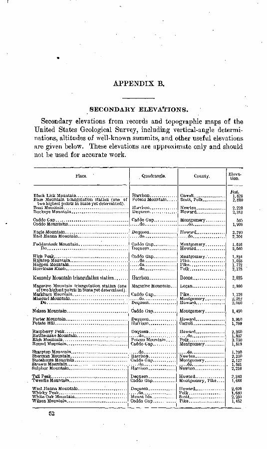
APPENDIX B.
SECONDARY ELEVATIONS.
Secondary elevations from records and topographic maps of the United States Geological Survey, including vertical-angle determi nations, altitudes of well-known summits, and other useful elevations are given below. These elevations are approximate only and should not be used for accurate work.
Place. '
two highest points in State yet determined).
Eagle Mountain ............... ; .................East Hanna Mountain. .........................
Do.........................................
High Peak... ...................................
of two highest points in State yet determined) . Markham Mountain. . ..........................Missouri Mountain.... . .........................DO................................;........
Porter Mountain.... . ...........................Potato Hill.....................................
Sulphur Mountain. .............................
Tall Peak.. .....................................
White Oak Mountain. ..........................
Quadrangle.
Poteau Mountain. . . .
.....do.................
.....do.................
.....do.................
.....do.................
Caddo Gap.................do.................
....do.................
Dequeen..............
Mount Ida .............
County.
Carroll. ...............Scott, Polk............
.....do.................
Pike..................
Polk..................
Boone.................
Pike..................
Carroll................
....do.................Polk..................
....do.................
Howard. ..............
Polk..................Scott.................. Pike..................
Eleva tion.
Feet.1 ftOA
2,800
2 99ftQ O1 Q
5851 906
2 Qft4
2,040
1,8341 *\^S
1 7722 170
2,085
2,800
1,2292,212
i 4Qfl
1,9101,789
9 Sfid
1,8572 7Cfi
1 Q1Q
1 ^Qft
2 9^fi
2 197
. 1, 5612,210
2,340 1,666
2,0701,6802,2501 4W
52
INDEX.
A. Pago. Alamo...................................... 22Alexander................................... 42Alma....................................... 38Altus....................................... 44Antimony.................................. 26Antoine..................................... 19Argenta..................................... 42Arkaclelplua.......................... 17,20,31-32Arkadelphia quadrangle.............. 17,20,31-32Arkansaw City.............................. 32Arkansaw City quadrangle.................. 32Ashley County.............................. 31Athens...................................... 24Atkins...................................... 40Atlanta quadrangle................ I........ 28Avoca....................................... 36
B.Baker Springs..............................Baldwin >. .................................Baring Cross bridge.......................Batavia...................................Baxter....................................Bayou Lapile............................... 37Beaver...................................... 9Beech Hill.................................. 48Belle Point Landing........................ 37Bolmont.................................... 15Bench marks, description of................. 5-6
views of ................................ 5Benton..................................... 10,32Bonton County ............................. 7,31Benton quadrangle.......................... 16,32Bentonville................................. 8Berryville................................... 11Bierao...................................... 17Big Brushy Creek........................... 27Big Fork.................................... 22Birdseye, C. H., leveling by................. 15Black Lick Mountain....................... 52Black Springs............................... 22Blackville................................... 46Blanchard.................................. 26,27Blaylock Mountain.......................... 28Blue Mountain triangulation station......... 52Bluff City................................... 19Boat Mountain.............................. 52Bodcaw..................................... 18Boone County............................... 7,52Boughton................................... 17Boyd, J. A..levelingby..................... 7,15Bradley..................................... 39Brentwood................................... 51Bridge Junction............................. 29Bright water................................. 37
Page. Buckeye Mountain.......................... 52Buckner.................................... 33Buckner quadrangle........................ 32-33Buena Vista................................. 18,33Buena Vista quadrangle..................... 33Bull Bayou................................. 22Burg........................................ 25
C. Caddo Gap............................... 22,Caddo Gap quadrangle......................Caddo Mountains............................Calhoun County.............................Camden.................................. 18,Camden quadrangle................ 18,20-22,Caney.......................................Canfield.....................................Canuck......................................Carey ville...................................Carroll County..............................Center Point................................Ccnterville..................................Champagnolle...............................Champagnolle Landing......................Chapel Hill..................................Chicago, Rock Island & Pacific Ry..........Chicot County...............................Chidester....................................Cincinnati...................................Clark County................................Clarksville...................................Classification of level lines...................Clifty........................................Clyde.......................................Coal Hill....................................Coast and Geodetic Survey, elevations from..
Coe, Robert, leveling by............Conway............................Coaway County....................Corps of Engineers, elevations from. Cossatot River.....................Cove.....................'..........Crawford County...................Crittenden County.................Curry, C. C., leveling by............Curt is..............................
23,5222-24
52 15
33-3433-34
19 39 10 45
7,5223,24
18 40 47 26
15-17 31
18,39 9
15,3135-36
5 10 14 44 7,
31-517,15
4131152627
7,3129
717,40
D.Daisy....................................... 24Dalark...................................... 20Dalark quadrangle.......................... 20,34Dalevllle.................................... 32Dallas County............................... 15Dardanelle quadrangle...................... 34-36
53
54 INDEX.
Page.Datum, nature of....................... I.... 6-7Decatur..................................... 8Denver...................................... 12De Queen................................... 25De Queen & Eastern R. R............... 24-25,28De Queen & Eastern R. R. bridge........... 24De Queen quadrangle....................... 24-28Dermott..................................... 43Desha County............................... 31Diehl, G.E., leveling by.................... 7,15Dierks....................................... 25Donaldson.................................. 34Drakes Creek................................ 10Dutch Mills............:.................... 13Dyer........................................ 38
E.Eagle Mountain............................. 52East Hanna Mountain....................... 52Elberson City............................... 28El Dorado Landing.......................... 47Elevations, secondary....................... 52Elkins Ford................................. 19Elliott....................................... 33Elm Springs................................. 8Emmet...................................... 17Ensign...................................... 43Euclid....................................... 25Eureka Springs.............................. 9,11Eureka Springs quadrangle................ 0-11,36Eutaw Shoals............................... 37
Fairview .........Fancy Hill .......Farmington ......Faulkner County .
....:................ 13
..................... 23
..................... 8
..................... 31Fayetteville .. . .............................. 7, 36Fayetteville quadrangle ................. ', -9, 36-37Felsenthal quadrangle, . ...................... 37Finn........................................ 22Fletchers Landing. .......................... 45Fodderstack Mountain ...................... 52Fort Smith. ................................. 38Fort Smith quadrangle...................... 38-39Franklin County ............................ 31Franklin Landing ........................... 45Frenchport. ................................. 33Frostville quadrangle........................ 39
G.Galla Creek.. ....Garfleld.. .......Garland .........Garland County.
...................... 34
...................... 36
...................... .40
...................... 15Gelbach, W. A., leveling by.. ............... 24Geneva. ..................................... 25Germantown ................................ 46Gillham..................................... 26,27Gordon Hollow.. . ........................... 8Goshen...................................... 9Grannis... .................................. 26,27Gravette .................................... 8Green Forest.... .........................:.. 11-12Greenland. .................................. 51Gum Springs station ........................ - 31Gurdon.. .................................... 17,39Gurdon quadrangle. ................ 17, 18-20, 39-40
H. Page.Harlow...................................... 21Harrison.................................... 12Harrison quadrangle.............. ...A ...... 11-13Hartman.................................... 44Hatfield..................................... 27,28Hatton...................................... 27Helena...................................... 40Helena quadrangle ............................ 40Hempstead County.......................... ' 15High Peak.................................. 52Hightop Mountain.......................... 52Hindsville................................... 9Hogpen Mountain........................... 52Hope........................................ 17Hopefield.................................... 30Hope quadrangle............................ 17Hot Springs................................. 16Hot Spring County.......................... 15,31Hot Springs special quadrangle.............. 16Howard County.......................... 15,24, 52Hudspeth................................... 41Hulbert..................................... 29-30Hunts ville................................... 10Hurricane Knob............................. 52
I.Illinois Creek... Irvine, Chester.
Jacks Island......Jarissen...........Jasper............Jefferson County. Johnson..........Johnson County.. Jordan Ferry.....Jordan Landing..
K.Kansas City Southern Ry................ 25-26,28Kennedy Mountain triangulation station.... 52Zidds spur.................................. 41Kings spur.................................. 25Kingston.................................... llKirby....................................... 23Knoxville................................... 35Kress quadrangle............................ 40-41
L. Lafayette County............................ 31Lake Landing............................... 3Lake Village quadrangle...................... 41Lamar...................................... 53Lancaster................................... 50Laneburg............................;....... 18Langley..................................... 23Leppards Camp............................. 48Lester....................................... 22,34Leveling. See Primary leveling; Precise lev
eling. Lewisville................................... 40Lillie........................................ 39Lincoln County............................. 31Linden quadrangle.......................... 41Lissie........................................ 23Little Bay................................... 48Little Brushy Creek......................... 27
INDEX. 55
Page. Little Alissouri River........................ 39Little Bock............................... 15,42,43Little Rock quadrangle................... 15,41-43Locksburg................................... 28Locksburg quadrangle....................... 28Lodi.......................'.................. 23Logan County............................... 52London..................................... 35Lowell...................................... 36Lucky quadrangle........................... 22
M. Mabel vale................................... 43McCehee.................................... 44McGehee quadrangle........................ 45McNeil...................................... 49Madison County............................. 7Magazine Mountain quadrangle.............. 44-45Magazine Mountain triangulation station.... 52Malvern.................................. 10-17,45Malvern quadrangle....................... 16-17,45Marble....................................... 11Marche...................................... 42Marion....................................... 30Markham Mountain.......................... 52May Flower.................................. 42Memphis..................................... 29Memphis, Dallas & Gulf R. TA................ 20Memphis quadrangle......................... 29-30Menifee......................................' 46Messer Creek................................. 24Meyers....................................... 22Mill Creek station............................ 35Miller County................................ 28Mineola.................................:. 25,26,28Missouri & N orth A rkansas R. R............ 9Missouri, Kansas & Texas Ry................ 28Missouri Mountain........................... 52Montgomery County......................... 15,52Moores spur................................. 26Morobayquadrangle......................... 45-46Morrell....................................... 41Morrillton.................................... 46Morrillton quadrangle........................ 46Mound City.................................. 30Mounds...................................... 30Mountainburg............................... 50Mountain Fork bridge....................... 28Mountain Valley............................. 16Muddy Fork................................ 23Mulberry.................................... 38Muldrow,H. L.,levelingby................. ' 15Murfreesboro................................. 23
N.Nathan...................................... 24Natural Dam post office...................... 13Nelson Mountain............................ 52Nevada County.............................. 15New Hope................................... 24New Lewisville.............................. 40Newton County.............................. 7,52Nix.......................................... 20Noble Lake.................................. 46Noble Lake quadrangle...................... 46
0.Oak Grove..................Ogamaw....................Okolona....................Older, Clifford, leveling by. Omaha......................Onalaska..................Onita station...............Orchard....................Oregon......................Osage.......................
Page. 12 48 19
712 21 348
1213
Osage Mills.................................. 8Ouachita Belle Landing...................... 37Ouachita County............................ 15,31Ozark........................................ 44
P.Palarm...................................... 42Parkdalo.................................... 49Pastoria quadrangle......................... 46-47Pension Mountain........................... 11Personnel................................... 5Pigeon Hill Landing........................ 45Pike City.................................... 23Pike County................................ 15,52Pine Bluff................................... 47Pine Bluff quadrangle....................... 47Piney station................................ 35Pinon Hollow............................... 9Plata........................................ 22Plumervillc................................. 46Poopping.................................... 45Polk County............................. 15,24,52Pope County................................ 31Porter....................................... 50Porter Mountain............................ 52Portland.................................... 49Potash Sulphur Springs...................... 16Potato Mountain............................ . 52Precise leveling, elevations by................ 31-51Prescott..................................... 17Preston..................................... 41Primary leveling, definition of............... 5
elevations by............................ 7-30Princoton ................................... 20Provo........................................24-25Pruitt....................................... 12Publication, earlier.......................... 5Pulaski County............................. 15,31Pullman..................................... 25
R.Raspberry Peak.......Rattlesnake Mountain. Raum.................Ravenna..............Rod Fork quadrangle. Riceville..............Rich Mountain........Rock Creek............Rock Island Railway.. Rock Springs..........Rogers................Round Mountain......Rudy.................Russell ville............
5252122847305222292536525034
56 INDEX.
S.St. Louis & San Francisco Railroad .. 7,36-37,50-51 St. Louis, Iron Mountain and Southern
Railway................. 15-18,23,31-36,38-46,49St. Louis Southwestern Railway............. 18,
32-33,39-40,48-49 Saline County............................... 15-31Saline River..............................Sea level, mean, definition of. .............Scott County....:........................... 52Seba.....................................Sensensey, H. S., leveling by................. 29Sevier County............................... 24Shady...................................Sharptop Mountain..........:.....'......... 52Sherman Mountain.......................Shepard,E. L.,levelingby................... 15Siloam Springs............................Siloam Springs quadrangle................Smackover Creek..........................Smackover quadrangle...................... 47-48Smith, T.E..leveling by...................Smithton..................................Spadra....................................... 44Springdale................................... 36Spring Lake................................. 16Springtown................................Spring Valley.............................Stamps...................................... 33Statehouse Mountain.....................Stattler...................................Stephens.................................... 48,49Stephens quadrangle........................ 48-49Stony Point Church.......................Strawn Mountain..........................Strickler...................................Sulphur City..............................Sulphur Springs...........................Sunshine.................................Sweet Home...............................
T.
Tall Peak.................................Texarkana...............................Texarkana quadrangle....................... 29Tillar......................................Topographic maps,list of..................
ge-(-51
i M9 >-31
326
62 8
292428525215 9 9
47-48
740443616
810335?,14
,49-49
11521415
S4942
52 2929 43
7
' U. Ultima Thule...................."...
V.
W. Waldo.... ................ ...........Walnut Hill. ........................
Washington County. . ...............Wedington Gap .....................
West Fork. .........................
White Oak ..........................White Oak Mountain. ...............White River. ... .....'................
Wilmot.. ............................
Wilson..............................
Wolf Creek ..........................
Wray, D. C., leveling by .....'.......Wrightsville. .........................
Y. Yocum.. ............................
Page. ........ 49........ 49........ 44........ 52
........ 26
........ 31
........ 38
....... 21........ 49........ 49
....... 32........ 48........ 47........ 10
7 31........ 8........ 10....... 51........ 52....... 8....... 18,39....... 52........ 45........ 52....... 10........ 26........ 49........ 49....... 22........ 52....... 14,51. 13-15,50-51....... 23........ 51
....... 15
........ 12
o