srl 80(5).indb
TRANSCRIPT

SEISMOLOGICAL RESEARCH LETTERS
IzmirNet: A Strong-motion Network in Metropolitan Izmir, Western Anatolia, Turkey
by Orhan Polat 1,2, Ulubey Ceken 3, Tulay Uran 3, Elcin Gok 2, Nazan Yilmaz 3, Murat
Beyhan 3, Nurcan Koc 3, Berna Arslan 4, Doguser Yilmaz 1, and Mehmet Utku 1
1. Dokuz Eylül University, Geophysical Engineering Department, Division of Seismology, Izmir, Turkey 2. Earthquake Research and Implementation Center of Dokuz Eylül University, Izmir, Turkey 3. Earthquake Research Department, General Directorate of Disaster Affairs, Ankara, Turkey 4. Metropolitan Municipality of Izmir, Directorate of Construction Affairs, Izmir, Turkey
doi: 10.1785/gssrl.80.5.831 - September/ October 2009 Seismological Research Letters 80 (5), 831-838
Seismological Research Letters Volume 80, Number 5 September/October 2009 831doi: 10.1785/gssrl.80.5.831
INTRODUCTION
A 16-station strong-motion seismic monitoring network cov-ering metropolitan Izmir and the surrounding region was established in July 2008. The seismic network was installed as a cooperative effort involving the Earthquake Research and Implementation Center (ERIC-DAUM) of Dokuz Eylül University (DEU, Izmir), the Earthquake Research Department (ERD) of the General Directorate of Disaster Affairs (GDDA, Ankara), the Izmir Metropolitan Municipality, and the Ministry of Public Works and Settlement. The project was funded by the Scientific and Technological Research Council of Turkey (TUBITAK) to collect strong-motion data for earthquake hazard assessment studies and to develop a real-time monitoring system in Turkey (Inan etal. 2007) to address public safety issues.
The network is critically important to addressing earth-quake hazard issues in western Turkey, an area known to have historically damaging earthquakes. Izmir is the third largest city in Turkey in terms of population, industrial density, eco-nomic capacity, and contribution to the national economy, and the economic and human consequences of a damaging earth-quake in the Izmir area would be significant.
A primary goal of this project is to acquire strong ground-motion data in order to understand propagation and site response characteristics of the Quaternary and Neogene sediments that underlie the Izmir metropolitan area and are thought to produce large site amplification and seismic hazard (Aydinoglu 2000; Masure et al. 2000). These data will com-plement laboratory data to characterize the properties of the soft soils underlying the Izmir metropolitan residential area so that engineers and architects can design appropriate earth-
quake-resistant structures for the region. This project is also a first step toward developing a “Rapid Response and Damage Prediction System” for metropolitan Izmir where near real-time strong ground-motion records can be used to compute ground-shaking maps showing the areas most strongly affected by earthquakes.
SEISMOTECTONIC SETTING
The tectonic framework of western Anatolia is dominated by crustal extension. The Aegean region to the south of 39.50N extends in a N-S direction with an upper bound rate of 20 mm/y, while the north Anatolian fault zone (NAFZ) and east Anatolian fault (EAF) are characterized by strike-slip deforma-tion (Figure 1; see also Jackson and McKenzie 1984; Saroglu etal. 1992). Within this extensional framework, the study area is located at the western termination of the Gediz graben system (GGS), close to the city of Manisa in the north and Doganbey cap (DC) in the south (Pamukcu and Yurdakul 2008; Polat etal. 2008).
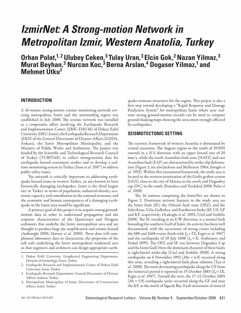
The 16 stations comprising the IzmirNet are shown in Figure 2. Dominant tectonic features in the study area are the Izmir fault (IF); the Orhanli fault zone (OFZ); and the Seferihisar, Urla, Gulbahce, and Karaburun faults (SF, UF, GF and KF, respectively; Ocakoglu etal. 2005; Uzel and Sozbilir 2008). The IF, trending in an E-W direction, is a normal fault bounding the southern Gulf of Izmir. Its activity has been well documented, with the occurrence of strong events including the 688 and 1668 events (both with I0 = IX, Ergin etal. 1967) and the earthquake of 10 July 1688 (I0 = X; Ambraseys and Finkel 1995). The OFZ and SF run between Doganbey Cap and the Izmir Gulf. Here the dominant character of these faults is right-lateral strike-slip (Uzel and Sozbilir 2008). A strong earthquake on 6 November 1992 (Mw = 6.0) occurred along this zone, revealing a right-lateral fault plane solution (Tan etal. 2008). The most devastating earthquake along the UF from the historical period is reported on 15 October 1883 (I0 = IX, Ergin etal. 1967). Toward the west, the 17–21 October 2005 (Ms= 5.9) earthquake series occurred along the GF and near the KF, at the north of Sigacik Bay. Fault movement of most of
izmirnet: a strong-motion network in Metropolitan izmir, western anatolia, turkeyOrhan Polat, Ulubey Ceken, Tulay Uran, Elcin Gok, Nazan Yilmaz, Murat Beyhan, Nurcan Koc, Berna Arslan, Doguser Yilmaz, and Mehmet Utku
Orhan Polat,1, 2 Ulubey Ceken,3 Tulay Uran,3 Elcin Gok,2 Nazan Yilmaz,3
Murat Beyhan,3 Nurcan Koc,3 Berna Arslan,4 Doguser Yilmaz,1 and Mehmet Utku1
1. Dokuz Eylül University, Geophysical Engineering Department, Division of Seismology, Izmir, Turkey
2. Earthquake Research and Implementation Center of Dokuz Eylül University, Izmir, Turkey
3. Earthquake Research Department, General Directorate of Disaster Affairs, Ankara, Turkey
4. Metropolitan Municipality of Izmir, Directorate of Construction Affairs, Izmir, Turkey

832 Seismological Research Letters Volume 80, Number 5 September/October 2009
the events reveals pure strike-slip faults as evidenced from focal mechanism solutions (Aktar etal. 2007; Benetatos etal. 2006).
The region is situated in the first-degree hazard zone in the Official Earthquake Hazard Regionalization Map of Turkey. By using historical (since 5th century B.C.) and instrumental (from 1911 on) data. Papazachos etal. (2004) postulated the possibility of a severe earthquake with magnitude larger than 6.4 in the study area. Koravos etal. (2003) proposed a maxi-mum earthquake magnitude 7.2 ± 0.1 near KF by using a com-bination of instrumental, historical, and geodetic data. Since devastating earthquakes occur relatively infrequently in the region, this should be treated with caution. A missed oppor-tunity for proper recording of the ground motions these events produce represents the loss of important and irreplaceable sci-entific data in metropolitan Izmir and the surrounding area. High-density strong-motion networks are justified because if effects of these rare occurrences are recorded, they could pro-vide valuable insight to engineers and seismologists about what to expect in a future damaging earthquake.
DESCRIPTION OF IZMIRNET
The main conceptual aims of the new network are: 1) adequate coverage of the various sedimentary environments in Izmir and surroundings, 2) station locations close to potential fault planes, 3) free-field station installations wherever logistically possible, 4) remote accessibility to the data, and 5) continuous recording (as opposed to triggered recording) so that relatively small events are recorded at all stations. The IzmirNet covers an area of approximately 50 km × 20 km around the Gulf of Izmir and is deployed over the active fault system. A list of the basic parameters for all stations is given in Table 1.
Station HardwareAll stations are free-field and equipped with three-component CMG-5TD accelerographs (Guralp Systems, Reading, UK) with CMG-5T force balance accelerometer and built-in 24-bit AD converter for data acquisition. The system contains two supply boxes for communication and uninterruptible power
▲ Figure 1. Principal tectonic features of the Aegean region of Turkey, western Anatolia (compiled from Saroglu et al. 1992). GA—Gulf of Antalya, BMG—Buyuk Menderes graben, CB—Candarli Bay, DC—Doganbey cap, GB—Gokova Bay, GGS—Gediz graben system, KP—Karaburun Peninsula, KB—Kusadasi Bay. Inset Map: NAF—North Anatolian fault, EAF—East Anatolian fault.
Seismological Research Letters Volume 80, Number 5 September/October 2009 833
▲ Figure 2. Main tectonic elements near metropolitan Izmir, Aegean region of Turkey. Tectonic features are mainly compiled from Ocakoglu et al. (2005) and Uzel and Sozbilir (2008). KF—Karaburun fault, GF—Gulbahce fault, IF—Izmir fault, SF—Seferihisar fault, OFZ—Orhanli fault zone, UF—Urla fault.
TABLE 1Station Parameters of the IzmirNet Strong-Motion Network
Code Lon. deg E Lat. deg NElev. (m) Location Environment
Installation Date *
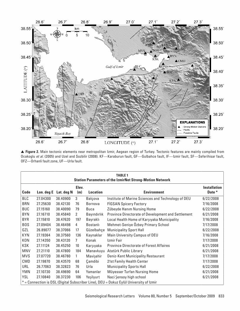
BLC 27.04300 38.40900 3 Balçova Institute of Marine Sciences and Technology of DEU 6/22/2008BRN 27.25630 38.42130 76 Bornova FİGSAN Spicery Factory 7/16/2008BUC 27.15160 38.40090 79 Buca Zübeyde Hanım Nursing Home 6/22/2008BYN 27.16710 38.45840 2 Bayındırlık Province Directorate of Development and Settlement 6/21/2008BYR 27.15810 38.47620 197 Bayraklı Local Health Home of Karşıyaka Municipality 7/16/2008BOS 27.09404 38.46498 4 Bostanlı Mehmet-Seniye Özbey Primary School 7/17/2008GZL 26.89077 38.37066 17 Güzelbahçe Municipality Sport Hall 6/22/2008KYN 27.19364 38.37560 136 Kaynaklar Main University Campus of DEU 7/16/2008KON 27.14350 38.43120 7 Konak Izmir Fair 7/17/2008KSK 27.11124 38.45250 10 Karşıyaka Province Directorate of Forest Affaires 6/21/2008MNV 27.21110 38.47800 184 Manavkuyu Atatürk Public Library 6/21/2008MVS 27.07720 38.46780 1 Mavişehir Deniz-Kent Municipality Restaurant 7/17/2008CMD 27.19870 38.43570 68 Çamdibi 21st Family Health Center 7/17/2008URL 26.77063 38.32823 76 Urla Municipality Sports Hall 6/22/2008YMN 27.10730 38.49690 64 Yamanlar Müyesser Turfan Nursing Home 6/21/2008YSL 27.10840 38.37230 106 Yeşilyurt Naci Şensoy high school 6/21/2008* = Connection is DSL (Digital Subscriber Line), DEU = Dokuz Eylül University of Izmir
834 Seismological Research Letters Volume 80, Number 5 September/October 2009
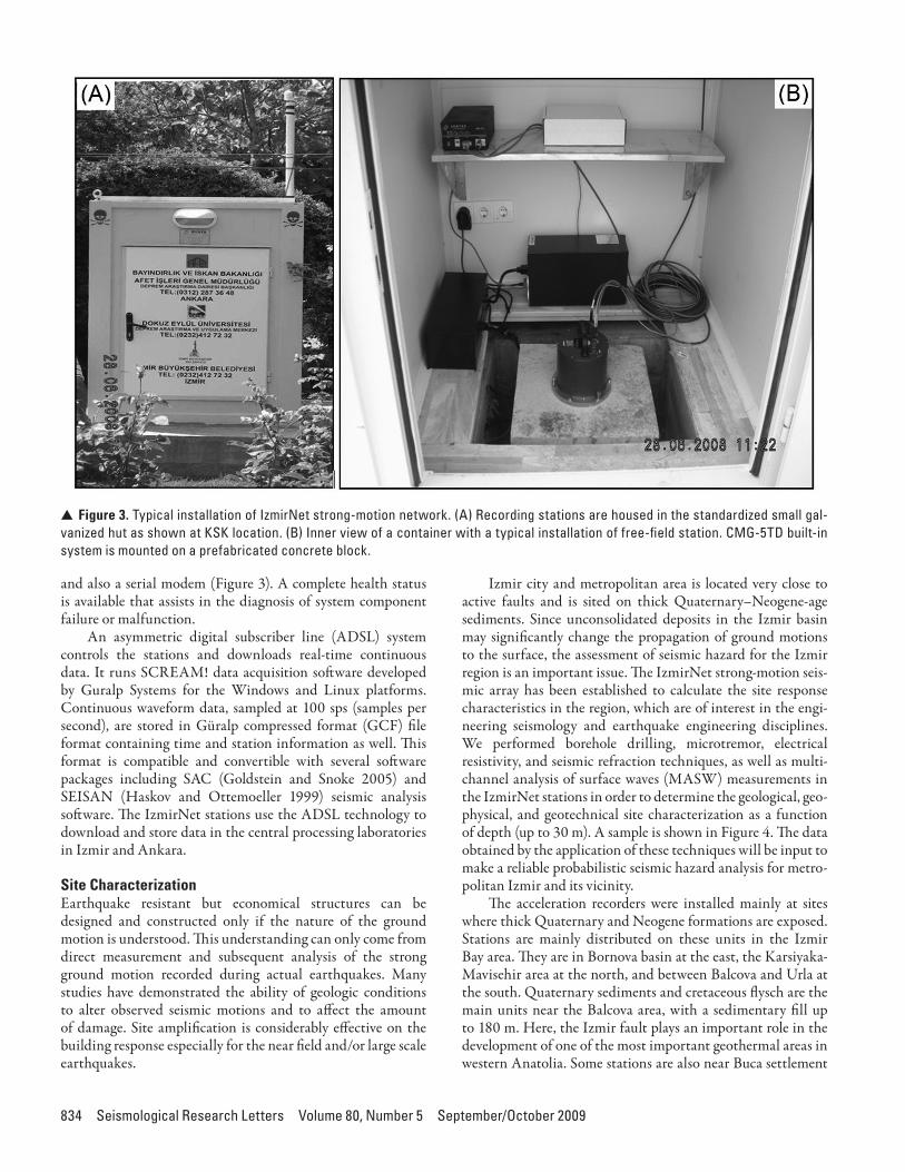
and also a serial modem (Figure 3). A complete health status is available that assists in the diagnosis of system component failure or malfunction.
An asymmetric digital subscriber line (ADSL) system controls the stations and downloads real-time continuous data. It runs SCREAM! data acquisition software developed by Guralp Systems for the Windows and Linux platforms. Continuous waveform data, sampled at 100 sps (samples per second), are stored in Güralp compressed format (GCF) file format containing time and station information as well. This format is compatible and convertible with several software packages including SAC (Goldstein and Snoke 2005) and SEISAN (Haskov and Ottemoeller 1999) seismic analysis software. The IzmirNet stations use the ADSL technology to download and store data in the central processing laboratories in Izmir and Ankara.
Site CharacterizationEarthquake resistant but economical structures can be designed and constructed only if the nature of the ground motion is understood. This understanding can only come from direct measurement and subsequent analysis of the strong ground motion recorded during actual earthquakes. Many studies have demonstrated the ability of geologic conditions to alter observed seismic motions and to affect the amount of damage. Site amplification is considerably effective on the building response especially for the near field and/or large scale earthquakes.
Izmir city and metropolitan area is located very close to active faults and is sited on thick Quaternary–Neogene-age sediments. Since unconsolidated deposits in the Izmir basin may significantly change the propagation of ground motions to the surface, the assessment of seismic hazard for the Izmir region is an important issue. The IzmirNet strong-motion seis-mic array has been established to calculate the site response characteristics in the region, which are of interest in the engi-neering seismology and earthquake engineering disciplines. We performed borehole drilling, microtremor, electrical resistivity, and seismic refraction techniques, as well as multi-channel analysis of surface waves (MASW) measurements in the IzmirNet stations in order to determine the geological, geo-physical, and geotechnical site characterization as a function of depth (up to 30 m). A sample is shown in Figure 4. The data obtained by the application of these techniques will be input to make a reliable probabilistic seismic hazard analysis for metro-politan Izmir and its vicinity.
The acceleration recorders were installed mainly at sites where thick Quaternary and Neogene formations are exposed. Stations are mainly distributed on these units in the Izmir Bay area. They are in Bornova basin at the east, the Karsiyaka-Mavisehir area at the north, and between Balcova and Urla at the south. Quaternary sediments and cretaceous flysch are the main units near the Balcova area, with a sedimentary fill up to 180 m. Here, the Izmir fault plays an important role in the development of one of the most important geothermal areas in western Anatolia. Some stations are also near Buca settlement
▲ Figure 3. Typical installation of IzmirNet strong-motion network. (A) Recording stations are housed in the standardized small gal-vanized hut as shown at KSK location. (B) Inner view of a container with a typical installation of free-field station. CMG-5TD built-in system is mounted on a prefabricated concrete block.

Seismological Research Letters Volume 80, Number 5 September/October 2009 835
toward the south extremity of the city, where geological units generally exhibit limestone and marl.
SAMPLE DATA
Figure 5 shows an example from time and frequency domain analysis for the earthquake (Md = 3.0) that occurred on 10 August 2008. A horizontal-component accelerogram (SH) was used to analyze the site and source characteristics of the selected event. We plan to compute source size, spectral level (Wo), seismic moment, stress drop, and validity of corner and cut-off frequency (fmax), with a discussion of the effect of vari-ous attenuation models on the source spectra. Two horizontal motions are combined in the Z-component to infer the particle motion characteristics. This study procedure allows a detailed analysis of frequencies at which the ground motion is the larg-est and most polarized. Particle motion in the horizontal plane represents an ellipse, and it is a very important measure of horizontal shaking that provides a complete description of the magnitude of motions. Here, we estimated mainly north and east directions for the KSK and KYN stations, respectively, for the selected event of 10 August 2008.
Figure 6 shows the data quality and selected earthquakes recorded by IzmirNet. The three-component event that occurred on 3 September 2008 (MD = 2.8) has a 10-km hypo-central distance. The earthquake of 10 August 2008 (MD = 3.0) was recorded by at least 13 stations. These data examples pres-ent local microearthquakes with a good S/N ratio. Since all sta-
tions are remotely accessible, we plan to use the data to perform a rapid calculation of intensities.
FUTURE PLANS
Due to its high density, wide dynamic range (flat response from DC to 50 Hz), and advanced data-acquisition and data-transmission technologies, IzmirNet will become the core infrastructure of a prototype “Rapid Response and Damage Prediction System” in metropolitan Izmir. In the near future, it will be devoted to real-time estimation of magnitude and earthquake location to calculate rapid ground-shaking maps for the whole of the city.
The principal aim of the network is to address site-response issues in Izmir. But IzmirNet will also contribute to emergency response in the near future by increasing the number of sta-tions in the region and connecting to a broader system for reporting earthquake locations and magnitudes and comput-ing the shakemaps. The information provided by the network during the first few seconds of a potentially damaging seismic event will be used to activate several types of security measures, such as the shutdown of critical systems, i.e., gas or oil pipelines or water, sewer, and electricity lines, etc. Hence, the IzmirNet is closely concerned with the lifeline systems and public social life. The network will provide precise peak ground acceleration (PGA) distribution, which is one of the most important param-eters when projecting loss estimates as the result of a potential strong earthquake. In the near future, ground-shaking maps
▲ Figure 4. Local soil information for station 04_BYN (modified from METU 2007).

836 Seismological Research Letters Volume 80, Number 5 September/October 2009
will also play an important role in reducing the negative impact of destructive earthquakes in urban areas. This local array will be used to fully exploit the PGA distribution during the earth-quake and exhibit critical settlement areas of the city (Ulusay etal. 2004).
CONCLUSIONS
The IzmirNet strong-motion network has been fully opera-tional since August 2008. It promises to be useful for research and implementation in engineering and strong-motion seis-mology. The array is already recording small-scale earthquakes in the Gulf of Izmir and the surrounding area (Figure 6). Location parameters are given in Table 2. Most of the events are low magnitude, but they lay the groundwork for studying a future large earthquake and predicting its ground motion.
To make accurate epicenter locations and to produce more reliable ground-shaking maps after a strong earthquake in or
around Izmir, we plan to install additional recorders near the Gulf of Izmir in locations north of Karaburun Peninsula (to the west), the western half of the Cigli and Mavisehir districts (in the north), and near the Gaziemir district (to the south). These additional stations will be equipped with the same instruments and communication protocols to retrieve peak ground parameters.
IzmirNet is part of the national strong-motion network of the GDDA (Ankara) that is already operating and includes several local arrays in western Anatolia. The long-sought goal of the GDDA is to increase the total number of accelerographs in Turkey (Gulkan et al. 2007). Currently, the national net-work consists of about 220 strong-motion recorders; the local IzmirNet array, a joint operation between ERIC in Izmir and ERD in Ankara, will help reduce the chances of missing important seismological data if a moderate-to-large earthquake were to hit the Aegean region and western Anatolia.
▲ Figure 5. Sample analysis of the event of 10 August 2008 (Md = 3.0). (A) Two horizontal components of the BLC station in time domain. (B) Displacement spectra of the event showing corner frequency (fc), fmax (Hanks 1982), and spectral level (Ωo) to compute source parameters for Brune’s (1970) model. (C) Examples of the particle motion analysis at KSK and KYN stations in the plane NS-Z and EW-Z.

Seismological Research Letters Volume 80, Number 5 September/October 2009 837
ACKNOWLEDGMENTS
The IzmirNet strong-motion network was funded by the TUBITAK Scientific and Technological Research Council of the Turkish Republic under the category of the Public Research Grant Committee (KAMAG) of Support Program for Research Projects of Public Institutions (1007). This con-tribution is from Seismology Work Group-1 of the Izmir Earthquake Project, which is financially supported by TUBITAK under the project number KAMAG-106G159.
This study is a part of the PhD thesis of Elcin Gok. The authors acknowledge an anonymous reviewer for constructive com-ments and wish to thank our project consultants (Professor Resat Ulusay and Assoc. Professors Esref Yalcinkaya, Oguz Ozel, and Ahmet Yakut) for their helpful advice in finalizing the site selection of the strong-motion stations. We also thank the staff of geophysicists, geologists, and civil engineers of Dokuz Eylül University (Izmir) and the Earthquake Research Department (Ankara) for their help during the strong-motion station studies. We wish to acknowledge the Governorship of Izmir, mayors of metropolitan Izmir and Karsiyaka munici-palities, and also FIGSAN Company, Izmir.
We have received enormous support and great help from Ismail Asi, Oksan Mersin, Oznur Zorlu, Latif Bilgin, Mete Mirzaoglu, Naki Hozer, Kamuran Turkun, and Rafael Benveniste. Numerous individuals have been of great help dur-ing our bureaucratic travails and station installations. We are grateful for their encouragement. Because we are afraid that a list may leave someone out, we thank them very much as a group.
REFERENCES
Aktar, M., H. Karabulut, S. Ozalaybey, and D. Childs (2007). A con-jugate strike-slip fault system within the extensional tecton-ics of Western Turkey. Geophysical Journal International; doi: 10.1111/j.1365-246X.2007.03598.x, 1–13.
Ambraseys, N. N., and C. F. Finkel (1995). TheSeismicityofTurkeyandAdjacentAreas. Istanbul: Eren Publications, 240 pps.
Aydinoglu, N. (2000). Loss Estimation of Building Stock in IzmirEarthquake Master Plan. Bogazici University report for the RADIUS Project, Istanbul.
▲ Figure 6. Recorded earthquakes by IzmirNet strong-motion network. See Table 2 for earthquake location parameters. MRC: Local stations of TUBITAK Marmara Research Center, Gebze, Kocaeli; ERD: National stations of Earthquake Research Department of GDDA, Ankara; KOERI: National stations of Kandilli Observatory and Earthquake Research Institute, Istanbul.
TABLE 2Selected earthquake locations recorded by IzmirNet
strong-motion network
Event No Date Time
Epicentral Coordinates
Md
Depth (km)N (o) E (o)
1 04.08.2008 23:07 38.5552 26.6998 2.8 7.02 10.08.2008 02:22 38.3805 27.0913 3.0 10.63 10.08.2008 02:55 38.3803 27.0858 2.7 7.04 19.08.2008 07:46 38.3520 26.8897 2.6 7.05 22.08.2008 02:10 38.2025 26.7848 2.8 7.06 26.08.2008 04:17 38.2693 27.2493 2.8 7.37 27.08.2008 09:36 38.4032 27.3170 2.6 7.08 30.08.2008 18:10 38.2552 26.7330 2.7 12.59 03.09.2008 11:58 38.4080 27.0125 2.8 7.0
10 18.09.2008 18:36 38.4973 26.6067 3.1 28.7

838 Seismological Research Letters Volume 80, Number 5 September/October 2009
Benetatos, C., A. Kiratzi, A. Ganas, M. Ziazia, A. Plessa, and G. Drakatos (2006). Strike-slip motions in the Gulf of Sigacik (western Turkey): Properties of the 17 October 2005 earthquake seismic sequence. Tectonophysics 426, 263–279.
Brune, J. N. (1970). Tectonic stress and the spectra of seismic shear waves from earthquakes. JournalofGeophysicalResearch 75, 4,997–5,009.
Ergin, K., U. Güçlü, and Z. Uz (1967). ACatalog of Earthquakes forTurkey and Surrounding Area 11 A.D. to 1964 A.D. Istanbul: Istanbul Technical University Press No. 24, Turkey, 169 pps.
Goldstein, P., and A. Snoke (2005). SAC availability for the IRIS com-munity. DMS Electronic Newsletter 7 (1); http://www.iris.edu/news/newsletter.
Gulkan, P., U. Ceken, Z. Colakoglu, T. Ugras (Uran), T. Kuru, A. Apak, J. G. Anderson, H. Sucuoglu, M. Celebi, S. Akkar, U. Yazgan, and A.Z. Denizlioglu (2007). Enhancement of the national strong-motion network in Turkey. SeismologicalResearchLetters 78 (4), 429–438.
Hanks, T. (1982). Fmax. BulletinoftheSeismologicalSocietyofAmerica 71 (6), 1,867–1,879.
Haskov, J., and L. Ottemoeller (1999). SEISAN: The EarthquakeAnalysisSoftware. Bergen, Norway: Institute of Solid Earth Physics, Univ. of Bergen.
Inan, S., S. Ergintav, R. Saatcilar, B. Tuzel, and Y. Iravul (2007). Turkey makes major investment in earthquake research. Eos,Transactions,AmericanGeophysicalUnion 88 (34), 333–334.
Jackson, J. A., and D. P. McKenzie (1984). Active tectonics of Alpine–Himalayan belt between western Turkey and Pakistan. GeophysicalJournaloftheRoyalAstronomicalSociety77, 185–265.
Koravos, G. C., I. G. Main, T. M. Tsapanos, and R. M. W. Musson (2003). Maximum earthquake magnitudes in the Aegean area constrained by tectonic moment release rates. GeophysicalJournalInternational 152, 94–112.
Masure, P., P. Mouroux, and C. Martin (2000). TheInternationalDecadefor Natural Disaster Reduction (IDNDR) RADIUS Project: CaseStudy:SeismicRiskAssessmentofIzmirCity. Geneva, Switzerland; http://www.geohaz.org/news/images/publications/RADIUS_Report.pdf.
METU (2007). Seismic and Geotechnical Survey at “AI_115_BRN_BAY” Station. Ankara, Turkey: ERD-METU TUBITAK Scientific Research Project (No. 105G016), 16 pps.
Ocakoglu, N., E. Demirbag, and I. Kuscu (2005). Neotectonic structures in Izmir Gulf and surrounding regions (western Turkey): Evidences of strikeslip faulting with compression in the Aegean extensional regime. MarineGeology 219, 155–171.
Pamukcu, O., and A. Yurdakul (2008). Isostatic compensation in west-ern Anatolia with estimate of the effective elastic thickness. TurkishJournalofEarthSciences 17, 545–557.
Papazachos, C. B., G. F. Karakaisis, E. M. Scordilis, and B. C. Papazachos (2004). Probabilities of activation of seismic faults in critical regions of the Aegean area. GeophysicalJournalInternational 159, 679–687.
Polat, O., E. Gok, and D. Yilmaz (2008). Earthquake hazard of the Aegean extension region (west Turkey). Turkish Journal ofEarthSciences 17, 593–614.
Saroglu, F., O. Emre, and I. Kuscu (1992). TurkishActiveFaultsMap. Ankara, Turkey: Report of Directorate of Mineral Research and Exploration.
Tan, O., C. Tapirdamaz, and A. Yoruk (2008). The earthquake cata-logues for Turkey. TurkishJournalofEarthScience 17, 405–418.
Ulusay, R., E. Tuncay, H. Sonmez, and C. Gokceoglu (2004). An attenu-ation relationship based on Turkish strong motion data and iso-acceleration map of Turkey. EngineeringGeology 74, 265–291.
Uzel, B., and H. Sozbilir (2008). A first record of a strike-slip basin in western Anatolia and its tectonic implication: The Cumaovasi Basin. TurkishJournalofEarthSciences 17, 559–591.
Dokuz Eylül UniversityGeophysical Engineering Department
Division of SeismologyIzmir, Turkey
[email protected](O.P.)