staff report ketchum planning and zoning …
TRANSCRIPT

STAFF REPORT
KETCHUM PLANNING AND ZONING COMMISSION REGULAR MEETING OF SEPTEMBER 21, 2021
PROJECT: Okada Residence
FILE NUMBER: P21-042 and P21-041 APPLICATION TYPE: Final Design Review and Subdivision – Preliminary Plat REPRESENTATIVE: Jolyon Sawrey, Vital Ink Architecture (Architect) PROPERTY OWNER: Robert L. Okada REQUEST: Final Design Review and Preliminary Plat application for the development of a new
1,792 square foot detached townhome LOCATION: 407 Bald Mountain Rd – Tax Lot 3215 ZONING: General Residential – Low Density (GR-L) REVIEWER: Morgan R. Landers, AICP – Senior Planner NOTICE: A public hearing notice for the project was mailed to all owners of property within 300
feet of the project site and all political subdivisions on September 21, 2021. The public hearing notice was published in the Idaho Mountain Express the on September 1, 2021. A notice was posted on the project site and the city’s website on September 13, 2021.
I. EXECUTIVE SUMMARY:
The Applicant is proposing a new 1,792 square foot two-story detached townhome (the “project”), located at 407 Bald Mountain Rd (the “subject property”). The subject property is a tax lot with an existing single family dwelling unit zoned General Residential – Low Density (GR-L). Detached townhomes are a permitted use within the GR-L zone district provided that all dimensional standards are met. The project proposes to retain the existing single family dwelling unit, subdivide the property into two townhouse sublots and construct a new detached dwelling unit on the newly created lot. See Sheet C1.0 in Attachment B for a site plan illustrating the location of the existing dwelling unit, proposed lot lines, and location of the proposed unit.
Figure 1: Conceptual Rendering of Okada Residence

Lofts at 780 Multi-Family Building Design Review and Preliminary Plat Planning & Zoning Commission Meeting of September 21, 2021 Page 2 of 5
As the existing lot has not previously subdivided, both structures must meet zoning and subdivision requirements for approval of the townhouse subdivision. The existing single-family dwelling unit was constructed in 1961. See Attachment E for a review of the project’s conformance with zoning and dimensional standards. The project will construct improvements to the right-of-way per the City of Ketchum improvement standards. All improvements to the right-of-way will be reviewed and approved by the City Engineer and Streets Department prior to issuance of a building permit. See sheet C1.1 of Attachment B and Sections III and IV of this staff report for an overview of proposed improvements. Staff believes the project to be in conformance with all requirements of the zoning code, all standards related to design review, and all subdivision requirements for preliminary plats. II. BACKGROUND: The City of Ketchum received the application for Design Review and Preliminary Plat on April 28, 2021. Preapplication Design Review is not required for the project as the total number of units is less than five. The Final Design and Preliminary Plat applications have been reviewed concurrently and were deemed complete on July 15, 2021, after one review for completeness. Following receipt of the complete application, staff routed the application materials to all city departments for review. Department comments were provided to the applicant on August 11, 2021. Department comments can be found in Table 1, Attachment E to this staff report. III. CONFORMANCE WITH ZONING AND DESIGN REVIEW STANDARDS: Per Ketchum Municipal Code (KMC) §17.96.010.A – Applicability, design review is required for all new multi-family dwellings including attached and detached townhomes. Before granting Design Review approval, the Commission must determine that the application meets two criteria: (1) the project doesn’t jeopardize the health, safety, or welfare of the public, and (2) the project conforms to all Design Review standards and zoning regulations (KMC §17.96.050.A). Conformance with Zoning Regulations During department review, city staff reviewed the project for conformance with all applicable zoning code requirements including uses, dimensional limitations, signage, parking, development standards, and dark skies. The project follows all applicable zoning code requirements. Review of compliance with zoning and dimensional standards can be found in Attachment F. For ease of reference, Sublot 1 is the existing home. Below is an overview of standards worth noting: Building Coverage Dimensional standards for townhouse lots are measured from the parent lot, not each individual sublot. For the proposed project, total lot coverage is calculated by adding the coverage of both structures and dividing that number by the total lot area for the parent lot. For the project, the total lot coverage is 2,136.30 square feet. This represents a total lot coverage of 24.5% of the parent lot which is 8,712 square feet. Setbacks In the GR-L zone district, side setbacks are a function of the building height on the lot. For townhouse sublots, side setbacks are based on the building adjacent to the setback being measured. For this project, the side setback for the western property boundary is based on the existing structure (12 feet 6 inches tall). The side setback for the eastern property boundary is based on the proposed building (21 feet 10 1/8 inches). As shown on Sheet A1.1 and calculation in Attachment F, both structures meet side setback requirements. There is an existing shed on Sublot 1 within the front setback, this shed is being removed as part of the project as noted on Sheet C1.1.

Lofts at 780 Multi-Family Building Design Review and Preliminary Plat Planning & Zoning Commission Meeting of September 21, 2021 Page 3 of 5
Parking Although detached townhomes with no common area and separate driveways appear as single-family dwelling units, pursuant to the definition of “Dwelling: townhouse” in KMC 17.080.020, detached dwelling units are considered multi-family dwelling units. The minimum number of parking spaces for multi-family dwelling units is one parking space for units less than 2,000 square feet. Units above 2,000 square feet require two parking spaces. The square footage of the existing unit is 1,032 and the new unit is 1,792. Both dwelling units are less than 2,000 square feet and provide one parking space off-street, complying with the zoning requirements. See Section IV below for a further discussion of restrictions to surface parking in the driveway for sublot 2. Curb Cut Currently, the curb cut extends the full length of the property. The applicant proposes to remove the existing asphalt and replace with the proposed curb cuts as shown on Sheet C1.1. The proposed curb cuts meet the requirements for maximum linear footage accessing off-street parking and are correcting a current nonconformity on site. Conformance with Design Review Improvements and Standards During department review, city staff reviewed the project for conformance with all applicable design review improvements and standards outlined in KMC §17.96.060 – Improvements and Standards. Staff reviewed the project for conformance with all corresponding city code requirements related to right-of-way improvements including but not limited to sidewalks, street lighting, alleys, and on-street parking. Staff believes that either a requirement is not applicable due to the scope of the project, or requirements are met. Please see Attachment G for a review of all design review improvements and standards. Below is an overview of comments provided by the Commission in Preapplication Design Review and changes the applicant has made to address the comments: Compatibility of Design (KMC 17.96.060.E) and Architectural (KMC 17.96.060) The character and makeup of Bald Mountain Rd is diverse, ranging from small single-family residences on the west end to large multi-family buildings on the east end. Many of the buildings are of an older vintage with pitched or sloped roofs. A variety of colors and natural materials make up the exterior of the buildings including natural wood or brown shades of siding to lighter shades of grey, beige, and blue siding. The existing residence is a one-story building with a pitched roof and natural wood vertical siding. To the east, is a one-story building with a pitched roof and blue-grey vertical siding. The project proposes a two-story building with sloped roofs and vertical wood siding. As shown on Sheet A6.0, the color palette for the project is natural wood with black windows, corrugated metal roof, and steel accent fascia and garage door. The front façade is broken up to reduce flatness and bulk by recessing the second floor on the west side and carry the roof form below the recessed portion across the full length of the building. Staff believes the proposed building design and materials is compatible with the surrounding neighborhood and adjacent structures. Sidewalks (KMC 17.96.060.B) KMC 17.124.140 outlines the zone districts where sidewalks are required when substantial improvements are made, which include the CC, all tourist zone districts, and all light industrial districts. The subject property is within the GR-L zone district, which is not a district where sidewalks are required per the development standards. Streets (KMC 17.96.060.A) and Drainage (KMC 17.96.060.C) Bald Mountain Rd is classified as a residential street, requiring a minimum right-of-way of 60 feet. The Bald Mountain Rd right-of-way is nonconforming at 40 feet. A normal 60 foot right-off-way would include 26 feet of pavement and a total of 17 feet for permeable material to manage drainage and snow storage. The existing pavement on Bald Mountain Rd ranges from 21-23 feet wide with 3.5-5.5 feet of permeable material for

Lofts at 780 Multi-Family Building Design Review and Preliminary Plat Planning & Zoning Commission Meeting of September 21, 2021 Page 4 of 5
drainage. The applicant is required to bring the width of pavement to a consistent 26 feet for the length of the subject property. Pursuant to KMC 17.96.060.C.3, the City Engineer and Director of Streets and Facilities has reviewed the drainage and snow storage requirements for this section of road and determined that a total of 8 feet for drainage and snow storage is necessary. To achieve this, a snow storage easement along the front property line will be reserved for the City of Ketchum for snow storage purposes. The snow storage easement must remain free from obstructions, therefore, no surface parking in the driveway of Sublot 2 is permitted. See Sheet C1.1 for proposed right-of-way improvements. Final civil drawings for right-of-way improvements will be reviewed and approved by the City Engineer and Streets department prior to issuance of a building permit per recommended condition of approval #2. Utilities (17.96.060.D) Currently, the Bald Mountain Rd residential area is served by a series of above ground power lines. Many of which serve multiple lots and residences from one pole and transformer. There is an above ground power pole located at the northwest corner of the subject property that serves the existing home, and three other lots to the east, west, and north of the subject property. To accommodate the new detached townhouse, the pole size and transformer on the pole will be upgraded. The overhead line serving the residence to the east, the existing residence on the subject property, and the service to the new detached townhouse will be underground, running along the front property line. The overhead power pole serving the existing properties to the north and west will remain. Staff believes this meets the criteria for underground utilities as all new and existing structures within the development will be served with underground utilities. Sheet A1.1 shows a potential transformer in the northwest corner of the property, pending discussions with Idaho Power. Staff received confirmation that this transformer will be pole mounted and that the only transformer or junction box on site would be in the northwest corner of the property as shown on the landscape plan, Sheet A1.2. Staff recommends condition of approval #1 to ensure that the final configuration is adhered to. IV. CONFORMANCE WITH SUBDIVISION STANDARDS During Department Review, staff reviewed the preliminary plat application for conformance with KMC 16.04.030 – Procedures for subdivision approval, KMC 16.04.040 – Development and Design, and KMC 16.04.070 – Condominiums. Please see Attachment H for the review of all requirements and standards. Where “N/A” is checked, the standard is not applicable for one of the following reasons:
• The standard applies to the creation of new subdivisions or new infrastructure. The application does not propose any new streets, water or sewer extensions of main lines, or master drainage infrastructure.
• The standard applies to action that shall be taken at the final plat stage of the process and this application is for a preliminary plat.
• Per provisions of the standard, the City Engineer has determined that the standard does not apply. As discussed above in Section III of the staff report, a snow storage easement will be reserved for the City of Ketchum as depicted on the Preliminary Plat. No parking is permitted within the snow storage easement. Staff recommends a plat note be added that indicates this restriction to ensure full compliance with the requirement. Condition of approval #2 for the preliminary plat addresses this item. Staff believes the proposed preliminary plat, as conditioned, meets all applicable subdivision requirements and standards for a preliminary plat and condominium map. V. STAFF RECOMMENDATION Staff recommends approval of the Design Review application subject to the following conditions:
1. The transformer noted in the northwest corner of the property on Sheet A1.1 shall be pole mounted with underground lines serving the existing residence, the new detached townhome, and the property

Lofts at 780 Multi-Family Building Design Review and Preliminary Plat Planning & Zoning Commission Meeting of September 21, 2021 Page 5 of 5
to the east. Revised electrical and civil plan sets are required for final review and approval by the Planning Department and City Engineer prior to issuance of a building permit for the project.
2. Final civil drawings prepared by an engineer registered in the State of Idaho which include specifications for right-of-way, utilities, and drainage improvements shall be submitted for review and approval by the City Engineer, Streets, and Utilities departments prior to issuance of a building permit for the project.
3. The term of Design Review approval shall be twelve (12) months from the date that the Findings of Fact, Conclusions of Law, and Decision are adopted by the Commission or upon appeal, the date the approval is granted by the Council subject to changes in zoning regulations.
4. In addition to the requirements set forth in this Design Review approval, this project shall comply with all applicable local, state, and federal laws.
Staff recommends approval of the Preliminary Plat application subject to the following conditions:
1. The preliminary plat is subject to all conditions of approval associated with Design Review approval 21-069.
2. The Final Plat application shall include a plat note prohibiting parking within the driveway for sublot 2. 3. Failure to record a Final Plat within two (2) years of Council’s approval of a Preliminary Plat shall cause
the Preliminary Plat to be null and void.
VI. RECOMMENDED MOTIONS Design Review: “I move to approve the Okada Residence Design Review application, as conditioned, as it does not jeopardize the health, safety, and welfare of the public and conforms to all applicable design review standards and zoning regulations.” Preliminary Plat: “I move to recommend approval of the Okada Subdivision Preliminary Plat application, as conditioned, as it conforms to all applicable subdivision regulations for a preliminary plat and condominium map.” ATTACHMENTS:
A. Application Materials – Design Review application and supplemental materials B. Application Materials - Design Review Plan Set C. Application Materials – Preliminary Plat application and supplemental materials D. Application Materials – Preliminary Plat Plan Set E. Table 1 – Department Comments F. Table 2 – Zoning and Dimensional Standards Evaluation G. Table 3 – Design Review Standards Evaluation H. Table 4 – Preliminary Plat Requirements Evaluation
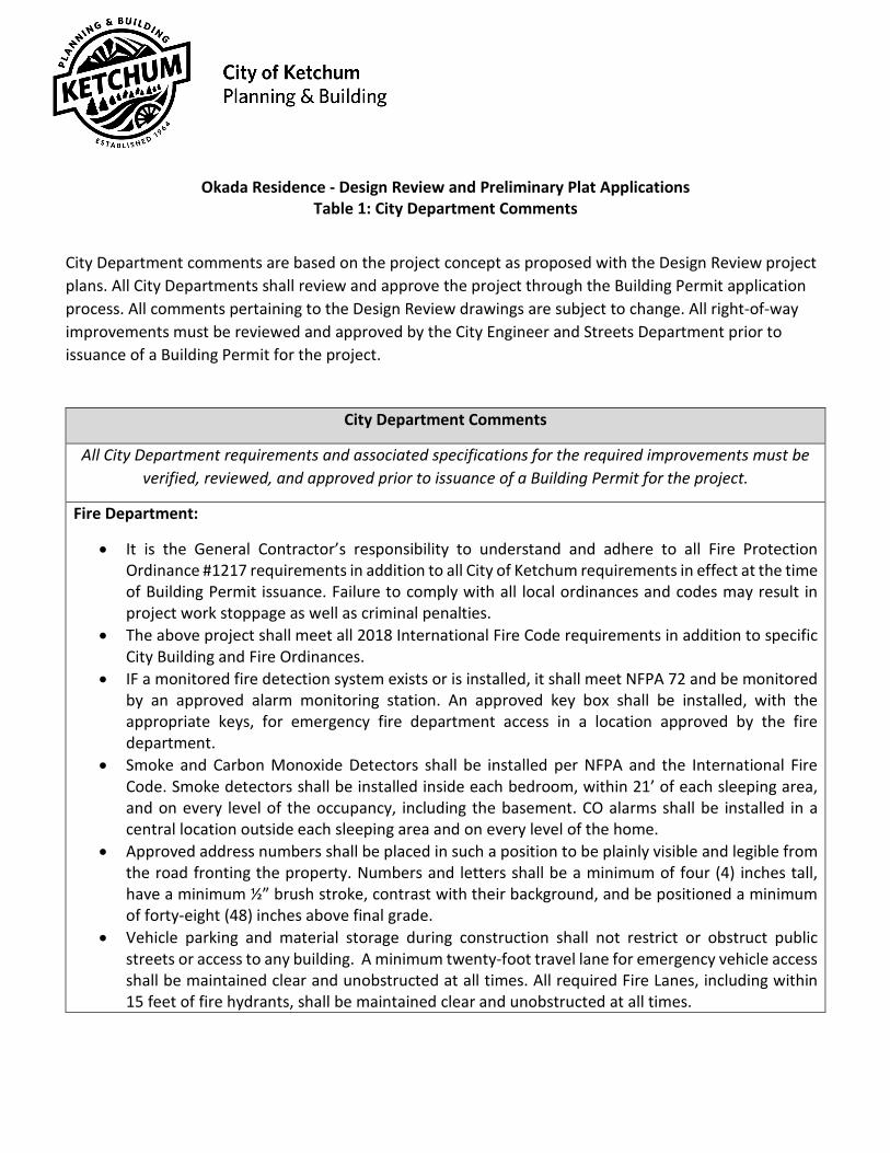
Okada Residence - Design Review and Preliminary Plat Applications
Table 1: City Department Comments
City Department comments are based on the project concept as proposed with the Design Review project plans. All City Departments shall review and approve the project through the Building Permit application process. All comments pertaining to the Design Review drawings are subject to change. All right-of-way improvements must be reviewed and approved by the City Engineer and Streets Department prior to issuance of a Building Permit for the project.
City Department Comments
All City Department requirements and associated specifications for the required improvements must be verified, reviewed, and approved prior to issuance of a Building Permit for the project.
Fire Department:
• It is the General Contractor’s responsibility to understand and adhere to all Fire Protection Ordinance #1217 requirements in addition to all City of Ketchum requirements in effect at the time of Building Permit issuance. Failure to comply with all local ordinances and codes may result in project work stoppage as well as criminal penalties.
• The above project shall meet all 2018 International Fire Code requirements in addition to specific City Building and Fire Ordinances.
• IF a monitored fire detection system exists or is installed, it shall meet NFPA 72 and be monitored by an approved alarm monitoring station. An approved key box shall be installed, with the appropriate keys, for emergency fire department access in a location approved by the fire department.
• Smoke and Carbon Monoxide Detectors shall be installed per NFPA and the International Fire Code. Smoke detectors shall be installed inside each bedroom, within 21’ of each sleeping area, and on every level of the occupancy, including the basement. CO alarms shall be installed in a central location outside each sleeping area and on every level of the home.
• Approved address numbers shall be placed in such a position to be plainly visible and legible from the road fronting the property. Numbers and letters shall be a minimum of four (4) inches tall, have a minimum ½” brush stroke, contrast with their background, and be positioned a minimum of forty-eight (48) inches above final grade.
• Vehicle parking and material storage during construction shall not restrict or obstruct public streets or access to any building. A minimum twenty-foot travel lane for emergency vehicle access shall be maintained clear and unobstructed at all times. All required Fire Lanes, including within 15 feet of fire hydrants, shall be maintained clear and unobstructed at all times.

• An approved access roadway per 2018 International Fire Code Appendix D (www.ketchumfire.org)
shall be installed prior to any combustible construction on the site. The road shall be a minimum of twenty (20) feet in width and capable of supporting an imposed load of at least 75,000 pounds. The road must be an all-weather driving surface maintained free, clear, and unobstructed at all times. Where the vertical distance between the grade plane and the highest roof surface exceeds 30 feet, approved aerial fire apparatus access roads shall be provided. Aerial fire apparatus access roads shall have a minimum unobstructed width of 26 feet, exclusive of shoulders, in the immediate vicinity of the building or portion thereof.
• Fire extinguishers shall be installed and maintained per 2018 IFC Section 906 both during construction and upon occupancy of the building. During construction fire extinguishers shall be placed in a conspicuous, easy to access, unobstructed location that is less than 75’ travel distance to any combustibles on site, 30’ to any hot work. Upon completion of project every single-family residence shall have a minimum of one extinguisher per garage and one extinguisher per kitchen area. Extinguishers shall be mounted in a conspicuous, easy to access, unobstructed location. (during construction, two (2) five lb. class A fire extinguishers shall be required for this project)
• Spark arresters are required on all solid fuel burning appliance chimneys to reduce potential fires from burning embers. A minimum 10’ separation from all chimneys to combustible vegetation and tree crowns shall be maintained at all times.
• This project shall comply with the City of Ketchum Fire Protection and defensible space characteristics. All exterior windows shall be glazed, and all exterior doors shall be solid core construction, or have a fire rating of not less than 20 minutes. All exterior vents shall be designed and approved to prevent flame or ember penetration and all exterior mesh shall have openings that do not exceed 1/8”. Gutters and downspouts shall be non-combustible and shall be provided with an approved means to prevent the accumulation of leaves and debris. All materials within 12” vertical of finished grade shall be 1 hour rated, non-combustible, or covered with minimum 28-gauge flashing. The area 12” horizontal from the base of a wall shall be finished in a way to prevent any vegetation growing, and for vegetative debris to be easily removed. Tree crowns extending to within 10 feet of any structure shall be pruned to maintain a minimum horizontal clearance of 10 feet. Tree crowns within 30 feet of any structure shall be pruned to remove limbs located less than 6 feet above the ground surface adjacent to the trees. Non-fire resistive vegetation or growth shall be kept clear of buildings and structures, in such a manner as to provide a clear area for fire suppression operations.
• Final inspections of all fire department permit required installations by the Fire Chief or an appointee are required and shall be scheduled at least 48 hours in advance. A Final Inspection Checklist can be found at www.ketchumfire.org.
• Note: Additional requirements may be added upon final plan review. City Engineer & Streets Department:
• The building permit plans and construction drawings shall meet all applicable sections of Chapter 12 of Ketchum Municipal Code.

• All stormwater shall be retained on site. • Due to substandard right-of-way widths, additional snow storage and drainage easement is
required. • Paved width of Bald Mountain Rd must be 26 feet for the length of the subject property.
Utilities & Wastewater:
• A separate water and sewer connection from Bald Mountain Dr. for the new townhouse sublot is required.
Planning and Zoning:
All comments from the Planning Department resulting from department review have either been addressed satisfactorily by the applicant or are listed as conditions of approval for the Design Review or Preliminary Plat applications.
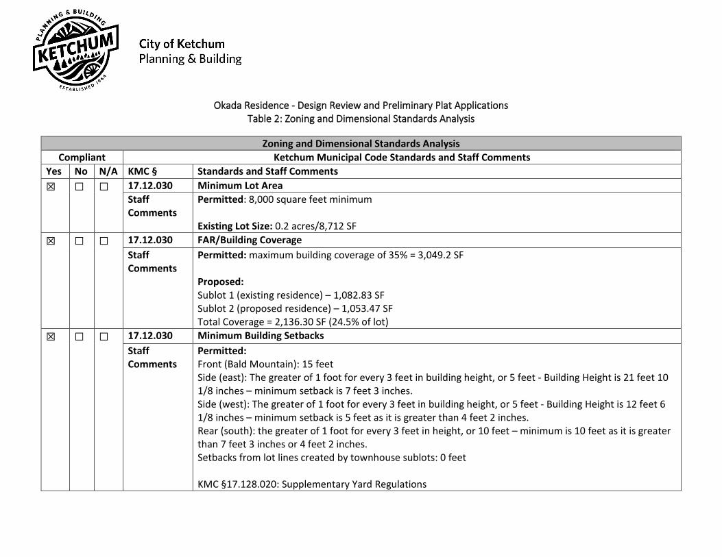
Okada Residence - Design Review and Preliminary Plat Applications Table 2: Zoning and Dimensional Standards Analysis
Zoning and Dimensional Standards Analysis
Compliant Ketchum Municipal Code Standards and Staff Comments Yes No N/A KMC § Standards and Staff Comments ☒ ☐ ☐ 17.12.030 Minimum Lot Area
Staff Comments
Permitted: 8,000 square feet minimum Existing Lot Size: 0.2 acres/8,712 SF
☒ ☐ ☐ 17.12.030 FAR/Building Coverage Staff Comments
Permitted: maximum building coverage of 35% = 3,049.2 SF Proposed: Sublot 1 (existing residence) – 1,082.83 SF Sublot 2 (proposed residence) – 1,053.47 SF Total Coverage = 2,136.30 SF (24.5% of lot)
☒ ☐ ☐ 17.12.030 Minimum Building Setbacks Staff Comments
Permitted: Front (Bald Mountain): 15 feet Side (east): The greater of 1 foot for every 3 feet in building height, or 5 feet - Building Height is 21 feet 10 1/8 inches – minimum setback is 7 feet 3 inches. Side (west): The greater of 1 foot for every 3 feet in building height, or 5 feet - Building Height is 12 feet 6 1/8 inches – minimum setback is 5 feet as it is greater than 4 feet 2 inches. Rear (south): the greater of 1 foot for every 3 feet in height, or 10 feet – minimum is 10 feet as it is greater than 7 feet 3 inches or 4 feet 2 inches. Setbacks from lot lines created by townhouse sublots: 0 feet KMC §17.128.020: Supplementary Yard Regulations
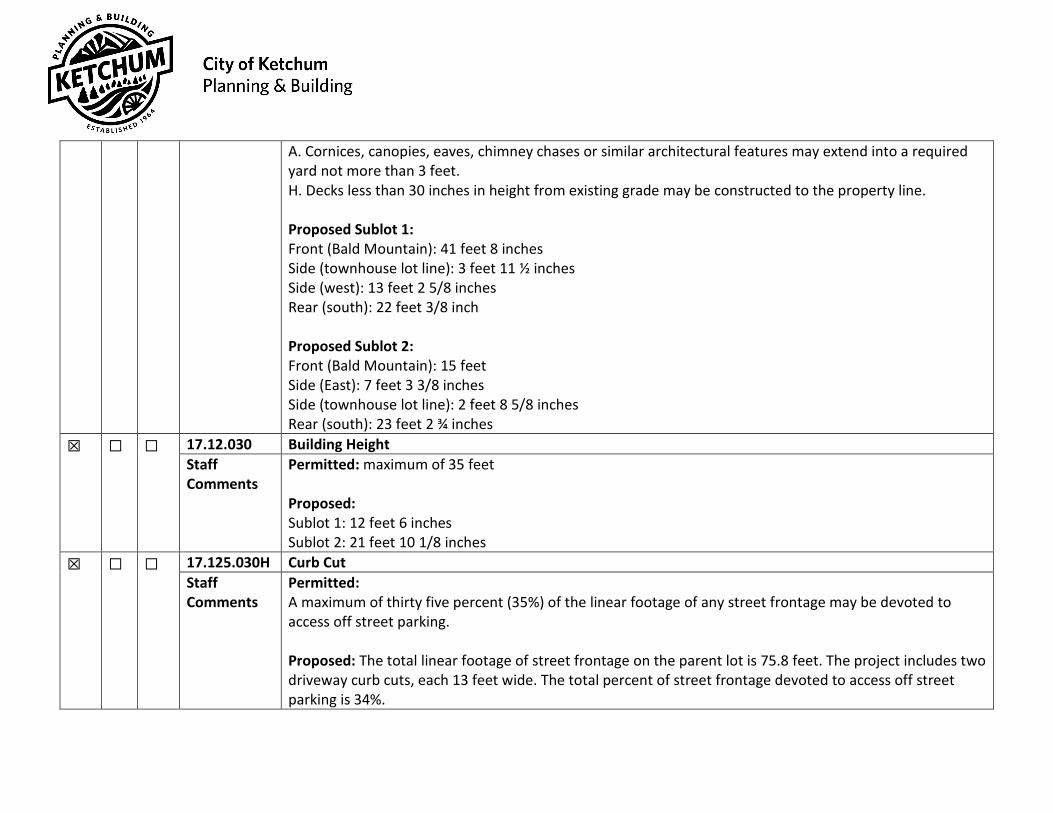
A. Cornices, canopies, eaves, chimney chases or similar architectural features may extend into a required yard not more than 3 feet. H. Decks less than 30 inches in height from existing grade may be constructed to the property line. Proposed Sublot 1: Front (Bald Mountain): 41 feet 8 inches Side (townhouse lot line): 3 feet 11 ½ inches Side (west): 13 feet 2 5/8 inches Rear (south): 22 feet 3/8 inch Proposed Sublot 2: Front (Bald Mountain): 15 feet Side (East): 7 feet 3 3/8 inches Side (townhouse lot line): 2 feet 8 5/8 inches Rear (south): 23 feet 2 ¾ inches
☒ ☐ ☐ 17.12.030 Building Height Staff Comments
Permitted: maximum of 35 feet Proposed: Sublot 1: 12 feet 6 inches Sublot 2: 21 feet 10 1/8 inches
☒ ☐ ☐ 17.125.030H Curb Cut Staff Comments
Permitted: A maximum of thirty five percent (35%) of the linear footage of any street frontage may be devoted to access off street parking. Proposed: The total linear footage of street frontage on the parent lot is 75.8 feet. The project includes two driveway curb cuts, each 13 feet wide. The total percent of street frontage devoted to access off street parking is 34%.
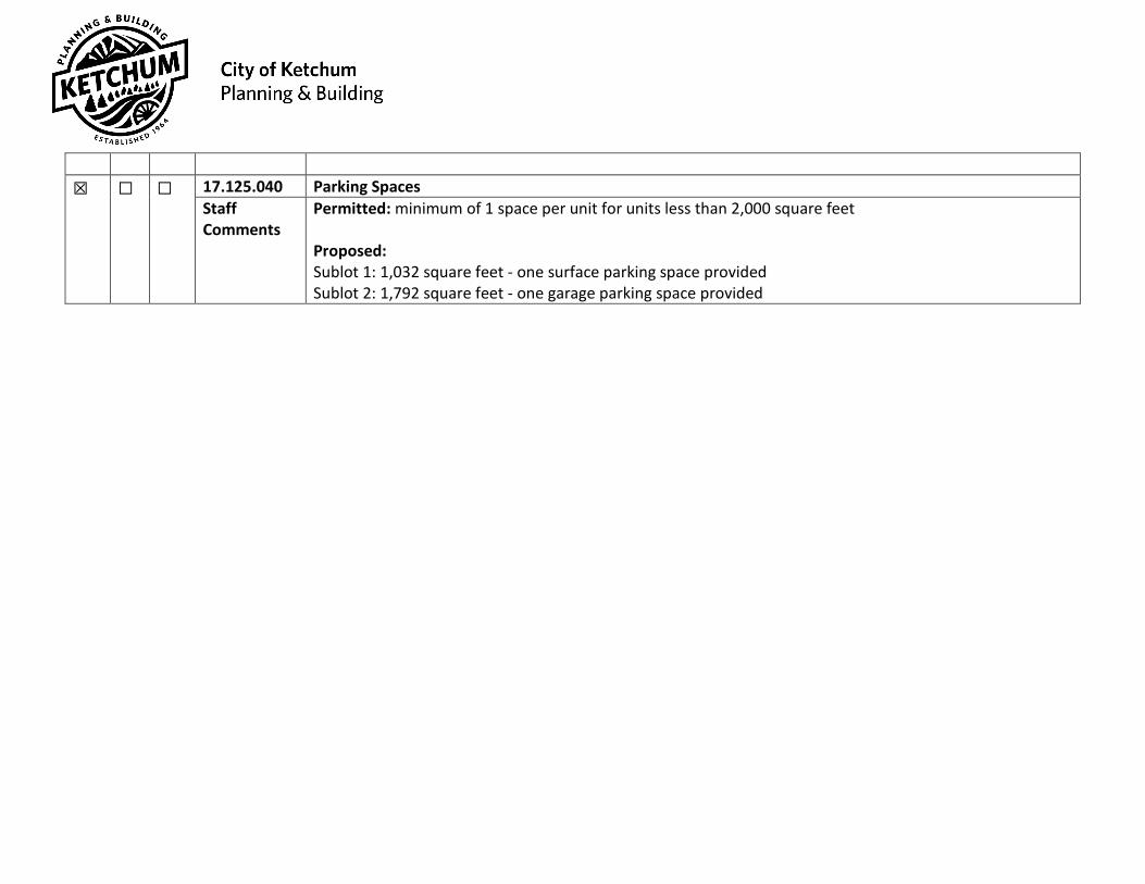
☒ ☐ ☐ 17.125.040 Parking Spaces
Staff Comments
Permitted: minimum of 1 space per unit for units less than 2,000 square feet Proposed: Sublot 1: 1,032 square feet - one surface parking space provided Sublot 2: 1,792 square feet - one garage parking space provided

P21-042 Okada Residence - Design Review and Preliminary Plat Applications
Table 3: Design Review Standards Evaluation
Improvements and Standards (KMC §17.96.060) Yes No N/A City Code City Standards ☒ ☐ ☐ 17.96.060.A1
Streets The applicant shall be responsible for all costs associated with providing a connection from an existing city street to their development.
☒ ☐ ☐ 17.96.060.A2 Streets
All street designs shall be approved by the City Engineer.
☐ ☐ ☒ 17.96.060.B1 Sidewalks
All projects under 17.96.010(A) that qualify as a “Substantial Improvement” shall install sidewalks as required by the Public Works Department.
☐ ☐ ☒ 17.96.060.B2 Sidewalks
Sidewalk width shall conform to the City’s right-of-way standards, however the City Engineer may reduce or increase the sidewalk width and design standard requirements at their discretion.
☒ ☐ ☐ 17.96.060.B3 Sidewalks
Sidewalks may be waived if one of the following criteria is met: a. The project comprises an addition of less than 250 square feet
of conditioned space. b. The City Engineer finds that sidewalks are not necessary
because of existing geographic limitations, pedestrian traffic on the street does not warrant a sidewalk, or if a sidewalk would not be beneficial to the general welfare and safety of the public.
☐ ☐ ☒ 17.96.060.B4 Sidewalks
The length of sidewalk improvements constructed shall be equal to the length of the subject property line(s) adjacent to any public street or private street.
☐ ☐ ☒ 17.96.060.B5 Sidewalks
New sidewalks shall be planned to provide pedestrian connections to any existing or future sidewalks adjacent to the site. In addition, sidewalks shall be constructed to provide safe pedestrian access to and around a building.
☐ ☐ ☒ 17.96.060.B6 Sidewalks
The City may approve and accept voluntary cash contributions in-lieu of the above described improvements, which contributions must be segregated by the City and not used for any purpose other than the provision of these improvements. The contribution amount shall be one hundred ten percent (110%) of the estimated costs of concrete sidewalk and drainage improvements provided by a qualified contractor, plus associated engineering costs, as approved by the City Engineer. Any approved in-lieu contribution shall be paid before the City issues a certificate of occupancy.

☒ ☐ ☐ 17.96.060.C1
Drainage All storm water shall be retained on site.
☒ ☐ ☐ 17.96.060.C2 Drainage
Drainage improvements constructed shall be equal to the length of the subject property lines adjacent to any public street or private street.
☒ ☐ ☐ 17.96.060.C3 Drainage
The City Engineer may require additional drainage improvements as necessary, depending on the unique characteristics of a site.
☒ ☐ ☐ 17.96.060.C.4 Drainage
Drainage facilities shall be constructed per City standards.
☒ ☐ ☐ 17.96.060.D1 Utilities
All utilities necessary for the development shall be improved and installed at the sole expense of the applicant.
☒ ☐ ☐ 17.96.060.D2 Utilities
Utilities shall be located underground and utility, power, and communication lines within the development site shall be concealed from public view.
☐ ☐ ☒ 17.96.060.D3 Utilities
When extension of utilities is necessary all developers will be required to pay for and install two (2”) inch SDR11 fiber optical conduit. The placement and construction of the fiber optical conduit shall be done in accordance with city of Ketchum standards and at the discretion of the City Engineer.
☒ ☐ ☐ 17.96.060.E1 Compatibility of Design
The project's materials, colors and signing shall be complementary with the townscape, surrounding neighborhoods and adjoining structures.
☐ ☐ ☒ 17.96.060.E2 Compatibility of Design
Preservation of significant landmarks shall be encouraged and protected, where applicable. A significant landmark is one which gives historical and/or cultural importance to the neighborhood and/or community.
☐ ☐ ☒ 17.96.060.E3 Compatibility of Design
Additions to existing buildings, built prior to 1940, shall be complementary in design and use similar material and finishes of the building being added to.
☒ ☐ ☐ 17.96.060.F1 Architectural
Building(s) shall provide unobstructed pedestrian access to the nearest sidewalk and the entryway shall be clearly defined.
☒ ☐ ☐ 17.96.060.F2 Architectural
The building character shall be clearly defined by use of architectural features.
☒ ☐ ☐ 17.96.060.F3 Architectural
There shall be continuity of materials, colors and signing within the project.
☒ ☐ ☐ 17.96.060.F4 Architectural
Accessory structures, fences, walls and landscape features within the project shall match or complement the principal building.
☒ ☐ ☐ 17.96.060.F5 Architectural
Building walls shall provide undulation/relief, thus reducing the appearance of bulk and flatness.
☒ ☐ ☐ 17.96.060.F6 Building(s) shall orient towards their primary street frontage.
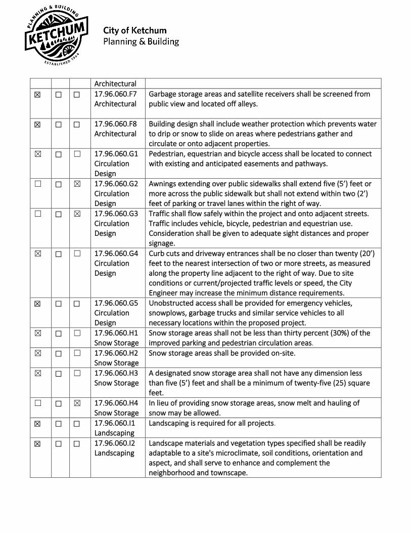
Architectural
☒ ☐ ☐ 17.96.060.F7 Architectural
Garbage storage areas and satellite receivers shall be screened from public view and located off alleys.
☒ ☐ ☐ 17.96.060.F8 Architectural
Building design shall include weather protection which prevents water to drip or snow to slide on areas where pedestrians gather and circulate or onto adjacent properties.
☒ ☐ ☐ 17.96.060.G1 Circulation Design
Pedestrian, equestrian and bicycle access shall be located to connect with existing and anticipated easements and pathways.
☐ ☐ ☒ 17.96.060.G2 Circulation Design
Awnings extending over public sidewalks shall extend five (5’) feet or more across the public sidewalk but shall not extend within two (2’) feet of parking or travel lanes within the right of way.
☐ ☐ ☒ 17.96.060.G3 Circulation Design
Traffic shall flow safely within the project and onto adjacent streets. Traffic includes vehicle, bicycle, pedestrian and equestrian use. Consideration shall be given to adequate sight distances and proper signage.
☒ ☐ ☐ 17.96.060.G4 Circulation Design
Curb cuts and driveway entrances shall be no closer than twenty (20’) feet to the nearest intersection of two or more streets, as measured along the property line adjacent to the right of way. Due to site conditions or current/projected traffic levels or speed, the City Engineer may increase the minimum distance requirements.
☒ ☐ ☐ 17.96.060.G5 Circulation Design
Unobstructed access shall be provided for emergency vehicles, snowplows, garbage trucks and similar service vehicles to all necessary locations within the proposed project.
☒ ☐ ☐ 17.96.060.H1 Snow Storage
Snow storage areas shall not be less than thirty percent (30%) of the improved parking and pedestrian circulation areas.
☒ ☐ ☐ 17.96.060.H2 Snow Storage
Snow storage areas shall be provided on-site.
☒ ☐ ☐ 17.96.060.H3 Snow Storage
A designated snow storage area shall not have any dimension less than five (5’) feet and shall be a minimum of twenty-five (25) square feet.
☐ ☐ ☒ 17.96.060.H4 Snow Storage
In lieu of providing snow storage areas, snow melt and hauling of snow may be allowed.
☒ ☐ ☐ 17.96.060.I1 Landscaping
Landscaping is required for all projects.
☒ ☐ ☐ 17.96.060.I2 Landscaping
Landscape materials and vegetation types specified shall be readily adaptable to a site's microclimate, soil conditions, orientation and aspect, and shall serve to enhance and complement the neighborhood and townscape.

☒ ☐ ☐ 17.96.060.I3
Landscaping All trees, shrubs, grasses and perennials shall be drought tolerant. Native species are recommended but not required.
☒ ☐ ☐ 17.96.060.I4 Landscaping
Landscaping shall provide a substantial buffer between land uses, including, but not limited to, structures, streets and parking lots. The development of landscaped public courtyards, including trees and shrubs where appropriate, shall be encouraged.
☐ ☐ ☒ 17.96.060.J1 Public Amenities
Where sidewalks are required, pedestrian amenities shall be installed. Amenities may include, but are not limited to, benches and other seating, kiosks, bus shelters, trash receptacles, restrooms, fountains, art, etc. All public amenities shall receive approval from the Public Works Department prior to design review approval from the Commission.
Okada Residence - Design Review and Preliminary Plat Applications
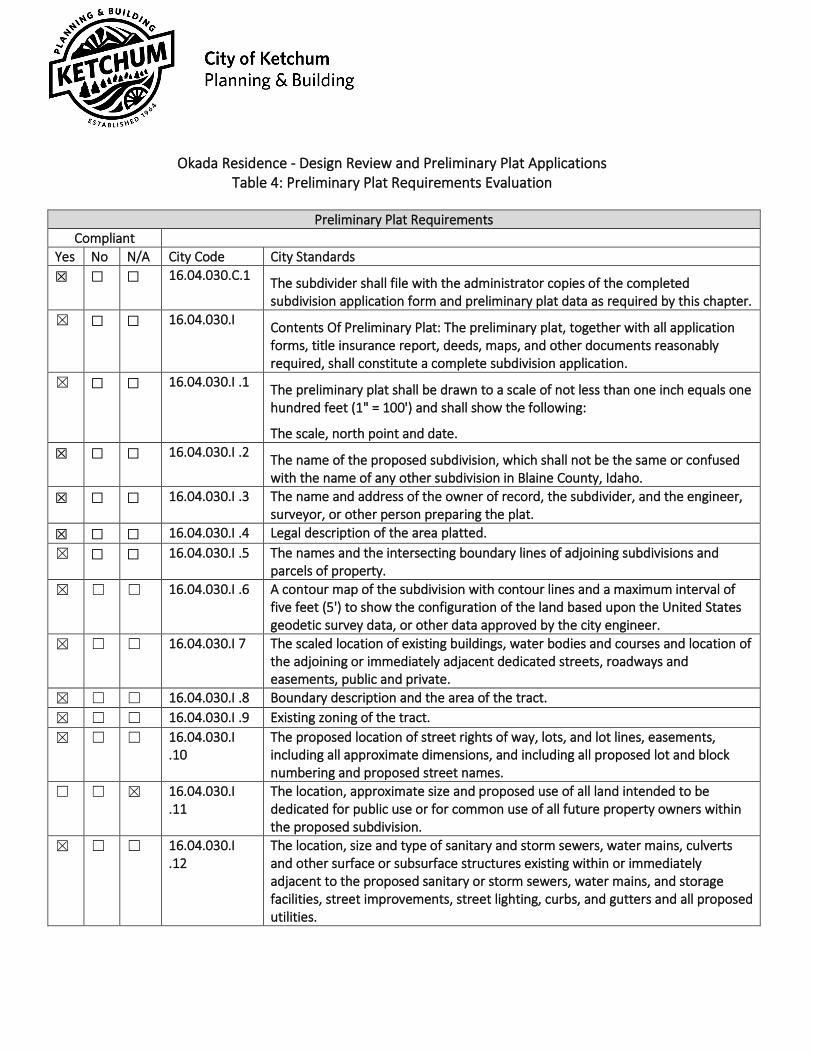
Table 4: Preliminary Plat Requirements Evaluation
Preliminary Plat Requirements Compliant
Yes No N/A City Code City Standards ☒ ☐ ☐ 16.04.030.C.1 The subdivider shall file with the administrator copies of the completed
subdivision application form and preliminary plat data as required by this chapter. ☒ ☐ ☐ 16.04.030.I Contents Of Preliminary Plat: The preliminary plat, together with all application
forms, title insurance report, deeds, maps, and other documents reasonably required, shall constitute a complete subdivision application.
☒ ☐ ☐ 16.04.030.I .1 The preliminary plat shall be drawn to a scale of not less than one inch equals one hundred feet (1" = 100') and shall show the following:
The scale, north point and date. ☒ ☐ ☐ 16.04.030.I .2 The name of the proposed subdivision, which shall not be the same or confused
with the name of any other subdivision in Blaine County, Idaho. ☒ ☐ ☐ 16.04.030.I .3 The name and address of the owner of record, the subdivider, and the engineer,
surveyor, or other person preparing the plat. ☒ ☐ ☐ 16.04.030.I .4 Legal description of the area platted. ☒ ☐ ☐ 16.04.030.I .5 The names and the intersecting boundary lines of adjoining subdivisions and
parcels of property. ☒ ☐ ☐ 16.04.030.I .6 A contour map of the subdivision with contour lines and a maximum interval of
five feet (5') to show the configuration of the land based upon the United States geodetic survey data, or other data approved by the city engineer.
☒ ☐ ☐ 16.04.030.I 7 The scaled location of existing buildings, water bodies and courses and location of the adjoining or immediately adjacent dedicated streets, roadways and easements, public and private.
☒ ☐ ☐ 16.04.030.I .8 Boundary description and the area of the tract. ☒ ☐ ☐ 16.04.030.I .9 Existing zoning of the tract. ☒ ☐ ☐ 16.04.030.I
.10 The proposed location of street rights of way, lots, and lot lines, easements, including all approximate dimensions, and including all proposed lot and block numbering and proposed street names.
☐ ☐ ☒ 16.04.030.I .11
The location, approximate size and proposed use of all land intended to be dedicated for public use or for common use of all future property owners within the proposed subdivision.
☒ ☐ ☐ 16.04.030.I .12
The location, size and type of sanitary and storm sewers, water mains, culverts and other surface or subsurface structures existing within or immediately adjacent to the proposed sanitary or storm sewers, water mains, and storage facilities, street improvements, street lighting, curbs, and gutters and all proposed utilities.

☐ ☐ ☒ 16.04.030.I
.13 The direction of drainage, flow and approximate grade of all streets.
☐ ☐ ☒ 16.04.030.I .14
The location of all drainage canals and structures, the proposed method of disposing of runoff water, and the location and size of all drainage easements, whether they are located within or outside of the proposed plat.
☐ ☐ ☒ 16.04.030.I .15
All percolation tests and/or exploratory pit excavations required by state health authorities.
☐ ☐ ☒ 16.04.030.I .16
A copy of the provisions of the articles of incorporation and bylaws of homeowners' association and/or condominium declarations to be filed with the final plat of the subdivision.
☒ ☐ ☐ 16.04.030.I .17
Vicinity map drawn to approximate scale showing the location of the proposed subdivision in reference to existing and/or proposed arterials and collector streets.
☐ ☐ ☒ 16.04.030.I .18
The boundaries of the floodplain, floodway and avalanche zoning district shall also be clearly delineated and marked on the preliminary plat.
☐ ☐ ☒ 16.04.030.I .19
Building envelopes shall be shown on each lot, all or part of which is within a floodway, floodplain, or avalanche zone; or any lot that is adjacent to the Big Wood River, Trail Creek, or Warm Springs Creek; or any lot, a portion of which has a slope of twenty five percent (25%) or greater; or upon any lot which will be created adjacent to the intersection of two (2) or more streets.
☒ ☐ ☐ 16.04.030.I .20
Lot area of each lot.
☒ ☐ ☐ 16.04.030.I .21
Existing mature trees and established shrub masses.
☒ ☐ ☐ 16.04.030.I .22
A current title report shall be provided at the time that the preliminary plat is filed with the administrator, together with a copy of the owner's recorded deed to such property.
☒ ☐ ☐ 16.04.030.I .23
Three (3) copies of the preliminary plat shall be filed with the administrator.
☒ ☐ ☐ 16.04.040.A Required Improvements: The improvements set forth in this section shall be shown on the preliminary plat and installed prior to approval of the final plat. Construction design plans shall be submitted and approved by the city engineer. All such improvements shall be in accordance with the comprehensive plan and constructed in compliance with construction standard specifications adopted by the city. Existing natural features which enhance the attractiveness of the subdivision and community, such as mature trees, watercourses, rock outcroppings, established shrub masses and historic areas, shall be preserved through design of the subdivision.
☐ ☐ ☒ 16.04.040.B Improvement Plans: Prior to approval of final plat by the commission, the subdivider shall file two (2) copies with the city engineer, and the city engineer shall approve construction plans for all improvements required in the proposed subdivision. Such plans shall be prepared by a civil engineer licensed in the state.
☐ ☐ ☒ 16.04.040.C Prior to final plat approval, the subdivider shall have previously constructed all required improvements and secured a certificate of completion from the city
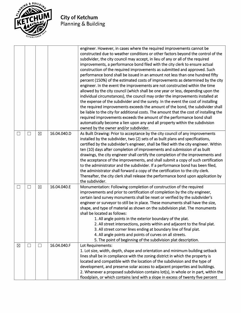
engineer. However, in cases where the required improvements cannot be constructed due to weather conditions or other factors beyond the control of the subdivider, the city council may accept, in lieu of any or all of the required improvements, a performance bond filed with the city clerk to ensure actual construction of the required improvements as submitted and approved. Such performance bond shall be issued in an amount not less than one hundred fifty percent (150%) of the estimated costs of improvements as determined by the city engineer. In the event the improvements are not constructed within the time allowed by the city council (which shall be one year or less, depending upon the individual circumstances), the council may order the improvements installed at the expense of the subdivider and the surety. In the event the cost of installing the required improvements exceeds the amount of the bond, the subdivider shall be liable to the city for additional costs. The amount that the cost of installing the required improvements exceeds the amount of the performance bond shall automatically become a lien upon any and all property within the subdivision owned by the owner and/or subdivider.
☐ ☐ ☒ 16.04.040.D As Built Drawing: Prior to acceptance by the city council of any improvements installed by the subdivider, two (2) sets of as built plans and specifications, certified by the subdivider's engineer, shall be filed with the city engineer. Within ten (10) days after completion of improvements and submission of as built drawings, the city engineer shall certify the completion of the improvements and the acceptance of the improvements, and shall submit a copy of such certification to the administrator and the subdivider. If a performance bond has been filed, the administrator shall forward a copy of the certification to the city clerk. Thereafter, the city clerk shall release the performance bond upon application by the subdivider.
☐ ☐ ☒ 16.04.040.E Monumentation: Following completion of construction of the required improvements and prior to certification of completion by the city engineer, certain land survey monuments shall be reset or verified by the subdivider's engineer or surveyor to still be in place. These monuments shall have the size, shape, and type of material as shown on the subdivision plat. The monuments shall be located as follows:
1. All angle points in the exterior boundary of the plat. 2. All street intersections, points within and adjacent to the final plat. 3. All street corner lines ending at boundary line of final plat. 4. All angle points and points of curves on all streets. 5. The point of beginning of the subdivision plat description.
☒ ☐ ☐ 16.04.040.F Lot Requirements: 1. Lot size, width, depth, shape and orientation and minimum building setback lines shall be in compliance with the zoning district in which the property is located and compatible with the location of the subdivision and the type of development, and preserve solar access to adjacent properties and buildings. 2. Whenever a proposed subdivision contains lot(s), in whole or in part, within the floodplain, or which contains land with a slope in excess of twenty five percent

(25%), based upon natural contours, or creates corner lots at the intersection of two (2) or more streets, building envelopes shall be shown for the lot(s) so affected on the preliminary and final plats. The building envelopes shall be located in a manner designed to promote harmonious development of structures, minimize congestion of structures, and provide open space and solar access for each lot and structure. Also, building envelopes shall be located to promote access to the lots and maintenance of public utilities, to minimize cut and fill for roads and building foundations, and minimize adverse impact upon environment, watercourses and topographical features. Structures may only be built on buildable lots. Lots shall only be created that meet the definition of "lot, buildable" in section 16.04.020 of this chapter. Building envelopes shall be established outside of hillsides of twenty five percent (25%) and greater and outside of the floodway. A waiver to this standard may only be considered for the following:
a. For lot line shifts of parcels that are entirely within slopes of twenty five percent (25%) or greater to create a reasonable building envelope, and mountain overlay design review standards and all other city requirements are met. b. For small, isolated pockets of twenty five percent (25%) or greater that are found to be in compliance with the purposes and standards of the mountain overlay district and this section.
3. Corner lots shall have a property line curve or corner of a minimum radius of twenty five feet (25') unless a longer radius is required to serve an existing or future use. 4. Side lot lines shall be within twenty degrees (20°) to a right angle or radial line to the street line. 5. Double frontage lots shall not be created. A planting strip shall be provided along the boundary line of lots adjacent to arterial streets or incompatible zoning districts. Should a double frontage lot(s) be created out of necessity, then such lot(s) shall be reversed frontage lot(s). 6. Minimum lot sizes in all cases shall be reversed frontage lot(s). 7. Every lot in a subdivision shall have a minimum of twenty feet (20') of frontage on a dedicated public street or legal access via an easement of twenty feet (20') or greater in width. Easement shall be recorded in the office of the Blaine County recorder prior to or in conjunction with recordation of the final plat.
☐ ☐ ☒ 16.04.040.G G. Block Requirements: The length, width and shape of blocks within a proposed subdivision shall conform to the following requirements:
1. No block shall be longer than one thousand two hundred feet (1,200'), nor less than four hundred feet (400') between the street intersections, and shall have sufficient depth to provide for two (2) tiers of lots. 2. Blocks shall be laid out in such a manner as to comply with the lot requirements. 3. The layout of blocks shall take into consideration the natural topography of the land to promote access within the subdivision and

minimize cuts and fills for roads and minimize adverse impact on environment, watercourses and topographical features. 4. Corner lots shall contain a building envelope outside of a seventy five foot (75') radius from the intersection of the streets.
☐ ☐ ☒ 16.04.040.H Street Improvement Requirements: 1. The arrangement, character, extent, width, grade and location of all streets put in the proposed subdivision shall conform to the comprehensive plan and shall be considered in their relation to existing and planned streets, topography, public convenience and safety, and the proposed uses of the land; 2. All streets shall be constructed to meet or exceed the criteria and standards set forth in chapter 12.04 of this code, and all other applicable ordinances, resolutions or regulations of the city or any other governmental entity having jurisdiction, now existing or adopted, amended or codified; 3. Where a subdivision abuts or contains an existing or proposed arterial street, railroad or limited access highway right of way, the council may require a frontage street, planting strip, or similar design features; 4. Streets may be required to provide access to adjoining lands and provide proper traffic circulation through existing or future neighborhoods; 5. Street grades shall not be less than three-tenths percent (0.3%) and not more than seven percent (7%) so as to provide safe movement of traffic and emergency vehicles in all weather and to provide for adequate drainage and snow plowing; 6. In general, partial dedications shall not be permitted, however, the council may accept a partial street dedication when such a street forms a boundary of the proposed subdivision and is deemed necessary for the orderly development of the neighborhood, and provided the council finds it practical to require the dedication of the remainder of the right of way when the adjoining property is subdivided. When a partial street exists adjoining the proposed subdivision, the remainder of the right of way shall be dedicated; 7. Dead end streets may be permitted only when such street terminates at the boundary of a subdivision and is necessary for the development of the subdivision or the future development of the adjacent property. When such a dead end street serves more than two (2) lots, a temporary turnaround easement shall be provided, which easement shall revert to the adjacent lots when the street is extended; 8. A cul-de-sac, court or similar type street shall be permitted only when necessary to the development of the subdivision, and provided, that no such street shall have a maximum length greater than four hundred feet (400') from entrance to center of turnaround, and all cul-de-sacs shall have a minimum turnaround radius of sixty feet (60') at the property line and not less than forty five feet (45') at the curb line; 9. Streets shall be planned to intersect as nearly as possible at right angles, but in no event at less than seventy degrees (70°);

10. Where any street deflects an angle of ten degrees (10°) or more, a connecting curve shall be required having a minimum centerline radius of three hundred feet (300') for arterial and collector streets, and one hundred twenty five feet (125') for minor streets; 11. Streets with centerline offsets of less than one hundred twenty five feet (125') shall be prohibited; 12. A tangent of at least one hundred feet (100') long shall be introduced between reverse curves on arterial and collector streets; 13. Proposed streets which are a continuation of an existing street shall be given the same names as the existing street. All new street names shall not duplicate or be confused with the names of existing streets within Blaine County, Idaho. The subdivider shall obtain approval of all street names within the proposed subdivision from the commission before submitting same to council for preliminary plat approval; 14. Street alignment design shall follow natural terrain contours to result in safe streets, usable lots, and minimum cuts and fills; 15. Street patterns of residential areas shall be designed to create areas free of through traffic, but readily accessible to adjacent collector and arterial streets; 16. Reserve planting strips controlling access to public streets shall be permitted under conditions specified and shown on the final plat, and all landscaping and irrigation systems shall be installed as required improvements by the subdivider; 17. In general, the centerline of a street shall coincide with the centerline of the street right of way, and all crosswalk markings shall be installed by the subdivider as a required improvement; 18. Street lighting may be required by the commission or council where appropriate and shall be installed by the subdivider as a requirement improvement; 19. Private streets may be allowed upon recommendation by the commission and approval by the council. Private streets shall be constructed to meet the design standards specified in subsection H2 of this section; 20. Street signs shall be installed by the subdivider as a required improvement of a type and design approved by the administrator and shall be consistent with the type and design of existing street signs elsewhere in the city; 21. Whenever a proposed subdivision requires construction of a new bridge, or will create substantial additional traffic which will require construction of a new bridge or improvement of an existing bridge, such construction or improvement shall be a required improvement by the subdivider. Such construction or improvement shall be in accordance with adopted standard specifications; 22. Sidewalks, curbs and gutters may be a required improvement installed by the subdivider; and 23. Gates are prohibited on private roads and parking access/entranceways, private driveways accessing more than one single-family dwelling unit and one accessory dwelling unit, and public rights of way unless approved by the city council.

☐ ☐ ☒ 16.04.040.I Alley Improvement Requirements: Alleys shall be provided in business,
commercial and light industrial zoning districts. The width of an alley shall be not less than twenty feet (20'). Alley intersections and sharp changes in alignment shall be avoided, but where necessary, corners shall be provided to permit safe vehicular movement. Dead end alleys shall be prohibited. Improvement of alleys shall be done by the subdivider as required improvement and in conformance with design standards specified in subsection H2 of this section.
☒ ☐ ☐ 16.04.040.J Required Easements: Easements, as set forth in this subsection, shall be required for location of utilities and other public services, to provide adequate pedestrian circulation and access to public waterways and lands. 1. A public utility easement at least ten feet (10') in width shall be required within the street right of way boundaries of all private streets. A public utility easement at least five feet (5') in width shall be required within property boundaries adjacent to Warm Springs Road and within any other property boundary as determined by the city engineer to be necessary for the provision of adequate public utilities. 2. Where a subdivision contains or borders on a watercourse, drainageway, channel or stream, an easement shall be required of sufficient width to contain such watercourse and provide access for private maintenance and/or reconstruction of such watercourse. 3. All subdivisions which border the Big Wood River, Trail Creek and Warm Springs Creek shall dedicate a ten foot (10') fish and nature study easement along the riverbank. Furthermore, the council shall require, in appropriate areas, an easement providing access through the subdivision to the bank as a sportsman's access. These easement requirements are minimum standards, and in appropriate cases where a subdivision abuts a portion of the river adjacent to an existing pedestrian easement, the council may require an extension of that easement along the portion of the riverbank which runs through the proposed subdivision. 4. All subdivisions which border on the Big Wood River, Trail Creek and Warm Springs Creek shall dedicate a twenty five foot (25') scenic easement upon which no permanent structure shall be built in order to protect the natural vegetation and wildlife along the riverbank and to protect structures from damage or loss due to riverbank erosion. 5. No ditch, pipe or structure for irrigation water or irrigation wastewater shall be constructed, rerouted or changed in the course of planning for or constructing required improvements within a proposed subdivision unless same has first been approved in writing by the ditch company or property owner holding the water rights. A written copy of such approval shall be filed as part of required improvement construction plans. 6. Nonvehicular transportation system easements including pedestrian walkways, bike paths, equestrian paths, and similar easements shall be dedicated by the subdivider to provide an adequate nonvehicular transportation system throughout the city.
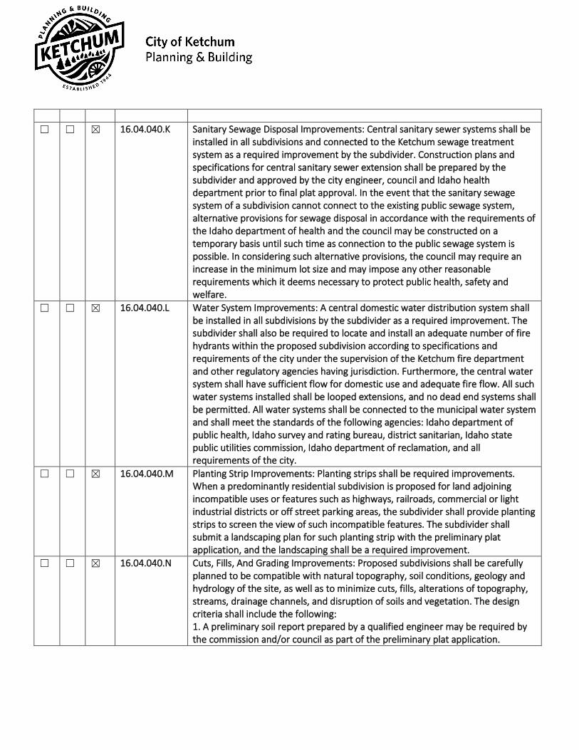
☐ ☐ ☒ 16.04.040.K Sanitary Sewage Disposal Improvements: Central sanitary sewer systems shall be installed in all subdivisions and connected to the Ketchum sewage treatment system as a required improvement by the subdivider. Construction plans and specifications for central sanitary sewer extension shall be prepared by the subdivider and approved by the city engineer, council and Idaho health department prior to final plat approval. In the event that the sanitary sewage system of a subdivision cannot connect to the existing public sewage system, alternative provisions for sewage disposal in accordance with the requirements of the Idaho department of health and the council may be constructed on a temporary basis until such time as connection to the public sewage system is possible. In considering such alternative provisions, the council may require an increase in the minimum lot size and may impose any other reasonable requirements which it deems necessary to protect public health, safety and welfare.
☐ ☐ ☒ 16.04.040.L Water System Improvements: A central domestic water distribution system shall be installed in all subdivisions by the subdivider as a required improvement. The subdivider shall also be required to locate and install an adequate number of fire hydrants within the proposed subdivision according to specifications and requirements of the city under the supervision of the Ketchum fire department and other regulatory agencies having jurisdiction. Furthermore, the central water system shall have sufficient flow for domestic use and adequate fire flow. All such water systems installed shall be looped extensions, and no dead end systems shall be permitted. All water systems shall be connected to the municipal water system and shall meet the standards of the following agencies: Idaho department of public health, Idaho survey and rating bureau, district sanitarian, Idaho state public utilities commission, Idaho department of reclamation, and all requirements of the city.
☐ ☐ ☒ 16.04.040.M Planting Strip Improvements: Planting strips shall be required improvements. When a predominantly residential subdivision is proposed for land adjoining incompatible uses or features such as highways, railroads, commercial or light industrial districts or off street parking areas, the subdivider shall provide planting strips to screen the view of such incompatible features. The subdivider shall submit a landscaping plan for such planting strip with the preliminary plat application, and the landscaping shall be a required improvement.
☐ ☐ ☒ 16.04.040.N Cuts, Fills, And Grading Improvements: Proposed subdivisions shall be carefully planned to be compatible with natural topography, soil conditions, geology and hydrology of the site, as well as to minimize cuts, fills, alterations of topography, streams, drainage channels, and disruption of soils and vegetation. The design criteria shall include the following: 1. A preliminary soil report prepared by a qualified engineer may be required by the commission and/or council as part of the preliminary plat application.
2. Preliminary grading plan prepared by a civil engineer shall be submitted as part of all preliminary plat applications. Such plan shall contain the following information:
a. Proposed contours at a maximum of five foot (5') contour intervals. b. Cut and fill banks in pad elevations. c. Drainage patterns. d. Areas where trees and/or natural vegetation will be preserved. e. Location of all street and utility improvements including driveways to building envelopes. f. Any other information which may reasonably be required by the administrator, commission or council to adequately review the affect of the proposed improvements.
3. Grading shall be designed to blend with natural landforms and to minimize the necessity of padding or terracing of building sites, excavation for foundations, and minimize the necessity of cuts and fills for streets and driveways. 4. Areas within a subdivision which are not well suited for development because of existing soil conditions, steepness of slope, geology or hydrology shall be allocated for open space for the benefit of future property owners within the subdivision. 5. Where existing soils and vegetation are disrupted by subdivision development, provision shall be made by the subdivider for revegetation of disturbed areas with perennial vegetation sufficient to stabilize the soil upon completion of the construction. Until such times as such revegetation has been installed and established, the subdivider shall maintain and protect all disturbed surfaces from erosion. 6. Where cuts, fills, or other excavations are necessary, the following development standards shall apply:
a. Fill areas shall be prepared by removing all organic material detrimental to proper compaction for soil stability. b. Fills shall be compacted to at least ninety five percent (95%) of maximum density as determined by AASHO T99 (American Association of State Highway Officials) and ASTM D698 (American standard testing methods). c. Cut slopes shall be no steeper than two horizontal to one vertical (2:1). Subsurface drainage shall be provided as necessary for stability. d. Fill slopes shall be no steeper than three horizontal to one vertical (3:1). Neither cut nor fill slopes shall be located on natural slopes of three to one (3:1) or steeper, or where fill slope toes out within twelve feet (12') horizontally of the top and existing or planned cut slope. e. Toes of cut and fill slopes shall be set back from property boundaries a distance of three feet (3'), plus one-fifth (1/5) of the height of the cut or the fill, but may not exceed a horizontal distance of ten feet (10'); tops and toes of cut and fill slopes shall be set back from structures at a distance of at least six feet (6'), plus one-fifth (1/5) of the height of the
cut or the fill. Additional setback distances shall be provided as necessary to accommodate drainage features and drainage structures.
☒ ☐ ☐ 16.04.040.O Drainage Improvements: The subdivider shall submit with the preliminary plat application such maps, profiles, and other data prepared by an engineer to indicate the proper drainage of the surface water to natural drainage courses or storm drains, existing or proposed. The location and width of the natural drainage courses shall be shown as an easement common to all owners within the subdivision and the city on the preliminary and final plat. All natural drainage courses shall be left undisturbed or be improved in a manner that will increase the operating efficiency of the channel without overloading its capacity. An adequate storm and surface drainage system shall be a required improvement in all subdivisions and shall be installed by the subdivider. Culverts shall be required where all water or drainage courses intersect with streets, driveways or improved public easements and shall extend across and under the entire improved width including shoulders.
☒ ☐ ☐ 16.04.040.P Utilities: In addition to the terms mentioned in this section, all utilities including, but not limited to, electricity, natural gas, telephone and cable services shall be installed underground as a required improvement by the subdivider. Adequate provision for expansion of such services within the subdivision or to adjacent lands including installation of conduit pipe across and underneath streets shall be installed by the subdivider prior to construction of street improvements.
☐ ☐ ☒ 16.04.040.Q Off Site Improvements: Where the offsite impact of a proposed subdivision is found by the commission or council to create substantial additional traffic, improvements to alleviate that impact may be required of the subdivider prior to final plat approval, including, but not limited to, bridges, intersections, roads, traffic control devices, water mains and facilities, and sewer mains and facilities.
Townhouse Plat Requirements
Compliant Standards Yes No N/A City Code City Standards ☐ ☐ X 16.04.080.B Townhouse Owners' Documents: The subdivider of the townhouse project shall
submit with the preliminary plat application a copy of the proposed party wall agreement and any proposed document(s) creating an association of owners of the proposed townhouse sublots, which shall adequately provide for the control and maintenance of all commonly held facilities, garages, parking and/or open spaces. Prior to final plat approval, the subdivider shall submit to the city a final copy of such documents and shall file such documents prior to recordation of the plat, which shall reflect the recording instrument numbers.

☒ ☐ ☐ 16.04.080.C.1 Preliminary Plat Procedure: Townhouse developments shall be administered
consistent with the procedures and design and development regulations established in §16.04.030 and §16.04.040 and the standards of this subsection. All townhouse developments shall be platted under the procedures contained in the subdivision ordinance in effect and shall be required to obtain design review approval prior to building permit issuance.
☒ ☐ ☐ 16.04.080.C.2 The subdivider may apply for preliminary plat approval from the commission pursuant to subsection 16.04.030D of this chapter at the time application is made for design review approval pursuant to title 17, chapter 17.96 of this code. The commission may approve, deny or conditionally approve such preliminary plat upon consideration of the action taken on the application for design review of the project.
☒ ☐ ☐ 16.04.080.C.3 The preliminary plat, other data, and the commission's findings may be transmitted to the council prior to commencement of construction of the project under a valid building permit issued by the City. The council shall act on the preliminary plat pursuant to subsection 16.04.030E and F of this chapter.
☐ ☐ ☒ 16.04.080.C.4 4. In the event a phased townhouse development project is proposed, after preliminary plat is granted for the entirety of a project, the final plat procedure for each phase of a phased development project shall follow §16.04.030.G and comply with the additional provisions of §16.04.110 of this code.
☒ ☐ ☐ 16.04.080.D D. Final Plat Procedure: 1. The final plat procedure contained in subsection 16.04.030G of this chapter shall be followed. However, the final plat shall not be signed by the city clerk and recorded until the townhouse has received either:
a. A certificate of occupancy issued by the city of Ketchum for all structures in the townhouse development and completion of all design review elements as approved by the planning and zoning administrator; or b. Signed council approval of a phased development project consistent with §16.04.110 herein.
2. The council may accept a security agreement for any design review elements not completed on a case by case basis pursuant to title 17, chapter 17.96 of this code.
☒ ☐ ☐ 16.04.080.E.1 E. Required Findings: In addition to all Townhouse Developments complying with the applicable provisions of Title 17 and this Subdivision Chapter (§16.04), the Administrator shall find that All Townhouse Developments, including each individual sublot, shall not exceed the maximum building coverage requirements of the zoning district.
☒ ☐ ☐ 16.04.080.E.2 Garage: All garages shall be designated on the preliminary and final plats and on all deeds as part of the particular townhouse units. Detached garages may be platted on separate sublots; provided, that the ownership of detached garages is tied to specific townhouse units on the townhouse plat and in any owner's
documents, and that the detached garage(s) may not be sold and/or owned separate from any dwelling unit(s) within the townhouse development.
☒ ☐ ☐ 16.04.080.E.3 General Applicability: All other provisions of this chapter and all applicable ordinances, rules and regulations of the city and all other governmental entities having jurisdiction shall be complied with by townhouse subdivisions. (Ord. 1061 § 3, 2009: Ord. 879 § 4, 2001: Ord. 460 § 2, 1987)