standards and policies manual volume i
TRANSCRIPT

STANDARDS AND
POLICIES MANUAL
VOLUME I
(LAND DEVELOPMENT)
Prepared By Land Development Engineering & Surveying Division Dean P. Larson, Manager/County Surveyor
For
ENVIRONMENTAL MANAGEMENT/
GENERAL SERVICES AGENCY
Paul Yarborough/Director
EMA/GSA
PARTICIPATING OFFICES
Land Dev. Eng. & Surveying Planning Dept. Central Permit Office Dean P. Larson, Leon Pollard, Raffi Sarkisian, Mgr./County Surveyor Director Mrg./Land Dev. Coordinator Building Inspection Fire Marshal Architectural Division William Parissenti, Clifford Johnson, Tevis Dooley, Jr. Building Inspector Fire Marshal Supervising Architect
OTHER PARTICIPATING AGENCIES
ENVIRON. HEALTH SERVICES TRANSP. AGENCY S.C.V. WATER DISTRICT VINCENT CANCILLA, LOU MONTINI, GEORGE KORBAY, DIRECTOR ROAD COMMISSIONER FLOOD CONTROL MGR.

PREFACE The Environmental Management/General Services Agency is an umbrella organization that includes, among others, the majority of the County departments and divisions that play a significant role in land development related activities. It is planned that all of their standards and policies pertaining to land development will be incorporated into this manual, initially consisting of two volumes. Also, some of the more frequently used development standards and policies of Environmental Health Services, the Transportation Agency, and the Santa Clara Valley Water District have been added, or a convenient reference provided. For more complete information, the user is referred to the separate publications of these other organizations.
Distribution and Sale
This manual is intended for the use of the general public and the County staff. Copies are available for sale in whole or in part at the Central Permit Office. Inquiries regarding price, availability and updated material, should be directed to that office at 70 West Hedding Street, San Jose, California, 95110. 3/81

i
TABLE OF CONTENTS
STANDARDS AND POLICIES MANUAL Volume I
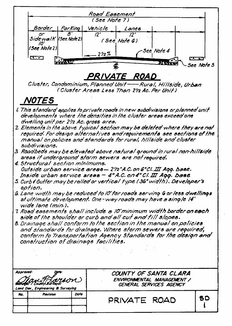
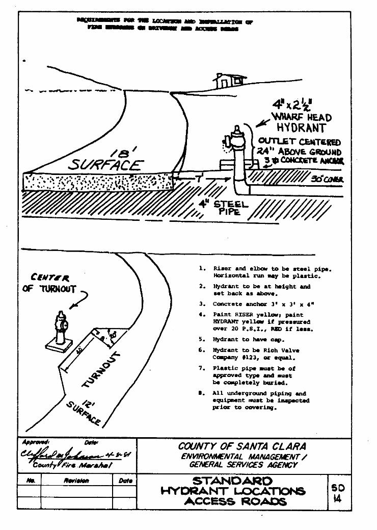
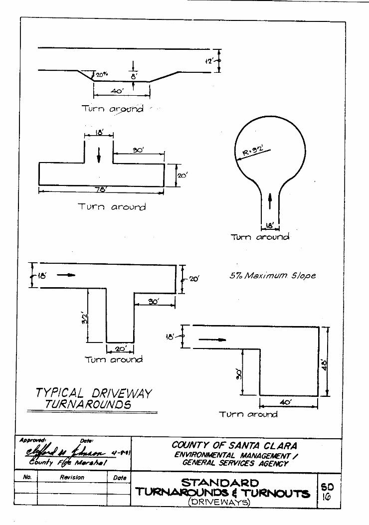
INTRODUCTION . . . . . . . . . . . . . . . . . . . . . . . . . . . . . . . . . . . . . . . . . . . . . . . . . . . . . . . . i i POLICIES AND STANDARDS FOR ROADS Background and General Policies . . . . . . . . . . . . . . . . . . . . . . . . . . . . . . . . . . . . . . A1.l Dedication and Improvement Policies . . . . . . . . .. . . . . . . . . . . . . . . . . . . . . . . . . . . A2.1 Design Criteria . . . . . . . . . . . . . . . .. . . . . . . . . . . . . . . . . . . . . . . . . . . . . . . . . . . . . . A3.1 Deferment of Improvements . . . . . . . .. . . . . . . . . . . . . . . . . . . . . . . . . . . . . . . . . . . . A4.1 Future Width Lines of Major County Roads . . . . . . . . . . . . . . . . . . . . . . . . . . . . . . . . A5.1 Private Road Stage Improvements . . . . . . . . . . . . . . . . . . . . . . . . . . . . . . . . . . . . . . A6.1 WATER SYSTEMS (See also Volume II) . . . . . . . . . . . . . . . . . . . . . . . . . . . . . . . . . . . . B1.1 IMPROVEMENT PLANS, GRADING PLANS AND CONSTRUCTION . . . . . . . . . . . . . . C1.1 GRADING AND EROSION CONTROL . . . . . . . . . . . . . . . . . . . . . . . . . . . . . . . . . . . . . . D1.1 DRAINAGE . . . . . . . . . . . . . . . . . . . . . . . . . . . . . . . . . . . . . . . . . . . . . . . . . . . . . . . . . . . E1.1 GEOLOGIC HAZARDS . . . . . . . . . . . . . . . . . . . . . . . . . . . . . . . . . . . . . . . . . . . . . . . . . . F1.1 MAPPING, SURVEYING AND RELATED COUNTY SURVEYOR FUNCTIONS . . . . . . G1.1 RURAL SUBDIVISION POLICIES AND STANDARDS . . . . . . . . . . . . . . . . . . . . . . . . . . H1.1 HILLSIDE SUBDIVISION POLICIES AND STANDARDS . . . . . . . . . . . . . . . . . . . . . . . . .I1.1 CLUSTER, PLANNED UNIT AND CONDOMINIUM POLICIES AND STANDARDS . . . J1.1 (FUTURE ADDITIONS) Fire Protection, Planning, Health, Central Permit Office, Flood Control, Parks and Recreation STANDARD DETAIL DRAWINGS Private Road – Cluster, Planned Unit, Condominium . . . . . . . . . . . . . . . . . . . . . . SD. 1 Private Road – Hillside . . . . . . . . . . . . . . . . . . . . . . . . . . . . . . . . . . . . . . . . . . . . . SD. 2 Private Road – Non-Hillside . . . . . . . . . . . . . . . . . . . . . . . . . . . . . . . . . . . . . . . . . SD. 3 Private road – Driveway Approach . . . . . . . . . . . . . . . . . . . . . . . . . . . . . . . . . . . . SD. 4 Single Driveway . . . . . . . . . . . . . . . . . . . . . . . . . . . . . . . . . . . . . . . . . . . . . . . . . . SD. 5 Grading Standards – Typical Lot and Typical Road . . . . . . . . . . . . . . . . . . . . . . . SD. 6 Watershed Sample Map . . . . . . . . . . . . . . . . . . . . . . . . . . . . . . . . . . . . . . . . . . . . SD. 7 Chart for Determining Ditch Lining Requirements . . . . . . . . . . . . . . . . . . . . . . . . SD. 8 Scarified and Serrated Slopes . . . . . . . . . . . . . . . . . . . . . . . . . . . . . . . . . . . . . . . . SD. 9 Energy Dissipator . . . . . . . . . . . . . . . . . . . . . . . . . . . . . . . . . . . . . . . . . . . . . . . . . SD.10 Chain Link Fence . . . . . . . . . . . . . . . . . . . . . . . . . . . . . . . . . . . . . . . . . . . . . . . . . SD.11 Fire Hydrant Location – County Roads . . . . . . . . . . . . . . . . . . . . . . . . . . . . . . . . . SD.12 Fire Hydrant Location – Private Roads . . . . . . . . . . . . . . . . . . . . . . . . . . . . . . . . . SD.13 Rural Fire Water Supply . . . . . . . . . . . . . . . . . . . . . . . . . . . . . . . . . . . . . . . . . . . . SD.14 Fire Truck Turnaround . . . . . . . . . . . . . . . . . . . . . . . . . . . . . . . . . . . . . . . . . . . . . . SD.15 3/81
INTRODUCTION
All land development projects involve alterations to the land or existing improvements that are reflected on maps, plans, and specifications prepared by engineers, surveyors and architects. Approval of these maps and plans involves several County departments and outside agencies. The coordination of these approvals and the final signing of the maps and improvement plans is the responsibility of the County Surveyor’s Office which prepared this manual. Purpose and Scope The manual is a compilation of the standards and policies of the Environmental Management/General Services Agency (EMA/GSA) that relate to land development activities within the unincorporated areas of the County. Its purpose is to provide a single ready reference document for the use of engineers, surveyors, architects and the general public, as well as the County staff. Some of the standards and policies were prepared specifically for the manual (largely from existing unpublished procedures and policies) and others are copies or extracts of reports and previously published standards. In situations where it is discovered that a policy or standard has changed from the wording used in the text, a footnote or other explanation is provided. It is not expected that the general public will understand all the standards and policies, or that the manual will eliminate the need for professional help and advice. Developers and prospective applicants for a land use approval should retain the services of a professional in the early stages of planning a project. Other Affected Agencies It is not practical to incorporate all of the standards and policies of organizations outside EMA/GSA (such as the Transportation Agency, Santa Clara Valley Water District, Environmental Health, and the Sanitation districts) although they may be of equal importance to any given project. References to these other standards and policies will be found at various locations in the manual. How to Use the Manual The manual consists of two volumes and several sections, each of which pertains to a particular type of work or major concern, such as water systems. To maximize the utility of the manual, the standards and policies regarding a particular subject may be located in more than one section. For example, information on fire hydrants, which is the responsibility of the County Fire Marshal (or fire districts), is located in both the road design and water systems sections since both types of facilities are affected.
i i

Creative Design Creative design on private land development projects in encouraged on the basis of its being equal or better than County minimum standards. Some agencies have publications indicating alternative design concepts and encouraged their use. Copies or information on these publications can be obtained from the Central Permit Office or directly from the agency involved. Prior to doing extensive work on particular design concepts, it is wise to discuss them in advance with the agency responsible for their approval or future public maintenance. Future Updating It is planned that the manual will be updated on an annual basis. Intermittent changes also may occur and copies of the material will be made available at the Central Permit Office.
i i i

POLICIES AND STANDARDS FOR ROADS BACKGROUND AND GENERAL POLICIES
Background County policies and standards for roads have evolved over a period of many years emanating largely from staff reports and consultant studies of special problems. The design standards for roads, drainage and street lighting improvements were published in booklet form by the Department of Public Works and adopted by the Board of Supervisors in 1966. In 1978 they were republished in modified form and re-approved by the Board of Supervisors as Transportation Agency standards omitting the standards for private roads. This new EMA/GSA manual expands and republishes the private road standards in slightly modified form and includes some additional standards for drainage and erosion control. The various sections of the manual contain both a republication of certain reports to the Board of Supervisors and short statements of policy that intended to provide guidance for those engaged in planning, designing or constructing roads in connection with land development projects. General Policies
o Safe and adequate access for vehicular and pedestrian traffic is a necessary part of land development projects and a requirement for County approval. To ensure this, the County develops and implements minimum standards commensurate with various land uses and road locations, such as hillside, rural and urban.
o Road improvements enhance property values and to the extent that they are needed
for land development projects, they are provided and paid for by the developer. County requirements typically include (with minor exceptions) underground utilities installed in the roadway. The facilities are shown on the road improvement plans for coordinated design and construction.
o When new roads are to be constructed, publicly-maintained roads are preferred to
private roads, and dedication and improvement to County-maintained road standards is required in connection with all land development projects, unless otherwise stated in the conditions of approval. Exceptions to the dedication policy (described elsewhere) may be allowed for private roads in cluster, planned unit development and condominium projects where a property owners’ association is responsible for the maintenance work and enforcement of traffic rules.
o Road improvements include (but are not necessarily limited to) bridges, drainage
facilities, bike and pedestrian facilities, signs and traffic control devices, underground utilities and street lighting as well as the pavement and various other elements of the roadway.
A1.1

o County urban standards are compatible, if not identical, with city standards in most cases. When developments occur within city urban service areas, the County strives to accommodate city recommendations with respect to any variations in the policies or standards of the two agencies, such as width of sidewalk or street lighting.
o Roads must be planned in accordance with coherent areawide plans of the County,
affected cities and the State. The Planning Department, the Transportation Agency, the County Surveyor’s Office and the cities are all involved in approving public street patterns. The coordination of approvals by the various agencies and the signing of individual plans is the responsibility of the County Surveyor.
o Significant deviations from County standards are not allowed. Minor deviations and/or
interim measures sometimes are necessary because of special circumstances. In such instances, the developer’s engineer must furnish full information and justification. Any requests for deviation should be made known at the tentative map stage so that they can be considered by the appropriate authorities in connection with the tentative map.
o Road grading and erosion control work must conform to the standards of the County
grading ordinance or higher standards, if any, adopted by the various agencies.
o New and replacement fences must not encroach upon the road right of way. Relocation of existing needed fences to the right of way line at the developer’s or property owner’s expense is required in situations where the fence interferes with road maintenance or the safe movement of traffic, or where road improvements to the ultimate standard (rural, hillside, etc.) are to be installed.
o New street trees and watering facilities must be placed outside the road right-of-way
unless otherwise approved by the Transportation Agency or the County Surveyor. Maintenance of the trees, or other plantings, is the responsibility of the property owners or a homeowner’s association.
o Improvement plans and/or grading plans prepared by registered civil engineers are
required for all construction except minor work not needing engineering design. These plans are reviewed and signed by the County Surveyor or his authorized representative when they are finished in accordance with adopted standards and the conditions of approval for the project. A permit for the work is issued immediately following the signing of the plans. The specific policies and standards for the preparation of plans are described in the section of this manual entitled, “ Improvement Plans, Grading Plans, and Construction.”
A1.2

o Where existing utilities, such as power poles, must be moved, it is the responsibility of the developer to make arrangements with the owners for the relocation work and pay the company’s charges, if any. Utility companies that have franchise rights in County roads normally will make reasonable relocations of their facilities, but may not assume the full cost.
o The County does not allow the use of assessment districts for constructing new roads
in subdivisions, but does encourage their use for the purpose of improving existing roads to full County standards.
o The County Transit District provides buses on most major arterial streets within the
County. Developers proposing projects adjacent to streets offering public transit and public agencies improving such streets should add bus stop improvements to their project plans. The principal improvements to be considered include:
• Bus stop duckouts or 22’ wide curb lanes • Boarding and deboarding areas • Passenger shelters • Pedestrian access from the bus stop to the development
For County approval, the improvements must be made in accordance with Transportation
Agency’s “Bus Stop and Facility Standards” which were approved by the Board in November of 1978. Developments not adjacent to streets with public transit should include sidewalks on their street frontages to enhance pedestrian access to streets providing public transit.
Special Policies for County-Maintained Roads
o Road and drainage standards for County-maintained roads are contained in the standard Details Manual of the Transportation Agency. These standards include bridges, drainage facilities, bike and pedestrian facilities, street lighting, underground utilities, signs, traffic control devices and all visible elements of the roadway. The manual also contains charts and tables for designing pavements. Copies of the manual are for sale at the Central Permit Office and the Transportation Agency.
o The County enforces the same County-maintained road standards in both major
subdivisions and minor subdivisions (four or less parcels) where the parcel sizes are less than 20 acres. The cluster method of development in areas zoned for large parcels is encouraged for the purpose of reducing construction and maintenance cost—as well as preserving open space.
o Only the new roads that are contiguous with an existing County, City or State
maintained road and constructed to County-maintained road standards are accepted into the County Road System. The acceptances are routinely made (for purposes of maintenance and enforcement of traffic laws) by resolution (only) of the Board of Supervisors soon after final construction acceptance.
A1.3

o Road maintenance costs are paid entirely from gas tax and other Road Fund revenues—no County General Fund money. County policy as well as the State law prohibits expenditures from the Road Fund for the maintenance of private roads.
o Extension of drainage systems, extensions of curb or sidewalk, modifications of traffic
signs and signals, and other off-site improvements that are needed for effective use of road improvements that serve new developments must be installed and/or paid for by the developers. In situations where undeveloped (or underdeveloped) property would benefit from the extension or oversizing of facilities, the County may consider reimbursement agreements that provide for partial reimbursement to the initial developer by future developers who would especially benefit from the expanded improvements.
o In situations where new street lights are required, the developed property must be
annexed to the County Lighting Service Area.
o Encroachment permits for driveways and other types of work within existing County-maintained roads are issued at the EMA/GSA Central Permit Office by representatives of the Transportation Agency immediately following the final approval of construction plans. The plans are signed by the County Surveyor or his authorized representative after clearance by the Transportation Agency and other agencies affected by the particular roadway location and design.
Special Policies for Private Roads
o Under County land development regulations, all roads that are not publicly maintained are considered to be private roads even though they may be offered for dedication. Vehicular access ways are classified as roads when they serve two or more parcels of land, two or more dwelling units or two or more ownerships or business entities in a common building.
o New private roads are discouraged but may be allowed under certain conditions as
described elsewhere in the manual. Generally, they create maintenance and law enforcement problems that are difficult to resolve and burdensome to property owners. Also, they are unsatisfactory for public transit and school buses in most cases.
o The County regulates the improvement of existing private roads and the construction
of new private roads in very low density areas (parcels 20 acres or larger) to enhance their service life for the benefit of property owners and to help achieve safe and adequate access for emergency vehicles.
o Existing private roads that do not meet minimum County standards for safe and
adequate access must be improved at the time of any proposed new development. In addition to the current improvements, a deferred improvement agreement as described elsewhere generally is required for the future, ultimate improvements.
A1.4

o The frontage of all parcels proposed for development on private roads must be offered for dedication except where there will be three or less parcels of land (or separate property interests) to be served by the road at ultimate development. Roads offered for dedication remain private until the road is improved to County maintained road standards and accepted into the County Road System by resolution of the Board of Supervisors.
o Private roads in low density subdivisions (generally existing private roads or new roads
constructed prior to the adoption of rural subdivision standards) must continue to be privately maintained (even though offered for dedication to the County) until they are upgraded to current County maintained road standards and accepted into the County Road System.
o Gates on private roads are discouraged. If proposed in connection with subdivision
development, the approval (if any) must be granted by the Advisory Agency or the Board of Supervisors; and the requirements for approval, operation and maintenance established a that time.
A1.5

POLICIES AND STANDARDS FOR ROADS
DEDICATION AND IMPROVEMENT
Reports Prepared by Land Development Engineering and Surveying Dean P. Larson, Manager/County Surveyor
(Accepted by Board of Supervisors on 9/11/78)
Reports Prepared by the Transportation Agency Lou Montini, Road Commissioner and Director of Transportation Development
(Accepted by Board of Supervisors on 9/11/78 and 10/2/1979)
Report Prepared by Ruth & Going, Inc. Consulting Engineer
(Approved by Board of Supervisors on 5/4/71)
Background The County’s official policy statements on road dedication and improvement are contained in a number of separate reports to the Board of Supervisors submitted over a period of several years. The four principal reports and the dates of approval by the Board of Supervisors were as follows:
o Consultant study and report entitled, “Future Width Line Study” prepared by Ruth & Going, Inc., and approved by the Board of Supervisors on May 4, 1971.
o Two staff reports prepared by Land Development Engineering and Surveying
Division and the Transportation Agency on recommended policies for roads in 20-acre zoning districts accepted by the Board of Supervisors on September 11, 1978.
o A staff report prepared by the Transportation Agency containing recommended
criteria for interim improvements to existing County-maintained roads in connection with the development of single residential building sites approved by the Board of Supervisors on October 2, 1979.
RUTH & GOING REPORT (1971 Future Width Line Study) The following are extracts from the policy recommendations contained in the Ruth & Going report. The wording has been restructured and condensed for brevity and clarity.
General Policy
Dedication and improvement requirements should be commensurate with the benefit to the property being divided or developed. For subdivision or other development purposes, all land uses should be grouped into three categories and the dedication and improvement requirements set according to the use and the parcel size. The criteria are applicable to both subdivisions and single sites.
A2.1

(1971 Ruth & Going Report) Category 1 Single family residential development on parcels 20 acres to 60 acres in size.
o Dedicate one half of the proposed right of way, not to exceed 30 feet;
o No improvement of County roads required;
o Stage improvements of private roads (existing) as needed for safe and adequate access.
Category 2 Single family or duplex development on parcels less than 20 acres in size. Requirements
o Dedicate and improve one half of the proposed right of way, not to exceed 30 feet—except that 40 feet may be required in situations where a frontage-type road is to be constructed,* or a new half road borders a property line.
o Stage improvements of private roads (existing) as needed for safe and adequate
access. Improvements should include the frontage of the property plus stage improvements at other locations, as appropriate in each case.
Category 3 Triplex and higher uses (includes commercial uses, churches, schools, golf courses, etc.). Requirements
o Dedicate right of way as needed not to exceed a 67-foot half street and improve up to a 46-foot half street. The width of right of way dedication responsibility should be measured from the road center line, or base line, toward the right of way line. The improvement responsibility should be from the ultimate right of way line toward the road center line (i.e., sidewalk, curb and gutter, parking lane, traveled lane, etc.).
Other Recommended (Adopted) Policies (1971 Ruth & Going Report)
o Roadway widths in excess of benefits received by adjacent property (normal dedication and improvement) should be paid for by the public agency because the extra width is beneficial in general and not specifically to the adjacent property.
* Current standard is more than 40 feet for frontage-type roads.
A2.2

(1971 Ruth & Going Report)
o The County should purchase access rights to expressways wherever feasible. Where the County has purchased rights of way, but not acquired access rights, the developer should be required to dedicate and improve 12 feet of roadway width when developing the property adjacent to the expressway.
o The County, at its discretion, may allow the developer the option of dedicating
extra right of way as an offset against his responsibility for the installation of improvements (assumed approximate equal value).
o The County, at its discretion, may defer the construction work in some
instances for the installation of the improvements as a part of a larger street improvement project. (See the section of this manual on deferred improvement agreements.)
o The County should require backup type of developments adjacent to major
roadways wherever it is feasible and practicable.*
o Where eccentric widening of an existing road is required, the developer’s responsibility should not exceed the amounts that would be required for normal concentric widening.
o Where property line irregularities preclude standard dedication and
improvement, the developer should be responsible for acquiring the necessary land. The County should help with condemnation procedures, if necessary, at developer’s cost.
o If the property has frontage and access on two parallel roads, dedication and
improvement on each of the roads should be required. If the development has frontage on two parallel roads but access from only one, the total dedication and improvement requirements should not exceed those for a single major road.
o If the property has frontage on a private road that potentially will be
maintained by the County, the dedication and improvement requirements should parallel those for County-maintained roads. The County should accept for maintenance those roads that are improved to County-maintained standards (assuming they are contiguous with a County-maintained road).
o If a road link is needed between a proposed development and a public road,
the developer should provide this link.
o Improvements need not be required if the parcels are not approved building sites.
* Since preparation of the 1971 Ruth & Going report recommending “backup” policy for
subdivision design adjacent to major roads, the Santa Clara Valley Water District has adopted a policy on creative creekside design. Copies of a brochure containing examples of recommended types of subdivision design adjacent to watercourses are available at District Offices and the County Central Permit Office.
A2.3

o All buildings should be set back as needed for road widening (regardless of any limited dedication or zoning).
o The County should develop the necessary ordinances to require the dedication of
road right of way in connection with the rezoning of individual parcels of land. (Note: Not implemented to date.)
REPORTS ON NEW ROADS IN 20-ACRE ZONING DISTRICTS (Subdivisions Only) In May 1978, the Board of Supervisors received a request from the Landowners’ Association that the standards for new roads be modified for subdivisions in areas zoned –20s (20-acre minimum). The concerns expressed or implied by the representatives of the Association were that the standards for new roads in very low density areas were too high and not justified on the basis of traffic volume. Since the complaint involved both the Environmental Management Agency and the Transportation Agency, two separate reports were prepared and submitted to the Board of Supervisors on September 11, 1978. The Board approved the concept of low-standard roads that could be upgraded in the future to County-maintained road standards and referred the reports to the Planning Commission, the Santa Clara County Landowners’ Association and the Associated Civil Engineers and Land Surveyors of Santa Clara County. The Planning Commission held a public hearing on the two reports on October 5, 1978 and unanimously adopted a motion to send a favorable report to the Board of Supervisors with emphasis on the following:
o The standards would be appealable to the Planning Commission and the Board of
Supervisors.
o The type of all-weather surfacing would be determined at the time of conditioning the particular project.
o The present dedication policies would be continued.
o Emergency access roads would be required only where needed.
Note: To date the Board has not received (or has not taken any action on) the Planning
Commission report. The following is a summary of the recommendations contained in the two staff reports (restructured and reworded for brevity and to include the Planning Commission recommendations to the Board): TRANSPORTATION AGENCY RECOMMENDATIONS FOR ROADS IN 20-acre zoning districts to be maintained by the county (APPROVED 9/11/78)
o Roads that are planned to be maintained by the County should be improved in accordance with Transportation Agency Standard Details A/4 (rural standards) and/or A/8 (hillside standards).
A2.4
o Road alignment, drainage, pavement and other elements of the roadway should be designed in accordance with the Transportation Agency Standard Details Manual and the standards contained in the land development regulations.
o In the event the developer does not agree with the standards and wishes to have
an alternative approved, he should submit quantitative reasons as to why the existing standards are not appropriate, and the justification and engineering information on strength, function and safety requirements.
LAND DEVELOPMENT ENGINEERING AND SURVEYING RECOMMENDED GUIDELINES FOR ROADS IN 20-ACRE ZONING DISTRICTS TO BE PRIVATELY MAINTAINED(Approved 9/11/78)
o Economic feasibility should be balanced with environmental and community needs.
o Road should be designed for upgrading in the future to County maintenance
standards, where practical.
o New roads should be based on neighborhood traffic circulation plans approved by the Planning Commission, including emergency access and vehicular escape routes, where needed.
o Roads should be adequate for access to all building sites by emergency vehicles.
o Roads should be offered for dedication to public use in accordance with present
policy.
o Graded roadbed widths should be not less than-- • 30 feet or 36 feet (Transportation Agency hillside standards) for common driveways
serving two or more residences. • 24 feet for roads with no potential for County maintenance and for common
driveways serving two or more residences. • 15 feet for single driveways, widened to 24 feet at vehicle passing sections (where
needed) approved by the Fire Marshal. • 18 feet for emergency vehicle escape routes. (If a future County road, grade the
emergency road the same as described above for other roads.)
o Culverts, bridges and roadbed should be designed to sustain a 35,000-pound wheel load.
o Roadbed should be surfaced with not less than four-inch thickness of Class II
aggregate base (or equivalent) 18 feet wide, plus two three-foot shoulders of base rock or good granular native material. If the use of native material is proposed as an alternative to manufactured Class II base material, it should be tested by soils laboratory at the developer’s expense. If the use is approved, the roadbed should be designed and certified by developer’s engineer.
A2.5

o Single driveways should be designed the same as above except the width may be reduced to 12 feet plus one 3-foot wide shoulder.
o Grades of 15 percent or more must be paved with asphalt surfacing (roads and
driveways).
o Emergency access rods (where needed) should have all-weather surfacing and grades satisfactory to the Fire Marshal.
o Roads should have all-weather surfacing (type to be determined as a condition of
approval of the tentative map).
o Stage improvement of new roads should not be permitted (i.e., original developer to provide roads to the full –20s standards).
Note: The above guidelines apply only to non-cluster type subdivisions. *REPORT BY THE TRANSPORTATION AENCY PERTAINING TO EXISTING COUNTY ROADS AND SINGLE BUILDING SIES OF LESS THAN 20 ACRES (Approved 10/2/1979) The following is a brief summary of the policies recommended by the Transportation Agency in a report approved by the Board of Supervisors on October 2, 1979, pertaining to the improvement of existing County-maintained roads by the developers of existing single residential building sites that are less than 20 acres in size. The wording has been restructured and condensed (or expanded) for clarity and brevity.
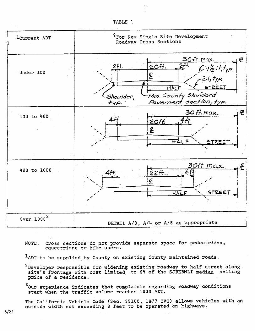
o Interim-type improvements may be required, determined on the basis of lane width, average daily traffic and safety needs. (See chart at the end of this section.)
o Improvements, where required, generally shall be limited to lane and shoulder
widening, drainage and traffic safety work (sight distance, guardrail, etc.).
o The total cost of the required interim-type improvements to County roads shall not exceed five percent of the San Jose Real Estate Board Multiple Listing Index (SJRBMLI) median selling price for a house in the specific area (there are 21 areas).
In situations where interim improvements are required or may be required, the Transportation Agency and the developer each are responsible for the following:
* For supplemental information on deferred improvement agreements that may be required
in connection with interim improvements, see section entitled “Deferment of Improvements.”
A2.6

Transportation Agency’s Responsibilities
o Explain County policy.
o Review Table 1 (attached) for appropriate roadway cross section and specify the appropriate lane and shoulder widths, if road widening is required.
o Specify the general nature of the required improvements, if any, at the time the Land
Development Coordinator grants conditional building site approval.
o Determine the current SJREBMLI median selling price within the project site location.
o If interim improvements are required, and they are of such a nature that formal engineered plans are not required, prepare a sketch plan of the work.
o ºReview the improvement plans in situations where engineered plans are required.
o Sign agreement, collect encroachment permit fee and issue encroachment permit after
developer has met the conditions of approval.
o Inspect the work during construction and when the construction work has been satisfactorily completed, so indicate to the Building Inspector for house occupancy approval.
o Release the performance bond—if the project is of such size as to require a bond.
Developer’s Responsibilities
o Furnish sufficient technically accurate information with the building site tentative plan as needed to aid the Transportation Agency in setting the conditions of approval.
o Obtain the services of a civil engineer to prepare engineered plans in situations where
such plans are required.
o Submit plans to the Transportation Agency for review and approval (when plans are required).
o Pay an encroachment permit fee.
o Post a performance bond if the estimated cost of the work is over $5,000.
o Obtain the services of a contractor and complete the installation of the improvements
prior to occupancy of the house. If this is not feasible because of weather or other good reason, a bond in the amount of the full estimated cost of the remaining work must be posted.
o Request final inspection, and if a bond was posted, also request release of the bond.
A2.7

POLICIES AND STANDARDS FOR ROADS
ORDINANCE REQUIREMENTS FOR DEDICATION AND IMPROVEMENT
The following are the ordinance specified requirements for road dedication and improvement (Section C12-130): A tentative map condition of approval may require a subdivider to dedicate or irrevocably offer to dedicate real property within the subdivision for streets and alleys, including access rights and abutter’s rights, flood control and drainage, public utility easements and other public easements.
(a) All land shown on a final or parcel map, intended for any public use shall be offered for dedication for public use, except such land which is intended and approved by the County for the exclusive use of property owners in the subdivision. Dedications shall be in the form of easement, unless otherwise agreed to by the subdivider and the County. For land uses with a density of or equivalent to A, R1E, R1 and R2 and A1 residential use zoning districts, the street dedication shall be one-half (1/2) of the planned right-of-way width not to exceed the amount needed for a curvilinear thirty- (30) foot half-street on the frontage of each lot or parcel. For all other land uses, the street dedication shall be on-half (1/2) of the planned right-of-way width not to exceed the amount needed for a curvilinear sixty-seven,-(67) foot half-street on the frontage of each lot or parcel. If the planned right-of-way width on any parcel exceeds the amount to be dedicated, appropriate additional setback may be required. Exceptions to the above requirements may be made in the following situations:
(1) Where a proposed new half-street is to be maintained by the County, the
minimum right-of-way dedication shall be forty (40) feet. (2) Where the street is developable on one side only (such as, but not limited to, a
road adjacent to a stream, limited access highway or railroad), the dedication shall be in accordance with the right-of-way widths specified in the adopted standards referred to herein not to exceed sixty (60) feet for density through R2 and seventy (70) feet for all other land uses.
(b) Local streets shall have a right-of-way width of sixty (60) feet, except as otherwise
provided in this chapter. A cul-de-sac in residential districts may be approved with right-of-way widths of fifty-six (56) feet. In subdivisions where each lot or parcel created is more than one acre, the right-of-way width may be altered depending upon terrain. Lesser widths may also be approved when sufficient evidence is presented to show that the above requirements are not practical.
(c) The street design and right-of-way widths within and adjacent to every subdivision
shall conform to the circulation element of the general plan, adopted official plan lines, proposed plan lines of the County, adopted expressway and freeway routes, city plan lines when not in conflict with the County, and to the provisions of this chapter.
A2.8

POLICIES AND STANDARDS FOR ROADS
ROAD DESIGN CRITERIA
Ordinance Requirements (Design) Non-structural road design criteria are set forth in the County’s land development regulations in Section C12-184. The Requirements are: a. Street extensions. Streets needed to provide traffic circulation or to serve adjoining
property shall be extended to the subdivision boundary. If, the street does not connect to an existing street, the final one foot shall be granted in fee* to the County. It is the purpose of the one-foot fee strip to prohibit ingress or egress across it to the adjoining property until such time as an extension of the road on which the reservation is placed is dedicated to public use and said dedication is recorded. After extension of the street pursuant to County approval, the one-foot fee* dedication shall be null and void.
b. Center lines. All streets shall, as far as practicable, be in alignment with existing
adjacent streets. If the center line of two (2) streets, intercepting the same street from opposite directions, are off-set from each other, said off-set shall be a minimum distance of two hundred (200) feet measured along the center line of the street intercepted.
c. Intersecting angles and return radii. Streets shall intersect at an angle as near to a right
angle as is practicable in each specific case, unless otherwise necessitated by topographic conditions. The right-of-way line radii of returns at corners may vary with the widths of roadways, intersection design and the type of land use. The minimum return radius shall be twenty (20) feet. Streets intersecting at an angle other than ninety (90) degrees may require special design features to assure desirable visibility and safety.
d. Dead-end street turning area. Wherever a permanent dead-end street or a temporary
dead-end street is permitted, an adequate turning area will be required. e. Loops, courts and secondary means of access. Whenever the size or location of a
parcel of land does not permit a lot layout directly related to a normal street arrangement, a court or nonconnecting street may be used; provided, however, all lots or parcels which are more than eight hundred (800) roadway feet from an existing or County approved future through road interesection shall be served by a loop street, if possible. The advisory agency may require a safe and adequate secondary means of access. Any requirements imposed under this section shall not be an unreasonable burden or hardship to the subdivider.
* Fee dedications are not required. This is a technical error in the ordinance.
f. Grades and curves. All streets shall have at least a five-tenths (0.5) percent grade.
Grades shall not exceed six (6) percent on highways, twelve (12) percent on local traffic streets, fifteen (15) percent on any street, or twenty (20) percent if no other method is practicable and if consistent with good engineering practices. Streets or portions thereof with twenty (20) percent grade shall be not more than three hundred (300) feet in length.
A3.1

Center line radii shall be not less than five hundred (500) feet on highways, except in mountainous areas, where the radius may be reduced to not less than two hundred (200) feet, and on all other streets, the center line radii shall be not less than seventy-five (75) feet. Lesser or greater grades and radii may be used in cases in which sufficient evidence is presented to show that the above requirements are not practicable.
g. Street vertical clearance. Streets and easements serving new subdivisions shall have a
minimum vertical clearance of fifteen (15) feet over the surface of the roadway. h. Street lighting. The subdivider may be required to provide street lighting in accordance
with adopted County standards, including the current standard Details Manual. Before approval of a final map or parcel map, the owners of a subdivision for which street lights are to be installed, shall petition the Board of Supervisors to commence proceedings to annex the subdivision to the County Lighting Service Area.
i. Street signs. The subdivider shall equip all street intersections with signposts, street
name signs, dead-end signs and similar safety devices which shall conform to the standards and specifications established by the County of Santa Clara.
j. Street landscaping and erosion control. Street trees, erosion control plantings and
watering facilities in the subdivision or within rights-of-way shown on the subdivision map may be required by the advisory agency as a condition of approval of tentative map. Such plantings and facilities shall be shown on the street improvement plans. The work shall be included in the performance and labor and materialmen’s bonds for street improvements. The subdivider may delay tree and erosion control planting and watering facilities, in which case he may be required to file a separate bond.
k. Drainage design and improvement. The subdivision, including its lot design, proposed
structures and improvements, shall conform to good drainage practice to reduce flooding and economic loss due to storm water within and outside the boundaries of the subdivision.
The subdivider shall install drainage improvements in accordance with adopted standards
and storm drainage master plans, copies of which are on file for use and examination by the public in the Office of the Clerk of the Board of Supervisors. Complete drainage facilities shall be shown on either the street improvement plan or the lot grading plans. When it is necessary that storm sewers, drains or other facilities be constructed which can be or will be used for the benefit of property not in the subdivision, and such sewers, drains or other facilities are dedicated to the public, the subdivider and the County may enter into a contract which provides the subdivider reimbursement for such additional construction.
If deferment of construction of drainage improvements is recommended by the County
Surveyor, the sudivider may be required to enter into a contract with the County covering the future obligations of subdivider with respect to drainage improvements. If the subdivision will be served by an existing storm sewer, the subdivider may be required to pay the subdivision’s pro-rata share of the cost of said drainage facility.
A3.2

*l. Bridges and culverts. Bridges and culverts shall be designed for American Association of State Highway Officials Loading Designation H20-44, except that a lesser standard may be approved upon sufficient evidence being shown that no undue traffic hazard is created. Permits for construction of bridges and culverts are required from the Santa Clara Valley Water District.
m. Flood-control facilities. When the subdivision is traversed by or abuts flood-control
facilities as defined in Resolution No. 74-71 and Ordinance 74-1 of the Santa Clara Valley Water District, the subdivider may be required to install improvements for the preservation of property in the subdivision and for the safety and welfare of the residents of the subdivision and the general public.
n. Underground utilities. Telephone, television (if any) and electrical distribution facilities to
serve the subdivision shall be installed underground unless the advisory agency finds such installation to be inappropriate and impractical on the basis of information furnished by the subdivider at the time of approval of the tentative map. The subdivider shall make all necessary arrangements with the servicing utility companies and coordinate with said companies in the preparation of street improvement plans. The installation work shall comply with applicable rules, regulations, standards and specifications of the County, public utilities commission and the servicing utility companies. Said companies shall be responsible for design, construction, inspection, conformance with applicable County standards and requirements, and for the future maintenance of the installed facilities within the public right-of-way or easement. The general location of existing utilities shall be shown on the street improvement plans.
• This criterion is construed to mean the current bridge standards of the Association and the Board approved standards of the County Transportation Agency.
Implementation Policies (Design)
o Wherever minimums are given in a design standard such as thickness of base material, the engineer who is responsible for the design must satisfy himself through field investigation and laboratory tests as needed, that the design assumptions on which the minimum is based have been met. Evidence of such investigations and/or tests may be required at any time.
o Any special criteria for major road structural section and other design
requirements not contained in the Transportation Agency’s Standard Details Manual will be furnished by that agency.
o Existing facilities within the right-of-way, such as fire hydrants and power
poles, must be shown on the plans. Coordination of the design with the utility companies is the responsibility of the developer’s engineer. This should be done before submitting plans to the County for approval. Utility companies may or may not move the facilities at their cost (particularly on private roads), and the problems of relocation as they affect design alternatives must be resolved before the plans are approved.
A3.3

o Improvements extending beyond the developer’s property frontage may be required as needed for traffic and pedestrian safety or for the proper functioning of the improvements.
NOTE: This section is a copy of the ordinance wording is Section C12-184 as it
existed in March 1981.
A3.4

POLICIES AND STANDARDS FOR ROADS
DEFERMENT OF IMPROVEMENTS
Report Prepared by Engineering Services Division Dean P. Larson, Manager
(Approved by the Board of Supervisors on 9/8/75)
Report Prepared by the Transportation Agency Lou Montini, Road Commissioner and Director of Transportation Development
(Approved by the Board of Supervisors on 10/2/79)
Background The County instituted limited use of deferred improvement agreements in the mid-1960’s as a means of coordinating small curb and gutter type land development road improvement projects with major road widening projects that were designed and constructed by the County, or a city or the State. There were two basic objectives. The first was to make certain that the improvements installed by developers would conform to the line and grade of the yet to be designed future public agency work. The second was to eliminate or reduce the complaints and problems caused by piecemeal frontage widenings by developers that resulted in traffic hazards and poor drainage. Later, at a time when there were extensive low density developments in scattered rural areas, the practice of deferment grew to include a majority of the minor subdivisions and single building sites on both major and minor roads. The County, during this period, had no adopted rural standards and, in most instances, curb and gutter type road improvements were not practical. Beginning in 1975, County policy with respect to the use of deferred improvement agreements began to change; and on September 8,1975, the Board of Supervisors approved a staff report which recommended limiting the requirements for the agreements to certain well-defined situations. The following paragraphs and policy statement are extracts from this report.
REPORT BY ENGINEERING SERVICES DIVISION (9/8/75) (Deferred Improvement Agreement)
Three interrelated changes in land development policy have occurred within the past two years which significantly affect the use of the deferred improvement agreement. One is the establishment of urban service area boundaries. The second is referral of all developments within the urban service areas to the appropriate city for recommendations as to conformance with city standards to the extent permitted by County regulations. The third is adoption of rural subdivision standards. Rural was defined in the report on these standards, approved by the Board of Supervisors on February 5, 1974, as being lots or parcels two and one-half acres or more minimum size as specified in the zoning ordinance. Under this criterion, rural standards are applicable inside as well as outside urban service areas, although such standards may be inappropriate inside because of probable higher density development in the future.
A4.1
(1975 Report on Deferred Improvement Agreements – Continued) Because of these changes and the interim nature of many of the rural developments, the appropriateness of the deferred improvement agreement as a standard requirement is questionable. Also, the policies of the cities vary with respect to the deferred improvement agreement. Some cities do not favor this type of agreement and others use them extensively.
For all of the above reasons, it is recommended that the County amend its policy on deferred improvement agreements as follows: (Adopted Policy) A. Urban Service Areas Deferred improvement agreements will be required only in the following situations:
1. City requests the agreement (either official notice of blanket city policy or individual request), or
2. Improvements can be included in project that is being planned by the County.
Rationale
Cities should have a free hand in planning the improvements within their future boundaries. In situations where the improvements that are the responsibility of the owner can be included in a County road project, the planning is done on a cooperative basis with the affected cities and should pose no particular problems.
B. Outside Urban Service Areas Deferred improvement agreements will be required only in the following situations: 1. Commercial-type developments where curb and gutter improvements are not practical at the time of development. 2. Residential developments taking access from existing non-County maintained roads that (1) are road patterns approved by the County, and (2) have a potential of 60% coverage by deferred improvement agreements. Rationale
(a) Commercial Developments
Commercial-type developments outside urban service areas usually are small, scattered and limited to major roads. These types of development ultimately should have curb and gutter type improvements, but such improvements usually are not practical at the time of development.
A4.2

Residential Developments
Planning for areas outside the urban service areas has and probably will continue to change many times over the years. The needs and the method of obtaining future improvements on existing County maintained roads should be decided at the time of a revised County General Plan and rezoning. Private roads should be improved to County standards at the property owner’s expense as soon as practicable and accepted into the County road System. Experience has shown that most private roads are a continuing burden to property owners and a problem for emergency vehicles, service trucks, school buses and public transit.
The above statements remain as current County policy with the exception of one modification (described below) recommended by the Transportation Agency pertaining to single building sites. The requirements for deferred improvement agreements pertaining to existing County maintained roads are specified by the Transportation Agency and the agreements are signed by the Road Commissioner. The requirements pertaining to all other roads are specified by Land Development Engineering and Surveying and the agreements are signed by the County Surveyor.
REPORT BY THE TRANSPORTATION AGENCY (10/2/79) (Recommendations adopted)
The following extracts from the Transportation Agency’s report pertain to County maintained roads only. General Policy Recommendations (Transportation Agency Report 10/2/79)
o That existing policy regarding County maintained roads, entitled “Revised Policy and Criteria Pertaining to Deferred Improvement Agreements” dated August 26, 1975, be continued except as modified herein.
o That a developer of a single family lot be required to make roadway improvements
based on the percentage relationship of roadway improvement costs to the median selling price of a single family residence in a subdivision as developed in this report.
o That five percent of the SJREBMLI (San Jose Real Estate Board Multiple Listing
Index) median selling price be used for the roadway improvement cost percentage in connection with the improvement criterion.
o That the most recent publication of the “San Jose Real Estate Board Multiple Listing
Index’ be used to determine the median selling price for a residence by listed areas.
o That those developers who want to enter into a deferred improvement agreement be required to pay a fee of $100.00 to cover the administrative cost to Transportation agency involved with processing and filling the agreement.
A4.3

Criteria for Use of Deferred Improvement Agreements for Single Residential Sites Outside the Urban Service Area of Any City (Transportation Agency Report Approved 10/2/79)
o Ultimate Improvement as outlined in the “Ruth and Going Report” will be deferred if the development is in an area that is currently zoned 20 acres or larger regardless of the current lot size. The ultimate improvement will be deferred either until such time as the
area is rezoned to less than 20-acre lot size or the conditions set forth in the guidelines for calling the agreements are met. Interim improvements as outlined in this report may be required and shall not be deferred.
o Any specific plan or transition zone improvement criterion adopted by the Board of
Supervisors shall modify these criteria as regards said planning area.
o Some interim improvements may be required (e.g., drainage improvements, lane widening based on existing pavement width, ADT and California Vehicle code’s maximum width provision for vehicles). The amount of the improvement would be based on Table 1, but could not exceed five percent of the SJREBMLI median selling price of a residence within the project site location.
Clarifying Notes (County maintained roads) Areas zoned 20 acres or larger located outside any urban service area:
1. If a parcel outside any urban service area is less than 20 acres in size and situated within an area zoned 20 acres or larger, the ultimate standard road improvement is required, but on the request of the developer, the work will be deferred (Deferred Improvement Agreement required). Upon deferment of the ultimate improvements, interim type improvements may be required and such lesser work (where needed) will not be deferred other than driveway approach.
2. If a single building site outside any urban service area is larger than 20 acres and
situated within an area zoned 20 acres or larger, no improvements, interim or ultimate, are required other than a driveway approach (no Deferred Improvement Agreement).
A4.4

Criteria for Use of Deferred Improvement Agreements for Single Residential Sites Inside the Urban Service Area of Any City (Transportation Agency Report 10/2/79)
o If the city has a policy regarding deferred improvements, the County will implement
said policy. No deferment shall be allowed unless specifically recommended by the city, and city agrees to annex site. The developer shall be responsible for obtaining the city’s recommendation.*
o If no policy exists allowing deferment of improvements, the developer shall install
improvements.
o Some interim improvements may be required (e.g., drainage improvements, lane widening based on existing pavement width, ADT and California Vehicle Code’s maximum width provision for vehicles). The amount of the improvement would be based on Table I, but could not exceed five percent of the SJREBMLI median selling price of a residence within the project site location.
o If improvements exist contiguous to the project site location, improvements shall not be
deferred notwithstanding the above. The “Ruth and Going Report,” dated February 12, 1971, sets forth a maximum improvement width of 30 feet for single sites of less than 20 acres. The adoption of this Transportation Agency report would not change the developer’s responsibility for ultimate roadway improvements, but would allow phased improvements based on the criteria set forth in this report. Clarifying Note The above policy pertains to single building sites on County maintained roads with gross area less than 20 acres located in any zoning district within an urban service area. If the parcel is 20 acres or larger in size, no improvements, interim or ultimate, are required other than a driveway approach (no Deferred Improvement Agreement). Guidelines for Calling Agreements (Transportation Agency Report 10/2/79) The following are guidelines that may be used to call deferred improvement agreements for the construction of improvements to County standards. The guidelines should be used in connection with new and existing deferred improvement agreements.
o When the owners of more than sixty percent (60%) of the front footage along a street request improvements. A street means one side of an existing or planned public right of way of way offered for public roadway purposes between the next intersecting streets, a cul-de-sac right of way or a 1,000-foot length, whichever is less.
o ADT (average daily traffic exceeds 1,000.
o County maintenance project includes lot frontage.
* If the affected city refuses to respond, the Director of Transportation Development may in his discretion allow a deferred improvement agreement. See attachment at the end of this section.
A4.5

o County spot safety project includes lot frontage.
o Maintenance problem along site frontage.
o When local school district requests improvements (e.g., bus and pedestrian facilities).
o When an emergency agency requests improvements (e.g., turnaround area).
o A private land development project is either opposite or adjacent to the lot frontage. The deferred improvement agreement includes a clause that the property owner entering into the agreement agrees to cooperate in the formation of a local improvement district. Therefore, agreements may be called in connection with the formation of an assessment district. It should be noted that when calling a deferred improvement agreement, the Road Commissioner notifies the property owner that the reasons for the deferment of improvements no longer exist in connection with public or planned public roadways. After notification to install roadway improvements, the agreement allows the property owner to appeal to the Board of Supervisors the Road Commissioner’s request for the installation of improvements. POLICY MATTERS CONTAINED IN ALL STANDARD DEFERRED IMPROVEMENT AGREEMENTS
o A general description of the type and extent of the improvements to be installed.
o The reason for the deferment of the work.
o A requirement for the property owner to participate in a proposed joint cooperative project (assessment district or neighborhood project).
o County to accept improvements for maintenance when they are completed (assuming the
road is contiguous with County maintained road).
o Owner assumes full responsibility for the proper functioning of temporary private road and drainage improvements and to maintain them in a manner which will preclude any hazard to life, health or damage to adjoining property.
o The agreement is recorded and responsibility for the work runs with title to the land.,
o Notice to proceed with the work is provided by the Director of Transportation, the Road
Commissioner or County Surveyor.
o The owners may appeal to the Board of Supervisors if they disagree with any of the requirements set forth in the notice to proceed.
o Any annexing city has full rights as a third-party beneficiary.
Attachment A4.6

(ATTACHMENT)
Proposed Modification to the Existing Deferred Improvement Agreement Policy For Single Residential Sites (1979 Policy)
It is recommended that the existing Deferred Improvement Agreement Policy be modified to incorporate the following provisions: 1. That the Road Commissioner be allowed to grant a deferred improvement agreement
within an urban service area when a city refuses or has a history of refusing to make a recommendation regarding deferment of the road improvements based on the October 2, 1979 adopted Board of Supervisors’ policy.
2. That the applicant pay the $100.00 processing fee (required under the October 2, 1979
policy) if the road Commissioner grants a deferred improvement agreement 3. That the Road Commissioner be allowed to require interim roadway improvements
based on the guidelines listed below: GUIDELINES
Interim improvements will be based on the following guidelines:
1. The existing level of improvement within the neighborhood. 2. Identified public roadway needs (e.g., lane width, on-street parking, drainage provisions,
pedestrian provisions and bike facilities). 3. Table 1 of the report entitled “Report on Modifications to the Existing Deferred
Improvement Agreement Policy” adopted on October 2, 1979 REASONS FOR RECOMMENDATION 1. The October 2, 1979 adopted Policy requires a city to make a recommendation
regarding the deferment of improvements. Most cities have cooperated and have sent us a recommendation; however, the City of San Jose usually does not send us a recommendation.
2. Applicants have expressed frustration after contacting the City of San Jose and being
informed that the City will not make a written recommendation for deferment. The applicants then have requested that the Transportation Agency grant the deferment.
NOTE: This attachment is a recommended policy change proposed by the County Road
Commissioner relative to the deferred improvement agreement policy adopted on October 2, 1979

3. If a city will not make a recommendation for deferment, the applicant’s alternative is the
appeal process which is costly and time consuming to both the applicant and the County.
4. We believe that it is the Board of Supervisors’ intent to implement a liberal application of
the deferred improvement agreement policy. BACKGROUND On September 8, 1975 the Board of Supervisors adopted a staff report regarding deferred improvement agreements that list criteria for deferments within and outside an urban service area. On October 2, 1979 the Board of Supervisors adopted a staff report regarding deferred improvement agreements for single family residences. Single residential sites inside the urban service area of a city are conditioned to meet standard dedication and improvement requirements. Also, an additional condition is included that informs the applicant that he/she is eligible for deferment of the improvements provided the applicant obtains a written letter from the City recommending that the improvements be deferred. Many cities have made recommendations favoring deferment and a deferred improvement agreement has been processed. However, the City of San Jose does not always respond to an applicant’s request for a recommendation. When the applicants have requested a written recommendation form the City of San Jose for deferment of the standard improvements and the City has refused to make a recommendation, the applicants have asked that the Transportation Agency issue a deferred improvement agreement. The 1979 County policy does not allow staff to issue a deferred improvement agreement unless a city make a recommendation to defer the improvements. If an applicant does all he/she can to comply with the County’s policy but a city refuses to cooperate, we believe that the Road Commissioner should be allowed to grant a deferred improvement agreement based on the guidelines included in this report. This Agency has granted deferred improvement agreements for single residential sites within San Jose’s urban service area when the City has refused to make a recommendation and the applicants have submitted letters explaining that the City was requested to make a recommendation but refused. The adoption of this report would modify the Board of Supervisors October 2, 1979 policy to include this Agency’s informal method of dealing with cities that decline to make a written recommendation regarding deferment of improvements.

POLICIES AND STANDARDS FOR ROADS
FUTURE WIDTH LINES OF MAJOR COUNTY ROADS
Report Prepared by Engineering Services Division Dean P. Larson, Manager
(Approved by Board of Supervisors on May 4, 1971)
Report Prepared by Ruth & Going, Inc. Consulting Engineers
(Approved by Board of Supervisors on May 4, 1971)
Background The Ruth and Going report entitled, “Future Width Line Study,” is a major land development policy document based on a Countywide study that was approved by the Board of Supervisors on May 4, 1971. The principal purposes of the report were to: (I) Establish the location, width and general alignment of all future four and six-lane roads
throughout the County; (2) Establish typical right of way, access and underground utility location policies; and (3) Establish road dedication and improvement policies for all types of County roads. These are all major land development policy matters. The future width line report consisted of two volumes plus a set of reproducible 500 scale maps showing the future width lines of all proposed major roads in the unincorporated areas of the County. The first volume describes the study findings and the recommended policies that the County should follow to implement the study. The Second volume describes the method used for determining the major road network for the South County area southerly of Metcalf Road. Up to the date of this report, no significant study had been made with respect to the location and width of future South County major roads other than the Santa Teresa Expressway and the proposed State Freeway. The future width line maps were coordinated with the major road plans of the various cities and were planned for periodic updating as changes occur. They provide a source of essential information for the use of engineers, property owners and public agency staff people in planning development adjacent to and in the vicinity of major roads.
A5.1

The study included recommended policies on dedication and improvement by developers. The primary purpose of this part of the study was to help shape a policy to achieve the road-widening goals. The recommendations were adopted and they are still valid, with the exception of certain minor changes described in the section of this manual entitled, “Road Dedication and Improvement.” One of the significant policy matters established by the report (there were many) was the concept that road dedication and improvement by developers should be commensurate with the benefit received from the road. This policy has the effect of fair and appropriate sharing of responsibility with the private sector for new and widened County roads. Information from the County Transportation Planning Study was used in the development of the major road network. Mass transit was a prime consideration and the road widths of 92 feet, 110 feet, and 134 feet meet national road standards and conveniently accommodate bus-type transportation as well as the efficient movement of vehicles through intersections and other congested areas. Copies of the future width line maps and extracts from the reports can be obtained from the Central Permit Office. For detailed information regarding the dedication and improvement policies set forth in the report, see the section of this manual entitled, “Policies Pertaining to Road Dedication and Improvement.” For detailed information pertaining to current County road design and typical underground utilities locations, see the Transportation Agency’s Standard Details Manual.
A5.2

POLICIES AND STANDARDS FOR ROADS
PRIVATE ROAD STAGE IMPROVEMENTS
Report and Resolution Prepared by Engineering Services Division Dean P. Larson, Manager
(Approved by Board of Supervisors 11/29/65)
Background Existing private roads generally do not meet County minimum standards for safe and adequate access for emergency vehicles. The regulations require that such roads be stage improved when the properties that utilize the road are proposed for development. It is assumed that the existing improvements, regardless of their condition or adequacy for the present use, were provided by the owners of the developed properties and, to the extent practical, it is the responsibility of the remaining undeveloped properties to provide the remainder of the minimum essential improvements. In 1965, the County Land Development Committee and the Board of Supervisors approved a report recommending the following policy statement, which had been adopted as a resolution by the Land Development Committee.* Resolution WHEREAS, the County of Santa Clara Ordinance Code authorizes the County Land Development Committee to determine whether a street or easement serving a building site is safe and adequate for the purpose of access; and WHEREAS, said ordinance authorizes this Committee to require the installation of street and drainage improvements and dedication of property necessary for the creation of safe and adequate access; and WHEREAS, the acquisition, preservation and improvement of right of way is necessary to preserve and provide safe and adequate access for building sites; and WHEREAS, increased development on right of way creates an additional traffic burden which may be relieved by the dedication and improvement of said access road; and WHEREAS, incremental improvements to provide safe and adequate access can be staged to coincide with traffic needs as development takes place on said access road; and WHEREAS, under a stage development policy owners who obtain a building permit or a house-moving permit for a site on a private road will improve the access road in relation to the additional traffic burden created by the development; and * The Land Development Committee has been dissolved. The statement remains as
approved County policy.
A6.1

WHEREAS, this Committee desires to condition its approvals of access to a building site in accordance with an adopted policy of stage development as the best means for accomplishing the objectives of said Ordinance and the sharing of improvement costs by those who will be using the road, NOW, THEREFORE, BE IT RESOLVED that the Land Development Committee of the County of Santa Clara does hereby adopt the following stage development policy, which policy is designed to provide safe and adequate access to building sites: 1. The frontage of the building site and such other property as is necessary to provide safe and adequate access normally will be dedicated to public use for road purposes. 2. Each applicant shall improve his building site frontage and the access between the County highway and the site as is determined by the Committee to be necessary for safe and adequate access. 3. The estimated cost of all improvements shall be apportioned as equally as possible among the undeveloped building sites on the access road. 4. Improvements shall be in accordance with the Standard Details Manual, but may be limited to oil and screenings surfacing, drainage facilities, street signs, traffic signs and safety devices, and lights on wood poles at intersections, dead end, sharp bends, or other locations as needed for safe access. 5. New construction shall be bonded and inspected by County. 6. Assessment districts for the purpose of installing County standard subdivision type improvements will be encouraged when warranted by the amount of development along the access road. 7. Road maintenance districts generally are not satisfactory and will not be encouraged. Such districts, or service areas, will be considered, however, provided: a. The roadway is improved to an acceptable standard before formation of district or
service area. b. Sufficient tax revenue will be generated by the district or service area for a good
standard of maintenance. c. Extenuating circumstances preclude sufficient upgrading by users for acceptance
of the road into the County road system. 8. Access roads may be recommended for acceptance into the County road system when all of the following conditions have been completed:
A6.2
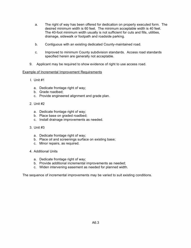
a. The right of way has been offered for dedication on properly executed form. The desired minimum width is 60 feet. The minimum acceptable width is 40 feet. The 40-foot minimum width usually is not sufficient for cuts and fills, utilities, drainage, sidewalk or footpath and roadside parking.
b. Contiguous with an existing dedicated County-maintained road.
c. Improved to minimum County subdivision standards. Access road standards
specified herein are generally not acceptable. 9. Applicant may be required to show evidence of right to use access road. Example of Incremental Improvement Requirements I. Unit #1
a. Dedicate frontage right of way; b. Grade roadbed; c. Provide engineered alignment and grade plan.
2. Unit #2
a. Dedicate frontage right of way; b. Place base on graded roadbed; c. Install drainage improvements as needed.
3. Unit #3
a. Dedicate frontage right of way; b. Place oil and screenings surface on existing base; c. Minor repairs, as required.
4. Additional Units
a. Dedicate frontage right of way; b. Provide additional incremental improvements as needed; c. Widen intervening easement as needed for planned width.
The sequence of incremental improvements may be varied to suit existing conditions.
A6.3

POLICIES AND STANDARDS PERTAINING TO WATER SYSTEMS
Background County regulations require that each new subdivision lot or single building site proposed for development be supplied with water for domestic and fire protection purposes. While individual wells are sometimes possible, water systems are preferred for reasons of better assurance of quality and quantity of water. In many cases they also are more economical when considering the requirements for fire protection. During past years, various terms have been used to describe different types of installations, such as “common well” or “shared water system,” without a clear understanding by the public as to what these terms mean or what standards or regulations apply. For simplicity, the generic term of “water system” as used in this manual (and County ordinances) means any type of common pipe system that serves two or more domiciles or business entities. Many variations of design are possible, but all of them are subject to uniform minimum standards. A significant consideration in the adoption of standards is the fact that the majority of small water systems either are expanded to serve additional connections, taken over by a public utility or annexed by a city. To avoid future replacement of facilities at very high costs, it is important for the County to utilize uniform standards as a matter of general public interest. All water systems in the unincorporated area are regulated wither by the State Department of Health, the County or the Public Utilities Commission (PUC). The County has jurisdiction over water systems with less than 200 connections, and both the County and the Public Utility Commission regulate those with 200 or more. Environmental Health Services enforces both State and County health and safety regulations pertaining to domestic water and issues permits for most types and sizes of systems. Many other departments and agencies are involved, however, including the County Surveyor, Fire Marshal, Building Inspector, Planning Department, Central Permit Office, Transportation Agency, Santa Clara Valley Water /District, the State Corporations Commission, and a city in some cases. Each agency has a special (generally nonduplicating) role in either the approval, design, permit or construction process and enforces certain policies and standards as described in the succeeding paragraphs. The table in the section of the Manual (Volume II) entitled, “Submittal and Approval Procedure,” shows the functions of various State and County offices pertaining to all sizes of water systems. In instances where there are inconsistencies in the standards of various agencies, the higher standards are required. For additional information, the reader is referred to the County ordinances and the following brochures published by the State Department of Health Services Sanitary Engineering Section, 2151 Berkeley Way, Berkeley, CA 94704:
(1) California Waterworks Standards (2) California Safe Drinking Water Act (3) California Domestic Water Quality and Monitoring
Regulations
B1.1

General Policies
o Water systems are preferred to individual wells, and large systems generally are preferred over small systems for reasons of better controls on quantity, quality and maintenance.
o PUC-regulated water systems are preferred to non-PUC systems because of their
larger size, rate controls by PUC and other refinements.
o Water systems must be designed for both domestic and fire protection purposes unless specifically approved otherwise. The higher standards for either type of service with respect to volume and purity apply to the design of all domestic water systems (unless a separate interim type fire protection system is allowed meeting only the fire protection standards). All systems serving domestic water must comply with the standards for design and construction contained in the California Health and Safety Code and the California Administrative Code (Title 22) as well as the County Subdivision Ordinance.
o Service by a city water system is required whenever such service is feasible and
available. (For more information, see the resolution of the Board of Supervisors on utilities and facilities at the end of this section.)
o Connection to an existing available system and/or the extension of the lines of
such a system may be required for County approval. If the system does not currently meet the State and County minimum standards, or would not after the additional service connections, an upgrading of the system must be completed, or assured, prior to final County approval of the subdivision or building site. When justified, the County may consider stage improvement in accordance with comprehensive engineered plans and an implementation schedule.
o In the event the service is to be provided from an existing non-PUC system, the
owner of the system must demonstrate that the system, or any independent portion providing the extended service, meets minimum County standards.
o Water system reports to the County prepared by registered civil engineers are
required for all non-PUC water systems, and extensions to existing systems. The purpose of the reports is to (1) provide an anlysis of the proposed (or existing) system by competent persons, and (2) provide reasonable assurance that the system can be completed (or upgraded) in accordance with adopted County standards. Water system reports must accompany the plans in the checking and review process.
B1.2

o All new non-PUC water system installations, including the extension of existing pipes, must have County approved plans prepared by a registered civil engineer in accordance with State and County water system standards. The policies and procedures described in the section of the manual (Volume I) entitled, “Improvement Plans, Grading Plans and Construction,” are applicable to the plans for water systems.
o Public Utilities Commission-regulated water companies (only) are exempt from County plan review and bonding requirements if the plans reflect compliance with State and County standards.
o Within urban service areas, any higher standards of the affected city take
precedence over County minimum standards. In situations where service is to be provided by a city-operated system, the County approvals for subdivisions or other types of development are handled in a manner similar to those for private water companies.
o Ex post facto water systems which are constructed (or proposed for construction)
after County permits are issued for development on the basis of water service by individual wells on each lot (rather than a water system) are subject to the same plan preparation, review and inspection requirements as regular water system construction. These requirements must be met prior to County approval of the system and the issuance of permits to operate.
o In situations where reimbursement to a developer may be appropriate due to his
installing or financing of a water main extension (or additional storage tank, etc.) which will serve future additional connections, it is his responsibility to make arrangements with the owners of the water system for such reimbursement.
o The County does not regulate or arbitrate water system connection fees or
conditions of service. In the event of disagreement between the applicant and the company, he may appeal the County’s conditions of approval requiring service by that company by following the standard appeal process. To avoid possible loss of appeal rights, the applicant should assure himself regarding the cost of service and other relevant facts before the County’s appeal period lapses.
o The use of wood tanks is discouraged because leakage problems occur when
portions of the tank become dry, and the wood provides a favorable environment for the growth of bacteria.
o Fencing of tank sites typically is required for reasons of public health and safety.
The standards for fencing are set forth elsewhere in the manual.
o Annexation to a fire protection district may be required. For processing policies see heading below, “Fire Marshal Functions and Policies.”
B1.3
o Loop systems are required wherever feasible. Long dead-end pipes are discouraged.
o Elevated tanks providing adequate static head are preferred to mechanically
pressurized systems. If adequate static head for the complete system is not feasible, a centrally operated pressure tank system (as opposed to individual pressure tanks) may be required.
o Water systems serving five or more lots or domiciles must be either mutual water
companies or PUC-regulated. (Note: Currently the PUC does not regulate new water companies with less than 400 service connections.
o Shared (non-community) water system may be used when there are less than five
lots or wells. Such systems must meet both domestic water and fire protection standards. An appropriate legal document must be submitted with the application for approval by Environmental Health Services and be fully executed prior to final approval of the plans.
County Surveyor Functions and Policies Functions
The County Surveyor’s functions with respect to water systems are to approve the engineered plans and report, and to coordinate their review with affected agencies, collect clearance letters, receive and enforce bonds, sign the plans and agreements and inspect the work during construction.
Policies
o Water system plans are reviewed by the County surveyor for general compliance with the conditions of approval immediately after they are received from the engineer, then copies are distributed to Environmental Health Services and other agencies as appropriate in each case. After Environmental Health Services completes its plan check, it forwards its comments to the County Surveyor’s Office, which in turn forwards them to the private engineer with the comments of all other affected agencies.
o Water system improvements for a subdivision that come under the purview of the
Uniform Building Code, such as storage tanks, must be shown on the water system plans and covered by performance bond and construction agreement. Permits for these items must be issued (or ready for issue, with all fees paid) before the subdivision map is recorded. Inspection fees for items covered by the building permit are deducted from the overall water system inspection fees collected by the County Surveyor.
B1.4
o If used materials are proposed to be installed in the water system, the permittee must provide evidence that they meet minimum State and County ordinance requirements and have a life expectancy substantially equal to new materials. Laboratory tests and/or private engineer’s certification are required.
o Adequate and appropriately located easements for water system pipes, tanks and
necessary access roads must be provided. If the development is a subdivision, the easements must be shown on the map and dedicated in the owner’s certificate. Under normal conditions, tank site easements (and other water system easements) are not deducted from the net lot area required by the zoning ordinance.
o Water systems must be designed with adequate safety factors and be free from
structural and sanitary hazards. If they are in flood hazard areas, they must be designed to prevent infiltration of flood water into the system. Pipe lines are not permitted in active slide areas. If they cross an active fault line, the pipe and fittings must be designed in a manner that will minimize the damages and repair costs due to movement of the fault. Storage tanks must be located away from fault lines and designed (per building code) for earthquake-induced forces.
o When the water system is within the urban service area of a city of the service area of a
public utility that may incorporate the facilities into its own system, any higher standards of that agency shall apply.
o Either the developer or the water company (not a mixture of both) may post the
necessary bonds and sign the agreement. If the company posts the bond and signs the agreement, the water system plans must be separate from the developer’s plans for the roads or other work. If the company employs a registered civil engineer on a regular basis to do its water system design, this engineer may be authorized by the County Surveyor to perform the inspection work.
o Polyvinyl chloride (PVC) pressure pipe sizes 4” through 12” may be used provided it is
Class 150 pipe conforming to American Water Works Association specification C900-75.
o Requests to construct a water system prior to final County approval of a subdivision are handled in the same manner as described in the section of this manual entitled, “Policies and Standards Pertaining to Improvement Plans, Grading Plans and Construction,” under the sub-heading, “Bond Preemption Policy.”
o A clearance letter from the private water company to the County Surveyor is required in
all cases (PUC and non-PUC systems) prior to final approval of the subdivision map, or issuance of building permits for single sites, stating that service will be provided and that the developer has made all necessary arrangements for the work—including financial. Clearance letters from Environmental Health Services and other affected agencies also are required.
B1.5

Environmental Health Services Functions and Policies Functions
Environmental Health Services enforces State and County laws regulating the operation and maintenance of water systems. This includes field investigation, recommended conditions of approval for development, the checking of plans, the review of water system reports and legal documents such as mutual water company bylaws and articles of incorporation, the checking of quality and quantity of water and issuance of permits to operate.
Policies o Wells must be drilled, tested and certified prior to approval of a tentative subdivision map
or single building site unless Environmental Health Services has sufficient information on the ground water in the area to justify waiver of this requirement. In all cases, the well drilling and supply requirements must be met prior to final approval of the subdivision map, or issuance of building permits. The well test results must meet the California Domestic Water Quality Monitoring and Regulation (Title 22) requirements.
o Existing wells is to be from an existing approved system not under the ownership or
control of the developer, evidence of an agreement for service is required prior tentative map approval.
o Existing wells that are not approved for continued service must be sealed in accordance
with well—sealing standards approved by Environmental Health Services and administered by the Santa Clara Valley Water District prior to the recording of subdivision maps or the issuance of building permits for single sites.
o Legal documents must be approved prior to final approval of the subdivision map.
These documents may include shared water system agreements, articles of incorporation, bylaws and permit to issue securities as a mutual water company. County concerns include such matters as service delivery, reasonable rates that include proper water system maintenance and replacement, voting rights, transferability of shares and ownership of water rights.
o Anyone may apply for an inspection report. Environmental Health Services checks for
contamination and integrity of the system and obvious water supply problems. An in-depth water system investigation and report by a registered civil engineer competent in the field of water system design may be required. An application (or status determination) for regulation by PUC also may be required.
B1.6

o A permit to operate must be issued before use of any water system. Permits for the selling of water are not issued to individuals. If pipelines or tanks are constructed without permits issued by the County Surveyor and/or the Building Inspector, no permit to operate will be issued until the plans and report have been processed in the standard manner assuring compliance with State and County standards and the ordinance requirements.
o New systems serving five or more connections must be set up and operated as mutual
water companies. o The use of springs is not allowed for new water systems, and strongly discouraged for
individual services.
o Environmental Health Services checks the health and safety features of the system after construction and tests samples of water from appropriate locations. This must be accomplished prior to final construction acceptance and release of the bond.
Fire Marshal Functions and Policies Functions
A Deputy Fire Marshal is part of the Central Permit Office staff. His primary function in land development is to enforce County ordinance and standards pertaining to fire protection. This includes preparing recommended conditions of approval for tentative maps and reviewing improvement plans with respect to fire protection facilities. He also functions as a link with the fire protection districts and city fire departments. Policies o The County enforces the Uniform Fire Code as compiled and published by the
International Conference of Building Officials of the Western Fire Chiefs Association. Adequate water supply is defined as being in compliance with the Insurance Services Office publication, “Guide for Determining Required Fire Flow.”
o Water supply from an existing approved water system meeting fire protection standards
and capable of serving additional connections is preferred to single lot or small marginal systems. A connection to an existing adequate and available water system may be required.
o Fire hydrants, storage tanks and appurtenances meeting adopted minimum fire
protection standards must be shown on the engineered water system plans. The Deputy Fire Marshal in the Central Permit Office reviews the plans with respect to these items and furnishes a clearance letter to the County Surveyor when the plans are satisfactory and other fire protection requirements are met.
B1.7

o Water systems must have sufficient storage to provide fire flows of not less than 250 gallons per minute for two hours at 20 psi residual pressure. Booster pumps in the systems are required if they are needed to meet this minimum standard. Minimum pipe diameters are 6” in a closed loop and 8” in a dead-end main.
o Fire hydrant design must equal or exceed the specifications for Rich Valve #950.
Spacing maximum are 500’ in rural areas and 300’ in urban areas. Fire hydrants at street intersections generally are required.
o If a fire protection district requests that property be annexed to the district in
connection with a land development project, the Fire Marshal includes this request as a recommendation to the advisory agency as a condition of approval of the tentative map. Prior to final approval of the subdivision map or issuance of a building permit for a single site, the applicant must apply to LAFCO for annexation to the fire district and furnish evidence to the Fire Marshal that the annexation either has taken place or that all arrangements have been made with the district for the annexation to proceed.
o LAFCO has a policy that requires land to be annexed to a special district to also be
annexed to a city if it is reasonably feasible (generally land within the urban service areas). If this policy is applied by LAFCO, it is the Fire Marshal’s policy to require that prior to final subdivision or site approval, the developer must obtain a clearance letter from the city stating all its requirements have been met to conclude the annexation. In the absence of such a clearance letter, the developer must request a waiver of the LAFCO requirement from the County advisory agency or the Board of Supervisors if he proposes to continue with the project.
o If service from a regular water system approved for fire protection is not available
and not feasible to construct, an interim system for fire protection only will be considered provided it conforms to the following fire protection requirements:
Storage
1 dwelling 4,000 gallons 2 dwellings 6,000 gallons 3 dwellings 8,000 gallons
4 dwellings 10,000 gallons
B1.8

Pipe Requirements Minimum pipe diameter is 4” provided, however, 3” pipe may be used if the pressure is
sufficient to provide 200 pm. Any above ground pipe must be steel. Fire Hydrants Fire hydrants may be either wharf type, single barrel, with 2 1/2” gate valve and
adaptor or a municipal type hydrant with 4” or 4 /2” outlet (as specified). Wells and Pumps Wells and pumps must be capable of delivering 200 gpm for twenty minutes and
provided with automatic controls. The electrical supply to the pump must be separate from all buildings.
Materials If the system is to be upgraded in the future, or connected to another regular water
system that provides both domestic water and fire protection, the ordinance requirements for the materials to be used in regular water systems are required. If the system is strictly temporary, the materials must be adequate for the pressures and have a life expectancy consistent with the County approval.
Deferred Improvement Agreements
The Fire Marshal implements a deferred improvement agreement policy similar to the one for roads when a regular water system is not feasible and development is allowed to proceed on the basis of an interim fire protection system. These agreements are recorded, and they set forth County requirements with respect to utilization of a future adequate water system.
Building Inspection Functions and Policies Functions Permits are required for electrical facilities and for the construction of water storage
tanks that are 5,000 gallons or larger in size. The Building Inspector’s functions with respect to water systems are to issue the necessary permits and inspect the work during construction. (Note: Any exemption from the Building Code does not exempt the tanks from regulation under other applicable County ordinances.)
B1.9

Policies
o Building permits are required for water tanks (above ground or below) that are 5,000 gallons or larger in size (Building Code requirement). The structures supporting elevated tanks of any size may need a building permit.
o Applications for building and electrical permits must be signed off by affected County
departments prior to issuance of the permit. These offices check to see that the ordinance requirements have been met pertaining to use permit, approved water system plans, etc.
o After completion of construction of water tanks, the Building Inspector notifies
Environmental Health Services and/or the County Surveyor. The total system then is checked for compliance with health, fire protection and other project or ordinance requirements.
Planning Department Functions and Policies Functions
The Planning Department functions as an arm of the Planning Commission with respect to water systems. It presents applications for use permits to the Commission and performs the principal staff work for the Architectural and Site Committee.
Policies
o Use permits in all zoning districts are required for all water systems (PUC regulated or not) except those that (1) are developed and approved with a new subdivision and (2) the plans have been signed by the County Surveyor.
o Architectural and site approval typically is a requirement for water tank use permits.
The conditions of approval embrace the spectrum of regulations and policies administered by the various County departments and agencies.
o Aesthetic improvement measures related to underground wiring, landscaping,
screening and painting of water tanks are typical requirements. These items are field checked prior to final construction approval and release of the bond by the County Surveyor.
Transportation Agency Functions and Policies
Functions
o Any portion of a water system within a County maintained road right of way must
have an encroachment permit issued by the Transportation Agency.
B1.10

Policies
o A representative of the Transportation Agency is stationed a the Central Permit Office. Water system plans that show work in a County road are reviewed and encroachment permits are issued when they are satisfactory.
o Plans are reviewed for conformance with the published standards of the Agency
pertaining to pipe location, trenching, backfill and surface restoration. The permit specifies the general requirements relating to traffic, hours of work, etc. A bond may or may not be required depending upon, the circumstances in each case.
o Boring and jacking of pipes across the traffic lanes of major roads generally is
required. Santa Clara Valley Water District Functions and Policies
Functions
The District regulates the construction and abandonment of wells throughout the County
under District Ordinance 75-6 and a parallel set of adopted standards. A District employee is stationed at the Central Permit Office and a part of his duties is to issue well permits.
Policies
o The District administers only well standards that have been approved by
Environmental Health Service. The purpose of these standards is to protect the underground aquifers as well as the water entering the distribution system.
o The District does not regulate the number of wells or the location of wells other than
enforcing the minimum distance separation of the well from sources of potential pollution set forth in the District standards.
o The District does not regulate the use of water from wells nor does it duplicate any of
the functions of the Environmental Health Services with respect to enforcement of operational health and safety standards.
o If the property to be developed has an existing well, it must be either improved to
District standards for operational wells or abandoned and sealed in accordance with adopted standards.
Well Standards
See attachments pertaining to the construction and sealing of wells.
NOTE: See Volume II for water system standard details and construction specifications.
B1.11

RESOLUTION OF THE BOARD OF SUPERVISORS REGARDING LAND USES REQUIRING PUBLIC
UTILITES AND FACILITIES
WHEREAS, the proper development of real property located within the County of Santa Clara and potentially available for residential, commercial, industrial and all other urban uses require the existence of various utilities and facilities such as water, storm and sanitary sewers, to service such property; and WHEREAS, within the County of Santa Clara such facilities are normally furnished in whole or part by municipal corporations, local agencies or by sanitary or sanitation districts; and WHEREAS, the granting of zone changes or use permits for such uses in those situations where such utilities and facilities are not available within the unincorporated territory leads to a duplication of the planning and zoning process in that such utilities and facilities must be sought from other political jurisdictions or local agencies after the obtaining of such land use authorization from the County of Santa Clara, thus on occasion giving rise to conflicts and disagreements; and WHEREAS, an applicant seeking a zone change or use permit for such land use should have the burden of establishing to the satisfaction of the Planning Commission and, where appropriate, the Board of Supervisors, that such utilities and facilities are or would be available to him were the real property the subject of the application to remain in and be fully developable in such unincorporated territory, and that such applicant furnish a written statement from the appropriate political jurisdiction or local agency that such jurisdiction or agency will furnish such utilities and facilities to the real property of the applicant while such property remains in the unincorporated area of the County, NOW, THEREFORE, BE IT RESOLVED by the Board of Supervisors of the County of Santa Clara, State of California, that it declares as a matter of policy that it hereby expresses and most strongly discourages applications for zone changes and use permits in those situations where the development of real property for residential, commercial, industrial and all other urban uses require the existence of various public utilities and facilities such as water and storm and sanitary sewers, and such facilities are not available within the unincorporated territory of the County. BE IT FURTHER RESOLVED that in those situations where such facilities are not so available the applicant shall be expressly and most strongly urged to obtain authorization to use such lands for residential, commercial, industrial and all other urban purposes from the political jurisdiction from which such facilities are available.
BE IT FURTHER RESOLVED that this policy shall be augmented at the staff level in as many ways as possible, including the following: (a) That a copy of this Resolution be made available to and discussed with any applicant for land use which use is subject to this Resolution; and that such availability and discussion occur prior to the time that such application for land use is filed so that the applicant fully and clearly understands the policy of this County;
(b) That such applicant furnish a written statement from the appropriate political
jurisdiction or local agency that it will furnish such utilities and facilities for the development of such land while such land remains in the unincorporated territory;
(c) That the Director of the Planning Department or his representative determine whether this Resolution is applicable to a proposed land use and in the course of such determination confer with all affected departments of the County of Santa Clara, including the Health Department, the Public Works Department and the Fire Marshal, and with the political jurisdiction or local agency involved;
(d) That if the application for such land use is filed, such determination together with the facts thereof, be made available to the Planning Commission, the political jurisdiction or local agency involved and the Board of Supervisors, in the event that such application reaches such board. BE IT FURTHER RESOLVED that a copy of this resolution be furnished to the Planning Commission of the County of Santa Clara and to the city councils and planning commissions of each city in the county of Santa Clara. PASSED AND ADOPTED by the Board of Supervisors of the County of Santa Clara, State of California, on November 28, 1967. Signed/Sam P. Della Maggiore Chairman, Board of Supervisors
-2-

POLICIES AND STANDARDS PERTAINING TO IMPROVEMENT PLANS, GRADING PLANS AND CONSTRUCTION
Background and Purposes Long-standing County policy and regulations require improvement plans and/or grading plans for all land development and grading projects except minor work, such as a driveway approach within the road right of way where a published standard detail is sufficient for construction without engineering design. The primary County purposes of engineered plans are to:
o Coordinate the planning and implementation requirements of many different agencies that may be involved in any given project.
o Assess the proposed development and implement the minimum design and
environmental standards of all affected agencies.
o Control the on-site and off-site improvement work for conformance with the concepts approved for the development by the County.
o Protect the public interest by providing a basis for inspection and a bond to help ensure
that the work will be completed in accordance with approved design and time limits. The policies and standards for preparation and approval of plans and other construction-related matters are described below. Improvement Plans – General Policies
o Plans must be prepared by registered civil engineers, retained by the applicants, and based on adopted minimum standards of the affected agencies. The standards and format for the plans are described below under the heading, “Plan Content, Format and Standards.”
o The plans must properly reflect the conditions of approval for the particular project
issued by the County. Imaginative and creative design which is equal to or better than the adopted minimum standards is encouraged.
o The County Surveyor is responsible for the coordination of the review of the plans by
various agencies, the final approval of the plans and the enforcement of land development and grading agreements. A checklist is furnished to engineers that is intended to cover all of the standard items on a typical set of plans. This checklist must be filled out and turned in with the initial checkprints.
o Plans must be based on sufficient field data and reflect true field conditions. Plan and
profile sheets drawn at appropriate scale are required for roads, driveways and pipelines. Standard notes and certificates also are required as described below:
C1.1

o Plans must conform to the adopted minimum standards of the various agencies
(Transportation Agency, Santa Clara valley Water District, sanitation districts and the County Surveyor). Any proposed deviations from these standards must be handled by direct communication between the private engineer and the agency involved.
o It is standard practice for most agencies to require that alternatives to adopted standards
be presented by the engineer on an equal or better basis with appropriate written justification, as well as documentation, when needed, such as laboratory tests of soils, geologic reports, etc. In all situations involving a lesser design than the adopted County standard, the matter may be referred to the Board of Supervisors. Such deviations (as well as those of other affected regulatory agencies) should be made known by the engineer during the tentative map stage for resolution of issues at that time.
o All types of public improvements and on-site development work, should be included in
one set of plans to better coordinate the construction, bonding, final plan approval and inspection requirements. This may include such items as sanitary sewers, water systems and improvements to flood control facilities.
o Earthwork must conform to the standards of the grading ordinance or any higher
standards adopted by the affected public agencies. Final Approval
o Improvement plans are submitted to the County Surveyor through the Central Permit Office for review and approval. Information on the number of copies and the process is available from the Central Permit Office. Copies are referred to all affected agencies by the County Surveyor for review in accordance with the three-step process and checklist described in this section. To avoid a myriad of problems involved in redistribution when the original plans are deficient, a pre-screening of the plans is made immediately after they are received. The engineer is notified promptly if there are significant deficiencies to be corrected before distribution and checking of the plans.
o At the time check prints are submitted for County review, they must be accompanied by
the engineer’s cost estimate. A detailed estimate by bid items with current unit prices is required, including such items as equipment move-on, clearing and grubbing, Unit prices should properly reflect the location of the work and site conditions.
o All conditions of approval applicable at the time of final plan approval must be completed
before they are signed by the County Surveyor. The original plans are returned to the private engineer after reproducible copies have been made for County records. Only copies signed by the County Surveyor should be used for soliciting bids for the construction work.
C1.2

o To eliminate duplication and reduce processing time, conditional clearance forms are used for reports from affected departments and agencies to the County Surveyor regarding the acceptability of the plans. The method is effective only if private engineers conscientiously comply with the standards of the agency and the project conditions of approval. If there are significant problems, this should be resolved with the affected agency (s) prior to submitall or the plans for a plan check.
o The County Surveyor utilizes a three-step method for the final approval of improvement
plans and grading plans which is instituted at the end of the plan check. The method, processing checklist and responsibilities of the various parties are described in an attachment to this section of the manual. The purpose of the three-step method is to reduce time and costs to both the applicant and the County.
o Copies of signed plans and permit must be retained on the job site at all times and the
work performed in accordance with these plans. Any significant field changes must be shown on the plans and approved by the County before construction.
o After completion of the construction work, as-built plans are prepared by the County or
any private engineer who is authorized by the County Surveyor to perform the inspection work. These plans are retained by the County as a public record.
Agreements At the time of signing the plans, the developer and the County Surveyor, or his authorized representative, both sign an agreement (except the County Surveyor does not sign the agreement for major subdivisions) which specifies the time period and other requirements for satisfactory completion of the work. If the development is a major subdivision, the agreement, bond, tract map and pertinent papers are sent to the Board of Supervisors for signing and final approval. It normally requires a minimum of three weeks for the preparation and agendizing of this report. It is the policy of the County Surveyor not to sign the plans for a major subdivision until the Board of Supervisors approves the final map and agreement. The principal provisions of the typical agreement are:
o All work is to be completed in accordance with approved plans prior to occupancy of any new buildings or building additions, but not later than one year.
o The County Surveyor may, upon written request and submission of satisfactory evidence
that the specified time limits are not appropriate or practical, give written authorization of an extension of time and modify the requirements for occupancy.
o The work includes (whether stated on the plans or not) the setting of construction stakes,
monument boxes and survey monuments.
C1.3
o The work may be completed by the County if the developer fails to perform. (NOTE: It is County policy to first sue the developer, if necessary, for specific performance.)
o The developer guarantees all work for a period of one year (except single sites and
grading) from the date of completion and construction acceptance by County. o In the event the work is not to be maintained by a public agency, the developer agrees to
notify any purchaser regarding the property owner’s responsibility for continued maintenance of the improvements in a manner consistent with the purposes of the County approval.
o The developer agrees to indemnify and hold the County harmless from any liabilities,
claims, damages or suits for reason of death or injury arising out of the work performed, except for liabilities or claims arising out of the sole negligence of the County.
o The developer must maintain public liability and property damage insurance in the
minimum amounts of $300,000 for bodily injury, $50,000 for property damage, single occurrence, and an aggregate limit of $200,000. Evidence of such insurance may be required at any time.
o Upon annexation into any city, the developer agrees to fulfill all the terms of this
agreement upon demand by such city as though he had contracted with such city originally. Any annexing city has the rights of a third-party beneficiary.
o Special provision pertaining to bonds and insurance as described below.
Bonds
o Performance bonds in the full amount of the estimated cost of the work are required for all projects except as noted below for certain discretionary types of grading and single building site development. Since bonds are for the purpose of assuring completion of the work in the event of failure of the developer to perform, they must include ancillary items such as equipment move-on.
o Bond amounts are determined by the County Surveyor using the private engineer’s
itemized cost estimate as a guide. One year inflation and ten percent contingency factors are added to the cost estimate. The County may use unit costs higher than the private engineer’s on the basis that the County may have to get the work done under less favorable circumstances.
o Bonds must include the cost of any structural items shown on the plans that require a building permit, such as tanks and retaining walls. The bonds also must include all items of work that are required by other affected agencies to comply with conditions of approval or the agency’s standards, such as drainage outfall improvements in the Water District’s channels. County bonds are not required for items of work that are installed or guaranteed to the County by public utilities and special districts, electric distribution lines and sanitary sewers. The agencies responsible for those improvements require either a bond or full payment by developer prior to issuance of a clearance letter to the County Surveyor.
C1.4
o The permittee has a choice of bond types that includes cash, certificates of deposit, letters of credit and surety company bonds, The latter generally are not viable for small projects. The County furnishes standard forms which must be used in all cases.
o If a labor and materialmen’s bond is required and the developer chooses to post cash, or
a form of cash such as certificate of deposit, the performance bond and the labor and materialmen’s bond amount may be combined for a single bond 110%. The additional ten percent is for the purpose of securing the payment of County legal costs in enforcing the agreement, if necessary.
o Less than 100% bonds are allowed for projects where all or a portion of the work is
discretionary on the part of the permittee. Discretionary work may include such things as the development of existing single building sites or the grading for tennis courts, playgrounds, etc. The bond amount is computed by the County based upon 100% of the estimated cost of any required items of work, plus the cost of potential remedial grading or restoration work (as determined by the County) that may be needed in the event of abandonment of a partially completed project.
o Third-party bonds (persons other than the developer, such as contractors or buyers) are
not enforceable under the agreement with the developer and cannot be accepted.
o Performance bonds can be released by the County Surveyor in increments of 25 percent as the work progresses. The final 25 percent increment cannot be released until final completion and acceptance of the work. If a form of cash is posted and the project requires a labor and materialmen’s bond, the maximum incremental release is 50 percent because the remaining 50 percent is the minimum labor and materialmen’s bond required by State law.
o Labor and materialmen’s bonds must be retained for a period of six months (State law)
after completion of the work and claims, if any, have been settled.
o The agreement for single building sites provides that in the event the improvement costs are less than $5,000, the County Surveyor may waive the bond requirements. In no case will occupancy approval of any new buildings or additions to existing buildings be granted prior to completion of all required work unless and until a bond in the full amount of the estimated remaining costs has been posted.
o The developer must request release of the bond upon completion of the work. The
County Inspector initiates the administrative procedures for bond release upon request and final approval. It normally takes about ten days for the return of bonds. Bonds cannot be released until those portions of the work to be done under a building permit, such as tanks and retaining walls, or the work required by outside agencies which was included in the bond furnished to the County has been fully completed and approved.
C1.5
o In the event a maintenance period is required for plantings and erosion control facilities,
a separate maintenance bond must be posted, or the original bond retained for the prescribed period of time. The bond amount must be sufficient to cover both the potential remedial work and the normal maintenance express.
Bond Pre-emption Policy (Report approved by Board of Supervisors, 6/2/80)
o State and County regulations do not preclude a developer from constructing subdivision
improvements (except grading) before the recording of the map and posting of bonds. He does run the risk, however, of not receiving final County approval—even with County inspection during construction. To help avoid some of the potential problems, a report was sent to the Board of Supervisors on June 2, 1980 (and approved) recommending certain policy guidelines to e followed in situations where developers request County approval to commence construction prior to the signing of the subdivision map or the posting of a full performance bond. The approved guidelines are:
(1) If the project is a major subdivision, the developer should make his
request directly to the Board of Supervisors. If the project is a minor land division, the request is to be handled by the County Surveyor without a report to the Board. (See note below.)
(2) If the request is approved, the plans must be fully completed and signed
by the County Surveyor. Concurrently, a modified land development agreement approved by the County Counsel covering the work and ancillary items is to be signed by the developer and the County Surveyor.
(3) All subdivision conditions of approval must be met prior to approval of the
plans, except ones that are obviously inappropriate at that time. The requirements to be met in these cases typically would include (but not be limited to) payment of fees, posting of appropriate bond (not less than ten percent of the estimated cost of the advance work), signing an agreement and clearance letters from all affected County departments and outside agencies.
(4) If it is proposed to include in the advance work the improvement of an
existing County road, the bond shall include the full cost of such work. Any exceptions to this requirement are to be approved by the Transportation Agency or the Board of Supervisors.
(5) Written acknowledgment by the developer that any advance construction
work will not be a consideration with respect to future proceedings or final approval of the subdivision map.
C1.6

NOTE: At the time of this report, County Counsel recommended that the conditions of approval for future subdivisions include basic requirements to be met prior to County approval of any construction work to be done in advance of final approval of the subdivision map. In the absence of such conditions being included when the Board of Supervisors approves the tentative map of a minor subdivision, the request for advance construction will be referred to the Board of Supervisors.
Permits
o Permits for the work are issued immediately after the plans and agreement are signed. The permits specify the responsibilities of the permittee for the conduct of the work, the time period (or restricted times, if any) and other significant matters not covered in the plan specifications or the agreement.
o Permits are not transferable and permitee’s responsibility for completion of the work
cannot be assigned to third parties (lot buyers, etc.).
o Building permits are required for structures, such as retaining walls and bridges, when they are located outside the right of way of a County maintained road, or road to be County maintained immediately after construction.
o The permit must be retained at the work site whenever work is in progress. In the event
the work is not being performed in accordance with the permit (or plans), the permit may be suspended or revoked by the County Surveyor or his authorized representative.
o When the time limits may expire, without the work being completed, the permittee must
request an extension of time. Time limit expirations in no way lessen the permittee’s obligations to complete the required work. The County Surveyor may specify new requirements to be met when issuing an extension of time. In the event the permittee fails to complete the work in a satisfactory manner after due notice, (or time extension), the matter is reported to the Board of Supervisors for legal action.
Inspection
o All construction work must be inspected by the County. Private engineers may do the inspection for the County when authorized in writing by the County Surveyor. A standard three-part form (permittee/private engineer/County Surveyor) is used for this purpose.
o When private inspection is authorized by the County Surveyor, the applicant must obtain
and pay for the services of a licensed private engineer or engineering firm (satisfactory to the County Surveyor) other than the one who prepared the plans.
o A notice of 48 hours to the inspector is required prior to commencement of work.
C1.7

o Any significant changes in the work during construction must be shown as modifications on the original plans and reviewed and approved by the County prior to construction. If the inspector finds the work is not being done in accordance with the approved plans or the permit, he may order the work to be discontinued.
o Laboratory tests of certain materials may be required. Compaction tests of fills must be
done in the manner and number descried in the ordinance, or in the plans and specifications. Soils and/or geologic investigations and reports also may be required while the work is in progress or prior to acceptance. As-built plans are prepared for public record upon completion of the project.
o A field walk-through of the project is held with the inspectors, the developer and/or
contractor, and a representative of any affected agencies near the end of the work schedule. Upon satisfactory completion of the work, and request from the developer, the County inspector initiates the final acceptance and bond release. Any unpaid County charges for laboratory tests, etc., must be paid prior to final acceptance and release of the bond.
o In the event an approved soils or geologic report (or correspondence) recommends that
the engineer or geologist who prepared the report (or other qualified person) check the excavation or other work at some point during or after construction or that certain measures be taken contingent upon site conditions revealed after the start of work, the developer/permittee must carry out these recommendations and furnish written evidence of such from the engineer or geologist prior to final acceptance of the work and release of the bond.
o When the plans include a private water system, or separate fire protection facilities, they
must be tested and approved in accordance with the methods and standards of the affected agencies—generally Environmental Health Services and Fire Protection districts.
Plan Check and Inspection Fees
o Plan check and inspection fees are set by Board resolution. The plan check portion (non-refundable) must be paid at the time prints are submitted for plan check. The amount of the fee is initially determined and paid on the basis of the private engineer’s estimated cost of the work shown on the plans. After the plan check is completed, the final plan check fee amount and the inspection fee are computed by the County based on the method described above for determining the amount of the bond. Any unpaid balance for the plan check as well as the inspection fee must be paid prior to approval of the plans. If the initial plan check fee happens to be too much, the balance is applied to the inspection fee --or refunded.
C1.8

o If a private engineer is authorized to inspect the work, only the plan check fee is paid to
the County. It is the developer’s/permittee’s responsibility to make all necessary financial arrangements with the private engineer that he retains to do the work and to pay the costs of tests and reports. (NOTE: County inspection fees include routine tests of material and compaction of fills. Any special tests and investigations, or retesting necessitated by failure of the original tests to comply with requirements, are paid by the developer/permittee.)
o In situations where the plans show improvements that require a building permit (retaining
walls, tanks, etc.), the amount of the Building Inspector’s fee is deducted from the improvement plan and inspection fees.
Plan Content, Format and Standards For clarity, storage and reproduction purposes, the County has adopted the following policies regarding the content, materials and format for improvement plans and grading plans:
o Use of high quality materials in sheets size 24” X 36” capable of producing good quality prints from standard ammonia process print machines.
o Drafting work suitable for microfilming. Light pencil lines and small lettering will not
provide readable microfilm prints and cannot be accepted.
o A minimum of two sheets with consecutive numbers. The second and succeeding sheets should include plans and profile sheets as needed and the detailed design information. The first sheet (cover sheet) should contain the basic project indentification, plan approval notes and general construction information descried below. Use of a standard format is encouraged but not required, except for specific items as noted.
A. Cover Sheet
- A title block in the lower right-hand corner naming the project, the firm that
prepared the plans, revision dates, County file number and the sheet number written (1 of 2 or 1 of 4, etc.).
- Standard notes on the left side of the sheet.
- Appropriate margin lines with adequate binding space on left side.
- Location/vicinity map and legend.
- Typical road cross sections.
- A sketch plan at appropriate scale indicating the extent and correlation of major
elements of the work and their relationship to property lines, existing or proposed structures, etc.
- Notes and statements worded as follows:
C1.9

(a) ENGINEER’S STATEMENT
I hereby state that these plans are in compliance with adopted County standards, the approved tentative map (or plan) and conditions of approval pertaining thereto dated , File (s) No. Date Signature R.C.E. No. COUNTY SURVEYOR’S NOTE Issuance of a permit authorizing construction does not release the developer, permittee or engineer from responsibility for the correction of errors or omissions contained in the plans. If, during the course of construction, the public interest requires a modification of (or a departure from) the specifications or the plans, the County shall have the authority to require the suspension of work and the necessary modification or departure and to specify the manner in which the same is to be made. Date County Surveyor
(b) AS-BUILT PLANS STATEMENT
This is a true copy of the As-Built Plans. There ( were) ( were not) minor field changes—marked with the symbol ( ). There ( were) ( were not) plan revisions indicating significant changes reviewed by the County Surveyor and marked with the symbol , Date Signature
NOTE: Mylar cover sheets pre-drafted by the County Surveyor’s Office are available from
commercial outlets (San Jose Blue Print Service and Supply company, and Valley Reproduction Services). These sheets save considerable drafting time. Their use is encouraged, but not required if the engineer’s plans show all of the same notes and information.
C1.10

NOTE: The above statement regarding as-built plans is to be signed by the county inspector or the private engineer authorized by the County Surveyor to perform the inspection work. A reproducible copy of the as-built plans must be furnished to the County Surveyor after construction.
(c) CONSTRUCTION/ENCROACHMENT/GRADING PERMIT Permit (s) No (s) File (s) No (s) Issued by Date B. 2nd and Succeeding Sheets –
- Plan and profile sheet (s) showing the road centerline, curb lines, ditch lines, etc., and any underground pipes, wires, manholes, etc.
- Details as needed for construction and design evaluation.
- Cross sections of roads and channels sufficient for the computation of earthwork
volumes with reasonable accuracy and for determining the suitability of the design with respect to property lines, structures and other improvements. Ground profile lines must extend an adequate distance beyond cut-and-fill lines to indicate the correlation with existing terrain features or constraints, such as property lines.
- Cross sections of all significant graded areas showing maximum cuts and fills and the
silhouettes of major structures, such as tanks. (NOTE: the primary need for this information is for environmental assessment.)
C1.11


POLICIES AND STANDARDS PERTAINING TO GRADING AND EROSION CONTROL
Background The County instituted grading regulations in 1964 when it adopted Chapter 70 of the Uniform Building Code. The objectives were to improve or control the quality of construction and provide certain safeguards for neighboring properties. Later on the environmental and development issues became dominant factors and the ordinance was replaced in 1972 with more comprehensive regulations inserted as Chapter X of the Land Development Regulations, which in turn were replaced by Chapter III in 1978. The many changes that occurred were aimed primarily at reducing the number of non-permit (illegal) grading operations and instituting strict land use requirements to be met prior to doing the grading. The policies now in effect (many of them embedded in the present ordinance) evolved over the years to deal with very controversial issues—generally non-technical matters such as land use and environmental controls. The grading standards, as opposed to the policies, have not undergone major changes. Those that have been changed or added pertain primarily to erosion control. Enforcement of the ordinance is the responsibility of the County Surveyor. Objectives There are four primary purposes for issuing grading permits: • To help ensure the integrity of structures to be constructed in graded areas; • To minimize damage or danger to neighboring properties; • To minimize environmental damage, including soil erosion, and to institute mitigating
measure as needed; • To make sure that the grading will be consistent with approved use of the land. Applications o Proposed grading must be directly related to an approved land use. The ordinance
prohibits approval of an application unless the following findings are made:
• The proposed grading is related to the land use presently permitted by law;
• The grading is necessary for establishment or maintenance of the use;
• The design, scope and location of the grading is appropriate for the use and causes minimum disturbance to the terrain and natural features of the land.
D1.1

NOTE: Exceptions to the land use requirements are allowed for emergency work, and for work
pertaining to a project under city annexation procedures (see ordinance for exact requirements).
o To coordinate the grading and other necessary reviews for a given project, the grading
and land development applications should be submitted at the same time. If this is done, the costs and time factors may be significantly reduced.
o Grading applications are submitted to the Central Permit Office which refers them to
the County departments, outside agencies and cities that may be affected. The recommendations of these departments and agencies are used by the Land Development Coordinator in preparing conditions of approval which are furnished to the applicant. The County implements city recommendations to the extent that they are feasible and not in conflict with County standards or regulations. Handout materials are supplied by the Central Permit Office explaining the procedures and time requirements.
o Conditions of approval for the grading are issued by the Land Development
Coordinator—or by the Architectural and Site Approval Committee if the grading is related to an architectural and site approval or use permit project. The period of validity of the approval (specified in each case) generally is the same as the tentative map approval for the related project, such as a subdivision or single building site. If the grading is purely discretionary, a reasonable time period is specified depending on the circumstances in each case.
o The applicant may appeal the conditions of approval (or no approval) to the Planning
Commission. Instructions are available at the Central Permit Office. Members of the public also can appeal. No permit (except for emergency work) can be issued until the time period for such an appeal has elapsed.
o Meetings with the Land Development Coordinator (or Architectural and Site Approval
Committee) and other interested parties prior to filing and appeal are encouraged.
o Environmental assessment is required in situations where (1) the combined volume of cuts and fills exceeds 1,500 cubic yards and the slope of the land is ten percent or more, or (2) the grading is located in a waterway, wetland, officially designated scenic area or an officially mapped geologic hazard area.
o Permits for remedial work to correct a grading violation must follow the same
application and approval procedures as for regular grading.
o Grading applications must be accompanied by preliminary grading plans prepared by registered civil engineers containing basic information described in the ordinance and handout materials. The final design is not required (and should not be attempted) until tentative approval for the grading has been officially granted.
D1.2
Exemptions
o Grading by private parties associated with approved road building (or other projects involving major earthwork) normally is exempt from the grading application requirements. To be exempt, the work must be a requirement for a County-approved subdivision, building site, etc., be properly shown on the tentative map (including approximate depths of cuts and fills and other information needed for environmental assessment) and be designed with the same or better grading standards than specified in the grading ordinance. This exemption is not effective until the necessary approvals and permits for the building site (etc.) have been obtained.
o All grading in the unincorporated area is regulated except that which is specifically
exempted. Basically, the permit requirements apply if the quantities of either cut or fill exceed 150 yard cubic yards or if the vertical depth of cut fill exceeds five feet (irrespective of yardage). There are exemption to the 150-yard exemption specified in the ordinance which make the exemption inapplicable if the grading would interfere with a natural watercourse or cause a public nuisance or hazard. The ordinance also describes ten other types of exemptions, many which pertain to grading controlled under other regulations, such as the Building Code. The applicability of the exemptions in specific situations should be checked out before doing any grading type work.
o Inquiries regarding whether an ordinance exemption applies in a specific situation should
be directed to the County Surveyor. Where verification of an exemption is needed, it is his policy to respond in writing explaining any conditions or requirements that must be met for the exemption to apply.
o The County Building Inspector has discretionary authority as to the inclusion or exclusion
of the grading with the building permit for a structure. It is his policy not to include heavy grading or work outside the immediate environs (or purposes) of the building.
o The same standards apply whether the work is covered by a building permit or grading permit. Earth material removed from the immediate area of the building is never covered by the building permit unless it is separately shown on the plans and specifically approved and inspected by the Building Inspector.
Design and Construction
o The grading standards are set forth in the grading ordinance and this manual. These
standards may be modified for any given project when recommended by the civil engineer designing the work and approved by the County Surveyor. Soils and/or geologic investigations and reports may be required.
o The maximum angle of cut slope is one and one-half horizontal to one vertical, and the
maximum angle of fill slope is two horizontal to one vertical, unless sufficient evidence is presented showing that steeper slopes will be stable and slope stability is certified by the design engineer. Laboratory tests and reports may be required.
D1.3

o Where cut or fill slopes are 30 feet or more in vertical height, drainage terraces at 25-foot
maximum intervals are required.
o Fill areas must be cleared and properly prepared. Benching is required where the existing hillside slopes are 20 percent or more. Compaction tests of embankments must be taken during construction, and the results must show that a minimum of 90 percent of the maximum density has been obtained as determined by test method No. California 216-G, or other alternate method approved by the County Surveyor. The amount and manner of taking the compaction tests are set forth in the ordinance.
o Fills must be free of organic material.
o Expansive soils are not permitted within two feet of any finished grade that is intended to
support structures.
o Complete drainage facilities are required. Subdrains must be installed where needed to intercept underground water that would weaken or endanger graded areas.
o Soils and/or geologic reports are required for work in hazardous or sensitive areas.
o Appropriate setbacks from structures and property lines must be maintained (see
standard sheet in this manual). Erosion Control County policies and standards in the grading ordinance encompass the following erosion control provisions: • Adopted standards published in this manual and the Transportation Agency’s Standard
Details Manual. • Determination of runoff in accordance with sound hydrologic principles and reflected on
construction plans prepared by registered civil engineers. • Specified times for performance of all or certain portions of the work. • Ground stabilization measures including seeding and ground-cover plants. • Shrubs of specified size, species, and spacing in situations where slopes exceed 15 feet
in height. Plans by a landscape architect may be required. • Preservation of native vegetation and trees on non-graded areas. • Irrigation facilities where needed for plant propagation and continued maintenance.
D1.4

• Dikes, swales, ditches and other devices designed to control runoff. • Drainage interceptors and devices at the tops of cut-and-fill slopes where there is extensive runoff from uphill areas. • Drainage terraces at intervals not exceeding 25 feet on the face of cut-and-fill slopes. • Spillway on all dams designed for hydrologic and erosion considerations. • Sedimentation basins and devices to control runoff. • Lining of roadside ditches in situations where lining is indicated on the chart in this
manual entitled, “Chart for Determining Ditch Lining Requirements.” • Energy dissipators at the ends of culverts, spillways, and lined ditches or channels
discharging water with eroding velocities. • Setback of fill slopes from natural watercourses and/or the lining of such slopes affected
by flowing water. • Disposal of excess excavation in a planned and controlled manner (shown on the
grading plans). • An erosion control plan prepared by applicant’s engineer. The above policies and standards are implemented in connection with the approval of engineered plans for roads or grading work. Requirements that are not shown in the engineered plans, such as the time period for doing the work, are set forth in a permit and in an agreement executed by the applicant and the County Surveyor or his authorized representative at the time of final approval of the plans. Plans
o Grading plans prepared by a registered civil engineer are required. The policies and standards for preparation of these plans are set forth in the section of this manual entitled, “Policies and Standards Pertaining to Improvement Plans, Grading Plans and Construction.”
D1.5

o In situations where road or driveway improvements are to be installed on the graded surface, the additional driveway work may be shown on the grading plans. If different inspection or bond requirements apply to the two kinds of work, the distinction must be clearly indicated on the plans.
o In situations where the property to be graded is involved in a grading violation, an
approved final grading plan, bond and agreement relating solely to the violation abatement work are required prior to approval of any rezoning request or tentative (or final) map approval, site approval, use permit, etc.
o The grading plans cannot be signed until all conditions of approval applicable prior to
plan approval have been met. After signing and commencement of work, a signed set of plans must be available at the job site at all times while construction is in progress.
Grading Permits and Inspection The policies pertaining to grading permits and inspection are the same as those described in the section of the manual entitled, “Policies and Standards Pertaining to Improvement Plans, Grading Plans and Construction.” The consequences of doing grading permit-type work without a permit, however, are very severe and result in a different set of policies descried below relating to bonds and the correction of the violation. Grading Bonds
o Grading bonds (performance bonds) are required in connection with all grading permits. Either a 100 percent bond or a lesser amount may be specified depending on he nature of the work or type of project. Third party bonds (permittee’s contractor) cannot be accepted.
o One hundred percent bonds are required for subdivision grading, correction of grading
violations, stage improvement or private access roads, non-exempt exploratory grading, work in hazardous areas (such as slides), architectural and site approval projects, use permit projects and any project where government requires completion of all of the work.
o Less than 100 percent bonds are acceptable for projects where all or a portion of the
work is discretionary on the part of the permittee. For more detailed information, see the section in this manual entitled, “Policies and Standards Pertaining to Improvement Plans, Grading Plans and Construction.”
o If the work is deemed to be hazardous, a cash bond or equivalent (certificate of deposit)
is required.
D1.6

Violations
o Reports of possible grading violations are checked in the field immediately by employees of the County Surveyor’s Office. If confirmed, the following actions are taken:
• A stop-work notice is posted on the site. If the work does not cease, a Deputy
Sheriff is called to enforce the stop-work notice. • An abatement order and/or notice to correct the violation is mailed to the property
owner and/or other responsible party setting forth the requirements (and timeperiod) to initiate the corrective action. Normal permit procedure and plan requirements prevail unless an emergency condition exists.
• Written notice of the violation and the abatement requirements is accomplished by
regular mail. If the property owner or other responsible party disagrees that the grading is a violation, proof may be submitted to the County Surveyor, including documentation and engineering reports showing that a grading permit is not required. The County Surveyor’s decision may be appealed to the Planning Commission and the Board of Supervisors.
• A notice of violation is recorded by the County Surveyor and this is reflected in title
reports until the violation is corrected. After correction, a notice of expungement of the violation is recorded. No County permit of any type can be issued until the violation is corrected—or approved for correction with signed plans and bond as described above.
• All violations are reported to the Board of Supervisors with the recommendation
that County Counsel be authorized to take legal action as may be appropriate and necessary in each case. Fines can be imposed by the courts of up to $500, imprisonment of up to six months, or both.
• A violation investigation and enforcement fee must be paid at the time of filling the
application for a permit to abate the violation.
o No final map or parcel map can be filed with the County recorder and no petition for change of zone or application for subdivision, lot line adjustment, single building site approval, use permit or special permit can be accepted as complete and no building permit, septic tank, water, sewer, electric or other permit can be issued to any applicant for any premises or portion thereof which has been graded in violation of this chapter and not corrected. Upon written request of the applicant, the Board of Supervisors or other approving authority may waive these requirements whenever corrective work has commenced pursuant to the provisions of the ordinance or whenever the County Surveyor recommends on the basis of substantial justification furnished by the applicant that all or a specified portion of the corrective work will be included in the proposed development plan, if approved.
D1.7

Emergency Permits
o Permits for emergency-type work can be issued when justified. Such permits are not allowed for the purpose of circumventing normal permit procedures.
o Emergency permits are issued in writing by the County Surveyor.
o Grading plans prepared by a registered civil engineer may be required. Inspection
during construction by a private registered civil engineer retained by the permittee is required unless otherwise specified by he County Surveyor. A Bond normally is not required because of attendant delays but may be specified for all or certain parts of the work.
D1.8

POLICIES AND STANDARDS PERTAINING TO DRAINAGE
Good drainage is a fundamental part of all land development projects, and it involves major cost factors that can vary widely depending on the proximity of the project to an adequate natural water course, man-made channel or storm sewer. In many areas of the County no such facilities exist and none are planned for construction in the near future. To deal with the problems, the County has over a period of many years developed various policies, standards and drainage master plans which are descried in this section. General Policies
o Each Developer is responsible for providing the drainage system necessary for his developments in accordance with adopted standards. Most of the non-hillside areas of the County have master storm drainage plan—County or city. Conformance to these plans (County or city) is required. If construction in accordance with the master plan is not currently feasible, and an interim system is allowed, a recorded deferred improvement agreement may be required.
o All applications for development within city urban service areas are referred to the
appropriate city for review and comment. It is the policy of the County to implement city drainage recommendations where it is feasible to do so. If direct connection to a city facility is required, it is the responsibility of the developer to meet all city requirements and furnish a clearance letter from the city to the County Surveyor prior to approval of the map or plans.
o County charges no drainage fees (at the time of publication of this manual), but such fees
may be demanded by a city for utilizing its facilities if a city permit is required. (NOTE: The County may modify its present policies and ordinances in the not too distant future to reinstitute some form of drainage fees—particularly land outside city urban service area.)
o In situations where subsequent developers could utilize, and would benefit from,
oversized drainage facilities, the County may enter into an agreement with the developer that provides for oversizing at developer’s cost and his reimbursement by subsequent developers of a pro rata share of the original costs.
o If property to be developed is within an area subject to flooding from the one percent
flood, as indicated on the National Flood Insurance Program maps, County Ordinance Section C3-4 requires that the approving body provide assurance that the proposed development is substantially consistent with the need to minimize flood damage and that adequate drainage is provided to minimize flood damage. It also requires that the developer furnish base flood elevation data.
E1.1

o Property owners are responsible for the maintenance of natural water courses through
their properties, except those that have been dedicated and accepted for maintenance by the County or the Santa Clara Valley Water District.
o The storm drainage facilities shown in the Transportation Agency’ s Standard Details
Manuel are adopted as part of the drainage standards for EMA/GSA Land Development. Copies of this Manual are available at the Central Permit Office or from the transportation Agency.
o Draining to a roadside ditch (County road or private road) is not considered adequate
drainage solution unless the ditch and culverts have the required flow capacity. Any proposal for this type of drainage must be supported by complete layout and analysis furnished by the applicant’s engineer. Large roadside ditches are traffic hazards and maintenance problems, and generally are not allowed.
Erosion Control
o Erosion control standards and methods are set forth in the section of this manual entitled, “Policies and Standards Pertaining to Grading and Erosion Control.”
Policies Regarding Runoff Computations
o The County Drainage Manual published in 1966 is adopted as the policy of EMA/GSA Land Development to the extent it is not in conflict with the provisions of this manual. It provides, among other things, the criteria and guidelines for determining storm water runoff. It does not, however, contain all of the necessary criteria for certain special facilities that are sometimes necessary under current conditions of development. The criteria are:
Type of Facility Return Period (Min.)
Underground sewers and ditches 3 years Less than 200 acres watershed 10 years Over 200 acres watershed **10 years Retarding and Retention Basins **10 years *Erosion protection for natural water courses **10 years Lining of roadside ditches * Except Santa Clara Valley Water District Facilities ** New Policy since publication of the County Drainage Manual
E1.2
Policies Relative to Retarding/Retention Basins
o Many areas of the South County do not have adequate natural water courses, improved channels or storm sewers. In these cases, tentative approval for the project cannot be granted unless it is demonstrated by the applicant’s engineer that it can be adequately drained, that it will not cause problems to nearby property, that it is not subject to significant damage from the one percent flood, and that the on-site drainage will be controlled in such a manner as to not increase the downstream peak flow or cause a hazard or public nuisance.
o Retarding and retention basins have inherent maintenance problems and in some
instances they may be pollution or safety hazards. If allowed, they are considered to be temporary in nature. Fencing and other safety measures may be required.
o Adequate provisions for continued maintenance of the facilities in the form of a property
owner’s association must be devised and approved by the County prior to or concurrently with the final approval of the map and plans.
o Plans for the work must be included with the road improvement or grading plans and
covered by the land development agreement and performance bond.
o Basins must be designed for controlled, automatic and complete emptying in a manner that does not increase the downstream peak flow, or any lesser flow rate that may be specified. If the emptying of a basin is to be by percolation, the percolation rate must be determined by field tests. The time period for emptying the basin after the design storm has passed, shall be 72 hours, or such other period as specified or approved by the County Surveyor. The design and maintenance shall include silt retention and removal considerations.
Policies Regarding the Dedication of Drainage Easements
o The County typically requires the dedication of drainage easements where natural
watercourses, drainage pipes or drainage ditches extend through the developer’s property. The width of the easement must be adequate for maintenance. Construction access may also be required unless an adequate working area is preserved.
o Easement dedications to public use and offers to the County are made on the subdivision
map or on County standard forms at the time of approval of the map or plans. Offers of dedication to the County are accepted for maintenance only by resolution of the Board of Supervisors. It is the policy of the County to require an offer of dedication of all of present and future planned easement needs within the developer’s property at the time of the initial development.
o The developer is responsible for obtaining all necessary easements through other
properties. Utilization of easements usually causes some disruption of improvements or crops that must be restored or compensated by the developer. He also is responsible for the work arrangements with the owners of the affected properties.
E1.3

o When easements for open channels are required, the dedication policy and guidelines
are the same, with certain exceptions, as those described in a document entitled, “Policy and Guidelines for Dedication and Reservation of Lands Needed for Flood Control Purposes,” adopted by the County and the Water District in 1973. The exceptions are noted in that document. (See note at the end of this section giving the file locations of this document.)
Policies Regarding County Versus Santa Clara Valley Water District Jurisdiction
o A resolution entitled, “Policy and Guidelines for Dedication and Reservation of Lands Needed for Flood Control Purposes,” adopted in 1973 by the Santa Clara Valley Water District Board of Directors and the County Board of Supervisors, states in paragraph 8 that the District shall have jurisdiction and responsibility for designated floodways and the watercourses tributary thereto which have a drainage area greater than 640 acres. It also states that the terminal point of the District’s Jurisdiction on any watercourse is the point at which the tributary area is diminished to 320 acres. This dividing line may be adjusted by agreement between the District and the County. Another way of describing the criteria governing County jurisdiction and responsibility is (1) all the land in the upper 320 acres of those watersheds that contain more than 640 acres, and (2) all the land in those watersheds which contain less than 640 acres.
o In areas where the District has responsibility for regulatory functions, it issues permits,
collects fees and exercises design control; and where the County has jurisdiction, it performs similar functions. If drainage from a development is to be handled through new or expanded drainage facilities within an existing County road right of way, the tentative approval and encroachment permit must be obtained from the Transportation Agency. For all other situations, the approvals and any necessary permits are handled by EMA/GSA Land Development Engineering and Surveying, except in situations where a permit is required from a city or State agency. In the latter situation, the developer must obtain the approvals and permits from the city or State.
o EMA/GSA Land Development, the Transportation Agency and the Santa Clara Valley
Water District each have adopted standards dealing specifically with the responsibilities of heir respective agencies. Copies of these standards are available from the individual offices or the Central Permit Office.
E1.4

County Drainage Manual The County Drainage Manual, prepared and adopted in 1966, supplements the 1965 Storm Drainage Master Plan. Its primary purposes is to provide uniform criteria and guidelines for the design of drainage systems. The manual officially established the three-year storm as the basis for the design of storm sewers serving watersheds of less than 200 acres. The rationale for this criterion was based in part on studies that show that the three-year storm frequency is the magnitude of storm where runoff from previous areas begins to have an appreciable effect on peak flows. Peak runoff from storms of lesser intensity in substantially developed areas comes almost entirely from the impervious areas. Certain exceptions to the three-year criteria are described elsewhere in this section. Any higher storm frequency design or standards that are planned or used for a particular watercourse or storm sewer system shall be adhered to. In addition to providing uniform criteria and guidelines, the drainage manual also contains sample forms and information for drainage computations to be submitted to the County. For watershed areas less than 100 acres, the manual suggests the use of the rational formula for determining peak flows and describes the proper runoff coefficients. Care and judgment must be exercised in selecting the proper runoff coefficients and determining the times of concentration. Copies of the Drainage Manual may be obtained at the Central Permit Office. Storm Drainage Master Plans 1965 Countywide Drainage Master Plan. In 1965, the Department of Public Works prepared and published a Countywide storm drainage master plan that listed the peak flows in 1,243 sub-areas of the various watersheds. The information was contained in a set of maps and a booklet entitled, “Master Storm Drainage Plan – Summary Report and Standard Design Flows.” The plans was developed on the basis of the then projected 1985 County General Plan utilizing computer analysis of a complex set of criteria and the Stanford Watershed Model. The peak flow data, available at the County Surveyor’s Office, is still useful and valid; but, of course, must be updated on the basis of actual development and new zoning. Additional, more comprehensive master plans showing a network of facilities have since been developed by the County for various unincorporated areas and by all of the 15 cities. The two most significant County plans subsequent to the 1965 plan are described below.
E1.5

E-2 Zone Master Plan The E-2 Zone (within the East Zone) was created by the Santa Clara Valley Water District in 1959 for the purpose of providing funds for drainage facilities within the area generally bounded by Mt. Hamilton Road, Alum Rock Avenue, White Road, Story Road, Fleming Avenue and the North Branch of Babb Creek. A special tax was collected on all the properties in the zone and the funds were used by the County under an agreement with the District for the design and construction of storm sewers. All of the essential facilities to serve the developed areas within the zone were installed and the special tax repealed several years ago. Additional pipes and inlets to serve certain undeveloped properties were planned to be installed at the developer’s expense when the land was subdivided. These undeveloped parcels were mostly in the Fleming Avenue and Porter Lane areas and some are still undeveloped. The downstream pipes were sized to accommodate the runoff from both the developed and undeveloped properties were their contributions for the downstream pipe oversizing. There are severe problems in implementing the complete plan on a piecemeal basis and an assessment district may be the only practical method of completing all of the remaining essential facilities. South County Master Plan. The South County Storm Drainage Master Plan pertains to the area south of Metcalf Road. It was substantially completed prior to the subdivision moratorium in 1977. Publication and formal adoption of the plan was withheld pending the new County General Plan adopted in November 1980. The drainage master plan shows the South County area divided into watershed and sub-watershed areas with channels and pipes indicated at the appropriate locations. Peak flows for the various areas were based on the projected development indicated by the then existing General Plan. Now that the new General Plan has been adopted, consideration may be given to amending the South County Master Storm Drainage Plan to be consistent with the new lower density zoning. In doing so, it should be recognized, however, that the larger easements and different facilities that would be needed to accommodate higher density development that might happen in the future may not be practical. Pipe sizes are shown on the master plan for ease in using the plan, however, alternatives to pipe will be considered depending on the zoning and development patterns. Generally, it is expected that pipes will be in roadways although they could be located in appropriate easements. In only a very few locations are there existing channels with adequate depth and capacity to handle an underground storm sewer system. If development is allowed prior to construction of the major channels, temporary ditches and retarding or retention basins will be required. These are not indicated on the master plan and must be conceived and designed by the developer’s engineer in coordination with the County and the Santa Clara Valley Water District. The master plan has been coordinated with the Water District and the cities of Gilroy and Morgan Hill.
E1.6

The implementation policies descried in the plan are:
o The plan supersedes the 1965 master drainage plan. It is to be implemented primarily in connection with land development projects.
o Design flows (Q’s) are published in booklet form and are available at the EMA/GSA Land
Development Engineering and Surveying Office. The master plan sheets show pipe sizes for convenience and layman understanding. In the event of conflict between design flows and pipe sizes (whether because of changes in land use, design or drafting errors), the correct design flows will govern.
o It is the responsibility of the developer of each property to provide adequate drainage and
to the extent possible and practical, design and construct the ultimate drainage facilities indicated on the master plan. The developer’s engineer must furnish drainage plans showing the on-site and off-site drainage flows and the facilities indicated on the plan. A suggested staging plan for the work may be considered where justified. Requests to alter portions of the master plan also will be considered provided that equal or better alternatives are fully justified on the basis of data, preliminary design, environmental considerations, cost estimate, and other relevant information existing or furnished by the developer and his engineer.
o Underground facilities will be required for development projects at urban densities. For
interim and permanent non-urban situations where underground pipe is shown on the master plan (usually within an existing or proposed road right of way), open channel facilities inside property lines generally will be required, unless the pipe is installed.
o Open channel and underground pipe easements shall have adequate width for both
construction and maintenance purposes. The minimum easement for underground pipe generally will be 20 feet.
o Storm drainage flows at points of concentration were determined in accordance with the
following table set forth on page 7 of the County Drainage Manual. (Note: Not applicable to flood control facilities under the jurisdiction of the Santa Clara Valley Water District.)
• Tributary Drainage Area Minimum Return
Period
• 200 Acres or Less 3 Years • Between 200 and 2560 Acres 10 Years
o Flood control channels and designated floodways of adequate depth and capacity are
essential for a fully functional drainage system. Where such facilities are indicated on the Master Plan and do not exist at the time of development, satisfactory interim measures must be provided. Approval of such measures (if development is permitted) must be based on County and Water District standards.
E1.7

o To eliminate gaps in the flow patterns, the drainage master plan shows the location of
certain flood control facilities. These are clearly indentified and should not be construed as drainage facilities. Information relating to them is available from the Santa Clara Valley Water District. The distinction between drainage and flood control facilities is based on the aforementioned 1973 document entitled, “Policy and Guidelines for Dedication and Reservation of Lands Needed for Flood Control Purposes,” adopted in 1973.
Drainage Policies Relative to Tentative Map Approval
o Conceptual approval of the design of facilities for both the interim and ultimate drainage within a watershed area is an essential part of the tentative map approval for any project. In the unincorporated areas of the County, the developments frequently cannot be served by existing adequate trunk lines or drainage channels. In these situations, the initial construction is crucial to the total future area-wide drainage solution. The initial preliminary drainage design, therefore, must be sufficient to determine the geometrics of the facilities on an area-wide basis; the location of easements; and the necessary setbacks for structures, roads and other improvements.
o Many flood control channels throughout the County (as well as storm sewers and
drainage channel (s) presently do not have adequate depth or capacity to protect new development or accommodate the necessary new drainage facilities. In these instances, the tentative map must be accompanied by a comprehensive analysis and a plan for resolution of the problems prepared by the developer’s engineer and approved by the County and the Water District. For information on resolution of problems pertaining to flood control facilities, the applicant’s engineer should communicate directly with the Santa Clara Valley Water District.
Watershed Map and Study (For Tentative Map Approval) At the time of submitting a tentative map for County approval, the engineer for the project must furnish a proposed drainage plan. This plan should be prepared on a suitable topographic base map of the complete watershed or a copy of the County (or city) drainage master plan sheet, if such a plan has been prepared (see sample attached). Show the following information:
o Watershed boundaries (and sub-watershed, if appropriate).
o Boundaries of the proposed development—as well as the property lines of any contiguous property under the same ownership at the time of the tentative map.
o Schematic layout for handling the uphill drainage flowing toward the property to be
developed and the disposal of the water leaving the property. Include any proposed or needed retarding or retention facilities.
E1.8

o Conform to the storm drainage master plan and implementation policies for the area—city or county. If modifications to the master plan are needed, indicate the proposed changes and provide a statement of explanation and justification.
o Contours, and in relatively flat areas, the ground elevations at the various corners of the
property.
o The location, size, and direction of the flow of any channels, pipes, culverts and bridges affecting the drainage design.
o The location of existing structures or improvements (such as houses and wells) that
affect the drainage design or easements.
o The approximate size, flow line elevations of proposed pipe or channels, and the dimensioned cross section of existing ditch or channel (or pipe) to be used for disposal of the drainage. The adequacy of existing facilities and the feasibility of utilizing them should be checked out in advance with the public agency responsible for issuing the encroachment or construction permit.
o The design peak flows entering and leaving the property. Use the master plan
information (where available) updated in accordance with the current zoning and the criteria set forth in this manual and the County Drainage Manual. In the event of conflict in the provisions of the two manuals, the higher standards shall apply.
o The type and location of drainage facilities to be installed. Underground pipes are
required for urban type development unless they clearly are not appropriate or needed for conformance to the County of city master plans.
o The location and approximate dimensions of any needed drainage easements.
o The 100-year (one percent) flood water surface elevation, if the land is in a flood-plain
area. This information is provided on the National Flood Insurance Program maps available at the Central Permit Office.
o If staging of the drainage improvements is necessary and feasible, indicate the
proposed interim and ultimate improvements and provide a statement of explanation and justification.
o If the property needs to be graded in such a manner as to raise the floor pad elevations,
or change the natural drainage characteristics of the land, the preliminary grading plans and the preliminary drainage plans (watershed study map) must be fully coordinated and submitted for concurrent County review with the tentative map.
E1.9
o Final design calculations are not required at the time of the tentative map, but the
engineer must have done sufficient investigation and computation to assure the reasonable accuracy and feasibility of the proposal.
Final Design
o The section of this manual entitled, “Policies and Standards Pertaining to Improvement
Plans, Grading Plans and Construction,” apply to drainage improvements. If the project includes road improvements or grading, the drainage improvements should be incorporated in the plans for this work. This includes any outfall structures in flood control channels.
o The plans for drainage improvements must reflect the drainage design concepts
approved for the development at the time of approval of the tentative map. The plans also must reflect the County’s standards for the control of erosion associated with culverts and ditches as set forth in the section of this manual entitled, “Policies and Standards Pertaining to Grading and Erosion Control.” Outfalls into flood control channels also must be designed and protected form erosion in accordance with the Santa Clara Valley Water District’s standards.
o Storm sewers with outlets into open channels must be designed and constructed to
prevent the backflow of water from the channel into the drainage system. NOTE: The 1973 resolution entitled, “Policy and Guidelines for the Dedication and
Reservation of Land Needed for Flood Control Purposes,” is on file at the offices of the Santa Clara Valley Water District, the County Central Permit Office and the County Surveyor’s Office.
Attachment (Water shed Study Map)
E1.10

POLICIES AND STANDARDS PERTAINING TO GEOLOGIC HAZARDS Background Geologic hazard maps and regulations requiring in-depth geology reports prepared by registered engineering geologists were first adopted in 1974. At the time of adoption, the regulations were highly controversial because property owners and developers felt threatened by the manner in which they might be implemented. To facilitate administration of the ordinance, various policies were developed over a period of time which were intended to provide for reasonable implementation without compromising the intent of the ordinance—which was to protect the public health and safety. These policies described below were incorporated into a newly revised edition of the Land Development Regulations adopted in 1978. (See Sections C12-600 through C12-649.) The Office of County Geologist was created in 1973 as a part of the Land Development Engineering and Surveying Department. The primary functions of the office are to maintain the official geologic hazard maps and data base, review land development applications, determine County’s requirements for geologic investigations, review reports and advise the staff, the Planning Commission and the Board of Supervisors regarding geologic matters. The County Geologist also supervises consultant contracts on studies to locate and classify geologic hazards. General Policies and/or Ordinance Requirements
o The County endeavors to locate, record and make available to the public comprehensive information on geologic hazards as the best means of avoiding or reducing injury and economic loss due to geologic conditions. The principal types of hazards that are addressed are earthquake and landslides.
o County geologic hazard maps are updated periodically and adopted by resolution of the
Board of Supervisors. Relative risk factors assigned to various areas on the maps indicate whether geology reports are required, or may be required, when land is proposed for development. All sources of information, in addition to the maps, may be used by the County Geologist in making his determination regarding report requirements.
o The Alquist-Priolo Special Studies Zones (State law) are included on the official County
geologic hazard maps; and in these areas, County regulations supplement the State law.
o The County Geologist inspects problem areas proposed for development on a time-available basis, but staff limitations preclude the checking of individual sites on a regular basis. In areas of known or suspected geologic hazard, private registered engineering geologists must investigate the sites at the applicants’ expense and prepare reports for approval by the County Geologist.
F1.1

o In-depth geologic reports are required in areas shown on County maps with hazard
ratings of moderate to very high. These reports must be based on site-specific investigations and contain recommendations regarding the proposed or potential development. A checklist and standards for the preparation of these reports is furnished by the County Geologist. The reports must address all of the items on the form and provide specific recommendations regarding development of the site.
o In situations where a subdivision located in a geologic hazard area will create large
parcels with several possible building sites, a “feasibility report” may be accepted if there are no current plans for development of the land. The feasibility report must indicate, with supporting information, that there are buildable sites on each parcel to be created if the land is intended to be building sites. An additional report normally will be required at the time of development of each site.
o In areas of low or uncertain geologic hazard, the County Geologist may accept a letter
type of geologic report based on something less than an in-depth field investigation. The results of this initial field check or study and the recommendations of the private geologist are used by the County Geologist to approve the development or to determine whether to require a more detailed study.
o In situations where a report is approved stating that further investigation is to be made
during construction, or that mitigation measures are to be implemented during construction, these recommendations must be reflected in the plans or specifications and strictly adhered to. A final clearance or approval letter from the private geologist may be required upon completion of construction.
o Geologic reports may be either negative or positive with respect to a particular land use
or development proposal. Both types are approved as to content by the County Geologist when the County’s report evaluation criteria have been met. The private geologist’s report and the recommendations of the County Geologist provide a basis for approval or disapproval of the application by the advisory agency or other approving authority, and any requirements it may impose as a result of geologic conditions. Adequate assurance must be provided for a reasonably safe development. An acknowledgment statement may be required prior to issuance of building permit or grading permit.
o The County Geologist, or other approving authority, may allow a waiver in hardship
appeal situations in lieu of an in-depth geologic investigation, provided the property owner accepts all risks and consequences. The waiver is signed by the property owner, acknowledged and recorded.
o In situations where the required geologic report indicates the property is subject to
unusually severe geologic problems or constraints, development may (at the County’s discretion) proceed only after the property owners sign an acknowledgment statement recognizing the specific hazards and accepting the risks. The statement is recorded and reflected in subsequent title reports.
F1.2

o Any person may appeal a decision of the County Geologist or the advisory agency by
following the standard appeal procedure set forth in the regulations.
o State law requires sellers of property to disclose to buyers that the property is in a high-risk area, when such information is known to the seller. To facilitate such disclosures, the County provides full information about various areas on maps and in handout materials, but because of workload and staff limitations, it is precluded from checking individual sites or routinely responding to requests for such information over the telephone.
o The County exchanges geologic information with the cities and other agencies, and
cooperates in obtaining new information, but does not provide them with geologic services or become involved in their decisions or problems. On County land development projects, the County Geologist coordinates closely with the SCV Water District Geologist and any affected cities.
F1.3

MINIMUM CRITERIA FOR ACCEPTABLE GEOLOGIC REPORTS
For review by the County of Santa Clara, all acceptable geologic reports shall e prepared by qualified engineering geologists, certified by the State of California. The reports shall include:
1. The original signature and certification number of the responsible geologist. (Photocopies of signatures and “in the absence of” signatures are not acceptable.)
2. An index map showing the regional setting of the study area. (A copy of a published
regional geologic map is recommended as an index.)
3. A statement regarding methods of study and approximate time spent in the field (to permit meaningful evaluation y the County of the basic data).
NOTE: Methods of study may include, but are not limited to (1) field traverses and inspection, (2) test pits or trenches, (3) drill holes, (4) geophysical investigation, (5) aerial photo analyses, (6) laboratory tests, (7) research of previously published or unpublished work.
*4. On an appropriate topographic base an original geologic map of the site and as much of the surrounding area as practicable. (The scale shall be 1”:1000’ or larger for the main geologic map, and 1”:100’ or larger for complementary geologic maps emphasizing special features or hazards.)
*5. One or more geologic structure sections to show actual or probable subsurface relations
and clearly labeled as to which relations are conjectural.
6. A statement of conclusions and recommendations regarding the inter-related effects of the proposed development upon existing or potential geologic hazards. NOTE: Statements such as “the property appears to be stable under present conditions” does not fulfill this requirement.
7. No geologic report shall be considered complete by this office unless it considers slope
stability and appropriate locations for leach fields (except where the property is to be sewered).
8. A list of references of geologic literature used in evaluation of this site.
These minimum requirements are intended to establish more uniform quality in geologic reports received by the County, but geologists should be encouraged to produce more exhaustive reports, where time and circumstances permit.
The landowner is responsible for submitting promptly 3 or 4 copies of the geologic report to this office. (4 needed if site is affected by a special studies zone.) NOTE: For further information, contact James Berkland, County Geologist, Land Development Engineering & Surveying, County Government Center, east Wing 70 West Hedding Street, 7th Floor, San Jose, CA 95110. (408) 299-2871. * Required for “in depth” and “feasibility” geologic reports. Recommended for geologic “letter”
reports.

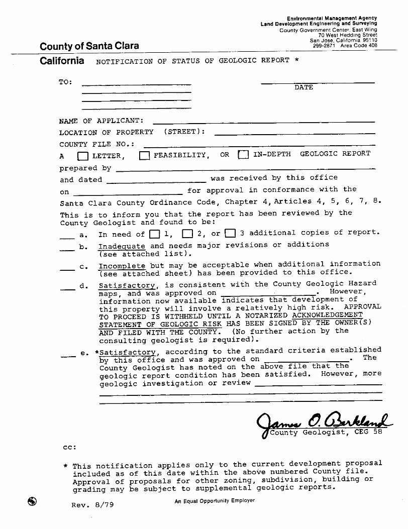

POLICIES AND STANDARDS PERTAINING TO MAPS, SURVEYING AND
RELATED COUNTY SURVEYOR FUNCTIONS
BACKGROUND The County Surveyor is responsible for a variety of functions that relate directly or indirectly to land development. Generally, these are set forth in the portions of the Land Development Regulations pertaining to roads, drainage, grading, underground utilities, mapping, surveying, water systems, bonds, agreements, and construction inspection. Additional responsibilities specified in various other regulations and policies include assessment districts, certification of annexation boundaries (LAFCO), maintenance of County base maps (mapping program), and administration of the County ordinances pertaining to survey monument preservation fund, Indian burial grounds, and community antenna television (CATV). The County policies pertaining to certain ones of these functions that have a bearing on land development are set forth below. General Map Checking Policies (All Survey Maps)
o Map checking is done concurrently with the review of improvement plans to coordinate technical map information with the design of the improvements.
o In resolving difficult problems, every reasonable effort is made to work out solutions
with surveyors and engineers—as opposed to a proliferation of adverse County Surveyor notes on maps that otherwise would be required by the Land Surveyor’s Act.
o Checklists are furnished by the County Surveyor to licensed land surveyors and civil
engineers for their use in preparing maps for County review. A filled out copy of the list is required to be turned in with the map check prints, and this same copy is returned with the County’s marked check prints.
o A survey monumentation policy has been adopted and published for the guidance of
surveyors and engineers in performing field work and preparing maps to be submitted for approval. A copy of the complete policy is included at the end of this section.
o The County Surveyor maintains a public record of survey information and maps which
may or may not be recorded. Because of limited storage, all maps must be suitable for microfilming. Lightly drawn lines and small letters or figures will not be readable on microfilm prints, and maps containing such work cannot be accepted.
o Certified electronic map closure computations are required and accepted as complete
and accurate without recomputation by the County. These calculations must be certified and submitted with the check prints.
G1.1

o Old lot lines and lot numbers that are inconsistent with proposed lines of ownership after the map is recorded should not be shown unless they are essential for clarity or title purposes and appropriately noted on the map. If a lot line change is needed, or proposed, where land is to be conveyed from one ownership to another, it must be filed as a “lot line change” at the Central Permit Office.
o All monuments, except those to be covered by monument bond, must be set in the
field prior to submittal of the initial check prints.
o Easements that are to be established in connection with the current development, as well as all existing easements affecting the property, must be shown on the map. The easement widths and locations must be consistent with the existing or proposed improvements.
o All existing found monuments must be tied to the current survey and adequately
described with tag numbers (if any) and appropriate reference information noted on the map.
o Ties to significant physical features that may effect property line interpretation are
required, such as fences, roads, stream bed, buildings across the property line, etc.
o The method of subdivision used for sectionalized land must be shown.
o Privately maintained roads must be shown by dashed lines. Roads that are publicly maintained, or to be publicly maintained after the current project, are to be shown with solid lines.
o Monument boxes must be installed in accordance with the above-referenced
monumentation policy. Polices Pertaining to Parcel Maps and Numbered Tract Subdivision Maps
o The County Central Permit Office issues consecutive tract numbers for major subdivisions in both incorporated and unincorporated territory. Numbers once issued are not re-issued even though the subdivision map is not finally approved and recorded. To minimize the number of gaps in the consecutive numbering system, tract numbers should not be requested unless there is reasonable certainty that the map will be recorded.
o If offers of dedication are made by separate instrument, the County standard form
must be used. To avoid potential problems, these forms are recorded only immediately prior to the recording of the parcel map (or record of survey—if a single building site). Dedications by separate instrument must be prepared or checked by a registered civil engineer or licensed land surveyor (preferably the one who performed the survey), and attached to a sketch showing all the information contained in the dedication description (see attached sample map).
G1.2
o The State Division of Real Estate prepares public reports on all major subdivisions. No such report is made on minor land divisions (four or less lots) and to help avoid misunderstandings between buyer and seller (or the County) as to their respective responsibilities when final site approval requirements are not to be completed by the subdivider, County furnished standard notes must be placed on the parcel map. A variety of typical wordings for different types of situations are furnished by the County Surveyor’s Office.
o In areas subject to flooding, where there is a County requirement to raise house pads
as a flood mitigation measure, a permanent bench mark elevation based on USGS mean sea level datum must be established at a location on or near the frontage of each lot or parcel to be created, or within 300 feet of the most probable building site on each lot or parcel. The bench mark should be situated where it can be conveniently used to determine floor elevations; and the location, elevation and datum shown on the parcel map or tract map.
o Offers of dedication made by owner’s certificate on parcel maps are preferred over
dedications by separate instrument because this method is less subject to errors and the checking is simplified. If right of way is to be dedicated to the Santa Clara Valley Water District, it must conform to District policies and be dedicated by separate instrument on District forms. The review and processing is handled by the District.
o The Clerk of the Board’s certificate on tract maps and the County Surveyor’s certificate
on parcel maps are worded in all cases to say that offers of dedication to the County are not accepted (at this time). It is County policy to accept such offers only by board resolution after the improvements have been completed to County-maintained road standards for the full distance to a County road.
o The signing and recording of tract maps and parcel maps signify the County’s approval
of the sale of subdivision lots. These maps, therefore, cannot be signed until all conditions of approval applicable at the time of signing the maps have been met. Parcel maps are signed by the County Surveyor and delivered to the County Recorder. Numbered tract maps require final approval by the Board of Supervisors. It is Board policy that such maps be presented as agenda items and accompanied by a complete written report.
o All maps must be based on a field survey. The County monumentation policy provides
guidelines for County approval of non-monumented lines or offset markers. Policies Pertaining to Record of Survey Maps
o Record of survey maps are reviewed in accordance with the Land Surveyor’s Act and signed by the County Surveyor as a “no fee” service in order to encourage the filing of these maps as important public documents.
G1.3

o The general policy statements at the beginning of this section apply to record of survey maps. Reliance is placed on the engineers’/surveyors’ checklist statements as to field conditions, and there is no field check by the County Surveyor or referral to cities or County departments. Maps are delivered to the County Recorder as soon as they are ready for recording.
Policies Pertaining to Survey Monument Preservation Fund
o The Survey Monument Preservation Fund (trust fund) was established by County ordinance on January 29, 1979, and is administered by the County Surveyor. The purpose of this fund is to pay part of the costs incurred by the County Surveyor in retracing or remonumenting major historical survey points and lines upon which later surveys are based.
o The fund is derived from Countywide sources, and it is the County Surveyor’s policy to
extend Countywide benefits commensurate with need and available funds. Cities and private engineers/surveyors may request assistance for specific surveyor that have general public benefit. The criteria are set forth in the form included at the end of this section entitled, “Request for Survey Monumentaiton Assistance.”
o Work is performed in accordance with available funds and a priority listing of projects
established by the County Surveyor. Policies Pertaining to Annexation Proposals (LAFCO Items) Prior to consideration by the Local Agency Formation Commission, the County Surveyor’s Office reviews the annexation proposals and certifies that the boundaries are definite and certain. In making this review, the County Surveyor enforces (or reports to LAFCO on non-compliance) the following described LAFCO or State Board of Equalization adopted policies: 1. Maps and Descriptions
o Maps and descriptions must be professionally prepared and suitable for microfilming.
o Descriptions must be self-sufficient without the necessity of reference to any
extraneous document. When a description refers to a deed of record, the deed should be used only as a secondary reference.
o Metes and Bounds descriptions of contiguous annexations may omit the details
of the contiguous portion(s) of the boundary. The points of departure from existing boundaries must be clearly established.
G1.4
o Parcel descriptions of sectionalized land (e.g., the SW 1/4 of Section 22, TIN, RIW) are permissible without a metes and bounds description of the permissible without a metes and bounds description of the perimeter boundary.
o Descriptions that make reference only to a subdivision or a lot within a subdivision are
not acceptable unless all dimensions needed to plot the boundaries are given on an accompanying plat. The relationship of lot lines to street rights-of-way must be clearly indicated.
o Maps must be drawn to scale, conform generally to the format indicated on the
attached sample map and contain the information indicated thereon. If the map is reduced, or to be reduced, a graphic scale must be provided on the face of the map before reduction.
2. Annexation of Roads
o Cities shall annex entire street sections whenever possible.
o When streets are used as boundaries for annexations, the annexation proposals
must be designed to include a continuous section of roadway sufficient length for the efficient maintenance and policing of the street by a single jurisdiction. Annexation of full width sections normally must be made in increments of not less than one thousand feet, or the distance between two consecutive intersections, at such time as 50 percent or more of the frontage on both sides of the street in said increment has been, or is to be, included in the city.
o Annexation of existing short segments of County road to provide single agency
jurisdiction to a full width section of the road, or to provide continuity of city limits, shall be accomplished in the most practical manner.
o When a street is the boundary line between two cities, the center line of the
street may be used as the boundary. Such street annexations shall occur in increments as described above.
o Half-street annexations will not be approved except as provided above.
G1.5

3. Splitting of Lines of Assessment
It is against LAFCO policy (for a variety of reasons) not to allow annexations to split lines of assessment. One of the adverse effects of this practice, if allowed, as it affects land development, is that the State law requires both the County Surveyor and the city engineer to sign the parcel map when the property on either side of the annexation line is proposed for development, indicating that the requirements of both agencies have been complied with. This obviously creates problems for the developer in filing and complying with requirements of two different jurisdictions, as well as increasing the processing time and costs. (NOTE: The review of this aspect of annexation proposals is not a primary responsibility of the County Surveyor, but it is his policy to note such deficiencies in his report to the commission.)
Policies Pertaining to Assessment Districts
o Assessment districts are encouraged for the purpose of constructing street, sewers and utilities in existing developed areas that need these improvements. This method is considered to be a particularly viable way of obtaining improvements in unsewered areas, and for private roads to be brought up to Transportation Agency standards for maintenance by the County.
o Assessment districts are not a currently approved method of developing subdivisions
in the unincorporated area.
o Assessment districts must be initiated by petition signed by not less than 60 percent of the owners of the land within the boundaries of the proposed district. They may be initiated by resolution of the Board of Supervisors in situations where the Board determines that they are needed for reasons of public health or safety. After acceptance of a petition and prior to commencement of preliminary engineering, the petitioners must post cash with the County to pay the costs of the preliminary engineering work. The money is refundable only if, and when, the district is formed. Full information on the requirements and procedures for assessment districts is available at the County Surveyor’s Office.
Underground Utilities The County presently has no underground utilities policy other than that specified in the land development regulations which is that utilities must be installed underground unless the advisory agency determines on a case-by-case basis that they are inappropriate and impractical. The burden of proof is on the applicant. It is expected that the County will develop and adopt a formal policy in the near future after a study by the County Planning Department and public hearings.
G1.6


SURVEY MONUMENTATION POLICY
The purpose of this policy statement is to establish uniform standards for monumentation in connection with field surveys for maps submitted to the County for approval. It was developed in cooperation with Associated Civil Engineers and Land Surveyors of Santa Clara County and has been approved by that organization. It should be used as a guide by all civil engineers and land surveyors doing survey work in the unincorporated area of the County and will be used by the County staff for the checking of maps. 1. MATERIALS AND WORKMANSHIP
Materials and workmanship shall conform to the requirements of the California Land Surveyors’ Act and local standards and regulations. Monuments set in existing or future County roads shall conform to Transportation Agency published standards.* Section, quarter section and rancho corners shall be not less than 2” nominal diameter iron pipe 36” long. Standard property corner monuments shall be iron pipe not less than 3/4” nominal diameter 18” long.
2. MONUMENTING PROPERTY LINES
Monument the full exterior boundaries of the property and the corners of the lots or parcels being created. (For exceptions see 4 and 6)
3. TIES TO EXISTING MONUMENTS
Find and show on the map of the survey (with ties) all existing monuments in the immediate area which have a significant bearing on the confirmation or establishment of the lines of the property being surveyed. Re-establish any lost monuments that have a controlling influence on the lines of the survey. Identify on the map the monuments used as the basis for the survey – and which correlate with the legal description of the property.
4. MONUMENTING ROAD CENTERLINES (Public and Private)
a. Monument the centerline intersection of roads created or widened by the parcels being surveyed. Provide additional road centerline monumentation adequate for the present survey and future re-subdivision or re-survey of the property. (Maximum distance between centerline monuments to be 1000 feet)
b. Find and show on the map the existing road centerline and/or monument lines of record
in existing roads adjacent to the parcels being surveyed. If monuments are below the road surface and not enclosed in monument boxes, show the existing record data on all monuments on the map of the survey and uncover only such monuments as are needed for establishment of the survey and verification of points and lines.
5. MONUMENTING ROAD RIGHT OF WAY ANND ROAD EASEMENT LINES (Public and Private)
a. Monument the road right of way or road easement lines at the point of intersection with the property line.
* Monument set inside County Standards Monument Box.

b. Monument the road right of way or road easement lines at all BC’s and EC’s, or angle point if there is no curve.
Note: County regulations require curvilinear alignment for newly created or widened
roads
c. Monument the proposed right of way line rather than the existing one if the survey involves a right of way or easement to be widened in connection with a land development project.
d. Find and show on the map of the survey the existing right of way or easement monuments of record.
6. MONUMENTING DRAINAGE, FLOOD CONTROL AND UTILITY EASEMENTS (Existing and Proposed)
a. Monument drainage and flood control easement lines rather than the property lines in situations
where the easement is adjacent to the property lines and it would not be appropriate or practical to set the monument on the property line because of flowing water, erosion, proposed construction, etc.
b. Monument the proposed property lines in situations where land is to be purchased or dedicated in
fee in connection with a land development project.
c. Monuments on easement lines other than those described in a and b above are not required unless they are needed to determine the setbacks for buildings or other permanent improvements.
d. Show all easement widths, bearings, distances, ties and recording data if recorded) on the map of
the survey. (Required regardless of whether monuments are provided). 7. EXCEPTIONS TO MONUMENTATION POLICY
a. Monuments are not required if they pertain only to a non-surveyed 5 acre, or larger, single
remainder of a divided parcel conforming to the requirements of Section 66445 (e) of the Subdivision Map Act.
b. Monuments are not required if they would be in a state highway and the setting of the monuments
would be contrary to state policy o regulations. c. Monuments are not required if they are not practical to set at their precise location because of a
fixed permanent improvement, such as a building or concrete sidewalk. In these situations, the intended location shall be appropriately marked by a chiseled cross or other distinctive and permanent engraving. Such markings may be offset if required by field conditions. Show in appropriate manner on the map of the survey.
d. Monuments are not required if they are not practical to set at their precise location because of a
substantial natural obstacle, such as a water course, unstable bank or tree. In these situations, an offset monument shall be provided at a suitable distance, such as the top of the bank of a watercourse. Show in appropriate manner on the map of the survey. (See also Paragraph 6 above pertaining to easements.)
e. Monuments are not required if they would coincide with the corners of proposed condominium units or other proposed buildings. Sufficient monumentation shall be provided, however, to accurately and conveniently determine the correct location of the future buildings. Show in appropriate manner on the map of the survey.
f. The setting of required monuments that would be disturbed as a result of proposed grading or
construction work may be deferred until after such work has been performed; provided, however, adequate monuments shall exit when the map is approved to assure complete boundary and map accuracy. Appropriate map notes and bond for future monumentation shall be provided.
NOTE: If the surveyor finds that the monumentation work specified in this policy is not possible or
practical, and is not covered by the exceptions described above, he should request an exemption and submit the justification is writing with the initial map check prints.
References:
1. Land Surveyors’ Act 2. Subdivision Map Act (Section 66495) 3. County Land Development Regulations May 1, 1978 (C12-26, C12-33).

SANTA CLARA COUNTY SURVEYOR’S OFFICE Request for Survey Monumentation Assistance
General Information On January 29, 1979 the Board of Supervisors adopted Ordinance NS300.276 which provided for the creation of a special limited use Survey Monument Preservation Fund. The purpose of this fund is to help pay the necessary expenses incurred by the County Surveyor in any retracement or remonument survey of major historical land division lines on which land surveys are based, such as, but not limited to, government section lines, rancho lines, grant lines, rancho section lines, acreage subdivision lot lines, and subdivision boundary lines within Santa Clara County. When significant monuments marking the corners of these lines are determined b a city engineer or a licensed land surveyor/registered civil engineer to be nonexistent and cannot be re-established without extensive resurvey of the surrounding area, he may request help from the County Surveyor’s office. His request will be considered in light of available funds, established priorities, work load and general public benefit from the particular survey. Application Procedure This form is to be used for requesting survey help by the County Surveyor. It must be filled out by a a city engineer or by the licensed land surveyor/registered civil engineer engaged by the property owner to do survey work, and returned to the County Surveyor’s office. Forms are available at the County Surveyor’s office on the 7th floor, 70 W. Hedding Street, San Jose, CA 95110. The completed application form should be returned with a cover letter containing all of the pertinent information not adequately provided for in the blanks of the form.
Information Required
1. Requestor’s need for the monument (s) at this time:
2. Public’s need and benefit from restoring the lost monument (s):
3. Could this survey result in the need for a boundary line agreement? Yes No
If yes, are all the affected property owners agreeable to a boundary line agreement? Yes No
If no, explain
4. Are these lines in dispute? Yes No If yes, explain
5. Attach an assessor’s map and show the following: A. The specific corner or corners to be located or set. B. All of the known existing corners that could affect this survey. C. All of the property owners (with addresses and APN’s) adjacent to or affected by this survey. D. Which property owners are aware of this request. (All affected owners will be notified.) E. Which property owners want this survey. F. A list of all of your research to date.
6. Surveyor’s cost estimate, including the setting of monuments and filling a record of survey. A. Field time: hours @ = B. Office time: hours @ = C Filing the record of survey = D. Monument cost = E. Other (Explain) = Total (over)

Santa Clara County Surveyor’s Office Request for Survey Monumentation Assistance 7. What would be the additional cost to tie this survey into the California coordinate system and show on
the map? Also, show the names of the control stations to be used and the order of control, i.e., 2nd, 3rd, etc.
Additional cost 8. Proposed amount of cost sharing by property owners (indicate percentage breakdown benefit to each
participant)
9. Does this survey have to be completed by a certain date: Yes No If yes, when?
10. Person or firm requesting survey Address Phone Date Signature
Title
For County Use Only 1. Does this survey request qualify for assistance under the guidelines for use of the Survey
Monumentation Preservation Fund: Yes No
2. What is the County’s estimated cost of this survey?
A. Field time: hours @ = B. Office time: hours @ = C. Material cost = D. Other (Explain) = Total 3. Additional cost to put on the California coordinate system
4. Can this survey be done by the County Surveyor within the time frame requested? Yes No 5. Is it practical to contract this survey out to a city engineer or a licensed land surveyor/registered civil
engineer? Yes No Give reason for answer 6. Appropriate county share
7. Justification for the county sharing in the cost
8. The decision of the County Surveyor is to: Approve the request and have the County Surveyor’s office do the surveying.
Approve the request and contract the surveying with a city engineer or a licensed land surveyor/registered civil engineer.
Approve the request and have a joint venture between the County and a city engineer or a licensed land surveyor/registered civil engineer.
Deny the request for the following reason:
Date Signature
Title


POLICIES AND STANDARDS FOR RURAL SUBDIVISIONS
Report Prepared by Engineering Services Division Dean P. Larson, Manager
(Approved by Board of Supervisors on February 5, 1974)
Background Prior to 1974 the County did not make any special distinction in its published standards between rural and urban subdivisions, although there were practical limitations on development in rural areas caused primarily by the lack of adequate flood control, drainage, water and sanitary sewer facilities. Large parcels were the rule, and it was generally assumed that they would be re-divided in the future and provided with urban type improvements at that time. This was the basis of most of the deferred improvement agreements relating to roads and drainage. These were the two primary issues, but appropriate standards of all types for rural subdivisions were of concern and included in the report. Adoption of new zoning districts in the early part of the 1970’s requiring 2.5-acre minimum size parcels made it appropriate to institute new standards tailored to rural conditions on a more or less permanent basis. The following report was requested by the Board of Supervisors in 1973 and finally was approved without substantive change on February 5, 1974 after a long series of public meetings with representatives of the cities, home-owners’ association and environmental groups. Some changes in policy and standards have occurred since preparation of this report and these are described in footnotes on the various pages. With the exception of these changes, the policies are still in effect. In situations where there is (or appears to be) a conflict between the rural and the hillside standards, the higher standards are required—unless the Board of Supervisors has adopted (or approved) lower standards, such as for road paving in non-cluster type subdivisions in –20s zoning districts. Current ultra-low density zoning regulations make it difficult to implement many of the standards established by this report without application of the clustering method of development.
CONCLUSIONS AND RECOMMENDATIONS (Policy Report, 1974)
Conclusions 1. Recent adoption of new zoning districts requiring parcels 2.5 acres, and larger, minimum
size now make it plausible to adopt rural subdivision standards with some assurance that the areas will remain low density.
2. Rural subdivision standards will provide incentives to develop lands as subdivisions
rather than minor land divisions. 3. Rural subdivision standards will encourage better and more comprehensive land
development planning.
H1.1

(Rural Subdivisions – Policy Report, 1974)
4. Subdivisions provide better opportunities for environmental protection than minor land divisions.
5. Public welfare and property values will be enchanced by a system of publicly maintained
roads. 6. Deed restrictions and recorded covenants and restrictions can be used as means to
reduce the pressure for future parcel splitting. 7. Rural subdivision standards can be implemented within the framework of existing
regulations. Recommendations 1. Approve this report as a policy document for development of subdivisions within zoning
districts requiring 2.5-acre minimum size parcels.*(1) 2. Apply the same policy and standards insofar as practical to all divisions of land where
the parcels are 2.5 acres or more minimum allowed size.*(2) 3. Approve the preparation and publication of standards along the lines set forth in this
report. 4. Request the Fire Marshal and Health Department to prepare separate reports to the
Board of Supervisors on standards and implementation policies.
INTRODUCTION
This report on proposed rural subdivision standards is part of a sustained effort by the County of Santa Clara to keep its land development standards in step with changing conditions as reflected in new land use regulations and development policies. Up until the mid-1960s, the County processed many subdivisions (usually in the process of annexation to cities), but the emphasis has shifted to parcel maps. This is not a deliberate choice of government, but rather a response to a need to regulate, caused by development pressures. In the last fiscal year, ending June 30, 1973, the County approved 264 parcel maps containing 746 parcels. The majority of these parcels had access from an existing private road or a new private road. Also, the majority were approved building sites, but were not served by a central water system or sewer system. NOTE: *(1) Current zoning in most locations outside the urban service areas requires 20
acres or more, minimum parcel sizes.
*(2) With minor exceptions, the law now classifies all divisions of land as subdivisions
H1.2

(Rural Subdivisions – Policy Report, 1974)
The term “rural subdivision” engenders a concept of low density country living in an undisturbed natural environment—the goal of many and the reality of few. The term also fosters the idea of country roads for which the County presently has no set standards insofar as they pertain to private land development. Heretofore it has been assumed that all subdivision development was, or eventually would be, urban in character. This assumption was a natural outgrowth of previous zoning laws and practices. The situation has changed now with adoption of new zoning districts with parcel sizes 2.5 acres and larger minimum size. Since many of these districts are outside the urban service areas, it now becomes plausible to adopt rural standards with some assurance that the areas will remain low density. At the present time, the County has only one standard for new roads to be accepted into the County Road System that are constructed in connection with private land development. This is essentially an urban type road, the principal elements of which are concrete curb and gutter, asphalt concrete surface, concrete sidewalk, underground storm drainage and street lights. These are good standards, but they are not necessarily appropriate nor practical for rural conditions. Since June 25, 1969 when the County adopted its present ordinance regulating two-lot splits, it has processed 844 parcel maps containing 2,532 parcels. A large percentage of these maps created new roads, very few of which were improved to our present standards for acceptance into the County Road System.
PURPOSE AND OBJECTIVES
The primary purpose of adopting rural subdivision standards is to improve the quality of low density development in the unincorporated areas of the County. The specific objectives are: 1. Encourage higher standards of development. 2. Provide a viable alternative to minor land divisions. (NOTE: Minor land divisions were
unintentionally encouraged prior to this report because the urban type street standards that typically were required for all subdivisions (five or more lots) were not practical to construct in low density rural areas.)
3. Provide a system of high quality rural public roads designed to accommodate various
modes of transportation. 4. Improve the health, safety and welfare of citizens by having well planned and well
maintained public facilities.
APPLICATION OF STANDARDS Rural subdivision standards shall be applied in the following situations: I. Subdivisions of five or more parcels within zoning districts requiring 2.5 acres minimum
parcel size.
H1.3
(Rural Subdivisions – Policy Report, 1974)
2. Minor land divisions of four or less parcels, and divisions of land into five or more parcels not classed as subdivisions under State and local regulations.*(1) where contiguous land under one ownership, or development control, could be divided into five or more parcels 2.5 acres or more in size. These standards are to be applied whether or not the minimum size parcels allowed in the zoning district are proposed by the developer, unless the Land Development Committee determines that the standards are inappropriate and impractical.
3. Any division of land where the Land Development Committee makes a finding that
the rural subdivision standards are practical and needed for continuity of development of the neighborhood area.
Obviously the standards cannot be applied in every situation, but good judgment and sound evidence that the standards are not appropriate and practical, should permit the Land Development Committee to make proper decisions.*(2)
ROAD DESIGN FACTORS *(3)
It is said that a road is a road—is a road—is a road, the primary purpose of which is travel (vehicular, pedestrian, equestrian) and access to property. The right of way also serves the important function of utility installation, including water and sewer lines. In high density areas, it often is the principal open space for light and air. In rural areas, it provides definition to the landscape and the trees and shrubs along the road attract wildlife for environmental enrichment. All of these are important factors in the overall road design, and they were the basis for preparation of the Department’s Creative Road Design Guide submitted to the Board of Supervisors as a general policy document on May 25, 1971. The most significant factors in the design of rural roads are: 1. Right of Way Widths Standard right of way widths for subdivisions are set forth in the County Land Development Regulations. Local street widths are 60 feet, except short cul-de-sacs which are 52 feet.*(4) In situations where development can occur on one side only, the right of way may be as narrow as 40 feet provided the County design criteria can be met. Because of cut and fill slopes and the need for pathways, ditches and utilities, these right of way widths should be maintained as minimums in rural subdivisions even though the pavement widths may be less than in urban developments. NOTES: *(1) Current State law classifies minor land divisions as subdivisions *(2) The Land Development Committee has since been dissolved. Currently the Board of Supervisors approves all subdivisions. *(3) Minor changes in road standards have occurred since preparation of this report. For complete information, see the sections of this manual describing the policies and standards for roads. *(4) Current standard is 56 feet.
H1.4

(Rural Subdivisions – Policy Report, 1974)
2. Pavement Widths
The principal factors affecting the widths of pavement are moving vehicles and stopped or parked vehicles. For reasons of safety, the pavement on through roads for two-traffic lanes should be not less than 24 feet, excluding parking, shoulders or bikeways. If the roads are one-way, such as split-level roads in hillside areas, the minimum width should be 14 feet. The minimum pavement width under any circumstances for a two-way public road should be 20 feet. Where on-street parking or transit, school bus, fire truck or mail delivery stops are needed, a 10-foot wide paved surface abutting the outside traffic lane should be provided. Large front yard building setbacks and generous off-street parking should be provided to reduce the amount of paving for on-street parking.
3. Pavement Structural Section
The pavement structural section for rural subdivision roads shall conform to present County road standards or be designed on the bais of traffic index and soil conditions in accordance with standard engineering practice, and approved by the Director of Public Works.*
4. Shoulders and Bikeways
Shoulders are an essential and integral part of the roadway. Their most important functions are to confine and stabilize the roadbed and provide emergency pullout for stalled vehicles. The widths may vary from three to six feet (excluding parking) depending on terrain and traffic conditions. If parking is a consideration, the width should be ten feet. Much better protection to the edge of pavement is provided if the shoulders are paved. Where bikeways are to be provided the shoulder should be paved and widened to six feet.
5. Alternatives to Concrete Curb and Gutter
Vertical concrete curb and gutter is used in urban areas to control drainage and confine vehicles to areas designed to accommodate them. If vehicles are not confined to these areas, the pavement edges break down forming ruts and water pockets; and, in general, creating maintenance problems as well as unsightly and unsanitary conditions. Since curb and gutter generally is not practical in rural areas, other alternatives must be devised. One of these is an asphalt dike. Except in limited situations, this is at best an interim type improvement since it weathers and breaks down under traffic abuse. Extruded concrete curb placed on a paved shoulder similar to asphalt dikes is another alternative, but it also has limitations similar to asphalt dikes. Guard rail is an alternative to dikes to confine traffic, but it is unsightly and expensive.
NOTE: *Changed in current standards to Road Commissioner
H1.5

(Rural Subdivisions – Policy Report, 1974)
All factors considered, the most acceptable alternatives to concrete curb and gutter are: (1) adequate off-street parking; (2) paved roadside pull-off and parking areas in appropriate locations; (3) roadside swales or ditches that are paved, rocked or otherwise protected from erosion; and (4) asphalt dikes or extruded concrete curbs in appropriate locations as well as some concrete curb and gutter in certain design situations, such as storm drainage inlets.
6. Drainage, Culverts and Bridges
The majority of rural subdivisions will have difficult drainage problems to be solved, but a positive drainage system is essential in all cases. In hilly areas, the primary considerations are adequate culverts and erosion protection. If there are insufficient natural watercourses, downstream ditches (or pipe) and easements will be required. In flatland rural areas, the only way to reach a natural watercourse in most cases is through one or more neighboring properties. This poses easement problems for the developer and additional cost. If underground storm sewers, or roadway culverts or bridges are needed, they should be provided full size wherever practical. If adjacent undeveloped lands will benefit from the improvement, the County should enter into an agreement with the subdivider which will provide for his reimbursement by others when such other lands are developed.
At the present time, many of the natural watercourses are to shallow too discharge water from an underground storm drainage system. In these cases, a surface drainage system will be required as an interim solution. If the natural drainage course has been filled in by farming operations, as they have in many instances, residential development will be precluded until adequate storm water disposal facilities are provided.
7. Pathways
Pathways within the right of way should be a subdivision approval requirement. Such pathways should be as far from the traveled roadway as possible and have a smooth and durable all-weather surface not less than five feet wide.
8. Underground Utilities
Public Utilities Commission regulation require underground utilities for all subdivisions except as exempted under PUC decision No. 81629 adopted on August 13, 1973. A copy of this decision has not been received, but it is reported that underground utilities are not required if the parcels are three acres or larger in size, and--
a. Local ordinances do not require undergrounding. b. Local ordinance or deed restrictions do not permit further division of the parcels. c. Local ordinances do not permit more than one dwelling per parcel.
H1.6

(Rural Subdivisions – Policy Report, 1974)
d. New overhead lines would not be visible from a scenic area. e. Exceptional conditions do not warrant undergrounding.
In situations where underground utilities are installed, the PUC regulations require the utility company to pay for the electrical cable and appurtenances. The subdivider pays for the trenching and backfilling, less certain credits if there are other utilities in the same trench, such as a gas pipe.*(1)
9. Street Lights
Street lighting presently is covered by ordinance and by adopted standards of the Department of Public Works.*(2) Both the ordinance and standards were designed to reflect rural as well as urban conditions. The ordinance states that in subdivisions over 40,000 square feet, the street light requirements are waived except for lights at street intersections and dead ends. The standards provide for either regular or post top electroliers and underground wiring when required.*(1)
10. Grades, Curves and Other Road Standards
Grades, curves and other road standards not discussed herein are generally appropriate and applicable to rural subdivisions without major modification. These standards are descried in the County Ordinance Code.
IMPROVEMENT OF EXISTING COUNTY ROADS
It is County policy to require existing County roads to be improved to full urban standards at the time of development of the abutting land. If the improvements are impractical at the time of development of the land, they are deferred by agreement with the Board of Supervisors.*(3) It is proposed that this policy be continued, but that the urban standards be changed to rural standards where the development is a residential subdivision (or minor land division) outside the urban service areas.
WATER SUPPLY AND FIRE PROTECTION
Water supply from individual wells comes under Health Department jurisdiction. If the subdivider develops a central water system, however, the regulations overlap the Health Department, Fire Marshal and Public Works.*(4) The role of each is established by the regulations they enforce. The Health Department has responsibility for approving the water supply and tank storage requirements for domestic water, excluding fire protection. NOTES: *(1) See County subdivision ordinance Section C12-184 for current underground utilities and street lighting requirements. *(2) Changed to Transportation Agency *(3) For current policies regarding deferred improvement agreements, see section of this manual entitled, “Policies and Standards for Roads, Deferment of Improvements.” *(4) Currently County Surveyor
H1.7

(Rural Subdivisions – Policy Report, 1974)
The Fire Marshal is responsible for fire hydrants, sizes and locations and the volume and duration of flow at the fire hydrant. The Department of Public Works *(1) is responsible for approving the water system improvement plans, the pipe easements, the tank construction (Building Inspector), the underground pipe construction and the inspection of the work during construction.
In the past, the efforts of the three departments have been well coordinated, but there is a problem with respect to pipe sizes and tank capacity. The water storage and pipe size requirements are higher for fire protection than for domestic water alone; and, therefore, they are the principal determining factors in deciding on a central water system. The increased cost for fire protection sometimes is a major problem. It takes the cooperation of the developer and the three departments working together to arrive at the best possible solution, which should be in favor of a central water system if at all possible.*(2)
Since fire protection requirements generally are the controlling factors in the design of the water system; and since fire protection standards for residential subdivisions have not been finally determined and published, the subject should be reviewed by the Fire Marshal and reported on separately.
SANITATION
In most instances, the Health Department standards for septic tanks can be met for parcels 2.5 acres or more in size. However, there is concern about long-term pollution, particularly if the water supply is by individual wells. It would seem, therefore, that the public interest would be served by finding viable alternatives to both septic tanks and individual wells in subdivisions. This is another matter that should be reported on separately.
FLOOD CONTROL
The Santa Clara County Flood Control and Water District*(3), which is a member of the Land Development Committee*(4), has responsibility for the planning, construction and maintenance of flood control facilities throughout the County. In only certain locations are there improved channels in rural areas, and in the flatland portions, the natural watercourses frequently are inadequate to prevent flooding. The flood plain areas adjacent to the channels, which may exist for many years vary from a few inches to several feet in potential water depth. The advisability of subdividing these areas is somewhat questionable and any decision on development should be based on evaluation of probable damage and the mitigating circumstances. Minimum foundation elevations should be specified in all cases where development is permitted in areas subject to flooding. NOTES: *(1) Currently County Surveyor. *(2) For current water system policies, see the section in volume II of this manual entitled, “Policies and Standards for Water Systems.” *(3) Land Development Committee has been dissolved.
H1.8

(Rural Subdivisions – Policy Report, 1974)
Rural subdivisions with only one access road to serve both sides of a flood control channel will not be practical in many instances because of the cost of constructing the bridge or culvert. In all cases, there needs to be areawide planning of road patterns to provide access to both sides of the channel, wherever feasible, with a minimum number of crossings. The standards with regard to dedications and other related matters were set forth in a policy document approved by the Board of Supervisors on March 18, 1973.
PLANNING
The Planning Department has responsibility for several planning matters that are crucial to the concept as well as successful implementation of rural subdivision standards. The first two, and most important, are land use and density. These factors are the basis for determining water, fire protection and sanitation requirements as well as traffic volume and road design. The other principal concerns are road patterns, off-street parking and building setback requirements. Since land use and density are so important, all methods of control in addition to zoning should be considered. One of these is changing ordinance setback requirements; and another is use of subdivision covenants and restrictions, or deed restrictions, approved by the County and recorded by the developer.
DEFERRED IMPROVEMENT AGREEMENTS
It has been the policy of the Department of Public Works for the past several years to require deferred improvement agreements in situations where roads were not improved to full urban standards at the time of division or development of land. These agreements should not be required if the development is outside the urban service areas and improved to full rural subdivision standards. If storm drains or other essential public improvements are not provided, however, they should be covered by an agreement relating to these items. If the development is within an urban service area, the additional city standard public improvements not included in the County’s rural subdivision standards should be covered by deferred improvement agreement if the city so requests. To date, only the Department of Public Works has utilized deferred improvement agreements, and they have pertained only to roads and other improvements installed within the right of way.*(1) and *(2)
ACCEPTANCE OF ROADS INTO THE COUNTY ROAD SYSTEM
The standards proposed herein for rural subdivisions are adequate for adequate for accepting the roads into the County Road System, and the improvements can be upgraded to full urban standards without substantial reconstruction or cost to government if the need arises in the future.*(3) NOTES: *(1) Current Fire Marshal policy embraces use of deferred improvement agreements in limited situations. *(2) For current policy regarding deferred improvement agreements, see section of this manual entitled, “Polices and Standards for Roads, Deferment of Improvements.” *(3) Costs of road reconstruction will be significant in situations where the road is originally constructed above natural ground due to drainage problems.
H1.9
(Rural Subdivisions – Policy Report, 1974) In order to be accepted, the roads must be contiguous with a publicly maintained road. If the roads are not contiguous, the developer should be required as a condition of approval of the subdivision to cause the necessary right of way to be dedicated to the County and improved to rural subdivision standards. Controlled exceptions could be made in situations where it is not possible or practical to meet this requirement. In these cases, a homeowners’ association, with full legal authority to assess and carry out the responsibilities of the association, should be required in order to assure continued maintenance by the property owners of the subdivision roads and any external access road needed for travel to the publicly maintained road.
CLUSTER SUBDIVISION
Cluster type subdivisions in rural areas are possible under existing regulations and should be encouraged in order to decrease improvement costs and increase usable open space. The design of roadways within cluster subdivisions is presently covered by a policy resolution approved by the Board of Supervisors on June 21, 1972.* Some modification of these standards may be appropriate depending on the development density of the cluster area. Sanitary sewerage is a significant problem that possibly will require some innovative solutions.
URBAN SERVICE AREAS
Urban service areas have been determined for each of the 15 cities of the County. These provide for at least five years’ growth by the city into the unincorporated area. The objective is to have development within these areas occur under the jurisdiction of the cities. The urban service area maps are submitted to the Local Agency Formation Commission for approval. Revised map boundaries may be prepared and submitted to LAFCO for approval each year. It is planned that the County, by ordinance, will restrict development within the urban service areas. Single family residential development may occur under County jurisdiction, however, when the parcels are 2.5 acres or more in size.
INCENTIVES
The matters of primary concern to persons proposing to subdivide land are market, costs, sales price and quality of product. The matters of primary concern to government are community development, public improvements, public services, environmental protection and future governmental costs attributable to the development. The public welfare would be served best, therefore, by providing incentives which would encourage the highest quality development. One of these incentives is publicly maintained roads. A second is for the County to allow formation of assessment districts for the construction of street and drainage improvements, or other improvements to be owned and maintained by the County. NOTE: *The policy is republished in this manual under the section entitled, “Policies and Standards for Cluster, Planned Unit and Condominium Projects.”
H1.10

(Rural Subdivisions – Policy Report, 1974)
The principal advantage of assessment districts to the County is high quality improvements and the advantage to the developer is low interest bonds to pay for the improvements spread out over a period of ten to fifteen years. At the time of sale of a parcel after subdivision of the land, the buyer can either assume the bond payments or pay off the bond completely at the time of taking title to the property. Two types of bonds are possible, commonly known as 1911 Act bonds and 1915 Act for bond payment. The 1915 Act bonds are a lien on the land, but are also backed up by the County; and, therefore, are generally more attractive to investors. Since these bonds are a contingent liability against the County, they should be used judiciously and limited to situations where the land will not be redivided. If further subdivision is possible, the 1911 Act bonds should be used (see Note (1) below).
ENVIRONMENTAL IMPACT
Environmental controls have the best chance of being effective in maintaining or improving the environment if land is developed as subdivisions rather than minor land divisions. The reasons are that subdivisions provide better opportunities for areawide planning and the installation of quality improvements, the cost of which can be spread over a large number of parcels. Any unbalancing of environmental emphasis against subdivisions is likely to cause the opposite of the desired end result.
IMPLEMENTATION
Rural subdivision standards can be implemented within the framework of existing regulations, but some changes in standards and policy will be required. After some experience, it, no doubt, will be deemed advisable to also make some changes in the regulations. In any event, the County could commence implementation immediately. NOTES: (1) Development in the unincorporated area is not presently encouraged and assessment districts are not a Board approved method of providing subdivision improvements. (2) For current information regarding the design of County maintained roads in rural areas, the reader is referred to the Transportation Agency’s Standard Details Manual. (3) For more information regarding current cluster standards for subdivisions in rural areas, see the section of this Manual entitled, “Policies and Standards for Cluster, Planned Unit and Condominium Developments.”
H1.11

POLICIES AND STANDARDS FOR HILLSIDE SUBDIVISIONS
BACKGROUND In 1969 the Engineering Services Division prepared hillside subdivision standards, which were included as a chapter in a set of new land development regulations adopted by the Board of Supervisors on March 18, 1969. Since they are primarily statements of policy, the chapter was deleted from the ordinance code on March 13, 1978; but the standards have remained in use as adopted County hillside development policy. Purpose Hillside standards provide the best means of adapting the improvements and lot design to the natural features of the land. The principal objectives are to preserve the natural characteristics of the hill areas, protect watersheds and natural watercourses, maintain open space, preserve trails, and encourage the construction of the highest quality improvements commensurate with land use and economic feasibility. Definition A hillside development is defined as one in which the slope of the land is ten (10) percent or more. The term “percent slope” means the vertical drop divided by the horizontal distance multiplied by one hundred (100). Percent slope “S” is computed by the formula: S = 0.00229IL divided by A Where S = Percent slope I = Contour interval in feet (Uniform vertical distance between successive contours) L = Length of contours in feet (Summation of individual contours) A = Area in acres of parcel being considered
Altered or unusual minor terrain features (roads, watercourses, etc.) normally are omitted in the computations.
Limitations Hillside standards are not applicable to subdivisions where the lot sizes are less then 20,000 square feet. In areas where the slope of the land is less than ten percent; and the parcel sizes are all 20,000 or more square feet, either hillside or rural subdivision standards (or a mixture of both) may be proposed or required by the County, depending on the drainage, parcel sizes, type of development (such as cluster) and the unique features of the land.
I1.1

(Hillside Standards – continued)
Full urban standards are required for subdivisions with lot sizes less than 20,000 square feet. Such standards may be required for any subdivision (regardless of lot size) within city urban service areas. Lot Design Cluster design for hillside subdivisions is encouraged for the purposes of preserving open space and reducing the amount of road and utility improvements. Each lot must have sufficient area for the house, setbacks, yards, off-street parking, septic tank and well (if required) and any necessary cuts or fills. The size and shape of the parcels must be such that permits can be issued under normal review procedures based upon the application of ordinance requirements and good design principles. Future street openings and street extensions for traffic circulation must be provided where needed. Lots should have frontage on only one street, but where this is not practical because of certain natural terrain features, they may have double frontage. All lots should be designed to provide the maximum in safety and human enjoyment while taking advantage of the best natural building sites. Trees of significant value and the natural contours of the land should be preserved as much as possible. Appendage type parcels (i.e., flag lots, corridor lots, etc.) may be approved where this design provides the most practicable means of access to building sites. Up to ten percent of the lot area may be composed of land in the appendage. The maximum length of the appendage should not exceed 300 feet. Appendages for single lots should be not less than 20 feet wide. No more than two adjacent appendages are allowed. Reciprocal easements generally are required for parallel appendages. Lesser widths and greater length appendages may be approved when sufficient evidence is presented to show that the above requirements are not practical. In all cases, the building site, exclusive of the appendage, must meet the minimum development standards. Road and Drainage Design Roads in hillside areas should be designed to take advantage of the natural contour of the land in order to provide the best possible access to building sites, reduce the cuts and fills and establish desirable curves and grades. Split-level or one-way design in encouraged to achieve these objectives. Since roadways in hill areas must provide adequate space for driveway approaches, pathways, utilities, and cuts and fill slopes, the standard 60-foot right-of –way is required, except that 56 feet may be used for short cul-de-sac roads. Additional slope easements frequently are necessary. Cul-de-sacs normally should not be designed to serve more than ten lots and the length should not be more than eight hundred (800) feet unless an emergency access is provided for fire protection. If one-way loop roads without adequate passing width are approved, emergency pull-out areas must be provided at locations approved by the County. Three hundred feet generally is a maximum interval. Street and drainage improvements must conform to adopted standards.
I1.2
(Hillside Standards – continued)
Improved pathways or paved shoulders three feet wide normally are required. A parking lane not less than eight feet wide is required in the vicinity of building sites if adequate off-street parking to meet County standards is not provided. For typical cross-section design and other details pertaining to County maintained roads, see the Transportation Agency Standard Details Manual, page A/8. Design information for roads that are not planned to be maintained by the County is provided in EMA/GSA Policies and Standards Manual. Landscaping Landscaping of streets is required where appropriate, especially on unsightly cuts and fills. Additional erosion control plantings generally are needed to prevent erosion. Street Lighting County regulations do not specifically require street lighting in hillside subdivisions. Some lighting may be specified, however, for vehicular and pedestrian safety. Additional on-site safety lighting installed and maintained by property owners in encouraged. Where street lighting is required, the benefiting property in the development must be annexed to the County Lighting Service Area. Off-Road Parking The County standard hillside road does not provide for on-road parking. It is essential, therefore, that adequate on-site parking for owner and guest vehicles be provided, unless the road is widened to provide eight-foot wide parking lanes. Either individual lot or common parking areas may be used. If common parking areas are used, they must be designed for not less than two parking spaces per dwelling unit in addition to the garages and carports. If common parking areas are not used, each lot must be graded and improved to provide off-street parking spaces for six cars. Any combination of garages, carports, and driveways may be used to meet the six-car requirement. Off-road parking is a critical element of hillside subdivision design and should be planned and made a part of the tentative map. Driveways Driveway location, width and grade are three important factors in good hillside subdivision design, and they should be planned and shown on the tentative map. The major considerations are: 1. Safe sight distance at the connection with the County road or private access road. The
sight distance design standards apply to obstructions (such as trees and shrubs), horizontal and vertical curves in the roadway and horizontal and vertical curves in the driveway—particularly at the road connection.
I1.3

(Hillside Standards – continued)
2. Driveway grades limited to 20 percent maximum. If fire truck access is required, the grades should be not more than 15 percent. Any grades more than 15 percent are subject to approval by the County Fire Marshal.
3. A roadbed not less than 15 feet wide with a 12-foot all-weather surface and a three-foot
wide shoulder. An asphalt or concrete surface is required where the grade is 15 percent or more.
4. Turnouts, turnaround and parking area at the upper end of long driveways that are
satisfactory to the Fire Marshal. County approval and permits are required for new driveway construction. Water Supply Water systems are preferred to individual wells. In either case, they must meet the minimum quality and quantity standards for both household use and fire protection. The storage and pipe capacity requirements for fire protection are the determining factors for water quantity for either the single lot or water system design. The standards for each are contained in this manual. Grading and Erosion Control Excessive grading is discouraged because of its detrimental effects on soil stability, erosion and aesthetics. Erosion control measures are a must for development in hillside areas. The standards for grading and erosion control are set forth in County ordinances and this manual. Geologically Unstable Areas Development in geologically sensitive areas is discouraged and tightly regulated. Reports prepared by registered engineering geologists may be required and must be approved by the County Geologist prior to construction. Such reports must indicate safe building sites and any geologic design considerations that are necessary. For further information see the section in this manual entitled, “policies and Standards Pertaining to Geologic Hazards.”
I1.4

POLICIES AND STANDARDS FOR CLUSTER, PLANNED UNIT AND CONDOMINIUM PROJECTS
Report and Resolution prepared by Engineering Services Division
Dean P. Larson, Manager (Adopted by Board of Supervisors on July 11, 1972)
Background Cluster standards for subdivisions were developed and adopted in 1972 at a time when cluster and condominium types of development in the County were becoming very popular. Up to that time, there were no County guidelines regarding certain on-site features of the subdivision that were highly important to future property owners, such as the design of private roads, street parking and lighting. Also there was uncertainty and disagreement as to whether the County should perform construction inspection, other than that which happened to come under the purview of the building code. Purpose The purpose of the cluster standards (which includes condominiums, community apartments and planned unit developments) was to provide guidelines regarding the minimum acceptable standards for design and quality assurance—including construction inspection. Applicability to Current Projects The following digest of cluster standards and resolution were presented to the Board of Supervisors on June 2, 1972; and the resolution was adopted on July 11, 1972. The resolution is still in effect, and there have been only minor changes in the policies and standards. These are described in footnotes on the various pages. Digest of Cluster Standards (1972 Report) I. Creativity in road design is encouraged. Explanation
The Department of Public Works* has prepared and published a booklet entitled “Creative Road Design Guide” which was approved by the Board of Supervisors on May 25, 1971. This booklet suggests many ideas, particularly in Chapters 6 and 7, for the enhancement of neighborhoods by better designed roads.
*NOTE: The Department of Public Works has been dissolved. Copies of the Creative Design Guide are on file at the Transportation Agency and the Central Permit Office.
J1.1

(1972 Policy Report on Cluster, Planned Unit and Condominium Projects)
2. Roads shall be provided for adequate neighborhood traffic circulation.
Explanation Cluster-type subdivisions should not be allowed to obstruct necessary neighborhood traffic circulation. The maintenance of roads that carry through traffic should be a public agency responsibility rather than a burden on the property owners.
3. Roads within the subdivision that are not needed for through traffic may be dedicated if
they are improved to County Standards. Explanation
Developers and future property owners should be afforded the opportunity to be relieved of the responsibility of road maintenance the same as owners of lots in conventional subdivisions if the improvements are of equal standards.
4. Roads not offered for dedication shall be designed in accordance with adopted hillside
standards, or equal or better design approved by the Department of Public Works.* Explanation
The County’s adopted hillside standard has a curb-to-curb width of 24 feet with the same type of paving as valley subdivisions. If parallel on-street parking is allowed, the curb-to-curb width must be increased eight feet for each parking lane. The Developer has the option of either providing additional off-street parking or increasing the road width to accommodate such parking.
5. If the roadway is not designed for on-street parking, it shall be posted for no parking in
accordance with provisions of the Vehicle Code. Explanation
Enforcement of no-parking regulations on roads that are not designed for on-street parking is one of the most serious of the road problems. Appropriate signs, curb painting and curb lettering should be used,
6. Private vehicle access ways should be connected to County roads by driveways rather
than street openings.
* NOTE: Public Works Department has been dissolved. The County Surveyor is now responsible for approval of the design of private roads.
Explanation
The motoring public generally recognizes driveways for what they are and will not accidentally enter thinking they are through roads.
J1.2

(1972 Policy Report on Cluster, Planned Unit and Condominium Projects)
7. Diagonal or perpendicular parking may be used adjacent to private roads. Explanation
This type of parking should be allowed on private roads where there is low traffic volume provided certain standards are met. It is customary to design carports for direct entry from these private vehicular ways and there are no particular problems if certain design criteria are met. The present trend is to construct garages rather than carports to avoid theft. Unless there is adequate setback, cars must park in the roadway while the garage doors are being opened.
8. Roads should be looped rather than dead-end cul-de-sac. Explanation
Dead-end roads tend to become congested in high-density areas, particularly in times of an emergency.
9. Sidewalks shall be constructed unless other adequate walkways are provided. Explanation
Public service people, such as mailmen, and the residents and visitors need to have good pedestrian access to all living units.
10. Private access roads shall be named as necessary for addressing purposes. Explanation
For house-numbering purposes, it is essential that roads be named and made a matter of public record. Road names are important to police and fire agencies as well as visitors.
11. Utility easements shall be provided as necessary within the common area. Explanation
Utility companies require easements before installing facilities. In some cases, blanket utility easements over the entire open space have been provided rather then specifying specific locations. Unless specific locations are shown on the map and the improvement plans, it is difficult to avoid conflicts during construction and to locate underground utilities after the areas have been landscaped.
12. Private access roads shall be established as multi-purpose easements unless other
easements are provided for present and future needs.
J1.3

(1972 Policy Report on Cluster, Planned Unit and Condominium Projects) Explanation
In many instances, the best location for utilities is the roadway, or adjacent thereto. Unless there is good reason not to, it is logical to establish roadways as multi-purpose easements.
13. Street lighting shall be provided. Explanation
Street lights are almost always needed at the intersection of the private road with the public road. Other street lighting within the development is a matter of total design concept. The County has approved standards for both post-top and conventional street lighting; and if street lighting is desired by the developer and the work is done in accordance with County standards within proper easements, it would be appropriate for the street lights to be maintained by the County.
14. Improvement plans shall be approved by the Department of Public Works.* Explanation
At the present time, the Department exercises control of the design of improvements only if the roads are to be dedicated and maintained by the County. It is in the public interest for the roads and drainage to be designed in accordance with certain minimum standards.
15. County shall inspect roads, private vehicle access ways, storm drainage and street
lighting. * NOTE: Department of Public Works has been dissolved. Responsibility for plan approval
assigned to County Surveyor who coordinates the work with the Transportation Agency.
Explanation This work should be covered in the agreement with the Board of Supervisors, bonded and inspected by the Department of Public Works during construction.*
16. As-built plans shall be prepared. Explanation
It is important that as-built plans be prepared and furnished to the homeowners’ association, utility companies and the County for future reference as to the exact location of manholes, valves, fire hydrants and other facilities.
J1.4

(1972 Policy Report on Cluster, Planned Unit and Condominium Projects)
17. Roads and utilities not maintained by public or private agencies shall be maintained in perpetuity by the property owners.
Explanation
It is a matter of concern to the Department of Public Works that roads and other facilities not designed in accordance with standards for publicly-maintained facilities may become a public liability. It is important that the proper controls be exercised to avoid what could become a very bad situation.
18. Legal documents are to be approved by the County. Explanation
The manner of preparation of legal papers, such as the articles of incorporation, by-laws and declaration of covenants, conditions and restrictions could have a significant bearing on future County liability and responsibilities. It is important that the documents be reviewed and approved.
Board Resolution WHEREAS, there is set forth in the zoning ordinance and the land development regulations the basic requirements for land development projects that involve either divided or undivided ownership in real property and which may include, in addition thereto, a separate interest in common with others in portions of said real property, being such types of development projects as cluster developments, condominiums, community apartments, planned residential developments and similar proposals involving so-called common areas owned as tenants-in-common by the owners of the separate divided or undivided interests; and * NOTE: Construction inspection now provided by County Surveyor or the Transportation
Agency.
WHEREAS, said developments frequently have private roads and drainage systems that are not maintained by the County; and WHEREAS, said ordinances provide for the adoption of standards to be published in the Department of Public Works Standard Details Manual,* copies of which are no file in the Office of the Board of Supervisors; and WHEREAS, existing adopted standards do not make specific reference to private roads or storm drainage in said developments; and WHEREAS, it is in the public interest to adopt certain policies and standards with respect to the design and construction of said private roads and drainage systems,
J1.5

(1972 Policy Report on Cluster, Planned Unit and Condominium Projects)
NOW, THEREFORE, BE IT RESOLVED that the following is adopted as official County policy with respect to private land development projects that involve separate ownerships of both divided and undivided interests in land: 1. Creativity in road design is encouraged as set forth in the booklet “Creative Road Design Guide,” published by the Department of Public Works and approved by the Board of Supervisors on May 25, 1971. 2. Roads shall be provided for adequate neighborhood traffic circulation. Roads that are needed for through traffic shall be dedicated and improved to County standards for conventional subdivisions. 3. Roads within the development which are not needed for through traffic may be offered for dedication to the County at the option of the developer provided they conform to County standards for conventional subdivisions. 4. Roads (vehicle access ways) that are not offered for dedication to the County and not intended to be maintained by County shall be designed and constructed in accordance with adopted hillside standards, or other equal or better design approved by the Department of Public Works.** If parallel on-street parking is to be allowed on one or two ides of the road, the design shall provide an eight-foot width for each parking lane in addition to the two traffic lanes. NOTE: *See Transportation Agency Standard Details Manual for the standards for roads to
be maintained by the County. The construction standards for private roads are contained in this manual.
** Public Works Department has been dissolved. The County Surveyor is now
responsible for approval of the design of private roads. 5. All private roads that are not designed for on-street parking shall be signed for “no parking” in accordance with Section 22658 of the Vehicle Code. In addition to signs, curb painting or curb lettering may be used. Enforcement of no parking, including vehicle removal as provided in said section of the Code, shall be the responsibility of the property owners. Other signs giving notice that the roads are privately owned and maintained shall be installed in the manner prescribed in Section 21107.5(b) of the Vehicle Code. 6. To help avoid motorist confusion, private access roads generally shall connect to public streets with standard driveways rather than street openings. 7. Diagonal or perpendicular parking adjacent to private access roads may be approved where there is low traffic volume and adequate setback and site distance for normal traffic safety.
J1.6

(1972 Policy Report on Cluster, Planned Unit and Condominium Projects)
8. To better serve school buses, delivery vans and fire vehicles, loop roads (rather than cul-de-sac) shall be provided wherever it is practicable to do so. 9. Unless other adequate walkways are provided, sidewalks shall be constructed on each principal access road and shown on the improvement plans. 10. Private access roads shall have street name signs as are necessary for addressing purposes and other signs as needed for traffic information and regulation. Road names shall be shown on the map and sign installation work shall be shown on the improvement plans. 11. Private access roads shall be established as multi-purpose easements unless other adequate easements are provided for present and future needs. 12. Well-defined utility easements approved by utility companies shall be shown on the map and improvement plans. 13. Street lighting shall be provided at the intersection of private roads with roads maintained by a public agency. Other street lighting shall be optional with the developer. The property may be annexed to the County Lighting Service Area for the purpose of street light maintenance provided the lights are in appropriate easements and constructed in accordance with County standards.
14. Improvement plans for each project shall be furnished to the Department of Public Works for approval.* These plans shall show construction details in accordance with County standards for roads, sidewalks, access ways, drainage system and any street lights to be maintained by the County. The plans shall also show fire hydrants and the type, location, size and depth of underground utilities. 15. County shall inspect the construction of roads, adjacent sidewalks, vehicular access ways, storm drainage system and any street lighting facilities to be maintained by the County. 16. Upon completion of construction work the Developer shall furnish as-built plans to the County, utility companies and homeowners association. 17. Roads, storm drainage and street lighting that are not within dedicated rights of way of appropriate width and constructed in accordance with County standards for publicly maintained roads, as well as any sewers or utilities not maintained by public or private agencies, shall be maintained in perpetuity by the property owners. The declaration of covenants, conditions and restrictions related to the development or other appropriate legal papers for the development shall be provided.
J1.7

(1972 Policy Report on Cluster, Planned Unit and Condominium Projects)
18. The articles of incorporation, by-laws, and declaration of covenants, conditions and restrictions related to the development shall be submitted to the County for review and approval by the County Counsel prior to filing the parcel map or subdivision map. PASSED AND ADOPTED by the following vote: Signed/Charles A. Quinn Chairperson, Board of Supervisors (7/11/72) * NOTE: Public Works Department has been dissolved. The County Surveyor is now
responsible for approval of the design of private roads.
J1.8