maricopa county drainage policies and standards revisions · maricopa county drainage policies and...
TRANSCRIPT

Maricopa County Drainage Policies and Standards Revisions

Page Intentionally Left Blank


Maricopa County Drainage Policies and Standards Revisions
REVISIONS Because of ongoing regulatory and technical changes in the fields of drainage, floodplain, and stormwater management, revisions to this manual will be required from time to time. Such revisions will take place in accordance with the procedures contained in Chapter 7. Hard copy (printed) revisions will not be distributed. It is the holder’s responsibility to keep the document current by periodically checking the web page for new digital versions. The revision history of this document is listed below.
Dates of Revisions 1st Edition
January 11, 2007 i

Table of Contents Maricopa County Drainage Policies and Standards
Page Intentionally Left Blank
ii January 11, 2007

Maricopa County Drainage Policies and Standards Table of Contents
TABLE OF CONTENTS REVISIONS ................................................................................................................................... i TABLE OF CONTENTS............................................................................................................... iii LIST OF FIGURES ...................................................................................................................... vi LIST OF TABLES......................................................................................................................... vi LIST OF ACRONYMS and ABBREVIATIONS............................................................................ vii 1 INTRODUCTION.................................................................................................................1-1
1.1 PURPOSE ...................................................................................................................................1-1 1.2 DISCLAIMER...............................................................................................................................1-1 1.3 APPLICATION.............................................................................................................................1-2 1.4 BACKGROUND...........................................................................................................................1-2 1.5 SCOPE ........................................................................................................................................1-3
2 DRAINAGE PLANNING ......................................................................................................2-1 2.1 PURPOSE ...................................................................................................................................2-1 2.2 WHAT CONSTITUTES DRAINAGE PLANNING? ......................................................................2-2 2.3 DRAINAGE PLANNING PHILOSOPHY......................................................................................2-3 2.4 TYPES OF DRAINAGE PLANS ..................................................................................................2-3
2.4.1 Regional Drainage Planning.................................................................................................2-4 2.4.2 Local Drainage Planning ......................................................................................................2-5 2.4.3 Final Drainage Design Report ..............................................................................................2-8
2.5 INFORMATION FOR DRAINAGE PLANNING ...........................................................................2-8 2.6 DRAINAGE PLANNING PROCESS............................................................................................2-9
2.6.1 Plan Development ................................................................................................................2-9 2.6.2 Waters of the United States (Section 404)...........................................................................2-9 2.6.3 Waters of the United States (EPA).....................................................................................2-10 2.6.4 Regulations, Policies, and Standards ................................................................................2-10 2.6.5 Watercourse Open Space ..................................................................................................2-11 2.6.6 Stormwater Storage ...........................................................................................................2-12 2.6.7 Zoning.................................................................................................................................2-12 2.6.8 Rules of Development ........................................................................................................2-13 2.6.9 Drainage Guidelines...........................................................................................................2-13 2.6.10 Design Hydrology and Hydraulics ......................................................................................2-13 2.6.11 Other Hazard Considerations.............................................................................................2-14 2.6.12 Safety .................................................................................................................................2-14 2.6.13 Cost ....................................................................................................................................2-14
2.7 APPROACH TO DRAINAGE PLANNING .................................................................................2-15 2.7.1 Open Channel Conveyance ...............................................................................................2-15 2.7.2 Storage ...............................................................................................................................2-16 2.7.3 Environmental Protection ...................................................................................................2-16
2.8 FINAL DESIGN CONSIDERATIONS ........................................................................................2-17 2.9 REFERENCES ..........................................................................................................................2-17
3 DRAINAGE POLICIES ........................................................................................................3-1 3.1 PURPOSE ...................................................................................................................................3-1 3.2 GENERAL....................................................................................................................................3-2 3.3 PLANNING ..................................................................................................................................3-3 3.4 DRAINAGE PATTERNS..............................................................................................................3-4 3.5 HYDROLOGY..............................................................................................................................3-4
January 11, 2007 iii

Table of Contents Maricopa County Drainage Policies and Standards
3.6 STORMWATER QUALITY ..........................................................................................................3-5 3.7 FLOODPLAIN MANAGEMENT...................................................................................................3-6
3.7.1 FEMA....................................................................................................................................3-6 3.7.2 Non-FEMA............................................................................................................................3-8
3.8 EROSION HAZARD MANAGEMENT .........................................................................................3-9 3.8.1 Riverine Areas......................................................................................................................3-9 3.8.2 Distributary Flow Areas ........................................................................................................3-9 3.8.3 Sheet Flow/Unconfined Flow Areas .....................................................................................3-9 3.8.4 Alluvial Fan/Piedmont Areas ..............................................................................................3-10
3.9 STREET DRAINAGE.................................................................................................................3-10 3.10 CONVEYANCE FACILITIES .....................................................................................................3-11 3.11 STORMWATER STORAGE FACILITIES..................................................................................3-12 3.12 SAND AND GRAVEL MINING FLOODPLAIN USE PERMITS.................................................3-14 3.13 OWNERSHIP AND MAINTENANCE OF DRAINAGE FACILITIES ..........................................3-14 3.14 EROSION CONTROL DURING CONSTRUCTION ..................................................................3-15 3.15 REFERENCES ..........................................................................................................................3-16
4 FEDERAL AND STATE REGULATIONS............................................................................4-1 4.1 INTRODUCTION .........................................................................................................................4-1 4.2 WATER AND CULTURAL RESOURCE AGENCY CONTACT LIST ..........................................4-1 4.3 NATIONAL FLOOD INSURANCE PROGRAM ...........................................................................4-2
4.3.1 Introduction...........................................................................................................................4-2 4.3.2 Community Rating System...................................................................................................4-3 4.3.3 FEMA Special Flood Hazard Areas......................................................................................4-3 4.3.4 Flood Hazard Zones.............................................................................................................4-3 4.3.5 Application Process..............................................................................................................4-4 4.3.6 Approval Actions Taken by FEMA........................................................................................4-7 4.3.7 Construction in Special Flood Hazard Areas .......................................................................4-8 4.3.8 Floodplain Requirements for Alluvial Fans...........................................................................4-9 4.3.9 Post Construction Review ....................................................................................................4-9 4.3.10 Fees......................................................................................................................................4-9 4.3.11 Additional Information...........................................................................................................4-9 4.3.12 State of Arizona..................................................................................................................4-10 4.3.13 Contact Information ............................................................................................................4-11
4.4 SECTION 404 PERMIT FOR WATERS OF THE UNITED STATES ........................................4-11 4.4.1 Permits ...............................................................................................................................4-12 4.4.2 Contact Information ............................................................................................................4-15
4.5 STORMWATER NPDES/AZPDES............................................................................................4-15 4.5.1 Permits ...............................................................................................................................4-16 4.5.2 Industrial Activities..............................................................................................................4-18 4.5.3 Other Permits .....................................................................................................................4-19 4.5.4 Contact Information ............................................................................................................4-21
4.6 DAMS ........................................................................................................................................4-21 4.6.2 Permits ...............................................................................................................................4-22 4.6.3 Contact Information ............................................................................................................4-22
4.7 DRYWELL REGISTRATION .....................................................................................................4-22 4.7.1 Permits ...............................................................................................................................4-23 4.7.2 Contact Information ............................................................................................................4-23
4.8 AQUIFER PROTECTION PERMIT ...........................................................................................4-23 4.8.1 Permits ...............................................................................................................................4-23 4.8.2 Contact Information ............................................................................................................4-24
5 COUNTY REGULATIONS...................................................................................................5-1 5.1 INTRODUCTION .........................................................................................................................5-1 5.2 DRAINAGE REGULATION FOR MARICOPA COUNTY ............................................................5-1
iv January 11, 2007

Maricopa County Drainage Policies and Standards Table of Contents
5.3 FLOODPLAIN REGULATION FOR MARICOPA COUNTY ........................................................5-1 5.4 MARICOPA COUNTY ZONING ORDINANCE ...........................................................................5-1 5.5 MARICOPA COUNTY SUBDIVISION REGULATIONS..............................................................5-2 5.6 MARICOPA COUNTY STORMWATER MANAGEMENT ...........................................................5-2 5.7 Release of Stormwater to Drainage Systems. ............................................................................5-2 5.8 Permits.........................................................................................................................................5-2 5.9 Contact Information .....................................................................................................................5-3
6 DRAINAGE STANDARDS...................................................................................................6-1 6.1 INTRODUCTION .........................................................................................................................6-1 6.2 PUBLIC SAFETY.........................................................................................................................6-1 6.3 HYDROLOGY..............................................................................................................................6-6
6.3.1 Design Storm Duration Criteria ............................................................................................6-6 6.3.2 Rational Method Criteria.......................................................................................................6-7 6.3.3 Unit Hydrograph Method Criteria........................................................................................6-12 6.3.4 Hydrologic and Hydraulic Design Criteria ..........................................................................6-18
6.4 STORMWATER QUALITY ........................................................................................................6-25 6.5 STREET DRAINAGE.................................................................................................................6-26 6.6 STORM DRAINS .......................................................................................................................6-29 6.7 CULVERTS AND BRIDGES......................................................................................................6-32 6.8 OPEN CHANNELS....................................................................................................................6-36 6.9 HYDRAULIC STRUCTURES ....................................................................................................6-41 6.10 STORMWATER STORAGE ......................................................................................................6-42 6.11 PUMP STATIONS .....................................................................................................................6-47 6.12 SEDIMENTATION .....................................................................................................................6-47 6.13 HYDROLOGY AND HYDRAULICS REPORTS (Non-FIS) .......................................................6-48
6.13.1 Report Organization ...........................................................................................................6-48 6.13.2 Hydrology and Hydraulics Report Checklists .....................................................................6-49 6.13.3 Additional Report Requirements ........................................................................................6-49
6.14 HYDROLOGY AND HYDRAULICS REPORTS (FIS) ...............................................................6-50 6.14.1 Report Organization ...........................................................................................................6-50 6.14.2 Technical Data Notebook Additional Requirements...........................................................6-51
6.15 GENERAL CONSTRUCTION DRAWING REQUIREMENTS...................................................6-51 6.16 REFERENCES ..........................................................................................................................6-54
7 REVISION PROCESS.........................................................................................................7-1 8 GLOSSARY.........................................................................................................................8-1 APPENDIX A CHECKLISTS .....................................................................................................1
A.1 PURPOSE ......................................................................................................................................1 A.2 DRAINAGE DESIGN REPORT GENERAL CHECKLIST ..............................................................2 A.3 HYDROLOGY SPECIFIC CHECKLIST..........................................................................................8 A.4 HEC-RAS HYDRAULICS SPECIFIC CHECKLIST ......................................................................17 A.5 DRAINAGE REPORT/TECHNICAL DATA NOTEBOOK CHECKLIST........................................20
APPENDIX B STANDARD DRAINAGE EASEMENT................................................................1 B.1 PURPOSE ......................................................................................................................................1 B.2 STANDARD DRAINAGE EASEMENT ...........................................................................................1 B.3 FINAL PLAT DRAINAGE EASEMENT MAINTENANCE AND DEDICATION ...............................2
INDEX...........................................................................................................................................1
January 11, 2007 v

Table of Contents Maricopa County Drainage Policies and Standards
LIST OF FIGURES Figure 4.1 Generic FEMA Floodplain Encroachment Permit: Individual Lots .................4-5 Figure 4.2 Generic FEMA Floodplain Encroachment Permit: Subdivision......................4-6 Figure 4.3 ADWR Jurisdictional Dam Chart..................................................................4-22 Figure 6.1 Depth-velocity flood danger relationship for adults........................................6-3 Figure 6.2 Depth-velocity flood danger relationship for children.....................................6-3
LIST OF TABLES Table 2.1 Types of Available Drainage Information.......................................................2-8 Table 6.1 Conduit and Hydraulic Structure Trashrack and Access Barriers..................6-5 Table 6.2 Design Storm Duration Criteria......................................................................6-7 Table 6.3 Rational Method Developed Condition C Coefficients...................................6-8 Table 6.4 Rational Method Natural Condition C Coefficients ......................................6-12 Table 6.5 Unit Hydrograph Method Developed Condition Parameters........................6-13 Table 6.6 Unit Hydrograph Method Natural Condition Parameters .............................6-17 Table 6.7 Minimum Drainage Design Criteria..............................................................6-18 Table 6.8 Catch Basin Clogging Factors .....................................................................6-28 Table 6.9 Storm Drain Hydraulic Design Standards ....................................................6-30 Table 6.10 Design Criteria for Culvert Outlets ...............................................................6-35 Table 6.11 Design Criteria for Culvert Cut-off Walls......................................................6-35 Table 6.12 Maximum Permissible Velocities for Unlined Channels...............................6-38 Table 6.13 Maximum Permissible Velocities for Grass-Lined Channels .......................6-39 Table 6.14 Criteria for Artificial Channels ......................................................................6-39 Table 6.15 Emergency Spillway Design Capacity Requirements..................................6-46
vi January 11, 2007

Maricopa County Drainage Policies and Standards List of Acronyms
LIST OF ACRONYMS and ABBREVIATIONS
Term Description
Arizona Canal Diversion Channel, a USACE flood control project located in central Phoenix ACDC
ADEM Arizona Division of Emergency Management
ADEQ Arizona Department of Environmental Quality
ADMP Area Drainage Master Plan
ADMS Area Drainage Master Study
ADOT Arizona Department of Transportation
ADOT Standards
ADOT Standard Specifications for Road & Bridge Construction, and ADOT Standard Drawings
ADWR Arizona Department of Water Resources
ALTA American Land Title Association
AZPDES Arizona Pollutant Discharge Elimination System
BFE Base Flood Elevation
BMP Best Management Practice
CAFO Concentrated Animal Feeding Operations
CAP Central Arizona Project
CC&R’s Subdivision Protective Covenants, Conditions and Restrictions
January 11, 2007 vii

List of Acronyms Maricopa County Drainage Policies and Standards
Term Description
CFR Code of Federal Regulations
cfs cubic feet per second
CLOMA Conditional Letter of Map Amendment
CLOMR Conditional Letter of Map Revision
CLOMR-F Conditional Letter of Map Revision Based on Fill
CMP Corrugated Metal Pipe
CRS Community Rating System
County/District Maricopa County and the Flood Control District of Maricopa County
DDM Drainage Design Manual for Maricopa County (3 volumes)
DFIRM Digital Flood Insurance Rate Map
du dwelling units
EPA Environmental Protection Agency
FEMA Federal Emergency Management Agency
FHWA Federal Highway Administration
FIRM Flood Insurance Rate Map
FIS Flood Insurance Study
fps feet per second
LOMA Letter of Map Amendment
LOMR Letter of Map Revision
LOMR-F Letter of Map Revision Based on Fill
viii January 11, 2007

Maricopa County Drainage Policies and Standards List of Acronyms
Term Description
MAG Maricopa Association of Governments
MAG Standards MAG Uniform Standard Specifications and Details for Public Works Construction
MCDOT Maricopa County Department of Transportation
MSGP Multi-Sector General Permit
MCPRD Maricopa County Parks and Recreation Department
NFIP National Flood Insurance Program
NOI Notice of Intent
NOT Notice of Termination
NPDES National Pollution Discharge Elimination System
NRCS Natural Resources Conservation Service (formerly Soil Conservation Service, SCS)
PDSD Planning and Development Services Department
PMR Physical Map Revision
RFE Regulatory Flood Elevation
RUSLE Revised Universal Soil Loss Equation
SFHA Special Flood Hazard Areas
SWPPP Stormwater Pollution Prevention Plan
TMDL Total Maximum Daily Load
USACE United States Army Corps of Engineers
USBR United States Bureau of Reclamation
USFS United States Forest Service
January 11, 2007 ix

List of Acronyms Maricopa County Drainage Policies and Standards
Term Description
WCMP Watercourse Master Plan
WSEL Water Surface Elevation
x January 11, 2007

Maricopa County Drainage Policies and Standards Introduction
1 INTRODUCTION 1.1 PURPOSE
The purpose of this document is to provide guidance and detail on implementation of the Flood Control District of Maricopa County (District) Floodplain Regulations and the Maricopa County (County) Drainage Regulations. It is intended that drainage studies, plans, design reports, construction drawings and accompanying drainage/floodplain use permit applications prepared in accordance with the philosophies, policies and minimum standards contained herein will meet the minimum requirements of the governing regulations. This will expedite the review, approval and permitting processes and help meet the missions of both Maricopa County and the District. The term “County/District” is hereinafter used to refer to both Maricopa County and the Flood Control District of Maricopa County.
The document presents the County/District philosophy on drainage and floodplain management, and planning for drainage facilities. It contains descriptions of federal, state and county regulations pertaining to such facilities, including links to the various District and County regulations that can be found on the Internet. Most importantly, the policies and minimum standards for implementing the regulations are presented. These policies and standards are based on flood and erosion hazard mitigation strategies that are intended to reduce or eliminate cumulative impacts resulting from development and to enhance public safety.
This document is intended to be used in concert with the most current version of the Drainage Design Manual for Maricopa County (DDM), which consists of three volumes Hydrology, Hydraulics and Erosion Control. The objective of the DDM is to provide technical guidance for planning and design of storm drainage facilities in Maricopa County. The DDM provides a convenient source of analytical and design information that is specifically tailored to the unique hydrologic, environmental, and social character of Maricopa County. The Drainage Policies and Standards manual provides specific guidelines for application of this technical information for the purposes set forth in Section 1.3.
1.2 DISCLAIMER
The County/District will review and approve flood hazard delineation studies, drainage reports and plans for construction projects for conformance with the District’s floodplain regulations, Maricopa County’s drainage regulations, the Maricopa County subdivision regulations and zoning ordinance, and the County/District policies and standards, as appropriate under their separate authorities (refer to Chapter 5). This not withstanding, the County/District assume no liability for insufficient design or improper construction. Review and approval does not absolve the owner, developer, design engineer, or contractor of liability for inadequate design or poor construction. The design engineer has the responsibility to design drainage facilities that meet
January 11, 2007 1-1

Introduction Maricopa County Drainage Policies and Standards
standards of practice for the industry and promote public safety. Compliance with the regulatory elements, and meeting the policies and minimum design standards, does not guarantee that properties will be free from flooding or flood damage. The County/District, and their officials or employees assume no liability for information, data, or conclusions prepared by private engineers or environmental professionals and make no warranty expressed or implied in their review/approval of drainage/floodplain projects or studies including stormwater quality submittals.
1.3 APPLICATION
Philosophies, policies and standards set forth in this document apply to private development projects within the unincorporated areas of Maricopa County, projects funded entirely by Maricopa County and/or the District, and projects funded in cooperation with Maricopa County and/or the District and/or other agencies, or for those communities where the District has floodplain management responsibilities. These policies and standards also apply, in an advisory capacity, to federally-funded projects sponsored by Maricopa County and/or the District. It is understood that there may be exceptions to the policies and standards that may be granted by Maricopa County and/or the District. The standards are minimum standards. There may be more stringent requirements in the event that public health, safety and welfare could be adversely affected by application of the minimum standard.
1.4 BACKGROUND
It is the intent of the State of Arizona, Maricopa County, and the District to have a comprehensive floodplain and drainage management program that protects the health, safety, and welfare of its citizens, their property, and the environment. To accomplish this, the State of Arizona has mandated the establishment of County Flood Control Districts to identify and remediate flooding problems and administer the National Flood Insurance Program in Arizona. Maricopa County has regulatory authority for development drainage review, and managing stormwater quality issues.
In 1987, the Board of Directors of the District, and the Maricopa County Board of Supervisors, approved the Uniform Drainage Policies and Standards for Maricopa County, Arizona. On April 15, 1991 the Board of Directors of the District adopted the Drainage Design Manual for Maricopa County, Volume I Hydrology, thereby requiring its use by jurisdictions cost-sharing with the District in flood control projects, by contractors working for the District, and beginning January 1, 1992, by all parties submitting drainage reports and studies to the District for review and approval. The Drainage Design Manual for Maricopa County, Volume II Hydraulics was published in November 1991. The most current editions of these two manuals are referred to herein as the Hydrology and Hydraulics volumes.
In 1998, the District started a collaborative effort with the City of Phoenix to meld their respective drainage design manuals. The purpose of this collaboration was three-fold. First, various technical aspects of both the City’s and District's manuals required updating due to advances in the engineering science and further experience with applications unique to
1-2 January 11, 2007

Maricopa County Drainage Policies and Standards Introduction
Maricopa County. Second, advances in computer technology provided the opportunity to develop a living document that would be posted on the internet that encompassed unique engineering software for the design/evaluation of drainage facilities. The user of the DDM is encouraged to routinely check the web-based version for updates since addenda will be issued by this means. Third, the "drainage policies and standards" identified in the 1996 and earlier versions of the Hydrology and Hydraulics volumes were removed to allow the City of Phoenix and all other municipalities within Maricopa County the opportunity to have their own stand -alone policies and standards that address the unique conditions in their respective communities.
The new Hydrology and Hydraulics volumes now only provide comprehensive technical methodologies for definition of flood and erosion hazards and for design of drainage facilities within both the unincorporated and incorporated areas of Maricopa County. The intent is that the DDM be adopted as a part of each separate Drainage Policies and Standards manual prepared and adopted by individual municipalities.
In January 1993, a third document, Volume III, Erosion Control was published. This document was prepared with the help and assistance of the Erosion Control Task Force Technical Committee. Similar to the Hydrology and Hydraulics volumes, the Erosion Control volume is a technical manual to provide guidance to agencies, developers, engineers, and contractors in complying with the new AZPDES permitting process for construction activities as well as other AZPDES permit requirements. This volume provides information and potential strategies for the AZPDES permitting process. The main focus of this volume is on the construction site component to stormwater management but includes a broader discussion on other permitting issues associated with the Arizona Department of Environmental Quality (ADEQ) and the stormwater permitting program responsibilities of the Environmental Protection Agency (EPA).
This document provides drainage policies and standards specific to the unincorporated areas of Maricopa County, and those communities for which the District conducts reviews. The latest edition of the DDM is incorporated into this document by this reference.
1.5 SCOPE
The Maricopa County Drainage Policies and Standards manual is divided into seven chapters that address the major administrative areas of drainage and stormwater management. The intent of this manual is to provide implementation guidelines for meeting the intent of the drainage and floodplain regulations for the design of drainage and stormwater facilities. Chapter 2 (Drainage Planning) stresses the County/District vision for drainage and stormwater management while providing guidance for the planning process. The drainage and stormwater management policies provided in Chapter 3 (Policies) build upon this vision and are supported by the District's floodplain and Maricopa County’s drainage regulations. A Floodplain Regulation for Maricopa County has been in force since February 25, 1974. The District floodplain regulations currently in force were adopted December 20, 2006. The Maricopa County Drainage Regulations currently in force were first adopted in September 26, 1988. Federal and state regulatory requirements are outlined in Chapter 4 (Regulations) for the convenience of the user. District and Maricopa County specific regulations are listed in Chapter 5 (Maricopa County Regulations), and hyperlinks to online copies presented. The minimum
January 11, 2007 1-3

Introduction Maricopa County Drainage Policies and Standards
standards, provided in Chapter 6 (Standards), identify specific criteria for the definition of flood hazards and the design of drainage and stormwater facilities in conformance with the more general policies. These standards are also supported by the District's floodplain and Maricopa County’s drainage regulations. Finally, Chapter 7 (Revision Process) identifies the procedures for modifying policies and standards.
1-4 January 11, 2007

Maricopa County Drainage Policies and Standards Drainage Planning
2 DRAINAGE PLANNING 2.1 PURPOSE
The purpose of this chapter is to encourage thoughtful and careful consideration of drainage issues when preparing to impose change on a natural system, whether that change is a new subdivision, transportation facility, or flood control project to benefit upstream, downstream, and adjacent properties. To accomplish this goal, discussions are provided on drainage planning philosophy, types of drainage plans and their purposes, information that should be gathered and used as a part of the planning process, components of the drainage planning process, the preferred approach to drainage planning, and final design considerations. The purpose for applying proper drainage planning is to minimize or eliminate adverse impacts and to achieve the many benefits, including the following:
1. Maintain good standing in the National Flood Insurance Program (NFIP).
2. Increased public safety.
3. Reduced costs, including the cost to repair homes and property damaged by flooding, erosion and deposition of sediment, and the cost of drainage infrastructure, street construction, and maintenance.
4. Avoidance of flood damage claims and resultant litigation.
5. Continuity of stormwater flow through the site to meet legal requirements for not impacting adjacent, upstream, and downstream properties.
6. Improved stormwater quality.
7. Reduce the loss of groundwater recharge resulting from development.
8. Compatibility with existing and proposed regional drainage plans.
9. Improved movement of traffic, and all weather access to homes and businesses.
10. Lower cost open space and park areas and more recreational opportunities.
11. Development of otherwise un-developable land.
12. Opportunities for lower building construction cost.
13. Avoidance of fines and fees levied for non-compliance with Federal (NPDES) and State (AZPDES) Stormwater regulations.
January 11, 2007 2-1
Introduction Maricopa County Drainage Policies and Standards
2.2 WHAT CONSTITUTES DRAINAGE PLANNING?
Good drainage planning is a complex process. Application of drainage planning applies to the complete range of projects from preparation of regional plans for large watersheds, down to planning site drainage for the corner commercial complex or a single family residence. Drainage planning consists of the following considerations:
1. A drainage plan, in addition to providing a unified drainage plan, should be coordinated with planning for open space and recreation facilities, planning for transportation, and other urban considerations. Drainage planning should not be done after all the other decisions are already made as to the layout of a new subdivision, commercial or industrial area. It is this latter approach that creates drainage problems, and often requires costly corrective action.
2. Drainage and stormwater runoff facilities are an integral part of public infrastructure systems and should be planned as such.
3. Basic planning considerations that should be taken up early include planning for the drainage system, developing a grading concept, and planning for the environment, including water quality considerations. A philosophical approach that addresses environmental issues up front will result in less cost over the long term of the project and may eliminate a future requirement to possibly retrofit due to more stringent environmental regulations.
4. When planning a new subdivision for residential purposes, various drainage concepts should be evaluated before decisions are made as to street location and block layout. It is at this point of the development process where the greatest impact can be made on the cost of drainage and transportation facilities.
5. When flood or erosion hazards are involved, the planner should take these hazards into consideration in land planning to avoid unnecessary complications when designing the infrastructure.
6. The drainage engineer must be included in the formulation of both site-specific and regional drainage plans and all urban planning should be coordinated from the beginning with the drainage engineer.
7. Natural drainage ways and street drainage patterns should be coordinated to achieve the policies and design criteria presented in this manual.
8. The quality of the planning significantly impacts the costs to the developer and the citizens of Maricopa County. Construction and/or long term maintenance costs for drainage and flood control measures are high without this planning. Furthermore, inadequate planning potentially affects residents and other infrastructure systems in terms of flood damages.
9. Supplemental and complementary benefits and uses from drainage facilities should be considered. Both passive and active recreational uses are examples. Any effort made towards increasing local and community-wide benefits is appropriate and is encouraged.
2-2 January 11, 2007

Maricopa County Drainage Policies and Standards Drainage Planning
10. Consideration of multiple uses and multiple benefits in drainage planning and engineering can minimize societal costs and increase benefits to the community. A way to maximize consideration of these multiple uses is by preparing practical drainage plans so that the overall effort is coordinated with predetermined objectives.
2.3 DRAINAGE PLANNING PHILOSOPHY
Planning of drainage facilities should be based upon incorporating natural waterways, artificial channels, storm drains, and other drainage works into the development of a desirable and aesthetic community, rather than attempting to superimpose drainage works on a development after it is laid out. Preserving natural channel systems and floodplains is the preferred alternative and should be the focus of the planning effort. Defining the need for constructed storage basins, channels and storm drains should be based on minimizing the impact to the preserved natural system while meeting the safety, stormwater quality and aesthetic criteria that govern the need for such facilities. The drainage facilities that are identified as necessary components should then, where practical, be designed as a focal point of the community to minimize misuse (e.g. dumping) and encourage proper maintenance.
Drainage should be considered on the basis of two design phases. The first is the preliminary phase where conceptual drainage plans are developed. The second is the final design phase, which encompasses detailed engineering using the first phase as the basis for the final design. The first phase is a more global view, and results in the conceptualization of an overall drainage solution. The second phase is an extension of the first where the engineering details for the localized issues are worked out.
A well-planned drainage system that preserves as much of the natural waterways as possible, can reduce or mitigate the cost of expensive capital improvement infrastructure. It can also protect the development area from extensive property damage and loss of life from flooding and reduce maintenance costs for the public. It could also enhance and increase development returns for lots located next to such waterways. It must be remembered that the drainage system exists in a community whether or not it is planned and designed, and whether or not development is situated wisely with respect to it. Water will obey the law of gravity and flow downhill whether development and people are in its way or not.
2.4 TYPES OF DRAINAGE PLANS
Drainage plans can be divided into two types: regional and local. Regional plans are those prepared by a governmental agency for continuity on a regional basis. Local drainage plans for private land development or public projects that must conform to the regional plan, or stand on their own merits if a regional plan has not been developed. Both of these types typically have two component phases consisting of a conceptual drainage plan and a final drainage plan, as mentioned above. Conceptual drainage plans deal with the broad assessment of existing drainage conditions and development of conceptual alternatives to accommodate drainage. Final drainage plans provide detailed analysis of preferred conceptual solutions, and/or documentation of engineered solutions and details to support the final design of a project. This section describes the two types of plans and their respective component phases.
January 11, 2007 2-3

Introduction Maricopa County Drainage Policies and Standards
2.4.1 Regional Drainage Planning
The District, as directed by ARS 48-3602, provides regionally-coordinated planning functions that identify drainage hazards and problems on a watershed basis. Technically sound and cost-effective solutions are then developed and implemented through either non-structural or structural approaches, which include regulations, the District’s 5-year Capital Improvement Program (CIP), and coordination and construction by the development community and other communities and agencies. The following are elements the District considers when determining if a structural approach proposed as a part of a District plan is eligible for funding under the CIP. Such projects can affect proposed developments and projects planned by other agencies or communities.
1. The watershed contributing to the project is located in or the downstream impacts affect more than one municipality, at least one municipality and the unincorporated county, or only the unincorporated county or counties.
2. A project is identified as a primary element of a drainage master plan that affects more than one municipality, at least one municipality and the unincorporated county, or only the unincorporated county, or that manages stormwater from a watershed at least ten (10) square miles in area or provides benefits to or impacts in an area of at least ten (10) square miles.
3. The project is required as mitigation, protects the integrity or improves the performance of an existing District flood control or stormwater management project, or enhances the resale value of property owned by the District.
4. New facilities or modifications to existing facilities needed for flood hazard mitigation that will be operated and maintained by the District. These facilities may include channels, dams, detention basins, flood warning infrastructure, or components of the Arizona Pollutant Discharge Elimination System.
Developers should check with the District to determine if new floodplains, regulations, or projects have been identified or developed as part of the regional drainage plans detailed in this section. Regional drainage plans, on a watershed basis, are typically called Area Drainage Master Studies & Plans (ADMS & ADMP). Another type of regional drainage plan is a Watercourse Master Plan (WCMP). Construction projects that are defined as a part of a regional drainage plan typically have a Final Drainage Design Report for documenting the basis for the design. Regional drainage planning now also typically includes stormwater quality plans or plan components. These plan phases are discussed in more detail as follows:
ADMS. The ADMS constitutes the conceptual/preliminary drainage plan hydrology and hydraulics component. An ADMS is prepared to identify areas prone to flooding and related hazards, and present possible management alternatives. Alternatives typically include an array of stormwater conveyance and storage structural components for hazard management, and non-structural or regulatory hazard management methods. The ADMS typically includes mapping, detailed hydrologic and hydraulic analyses, and identification of flooding and erosion hazards within a major watershed area. Management alternatives are identified, evaluated, and
2-4 January 11, 2007

Maricopa County Drainage Policies and Standards Drainage Planning
classified. These plans are an excellent source for hydrology as sub-basin hydrographs are typically provided for the 6- and 24-hour storms.
ADMP. An ADMP constitutes a final drainage plan component. The ADMP is typically a more detailed study, providing analysis of selected alternatives recommended in the ADMS, and a thorough evaluation of a final recommended alternative. The ADMP can also provide guidelines for development within the study area, which have a focus on watershed management to implement a public safety strategy. The ADMP may also include watershed components of any WCMP completed in the study area.
WCMP. A WCMP is similar to an ADMP, except that a WCMP has a focus on the management of a particular major watercourse and associated flood and erosion hazard zones. It provides the technical background for planning new development. For more information on erosion hazard zones, refer to ADWR (1996). Watercourse management alternatives are typically focused on methods of minimizing cumulative impacts resulting from encroachments within the floodplain. Recommendations for watershed management techniques are provided to support the recommended watercourse management alternative.
Final Drainage Design Report. A Final Drainage Design Report constitutes a final drainage plan component. It is the final documentation of the detailed drainage design shown on contract construction drawings for a project defined in an ADMP, WCMP, or a capital improvement project created through a process other than an ADMP or WCMP. Refer to Section 2.4.3 for a description of a Final Drainage Design Report, which is common to both the government agency and private land development types of drainage plans.
Regional Stormwater Quality Planning. In the past, regional drainage issues were mainly focused on water quantity issues and did not address water quality issues. A new approach or philosophy to regional drainage planning should consider water quality concerns. With new and more stringent environmental regulations and the focus on kinder/gentler approaches to development, water quality considerations should be taken into account. Water quality planning is a new approach to regional issues.
2.4.2 Local Drainage Planning
Drainage plans are also prepared for land development and public projects. Here, the focus is to identify existing flooding conditions and to develop approaches to prevent the proposed development from exacerbating existing flooding conditions while protecting the proposed development. Within the unincorporated areas of Maricopa County, drainage plans are typically required as described below. Drainage plans for developments or drainage improvements should also consider water quality components to their site development to prevent stormwater runoff concerns.
2.4.2.1 Large Developments. Large developments, which require a Development Master Plan per Section 206 of the Maricopa County Subdivision Regulations, are typically considered to be greater than or equal to 640 acres in size as defined in the Maricopa County Zoning Ordinance. However, any
January 11, 2007 2-5

Introduction Maricopa County Drainage Policies and Standards
significant development divided into units or phases may be considered as a large development. Stormwater quality concerns should be met on a unit/phased basis. It would not be appropriate to address stormwater quality at the final phase of development. By phasing or implementing stormwater BMPs upfront water quality concerns will be met. The drainage plans required for large developments are:
1. Drainage Master Plan. A Drainage Master Plan is a conceptual plan that establishes the drainage approach and system to be used for the entire development. It also establishes how and when the various drainage system components will be constructed. This in turn has a significant impact on the size and orientation of lot and street layouts. Preparation of a Drainage Master Plan and the overall development plan is an iterative process between the developer, land planner and the drainage engineer/planner. The Drainage Master Plan will often significantly impact the definition of development units and phases.
The first step in preparing a Drainage Master Plan is studying the hydrology of the watersheds that contribute stormwater runoff to the master plan study area, and the hydrology of the onsite area.
The second step is definition of existing 100-year floodplains and base flood elevations for watercourses within the development where Federal Emergency Management Agency (FEMA) regulatory base flood elevations have not been established. This is to be done in accordance with Section 3.7.2. The definition of erosion hazards and an assessment of the drainage system sediment balance are to be done where necessary in conformance with Section 3.8.
The third step is definition and evaluation of drainage system alternatives, and recommendation of a drainage scheme. The key to preparing Drainage Master Plans for land developments is developing an approach to intercept offsite flow and identifying a workable means of conveying the flow through the project. The method for discharging to the downstream drainage network (whether natural or man-made) is established in a manner that returns the flow to its historical flow path without changing the pre-development flow characteristics. Drainage Master Plans for land developments also identify locations for stormwater storage facilities to accommodate on-site runoff, and identify a stormwater quality plan for the development. Offsite flows are not allowed to drain through the onsite conveyance or storage facilities. The above principles remain valid for conceptual drainage plans for all parcels regardless of size.
Drainage Master Plans are to be prepared in conformance with the report outline presented in Section 6.13 for the technical (Hydrology and Hydraulics) portions of the report document.
2. Preliminary Drainage Design Report. A Preliminary Drainage Design Report is a conceptual drainage plan for an individual unit or phase of the master planned development. It implements the drainage system recommended in the Drainage Master Plan to the specific unit in question. Adjustments are made to the Drainage Master Plan hydrology and hydraulics, if necessary, and alternatives for drainage facilities specific to
2-6 January 11, 2007

Maricopa County Drainage Policies and Standards Drainage Planning
the unit/phase are defined that meet the guidelines defined in the Drainage Master Plan. The alternatives are analyzed and a recommended drainage system, including parameters for use during final design, is presented. These parameters include:
• Design discharges and design storage volumes.
• Definition of stormwater conveyance methods, including: channel locations, geometry, lining types and recommended slope ranges; storm drain locations, including preliminary sizes and material types; natural floodplains to be left undisturbed; and guidelines for use of street sections for stormwater conveyance.
• Definition of methods to be used for erosion and scour protection.
• Location, size, and recommended geometry of proposed stormwater storage basins.
• Recommended stormwater quality design parameters.
• Proof that the Drainage Master Plan recommendations for handling stormwater along the master-planned area boundaries are being met. This must include any needed addendum to the Drainage Master Plan for revised recommendations for future unit/phases.
• Stormwater quality concerns must be addressed on a unit or phase basis as construction of the development occurs.
Preliminary Drainage Design Reports are to be prepared using the report outline presented in Section 6.13.
3. Final Drainage Design Report. A Final Drainage Design Report constitutes a final drainage plan component. It is the final documentation of the detailed drainage design shown on contract construction drawings for the development project. Refer to Section 2.4.3 for a description of a Final Drainage Design Report, which is common to both the government agency and private land development types of drainage plans.
2.4.2.2 Local Developments. Local developments are typically considered to be less than 640 acres in size. The drainage plans required for local developments are:
1. Preliminary Drainage Design Report. A Preliminary Drainage Design Report is a conceptual drainage plan for a private or agency project. For simple projects with minimal drainage considerations, the detail and length of the report is intended to be minimal. For larger projects with significant drainage considerations, the submittal requirements and level of detail may be a combination of the Drainage Master Plan and Preliminary Drainage Design Report for Large Developments as described above.
January 11, 2007 2-7
Introduction Maricopa County Drainage Policies and Standards
2. Final Drainage Design Report. A Final Drainage Design Report for Local Developments is the same as for Large Developments. The level of detail required is commensurate with the complexity of the drainage design.
2.4.3 Final Drainage Design Report
As stated above, a Final Drainage Design Report constitutes a final drainage plan component. Final drainage construction drawings provide engineered solutions and details to implement the final drainage design of a project. The Final Drainage Design Report documents the supporting calculations and design assumptions the construction drawings are based on. The hydrology and hydraulics of the selected approach from the Drainage Master Plan and Preliminary Drainage Design Report is further refined and documented to apply to the specifics of the chosen drainage solution. The project may be a regional capital improvement project to alleviate existing flooding conditions or improvements resulting from land development. The design report documentation is to be prepared in accordance with Section 6.13.
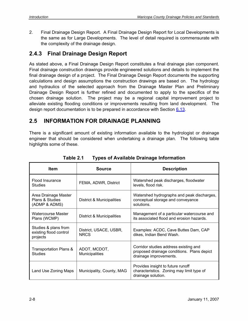
2.5 INFORMATION FOR DRAINAGE PLANNING
There is a significant amount of existing information available to the hydrologist or drainage engineer that should be considered when undertaking a drainage plan. The following table highlights some of these.
Table 2.1 Types of Available Drainage Information
Item Source Description
Watershed peak discharges, floodwater levels, flood risk.
Flood Insurance Studies FEMA, ADWR, District
Area Drainage Master Plans & Studies (ADMP & ADMS)
District & Municipalities Watershed hydrographs and peak discharges, conceptual storage and conveyance solutions.
Management of a particular watercourse and its associated flood and erosion hazards.
Watercourse Master Plans (WCMP) District & Municipalities
Studies & plans from existing flood control projects
District, USACE, USBR, NRCS
Examples: ACDC, Cave Buttes Dam, CAP dikes, Indian Bend Wash.
Corridor studies address existing and proposed drainage conditions. Plans depict drainage improvements.
Transportation Plans & Studies
ADOT, MCDOT, Municipalities
Land Use Zoning Maps Municipality, County, MAG Provides insight to future runoff characteristics. Zoning may limit type of drainage solution.
2-8 January 11, 2007

Maricopa County Drainage Policies and Standards Drainage Planning
Table 2.1 Types of Available Drainage Information
Item Source Description
Identifies runoff characteristics and engineering limitations. Soil Maps NRCS & USFS
Identifies watershed and existing land-use characteristics. Aerial Photography public & private
Used to determine watershed boundaries, slopes, and water-course hydraulic characteristics.
Topographic Mapping public & private
ALTA Surveys Maricopa County Recorder’s Office
Land ownership, boundary & utility easements (if available).
Drainage plans from adjacent developments
Municipalities/County/Land Developer/Home Owners Assoc.
Depicts existing or proposed conditions for adjacent properties that may affect the site under study.
Depicts the location of underground and above ground utilities that may affect the location of drainage facilities and the routing of stormwater.
Utility Plans Utility companies
2.6 DRAINAGE PLANNING PROCESS
2.6.1 Plan Development
The drainage planning process requires the collection and assimilation of information from most of the sources identified above. Consideration must be given to regulations, environmental impacts, ordinances, open space, zoning, regional hydrology, flood hazards, safety, compatibility with adjoining projects, and cost. As part of the initial layout design, the designer must consider and accommodate the future need of vehicular access for maintenance purposes. Preliminary design should minimize long-term maintenance requirements.
2.6.2 Waters of the United States (Section 404)
Waters of the United States, for the purposes of the Section 404 program (refer to Section 4.4), are drainage ways meeting certain criteria that define them by federal law as being under the jurisdiction of the U.S. Army Corps of Engineers (USACE). Waters of the United States are often referred to as jurisdictional waters. Construction activities that impact jurisdictional waters require a permit issued through the USACE. For most areas under study, jurisdictional waters exist. Therefore, drainage plans must consider the nuances of jurisdictional waters (See Chapter 4 (Regulations), and Policy 3.3.5). The professional undertaking a drainage plan must
January 11, 2007 2-9

Introduction Maricopa County Drainage Policies and Standards
have knowledge of 404 requirements to apply to the planning objective or have the jurisdictional waters delineated prior to delving too far into the drainage planning process. It is likely that the jurisdictional waters will have a significant impact on the overall drainage plan, remediation, and on-going maintenance activities.
2.6.3 Waters of the United States (EPA)
Waters of the United States as defined by the Environmental Protection Agency (EPA) has a different context from that defined under Section 404. The EPA definition is included below for reference for those dealing with stormwater quality issues (refer to Policy 3.6.5).
(a) All waters which are currently used, were used in the past, or may be susceptible to use in interstate or foreign commerce, including all waters which are subject to the ebb and flow of the tide;
(b) All interstate waters, including interstate ``wetlands;''
(c) All other waters such as intrastate lakes, rivers, streams (including intermittent streams), mudflats, sand flats, ``wetlands,'' sloughs, prairie potholes, wet meadows, playa lakes, or natural ponds the use, degradation, or destruction of which would affect or could affect interstate or foreign commerce including any such waters:
(1) Which are or could be used by interstate or foreign travelers for recreational or other purposes;
(2) From which fish or shellfish are or could be taken and sold in interstate or foreign commerce; or
(3) Which are used or could be used for industrial purposes by industries in interstate commerce.
(d) All impoundments of waters otherwise defined as waters of the United States under this definition;
(e) Tributaries of waters identified in paragraphs (a) through (d) of this definition;
(f) The territorial sea; and
(g) ``Wetlands'' adjacent to waters (other than waters that are themselves wetlands) identified in paragraphs (a) through (f) of this definition.
2.6.4 Regulations, Policies, and Standards
All drainage plans and construction drawings shall meet District and Maricopa County regulations. The policies (Chapter 3) and standards (Chapter 6) are intended to be an implementation guide for preparing drainage plans and drainage designs that are in
2-10 January 11, 2007

Maricopa County Drainage Policies and Standards Drainage Planning
conformance with the regulations. The time required for the review process is normally less, and review comments minimized, if the drainage plans are prepared in conformance with the policies and standards. Sometimes additional documentation may be required for submittal and review by the County/District to prove conformance with the regulations. These policies and standards also establish the minimum guidelines for capital improvement projects, both public and private.
2.6.5 Watercourse Open Space
The concept of combined flood control, environmental considerations, and recreational uses can be applied to drainage corridors (watercourses). Natural or semi-structural drainage/greenbelt corridors can be developed with landscaping, stormwater quality improvements, and multi-use trails incorporated into the drainage design to provide recreation opportunities. This concept can be applied to new drainage channels that are utilized for recreation uses, and existing open channels that currently do not provide recreation opportunities. The multi-use trails should be located above the channel banks to avoid impacting Waters of the United States (Section 404), to minimize effects of erosion, to minimize interaction with nuisance flows, and to minimize maintenance requirements. The County/District stresses the establishment of natural or semi-structural drainage/greenbelt corridors. Utilizing natural/greenbelt corridors to accommodate stormwater is the District preferred approach for several reasons, including:
1. Watercourses make excellent natural open spaces of high scenic quality due to their associated vegetation, wildlife and landforms.
2. Natural features such as topography, and natural processes such as erosion, have defined the land along natural watercourses as a drainage and stormwater runoff corridor.
3. Desert adapted vegetation is dependent on natural watercourses for water supply and seed disbursement and germination.
4. Many desert wildlife species are adapted to seek watercourse areas for food and shelter.
5. Impacts to watercourses have environmental consequences such as habitat loss, reduced flood conveyance, loss of a valuable landscape amenity, and reduced ground water recharge and impaired stormwater quality.
6. Impacts to watercourses have public safety consequences adjacent, upstream and downstream of the impact area.
7. Impacts to watercourses often have decreased property value implications as environmental impacts diminish abutting land value.
8. Designating open space along watercourses is often more cost effective for the developer due to the high risk of flooding in these corridors.
January 11, 2007 2-11

Introduction Maricopa County Drainage Policies and Standards
2.6.6 Stormwater Storage
In the planning process, it is a County/District goal that stormwater storage basins be combined where feasible with open space, parks, and trails to create focal points for the community instead of isolated tracts. These combined uses should be planned and designed to augment Maricopa County parklands. The benefits of this approach are an enhanced sense of community and increased open space with landscape amenities. The County/District encourages combined use of drainage and recreation facilities on both public and private lands. It is recommended that these drainage facilities be non-geometrically designed. Also, design of stormwater storage facilities should be coordinated with the County/District to assure compliance with stormwater quality requirements.
2.6.6.1 Public Stormwater Storage Basins Given the demand for organized sports fields such as soccer and ball fields, basins may serve multi-use purposes. It is recommended to avoid siting recreational facilities at the very bottom of stormwater storage basins. It is further recommended these basins be designed with tiers or gentle slopes to allow for the collection and conveyance of nuisance water around fields to allow for dry field areas under normal conditions.
The desired location for stormwater storage basins is adjacent to parks to increase the open space. Integrating non-geometric basins into park design is encouraged for both active and passive recreation purposes, subject to meeting Maricopa County aesthetic and safety standards.
2.6.6.2 Private Stormwater Storage Basins The County/District recommends non-geometric designs for stormwater basins in private development projects. In these developments, the use of open space in combination with stormwater storage basins is encouraged in order to provide a more natural and aesthetically pleasing method of addressing runoff, stormwater storage, and stormwater quality. This practice can provide measurable benefits to the residents of the development when a sufficient recreation area is provided. These areas should be made focal points of the community instead of isolated tracts, which helps create a sense of community. Other design considerations include access, multi-use trails and habitat connectivity.
2.6.7 Zoning
Zoning often dictates the nature of watercourse development and open space requirements for land development projects. Rezoning land to address flooding or erosion hazards, either through the use of an overlay or replacement zoning district (such as the City of Phoenix flood hazard and erosion management district), or through conditions of zoning approval that limit the use of such land, is intended to provide a natural or limited structural design approach to watercourse management. Generally, this results in ideally situated open space. Even small washes lend themselves to regulation in the same manner as larger watercourses if the identification of the flood hazard and erosion impact is initiated early enough. Where ADMPs and WCMPs have been completed, approved implementation plans may dictate land-
2-12 January 11, 2007

Maricopa County Drainage Policies and Standards Drainage Planning
use/drainage design options. In other areas, individual rezoning applications or zoning overlay districts may include stipulations or design guidelines that address watercourse treatment and the degree to which the watercourse may be altered or disturbed.
2.6.8 Rules of Development
Rules of development are District requirements that are produced for specific watersheds and are based on unique characteristics of that watershed. These rules are usually developed as part of an ADMS, ADMP or WCMP. Rules of Development are typically more stringent than the minimum requirements of the Drainage and Floodplain Regulations. Refer to Policy 3.3.2.
The District will use the Rules of Development to manage flood hazards within developments, which includes subdivisions and individual lots. The Rules of Development will typically address watershed management issues critical to long-term public safety, such as:
• Where or how structures such as walls, buildings and fences can be constructed.
• Methods to alleviate the impacts of construction on the watershed, such as limits on vegetation removal.
• Measures to protect structures from flooding and erosion, such as more stringent finished floor elevation requirements.
2.6.9 Drainage Guidelines
Prior to the adoption of an ADMS, ADMP or WCMP, Drainage Guidelines may be defined by the District early in the development of the plan. Drainage Guidelines are preliminary Rules of Development (Section 2.6.8) that are intended to address known or suspected public safety issues on an interim basis. New development is expected to make every effort to follow the drainage guidelines. Refer to Policy 3.3.3.
2.6.10 Design Hydrology and Hydraulics
The drainage engineer should determine if there is existing hydrologic and hydraulic information available for the upstream watershed and project site that is suitable for use in design of the project improvements. This includes researching the information sources listed in Table 2.1. In particular, review of the District ADMS or ADMP that encompasses the project area provides the design team with valuable information pertaining to the magnitude of stormwater discharges and volumes affecting the project. The design engineer must either concur with the ADMS, ADMP and/or WCMP by statement, or submit additional documentation addressing and substantiating differences. The FEMA Flood Insurance Rate Maps (FIRM) should also be reviewed to establish if regulated floodplains cross the project. Where existing studies are not available, the drainage engineer should contact the District as it has an aggressive schedule to undertake the
January 11, 2007 2-13

Introduction Maricopa County Drainage Policies and Standards
study of new areas1. “In-progress” information is often available, and if not, staff experience is extensive.
In the event there is insufficient hydrology or hydraulic information available, then the drainage engineer will have to generate new information using the Hydrology and Hydraulics volumes and the policies and standards herein. At the drainage plan level, the drainage engineer should concentrate on quantifying off-site flows that may impact the project, and determine the means for conveying that flow through the project site. A reasonable estimate of the design peak discharge is necessary to approximate the channel or drainage structure capacity and size. Again, the improvements presented in a drainage plan shall not adversely impact adjacent property owners.
2.6.11 Other Hazard Considerations
Drainage plans need to focus on more than flood levels derived from open channel hydraulic analyses. Aggradation of channel beds and overbanks via sedimentation and degradation of channels from erosive processes are threats to the performance of drainage systems that should be considered. In addition, the lateral migration of watercourses may threaten public safety, health and welfare, unless proper erosion hazard zones are identified, prohibiting development in these areas unless remediation of the hazard is accomplished. ADWR (1996) and should be considered and addressed in the planning process. The determination of flood levels on alluvial piedmonts is particularly challenging because of active geomorphic processes. The plan should consider the District’s Piedmont Flood Hazard Assessment for Flood Plain Management for Maricopa County (Hjalmarson, 2000) or most current version, and the National Research Council (1996), when drainage planning on alluvial piedmonts. Finally, ponding areas up gradient of elevated roads, railroads, and irrigation canals must be considered during the development of the drainage plan to assess finished floor elevations, outfall hydraulics, and compensation for volume displacement..
2.6.12 Safety
A basic tenet of any capital improvement project is the promotion of public safety. Public safety must be a consideration taken throughout the development of a drainage plan. Excessive stormwater depth, velocity, erosion, sedimentation, and/or poor stormwater quality pose a threat to safety and public health.
2.6.13 Cost
During the development of a drainage plan, initial capital costs, long term maintenance costs, and stormwater treatment cost should be considered. Ideally, the least societal costs necessary
1In all cases, the professional should contact the District to determine if the area is under study or re-study.
2-14 January 11, 2007

Maricopa County Drainage Policies and Standards Drainage Planning
to provide the required level of protection to the public is the desired goal. Attainment of this goal is fostered by adherence to the County/District’s policies and standards.
2.7 APPROACH TO DRAINAGE PLANNING
2.7.1 Open Channel Conveyance
The alignment of a planned drainage system is often set by following the natural watercourse flow line or low flow channel. In these cases, the alignment need only be defined on available topographic mapping or aerial photographs. In many areas about to be urbanized, the runoff has been so minimal that well-defined natural channels do not exist. However, low flow channels nearly always exist which provide an excellent basis for location of improved channels. Use of these channels to convey stormwater is likely to reduce development costs and minimize drainage problems. In some cases, the wise utilization of natural watercourses in the development of a drainage system will eliminate the need for an underground storm drain system. Where WCMP’s have been completed, setbacks for erosion hazard zones may have been identified. If setbacks have not been defined as part of the WCMP, then erosion hazard areas should be approximated following the methodologies identified in ADWR (1996) and the Hydraulics volume. Detailed lateral migration and long-term erosion analyses would be performed as part of final design in those circumstances.
The drainage plan is where major decisions are made as to design velocities, location of structures, means of accommodating conflicting utilities, and the potential alternate uses in the case of an open channel. The choices of channel types available to the design team are numerous, depending only upon good hydraulic practice, environmental design (including stormwater quality control and treatment), sociological impact, and basic project requirements. However, from a practical standpoint, the basic choice to be made initially is whether or not the channel is to be lined for higher velocities or if a natural channel and floodplain already exists that can be effectively utilized with considerations to erosion setbacks and the 100-year flooding limits.
A more natural approach is preferred. The more desirable setting for the channel and overbank floodplain combination is an undisturbed one. The benefits of such a channel are that:
• Velocities are usually lower, resulting in longer concentration times and lower downstream peak flows.
• Natural channel and overbank floodplain storage tends to decrease peak flows.
• Maintenance needs are usually less than artificial channels.
• The natural channel and overbank floodplain provides desirable open space and recreational area adding significant social benefits. The more closely the character of an artificial channel can be made to emulate that of a natural channel with overbank floodplain, generally the higher the quality of the artificial channel.
January 11, 2007 2-15

Introduction Maricopa County Drainage Policies and Standards
For a drainage plan, the level of analysis necessary to establish artificial channel widths varies. If the artificial channel is for a watercourse with a 100-year peak discharge of 50 cfs or greater, a detailed floodplain analysis maybe required (see Table 6.7). The level of analysis is also dependent upon the existing or proposed land-use and whether encroachments, such as road culvert embankments, affect the flow regime. Otherwise, simple “normal depth flow” calculations may suffice. Where channel slopes exceed 0.5% to 1.0%, supercritical flow analysis may be warranted.
Another key component of planning for a channel at the drainage plan level is the transitioning of flow into and out of a proposed channel. Key County/District policies (Policy 3.4.2 and Policy 3.3.3) require that proposed facilities do not exacerbate flooding conditions for adjoining properties. Thus, any drainage improvement must not increase water levels or result in erosive velocities greater than pre-development conditions. Interceptor channels may be required to funnel offsite flow into an onsite channel. Similarly, spreading basins or 4:1 channel expansions may be necessary to transition from an artificial channel to the existing downstream floodplain.
2.7.2 Storage
The drainage plan is where decisions need to be made on the use of stormwater storage facilities and their location. The siting of storage facilities where topography is favorable to the construction of embankments and/or excavation of basins will provide significant benefits including the reduction of peak flows and the settling out of sediment and debris. The latter can help to improve the quality of water downstream.
For conceptual sizing of stormwater storage facilities, a storage per unit area relationship along with a safety factor can be utilized to derive an approximate stormwater volume for storage and stormwater quality treatment. The storage per unit area is primarily dependent upon the land-use of the proposed project within the proposed project area only and upon the design rainfall depth for the area in question. Offsite flows are not allowed to mix with onsite storage facilities.
For land development projects involving large acreage, establishing the contributing drainage area prior to final design can be problematic for the inexperienced. Overlaying the proposed site plan with existing topography allows for the development of a conceptual or preliminary grading plan. Establishing proposed grade breaks for mass grading consistent with existing drainage divides is the preferred method. Taking this approach wherever possible during the drainage planning effort provides an additional benefit in that it minimizes earthwork and storm sewer expenditures pursuant to final design. Undertaking such an approach supports the basis for preliminary stormwater storage design and will tend to minimize the necessity for dramatic design revisions resulting from unforeseen drainage requirements during final design.
2.7.3 Environmental Protection
There are numerous federal, state, and local regulations that must be adhered to during plan development and implementation. At the federal and state level, Section 404 of the Clean Water Act (Waters of the U.S.) and Section 401 (water quality) permitting are typically required during the project approval process and may be required for maintenance or other activities
2-16 January 11, 2007

Maricopa County Drainage Policies and Standards Drainage Planning
proposed in conjunction with the drainage facilities. For the District, the plan must comply with the Federal NPDES (40 CFR 122), the state AZPDES stormwater quality programs, and also any action or restriction they consider reasonably necessary to meet their obligations, if any, to comply with local, state or federal water quality laws. Taking the requirements of these regulations into account during the development of the drainage plan will streamline the design and implementation process. For example, recognition of the trigger points in 404 permitting will provide guidance in developing mitigation plans (see Chapter 4, Federal and State Regulations). The County/District strongly endorses minimizing disturbances to natural watercourses in order to lessen the impacts on ecology.
2.8 FINAL DESIGN CONSIDERATIONS
The drainage plan serves as the framework for final design. A thorough drainage plan streamlines the final design process. That is not to say that changes will not occur during final design. However, wholesale changes should not occur due to drainage issues.
It is during final design that street drainage is analyzed and catch basins/storm drains are designed. The specifics and supporting analysis for open channels including culverts and bridges, and the influences of sedimentation and scour, are developed during final design. It is here that stormwater storage facility details, including pump stations if appropriate, are enumerated to permit review by the County/District and subsequent construction. During final design, the design engineer applies the policies and standards of the County/District to minimize capital cost and long term maintenance of the drainage improvements while accommodating safety and health concerns.
2.9 REFERENCES
ADWR, 1996, State Standard for Watercourse System Sediment Balance, State Standard 5-96, Flood Warning and Dam Safety Section.
FCDMC, 2007, Drainage Design Manual for Maricopa County, Hydrology.
FCDMC, 2007, Drainage Design Manual for Maricopa County, Hydraulics.
Hjalmarson, H. W., 2000 (Draft), Piedmont Flood Hazard Assessment for Flood Plain Management for Maricopa County, Arizona: for Flood Control District of Maricopa County, Phoenix.
National Research Council, 1996, Alluvial Fan flooding: National Academy Press.
January 11, 2007 2-17
Introduction Maricopa County Drainage Policies and Standards
Page Intentionally Left BlanK
2-18 January 11, 2007

Maricopa County Drainage Policies and Standards Drainage Policies
3 DRAINAGE POLICIES 3.1 PURPOSE
The policies contained in this chapter are the general principles by which the County/District implement the District and Maricopa County regulations and ordinances governing stormwater management. Application of these policies assist the County/District in their mission to provide regional flood hazard identification, regulation, remediation, and education to Maricopa County residents so that they can reduce their risks of injury, death, and property damage from flooding, while still enjoying the natural and beneficial values served by floodplains. Policies are normally used internally by the County/District to guide employees with application of the governing regulations. Guidelines are policies that the County/District sets forth for use externally by the public and other agencies to define acceptable practice that the County/District interprets as meeting the intent of the governing regulations. The policies in Chapter 3 are intended to meet this purpose and are for internal and external application. The County/District regulations and ordinances that these policies help implement include the following:
• Drainage Regulations for Maricopa County, September 2004.
• Floodplain Regulations for Maricopa County, 2000 rev (currently undergoing revision).
• Maricopa County Zoning Ordinance.
• Maricopa County Subdivision Regulations.
Additional District policies and standards include:
• DDM - Hydrology, most current edition.
• DDM - Hydraulics, most current edition.
• DDM - Erosion Control, most current edition.
• Erosion Hazard Guidelines, (ADWR, 1996).
• Policy for the Aesthetic Treatment and Landscaping of Flood Control Projects, (FCDMC, 1992).
• Piedmont Flood Hazard Assessment for Flood Plain Management for Maricopa County, 2000 draft (Hjalmarson, 2000).
• Sand and Gravel Mining Floodplain Use Permit Application Guidelines (FCDMC, 2003).
January 11, 2007 3-1

Drainage Policies Maricopa County Drainage Policies and Standards
The County/District has adopted floodplain management and stormwater drainage policies with this document that set forth guiding principles for stormwater management. These drainage policies fall under the following categories:
• General
• Planning
• Drainage Patterns
• Hydrology
• Stormwater Quality
• Floodplain Management
• Erosion Hazard Management
• Street Drainage
• Conveyance Facilities
• Stormwater Storage Facilities
• Sand and Gravel Mining Floodplain Use Permits
• Ownership and Maintenance
• Erosion Control During Construction
These policies, together with the stormwater management documents listed above, define the criteria and procedures to be used for stormwater management and drainage design and construction in the unincorporated areas of Maricopa County.
3.2 GENERAL
The policies listed in Chapter 3 are intended for both internal use by County/District employees, and for external use by the public. The following policies are intended to clarify general issues related to public versus private projects, and new development versus retrofit and rehabilitation projects.
Policy 3.2.1 Design Standards for New Construction. The standards listed in Chapter 6 apply as the minimum requirements for new public and private development projects on previously undeveloped land or on land where existing improvements are completely removed.
Policy 3.2.2 Design Standards for Rehabilitation Projects. For the purposes of this policy, a rehabilitation project is any project that will repair (other than routine, ongoing maintenance) and/or improve existing facilities. Rehabilitation projects are to normally be
3-2 January 11, 2007

Maricopa County Drainage Policies and Standards Drainage Policies
constructed to the standards listed in Chapter 6, but may be built to a lesser standard under the following conditions:
1. Adjacent, upstream and downstream properties and/or drainage facilities would be adversely affected by constructing the proposed improvements to current standards and the cost to mitigate the adverse effects is determined by the County/District to be impractical. Such properties must not be adversely affected by the proposed improvements, when compared to existing conditions.
2. If the project is funded with public funds and the proposed improvements will increase public safety, health and welfare.
Policy 3.2.3 Subsidence and Fissures. The designer should consider the effects of subsidence and/or fissures when planning, designing and constructing drainage facilities.
3.3 PLANNING
Proper planning and design of drainage facilities are as important as for water, wastewater, streets and other infrastructure needs in a growing community. The following are County/District policies related to drainage planning for private developments.
Policy 3.3.1 Compatibility with Studies of Record. Developments shall acknowledge and assess their project for compatibility with any ADMSs, ADMPs, WCMPs, or flood insurance studies.
Policy 3.3.2 Rules of Development. New development, including subdivisions and individual lots, within watersheds of an adopted ADMS or ADMP, should follow any Rules of Development adopted as a part of the plan. Refer to Section 2.6.8. In the event that development does not want to follow the rules, an engineering analysis will need to be provided to substantiate the reasons for not adhering to the Rules of Development.
Policy 3.3.3 Drainage Guidelines. New development, including subdivisions and individual lots, within watersheds of an ADMS or ADMP that is in progress but not yet adopted, are encouraged to follow any Drainage Guidelines (interim Rules of Development) that are drafted as a part of the plan development and approved by the County/District. Refer to Section 2.6.9.
Policy 3.3.4 Watercourse Master Plan Requirements. Where a WCMP has been completed, the approved plan for erosion setbacks, structural and non-structural measures, existing and/or future condition floodplain and floodway requirements, Rules of Development, and Development Guidelines should be followed.
Policy 3.3.5 Permits. There are a myriad of federal, state, and county permits that may be required prior to the start of construction of a project (see Chapter 4 and Chapter 5). It is not the County/District’s responsibility to ensure that the plans for a proposed project satisfy state and federal permit requirements. It is the County/District’s policy that all such permits must be obtained, but it is the owner’s responsibility to determine which permits are required and to
January 11, 2007 3-3

Drainage Policies Maricopa County Drainage Policies and Standards
obtain them as appropriate for the timing of the project. County/District-issued permits may be withheld pending written proof that required State and/or Federal permits have been obtained.
3.4 DRAINAGE PATTERNS
The provision for facilities to convey stormwater runoff is a necessary part of land development activity. In the natural environment, stormwater runoff will determine its own course. Land development may require alteration of the natural alignment of a drainage system. This may result in realigned flow paths, larger peak discharges, greater volume of runoff, higher water surface elevations, increased flow velocities and other drainage modifications that can adversely impact other properties, and which must be mitigated. As a result, the following are County/District policies:
Policy 3.4.1 Disturbances to Natural Watercourses. Disturbances to natural watercourses should be minimized in order to preserve the watercourses’ natural and beneficial function.
Policy 3.4.2 Historic Drainage Patterns. Historic drainage patterns, where runoff enters and exits a property, shall be maintained, to the extent possible.
Policy 3.4.3 Alteration of On-Site Drainage Patterns. Activities on a property that affect drainage shall not result in adverse impacts on adjacent properties. At a minimum, such drainage activities, including wash relocations and the concentration of sheet flows or braided washes, shall not adversely change water surface elevations and flow characteristics. Such drainage activities shall require an engineered report that substantiates there are no adverse impacts.
Policy 3.4.4 Drainage Facilities and Structures. Any drainage facility or structure that will be located within a watercourse, drainage way, or other means of conveying or storing stormwater shall be designed and constructed to the standards listed in Chapter 6.
3.5 HYDROLOGY
Hydrology addresses surface water and the estimation of peak discharges, volumes and time distributions, which result from precipitation. Hydrologic data is fundamental in the design of drainage facilities. The purpose in application of hydrology is ultimately for delineation of the limits of flood-prone areas, for design of drainage structures and facilities, and to define what constitutes natural and/or historical conditions at property boundaries. There are a number of methods for obtaining the necessary hydrologic information to accomplish this purpose. The following policy defines the preferred hierarchy for use of such information and for generation of new hydrology.
Policy 3.5.1 Source of Peak Discharge and Runoff Volume Information. The following is the preferred order of hierarchy for obtaining peak discharges and runoff volumes for various floodplain and drainage purposes:
3-4 January 11, 2007
Maricopa County Drainage Policies and Standards Drainage Policies
1. The first choice is to obtain accepted peak discharges and runoff volumes of record from ADMSs, ADMPs, WCMPs or flood insurance studies. The results from these studies must be evaluated to determine if the assumptions made are still valid and appropriate for the intended purpose. Such studies may only provide information for the 100-year storm. Information for other storm frequencies may be obtained by appropriate revision of the existing computer models using the procedures defined in the Hydrology and Hydraulics volumes.
2. The second choice is the drainage plans and design reports from adjacent properties. This information may be used where available and if approved by the reviewing agency for use on the project.
3. If choices 1 and 2 above are not available options, or are deemed inappropriate, then peak discharges and runoff volumes should be estimated in accordance with the procedures in the Hydrology and Hydraulics volumes.
3.6 STORMWATER QUALITY
In March 2003, Arizona municipalities within the urbanized area were brought into the municipal stormwater permitting program through Phase II of the Federal stormwater program called the National Pollutant Discharge Elimination System (NPDES). In Arizona, this program is called the Arizona Pollutant Discharge Elimination System (AZPDES), except for tribal lands, which are administered by the EPA. Maricopa County has been designated as a permittee under this program. Under this permitting effort, all County departments including the District are doing their part to protect and help improve stormwater quality. The following are the County/District's policies as they relate to stormwater quality:
Maricopa County policies related to stormwater quality are:
Policy 3.6.1 Discharge of Pollutants. No person or entity may cause the discharge of pollutants1 into a natural drainage system or a public storm sewer system or facility.
Policy 3.6.2 Pollutants on the Land Surface. Pollutants released to the land surface that subsequently become a constituent of stormwater runoff are considered a discharge of pollutants2.
Policy 3.6.3 Soil as a Pollutant. Soil is considered a pollutant when it is entrained in stormwater runoff from construction sites in quantities greater than natural conditions.
1 Pollutant shall have the same meaning as defined in ARS 49-201 (28). 2 As of 11/30/01, excludes certain activities such as not-for-profit washing of vehicles, non-agricultural
irrigation water discharges, fire hydrant/potable water system flushing, dust control watering, and discharge of residential evaporative cooler/air conditioning condensate. Since the federal regulations pertaining to this matter change periodically, the practitioner should review the Federal Register for revision.
January 11, 2007 3-5

Drainage Policies Maricopa County Drainage Policies and Standards
Policy 3.6.4 Erosion Control. Erosion control measures for new developments should be in conformance with Best Management Practices (BMPs) identified in the DDM - Erosion Control or other EPA, ADEQ, or locally approved method.
Policy 3.6.5 Stormwater Pollution Prevention. Stormwater Pollution Prevention is to be addressed through the use of BMPs to the maximum extent practicable to comply with federal, state, county or local regulations or ordinances. Refer to the Erosion Control volume.
Policy 3.6.6 First Flush. The District has established a minimum level of control for new development at which stormwater pollution prevention practices must be put in place. This minimum standard is “First Flush”, and consists of retaining or treating the first 0.5 inches of direct runoff from a storm event. Normally, this minimum level of control is met by following the County/District retention requirement (Section 5.2, Policy 3.11.1, Standard 6.10.5). In the event that normal County retention standards are waived (100 year, 2 hour storm), or a surface based bleed off for the retention basin is proposed, the first flush provisions shall apply. Refer to Standard 6.4.1 for technical details and an example application.
This first flush policy is the result of ARS 48-3622 where the District may require any action or impose any restriction that the District considers reasonably necessary to meet the District's obligations, if any, to comply with local, state or federal water quality laws. The full text of this statute is included in Section 5.7.
3.7 FLOODPLAIN MANAGEMENT
Maricopa County participates in the NFIP, which provides flood insurance to its citizens and flood mitigation assistance and emergency assistance to flood victims. The Department of Homeland Security, Federal Emergency Management Agency (FEMA) oversees the NFIP. FEMA has regulations pertaining to floodplain management that must be followed in order for Maricopa County to continue as a member of the NFIP. The State of Arizona, in turn, requires each county to form a flood control district and to adopt and enforce floodplain regulations for the county. The District has adopted floodplain regulations for Maricopa County that meet or exceed the FEMA and State regulations.
The District has local policies to manage floodplains in a uniform and consistent manner to meet the intent of the floodplain regulations. These policies are categorized as being FEMA related and non-FEMA related in nature. Erosion and sedimentation hazards management are an integral part of floodplain management. Policies are also established to manage erosion and sedimentation hazard areas in a uniform and consistent manner.
3.7.1 FEMA
Refer to the Floodplain Regulations for Maricopa County (Section 5.3). FEMA has identified floodplains and established floodways that are shown on the FIRMs. Refer to Section 4.3 for a description of the NFIP under which these maps were prepared. The District policies related to implementation of the Floodplain Regulations are as follows:
3-6 January 11, 2007

Maricopa County Drainage Policies and Standards Drainage Policies
Policy 3.7.1 Best Available Technical Information. New or updated information for FEMA defined floodplains and floodways is constantly being prepared, both by the District and others. It is the District’s policy, in conformance with FEMA Guidelines, to use this information for regulatory purposes and to provide it to the public as the “Best Available Technical Information”. Examples of “Best Available Technical Information” follow:
1. New studies that have not yet been submitted to FEMA. This information is usually from studies that are in progress but could also be completed studies that are being held pending further investigations such as completion of an ADMS, ADMP or WCMP. This information may be shared with the public if appropriate, it is stamped preliminary, and the recipient is notified that the information is subject to change and is used at-risk. This information may be used for regulatory purposes if the floodplain and/or floodway widths or 100-year water surface elevations exceed those of the effective FEMA Flood Insurance Study (FIS).
2. New studies that have been submitted to FEMA but not yet approved. This information will be shared with the public, will be stamped preliminary, and the recipient will be notified that the information is subject to change and is used at-risk. This information will be used for regulatory purposes if the floodplain and/or floodway widths or 100-year water surface elevations exceed those of the effective FEMA FIS. The effective FEMA FIS will be used for regulatory purposes for all other cases.
3. A floodway delineation in a new study prior to submittal to FEMA. If the results of a new study will place existing structures within a proposed floodway, the District will normally initiate an internal District Review Committee to determine if:
A. More detailed surveys should be done to evaluate the floodway location.
B. Evaluate whether anticipated future conditions may affect the proposed floodway location.
C. Assess the risk for each structure and determine the level of priority for inclusion in the District Floodprone Property Assistance Program.
Policy 3.7.2 CLOMR Requirement Prior to Issuance of a Grading Permit. Subdivisions of 5 acres or greater and/or 50 lots and greater planning to submit a CLOMR for modification of a FEMA-designated floodplain and/or floodway, must receive District approval and submit the CLOMR request to FEMA before a grading and drainage permit will be issued by Maricopa County for the development.
Policy 3.7.3 LOMR Requirement Prior to Final Development Approval. Residential subdivisions of 5 acres or greater and/or 50 lots and greater that have submitted a CLOMR to FEMA for modification of a FEMA-designated floodplain and/or floodway, must receive an FEMA-approved LOMR before final approval by Maricopa County is granted for building occupancy for the development.
January 11, 2007 3-7

Drainage Policies Maricopa County Drainage Policies and Standards
Policy 3.7.4 Location of Structures. The developer should locate proposed structures outside of a FEMA-designated floodplain if at all possible. District staff will work with the developer on building placement and issue a Floodplain Clearance if the proposed structure(s) is successfully placed outside the floodplain.
Policy 3.7.5 Public and Private Roads Affecting FEMA Floodplains. A CLOMR and LOMR must be submitted to the District and FEMA for approval if a proposed roadway affects a FEMA-designated floodplain and/or floodway. This applies to all development including those done by MCDOT, ADOT and all District-regulated communities within Maricopa County.
3.7.2 Non-FEMA
There are many floodprone areas in Maricopa County that do not have floodplains or floodways identified by FEMA. The District’s mission is clear: To provide regional flood hazard identification, regulation, remediation, and education for Maricopa County residents so that they can reduce their risks of injury, death and property damage from flooding, while still enjoying the natural and beneficial values served by floodplains. Such floodprone areas, meeting the definition set forth in the District’s Floodplain Regulations (Section 5.3), are subject to regulation.
County/District policies pertaining to non-FEMA flood or erosion prone areas follow:
Policy 3.7.6 Requirement to Delineate 100-year Flood Hazard Area and Establish Minimum Finished Floor Elevation. In locations where development is proposed and a FEMA regulatory floodplain does not exist, delineation of the 100-year flood hazard area may be required by the County/District. The minimum finished floor elevation requirements always apply. Refer to Table 6.7 for more specific criteria and requirements. Required delineations are to be prepared using the technical guidance in the Hydrology and Hydraulics volumes and require approval by the County/District.
Policy 3.7.7 Erosion Protection. Building pads and foundations may be required to have an additional setback or be protected from erosion and scour in conformance with the procedures in the Hydraulics volume. As an alternative to structural protection, building setbacks from washes may be required for protection from erosion hazards, as set forth in ADWR (1996).
Policy 3.7.8 Lot Grading. Lots are to be graded to drain so as not to adversely affect adjacent property owners. Runoff redirected from its natural flow location may drain onto or through an adjacent property if a written agreement is in place with the affected property owner(s) or a drainage easement(s) or tract(s) is provided. Such agreements, easements or tract(s) must be recorded against the deed(s) of the affected properties. A legal description and exhibit drawing of every easement must be included as a part of the recorded documents.
3-8 January 11, 2007

Maricopa County Drainage Policies and Standards Drainage Policies
3.8 EROSION HAZARD MANAGEMENT
3.8.1 Riverine Areas
Policy 3.8.1 Riverine Erosion Hazard Zones. Erosion hazard guidelines (ADWR, 1996), as a minimum, apply to:
• Structures that could fail or incur significant damage as a result of erosion or deposition.
• Proposed structures that, if built, could result in adverse impacts to adjacent properties.
• Watercourses that do not have erosion hazard zones approved by the District.
• Watercourses within existing or proposed subdivisions, including residential and non-residential.
• Watercourses identified by the District as having significant potential flood hazards.
• Watercourses with drainage areas equal to or greater than 30 acres or a 100-year peak discharge estimate of more than 50 cfs, as estimated using the procedures in the Hydrology and Hydraulics volumes.
Erosion zones consistent with ADWR (1996) may be required for all properties developed in which the watercourses are to be left in an undisturbed state. Depending on the geomorphic conditions of the area, if the erosion limits are suspected by the District to exceed those estimated using a Level I analysis, as defined in ADWR (1996), a Level II or Level III analysis may be required.
3.8.2 Distributary Flow Areas
Policy 3.8.2 Watercourse Stability Analysis. Stability of the watercourse divergence point(s) and divergent wash(es) should be determined prior to the approval of a proposed structure.
Policy 3.8.3 Proposed Watercourse Alterations. Proposed modifications should not disturb the natural divergence location(s),, especially if upstream, downstream or adjacent parcels may be adversely impacted.
Policy 3.8.4 Erosion Hazard Zones. Erosion hazard guidelines (ADWR, 1996) should be applied to all divergent watercourses adjacent to the proposed structure.
3.8.3 Sheet Flow/Unconfined Flow Areas
Policy 3.8.5 Vegetation Removal and Flow Concentration. Erosion potential directly relates to vegetation removal and concentration of flows. Proposed development should limit vegetation removal and concentration of flow to a minimum.
January 11, 2007 3-9

Drainage Policies Maricopa County Drainage Policies and Standards
Policy 3.8.6 Single-lots. Flows will not be concentrated beyond the typical shallow swale around the structure. These swales should daylight and broaden to the original sheet flow conditions on the downstream side of proposed structures. Erosion protection may be required.
Policy 3.8.7 Subdivisions. The subdivision drainage design should focus on limiting the concentration of flows to the absolute minimum condition. Where flows are concentrated, appropriate scour protection should be applied to the channelized reach. Concentrated flows shall be returned to the natural sheet flow condition prior to exiting the property.
3.8.4 Alluvial Fan/Piedmont Areas
Policy 3.8.8 Piedmont Assessment Analysis. Locations exhibiting signs of erosion associated with active alluvial fan flooding may require a piedmont assessment analysis.
Policy 3.8.9 Piedmont Erosion Hazards. Erosion hazards are to be addressed through engineering and geomorphic analysis for all landforms associated with the piedmonts.
Policy 3.8.10 Alluvial Fan Floodway Corridors Erosion Hazard Zones. Alluvial fan floodway corridors and flow through channels are to follow the guidelines outlined in ADWR (1996).
Policy 3.8.11 Other Piedmont Locations. For other piedmont locations, follow the appropriate erosion hazard analysis based on the type of flow characteristics representative of the area. Refer to Section 3.8.1 for tributary channels on pediments, inactive and relict fans. Refer to Section 3.8.2 for distributary flow areas on pediments, inactive fans, and alluvial plains. Refer to Section 3.8.3 for sheet flow areas on pediments, inactive fans, and alluvial plains.
3.9 STREET DRAINAGE
The primary purpose of streets is to serve transportation needs. Accommodation of street drainage is provided so that motorists and emergency vehicles have a reasonable level of access and safety during storm events. For new public street construction or improvements to existing public streets, stormwater flowing within or across a street is to be managed in accordance with the following County/District policies.
Policy 3.9.1 No Adverse Impacts. Street design should identify any increase in peak discharge and flow velocities and account for them in the roadway design so there are no adverse impacts to other properties.
Policy 3.9.2 Safety. Streets should be designed to convey stormwater runoff so as to provide motorists and emergency vehicles access and safety during a storm event.
Policy 3.9.3 Standards. Streets shall be designed to accommodate stormwater in conformance with County/District Drainage Standards (Refer to Chapter 6).
Policy 3.9.4 Velocity. Street flow velocities in excess of those established in the County/District Drainage Standards (Chapter 6) require County/District administrative approval.
3-10 January 11, 2007

Maricopa County Drainage Policies and Standards Drainage Policies
Policy 3.9.5 Inverted Crowns. Inverted crown streets are not permitted without County/District approval.
Policy 3.9.6 Local Streets. Local streets shall not be designed to collect or direct runoff from expressway, arterial, and collector roads. Expressway, arterial and collector roads shall not direct drainage onto local streets.
Policy 3.9.7 Culverts and Bridges. Culverts or bridges should be provided for all expressway, arterial, and collector roads that cross open channels or drainage ways. Exceptions may be approved by the County/District. Engineering justification must be provided and approved administratively by the County/District.
3.10 CONVEYANCE FACILITIES
Stormwater conveyance facilities are defined to include open channels, undisturbed watercourses such as rivers and washes, ditches and swales, streets, culverts, or storm drains. The following are County/District policies related to drainage conveyance facilities:
Policy 3.10.1 Review. Watercourses may be reviewed for conveyance capacity and erosion/sedimentation considerations in accordance with the County/District Drainage Standards (Chapter 6) and the Hydrology and Hydraulics volumes.
Policy 3.10.2 Hydraulic Structures. All hydraulic structures are to be designed and constructed, as a minimum, in conformance with the Uniform Standard Specifications and Details for Public Works Construction (MAG Standards) by the Maricopa Association of Governments, latest edition, including any County/District amendments. Use of the ADOT Standard Specifications for Road & Bridge Construction and Standard Drawings (ADOT Standards), latest edition of both including any County/District amendments, is also permissible. Additional details and specifications may be necessary or required, and in all cases, the final approved construction documents, compliant with current design standards, shall control.
Policy 3.10.3 Acceptance of Existing Structures/Facilities. Prior to the acceptance by Maricopa County and/or the District, to incorporate existing structures and/or facilities for maintenance, such structures and/or facilities shall be refurbished for the intended life cycle and constructed or reconstructed as a minimum, in conformance with the MAG Standards, latest edition, including any County/District amendments. Use of the ADOT Standards, latest edition including any County/District amendments, is also permissible. Additional details and specifications may be necessary or required, and in all cases, the final approved construction documents, compliant with current design standards, shall control.
Policy 3.10.4 Erosion/Sedimentation Analyses. The designer of drainage facilities should undertake the appropriate level of erosion/sedimentation analysis commensurate with the risk of undesirable consequences expected to the health, safety, and welfare of the general public. Design water surface elevations for excavated channels are to be below adjacent natural ground, including design freeboard.
January 11, 2007 3-11

Drainage Policies Maricopa County Drainage Policies and Standards
Policy 3.10.5 Levees and Berms. Levees or berms should not obstruct side or interior drainage to a channel.
Policy 3.10.6 Irrigation Canals. Irrigation canals may not be used as an outfall for stormwater runoff without written approval by the agency that owns the facility.
Policy 3.10.7 Siphons. The use of siphons for stormwater conveyance is strongly discouraged. A siphon may be allowed provided it is demonstrated there is no other feasible option and adequate provisions for on-going maintenance are in-place.
Policy 3.10.8 Trash Racks and Access Barriers. Trash racks at entrances and access barriers at outlets are to be provided for stormwater conduits as specified in Chapter 6 (Standards).
Policy 3.10.9 Landscape Character. All channels should be designed to blend into the surrounding landscape to the greatest reasonable extent possible.
Policy 3.10.10 Stormwater Conveyance During Construction. Stormwater conveyance is to be provided at all times during construction in such a manner as to not increase flood depths, sedimentation, or erosive velocities above pre-construction levels for the areas adjacent to, and downstream of, construction projects.
3.11 STORMWATER STORAGE FACILITIES
Land development can convert natural pervious areas into impervious or otherwise altered surfaces. These activities may cause an increase in runoff volume and/or peak discharge. The temporary storage of stormwater runoff can decrease downstream peak discharges and associated impacts to drainage infrastructure. The following are County/District policies related to stormwater storage:
Policy 3.11.1 Stormwater Retention for Developments. All development (residential and non-residential subdivisions, and single non-residential parcels) shall make provisions to retain stormwater runoff falling within its boundaries in accordance with the Drainage Regulations for Maricopa County (Section 5.2), the procedures provided in the Hydrology and Hydraulics volumes, and the County/District Drainage Standards (Chapter 6).
Policy 3.11.2 On-Lot Storage. On-lot storage is not allowed for residential subdivisions with a lot size less than one gross acre without a variance from Drainage Regulations Section 603.2.d, approved in writing by the Drainage Review Board.
Policy 3.11.3 Multi-Use Features. The designers of stormwater storage areas in residential subdivisions are encouraged to incorporate multi-use features and to design the basin grading with varying side slopes/land features that are aesthetically pleasing while accommodating safety features. Aesthetics as well as functionality are to be considered in the design of stormwater storage and conveyance facilities. Siting recreational facilities, particularly playgrounds for children, at the very bottom of stormwater storage basins is to be avoided. It is recommended these basins be designed with tiers or gentle slopes to allow for the collection of
3-12 January 11, 2007

Maricopa County Drainage Policies and Standards Drainage Policies
nuisance water and conveyance around fields and play areas to keep them safe from inundation during the more frequent rainfall events, such as the one- or two-year storm.
Policy 3.11.4 Landscape Character. All stormwater storage facilities should be designed to blend into the surrounding landscape to the greatest reasonable extent possible.
Policy 3.11.5 Public Health, Safety and Water Quality Enhancement. Stormwater storage facilities shall be designed with public health and safety in mind.
Policy 3.11.6 Drainage of Storage Facilities. Storage facilities shall be designed to drain in accordance with the procedures in the DDM, the Drainage Regulations for Maricopa County (Section 5.2), and Section 6.10. All stormwater storage facilities shall be designed to drain to appropriate outfall facilities.
Policy 3.11.7 Underground Storage Facilities. Underground storage facilities are allowed but not encouraged. Such facilities must be designed in accordance with Section 6.10.
Policy 3.11.8 Basin Geometry. Depth and side slopes of stormwater storage facilities shall be in accordance with the procedures in the DDM and the County/District Drainage Standards (Chapter 6).
Policy 3.11.9 Discharge to District-Owned or Maintained Facilities. The discharge from a stormwater storage facility into District-owned or maintained drainage facilities shall require a right-of-way use permit issued by the District for work in, and continued discharge to, District rights-of-way. In addition, a water quality permit from the District for compliance with the First Flush policy must be obtained.
Policy 3.11.10 Offsite Flows. Off-site flows shall not be routed through a stormwater storage facility without County/District approval. Offsite flows shall not be co-mingled with onsite flows.
Policy 3.11.11 FEMA Special Flood Hazard Area. Stormwater storage facilities shall not be sited within a FEMA Special Flood Hazard Area (Section 4.3.3) without District approval.
Policy 3.11.12 Storage Requirement Variances. Variances from Stormwater Storage requirements may be granted in accordance with Section 503 of the Drainage Regulations (Section 5.2). Item 2a of that regulation may be met in cases where the developer demonstrates one of the following:
• 100-year post-development peak discharges are less than pre-development and post-development times of concentrations do not exacerbate downstream conditions.
• The downstream drainage system is adequate to safely accommodate existing and future buildout conditions without adverse impacts to adjacent properties and the potential runoff has been included in a storage facility at another location.
• The downstream drainage system is adequate for existing and future buildout conditions, and the potential runoff can be directly carried to a regional drainage system without adverse impacts to adjacent properties.
January 11, 2007 3-13

Drainage Policies Maricopa County Drainage Policies and Standards
• A cost-share agreement is in-place, mutually acceptable to all concerned parties, for construction of regional drainage works that would obviate the need for on-site retention facilities.
In any case, a variance will only be allowed after County/District acceptance of any action or restriction they consider reasonably necessary to meet their obligations, if any, to comply with local, state or federal water quality laws as a result of their AZPDES permit.
3.12 SAND AND GRAVEL MINING FLOODPLAIN USE PERMITS
All sand and gravel mining operations within watercourses in Maricopa County must have an approved District Floodplain Use Permit prior to commencing operations.
3.13 OWNERSHIP AND MAINTENANCE OF DRAINAGE FACILITIES
It is essential that maintenance be considered during the planning, design and construction of drainage facilities. Maintenance is provided so that the facilities can function as they were originally designed and constructed, and so that the service life of the facility is maximized. Common maintenance problems associated with drainage facilities include growth of undesirable vegetation, debris accumulation, sedimentation, erosion, scour, soil piping, soil settlement and structural damage. Culverts and bridges are to be designed to avoid impacts to existing sediment transport conditions. The following are County/District policies related to maintenance for stormwater and drainage facilities:
Policy 3.13.1 Ownership and Maintenance (Subdivisions). A privately-owned drainage tract should be provided for all new subdivision common-use drainage conveyance and storage facilities and must accommodate access for maintenance. A Homeowner's Association may be formed to own and maintain common stormwater conveyance and storage areas. Such common stormwater conveyance and storage areas will be located within platted rights-of-way, drainage or open area tracts.
Policy 3.13.2 Ownership and Maintenance (Minor Land Divisions). A privately-owned drainage tract should be provided for all new minor land division common-use stormwater conveyance and storage facilities and must accommodate access for maintenance. Such developments shall dedicate common-use rights-of-way, easements or tract(s), including a maintenance agreement, and must be recorded against the deed(s) of the affected properties.
Policy 3.13.3 Standard Drainage Easement. Drainage easements for Homeowner’s Associations or privately-owned parcels should be prepared using the Standard Drainage Easement contained in Appendix B.2, modified appropriately for the application. A legal description and exhibit drawing of every easement are to be included as a part of the recorded documents.
Policy 3.13.4 Permanent Accessibility. Provision for permanent drainage facility accessibility, including access for maintenance equipment into channels and culverts, is necessary for regularly scheduled maintenance activities. All drainage facilities shall be
3-14 January 11, 2007

Maricopa County Drainage Policies and Standards Drainage Policies
accessible for appropriate maintenance equipment, with special consideration given to access during flood emergencies.
Policy 3.13.5 Consideration of O&M Cost During Design. All drainage facilities should be designed and constructed with consideration to the cost of ongoing operation and maintenance, including maintenance related to stormwater quality.
Policy 3.13.6 Maintenance of Privately-Owned Drainage Facilities. The County/District will not maintain privately-owned drainage facilities of any type.
Policy 3.13.7 Tracts for Privately-Maintained Facilities. Drainage facilities that are to be privately maintained should be encompassed within a drainage tract or easement with said tract or easement clearly identified as private property. All drainage facilities owned and/or operated by private entities, including Homeowner's Associations, shall be properly maintained to promote performance of the drainage facilities consistent with the original design intent, including stormwater quality.
Policy 3.13.8 CC&R Requirement. Homeowner's Associations that own and/or operate drainage facilities shall include statements in their CC&R’s and on the recorded Final Plat clearly identifying that the Homeowner's Association is responsible for regular inspection, operation, maintenance and repair of the drainage facilities, including stormwater quality.
Policy 3.13.9 Final Plat Drainage Easement Maintenance Clause. Where the developer has chosen to not form a Homeowner’s Association for the development, the language contained in Appendix B.3 may be used on the Final Plat, modified appropriately for the application. The dedication on the Final Plat shall not dedicate drainage easements to the public, Maricopa County or the Flood Control District of Maricopa County.
Policy 3.13.10 Alteration of Privately-Owned Facilities. Drainage features and facilities that are the responsibility of entities other than the County/District (i.e. Homeowner’s Associations, developers, management companies, private owners, or other entities) may not be altered in form or function without a proper permit.
Policy 3.13.11 Section 404 Permits. Where required, Section 404 permits shall be obtained prior to the start of maintenance activities that fall under Section 404 permit requirements.
Policy 3.13.12 Permits. The owner is responsible for obtaining permits necessary for performing maintenance activities, including, but not limited to, a Maricopa County Dust Control Permit and AZPDES permit.
3.14 EROSION CONTROL DURING CONSTRUCTION
Construction activity disturbs the land surface thereby exposing native soils to increased rates of erosion by wind and rain. Airborne soil poses detrimental health risks and reduces visibility. Erosion of soil from construction sites by stormwater increases the rate of siltation of drainage ways, which can exacerbate flooding and increase the cost of on-going maintenance. The County/District policies associated with erosion control during construction are as follows:
January 11, 2007 3-15

Drainage Policies Maricopa County Drainage Policies and Standards
Policy 3.14.1 Requirement. Appropriate erosion control measures are required by ADEQ and EPA stormwater quality regulations (Section 4.5), and Maricopa County Air Pollution Control Regulations at construction sites.
Policy 3.14.2 Standards. Erosion control should be in accordance with the DDM - Erosion Control, or as approved by the County/District.
3.15 REFERENCES
Arizona Department of Transportation, latest edition, Standard Specifications for Road & Bridge Construction and Standard Drawings (ADOT Standards).
ADWR, 1996, State Standard for Watercourse System Sediment Balance, State Standard 5-96, Flood Warning and Dam Safety Section.
FCDMC, 1992, Policy for the Aesthetic Treatment and Landscaping of Flood Control Projects, Flood Control District of Maricopa County.
FCDMC, 2003, Sand and Gravel Mining Floodplain Use Permit Application Guidelines, Flood Control District of Maricopa County.
FCDMC, 2007, Drainage Design Manual for Maricopa County, Hydrology.
FCDMC, 2007, Drainage Design Manual for Maricopa County, Hydraulics.
FCDMC, 2007, Drainage Design Manual for Maricopa County, Erosion Control.
Hjalmarson, H. W., 2000 (Draft), Piedmont Flood Hazard Assessment for Flood Plain Management for Maricopa County, Arizona: for Flood Control District of Maricopa County, Phoenix.
Maricopa Association of Governments, latest edition, Uniform Standard Specifications and Details for Public Works Construction.
3-16 January 11, 2007

Maricopa County Drainage Policies and Standards Federal and State Regulations
4 FEDERAL AND STATE REGULATIONS
4.1 INTRODUCTION
SPECIAL NOTE. This chapter is intended to provide an overview of pertinent federal and state regulations that address drainage and drainage related issues. County/District regulations, policies and standards meet and often exceed these minimum requirements. Refer to Chapter 5 for the local regulations and a description of the permitting process pertinent to the unincorporated areas of Maricopa County. The differences between the Federal and State regulations, and those for the unincorporated areas of Maricopa County, are not set forth in this chapter.
Engineers responsible for drainage design must conform to all regulations that may affect their project including federal, state and local acts, codes, laws, regulations, ordinances, standards and policies. Although these regulations are constantly changing, the following discussion provides some guidance as to the areas where federal and state governmental agencies exercise control over drainage related activities.
4.2 WATER AND CULTURAL RESOURCE AGENCY CONTACT LIST
The list that follows identifies the various agencies one may need to contact to obtain information or file a permit for drainage projects. This list is provided as assistance and for information purposes only. This list may not include all agencies or environmental reviews or permits that are required for a given project. Telephone numbers and addresses are subject to change.
General Information
Environmental Protection Agency (EPA) Public Information Center: (415) 947-8000 (866) EPA-WEST web site: www.epa.gov/region9 Arizona Department of Environmental Quality (ADEQ) (602) 771-2300, Main Number (602) 771-4881, Ombudsman (602) 771-2330, Emergency Response Line web site: www.azdeq.gov
Arizona Department of Water Resources (ADWR) (602) 771-8500 web site: www.azwater.gov/dwr Floodplain Information
Federal Emergency Management Agency (510) 627-7100 (Oakland) (202) 566-1600 (Washington D.C.) (800) 621-FEMA web site: www.fema.gov
January 11, 2007 4-1

Federal and State Regulations Maricopa County Drainage Policies and Standards
Clean Water Act Section 404 Permits Native Plant Law
US Army Corps of Engineers Arizona Dept. of Agriculture (602) 640-2015 Plant Services Division web site: http://www.usace.army.mil (602) 542-0994 web site: http://www.azda.gov
National Pollutant Discharge Elimination System (NPDES) Permits Endangered Species Act EPA (415) 972-3510 U.S. Fish & Wildlife Service ADEQ (602) 771-2300 (602) 242-0210 web site: http://www.fws.gov/arizonaes/ Aquifer Protection Permits
Historic & Prehistoric Sites ADEQ
(602) 771-2300 State Historic Preservation Office Drywell Permits (602) 542-4009
web site: http://www.pr.state.az.us ADEQ Native American Community Contacts, Maricopa County
(602) 771-2300 (877) 800-3207 – Hotline Groundwater & other Water Permits Ak-Chin Indian Community
(520) 568-2227 web site: http://www.ak-chin.nsn.us/ ADEQ (602) 771-2300 ADWR (602) 771-8500 Ft. McDowell Yavapai Nation (480) 837-5121 Water Quality Certification 401 Permits web site: http://www.ftmcdowell.org ADEQ Gila River Indian Community (602) 771-2300 (520) 562-6000 web site: http://www.gric.nsn.us/ State Species of Concern Salt River Pima Maricopa Indian Community
Arizona Game & Fish Department (480) 850-8000 (602) 942-3000 web site: http://www.saltriver.pima-
maricopa.nsn.us/ http://www.azgfd.gov
4.3 NATIONAL FLOOD INSURANCE PROGRAM
4.3.1 Introduction
The National Flood Insurance Act of 1968, as amended in 1973, provides for a federally subsidized National Flood Insurance Program (NFIP) conditioned on active management and regulation of development by states and local governments. FEMA administers the NFIP as a part of its overall responsibilities in preventing and responding to natural events that damage
4-2 January 11, 2007

Maricopa County Drainage Policies and Standards Federal and State Regulations
private and public property and any life-threatening natural event including floods. The NFIP provides flood insurance at affordable rates through Federal subsidy of the insurance offered by licensed insurance agents. This insurance is designed to provide an insurance alternative to disaster assistance to meet the escalating costs of repairing damage to buildings and their contents caused by floods.
Participation in the NFIP is based on an agreement between local communities and the Federal Government. This agreement states if a community will adopt and enforce a floodplain management ordinance(s) to reduce future flood risks to new construction, the Federal Government will make flood insurance available within the community as a financial protection against flood losses.
Availability of the subsidized flood insurance is contingent upon the development of a floodplain management system by the local municipality. Prevention of flood related property damage is achieved through the delineation of property subject to flood events and the establishment of specific rules concerning development within these identified areas. FEMA publishes FIRM's for certain flood prone areas that delineate different SFHA’s.
Maricopa County participates in the NFIP and has adopted floodplain regulations, through the District, and ordinances so that its citizens have access to the subsidized insurance. The role of the community is to enact and implement floodplain management ordinances required for participation in the NFIP.
4.3.2 Community Rating System
The NFIP Community Rating System (CRS) was implemented in 1990 as a program for recognizing and encouraging community floodplain management activities that exceed the minimum NFIP standards. The National Flood Insurance Reform Act of 1994 codified the Community Rating System in the NFIP. Under the CRS, flood insurance premium rates are adjusted to reflect the reduced flood risk resulting from community activities that meet the three goals of the CRS: (1) reduce flood losses; (2) facilitate accurate insurance rating; and (3) promote the awareness of flood insurance.
4.3.3 FEMA Special Flood Hazard Areas
Citizens within Maricopa County are required to ascertain whether or not their respective property is located in a FEMA SFHA before commencing with any building or land disturbance activity. FEMA Flood Insurance Rate Maps (FIRM's), are available for review at the District, Maricopa County, and the Arizona Department of Water Resources. The FIRM's are used to determine if a property is located within a SFHA regulated by FEMA.
4.3.4 Flood Hazard Zones
The flood hazard maps are subdivided into zones that relate to flooding hazards. These are defined as follows:
January 11, 2007 4-3

Federal and State Regulations Maricopa County Drainage Policies and Standards
1. 100-year Floodplain: Floodplain resulting from the occurrence of the 100-year rainfall. FEMA sets its jurisdictional limits to the 100-year event, which is cited as the base flood elevation. The 100-year event is an event that has a one (1) percent chance of occurring in any given year. Jurisdictional limits are defined by horizontal flooding limits using the base flood elevation. The 100-year floodplain is divided by FEMA into the following hazard zones for flood insurance rating purposes:
D. Zone A: No base flood elevations determined.
E. Zone AE: Base flood elevations determined.
F. Zone AH: Flood depths of 1 to 3 feet (usually areas of ponding), base flood elevations determined.
G. Zone AO: Flood depths of 1 to 3 feet (usually sheet flow on sloping terrain), average depths determined (and velocities determined for alluvial fan floodplains).
H. Zone X (shaded): Areas of 500-year flood; areas of 100-year flood with average depths of less than 1 foot or with drainage areas less than 1 square mile; and areas protected by levees from 100-year flood.
I. Zone X (unshaded): Areas determined to be outside 500-year floodplain.
2. Floodway: That portion of the 100-year floodplain that is required to convey the 100-year flood with a rise in water surface no greater than 1 foot. The allowable rise and the limits of the floodway are predetermined by the governing municipality.
4.3.5 Application Process
The following figures illustrate a generic representation of the permitting process for a single building lot and a larger community tract within a SFHA.
4-4 January 11, 2007

Maricopa County Drainage Policies and Standards Federal and State Regulations
Figure 4.1 Generic FEMA Floodplain Encroachment Permit: Individual Lots
January 11, 2007 4-5

Federal and State Regulations Maricopa County Drainage Policies and Standards
Figure 4.2 Generic FEMA Floodplain Encroachment Permit: Subdivision
4-6 January 11, 2007

Maricopa County Drainage Policies and Standards Federal and State Regulations
4.3.6 Approval Actions Taken by FEMA
If a property is determined to be located within a FEMA SFHA after reviewing the appropriate FIRM, there are several approval options available that, if desired and applicable, the landowner must process through FEMA. The landowner must select the permit option that best fits the need of the property and satisfies FEMA requirements. Each permit option requires completion of specific application forms and may require that a registered land surveyor or professional engineer complete the forms. Each permit/application form is identified below by name followed by a brief description of the approval response to be expected from FEMA.
3. Conditional Letter of Map Amendment (CLOMA) - A letter from FEMA stating that a proposed structure that is not to be elevated by fill would not be inundated by the 100-year flood if built to the proposed finished floor elevation.
4. Letter of Map Amendment (LOMA) - A letter from FEMA stating that an existing structure or parcel of land that has not been elevated by fill would not be inundated by the 100-year flood.
5. Conditional Letter of Map Revision Based on Fill (CLOMR-F) - A letter from FEMA stating that a parcel of land or proposed structure that is to be elevated by fill would not be inundated by the 100-year flood if fill is placed on the parcel as proposed or the structure is built as proposed.
6. Letter of Map Revision Based on Fill (LOMR-F) - A letter from FEMA stating that an existing structure or parcel of land that has been elevated by fill would not be inundated by the 100-year flood.
Application forms for the four items listed above can be obtained from FEMA by reference MT-1 FEMA FORM 81-87 SERIES. FEMA's contact address is provided at the end of this section.
1. Conditional Letter of Map Revision (CLOMR) - A letter from FEMA commenting on whether a proposed project, if built as proposed, would justify a map revision.
2. Letter of Map Revision (LOMR) - A letter from FEMA officially revising the current FIRM to show changes to floodplains, floodways, or flood elevation. Physical changes include watershed development, flood control structures, etc.
3. Physical Map Revision (PMR) - A reprinted FIRM incorporating changes to floodplains, floodways, or flood elevations. Because of the time and cost involved to change, reprint, and redistribute a FIRM, a PMR is usually processed when a revision reflects increased flood hazards or large-scope changes.
Application forms for the three items listed above can be obtained from FEMA by reference MT-2 FEMA FORM 81-89 SERIES. FEMA's contact address is provided at the end of this section.
Projects receiving a conditional letter must re-apply for a letter of amendment or revision upon completion of construction. The conditional letter allows financing and local approvals, and/or occupancy of the structure to take place. To initiate FEMA review for a specific activity or
January 11, 2007 4-7

Federal and State Regulations Maricopa County Drainage Policies and Standards
location, a letter to FEMA requesting one of the “conditional” letters is sent to FEMA along with supporting data which includes a signed letter from Maricopa County indicating its concurrence with the request. Supporting data may be in the form of improved methodology or improved survey data. Improved methodology may be a different technique (model) or adjustments to models used in the effective FIS. Improved survey data include revised as well as new data. Floodway revisions involve any shift in the FEMA-designated floodway boundaries, regardless of whether the shift results in a change that is measurable at the scale of a DFIRM panel.
4.3.7 Construction in Special Flood Hazard Areas
The lowest floor of all residential structures constructed in the SFHA must be constructed to a minimum of the Base Flood Elevation (BFE)1. Building structures located within the SFHA (but not within the Floodway) may be protected from floods up to and including the 100-year flood by placement of fill to elevate the structure to or above the BFE. See FEMA guidelines for further specifications. Basements of residential structures located in the SFHA must be elevated above the BFE. The NFIP regulations allow nonresidential buildings (commercial structures, garages, warehouses, etc.) the option to flood-proof rather than elevate as a means of protection from the base flood. Non-residential structures can be flood-proofed to one (1) foot above the BFE instead of being elevated. Modular buildings must have the bottom of the structure (bottom of lowest beam and utilities) raised, as a minimum, to or above the Base Flood Elevation (BFE) regardless of its use. Detached garages, barns, and storage sheds are some examples of buildings that may not have to be elevated or dry flood-proofed if openings are installed to allow floodwaters to enter or exit a structure and meet all other wet flood-proofing requirements. Wet flood-proofing requires the use of flood-resistant materials below the BFE and elevating items subject to flood damage above the BFE. Flood-proofed structures must comply with appropriate sections of the NFIP regulation 60.3.
All new construction and substantial improvements shall be constructed with electrical, HVAC, plumbing, and other service facilities that are designed and/or located so as to prevent water from entering or accumulating within the components during conditions of flooding. Mechanical and electrical equipment must be installed at or above the BFE as a minimum. Septic tanks within a SHFA must be above the BFE. All other below ground tanks must be anchored against flotation. Above ground tanks are considered structures for floodplain management purposes.
The community must require new and replacement water supply systems within floodprone areas to be designed to minimize or eliminate infiltration of floodwaters into the systems. The location and design of on-site waste disposal systems should be reviewed in order to prevent possible operational failure and potential contamination to the environment during flooding. The system should be protected from flood damage such that it can resume operation after the flood recedes. Manholes should be raised above the 100-year flood level or equipped with seals to 1 All new construction and substantial improvements of residential structures located within Zones A1-30,
AE, and AH shall have the lowest floor, including the basement, elevated at or above the Base Flood Elevation.
4-8 January 11, 2007

Maricopa County Drainage Policies and Standards Federal and State Regulations
prevent leakage. Pump stations should be located to allow access during a flood and designed to not release contamination. Automatic backflow valves should be installed to prevent sewage from backing up into buildings during a flood event.
Under no circumstances can filling or other construction activity be allowed within a floodway that may cause any rise in the water surface elevation above the designated floodway elevation.
An “Elevation Certificate” (FEMA Form 81-31) must be completed for each structure constructed in the SFHA prior to the electrical clearance and final acceptance for that structure. One copy of the “Elevation Certificate” is to be submitted to the General Building Safety Inspector on site and one copy is to be submitted to the community Floodplain Administrator. See Federal Code for a complete list of requirements.
4.3.8 Floodplain Requirements for Alluvial Fans
In addition to or in place of the above requirements, the following is required for alluvial fan floodplains. The lowest floor of all residential structures in the SFHA must be elevated one (1) foot above the highest adjacent grade in accordance with the Code of Federal Regulations (CFR) Section 60.3c(7). Non-residential structures may be flood-proofed in lieu of elevation. Adequate drainage paths must be provided in accordance with Section 60.3 c(11) of the CFR.
4.3.9 Post Construction Review
After the proposed improvements have been constructed, the owner/developer is required to submit as-built/documents of record to FEMA and the community Floodplain Administrator along with a request for a letter of map revision or amendment as appropriate.
4.3.10 Fees
Fees will be assessed by FEMA for it’s review of proposed and “as-built” projects as outlined in NFIP regulations 44 CFR Ch. 1, Part 72. In addition, Maricopa County levies a fee to help defray its cost for administering floodplain management in conformance with the NFIP.
4.3.11 Additional Information
FEMA publishes numerous documents to inform those within or adjacent to a SFHA. Those documentscan be located using FEMA's contact address at the end of this section. The most recent version of the following documents are very useful to consult if a property is determined to be within a SFHA:
1. "National Flood Insurance Program (Regulations for Floodplain Management and Flood Hazard Identification)", Federal Emergency Management Agency, 44 CFR, Part 1 most current revision.
2. "Guidelines and Specifications for Flood Hazard Mapping Partners, Federal Emergency Management Agency, February 2002.
January 11, 2007 4-9

Federal and State Regulations Maricopa County Drainage Policies and Standards
3. “Technical Bulletin 2-93, Flood-Resistant Materials Requirements for Buildings Located in Special Flood Hazard Areas in accordance with National Flood Insurance Program”, Federal Emergency Management Agency, April, 1993.
4. “Technical Bulletin 3-93, Non-Residential Flood Proofing Requirements and Certification for Buildings Located in Special Flood Hazard Areas in Accordance with the National Flood Insurance Program”, Federal Emergency Management Agency, April, 1993.
5. “Technical Bulletin 10-01, Ensuring That Structures Built on Fill In or Near Special Flood Hazard Areas Are Reasonably Safe From Flooding in Accordance with the National Flood Insurance Program”, Federal Emergency Management Agency, May, 2001.
Other publications about the NFIP can be found online at:
http://www.fema.gov/business/nfip/libfacts.shtm.
4.3.12 State of Arizona
The State of Arizona has set minimum floodplain management requirements for both areas that are not studied and areas identified by FEMA as a SFHA. The Arizona Department of Water Resources (ADWR) is responsible for floodplain management statewide and for administering the NFIP at the state level. ADWR has developed a series of State Standards to aid in floodplain management for the FEMA and non-FEMA studied areas of the state. Each State Standard has a companion document called the State Standard Attachment (SSA). The SSA is the technical document that provides the methodology and examples of how to apply the standard.
The following is a list of State Standards (SS) currently available from ADWR. It is the responsibility of each person to ensure that they have the most current version or new State Standard available. ADWR does update existing State Standards periodically and is developing new State Standards where a need exists. These standards are available online at: http://www.azwater.gov/dwr/Content/Find_by_Program/Dam_Safety_and_Flood_Mitigation/default.htm.
SS 1-97 - Requirement for Flood Study Technical Documentation
SS 2-96 - Requirement for Floodplain and Floodway Delineation in Riverine Environments
SS 3-94 - State Standard for Supercritical Flow
SS 4-95 - State Standard for Identification of and Development within Sheet Flow Areas
SS 5-96 - State Standard for Watercourse System Sediment Balance
SS 6-96 - State Standard for Development of Individual Residential Lots within Floodprone Areas
SS 7-98 - State Standard for Watercourse Bank Stabilization
4-10 January 11, 2007
Maricopa County Drainage Policies and Standards Federal and State Regulations
SS 8-99 - State Standard for Retention/Detention
SS 9-02 - State Standard for Floodplain Hydraulic Modeling
In addition, ADWR provides training documents in the appropriate use of the State Standards. The Floodplain Issues in Transportation Design training document is very appropriate for use in conjunction with this manual. It can be found on the same web page as the State Standards listed above.
4.3.13 Contact Information
Flood Control District of Maricopa County 2801 West Durango Street Phoenix, AZ 85009 (602) 506-1501 web site: www.fcd.maricopa.gov State of Arizona Department of Water Resources Flood Mitigation Section 3550 N. Central Avenue Phoenix, AZ 85012 (602) 771-8500 web site: www.azwater.gov/dwr
Department of Homeland Security Emergency Response and Recovery Directorate Federal Emergency Management Agency National Flood Insurance Program Region IX Federal Insurance and Mitigation Division 1111 Broadway, Suite 1200 Oakland, CA 94607-4052 (510) 627-7260 web site: www.fema.gov
4.4 SECTION 404 PERMIT FOR WATERS OF THE UNITED STATES
The U.S. Army Corps of Engineers (USACE) has been involved in regulating certain activities in the nation's waterways since the 1890's (Section 10 of the River and Harbors Act of 1899). Until 1968, the primary thrust of the USACE regulatory program was the protection of navigation. As a result of the environmental movement in the 1960’s, several new environmental laws and judicial decisions (Clean Water Act of 1968; Marine Protection, Research, and Sanctuaries Act of 1972), the program evolved to water resource protection which focused on the environmental (archeological, biological and the ecological) aspects of both arid and aquatic environments. The program includes one that considers the full public interest by balancing the favorable impacts against the detrimental impacts. Therefore, Section 404 of the Clean Water Act insures that the physical, biological, and chemical quality of our nation's water is protected from irresponsible and unregulated discharges of dredged or fill material that could permanently alter or destroy these valuable resources.
Section 404 of the Clean Water Act regulates the discharge of dredge and fill activities in waters of the US. Any person, firm, or agency (including federal, state, and local government agencies) planning to work in or place dredged or fill material in Waters of the United States, must first obtain a permit from the USACE. The regulatory area is designated “Waters of the United States” or “jurisdictional waters”. Waters of the United States includes essentially all surface waters such as all navigable waters and their tributaries, all interstate waters and their tributaries, all wetlands adjacent to these waters, and all impoundments of these waters. In Maricopa County, ephemeral streams (washes) may be jurisdictional if they exhibit certain
January 11, 2007 4-11

Federal and State Regulations Maricopa County Drainage Policies and Standards
characteristics, such as the width of the wash, presence of hydraulic sorting, and the presence of riparian habitat. The regulations governing Waters of the United States (including wetlands) apply to both public and private property.
Determination of the presence and extent (if present) of jurisdictional waters should be undertaken during the early stages of project planning. A jurisdictional delineation establishes the USACE regulatory area. It is highly recommended that the inexperienced seek guidance from the USACE or other environmental professionals.
4.4.1 Permits
Physical work in a watercourse or wetland may require a USACE permit. The program provides for the consideration of all concerns of the public, such as environmental, social, and economic aspects, in the USACE 404 permit decision-making process. As part of this responsibility, the USACE Section 404 permit program extends its jurisdiction to areas that were not regulated prior to the Clean Water Act.
Capital improvement projects undertaken on behalf of and paid for by Maricopa County must coordinate their efforts with their client department2 and/or the District prior to contacting the USACE. Joint ventures between the District or Maricopa County and private entities must coordinate with the appropriate division prior to any inquiries or submittals to the USACE. Should a permit be required, there are several options depending on the type of land disturbance activity.
4.4.1.1 Individual Permits Individual permits are issued following a full public interest review of an individual application for a USACE permit. A public notice is distributed primarily to adjacent property owners and all known interested persons. After evaluating all comments and information received, final decision on the application is made.
The permit decision is generally based on the outcome of a public interest balancing process where the environmental benefits of the project are balanced against the detriments. A permit will be granted unless the project is not found to be the least environmental damaging and practicable alternative, exhibiting avoidance and minimization of impacts to the natural resources. Public interest, economics, engineering and other factors can also play a part in the final decision.
An individual permit also requires a 401 Water Quality Certification from ADEQ. Application forms for individual permits are available from all USACE regulatory offices and ADEQ.
2 Consultants should contact their client department to determine the best means of communication.
4-12 January 11, 2007

Maricopa County Drainage Policies and Standards Federal and State Regulations
4.4.1.2 Nationwide Permits A nationwide permit (NWP) is a form of general permit that authorizes a category of specific activities that exhibit minimal impact to the environment. These permits are valid only if the conditions applicable to the permits are met. If the conditions cannot be met, a regional or individual permit may be required. Please note that the NWP program is proposed to be revised on March 19, 2007, by notice dated January 15, 2002 (see FR Vol. 67, No. 10, January 15, 2002 and www.usace.army.mil/inet/functions/cw/cecwo/reg/). Nationwide permits listed below may be modified to accommodate regional conditions. Contact the USACE office provided at the end of this section to obtain the most current information on the NWP program changes. The reader should contact the USACE for a complete listing, permit details, and regional limitations placed upon nationwide permits. Some activities under nationwide permits require preconstruction notification submittals to the USACE prior to the carrying out of those activities. Notification requirements are described in General Condition 13, 65 FR 52 12818-12899. All nationwide permits must comply with the requirements of the particular nationwide permit, and meet the general conditions (27) required for each one, the 401 conditions (for water quality), and, if adopted, the Los Angeles District regional conditions. A list of the more pertinent, presently available, nationwide permits follows.
NWP 3: Maintenance. The repair, rehabilitation, or replacement of any previously authorized, currently serviceable, structure or fill, or of any currently serviceable structure or fill authorized by 33 CFR 330.3. Discharges of dredged or fill material, including excavation, into all Waters of the United States to remove accumulated sediments and debris in the vicinity of, and within, existing structures and the placement of new or additional rip rap to protect the structure.
NWP 6: Survey Activities. Survey activities including core sampling, seismic exploratory operations, plugging of seismic shot holes and other exploratory-type bore holes, soil survey and sampling, and historic resources surveys.
NWP 7: Outfall Structures. Activities related to construction of outfall structures and associated intake structures where the effluent from the outfall is authorized, conditionally authorized, or specifically exempted, or are otherwise in compliance with regulations issued under the National Pollutant Discharge Elimination System program (NPDES) (Section 402 of the Clean Water Act).
NWP 12: Utility Lines. The construction, maintenance, or repair of utility lines, including outfall and intake structures and the associated excavation, backfill, or bedding for the utility lines, in all Waters of the United States, provided there is no change in preconstruction contours.
NWP 14: Linear Transportation Crossings. Activities required for the construction, expansion, modification, or improvement of linear transportation crossings (e.g., highways, railways, trail, and airport runways and taxiways) in waters of the United State subject to acreage limitations.
NWP 18: Minor Discharges. Minor discharges of dredged or fill material into all Waters of the United States subject to volume or acreage limitations.
January 11, 2007 4-13

Federal and State Regulations Maricopa County Drainage Policies and Standards
NWP 20: Oil Spill Cleanup. Activities required for the containment and cleanup of oil and hazardous substances which are subject to the National Oil and Hazardous Substances Pollution Contingency Plan (40 CFR Part 300) in accordance with certain state and federal requirements.
NWP 25: Structural Discharges. Discharges of material such as concrete, sand, rock, etc. into tightly sealed forms or cells where the material will be used as a structural member for standard pile supported structures, such as bridges, transmission line footings, and walkways.
NWP 29: Single-Family Housing. Discharges of dredged or fill material into non-tidal Waters of the United States, including non-tidal wetlands for the construction or expansion of a single-family home and attendant features (such as a garage, driveway, storage shed, and/or septic field) for an individual permittee.
NWP 31: Maintenance of Existing Flood Control Facilities. Discharges of dredged or fill material for the maintenance of existing flood control facilities, including debris basins, stormwater storage basins, and channels. The maintenance is limited to that approved in a maintenance baseline determination made by the District Engineer.
NWP 38: Cleanup of Hazardous and Toxic Waste. Specific activities required to effect the containment, stabilization, or removal of hazardous or toxic waste materials that are performed, ordered, or sponsored by a government agency.
NWP 39: Residential, Commercial, and Institutional Developments. Discharges of dredged or fill material into non-tidal Waters of the United States for the construction or expansion of residential, commercial, and institutional building foundations and building pads and attendant features that are necessary for the use and maintenance of the structures.
NWP 40: Agricultural Activities. Discharges of dredged or fill material into non-tidal Waters of the United States for the purpose of improving agricultural production and the construction of building pads for farm buildings. Authorized activities include the installation, placement, or construction of drainage tiles, ditches, or levees; mechanized land clearing; land leveling; the relocation of existing serviceable drainage ditches constructed in Waters of the United States; and similar activities.
NWP 41: Reshaping Existing Drainage Ditches. Discharges of dredged or fill material into non-tidal Waters of the United States to modify the cross-sectional configuration of currently serviceable drainage ditches constructed in these waters. The reshaping of the ditch cannot increase drainage capacity beyond the original design capacity or expand the area drained by the ditch as originally designed (i.e., the capacity of the ditch must be the same as originally designed and it cannot drain additional wetlands or other Waters of the United States).
NWP 42: Recreational Facilities. Discharges of dredged or fill material into non-tidal Waters of the United States, excluding non-tidal wetlands adjacent to tidal waters, for the construction or expansion of recreational facilities.
4-14 January 11, 2007

Maricopa County Drainage Policies and Standards Federal and State Regulations
NWP 43: Stormwater Management. Discharges of dredged or fill material into non-tidal Waters of the United States for the construction and maintenance of stormwater management facilities, including activities for the excavation of stormwater ponds/facilities, detention basins, and retention basins; the installation and maintenance of water control structures, outfall structures and emergency spillways; and the maintenance dredging of existing stormwater management ponds/facilities and detention and retention basins.
NWP 44: Mining Activities. Discharges of dredged or fill material into: (i) Isolated waters, streams where the annual average flow is 1 cubic foot per second or less, and non-tidal wetlands adjacent to headwater streams, for aggregate mining and other mining activities subject to certain limitations.
To apply for a nationwide permit, an application must be completed. USACE application forms for the permits are available from the local USACE regulatory offices (see contact information below).
4.4.1.3 Regional Permits Regional permits are issued by the USACE District Engineer for a general category of activities when:
1. the activities are similar in nature and cause minimal environmental impact (both individually and cumulatively), and
2. the regional permit reduces duplication of regulatory control by State and Federal agencies.
Contact the USACE District Regulatory office in your area for information regarding regional permits.
4.4.2 Contact Information U.S. Army Corps of Engineers Los Angeles District, Regulatory Branch 3636 North Central Avenue, Suite 900 Phoenix, AZ 85012-1936 (602) 640-5385 web site: http://www.spl.usace.army.mil Arizona Department of Environmental Quality Water Quality, Section 401
1110 W. Washington Street Phoenix, AZ 85007 (602) 771-4502 Flood Control District of Maricopa County Planning and Project Management Division 2801 W. Durango Street Phoenix, AZ 85009 (602) 506-1501 web site: http://www.fcd.maricopa.gov
4.5 STORMWATER NPDES/AZPDES
Stormwater systems are subject to the requirements and permitting process of the National Pollutant Discharge Elimination System (NPDES), which is a U.S. Environmental Protection Agency (EPA) program and is the administrative mechanism chosen for stormwater permitting. The EPA issued regulations in 1990 authorizing the creation of a NPDES permitting system for stormwater discharges from a large group of industrial activities (including construction activities) and for discharges from municipal separate storm sewer systems located in
January 11, 2007 4-15
Federal and State Regulations Maricopa County Drainage Policies and Standards
municipalities with a population of 100,000 or more. In 1999, Phase II of the stormwater program added small municipal separate storm sewer systems from any other municipalities located wholly or partially in urbanized areas if they were not already covered by Phase I of the stormwater program. In addition, construction sites that disturb one acre but less than five acres were also added. In Arizona, the NPDES program is called AZPDES, which stands for Arizona Pollutant Discharge Elimination System. An AZPDES permit is required for any point source discharge of pollutants to a water of the United States. Because stormwater runoff can transport pollutants to either municipal storm sewer systems or to Waters of the United States, permits are required for those discharges. In addition to stormwater permits, there are also NPDES/AZPDES permits required for the discharge of processed wastewater and the land application of sludge. The application process for both general permits is similar.
4.5.1 Permits
Most stormwater discharges are permitted under various general permits. However, an individual permit is required when the general permit requirements do not accurately represent the activity at a facility/municipality and a permit is customized to the site/for the permittee.
An individual permit may be necessary if the Limitations of Coverage section of a general permit does not allow the facility's discharge to be covered within the general permit. It is the responsibility of every applicant to determine if any of the Limitations of Coverage apply to the facility seeking a general permit.
4.5.1.1 Construction Activities Stormwater discharges generated during construction activities can cause an array of physical, chemical and biological water quality impacts. Specifically, the biological, chemical and physical integrity of the waters may become severely compromised. Water quality impairment results, in part, because a number of pollutants are preferentially absorbed onto mineral or organic particles found in fine sediment. The interconnected process of erosion (detachment of the soil particles), sediment transport and delivery is the primary pathway for introducing key pollutants such as nutrients (particularly phosphorus), metals, and organic compounds into aquatic systems.
Stormwater runoff from construction sites can include pollutants other than sediment such as phosphorous and nitrogen, pesticides, petroleum derivatives, construction chemicals and solid wastes that may become mobilized when land surfaces are disturbed. Generally, properly implemented and enforced construction site ordinances effectively reduce these pollutants. In many areas, however, the effectiveness of ordinances in reducing pollutants is limited due to inadequate enforcement or incomplete compliance with local ordinances by construction site operators.
Construction General Permit Coverage
This general permit authorizes discharges of stormwater associated with construction activity provided the operator complies with all the requirements of the general permit and submits a Notice of Intent (NOI) in accordance with the general permit.
4-16 January 11, 2007

Maricopa County Drainage Policies and Standards Federal and State Regulations
Stormwater associated with large construction activity refers to the disturbance of five or more acres, as well as the disturbance of less than 5 acres of total land area that is a part of a larger common plan of development or sale if the larger common plan will ultimately disturb five acres or more (40 CFR 122.26(b)(14)(x)).
Stormwater associated with small construction activity, as defined in 40 CFR 122.26(b)(15), refers to the disturbance of equal to or greater than 1 and less than 5 acres of land for construction, or the disturbance of less than 1 acre of total land area that is part of a larger common plan of development or sale if the larger common plan will ultimately disturb equal to or greater than 1 and less than five acres.
Permit Waivers. There are two waivers available for small construction activities. The first is where the construction site operator has determined that the rainfall erosivity factor (R) in the revised universal soil loss equation (RUSLE) is less than 5. The second waiver is available where the operator certifies that stormwater controls are not needed based upon a total maximum daily load (TMDL). Currently Arizona TMDL’s do not address this issue, but the permit includes the TMDL waiver as a potential future option.
How to Obtain Coverage. The operator of a construction site is responsible for obtaining coverage under an AZPDES permit. The operator could be the owner, the developer, the general contractor or individual contractor. When responsibility for operational control is shared, all operators must apply. Thus, a single construction site may have a number of operators who may operate under a common or separate Storm Water Pollution Prevention Plan (SWPPP).
Submit a NOI to the Stormwater Coordinator, Arizona Department of Environmental Quality, 1110 West Washington Street, Phoenix, Arizona 85007. This form must be complete and accurate and signed by the appropriate party in order for you to obtain coverage. The form also serves as a promise by the operator that there will be compliance with the permit conditions. ADEQ now offers a web-based service to assist individuals in applying for construction stormwater discharge permits. This site may be located at: http://az.gov/webapp/noi/main.do.
The operator must also develop and implement a SWPPP that satisfies the conditions of the permit. If your site is located within 1/4 mile of unique or impaired water, the SWPPP must be submitted with your NOI. In all other cases, do not submit the SWPPP to ADEQ, however the SWPPP must be available for ADEQ review. Once the SWPPP is prepared and a complete and accurate NOI is received by ADEQ, the operator must wait at least 2 business days before discharging. If ADEQ does not contact the operator within the waiting period, the operator may assume permit coverage has been granted. Whether or not ADEQ notifies the operator of a deficiency in the NOI, discharges are not authorized under this permit if the operator submits an incomplete or incorrect NOI. The SWPPP can be requested by any agency (including Maricopa County) and should remain available for review at the project site. For a more detailed description of unique or impaired waters, please see ADEQ's website at:
http://www.adeq.state.az.us/environ/water/permits/stormwater.html.
January 11, 2007 4-17

Federal and State Regulations Maricopa County Drainage Policies and Standards
Notice of Termination. After the construction project is complete and the project's disturbed area is stabilized to at least 70 percent of natural background levels or responsibility for the project has been assumed by another operator, the permittee must submit a Notice of Termination (NOT) to end participation in the AZPDES stormwater program.
ADEQ's Construction General Permit
ADEQ's New General Permit for Construction (AZG2003-001) was issued on Feb. 28, 2003. This permit replaces the previous construction general permit, which was issued for a five-year term by EPA Region 9 in February 1998 (63 FR 7858) and July 1998 (63 FR 36490). The AZPDES Construction General Permit expires on Feb. 28, 2008.
The construction general permit authorizes stormwater discharges from large and small construction-related activities that result in a total land disturbance of equal to or greater than 1 acre, where those discharges enter surface waters of the United States or a storm drain. Note the AZPDES authorizing statute uses the term “navigable waters” which are defined as equivalent to the waters of the United States. However, because the term “navigable waters” can be confusing to the general public (i.e., the definition of “navigable waters” also includes ephemeral washes, intermittent streams, playas, and wetlands, that may not be able to be traveled by conventional vessels), this permit generally references discharges to Waters of the United States. This permit expands coverage from the 1998 construction general permit that provided coverage for large construction sites (i.e., those disturbing greater than 5 acres) to include both small and large construction activities (i.e., any project disturbing greater than 1 acre).
Permit Area. This general permit covers stormwater discharges from large and small construction activity in Arizona, except for those construction discharges in Indian Community Lands.
4.5.2 Industrial Activities
Activities that take place at industrial facilities, such as material handling and storage, are often exposed to stormwater. The runoff from these activities discharge industrial pollutants into nearby storm sewer systems and water bodies. This may adversely impact water quality. The initial focus of the NPDES permitting program was to regulate discharges of industrial process wastewater and municipal wastewater treatment plants. Most industrial facilities have permit coverage under a general permit because it is the most efficient permit option. General permits contain requirements for numerous types of industrial activities, allowing a facility operator to quickly obtain permit coverage. The Multi-Sector General Permit is the general permit currently available to facility operators. SPECIAL NOTE: At the time of publication of this document, it is unclear as to whether it will be ADEQ’s MSGP or EPA’s MSGP that will be available for coverage in Arizona due to an impending legal challenge.
4-18 January 11, 2007

Maricopa County Drainage Policies and Standards Federal and State Regulations
Multi-Sector General Permit (MSGP)
The state currently recognizes the MSGP established by EPA, which became effective on October 30, 2000. This permit expired on October 30, 2005; however, it will remain in effect until a new one is issued by EPA.
The multi-sector general permit (MSGP) is designed for discharges of stormwater from certain industrial sites that are of a non-construction nature. The MSGP is one large permit divided into numerous separate sectors. Each sector represents a different type of activity and is dependent upon its standard industrial classification (SIC) code or narrative description. Review the information on Facilities Required to Apply for a Stormwater Permit (40 CFR 122.26(b)(14)) for applicable SIC codes and descriptions. Once a SIC code or narrative description is determined, review the document "What's My Sector?" at the following web link to determine which sector of the MSGP contains the specific permit requirements for a facility. Once the necessity for a permit is determined, a facility will be subject to the requirements of more than one sector if it has operations that can be described by other sectors.
http://www.azdeq.gov/environ/water/permits/download/sector.pdf
Application for this general permit is achieved by the completion of a simple one-page form called a notice of intent (NOI). The NOI is a promise by the applicant that there will be compliance with the permit conditions. However, before the NOI is submitted, a SWPPP must be prepared. The MSGP details the requirements EPA considers necessary for each sector to produce an acceptable SWPPP. There is no requirement to submit the SWPPP to ADEQ, but ADEQ, EPA or Maricopa County can request that the SWPPP be available for review. Once the SWPPP is prepared and the NOI submitted, there is a waiting period of two days. If ADEQ does not contact the applicant within the waiting period, the applicant may assume permit coverage has been granted. After the two-day waiting period the permittee may implement the SWPPP and begin activities. ADEQ will confirm permit coverage with the permittee by a letter containing the discharge authorization number. If the NOI is submitted with missing, nonconforming or incorrect information, ADEQ will inform the applicant of the inadequacies and request additional information. Permit authorization to discharge stormwater is only possible after the submittal of a complete and accurate NOI. The permittee submits a notice of termination to end participation in the NPDES stormwater program. Failure to develop specific Best Management Practices (BMPs) or to implement these BMPs identified in the SWPPP may subject the Permittee(s) to fines of up to $25,000 per day per violation.
Permit information and forms may be obtained from the agencies provided in Section 4.5.4.
4.5.3 Other Permits
For information on other permits available through ADEQ, check out ADEQ's website at: http://www.azdeq.gov/environ/water/permits/azpdes.html. The following is ADEQ's summary of the DeMinimus Discharge Permit and the Concentrated Animal Feeding Operations program.
January 11, 2007 4-19

Federal and State Regulations Maricopa County Drainage Policies and Standards
4.5.3.1 DeMinimus Discharge Permit ADEQ issued the first AZPDES De Minimus General Permit (DGP) No. AZG2004-001 on March 7, 2004. The permit allows for the discharge of pollutants associated with potable and reclaimed water systems, subterranean dewatering, well development, aquifer testing, hydrostatic testing of specific pipelines, residential cooling water, charitable car washes, building and street washing, and de-chlorinated swimming pool water. The permit also allows ADEQ to review and approve other case-by-case short-term and/or low volume discharges that are considered De Minimus. By definition (DGP, Part VII), De Minimus discharges contain relatively low levels of pollutants, are of limited flow and/or frequency, and shall not last for more than 30 days unless approved in advance by ADEQ.
The DGP authorizes discharges where they have potential to enter a water of the U.S. Note: the AZPDES authorizing statute uses the term "navigable waters," which is defined as equivalent to the waters of the U.S. However, because the term 'navigable waters' can be confusing to the general public (i.e., the definition of 'navigable waters' also includes ephemeral washes, intermittent streams, playas, and wetlands, that may not be able to be traveled by conventional vessels), this permit references discharges to waters of the U.S.
Authorization under this permit will require the owner or operator of the discharge facility to implement various BMPs and conduct discharge monitoring based on the type of discharge activity and the type of receiving water. For further information on this permitting program, visit ADEQ's website at:
http://www.azdeq.gov/environ/water/permits/gen.html#demi.
4.5.3.2 Concentrated Animal Feed Operations ADEQ revised the AZPDES program rules (18 A.A.C. 9, Article 9) to conform with the updated federal regulations for Concentrated Animal Feeding Operations (CAFOs). The rule revisions became effective on Feb. 2, 2004. Under the new rule all CAFOs are required to apply for a permit, submit an annual report and develop and follow a plan for handling manure and wastewater. In addition, the rule moves efforts to protect the environment forward by placing controls on land application of manure and wastewater, covering all major animal agriculture sectors, and increasing public access to information through CAFO annual reports. The rule also eliminates current permitting exemptions and expands coverage over types of animals in three important ways: the rule eliminates the exemption that excuses CAFOs from applying for permits if they only discharge during large storms; second, the rule eliminates the exemption for operations that raise chickens with dry manure handling systems; and third, the rule extends coverage to immature swine and immature dairy cows. ADEQ issued the AZG2004-002 general permit on April 16, 2004. For further information on this permitting program, visit ADEQ's website at: http://www.azdeq.gov/environ/water/permits/cafo.html.
Application or approval of any permit from ADEQ does not grant approval for any other permits required by other federal, state, or local entities including the Flood Control District of Maricopa County (i.e. the granting of a DeMinimus Discharge permit does not give anyone the right to
4-20 January 11, 2007

Maricopa County Drainage Policies and Standards Federal and State Regulations
discharge into a District structure without the District's prior approval/permit. A District right of way permit is still required).
4.5.4 Contact Information Arizona Department of Environmental Quality 1110 W. Washington Street Phoenix, AZ 85007 (602) 771-4449 web site: http://www.azdeq.gov Maricopa County Environmental Services Dept. 1001 N. Central Avenue, Suite 150 Phoenix, AZ 85004 (602) 506-6666 web site: http://www.maricopa.gov/envsvc/
Flood Control District of Maricopa County Engineering Division Water Quality Branch 2801 W. Durango Street Phoenix, AZ 85009 (602) 506-1501 web site: http://www.fcd.maricopa.gov
4.6 DAMS
All dams in the state, except those owned or operated by an agency or instrumentality of the federal government, are under the jurisdiction of the Arizona Department of Water Resources (ADWR). A dam is any artificial barrier that impounds or diverts water above the natural ground surface. A detention basin or retention basin that impounds stormwater above the natural ground surface may be considered as being a dam under the authority of ADWR. The following do not fall under the authority of ADWR.
Any artificial barrier:
1. Less than 6 feet in height, regardless of storage capacity.
2. Fifteen acre-feet or less of storage capacity, regardless of height.
3. Between 6 and 25 feet in height, with a storage capacity less than 50 acre-feet.
Any impoundment or diversion structure that exceeds the criteria above will require a permit from ADWR. Individuals having questions should contact the Dam Safety Section of ADWR.
A JURISDICTIONAL DAM is either 25 or more feet in height or has capacity to store more than 50 acre-feet. HEIGHT is the vertical distance from the lowest point on the downstream toe (at natural ground) to the emergency spillway crest. CAPACITY is the maximum storage that can be impounded when there is no discharge of water.
January 11, 2007 4-21

Federal and State Regulations Maricopa County Drainage Policies and Standards
Figure 4.3 ADWR Jurisdictional Dam Chart
4.6.2 Permits
A permit is required for all new dams or the repair, alteration or removal of an existing dam. Application forms are available from ADWR. An administrative review fee is required by ADWR.
4.6.3 Contact Information State of Arizona Department of Water Resources Dam Safety Section 3550 N. Central Avenue Phoenix, AZ 85004 (602) 771-8500 web site: http://www.azwater.gov/dwr 4.7 DRYWELL REGISTRATION
A person who owns an existing drywell that is or has been used for stormwater disposal shall register the drywell with the Arizona Department of Environmental Quality (ADEQ). A drywell is a bored, drilled, or driven shaft or hole whose depth is greater than its width and is designed and constructed specifically for the disposal of stormwater. Drywells must be registered by completing a form from ADEQ, and submitting a registration fee for each drywell.
4-22 January 11, 2007

Maricopa County Drainage Policies and Standards Federal and State Regulations
4.7.1 Permits
Drywells are regulated by Arizona Revised Statute (A.R.S.) § 49-241 and § 49-331 through 336, and Aquifer Protection Permit statutes and rules. Drywells that drain areas where hazardous substances are used, stored, loaded, or treated are subject to the General Permit or full Aquifer Protection Permit (see Section 4.8). Specific rules regarding dry wells are found in R-18-9-102-A and R18-9-A301. Program guidance documents are available from ADEQ, and should be followed for dry well construction, maintenance, siting, investigation, decommissioning, and closure. Registration is generally not required for dry wells used in conjunction with golf course maintenance, and they are exempted from regulation under the dry well program. However, vadose zone injection wells (including dry wells) that receive stormwater mixed with reclaimed wastewater or groundwater from manmade bodies of water associated with golf courses, parks, and residential areas must be registered. In this situation, a general permit is issued by statute in lieu of an individual permit, provided that six criteria, including registration, are met (A.R.S. § 49 - 245.02).
Dry well registration and permit information and forms may be obtained from ADEQ at the location provided below.
4.7.2 Contact Information Arizona Department of Environmental Quality 1110 W. Washington Street Phoenix, AZ 85007 (602) 771-2300 web site: http://www.azdeq.gov 4.8 AQUIFER PROTECTION PERMIT
An individual will need to obtain an Aquifer Protection Permit (APP) if they own or operate a dry well that discharges a pollutant either directly to an aquifer or to the land surface or the vadose zone in such a manner that there is a reasonable probability that a pollutant will reach an aquifer. ADEQ may provide an "APP Determination of Applicability Form" for dry wells in areas where hazardous substances are used, stored, loaded, or treated. Dry wells that are used solely for the disposal of stormwater runoff do not require an Aquifer Protection Permit; however, dry well registration is still a requirement.
4.8.1 Permits
The following APP Permits are available:
4.8.1.1 Individual Permits Individual permits are issued for a term not to exceed the operational lifetime of the facility. Approval of individual permits can take, on average, from 6 months to 2 + years. Processing time is approximately 6 months; however, incomplete applications often result in delays.
January 11, 2007 4-23

Federal and State Regulations Maricopa County Drainage Policies and Standards
4.8.1.2 Area-Wide Permits Area-wide permits may be issued in lieu of an individual permit to cover facilities under common ownership in a contiguous geographic area. Discharge reduction in the pollutant management area and the demonstration that aquifer water quality standards will not be violated or further degraded can be evaluated collectively for existing facilities. This type of permit is most applicable to large mining and industrial sites.
4.8.1.3 General Permits There are currently 15 different types of general permits. These are issued by rule or statute, and the facility is automatically permitted, provided that certain conditions are adhered to. A separate permit document is not required to operate under these conditions and no fee is required.
Information regarding APP's is available from ADEQ at the location provided below.
4.8.2 Contact Information Arizona Department of Environmental Quality 1110 W. Washington Street Phoenix, AZ 85007 602) 771-2300 web site: http://www.azdeq.gov
4-24 January 11, 2007

Maricopa County Drainage Policies and Standards County Regulations
5 COUNTY REGULATIONS 5.1 INTRODUCTION
In addition to the Federal and state regulations discussed in Chapter 4, engineers responsible for drainage design must conform to Maricopa County and other local regulations that may affect their project including local acts, codes, laws, regulations, ordinances, standards and policies. Sections 5.2 through 5.5 list the County/District regulations that apply, and contain hyperlinks to the sites on the Internet where each document can be obtained. The District/County stormwater management program, which is in the development process, is discussed in Section 5.6. The following are the Maricopa County agencies that may be contacted to obtain assistance with application of these regulations.
General Information
Maricopa County Environmental Services Department (602) 506-6666 web site: http://www.maricopa.gov/envsvc Floodplain Information
Flood Control District of Maricopa County (602) 506-1501 web site: http://www.fcd.maricopa.gov
Maricopa County Department of Transportation (602) 506-8600 web site: http://www.mcdot.maricopa.gov Maricopa County Planning and Development (602) 506-3301 web site: http://www.maricopa.gov Historic & Prehistoric Sites
Maricopa County Historic Preservation Office (602) 261-8699
5.2 DRAINAGE REGULATION FOR MARICOPA COUNTY
The Maricopa County drainage regulations can be found at: Drainage Regulation for Maricopa County.
5.3 FLOODPLAIN REGULATION FOR MARICOPA COUNTY
The District floodplain regulations can be found at: Floodplain Regulation for Maricopa County.
5.4 MARICOPA COUNTY ZONING ORDINANCE
The Maricopa County zoning code can be found at: Maricopa County Zoning Ordinance.
January 11, 2007 5-1
County Regulations Maricopa County Drainage Policies and Standards
5.5 MARICOPA COUNTY SUBDIVISION REGULATIONS
The Maricopa County subdivision regulations can be found at: Maricopa County Subdivision Regulations.
5.6 MARICOPA COUNTY STORMWATER MANAGEMENT
It is the goal of Maricopa County to protect, maintain, and enhance the public health, safety and general welfare by establishing requirements and procedures to control the adverse effects of stormwater runoff and pollution associated with land development. This manual sets forth the policies and standards for management of urban drainage and floodplains. The Maricopa County Planning and Development Department administers the approval and permit processes established for grading and drainage. The District administers the approval and permit processes for floodplain management.
5.7 Release of Stormwater to Drainage Systems.
The following is an excerpt from ARS 48-3622:
ARS 48-3622. Permission required to connect to stormwater drain; fee; violation; classification.
A person desiring to make a connection to any stormwater drain of a flood control district or to cause floodwaters or storm or other waters to be emptied into any ditch or drain of the district shall first apply to the district for permission to make the connection. The district may require the connection to be made in such manner as it directs and may impose reasonable conditions and such reasonable connection fee as it deems proper or, if reasonably justified by the circumstances, may refuse permission. In addition, the district may require any action or impose any restriction that the district considers reasonably necessary to meet the district's obligations, if any, to comply with local, state or federal water quality laws. A person making a connection which causes floodwaters to be so discharged without first having obtained permission is guilty of a class 2 misdemeanor.
5.8 Permits
Maricopa County has permit requirements for stormwater facilities. Individual permits are available for the following.
1. Drainage Facilities Permit
2. Grading and Drainage Permit
3. Floodplain Use Permit.
5.8.1.1 Drainage Facilities Permit A Drainage Facilities Permit is required in order to connect and discharge stormwater into the County's drainage infrastructure. New storm drain segments or inlets, low-flow bleed-off lines
5-2 January 11, 2007

Maricopa County Drainage Policies and Standards County Regulations
from detention basins, or stormwater discharge pumps are examples of drainage facilities requiring a permit. This permit provides a procedure for Maricopa County to track additions to the county’s storm drain system.
5.8.1.2 Grading and Drainage Permit A Grading and Drainage Permit is required for development activities that include excavation, fill, drainage swales and channels, drainage structures and pipes, detention/retention areas, and dry wells.
5.8.1.3 Floodplain Use Permit A floodplain use permit is required for all new or substantial improvements per the Floodplain Regulations for Maricopa County. This permit ensures that development will comply with NFIP criteria and State and Federal law and provides proper documentation to assess flood insurance rates if needed.
5.9 Contact Information
Flood Control District of Maricopa County Engineering Division Water Quality Branch 2801 W. Durango Street Phoenix, AZ 85009 (602) 506-1501 web site http://www.fcd.maricopa.gov
Maricopa County Environmental Services Department Stormwater Quality Program 1001 N. Central Avenue, Suite 150 Phoenix, AZ 85004 (602) 506-6666 Web site: http://www.maricopa.gov/envsvc
January 11, 2007 5-3

County Regulations Maricopa County Drainage Policies and Standards
Page Intentionally Left Blank
5-4 January 11, 2007

Maricopa County Drainage Policies and Standards Drainage Standards
6 DRAINAGE STANDARDS 6.1 INTRODUCTION
The Hydrology and Hydraulics volumes provide technical guidance for definition and evaluation of flood and erosion hazards, and for design of drainage facilities. This chapter contains the minimum standards for applying the technical concepts contained in the DDM for design of drainage facilities in Maricopa County. These minimum standards apply in the unincorporated areas of Maricopa County and the municipalities for which the District may administer floodplain management, and the County may administer drainage management responsibilities. Unless otherwise specified, they apply to improvements within subdivisions created under the Maricopa County Subdivision Regulations (Section 5.5) and to County/District projects, including improvements that will be maintained by County/District or subdivision improvements maintained by private entities such as Homeowner’s Associations. These minimum standards may also apply to other situations, such as improvements made as a part of Minor Land Divisions. Since these minimum standards have their base in public safety, the prudent developer/engineer should consider their use where appropriate for similar applications.
It is not intended that these minimum standards be blindly applied in every application. There may be strong technical reasons why a particular standard is not appropriate for a given situation, or another method may also meet the intent of the Maricopa County Drainage and Subdivision Regulations, and/or the District’s Floodplain Regulation. In many situations, in the interest of public safety, a higher technical standard may be more appropriate. The County/District reserves the right to require a higher technical standard in the interest of public safety. Also, the County/District may review technical documentation submitted in support of using a different minimum standard for a specific application. Administrative approval may be granted by County/District If found to be technically appropriate and to maintain an equal or higher level of public safety.
There are many computer programs available to help in the design of drainage systems. These programs may use different methods of analysis than those presented in the DDM. Therefore, the designer of the drainage system should check with the governing agency before using a particular software packages to apply the standards presented herein.
Drainage infrastructure should normally be designed for a minimum service life of 50-years. A longer service life is recommended wherever possible.
6.2 PUBLIC SAFETY
Designs for hydraulic structures must address the issue of safety. Since the County/District has established the policy that disturbances to natural watercourses shall be minimized (Policy 3.4.1), the design of hydraulic structures must also address the protection of the natural
January 11, 2007 6-1

Drainage Standards Maricopa County Drainage Policies and Standards
environment. Emergency vehicle access is of particular importance. Minimum design standards for All Weather Access streets are intended to help keep such routes drivable during major flooding events, such as the 100-year storm. The following minimum standards, and other standards in Chapter 6 and Policies in Chapter 3, address these issues:
Standard 6.2.1 Subsidence and Fissures. The designer should determine if the site is subject to long-term subsidence or fissures. This can be researched starting with the Arizona Geological Survey at http://www.azgs.az.gov/CLASEFI.htm, and may require geotechnical investigations.
Standard 6.2.2 Protection Related to Depth and Velocity. The designer shall carefully consider public safety where standing water depths, and water flow depths and velocities pose a hazard. This should be done for design of all drainage facilities, including stormwater storage facilities, channels, storm drains and street systems. Figure 6.1 and Figure 6.2 (USBR 1988) can be used in this regard to aid in defining the level of hazard, based on criteria such as the type and frequency of use of the facility by the public, access concerns for emergency response vehicles, the statistical frequency of hazardous storm events, and risks associated with public access combined with the frequency of the hazard. Engineering judgment shall be applied in assessing the risks and determining which areas require special attention. With the areas of concern defined, the designer should include mitigation measures appropriate to the risk to discourage or prevent public access to these facilities during a flood event. The measures could include, but are not limited to:
Mitigating design criteria such as maximum flow rates and depths.
1. Signage to alert the public to the hazard.
2. Flood warning alarm or announcement systems.
3. Physical barriers, such as fencing or railings.
4. Higher minimum technical standards for design of drainage facilities.
6-2 January 11, 2007

Maricopa County Drainage Policies and Standards Drainage Standards
Figure 6.1 Depth-velocity flood danger relationship for adults
Figure 6.2 Depth-velocity flood danger relationship for children
January 11, 2007 6-3
Drainage Standards Maricopa County Drainage Policies and Standards
Standard 6.2.3 Channel Drop Structure Height. For all channel drop structures, the maximum vertical height from invert crest to invert toe shall be 2.5 feet. Larger drops may be allowed if access and safety issues are addressed to the satisfaction of the County/District. Protection for the effects of scour and erosion shall be provided. Drop structures constructed of concrete or pneumatically placed concrete shall have a roughened surface to discourage inappropriate recreational use.
Standard 6.2.4 Emergency Escape Requirements for Lined Channels. All concrete, pneumatically placed concrete, or smooth sided soil cement channels with a design flow depth greater than 3 feet shall have emergency escape stair-steps formed, alternating every 1,000 feet from one side of the channel to the other, or other approved alternative.
Standard 6.2.5 Stormwater Storage Ponds with Permanent Water Body. For stormwater storage ponds with a permanent water body in the bottom, the pond edge shall be designed to minimize safety hazards. A safety shelf shall be provided with water depth limited to 1.5 feet within 8 feet of the edge of the water feature, and gradually get deeper as needed.
Standard 6.2.6 Amenities within Stormwater Storage and Conveyance Facilities. Amenities placed within the inundation area of a stormwater storage facility, or the conveyance area of a channel, shall be adequately secured to prevent them from becoming waterborne debris.
Standard 6.2.7 Fencing Requirement. Fencing will be required for all constructed drainage basins and channels, located in developed areas, with side-slopes steeper than 4:1 or depths exceeding three (3) feet, unless provisions are made for safe exit from the facility during flooding conditions, appropriate warning signs are posted, and other deterrents to access during unsafe conditions are provided. Such provisions require advance approval by the County/District and must be sealed by an Arizona registered civil engineer Determining the type and height of such fencing shall be based on sound engineering judgment for the intended application. Fencing shall not be allowed to block the floodway of an open water course or channel.
Standard 6.2.8 Access Ramps and Access Roads. Drainage facilities must be readily accessible by emergency or maintenance vehicles. Access roads shall be required, including access to the bottom of channels. Access road ramps will be required for stormwater storage facilities and engineered channels with depths greater than 3 feet, or engineered channels with a bottom width of 10 feet or greater. A minimum of one (1) access ramp will be required for each reach of channel, defined by vertical drops or obstructions such as street culvert crossings. Ramped access roads are not necessary for stormwater storage facilities and engineered channels 3 feet deep or shallower with 6:1 side slopes or flatter along at least one side of the storage facility or channel that would allow maintenance and emergency vehicle access. Access for maintenance is required for all other engineered channels including swales, drainage ditches, etc. Access ramps shall be a minimum of 16 feet wide compacted with a longitudinal slope no steeper than 10%. Access vehicular travel lanes shall be at least 12 feet wide within a clear 16 foot wide tract (included as part of a right-of-way, or privately owned drainage tract) such that vehicles can freely maneuver. Hard surface paved access roads shall be at least 10 feet wide.
6-4 January 11, 2007

Maricopa County Drainage Policies and Standards Drainage Standards
Standard 6.2.9 Trashracks and Access Barriers. Trashracks may be required on the entrances and access barriers on outlets to conduits or other hydraulic structures. Where such barriers are required, they shall be placed on both the inlet and outlet ends. They are required in areas where debris potential and/or public safety indicate they are necessary, such as in developed areas or where a person could likely be injured or trapped. Refer to Table 6.1 for additional guidelines within such areas.
Table 6.1 Conduit and Hydraulic Structure Trashrack and Access Barriers
Facility Description Diameter or Cross Sectional Area
(per barrel) Length
Inlet Trash Rack
Required1
Outlet Access Barrier
Required1
Culverts and Storm Drains Dia < 24” Area < 3.14 sf All No No
Outlets from multiple-use stormwater storage facilities.
Dia≥ 24” Area ≥ 3.14 sf All Yes Yes
Culverts and Storm Drains with sufficient bend that the opposite end cannot be clearly seen when looking into the structure.
Dia ≥ 24” Area ≥ 3.14 sf All Yes Yes
Culverts and Storm Drains, other than noted above
Dia ≥ 24” 3.14 sf < Area ≤ 15 sf
L < 200 ft L ≥ 200 ft
No Yes
No Yes
Culverts and Storm Drains, other than noted above
Area > 15 sf All No No
1 Required within developed areas or where a person could likely be injured or trapped
Flap gates may be substituted for access barriers on conduit or hydraulic structure outlets when it can be shown that sedimentation will not prevent the flap gate from opening or that the design of the outlet structure will reduce downstream sedimentation that would prevent the flap gate from opening.
Trashrack and access barrier assemblies shall be secured to prevent public access, but hinged or removable to allow access for maintenance. They shall be designed to withstand the hydrodynamic load resulting from the 100-year design event. The assemblies shall be suitable for exposure to sunlight, as well as submerged conditions. An anti-vortex device shall be
January 11, 2007 6-5

Drainage Standards Maricopa County Drainage Policies and Standards
included with the trashrack design if vortices are anticipated which could affect hydraulic efficiency and cause erosion of adjacent earth slopes.
6.3 HYDROLOGY
6.3.1 Design Storm Duration Criteria
The design storm duration specified for the type of structure under consideration in combination with the size of the contributing drainage area, varies depending on the risk to public safety. The following minimum standards shall be applied for the differing applications. Refer to Table 6.7 for more specific minimum storm frequency-duration criteria.
6-6 January 11, 2007

Maricopa County Drainage Policies and Standards Drainage Standards
Table 6.2 Design Storm Duration Criteria
Purpose/Method Criteria
Retention basins 100-year, 2-hour rainfall as defined in the Hydrology volume for stormwater storage
Analysis for undisturbed drainageways and design of engineered channels, bridges, and culverts:
Drainage Area: 0 to 160 acres (Rational Method or Unit Hydrograph Method)
If only design peak charges are needed, then the Rational Method is acceptable. Refer to Section 5.3 of the Hydrology volume for limitations on use of the Unit Hydrograph Method.
Drainage area: 160 acres to 20 square miles (Unit Hydrograph Method)
6-hour local storm per Hydrology volume. Engineering judgment may dictate use of a 24-hour storm depending on soil conditions, or other hydrologic parameters or criteria. The County/District may require analysis of both the 6-hour and 24-hour storms, and require that the larger peak discharge be utilized.
Drainage area: 20 to 100 square miles (Unit Hydrograph Method)
Either a critically centered 6-hour local storm as defined in Hydrology volume, or a 24-hour general storm. The County/District requires analysis of both the 6-hour local storm and the 24-hour general storm, and requires that the larger peak discharge and runoff volume be utilized.
Drainage area.100 to 500 square miles 24-hour general storm. (Unit Hydrograph Method)
6.3.2 Rational Method Criteria
Table 6.3 and Table 6.4 contain C Coefficients for use with the Rational Method and are to be applied for most applications. It is the engineers’ responsibility to verify the applicability of these values for the intended application. Other values may be approved, within the ranges specified in Table 3.2 of the Hydrology volume, if technical justification is provided based on an analysis of planned and/or actual percent imperviousness and vegetation and soils conditions.
January 11, 2007 6-7

Drainage Standards Maricopa County Drainage Policies and Standards
Table 6.3 Rational Method Developed Condition C Coefficients
Land Use1 Return Period
Class Maricopa Association of
Governments/County Zoning Classifications
2-, 5-, & 10-Year
25-Year
50-Year
100-Year
Kb Type2
110 Rural Residential (<= 1/5 dwelling units (du) per acre Rural-190
0.42 0.46 0.50 0.53 A
120 Estate Residential (1/5 du per acre to 1 du per acre) Rural-70, Rural-43
0.42 0.46 0.50 0.53 A
130 Large Lot Residential - Single Family (1 du per acre to 2 du per acre) R1-35 0.48 0.53 0.58 0.60 A
140 Medium Lot Residential - Single Family (2-4 du per acre) R1-18, R1-10 0.48 0.53 0.58 0.60 A
150 Small Lot Residential - Single Family (4-6 du per acre) R1-8 0.65 0.72 0.78 0.82 A
160 Very Small Lot Residential - Single Family (>6 du per acre-includes mobile home) R1-7, R1-6 0.75 0.83 0.90 0.94 A
170 Medium Density Residential - Multi Family (5-10 du per acre) R-2 0.75 0.83 0.90 0.94 A
180 High Density Residential - Multi Family (10-15 du per acre) R-3 0.75 0.83 0.90 0.94 A
190 Very High Density Residential - Multi Family (> 15 du per acre) R-4, R-5 0.75 0.83 0.90 0.94 A
200 General Commercial (Commercial where no detail available) C-3 0.85 0.94 0.95 0.95 A
1 From MAG 2000 Land Use Plan and Maricopa County Zoning Ordinance 2 Refer to the Hydrology Manual, Chapter 5, Table 5.3 for descriptions of each type.
6-8 January 11, 2007

Maricopa County Drainage Policies and Standards Drainage Standards
Table 6.3 Rational Method Developed Condition C Coefficients
Land Use1 Return Period
Class Maricopa Association of
Governments/County Zoning Classifications
2-, 5-, & 10-Year
25-Year
50-Year
100-Year
Kb Type2
210 Specialty Commercial (<=50,000 sq. ft.) C-S, C-O, C-1, C-2, C-3 0.85 0.94 0.95 0.95 A
220 Neighborhood Commercial (50,000 to 100,000 sq. ft.) 0.85 0.94 0.95 0.95 A
230 Community Commercial (100,000 to 500,000 sq. ft.) 0.85 0.94 0.95 0.95 A
240 Regional Commercial (500,000 to 1,000,000 sq. ft.) 0.85 0.94 0.95 0.95 A
250 Super-Regional Commercial (>= 1,000,000 sq. ft.) 0.85 0.94 0.95 0.95 A
300 General Industrial (Industrial where no detail available) 0.80 0.88 0.95 0.95 A
310 Warehouse/Distribution Centers 0.85 0.94 0.95 0.95 A
320 Industrial IND-1, IND-2, IND-3 0.80 0.88 0.95 0.95 A
400 Office General (Office where no detail available) 0.85 0.94 0.95 0.95 A
410 Office Low Rise (1-4 stories) 0.85 0.94 0.95 0.95 A
420 Office Mid Rise (5-12 stories) 0.85 0.94 0.95 0.95 A
430 Office High Rise (13 stories or more) 0.85 0.94 0.95 0.95 A
510 Tourist and Visitor Accommodations (Hotels, motels and resorts) 0.85 0.94 0.95 0.95 A
520 Educational (Public schools, private schools and universities) 0.75 0.83 0.90 0.94 A
January 11, 2007 6-9

Drainage Standards Maricopa County Drainage Policies and Standards
Table 6.3 Rational Method Developed Condition C Coefficients
Land Use1 Return Period
Class Maricopa Association of
Governments/County Zoning Classifications
2-, 5-, & 10-Year
25-Year
50-Year
100-Year
Kb Type2
530 Institutional (Includes hospitals and churches) 0.85 0.94 0.95 0.95 A
540 Cemeteries 0.25 0.28 0.30 0.31 B
550 Public Facilities (Includes community centers, power sub-stations, libraries) 0.85 0.94 0.95 0.95 A
560 Special Events (Includes stadiums, sports complexes and fairgrounds) 0.85 0.94 0.95 0.95 A
570 Other Employment - low (Proving grounds and land fills) 0.85 0.94 0.95 0.95 A
580 Other Employment - medium 0.85 0.94 0.95 0.95 A
590 Other Employment - high 0.85 0.94 0.95 0.95 A
600 General Transportation (Transportation where no detail available) 0.95 0.95 0.95 0.95 A
610 Transportation (Includes railroads, rail yards, transit centers and freeways) 0.95 0.95 0.95 0.95 A
620 Airports (Includes public use airports) 0.80 0.88 0.95 0.95 A
700 General Open Space (Open space where no detail available) 0.40 0.44 0.48 0.50 B
710 Active Open Space (Includes parks) 0.25 0.28 0.30 0.31 A
720 Golf courses 0.25 0.28 0.30 0.31 A
730 Passive Open Space (Includes mountain preserves and washes) 0.55 0.61 0.66 0.69 D
740 Water 1.00 1.00 1.00 1.00 A
6-10 January 11, 2007

Maricopa County Drainage Policies and Standards Drainage Standards
Table 6.3 Rational Method Developed Condition C Coefficients
Land Use1 Return Period
Class Maricopa Association of
Governments/County Zoning Classifications
2-, 5-, & 10-Year
25-Year
50-Year
100-Year
Kb Type2
750 Agriculture 0.20 0.22 0.24 0.25 B
810 Business Park (Includes enclosed industrial, office or retail) 0.85 0.94 0.95 0.95 A
900 Vacant (Existing land use database only) 0.40 0.44 0.48 0.50 B
20003 Landscaping with impervious under treatment 0.85 0.94 0.95 0.95 B
20013 Landscaping w/o impervious under treatment 0.40 0.44 0.48 0.50 B
20023 Pavement and Rooftops 0.95 0.95 0.95 0.95 A
20033 Gravel Vehicular travel lanes & Shoulders 0.70 0.77 0.84 0.88 A
3 Assigned by the District
January 11, 2007 6-11

Drainage Standards Maricopa County Drainage Policies and Standards
Table 6.4 Rational Method Natural Condition C Coefficients
Land Use Return Period
Code Category 2-, 5-, & 10-Year 25-Year 50-Year 100-
Year
Kb Type
NDR Undeveloped Desert Rangeland. Little topographic relief, slopes <5%
0.40 0.44 0.48 0.50 B
NHS Hillslopes, Sonoran Desert. Moderate topographic relief, slopes >5%
0.55 0.61 0.66 0.69 C
NMT Mountain Terrain. High topographic relief, slopes >10%
0.80 0.88 0.95 0.95 D
6.3.3 Unit Hydrograph Method Criteria
Table 6.5 contains rainfall loss, Time of Concentration equation and Lag equation parameters for use with the unit hydrograph method. Refer to Section 4.4.1 of the Hydrology volume for details of application. 0 contains similar parameters for the natural condition. These parameters are for developed land use conditions corresponding with the Maricopa County Zoning Code. These are the default values contained in the DDMSW computer program and are to be used for most applications. It is the engineers’ responsibility to verify the applicability of these values for the intended application. Other values may be approvable, within the ranges specified in Table 4.2 of the Hydrology volume, if technical justification is provided based on an analysis of planned and/or actual percent imperviousness and vegetation and soils conditions.
6-12 January 11, 2007

Maricopa County Drainage Policies and Standards Drainage Standards
Table 6.5 Unit Hydrograph Method Developed Condition Parameters
Land Use4
Class Maricopa Association of
Governments/County Zoning Classifications
IA5
(inches) RTIMP6
(%) VCD7
(%)
Soil Moisture
Condition8Kn
9 Kb Type10
110 Rural Residential (<= 1/5 du per acre) Rural-190 0.30 5 30 normal 0.02 A
120
Estate Residential (1/5 du per acre to 1 du per acre) Rural-70, Rural-43
0.30 5 30 normal 0.02 A
130 Large Lot Residential - Single Family (1 du per acre to 2 du per acre) R1-35
0.30 15 50 normal 0.02 A
140 Medium Lot Residential - Single Family (2-4 du per acre) R1-18, R1-10
0.25 30 50 normal 0.02 A
150 Small Lot Residential - Single Family (4-6 du per acre) R1-8 0.25 30 50 normal 0.02 A
160
Very Small Lot Residential - Single Family (>6 du per acre-includes mobile home) R1-7, R1-6
0.25 40 50 normal 0.02 A
170 Medium Density Residential - Multi Family (5-10 du per acre) R-2
0.25 45 50 normal 0.02 A
180 High Density Residential - Multi Family (10-15 du per acre) R-3 0.25 45 50 normal 0.02 A
4 From MAG 2000 Land Use Plan and Maricopa County Zoning Ordinance 5 Initial abstraction, inches 6 Percent impervious 7 Percent vegetation cover 8 For assigning a value of DTHETA 9 For use in the S-Graph Lag Equation 10 For use with the Clark Unit Hydrograph Time of Concentration Equation
January 11, 2007 6-13

Drainage Standards Maricopa County Drainage Policies and Standards
Table 6.5 Unit Hydrograph Method Developed Condition Parameters
Land Use4
Class Maricopa Association of
Governments/County Zoning Classifications
IA5
(inches) RTIMP6
(%) VCD7
(%)
Soil Moisture
Condition8Kn
9 Kb Type10
190 Very High Density Residential - Multi Family (> 15 du per acre) R-4, R-5
0.25 45 50 normal 0.02 A
200 General Commercial (Commercial where no detail available) C-3
0.10 80 60 normal 0.02 A
210 Specialty Commercial (<=50,000 sq. ft.) C-S, C-O, C-1, C-2, C-3
0.10 80 65 normal 0.02 A
220 Neighborhood Commercial (50,000 to 100,000 sq. ft.) 0.10 80 65 normal 0.02 A
230 Community Commercial (100,000 to 500,000 sq. ft.) 0.10 80 75 normal 0.02 A
240 Regional Commercial (500,000 to 1,000,000 sq. ft.) 0.10 80 65 normal 0.02 A
250 Super-Regional Commercial (>= 1,000,000 sq. ft.) 0.10 80 70 normal 0.02 A
300 General Industrial (Industrial where no detail available) 0.15 55 60 normal 0.02 A
310 Warehouse/Distribution Centers 0.10 80 75 normal 0.02 A
320 Industrial IND-1, IND-2, IND-3 0.15 55 60 normal 0.02 A
400 Office General (Office where no detail available) 0.10 80 75 normal 0.02 A
410 Office Low Rise (1-4 stories) 0.10 80 75 normal 0.02 A
420 Office Mid Rise (5-12 stories) 0.10 80 75 normal 0.02 A
430 Office High Rise (13 stories or more) 0.10 80 75 normal 0.02 A
510 Tourist and Visitor Accommodations (Hotels, motels and resorts)
0.10 80 75 normal 0.02 A
520 Educational (Public schools, private schools and universities) 0.29 45 80 normal 0.02 A
6-14 January 11, 2007
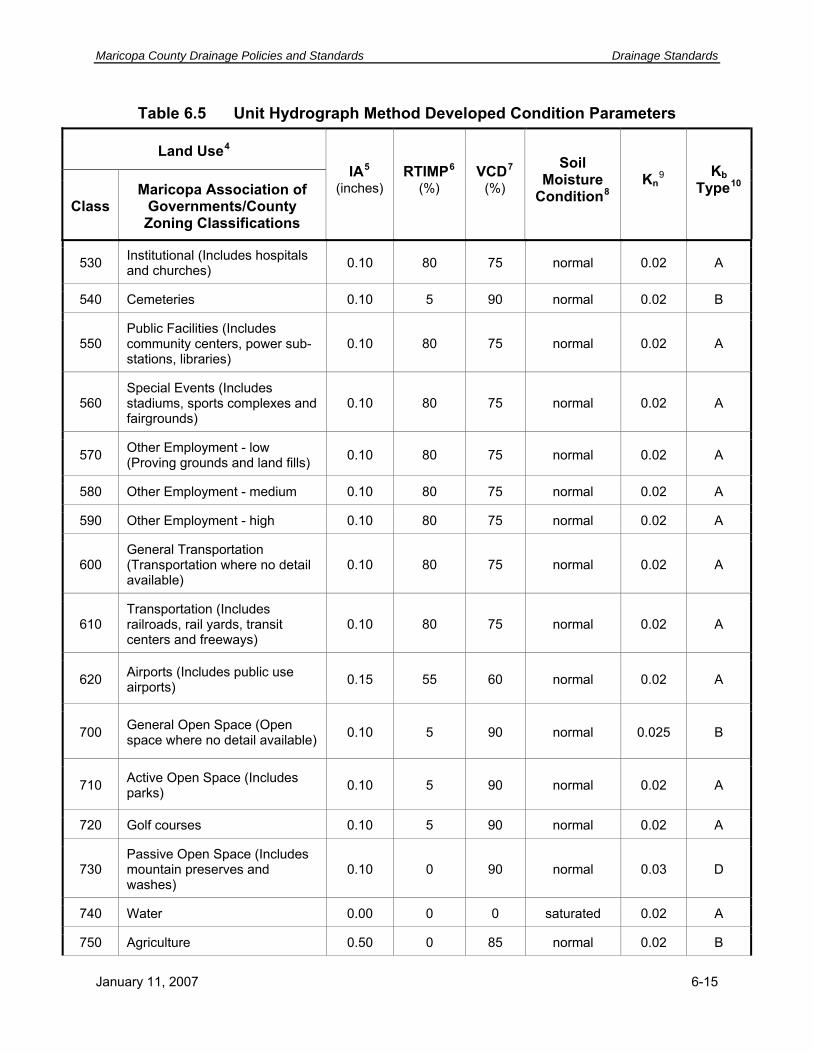
Maricopa County Drainage Policies and Standards Drainage Standards
Table 6.5 Unit Hydrograph Method Developed Condition Parameters
Land Use4
Class Maricopa Association of
Governments/County Zoning Classifications
IA5
(inches) RTIMP6
(%) VCD7
(%)
Soil Moisture
Condition8Kn
9 Kb Type10
530 Institutional (Includes hospitals and churches) 0.10 80 75 normal 0.02 A
540 Cemeteries 0.10 5 90 normal 0.02 B
550 Public Facilities (Includes community centers, power sub-stations, libraries)
0.10 80 75 normal 0.02 A
560 Special Events (Includes stadiums, sports complexes and fairgrounds)
0.10 80 75 normal 0.02 A
570 Other Employment - low (Proving grounds and land fills) 0.10 80 75 normal 0.02 A
580 Other Employment - medium 0.10 80 75 normal 0.02 A
590 Other Employment - high 0.10 80 75 normal 0.02 A
600 General Transportation (Transportation where no detail available)
0.10 80 75 normal 0.02 A
610 Transportation (Includes railroads, rail yards, transit centers and freeways)
0.10 80 75 normal 0.02 A
620 Airports (Includes public use airports) 0.15 55 60 normal 0.02 A
700 General Open Space (Open space where no detail available) 0.10 5 90 normal 0.025 B
710 Active Open Space (Includes parks) 0.10 5 90 normal 0.02 A
720 Golf courses 0.10 5 90 normal 0.02 A
730 Passive Open Space (Includes mountain preserves and washes)
0.10 0 90 normal 0.03 D
740 Water 0.00 0 0 saturated 0.02 A
750 Agriculture 0.50 0 85 normal 0.02 B
January 11, 2007 6-15

Drainage Standards Maricopa County Drainage Policies and Standards
Table 6.5 Unit Hydrograph Method Developed Condition Parameters
Land Use4
Class Maricopa Association of
Governments/County Zoning Classifications
IA5
(inches) RTIMP6
(%) VCD7
(%)
Soil Moisture
Condition8Kn
9 Kb Type10
810 Business Park (Includes enclosed industrial, office or retail)
0.10 80 75 normal 0.02 A
900 Open Space 0.35 0 25 dry 0.025 B
200011 Landscaping with impervious under treatment 0.10 95 30 normal 0.02 A
200111 Landscaping w/o impervious under treatment 0.20 0 30 normal 0.02 A
200211 Pavement and Rooftops 0.05 95 0 dry 0.015 A
200311 Gravel Vehicular travel lanes & Shoulders 0.10 5 0 dry 0.02 A
11 Assigned by the District
6-16 January 11, 2007

Maricopa County Drainage Policies and Standards Drainage Standards
Table 6.6 Unit Hydrograph Method Natural Condition Parameters
Land Use
Class Category
IA12 RTIMP13 VCD14Soil
Moisture Condition15
Kn16 Kb
Type17
NDR
Undeveloped Desert Rangeland. Little topographic relief, slopes <5%
0.40 0.44 0.48 0.50 0.02 B
NHS Hillslopes, Sonoran Desert. Moderate topographic relief, slopes >5%
0.55 0.61 0.66 0.69 0.03 C
NMT Mountain Terrain. High topographic relief, slopes >10%
0.80 0.88 0.95 0.95 0.05 D
12 Initial abstract, in inches 13 Percent impervious 14 Percent vegetation cover 15 For assigning a value of DTHETA 16 For use in the S-Graph Lag Equation 17 For use with the Clark Unit Hydrograph Time of Concentration Equation
January 11, 2007 6-17

Drainage Standards Maricopa County Drainage Policies and Standards
6.3.4 Hydrologic and Hydraulic Design Criteria
Standard 6.3.1 Design Criteria. The following peak discharge and storm frequency related design criteria are to be applied for the listed drainage features.
Table 6.7 Minimum Drainage Design Criteria
Peak Frequencies Drainage Feature
2-year through 50-year 100-year
STREETS
Criteria for Street with Curb and Gutter (longitudinal flow) common to all Street Classifications
For all storm frequencies up to and including the 100-year: 1. Channel and/or storm drain systems installed as needed to meet street
drainage criteria. 2. Historic drainage divides should be retained. Flows within existing streets
should follow historic drainage paths. 3. Runoff to be contained 12-inches below the finished floor of adjacent
buildings. 4. Qmax = 100 cfs. 5. Vmax = Refer to Standard 6.2.2.
Arterial/Major Collector/All-Weather Access Streets
10-year: One 12-foot dry driving lane maintained in each direction, and flow depths not to exceed curb height.
dmax vehicular travel lane = 6-inches
Minor Collector/Local Streets
10-year: Flow depths not to exceed curb height. dmax vehicular travel lane = 8-inches
6-18 January 11, 2007

Maricopa County Drainage Policies and Standards Drainage Standards
Table 6.7 Minimum Drainage Design Criteria
Peak Frequencies Drainage Feature
2-year through 50-year 100-year
For all storm frequencies up to and including the 100-year: 1. Historic drainage divides should be retained. Flows within existing streets
should follow historic drainage paths. 2. Runoff to be contained 12-inches below the finished floor of adjacent
buildings. Criteria for Street without Curb and Gutter (longitudinal flow) common to all Street Classifications
Runoff conveyed by channel with maximum water surface no greater than the lowest adjacent road subgrade or alternative design approved by County/District for the storm frequency listed below by street classification. Culvert outlet Vmax = 15 fps
Runoff to be conveyed by channel with maximum flow depth in vehicular travel lane as specified below by street classification.
Channel adjacent to Arterial/All-Weather Access streets
50-year frequency dmax vehicular travel lane = 6-inches
Channel adjacent to Collector streets 25-year frequency dmax vehicular travel lane = 6-inches
Channel adjacent to Local streets 10-year frequency dmax vehicular travel lane = 8-inches
January 11, 2007 6-19

Drainage Standards Maricopa County Drainage Policies and Standards
Table 6.7 Minimum Drainage Design Criteria
Peak Frequencies Drainage Feature
2-year through 50-year 100-year
CULVERTS AND BRIDGES
Criteria for Cross Road Culverts Common to all Street Classifications
Runoff to be conveyed by culvert with maximum water surface no greater than the lowest adjacent road subgrade or alternative design approved by County/District, for the storm frequency listed below by street classification. Culvert outlet Vmax = 15 fps
Runoff to be conveyed by culvert with maximum depth in vehicular travel lane as specified below by street classification. Culvert outlet Vmax = 15 fps. Where flow weirs over road, suitable erosion protection approved by County/District shall be provided.
Arterial/All-Weather Access streets. 50-year frequency dmax vehicular travel lane = 6-inches
Collector Streets 25-year frequency dmax vehicular travel lane = 6-inches
Local Streets 10-year frequency dmax vehicular travel lane = 8-inches
6-20 January 11, 2007

Maricopa County Drainage Policies and Standards Drainage Standards
Table 6.7 Minimum Drainage Design Criteria
Peak Frequencies Drainage Feature
2-year through 50-year 100-year
Bridges for all Street Classifications, including Pedestrian Bridges
Runoff to be conveyed under road with 2 foot freeboard below bridge low chord, with pier clogging factors per Standard 6.7.16.
N/A
LOW WATER CROSSINGS
Criteria for Low Water Crossings Common to all Street Classifications
For all storm frequencies up to and including the 100-year: Allowable for long areas of shallow or distributary flow where the County/District determines that construction of culverts is impractical, detrimental to public safety, or would result in adverse impacts to properties. Low water crossings shall have erosion protection as approved by County/District. If exceptions to the 100-year flow depth are approved by County/District, a flow monitoring-flooded roadway warning system together with road closure facilities shall be provided as required by County/District. No exceptions to the 100-year flow depth requirement for subdivision all-weather access street classifications will be granted. Vmax = Refer to Standard 6.2.2.
January 11, 2007 6-21

Drainage Standards Maricopa County Drainage Policies and Standards
Table 6.7 Minimum Drainage Design Criteria
Peak Frequencies Drainage Feature
2-year through 50-year 100-year
Arterial/Collector/All-Weather Access streets
NA dmax vehicular travel lane = 6-inches
Local streets N/A dmax vehicular travel lane = 8-inches
OPEN CHANNELS PARALLEL OR ADJACENT TO STREETS
Criteria for Open Channels Common to all Street Classifications
Runoff to be conveyed by open channel with maximum water surface no greater than the lowest adjacent road subgrade or alternative design approved by County/District, for the storm frequency listed below by street classification.
Runoff to be conveyed by open channel with maximum depth in vehicular travel lane as specified below by street classification. Channel design shall not result in adverse impacts to adjacent properties. Subject to freeboard requirements per Standard 6.8.7. Subject to flow regime requirements per Standard 6.8.3 (6).
Arterial/All-Weather Access streets. 50-year frequency dmax vehicular travel lane = 6-inches
Collector Streets 25-year frequency dmax vehicular travel lane = 6-inches
Local Streets 10-year frequency dmax vehicular travel lane = 8-inches
DELINEATED FLOODPLAINS - FEMA
It is the intent of the District that floodplains and floodways be delineated for areas meeting this criteria, and that those delineations be submitted to FEMA for approval. Delineations may be done by the District as funding permits. The Floodplain Administrator may elect to temporarily not submit a delineation to FEMA due to extenuating circumstances. The County will require a developer to delineate floodplains for areas that meet this criterion, and the District may require that the delineation be submitted to FEMA, particularly if lots or homes are proposed for construction within the defined flood hazard area. The District will only regulate floodplains that are identified on the District Flood Management Maps.
Requirement for Delineated Floodplain N/A
At a minimum, delineate floodplain for: 1. Q100 >= 500 cfs. 2. Watershed areas >= 1 sq. mi. 3. Developments meeting criteria 1 or 2 that are 5 acres in area or greater or will have 50 or more lots.
6-22 January 11, 2007

Maricopa County Drainage Policies and Standards Drainage Standards
Table 6.7 Minimum Drainage Design Criteria
Peak Frequencies Drainage Feature
2-year through 50-year 100-year
N/A
Delineate a Floodway where successive encroachments by development within the Delineated Floodplain may result in cumulative impacts, detrimental to public safety or property, to flood depths, velocities, erosion hazards or the uncertainty of distributary flow paths on adjacent, upstream or downstream properties.
Requirement for Delineated Floodway
Lowest floor elevation (for manufactured homes, see Section 4.3.7) to be a minimum of 1-foot above the Regulatory Flood Elevation (RFE). Note that to file a CLOMR-F with FEMA and remove the dwelling from the floodplain for flood insurance purposes, the grade adjacent to the dwelling must be at or above the Base Flood Elevation prior to construction.
Lowest floor elevation for dwellings within a floodplain delineated by FEMA.
N/A
DELINEATED FLOODPLAINS - NON-FEMA
The County may require that floodplains be delineated for areas meeting this criterion.
Requirement for Delineated Floodplain N/A
Q100 < 50 cfs, Flow depth <= 3-inches: Limits do not have to be delineated, but lowest floor requirements within a Non-FEMA Delineated Floodplain apply. Q100 >= 50 cfs or Watershed Area >= 0.25 sm: Floodplain limits and elevations are to be defined if required by the County as part of a subdivision and/or drainage review. Floodplains shall be delineated, and shown on the Grading and Drainage Plans, and the Final Plat, for: 1. Q100 >= 500 cfs. 2. Watershed areas >= 1 sq. mi. 3. Developments meeting criteria 1 or 2 that are 5 acres in area or greater or will have 50 or more lots.
January 11, 2007 6-23
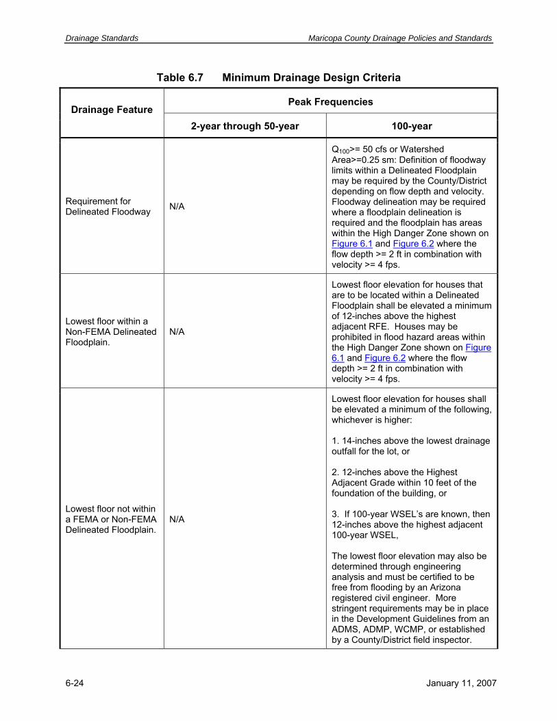
Drainage Standards Maricopa County Drainage Policies and Standards
Table 6.7 Minimum Drainage Design Criteria
Peak Frequencies Drainage Feature
2-year through 50-year 100-year
N/A
Q100>= 50 cfs or Watershed Area>=0.25 sm: Definition of floodway limits within a Delineated Floodplain may be required by the County/District depending on flow depth and velocity. Floodway delineation may be required where a floodplain delineation is required and the floodplain has areas within the High Danger Zone shown on Figure 6.1 and Figure 6.2 where the flow depth >= 2 ft in combination with velocity >= 4 fps.
Requirement for Delineated Floodway
Lowest floor within a Non-FEMA Delineated Floodplain.
N/A
Lowest floor elevation for houses that are to be located within a Delineated Floodplain shall be elevated a minimum of 12-inches above the highest adjacent RFE. Houses may be prohibited in flood hazard areas within the High Danger Zone shown on Figure 6.1 and Figure 6.2 where the flow depth >= 2 ft in combination with velocity >= 4 fps.
Lowest floor not within a FEMA or Non-FEMA Delineated Floodplain.
N/A
Lowest floor elevation for houses shall be elevated a minimum of the following, whichever is higher: 1. 14-inches above the lowest drainage outfall for the lot, or 2. 12-inches above the Highest Adjacent Grade within 10 feet of the foundation of the building, or 3. If 100-year WSEL’s are known, then 12-inches above the highest adjacent 100-year WSEL, The lowest floor elevation may also be determined through engineering analysis and must be certified to be free from flooding by an Arizona registered civil engineer. More stringent requirements may be in place in the Development Guidelines from an ADMS, ADMP, WCMP, or established by a County/District field inspector.
6-24 January 11, 2007

Maricopa County Drainage Policies and Standards Drainage Standards
Table 6.7 Minimum Drainage Design Criteria
Peak Frequencies Drainage Feature
2-year through 50-year 100-year
STORMWATER STORAGE BASINS
N/A 100-year 2-hour storm for determining stormwater storage volume. Retention Basin
Detention Basins are STRONGLY discouraged and may only be used if specified by an adopted ADMP/WCMP or with special approval by the County Drainage Review Board or the District Board of Directors.
2-, 10- and 50-year peak discharge: Qpost reduced to < Qpre
Qpost reduced to < Qpre
6.4 STORMWATER QUALITY
The following minimum standards will be utilized for protection of stormwater quality in Maricopa County.
Standard 6.4.1 First Flush. Discharges into a structure owned or operated by the District must comply with Policy 3.6.6 First Flush, and County-wide all discharges may be required to meet the First Flush requirements of Policy 3.6.6 by providing stormwater runoff control (Policy 3.11.1). The First Flush requirement can be addressed by retaining the required minimum First Flush volume, treating the first flush discharge, or utilizing a combination of both approaches.
The minimum First Flush volume is calculated as follows:
VFF C P12------A= (6.1)
where:
VFF = minimum First Flush volume in ac-ft, C = runoff coefficient (set = 1), P = first 0.5 inches of direct runoff, and A = area of project site, in acres.
January 11, 2007 6-25
Drainage Standards Maricopa County Drainage Policies and Standards
The minimum First Flush treatment discharge is calculated as follows:
QFF CIA= (6.2)
where:
QFF = minimum First Flush discharge in cfs, C = runoff coefficient (set =1),
I = 0.5 inches/hour rainfall excess intensity (0.5 inches of direct runoff in 1st hour), and A = area of project site, in acres. Example: Calculate the volume for a stormwater storage basin that must be constructed to capture the first flush from a commercial site with 100 acres of developed area. Also calculate the discharge that must be treated if the storage option is not selected.
VFF = 1.0*(0.5/12 ft)*100 acres
VFF = 4.17 ac-ft
QFF = 1.0*(0.5 in/hr)*100 acres
QFF = 50 cfs.
6.5 STREET DRAINAGE
The conveyance of stormwater in a roadway is influenced by the typical roadway cross-section, cross-slope, longitudinal slope and roadway material. The following are standards to be used in the evaluation of roadway conveyance:
Standard 6.5.1 Construction Plans. Construction plans for street drainage improvements are to meet the requirements of Section 6.15 and the MCDOT Roadway Design Manual.
Standard 6.5.2 Building Finished Floor Elevations. Refer to Table 6.7, Section 5.2 and Section 5.3.
Standard 6.5.3 Sizing Inlets and Laterals. Runoff calculations for the sizing of inlets and lateral connection pipes shall be based on acceptable hydrologic criteria.
Standard 6.5.4 Manning’s n-value. A Manning’s n-value of 0.015 shall be used for paved street flow unless special conditions exist.
Standard 6.5.5 Inverted Crowns. The use of inverted crown roadways is not permitted within County/District right-of-way.
Standard 6.5.6 Valley Gutters. Valley gutters will only be allowed between intersections on local streets. The minimum slope for valley gutters shall be as defined in the MCDOT Roadway Design Manual.
6-26 January 11, 2007

Maricopa County Drainage Policies and Standards Drainage Standards
Standard 6.5.7 Curb Return Gutter Slope. Curb return gutters shall have a minimum slope of 0.0025 feet of fall for every 1.0 feet of gutter length.
Standard 6.5.8 Maximum Flow Depth in Street Sections. Refer to Table 6.7.
Standard 6.5.9 Maximum Catch Basin Spacing. For arterial, collector streets and all-weather access streets, the maximum distance that drainage may be carried in the street is based on maintaining a 12-foot dry lane in each direction for the 10-year event, and 10-year peak flow depths shall not exceed the top-of-curb for local streets.
Standard 6.5.10 On-Grade Catch Basins. Catch basins constructed on a continuous grade are generally not required to intercept 100% of the design flow. Such catch basins shall be designed to meet the requirements of Standard 6.5.9. 100% interception of the design flow may be required at intersections.
Standard 6.5.11 Maximum Catch Basin Curb Opening Height. The curb opening for a catch basin shall not be greater than 6-inches in height.
Standard 6.5.12 Inlet Grate Types. The use of grated catch basins is discouraged within street sections. If a grated catch basin is used within a street section, only those grate types with bars transverse to traffic, or reticuline types, are acceptable. The reduction factors, as identified in Table 6.8, shall be applied to the specified variable to obtain the interception capacity used for design.
January 11, 2007 6-27

Drainage Standards Maricopa County Drainage Policies and Standards
Table 6.8 Catch Basin Clogging Factors
Condition Inlet Type Clogging Factor
Sump Curb Opening18 1.25L
Sump Grate19, 20 2.0P
Sump Combination21 1.25L and 2.0P
Continuous Grade Curb Opening22 1.25Lt
Continuous Grade Longitudinal Bar Grate23
Longitudinal Bar Grate with recessed transverse bars23 Longitudinal Bar Grate with transverse bars23 Reticuline Grate23
0.75Rf and 1.25L
0.60Rf and 1.5L 0.40Rf and 2.0L
0.35Rf and 2.25L
Combination 24 Apply factor 1.25Lt to curb opening only
Continuous Grade
Shallow Sheet Flow 25 Slotted Drains26 1.25L
18 Applied to total length, L, per Example 5 in Chapter 3 of Hydraulics volume 19 Grated inlets in sump condition should be avoided whenever possible. 20 Applied to total grate perimeter, P, per Example 6 in Chapter 3 of Hydraulics volume 21 Apply clogging factors to both curb opening and grate 22 Applied to Lt per Example 2 in Chapter 3 of Hydraulics volume 23 Applied to Rf and L per Example 3 in Chapter 3 of Hydraulics volume 24 Applied to Lt per Example 4 in Chapter 3 of Hydraulics volume 25 Slotted drains are most effective for shallow sheet flow conditions or sumps. With greater depths and flows, a different type of inlet should be used. 26 Applied to total length of slotted drain. Slotted drains are most effective for shallow sheet flow
conditions. With greater depths and flows, a different type of inlet should be used.
6-28 January 11, 2007

Maricopa County Drainage Policies and Standards Drainage Standards
6.6 STORM DRAINS
The following minimum standards including the requirements in Table 6.9 are to be met for the design of storm drains that will be placed into the MCDOT or District maintenance systems:
Standard 6.6.1 Construction Standards. The MAG Standards shall be used for construction of storm drain systems. ADOT Standards may be used for items not covered by the MAG Standards.
Standard 6.6.2 Pipe Selection Requirements. The selection of pipe materials for storm drains shall be done in conformance with the MCDOT Roadway Design Manual. Minimum cover requirements may also be per the manufacturer’s specifications, at the discretion of the design engineer. ADOT (1996) methods may also be used, with prior approval by County/District. The District requires that storm drain pipes constructed within District right-of-way be reinforced concrete.
Standard 6.6.3 Flow Velocity. Storm drains with flow velocities less than 3 fps for 0.5 x Qdesign, less than 5 fps for Qdesign, or in excess of 15 fps shall require prior approval by County/District.
Standard 6.6.4 Storm Drain Profiles. Storm drain pipes and manholes shall be shown in profile along with existing and proposed grades. Catch basin and connector pipe profiles shall be provided in the design drawings. The pipe slope to four significant figures and the pipe size shall be shown. All existing and proposed utilities crossing over and under the proposed storm drain shall be shown to scale at their actual location and elevation. Clearance with utilities shall be a minimum of 1 foot (horizontal & vertical) except for Salt River Project utilities that require a minimum of 2 feet clearance horizontally and 1 foot vertically. The information provided in profile format shall include: pipe stationing, pipe size, pipe discharge (Q), pipe velocity, pipe material, hydraulic grade line, energy grade line, gutter flowline, inlet locations, and finish grade over pipe. Where alternative pipe materials are allowable, the design information for each pipe material type shall be included. See Section 6.15 and the MCDOT Roadway Design Manual for construction plan requirements.
January 11, 2007 6-29

Drainage Standards Maricopa County Drainage Policies and Standards
Table 6.9 Storm Drain Hydraulic Design Standards
Design Variable Design Standard
5 fps for Qdesign The lesser of 3 fps for 0.5 x Qdesign or 3 fps at
flow depth = 1’ Minimum Velocity.
Maximum Velocity. 15 fps
Minimum Pipe Size. Main Line
Lateral and Connectors 18-inches 15-inches
Pipe Diameter Changes. The elevation of pipe crowns, not inverts, are to be matched at manholes and structures.
Maximum Distance to First Catch Basin.
10-year storm frequency: Maintain one 12-foot lane in each direction for Arterial, Collector and
All-weather Access Streets. 10-year peak discharge flow depth shall not exceed the top-
of-curb for Local streets.
Manhole Spacing (SD = Storm Drain Diameter).
< 30 inches SD (straight) = 330 feet max 33-45 inches SD = 440 feet max 48-84 inches SD = 660 feet max >84 inches SD = 1,320 feet max
Maximum Hydraulic Grade Line Elevation, Qdesign. Shall not be higher than 12 inches below inlet
gutter flowline elevation
Maximum Energy Grade Line Elevation, Qdesign. Shall not exceed gutter flowline elevation
Manning’s n-values. Reinforced Concrete Pipe (RCP) Corrugated Metal Pipe-(CMP) Concrete Lined
Standard 6.6.5 Hydraulic and Energy Grade Lines. Storm drain systems shall be designed for Qdesign so that the hydraulic grade line is at least 12 inches below the inlet gutter flowline elevation, and the energy grade line shall not exceed the elevation of the gutter flowline. Hydraulic and energy grade line information for all main line and connector storm drain pipes shall be prepared by the design engineer and submitted to the County/District for approval.
Standard 6.6.6 Tabular Information Requirement. The information provided in tabular format in the drainage design report shall include: pipe stationing, pipe size, pipe discharge (Q), pipe velocity, pipe material, hydraulic grade line, energy grade line, inlet locations, finish grade over pipe, gutter flowline and inlet elevations.
Corrugated Metal Pipe (CMP), connector pipes only High-Density Polyethylene Pipe (HDPE) Cast-In-Place-Pipe (CIPP). Increase minimum size required for hydraulics by 6-inches.
0.013 0.013 0.024 0.013 0.013
6-30 January 11, 2007

Maricopa County Drainage Policies and Standards Drainage Standards
Standard 6.6.7 Soil Boring Requirements. Soil boring logs shall be provided with the design documentation for all storm drains within a proposed right-of-way or easement. Procedures other than those listed herein require administrative County/District approval. Storm drains less than 660 feet in length shall have at least one soil boring. Storm drains longer than 660 feet shall have multiple borings at intervals not to exceed 1,320 feet. Boring depth shall be a minimum of 5 feet below the pipe invert. If cemented or rock material is encountered during drilling which results in refusal, then a rock core shall be taken to identify the type and extent of refusal to 2 feet below proposed pipe invert. Borings will be located in plan and tied to the same datum as the proposed project. Resistivity and pH testing of the soils shall be required to support pipe design in terms of material selection. If resistivity readings fall below 1500 ohms per cubic centimeter, additional readings shall be made at intervals of not less than 25 feet or more than 100 feet until the area of low resistance soil is fully defined. Boring log data shall include the following information.
1. The name of the company that produced the soil report.
2. The date the test boring was made.
3. The type of equipment used to drill the hole and take the samples.
4. The size of the auger used.
5. A description of caving that occurred during the excavation, if any.
6. Horizons of each type of soil encountered.
7. Description of the soil.
8. Classifications by the Unified Soil Classification System.
9. Plasticity index.
10. Percent passing No. 200 sieve.
11. Water encountered.
12. Pavement structure (A.C. thickness, sub-base thickness, if applicable).
13. Relative moisture content (specify depth taken).
14. Representative unit weight of native material (specify depth taken)
15. Laboratory calculated optimum moisture content.
16. Resistivity and pH readings.
Standard 6.6.8 Storm Drain Junctions.
1. Junctions for storm drains shall be prefabricated “T”s, manholes, or designed junction structures. Connection to an existing storm drain shall be per an approved detail.
January 11, 2007 6-31

Drainage Standards Maricopa County Drainage Policies and Standards
2. Manholes are required at, or immediately next to, all storm drain pipe size changes and junctions.
Standard 6.6.9 Storm Drain Connector Pipes
1. Opposing connector pipes, except at manholes or junction structures, shall be offset a minimum of 5 feet horizontally as measured from the centerline of each pipe.
2. Prefabricated pipe fittings are to be used on all connections to the main storm drains where a new main is being installed and the connection is not at a manhole location.
3. On projects where the storm drain main is existing, connections are to be made with an approved detail.
Standard 6.6.10 Horizontal and Vertical Deflections.
1. Alignment changes using joint deflections shall be allowed only using joint deflections within the pipe manufacturer’s specified tolerances. When pipe alignment changes are to be made by deflecting pipe joints, the maximum deflection per joint shall be noted on the construction plans.
2. Manholes are required at all horizontal angle points where the total deflection angle exceeds the manufacturers tolerances for a single joint. If the alignment change is accomplished with a pipe fitting or poured collar, a manhole is required immediately upstream or downstream of the bend.
3. Manholes are required at all vertical grade breaks of a storm drain.
4. Concrete pipe collars may be used to create vertical bends on connector pipes.
Standard 6.6.11 Right-of-Way Width Requirement. A county-owned property, dedicated right-of-way, or privately owned drainage tract/easement shall be a minimum of 16 feet wide for underground storm drains if not under a designated road right-of-way. A greater width may be
Additional standards pertaining to Storm Drains are listed in Section 6.2, Public Safety.
6.7 CULVERTS AND BRIDGES
Bridges are defined as structures designed to span a watercourse, including bridges for vehicular roadways and pedestrian-only uses. Culverts are buried pipe or box hydraulic conveyance structures designed to convey stormwater from one side of a roadway, embankment, or service area to the other side. The following minimum standards are to be employed in the design of culverts and bridges that will be placed into the MCDOT or District maintenance systems:
Standard 6.7.1 Requirement to Provide Culverts or Bridges. Except where low water crossings are allowed as specified in Table 6.7, watercourses found to meet the following conditions are to be culverted or bridged,:
6-32 January 11, 2007

Maricopa County Drainage Policies and Standards Drainage Standards
1. A watercourse with a 100-year peak discharge of 25 cfs or greater,
2. A watercourse that is a regulatory area designated as “Waters of the United States” under Section 404 of the Clean Water Act (refer to Section 4.4), or
3. As necessary in order to preserve natural flow patterns and prevent adverse impacts on adjacent, upstream and downstream properties.
Standard 6.7.2 Construction Plans. Construction plans for culvert and bridge drainage improvements are to meet the requirements of Section 6.15 and the MCDOT Roadway Design Manual.
Standard 6.7.3 Pipe Selection Requirements. The selection of pipe materials and section type for culverts shall be done in conformance with the requirements of the MCDOT Roadway Design Manual.
Standard 6.7.4 Design Storms. Culverts are to be designed to convey, as a minimum, the storm frequency peak discharge listed below by street classification with no flow crossing over the roadway and the ponded water surface elevation shall not exceed the lowest adjacent roadway subgrade elevation unless an alternative design is approved by County/District.
Arterial and All-Weather Access Streets: 50-year storm frequency
Collector Streets: 25-year storm frequency.
Local Streets: 10-year storm frequency.
Refer to Table 6.7 for flow depth requirements.
Standard 6.7.5 Ponding Outside of Right-of-Way. Backwater ponding limits that extend outside of the roadway right-of-way shall be delineated and a drainage easement or right-of-way obtained from the property owner. Drainage easements shall be recorded and attached to the deed for the property.
Standard 6.7.6 Low Water Crossings. Low water crossings and dip sections are not allowed without approval in writing by the County/District. Refer to the requirements in Table 6.7.
Standard 6.7.7 Headwall Requirements. Headwalls are required at the inlet and outlet of all culvert installations unless otherwise approved by the County/District. Pipe sizes of 30-inch or greater have concrete headwalls. Pipe sizes less than 30-inch shall have concrete headwalls if trash racks are required to comply with requirements specified in Table 6.1. Otherwise, pipe sizes less than 30-inch shall have flared end sections or concrete/masonry headwalls.
Standard 6.7.8 Minimum Pipe Diameter. Refer to the MCDOT Roadway Design Manual for minimum required pipe diameters for County-maintained culverts.
January 11, 2007 6-33

Drainage Standards Maricopa County Drainage Policies and Standards
Standard 6.7.9 Maintenance Access. Ramped, vehicular access for maintenance is required at the upstream and downstream ends of all culverts that are not accessible from the roadway. The maintenance access route shall be within public right-of-way or a County approved easement.
A county-owned property, right-of-way, or privately-owned drainage tract or easement shall be provided for the area inundated by backwater from the culverts for the peak 100-year event. The 100-year floodplain limits shall be delineated and shown on the subdivision Final Plat or Map of Dedication.
Standard 6.7.10 Velocity Requirements.
1. Design velocity requirements shall conform with those specified in Table 6.9.
2. Culverts are to be designed with consideration to the guidelines presented in the Culverts and Bridges, and Sedimentation chapters in the Hydraulics volume.
3. The culvert shall be designed so minimum velocities facilitate sediment transport to keep the culvert clean.
4. The maximum velocity in the culvert should be consistent with channel stability requirements at the culvert outlet. Aggradation or degradation at culvert crossings must be examined in the design of culverts.
Standard 6.7.11 Outlet Protection Requirements. Culvert outlet requirements shall conform with the requirements set forth in Table 6.10. The size, depth, and lateral extent of outlet protection, including energy dissipaters, shall be designed in conformance with the Culvert and Bridges, and the Hydraulic Structures, chapters of the Hydraulics volume.
Standard 6.7.12 Cut-off Wall Requirements. Culverts with headwalls shall have cut-off walls where dictated by scour depth. If cut-off walls are determined to be necessary, then minimum cut-off wall depths shall be as indicated in Error! Reference source not found.. For pipes larger than 24 inches, cut-off wall depth shall be dictated by the greater of the depth shown in the table or that depth calculated using the depth of scour equation identified in the Culvert and Bridges chapter of the Hydraulics volume.
6-34 January 11, 2007

Maricopa County Drainage Policies and Standards Drainage Standards
Table 6.10 Design Criteria for Culvert Outlets
Outlet Protection Natural Channel Artificial Channel
Up to 1.3 times existing channel velocity
Up to maximum allowable velocity for channel lining
None
1.3 to 2.5 times existing channel velocity
1.0 to 2.5 times allowable channel lining velocity
Riprap or other suitable transition apron
Velocities greater than 2.5 times existing channel velocity Energy Dissipater
Velocities greater than 2.5 times allowable channel lining velocity
Table 6.11 Design Criteria for Culvert Cut-off Walls
MAG Standard Pipe Diameter
Minimum Inlet & Outlet Cutoff Wall
Depth (feet)
24” to 42” 2.0
42” to 84” 4.0
Standard 6.7.13 Bridge Freeboard Requirements. Bridges shall be designed to have a minimum freeboard of 2 feet below the low chord elevation for the 100-year event.
Standard 6.7.14 Bridge Debris Allowance. The structural design of the bridge shall take into account the possibility of debris and/or flows impacting the bridge. Design hydraulic modeling of bridges shall reflect piers as twice their design width or 1 foot on each side, whichever is greater.
Standard 6.7.15 Bridge Design Erosion Requirements. Bridges crossing undisturbed watercourses with designated erosion setbacks shall span the lateral migration erosion hazard zone. Alternatively, if structural erosion protection is proposed, a comprehensive sediment transport analysis that assesses sediment transport in time and space (i.e. dynamic modeling consistent with 3 tier analyses identified in Chapter 11 of the Hydraulics volume) shall be undertaken to support the design and show that there are no adverse impacts to adjacent properties. The study may also be required to show that use of a similar design for other potential future crossings within limits of a study reach established by the District do not result in cumulative adverse impacts within the study reach.
January 11, 2007 6-35

Drainage Standards Maricopa County Drainage Policies and Standards
Standard 6.7.16 Supercritical Flow Requirements.
1. For channels functioning in a supercritical flow regime for the design discharge, there shall be no reduction in cross sectional area at bridges or culverts, or any obstructions (including bridge piers) in the flow path, up to the maximum practical span for the structure type as approved by MCDOT. For cases where bridge piers must be constructed because of maximum practical span considerations, piers shall be placed in the areas of lowest velocity whenever possible.
2. Bridge freeboard below the low chord elevation shall be the greater of 2 feet or the
computed velocity head (4.64
2V) for channel velocities.
Additional standards pertaining to culvert and bridges are listed in Section 6.2, Public Safety.
6.8 OPEN CHANNELS
The following minimum standards will be employed in all designs of engineered open channels (does not apply to undisturbed drainageways):
Standard 6.8.1 Construction Plans. Construction plans for open channel drainage improvements are to meet the requirements of Section 6.15.
Standard 6.8.2 Floodplain Encroachment Requirements.
1. All channelization and/or floodplain encroachments within FEMA mapped floodplains must be designed so that the cumulative effect of all new development the channel serves does not raise the 100-year water surface (or energy grade line for supercritical flow) more than 1 foot. In addition, when determining encroachments of fill or other development, the “equal conveyance from both sides of channel” rule shall apply. The 1 foot rise in water surface may not come from one side of the channel at the expense of the adjacent property owner. In the event that the 1 foot rise criteria will be exceeded, the protection levees necessary shall be designed and constructed in accordance with, and certified to meet, FEMA and District criteria. A government agency shall also agree in writing to maintain the levee system.
2. Encroachment and/or stabilization on one bank may result in increased erosion potential on the opposite bank. Such adverse effects shall be evaluated and mitigated as a part of the design.
Standard 6.8.3 Channel Lining Requirements.
1. Concrete and pneumatically placed concrete lined channels shall be evaluated for the need for continuous reinforcement extending both longitudinally and transversely.
6-36 January 11, 2007

Maricopa County Drainage Policies and Standards Drainage Standards
Pneumatically placed concrete channels are to be designed to the same structural integrity as concrete channels.
2. All sloping and flat concrete, pneumatically placed concrete, and soil cement finished surfaces shall have roughened surfaces (e.g. embedded rock, grooves, etc.) to discourage inappropriate recreational use, or be fenced appropriately.
3. The lining for channel bottoms that will require maintenance vehicle access must be designed for a minimum of 18 kip axle loads assuming one loading per week for the design life of the channel.
4. The minimum thickness of riprap linings shall be the greater of d100 or 2.0 times d50. Refer to the Hydraulics volume for determining stone size requirements. The recommended maximum stone size is 2 times the d50 and the recommended minimum size is one third of the d50, or 6-inches, whichever is greater.
5. All stones composing the riprap should have a specific gravity equal to or exceeding 2.4, following the standard test ASTM C127 and must be angular when not grouted or enclosed in wire-tied or gabion baskets.
6. Due to erosion and scour of erodible channels and safety concerns with excessively high velocities, the recommended upper limit of Froude Number (Fr) shall be 2.0. The limiting Froude Number for all types of channel linings designed for the subcritical flow regime shall be Fr < 0.86. For concrete, soil cement, and pneumatically placed concrete lined channels designed to function in the supercritical flow regime, the additional range of 1.13<Fr<2.0 is allowed, provided a sediment analysis is approved that substantiates that sediment loading will not change the flow regime from supercritical to subcritical. At locations where there are to be planned hydraulic jumps, concrete, soil cement, and pneumatically placed concrete lined channels may pass through 0.86>Fr<1.13. No other linings may be used in channels that fall in the Froude number range of 1.13 to 2.0. A 100-year floodplain delineation based on subcritical conditions will be required if a channel designed to be supercritical may change flow regimes unpredictably due to sedimentation issues and flow will exceed the channel banks for the subcritical condition.
7. Earthen bottom channels with lined side slopes buried below the depth of expected total scour are allowed with supporting engineering justification including sediment transport analysis, scour analysis, soil boring logs, and long term watershed yield analysis to support equilibrium longitudinal slopes. Riprap, gabions, soil cement, structural concrete or pneumatically placed concrete may be used to line side slopes.
8. Gabions are not allowed on channel bottoms used for vehicular maintenance access or bed load conveyance except at grade control, drop structures, or similar hydraulic structures.
Standard 6.8.4 Design Technical Guidelines. Channels shall be designed consistent with the guidelines provided in the Open Channels, Friction Losses in Open Channels, and Sedimentation chapters of the Hydraulics volume.
January 11, 2007 6-37

Drainage Standards Maricopa County Drainage Policies and Standards
Standard 6.8.5 Maximum channel velocities will be governed by the following tables:
Table 6.12 Maximum Permissible Velocities for Unlined Channels
(USDOT, FHWA, 1961 and 1983)
Soils Type of Lining (Earth, No Vegetation)
Maximum Permissible Velocity (1), ft/s
Fine Sand (noncolloidal) 2.5
Sandy Loam (noncolloidal) 2.5
Silt Loam (noncolloidal) 3.0
Ordinary Firm Loam 3.5
Fine Gravel 5.0
Stiff Clay (very colloidal) 5.0
Graded, Loam to Cobbles (noncolloidal) 5.0
Graded, Silt to Cobbles (noncolloidal) 5.5
Alluvial Silts (noncolloidal) 3.5
Alluvial Silts (colloidal) 5.0
Coarse Gravel (noncolloidal) 6.0
Cobbles and Shingles 5.5
Shales and Hard Pans 6.0
(1) For sinuous channels multiply permissible velocity by: 0.95 for slightly sinuous; 0.90 for moderately sinuous; and 0.80 for highly sinuous.
6-38 January 11, 2007

Maricopa County Drainage Policies and Standards Drainage Standards
Table 6.13 Maximum Permissible Velocities for Grass-Lined Channels
Channels with Uniform Stand of Various Grass Cover and Well Maintained (1) (2)
(Adapted from USDOT, FHWA 1961 and 1983)
Cover Maximum Permissible Velocity, fps
Bermuda Grass 6.0
Desert Salt Grass and Vine Mesquite 5.0
Lehman Lovegrass, Big Galleta, Purple Threeawn, Sand Dropseed 3.5
(1) Use velocities over 5 fps only where good covers and proper maintenance can be obtained. (2) Grass is accepted only if an irrigation system is provided.
Table 6.14 Criteria for Artificial Channels
Maximum Side Slope,
H:V (%) Maximum Velocity, fps (2) Type of Channel Lining (1)
Structural Concrete Vertical 15
1.5:1 (67%) (7) 10 Pneumatically Placed Concrete (3)
2:1 (50%) 7(4) Soil Cement
Riprap 3:1 (33%) 9(5)
2:1 (50%) 9(5) Grouted Riprap
(6) 9(5) Gabion Baskets
Grass (irrigated & maintained) 4:1 (16%) 2.5 to 6.0
Earth 6:1 (25%) 2.5 to 6.0
January 11, 2007 6-39

Drainage Standards Maricopa County Drainage Policies and Standards
Table 6.14 Criteria for Artificial Channels
Type of Channel Lining (1) Maximum
Side Slope, H:V (%)
Maximum Velocity, fps (2)
(1) The values in this table are for channel sections with the same lining material for bottom and sides. For conditions where the bottoms and sides of the channels are different, the most critical applicable criteria are to be used. (2) Maximum velocities listed for erodible linings are to be checked in each design to assure that erosion will not occur. (3) Pneumatically Placed Concrete is allowed, but must be reinforced per a structural concrete design. Fiberglass reinforcement may be used with supporting design calculations. (4) Higher velocities for soil cement lined channels/drop structures are acceptable upon submittal of a geotechnical analysis that assesses the suitability of the in-situ materials for soil cement applications and presents cement mixture specifications for the in-situ soils for the proposed maximum design velocities. The submittal shall be sealed and signed by a PE. Velocities greater than 15 fps are not recommended. Energy dissipaters may be required. (5) Guideline only. Strict limits have not been set because this manual recommends that these channels be designed for subcritical flow. (6) Per manufacturer’s specifications. (7) Channel side slope shall not exceed the soil natural angle of repose. Note: The criteria listed in this table are boundary values. The designer is responsible for determining the adequacy of criteria for each specific application. For design of lining materials, analyses of soil conditions and subsurface drainage may be required.
Standard 6.8.6 Curved Channel Radius Requirement. For channels with Froude Numbers less than 0.86, the ratio of the channel radius, rc, (at the centerline) to the design width of the water surface shall be greater than 3.0.
Standard 6.8.7 Freeboard Requirements.
1. Required freeboard is computed according to the following formula:
(6.3)
where:
FB 0.25 Y V2
2g------+⎝ ⎠
⎛ ⎞=
FB = freeboard in feet, Y = depth of flow in feet, V = velocity of flow in ft/s; and g = acceleration due to gravity in ft/s2.
2. The minimum freeboard value for rigid channels shall be 1 foot for subcritical and 2 feet
for supercritical flows. The freeboard requirements are to be added to the superelevated water surface elevation at channel bends for both subcritical and supercritical flow conditions. Using a smaller freeboard in specific cases requires prior approval. Freeboard exceeding the minimum standard is strongly recommended in undeveloped or developing areas.
6-40 January 11, 2007

Maricopa County Drainage Policies and Standards Drainage Standards
3. Levees, although strongly discouraged, must meet FEMA and USACE freeboard requirements as a minimum.
4. In all FEMA jurisdictional floodplains, the greater of the above equation or FEMA’s freeboard requirement shall prevail for design use.
5. Every constructed channel that is capable of supporting vegetation growth is to be designed for an appropriate range of n-values in conjunction with an approved vegetation maintenance plan. The procedures in Chapter 7, Friction Losses in Open Channels, of the Hydraulics volume shall be followed. The maintenance plan shall include an agreement, approved by the County/District, for perpetual maintenance of the channel. If this is not feasible, then additional freeboard shall be required. For this case, standard freeboard requirements shall be added to the water surface elevation for the design storm hydraulics computed using the expected worst-case roughness condition assuming no on-going maintenance of vegetation..
Standard 6.8.8 Minimum Easement Width Requirement for Constructed Channels. A dedicated right-of-way, or privately owned drainage tract shall be a minimum of the top width of an appropriately sized open channel plus 2 feet contiguous on both sides. If vehicular maintenance access is not provided within the channel bottom, add 16 feet of width to the top on one side.
Standard 6.8.9 Minimum Landscape and Maintenance Guidelines. Landscaping and revegetation must not impede access for maintenance. The vegetation must comply with the design intent of the channel in terms of conveyance and freeboard. Landscaped channels must be designed using minimum and maximum expected n-values for the interval between maintenance operations, with minimum freeboard as specified above.
Additional standards pertaining to open channels are listed in Section 6.2, Safety.
6.9 HYDRAULIC STRUCTURES
The following minimum standards will be utilized in the design of hydraulic structures:
Standard 6.9.1 Construction Plans. Construction plans for hydraulic structure drainage improvements are to meet the requirements of Section 6.15.
Standard 6.9.2 Trash Rack Clogging Factor Requirement. A minimum clogging factor of 50 percent shall be used in the hydraulic analysis of all trash racks.
Standard 6.9.3 Drop Structure Requirements.
1. Hydraulic jump analyses shall be conducted for the 2-, 10-, and-100-year peak discharges, since flow characteristics at the drop vary with discharge. These analyses are to be used to support the design of the structure and erosion control measures.
January 11, 2007 6-41

Drainage Standards Maricopa County Drainage Policies and Standards
2. Drop structures having loose riprap on a sloping face are discouraged for private development and prohibited within District right-of-way due to a high failure rate and excessive maintenance costs.
3. Open channels are recommended in lieu of pipes for conveyance of low flows through drop structures. Pipes may plug or frequently overtop, leading to additional maintenance problems. Pipes, if approved for conveying low flows through drop structures, should be no smaller than 24 inches in diameter.
Standard 6.9.4 Aesthetic Treatment Requirement. Where hydraulic structures are located within or adjacent to undisturbed or naturalistic drainageways, the structures should have aesthetic treatment to match the surroundings. Trash racks should have an exterior color to match the surrounding native soil.
Standard 6.9.5 Levees. The use of levees is strongly discouraged and must be approved in concept by County/District prior to beginning design. Levees shall be designed to meet FEMA and USACE requirements for certification by both agencies.
Additional standards pertaining to hydraulic structures are listed in Section 6.2, Public Safety.
6.10 STORMWATER STORAGE
The analysis and design of stormwater storage facilities shall be to the following minimum standards:
Standard 6.10.1 Construction Plans. Construction plans for stormwater storage drainage improvements are to meet the requirements of Section 6.15 and the DDM (all three volumes).
Standard 6.10.2 Minimum Design Storm. All new developments, regardless of lot size, shall make provisions to retain the stormwater runoff from a 100-year, 2-hour duration storm falling within its boundaries. On-lot retention is permitted (but not encouraged) only if the lots are greater than one (1) acre in gross area. On-lot retention is not permitted for lots less than one (1) acre in gross area.
Standard 6.10.3 Sediment Storage Requirement. Sedimentation basins, which may be required, are to be located at the upstream (inlet) portions of stormwater storage facilities. The sediment settling basins shall be easily accessible by maintenance equipment (such as backhoes) and should have a minimum storage volume equivalent to the 2-year watershed sediment yield, in addition to the 100-year, 2-hour stormwater runoff volume required for the stormwater retention basin.
Standard 6.10.4 Detention Basin Requirements. The use of a detention basin in lieu of a retention basin is not allowed without an approved variance in accordance with the Drainage Regulations. In the special case when a variance from the requirement to retain the 100-year 2-hour runoff volume is approved, the stormwater quality requirements must still be met. In addition, post-development peak discharges may not exceed pre-development peak discharges
6-42 January 11, 2007

Maricopa County Drainage Policies and Standards Drainage Standards
for the 2-, 10-, 50-, and 100-year storm events for the design of detention basins. First flush water quality criteria per Policy 3.6.6 requirements must be met. Possible special cases where detention basins may be considered are as follows:
1. A major drainageway or watercourse is available to accept runoff from the subject site that has sufficient hydraulic capacity to safely convey the 100-year pre-development peak discharge. To be approved: 1) watershed timing issues must be studied and determined to not be an issue for downstream properties, 2) system sediment balance must not be significantly affected, and 3) cumulative impacts of applying such a policy throughout the watershed must not be detrimental to public safety or property.
2. An approved Area Drainage Master Plan for the area states application of detention basins is acceptable.
3. Riparian vegetation in a downstream watercourse would be adversely affected by application of the retention basin policy.
Standard 6.10.5 Retention Volume Calculations. Retention basin volume calculation shall be by the following equation:
V C P12------⎝ ⎠⎛ ⎞A= (6.4)
where:
V = calculated volume in acre-feet, C = Runoff coefficient (see Section 6.3.2), P = 100-year, 2-hour rainfall depth in inches; and A = drainage area in acres.
Standard 6.10.6 Retention Basin Design Requirements.
1. Depth. Stormwater retention basins should typically have a maximum water depth of 3 feet for the 100-year, 2-hour storm event. Deeper water depths for the design event should address safety issues. Refer to Section 6.2 and the Hydraulics volume.
2. Adjacent to Streets. The required stormwater retention volume shall not intrude upon the public road right-of-way without the written approval of the governing jurisdiction. The basin side slope should not begin closer than 2 feet from back of sidewalk. If there is no sidewalk, stormwater retention shall begin no closer than 6 feet from the back of curb.
3. Berms. Berms are not to be placed closer than 13 feet from the back of the curb, or 8 feet from the back of the sidewalk. Berms are not to be higher than 2-1/2 feet above grade on the downhill side. Berms higher than 2.5 feet require a maintenance agreement that is approved by County/District. Berms must have a minimum top width of 8 feet. A overflow area (emergency spillway) shall be provided in accordance with Standard 6.10.14.
4. Side Slopes. Side slopes of stormwater retention facilities are to be no steeper than 4:1 unless prior approval is received for a steeper slope, considering safety issues and
January 11, 2007 6-43
Drainage Standards Maricopa County Drainage Policies and Standards
erosion control. Stormwater retention basin sides, edges, or top of slopes should be of irregular geometry.
5. Revegetation. Basins should incorporate native materials (including native stone and boulders) and be revegetated in a manner consistent with the engineering intent of the facility and conducive to maintenance activities.
Standard 6.10.7 Within Parking Lots. The maximum depth of ponded water within any parking lot location shall be 1 foot. Parking lot retention areas shall not be adjacent to buildings and not be sited in travel lanes. No more than 25% of the parking lot area may be used for stormwater storage. The minimum longitudinal slope permitted within parking lot storage facilities is 0.005 ft/ft, unless concrete valley gutters are provided. With concrete valley gutters, a minimum longitudinal slope of 0.002 ft/ft may be permitted.
Standard 6.10.8 Rooftop Storage. Rooftop storage is allowed, subject to all other applicable County Building Code requirements.
Standard 6.10.9 Underground Storage. Underground storage is allowed. It shall meet the requirements of Standard 6.10.10.
Standard 6.10.10 Basin Drain Time Requirement. The design of all stormwater storage facilities shall be such that the stored runoff shall be emptied completely from the facility within 36 hours after the runoff event has ended. The preferred method for draining retention basins is by infiltration. The next preferred method is the use of dry wells, or a combination of infiltration and dry wells. These options shall be used unless one or both are not possible due to geologic constraints and/or aquifer protection or groundwater quality permitting issues. If the use of infiltration and/or dry wells is not possible, then disposal options include pumping to an approved facility or gravity bleed-off to the existing surface drainage system. Where bleed-off pipes are to be used as the primary means of draining a retention-type stormwater storage basin, the calculated outlet diameter shall drain the 100-year (design) stormwater storage volume within 36 hours, but in no less than 24 hours. As a part of the design of the bleed-off system, the design engineer shall evaluate and show that discharge flow rate post-development times of concentration do not adversely affect downstream peak discharges. Retention systems using a bleed-off method shall meet the first flush requirements of Policy 3.6.6. The proposed diameter of a basin drain pipe should be rounded up to the nearest standard size made by pipe manufacturers. The minimum allowable pipe size for primary outlet structures is 18-inches in diameter. The maximum bleed-off rate should typically not exceed 1 cfs. To meet this criterion, a permanently attached, hinged orifice plate shall be used, in conformance with Figure 8.5 of the Hydraulics volume. Bleedoff time shall be calculated by the Modified Puls storage routing method. Refer to the Hydraulics manual for example computations.
The required basin drain time may be extended, with prior approval by the County/District, for major storage basins (> 50 acre-feet). Vector control provisions will be one of the requirements for approval of an extended drain time.
6-44 January 11, 2007

Maricopa County Drainage Policies and Standards Drainage Standards
Standard 6.10.11 NPDES Requirement. Discharges from stormwater facilities must be in compliance with 40 CFR 122, the National Pollution Discharge Elimination System (NPDES), and the AZPDES.
Standard 6.10.12 Permeability Test Requirement For Retention Basins. Field investigations shall be performed and shall include percolation tests to obtain permeability rates for use in the design of the stormwater storage facility. Procedures used will be accredited methods outlined in ASTM D 3385, Double Ring Infiltrometer (shallow pit percolation testing procedures are not permissible). Such investigations will be performed in the receiving layer below the proposed basin, and will include borings at least 10 feet deep to assure that the soils underlying the basin will not impede infiltration. At least one soil boring and percolation test shall be done for each basin, and one soil boring for every 5,000 square feet of proposed basin floor percolation area. Additional percolation tests may be required if the soil borings indicate less permeable soils are present within the proposed percolation area. The test results are to be de-rated by a factor of 10 to allow for future working conditions in the completed retention facility. The tests shall be performed by a certified testing laboratory, and the results sealed by a civil or geotechnical engineer, licensed to practice in the State of Arizona.
Standard 6.10.13 Drywells. Drywells shall be designed, operated, and maintained in conformance with the most current ADEQ guidelines. ADEQ shallow pit testing procedures are to be used for determining initial design percolation rates. The accepted design disposal rate for a dry well is not to exceed 0.1 cfs per well unless a greater rate can be supported by a constant-head percolation test on a completed well at the site. Should this test reflect a higher value, the results shall be de-rated based on the in-situ soil conditions. A de-rating factor of 2 shall be applied for coarse-grained soils (cobbles, gravels and sands). A de-rating factor of 3 shall be applied for fine grained soils (silts and loams). A de-rating factor of 5 shall be applied for clay soils. These de-rating factors are required to compensate for deterioration of the percolation capacity over time in addition to providing a factor of safety for silting and grate obstruction. It shall be the owner’s, or owner representative’s, responsibility to clean and maintain each dry well to ensure that each remains in proper working order. Under no condition shall the regular maintenance schedule exceed 3-years. Drywells that cease to drain a retention basin with 36-hours shall be replaced or refurbished by the owner or his representative. Additionally, said maintenance requirements shall be written in the subdivision CC&R’s where dry wells are used to drain retention basins. The maximum allowable rate shall not exceed 0.5 cfs per drywell in any case for design purposes. In accordance with ADEQ requirements, the installation of any subsurface drainage structure must be located into a permeable porous strata at least 10-feet above saturated soils and 100-feet away from any water supply well.
Standard 6.10.14 Emergency Spillway Requirement.
1. Emergency spillways shall be provided for all stormwater storage basins. For basins with all the design storage volume situated below existing grade (i.e. without a berm/dam), the spillway may be nothing more than grading to ensure that basin overflows will follow the downstream predevelopment drainage pattern in a safe manner. Refer to Section 3.4.
January 11, 2007 6-45

Drainage Standards Maricopa County Drainage Policies and Standards
2. Emergency spillways must be designed to safely convey the peak discharge from the storm listed in Emergency Spillway Design Capacity Requirements, exclusive of the attenuation effects of the basin.
Table 6.15 Emergency Spillway Design Capacity Requirements
For an Embankment Berm/Dam that is not Regulated by ADWR
Berm/Dam Height Spillway Design Capacity
H < 6 ft. Unattenuated 100-year inflow
6 ft. <= H < 25 ft. ½ Probable Maximum Flood
where:
Berm/Dam height is the vertical distance from the lowest point along the downstream slope to the crest of the emergency spillway.
100-year inflow is the unattenuated peak discharge from the pre- or post-development 100-year 6-hour or 24-hour storm, whichever is larger.
Refer to Section 4.6 for information regarding dams regulated by ADWR.
3. Emergency spillways shall be designed to convey the design peak discharge and provide erosion protection in accordance with the Hydraulics volume.
4. Down-gradient properties are to be protected from flow depths and velocities in excess of pre-development conditions.
5. A 1 foot minimum freeboard is required between the berm crest and the water surface elevation of the 100-year peak discharge in the emergency spillway (without attenuation from basin storage), except where the berm crest is designed to function as the emergency spillway.
6. The finished floor elevation of adjacent structures must be at least 1.0 feet above the 100-year peak water surface elevation of the flow passing through the emergency spillway.
Standard 6.10.15 Landscaping. Proposed landscaping is to be approved for the stormwater storage area prior to the issuance of a grading permit. The landscaping design should show accommodation for access by commonly used maintenance equipment. Landscaping components should not adversely affect the basin hydrologic and hydraulics functions.
6-46 January 11, 2007

Maricopa County Drainage Policies and Standards Drainage Standards
Standard 6.10.16 Maintenance. Stormwater storage basins are to be privately maintained and located within a designated drainage tract.
Additional standards pertaining to stormwater storage are listed in Section 6.2, Public Safety.
6.11 PUMP STATIONS
Standard 6.11.1 Construction Plans. Construction plans for pump station drainage improvements are to meet the requirements of Section 6.15.
Standard 6.11.2 Stormwater Quality Requirement. The requirements of Section 6.4 will be met for stormwater discharge from pump stations.
Standard 6.11.3 Pump Capacity. Pump capacity shall be sufficient to empty the facility within 36 hours. The requirements of Standard 6.10.10 shall be met.
Standard 6.11.4 Clean Water Act. Pump discharges must conform to the requirements of the Clean Water Act or other applicable federal, state and local laws or regulations if discharging into a Water of the U.S., a tributary to Waters of the U.S., or into a District or County-owned structure.
6.12 SEDIMENTATION
Recognizing that sedimentation and sediment transport is either supply or transport control driven (see the Hydraulics volume, Chapter 11, Sedimentation) and that stormwater runoff may produce sedimentation or erosion, the following minimum standards are to be applied.
Standard 6.12.1 Construction Plans. Construction plans for scour and erosion protection drainage improvements are to meet the requirements of Section 6.15.
Standard 6.12.2 Culvert and Bridge Design Requirements. For arterial, collector, and all-weather access streets crossing a distributary flow area or alluvial fan, the following minimum standards shall apply for the design of culverts or bridges:
1. Culverts shall be box culverts, a minimum of 4 feet high (5 feet high is preferred), set to equilibrium grade (inverts may be buried a maximum of 6-inches for sediment continuity, but the minimum clear opening above the channel invert shall be a minimum of 4 feet) . Culverts shall be sized so that the sediment transport capacity of flow does not vary more than 5% from the existing condition.
2. For adjacent watercourses, separated by less than 100 feet, where the natural grade of the watercourses at the culvert inlets are within 12 inches vertically, an equalizer ditch shall be placed on the upgradient side of the road, between culverts. The bottom width shall be no narrower than 5 feet with side slopes no steeper than 25% (4:1).
3. Policy 3.9.7, the requirements of Table 6.7, and Section 6.7 also apply.
January 11, 2007 6-47

Drainage Standards Maricopa County Drainage Policies and Standards
6.13 HYDROLOGY AND HYDRAULICS REPORTS (Non-FIS)
6.13.1 Report Organization
Hydrology and hydraulics reports for purposes other than flood insurance studies should, as a minimum, include the following information:
• Documentation for new and revised hydrology and hydraulic models.
• Design assumptions and parameters for each drainage system component.
• Minimum building pad and finished floor elevations for areas within floodplains and backwater ponding from structures or roadway embankments.
• Retention basin design parameters and rating curves.
• If a variance from stormwater retention criteria is being requested, a Stormwater Quality Plan documenting permanent stormwater quality features including First Flush provisions shall be provided in addition to documentation addressing the variance requirements in the Drainage Regulation.
• It is also recommended that a Storm Water Pollution Prevention Plan (SWPPP), as filed with ADEQ, documenting recommended BMP’s and recommended BMP locations for the various phases of the construction process, be included as a part of the Final Drainage Design Report.
The Table of Contents must be sealed by a Civil Engineer licensed to practice in the State of Arizona. The Final Drainage Report should be organized to include sections as follows (as a minimum):
TABLE OF CONTENTS
1.0 Completed Hydrology and Hydraulics Report General Checklist 2.0 Introduction/Purpose 3.0 Location 4.0 Site Description and Proposed Development 5.0 FEMA Floodplain Classification 6.0 Off-site Drainage Description 6.1 Background 6.2 Proposed Offsite Flow Management 7.0 On-site Drainage Design Description 8.0 Hydrology (similar to ADWR SS 1-97) 8.1 Methodology 8.2 Parameters 8.3 Results 8.4 Confidence Checks and Sensitivity Analyses 9.0 Hydraulics (similar to ADWR SS 1-97) 9.1 Methodology
6-48 January 11, 2007

Maricopa County Drainage Policies and Standards Drainage Standards
9.2 Parameters 9.3 Results 9.4 Confidence Checks and Sensitivity Analysis 10.0 Stormwater Retention and First Flush Requirements 11.0 Minimum Finished Floor Elevation Requirements 12.0 Stormwater Pollution Prevention Plan (SWPPP) 13.0 Sedimentation and Erosion Hazards Discussion 14.0 Stormwater Permits Requirements (401/404, Floodplain, Right-of-Way,
Stormwater Quality, and other permit requirements) 15.0 Conclusions and Recommendations 16.0 References
FIGURES
Figure 1 Area Location Map Figure 2 Site Aerial Photo Map Figure 3 FIRM Map Figure 4 Off-site Watershed Map Figure 5 On-site Watershed Map Figure 6 On-Site Drainage and Grading Plan
APPENDICES
Appendix A Offsite Hydrology Documentation Appendix B On-Site Hydrology Documentation Appendix C Channel Design and Floodplain Hydraulics Documentation Appendix D Street Capacities & Storm Drain Analysis Documentation Appendix E Stormwater Storage and First Flush Documentation Appendix F Stormwater Quality Documentation Appendix G Sediment and Erosion Hazard Documentation Appendix H Digital Data/Model Input and Output Files
6.13.2 Hydrology and Hydraulics Report Checklists
Each report should contain the applicable hydrologic and hydraulic analysis checklists shown in APPENDIX A, completed as appropriate for the proposed project.
6.13.3 Additional Report Requirements
1. Analysis of existing and proposed storm drain and street capacities shall be formatted as depicted in the spreadsheet available for use from the Maricopa County website. This analysis shall be included in Appendix D to the hydrology/hydraulic report.
2. Hydrology/Hydraulic reports shall include, but not be limited to, the following items:
January 11, 2007 6-49

Drainage Standards Maricopa County Drainage Policies and Standards
A. Professional engineer seal, signed and dated, on the Title page and Table of Contents.
B. A drainage map that shows the discharges at points of concentration and clearly identifies the existing drainage system. Minimum scale will be 1 inch equals 500 feet. Where drainage areas are large or otherwise inappropriate, other scales may be approved.
C. Detailed street hydraulic analysis and storm drain analysis (where required).
D. Calculations for the proposed stormwater retention facilities showing storage volume required and retention volume provided, and First Flush calculations. If more than one facility is proposed, calculations must be separated for each area, and each tributary area referenced to its respective stormwater storage facility. Analysis confirming basin draining within 36 hours of the end of the design precipitation event is required.
E. If adjacent land drains into or is diverted around the development, adjacent contributory drainage area must be shown and quantified. Size of the adjacent drainage area and slope of the land information shall be shown.
F. A lined drawing of the proposed drainage system in plan view showing design flow and capacity.
G. Sufficient information to determine the path of the water entering and leaving the project property under pre-development and post-development conditions. Sufficient information to show that proposed conditions do not pond water on adjacent properties or change the historical flow path and pre-development hydrologic and hydraulic characteristics of stormwater leaving the property.
H. Typical cross sections of all street classifications.
I. FEMA floodplains in and adjacent to the project area as an exhibit or figure.
J. Summary of previously prepared drainage reports pertinent to the subject area.
6.14 HYDROLOGY AND HYDRAULICS REPORTS (FIS)
6.14.1 Report Organization
Hydrology and hydraulics reports documenting floodplain delineation studies for approval by the District and/or FEMA shall be prepared in accordance with ADWR State Standard 1-97. The checklists in Checklist A.2 and Checklist A.3 should be used and a completed copy of both provided with the submittal. The Technical Data Notebook (TDN) prepared using ADWR State Standard 1-97 shall be based on the considerations listed in Technical Data Notebook Additional Requirements.
6-50 January 11, 2007

Maricopa County Drainage Policies and Standards Drainage Standards
6.14.2 Technical Data Notebook Additional Requirements
The checklist shown in Checklist A.4 shall be used in preparation of the TDN, and a completed copy included with the submittal.
6.15 GENERAL CONSTRUCTION DRAWING REQUIREMENTS
Standard 6.15.1 Construction Documents. Construction documents shall comply with requirements in the MCDOT Roadway Design Manual for items to be installed or constructed in public rights-of-way or easements.
Standard 6.15.2 Preparation by Licensed Professional. All plans for engineered drainage improvements shall be prepared under the direction of a Civil Engineer licensed to practice in the State of Arizona, and sealed, dated and signed by that engineer.
Standard 6.15.3 Plan Requirements for Q100<50 cfs. Engineered drainage improvements designed for flows less than 50 cfs may be shown in plan view with spot elevations, flow direction arrows, and typical sections. The plan shall show the horizontal alignment and dimensions as well as the type and extent of the proposed work. Other elements from Standard 6.15.5 may be required.
Standard 6.15.4 Plan Requirements for Q100≥50 cfs.
1. All drainage improvement plans may be required to contain a plan and profile as well as adequate cross sections to describe geometry.
2. The profile, if required, shall show the following: proposed invert, estimated water surface profile, energy grade line, hydraulic jump location and length, original ground at channel center line, top of slope, all utilities and structure crossings, and if necessary, top of proposed embankment and fill including freeboard as required.
3. Other elements from Standard 6.15.5 may be required.
Standard 6.15.5 Plan Requirements for Q100≥500 cfs. The following are general requirements for drainage improvement plans:
1. Information to determine drainage patterns.
2. Information to determine that an adjacent property drainage pattern will not be adversely affected.
3. A HEC-RAS analysis for designed channels and existing washes shall be provided. The model characteristics and results shall be submitted in plan and profile at a scale not to exceed 1”=100’. The plan view shall show existing and proposed ground contours, depict the exact location of the beginning and end point locations of each cross section, the left and right bank station alignments, the limits of defined reaches, and 100-year floodplain limits. Profiles shall include the existing ground, design water surface, and the energy gradeline. This information is to be provided with the design data sheet(s) from the
January 11, 2007 6-51

Drainage Standards Maricopa County Drainage Policies and Standards
hydrology/hydraulics report. The following data shall also be included in addition to the HEC-RAS standard output tables:
K. Delta water surface elevation change between cross sections.
L. Left bank freeboard.
M. Right bank freeboard.
N. Velocity distribution for each cross section.
4. Profiles of storm drains and catch basins and connector pipes shall be provided. These profiles shall show gutter elevation, top of curb elevation, catch basin type, depth, size and cross-section, connector pipe invert at the catch basin and at the inlet to the main line storm drain (as well as any grade breaks), connector pipe size and slope in ft/ft, and the location and size of existing and proposed utilities along the profile and in the vicinity of the catch basin. Each catch basin profile shall be labeled by road centerline station or main storm drain stationing if different. Profiles shall also include:
A. The finished street elevation over the storm drain pipe.
B. The pipe profile and size.
C. The design peak discharge (cfs) in each storm drain pipe segment.
D. The velocity (fps) in each storm drain pipe segment.
E. Appropriate stationing.
5. On the storm drain plan sheets, the engineer should show the rim and invert elevations at all existing sanitary sewer manholes.
6. In plan and profile, existing and proposed underground utilities shall be labeled according to size and type. Corresponding alphanumeric labels shall be shown for each utility and depicted in the legend. If the utility is an underground conduit, give all the details such as number of ducts and whether or not the conduit is encased in concrete. Any utilities to be constructed prior to the project shall be shown and so indicated. Conflicts between existing utilities and proposed construction are to be identified. Utilities that are abandoned or to be abandoned shall be indicated as well as those designated to be relocated or removed. The engineer shall contact the appropriate utility if any questions arise about types or locations of underground facilities. Existing and proposed underground tanks shall also be shown.
7. The minimum vertical clearance between a proposed storm drain and all existing utilities shall be 1 foot unless otherwise required by the given utility.
8. Below ground utilities shall be dimensioned from the road center or monument line.
6-52 January 11, 2007

Maricopa County Drainage Policies and Standards Drainage Standards
9. Above ground utilities such as power poles, light poles, guys and anchors, irrigation structures, utility pedestals, transformers, switching cabinets, gas regulators, waterline back-flow prevention units, and other features shall be called out including size and pad elevation, and shown in plan, and stationed relative to the adjacent road monument line or centerline from the street side face of the utility (e.g. 12+33 R 32’).
10. When below ground appurtenances (utilities, monuments, tanks, valve boxes, and other features) depicted on As-Built or “Record” drawings can not be field located, they shall be shown and labeled as “not found”.
11. The following items shall be shown on storm drain plan and profile sheets:
A. New storm drain pipe
B. Manholes/Junction structures
C. Catch basins
D. Connector pipe
E. Pipe collars
F. Prefabricated pipe fittings
G. Other drainage appurtenances (headwalls, trashracks, drop inlets, hand rails, pipe supports, etc.).
12. Where new street paving work joins existing side streets, pavement crown and gutter elevations are required to be displayed and shall be shown in plan view for a minimum of 100 feet beyond the curb return on the side street intersections. Where new street paving work joins an existing street linearly, the existing pavement crown and gutter elevation shall be a minimum of 300 feet beyond the new work to ensure proper drainage and a smooth ride for vehicular traffic.
13. All storm drain plans shall have the following format:
A. Storm drain designs shall be depicted on single plan/profile sheets.
B. Main line storm drain plans shall be 1 inch=20 feet horizontal and 1 inch=2 feet vertical, unless otherwise approved.
C. Scales for connector pipe/catch basin profiles shall be 1 inch=5 feet horizontal and 1 inch=5 feet vertical, unless otherwise approved.
D. Profile slopes shall be shown in feet per foot dimensions to four significant figures.
January 11, 2007 6-53

Drainage Standards Maricopa County Drainage Policies and Standards
E. Grade breaks shall be stationed with elevations shown. Station and elevations shall also be shown at sheet match lines and at the beginning/end of the storm drain.
F. Centerline stationing shall be shown on plan and profile. Stationing shall run from the low point, or outfall, and increase toward the high point or inflow. Where the storm drain is being installed in conjunction with a paving project (i.e. depicted on corresponding paving plans), the stationing shall be correlated with the paving project stationing.
G. All plans shall use standard Flood Control District symbols, available on the District web site at www.fcd.maricopa.gov, or MCDOT approved symbols.
H. Final plan sheets shall be 24 inch x 36 inch, ink on mylar.
I. Letter size on full size drawings shall be 14 point minimum.
J. Title blocks shall be located in the lower right-hand corner of the plans and shall include the title “Grading and Drainage Plans”.
K. Storm drain diameters shall be shown in plan and profile without reference to material type.
6.16 REFERENCES
Arizona Department of Transportation (ADOT), Intermodal Transportation Division, 1996, Pipe Selection Guidelines and Procedures.
U.S. Department of the Interior, Bureau of Reclamation, 1988, Downstream Hazard Classification Guidelines, Acer Technical Memorandum No. 11.
6-54 January 11, 2007

Maricopa County Drainage Policies and Standards Revision Process
7 REVISION PROCESS Maricopa County and the District utilize a multi-disciplinary multi-division committee to review and recommend adoption of proposed changes to the Drainage Policies and Standards manual. This committee is made up of multi-disciplined professionals in order to best reflect the multitude of societal resources influenced by stormwater runoff. Representatives from the District, MCDOT, Planning and Development Services, Environmental Services, Parks and Recreation, the Flood Control District Advisory Board, and the Planning and Development Services Drainage Review Board may serve on this committee to represent the concerns of their respective divisions, Maricopa County departments, and elected officials.
Those seeking changes to policies or standards must make a formal submittal to the committee stating the present policy/standard, identifying the proposed change(s), and providing comprehensive justification for the change. The committee will convene periodically to review requested changes. If proposed changes are found appropriate by the review committee, the manual will be revised in draft form, posted on the Planning and Development Service’s web page (www.maricopa.gov/planning), and notices send out to holders of the manual soliciting review and comments. A notice regarding the availability of the new draft document for review and comment and the review period will be posted on the web pages listed below. The notice will also be posted on the public bulletin boards of Planning and Development Services, the District, MCDOT, and Environmental Services, Public review comments received will be carefully considered and changes made if appropriate. The revised manual will be forwarded to the District Board of Directors and the County Board of Supervisors for approval.
Amendment application forms are available from the Engineering Division of the District and from Planning and Development Services. Six copies of the completed application and supporting documents should be delivered to the District or to Planning and Development Services. Upon review and certification of a complete submittal, a date will be assigned at which time the committee will review requested amendments.
Planning and Development Services will keep a current list of the representatives from each of the departments/programs referenced above who are presently assigned to serve on this committee. The current adopted Drainage Policies and Standards Manual will be posted on the Planning and Development Services web page (www.maricopa.gov/planning). Links to the document will be provided on the following web pages:
District web site (www.fcd.maricopa.gov).
MCDOT website (www.mcdot.maricopa.gov).
Environmental Services website (www.maricopa.gov/envsvc).
January 11, 2007 7-1

Revision Process Maricopa County Drainage Policies and Standards
Page Intentionally Left Blank
7-2 January 11, 2007

Maricopa County Drainage Policies and Standards Glossary
8 GLOSSARY
Glossary terms defined in the Drainage Regulations and the Floodplain Regulations are included herein by reference.
All Weather Access. Each lot within a subdivision shall have at least one vehicular access route which, regardless of street width design classification, provides access to and from the lot for private and emergency vehicles during flood events. Such routes are referred to as “All Weather Access” routes.
Best Management Practices (BMPs). Schedules of activities, prohibitions of practices, maintenance procedures, and other management practices to prevent or reduce the discharge of pollutants to stormwater discharges. BMPs also include treatment requirements, operating procedures, and practices to control site runoff, spillage or leaks, sludge or waste disposal, or drainage from outdoor storage areas.
First Flush. The initial or early stages of stormwater runoff from a storm event which commonly delivers a disproportionately large amount of previously accumulated pollutants due to the rapid rate of runoff. The first flush is defined as the first one-half (1/2) inch of direct runoff from the contributing drainage basin.
Flood Management Map. An official map for Maricopa County on which the District Floodplain Administrator has delineated floodplains and other flood related flood hazard zones for the purpose of floodplain administration.
Pollutant. Fluids, contaminants, toxic wastes, toxic pollutants, dredged spoil, solid waste, substances and chemicals, pesticides, herbicides, fertilizers and other agricultural chemicals, incinerator residue, sewage, garbage, sewage sludge, munitions, petroleum products, chemical wastes, biological materials, radioactive materials, heat, wrecked or discarded equipment, rock, sand, cellar dirt and mining, industrial, municipal and agricultural wastes or any other liquid, solid, gaseous or hazardous substances.
Major Drainageway or Watercourse. A watercourse with a contributing watershed of a minimum of ten (10) square miles.
Minor Land Division. The definition from the current version of the Maricopa County Subdivision Regulations is used for the purposes of this document.
Subdivision. The definition from the current version of the Maricopa County Subdivision Regulations is used for the purposes of this document.
January 11, 2007 8-1

Glossary Maricopa County Drainage Policies and Standards
Page Intentionally Left Blank
8-2 December 20, 2006
Maricopa County Drainage Policies and Standards Appendix A
APPENDIX A CHECKLISTS A.1 PURPOSE These checklists are intended for two purposes as follows:
1. Internal use by County/District employees as a guide for reviewing drainage studies, reports and construction plans, including those submitted by the public and prepared internally at the County/District and by other agencies.
2. External use by the public for preparing drainage studies, reports and construction plans that will be reviewed by the County/District.
This should help expedite the review process and help the public better understand what the County/District will be looking for when performing a review. These checklists are not intended to be applicable for every situation. They are intended to be helpful and not mandatory. Checklist items that do not apply to a given situation should have the “N/A” box checked. The column headed with an “*” should be checked if more information or comments are necessary. Additional information and comments should be placed in the “COMMENTS” section provided at the end of each table, with the appropriate checklist item number listed at the start of the comment. Such additional information or comments may also be provided on additional pages.
The engineer is encouraged to provide the appropriate checklist as a part of the study or report, as shown in Section 6.14 and Section 6.15. The general intended uses for each checklist are as follows:
Checklist A.1: Drainage Design Report General Checklist. Drainage Design Reports for subdivision preliminary and final plats, street improvement projects and drainage improvement projects. Portions of the checklist may also be appropriate for grading and drainage plans.
Checklist A.2: Hydrology Specific Checklist. This checklist is to be applied for flood insurance studies, drainage planning studies, and for Drainage Design Reports where new hydrology calculations or modeling is prepared.
Checklist A.3: HEC-RAS Hydraulics Specific Checklist. This checklist is to be applied for flood insurance studies, drainage planning studies, and for Drainage Design Reports and drainage and grading plans where new hydraulic modeling is done using HEC-RAS (preferable) or HEC-2.
Checklist A.4: Technical Data Notebook Checklist. This checklist is to be applied for flood insurance studies.
January 11, 2007 A-1

Appendix A Maricopa County Drainage Policies and Standards
A.2 DRAINAGE DESIGN REPORT GENERAL CHECKLIST
Item Description YES NO N/A *SECTION 1: GENERAL
1 PROJECT NAME: REVISION NO: DATE:
2 SELECT PROJECT TYPE: Preliminary Plat [ ] Final Plat [ ] Street Imp. [ ] Drainage Design [ ] Grading and Drainage Plan [ ] Other [ ]
3 REVIEWED BY:
4 Is this a complete drainage report, sealed by a professional Civil Engineer currently licensed to practice in Arizona?
5 Is the Hydrology Specific Checklist included and completed, if appropriate?
6 Is the HECRAS Hydraulics Specific Checklist included and completed, if appropriate?
7 Is this report for floodplain delineation purposes, requiring use of the TDN format and checklist?
8 Does the report discuss whether the site is in a subsidence area or if there are fissures present?
9 If in a subsidence area or fissures are present, are facilities appropriately sited and designed?
10 If a construction project, has an SWPPP been developed and an NOI submitted per ADEQ requirements?
11 If a construction project, has a copy of the SWPPP and NOI been included in the report?
12 Have all permit requirements been met (ie. Floodplain, Drainage Clearance, Right-of-Way, Zoning, Stormwater Quality, 401/404, etc)?
13 Is there a section on Conclusions and Recommendations, and is it adequate?
SECTION 2: FIELD SURVEY AND MAPPING
1 Are company name, project number, and dates of surveying specified?
2 Is the report sealed and signed by a professional Land Surveyor currently registered in the State of Arizona?
3 Are the mapping and map control used in the study fully described? 4 Are both horizontal and vertical mapping datums specified?
5 Are the date of aerial photography, mapping scale, and contour interval specified?
6 Other. SECTION 3: DRAINAGE AREA MAP
1 Is there a drainage area map at an appropriate scale?
2 Is each sub-basin area delineated and uniquely labeled with alpha-numeric characters in a consistent manner on the Drainage Area Map?
3 Are directional drainage arrows shown on all streets, parking lots, paved areas, and vacant land?
A-2 January 11, 2007

Maricopa County Drainage Policies and Standards Appendix A
A.2 DRAINAGE DESIGN REPORT GENERAL CHECKLIST
Item Description YES NO N/A *4 Is the existing zoning shown on each parcel?
5 Are existing and proposed catch basins shown and clearly identified?
6 Does each catch basin number correspond to the number of the sub-basin area which contributes to it?
7
Are catch basins numbered, beginning with number 1 as the first catch basin contributing to the storm drain at the upstream end? The following catch basins contributing should be numbered consecutively.
8 Is the same catch basin number used throughout the project – on the drainage area map, in the design report, on the Storm Drain Design Summary Sheet, and on the plans?
SECTION 4: STORMWATER COLLECTION SYSTEMS
1 Is the hydrologic design criteria described and does it match the jurisdiction's requirements?
2 Is the street drainage network described (i.e. longitudinal and cross slopes, curb height, gutter width).
3 Is the storm drain network described (i.e. inlet and catch basin design).
4 Is a Storm Drain Design Summary Sheet included?
5 Is conformance with previous drainage studies checked and differences discussed?
6 Has a Hydraulic & Energy Grade Line Profile been submitted?
7 Is the pipe velocity for 0.5*Qdesign ≥ 3 fps, Qdesign ≥ 5 fps, and ≤ 15 fps?
8 Are dry lane requirements met? 9 Are appropriate drainage runoff volumes and discharges used?
10 Are the diameter, length, slope, and construction material of storm drainpipe (RCP, CMP, or other) specified?
11 Are appropriate clogging factors applied for inlets, in conformance with the jurisdiction's requirements?
12 Is the maximum hydraulic grade line ≥ 1 ft below the grate elevation of all catch basins and inlets?
13 Is the maximum energy grade line at or below the adjacent gutter flow line elevation?
14 Other. SECTION 5: CULVERTS
1 Is the application described (ie, roadway classification, design setting, erosion/deposition concerns)
2 Is the hydrologic design criteria used described and does it meet or exceed the minimum standards?
3 Is the number, diameter, length, and construction material specified appropriately? (ie, CMP, RCP, or other)
4 For existing condition studies, are appropriate n-values assigned for pipe condition?
5 Are appropriate clogging factors applied for inlets, in conformance with the jurisdiction's requirements?
6 Does the culvert design for Qdesign meet the requirements of Table
January 11, 2007 A-3

Appendix A Maricopa County Drainage Policies and Standards
A.2 DRAINAGE DESIGN REPORT GENERAL CHECKLIST
Item Description YES NO N/A *6.7?
7 Does the inlet headwater elevation for Q100 meet the requirements of Table 6.7?
8 Does the flow depth over the road for Q100 meet the requirements of Table 6.7?
9 Does backwater at the inlet overtop adjacent land features and drain elsewhere, other than through the culvert?
10 Does backwater at the inlet affect adjacent parcels of land, requiring ponding easements or establishment of minimum finish floor elevations?
11 Is the outlet velocity ≤ 15 fps? 12 Is outlet protection necessary?
13 If a low water crossing is specified, are cut-off walls provided along the upstream and downstream edges of pavement to limits of flow?
14 Is a profile provided for each culvert depicting length, slope, cover, road side slopes, design headwater elevation, and any utility conflicts?
15 Other. SECTION 6: RETENTION BASINS
1 Is the hydrologic design criteria used described and does it match the jurisdiction's requirements?
2 Have stormwater storage and first flush requirements been met?
3 Are stormwater storage and first flush calculations included and documented in the report?
4 Does the maximum basin depth meet the jurisdiction's criteria?
5 Is an emergency spillway/overflow identified in an appropriate location, and adequately protected from scour?
6 Are side slopes 4:1 or flatter?
7 Are appropriate clogging factors applied for inlets, in conformance with the jurisdiction's requirements?
8 Are debris barriers specified for inlets?
9 Are access barriers specified for outlets 18 inches in diameter and greater?
10 Is an upstream siltation basin included if necessary? 11 Other.
SECTION 7: FCD FLOOD RETARDING STRUCTURES 1 Name of structure(s):
2 Identify phase of FCD Structures Assessment Program and any hydrologic investigations performed as part of the program.
3 Specify hydrologic design criteria for reservoir, i.e. SPF, 100-yr.
4 Specify inflow design flood for spillway, i.e. 100-yr, or % PMF (dependent on hazard classification).
5 Other. SECTION 8: CANALS
A-4 January 11, 2007

Maricopa County Drainage Policies and Standards Appendix A
A.2 DRAINAGE DESIGN REPORT GENERAL CHECKLIST
Item Description YES NO N/A *1 Are any canals located within the project boundaries?
2 Is a discussion of backwater and overtopping issues provided, and are they adequately addressed?
3 Other. SECTION 9: CONSTRUCTION PLANS
1 Are all underground utilities identified in plan & profile?
2 Is a utility “potholes requested” letter (as needed) for capital improvement projects provided?
3 Are water, and sewer, and natural gas service taps shown in plan & profile?
4 Are all sanitary sewer manhole rim and invert elevations shown on plans?
5 Is any existing Portland Cement concrete pavement underlay shown?
6 Are storm drain conflicts with other utilities identified and addressed?
7 Have SRP, RID, and private irrigation facilities been checked for conflicts?
8 Are waterline thrust block conflicts identified and addressed?
9 Are pipe support locations for sanitary sewer lines above main storm drains identified?
10 Are existing topography and buildings shown at least 30 feet beyond street R.O.W.?
11 Are intersecting side street elevations at least 100 feet beyond curb returns noted on plans?
12 Are potential ponding locations behind sidewalks checked and resolved?
13 Are driveway/catch basin conflicts checked and resolved?
14 Are finished floors appropriately elevated relative to the peak 100-year water surface elevations?
15 Is one typical full-street cross-section with storm drain and applicable other underground utilities shown to scale on each storm drain profile sheet?
16 Does the mainline storm drain have a minimum of 5-foot of cover (unless otherwise approved)?
17 Is the farthest upstream catch basin located to meet the flow depth criteria in Table 6.7?
18 Do all catch basins have a maximum spacing meeting the criteria in Table 6.9?
19 Have soil boring(s) extending at least 2 feet below the proposed storm drain been taken and shown on the plans or provided in a report?
20 Are soil boring logs and information including pH and resistivity shown on plans or provided in a report?
21 Are pipe materials designed to accommodate soil conditions? Do existing soil conditions meet requirements for cast-in-place concrete pipe or concrete lined corrugated metal pipe?
22 Are existing and proposed ground elevations shown for all mainline
January 11, 2007 A-5

Appendix A Maricopa County Drainage Policies and Standards
A.2 DRAINAGE DESIGN REPORT GENERAL CHECKLIST
Item Description YES NO N/A *and connector pipe profiles?
23 Is a Storm Drain Key Map included? 24 Is a complete alternate pipe chart included?
25
Does the alternate pipe chart show storm drain pipe diameters 6-inches larger than designed pre-cast concrete pipe diameters? The calculated pipe wall thickness for cast-in-place pipe is based on the required larger size.
26 Does the alternate pipe chart show cast-in-place concrete pipe to be no smaller than 30 inches in diameter?
27 Check for permanent pipe supports. 28 Are there any ACP waterline crossings?
29 Is there a completed Storm Drain Design Summary sheet included with plans?
SECTION 10: *ADDITIONAL COMMENTS
A-6 January 11, 2007

Maricopa County Drainage Policies and Standards Appendix A
A.2 DRAINAGE DESIGN REPORT GENERAL CHECKLIST
Item Description YES NO N/A *
January 11, 2007 A-7

Appendix A Maricopa County Drainage Policies and Standards
A.2 DRAINAGE DESIGN REPORT GENERAL CHECKLIST
Item Description YES NO N/A *
A.3 HYDROLOGY SPECIFIC CHECKLIST Item Description YES NO N/A *SECTION 1: PROJECT DETAILS
1 PROJECT NAME: REVISION NO: DATE:
2 SELECT PROJECT TYPE: ADMS[ ] ADMP [ ] WCMP [ ] FDS [ ] Development Review [ ] Regulatory Review [ ] Hydrology Study [ ] Other [ ]
3 REVIEWED BY:
4 Are both hard and electronic copies of HEC-1 input and output files included with submittal?
5 Is the report sealed and signed by a professional Civil Engineer currently licensed to practice in Arizona?
6 REPORT TITLE: 7 CONSULTANT: 8 LIST SOFTWARE, VERSION, and FILE NAMES: 9 Is this a CIP PROJECT?
10 Is the development located in a flood hazard area? Check Category: Floodway[ ] Floodplain: A [ ] AH [ ] AE [ ] AO [ ] X [ ] EHZ [ ]
11 Is there a section on Conclusions and Recommendations, and is it adequate?
SECTION 2: HYDROLOGY MAPS
1 Is a map provided that shows study area boundary, sub-basin boundaries, and concentration points?
2 Check the sub-basin delineation. Are areas, soil and land use types, and topography homogenous for each sub-basin?
3 Check sub-basin areas. Are areas measured correctly?
4 Is the naming convention for sub-basins, concentration points, routing reaches, reservoir routes, and flow diversions identified?
5 Is a map provided that shows time of concentration and hydrograph routing paths?
6 Is a map provided that shows soils boundaries?
7 Is a map provided that shows land use boundaries for both existing and developed conditions?
8 Is the basis and method for estimating vegetation cover (existing and developed) described? Is the method appropriate?
9
Was "no contributing runoff" assumed for properties with existing 100-year on-site retention, or properties with plans for 100-year on-site retention, which have been reviewed and approved by Maricopa County Planning & Development Services?
10 Is there a description of watershed condition and watershed resistance? Is selection of Kb and/or Kn values discussed appropriately in that context?
11 Other. SECTION 3: RATIONAL METHOD
1 Is the maximum individual basin area less than or equal to 160 acres?
A-8 January 11, 2007
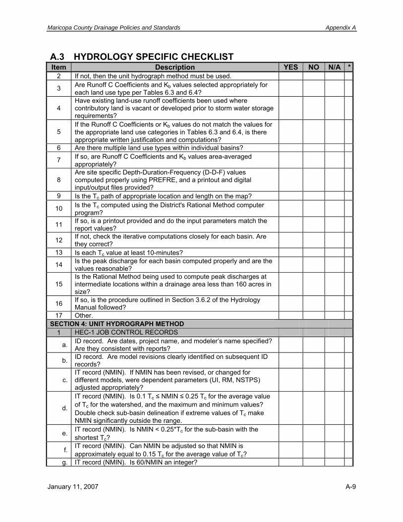
Maricopa County Drainage Policies and Standards Appendix A
A.3 HYDROLOGY SPECIFIC CHECKLIST Item Description YES NO N/A *
2 If not, then the unit hydrograph method must be used.
3 Are Runoff C Coefficients and Kb values selected appropriately for each land use type per Tables 6.3 and 6.4?
4 Have existing land-use runoff coefficients been used where contributory land is vacant or developed prior to storm water storage requirements?
5 If the Runoff C Coefficients or Kb values do not match the values for the appropriate land use categories in Tables 6.3 and 6.4, is there appropriate written justification and computations?
6 Are there multiple land use types within individual basins?
7 If so, are Runoff C Coefficients and Kb values area-averaged appropriately?
8 Are site specific Depth-Duration-Frequency (D-D-F) values computed properly using PREFRE, and a printout and digital input/output files provided?
9 Is the Tc path of appropriate location and length on the map?
10 Is the Tc computed using the District's Rational Method computer program?
11 If so, is a printout provided and do the input parameters match the report values?
12 If not, check the iterative computations closely for each basin. Are they correct?
13 Is each Tc value at least 10-minutes?
14 Is the peak discharge for each basin computed properly and are the values reasonable?
15 Is the Rational Method being used to compute peak discharges at intermediate locations within a drainage area less than 160 acres in size?
16 If so, is the procedure outlined in Section 3.6.2 of the Hydrology Manual followed?
17 Other. SECTION 4: UNIT HYDROGRAPH METHOD
1 HEC-1 JOB CONTROL RECORDS
a. ID record. Are dates, project name, and modeler’s name specified? Are they consistent with reports?
b. ID record. Are model revisions clearly identified on subsequent ID records?
c. IT record (NMIN). If NMIN has been revised, or changed for different models, were dependent parameters (UI, RM, NSTPS) adjusted appropriately?
d.
IT record (NMIN). Is 0.1 Tc ≤ NMIN ≤ 0.25 Tc for the average value of Tc for the watershed, and the maximum and minimum values? Double check sub-basin delineation if extreme values of Tc make NMIN significantly outside the range.
e. IT record (NMIN). Is NMIN < 0.25*Tc for the sub-basin with the shortest Tc?
f. IT record (NMIN). Can NMIN be adjusted so that NMIN is approximately equal to 0.15 Tc for the average value of Tc?
g. IT record (NMIN). Is 60/NMIN an integer?
January 11, 2007 A-9

Appendix A Maricopa County Drainage Policies and Standards
A.3 HYDROLOGY SPECIFIC CHECKLIST Item Description YES NO N/A *
h. IT record (NMIN). Is NMIN equal to or evenly divisible by JXMIN on the IN record?
I. IT record (NMIN, NQ). Is NMIN*NQ at least as long as the storm duration?
j. IN record (JXMIN). Is the IN record used correctly?
k. Is *DIAGRAM specified for at least one HEC-1 model in the study? One for each model with differences other than storm frequency.
l.
IO record (IPRT). Is Level 3 or lower output used for at least one HEC-1 model in the study? One for each model with differences other than storm frequency? Level 3 should be used for the model of the largest storm.
m. JP record. Is (NPLAN*NRATIO) < 45? n. JP record. Is (NPLAN*NRATIO*NQ) < 4800? o. JD record. Are JD records used and applied appropriately?
p. JD record. When using JD records for FRS volume computation, were the interpolated volumes from each sub-basin used?
q. Other. 2 PRECIPITATION AND RAINFALL DISTRIBUTION
a. Check rainfall frequency and duration in the report and HEC-1 files. Identify the source of rainfall data, i.e. NOAA Atlas 2, HMR-49. Is the source appropriate for the study area and type?
b. PB record. Specify rainfall depth. Is areal reduction applied correctly and discussed in the text?
c. PI and PC records. Were PC or PI records checked against the IN record?
PI and PC records. Were PC or PI records checked against distribution patterns?
d.
e. Are design storm distributions applied correctly? f. Other.
3 RAINFALL LOSSES
a. Are Green-Ampt loss rate parameters specified and are the selected values for IA, DTHETA, XKSAT, PSIF, and RTIMP reasonable?
b. Is the watershed moisture condition assumption described for the selection of DTHETA?
c. Are there different moisture condition land uses present within individual sub-basins (agricultural and natural, for instance)?
d. If so, are the values area averaged appropriately?
e.
Is area averaging of Green & Ampt parameters performed using the current version of DDMSW, or by external means or old versions of DDMSW/MCUHP? Check those that use older versions of DDMSW/MCUHP more closely. Check those using external means very closely.
f. Is bare ground XKSAT adjusted for vegetation cover? Is the adjustment appropriate?
Does the watershed span multiple NRCS (SCS) Soil Surveys? Are differences in soil texture between adjacent soil surveys discussed in the text and addressed if necessary in the models?
g.
h. Is there a discussion of natural RTIMP present in the watershed? Is natural RTIMP assumed to be hydraulically connected, have any adjustments been made to the percentages listed for the soil types, and are the revisions reasonable and adequately documented?
I.
A-10 January 11, 2007

Maricopa County Drainage Policies and Standards Appendix A
A.3 HYDROLOGY SPECIFIC CHECKLIST Item Description YES NO N/A *
j. Other. 4 HYDROGRAPHS
a. Specify method of hydrograph generation, i.e. Clark, S-graph. Is the method appropriate?
b. UC record (Tc). Are Tc parameters L, S, and Kb reasonable? c. Is Tc < 90 minutes for each sub-basin?
d. Does Tc exceed the duration of rainfall excess for any sub-basin? This should be documented in the text.
e. UC record (R). Is R ≥ 0.5xNMIN?
f. UC record (Tc). Check against similar sub-basins. Are Tc values reasonable?
g. UC record (Tc). Were Tc values checked to ensure that average velocities throughout the watershed are reasonable?
h. HC record. Are hydrographs combined properly? i. HC record. Is HC ≤ 5?
j. HC record (TAREA). Is total area correct? Was area above the concentration point manually recalculated for diverted hydrographs?
k. Other. 5 CHANNEL/PIPE ROUTING METHODS
a. Are specific channel/pipe routing method(s) specified, i.e. modified Puls, normal depth, Muskingum, Muskingum-Cunge, kinematic wave, and are the methods appropriate?
b. RC record (RLNTH). Check reach lengths. Were lengths measured correctly?
c.
RC record (ANL, ANCH, ANR). Were Manning’s “n” values developed using methodology in Estimated Manning’s Roughness Coefficients for Stream Channels and Flood Plains in Maricopa County, Arizona (April 1991)?
d. RC record (ANL, ANCH, ANR). Are Manning's “n” values reasonable?
e. RX and RY records. Are cross sections typical for the routing reach? If not, does the reach need to be broken into multiple reaches?
f. Are NSTPS generally equal to L/(Vavg * NMIN)?
g. Is NSTEP for each reach within +/- 1 of TT/NMIN, where TT is the travel time for the reach computed by HEC-1?
h. Are transmission losses modeled? If so, is there an acceptable discussion of the reasons for modeling losses, and the source of the parameters?
i. Are there questionable routing operations identified above that warrant plotting and visual examination of the hydrograph?
j. Other. 6 RESERVOIR (STORAGE) ROUTING METHODS
a. Are USGS, FCD, NWS, or other rain or stream gages used in hydrologic analysis or model calibration identified and discussed?
b. Are stage-storage relationships modeled correctly? c. Are stage-discharge relationships modeled correctly?
d. RS record. Are NSTPS = 1? If NSTPS is changed, travel time and attenuation will be affected.
January 11, 2007 A-11

Appendix A Maricopa County Drainage Policies and Standards
A.3 HYDROLOGY SPECIFIC CHECKLIST Item Description YES NO N/A *
e. RS record (ITYP, RSVRIC). Are starting conditions modeled appropriately?
f. Are rating curves for storage and outflow hydraulics included? Are the rating curves reasonable?
g. Is there an acceptable discussion of the basis for estimation of storage and outflow parameters in the text, and a discussion of reservoir routing results?
h. Other. 7 DIVERSION DATA
a. DI/DQ records. Are diversions/split flows modeled correctly?
b. Are hydraulic computations for diversions done appropriately and included in the report?
c. Are rating curves for each diversion plotted and included in the report?
d. Are watershed areas corrected using the HC record where diverted hydrographs are recalled into the model?
e. Other. SECTION 5: HEC-1 OUTPUT
1 ERROR AND WARNING MESSAGES
a. Are there error or warning messages related to hydrograph generation or combination that are not adequately addressed in the test, or are critical?
b.
Are there error or warning messages related to routing that are not adequately addressed in the text? Specifically check for peak discharge outside of specified range warnings and lack of hydraulic capacity for the reach cross-section.
c. Have error and warning messages been checked and corrected? Are error and warning messages explained adequately?
d. Other. 2 SCHEMATIC DIAGRAM
a. Compare the schematic to the watershed map. Is the structure logical? Are all points labeled clearly? Specify any problems.
b. Are there < 9 hanging hydrographs? c. Have all of the diverted hydrographs been accounted for? d. Are all sub-areas attached and combined in the proper sequence? e. Other.
3 DRAINAGE AREA
a. Has the area associated with all returned diverted hydrographs been returned?
b. Check total drainage area. Is it accurate? c. Other.
4 RAINFALL LOSSES
a. Check the total rainfall, total losses, and total runoff for each sub-basin. Are there zeros or very small numbers? Explain.
b. Other. 5 HYDROGRAPH ROUTING
a. Is outflow peak discharge < inflow peak discharge? b. Is flow contained within x-sections?
A-12 January 11, 2007

Maricopa County Drainage Policies and Standards Appendix A
A.3 HYDROLOGY SPECIFIC CHECKLIST Item Description YES NO N/A *
c. Check travel time. Does travel time appear to be too short or too long? If so, check input parameters for routing. Check routing steps in the input against the output velocity.
d. Is attenuation of peak flows reasonable?
e. For kinematic wave routing, is the peak flow attenuated? If so, check model and revise.
f. Other. 6 PEAK RUNOFF
a. Is specific yield (cfs/sq mi) for each sub-basin included in the report? b. Other.
7 TIME TO PEAK
a. Check the time to peak column in the HEC-1 summary table. Do times to peak increase with increasing drainage area?
b. Are all times to peak very close or identical to one another? If so, NMIN and routing operations may need to be revised.
c. Do all times to peak occur after the most intense period of rainfall (about half the rainfall duration)?
d. Other. 8 RUNOFF VOLUMES
a. Are runoff volumes reasonable? b. Other.
SECTION 6: MODEL CALIBRATION AND INDIRECT METHODS VERIFICATION 1 INSTRUMENTATION
a. Identify USGS, FCD, NWS, or other rain or stream gages used in hydrologic analysis or model calibration.
b. Have any gages been relocated during the period of record? Discuss.
c. Other. 2 INDIRECT METHODS/STATISTICAL ANALYSES
a. Have statistical analyses been performed and are the results discussed?
b. Are USGS regression equations used, the sources identified, and are they appropriate and implemented correctly?
c. Is the period of record adequate for use with Water Resources Council Bulletin 17B (March 1982)?
d. Are any other Indirect Methods used, the sources identified, and are they appropriate and implemented correctly?
e. Are the model results reasonable based on comparisons with the results of the application of Indirect Methods?
f. Other. SECTION 7: ADDITIONAL COMMENTS
January 11, 2007 A-13

Appendix A Maricopa County Drainage Policies and Standards
A.3 HYDROLOGY SPECIFIC CHECKLIST Item Description YES NO N/A *
A-14 January 11, 2007

Maricopa County Drainage Policies and Standards Appendix A
A.3 HYDROLOGY SPECIFIC CHECKLIST Item Description YES NO N/A *
January 11, 2007 A-15

Appendix A Maricopa County Drainage Policies and Standards
A.3 HYDROLOGY SPECIFIC CHECKLIST Item Description YES NO N/A *
A-16 January 11, 2007

Maricopa County Drainage Policies and Standards Appendix A
A.4 HEC-RAS HYDRAULICS SPECIFIC CHECKLIST Item Description YES NO N/A *SECTION 1: PROJECT DESCRIPTION
1 PROJECT NAME: REVISION NO: DATE:
2 SELECT PROJECT TYPE: ADMS[ ] ADMP [ ] WCMP [ ] FDS [ ] Development Review [ ] Regulatory Review [ ] Hydrology Study [ ] Other [ ]
3 REVIEWED BY: 4 Is there a project description?
5 Does the description include the study name, District contract number, consultant name and address?
6 Does the description include the purpose of the model (floodplain delineation study, channel project, …)?
7 Are the data sources identified? 8 Are general assumptions listed?
9 Are the events being modeled identified (100-year, SPF, multiple year, …)?
10 Is the project file name appropriate for the project? Names like a, b, job 1, and FIS are not acceptable.
11 Is there an adequate map that shows the topography, cross sections, thalwegs, labels, floodplain and floodway limits, and left and right bank locations?
12 Is the version of the hydraulic model used to do the study listed?
13 Is there a section on Conclusions and Recommendations, and is it adequate?
SECTION 2: FILES
1 Note the number of geometry, flow data, and plan files. Should multiple models be created?
2 Are the file names appropriate?
3 Do the file names reflect the project name, and what each file includes?
SECTION 3: FLOW DATA
1 Are the changes in discharge input at the correct locations, and are the values correct?
2 For floodplain studies are Floodplain (or FP) and Floodway (or FW) being used for the profile names?
3 For other studies do the profile names reflect what is being modeled (25-yr, 50-yr, …)?
4 Are the upstream and downstream boundary conditions appropriate for the model?
5 Are any internal rating curves or fixed changes in water surface elevations being used?
SECTION 4: GEOMETRY FILE
1 Are rivers and reaches named correctly? Names like a, b, and Job 1 are not acceptable.
2 Are the junction names acceptable?
3 Are the cross sections identified in river miles for floodplain delineations (feet may be used for Non-FEMA delineations)?
4 Do cross section start and stop locations and length on the map match the geometry file?
January 11, 2007 A-17

Appendix A Maricopa County Drainage Policies and Standards
A.4 HEC-RAS HYDRAULICS SPECIFIC CHECKLIST Item Description YES NO N/A *
5 Are cross sections oriented with stationing from left to right looking downstream?
6 Are cross sections stationed using 10,000 at the thalweg?
7 Are comments included where appropriate in the cross section descriptions?
8 Are reach lengths measured correctly? They should be measured at the center of the mass of flow.
9 Are the bank station locations appropriate? Bank stations can be different for different events.
10 Are contraction/expansion coefficients appropriate? (note: culverts may use larger values than bridges)
11 Are blocked flow, levees, or ineffective flow being used, and used correctly?
12 Are the n values appropriate? (for design projects there should be a range of n values)
13 Are bridges and culverts being modeled correctly? Is there pressure flow, weir flow, or both?
14 Are any inline weirs or spillways being used?
15 If yes, are weir coefficients acceptable and are they modeled appropriately?
16 Are interpolated cross sections being used? If yes, why? SECTION 5: CALCULATIONS
1 Does the plan file have an adequate description? 2 Are the correct flow and geometry files being used?
3 Is an appropriate starting WSEL method used and explained, and is it applied correctly?
4 Are ineffective flow areas identified and addressed appropriately? 5 Are there any breakouts?
6 Are bridges and culverts modeled appropriately, including ineffective flow?
6 Is the correct flow regime (sub, mixed, or super) being used (subcritical only for floodplain studies)?
8 Are encroachments used?
9 If encroachments are used, are they applied properly using the water surface or energy grade line and show < 1.0 foot increases at every cross section?
10 Are the floodplain and floodway delineations done in accordance ADWR State Standards 2-96, 3-94 and 9-02?
11 Is the flow distribution option turned on, if appropriate?
12 Is the appropriate method used for conveyance calculations and the friction slope?
SECTION 6: REPORT FILE
1 Does the Report File printouts of all the input data including (geometry, flow, plan)?
2 Are all the profiles included in the output results? 3 Are appropriate summary tables included?
SECTION 7: REVIEWING THE RESULTS
1 Check the Froude numbers, does critical flow (or close to critical flow) occur anywhere?
2 Does at least a portion of the flow occupy the channel?
A-18 January 11, 2007

Maricopa County Drainage Policies and Standards Appendix A
A.4 HEC-RAS HYDRAULICS SPECIFIC CHECKLIST Item Description YES NO N/A *
3 Is the percentage of flow in the main channel less than 25%? Examine model carefully if yes.
4 Are there large changes in depth and/or velocity between cross sections?
SECTION 8: ERRORS 1 Are there any extended cross sections? 2 Does divided flow occur? SECTION 9: *ADDITIONAL COMMENTS
January 11, 2007 A-19

Appendix A Maricopa County Drainage Policies and Standards
A.5 DRAINAGE REPORT/TECHNICAL DATA NOTEBOOK CHECKLIST
Item Description YES NO N/A *SECTION 1: COVER SHEET
1 Is the Study Name included, and is it correct? 2 Is the date correct? 3 Are revision dates included? 4 Is the consultant's name (address and telephone number) included? 5 Is the District's contract number included?
6 Are the cover and Table of Contents sealed by a professional Civil Engineer currently licensed to practice in Arizona?
SECTION 2: DOCUMENT FORMAT AND LAYOUT 1 Is the document prepared in accordance with ADWR SS 1-96?
2 If new topographic mapping, survey notes and data are included, are they sealed by professional Land Surveyor currently licensed to practice in Arizona?
3 Does the TDN Binder include all the labels and logos of the study partners, including FEMA?
4 Are Section Corners labeled on the Study Maps? SECTION 3: MODEL PRINTOUT
1
Are printouts from the hydrologic and hydraulic models included? Hydrologic and hydraulic models need to be fully documented in a way that isn’t subject to change, therefore printouts of the models must be included in the TDN.
2 Do the printouts include the input data and the results? 3 For HEC-RAS models, is a HEC-RAS generated report included?
4 Do HEC-RAS report files include both the input data and the detailed calculation results? Printouts which contain only HEC-RAS summary tables are not acceptable.
5 Do the units shown on the flood profiles, such as River Miles, match those used in the hydraulic models?
6 Are all modeled reaches included in the Floodway tables? SECTION 4: COMPACT DISKS
1 Are electronic copies of the hydrologic and hydraulic models included on CD? (mandatory) CDs are the only acceptable mediums at this time.
2 Are all of the input and output files for all computer models used included on CD? (mandatory) In general the input files shouldn’t be zipped, but if space is a problem it is acceptable to zip the output files.
3
Is the CD labeled with such items as the study name, contract number, consultant’s name, date, general description of what is on the CD, the names of all the watercourses studied or the names of all the files on the CD? (mandatory)
4 Is a “README” file included on the CD, and in ASCII text file format?
A-20 January 11, 2007

Maricopa County Drainage Policies and Standards Appendix A
A.5 DRAINAGE REPORT/TECHNICAL DATA NOTEBOOK CHECKLIST
Item Description YES NO N/A *
5
Does the minimum information in the “README” file include: Name and address of study contractor; name, county and state of the community; name of the hydrologic/hydraulic computer program used; and the name of each input and output file including a model description, stream name and date of creation? The consultant should include additional information as is necessary.
6 Is a printed copy of the “README” file located in the TDN next to the CD? (mandatory)
7 In the case of multiple models, is a simple line diagram included depicting the relative location of the models to each other?
8
Are all file names unique to the project, and worded in a manner related to the project and the scenario(s) being modeled? File names like a, b, c, job 1, floodplain, and FIS are not acceptable types of names and their use should be avoided.
9
Has the consultant included on the CD scanned images of the final (signed and sealed) drawings or exhibits, original CAD files, the TDN in electronic format, and any other electronic files the consultant may have generated? (not mandatory, but preferred)
SECTION 5: *ADDITIONAL COMMENTS
January 11, 2007 A-21
Appendix A Maricopa County Drainage Policies and Standards
A.5 DRAINAGE REPORT/TECHNICAL DATA NOTEBOOK CHECKLIST
Item Description YES NO N/A *
A-22 January 11, 2007
Maricopa County Drainage Policies and Standards Appendix B
APPENDIX B STANDARD DRAINAGE EASEMENT
B.1 PURPOSE The purpose of this appendix is to provide standard drainage easement language for conformance with Policy 3.13.3 and Policy 3.13.9. The user is advised to consult with legal counsel for the purpose of addressing individual issues specific to their situation. Drainage easements SHALL NOT be dedicated to the public, Maricopa County, or the Flood Control District of Maricopa County.
B.2 STANDARD DRAINAGE EASEMENT For good and valuable consideration, receipt of which is hereby acknowledged, that ____ ENTER TRUST NAME AND NUMBER ______________, AS OWNER (“DECLARANT”), hereby creates, conveys, and assigns to ______SUBDIVISION NAME______ HOMEOWNERS’ ASSOCIATION, AN ARIZONA NON-PROFIT CORPORATION (“HOA”), a drainage easement in perpetuity over and across that portion of the real property more particularly described hereon which is designated as a “Drainage Easement” hereon this final plat map.
HOA as the owner and holder of the Drainage Easement shall have the right (I) to access same at any time, and from time to time, without the permission or consent of the owner of any underlying fee interest of the property encumbered thereby or any third party, (II) to remove from or change the location of any obstructions within the Drainage Easement in order to promote and enhance such area as a channel for flood waters and natural runoff, (III) to trim or remove vegetation growing therein, (IV) to grade, excavate, channel or otherwise change the ground surface therein as may be required from time to time to maintain the drainage easement as a channel for flood waters and natural runoff, (V) to construct and maintain within the bounds of the drainage easement such drainage ways or other flood control structures or devices, as it may deem necessary or appropriate from time to time to utilize the drainage easement for flood control purposes, (VI) to install riprap and such other erosion control devices that may be appropriate from time to time in the drainage easement, and (VII) to take any and all such other actions and make any and all such other improvements as it may deem appropriate from time to time to promote the health, safety and general welfare.
No portion of the land included within the Drainage Easement as shown in final plat hereto shall hereafter be used by DECLARANT or any successor or assign in the ownership thereof to construct or maintain any wall, fence, building or any other above ground structure, except that with the prior written consent and approval of both the HOA and Maricopa County, ______ ENTER TRUST NAME AND NUMBER _______________, and its successors and assigns as
December 20, 2006 B-1

Appendix B Maricopa County Drainage Policies and Standards
the owners thereof may from time to time install riprap or other flood control devices provided the plans for such improvements have been specifically approved and authorized in writing by MARICOPA COUNTY in its sole and reasonable discretion prior to the construction or installation thereof. Any such device or structure placed by an owner in the drainage easement area shall thereafter be maintained in a state of good repair by an owner of the property where such device or structure is located. No portion of the land included within the drainage easement as shown in final plat hereto shall be used by DECLARANT or any successor or assign in the ownership thereof as the site for any septic tank. No landscaping plants or materials shall be placed by DECLARANT or any successor or assigns in the drainage easement, except for maintenance of native plant material now existing therein, unless such landscaping plants and materials are reflected on a landscaping plan that has been submitted to and specifically approved and authorized in writing by MARICOPA COUNTY in its sole and reasonable discretion prior to installation thereof.
If at the time of the recording of the final plat for the real property more particularly described on final plat hereto the boundaries of the “Drainage Easement” as shown on the preliminary plat attached hereto as final plat shall have been changed or modified in any fashion, then, with the prior written consent and joinder of HOA, and the prior written consent of MARICOPA COUNTY, the Drainage Easement created hereby shall be modified and amended to conform to the boundaries of the Drainage Easement as shown on such final plat, such amendment to become effective upon the execution and recording of a written amendment hereto executed by DECLARANT, HOA, and MARICOPA COUNTY.
The Drainage Easement created hereby is and shall be a covenant that runs with the land encumbered hereby in perpetuity, but it is and shall remain an easement in favor of HOA and shall not be construed or interpreted to a dedication in favor of the public or any party other than HOA. No change, modification or amendment to this Drainage Easement shall be effective without prior written consent and agreement of both HOA and MARICOPA COUNTY. MARICOPA COUNTY may require any action or impose any restriction that MARICOPA COUNTY considers reasonably necessary to meet the district’s obligations, if any, to comply with local, state or federal water quality laws.
B.3 FINAL PLAT DRAINAGE EASEMENT MAINTENANCE AND DEDICATION DRAINAGE EASEMENTS AMONG OWNERS: Drainage Easements Among Owners: Wherever drainage flows from one lot onto, under or through one or more lots, said drainage flow shall not be impeded, diverted or otherwise changed. No wall, fence, building or any other above ground structure shall be erected within the defined drainage easements as depicted on the final plat. No vegetation shall be planted within the drainage easements, which might impede the flow of flood waters or natural runoff, nor shall any lot owner alter the grade within the drainage easement.
MAINTENANCE: Drainage easements as shown on the final plat for (name of subdivision), are for the collection and conveyance of stormwater from off-site and on-site drainage sources. The owners of lots within (name of subdivision) that abut drainage easements platted hereon shall
B-2 January 11, 2007

Maricopa County Drainage Policies and Standards Appendix B
be jointly and severally responsible for maintaining said easements in a clean and debris-free condition, such that stormwater flows from upstream sources and from on-site sources shall not be slowed, impeded, redirected or diverted from said drainage easements. In the event the maintenance of any drainage easement requires expenditures of funds, then each owner abutting said easement shall contribute to the cost of such maintenance on a prorated basis. In the event the need for maintenance within any drainage easement is the result of actions or failure to act by a lot owner or lot owners abutting said easement, then the cost of such maintenance shall be borne solely by the abutting lot owners who brought about the need for the maintenance. Failure by any lot owner abutting a drainage easement to contribute his or her share of the costs of maintaining said easement shall entitle the other lot owners or any individual lot owner to enforce, by any proceeding at law or in equity the maintenance of said drainage easement. In the event a property owners association is formed, the maintenance of drainage easements platted hereon shall be assumed by the property owners association.
DEDICATION: Easements are provided hereon in the above-described premises as shown.
December 20, 2006 B-3

Appendix B Maricopa County Drainage Policies and Standards
Page Intentionally Left Blank
B-4 January 11, 2007

Maricopa County Drainage Policies and Standards Index
INDEX
ACDC, vii, 2-8 ADEM, vii ADEQ, vii, 4-1, 4-2, 4-12, 4-17, 4-22, 4-23, 4-24 ADMP, vii, 2-4, 2-5, 2-8, 2-12, 3-3, 3-5 ADMS, vii, 2-4, 2-5, 2-8, 3-5 ADOT, vii, 2-8, 6-29 ADWR, vii, 2-8, 4-2, 4-10, 4-21, 4-22, 6-46, 6-
48, 6-50 Aggradation, 2-14, 6-34 Alluvial fan, 3-10, 4-4, 4-9, 6-47 ALTA, vii, 2-9 Aquifer:protection permit, 4-23 Aquifer:water quality standards, 4-24 AZNPDES, 2-1 AZPDES, vii, 3-13, 4-16, 4-17, 4-18 BFE, vii, 4-8 BMP, 4-19 Bridge:design, 6-34, 6-35, 6-47 Bridge:design considerations, 2-17 Bridge:policies, 3-11, 3-14 Bridge:standards, 4-14, 6-7, 6-32, 6-34, 6-35, 6-
47 CAP, vii, 2-8, 4-21 CFR, vii, 4-17, 4-19 Channel:artificial, 2-3, 2-15, 2-16, 6-35 Channel:banks, 2-11 Channel:bed, 2-14 Channel:bends, 6-40 Channel:capacity, 2-14 Channel:channelization, 6-36 Channel:concrete, 6-37 Channel:design criteria, 6-35 Channel:design guidelines, 6-37 Channel:drainage, 2-11 Channel:drop structures, 6-4 Channel:earthen, 6-37 Channel:emergency escape, 6-4 Channel:engineered, 6-4, 6-7, 6-37 Channel:erodible, 6-37 Channel:expansion, 2-16 Channel:fencing, 6-4 Channel:freeboard, 6-36, 6-40 Channel:Froude number, 6-40 Channel:grass-lined, 6-39
Channel:ideal, 2-15 Channel:improved, 2-15 Channel:interceptor, 2-16 Channel:landscape character, 3-12 Channel:landscaping, 6-41 Channel:low flow, 2-15 Channel:maintenance, 4-14 Channel:maintenance access, 3-14, 6-4 Channel:maximum velocity, 6-35, 6-38, 6-39 Channel:minimum easement, 6-41 Channel:natural, 2-15, 6-35 Channel:open, 2-14, 2-15, 2-17, 3-11, 6-36, 6-42 Channel:permit requirement, 5-3 Channel:plan requirements, 6-51 Channel:radius requirement, 6-40 Channel:shotcrete, 6-37 Channel:side or interior drainage, 3-12 Channel:sinuous, 6-38 Channel:slope, 2-16 Channel:stability requirements, 6-34 Channel:supercritical, 6-36 CLOMA, viii, 4-7 CLOMR, viii, 4-7 CLOMR-F, viii, 4-7 CMP, viii Concrete, 6-4, 6-30, 6-33, 6-34, 6-37, 6-39, 6-
44, 6-52 CRS, viii, 4-3 Culvert:design, 6-33, 6-34, 6-35, 6-47 Culvert:design considerations, 2-17 Culvert:encroachments, 2-16 Culvert:policies, 3-11, 3-14 Culvert:standards, 6-7, 6-32, 6-34, 6-36, 6-47 Dams:authority, 4-21 Dams:emergency spillway rquirements, 6-46 Dams:height, 6-46 Dams:jurisdictional, 4-21 Degradation, 2-14, 6-34 Design storm, 6-6, 6-33, 6-42 Distributary flow, 3-9, 6-47 Drainage Design Manual, 1-1, 1-2, 1-3, 3-5, 3-9,
3-11, 3-12, 6-1 Drainage Design Manual:Erosion Control, 1-1,
1-3, 3-1, 3-6, 3-16
January 11, 2007 I-1

Appendix B Maricopa County Drainage Policies and Standards
Drainage Design Manual:Hydraulics, 1-1, 1-2, 1-3, 2-14, 3-1, 3-5, 3-8, 3-11, 3-12, 6-1, 6-34, 6-35, 6-37, 6-47
Drainage Design Manual:Hydrology, 1-2, 1-3, 2-14, 3-1, 3-5, 3-8, 3-9, 3-11, 3-12, 6-1, 6-7, 6-12
Drainage:facilities, 1-1, 1-3, 2-2, 2-3, 2-12, 2-17, 3-3, 3-4, 3-11, 3-13, 3-14, 3-15, 5-2, 5-3, 6-1
Drainage:regulations, 1-3, 1-4, 3-13 Drainageway:aesthetic treatment requirements,
6-42 Drainageway:culverts and bridges, 3-11 Drainageway:design standards, 3-4 Drainageway:design storm criteria, 6-7 Drainageway:erosion during construction, 3-15 Drainageway:major, 6-43 Drop structure, 6-37, 6-40 Drop Structure, 6-4, 6-41 Dry wells:design disposal rate, 6-45 Dry wells:permits, 4-23 Dry wells:standards, 6-44, 6-45 drywell, 4-22, 6-45 EPA, viii, 4-1, 4-2, 4-15, 4-18, 4-19 Equilibrium slope, 6-37, 6-47 Erosion, 3-6 Erosion:alluvial fan, 3-10 Erosion:control, 3-6, 3-15, 6-41 Erosion:effects of, 2-11, 2-12, 6-6 Erosion:hazard, 1-3, 2-4, 2-8, 2-12, 6-1, 6-49 Erosion:hazard zone, 2-5, 2-14, 2-15, 3-9, 6-35 Erosion:management, 2-12, 3-6, 3-9, 3-14 Erosion:manual, 3-6, 3-16 Erosion:policies, 3-6, 3-8, 3-11, 3-16 Erosion:processes, 2-11 Erosion:setbacks, 2-15, 3-3, 3-9, 6-35 Erosion:standards, 6-35, 6-36, 6-40, 6-47 Exceptions, 1-2 FEMA, viii, 2-6, 2-8, 3-6, 3-8, 4-2, 4-3, 4-4, 4-7,
4-8, 4-9, 4-10, 6-23, 6-24, 6-36, 6-41, 6-48, 6-50
FHWA, viii, 6-38, 6-39 FIRM, viii, 2-13, 4-3, 4-7, 6-49 FIS, viii, 4-8, 6-48, 6-50 Floodplain:alluvial fan requirements, 4-9 Floodplain:analysis requirement, 2-16 Floodplain:defined, 4-4 Floodplain:documenting, 6-50 Floodplain:fees, 4-9 Floodplain:information, 4-1, 1 Floodplain:management, 3-2, 3-6, 4-3, 4-8, 5-2 Floodplain:management ordinance, 4-3 Floodplain:Non-FEMA, 3-8, 4-10 Floodplain:regulations, 1-3, 1-4, 4-2
Floodplain:storage, 2-15 Floodplain:use permit, 3-14 Floodplain:variances, 4-9 Floodway:construction in, 4-8, 4-9 Floodway:defined, 4-4 Floodway:Non-FEMA, 3-8 Floodway:requirements, 3-3 Floodway:revisions, 4-8 Gabions, 6-37, 6-39 Grade control, 6-37 Grass, 6-39 Health, 1-2, 3-11, 3-13, 3-15, 5-2 Hydraulic jump, 6-37, 6-41, 6-51 Inverted crown, 3-11 Jurisdictional:dam, 4-21 Jurisdictional:delineation, 4-12 Jurisdictional:floodplains, 6-41 Jurisdictional:limits, 4-4 Jurisdictional:waters, 2-9, 4-11 Lateral migration, 2-14, 2-15, 6-35 LOMA, viii, 4-7 LOMR, viii, 4-7 LOMR-F, viii, 4-7 MAG, viii, 2-8, 6-29, 6-32, 6-35 Maintenance:cost, 2-1, 2-2, 2-14, 2-17 Maintenance:design considerations, 2-9 Maintenance:long-term, 2-9, 2-14, 2-17 Maintenance:minimizing, 2-11, 2-15 Maintenance:requirements, 2-16 MCDOT, ix, 2-8 MCPRD, ix MSGP, ix, 4-19 NFIP, ix, 3-6, 4-2, 4-3, 4-8, 4-9, 4-10 NOI, ix, 4-16, 4-17, 4-19 NOT, ix, 4-18 NPDES, ix, 2-1, 4-2, 4-13, 4-15, 4-18, 6-45 NRCS, ix, 2-8, 2-9 Open channel, 2-11, 2-14, 2-17, 3-11, 6-41, 6-42 PDSD, ix Permit:agencies, 4-1 Permit:aquifer protection, 4-2, 4-23 Permit:drainage facilities, 5-2 Permit:dry well, 4-23 Permit:drywell, 4-2 Permit:floodplain encroachment, 4-7 Permit:floodplain use, 3-14 Permit:grading and drainage, 5-2, 6-46 Permit:groundwater, 4-2 Permit:jurisdictional dam, 4-21 Permit:NPDES, 4-2 Permit:process, 4-4 Permit:sand and gravel mning, 3-14 Permit:Section 401, 2-16, 4-2, 4-12
B-2 January 11, 2007

Maricopa County Drainage Policies and Standards Index
Permit:Section 404, 2-9, 2-16, 3-15, 4-2, 4-11, 4-12, 4-14, 4-15
Permit:storm water, 5-2 permits, 4-16 permitting, 4-15 Pipe:basin drain, 6-44 Pipe:bleed-off, 6-44 Pipe:connector, 6-30, 6-32, 6-52 Pipe:cut-off wall requirements, 6-34 Pipe:fittings, 6-32 Pipe:headwall requirements, 6-33 Pipe:laterals, 6-26 Pipe:manholes, 6-32 Pipe:minimum size, 6-44 Pipe:permit requirement, 5-3 Pipe:profile requirements, 6-29 Pipe:soil boring requirements, 6-31 Pipe:stationing, 6-29 Pipe:storm drain, 6-29 Pipe:supports, 6-53 Planning, 1-1, 1-3 Planning:alluvial piedmonts, 2-14 Planning:approach, 2-15 Planning:benefits, 2-2 Planning:drainage, 2-2, 2-3, 2-8, 2-9, 3-3 Planning:flood damages, 2-2 Planning:land, 2-2 Planning:maintenance, 3-14 Planning:multiple uses, 2-3 Planning:open space and recreation, 2-2, 2-12 Planning:philosophy, i, 1-1, 1-3, 2-9, 4-12, 1 Planning:policies, 3-2, 3-3, 4-11 Planning:process, 1-3, 2-14 Planning:regional, 2-4 Planning:storm water, 5-2 Planning:subdivision, 2-2, 2-5, 2-16, 3-3 Planning:transportation, 2-2 Planning:urban, 2-2 PMR, ix, 4-7 pneumatically placed concrete, 6-4, 6-36, 6-37 Pneumatically placed concrete, 6-37 Pneumatically Placed Concrete, 6-40 Rational Method, 6-7
RFE, ix Riprap, 6-35, 6-37, 6-39, 6-42 Riverine, 3-9, 4-10 RUSLE, ix, 4-17 Safety, 1-2, 2-5, 2-9, 2-11, 2-12, 2-14, 2-16, 2-
17, 3-10, 3-11, 3-12, 3-13, 4-9, 4-21, 4-22, 5-2, 6-1, 6-4, 6-6, 6-37, 6-43
Scour, 2-17, 3-14, 6-34, 6-37 Sediment:transport capacity, 6-47 Sedimentation, 2-14, 2-17, 3-6, 3-11, 3-12, 3-14,
6-5, 6-34, 6-37, 6-42 SFHA, ix, 4-3, 4-7, 4-8, 4-9, 4-10 Sheet flow, 3-4, 4-4, 4-10, 6-28 Soil cement, 6-4, 6-37 Soil Cement, 6-39 Soils, 3-15, 6-7, 6-31, 6-38, 6-40, 6-45 Storm water:management, 1-3 Storm water:policies, 3-12 Storm water:standards, 6-44, 6-50 Storm water:storage, 6-44, 6-50 Storm water:volume, 6-7 Street:drainage patterns, 2-2, 2-17 Street:drainage policies, 3-2, 3-10 Street:drainage standards, 6-18, 6-19, 6-26, 6-
43, 6-47, 6-49, 6-50, 6-53 Street:planning, 2-2 Structural concrete, 6-39 SWPPP, ix, 4-17, 4-19 TMDL, ix, 4-17 USACE, vii, ix, 2-8, 2-9 USBR, ix, 2-8 USFS, ix, 2-9 Velocity:excessive, 2-14 Velocity:maximum, 6-30, 6-38, 6-39 Velocity:minimum, 6-30 Velocity:policies, 3-10 Velocity:standards, 6-29, 6-30, 6-34, 6-35, 6-36,
6-38, 6-39, 6-40, 6-43 Waters of the United States, 2-9, 2-10, 4-11, 4-
13, 4-14 Watershed, 2-4, 2-8, 4-7, 6-37, 6-42, 6-43, 6-49 WCMP, ix, 2-4, 2-5, 2-8, 2-12, 2-15, 3-3
January 11, 2007 I-3