state of hawaii -
TRANSCRIPT

NEAL ABERCROMBIE WILLIAM J. AILA, JR.GOVERNOR OF HAWAIt CRAIRPERSON
WILLIAM D. BALFOUR, JR.KAMANA BEAMER
LORETTAJ. FUDDY, A.C.S.W.,MPH.
MILTON D. PAVAOLAWRENCE H. MIIKE, M.D., JO.
WILLIAM M. TAM
STATE OF HAWAIIDEPARTMENT OF LAND AND NATURAL RESOURCES
COMMISSION ON WATER RESOURCE MANAGEMENTP.O. BOX 621
HONOLULU, HAWAII 96809
STAFF SUBMITTAL
COMMISSION ON WATER RESOURCE MANAGEMENT
August 21, 2013Honolulu, Hawaii
Request to Enter into a Joint Funding Agreement with U.S. Geological SurveyFor Statewide Hydrologic Data Collection and
Water Resource Monitoring for Federal Fiscal Year (FFY) 2014
SUMMARY OF REOUEST
The Commission staff recommends that the Commission on Water Resource Management(Commission) enter into a Joint Funding Agreement (“Agreement”) with the U.S. GeologicalSurvey (USGS) for the inventory and investigation of Hawaii’s water resources.
BACKGROUND
The cooperative monitoring of Hawaii’s hydrologic resources began in 1909 when the USGSentered into an agreement with the Territory of Hawaii. At its inception, monitoring focusedmainly on surface water. Initially only 12 streams were gauged continuously. By 1914, 87continuous-record stations were gauged. The program grew to a peak in 1966 when 197 gageswere operational under the agreement. Over the years, some gauges were discontinued for avariety of reasons, including shifting fiscal priorities, changing economic realities, completeddata acquisition objectives, and dwindling partnership engagement in monitoring and datacollection.
In 1972, groundwater data collection became an integral part of the Agreement and beganestablishing the baseline data throughout the State with 170 observation wells. For reasonssimilar to the surface water gages, observation well data recording has steadily declined over theyears such that only 14 well sites now remain to provide data continuity in FFY 2014.
Beginning in 1998, the Commission streamlined the Cooperative Agreement by transferring thecrest-stage stream-gauging program to civil defense agencies where these data (e.g. floodingissues) are more relevant to disaster response rather than sustainability issues, and by eliminatingduplication of groundwater data collection efforts in wells. Groundwater data gathering changedand expanded to incorporate the data provided by water system purveyors and well owners, whowere required by law and rule to report their water-use and groundwater and chloride levels.
Dl

USGS Cooperative Agreement August 21, 2013Staff Submittal
A partnership with the Division of Forestry and Wildlife (DOFAW) through its WatershedManagement Grant Program (WMGP) boosted the streamfiow gauging stations operations onwatershed partnership lands. Due to challenging economic times, the WMGP withdrew itssupport for these gauging operations in watershed management areas, disengaged from thewatershed partnerships and from USGS efforts to monitor water resources in watershed areas.
However, to support the recent DOFAW Rain Follows the Forest initiative, the Commission willfund a continuous-record streamfiow gage on the Moanalua Stream in the recently acquiredMoanalua Valley State Forest Reserve. The data gathered from this gage will help DOFAWevaluate the impact of their watershed restoration efforts.
The Waiahole Trust Fund continues to help defray the cost of monitoring the Waiahole Ditchsystem and its sources. Exhibit 1 provides a summary of changes to the program, including theoperational cost, since FFY 2007. Exhibit 2 shows the changes in the total number of monitoringstations since the program’s inception.
The cooperative monitoring of Hawaii’s hydrologic resources fulfills the Commission’s mandateto “maintain an inventory of all water uses and water resources.” Haw. Rev. Stat. §174C-5(14).The program allows the Commission to assess water resource impacts from climate variability,changing land use, and increasing water demands. Maintaining a long-term hydrologicmonitoring program with the USGS is an essential component of the Commission’s mission tomanage Hawaii’s water resources.
CURRENT AGREEMENT
Although the nature of the Agreement and relationship of the parties remains the same as theprevious year’s Agreement, the total number of stream gauging stations has decreased from 28 to25. A proposed list of stations to be funded in the FFY 2014 agreement is attached (Exhibit 4).The total cost of the agreement will not exceed $702,650. The Commission’s share will notexceed $433,218. Federal funding to the USGS was reduced in FY 2013 due to sequestration.Additional reductions in Federal funding are anticipated in FY 2014. Because of these changes,the USGS reduced its contribution to the program by 4.5 percent ($12,678). As a result, CWRMwill need to increase its contribution by 3.7 percent ($15,568) to prevent a further reduction inthe number of stations.
Under the Joint Funding Agreement for FFY 2014, the USGS will collect basic hydrologic dataand provide data summary reports on water resources throughout the State of Hawaii. Aproposed scope of services outlines the expectations of the Agreement (see Exhibit 3). TheAgreement will span FFY 2014 (October 1, 2013 to September 30, 2014).
The table below summarizes the annual changes in funding requirements for this Joint FundingAgreement.
2

USGS Cooperative Agreement August 21, 2013Staff Submittal
COST FFY2O12 FFY2O13 FFY2O14
Total Joint Funding Requirement $857,760 $699,760 $702,650
Expected (full-year) CWRM cost-share not to exceed $487,760 $417,650 $433,21 80
Percentage CWRM cost-share 57% 59% 62%
DOFAW Watershed Management Grant $0 $0 $0
Waiahole Ditch Monitoring Fund $41,850 $39,850 $41,650
Ground water well continuous monitoring $6,800 $6,090 $7,230
Rain gage continuous recording $10,800 $9,670 $9,670
Continuous recording stream gage $22,500 $20,150 $20,090
OTHER
I. Chapter 343 — Environmental Assessment (EA) Compliance
EA TriggersIn accordance with §HRS 343-5(a), the proposed action triggers the need for an EA based on theuse of state funds.
EA ExemptionThe proposed action qualifies for an exemption from an EA based on §HAR1 1-200-8(a), basicdata collection, research, experimental management and resource evaluation activities which donot result in a serious or major disturbance to an environmental resource.
RECOMMENDATIONS
Staff recommends that the Commission:
1) Authorize the Chairperson to enter into a Joint Funding Agreement with the U.S.Geological Survey in FFY 2014 to undertake the specified monitoring activities, and
2) Delegate authority to the Chairperson to modify the list of monitoring stations to deletestations from the Joint Funding Agreement if other cooperators can be found.
The Agreement is subject to the approval of the Department’s Deputy Attorney General.Contract execution will be done in accordance with Haw. Rev. Stat. Chapter 103D and HawaiiAdministrative Rules, Chapter 3-122.
3

USGS Cooperative Agreement August 21, 2013Staff Submittal
Respectfully submitted,
(%>t&WILLIAM M. TAMDeputy Director
Exhibits: 1 Summary of Changes to the Cooperative Program: 2007-20 142 Graph of Declining Stations3 Proposed Scope of Services4 USGS Joint Funding Agreement for FFY 2014
APPROVED FOR SUBMITTAL:
WILLIAM J. AILA, JR.Chairperson
4
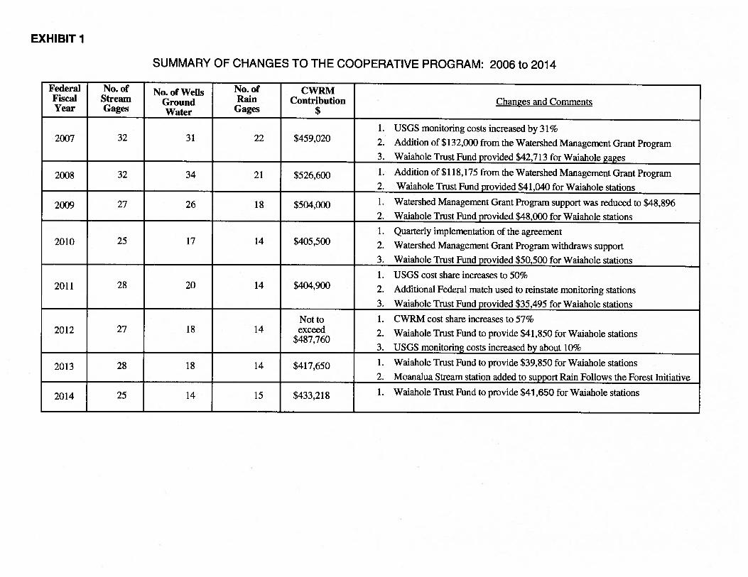
SUMMARY OF CHANGES TO THE COOPERATIVE PROGRAM: 2006 to 2014
Federal No. of No. of Wells No. of CWRMFiscal Stream Ground Rain Contribution Changes and CommentsYear Gages Water Gages $
1. USGS monitoring costs increased by 31%2007 32 31 22 $459,020 2. Addition of $132,000 from the Watershed Management Grant Program
3. Waiahole Trust Fund provided $42,713 for Waiahole gages
2008 32 34 21 $526,600 1. Addition of $118,175 from the Watershed Management Grant Program2. Waiahole Trust Fund provided $41,040 for Waiahole stations
2009 27 26 18 $504,000 1. Watershed Management Grant Program support was reduced to $48,8962. Waiahole Trust Fund provided $48,000 for Waiahole stations
1. Quarterly implementation of the agreement2010 25 17 14 $405,500 2. Watershed Management Grant Program withdraws support
3.__Waiahole Trust Fund_provided_$50,500 for Waiahole_stations
1. USGS cost share increases to 50%2011 28 20 14 $4,900 2. Additional Federal match used to reinstate monitoring stations
3.__Waiahole Trust Fund_provided_$35,495_for Waiahole_stations
Not to 1. CWRM cost share increases to 57%2012 27 18 14 exceed 2. Waiahole Trust Fund to provide $41,850 for Waiahole stations
$487,7603. USGS_monitoring_costs_increased by_about_10%
2013 28 18 14 $417,650 1. Waiahole Trust Fund to provide $39,850 for Waiahole stations
2.__Moanalua_Stream_station_added to_support Rain_Follows_the Forest Initiative
2014 25 14 15 $433,218 1. Waiahole Trust Fund to provide $41,650 for Waiahole stations
EXHIBIT 1

250
200
0Co00)
1500)
0C.)
(0
0
1000C.)‘I0I-.0
EZ 50
0
History of USGS Monitoring Stations in Operation, Pacific Island Water Science Center
[EXHIBIT 2]

EXHIBIT 3
SCOPE OF SERVICES
1. This Joint Funding Agreement is a continuation of the joint funding agreement for thecollection of hydrological data in the State of Hawaii between the U.S. Geological Survey,United States Department of the Interior and the Commission on Water Resource Management,Department of Land and Natural Resources, State of Hawaii.
2. The scope of services involves the collection and computation of data on water resourcescollected in multiple locations throughout the State of Hawaii.
3. U.S. Geological Survey shall collect data at an agreed upon list of surface water stations,ground water monitoring stations, and rainfall stations, as set forth in Exhibit 4 which isattached hereto and incorporated by reference.
4. U.S. Geological Survey shall provide data summary reports and review of historical data sets.
5. U.S. Geological Survey shall host the maps, data, and reports resulting from this program in apublicly-accessible website, and shall provide the Commission staff direct and easy access toacquire, download, or transfer the data and report from a USGS server. The parties shall usegood faith efforts to resolve any disagreements in the scope and validation of data acquisitionand the contents of the report.
6. U.S. Geological Survey shall provide a readable statement of cooperative relations and visuallyidentifiable symbol of the Commission as a cooperator in print, digital, and online publicationsof the data and reports of the monitoring stations that are included in the current cooperativeprogram, and as well as the stations that were historically supported and funded by theCommission.
7. At least quarterly and upon request by the Commission on Water Resource Management, theU.S. Geological Survey will update the Commission on the progress of its work on this JointFunding Agreement.
8. The Commission on Water Resource Management shall assist the U.S. Geological Survey in itswork under the Joint Funding Agreement to the extent feasible and practicable under existingresources of the Commission.
— C.
United States Department of the InteriorU.S. GEOLOGICAL SURVEY
Pacific Islands Water Science Center677 Ala Moana Blvd., Suite 415
Honolulu, Hawaii 96813
Phone: (808) 587-2400/Fax: (808) 587-2401
August 2, 2013
Mr. William Tam, Deputy DirectorState of HawaiiDepartment of Land and Natural ResourcesCommission on Water Resource ManagementP.O. Box 621Honolulu, Hawaii 96809
Attention: Jeremy Kimura
Dear Mr. Tam:
Subject: Joint Funding Agreement to continue our cooperative water-resource monitoring programduring the period October 1, 2013 to September 30, 2014
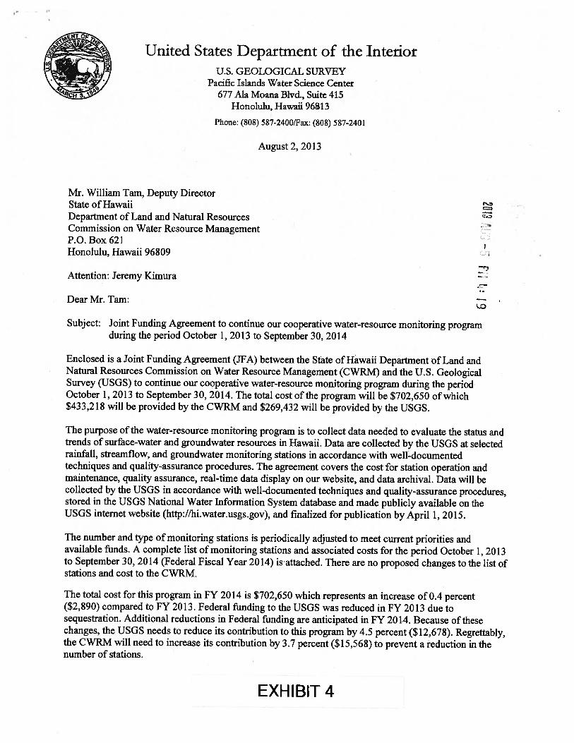
Enclosed is a Joint Funding Agreement (JFA) between the State of Hawaii Department of Land andNatural Resources Commission on Water Resource Management (CWRM) and the U.S. GeologicalSurvey (USGS) to continue our cooperative water-resource monitoring program during the periodOctober 1, 2013 to September 30, 2014. The total cost of the program will be $702,650 of which$433,218 will be provided by the CWRM and $269,432 will be provided by the USGS.
The purpose of the water-resource monitoring program is to collect data needed to evaluate the status andtrends of surface-water and groundwater resources in Hawaii. Data are collected by the USGS at selectedrainfall, streamfiow, and groundwater monitoring stations in accordance with well-documentedtechniques and quality-assurance procedures. The agreement covers the cost for station operation andmaintenance, quality assurance, real-time data display on our website, and data archival. Data will becollected by the USGS in accordance with well-documented techniques and quality-assurance procedures,stored in the USGS National Water Infbnnation System database and made publicly available on theUSGS internet website (http://hi.water.usgs.gov), and finalized for publication by April 1, 2015.
The number and type of monitoring stations is periodically adjusted to meet current priorities andavailable funds. A complete list of monitoring stations and associated costs for the period October 1, 2013to September 30, 2014 (Federal Fiscal Year 2014) is attached. There are no proposed changes to the list ofstations and cost to the CWRM.
The total cost for this program in FY 2014 is $702,650 which represents an increase of 0.4 percent($2,890) compared to FY 2013. Federal funding to the USGS was reduced in FY 2013 due tosequestration. Additional reductions in Federal funding are anticipated in FY 201.4. Because of thesechanges, the USGS needs to reduce its contribution to this program by 4.5 percent ($12,678). Regrettably,the CWRM will need to increase its contribution by 3.7 percent ($15,568) to prevent a reduction in thenumber of stations.
EXHIBIT 4

Mr. William Tam, Deputy Director Page 2
If you are in agreement with this program, please sign and return a copy of the enclosed JFA bySeptember 30, 2013, or at your earliest convenience.
The legal authority for the USGS to enter into this program is 43 USC 50. Work performed with fundsfrom this agreement will be conducted on a fixed-price basis. This means that invoices will be based onthe agreed-upon amount, rather than actual itemized expenses. Your agency will be billed using Form DI-1040, according to the terms of the agreement
The results of the work under this agreement will be available to the USGS for publication and use inconnection with related work. In addition, the USGS may provide unpublished USGS data or informationto your office for review during the course of this jointly planned activity and partnership. Guidanceconcerning the U.S. Geological Survey’s non-disclosure policy will be provided with any review materialand is further explained in USGS Circular 1367, Fundamental Science Practices, available athttp://pubs.usgs.gov/circ/1367/pdflC 13 67.pdf.
If you have any questions concerning this program, please feel free to contact Ron Rickman of my staff at587-2407 or by e-mail (rrickmanusgs.gov).
Thank you for your continued interest in working with the USGS to provide water resource informationfor the State of Hawaii.
Sincerely,
4sStephen S. AnthonyCenter Director
Enclosure/Attachment
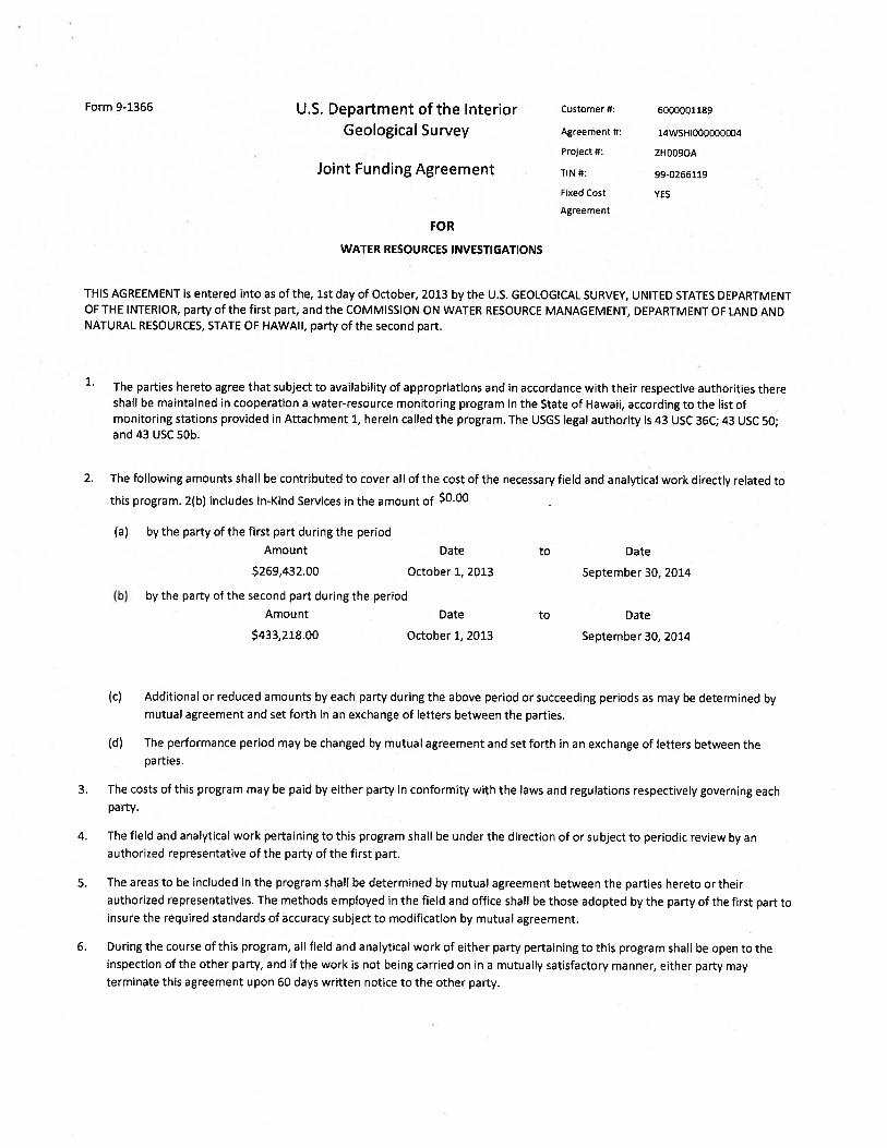
Form 9-1366 U.S. Department of the Interior Customer#: 6000001189
Geological Survey Agreement #: 14W5H1000000004
Project 4*: ZHOO9OA
Joint Funding Agreement TIN 4*: 99-0265119
F,xed Cost YES
Agreement
FOR
WATER RESOURCES INVESTIGATIONS
THIS AGREEMENT is entered into as of the, 1st day of October, 2013 by the U.S. GEOLOGICAL SURVEY, UNITED STATES DEPARTMENTOF THE INTERIOR, party of the first part, and the COMMISSION ON WATER RESOURCE MANAGEMENT, DEPARTMENT OF LAND ANDNATURAL RESOURCES, STATE OF HAWAII, party of the second part.
1. The parties hereto agree that subject to availability of appropriations and in accordance with their respective authorities thereshall be maintained in cooperation a water-resource monitoring program in the State of Hawaii, according to the list ofmonitoring stations provided in Attachment 1, herein called the program. The USGS legal authority is 43 USC 36C; 43 USC 50;and 43 USC 5Db.
2. The following amounts shall be contributed to cover all of the cost of the necessary field and analytical work directly related to
this program. 2(b) includes In-Kind Services in the amount of $0.00
(a) by the party of the first part during the period
Amount Date to Date
$269,432.00 October 1, 2013 September 30, 2014
(b) by the party of the second part during the period
Amount Date to Date
$433,218.00 October 1, 2013 September 30, 2014
(c) Additional or reduced amounts by each party during the above period or succeeding periods as may be determined bymutual agreement and set forth in an exchange of letters between the parties.
(d) The performance period may be changed by mutual agreement and set forth in an exchange of letters between theparties.
3. The costs of this program may be paid by either party in conformity with the laws and regulations respectively governing eachparty.
4. The field and analytical work pertaining to this program shall be under the direction of or subject to periodic review by anauthorized representative of the party of the first part.
5. The areas to be included in the program shall be determined by mutual agreement between the parties hereto or theirauthorized representatives. The methods employed in the field and office shall be those adopted by the party of the first part toinsure the required standards of accuracy subject to modification by mutual agreement.
6. During the course of this program, all field and analytical work of either party pertaining to this program shall be open to theinspection of the other party, and if the work is not being carried on in a mutually satisfactory manner, either party mayterminate this agreement upon 60 days written notice to the other party.

9-1366 (Continuation) Customer #: 6000001189 Agreement #: 14WSHI000000004
7. The original records resulting from this program will be deposited in the office of origin of those records. Upon request, copiesof the original records will be provided to the office of the other party.
8. The maps, records, or reports resulting from this program shall be made available to the public as promptly as possible, Themaps, records, or reports normally will be published by the party of the first part. However, the party of the second partreserves the right to publish the results of this program and, if already published by the party of the first part shall, uponrequest, be furnished by the party of the first part, at costs, impressions suitable for purposes of reproduction similar to that forwhich the original copy was prepared. The maps, records, or reports published by either party shall contain a statement of thecooperativerelations between the parties.
9. USGS will issue billings utilizing Department of the Interior Bill for Collection (form Dl-1040). Billing documents are to berendered Quarterly. Payments of bills are due within 60 days after the billing date. If not paid by the due date, interest will becharged at the current Treasury rate for each 30 day period, or portion thereof, that the payment is delayed beyond the duedate. (31 USC 3717; Comptroller General File B-212222, August 23, 1983).
U.S. Geological Survey Commission on Water ResourceUnited States Management
Department of the Interior Department of Land and NaturalResources
State of HawaiiUSGS Point of Contact Customer Point of Contact
Name: Ronald Rickman Name: William J. Aila Jr., Chairperson
Address: USGS - PIWSC Address: CWRM - DLNR677 Ala Moana Blvd., Suite 415, P.O. Box 621Honolulu, Hawaii 96813 Honolulu, Hawaii 96809
Telephone: 808-587-2407 Telephone: 808-587-0214
Email: [email protected] Email: [email protected]
Signature and Date Signature and Date
Signature and ,
,.-.
Signature andDate:
/c7))i Date:
Name: Ronald Rickman Name: William J. Aila Jr.
Title: Acting Center Director Title: Chairperson

Scope of Investigations Attachment I
Monitoring Stations to be operated as part of the cooperative water-resource monitoring program between the State of Hawaii Department of Land and Natural ResourcesCommission on Water Resource Management and the U.S. Geological Survey during the period October 1,201310 September 30, 2014.
RT, real-time telemetry to make data accessible over the internet through the USGS National Water Information System]
USGS Station No. Island USGS Station Name Station Type Frequency CWRM USGS Total
215607159344301 Kauai212154158015201 Oahu212738158034301 Oahu213438158091101 Oahu211832157515501 Oahu211832157515502 Oahu212238157561101 Oahu210402156495801 Molokai210825157004301 Molokai205140156304501 Maui205405156305401 Maui194327156002301 Hawaii190423155371501 Hawaii200132155471101 Hawaii
2-5634-01 Hanapepe Ridge3-2101-03 Honouliuli3-2703-02 Kunia Basal Monitor Well3-3409-16 Mokuleia3-1851-19 Halekauwila Street, Pipe A3-1851-19 Halekauwila Street, Pipe B3-2256-10 Aiea US Navy, (187-B)4-0449-01 Ualapue4-0800-01 Kualapuu Deep Monitor Well6-5130-01 Waikapu 16-5430-05 Waiehu Deep Monitor Well4360-01 Kalaoa N Kona (VV12-11)8-0437-01 Waiohinu*
8-6147-01 Kawaihae W-3
1051.0 N. Wailua Ditch near Lihue1083.0 Mohihi Crossing near Waimea1082.0 Waiakoali near Waimea1084.0 Kilohana near Hanalei1042.0 Waialae near Waimea772.3 Moanalua No. I at alt. 1,000 ft837.0 Waiahole at Kamehameha Hwy.883.12 Poamoho No. 1, nr Wahiawa886.4 Kahana at alt. 95 ft.897.9 Pupukea at alt. 1,160 ft.897.11 Kamananui at alt. 720 ft.255.0 Kepuni Gulch83.0 Quarry at Saddle Road92.5 Kiholo185.7 Kawainui near Kamuela
Groundwater levelGroundwater levelGroundwater levelGroundwater levelGroundwater level + ChlorideGroundwater level + ChlorideGroundwater levelGroundwater levelSalinity profileGroundwater levelGroundwater levelGroundwater levelGroundwater levelGroundwater level
RainfallRainfallRainfallRainfallRainfallRainfallRainfallRainfallRainfallRainfallRainfallRainfallRainfallRainfallRainfall
220356159281401220713159361201220739159373001220927159355001220523159341201212359157502601212855157504501213215157552800213237157530701213608158011101213732158010201203721156151601194117155174801194945155534402200518155405801
KauaiKauaiKauaiKauaiKauaiOahuOahuOahuOahuOahuOahuMaui
HawaiiHawaiiHawaii
QuarterlyQuarterlyQuarterlyQuarterlyQuarterlyQuarterly7 times per yearQuarterly2 times per yearQuarterlyContinuousContinuousQuarterlyQuarterly
Continuous - RTContinuous - RTContinuous - RTContinuous - RTContinuous - RTContinuous - RTContinuous - RTContinuous - RTContinuous - RTContinuous - RTContinuous - RTContinuous - RTContinuous - RTContinuous - RTContinuous - RT
2,0452,5202,5152,8304,4104,4103,3682,5202,7302,5204,6105,0401,4203,040
6,4556,4556,4556,4556,4556,4556,2055,4806,2056,4556,4556,0706,0706,6505,545
1,2801,280
730730
1,0301,030
8221,2801,2801,2802,1902,190
350730
3,2153,2153,2153,2153,2153,2151,8554,1901,8553,2153,2153,6003,6003,0202,515
3,3253,8003,2453,5605,4405,4404,1903,8004,0103,8006,8007,2301,7703,770
9,6709,6709,6709,6709,6709,6708,0609,6708,0609,6709,6709,6709,6709,6708,060

USGS Station No. Island USGS Station Name Station Type Frequency CWRM USGS IcI
16049000 Kauai Hanapepe Riv below Manuahi Str nr Eleele SW RT-Cont Continuous - RT 11,815 8,275 20,09016060000 Kauai SF Wailua River near Lihue SW RT-Cont Continuous - RT 11,815 8,275 20,09016068000 Kauai East Branch of North Fork Wailua River nr Lihue SW RT-Cont Continuous - RT 11,815 8,275 20,09016071500 Kauai Left Branch Opaekaa Stream near Kapaa SW RT-Cont Continuous - RT 11,815 8,275 20,09016097500 Kauai Halaulani Stream at alt 400 ft. near Kilauea SW RT-Cont Continuous - RT 11,815 8,275 20,09016103000 Kauai Hanalei River near Hanalei SW RT-Cont Continuous - RT 11,815 8,275 20,09016227500 Oahu Moanalua Stream near Kaneohe SW RT-Cont Continuous — RT 11,815 8,275 20,09016229000 Oahu Kalihi Stream near Honolulu SW RT-Cont Continuous - RT 11,815 8,275 20,09016240500 Oahu Waiakeakua Stream at Honolulu SW RT-Cont Continuous - RT 11,815 8,275 20,09016294900 Qahu Waikane Stream at alt. 75 ft. at Waikane SW RT-Cont Continuous - RT 11,815 8,275 20,09016345000 Oahu Opaeula Stream near Wahiawa SW RT-Cont Continuous - RT 11,815 8,275 20,09016294100 Oahu Waiahole Stream above Kamehameha Hwy. SW RT-Cont Continuous - RT 11,815 8,275 20,09016296500 Oahu Kahana Stream at alt. 30 ft. nr Kahana SW RT-Cont Continuous - RT 11,815 8,275 20,09016301050 Qahu Punaluu Stream above Diversion near Punaluu SW RT-Cont Continuous - RT 11,815 8,275 20,09016508000 Maui Hanawi Stream near Nahiku SW RT-Cont Continuous - RT 11,815 8,275 20,09016604500 Maui lao Stream at Kepaniwai Park near Wailuku SW RT-Cont Continuous - RT 11,815 8,275 20,09016614000 Maui Waihee River abv Waihee Ditch Intake nr Waihee SW RT-Cont Continuous - RT 11,815 8,275 20,09016620000 Maui Honokohau Stream near Honokohau SW RT-Cont Continuous - RT 11,815 8,275 20,09016518000 Maui West Wailuaiki Stream near Keanae SW RT-Cont Continuous - RT 11,815 8,275 20,09016587000 Maui Honopou Stream near Huelo SW RT-Cont Continuous - RT 11,815 8,275 20,09016704000 Hawaii Wailuku River at Piihonua SW RT-Cont Continuous - RT 11,815 8,275 20,09016720000 Hawaii Kawainui Stream nr Kamuela SW RT-Cont Continuous - RT 11,815 8,275 20,09016770500 Hawaii Paauau Gulch at Pahala SW RT-Cont Continuous - RT 11,815 8,275 20,09016717000 Hawaii Honolii Stream nr Papaikou SW RT-Cont Continuous - RT 11,815 8,275 20,09016725000 Hawaii Alakahi Stream near Kamuela SW RT-Cont Continuous - RT 11,815 8,275 20,090
* $3,100 funded by the USGS CBR program Total = 433,218 269,432 702,650