state of the art of geomatics in italy …geomatica.como.polimi.it/presentazioni/udine_ottobre...
TRANSCRIPT

Udine, 26th October 2011
STATE OF THE ART OF GEOMATICSIN ITALY:
FROM SCIENCE TO TECHNOLOGY
Fernando Sansó
DIIAR - Politecnico di Milano – Polo Territoriale di Como

The presentation is done according to the following tree
Positioning Navigation
Geomatics
Surface DeterminationGeodesy Geo Info Systems
Geometry Thematic 2D 4D Warping & Generalization
GeoservicesGravity field; heights
DIIAR - Politecnico di Milano Polo Territoriale di Como
STATE OF THE ART OF GEOMATICS IN ITALY: FROMSCIENCE TO TECHNOLOGY 2

Geodesy
Gravity Field Positioning
Surveying & NavigationReference Systems
& Monitoring
Global Local
Space Gravity MonitoringGeoid
DIIAR - Politecnico di Milano Polo Territoriale di Como
STATE OF THE ART OF GEOMATICS IN ITALY: FROMSCIENCE TO TECHNOLOGY 3

Surface Determination
Image Analisys Geometry
Frequency Space (Remote Sensing
Classification)
(Interface : Vision and Artificial Intelligence)
Close Range Image Space
(Segmentation Recognition)
DTM/DSM
DIIAR - Politecnico di Milano Polo Territoriale di Como
STATE OF THE ART OF GEOMATICS IN ITALY: FROMSCIENCE TO TECHNOLOGY 4

(Interface : Informatics) Geo-Information Systems
DB Merging GeoservicesRepresentation
Georefering Warping Generalization from 2D to 4D 3D Visualization GeoWeb
DIIAR - Politecnico di Milano Polo Territoriale di Como
STATE OF THE ART OF GEOMATICS IN ITALY: FROMSCIENCE TO TECHNOLOGY 5

For each subject we will consider:
• conceptual framework• problems and research items on which there are
groups working (to the knowledge of the speaker)• realizations, if any (to the knowledge of the speaker)
No list of names (too boring)
The puzzle will not be complete
DIIAR - Politecnico di Milano Polo Territoriale di Como
STATE OF THE ART OF GEOMATICS IN ITALY: FROMSCIENCE TO TECHNOLOGY 6

Geodesy: Heights
- need of an overall geoid Global gravity model only?
( )ζ+=+= *hNHh
(2159)2 coefficients! and spherical harmonics
sewing the various geoid patches.
EGM08cm10≈σ( )∑= λϑ
γ,1
mmYTN
- worldwide unification of the height datum
G1
G2
DIIAR - Politecnico di Milano Polo Territoriale di Como
STATE OF THE ART OF GEOMATICS IN ITALY: FROMSCIENCE TO TECHNOLOGY 7

Realization
( ) cmN 5≈σ
The Italian geoid Italgeo05
DIIAR - Politecnico di Milano Polo Territoriale di Como
STATE OF THE ART OF GEOMATICS IN ITALY: FROMSCIENCE TO TECHNOLOGY 8

Geodesy: Space Gravity Monitoring
To understand climate evolution and assess natural hazards
Ice melting
Atmospheric water vapour content
Earthquake
DIIAR - Politecnico di Milano Polo Territoriale di Como
STATE OF THE ART OF GEOMATICS IN ITALY: FROMSCIENCE TO TECHNOLOGY 9

Geodesy: Reference Systems and Monitoring (1)
Combination of Global RS – Regional RS
Geodinamics: deformation as function of Reference System
from Global to National
DIIAR - Politecnico di Milano Polo Territoriale di Como
STATE OF THE ART OF GEOMATICS IN ITALY: FROMSCIENCE TO TECHNOLOGY 10

Realization 1RDN (National Reference Network by IGM, Istituto Geografico Militare, and Universities).
National Network of 90 permanent GNSS stations implemented according to EUREF rules: continuous monitoring in progress.
DIIAR - Politecnico di Milano Polo Territoriale di Como
STATE OF THE ART OF GEOMATICS IN ITALY: FROMSCIENCE TO TECHNOLOGY 11

Realization 2RING (National Deformation Network by INGV)
National Network of more than 150 permanent GNSS stations to study deformation related to crustal dynamics and relevant geophysical effects.
DIIAR - Politecnico di Milano Polo Territoriale di Como
STATE OF THE ART OF GEOMATICS IN ITALY: FROMSCIENCE TO TECHNOLOGY 12

Geodesy: Reference Systems and Monitoring (2)
Local
Regional positioning services
Positioning Services by Private Companies
Local Monitoring(- combination of Positioning with
prior deformation models,- combination of Positioning with differentsensors)
DIIAR - Politecnico di Milano Polo Territoriale di Como
STATE OF THE ART OF GEOMATICS IN ITALY: FROMSCIENCE TO TECHNOLOGY 13

“Real time”The reconstruction of an earthquake waveform by a standing alone GPS receiver (Fukushima Earthquake).
DIIAR - Politecnico di Milano Polo Territoriale di Como
STATE OF THE ART OF GEOMATICS IN ITALY: FROMSCIENCE TO TECHNOLOGY 14

Troposheric Tomography by GPS to correct SAR dat on P.S. at mm level! (The Ivanchich landslide)
sliding area
DIIAR - Politecnico di Milano Polo Territoriale di Como
STATE OF THE ART OF GEOMATICS IN ITALY: FROMSCIENCE TO TECHNOLOGY 15

Surveying and Navigation
• Theory, algoritms and SW development forpermanent GNSS networks, positioning services andnavigation (several items; in particular Quality Control ofRTK positioning).
• Exploring the limits of low cost receivers (100 €) embeddedin a positioning service.
in continuous evolution
Accuracy
DIIAR - Politecnico di Milano Polo Territoriale di Como
STATE OF THE ART OF GEOMATICS IN ITALY: FROMSCIENCE TO TECHNOLOGY 16

A student's Lab with an Ublox/eBontek receivers referred to a permanent station.
ReferenceLab SW (GoGPS)Resident SW
DIIAR - Politecnico di Milano Polo Territoriale di Como
STATE OF THE ART OF GEOMATICS IN ITALY: FROMSCIENCE TO TECHNOLOGY 17

Not to be forgotten: the true navigation!GBAS system scenery
DIIAR - Politecnico di Milano Polo Territoriale di Como
STATE OF THE ART OF GEOMATICS IN ITALY: FROMSCIENCE TO TECHNOLOGY 18

SBAS system scenery
DIIAR - Politecnico di Milano Polo Territoriale di Como
STATE OF THE ART OF GEOMATICS IN ITALY: FROMSCIENCE TO TECHNOLOGY 19

S.D.: Geometry DTM/DSMDTM = DEM + other
vector data usefulto describe theterrain morphology
DEMDSM
DDTM = Dense DTM
(high spatial resolution)
Problems:• find broken lines• identify synthetic/natural surfaces• interpolation algorithms
(e.g. gravimetry requires knowing DTM, flood riskprevention requires DTM without canopy, forestry requirescanopy and DTM i.e. mean height of the trees...)
DIIAR - Politecnico di Milano Polo Territoriale di Como
STATE OF THE ART OF GEOMATICS IN ITALY: FROMSCIENCE TO TECHNOLOGY 20

A surface described bypixels (light or SAR) or bypoints (LiDAR)
S.D.: Geometry: the resolution problem
Research item: the “best” combination of differentobservation functionals with different accuracy and different
resolution, (mostly) with insufficient information on thestochastic model.
SAR Imaging
LiDAR
DIIAR - Politecnico di Milano Polo Territoriale di Como
STATE OF THE ART OF GEOMATICS IN ITALY: FROMSCIENCE TO TECHNOLOGY 21

Photogrammetry Navigation
UAVSurface
Reconstruction
S.D.: Photogrammetry by complex takings
DIIAR - Politecnico di Milano Polo Territoriale di Como
STATE OF THE ART OF GEOMATICS IN ITALY: FROMSCIENCE TO TECHNOLOGY 22

• UAV: Microdrones MD4‐200• Multispettral images with different payloads (Pentax Optio AD40, Sigma DP1, Tetracam ADC Lite)
Test area:Medolago (BG) – Parco Adda Nord
Objective:classification study for recognizing non‐native plants
Multispectral images from UAV
DIIAR - Politecnico di Milano Polo Territoriale di Como
STATE OF THE ART OF GEOMATICS IN ITALY: FROMSCIENCE TO TECHNOLOGY 23

Georeferencing ortriangulation
S.D.: Geometry: space imaging
High resolution images: (Heros, Aster, Quickbird)validation/calibration
DIIAR - Politecnico di Milano Polo Territoriale di Como
STATE OF THE ART OF GEOMATICS IN ITALY: FROMSCIENCE TO TECHNOLOGY 24

Realizations
• Imagery of the whole national area every 3 years by a private company (BLOM, once CGR)
• SAR imaging by Cosmo SkyMed (Italian Space Agency)
• Many realizations at regional or more local level formapping or other particular purposes
• No national authority for imaging only regional coordination (CISIS)
DIIAR - Politecnico di Milano Polo Territoriale di Como
STATE OF THE ART OF GEOMATICS IN ITALY: FROMSCIENCE TO TECHNOLOGY 25

Cosmo Sky Med (SAR in X band) by Italian Space Agency
Realizations
PRISMA by ASI (Launch 2013)Environmental hyperspectral mission(parallel to ENMAP by DLR)
DIIAR - Politecnico di Milano Polo Territoriale di Como
STATE OF THE ART OF GEOMATICS IN ITALY: FROMSCIENCE TO TECHNOLOGY 26

Coverage of rivers andcoast lines by LIDAR + Hyperspectral (MIVIS)data (flight 2011)
Extraordinary Plan for the Environmental Remote Sensing
DIIAR - Politecnico di Milano Polo Territoriale di Como
STATE OF THE ART OF GEOMATICS IN ITALY: FROMSCIENCE TO TECHNOLOGY 27

Automatic Italian SW on LiDAR image classification
Object with single pulse (building)
Object with double pulse (high vegetation)
Terrain with double pulse (low vegetation)
Terrain with single pulse (terrain)
DIIAR - Politecnico di Milano Polo Territoriale di Como
STATE OF THE ART OF GEOMATICS IN ITALY: FROMSCIENCE TO TECHNOLOGY 28

TerraScan automatic classification
Building
Unclassified
Vegetation
Terrain
DIIAR - Politecnico di Milano Polo Territoriale di Como
STATE OF THE ART OF GEOMATICS IN ITALY: FROMSCIENCE TO TECHNOLOGY 29

• Project fidelity• Monitoring
S.D.: Geometry: Close Range
Deformations detected by laser scanning
TLS station
May 2006 VS Oct 2005
Nov 2006 VS May 2005
Traditional monitoring with
pendulum (middle section)
Cancano Dam (Valtellina, Italy)Surface monitoring of the Cancano Dam by combining total station, Laser tracking and LIDAR.
DIIAR - Politecnico di Milano Polo Territoriale di Como
STATE OF THE ART OF GEOMATICS IN ITALY: FROMSCIENCE TO TECHNOLOGY 30

YX
Z
94 images70.000 tie pointsRMS (res.) = 0.7 pix
Piazza Navona
Automatic orientation of image sequences with ATiPE (PoliMi)
DIIAR - Politecnico di Milano Polo Territoriale di Como
STATE OF THE ART OF GEOMATICS IN ITALY: FROMSCIENCE TO TECHNOLOGY 31

Cultural heritage archiving/restoring/virtual museum
A wealth of applications for obvious “Italian” reasons.
Bronze horse of the San Marco Basilica in Venice
San Marco Basilica in Venice
DIIAR - Politecnico di Milano Polo Territoriale di Como
STATE OF THE ART OF GEOMATICS IN ITALY: FROMSCIENCE TO TECHNOLOGY 32

33
Multimodal guide for the fruition of cultural heritage.
The wooden ceiling of the Steri Palace in Palermo (Italy)
DIIAR - Politecnico di Milano Polo Territoriale di Como
STATE OF THE ART OF GEOMATICS IN ITALY: FROMSCIENCE TO TECHNOLOGY

S.D.: Image Analysis: segmentation, learning
• The conceptual context
• Contour identification
• Locally adaptive filters (inhomogeneous R.F.)
• Markov Random Fields theory vs variational principles
• Object identification (contour + texture and Bayesianclassification on a finite catalogues)
• Expert systems for decision supportingDIIAR - Politecnico di Milano Polo Territoriale di Como
STATE OF THE ART OF GEOMATICS IN ITALY: FROMSCIENCE TO TECHNOLOGY 34

Challenges:
• quantifying the information of hyperspectral data(principal components analysis)
• unification of supervised and unsupervised classification(Bayesian approach)
• Markov random fields theory
S.D.: Image Analysis: frequency domain
DIIAR - Politecnico di Milano Polo Territoriale di Como
STATE OF THE ART OF GEOMATICS IN ITALY: FROMSCIENCE TO TECHNOLOGY 35

Optical Remote Sensing challenges new data technologies- availability of long time series need for appropriate analysis methodologies- availability of new multi-dimensional data (hyperspectral, sub-daily frequence, …)
needs for new advanced algorithmsnew application fields- near-real time environmental indicators integration of multi-source data- quantitative monitoring of bio-physical parameters specialisation (time and space) of standard bio-optical models
Bio-physical ParametersEnvironmental Indicators
0-2020-4040-6060-8080-100>100 Sahel (Africa)
June
July
Aug.
Oct.
Growth Index
Lago Trasimeno (Italia)
Concentration of cyanobacteria
Low
High
DIIAR - Politecnico di Milano Polo Territoriale di Como
STATE OF THE ART OF GEOMATICS IN ITALY: FROMSCIENCE TO TECHNOLOGY 36
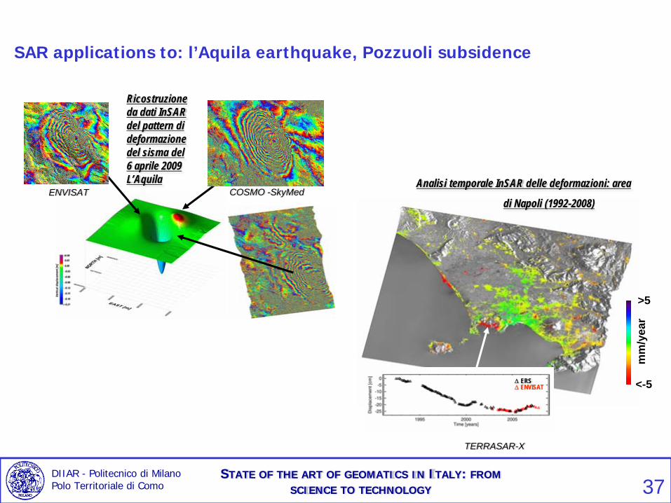
TERRASAR-X
Δ ERSΔ ENVISAT
>5
<-5
mm
/yea
r
Analisi temporale InSAR delle deformazioni: area
di Napoli (1992-2008)COSMO -SkyMedENVISAT
Ricostruzione da dati InSARdel pattern di deformazione del sisma del 6 aprile 2009 L’Aquila
SAR applications to: l’Aquila earthquake, Pozzuoli subsidence
DIIAR - Politecnico di Milano Polo Territoriale di Como
STATE OF THE ART OF GEOMATICS IN ITALY: FROMSCIENCE TO TECHNOLOGY 37

• Georeferencing• Warpring
… to estimate automatically the transformation between “corresponding” points.
Question: use of multiresolution analysis
GIS: DB merging
DIIAR - Politecnico di Milano Polo Territoriale di Como
STATE OF THE ART OF GEOMATICS IN ITALY: FROMSCIENCE TO TECHNOLOGY 38

Automatic wraping of a cadastral map on a regional map
Cadastral map
Technical map
Affine transformation
Splinetransformation
DIIAR - Politecnico di Milano Polo Territoriale di Como
STATE OF THE ART OF GEOMATICS IN ITALY: FROMSCIENCE TO TECHNOLOGY 39
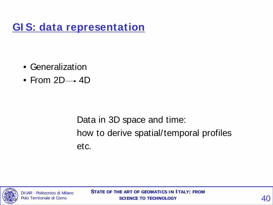
GIS: data representation
• Generalization• From 2D 4D
Data in 3D space and time:how to derive spatial/temporal profilesetc.
DIIAR - Politecnico di Milano Polo Territoriale di Como
STATE OF THE ART OF GEOMATICS IN ITALY: FROMSCIENCE TO TECHNOLOGY 40
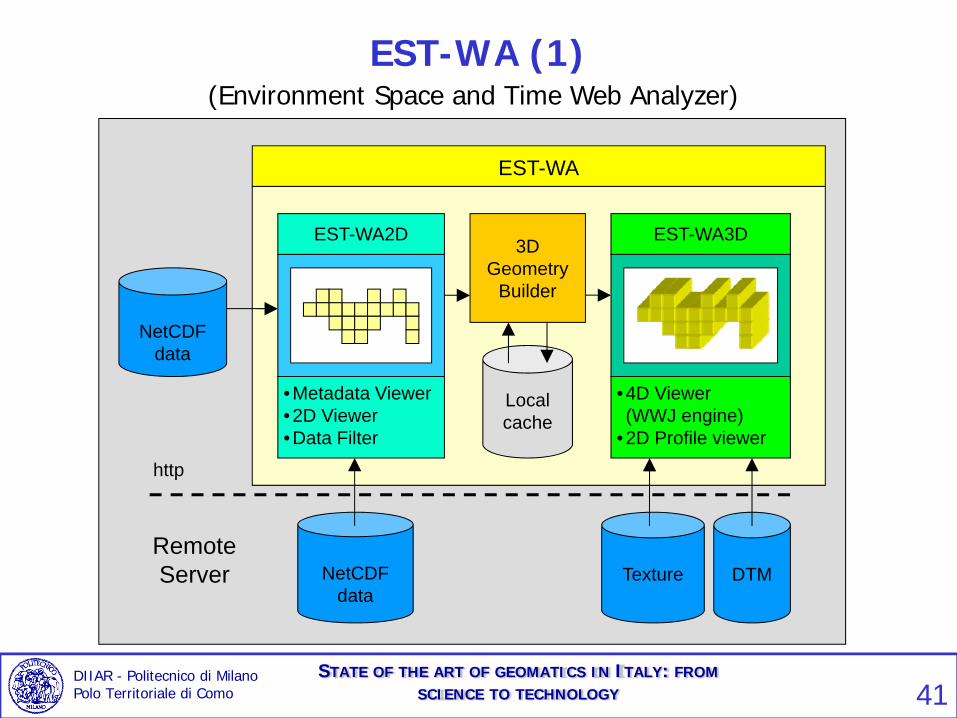
EST-WA (1)(Environment Space and Time Web Analyzer)
•Metadata Viewer •2D Viewer•Data Filter
EST-WA2D 3D Geometry
Builder
Local cache
•4D Viewer (WWJ engine)
•2D Profile viewer
EST-WA3D
EST-WA
NetCDF data
NetCDF data
RemoteServer
http
DTMTexture
DIIAR - Politecnico di Milano Polo Territoriale di Como
STATE OF THE ART OF GEOMATICS IN ITALY: FROMSCIENCE TO TECHNOLOGY 41

EST-WA (2)
EST-WA3D
EST-WA2D: METADATA VIEWEREST-WA2D: DATA FILTER
DIIAR - Politecnico di Milano Polo Territoriale di Como
STATE OF THE ART OF GEOMATICS IN ITALY: FROMSCIENCE TO TECHNOLOGY 42

Users
Catalogues
Data
Processes
INTERNET
GIS: geoservices (cloud computing)
DIIAR - Politecnico di Milano Polo Territoriale di Como
STATE OF THE ART OF GEOMATICS IN ITALY: FROMSCIENCE TO TECHNOLOGY 43

GIS Geoservices – GeoWeb
One server
Many clients
Many servers
One client
DIIAR - Politecnico di Milano Polo Territoriale di Como
STATE OF THE ART OF GEOMATICS IN ITALY: FROMSCIENCE TO TECHNOLOGY 44

Web MappingWeb Map and Geodata
ServersWeb Map and Geodata Clients
INTERNET
DIIAR - Politecnico di Milano Polo Territoriale di Como
STATE OF THE ART OF GEOMATICS IN ITALY: FROMSCIENCE TO TECHNOLOGY 45

Map mashing-upServers Clients
INTERNET
DIIAR - Politecnico di Milano Polo Territoriale di Como
STATE OF THE ART OF GEOMATICS IN ITALY: FROMSCIENCE TO TECHNOLOGY 46

Based on the personal opinion of the speaker:SUMMARY 1
ITALY:
• we have a quite good understanding of research itemswith a inhomogeneous coverage
• we have a substational lack of rules and organizationfor the “national” uniform technical implementation ofadvanced ideas in geomatics
DIIAR - Politecnico di Milano Polo Territoriale di Como
STATE OF THE ART OF GEOMATICS IN ITALY: FROMSCIENCE TO TECHNOLOGY 47

SUMMARY 2 – (key words)
Different data sourcesDimension of the informationComplexity
General Conceptual Problems we still have to face:
Preprocessing, Validation and
Calibration
Define “gross parameters” beforerefining
Assimilation, Fusion Optimal/sub-optimal algorithms
Information supply Visualization 3D – 4D
DIIAR - Politecnico di Milano Polo Territoriale di Como
STATE OF THE ART OF GEOMATICS IN ITALY: FROMSCIENCE TO TECHNOLOGY 48