status of the multi-functional transport satellite (mtsat) program prepared for apsdeu-6, 1-3 june...
TRANSCRIPT
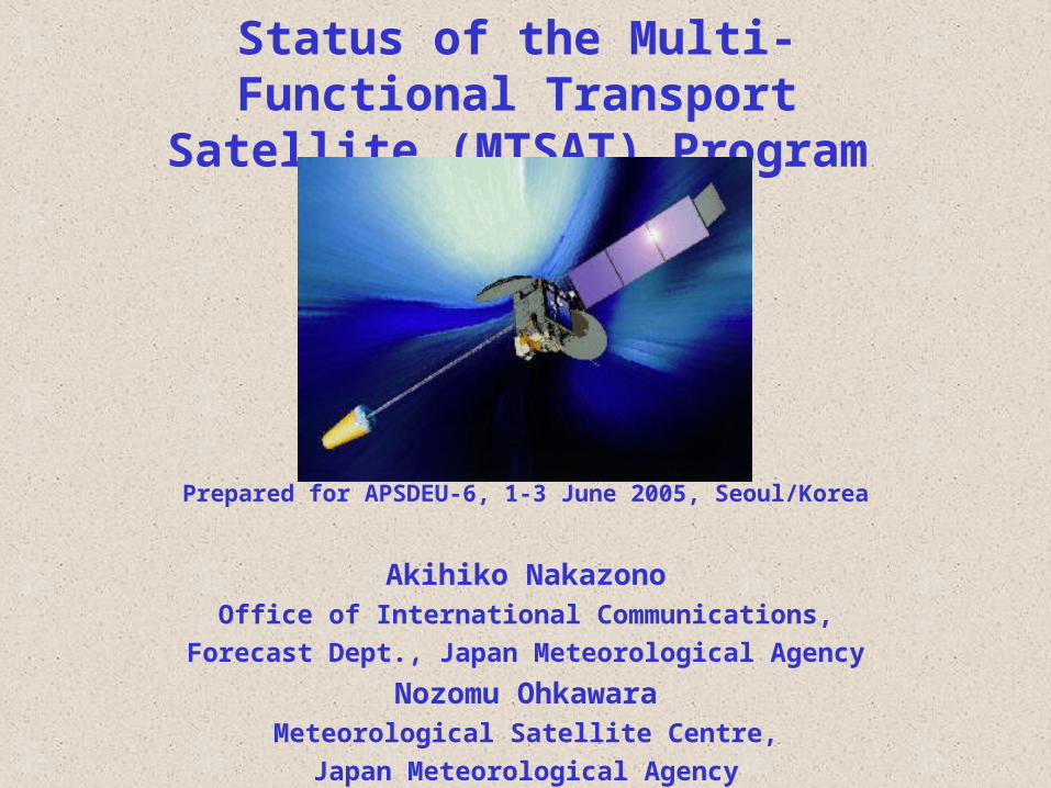
Status of the Multi-Functional Transport Satellite (MTSAT) Program
Prepared for APSDEU-6, 1-3 June 2005, Seoul/Korea
Akihiko NakazonoOffice of International Communications,
Forecast Dept., Japan Meteorological Agency
Nozomu OhkawaraMeteorological Satellite Centre,
Japan Meteorological Agency

IR4 (3.7mm)VIS
IR3(WV:6.7mm)IR1 (11mm)
First images from MTSAT-1R ( 24 March 2005)
IR2 (12mm)

• MTSAT-1 was failed to launch in November 1999
• GMS-5 had been deteriorating its function – The imaging function has been backed
up by GOES-9, in cooperation with NOAA/NESDIS, since 22 May 2003
Back-up of GMS-5 with GOES-9
The left end of a picture is
missing
Sub-satellite point of GOES-9
●●
Sub-satellite point of the GMS-5

MTSAT (-1R / -2) Program
• The successor to the GMS-5 – 3 axis stabilized satellite– 2 missions
• Aeronautical Mission (JCAB)• Meteorological Mission (JMA)

MTSAT-1R
• MTSAT-1R was successfully launched on 26th Feb 2005.
• The in-orbit test of MTSAT-1R has been performed.
• After checking-out of the whole system, including ground facilities, dissemination of imagery from MTSAT-1R will be started. – Test dissemination started on 31th May– The commencement of operational dissemination is
to be announced as soon as defined.
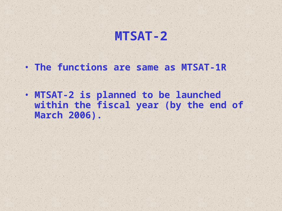
MTSAT-2
• The functions are same as MTSAT-1R
• MTSAT-2 is planned to be launched within the fiscal year (by the end of March 2006).
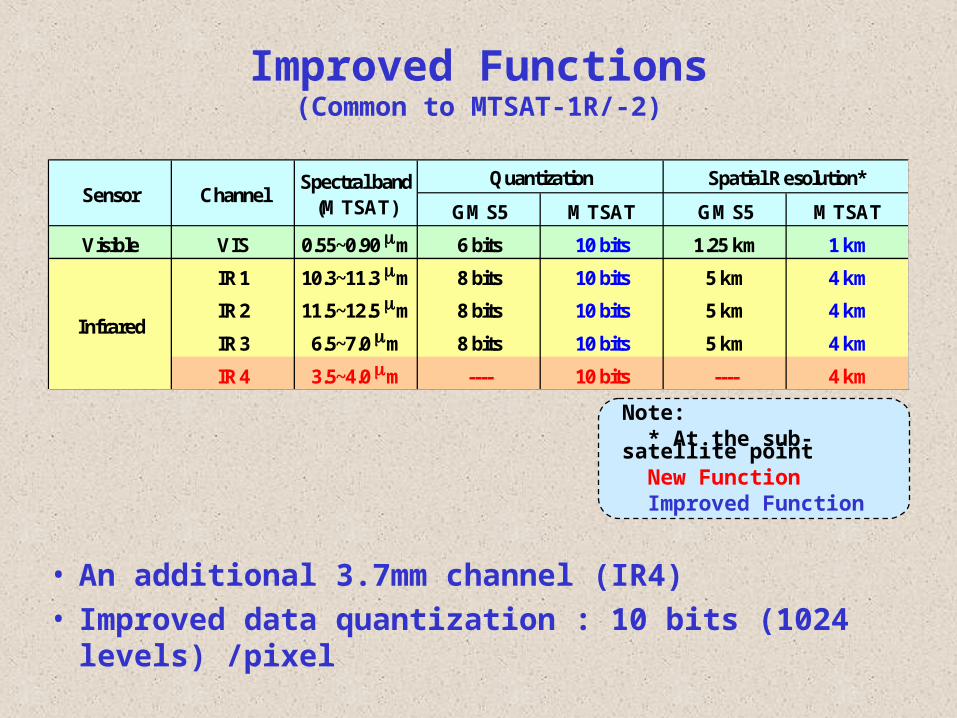
Improved Functions(Common to MTSAT-1R/-2)
GMS5 MTSAT GMS5 MTSAT
Visible VIS 0.55~0.90 m 6 bits 10 bits 1.25 km 1 km
IR1 10.3~11.3 m 8 bits 10 bits 5 km 4 km
IR2 11.5~12.5 m 8 bits 10 bits 5 km 4 km
IR3 6.5~7.0 m 8 bits 10 bits 5 km 4 km
IR4 3.5~4.0 m ---- 10 bits ---- 4 km
Infrared
QuantizationSensor Channel
Spectral band(MTSAT)
Spatial Resolution*
• An additional 3.7mm channel (IR4)• Improved data quantization : 10 bits (1024 levels) /pixel
Note: * At the sub-satellite point New Function Improved Function
Improvement of Services• Half hourly observation for northern hemisphere• No cancellation of observations caused from eclipse pheno
mena • New HRIT and LRIT dissemination services• Continuance of HiRID (S-VISSR compatible) and WEFAX diss
emination services to support user’s migrations• Separate and Independent dissemination service for MDUSs
and SDUSs• Continuance of the Internet dissemination service for MDUS
users (IR1 only)

Observation Schedule of MTSAT-1R
: Full-disk ObservationN S
: Northern Hemisphere ObservationN
: Southern Hemisphere ObservationS

Low Rate Information Transmission (LRIT, 2005~)
• Digital data transmission (64Kbps)– Conventional data compression (JPEG, lossless or lo
ssy)• Contents
– MTSAT Imagery– MANAM
VIS6bits
IR18bits
IR28bits
IR38bits
IR48bits
The Full Earth's Disk Imagery 5km* - o - o -The East Asia Imagery 6.4km o o - O O
The north-east of Japan Imagery 2.4km O - - - -The south-west of Japan Imagery 2.1k O - - - -
o Same products on WEFAXO New products
Spectral Channel
Imagery TypeSpatial
Resolution
* at the subsatellite point

High Resolution Imager Data (HiRID, 2005~2007)
• Compatible with S-VISSR format of GMS-5• IR data with 10 bits level resolution are available• An additional 3.7mm data are also available
S-VISSR FORMAT
IR1
IR2
IR3
VIS1
VIS2
VIS3
VIS4
8 bits 6 bits
IR1
IR2
IR3
VIS1
VIS2
VIS3
VIS4
Upper 8 bits 6 bits
HiRID FORMAT
IR3
IR2
IR1
IR4
10 bitsLower 2 bits
Time gap(No signal)
Doc
umen
tatio
nD
ocum
enta
tion

High Rate Information Transmission (HRIT, 2005~)
• Digital Data Transmission (3.5Mbps)– Conventional data compression (JPEG, lossless)
• Contents– Full resolution imagery of all channels
• Spatial resolution of all channels are improved• VIS data are also available with 10 bits resolution
– NAMAM
GMS5 MTSAT GMS5 MTSAT
Visible VIS 0.55~0.90 m 6 bits 10 bits 1.25 km 1 km
IR1 10.3~11.3 m 8 bits 10 bits 5 km 4 km
IR2 11.5~12.5 m 8 bits 10 bits 5 km 4 km
IR3 6.5~7.0 m 8 bits 10 bits 5 km 4 km
IR4 3.5~4.0 m ---- 10 bits ---- 4 km
Infrared
QuantizationSensor Channel
Spectral band(MTSAT)
Spatial Resolution*
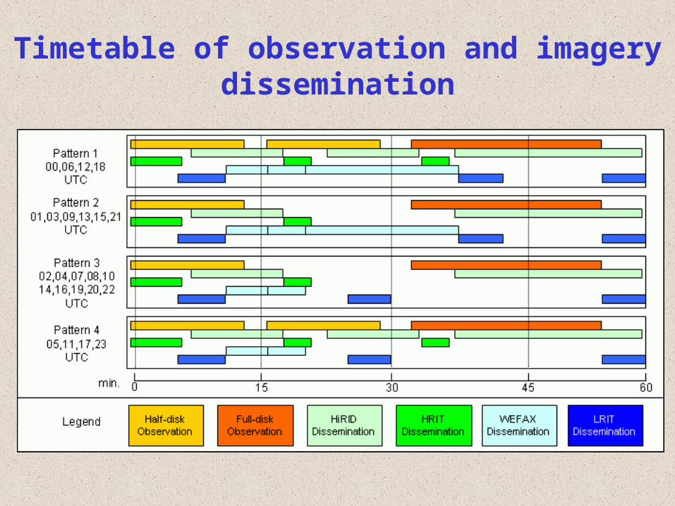
Timetable of observation and imagery dissemination
X
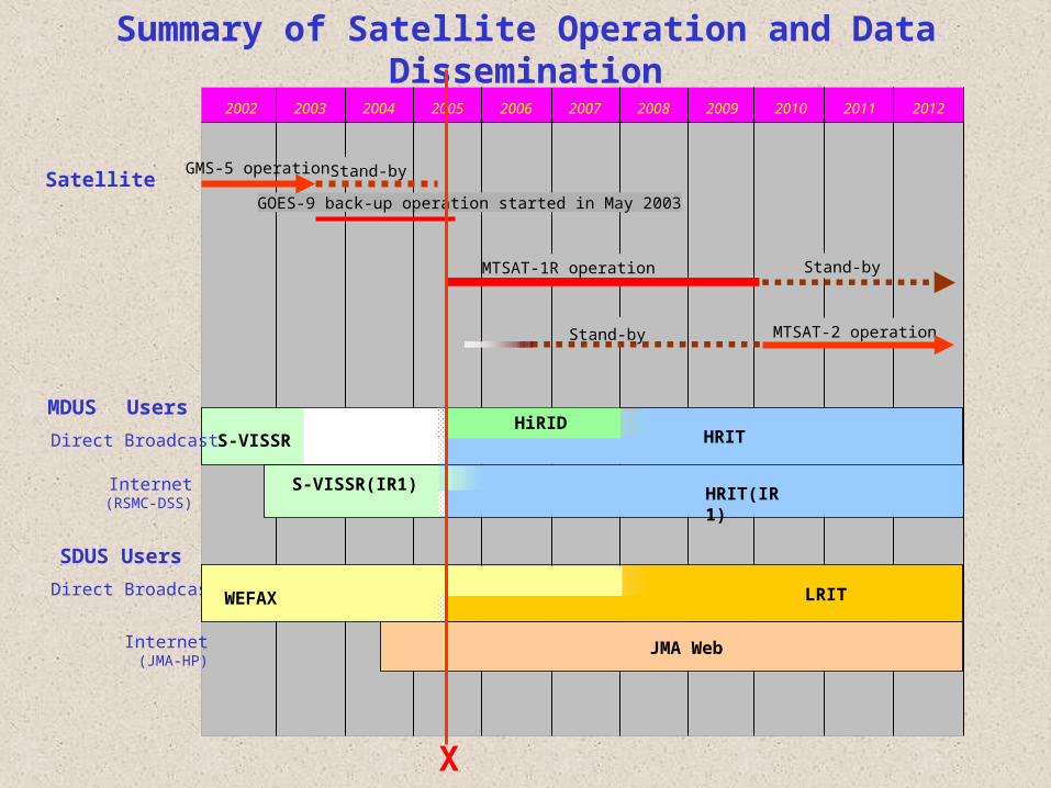
Summary of Satellite Operation and Data Dissemination
2002 2003 2004 2005 2006 2007 2008 2009 2010 2011 2012
MDUS Users
Internet(RSMC-DSS)
SDUS Users
Direct Broadcast
Internet(JMA-HP)
GMS-5 operation Stand-by
MTSAT-1R operation Stand-by
Stand-by MTSAT-2 operation
GOES-9 back-up operation started in May 2003
S-VISSR
JMA Web
LRITWEFAX
HRIT
S-VISSR(IR1)
Direct BroadcastHiRID
Satellite
HRIT(IR1)

Expected improvements of Products
• Sea Surface Temperature (SST)
• Aerosol Optical Thickness (AOT)
• Cloud & Water Vapor Motion Winds
(CMWs & WVMWs)
• Cloud Grid Information Data (CGID)

Sea Surface Temperature (SST)
• IR4 (3.7mm) data was useful to discriminate low level clouds from cloud-free sea in nighttime- Decrease the error due to misjudged low level clouds in
nighttime
Comparisons between satellite SST with/without 3.7mm data and buoy measurements ( Left : bias, Right : RMSE )
bias (mean) RMSE (mean) With 3.7m -0.21 (K) 1.55 (K)Without 3.7m -0.29 (K) 1.78 (K)
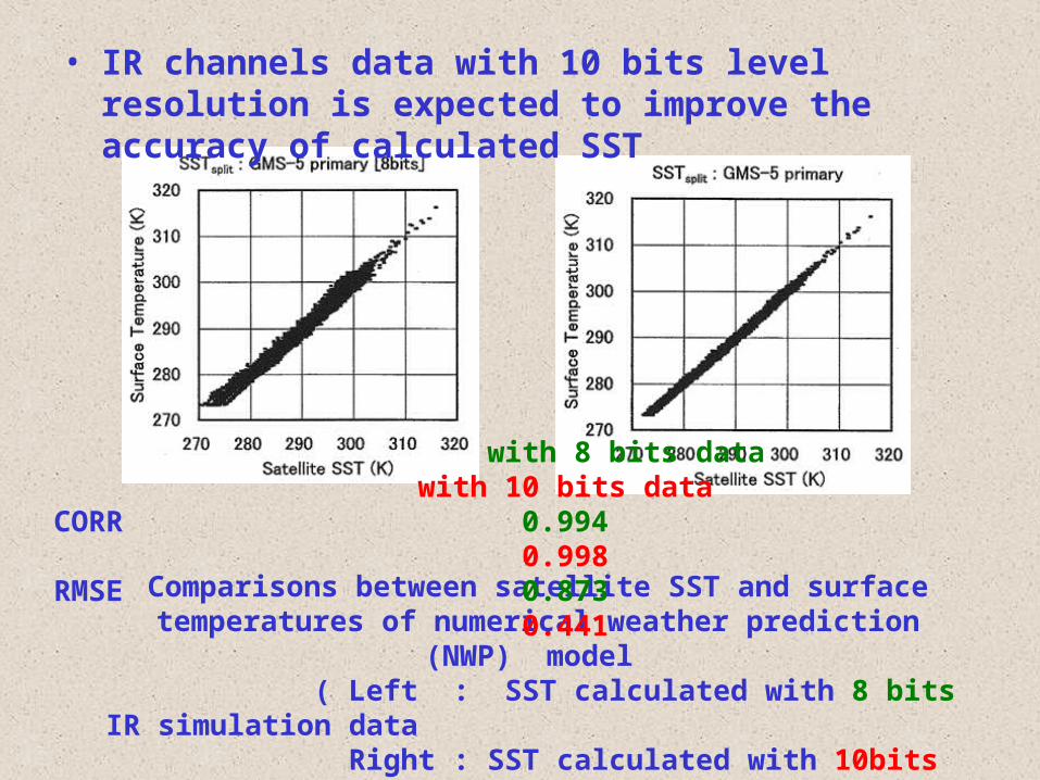
Comparisons between satellite SST and surface temperatures of numerical weather prediction (NWP) model
( Left : SST calculated with 8 bits IR simulation data Right : SST calculated with 10bits IR simulation data )
with 8 bits data with 10 bits dataCORR 0.994 0.998RMSE 0.873 0.441
• IR channels data with 10 bits level resolution is expected to improve the accuracy of calculated SST

Aerosol Optical Thickness (AOT)
• VIS data with 10 bits level resolution will enable the calculated AOT resolution to be 0.01 from 0.1

Cloud & Water Vapor Motion Winds (CMWs and WVMWs)
15 minutes 30 minutes
CMWs 169 104
WVMWs 239 177
• 15 minutes interval observations increased the number of CMWs and WVMWs about 20%
(Tokuno, 1997)
Cloud Grid Information Data (CGID)• CH4 (3.7mm) data will improve the classification
of low level clouds in nighttime
(Tokuno, 1999)
• General Informations, Announcements and Imageries http://www.jma.go.jp/JMA_HP/jma/jma-eng/satellite/index.html
• Time Table http://www.jma.go.jp/JMA_HP/jma/jma-eng/satellite/NEWS/timetable_test.pdf http://www.jma.go.jp/JMA_HP/jma/jma-eng/satellite/NEWS/dissemination_plan.pdf
• Technical Informations & Samples http://mscweb.kishou.go.jp/
• MANAM Examples http://mscweb.kishou.go.jp/user_support/manam_sample/mtsat_manam.htm
For Your Reference

Thank you for your attention!
감사합니다감사합니다