steinaker dam right abutment slide repair final ... · pdf filesteinaker dam right abutment...
TRANSCRIPT

U.S. Department of the Interior Bureau of Reclamation Provo Area Office Provo, Utah January 2017
Steinaker Dam Right Abutment Slide Repair Final Environmental Assessment PRO-EA-16-010 Upper Colorado Region Provo Area Office Provo, Utah

Mission Statements
The mission of the Department of the Interior protects and manages
the Nation’s natural resources and cultural heritage; provides
scientific and other information about those resources; and honors
its trust responsibilities or special commitments to American
Indians, Alaska Natives, and affiliated island communities.
The mission of the Bureau of Reclamation is to manage, develop,
and protect water and related resources in an environmentally and
economically sound manner in the interest of the American public.

U.S. Department of the Interior Bureau of Reclamation Provo Area Office Provo, Utah January 2017
Steinaker Dam Right Abutment Slide Repair Final Environmental Assessment Upper Colorado Region Provo Area Office Provo, Utah
Interdisciplinary Team Leader:
Peter L. Crookston
302 East 1860 South
Provo, Utah 84606
801-379-1152

Contents
Page
Chapter 1 Purpose of and Need for Proposed Action ...................................... 1 1.1 Introduction ........................................................................................... 1
1.2 Background ........................................................................................... 1 1.3 Purpose of and Need for Proposed Action ............................................ 2
1.4 Public Scoping and Involvement .......................................................... 3
1.5 Permits and Authorizations ................................................................... 3 1.6 Related Projects and Documents .......................................................... 4
1.6.1 Final EA Steinaker Reservoir Water Surface Elevation Increase ... 4
1.6.2 Final EA Steinaker Service Canal Modification Project ................ 4 1.6.3 Final EA Steinaker Feeder Canal Dam/Service Canal/Carriage of
Non Project Water....................................................................................... 4
1.7 Scope of Analysis ................................................................................. 4
Chapter 2 Alternatives .................................................................................... 5 2.1 Introduction ........................................................................................... 5 2.2 No Action .............................................................................................. 5 2.3 Proposed Action .................................................................................... 5
2.3.1 Construction Schedule .................................................................... 6
2.4 Alternatives Considered and Eliminated from Further Study ............... 6 2.4.1 Retaining Wall at Outlet Works and Flatten Embankment Slope .. 6 2.4.2 Flatten Embankment and Maintain 2:1 Slope at the Outlet Works
Using Soil Cement ...................................................................................... 7 2.4.3 Construct Downstream Filter Berm ................................................ 7
2.4.4 Retaining Wall at Outlet Works and Flatten Embankment Slope
and Construct Downstream Filter Berm ..................................................... 8 2.4.5 Reservoir Restriction Only ............................................................. 8 2.4.6 Reservoir Restriction Plus Pumping (Elevation 5470) ................... 8 2.4.7 Reservoir Restriction with Reduction in Demand .......................... 9
2.4.8 Dam Breach .................................................................................... 9 2.5 Comparison of Alternatives .................................................................. 9 2.6 Minimization Measures Incorporated into the Proposed Action ........ 10
Chapter 3 Affected Environment and Environmental Consequences .......... 11 3.1 Introduction ......................................................................................... 11 3.2 Resources Considered and Eliminated from Further Analysis ........... 11 3.3 Affected Environment and Environmental Consequences ................. 13
3.3.1 Cultural Resources ........................................................................ 14 3.3.1.1 No Action .......................................................................... 17 3.3.1.2 Proposed Action ................................................................ 17
3.3.2 Paleontological Resources ............................................................ 18
3.3.2.1 No Action ............................................................................. 18
3.3.2.2 Proposed Action ................................................................... 18 3.3.3 System Operations ........................................................................ 18
3.3.3.1 No Action ............................................................................. 19
3.3.3.2 Proposed Action ................................................................... 19 3.3.4 Health, Safety, Air Quality, and Noise ......................................... 19
3.3.4.1 No Action ............................................................................. 19 3.3.4.2 Proposed Action ................................................................... 19
3.3.5 Fish and Wildlife resources .......................................................... 19
3.3.5.1 No Action ............................................................................. 20 3.3.5.2 Proposed Action ................................................................... 20
3.3.6 Recreation ..................................................................................... 20 3.3.6.1 No Action ............................................................................. 21
3.3.6.2 Proposed Action ................................................................... 21 3.3.7 Socioeconomics ............................................................................ 21
3.3.7.1 No Action ................................................................................ 21 3.3.7.2 Proposed Action ...................................................................... 22
3.3.8 Access, and Transportation ........................................................... 22 3.3.8.1 No Action ............................................................................. 22 3.3.8.2 Proposed Action ................................................................... 23
3.4 Indian Trust Assets ............................................................................. 23 3.5 Environmental Justice ......................................................................... 23
3.6 Cumulative Effects.............................................................................. 23 3.7 Summary of Environmental Effects.................................................... 24
Chapter 4 Environmental Commitments ........................................................ 26 4.1 Environmental Commitments ............................................................. 26
Chapter 5 Consultation and Coordination ...................................................... 30 5.1 Introduction ......................................................................................... 30 5.2 Public Involvement ............................................................................. 30
5.3 Native American Consultation ............................................................ 31 5.4 Utah Geological Survey ...................................................................... 31
5.5 Utah State Historic Preservation Office .............................................. 31 5.6 Bureau of Indian Affairs ..................................................................... 31
5.7 US Army Corps of Engineers ............................................................. 32
Chapter 6 Preparers .......................................................................................... 33 Chapter 7 Acronyms and Abbreviations ......................................................... 34
Chapter 8 References ......................................................................................... 36 Appendix A Figures ............................................................................................ 39
Appendix B Correspondence ............................................................................. 48 Appendix C Cultural History Overview ........................................................... 54
1
Chapter 1 Purpose of and Need for Proposed Action
1.1 Introduction
This Environmental Assessment (EA) was prepared to examine the potential
environmental impacts of the Steinaker Dam Right Abutment Slide Repair Project
(Project), proposed by the Bureau of Reclamation (Reclamation) in Uintah
County, Utah. If approved, the outlet works conduit would be extended
approximately 80 feet upstream, a new intake structure would be constructed, the
upstream slope of the right abutment would be flattened to improve stability, and
a stability berm would be built along the upstream face of the main dam.
This EA evaluates the potential effects of the Proposed Action in order to
determine whether it would cause significant impacts to the human or natural
environment, as defined by the National Environmental Policy Act (NEPA) of
1969. If the EA shows no significant impacts associated with implementation of
the proposed Project, then a Finding of No Significant Impact (FONSI) will be
issued by Reclamation. Otherwise, an Environmental Impact Statement will be
necessary prior to implementation of the Proposed Action.
1.2 Background
Steinaker Dam is an off-stream structure located 3.5 miles north of Vernal, Utah
(Figure 1). Surplus flows of Ashley Creek are diverted at Fort Thornburgh
Diversion Dam and conveyed to Steinaker Reservoir through the Steinaker Feeder
Canal. Water stored in the reservoir is released into the Steinaker Service Canal
and delivered to Vernal and Jensen Unit project (project) lands.
The dam was built by Reclamation in 1961, who still maintains ownership; the
dam is operated and maintained by the Uintah Water Conservancy District
(UWCD). The Upper Colorado Region, Provo Area Office is the responsible
Reclamation Area office.
Steinaker Dam is a rolled, zoned earth-fill embankment with a structural height of
162 feet, a hydraulic height of 138 feet, a crest width of 30 feet, and a crest length
of 1,997 feet at elevation 5527.0 feet. The reservoir has a total capacity of
40,043 acre-feet at water surface elevation 5520.5 feet. The typical annual
reservoir cycle is to fill the reservoir in the winter months and spring, and release
water during the irrigation season. The maximum reservoir water surface

2
elevation to date is 5521.1 feet, which occurred in June 2005. Typically, the
reservoir reaches about elevation 5520.5 feet in a normal water year.
On September 23, 2014 a slope failure was noticed in the upstream face of the
right abutment, in close proximity to the outlet works (Figures 2 and 3).
Following the slope failure, an inspection of the slide area was completed. The
slide is about 375 feet wide, extending from approximate dam station 1+88 to
dam station 5+60. The length from the top-most scarp to the lowest visible point
on the upstream slope, (the reservoir level at the time was elevation 5475 feet), is
about 83 feet. The maximum offset as a result of the slide is about 6 feet;
however, the offset ranged from 1 foot to 6 feet.
Currently, Steinaker Dam has an elevated risk of failure under normal operations
due to the slide’s potential to expand both vertically towards the crest and
laterally toward the main embankment. The current slope failure geometry and
any expansion of the slope failure have the potential to allow large quantities of
seepage through the ungrouted, pervious sandstone that is in contact with the
main embankment. The reservoir has been operating under restricted operations
since the slide was observed in 2014. This has resulted in diminished carryover
storage from one season to the next.
1.3 Purpose of and Need for Proposed Action
The purpose of the Project is (1) risk reduction and (2) restore full project
benefits. Reclamation’s objective is to reduce the risks of dam failure in the least
costly, technically acceptable manner, with no significant environmental impacts
and restore project benefits as soon as possible. Risk reduction must proceed as
soon as practicable to prevent additional slope movement on the upstream face of
the dam, allowing reservoir water to enter the right abutment and initiate erosion,
which present high risks to the downstream public. The Project is needed because
the community depends on the benefits of Steinaker Dam.
The treatment is designed to address the identified potential failure modes
associated with the upstream slope as it relates to public risk. The original design
and construction of Steinaker Dam did not include the current state-of-the-art
defensive measures to prevent or arrest these failure modes. The recent slope
failure in the right abutment impervious blanket provides a pathway for reservoir
water to enter the pervious right abutment and could potentially result in internal
erosion of the dam embankment. Reservoir level restrictions are currently
enforced, but only provide a temporary solution which is not sufficient for
protection against these failure modes.
Current state-of-the-art defensive measures would include repairing the failed
impervious blanket, complete removal of the entire slope failure plane, flattening
the upstream slope of the impervious blanket and the right abutment of the dam,
and constructing a new outlet works intake upstream of the existing outlet works

3
intake. State-of-the-art design and construction practices would also include
cleaning the right abutment rock and treating it with slush grout, dental concrete,
and shotcrete. These defensive measures would provide confidence that future
slope failures would not occur, that the impervious blanket material is not eroded
into the pervious right abutment rock, and that reservoir seepage into the right
abutment rock would be reduced around the main embankment and right
abutment.
1.4 Public Scoping and Involvement
A public scoping meeting, with 41 individuals in attendance, was held in Vernal
at the Uintah Conference Center on November 3, 2016, to discuss and take
questions on the proposed Project. Reclamation mailed 120 scoping letters to
land owners, canal companies, public municipalities, organizations and state and
Federal agencies, notifying them of the Project, providing the draft EA for a 21-
day comment period, and inviting them to the open house. Verbal comments and
one written comment were received during the comment period. They were
considered and incorporated into the Final Environmental Assessment. A follow-
up public meeting was held on January 18, 2017 at the same location as the first
to address the construction timeline. One hundred and fifteen entities and
individuals were invited and sixteen individuals were in attendance.
1.5 Permits and Authorizations
Implementation of the Proposed Action may require a number of authorizations or
permits from state and Federal agencies. The contractor would be responsible for
obtaining all permits and authorizations required for the Project. Potential
authorizations or permits may include those listed in Table 1-1.
Table 1-1
Permits and Authorizations
Agency/Department Purpose
Utah Division of Water Quality Utah Pollutant Discharge Elimination
System (UPDES) permit for general
construction activities in compliance
with Section 402 of the Clean Water
Act (CWA).
Utah State Historic Preservation
Office
Consultation pursuant to Section 106
of the National Historic Preservation
Act (NHPA), 16 USC 470
USC 470.

4
Agency/Department Purpose
United States Army Corps of
Engineers (USACE)
A USACE permit, in compliance with
Section 404 of the CWA, would be
required prior to the discharge of
dredged or fill material into “waters of
the United States”.
Bureau of Reclamation A supplemental Operation and
Maintenance (O&M) Agreement
would be necessary in order for
permission to be granted for the
UWCD to modify Federal facilities.
1.6 Related Projects and Documents
1.6.1 Final EA Steinaker Reservoir Water Surface Elevation Increase
The 2007 Steinaker Reservoir Water Surface Elevation Increase EA analyzed a
proposal to raise the full pool water surface elevation of Steinaker Reservoir from
5517.8 feet above mean sea level (msl) to 5520.5 msl. UWCD requested
authorization from Reclamation for this action. The purpose of the proposal was
to increase the reservoir’s water storage capacity with no structural or operational
modification to the dam or reservoir. The water surface elevation increase and the
dam repair are separate projects independent of each other. A FONSI was issued
September 2007.
1.6.2 Final EA Steinaker Service Canal Modification Project
The 2014 Steinaker Service Canal Modification Project EA was prepared to allow
UWCD to modify the existing 12 mile canal into a pressurized pipeline. The
service canal modification and the dam repair are separate projects, independent
of each other. A FONSI was issued September 2014.
1.6.3 Final EA Steinaker Feeder Canal Dam/Service Canal/Carriage of Non Project Water
The 2015 Steinaker Feeder Canal Dam/Service Canal/Carriage of Non Project
Water EA was prepared to allow UWCD the carriage of 35,000 acre-feet of non-
project water through the Vernal Unit facilities. The carriage of non-project water
through Steinaker facilities and the dam repair are separate projects independent
of each other. A FONSI was issued September 2015.
1.7 Scope of Analysis
The purpose of this EA is to determine whether or not Reclamation should
authorize, and enter into an agreement with UWCD for the dam repair.

5
Chapter 2 Alternatives
2.1 Introduction
This chapter describes the features of the No Action and Proposed Action
Alternatives, and presents a comparative analysis. It includes a description of
each alternative considered. This section also presents the alternatives in
comparative form, defining the differences between each alternative.
2.2 No Action
Under the No Action Alternative, no modifications to the dam would be initiated.
The reservoir would continue to be operated at restricted elevations in order to
reduce dam safety risks associated with the right abutment slide. Exact
restrictions would potentially vary year to year depending on instrumentation
readings, monitoring results and dam safety decision-making. These reservoir
restrictions would continue to have a negative impact on overall project benefits.
Restricted reservoir filling and drawdown rates would also be expected to
continue, impacting operational flexibility. Dam failure could result in possible
death and significant loss of public trust and confidence in Reclamation and the
United States Government.
2.3 Proposed Action
The Proposed Action is the preferred alternative. Reclamation intends to repair
the slope failure and construct a flatter, more stable earthen slope on the upstream
face of the dam (Figure 4). In addition to decreasing the slope, treatment of the
bedrock at the right abutment would be completed and zone material within the
embankment would be reconstructed. This modification would prevent additional
slope movement, prevent seepage through the right abutment bedrock, and
prevent erosion. In order to accommodate for the flatter slope in the vicinity of
the outlet works conduit and intake structure, the outlet works would need to be
extended and a new intake structure built. Modifications for this Project would
take place during fiscal years 2018 and 2019.
The Proposed Action consists of the following primary components: removing the
existing impervious clay blanket on the right abutment down to bedrock, treating
the bedrock with shotcrete, extending the outlet conduit upstream by
approximately 80 feet, constructing a new intake structure, reconstructing the clay
blanket, and constructing a highly permeable shell upstream of the clay blanket.
Constructing the new permeable shell would flatten the slope of the right
6
abutment from the current 2:1 (horizontal to vertical) slope to a much flatter 3.5:1
slope. The lower portion of the shell would be extended from the right abutment
across the main dam, creating a berm on the lower reaches of the upstream face of
the main dam that would improve stability of the dam under earthquake shaking
(Figure 5).
The reservoir would be drained to dead pool to allow for construction of these
modifications. Even when drained to dead pool, the reservoir would still cover
the area where the extended outlet conduit and new intake structure would be
constructed. Therefore, a temporary coffer dam would be constructed around this
area and the water pumped out so that these two features could be constructed.
The lower portions of the shell and stability berm would be constructed by
placing very coarse, granular material underwater (Figures 6, 7 and 8).
A portion of a sandstone outcropping located upstream of the right abutment
would be excavated in order to create enough room to construct the outlet conduit
extension, intake structure, and a new channel leading to the intake structure.
The existing materials removed from the dam during modification (specifically
the clay blanket and the riprap) would be stockpiled and reused when the new
portions of the embankment are constructed. Additional clay soil and riprap
would be imported to the site to supplement the existing materials. Granular fill
would be imported to the site to construct the shell and stability berm.
The soil for the clay blanket would be obtained from the Honda Hills area directly
to the east of the dam. Riprap would be obtained from either the Wild Mountain
pit or from a commercial source. The fill for the shell and stability berm would
be obtained from the Ouray Pit.
2.3.1 Construction Schedule
Construction is tentatively scheduled to begin in the late fall of 2017, with a
completion near the end of 2018.
2.4 Alternatives Considered and Eliminated from Further Study
The following alternatives were evaluated but eliminated because they did not
meet the purpose of or need for the Project.
2.4.1 Retaining Wall at Outlet Works and Flatten Embankment Slope
In addition to repairing the slope failure and constructing a flatter, more stable
slope, this alternative would include the construction of a retaining wall around
the existing outlet works conduit and intake structure. The wall would have a
total length of approximately 190 feet and would range in height from 3 to
7
30 feet. The wall would consist of 3 sides: a headwall oriented perpendicular to
the conduit alignment, the left wall oriented parallel to the conduit alignment, and
the right wall oriented 45 degrees from the headwall. The upstream slope would
be flattened from a 2:1 slope to a 3.5:1 from the right abutment to about station
11+30. A retaining wall around the existing outlet works conduit would be used
to stabilize to the slope during rapid, drawdown loading. Utilizing the retaining
wall would allow the existing outlet works intake to be maintained at its current
location.
This alternative does not meet the purpose of and need for the Project because the
structural walls would complicate construction and could potentially overload the
existing conduit. Costs were estimated to be higher, and construction would take
additional time due to large amounts of special compaction needed adjacent to the
concrete walls.
2.4.2 Flatten Embankment and Maintain 2:1 Slope at the Outlet Works Using Soil Cement
This alternative involves repairing the slope failure and constructing a flatter,
more stable slope. The only difference is that it would require the use of soil-
cement between the right abutment and station 5+50 to stabilize to the slope
during rapid, drawdown loading. This would allow the existing intake structure to
be maintained, and reduces the riprap quantity needed since the soil-cement also
provides upstream slope protection.
This alternative does not meet the purpose of and need for the Project because the
use of soil cement has the potential for developing cracks. These cracks could
widen during earthquake events, or by freezing and thawing during lower
reservoir elevations. These cracks may extend and develop a direct path to the
open joints in the rock at the abutment contact. While there is no identified threat
to the dam for increased seepage, it is difficult to predict the long-term effects of
increasing in seepage may have on the stability of the abutment, therefore this
alternative in not technically preferred.
2.4.3 Construct Downstream Filter Berm
This alternative consists of cleaning off the downstream right abutment rock and
the downstream area above/adjacent to the existing seismic berm. A new berm
would be constructed on the downstream area of the dam from about station 8+50
to station 19+50 from about elevation 5480 feet to elevation 5400 feet. The
downstream berm would include a filter and drainage zone on the right abutment
and against the downstream embankment slope. The drainage zone would include
a new toe drain pipe. The existing toe drain pipe from the prior seismic
modification would be hydraulically connected to the drainage system for this
alternative.

8
This alternative does not meet the purpose of and need for the Project because it
does not reduce seepage through the right abutment, upstream slope failures could
still continue to occur, and it may also impact culturally sensitive sites.
2.4.4 Retaining Wall at Outlet Works and Flatten Embankment Slope and Construct Downstream Filter Berm
This alternative combines the two alternatives of Extending Existing Outlet
Works Conduit Upstream, Flatten Embankment Slope and the alternative of
Downstream Filter and Berm.
This alternative does not meet the purpose of and need for the Project because the
new filter zone would leave 50 feet of the dam without filter protection and it is
the highest cost alternative. It may also impact culturally sensitive sites and
require additional environmental work.
2.4.5 Reservoir Restriction Only
This alternative involves restricting the maximum reservoir water surface
elevation to be 5470 feet, which is equivalent to a loss in average annual
deliveries of about 11,800 acre-feet. The reservoir restriction options include
remediation of the reservoir basin exposed as a result of each restricted level. The
remediation work includes, removing reservoir sediments and reclaiming the area
with topsoil and seed.
This alternative does not meet the purpose of and need for the Project because it
does not eliminate the instability of the dam and is more costly than the preferred
alternative.
2.4.6 Reservoir Restriction Plus Pumping (Elevation 5470)
In addition to the reservoir restriction described above (water surface elevation
5470 or a loss in average annual deliveries of about 11,800 acre-feet), this
alternative is combined with efforts to replace the yield in the Vernal Unit lost as
a result of the reservoir restriction. Lost yield would be replaced by pumping
water from Red Fleet Reservoir (part of the Jensen Unit of the Central Utah
Project) to Steinaker Reservoir. Water pumped from Red Fleet Reservoir would
then be replaced by water pumped from the Green River.
This alternative does not meet the purpose of and need for the Project because it
results in the loss of habitat for the endangered Ute Ladies’ Tresses, (Spiranthes
diluvialis), loss of benefits, and has complications with legal authority and
funding sources, likely requiring special congressional authorization.
9
2.4.7 Reservoir Restriction with Reduction in Demand
This alternative involves restricting the maximum reservoir water surface
elevation to be 5470 feet or a loss in average annual deliveries of about 11,800
acre-feet combined with efforts to reduce the demand for irrigation water within
the Vernal Unit. A reservoir restriction would reduce the yield of the Vernal Unit
between 2,800 acre-feet and 11,800 acre-feet per year. The intent of this
alternative is to reduce the demand for irrigation water until it matches the loss in
yield by buying out the contractual right of willing sellers to receive Vernal Unit
irrigation water. Under this alternative, Reclamation would compensate irrigators
for reducing their use of irrigation water through long-term forbearance
agreements or permanent conservation easements.
This alternative does not meet the purpose of and need for the Project because it
results in the loss of habitat for the endangered Ute Ladies’ Tresses, loss of
benefits, and has complications with legal authority and funding sources, likely
requiring special congressional authorization.
2.4.8 Dam Breach
This alternative involves breaching the reservoir. A breach would require
excavating a notch through the embankment, which would allow the reservoir to
drain in a controlled fashion. It would also require removal of the spillway and
the outlet works.
This alternative does not meet the purpose of and need for the Project because it
would result in complete loss of project benefits and the cost related to the loss of
irrigation and recreation benefits is more than double the cost of the preferred
alternative.
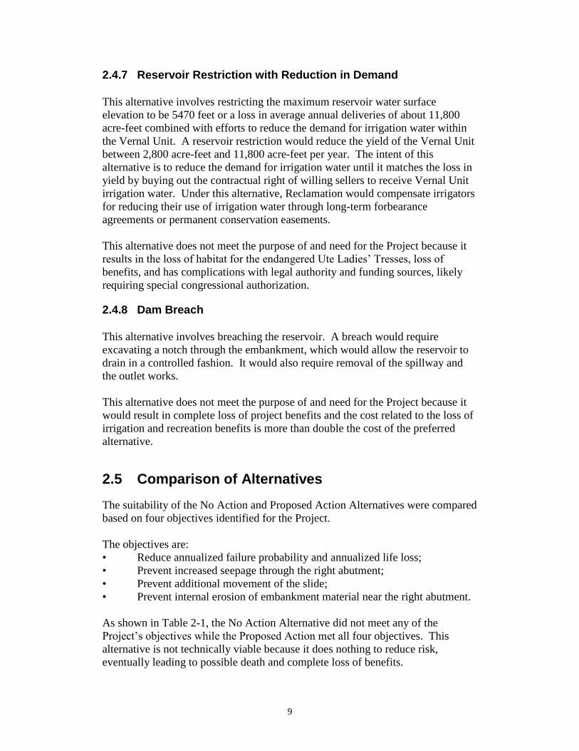
2.5 Comparison of Alternatives
The suitability of the No Action and Proposed Action Alternatives were compared
based on four objectives identified for the Project.
The objectives are:
• Reduce annualized failure probability and annualized life loss;
• Prevent increased seepage through the right abutment;
• Prevent additional movement of the slide;
• Prevent internal erosion of embankment material near the right abutment.
As shown in Table 2-1, the No Action Alternative did not meet any of the
Project’s objectives while the Proposed Action met all four objectives. This
alternative is not technically viable because it does nothing to reduce risk,
eventually leading to possible death and complete loss of benefits.
10
Table 2-1
Comparison of Alternatives
Project Objective Does the No Action
Meet the Objective
Does the Proposed
Action Meet the
Objective
Reduce annualized
failure probability and
annualized life loss;
No Yes
Prevent increased
seepage through the right
abutment;
No Yes
Prevent additional
movement of the slide;
No Yes
Prevent internal erosion
of embankment material
near the right abutment
No Yes
2.6 Minimization Measures Incorporated into the Proposed Action
The minimization measures, along with other measures listed under each resource
in Chapter 3 and Chapter 4 have been incorporated into the Proposed Action to
lessen the potential adverse effects.
• The proposed Project construction area would be located in previously
disturbed sites such as rights-of-ways, existing roads, construction sites,
and staging areas, and would have as small a footprint as possible.
• Staging and stockpiling areas would be cleared and approved in advance
and located where they would minimize disturbance.
• The contractor would be responsible during construction for safety
measures, noise and dust control, minimizing air and water pollution, and
complying with all permit requirements.
• The Proposed Action would be located so as to avoid sensitive features
such as, but not limited to, riparian areas and significant cultural resources.

11
Chapter 3 Affected Environment and Environmental Consequences
3.1 Introduction
This chapter describes the environment that could be affected by the Proposed
Action. These impacts are discussed under the following resource issues: geology
and soils resources; visual resources; cultural resources; paleontological
resources; wilderness, and wild and scenic rivers; hydrology; water quality;
system operations; health, safety, air quality, and noise; prime and unique
farmlands; flood plains; wetlands, riparian, noxious weeds and existing
vegetation; fish and wildlife resources; threatened, endangered, and sensitive
species; recreation; socioeconomics; access and transportation; water rights;
Indian Trust Assets (ITAs); environmental justice; and cumulative effects. The
present condition or characteristics of each resource are discussed first, followed
by a discussion of the predicted impacts caused by the Proposed Action. The
environmental effects are summarized in Section 3-7.
Implementing minimization measures would ensure impacts are minimal and
short-term. Chapter 3 presents the impact analysis for resources after
minimization measures and Standard Reclamation Best Management Practices
(BMPs) have been successfully implemented.
3.2 Resources Considered and Eliminated from Further Analysis
The following resources were considered but eliminated from further analysis
because they did not occur in the Project area or because their effect is so minor
(negligible) that it was discounted.
Table 3-1
Resources Eliminated from Further Analysis
Resource Rationale for Elimination from
Further Analysis
Geology and soils resources Project activities would occur within
the disturbance footprint of the
existing dam, staging and construction
areas, and access road. Therefore,
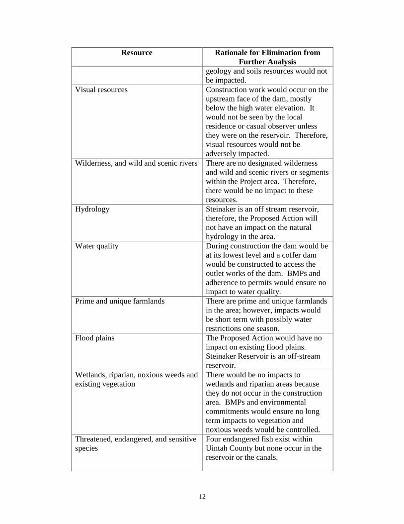
12
Resource Rationale for Elimination from
Further Analysis
geology and soils resources would not
be impacted.
Visual resources Construction work would occur on the
upstream face of the dam, mostly
below the high water elevation. It
would not be seen by the local
residence or casual observer unless
they were on the reservoir. Therefore,
visual resources would not be
adversely impacted.
Wilderness, and wild and scenic rivers There are no designated wilderness
and wild and scenic rivers or segments
within the Project area. Therefore,
there would be no impact to these
resources.
Hydrology Steinaker is an off stream reservoir,
therefore, the Proposed Action will
not have an impact on the natural
hydrology in the area.
Water quality During construction the dam would be
at its lowest level and a coffer dam
would be constructed to access the
outlet works of the dam. BMPs and
adherence to permits would ensure no
impact to water quality.
Prime and unique farmlands There are prime and unique farmlands
in the area; however, impacts would
be short term with possibly water
restrictions one season.
Flood plains The Proposed Action would have no
impact on existing flood plains.
Steinaker Reservoir is an off-stream
reservoir.
Wetlands, riparian, noxious weeds and
existing vegetation
There would be no impacts to
wetlands and riparian areas because
they do not occur in the construction
area. BMPs and environmental
commitments would ensure no long
term impacts to vegetation and
noxious weeds would be controlled.
Threatened, endangered, and sensitive
species
Four endangered fish exist within
Uintah County but none occur in the
reservoir or the canals.

13
Resource Rationale for Elimination from
Further Analysis
The black-footed ferret (Mustela
nigripes), Canada lynx (Lynx
canadensis), greater sage-grouse
(Centrocercus urophasianus),
Mexican spotted owl (Strix
occidentalis lucida), and western
yellow-billed cuckoo
(Coccyzus americanus occidentalis)
exist within Uintah County but are not
known to occur in the Project area.
The Ute ladies’-tresses are known to
occur along portions of the canal
corridor but not near the dam. No Ute
ladies’-tresses were identified during
surveys of the project area.
The bald eagle (Haliaeetus
leucocephalus) was delisted as a
Federally threatened species in 2007,
but is still protected under the Bald
and Golden Eagle Protection Act and
the Migratory Bird Treaty Act. There
are no known nesting pairs at or near
the Project area; however, it is a
winter resident of the area.
Water rights Water right operations would not be
changed by the Proposed Action. The
volume and timing of water storage
and deliveries would be the same after
the repairs as they were prior to 2014.
3.3 Affected Environment and Environmental Consequences
This chapter describes the affected environment (baseline conditions) and
environmental consequences (impacts as a result of the Proposed Action) on the
quality of the human environment that could be impacted by construction and
operation of the Proposed Action, as described in Chapter 2. The human
environment is defined in this study as all of the environmental resources,
including social and economic conditions occurring in the impact area of
influence.

14
3.3.1 Cultural Resources
Cultural resources are defined as physical or other expressions of human activity
or occupation that are over 50 years in age. Such resources include culturally
significant landscapes, prehistoric and historic archaeological sites as well as
isolated artifacts or features, traditional cultural properties, Native American and
other sacred places, and artifacts and documents of cultural and historic
significance.
Section 106 of the National Historic Preservation Act of 1966 (NHPA), mandates
that Reclamation take into account the potential effects of a proposed Federal
undertaking on historic properties. Historic properties are defined as any
prehistoric or historic district, site, building, structure, or object included in, or
eligible for, inclusion in the National Register of Historic Places (NRHP).
Potential effects of the described alternatives on historic properties are the
primary focus of this analysis.
The affected environment for cultural resources is identified as the area of
potential effects (APE), in compliance with the regulations to Section 106 of the
NHPA (36 CFR 800.16). The APE is defined as the geographic area within
which federal actions may directly or indirectly cause alterations in the character
or use of historic properties. The APE for this proposed action includes the area
that could be physically affected by any of the proposed project alternatives (the
maximum limit of disturbance).
The Class I records search of the proposed undertaking’s APE occurred on
September 2, 2015, by Dr. Zachary Nelson, via Preservation Pro (Nelson 2016).
The Preservation Pro file search revealed that 31 previously recorded sites have
been identified within 0.5 miles of the APE (See Table 3-2). There have been 16
previous surveys within 0.5 miles of the APE. The most important work was
done by Gunnerson (1957), Lipe (1959), Norman and Merrill (1983), and the
Brigham Young University-Office of Public Archaeology (Baker 1994, Billat
1994, Irvine et al 1995, Richens 1997, Richens and Talbot 1998, Talbot et al 1992
and 1997, and Talbot and Richens 1996 and 1999).
In addition to reports, the General Land Office (GLO) patent maps for 1879,
1880, 1901, 1908, 1922, 1978 were consulted as well as the USGS Ashley 1885
(1:250,000), Marsh Peak 1906 (1:125,000), Marsh Peak 1908 (1:125,000), Vernal
1960 (1:250,000), Steinaker Reservoir 1965 (1:24,000), Vernal 1974 (1:250,000),
Dutch John 1981 (1:100,000), and Steinaker Reservoir 2014 (1:24,000)
topographic maps. Aerial photography from 1953, 1956, 1963, and 1964 was
examined for additional historic features.
Table 3-2
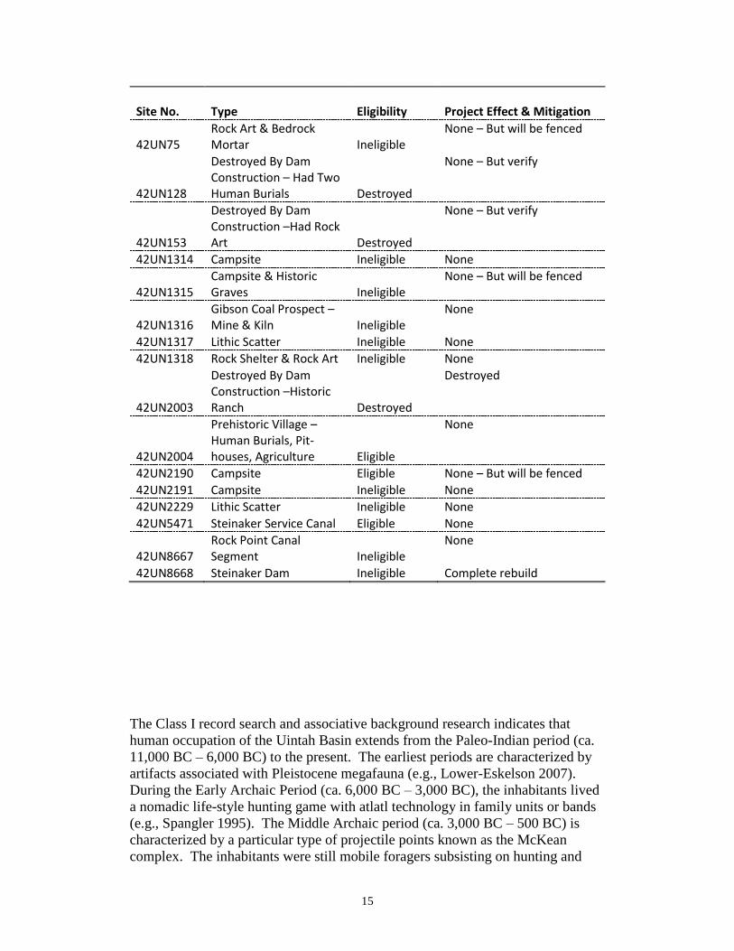
15
Site No.
Type Eligibility
Project Effect & Mitigation
42UN75 Rock Art & Bedrock Mortar Ineligible
None – But will be fenced
42UN128
Destroyed By Dam Construction – Had Two Human Burials Destroyed
None – But verify
42UN153
Destroyed By Dam Construction –Had Rock Art Destroyed
None – But verify
42UN1314 Campsite Ineligible None
42UN1315 Campsite & Historic Graves Ineligible
None – But will be fenced
42UN1316 Gibson Coal Prospect – Mine & Kiln Ineligible
None
42UN1317 Lithic Scatter Ineligible None
42UN1318 Rock Shelter & Rock Art Ineligible None
42UN2003
Destroyed By Dam Construction –Historic Ranch Destroyed
Destroyed
42UN2004
Prehistoric Village – Human Burials, Pit-houses, Agriculture Eligible
None
42UN2190 Campsite Eligible None – But will be fenced
42UN2191 Campsite Ineligible None
42UN2229 Lithic Scatter Ineligible None
42UN5471 Steinaker Service Canal Eligible None
42UN8667 Rock Point Canal Segment Ineligible
None
42UN8668 Steinaker Dam Ineligible Complete rebuild
The Class I record search and associative background research indicates that
human occupation of the Uintah Basin extends from the Paleo-Indian period (ca.
11,000 BC – 6,000 BC) to the present. The earliest periods are characterized by
artifacts associated with Pleistocene megafauna (e.g., Lower-Eskelson 2007).
During the Early Archaic Period (ca. 6,000 BC – 3,000 BC), the inhabitants lived
a nomadic life-style hunting game with atlatl technology in family units or bands
(e.g., Spangler 1995). The Middle Archaic period (ca. 3,000 BC – 500 BC) is
characterized by a particular type of projectile points known as the McKean
complex. The inhabitants were still mobile foragers subsisting on hunting and

16
gathering. The Late Archaic Period (ca. 500 BC – AD 550) is characterized by a
transition to semi-subterranean residential structure, such as pit-houses,
agriculture in the form of maize, and bow-and-arrow technology. This trajectory
culminates in the Formative Stage (ca. AD 550- AD 1300) with the “Fremont
culture”. This archaeologically defined cultural complex includes permanent
villages, elaborate rock art, ceramics, agricultural production with surpluses, and
increased evidence of population (e.g., Spangler 1995).
The Fremont culture disappears with the advent of the Protohistoric Period (AD
1300 – AD 1650). This period is characterized by different types of ceramics,
projectile points, rock art, and subsistence strategies. The next major phase is the
Historic Ute Period (AD 1650 – Present). This phase is characterized by
interaction with European traders and settlers. The introduction of the horse
meant that the tribes had increased mobility and access to a wider range of trade
contacts. The influx of Euro-American settlers into the area caused the
dispossession and relocation of the Ute people onto reservations (see Conetah
1982 for discussion).
The subsequent establishment of U.S. military forts and the official opening of the
Uintah and Ouray Reservations to white settlement in 1887, with the Dawes
Severalty Act, marked the final dispossession of the Ute peoples. This led to the
dispossession of Ute peoples from the reservation lands originally set aside for
their exclusive use following their previous dispossession from traditional
territories (see Conetah 1982 for discussion). Initially, livestock represented the
main industry of white settlers in the Uinta Basin, likely due to the availability of
grass and water in the region. Eventually, the sheep industry boomed,
contributing to a decline in the cattle industry (Lower-Eskelson 2007).
Commercial oil production began in 1948 but was not fully exploited until the
1970s with increases in the price of crude oil. Consequently, private and public
ventures began work to develop an inexpensive process for separating oil from oil
shale and tar sands, both prevalent in the Uinta Basin.
A long-term difficulty in the Uintah Basin is the lack of water. Native groups
frequently settled and hunted near water sources. Euro-American settlers needed
a reliable source of water for agriculture. Reclamation engineer Howard Reed
first proposed a dam across Steinaker Draw in 1904. The potential of adding
additional water supplies garnered enthusiastic support for the Project from
Ashley Valley farmers and ranchers. When Congress finally authorized funds to
begin the project, the Ashley Valley residents organized the largest parade in the
city's history (Eastman 2007). Constructed during the era of big dams, Steinaker
is relatively small in comparison. But its size belies the reservoir's importance to
the community it supplies. The reservoir provides much needed water for
municipal and supplemental irrigation and remains a popular recreational
destination.
17
The Class III inventory occurred on September 17-19, 2015 and April 1-2, 2016
(Nelson 2016). Dr. Zachary Nelson surveyed the APE and survey area for
cultural resources. Seven sites were revisited (42UN128, 42UN153, 42UN1317,
42UN2003, 42UN2004, 42UN2229, & 42UN5471), seven sites were updated
(42UN75, 42UN1314, 42UN1315, 42UN1316, 42UN1318, 42UN2190, &
42UN2191), and two sites were newly recorded (42UN8667 and 42UN8668).
In accordance with 36 CFR 800.4, these sites were evaluated for significance in
terms of NRHP eligibility. The significance criteria applied to evaluate cultural
resources are defined in 36 CFR 60.4 as follows:
The quality of significance in American history, architecture, archeology,
engineering, and culture is present in districts, sites, buildings, structures, and
objects that possess integrity of location, design, setting, materials, workmanship,
feeling, and association and
1. that are associated with events that have made a significant
contribution to the broad patterns of our history; or
2. that are associated with the lives of persons significant in our past; or
3. that embody the distinctive characteristics of a type, period, or method
of construction, or that represent the work of a master, or that possess
high artistic values, or that represent a significant and distinguishable
entity whose components may lack individual distinction; or
4. that have yielded, or may be likely to yield, information important in
prehistory or history.
Based upon these criteria, sites 42UN2004, 42UN2190, and 42UN5471 are
considered eligible for inclusion on the NRHP. All other sites within the APE are
not eligible or were previously destroyed by dam construction. The Utah State
Historic Preservation Office (SHPO) was sent a letter and a report with
Reclamation’s findings on November 22, 2016. As eligible resources, any
changes made to these structures that are not in keeping with their historic
integrity would result in an adverse effect to these historic resources.
3.3.1.1 No Action
Under the No Action Alternative, there would be no adverse effects to cultural
resources. There would be no need for ground disturbance associated with
construction activities. Existing conditions would continue. There is a potential
for the Steinaker Dam (Site 42UN8668) to rupture, but as an ineligible site that
would not harm cultural resources.
3.3.1.2 Proposed Action
Under the Proposed Action Alternative, there would be no adverse effects to
cultural resources. The proposed project will avoid all eligible sites and most of

18
the ineligible sites by design. Several site elements will be fenced during
construction for additional protection. These include possible historic graves, a
free-standing bedrock mortar, and a portion of an eligible site which lies along an
access road (42UN2190).
The indirect effect of lowering the reservoir is exposure of cultural resources that
have not been above water since 1994 during a previous dam repair. At that time,
Reclamation fulfilled its Section 106 responsibilities through surveys, site testing,
and excavation of eligible sites. This resulted in an excellent understanding of the
prehistory around the reservoir. Unfortunately, the wave-action erosion caused by
raising and lowering the reservoir had severely damaged many of the sites and
their current condition is unknown.
Due to the indirect effects of the project, Reclamation has created an
unanticipated discovery plan and a site feature covering plan. Once the reservoir
basin is drawn-down, Reclamation will evaluate the exposed sites and determine
if intact features within them should be covered to prevent erosion and loss of
integrity. This covering will consist on geo-cloth, six inches of sand, and riprap.
In addition, Reclamation has asked the Steinaker park ranger for increased patrols
of the drained reservoir basin to discourage looting and vandalism.
3.3.2 Paleontological Resources
The Vernal area is known for its dinosaur fossils. Fossils of various types are
found around the Steinaker reservoir. However, no known fossils are located in
the APE. Sensitive fossil locations are well outside of the proposed project.
3.3.2.1 No Action
The No Action Alternative would have no effect on paleontological resources.
No known fossils are located within the project area.
3.3.2.2 Proposed Action
The Proposed Action Alternative would have no effect on paleontological
resources. No known fossils are located within the project area.
3.3.3 System Operations
Steinaker Reservoir is an off-stream reservoir located 3.5 miles north of Vernal,
Utah. Surplus flows of Ashley Creek are diverted at Fort Thornburgh Diversion
Dam and conveyed to Steinaker Reservoir through the 400 cfs capacity Steinaker
Feeder Canal. Water stored in the reservoir is released into Steinaker Service
Canal and delivered to other project features.
The reservoir has a total capacity of 40,043 acre-feet (34,955 acre-feet active
capacity) at water surface elevation 5520.5 feet, which is roughly enough water
for two irrigation seasons, allowing for operational flexibility to lessen the impact

19
of dry years on water deliveries. The typical annual reservoir cycle is to fill the
reservoir in the winter months and release water during the irrigation season. The
maximum reservoir water surface elevation to date is 5521.1 feet, which occurred
in June 2005. The reservoir is filled based on the volume of water available for
storage from Ashley Creek. If adequate water is available, the reservoir is filled
to elevation 5520.5 feet. Currently, the reservoir is being operated under
restrictions, including restrictions to the maximum water surface elevation and
reservoir filling and drawdown rates.
3.3.3.1 No Action
The No Action Alternative would have no effect on the current operation of
Steinaker Reservoir. Restrictions on the reservoir maximum water surface
elevation, and reservoir filling and drawdown rates would continue to be
enforced, impacting operational flexibility and decreasing the volume of
carryover storage. Operating under the no action alternative would have a
negative impact to the water supply and project benefits, particularly during dry
years. Further slide movement could potentially impact outlet works operations
and negatively impact deliveries.
3.3.3.2 Proposed Action
The Proposed Action Alternative would remove the need for the reservoir
operation restrictions currently in place for Steinaker Reservoir, returning the
system operations to typical historical operations, and restoring historic project
benefits.
3.3.4 Health, Safety, Air Quality, and Noise
3.3.4.1 No Action
The No Action Alternative would have a negative impact to public safety and
health. There would be an increase in the risk of dam failure if no action is taken.
The No Action Alternative would have no effect on air quality and noise.
3.3.4.2 Proposed Action
The Proposed Action would have a positive impact to public safety and health by
decreasing the risk of dam failure. As BMPs and environmental commitments are
implemented there would be minor effect to air quality and noise during
construction. There would be a temporary increase in noise and dust due to
construction activities. There may also be a slight temporary decrease in public
safety and health due to the increased construction traffic around and near the
dam.
3.3.5 Fish and Wildlife resources
The DWR works with Reclamation, State Parks, and other entities to provide high
quality fishing and wildlife opportunities. Steinaker Reservoir is managed as a
two-story fishery, with both coldwater and warmwater fish species. It is a Blue

20
Ribbon fishery for Largemouth Bass (Micropterus salmoides), which were
stocked into the reservoir in 1990 as fry. The DWR annually stocks 30,000 8 inch
Rainbow Trout (Oncorhyncus mykiss) in the spring and manages this species as a
put-grown-and-take fishery. Brown Trout (Salmo trutta) are also present and
either move in from the Steinaker Feeder Canal from Ashley Creek or are stocked
by the DWR as fingerlings in the spring as a basic yield fishery. Bluegill
(Lepomis macrochirus) now serve as an important prey item for the Largemouth
Bass and provide an important sportfish component, especially during the ice
fishing season and especially given the decline in Bluegill condition at Pelican
Lake, the other regional Bluegill water. Smallmouth Bass (Micropterus
dolomeiu) and other sunfish species (Lepomis spp.) are occasionally observed in
the reservoir.
3.3.5.1 No Action
The No Action Alternative could result in long term impacts to fish and wildlife
resources. If the reservoir were to be operated at restricted elevations, like it is
now, the fishery could be limited.
3.3.5.2 Proposed Action
If the proposed action is implemented both rainbow and brown trout species
stocking would be cut in half in 2017 and in 2018 to accommodate the smaller
volume in the reservoir and to increase the likelihood of survival of all fish. The
Largemouth Bass and Bluegill, therefore are the only species that would likely
lose two entire year classes. Although a complete fish kill is not anticipate, it is
possible that the number of fish present in the reservoir are underestimated and
that overcrowding during the drawdown could result in either a complete or
partial fish kill, in which fish of all ages/sizes succumb to low oxygen levels due
to high respiration. In this scenario, the DWR would want to restock both
Largemouth Bass and Bluegill, which would be a cost additional to the annual
operating costs. Restocking Rainbow Trout and Brown Trout would happen
anyway as both of these quotas are annual quotas.
Reclamation and DWR propose as mitigation to restore the fishery after the
project drawdown, if needed. Mitigation would include restocking the reservoir
with Largemouth Bass and Bluegill, which is not done annually. These species
would only need to be restocked if a major fish kill was observed as a result of the
draw down. This would be noted with the appearance of thousands of dead fish
along the shoreline, which would most likely be observed at ice off in the spring
of 2018, but could occur at any point if a critically low dissolved oxygen
concentration is reached at any time during the draw down. An environmental
commitment was developed to assist in the restocking effort (Section 4.1, 9A).
3.3.6 Recreation
Recreation areas are Steinaker State Park, Ashley Nature Trail Park, and Vernal
City Park. Steinaker State Park is often informally used as a recreational area for
fishing, camping, picnicking, walking, jogging, and bicycling. Estimated yearly

21
visitation at Steinaker has been around 37,500 with the highest visitation in the
month of June. The predominant visitor origination comes from the Vernal area,
with some coming from outside the local region.
3.3.6.1 No Action
The No Action Alternative could result in long term impacts to recreation. If the
reservoir were to be operated at restricted elevations, like it is now, the visitation
numbers could remain lower. If the low visitation numbers were to be ongoing
the park would not be able to sustain itself and the park may need to be closed.
If the problem on the dam were to remain unchanged, over time the dam could
fail and cause the recreation at Steinaker to be left as a campground only.
3.3.6.2 Proposed Action
Under the Proposed Action Alternative with construction for a year there would
be some temporary impacts to recreation. The impacts on the recreation of
Steinaker Reservoir would result in the reduction of visitors to the park that come
solely for fishing, camping, water skiing, and swimming. The work is proposed
to be completed through the winter months and through one summer and fall.
The water recreation would be minimal during this time frame.
Any visitors that come to Steinaker would be forced to go to nearby Red Fleet
Reservoir or on to other places in the region such as Starvation or Flaming Gorge
Reservoirs.
3.3.7 Socioeconomics
Vernal, the county seat and largest city in Uintah County, had a population of
9,089 residents as of the 2010 Census. Population estimates as of July 1st 2015
place the resident population at 11,200 which is a 22.9% increase from the 2010
census (Census Bureau 2016a).
The estimated median household income, for Vernal, between the years 2010 –
2014 is estimated to be $54,947 (in 2014 dollars), while per capita income in the
last 12 months (in 2014 dollars) is estimated to be $24,136 with 17.4% of people
in poverty compared to the State of Utah average of 11.3%% (Census Bureau
2016b).
Mean travel time to work is 15.3 minutes and 64.9% of people 16 years and older
are employed in the civilian labor force. The percentage of people 25 years and
older with at least a high school degree stands at 88.3% of which 15.5% have a
Bachelor’s degree or higher (Census Bureau 2016c).
3.3.7.1 No Action
Under the No Action Alternative, the area would be subject to scenarios ranging
from reservoir level restrictions to catastrophic dam failure. A reservoir
22
restriction to elevation level 5,470 would result in lost irrigation deliveries of
11,800 AF which would reduce local agricultural revenues by approximately
$281,000 annually. A reservoir restriction to elevation level 5,495 would result in
lost irrigation deliveries of 2,800 AF which would reduce local agricultural
revenues by approximately $67,000 annually (Steinaker Safety of Dams 2016).
M&I deliveries would continue even under reservoir restrictions.
A reservoir restriction to elevation level 5,470 would result in a loss of recreation
visitation days equaling 28,144 which would result in lost annual recreation
benefits equaling approximately $1,651,000. A reservoir restriction to elevation
level 5,495 would result in a loss of recreation visitation days equaling 15,580
which would result in lost annual recreation benefits equaling approximately
$914,000 (Steinaker Safety of Dams 2016).
In the event of a catastrophic failure, there would be a significant impact to the
socioeconomics of the community via significant loss of life, property damage
and loss of revenues generated through irrigation, M&I deliveries, recreational
activities, etc. Investigations conducted under Reclamation’s Safety Examination
of Existing Dams program, published in the 2016 MOD Report, estimate the cost
of dam failure to exceed $195 million.
3.3.7.2 Proposed Action
The Proposed Action Alternative would mitigate the long-term loss of project
purposes as well as recreational revenue at Steinaker State Park in the event of
catastrophic dam failure.
Under the proposed action, loss of revenue during the anticipated construction
phase (one irrigation season, approximately 12-16 months) would be
approximately $1,219,000 - $1,625,00 for revenues due to recreational activities
at Steinaker State Park (Utah State Parks 2015; Utah State Parks 2016;
Rosenberger and Loomis 2001).
Loss of revenue encumbered upon irrigation activities during construction would
be in the range of $7,281,000 - $9,748,000 for alfalfa hay and $2,760,000 -
$3,680,000 (USDA ERS 2001; Borchers et al. 2014; Steinaker Safety of Dams
2016).
3.3.8 Access, and Transportation
The Project is located within Uintah County and can be accessed from several
cross streets and major roadways within the county. The impact area of influence
for transportation includes roads that would be used during construction,
operation and maintenance of the facilities.
3.3.8.1 No Action
The No Action Alternative would have no impact on access, and transportation.

23
3.3.8.2 Proposed Action
During construction, it is estimated that between 80 and 100 construction vehicles
per day would travel to the site. The majority of the vehicle trips would be for
transporting construction materials including concrete, excavation and backfill
materials. The contractor would be transporting heavy construction equipment to
the construction site. Upon completion of construction, vehicle trips are expected
to be reduced to no more than 2 per day for O&M purposes.
The Proposed Action Alternative would have minor short-term effects during
construction, but no long-term effects on access, and transportation.
3.4 Indian Trust Assets
Indian Trust Assets (ITA) are legal interests in property held in trust by the United
States for Federally recognized Indian Tribes or Indian individuals. Assets can be
real property, physical assets, or intangible property rights, such as lands,
minerals, hunting and fishing rights, and water rights. The United States has an
Indian trust responsibility to protect and maintain rights reserved by or granted to
such tribes or individuals by treaties, statutes, and executive orders. These rights
are sometimes further interpreted through court decisions and regulations. This
trust responsibility requires that all Federal agencies take all actions reasonably
necessary to protect trust assets. Reclamation carries out its activities in a manner
which protects these assets and avoids adverse impacts when possible. When
impacts cannot be avoided, Reclamation would provide appropriate mitigation or
compensation. Implementation of the Proposed Action would have no
foreseeable negative impacts on ITAs (see Section 5.6)
3.5 Environmental Justice
Executive Order 12898, established Environmental Justice as a Federal agency
priority to ensure that minority and low-income groups are not disproportionately
affected by Federal actions. Implementation of the Proposed Action would not
disproportionately (unequally) affect any low-income or minority communities
within the Project area. The reason for this is that the proposed Project would not
involve population relocation, health hazards, hazardous waste, property takings,
or substantial economic impacts. This action would therefore have no adverse
human health or environmental effects on minority and low-income populations.
3.6 Cumulative Effects
In addition to Project-specific impacts, Reclamation analyzed the potential for
significant cumulative impacts to resources affected by the Project and by other
past, present, and reasonably foreseeable activities within the watershed.
According to the Council on Environmental Quality's (CEQ) regulations for
24
implementing NEPA (50 CFR §1508.7), a “cumulative impact” is an impact on
the environment which results from the incremental impact of the action when
added to other past, present, and reasonably foreseeable future actions, regardless
of what agency or person undertakes such other actions. Cumulative impacts can
result from individually minor but collectively significant actions taking place
over a period of time. It focuses on whether the Proposed Action, considered
together with any known or reasonably foreseeable actions by Reclamation, other
Federal or state agencies, or some other entity combined to cause an effect. There
is no defined area for potential cumulative effects.
Based on Reclamation resource specialists’ review of the Proposed Action,
Reclamation has determined that this action would not have a significant adverse
cumulative effect on any resources.
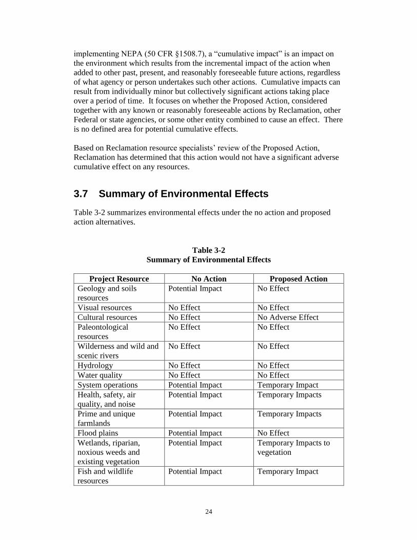
3.7 Summary of Environmental Effects
Table 3-2 summarizes environmental effects under the no action and proposed
action alternatives.
Table 3-2
Summary of Environmental Effects
Project Resource No Action Proposed Action
Geology and soils
resources
Potential Impact No Effect
Visual resources No Effect No Effect
Cultural resources No Effect No Adverse Effect
Paleontological
resources
No Effect No Effect
Wilderness and wild and
scenic rivers
No Effect No Effect
Hydrology No Effect No Effect
Water quality No Effect No Effect
System operations Potential Impact Temporary Impact
Health, safety, air
quality, and noise
Potential Impact Temporary Impacts
Prime and unique
farmlands
Potential Impact Temporary Impacts
Flood plains Potential Impact No Effect
Wetlands, riparian,
noxious weeds and
existing vegetation
Potential Impact Temporary Impacts to
vegetation
Fish and wildlife
resources
Potential Impact Temporary Impact

25
Project Resource No Action Proposed Action
Threatened, endangered,
and sensitive species
No Effect No Effect
Recreation Potential Impact Temporary Impact
Socioeconomics Potential Impact Temporary Impact
Access and
transportation
Potential Impact Temporary Impact
Water rights Potential Impact No Effect

26
Chapter 4 Environmental Commitments
Environmental commitments, along with minimization measures in section 2.6
have been developed to lessen the potential adverse effects of the Proposed
Action.
4.1 Environmental Commitments
The following environmental commitments would be implemented as an integral
part of the Proposed Action.
1. Standard Reclamation Best Management Practices (BMPs) - Standard
Reclamation BMPs would be applied during construction activities to
minimize environmental effects and would be implemented by
construction forces, or included in construction specifications. Such
practices or specifications include sections in the present EA on geology
and soils resources; visual resources; cultural resources; paleontological
resources; hydrology; water quality; health, safety, air quality, and noise;
waste material disposal; erosion control; flood plains; wetlands, riparian,
noxious weeds and existing vegetation; fish and wildlife resources; access
and transportation. Excavated material and construction debris may not be
wasted in any stream or river channel in flowing waters. This includes
material such as grease, oil, joint coating, or any other possible pollutant.
Excess materials must be wasted at a Reclamation approved upland site
well away from any water channel. Construction materials, bedding
material, excavation material, etc. may not be stockpiled in riparian,
wetland, or water channel areas. Silt fencing would be appropriately
installed and left in place until after revegetation becomes established, at
which time the silt fence can then be carefully removed. Machinery must
be fueled and properly cleaned of dirt, weeds, organisms, or any other
possibly contaminating substances offsite prior to construction.
2. Cultural Resources – Any person who knows or has reason to know that
he/she has inadvertently discovered possible human remains on Federal
land, he/she must provide immediate telephone notification of the
discovery to Reclamation’s Provo Area Office archaeologist. Work would
stop until the proper authorities are able to assess the situation onsite. This
action would promptly be followed by written confirmation to the
responsible Federal agency official, with respect to Federal lands. The
Utah State Historic Preservation Office (SHPO) and interested Native
American Tribal representatives would be promptly notified. Consultation

27
would begin immediately. This requirement is prescribed under the
Native American Graves Protection and Repatriation Act (43 CFR Part
10) and the Archaeological Resources Protection Act of 1979 (16 U.S.C.
470).
3. Paleontological Resources - Should vertebrate fossils be encountered by
the proponent during ground disturbing actions, construction must be
suspended until a qualified paleontologist can be contacted to assess the
find.
4. Air Quality – Construction procedures would be followed to mitigate for
temporary impact on air quality due to construction-related activities.
These may include the application of dust suppressants and watering to
control fugitive dust; minimizing the extent of disturbed surface; during
times of high wind, restricting earthwork activities; and limiting the use
of, and speeds on, unimproved road surfaces.
5. Fugitive Dust Control Permit - The Division of Air Quality regulates
fugitive dust from construction sites, requiring compliance with rules for
sites disturbing greater than one-quarter of an acre. Utah Administrative
Code R307-205-5, requires steps be taken to minimize fugitive dust from
construction activities.
6. Flood Plains – The contractor would be compliant with all rules and
regulations of the Federal Floodplain Insurance Program as administered
by the local city or county floodplain administrator.
7. Vegetation – Design and treatment activities would ensure that vegetation
would be protected with no long term adverse effects. Staging areas
would be in previously disturbed areas to the extent possible.
8. Invasive Species – Appropriate steps would be taken to prevent the spread
of, and to otherwise control, undesirable plants and animals within areas
affected by construction activities. Equipment used for the Project would
be inspected for reproductive and vegetative parts, foreign soil, mud or
other debris that may cause the spread of weeds, invasive species and
other pests. Such material would be removed before moving vehicles and
equipment. Upon the completion of work, decontamination would be
performed within the work area before the vehicle and/or equipment are
removed from the Project site if work was conducted in an area infested
with noxious weeds.
The contractor would make periodic inspections following vegetation of
disturbed areas to locate and control populations of noxious weeds, if
present. All seed used for restoration would be certified “noxious weed
28
free” before use. If needed, the County Weed Control Department could
be contacted to provide services to control the spread of noxious weeds.
9. Fish and Wildlife Resources –
a. Fishery Protection - Precautions will be taken to protect the
fishery during construction. If there is an excessive fish kill
Reclamation will participate in a 50/50 percent cost share of up to
$89,600 with Utah Division of Wildlife Resources in a restocking
program. This effort to restock the reservoir in the event of a fish
kill is voluntary by Reclamation and not precedent setting.
b. Migratory Bird Protection
i. Perform any ground-disturbing activities or vegetation
treatments before migratory birds begin nesting or after all young
have fledged.
ii. If activities must be scheduled to start during the migratory
bird breeding season, take appropriate steps to prevent migratory
birds from establishing nests in the potential impact area. These
steps could include covering equipment and structures and use of
various excluders (e.g., noise). Prior to nesting, birds can be
harassed to prevent them from nesting on the site.
iii. If activities must be scheduled during the migratory bird
breeding season, a site-specific survey for nesting prior to
groundbreaking activities or vegetation treatments. Established
nests with eggs or young cannot be moved, and the birds cannot be
harassed (see b., above), until all young have fledged and are
capable of leaving the nest site.
iv. If nesting birds are found during the survey, appropriate
spatial buffers should be established around nests. Vegetation
treatments or ground-disturbing activities within the buffer areas
should be postponed until the birds have left the nest.
Confirmation that all young have fledged should be made by a
qualified biologist.
c. Raptor Guidelines – The contractor would adhere to the U. S.
Fish and Wildlife Service (USFWS) Raptor Guidelines by placing
seasonal and spatial “no construction” buffers, along with daily
timing restrictions around all active raptor nests or winter roosting
bald eagles. If unknown nests are located during construction, the
same guidelines would be implemented.

29
10. Threatened and Endangered Species – Construction activities would
avoid Ute Ladies’-tresses habitat.
11. Public Access - Construction sites would be closed to public access.
Temporary fencing, along with signs, would be installed to prevent public
access.
12. Disturbed Areas - All disturbed areas resulting from the Project would be
smoothed, shaped, contoured, and rehabilitated to as near the pre-Project
construction condition as practicable. After completion of the
construction and restoration activities, disturbed areas would be seeded at
appropriate times with weed-free, native seed mixes having a variety of
appropriate species (especially woody species where feasible) to help hold
the soil around structures, prevent excessive erosion, and to help maintain
other riverine and riparian functions. The composition of seed mixes
would be coordinated with wildlife habitat specialists and Reclamation
biologists. Weed control on all disturbed areas would be required.
Successful revegetation efforts must be monitored and reported to
Reclamation, along with photos of the completed Project.
13. Additional Analyses – If the Proposed Action were to change
significantly from that described in the EA, because of additional or new
information, or if other construction areas are required outside the areas
analyzed in this EA, additional environmental analysis including cultural
and paleontological analyses would be undertaken, if necessary.

30
Chapter 5 Consultation and Coordination
5.1 Introduction
This chapter details other consultation and coordination between Reclamation and
other Federal, state, and local Government Agencies, Native American Tribes,
and the public during the preparation of this EA. Compliance with NEPA, is a
Federal responsibility that involves the participation of all of these entities in the
planning process. NEPA requires full disclosure about major actions taken by
Federal agencies and accompanying alternatives, impacts, and potential mitigation
of impacts.
5.2 Public Involvement
Reclamation mailed 91 scoping letters to land owners, canal companies, the
public, municipalities, organizations and state and Federal agencies, notifying
them of the Project and inviting them to an open house at the Uintah Conference
Center, 313 E 200 S, in Vernal on November 3, 2016. Approximately 41
individuals were in attendance. Many verbal comments and one written comment
was received during the public meeting and was considered and incorporated into
the EA.
On December 6, 2016, Reclamation mailed 120 notices informing the public that
the draft EA was available on the internet at
www.usbr.gov/uc/envdocs/index.html. Notices were sent to land owners, canal
companies, the public, municipalities, organizations and state and Federal
agencies initiating a 21-day comment period which ended on December 27, 2016.
The public was notified that if they want a CD or hard copy of the draft EA it
would be provided. All comments were considered in the Final EA.
On January 9, 2017, Reclamation mailed 115 notices that the Final EA was
available on the internet at the same location as the draft EA. A second open
house was scheduled for January 18th as a follow-up on conversations and to
address timelines associated with construction. Sixteen individuals were in
attendance. Meeting notes, public comments, and attendance logs are available
upon request.

31
5.3 Native American Consultation
Reclamation conducted Native American consultation throughout the public
involvement process. An initial proposal letter was mailed on March 7, 2016. A
consultation letter and copy of the Class III Cultural Resource Inventory Report
were mailed on November 22, 2016 to the Hopi Tribe of Arizona, Navajo Nation,
Arizona, New Mexico & Utah, Northwest Band Shoshone Tribe, Santa Clara
Pueblo, New Mexico, Shoshone-Bannock Tribes of the Fort Hall Reservation of
Idaho, Shoshone Tribe of the Wind River Reservation, Southern Ute Tribe of the
Southern Ute Reservation, Ute Mountain Tribe of the Ute Mountain Reservation,
Ute Tribe of the Uintah and Ouray Reservation, Zuni Tribe of the Zuni
Reservation, New Mexico. This consultation was conducted in compliance with
36 CFR 800.2(c)(2) on a government-to-government basis. Through this effort
the tribe is given a reasonable opportunity to identify any concerns about historic
properties; to advise on the identification and evaluation of historic properties,
including those of traditional religious and cultural importance; to express their
views on the effects of the Proposed Action on such properties; and to participate
in the resolution of any adverse effects.
The Hopi Tribe of Arizona and the Santa Clara Pueblo, New Mexico, both
responded (see Chapter 10 Appendix). These tribes are interested in the project
and wish to be kept informed of project activities and determinations. The Santa
Clara Pueblo recommend that: “…a site monitor be present during construction
activities and construction to be halted if any inadvertent discoveries are made
and Santa Clara Pueblo be contacted to provide comment.”
5.4 Utah Geological Survey
Reclamation requested a paleontological file search from the UGS to determine
the nature and extent of paleontological resources within the APE on November
28, 2016. File search results and recommendations from the UGS were received
in a letter dated November 28, 2016 (Chapter 10 Appendix).
5.5 Utah State Historic Preservation Office
A copy of the Class III Cultural Resource Inventory Report and a determination
of no adverse effect to historic properties for the Proposed Action were submitted
to the SHPO on November 22, 2016.
5.6 Bureau of Indian Affairs
In an email dated November 28, 2016, Reclamation’s archeologist, Dr. Zachary
Nelson, requested an evaluation of Indian Trust Assets (ITAs) within the APE
32
from the BIA, Uintah and Ouray Agency. Reclamation received no response
from the BIA identifying any ITAs impacted by the Proposed Action.
5.7 US Army Corps of Engineers
The Proposed Action would require the discharge of dredged or fill material
below the ordinary high water mark of Steinaker Reservoir, which appears to be
considered a “waters of the United States”. It is anticipated that the Proposed
Action would qualify for a nationwide permit that is issued for activities resulting
in minimal individual and cumulative adverse effects on the aquatic environment.
In compliance with Section 404 of the Clean Water Act of 1977, a formal permit
application would be submitted to the USACE to determine the extent of
jurisdiction and impacts.
33
Chapter 6 Preparers
The following is a list of preparers who participated in the development of the
EA. They include Reclamation team members and UWCD members.
Table 6-1
Reclamation Team Members
Name Title Resource
Mr. Rick Baxter ESA Coordinator Bureau of Reclamation
Mr. Scott Blake Recreation and Visual Bureau of Reclamation
Mr. Peter Crookston NEPA Team Leader Bureau of Reclamation
Mr. Dale Hamilton Engineer Bureau of Reclamation
Mr. Jeff Hearty Economist Bureau of Reclamation
Mr. Gary Henrie Engineer Bureau of Reclamation
Mr. Bart Leeflang Engineer Bureau of Reclamation
Mr. Ryan Luke Engineer Bureau of Reclamation
Ms. Linda Morrey Secretary Bureau of Reclamation
Mr. Zachary Nelson Archaeologist Bureau of Reclamation
Mr. Prashant Singh Economist Bureau of Reclamation
Mr. Justin Record Water Rights Bureau of Reclamation
Mr. David Snyder CWA Coordinator Bureau of Reclamation
Mr. Spencer Strand Engineer Bureau of Reclamation
Ms. Rachelle
Vanderplas
Geologist Bureau of Reclamation
Table 6-2
Uintah Water Conservancy District Members
Name Title Company
Mr. Gawain Snow General Manager Uintah Water
Conservancy District
Mr. John Hunting Assistant Manager Uintah Water
Conservancy District

34
Chapter 7 Acronyms and Abbreviations
Acronym/Abbreviations Meaning
APE Area of Potential Effect
BLM Bureau of Land Management
BA Biological Assessment
BIA Bureau of Indian Affairs
BMP Best Management Practices
BO Biological Opinion
Canal Steinaker Service Canal
CEQ Council on Environmental Quality
CFR Code of Federal Regulations
Cfs Cubic Feet Per Second
CWA Clean Water Act
UWCD Uintah Water Conservancy District
DEQ State of Utah Department of
Environmental Quality
DWR State of Utah Division of Wildlife
Resources
DWRi State of Utah Division of Water
Rights
EA Environmental Assessment
EPDM Ethylene Propylene Diene Monomer
ESA Endangered Species Act
FONSI Finding of No Significant Impact
HDPE High Density Polyethylene
ITA Indian Trust Assets
LUST Leaking Underground Storage Tank
MSL Mean Sea Level
NEPA National Environmental Policy Act
NRCS Natural Resource Conservation
Service
NRHP National Register of Historic Places
NWI National Wetlands Inventory
O&M Operation and Maintenance
PVC Polyvinyl Chloride
Reclamation U.S. Bureau of Reclamation
SHPO Utah State Historic Preservation
Office

35
Acronym/Abbreviations Meaning
UDOT State of Utah Department of
Transportation
UGS Utah Geological Service
ULT Ute-ladies’-tresses
UPDES Utah Pollutant Discharge Elimination
System
USFWS U.S. Fish and Wildlife Service
U.S.C United States Code
UST Underground Storage Tanks
USACE US Army Corps of Engineers
UWCD Uintah Water Conservancy District
36
Chapter 8 References
Baker, Shane A., 1994. Preliminary Report on Limited Archaeological Data
Recovery at 42Un2094, Steinaker Reservoir Area, North of Vernal, Uintah
County. Utah. Museum of Peoples and Cultures Technical Series 94-4. Brigham
Young University, Provo.
Billat, Scott E., 1994. A Site Evaluation of 42UN154, Located Within Steinaker
Reservoir, North of Vernal, Utah. Museum of Peoples and Cultures Technical
Series No. 94-1. Brigham Young University, Provo, Utah.
Borchers, Allison, Elizabeth Truex-Powell, Steven Wallander, and Cynthia
Nickerson, 2014. Multi-Cropping Practices: Recent Trends in Double Cropping,
EIB-125. U.S. Department of Agriculture, Economic Research Service.
Conetah, Fred A., 1982. A History of the Northern Ute People. Edited by Kathryn
L. MacKay and Floyd A. O’Neil. Published by the Uintah-Ouray Ute Tribe,
University of Utah Printing Service, Salt Lake City, Utah.
Eastman, Adam, 2007. The Central Utah Project, Vernal Unit. Historic
Reclamation Projects Book.
Form 7-1686 Reservoir Capacity Allocations, Steinaker Dam and Reservoir,
Approved 14 December 2006. Bureau of Reclamation
Gunnerson, James H., 1957. An Archeological Survey of the Fremont Area.
Anthropological Papers No. 28. University of Utah Press, Salt Lake City.
Irvine, Howard S., Richard K. Talbot, and Lane D. Richens, 1995. An
Archaeological Survey of Bureau of Reclamation Lands Around Steinaker Lake,
Vernal, Utah. Museum of Peoples and Cultures Technical Series No. 95-7.
Brigham Young University, Provo, Utah.
Lipe, William D., 1959. Archaeological Survey of the Steinaker Reservoir Area,
Uintah County, Utah. Manuscript on file, Department of Anthropology,
University of Utah, Salt Lake City.
Lower-Eskelson, Kylie, 2007. Cultural Resource Inventory of Veritas
Geophysical Integrity’s Uintah Basin 3D Seismic Prospect Uintah County, Utah.
Moab (UT): Montgomery Archaeological Consultants, Inc.

37
Nelson, Zachary, 2016. Class III Cultural Resource Inventory for the Steinaker
Dam Repair Project, Uintah County, Utah. Bureau of Reclamation Cultural
Resources Report EA-16-010.
Norman, V. Garth, and David B. Merrill, 1983. Cultural Resources Survey of a
Portion of the Steinaker Reservoir Area, Vernal Unit, Central Utah Project. Mesa
CRM Paper No. 12. Orem.
Richens, Lane D., 1997. Steinaker Lake: Excavations at 42UN1671. Museum of
Peoples and Cultures Technical Series No. 97-17. Brigham Young University,
Provo, Utah.
Richens, Lane D., and Richard K. Talbot, 1998. Steinaker Lake: A Phased
Approach to Archaeological Site Documentation, Research, and Long Term
Management; Phases II and III Report: 1996-1997 Site Testing and Data
Retrieval, and Draft Long Term Management Plan. Museum of Peoples and
Cultures Technical Series No. 98-6. Brigham Young University, Provo, Utah.
Rosenberger, Randall S., and John B. Loomis, 2001. Benefit transfer of outdoor
recreation use values: A technical document supporting the Forest Service
Strategic Plan (2000 revision). Gen. Tech. Rep. RMRS-GTR-72. Fort Collins,
CO: U.S. Department of Agriculture, Forest Service, Rocky Mountain Research
Station. 59 p.
Spangler, Jerry D., 1995. Paradigms and Perspectives: A Class I Overview of
Cultural Resources in the Uinta Basin and Tavaputs Plateau. Salt Lake City
(UT): Uinta Research.
Steinaker Safety of Dams Economic Benefit Analysis and Damage Assessment,
2016.
Talbot, Richard K., Shane A. Baker, and Lane D. Richens, 1992. Preliminary
Report of Test Excavations at 42UT 1859 and 42UT 2004 North of Vernal, Uintah
County, Utah. Museum of Peoples and Cultures Technical Series No. 92-10.
Brigham Young University, Provo.
Talbot, Richard K. and Lane D. Richens, 1996. Steinaker Gap: An Early Fremont
Farmstead. Museum of Peoples and Cultures Occasional Papers, No.2. Brigham
Young University, Provo.
Talbot, Richard K. and Lane D. Richens, 1999. Prehistoric Farmers of the Uinta
Basin: The Steinaker Lake Project. Brigham Young University Museum of
Peoples and Cultures Technical Series No. 99-4. Provo, Utah.
Talbot, Richard K., Lane D. Richens, and William Eckerle, 1997. Steinaker Lake:
A Phased Approach to Archaeological Site Documentation, Research, and Long

38
Term Management. Phase I Report: 1994 Site Testing Results. Museum of
Peoples and Cultures Technical Series No. 96-3. Brigham Young University,
Provo, Utah.
Technical Memorandum No. SI-83311-11, January 2015. Steinaker Dam -
Monitoring for Filling and Drawdown Post Right Abutment Failure Fall-Winter
Season 2014/2015. Bureau of Reclamation, Denver, Colorado.
US Census Bureau, 2016a. Accessed at
http://www.census.gov/quickfacts/table/PST045215/4980090
US Census Bureau, 2016b. Accessed at
http://www.census.gov/quickfacts/table/INC110214/4980090
US Census Bureau, 2016c. Accessed at
http://www.census.gov/quickfacts/table/EDU635214/4980090
US Department of Agriculture Economic Research Service, 2016. Accessed at
https://www.ers.usda.gov/data-products/normalized-prices/
Utah State Parks, 2015. Accessed at
http://stateparks.utah.gov/stateparks/wpcontent/uploads/sites/26/2015/03/steinaker
-web.pdf
Utah State Parks, 2016. Accessed at https://stateparks.utah.gov/resources/park-
visitation-data/
Water and Power Resources Service, Project Data, A Water Resources Technical
Publication, 1981.

39
Appendix A Figures

40

41

42

43
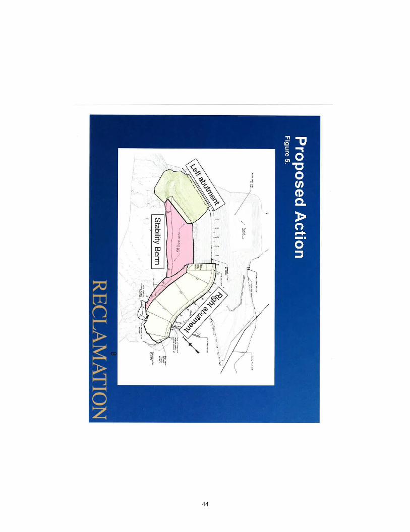
44

45

46
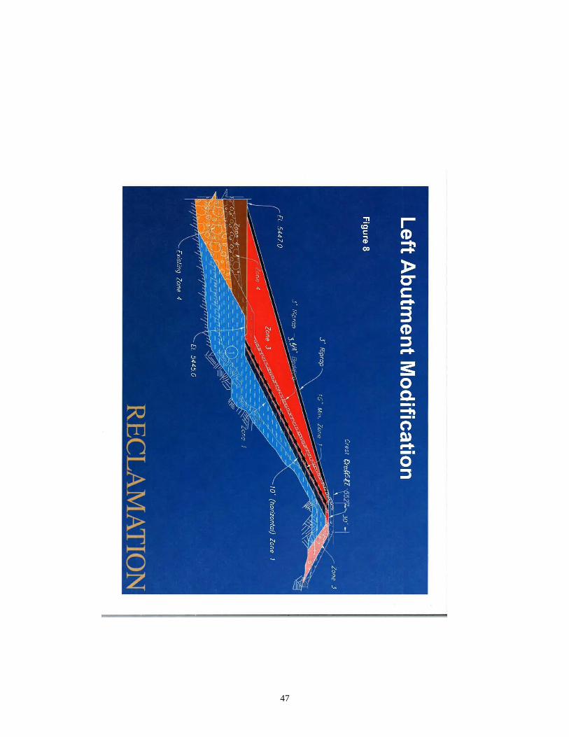
47

48
Appendix B Correspondence
49

50
51
52
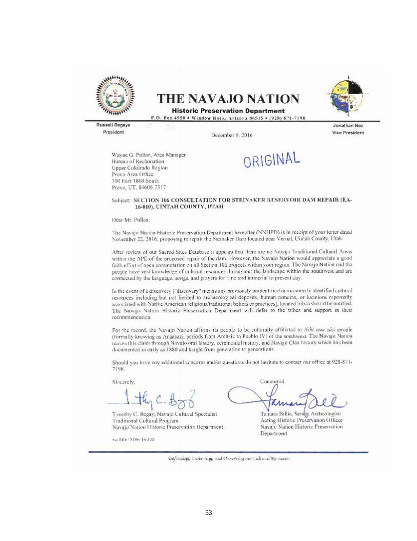
53

54
Appendix C Cultural History Overview
The following discussion of the cultural history of the project area quotes
extensively from the existing Resource Management Plan for Steinaker Reservoir
(Reclamation 2013) and is copied from Nelson (2016).
The project area lies on the border between the Uinta Mountains, an east-west
trending, 150-mile-long mountain range in northeastern Utah and the distinctly
bowl-shaped region known as the Uinta Basin. Both the Uinta Mountains and Uinta
Basin are sections of what geologist William Lee Stokes refers to as the Colorado
Plateau physiographic province (1986). The general culture history of the Study
Area described below is based on the broader cultural chronological sequence of
the Uinta Basin.
Archaeological evidence of human occupation in the Uinta Basin extends as far
back as about 11,000 years ago, the beginning of what is generally referred to as
the Paleo-Indian Period (ca 13,000 BP–6,000 BC). The Paleo-Indian Period is
characterized by human adaptation to terminal Pleistocene environments and the
exploitation of various extinct and modern megafauna (Lower-Eskelson 2007). A
deficiency in evidence of plant procurement as well as repeated or longer-term
occupation suggests that Paleo-Indian populations in the Uinta Basin were highly
mobile. Although distinctive artifacts typically associated with the hunting of
Pleistocene megafauna have been discovered in the Uinta Basin, there remains a
lack of stratified sites exhibiting evidence of human occupation prior to about 6,000
BC. Paleo-Indian projectile points from the Uinta Basin (i.e., Clovis, Folsom,
Goshen, Agate Basin, Hell Gap, Eden-Scottsbluff, and Alberta-Cody), however,
are identical to those from the northwestern plains region of the North America,
which have been recovered in chronometrically dated contexts from this period
(Spangler 1995). As a result, even though a detailed account of the nature and extent
of human occupation in the Uinta Basin during the Paleo-Indian Period remains
difficult without sufficient site data, the existence of these projectile points implies
that the area was inhabited during the Paleo-Indian Period.
The next period in the cultural chronological sequence of the Uinta Basin is known
as the Early Archaic Period (ca 6,000 BC–3,000 BC). According to Jennings
(1978), a shift to a “mobile hunting-collecting way of life” marks the transition
from the Paleo-Indian to the Early Archaic Period. In addition, new projectile point
types also appear during the Early Archaic Period (i.e., Pinto Series, Humboldt,
Elko Series, Northern Side-Notched, Hawken Side-Notched, Sudden Side-
Notched, and Rocker Base Side-Notched). This change in projectile point
production is seen by some as a reflection of the development of the atlatl for the
55
pursuit of smaller, faster game (Holmer 1986). The discovery of projectile points
that are characteristic of the Early Archaic Period in association with temporary
camps and lithic scatters suggests that human occupations in the region were
sporadic. The Early Archaic inhabitants of the Uinta Basin likely practiced nomadic
exploitation of local resources in small groups based on seasonal and locational
availability (Spangler 1995). Although cultural remains from the Paleo-Indian and
Early Archaic Periods remain sparse in the Uinta Basin, dozens of archaeological
sites representing the next cultural chronological sequence period, the Middle
Archaic, exist in the region.
The shift from the Early Archaic to the Middle Archaic Period in the Uinta Basin
is demonstrated by an increase in human populations and the appearance of the
distinctive McKean Complex projectile points (Spangler 1995). The Middle
Archaic Period (ca 3,000 BC–500 BC) sites illustrate cultural influences from the
plains region of North America. The continued production and use of Elko Series
projectile points, however, indicates cultural influences from the Great Basin and/or
northern Colorado Plateau as well (Spangler 1995). Most researchers agree that
Middle Archaic populations in the Uinta Basin were mobile foragers whose
subsistence patterns included predominantly hunting, supplemented with gathering.
This theory is supported by the fact that no permanent settlements have been
discovered in the region, although a few semi-permanent base camps have been
noted. Middle Archaic Period subsistence activities were likely conducted within
the context of small bands. These small bands hunted game and procured locally
available floral resources from one of these semi-permanent base camps (Spangler
1995). As the Middle Archaic Period transitioned into the Late Archaic Period, the
subsistence strategies and settlement patterns that are generally associated with the
Early and Middle Archaic Periods began to change.
As the Late Archaic Period (ca 500 BC–AD 550) began, McKean Complex
projectile points vanish. Semi-subterranean residential structures began to appear
regularly at base camps beginning around AD 1. At the same time, the introduction
of maize horticulture, the bow and arrow, and Rose Spring arrow points suggest
that, in addition to the traditional Archaic mobile hunter-gatherer subsistence
strategies prevalent during the Early and Middle Archaic Periods, a new strategy
incorporating horticulture and a more sedentary lifestyle emerged (Spangler 1995).
The Archaic Periods were followed by a series of Formative Stage cultures, groups
that were even more dependent on foods produced through horticulture (Jennings
1978).
The Formative Stage (ca AD 550–AD 1300) and the “Fremont culture,” a term
generally associated with the people of the Formative Stage, remains the most
thoroughly investigated period of the cultural chronological sequence of the Uinta
Basin. Even with the breadth of research associated with the Formative Stage,
important questions regarding temporal ranges, geographic distribution, settlement
patterns, and subsistence strategies, to name a few, remain unanswered. Some broad
distinctions, however, can be made between the Late Archaic Period and the
56
Formative Stage. In addition to a greater, perhaps dominant, importance placed on
horticulture as a subsistence strategy, one such distinction involves an increase in
the complexity of residential architecture. Architectural advancements include
prepared clay floors, adobe-rimmed fire pits, and coursed-masonry architecture
(Spangler 1995). An increase in the size of food-storage structures, typically
associated with food surplus, also demarcates the Formative Stage. The
manifestation of small villages and farmsteads, elaborate rock art and figurines, and
ceramics suggest an “enhanced social complexity” during this period (Spangler
1995).
In the Uinta Basin, specifically, the Fremont culture is characterized by “shallow,
saucer-shaped pithouses or surface structures with randomly placed potholes and
off-center fire pits, some of which were adobe-rimmed” (Spangler 1995). Surface
storage structures were nearly absent and Uinta Gray ceramics dominated all other
types. Uinta Gray ceramics were constructed using a coil-and-scrape method are
almost exclusively tempered with crushed calcite (Madsen 1977). Unlike the
Fremont cultures in other portions of Utah, the Uinta Basin Fremont did not use the
Utah-type metate nor did they produce unfired clay figurines. Gilsonite, a natural
asphalt found only in the Uinta Basin, was used to repair broken ceramics (Marwitt
1970). The use of gilsonite marks another distinguishing feature of the Uinta
Fremont. Projectile points used in the Uinta Basin during the Formative Stage
include Rose Springs, Cottonwood triangular, Eastgate expanding-stem, and Elko
corner-notched varieties. By AD 1300, evidence of the Fremont culture in the Uinta
Basin disappears, giving way to what is commonly termed the Protohistoric Period
(AD 1300–1650).
The reasons for the disappearance of Fremont culture sites in the Uinta Basin
remain unclear. Some researchers postulate that climatic changes or the pressures
of other cultural groups entering the region caused the Fremont culture
abandonment (Jennings 1978). Others believe that the Fremont culture didn’t
actually abandon the Uinta Basin, but rather, that Fremont culture peoples coexisted
with the new groups, such as the ancestral Ute (Uinta-ats) and Shoshone. A sheer
lack of archaeological data associated with the Protohistoric Period in the Uinta
Basin leaves many questions about the cultural continuity, or lack thereof,
unanswered. Whatever the reasons, evidence points to a disappearance of
horticulture and subsequent dominance of a more hunter-gatherer-oriented
subsistence strategy, traditionally referred to as Shoshonean or Numic. Although
earlier Formative Stage Fremont culture remains turn up at some archaeological
sites dating to the Protohistoric Period, the Protohistoric Period material culture in
the Uinta Basin, unlike earlier Fremont sites, includes Desert side-notched
projectile points, Shoshonean ceramics, and occasionally, basketry and Shoshonean
knives. Decidedly different rock art styles from those of the Formative Period also
appear (Spangler 1995). One distinct aspect of Protohistoric Period rock art in the
Uinta Basin is the representation of the horse. The introduction of the horse into the
Uinta Basin cultures occurred sometime during the late stages of the Protohistoric
Period. Contact between Euro-American peoples and Native American groups to

57
the south eventually led to the animals’ dissemination into the basin. The
introduction, and subsequent dependency, of the horse in Protohistoric Period
cultures marks the shift to the next period in the cultural chronological sequence of
the Uinta Basin.
The Historic Ute Period (ca AD 1650–present) follows the Protohistoric Period.
According to Spangler (1995), the Historic Ute Period actually consists of three
distinct phases, the Antero Phase (ca AD 1650–1861), the Early Reservation Phase
(ca AD 1861–1881), and the Late Reservation Phase (ca AD 1881–present). The
Antero Phase is generally classified as the time period when those Protohistoric
Period groups living in the Uinta Basin first adopted a lifestyle highly dependent
on the horse but prior to their confinement to reservations. Subsistence strategies
during this time continued to include both hunting and gathering, although the
introduction of the horse dramatically changed the dynamics of these strategies.
Groups in the Uinta Basin became exceptionally mobile, exploiting floral and
faunal resources all over Utah. In addition to buffalo, historical accounts reference
seasonal hunting forays into the Uinta Basin for fish, fowl, and lacustrine plant
resources (Spangler 1995). Small bands of 10 to 40 individuals, and occasionally
larger groups numbering in the hundreds, travelled throughout the region hunting
and gathering.
Ute peoples during this period experienced rapid social, political, and economic
change (Spangler 1995). The aforementioned use of horses contributed greatly to
the changes, as did the arrival of Euro-American explorers into the Uinta Basin.
According to historical descriptions, the first Euro-American explorers to enter the
Uinta Basin were members of the small Spanish expedition from Santa Fe, New
Mexico, headed by Fray Silvestre Velez de Escalante and Fray Francisco Atanasio
Dominguez. The Dominguez-Escalante expedition traveled through the Uinta
Basin in 1776 searching for a land route to Monterey, California. These explorers
opened the Uinta Basin to Spanish, and later Mexican, American, and British fur-
trappers and traders.
With the arrival of Euro-American explorers came trade with the Ute groups in the
Uinta Basin. Euro-American items such as weaponry, blankets, metal utensils, and
glass ornaments were often traded for animal furs during the early nineteenth
century. This eventually led the Ute peoples to become increasingly dependent
upon these trade goods. Euro-American trade with these Native American groups,
along with intermarriage between Euro-Americans and the Native American
groups in the Uinta Basin, “irreversibly altered traditional lifeways” (Spangler
1995). The practice of slave trading and exacting tribute from traders also became
prevalent by the 1830s. Increased territoriality and warfare were among the results
of such practices.
Several important U.S. government expeditions (official and unofficial) also visited
the Uinta Basin during the Antero Phase, including the Captain John C. Fremont
expedition in the 1840s. The government declared that the intent of these
58
expeditions involved surveying and mapping undiscovered western territories
(Spangler 1995). The Uinta Basin drew little interest during this initial exploration.
Many saw the climate and environment as unsuitable for settlement. In 1852
Mormon leader Brigham Young ordered small survey parties to explore the Uinta
Basin to determine the suitability for locating settlements there. Upon their return
the survey parties reported that the Uinta Basin was one vast contiguity of waste
and measurably valueless (Fuller 1994). As a result Young decided not to send
Mormon settlers to the region. Mormon leaders did, however, decide that the Uinta
Basin was a suitable region for the relocation of Ute peoples. Near the end of the
Antero Phase, the social and political attitudes of the Mormon leaders toward the
Native American groups led to their dispossession from their traditional territories
around Utah Lake.
Violence resulting from the dispossession and relocation of the Ute peoples resulted
in the creation of the first reservation in the Uinta Basin in 1861 (see Conetah 1982
for discussion). The creation of the Uintah Reservation marks the beginning of the
Early Reservation Phase of the Historic Ute Period. According to Spangler (1995),
this phase is defined as the period when Ute peoples throughout Utah were
systematically removed from their traditional territories and forced to live in the
Uintah Reservation. The reservation originally included western Uintah County,
most of modern-day Duchesne County, and the Strawberry Valley (Spangler 1995).
Ute peoples participated in government-sponsored agricultural projects, and
relations on the reservation were relatively peaceful. The arrival of government
surveying parties in 1876 and the subsequent arrival of homesteaders to the
reservation in the late 1870s, however, led the Ute peoples to suspect a government
plan to open the reservation to white settlers. As the Early Reservation Phase came
to an end, the Ute culture was experiencing “tremendous social upheaval
precipitated by at least three decades of intensive association with Euro-
Americans” (Spangler 1995). The Ute peoples of western Colorado were facing
similar issues.
By 1881 violence over the dispossession of traditional territories in the region
culminated in the forcible relocation of Ute peoples from western Colorado to a
new temporary reservation, the Ouray Reservation, in the Uinta Basin (see Conetah
1982 for discussion). According to Spangler (1995), this marks the beginning of
the Late Reservation Phase of the Historic Ute Period. The forced settlement of so
many different Ute bands in the Uinta Basin led to serious friction. Increased
Mormon settlement in the Uinta Basin continued to promote Ute fears of white
settler infiltration of reservation lands. Ute lifeways now included cattle ranching,
cultivation of crops, and dairy farming. The Late Reservation Phase was also
marked by a decisive plan of enculturation by the U.S. government. Through the
use of government-assigned reservation superintendents, Ute peoples were to be
made into “carbon-copy white men” (Spangler 1995). The discovery of gilsonite
and valuable hydrocarbon resources in the Uinta Basin in the late 1880s led to the
withdrawal of 7,000 acres from the Uinta Reservation (Fuller 1994). The
subsequent establishment of U.S. military forts and the official opening of the

59
Uintah and Ouray Reservations to white settlement in 1887, with the Dawes
Severalty Act, marked the final dispossession of the Ute peoples (Conetah 1982).
With an influx of white settlers (mostly farmers and ranchers) entering the Uinta
Basin, complex irrigation systems and additional rangelands were needed. This led
to the dispossession of Ute peoples from the reservation lands originally set aside
for their exclusive use following their previous dispossession from traditional
territories (see Conetah 1982 for discussion). Initially, livestock represented the
main industry of white settlers in the Uinta Basin, likely due to the availability of
grass and water in the region. Eventually, the sheep industry boomed, contributing
to a decline in the cattle industry (Lower-Eskelson 2007). Commercial oil
production began in 1948 but was not fully exploited until the 1970s with increases
in the price of crude oil. Consequently, private and public ventures began work to
develop an inexpensive process for separating oil from oil shale and tar sands, both
prevalent in the Uinta Basin.
Around 1980, international oil prices began to fall and the economic health of the
Uinta Basin, based heavily on the oil industry, fell sharply. The development of
water resources for other parts of Utah, especially the Wasatch Front, led to another
temporary economic stimulus. Today, little evidence of the aforementioned
economic flourishes remains (Fuller 1994). What does remain is a fairly small
population base of both farmers and ranchers as well as Ute peoples on the Uintah
and Ouray Reservation, who are supported by a fragile economy based on
petroleum and mining. According to Burton (1996), an estimated 30 percent of jobs
in the Uinta Basin were related to mining and petroleum.
The Central Utah Project, Vernal Unit (based on Eastman 2007)
The idea for a dam within the Ashley Valley is credited to Howard S. Reed in 1903
while prospecting for potential dam sites in the Uinta Basin. However, other
priorities interfered with his plan for several decades.
The Colorado River Storage Project (CRSP), signed in 1956, became the legislative
route for authorization. Basically, the CRSP would dam portions of the Colorado
River and its tributaries for hydroelectric power and irrigation purposes. The Vernal
Unit was authorized under CRSP and its primary feature is an off stream reservoir
in the Steinaker Draw (Figure 3.1). The dam is named after the family which settled
the area. During investigations and early project history, the name was rendered
"Stanaker," reflecting an error originating on 1906 USGS maps. Reclamation
perpetuated this error for several years, but in response to petitions from local
citizens Reclamation changed the name to reflect the family spelling of the name,
"Steinaker".
Budgetary appropriation for the dam occurred in 1958 with $1 million committed
to the enterprise. On April 1, 1959, the contract was awarded to Morrison-Knudsen
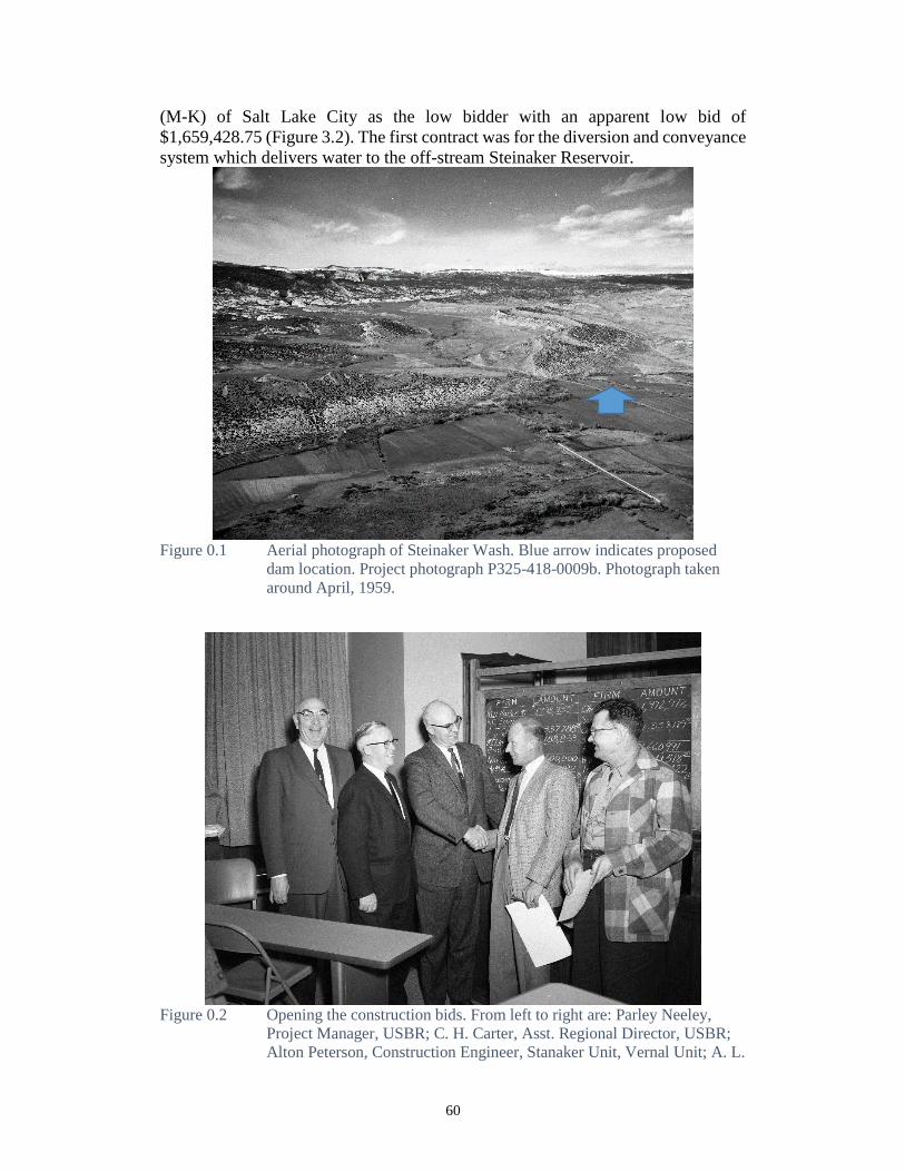
60
(M-K) of Salt Lake City as the low bidder with an apparent low bid of
$1,659,428.75 (Figure 3.2). The first contract was for the diversion and conveyance
system which delivers water to the off-stream Steinaker Reservoir.
Figure 0.1 Aerial photograph of Steinaker Wash. Blue arrow indicates proposed
dam location. Project photograph P325-418-0009b. Photograph taken
around April, 1959.
Figure 0.2 Opening the construction bids. From left to right are: Parley Neeley,
Project Manager, USBR; C. H. Carter, Asst. Regional Director, USBR;
Alton Peterson, Construction Engineer, Stanaker Unit, Vernal Unit; A. L.
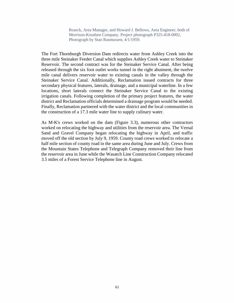
61
Roarck, Area Manager, and Howard J. Bellows, Area Engineer, both of
Morrison-Knudsen Company. Project photograph P325-418-0002,
Photograph by Stan Rasmussen, 4/1/1959.
The Fort Thornburgh Diversion Dam redirects water from Ashley Creek into the
three mile Steinaker Feeder Canal which supplies Ashley Creek water to Steinaker
Reservoir. The second contract was for the Steinaker Service Canal. After being
released through the six foot outlet works tunnel in the right abutment, the twelve
mile canal delivers reservoir water to existing canals in the valley through the
Steinaker Service Canal. Additionally, Reclamation issued contracts for three
secondary physical features, laterals, drainage, and a municipal waterline. In a few
locations, short laterals connect the Steinaker Service Canal to the existing
irrigation canals. Following completion of the primary project features, the water
district and Reclamation officials determined a drainage program would be needed.
Finally, Reclamation partnered with the water district and the local communities in
the construction of a 17.3 mile water line to supply culinary water.
As M-K's crews worked on the dam (Figure 3.3), numerous other contractors
worked on relocating the highway and utilities from the reservoir area. The Vernal
Sand and Gravel Company began relocating the highway in April, and traffic
moved off the old section by July 9, 1959. County road crews worked to relocate a
half mile section of county road in the same area during June and July. Crews from
the Mountain States Telephone and Telegraph Company removed their line from
the reservoir area in June while the Wasatch Line Construction Company relocated
3.5 miles of a Forest Service Telephone line in August.

62
.3 Figure 0.3 Photo is taken during first blasting operation. Looking toward left
abutment. Project photograph P325-418-0264, Photograph by Elmer S.
Davis, 3/26/60.
The Moon Lake Electric Association also completed the relocation of its lines in
August. The Utah Power and Light Company was the only company with remaining
power lines in late 1959. The company had awarded a contract, but the work was
held up because the government had not completed acquisition of the new right of
way.
The Annual History has an important note in the December 7, 1959 report:
On the afternoon of November 20, skeletal remains of a human were exposed in
excavation of the left abutment, Station 17+00, 143 feet downstream from the dam
axis at elevation 5400 (Figure 3.4). Further excavation in this area revealed
fragments of two other humans. Mr. James H. Gunnerson, Curator, Museum of
Anthropology, University of Utah, visited the site on November 25 and made a
preliminary examination of the bones. His opinion was that the skeletons were those
of Indians of undetermined antiquity who had been buried in crevices in the rocks.
The bones were turned over the Mr. Gunnerson for the Museum of Anthropology
at the University of Utah (See Reclamation 1959:86).
Subsequently, the location was assigned site number 42UN128.
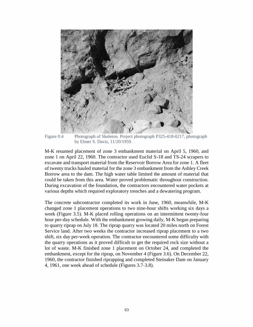
63
Figure 0.4 Photograph of Skeleton. Project photograph P325-418-0217, photograph
by Elmer S. Davis, 11/20/1959.
M-K resumed placement of zone 3 embankment material on April 5, 1960, and
zone 1 on April 22, 1960. The contractor used Euclid S-18 and TS-24 scrapers to
excavate and transport material from the Reservoir Borrow Area for zone 1. A fleet
of twenty trucks hauled material for the zone 3 embankment from the Ashley Creek
Borrow area to the dam. The high water table limited the amount of material that
could be taken from this area. Water proved problematic throughout construction.
During excavation of the foundation, the contractors encountered water pockets at
various depths which required exploratory trenches and a dewatering program.
The concrete subcontractor completed its work in June, 1960, meanwhile, M-K
changed zone 1 placement operations to two nine-hour shifts working six days a
week (Figure 3.5). M-K placed rolling operations on an intermittent twenty-four
hour per-day schedule. With the embankment growing daily, M-K began preparing
to quarry riprap on July 18. The riprap quarry was located 20 miles north on Forest
Service land. After two weeks the contractor increased riprap placement to a two
shift, six day per-week operation. The contractor encountered some difficulty with
the quarry operations as it proved difficult to get the required rock size without a
lot of waste. M-K finished zone 1 placement on October 24, and completed the
embankment, except for the riprap, on November 4 (Figure 3.6). On December 22,
1960, the contractor finished riprapping and completed Steinaker Dam on January
4, 1961, one week ahead of schedule (Figures 3.7-3.8).

64
Figure 0.5 Embankment construction in progress on Zones 1, 2, and 3. View is
looking northeast from right abutment. Average elevation for the three
zones shown is 5450. Project photograph P325-418-0329, photograph by
Elmer S. Davis, 7/18/1960.
Figure 0.6 Nearly completed dam. View towards right abutment. Project photograph
P325-418-0398, photograph by Elmer S. Davis, 10/26/1960.
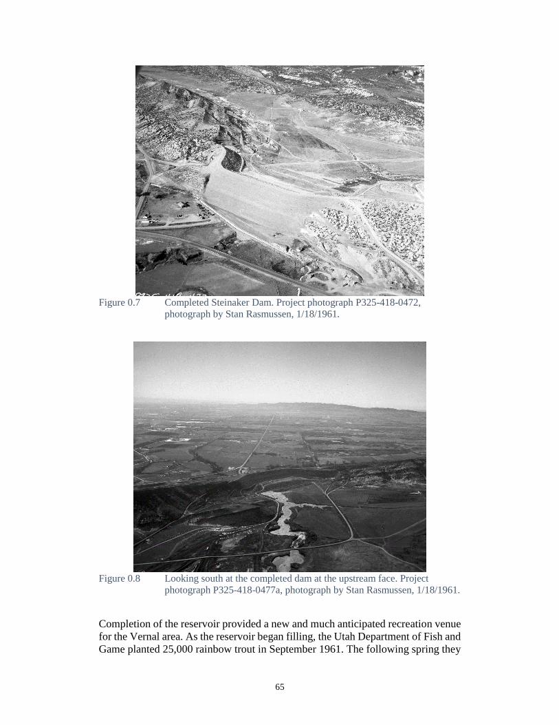
65
Figure 0.7 Completed Steinaker Dam. Project photograph P325-418-0472,
photograph by Stan Rasmussen, 1/18/1961.
Figure 0.8 Looking south at the completed dam at the upstream face. Project
photograph P325-418-0477a, photograph by Stan Rasmussen, 1/18/1961.
Completion of the reservoir provided a new and much anticipated recreation venue
for the Vernal area. As the reservoir began filling, the Utah Department of Fish and
Game planted 25,000 rainbow trout in September 1961. The following spring they
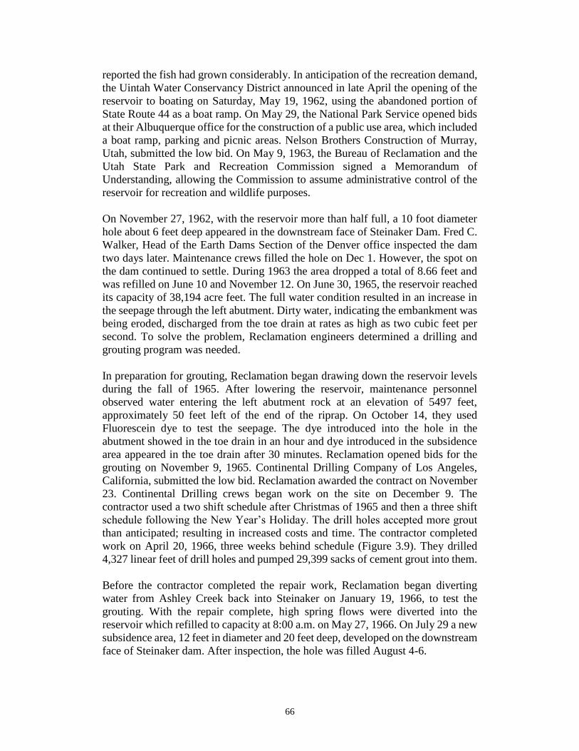
66
reported the fish had grown considerably. In anticipation of the recreation demand,
the Uintah Water Conservancy District announced in late April the opening of the
reservoir to boating on Saturday, May 19, 1962, using the abandoned portion of
State Route 44 as a boat ramp. On May 29, the National Park Service opened bids
at their Albuquerque office for the construction of a public use area, which included
a boat ramp, parking and picnic areas. Nelson Brothers Construction of Murray,
Utah, submitted the low bid. On May 9, 1963, the Bureau of Reclamation and the
Utah State Park and Recreation Commission signed a Memorandum of
Understanding, allowing the Commission to assume administrative control of the
reservoir for recreation and wildlife purposes.
On November 27, 1962, with the reservoir more than half full, a 10 foot diameter
hole about 6 feet deep appeared in the downstream face of Steinaker Dam. Fred C.
Walker, Head of the Earth Dams Section of the Denver office inspected the dam
two days later. Maintenance crews filled the hole on Dec 1. However, the spot on
the dam continued to settle. During 1963 the area dropped a total of 8.66 feet and
was refilled on June 10 and November 12. On June 30, 1965, the reservoir reached
its capacity of 38,194 acre feet. The full water condition resulted in an increase in
the seepage through the left abutment. Dirty water, indicating the embankment was
being eroded, discharged from the toe drain at rates as high as two cubic feet per
second. To solve the problem, Reclamation engineers determined a drilling and
grouting program was needed.
In preparation for grouting, Reclamation began drawing down the reservoir levels
during the fall of 1965. After lowering the reservoir, maintenance personnel
observed water entering the left abutment rock at an elevation of 5497 feet,
approximately 50 feet left of the end of the riprap. On October 14, they used
Fluorescein dye to test the seepage. The dye introduced into the hole in the
abutment showed in the toe drain in an hour and dye introduced in the subsidence
area appeared in the toe drain after 30 minutes. Reclamation opened bids for the
grouting on November 9, 1965. Continental Drilling Company of Los Angeles,
California, submitted the low bid. Reclamation awarded the contract on November
23. Continental Drilling crews began work on the site on December 9. The
contractor used a two shift schedule after Christmas of 1965 and then a three shift
schedule following the New Year’s Holiday. The drill holes accepted more grout
than anticipated; resulting in increased costs and time. The contractor completed
work on April 20, 1966, three weeks behind schedule (Figure 3.9). They drilled
4,327 linear feet of drill holes and pumped 29,399 sacks of cement grout into them.
Before the contractor completed the repair work, Reclamation began diverting
water from Ashley Creek back into Steinaker on January 19, 1966, to test the
grouting. With the repair complete, high spring flows were diverted into the
reservoir which refilled to capacity at 8:00 a.m. on May 27, 1966. On July 29 a new
subsidence area, 12 feet in diameter and 20 feet deep, developed on the downstream
face of Steinaker dam. After inspection, the hole was filled August 4-6.
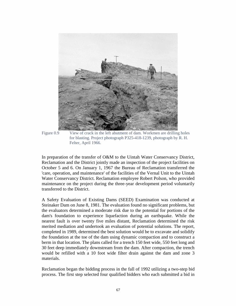
67
Figure 0.9 View of crack in the left abutment of dam. Workmen are drilling holes
for blasting. Project photograph P325-418-1239, photograph by R. H.
Felter, April 1966.
In preparation of the transfer of O&M to the Uintah Water Conservancy District,
Reclamation and the District jointly made an inspection of the project facilities on
October 5 and 6. On January 1, 1967 the Bureau of Reclamation transferred the
'care, operation, and maintenance' of the facilities of the Vernal Unit to the Uintah
Water Conservancy District. Reclamation employee Robert Polson, who provided
maintenance on the project during the three-year development period voluntarily
transferred to the District.
A Safety Evaluation of Existing Dams (SEED) Examination was conducted at
Steinaker Dam on June 8, 1981. The evaluation found no significant problems, but
the evaluators determined a moderate risk due to the potential for portions of the
dam's foundation to experience liquefaction during an earthquake. While the
nearest fault is over twenty five miles distant, Reclamation determined the risk
merited mediation and undertook an evaluation of potential solutions. The report,
completed in 1989, determined the best solution would be to excavate and solidify
the foundation at the toe of the dam using dynamic compaction and to construct a
berm in that location. The plans called for a trench 150 feet wide, 550 feet long and
30 feet deep immediately downstream from the dam. After compaction, the trench
would be refilled with a 10 foot wide filter drain against the dam and zone 3
materials.
Reclamation began the bidding process in the fall of 1992 utilizing a two-step bid
process. The first step selected four qualified bidders who each submitted a bid in
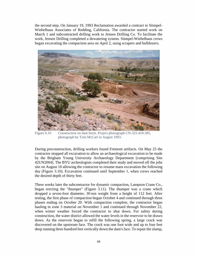
68
the second step. On January 19, 1993 Reclamation awarded a contract to Stimpel-
Wiebelhaus Associates of Redding, California. The contractor started work on
March 1 and subcontracted drilling work to Jensen Drilling Co. To facilitate the
work, Jensen Drilling completed a dewatering system. Stimpel-Wiebelhaus crews
began excavating the compaction area on April 2, using scrapers and bulldozers.
Figure 0.10 Construction on dam berm. Project photograph CN-325-418-385,
photograph by Tom McCarl in August 1993.
During preconstruction, drilling workers found Fremont artifacts. On May 25 the
contractor stopped all excavation to allow an archaeological excavation to be made
by the Brigham Young University Archaeology Department [comprising Site
42UN2004]. The BYU archeologists completed their study and moved off the jobs
site on August 10 allowing the contractor to resume mass excavation the following
day (Figure 3.10). Excavation continued until September 1, when crews reached
the desired depth of thirty feet.
Three weeks later the subcontractor for dynamic compaction, Lampson Crane Co.,
began erecting the "thumper" (Figure 3.11). The thumper was a crane which
dropped a seven-foot diameter, 30-ton weight from a height of 112 feet. After
testing, the first phase of compaction began October 4 and continued through three
phases ending on October 20. With compaction complete, the contractor began
hauling in zone 3 material on November 1 and continued through November 22,
when winter weather forced the contractor to shut down. For safety during
construction, the water district allowed the water levels in the reservoir to be drawn
down. As the reservoir began to refill the following spring, a large crack was
discovered on the upstream face. The crack was one foot wide and up to four feet
deep running three hundred feet vertically down the dam's face. To repair the slump,
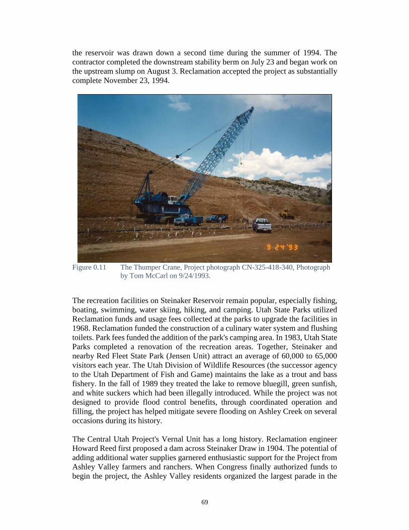
69
the reservoir was drawn down a second time during the summer of 1994. The
contractor completed the downstream stability berm on July 23 and began work on
the upstream slump on August 3. Reclamation accepted the project as substantially
complete November 23, 1994.
Figure 0.11 The Thumper Crane, Project photograph CN-325-418-340, Photograph
by Tom McCarl on 9/24/1993.
The recreation facilities on Steinaker Reservoir remain popular, especially fishing,
boating, swimming, water skiing, hiking, and camping. Utah State Parks utilized
Reclamation funds and usage fees collected at the parks to upgrade the facilities in
1968. Reclamation funded the construction of a culinary water system and flushing
toilets. Park fees funded the addition of the park's camping area. In 1983, Utah State
Parks completed a renovation of the recreation areas. Together, Steinaker and
nearby Red Fleet State Park (Jensen Unit) attract an average of 60,000 to 65,000
visitors each year. The Utah Division of Wildlife Resources (the successor agency
to the Utah Department of Fish and Game) maintains the lake as a trout and bass
fishery. In the fall of 1989 they treated the lake to remove bluegill, green sunfish,
and white suckers which had been illegally introduced. While the project was not
designed to provide flood control benefits, through coordinated operation and
filling, the project has helped mitigate severe flooding on Ashley Creek on several
occasions during its history.
The Central Utah Project's Vernal Unit has a long history. Reclamation engineer
Howard Reed first proposed a dam across Steinaker Draw in 1904. The potential of
adding additional water supplies garnered enthusiastic support for the Project from
Ashley Valley farmers and ranchers. When Congress finally authorized funds to
begin the project, the Ashley Valley residents organized the largest parade in the

70
city's history. Constructed during the era of big dams, Steinaker is relatively small
in comparison. But its size belies the reservoir's importance to the community it
supplies. The Vernal Unit provides much needed water for municipal and
supplemental irrigation and remains a popular recreational destination. The
investment to stabilize the dam will insure that it continues to offer benefits for
many years.
Steinaker Archaeological Investigations
This section quotes extensively from Talbot and Richens 1999, pages 6-8 and 11-
12. Talbot and Richens were the archaeologists in charge of the Steinaker
archaeological investigations during the 1994 Steinaker Dam repairs. They
surveyed the reservoir basin and surrounding area, excavated at several sites, tested
many others, and in general created the baseline data which will be used in the
future for assessing sites. Several monographs came out of their investigations. The
project history provided here is quoted from Prehistoric Farmers of the Uinta
Basin: The Steinaker Lake Project.
The lake initially reached full storage capacity in 1965, and since that time water
levels have fluctuated considerably, depending on the availability of and demand
for water. In 1993-94, as part of Reclamation Safety of Dams program,
reinforcement work was initiated on the dam. After reaching its normal high water
level of 1682 m (ca. 5520 ft.) in late spring of 1993, the lake was drained for
irrigation use during summer and early fall of that same year, and the water level
was then allowed to drop farther so that by November of 1993 the water had
reached ca. 1661 m (5450 ft.), just above the conservation pool level of ca 1652 m
(5420 ft.). Reinforcement work at the toe of the dam was on-going during this
time. Lake refilling began in late winter and continued through the spring of 1994.
However, during this refilling effort the need for additional dam work was
recognized. The water level was then lowered once again during the summer of
1994. Refilling followed again during the subsequent fall and winter, and by the
spring of 1995 the lake had reached ca. 1672 m (5485 ft.). The following year the
lake was returned to its high water level.
Prior to the dam reinforcement work, archaeological studies within or near the
impoundment area had been sporadic, but at least 16 archaeological sites were
known for the area (see Talbot and Richens 1996). In 1992, while conducting soils
tests at the toe of the dam, human remains were uncovered. Personnel from the
Brigham Young University Office of Public Archaeology (OPA) carried out test
excavations at that time, determining that the site (42Un2004) contained
significant, intact deposits (Talbot et al. 1992). In late spring of 1993, the testing
was expanded and research culminated in the excavation of a large prehistoric use
surface and irrigation facilities that became known as the Steinaker Gap site
(Talbot and Richens 1996). In January of 1994, a large site located on a knoll in
the Steinaker Lake basin (42Un154) was noted by state park personnel to have
human remains eroding off the surface. The site was examined by OPA personnel
71
(Billat 1994), who also located two sites nearby, one (42Un2094) with a human
burial eroding from a cutbank. That burial was salvaged the following month (S.
Baker 1994).
In July-August of 1994, when the lake water level was reduced to minimum levels,
personnel from OP A carried out an intensive inventory of ca. 1500 acres, taking
in most of the current Steinaker Lake State Park boundaries (Irvine et al. 1995).
Although the water level temporarily reached the conservation pool level of 5420
ft., water level during most of the inventory was between 1661-1663 m (5450-
5455 ft.). A total of 44 existing archaeological sites were located at that time,
including most of the sites documented in earlier years. It was determined that 24
of the sites met the eligibility criteria for inclusion on the National Register of
Historic Places (NRHP).
Talbot and Richens recognized at the time of the initial inventory that these sites
represented, as a group, one of the more significant archaeological data sets for
Utah to come to light in recent years. While traditional chronologies place the
centuries immediately preceding and postdating the time of Christ (up to ca. AD
500) as part of the Late Archaic Period, during which native groups were thought
to have been relatively nomadic, the Steinaker Basin sites offered intriguing
evidence for corn agriculture and settled pithouse life that was well-established by
the third and fourth centuries AD, as demonstrated most impressively by the
Steinaker Gap work. The numerous sites within the basin itself seemed to relate to
this same time period and shortly thereafter, and promised to provide insight into
the earliest appearance of farmers in Utah, and to farmer-forager interaction
specifically in the Uinta Basin.
Unfortunately, it was also determined that 14 NRHP-eligible sites, designated as
"High Danger Potential" sites, were systematically being destroyed by a
combination of fluctuating water levels, exposure of vegetation-barren site
surfaces to wind and water erosion, dam reinforcement work, recreational use, and
state park development activities. By far the most destructive impacts were in fact
directly related to the dam reinforcement work. The lake draining exposed
archaeological sites that had been under water for nearly four decades, sites which
no longer had the vegetation cover that had protected them for over a thousand
years. Wind and rain erosion began to immediately impact the sites. As water
levels began to rise again, wave erosion took over. If the lake was permitted to
stand at one level for more than a day, waves began creating cutbank terraces all
along shorelines where sites were located. Boat wakes exacerbated the problem,
and the wave terraces expanded, cutting away at long-protected subsurface cultural
features. By the time the lake was refilled the second time, all of the "High Danger
Potential" sites had been seriously damaged. The remaining 10 NRHP-eligible
sites, designated as "Moderate" or "Low Danger Potential" sites, were not
impacted directly by wind-water erosion, but were receiving impacts from
secondary recreational activities (e.g., trails, vandalism, state park development,
etc.).

72
Following the 1994 inventory, when it was recognized that so many of the other
Steinaker Lake sites were in imminent danger of complete destruction, OPA was
directed by Reclamation to conduct site testing at all of the NRHP eligible sites.
This was carried out in three phases between 1994 and 1997 (Richens 1997; Talbot
et al. 1997; Richens and Talbot 1998), with the sites at or below the water line
tested first, while the water level was down for dam reinforcement work. Most of
the testing consisted of test trenches and test pits placed in sites where intact
features appeared to be present. Beyond the work at the Steinaker Gap site, more
extensive salvage work was necessary at two of the sites. A human burial at site
42Un162 had been previously salvaged when it was found to have slumped down
from an erosional terrace. A pithouse was noted in that same vertical terrace, and
what was left of it was excavated before the shoreline erosion could destroy it
entirely. Similarly, a human burial was found eroding out of site 42Un1671
(Hidden Island site). That burial and the pit in which it was located were also
excavated. The lake level was rising at the time of the excavation, and numerous
eroded features in the general vicinity of the burial were also in danger of complete
destruction, and at the direction of Reclamation archaeologist, several of these
features were salvaged just before the water level inundated the site (Richens
1997).
The background on prior archaeological work in this next section comes from
Talbot and Richens 1999:11-12. Here, they summarize archaeological work in the
area and place their excavations into the general framework.
The Claflin-Emerson Expedition (Gunnerson 1969: 118-121; Scott 1931)
excavated a large cave site (A6-1) at the junction of Dry Fork and Ashley Creek
containing storage cists, and two baskets filled with both shelled and eared com.
One was covered with a piece of buffalo hide and also contained squash seeds.
Three additional cave sites (A6-2, A6-6, and A6-7) in the same vicinity were
investigated. One contained a turtle-backed adobe structure, while the others
apparently contained cists and considerable perishable remains, including
corncobs, squash, basketry and cordage, hide, and reed tubes. Reports of vandal
activity indicated that blankets, dewclaw moccasins, buckskin and bark bags, and
a human burial were taken from the caves prior to the Claflin-Emerson work
(Spangler 1995:60). Two open sites (A7-1 and A 7 -2), each containing three
boulder-lined structures and sparse Uinta Gray sherds, were also reported from the
Brush Creek area. Finally, two rockshelter sites (A6-3 and A6-5) were explored in
an area "5 miles north of Vernal" (Gunnerson 1969: 120), which would place them
in the middle to upper Steinaker Basin, both on the valley floor. One contained an
adobe-lined cist with a "thin layer of carbonized seeds" on the bottom, and the
other contained a possible unlined pit, several charcoal ash layers, and a bark layer.
A single corncob and two com shanks were recovered from the latter rockshelter.
Albert B. Reagan was certainly one of the more prolific Uinta Basin researchers.
In the early 1930s (see Spangler 1995:65-72 for an in-depth review of Reagan's
work) Reagan visited and described numerous caves, camp sites, and rock art in
73
the Dry Fork/Ashley Creek, Spring Creek, and Steinaker areas. Two of the caves
(Caves 34 and 35) were located in the upper part of Steinaker Basin. In one of his
better known manuscripts, Reagan (1933) described 40 caves in this immediate
area, two in Steinaker Draw: Cave 34 contained much material, including a basket
partially filled with com, a buckskin bag with some type of dried food cakes, a
buckskin legging, and squash remains; Cave 35 contained a walled structure. Most
of the remaining caves in the area contained similar findings, including impressive
quantities of com, squash, etc.
Reagan (1931a) also reported pictographs (Panels 99-105) along the hogback ridge
("the Point of Rocks ridge") west of Steinaker Gap. On this same ridge Reagan
(1931b) reported on a large campsite containing a large quantity of artifacts as well
as at least 17 mortar holes or pot-holes dug into the rock that he speculated were
used for various purposes, from cooking pots to grinding holes. Just to the south
of this ridge on property owned by William Gibson, ca. 400-500 meters southwest
of Steinaker Dam, Reagan (1931c) noted the presence of "several earth lodges, all
showing evidence of having been destroyed by fire." Reagan (1931b:126) suggests
that a typical earth lodge had "at least four support posts, a post being set at each
comer of the squarish or rectangular enclosure." In the Brush Creek area, Reagan
found several structures, one containing two ceramic jars, and a cave site with a
partial child burial. One of his most interesting observations (Reagan 1931d: 136-
137; quoted in Spangler 1995:67) is that of prehistoric irrigation ditches in the
Vernal area:
These house builders were also agriculturalists, and their irrigating ditches of
those far off days can still be traced ..... On the west side of Brush Creek. .... an
ancient ditch can still be traced for a distance of nearly three miles, to where it
finally ascends onto the mesa bench. Here it is four steps wide and still shows a
depression a foot or so in depth. It then crosses the flats till it is lost, due to the
wear of time. However, further down the valley are the remains of a reservoir ....
; the double rock wall fifty feet in length, with walls four feet apart, still shows.
The water of the reservoir finally cut an outlet farther down the valley. A similar
irrigation system can be traced on the opposite side of the valley, and another in
the vicinity of the mouth of the creek, near Jensen. Remains of ancient irrigation
ditches can also be traced in the vicinity of Ferndale. Three of these, as with the
ditch near Jensen, have been cleared out by the white settlers and are being used
at the present time.
Julian Steward (1933) carried out excavations near the Uinta River, just north of
Fort Duchesne, at a group of mounds. Two pithouses and a rock-walled structure
were excavated.
In 1954, James Gunnerson (1955, 1957) carried out reconnaissance surveys in the
general foothill regions of the Uintas, including within the Ashley Creek and
Steinaker areas, as part of the Utah Statewide Archaeological Survey. Within the
current project area, sites 42Un67 and 42Un75, and probably 42Un2220 (formerly
74
designated as 42Un68) were all recorded as part of this first effort, along with
nearby rock art sites 42Un76 and 42Un77 along the Point of Rocks ridge. Five
years later, during construction of Steinaker dam in 1959, human skeletal remains
were encountered near the northeast dam abutment. The site (42Un128) was
examined by Gunnerson and the remains, which had already been removed from
the spot by the construction workers, were transported to the University of Utah.
No further archaeological work was carried out (Jennings 1959).
A month prior to the discovery of these burials, Lipe (1959) carried out a survey
of the proposed reservoir area. A large rock art panel (42Un153) and several
campsites (42Un75, 154-166) were found. Sites 42Un153 and 42Un154 were
located within the impoundment area of the reservoir, and the remaining sites were
found on the eroded finger ridges on the west side of the reservoir basin. The
reservoir basin was resurveyed by MESA in 1982 (Norman and Merrill 1983),
with several new sites recorded (42Un1308-1319 and 42Un1334), all but two of
which were prehistoric. Phillips (Phillips 1990; Phillips and Truesdale 1991)
carried out salvage work at two of the sites (42Un162 and 42Un1671), followed
by the OPA work reported in this volume.
Regional research has been extensive but primarily of the grey literature type, and
much of it is now well-dated. An important synthesis of area research was recently
compiled by Spangler (1995), and additional summaries are presented by Jones
and MacKay (1980), (Berry and Berry 1976), Sisson (1978), and Phillips (1990;
Phillips and Truesdale 1991). Well known excavations have been carried out at
Caldwell Village (Ambler 1966) and several sites nearby (Shields 1967),
Boundary Village (Leach 1966), in and near Dinosaur National Monument (Lister
1951; Breternitz 1970; Leach 1970a and 1970b; Holmer 1979; Truesdale 1993),
at Thorne Cave (Day 1964), and around Flaming Gorge (Day and Dibble 1963;
Sharrock 1966), and recently in the Uinta Mountains by Loosle (1997). To the east
in northwest Colorado, recent work has been carried out most prominently in the
Douglas Creek and Piceance Basin (S.G. Baker 1995, 1996, 1997; Creasman 1981;
Grady 1980; La Point 1987; Newkirk and Roper 1983), and generally throughout
the area (see Bambrey 1984, and McDonald 1994). In southwest Wyoming, recent
work includes Armitage et al. (1982), Reust et al. (1993), Schroedl (1985), Smith
and Creasman (1988), and most recently by Thompson and Pastor (1995).

75
References
Ambler, J. Richard
1966 Caldwell Village. Anthropological Papers No. 84. University of Utah, Salt
Lake City.
Armitage, C. Lawrence, Janice C. Newberry-Creasman, M. C. Mackey, Charles
M. Love, Douglas Heffington, K. Harvey, J. E. Sall, K. Dueholm, and Steven D.
Creasman
1982 The Deadman Wash Site. Cultural Resource Management Report No. 6.
Western Wyoming College, Rock Springs.
Babb, Cyrus Cates
1900 Water Supply of the Uinta Indian Reservation, Utah. U.S. Government
Printing Office.
Baker, Shane A.
1994 Preliminary Report on Limited Archaeological Data Recovery at
42Un2094, Steinaker Reservoir Area, North of Vernal. Uintah County.
Utah. Museum of Peoples and Cultures Technical Series 94-4. Brigham
Young University, Provo.
Baker, Steven G.
1992 An Archaeological Monitor of the Cow Canyon Water Crossing
Reconstruction, Canyon Pintado National Historic District, Rio Blanco
County, Colorado. MS, prepared for Fina Oil and Chemical Company.
Centuries Research, Inc. Montrose, Colorado.
1995 Fremont and Numic Archaeology on the Douglas Creek Arch, Rio Blanco
County, Colorado: The Sandshadow and New Sites (5RB2958 and
5RB3060). Chandler Douglas Arch Series, Report No. 78. Centuries
Research, Inc. Montrose, Colorado.
1996 Numic Archaeology on the Douglas Creek Arch, Rio Blanco County,
Colorado: Ute Racherias and the Broken Blade Wickiup Village
(5RB3182). Chandler Douglas Arch Series, Report No. 79. Centuries
Research, Inc. Montrose, Colorado.
1997 Fremont Archaeology on the Douglas Creek Arch, Rio Blanco County,
Colorado: Granaries and Rock Art in Shavetail Basin (5RB3180, 3286,
3288, 3290, and 3512). Chandler Douglas Arch Series, Report No. 82.
Centuries Research, Inc. Montrose, Colorado.
Bambrey, Lucy Hackett
1984 Extending the Limits of the Fremont Culture in Northwest Colorado.
Unpublished Master's thesis, Department of Anthropology, University of
Denver, Denver.
Berry, Michael S., and Claudia F. Berry

76
1976 An Archeological Reconnaissance of the White River Area, Northeastern
Utah. Antiquities Section Selected Papers Vol. II, No.4. Utah State
Historical Society, Salt Lake City.
Billat, Scott E.
1994 A Site Evaluation of 42UN154, Located Within Steinaker Reservoir, North
of Vernal, Utah. Museum of Peoples and Cultures Technical Series No.
94-1. Brigham Young University, Provo, Utah.
Breternitz, David A. (assembler)
1970 Archaeological Excavations in Dinosaur National Monument, Colorado-
Utah, 1964-1965. University of Colorado Studies, Series in Anthropology
No. 17. University of Colorado Press, Boulder.
Burton, Dorris K.
1996 A History of Uintah County: Scratching the Surface. Utah Centennial
County History Series. Salt Lake City (UT): Utah State Historical Society
and Uintah County Commission.
Conetah, Fred A.
1982 A History of the Northern Ute People. Edited by Kathryn L. MacKay and
Floyd A. O’Neil. Published by the Uintah-Ouray Ute Tribe, University of
Utah Printing Service, Salt Lake City, Utah.
Creasman, Steven D.
1981 Archaeological Investigations in the Canyon Pintado Historic District,
Rio Blanco County, Colorado. Unpublished Master's thesis, Department of
Anthropology, Colorado State University, Fort Collins.
Day, Kent C.
1964 Thorne Cave, Northeastern Utah: Archaeology. American Antiquity
30(1):50-59.
Day, Kent C., and David S. Dibble
1963 Archaeological Survey of the Flaming Gorge Reservoir Area, Wyoming-
Utah. Upper Colorado Series No.9, Anthropological Papers No. 65.
University of Utah, Salt Lake City.
[DUP] Daughters of the Utah Pioneers of Uintah County, Utah
1947 A Centennial History of the Uintah County, 1872 to 1947. Springville,
Utah: Art City Publishing Company.
Eastman, Adam
2007 The Central Utah Project, Vernal Unit. Historic Reclamation Projects
Book.
77
Fuller, Craig
1994 Uintah Basin. In Utah History Encyclopedia. A.K. Powell, ed. Available
online at
http://historytogo.utah.gov/utah_chapters/the_land/uintabasin.html.
Accessed 10/24/2016.
Grady, James
1980 Environmental Factors in Archaeological Site Locations. Cultural
Resource Series No. 9. Colorado Bureau of Land Management, Denver.
Gunnerson, James H.
1955 Archaeological Survey, Preliminary Report of 1954 Reconnaissance.
Manuscript on file, Department of Anthropology, University of Utah, Salt
Lake City.
1957 An Archeological Survey of the Fremont Area. Anthropological Papers
No. 28. University of Utah Press, Salt Lake City.
1969 The Fremont Culture: A Study in Culture Dynamics on the Northern
Anasazi Frontier. Papers of the Peabody Museum of Archaeology and
Ethnology Vol. 59, No. 2. Harvard University, Cambridge.
Holmer, Richard N.
1979 Split Mountain Cultural Study Tract. Archaeological Center, Department
of Anthropology, University of Utah, Salt Lake City.
1986 Common projectile points of the Intermountain West. In Anthropology of
the Desert West: Essays in Honor of Jesse D. Jennings, edited by Carol J.
Condie and Don D. Fowler, pp. 89-115. Anthropological Papers No. 110.
University of Utah, Salt Lake City.
Irvine, Howard S., Richard K. Talbot, and Lane D. Richens
1995 An Archaeological Survey of Bureau of Reclamation Lands Around
Steinaker Lake, Vernal, Utah. Museum of Peoples and Cultures Technical
Series No. 95-7. Brigham Young University, Provo, Utah.
Jennings, Jesse D.
1959 Letter to Mr. A.H. Peterson, Bureau of Rec1amation, dated November 30,
1959.
1978 Prehistory of Utah and the Eastern Great Basin. Salt Lake City (UT):
University of Utah Anthropological Papers No. 98.
Jones, Kevin, T., and Kathryn L. MacKay
1980 Cultural Resources Existing Data Inventory: Vernal District, Utah. Ms on
file, University of Utah Archaeological Center. Salt Lake City.
LaPoint, Halcyon
1987 An Overview of Prehistoric Cultural Resources. Cultural Resource Series
No. 20. Colorado Bureau of Land Management, Denver.
78
Leach, Larry L.
1966 The Archeology of Boundary Village. In Miscellaneous Collected Papers
11-14 (Paper No. 13) by Kent C. Day, Floyd W. Sharrock, Larry L. Leach,
and Erik K. Reed, pp. 85-129. Anthropological Papers No. 83. University
of Utah, Salt Lake City.
1970a Archaeological Investigations at Deluge Shelter in Dinosaur National
Monument. Unpublished Ph.D. dissertation, Department of Anthropology,
University of Colorado, Boulder.
1970b Swelter Shelter, 42UN40. In Archaeological Excavations in
Dinosaur National Monument, Colorado- Utah, 1964-1965, assembled by
David A. Breternitz, pp. 127-135. University of Colorado Studies, Series
in Anthropology No. 17. University of Colorado Press, Boulder.
Lipe, William D.
1959 Archaeological Survey of the Steinaker Reservoir Area, Uintah County,
Utah. Manuscript on file, Department of Anthropology, University of
Utah, Salt Lake City.
Lister, Robert H.
1951 Excavations at Hells Midden, Dinosaur National Monument. University of
Colorado Studies, Series in Anthropology No.3. University of Colorado
Press, Boulder.
Loosle, Byron
1997 Borders, Boundaries and High Mountains: The Uinta Fremont's
Acquisition of Nonlocal Lithic Materials. Paper presented at the Third
Rocky Mountain Anthropological Conference, Bozeman, Montana.
Lower-Eskelson, Kylie
2007 Cultural Resource Inventory of Veritas Geophysical Integrity’s Uintah
Basin 3D Seismic Prospect Uintah County, Utah. Moab (UT):
Montgomery Archaeological Consultants, Inc.
Madsen, Rex E.
1977 Prehistoric Ceramics of the Fremont. Flagstaff (AZ): Museum of
Northern Arizona Ceramic Series No. 6.
Marwitt, John P.
1970 Median Village and Fremont Culture Regional Variation. Salt Lake City
(UT): University of Utah Anthropological Papers No. 95.
McDonald, Elizabeth Kae
1994 A Spatial and Temporal Examination of Prehistoric Interaction in the
Eastern Great Basin and on the Northern Colorado Plateau. Unpublished
79
Ph.D. Dissertation, Department of Anthropology, University of Colorado,
Boulder.
Newkirk, Judith A., and Donna C. Roper
1983 Predictive Modeling in the Piceance Basin, Northwest Colorado. White
River Resource Area, Craig District, Colorado Bureau of Land
Management, Denver.
Norman, V. Garth, and David B. Merrill
1983 Cultural Resources Survey of a Portion of the Steinaker Reservoir Area,
Vernal Unit, Central Utah Project. Mesa CRM Paper No. 12. Orem.
Phillips, H. Blaine
1990 The Archaeology of 42UN1671: A Submerged Fremont Site, Uintah
County, Utah. Manuscript on file at Bureau of Land Management, Vernal
District Office, Vernal.
Phillips, H. Blaine, and James A. Truesdale
1991 A Report on the Removal and Analysis of a Prehistoric Child's Burial from
Steinaker Reservoir, Uintah County, Utah. Manuscript on file at Bureau of
Land Management, Vernal District Office, Vernal.
Reagan, Albert B.
1931a The Pictographs of Ashley and Dry Fork Valleys in Northeastern Utah.
Transactions, Kansas Academy of Sciences 34:168-216.
1931b Additional Archaeological Notes on Ashley and Dry Fork Canyons in
Northeastern Utah. El Palacio 31(8):122-131.
1931c Newspaper article in the Vernal Express, dated June 4, 1931.
1931d Archaeological Notes on the Brush Creek Region, Northeastern Utah.
Wisconsin Archeologist 10(4):132-138.
1933 Anciently Inhabited Caves of the Vernal (Utah) District, with Some
Additional Notes on Nine Mile Canyon, Northeast Utah. Transactions,
Kansas Academy of Sciences 36:41-70.
[Reclamation] U.S. Bureau of Reclamation.
1959 Annual Project History, Vernal Unit, Central Utah Project, Utah. Volume
1, Calendar Years 1919-1959.
2013 Resource Management Plan (RMP) for Steinaker Reservoir, August 2013,
Upper Colorado Region of the Bureau of Reclamation.
Reust, Thomas, Darryl Newton, Rick Weathermon, William Harding, and Craig
Smith
1993 The Bairoil Archaeological Project: 7500 Years of Prehistory in the
Bairoil Area, Carbon and Sweetwater Counties, Wyoming. Cultural
Resources Series No.8. Wyoming State Office, Bureau of Land
Management, Cheyenne.

80
Richens, Lane D.
1997 Steinaker Lake: Excavations at 42UN1671. Museum of Peoples and
Cultures Technical Series No. 97-17. Brigham Young University, Provo,
Utah.
Richens, Lane D., and Richard K. Talbot
1998 Steinaker Lake: A Phased Approach to Archaeological Site
Documentation, Research, and Long Term Management; Phases II and III
Report: 1996-1997 Site Testing and Data Retrieval, and Draft Long Term
Management Plan. Museum of Peoples and Cultures Technical Series No.
98-6. Brigham Young University, Provo, Utah.
Schroedl, Alan R.
1985 Archaic and Late Prehistoric Adaptation in Southwestern Wyoming: The
Frontier Pipeline Excavations. Cultural Resource Series No.3. Wyoming
Bureau of Land Management, Cheyenne.
Scott, Donald
1931 Field Notes of the Claflin-Emerson Expedition, 1931 Field Season.
Manuscript on file, Peabody Museum, Harvard University. Cambridge,
Massachusetts.
Sharrock, Floyd W.
1966 Prehistoric Occupation Patterns in Southwest Wyoming and Cultural
Relationships with the Great Basin and Plains Culture Areas.
Anthropological Papers No. 77. University of Utah, Salt Lake City.
Shields, Wayne F.
1967 1966 Excavations: Uinta Basin. In Miscellaneous Collected Papers 15-18,
by Wayne F. Shields, John P. Marwitt, Gordon N. Keller, John D. Hunt,
and Erik K. Reed, Paper No. 15, pp. 1-32. Anthropological Papers No. 89.
University of Utah, Salt Lake City.
Sisson, Edward B.
1978 Survey and Evaluation of Archeological and Historical Resources,
Central Utah Project, 1977. Bureau of Rec1amation, Upper Colorado
Region, Salt Lake City.
Smith, Craig S., and Steven D. Creasman
1988 The Taliaferro Site: 5000 Years of Prehistory in Southwest Wyoming.
Cultural Resource Series No. 6. Wyoming Bureau of Land Management,
Cheyenne.
Spangler, Jerry D.

81
1995 Paradigms and Perspectives: A Class I Overview of Cultural Resources in
the Uinta Basin and Tavaputs Plateau. Salt Lake City (UT): Uinta
Research.
Stokes, William L.
1986 Geology of Utah. Salt Lake City (UT): Utah Museum of Natural History,
University of Utah.
Talbot, Richard K., Shane A. Baker, and Lane D. Richens
1992 Preliminary Report of Test Excavations at 42UT 1859 and 42UT 2004
North of Vernal, Uintah County, Utah. Museum of Peoples and Cultures
Technical Series No. 92-10. Brigham Young University, Provo.
Talbot, Richard K. and Lane D. Richens
1996 Steinaker Gap: An Early Fremont Farmstead. Museum of Peoples and
Cultures Occasional Papers, No.2. Brigham Young University, Provo.
1999 Prehistoric Farmers of the Uinta Basin: The Steinaker Lake Project.
Brigham Young University Museum of Peoples and Cultures Technical
Series No. 99-4. Provo, Utah.
Talbot, Richard K., Lane D. Richens, and William Eckerle
1997 Steinaker Lake: A Phased Approach to Archaeological Site
Documentation, Research, and Long Term Management. Phase I Report:
1994 Site Testing Results. Museum of Peoples and Cultures Technical
Series No. 96-3. Brigham Young University, Provo, Utah.
Thompson, Kevin W., and Jana V. Pastor
1995 People of the Sage: 10,000 Years of Occupation in Southwest Wyoming.
Cultural Resource Management Report No. 67. Archaeological Services,
Western Wyoming Community College, Rock Springs.
Truesdale, James A.
1993 Archeological Investigations at Two Sites in Dinosaur National
Monument: 42UN1724 and 5MF2645. Selections from the Division of
Cultural Resources No 4, Rocky Mountain Region, National Park Service.
Denver.