stormwater harvesting and managed aquifer … · antica tipografi a dal 1876 s.r.l. - piazza delle...
TRANSCRIPT

Seediscussions,stats,andauthorprofilesforthispublicationat:https://www.researchgate.net/publication/313251350
STORMWATERHARVESTINGANDMANAGEDAQUIFERRECHARGE(MAR)INTHECITYOFROME:POSSIBLE...
Article·January2017
CITATION
1
READS
26
3authors,including:
Someoftheauthorsofthispublicationarealsoworkingontheserelatedprojects:
IAHItalianChapterViewproject
GovernacepracticesregardinglandandenvironmentalmanagementinRome(Italy).Viewproject
FrancescoLaVigna
RomaCapitale(MunicipalityofRome)
74PUBLICATIONS141CITATIONS
SEEPROFILE
AllcontentfollowingthispagewasuploadedbyFrancescoLaVignaon03February2017.
Theuserhasrequestedenhancementofthedownloadedfile.
Antica Tipografi a dal 1876 S.r.l. - PIAZZA DELLE CINQUE LUNE, 113 - 00186 ROMAAzienda con Sistema Qualità certifi cato ISO 9001 - 14001
A C C A D E M I A N A Z I O N A L E D E I L I N C E I
ATTI DEI CONVEGNI LINCEI305
Meeting
Convegno
Resilience of art cities to flooding:Success and failure of the Italian experience
Resilienza delle città d’arte alle catastrofi idrogeologiche:successi e insuccessi dell’esperienza italiana
(Rome, November 4-5, 2014)
Poster contributions
ESTRATTO
ROMA 2016
BARDI EDIZIONIEDITORE COMMERCIALE

Francesco La Vigna (a), Simona Martelli (a), Isidoro Bonfà (a)
STORMWATER HARVESTING AND MANAGED AQUIFER RECHARGE (MAR) IN THE CITY OF ROME: POSSIBLE SOLUTION FOR A BETTER MANAGEMENT OF STORMWATER AND URBAN
FLOODS
1. Introduction
Harvesting urban stormwater for safe reuse has many potential benefits. It can help to reduce the impact of urban development on water quality and stream flow, and can also help to meet water conservation objectives. These potential benefits are important to the economic and environmental viability of many stormwater reuse projects (Australian Councils, 2009a).
Managed aquifer recharge is the intentional recharge of water to aqui-fers for subsequent recovery or environmental benefit; this intentional and controlled charging of an aquifer is a process by which the volume of water normally stored in the subsoil is increased at a rate higher than the natural recharge. The managed process assures adequate protection of human health and the environment. Aquifers may be recharged by diversion of water into wells or infiltration of water through the floor of basins, galleries or rivers. This technique is used in a few cases in Italy and under-utilized over the Mediterranean.
The water recharged into an aquifer may be:• storedasbankedwaterforemergencysupplies• recoveredfordrinking,industrialorirrigationsupplies• used to sustain environmental flows and phreatophytic vegetation (ie
deep-rooted plants) in stressed surface water or groundwater systems• usedasabarriertopreventsalineintrusioninoverexploitedaquifers.
(a) Roma Capitale, Environmental and Service Department Contaminated Sites Remediation and Environmental Geology, Circonvallazione Ostiense, 191 – Rome; email [email protected]
— 150 —
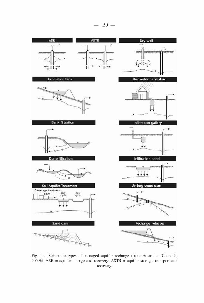
FIG. 1. – Schematic of types of managed aquifer recharge (from Australian Councils, 2009b). ASR = aquifer
storage and recovery; ASTR = aquifer storage, transport and recovery
TABLE 1 – Components of a managed aquifer recharge system (modified from Australian Councils, 2009b)
Component Examples
Fig. 1 – Schematic types of managed aquifer recharge (from Australian Councils, 2009b). ASR = aquifer storage and recovery; ASTR = aquifer storage, transport and
recovery.

— 151 —
Two examples ofmanaged aquifer recharge are shown in Fig. 1.Thefigure shows the seven components of the system (also listed in Tab. 1).
Table 1 – Components of a managed aquifer recharge system (modified from Australian Councils, 2009b).
Component Examples
1. Capture zone • Harvesting usingweirs andwetlands in urban storm-water catchments•Connection to a recycledwaterpipe froma treatmentplant
2. Pretreatment •Passivesystemssuchaswetlands• Engineered treatments (if needed) to produce sourcewater suitable for recharge
3. Recharge •Injectionwell•Infiltrationbasin•Infiltrationgallery
4. Subsurface storage •The aquifer thatwater is stored in andwhere aquiferpassive treatment occurs
5. Recovery •Recoverywell•Intentionaldischargetoagroundwater-dependenteco-system
6. Post-treatment •Passivesystemssuchaswetlands• Engineered treatments (if needed) to produce watersuitable for its intended use
7. End use •Distributiontousers,suchas–drinkingwatersupplies– irrigators or industry– aquatic ecosystems (ie human health and environmen-tal receptors)
Climate change and increasing urban population have increased pres-sures on water resources. Therefore, more diligent management is needed to secure adequate supplies of suitable water for human and environmen-tal needs. Managed aquifer recharge offers ways to generate water supplies and protect the environment using water that may otherwise be wasted. Be-lowground storage — particularly in urban areas where there are few al-ternatives— allows excess seasonal water to be conserved until water isin higher demand. Well-designed and operated systems can improve groun-dwater quality.
Managed aquifer recharge, particularly via wells, has many advantages, including (Pyne 2006):
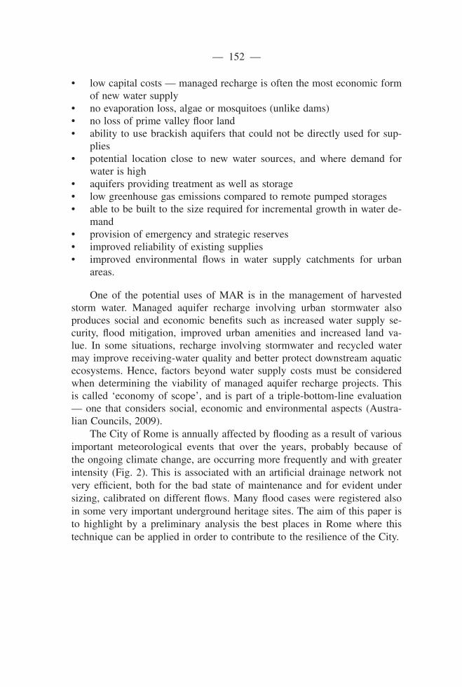
— 152 —
• lowcapitalcosts—managedrechargeisoftenthemosteconomicformof new water supply
• noevaporationloss,algaeormosquitoes(unlikedams)• nolossofprimevalleyfloorland• ability tousebrackishaquifers thatcouldnotbedirectlyusedforsup-
plies• potential location close to new water sources, and where demand for
water is high• aquifersprovidingtreatmentaswellasstorage• lowgreenhousegasemissionscomparedtoremotepumpedstorages• abletobebuilttothesizerequiredforincrementalgrowthinwaterde-
mand• provisionofemergencyandstrategicreserves• improvedreliabilityofexistingsupplies• improved environmental flows in water supply catchments for urban
areas.
One of the potential uses of MAR is in the management of harvested storm water. Managed aquifer recharge involving urban stormwater also produces social and economic benefits such as increased water supply se-curity, flood mitigation, improved urban amenities and increased land va-lue. In some situations, recharge involving stormwater and recycled water may improve receiving-water quality and better protect downstream aquatic ecosystems. Hence, factors beyond water supply costs must be considered when determining the viability of managed aquifer recharge projects. This is called ‘economy of scope’, and is part of a triple-bottom-line evaluation — one that considers social, economic and environmental aspects (Austra-lian Councils, 2009).
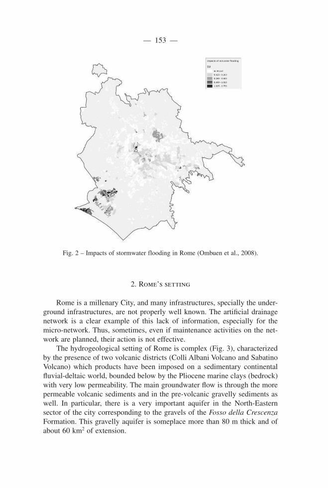
The City of Rome is annually affected by flooding as a result of various important meteorological events that over the years, probably because of the ongoing climate change, are occurring more frequently and with greater intensity(Fig.2).This isassociatedwithanartificialdrainagenetworknotvery efficient, both for the bad state of maintenance and for evident under sizing, calibrated on different flows. Many flood cases were registered also in some very important underground heritage sites. The aim of this paper is to highlight by a preliminary analysis the best places in Rome where this technique can be applied in order to contribute to the resilience of the City.
— 153 —
1. Capture zone • Harvesting using weirs and wetlands in urban stormwater catchments • Connection to a recycled water pipe from a treatment plant
2. Pretreatment • Passive systems such as wetlands • Engineered treatments (if needed) to produce source water suitable for recharge
3. Recharge • Injection well• Infiltration basin • Infiltration gallery
4. Subsurface storage • The aquifer that water is stored in and where aquifer passive treatment occurs
5. Recovery • Recovery well• Intentional discharge to a groundwater‐dependent ecosystem
6. Post‐treatment • Passive systems such as wetlands • Engineered treatments (if needed) to produce water suitable for its intended use
7. End use • Distribution to users, such as – drinking water supplies – irrigators or industry – aquatic ecosystems (ie human health and environmental receptors)
FIG. 2. – Impacts of stormwater flooding in Rome (Ombuen et al, 2008)
Fig. 2 – Impacts of stormwater flooding in Rome (Ombuen et al., 2008).
2. Rome’s setting
Rome is a millenary City, and many infrastructures, specially the under-groundinfrastructures,arenotproperlywellknown.Theartificialdrainagenetwork is a clear example of this lack of information, especially for themicro-network.Thus,sometimes,evenifmaintenanceactivitiesonthenet-workareplanned,theiractionisnoteffective.
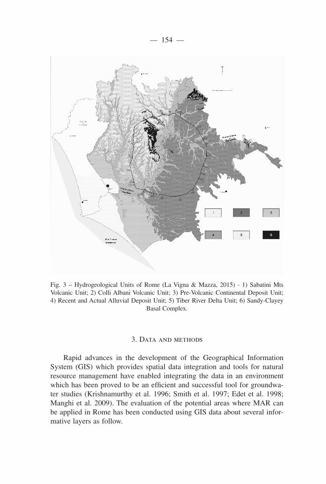
ThehydrogeologicalsettingofRomeiscomplex(Fig.3),characterizedby the presence of two volcanic districts (Colli Albani Volcano and Sabatino Volcano) which products have been imposed on a sedimentary continental fluvial-deltaicworld,boundedbelowbythePliocenemarineclays(bedrock)with very low permeability. The main groundwater flow is through the more permeable volcanic sediments and in the pre-volcanic gravelly sediments as well. In particular, there is a very important aquifer in the North-Eastern sector of the city corresponding to the gravels of the Fosso della Crescenza Formation.Thisgravellyaquiferissomeplacemorethan80mthickandofabout60km2ofextension.
— 154 —
Fig. 3 – Hydrogeological Units of Rome (La Vigna & Mazza, 2015) - 1) Sabatini Mts Volcanic Unit; 2) Colli Albani Volcanic Unit; 3) Pre-Volcanic Continental Deposit Unit; 4) Recent and Actual Alluvial Deposit Unit; 5) Tiber River Delta Unit; 6) Sandy-Clayey
BasalComplex.
3. Data and methods
Rapid advances in the development of the Geographical Information System (GIS) which provides spatial data integration and tools for natural resource management have enabled integrating the data in an environment which has been proved to be an efficient and successful tool for groundwa-ter studies (Krishnamurthy et al. 1996; Smith et al. 1997; Edet et al. 1998; Manghi et al. 2009). The evaluation of the potential areas where MAR can be applied in Rome has been conducted using GIS data about several infor-mative layers as follow.

— 155 —
• The Geological Map of Rome 1:50.000 Scale (Funiciello et al., 2008) , has been considered as the base layer of the evaluation.
• Data on urban floods coming from the department of Urban Planning, and from the Civil Protection of Rome
• Data of storm floods areas coming from RomaTRE University (Fig. 4 - Ombuen et al., 2008)
• Data on groundwater levels coming from the new Hydrogeological Map of Rome 1:50.000 Scale (La Vigna & Mazza, 2015) and from the Hydrogeological Map of the Lower Aniene River Basin 1:20.000 (La Vigna et al., 2008)
• Data on specific site stratigraphic setting coming from existing crosssections (La Vigna et al., 2008, Funiciello et al., 2008)
• Surveyofwells about theGroundwaterMonitoringNetworkofRome(La Vigna et al., 2014)
The analysis process at this stage simply consisted in the overlapping layers and highlight where the hydrogeological setting and the water table deep are matching the goals of possible MAR projects in those areas af-fected by storm floods.
4. Discussion
Bytheanalysisofthecurrentavailabledata,excludingthecoastsectorof Rome, where are located the most serious cases of stormwater floods, and where floods cover more than the 50% of the land (Fig. 2 - Ombuen et al., 2008), the second sector with an important concentration of areas subjected to floods is located in the North Eastern sector of the City, in the district na-med “Prati Fiscali”. The research activity is focusing on this sector.
LookingatthemapofFig.4,whereareassubjectedtostormwaterflo-ods (dark area in the center of the map), are compared to the geologicalsettingandthewatertable,andlookingalsoatFig.5whereisshowntheageological cross section of this area, is possible to see that there is a very thickgravellyformation.ThisformationcorrespondstotheFosso della Cre-scenza Formation, which is composed by coarse gravel and sand, and as in-troduced before, it can be considered as one of the most important and pro-ductive aquifer of Rome. But the most important feature shown in the cross section is the water table level; in fact, is possible to see how the depth of the saturation level is always more than 15m in this sector, and this is a very important factor to be considered in a probable MAR project.
TheGroundwaterMonitoringNetworkofRome,whichisshowninthemap of Fig. 4, will contribute also to collect more groundwater data, in or-

— 156 —
der to proceed with a more detailed analysis of some possible pilot sites to choose,anddeterminethefirstexperiencesofMARinRomeforthecontri-bution to avoid serious urban flooding in this important sector of the City. Differenty, the flooding issues of the coastal sector of Rome could be appro-ached using the harvesting technologies, realizing very large underground tanks,asmanyothercoastalcitesdo(Philipetal.,2008).
FIG. 3. – Hydrogeological Units of Rome (Capelli et al, 2008) - 1) Sabatini Mts Volcanic Units; 2) Colli
Albani Volcanic Units; 3) Continental Units of PaleoTiber and Ponte Galeria Fm.; 4) Olocene Alluvial units;
5) Tiber fan units; 6) Mt. Vaticano clayey bedrock.
FIG. 4 – Comparison between areas subjected to sotmwater floods (dark area in the center of the map), in the
North-Eastern sector of Rome, the geological setting and the water table (piezometry data from Capelli et al,
2012). The cross section with SouthWest – NorthEast direction is shown in Fig. 5.
FIG. 5 – Cross section of the study area (modified from Funiciello et al,2008). The yellow lithology
represents the Fosso della Crescenza Formation, which is composed by coarse gravel and sand, and it can be
Fig. 4 – Comparison between areas subjected to sotmwater floods (dark area in thecenter of the map), in the North-Eastern sector of Rome, the geological setting and the water table (piezometry data from La Vigna & Mazza, 2015). The cross section with
SouthWest – NorthEast direction is shown in Fig. 5.
5. Conclusions
Stormwater harvesting and infiltration are principles which are more and more utilized on urban sites of many counties. However, given the characte-ristics of urban surfaces, and notably the amounts of the different pollutants that stormwater is likely tocontain, it is important to try toassess the im-pact of MAR systems on the soils and on groundwater (Barraud et al., 1999) even if has been demonstrated that such contamination is often strictly limi-ted in the close surroundings of the infiltrations point. Notwithstanding this,

— 157 —
due to the particular hydrogeological setting of Rome, several sites which are subject to be flooded during heavy storms, are eligible to be considered aspilotexamplesofStormwaterMARprojects.Obviouslyeveryoneofthe-se projects must consider a treatment system or a filter which can mitigate the impact of polluted washing water on the subsoil and groundwater.
Thiskindoftechniqueifproperlyplannedbyanintegratedanalysisofall suitable sites of Rome could be a great contribution to avoid urban flo-ods and enhance the resilience of Rome.
Fig. 5 – Cross section of the study area (modified from Funiciello et al., 2008). The thicklithologyrepresentstheFossodellaCrescenzaFormation,whichiscomposedbycoarse gravel and sand, and it can be considered as one of the most important and pro-ductive aquifer ofRome.The dark line rapresents thewater table (fromLaVigna&
Mazza, 2015) and its depth is clearly shown.
— 158 —
References
Australian Councils of Nat. Resource Management Ministerial, Environ. Protec-tion and Heritage, Health and Medical Research (2009) Australian Guidelines 23 forWaterRecycling:Managinghealth and environmental risks (Phase2).Stormwater Harvesting and Reuse.
Australian Councils of Nat. Resource Management Ministerial, Environ. Protec-tion and Heritage, Health and Medical Research (2009) Australian Guidelines 24 forWaterRecycling:Managinghealth and environmental risks (Phase2).Managed Aquifer Recharge.
Barraud S., Gautier A., Bardin J.P., Riou V, (1999) The impact of intentional storm-water infiltration on soil and groundwater. Water Science Technology, 39:2, 185-192.
EdetA.E.,OkerekeC.S.,TemeS.C.,EsuE.O.,(1998)Applicationofremote-sens-ing data to groundwater exploration:A case study of the Cross River State,southeastern Nigeria. Hydrogeol J 6:394–404
Funiciello R., Giordano G., Mattei M. (2008) Carta geologica del Comune di Roma - Geological map of Roma Municipality Firenze: S..E.L.C.A.
Krishnamurthy J., Kumar N.V., Jayaraman V., Manivel M., (1996) An approach to demarcate ground water potential zones through remote sensing and a geo-graphical information system. Int J Remote Sens 17:1867–1884.
La Vigna F., Mazza R. (2015) Carta idrogeografica di Roma – Hydrogeological Map of Rome -Scala- Scale 1:50.000. Roma Capitale, Poligraf.
La Vigna F., Bonfà I., Martelli S., Mazza M., Francesconi F., Bartoccini R., Provan-tini R. (2014) Preliminary activities for developing the Groundwater Monitoring NetworkofRome(Italy).Flowpath 2014 - National Meeting on Hydrogeology.
La Vigna F., Capelli G., Mazza R. (2008) Assetto idrogeologico del settore roma-no del bacino del Fiume Aniene, in Memore descrittive della Carta Geologica d'Italia Vol. 80 - La geologia di Roma dal centro storico alla periferia. Firenze: S.E.L.C.A.
La Vigna F., Capelli G., Mazza R (2008) Hydrogeological Map of the Lower Anie-ne River Basin, in Memore descrittive della Carta Geologica d'Italia Vol. 80 - La geologia di Roma dal centro storico alla periferia. Firenze: S.E.L.C.A.
Manghi F., Mortazavi B., Crother C., Hamdi M.R. (2009) Estimating Regional Groundwater Recharge Using a Hydrological Budget Method. Water Resour Manag 23:12. doi:10.1007/s11269-008-9391-0 Pyne R.D.G. (2006).
Ombuen S., Filpa A., Benelli F., Camerata F., Barbieri L., Pellegrini V.,Borfecchia F., Caiaffa E., Pollino L., De Cecco L., Martini S., La Porta L. (2008) Clima-te Vulnerability map of Rome 1.0, DARC Roma Tre University and UTMEA Department of ENEA.
PhilipM.,McMahonJ.,HeyengaS.,MarinoniO., JenkinsG.,MaheepalaS.,andGreenway M. (2008) Review of Stormwater Harvesting Practices. Urban Wa-ter Security Research Alliance Technical Report n. 9.
Pyne R.D.G. (2006) Groundwater Recharge and Wells, 2nd edition, ASR Systems, Florida.
View publication statsView publication stats