strategic overarching bushfire management plan 2015 - … · strategic overarching bushfire...
TRANSCRIPT

STRATEGIC OVERARCHING BUSHFIRE MANAGEMENT PLAN
Project:
Version:
RUIC Job:
RUIC | PERTH || MARGARET RIVER || BUSSELTON
T: 1300 797 607 E: [email protected]
3627
1.0
Shire of Dardanup Urban & Industrial Expansion Areas, SOBMP
`
© RUIC Fire 2015 P a g e | ii
Shire of Dardanup Urban & Industrial Expansion Areas, SOBMP
Strategic Overarching Bushfire Management Plan
RUIC Fire is a trading name of
Rural Fire Risk Consultancy Pty Ltd
ABN: 48 151 451 713
`
© RUIC Fire 2015 P a g e | iii
Shire of Dardanup Urban & Industrial Expansion Areas, SOBMP
Disclaimer and Limitation This report is prepared solely for The Department of Planning (the ‘proponent’) and is not for
the benefit of any other person and may not be relied upon by any other person.
The mitigation strategies contained in this Strategic Overarching Bushfire Management Plan
are considered to be prudent minimum standards only, based on the writer’s experience as
well as standards prescribed by relevant authorities. It is expressly stated that RUIC Fire and the
writer do not guarantee that if such standards are complied with or if a property owner
exercises prudence, that a building or property will not be damaged or that lives will not be
lost in a bush fire.
Fire is an extremely unpredictable force of nature. Changing climatic factors (whether
predictable or otherwise) either before or at the time of a fire can also significantly affect the
nature of a fire and in a bushfire prone area it is not possible to completely guard against
bushfire.
Further, the growth, planting or removal of vegetation; poor maintenance of any fire
prevention measures; addition of structures not included in this report; or other activity can
and will change the bushfire threat to all properties detailed in the report. Further, the
achievement of the level of implementation of fire precautions will depend on the actions of
the landowner or occupiers of the land, over which RUIC Fire has no control. If the proponent
becomes concerned about changing factors then a new Strategic Overarching
Management Plan should be requested.
To the maximum extent permitted by the law, RUIC Fire, its employees, officers, agents and the
writer (“RUIC Fire”) excludes all liability whatsoever for:
1. claim, damage, loss or injury to any property and any person caused by fire or as a
result of fire or indeed howsoever caused;
2. errors or omissions in this report except where grossly negligent; and
the proponent expressly acknowledges that they have been made aware of this exclusion
and that such exclusion of liability is reasonable in all the circumstances.
If despite the provisions of the above disclaimer RUIC Fire is found liable then RUIC Fire limits its
liability to the lesser of the maximum extent permitted by the law and the proceeds paid out
by RUIC Fire’s professional or public liability insurance following the making of a successful
claim against such insurer.
RUIC Fire accepts no liability or responsibility whatsoever for or in respect of any use or reliance
upon this report and its supporting material by any third party.
This report is intended as a strategic guide only and does not replace the need for site specific
Bushfire Management Plans at the time of Structure Plan development.
`
© RUIC Fire 2015 P a g e | iv
Shire of Dardanup Urban & Industrial Expansion Areas, SOBMP
Document Details
ITEM DETAIL
Project Number 3619
Project Name Shire of Dardanup Urban & Industrial Expansion Areas SOBMP
Project Manger Greg Penney
Prepared by Greg Penney and Louisa Robertson
Approved by Greg Penney
Version 1.0
Date of Issue 6th August 2015
_______________________
Technical Endorsement
Date: 6th August 2015
In signing the above, we declare the report is true and accurate to the best of our knowledge
at the time of issue.
`
© RUIC Fire 2015 P a g e | v
Shire of Dardanup Urban & Industrial Expansion Areas, SOBMP
Abbreviations
ABBREVIATION DESCRIPTION
AHD Australian Height Datum
AS Acceptable Solution
AS3959 Australian Standard 3959 Construction of buildings in bushfire-prone areas,
2009
BAL Bushfire Attack Level
BAL-FZ BAL Flame Zone
BCA Building Code of Australia
BMP Bushfire Management Plan/s
BPAD Bushfire Planning and Design
BPZ Building Protection Zone
CAWCR Centre for Australian Weather and Climate Research
COAG Council of Australian Governments
CSIRO Commonwealth Scientific and Industrial Research Organisation
DFES Department of Fire and Emergency Services
DoP Department of Planning
DPaW Department of Parks and Wildlife
DSP District Structure Plan
DPC Department of Premier and Cabinet
DtS Deemed to Satisfy
EPBC Act Commonwealth Environment Protection and Biodiversity Conservation Act
1999
FDI Fire Danger Index
FES Commissioner Fire and Emergency Services Commissioner
FESA Fire and Emergency Services Authority (now DFES)
ha Hectare
HSZ Hazard Separation Zone
ISO31000:2009 Risk management – Principles and guidelines
m Metre/s
PBS Performance Based Solution
PfBPG Planning for Bushfire Protection Guidelines, Edition 2, 2010
POS Public Open Space
SOBMP Strategic Overarching Bushfire Management Plan/s
SPP3.7 Draft State Planning Policy 3.7 Planning for Bushfire Risk Management, 2014
SPP3.7 Guidelines Draft Planning for Bushfire Risk Management Guidelines, 2014
TEC Threatened Ecological Community
WAPC Western Australian Planning Commission
WC Act Wildlife Conservation Act 1950
`
© RUIC Fire 2015 P a g e | vi
Shire of Dardanup Urban & Industrial Expansion Areas, SOBMP
Executive Summary
Rural Fire Risk Consultancy Pty Ltd trading as RUIC Fire was engaged by the proponent to
prepare this Strategic Overarching Bushfire Management Plan (SOBMP) to support the
proposed District Structure Plans (DSPs) for future urban and industrial development east of
Eaton within the Shire of Dardanup (the site).
Strategic assessment of the site and surrounding area was completed in accordance with
Planning for Bushfire Protection Guidelines 2nd Edition (FESA, 2010). Whereas the site and
surrounding area contains limited areas of vegetation that would facilitate extended bushfire
behaviour, existing vegetation and proposed revegetation areas warrant precautionary
design measures to be adopted as part of a precautionary approach to bushfire related risk
mitigation. During progressive development, mitigation works as detailed in this report
(inclusive of appropriate low threat buffers around staged development) shall significantly
reduce the potential bushfire impact to within acceptable levels in accordance with draft
SPP3.7, in particular Policy Provision 6.10. In complying with the provisions detailed in this
SOBMP it is concluded that the Bushfire Hazard is not prohibitive of development within the
site.
Risk assessment was completed in accordance with ISO31000:2009 and COAG’s National
Inquiry on Bushfire Mitigation and Management (2004). It is concluded that post
implementation of the treatments detailed in this SOBMP, the bushfire related risk is not
prohibitive of development.
The proposed development is designed using the performance criteria of Planning for Bushfire
Protection Guidelines 2nd Edition (PfBPG) with due regard for draft State Planning Policy 3.7
Planning for Bushfire Risk Management (SPP3.7). The Bushfire Hazard rating, bushfire related
risk level and BAL equivalent ratings applicable to the proposed KSIA are not prohibitive of
development. The OSBMP provides for the all future subdivisions within the KSIA to satisfy all
Elements and Performance Principles of SPP3.7 Appendix 4.
Whilst each individual subdivision should be subject to a separate Bushfire Management Plan,
the application of the Elements and Performance Principles of draft SPP3.7 for future Bushfire
Management Plans are summarised in Tables i and ii. Where Performance Based Solutions are
utilised, detailed justification is provided in the relevant section of this report.
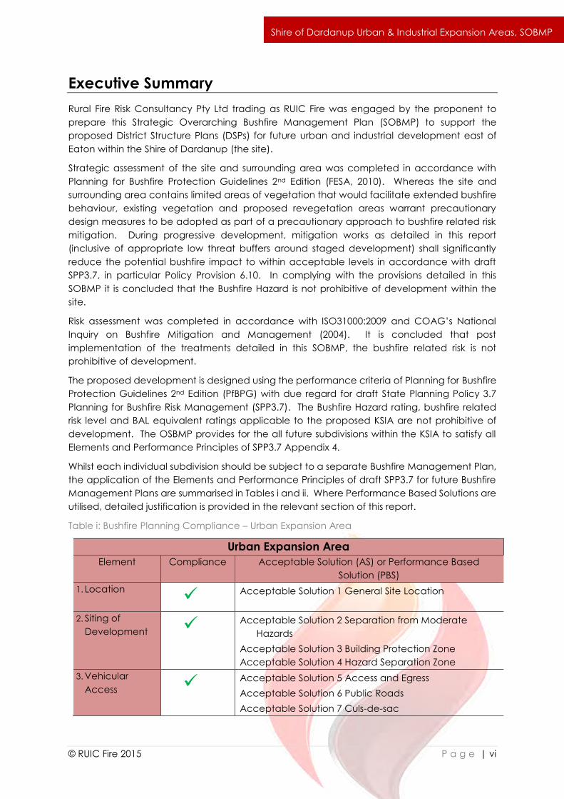
Table i: Bushfire Planning Compliance – Urban Expansion Area
Urban Expansion Area
Element Compliance Acceptable Solution (AS) or Performance Based
Solution (PBS)
1. Location Acceptable Solution 1 General Site Location
2. Siting of
Development Acceptable Solution 2 Separation from Moderate
Hazards
Acceptable Solution 3 Building Protection Zone
Acceptable Solution 4 Hazard Separation Zone
3. Vehicular
Access Acceptable Solution 5 Access and Egress
Acceptable Solution 6 Public Roads
Acceptable Solution 7 Culs-de-sac
`
© RUIC Fire 2015 P a g e | vii
Shire of Dardanup Urban & Industrial Expansion Areas, SOBMP
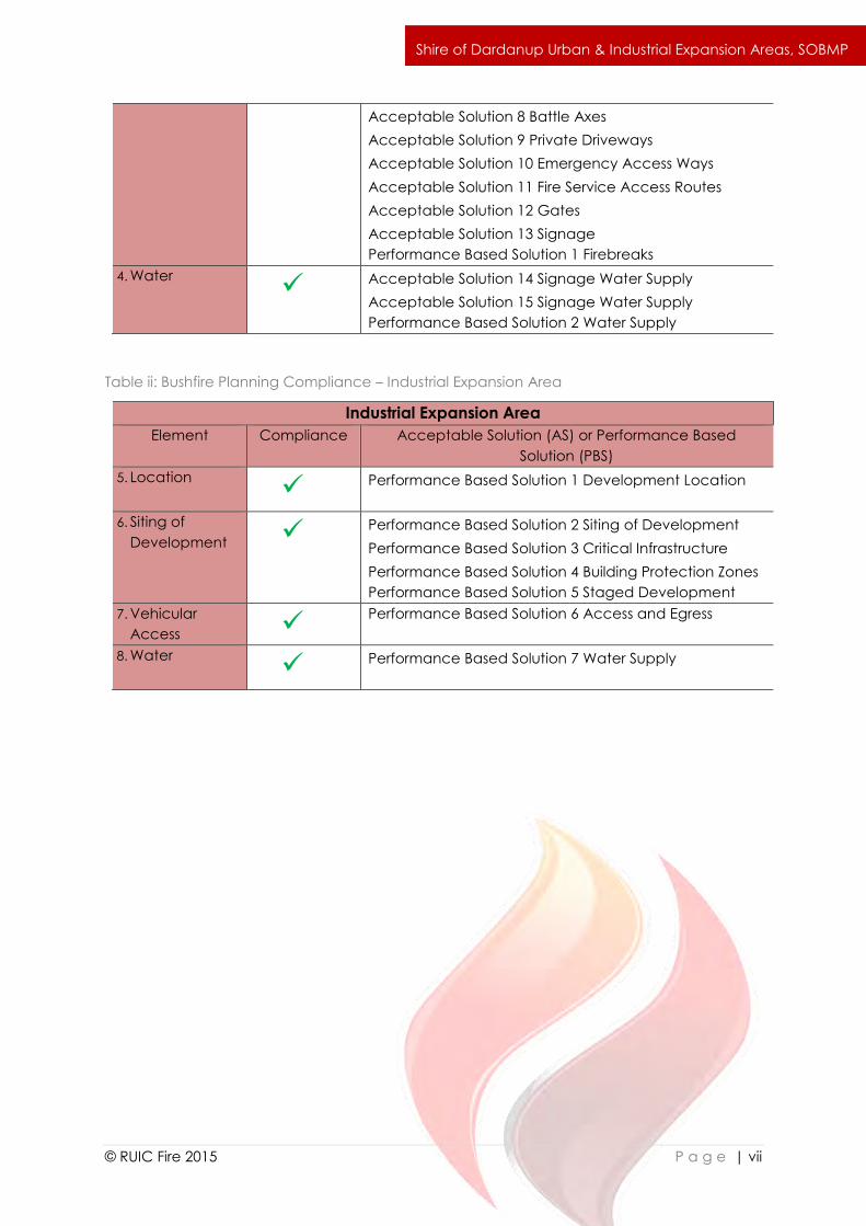
Acceptable Solution 8 Battle Axes
Acceptable Solution 9 Private Driveways
Acceptable Solution 10 Emergency Access Ways
Acceptable Solution 11 Fire Service Access Routes
Acceptable Solution 12 Gates
Acceptable Solution 13 Signage
Performance Based Solution 1 Firebreaks
4. Water Acceptable Solution 14 Signage Water Supply
Acceptable Solution 15 Signage Water Supply
Performance Based Solution 2 Water Supply
Table ii: Bushfire Planning Compliance – Industrial Expansion Area
Industrial Expansion Area
Element Compliance Acceptable Solution (AS) or Performance Based
Solution (PBS)
5. Location Performance Based Solution 1 Development Location
6. Siting of
Development Performance Based Solution 2 Siting of Development
Performance Based Solution 3 Critical Infrastructure
Performance Based Solution 4 Building Protection Zones
Performance Based Solution 5 Staged Development
7. Vehicular
Access Performance Based Solution 6 Access and Egress
8. Water Performance Based Solution 7 Water Supply
`
© RUIC Fire 2015 P a g e | viii
Shire of Dardanup Urban & Industrial Expansion Areas, SOBMP
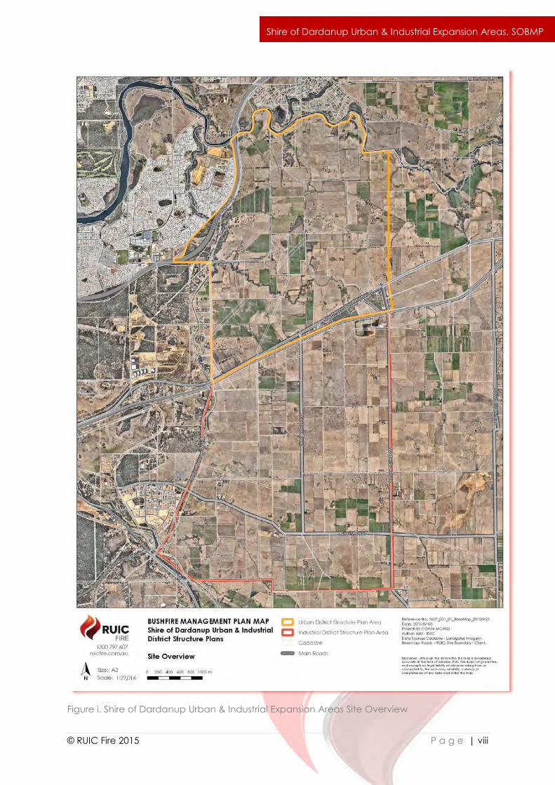
Figure i. Shire of Dardanup Urban & Industrial Expansion Areas Site Overview
`
© RUIC Fire 2015 P a g e | ix
Shire of Dardanup Urban & Industrial Expansion Areas, SOBMP
Contents
1.0 Introduction ................................................................................................................... 1
1.1 Scope .................................................................................................................................. 1
1.2 Objectives .......................................................................................................................... 1
1.3 Document Review ............................................................................................................ 1
1.4 Planning Context .............................................................................................................. 1
1.4.1 Existing Bushfire Management Plans ............................................................................. 1
1.4.2 Bushfire Prone Designation ............................................................................................. 1
1.4.4 Draft State Planning Policy 3.7 Planning for Bushfire Risk Management ................ 2
1.4.5 Section 70A Notice on Title ............................................................................................. 2
1.4.6 Summary ............................................................................................................................. 2
1.5 Bushfire Context ................................................................................................................ 2
2.0 Site Details ..................................................................................................................... 6
2.1 Description ......................................................................................................................... 6
2.1.1 Location .............................................................................................................................. 6
2.1.2 Proposed Land Use ........................................................................................................... 6
2.1.3 7
Access ........................................................................................................................................... 7
2.1.4 Water Supply ..................................................................................................................... 8
2.1.5 Vegetation & Conservation Value ................................................................................ 8
2.1.6 Climate ............................................................................................................................... 9
2.1.7 Site Topography ................................................................................................................ 9
2.1.8 Bushfire Fuels ...................................................................................................................... 9
2.1.9 Conclusion ......................................................................................................................... 9
3.0 Bushfire Assessment ................................................................................................... 19
3.1 Potential for Bushfire Activity ........................................................................................ 19
3.2 Bushfire Hazard Assessment .......................................................................................... 19
3.3 Bushfire Impact Analysis & BAL Ratings ...................................................................... 20
3.4 Risk Assessment ................................................................................................................ 20
3.5 Performance Criteria and Compliance ..................................................................... 34
3.6 Conclusion ....................................................................................................................... 35
4.0 Bush Fire Risk Mitigation ............................................................................................. 36
`
© RUIC Fire 2015 P a g e | x
Shire of Dardanup Urban & Industrial Expansion Areas, SOBMP
4.1 Urban Expansion Area ................................................................................................... 36
4.1.1 Element 1 – Location of Development ....................................................................... 36
4.1.2 Element 2 - Siting of Development .............................................................................. 36
4.1.3 Element 3 - Vehicular Access ....................................................................................... 38
4.1.4 Element 4 – Water Supply ............................................................................................. 42
4.2 Industrial Expansion Area .............................................................................................. 44
4.2.1 Element 1 – Location of Development ....................................................................... 44
4.2.2 Element 2 – Siting of Development ............................................................................. 45
4.2.3 Element 3 - Vehicular Access ....................................................................................... 56
4.2.4 Element 4 – Water Supply ............................................................................................. 56
5.0 References .................................................................................................................. 57
6.0 Appendix A Classes of Buildings (BCA 2010) ........................................................ 58
`
© RUIC Fire 2015 P a g e | 1
Shire of Dardanup Urban & Industrial Expansion Areas, SOBMP
1.0 Introduction
1.1 Scope
The proponent engaged Rural Fire Risk Consultancy Pty Ltd (RUIC Fire) to prepare a Strategic
Overarching Bushfire Management Plan (SOBMP) in support of the Urban Expansion Area and
the Industrial Expansion Area within the Shire of Dardanup (the development), located
approximately 9km east of Bunbury (the site).
1.2 Objectives
The objectives of the SOBMP are to:
i. Achieve consistency of the overall DSPs with objectives and policy measures of the
current Planning for Bushfire Protection Guidelines 2nd Edition (PfBPG); draft SPP 3.7
Planning for Bushfire Risk Management (SPP3.7) and the Planning for Bushfire Risk
Management Guidelines (SPP3.7 Guidelines), and any local planning scheme
provisions relating to bushfire;
ii. Understand and document the extent of bushfire risk for the SOBMP area;
iii. Prepare bushfire risk management measures for bushfire management of all land
subject of the DSPs, with due regard for people, property, infrastructure and the
environment;
iv. Provide guidance and document requirements specific to bushfire planning for the
future development of individual stages and lots within the DSPs;
v. Nominate individuals and organisations responsible for fire management and
associated works within the plan area (eg. local government for land vested in it and
private property owners for freehold land); and
vi. Define an assessment procedure which will evaluate the effectiveness and impact of
proposed, as well as existing, bushfire risk management measures and strategies.
1.3 Document Review
In accordance with SPP3.7 Guidelines this Strategic Overarching Bushfire Management Plan
should be reviewed after a period of 3 years from the date of issue to ensure currency and
proposed bushfire related risk mitigation strategies continue to align with industry best practice.
The relevant Jurisdiction Having Authority (Department of Planning in conjunction with the Shire
of Dardanup) is responsible for the evaluation and effectiveness of all mitigation strategies
detailed in this Strategic Overarching Bushfire Management Plan.
1.4 Planning Context
No existing Strategic Overarching Fire Management Plan or Bushfire Management Plan exists
for the proposed development.
In the absence of formal Bushfire Prone designation, the District Structure Plans for the
development shall include the provision:
“Regardless of whether this land has been designated as bushfire prone, any buildings to be
erected pursuant to this structure plan shall comply with the requirements of Australian
Standard 3959 under the Building Code of Australia.”
`
© RUIC Fire 2015 P a g e | 2
Shire of Dardanup Urban & Industrial Expansion Areas, SOBMP
It is acknowledged that the Industrial Expansion Area is unlikely to contain any Class 1,2 or 3
buildings (Appendix A), however inclusion of this provision facilitates increased bushfire
resilience of any such buildings as well as serving to provide for increased construction
standards of other Classes of buildings as potentially adopted in future editions of the Building
Code of Australia.
Town Planning Scheme No. 3 does not currently identify any areas within the Shire of Harvey
as bushfire prone. The Shire of Dardanup defer to draft State Planning Policy 3.7 Planning for
Bushfire Risk Management, draft Planning for Bushfire Risk Management Guidelines and the
applicable draft Planning for Bushfire Risk Management Guidelines Appendices.
Draft State Planning Policy 3.7 Planning for Bushfire Risk Management Guidelines (WAPC,
2014b, s2, p4) identifies three ways a site may be designated as bushfire prone:
i. if the land is identified as bushfire-prone on a local government bushfire map approved
by a resolution of Council and designated by the Fire and Emergency Services (FES)
Commissioner; or
ii. if the land is not covered by a map in (1), but is identified as bushfire-prone on the State
Bushfire-Prone Area Map prepared and designated by the FES Commissioner; or
iii. if the land is not covered by either a local government map in (1) or the State Bushfire-
Prone Area Map in (2), but is within 100 metres of an area of bushfire-prone vegetation
equal to or greater than one hectare (default position).
Bushfire-prone vegetation includes types of vegetation classified in Australian Standard 3959:
Construction of buildings in bushfire-prone areas (AS3959). AS3959 is included by direct
reference in the Building Code of Australia (BCA).
The development is subject to a S70A Notification on Title stating that this Strategic
Overarching Bushfire Management Plan is applicable to the site and is to be complied with.
In the absence of a local or state government bushfire prone map, areas of the site within the
Shire of Dardanup shall be subject to assessment in accordance with PfBPG. Areas of the site
within 100m of bushfire prone vegetation shall be identified as bushfire prone in accordance
with the default position of draft SPP3.7 and declaration in the DSP.
1.5 Bushfire Context
Bushfire planning requirements in Western Australia are currently in a fluid state of change with
revisions to draft SPP3.7 soon to be released for public comment. Where changes occur that
impact this SOBMP, a precautionary principle should be adopted with the higher standard of
bushfire protection being applied. Where terminology changes with the adoption of new
documents (Building Protection Zones, being termed Asset Protection Zones for instance), the
terminology should be regarded as interchangeable throughout the SOBMP unless otherwise
specifically stated in SPP3.7 or associated documents.

`
© RUIC Fire 2015 P a g e | 3
Shire of Dardanup Urban & Industrial Expansion Areas, SOBMP
Development of industrial estates receives limited specific guidance in regards to design
requirements to achieve the necessary level of protection from bushfire. PfBPG Principle 4 and
Draft SPP3.7 policy measure 6.10 address the requirements for industrial and commercial
development. Discussed in further detail in Section 4 of this SOBMP, the relevant provisions are
identified here as:
PfBPG Principle 4 states:
“In areas with an extreme bush fire hazard level where more intensive
subdivision/development, such as residential, rural-residential, hobby farms, tourist and
industrial developments, is considered unavoidable, permanent hazard reduction
measures need to be implemented to the satisfaction of the decision-making
authorities (ie FESA, the WAPC, and/or the relevant local government) to reduce the
hazard level to low or moderate or bush fire attack levels between BAL-Low and BAL-
29.”
This report demonstrates that development within the Industrial Expansion Area shall occur only
on land having a Low Bushfire Hazard rating and radiant heat impact less than 29kW/m2
(equivalent to BAL-29) post development, satisfying PfBPG Principle 4.
Draft SPP3.7 policy measure 6.10 states:
“Proposals for vulnerable or high-risk land uses in moderate bushfire hazard level areas
shall not be supported unless they are accompanied by a Bushfire Management Plan,
prepared by a fire consultant, that demonstrates compliance with the bushfire
protection criteria, and which includes an emergency evacuation plan for proposed
occupants and/or risk management for any flammable on-site hazards, to the
satisfaction of the decision-maker.
Draft SPP3.7 requires that “high risk land use” complies with draft SPP3.7 policy measure 6.10.
“High risk land use” is defined as “Land uses which may lead to the potential ignition, duration
and/or intensity of a bushfire. Such uses may also expose the community, fire fighters and the
surrounding environment to dangerous, uncontrolled substances during a bushfire event.
Typically such uses would involve the bulk manufacture or storage of flammable or otherwise
hazardous materials.” For clarity and consistency with the Building Code of Australia, for the
purposes of this SOBMP, high risk development is defined as those occupancies of excessive
hazard as identified in BCA Volume One Table E1.5 Note 3 (see Table 1A).
Table 1A: Identification of High Risk Land Use – restricted within 100m of bushfire prone
vegetation.
Occupancies of Excessive Fire Hazard – High Risk Land Use
Hazardous processes or storage including the following:
1. Aircraft hangars.
2. Cane furnishing manufacture, processing and storage. Fire-lighter and fireworks
manufacture and warehousing.
3. Foam plastic and foam plastic goods manufacture, processing and warehousing,
eg, furniture factory.
4. Hydrocarbon based sheet product, manufacture, processing and warehousing,
eg, vinyl floor coverings.
5. Woodwool and other flammable loose fibrous material manufacture.
`
© RUIC Fire 2015 P a g e | 4
Shire of Dardanup Urban & Industrial Expansion Areas, SOBMP
Combustible Goods with an aggregate volume exceeding 1000 m3 and stored to a height
greater than 4 m including the following:
1. Aerosol packs with flammable contents. Carpets and clothing. Electrical
appliances.
2. Combustible compressed fibreboards (low and high density) and plywoods.
3. Combustible cartons, irrespective of content Esparto and other fibrous combustible
material.
4. Furniture including timber, cane and composite, where foamed rubber or plastics
are incorporated.
5. Paper storage (all forms of new or waste) eg, bales, sheet, horizontal or vertical
rolls, waxed coated or processed.
6. Textiles raw and finished, eg, rolled cloth, clothing and manchester. Timber storage
including sheets, planks, boards, joists and cut sizes.
7. Vinyl, plastic, foamed plastic, rubber and other combustible sheets, offcuts and
random pieces and rolled material storage, eg, carpet, tar paper, linoleum, wood
veneer and foam mattresses.
8. All materials having wrappings or preformed containers of foamed plastics.
The following documents are identified as being referenced to provide the performance
criteria and technical specifications for this Strategic Overarching Bushfire Management Plan:
i. Shire of Dardanup. (1979). Town Planning Scheme No. 3. Updated to include Amd 187
gg 10/2/15.
ii. Ellis, S., Kanowski, P., & Whelan, R. (2004). National Inquiry on Bushfire
Mitigation and Management. Commonwealth of Australia, Canberra.
iii. FESA. (2010). Planning for Bush Fire Protection Guidelines 2nd Edition Perth:
Western Australian.
iv. Keelty, M. J. (2011). A Shared Responsibility: The Report of the Perth Hills
Bushfire February 2011 Review. Government of Western Australia, Perth.
v. National Emergency Management Committee. (2010). National Emergency
Risk Assessment Guideline. Tasmanian State Emergency Service, Hobart.
vi. Standards Australia. (2009). AS 3959:2009 Construction of buildings in bushfire
prone areas: SAI Global.
vii. Standards Australia. (2009). ISO AS 31000:2009 Risk management principles
and guidelines: SAI Global.
viii. Standards Australia. (2013). HB89:2013 Risk management - Guidelines on risk
assessment techniques (Vol. HB 89:2013). Sydney: SAI Global.
ix. Standards Australia. (2013). HB 436:2013 Risk management guidelines -
Companion to AS/NZS ISO 31000:2009 (Vol. HB436:2013). Sydney: SAI Global.
x. WAPC. (2013). Planning Bulletin 111/2013 Planning for Bushfire. Western
Australian Planning Commission.
xi. WAPC. (2014a). Draft State Planning Policy 3.7 Planning for Bushfire Risk
Management. West Australian Planning Commission,
xii. WAPC. (2014b). Draft State Planning Policy 3.7 Planning for Bushfire Risk
Management Guidelines. West Australian Planning Commission,
`
© RUIC Fire 2015 P a g e | 5
Shire of Dardanup Urban & Industrial Expansion Areas, SOBMP
xiii. WAPC. (2014c). Draft State Planning Policy 3.7 Planning for Bushfire Risk
Management Guidelines Appendixes. West Australian Planning Commission,
Department of Fire and Emergency Services.
WAPC has provided specific advice that draft State Planning Policy 3.7 Planning for Bushfire
Risk Management is a seriously entertained document that must be given due consideration.
Whilst the format of this report is consistent with draft SPP3.7 Appendix 3, to satisfy local
government requirements the development is assessed against the requirements of both
PfBPG and draft SPP3.7.
`
© RUIC Fire 2015 P a g e | 6
Shire of Dardanup Urban & Industrial Expansion Areas, SOBMP
2.0 Site Details
2.1 Description
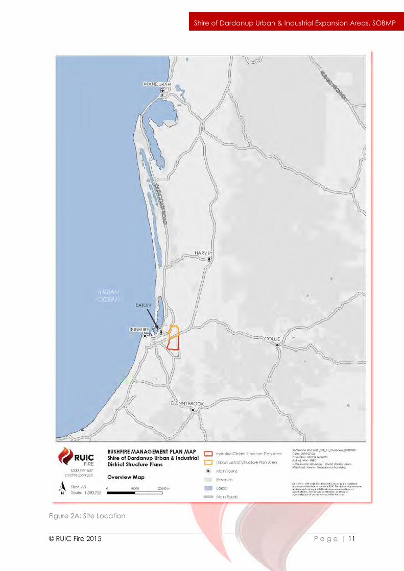
The Shire of Dardanup Urban and Industrial Expansion Areas (the site) are located in the
Municipality of the Shire of Dardanup within the localities of Waterloo and Paradise. The Urban
Expansion Area is sited immediately north of the Industrial Expansion Area (Figures 2A & 2B).
The town of Eaton is the closest residential centre and is located within 3km west of the site,
across the Forrest Highway.
Urban Expansion Area:
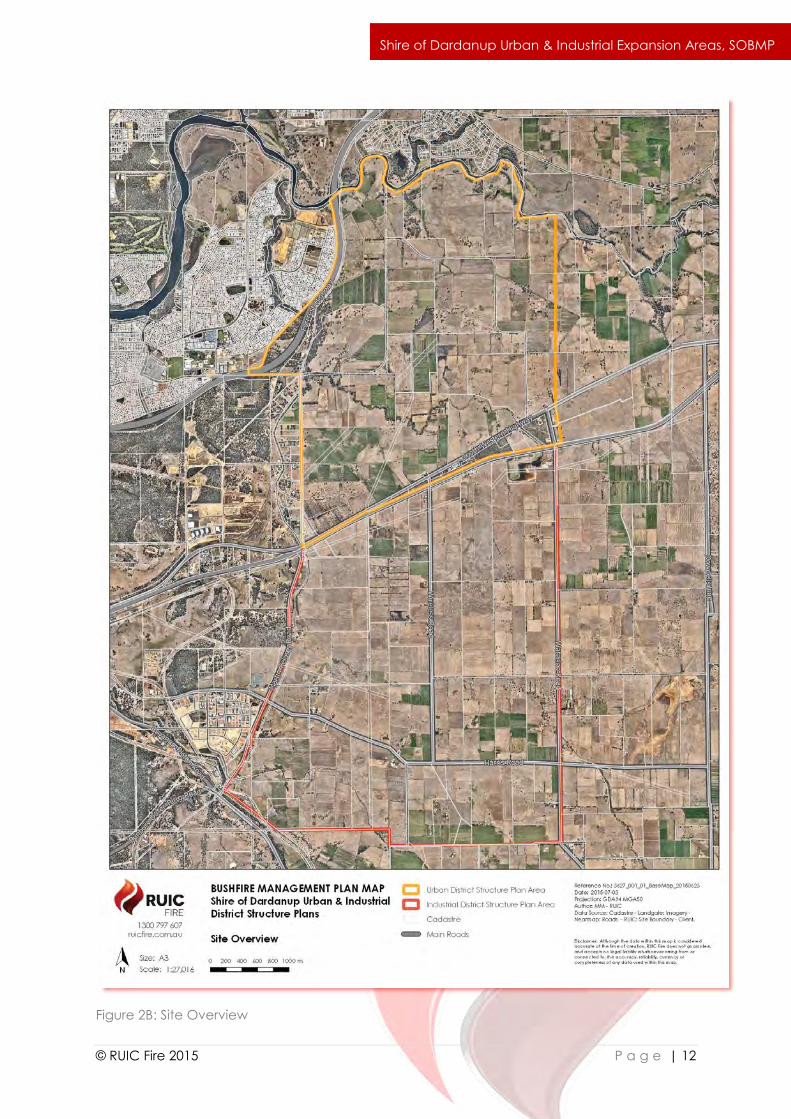
The southern end of the Urban Expansion Area is approximately 11km driving and 9km straight
line distance east of the Bunbury CBD (Figure 2A). The Urban Expansion Area is approximately
1100ha in size and is currently zoned Rural. The area is bordered by the Collie River in the north,
Railway Road in the south and Hynes Road, Clifton Road, Millbrook Estate (in Eaton) and the
Forrest Highway in the east (Figure 2B).
Industrial Expansion Area:
The southern end of the Industrial Expansion Area is approximately 10km driving and 9km
straight line distance south east of the Bunbury CBD. The Industrial Expansion Area has a total
land area of approximately 1600ha and is currently zoned Rural. The area is bordered by
Railway Road in the north, Waterloo Road in the east and Martin Pelusey Road in the west
(Figure 2B).
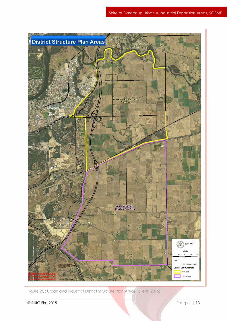
The Shire of Dardanup and the WA Department of Planning are currently preparing two District
Structure Plans to support development within the Urban and Industrial Expansion Areas
located in the Shire of Dardanup (Figures 2A & 2B). The current major land uses within the site
are rural farming and small holdings.
Urban Expansion Area:
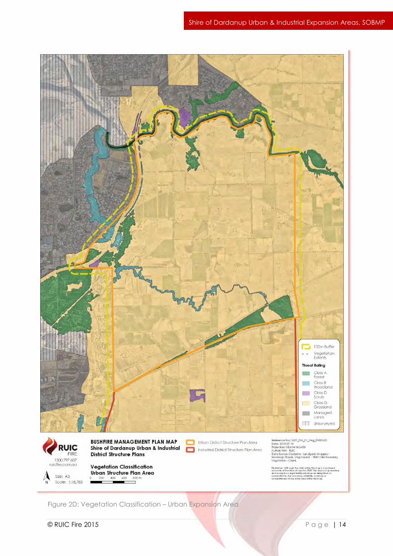
The northern Urban Expansion Area is expected to accommodate up to 70,000 people in the
future with the construction of high density residential housing. Riparian vegetation located
adjacent to the Collie River in the north and Millars Creek, which runs centrally through the site,
are proposed to be retained as vegetated reserves and Public Open Space (POS). This
includes the provision of significant buffer areas of Low Threat POS between retained /
revegetated vegetation and future residential development. The junction of the future
Bunbury Outer Ring Road with the upgraded Clifton Road (Figure 1C) is expected to
incorporate a significant portion of Millars Creek just south and north of Clifton Road. A forest
reserve in the north of the Urban Expansion Area is set aside as POS (Figure 3J). Forest and
woodland areas between Forrest Highway and Hynes Road are also proposed to be retained
as far as possible but some clearing may be necessary as the design of the development
progresses.
Industrial Expansion Area:
Future land uses within the southern Industrial Expansion Area may include the construction of
large hardstand areas, storage sheds and food processing companies such as abattoirs. The
`
© RUIC Fire 2015 P a g e | 7
Shire of Dardanup Urban & Industrial Expansion Areas, SOBMP
Industrial Expansion Area is largely devoid of native vegetation, therefore clearing within the
area will be limited.
Critical Infrastructure: The Department of the Premier and Cabinet (DPC) defines Critical
Infrastructure as:
“those physical facilities, supply chains, information technologies and communication
networks which, if destroyed, degraded or rendered unavailable for an extended
period, would significantly impact on the social or economic well-being of the nation,
or affect Australia’s ability to conduct national defence and ensure national security.”
Where Critical Infrastructure is proposed within the Industrial Expansion Area, it is strongly
recommended that a site and infrastructure specific Bushfire Management Plan should be
prepared by an accredited BPAD Level 3 Practitioner. This recommendation is based on the
level of complexity involved in Critical Infrastructure protection, the potential consequences
of Critical Infrastructure being damaged or destroyed and that no acceptable solutions or
technical guidance are provided in Western Australia for the protection of Critical
Infrastructure.
The existing extensive public road network facilitates multiple access and egress routes to the
site at all times and in all weather conditions.
A railway line south of the South West Highway borders the southern boundary of the Urban
Expansion Area. There are two direct access points from the South West Highway into the site;
being Hynes Road in the west and Clifton Road in the east. The Forrest Highway provides
access to the central west area of the site via Hynes Road which turns into Clifton Road,
providing access to eastern parts of the area from the west.
The Industrial Expansion Area is immediately accessed off the Bunbury Outer Ring Road and
Boyanup-Picton Road in the south and the South West Highway in the north. Martin Pelusey
Road, Wireless Road and Waterloo Road all originate from the South West Highway and extend
the length of the area in a north-south direction. Harris Road, originating from Boyanup-Picton
Road also provides direct access and runs in an east-west direction through the area.
Design of future subdivisions within the Industrial Expansion Area must satisfy the performance
requirement of ensuring the internal layout, design and construction of all public and private
access throughout the subject lot(s) ensures multiple evacuation routes away from all possible
approaching bushfire fronts and safer destinations more than 100m away from the closest
point of any potential bushfire front.
Unrestricted firefighting access should be provided within the perimeter of individual
subdivision design to ensure safe fire appliance access and retreat is possible at all times and
in all weather conditions. This may be achieved using a combination of public and private
road networks in addition to dedicated strategic fire service access routes or firebreaks where
required.

`
© RUIC Fire 2015 P a g e | 8
Shire of Dardanup Urban & Industrial Expansion Areas, SOBMP
Site specific Bushfire Management Plans (BMPs) must ensure any access strategies are
complementary to existing BMPs for previous subdivisions and should build upon them to
ensure integrated access and egress throughout the development. Where individual
subdivisions are planned in isolation, the design must ensure any access and egress designs
satisfy the required performance requirement without relying on future development.
These requirements are to be addressed prior to the endorsement of each individual
subdivision within the Industrial Expansion Area. Unless technical requirements specific to
industrial development have been adopted by the Department of Planning (DoP) the relevant
residential technical requirements identified in draft SPP3.7 (as amended) shall apply.
Both the Urban and Industrial Expansion Areas will be serviced by reticulated scheme water
and firefighting hydrants that satisfy Acceptable Solution A4.1.
Where lots within the site are not serviced by reticulated scheme water, dedicated 50,000L
firefighting water tank/s vested with the Local Government should be provided. Any
firefighting water tank shall be sited to ensure a maximum 20 minute turn around for firefighting
appliances and shall satisfy the requirements of A4.2.
Where lots are not serviced by reticulated scheme water the use of private water tanks within
the Urban Expansion Area to provide firefighting water reserves may be considered suitable
as a performance based design solution by the Shire of Dardanup (assessed on a case by
case basis). Where private domestic water tanks are utilised for firefighting water supply, they
should be specifically designed to facilitate a rapid turnaround and resupply of firefighting
appliances across multiple lots within the required 20 minute time period; have a suitable
hardstand constructed within 3m of the tank; be fitted with DFES approved couplings; and
contain a minimum 15,000L water reserve.
The majority of the site has been cleared for agriculture and consists of grazed pastureland.
One DPaW managed forest reserve is located in the south east corner of the Urban Expansion
Area. The remainder of remnant native vegetation exists along road reserves, rivers and creeks
and in degraded patches on private land.
A flora and fauna survey conducted by GHD (2015) identified one Threatened Ecological
Community (TEC) within the site, “Claypans of the Swan Coastal Plain”, that is listed under the
EPBC Act. Although the site is dominated by introduced vegetation, 51% the 201 flora taxa
identified in the study were native. Two DPaW priority listed flora species, but no EPBC Act or
Wildlife Conservation Act (WC Act) listed species were located within the site. Riparian
vegetation along the Collie River and Millars Creek provide ecological linkages for fauna
species. Five wildlife species of conservation significance were recorded at the site, including
Carnaby’s Black Cockatoo, Red-tailed Black Cockatoo, Western Ringtail Possum, Water Rat
and Carter’s Freshwater Mussel. Baudin’s Black Cockatoo and Great Egret are also thought to
occur within the site.
Development and maintenance of Building Protection Zones and all other bushfire
management strategies outlined in this report must be undertaken in a manner that preserves
the identified priority flora and fauna species. Priority flora species may be retained within the
Building Protection Zone as part of low bushfire threat landscaping.
`
© RUIC Fire 2015 P a g e | 9
Shire of Dardanup Urban & Industrial Expansion Areas, SOBMP
Data collected from the Bureau of Meteorology indicates that the site experiences a
temperate climate characterised by mild winter periods and hot, dry summers. The bushfire
danger period occurs during the dryer summer months where grass curing has occurred and
humidity is low. The effect of climate on potential bushfire behaviour is incorporated into
modelling of bushfire impact in section 3 of this report in accordance with AS3959 through the
selection of a Fire Danger Index of 80 as assigned to Western Australia.
CSIRO CAWCR Technical Report No. 10 identifies that an FDI exceeding 50 has occurred only
in the 99th percentile of historical weather data for the greater region. Consistent with the
required precautionary approach, this affords a significant safety margin in the modelling of
potential bushfire impact on the site determined in this report.
The site is predominantly flat with the most variation in relief being localised to the banks of the
Collie River and the north west section of Millars Creek. The site is fairly low-lying with a
maximum height of 25m AHD in the south east corner of the Industrial Expansion Area.
Topography has the potential to affect bushfire behaviour within and external to the site. Figure
2F illustrates the slope of the land within the site and the surrounding area. This data is
incorporated into bushfire modelling provided in section 3 of this report.
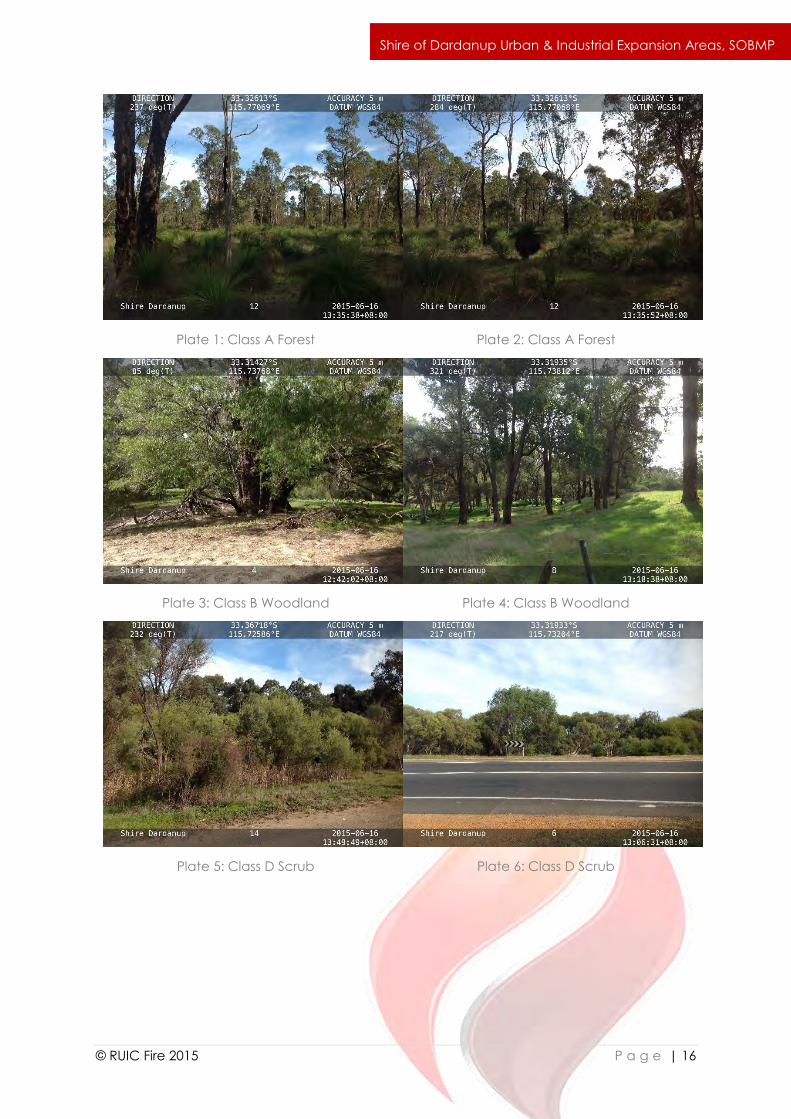
The following AS3959 vegetation structures are located within the site or within 100m of the site
boundary:
(i) Class A Forest
(ii) Class B Woodland
(iii) Class D Scrub
(iv) Areas exempt from classification in accordance with AS3959 s2.2.3.2
AS3959 vegetation structures within 100m of the site are mapped in Figures 2D and 2E and
illustrated in the associated plates. Bushfire fuel loads are identified as consistent with AS3959
Table B2 for radiant heat flux modelling purposes.
Although the majority of the site is currently pastureland, it is assumed that once the
development is completed, the entire extent of grassland areas within the site will be
developed or managed to a Low Threat state (slashed or mowed to a height of less than
10cm). During staged development, sufficient Low Threat landscaping buffers between
developed and undeveloped lots will ensure the bushfire related risk from unmanaged
grassland is managed appropriately.
The site and surrounding area is predominately degraded farmland, containing limited areas
of fragmented of remnant vegetation that could support restricted bushfire behaviour. The
design of the Urban and Industrial Expansion Areas will ensure areas of low threat vegetation
(grassed POS, road reserves) provide a substantial buffer from vegetation structures within and
surrounding the site. Bushfire specific design considerations will be included in the
development as detailed in this report to ensure access, water supply and potential bushfire

`
© RUIC Fire 2015 P a g e | 10
Shire of Dardanup Urban & Industrial Expansion Areas, SOBMP
impact are appropriately addressed. These design standards incorporate worst case scenario
bushfire impact as assessed in section 3 and detailed in section 4 of this report.
`
© RUIC Fire 2015 P a g e | 11
Shire of Dardanup Urban & Industrial Expansion Areas, SOBMP
Figure 2A: Site Location
`
© RUIC Fire 2015 P a g e | 12
Shire of Dardanup Urban & Industrial Expansion Areas, SOBMP
Figure 2B: Site Overview
`
© RUIC Fire 2015 P a g e | 13
Shire of Dardanup Urban & Industrial Expansion Areas, SOBMP
Figure 2C: Urban and Industrial District Structure Plan Areas (Client, 2015)
`
© RUIC Fire 2015 P a g e | 14
Shire of Dardanup Urban & Industrial Expansion Areas, SOBMP
Figure 2D: Vegetation Classification – Urban Expansion Area

`
© RUIC Fire 2015 P a g e | 15
Shire of Dardanup Urban & Industrial Expansion Areas, SOBMP
Figure 2E: Vegetation Classification – Industrial Expansion Area
`
© RUIC Fire 2015 P a g e | 16
Shire of Dardanup Urban & Industrial Expansion Areas, SOBMP
Plate 1: Class A Forest
Plate 2: Class A Forest
Plate 3: Class B Woodland
Plate 4: Class B Woodland
Plate 5: Class D Scrub
Plate 6: Class D Scrub
`
© RUIC Fire 2015 P a g e | 17
Shire of Dardanup Urban & Industrial Expansion Areas, SOBMP
Plate 7: Class G Grassland
Plate 8: Class G Grassland
Plate 9: Class B Woodland vegetation
alongside Millars Creek
Plate 10: Future POS in north of Urban
Expansion Area

`
© RUIC Fire 2015 P a g e | 18
Shire of Dardanup Urban & Industrial Expansion Areas, SOBMP
Figure 2F: Site Topography
`
© RUIC Fire 2015 P a g e | 19
Shire of Dardanup Urban & Industrial Expansion Areas, SOBMP
3.0 Bushfire Assessment
3.1 Potential for Bushfire Activity
Native vegetation capable of sustaining a bushfire event within the site is limited. The area of
forest located between the South West Highway and Railway Road in the south of the Urban
Expansion Area is effectively isolated by these two roads. The source of a fire occurring here
would most likely be due to point source ignition such as arson or lightning strike and the
restricted size of the area means it would be unlikely to support a large scale bushfire event.
The forest and woodland vegetation located near the corner of the Forrest Highway and
Hynes Road in the west of the Urban Expansion Area is separated from forest vegetation
bordering Millars Creek west of the site boundaries by the Forrest Highway. A fire starting here
would most likely be an independent event as opposed to a large scale bushfire, being limited
in intensity by the size of the remnant patch. A significant area of native vegetation is located
external to the Urban Expansion Area boundary, south west of Hynes Road and south of the
Forrest Highway. This patch of forest has a potential fire run of over 1000m and could encroach
on the site from the west, or ignite spot fires within the site. Standing vegetation within and
surrounding the Industrial Expansion Area is very limited. Stands of woodland bordering the
western boundary are relatively small and isolated and would most likely not sustain extended
bushfire behaviour. The small area of forest east of Martin Pelusey Road is degraded and may
not be retained within the development.
Riparian vegetation along the majority of Millars Creek will be limited to a 10m strip of
woodland reserve either side of the creek with a 40m buffer, comprising 20m grassed POS and
20m road reserve on either side, creating substantial separation between the vegetation
threat and residential development. In the north of the Urban Expansion Area, the forested
area set aside as POS is currently devoid of understorey due to grazing. Even with revegetation
works and natural regeneration of this area, the bushfire risk to the development will be
managed through a 40m buffer of grassed POS. Similarly, riparian vegetation along the Collie
River will be bordered by a Low Threat buffer area sufficient to reduce the effects of radiant
heat impact on future dwellings.
Whereas a bushfire event occurring within the site remains a credible threat to the
development, the Urban and Industrial Expansion Areas are not subject to an unacceptable
level of radiant heat impact or hazard level as detailed in Sections 3.2 and 3.3 of this report.
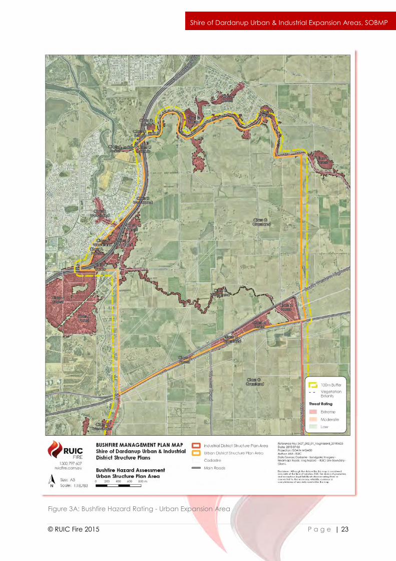
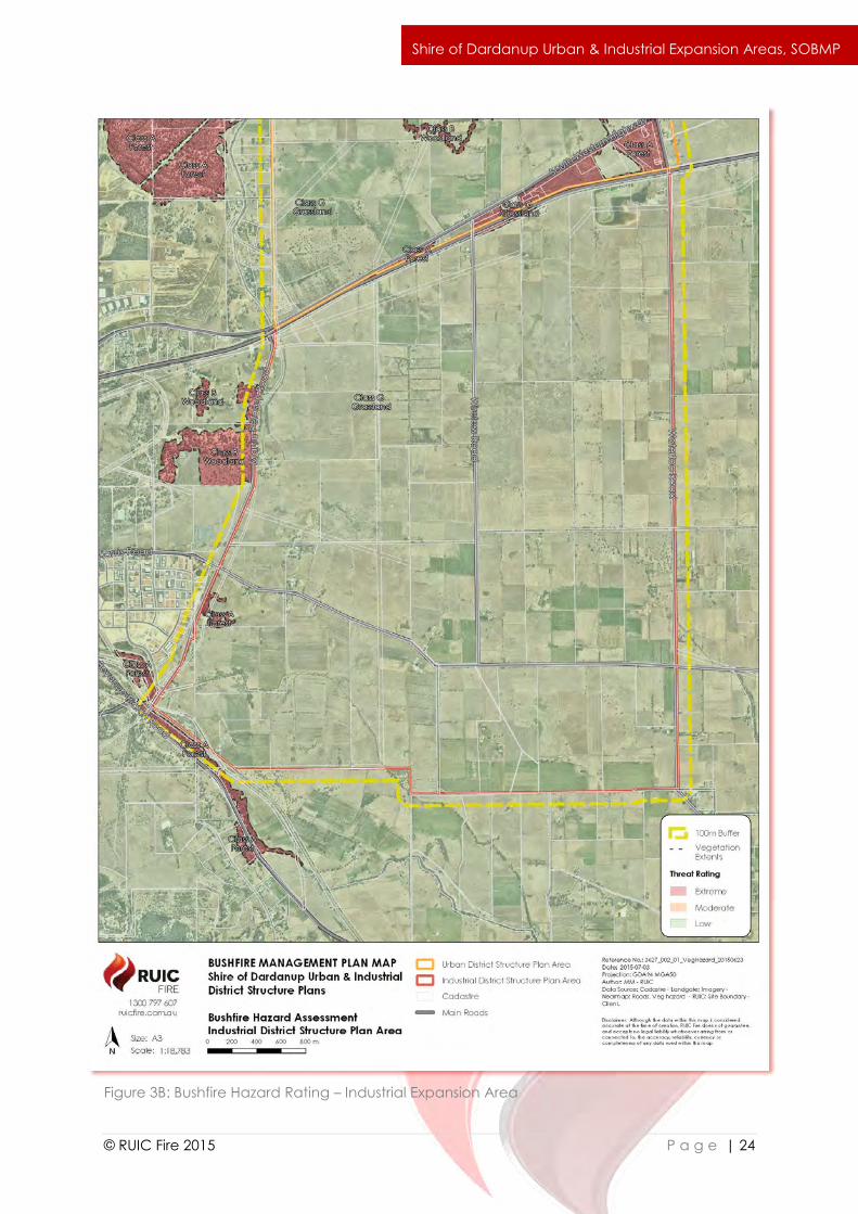
3.2 Bushfire Hazard Assessment
Bushfire Hazard Assessment in accordance with PfBPG Appendix 1 on the basis of the
“predominant vegetation” identifies that post development, the site shall have a Low Bushfire
Hazard rating. Vegetation threats within the site are identified as Low (pasture areas with very
limited native standing vegetation) and Extreme (areas of native woodland and forest) as
mapped in Figures 3A and 3B).
It is concluded the predominant Bushfire Hazard Rating by land area of the site is Low. Despite
this, the proponent has adopted a precautionary approach and has included bushfire
considerations and design standards into the development as far as reasonably practicable.
These design strategies are detailed in section 4 of this report.
`
© RUIC Fire 2015 P a g e | 20
Shire of Dardanup Urban & Industrial Expansion Areas, SOBMP
3.3 Bushfire Impact Analysis & BAL Ratings
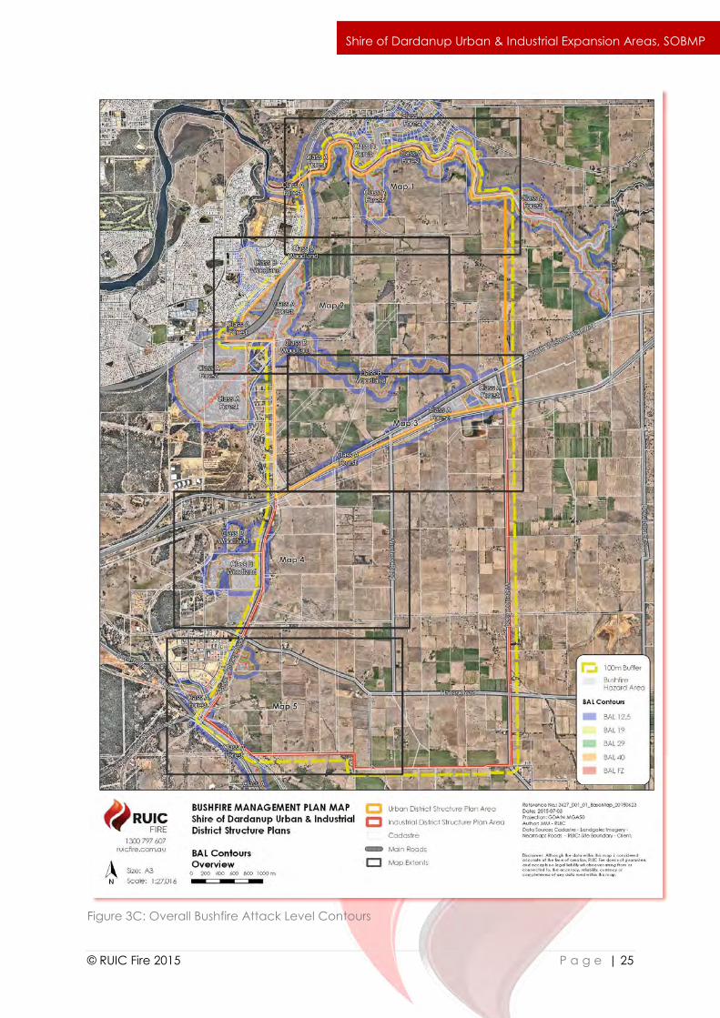
Potential bushfire impact analysis was undertaken in accordance with AS3959 Methodology 1
to determine the potential worst case scenario radiant heat impact on future development in
the event of a bushfire occurring within vegetation identified as a bushfire threat. The
modelling (Figures 3C to 3K) identifies that the attainment of a maximum potential radiant heat
impact of BAL-29 for the development is achievable through lot specific internal setbacks,
public roads and landscaping, satisfying SPP3.7 Element 1: Location, Acceptable Solution 1.
Development of land identified as having a BAL-40 or BAL-FZ rating should be restricted to
Public Open Space, Road Reserves and low threat landscaping buffers to prevent
development occurring in areas that may result in an unacceptable level of radiant heat
impact should a bushfire event occur.
Additional bushfire related design requirements specific to the Industrial Expansion Area are
provided in Section 4 of this report to ensure future land usage and industrial development is
not subject to unacceptable levels of bushfire related risk.
3.4 Risk Assessment
Risk is not an event (SAHB 436:2013 s2.1). It is not an explosion, bushfire, flood or other
emergency. Risk cannot be expressed as either positive or negative, but rather as the
likelihood of a consequence, positive or negative, occurring. In the context of planning for
bushfire protection, bushfire is considered a risk source that can impact upon the objectives
of preventing damage or loss to life, property and the environmental assets (prioritised in that
order).
Management of bushfire related risk is a shared responsibility (Keelty, 2011). Risk criteria are
sourced from Emergency Management Australia (2010); FESA (2010); and stakeholder
consultation. Residual bushfire related risk to identified assets within the proposed
development following implementation of the risk mitigation strategies is summarised in Table
3B in accordance with:
ISO31000:2009 Risk management – principles and guidelines;
SAHB 436:2013 Risk management guidelines – Companion to AS/NZS ISO 31000:2009;
National Inquiry on Bushfire Mitigation and Management (2010).
The risk assessment demonstrates that after application of the risk management strategies
incorporated into the design of the development, the residual bushfire related risk post
subdivision is significantly reduced compared to the current state.
`
© RUIC Fire 2015 P a g e | 21
Shire of Dardanup Urban & Industrial Expansion Areas, SOBMP
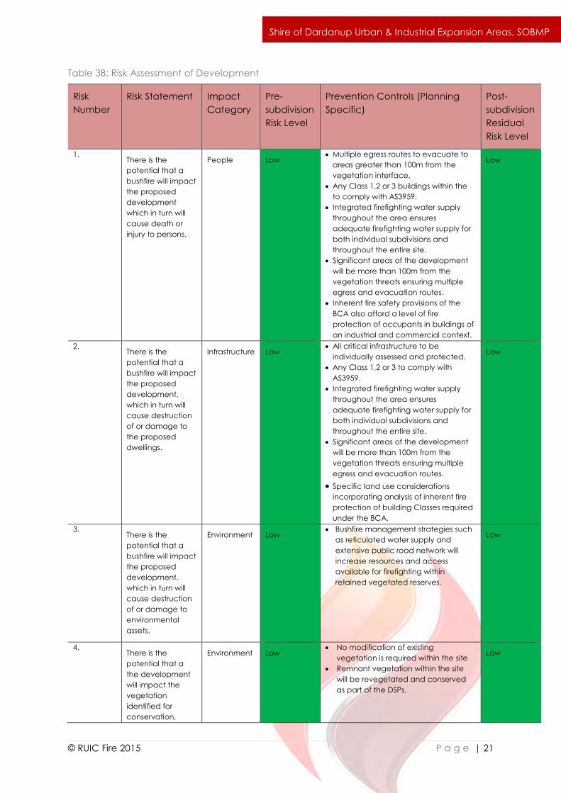
Table 3B: Risk Assessment of Development
Risk
Number
Risk Statement Impact
Category
Pre-
subdivision
Risk Level
Prevention Controls (Planning
Specific)
Post-
subdivision
Residual
Risk Level
1. There is the
potential that a
bushfire will impact
the proposed
development
which in turn will
cause death or
injury to persons.
People Low Multiple egress routes to evacuate to
areas greater than 100m from the
vegetation interface.
Any Class 1,2 or 3 buildings within the
to comply with AS3959.
Integrated firefighting water supply
throughout the area ensures
adequate firefighting water supply for
both individual subdivisions and
throughout the entire site.
Significant areas of the development
will be more than 100m from the
vegetation threats ensuring multiple
egress and evacuation routes.
Inherent fire safety provisions of the
BCA also afford a level of fire
protection of occupants in buildings of
an industrial and commercial context.
Low
2. There is the
potential that a
bushfire will impact
the proposed
development,
which in turn will
cause destruction
of or damage to
the proposed
dwellings.
Infrastructure Low All critical infrastructure to be
individually assessed and protected.
Any Class 1,2 or 3 to comply with
AS3959.
Integrated firefighting water supply
throughout the area ensures
adequate firefighting water supply for
both individual subdivisions and
throughout the entire site.
Significant areas of the development
will be more than 100m from the
vegetation threats ensuring multiple
egress and evacuation routes.
Specific land use considerations
incorporating analysis of inherent fire
protection of building Classes required
under the BCA.
Low
3. There is the
potential that a
bushfire will impact
the proposed
development,
which in turn will
cause destruction
of or damage to
environmental
assets.
Environment Low Bushfire management strategies such
as reticulated water supply and
extensive public road network will
increase resources and access
available for firefighting within
retained vegetated reserves.
Low
4. There is the
potential that a
the development
will impact the
vegetation
identified for
conservation,
Environment Low No modification of existing
vegetation is required within the site
Remnant vegetation within the site
will be revegetated and conserved
as part of the DSPs.
Low

`
© RUIC Fire 2015 P a g e | 22
Shire of Dardanup Urban & Industrial Expansion Areas, SOBMP
which in turn will
cause destruction
of or damage to
environmental
assets.
`
© RUIC Fire 2015 P a g e | 23
Shire of Dardanup Urban & Industrial Expansion Areas, SOBMP
Figure 3A: Bushfire Hazard Rating - Urban Expansion Area
`
© RUIC Fire 2015 P a g e | 24
Shire of Dardanup Urban & Industrial Expansion Areas, SOBMP
Figure 3B: Bushfire Hazard Rating – Industrial Expansion Area
`
© RUIC Fire 2015 P a g e | 25
Shire of Dardanup Urban & Industrial Expansion Areas, SOBMP
Figure 3C: Overall Bushfire Attack Level Contours
`
© RUIC Fire 2015 P a g e | 26
Shire of Dardanup Urban & Industrial Expansion Areas, SOBMP
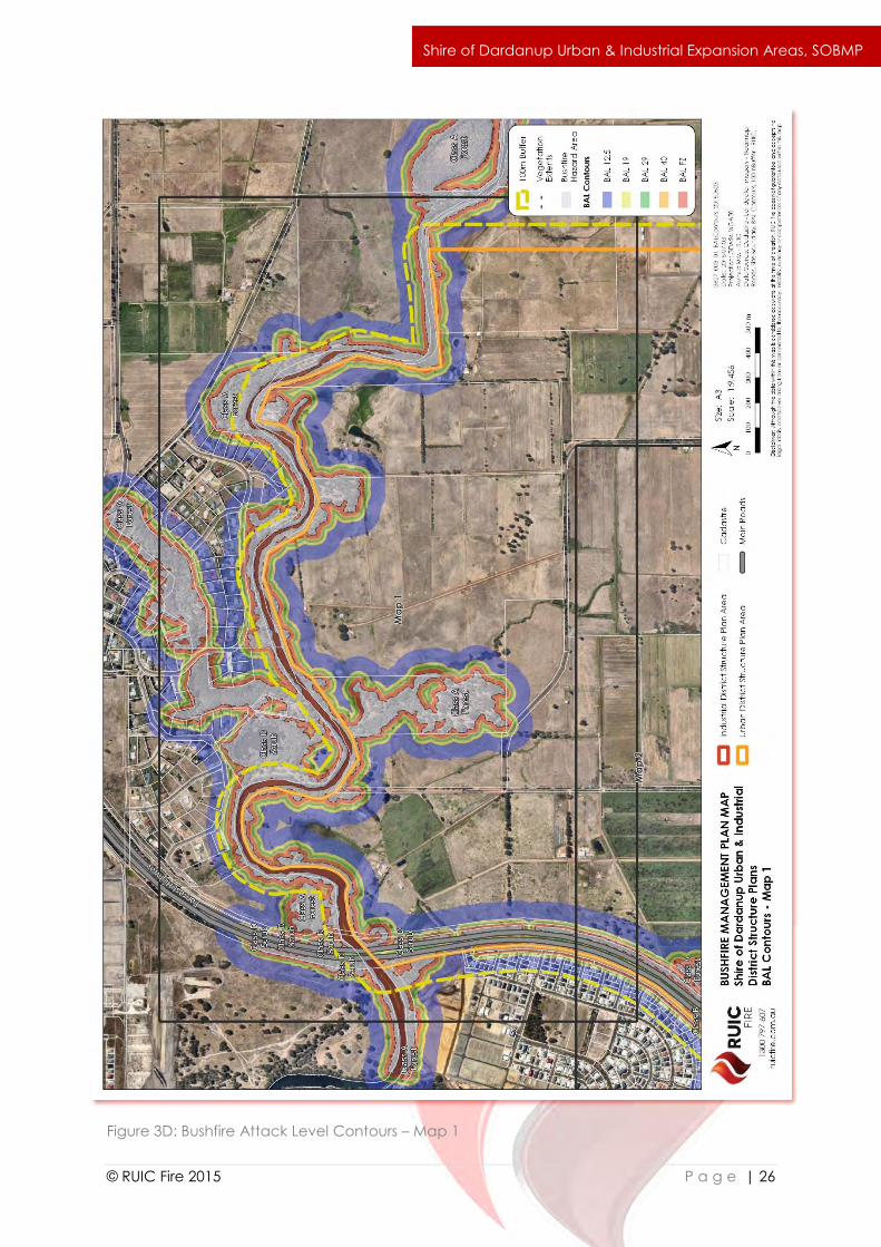
Figure 3D: Bushfire Attack Level Contours – Map 1
`
© RUIC Fire 2015 P a g e | 27
Shire of Dardanup Urban & Industrial Expansion Areas, SOBMP
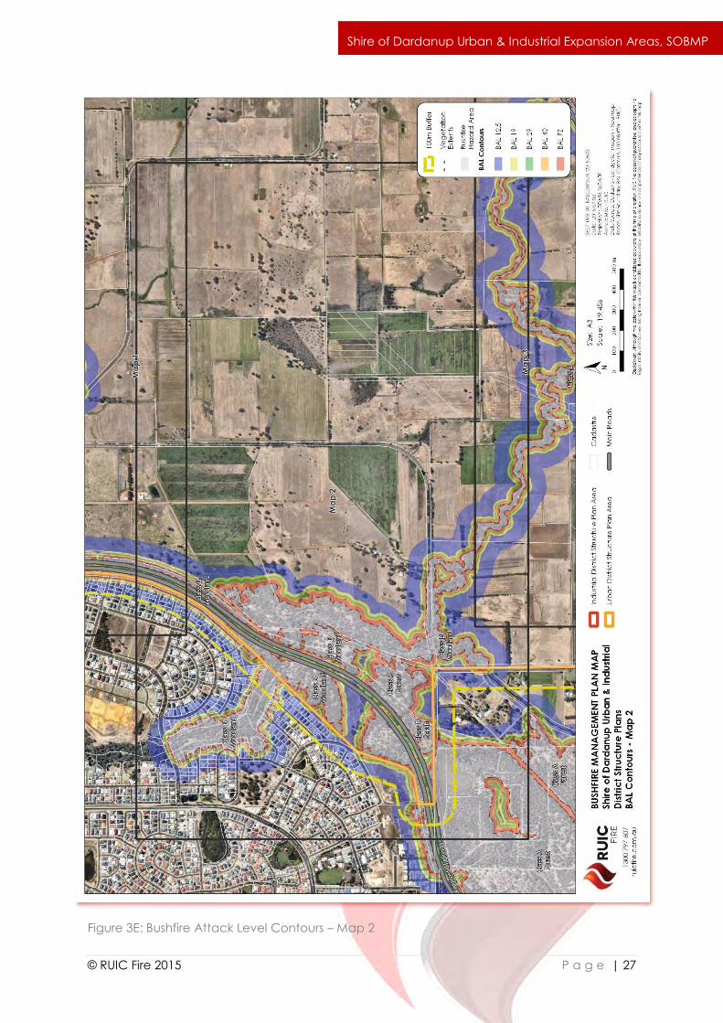
Figure 3E: Bushfire Attack Level Contours – Map 2
`
© RUIC Fire 2015 P a g e | 28
Shire of Dardanup Urban & Industrial Expansion Areas, SOBMP
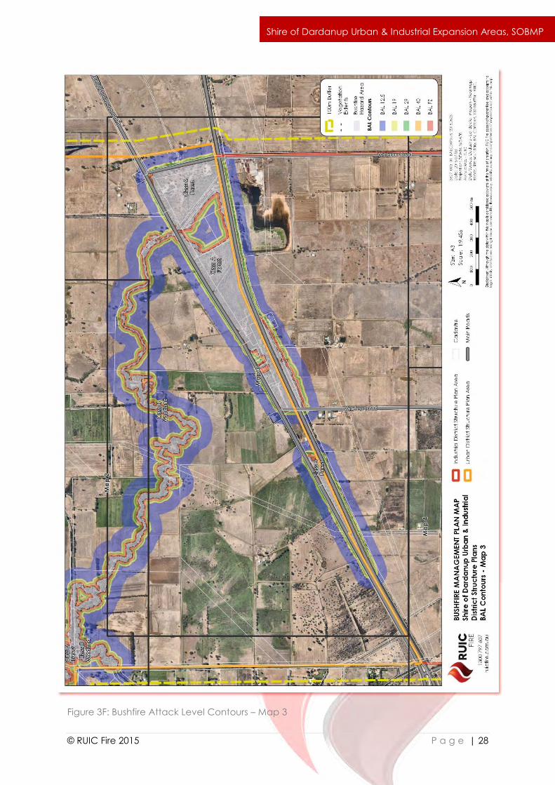
Figure 3F: Bushfire Attack Level Contours – Map 3
`
© RUIC Fire 2015 P a g e | 29
Shire of Dardanup Urban & Industrial Expansion Areas, SOBMP
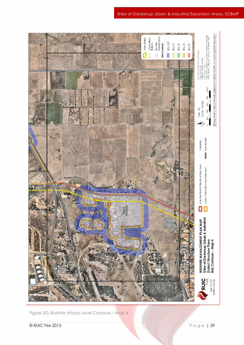
Figure 3G: Bushfire Attack Level Contours – Map 4

`
© RUIC Fire 2015 P a g e | 30
Shire of Dardanup Urban & Industrial Expansion Areas, SOBMP
Figure 3H: Bushfire Attack Level Contours – Map 5
`
© RUIC Fire 2015 P a g e | 31
Shire of Dardanup Urban & Industrial Expansion Areas, SOBMP
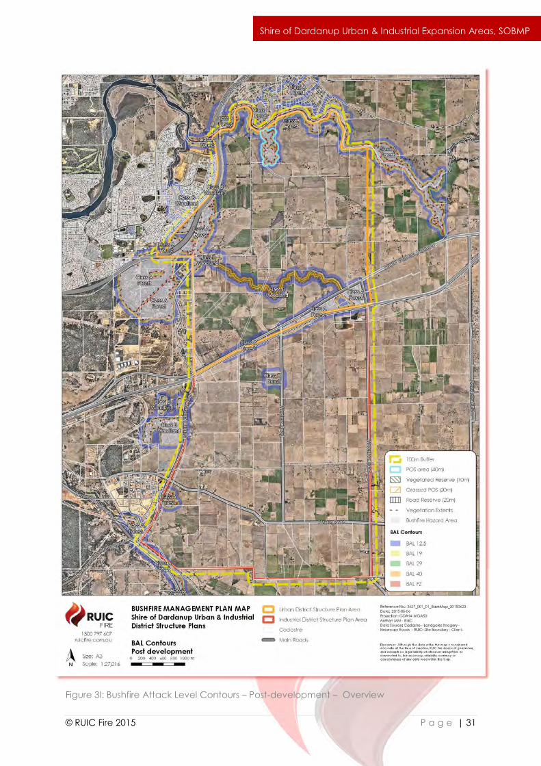
Figure 3I: Bushfire Attack Level Contours – Post-development – Overview
`
© RUIC Fire 2015 P a g e | 32
Shire of Dardanup Urban & Industrial Expansion Areas, SOBMP
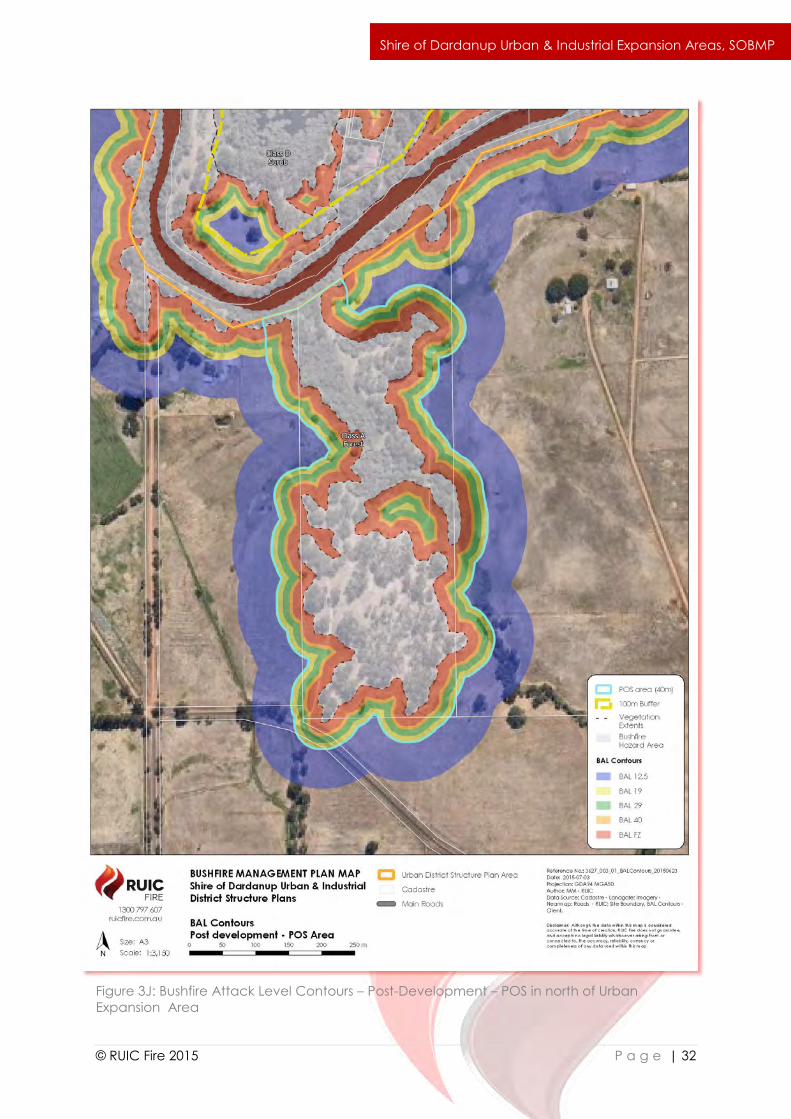
Figure 3J: Bushfire Attack Level Contours – Post-Development – POS in north of Urban
Expansion Area
`
© RUIC Fire 2015 P a g e | 33
Shire of Dardanup Urban & Industrial Expansion Areas, SOBMP
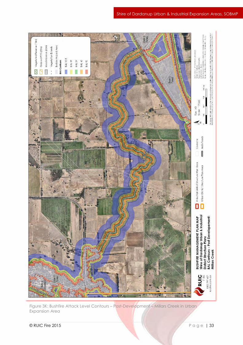
Figure 3K: Bushfire Attack Level Contours – Post-Development – Millars Creek in Urban
Expansion Area
`
© RUIC Fire 2015 P a g e | 34
Shire of Dardanup Urban & Industrial Expansion Areas, SOBMP
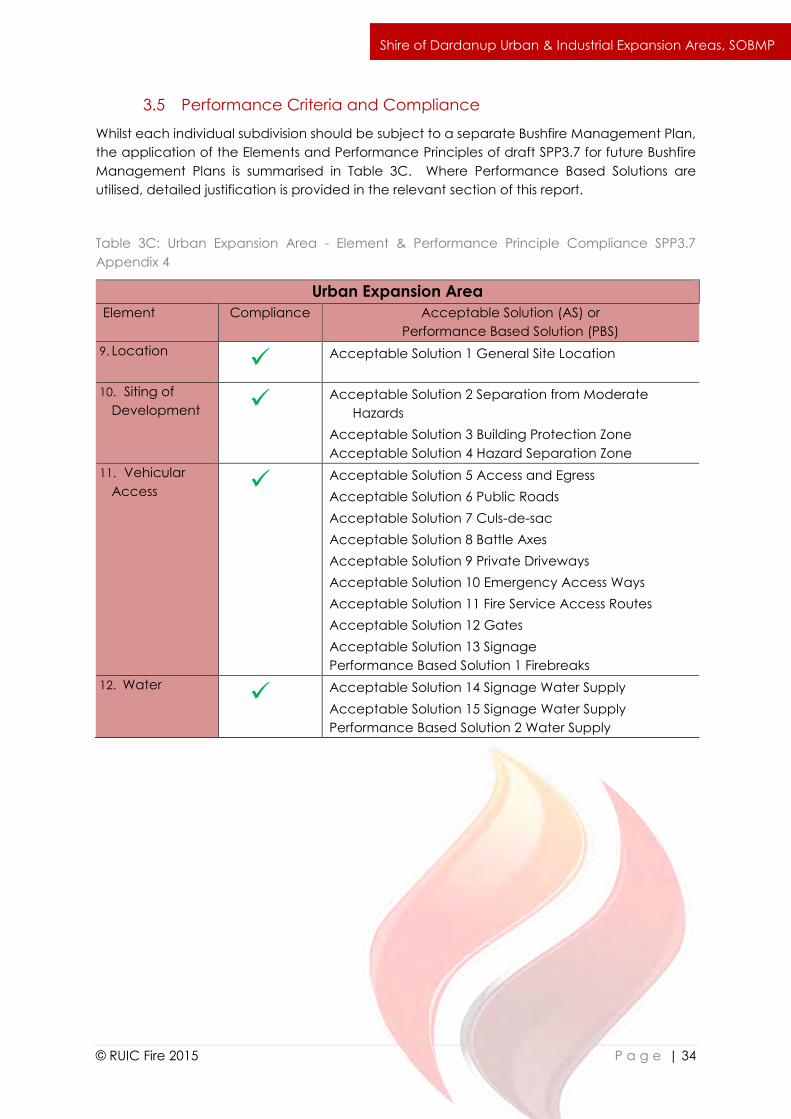
3.5 Performance Criteria and Compliance
Whilst each individual subdivision should be subject to a separate Bushfire Management Plan,
the application of the Elements and Performance Principles of draft SPP3.7 for future Bushfire
Management Plans is summarised in Table 3C. Where Performance Based Solutions are
utilised, detailed justification is provided in the relevant section of this report.
Table 3C: Urban Expansion Area - Element & Performance Principle Compliance SPP3.7
Appendix 4
Urban Expansion Area
Element Compliance Acceptable Solution (AS) or
Performance Based Solution (PBS)
9. Location Acceptable Solution 1 General Site Location
10. Siting of
Development Acceptable Solution 2 Separation from Moderate
Hazards
Acceptable Solution 3 Building Protection Zone
Acceptable Solution 4 Hazard Separation Zone
11. Vehicular
Access Acceptable Solution 5 Access and Egress
Acceptable Solution 6 Public Roads
Acceptable Solution 7 Culs-de-sac
Acceptable Solution 8 Battle Axes
Acceptable Solution 9 Private Driveways
Acceptable Solution 10 Emergency Access Ways
Acceptable Solution 11 Fire Service Access Routes
Acceptable Solution 12 Gates
Acceptable Solution 13 Signage
Performance Based Solution 1 Firebreaks
12. Water Acceptable Solution 14 Signage Water Supply
Acceptable Solution 15 Signage Water Supply
Performance Based Solution 2 Water Supply
`
© RUIC Fire 2015 P a g e | 35
Shire of Dardanup Urban & Industrial Expansion Areas, SOBMP
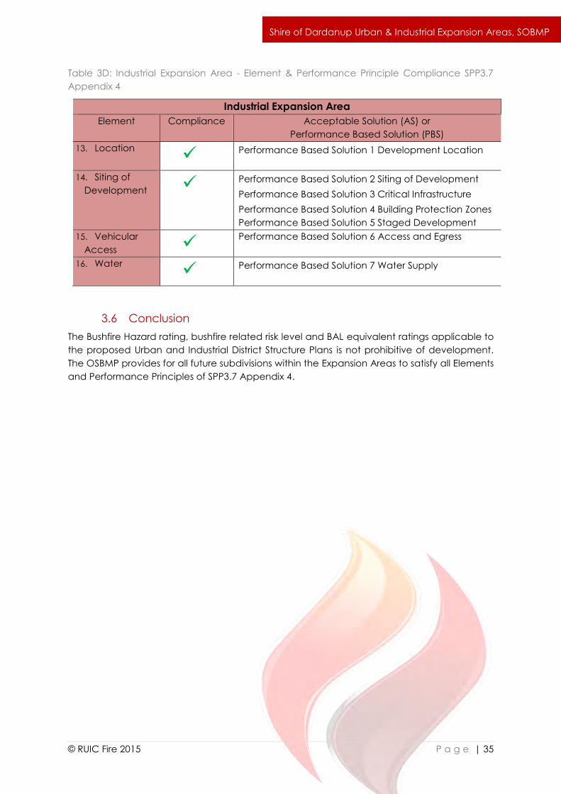
Table 3D: Industrial Expansion Area - Element & Performance Principle Compliance SPP3.7
Appendix 4
Industrial Expansion Area
Element Compliance Acceptable Solution (AS) or
Performance Based Solution (PBS)
13. Location Performance Based Solution 1 Development Location
14. Siting of
Development Performance Based Solution 2 Siting of Development
Performance Based Solution 3 Critical Infrastructure
Performance Based Solution 4 Building Protection Zones
Performance Based Solution 5 Staged Development
15. Vehicular
Access Performance Based Solution 6 Access and Egress
16. Water Performance Based Solution 7 Water Supply
3.6 Conclusion
The Bushfire Hazard rating, bushfire related risk level and BAL equivalent ratings applicable to
the proposed Urban and Industrial District Structure Plans is not prohibitive of development.
The OSBMP provides for all future subdivisions within the Expansion Areas to satisfy all Elements
and Performance Principles of SPP3.7 Appendix 4.
`
© RUIC Fire 2015 P a g e | 36
Shire of Dardanup Urban & Industrial Expansion Areas, SOBMP
4.0 Bush Fire Risk Mitigation
The bush fire risk mitigation strategies detailed in this report are designed to comply with the
Performance Criteria detailed in PfBPG; WAPC Planning Bulletin 111/2013; and draft SPP3.7.
The format of mitigation strategies is aligned with SPP3.7 Appendix 4 in accordance with
direction provided in SPP3.7 Guidelines.
The notation (P3) refers to Performance Principle 3 of draft SPP3.7 Appendix 4. Where
a Performance Based Solution is offered detailed justification is provided.
The notation (A3.1) refers to Acceptable Solution 3.1 of draft SPP3.7 Appendix 4.
The notation (E3.1) refers to Explanatory Note 3.1 of draft SPP3.7 Appendix 4.
Where discrepancy occurs between State and Local bushfire planning provisions the
higher standard of mitigation has been selected.
Where performance based design solutions are proposed, detailed justification is provided in
the relevant section.
The bushfire risk related mitigation design strategies identified here are to provide overarching
guidance only. Each individual subdivision must provide an individual Bushfire Management
Plan in accordance with the relevant conditions of planning approval.
4.1 Urban Expansion Area
4.1.1 Element 1 – Location of Development
Intent: To ensure that the subdivision, development or land use is located in areas with the
least possible risk of bushfire, to help minimise risk to people, property and infrastructure.
Performance Principle (P1): The subdivision, development or land use is located in an area
where the bushfire hazard assessment classification is or will be moderate or low, and the risk
can be managed.
Acceptable Solution 1 Development Location A1.1
Development of land identified as having a BAL-40 or BAL-FZ rating should be restricted to
Public Open Space, Road Reserves and low threat landscaping buffers to prevent
development occurring in areas that may result in an unacceptable level of radiant heat
impact should a bushfire event occur. To ensure development within both the Urban
Expansion Area and Industrial Expansion Area satisfies P1; A1.1, all dwellings and other buildings
should be sited to ensure a maximum BAL-29 rating is applicable. The BAL Contour maps
provided in section 3 of this report may be referred to for strategic guidance. Site specific BAL
ratings may be updated through future site specific Bushfire Management Plans and BAL
Assessments.
4.1.2 Element 2 - Siting of Development
Intent: To ensure that the siting of development minimises the level of bushfire impact.
Performance Principle (P2): The siting and design of the subdivision, development or land use
(including paths and landscaping) is appropriate to the level of bushfire risk that applies to the
site and minimises the bushfire risk to people, property and infrastructure.
`
© RUIC Fire 2015 P a g e | 37
Shire of Dardanup Urban & Industrial Expansion Areas, SOBMP
Acceptable Solution 2 Hazard Separation – Moderate Bushfire Hazard Level A2.1
Future development will be designed to ensure that every building is sited a minimum distance
of 100 metres from any vegetation classified in AS3959 as forests, woodlands, closed shrub,
open shrub, mallee/mulga and rainforest and 50 metres from unmanaged grassland, or will
have its construction standard increased to align with the appropriate BAL for that location.
Where a building cannot be located a minimum distance of 100m from the vegetation the
building must be constructed to the higher standard as described in AS3959.
All new dwellings in the Urban Expansion Area and within 100m of bushfire prone vegetation
will be constructed in accordance with AS3959:2009 to facilitate the reduced separation
distance, therefore complying with A2.1.
Acceptable Solution 3 Building Protection Zone A2.2
The Building Protection Zone is a low fuel area immediately surrounding a building and is
designed to minimise the likelihood of flame contact with buildings. Features such as
driveways, footpaths, roads, vegetable patches, lawn or landscaped garden (including
deciduous trees and fire resistant plant species) may form part of building protection zones.
Areas of vegetation deemed Low Threat Vegetation and managed in a reduced fuel state
inclusive of Public Open Space and nature strips may form part of a buildings defendable
space. Isolated shrubs and trees may be retained within building protection zones.
Acceptable Solution A2.1 standard for the building protection zone is modified to remove the
reference to tree crowns being spaced in accordance with the BCA as the Building Code of
Australia does not comment on landscaping measures. The BCA directly references
AS3959:2009 for the calculation of bushfire radiant heat flux, therefore AS3959:2009 s2.2.3.2 (f)
Low Threat Vegetation is subsequently used to define the standard required for vegetation
within the building protection zone.
The “Vegetation key: Comprehensive Field Guide for Bushfire Attack Level Assessors using
AS3959” may be referred to for additional guidance in determining suitable landscaping within
the Building Protection Zone.
a) Design Standard
i. Width: Sufficient to ensure a maximum BAL-29 rating on all dwellings;
ii. fuel load: reduced to and maintained at 2 tonnes per hectare and
maintained in accordance with AS3959:2009 s2.2.3.2 (f) stated here as:
“Including grassland managed in a minimal fuel condition, maintained
lawns, golf courses, maintained public reserves and parklands,
vineyards, orchards, cultivated gardens, commercial nurseries, nature
strips and windbreaks. NOTE: Minimal fuel condition means there is
insufficient fuel available to significantly increase the severity of the
bushfire attack (recognizable as short-cropped grass for example, to a
nominal height of 100 mm).”
iii. no tall shrubs or trees located within 2 metres of a building;
iv. no tree crowns overhanging the building; and
v. fences and sheds within the building protection zone are constructed using
non-combustible materials (eg. iron, brick, limestone).
b) Implementation
`
© RUIC Fire 2015 P a g e | 38
Shire of Dardanup Urban & Industrial Expansion Areas, SOBMP
Building Protection Zones should be implemented by the developer of individual
sub divisions prior to the habitation of any lots within that subdivision. In higher
density development it may be considered suitable for Building Protection Zones to
overlap between individual housing lots as long as they provide a continuous low
fuel area.
c) Development
It should be the responsibility of the developer of each individual subdivision to
ensure each relevant Building Protection Zone to ensure that the burden and cost
is not placed on individual land owners.
d) Maintenance
It should be the responsibility of the individual property owner to ensure the Building
Protection Zone standard continues to be achieved post completion of the
development. This includes vacant blocks which should be maintained in a
minimal fuel condition. It is recommended that the Shire of Dardanup aligns the
Annual Fire Break Notice with the terminology of this report to ensure consistency
and a legal requirement for land owners to maintain all lots in a minimal fuel
condition post development.
Acceptable Solution 4 Hazard Separation Zone A2.3
Hazard Separation Zones assist in reducing fire intensity when a bushfire impacts on buildings
within a subdivision. Separation may be necessary on the perimeter of a subdivision but may
also be needed where bushfire hazards exist within a subdivision. This separation reduces the
overall vulnerability of a subdivision and related development and assists with fire control
operations. Where the full Hazard Separation Zone cannot be achieved, enhanced
construction in accordance with AS3959 is required (A2.1).
All new dwellings within 100m of bushfire prone vegetation will be constructed in accordance
with AS3959:2009 to facilitate the reduced separation distance, therefore complying with A2.1
and A2.3.
4.1.3 Element 3 - Vehicular Access
Intent: To ensure that the vehicular access serving a subdivision/development is available
during a bushfire event.
Performance Principle (P3): The internal layout, design and construction of public and private
vehicular access in the subdivision/development allows emergency and other vehicles to
move through it easily and safely at all times.
Acceptable Solution 5 Two Access Routes A3.1
Future development within the Urban Expansion Area should be designed to ensure that the
internal and external public road network will provide multiple access and egress routes and
egress destinations available at all times and in all weather conditions. This will satisfy
Acceptable Solution (A3.1). Perimeter roads should border identified vegetation threats (or
Public Open Space adjacent to areas of retained vegetation) to provide permanent physical
separation that will assist in the reduction of potential bushfire impact on dwellings, facilitate
firefighting access and provide multiple access routes throughout the individual subdivisions.
Road design between individual subdivisions should be complementary to facilitate
enhanced egress options where possible.
`
© RUIC Fire 2015 P a g e | 39
Shire of Dardanup Urban & Industrial Expansion Areas, SOBMP
Acceptable Solution 5 Public Roads A3.2
Future public roads shall meet the following design standards, satisfying Acceptable Solution
A3.2:
a) Standard:
All public roads are to meet the requirements in Table 4A;
b) Implementation:
New public roads shall meet the required standard prior to habitation of any
dwellings accessed by the road.
c) Development:
It is the responsibility of the developer to ensure the public road standard is
established.
a) Maintenance:
It is the responsibility of Local and State Government (as appropriate) to ensure the
maintenance of public roads vested within their jurisdiction.
Acceptable Solution 5 Cul-de-sac A3.3
Whilst cul-de-sacs are discouraged in draft SPP3.7 Appendix 4, they remain an Acceptable
Solution and should therefore be considered suitable for inclusion in subdivision design. It is
suggested however that should cul-de-sacs be included, where they are situated within 100m
of a vegetation identified as a potential bushfire hazard, they do not require persons to travel
towards the potential fire front as part of their egress route. All future cul-de-sacs shall meet
the requirements of Acceptable Solution A3.3. All cul-de-sacs should be less than 200m in
length unless the heads are connected by Emergency Access Ways, in which case the length
may be extended to a maximum of 800m.
Standard:
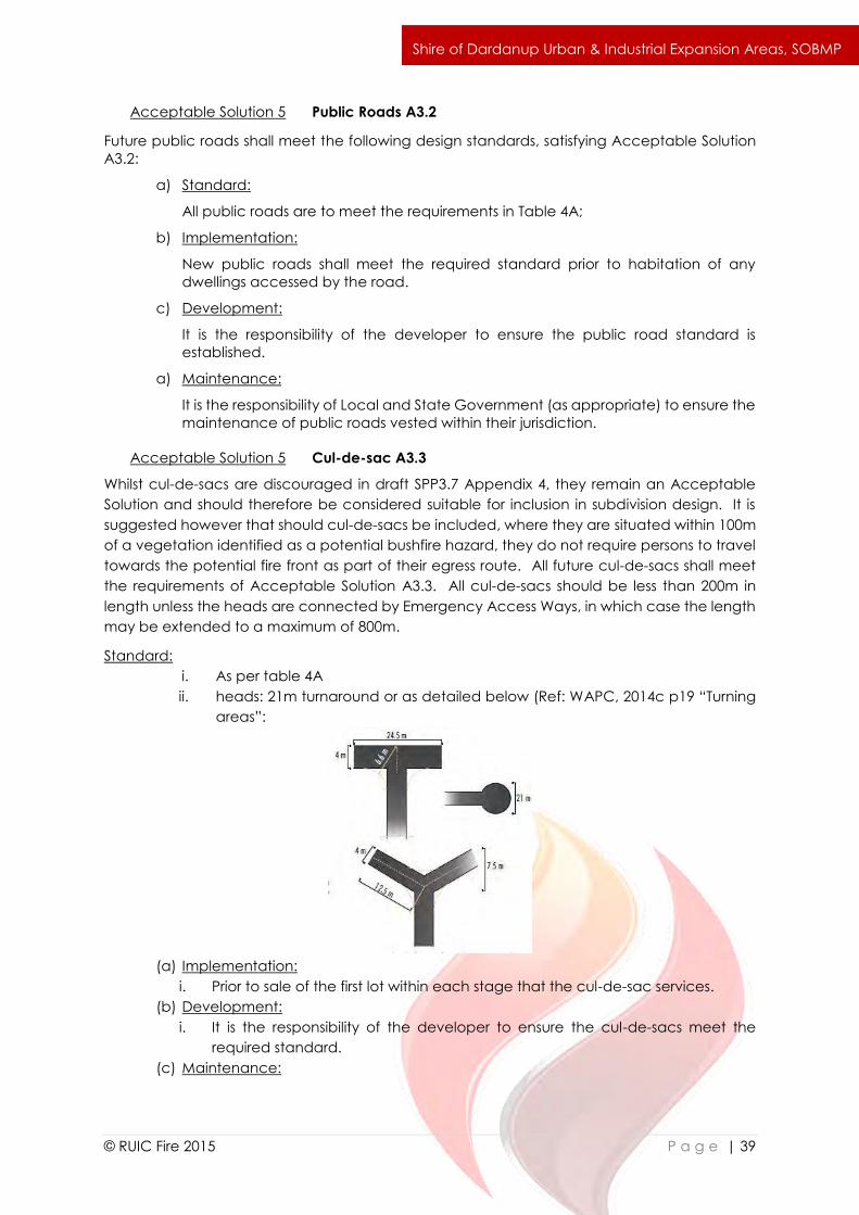
i. As per table 4A
ii. heads: 21m turnaround or as detailed below (Ref: WAPC, 2014c p19 “Turning
areas”:
(a) Implementation:
i. Prior to sale of the first lot within each stage that the cul-de-sac services.
(b) Development:
i. It is the responsibility of the developer to ensure the cul-de-sacs meet the
required standard.
(c) Maintenance:
`
© RUIC Fire 2015 P a g e | 40
Shire of Dardanup Urban & Industrial Expansion Areas, SOBMP
i. It is the responsibility of the Local Government to ensure the cul-de-sacs
continue to meet the required standard.
Acceptable Solution 6 Battle Axes A3.4
Any future battle-axe legs should be less than 600m in length and will be required to comply
with Acceptable Solution A3.4:
(a) Standard:
i. As per table 4A
(b) Implementation:
ii. Prior to sale of the lot that the battle axe services.
(c) Development:
ii. It is the responsibility of the developer to ensure the battle axes meet the
required standard.
(d) Maintenance:
ii. It is the responsibility of the Local Government to ensure the battle axes
continue to meet the required standard.
Acceptable Solution 7 Private Driveways A3.5
All dwellings located more than 50m from a public road will be required to be serviced by a
Private driveway meeting the specifications of A3.5.
(a) Standard:
i. As per table 4A
(b) Implementation:
i. Prior to habitation of the subject dwelling serviced by the Private
Driveway.
(c) Development:
i. It is the responsibility of the individual land owner to ensure private
driveways meet the required construction standards
(d) Maintenance:
i. It is the responsibility of the individual land owner to ensure private
driveways continue to meet the required construction standards.
Acceptable Solution 8 Emergency Access Ways A3.6
Where Emergency Access Ways are provided for alternative links between public roads. They
are required to meet the standard detailed in Acceptable Solution A3.6.
(a) Standard:
i. As per table 4A
ii. No further than 1km from a public road;
iii. Provided as a right of ways or public access easement in gross to
ensure accessibility to the public and fire services during an
emergency;
iv. Must be signposted
(b) Implementation:
i. Prior to clearance.
(c) Development:
i. It is the responsibility of the developer to ensure the emergency access
ways meets the required standards.
`
© RUIC Fire 2015 P a g e | 41
Shire of Dardanup Urban & Industrial Expansion Areas, SOBMP
(d) Maintenance:
i. It is the responsibility of the Local Government to ensure the emergency
access ways continue to meet the required construction standards.
Acceptable Solution 9 Fire Service Access Routes A3.7
Fire service access routes provide access within and around the edge of the subdivision and
links to public roads for firefighting. Appropriate design of subdivision through the strategic use
of perimeter public roads may mean that Fire Service Access Routes are not required. This
should be the preferred option for subdivision design. Where included, all fire service access
routes are to meet the standard of Acceptable Solution A3.7:
(a) Standard:
i. As per table 4A ;
ii. Provided as right of ways or public access easements in gross to ensure
accessibility to the public and fire services during an emergency;
iii. Surface: all-weather;
iv. Dead ends are not permitted;
v. Turn-around areas designed to accommodate 3.4
vi. Appliances and to enable them to turn around safely every 500 metres;
vii. Erosion control measures and long term maintenance arrangements in
place;
viii. No further than one kilometre from a public road; and
ix. Allow for two-way traffic.
(b) Implementation:
i. Prior to the clearance.
(c) Development:
i. It is the responsibility of the developer to ensure the fire services access
routes meets the required standard.
(d) Maintenance:
i. It is the responsibility of the Local Government to ensure the fire service
access routes continue to meet the required standard.
Acceptable Solution 10 Gates A3.8
Where gates are used to restrict traffic on fire service access routes, emergency access routes
or firebreaks they shall meet the requirements of Acceptable Solution A3.8.
(a) Standard(minimum):
i. Width 3.6m;
ii. Design and construction to be approved by the Local Government;
and
iii. If they are locked, only a common lock with a common key available
to the local fire service must be used;
(b) Implementation:
i. When fire service access is to be restricted across a firebreak or other
access route.
(c) Development:
i. It is the responsibility of the developer to ensure gates meet the
required construction standards.
(d) Maintenance:
`
© RUIC Fire 2015 P a g e | 42
Shire of Dardanup Urban & Industrial Expansion Areas, SOBMP
i. It is the responsibility of the individual land owner to ensure gates
continue to meet the required construction standards.
Acceptable Solution 11 Signage A3.9
Signs are to be erected where emergency access ways and fire services access routes adjoin
public roads, including driveways that are used as fire service access routes. Signs are to meet
the following requirements. Where gates are installed signage meeting the following
requirements must be installed (A3.9).
(a) Standard (minimum):
i. Height above ground 0.9m;
ii. Lettering height of 100mm;
iii. To display the following words (as appropriate): ‘Fire Service Access –
No Public Access’ or ‘Emergency Access Only’; and
iv. Design and construction to be approved by the relevant local
government.
(b) Implementation:
i. When required in conjunction with a gate used to restrict traffic on fire
service access routes, emergency access routes or firebreaks.
(c) Development:
i. It is the responsibility of the developer to ensure signs meet the
required construction standards.
(d) Maintenance:
i. It is the responsibility of the individual land owner to ensure signs
continue to meet the required construction standards.
Where firebreaks are required, they shall meet the standard required by the Shire of Dardanup
Annual Fire Prevention Order. Firebreaks are a performance based solution as they have been
removed as a standard requirement from Draft SPP 3.7. Appropriate subdivision design
including the use of perimeter public roads may eliminate the need for firebreaks. This should
be considered where lot sizes are not conducive to individual firebreaks.
4.1.4 Element 4 – Water Supply
Intent: To ensure that water is available to the subdivision, development or land use to enable
people, property and infrastructure to be defended from bushfire.
Performance Principle (P4): The subdivision, development or land use is provided with a
permanent and secure water supply that is sufficient for firefighting purposes.
Three options are discussed as providing sufficient firefighting water supply through the greater
site. Reticulated scheme water with associated hydrants complying with Water Corporation
Design Standard DS63 should be considered the preferred option.
Acceptable Solution 12 Reticulated Area A4.1
The site should be serviced by reticulated scheme water and firefighting hydrants that satisfy
Acceptable Solution A4.1.
Acceptable Solution 13 Non-reticulated Area A4.2
`
© RUIC Fire 2015 P a g e | 43
Shire of Dardanup Urban & Industrial Expansion Areas, SOBMP
Where lots within the site are not serviced by reticulated scheme water, dedicated 50,000L
firefighting water tank/s vested with the Local Government shall be provided. Any firefighting
water supply shall be sited to ensure a maximum 20 minute turn around for firefighting
appliances and shall satisfy the requirements of A4.2:
Standard (minimum):
i. volume: 50,000 litres per tank;
ii. ratio of tanks to lots: minimum 1 tank per 25 lots (or part thereof);
iii. tank location: tanks are located no more than two kilometres to the
furthest house site within the residential development to allow a 2.4
fire appliance to achieve a 20 minute turnaround time at legal road
speeds;
iv. hardstand and turn-around areas suitable for a 3.4 fire appliance are
provided within 3 metres of each water tank; and
v. water tanks and associated facilities are vested in the relevant local
government.
(b) Implementation:
i. Prior to the sale of the stage where any lot on that stage shall be
serviced by the subject tank.
(c) Development:
i. It is the responsibility of the developer to ensure the water tank meets
the required standard.
(d) Maintenance:
i. It is the responsibility of the Local Government to ensure the tank/s
continue to meet the required standard.
Performance Based Solution 2 Element 4 Water Supply – Non-Reticulated Water
Justification:
Where lots are not serviced by reticulated scheme water the use of private water tanks within
the Urban Expansion Area to provide firefighting water reserves may be considered suitable
as a performance based design solution by the Shire of Dardanup (assessed on a case by
case basis). Where private domestic water tanks are utilised for firefighting water supply, they
should be specifically designed to facilitate a rapid turnaround and resupply of firefighting
appliances across multiple lots within the required 20 minute time period; have a suitable
hardstand constructed within 3m of the tank; be fitted with DFES approved couplings; and
contain a minimum 15,000L water reserve.
Performance Based Solution:
Where private domestic water tanks are required, they will be specifically designed to facilitate
a rapid turnaround and resupply of firefighting appliances across multiple lots within the
required 20 minute time period. Private water tanks will be subject to meeting the following
requirements:
a) Standard:
i. volume: minimum 15,000L dedicated firefighting reserve per tank (see
figure 4B);
ii. 50mm camlock coupling with full flow valve suitable for local firefighting
appliances in accordance with relevant standards from the
Department of Fire and Emergency Services;
`
© RUIC Fire 2015 P a g e | 44
Shire of Dardanup Urban & Industrial Expansion Areas, SOBMP
iii. above ground tanks are constructed of concrete or metal and the
stands of raised tanks are constructed using non-combustible materials
and heat shielding where appropriate (ie heat shielding will be required
in the case of metal tank stands);
iv. incorporate an externally visible heat resistant float gauge; and
vi. hardstand and turn around area suitable for a 3.4 appliance are
provided within 3 metres of each water tank
a) Implementation:
i. All new domestic rainwater tanks are required to meet the standards
at the time of construction.
ii. The minimum 15,000L dedicated firefighting reserve shall be placed in
the tank at the time of construction.
b) Development:
i. It is the responsibility of the individual land owner to ensure the rainwater
tanks meets the required construction standards on installation.
c) Maintenance:
i. It is the responsibility of the individual land owner to ensure that the
rainwater tanks and firefighting valves are operational at all times.
4.2 Industrial Expansion Area
Due to the industrial context of the Industrial DSP Area, all solutions relating to this are
Performance Based and are designed as overall guidance strategies. Individual subdivisions
and future development must demonstrate compliance with all Performance Principles
identified in draft SPP3.7 (as amended); it is recognised that the acceptable solutions provided
in draft SPP3.7 Appendices and Guidelines are designed for residential development and may
not be suitable for the industrial context of the site.
In the absence of formal State Planning Policy acceptable solutions specific to bushfire related
planning strategies in the industrial context, further guidance for future individual subdivisions
within the Industrial Expansion Area is discussed in detail. This has been provided to specifically
address draft SPP 3.7 Policy Provision 6.10. Should State Planning Policy and associated
documents be enhanced to specifically address industrial development in areas where
bushfire related risk must be considered then those standards must be applied.
Intent: To ensure that the subdivision, development or land use is located in areas with the
least possible risk of bushfire, to help minimise risk to people, property and infrastructure.
Performance Principle (P1): The subdivision, development or land use is located in an area
where the bushfire hazard assessment classification is or will be moderate or low, and the risk
can be managed.
Once developed the majority of the site shall be subject to a Low Hazard Rating. Each stage
of development and individual subdivision shall be designed to ensure all buildings are subject
to radiant heat impact of less than 29kW/m2 (equivalent to a BAL-29 rating). This satisfies the
`
© RUIC Fire 2015 P a g e | 45
Shire of Dardanup Urban & Industrial Expansion Areas, SOBMP
intent of Performance Principle P1 and PfBPG Principle 4 whilst contextualised for the Industrial
context of the development.
Intent: To ensure that the siting of development minimises the level of bushfire impact.
Performance Principle (P2): The siting and design of the subdivision, development or land use
(including paths and landscaping) is appropriate to the level of bushfire risk that applies to the
site and minimises the bushfire risk to people, property and infrastructure.
Future subdivisions must be designed to ensure a maximum theoretical radiant heat impact
on all buildings of less than 29kW/m2 (equivalent to a BAL-29 rating). As AS3959 does not apply
to Class 4-9 buildings (Appendix A), suitable construction Types as identified under the BCA
must be applied as detailed in Performance Based Solution 2. This satisfies Performance
Principle 2 whilst providing specific considerations for the industrial nature of the development.
Planning Considerations
Both Planning for Bushfire Protection Guidelines 2nd Edition (PfBPG) and draft State Planning
Policy 3.7 Planning for Bushfire Risk Management including relevant appendices (SPP3.7)
provide significant focus on residential development with little consideration of commercial,
industrial, vulnerable land use or critical infrastructure. PfBPG Principle 4 and Draft SPP3.7 policy
provision 6.10 address the requirements for industrial and commercial development.
PfBPG Principle 4 states:
“In areas with an extreme bush fire hazard level where more intensive
subdivision/development, such as residential, rural-residential, hobby farms, tourist and
industrial developments, is considered unavoidable, permanent hazard reduction
measures need to be implemented to the satisfaction of the decision-making
authorities (ie FESA, the WAPC, and/or the relevant local government) to reduce the
hazard level to low or moderate or bush fire attack levels between BAL-Low and BAL-
29.”
Draft SPP3.7 requires that “high risk land use” complies with draft SPP3.7 po licy measure 6.10.
“High risk land use” is defined as “Land uses which may lead to the potential ignition, duration
and/or intensity of a bushfire. Such uses may also expose the community, fire fighters and the
surrounding environment to dangerous, uncontrolled substances during a bushfire event.
Typically such uses would involve the bulk manufacture or storage of flammable or otherwise
hazardous materials.” For clarity and consistency with the Building Code of Australia, high risk
development may be considered to be defined as those occupancies of excessive hazard as
identified in BCA Volume One Table E1.5 Note 3 (see Table 4A).
Draft SPP3.7 policy measure 6.10 states:
“Proposals for vulnerable or high-risk land uses in moderate bushfire hazard level areas
shall not be supported unless they are accompanied by a Bushfire Management Plan,
prepared by a fire consultant, that demonstrates compliance with the bushfire
protection criteria, and which includes an emergency evacuation plan for proposed
`
© RUIC Fire 2015 P a g e | 46
Shire of Dardanup Urban & Industrial Expansion Areas, SOBMP
occupants and/or risk management for any flammable on-site hazards, to the
satisfaction of the decision-maker.
Formal designation of an area as “Bushfire Prone” provides the legislative trigger to enforce all
Class 1, 2, 3, and associated Class 10a buildings to be constructed in accordance with
AS3959:2009 Construction of buildings in bushfire prone areas as directly referenced in the
National Construction Code (see further information below).
It is important to acknowledge the Bushfire Hazard Assessment methodology (PfBPG Appendix
1, p18 and SPP3.7 Appendix 2) is different to the methodology for determining the Bushfire
Attack Level to a building as detailed in AS3959. It is again different to Bushfire Prone mapping
undertaken by the local government, which is part of the legal mechanism for the application
of AS3959, but in itself does not provide an indication of the actual level of bushfire impact (as
a BAL-Low rating may apply to dwellings in designated bushfire prone areas). Under the
current PfBPG it is possible for an area to be identified as having an elevated bushfire hazard
level, whilst not being formally declared bushfire prone. It may also be possible for a declared
bushfire prone site to have an elevated BAL rating (if declared bushfire prone) whilst having a
Low Bushfire Hazard rating.
In considering the application of PfBPG Principle 4 and SPP3.7 Policy Measure 6.10 to
development other than residential, it is just as critical to consider the National Construction
Code 2015 Building Code of Australia (BCA) as it applies to the relevant Building Classifications
(Appendix A)
Table 4A: Occupancies of Excessive Fire Hazard – High Risk Land Use
Occupancies of Excessive Fire Hazard – High Risk Land Use
Hazardous processes or storage including the following:
1. Aircraft hangars.
2. Cane furnishing manufacture, processing and storage. Fire-lighter and fireworks
manufacture and warehousing.
3. Foam plastic and foam plastic goods manufacture, processing and warehousing,
eg, furniture factory.
4. Hydrocarbon based sheet product, manufacture, processing and warehousing,
eg, vinyl floor coverings.
5. Woodwool and other flammable loose fibrous material manufacture.
Combustible Goods with an aggregate volume exceeding 1000 m3 and stored to a height
greater than 4 m including the following:
9. Aerosol packs with flammable contents. Carpets and clothing. Electrical
appliances.
10. Combustible compressed fibreboards (low and high density) and plywoods.
11. Combustible cartons, irrespective of content Esparto and other fibrous combustible
material.
12. Furniture including timber, cane and composite, where foamed rubber or plastics
are incorporated.
`
© RUIC Fire 2015 P a g e | 47
Shire of Dardanup Urban & Industrial Expansion Areas, SOBMP
13. Paper storage (all forms of new or waste) eg, bales, sheet, horizontal or vertical
rolls, waxed coated or processed.
14. Textiles raw and finished, eg, rolled cloth, clothing and manchester. Timber storage
including sheets, planks, boards, joists and cut sizes.
15. Vinyl, plastic, foamed plastic, rubber and other combustible sheets, offcuts and
random pieces and rolled material storage, eg, carpet, tar paper, linoleum, wood
veneer and foam mattresses.
16. All materials having wrappings or preformed containers of foamed plastics.
Building Code of Australia
When considering the suitability of Commercial and Industrial development in areas having a
Bushfire Attack Level (BAL) other than low, it is important to understand how the BCA addresses
the required construction standards. Commercial and Industrial development is defined in this
report as “development constituting a Class 5, 6, 7b or 8 Building (as defined in the BCA).”
Residential development is defined in this report as “development constituting a Class 1,2,3 or
associated Class 10 Building” (Appendix A).
Residential Bushfire Requirements
The BCA Volume Two (1.0.2) covers the requirements for:
(i) Class 1 and 10a buildings (other than access requirements for people with a
disability in Class 1b and 10a buildings); and
(ii) certain Class 10b structures (other than access requirements for people with a
disability in Class 10b swimming pools); and
(iii) Class 10c private bushfire shelters.
BCA Volume Two Part 2.3 addresses bushfire requirements in Class 1 Buildings. The Objectives
(stating what the community expects of a building) are informative statements to aid in
interpreting the intent of Performance Requirements and Deemed-to-Satisfy Provisions. For
Class 1 buildings the objectives as detailed in O2.3 relating to bushfire are:
(a) safeguard the occupants from illness or injury—
(i) by alerting them of a fire in the building so that they may safely evacuate; and
(ii) caused by fire from heating appliances installed within the building; and
(iii) in alpine areas, from an emergency while evacuating the building; and
(b) avoid the spread of fire; and
(c) protect a building from the effects of a bushfire; and
(d) reduce the likelihood of fatalities arising from occupants of a Class 1a dwelling not
evacuating a property prior to exposure from a bushfire event.
The Performance Requirements (detailing the minimum standard a building must attain) are
compulsory under building control legislation. As detailed in BCC Part Two P2.3.4 the
Performance Requirements for Bushfire areas are:
A Class 1 building or a Class 10a building or deck associated with a Class 1 building that is
constructed in a designated bushfire prone area must, to the degree necessary, be designed
and constructed to reduce the risk of ignition from a bushfire, appropriate to the—
(a) potential for ignition caused by burning embers, radiant heat or flame generated by
a bushfire; and
`
© RUIC Fire 2015 P a g e | 48
Shire of Dardanup Urban & Industrial Expansion Areas, SOBMP
(b) intensity of the bushfire attack on the building.
In order to satisfy these Performance Requirements either a Deemed-to-Satisfy (DtS) or
Alternative Solution may be applied. This report focuses only on DtS provisions.
BCC Part Two 3.7.4.0 states:
Performance Requirement P2.3.4 is satisfied for—
(a) a Class 1 building; or
(b) a Class 10a building or deck associated with a Class 1 building,
located in a designated bushfire prone area if it is constructed in accordance with—
(c) AS 3959; or
(d) NASH Standard 'Steel Framed Construction in Bushfire Areas'.
The BCA Volume One (A0.2) also includes requirements for some residential development
(being Class 2 and 3 buildings) as well as those deemed to be commercial or industrial:
a. all Class 2 to 9 buildings; and
b. access requirements for people with a disability in Class 1b and 10a
buildings; and
c. certain Class 10b structures including access requirements for people with
a disability in Class 10b swimming pools.
BCA Volume One Part G5 addresses bushfire requirements in Class 2 and 3 Buildings. The
objectives as detailed in GO5 relating to bushfire are:
(a) safeguard the occupants from injury
(b) protect buildings,
from the effects of a bushfire.
The associated Performance Requirements for Class 2 and 3 buildings (GP5.1) mirror those of
BCA Volume Two P2.3.4. Accordingly, the Performance Requirements are also satisfied
through a DtS solution (G5.2) by compliance with AS3959.
Industrial and Commercial Requirements
The BCA does not contain bushfire specific construction requirements for Class 5,6,7b or 8
buildings. This means that currently commercial and industrial buildings may be constructed
in bushfire prone areas and satisfy the BCA without enhanced construction requirements
specific to bushfire. This in its own right causes conflict with current and proposed State
Planning Policies which require development to be either located more than 100m from
vegetation classified as a moderate or extreme bushfire hazard; or constructed in accordance
with AS3959.
Total exclusion of industrial and commercial development within the 100m buffer of vegetation
considered a bushfire hazard (as defined using the appropriate Bushfire Hazard methodology)
is inappropriate and does not consider the differences in occupancies and construction
standards required of commercial and industrial development. In light of this, in determining
appropriate commercial and industrial land use within 100m of vegetation identified as a
`
© RUIC Fire 2015 P a g e | 49
Shire of Dardanup Urban & Industrial Expansion Areas, SOBMP
bushfire hazard it becomes critical to understand the inherent fire safety provisions required
under BCA Volume One Section C Fire Resistance.
The Objectives (CO1) are detailed as:
(a) safeguard people from illness or injury due to a fire in a building; and
(b) safeguard occupants from illness or injury while evacuating a building during a fire;
and
(c) facilitate the activities of emergency services personnel; and
(d) avoid the spread of fire between buildings; and
(e) protect other property from physical damage caused by structural failure of a
building as a result of fire.
The Performance Requirements (CP1-CP2, CP4-CP9) relating to fire are stringent and too
extensive to list in this report. In summary however, they require a building to have elements
which will, to the degree necessary:
maintain structural stability during a fire (CP1);
avoid the spread of fire to exits and sole-occupancy units (CP2);
maintain tenable conditions appropriate to the required evacuation time, occupant
characteristics, the function and use of the building and installed fire safety systems
(CP4);
external concrete walls that are a complete panel must be designed to avoid falling
outward (CP5);
avoid the spread of fire from service equipment having a high fire hazard or potential
for explosion (CP6);
avoid the spread of fire so that emergency equipment will continue to function for a
period of time so it is operational during a fire (CP7);
avoid the spread of fire through penetrations of building elements designed to resist
the spread of fire (CP8); and
provide access for fire brigade vehicles and personnel to facilitate fire brigade
intervention appropriate to the function, fire load and design of the building (CP9).
The DtS provisions to satisfy the Performance Requirements are numerous and stringent and far
too extensive to summarise in this report. In particular however, it is critical to consider the Type
of Construction required as detailed in BCA Volume One Table C1.1 (illustrated below). Whilst
the BCA Volume One does not currently require increased construction standards of Class 5-8
buildings in bushfire prone areas, it does require that buildings are inherently constructed to a
higher level of fire resistance than dwellings (represented by Type A, B and C construction
requirements). Type A construction being the most fire resistant, Type C being the least. It
should be noted Occupancies of Excessive Hazard are also required to comply with additional
fire safety requirements in addition to the Type of Construction required as detailed in Table
C1.1.
It is this consideration that becomes vitally important when identifying suitable industrial and
commercial land use within areas identified as being subject to a BAL equivalent rating of BAL-
12.5 or higher. It should be noted the term BAL-equivalent is used to identify areas that have
been assigned a BAL rating calculated in accordance with AS3959 Methodology 1 or 2, but
are not subject to increased construction standards aligned with AS3959 (ie commercial and
industrial development).

`
© RUIC Fire 2015 P a g e | 50
Shire of Dardanup Urban & Industrial Expansion Areas, SOBMP
BAL Ratings and Equivalent Radiant Heat Impact
Figure 4A: Bushfire radiant heat impacts
It is important to acknowledge that the BAL ratings applied under AS3959 are directly related
to the mathematically modelled theoretical radiant heat flux impact from a fire front as
opposed to being a definitive guide to the physical form of bushfire impact (ember, flaming
brand etc). The associated descriptions of bushfire impact may occur, however the house will
ultimately be designed to have enhanced survivability against the radiant heat impact and
secondary ignition from ember penetration. This must be considered in conjunction with the
fire resistance afforded in the Type of Construction required.
Aligning Type of Construction with BAL Equivalent Ratings
In consideration of the inherent fire resistance of Class 5 to 8 buildings required in Section C of
the BCA Volume 1 and the Performance Requirements for ‘commercial’ and ‘industrial’
development it is proposed the following Types of Construction may align with BAL ratings.
Until such time as formal adoption of specific bushfire construction considerations for Class 5-8
buildings under the BCA, these equivalences may be used to guide suitable land use and
construction requirements of industrial and commercial developments:
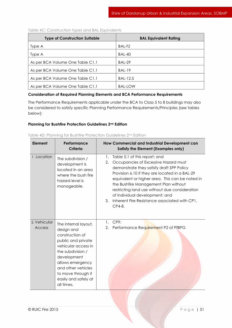
`
© RUIC Fire 2015 P a g e | 51
Shire of Dardanup Urban & Industrial Expansion Areas, SOBMP
Table 4C: Construction types and BAL Equivalents
Type of Construction Suitable BAL Equivalent Rating
Type A BAL-FZ
Type A BAL-40
As per BCA Volume One Table C1.1 BAL-29
As per BCA Volume One Table C1.1 BAL-19
As per BCA Volume One Table C1.1 BAL-12.5
As per BCA Volume One Table C1.1 BAL-LOW
Consideration of Required Planning Elements and BCA Performance Requirements
The Performance Requirements applicable under the BCA to Class 5 to 8 buildings may also
be considered to satisfy specific Planning Performance Requirements/Principles (see tables
below):
Planning for Bushfire Protection Guidelines 2nd Edition
Table 4D: Planning for Bushfire Protection Guidelines 2nd Edition
Element Performance
Criteria
How Commercial and Industrial Development can
Satisfy the Element (Examples only)
1. Location The subdivision /
development is
located in an area
where the bush fire
hazard level is
manageable.
1. Table 5.1 of this report; and
2. Occupancies of Excessive Hazard must
demonstrate they satisfy draft SPP Policy
Provision 6.10 if they are located in a BAL-29
equivalent or higher area. This can be noted in
the Bushfire Management Plan without
restricting land use without due consideration
of individual development; and
3. Inherent Fire Resistance associated with CP1,
CP4-8.
2. Vehicular
Access The internal layout,
design and
construction of
public and private
vehicular access in
the subdivision /
development
allows emergency
and other vehicles
to move through it
easily and safely at
all times.
1. CP9;
2. Performance Requirement P2 of PfBPG

`
© RUIC Fire 2015 P a g e | 52
Shire of Dardanup Urban & Industrial Expansion Areas, SOBMP
3. Water To ensure that
water is available
to the
development to
enable life and
property to be
defended from
bush fire.
1. Table 5.1 of this report (associated water and
firefighting requirements applicable to
individual buildings; and
2. Acceptable Solution A3.1of PfBPG –
Reticulated Hydrants complying with Water
Corporation DS63.
4. Siting The siting (including
paths and
landscaping) of
the development
minimises the bush
fire risk to life and
property.
1. Building Protection Zones are low fuel areas
immediately surrounding a building and are
designed to minimise the likelihood of flame
contact with buildings. Features such as
driveways, footpaths, roads, lawn or
landscaped garden (including deciduous trees
and fire resistant plant species) may form part of
building protection zones. Areas of vegetation
deemed Low Threat Vegetation and managed
in a reduced fuel state inclusive of Public Open
Space and nature strips may form part of a
building’s defendable space. Isolated shrubs
and trees may be retained within building
protection zones. The inherent design of
industrial and commercial developments
ultimately meets the standard required for a
Building Protection Zone throughout the estate
(conservation areas excepted); and
2. Table 5.1 of this report; and
3. CP9.
5. Design The design of the
development is
appropriate to the
level of bush fire
hazard that applies
to the
development site.
1. Table 5.1 of this report;
2. Occupancies of Excessive Hazard must
demonstrate they satisfy draft SPP Policy
Provision 6.10 if they are located in a BAL-29
equivalent or higher area. This can be noted in
the Bushfire Management Plan without
restricting land use without due consideration
of individual development; and
3. Inherent Fire Resistance associated with CP1,
CP4-9.
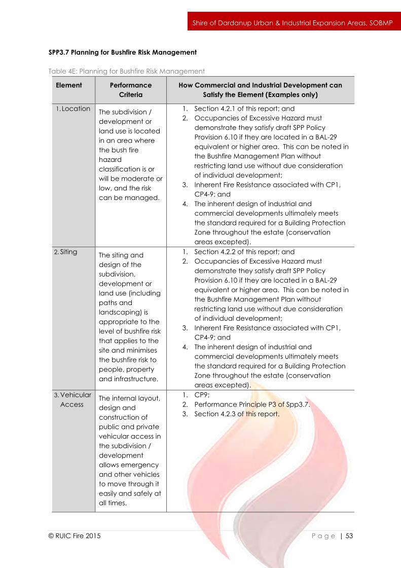
`
© RUIC Fire 2015 P a g e | 53
Shire of Dardanup Urban & Industrial Expansion Areas, SOBMP
SPP3.7 Planning for Bushfire Risk Management
Table 4E: Planning for Bushfire Risk Management
Element Performance
Criteria
How Commercial and Industrial Development can
Satisfy the Element (Examples only)
1. Location The subdivision /
development or
land use is located
in an area where
the bush fire
hazard
classification is or
will be moderate or
low, and the risk
can be managed.
1. Section 4.2.1 of this report; and
2. Occupancies of Excessive Hazard must
demonstrate they satisfy draft SPP Policy
Provision 6.10 if they are located in a BAL-29
equivalent or higher area. This can be noted in
the Bushfire Management Plan without
restricting land use without due consideration
of individual development;
3. Inherent Fire Resistance associated with CP1,
CP4-9; and
4. The inherent design of industrial and
commercial developments ultimately meets
the standard required for a Building Protection
Zone throughout the estate (conservation
areas excepted).
2. Siting The siting and
design of the
subdivision,
development or
land use (including
paths and
landscaping) is
appropriate to the
level of bushfire risk
that applies to the
site and minimises
the bushfire risk to
people, property
and infrastructure.
1. Section 4.2.2 of this report; and
2. Occupancies of Excessive Hazard must
demonstrate they satisfy draft SPP Policy
Provision 6.10 if they are located in a BAL-29
equivalent or higher area. This can be noted in
the Bushfire Management Plan without
restricting land use without due consideration
of individual development;
3. Inherent Fire Resistance associated with CP1,
CP4-9; and
4. The inherent design of industrial and
commercial developments ultimately meets
the standard required for a Building Protection
Zone throughout the estate (conservation
areas excepted).
3. Vehicular
Access The internal layout,
design and
construction of
public and private
vehicular access in
the subdivision /
development
allows emergency
and other vehicles
to move through it
easily and safely at
all times.
1. CP9;
2. Performance Principle P3 of Spp3.7.
3. Section 4.2.3 of this report.
`
© RUIC Fire 2015 P a g e | 54
Shire of Dardanup Urban & Industrial Expansion Areas, SOBMP
4. Water The subdivision,
development or
land use is
provided with a
permanent and
secure water
supply with that is
sufficient for
firefighting
purposes.
1. Section 4.2.1; and
2. Acceptable Solution A4.1of SPP3.7 –
Reticulated Hydrants complying with Water
Corporation DS63.
Summary
Through considered application of the inherent fire resistance required of Class 5 to 8 buildings
through the BCA in conjunction with relevant Performance Criteria and Performance Principles
of PfBPG and draft SPP3.7, the suitability of commercial and industrial development can be
demonstrated.
Whilst this report does not discuss the difference in occupant characteristics and scale of
individual building size between residential and commercial/industrial development, the
differences are considered to only further justify the approaches detailed.
References
ABCB. (2015). National Construction Code Building Code of Australia Volume One.
ABCB. (2015). National Construction Code Building Code of Australia Volume Two.
ABCB. (2015). National Construction Code Building Code of Australia Guide to Volume One
2015.
Australian Standard AS3959 .(2009). Construction of Buildings in Bushfire Prone Areas.
FESA. (2010). Planning for Bushfire Protection Guidelines 2nd Edition. Perth.
G. Penney. (2014). Draft FPA Good Practice Guide – Designing Industrial and Commercial
Development for Bushfire Resilience.
G. Penney. (2014). Draft FPA Good Practice Guide – Designing Critical Infrastructure for Bushfire
Resilience.
WAPC. (2014). Draft SPP 3.7 Planning for Bushfire Risk Management.
Where Critical Infrastructure is proposed within the Industrial Expansion Area, it is strongly
recommended a site and infrastructure specific Bushfire Management Plan should be
prepared by an accredited BPAD Level 3 Practitioner to the satisfaction of the Jurisdiction
Having Authority. This recommendation is based on the level of complexity involved in Critical
Infrastructure protection, the potential consequences of Critical Infrastructure being
damaged or destroyed and that no acceptable solutions or technical guidance are provided
in Western Australia for the protection of Critical Infrastructure.
The Building Protection Zone is a low fuel area immediately surrounding a building and is
designed to minimise the likelihood of flame contact with buildings. Features such as
driveways, footpaths, roads, lawn or landscaped garden (including deciduous trees and fire
resistant plant species) may form part of building protection zones. Areas of vegetation
deemed Low Threat Vegetation and managed in a reduced fuel state inclusive of Public
`
© RUIC Fire 2015 P a g e | 55
Shire of Dardanup Urban & Industrial Expansion Areas, SOBMP
Open Space and nature strips may form part of a building’s defendable space. Isolated shrubs
and trees may be retained within building protection zones. Due to the nature of the industrial
development within the Industrial Expansion Area, once completed the entire site shall meet
the standard of the Building Protection Zone.
The “Vegetation key: Comprehensive Field Guide for Bushfire Attack Level Assessors using
AS3959” may be referred to for additional guidance in determining suitable landscaping within
the Building Protection Zone.
Unmanaged vacant lots are recognised as a potential bushfire hazard to adjacent developed
lots. To mitigate this hazard, vacant lots should be managed at all times through slashing or in
a mosaic manner consistent with AS3959 s2.2.3.2(c) or (d). Alternatively lots should be
managed in a manner that is approved by the Local Government.
(a) Standard:
i. Areas of vegetation are to be less than 0.25ha in area and not within 20m of
other areas of vegetation or within 20m of developed lots (see Figure 4B for
guidance); and
ii. Vegetation strips, regardless of length, must be less than 20m in width and not
within 20m of other areas of vegetation or developed lots (note Nature Strips
that are located in road reserves and are less than 5m wide are exempt from
the requirement to be separated from developed lots by 20m); or
iii. Lots are to be managed in a manner that is approved by the Local
Government.
(b) Implementation:
i. Vacant lots must meet the standard if they are within 100m of a developed lot.
(c) Development:
i. It is the responsibility of the developer to ensure all unsold lots meet the
standard as required.
ii. It is the responsibility of the land owner to ensure all sold vacant lots meet the
standard as required.
(d) Maintenance:
i. It is the responsibility of the land owner to ensure vacant lots meet the standard
at all times.

`
© RUIC Fire 2015 P a g e | 56
Shire of Dardanup Urban & Industrial Expansion Areas, SOBMP
Figure 4B: Low Threat vegetation landscaping
As per Section 4.1.3
Intent: To ensure that water is available to the subdivision, development or land use to enable
people, property and infrastructure to be defended from bushfire.
Performance Principle (P4): The subdivision, development or land use is provided with a
permanent and secure water supply that is sufficient for firefighting purposes.
Design of future subdivisions within the Industrial Expansion Area must satisfy the performance
requirement of providing permanent firefighting water reserves allowing for a maximum 20
minute turnaround time for fire appliances with sufficient water supply for the scale of the
development. This may be achieved using either reticulated firefighting water supply
specifications as outlined in Water Corporation Design Standard DS63, the provision of
dedicated public firefighting water tanks or other suitable performance based design solution.
The water supply of each subdivision should be designed to be stand alone and should not
rely on water supply from another subdivision unless it is part of an overall reticulated firefighting
water supply.
`
© RUIC Fire 2015 P a g e | 57
Shire of Dardanup Urban & Industrial Expansion Areas, SOBMP
5.0 References
Bureau of Meteorology. (2015). Climate Data Online. Retrieved from www.bom.gov.au.
Ellis, S., Kanowski, P., & Whelan, R. (2004). National Inquiry on Bushfire Mitigation and
Management. Council of Australian Governments.
FESA. (2010). Planning for Bush Fire Protection Guidelines 2nd Edition Perth: Western Australian
Planning Commission Fire and Emergency Services Authority of Western Australia.
RUIC Fire. (2013.) Bushfire Attack Level Calculator v7.f.
Standards Australia. (2009). AS 3959:2009 Construction of buildings in bushfire prone areas: SAI
Global.
Standards Australia. (2009). ISO AS 31000:2009 Risk management principles and guidelines:
SAI Global.
Standards Australia. (2013). HB89:2013 Risk management - Guidelines on risk assessment
techniques (Vol. HB 89:2013). Sydney: SAI Global.
Standards Australia. (2013). HB 436:2013 Risk management guidelines - Companion to AS/NZS
ISO 31000:2009 (Vol. HB436:2013). Sydney: SAI Global.
WAPC. (2006). State Planning Policy 3.4 Natural Hazards and Disasters. State Law Publisher.
WAPC. (2013). Planning Bulletin 111/2013 Planning for Bushfire. Western Australian Planning
Commission.
WAPC. (2014a) Draft State Planning Policy 3.7 Planning for Bushfire Risk Management. West
Australian Planning Commission.
WAPC. (2014b) Draft State Planning Policy 3.7 Planning for Bushfire Risk Management
Guidelines. West Australian Planning Commission.
WAPC. (2014c) Draft State Planning Policy 3.7 Planning for Bushfire Risk Management
Guidelines Appendixes. West Australian Planning Commission, Department of Fire and
Emergency Services.
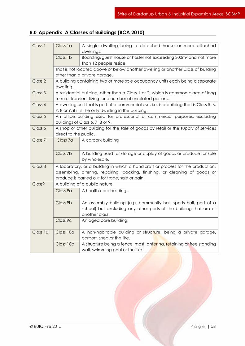
`
© RUIC Fire 2015 P a g e | 58
Shire of Dardanup Urban & Industrial Expansion Areas, SOBMP
6.0 Appendix A Classes of Buildings (BCA 2010)
Class 1 Class 1a A single dwelling being a detached house or more attached
dwellings.
Class 1b Boarding/guest house or hostel not exceeding 300m2 and not more
than 12 people reside.
That is not located above or below another dwelling or another Class of building
other than a private garage.
Class 2 A building containing two or more sole occupancy units each being a separate
dwelling.
Class 3 A residential building, other than a Class 1 or 2, which is common place of long
term or transient living for a number of unrelated persons.
Class 4 A dwelling unit that is part of a commercial use, i.e. is a building that is Class 5, 6,
7, 8 or 9, if it is the only dwelling in the building.
Class 5 An office building used for professional or commercial purposes, excluding
buildings of Class 6, 7, 8 or 9.
Class 6 A shop or other building for the sale of goods by retail or the supply of services
direct to the public.
Class 7 Class 7a A carpark building
Class 7b A building used for storage or display of goods or produce for sale
by wholesale.
Class 8 A laboratory, or a building in which a handicraft or process for the production,
assembling, altering, repairing, packing, finishing, or cleaning of goods or
produce is carried out for trade, sale or gain.
Class9 A building of a public nature.
Class 9a A health care building.
Class 9b An assembly building (e.g. community hall, sports hall, part of a
school) but excluding any other parts of the building that are of
another class.
Class 9c An aged care building.
Class 10 Class 10a A non-habitable building or structure, being a private garage,
carport, shed or the like.
Class 10b A structure being a fence, mast, antenna, retaining or free standing
wall, swimming pool or the like.