bushfire management plan - department of planning, … · web viewbushfire management plan –...
TRANSCRIPT
Bushfire Management Plan – Strategic Planning Proposals – BHL assessment
Table of Contents
Executive Summary (optional)
1: Proposal Details2: Environmental Considerations2.1: Native Vegetation – modification and clearing
2.2: Re-vegetation / Landscape Plans
3: Bushfire Assessment Results3.1: Assessment Inputs
3.2: Assessment Outputs
4: Identification of Bushfire Hazard Issues5. Assessment against the Bushfire Protection Criteria5.1: Compliance Table
5.2: Additional management strategies
6: Responsibilities for Implementation and Management of the Bushfire Measures
List of figuresFigure 1: Copy of strategic planning proposal
Figure 2: Site overview
Figure 3: Map of Bushfire Prone Areas for subject site
Figure 4: Pre-development vegetation class and effective slope
Figure 5: Pre-development BHL assessment
Figure 6: Issues Plan
Figure 7: Spatial representation of the bushfire management strategies (post-development BHL assessment)
List of appendices

Bushfire Management Plan – Strategic Planning Proposals – BHL assessment
Full Content Detail
Bushfire Management Plan Coversheet
Insert a BMP coversheet (as per coversheet issued by Department of Planning, Lands and Heritage (DPLH) or Fire Protection Association of Australia).
The current DPLH template can be found at www.planning.wa.gov.au under bushfire planning publications. The coversheet is to be included as the front page of the BMP.
Ensure all relevant details of the coversheet are completed, including accreditation details and checking the box for ‘Strategic Planning Proposals’ to trigger referral to Department of Fire and Emergency Services.
Cover Page - Content determined by report author.
Document control
Client: Insert client name
Report Version Purpose Author/reviewer and accreditation details Date Submitted
Disclaimer
Executive Summary (optional)
This section is optional, but can be useful in providing a one page summary of the following information, particularly for more complex planning proposals: overview of the planning proposal, development context and necessary bushfire assessment
and reporting requirements existing on-ground conditions and key results of bushfire assessment bushfire management strategies that will be incorporated into development design in order to
demonstrate compliance with bushfire protection criteria summary of key management responsibilities going forward.

Bushfire Management Plan – Strategic Planning Proposals – BHL assessment
Section 1: Proposal Details
Do not: paraphrase or repeat sections State Planning Policy 3.7 or the Guidelines for Planning in Bushfire Prone AreasDo not include: climate, bushfire history, prevailing winds
Provide a brief overview of the planning proposal and resulting intensification of land use.
Acknowledgement of any known reports or plans that have been prepared for previous planning stages, that refer to the subject area and that may or will impact the assessment of bushfire risk and/or the implementation of bushfire risk management measures and will be referenced in the BMP (e.g. structure plan, environmental report, landscaping plan or any relevant bushfire risk assessments).
FIGURE 1: Copy of strategic planning proposal
If available, include a map of the strategic planning proposal to tie the BMP to the planning application (this can be provided by the planning consultant).
FIGURE 2: Site overview
Include a map that depicts a spatial overview of existing site conditions, such as existing cadastral detail, an outline of the site boundary and label any areas of significance to the BMP (e.g. existing local reserves, State Forest, National Park, wetlands, Bush Forever sites, etc). The map should be overlaid on an up-to-date aerial image. The map extent should be appropriate to the size of the development and depict the full site boundary plus the broader spatial context surrounding the site. This will ensure consideration is given to the wider road network, proximity of settlements to the subject site and the broader vegetation extent.
FIGURE 3: Map of Bushfire Prone Areas for subject site
Screen shot of Map of Bushfire Prone Areas for the subject site and surrounds.
2 | P a g e

Bushfire Management Plan – Strategic Planning Proposals – BHL assessmentSection 2: Environmental Considerations
Some bushfire prone areas also have high biodiversity values. SPP 3.7 policy objective 5.4 recognises the need to consider bushfire risk management measures alongside environmental, biodiversity and conservation values.
Subsection 2.1: Native Vegetation – modification and clearing
1. Identify whether on-site clearing of native vegetation will be required and whether this may trigger potential environmental impact/referral requirements under State and Federal environmental legislation, such as:
conservation covenants; bush forever sites; conservation category wetlands and buffer; threatened ecological communities (TECs); declared rare flora (DRFs); and land identified as significant through a Local Planning Strategy or Local Biodiversity
Strategy.
This information can be provided by the project environmental consultant/planner/developer or alternatively can be obtained through publicly available databases (SLIP database and/or a Local Biodiversity Strategy).
Confirmation should be included from the relevant agencies that the proposed clearing is acceptable.
2. Identify alternative bushfire management design solutions that may reduce the extent of vegetation clearing. These include: reduction of lot yield; cluster development; construction of the building to a higher standard as per BCA and AS3959; and/or modification to the development location.
Subsection 2.2: Re-vegetation/Landscape Plans
Identify those areas required or intended to be re-vegetated or retained as part of the proposal. These may include riparian zones and wetland or foreshore buffers. This may also include areas of public open space.
Written evidence and /or an approved Landscape Plan should be provided to demonstrate that the agency responsible for the on-going management (ie. local government and / or Department of Biodiversity, Conservation and Attractions) understand and support the vegetation classification assigned to the subject area.
3 | P a g e
Bushfire Management Plan – Strategic Planning Proposals – BHL assessmentSection 3: Bushfire Assessment Results For strategic planning proposals where lot layout is not yet known, a Bushfire Hazard Level (BHL)
assessment is required in accordance with Appendix 2 of the Guidelines. Only where the BMP has been prepared to support both a strategic proposal and a subsequent
stage where lot layout is known (such as a structure plan), can a BAL Contour be prepared in absence of the BHL assessment.
Subsection 3.1: Assessment inputs
Provide results of a site assessment in accordance with Appendix 2 of these Guidelines. Insert site photos to support the vegetation classification.
Photo IDPlot numberVegetation classification or exclusion clauseDescription / justification for classification
Insert photo
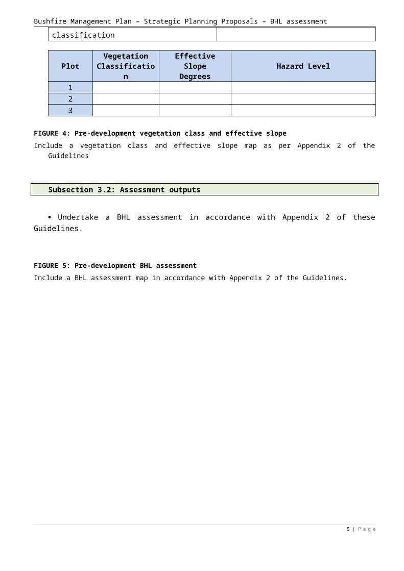
Plot Vegetation Classification
Effective SlopeDegrees Hazard Level
123
FIGURE 4: Pre-development vegetation class and effective slopeInclude a vegetation class and effective slope map as per Appendix 2 of the Guidelines
Subsection 3.2: Assessment outputs
Undertake a BHL assessment in accordance with Appendix 2 of these Guidelines.
FIGURE 5: Pre-development BHL assessmentInclude a BHL assessment map in accordance with Appendix 2 of the Guidelines.
4 | P a g e

Bushfire Management Plan – Strategic Planning Proposals – BHL assessment
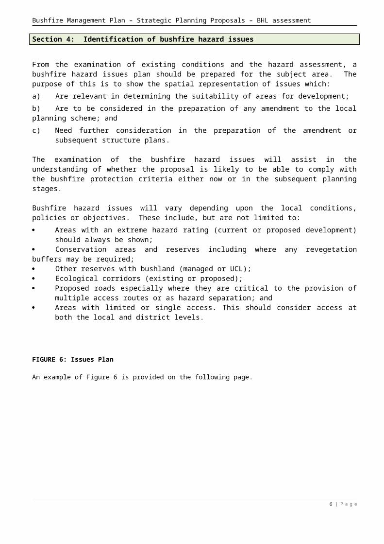
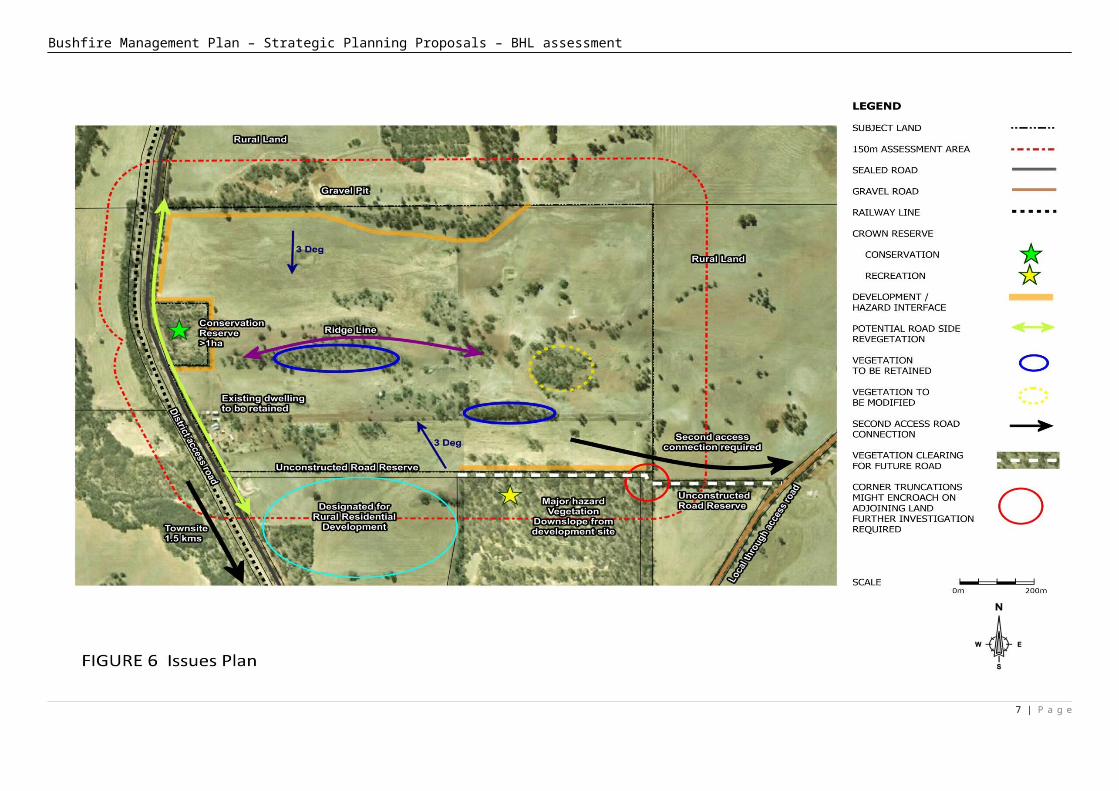
Section 4: Identification of bushfire hazard issues
From the examination of existing conditions and the hazard assessment, a bushfire hazard issues plan should be prepared for the subject area. The purpose of this is to show the spatial representation of issues which:a) Are relevant in determining the suitability of areas for development;b) Are to be considered in the preparation of any amendment to the local planning scheme; andc) Need further consideration in the preparation of the amendment or subsequent structure plans.
The examination of the bushfire hazard issues will assist in the understanding of whether the proposal is likely to be able to comply with the bushfire protection criteria either now or in the subsequent planning stages.
Bushfire hazard issues will vary depending upon the local conditions, policies or objectives. These include, but are not limited to: Areas with an extreme hazard rating (current or proposed development) should always be
shown; Conservation areas and reserves including where any revegetation buffers may be required; Other reserves with bushland (managed or UCL); Ecological corridors (existing or proposed); Proposed roads especially where they are critical to the provision of multiple access routes or
as hazard separation; and Areas with limited or single access. This should consider access at both the local and district
levels.
FIGURE 6: Issues Plan
An example of Figure 6 is provided on the following page.
5 | P a g e
Bushfire Management Plan – Strategic Planning Proposals – BHL assessment
6 | P a g e
Bushfire Management Plan – Strategic Planning Proposals – BHL assessment
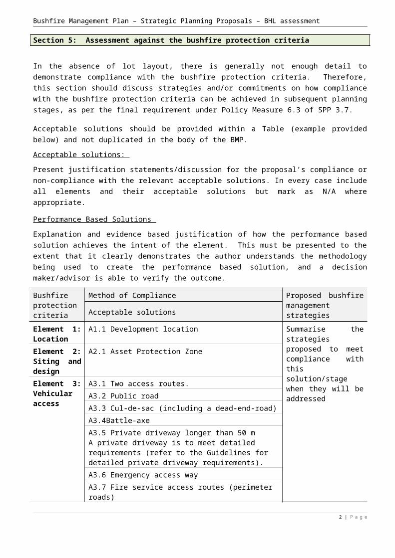
Section 5: Assessment against the bushfire protection criteria
In the absence of lot layout, there is generally not enough detail to demonstrate compliance with the bushfire protection criteria. Therefore, this section should discuss strategies and/or commitments on how compliance with the bushfire protection criteria can be achieved in subsequent planning stages, as per the final requirement under Policy Measure 6.3 of SPP 3.7.
Acceptable solutions should be provided within a Table (example provided below) and not duplicated in the body of the BMP.
Acceptable solutions:
Present justification statements/discussion for the proposal’s compliance or non-compliance with the relevant acceptable solutions. In every case include all elements and their acceptable solutions but mark as N/A where appropriate.
Performance Based Solutions
Explanation and evidence based justification of how the performance based solution achieves the intent of the element. This must be presented to the extent that it clearly demonstrates the author understands the methodology being used to create the performance based solution, and a decision maker/advisor is able to verify the outcome.
Bushfire protection criteria
Method of Compliance Proposed bushfire management strategiesAcceptable solutions
Element 1: Location
A1.1 Development location Summarise the strategies proposed to meet compliance with this solution/stage when they will be addressed
Element 2: Siting and design
A2.1 Asset Protection Zone
Element 3: Vehicular access
A3.1 Two access routes.
A3.2 Public road
A3.3 Cul-de-sac (including a dead-end-road)
A3.4Battle-axe
A3.5 Private driveway longer than 50 mA private driveway is to meet detailed requirements (refer to the Guidelines for detailed private driveway requirements).A3.6 Emergency access way
A3.7 Fire service access routes (perimeter roads)
A3.8 Firebreak width
Element 4: Water
A4.1 Reticulated areasA4.2 Non-reticulated areasA4.3 Individual lots within non-reticulated areas (Only for use if creating 1 additional lot and cannot be applied cumulatively)
2 | P a g e
Bushfire Management Plan – Strategic Planning Proposals – BHL assessment
FIGURE 7: Spatial representation of the bushfire management strategies (post-development BHL assessment)
Insert figure showing the indicative development footprint/management (if available) on an aerial image of the site and the subsequent reduction in bushfire hazard level to demonstrate that a low/moderate bushfire hazard level can be achieved.
2 | P a g e
Bushfire Management Plan – Strategic Planning Proposals – BHL assessment
3 | P a g e

Bushfire Management Plan – Strategic Planning Proposals – BHL assessment
Section 6: Responsibilities for Implementation & Management of the Bushfire Measures
Summarise the bushfire assessment and BMP reporting information that is likely to be required to accompany future planning applications (i.e. Bushfire Management Plans and BAL assessment/contour mapping to accompany future Structure Plans, application for subdivision or development approval in order to address the relevant SPP 3.7 requirements).
Outline the responsibilities for ongoing bushfire work. Summarise the bushfire management strategies that will need to be considered as part of future
Bushfire Management Plans and lot design for the site.
2 | P a g e
Bushfire Management Plan – Strategic Planning Proposals – BHL assessment
Appendices
Include documentation to support the BMP and assist with demonstration of bushfire management criteria.
Information can be provided in the Appendices for the landowner. It should be clearly labelled as such.
3 | P a g e