stream temperature prediction in ungauged basins: review ... · pdf file3faculty of applied...
TRANSCRIPT

Hydrol. Earth Syst. Sci., 19, 3727–3753, 2015
www.hydrol-earth-syst-sci.net/19/3727/2015/
doi:10.5194/hess-19-3727-2015
© Author(s) 2015. CC Attribution 3.0 License.
Stream temperature prediction in ungauged basins: review of recent
approaches and description of a new physics-derived statistical
model
A. Gallice1, B. Schaefli1, M. Lehning1,2, M. B. Parlange1,3, and H. Huwald1
1School of Architecture, Civil and Environmental Engineering (ENAC),
École Polytechnique Fédérale de Lausanne (EPFL), Switzerland2SLF, WSL Institute for Snow and Avalanche Research, 7260 Davos, Switzerland3Faculty of Applied Sciences, University of British Columbia, Vancouver, Canada
Correspondence to: A. Gallice ([email protected])
Received: 23 February 2015 – Published in Hydrol. Earth Syst. Sci. Discuss.: 24 April 2015
Revised: 30 July 2015 – Accepted: 6 August 2015 – Published: 1 September 2015
Abstract. The development of stream temperature regression
models at regional scales has regained some popularity over
the past years. These models are used to predict stream tem-
perature in ungauged catchments to assess the impact of hu-
man activities or climate change on riverine fauna over large
spatial areas. A comprehensive literature review presented
in this study shows that the temperature metrics predicted
by the majority of models correspond to yearly aggregates,
such as the popular annual maximum weekly mean temper-
ature (MWMT). As a consequence, current models are of-
ten unable to predict the annual cycle of stream tempera-
ture, nor can the majority of them forecast the inter-annual
variation of stream temperature. This study presents a new
statistical model to estimate the monthly mean stream tem-
perature of ungauged rivers over multiple years in an Alpine
country (Switzerland). Contrary to similar models developed
to date, which are mostly based on standard regression ap-
proaches, this one attempts to incorporate physical aspects
into its structure. It is based on the analytical solution to a
simplified version of the energy-balance equation over an
entire stream network. Some terms of this solution cannot
be readily evaluated at the regional scale due to the lack of
appropriate data, and are therefore approximated using clas-
sical statistical techniques. This physics-inspired approach
presents some advantages: (1) the main model structure is
directly obtained from first principles, (2) the spatial extent
over which the predictor variables are averaged naturally
arises during model development, and (3) most of the regres-
sion coefficients can be interpreted from a physical point of
view – their values can therefore be constrained to remain
within plausible bounds. The evaluation of the model over a
new freely available data set shows that the monthly mean
stream temperature curve can be reproduced with a root-
mean-square error (RMSE) of ±1.3 ◦C, which is similar in
precision to the predictions obtained with a multi-linear re-
gression model. We illustrate through a simple example how
the physical aspects contained in the model structure can be
used to gain more insight into the stream temperature dynam-
ics at regional scales.
1 Introduction
Among the parameters affecting the ecological processes in
streams, temperature occupies a predominant role. It influ-
ences the concentration of chemicals, such as dissolved oxy-
gen, and may increase the toxicity of dissolved substances
(Langford, 1990). It also affects the life cycle of many fish
species, particularly the salmonids whose rate of spawning,
timing of birth and rate of death are directly influenced by
stream temperature (Caissie, 2006; Benyahya et al., 2007).
Water temperature is also a relevant factor for many thermal
power plants which rely on cooling by river water, and whose
electricity production decreases when water temperature ex-
ceeds a certain limit (Haag and Luce, 2008).
As a result of the rising concern about climate change and
water management impacts on aquatic life, stream tempera-
Published by Copernicus Publications on behalf of the European Geosciences Union.

3728 A. Gallice et al.: Stream temperature prediction in ungauged basins
ture modelling has regained some interest over the past 10–
15 years. This fostered the development of many stochastic
and deterministic models (e.g. Mohseni et al., 1998; Segura
et al., 2014; Chang and Psaris, 2013; DeWeber and Wagner,
2014; Meier et al., 2003; Westhoff et al., 2007). The for-
mer type relies on a statistical analysis to empirically relate
stream temperature to climatic and physiographic variables,
such as air temperature, discharge, altitude or channel width
(see Benyahya et al., 2007, for a complete review of this
subject). Deterministic models, on the other hand, rely on
a physically based formulation of the stream energy conser-
vation to compute water temperature (Caissie, 2006). Both
model types have usually been applied to a single stream
reach or a limited number of catchments (e.g. Sinokrot and
Stefan, 1993; Roth et al., 2010; Caissie et al., 2001; Cald-
well et al., 2013; Grbic et al., 2013). As a response to the
lack of stream temperature data, some studies have recently
attempted to develop regionalized models. This effort was
certainly encouraged by the incentive of the International As-
sociation of Hydrological Sciences (IAHS), which set the fo-
cus of the last decade on hydrological prediction in ungauged
basins (Sivapalan et al., 2003; Hrachowitz et al., 2013). In
the case of stream temperature, the difficulty in meeting the
data requirements of the physically based models led the au-
thors to mostly rely on statistical approaches to make predic-
tions in ungauged catchments. However, the validity of these
models for studying climate change impacts or water man-
agement techniques has not been assessed yet.
In this paper, more than 30 studies describing regionalized
statistical models for stream temperature estimation were re-
viewed to put our work in a larger context (see Table 1). The
extensive introduction below discusses several aspects of the
reviewed literature which motivated the development of the
novel stream temperature model described in the next sec-
tion.
1.1 Predictions with limited precision
One recurring issue described in the reviewed literature is
the difficulty in predicting stream temperature with a high
level of precision. A typical example is the statistical model
of Isaak et al. (2010) for the estimation of mean summer
stream temperature (15 July–15 September) in the Boise
River basin, Idaho. Despite considering a significant num-
ber of predictor variables and two different modelling ap-
proaches a priori, Isaak et al. (2010) could not reduce the
root-mean-square error (RMSE) of their model below 1.5 ◦C.
Prediction uncertainties of the same order of magnitude are
reported e.g. by Wehrly et al. (2009), Ruesch et al. (2012),
Moore et al. (2013) or Hill et al. (2013).
In general, it seems that the model error originates partly
from the lack of appropriate field data, such as measures of
riparian shading, groundwater infiltration or irrigation with-
drawals (Moore et al., 2013). As noted by Hill et al. (2013),
“these types of data are not readily available everywhere and
will take time to develop”. In the meantime, they can in some
circumstances be accounted for through indirect measures.
For example, Tague et al. (2007) used the geological aquifer
type as a proxy for the presence or absence of groundwa-
ter infiltration. Similarly, Hrachowitz et al. (2010) and Scott
et al. (2002) estimated riparian shading based on riparian for-
est coverage, computed over buffer areas of various widths
and lengths around the streams. In the absence of such prox-
ies, the model cannot represent some known processes and
must concede some increase in its prediction error (Moore
et al., 2013). The size of the areas over which stream tem-
perature is modelled – and hereby the diversity of encoun-
tered climatic and geomorphologic conditions – constitutes
another factor potentially explaining the model uncertainties
for some studies.
Regarding the impact of the modelling approach, Wehrly
et al. (2009) investigated four different statistical model types
and showed that their difference in prediction accuracy was
relatively small. The same conclusion was reached by Daigle
et al. (2010), who compared four other modelling techniques.
Isaak et al. (2010) found that networked kriging regression
performed better than multi-linear regression over the cali-
bration data set, but this assertion became much less evident
over the validation set. Similarly, Pratt and Chang (2012)
and Chang and Psaris (2013) concluded that geographically
weighted regression is slightly more accurate than multi-
linear regression, but they did not validate their results on
an independent data set. These studies tend to suggest that
no significant decrease in the prediction errors should be
awaited from a change in the statistical modelling technique.
Further comparisons between the different models re-
ported in the literature are unfortunately hindered by the di-
versity of temperature metrics and error measures used by
the authors. As mentioned in several studies already, we ad-
vocate here the systematic use of the different error mea-
sures that are RMSE, bias and coefficient of determination
R2 for the evaluation of the model precision, possibly com-
bined with a benchmark model (Schaefli and Gupta, 2007). It
should be noted that R2 is also referred to as Nash–Sutcliffe
efficiency by the hydrological community (Nash and Sut-
cliffe, 1970), and is defined as 1 minus the ratio of the model
error variance over the variance of the observed data.
1.2 Few models can predict the stream temperature
annual cycle
Inspecting Table 1, it can be seen that most regionalization
efforts have concentrated on some particular periods of the
year. For example, Jones et al. (2006), Isaak et al. (2010) and
Chang and Psaris (2013) focused on the annual maximum of
the 7-day moving average of the daily maximum temperature
(MWMT). Similarly, both Pratt and Chang (2012) and Hill
et al. (2013) aimed at estimating mean stream temperature in
summer and winter. Very few studies have actually attempted
Hydrol. Earth Syst. Sci., 19, 3727–3753, 2015 www.hydrol-earth-syst-sci.net/19/3727/2015/

A. Gallice et al.: Stream temperature prediction in ungauged basins 3729
Table 1. List of reviewed publications about statistical stream temperature prediction in ungauged basins.
ReferenceGeographic Model Number of Number of Temporal
Model precisionb,c
location typea sites yearsb scale
Arscott et al. (2001) Italy MLR 22 1 Season R2= 0.37–0.8
Bogan et al. (2003) Eastern USA AE 596 30 Week R2= 0.80, σe = 3.1 ◦C
Chang and Psaris (2013) Western USA MLR, GWR 74 n/a Week, year R2= 0.52–0.62, σe = 2.0–2.3 ◦C
Daigle et al. (2010) Western Canada Various 16 0.5 Month σe = 0.9–2.8 ◦C
DeWeber and Wagner (2014) Eastern USA ANN 1080 31 Day σe = 1.8–1.9 ◦C
Ducharne (2008) France MLR 88 7 Month R2= 0.88–0.96, σe = 1.4–1.9
Gardner and Sullivan (2004) Eastern USA NKM 72 1 Day σe = 1.4 ◦C
Garner et al. (2014) UK CA 88 18 Month n/a
Hawkins et al. (1997) Western USA MLR 45 ≥ 1 Year R2= 0.45–0.64
Hill et al. (2013) Conterminous USA RF ∼ 1000 1/site Season, year σe = 1.1–2.0 ◦C
Hrachowitz et al. (2010) UK MLR 25 1 Month, year R2= 0.50–0.84
Imholt et al. (2013) UK MLR 23 2 Month R2= 0.63–0.87
Isaak et al. (2010) Western USA MLR, NKM 518 14 Month, year R2= 0.50–0.61, σe = 2.5–2.8 ◦C
Isaak and Hubert (2001) Western USA PA 26 1/site Season R2= 0.82
Johnson (1971) New Zealand ULR 6 1 Month n/a
Johnson et al. (2014) UK NLR 36 1.5 Day R2= 0.67–0.90, σe = 1.0–2.4 ◦C
Jones et al. (2006) Eastern USA MLR 28 3 Year R2= 0.57–0.73
Kelleher et al. (2012) Eastern USA MLR 47 2 Day, week n/a
Macedo et al. (2013) Brazil LMM 12 1.5 Day R2= 0.86
Mayer (2012) Western USA MLR 104 ≥ 2 Week, month R2= 0.72, σe = 1.8 ◦C
Miyake and Takeuchi (1951) Japan ULR 20 n/a Month n/a
Moore et al. (2013) Western Canada MLR 418 1/site Year σe = 2.1 ◦C
Nelitz et al. (2007) Western Canada CRT 104 1/site Year n/a
Nelson and Palmer (2007) Western USA MLR 16 3 Season R2= 0.36–0.88
Ozaki et al. (2003) Japan ULR 5 8 Day n/a
Pratt and Chang (2012) Western USA MLR, GWR 51 1/site Season R2= 0.48–078
Risley et al. (2003) Western USA ANN 148 0.25 Hour, season σe = 1.6–1.8 ◦C
Rivers-Moore et al. (2012) South Africa MLR 90 1/site Month, year R2= 0.14–0.50
Ruesch et al. (2012) Western USA NKM 165 15 Year R2= 0.84, σe = 1.5 ◦C
Segura et al. (2014) Conterminous USA MLR 171 ≥ 1.5 Week, month R2= 0.79
Sponseller et al. (2001) Eastern USA MLR 9 1 Year R2= 0.81–0.93
Scott et al. (2002) Eastern USA MLR 36 1/site Season R2= 0.82
Stefan and Preud’homme (1993) Eastern USA ULR 11 n/a Day, week σe = 2.1–2.7 ◦C
Tague et al. (2007) Western USA MLR 43 4 Day R2= 0.49–0.65
Wehrly et al. (2009) Eastern USA Various 1131 1/site Month σe = 2.0–3.0 ◦C
Westenbroek et al. (2010) Eastern USA ANN 254 1/site Day R2= 0.70, σe = 1.8 ◦C
Young et al. (2005) New Zealand MLR 23 1 Season R2= 0.75–0.93
a AE: analytical expression; ANN: artificial neural network; CA: cluster analysis; CRT: classification and regression trees; GWR: geographically weighted regression; LMM: linear mixed model; MLR:
multi-linear regression; NKM: networked kriging model; NLR: non-linear regression; PA: path analysis; RF: random forest; ULR: univariate linear regression.b n/a: not available.c σe : root-mean-square error; R2: coefficient of determination (sometimes referred to as the Nash–Sutcliffe index).
to derive regional models to compute the complete annual
cycle of stream temperature over several years.
Miyake and Takeuchi (1951) and Stefan and
Preud’homme (1993) were probably the first authors to
address this issue; they relied on linear regression against
air temperature to simultaneously estimate stream tem-
perature at multiple sites. However, their respective works
are restricted to a limited number of rivers (20 and 11,
respectively) and could probably not be applied to larger
areas. In an attempt at generalizing these models, Ozaki
et al. (2003) and Kelleher et al. (2012) separately regressed
stream temperature against air temperature in each one of the
catchments they considered, and subsequently regionalized
the slopes of the regression lines. However, both studies
were only partly successful in completing the regionaliza-
tion step, since the modelled regression slopes had large
prediction errors. They would additionally have had to
model the intercepts of the regression lines to completely
regionalize the stream–air temperature relationship. In a
similar fashion, Johnson et al. (2014) relied on the logistic
equation introduced by Mohseni et al. (1998) to relate stream
temperature to air temperature in each catchment. Also,
they faced difficulties in regressing the equation parameters
against geomorphological properties of the catchments.
The two most complete works on the regionalization of the
linear stream–air temperature relationship were recently
conducted by Ducharne (2008) and Segura et al. (2014).
These two studies attempted to regionalize both the slopes
www.hydrol-earth-syst-sci.net/19/3727/2015/ Hydrol. Earth Syst. Sci., 19, 3727–3753, 2015

3730 A. Gallice et al.: Stream temperature prediction in ungauged basins
and intercepts of the regression lines between stream and
air temperature. To this end, Ducharne (2008) grouped the
streams according to their Strahler order and fitted a single
line in each group. Segura et al. (2014), on the other end,
expressed the slopes and intercepts as linear combinations
of climatic and physiographic variables. The model of
Ducharne (2008) had nominally a higher explanatory power
(R2= 0.88− 0.96, depending on the Strahler order) than
Segura et al. (2014)’s model (R2= 0.79), but was effectively
based on about 10 times fewer rivers.
Instead of using air temperature as an independent vari-
able, Bogan et al. (2003) relied on equilibrium temperature.
This variable corresponds to the stream temperature at which
the net energy flux at the air–water interface vanishes (e.g.
Edinger et al., 1968). It was shown by Bogan et al. (2003)
to be a fairly good estimator of stream temperature for al-
most 600 rivers in the eastern and central United States, with
a prediction error of about 3 ◦C.
As an alternative to the above-mentioned studies, the an-
nual cycle of stream temperature has been modelled by some
authors as a function of time directly, rather than air or
equilibrium temperature. Hrachowitz et al. (2010), Imholt
et al. (2013) and Rivers-Moore et al. (2012) expressed water
temperature as a linear combination of climatic and phys-
iographic variables for each month of the year separately.
Their models were derived for a particular year, but can be
transferred to other years by estimating stream temperature
at a few measurement points using Mohseni’s logistic equa-
tion and fitting the multi-linear regression model to the re-
sulting values (Hrachowitz et al., 2010). Based on a similar
approach, Macedo et al. (2013) succeeded in deriving one
single regression model to estimate daily mean stream tem-
perature at 12 different sites in Brazil over 1.5 years. The
performance of their model was not tested using data from
subsequent years, though.
Johnson (1971) relied on another different technique to
estimate the thermal regime of six rivers in New Zealand.
He first fitted the stream temperature annual cycles with
sine curves. In a second step, he identified the physiographic
properties of the catchments which best correlated with the
fit coefficients. The focus of his study being on the investi-
gation of these physiographic properties, he did not evaluate
the prediction error of his model. Although not intended for
this purpose, the work of Garner et al. (2014) is based on
a somewhat similar approach and may be used to get a first
estimate of the annual cycle of temperature in UK streams.
The authors classified rivers into several groups according to
the shape and magnitude of their respective thermal regimes.
Then, they investigated the similarities and dissimilarities of
some geomorphological properties among and between the
groups. This processing could be inverted to infer the thermal
regime from the physiographic properties of the catchments.
Finally, some studies have evaluated the possibility of
modelling the time evolution of stream temperature using
machine learning techniques. For example, DeWeber and
Wagner (2014) trained an artificial neural network to repro-
duce daily mean temperature values from May to October
over more than 30 years for 1080 streams in the eastern
United States. Their approach could be easily extended so
as to model the complete annual cycle of stream temperature
each year.
1.3 Space-averaging of the predictor variables
Some of the reviewed publications on regional stream tem-
perature modelling addressed the question of the spatial scale
over which the predictor variables should be averaged. It is
common knowledge that stream temperature is not only af-
fected by local environmental conditions, but also by the con-
ditions prevailing upstream. However, the exact extent of the
area controlling the stream energy balance at a given point is
not clear (Moore et al., 2005).
Due to this uncertainty, different approaches have been
used in the literature to average the predictor variables. Based
on studies of the effect of forest harvesting on stream tem-
perature (e.g. Moore et al., 2005), some authors considered
riparian buffer zones of various widths and lengths as aver-
aging areas. This approach was usually applied to average
the land cover characteristics only, particularly forest cover-
age (e.g. Sponseller et al., 2001; Scott et al., 2002; Macedo
et al., 2013; Segura et al., 2014), but also in some cases to
average most of the predictor variables, including elevation
or slope (Hrachowitz et al., 2010; Imholt et al., 2013). Other
authors considered larger portions of the catchments as av-
eraging areas, sometimes extending far beyond the riparian
zone. For example, Wehrly et al. (2009) used the whole area
drained by the stream segment located directly upstream of
the temperature measurement point. Whereas most studies
relied on simple spatial averaging, a few of them applied
a weighting scheme to give more emphasis to the condi-
tions prevailing near the gauging point. As such, Isaak et al.
(2010) and Hill et al. (2013) applied a weight w decreas-
ing exponentially with the distance d to the catchment outlet,
w = exp(−d/Lc), where the e-folding distance Lc controls
the spatial extent of the averaging area.
In response to this diversity of methods, we could not find
a general consensus in the reviewed literature concerning the
extent of the spatial area which is relevant for stream temper-
ature prediction. While some studies conclude that this area
should have a length of about 1–4 km (Isaak et al., 2010; Hra-
chowitz et al., 2010; Chang and Psaris, 2013; Macedo et al.,
2013), others tend to indicate that the catchment scale is the
most appropriate one (Sponseller et al., 2001; Scott et al.,
2002). Similarly, values between 30 and 200 m are assumed
for the width of the riparian buffer affecting stream tempera-
ture at a given point (e.g. Jones et al., 2006; Scott et al., 2002;
DeWeber and Wagner, 2014).
Hydrol. Earth Syst. Sci., 19, 3727–3753, 2015 www.hydrol-earth-syst-sci.net/19/3727/2015/

A. Gallice et al.: Stream temperature prediction in ungauged basins 3731
1.4 State-of-the-art in the European Alps
Of all the regional models reported in Table 1, less than a
third were developed for stream temperature prediction out-
side of North America, and only one – the model devel-
oped by Arscott et al. (2001) – is applied over a European
Alpine region. An unpublished attempt at developing an-
other model for an Alpine country (Switzerland) was con-
ducted by Rubin et al. (2012). They relied on the regional-
ization of the stream–air temperature relationship, but unfor-
tunately did not evaluate the precision of their model. Other
studies have sought to classify the thermal regimes of Alpine
rivers (Jakob, 2010; Müller, 2011), sometimes with minimal
success (see Schädler, 2008, for a review of the classifica-
tion efforts before 2008). These authors grouped the streams
according to the physiographic characteristics of their asso-
ciated watershed, such as mean basin altitude, water origin
(lake, artificial reservoir, deep aquifer or shallow subsurface
groundwater), channel width or slope. They computed the
characteristics of the typical thermal regime of each group.
However, inter-annual variations of the thermal regime can-
not be accounted for by this method.
1.5 Investigation of a new modelling approach
All the reviewed models rely on standard statistical tech-
niques to estimate stream temperature. The range of meth-
ods encompasses traditional approaches such as multi-linear
regression (e.g. Arscott et al., 2001; Mayer, 2012; Imholt
et al., 2013) or linear mixed modelling (Macedo et al., 2013),
but also more advanced techniques such as geographically
weighted regression (Pratt and Chang, 2012; Chang and
Psaris, 2013), networked kriging models (Gardner and Sulli-
van, 2004; Isaak et al., 2010; Ruesch et al., 2012) or machine
learning techniques (e.g. Westenbroek et al., 2010; Hill et al.,
2013; DeWeber and Wagner, 2014).
All these methods are general, in the sense that they can
be used to model almost any possible relationship between
given input and output variable(s). As a consequence of this
generality, the user has to specify the set of predictor vari-
ables to be considered by the model. Although some objec-
tive methods can help to perform this selection (e.g. Burn-
ham and Anderson, 2002), the original set of variables on
which these methods act must initially be indicated by the
user. In the end, the choice of predictor variables is necessar-
ily affected to some extent by the training and experience of
the authors, hereby introducing some diversity in the sets of
predictor variables. Thus, in the case of stream temperature
modelling in ungauged catchments, some studies consider
only physiographic characteristics as predictor variables (e.g.
Scott et al., 2002; Jones et al., 2006; Nelson and Palmer,
2007; Hrachowitz et al., 2010), while others also include cli-
matic variables (e.g. Isaak et al., 2010; Ruesch et al., 2012;
Moore et al., 2013), stream morphological factors such as
channel width or bed gravel size (e.g. Hawkins et al., 1997;
Arscott et al., 2001; Daigle et al., 2010), or even markers
of anthropogenic activities (e.g. Pratt and Chang, 2012; Hill
et al., 2013; Macedo et al., 2013). It should be mentioned that
this diversity also largely results from the varying availability
and reliability of data among different geographic areas. This
is particularly true for riparian shading, which is never di-
rectly measured and can only be estimated based on the data
at one’s disposal. For example, Isaak et al. (2010) approxi-
mated riparian shading using a sophisticated combination of
satellite orthoimages and ground hemispherical canopy pic-
tures, whereas DeWeber and Wagner (2014) could only rely
on country-wide land-use data.
Although the generality of the standard statistical meth-
ods allows them to be applied to many problems, it prevents
them from incorporating prior knowledge about the system
dynamics into their structure. For example, a multi-linear
model expresses the predictand as a linear combination of
the predictors regardless of the problem at hand. This fact is
also true for non-parametric methods such as artificial neural
networks, which implicitly impose some (flexible) functional
form onto the model. As advocated by Burnham and Ander-
son (2002), our idea is therefore to attempt to derive a statis-
tical model whose structure includes known dynamics of the
predictand variable of interest, namely stream temperature in
the case at hand.
Our approach is strongly inspired by the physically based
models which have been used for decades to predict wa-
ter temperature along stream reaches (e.g. Brown, 1969;
Sinokrot and Stefan, 1993; Westhoff et al., 2007). However,
it differs from these models in the sense that we seek a much
simpler expression for stream temperature, expressed as a
function of variables which are readily available at the re-
gional scale. To this end, we analytically solve a simpli-
fied version of the energy-balance equation over an entire
stream network (see Sect. 3.1). The resulting expression in-
volves variables whose value cannot be estimated based on
the available spatial data sets. Due to our lack of knowl-
edge regarding the nature of the relationships between the
unknown variables and the available data, we choose to rely
on multi-linear regression to estimate the former as a func-
tion of the latter. Although this step involves the subjective
selection of predictor variables and assumes a linear relation-
ship, we do not think that it entirely questions our incentive
to incorporate physical considerations into the model struc-
ture. As a matter of fact, only the unknown variables are re-
placed in the analytical formula, letting the global form of
the relationship be unaffected. Assuming that the major non-
linearities are already captured by the global structure of the
model, the specific form of the expressions used to approxi-
mate the unknown terms may be considered to have a minor
effect. Moreover, our approach attributes a physical meaning
to some of the terms appearing in the formula. These terms
can be constrained to remain within physical bounds, hereby
restricting the range of values that the calibration parameters
can adopt.
www.hydrol-earth-syst-sci.net/19/3727/2015/ Hydrol. Earth Syst. Sci., 19, 3727–3753, 2015
3732 A. Gallice et al.: Stream temperature prediction in ungauged basins
The objectives of the present work are three-fold: (1) de-
scribe a new physics-inspired statistical model for the predic-
tion of stream temperature in ungauged basins, allowing for
the computation of the monthly resolved annual cycle and
capturing inter-annual variability; (2) through proper cali-
bration of the model, determine the length of the upstream
area which controls stream temperature at a given point; and
(3) compare the physics-inspired model with a more standard
statistical approach over a set of various Swiss catchments,
so as to evaluate the potential benefits of the incorporation of
physical considerations into the model structure. The data set
used to evaluate the performances of the models is presented
in Sect. 2. The models are described in Sect. 3. Results are
detailed in Sect. 4 and discussed in Sect. 5, followed by the
conclusion.
2 Data description
2.1 Selected catchments for model evaluation
In order to test the two stream temperature models, catch-
ments are selected in Switzerland such that (a) the natural
regime of the river is as little affected by anthropogenic ac-
tivities as possible, and (b) measurements of discharge and
stream temperature are available for more than 1 year. This
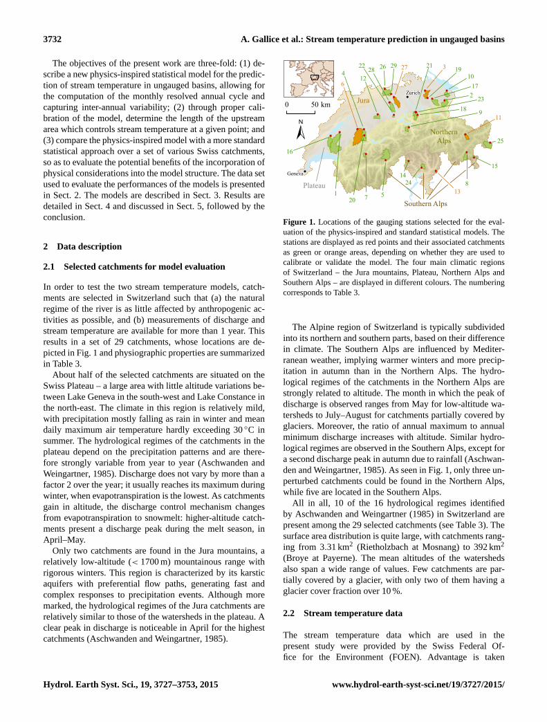
results in a set of 29 catchments, whose locations are de-
picted in Fig. 1 and physiographic properties are summarized
in Table 3.
About half of the selected catchments are situated on the
Swiss Plateau – a large area with little altitude variations be-
tween Lake Geneva in the south-west and Lake Constance in
the north-east. The climate in this region is relatively mild,
with precipitation mostly falling as rain in winter and mean
daily maximum air temperature hardly exceeding 30 ◦C in
summer. The hydrological regimes of the catchments in the
plateau depend on the precipitation patterns and are there-
fore strongly variable from year to year (Aschwanden and
Weingartner, 1985). Discharge does not vary by more than a
factor 2 over the year; it usually reaches its maximum during
winter, when evapotranspiration is the lowest. As catchments
gain in altitude, the discharge control mechanism changes
from evapotranspiration to snowmelt: higher-altitude catch-
ments present a discharge peak during the melt season, in
April–May.
Only two catchments are found in the Jura mountains, a
relatively low-altitude (< 1700 m) mountainous range with
rigorous winters. This region is characterized by its karstic
aquifers with preferential flow paths, generating fast and
complex responses to precipitation events. Although more
marked, the hydrological regimes of the Jura catchments are
relatively similar to those of the watersheds in the plateau. A
clear peak in discharge is noticeable in April for the highest
catchments (Aschwanden and Weingartner, 1985).
!
!
1
16
26 29 2728124
6
20 7 5
1424
138
15
25
11
217
1019322 21
923
18
Geneva
ZurichJura
NorthernAlps
Plateau
Southern Alps
±0 50 km
Figure 1. Locations of the gauging stations selected for the eval-
uation of the physics-inspired and standard statistical models. The
stations are displayed as red points and their associated catchments
as green or orange areas, depending on whether they are used to
calibrate or validate the model. The four main climatic regions
of Switzerland – the Jura mountains, Plateau, Northern Alps and
Southern Alps – are displayed in different colours. The numbering
corresponds to Table 3.
The Alpine region of Switzerland is typically subdivided
into its northern and southern parts, based on their difference
in climate. The Southern Alps are influenced by Mediter-
ranean weather, implying warmer winters and more precip-
itation in autumn than in the Northern Alps. The hydro-
logical regimes of the catchments in the Northern Alps are
strongly related to altitude. The month in which the peak of
discharge is observed ranges from May for low-altitude wa-
tersheds to July–August for catchments partially covered by
glaciers. Moreover, the ratio of annual maximum to annual
minimum discharge increases with altitude. Similar hydro-
logical regimes are observed in the Southern Alps, except for
a second discharge peak in autumn due to rainfall (Aschwan-
den and Weingartner, 1985). As seen in Fig. 1, only three un-
perturbed catchments could be found in the Northern Alps,
while five are located in the Southern Alps.
All in all, 10 of the 16 hydrological regimes identified
by Aschwanden and Weingartner (1985) in Switzerland are
present among the 29 selected catchments (see Table 3). The
surface area distribution is quite large, with catchments rang-
ing from 3.31 km2 (Rietholzbach at Mosnang) to 392 km2
(Broye at Payerne). The mean altitudes of the watersheds
also span a wide range of values. Few catchments are par-
tially covered by a glacier, with only two of them having a
glacier cover fraction over 10 %.
2.2 Stream temperature data
The stream temperature data which are used in the
present study were provided by the Swiss Federal Of-
fice for the Environment (FOEN). Advantage is taken
Hydrol. Earth Syst. Sci., 19, 3727–3753, 2015 www.hydrol-earth-syst-sci.net/19/3727/2015/

A. Gallice et al.: Stream temperature prediction in ungauged basins 3733
of the present publication to describe this new data set,
which is freely accessible for research purposes at the
following address: http://www.bafu.admin.ch/wasser/13462/
13494/15076/index.html?lang=en. A map displaying the po-
sition of all available hydrological stations which measure
stream temperature can also be found on the website of the
FOEN (http://www.hydrodaten.admin.ch/en/messstationen_
temperatur.html).
The FOEN operates an automatic network of stream gaug-
ing stations, continuously measuring water level and dis-
charge at more than 180 locations in Switzerland. Water
level is recorded using an ultrasonic distance sensor and con-
verted into discharge values through a rating curve adapted
each year. The water level values are validated against the
measurements of a second instrument – a pressure probe –
and rejected in case the difference between the two values
is greater than 2 cm. A limited number of gauging stations
has been equipped with a thermometer, the earliest starting
in 1968. This number has increased greatly since 2002, with
now more than 70 stations automatically probing water tem-
perature every 10 min (Jakob, 2010). The measurement val-
ues are automatically uploaded and displayed in real time on
the webpage of the FOEN (same page as for the map display-
ing the positions of the stations).
Among the watersheds in which temperature is monitored,
25 have been identified in the present study as being little af-
fected by anthropogenic activities. In order to complete this
data set, the temperature and discharge measurements of four
additional gauging stations were obtained from the Depart-
ment for Construction, Transport and Environment of Canton
Aargau (see Table 3). The period in which water temperature
was measured by each station is also indicated in Table 3.
The temperature data are usually not quality-proofed by
the FOEN or Canton Aargau. As a validation procedure, we
performed two different tests on the data at the hourly time
step, on top of visual inspection.
a. All temperature measurements lower than 0 ◦C or
greater than 30 ◦C were removed, except for the values
between −0.5 and 0 ◦C, which were set to 0 ◦C, and the
values between 30 and 30.5 ◦C which were set to 30 ◦C.
Although the limit of 30 ◦C might be naturally reached
in shallow areas, some temperature series showed clear
evidence that such temperature was recorded as a result
of the sensor being out of water. As a consequence, it
was decided to remove all data points above 30 ◦C, po-
tentially discarding correct data.
b. The temperature variation between consecutive time
steps was checked to remain within physical bounds.
In particular, it was verified that temperature varied by
more than 0.01 ◦C over 5 h, but less than 3 ◦C within
1 h. Constant temperature values could result from a
defect in the sensor, but also from the fact that the
hourly values had been replaced with their daily mean in
some cases. In order to distinguish between the two, the
present quality control procedure was performed semi-
manually.
After quality control, the hourly data were aggregated into
monthly mean values.
2.3 Meteorological data
The two statistical models described in Sect. 3 use monthly
mean air temperature and incoming solar radiation as pre-
dictor variables. Data for these variables were obtained from
the Swiss Meteorological Office (MeteoSwiss), which pro-
vides free access to them for research purposes. For each
one of the selected catchments described in Sect. 2.1, the air
temperature and incoming solar radiation values measured
by all the meteorological stations located at less than 20 km
from the catchment outlet were collected. In case fewer than
three stations could be found within a 20 km radius, data
from the three closest meteorological stations were retained.
The value of 20 km was chosen so as to ensure that data inter-
polations would remain representative of the climatic condi-
tions at the catchment outlet, while being based on three sta-
tions at least. In fact, 27 of the 29 selected catchments are
entirely contained within the disk of radius 20 km centered
on their respective outlet point (not shown). As such, the col-
lected meteorological data can actually be considered as rep-
resentative for the entire catchments, and not just for their
outlet point.
We were provided with hourly mean data, which
we aggregated into monthly mean values. We did not
perform any quality checks on the data, since Me-
teoSwiss already follows strict quality control pro-
cedures (see http://www.meteosuisse.admin.ch/home/
systemes-de-mesure-et-de-prevision/gestion-des-donnees/
preparation-des-donnees.html; webpage only available in
German, French or Italian).
Among its network of operated meteorological sta-
tions, MeteoSwiss selected a subset of 14 stations which
are considered to be representative of the climate di-
versity in Switzerland (see http://www.meteoswiss.admin.
ch/home/climate/past/homogenous-monthly-data.html; de-
scription only available in German, French or Italian). These
stations, referred to as “reference stations” in the following,
are used by the standard statistical model to estimate the
monthly mean air temperature over the entire Swiss territory
(see Sect. 3.2).
2.4 Thermal regime classification
A preliminary study of the selected catchments was per-
formed, with the aim of classifying the rivers according to
their thermal behaviour. This classification was intended to
be used later in order to investigate whether the performance
of the models was affected by the river thermal regime.
As a first attempt, we examined whether the catchments
could be classified based on the shape of their stream tem-
www.hydrol-earth-syst-sci.net/19/3727/2015/ Hydrol. Earth Syst. Sci., 19, 3727–3753, 2015

3734 A. Gallice et al.: Stream temperature prediction in ungauged basins
2010 2011 2012Time
2
1
0
1
2N
orm
. Stre
am T
[-]
(a)
0 2 4 6Intercept [ ◦ C]
0.0
0.2
0.4
0.6
0.8
1.0
Slop
e [-
]
proglacialstream groundwater-fed
streams
thermallyclimate-driven
streams
(b)
Figure 2. Classification of the thermal regimes of the selected
catchments. Streams impacted by groundwater infiltration are
shown in green, the proglacial stream in blue and the thermally
climate-driven streams in orange. (a) Normalized monthly mean
stream temperature curves over 3 consecutive years (2010–2012);
all curves are z scored independently each year. (b) Slopes and
intercepts of the regression lines fitted to the stream–air tempera-
ture points of the respective catchments. All points with negative
air temperature values have been discarded prior to fitting. The bars
indicate the standard error estimates.
perature curve. To this end, we z scored (i.e. standardized)
the monthly mean stream temperature values in each water-
shed similarly to Garner et al. (2014). However, as observed
by these authors, we could identify only one single thermal
regime (Fig. 2a). Only two catchments among the 29 did not
to present the same thermal regime as the others, namely
those labelled as 5 and 14 in Table 3.
As an alternative approach, we tested whether the charac-
teristics of the stream–air temperature curve could be used
to characterize the thermal regime of the catchments. For
this purpose, monthly mean stream temperature was linearly
regressed against monthly mean air temperature, excluding
the points with negative air temperature values (e.g. Kelle-
her et al., 2012). Based on the values of the slope and in-
tercept of this relationship, three groups of catchments could
be clearly identified (Fig. 2b). The first group contains the
watersheds in which a significant portion of discharge origi-
nates from deep aquifer infiltration (watersheds 9 and 14 in
Table 3, labelled as “groundwater-fed streams” in Fig. 2b).
This group is characterized by low slope and high intercept
values, as reported by many studies (e.g. Caissie, 2006; Webb
et al., 2008). The second group of watersheds corresponds to
the high-altitude basins with more than 50 % glacier cover.
Both the slope and intercept of the stream–air temperature
relationship are small for the members of this group, which
is actually composed of only one catchment (watershed 5
in Table 3, denoted as “proglacial” in Fig. 2b). The vast
majority of the watersheds do not fall into any of the two
aforementioned groups. These catchments, denoted as “ther-
mally climate-driven”, are characterized by relatively low in-
tercept and high slope values; i.e. their stream temperature is
strongly correlated with air temperature.
Because of the predominance of the thermally climate-
driven streams, only the latter will be considered for the test-
ing of the physics-inspired and standard regression models.
The inclusion of the groundwater-dominated streams in the
test set would require the amount of groundwater discharging
into the stream to be estimated. We tested several methods,
including the derivation of the baseflow index from discharge
measurements (e.g. Eckhardt, 2005; van Dijk, 2010) or from
the TOPMODEL topographic index (e.g. Ducharne, 2009).
However, none of the investigated techniques succeeded in
predicting a larger baseflow index for the catchments labelled
as “groundwater-fed” as compared to the others (not shown).
Similarly, the consideration of the proglacial streams would
imply the glacier cover fraction being included in the models.
This addition of one calibration parameter was not consid-
ered justified given that this group contains only one catch-
ment. In total, 26 catchments were used for the calibration
and validation of the models, namely all those listed in Ta-
ble 3 except watersheds 5, 9 and 14.
3 Formulations of the stream temperature models
The new physics-inspired statistical model for stream tem-
perature prediction is derived in the following subsection.
The standard statistical model used for comparison is pre-
sented in Sect. 3.2.
3.1 Physics-inspired statistical model
As mentioned above, the physics-inspired stream tempera-
ture model presented in this paper is based on the analyt-
ical solution to the stream energy-balance equation. This
topic has been investigated extensively in the literature (e.g.
Edinger et al., 1968; Theurer et al., 1984; Gosink, 1986;
Polehn and Kinsel, 2000; Toffolon et al., 2010), although
used only once for stream temperature prediction in un-
gauged basins (Bogan et al., 2003). In order to analytically
solve the energy-balance equation, all studies relied on the
linearization of the heat flux φa at the air–water interface as
a function of stream temperature T : φa =−k(T −Te). Some
Hydrol. Earth Syst. Sci., 19, 3727–3753, 2015 www.hydrol-earth-syst-sci.net/19/3727/2015/

A. Gallice et al.: Stream temperature prediction in ungauged basins 3735
of them assumed the heat transfer coefficient k to be con-
stant and used prescribed functions of time, space or both to
express the equilibrium temperature Te (e.g. Gosink, 1986;
Polehn and Kinsel, 1997; Daly, 2005). Other studies derived
analytical formulations for k and Te based on the physical
expressions of the heat fluxes occurring at the stream–air in-
terface (e.g. Edinger et al., 1968; Bogan et al., 2003; Caissie
et al., 2005; Bustillo et al., 2014). While a minority of authors
considered the temperature distribution to be spatially homo-
geneous (Edinger et al., 1968; Caissie et al., 2005; Bustillo
et al., 2014), most of them assumed the stream to be in a
steady state or, equivalently, the stream celerity to be con-
stant. In addition, they all assumed the river width to re-
main constant along the stream so as to analytically solve the
energy-balance equation. Very few studies accounted for the
heat exchange with the stream bed or the heat advected by
lateral inflow of water (Bogan et al., 2004; Herb and Stefan,
2011). Bogan et al. (2003) were the only authors to evaluate
their analytical expression over ungauged basins. They tested
their model in the central and eastern United States, since this
region has a topography flat enough for a meteorological sta-
tion located even at more than 100 km from a given point
to be still representative of the climate at that point. Their
work is therefore hardly transferable to Switzerland, where
the mountainous landscape prevents the proper interpolation
of variables such as air humidity or wind speed, which are
required as input by the model.
3.1.1 Derivation of the analytical solution to the
energy-balance equation
Assuming a well-mixed water column and a negligible lon-
gitudinal heat dispersion, the mass and energy-balance equa-
tions along a stream reach read (adapted from Westhoff et al.,
2007)
∂A
∂t+∂Q
∂x= q`, (1)
∂(AT )
∂t+∂(QT )
∂x=wφa+pφb
ρcp
+ q` T`−Qg
cp
∂z
∂x, (2)
where w (m), p (m), A (m2), Q (m3 s−1) and T (◦C) denote
the width, wetted perimeter, cross-sectional area, discharge
and temperature of the stream, respectively; t (s) refers to
time, x (m) to the downstream distance, z (m) to altitude, and
g (ms−2) to the gravitational acceleration. The water mass
density ρ (kgm−3) and the specific heat capacity of water
cp (J ◦C−1 kg−1) are both assumed constant. The quantities
φa (Wm−2) and φb (Wm−2) refer to the energy fluxes at the
stream–air and stream–bed interfaces, respectively. The lat-
eral heat fluxes due to the inflow of surface, fast subsurface
and slow subsurface runoffs into the stream are merged into
a single term, q` T`, where q` (m2 s−1) denotes the sum of
these three runoffs per unit stream length and T` (◦C) stands
for their mean temperature. The last term on the right-hand
side of Eq. (2) corresponds to friction, which is usually ne-
glected in stream temperature models (e.g. Sinokrot and Ste-
fan, 1993; Westhoff et al., 2007), but has been shown by Han-
nah et al. (2004) and Leach and Moore (2014) to be an im-
portant term in the energy balance of small streams during
winter.
The present study builds mainly upon the work of Theurer
et al. (1984), which is one of those considering the less re-
strictive approximations for the derivation of the solution to
Eqs. (1)–(2). Our own assumptions are the following.
i. At the timescale of the month, the stream temperature is
assumed to be in a steady state.
ii. The energy flux at the stream–air interface is expressed
as
φa = φr+ k (Ta− T ), (3)
where φr (Wm−2) denotes the net radiative heat flux, in-
corporating both the short-wave and long-wave compo-
nents. The second term on the right-hand side accounts
for both the latent and sensible heat fluxes (e.g. Polehn
and Kinsel, 1997; Toffolon et al., 2010), where the bulk
heat transfer coefficient k (Wm−2 ◦C−1) between water
and air is assumed to be constant, and Ta (◦C) refers to
the air temperature.
iii. The energy flux at the stream–bed interface is neglected;
i.e. φb = 0 (e.g. Bogan et al., 2003; Caissie et al., 2005;
Bustillo et al., 2014).
iv. The lateral inflow of water q` is assumed to be spatially
constant (e.g. Biswal and Marani, 2010; Mutzner et al.,
2013).
v. The ratio of stream width to discharge w/Q is assumed
to be spatially constant, as opposed to Theurer et al.
(1984) and Polehn and Kinsel (2000), who both as-
sumed a constant stream width. This approximation also
differs from the typical relationship used in fluvial geo-
morphology, which expresses stream width as a power-
law function of discharge with exponent ∼ 0.5 (see e.g.
Knighton, 1998). It allows for the definition of a char-
acteristic stream length Lc (m),
Lc =cp ρQ
wk. (4)
vi. All sources in the network are supposed to have the
same discharge, denoted as Qs in the following. This
approximation is discussed in more detail in Sect. 3.1.2.
www.hydrol-earth-syst-sci.net/19/3727/2015/ Hydrol. Earth Syst. Sci., 19, 3727–3753, 2015

3736 A. Gallice et al.: Stream temperature prediction in ungauged basins
Using the above assumptions, the mass and energy-
balance equations simplify to Eqs. (5)–(6),
dQ
dx= q`, (5)
dT
dx=
1
Lc
(γ φr+ Ta− T )+q`
Q(T`− T )−
g
cp
dz
dx, (6)
where γ = 1/k. The reader is referred to Appendix A for
the complete derivation of the analytical solution to these
equations. Only the final expressions for discharge Qout and
stream temperature Tout at the outlet of a catchment are re-
ported here,
Qout = nsQs+Ltotq`, (7)
Tout = ω1Ts+ω2
⟨T`⟩L+ω3
⟨γφr+ Ta−Lc
g
cp
dz
dx
⟩L, (8)
with
ω1 = (1− η)δs, (9)
ω2 = ηδ`, (10)
ω3 = 1−ω1−ω2. (11)
In the above equations, Ltot and ns correspond to the to-
tal length of the river network and the number of sources
in the catchment, respectively. The operator⟨·⟩L refers to
the distance-weighted average; it computes the average of its
operand over the entire stream network using a weight equal
to exp(−d/Lc), where d denotes the distance to the catch-
ment outlet. This operator gives much more emphasis to the
points located near to the catchment exit. It should be noted
that the spatial extent of the area over which the average is
computed is controlled by the characteristic length Lc: the
smaller Lc, the smaller the contributing area. The quantity Ts
appearing in Eq. (8) denotes the weighted average of water
temperature at the network sources. The latter are weighted
by a factor exp(−ds,i/Lc), where ds,i is the distance along
the stream between the ith source point and the catchment
outlet. The weights ω1, ω2 and ω3 are all in the interval [0,1].
In Eqs. (9)–(10), the factor η refers to the fraction of dis-
charge at the catchment outlet originating from lateral inflow
of water along the stream network – i.e. excluding the frac-
tion coming from the sources,
η =q`Ltot
Qout
= 1−nsQs
Qout
. (12)
The two factors δs and δ` are defined as
δs =1
ns
ns∑i=1
e−ds,i/Lc , (13)
δ` =Lc
Ltot
nr∑k=1
e−dk/Lc(1− e−Lk/Lc
), (14)
where nr denotes the number of reaches in the stream net-
work, dk the streamwise distance between the downstream
point of stream reach k and the catchment outlet, and Lk the
length of stream reach k. The factor δs corresponds to the
average of the weight exp(−d(x)/Lc) over all the network
sources, and the factor δ` refers to the average of the same
weight over the set of all stream reaches in the catchment. It
follows that both δs and δ` decrease roughly exponentially as
a function of the network length.
Equation (8) expresses stream temperature as a linear
function of air temperature, the slope of the regression line
between the two being equal to ω3 = 1−ω1−ω2. Assuming
η to vary only slightly along the network, it can be seen in
Eqs. (9) and (10) that ω1 and ω2 decrease roughly exponen-
tially with the stream network length. As a consequence, the
present model predicts ω3 to tend towards 1 as the catchment
size increases, a fact which has been observed at many loca-
tions (e.g. Ozaki et al., 2003; Ducharne, 2008; Kelleher et al.,
2012; Chang and Psaris, 2013; Segura et al., 2014).
The present expression for Tout differs from those reported
previously in the literature in at least two aspects (see Sect. 1
for a review of the analytical solutions to the energy-balance
equation published to date). First, the terms on the right-hand
side of Eq. (6) were not assumed to be spatially homoge-
neous when integrating them. This explains the presence of
the spatial averaging operator⟨·⟩L in Eq. (8), which in turn
translates the fact that stream temperature is not impacted by
local conditions only. This operator has already been used for
the computation of predictor variables in regression-based
stream temperature models (Isaak et al., 2010; Hill et al.,
2013), but never in association with analytical solutions to
the energy-balance equation. Second, the source and lateral
inflow terms have not been neglected. These two terms are
weighted by the factors ω1 and ω2 in Eq. (8), respectively,
and tend to decrease exponentially with the stream length
(see discussion above). Although negligible in large catch-
ments, they might be of the same order of magnitude as the
heat exchange term in small watersheds. Only a few studies
relying on an analytical expression for stream temperature
modelling have considered the lateral inflow term to date
(Bogan et al., 2004; Herb and Stefan, 2011), and none has
retained the source term.
As noted above, the extent of the zone over which⟨·⟩L av-
erages its operand is controlled by the characteristic length
Lc. Given that this length is a function of the river discharge-
to-width ratio Q/w (see Eq. 4) and that the stream celer-
ity is assumed here to be constant, Lc is approximately pro-
portional to the water height. Its value should therefore be
expected to change over the course of the year. Based on a
formula similar to Eq. (4), Herb and Stefan (2011) have es-
timated Lc to vary between 3 and 45 km for discharge val-
ues between 0.4 and 5.8 m3 s−1 in the case of the Vermillion
River in Minnesota. As most of the catchments considered
in the present study have discharges contained within this
range, we should expect a marked variation in the values of
Lc both during the course of the year and across catchments.
However, since the characteristic length will be treated as
Hydrol. Earth Syst. Sci., 19, 3727–3753, 2015 www.hydrol-earth-syst-sci.net/19/3727/2015/

A. Gallice et al.: Stream temperature prediction in ungauged basins 3737
a calibration parameter here (see Sect. 3.1.2), only its sea-
sonal variability will be investigated. A single value will be
assumed in each season for all the catchments (see Sect. 4),
for otherwise Lc would have to be calibrated independently
for each catchment, which would prevent prediction in un-
gauged basins. We acknowledge this as a limitation of our
model.
3.1.2 Parametrization of the unknown terms
Equation (8) contains several unknown quantities. The pro-
cedure used to calculate their respective values is detailed
below.
The channel slope dz/dx is computed along the cen-
tre line of each stream. A vector representation of the
centre lines was extracted from a land cover map at
scale 1 : 25 000 (for more information on this map, see
http://www.swisstopo.admin.ch/internet/swisstopo/en/
home/products/maps/national/25.html). This map was over-
laid with a digital elevation model of Switzerland with 2 m
horizontal resolution produced by the Swiss Federal Office
of Topography (see http://www.swisstopo.admin.ch/internet/
swisstopo/en/home/products/height/swissALTI3D.html) in
order to extract the altitude of each point. As an alternative
approach, a geomorphological analysis of the stream wa-
tersheds could have been performed so as to automatically
extract the stream networks. However, it was observed that
the results of this analysis did not match with the land cover
map in some basins (not shown).
The monthly mean air temperature Ta along the streams is
computed based on the values measured by the neighbouring
meteorological stations (see Sect. 2.3). Within each catch-
ment i, air temperature Ta,i is assumed to be a linear function
of altitude only,
Ta,i(z)= aT ,i(z− zi)+ bT ,i , (15)
where zi (m) refers to the altitude of the gauging station. The
lapse rate aT ,i (◦C m−1) is computed each month separately
by regressing the air temperature measurements of the neigh-
bouring meteorological stations against the station altitudes.
In case the coefficient of determination R2 of the regression
line is lower than 0.6, aT ,i is set equal to 0. The intercept
bT ,i (◦C) is computed each month as the inverse-distance-
weighted average of the same air temperature measurements,
which are first corrected for the altitude effect by virtually
transferring them to altitude zi using the lapse rate aT ,i .
The quantity γφr, which accounts for the effect of the net
radiation heat flux at the air–water interface, cannot be read-
ily computed based on the available data. As a matter of fact,
long-wave radiation and reflected short-wave radiation mea-
surements are performed by MeteoSwiss at a few locations
only. Incoming short-wave radiation φisw (Wm−2), on the
other hand, is a commonly measured variable which can be
interpolated along the stream networks. To this end, it is as-
sumed that the incoming short-wave radiation φisw,i in each
catchment i is a function of altitude only,
φisw,i(z)= aφ,i(z− zi)+ bφ,i , (16)
where the lapse rate aφ,i (Wm−3) and the intercept
bφ,i (Wm−2) are computed similarly to aT ,i and bT ,i in
Eq. (15). An attempt is made to correct the values computed
using Eq. 16 in order to account for riparian shading. As dis-
cussed in Sect. 1.5 above, very few spatial data sets exist for
riparian shading, which in practice often has to be estimated
using proxy variables. In the present case, riparian shading
at a given stream point is approximated based on the stream
orientation θ and riparian forest cover ff at that point. Using
the land cover map at scale 1 : 25 000 mentioned above, θ is
computed as the cosine of the angle between north and the
stream flow direction; it is a measure of northing, i.e. values
close to 1 indicate a catchment that is oriented towards north
and values close to −1 a catchment that is south-oriented.
The riparian forest cover ff is defined here as the fraction of
the riparian zone which is covered with forests according to
the land cover map. As the extent of the riparian zone affect-
ing stream temperature is unclear (Moore et al., 2005), the
forest cover fraction is computed over riparian buffers with
different widths: 25, 50 and 100 m on each side of the centre
line of the streams (total buffer widths are 50, 100 and 200 m,
respectively). The map does unfortunately not allow for the
distinction between coniferous and deciduous forests. In ad-
dition to θ and ff, topographical shading fs is also computed
in order to correct the incoming solar radiation values esti-
mated from Eq. (16). fs is expressed at each point along the
streams as a value between 0 and 1, 1 indicating complete
shading. It is derived from the above-mentioned 2 m digital
elevation map of Switzerland at nine different hours of day
time – corresponding to the fractions 0.1–0.9 of the day-time
period – on the 15th day of each month of the year. These
values are then averaged at each grid cell and in each sea-
son to obtain the spatial distribution of fs. Since shading by
topography and by the riparian forest does not only affect
incoming solar radiation, but also incoming long-wave radi-
ation, it was decided not to use the variables θ , ff and fs to
directly modify the values of φisw. Instead, it is the unknown
term γφr which is approximated as a linear combination of
φisw, θ , ff and fs:
γφr = aφ,iswφisw+ aφ,sfs+ aφ,θθ + aφ,fff+ bφ . (17)
As discussed in Sect. 1.5, the choice of a linear relationship
is motivated by our wish to keep the model simple and by
our ignorance of the actual form of the function linking γφr
to the above-mentioned predictor variables. A linear relation-
ship also significantly simplifies the computation of the dis-
tance average of γφr using the operator⟨·⟩L. Equation (17)
requires the calibration of five unknown coefficients, namely
{aφ,x}x=isw,s,θ,f and bφ . In order to limit the number of model
parameters, this expression is not directly used as is, but more
parsimonious formulations are evaluated instead. All possi-
ble sub-expressions involving any combination of either one
www.hydrol-earth-syst-sci.net/19/3727/2015/ Hydrol. Earth Syst. Sci., 19, 3727–3753, 2015

3738 A. Gallice et al.: Stream temperature prediction in ungauged basins
or two of the predictor variables {φisw,θ,ff,fs} is consid-
ered for approximating γφr. It should be mentioned that the
choice to consider expressions with at most two terms (plus
the intercept) is arbitrary and only introduced to avoid equifi-
nality issues (Beven, 1993). In total, 11 different models are
tested for γφr – including the constant expression with only
bφ as calibration parameter.
The two weights ω1 and ω2 cannot be readily estimated
from Eqs. (9) and (10). While the values of the factors δs
and δ` can be easily derived from the vector representa-
tion of the stream network described above, the parameter
η requires additional assumptions. It should be remembered
that this parameter corresponds to the fraction of the out-
let discharge which originates from lateral inflow. Assuming
a typical power-law relationship between drainage area and
discharge (e.g. Mutzner et al., 2013), η could in principle
be approximated as the ratio between the area Anet drained
by the network (excluding the area drained by the sources)
and the total catchment area Atot, raised to some power α:
η ∼ (Anet/Atot)α . However, the computation of Anet would
require a geomorphological analysis, which was discarded
based on the discrepancy between the stream network pre-
dicted by this analysis and the observed one (see above).
As alternative methods, we consider two different techniques
for estimating η. The simplest approach assumes a constant
single value for η, calibrated over all catchments. The sec-
ond approach relies on the analytical expression for η pre-
sented in Eq. (12), in which the ratio Qs/Qtot is replaced
with (As/Atot)α:
η = 1− ns
(As
Atot
)α. (18)
The calibration parameters of this second method correspond
to the area As drained by a single source and the exponent α.
In order to compute Ts and⟨T`⟩L in Eq. (8), two different
methods for the estimation of the source and lateral inflow
temperatures are considered. In a first approximation, these
two temperatures are assumed to be both constant and equal.
The second method considers them to be linearly related to
air temperature as measured at their respective altitudes. In
other words, it expresses the temperature Ts,i of each source
i = 1. . .ns and the lateral inflow temperature T`(z) at any
point with altitude z along the network as
Ts,i = awTa(zs,i)+ bw, (19)
T`(z)= awTa(z)+ bw, (20)
where zs,i (m) denotes the altitude of source i, and
aw (◦C ◦C−1) and bw (◦C) are two parameters to be calibrated
over the set of all catchments. Notice that the same slope awand intercept bw are used to derive both Ts,i and T` from air
temperature, hereby assuming that the source and lateral in-
flows originate from the same hydrological processes. More-
over, since these two parameters are the same for all catch-
ments, it is implicitly supposed that the ratio of surface runoff
to subsurface runoff is the same in all watersheds. As dis-
cussed in Sect. 2.4, this requires catchments to be classified
by hydrological regime before aw and bw can be calibrated
separately for each regime. In Eqs. (19)–(20), the monthly
mean air temperature is computed in each catchment using
Eq. (15).
The distance average of variables T`, γφr, Ta and dz/dx
are computed by discretizing the operator⟨·⟩L over the stream
segments,
⟨f⟩L =
∑k∈0e
−(dk+Lk/2)/Lc Lk fk∑k∈0e
−(dk+Lk/2)/Lc Lk, (21)
where fk denotes the unweighted mean value of variable f
along stream segment k; the other quantities have been de-
fined previously in Sect. 3.1.1. Except for the riparian forest
cover ff, which is derived over buffers of widths 25, 50 and
100 m, the unweighted means of all other quantities (namely
φisw, fs, Ta and dz/dx) along each stream segment are com-
puted over a 20 m wide buffer centered around the centre
line of the segment, as extracted from the vector represen-
tation of the stream network at scale 1 : 25 000 (see above).
The value of 20 m is considered to be typical for the width of
the streams investigated in the present study; although only
this value has been tested, it is expected to have little im-
pact on the computed averages. It should be noted that the
expressions for⟨Ta
⟩L and
⟨φisw
⟩L both reduce to linear func-
tions of the distance-weighted average of altitude along the
stream network⟨z⟩L as per Eqs. (15) and (17). The length
Lk of stream reach k and the distance dk between the down-
stream end of reach k and the catchment outlet are derived
from the vector map of the stream network.
Replacing the terms in Eq. (8) with their above expres-
sions, the stream temperature model reads
Tout = (1− η)δs
(awTa+ bw
)+ ηδ`
(aw⟨Ta
⟩L+ bw
)+ (1− δs− ηδs− ηδ`)
⟨Teq
⟩L, (22)
where
Teq = aφ,isw
⟨φisw
⟩L+ aφ,s
⟨fs
⟩L+ aφ,θ
⟨θ⟩L
+ aφ,f⟨ff
⟩L+
⟨Ta
⟩L−Lc
g
cp
⟨ dzdx
⟩L+ bφ . (23)
The calibration parameters of the model are listed in Table 2.
When testing a constant parametrization for the source and
lateral inflow temperatures, aw should be set to 0. Similarly,
at least two of the coefficients {aφ,x}x=isw,s,θ,f are assumed
equal to 0, as per the parametrization of the radiation term
discussed above. Thus, between three and eight parameters
must be calibrated, depending on the methods used to ap-
proximate the respective unknown variables in Eq. (8). Ad-
vantage is taken of the fact that each parameter can be inter-
preted from a physical point of view to restrict its associated
calibration range (see Table 2). For example, η is imposed
Hydrol. Earth Syst. Sci., 19, 3727–3753, 2015 www.hydrol-earth-syst-sci.net/19/3727/2015/

A. Gallice et al.: Stream temperature prediction in ungauged basins 3739
Table 2. Calibration parameters of the physics-inspired statistical model.
Parameter Defined in Units Calibration range Physical constraints
aw Eqs. (19)–(20) (◦C◦C−1) Chosen so as to constrain Ts,i and T` to the range 0–25 ◦C Must be positive
bw (◦C) None
aφ,isw Eq. (17) (◦Cm2 W−1) Chosen so as to constrain γφr to the range −20–20 ◦C Must be positive
aφ,s (◦C) Must be negative
aφ,θ (◦C) Must be negative
aφ,f (◦C) None
bφ (◦C) None
η Eqs. (9)–(10) (–) 0–1 None
As Eq. (18) (m2) Chosen so as to constrain η in the range 0–1 Must be positive
α (–) 0–3 None
Table 3. Physiographic properties of the 29 selected hydrological catchments in Switzerland. The three watersheds indicated in bold are not
used for the model evaluation.
Basin Name Basin Gauging station Mean basin Glacier Hydrological Temperature measure- Data
number area (km2) altitude (m) altitude (m) cover (%) regimea ment period providerb
1 Broye at Payerne 392.0 441 710 0 Pluvial inferior 1976–2012 FOEN
2 Sitter at Appenzell 74.2 769 1252 0.1 Transition nival 2006–2012 FOEN
3 Murg at Wängi 78.0 466 650 0 Pluvial inferior 2002–2012 FOEN
4 Gürbe at Belp, Mülimatt 117.0 522 849 0 Transition pluvial 2007–2012 FOEN
5 Massa at Blatten, Naters 195.0 1446 2945 65.9 Glacial 2003–2012 FOEN
6 Sense at Thörishaus, Sensematt 352.0 553 1068 0 Pre-Alpine nivo-pluvial 2004–2012 FOEN
7 Allenbach at Adelboden 28.8 1297 1856 0 Alpine nival 2002–2012 FOEN
8 Rosegbach at Pontresina 66.5 1766 2716 30.1 Glacial 2004–2012 FOEN
9 Grosstalbach at Isenthal 43.9 767 1820 9.3 Alpine nival 2005–2012 FOEN
10 Goldach at Goldach, Bleiche 49.8 399 833 0 Pluvial superior 2005–2012 FOEN
11 Dischmabach at Davos, Kriegsmatte 43.3 1668 2372 2.1 Glacio-nival 2004–2012 FOEN
12 Langeten at Huttwil, Häberenbad 59.9 597 766 0 Pluvial inferior 2002–2012 FOEN
13 Riale di Roggiasca at Roveredo 8.1 980 1710 0 Meridional nivo-pluvial 2003–2012 FOEN
14 Riale di Calneggia at Cavergno, Pontit 24 890 1996 3.0 Meridional nival 2002–2012 FOEN
15 Poschiavino at La Rösa 14.1 1860 2283 0.4 Meridional nival 2004–2012 FOEN
16 Mentue at Yvonand, La Mauguettaz 105.0 449 679 0 Jurassian pluvial 2003–2012 FOEN
17 Necker at Mogelsberg, Aachsäge 88.2 606 959 0 Pluvial superior 2007–2012 FOEN
18 Grossbach at Gross, Säge 9.1 940 1276 0 Pre-Alpine nivo-pluvial 2003–2012 FOEN
19 Rietholzbach at Mosnang, Rietholz 3.3 682 795 0 Pluvial superior 2002–2012 FOEN
20 Gürbe at Burgistein, Pfandersmatt 53.7 569 1044 0 Pre-Alpine nivo-pluvial 2007–2008 FOEN
21 Biber at Biberbrugg 31.9 825 1009 0 Pluvial superior 2003–2012 FOEN
22 Sellenbodenbach at Neuenkirch 10.5 515 615 0 Pluvial superior 2003–2012 FOEN
23 Alp at Einsiedeln 46.4 840 1155 0 Transition pluvial 2003–2012 FOEN
24 Riale di Pincascia at Lavertezzo 44.4 536 1708 0 Meridional nivo-pluvial 2004–2012 FOEN
25 Rom at Müstair 129.7 1236 2187 0.1 Meridional nival 2003–2012 FOEN
26 Sissle at Eiken 123.0 314 529 0 Jurassian pluvial 2004–2012 Aargau
27 Bünz at Othmarsingen 110.6 390 526 0 Pluvial inferior 2005–2012 Aargau
28 Wyna at Unterkulm 92.1 455 643 0 Pluvial inferior 2005–2012 Aargau
29 Talbach at Schinznach-Dorf 14.5 358 559 0 Jurassian pluvial 2009–2012 Aargau
a According to the classification by Aschwanden and Weingartner (1985).b FOEN: Swiss Federal Office for the Environment, Aargau: Department for Construction, Transport and Environment of Canton Aargau.
to adopt a value between 0 and 1 as per Eq. (12), and only
positive values are considered for aφ,isw based on the fact
that solar radiation is contributing positively to the net radi-
ation heat flux. Moreover, six different values are tested for
the characteristic length Lc used in the definition of⟨·⟩L: 1,
2, 4, 8, 16 and 32 km (see Sect. 4.2). All possible combina-
tions of the different parametrizations of the model terms are
tested for each one of these values of Lc. The model associ-
ated with the lowest value of the modified Akaike informa-
tion criterion (AICc) is considered to be the best one among
the tested set (e.g. Burnham and Anderson, 2002). As men-
tioned in Sect. 3.1.1, the model is calibrated in each season
separately to account for the fact that the value of the param-
eter Lc varies over the year.
3.2 Standard regression model
In order to assess its performances, the physics-inspired sta-
tistical model described by Eq. (22) is compared with a more
classical regression model which we developed based on a
combination of some of the standard statistical approaches
reviewed in Sect. 1. The regression model takes advantage
of the fact that most stream temperature curves have a simi-
lar shape (see Sect. 2.4). This shape is first estimated by the
model based on air temperature, before being mapped to the
www.hydrol-earth-syst-sci.net/19/3727/2015/ Hydrol. Earth Syst. Sci., 19, 3727–3753, 2015

3740 A. Gallice et al.: Stream temperature prediction in ungauged basins
respective stream temperature curves of the catchments using
a linear transformation.
The model assumes all streams to have the same z scored
(i.e. standardized) temperature T (–). The latter is related to
the monthly mean temperature Ti of each individual catch-
ment i through (see e.g. Garner et al., 2014)
Ti = σi T + T i , (24)
where T i (◦C) and σi (◦C) correspond to the annual mean
and standard deviation of monthly mean stream tempera-
ture in catchment i, respectively. These two quantities are
estimated each year independently using multi-linear regres-
sion (MLR) models. Although more sophisticated techniques
could have been used, Wehrly et al. (2009) and Daigle et al.
(2010) showed that MLR performs at least as well as several
more complicated statistical methods for stream temperature
prediction. The MLR models were constructed using sim-
ilar predictor variables as in the physics-inspired statistical
model, namely the annual mean and standard deviation of
both air temperature and incoming short-wave radiation, the
riparian forest cover fraction, stream channel slope, stream
orientation, the difference in topographical shading between
summer and winter, the number of sources in the network
and the watershed area. All multi-linear models based on
any possible subset of these variables were tested, with a
maximum number of terms per model arbitrarily fixed to
six. This limitation was introduced in order to avoid over-
parametrization, but also to ensure that the number of pa-
rameters in the final standard regression model was about the
same as in the physics-inspired model, hereby guaranteeing
a more even comparison between the two. Multicollinearity
issues were avoided by discarding MLR models whose vari-
ance inflation factor (VIF) exceeded 5. Each predictor vari-
able was distance-averaged over the stream networks using
the operator⟨·⟩L, as in the case of the physics-inspired statis-
tical model. Different values of Lc were considered when ap-
plying this operator as per Eq. (21): 1, 2, 4, 8, 16 and 32 km.
The best predicting MLR models for T i and σi were selected
based on AICc.
In Eq. (24), the z scored stream temperature is computed
each month based on a non-linear relationship with air tem-
perature,
T = µ+α−µ
1+ exp(− κ
(Ta−β
)) , (25)
where µ (◦C), α (◦C), β (◦C) and κ (◦C−1) are coefficients
obtained through ordinary least squares regression, and Ta (–)
denotes the mean z scored air temperature over Switzerland.
Ta is obtained by averaging the z scored measurements of
the 14 MeteoSwiss reference meteorological stations (see
Sect. 2.3),
Ta =1
14
14∑k=1
Ta,k − T a,k
σa,k
. (26)
In the above equation, Ta,k (◦C) denotes the monthly mean air
temperature measured at reference station k, and T a,k (◦C)
and σa,k (◦C) refer to the annual average and standard devia-
tion of Ta,k computed each year independently, respectively.
In summary, the standard regression model proceeds as
follows to estimate stream temperature in an ungauged basin:
(a) it first computes the mean z scored air temperature over
Switzerland according to Eq. (26), based on the measure-
ments of 14 meteorological stations, (b) it then uses Ta to
estimate the z scored stream temperature in any catchment
as per Eq. (25), and finally (c) it converts T to the actual
stream temperature using Eq. (24), where the scaling coeffi-
cients T i and σi are estimated for the catchment of interest
using MLR models. These different steps will be illustrated
in more detail in Sect. 4.4.
4 Model evaluation
In order to rigorously evaluate the performance of the two
models described in the previous section, 5 of the 26 selected
catchments were removed from the data set to create an in-
dependent validation set (watersheds 3, 6, 11, 13 and 27, dis-
played in orange in Fig. 1). Caution was given to single out
basins with different size, mean elevation and geographic lo-
cation. Among the four climatic regions of Switzerland, only
the Jura could not be represented in the validation set, given
that only 1 station (number 26) among the 26 available was
located in this area. A bootstrap on the validation stations was
not possible because of too high computational requirements.
Indeed, Burnham and Anderson (2002) recommend using at
least 10 000 bootstrap samples, which led to a prohibitively
high number of model evaluations in our case.
The measurement time period is also split into a calibra-
tion (2007–2012) and validation (all dates before and includ-
ing 2006) period. Only the measurements performed by the
calibration stations – whose drainage area is marked in green
in Fig. 1 – during the period 2007–2012 are used to calibrate
the models. Four different validation sets can be formed with
the remaining station months.
1. The data set containing the measurements of the valida-
tion stations during the calibration period. This set can
be used to evaluate the ability of the models to make
predictions in ungauged basins.
2. The data set containing the measurements of the calibra-
tion stations during the validation period. This set will
be used to evaluate the precision of the models when
predicting stream temperature in past or future years.
3. The data set formed by the measurements of the valida-
tion stations during the validation period. This set serves
to evaluate the performance of the models when predict-
ing stream temperature both in ungauged basins and in
ungauged years.
Hydrol. Earth Syst. Sci., 19, 3727–3753, 2015 www.hydrol-earth-syst-sci.net/19/3727/2015/

A. Gallice et al.: Stream temperature prediction in ungauged basins 3741
4. The data set corresponding to the union of all three pre-
vious validation sets, which may be used to obtain a syn-
thetic evaluation of the precision of the models.
The complete data set is almost equally subdivided into its
calibration and validation parts, with the former containing
1223 station months and the validation sets 1–4 regrouping
360, 705, 204 and 1269 station months, respectively.
As mentioned in Sect. 3.1, the value of the characteris-
tic stream length Lc is expected to change over the course
of the year. In order to ease capturing of this variability,
the physics-inspired statistical model is calibrated over each
season separately. As such, the calibration and validation
data sets are each subdivided into four groups, correspond-
ing to winter (January–March), spring (April–June), summer
(July–September) and autumn (October–December), respec-
tively. Each one of these subgroups contains approximately
one-fourth of the station months originally belonging to the
parent group. The standard regression model is calibrated
over all seasons at once, but is evaluated in each season sep-
arately so as to investigate a potential effect of the period of
the year on its precision.
Since the physics-inspired model expresses stream tem-
perature as a linear function of air temperature, it cannot re-
produce the asymptotic behaviour of the former as the latter
drops below 0 ◦C. Consequently, data points associated with
negative air temperature values are removed from the data set
before calibration (Kelleher et al., 2012). When evaluating
the model over the validation sets, all stream temperatures
predicted to be negative are replaced with 0 ◦C values.
In the following, the best seasonal formulations of the
physics-inspired model are presented first. The precision of
this model is then evaluated, and the influence of the stream
network resolution on the model results investigated. Finally,
comparison is made with the standard regression model. All
the results presented in this section will be discussed and
analysed in Sect. 5.
4.1 Model formulations
As mentioned in Sect. 3.1.2, the different possible formu-
lations of the physics-inspired statistical model are ranked in
each season according to their respective AICc value. AICc is
preferred here over the classical definition of the Akaike in-
formation criterion (AIC) since it includes a correction term
for finite-sized data sets (Burnham and Anderson, 2002). It
should be mentioned that, following Burnham and Anderson
(2002), AICc is computed by calibrating the models not over
the calibration set only, but rather over the entire data set (i.e.
both the calibration set and validation set 4). Only in a sec-
ond time is each model calibrated over just the calibration
set, so as to evaluate its performances in terms of RMSE, R2
and bias.
Table 4 presents the best model formulations selected in
each season, ranked according to their respective Akaike
weights wi . The latter corresponds to the probability of each
model being a better descriptor of the observed data (accord-
ing to information theory) as compared to the model with
the minimum AICc value (Burnham and Anderson, 2002;
Wagenmakers and Farrell, 2004). Considering models with
wi ≤ 0.1 to be statistically insignificant, it can be observed
that only a few formulations were identified in each season as
being relevant for stream temperature prediction. The char-
acteristic stream length Lc is found to be consistent among
these formulations, with a value of 4 km in spring, summer
and autumn, and 8 km in winter, regardless of the formula-
tion.
The model selection reveals the radiation term γφr to be
preferentially expressed as a function of topographical shad-
ing fs and riparian forest cover fraction ff, or as a function
of fs alone. Among the tested buffer widths used to compute
ff, none of the three values 50, 100 or 200 m prevails sig-
nificantly over the others. The order in which they appear in
the ranked models varies depending on the season; for ex-
ample in winter, forest cover computed over a 100 m wide
buffer is expected to be a better predictor of γφr than forest
cover over a 50 m wide buffer, whereas the opposite is true
in spring. Focusing on each season separately, the linear co-
efficient associated with any given term is observed to have a
fairly constant value among the different expressions tested
for γφr. For example, the coefficient multiplying fs remains
within a narrow range (at most 1 ◦C large) in each season.
This behaviour is even more pronounced in the case of the
term associated with the source and lateral inflow tempera-
tures (Ts and T`). This term is expressed as a linear function
of air temperature, whose slope aw and intercept bw are con-
stant among the various model formulations in a given season
(see Table 4). The values of aw are observed to be rather low
independently of the period of the year, which indicates a
weak coupling between the stream source (or lateral inflow)
temperature and air temperature. Moreover, aw and bw differ
among the seasons in such a way that Ts and T` are the least
coupled to air temperature in winter and the most in summer.
The model ranking based on AICc also identified a sin-
gle expression for η in each season. This parameter is found
equal to 1 in summer and autumn, and 0 in winter. Its ex-
pression is slightly more complicated in spring, where the
selected formulation is the one based on the source drainage
area (see Sect. 3.1.2).
4.2 Model performance
The RMSE, R2 and bias of the best selected model formula-
tion in each season – i.e. the one withwi = 1 – are reported in
Table 5. Based on the results of the evaluation over validation
set 4, the model precision is observed to be rather satisfac-
tory. Its RMSE and R2 are relatively constant over the year
(about 1.3 ◦C and 0.87, respectively), except in winter where
the value of the coefficient of determination is much lower
(0.55). Similarly, the bias is small in all seasons (−0.11 to
0.14 ◦C) apart from winter (−0.47 ◦C).
www.hydrol-earth-syst-sci.net/19/3727/2015/ Hydrol. Earth Syst. Sci., 19, 3727–3753, 2015

3742 A. Gallice et al.: Stream temperature prediction in ungauged basins
Table 4. Formulations of the physics-inspired statistical model selected in each season based on their corresponding AICc value. The Akaike
weights are denoted as wi . Only the model formulations with wi ≥ 0.1 are presented here. The widths of the buffers used to compute
the riparian vegetation cover are indicated as subscripts of the variable ff (the indicated values correspond to the total buffer widths, i.e.
accounting for both sides of the stream centre line).
Season wi Lc (km) Formulation of γφr Formulation of Ts and T` Formulation of η
Winter
1 8 γφr = aφ,sfs+ aφ,fff,100m+ bφ , Ts = awTa+ bw , η = 0 (constant)
with aφ,s = 18.2 ◦C, aφ,f =−2.9 ◦C and bφ =−12.1 ◦C with aw = 0.15 and bw = 3.1 ◦C
0.25 γφr = αφ,sfs+ bφ ,
with aφ,s = 19.4 ◦C and bφ =−14.1 ◦C
0.15 γφr = aφ,sfs+ aφ,fff,50m+ bφ ,
with aφ,s = 19.3 ◦C, aφ,f =−0.4 ◦C and bφ =−13.9 ◦C
Spring
1 4 γφr = aφ,sfs+ aφ,fff,50m+ bφ , Ts = awTa+ bw , η = 1− ns(As/Atot)α ,
with aφ,s = 12.9 ◦C, aφ,f =−3.7 ◦C and bφ =−11.3 ◦C with aw = 0.27 and bw = 5.3 ◦C with As = 0.13 km2 and α = 1
0.86 γφr = aφ,sfs+ aφ,fff,200m+ bφ ,
with aφ,s = 13.1 ◦C, aφ,f =−3.4 ◦C and bφ =−11.6 ◦C
0.53 γφr = aφ,sfs+ bφ ,
with aφ,s = 13.1 ◦C and bφ =−12.7 ◦C
0.31 γφr = aφ,sfs+ aφ,fff,100m+ bφ ,
with aφ,s = 13.4 ◦C, aφ,f =−2.2 ◦C and bφ =−12.3 ◦C
Summer
1 4 γφr = aφ,sfs+ aφ,fff,100m+ bφ , Ts = awTa+ bw , η = 1 (constant)
with aφ,s = 13.4 ◦C, aφ,f =−0.3 ◦C and bφ =−13.0 ◦C with aw = 0.33 and bw = 6.6 ◦C
0.15 γφr = aφ,sfs+ bφ ,
with aφ,s = 13.4 ◦C and bφ =−13.1 ◦C
Autumn
1 4 γφr = aφ,sfs+ bφ , Ts = awTa+ bw , η = 1 (constant)
with aφ,s = 10.4 ◦C and bφ =−5.9 ◦C with aw = 0.25 and bw = 5.1 ◦C
0.54 γφr = aφ,sfs+ aφ,fff,100m+ bφ ,
with aφ,s = 10.0 ◦C, aφ,f =−2.8 ◦C and bφ =−4.7 ◦C
0.48 γφr = aφ,sfs+ aφ,fff,200m+ bφ ,
with aφ,s = 10.1 ◦C, aφ,f =−2.9 ◦C and bφ =−4.7 ◦C
0.4 γφr = aφ,sfs+ aφ,fff,50m+ bφ ,
with aφ,s = 10.2 ◦C, aφ,f =−2.2 ◦C and bφ =−5.1 ◦C
Regarding the different validation sets, it can be observed
in Table 5 that the model performs better when predicting
in ungauged catchments as compared to simulating past or
future years. Indeed, the RMSE values computed using val-
idation set 1 are smaller than those based on set 2, partic-
ularly in winter, autumn and summer. Similarly, the values
of R2 are higher over set 1 than over set 2, despite the fact
that the model bias is larger over the former set as com-
pared to the latter. As expected, the weakest model perfor-
mances are generally associated with validation set 3, which
contains the measurements performed by the validation sta-
tions during the validation period. The only noticeable ex-
ception is in summer, where the model evaluation over set 3
provides satisfactory results (RMSE= 1.13 ◦C, R2= 0.90,
bias=−0.01 ◦C).
4.3 Influence of the stream network resolution
The results reported above are based on the stream net-
work geometries extracted from the land cover map at scale
1 : 25 000 (see Sect. 3.1.2). These geometries directly affect
the values of the distance-averaged predictor variables, since
the operator⟨·⟩L averages over the entire stream network. As
a consequence, modifying the network resolution is expected
to impact the model performance.
To test this hypothesis, two additional stream networks
with a coarser resolution than the original one were inves-
tigated. These networks were obtained by removing stream
segments with Strahler order 1, and those with Strahler or-
der 1 and 2, respectively. Through this procedure, the mean
drainage density of the 26 selected catchments decreased
from 2.1 kmkm−2 for the original network to 0.5 kmkm−2
for the coarsest one, passing through 1.0 kmkm−2 for the
intermediate-resolution network. The different model formu-
lations were evaluated over the two additional networks us-
ing the same procedure as described in the previous section.
Although the results are not reported here, it was essentially
observed that the network resolution had little influence on
the ranking of the model formulations based on AICc in each
season. Almost all selected models were associated with a
characteristic stream length Lc = 4 or 8 km, as in the case
of the original stream network. The parametrization of the
net radiation heat flux γφr was also similar to the one re-
ported in Table 4. Topographical shading and riparian forest
cover remained the two most statistically significant predic-
tors for this term, except during winter, where stream orienta-
tion appeared as a relevant variable. The values of the coeffi-
cients aw and bw were noted to vary little among the selected
model formulations in a given season. Finally, the parameter
η was preferentially expressed as a constant term. Its value
Hydrol. Earth Syst. Sci., 19, 3727–3753, 2015 www.hydrol-earth-syst-sci.net/19/3727/2015/

A. Gallice et al.: Stream temperature prediction in ungauged basins 3743
JFM AMJ JAS OND6
4
2
0
2
4
6R
esid
ual [◦C
]
Figure 3. Prediction error of the physics-inspired statistical model
for different resolutions of the stream network. The boxes extend
from the first to the third quartile of the error distribution. Outliers
are displayed as red dots. In each season, the network resolution
decreases from left to right: the left box corresponds to the network
with all stream reaches, whereas the central and right boxes contain
only the stream segments whose Strahler order is greater than or
equal to 2 and 3, respectively. The error values 0,−1 and+1 ◦C are
displayed as a solid grey line and two dashed grey lines.
was identified as being 0 in all seasons except summer in the
case of the intermediate-resolution stream network, whereas
its parametrization was close to the one described in Table 4
in the case of the coarser network.
As a consequence of the little influence of the network res-
olution on the model parametrization, few variations in the
model precision were observed between the three stream net-
works. As seen in Fig. 3, no clear tendency can be identified
among the residuals. At most, a small increase in the model
prediction error can be detected for the coarsest network as
compared to the first two, especially in autumn. The largest
absolute residuals are also observed to be generated by this
network. On the other hand, the strong bias previously noted
in winter is present in the case of the intermediate resolution
network, but less so in the case of the coarsest resolution one.
4.4 Comparison with the standard regression model
This section describes the characteristics of the calibrated
standard regression model first, before presenting the results
of its evaluation in a second step. Figure 4 pictures the ob-
served monthly mean stream temperature, z scored and av-
eraged over the 21 calibration stations, as a function of Ta
over the period 2007–2012. As can be observed, the relation-
ship between these two quantities displays a small hystere-
sis effect, which can be explained by stream cooling due to
snowmelt in spring (Mohseni et al., 1998). The logistic equa-
tion introduced by Mohseni et al. (1998) is fitted to each one
of the hysteresis branches separately,
T =−1.87+4.88
1+ e−0.99·(Ta−0.66)
(in January–June), (27)
2 1 0 1 2Ta [
◦ C]
2
1
0
1
2
T [◦C
]
Figure 4. Non-linear relationship between the z scored stream tem-
perature T and the z scored air temperature Ta averaged over 14 ref-
erence meteorological stations. The values of T are obtained by av-
eraging in each month the z scored stream temperatures measured at
the 21 calibration stations. Each point corresponds to a single month
of the calibration period 2007–2012. Months from January to July
are displayed as green crosses, and those from July to December as
blue dots. The two solid lines correspond to the respective fits of the
data points in the two year halves (see Eqs. 27–28).
T =−1.86+3.96
1+ e−1.16·(Ta−0.06)
(in July–December). (28)
It should be noted that the parameters corresponding to the
lower and upper asymptotic values of the logistic curve are
particularly sensitive to the data points located at both ends
of the hysteresis. To limit inaccuracy errors, the temperatures
measured in January and July were used to fit both branches
of the hysteresis, as they usually correspond to the annual
extreme values. Equations (27)–(28) are those used in the
model to determine the z scored stream temperature T at any
location based on Ta (see Sect. 3.2).
The multi-linear regression models which were selected to
estimate the annual mean T i and the standard deviation σi of
stream temperature in a given year are presented in Table 6.
They correspond to the models associated with the lowest
AICc values among the tested formulations (see Sect. 3.2).
As observed in the table, the characteristic stream length used
by the operator⟨·⟩L to average the predictor variables over
the stream networks is significantly different in the two cases:
Lc = 4 km for the T i model, whereas Lc = 32 km for the σione.
Table 7 summarizes the prediction errors of the standard
stream temperature regression model when evaluated over
validation set 4 using the original stream network. Compari-
son with Table 5 reveals that its precision is greater than the
one of the physics-inspired model. Its RMSE is about 0.2 ◦C
lower, its R2 about 0.03 to 0.12 larger, and its absolute bias
0.05 to 0.20 ◦C smaller, depending on the season. However,
www.hydrol-earth-syst-sci.net/19/3727/2015/ Hydrol. Earth Syst. Sci., 19, 3727–3753, 2015

3744 A. Gallice et al.: Stream temperature prediction in ungauged basins
Table 5. Performance of the best physics-inspired statistical model in each season (wi = 1) in terms of RMSE, R2 and bias, depending on
the validation set. The numbers between brackets refer to the different validation sets (see beginning of Sect. 4).
SeasonRMSE (◦C) R2 (–) Bias (◦C)
1 2 3 4 1 2 3 4 1 2 3 4
Winter 1.34 1.34 1.58 1.38 0.68 0.40 0.52 0.55 −0.58 −0.30 −0.84 −0.47
Spring 1.51 1.29 1.57 1.40 0.87 0.90 0.86 0.88 0.24 0.02 0.36 0.14
Summer 1.07 1.47 1.13 1.31 0.91 0.84 0.90 0.87 −0.04 0.01 −0.01 −0.01
Autumn 1.16 1.22 1.47 1.25 0.89 0.87 0.84 0.87 −0.49 0.15 −0.34 −0.11
All year 1.28 1.33 1.45 1.34 0.94 0.94 0.93 0.94 −0.22 −0.03 −0.21 −0.11
Table 6. Best multi-linear regression models for the prediction of annual mean T i and standard deviation σi of the monthly mean stream
temperature in a given year. All predictor variables are averaged over the stream networks using the operator⟨·⟩L.
Predictand Predictors∗ (with coefficients) Lc (km)
T i (◦C) ff,25m (−1.86 ◦C), θ (0.60 ◦C), Atot (1.6× 10⁻³◦C km−2), 4
1fs (−4.90 ◦C), T a,i (0.75◦C ◦C−1), intercept (3.88 ◦C)
σi (◦C) |dz/dx| (6.03 ◦C), ff,25m (6.70 ◦C), θ (0.93 ◦C), 32
ns (1.6× 10⁻³ ◦C), 1fs (−12.8 ◦C), σa,i (0.39◦C ◦C−1),
intercept (0.34 ◦C)
∗ 1fs denotes the difference in topographical shading between summer and winter, T a,i and σa,i refer to the
annual mean value and standard deviation of air temperature in the year of interest, respectively, Atot denotes the
watershed area and |dz/dx| the channel slope. The other variables have been defined in the text.
Table 7. Performance of the standard regression model in terms of
RMSE, R2 and bias computed over the validation set 4 in each sea-
son. The stream network used to evaluate the model corresponds to
the original one derived from the map at scale 1 : 25 000.
Season RMSE (◦C) R2 Bias (◦C)
Winter 1.18 0.67 −0.27
Spring 1.06 0.93 −0.09
Summer 1.18 0.90 0.11
Autumn 1.03 0.91 0.02
All year 1.12 0.96 −0.06
its performance worsens when using the two stream networks
with coarser resolution: its yearly average RMSE increases
to 1.26 ◦C in the case of the intermediate resolution network,
and even 1.29 ◦C for the coarsest network, which is close to
the value obtained with the physics-inspired model.
5 Discussion
The formulations of the physics-inspired model selected by
AICc ranking are consistent among the different seasons. In
particular, topographical shading systematically appears to
be the strongest predictor of the net radiation heat flux γφr.
This observation is not particularly surprising in a mountain-
ous country like Switzerland, where some valleys are steep
enough for their bottom not to be illuminated by direct sun-
light for some period of the year. The basins referred to as
numbers 14 and 24 in Table 3 are examples of such water-
sheds, both having a mean catchment slope larger than 35 ◦.
Riparian forest cover fraction corresponds to the second most
important predictor for the net radiation heat flux term. It was
rather unexpected to identify this parameter as relevant dur-
ing autumn and winter, especially since more than half of
the selected catchments are mainly covered with deciduous
forests due to their relatively low mean elevation (< 1000 m).
This result has to be balanced with the fact that a given
fraction increase in riparian forest cover is predicted by the
model to have an effect on γφr about 4 to 6 times smaller
in magnitude than the same fraction increase in topographi-
cal shading. It should also be remembered that the precision
of the model is rather low in winter, hereby questioning the
validity of its parametrization in this season. Certainly more
unexpected is the absence of solar radiation among the pre-
dictors of γφr, which will be explained below. Regarding the
parametrization of the discharge fraction due to lateral water
inflow η, the model predicts the water in the stream channel
to originate principally from surface and subsurface runoff
during summer and autumn (η = 1). This partly matches
our expectations, since the fraction of discharge originating
from the sources is expected to decrease when moving down-
stream along a given network. The characteristic catchment
size defining the transition from source-water-dominated to
lateral-inflow-dominated discharge is controlled here by Lc,
which is equal to 4 km in summer and autumn. This value is
Hydrol. Earth Syst. Sci., 19, 3727–3753, 2015 www.hydrol-earth-syst-sci.net/19/3727/2015/

A. Gallice et al.: Stream temperature prediction in ungauged basins 3745
smaller than the main channel length in more than 90 % of
the selected watersheds (not shown), hereby strengthening
our confidence in the parametrization of η during these two
seasons. On the other hand, a value of 1 for η in all catch-
ments may appear as a too simplified approach (see below).
The questioning of the parametrization of η is all the more
true in winter, where its value is predicted to be 0. Only
in spring did the model ranking select the more physically
based formulation for η, expressed as a function of the area
drained by each source. Concerning the parametrization of
the source and lateral inflow temperatures, it should be men-
tioned that the linear expression as a function of air tempera-
ture was systematically preferred over the constant term. This
certainly results from the large altitudinal range covered by
the selected catchments, which does not allow for a constant
inflow temperature to reflect the diversity of encountered cli-
matological conditions, and mainly air temperature.
As defined in Eq. (22), the physics-inspired model linearly
relates air temperature to stream temperature through the pro-
portionality coefficient ω3. The latter is compared in Fig. 5
with its actual observed value, namely the slope of the re-
gression line between the monthly mean temperature mea-
surements of the stream and air. As seen in the figure, the
model systematically overestimates the value of ω3, particu-
larly in winter and summer, where the mean bias equals 0.2.
Referring to Eq. (22), this implies that ω1 and ω2 are glob-
ally underestimated by the model, hereby indicating that the
parametrization of the factor η could possibly be improved.
As noted in Sect. 3.1.2, a more physically based expression
could be used to compute η, as long as a geomorphological
analysis of the river watersheds can be performed. This ap-
proach was not investigated here for the reasons mentioned
earlier.
The overestimation of ω3 is probably at the origin of the
fact that solar radiation is unexpectedly missing from the se-
lected expressions for the net radiation heat flux γφr (see
Table 4). Contrary to the standard regression model, the
physics-inspired model presents the advantage that the cal-
ibration range of most of its parameters can be restricted
based on physical considerations (see Table 2). An attempt
was made to remove these constraints, which resulted in in-
coming short-wave radiation being present in almost all mod-
els for γφr, but associated with a negative coefficient. It was
concluded that the unconstrained model takes advantage of
the fact that the annual cycles of air temperature and solar
radiation have a similar shape to artificially reduce the value
of air temperature by subtracting a fraction of solar radiation,
hereby compensating for the too large value of ω3. This ob-
servation argues once more in favour of a better parametriza-
tion of the factor η.
As mentioned in Sect. 4, the characteristic stream length
Lc is found to be of the order of 4–8 km regardless of the
season or the stream network resolution in the case of the
physics-inspired model. This range is in agreement with the
findings of Isaak et al. (2010) and Macedo et al. (2013). Hra-
0
0.25
0.50
0.75
1
Mod
. Slo
pe [-
] (a)
b=0.2
(b)
b=0.1
0 0.25 0.50 0.75 1Meas. Slope [-]
0
0.25
0.50
0.75
1
Mod
. Slo
pe [-
] (c)
b=0.2
0 0.25 0.50 0.75 1Meas. Slope [-]
(d)
b=0.1
Figure 5. Comparison of modelled against measured slopes of the
regression line between stream and air temperatures. The panels
correspond to the different seasons: (a) January–March, (b) April–
June, (c) July–September, and (d) October–December. The bias b
corresponds to the average, in each season, of the difference be-
tween the modelled and measured regression slopes over all the se-
lected stations and years (i.e. belonging to both the calibration set
and validation set 4). The 1 : 1 line is indicated as a dashed grey
curve.
chowitz et al. (2010) and Chang and Psaris (2013) rather con-
cluded that Lc was around 1 km; however, they did not inves-
tigate values for Lc larger than 1 km. Contrary to our expec-
tations, we do not observe a marked variation of Lc across
seasons, probably due to the fact that we assumed a single
value for all the catchments. The annual cycle of Lc may
have been better captured by separately calibrating this pa-
rameter in each catchment individually, but this would have
contradicted our aim to derive a regional model. It should be
emphasized that the absence of an observed annual cycle for
Lc does not question the decision to calibrate the physics-
inspired model on a seasonal basis, since the source temper-
ature parametrization is observed to vary significantly over
the year (see Table 4).
Our model is rather equivocal regarding the width of the
riparian buffer which is relevant for the determination of
stream temperature at a given point. As a matter of fact, none
of the tested buffer widths appears to prevail over the other
ones in the retained parametrizations of γφr. This ambigu-
ity reflects the range of buffer widths used in the literature,
which extends from 30 m (e.g. Jones et al., 2006; Macedo
et al., 2013) to 200 m (e.g. Scott et al., 2002; Segura et al.,
2014). This also points to the difficulty in adequately ac-
counting for the effect of riparian vegetation using the avail-
able spatial data sets, which often lack important details such
as the distinction between deciduous and coniferous forest.
The precision of the physics-inspired model was reported
in the previous section to be rather low in January–March.
This can be explained by the fact that the non-linearity of
the stream–air temperature relationship at low air tempera-
www.hydrol-earth-syst-sci.net/19/3727/2015/ Hydrol. Earth Syst. Sci., 19, 3727–3753, 2015

3746 A. Gallice et al.: Stream temperature prediction in ungauged basins
ture values is not captured by the model. The latter rather
simulates a sharp transition from the linear regime to a con-
stant one, since the stream temperature values predicted to be
negative are systematically replaced with 0 ◦C. This implies
a faster decrease towards 0 ◦C, which is at the origin of the
strong negative model bias in winter.
As is noticeable in Table 5, the model RMSE is larger in
spring as compared to the other seasons. This is attributable
to the fact that many of the selected watersheds are impacted
by snowmelt in spring. Since the snow cover conditions are
strongly variable both spatially and temporally, a large dis-
persion of the stream temperature values is typically ob-
served in spring. The model performs nonetheless relatively
well in this season, for its R2 value is of the same magnitude
in spring as during the rest of the year.
Advantage can be taken of the physics integrated into the
model structure to investigate some aspects of the stream
temperature dynamics. For example, Fig. 6 displays the re-
spective values of the factors ω1, ω2 and ω3 appearing in
Eq. (22) as a function of the season. These factors corre-
spond to the weights associated with the mean source tem-
perature T s, average lateral inflow temperature along the net-
work⟨T`⟩L and average equilibrium temperature along the
network⟨Te
⟩L, respectively. As seen in the figure, ω3 is the
largest factor of the three in all seasons, with a value of about
0.6–0.8. This results from the fact that stream temperature is
primarily impacted by the atmospheric conditions. The other
two factors are nonetheless non-negligible, with ω1 being of
the order of 0.4 in winter and ω2 being approximately equal
to 0.2 from April to December. The value of ω1 has to be put
into perspective with respect to the fact that our confidence in
the model parametrization is relatively low in winter. More-
over, following the above discussion about the computation
of the factor η, the values reported here for ω2 should be
considered as a lower limit. It therefore appears that not only
the net total heat flux at the air–water interface is important
in determining stream temperature, but also the heat flux as-
sociated with the lateral inflow of water. This conclusion is
in agreement with the findings of Bogan et al. (2004), who
found that the precision of their stream temperature model
was improved by including a term accounting for the lateral
water inflow. Similarly, Herb and Stefan (2011) mention that
the heat input associated with groundwater infiltration may
be of the same order of magnitude as the heat flux due to
atmospheric forcing in some cases. This effect seems to be
largely underestimated in the literature, since the lateral in-
flow of water has often been neglected in previous stream
temperature models (e.g. Edinger et al., 1968; Bogan et al.,
2003; Caissie et al., 2005; Bustillo et al., 2014).
The simplifying assumptions (i)–(vi) reported in
Sect. 3.1.1 are likely to have limited the performance
of the physics-inspired model. In particular, the assumption
of a spatially homogeneous lateral inflow rate q` is expected
to fail in most catchments. For example, only the highest
JFM AMJ JAS OND0.0
0.2
0.4
0.6
0.8
1.0
Wei
ght [
-] ω1
ω2
ω3
Figure 6. Seasonal values of the factors ω1, ω2 and ω3 weight-
ing the different terms in Eq. (8). The values of these weights are
evaluated over the entire data set, i.e. both the calibration set and
validation set 3. The error bars indicate the confidence interval cen-
tered around the mean and extending over 1 standard deviation on
each side.
regions of low-altitude catchments experience snowmelt
in spring. In higher-altitude catchments, snowmelt leads to
an increase in q` only at low altitudes at the beginning of
spring, and only at higher altitudes later in the season. These
mechanisms introduce an altitude dependence in q` which
contradicts our assumption and may partly explain the higher
RMSE of the model in spring. Similarly, assumption (v)
expresses stream width as a linear function of discharge.
As compared to the typical power-law relationship used
in fluvial geomorphology (Knighton, 1998), this simplifi-
cation may lead to an overestimation of stream width at
low discharge rates – i.e. in small catchments – and to an
underestimation of stream width at high discharge rates –
i.e. in large catchments. This may in turn decrease the ability
of the model to simulate catchments of various sizes, hereby
increasing its prediction error. Assumption (vi), stating that
all sources in a given catchment have the same discharge
rate, is also disputable. This is particularly true for small
catchments, where the short distance to the outlet and the
low number of sources do not allow the averaging effect to
be significant enough to compensate for the introduced error.
In addition to the simplifying assumptions discussed
above, the parametrizations of the unknown terms in the an-
alytical solution might also have impacted the model pre-
cision. Indeed, the estimation of the source and lateral in-
flow temperatures using only air temperature has recently
been questioned, particularly for the catchments impacted
by snowmelt or glacier melt (Leach and Moore, 2015). This
simplification may notably have contributed to increase the
model RMSE in spring. Regarding the parametrization of
the term accounting for the net radiation heat flux at the air–
water interface, the use of a linear expression may appear as
limiting. We actually tested a power-law function as well, but
did not succeed in calibrating the model due to convergence
issues. We also considered an alternative expression based
on an estimation of the incoming atmospheric radiation and
a first-order approximation of the long-wave radiation emit-
ted by the stream (not shown). Rather than an improvement,
Hydrol. Earth Syst. Sci., 19, 3727–3753, 2015 www.hydrol-earth-syst-sci.net/19/3727/2015/

A. Gallice et al.: Stream temperature prediction in ungauged basins 3747
this parametrization actually led to a decrease in the model
precision, as a result of its inability to compensate for the
overestimation of ω3 (see above).
As opposed to the physics-inspired model, the parameter
values of the standard regression model could not be con-
strained using physical considerations. As a result, the sign
of some of the linear coefficients relating the predictor vari-
ables to T i and σi are in contradiction with our understand-
ing of stream temperature dynamics (see Table 6). For exam-
ple, the stream orientation θ , measured as the cosine of the
angle between north and the channel direction, is positively
related to the annual mean stream temperature T i . It was
rather expected that north-oriented catchments receive less
radiation from the sun, hereby implying lower stream tem-
peratures. The same observation is true for the riparian forest
cover fraction, which is positively associated in the model
with the annual standard deviation σi of stream temperature.
However, experimental observations tend to conclude that ri-
parian shading has a buffering effect on stream temperature,
therefore dampening the amplitude of the variations of the
latter (see e.g. Moore et al., 2005). Despite these inconsis-
tencies, the standard regression model performs better than
the physics-inspired one in terms of RMSE, R2 and bias.
This fact questions further the validity of the parametrization
of the physics-inspired model, which could certainly be im-
proved (see Sect. 6). On the other hand, the standard regres-
sion model appears to be much more sensitive to the stream
network resolution as compared to its counterpart, possibly
as a consequence of its lack of physical elements in its struc-
ture. This lack also does not allow for the investigation of the
physics governing stream temperature, as can be done with
the physics-inspired model (see Fig. 6).
6 Conclusions
This study aimed to present a new statistical model for the
prediction of monthly mean stream temperature in ungauged
basins. As opposed to the standard statistical methods, this
model is devised so as to incorporate physical considerations
into its structure. To this end, it is built upon the analytical so-
lution to a simplified version of the one-dimensional heat ad-
vection equation. Contrary to previously reported analytical
solutions, the present one is obtained by solving the equation
over an entire stream network instead of a single stream each.
Moreover, the various terms of the equation are not supposed
to be spatially homogeneous, which leads to the apparition of
a space averaging operator⟨·⟩L applied to most terms of the
solution. This operator uses a weight which decreases expo-
nentially with the distance to the catchment outlet, hereby
giving more emphasis to the points located near the gauging
station. Both the source and the lateral inflow terms – which
are usually neglected – are retained in the final solution to the
heat advection equation. This notably enables the model to be
applied in small watersheds, where the influence of source
temperature on the value of stream temperature measured at
the catchment outlet cannot be discarded.
While most terms of the analytical expression can be
evaluated using meteorological observations or topographic
maps, some require data which are not available. These terms
are replaced with approximations based on the spatial data
sets at hand. In particular, the net radiation heat flux at the
air–water interface is expressed as a linear combination of
several physiographic variables. Similarly, the source and lat-
eral inflow temperatures are approximated as a linear func-
tion of air temperature measured at the source location and
along the stream, respectively. Finally, the fraction η of dis-
charge at the catchment outlet originating from lateral water
inflow along the network is estimated based on the number
of sources in the watershed. As a consequence of these ap-
proximations, the resulting model is statistical in nature, but
nevertheless retains physical aspects due to its global struc-
ture being derived from the heat-balance equation.
The performance of the model is quite satisfactory, with a
root-mean-square error of about 1.3 ◦C and a coefficient of
determination R2 of 0.87 when used for stream temperature
prediction in “thermally climate-driven” catchments. These
catchments, which are by far the most abundant ones in
Switzerland, correspond to those with a glacier cover lower
than 50 % and whose stream is not impacted by groundwater
infiltration from a deep aquifer. Model precision is the low-
est in winter, due to the inability of the model to reproduce
the fact that stream temperature asymptotically tends towards
0 ◦C for negative air temperature values.
The precision of the model was also assessed by com-
paring it with a more standard regression model. The lat-
ter was observed to perform slightly better, with a RMSE
about 0.2 ◦C lower. However, its parameters could not be in-
terpreted from a physical point of view, hereby hindering
the restriction of their respective calibration ranges based
on physical considerations. This led the regression model to
simulate some aspects of the stream temperature dynamics
wrongly. For example, some physiographic variables known
to have a cooling effect on water temperature were modelled
as warming up the stream. The standard regression model
was also observed to be much more sensitive than its physics-
inspired counterpart with respect to the stream network reso-
lution. When discarding all stream segments with a Strahler
order equal to 1, the RMSE of the regression model increased
from 1.12 to 1.26 ◦C, whereas the one of the physics-inspired
model remained constant up to 0.01 ◦C.
Despite a few deficiencies, the physics-inspired statistical
model can be used to analyse some aspects of the physics
governing stream temperature. As an example, the relative
importance of each one of the stream heat sources could be
determined from the model. Climatic forcing was found to
be the major driver of water temperature, as expected (e.g.
Caissie, 2006). More interestingly, the lateral inflow of water
was identified as a non-negligible secondary heat flux. This
fact is confirmed by other studies (e.g. Bogan et al., 2004;
www.hydrol-earth-syst-sci.net/19/3727/2015/ Hydrol. Earth Syst. Sci., 19, 3727–3753, 2015

3748 A. Gallice et al.: Stream temperature prediction in ungauged basins
Herb and Stefan, 2011), but nonetheless fails to be accounted
for in many stream temperature models (e.g. Caissie et al.,
2005; Bustillo et al., 2014). We therefore wish to emphasize
the role of lateral water inflow in stream temperature, even in
catchments – such as those used in this study – which are not
impacted by groundwater infiltration originating from a deep
aquifer.
Among the improvements that can be brought to the
physics-inspired model, a more accurate parametrization of
the discharge fraction originating from lateral water inflow η
appears as a promising enhancement. In particular, η could
be estimated from a geomorphological analysis of the catch-
ments. This approach was not retained here due to the dis-
crepancy between the stream networks predicted by the ge-
omorphological analysis and the observed ones. In case it
could be implemented, such a revision is expected to improve
the predicted slope of the stream–air temperature curve. A
geomorphological analysis could also positively influence
the modelling of the source and lateral inflow temperatures.
The parametrization of these two terms could be improved by
including predictor variables accounting for e.g. the glacier
cover fraction or the mean altitude of the area drained by each
source (or stream reach). The model could also be substan-
tially improved in case the characteristic stream length Lc,
which controls the extent of the spatial area over which the
operator⟨·⟩L acts, could be computed instead of calibrated.
Indeed, Lc does not only present a seasonal variation, but
also differs across the individual catchments, a fact which
was neglected in the present work. Finally, one might expect
the model precision to improve by using a more physically
based parametrization for the net radiation heat flux – instead
of the multi-linear model used here.
We expect the physics-inspired model to be easily transfer-
able to other regions of the globe. The parametrization of the
net radiation heat flux at the air–water interface might need
some adaptation in order to correctly reflect the dominant
physiographic controls on local stream climate. For exam-
ple, topographic shading is certainly not a relevant predictor
variable over flat regions. Similarly to the approach presented
in this work, the most appropriate set of predictor variables
for the net radiation heat flux over a particular region can be
obtained through AICc ranking. Once set, the stream temper-
ature model can be used to investigate e.g. the extent of the
stream network which is thermally suitable for sensitive fish
species at the regional scale (e.g. Isaak et al., 2010). This in-
vestigation can in turn serve as a basis for the introduction of
regulation policies or protection measures.
Hydrol. Earth Syst. Sci., 19, 3727–3753, 2015 www.hydrol-earth-syst-sci.net/19/3727/2015/

A. Gallice et al.: Stream temperature prediction in ungauged basins 3749
Appendix A: Solution to the energy-balance equation
over a stream network
The analytical solution to Eqs. (5)–(6) is first derived for the
case of a simple stream reach of length L (see Fig. A1a). Let
the downstream distance be denoted as x, with x0 and x1 re-
ferring to the positions of the reach origin and end points,
respectively. The discharge Q(x1) and stream temperature
T (x1) can be easily computed by integrating Eqs. (5)–(6) be-
tween x0 and x1,
Q(x1)=Q(x0)+ q`L, (A1)
T (x1)=Q(x0)
Q(x1)e−d(x0)/LcT (x0)
+1
Q(x1)
x1∫x0
e−d(x)/Lc ψ(x) dx, (A2)
where
ψ(x)= q` T`(x)+Q(x)
(γ φr(x)+ Ta(x)
Lc
−g
cp
dz
dx
). (A3)
In Eq. (A2), d(x)= x1−x denotes the distance between any
point x and the downstream end point x1 (see Figure A1a).
The above equations require the values of discharge and
temperature at the upstream end of the reach to be known.
By applying them iteratively to all the reaches of a network,
starting from the most downstream one, the expressions for
discharge Qout and water temperature Tout at the network
outlet can be expressed as a function of the discharges and
temperatures of the sources. At the confluences, the dis-
charges Qu,1 and Qu,2 and the temperatures Tu,1 and Tu,2
of the two upstream reaches can be related to the discharge
Qd and temperature Td of the downstream reach using the
mass and energy-balance equations (Westhoff et al., 2007),
Qd =Qu,1+Qu,2, (A4)
Td =Qu,1
Qd
Tu,1+Qu,2
Qd
Tu,2. (A5)
Based on Eqs. (A1)–(A5), the derivation of the expressions
forQout and Tout is straightforward and leads to the following
relations:
Qout =
ns∑i=1
Qs,i + q`Ltot, (A6)
Tout =
ns∑i=1
Qs,i
Qout
e−ds,i/Lc Ts,i
+1
Qout
∫L
e−d(x)/Lc ψ(x) dx. (A7)
In the above equations, ns refers to the number of sources in
the network, Ltot denotes the total length of the stream net-
work, ds,i corresponds to the downstream distance of source
point xs,i to the network outlet, d(x) refers to the distance
between any point x along the network and the network out-
let, L corresponds to the geometrical union of all reaches
in the stream network, and Ts,i and Qs,i denote the stream
temperature and discharge at source point xs,i , respectively.
The reader is referred to Fig. A1b for a graphical illustration
of some of the variables. The integral over L is a shorthand
notation for the sum of the respective integrals over all the
reaches in the network.
Equations (A6)–(A7) can be written in a more convenient
form using space-averaging operators. Replacing ψ with its
expression defined in Eq. (A3), the integral on the right-hand
side of Eq. (A7) can be written as∫L
e−d(x)/Lc ψ(x)dx = A1 q`⟨T`⟩L
+A2
Lc
⟨γ φr+ Ta−Lc
g
cp
dz
dx
⟩Q, (A8)
where the two averaging operators⟨·⟩L and
⟨·⟩Q are defined
as
⟨f⟩L =
1
A1
∫L
e−d(x)/Lc f (x) dx and (A9)
⟨f⟩Q =
1
A2
∫L
e−d(x)/Lc Q(x)f (x) dx, (A10)
for any integrable function f defined on L, with the normal-
izing factors A1 and A2 being defined as
A1 =
∫L
e−d(x)/Lc dx,
=
nr∑k=1
xk,1∫xk,0
e−d(x)/Lc dx
=
nr∑k=1
Lce−dk/Lc
(1− e−Lk/Lc
)and (A11)
A2 =
∫L
e−d(x)/Lc Q(x) dx
=
nr∑k=1
xk,1∫xk,0
e−d(x)/Lc Qk(x) dx. (A12)
In the above equations, nr denotes the number of reaches in
the network; xk,0, xk,1 and Lk refer to the upstream point,
downstream point and length of reach k, respectively; dkrefers to the distance along the stream network between xk,1and the network outlet; and Qk(x) denotes the discharge
along reach k (see Fig. A1b). Based on Eq. (A1), Qk may
www.hydrol-earth-syst-sci.net/19/3727/2015/ Hydrol. Earth Syst. Sci., 19, 3727–3753, 2015

3750 A. Gallice et al.: Stream temperature prediction in ungauged basins
x1
flow direction
(a)
L
d x0 x xk,1
xk,0
Lk
xs,1
xs,i xs,ns
ds,i
dk
Πk Γk
Ωi
Δk
source i
reach k
(b) (c)
Figure A1. Schematic representations of (a) a stream reach and (b–c) a stream network, illustrating the notation used in Appendix A to
derive the analytical solution to the stream energy balance.
be expressed as
Qk(x)=Q(xk,0)+ q`(x− xk,0)
=
∑j∈5k
Qs,j + q`∑r∈0k
Lr + q`(x− xk,0), (A13)
where 5k and 0k denote the set of source points and reaches
draining into reach k, respectively, as illustrated in Fig. A1c.
Inserting the above equation into Eq. (A12) and re-arranging
the terms, A2 may be written as
A2 =
ns∑i=1
Qs,i
∑j∈�i
xj,1∫xj,0
e−d(x)/Lc dx
+ q`
nr∑k=1
Lk∑r∈1k
xr,1∫xr,0
e−d(x)/Lc dx
+ q`
nr∑k=1
xk,1∫xk,0
e−d(x)/Lc x dx, (A14)
where �i refers to the set of reaches linking the ith source
point to the network outlet, and1k denotes the set of reaches
linking reach k to the network outlet, not including reach k
itself (see Fig. A1c). Assuming that all source points have
the same discharge Qs, and replacing the integrals along the
reaches with their respective values, Eq. (A14) can be written
more simply as
A2 = LcQs
ns∑i=1
(1− e−ds,i/Lc
)+ q`Lc
nr∑k=1
{Lk −Lce
−dk/Lc(1− e−Lk/Lc
)}= Lc
(Qtot− q`Ltot
)(1− δs
)+ q`LcLtot
(1− δ`
), (A15)
where Eq. (A6) has been used in the second step to replace
nsQs withQtot−q`Ltot, and the factors δs and δ` are defined
as
δs =1
ns
ns∑i=1
e−ds,i/Lc and (A16)
δ` =Lc
Ltot
nr∑k=1
e−dk/Lc(1− e−Lk/Lc
)=A1
Ltot
. (A17)
Combining Eqs. (A7), (A8), (A11) and (A15), the expression
for stream temperature at the network outlet can eventually
be written in a more convenient form,
Tout = (1− η)δsTs+ ηδ`⟨T`⟩L
+[1− (1− η)δs− ηδ`
]⟨γφr+ Ta−Lc
g
cp
dz
dx
⟩L, (A18)
where the averaging operator⟨·⟩Q has been approximated by⟨
·⟩L, and Ts corresponds to the distance-weighted source tem-
perature, averaged over all sources and weighted by a factor
decreasing exponentially with the respective distance of each
source to the network outlet,
Ts =1
nsδs
ns∑i=1
e−ds,i/Lc Ts,i . (A19)
The factor η appearing in Eq. (A18) denotes the ratio be-
tween the discharge originating from lateral inflow and the
total discharge at the network outlet,
η =q`Ltot
Qtot
. (A20)
Hydrol. Earth Syst. Sci., 19, 3727–3753, 2015 www.hydrol-earth-syst-sci.net/19/3727/2015/

A. Gallice et al.: Stream temperature prediction in ungauged basins 3751
Author contributions. A. Gallice performed the analysis, produced
the figures and wrote the manuscript. B. Schaefli gave much ap-
preciated guidance and impulse to the present work. M. P. Par-
lange commented on the manuscript. H. Huwald, M. Lehning and
B. Schaefli helped write the manuscript and co-supervised the work.
Acknowledgements. This work was financially supported by the
Swiss Federal Office for the Environment (FOEN). The Department
for Construction, Transport and Environment of Canton Aargau
and FOEN are greatly acknowledged for the free access to their
hydrological data. All plots have been produced with the Matplotlib
Python library (Hunter, 2007).
Edited by: N. Basu
References
Arscott, D. B., Tockner, K., and Ward, J.: Thermal heterogeneity
along a braided floodplain river (Tagliamento River, northeastern
Italy), Can. J. Fish. Aquat. Sci., 58, 2359–2373, 2001.
Aschwanden, H. and Weingartner, R.: Die Abflussregimes der
Schweiz, Publikation gewässerkunde nr. 65, Geographisches In-
stitut der Universität Bern, Switzerland, 1985.
Benyahya, L., Caissie, D., St-Hilaire, A., Ouarda, T. B., and Bobée,
B.: A Review of Statistical Water Temperature Models, Can. Wa-
ter Resour. J., 32, 179–192, doi:10.4296/cwrj3203179, 2007.
Beven, K.: Prophecy, reality and uncertainty in distributed
hydrological modelling, Adv. Water Resour., 16, 41–51,
doi:10.1016/0309-1708(93)90028-E, 1993.
Biswal, B. and Marani, M.: Geomorphological origin of
recession curves, Geophys. Res. Lett., 37, L24403,
doi:10.1029/2010GL045415, 2010.
Bogan, T., Mohseni, O., and Stefan, H. G.: Stream temperature-
equilibrium temperature relationship, Water Resour. Res., 39,
1245, doi:10.1029/2003WR002034, 2003.
Bogan, T., Stefan, H. G., and Mohseni, O.: Imprints of sec-
ondary heat sources on the stream temperature/equilibrium
temperature relationship, Water Resour. Res., 40, W12510,
doi:10.1029/2003WR002733, 2004.
Brown, G. W.: Predicting Temperatures of Small Streams, Water
Resour. Res., 5, 68–75, doi:10.1029/WR005i001p00068, 1969.
Burnham, K. P. and Anderson, D. R.: Model selection and mul-
timodel inference: a practical information-theoretic approach,
Springer, New York, USA, 2002.
Bustillo, V., Moatar, F., Ducharne, A., Thiéry, D., and Poirel, A.:
A multimodel comparison for assessing water temperatures un-
der changing climate conditions via the equilibrium temperature
concept: case study of the Middle Loire River, France, Hydrol.
Process., 28, 1507–1524, doi:10.1002/hyp.9683, 2014.
Caissie, D.: The thermal regime of rivers: a review, Freshwater
Biol., 51, 1389–1406, doi:10.1111/j.1365-2427.2006.01597.x,
2006.
Caissie, D., El-Jabi, N., and Satish, M. G.: Modelling of max-
imum daily water temperatures in a small stream using
air temperatures, J. Hydrol., 251, 14–28, doi:10.1016/S0022-
1694(01)00427-9, 2001.
Caissie, D., Satish, M. G., and El-Jabi, N.: Predicting river
water temperatures using the equilibrium temperature con-
cept with application on Miramichi River catchments (New
Brunswick, Canada), Hydrol. Process., 19, 2137–2159,
doi:10.1002/hyp.5684, 2005.
Caldwell, R. J., Gangopadhyay, S., Bountry, J., Lai, Y., and Elsner,
M. M.: Statistical modeling of daily and subdaily stream temper-
atures: Application to the Methow River Basin, Washington, Wa-
ter Resour. Res., 49, 4346–4361, doi:10.1002/wrcr.20353, 2013.
Chang, H. and Psaris, M.: Local landscape predictors of maxi-
mum stream temperature and thermal sensitivity in the Columbia
River Basin, USA, Sci. Total Environ., 461–462, 587–600,
doi:10.1016/j.scitotenv.2013.05.033, 2013.
Daigle, A., St-Hilaire, A., Peters, D., and Baird, D.: Multivariate
Modelling of Water Temperature in the Okanagan Watershed,
Can. Water Resour. J., 35, 237–258, doi:10.4296/cwrj3503237,
2010.
Daly, S. F.: Anchor ice flooding in Jackson, WY, in: World
Water and Environmental Resources Congress 2005: Im-
pacts of Global Climate Change, 1–9, American Society of
Civil Engineers, Anchorage, Alaska, USA, 15–19 May 2005,
doi:10.1061/40792(173)240, 2005.
DeWeber, J. T. and Wagner, T.: A regional neural network ensem-
ble for predicting mean daily river water temperature, J. Hydrol.,
517, 187–200, doi:10.1016/j.jhydrol.2014.05.035, 2014.
Ducharne, A.: Importance of stream temperature to climate change
impact on water quality, Hydrol. Earth Syst. Sci., 12, 797–810,
doi:10.5194/hess-12-797-2008, 2008.
Ducharne, A.: Reducing scale dependence in TOPMODEL using
a dimensionless topographic index, Hydrol. Earth Syst. Sci., 13,
2399–2412, doi:10.5194/hess-13-2399-2009, 2009.
Eckhardt, K.: How to construct recursive digital filters
for baseflow separation, Hydrol. Process., 19, 507–515,
doi:10.1002/hyp.5675, 2005.
Edinger, J. E., Duttweiler, D. W., and Geyer, J. C.: The Response
of Water Temperatures to Meteorological Conditions, Water
Resour. Res., 4, 1137–1143, doi:10.1029/WR004i005p01137,
1968.
Gardner, B. and Sullivan, P. J.: Spatial and temporal stream tem-
perature prediction: Modeling nonstationary temporal covariance
structures, Water Resour. Res., 40, doi:10.1029/2003WR002511,
2004.
Garner, G., Hannah, D. M., Sadler, J. P., and Orr, H. G.: River tem-
perature regimes of England and Wales: spatial patterns, inter-
annual variability and climatic sensitivity, Hydrol. Process., 28,
5583–5598, doi:10.1002/hyp.9992, 2014.
Gosink, J. P.: Synopsis of Analytic Solutions for the Tem-
perature Distribution in a River Downstream From a
Dam or Reservoir, Water Resour. Res., 22, 979–983,
doi:10.1029/WR022i006p00979, 1986.
Grbic, R., Kurtagic, D., and Sliškovic, D.: Stream water
temperature prediction based on Gaussian process regres-
sion, Expert Systems with Applications, 40, 7407–7414,
doi:10.1016/j.eswa.2013.06.077, 2013.
Haag, I. and Luce, A.: The integrated water balance and water tem-
perature model LARSIM-WT, Hydrol. Process., 22, 1046–1056,
doi:10.1002/hyp.6983, 2008.
Hannah, D. M., Malcolm, I. A., Soulsby, C., and Youngson, A. F.:
Heat exchanges and temperatures within a salmon spawning
www.hydrol-earth-syst-sci.net/19/3727/2015/ Hydrol. Earth Syst. Sci., 19, 3727–3753, 2015

3752 A. Gallice et al.: Stream temperature prediction in ungauged basins
stream in the Cairngorms, Scotland: seasonal and sub-seasonal
dynamics, River Res. Appl., 20, 635–652, doi:10.1002/rra.771,
2004.
Hawkins, C. P., Hogue, J. N., Decker, L. M., and Feminella,
J. W.: Channel Morphology, Water Temperature, and Assem-
blage Structure of Stream Insects, J. N. Am. Benthol. Soc., 16,
728–749, 1997.
Herb, W. R. and Stefan, H. G.: Modified equilibrium temperature
models for cold-water streams, Water Resour. Res., 47, W06519,
doi:10.1029/2010WR009586, 2011.
Hill, R. A., Hawkins, C. P., and Carlisle, D. M.: Predicting ther-
mal reference conditions for USA streams and rivers, Freshwater
Science, 32, 39–55, doi:10.1899/12-009.1, 2013.
Hrachowitz, M., Soulsby, C., Imholt, C., Malcolm, I. A., and Tet-
zlaff, D.: Thermal regimes in a large upland salmon river: a sim-
ple model to identify the influence of landscape controls and cli-
mate change on maximum temperatures, Hydrol. Process., 24,
3374–3391, doi:10.1002/hyp.7756, 2010.
Hrachowitz, M., Savenije, H., Blöschl, G., McDonnell, J., Siva-
palan, M., Pomeroy, J., Arheimer, B., Blume, T., Clark, M.,
Ehret, U., Fenicia, F., Freer, J., Gelfan, A., Gupta, H., Hughes,
D., Hut, R., Montanari, A., Pande, S., Tetzlaff, D., Troch, P.,
Uhlenbrook, S., Wagener, T., Winsemius, H., Woods, R., Zehe,
E., and Cudennec, C.: A decade of Predictions in Ungauged
Basins (PUB) – a review, Hydrolog. Sci. J., 58, 1198–1255,
doi:10.1080/02626667.2013.803183, 2013.
Hunter, J. D.: Matplotlib: A 2D graphics environment, Comput. Sci.
Eng., 9, 90–95, 2007.
Imholt, C., Soulsby, C., Malcolm, I. A., Hrachowitz, M., Gibbins,
C. N., Langan, S., and Tetzlaff, D.: Influence of scale on thermal
characteristics in a large montane river basin, River Res. Appl.,
29, 403–419, doi:10.1002/rra.1608, 2013.
Isaak, D. J. and Hubert, W. A.: A hypothesis about factors that
affect maximum summer stream temperatures across montane
landscapes, JAWRA J. Am. Water Resour. As., 37, 351–366,
doi:10.1111/j.1752-1688.2001.tb00974.x, 2001,
Isaak, D. J., Luce, C. H., Rieman, B. E., Nagel, D. E., Peterson,
E. E., Horan, D. L., Parkes, S., and Chandler, G. L.: Effects of cli-
mate change and wildfire on stream temperatures and salmonid
thermal habitat in a mountain river network, Ecol. Appl., 20,
1350–1371, 2010.
Jakob, A.: Temperaturen in Schweizer Fliessgewässern, GWA, 3,
221–231, 2010.
Johnson, F.: Stream temperatures in an Alpine area, J. Hydrol., 14,
322–336, doi:10.1016/0022-1694(71)90042-4, 1971.
Johnson, M. F., Wilby, R. L., and Toone, J. A.: Inferring air–water
temperature relationships from river and catchment properties,
Hydrol. Process., 28, 2912–2928, doi:10.1002/hyp.9842, 2014.
Jones, K. L., Poole, G. C., Meyer, J. L., Bumback, W., and Kramer,
E. A.: Quantifying expected ecological response to natural re-
source legislation: a case study of riparian buffers, aquatic habi-
tat, and trout populations, Ecology and Society, 11, 15, available
at: http://www.ecologyandsociety.org/vol11/iss2/art15/ (last ac-
cess: 31 August 2015), 2006.
Kelleher, C., Wagener, T., Gooseff, M., McGlynn, B., McGuire, K.,
and Marshall, L.: Investigating controls on the thermal sensi-
tivity of Pennsylvania streams, Hydrol. Process., 26, 771–785,
doi:10.1002/hyp.8186, 2012.
Knighton, D.: Fluvial forms and processes: a new perspective,
Arnold, Routledge, New York, USA, 1998.
Langford, T.: Ecological Effects of Thermal Discharges, Pollution
Monitoring Series, Springer, http://books.google.ch/books?id=
f1M6lkRZ7MUC (last access: 17 March 2015), 1990.
Leach, J. A. and Moore, R. D.: Winter stream temperature in the
rain-on-snow zone of the Pacific Northwest: influences of hill-
slope runoff and transient snow cover, Hydrol. Earth Syst. Sci.,
18, 819–838, doi:10.5194/hess-18-819-2014, 2014.
Leach, J. A. and Moore, R. D.: Observations and mod-
eling of hillslope throughflow temperatures in a coastal
forested catchment, Water Resour. Res., 51, 3770–3795,
doi:10.1002/2014WR016763, 2015.
Macedo, M. N., Coe, M. T., DeFries, R., Uriarte, M., Brando, P. M.,
Neill, C., and Walker, W. S.: Land-use-driven stream warm-
ing in southeastern Amazonia, Philos. T. R. Soc. B, 368, 1619,
doi:10.1098/rstb.2012.0153, 2013.
Mayer, T. D.: Controls of summer stream temperature
in the Pacific Northwest, J. Hydrol., 475, 323–335,
doi:10.1016/j.jhydrol.2012.10.012, 2012.
Meier, W., Bonjour, C., Wüest, A., and Reichert, P.: Mod-
eling the Effect of Water Diversion on the Temperature
of Mountain Streams, J. Environ. Eng., 129, 755–764,
doi:10.1061/(ASCE)0733-9372(2003)129:8(755), 2003.
Miyake, Y. and Takeuchi, U.: On the temperature of river waters of
Japan, Japanese Journal of Limnology, 15, 145–151, 1951.
Mohseni, O., Stefan, H. G., and Erickson, T. R.: A nonlinear regres-
sion model for weekly stream temperatures, Water Resour. Res.,
34, 2685–2692, doi:10.1029/98WR01877, 1998.
Moore, R., Nelitz, M., and Parkinson, E.: Empirical mod-
elling of maximum weekly average stream temperature in
British Columbia, Canada, to support assessment of fish
habitat suitability, Can. Water Resour. J., 38, 135–147,
doi:10.1080/07011784.2013.794992, 2013.
Moore, R. D., Spittlehouse, D. L., and Story, A.: Riparian mi-
croclimate and stream temperature response to forest har-
vesting: a review, J. Am. Water Resour. As., 41, 813–834,
doi:10.1111/j.1752-1688.2005.tb03772.x, 2005.
Müller, V.: Erarbeitung eines anthropogen unbeeinflussten, typis-
chen Jahresgangs der Wassertemperatur nach biozönotischen Re-
gionen, Master’s thesis, Swiss Federal Institute of Technology
Zurich, Switzerland, 2011.
Mutzner, R., Bertuzzo, E., Tarolli, P., Weijs, S. V., Nicotina, L.,
Ceola, S., Tomasic, N., Rodriguez-Iturbe, I., Parlange, M. B.,
and Rinaldo, A.: Geomorphic signatures on Brutsaert base
flow recession analysis, Water Resour. Res., 49, 5462–5472,
doi:10.1002/wrcr.20417, 2013.
Nash, J. and Sutcliffe, J.: River flow forecasting through conceptual
models part I – A discussion of principles, J. Hydrol., 10, 282–
290, doi:10.1016/0022-1694(70)90255-6, 1970.
Nelitz, M. A., MacIsaac, E. A., and Peterman, R. M.: A Science-
Based Approach for Identifying Temperature-Sensitive Streams
for Rainbow Trout, N. Am. J. Fish. Manage., 27, 405–424,
doi:10.1577/M05-146.1, 2007.
Nelson, K. C. and Palmer, M. A.: Stream Temperature Surges
Under Urbanization and Climate Change: Data, Models,
and Responses, J. Am. Water Resour. As., 43, 440–452,
doi:10.1111/j.1752-1688.2007.00034.x, 2007.
Hydrol. Earth Syst. Sci., 19, 3727–3753, 2015 www.hydrol-earth-syst-sci.net/19/3727/2015/

A. Gallice et al.: Stream temperature prediction in ungauged basins 3753
Ozaki, N., Fukushima, T., Harasawa, H., Kojiri, T., Kawashima, K.,
and Ono, M.: Statistical analyses on the effects of air temperature
fluctuations on river water qualities, Hydrol. Process., 17, 2837–
2853, 2003.
Polehn, R. A. and Kinsel, W. C.: Transient temperature solution for
stream flow from a controlled temperature source, Water Resour.
Res., 33, 261–265, doi:10.1029/96WR03016, 1997.
Polehn, R. A. and Kinsel, W. C.: Transient temperature solution for
a river with distributed inflows, Water Resour. Res., 36, 787–791,
doi:10.1029/1999WR900350, 2000.
Pratt, B. and Chang, H.: Effects of land cover, topogra-
phy, and built structure on seasonal water quality at mul-
tiple spatial scales, J. Hazard. Mater., 209–210, 48–58,
doi:10.1016/j.jhazmat.2011.12.068, 2012.
Risley, J. C., Roehl, E. A., and Conrads, P. A.: Estimating Water
Temperatures in Small Streams in Western Oregon Using Neu-
ral Network Models, U.S. Geological Survey, Water-Resources
Investigations, Portland, Oregon, USA, Report 02-4218, 2003.
Rivers-Moore, N., Mantel, A., and Dallas, H.: Prediction of wa-
ter temperature metrics using spatial modelling in the East-
ern and Western Cape, South Africa, Water SA, 32, 167–176,
doi:10.4314/wsa.v38i2.2, 2012.
Roth, T. R., Westhoff, M. C., Huwald, H., Huff, J. A., Rubin,
J. F., Barrenetxea, G., Vetterli, M., Parriaux, A., Selker, J. S.,
and Parlange, M. B.: Stream Temperature Response to Three
Riparian Vegetation Scenarios by Use of a Distributed Tem-
perature Validated Model, Environ. Sci. Tech., 44, 2072–2078,
doi:10.1021/es902654f, 2010.
Rubin, J.-F., Richard, A., Chevalley, P.-A., O’Rourke, J., Ingold,
S., Rebetez, M., Huwald, H., Barrenetxea, G., Hass, P., Mon-
tavon, R., Travaglini, O., Guisan, A., Frossard, P.-A., Prunier, P.,
Zouaoui, I., Pusterla, C., Cid, M., Gavillet, G., Kummer, N., and
Ciotti, V.: Rapport Clim-arbres, Tech. rep., La Maison de la Riv-
ière and Haute École du Paysage, d’Ingénierie et d’Architecture
de Genève, available at: http://www.proclim.ch/4dcgi/proclim/fr/
News?2435 (last access: 31 August 2015), 2012.
Ruesch, A. S., Torgersen, C. E., Lawler, J. J., Olden, J. D.,
Peterson, E. E., Volk, C. J., and Lawrence, D. J.: Projected
Climate-Induced Habitat Loss for Salmonids in the John Day
River Network, Oregon, USA, Conserv. Biol., 26, 873–882,
doi:10.1111/j.1523-1739.2012.01897.x, 2012.
Schädler, M.: Die Temperatur schweizerischer Fliessgewässer,
Tech. rep., Swiss Federal Office for the Environment, Section
Hydrology, Bern, Switzerland, 2008.
Schaefli, B. and Gupta, H. V.: Do Nash values have value?, Hydrol.
Process., 21, 2075–2080, doi:10.1002/hyp.6825, 2007.
Scott, M. C., Helfman, G. S., McTammany, M. E., Benfield,
E. F., and Bolstad, P. V.: Multiscale influences on physical
and chemical stream conditions across blue ridge landscapes,
J. Am. Water Resour. As., 38, 1379–1392, doi:10.1111/j.1752-
1688.2002.tb04353.x, 2002.
Segura, C., Caldwell, P., Sun, G., McNulty, S., and Zhang,
Y.: A model to predict stream water temperature across
the conterminous USA, Hydrol. Process., 29, 2178–2195,
doi:10.1002/hyp.10357, 2014.
Sinokrot, B. A. and Stefan, H. G.: Stream temperature dynam-
ics: Measurements and modeling, Water Resour. Res., 29, 2299–
2312, doi:10.1029/93WR00540, 1993.
Sivapalan, M., Takeuchi, K., Franks, S. W., Gupta, V. K., Karam-
biri, H., Lakshmi, V., Liang, X., McDonnell, J. J., Mendiondo,
E. M., O’Connell, P. E., Oki, T., Pomeroy, J. W., Schertzer, D.,
Uhlenbrook, S., and Zehe, E.: IAHS Decade on Predictions in
Ungauged Basins (PUB), 2003–2012: Shaping an exciting fu-
ture for the hydrological sciences, Hydrolog. Sci. J., 48, 857–
880, doi:10.1623/hysj.48.6.857.51421, 2003.
Sponseller, R. A., Benfield, E. F., and Valett, H. M.: Relation-
ships between land use, spatial scale and stream macroin-
vertebrate communities, Freshwater Biol., 46, 1409–1424,
doi:10.1046/j.1365-2427.2001.00758.x, 2001.
Stefan, H. G. and Preud’homme, E. B.: Stream temperature estima-
tion from air temperature, J. Am. Water Resour. As., 29, 27–45,
doi:10.1111/j.1752-1688.1993.tb01502.x, 1993.
Tague, C., Farrell, M., Grant, G., Lewis, S., and Rey, S.: Hy-
drogeologic controls on summer stream temperatures in the
McKenzie River basin, Oregon, Hydrol. Process., 21, 3288–
3300, doi:10.1002/hyp.6538, 2007.
Theurer, F. D., Voos, K. A., and Miller, W. J.: Instream water tem-
perature model. Instream Flow Information Paper 16, Federal
Government Series 16, FWS/OBS-84/15, Fort Collins, Colorado,
USA, 1984.
Toffolon, M., Siviglia, A., and Zolezzi, G.: Thermal wave dynam-
ics in rivers affected by hydropeaking, Water Resour. Res., 46,
W08536, doi:10.1029/2009WR008234, 2010.
van Dijk, A. I. J. M.: Climate and terrain factors explaining stream-
flow response and recession in Australian catchments, Hydrol.
Earth Syst. Sci., 14, 159–169, doi:10.5194/hess-14-159-2010,
2010.
Wagenmakers, E.-J. and Farrell, S.: AIC model selection
using Akaike weights, Psychon. B. Rev., 11, 192–196,
doi:10.3758/BF03206482, 2004.
Webb, B. W., Hannah, D. M., Moore, R. D., Brown, L. E., and
Nobilis, F.: Recent advances in stream and river temperature
research, Hydrol. Process., 22, 902–918, doi:10.1002/hyp.6994,
2008.
Wehrly, K. E., Brenden, T. O., and Wang, L.: A Comparison of Sta-
tistical Approaches for Predicting Stream Temperatures Across
Heterogeneous Landscapes1, J. Am. Water Resour. As., 45, 986–
997, doi:10.1111/j.1752-1688.2009.00341.x, 2009.
Westenbroek, S., Stewart, J., Buchwald, C., Mitro, M., Lyons, J.,
and Greb, S.: A Model for Evaluating Stream Temperature Re-
sponse to Climate Change Scenarios in Wisconsin, in: Watershed
Management Conference 2010, American Society of Civil En-
gineers, Madison, Wisconsin, USA, ISBN 978-0-7844-1143-8,
doi:10.1061/41143(394)1, 2010.
Westhoff, M. C., Savenije, H. H. G., Luxemburg, W. M. J ., Stelling,
G. S., van de Giesen, N. C., Selker, J. S., Pfister, L., and Uh-
lenbrook, S.: A distributed stream temperature model using high
resolution temperature observations, Hydrol. Earth Syst. Sci., 11,
1469–1480, doi:10.5194/hess-11-1469-2007, 2007.
Young, R. G., Quarterman, A. J., Eyles, R. F., Smith, R. A.,
and Bowden, W. B.: Water quality and thermal regime of the
Motueka River: Influences of land cover, geology and posi-
tion in the catchment, New Zeal. J. Mar. Fresh., 39, 803–825,
doi:10.1080/00288330.2005.9517354, 2005.
www.hydrol-earth-syst-sci.net/19/3727/2015/ Hydrol. Earth Syst. Sci., 19, 3727–3753, 2015