streetsboro parks master plan, 2007
DESCRIPTION
This is a document meant to help Streetsboro plan and implement improvements to its park system. It includes a variety of conceptual plans for parks, as well as consideration of other parks in the area and the needs of residents.TRANSCRIPT
CITY OF STREETSBORO
Parks and Recreation Master Plan September 2007

September 13, 2007
City of StreetsboroMayor Mark J. PavlickElaine VanHooseAnthony Fiorilli IIIBill MillerLinda KovacsBill Rudlosky
City of Streetsboro Recreation and Preservation CommitteeEileen FitzsimmonsJustin Czekaj, P.E.Carol MoracoGeorge DzurindaHelen Tremaine GregoryHarry Stark
Portage CountyChristine Craycroft
Consultant TeamDennis Mersky, ASLAMatt Simpson, ASLADick Pierson
Acknowledgements
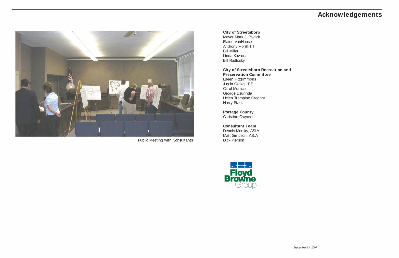
Public Meeting with Consultants
September 13, 2007 2
Table of Contents
Introduction Statement of Project Scope 3 Public Involvement Summary Background Data Collection Site Reconnaissance Background Mission and Vision
Resource Inventory and Analysis 4 Existing Public Lands, Public Parks & Recreation Facilities Private Recreation Facilities Unique Cultural and Natural Resources Summary of Potential Strengths and Weaknesses Recreation Needs Analysis 10 Methodology Total Park Area Method Proximity Method Facilities/Population Standards Method
Operational and Facility Assessment 12 Funding and Accounting Practices Review Financial Sustainability Opportunities
Master Plan Development 16 Overall Concept Plan for Parks, Trails and Greenspace Systems City Park, Wilcox Park and Vantage Point Master Plans Recommendations
Implementation, Operations Plan 24 Ten-year Timeline for Phased Implementation Summary of Potential Funding Sources & Strategies Key Action Steps
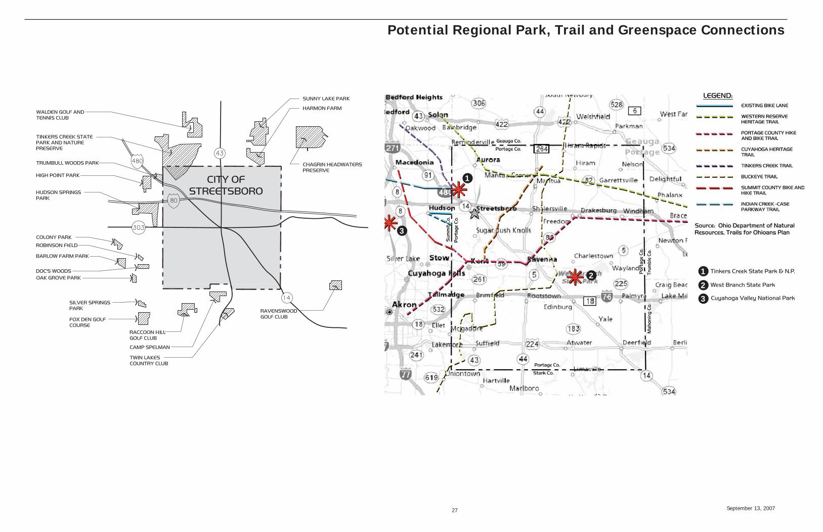
Appendix 26 Facility Matrix Regional Park, Trail and Greenspace Connections
Contents
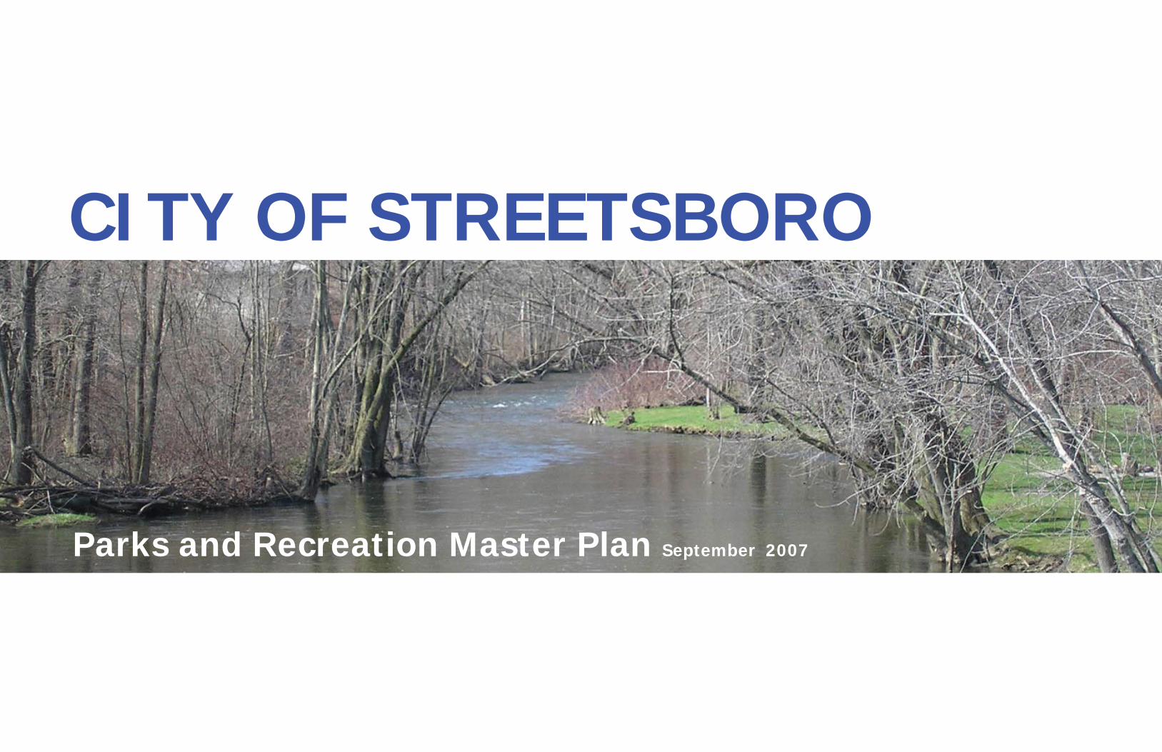
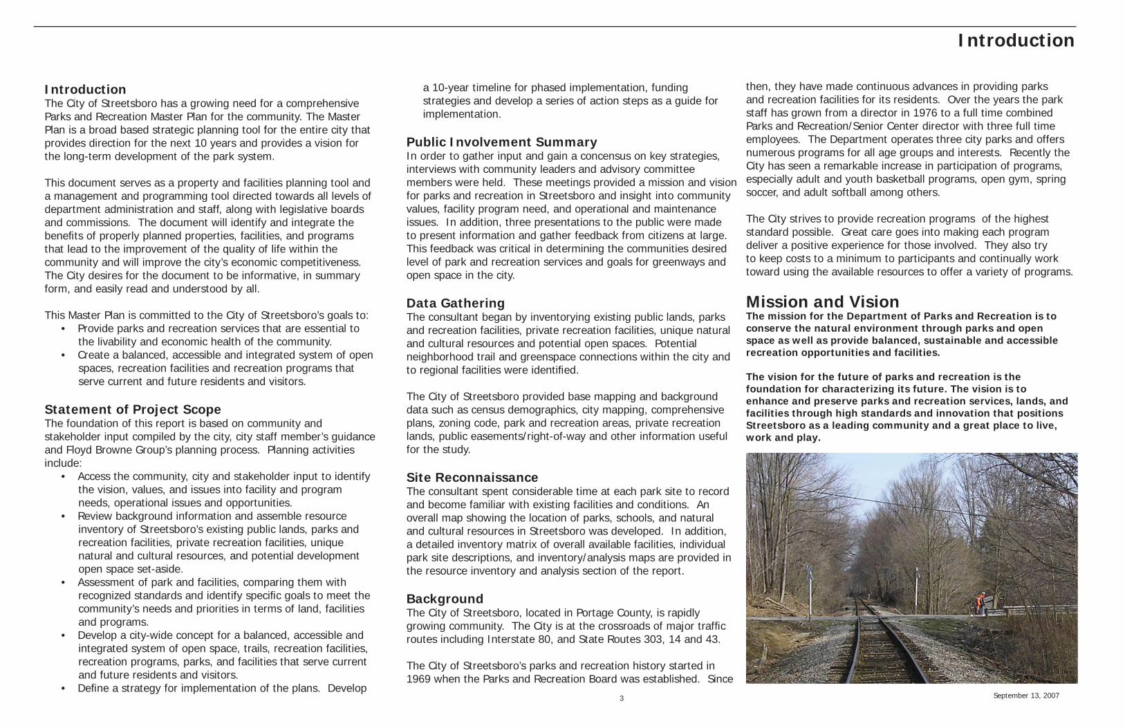
Cuyahoga River
September 13, 2007 3
IntroductionThe City of Streetsboro has a growing need for a comprehensive Parks and Recreation Master Plan for the community. The Master Plan is a broad based strategic planning tool for the entire city that provides direction for the next 10 years and provides a vision for the long-term development of the park system.
This document serves as a property and facilities planning tool and a management and programming tool directed towards all levels of department administration and staff, along with legislative boards and commissions. The document will identify and integrate the benefi ts of properly planned properties, facilities, and programs that lead to the improvement of the quality of life within the community and will improve the city’s economic competitiveness. The City desires for the document to be informative, in summary form, and easily read and understood by all. This Master Plan is committed to the City of Streetsboro’s goals to:
• Provide parks and recreation services that are essential to the livability and economic health of the community.• Create a balanced, accessible and integrated system of open spaces, recreation facilities and recreation programs that serve current and future residents and visitors.
Statement of Project ScopeThe foundation of this report is based on community and stakeholder input compiled by the city, city staff member’s guidance and Floyd Browne Group’s planning process. Planning activities include:
• Access the community, city and stakeholder input to identify the vision, values, and issues into facility and program needs, operational issues and opportunities.• Review background information and assemble resource inventory of Streetsboro’s existing public lands, parks and recreation facilities, private recreation facilities, unique natural and cultural resources, and potential development open space set-aside.• Assessment of park and facilities, comparing them with recognized standards and identify specifi c goals to meet the community’s needs and priorities in terms of land, facilities and programs.• Develop a city-wide concept for a balanced, accessible and integrated system of open space, trails, recreation facilities, recreation programs, parks, and facilities that serve current and future residents and visitors.• Defi ne a strategy for implementation of the plans. Develop
a 10-year timeline for phased implementation, funding strategies and develop a series of action steps as a guide for implementation.
Public Involvement SummaryIn order to gather input and gain a concensus on key strategies, interviews with community leaders and advisory committee members were held. These meetings provided a mission and vision for parks and recreation in Streetsboro and insight into community values, facility program need, and operational and maintenance issues. In addition, three presentations to the public were made to present information and gather feedback from citizens at large. This feedback was critical in determining the communities desired level of park and recreation services and goals for greenways and open space in the city.
Data GatheringThe consultant began by inventorying existing public lands, parks and recreation facilities, private recreation facilities, unique natural and cultural resources and potential open spaces. Potential neighborhood trail and greenspace connections within the city and to regional facilities were identifi ed.
The City of Streetsboro provided base mapping and background data such as census demographics, city mapping, comprehensive plans, zoning code, park and recreation areas, private recreation lands, public easements/right-of-way and other information useful for the study.
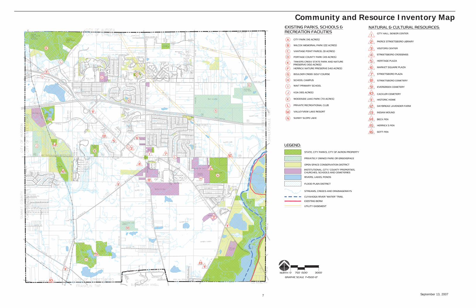
Site ReconnaissanceThe consultant spent considerable time at each park site to record and become familiar with existing facilities and conditions. An overall map showing the location of parks, schools, and natural and cultural resources in Streetsboro was developed. In addition, a detailed inventory matrix of overall available facilities, individual park site descriptions, and inventory/analysis maps are provided in the resource inventory and analysis section of the report.
BackgroundThe City of Streetsboro, located in Portage County, is rapidly growing community. The City is at the crossroads of major traffi c routes including Interstate 80, and State Routes 303, 14 and 43.
The City of Streetsboro’s parks and recreation history started in 1969 when the Parks and Recreation Board was established. Since
then, they have made continuous advances in providing parks and recreation facilities for its residents. Over the years the park staff has grown from a director in 1976 to a full time combined Parks and Recreation/Senior Center director with three full time employees. The Department operates three city parks and offers numerous programs for all age groups and interests. Recently the City has seen a remarkable increase in participation of programs, especially adult and youth basketball programs, open gym, spring soccer, and adult softball among others.
The City strives to provide recreation programs of the highest standard possible. Great care goes into making each program deliver a positive experience for those involved. They also try to keep costs to a minimum to participants and continually work toward using the available resources to offer a variety of programs.
Mission and VisionThe mission for the Department of Parks and Recreation is to conserve the natural environment through parks and open space as well as provide balanced, sustainable and accessible recreation opportunities and facilities.
The vision for the future of parks and recreation is the foundation for characterizing its future. The vision is to enhance and preserve parks and recreation services, lands, and facilities through high standards and innovation that positions Streetsboro as a leading community and a great place to live, work and play.
Introduction
September 13, 2007 4
Existing Public Parks, Schools and Recreation Facilities
Secondary entrance drive to City Park
PavilionSkate park
City ParkSize: 116 AcresFacilities: 9 baseball/ softball diamonds, numerous multi-use fi elds, 1 single hoop basketball court, 2 tennis courts, 2 restroom facilities, concessions area, shelter, skate park, maintenance building, driveway and parking lots
City Park serves as Streetsboro’s only “Community Park”. It is bounded by Route 303 to the north, Kirby Lane to the west and housing development to the south.
Numerous active recreational uses are offered at City Park. Baseball/ softball diamonds are well used and offer excellent opportunity for youth athletic programs. Due to increasing participation, the athletic facilities are reaching their full capacity. Soccer fi elds are located between baseball diamonds and receive moderate use. Camps are offered to teach fundamentals of soccer, basketball and tennis. In addition, the city offers fl ag football on two of the fenced ball fi elds. Two tennis courts are located in the park and received periodic use. Tennis programs consist of either camps or leagues depending on the participation level and basketball activities are offered at the middle school gymnasium and cafeteria. Unprogrammed activities include a skate park, shelter, single basketball hoop and open lawn areas. The skate park has been a heavily used addition to the park, but vandalism and controlling bicycle use has been a problem. The main entrance to the site is at the intersection of Annalane Drive and Kirby Lane. Also, that location is the parking lot entrance to Campus Elementary School. Due to the number of confl icts in that area, the main entrance should be considered for relocation. The entrance drive bisects the site, skirting the northeast boundary of the active recreation area and working its way past the maintenance building to the park’s primary parking lot. During peak use times the existing parking lots are at full capacity and often overfl ow onto lawn areas. A secondary drive is located off of Route 303 and connects to the main drive at fi eld #7. Access from Route 303 may be an ideal location for a new main entrance to the park.
Formalized pedestrian paths do not exist; however, the secondary entrance drive is used as a walking path. There is potential to create a trail system that links to internal park amenities and the neighboring school grounds, neighborhoods and future city-wide trail system.
In addition to the active recreational activities offered, the Portage County Watershed Plan identifi es priority woodlands and wetlands on the site. The wooded area northeast of the ball fi elds has the potential for increased use as a passive recreational area with picnic tables, shelters, woodland nature paths, bird watching and interpretive areas. North of the woodland is a meandering stream that could be enhanced
by restoring its margins with native fl oodplain vegetation, providing an educational opportunity, increase habitat creation, water quality protection and reduce maintenance costs. North of the stream, the gently sloping hillside offers views to the stream and woodland below. Due to the important role these areas play in the community, care should be taken that their key natural resources and characteristics are preserved.
September 13, 2007 5
Existing Parks
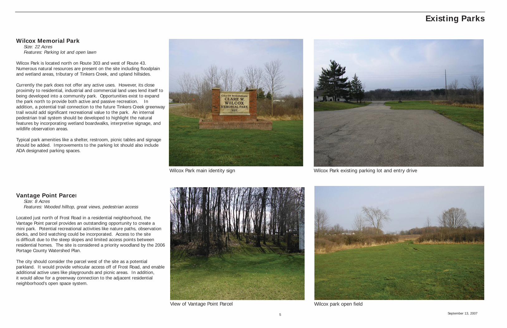
Wilcox Memorial ParkSize: 22 AcresFeatures: Parking lot and open lawn
Wilcox Park is located north on Route 303 and west of Route 43. Numerous natural resources are present on the site including fl oodplain and wetland areas, tributary of Tinkers Creek, and upland hillsides.
Currently the park does not offer any active uses. However, its close proximity to residential, industrial and commercial land uses lend itself to being developed into a community park. Opportunities exist to expand the park north to provide both active and passive recreation. In addition, a potential trail connection to the future Tinkers Creek greenway trail would add signifi cant recreational value to the park. An internal pedestrian trail system should be developed to highlight the natural features by incorporating wetland boardwalks, interpretive signage, and wildlife observation areas.
Typical park amenities like a shelter, restroom, picnic tables and signage should be added. Improvements to the parking lot should also include ADA designated parking spaces.
Vantage Point ParcelSize: 8 AcresFeatures: Wooded hilltop, great views, pedestrian access
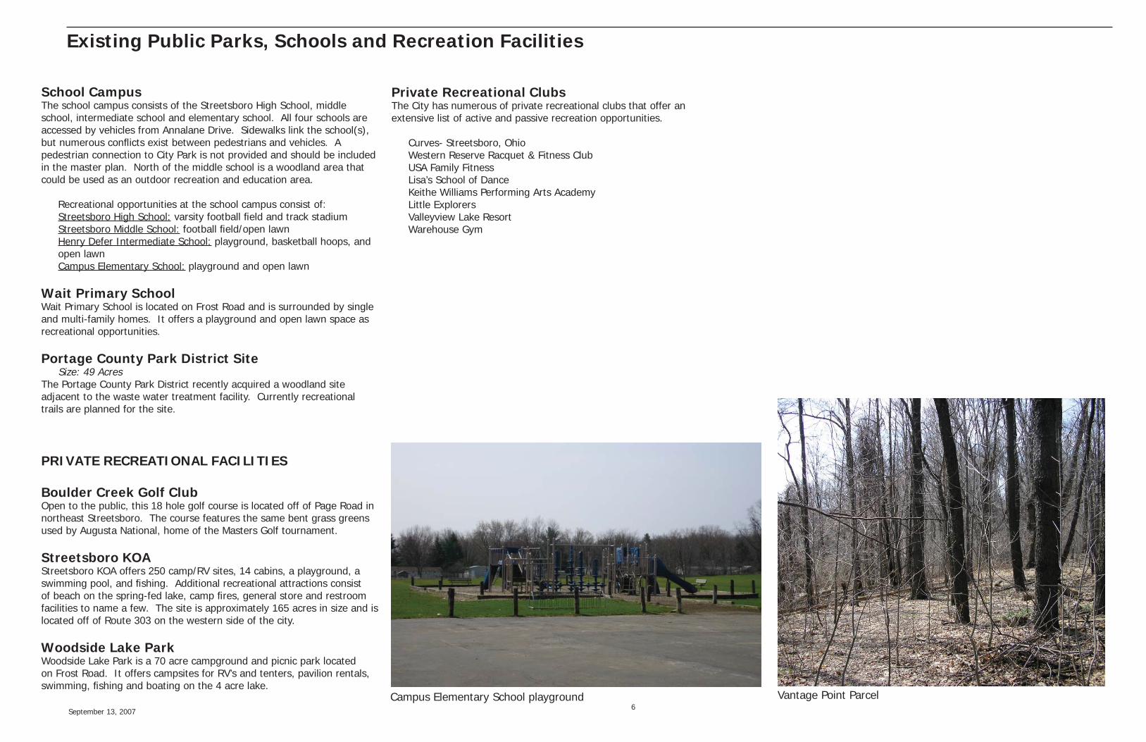
Located just north of Frost Road in a residential neighborhood, the Vantage Point parcel provides an outstanding opportunity to create a mini park. Potential recreational activities like nature paths, observation decks, and bird watching could be incorporated. Access to the site is diffi cult due to the steep slopes and limited access points between residential homes. The site is considered a priority woodland by the 2006 Portage County Watershed Plan.
The city should consider the parcel west of the site as a potential parkland. It would provide vehicular access off of Frost Road, and enable additional active uses like playgrounds and picnic areas. In addition, it would allow for a greenway connection to the adjacent residential neighborhood’s open space system.
Wilcox Park main identity sign Wilcox Park existing parking lot and entry drive
Wilcox park open fi eldView of Vantage Point Parcel
September 13, 2007 6
Existing Public Parks, Schools and Recreation Facilities
School CampusThe school campus consists of the Streetsboro High School, middle school, intermediate school and elementary school. All four schools are accessed by vehicles from Annalane Drive. Sidewalks link the school(s), but numerous confl icts exist between pedestrians and vehicles. A pedestrian connection to City Park is not provided and should be included in the master plan. North of the middle school is a woodland area that could be used as an outdoor recreation and education area.
Recreational opportunities at the school campus consist of:Streetsboro High School: varsity football fi eld and track stadiumStreetsboro Middle School: football fi eld/open lawnHenry Defer Intermediate School: playground, basketball hoops, and open lawnCampus Elementary School: playground and open lawn
Wait Primary SchoolWait Primary School is located on Frost Road and is surrounded by single and multi-family homes. It offers a playground and open lawn space as recreational opportunities.
Portage County Park District SiteSize: 49 Acres
The Portage County Park District recently acquired a woodland site adjacent to the waste water treatment facility. Currently recreational trails are planned for the site.
PRIVATE RECREATIONAL FACILITIES
Boulder Creek Golf ClubOpen to the public, this 18 hole golf course is located off of Page Road in northeast Streetsboro. The course features the same bent grass greens used by Augusta National, home of the Masters Golf tournament.
Streetsboro KOA Streetsboro KOA offers 250 camp/RV sites, 14 cabins, a playground, a swimming pool, and fi shing. Additional recreational attractions consist of beach on the spring-fed lake, camp fi res, general store and restroom facilities to name a few. The site is approximately 165 acres in size and is located off of Route 303 on the western side of the city.
Woodside Lake ParkWoodside Lake Park is a 70 acre campground and picnic park located on Frost Road. It offers campsites for RV’s and tenters, pavilion rentals, swimming, fi shing and boating on the 4 acre lake.
Private Recreational ClubsThe City has numerous of private recreational clubs that offer an extensive list of active and passive recreation opportunities.
Curves- Streetsboro, OhioWestern Reserve Racquet & Fitness ClubUSA Family FitnessLisa’s School of DanceKeithe Williams Performing Arts AcademyLittle ExplorersValleyview Lake ResortWarehouse Gym
Vantage Point ParcelCampus Elementary School playground
September 13, 2007 7
Community and Resource Inventory Map
September 13, 2007 8
Unique Natural and Cultural Resources
Tinkers Creek State Park and Nature PreserveTinkers Creek State Park and Nature Preserve is located in the northwest corner of Steetsboro and is a hub for passive recreational activities in the area. Their land holdings combined encompass approximately 1,150 acres. The State Park, of approximately 370 acres, features recreational opportunities such as plant and wildlife observation, fi shing, hiking and picnicking. However, most of the park is maintained as a swamp and marshland providing habitat for migratory birds. It is the home of numerous wildlife including bass, crappie, catfi sh, herons, ducks, beavers and bald eagles. Some active recreational opportunities are provided such as a cross-country skiing, playground, horseshoes and volleyball courts. The Nature Preserve features extensive marshes, numerous nature trails, boardwalks, and observation deck.
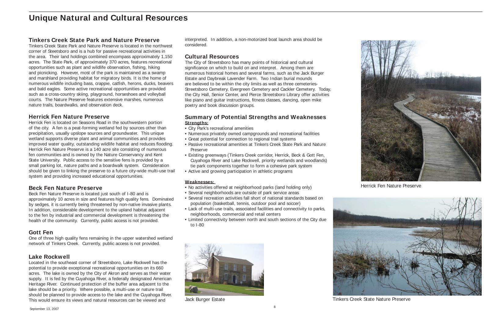
Herrick Fen Nature PreserveHerrick Fen is located on Seasons Road in the southwestern portion of the city. A fen is a peat-forming wetland fed by sources other than precipitation, usually upslope sources and groundwater. This unique wetland supports diverse plant and animal communities and provides improved water quality, outstanding wildlife habitat and reduces fl ooding. Herrick Fen Nature Preserve is a 140 acre site consisting of numerous fen communities and is owned by the Nature Conservancy and Kent State University. Public access to the sensitive fens is provided by a small parking lot, nature paths and a boardwalk system. Consideration should be given to linking the preserve to a future city-wide multi-use trail system and providing increased educational opportunities.
Beck Fen Nature PreserveBeck Fen Nature Preserve is located just south of I-80 and is approximately 10 acres in size and features high quality fens. Dominated by sedges, it is currently being threatened by non-native invasive plants. In addition, considerable development to the upland habitat adjacent to the fen by industrial and commercial development is threatening the health of the community. Currently, public access is not provided.
Gott FenOne of three high quality fens remaining in the upper watershed wetland network of Tinkers Creek. Currently, public access is not provided.
Lake RockwellLocated in the southeast corner of Streetsboro, Lake Rockwell has the potential to provide exceptional recreational opportunities on its 660 acres. The lake is owned by the City of Akron and serves as their water supply. It is fed by the Cuyahoga River, a federally designated American Heritage River. Continued protection of the buffer area adjacent to the lake should be a priority. Where possible, a multi-use or nature trail should be planned to provide access to the lake and the Cuyahoga River. This would ensure its views and natural resources can be viewed and
interpreted. In addition, a non-motorized boat launch area should be considered.
Cultural ResourcesThe City of Streetsboro has many points of historical and cultural signifi cance on which to build on and interpret. Among them are numerous historical homes and several farms, such as the Jack Burger Estate and Daybreak Lavender Farm. Two Indian burial mounds are believed to be within the city limits as well as three cemeteries- Streetsboro Cemetery, Evergreen Cemetery and Cackler Cemetery. Today, the City Hall, Senior Center, and Pierce Streetsboro Library offer activities like piano and guitar instructions, fi tness classes, dancing, open mike poetry and book discussion groups.
Summary of Potential Strengths and WeaknessesStrengths:• City Park’s recreational amenities• Numerous privately owned campgrounds and recreational facilities• Great potential for connection to regional trail systems• Passive recreational amenities at Tinkers Creek State Park and Nature Preserve• Existing greenways (Tinkers Creek corridor, Herrick, Beck & Gott Fen, Cuyahoga River and Lake Rockwell, priority wetlands and woodlands) tie park components together to form a cohesive park system• Active and growing participation in athletic programs
Weaknesses: • No activities offered at neighborhood parks (land holding only)• Several neighborhoods are outside of park service areas• Several recreation activities fall short of national standards based on population (basketball, tennis, outdoor pool and soccer)• Lack of multi-use trails, associated facilities and connectivity to parks, neighborhoods, commercial and retail centers• Limited connectivity between north and south sections of the City due to I-80
Herrick Fen Nature Preserve
Tinkers Creek State Nature PreserveJack Burger Estate
September 13, 2007 9
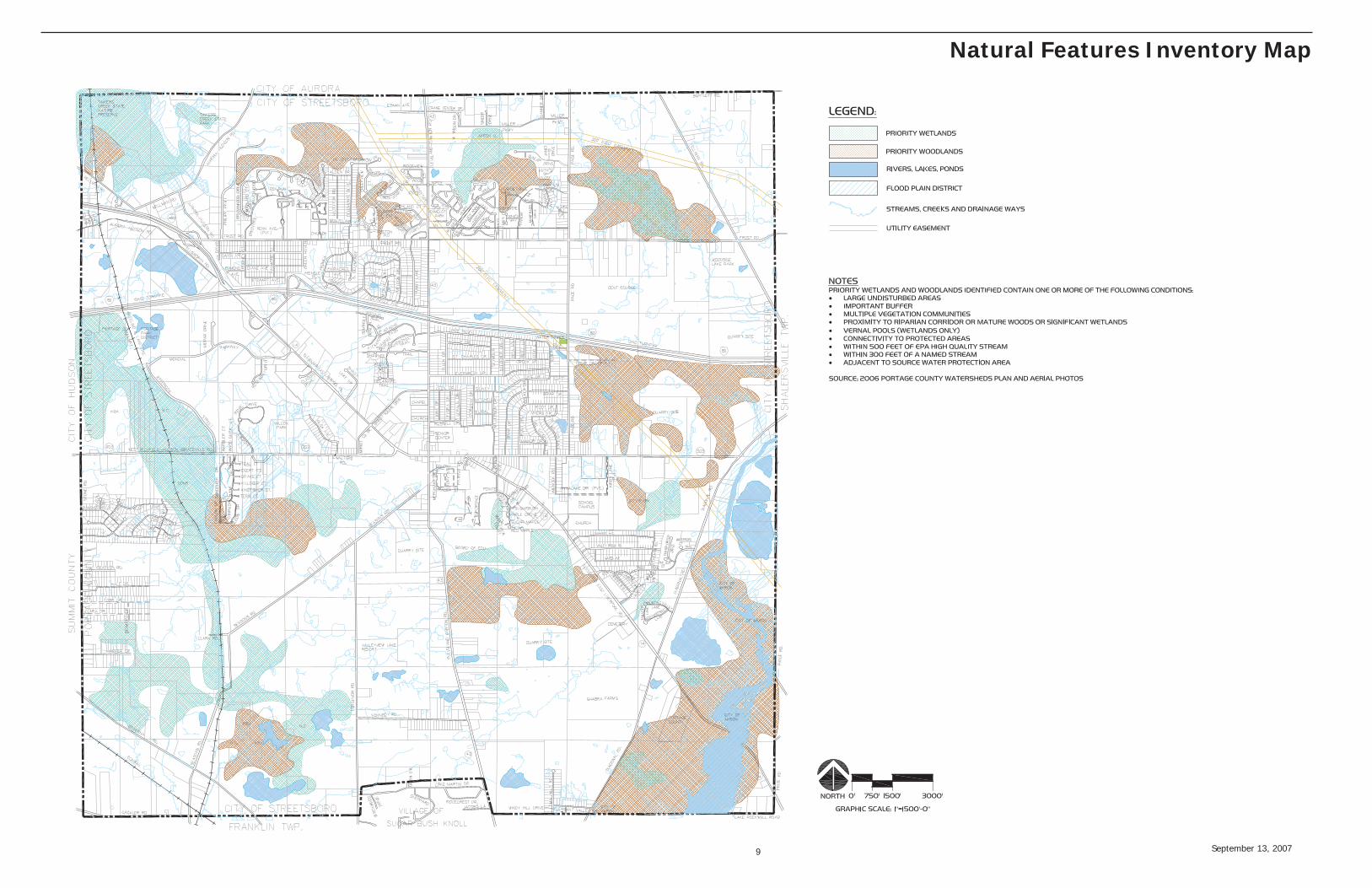
Natural Features Inventory Map
September 13, 2007 10
ApproachOne of the most important tasks of the planning process is to determine the community’s desired level of park and recreation service and to tie that level of service to a measurable growth indicator. Many factors go into that determination including future population levels, the age of population, the ability to fund improvements and to maintain those improvements over the long term, and the availability of parks within the greater area. In other words, the City must develop its own planning standard on how much and what type of parkland it desires to have in the future.
The City planning process approached this task in two ways. First, key community leaders, Advisory Committee and residents were invited to share their vision and expectations for future parks within the City. Secondly, the use of the National Recreation and Parks Association (NRPA) planning standards for an ideal park system. The most current publication on park system planning by the NRPA, “Park, Recreation, Open Space and Greenway Guidelines” (1996), recommends a planning approach that establishes a level of service that is needs-based, facilities-driven, and land-measured. The scope of service for this report did not permit the full model approach recommended in this NRPA publication. However, several other methods were used to address the level of service criteria and to help determine the present and future recreation needs of Streetsboro. These included the total park area method, the proximity method, and the facility/population standards method.
As development occurs, all methodologies will adjust proportionately to accommodate additional needs for community parks, neighborhood parks, trail networks and athletic facilities. Other communities have adopted legislature requiring new developments to provide parkland proportionate to the pro-posed population increase and proximity to adjacent existing parkland. This is a valuable and progres-sive way to increase parkland with new developments.
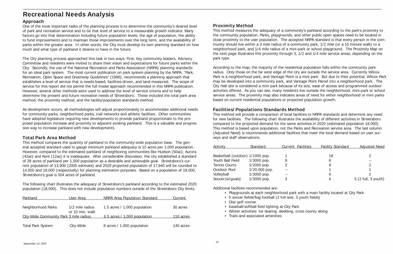
Total Park Area MethodThis method compares the quantity of parkland to the community-wide population base. The gen-eral accepted standard used to gauge minimum parkland adequacy is 10 acres per 1,000 population. However, compared to the estimated parkland of neighboring communities like Hudson (50ac), Aurora (42ac) and Kent (12ac) it is inadequate. After considerable discussion, the city established a standard of 28 acres of parkland per 1,000 population as a desirable and achievable goal. Streetsboro’s cur-rent population of 13,900 (2005 estimate) and 2020 projected population of 17,940 will be rounded to 14,000 and 18,000 (respectively) for planning estimation purposes. Based on a population of 18,000, Streetsboro’s goal is 504 acres of parkland.
The following chart illustrates the adequacy of Streetsboro’s parkland according to the estimated 2020 population (18,000). This does not include population numbers outside of the Streetsboro City limits.
Parkland User Area NRPA Area Population Standard Current
Neighborhood Parks 1/2 mile radius 1.5 acres / 1,000 population 30 acres or 10 min. walk City-Wide Community Park 3 mile radius 6.5 acres / 1,000 population 110 acres Total Park System City-Wide 8 acres / 1,000 population 140 acres
Proximity MethodThis method measures the adequacy of a community’s parkland according to the park’s proximity to the community population. Parks, playgrounds, and other public open spaces need to be located in close proximity to the user population. The accepted NRPA standard is that every person in the com-munity should live within a 3 mile radius of a community park, 1/2 mile (or a 10 minute walk) to a neighborhood park, and 1/4 mile radius of a mini-park or school playground. The Proximity Map on the next page illustrates this proximity through 3, 1/2 and 1/4 mile service areas, depending on the park type.
According to the map, the majority of the residential population falls within the community park radius. Only those on the far west edge of the city are outside the service area. Currently Wilcox Park is a neighborhood park, and Vantage Point is a mini park. But due to their potential, Wilcox Park may be developed into a community park, and Vantage Point Parcel into a neighborhood park. The City Hall site is considered a mini park because of its size, ease of access and programmed outdoor activities offered. As you can see, many residents live outside the neighborhood, mini-park or school service areas. The proximity map also indicates areas of need for either neighborhood or mini parks based on current residential populations or projected population growth.
Facilities/Populations Standards MethodThis method will provide a comparison of local facilities to NRPA standards and determine any need for new facilities. The following chart illustrates the availability of different activities in Streetsboro compared to the projected demand for the same activities in 2020 (estimated population 18,000). This method is based upon population, not the Parks and Recreation service area. The last column (Adjusted Need) is recommends additional facilities that meet the local demand based on user sur-veys and staff observations.
Recreational Needs Analysis
Activity Standard Current Facilities Facility Standard Adjusted Need
Basketball (outdoor) 1/1000 pop. 1 18 2Youth Ball Field 1/3000 pop. 9 6 --Tennis Courts 1/2000 pop. 2 9 2Outdoor Pool 1/20,000 pop. -- 1 1Volleyball 1/3000 pop. -- 6 2Soccer (w/goals) 1/3000 pop. 3 6 5 (2 full, 3 youth)
Additional facilities recommended are: • Playgrounds at each neighborhood park with a main facility located at City Park • 5 soccer fi elds/fl ag football (2 full-size, 3 youth fi elds) • Disc golf course • baseball/softball fi eld lighting at City Park • Winter activities: ice skating, sledding, cross county skiing • Trails and associated amenities

September 13, 2007 11
Proximity Map
COMMUNITY PARK: 3 MILE RADIUS
NEIGHBORHOOD PARK (LAND HOLDING ONLY): 1/2 MILE RADIUS
MINI PARK: 1/4 MILE RADIUS
SCHOOL SITE: 1/4 MILE RADIUS
AREA OF NEED
SERVICE AREA
September 13, 2007 12
Operations and Financial Overview
History
The City of Streetsboro established a Parks and Recreation Board in 1969 as provided by section 755.14 of the Ohio Revised Code. The Board was designed to be fi ve members, three appointed by the Mayor and two appointed by the School Board. The responsibilities were to equip, operate and maintain playgrounds, playfi elds, gymnasiums, public baths, swimming pools or recreation centers. With no land and no staff, it was a proper beginning but slow to evolve. In 1972 approximately 90 acres of land, generally known today as City Park, was designated for public park use. (1)*
In 1973, a .5 mill levy was passed and used as the basis for the Parks and Recreation budget. In 1976, the Director’s position was established and was to be fi lled by the Parks and Recreation Board. City Council authorized the sum of $1.00 per annum as a token salary. (2)* No one was identifi ed as accepting the position. In that same year, the .5 mill levy was renewed to provide for continued fi nancial support.
The Streetsboro Lions Club stepped forward in 1979 with a $1,161.00 donation to establish water services in City Park. The Lions Club also provided a picnic shelter for City Park during that same year.
In the early 1980’s, $9,000 was accepted from the City to establish a Recreation Fund. During the same period, an application for a federal grant was submitted for 15.5 acres of land located in the southwest quadrant of City Park. In 1988, Steve Kolar was hired as the Park and Recreation Director. (3)*
A charter amendment in 1990 changed the manner in which appointments were made to the Parks and Recreation Board. As of this amendment, all fi ve board members were to be appointed by the Mayor and confi rmed by City Council. During this same year the City and the Schools authorized a joint license agreement for playgrounds on school grounds. (4)*
In 1992, the Streetsboro City Charter Section 14.03 was amended providing for the Parks and Recreation Director to be appointed by City Council and responsible to the Mayor. It also provided for removal of the Director by ¾ majority of City Council. The Parks and Recreation Board would have responsibility only for part time personnel. Parks and Recreation employees were added to the pay ordinance, and appropriation adjustments were made for a Parks Capital Improvements budget. (5)*
1996 showed that $230,000 was allocated for a NatureWorks Grant for construction of a toilet shelter building, walkways, and two new ball fi elds all located in City Park. (6)* A contract was approved with Ted Manfrass for the design of these park improvements. (7)* A theatre fund was established to operate under the Parks and Recreation Department, and Michele Harmel was confi rmed as the new Parks and Recreation Director.
City Council approved all expenditures for Parks and Recreation as noted in an ordinance to award a $250.00 contract to Andrew Clark to direct the play “Peter Pan” during the summer of 1997. (8)*
In 1998 another ordinance was passed by City Council establishing the Parks and Recreation Department and its director. The director would be responsible to the Mayor, effectively abolishing the Parks and Recreation Board.(9)* The director’s salary increased from $22,250.00 to $27,450.00.(10)* In the fees and charges arena, City Council authorized a reduction in the Park Impact Fee from $500.00 to $200.00 for each new development, whether single family or a sub division development.(11)*
City Council approved several individual contracts in 2000 for swing dance, playtime partners, basketball coordinator, spring theatre, concerts in the parks, and youth craft classes. A grant application was submitted to the Ohio Arts Council to request budget assistance for these programs. In 2001, City Council authorized construction of an addition to the storage building in City Park. (12)*
In 2002, City Council established a new department called “The Department of Public Grounds and Facilities”. This department was to be responsible for maintaining City Buildings, Grounds, and Park Lands. (13)* The park maintenance staff, formerly operating under the Parks and Recreation Department, was moved to the Department of Public Grounds and Facilities.
Approval was given by City Council in 2003 for the construction of the Skatepark located in City Park. Individual contracts were awarded for concrete construction and apparatus.
City Council took a major step in 2003 by establishing the “Citizens Committee for Public Recreational Land Use”, an advisory committee of the City. “The committee was charged to take steps (…within the authority of the law…) to assess lands presently
owned by the City and in private ownership, to determine suitability for active and passive recreation by City residents, to consider applicable funding sources for the acquisition and development of such public recreation lands, including drainage, to assist Council in allocating City recreational funds and funding sources, and to recommend to Council any other aspect of land use it deems appropriate and benefi cial to the residents of the City.”(14) Seven members were appointed by the Mayor and confi rmed by City Council.
In 2005, three properties were approved by City Council for option to buy, and then the authorization was reversed. (15) The reversal of the decision was based on the desire to wait for the Parks and Recreation Master Plan to be completed which would help determine what lands should be purchased.
In January 2006, The Parks and Recreation Director and Senior Citizens Director positions were combined into one job. Elaine VanHoose was appointed as the new “combined” director. (16)
During the summer of 2006, City Council authorized a “Request for Proposal” for the development of a Master Plan for Parks and Recreation. (17)*
Staffi ng
Staffi ng for the Parks and Recreation Department reached an all time high in 2001 with three permanent positions and one seasonal. The director, clerk, and recreation supervisor were permanent positions, and the seasonal position was part of the grounds maintenance staff. In 2003, the non-salaried positions joined the union under AFSCME local 3811. At this time, the supervisor’s position was renamed programmer, and it, along with the clerk position, fell under the same job classifi cation, it remains that way today.
The maintenance of the parks falls under the Department of Public Grounds and Facilities. This department is responsible for maintaining public buildings, public grounds, and preparing and maintaining the parks for recreational activities and special events. With this much responsibility for public lands falling to one department, there are times when priorities require choices that result in a less-than-desired public image for public lands and/or public parks.
September 13, 2007 13
Operational and Facility Assessment
The department continues to operate with the director serving as the Parks and Recreation Director and the Senior Citizens Director. The subordinate staff fi lling the two other permanent positions, particularly the recreation programmer, continues to turn over, making it diffi cult to provide continuity, creativity, and consistency in recreational programming. Under the present organizational structure, with the clerk and the recreational programmer listed in the same job classifi cation under the union contract, hiring and keeping a recreation programmer is diffi cult.
Programming Operations
Presently, programming activities take place at three indoor locations and outdoors at City Park. Indoor programming is found at City Hall, Streetsboro Middle School, and Campus Elementary School. City Hall programming includes the Teen Center, and use of the Music/Computer Room, open classroom, and the Multi-Purpose Room. The schools permit utilization of the cafeteria and gymnasiums with the additional use at Campus Elementary of some classrooms, the playground, and the open fi eld.
Outdoor programming takes place in the open fi eld area around City Hall and at City Park. Tennis courts, the skatepark, baseball and softball fi elds, and the open fi eld play areas are programmed at City Park.
Present programming, as well as historical programming, has been offered to all age categories. Some ages are served better than others because of (or lack of) interest, facilities and appropriate staff. 2007 has seen an increase in participation over 2006 in several program categories. Presently the Parks and Recreation Department offers a multitude of recreation programming for all age groups.
Residents can fi nd programming in many categories including toddlers, youth sports, adult sports, sport camps, fi ne arts, teen programs, youth classes, adult classes and several special events. Some of the special events include photography, travel opportunities, holiday special activities, Safety Land, Paws-in-the-Park, Tiny Tykes track and fi eld, and the NFL Pepsi Punt, Pass, and Kick Competition.
The Recreation Programming takes place throughout the calendar year and has the potential of expanding with the advent of more
park land and required staff.
* Streetsboro City Council ordinances by year and number of ordinances.
1. 1972-592. 1976-163. 1985-634. 1990-665. 1992-806. 1997-867. 1997-888. 1997-979. 1998-10310. 1998-13511. 1998-15212. 2000-5413. 2002-5114. 2003-17215. 2005-5816. 2006-0117. 2007-57
September 13, 2007 14
Operational and Facility Assessment
Funding and Accounting Practices ReviewWhen the voters in Streetsboro approved a ballot issue in 1970 to have their community become an offi cial “City” effective January 1, 1971, the area already had a colorful history dating back to 1798. There was the famous founder, Titus Street, the 1825 “original turnpike” from Cleveland to Wellsville, and recognition of Streetsboro as one of the major cheese producers in the United States producing over 600,000 pounds of cheese in 1873.
The City of Streetsboro literally exploded with development when the Ohio Turnpike opened in 1955 (with one of the few exists right at the edge of town). With the popularity of the automobile and Streetsboro’s strategic location in proximity to Cleveland, Akron, and Youngstown, the community began its rapid growth that continues today.
The establishment of a Parks and Recreation Board was approved in 1969, just prior to the “offi cial City” declaration. The actual department emerged in 1972 when approximately 90 acres of land, (known as City Park) was designated for public park use. The ability to develop that land and offer recreation programming was realized in 1973 when a .5 mill levy was passed that provided the basis for the Parks and Recreation budget. The necessity of a Park budget was realized even in the infant days as Streetsboro developed into a city.
Records show that the .5 mill levy was renewed in 1976. In addition, donations from service clubs and private individuals were accepted, and an application for a federal grant was submitted to obtain additional land around City Park.
In the 1990’s, City Council appropriated General Fund monies for part time labor in the Recreation Department. In the late 1990’s, a NatureWorks Grant was submitted for capital improvements at City Park, and a park impact fee was established by City Council. For the last several years, the City’s General Fund budget has been the primary resource for funding for the Parks and Recreation Department.
The history of the City of Streetsboro refl ects several ways in which the Parks and Recreation Department was funded. It included 1) a levy; 2) private donations; 3) public organizational donations; 4) grants; 5) a park impact fee for developers; 6) the City’s general fund; and 7) the City’s capital budget. All of these are legitimate
and effective ways to provide a budget for the Parks and Recreation Department. The key is to fi nd an operative manner in which to provide funding, justify it, and most importantly, accomplish the declared tasks for which the budget was allocated.
Financial Sustainability OpportunitiesWhenever the suggestion is made to develop a new site, acquire new property, buy new equipment, or expand existing lands or facilities, concern immediately follows based on the question, “How will we pay for these projects?” How is the community going to fund this capital project and possibility more importantly, how will the ongoing maintenance of the property or equipment be funded?
The City of Streetsboro has accomplished these challenges in the past by taking advantage of some of the many funding opportunities available. To simply list them, they include: Funding Source Allocating Authority1. General Fund City Council2. Park Levy Ballot Issue3. Impact Fees City Council4. Assessments City Council5. Bond Issues Ballot Issue6. Income Tax Ballot Issue7. Multiple Grants a. Nature Works, Ohio Department of Natural Resources b. Land and Water Conservation Fund, Federal through ODNR c. Recreational Trails, ODNR d. Tea-21, Federal through ODNR e. National Scenic Byway Program, ODOT f. Ohio EPA Non-Point Source Management Program ODNR g. Clean Ohio Fund, ODNR h. Cooperative Boating Facility Grant, ODNR i. Ohio Water Trails Program, ODNR8. Public/Private Partnerships9. National Foundation and Organization Grants10. In-Kind Services11. Scholarships12. User Fees
Grants are an excellent source of funding and one of the major requirements of grant applications is that the requested project be part of a planning document. By accepting this Parks and
Recreation Master Plan, a major hurdle in grant approval will have been accomplished.
In general, State and Federal grants are awarded to communities to acquire new land or build new facilities and are less likely to provide operations and maintenance budgets for those improvements. There are State and Federal grants that address operations and maintenance, and those opportunities should be explored. Local funding though, of which there are many possibilities, is usually tapped to provide the funding source for operations and maintenance. This can be accomplished through partnerships, in-kind services, a park levy, foundation grants, a bond issue, general fund allocations and user fees. One must keep in mind that while new developments, site improvements, and acquisition of new land will need fi nancial stewardship, there are many opportunities available to communities to fi nd appropriate funding.
Operations and Maintenance Staffi ngThe recommendations in this Master Plan for Parks and Recreation represent several different levels of commitment for operations and maintenance staffi ng. If City Council adopts an open space dedication policy, establishes a Conservation Zoning Overlay District, or adopts legislation that directs the City to preserve and/or acquire fl oodplain property for open space and trails, the immediate impact on operations and maintenance staffi ng would be minimal. These pieces of legislation are a terrifi c place to begin because it doesn’t require immediate funding. At the same time, it establishes the direction the City desires to go in the future concerning open space and green space.
By adopting this Master Plan, City Council will establish what is acceptable concerning open space in the city. It also means that a fi nancial commitment will be required in the future to meet the goals of the plan. To succeed with a fi nancial commitment in the future, the City must build a trust with the citizens. For example, when the fl oodplain properties are acquired with the intent to build trails on them, the trails must be built. When those goals are accomplished, the residents will develop a trust in the City that future goals will also be achieved. That trust will lay the groundwork for confi dence in future fi nancial endeavors that will provide funding for acquisition, operations, and maintenance staffi ng. It is the residents after all who will provide the City with at least part of the necessary fi nancing to acquire as well as develop and maintain the recommendations in this plan.

September 13, 2007 15
Operational and Facility Assessment
The funding plans recommended in this Master Plan are in addition to present day existing budgets. It must be recognized that the parks, public grounds and facilities in all of Streetsboro are being maintained by two people using outdated equipment. Everyone is constantly requested to do more with less, and this division of the Department of Public Service has been doing all they can with less and less. This department cannot be stretched any further.
If some of the actions recommended in this plan are adopted (i.e. acquire and construct additional community and neighborhood parks, continue to develop City Park’s recreational amenities, provide active and passive recreational opportunities at Wilcox Park, purchase the property adjacent to Vantage Point and develop a neighborhood park), then more equipment and more man power will be required to build and maintain those areas. It will depend on what actions are accepted in the Master Plan to determine the amount of equipment or the number of additional man hours it will take to maintain the improvements. It would be extremely shortsighted to accept this Master Plan and not acknowledge the need to develop a funding plan in order to accomplish the stated goals.

September 13, 2007 16
Master Plan
The Park SystemA park system consists of several park classifi cations that include community, neighborhood, mini and school parks. Together with a network of trail and greenways, they create a system of recreation activities for the community. The following are brief descriptions of the various park types as classifi ed by The National Recreation and Park Association.
Community Parks are typically large in size (20-50 acres) and serve the recreational needs of the entire community. They provide amenities to multiple neighborhoods and have a service area of up to 3 miles. Access to the site should be conveniently located near collector or arterial streets and be easily accessible by a trail system. Ideally, the site should be geographically centered and have a strong relationship to the other park areas. The site’s natural character should also be carefully considered during the acquisition and planning stages to ensure that unique qualities like vegetation, watersheds, views and topography are preserved or enhanced.
Neighborhood Parks are the basic unit of a park system. They are typically 5 to 10 acres in size and serve the recreational needs of a specifi c neighborhood. They can have both active or passive recreation opportunities or be geared to a specifi c user group. They should be centrally located in the neighborhood being served and be accessible by a trail system, sidewalks or residential streets. The site should posses aesthetic qualities, since experiencing a pleasant outdoor environment is a primary recreational activity in neighborhood parks.
Mini Parks are usually under an acre in size and are used to fulfi ll the recreational needs of an isolated area. They can offer active recreation like playgrounds or be designed to fi t a unique function like a rose garden, interpretive area or plaza adjacent to a shopping center. Their location should be based on a specifi c need rather than by population. The park should be easily accessible by sidewalks or residential streets and be linked to neighborhood parks by a trail system.
School Parks expand the recreation opportunities of the community by providing shared facilities and land area. Depending on the school and its location, recreation activities like playgrounds, open lawn, and athletic fi elds can be a joint use relationship with the school district and park system.
The Trail SystemThe trail system is comprised of a variety of trail types, providing continuous connections throughout the greenway system. These trails take advantage of stream corridors, rail and utility right-of- ways, widened sidewalks, abandoned canal tow paths and lightly used roads. These lands are both public and private. Generally, multi-use trails will accommodate a variety of uses including walking, running, biking, roller blade skating, nature observation, and equestrian use. Trail surfaces are typically asphalt or compacted crushed stone. The trail surface should be barrier-free and accessible to wheelchairs and other physically challenged users. The trails are predominately protected for motorized vehicles, either by their direct prohibition of off-road trails, or in the case of on-road trails a separate signed lane. Where trails share traffi c lanes with cars, they should be well-marked with signs posted along the roadside. They will be developed with a variety of visitor amenities (such as trailheads) and are often planned in association with existing commercial developments that can provide visitor access.
Nature trails are often needed to connect the multi-purpose trails to environmentally sensitive areas and remote locations within the greenway corridor. Trail construction can be as simple as a mowed or cleared path.
GreenwaysGreenways are a linear connection along a natural or man-made feature often connecting people to places. Greenways offer recreational, ecological, and strong positive economic benefi ts for the communities they serve. Examples of greenways include: river and stream corridors, active and abandoned railroad right-of-ways, canal lands, utility corridors, shorelines, roads, and ridgelines.
Not all greenways involve public access; many have value as privately owned corridors of natural habitat. Some greenways are not green at all. A railroad right-of-way through an industrial area might provide a critical greenway linkage as part of regional trails system. Greenways can provide tremendous recreational benefi ts while simultaneously supplying an alternative route to much needed infrastructure.
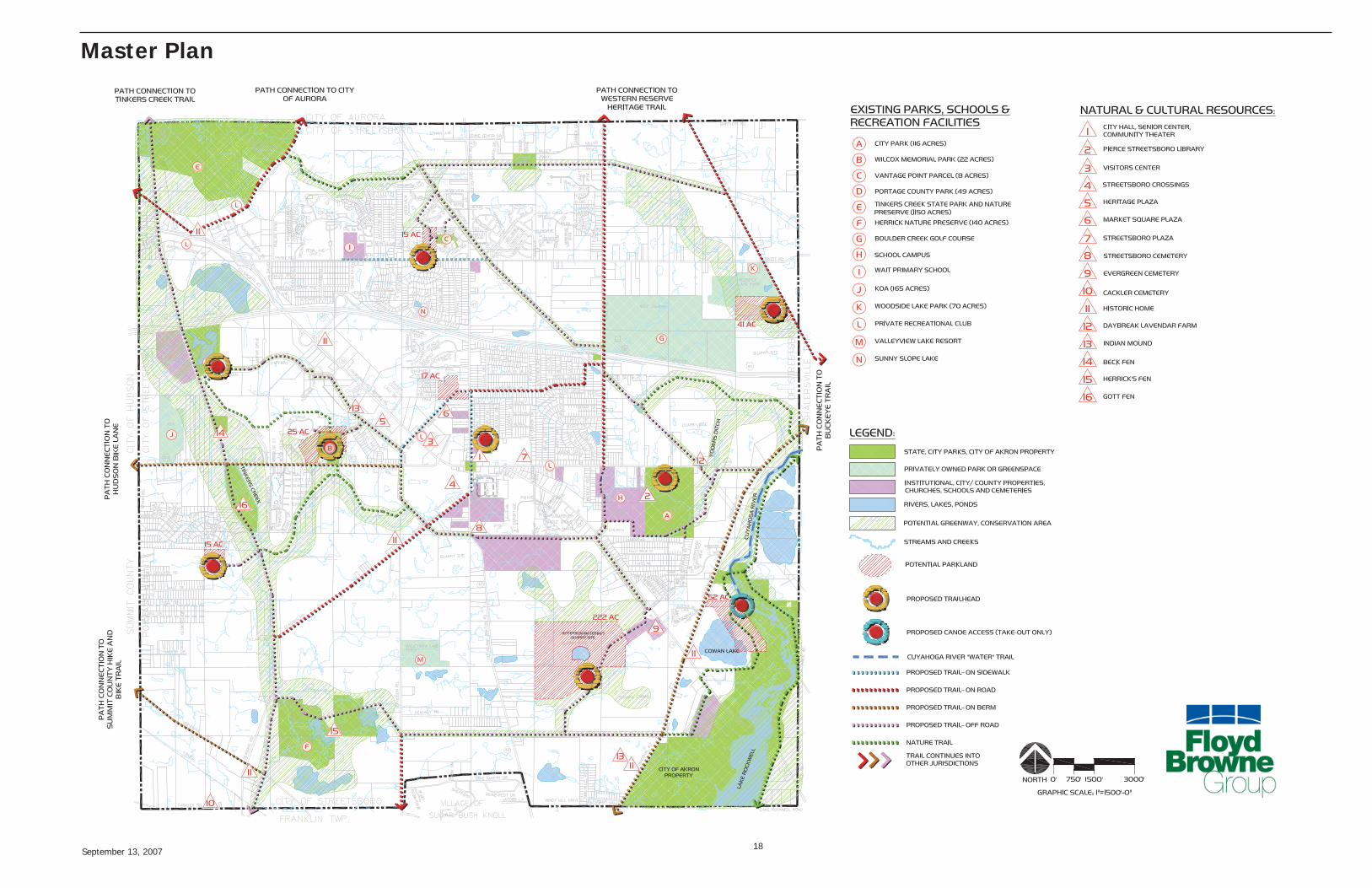
The greenway components proposed in this plan are primarily associated with the Cuyahoga River, Tinkers Creek, Lake Rockwell and the riparian corridors that feed them; rail lands, and utility easements. These areas are considered important as preservation of open space and ecological enhancement. The plan recognizes these areas as signifi cant contributors to water and air quality, habitat, wildlife, and open space protection. The greenways identifi ed as part of this plan will serve as a catalyst for local preservation and environmental enhancement efforts as a framework for crafting protection strategies.
In addition, several quarry lands were considered as potential reclamation sites. These areas provide ecological restoration potential as part of their reuse and may prove feasible for recreation programs, such as mountain biking and fi shing.
September 13, 2007 17
Master Plan
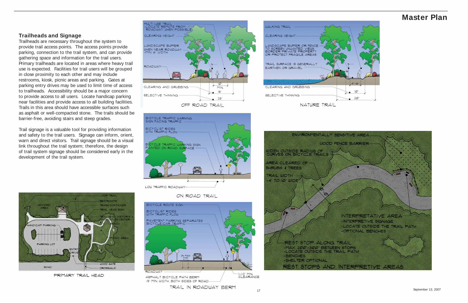
Trailheads and SignageTrailheads are necessary throughout the system to provide trail access points. The access points provide parking, connection to the trail system, and can provide gathering space and information for the trail users. Primary trailheads are located in areas where heavy trail use is expected. Facilities for trail users will be grouped in close proximity to each other and may include restrooms, kiosk, picnic areas and parking. Gates at parking entry drives may be used to limit time of access to trailheads. Accessibility should be a major concern to provide access to all users. Locate handicap parking near facilities and provide access to all building facilities. Trails in this area should have accessible surfaces such as asphalt or well-compacted stone. The trails should be barrier-free, avoiding stairs and steep grades.
Trail signage is a valuable tool for providing information and safety to the trail users. Signage can inform, orient, warn and direct visitors. Trail signage should be a visual link throughout the trail system; therefore, the design of trail system signage should be considered early in the development of the trail system.
September 13, 2007 18
Master Plan
September 13, 2007 19
Master Plan Recommendations
Recommendation: Seek to acquire and construct additional community and neighborhood parks.This plan recommends that a park be developed west of U.S. Route 43 and north of Market Square Drive. A future park in this area would be in close proximity to the primary residential core of the community. It would also be accessible by U.S. Route 43 and be within walking distance of City Hall/Senior Center and Market Square Plaza. The land is reasonably fl at and will be conducive to development of playing fi elds for youth recreation. This site may also serve as a site for a future community pool or water playground.
The plan envisions an additional park similar in size and potential to Wilcox Park, located in the southwestern portion of the city between Tinkers Creek and McCracken Road. The site has potential for both active and passive uses and is in close proximity to residential development and environmentally sensitive areas.
In the southeastern portion of the city are two potential parks. The fi rst is located between Cowan Lake and the Cuyahoga River. It is approximately 52 acres in size and has the potential for amenities such as swimming, beaches, playgrounds, picnicking, disc golf, fi shing, wildlife observation, paddle boating and canoe takeout. The other site is at the Jefferson Materials quarry site located on U.S. Route 14. This site has the potential for reuse (once its current extraction operation is played out. This is expected in the next four to fi ve years) as an active recreational area with facilities such as community pool/ recreation center, youth sports, mountain biking, fi shing, disc golf, sled run, ice skating and amphitheater to name a few.
In the northeastern portion of the city, the plan recommends a 41 acre site that would build on the existing recreational activities in this area. Located just south of the Woodside Lake Park, this park would provide both active and passive uses, connection and buffering of sensitive greenways and potential connection to Boulder Creek Golf Course.
Recommendation: Prepare plans for known future parks.As the community considers ongoing investment in its park system, it will be important to develop a common vision on how known parks sites may be developed. A conceptual vision of each park, though subject to change and refi nement, will ensure that all
improvements over time will be consistent and complementary. It will also ensure that each park will in turn contribute to the whole park system.
Recommendation: Adopt an open space dedication policy that expresses a preference for scenic open spaces that are integrated within new neighborhoods, open space that preserves and enhances larger setbacks along existing roads.The key component of the park system strategy will concentrate on developing the existing park sites and acquiring and developing new community and neighborhood parks. The balance of the strategy will then focus on acquiring scenic open spaces that offer more passive recreation activities. These acquisitions will be made primarily through developer open space dedications.
As new subdivisions are planned, developers will be directed to incorporate open spaces (generally ravines, wetlands and wooded areas) into their designs so that the scenic qualities of the entire subdivision may be enhanced and enjoyed by all the residents of the new neighborhood. Each new subdivision should serve to link to existing open spaces. To accomplish this, key open space reserves should be planned along streets of the subdivisions to emphasize the public nature of the dedication. Outward facing, connected open spaces will increase property values within the neighborhoods, as well as enhance the character of the entire community.
In addition, open space may be dedicated to provide larger setback along existing roadways. This will serve to preserve and enhance the scenic quality of the roadways that are very much part of the character and identity of the city.
Recommendation: Adopt a Conservation Subdivision Residential Zoning Overlay District to conserve natural resources, open space and the rural character of the city.In areas of signifi cant natural and cultural resources, require that development achieve a balance between development and conservation. The primary goal of a conservation subdivision is to meet or exceed the number of residential units allowed by current zoning, while preserving open space and the natural resource functions of the site. Conservation Subdivisions generally
dedicate 40% of the site to preservation of stream corridors, associated riparian areas, wetlands, wooded areas and farmland. In return for these conservation measures, the zoning code should enable the developer to concentrate home construction, creating greater effi ciency and cost savings in construction operation and maintenance of public roads and utilities.
Recommendation: Develop strategies to protect existing wetlands, streams, steep slopes and farmland.Establish conservation setback areas for all wetlands and streams. Defi ne minimum buffer widths to help reduce harmful substances from entering watercourses, improve water quality, protect habitat, and to conserve the scenic and natural features of the land.
Develop a steep slope ordinance that protects the natural topography and drainage patterns of the land by regulating construction activities in areas with slopes greater than 15%.
Develop an initiative to protect the rural character of the city by encouraging farmland preservation. Potential measures include agricultural conservation easements, tax exemptions, transfer of development rights, and zoning in support of agriculture.
Recommendation: Preserve and/or acquire fl oodplain property for open space and trails.Floodplain conservation and accessibility are vital components of a connected open space system. In addition to providing key open spaces, the preservation of fl oodplains has other regional benefi ts including stormwater runoff protection, the provision for wildlife habitats, enhancement of the water quality and enhancement of the visual character of the city.
Ideally, much of the fl oodplain, especially along Tinkers Creek and the Cuyahoga River, should become part of the public domain for use by the larger community.
September 13, 2007 20
Master Plan Recommendations
Recommendation: Plan major bikeway and trail routes along Tinkers Creek and/or the existing railroad right-of-way, Diagonal Road, and utility easements.The plan recommends a series of major trails that create a greenbelt around the perimeter of the city. The system utilizes railroad rights-of-way, publicly owned properties, stream corridors, trail easements, lightly traveled roadways and utility corridors. Trail types vary from on-road bike routes to nature trails. Together they provide a continuous loop that connects to destinations such as Tinkers Creek State Park, Herrick Nature Preserve, Lake Rockwell, and City Park to name a few. The fi rst segment of the trail route follows the lightly used short line railroad that runs parallel to Tinkers Creek. The second segment links the south side of the city from Herrick Nature Preserve and Diagonal Road by the use of trail easements. On the eastern side of the city, the trail follows Diagonal Road, utility corridors and Page Road. To connect the loop on the north side, the trail system utilizes another utility corridor and tributary of Tinkers Creek. Recommendation: Plan peripheral bikeway and trail connections in the following locations.Other key connections within the city include, but are certainly not limited to:• Off-road trail from Boulder Creek Golf Course northwest along the existing utility corridor to a tributary of Tinkers Creek.• Along Mondial Parkway and behind retail buildings along U.S. 14• Nature Trails along Tinkers Creek, Yoders Ditch and the Cuyahoga River• An internal loop system that connects to Wilcox Park, School Campus, City Park, and the City Hall/Senior Center• Trail through Shabra Farms, the Jefferson Materials quarry site, and Evergreen Cemetery• Bike routes or lanes along U.S. Route 303, Seasons Road, Ellman Road, Aurora Hudson Road and Ravenna Raod. Recommendation: Plan bikeway and trail connections to regional trails.Partner with neighboring communities, County Park District and public and private groups to aggressively pursue bikeway right-of-ways along existing roadways and greenways for connection to
existing and planned regional trails.
• Western Reserve Heritage Trail• Cuyahoga Heritage Trail• The Portage Hike and Bike Trail• Tinkers Creek and Indian Creek-Case Parkway Trails
Recommendation: Build and Maintain Partnerships.The City has many partnerships in place with the school district and youth sports clubs and associations. The partnerships should be written with measurable outcomes that are agreeable and traceable. The City should adopt individual policies for each type of partnership in place: public/public partners, public/private partners and public/not-for-profi t partners.
September 13, 2007 21
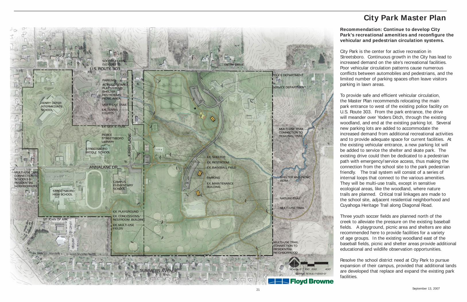
City Park Master PlanRecommendation: Continue to develop City Park’s recreational amenities and reconfi gure the vehicular and pedestrian circulation systems.
City Park is the center for active recreation in Streetsboro. Continuous growth in the City has lead to increased demand on the site’s recreational facilities. Poor vehicular circulation patterns cause numerous confl icts between automobiles and pedestrians, and the limited number of parking spaces often leave visitors parking in lawn areas.
To provide safe and effi cient vehicular circulation, the Master Plan recommends relocating the main park entrance to west of the existing police facility on U.S. Route 303. From the park entrance, the drive will meander over Yoders Ditch, through the existing woodland, and end at the existing parking lot. Several new parking lots are added to accommodate the increased demand from additional recreational activities and to provide adequate space for current facilities. At the existing vehicular entrance, a new parking lot will be added to service the shelter and skate park. The existing drive could then be dedicated to a pedestrian path with emergency/service access, thus making the connection from the school site to the park pedestrian friendly. The trail system will consist of a series of internal loops that connect to the various amenities. They will be multi-use trails, except in sensitive ecological areas, like the woodland, where nature trails are planned. Critical trail linkages are made to the school site, adjacent residential neighborhood and Cuyahoga Heritage Trail along Diagonal Road. Three youth soccer fi elds are planned north of the creek to alleviate the pressure on the existing baseball fi elds. A playground, picnic area and shelters are also recommended here to provide facilities for a variety of age groups. In the existing woodland east of the baseball fi elds, picnic and shelter areas provide additional educational and wildlife observation opportunities.
Resolve the school district need at City Park to pursue expansion of their campus, provided that additional lands are developed that replace and expand the existing park facilities.
September 13, 2007 22
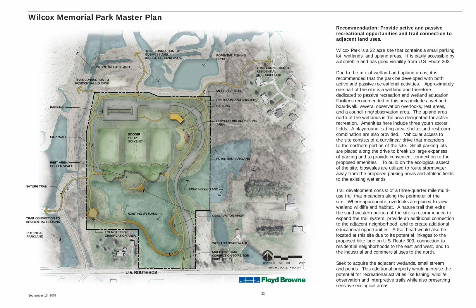
Wilcox Memorial Park Master PlanRecommendation: Provide active and passive recreational opportunities and trail connection to adjacent land uses.
Wilcox Park is a 22 acre site that contains a small parking lot, wetlands, and upland areas. It is easily accessible by automobile and has good visibility from U.S. Route 303.
Due to the mix of wetland and upland areas, it is recommended that the park be developed with both active and passive recreational activities. Approximately one-half of the site is a wetland and therefore dedicated to passive recreation and wetland education. Facilities recommended in this area include a wetland boardwalk, several observation overlooks, rest areas, and a council ring/observation area. The upland area north of the wetlands is the area designated for active recreation. Amenities here include three youth soccer fi elds. A playground, sitting area, shelter and restroom combination are also provided. Vehicular access to the site consists of a curvilinear drive that meanders to the northern portion of the site. Small parking lots are placed along the drive to break up large expanses of parking and to provide convenient connection to the proposed amenities. To build on the ecological aspect of the site, bioswales are utilized to route stormwater away from the proposed parking areas and athletic fi elds to the existing wetlands.
Trail development consist of a three-quarter mile multi-use trail that meanders along the perimeter of the site. Where appropriate, overlooks are placed to view wetland wildlife and habitat. A nature trail that exits the southwestern portion of the site is recommended to expand the trail system, provide an additional connection to the adjacent neighborhood, and to create additional educational opportunities. A trail head would also be located at this site due to its potential linkages to the proposed bike lane on U.S. Route 303, connection to residential neighborhoods to the east and west, and to the industrial and commercial uses to the north.
Seek to acquire the adjacent wetlands, small stream and ponds. This additional property would increase the potential for recreational activities like fi shing, wildlife observation and interpretive trails while also preserving sensitive ecological areas.
September 13, 2007 23
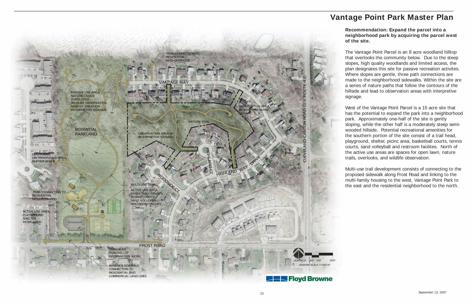
Vantage Point Park Master PlanRecommendation: Expand the parcel into a neighborhood park by acquiring the parcel west of the site.
The Vantage Point Parcel is an 8 acre woodland hilltop that overlooks the community below. Due to the steep slopes, high quality woodlands and limited access, the plan designates this site for passive recreation activites. Where slopes are gentle, three path connections are made to the neighborhood sidewalks. Within the site are a series of nature paths that follow the contours of the hillside and lead to observation areas with interpretive signage.
West of the Vantage Point Parcel is a 15 acre site that has the potential to expand the park into a neighborhood park. Approximately one-half of the site is gently sloping, while the other half is a moderately steep semi-wooded hillside. Potential recreational amenities for the southern portion of the site consist of a trail head, playground, shelter, picinc area, basketball courts, tennis courts, sand volleyball and restroom facilites. North of the active use areas are spaces for open lawn, nature trails, overlooks, and wildlife observation.
Multi-use trail development consists of connecting to the proposed sidewalk along Frost Road and linking to the multi-family housing to the west, Vantage Point Park to the east and the residential neighborhood to the north.
September 13, 2007 24
Implementation and Operations Plan
10-year Timeline for Phased Implementation• Develop Wilcox Park. Refi ne the concept plan and prepare design development and construction drawings for park improvements. Provide infrastructure such as vehicular entrance drive, parking areas, restroom facility. Add both passive and active use activities such as soccer fi elds, playground, wetland boardwalk, and trails. Attach a fi nancial plan dedicated to the park’s operations and maintenance. Accomplishing this major goal of the Master Plan will build trust and confi dence with the citizens of Streetsboro.
• Provide much-needed playground facilities. Develop at each existing neighborhood park and add as a component of future park facilities. Providing playground facilities will provide a direct benefi t to the residents that is now unmet.
• Seek to acquire parkland in the central part of the city. Acquire a parcel in the densest population area of town while land is still available. Prepare concept plans and cost estimates for use in grant applications.
• Provide trail connections from Wilcox Park to neighboring residential, commercial, industrial uses and County parks site. Building this fi rst section of Streetsboro’s trail system will show progress in the mission and vision of the Parks and Recreation Master Plan and build confi dence with the citizens. • Expand recreational amenities at City Park. Refi ne the concept plan and prepare design development and construction drawings for park improvements. Realign the vehicular entrance and drive and provide parking for existing and proposed facilities. Add active and passive use activities such as playground, basketball court, shelters and trail system. Resolve expansion of City School District campus. Relocate affected park facilities elsewhere.
• Provide nature trails, overlooks, interpretive signs at Vantage Point Parcel.
• Seek to acquire parkland adjacent to the Vantage Point Parcel to create a neighborhood park.
• Seek to acquire recommended land in southeast quadrant of the City.
Summary of Potential Funding Sources and StrategiesSuccessful implementation of this Plan will depend on the ability of the City to secure necessary fi nancing. Besides the General Fund, the following sources of revenue available to the City:
Millage, Assessments, and Bonds:Dedicated Millage: Special millages can be general revenue for specifi c purpose.Special Assessments: Special assessments are compulsory contributions collected from the owners of property benefi ted by specifi c public improvements to defray the costs of such improvements.Bond Programs: Bonds are one of the principal sources of fi nancing used by communities to pay for capital improvements.
Grants:Recreational Trails (RT) Program: The State of Ohio has set aside additional TEA-21 funds to fund the Recreational Trails Program; the program requires a 20% match. Funds can be applied to land/easement purchase for trails, trail design and engineering, construction, maintenance and restoration projects, trail facilities.
TEA-21: This funding is provided by landmark legislation passed by Congress in 1998. TEA-21 requires the each state to set aside 10% of their Surface Transportation Funds for Transportation Enhancement projects including bicycle and pedestrian facilities, transportation beautifi cation and historic preservation projects.
Land and Water Conservation Fund Program: ODNR - The LWCF is a federal program aimed at providing resources to maintain, develop and preserve outdoor planning, acquisition and development of trails and stream corridors recreation resources. The program provides up to 50% reimbursement assistance.
Nature Works: ODNR - Established in 1993 when Ohio voters passed a statewide levy providing for the Ohio Parks and Resources Fund. The program requires a 25% match and can be used for acquisition, development, or rehabilitation of public park and recreation areas.
National Scenic Byway Program (NSBP): ODOT - Planning, acquisition and development of trails and stream corridors.
Ohio EPA Non-Point Source Management Program: Water quality restoration solutions including greenway applications in critical areas (streams that do not meet chemical or biological water standards).
Clean Ohio Fund: The fund is voter-sponsored legislation enabling the State to issue bonds for numerous public improvements, including recreational trails.
Cooperative Boating Facility Grant: ODNR - Provides reimbursement assistance for acquiring, improving and/ or developing recreational boating access.
Ohio Water Trails Program: ODNR - Offers assisting with boating Safety Education Grant Funds, providing information and assistance designating water trails.
Private Sources:Corporations, non-profi t organizations, and foundations should be considered to help fi nance park and recreation related public improvement projects.
Partnerships:Seeking to build the City’s park system through partnerships with recreation focused agencies like ODNR, Portage Park District, the Nature Conservancy and others makes sound fi scal sense. It also helps build alliances that support mutual goals and ensures a sustaining environment for success.
September 13, 2007 25
Key Action Steps
Recommendation: Seek to acquire and construct additional community and neighborhood parks.Actions:City to meet with potentially affected property owners to inform them of the City’s park acquisition strategy and to set the stage for future rezoning and development negotiations.
City to monitor development patterns in order to anticipate the timing of development within the city.
Develop a fi nancial strategic plan to deal with land acquisition opportunities/issues that could emerge in the near term (one to fi ve years). The plan will identify how the land may be secured by options or other techniques if it appears the land will not be obtained through developer dedications or donation or if more land must be purchased with donations or dedication alone.
Recommendation: Prepare plans for known future parks.Actions:Parks and Recreation Department to develop concept plans for future parks that consider the natural and cultural resources, community needs and aesthetics of the site. Prioritize various community and neighborhood park improvements and prepare cost estimates to enable the City to be continually prepared for grants and other funding opportunities.
Recommendation: Connect parks, schools, open space and trails to enhance and promote civic identity and community character.Actions:The City should meet with the Portage Park District, County Engineer, Regional Planning Commission and neighboring municipalities to discuss aggressively pursuing bike way right-of-way widths along existing and proposed roadways in and around the City and connection to regional trails. Informally meet with property owners impacted by the trail plan to explain the concept and to make them aware of the need to acquire additional right-of-way and potential open space easements.
City to prepare a prioritized list of bikeway segments. Utilize the list to match potential capital projects with funding sources.
This will include general funds, grants and/or public/private improvement opportunities. Formalize zoning and development review procedures that includes the review of trails and greenways at an early stage in the development review process.
Recommendation: Adopt an open space dedication policy that expresses a preference for scenic open spaces that are integrated within new neighborhoods, opens space that preserves and enhances larger setbacks along existing roads.Actions:Park Department to work with City Planners to determine how these policies may be integrated into the review process. City to explain the City’s development preferences to potential developers and land owners.
Recommendation: Adopt a Conservation Zoning Overlay District.Actions:Zoning Board to review and recommend open space and conservation alternatives for proposed subdivisions.
Develop a public education strategy that helps community residents appreciate the benefi ts of conservation developments as an alternative to standard development practices. This may include a series of open forums with invited guests to present the benefi ts.
Recommendation: Preserve and/or acquire fl oodplain property for open space and trails.Actions: City to study the range of potential initiatives that would include different forms of land acquisition and conservation programs.
Meet with the County Park District to discuss location and timing of greenways and trails. Meet with property owners to explain the concept and to make them aware of the need to acquire additional right-of-way and potential open space easements.
Monitor funding and grant cycles of various county, state and federal agencies. Prepare a pamphlet on potential donor opportunities.
Recommendation: Reorganize and expansion of the Parks and Recreation Department.Actions:City offi cials and the Parks and Recreation Department to study the existing organizational chart for effi ciency of operations of the Parks and Recreation Department.
Evaluate the advantages/disadvantages of the Senior Center as its own department. Evaluate the advantages/disadvantages of park maintenance effi ciency operating under a different department. Evaluate dedicated park maintenance staff for total park acreage, present and future, with national standards for communities of similar size.
Recognize as park lands and facilities increase through implementation of the Parks and Recreation Master Plan. The Department of Public Service is responsible for an additional and entirely different set of public lands and buildings and also is a required City department.
Explore the potential and possibility of a capital improvements Park Levy, with a percentage dedicated to operations and maintenance.
Recommendation: Develop a Funding Plan.Actions:Within a year of the adoption of the Master Plan, the Park and Recreation Department will prepare and submit capital improvement plans that will identify the timing and cost of potential parks, trails and greenway projects. These projects may be both public and private projects and be matched with a variety of funding sources.
Update the capital plan every year with the guidance of Parks and Recreation Master Plan and current citizen needs. The City will update the Master Plan when it is apparent the existing document is no longer adequately guiding the capital planning process.
The City will stay on top of grant opportunities and timing as well as use the Master Plan to prepare applications well in advance of the deadlines.
September 13, 2007 26
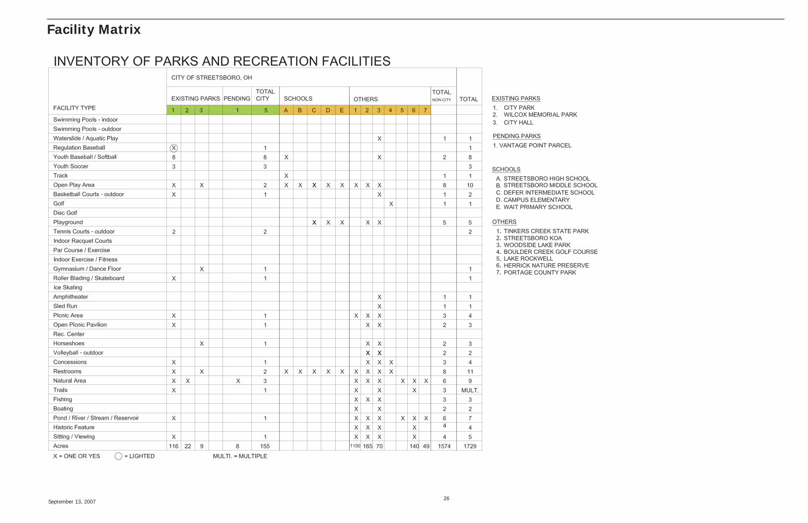
Facility Matrix
September 13, 2007 27
Potential Regional Park, Trail and Greenspace Connections
Tinkers Creek State Park & N.P.1
2
3
West Branch State Park
Cuyahoga Valley National Park
1
2
3