structural elements of the makran region
TRANSCRIPT

8/3/2019 Structural Elements of the Makran Region
http://slidepdf.com/reader/full/structural-elements-of-the-makran-region 1/15
O R I G I N A L P A P E R
Structural elements of the Makran region, Oman sea
and their potential relevance to tsunamigenisis
Mohammad Mokhtari Æ Iraj Abdollahie Fard Æ Khaled Hessami
Received: 2 September 2007 / Accepted: 15 December 2007 / Published online: 12 February 2008Ó Springer Science+Business Media B.V. 2008
Abstract The character of convergence along the Arabian–Iranian plate boundary
changes radically eastward from the Zagros ranges to the Makran region. This appears to
be due to collision of continental crust in the west, in contrast to subduction of oceanic
crust in the east. The Makran subduction zone with a length of about 900 km display
progressively older and highly deformed sedimentary units northward from the coast,
together with an increase in elevation of the ranges. North of the Makran ranges are large
subsiding basins, flanked to the north by active volcanoes. Based on 2D seismic reflectiondata obtained in this study, the main structural provinces and elements in the Gulf of Oman
include: (i) the structural elements on the northeastern part of the Arabian Plate and, (ii)
the Offshore Makran Accretionary Complex. Based on detailed analysis of these data on
the northeastern part of the Arabian Plate five structural provinces and elements—the
Musendam High, the Musendam Peneplain, the Musendam Slope, the Dibba Zone, and the
Abyssal Plain have been identified. Further, the Offshore Makran Accretionary Complex
shown is to consist Accretionary Prism and the For-Arc Basin, while the Accretionary
Prism has been subdivided into the Accretionary Wedge and the Accreted/Colored
Melange. Lastly, it is important to note that the Makran subduction zone lacks the trench.
The identification of these structural elements should help in better understanding the
seismicity of the Makran region in general and the subduction zone in particular. The 1945
magnitude 8.1 tsunamigenic earthquake of the Makran and some other historical events are
illustrative of the coastal region’s vulnerability to future tsunami in the area, and such data
should be of value to the developing Indian Ocean Tsunami Warning System.
Keywords Makran Á Tsunami wave heights Á Subduction zone Á Accretionary margin Á
Dibba Fault Zone Á Indian Ocean Á Seismic reflection
M. Mokhtari (&) Á K. Hessami
International Institute of Earthquake Engineering and Seismology, No. 26, Argavan Ave, Dibaji
Shomali, Tehran, Iran
e-mail: [email protected]
I. Abdollahie Fard
National Iranian Oil Company, Exploration Directorate, Tehran, Iran
123
Nat Hazards (2008) 47:185–199
DOI 10.1007/s11069-007-9208-0

8/3/2019 Structural Elements of the Makran Region
http://slidepdf.com/reader/full/structural-elements-of-the-makran-region 2/15
1 Introduction
The Makran Accretionary Complex is bounded to the north by the Jaz Murian and Hamun
Mashkel depressions and to the south-east is marked by the base of the continental slope,
some 150 km offshore. To the south and west, the area is bounded by the narrow and steepcontinental margin of Oman (Fig. 1). The Makran Accretionary Complex is bounded to the
east and west by large transform faults of the Zendan-Minab Fault System and the Oranch
Fault Zone, respectively (Fig. 1).
Based on pervious and present studies (e.g., Farhoudi and Karig 1977; Platt et al. 1985)
the Makran region is composed of a large sedimentary prism accreted during the Cenozoic.
All the characteristics of Accretionary prisms with exception of the trench that have been
observed in other well-studied arcs can be identified or inferred in the Makran, which,
however, is unique in its degree of surface exposure.
For the first time, Stoneley (1974) proposed a subduction zone along the Makran coasts
that formed the boundary between the Arabian and Eurasian Plates. Later, Shearman
(1977) and Farhoudi and Karig (1977) presented data to support this hypothesis.
Fig. 1 Plate tectonic setting of the Oman Sea and the main structural elements, the plate boundaries in the
north of the Indian Ocean are also shown; AFP; African Plate, ARP; Arabian Plate, AS; Arabian Sea, COFS;
Chaman Oranch Fault System, CS; Caspian Sea, GA; Gulf of Aden, GO; Gulf of Oman, INO; Indian Ocean,
INP; Indian Plate, MAW; Makran Accretionary Wedge, OMFZ; Owen Murray Fault Zone, PG; Persian
Gulf, RS; Red Sea, ZSZ; Zagros Suture Zone
186 Nat Hazards (2008) 47:185–199
123

8/3/2019 Structural Elements of the Makran Region
http://slidepdf.com/reader/full/structural-elements-of-the-makran-region 3/15
Quittmeyer and Jacob (1979) conducted a comprehensive study of the Makran region
seismicity and concluded that it is consistent with the interpretation of this area as an active
subduction zone. In addition, Page et al. (1979) by performing a field survey of the Iranian
coastline, air photo analysis, and aerial reconnaissance, confirmed the tectonic model of
subduction zone for Makran coasts.The Makran region both onshore and offshore in contrast to its eastern and western ends
that cannot be classified with high seismic activity. However, due to its nature of being an
active subduction zone, the region historically has been affected by tsunamigenic earth-
quakes. The oldest record of tsunami in the region is from November 326 BC earthquake
near the Indus delta/Kutch region that set off massive sea waves in the Arabian Sea
(Lisitzin 1974). Tsunami has also been observed on the Iranian coast from a local earth-
quake between 1st April and 9th May 1008 (Murty and Bapat 1999). In addition, the 8.1
magnitude earthquake of 1945 created a significant tsunami in the region killing at least
4,000 people and having great economic impact in Pakistan, Oman, and Iran (Pacheco and
Sykes 1992, Pararas-Carayannis 2006). It led to the formation of four small islands. A large
volume of gas that erupted from one of the islands, sent flames leaping ‘‘hundreds of
meters’’ into the sky (Mathur 1988). The tsunami reached a height of 12 m in some Makran
ports (Pararas-Carayannis 2006). Recently, a comprehensive catalogue of tsunami occur-
rence in the Indian Ocean was presented by Rastogi and Jaiswal (2006) indicating the
susceptibility of the Makran and its vicinity to future tsunami. In this respect and in the
light of the area’s extensive development and high growth of population, inclusion of
Makran zone in the Indian Ocean Early Warning System has become a necessity.
In this study using seismic reflection data in defining the main structural provinces and
elements, the seismicity of the region has been elaborated.
2 Tectonic evolution of northern Indian Ocean
The Gulf of Oman is a remnant of Late Cretaceous/Early Paleocene oceanic crust. Figure 1
shows the major structural elements and the plate boundaries in the northern Indian Ocean.
The evolution of this region including the Oman Sea has been a long and complex process,
since initial rifting and ocean floor spreading of the Neo-Tethys in Late Permian time. The
oldest evidence of seafloor spreading is found in the Oman Mountains, where Permian
faunas are interbedded with basaltic pillow lavas, sills, dykes, and volcanics (EarlyPermian) (Glennie 2000). This first phase of spreading lasted till Late Triassic (Neo-Tethys
I). The width of the ocean had by then reached 400 km in the present Oman Sea (Glennie
2000). The spreading axis then jumped to the northeast. The oceanic crust documented
from the second phase (Neo-Tethys II) is of Upper Jurassic–Turonian age (McCall 1985;
Nicolas 1988).
In the Jurassic age, a thin continental sliver (the Bajgan–Dur–Kan Carbonate Fore-Arc)
was rifted off the continental margin of the Eurasian plate, and the Inner Makran Spreading
zone developed, with ophiolites ranging in age from Early Cretaceous to Early Paleocene
(McCall 1985). This rift has the character of back-arc spreading rather than a mid-oceanicspreading ridge.
In Albian–Aptian times (110 Ma) convergence between the African-Arabian and the
Eurasian Plate started. Two northward dipping subduction zones developed, nearly, at the
same time. A southern subduction zone developed about 800 km north of the present
continental margin of Oman. It started as a low angle northward intra-oceanic subduction
at a mid-ocean ridge (McCall 1985; Nicolas 1988) (Fig. 2). This has been documented by
Nat Hazards (2008) 47:185–199 187
123

8/3/2019 Structural Elements of the Makran Region
http://slidepdf.com/reader/full/structural-elements-of-the-makran-region 4/15
the high-temperature Cenomanian (90 Ma) metamorphism at the ophiolite sole (Hacker
1994). In the Campanian convergence along the margin of Oman changed character from
subduction to obduction.The northern subduction zone, located south of the Bajgan–Dur–Kan Carbonate Fore-
Arc, resulted in accretion of the Colored Melange (Fig. 2). Onset of subduction postdates
exotic blocks of Albian–Aptian reefal limestones in the melange, together with Late
Pliensbachian–Late Cretaceous ophiolites and deep marine sediments (McCall 1985). The
youngest sediments in the Colored Melange are Late Cretaceous-Early Paleocene shallow
marine bio-micrites, probably representing syn-tectonic deposition (McCall 1985).
During the Campanian (80 Ma), the southward migration of nappes reached the con-
tinental margin of Oman, resulting in down-flexing and obduction of oceanic crust onto the
Arabian Plate (Glennie et al. 1973; Lamphere 1981; Montigny et al. 1988). By the end of
the Cretaceous, obduction along the southern continental margin of the Neo-Tethys had
come to a halt. Since then the continental margin of Oman has been a passive margin, and
the remnant of the Neo-Tethyan oceanic crust has become a part of the African-Arabian
Plate. Subduction on the northern subduction zone continued and is still active off the coast
of Makran. The initial Accretionary front is located about 110 km north of the present
coastline and about 230 km north of the present Accretionary front.
Fig. 2 Schematic subduction history in the Oman Sea along the profile shown in the index figure at the left
corner. AP, Arabian Plate, BDKZ, Bagjan Dur-Kan Zone; CM, Colored Melange; EF, Eocene Flysch; MS,
Molassic Sediments; OSZ, Oman Subduction Zone, SO; Semail Ophiolite, and AW; Accretionary Wedge
(modified after McCall 1985)
188 Nat Hazards (2008) 47:185–199
123
8/3/2019 Structural Elements of the Makran Region
http://slidepdf.com/reader/full/structural-elements-of-the-makran-region 5/15
The onset of convergence of the Neo-Tethys approximately coincides with the opening
of the Atlantic, and might have been triggered by increased rotational speed of the African-
Arabian Plate. The change from an active to a passive margin coincides with the shift in
spreading axis in the Indian Ocean, leaving the Seychelles on the African Plate (Glennie
et al. 1973; Lamphere 1981).The break off of the Arabian Plate from the African Plate probably resulted in an
increase in subduction rate. At this stage the mountain chains along the Himalayan con-
tinent–continent collision zone were uplifted and eroded, resulting in a major increase in
sediment input into the Indian Ocean and the Oman Sea. The formation of the Makran
Fore-Arc Basins was also probably controlled by the increased subduction rate in com-
bination with increased sediment input behind the Accretionary front.
The Makran coastline, once much further north has been regressing ocean-ward at a rate
of about 1 cm per year at least since the Early Miocene due to tectonic activity (White and
Louden 1982). Consequently, two-thirds of the Accretionary prism is located onshore. The
recent sediments deposited offshore are therefore expected to be more proximal than the
older distal-deep marine sediments.
These structural features have all been determined based on evidence from the surface
geology, but in the following section, the main structural elements we observe based on
geophysical data will be discussed. The purpose is to define possible sources for seismicity
in the offshore region as the site of future earthquake and tsunami.
3 Main structural elements
Based on the present study, utilizing 2D seismic reflection data the main structural
provinces and elements in the Gulf of Oman are (i) the structural elements on the north-
eastern part of the Arabian Plate and (ii) the Offshore Makran Accretionary Complex
Elements. On the northeastern part of the Arabian Plate, five structural provinces and
elements have been defined (Fig. 3): the Musendam High, the Musendam Peneplain, the
Musendam Slope, the Dibba Zone, and the Abyssal Plain. The Zendan-Minab Fault System
and the Accretionary front define the western and southern boundary of the Makran
Accretionary Complex, respectively. The Oranch Fault Zone (Fig. 1) is located in the
eastern side of this complex and is considered as the western boundary of the Indian Plate,
while the Murray ridge system defines the offshore boundary of the Arabian and Indianplates.
These seismic profiles gathered under auspices of National Iranian Oil Company in
2000 using conventional marine 2D seismic methodology. These are part of PC2000
project which covers both the Persian Gulf and Oman Sea.
The Offshore Makran Accretionary Complex consists of Accretionary Prism and the
For-Arc Basin. The Accretionary Prism has been subdivided into the Accretionary Wedge
and the Accreted/Colored Melange (Fig. 3).
3.1 The structural elements of the northeastern part of the Arabian Plate
The structural elements of the northeastern part of the Arabian Plate include: (i) the
Musendam High which defines the northern offshore extension of the Musendam Penin-
sula; (ii) the Dibba Fault Zone as a prominent structural feature/lineament cutting across
the Musendam Peninsula in a southwest/northeast direction (Fig. 4); (iii) the Musendam
Nat Hazards (2008) 47:185–199 189
123

8/3/2019 Structural Elements of the Makran Region
http://slidepdf.com/reader/full/structural-elements-of-the-makran-region 6/15
Peneplain located on the west of the Zendan-Minab Fault System (Fig. 4) which was
subject to extensive erosion in the Early Tertiary resulting in a very mature peneplain; (iv)
the Musendam Slope which lies to the southeast of the Musendam Peneplain, up against
the Zendan-Minab Fault System and might represent the Neo-Tethyan paleo-slope, which
implies that the crust underlying the slope is an attenuated continental crust, not oceanic;
and (v) the Abyssal Plain which represents un-deformed remnant of the Neo-Tethyan
oceanic crust, now part of the Arabian Plate with a cover of deep marine sediments
(Fig. 3). Total thickness of the sediments in the Abyssal Plain is about 7.5 km and
are found all over the Oman Sea. Figure 5 shows the seismic expression of the Abyssal
Plain.
3.2 The plate boundaries
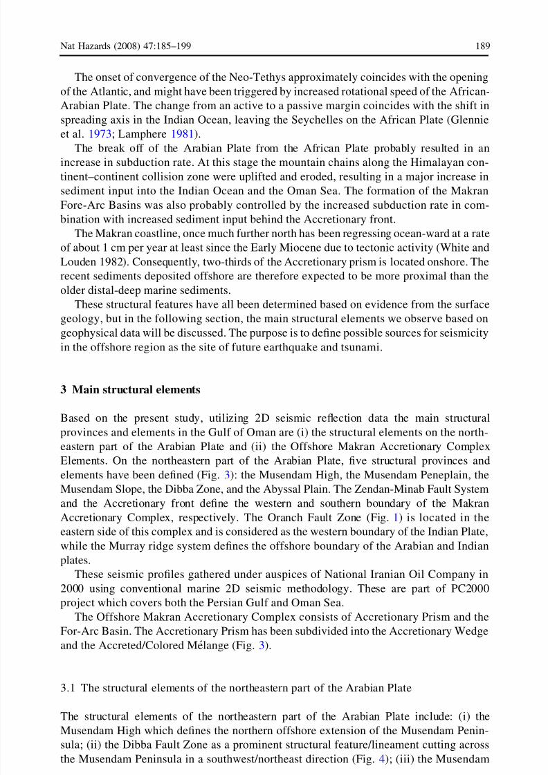
The Plate Boundaries in the Makran region are (i) The Zendan-Minab Fault System that
represents the eastern boundary of the Arabian Plate (Fig. 1), (ii) the Oranch Fault Zone
which is part of the Eurasian–Indian plate boundary complex (Fig. 1) and (iii) the NE–SW
trending Murray Ridge System in the northern Arabian Sea extends about 750 km (Fig. 1).
Onshore the Zendan-Minab Fault System is defined by a series of sub-parallel north–
south trending right-lateral (dextral) transpressional faults, creating a series of en-echelon
oriented compressional structures. Based on a teleseismic study by Yamini-Fard et al.
(2007), the convergence between the Arabian plate and Central Iran may be accommo-
dated by a mechanism of distributed deformation at depth. These seismological evidences
suggest that the transition from the Zagros collision zone to the Makran subduction zone is
not abrupt. However, GPS measurements suggest that the Zendan-Minab Fault System is
Fig. 3 Main structural element of the Makran margin based on interpretation of seismic profiles (in the
Iranian side)
190 Nat Hazards (2008) 47:185–199
123
8/3/2019 Structural Elements of the Makran Region
http://slidepdf.com/reader/full/structural-elements-of-the-makran-region 7/15
an active fault at the present (Bayer et al. 2006). A zone of decollement can be considered
as a result of the first stage of the continental collision in this region as proposed by White
and Ross (1979) and reported by Byrne et al. (1992).
The Oranch Fault Zone has evolved from a thrust fault of the Arabian–Eurasian col-
lisional complex to a strike-slip fault along the Eurasian–Indian transform boundary. The
Arabian–Eurasian plate boundary, a subduction zone, is beneath the Indian Ocean to the
south of the Makran region (Fig. 6).
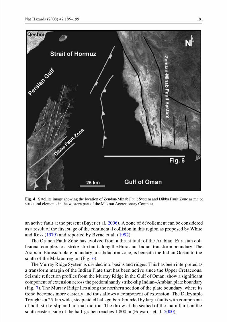
The Murray Ridge System is divided into basins and ridges. This has been interpreted as
a transform margin of the Indian Plate that has been active since the Upper Cretaceous.
Seismic reflection profiles from the Murray Ridge in the Gulf of Oman, show a significant
component of extension across the predominantly strike-slip Indian–Arabian plate boundary(Fig. 7). The Murray Ridge lies along the northern section of the plate boundary, where its
trend becomes more easterly and thus allows a component of extension. The Dalrymple
Trough is a 25 km wide, steep-sided half-graben, bounded by large faults with components
of both strike-slip and normal motion. The throw at the seabed of the main fault on the
south-eastern side of the half-graben reaches 1,800 m (Edwards et al. 2000).
Fig. 4 Satellite image showing the location of Zendan-Minab Fault System and Dibba Fault Zone as major
structural elements in the western part of the Makran Accretionary Complex
Nat Hazards (2008) 47:185–199 191
123

8/3/2019 Structural Elements of the Makran Region
http://slidepdf.com/reader/full/structural-elements-of-the-makran-region 8/15
Fig. 5 2D offshore seismic profile showing the boundary between the abyssal plain and the Makran
Accretionary Complex. Note the lack of a trench in front of the Accretionary Complex. The line is located in
the Iranian water (location of the seismic section shown on the index map in the bottom left corner) (Curtsey
of National Iranian Oil Company)
Fig. 6 Seismic section across offshore extension of the Zendan-Minab Fault System (location of the
seismic section shown on the index map in the bottom left corner) (Curtsey of National Iranian Oil
Company)
192 Nat Hazards (2008) 47:185–199
123
8/3/2019 Structural Elements of the Makran Region
http://slidepdf.com/reader/full/structural-elements-of-the-makran-region 9/15
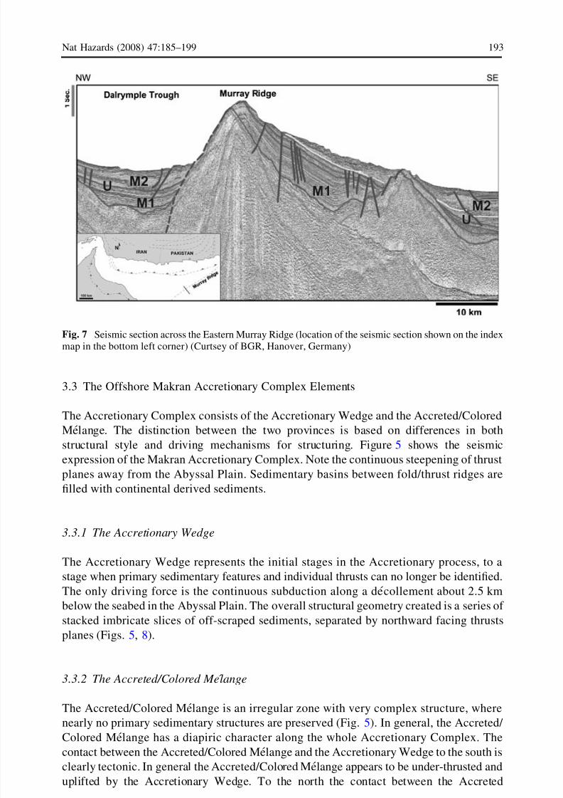
3.3 The Offshore Makran Accretionary Complex Elements
The Accretionary Complex consists of the Accretionary Wedge and the Accreted/ColoredMelange. The distinction between the two provinces is based on differences in both
structural style and driving mechanisms for structuring. Figure 5 shows the seismic
expression of the Makran Accretionary Complex. Note the continuous steepening of thrust
planes away from the Abyssal Plain. Sedimentary basins between fold/thrust ridges are
filled with continental derived sediments.
3.3.1 The Accretionary Wedge
The Accretionary Wedge represents the initial stages in the Accretionary process, to astage when primary sedimentary features and individual thrusts can no longer be identified.
The only driving force is the continuous subduction along a decollement about 2.5 km
below the seabed in the Abyssal Plain. The overall structural geometry created is a series of
stacked imbricate slices of off-scraped sediments, separated by northward facing thrusts
planes (Figs. 5, 8).
3.3.2 The Accreted/Colored Me lange
The Accreted/Colored Melange is an irregular zone with very complex structure, where
nearly no primary sedimentary structures are preserved (Fig. 5). In general, the Accreted/
Colored Melange has a diapiric character along the whole Accretionary Complex. The
contact between the Accreted/Colored Melange and the Accretionary Wedge to the south is
clearly tectonic. In general the Accreted/Colored Melange appears to be under-thrusted and
uplifted by the Accretionary Wedge. To the north the contact between the Accreted
Fig. 7 Seismic section across the Eastern Murray Ridge (location of the seismic section shown on the index
map in the bottom left corner) (Curtsey of BGR, Hanover, Germany)
Nat Hazards (2008) 47:185–199 193
123

8/3/2019 Structural Elements of the Makran Region
http://slidepdf.com/reader/full/structural-elements-of-the-makran-region 10/15
Melange and the Fore-Arc Basin shows a continuous onlap of the Fore-Arc Basin sedi-ments onto the Accreted/Colored Melange. Post-depositional faulting or diapirism often
obscures the primary sedimentary contact.
3.3.3 Fore-Arc Basin
The Fore-Arc Basin is not a continuous basin running along the full length of the Makran
Accretionary Complex. The Fore-Arc Basin was initiated, as a series of narrow half
grabens controlled by seaward facing listric normal faults, with sediments onlapping the
rising diapirs of the Accreted Melange to the south (Fig. 5). Through time the sub-basins
expanded southward. In places two sequences can be identified in the fore-arc basin
(Fig. 9), a deep strongly deformed thrusted and mobilized sequence and an upper sequence
dominated by normal faulting.
4 Review of tsunami sources in the Makran Accretionary Complex
Based on the above-mentioned geological setting, tectonic evolution and main structural
elements, we classify the Makran Accretionary Complex as a major seismically active
zone. Moreover, in a plate tectonic setting like that of the Makran Accretionary Complex a
fairly high rate of earthquake activity would be expected, as in many of the other major
Accretionary complexes/subduction zones around the world (e.g. Agean region). However,
this region which is located between the Zendan-Minab Fault System and Oranch Fault
Zone shows relatively low seismicity (based on available data in the region, see Fig. 10) in
comparison with the surrounding region.
Fig. 8 NNE–SSW seismic line through the Accretionary Wedge. Note the continuous steepening of thrust
planes away from the Abyssal Plain. Sedimentary basins between fold/thrust ridges are filled with
continental derived sediments (location of the seismic section shown on the index map in the bottom right
corner) (Curtsey of National Iranian Oil Company)
194 Nat Hazards (2008) 47:185–199
123

8/3/2019 Structural Elements of the Makran Region
http://slidepdf.com/reader/full/structural-elements-of-the-makran-region 11/15
It is important to note that in spite of low seismicity some historical data about tsunamis
in the Makran region have been reported by Murty and Rafiq ( 1991), Murty and Bapat
(1999), Dominey-Howes et al. (2007), Rastogi and Jaiswal (2006). This could be related to
very long recurrence interval of large magnitude tusnamigenic earthquakes, which is not
recorded in the available historical data. According to above mentioned reports, the total
number of tsunami events in the Makran zones is three which includes two of seismic
origin and one of unknown origin. The most recent event is the major earthquake generated
tsunami of 1945 in the eastern Makran which was an inter-plate thrust event that ruptured
approximately one-fifth of the length of the subduction zone (Fig. 10). It is important to
note that the epicenter of this event is also close to the Sonne Fault which has createdsegments on the Makran Subduction Zone. The crossing points between the Makran
Subduction Zone and these oblique fault zones suggest to us that this junction can be a
location for occurrence of major earthquake activities. However, more studies are required
for further clarification.
In addition to the above, Byrne et al. (1992) reported nine smaller events in eastern
Makran that are also located at or close to the plate interface and have thrust mechanisms
similar to that of the 1945 shock. Seaward of these thrust earthquakes lies the shallowest
70–80 km of the plate boundary. This segment and the overlying Accretionary Wedge
remain aseismic both during and among great earthquakes.
As in other subduction zones, this aseismic zone lies within that part of the Accretionary
Wedge that consists of largely unconsolidated sediments (P wave seismic velocities less
than 4.0 km/s). The existence of thrust earthquakes indicates that either the sediments
along the plate boundary in the eastern Makran become sufficiently well consolidated and
dewatered at about 70 km from the deformation front, or lithified rocks are present within
the Fore-Arc Basin so that stick-slip sliding behavior becomes possible. Byrne et al. (1992)
Fig. 9 North–south seismic lines through western part of the Fore-Arc Basin. Basin growth is controlled by
syn-depositional listric faulting and continuous growth of diapir. Shortening has been occurred by
continuous tilting/rotation of graben sediments (location of the seismic section shown on the index map in
the bottom right corner) (Curtsey of National Iranian Oil Company)
Nat Hazards (2008) 47:185–199 195
123

8/3/2019 Structural Elements of the Makran Region
http://slidepdf.com/reader/full/structural-elements-of-the-makran-region 12/15
showed that a large quantity of unconsolidated sediment does not necessarily indicate a
low potential for great thrust earthquakes. In contrast to the east, the plate boundary in the
western Makran has no clear record of historically great events, nor has modern instru-
mentation detected any shallow thrust events for at least the past 25 years. Most
earthquakes in the western Makran occur within the down-going plate at intermediate
depths (Byrne et al. 1992; Kukowski et al. 2000). The large changes in seismicity between
the eastern and western Makran suggest segmentation of the subduction zone. This is alsosupported by Kukowski et al. (2000) where they introduce a new boundary coinciding very
well with the Sonne strike-slip fault (Fig. 10). The western part is characterized by the
absence of inter-plate events. East of the Sonne fault and west of long 64°E is the only
region with a clustering of events within the submarine and southernmost onshore part of
the Accretionary Wedge, also including the Mw 8.1 event of 1945 (Byrne et al. 1992)
(Fig. 10). Most events in the wedge appear to be pure-thrust earthquakes and are inter-
preted as plate boundary events (Quittmeyer and Kafka 1984; Byrne et al. 1992). The
earthquake of August 12, 1963, a few tens of kilometers east of the Sonne fault, had a large
strike-slip component and its depth was estimated to be only 5 km (Quittmeyer and Kafka
1984). Taking into account the uncertainties of focal estimation, it is suspected that this
event may have occurred in connection with motion along the Sonne fault (Kukowski et al.
2000). The subduction rate based on GPS measurements indicated by Vernant et al. (2004)
is about 18 mm/year.
The absence of plate boundary events in the western Makran indicates either that
entirely aseismic subduction occurs or that the plate boundary is currently locked and
Fig. 10 The seismicity map of Makran Region; star sign shows the 1945 Tsunamigenic earthquake
location. Regional tectonic map of Arabian–Indian–Eurasian convergence zone showing the Sonne Fault
and distribution of earthquakes (circles; compiled from Byrne et al. 1992; Jackson et al. 1995; and U.S.
National Earthquake Information Center data set). Onshore topography is from satellite altimetry; submarine
topography is combined from satellite altimetry and RV Sonne cruise data set (modified after Kukowskiet al. 2000)
196 Nat Hazards (2008) 47:185–199
123

8/3/2019 Structural Elements of the Makran Region
http://slidepdf.com/reader/full/structural-elements-of-the-makran-region 13/15
experiences great earthquakes with long repeat times. Evidence is presently inconclusive
concerning which of these two hypotheses (or some other) is the correct one.
As mentioned above, the largest recorded earthquake (tsunamigenic) occurred at 21:56
UTC on 28th November 1945 with epicenter of 87.1 km SSW Churi (Baluchistan),
Pakistan. It was located at 24.50 N and 63.00 E with a magnitude of Mw 8.1 (Fig. 10).Another earthquake at 1424 UTC located at 25.10 N, 63.40 E on the 5th August 1947
also occurred off the Makran coast (Baluchistan), Pakistan. There is no report of tsunami
generation associated with this event, which has occurred in a very shallow depth of the
coast.
This was the last major tsunami-generating earthquake in the Oman Sea. More than
4,000 people were killed on the Makran coast by both the earthquake and the tsunami. The
tsunami reached a run-up height of approximately 12 m in some Makran ports (Pararas-
Carayannis 2006) and caused great damage to the entire coastal region. The towns of Pasni
and Ormara were badly affected. Both were reportedly ‘‘underwater’’ after the tsunami.
The tsunami was also recorded at Muscat and Gwadar (Pararas-Carayannis 2006).
The waves were about 2 m high in Karachi (Pararas-Carayannis 2006). The first wave
was recorded at 5:30 am, then at 7:00 am, 7:15 am and finally at 8:15 am. The last
wave at 8:15 was the biggest. The tsunami had a run-up height of 11.0–11.5 m in Kutch,
Gujarat. At 8:15 am, it was observed on Salsette Island, i.e., Mumbai. It was recorded in
Bombay Harbour, Versova (Andheri), Haji Ali (Mahalaxmi), Juhu (Ville Parle), and Danda
(Khar).
5 Conclusions
Different from most other Accretionary Complexes based on the 2D seismic reflection data
there is no trench developed in front of the Makran Accretionary Complex. The absence of
trench in this region can be due to the fact that the subduction angle at the accretionary
front is very low; it is due to existence of thick sediments with low compaction or it might
be caused by high deposition rate. However the main reason is most probably the low angle
of subduction.
The presence of well-defined late Holocene marine terraces along portions of the
coasts of eastern and western Makran could be interpreted as evidence that both sections
of the subduction zone are capable of generating large plate boundary tsunamigenicearthquakes. The occurrence of tsunamigenic earthquake in the eastern segment has been
documented, but well defined large earthquakes in the west so far is lacking. This could
either be that the western Makran is capable of producing great earthquakes or it could
rupture as a number of segments in somewhat smaller-magnitude events. Alternatively, it
is possible that western Makran is significantly different from eastern Makran and
experiences largely aseismic slip at all times. Knowledge of the velocity structure and
nature of the state of consolidation or lithification of rocks at depth in the interior portion
of the fore-arc of western Makran should help to ascertain whether that portion of the
plate boundary moves aseismically or ruptures in large to great earthquakes. A resolutionof this question has important implications for seismic hazard assessment of the western
Makran.
Based on the above the potential of tsunamigenic earthquake occurrence necessitate an
improved understanding of the seismotectonic and seismicity of the Makran region, a
better understanding of past earthquake sources through the use of paleotsunami, tsunami
hazard assessment, preparation of evacuation maps and hazard reduction strategy.
Nat Hazards (2008) 47:185–199 197
123

8/3/2019 Structural Elements of the Makran Region
http://slidepdf.com/reader/full/structural-elements-of-the-makran-region 14/15
Acknowledgments The authors would like to thank National Iranian Oil Company, Exploration Direc-
torate for providing the seismic sections and permission for their publication. The authors would also like to
thank the two anonymous reviewers for their constructive comments and suggestions to improve the
manuscript.
References
Bayer R, Chery J, Tatar M, Vernant P, Abbassi M, Masson F, Nilforoushan F, Doerflinger E, Regard V,
Bellier O (2006) Active deformation in Zagros–Makran transition zone inferred from GPS measure-
ments. Geophys J Int 165:373–381
Byrne DE, Sykes LR, Davis DM (1992) Great thrust earthquakes and aseismic slip along the plate boundary
of the Makran subduction zone. J Geophys Res 97(B1):449–478
Dominey-Howes D, Cummins P, Burbidge D (2007) Historic records of teletsunami in the Indian Ocean and
insights from numerical modelling. Nat Hazards 42(1):1–17
Edwards RA, Minshull TA, White RS (2000) Extension across the Indian Arabian plate boundary: the
Murray Ridge. Geophys J Int 142:461–477Farhoudi G, Karig DE (1977) The Makran of Iran and Pakistan as an Active Arc System. Abstr., EOS
Trans., Am Geophys Union 58:446
Glennie KW (2000) Cretaceous tectonic evolution of Arabia’s eastern plate margin: a tale of two oceans.
SEPM special publication 69, pp 9–20
Glennie KW, Boeuf MGA, Hughes Clarke MW, Moody-Stuart M, Pilaar WFH, Reinhardt BM (1973) Late
Cretaceous nappes in Oman Mountains and their geologic evolution. AAPG Bull 57:5–27
Hacker BR (1994) Rapid emplacement of young oceanic lithosphere: argon geochronology of the Oman
ophiolite. Science 265:1563–1565
Jackson J, Haines J, Holt W (1995) The accommodation of Arabia-Eurasia plate convergence in Iran.
J Geophys Res 100:15205–15219
Kukowski N, Schillhorn T, Flueh ER, Huhn K (2000) Newly identified strike-slip plate boundary in the
northeastern Arabian Sea. Geology 28(4):355–358Lamphere MA (1981) K-Ar ages of metamorphic rocks at the base of the Semail Ophiolites, Oman.
J Geophys Res 86:2777–2782
Lisitzin E (1974) Sea level changes. Elsevier oceanographic series, vol 8, New York, p 273
Mathur SM (1988) Physical geology of India. National Book Trust of India, New Delhi
McCall GJH (ed) (1985) Area report, East Iran project, area no: 1 (North Makran and South Beluchistan),
Geological Survey of Iran
Montigny R, Le Mer O, Thuizat R, Whitechurch H (1988) K-Ar and 40Ar/ 39Ar study of metamorphic rocks
associated with Oman ophiolite: Tectonic implications. Tectonophysics 151:345–362
Murty TS, Rafiq M (1991) A tentative list of tsunamis in the marginal seas of the north Indian Ocean.
Nat Hazards 4(1):81–84
Murty TS, Bapat A (1999) Tsunamis on the coastlines of India. Sci Tsunami Hazards 17(3):167–172
Nicolas A (1988) Structures of ophiolites and dynamics of oceanic lithosphere. Petrology and structural
geology 4. Kluwer, Dordrecht
Pacheco J, Sykes L (1992) Seismic moment catalog of large shallow earthquakes, 1900 to 1989. Bull
Seismol Soc Am 82:1306–1349
Page WD, Alt JN, Cluff LS, Plafker G (1979) Evidence for the recurrence of large-magnitude earthquakes
along the Makran Coast of Iran and Pakistan. Tectonophysics 52:533–547
Pararas-Carayannis G (2006) The potential of tsunami generation along the Makran Subduction Zone in the
northern Arabian Sea. Case study: the earthquake and Tsunami of November 28, 1945. Sci Tsunami
Hazards 24(5):358–384
Platt JP, Leggett JK, Young J, Raza H, Alam S (1985) Large-scale sediment underplating in the Makran
accretionary prism, southwest Pakistan. Geology 13:507–511
Quittmeyer RC, Jacob KH (1979) Historical and modem seismicity of Pakistan, Afghanistan, Northwestern
India, and Southeastern Iran. Bull Seismol Soc Am 69(3):773–823
Quittmeyer VN, Kafka AL (1984) Constraints on plate motions in southern Pakistan and northern Arabian
Sea from focal mechanisms of small earthquakes. J Geophys Res 89:2444–2458
Rastogi BK, Jaiswal RK (2006) A catalog of tsunamis in the Indian Ocean. Sci Tsunami Hazards 25(3):
128–143
Shearman DJ (1977) The geological evolution of Southern Iran, the report of the Iranian Makran expedition.
Geogr J 142:393–410
198 Nat Hazards (2008) 47:185–199
123

8/3/2019 Structural Elements of the Makran Region
http://slidepdf.com/reader/full/structural-elements-of-the-makran-region 15/15
Stoneley R (1974) Evolution of the continental margins bounding a former Tethys. In: Burk CA, Drake CL
(eds) The geology of continental margins. Springer, New York, pp 889–903
Vernant P, Nilforoushan F, Hatzfeld D, Abbasi MR, Vigny C, Masson F, Nankali H, Martinod J, Ashtiani A
(2004) Present-day crustal deformation and plate kinematics in Middle East constrained by GPS
measurements in Iran and northern Oman. Geophys J Int 157:381–398
White RS, Louden KE (1982) The Makran continental margin: structure of a thickly sedimented convergentplate boundary. In: Watkins JS, Drake CL (eds) Studies in continental margin geology, vol 34.
Mem Am Assoc Petrol Geol, pp 499–518
White RS, Ross DA (1979) Tectonics of the Western Gulf of Oman. J Geophys Res 84:3479–3489
Yamini-Fard F, Hatzfeld D, Farahbod AM, Paul A, Mokhtari M (2007) The diffuse transition between the
Zagros continental collision and the Makran oceanic subduction (Iran): microearthquake seismicity
and crustal structure. Geophys J Int 170:182–194
Nat Hazards (2008) 47:185–199 199
13