structure plan - city of bunbury and building/structure plan report... · structure plan – lot 81...
TRANSCRIPT
Structure Plan
Lot 81 South Western Highway, Davenport
December 2016
PREPARED BY
Structure Plan – Lot 81 South Western Highway, Davenport Page | i
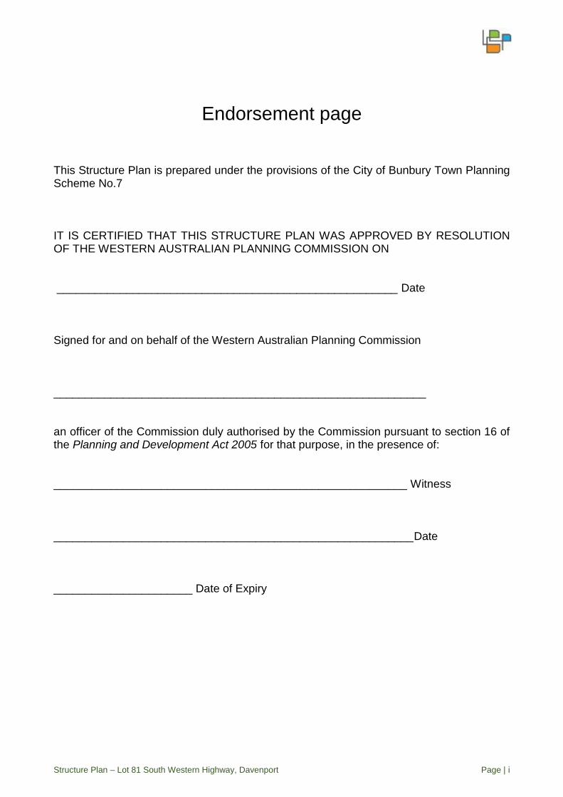
Endorsement page This Structure Plan is prepared under the provisions of the City of Bunbury Town Planning Scheme No.7 IT IS CERTIFIED THAT THIS STRUCTURE PLAN WAS APPROVED BY RESOLUTION OF THE WESTERN AUSTRALIAN PLANNING COMMISSION ON ______________________________________________________ Date Signed for and on behalf of the Western Australian Planning Commission ___________________________________________________________ an officer of the Commission duly authorised by the Commission pursuant to section 16 of the Planning and Development Act 2005 for that purpose, in the presence of: ________________________________________________________ Witness _________________________________________________________Date ______________________ Date of Expiry
Structure Plan – Lot 81 South Western Highway, Davenport Page | ii
DISCLAIMER: This document has been undertaken solely for NBR Investments (the client) and it is assumed that all information and documents relied upon to compile this document are complete, accurate and up-to-date. Where LB Planning has obtained information from a government register or database, it assumes the information is also accurate. No responsibility is accepted to any third party who may come into possession of this document in whatever manner and who may use or rely on the whole or any part of this document. Although care has been taken on the compilation of this document, LB Planning disclaims any responsibility for any errors or omissions. The right is reserved to change this document at any time. The information contained in this document has been compiled in good faith and liability is expressly disclaimed by LP Planning for any loss or damage which may be sustained by any persons and/or entity acting on this document. COPYRIGHT: The concepts and information contained in this document are the property of LB Planning. Use or copying of this document in whole or in part without the written permission of LB Planning constitutes an infringement of copyright.
Table of amendments
Amendment No. Summary of the
Amendment
Amendment type Date approved by
Commission

Structure Plan – Lot 81 South Western Highway, Davenport Page | iii
EXECUTIVE SUMMARY
This Structure Plan has been prepared to guide the subdivision and development of land contained within Lot 81 South Western Highway, Davenport.
The Structure Plan area comprises 41.83 hectares and is located approximately 8km south east of the Bunbury CBD. It forms part of the City of Bunbury local government area and is identified under both the Local and Regional Planning Scheme’s for industrial land use.
The landowner (NBR Investments) purchased the property in 2005 and now seeks to subdivide the land into six large industrial lots to facilitate industrial development, as intended by the relevant planning framework.
The consultant project team involved with the preparation of this Structure Plan is as follows:
LB Planning - Town Planning and Design; Development Engineering Consultants - Civil Engineering & Local Water
Management Strategy; Ecoscape – Environmental Assessment; Shawmac- Traffic and Transport Assessment; and Ecosystem Solutions - Bushfire Assessment.
The Structure Plan has been designed to support industrial land use and development of the site, based on larger lots to serve the industrial needs of the City of Bunbury.
The key planning objectives that have been applied to formulate the plan are as follows:
Provision of large industrial lots generally ranging between 5 to 8 hectares in size with each being capable of supporting larger scale industrial operations where large areas of space required for equipment storage, parking and machinery placement;
25 metre wide central road reserve with connection to South Western Highway;
Suitable separation distances from adjoining bushland and the Preston River Foreshore;
Strategic location of designated flood storage areas and drainage swales to ensure sustainable stormwater management in accordance with the objectives of the Local Water Management Strategy; and
Un-sewered development with restriction on the types of industrial activity permitted on the site (i.e. dry industry only).
The proposed Structure Plan outlines the planned industrial layout for the land and also identifies wetland areas, associated buffers, bush fire prone land and proposed drainage design, supported by a Local Water Management Strategy.
It has been prepared in accordance with the relevant planning framework and will provide appropriate guidance to future subdivision and development assessment of the land.
Structure Plan – Lot 81 South Western Highway, Davenport Page | iv
Table of Contents
PART ONE - IMPLEMENTATION
1 STRUCTURE PLAN AREA ____________________________________________________________ 1
2 STRUCTURE PLAN CONTENT _________________________________________________________ 1
3 OPERATION ______________________________________________________________________ 1
PART TWO - EXPLANATORY SECTION
1 INTRODUCTION _________________________________________________________________ 3
2 SITE DESCRIPTION _____________________________________________________________ 4
3 LOCAL PLANNING FRAMEWORK ________________________________________________ 5
3.1 City of Bunbury Town Planning Scheme No.7 and Draft Local Planning Scheme No. 8 ________ 5
3.2 Local Planning Policy – Development in Flood Effected Areas ____________________________ 7
3.3 Endorsed Structure Plan __________________________________________________________ 7
3.4 City Vision Strategy ______________________________________________________________ 8
4 STATE PLANNING FRAMEWORK ______________________________________________________ 9
4.1 State Planning Strategy 2050 ______________________________________________________ 9
4.2 State Planning Policies ___________________________________________________________ 9
4.3 WAPC DC 4.1 – Industrial Subdivision ______________________________________________ 10
4.4 Bunbury – Wellington Region Plan _________________________________________________ 10
4.5 Greater Bunbury Region Scheme __________________________________________________ 11
4.6 Industry 2030 __________________________________________________________________ 11
4.7 Greater Bunbury Strategy ________________________________________________________ 12
5 ENVIRONMENTAL ISSUES __________________________________________________________ 13
5.1 Environmental Assessment _______________________________________________________ 13
5.2 Hydrology_____________________________________________________________________ 13
5.3 Acid Sulfate Soils _______________________________________________________________ 13
5.4 Vegetation and Flora ____________________________________________________________ 13
5.5 Fauna ________________________________________________________________________ 13
5.6 Land Capability ________________________________________________________________ 14
5.7 Wetlands _____________________________________________________________________ 14
6 PROPOSED STRUCTURE PLAN _______________________________________________________ 15
6.1 Traffic ________________________________________________________________________ 15
Structure Plan – Lot 81 South Western Highway, Davenport Page | v
6.2 Fire Assessment ________________________________________________________________ 16
6.3 Servicing Considerations _________________________________________________________ 16
6.3.1 Roadworks __________________________________________________________________ 16
6.3.2 Sewer ______________________________________________________________________ 16
6.3.3 Water ______________________________________________________________________ 17
6.3.4 Drainage ____________________________________________________________________ 17
6.3.5 Power ______________________________________________________________________ 17
6.3.6 Telecommunications __________________________________________________________ 18
6.3.7 Groundwater and Flood Levels __________________________________________________ 18
7 CONCLUSION ____________________________________________________________________ 19
TECHNICAL APPENDICES Appendix A Local Water Management Strategy Appendix B Bushfire Assessment Appendix C Environmental Assessment Appendix D Transport Assessment Appendix E Servicing Report Appendix F Certificate of Title
Part One IMPLEMENTATION

Structure Plan – Lot 81 South Western Highway, Davenport Page | 1
1 STRUCTURE PLAN AREA
This Structure Plan shall apply to Lot 81 South Western Highway, Davenport, being the land
contained within the inner edge of the broken black line shown on the Structure Plan Map.
For the purposes of this report it is referred to as the Structure Plan.
2 STRUCTURE PLAN CONTENT
This Structure Plan report comprises two parts being:
Part One (Implementation) – This section contains the Structure Plan Map including
requirements to be applied when assessing subdivision and development
applications within the Structure Plan Area.
Part Two (Explanatory Section) – This section provides an explanation of the
Structure Plan including planning background, site conditions, constraints, land use
and servicing. Part Two is to be used as a reference guide to interpret and justify the
implementation of Part One. This section also includes all specialist consultants
reports used to inform and prepare the Structure Plan.
3 OPERATION
This Structure Plan commences operation on the date it is approved by the Western Australian Planning Commission and is valid for a period of ten years from such time. Due regard to its intent and specific provisions shall be given when considering future subdivision and development of the land.
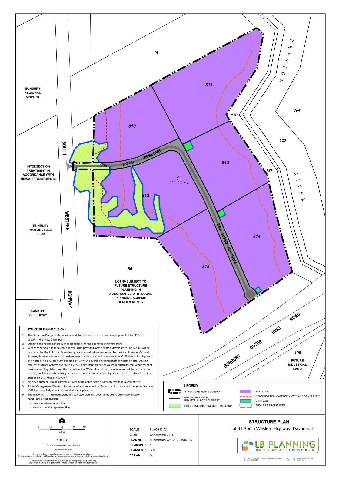
810
811
812
813
814
815
A
P
E 191A Naturaliste Terrace Dunsborough WA 6281
(08) 9750 5925
55 115 374 128ABN
N
0
metres
80
NOTES
LEGEND
12040 160
Lot 81 South Western Highway, Davenport
STRUCTURE PLAN
DRAWN
PLANNER
REVISION
PLAN No
DATE
SCALE
:
:
:
:
:
:
No copies in whole or in part may be made without LB Planning's permission.
The concepts presented in this plan remain the © copyright of LB Planning.
All carriageways are shown for illustrative purposes only and are subject to detailed engineering design.
Areas and dimensions shown are subject to final survey calculations.
Projection - GDA94
Base data supplied by Harley Dykstra
STRUCTURE PLAN PROVISIONS
BL
SLB
A
81DavenportLSP_V1.0_20161130
30 November 2016
1:4,000 @ A3
.restricted to ‘Dry Industry
Where connection to reticulated sewer is not provided, any industrial development on Lot 81, will be
- Urban Water Management Plan
- Foreshore Management Plan
conditions of subdivision:
The following management plans and selected planning documents are to be implemented via 6.
(DFES) prior to lodgement of a subdivision application.
A Fire Management Plan is to be prepared and endorsed by Department of Fire and Emergency Services 5.
No development is to be carried out within the Conservation Category Wetland (CCW) buffer’4.
exceeding 540 litres per 2000m².
the type which is predicted to generate wastewater intended for disposal on site at a daily volume not
Environment Regulation and the Department of Water. In addition, development will be restricted to
effluent disposal systems approved by the Health Department of Western Australia, the Department of
of on-site can be successfully disposed of, without adverse environmental or health effects, utilising
Planning Scheme where it can be demonstrated that the quality and volume of effluent to be disposed
Dry industry is any industrial use permitted by the City of Bunbury’s Local
3.
Subdivision shall be generally in accordance with the approved Structure Plan;2.
Western Highway, Davenport;
This Structure Plan provides a framework for future subdivision and development of Lot 81 South 1.
BUNBURY
OUTER
RING
ROAD
HIG
HW
AY
WESTER
NS
OUTH
81
41.832ha
25
m R
OA
D R
ES
ER
VE
25m ROAD
RESERVE
PR
ES
TO
N
RI
VE
R
80
14
104
120
121
123
120
106
LAND
INDUSTRIAL
FUTURE
REQUIREMENTS.
PLANNING SCHEME
ACCORDANCE WITH LOCAL
PLANNING IN
FUTURE STRUCTURE
LOT 80 SUBJECT TO
SPEEDWAY
BUNBURY
CLUB
MOTORCYCLE
BUNBURY
MRWA REQUIREMENTS
ACCORDANCE WITH
TREATMENT IN
INTERSECTION
AIRPORT
REGIONAL
BUNBURY
CONSERVATION CATEGORY WETLAND 50m BUFFER
DRAINAGE
BUSHFIRE PRONE AREA
STRUCTURE PLAN BOUNDARY INDUSTRY
INDUSTRIAL LOT BOUNDARY
INDICATIVE LARGE
RESOURCE ENHANCEMENT WETLAND

Part Two EXPLANATORY SECTION
Structure Plan – Lot 81 South Western Highway, Davenport Page | 3
1 INTRODUCTION
LB Planning has been appointed by NBR Investments (the landowner) to prepare a Structure Plan in respect of Lot 81 South Western Highway, Davenport (the site) in accordance with its zoning. A copy of the Certificate of Title in respect of the site is contained in Appendices Section of the report. The land is zoned ‘Development Zone (Industrial)’ pursuant to the City of Bunbury Town Planning Scheme No. 7 (the Scheme) and requires an approved Structure Plan to facilitate comprehensive planning and development of the land for industrial purposes. While a previous structure plan in relation to the site was adopted by Council and endorsed by the Western Australian Planning Commission (WAPC) in 2000, subsequent Environmental Protection Authority (EPA) advice to the Minister of the Environment regarding the Greater Bunbury Region Scheme and identified Preston Industrial Park (in context with the site) has undermined the current approved structure plan and its design philosophy. Accordingly, a Structure Plan has been prepared (in consultation with the City of Bunbury and Department for Planning) by a consultancy team whose investigation findings and recommendations (in support of the proposal) are incorporated as part of this report. The project team is as follows:
• Planning and Design – LB Planning
• Environmental – Ecoscape
• Bushfire Assessment – Ecosystem Solutions
• Engineering and Drainage Design– Development Engineering Consultants
• Transport Assessment - Shawmac
The proposal will enable the landowner to progress a viable industrial development in a rational and appropriate manner to service the growing industrial needs of Greater Bunbury and the broader South West Region. Details contained with this report are based on the structure planning design outcomes, technical investigation findings and information sourced from the City of Bunbury and WAPC, including relevant policy documents, reports and formal advice.
Structure Plan – Lot 81 South Western Highway, Davenport Page | 4
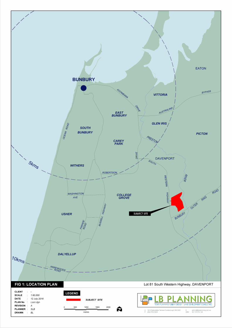
2 SITE DESCRIPTION
The subject land is identified as Lot 81, South Western Highway, Davenport and is
approximately 41.83 hectares. It is located approximately 8 kilometres south east of the
Bunbury CBD and falls within the City of Bunbury local government area (Figure1).
Historically the site has been used for broad acre farming and does not contain any existing
dwellings or outbuildings. The land has been cleared and pastured and its topography is
generally flat (14m to 11m AHD) with a gradual fall from west to east.
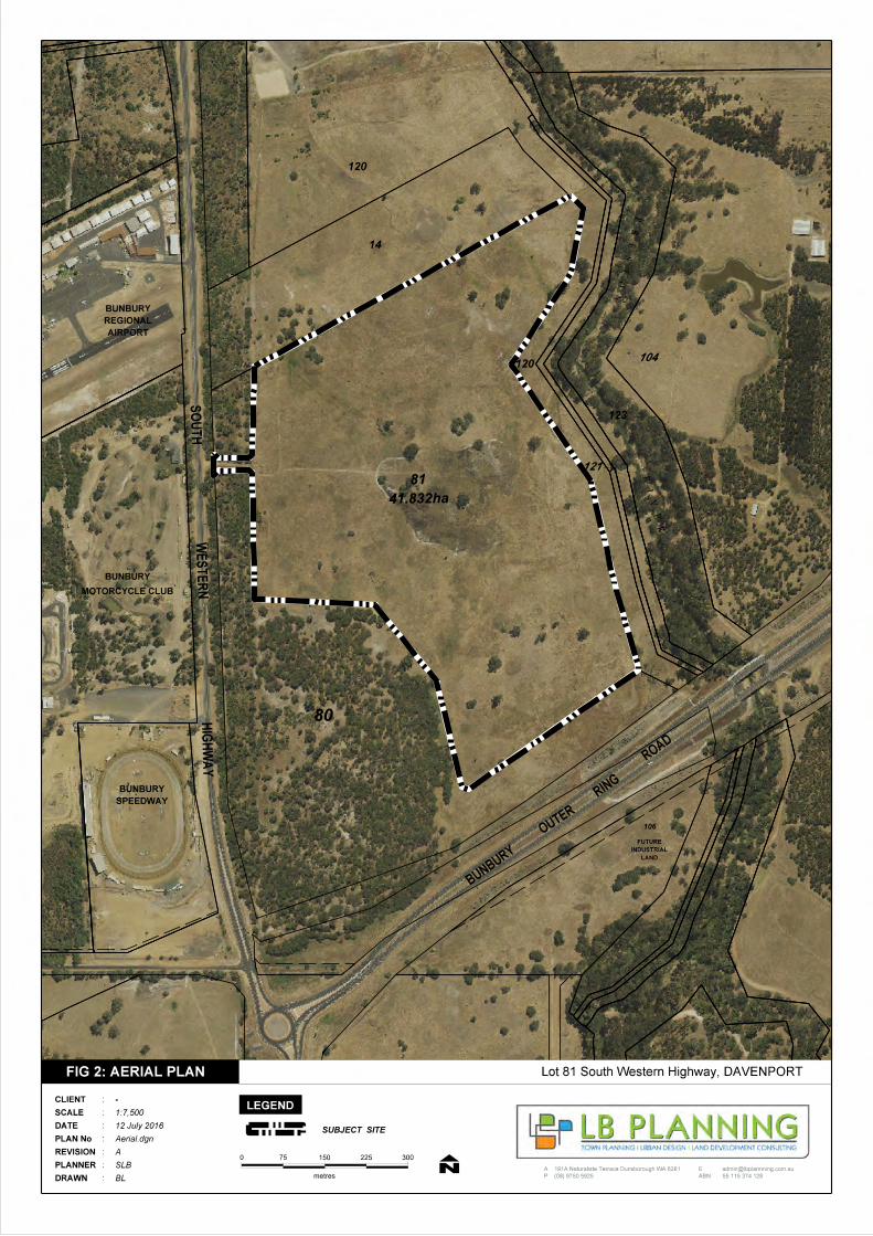
The site is bordered by South Western Highway to the west, a portion of the Bunbury Outer
Ring Road to the south, an airport expansion area to the north and the Preston River to the
east (Figure 2).
Surrounding land uses include of the Bunbury Speedway, the Bunbury Airport, Motorcycle
Club, Go-kart club, Bunbury Regional Prison to the west and various rural land uses. Land
further north is already developed for industrial purposes (i.e. Bunbury Business Park,
Halifax & Picton) and areas to the east and south are either strategically identified or
proposed as future industrial land.
The subject land is identified within the “Preston Industrial Park” area and in the context of
its surrounds is well suited for the proposed future industrial land use activity.
Directly abutting the subject land and South Western Highway to the west is a large
vegetated area known as Lot 80. This area of land formed part of the original lot parcel (Lot
15) which was subdivided in June 2015 (WAPC No 144945) into current Lots 80 & 81.
The majority of the Lot 80 is characterised by an elevated portion of land in the south western
corner comprising approximately 15 hectares of remnant peppermint woodland. The
remaining land is largely characterised by an identified Conservation Category Wetland
(CCW) area located along the South Western Highway boundary and a Resource
Enhancement (RE) wetland near the access leg to Lot 81.
The RE wetland also extends into the north-west corner of Lot 81 and while this potentially
constrains future industrial use in some portions of the subject land, the large nature of
proposed lots will enable appropriate measures to control land use in any sensitive areas at
the development approval stage.
5kms
AUSTRALIND
BYPASS
SOUTH
WES
TE
RN
HIG
HW
AY
EATON
DAVENPORT
10kms
BU
SS
ELL HIG
HW
AY
OC
EA
N R
OA
D
BUNBURY
ROAD
HAREWOODS
PA
RA
DE
RO
AD
WASHINGTON
AVE
ROBERTSON
DRIV
E
DRIV
E
KO
OM
BAN
A
BUNBURYEAST
VITTORIA
PICTON
GLEN IRIS
BUNBURY
SOUTH
WITHERS
GROVECOLLEGE
PARKCAREY
USHER
DALYELLUP
PRESTON
RIV
ER
BUNBURY
OUTER
ROAD
RING
SUBJECT SITE
A
P
E 191A Naturaliste Terrace Dunsborough WA 6281
(08) 9750 5925
55 115 374 128ABN
0
metresDRAWN
PLANNER
REVISION
PLAN No
DATE
SCALE
CLIENT
:
:
:
:
:
:
:
FIG 1: LOCATION PLAN
N1200 1800 2400
LEGEND
SUBJECT SITE
BL
SLB
A
Locn.dgn
12 July 2016
1:60,000
-
600
Lot 81 South Western Highway, DAVENPORT
81
41.832ha
PR
ES
TO
N
RI
VE
R
80
106
LAND
INDUSTRIAL
FUTURE
WESTER
NS
OUTH
AIRPORT
REGIONAL
BUNBURY
14
120
120
123
104
121
SPEEDWAY
BUNBURY
HIG
HW
AY
MOTORCYCLE CLUB
BUNBURY
BUNBURY
OUTER
RING
ROAD
A
P
E 191A Naturaliste Terrace Dunsborough WA 6281
(08) 9750 5925
55 115 374 128ABN
0
metresDRAWN
PLANNER
REVISION
PLAN No
DATE
SCALE
CLIENT
:
:
:
:
:
:
:
N150 225 300
LEGEND
SUBJECT SITE
Lot 81 South Western Highway, DAVENPORTFIG 2: AERIAL PLAN
BL
SLB
A
Aerial.dgn
12 July 2016
1:7,500
-
75
Structure Plan – Lot 81 South Western Highway, Davenport Page | 5
3 LOCAL PLANNING FRAMEWORK
3.1 City of Bunbury Town Planning Scheme No.7 and Draft Local Planning Scheme
No. 8
Pursuant to the City of Bunbury Town Planning Scheme No. 7 the site is zoned ‘Development Zone – Industrial’. Schedule 2 of the Planning and Development (Local Planning Schemes) Regulations 2015 outlines the deemed provisions and requirements in relation to the preparation and approval of structure plans, with the relevant provisions contained in Part 4. The proposed Structure Plan has been prepared in accordance with the above and sets out the broad infrastructure framework to facilitate intended subdivision and industrial development of the site. The Structure Plan responds to issues such as road layout, types of industry, servicing, drainage, environmental considerations and access. The Structure Plan is required to be approved by the City of Bunbury and the WAPC.
The aims of the Scheme relevant to this proposal, under Clause 1.6.3 of the Scheme text,
are as follows:
(a) To assist the effective implementation of regional plans and policies including the State Planning Strategy, Bunbury Wellington Region Plan and Industry 2030 (b) To ensure there is a sufficient supply of serviced and suitable land for housing, employment, commercial activities, community facilities, recreation and open space; (c) To protect and enhance the environmental values of the local government area and to promote ecologically sustainable land use and development; (l) To promote, as far as possible, high levels of accessibility: (i) of residential areas to employment centres commercial areas, education facilities and entertainment areas; and; (ii) of industry to sources of labour, power, and materials; (n) To promote and assist Bunbury’s future growth as a Regional Centre of character which offers an attractive and unique lifestyle enhanced by economic growth opportunities.; The proposed Structure Plan is consistent with the above in that it will assist the delivery of future industrial land to the City of Bunbury thereby supporting its future needs with respect to employment/commercial activities and ultimately its economic growth.
The proposal also acknowledges the existing environmental values attributed to the site and
its surrounds and provides an appropriate balance between these values and its future
industrial land use and development.
Following approval to the proposed Structure Plan, it is intended to rezone the land to
‘Industry’ zone by way of basic amendment to the Scheme.
Structure Plan – Lot 81 South Western Highway, Davenport Page | 6
The Scheme objectives in relation to the ‘Industry’ zone are outlined below:
Broad Objectives (Clause 4.2.1.5)
“To provide for a wide range of general and light industry uses, the storage and
distribution of goods and associated uses which, by the nature of their operations,
should be separated from residential areas.”
Specific Objectives (Clause 5.10.4)
(a) To encourage pleasant and efficient industrial activities;
(b) To encourage the consolidation and improvement of appropriately located
industrial areas;
(c) To enable industrial areas to expand where the need for such expansion can
be sustained;
(d) To promote the safe movement of vehicular and pedestrian traffic; and
(e) To protect the amenity of adjacent areas.
The proposed Structure Plan aligns with the above Scheme objectives.
In relation to wastewater disposal within the Industry zone, Clause 5.10.4.4 of the Scheme
states that:
“Within un-sewered areas of the various Industrial zones of the Scheme, the local
government is not to approve the establishment of industries which, in the opinion of
the local government, following consultation with the Health Department of Western
Australia, generate large volumes of wastewater or toxic wastes which cannot be
adequately disposed of other than by reticulated sewerage means.”
In this regard it is proposed to include a requirement in the Scheme whereby in the event
reticulated sewer is not provided, then only dry industrial uses will be permitted on the site.
In accordance with above Clause 5.10.4.4 of the Scheme, the City has discretion to approve
industrial development on un-sewered land and in this instance, such allowance is subject
to only certain types of industry being permitted. Reference to this restriction is noted on the
Structure Plan and ability to enforce this requirement is proposed by introducing ‘Additional
Site and Development Requirements’ to be set out in a table of the Scheme.
The City of Bunbury Draft Local Planning Scheme No. 8 (Draft Scheme) which at the time
of writing this report is being advertised for public comment, intends to maintain the
‘Industrial Development’ zoning of the land whereby a structure plan is required to guide
future land use and subdivision. As per Clause 40 (2) of the Draft Scheme, preparation of
required structure plans shall be in accordance with the Deemed Provisions of the Planning
and Development (Local Planning Schemes) Regulations 2015 contained in Part 4 of
Schedule 2.
Furthermore, Clause 43 of the Draft Scheme refers to “Additional Site and Development

Structure Plan – Lot 81 South Western Highway, Davenport Page | 7
Requirements for Areas Covered by a Structure Plan, Activity Centre Plan or Local
Development Plan”.
In order to ensure on-site waste water disposal is managed in an appropriate manner, it is
therefore intended to insert a requirement into a table contained in Schedule 6 of the Draft
Scheme, restricting land use on the site to dry industry only, until such time the site is
connected to reticulated sewer.
3.2 Local Planning Policy – Development in Flood Effected Areas
This policy influences the development and use of land within the Preston River Floodway and Flood Fringe areas. In respect of the site the policy stipulates that developers and subdividers shall be required not to develop lower than the recommended Minimum Finished Floor Level, as identified in flood studies carried out from time to time and in accordance with the Bunbury Flood Management Strategy. Information provided by the Department of Water (DoW) identifies the 1 in 100 year flood level for the Preston River adjacent to the development falling from approximately RL12.85 at the north-eastern (upstream) corner of the site to RL 12.18 at the north-western (downstream) corner of the site. Accordingly, no filling is allowed within the floodway area, which only impacts upon a very small area on the far north-eastern corner of the site however it is required that all buildings be sited at least 500mm above the 1 in 100 year flood level elsewhere. In this regard, future development will be guided by an approved Local Water Management Strategy (LWMS) and subsequent Urban Water Management Plan (UWMP) at the subdivision stage As part of this proposal a LWMS has been prepared by Development Engineering Consultants is contained in Appendix A of this report. In summary, the LWMS maintains certain levels of fill shall be required where buildings are proposed, with the full extent to be determined at the development approval stage with drainage, hard stand and/or open storage areas to be maintained at natural ground level.
3.3 Endorsed Structure Plan
A local structure plan in respect of the subject land and adjoining Lot 80 was adopted by
Council on 26 September 2000 and endorsed by the WAPC on 25 October 2000.
The approved plan provided the framework to progress intended subdivision and
development of the site for industrial purposes and identified various development precincts
and lot configuration guidelines for future industrial lots.
A plan of subdivision, based on the endorsed Structure Plan was approved by the WAPC
on 6 November 2000, (WAPC No. 113318) including development over the identified
“Conservation Category Wetland” on the western boundary and remnant vegetation located

Structure Plan – Lot 81 South Western Highway, Davenport Page | 8
in the south west corner of the site.
Under its current zoning, the Structure Plan is the only existing approved planning document
in relation to future subdivision and development of the subject land.
3.4 City Vision Strategy
The City Vision Strategy and associated City Vision Action Plan, was adopted by the
Bunbury City Council in September 2007,
The intent of the Strategy aims to establish broad direction for the future of the “Industry
Vision Focus Area” covering the localities of Davenport, Preston and the Bunbury Airport
precinct.
The proposed Structure Plan supports the intent of the City Vision Strategy and its Action
Plan.
Structure Plan – Lot 81 South Western Highway, Davenport Page | 9
4 STATE PLANNING FRAMEWORK
4.1 State Planning Strategy 2050
The State Planning Strategy 2050 was released in June 2014 and it provides the strategic
context for planning and development decisions throughout the State.
It also guides an informs local community plans, growth plans and local planning schemes
and strategies with structure planning and development assessments and it aspires to
ensure all strategic industrial areas are developed to an approved structure plan.
Accordingly, this proposal is aligned with the intent of the Strategy.
4.2 State Planning Policies
Relevant State Planning Policies to this proposal are as follows:
SPP 2.9 – Water Resources
With respect to water resources, the relevant issues are addressed in the Local Water
Management Strategy contained in Appendix A of this report.
SPP 3.7 – Planning in Bushfire Prone Areas
Both the eastern and western perimeters of the subject land are identified as Bushfire Prone
and accordingly a BAL Contour Assessment has been undertaken by Ecosystem Solutions
and is contained in Appendix B of this report.
In summary, it was found that only the very edges of Lot 81 will be subject to radiant heat
flux greater than 29 kW/m2 (i.e. BAL-29).
The “Guidelines for Planning in Bushfire Prone Areas” advocates that development is kept
where the radiant heat flux is less than BAL-29. Accordingly, provided any structure is built
outside the BAL-29 contour and appropriate separation distances from Class G – Grassland
vegetation are established and maintained, no building within the proposed development
will require a BAL assessment that exceeds BAL-29.
SPP 4.1: State Industrial Buffer Policy
Given that existing and proposed residential land uses are not within two kilometres of the
subject land, the need to consider industrial buffers to sensitive land uses in this instance is
not required.
Structure Plan – Lot 81 South Western Highway, Davenport Page | 10
4.3 WAPC DC 4.1 – Industrial Subdivision
Clause 3.7.2 of the policy states that;
Connection to a reticulated sewerage system is a normal requirement of industrial
subdivision. However, where a reticulated sewerage connection is not available and
is not in early prospect, this requirement may be dispensed with when the
Commission:
a) is satisfied that development will be limited to 'dry' industry, and
b) is advised by the relevant authorities that sod conditions allow for efficient on-site
disposal of effluent on a long-term basis.
The nearest sewer pressure main is approximately 2km away from the site and the cost to
install a Type 90 WWPS (as suggested by Watercorp) for only six industrial lots would make
the proposal unviable. Preliminary investigation findings also confirm that the resulting flow
rate would be insufficient for the WWPS to function properly in any case.
In relation to the estimated infrastructure delivery timeframe for the locality, advice from
Watercorp confirms that the planned Type 90 WWPS is not programmed at this point in time
nor is it likely to be within the next and 10 years.
Accordingly, it is proposed to only permit dry industry on the subject land, until such time
reticulated sewer is made available. Land use controls to ensure this occurs is proposed by
way of scheme amendment and details regarding suitably for on-site effluent disposal are
outlined in the Environmental assessment contained in Appendix C of this report.
4.4 Bunbury – Wellington Region Plan
The Bunbury-Wellington Region Plan (1995) was the guiding document for the preparation
of the Greater Bunbury Region Scheme (GBRS).
A component of the Bunbury-Wellington Region Plan is the Greater Bunbury Structure Plan,
which separates the Greater Bunbury Region into various planning unit areas and provides
policy guidelines for each of those areas.
The Greater Bunbury Structure Plan identifies the northern portion of the subject land within
“Planning Unit P8: Davenport”.
Relevant statements from the planning policies and guidelines of this planning unit are:
• Landscape buffers, conservation and tree planting areas should be promoted in
accordance with the approved structure plan; and
• Industrial development should satisfy environmental assessment requirements relating to
gaseous emissions, dust, noise, groundwater pollutants and provide safeguards for both
Structure Plan – Lot 81 South Western Highway, Davenport Page | 11
worker and resident health and safety.
This Structure Plan responds to the above mentioned planning unit provisions.
4.5 Greater Bunbury Region Scheme
The Greater Bunbury Region Scheme (GBRS) is a statutory scheme which covers the City
of Bunbury and the Shire’s of Harvey, Dardanup and Capel. The GBRS became operative
in 2007.
The GBRS is a large scheme which designates general zones and reservations of land. It
is a statutory requirement that all local planning schemes must be consistent with regional
planning schemes.
The site is designated as ‘Industrial’ under the GBRS, and therefore the proposed structure
plan is consistent with this Scheme.
There are a number of policies relevant to the GBRS, one of which is the Greater Bunbury
Region Scheme Flood Management Policy 2005. In summary the policy outlines how flood
risk needs to be considered to help decrease the impact of flooding through inappropriately
located land use and development.
In the context of the site, the policy identifies the eastern portion of the land, adjacent to the
Preston River, as part of the “Flood Fringe” which is defined as follows:
“..land that would be prone to flooding in a 1 in 100- year flood event, where
development would normally be permitted subject to a specified minimum habitable
floor level above the relevant 1 in 100-year flood level to provide adequate flood
protection.”
Accordingly and as mentioned previously, any future development of the site will be guided
by an approved LWMS to ensure certain levels of fill shall be required and maintained where
buildings are proposed, including those within the “Flood Fringe”.
4.6 Industry 2030
In 2000 the WAPC carried out a series of studies regarding industry and transport within the
Greater Bunbury Region and subsequently released a report called ‘Industry 2030 Greater
Bunbury Industrial Land and Port Access Planning’.
The report identifies major industrial and port access zones within the Bunbury area,
including the subject land.
The report also sets out a strategic planning framework to provide direction for investment
in the region to ensure suitably located industrial areas and transport routes meet the needs
of industry in the Greater Bunbury Region.
Structure Plan – Lot 81 South Western Highway, Davenport Page | 12
An Interim Strategy Plan is contained within the report which identifies the subject land as
‘transitional industry precinct’ and it notes that further technical investigations are required
in the following areas:
• Environmental impact modelling;
• Water and drainage management strategy (incorporating liquid waste disposal);
• Vegetation survey;
• Wetlands survey;
• Road access studies.
This Structure Plan is supported by a number of technical investigations to address the
above and investigation findings are appended at the back of this Report.
4.7 Greater Bunbury Strategy
The Greater Bunbury Strategy 2013 is a strategic plan to manage the growth of Greater
Bunbury over the medium to long term planning horizon. It provides for population growth in
Greater Bunbury from 83,598 people (2011 Census) to at least 150,000 people through
urban infill, and some additional greenfields urban expansion areas. This is anticipated to
cater for growth beyond the year 2050.
The Strategy supersedes the portion of the Bunbury Wellington Region Plan that relates to
land use within the Shires of Harvey, Capel and Dardanup and the City of Bunbury.
The Strategy will also form part of Statement of Planning Policy No. 1: State Planning
Framework and its outcomes will be implemented through relevant statutory documents,
being the Greater Bunbury Region Scheme, Local Planning Strategies and Schemes.
The Strategy incorporates the Greater Bunbury Structure Plan 2013 which identifies the
subject land as ‘industrial undeveloped land’ with a short to medium term priority to more
efficiently use the land for the purpose to which it is zoned.
This Structure Plan, will enable intended subdivision and industrial development of the land
to proceed.
Structure Plan – Lot 81 South Western Highway, Davenport Page | 13
5 ENVIRONMENTAL ISSUES
5.1 Environmental Assessment
An environmental assessment to support this Structure Plan has been undertaken by Ecoscape and its findings are contained in Appendix C of this report. The investigation used previous information in relation to the site, gathered and reported on in 2010 and further supported by an additional field assessment completed in August 2016. The key relevant environmental issues and subsequent findings are outlined below.
5.2 Hydrology
The site is located in the Middle Preston surface water management sub area DoW 2008.
Drainage at the site is generally from the south west to the east and there are no defined
streamlines with flows consisting broad surface movements. The Preston River flows in
close proximity to the eastern boundary of the site.
Groundwater level monitoring over recent years, through strategically placed bores indicates
groundwater levels close to the surface and in some cases, less than 1 metre below the
existing ground level. It is proposed that drainage will be managed by using bio-retention
swales and specific flood storage areas in the form of drainage basins. The location of the
proposed flood storage areas and swales are identified within the LWMS (Appendix A).
The LWMS is a key supporting document for the Structure Plan and has been prepared with
the intention of providing an outcome whereby subsequent development can occur
consistent with an appropriate water cycle management approach. The LWMS also provides
overall guidance to the general stormwater management principles for the area in order to
guide eventual development at the time of subdivision.
5.3 Acid Sulfate Soils
Mapping of potential acid sulphate soils (ASS) via Department of Environment Regulation
datasets indicates that the entirety of the site has a moderate to low risk of containing ASS.
5.4 Vegetation and Flora
Given the site is generally cleared and pastured and due to its completely degraded
bushland condition (Keighery 1994), the lack of any native vegetation understory and history
of grazing, it is considered highly unlikely that any conservation or significant flora is present.
5.5 Fauna
The environmental assessment finds the site devoid of any remnant native vegetation with
sufficient structure to provide fauna habitat value, other than large hollow bearing trees.
Structure Plan – Lot 81 South Western Highway, Davenport Page | 14
Accordingly, a Black Cockatoo survey of the study area was conducted by Ecoscape on 19
July 2016. The entire study area was traversed on foot and all trees with Diameter Breast
Height of 500 mm or greater were recorded and described.
These scattered and isolated trees were assessed by Ecoscape for value as potential Black
Cockatoo breeding trees. It was found that there are potential Black Cockatoo habitat
breeding trees within the study area (Refer Map 01 of Ecoscape Report) and it is intended
to retain these trees where possible. In the event the trees cannot be retained, then a referral
to the Commonwealth will be carried out by the subdivider. In this regard it is considered
that a sufficiently large number of similar trees can be found in the nearby natural areas,
including adjacent Lot 80.
5.6 Land Capability
As part of the environmental assessment Ecoscape investigated the land capability factors of the site, based on soil mapping. Its findings indicate that the land has a capability of Class 4 Low whereby its most limiting factor is in relation to high waterlogging. The high risk of this generally relates to the soils having low ability to absorb water combined with shallow depth to groundwater. Accordingly it is recommended that ATU systems are used for effluent disposal on site in conjunction with the required land fill for future building areas, as proposed by this Structure Plan.
5.7 Wetlands
There is a Resource Enhancement (RE) wetland recorded within the site, which was
recorded as Multiple Use (MU) in 2010 and then later modified by the Department of Parks
and Wildlife (DPaW). This wetland occurs in the North West corner of the site and may
potentially constrain the site’s development potential in this particular location.
Ecoscape recommends that a request for modification be lodged with the (DPaW) to alter
the classification of the portions of this RE wetland that lie within the site.
A Conservation Category Wetland (CCW) is also located on adjoining Lot 80 to the west.
CCW areas incorporate a buffer zone of at least 50 metres which has been nominally
identified on the proposed Structure Plan. The buffer zone reduces the amount of
developable area along the western boundary of the proposal, and while some
rationalisation of the boundary is required in order to accommodate the proposed Structure
Plan design, there is no intention to challenge the location of the wetland boundaries or its
classification status. While some discretion will be required, the separation of 50 metres from
the CCW can generally be achieved and is to be applied along with the management of the
boundary, including fencing where necessary.

Structure Plan – Lot 81 South Western Highway, Davenport Page | 15
6 PROPOSED STRUCTURE PLAN
The Structure Plan has been designed to support industrial land use and development of the site, based on larger lots to serve the industrial needs for the City of Bunbury. Planning objectives that have been applied to formulate the plan are as follows:
Provision of large industrial lots generally ranging between 5 to 8 hectares in size with each being capable of supporting larger scale industrial operations where large areas of space required for equipment storage, parking and machinery placement;
25 metre wide central road reserve with connection to South Western Highway;
Suitable separation distances from adjoining bushland and the Preston River Foreshore;
Strategic location of designated flood storage areas and drainage swales to ensure sustainable stormwater management in accordance with the objectives of the Local Water Management Strategy; and
Un-sewered development with restriction on the types of industrial activity permitted on the site (i.e. dry industry only).
6.1 Traffic
A transport assessment of the site and the proposed Structure Plan has been carried out by
Shawmac and its findings are contained in Appendix D of this report.
In summary Shawmac concludes the following:
1. Under the intended development of the land, the subdivision will yield 6 industrial lots
with a single access road.
2. The predicted traffic flows are approximately 5,032 vehicles per day.
3. The new intersection with South Western Highway is predicted to operate at
acceptable levels of service for the predicted development year, 2018 and for 10 years
beyond the development year.
4. The new road within the subdivision area will be constructed as Access Road to an
industrial standard, with a 10m wide carriageway and all 8.5m truncated corners. All other
cross section details, line marking, intersection control and local area traffic management
measures are to be addressed during the detailed subdivision design stages.
5. Pedestrian and cyclist facilities should be provided within the subdivision to allow for
future connections on South Western Highway.
6. Public Transport services are not currently available however given the nature of the
subdivision this is unlikely to affect the future development operations.

Structure Plan – Lot 81 South Western Highway, Davenport Page | 16
6.2 Fire Assessment
A Bushfire Attack Level (BAL) contour assessment and associated report has been
undertaken by Ecosystem Solutions to inform this proposal.
In summary the assessment concludes that the Structure Plan and its proposed layout, is
acceptable provided future buildings are built outside the BAL-29 contour and appropriate
separation distances from the Group G – Grassland vegetation are established and
maintained.
It also confirms the four elements of Guidelines for Planning in Bushfire Prone Areas
(WAPC, 2015 can be suitably addressed as part of any future development and that while
the current proposed cul de sac central road exceeds 600m in length, proposed land use is
for industrial/commercial (not residential) and the proposed width and standard of the cul de
sac will allow adequate access and egress in any bushfire emergency, given the overall
bushfire hazard of the landscape.
6.3 Servicing Considerations
The necessary services to support proposed land use and development of the site are either of very limited capacity or currently not available and will need to be extended / upgraded at the developer’s cost from west of the site via South Western Highway. Accordingly, the servicing requirements have been considered by Development Engineering Consultants as part of this proposal (refer Appendix E), the details of which are summarised below.
6.3.1 Roadworks
The subdivisional road will be designed and constructed to City of Bunbury industrial standards, and will be a substantial pavement in width and depth. It is expected that this road will be fully kerbed, with stormwater being collected in roadside swales using suitably designed / constructed “kerb breaks”.
No works are envisaged to South Western Highway apart from new intersection treatment
at the entrance of the site.
6.3.2 Sewer
The site is not currently connected to sewer and the closest Water Corporation sewer infrastructure is located approximately 2 km west of the site at Dodson Road. Water Corporation sewer planning for this area shows a future main Type 90 Waste Water Pumping Station (WWPS Bunbury “G”) to be located north of the Preston River. No planning or funding has been planned at this stage. It is also advised that a temporary WWPS will not be approved, and that it would not be workable due to the 2km pumping distance in a small main, leading to problems with stale or septic discharge, paucity of flow needing topping up with scheme water for hydraulic reasons. Therefore it is obvious that site disposal of wastewater should be effected by the use of ATU’s for each site sized to suit.

Structure Plan – Lot 81 South Western Highway, Davenport Page | 17
Discharge from ATU’s should be as per Health Department regulations, at least 100 metres from the Preston River, and at least 2 metres above the groundwater/ clay level. This may require filling with suitable granular material (sand with a PRI greater than 10) for lots north of the subdivision road, and locations along the southern boundaries of the lots south of the subdivisional road where the land is higher and depth to clay is suitable.
6.3.3 Water
At present there is a 100mm water main along South Western Highway which appears to be a dedicated main serving the Bunbury Regional Prison. This main is located on the southern verge of South Western Highway according to the plan supplied by Aqwest. It is therefore proposed that a new 150mm water main be extended along South Western Highway to the development from Halifax Drive, approximately 1.5Km west of the site.
Water services are controlled by the Aqwest (Bunbury Water Board), and all design and
construction will be to their approval. It is anticipated that a hydraulic study will be required
at the cost of the developer to determine the specific requirements of supply of potable and
fire- fighting water, street hydrants etc.
6.3.4 Drainage
The eastern boundary of the site is adjacent to the Preston River. In this regard, the 1 in 100 year flood level of the Preston River will have an impact on the development drainage and minimum fill levels, as a minimum of 500mm height above the estimated 1 in 100 year floodway is required for all areas within developed lots that are to contain significant or critical infrastructure. The development site will essentially be divided into three stormwater catchments, each directing extreme flow events towards three overflow channels, as described in greater detail in the LWMS report. Typically fill will need to be placed approximately 1.2 metres above the clay layer, with on-site detention & site soakage required for each industrial lot. Each industrial lot will be provided with an outlet overflow connection pipe which will similarly directed all appropriately detained extreme event overflows into the three “east-west” overflow channels that meet up with three existing natural channels that currently directs all flows into the Preston River. All stormwater drainage design and construction will be done to the City of Bunbury specification and approval. Three basin sites will detain the design storm runoff from the proposed road reserve and all lots within the estate will be required to detained flows within their lots to pre-development conditions as outlined in the LWMS report - by way of soak wells, rainwater tanks, underground storage devices &/or detention basins.
6.3.5 Power
A north-south high voltage (HV) aerial line runs within the eastern portion of the site adjacent to the Preston River and has two spur lines near the central-eastern part of lot 81. One of the spur lines heads east over the Preston River and one that heads west to service the

Structure Plan – Lot 81 South Western Highway, Davenport Page | 18
existing “dirt bike” track on the west side of Southwestern Highway. Underground HV cables run along the western portion of Bunbury Outer Ring Rd (where it abuts lot 80) and another short length runs along the west side of SW Hwy heading towards the airport. These underground cables are fed from two HV switchgear units on the north side of the Outer Ring Rd - one close to the NE corner of the SW Hwy/Outer Ring Rd intersection & another roughly mid-way between this intersection & the Preston River. All internal power reticulation lines and transformer installations (& under-grounding / relocation of any existing infrastructure) will be completed at the cost of the developer – including the upgrading (as necessary) of any existing HV switchgear units and the maintenance of supply to all existing / surrounding properties.
It is recommended that the subdivision should be serviced by a transformer at each lot -
servicing to at least a WP minimum servicing requirement of 200kVA/ha. The location of
each transformer site will be determined at the detailed subdivision design stage.
6.3.6 Telecommunications
Telstra services exist in the area along Southwester Highway adjacent to the site. Some
upgrading/ augmentation will be involved. If Telstra is to be the servicing authority, Telstra
normally requires twelve months’ notice of the commencement of the development starting
in order to ascertain any upgrading requirements.
NBN services are not available
6.3.7 Groundwater and Flood Levels
According to the plans supplied by the Department of Water (DoW), site levels fall from RL 14m AHD along the southern boundary of the site to generally RL 12m AHD along the Preston River frontage. The previous LWMS report prepared as part of the 2010 Structure Plan proposal has derived AAMGL’s over the site which falls from RL 14.5 on the western boundary to RL 10.0 along a major part of the eastern boundary, adjacent to the Preston River. The DoW plan also shows the 1 in 100 year flood level for the Preston River adjacent to the development falls from approximately RL12.85 at the north-eastern (upstream) corner of the site to RL 12.18 at the north-western (downstream) corner of the site. At this point the floodway impinges some 25 to 30 metres into the north eastern corner of the site. No filling is allowed within the floodway area which only impacts upon a very small area on the far north-eastern corner of the site.
There is a requirement for any buildings to be sited at least 500mm above the 1 in 100 year
flood level. Fill over and above this stipulation will be placed, where required, for this
development to provide the required site building classification and allow site soak wells to
function. The fill will need to consist of clean free draining sand.
Structure Plan – Lot 81 South Western Highway, Davenport Page | 19
7 CONCLUSION
This Structure Plan has been prepared in alignment with the industrial zoning of the site and the relevant local and state planning framework. It is envisaged that this Structure Plan will achieve the following:
Provide appropriate and efficient use of land for industrial purposes to serve the
Greater Bunbury Region until 2030 and beyond in accordance with the intentions of
the Bunbury Wellington Region Plan, Industry 2030 and the City of Bunbury Town
Planning Scheme No. 7;
Satisfy any shortfall of industrial land in the Greater Bunbury Region and provide
opportunity for the delivery of larger industrial lots;
Facilitate the efficient development of under-utilised land in an economically and
environmentally sustainable manner;
Provide land use opportunities that will complement the existing industrial land to the
north and the Bunbury Regional Airport;
Facilitate the provision of infrastructure to the site;
Apply environmentally sound local water management design principles in
accordance with the proposed Local Water Management Strategy;
Embrace the intent and fundamental objective to balance economic and
environmental values with a rational land use development outcome; and
Provide a suitable level of detail and planning framework to ensure appropriate
subdivision and development of the land.
The proposed Structure Plan is a strategic planning document and informs future subdivision and development of the site for industrial land use and has been prepared pursuant to the provisions of the Scheme as it relates to the Development Zone (‘Industrial’). The proposal provides a large lot design approach combined with suitable environmental and infrastructure measures to ensure an appropriate planning and development outcome for the site. Accordingly, approval from the City of Bunbury and the WAPC to this Structure Plan, is respectfully requested.
TECHNICAL
APPENDICES INDEX
Appendix A: Local Water Management Strategy Appendix B: Bushfire Assessment Appendix C: Environmental Assessment Appendix D: Transport Assessment Appendix E: Servicing Report Appendix F: Certificate of Title

Appendix A
Local Water Management Strategy
Prepared by Development Engineering Consultant
Appendix B
Bushfire Assessment Report
Prepared by Ecosystem Solutions
Appendix C
Environmental Assessment
Prepared by Ecoscape
Appendix D
Transport Assessment
Prepared by Shawmac
Appendix E
Servicing Report
Prepared by Development Engineering Consultants
Appendix F
Certificate of Title