study on open wells in yamalur watershed, bengaluru a historical perspective
TRANSCRIPT
1
STUDY ON OPEN WELLS OF YAMALUR WATERSHED, BENGALURU- A HISTORICAL
PERSPECTIVE
Minor Project Thesis
Submitted by
SUSHANT D. POTDAR
For the partial fulfillment of the
Degree of Master of Science in ENVIRONMENTAL STUDIES AND RESOURCE MANAGEMENT
Submitted to Department of Natural Resource
TERI University
August 2015
2
DECLARATION
This is to certify that the work that forms the basis of this project “Study on open
wells of Yamalur watershed, Bengaluru–A historical perspective” is an original
work carried out by me and has not been submitted anywhere else for the award
of any degree. I certify that all sources of information and data are fully
acknowledged in the project report.
Sushant D. Potdar New Delhi
28-07-2015
3
CERTIFICATE
This is to certify that SUSHANT D. POTDAR has carried out his minor
project in partial fulfilment of the requirement for the degree of Master in
Science in Environmental Studies and Resource Management on the
topic “Study on open wells of Yamalur watershed, Bengaluru–A historical
perspective” during May 2015 to July 2015. The project was carried out at Biome
Environmental Trust, Bengaluru, India.
The report embodies the original work of the candidate to the best of our
knowledge.
Date: 24–07–2015
Shubha Ramachandran
(Supervisor)
Water Sustainability Consultant
Biome Environmental Trust
Bengaluru, India

4
ACKNOWLEDGEMENTS
I would first and foremost like to thank Mr. S. Vishwanath, Founder trustee of
Biome Environmental Trust in giving me the opportunity to intern at the
organization. I am also grateful to him for giving me in depth knowledge and
ideas in the field of my study.
I would like to thank my supervisor, Shubha Ramachandran, Water
sustainability consultant at Biome Environmental Trust, in constantly
supporting and encouraging me to do well with the project. Without her
supervision and valuable inputs, this project would not have completed.
I express my sincere gratitude to Aditi Hastak and Avinash Krishnamurthy of
Biome Environmental Trust in providing valuable information during the study.
I also express my profound gratitude to all the people residing in Yamalur
watershed who helped me in finding the open wells and providing me with
information which has formed the base of this project report.
I would also like to thank Dr. Rajiv Seth (Registrar of TERI University) for his
constant support.
I am sincerely thankful to Madhur Chanana, Saarthak Bhola and Roopam
Shukla in helping me create the maps using the GIS software at Geoinformatics
laboratory of TERI University.
I am indebted to my family and friends for their continuous support and
guidance.

5
TABLE OF CONTENTS
DECLARATION .................................................................................................... 2
CERTIFICATE ....................................................................................................... 3
ACKNOWLEDGEMENTS ..................................................................................... 4
LIST OF FIGURES ................................................................................................ 6
ABSTRACT ............................................................................................................. 7
Introduction: ......................................................................................................... 8
1. Groundwater in India: .................................................................................. 8
2. Groundwater in Bengaluru: ......................................................................... 9
Aim and objectives: .............................................................................................. 11
Study area: ........................................................................................................... 11
Methodology: ....................................................................................................... 13
3.1 Obtaining the topographic sheets from Survey of India (SoI): ................ 13
3.2 Identifying open wells in Yamalur watershed:......................................... 13
3.3 Interview with open well owners and open well diggers: ........................ 14
Results: ................................................................................................................. 15
4.1 Comparing the recent map of Yamalur watershed with a 33 year old
map: ................................................................................................................. 15
4.2. Open wells of Yamalur watershed: .......................................................... 17
4.3. Interview with open well owners and open well digger: ....................... 26
Discussion and Conclusions:............................................................................... 29
5.1 Importance of open wells in Bengaluru city: ........................................... 29
5.2 The lives around open wells: .................................................................... 29
5.3 Reasons for closing down of open wells: .................................................. 30
5.4 Open wells as Common Property Resource (CPR): ................................. 30
References: .......................................................................................................... 33

6
LIST OF FIGURES
Figure 1: Location of the Yamalur watershed
Figure 2: Map of Yamalur watershed in 1978
Figure 3: Map of Yamalur watershed in 2011
Figure 4: Picture of open well 7 with its platform stone
Figure 5: Picture showing the open well and the waterway
Figure 6: The old open well of Hadosiddapura tank
Figure 7: Open well with water of Rayasandra tank
7
ABSTRACT
The groundwater is an important source of water for both potable and non-potable
purposes. India is a country where groundwater is used tremendously and about 80%
of the population in India depends on groundwater. Bengaluru city, the capital of
Karnataka state, is no exception. The groundwater has been in use from the Cholas and
the Hoysala period with the means of open wells. Since then, shallow aquifers and
surface waters were used for drinking, irrigation and household purposes. Today, the
use of groundwater has now shifted from agriculture based to industry and household
base. This is also the case with the Yamalur watershed located on Sarjapura road. The
area of 33.8 sq km was once an agricultural land but now has become more residential
due to the emergence of IT sector nearby. The watershed gets water from only one
source i.e groundwater due to which tremendous discharge is depleting both the
shallow and deep aquifers. Since the upcoming of bore wells which extract water from
deep aquifers, somehow the shallow aquifers, its open wells and tanks of the watershed
are neglected. It is important to understand the working of the aquifers to manage
them sustainably. In the Participatory Aquifer Mapping (PAQM) project undertaken
by Biome Environmental Trust, the history of the aquifers of Yamalur watershed is
essential in understanding its working and comparing it with the current information.
Thus it was essential in identifying the open wells of the watershed and understand the
historical significance of these wells required to manage the shallow aquifers. The
information was collected from the people and it will be used in the PAQM project to
make them aware of the threats and signify the importance of sustainable use of
ground water.
Key words: shallow aquifer, deep aquifer, open wells, PAQM, Yamalur watershed
8 Introduction:
Water is a vital molecule which is required for the existence of life on Earth. It is
proved that one of the basic requirements for life to exist on other planets is the
availability of water. It is because of this that people give so much reverence to
water, especially in areas where it is scarce. Humans, like other animals used
this water for potable purposes initially. It was when his intellectual capacity
expanded and various ideas started to flow, he made better use of resources,
including water, for his own benefit. Today, water, other than for drinking, is
used in many industrial processes and in production of many goods and
services. It is in this era that it is critical for us to think about water as “the liquid
with life” than just a common resource.
1. Groundwater in India:
The strong historical evidence of usage of groundwater in Indian subcontinent
dates back to the Harappan civilization way back in 2000 BC in the Indus valley.
It was a distinguishing feature for the Harappans to build wells and use it for the
purpose of irrigation and drinking. About 700 wells have been identified in the
archaeological excavations of Mohenjodaro. It is believed that the mouth of the
wells was kept small with an intention for the water to flow out of the well in an
artesian manner (Agarwal et al, 1997).
The different types of open wells and step wells of the country have been
beautifully explained in CSE’s Dying Wisdom. The stepwells of Rajasthan are
known as jhalaras which collect the water from the upstream lake or tank
through the underground seepage. The other type of structure from the Thar
Desert of Rajasthan is the famous kund in which people of the village regularly
maintained and took care of the catchment area. The individual kunds were
maintained by the owners and water from the monsoon fill into these structures
through three openings made at the surface of the land. Some structures in
Bikaner also maintained 12 m deep wells adjacent to the tanks. They are called
kuis and are recharged by seepage from the tanks. The dug wells of Gujarat are
called virads which collect rainwater. They are dug in low depressions and the
water collected can be used for about 4 months (Agarwal et al, 1997).
The Southern India had completely different ideas of water management in the
history. The wells of Bijapur in North Karnataka are known as bavadi which are
huge structures. Some of them are even tourist attractions at Bijapur. These
9 wells have been built by the Bijapur rulers to fulfil the water needs of the city
(Iyengar, 2007). The wells are intricately dependant on the tanks for their water.
The tanks of southern Karnataka and Andhra Pradesh were once connected
(Cunha et al 2006). Adjoining the tanks were bavis (wells) and kalyanis (step
reservoirs) present which got recharged by underground seepage from the tanks
(Vishwanath, 2012 and Unnikrishnan et al, 2015). The tanks got dried up during
summers but the wells next to them yielded and the driest period of the year was
managed with enough water in the wells. The tanks later filled up during the
monsoon thus continuing the cycle of water management with tanks and wells.
The statistics of groundwater usage with the help of bore wells and open wells in
the current circumstances is enormous. Almost 85 % of rural population and
more than 50 % of urban population depend on groundwater for their potable
purposes. The quality of the groundwater has also depleted according to the
CGWB report in 2009 which states that more than 60% of the districts in India
are facing either contamination or depletion. This might be due to increased
consumption of water in the urban as well as rural settings (Kulkarni et al,
2015).
2. Groundwater in Bengaluru:
The construction of tanks in Bengaluru district can be dated way back in 1110
AD by the Cholas and the Hoysalas. The series of tanks was later built by the
founder of Bengaluru, Kempe gowda from 1537 AD (Annaswamy, 2003). The
wells would have then come up gradually adjoining the tanks built during that
time. The oldest well that can be spotted in the city is located in the Begur fort
(Unnikrishnan et al, 2015). The famous well in Lalbagh Botanical Gardens,
probably built by Tipu Sultan at the end of the 18th century stands majestically
but filled with solid waste today (Unnikrishnan et al, 2015). The history of water
management has then been on a rough road as the tanks dried out. This city in
1949 merged its two municipalities namely the Bangalore city and the Bangalore
civil and military municipalities to become one (Sudhira et al, 2007). This
expanded the city which put a lot of stress on the waterbodies present in
Bengaluru at that time. The Cauvery Water Supply Scheme (CWSS) was initiated
by Bangalore Water Supply and Sewerage Board (BWSSB) in 1969 to bring
Cauvery river water to fulfil the needs of the city. In 2010, the 4th stage of CWSS
was in operation supplying 810 Million Litres per Day (MLD) of water to the city
(Banerjee et al, 2012). Today, the 5th stage of this scheme is in operation. The
groundwater use in the city has been on the rise and according to the data,

10 Bengaluru district has about 7741 open wells and 3921 bore wells as on 1987
(Kamath, 1990). The recent data shows that the number of bore wells have
increased to 7000 supplying 70 MLD of water to the city. These bore wells have
been maintained in the BWSSB records. The estimates of private bore wells in
the district are close to 80,000 with an annual drilling of 6,480 bore wells
(Banerjee et al, 2012).
With the statistics completely against the sustainable management of
groundwater, it is a hot topic to restore and check on the usage and discharge of
groundwater to support the future of the city. The recharge of groundwater
through rainwater harvesting and with the means of restoration of tanks in the
city, a possible sustainable outcome can be met which will probably be
beneficiary in the future.
The forgotten knowledge about shallow aquifers and importance of traditional
knowledge in managing water, especially groundwater, by collecting information
from the locals and making them aware of the threats by using the same
information, as being carried out in PAQM project, creates the base for this
project.
11
Aim and objectives:
To know the historical perspective and importance of open wells for
groundwater recharge and management in Yamalur watershed of Bengaluru
city.
The study had three main objectives.
1. To map the current status of the open wells with the help of a topographic
sheet and compare it with a 33 year old topographic sheet. The entire watershed
area is mapped to understand the change in land use and its impact on the
existence of the open wells.
2. To identify the open wells in Yamalur watershed and study their current
status, historical, traditional and cultural importance as a Common Property
Resource (CPR).
3. To understand the significance of the existing open wells in a city like
Bengaluru from an open well owner and an open well digger’s perspective.
Study area:
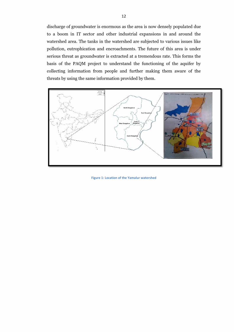
The study site selected to achieve the aim and the objectives listed is Yamalur
watershed of Bengaluru city. The Biome Environmental Trust has been carrying
out PAQM project of this watershed for over a year. The watershed lies in
Koramangala and Chellaghatta valley which is one of the three valleys in which
Bengaluru city lies. The watershed contains about 12 tanks which still exist. The
tanks are interconnected and drain out into the largest tank of Bengaluru, the
Bellandur tank. The area of the watershed is about 33.8 sq km through which
the two main roads of the city, the outer ring road and Sarjapura main road
pass. The Sarjapura main road passes right from the middle of the watershed
and is subject to commercial activities today. The main reason on choosing this
site for PAQM project is that the area is completely dependent on groundwater.
The BWSSB does not supply piped water to this area which forces the people to
depend on groundwater entirely. The supply is through private bore wells in
high rise complexes or private tanker operators are seen extracting water from
bore wells for supplying it to other apartment and residential communities. The
12 discharge of groundwater is enormous as the area is now densely populated due
to a boom in IT sector and other industrial expansions in and around the
watershed area. The tanks in the watershed are subjected to various issues like
pollution, eutrophication and encroachments. The future of this area is under
serious threat as groundwater is extracted at a tremendous rate. This forms the
basis of the PAQM project to understand the functioning of the aquifer by
collecting information from people and further making them aware of the
threats by using the same information provided by them.
Figure 1: Location of the Yamalur watershed
13 Methodology:
3.1 Obtaining the topographic sheets from Survey of India (SoI):
The topographic sheets had to be purchased from the SoI office located in
Koramangala to map the open wells and land use pattern of the watershed area.
Two maps were purchased, one printed in 1978 and the other recently printed in
2011. The maps have 33 years difference in them which is sufficient to study the
rapid land use change and its impact on open wells in the study area. The
Yamalur watershed lies in the south western part of Bengaluru city in the
topographic sheet with index number 57 H/9. The topographic sheets were
obtained on 2nd June, 2015 in the form of hard copy. The SoI keeps a record of
all the old maps scanned in their systems. It would cost more in getting them
printed than the recently available maps that they have at the store. At any cost,
the scanned copies of the maps are not provided to the customers.
The depiction of the open wells and the land use pattern on the topographic
sheet requires scanning. The scanning of the topographic sheets was done at a
separate enterprise at a cost of Rs. 300 per topographic sheet.
The scanned topographic sheets were later georeferenced with the help of QGIS
1.8.0 software. The digitization of the topographic sheets was carried out using
ArcGIS 10.0 software.
3.2 Identifying open wells in Yamalur watershed:
It was essential to identify the open wells present in the watershed to
understand their current status, historical, cultural and traditional importance.
From the literature, it is evident that there is a relation between the tanks and
open wells. Keeping this in mind, a search for open wells around the tanks
present in the watershed was carried out for a period of two weeks and covering
10 tanks out of 13 in the watershed. A total of 21 open wells were identified in
the watershed mostly around the tanks. A thorough search might lead to many
more open wells in the study area. The means of discovering the open wells were
different and this has been explained in the following chapter. The wells were
later identified on google maps to get their GPS locations.
14 3.3 Interview with open well owners and open well diggers:
Another objective of this study was to obtain people’s perspective about open
wells. The information gathered from open well owners would be vital in
understanding the problems faced by them in maintaining such massive
structures as well as incorporate their assessment about groundwater recharge
and management. The attempt was to identify the owners of all the 21 wells but
some wells were common and didn’t have any owners. There were some wells
for which the owners were not found. Overall, 7 open well owners were
interviewed and information was collected accordingly. An interview of an open
well digger was also considered to understand the change in technique and
behaviour of open well construction.
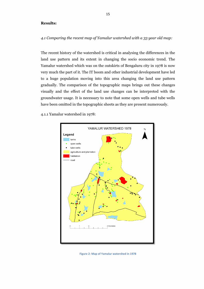
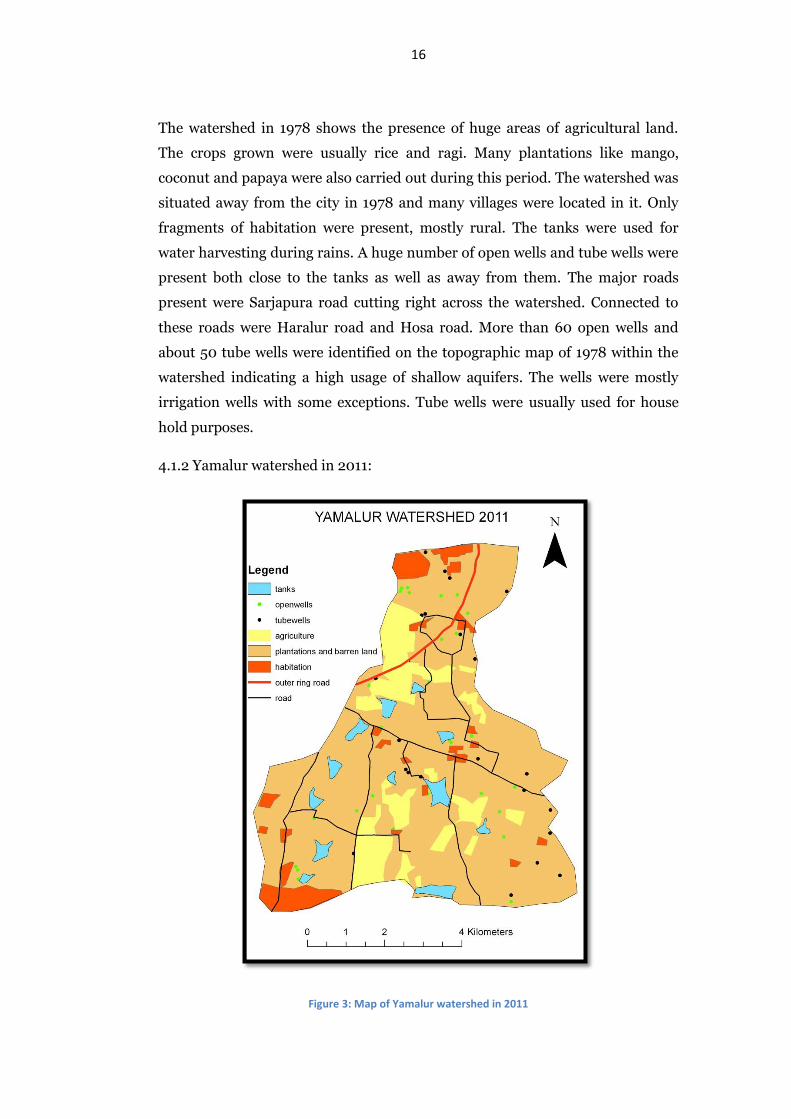
15 Results:
4.1 Comparing the recent map of Yamalur watershed with a 33 year old map:
The recent history of the watershed is critical in analysing the differences in the
land use pattern and its extent in changing the socio economic trend. The
Yamalur watershed which was on the outskirts of Bengaluru city in 1978 is now
very much the part of it. The IT boom and other industrial development have led
to a huge population moving into this area changing the land use pattern
gradually. The comparison of the topographic maps brings out these changes
visually and the effect of the land use changes can be interpreted with the
groundwater usage. It is necessary to note that some open wells and tube wells
have been omitted in the topographic sheets as they are present numerously.
4.1.1 Yamalur watershed in 1978:
Figure 2: Map of Yamalur watershed in 1978
16
The watershed in 1978 shows the presence of huge areas of agricultural land.
The crops grown were usually rice and ragi. Many plantations like mango,
coconut and papaya were also carried out during this period. The watershed was
situated away from the city in 1978 and many villages were located in it. Only
fragments of habitation were present, mostly rural. The tanks were used for
water harvesting during rains. A huge number of open wells and tube wells were
present both close to the tanks as well as away from them. The major roads
present were Sarjapura road cutting right across the watershed. Connected to
these roads were Haralur road and Hosa road. More than 60 open wells and
about 50 tube wells were identified on the topographic map of 1978 within the
watershed indicating a high usage of shallow aquifers. The wells were mostly
irrigation wells with some exceptions. Tube wells were usually used for house
hold purposes.
4.1.2 Yamalur watershed in 2011:
Figure 3: Map of Yamalur watershed in 2011

17
The 33 years brought a major difference to Bengaluru city. The city’s limits were
expanded on all the four directions. The major expansion of the city according to
me was in the south west Bengaluru due to the upcoming of many IT hubs.
Wipro has one of its offices located inside the study area. This provided
tremendous job opportunities for software engineers and with that came along
other fields and professions. The Electronic city is not far from the study area.
Agriculture as a profession was hit tremendously with this rate of growth of the
city. Many agricultural lands were converted into residential layouts and offices.
This can be clearly seen in the map. The loss of agriculture meant that the tanks
and open wells were ignored completely which later got dried up. The major
road, the outer ring road, passing through the watershed increased the ease for
people to come to their workplace in and around the watershed. This has
effectively taken a toll on the open wells and tube wells. Many of them have
stopped yielding and this puts an added pressure on their existence. With the
ease in digging up a bore well and using the deep aquifers, open wells and
shallow aquifers, including the tanks, were neglected. The barren land shown in
the map also includes land supposedly used for construction of residential
complexes.
4.2. Open wells of Yamalur watershed:
A total of 21 open wells were identified in the Yamalur watershed in a period of 2
weeks and relevant observations were made during the visit. The details of each
and every well were collected which helps us understand and achieve the
objective of knowing their historical, cultural and traditional heritage as a CPR.
4.2.1 Open well 1:
This open well is located near Parappana Agrahara tank (12°52'38.3"N
77°39'31.0"E). The open well and its location were already known to Biome
Environmental Trust. The open well was filled with sewage water and had reeds
growing around it. The pump house next to the well was damaged and looked
old. Since the well was filled with sewage water, the depth of the well is
unknown. A lot of suicide cases have been reported from the well, a recent one
reported on 13th June, 2015. The locals were unsure about the age of the well too.
A large Peepal tree (Ficus religiosa) was present next to the well but it was
chopped down due to innumerable suicide cases. It won’t be long before the
18 society decides to close down the well too for the above reason. The well is public
and the water was used to irrigate Ragi (Finger millet) fields in the past.
4.2.2 Open well 2:
This open well is also located near Parappana Agrahara tank (12°52'26.3"N
77°39'32.1"E). This open well was discovered by asking the locals at open well 1.
This well is a circular recharge well lined by concrete rings. The well yields water
which is used for washing clothes and utensils. The quality of the water looks
visually good as it is clear water. This well is in front of a house where an old
lady rented it from the owner. According to her, the well goes dry in the peak
summers and gets recharged during monsoon. The well is about 2 feet in
diameter. A tulsi plant (Ocimum sanctum) was planted in front of the well to
keep the area around the well clean. The water is drawn from the well using a
bucket tied with a rope. The well is meshed to avoid any kind of accidents.
4.2.3 Open well 3:
Another open well located near Parappana Agrahara tank (12°52'26.7"N
77°39'32.5"E) right in front of open well 2. This is also a recharge well lined by
concrete rings. This open well also had water in it at the time of visit and
probably behaves the same way as open well 2. The owner of the open well was
not identified as it was located in an empty site. A Custard apple tree (Annona
sp.) was seen growing next to the open well. The water of the well was used to
wash clothes and the clothes were hanged right next to the open well for drying.
This well is also covered by a mesh and a bucket is used to draw the water for
usage.
4.2.4 Open well 4:
A huge open well is located just next to open well 2 near Parappana Agrahara
tank (12°52'26.0"N 77°39'33.1"E). This open well was discovered by interacting
with the locals. The well is protected by a brick lined boundary and it is lined by
stones on the inside. The diameter of the well is about 20 feet and the depth of
the open well is about 40 feet. The well had miniscule amount of water during
the visit. A pipe was found inside the well attached to a motor to draw water and
store it in an underground sump next to the well. There was a separate pump
house for the pump next to the well. Steps are constructed on the walls of the
well to reach to the bottom. There are about 40 steps for the well. There is a door
which opens to these steps. The exact age of the well is not known but according
to the locals, it is about 50 years old. The area around the well is clean with 3
19 coconuts (Cocas nucifera), a custard apple (Annona sp.), a guava (Psidium sp.)
and a Singapore cherry (Muntingia sp.) trees. A Banyan tree (Ficus
benghalensis) is growing inside the well taking its roots into the crevices of the
stone lining of the well. The well has a protective mesh to avoid any accidents.
4.2.5 Open well 5:
This well is much closer to any of the wells of Parappana Agrahara tank
(12°52'43.0"N 77°39'33.0"E). The well had already been identified by Biome
Environmental Trust. It is a well which is approximately 20 feet in diameter and
20 feet in depth. The well has water but it is mainly rainwater which is
accumulated. A lot of solid waste has been dumped inside the well which is
floating on the water indicating that the well has not been use from quite a long
time. It has about 30 steps which lead to the floor of the well. A bore well has
been dug inside the well which yields water. According to the locals, this well
was also used to grow ragi (Finger millets) when the well was yielding. A drastic
change in land use has almost phased out this well today as it was only used for
irrigation. A good find was a tulsi plant planted next to the well with a tap
opening right next to the plant coming from the well. It is important to note the
trees growing inside and around the wells as it may have an effect on the
structure and strength of the wells. An unidentified plant was growing inside the
well taking its roots firmly inside the stone crevices of the wall of the well.
4.2.6 Open well 6:
The well is next to open well 5 close to Parappana Agrahara tank
(12°52'42.5"N 77°39'32.3"E). This well had already been identified by Biome
Environmental Trust. It is a dry well with a stone wall around it for safety
purpose. The well has 22 steps leading up to the bottom. The well is lined with
stones and it was observed that some part of the inner wall was wet indicating
the possibility of a crack present. It is about 20 feet in diameter and 25 feet deep,
constructed in the year 1959. A bore well is dug inside this well which yields
water. A separate pump house for the bore well is constructed right next to the
well. A Peepal tree (Ficus religiosa) was seen growing on the inner walls of the
well.
4.2.7 Open well 7:
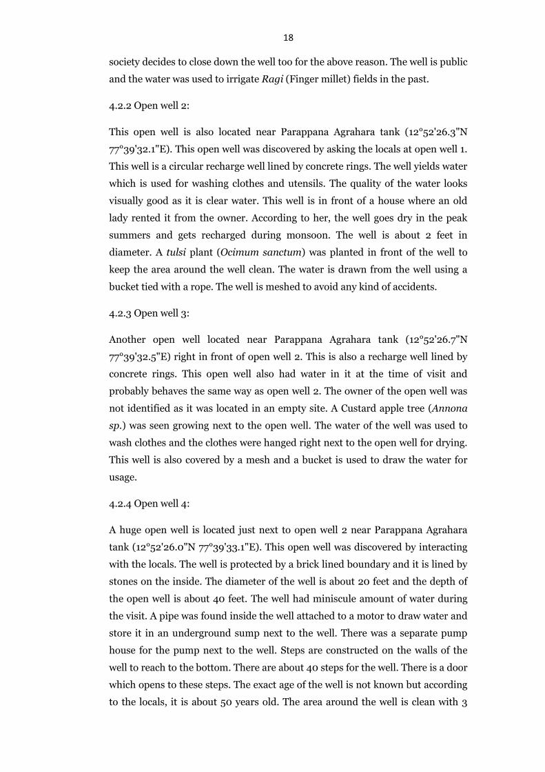
This well is near Chikka Kudlu tank located behind BDA playground on Haralur
road (12°53'26.8"N 77°39'25.1"E). The well was discovered by chance due to the
presence of a dense canopy of trees and the presence of a cemetery. The well
20 looks to be quite old as there is mud accumulated in the well. Only a small
portion of the well is visible. A stone platform stands firm which was used to
collect water in the past. The cemetery seems to be recent as indicated by the
dates on some of the graves. A huge tamarind tree (Tamarindus indicus) stands
right next to the well.
Figure 4: Picture of open well 7 with its platform stone
4.2.8 Open well 8:
This well is also near Chikka Kudlu tank but much further away from open well 7
(12°53'23.0"N 77°39'34.1"E). The well is situated amidst a farm land which was
tilled with a bull dozer. The well is old and dry, but the bottom of the well is not
visible due to many Singapore cherry (Muntingia sp.) trees growing inside it.
The trees have made a strong canopy near the surface. The well is about 20 feet
in diameter and its depth is unknown. This well too has the stone platform used
to draw water when in need. There are two coconut (Cocas nucifera) trees
growing next to the well. A pump house stands next to the well.
4.2.9 Open well 9:
This open well is in the same farm as that of open well 8 (12°53'25.1"N
77°39'31.5"E). The well is approximately about 28 feet in diameter and 50 feet in
depth. The well is dry but it has a bore well inside it which yields water. The well
has steps which are 30 in number. A lot of solid waste has been dumped inside
21 the well. A Singapore cherry (Muntingia sp.) is growing inside the well while a
coconut tree (Cocas nucifera) has been planted just next to the well.
4.2.10 Open well 10:
This well is the closest to the Chikka Kudlu tank, situated right next to the
Haralur road in front of a bungalow (12°53'25.1"N 77°39'22.8"E). It is a square
well indicating that the water was used for drinking purpose. The well is about
60 years old and 20 feet deep. It had a pulley system to draw water with the help
of a bucket and a rope. The well is completely dry today filled with solid waste.
4.2.11 Open well 11:
This is one of the two wells identified near Choodasandra tank. The well is
located just next to the tank behind a bungalow (12°53'11.7"N 77°40'51.3"E). The
well was identified already by Biome Environmental Trust. The well has an
approximate diameter of 24 feet and a depth of 50 feet. It has about 25 steps to
reach the bottom, but few steps in the middle are missing. A bore well is dug
inside the well. During the visit, the well had some amount of water which would
have been collected due to the rains. The well is approximately 40 years old. A
big unidentified tree stands next to the well.
4.2.12 Open well 12:
This well is away from the Choodasandra tank. The path next to Sarkari Kiriya
Prathamika School leads to a bungalow at the end of the path. The well is located
inside the private land (12°53'17.1"N 77°41'01.2"E). This well was identified by
chance and by asking the locals. The well can be seen from google maps too. It
has a diameter of approximately 28 feet and a depth of 50 feet. It is lined by
stones and the bottom seems marshy with grass and plants growing inside it.
The well is surrounded by Mango (Magnifera indica) plantation and the water
of the well was used to irrigate the farms earlier. The well is dry now and it has a
bore well dug inside for which a separate pump house was built next to the well.
The well is surrounded by stone compound for the safety purpose.
4.2.13 Open well 13:
This is a small round well located on the other side of the bund of
Halanayakanahalli tank (12°54'05.8"N 77°41'24.4"E). The well was identified
while observing the sluice gate of the tank. This well is lined by stones from the
inside and is about 10 feet in diameter. The actual depth of the well is unknown
as it is dry and filled with mud. This well has two stone platforms that were
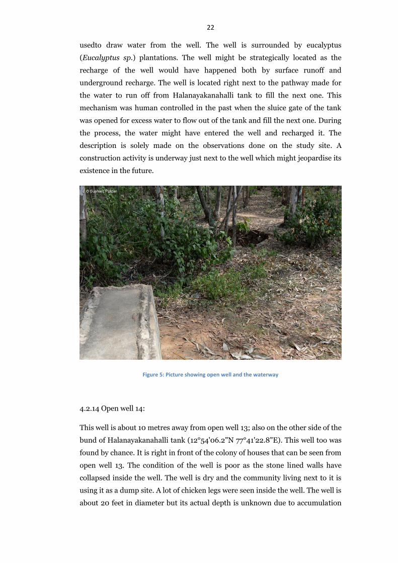
22 usedto draw water from the well. The well is surrounded by eucalyptus
(Eucalyptus sp.) plantations. The well might be strategically located as the
recharge of the well would have happened both by surface runoff and
underground recharge. The well is located right next to the pathway made for
the water to run off from Halanayakanahalli tank to fill the next one. This
mechanism was human controlled in the past when the sluice gate of the tank
was opened for excess water to flow out of the tank and fill the next one. During
the process, the water might have entered the well and recharged it. The
description is solely made on the observations done on the study site. A
construction activity is underway just next to the well which might jeopardise its
existence in the future.
Figure 5: Picture showing open well and the waterway
4.2.14 Open well 14:
This well is about 10 metres away from open well 13; also on the other side of the
bund of Halanayakanahalli tank (12°54'06.2"N 77°41'22.8"E). This well too was
found by chance. It is right in front of the colony of houses that can be seen from
open well 13. The condition of the well is poor as the stone lined walls have
collapsed inside the well. The well is dry and the community living next to it is
using it as a dump site. A lot of chicken legs were seen inside the well. The well is
about 20 feet in diameter but its actual depth is unknown due to accumulation
23 of mud and stones. There were eucalyptus (Eucalyptus sp.) plantations in front
of the well.
4.2.15 Open well 15:
This is one of the two wells identified near Hadosiddapura tank. It is located
next to a big banyan tree (Ficus benghalensis) which is next to the railway line
(12°53'17.3"N 77°42'27.1"E). This well was found with the help of the locals. The
well is also surrounded by a mango tree (Magnifera indica). The diameter of the
well is about 28 feet. There was water present but it looked to be stagnant and
black in colour. This water must have accumulated during the rains. There are
stone steps leading to the bottom but some of them have been broken. The well
is stone lined and water was seeping from the stone lined wall of the well
indicating a possibility of a crack. The entrance to the well was blocked by thick
Lantana sp. cover. There were gunny bags and solid waste floating in the water
of the well. A small stone carved idol was found next to the well.
4.2.16 Open well 16:
Figure 6: The old open well of Hadosiddapura tank
This well is situated very close to open well 15 (12°53'15.0"N 77°42'27.5"E). The
well was spotted by chance and it is very difficult to locate this well due to a lot
of vegetation around it. Only a part of the well can be seen while walking on the
path next to the railway line. The well is lined by stones on the inside but the
upper part of the well near the stone platform has caved in. The diameter of the
well is about 20 feet with a depth of about 40 feet. The well is dry and also filled
with solid waste. The well had 20 steps currently but in the past might have had
24 more. A stone platform is still standing strong. A lot of trees are growing around
the well. A huge private farm is present next to the well.
4.2.17 Open well 17:
This well is on the other side of the bund of Doddakannelli tank (12°54'38.5"N
77°41'37.4"E). It can be identified as a depression next to a broken brick house
when walking on the bund of the tank. The condition of the well is bad as the
stones of the wall of the well have collapsed. There is a lot of mud accumulation
due to rains. The well was spotted by chance due to a broken brick house. This
house might have been the pump house for the well. The diameter of the well is
about 12 feet but its actual depth is unknown. There is a honge tree (Pongamia
sp.) growing next to the well.
4.2.18 Open well 18:
This well is also located next to Doddakannelli tank on the other side of the bund
(12°54'39.7"N 77°41'40.7"E). The well is visible from a distance at the entrance
of the tank. This well was already identified by Biome Environmental Trust.
This is a square well indicating that the water might have been used for drinking
purpose in the past. Today, the well is dry and has a lot of solid waste dumped
into it. There are two stone structures placed on the walls of the well firmly. This
might have been used to draw water through pulley system. The well is
approximately 40 feet in depth. Around the well are stone platforms with steps.
4.2.19 Open well 19:
The first among the three wells identified at Rayasandra tank. It is right next to
the road on the side of the bund (12°52'25.3"N 77°40'46.7"E). This well was
identified by Biome Environmental Trust. This is a square well too indicating
that the water might have been used for drinking purpose. A bore well is dug
right next to the well which yields water and is transported to the engineering
college nearby. This is the closest well among the three to the tank. The water
present in the well during the visit might have been rain water. Otherwise the
well is heavily polluted with solid waste. The depth of the well is about 40 feet
and the inner linings of the wall are constructed using stones. The well is
surrounded by stone platforms to reach the mouth of the well. A single stone
slab is firmly constructed taking support of the walls of the well. This was used
to draw water from the well. A banyan tree (Ficus benghalensis) is growing
inside the well taking its roots in the crevices of the stone lined walls.
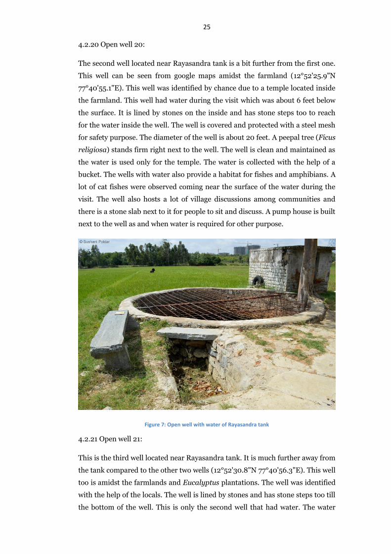
25 4.2.20 Open well 20:
The second well located near Rayasandra tank is a bit further from the first one.
This well can be seen from google maps amidst the farmland (12°52'25.9"N
77°40'55.1"E). This well was identified by chance due to a temple located inside
the farmland. This well had water during the visit which was about 6 feet below
the surface. It is lined by stones on the inside and has stone steps too to reach
for the water inside the well. The well is covered and protected with a steel mesh
for safety purpose. The diameter of the well is about 20 feet. A peepal tree (Ficus
religiosa) stands firm right next to the well. The well is clean and maintained as
the water is used only for the temple. The water is collected with the help of a
bucket. The wells with water also provide a habitat for fishes and amphibians. A
lot of cat fishes were observed coming near the surface of the water during the
visit. The well also hosts a lot of village discussions among communities and
there is a stone slab next to it for people to sit and discuss. A pump house is built
next to the well as and when water is required for other purpose.
Figure 7: Open well with water of Rayasandra tank
4.2.21 Open well 21:
This is the third well located near Rayasandra tank. It is much further away from
the tank compared to the other two wells (12°52'30.8"N 77°40'56.3"E). This well
too is amidst the farmlands and Eucalyptus plantations. The well was identified
with the help of the locals. The well is lined by stones and has stone steps too till
the bottom of the well. This is only the second well that had water. The water
26 here too was about 6 feet below the surface of the land. Only 8 steps were visible
while the others were covered with water. According to the locals, the well is
about 20 feet deep and 25 feet in diameter. The well goes dry during summer
but gets recharged during the monsoon both from the rainwater as well as from
the tank. This well too houses fish right from the juvenile phase to the adult. The
well is protected with barbed wires for the purpose of safety. The water is used
for growing crops in the farmland. A huge coconut tree (Cocas nucifera) stands
right next to the well.
4.3. Interview with open well owners and open well digger:
4.3.1 Interview with open well owners:
The open well owners are essential people to be included in the project of PAQM
as they are sources of information which can be used to get a clear picture of the
groundwater. Other than that, it is essential to make them aware of the need to
conserve these open wells, not only for the sake of historical significance but also
as a vital structure in managing shallow aquifers of the watershed. The
interviews would also help in understanding their thoughts about the open wells
and their approach in preserving such structures.
The owner of open well 4, near Parappana Agrahara tank had no interest in
conversing about his well. The permission to see the well and make the
observations were provided, but the in depth understanding of how and when
the well gets recharged, what is their perspective on keeping the well in a good
condition and many other questions were unanswered for this particular well. It
was difficult to even get the correct age of the well in this case.
The owner of open well 5 was a farmer with fields around Parappana Agrahara
tank. He started converting his land into housing complexes and renting them
out to workers and families who work at the companies close to the site. This
transformation came about when he realised that farming would not yield any
money from his land and thus he converted it into housing. The rents of the
houses range from Rs.3000 to 5000 per month. The water supplied to the
housing complex is through bore wells and tanker water which also comes from
other bore wells. Separate water metres have been installed in each house for
transparent billing. The water metres also provide the per capita usage of water.
The well which is now surrounded by the housing complex is used as a dump
site where wastes are thrown into it. The owner is willing to restore the well
which can further be used to supply water to the tenants and reduce the cost of
27 pumping and supplying water from the bore wells. It is difficult to implement
the idea according to him as the cost of restoration would be high.
The owner of open well 6 used to use the water of the well for irrigating his
fields. It was also used for drinking purpose. The well stopped yielding water for
more than 5 years now. A mere 5 feet of water was available a couple of years
back. The bore well, according to the owner, was dug about 30 years back. This
might have been to increase the production of crops in his fields. The fact that a
stone wall has been built around the well indicates that he is interested in
preserving the well as the bore well dug inside is still yielding water.
The owner of open well 10 (square well across the Haralur road) pointed out that
the well was easily 60 years old. The well has been dry from 8 years. The water
was used for drinking and there was a definite connection between the
availability of the water in the well and in Chikka kudlu tank which was right
next to it.
The owner of open well 11 indicated that her well is about 50 years old. The well
is next to Choodasandra tank. The well had miniscule amount of water and she
specified that this was collected during the rain. The well has not been yielding
water from the past 10 years and the bore well that has been dug also does not
yield today. According to another local, the tank was flooded about 4 years ago
but it is dry today and the tank bed has a lot of weeds taking roots.
The care taker of the farmhouse in which open well 12 was identified was
interviewed. According to him, the well is about 50 years old and is dependent
on the Choodasandra tank for recharging itself. The well was used to irrigate the
mango farm. The well stopped yielding about 6 years ago and the bore well dug
inside the well is also not operational as the pump got damaged due to silt
accumulation. He also mentioned that the rains were really good during the
monsoon about four years back but he was really disappointed with the
monsoon of 2014.
The owner of open well 20, located near Rayasandra tank, renovated the well as
it was in a bad state. The well was initially built by his grandfather indicating it
to be about 100 years old. He also built a temple next to the well during the
renovation to protect it from being misused. Unfortunately, a film crew
approached the well and later left the place in a bad state again. The well was
dried up and it took another renovating strategy to restore the condition of the
well. He subsequently covered the well with steel mesh, majorly from protecting
his ancestral structure. It also provided safety for people.
28 4.3.2 Interview with open well digger:
The Biome Environmental Trust suggested me to interview an open well digger
to understand the knowledge, efforts and challenges faced during the
construction of a well. The understanding of the working of an open well was an
important learning gained from this conversation.
Well digging has been a family occupation for the interviewee where the
knowledge of well digging has been passed on from generations to him. He is
now passing on the knowledge to his son who is picking it up well and learning
the techniques and skills from his father. The interviewee has built an open well
in Kaggalipura located in Bengaluru rural district which is about 20 feet in
diameter and 30 feet deep. The open well did not yield water as the adjoining
wells were unclean. He cleaned those wells and subsequently the water started
to flow in the new well that he had constructed. The well had about 15 stone
steps and took him and his team of 9 members about 10 days to dig the well and
line it with the stones. The method in which he digs the well has not been
changed and now is the skill and knowledge of many generations. He mentions
that the slope of the place is vital for open well building such that the water
should naturally flow into the well from the higher ground. He has also taken up
the job of digging recharge wells of 20 feet depth lined by cement rings which
are available in the market. Such wells can be found in gated communities like
Sunny brooks and Rainbow drive which are located inside the Yamalur
watershed. The open wells lined with stones though have to be cleaned regularly
and maintained properly. Silt accumulated at the bottom of the well has to be
removed periodically for the well to yield water.
29 Discussion and Conclusions:
5.1 Importance of open wells in Bengaluru city:
The open wells today stand as a mere historical structures from the time of Tipu
Sultan. The open wells were used for domestic purposes as well as irrigation. It
is by managing these wells very religiously, that our ancestors made sure that
there is enough water in the future. But somehow, the practice is lost in the city
due to the ease in getting water from the piped system. This water is treated and
supplied to about half the city every alternate day. The reasons for so many open
wells to go dry are rapid urbanisation and constant demand for land in the city,
putting the tanks, which become dry during summers, at a high risk of getting
transformed into layouts. The wells adjacent to the tanks get recharged from the
tank waters. Many wells in the area are found near the tanks, as seen in Yamalur
watershed too. The wells, even if they are dry, can act as recharge points for
groundwater recharge at different places (Unnikrishnan H et al, 2015). The wells
under a particular tank are in series. If these wells are restored and the water
gets back into the wells, then the excess water gets diverted from the tanks to
other tanks which finally end up in the river. This creates the opportunity to
both preserve the wells which yield water as well as increasing the base flow of
the rivers flowing around the city.
5.2 The lives around open wells:
The open wells of the Yamalur watershed have stories that have changed the way
in which we look at lives. Water is such a crucial aspect for the living that the
need for sufficient quantity and good quality water has shaped the human
society worldwide. The stories of how a well which was healthy and yielding
water suddenly went dry due to the well owner’s extra precaution towards
maintaining his well. This well is situated in the Yamalur watershed and
according to the locals; the well was yielding lots of water. The owner supplied
the water to the communities nearby for some price. He took added measures to
maintain the quality and quantity of the water in the well. A temple was situated
next to the well where devotees offered flowers to the God. The flowers offered
to the God were later put in the well. This brought a conflict of interest between
the well owner and the temple priest resulting in the temple being shifted
elsewhere as the owner didn’t want any waste to be put inside the well. Soon

30 after that, the well went dry and stopped yielding water. Till today, the well is
dry but the structure remains intact.
On the other hand, success stories are very less. The once, age old well, built by
another open well owner’s grandfather was renovated and taken care of by this
well owner and now he is enjoying the fruitful outcomes of his efforts. He also
built a temple next to the well for preserving the place. It is evident that there
are some religious attachments to these water yielding structures and this has to
be respected for the wellbeing of the community.
5.3 Reasons for closing down of open wells:
A well is such a structure for which a lot of effort is put in, in its construction.
These wells can be maintained for centuries if needed. But once an owner feels
that the utility of the well is over, he decides to make a better use of the land.
Open wells in Bengaluru are highly vulnerable for this very purpose. Many wells,
according to the locals, have been closed down for better usage of land occupied
by the dry wells. Moreover, the wells are closed down for social reasons like
suicides and unfortunate accidents. Wells are prone for being closed down as
they attract a lot of easy options for ending one’s life. If the cases are really high,
then the decision of closing the well down is immediately taken. Another reason
for wells to be closed down is due to the tremendous use of deep aquifers in the
form of bore wells. The bore wells make life easy as there is no physical effort
needed in pumping the water till the surface. Moreover, it is believed that the
quality of water from a bore well is much better than that of an open well. The
huge boom in digging of bore wells has completely overshadowed what open
wells used to serve us. Thus they are neglected and are subject for being closed
down.
5.4 Open wells as Common Property Resource (CPR):
Many open wells in the study area were public while some were public or the
property of the community. But it was seen that the open wells were an outdated
technology as the wells were not in working conditions. Out of 21 wells reported
in the watershed, only 2 wells yielded water. The map of the watershed in 1978
shows a completely different picture than that of the watershed in 2011 with
respect to the number of open wells and tube wells. In the case of tube wells, it is
mostly the community owned. The drastic reduction in the number of the open
wells and tube wells in the span of 30 years is due to many developmental
31 reasons. But development is not the sole reasons for this situation today. Lack of
managing the groundwater as a CPR is also major reason. But this is not been
perceived as the effects of development overshadows it in some situations. The
overexploitation of groundwater is also due to over drilling of groundwater from
bore wells. Thus the transformation from open wells which was a CPR to private
bore wells has converted groundwater from a CPR, which was the case of ancient
India, to a private property. Today, the notion is that if a property is bought,
then the owner owns the groundwater within the property too. Thus he is
entitled to dig a bore well and extract as much groundwater as he wishes without
respecting the fact that groundwater cannot be privatised as there are
connections and flow of water (Narain, 1998). The problem with groundwater in
Yamalur watershed includes greater rate of development which leads to
population migration, thus putting that much stress on groundwater and a flaw
in groundwater policy by making it a part of the private property.
The open wells in the Yamalur watershed are now being perceived as those
structures which stand without any purpose thus losing the race with time. CPR
is a governance strategy itself for sustainable use of a resource, in this case,
groundwater. One has to carefully see the difference between a CPR and an open
access resource. The CPR has a set of rules and regulations which is bound to
each and every person of the community. It is his/her responsibility to maintain
and conservatively use the resource. But on the other hand, open access resource
is that where a person can use it but is not entitled by any rules or regulations to
maintain it (Narain, 1998). There are also a set of rules which have to be
followed by the community to sustain their resource. This has been extensively
elaborated and postulated by Elinor Ostrom in her 8 design principles for
managing a CPR. These rules help in explaining the strategies to help support
the resource (Cox et al, 2010). With the help of these rules, one can try to
formulate the policy which helps in managing the open wells of Yamalur
watershed and the tanks which are associated with it after restoration of the
same in the future. This will not only help the community in attaining self-
sufficiency in the department of water, but will also become an example for
situations which are similar to this in the country.
The open wells are truly crucial structures in managing the shallow aquifers.
According to S. Vishwanath, the founder trustee of Biome Environmental Trust
and water expert of Bengaluru, “open wells are the only means by which one can
visually look at groundwater”. It is from the Harappan civilization that we study
the existence of open wells and even today; these open wells serve our purpose

32 whenever it is mostly required. Even though these open wells go dry, they serve
many more functions that the common person fails to understand. The scope for
further studies could be to come up with a participatory restoration plan in
restoring the open wells already identified in this study. This actually brings the
community together in managing a CPR for their own utilization. Moreover, it
would be ideal to design a policy which treats the groundwater as a CPR than a
private property resource.
33 References:
Agarwal, A. & Narain, S. eds., 1997. Dying Wisdom- Rise, fall and potential of
India's traditional water harvesting systems. New Delhi: Centre for Science
and Environment.
Annaswamy, T. V., 2003. Bengaluru to Banngalore- Urban History of
Bangalore from Pre-historic Period to the End of the 18th Century. Bangalore:
Vengadam Publications.
Anon., 2011. Rainwater Harvesting. [Online]
Available at: https://rainwaterharvesting.wordpress.com/2011/06/19/the-lake-
and-the-well-part-of-a-water-masterplan/
[Accessed 20 July 2015].
Banerjee, S. & Chaudhari, J., 2012. Excreta Matters. New Delhi: Centre for
Science and Environment.
Cox, M., Arnold, G. & Tomas, S. V., 2010. A Review of Design Principles for
Community-based Natural Resource Management. Ecology and Society, 15(4).
Cunha da, D. & Mathur, A., 2006. Deccan Traverses. New Delhi: Rupa Co.
Iyengar, S., ed., 2007. Waternama- A collection of traditional practices for
water conservation and management of Karnataka. Bangalore:
Communication for Development and Learning.
Kamath, S. U. ed., 1990. Karnataka State Gazetteer- Bangalore District.
Bangalore: Lotus Printers.
Kulkarni, H., Shah, M. & Shankar, V. P. S., 2015. Shaping the contours of
groundwater governance in India. Journal of Hydrology: Regional Studies, pp.
1-21.
Narain, V., 1998. Towards a new groundwater institution for India. Elsevier, pp.
357-365.
Sudhira, H. S., Ramachandra, T. V. & Subrahmanya, B. M. H., 2007. City
Profile- Bangalore. Elsevier, 24(5), pp. 379-390.
Trust, B. E., n.d. Bridging the gap through Participatory Aquifer Mapping- A
new age water sustainability transformation. s.l.:s.n.
Unnikrishnan, H. & Nagendra, H., 2015. Open wells of Bengaluru. The Hindu,
25 June.
Unnikrishnan, H. & Nagendra, H., 2015. The Nature of Cities. [Online]
Available at: http://www.thenatureofcities.com/2015/07/02/open-wells-and-
urban-resilience/
[Accessed 20 July 2015].

34