subaqueous landforms , features, and...
TRANSCRIPT

Subaqueous Landforms , Features, and Materials
( much content from Jim Turenne, NRCS, & Mark Stolt, URI )
1) Discrete underwater features or “geoforms” (that commonly can support rooted plants), and adjacent features, ordinarily found beneath permanent open water. [ Historically, in Soil Survey, these underwater features have been included in the generic map unit "water" ].
2) Soils that are submerged for > 90% of the time (e.g. > 21.5 hrs/day)

Why bother ?- Primarily driven by interest of new soil
survey / resource management customers.
- Political, financial, and societal support.
- They are a natural extension of the terrestrial soil continuum (ecologically, transported sediments, nutrients, contaminants, etc.).
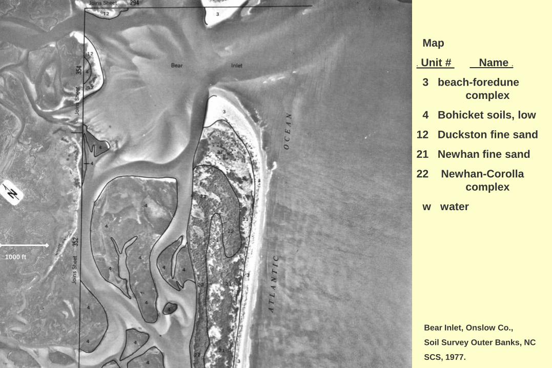
Bear Inlet, Onslow Co.,
Soil Survey Outer Banks, NC
SCS, 1977.
Map
. Unit # Name .
3 beach-foredune complex
4 Bohicket soils, low
12 Duckston fine sand
21 Newhan fine sand
22 Newhan-Corolla complex
w water
1000 ft

USGS
Estimated Coastal Inundation Scenarios from Sea Level Rise: Present Coastline vs : < 5m and < 10m

5
Four Principles ( mantra )
• GEOMORPHOLOGYlandforms / geoforms: shape, distribution, orientation, size.
• STRATIGRAPHYmaterials (layers): structure, composition
• HYDROLOGYwater (fluid) dynamics: direction, magnitude, etc.
• SOIL MORPHOLOGYField observations and Interpretations of soil development.
Geomorphic Description System
Version 4.126 / 24 / 2009
NATURAL RESOURCES CONSERVATION SERVICE USDA

ll ) GEOMORPHIC ENVIRONMENTS andOTHER GROUPINGS
8. Mass Movement ( gravity dominated )
9. Volcanic & Hydrothermal
10. Tectonic & Structural ( bedrock structures, crustal movement )
11. Slope ( generic slope forms, geometry, arrangement )
12. Erosional ( dominated by non-channel, non-perennial water erosion )
13. Wetlands ( vegetated or shallow wet areas, wet soils )
14. Depressional
15. Water Bodies ( permanent water features )
16. Subaqueous Features ( permanently underwater )
Other
Geom.
Envir.

Geomorphic Description System :
“Other Groupings”
‘Landforms’ (geoforms?) that share a common setting, but not necessarily
formed by the same geomorphic processes.

16. SUBAQUEOUS FEATURES [ Discrete underwater features that commonly can support rooted plants, and adjacent features, ordinarily found below permanent open water. [ Historically, in Soil Survey Reports these underwater features have been included in the generic map unit “Water” (e.g. lake) ].
Landscapes :
Landforms :
Microfeatures :
bay [coast] (water body; also LF) -- ? ocean (water body) --? gulf [coast] (water body) -- ? sea (water body) --estuary (water body; also LF) -- ? sound (water body) --lagoon [coast] (water body; also LF) – ? strait (water body) --
channel ( permanent water ) --
barrier cove -- mainland cove --bay [coast] (water body; also LS)-- marine lake --bay bottom -- reef WDcove [coast] -- relict-tidal inlet --dredged channel (Anthro Feature) -- shoal --dredge-deposit shoal (Anthro. Fea.) -- sound (also Landscape) --estuary (also Landscape) WD strait (also Landscape) --flood-tidal delta -- submerged back-barrier beachflood-tidal delta flat -- submerged mainland beach
etc. etc.

Glossary Some 66 terms are
referenced or defined to describe subaqueous and adjacent subaerial environments and landforms
29 terms exclusively used for subaqueous soils added to the NSSH

Subaqueous “environment”Erosionchannel
( voids , modified features )
Transporttidal inlet (active)
( dynamic deposits and features )
Depositionwashover-fan slope
flood-tidal delta
( “stable” deposits and features )

Barrier Island Components( subaqueous )
RI
shoal (s)
Subaqueous Landforms

• barrier systems (open coasts)• lagoon / estuary• fluviomarine systems (drowned but active fluvial systems)• lacustrine
Geomorphic Systems may be better for evaluating landform subsets within SAS:

Horizon Differentiation
Additions
Removals
Transfers
Transformations(Simonson, 1959)
ex. 4 Subaqueous Soils
Not just geology:Pedogenic processes are active in the subaqueous environment, and drive the formation of soil horizons.

Soil - Aquascape Relationships
Are there subaqueous “landforms”?
Do they have predictable sediment / soil patterns (can they be mapped)?
?

Ecological Site
Landform
Debra SurabianLittle Narragansett Bay, RI
The soil-landscape paradigm is valid in the subaqueous environment.

Google-Ocean Example
Turenne, Stolt

Can’t as easily observe landforms, but can manage.
Bathymetric Map required.Acoustic Soundings
Homemade bathometer with bicycles & GPS
Turenne, Stolt

Parent Materials:e.g. Acid-Sulfate Materials
Dredge Materials- Acid producing
upon oxidation.
Turrene, Stolt

Materials / Sediments (SAS Glossary, NSSH)
• estuarine deposit
• fluviomarine
• lacustrine deposit
• lagoonal deposit
• marine deposit
• overbank (barrier) deposit
• Mass wasting deposits ? ( landslides, turbidite )

Subaqueous turbidity flow deposits( proglacial lakes / lacustrine / estuarine systems )
( Selley, 1988 )

Subaqueous soil : gray loamy sediment over buried organic-rich (fibric) material Naraganset Bay, RI
( Schoeneberger, McVey )
Subaqueous soil : gray loamy sediment over buried organic-rich (fibric) material Naraganset Bay, RI
slpeaty sil l

mainland coves
barrier cove
Sediment differences?
RI

Conventional Shore / Coastal Facies
• beach : coarser sediments (med. - co.s, gr, cob, st )
• near shore : medium textured seds. ( med. – vfs;si further out )
• offshore : fine textured seds. ( fsi, c, organics )
Geomorphic Systems may be better for evaluating subsets:Barrier Systems (open coasts)Laggoon / estuaryFluviomarine systems (drowned but active fluvial systemsLacustrine

Modified from Fairbridge, 1968
Common landforms, zones & processes of non-rocky coasts.
BEACH RIDGE
FOREDUNE
swash zone

Pt. Reyes, CA

Coastal Marine Ecological Classification Standard (CMECS)- ver. 3 (draft 2010)

Source: Coastal and Marine Ecological Classification Standard, ver. 3 (April, 2010)

Landscape: shore complex Landform: beach ST Marks Light house, Wakulla Co., FL
Schoeneberger

Landforms: mangrove swamp, island Babeldauhpt Is., Palau
Bob Gavenda

Landform: mangrove swamp southern FL
( NOAA AGI id h9hk35 )

Soil: Lignumvitae PM: coastal marl FL
Schoeneberger
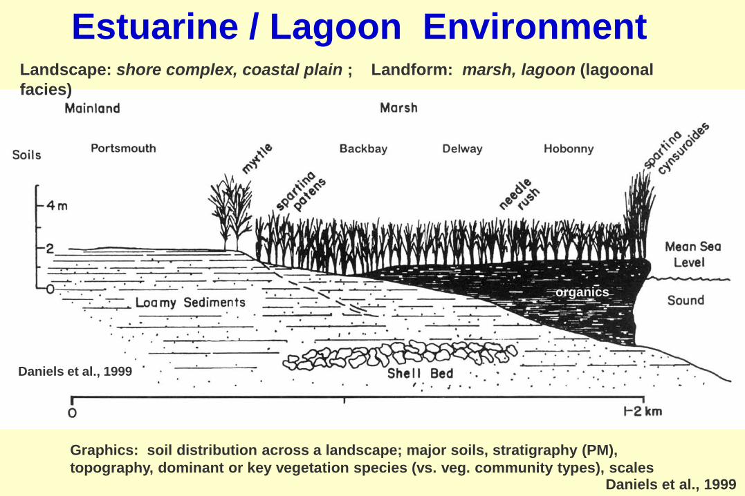
Daniels et al., 1999
Landscape: shore complex, coastal plain ; Landform: marsh, lagoon (lagoonal facies)
Graphics: soil distribution across a landscape; major soils, stratigraphy (PM), topography, dominant or key vegetation species (vs. veg. community types), scales
organics
Estuarine / Lagoon Environment
Daniels et al., 1999

1000 ft
Brunswick Co.,
Soil Survey Outer Banks, NC
Map
. Unit # Name .
3 beach -foredune complex
4 Bohicket soils, low
10 dredge spoil
21 Newhan fine sand
w water

Landscape: barrier island Landforms:beach, berm, overwash fan, relict overwash fansnorth Core Banks Is, NC
( NC Soc Sed Geol, AGI hflzbj )

Landscape: barrier island Landforms: beach, berm, washover fan, washover fan flatsN34.75 Lat, W76..25 Lon north Core Banks Is, NC
( AGI hflzbj )
tidal marsh
tidal marsh
wash-over fan flat
(relict) tidal channels
barrier beach ridge ( foredune )
washover-fan
terrestrial subaqueous

washover - fan flat
( subaqueous )
back- barrier flat
( subaerial )
Carteret Co.,Soil Survey of Outer Banks, NC, SCS,1977
Map . Unit # Name .
1 beach, occas. flooded
5 tidal flats
6 Carteret soils, low
9 Corolla-Duckston complex
12 Duckston fine sand
18 Carteret, high
21 Newhan fine sand
22 Newhan-Corolla complex
w water
1000 ft
washover fans

General shore features of rocky coasts
Modified from Fairbridge, 1968
wave-cut platform
Headlands

Rocky Coasts
Gravel Shingle
Modified from :

Landscape: shore complex Landforms: coastal headlands, cliff, wave-cut platformSchoeneberger

Anthropogenic Materials / Sediments, Landforms
Sediments / deposits
• dredge spoils
Landforms
• dredge channel
• dredge-deposit shoal
• dredge spoil bank
• filled marshland

channels( natural )
dredged channels
Stolt,
RI
( anthropogenic )
Anthropogenic Features & Materials

Pender Co.,Soil Survey Outer Banks, NC
SCS, 1977
Map
. Unit # Name .
6 Carteret soils, low
10 dredge spoil
18 Carteret soils, high
w water
1000 ft
dredge spoils (PM)dredge spoil bank
( dredge spoil shoal )( filled marshland )

Freshwater Subaqueous Features
•Largely ‘undeveloped’.•Lacustrine vs. Coastal Marine / Estuarine
similarities & differences e.g (waterlain deposition) (energies of systems)

Mapping Protocol Similar to Sub-tidal – no tide
correction but need surface/spillway ele.
Need to develop landscapes but similar to salt water.
Use GPR in winter or ice for sub-bottom and bathy.
Core and soil data same as sub-tidal
Jim Turenne

Freetown, submerged,
extremely stumpy
Jim Turenne

Map Examples
Jim Turenne

Work in Progress• Utilitarian ‘Landform’ terms (esp. freshwater /
lacustrine, anthropogenic features).
• Corresponding sediment (regolith?) info & terms.
• Landscape (soilscape) models - both generalized (facies??) and specific (case studies).