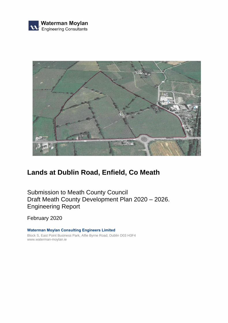
submission re lands at drummond house, enfield, co. …
TRANSCRIPT

M
arc
h 2
02
0
MEATH DRAFT COUNTY DEVELOPMENT PLAN 2020-2026
SUBMISSION RE LANDS AT DRUMMOND HOUSE, ENFIELD, CO. MEATH (“LU OBJ2” LANDS TO THE WEST OF ENFIELD)
On behalf of:
ANN HOLMES, CARMEL KELLY AND BRENDAN LITTLE
Taney Hall Eglinton Terrace Dundrum Dublin 14 D14C7F7 T: +353 1 6764522 E: [email protected] W: www.bmaplanning.ie

2
Contents
1. Introduction
2. Background
3. Draft Development Plan/ Zoning Sought
4. Conclusion
Appendix A – Zoning Maps 2009, 2013 and 2014
Appendix B – Technical Report (Waterman Moylan Engineering Consultants)

3
1. INTRODUCTION
On behalf of Ann Holmes, Carmel Kelly and Brendan Little the following submission to the
Draft Meath County Development Plan 2020 – 2026 (hereafter the “Draft Plan”) is made in
respect of their lands to the west of Enfield on northern side of R148 and West of R159 at
Drummond House Enfield, Co. Meath.
The lands are described in Section 2.0 below.
Section 3.0 below provides details of the existing zoning of the lands and confirms that the
lands are zoned in the current Meath County Development Plan 2013 – 2019 (2014 Variation
No. 2) which includes 6 zoning objectives - A1 (Existing Residential), A2 (New Residential), B1
(Commercial, Town Or Village Centre), G1 (Community Infrastructure), E2 (General Enterprise
and Employment) and F1 (Open Space). (Refer to Maps in Appendix A)
The lands are also subject to a specific local objective LU OBJ2 which required the submission
of a masterplan and proposals to address phasing, design and layout, roads and servicing
issues.
In the context of the above, and without a reasoned justification for dezoning, our clients had
a reasonable expectation that the lands could be developed and had made investment in the
project on that basis dating back to 2007/2008. For this reason, they object to the proposed
Draft Plan 2020-2026 which proposes to dezone the lands to “RA – Rural Area”.
The purpose of the current submission is to seek the reinstatement of zoning on part of the
lands for “Residential” use. To protect the remainder of the holding, we also propose the
inclusion of an objective as a “strategic land reserve” for the remainder of the lands. This is
considered reasonable in the circumstances and allows development to progress on the lands
during the currency of the forthcoming County Development Plan while at the same time
allowing for longer term investment decisions to be made. As outlined in Section 3 below, we
believe that the planning rationale for the inclusion of the limited zoning for residential
development is strong and these lands can be zoned without undermining the integrity of the
Core Strategy.
The submission is supported by Waterman Moylan Engineering Consultants who outline the
transportation and engineering proposals for access and servicing of the lands - Appendix B.

4
2. BACKGROUND
2.1 SUBJECT LANDS
Figure 1 is an aerial view of the lands and illustrates the location and extent of the lands in
proximity to Enfield.
The lands have been in the ownership of the Little family since 1957 when the parents of the current owners purchased it. Their mother, Marie Little (neé Daly), was born and grew up in Enfield, her parents (Edward and Jeanette Daly) having come to the town to run the post office and grocery store more than 100 years ago. The post office is still run by their descendants and a number of their grandchildren and their families continue to live in the area.
The subject lands have an area of 30 hectares (76 acres) and comprise a number of fields and
associated agricultural buildings located in the centre of the holding. The low point (80m OD)
on the site is the southeast corner at the junction of the Trim Road (R159) and the Dublin Road
(R148) to the high point at the northern tip (100m OD).
The lands are bounded by the Trim Road (R159) to the East, and the Dublin Road (R148) to
the South and the lands have frontage to both roads. The main access to the Drummond
House and the farm complex is currently provided via the existing R159 Trim Road and there
is a potential northern arm to the existing roundabout on the R148 Dublin Road.
There is an existing footpath that extends from Enfield Town Centre to the Baynefield housing
area on the R159 Trim Road which is directly opposite the Subject Lands.
The Royal Canal and railway line run in a southwest-northeast direction and beneath the
Dublin Road at a bridge located only 20 metres from the site boundary. Within a short distance
of crossing the rail/ canal bridge is Enfield Town Centre.
Enfield Railway Station is located on the opposite side of the rail/ canal corridor and is 400-
500 metres from the site.
Enfield Business Park is located about 50 metres from Drummond House on the opposite side
of the R159 Trim Road. Also in the immediate vicinity is a “mixed use” zoned site on the
opposite side of the Dublin Road.

5
Enfi
eld
To
wn
Ce
ntr
e
----
--
Su
bje
ct L
and
s
----
--
En
fiel
d B
usi
nes
s P
ark
Bay
nef
ield
H
ou
sin
g
Enfi
eld
B
usi
nes
s P
ark
Ho
usi
ng
SITE
“Mix
ed U
se”
Si
te
Dru
mm
on
d
Ho
use
Enfi
eld
R
ail S
tati
on
FIG
UR
E 1
: SU
BJE
CT
LAN
DS
– U
RB
AN
CO
NTE
XT

6
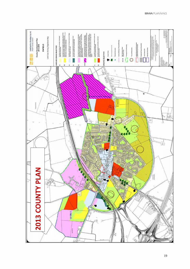
2.2 ZONING HISTORY
The current statutory Development Plan is the Meath County Development Plan 2013 – 2019
(the “County Plan”). The County Plan was adopted on 17th December 2012 and came into
effect on 22nd January 2013.
The zoning and policy provisions of the 2013 County Plan were based on the earlier Enfield
Local Area Plan 2009 – 2015, which was adopted in April 2009, and which zoned the subject
lands for 6 different zoning objectives. These were carried forward to the 2013 Plan and also
to the 2014 Variation (Variation No. 2) as described below.
It is not proposed to restate the contents of the 2009 LAP but it is important to contextualize
the submission by noting that the subject lands have been zoned in 3 previous Development
Plans/ Variations adopted by Meath County Council in 2009, 2013 and 2014. The 2009, 2013
and 2014 (Variation) zoning maps are reproduced below for ease of reference and the full
maps are included as Appendix A.
Variation No.2 (adopted on 19th May 2014) is the current position and the subject lands were
zoned for the following purposes: -
• A1 Existing Residential – “To protect and enhance the amenity of developed residential
communities. “
• A2 New Residential – “To provide for new residential communities with ancillary
community facilities, neighbourhood facilities and employment uses as considered
appropriate for the status of the centre in the Settlement Hierarchy.”
• B1 Commercial / Town or Village Centre – “To protect, provide for and / or improve town
and village centre facilities and uses.”
• G1 Community Infrastructure – “To provide for necessary community, social and
educational facilities.”
• E2 General Enterprise & Employment – “To provide for the creation of enterprise and
facilitate opportunities for employment through industrial, manufacturing, distribution,
warehousing and other general employment / enterprise uses in a good quality physical
environment.
• F1 Open Space – “To provide for and improve open spaces for active and passive
recreational amenities.”
In the Land Use Zoning Objectives Map, the Applicant’s Landholding are subject to Land Use
Objective 2 (LU OBJ 2) which has the following requirements: -
LU OBJ 2
“To require the preparation of a Master Plan for land to the west of the existing town
centre off the Trim road which seeks to provide for the development of a mix of uses
at this location including commercial, industrial, community and residential
development. The Master plan shall be submitted for the written agreement of the
Executive of the Planning Authority and shall accompany any planning application on
these lands. The plan shall provide for inter alia the following:
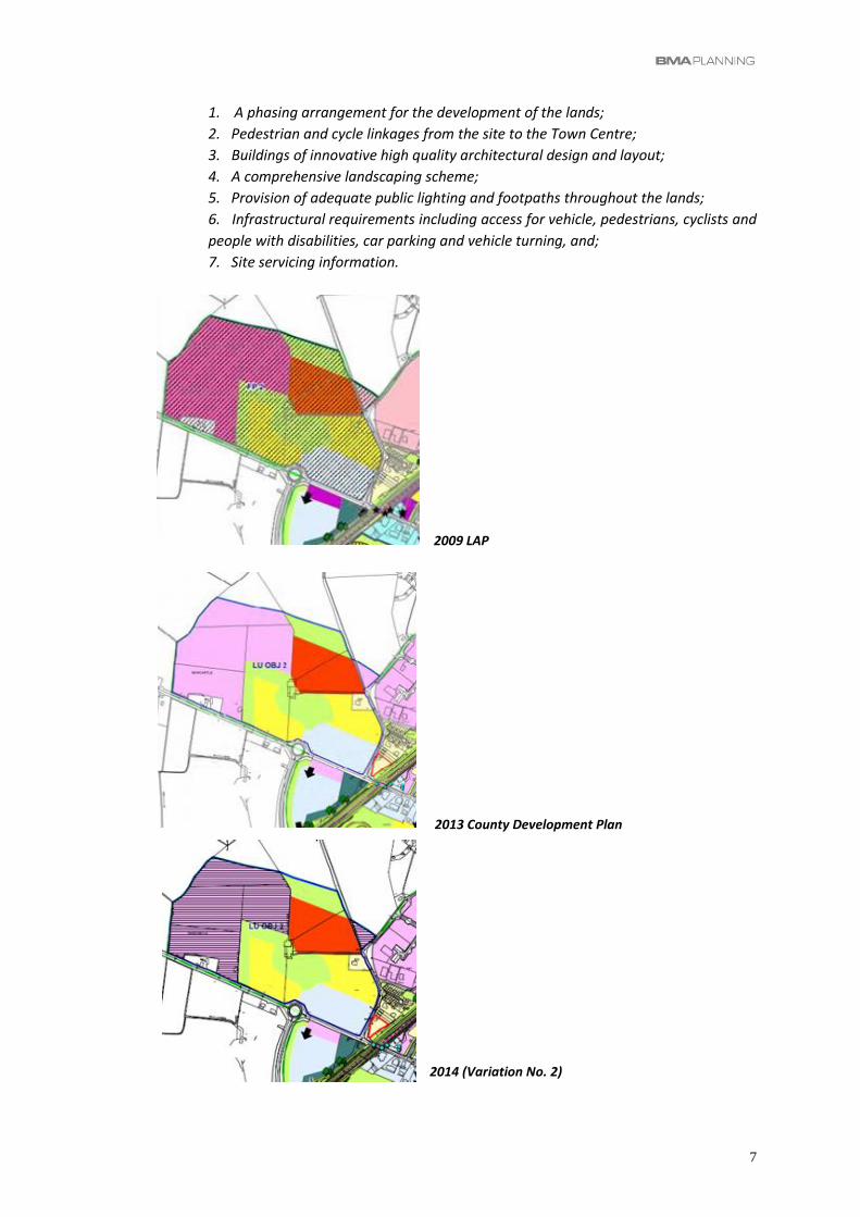
7
1. A phasing arrangement for the development of the lands;
2. Pedestrian and cycle linkages from the site to the Town Centre;
3. Buildings of innovative high quality architectural design and layout;
4. A comprehensive landscaping scheme;
5. Provision of adequate public lighting and footpaths throughout the lands;
6. Infrastructural requirements including access for vehicle, pedestrians, cyclists and
people with disabilities, car parking and vehicle turning, and;
7. Site servicing information.
2009 LAP
2013 County Development Plan
2014 (Variation No. 2)

8
3. DRAFT DEVELOPMENT PLAN / ZONING SOUGHT
3.1 DRAFT ZONING / ZONING SOUGHT
The Draft Plan zoning map for Enfield is available in digital form and the extract below is taken
from the version of the Draft Plan on the Council’s website.
The entire of the subject lands are now outside the Development Boundary of Enfield and the
following zoning objective applies to them: -
‘RA – Rural Areas’ To protect and promote in a balanced way, the development
of agriculture, forestry and rural-related enterprise,
biodiversity, the rural landscape, and the built and cultural
heritage.”
The proposal to dezone the subject lands to “RA – Rural Areas” is not justified and is not
supported on planning grounds and the proper planning and sustainable development
considerations for this are summarised in Section 4.2 below with reference to: -
• Zoning History
• Core Strategy
• Urban Form
• Roads and Transportation
• Servicing / Wastewater
Based on the planning rationale outlined and recognising the fact that development of the
lands is likely to be spread over a number of Development Plan periods, this submission
proposes zoning part of the lands, as follows.
ZONING SOUGHT
FROM: “RA – RURAL AREA”
TO: “A2 - NEW RESIDENTIAL” (5.9ha)
“A1 - EXISTING RESIDENTIAL” on Drummond House (0.3ha)
Note: A “Strategic Land Reserve” objective is sought for the remainder of the
LU-OBJ 2 lands.
Figure 2 below provides an outline of the lands we propose for zoning in the context of the
Draft Plan (Zoning Map), together with an OS Map showing the more immediate context of
the site.
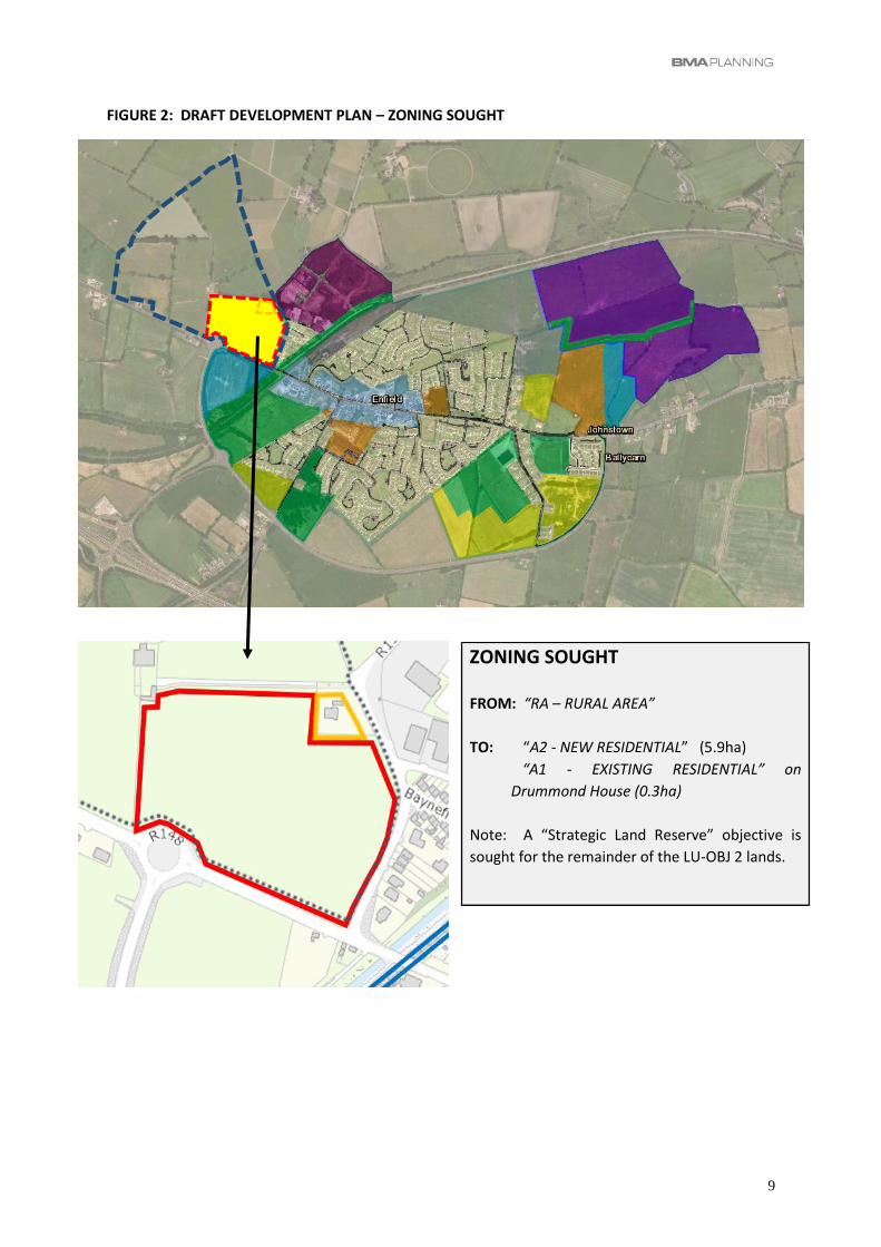
9
FIGURE 2: DRAFT DEVELOPMENT PLAN – ZONING SOUGHT
ZONING SOUGHT
FROM: “RA – RURAL AREA”
TO: “A2 - NEW RESIDENTIAL” (5.9ha)
“A1 - EXISTING RESIDENTIAL” on
Drummond House (0.3ha)
Note: A “Strategic Land Reserve” objective is
sought for the remainder of the LU-OBJ 2 lands.

10
3.2 PLANNING JUSTIFICATION FOR ZONING SOUGHT
1. Zoning History – The lands have been zoned on 3 previous occasions to facilitate large
scale mix use development and the proposal to designate them as “Rural Area” lands is
not justified having regard to the proper planning and sustainable development of
Enfield.
As detailed above, the subject lands were zoned for large scale development in the most
recent Development Plans / Local Area Plans. On this basis, and based on previous
engagement with Meath County Council, our clients have a reasonable expectation that the
lands could be brought forward for development in the short to medium term on a phased
basis and in accordance with the principles contained in the masterplan required under
Specific Local Objective LU-OBJ2. In accordance with the requirements of LU-OBJ 2, our
clients’ have commenced preparation of the masterplan including feasibility studies in relation
to design and layout, access and servicing etc. The intention is to commence discussions with
the Planning Authority in the coming months to agree a masterplan for the development of
the lands.
Against the background of current housing demand, the more immediate focus is on
residential development on the southeastern part of the site. However, all design and
engineering studies undertaken have assumed a phased development of the overall lands.
As the enclosed report from Waterman Moylan Engineering Consultants confirms, there are
no significant engineering impediments to the development of the subject lands that would
justify their dezoning and these engineering issues are addressed below.
In terms of the zoning proposals now sought, the “A1 - Existing Residential” zoning of
Drummond House should be acknowledged and retained as this is an existing dwelling and
was zoned for Residential use in the previous Development Plans.
The “A2 - New Residential” zoning now sought on the subject lands generally corresponds to
the lands that are zoned A2 (New Residential) and B1 (Commercial/ Town or Village Centre)
in the current Development Plan and represents only a quarter of the lands zoned at present.
For reasons outlined below, these lands are very suitable for residential development and we
respectfully suggest that the Draft Plan proposals are not justified from a planning
perspective.
The proposed “RA – Rural Area” zoning in the Draft Plan constitutes a wedge of agricultural
land projecting into the town almost to the railway line and is located between zoned parcels
of land. Consequently, it does not reflect the current setting of the lands on the edge of the
urban area where farming is, and will become increasingly impractical. The Little family have
been moving away from agriculture in recent years and working towards the future
development of the lands based on the zoning introduced as far back as 2009.
11
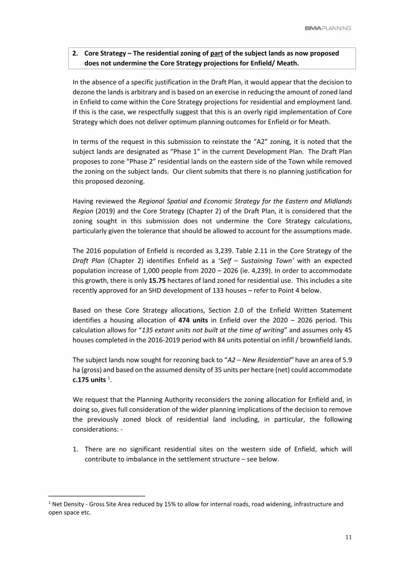
2. Core Strategy – The residential zoning of part of the subject lands as now proposed
does not undermine the Core Strategy projections for Enfield/ Meath.
In the absence of a specific justification in the Draft Plan, it would appear that the decision to
dezone the lands is arbitrary and is based on an exercise in reducing the amount of zoned land
in Enfield to come within the Core Strategy projections for residential and employment land.
If this is the case, we respectfully suggest that this is an overly rigid implementation of Core
Strategy which does not deliver optimum planning outcomes for Enfield or for Meath.
In terms of the request in this submission to reinstate the “A2” zoning, it is noted that the
subject lands are designated as “Phase 1” in the current Development Plan. The Draft Plan
proposes to zone “Phase 2” residential lands on the eastern side of the Town while removed
the zoning on the subject lands. Our client submits that there is no planning justification for
this proposed dezoning.
Having reviewed the Regional Spatial and Economic Strategy for the Eastern and Midlands
Region (2019) and the Core Strategy (Chapter 2) of the Draft Plan, it is considered that the
zoning sought in this submission does not undermine the Core Strategy calculations,
particularly given the tolerance that should be allowed to account for the assumptions made.
The 2016 population of Enfield is recorded as 3,239. Table 2.11 in the Core Strategy of the
Draft Plan (Chapter 2) identifies Enfield as a ‘Self – Sustaining Town’ with an expected
population increase of 1,000 people from 2020 – 2026 (ie. 4,239). In order to accommodate
this growth, there is only 15.75 hectares of land zoned for residential use. This includes a site
recently approved for an SHD development of 133 houses – refer to Point 4 below.
Based on these Core Strategy allocations, Section 2.0 of the Enfield Written Statement
identifies a housing allocation of 474 units in Enfield over the 2020 – 2026 period. This
calculation allows for “135 extant units not built at the time of writing” and assumes only 45
houses completed in the 2016-2019 period with 84 units potential on infill / brownfield lands.
The subject lands now sought for rezoning back to “A2 – New Residential” have an area of 5.9
ha (gross) and based on the assumed density of 35 units per hectare (net) could accommodate
c.175 units 1.
We request that the Planning Authority reconsiders the zoning allocation for Enfield and, in
doing so, gives full consideration of the wider planning implications of the decision to remove
the previously zoned block of residential land including, in particular, the following
considerations: -
1. There are no significant residential sites on the western side of Enfield, which will
contribute to imbalance in the settlement structure – see below.
1 Net Density - Gross Site Area reduced by 15% to allow for internal roads, road widening, infrastructure and open space etc.

12
2. There are only 3 other residential parcels zoned in the entire town and this situation gives
rise to potential for restricted supply of housing due to developers’ capacity to build on
these sites and/or their slower release of housing to protect house price growth. For this
reason, it is important that the housing market in the town is not dominated by a very
small number of landowners.
3. Having regard to the mixed use zoning proposed for the site opposite the subject lands,
the release of residential lands to the west of the railway line provide a critical mass of
housing that allows for investment in wastewater infrastructure to be carried out in a
more strategic and efficient manner than the piecemeal approach that will result from the
subject lands being shelved at this time. The lead-in time in providing infrastructure,
potentially involving multiple landowners, needs to be borne in mind and therefore it is
imperative to look beyond the immediate 2026 Core Strategy allocations
4. The housing allocations for Enfield can be updated to take into account recent
permissions, including a Strategic Housing Development (SHD ABP-304296-19) granted by
An Bord Pleanála in 2019 for 133 houses on land adjacent to Enfield Relief Road, Enfield,
County Meath. Unlike our Client’s lands which include “Phase 1” residential lands in the
current Development Plan, these lands are “Phase 2” lands. They are more remote from
the town centre and less favourable in terms of accessibility to public transport. It is
considered that the granting of permission for this SHD should not be allowed to skew the
growth of the town away from the town centre and railway station. The Planning Authority
should not allow the granting of this SHD (in Material Contravention of the current Plan) to
allow these lands to effectively supplant existing “Phase 1” residential lands and prejudice
the future orderly growth of the town.

13
3. Urban Form – A balanced approach to the development of Enfield supports the zoning
of the subject lands on the western side of the town to reflect proximity and access to
the Town Centre and Community Facilities and to counterbalance the significant
residential growth on the eastern side of the town.
Most of the recent residential development in Enfield has been to the east and south of the
Town within the physical boundary provided by the new ring road. Additional employment,
mixed use and educational lands have also been designated on the eastern side of the town.
Topographical constraints, mainly as a consequence of the railway and canal corridor, have
restricted development to the west and north. The diagram below illustrates this imbalance
in the town which is now to be exacerbated by the decision to dezone the subject lands in the
Draft Plan.
Diagram of Urban Form illustrating proximity of subject lands to Town
Centre and suitability for development in terms of achievement of a
compact settlement
There is a strong case for Residential zoning to the west of the railway / canal where the
subject site offers the opportunity to consolidate and improve this area of the town and to
faciltate an integrated approach to the subject lands with the existing residential area of
Baynefield to the immediate east of the site.
133no. Residential Units granted (ABP 304296-18) on “Phase 2” lands
SUBJECT LANDS

14
The diagram above also shows the relative location of the other “A2” zoned lands in Enfield,
including the recently approved Strategic Housing Development (SHD) permission adjacent to
the Inner Relief Road. As stated above, these lands are “Phase 2” lands in the current County
Development Plan and it is considered that the subject lands are more suitable for zoning
having regard to the Council’s policy for ‘Small Towns’ generally (SSOBJ 13) and the policy for
Enfield which states:-
SP1 – To promote the future development of the town as a compact settlement with
a pedestrian friendly environment, a legible and coherent physical form, and a variety
of land uses and amenities’
(emphasis added)
The current zoning proposals have dezoned the subject lands while retaining zoning on lands
that are more remote from the town centre and therefore less suitable in terms of the
sequential approach promoted in the Sustainable Urban Housing Guidelines for Planning
Authorities, 2009.
The lands to the west of the town have the potential to accommodate a variety of land uses,
including residential on the subject lands as provided for in the current Plan.
The Enfield Business Park located adjacent to the site has significant scope for expansion
and the masterplan promoted by the developers2 extends to circa 11 hectares with
light industrial, warehousing and commercial uses catered for with potential for
several hundred jobs.
There is also need to consider the development of the “mixed use” site on the southern
side of the R148 and it is likely that this site, which was the subject of a recent
unsuccessful planning application, will be redesigned and developed within the
lifetime of the next Development Plan.
4. Access and Transport – The lands are accessible to a wide range of existing commercial,
social and community facilities in Enfield Town Centre and are accessible by all transport
modes.
The lands are within close proximity to commercial, community and social facilities in Enfield.
Enfield Town Centre has a wide range of commercial, social and community services including
a range of local shops and non-retail services, and supermarkets (SuperValu and Tesco). The
Town Centre zone extends to the railway line less than 50 metres from the site and the heart
of the town is only 300-400 metres from the site.
Located adjacent to the town centre are schools and a number of childcare facilities, medical
facilities, pharmacy and other social and community services, including the Garda Station.
2 www.enfieldbusinesspark.ie

15
The Technical Report prepared by Waterman Moylan addresses the roads and transportation
characteristics and potential of the subject lands and confirm that: -
• Roads - The lands can be served from the existing access to the site via Drummond
House and there is potential for access to be gained via the northern arm of the
existing roundabout on the R148 Dublin Road.
• Pedestrian and Cycle Access The subject lands are located close to the existing urban
core, within the 60kph speed limit and access can easily be obtained to the site from
the R148 Dublin Road or R159 Trim Road with a minor upgrade and extension of
existing footpath/ cycle facilities.
• Public Transport (Rail and Bus)- The Enfield Written Statement in the 2013 – 2019
Development Plan describes the town as having ‘an enviable level of public transport,
located off the M4 and benefits from multi modal transport linkages being served by
a rail line’ (Pg. 389). The subject lands are within walking distance (400-500 metres)
of Enfield Railway Station which currently offers 10 rail services each day.
There are bus routes directly adjacent to the site and a number of public and private
bus companies serving bus stops within a short walking distance on Main Street.
The subject site is therefore a site that is extremely well placed to respond to the
Government policy as annunciated in various publications including Project Ireland
2040 – National Planning Framework which promotes new residential developments
located close to public transport. National Policy Objective 33 states as follows: -
5. Infrastructure / Services – The Enfield Wastewater Treatment infrastructure is being
upgraded and the site can be connected to existing infrastructure in close proximity to
the site.
The Technical Report prepared by Waterman Moylan addresses the water supply, foul
drainage and surface water/ flooding issues associated with the lands.
The Report confirms that the lands are serviceable and there is no infrastructural reason why
the lands should not be zoned for development.
Existing deficiencies in water infrastructure are being addressed by Irish Water and the
upgrades to resolve the capacity issues for water supply and wastewater treatment will be in
place by 2024. The detailed proposals to serve individual sites is a matter for planning
applications. In the case of the subject lands, Waterman Moylan has indicated that the

16
development proposals for the subject lands will include a new wastewater pumping station
to replace the substandard Trim Road Wastewater Pumping Station.
4. CONCLUSION
The proposal to dezone the subject lands to “RA – Rural Areas” is not justified and is not
supported on planning grounds and the following proper planning and sustainable
development considerations.
• Zoning History – The lands have been zoned on 3 previous occasions to facilitate large
scale mix use development and the proposal to designate them as “Rural Area” lands is
not justified on planning grounds.
• Core Strategy – The residential zoning of part of the subject lands as now proposed does
not undermine the Core Strategy projections for Enfield/ Meath.
• Urban Form – A balanced approach to the development of Enfield supports the zoning of
the subject lands on the western side of the town to reflect proximity and access to the
Town Centre and Community Facilities and to counterbalance the significant residential
growth on the eastern side of the town.
• Access and Transport – The lands are accessible to a wide range of existing commercial,
social and community facilities in Enfield Town Centre and are accessible by all transport
modes.
Based on the planning rationale outlined and recognising the fact that development of the
lands is likely to be spread over a number of Development Plan periods, this submission
proposes zoning part of the lands, as follows.
ZONING SOUGHT
FROM: “RA – RURAL AREA”
TO: “A2 - NEW RESIDENTIAL” (5.9ha)
“A1 - EXISTING RESIDENTIAL” on Drummond House (0.3ha)
Note: A “Strategic Land Reserve” objective is sought for the remainder of the
LU-OBJ 2 lands.
We look forward to hearing from you in due course.
Ray Ryan
BMA Planning
March 2020

17
Appendix A Zoning Maps – 2009, 2013 and 2014

18
20
09
LO
CA
L A
REA
PLA
N
19
20
13
CO
UN
TY P
LAN

20
VA
RIA
TIO
N N
O. 2
(2
01
4)

21
Appendix B Technical Report
(Waterman Moylan Engineering Consultants)
Lands at Dublin Road, Enfield, Co Meath
Submission to Meath County Council Draft Meath County Development Plan 2020 – 2026. Engineering Report
February 2020
Waterman Moylan Consulting Engineers Limited
Block S, East Point Business Park, Alfie Byrne Road, Dublin D03 H3F4 www.waterman-moylan.ie


Client Name: Ann Holmes, Carmel Kelly and Brendan Little
Document Reference: 20-025r.001
Project Number: 20-025
Quality Assurance – Approval Status
This document has been prepared and checked in accordance with Waterman Group’s IMS (BS EN ISO 9001: 2008, BS EN ISO 14001: 2004 and BS OHSAS 18001:2007)
Issue Date Prepared by Checked by Approved by
1 5 Mar 2020
B McCann
J Gibbons J Gibbons
Comments

Disclaimer
This report has been prepared by Waterman Moylan, with all reasonable skill, care and diligence within the terms of the Contract with the Client, incorporation of our General Terms and Condition of Business and taking account of the resources devoted to us by agreement with the Client. We disclaim any responsibility to the Client and others in respect of any matters outside the scope of the above.
This report is confidential to the Client and we accept no responsibility of whatsoever nature to third parties to whom this report, or any part thereof, is made known. Any such party relies on the report at its own risk.

Project Number: 20-025
Document Reference: 20-025r.001 M:\Projects\20\20-025 - Enfield Dublin Road\Documents\Reports\20-025r.001 ER.docx
Content
1. Introduction ................................................................................................................................. 1
1.1 Terms of Reference ......................................................................................................... 1
1.2 Location ............................................................................................................................ 1
1.3 Documents Consulted ...................................................................................................... 1
1.4 Topography ...................................................................................................................... 2
2. Roads ........................................................................................................................................... 3
2.1 Background ...................................................................................................................... 3
2.2 R148 Dublin Road ............................................................................................................ 3
2.3 R159 Dublin Road ............................................................................................................ 4
2.4 R159 Trim Road ............................................................................................................... 5
3. Access ......................................................................................................................................... 7
3.1 Existing Access ................................................................................................................ 7
3.2 Future Access .................................................................................................................. 9
4. Road Improvements ................................................................................................................. 10
5. Public Transport ....................................................................................................................... 11
5.1 Background .................................................................................................................... 11
5.2 Bus ................................................................................................................................. 11
5.3 Train ............................................................................................................................... 12
6. Traffic ......................................................................................................................................... 13
6.1 Existing Traffic Flow ....................................................................................................... 13
6.2 Traffic Impact of Proposed Development....................................................................... 13
7. Water Supply ............................................................................................................................. 14
7.1 Existing ........................................................................................................................... 14
7.2 Capacity to Supply Future Development ....................................................................... 14
7.3 Phasing of Development on the Subject Lands ............................................................. 14
7.4 Water Conservation ....................................................................................................... 14
7.5 Wayleaves ...................................................................................................................... 15
8. Wastewater Drainage ............................................................................................................... 16
8.1 Existing ........................................................................................................................... 16
8.2 Capacity to Serve Future Development ......................................................................... 17
8.3 Proposals for the Subject Lands .................................................................................... 17
8.4 Phasing of Development on the Subject Lands ............................................................. 17
8.5 Wayleaves ...................................................................................................................... 18
9. Surface Water Drainage ........................................................................................................... 19
9.1 Existing ........................................................................................................................... 19

Project Number: 20-025
Document Reference: 20-025r.001 M:\Projects\20\20-025 - Enfield Dublin Road\Documents\Reports\20-025r.001 ER.docx
9.2 Surface Water from a Future Development ................................................................... 19
9.3 Wayleaves ...................................................................................................................... 19
10. Flooding ..................................................................................................................................... 20
10.1 OPW Flood Mapping ...................................................................................................... 20
10.2 Meath County Council Development Plan 2013 – 2019 ................................................ 21
10.3 Summary of Flooding Assessment ................................................................................ 21
11. Utilities ....................................................................................................................................... 22
11.1 Description ..................................................................................................................... 22
11.2 Record Maps .................................................................................................................. 22
11.3 Diversion of Existing Services ........................................................................................ 24
12. Summary ................................................................................................................................... 25
Figures
Figure 1 Location Map (boundary of lands outlined in blue) ................................................................ 2
Figure 2 Aerial View of Roundabout at junction R148 and R159 ......................................................... 3
Figure 3 R148 west of Roundabout (subject lands on left) .................................................................. 4
Figure 4 R159 Dublin Road East of Roundabout (subject lands on right) ........................................... 5
Figure 5 R159 Trim Road east of site (subject lands on right) ............................................................. 6
Figure 6 Locations of Existing Access Points ....................................................................................... 7
Figure 7 Existing Access No 1 at Roundabout ..................................................................................... 8
Figure 8 Existing Access No 2 on R159 Trim Road (east) ................................................................... 8
Figure 9 Locations of Proposed Access ............................................................................................... 9
Figure 11 Location of Proposed Road Upgrades ............................................................................... 10
Figure 12 Walking Distance to Bus Stops on Main Street ................................................................. 11
Figure 13 Walking Distance to Enfield Railway Station ..................................................................... 12
Figure 14 Watermain Layout .............................................................................................................. 15
Figure 15 Wastewater Drainage ......................................................................................................... 16
Figure 16 Location of Proposed Wastewater Pumping Station .......................................................... 18
Figure 17 Extract from OPW Flood Map (subject lands outlined in red) ............................................ 20
Figure 18 Flood Map from Enfield Settlement Review ....................................................................... 21
Figure 19 Electrical Infrastructure operated by ESB Networks .......................................................... 22
Figure 20 Gas Infrastructure operated by Gas Networks Ireland (GNI) ............................................. 23
Figure 21 Communications Network operated by Eir ......................................................................... 23
Appendices

1
Project Number: 20-025
Document Reference: 20-025r.001 M:\Projects\20\20-025 - Enfield Dublin Road\Documents\Reports\20-025r.001 ER.docx
1. Introduction
1.1 Terms of Reference
This Engineering Report for lands at Dublin Road, Enfield, Co Meath has been prepared by
Waterman Moylan on behalf of Ann Holmes, Carmel Kelly and Brendan Little to accompany a
submission by BMA Planning to Meath County Council in relation to the Draft Meath County
Development Plan 2020 – 2026..
The report addresses the engineering requirements for development of the lands including
• Roads and Access
• Water Supply
• Wastewater Drainage
• Surface Water Drainage
• Flooding
• Utility Services (Electricity, Gas and Communications).
For the purpose of this report, the lands are also referred to as the ‘subject lands’ or the ‘subject site’.
1.2 Location
The lands which extend to some 30 ha (76 acres), are located on the R148 Dublin Road formerly the
N4 Dublin - Galway national primary road. Enfield was by-passed when the adjacent M4 Motorway
opened in 2005. See Figure 1.
The R148 Dublin Road and the R159 Dublin Road form the southern boundary of the lands and the
R159 Trim Road forms the eastern boundary.
1.3 Documents Consulted
The following documents were consulted during the preparation of this report.
• Enfield Written Statement, Volume 5, Meath County Development Plan 2013 – 2019.
• Strategic Flood Risk Assessment (SFRA), Appendix 6, Meath County Development Plan
2013 – 2019.
• OPW Flood Maps
• Utility Record Maps
- Irish Water
- Eir
- ESB Networks
- Gas Networks Ireland
The record maps for these utilities are included in Appendix A.
2
Project Number: 20-025
Document Reference: 20-025r.001 M:\Projects\20\20-025 - Enfield Dublin Road\Documents\Reports\20-025r.001 ER.docx
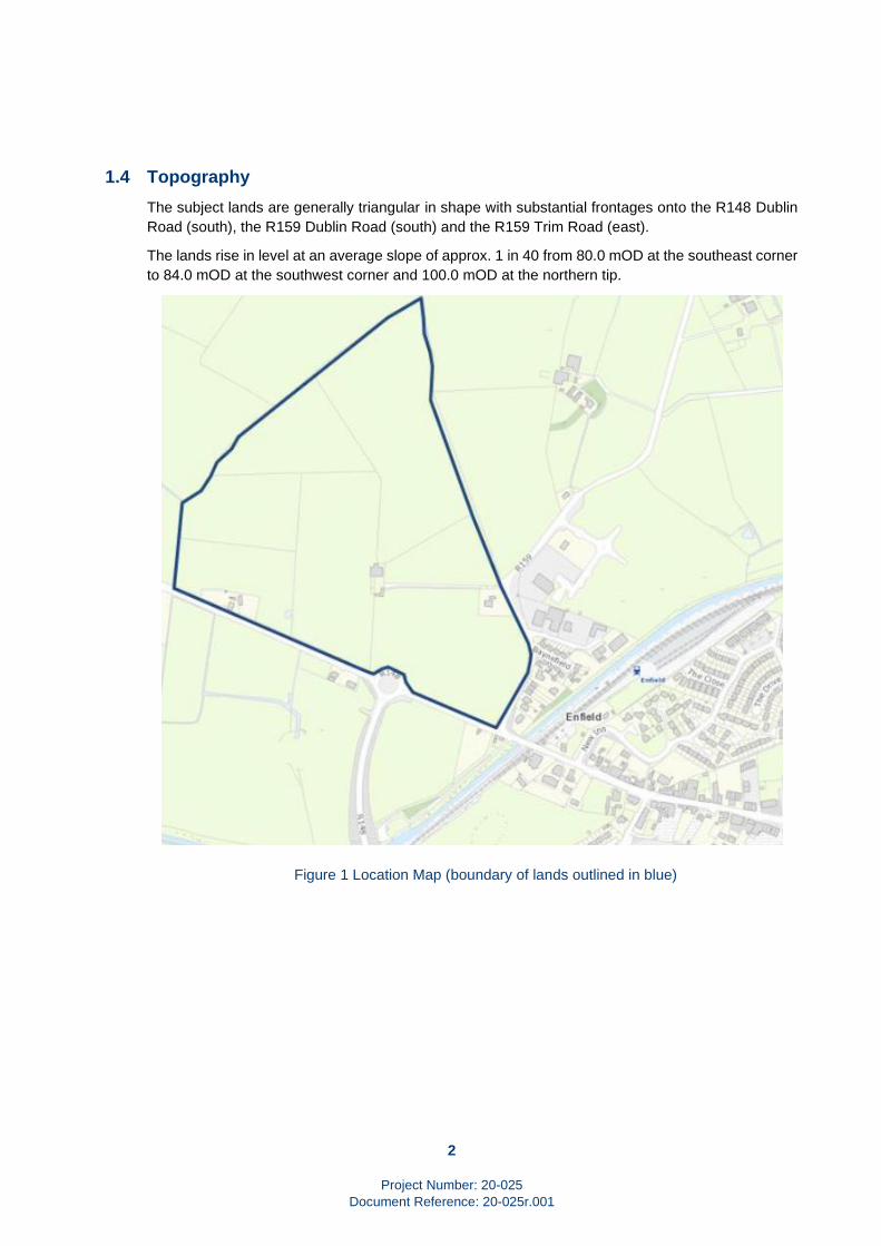
1.4 Topography
The subject lands are generally triangular in shape with substantial frontages onto the R148 Dublin
Road (south), the R159 Dublin Road (south) and the R159 Trim Road (east).
The lands rise in level at an average slope of approx. 1 in 40 from 80.0 mOD at the southeast corner
to 84.0 mOD at the southwest corner and 100.0 mOD at the northern tip.
Figure 1 Location Map (boundary of lands outlined in blue)
3
Project Number: 20-025
Document Reference: 20-025r.001 M:\Projects\20\20-025 - Enfield Dublin Road\Documents\Reports\20-025r.001 ER.docx
2. Roads
2.1 Background
The main roads in the area of the subject lands are the R148 Dublin Road which forms part of the
Southern Relief Road around Enfield and the R159 Dublin Road. These roads intersect at a large
three-arm roundabout with provision for a future fourth arm to access the subject lands. See Figure
2.
Dublin Road was formerly the N4 national primary route between Dublin and Galway. Enfield was
by-passed in 2005 when the adjacent Kinnegad – Mullingar section of the M4 Motorway was opened
to traffic. At the same time, the connection between Dublin Road and the M4 interchange was added.
Following the completion of the M4, Dublin Road, to the west of the roundabout was reclassified as
regional route R148.and the N4 between the roundabout and the Trim Road was reclassified as
regional route R159.
Figure 2 Aerial View of Roundabout at junction R148 and R159
(Subject Lands on right)
2.2 R148 Dublin Road
The subject lands have a frontage of some 470 metres onto the western section of Dublin Road.
The R148 to the west of the roundabout has a wide single carriageway with a good vertical and
horizontal alignment. There are hard shoulders on the both sides but no cycle or pedestrian facilities.
The road is served by public lighting. See Figure 3.

4
Project Number: 20-025
Document Reference: 20-025r.001 M:\Projects\20\20-025 - Enfield Dublin Road\Documents\Reports\20-025r.001 ER.docx
The existing speed limit on the R148 is 60 kph increasing to 80 kph midway along the frontage of the
subject lands.
Figure 3 R148 west of Roundabout (subject lands on left)
2.3 R159 Dublin Road
The subject lands have a frontage of some 230 metres onto the eastern section of Dublin Road.
The R159 Dublin Road to the east of the roundabout has a wide single carriageway with a good
vertical and horizontal alignment. The road is served by public lighting. See Figure 4.
There is a footpath on the south side and a hard shoulder on the north side. There are no cycle
facilities to the east of the roundabout.
Traffic calming has been provided on the R159 Dublin Road in the form of median hatching and
rumble strips on the approaches to the roundabout to reduce traffic speeds.
The existing speed limit on the R159 Dublin Road is 60 kph reducing to 50 kph at the speed limit
gateway on the approaches to the town centre (midway between the roundabout and the R159 Trim
Road junction).
There is also a 3.0 tonne weight limit on this section of road.

5
Project Number: 20-025
Document Reference: 20-025r.001 M:\Projects\20\20-025 - Enfield Dublin Road\Documents\Reports\20-025r.001 ER.docx
Figure 4 R159 Dublin Road East of Roundabout (subject lands on right)
2.4 R159 Trim Road
The subject lands have a frontage of some 320 metres onto the southern section of Trim Road.
Along the eastern boundary of the lands, the R159 Trim Road has a carriageway of standard width
and a footpath on the east side. See Figure 5.
This section of road has a good vertical alignment but a curved horizontal alignment.
The existing speed limit is 50 kph and the road is served by public lighting.

6
Project Number: 20-025
Document Reference: 20-025r.001 M:\Projects\20\20-025 - Enfield Dublin Road\Documents\Reports\20-025r.001 ER.docx
Figure 5 R159 Trim Road east of site (subject lands on right)

7
Project Number: 20-025
Document Reference: 20-025r.001 M:\Projects\20\20-025 - Enfield Dublin Road\Documents\Reports\20-025r.001 ER.docx
3. Access
3.1 Existing Access
There are two existing access points from the surrounding roads onto the subject lands.
Access No 1 is a field gate located at the north western corner of the roundabout. The junction
sightlines are not particularly good at this location. See Figures 6 and 7.
Access No 2 to Drummond House is located on the inside of a bend on the R159 Trim Road. The
junction sightlines are good at this location. See Figures 6 and 9.
Figure 6 Locations of Existing Access Points

8
Project Number: 20-025
Document Reference: 20-025r.001 M:\Projects\20\20-025 - Enfield Dublin Road\Documents\Reports\20-025r.001 ER.docx
Figure 7 Existing Access No 1 at Roundabout
(subject lands on left)
Figure 8 Existing Access No 2 on R159 Trim Road (east)
(subject lands behind Drummond House)

9
Project Number: 20-025
Document Reference: 20-025r.001 M:\Projects\20\20-025 - Enfield Dublin Road\Documents\Reports\20-025r.001 ER.docx
3.2 Future Access
During the preparation of this report, a review was undertaken of the options for future access to the
subject lands if developed on foot of a future planning permission(s).
The review concluded that two access points would be appropriate. These would be located in the
same locations as the two existing access points save for Access No 1 which would become the
fourth arm of the existing three arm roundabout.
The proposed locations of the two upgraded access points are shown on Figure 9.
Both locations would be located in areas with good horizontal and vertical alignment and have good
sightlines.
Figure 9 Locations of Proposed Access

10
Project Number: 20-025
Document Reference: 20-025r.001 M:\Projects\20\20-025 - Enfield Dublin Road\Documents\Reports\20-025r.001 ER.docx
4. Road Improvements
In addition to the new access points, upgrading of the pedestrian and cycle infrastructure would be
carried out by the applicants on foot of a planning permission. The upgrades would include
• Upgrade works to R148 / R159 junction (New traffic signals, pedestrian crossing points and
bus stop).
• Improvement works to R159 Dublin Road frontage (New footpath, cycle lane, cycle crossing
facilities and pedestrian crossing facilities).
• A widened speed limit gateway on R159 Dublin Road to accommodate the new footpath and
cycle track.
• Improvement works to the R159 Trim Road (New footpath)
The locations of the upgrade works are shown on Figure 11.
Figure 10 Location of Proposed Road Upgrades

11
Project Number: 20-025
Document Reference: 20-025r.001 M:\Projects\20\20-025 - Enfield Dublin Road\Documents\Reports\20-025r.001 ER.docx
5. Public Transport
5.1 Background
Enfield and the subject lands are in close proximity to and well served by public transport.
This enviable position was acknowledged by Meath County Council (MCC), A Bord Pleanala (ABP)
and the National Transport Authority (NTA) during the assessment of a recent planning application
on an adjoining site.
5.2 Bus
Enfield is very well services by bus services operated by a number of different companies. The
services provided include: -
• Bus Eireann on Route 20 / X20 Dublin – Enfield – Galway and Route 115 / 115A Dublin –
Enfield – Mullingar.
• Kearns Transport on Route 820 Edenderry - Enfield, Route 845 Dublin – Enfield - Birr, Route
847 Dublin – Enfield - Portumna and Route 763 Dublin Airport – Enfield – Galway.
The subject lands are within a 6-minute walking distance (500 metres) of the bus stops on Main
Street. See Figure 12.
The walking time will be further reduced by the provision of a new bus stop to be located on Dublin
Road at the access to the subject lands from the existing roundabout.
Figure 11 Walking Distance to Bus Stops on Main Street
(lands outlined in red)

12
Project Number: 20-025
Document Reference: 20-025r.001 M:\Projects\20\20-025 - Enfield Dublin Road\Documents\Reports\20-025r.001 ER.docx
5.3 Train
In addition to the bus services described above, Irish Rail provide ten rail services in each direction
serving Enfield Station on the Dublin – M3 Parkway – Longford and the Dublin – Sligo routes.
The subject lands are also within a 7-minute (500 metres) walking distance of the Enfield Railway
Station. See Figure 13.
Figure 12 Walking Distance to Enfield Railway Station
(lands outlined in red)

13
Project Number: 20-025
Document Reference: 20-025r.001 M:\Projects\20\20-025 - Enfield Dublin Road\Documents\Reports\20-025r.001 ER.docx
6. Traffic
6.1 Existing Traffic Flow
Traffic surveys carried out for another development on adjoining lands recorded the peak hour
movements at the following junctions:
• Existing roundabout at the junction R148 Dublin Road / R159 Dublin Road and the R148
Enfield Relief Road.
• Existing T-junction at intersection R159 Dublin Road / Main Street and the R159 Trim Road.
The surveys were carried out in September 2017 during the periods 07h00-10h00 and 16h00-19h00.
The results of the survey are presented in Table 1. It will be noted that the local traffic flow at the
inner T-junction was some 10% lower that the regional traffic flow at the R148 Roundabout.
Table 1 Peak Hour Flow Through Junctions pcus
Junction AM Peak Hour
08h00 – 09h00
PM Peak Hour
16h00 -19h00
R148 Roundabout 969 1,140
R159 T-junction 890 924
6.2 Traffic Impact of Proposed Development
The proposed development on the subject lands will have a very limited impact on the operation of
the surrounding road network.
Depending on the modal split, density of development and the trip distribution adopted, the
development generated flows through both junctions are likely to be in the order of 5%, the trigger
value at which a Traffic and Transport Assessment (TTA) would be required for congested areas
under Section 11.18 of the County Development Plan.
In the case of the proposed development, it is considered that the traffic impact of the proposed
development will not be significant.

14
Project Number: 20-025
Document Reference: 20-025r.001 M:\Projects\20\20-025 - Enfield Dublin Road\Documents\Reports\20-025r.001 ER.docx
7. Water Supply
7.1 Existing
The existing mains supplying potable water in the area are a 150mm dia looped main on Main Street
and a 150mm dia main on the R159 Trim Road.
The existing water supply installation includes hydrants, sluice valves and air valves.
A section of the Irish Water record drawing illustrating the main described above is reproduced as
Figure x below. The full drawing is included in Appendix A.
7.2 Capacity to Supply Future Development
The water supply for Enfield is provided by the Enfield Water Supply Scheme comprising source
boreholes, a water treatment plant and an underground system of distribution mains. The Scheme
has a design capacity of 6,000 population equivalent (PE) compared to a projected population of
4,200 persons by 2026.
Notwithstanding the fact that the current population is below the capacity of the Scheme, the capacity
of the system to supply future development is constrained by the capacity of the existing source
borehole from which the system gets its supply.
Since 2014, the water supply network throughout the country has been under the control of Irish
Water.
Irish Water currently includes a groundwater review project on its Capital Investment Plan. This
review identified the capital works required to service the water supply zone up to 2033. The review
was completed in 2019.
7.3 Phasing of Development on the Subject Lands
The timescale in which the existing deficiency in water supply will be made is good by Irish Water is
programmed to be in 2021. Such a program will integrate very well with the program for zoning and
development of the subject lands.
The applicants appreciate development of the subject lands are subject to the conditions of a future
connection agreement with Irish Water.
As advised by Irish Water, a water supply will be available for the subject lands within the timescale
envisaged for zoning and development.
7.4 Water Conservation
The proposed development will incorporate water conservation measures such as rainwater
harvesting, low flow wc’s incorporating reduced capacity cisterns, aerating taps and similar such
measures.
Leak detection will be implemented through the metering of supply at the connection to the public
main.

15
Project Number: 20-025
Document Reference: 20-025r.001 M:\Projects\20\20-025 - Enfield Dublin Road\Documents\Reports\20-025r.001 ER.docx
7.5 Wayleaves
No registered wayleaves for water supply services were found within the property boundary during
a search on Landirect, the website operated by the Property Registration Authority.
Figure 13 Watermain Layout
(watermain shown in dark blue and lands outlined in red)
16
Project Number: 20-025
Document Reference: 20-025r.001 M:\Projects\20\20-025 - Enfield Dublin Road\Documents\Reports\20-025r.001 ER.docx
8. Wastewater Drainage
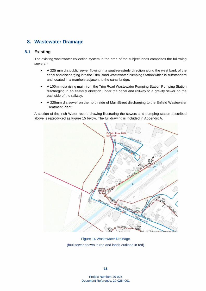
8.1 Existing
The existing wastewater collection system in the area of the subject lands comprises the following
sewers: -
• A 225 mm dia public sewer flowing in a south-westerly direction along the west bank of the
canal and discharging into the Trim Road Wastewater Pumping Station which is substandard
and located in a manhole adjacent to the canal bridge.
• A 100mm dia rising main from the Trim Road Wastewater Pumping Station Pumping Station
discharging in an easterly direction under the canal and railway to a gravity sewer on the
east side of the railway.
• A 225mm dia sewer on the north side of MainStreet discharging to the Enfield Wastewater
Treatment Plant.
A section of the Irish Water record drawing illustrating the sewers and pumping station described
above is reproduced as Figure 15 below. The full drawing is included in Appendix A.
Figure 14 Wastewater Drainage
(foul sewer shown in red and lands outlined in red)

17
Project Number: 20-025
Document Reference: 20-025r.001 M:\Projects\20\20-025 - Enfield Dublin Road\Documents\Reports\20-025r.001 ER.docx
8.2 Capacity to Serve Future Development
The town of Enfield and surrounding area is served by the Enfield Wastewater Treatment (WWTP).
The biological capacity of the plant to serve new developments is limited. However, the hydraulic
capacity does not suffer the same limitation.
Since 2014, the foul drainage network throughout the country has been under the control of Irish
Water.
The Enfield Wastewater Treatment Plant was upgraded by Irish Water in 2016.
A further upgrade is required to serve new developments. Irish Water has this project on their current
investment plan scheduled to be complete by 2020 / 2021.
Enquiries to Irish Water in February 2019 confirmed that the upgrade works to the capacity of the
Enfield Wastewater Treatment Plant are included in the Capital Investment Plan (CIP) for completion
in 2024.
In the interim and subject to the developer obtaining the appropriate statutory permissions. Irish
Water is allowing the temporary provision of private wastewater treatment plants on the developer’s
site prior to connection to the Irish Water network with a by-pass facility for when the Enfield
Wastewater Treatment Plant is upgraded by Irish Water.
8.3 Proposals for the Subject Lands
Preliminary proposals for foul drainage from the subject lands are for wastewater to drain via gravity
to a proposed new foul sewerage pumping station which is to be located in the south eastern corner
of the lands. See Figure 16.
The capacity of the new pumping station will include not only the subject lands and other adjoining
zoned and undeveloped lands but also flows from the existing sewer serving the area on the west
bank of the canal.
The existing sewer on the west bank of the canal would be diverted into the new pumping station
and the existing Trim Road Wastewater Pumping Station decommissioned.
The outflow from the new pumping station would be discharged through a new rising main to the
existing rising main. The existing rising main would continue to discharge under the railway and canal
to the existing gravity sewer at the rear of Main Street and thence to the Enfield WWTP.
The effect of the proposal would be to render the existing substandard Trim Road Wastewater
Pumping Station redundant and also to increase the capacity of the foul drainage network in the
area.
8.4 Phasing of Development on the Subject Lands
The timescale in which the existing deficiency in wastewater treatment will be made is good by Irish
Water is 2021.
The applicants appreciate development of the subject lands are subject to the conditions of a future
connection agreement with Irish Water.

18
Project Number: 20-025
Document Reference: 20-025r.001 M:\Projects\20\20-025 - Enfield Dublin Road\Documents\Reports\20-025r.001 ER.docx
As advised by Irish Water, wastewater treatment capacity will be available for the subject lands within
the timescale envisaged for development.
8.5 Wayleaves
No registered wayleaves for wastewater sewers were found within the property boundary during a
search on Landirect, the website operated by the Property Registration Authority.
Figure 15 Location of Proposed Wastewater Pumping Station

19
Project Number: 20-025
Document Reference: 20-025r.001 M:\Projects\20\20-025 - Enfield Dublin Road\Documents\Reports\20-025r.001 ER.docx
9. Surface Water Drainage
9.1 Existing
There are no existing surface water sewers within the boundaries of the subject lands which is
currently undeveloped.
9.2 Surface Water from a Future Development
In compliance with the stormwater policy set out in Section 7.16 of the Meath County Development
Plan 2013 – 2019 to promote and incorporate Sustainable Drainage Systems (SuDS) in new
developments, it is proposed that surface water from the developed lands will drain via gravity to
soakaways on within the boundaries of the lands.
The soakaways will be designed in accordance with BRE Digest 365. The surface water will percolate
naturally to ground with storage provided within the soakaways to accommodate the 1 in 100-year
storm and the projected effects of climate change.
The SUDS selection process which will be used for these lands will be is in accordance with the
SuDS selection flow chart in Figure 48, Section 6.5, Volume 3 of the Greater Dublin Strategic
Drainage Study (GDSDS)GD.
The characteristics of the site will be utilised to select the various SUDS techniques that would be
applicable. The designers will consider the use and effectiveness of all appropriate SUDS devices
as part of the site SUDS strategy including water butts, petrol interceptors and soakaways.
If the permeability of the underlying subsoil is determined to be too low for soakaways, stormwater
runoff from the subject lands will be attenuated within the boundaries of the lands so as to limit the
rate of discharge to the equivalent of the runoff from the current undeveloped lands.
For any buildings which are sufficiently large in area, green roofs will be incorporated into the
stormwater drainage system.
The effectiveness of each SUDS / drainage mechanism proposed is outlined below:
9.3 Wayleaves
No registered wayleaves for surface water sewers were found within the property boundary during a
search on Landirect, the website operated by the Property Registration Authority.

20
Project Number: 20-025
Document Reference: 20-025r.001 M:\Projects\20\20-025 - Enfield Dublin Road\Documents\Reports\20-025r.001 ER.docx
10. Flooding
10.1 OPW Flood Mapping
The OPW Flood Hazard Mapping website provides historical flood event information for Ireland by
identifying areas, which suffered from tidal, coastal, fluvial or surface water flooding.
The information and mapping on the OPW website do not show any flooding in the Enfield area. See
Figure 18.
Figure 16 Extract from OPW Flood Map (subject lands outlined in red)
21
Project Number: 20-025
Document Reference: 20-025r.001 M:\Projects\20\20-025 - Enfield Dublin Road\Documents\Reports\20-025r.001 ER.docx
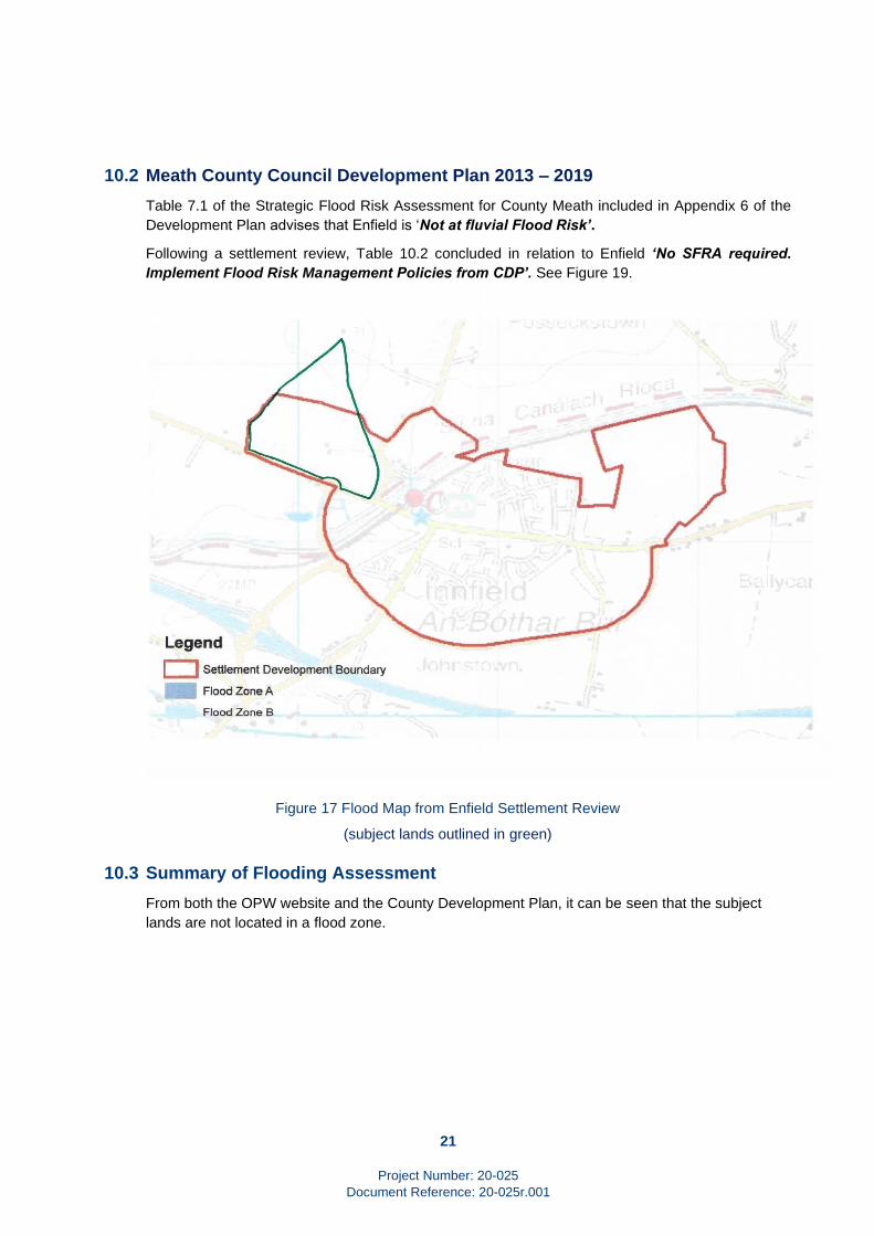
10.2 Meath County Council Development Plan 2013 – 2019
Table 7.1 of the Strategic Flood Risk Assessment for County Meath included in Appendix 6 of the
Development Plan advises that Enfield is ‘Not at fluvial Flood Risk’.
Following a settlement review, Table 10.2 concluded in relation to Enfield ‘No SFRA required.
Implement Flood Risk Management Policies from CDP’. See Figure 19.
Figure 17 Flood Map from Enfield Settlement Review
(subject lands outlined in green)
10.3 Summary of Flooding Assessment
From both the OPW website and the County Development Plan, it can be seen that the subject
lands are not located in a flood zone.
22
Project Number: 20-025
Document Reference: 20-025r.001 M:\Projects\20\20-025 - Enfield Dublin Road\Documents\Reports\20-025r.001 ER.docx
11. Utilities
11.1 Description
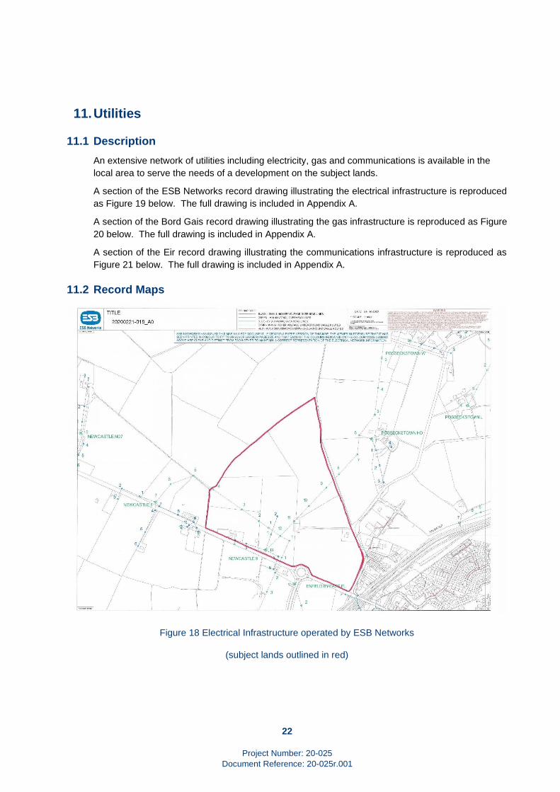
An extensive network of utilities including electricity, gas and communications is available in the
local area to serve the needs of a development on the subject lands.
A section of the ESB Networks record drawing illustrating the electrical infrastructure is reproduced
as Figure 19 below. The full drawing is included in Appendix A.
A section of the Bord Gais record drawing illustrating the gas infrastructure is reproduced as Figure
20 below. The full drawing is included in Appendix A.
A section of the Eir record drawing illustrating the communications infrastructure is reproduced as
Figure 21 below. The full drawing is included in Appendix A.
11.2 Record Maps
Figure 18 Electrical Infrastructure operated by ESB Networks
(subject lands outlined in red)

23
Project Number: 20-025
Document Reference: 20-025r.001 M:\Projects\20\20-025 - Enfield Dublin Road\Documents\Reports\20-025r.001 ER.docx
Figure 19 Gas Infrastructure operated by Gas Networks Ireland (GNI)
Figure 20 Communications Network operated by Eir

24
Project Number: 20-025
Document Reference: 20-025r.001 M:\Projects\20\20-025 - Enfield Dublin Road\Documents\Reports\20-025r.001 ER.docx
11.3 Diversion of Existing Services
The only utility infrastructure within the boundaries of the subject lands are the overhead electrical
lines operated by ESB Networks.
In order to fully develop the subject lands, the existing overhead lines across the lands will need to
be diverted.
Such diversion can readily be put in place in conjunction with the agreement of ESB Networks.

25
Project Number: 20-025
Document Reference: 20-025r.001 M:\Projects\20\20-025 - Enfield Dublin Road\Documents\Reports\20-025r.001 ER.docx
12. Summary
Background
This Engineering Assessment Report for lands at Dublin Road, Enfield, Co Meath has been prepared
by Waterman Moylan on behalf of Ann Holmes, Carmel Kelly and Brendan Little to accompany a
submission by BMA Planning to Meath County Council in relation to the Draft Meath County
Development Plan 2020 – 2026..
Water Infrastructure
Any existing deficiencies in the water infrastructure are being addressed by Irish Water and the
upgrades to resolve all of the capacity issues for both water supply and wastewater treatment will be
in place by 2024 before completion of the zoning, planning permission and development stages of
the subject lands.
In the interim and pending completion of the upgrades to the Enfield Wastewater Treatment Plant,
Irish Water is accepting treated wastewater from new developments.
Roads
The subject lands are very well served by roads whose capacity as former national primary road and
now regional route greatly exceeds the existing and future local traffic volumes.
High quality access is available from the existing roundabout on the R148 Dublin Road and from the
R159 Trim Road.
Flooding
The subject lands are not located within a Flood Zone or subject to flooding.
Stormwater
The development of the subject lands will include the incorporation of SuDS (Sustainable Urban
Drainage Systems) with stormwater soaking away to the underlying subsoil thereby restricting the
outflow from the lands to existing pre-development levels.
Wastewater
The development of the subject lands will include a new wastewater pumping station to replace the
substandard Trim Road Wastewater Pumping Station.
Utilities
There is an extensive network of existing services, both underground and over ground, to serve any
future development on the subject lands.
Wayleaves
There are no registered wayleaves for the subject lands which would inhibit or restrict their
development.
Benefits of Development
A number of positive upgrades to the surrounding infrastructure will be put in place as part of any
development on the subject lands. These upgrades will include: -
26
Project Number: 20-025
Document Reference: 20-025r.001 M:\Projects\20\20-025 - Enfield Dublin Road\Documents\Reports\20-025r.001 ER.docx
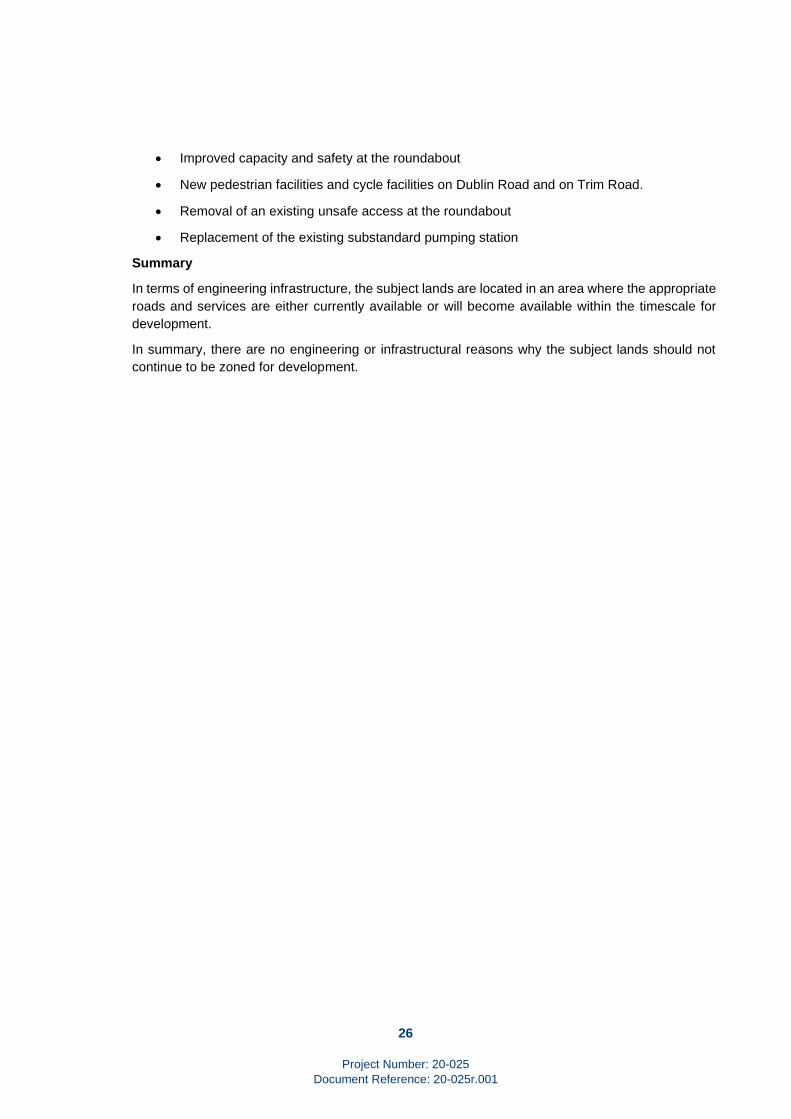
• Improved capacity and safety at the roundabout
• New pedestrian facilities and cycle facilities on Dublin Road and on Trim Road.
• Removal of an existing unsafe access at the roundabout
• Replacement of the existing substandard pumping station
Summary
In terms of engineering infrastructure, the subject lands are located in an area where the appropriate
roads and services are either currently available or will become available within the timescale for
development.
In summary, there are no engineering or infrastructural reasons why the subject lands should not
continue to be zoned for development.

Project Number: 20-025
Document Reference: 20-025r.001 M:\Projects\20\20-025 - Enfield Dublin Road\Documents\Reports\20-025r.001 ER.docx
APPENDICES
A. Record Drawings

Irish Water Web Map
© O rdna nce Surve y Ire la nd0 0.15 0.3 0.45 0.60.075
km1. No pa rt of th is drawing m ay b e re produce d or tra ns m itte d in a ny form or s tore d in a ny re trie va l s ys te m of a ny nature with out th e writte n pe rm is s ion of Iris h W ate ra s copyrig h th olde r e xce pt a s a g re e d for us e on th e proje ct for wh ich th e docum e nt wa s orig ina lly is s ue d.2. W h ilst e ve ry ca re h a s b e e n ta ke n in its com pilation, Iris h W ate r g ive s th is inform ation a s to th e pos ition of its unde rg round ne twork a s a g e ne ra l g uide only on th e s trict unde rsta nding th a t it is b a s e d onth e b e st a va ila b le inform ation provide d by e ach Loca l Auth ority in Ire la nd to Iris h W ate r. Iris h W ate r ca n a s s um e no re s pons ib ility for a nd g ive no g ua ra nte e s , unde rta king s or wa rra ntie s conce rning th e a ccuracy, com ple te ne s s or up to date nature of th e inform a tion provide d a nd doe s not a cce pt a ny lia b ility wh ats oe ve ra ris ing from a ny e rrors or om is s ions.Th is inform ation s h ould not b e re lie d upon in th e e ve nt of e xcavationsor a ny oth e r works b e ing ca rrie d out in th e vicinity of th e Iris h W a te r unde rg round ne twork. Th e onus is on th e pa rtie s ca rrying out e xcavations or a ny oth e r works to e ns ure th e e xact location of th e Iris h W ate r unde rg round ne twork is ide ntifie d prior to e xcava tions or a ny oth e r works b e ing ca rrie d out. Se rvice conne ction pipe s a re not g e ne ra lly s h own but th e ir pre s e nce s h ould b e a nticipate d.© Copyrig h t Iris h W ate rRe produce d from th e O rdna nce Surve y O f Ire la nd by Pe rm is s ion of th e Gove rnm e nt. Lice ns e No. 3-3-34“Ga s Ne tworks Ire la nd (GNI), th e ir a ffiliate s a nd a s s ig ns , acce pt no re s pons ib ility for a ny inform ation conta ine d in th is docum e nt conce rning location a nd te ch nica l de s ig na tion of th e g a s dis tribution a nd tra ns m is s ion ne twork (“th e Inform a tion”). Any re pre s e ntations a nd wa rra ntie s e xpre s s or im plie d, a re e xclude d to th e fulle s t e xte nt pe rm itte d by la w. No lia b ility s h a ll b e acce pte d for a ny los s or da m a g eincluding , with out lim itation, dire ct, indire ct, s pe cia l, incide nta l, punitive or cons e que ntia l los s including los s of profits, a ris ing out of or in conne ction with th e us e of th e inform ation (including m a ps or m a pping data ). NO TE: DIAL BEFO RE YO U DIG Ph one : 1850 427 747 or e -m a il dig @g a s ne tworks.ie - Th e actua l pos ition of th e g a s /e le ctricity dis tribution a nd tra ns m is s ion ne twork m us t b e ve rifie d on s ite b e fore a ny m e ch a nica l e xcavating ta ke s place . If a ny m e ch a nica l e xca vation is propos e d, h a rd copy m a ps m ust b e re que ste d from GNI re g a s . All work in th e vicinity of g a s dis tribution a nd tra ns m is s ion ne twork m us t b e com ple te d in accorda nce with th e curre nt e dition of th e He a lth & Sa fe ty Auth ority pub lication, ‘Code of Pra ctice For Avoiding Da ng e r From Unde rg round Se rvice s ’ wh ich is ava ila b le from th e He a lth a nd Sa fe ty Auth ority (1890 28 93 89) or ca n b e downloade d fre e of ch a rg e a t www.h s a .ie .”
Printe d b y:Iris h W a te r
Print Date : 18/02/2020


Enfield Business Park
Innfield
Industrial Estate
Platform
T
Spring
Pond
Baynefield
FC
EFD9
003
003EF
D1
1x10
0PP
2198
1x100PP
2126
2200
1x10
0PP
1 x 25PP2 x 100PP
1392
1 x 25PP
24 x 100PP
1 x
100P
P
2223
1 x 100PP
1 x 100PP
2220
1 x 100PP
1 x 100PP
2221
1 x 100PP
24x100PP
1318
6 x 100PP
1319
1 x 100PP
6 x 100PP
1412
1411
1792
1396
6x10
0PP
2 x 100PP
2 x 1
00PP
1x10
0PP
2x10
0CD
6x10
0PP
1791
6x10
0PP
1x10
0PP
4 x 100PP1 x 1-way MD1 x 100CD
1408
1x10
0PP
6x100PP
4x100PP
1 x 1-way MD1 x 100CD
1 x 1-way MD1 x 100CD2x100PP
1403
4x10
0PP
1405
1398
1441
2063
1x11
2TW
2062
2x100PP
1404
1442
4x100PP
1x11
2TW
2037
2x100PP2x100PP
4x100PP
14062x100PP
1443
1 x 38
PP1 x
1-way
MD
2284
1 x 3-way MD2 x 100PP
1x100CD
1555
1 x 1-way MD2 x 100PP1554
15561x100CD
1400
1401
1 x 1-way MD1 x 100CD
2x100PP
1399
1553 1 x 1-way MD2 x 100PP
1x100CD
1 x 1
-way
MD
1 x 1
00CD
THE INFORMATION GIVEN IS COMPILED FROM RECORDS AND IS BELIEVED TO BE CORRECT. THERE MAY, HOWEVER, BE DEPARTURES FROM THE COURSE[S] AND DEPTH[S] SHOWN OR INDICATED. THERE MAY ALSO BEITEMS OF eircom PLANT OF WHICH NO RECORDS IN HELD. THE INFORMATION IS GIVEN WITHOUT PREJUDICE TO THE LEGAL RIGHTS OF eircom LTD. TO COMPENSATION SHOULD eircom PLANT BE DAMAGED.
THE INFORMATION IN THIS DRAWING IS CONFIDENTIAL AND SHOULDNOT BE DISCLOSED TO ANY THIRD PARTY WITHOUT THE EXPRESSWRITTEN CONSENT OF eircom LTD. THE DRAWING IS NOT TO BEPHOTOCOPIED OR REPRODUCED IN ANY WAY Ordnance Survey Ireland Licence No EN 0007904
Copyright Ordnance Survey Ireland and Government of Ireland
Scale: 1:1500
18/02/2020
Centre XY: 277292 m, 241335 m
A3
DatePLANT REQUESTED FROM eircom emaps CBYD SERVICE
Irish National Grid Co-Ordinates
https://cbyd.emaps.eircom.ie/emaps CBYD

3612011s5504 SFRa live Report (v1.11 December 2012).doc
Strategic Flood Risk assessment for County Meath
A.16 ENFIELD
Settlement Area 199.96 Ha
Zoning within Flood Zone A and/or B? No
Area for Further Assessment under CFRAM programme? No
© Ordnance Survey Ireland & Government of Ireland, Meath 2012/31/CCMAThe Flood Zone mapping has been produced in accordance with the Planning Guidelines and therefore ignores the impact of flood protection structures. Areas protected by flood defences still carry a residual risk of flooding due to overtopping or breach, there may also be no guarantee of maintenance in perpetuity. Areas that benefit from defences are annotated separately. Note that Flood Zone mapping is only reproduced within the settlement development boundary. Flood Zone A – Fluvial: 1 in 100 year or 1% AEP, Tidal: 1 in 200 year or 0.5% AEP. Flood Zone B – 1 in 1000 year or 0.1% AEP.
Flood Zone mapping data source n/a
Historical Flooding Main Street, Enfield Recurring (minor surface water issue)
Comment The Royal Canal runs through Enfield. The Flood Zones map fluvial and tidal flood risk. They do not take into account flood risk from artificial / manmade channels. However, as the Canal does not comprise significant embankments flood risk is not considered as being high. Therefore management of flood risk can be achieved through the adoption of the policies set out in the CDP.
Some potential for surface water ponding in the north-east and south-west of the settlement.
Conclusion No SFRA requiredImplement Flood Risk Management policies from CDP
Appendix 06 SFRA Appendicies.zip 16
A.16 Enfield
Settlement Area 199.96 Ha
Zoning within Flood Zone A and/or B? No
Area for Further Assessment under CFRAM
programme?
No
© Ordnance Survey Ireland & Government of Ireland, Meath 2012/31/CCMA
The Flood Zone mapping has been produced in accordance with the Planning Guidelines and therefore ignores the
impact of flood protection structures. Areas protected by flood defences still carry a residual risk of flooding due to overtopping or breach, there may also be no guarantee of maintenance in perpetuity. Areas that benefit from defences
are annotated separately. Note that Flood Zone mapping is only reproduced within the settlement development boundary. Flood Zone A – Fluvial: 1 in 100 year or 1% AEP, Tidal: 1 in 200 year or 0.5% AEP. Flood Zone B – 1 in 1000 year or 0.1% AEP.
Flood Zone mapping data source n/a
Historical Flooding Main Street, Enfield Recurring (minor surface water
issue)
Comment The Royal Canal runs through Enfield. The Flood Zones
map fluvial and tidal flood risk. They do not take into
account flood risk from artificial / manmade channels.
However, as the Canal does not comprise significant
embankments flood risk is not considered as being
high. Therefore management of flood risk can be
achieved through the adoption of the policies set out in
the CDP.
Some potential for surface water ponding in the north-
east and south-west of the settlement.
Conclusions No SFRA required
Implement Flood Risk Management policies from CDP
A6

Project Number: 20-025
Document Reference: 20-025r.001 M:\Projects\20\20-025 - Enfield Dublin Road\Documents\Reports\20-025r.001 ER.docx

Project Number: 20-025
Document Reference: 20-025r.001 M:\Projects\20\20-025 - Enfield Dublin Road\Documents\Reports\20-025r.001 ER.docx