summer/fall 2015 cosmos greetings - national park … its city limits, which have benefited from ......
TRANSCRIPT

summer/fall 2015
W e lc o m e to c a r l s ba d c av e r n s a n d
Guadalupe Mountains National Parks. Carlsbad Caverns National Park, a World Heritage Site since 1995, features a spectacu-lar cave system of highly decorated cham-bers. Guadalupe Mountains National Park protects one of the world’s best examples of a fossil reef. Both parks are located within the Chihuahuan Desert, a fascinating place to explore desert life.
Our park staff are here to help make your visit a truly memorable event and will be happy to help you plan your visit to areas within and without the designated wilder-ness. Guided tours at Carlsbad Caverns can enrich your park experience. These tours of-fer a variety of caving experiences, from easy lantern tours to challenging trips involving crawling and squeezing through tight pas-sages.
Guadalupe Mountains National Park has over 80 miles of hiking trails to explore, ranging from wheelchair accessible paths to strenuous mountain hikes, including an 8.4 mile roundtrip hike to Texas’ highest moun-tain, Guadalupe Peak (8751', 2667m).
As you travel and spend time in the area please remember to keep safety in mind. Deer and other wildlife are plentiful—en-joy watching wildlife, but remember they often move across roads, especially in the evenings; be vigilant while driving during twilight hours. Hikers should be prepared for rapidly changing weather conditions. Hikers can become dehydrated in our dry climate, so carry plenty of water (one gal-lon per person per day is recommended). Always check trail conditions and weather forecasts with a ranger before venturing into the backcountry.
We are wholeheartedly committed to our mission of preserving and providing for the enjoyment of our nation’s most outstanding treasures. We wish you a rewarding experi-ence in every way.
Greetings
Douglas S. NeighborSuperintendentCarlsbad CavernsNational Park
Eric BrunnemannSuperintendentGuadalupe MountainsNational Park
Sincerely,
Hiking Info.............Page 6cave tours.............Page 4-5Inside this IssueContact Information Hiker Safety
Stagecoaching Was No Picnic Sitting Bull Falls
Area Attractions
2
4-5
10
11
12
by Carolyn Hunt F o r ge n e rat I o n s o u r a n c e s to r s
looked to the heavens and saw a sky full of stars. If you have never seen such a sight, it is something to behold! Imagine the inky black of night painted with a delicate misty glow; this is the Milky Way. The Milky Way is joined by bright stars twinkling—flashing red, blue, green, white. They seem to dance in the sky. This view has been described as numinous, evoking feelings of mystery, holiness, and spirituality. Some cultures even had myth, legend, and religion entwined with the stars.
Today, the stars often play a diminished role in our lives. Most people live in cities where even the night is bright, living in light 24 hours a day. We often have to travel great distances to see what is directly overhead. The tapestry of the heavens is hidden by a veil of human-made light. Consider the picture (right). Can you pick out where you are from? Places like Chicago, Los Angeles, Portland, Washington, D.C., and the entire outline of Florida are emblazoned on the earth. You can see that cities are in stark contrast to the nearby, uninhabited water bodies of the Pacific and Atlantic Oceans, the Great Lakes, and the Gulf of Mexico.
This human-caused lighting of the night was noticed by some people, particularly astrono-mers. Astronomers often have a keen interest in light pollution, as they look to the stars to seek answers and make predictions. This is because visible-light observations cannot be made with a large amount of light pollution. Light can travel hundreds of miles to disrupt astronomical observations. Some cities saw this was occurring and decided to decrease the amount of light they put into the sky. Two such cities are Tucson and Sedona, Arizona. They have less light pollution when com-pared to other cities their size. Tucson has a number of astronomical observatories out-side its city limits, which have benefited from their choice to reduce light pollution.
There are many ways in which residents of Sedona, Tucson—and other people con-cerned with reducing their light pollution—decrease light pollution going skyward. If one is to have a night-sky-friendly light you will get a “goldilocks” light. The light is just right, not too much, not too little.
To get a light that is “just right” follow these handy tips.:
1. WHERE: Use light where you need it. Choose locations of lights carefully and only install a light where it is truly needed.
2. SHIELD: Pick lighting fixtures that shield the light. A fixture which directs light to the ground is essential. Shielded light fixtures direct light at the ground, not the sky.
Cosmos
3. BRIGHTNESS: Consider the brightness of the light. The brightness of a light is called lumens; the amount of light. A 25 or 40 watt incandescent bulb, or a 9 watt compact fluo-rescent, is usually enough to light a porch or driveway.
4. WHEN: Consider when light is needed. Installing sensors can allow the light to come on when people are present and using the light. Sensors then turn the light off when it is not needed.
5. COLOR: The color of the light is impor-tant as well. “Warmer” colors, such as am-
An Awe-Inspiring Beauty
bers, are useful for a few reasons. They de-crease sky brightness, are easier on the eyes, and are less susceptible to insects.
Efforts like those listed above have contrib-uted to Sedona, Arizona’s status as a “Dark Sky Community,” recognized by the Interna-tional Dark Sky Association.
Astronomers are not the only ones who ben-efit from darkness. Animals also need night.
Though my soul may set in dark-
ness, it will rise in perfect light;
I have loved the stars too fondly to be fearful of the night.
—Sarah Williams
...continued on page 3
NPS Photo
A time-lapsed photo captures the Milky Way overhead in all of its magnificence and light pollution on the horizon.
The United States at night. Photo by NASA Earth Observatory/NOAA NGDC.
NPS
Ph
oto
/Pet
er J
on
es
Cave Tours pp. 6-7
NPS
Ph
oto
/D
ave
Bie
ri
Hiking Information p. 8Students Help Survey New Trail p. 3
NPS
Ph
oto
/Mic
hae
l Med
ran
o
Visitor Guide National Park Service U.S. Department of the InteriorCarlsbad Caverns and
Guadalupe Mountains National ParksFall/Winter 2017-18

Telephone andWeb Directory Official National Park Service sites include .gov in their web address.Carlsbad Caverns National Park3225 National Parks HighwayCarlsbad, NM 88220Visitor Center727 Carlsbad Caverns HighwayCarlsbad, NM 88220575-785-2232www.nps.gov/cavewww.facebook.com/Carlsbad Caverns National ParkCheck us out on Twitter:@CavernsNPS
Guadalupe Mountains National Park400 Pine Canyon DriveSalt Flat, TX 79847915-828-3251 ext. 2124www.nps.gov/gumowww.facebook.com/Guadalupe.Moun-tainsCheck us out on Twitter:@GuadalupeMtnsNP
www.meetup.com/Guadalupe-Moun-tains-National-Park-Meetup-Group/
Food, Lodging, and CampingCarlsbad Chamber of Commerce575-887-6516www.carlsbadchamber.com
Van Horn Texas Visitors Bureau432-283-2682
Weather ConditionsCarlsbad Weather Watch575-885-1848www.weather.gov
Road ConditionsNew Mexico: 800-432-4269www.nmroads.comTexas: 800-452-9292 drivetexas.org
Emergency: Call 911
GPS CoordinatesCarlsbad Caverns National Park Visitor Center (Nature Trail)Coordinate System: Lat/LongDatum: WGS 1984Latitude: 32.174212° N
Junior and Senior Ranger Programs
m a ny nat I o na l Pa r ks ac ro s s a m e r I c a o F F e r a j u n I o r
Ranger program for children to encourage interest in their national parks and to promote a sense of stewardship and ownership for these special places that they come to visit. This self-paced educa-tional program allows children to earn a patch and/or badge and/or certificate upon completion of required activities that teach them about park resources. Age appropriate activities are included in the Junior Ranger booklet, typically for pre-kindergarten through upper elementary-aged children.
At Carlsbad Caverns, the Junior Ranger program offers activities that teach children about the resources both above ground and below the surface (including plant and animal life of the desert, cave fea-tures, and history of the park). Younger children have opportunities to color and draw, find objects on a visual scavenger hunt, use their senses to experience their surroundings, and complete games. Older children will sequence events, complete word searches, and write stories and poems. Each activity in the booklet is an optional activity depending on interest and age-level. The Junior Ranger booklet is available at the visitor center information desk. Children of all ages may participate and earn a badge. The program is free.
At Guadalupe Mountains, children work through a separate activity booklet and visit points of interest within the park. The booklet ac-commodates families of varying travel plans. Many of the activities can be completed at the Pine Springs Visitor Center or Dog Canyon Contact Station. Children who complete four activities earn a badge and certificate, while those who do six, earn a patch, in addition to the badge and certificate. There is no charge for participation in the program. Junior Paleontologist, Wilderness Explorer, and Night Sky Explorer Activity Books are also available. Participants will earn a badge (Jr. Paleontologist) or patch (Wilderness Explorer, Night Sky Explorer) upon completion.
Senior Ranger programs are a new development, currently avail-able at limited locations, aimed at an audience who enjoys a chal-lenge and wants to use an activity book to learn about the park and help plan their visit. Senior Ranger books are available at the Pine Springs Visitor Center, Dog Canyon Contact Station, and the Carls-bad Caverns Visitor Center for anyone 13 years and older. Activities include visiting sites, learning about the park’s history, geology, flora, and fauna. Upon completion, participants earn a patch and certificate.
The National Park Service also offers an online WebRanger pro-gram for those who are unable to visit a national park, featuring activities about sites found across the nation. The activities illustrate principles in natural science and American history in new ways. To learn more, visit www.nps.gov/webrangers.
VolunteerismMakes a Difference W e Wo u l d l I k e to e xt e n d o u r s I n c e r e grat I t u d e to
the dedicated effort and talent that volunteers have brought to Carls-bad Caverns and Guadalupe Mountains National Parks. Volunteers play a vital role in fulfilling our mission of preserving our natural and cultural heritage and sharing that heritage with the visiting public. Volunteers do everything from staffing the information desk, roving interpretation, patrolling surface and cave trails, to trail mainte-nance, research, cave restoration, and more.
To become a Volunteer-In-Park (VIP) visit www.volunteer.govor contact:Carlsbad Caverns National ParkMaggi Daly, Volunteer-In-Park Coordinator575-234-1353Guadalupe Mountains National ParkBrian Schwieger, Volunteer-In-Park Coordinator 915-828-3251 ext. 2311
2 Visitor Guide
W e lc o m e to gua da lu P e m o u n ta I n s nat I o na l Pa r k . Guadalupe Mountains National Park protects one of the world’s best examples of a fossil reef. Both parks are located within the Chi-huahuan Desert, a fascinating place to explore desert life.
Park staff are here to help make your visit a truly memorable event and will be happy to help you plan your visit to areas within and without the designated wilderness.
Guadalupe Mountains National Park has over 80 miles of hiking trails to explore, ranging from wheelchair accessible paths to strenu-ous mountain hikes, including an 8.4-mile roundtrip hike to Texas’ highest mountain, Guadalupe Peak (8,751').
at c a r l s ba d c av e r n s nat I o na l Pa r k , P e t s a r e a l loW e d
on all paved roads, pullouts, and parking areas, along Walnut Canyon
Desert Drive (Loop Road), on the paved Nature trail, and at Rattle-
snake Springs picnic area. Pets must be kept on a leash at all times. Pets
are not permitted in the cave or at the bat flight programs. However,
service animals are allowed. During the day, your pet may be cared for
at the concessions kennel for a $10 fee. Call 575-785-2281 for details. A
citation will be issued if animals are left in vehicles when ambient air
temperatures will reach 70° Fahrenheit (21° Celcius) or higher.
At Guadalupe Mountains National Park, pets are allowed only on
the Pinery Trail, while on leash, but are not allowed on other trails,
in the backcountry, in buildings, or at evening programs. Service ani-
mals are allowed. Both pets and service animals are permitted in the
Pine Springs and Dog Canyon campgrounds. In any national park,
your pet must be physically restrained at all times.
Traveling with a Pet? On a warm day the temperature inside a car can kill a pet. Do not leave your pets unattended.
Longitude: 104.445855° W
Guadalupe Mountains NPVisitor Center (Nature Trail)Coordinate System: Lat/LongDatum: WGS 1984Latitude: 31.89370° NLongitude: 104.82214° W
What Time is It?
Both parks are in the
Mountain Time Zone.
Because Guadalupe
Mountains National
Park is close to the
Central Time Zone,
your phone will dis-
play the wrong time
unless you set it to
Mountain Time.
?? ? ?
As a nonprofit education partner of the
National Park Service, WNPA supports
71 national park partners across the
West, developing products, services, and
programs that enrich the visitor experi-
ence.
In partnership with the National Park
Service since 1938, WNPA advances
education, interpretation, research,
and community engagement to ensure
national parks are increasingly valued
by all.

Visitor Guide 3
Deadly Disease Continues to Kill Batsby Dale PateBats are important for ecosystems across the country and the world. They are excel-lent pollinators and eat millions of tons of insects nightly. Some of these insects are pests of food crops. A study completed in the 1990’s on the Brazilian (Mexican) Free-tailed bats from Carlsbad Cavern shows that 40 percent of the insects devoured by these bats are crop pests taken along the farmlands of the nearby Pecos River. Bats are important.
Unfortunately, beginning in the winter of 2006-2007 in caves near Albany, New York, a new and very deadly disease began to decimate bats that hibernate. Bat deaths were immediately associated with a white fungus growing around noses, ears, and on wing membranes. This condition was later named “White-nose Syndrome” (WNS).Since 2006, over five million bats have been killed by this disease and as of this summer, WNS has been detected in nine species of bats that hibernate. Death rates
of various colonies have been from 90 per-cent to 100 percent of all bats in that par-ticular colony. An additional concern is that WNS is spreading rapidly. It is now found in caves and mines in 31 states.
There are lots of unknowns concerning WNS. At this time, it does not appear to be affecting summer bat colonies such as Bra-zilian Free-tailed bats for which Carlsbad Cavern is famous. We must all be vigilant.
While it is known that transmission of the fungus is mostly from bat-to-bat, it may also be possible for humans to transport fungus spores on clothing, gear, shoes, or skin.
In an effort to slow down the spread of fungus and give bat scientists more time to look for a solution to this serious problem, Carlsbad Caverns National Park is asking visitors to caves in the park or the area to be aware of this problem and to help minimize the potential spread of this deadly disease.
Everyone can help in the following ways:If you have been in a cave or mine that is known to harbor WNS, or if you have been in a cave or mine within a state known to have WNS, please do not bring any of the potential-ly contaminated items (clothing, gear, shoes) used during that visit into Carlsbad Cavern or other caves.
States known to have WNS include: AL, AR, CT, DE, GA, IA, IL, IN, KY, MA, ME, MD, MI, MN, MO, NE, NH, NJ, NY, NC, OH, OK, PA, RI, SC, TN, VA, VT, WA, WI, and WV. Provinces in Canada known to have WNS include New Brunswick, Nova Scotia, Ontario, Prince Edward Island, and Quebec.
If you are taking one of the ranger-guided off-trail trips offered by Carlsbad Caverns National Park, please use the gear furnished by the park on those tours. Also, clean your shoes and other clothing before entering the cave.
Carlsbad Caverns National Park will be
increasing efforts to inform the public
about this devastating disease. Check
when arriving at the park for any up-
dates on WNS and what you can do
to help prevent its continued spread to
other areas and other bat species.
Almost half of all species on earth are noc-turnal! Nocturnal species are active at night and even depend on night. One such species at Carlsbad Caverns is the famous Brazilian Free-tailed bat (Tadarida Braziliensis). This bat is able to hunt the night skies for prey. While Brazilian Free-tailed bats can see, they do not rely on sight to hunt, instead they use echolocation. This allows the bats to “see” prey by bouncing sound off of objects. Since the Brazilian Free-tailed bat is active at night they avoid being eaten by diurnal (day ac-tive) predators. Bats are not the only animals that need night; people also benefit from night. Our circadian rhythms are attuned to light levels. Studies have shown the impor-tance of night and the effects of light pollu-tion on human health.
You, too, can experience the majesty of the cosmos! Both Guadalupe Mountains and Carlsbad Caverns National Parks have an expansive view of the night. There are a number of ways to share unique experiences with your families and friends. A ranger-guided tour is one of them. Ask about night sky programs at both parks. You can also take a self-guided tour of the stars by finding a good place to look up into the sky. Below you can check to see which dates are best for viewing the stars (new moon and last quarter) or night hiking (full moon and first quarter). For more information go to https://www.nps.gov/subjects/nightskies/index.htm
By Michael MedranoIn May 2017, a partnership consisting of federal land agencies and local community organizations in Carlsbad, NM celebrated the designation of the Guadalupe Ridge Trail (GRT). Organizations involved in the effort include: the National Park Service (NPS), the U.S. Forest Service (USFS), the Bureau of Land Management (BLM), the Carlsbad Early College High School (CECHS), and the Carlsbad Chamber of Commerce. The GRT runs from White’s City, through Carls-bad Caverns National Park, BLM land, the Lincoln National Forest, and Guadalupe Mountains National Park terminating at Guadalupe Peak. At approximately 100 miles long, the trail is being touted as an extreme challenge even for experienced backpackers.
In February, after meeting with Principal Eric Spencer, Carlsbad Caverns National Park, and the Lincoln National Forest, Guadalupe Mountains National Park staff turned to the CECHS for help with the GRT’s marketing and field mapping. In turn, CECHS students learned real-world advertising, marketing, and land manage-ment principles. Students from Gavin
Mack’s Social Studies class produced mar-keting logos and business plans for startup businesses that could be affiliated with the new trail. These students developed busi-nesses that could accommodate the needs of hikers, providing such necessities as shuttle services, outfitting, food and water delivery, clothing accessories, and even pet services. For the class mapping project, Hannah Vanscotter’s science students were responsi-ble for documenting trail and resource con-ditions on three segments of the GRT with Global Positioning System units (GPS). The students searched for plant and animal spe-cies of concern (rare/threatened species as well as invasive species), infrastructure (trail intersections, signage, water bars, stairs), archaeological resources, water sources, human impacts (graffiti) and hazardous or potentially hazardous trail conditions (ero-sion). The tasks were designed to strengthen not only the students’ GPS, field documen-tation, and observation skills, but also to expose the students to the challenges facing land managers who manage trails and facili-ties for the American public. The students spent a combined total of over 1100 hours working on GRT issues and resources.
Newly Created Guadalupe Ridge Trail,A Partnership Between Communityand Government Agencies
The students very quickly gained a new ap-preciation for resource conservation, visitor management, and business development. The spatial data and attributes generated by the students were assembled into a map suitable for public presentation utilizing geographic mapping software called ArcGIS. Attribute data was made available to the re-spective land management agencies for plan-ning purposes, and the same data helped the social studies students with their proposed business models. The students presented the results of their work to representatives of the federal agencies as well as the general public at the dedication of the GRT. All the students did a fantastic job of presenting their findings and interacting with visitors and dignitaries in a professional manner.
The students of the Early College High School are a group of highly motivated and intelligent young people. Hopefully some of those students, engaged by their experience on the GRT, will turn their career pursuits to entrepreneurial business and land manage-ment, or even careers with public lands such as the National Park Service, U.S. Forest Service, and BLM.
...continued from page 1
September
October
Full Moon (9/6), Last Quarter (9/13), New Moon (9/19), Au-tumnal Equinox (9/22), First Quarter (9/27)
Moon Phases & Meteor Showers
Full Moon (10/5), First Quarter (10/12), New Moon (10/19), Orionid Shower (10/21), First Quarter (10/27)Full Moon (11/3), Last Quarter (11/10), Leonid Shower (11/17), New Moon (11/18), First Quar-ter (11/26)Full Moon (12/3), Last Quar-ter (12/10), Geminid Shower (12/13), New Moon (12/17)Winter Solstice (12/21), Ursid Shower (12/22), First Quarter (12/26)
November
December
January Full Moon (1/1), Quadrantid Shower (1/3), Last Quarter (1/8), New Moon (1/16), First Quarter (1/24), Full Moon (1/31)
Last Quarter (2/7), Partial So-lar Eclipse 92/15), New Moon (2/15), First Quarter (2/23)
February
The Guadalupe Ridge Trail stretches from White’s City, NM to the highest point in Texas, Guadalupe Peak. Above is a view from the Lincoln National Forest looking into Guadalupe Mountains National Park.

With their large size and very long tails, mountain lions are unmistakable. Adult males may be more than 8 feet in length and weigh an average of 150 pounds. Adult females may be up to 7 feet long and weigh an average of 90 pounds. Their tracks show 4 toes with 3 distinct lobes present at the base of the pad, which is generally greater than 1.5 inches wide. Claw marks are usually not visible since their claws are retractable.
Mountain lions take their prey, usually deer, by ambush. After spotting prey, a lion stalks using available cover, then attacks with a rush, often from behind. They usu-ally kill with a powerful bite below the base of the skull, breaking the neck, then drag the carcass to a sheltered spot beneath a tree or overhang to feed on it. Often they cover the carcass with dirt or leaves and may return to feed on it over the course of a few days.
Although no one has had a physical en-counter with a mountain lion at Guadalupe Mountains National Park, sightings have become more frequent in the last few years. Lions have increasingly shown more curi-osity about people and less fear. Even with this increased lion activity, your chance of seeing one of these elusive creatures is ex-tremely low. A few simple precautions may reduce the risk of a dangerous encounter.
Rattlesnakes are the only venomous snakes found in the Guadalupe Mountains. They are recognized by the triangular, flat head, wider than the neck; vertical, elliptical pupils, and a heat-sensitive “pit” located between the eye and the nostril. Rattles are generally present, but may be broken off. To avoid rattlesnake bites, stay on trails where you are more easily able to see a snake. Watch where you put your hands and feet; look around before sitting down. If you see a rattle-snake, leave it alone. Alert other members of your party. Do not attempt to move it; simply walk around it and continue your hike.
Do not use these methods to treat a snakebite:—a tourniquet, which causes severe damage if wound too tightly.—cold or ice; it does not inactivate the venom and poses a frostbite hazard.—the “cut-and-suck” method; it can damage blood vessels and nerves.—mouth suction; your mouth is filled with bacteria, and you may infect the wound.—electric shock; no medical studies support this method.—alcoholic beverages, which dilate vessels and compound shock.—aspirin, which increases bleeding.
If a lion is sighted, there are several things to remember:• Do not approach a lion, especially one
that is feeding or with kittens. Most mountain lions will try to avoid con-frontation. Give them a way to escape.
• Stay calm; speak calmly yet firmly. Move slowly. Avoid prolonged direct eye contact.
• Face the lion and stand upright. Do all you can to appear larger. Raise your arms, or open your jacket.
• Protect small children by picking them up so they won’t panic and run.
• Back away slowly, if you can do it safely. Do not run! Running may stimulate a lion’s instinct to chase and attack.
• If the lion behaves aggressively, throw stones, branches or whatever you can get your hands on without crouching down or turning your back. Wave your arms slowly and speak firmly. What you want to do is convince the lion that you are not prey and that you may in fact be a danger to the lion.
• Fight back if a lion attacks you. People have fought back successfully with rocks, sticks, jackets, and their bare hands. Protect your head and neck with your arms. Remain standing or try to get back up.
• Please report all mountain lion sight-ings to a park ranger.
When you hike in mountain lion country:Travel in groups. Lions may key in on easy prey, like small children. Make sure children are close to you and within your sight at all times—do not let children run ahead of adults! Talk with children about lions and teach them what to do if they meet one.
First aid for a snakebite:• Get the victim away from the snake.
Rattlesnakes strike across a distance equal to half their body length and can bite more than once. Do not attempt to capture or kill the snake.
• Remove constrictive jewelry such as rings and watches.
• Suction with a venom extractor is only minimally effective and must be started within two to three minutes. Do not at-tempt oral suction or incising the skin.
• Use a sling or a splint to immobilize the limb loosely; keep it below the level of the heart.
• Look for signs of envenomation: severe burning pain at the bite site; swelling starting within 5 minutes and progress-ing up the limb (swelling may continue to advance for several hours); discolor-ation and blood-filled blisters develop-ing in 6 to 48 hours; and in severe cases, nausea, vomiting, sweating, weakness, bleeding, coma, and death. In 25% of rattlesnake bites, no venom is injected.
Mountain Lions
Rattlesnakes
Rattlesnakes are protected in National Parks;it is illegal to harm them.
Hiker Safety & Wildlife
4 Visitor Guide
• If there are immediate, severe symp-toms, keep the victim quiet; activity increases venom absorption. Have someone contact a ranger as soon as possible to begin evacuation.
• If there is no immediate reaction, you may choose to walk slowly with the vic-tim to the trailhead. Begin evacuation as quickly as possible; contact a ranger for assistance. If evacuation is prolonged and there are no symptoms after six to eight hours, there has probably been no envenomation. However, all bites can
cause infection and should be treated by a physician.
• Transport the victim to a medical facil-ity where antivenin is available. The closest facility to the park is Carlsbad Medical Center, at the north end of Carlsbad, New Mexico on US 285 (2430 West Pierce); driving time is 1½ hours from Pine Springs.
To avoid rattlesnake bites, stay on trails where you are more easily able to see a snake.

Lightning may be the most awesome hazard faced by hikers. In our area, storms are common from May through September, and usually occur in the late afternoon or early evening. You can estimate the distance of a lightning strike in miles by counting the time in seconds between flash and sound and dividing by five.
The effects of being close to a lightning strike may be minor, such as confusion, amnesia, numbness, tingling, muscle pain, temporary loss of hearing or sight, and loss of consciousness. Severe injuries include burns, paralysis, coma, and cardiac arrest. Since injuries may not be obvious initially—burns and cardiac injury may not appear until 24 hours after the lightning strike—medical observation is recommended for all lightning victims.
Decrease your risk of injury from lightning:• Get an early start so that you can finish
your hike before storms erupt. • Be aware of current and predicted
weather. Watch the sky for develop-ment of anvil-shaped cumulus clouds. If a storm is building, descend to lower elevations.
• If a storm occurs, seek shelter. A car or large building offers good protection. Tents offer no protection.
• Turn off cell phones and other elec-tronic equipment.
• If totally in the open, avoid single trees. Stay off exposed ridges.
• When caught in heavy lightning, the best stance is to crouch with feet close together, minimizing the opportunity for ground currents to find a path through the body. Crouch on a dry sleeping pad, if available.
• Stay out of shallow caves or overhangs. Large dry caves which are deeper than their width offer some protection; but do not lean against walls. Adopt the feet-together crouch.
• Valleys and ditches offer some protec-tion. Avoid a depression with a stream.
• In forests, seek low spots under thick growth or smaller trees.
• Avoid standing water, fences, power lines, and pipelines. Discard metal hik-ing sticks.
• Groups should not huddle together. Scatter so if one person is injured, the others can help—stay at least 30 feet apart.
The body balances heat loss against heat gain to keep the core body temperature within narrow limits. With strenuous exer-cise in hot climates, heat gain can exceed loss. Core temperatures may rise, sometimes to dangerous levels. Dehydration exacer-bates heat illness.
Heat Exhaustion develops over hours due to water and electrolyte loss from sweating; it causes collapse or gradual exhaustion with an inability to continue to exercise. Symp-toms include headache, dizziness, fatigue, nausea, vomiting, muscle cramps, rapid pulse, thirst and profuse sweating, goose-flesh, chills, and pale skin, and low blood pressure—the victim may faint.
Heatstroke occurs in people who undertake heavy exertion in hot climates, and results in sudden collapse with extreme elevation of body temperature, decreased mental status, and shock. It is a medical emergency that can kill; begin treatment immediately. Symptoms include headache, drowsiness, irritability, unsteadiness, confusion, convul-sions, coma, a rapid pulse and low blood pressure, and either dry or sweat-moistened hot skin.
PreventionDrink plenty of water when exercising in hot weather, before feeling thirsty and after feeling satisfied. Drink enough to produce clear urine regularly during the day. Eat high carbohydrate foods for energy. Avoid heavy exercise in high temperatures and high humidity. Wear light-colored clothes that fit loosely and cover all sun-exposed skin surface. Avoid alcohol and caffeine; both increase loss of fluid.
Treatment• Have the victim rest in the shade. • Remove excess clothing. • Wet the victim to increase evaporation. • Have the victim drink fluids; if avail-
able, add 1/4 teaspoon salt and 6 tea-spoons sugar to 1 quart of water.
• In serious cases, begin immediate, rapid cooling by one of these methods:
a) Increase evaporation by sprinkling water on the skin and fanning vigorously. b) Immerse the victim’s body in cool water. c) Place cold packs on the neck, abdomen, armpits, and groin.• Stop cooling when mental status im-
proves. Continue to monitor the victim.• Contact a park ranger for assistance.
Hypothermia is a cooling of the body core when more heat is lost than is produced, and can be life threatening. Wetness and wind are a lethal combination that chill a person more rapidly than dry cold. Hy-pothermia can occur in any season of the year: the hiker exposed to a sudden summer hailstorm while wearing only a T-shirt and shorts is more likely to become hypothermic than a well-dressed winter hiker. Windchill adds to the problem, but affects only the ex-posed parts of the body. Wearing windproof clothing reduces the effects of windchill.
Signs of mild hypothermia include progres-sively worsening shivering, uncharacteristic behavior, grumbling about feeling cold, inappropriate excitement or lethargy, poor judgement, confusion, and hallucinations. The victim may experience stiff muscles and cramps, uncoordinated movements, and stumbling. Skin will be cold, pale and blue-gray due to constricted blood vessels.
As hypothermia becomes severe, shivering ceases. The victim’s behavior changes from erratic to apathetic to unresponsive. The pulse becomes weak, slow, and irregular. Breathing slows, pupils become dilated. Eventually the victim will slip into a coma.
PreventionKnow the weather forecast; carry appro-priate extra clothing, such as a water/wind repellent shell, jacket, hat and mittens, and a space blanket or tarp for shelter. Evapora-tion of sweat is a major source of heat loss
during exercise; try to avoid sweating by wearing ventilated clothing. Watch for early signs of hypothermia, and act promptly to avert it. Gauge the day’s activity to the party’s weakest member; children are more prone to hypothermia than adults. Being exhausted, hungry, dehydrated, or demoral-ized prevents a proper response to cold and hastens the onset of hypothermia.
Treatment• Do not delay. • Find shelter out of the wind.• Remove wet clothes and replace with
dry; add layers and a wool cap to in-crease insulation.
• Give food and warm, sweet drinks. • If the victim is shivering strongly, place
victim inside a sleeping bag well-insu-lated from the ground.
• If the victim responds to rest and warmth, he may be able to continue hiking.
• For severe hypothermia, provide heat to the victim’s trunk after rescue by whatever means are available—body-to-body contact, hot water bottles, chemical heating pads, hot rocks wrapped in clothing. Place the heat sources in the groin and armpits and alongside the neck. Always have cloth-ing between a heat source and the skin to prevent burns.
• Never leave a hypothermic victim alone.
• Contact a park ranger for assistance.
Lightning Heat
ColdHiker Safety for Different Weather Conditions
Visitor Guide 5
NPS
Ph
oto
/Mic
hae
l Hay
nie
NPS
Ph
oto
/Mic
hae
l Hay
nie

Carlsbad Caverns National Park
NATURAL ENTRANCE SELF-GUIDED ROUTE
Length: 1.25 miles, 1 hourFee: Entrance FeeThis hike is similar to walking into a steep canyon (a descent of about 800 feet in one mile). It is recommended only for those physically fit and healthy; sturdy footwear required. Highlights include the Natural Entrance, Devil’s Spring, Whale’s Mouth, and Iceberg Rock.
4 Visitor Guide
BIG ROOM SELF-GUIDED ROUTE Length: 1.25 miles, 1.5 hoursFee: Entrance FeeDescend by elevator to start the tour in the Underground Rest Area. The non-skid trail is paved and mostly level, although there are a couple of short, steep hills. All visitors to Carlsbad Cavern should experience this tour. Highlights include the Lion’s Tail, Hall of Giants, Bottomless Pit, and Rock of Ages.Some of this trail can be navigated by wheel-chairs, with assistance. The park does not provide wheelchairs. This trail can also be accessed after hiking the 1.25-mile Natural Entrance Self-Guided Route.
kING’S PALACE GUIDED TOUR
Length: 1 mile, 1.5 hoursFee: Entrance Fee and $8.00 Tour Ticket(Half price for children, Senior Pass, and Access Pass cardholders)Moderately strenuous. There is a steep eighty-foot hill you must go down initially and then back up at the end of the tour. Walk through four naturally-decorated chambers with a variety of cave formations by descending to the deepest portion of the cavern open to the public. Rangers briefly turn off all lights to reveal the natural dark-ness of the cave. The trail is paved. Sturdy walking shoes required. Light jacket recom-mended. Tours depart from the Under-ground Rest Area.
SLAUGHTER CANyON CAVE Fee: $15.00 Tour Ticket(Half price for children, Senior Pass, and Access Pass cardholders)
Strenuous. Tour meets at the visitor center.Participants will then caravan to the cave site. Participants must hike a steep, rocky, and uneven 1/2 mile trail with 500' eleva-tion gain to the cave entrance. Bring water and sunscreen for the hike. The tour is slip-pery, muddy, and requires an ascent of a 15� slope using a knotted rope. Must wear sturdy, closed-toed hiking boots or shoes. Bring three AA batteries. Helmets and head-lamps are provided.
Carry water—weather may be very hot in summer and very cold in winter. Stay on the trail and wear sturdy hiking shoes.
NPS
Ph
oto
/Dal
e Pa
te
NPS
Ph
oto
/Pet
er J
on
es
NPS
Ph
oto
/Pet
er J
on
es
NPS
Ph
oto
/kri
sti H
ayn
ie
NPS
Ph
oto
/Pet
er J
on
es
Enhance your visit with an audio guide rental. As you tour the cavern, you will learn about the natural and cultural history of Carlsbad Caverns National Park.
Audio guide rentals are administered by Western National Parks Association (WNPA), a non-profit organization. The cost is $5.00.
AUDIO GUIDES
LOWER CAVE
Fee: Entrance Fee and $20.00 Tour Ticket (Half price for children, Senior Pass, and Access Pass cardholders)Strenuous. Initial descent is ten feet down a flowstone slope by knotted rope, then a fifty-foot descent down three sets of lad-ders. Bring three new AA alkaline batteries. Sturdy, closed-toed shoes or hiking boots required. Helmets and headlamps provided. Backpacks not allowed. Not recommended for anyone with a fear of enclosed spaces, heights, or darkness. Tours depart from the visitor center.
NPS
Ph
oto
/Pet
er J
on
es
LEFT-HAND TUNNELFee: Entrance Fee and $7.00 Tour Ticket(Half price for children, Senior Pass, and Access Pass cardholders) Moderately strenuous. This is a historic candle-lit lantern tour through an undevel-oped section of the cave on unpaved trails. The dirt trail winds over uneven surfaces with some steep, slippery slopes. Careful footing is required to navigate on steep, slip-pery slopes, around cavern pools and fragile formations. Not recommended for anyone who has difficulty seeing in dim-lit or can-dle-lit conditions. Lanterns are provided. Sturdy closed-toed shoes or hiking boots required. No backpacks. Tour departs from the visitor center.
Photography is permitted on most tours; however, please use proper etiquette. Warn those around you before using a flash, and do not use the rocks as your personal tripod. For safety reasons, tripods are not allowed on any guided tours. Tripods are allowed in the Big Room, Main Corridor, or Natural Entrance. Do not use the ultra-bright lights available on some cameras. Electronic devic-es are not allowed at the Bat Flight Program
offered from mid-May through October.
Adults—age 16 and older.............$10.00Children—15 and younger.................freeplus Audio Guide............................$5.00
All fees and tours are subject to change.
There is no entrance fee for those who own any of the following passes (up to three individuals plus the cardholder):The Annual Pass, Annual Pass (Military), Se-nior Pass, Access Pass (all three are part of the America the Beautiful—National Parks & Federal Recreational Lands Pass), Golden Age Passport and Golden Access Passport all cover the basic entrance fee. Pass hold-ers must still obtain free entry tickets.
Entrance fee applies to self-guided tours. Guided tours require an additional fee.
ReservationsWe recommend that you make reserva-tions for guided tours at least six weeks in advance. Some tours fill quickly. Reserva-tions are not necessary for self-guided tours. To make reservations call the Na-tional Park Reservation System at:877-444-6777 or visit www.Recreation.gov
Reserved tickets must be picked up no later than 30 minutes prior to the posted tour starting time. Tickets will not be issued if within ten minutes of the start of any tour. No refunds for late arrivals.
Have a Safe TourCave temperature is 56° F (13° C) year-round. A light jacket or sweater and good walking shoes are recommended. Do not wear sandals. For your safety:
• Stay on the paved trail.• Supervise children closely; children
under 16 must remain with an adult at all times.
• Ask park rangers for help.• Take prescribed medications with you.• High humidity in the cave can af-
fect respiratory problems; bring your inhaler just in case.
• If you are diabetic, be sure you have eaten enough calories.
• If you have an infant with you, child-carrying backpacks are recommended. Strollers are not allowed.
• Leave your pet at the kennel, not in your car.
Protect the Cave• Never touch, tap or handle the cave
formations; the oils on your skin dam-age the formations.
• Never take gum, tobacco, food, or drinks other than plain water into the cave.
• Never throw coins or other objects into the pools.
Visit www.nps.gov/cave for dates and times of tours, or call 575-785-2232.
6 Visitor Guide
SURFACE ACTIVITIESSERVICESFacilities include a visitor center, exhibits, bookstore, restaurant, gift shop and kennel service.
INFORMATION & ExHIBITSElevation 4,408 feet. The visitor center is open daily 8:00 a.m. to 5:00 p.m. Closed Thanksgiving, December 25, and January 1. Last ticket sales at 3:15 p.m.
NATURE TRAILThis one-mile paved, partially wheelchair accessible trail begins near the visitor center and highlights desert plants.
SCENIC DRIVEA one-hour drive through the Chihuahuan Desert, this 9.5-mile gravel road is suitable for high clearance vehicles. Brochures are available at the visitor center information desk. The scenic drive is open 1/2 hour be-fore sunrise and closes 1/2 hour after sunset. These hours are subject to change.
RATTLESNAkE SPRINGSThis historic oasis includes a picnic area, shade trees, restrooms and excellent bird watching. Located 5.5 miles south of White’s City on Highway 62/180, then 2.5 miles west on County Road 418. Day use only.
HIkING & CAMPINGThe park’s wilderness offers day hikes and backcountry camping (permit required). Rangers at the visitor center can provide free permits, trail and weather information, and backcountry camping tips. The bookstore sells topographic maps, which are consid-ered essential for desert hiking.
PHOTOGRAPHy CARLSBAD CAVERNS ROUTES & TOURS
ENTRANCE FEES

Visitor Guide 5
ACCESS PASSThe Access Pass is available for free to any U.S. citizen or permanent resident of any age that has been medically determined to have a permanent disability.
The Access Pass covers the en-trance fees to National Park Ser-vice and U.S. Fish & Wildlife sites and standard amenity fees at Bu-reau of Land Management, Bureau of Reclamation, and U.S. Forest Service Sites. Some camping and guided tour fees are discounted 50% for cardholders. The free pass can be obtained upon signing a medical affidavit at federal recre-ation sites that charge entrance or standard amenity fees.
SENIOR PASSESAny U.S. citizen or permanent resident of the United States 62 years or older may purchase the Annual Senior Pass or Lifetime Senior Pass.
It covers the entrance fees to Na-tional Park Service and U.S. Fish & Wildlife sites and standard amenity fees at Bureau of Land Manage-ment, Bureau of Reclamation, and U. S. Forest Service Sites. Some camping and guided tour fees are discounted 50% for cardhold-ers. The pass can be purchased at federal recreation sites that charge entrance or standard amenity fees.
ANNUAL PASSThe annual pass sells for $80.00 and is good for one year from date of purchase. The pass cov-ers entrance fees at National Park Service and U.S. Fish & Wildlife sites and standard amenity fees at Bureau of Land Management, Bureau of Reclamation and U. S. Forest Service sites. The pass can be purchased at federal recreation sites that charge entrance or stan-dard amenity fees.
FOR TOUR RESERVATIONS CALL 877-444-6777 OR TDD 1-877-833-6777Tour Trail Surface Tour Dates and Times Adult Fee Age Limit Tour Length Group Size
King’s Palace Paved Trail; 80 foot hill must be climbed on return trip
Due to repairs to the elevators that are underway at the time of printing, visit www.nps.gov/cave for dates and times for all tours, or call 575-785-2232.
Adults $8 Children (4-15), Senior Pass, andAccess Pass cardholders $4
A General Admission Ticket is alsorequired.
4 1.5 hours 55
Left Hand Tun-nel
Uneven dirt trail and slip-pery slopes
$7.00 and General Admission Ticket($3.50 ages 6-15, Senior Pass, and Access Pass holders)
6 2 hours 15
Lower Cave Must negotiate fifty feet of ladders, low light, and slippery, dirt trails. Might get dirty.
$20.00 and General Admission Ticket($10.00 ages 12-15, Senior Pass, and Access Pass holders)
12 3 hours 12
Slaughter Can-yon Cave
Strenuous climb required to reach cave entrance. Trail in cave is slippery, uneven and rocky.
$15.00($7.50 ages 8-15, Senior Pass, and Access Pass holders)
8 5.5 hours 20
Meet at the visitor center
Meet at the visitor center
Meet at the visitor center
Meet at the Under-ground Rest Area
ANNUAL PASS—MILITARyThe Military annual pass is free to U.S. Military members with a current CAC card, and their de-pendents with ID card Form 1173.The card is good for one year from the date it is obtained. The pass covers entrance fees at National Park Service and U.S. Fish & Wild-life sites and standard amenity fees at Bureau of Land Management, Bureau of Reclamation and U. S. Forest Service sites. The pass can be obtained at federal recreation sites that charge entrance or stan-dard amenity fees.
Visitor Guide 7
BAT FLIGHT PROGRAMS(MAy-OCTOBER)
A few hundred thousand bats fly from Carlsbad Cavern each eve-ning from mid-May to the end of October, when they migrate to Mexico. The ranger program gen-erally begins each evening 30 to 60 minutes before sunset at the park amphitheater, though weather and lightning can cause cancellation of the program. Check at the visitor center for the exact time the pro-gram starts or call 575-236-1374.
To protect the bats, all electronic
devices like cameras, cell phones,
and camcorders are prohibited
at the Bat Flight Program.
This rule is strictly enforced.
You can now purchase a $20 An-nual Senior Pass. The Annual Pass is good for one full year from the date of purchase. You can also pur-chase a $80 Lifetime Senior Pass. The Lifetime Pass does not need to be renewed.
A Lifetime Senior Pass can be purchased anytime for $80.Four Annual Senior Passes may be exchanged for a free Lifetime Senior Pass.
Any 4th grader who is a U.S. citizen or permanent resident (or 10 year-old for those who are in alternative school environments) may complete the education material on the Every Kid in a Park website (www.everykidinapark.gov) to obtain a free EKIP pas. It is available to U.S. 4th graders (including home-schooled and free-choice learners 10 years of age) who present a valid
EKIP paper pass, and is valid for the duration of the 4th grade school year through the following summer (September -August).
These passes are honored nation-wide at Forest Service, National Park Service, Bureau of Land Man-agement, Bureau of Reclamation, and US Fish & Wildlife Service sites charging entrance or standard ame-nity fees.
They admit the pass holder and any accompanying passengers in a pri-vate non-commercial vehicle.At per-person fee sites, they admit
the pass holder and up to 3 people who are 16 and older (for a maxi-mum of four people). Anyone 15 and younger is free of charge.
Paper passes can be obtained by vis-iting the Every Kid in a Park website (www.everykidinapark.gov.)Paper passes should be exchanged for a plastic 4th Grade Pass; howev-er, paper passes are also considered valid passes.
Digital versions of the paper pass (such as on smart phones or tablets) will not be accepted to exchange for an Annual 4th Grade Pass.
Carlsbad Caverns National Park
AMERICA THE BEAUTIFUL: THE NATIONAL PARkS & FEDERAL RECREATIONAL LANDS PASS
EVERy kID IN A PARk (EkIP) PASSES
Guadalupe Mountains National Park offers an annual pass for $20.00 for visitors who plan on visiting the park more than once a
year, but may not visit other federal fee areas.
The pass covers entrance fees and is good for 3 individuals plus the cardholder (persons 15 years and younger are free with or without the Guadalupe Mountains NP Annual Pass). The pass is available for purchase at the park at the Pine Springs Visitor Center.
GUADALUPE MOUNTAINS NATIONAL PARk ANNUAL PASS

6 Visitor Guide
Hike Safely...• There is no water available along
park trails, so be sure to bring plenty with you. One gallon per person per day is recommended.
• Trails are rocky—wear sturdy shoes. Trekking poles are recommended.
• Carry a trail map.• Pack warm clothing and rain gear;
sudden weather changes are com-mon.
SERVICES
Facilities and services within and near Gua-dalupe Mountains National Park are ex-tremely limited. The nearest gas stations are 43 miles west (Dell City, TX), 35 miles east (White’s City, NM), or 65 miles south (Van Horn, TX). There is no campstore; bring everything you need with you.
INFORMATION & ExHIBITS
Pine Springs Visitor CenterElevation 5,730'. On Highway 62/180, 55 miles southwest of Carlsbad, 110 miles east of El Paso, and 65 miles north of Van Horn on Highway 54 and Highway 62/180. Open every day except December 25. Open daily 8:00 a.m. to 4:30 p.m. (Mountain Time Zone). Information, natural history exhibits, introductory slide program.
Frijole Ranch History MuseumThe ranch house features exhibits describ-ing historic and current use of the Guada-lupes. Grounds include a picnic area near a spring shaded by large oak trees. Open intermittently.
McKittrick CanyonHighway entrance gate is open 8:00 a.m. to 4:30 p.m. Mountain Standard Time. During Daylight Savings Time, hours are expanded 8:00 a.m. to 6:00 p.m. Restrooms, outdoor exhibits, slide program, picnic tables.
BACkPACkING
Eighty-five miles of trails lead through for-ests, canyons, and desert to ten backcountry campgrounds. A free permit is required if you plan to spend a night in the backcountry. Permits are issued at the Pine Springs Visitor Center and the Dog Canyon Ranger Station. For those coming through Carlsbad, Dog Canyon is a great place to begin a backpack-ing trip because it requires less elevation gain to get into the backcountry.
Wood and charcoal fires are prohibited. Camp stoves are allowed. Pack out all your trash. Pets are not allowed on park trails.
Preparation is the key to an enjoyable back-packing trip. Be prepared for changing weather conditions. Carry plenty of water—there are no water sources in the backcoun-try. Topographic maps, hikers’ guides, and information can be found at the Pine Springs Visitor Center and the Dog Canyon Ranger Station.
HORSEBACk RIDING
Sixty percent of the park’s trails are open to stock use. A backcountry permit is required for all stock use. These free permits are is-sued at the Pine Springs Visitor Center and Dog Canyon Ranger Station. Stock riding is limited to day trips only.
Stock corrals are available at Dog Canyon and near Frijole Ranch. Each has four pens and will accommodate a maximum of 10 animals. Reservations may be made two months in advance by calling 915-828-3251 ext. 2124.
HIkING
Pinery TrailDistance: .67 mileDifficulty: Easy, wheelchair accessible, slight incline on return trip.
Discover the desert as you walk to the ruins of the Pinery, a stagecoach station on the Butterfield Overland Mail Route in 1858. Trailside exhibits. This is the only trail pets on leash are allowed.
McKittrick Canyon TrailDistance: to Pratt Cabin 4.8 miles roundtrip, to the Grotto, 6.8 miles roundtripDifficulty: Moderate, level but rocky trail, 200' elevation gain to Grotto.
Follow an intermittent stream through the desert and canyon woodlands to the his-toric Pratt Cabin. A guidebook is available at the trailhead. The Grotto Picnic Area and Hunter Line Cabin are one mile beyond the Pratt Cabin. Please do not drink the water or wade in the creek. To protect this fragile environment, you are required to stay on the trail.
Guadalupe Peak TrailDistance: 8.4 milesDifficulty: Strenuous. Approximately 3,000' elevation gain, steep, rocky path.
Hike to the “Top of Texas” at 8,751' for spec-tacular views. Avoid the peak during high winds and thunderstorms. During warm temperatures, carry a gallon of water per person.
CAMPING
Water and restrooms are available, but there are no showers, RV hookups, or dump sta-tions. The fee is $8.00 per night, per site, $4.00 with a Senior Pass (or existing Golden Age Passport) or Access Pass (or exist-ing Golden Access Passport). No wood or charcoal fires are permitted; camp stoves are allowed.
Pine Springs CampgroundLocated near the Pine Springs Visitor Center, there are twenty tent and nineteen RV campsites (including a wheelchair ac-cessible tent site) available on a first-come, first-served basis . Two group campsites are available for groups of 10-20 people. Reser-vations (for group sites only) can be made by phoning 915-828-3251 x2124 up to two months in advance. Campers planning on day hiking in McKittrick Canyon, to Guada-lupe Peak or the Bowl will want to stay here.
Dog Canyon CampgroundLocated at the end of New Mexico Highway 137, 70 miles from Carlsbad and 110 miles from Park Headquarters, at an elevation of 6,290' in a secluded, forested canyon on the north side of the park. The campground has nine tent and four RV campsites (including a wheelchair accessible tent site). There is one group site for groups of 10-20 people. Reservations for the group site only can be made up to two months in advance by call-ing 915-828-3251 x2124.
NPS
Ph
oto
/Mic
hae
l Hay
nie
NPS
Ph
oto
/Dav
e B
ieri
NPS
Ph
oto
/Dav
e B
ieri
NPS
Ph
oto
ENTRANCE FEE$5.00/person (16 & older)Free for Senior, Access,and Annual Pass cardholders
Trailhead Trail Distance Roundtrip
Description
Pine Springs Devil’s Hall Trail 4.2 miles Moderate to Strenuous. Hike in Pine Spring Canyon to the Hikers’ Staircase and Devil’s Hall. After the first mile, the trail drops into the wash and becomes very rocky and uneven. Turn left and follow the canyon bottom to the Hiker’s Staircase and a beyond to the Devil’s Hall. Area beyond Devil’s Hall closed March - August due to sensitive species.
The Bowl 8.5 miles Strenuous. The Bowl shelters a highcountry conifer forest. Recommended route: Tejas Trail, Bowl Trail, Hunter Peak, Bear Canyon Trail, Frijole Trail, Tejas Trail (.1mile) back to campground. Trail climbs 2,500'. Bear Canyon Trail is very rocky and extremely steep.
El Capitán Trail 11.3 miles Moderate to Strenuous. Desert lovers will appreciate the rocky arroyos and open vistas while skirting along the base of El Capitán. Recommended route: El Capitán Trail, Salt Basin Overlook, and return to Pine Springs on the El Capitán Trail.
Frijole Ranch Manzanita Spring .4 miles Easy. Path is paved and wheelchair accessible. Hike to a small pond that serves as a desert oasis. Dragonflies, butterflies, and birds are active here in the warmer months. During winter, bluebirds frequent the area. Opportunities for chancing upon other wildlife are higher here as well.
Smith Spring Trail(entire loop)
2.3 miles Moderate. Look for birds, deer and elk as you pass Manzanita Spring on the way to the shady oasis of Smith Spring. Trees around Smith Spring include madrones, maples, oaks, chokecherry, ponderosa pines and others.
McKittrick Canyon
McKittrick Nature Loop
0.9 miles Moderate. Climb the foothills and learn about the natural history of the Chihuahuan Desert. Trailside exhibits.
Permian Reef Trail 8.4 miles Strenuous. For serious geology buffs, this trail has stop markers that can be used with a geol-ogy guidebook sold at the Visitor Center. There are excellent views into McKittrick Canyon from the ridgetop. Trail climbs 2,000'.
Dog Canyon Indian MeadowNature Loop
0.6 miles Easy. Enjoy a stroll around a meadow frequented by a variety of birds and other wildlife. Along the way you will see evidence of recent fires and regrowth.
Marcus Overlook 4.6 miles Moderate. Follow the Bush Mountain Trail to the ridgetop for a view into West Dog Canyon. Trail climbs 800'.
Lost Peak 6.4 miles Strenuous. Climb out of Dog Canyon on the Tejas Trail to visit the conifer forest above. Out-standing views from Lost Peak. Lost Peak is a short distance off trail to the right, before the horse hitches. Trail climbs 1,500'.
Salt Basin Dunes
Salt Basin Dunes(Day Use Only)
3-4 miles Moderate. Follow the old roadbed from the parking area, for a little over a mile, to the north end of the dune field. There is one high dune to ascend that some may find difficult. No shade. Enjoy the contrast of the pure white dunes with the sheer cliffs of the the Guadalupes as a back-drop. Great for sunrise or sunset hikes all year, and daytime hikes during the winter.
other popular hikes...
Protect the Park...• Stay on trails; don’t cut across
switchbacks or create new trails.• Carry out all trash, including ciga-
rette butts.• Report any trail hazards to the Pine
Springs Visitor Center or any park staff member.
• Collecting of natural, historic or prehistoric objects is prohibited.
Weather
AverageTemperature (° F)
Average Rainfall
High Low Inches
Jan 56 34 0.67
Feb 59 36 0.90
Mar 65 41 0.58
Apr 73 48 0.60
May 82 56 0.91
June 88 62 2.18
July 88 64 2.37
Aug 86 63 3.29
Sep 81 58 2.54
Oct 73 50 1.34
Nov 63 41 0.97
Dec 56 33 1.05
Average annual precipitation for Pine Springs (1980-2003)
17.4
Guadalupe Mountains National Park
8 Visitor Guide

Visitor Guide 9
Mckittrick Canyon—the most beautiful spot in TexasMcKittrick Canyon is one of the best places to witness the diversity of life found in the Guadalupe Mountains. This is an extremely scenic hike through a canyon that contains a year-round, spring-fed stream. It will intro-duce hikers to the extremely unique riparian woodland ecosystem. It is especially beautiful in fall when the bigtooth maples are turning various shades of red, orange, and yellow. This normally occurs mid-October to mid-November.
This is a moderate hike with minimal eleva-tion gain. It will take from four to five hours to complete the roundtrip hike, depending on how far up the canyon you choose to go. The hike to Pratt Cabin is a 4.8 mile round-trip that will take from two to three hours to complete. The hike to the Grotto is a 6.8 mile roundtrip that will take from four to five hours to complete.
The first mile of the hike is open desert, but further in the canyon you will see an increase in the number and type of trees...bigtooth maples, chinkapin oaks, Texas madrones, velvet ash. Some crossings of the creekbed are dry and those that are wet, have stepping stones to help you across. Which crossings are wet versus dry changes from year to year and during the season. Rainfall levels are highest in the summer and lowest in the spring.
Beyond Pratt Cabin, where geologist Wal-lace Pratt made his summer vacation home, the trail continues through a dense riparian woodland alongside the stream that makes this canyon unique. The Grotto provides a beautiful spot to have a picnic lunch alongside the stream. Several old historic stone tables and benches make it a comfortable spot to take a rest break. Just a short walk beyond the Grotto is the historic Hunter Line Cabin.
Hikers will also have the option of continuing a bit further beyond the Grotto to the Notch. Beyond the Grotto, the trail begins to climb in elevation, getting quite steep below the Notch. The Notch is approximately 1.5 miles beyond the Grotto with an additional elevation gain of 8oo feet. The Notch provides fantastic views of South McKittrick Canyon.
The stone-roofed Pratt Cabin is the perfect place for a rest and a picnic.

10 Visitor Guide
By Sherri RamseyerGuadalupe mountains national park is not just a pretty place with mountains, desert, and trees. It has a history of occupation, explora-tion, and settlement that started thousands of years ago. One of the driving forces behind the development and settlement of the West was the Butterfield Overland Stage Route. It was initiated to enable travel across the continent and to connect the East coast with the West coast with a way to exchange information. The trials and tribulations of this precursor of the Pony Express were many.
“Remember boys, nothing on God’s earth must stop the United States mail!” John Butter-field gave his employees these last instructions before September 16, 1858, when Butterfield personally loaded the first bags of mail onto a beautiful, new Concord Stagecoach. He hand-ed the bags to his son, John Jr., who was the first driver of the westbound stage from Tipton, Missouri to San Francisco, with El Paso (then called Franklin), being the midway point.
The conductor cried, “All aboard,” blew his coach horn, and the first westbound coach was on its way at 6:15 pm, just a few minutes late. The eastbound stage left San Francisco more than 24 hours ahead of schedule.
John Butterfield was born in 1801 in Albany County, New York. He had a love for horses and coaches, even as a young man. His first job was as a driver and runner for a coach firm where he was to lure passengers away from the competition. He soon became well-known and well-regarded throughout New England as a great runner and driver.
Butterfield saved his money and soon was able to purchase his own horse and a two-seated carriage that he used for his own livery service business. He and his wife Malinda Harriet Baker invested in a boarding house along with his thriving livery service. Butterfield soon became owner of controlling interest in several New York stage lines.
California’s population was growing by leaps and bounds because of the gold rush in Sac-ramento in 1848. By 1851, the estimated new arrivals to California was 300,000. There was an increased need for a better mail delivery system. The one in place back then was a semi-monthly steamer service between New York and California by way of the Isthmus of Pan-ama. The trip averaged about 3 ½ to 4 weeks by steamer. There was a land route between Sacramento and Salt Lake City where it con-nected with another carrier to Independence, MO, but that one took 2 months and had no room for passengers.
In 1856, Aaron Brown was appointed post master general. He advertised for bids on a new overland mail route. Nine proposals were received, three of those were from John But-terfield all for central routes. One proposal was from James Birch for a more southern route from Memphis to San Francisco. The
northerners favored the northern route and the southerners favored the southern route, so much so that the Civil War almost broke out then rather than three years later when Ft. Sumter was fired upon.
James Birch was awarded the bid for the south-ern route which was nicknamed the “Ox-Bow Route” because it was not a direct route to San Francisco. Instead, it was a big bow to the south. The southern route was preferred because it would avoid the Rocky Mountains and much snow in the winter. Birch made sure the first delivery was on its way from the west and then he boarded the steamer on August 20th headed for Panama. Passengers from the steamer were transferred to the Panama railroad for the four hour trip across the isth-mus. Then they boarded the luxury steamer in Central America for the long trip to New York. The ship got caught in a storm by the South Carolina coast and went down. Four hundred passengers and crew were lost, including James Birch.
After James Birch’s death, a new contract was awarded for the southern route to John But-terfield, even though he had only bid on central routes. The contract was for $600,000 a year with the stipulation that the route had to be run from St. Louis to San Francisco in 25 days, semi-weekly. The Butterfield Overland Stage was the longest in the world, over 2,800 miles. A branch line came from Memphis, Tennessee and met at Fort Smith, Arkansas to go on to San Francisco. At the beginning of the route, fares for the eastbound passengers were $100, for people going west, $200. Later the fares were changed to $150 both ways.
Many editorials in the newspapers thought that the proposed schedule could not be kept. “Human ingenuity cannot devise a plan for such an unheard of achievement… It never has been done. It never will be done.” Despite protests, John Butterfield started building his stage line. It’s no wonder most people doubted that the route would be on schedule. Butter-field had just one year to get the line ready to go and it was a monumental task—almost half of the 2,800 route was in wilderness! The whole route had to be surveyed, some roads needed improvement, and some roads had to be built. Bridges had to be built over streams. Two hundred stations had to be built, stocked with food and equipment for repairs, wells had to be dug, and water had to be brought in where wells were not possible. Butterfield spent one million dollars in preparing the line for opera-tion, buying 1,000 horses, 500 mules, 800 sets of harnesses, 500 coaches and utility wagons.
Then people had to be hired to drive the coaches, to man the stations, to have meals ready for passengers, and to have teams of horses or mules ready for hitching up to the coaches. Most of the stations were about 20 miles apart. While only some stations were meal stations, all were “change” stations where they could get a fresh team of horses or mules. About every 300 miles, a new coach was sup-
plied. Concord coaches and Celerity wagons were the main vehicles used on the route and were on the move both day and night. Most passengers had trouble sleeping the first couple of nights, but after that, they would sleep from sheer exhaustion. Two meals a day were served at an extra cost to the passengers and could come at any time of the day or night, so the passengers were en-couraged to bring their own food. Passengers never knew if they were getting breakfast or dinner, but it really didn’t matter because most of the meals were similar; beans, jerky, hard tack, and black coffee. Once in a while, some of the stations would have vegetables, eggs, milk, and honey, but those were few and far between.
Waterman Lilly Ormsby, a special correspon-dent of the New York Herald from September 26 to November 19, 1858, was the first and only through passenger on the first west-bound stage. His accounts of the first Butterfield Over-land Mail Route were informative and sometimes amusing.
“We now came to a patch of woods through which the road was torturous and stony, but our driver’s ambition to make good time overcame his caution, and away we went, bounding over the stones at a fearful rate. The moon shone brightly, but its light was obstructed by the trees, and the driver had to rely much on his knowledge of the road for a guide. To see the heavy mail wagon whizzing and whirling over the jagged rocks through such a labyrinth, in comparative dark-ness, and to feel oneself bouncing—now on the hard seat, now against the roof, and now against the side of the wagon—was no joke, I assure you, though, I can truthfully say that I rather liked the excitement of the thing. But it was too dangerous to be continued without accident, and soon two heavy thumps and a bound of the wagon that unseated us all, and a crashing sound, denoted that something had broken.” It turned out to be the tongue of the wagon and at the next station it was fixed, but it took more time to fix it than the time the driver saved at going fast. Moral: “Make haste slowly!”
Hints for Plains Travelers
Stagecoaching Was No Picnic
At one stop, there was a delay in changing the teams because the wild mules had to be caught and harnessed. Several hours of their advanced time was lost. Ormsby wrote that when they got underway, “the mules reared, pitched, twisted, whirled, wheeled, ran, stood still, and cut up all sorts of capers. The wagon performed so many revolutions, that I, in fear for my life, abandoned it and took to my heels, fully confident that I could make more progress in a straight line, with much less risk of breaking my neck.”
The threat of Indian attacks was always present on the stage routes. Ormsby noted that on a 40 mile stretch through barren plains with clumps of scrub oaks, weeds, and grass, the only out-of-the-ordinary thing was a Comanche woman riding “straddle” and cows taking care of themselves. Even though the Indians didn’t at-tack the stage on this first trip, the drivers were always aware that they were being watched from the top of the mountains and behind the rocks. More often the Indians would attack the stations, taking stock and food and killing the people at the stations. More than 50 em-ployees were killed, hundreds of animals sto-len, and many stations looted and burned by Indians. The ruins of the Pinery Station here in the Guadalupe Mountains were reportedly burned by Mescalero Apaches in 1860.
The Civil War and removal of the troops from the forts as well as the confiscation of the Over-land property and stations by the Secessionists put an end to the great Butterfield Overland Mail in March of 1861. Stock, coaches, and equipment were transferred to the Central Route run by Wells Fargo who Butterfield owed money to.
The Butterfield Overland Mail Route, the pre-cursor to the Pony Express and the transconti-nental railroad, was the driving force for settle-ment and development of the West. The Pinery has the designation of being the only ruin of an original company built Butterfield Station standing on the route in close proxim-ity to a national highway. The Pinery is listed in the National Register of Historic Places.
Traces of the Butterfield Overland Mail Route and the ruins of one of its stations are still evident in the park.
—from an article in the Omaha Herald (1877)
Don’t smoke a strong pipe inside, especially in the morning.
Spit on the leeward side of the coach.
Don’t swear nor lop over on your neighbor when sleeping.
Don’t ask how far it is to the next station until you get there.
Never attempt to fire a gun or pistol while on the road, it may frighten the team.
Don’t discuss politics or religion nor point out places on the road where horrible murders have been committed,
if delicate women are among the passengers.
Don’t growl at the food at the stations, stage companies generally provide the best they can get.
Don’t grease your hair before starting or dust will stick there in sufficient quantities
to make a respectable “tater patch.”

By Brad Bolton
d o yo u l I k e a c H a l l e n ge a n d to
to travel where you rely on your own wits and physical strength to climb and negotiate through cave passages? For folks who really en-joy ‘wild caving’-type of trips, there are many adventures to be found in nearby Lincoln National Forest.
The Lincoln National Forest manages nu-merous caves, many of which are in the same mountains shared with the two national parks. While nothing can compare to Carlsbad Cav-erns, many Forest Service caves are spectacu-lar, unique, and world renowned for exquisite formations. In addition, many caves have vertical entrances requiring rapeling and rope work to enter! New discoveries are made yearly as scientists come to the Lincoln to study the geology and biology of caves. The caves are in a completely natural setting nestled in the high mountains and deep canyons. Visiting caves in the Lincoln National Forest can be challenging and remote, requiring specialized equipment, weeks of planning, and extensive training.
Below ground, management of backcountry caves is very similar for the different agencies. That is because the same 1988 Cave Protection Act is the federal law that requires manage-ment of significant caves for all national parks and National Forests. Lincoln National Forest promotes conservation by facilitating a back-country cave permit system, and by coordinat-ing volunteers from the National Speleological Society who monitor the caves for research, wildlife conservation, and preventing misuse.
Imagine starting out on a caving trip to Lincoln National Forest; things can be very different. Like many National Forests, primitive roads provide driving access into some very remote areas. These roads can be extremely rough and many folks opt to get out and hike along the beautiful ridgetops. Primitive camping is allowed almost everywhere and car camping is allowed within 300’ of most roads. After find-ing the perfect campsite, high in the Guadalupe Mountains, the next task is actually finding the caves themselves. There are no established trails that take visitors to wild caves so finding the cave entrance can be an extensive search along the side of a steep canyon, with the added challenges of orienteering and following maps. To help groups find caves and promote conservation, Lincoln National Forest facili-tates a public trip leader program. Members of the National Speleological Society (NSS) with extensive cave experience lead others to find new adventures.
If ‘wild caving’ sounds like fun, there is an easy way to get started and it starts right where you live. There are caving clubs called “Grottos” lo-cated across the country as part of the National Speleological Society or NSS. Finding and contacting one of these Grottos is a click away at www.caves.org. There you will find a U.S. map and contact information for caving enthu-siasts from across the country. The National Speleological Society is a great partner organi-zation and NSS Grottos provide the necessary training and education needed for visiting the backcountry caves of Lincoln National Forest.
By Jerermy Evanst H e gua da lu P e ra n ge r d I s t r I c t,
the southern-most district of the Lincoln Na-tional Forest, has many spectacular recreation opportunities. Remote, quiet and mysterious, the District beckons the visitor to explore this unique desert landscape. The Guadalupe Ranger District shares its southern boundary with two national parks; Guadalupe Moun-tains and Carlsbad Caverns. Hiking, camping, hunting, bird watching, and horseback riding are just some of the incredible activities that can be enjoyed on the district. One of the recreational highlights is Sitting Bull Falls Rec-reation Area. It sits at the end of a long remote canyon and has a series of waterfalls (fed from springs atop the canyon) that create a large pool of water at the base of the falls, which is 150 feet from top to bottom. The Sitting Bull Falls Recreation Area meets ADA guidelines for accessibility and some of the features include paved sidewalks, restrooms, picnic tables, rock cabanas, fresh water, trash containers, and a viewing deck of the waterfall.
Sitting Bull Falls and the surrounding land-scape are the remnants of an ancient reef, known as Capitan Reef. Approximately 260 million years ago the area was on the edge of a huge inland sea. The predominant geology of the area is limestone and is full of fissures and caves that were slowly eroded by acidic water over long periods of time. Also, deep and rough canyons have been carved by annual flooding and rains. Other geologic forces have created picturesque valleys teeming with wild-life and those forces, over time, helped create the underground water reservoirs and springs that feed into Sitting Bull Falls.
The Guadalupe Mountains sit on the north-ern edge of the Chihuahuan Desert and has a rich and diverse geologic and archaeological history. American Indians first came into the area around 10,000 years ago and the Mes-calero Apache called the area their home for many, many years. Then Spanish explorers came to the area around the 1500s, bringing horses, which proved to be very valuable to the Apache. By the mid-1800s explorers, settles, ranchers, businessmen, cattleman, and out-laws had migrated into the area. Because of the rough and remote terrain, the Guadalupe Mountains were settled very slowly.
In the 1930’s the Civilian Conservation Corps was assigned to the area and built impressive stone structures that still stand today as the pic-nic sites at Sitting Bull Falls. The 1970s ushered in a little more development, crews installed vault restrooms, added more cabanas and im-proved the trail to the falls. In the 1980s a route to the top of the falls was built by the Youth Conservation Corps. Then on Easter Sunday of 2011 the Last Chance Fire burned through the area, severely damaging the picnic cabanas and destroying the trees and vegetation. Sitting Bull Falls was closed for a year while repairs were made and then reopened only to be dam-aged again by a flood event in September of 2013. Again in 2014, another flood delayed re-construction efforts. Finally, by May of 2015, all reconstruction and repairs were completed. A new walkway was built to the falls which leads to a viewing deck with a bird’s-eye view of the falls! The entrance road to the well-known site was also reconstructed and literally “re-paved” the way to a whole new experience!
It is a day-use area and is open from 9 - 5 daily from October to March and 8:30 - 6 from April to September; the standard amenity fee is a bargain at $5 per vehicle. Visitors can wade in the water below the falls, hike, or picnic. The picnic sites have tables and grills, but you’ll need to bring your own charcoal and also be aware of any fire danger warnings. Many of the picnic sites provide overhead shelter from the sun’s rays that bear down on the area most of the day. Fresh water and rest-room facilities are available. There is a paved, ADA accessible, path to the falls viewing area. Camping is not allowed in the falls day use
Wildland Caving Opportunities in the Lincoln National Forest
Sitting Bull Falls (Lincoln National Forest)
area, but is allowed almost anywhere else on the Guadalupe Ranger District.
If you have questions, please visit the Gua-dalupe Ranger District office located at 5203 Buena Vista Drive in Carlsbad, or call 575-885-4181.
Sitting Bull Falls is approximately 42 miles west of Carlsbad, New Mexico and can be reached by car via Highway 285 to Highway 137, and then on to Forest Road 276 / County Road 409. Pets on leashes are allowed.
Come and enjoy Sitting Bull falls and
the surrounding area. Take a hike on the
many trails or relax and have a picnic
with your family. Whatever you decide
to do, your adventure to the Guadalupe
Ranger District will be memorable.
Don’t forget to come prepared. Bring
plenty of water and pay attention! Deer,
javelina, mountain lions, snakes, taran-
tulas, rabbits, and many other animal
species call the area home. If you decide
to go out and explore the backcountry,
please go prepared, the weather in this
area can be unpredictable and so can
the wildlife! Please be safe and enjoy
YOUR National Forest.
Visitor Guide 11
Visiting caves in the Lincoln National Forest can be challenging and remote, requiring specialized equipment, weeks of planning, and extensive training.
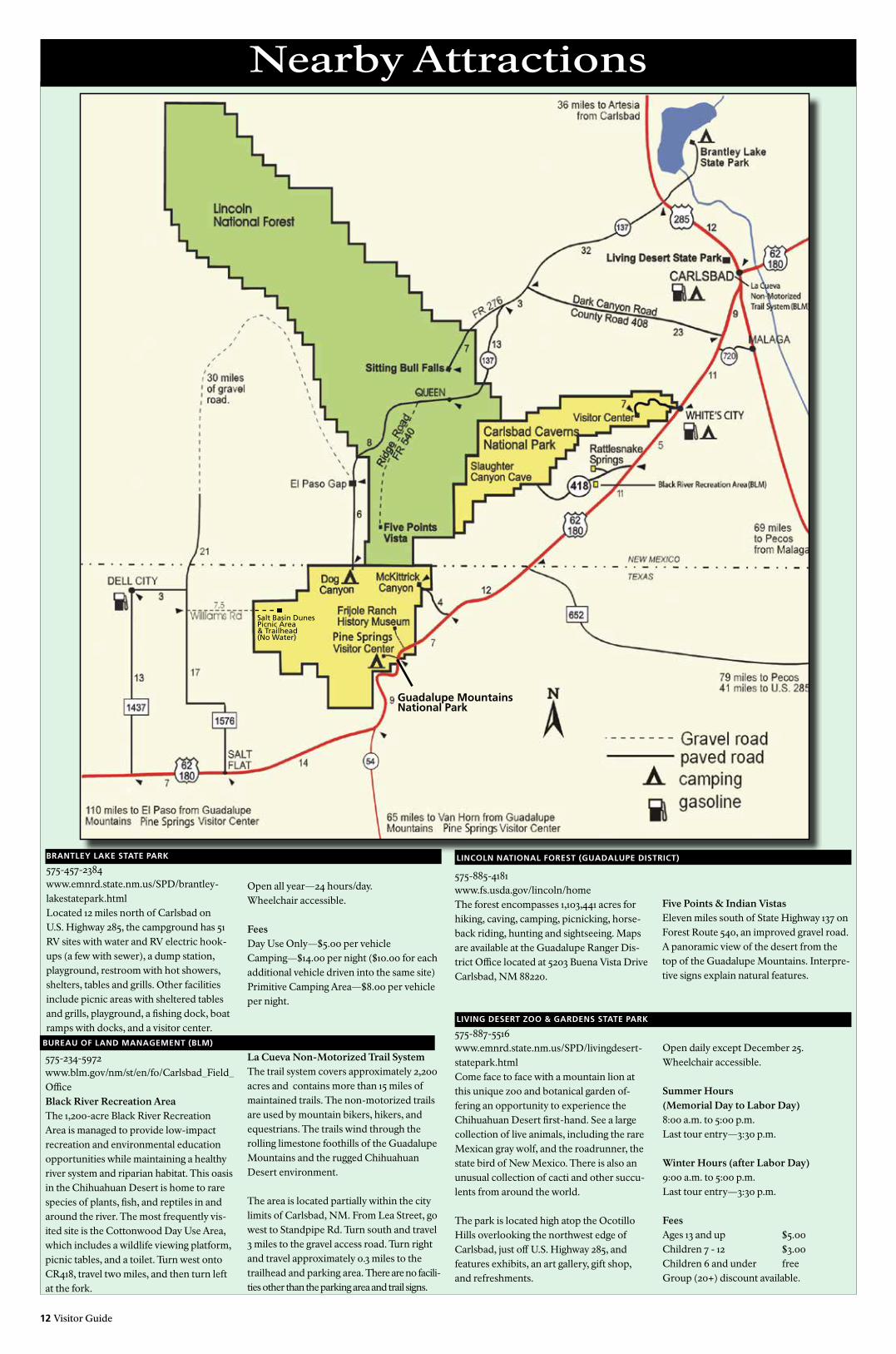
12 Visitor Guide
Nearby Attractions
575-887-5516www.emnrd.state.nm.us/SPD/livingdesert-statepark.htmlCome face to face with a mountain lion at this unique zoo and botanical garden of-fering an opportunity to experience the Chihuahuan Desert first-hand. See a large collection of live animals, including the rare Mexican gray wolf, and the roadrunner, the state bird of New Mexico. There is also an unusual collection of cacti and other succu-lents from around the world.
The park is located high atop the Ocotillo Hills overlooking the northwest edge of Carlsbad, just off U.S. Highway 285, and features exhibits, an art gallery, gift shop, and refreshments.
Open all year—24 hours/day.Wheelchair accessible.
FeesDay Use Only—$5.00 per vehicleCamping—$14.00 per night ($10.00 for each additional vehicle driven into the same site)Primitive Camping Area—$8.00 per vehicle per night.
BRANTLEy LAkE STATE PARk
575-457-2384www.emnrd.state.nm.us/SPD/brantley-lakestatepark.htmlLocated 12 miles north of Carlsbad on U.S. Highway 285, the campground has 51 RV sites with water and RV electric hook-ups (a few with sewer), a dump station, playground, restroom with hot showers, shelters, tables and grills. Other facilities include picnic areas with sheltered tables and grills, playground, a fishing dock, boat ramps with docks, and a visitor center.
575-885-4181www.fs.usda.gov/lincoln/homeThe forest encompasses 1,103,441 acres for hiking, caving, camping, picnicking, horse-back riding, hunting and sightseeing. Maps are available at the Guadalupe Ranger Dis-trict Office located at 5203 Buena Vista DriveCarlsbad, NM 88220.
575-234-5972www.blm.gov/nm/st/en/fo/Carlsbad_Field_OfficeBlack River Recreation AreaThe 1,200-acre Black River Recreation Area is managed to provide low-impact recreation and environmental education opportunities while maintaining a healthy river system and riparian habitat. This oasis in the Chihuahuan Desert is home to rare species of plants, fish, and reptiles in and around the river. The most frequently vis-ited site is the Cottonwood Day Use Area, which includes a wildlife viewing platform, picnic tables, and a toilet. Turn west onto CR418, travel two miles, and then turn left at the fork.
La Cueva Non-Motorized Trail SystemThe trail system covers approximately 2,200 acres and contains more than 15 miles of maintained trails. The non-motorized trails are used by mountain bikers, hikers, and equestrians. The trails wind through the rolling limestone foothills of the Guadalupe Mountains and the rugged Chihuahuan Desert environment.
The area is located partially within the city limits of Carlsbad, NM. From Lea Street, go west to Standpipe Rd. Turn south and travel 3 miles to the gravel access road. Turn right and travel approximately 0.3 miles to the trailhead and parking area. There are no facili-ties other than the parking area and trail signs.
BUREAU OF LAND MANAGEMENT (BLM)
Five Points & Indian VistasEleven miles south of State Highway 137 on Forest Route 540, an improved gravel road. A panoramic view of the desert from the top of the Guadalupe Mountains. Interpre-tive signs explain natural features.
LINCOLN NATIONAL FOREST (GUADALUPE DISTRICT)
LIVING DESERT zOO & GARDENS STATE PARk
Open daily except December 25. Wheelchair accessible.
Summer Hours(Memorial Day to Labor Day)8:00 a.m. to 5:00 p.m.Last tour entry—3:30 p.m.
Winter Hours (after Labor Day)9:00 a.m. to 5:00 p.m.Last tour entry—3:30 p.m.
FeesAges 13 and up $5.00Children 7 - 12 $3.00Children 6 and under freeGroup (20+) discount available.
Salt Basin DunesPicnic Area& Trailhead(No Water)
Guadalupe MountainsNational Park