supporting information · the english translation of the historic poem babad lombok: 274. mount...
TRANSCRIPT

Supporting InformationLavigne et al. 10.1073/pnas.1307520110SI Materials and MethodsRadiocarbon Dating. Samples of charcoal were prepared at the 14Claboratory, Eidgenössiche Technische Hochschule Zurich, be-fore accelerator mass spectrometry (AMS) analyses. Contami-nation by extraneous carbon was removed using the standardAcid Alkali Acid treatment (1). Charcoal was immersed ina weak acid bath (0.5 M HCl) at 60 °C for 12 h, removing car-bonates. Following multiple washes in distilled water, the sam-ples were treated with a weak base (0.1 M NaOH) at 60 °C for 12 h.This process removes humic acids that might also contaminate thesample. The samples were next washed at neutral pH. A final acidwash was applied to remove any atmospheric carbon that mighthave bonded to the charcoal during base treatment. The driedsamples (1 mg of C) were converted to graphite, pressed into thetargets and analyzed using AMS along with a set of blank andstandards. Blanks made of 14C-free coal were prepared to monitorcontamination during the preparation process. Conventional 14Cages (Fig. 4) were calculated following Stuiver and Polach (2).These ages include correction for fractionation based on on-linemeasurements of δ13C on graphite. The 1-σ error includescounting uncertainty as well as the scatter of standards andblanks. 14C ages were calibrated using the OxCal 4.1 program andINTCAL09 calibration dataset. We also applied the Bayesianmodel of OxCal 4.1 that puts constraints on the ages (prior) (3) toobtain a more precise chronology.
Modeling the Caldera Size. We modeled the size of the Samalaseruption based on pre- and posteruption topography of the RinjaniVolcanic Complex (hereafter RVC). This process of course re-quired reconstruction of the preeruptive topography as follows (4):
i) We located cells in the digital elevation model (DEM) likelyto represent the pre-eruptive surface. They include planezes,sectors of volcano preserved from erosion, and crests that arethe uppermost interfluves remaining after a significant amountof erosion. These sites provide the best approximation of paleo-topography.
ii) The preeruption RVC topography is first modeled from theselocated points by defining a first-order radial surface. It isa kind of surface of revolution defined by: (i) an exponen-tial-like function (the generatrix) fitting the average con-cave-upwards volcano profile; and (ii) the volcano’s summitlocation, around which the generatrix is rotated to form thesurface. To obtain the best-fitting first-order surface, we in-troduce the following sophistication. A conventional surfaceof revolution with axial symmetry generates circular contourlines. Instead, as the generatrix rotates around the summitlocation, we stretch and contract it to obtain, in planar section,an elliptically shaped surface defined by elliptical contourlines. The optimal set of parameters that define the first-orderprimary volcanic surface is obtained by a least-squares methodusing the simplex algorithm (5). Parameters solved for includethe location and elevation of the volcano summit, the eccen-tricity and long-axis azimuth of the contour lines, and thecoefficients of the generatrix.
iii) The first-order geometric surface is then modified accordingto second-order elevation variations because of local distri-butions of volcanic products. Residuals between elevations ofthe input points selected as representative of the preeruptionsurface and those obtained by the first-order modeled surfaceare calculated. Residuals are interpolated by kriging and nextsummed to the first-order surface elevations to obtain the
definitive preeruption surface elevation. Two independentsurfaces are modeled for each of the two RVC volcanoes.The preeruption surface elevation of RVC is finally obtainedby retaining for each of the two volcanoes, the area andelevations where the modeled paleo preexplosion surface liesabove the postexplosion lower surface. Kriging adjustmentsalso yield SEs for elevations of both basal and upper surfacesthat provide a measure of the uncertainty in the calculatedvolume of material removed by the Samalas eruption.
In addition to the preeruption surface, modeled as describedabove, calculation of the missing volume requires knowing theelevation of the caldera base everywhere immediately after theeruption. The present caldera walls provide some constraints onthis but within the crater, the floor has been mantled in productsof the Samalas eruption and subsequent activity of GunungBarujari (in the past two centuries). The basal surface is in-terpolated by kriging from the DEM cells located on the calderawalls but the lack of constraints on the thicknesses of accumulatedmaterial in the caldera limits its reliability.Finally, for every DEM cell, the height difference between
elevations of the preeruptive surface and caldera basal surface ismultiplied by the cell area. We estimate uncertainty by similarlycalculating the product of height difference SEs and cell area. Thefinal calculation of the volume of removed material requiressummation of each cell volume, and summation of errors.
Written Sources. Translation to Indonesian and to English of the historicpoem Babad Lombok, written in the Old Javanese language. The originaltext of the historic poem Babad Lombok in Old Javanese lan-guage, Wacana (6):
274. Gunung Renjani kularat, miwah gunung samalas rakrat, balaburwatu gumuruh, tibeng desa Pamatan, yata kanyut bale haling parubuh,kurambangning sagara, wong ngipun halong kang mati.
275. Pitung dina lami nira, gentuh hiku hangebeki pretiwi, hing lenenghadampar, hanerus maring batu Dendeng kang nganyuk, wong ngipunkabeh hing paliya, saweneh munggah hing ngukir.
276. Hing jaringo hasingidan, saminya ngungsi salon darak sangaji,hakupul hana hing riku, weneh ngunsi samuliya, boroh Bandar papunbalawan pasalun, sarowok pili lan ranggiya, sambalun pajang lan sapit.
277. Yek nango lan pelameran, batu banda jejangkah tanah neki, durihanare menyan batu, saher kalawan balas, batu lawang batu rentangbatu cangku, samalih tiba hing tengah, brang bantun gennira ngungsi.
278. Hana ring pundung buwak bakang, tana’ gadang lembak babidashiki, saweneh hana halarut, hing bumi kembang kekrang, pangadanganlawan puka hatin lungguh, saweneh kalah kang tiba, mara hing langkopajanggih.
279. Warnanen kang munggeng palowan, sami larut lawan ratu hingnguni, hasangidan ya riku, hingLombok goku medah, genep pitung dinapunang gentuh, nulih hangumah desa, hing preneha siji-siji.
The Indonesian translation of the historic poem BabadLombok:
274. Gunung Rinjani Longsor, dan Gunung Samalas runtuh, banjirbatu gemuruh, menghancurkan Desa Pamatan, rumah2 rubuh danhanyut terbawa lumpur, terapung-apung di lautan, penduduknya banyakyang mati.
Lavigne et al. www.pnas.org/cgi/content/short/1307520110 1 of 11
275. Tujuh hari lamanya, gempa dahsyat meruyak bumi, terdampar diLeneng (lenek), diseret oleh batu gunung yang hanyut, manusia berlarisemua, sebahagian lagi naik ke bukit.
276. Bersembunyi di Jeringo, semua mengungsi sisa kerabat raja, ber-kumpul mereka di situ, ada yang mengungsi ke Samulia, Borok, Bandar,Pepumba, dan Pasalun, Serowok, Piling, dan Ranggi, Sembalun, Pa-jang, dan Sapit.
277. Di Nangan dan Palemoran, batu besar dan gelundungan tanah,duri, dan batu menyan, batu apung dan pasir, batu sedimen granit, danbatu cangku, jatuh di tengah daratan, mereka mengungsi ke Brang batun.
278. Ada ke Pundung, Buak, Bakang, Tana’ Bea, Lembuak, Bebidas,sebagian ada mengungsi, ke bumi Kembang, Kekrang, Pengadangan danPuka hate-hate lungguh, sebagian ada yang sampai, datang ke Langko,Pejanggik.
279. Semua mengungsi dengan ratunya, berlindung mereka di situ, diLombok tempatnya diam, genap tujuh hari gempa itu, lalu membangundesa, di tempatnya masing-masing.
The English translation of the historic poem Babad Lombok:
274. Mount Rinjani avalanched and Mount Salamas collapsed, followedby large flows of debris accompanied by the noise coming from boulders.These flows destroyed (the seat of the kingdom) Pamatan. All houses weredestroyed and swept away, floating on the sea, and many people died.
275. During seven days, big earthquakes shook the Earth, stranded inLeneng (Lenek), dragged by the boulder flows, People escaped and someof them climbed the hills.
276. Hiding in Jeringo (close to Mataram), all people moved with the restof the king’s family to several places: Samulia, Borok, Bandar, PepumbaPasalun, Serowok, Piling, and Ranggi, Sembalun, Pajang, and Sapit.
277. At Nangan and Palemaron, big boulders rolled with soil, with pumicesand sand, and granite sediments on the land, they evacuated to Brang Batun.
278. There were people moving to Pundung, Buak, Bakang, Tana Bea,Lembuak, Bebidas, some of them evacuated to Kembang Bumi, Kek-rang, Pengadangan and Puka Puka hate-hate lungguh and also toLangko and Pejanggik.
279. Everybody took refuge together with the King, Lombok became veryquiet, even seven days after the earthquakes occurred, and later they builttheir own houses.
Evidence for Northern Hemisphere Winter Warming in Western Europein 1257/1258. Arras (France).
En cest an, fut le temps si doulz et si souef (chaud) que en tout l’hiverne gela que deux jours : ou mois de janvier, trouvoit on des violetteset les fleurs de fraisiers, et estoient tous les pommiers tous blancsflouris. (7)
Translation: At that time the wheater was so mild and so hot that frostbarely lasted for more than two days. In January [1258], violets couldbe observed, and strawberries and apple trees were in blossom.
Paris (France).
Et en l’autre année après, qui est en l’incarnation par M.CC. et LVI(1256) fist trop durement fort hyvier ou royaume de France etpluvieus ésté dusqu’à la Nativité saint Jehan Bauptiste (24 juin). Eten l’autre année après, fist merveilleusement chaut esté et chauttemps jusqu’à la Chandeleur ; et puis après, fist merveilleusementgrant froit jusqu’à la saint Marc (25 avril). Et en cèle annéemeismes, ot par toute la France grant chierté de pain, de vin et detoutes viandes. (8)
Translation: And the following year, which is the year 1256 of theIncarnation, the winter was very harsh in the kingdom of France andthe summer was very rainy until the Nativity of Saint Jean Baptist(June 24). And the following year (1257), the summer was excessivelyhot, and the weather was warm until Candlemass (2 February 1258),and then it was excessively cold until the St. Mark (25 April 1258). Andthis year also, there was throughout France a great shortage of bread,wine and any meat.
Saint Alban Abbey (England).
Annus quoque iste, cronicarum infirmitatum genitivus vix occupatumpermisit aliquatenus respirare. Non enim frigus vel serenitas vel gelusaltem aliquantulum stagnorum superficiem, prout consuevit, glacialeminduravit, vel stiriam a stillicidiis coegit dependere ; sed continuae in-undationes pluviarum et nebularum usque ad Purificationem beataeVirginis aera inspissarunt. (8)
Translation: This year (1257), too, generated chronic complaints,which scarcely allowed free power of breathing to any one labouringunder them. Not a single frosty or fine day occurred, nor was thesurface of the lakes at all hardened by the frost, as was usual; neitherdid icicles hang from the ledges of houses; but uninterrupted heavyfalls of rain and mist obscured the sky until the Purification of theBlessed Virgin (2 February 1258) (10)
1. Hajdas I (2009) Applications of radiocarbon dating method. Radiocarbon 51(1):79–90.2. Stuiver M, Polach HA (1977) Reporting of C-14 data—Discussions. Radiocarbon 19(3):
355–363.3. Ramsey CB (2009) Analyses of radiocarbon dates. Radiocarbon 51(1):337–360.4. Lahitte P, Samper A, Quidelleur X (2012) DEM-based reconstruction of Southern
Basse-Terre volcanoes (Guadeloupe archipelago, FWI): Contribution to the LesserAntilles arc construction rates and magma production. Geomorphology 136(1):148–164.
5. Nelder JA, Mead RA (1965) A simple method for function minimization. Comput J 7:308–313.
6. Wacana L (1979) Babad Lombok. (Departemen Pendidikan dan Kebudayaan, ProyekPenerbitan Buku Bacaan dan Sastra Indonesia dan Daerah, Jakarta).
7. Delisle L, Jourdain CMG, Wailly DEN, eds (1877) Chronique Anonyme Finissant en1306. Tome 21, Recueil des historiens des Gaules et de la France (Victor Palmé, Paris),pp. 130–137.
8. Delisle L, Jourdain CMG, Wailly DEN eds (1877) Chronique Anonyme des Rois deFrance Finissant en 1286. Tome 21, Recueil des historiens des Gaules et de la France,(Victor Palmé, Paris) pp. 81–102.
9. Luard HR ed (1872–1873) Matthaei Parisiensis monachi sancti Albani Chronica MajoraRerum britannicarum medii aevi scriptores Vol. 5 (London) pp. 661–662.
10. Giles JA ed and trans (1854) Matthew Paris’s English History. From the Year 1235 to1273 Vol. 3 (Henry G. Bohn, London) pp. 256–257.
Lavigne et al. www.pnas.org/cgi/content/short/1307520110 2 of 11
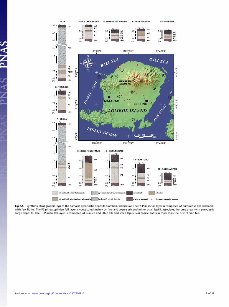
Fig. S1. Synthetic stratigraphic logs of the Samalas pyroclastic deposits (Lombok, Indonesia). The F1 Plinian fall layer is composed of pumiceous ash and lapilliwith few lithics. The F2 phreatoplinian fall layer is constituted mainly by fine and coarse ash and minor small lapilli, associated in some areas with pyroclasticsurge deposits. The F3 Plinian fall layer is composed of pumice and lithic ash and small lapilli, less coarse and less thick than the first Plinian fall.
Lavigne et al. www.pnas.org/cgi/content/short/1307520110 3 of 11
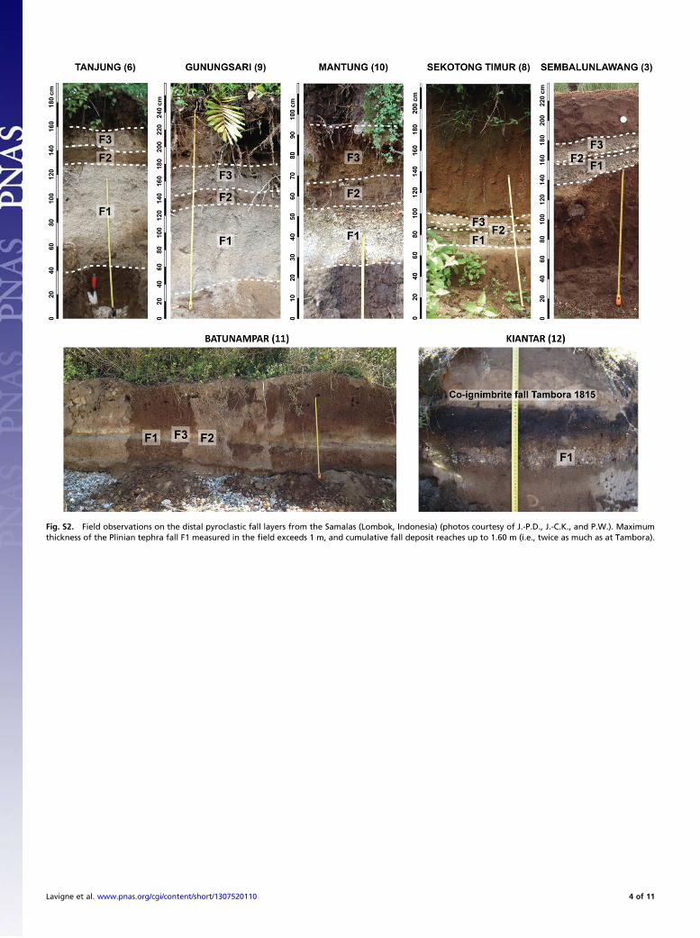
Fig. S2. Field observations on the distal pyroclastic fall layers from the Samalas (Lombok, Indonesia) (photos courtesy of J.-P.D., J.-C.K., and P.W.). Maximumthickness of the Plinian tephra fall F1 measured in the field exceeds 1 m, and cumulative fall deposit reaches up to 1.60 m (i.e., twice as much as at Tambora).
Lavigne et al. www.pnas.org/cgi/content/short/1307520110 4 of 11
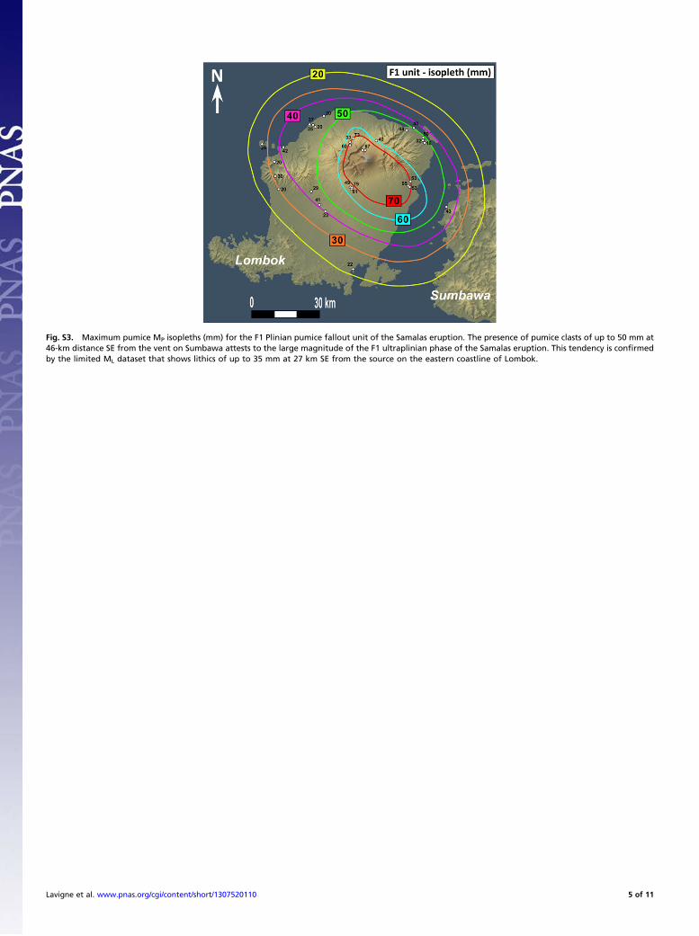
Fig. S3. Maximum pumice MP isopleths (mm) for the F1 Plinian pumice fallout unit of the Samalas eruption. The presence of pumice clasts of up to 50 mm at46-km distance SE from the vent on Sumbawa attests to the large magnitude of the F1 ultraplinian phase of the Samalas eruption. This tendency is confirmedby the limited ML dataset that shows lithics of up to 35 mm at 27 km SE from the source on the eastern coastline of Lombok.
Lavigne et al. www.pnas.org/cgi/content/short/1307520110 5 of 11
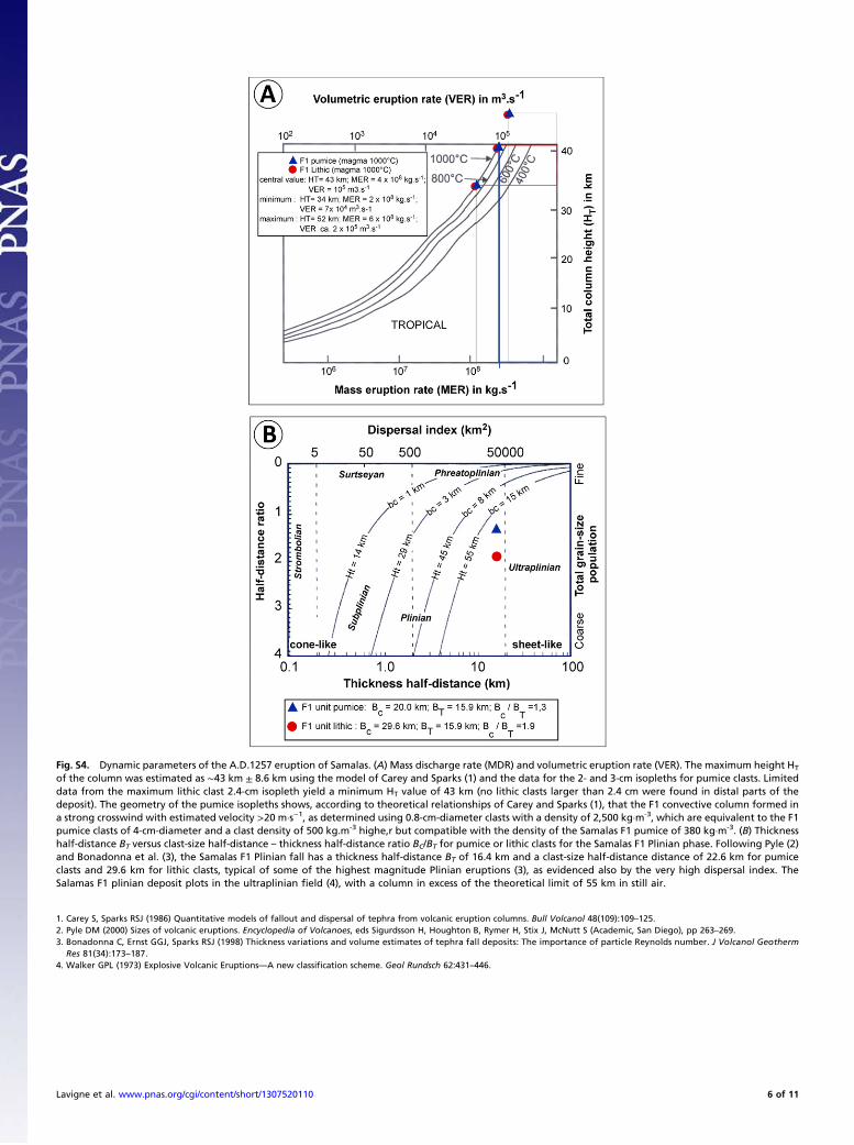
Fig. S4. Dynamic parameters of the A.D.1257 eruption of Samalas. (A) Mass discharge rate (MDR) and volumetric eruption rate (VER). The maximum height HT
of the column was estimated as ∼43 km ± 8.6 km using the model of Carey and Sparks (1) and the data for the 2- and 3-cm isopleths for pumice clasts. Limiteddata from the maximum lithic clast 2.4-cm isopleth yield a minimum HT value of 43 km (no lithic clasts larger than 2.4 cm were found in distal parts of thedeposit). The geometry of the pumice isopleths shows, according to theoretical relationships of Carey and Sparks (1), that the F1 convective column formed ina strong crosswind with estimated velocity >20 m·s−1, as determined using 0.8-cm-diameter clasts with a density of 2,500 kg·m-3, which are equivalent to the F1pumice clasts of 4-cm-diameter and a clast density of 500 kg.m-3 highe,r but compatible with the density of the Samalas F1 pumice of 380 kg·m-3. (B) Thicknesshalf-distance BT versus clast-size half-distance – thickness half-distance ratio BC/BT for pumice or lithic clasts for the Samalas F1 Plinian phase. Following Pyle (2)and Bonadonna et al. (3), the Samalas F1 Plinian fall has a thickness half-distance BT of 16.4 km and a clast-size half-distance distance of 22.6 km for pumiceclasts and 29.6 km for lithic clasts, typical of some of the highest magnitude Plinian eruptions (3), as evidenced also by the very high dispersal index. TheSalamas F1 plinian deposit plots in the ultraplinian field (4), with a column in excess of the theoretical limit of 55 km in still air.
1. Carey S, Sparks RSJ (1986) Quantitative models of fallout and dispersal of tephra from volcanic eruption columns. Bull Volcanol 48(109):109–125.2. Pyle DM (2000) Sizes of volcanic eruptions. Encyclopedia of Volcanoes, eds Sigurdsson H, Houghton B, Rymer H, Stix J, McNutt S (Academic, San Diego), pp 263–269.3. Bonadonna C, Ernst GGJ, Sparks RSJ (1998) Thickness variations and volume estimates of tephra fall deposits: The importance of particle Reynolds number. J Volcanol Geotherm
Res 81(34):173–187.4. Walker GPL (1973) Explosive Volcanic Eruptions—A new classification scheme. Geol Rundsch 62:431–446.
Lavigne et al. www.pnas.org/cgi/content/short/1307520110 6 of 11
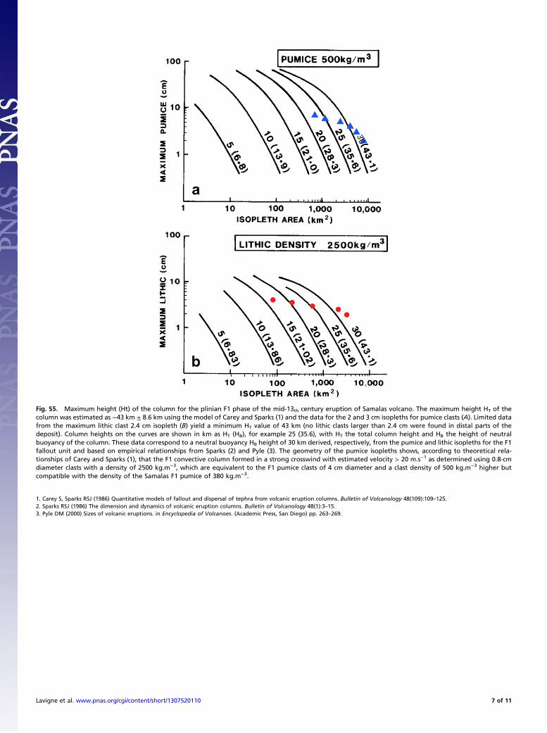
Fig. S5. Maximum height (Ht) of the column for the plinian F1 phase of the mid-13th century eruption of Samalas volcano. The maximum height HT of thecolumn was estimated as ∼43 km ± 8.6 km using the model of Carey and Sparks (1) and the data for the 2 and 3 cm isopleths for pumice clasts (A). Limited datafrom the maximum lithic clast 2.4 cm isopleth (B) yield a minimum HT value of 43 km (no lithic clasts larger than 2.4 cm were found in distal parts of thedeposit). Column heights on the curves are shown in km as HT (HB), for example 25 (35.6), with HT the total column height and HB the height of neutralbuoyancy of the column. These data correspond to a neutral buoyancy HB height of 30 km derived, respectively, from the pumice and lithic isopleths for the F1fallout unit and based on empirical relationships from Sparks (2) and Pyle (3). The geometry of the pumice isopleths shows, according to theoretical rela-tionships of Carey and Sparks (1), that the F1 convective column formed in a strong crosswind with estimated velocity > 20 m.s−1 as determined using 0.8-cmdiameter clasts with a density of 2500 kg.m−3, which are equivalent to the F1 pumice clasts of 4 cm diameter and a clast density of 500 kg.m−3 higher butcompatible with the density of the Samalas F1 pumice of 380 kg.m−3.
1. Carey S, Sparks RSJ (1986) Quantitative models of fallout and dispersal of tephra from volcanic eruption columns. Bulletin of Volcanology 48(109):109–125.2. Sparks RSJ (1986) The dimension and dynamics of volcanic eruption columns. Bulletin of Volcanology 48(1):3–15.3. Pyle DM (2000) Sizes of volcanic eruptions. in Encyclopedia of Volcanoes. (Academic Press, San Diego) pp. 263–269.
Lavigne et al. www.pnas.org/cgi/content/short/1307520110 7 of 11
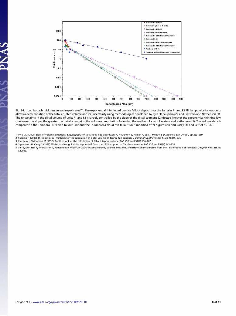
Fig. S6. Log isopach thickness versus isopach area0.5. The exponential thinning of pumice fallout deposits for the Samalas F1 and F3 Plinian pumice fallout unitsallows a determination of the total erupted volume and its uncertainty using methodologies developed by Pyle (1), Sulpizio (2), and Fierstein and Nathenson (3).The uncertainty in the distal volume of units F1 and F3 is largely controlled by the slope of the distal segment S2 (dotted lines) of the exponential thinning law(the lower the slope, the greater the distal volume) in the volume computation following the methodology of Fierstein and Nathenson (3). The volume data iscompared to the Tambora F4 Plinian fallout unit and the F5 umbrella cloud ash fallout unit, modified after Sigurdsson and Carey (4) and Self et al. (5).
1. Pyle DM (2000) Sizes of volcanic eruptions. Encyclopedia of Volcanoes, eds Sigurdsson H, Houghton B, Rymer H, Stix J, McNutt S (Academic, San Diego), pp 263–269.2. Sulpizio R (2005) Three empirical methods for the calculation of distal volume of tephra-fall deposits. J Volcanol Geotherm Res 145(3-4):315–3363. Fierstein J, Nathanson M (1992) Another look at the calculation of fallout tephra volume. Bull Volcanol 54(2):156–167.4. Sigurdsson H, Carey S (1989) Plinian and co-ignimbrite tephra fall from the 1815 eruption of Tambora volcano. Bull Volcanol 51(4):243–270.5. Self S, Gertisser R, Thordarson T, Rampino MR, Wolff JA (2004) Magma volume, volatile emissions, and stratospheric aerosols from the 1815 eruption of Tambora. Geophys Res Lett 31:
L20608.
Lavigne et al. www.pnas.org/cgi/content/short/1307520110 8 of 11
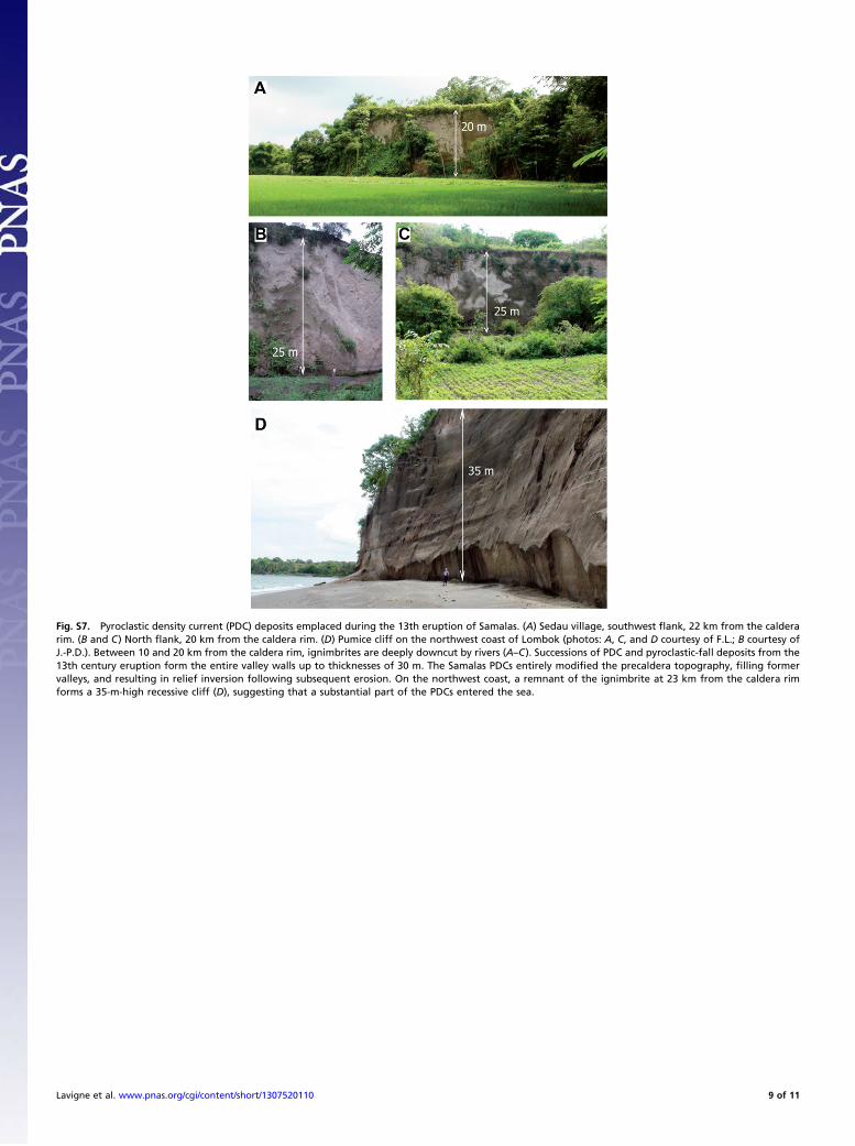
Fig. S7. Pyroclastic density current (PDC) deposits emplaced during the 13th eruption of Samalas. (A) Sedau village, southwest flank, 22 km from the calderarim. (B and C) North flank, 20 km from the caldera rim. (D) Pumice cliff on the northwest coast of Lombok (photos: A, C, and D courtesy of F.L.; B courtesy ofJ.-P.D.). Between 10 and 20 km from the caldera rim, ignimbrites are deeply downcut by rivers (A–C). Successions of PDC and pyroclastic-fall deposits from the13th century eruption form the entire valley walls up to thicknesses of 30 m. The Samalas PDCs entirely modified the precaldera topography, filling formervalleys, and resulting in relief inversion following subsequent erosion. On the northwest coast, a remnant of the ignimbrite at 23 km from the caldera rimforms a 35-m-high recessive cliff (D), suggesting that a substantial part of the PDCs entered the sea.
Lavigne et al. www.pnas.org/cgi/content/short/1307520110 9 of 11
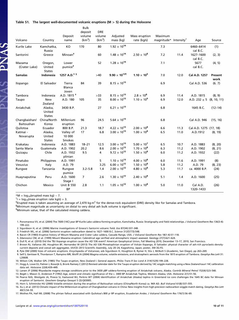
Table S1. The largest well-documented volcanic eruptions (M > 5) during the Holocene
Volcano CountryDepositname
Bulkdepositvolume(km3)
DREvolume(km3)
Adjustedmass (kg)
Mass eruptionrate (kg/s)
Maximummagnitude* Intensity† Age Source
Kurile Lake Kamchatka,Russia
KO 170 80 1.92 × 10¹⁴ 7.3 6460–6414cal B.C.
(1)
Santorini Greece Minoan‡ 60 1.48 × 10¹⁴ 2.50 × 10⁸ 7.2 11.4 1627–1600cal B.C.
(2, 3)
Mazama(Crater Lake)
Oregon,UnitedStates
Lowerpumice‡
52 1.28 × 10¹⁴ 7.1 5677cal B.C.
(4, 5)
Samalas Indonesia 1257 A.D.‡ § >40 9.90 × 10¹³{ 1.10 × 10⁹ 7.0 12.0 Cal A.D. 1257 Presentwork
Ilopango El Salvador TierraBlancaJoven
84 39 8.15 × 10¹³ 6.9 Cal A.D. 536 (6. 7)
Tambora Indonesia A.D. 1815 ‡ >33 8.15 × 10¹³ 2.8 × 10⁸ 6.9 11.4 A.D. 1815 (8, 9)Taupo New
ZealandA.D. 180 105 35 8.00 × 10¹³ 1.10 × 10⁹ 6.9 12.0 A.D. 232 ± 5 (8, 10, 11)
Aniakchak Alaska,UnitedStates
3430 B.P. 27 6.21 × 10¹³ 6.8 1645 B.C. (12–14)
Changbaishan/Baitoushan
China/NorthKorea
Milleniumeruption
96 24.5 5.64 × 10¹³ 6.8 Cal A.D. 946 (15, 16)
Quilotoa Ecuador 800 B.P. 21.3 18.7 4.22 × 10¹³ 2.00 × 10⁸ 6.6 11.3 Cal A.D. 1275 (17, 18)Katmai -
NovaruptaAlaska,UnitedStates
Valley of10 000Smokes
17 6.8 3.00 × 10¹³ 1.00 × 10⁸ 6.5 11.0 A.D.1912 (8, 19)
Krakatau Indonesia A.D. 1883 18–21 12.5 3.00 × 10¹³ 5.00 × 10⁷ 6.5 10.7 A.D. 1883 (8, 20)Santa Maria Guatemala A.D. 1902 20.2 8.6 2.00 × 10¹³ 1.70 × 10⁸ 6.3 11.2 A.D. 1902 (8, 21)Quizapu Chile A.D. 1932
plinian9.5 4 9.72 × 10¹² 1.50 × 10⁸ 6.0 11.2 A.D. 1932 (22)
Pinatubo Philippines A.D. 1991 5 1.10 × 10¹³ 4.00 × 10⁸ 6.0 11.6 A.D. 1991 (8)Vesuvius Italy A.D. 79 3.25 6.00 × 10¹² 1.50 × 10⁸ 5.8 11.2 A.D. 79 (8, 23)Rungwe Tanzania Rungwe
pumice3.2–5.8 1.4 2.00 × 10¹² 4.80 × 10⁸ 5.3 11.7 ca. 4000 B.P. (24)
Huaynaputina Peru A.D. 1600Stage I
7 2.6 1.30 × 10¹² 2.40 × 10⁸ 5.1 1.4 A.D. 1600 (25)
Chichon Mexico Unit B 550BP
2.8 1.1 1.05 × 10¹² 1.00 × 10⁸ 5.0 11.0 Cal A.D.1320–1433
(26)
*M = log10(erupted mass kg) − 7.†I = log10(mass eruption rate kg/s) + 3.‡Erupted mass is taken assuming an average of 2,470 kg·m3 for the dense-rock equivalent (DRE) density like for Samalas and Tambora.§Minimum magnitude as uncertainty on distal to very distal ash bulk volume is significant.{Minimum value, that of the calculated missing caldera.
1. Ponomareva VV, et al. (2004) The 7600 (14C) year BP Kurile Lake caldera-forming eruption, Kamchatka, Russia: Stratigraphy and field relationships. J Volcanol Geotherm Res 136(3-4):199–222.
2. Sigurdsson H, et al. (2006) Marine investigations of Greece’s Santorini volcanic field. Eos 87(34):337–348.3. Friedrich WL, et al. (2006) Santorini eruption radiocarbon dated to 1627–1600 B.C. Science 312(5773):548.4. Bacon CR (1983) Eruptive history of Mount Mazama and Crater Lake caldera, Cascade Range, USA. J Volcanol Geotherm Res 18(1-4):57–118.5. Zdanowicz CM, et al. (1999) Mount Mazama eruption: Calendrical age verified and atmospheric impact assessed. Geology 27(7):621–624.6. Dull R, et al. (2010) Did the TBJ Ilopango eruption cause the AD 536 event? American Geophysical Union, Fall Meeting 2010, December 13–17, 2010, San Francisco.7. Brown RJ, Vallance JW, Houghton BF, Hernandez W (2013) The AD 536 Phreatoplinian eruption of Volcán Ilopango, El Salvador: physical character of ash-rich pyroclastic-density-
current deposits and coeval ash aggregates. IAVCEI 2013 Scientific Assembly, July 20–24, Kagoshima, Japan; poster, 3W-3G-P2.8. Pyle DM (2000) Sizes of volcanic eruptions. Encyclopedia of Volcanoes, eds Sigurdsson H, Houghton B, Rymer H, Stix J, McNutt S (Academic, San Diego), pp 263–269.9. Self S, Gertisser R, Thordarson T, Rampino MR, Wolff JA (2004) Magma volume, volatile emissions, and stratospheric aerosols from the 1815 eruption of Tambora. Geophys Res Lett 31:
L20608.10. Wilson CJN, Walker GPL (1985) The Taupo eruption, New Zealand I. General aspects. Philos Trans R Soc Lond A 314(1529):199–228.11. Hogg A, Lowe DJ, Palmer J, Boswijk G, Bronk Ramsey C (2012) Revised calendar date for the Taupo eruption derived by 14C wiggle-matching using a New Zealand kauri 14C calibration
data set. Holocene 22(4):439–449.12. Larsen JF (2006) Rhyodacite magma storage conditions prior to the 3430 yBP caldera-forming eruption of Aniakchak volcano, Alaska. Contrib Mineral Petrol 152(4):523–540.13. Begét J, Mason O, Anderson P (1992) Age, extent and climatic significance of the c. 3400 BP Aniakchak Tephra, Western Alaska, USA. Holocene 2(1):51–56.14. Pearce NJG, Westgate JA, Preece SJ, Eastwood WJ, Perkins WT (2004) Identification of Aniakchak (Alaska) tephra in Greenland ice core challenges the 1645 BC date for Minoan
eruption of Santorini. Geochem Geophys Geosyst 5 (3):Q03005.15. Horn S, Schmincke HU (2000) Volatile emission during the eruption of Baitoushan volcano (China/North Korea) ca. 969 AD. Bull Volcanol 61(8):537–555.16. Xu J, et al. (2013) Climatic impact of the Millennium eruption of Changbaishan volcano in China: New insights from high-precision radiocarbon wiggle-match dating. Geophys Res Lett
40(1):54–59.17. Mothes PA, Hall ML (2008) The plinian fallout associated with Quilotoa’s 800 yr BP eruption, Ecuadorian Andes. J Volcanol Geotherm Res 176(1):56–69.
Lavigne et al. www.pnas.org/cgi/content/short/1307520110 10 of 11
18. Ledru MP, et al. (2013) The Medieval Climate Anomaly and the Little Ice Age in the eastern Ecuadorian Andes. Climate of the Past 9(1):307–321.19. Fierstein J, Hildreth W (1992) The plinian eruptions of 1912 at Novarupta, Katmai National Park, Alaska. Bull Volcanol 54(8):646–684.20. Self S, Rampino MR (1981) The 1883 eruption of Krakatau. Nature 294:699–704.21. Williams SN, Self S (1983) The October 1902 plinian eruption of Santa María Volcano, Guatemala. J Volcanol Geotherm Res 16(1-2):33–56.22. Hildreth W, Drake RE (1992) Volcan Quizapu, Chilean Andes. Bull Volcanol 54(2):93–125.23. Carey S, Sigurdsson H (1987) Temporal variations in column height and magma discharge rate during the 79 A.D. eruption of Vesuvius. Geol Soc Am Bull 99:303–314.24. Fontijn K, et al. (2011) The ∼4-ka Rungwe Pumice (South-Western Tanzania): A wind-still Plinian eruption. Bull Volcanol 73(9):1353–1368.25. Adams NK, et al. (2001) The physical volcanology of the 1600 eruption of Huaynaputina, southern Peru. Bull Volcanol 62(8):493–518.26. Macías JL (2003) The 26 May 1982 breakout flows derived from failure of a volcanic dam at El Chichón, Chiapas, Mexico. Geol Soc Am Bull 116(1-2):233–246.
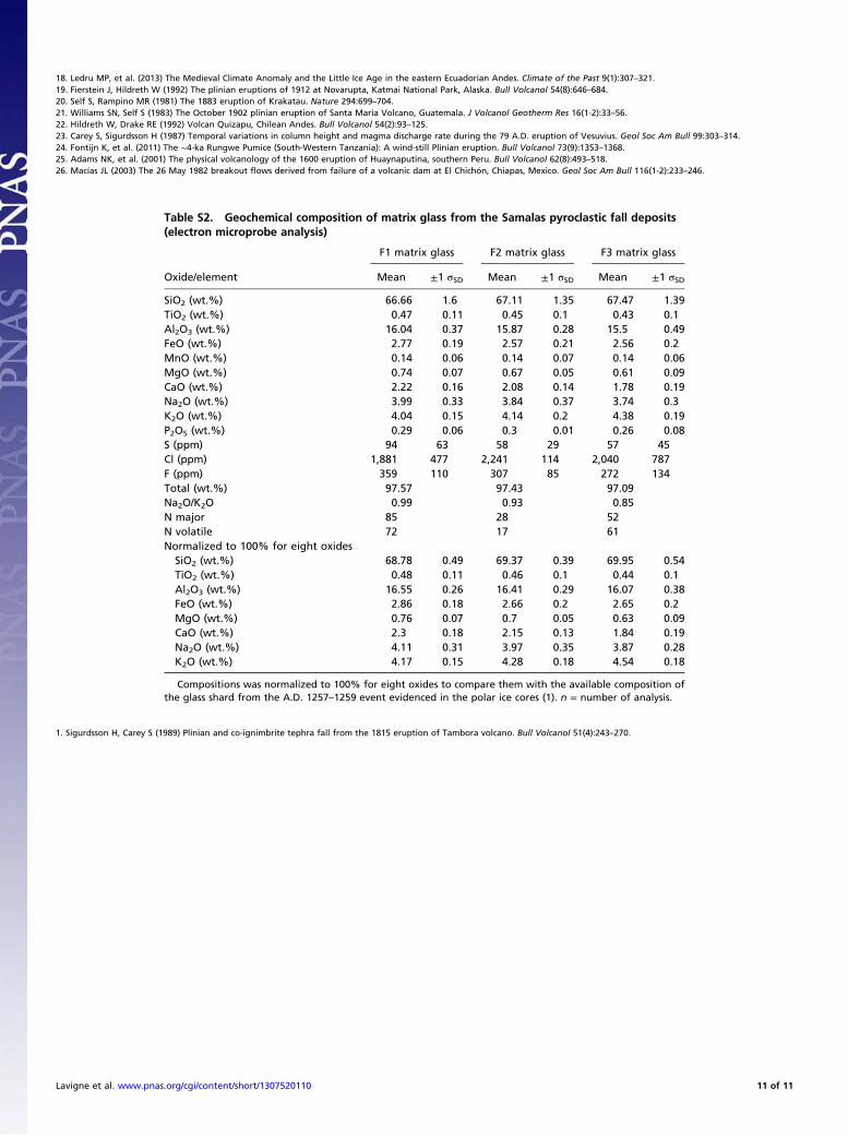
Table S2. Geochemical composition of matrix glass from the Samalas pyroclastic fall deposits(electron microprobe analysis)
Oxide/element
F1 matrix glass F2 matrix glass F3 matrix glass
Mean ±1 σSD Mean ±1 σSD Mean ±1 σSD
SiO2 (wt.%) 66.66 1.6 67.11 1.35 67.47 1.39TiO2 (wt.%) 0.47 0.11 0.45 0.1 0.43 0.1Al2O3 (wt.%) 16.04 0.37 15.87 0.28 15.5 0.49FeO (wt.%) 2.77 0.19 2.57 0.21 2.56 0.2MnO (wt.%) 0.14 0.06 0.14 0.07 0.14 0.06MgO (wt.%) 0.74 0.07 0.67 0.05 0.61 0.09CaO (wt.%) 2.22 0.16 2.08 0.14 1.78 0.19Na2O (wt.%) 3.99 0.33 3.84 0.37 3.74 0.3K2O (wt.%) 4.04 0.15 4.14 0.2 4.38 0.19P2O5 (wt.%) 0.29 0.06 0.3 0.01 0.26 0.08S (ppm) 94 63 58 29 57 45Cl (ppm) 1,881 477 2,241 114 2,040 787F (ppm) 359 110 307 85 272 134Total (wt.%) 97.57 97.43 97.09Na2O/K2O 0.99 0.93 0.85N major 85 28 52N volatile 72 17 61Normalized to 100% for eight oxidesSiO2 (wt.%) 68.78 0.49 69.37 0.39 69.95 0.54TiO2 (wt.%) 0.48 0.11 0.46 0.1 0.44 0.1Al2O3 (wt.%) 16.55 0.26 16.41 0.29 16.07 0.38FeO (wt.%) 2.86 0.18 2.66 0.2 2.65 0.2MgO (wt.%) 0.76 0.07 0.7 0.05 0.63 0.09CaO (wt.%) 2.3 0.18 2.15 0.13 1.84 0.19Na2O (wt.%) 4.11 0.31 3.97 0.35 3.87 0.28K2O (wt.%) 4.17 0.15 4.28 0.18 4.54 0.18
Compositions was normalized to 100% for eight oxides to compare them with the available composition ofthe glass shard from the A.D. 1257–1259 event evidenced in the polar ice cores (1). n = number of analysis.
1. Sigurdsson H, Carey S (1989) Plinian and co-ignimbrite tephra fall from the 1815 eruption of Tambora volcano. Bull Volcanol 51(4):243–270.
Lavigne et al. www.pnas.org/cgi/content/short/1307520110 11 of 11