supporting the helicopter pilot in degraded visual … · a head-down display or on a...
TRANSCRIPT

UNCLASSIFIED
Executive summary
UNCLASSIFIED
Nationaal Lucht- en Ruimtevaartlaboratorium National Aerospace Laboratory NLR
This report is based on a presentation held at the Avionics Europe Conference & Exhibition, Munich, Germany, 21-22 March 2012.
Report no. NLR-TP-2012-003 Author(s) A.J.C. de Reus T.C. Nijland J.R. ter Veer Report classification UNCLASSIFIED Date March 2012 Knowledge area(s) Training, Simulatie en Operator Performance Helikoptertechnologie Descriptor(s) Helicopter Degraded Visual Environment Brownout Helmet Mounted Displays
Supporting the Helicopter Pilot in Degraded Visual Environments
Problem area Degraded Visual Environments (DVE) form one of the major challenges being faced by helicopter operators around the world. Dust, snow or water thrown up by the rotor downwash and fog and precipitation deteriorate vital visual cues in the outside world, sometimes up to the point that all references are lost. DVE not only affects safety margins, but also the operation in general. A study was performed to assess potential aids for a particular form of DVE: ‘brownout’, the phenomena of dust or sand blown up by the wake of a helicopter rotor, forming a dense cloud that wraps the aircraft and blinds the crew during take-off and landing.
Description of work This paper outlines the findings of a study to identify the benefits and drawbacks of potential brownout avionics solutions and their applicability for the Royal Netherlands Air Force. As part of the study, a set-up was made in a helicopter flight simulator equipped with a helmet-mounted display to collect feedback from operational pilots. The results of these pilot-in-the-loop trials are presented. Potential solutions are also put into perspective with respect to the added value they offer for the operation. Results and conclusions The brownout issue can likely be solved by fitting the latest Helmet Mounted Display (HMD), sensors and/or auto flight technology.

UNCLASSIFIED
UNCLASSIFIED
Supporting the Helicopter Pilot in Degraded Visual Environments
Nationaal Lucht- en Ruimtevaartlaboratorium, National Aerospace Laboratory NLR Anthony Fokkerweg 2, 1059 CM Amsterdam, P.O. Box 90502, 1006 BM Amsterdam, The Netherlands Telephone +31 20 511 31 13, Fax +31 20 511 32 10, Web site: www.nlr.nl
These, combined with ‘augmented reality’ symbology for situations where visual cues disappear rapidly when getting close to the ground, certainly will be beneficial. Since a solution for brownout is only one step in tackling DVE, system manufacturers should clearly take into account growth potential when designing their products.
Applicability The results are applicable to all services that aim to operate helicopters in DVE as well a to helicopter and system manufacturers that aim to provide solutions to allow these operators.

Nationaal Lucht- en Ruimtevaartlaboratorium National Aerospace Laboratory NLR
NLR-TP-2012-003
Supporting the Helicopter Pilot in Degraded Visual Environments
A.J.C. de Reus, T.C. Nijland and J.R. ter Veer1
1 Ministry of Defence
This report is based on a presentation held at the Avionics Europe Conference & Exhibition, Munich, Germany, 21-22 March 2012. The contents of this report may be cited on condition that full credit is given to NLR and the authors. This publication has been refereed by the Advisory Committee AIR TRANSPORT. Customer National Aerospace Laboratory NLR Contract number ----- Owner NLR + partner(s) Division NLR Air Transport Distribution Unlimited Classification of title Unclassified March 2012 Approved by:
Author
Reviewer Managing department


NLR-TP-2012-003
3
Summary
Degraded Visual Environments (DVE) form one of the major challenges being faced by helicopter operators around the world. Dust, snow or water thrown up by the rotor downwash and fog and precipitation deteriorate vital visual cues in the outside world, sometimes up to the point that all references are lost. DVE not only affects safety margins, but also the operation in general. A study was performed to assess potential aids for a particular form of DVE: ‘brownout’, the phenomena of dust or sand blown up by the wake of a helicopter rotor, forming a dense cloud that wraps the aircraft and blinds the crew during take-off and landing. Several avionics systems are under development or being marketed to support pilots in these potentially hazardous situations. Some of these systems aim to restore the outside world cues using sensors, others strive to provide the pilots with virtual visual references, while some intend to offer a fully synthetic representation of the outside world. Obstacle detection may also be part of the system. The information coming from the DVE aids are often presented either on a head-down display or on a helmet-mounted display. This may be done in a classic two-dimensional way or with a perspective augmented reality view. A parallel approach is to apply advanced auto flight functions to increase helicopter stability and reduce pilot workload when flying in DVE. Depending on the configuration, growth options are likely to become available. This paper outlines the findings of a study to identify the benefits and drawbacks of potential brownout avionics solutions and their applicability for the Royal Netherlands Air Force. As part of the study, a set-up was made in a helicopter flight simulator equipped with a helmet-mounted display to collect feedback from operational pilots. The results of these pilot-in-the-loop trials are presented. Potential solutions are also put into perspective with respect to the added value they offer for the operation. The brownout issue can likely be solved by fitting the latest HMD, sensors and/or auto flight technology. These, combined with 3D symbology for situations where visual cues disappear rapidly when getting close to the ground, certainly will be beneficial. A solution for brownout is only one step in tackling DVE, so system manufacturers should clearly take into account growth potential when designing their products.

NLR-TP-2012-003
4
This page is intentionally left blank.

NLR-TP-2012-003
5
Contents
1 Introduction 7
2 Problem definition 8
3 Brownout project 9 3.1 Approach 9 3.2 Survey of brownout technologies 9 3.3 Operator needs and views 11 3.4 Promising solutions 12 3.5 Pilot-in-the-loop trials 13 3.6 Assessment of results 16 3.6.1 Assessment framework 16 3.6.2 HMD with reliable and accurate 2D information 17 3.6.3 HMD with 3D information and LZ marking using LOS 18 3.6.4 HMD with 3D information, LZ marking plus obstacle and terrain detection 19 3.6.5 Automatic hover with adjustable height to touchdown 20
4 Concluding remarks 21
5 References 22

NLR-TP-2012-003
6
Abbreviations
2D Two Dimensional 3D Three Dimensional AFCS Automatic Flight Control System DHC Defence Helicopter Command DVE Degraded Visual Environment EASA European Aviation Safety Authority FLIR Forward Looking Infrared HFM Human Factors & Medicine HMD Helmet Mounted Display HPS Helicopter Pilot Station LZ Landing Zone NLR National Aerospace Laboratory NLR NVG Night Vision Goggles ODA Optical Display Assembly RNLAF Royal Netherlands Air Force TTPs Tactics, Techniques and Procedures VFR Visual Flight Rules

NLR-TP-2012-003
7
1 Introduction
Degraded Visual Environments (DVE) form one of the main challenges being faced by helicopter operators around the world [1]. DVE is a broad concept. It encompasses fog and precipitation that reduce visibility of the environment during all mission phases and often for a prolonged period. However, it also encompasses water, sand or snow blown up by the rotor blades. This normally only has a momentary impact on visibility, i.e. at low speed and low altitude. Due to these phenomena the pilot can lose visual reference in the outside world, which is a clear threat for safe operation. Also, moving dust or snow (‘brownout’ and ‘whiteout’ respectively) in the wake of the rotor combined with loss of reference with the outside world could cause spatial disorientation. DVE can occur during day and night time. DVE situations cause two primary challenges in employability and effectiveness. Firstly, Visual Flight Rules (VFR) regulations may imply limitations to aviators, like for example the daytime 800 m flight visibility that is required as a minimum under certain circumstances. Also there are night limitations caused by the amount of light combined with flight visibility when flying with Night Vision Goggles (NVG). When operating with formations of helicopters the limitations may be different. When conditions fall below the limits it is not allowed to operate the helicopter. Secondly, DVE sometimes cause helicopters to be less effective in their mission execution, especially during Landing Zone (LZ) operations when the helicopters are required to be safely on the right place on the right time. Some situations leave little room for the pilot to choose his or her favorable landing site, most of all during missions that require high levels of flexibility like Special Forces and Medevac. This may make it impossible to avoid DVE by choosing a different LZ. DVE solutions can be used to improve these challenges in employability and effectiveness. One of the biggest issues in the development of functionalities that support DVE solutions is airworthiness certification. When used as a primary flight system under VFR conditions the (inter)national aviation authorities leave little room for risks and demand high reliability standards of the systems. When not used as a primary flight system, the primary goal must be to really improve employability or effectiveness in operational missions. This paper focuses on the improvement of employability and effectiveness during LZ operations, particularly in brownout conditions, but emphasizes that this is only one type of DVE operations. The ultimate goal is thus not only to make operations under brownout or whiteout conditions safer, but to allow the flight crew to be on time on target as safe as possible – during day and night time, under all visibility conditions and in both predictable and unpredictable environments.

NLR-TP-2012-003
8
2 Problem definition
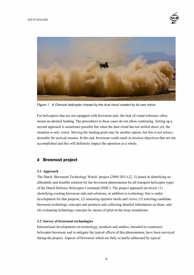
Internationally, helicopter DVE gained a lot of attention in the recent years. Loss of military personnel and helicopters due to brownout in war theatres as Iraq and Afghanistan evinced the need for solutions that help to reduce the risks accompanying helicopters operations at unprepared sites in sandy environments. As a result, industry and research institutions started seeking for applicable solutions to this particular problem. The DVE problem is addressed in civil aviation as well. Very recently, the European Aviation Safety Authority (EASA) asked for study proposals to find solutions to reduce the risks of helicopters’ unintended flight into DVE while operating under VFR regulations. Indeed, DVE has also caused a significant number of civil incidents and accidents over the years. Our work so far was mainly focused on finding suitable aids for a particular form of DVE: brownout. Military operations sometimes demand the crew to fly into possible brownout conditions. For example, lifting ground troops or dropping supplies in a desert area with a large transport helicopter is almost guaranteeing the helicopter to end up in a dense cloud of dust. Specific training and adequate procedures reduce the risks, but does not restore the outside world visual cues. Looking at the problem in more detail, landing at unprepared sites in sandy areas causes the quick development of a dust cloud when the helicopter approaches the earth’s surface. Already during the approach, a typical horseshoe shaped dust wreath forms below and behind the helicopter, eventually overtaking it only seconds before touch-down. Especially during these last seconds of a landing, visual reference with the outside world is important to the pilot. Looking at a fixed point (typically a small tree or rock) in the outside world helps the pilot to build awareness of the helicopter’s position and velocity relative to the ground. Looking outside also helps to keep track of aspects of the environment that only become visible when close to the ground, for example an uneven ground surface, wires and smaller obstacles such as rocks and poles. Due to the dust cloud the pilot loses sight on the reference point and the obstacles (Figure 1).
NLR-TP-2012-003
9
Figure 1 A Chinook helicopter chased by the dust cloud created by its own rotors.
For helicopters that are not equipped with brownout aids, the lack of visual reference often means an aborted landing. The procedures in these cases do not allow continuing. Setting up a second approach is sometimes possible but when the dust cloud has not settled down yet, the situation is only worse. Moving the landing point may be another option, but this is not always desirable for tactical reasons. In the end, brownout could result in mission objectives that are not accomplished and this will definitely impact the operation as a whole. 3 Brownout project
3.1 Approach The Dutch ‘Brownout Technology Watch’ project (2009-2011) [2, 3] aimed at identifying an affordable and feasible solution for the brownout phenomenon for all transport helicopter types of the Dutch Defence Helicopter Command (DHC). The project approach involved: (1) identifying existing brownout aids and solutions, in addition to technology that is under development for that purpose; (2) assessing operator needs and views; (3) selecting candidate brownout technology concepts and products and collecting detailed information on these; and (4) evaluating technology concepts by means of pilot-in-the-loop simulations. 3.2 Survey of brownout technologies International developments on technology, products and studies, intended to counteract helicopter brownout and to mitigate the typical effects of this phenomenon, have been surveyed during the project. Aspects of brownout which are fully or partly addressed by typical

NLR-TP-2012-003
10
‘brownout solutions’, have been identified to be able to classify the systems found during the survey. The main aspects addressed by potential solutions are found to be [1, 3]: o Increasing the situational awareness of the pilot, i.e. providing information to pilots to
increase their awareness of the aircraft’s position, velocities and attitude with respect to the earth’s surface. Solutions in this category can be found providing ‘eyes out’ and/or ‘eyes in’ information. With ‘eyes out’ based systems the pilot has access to information regardless of his viewing direction. Audio cues, tactile signals or helmet mounted displays are examples of technology in this category. With an ‘eyes in’ system, the pilot needs to view into the cockpit to find the information he is looking for, for example on a cockpit display.
o Compensating the lack of detailed information of the landing zone. A typical unprepared
landing zone (LZ) contains of risks, endangering a safe landing. Uneven terrain, the type of underground and fixed and moving obstacles form a risk to the helicopter. Some systems aim on providing the pilot with detailed information about the landing zone, to compensate for references that could get lost in the dust cloud. Sensors, some with ‘dust penetrating’ capacities and sometimes combined with terrain databases, often form the basis of such systems. Sensor and database data is often merged and processed into a fully synthetic image of the scanned area, usually presented on an ‘eyes in’ display. If a system is suitable for obstacle warning (‘electronic bumping’), imaging (synthetically visualising the terrain) or for a combination of both, depends on the characteristics of the sensor but also on for example data processing units and algorithms.
o Increasing helicopter stability and thereby reducing the pilot’s workload. Advanced flight
control systems supporting the pilot to stabilize the helicopter and to automatically prevent unintended motion could help the pilot focus on his main task: putting the helicopter down safely at the desired point, regardless of the presence of a disorienting dust cloud. Systems found during the survey for example focus on the automatic flight control system holding a steady hover at a desired position or even touching down automatically.
o Preventing the brownout cloud to arise. Some research programs focus on fundamental
questions like: what causes the brownout dust cloud to develop? How could the development of the dust cloud be influenced? The outcome of these programs for example could result in optimized approach procedures, reducing the dust cloud’s size, shape or speed. Furthermore, knowledge of relationships between rotor aerodynamics and dust cloud development could lead to design improvements on the helicopter that reduce rotor downwash to cause brownout.

NLR-TP-2012-003
11
3.3 Operator needs and views During a workshop with operators, including pilots and loadmasters from the Royal Netherlands Air Force (RNLAF), the needs seen from an operator viewpoint for a ‘brownout solution’ have been identified and roughly prioritized. These views, summarized in Table 1, were used as an input to formulate preliminary requirements. Note that the table is certainly not an official list of requirements. Table 1 Some operator views regarding a 'brownout solution'.
Crew cueing and control • head slaved, eyes out, world conformal • supporting during approach and landing • similar for ‘pilot flying’ and ‘pilot not-flying’ • provide useful information, such as drift and wind indication • prevent overload of pilot’s visual channel • simple control, ‘hands on collective and stick’
Integration and certification
• use of existing onboard sensors • compact, low weight system • interchangeable and suitable for multiple helicopter types • the system is certifiable for landings (ideally) under all (DVE)
conditions
Procedures • identical procedures for day and night operation • similar procedures with and without system • no ‘pilot out of the loop’ based system
Use of sensors • operation of the system should be independent of the type of sensor installed
• accurate height above terrain information • accurate drift sensing • fusion with forward looking infra red (FLIR) image
Use of automatic flight control modes
• automatic hover with transition mode • switching to ‘hands off mode’ only in the final stage of the
landing • for a ‘hands off mode’, pilots need sufficient feedback for
status monitoring
General • reduction of the risks associated with brownout operations and/or expand the operational possibilities
• generic solution, suitable to the transport helicopter types within the RNLAF helicopter fleet
• straightforward in use • useable in other degraded visual environments • deployable on short term (few years) • ample growth potential

NLR-TP-2012-003
12
3.4 Promising solutions The constraints formulated at the start of the project, e.g. to propose a feasible and affordable solution, together with system knowledge acquired during the market survey and operator views and needs were used to select of promising systems that could answer the RNLAF’s needs best. Each type of system, underlying principle or technology has its own challenging aspects in the development, realisation and implementation into the operational environment. Maturity, integration and certification aspects and growth potential of candidate systems formed important aspects during the selection. Assessment of the technological readiness levels of each subsystem was part of the study, and the results NATO HFM Task Group 162 on Rotary-wing Brownout Mitigation have been taken into account [1]. Additional analysis based on information requested from equipment manufacturers resulted in the selection of two candidate system principles to be evaluated in pilot-in-the-loop evaluation sessions. A third candidate solution, implementation of automatic flight control, was primarily analysed based on available system information and operator’s requirements, while system potential was taken into account. The first principle consists of presenting reliable basic flight information such as height above terrain, ground and indicated airspeed, attitude and descent rate in a two dimensional “layer” on a Helmet Mounted Display (HMD). We refer to this principle as ‘HMD with 2D symbology’. Two transport helicopters of the RNLAF are already equipped with this type of system: the ANVIS/HUD24 system on the Cougar and the Optical Display Assembly (ODA) on the Chinook [4]. These existing systems have their applications but also their limitations. The second principle consists of presenting world-conformal symbology on a HMD. The symbols are attached to the outside world and are only visible when the pilot looks into the proper direction. Symbology can be a perspective representation of a virtual landing zone attached to the earth’s surface on selected coordinates, where virtual objects serve as reference objects to the pilot or mark potentially hazardous objects in the vicinity of the LZ. We refer to this principle as ‘HMD with 3D symbology’. Note that usually the 3D symbology is combined with basic flight information in a 2D layer. Both principles have in common that they are ‘eyes out’ solutions, based on HMD technology. The main difference between the principles is that the information is either independent of the line of sight of the pilot (2D), or coupled to the line of sight of the pilot (3D). Obviously the latter principle requires a head-tracker. In the category of 3D symbology systems we found two

NLR-TP-2012-003
13
candidate systems in our market survey. Main differences between the systems can be found in the symbology design (amount and complexity), additional flight information presented and the presence of an obstacle warning and terrain scanning sensor. The third solution principle was not taken into account for the pilot-in-the-loop-evaluation sessions: advanced automatic flight control systems. Yet, the principle has been assessed on the same aspects as the 2D symbology system and both 3D symbology systems have. An automatic flight control system with advanced modes, takes account for keeping the helicopter attitude in a stable and desired condition. For example, a position hover hold functionality can keep the helicopter in a steady hover at a desired point, reducing the pilot’s workload by taking over this task. Moreover spatial disorientation, possibily caused by whirling dust or snow particles, does not longer lead to unnoticed drift of the helicopter. 3.5 Pilot-in-the-loop trials In order to get some hands-on experience with the new concepts and feedback from pilots, key elements of promising HMD based solutions were prototyped and integrated in a fixed-base helicopter fight simulator equipped with a freely programmable research-HMD [5]. The concepts consisted of a combination of new 3D symbology aimed at aiding the pilot in brownout conditions and existing 2D symbology. The existing Cougar 2D symbology [4] was used as a reference condition. The 3D “augmented reality” symbology in both concepts consisted of a combination of 2D elements (e.g. lines and circles) and pure 3D elements (e.g. cubes), both placed in a virtual world that augmented the outside world. The symbology was mostly centred on the LZ selected by the pilot by aiming the HMD centre to the desired location (Figure 2).Based on stakeholder input and expert judgement, a few new features were introduced. For example, a world-conformal horizon line was added, as well as 3D symbology intended for take-off. A lead-in line was oriented in such a way that the system would help to approach the LZ with head wind. Also, the required inputs were implemented on the cyclic, so that the pilot flying could stay hands on controls and eyes out during the approach. A sequence of scenarios with increasing complexity was prepared. This way, features of the symbology and the underlying systems were gradually introduced to the participating pilots. The scenarios included several different approach and landing runs as well as runs dedicated to hovering at low altitude and a few take-offs. A dynamic dust cloud (figure 3), responding to the helicopter’s movements using a physical model was used in most runs [5]. The outside world including dust cloud was projected on a 180x70 degrees visual system.

NLR-TP-2012-003
14
Figure 2 Top: Example of 3D symbology.
Bottom: Illustration of the NLR research HMD.

NLR-TP-2012-003
15
Figure 3 Top: cockpit of the Helicopter Pilot Station (HPS) with Research-HMD connected.
Bottom: a simulated brownout cloud is blinding the pilot’s outside view, as seen from the HPS pilot’s seat.

NLR-TP-2012-003
16
Test cards were prepared for each scenario, and provided to the participating crews. The pilot not flying briefed the pilot flying using the test cards, coached him/her during the runs and collected feedback using questions available on the test cards. When all runs were completed, the pilots switched roles. The day started with a briefing and ended with a debriefing. The focus was on obtaining feedback from operators, so performance data was not analysed. Feedback from the participants indicates that the “augmented reality” concept was intuitive to fly. Both 3D concepts tested had their advantages and disadvantages in terms of the amount and type of cueing they provided, the amount of attention they draw and the amount of display clutter. Generally speaking, the more symbology is used in the virtual 3D world, the more cueing it provides. On the other hand it also captures more attention and makes viewing the outside world more difficult. Clearly there is a trade-off that has to be made. LZ designation with the HMD and a control on the cyclic was received positively. A few additional remarks are warranted. Firstly, it appears that systems are primarily developed for landing. This means that take-off and low hover on the symbology can only be accomplished with some “tricks”. For example, the 3D landing symbology can be moved forward and then used for take-off or hover. This is regrettable, since brownout is certainly not exclusively an issue during landing. Secondly, the field of view of the HMD is of large influence on the part of the “augmented reality” that can be displayed at the same time. Practical field of views for helicopter HMDs are in the order of 25 to 40 degrees, which is certainly not enough to completely depict large virtual objects that are nearby. The challenge is to design the symbology in such a way, that the required cues are available to the pilot during the relevant part of the mission. The main parameters to tune are symbol size and position in the virtual world. Finally, tactics, techniques and procedures (TTPs) are not equal across helicopter types and certainly not across services or nations. Also, the TTPs can change. A system that works well in one situation is not necessarily suitable for another. It is our belief that symbology will therefore always need to be tuned to a particular situation. 3.6 Assessment of results 3.6.1 Assessment framework Assessments of the results of the work performed within the project consisted of gathering and assessing market survey and manufacturer’s information, operator’s needs and views, pilot’s and crewmember’s feedback and the experience gained during the development of the simulation setup [5].

NLR-TP-2012-003
17
The question is whether the different solution principles identified in this report reflect the needs and views of the stakeholders brought in at the beginning of the project. Considered at a high level, the main added value of an aid or system must lie in a reduction of the risks and broadening the operational capabilities. Transport helicopters are deployed on a range of landing zones. For some LZs, the conditions are manageable, for some LZs barely. The added value of an aid or system can be assessed by considering these two extremes. Other aspects that are considered in the assessment are affordability, technological feasibility, generic applicability, growth potential and ease of use. A ‘permanent LZ’ is kept free of obstacles and the terrain is prepared to minimize brownout. The approach and departure procedures are known to the pilots and fixed visual references often are provided. In tactical operations there usually is an improvised LZ. The chance of the presence of roughness in the terrain, obstacles and brownout is greater than for a permanent LZ. By the nature of the operations, there are no fixed, known approach and departure procedures. Ground units often select an appropriate LZ area, with adequate size and obstacle clearance, the helicopter crew carries out a reconnaissance during the approach of the LZ. The added value is assessed for four different types of aiding systems: (1) HMD with reliable and accurate 2D information, (2) HMD with 3D information and capability for the pilot to mark the LZ with LOS, (3) HMD with ‘LZ mark’ capability and 3D information plus obstacle and terrain detection, and (4) automatic hover with adjustable height to touchdown. Four scenarios are considered: 1. Landing on a permanent LZ; 2. Landing on an improvised LZ, with deployment of ground units available (the LZ has been
selected by ground units based on reconnaissance); 3. Landing on an improvised LZ in daylight, without involvement of ground units; 4. Landing on an improvised LZ with use of NVG, without involvement of ground units; 3.6.2 HMD with reliable and accurate 2D information Existing HMD systems used within the RNLAF transport helicopter fleet that provide 2D information are intended to lessen the risks of reduced visibility operations. These systems offer, however, insufficient information which can be relied on completely when operating close to the ground due to latencies and flaws in data. Some systems only work in combination with NVG thus cannot be used during daylight conditions.

NLR-TP-2012-003
18
By feeding HMD with reliable data and by reducing latency in drift cueing particularly, a better usable aid can be the result. More reliable cues are especially important for operations on an improvised LZ, where the risk of heavy brownout exists. As a result of better cues, crew members can keep their eyes more out of the cockpit, perhaps leaving a little more time for aerial reconnaissance of the LZ area in the daylight situation. A small reduction of the risks of brownout can be attributed to the better drift and height above ground cues presented to the pilot. The system contains few new advanced features and is therefore technically feasible, relatively affordable and readily available. Reuse of existing avionics is possible and by choosing such a system for all helicopter types within the fleet the system can be made generic in most part. 3.6.3 HMD with 3D information and LZ marking using LOS By adding a head tracker and an accurate terrain database to the foregoing system, 3D symbology can be created that offers a world conformal, virtual reference. This combined with an ‘LZ mark’ functionality, we have the system that was tested during the pilot-in-the-loop sessions. When the coordinates of the LZ are stored in the system, a fixed virtual reference can be attached to that location. Even in adverse visibility conditions this reference could be well recognized. On an improvised LZ, the virtual LZ offers a clear reference during the approach and landing. An ‘LZ mark’ functionality allows the pilot to choose and select his LZ in a flexible manner. Due to the lack of terrain and obstacle detection there is no significant improvement to be expected for night time conditions. This system provides more reference - which also fits well with the human motion and depth perception – so the 3D symbology is expected to further reduce the risks in brownout situations than 2D symbology is expected to do. This system requires some new advanced features (accurate head tracker and position and altitude determination, determination of intersection line of sight and terrain) but remains technically feasible and affordable and is available on short notice. This system too can be made generic in most part. As the simulator sessions have shown, the system is straight forward in use. The use of a database offers both challenges and possibilities. The main challenge is to determine the exact helicopter position and height with respect to the stored database. This determination and presentation must be precise and trustworthy. Incorrect databases and/or presentations can cause catastrophic misjudgements even if the system is only used as a supplemental aid. Some future challenges in using this system will probably be the usage when landing in urban or forrest area’s which heights are not (yet) stored in the database. The main

NLR-TP-2012-003
19
possibilities are found in the use of a (worldwide) terrain database itself. This all-round feature needs data storage capacity and regular updates, but gives also benefits. For instance, the ‘line of sight’ capability could be used for other applications, such as a world conformal presentation of the planned flight route as well as data link tracks. 3.6.4 HMD with 3D information, LZ marking plus obstacle and terrain detection By adding obstacle and terrain detection to the foregoing system, the cockpit crew can be made aware of roughness in the terrain and of the presence of fixed and moving objects. The resolution must be consistent with the relevant size of obstacles and terrain roughness. With this system, the location (coordinates) of permanent LZs can be stored. Although the LZ usually is free of fixed obstacles, the system can alert the crew for moving objects in the vicinity of the landing area. On an improvised LZ, the system gives an additional confirmation of the reconnaissance data provided by ground units. This reduces the need for a thorough recce by ground units. The system could compensate for the typical weaknesses of NVG (lesser depth perception and limited field of view) and thereby increasing the added value in night conditions. Since roughness in terrain and presence of obstacles can be shown to the crew, their situational awareness increases. It is expected that these aspects reduce the risks of brownout. This system will require new, sophisticated and quite expensive elements (including the obstacle / terrain sensor). The technical feasibility must still be partly demonstrated: no market-ready systems exist yet. (‘dust penetration’ capability, obstacle recognition algorithms and suppressing ‘false alarms’ are major challenges) With this system the use of a (worldwide) terrain database is not necessary but nevertheless could expand the possibilities of this system. For instance “LZ-mark” functionality beyond the sensor range limits. Also the potential growth options as discussed in the previous paragraph remain available when using a database. One of the main challenges for using a DVE solution as a primary flight instrument can be tackled by the application of a sensor which gives real-time obstacle and terrain information. A database alone is always less accurate and less updated, so must be confirmed by other means when used for primary flight purposes. This system too can be made generic in most part, and can be straight forward in use. However, the latter depends on the presentation of bumps and obstacles in the vicinity of the LZ: the raw

NLR-TP-2012-003
20
sensor data is hard for humans to interpret. Both line of sight capability and obstacle and terrain detection capability can be exploited for other applications, such as nap of the earth flying in poor visibility conditions. The presence of an obstacle / terrain scanning sensor allows the system to be deployed for obstacle avoidance (e.g. cables, wires, poles). This must be included in the cost-benefit analysis. 3.6.5 Automatic hover with adjustable height to touchdown It is possible to equip an AFCS (automatic flight control system) with an ‘automatic hover mode’. If the hover height above ground level can manually and gradually be decreased (so called “beeping”), landing in reduced visibility is possible. The AFCS takes care of the drift reduction. On a permanent LZ with little risk of brownout, the automatic hover does not have added value, since in that case manually landings can be performed well by the pilot himself. On improvised LZs, automatic hover functionality reduces the crew’s workload on controlling the helicopter’s tendency to drift. Still, the crew is depending on ground unit recce activities. But due to the automatic drift reduction the risk is expected to be somewhat lower than with the existing ways of operating the helicopter, provided that the mode is reliable, can be monitored sufficiently and does not need to crew to intervene unexpectedly. Note that from a tactical point of view, it may not always be desirable to hang around in a low level, steady hover for a while or to perform gradual transitions and movements, typical for automatic flight modes. An auto flight mode is by definition helicopter type specific. Affordability and availability strongly depend on existing capabilities on the helicopters. An automatic hover mode is also suitable for operations involving cargo pickup and sonar dipping. Besides the outcome as represented in the foregoing, other useful findings have been revealed during the project. These findings are related to potential design improvements of a system, unavoidable technical challenges and possible system limitations. Interesting findings are listed below and may be of value to equipment designers and operator’s.

NLR-TP-2012-003
21
4 Concluding remarks
From the above it can be concluded that the brownout issue can likely be solved by fitting the latest HMD, sensors and/or auto flight technology. This will certainly be beneficial for one category of DVE operations: visual cues disappearing when getting close to the ground at low speed. The sketched 3D concepts are ideal for situations where the landing zone is visible during the approach, and the symbology will help the crew through the last moments before touch down when visibility disappears. What about the situation where the LZ is not visible at all during the approach, due to heavy fog for example? And what about DVE in other mission phases? It is our belief that 3D HMD database based and sensor based solutions can improve employability and effectiveness of transport helicopters in DVE. In development of technologies the industry needs to focus on the main tasks and limitations of the crews: to be on time on target as safe as possible. The final goal is zero/zero employability which requires a combination of a highly trustworthy database of the real world, updated by real time sensor information and backed up by a traffic avoidance system. The path to achieve this goal is long and full of obstacles. A stepped approach is the only solution. For operators, describing the intended use of the systems is one of the hardest but also one of the most important tasks. Work needs to be done on certification as primary flight system and on building operators’ thrust in relying on it. However, if a system restricts operators in performing their original tasks or do not improve employability and effectiveness then the system is only a goody and not a force enabler. Therefore, DVE systems should always envision growth potential towards the final goal.

NLR-TP-2012-003
22
5 References
1. HFM Task Group 162 (2011). Rotary-wing Brownout Mitigation: Technologies and Training. Report RTO-TR-HFM-162. Parijs, Frankrijk: Human Factors and Medicine Panel, NATO Research and Technology Organisation.
2. A.J.C. de Reus, T.C. Nijland, “Helikopter Brownout Technology Watch, Nederlandse eisen
en randvoorwaarden”, NLR-CR-2010-067, Amsterdam, The Netherlands, 2010. 3. A.J.C. de Reus, T.C. Nijland, “Helikopter Brownout Technology Watch, Eindrapport”,
NLR-CR-2010-520, Amsterdam, The Netherlands, 2011. 4. A.J.C. de Reus and M. van Witzenburg; Pilot-in-the-loop evaluation of a novel acceleration
symbol for the RNLAF AS-532 U2 Cougar helicopter HUD; 33rd European Rotorcraft Forum, ERF33, Kazan, Russia, September 11-13, 2007.
5. A.J.C. de Reus, R.J.J. Bakker, T.C. Nijland, “A simulation environment for helicopter flight
in degraded visual environments”, National Aerospace Laboratory NLR, presented at DVE Conference of the Royal Aeronautical Society, London, U.K., 2010.