surface water asessment for the buntine-marchagee … · the engineering water ... the...
TRANSCRIPT

RESOURCE MANAGEMENT TECHNICAL REPORT 299
SURFACE WATER ASSESSMENT FOR THE BUNTINE-MARCHAGEERECOVERY CATCHMENT
Rod Short, Darren Farmer, Peter Whale, Neil Coles
March 2006

ISSN 1039-7205
Resource Management Technical Report 299
Surface Water Assessment for the
Buntine-Marchagee Recovery Catchment
1Rod Short, 1Darren Farmer, 2Peter Whale and 1Neil Coles 1Department of Agriculture, Western Australia
3 Baron-Hay Court, South Perth, Locked Bag 4 BENTLEY DELIVERY CENTRE WA 6983
Phone: (08) 9368 3333 Fax: (08) 9474 2405 E-mail: [email protected], [email protected], [email protected]
2Department of Agriculture, Western Australia 269 Thomas Street (PO Box 64), THREE SPRINGS WA 6519
Phone: (08) 99543333 Fax: (08) 9954 1115 E-mail: [email protected]
March 2006
© State of Western Australia, 2006
DISCLAIMER
The Chief Executive Officer of the Department of Agriculture and the State of Western Australia accept no liability whatsoever by reason of negligence or otherwise arising from use or release of this information or any part of it.

BUNTINE-MARCHAGEE SURFACE WATER ASSESSMENT
2
SUMMARY The Engineering Water Management (EWM) group at Department of Agriculture, Western Australia was contracted to compile a surface water assessment of the Buntine-Marchagee Recovery Catchment and develop a conceptual management strategy.
The Department of Conservation and Land Management (CALM) manages the Buntine-Marchagee Recovery Catchment project (BMRC). The objective of the recovery catchment process is to:
‘maintain the native species in a range of representative wetlands within the Buntine-Marchagee Natural Diversity Recovery Catchment by 2020’.
The project is implementing a range of actions, both biological and engineering; to ameliorate the threatening processes causing degradation within the recovery catchment. The recovery program is being developed in consultation with landholders, government departments and stakeholders.
This hydrological investigation combines available datasets (spatial, temporal and climatic) to define the underlying hydrological landscape to assist in the development of conceptual integrated water management strategies for the recovery catchment. The study utilised a combination of hydrology, soil, topography, aerial photography, satellite imagery, field observations and general catchment information to broadly categorise the key hydrological landscapes within the Buntine-Marchagee catchment. A preliminary assessment of soil hydrological properties in conjunction with the Digital Elevation Model (DEM) and climatic data gave an indication of surface water movement and surface water impedance. A desktop interpretation has identified areas at risk from rising watertables, inundation, flooding, and other water-driven land degradation processes.
The hydrological evaluation was completed in consultation with the Natural Resource Assessment Group (NRAG), Department of Agriculture WA who undertook to assess the soil-landform units which are described in a companion report (Griffin et al. 2004).
The Buntine-Marchagee catchment is characterised by a series of major tributaries and slopes that surround a dominant broad valley system with extremely low flow gradient. The lack of valley channel gradient has resulted in a discontinuous braided channel system that is heavily populated with playa lakes and wetlands.
Most of the valley landscapes are primary saline ecosystems with associated vegetation communities that are tolerant of periodic wetting and infrequent inundation. However there is evidence of widespread valley and tributary degradation. Clearing for agriculture has resulted in excess surface water (leading to more frequent inundation and waterlogging) and excess water in the near surface soil profile (waterlogging, seepage, surficial watertables and local groundwater systems), erosion of topsoil from shedding landscapes, and sedimentation of low lying areas such as valley floors and stream channels.
Based on a geophysical and hydrological assessment the recovery catchment was divided into three major sub-catchments (on the basis of flow) that were further subdivided into eight topographical sub-catchments (Koobabbie, Kooringa, Buntine, Nugadong, Lakeview, Masons, Meelya and Benelong).
The recovery catchment is characterised by upper slopes with gradients generally less than three per cent, with the main tributaries and lower slopes considered to be relatively flat with gradients of less than 1 per cent. The main valley floor drainage line has a gradient of between 0.03 and 0.07 per cent. The braided lake chain provides storage for surface water flow and buffers the impacts of most rainfall events until a threshold is reached.

BUNTINE-MARCHAGEE SURFACE WATER ASSESSMENT
3
Thirty-four landscape mapping units (LMUs) were defined and grouped on the basis of run-off potential, infiltration capacity/storage and area of impervious surface. Grouped soil-landscape units were defined as: valley floors, south-west sandplain, steep shedding landscapes, valleys with convex slopes, and south-east broad valleys with concave slopes.
The analysis of large catchment scale rainfall events that occur over a 72-hour period indicated a significant difference between the eastern and western sections of the catchment, with the east experiencing up to 40 mm more rain. A significant number of larger rainfall events occurred during the summer, with greater falls delivered in the east of the catchment. Although some of the largest events recorded have occurred since 1960, no significant trend towards an increased frequency of extreme events was identified. These events annually cause damage to culverts and road crossings. In 1999 and 2000 during significant rainfall events the main valley floor linked hydrologically resulting in widespread inundation and flow.
Soil types, soil characteristics, the intensity and duration of rainfall events, season, slopes and vegetation cover, all contribute to a catchment’s ability to generate surface flow. Managing water in the catchment landscapes before it becomes a problem is highlighted and implementing plans that will manage identified issues will play a key role in reducing the impact of water-driven degradation processes on the natural biodiversity within the catchment.
The study concluded that the segmented nature of the valley landscape makes it possible to link individual valley sections and upland areas of interest with distinct contributing areas. Once catchment scale biodiversity priorities have been identified, more detailed investigations to develop management strategies will be required.
ACKNOWLEDGMENTSThe contribution of Ted Griffin, Noel Schoknecht and Russell Speed toward interpretation and technical content is acknowledged. Phil Goulding and Don Bodeker assisted in the preparation of interpretation datasets.
Support has been provided by Department of Conservation and Land Management Recovery Catchment staff (Jodie Watts, Wes Manson, Marie Strelein, Lindsay Bourke and Marguerite D’Alton).
Most of this report has been based on an ongoing series of field visits by Darren Farmer, Peter Whale, Ted Griffin and Rod Short that were substantially supported by landholders within the Buntine-Marchagee Natural Diversity Recovery Catchment.
The Department of Conservation and Land Management through the Buntine-Marchagee Recovery Catchment Plan commissioned this report with funding provided through the State Salinity Strategy. The Department of Agriculture through its Natural Resource Management and Engineering Water Management activities has provided additional direct and in-kind support.

BUNTINE-MARCHAGEE SURFACE WATER ASSESSMENT
4
CONTENTSPage
SUMMARY ...................................................................................................................... 2 ACKNOWLEDGMENTS................................................................................................... 3
1. INTRODUCTION .................................................................................................... 51.1 OVERVIEW ..................................................................................................... 51.2 EXTENT OF STUDY AREA ................................................................................. 51.3 CATCHMENT ASSESSMENT METHODS AND PROJECT OUTCOMES ....................... 5
2. BUNTINE–MARCHAGEE CATCHMENT DESCRIPTION .................................... 72.1 BACKGROUND ................................................................................................ 72.2 CATCHMENT SCALE DEGRADATION RISK ASSESSMENT ..................................... 82.3 SLOPE ANALYSIS AND SUB-CATCHMENT DELINEATION ...................................... 82.4 SOILS MAPPING AND HYDROLOGICAL INTERPRETATION ..................................... 102.5 VEGETATION COVER ....................................................................................... 122.6 GENERAL LANDSCAPE ACTIVITIES AND MANAGEMENT ....................................... 12
3. SALINITY RISK ASSESSMENT ............................................................................ 13
4. RAINFALL ANALYSIS .......................................................................................... 164.1 BUNTINE-MARCHAGEE RECOVERY CATCHMENT .............................................. 164.2 RUN-OFF IMPLICATIONS .................................................................................. 19
5. SUB-CATCHMENT CHARACTERISTICS AND ANALYSIS ................................. 215.1 KOOBABBIE .................................................................................................... 185.2 KOORINGA ...................................................................................................... 195.3 BUNTINE ........................................................................................................ 275.4 NUGADONG .................................................................................................... 235.5 LAKEVIEW ...................................................................................................... 305.6 MASONS ......................................................................................................... 265.7 MEELYA ......................................................................................................... 275.8 BENELONG ..................................................................................................... 33
6. CONCLUSION AND RECOMMENDATIONS ........................................................ 35
7. REFERENCES ....................................................................................................... 36
APPENDIX A: MONITORING OPTIONS ....................................................................... 37

BUNTINE-MARCHAGEE SURFACE WATER ASSESSMENT
5
1. INTRODUCTION
1.1 Overview The Buntine-Marchagee Recovery Catchment (BMRC) project is managed by CALM staff based at its Geraldton Office. The objective of the recovery catchment process is to ‘maintain the native species in a range of representative wetlands within the Buntine-Marchagee Natural Diversity Recovery Catchment by 2020’. The recovery projects in consultation with other landholders, government departments and stakeholders are implementing a range of actions, both biological and engineering to ameliorate the threatening processes causing degradation of the biodiversity.
The BMRC was identified under the natural diversity recovery program conducted under the auspices of the State Salinity Strategy. The recovery catchment was the fifth biodiversity recovery catchment to be declared under the Strategy. The Buntine-Marchagee catchment differs from the other recovery catchments because it encompasses a naturally saline, braided channel wetland system typical of the eastern and northern wheatbelt (SKM 2003).
The Engineering Water Management (EWM) Group was contracted by CALM to provide an overview and broad assessment of the hydrological and landscape characteristics of the recovery catchment. The soil and landscape evaluation is presented in an additional report and is not discussed in detail here (see Griffin et al. 2004). This study identified eight major sub-catchments. The report describes the various landscapes that characterise these sub-catchments, the nature of the hydrological processes that occur within these landscapes and provides a generalised assessment of surface water impact and land degradation.
1.2 Extent of study area The BMRC is located south-east of Coorow and north-west of Dalwallinu (Figure 1), approximately 230 kilometres north-north-east of Perth in the northern agricultural zone. The project area is approximately 181,000 hectares and drains into an extensive system of creeks, pans and salt lakes. The dominant landscape feature is a horseshoe-shaped, primary saline braided drainage line which intermittently flows from the north-east to the south, then to the north-west towards the Yarra Yarra, Eganu and Pinjarrega lake systems.
1.3 Catchment assessment methods and project outcomes The hydrological investigation combines available datasets and field observations to describe the underlying hydrological landscape and key processes. Due to the size of the catchment, the assessment process was limited to landscape scales with field observation limited to roadside verification. The analysis provides the basis for describing sub-catchment characteristics and setting preliminary objectives for future management strategies with landholders, land managers and other stakeholders.
The investigation was carried out in conjunction with the soil-landform evaluation work completed by the Natural Resource Assessment Group (NRAG) of the Department of Agriculture (Griffin et al. 2004). This work provided a description of five soil-landscape systems and 34 main soil units as a basis for this analysis.

BUNTINE-MARCHAGEE SURFACE WATER ASSESSMENT
6
Figure 1. Location of the Buntine-Marchagee Biodiversity Recovery Catchment.
Dominant landscape characteristics along with key degradation issues and risks within sub-catchment areas were identified. The hydrological analysis concentrated primarily upon water-driven land degradation impacts arising from water accumulation, waterlogging and watertable development, inundation, flooding, and general surface and near-surface excess water redistribution. Areas of inferred groundwater and surface water interaction were noted. An overview of groundwater characteristics and results from investigative drilling has been prepared by Speed and Strelein (2004).
This assessment provides: an overview of relevant datasets and information; sub-catchment delineation; hydrological landscape analysis and salinity risk assessment; assessment of rainfall-run-off trends; generalised description of key hydrological behaviour.
The results also provide an indication of surface water movement, surface water impediment, surface water redistribution and their variability across the study area.

BUNTINE-MARCHAGEE SURFACE WATER ASSESSMENT
7
2. BUNTINE–MARCHAGEE CATCHMENT DESCRIPTION
2.1 Background The BMRC is located in the northern section of the Moore River Basin and comprises a broad flat valley system with a combination of fresh-brackish and saline ecosystems. Tributary systems above the main valleys exhibit a wide degree of diversity in soil-landscapes, vegetation and agricultural land use. Degradation of this system is increasing with impacts evident on the farmland and remaining uncleared vegetation. The extent and level of degradation is attributed to wind and water erosion, waterlogging and inundation, and the development of secondary salinity.
Based on anecdotal evidence and experience with other catchments, most of the degradation issues identified are driven by excess expressions of surface and sub-surface water in the landscape. This has occurred following extensive clearing of natural vegetation. The majority of cases can often be initially linked to local processes with localised controls. As the extent of local degradation increases, impacts such as increased steam-flow, erosion and sedimentation, secondary salinity and decreasing water quality develop into landscape scale problems that affect much wider areas.
In recent times, three significant rainfall events occurred in the recovery catchment during 1996, 1999 and 2000. These events caused widespread waterlogging, inundation and flooding. The Shires reported extensive road and culvert damage and there was increased waterlogging and sheet erosion at many sites. During the 1999 and 2000 events sufficient run-off was generated for sections within the main valley floor to become hydrologically linked causing valley scale inundation and surface water flow.
Previous work in the Moore River catchment by Sinclair Knight Merz (2001) suggested that since clearing run-off may have increased to 10 times previous levels. Local run-off increases from less than 1 per cent of annual rainfall to 8 per cent (depending on the level of clearing, soil-landscapes and the current land management practices) have been associated with land degradation problems identified within the BMRC (Sinclair Knight Merz 2003). Previous work by Farmer et al. (2001, 2002) and Cattlin et al. (2002) have reached similar conclusions for other areas of the dryland agricultural regions of the south-west of Western Australia.
The increased generation of run-off in upper landscapes of the sub-catchments and slopes shedding onto valley areas has led to increased stress being placed upon fragile wetlands, lakes and riparian ecosystems. These impacts have been observed in the primary valley systems, tributaries and small, elevated valleys throughout the catchment. Landholders in the Buntine-Marchagee area have utilised a variety of land, soil and water management methods including engineering and revegetation in a bid to address local productivity declines.
Any suggested management option in this report is based on a risk assessment procedure of the catchment as a whole and may not reflect the requirement to protect key or specific biodiversity assets. CALM is developing a prioritisation process based on the biodiversity values and risk to these assets along with the feasibility of delivering the desired outcome within a given time-frame. The developing process also considers budgets and the cooperation of neighboring or affected landholders. Sinclair Knight Merz (2003 suggested that involving landholders in water management process using changed land management practices is landholder or community-dependent, and varies with the skills and capacities of individual managers, economics of farm enterprises and seasonal conditions.

BUNTINE-MARCHAGEE SURFACE WATER ASSESSMENT
8
Previous experience with other catchment groups has highlighted the difficulties of reaching a consensus approach to catchment scale management and it may require that catchment plans are implemented using a segmented approach that allows individuals to implement on-ground works, within the context of an overall catchment driven outcome.
2.2 Catchment scale degradation risk assessment The field investigations conducted by the EWM Group in 2003 identified eight classes of significant soil, water and infrastructure degradation. These involved water and wind erosion processes, changes in salinity, waterlogging and inundation within each of the eight sub-catchments. Most areas at risk are in the valley floor with some of the tributary channel systems and narrow alluvial plains also threatened.
Degradation processes identified occur at various levels of intensity and have been recognised on both farmland and land managed by CALM. The eight processes are: salinisation along the valley floor margins and upland drainage lines; prolonged run-off and sheet erosion on mid to lower slopes; soil stripping on saline flats during flooding events; increased waterlogging, inundation and flooding on flat areas; wind erosion; sedimentation of the valley floor, tributaries, and wetlands; valley floor vegetation degraded by surface water flow impediments (roads, culverts); damage to roads and crossings following flood run-off caused by large rainfall events
that have significantly increased rainfall intensity and/or duration.
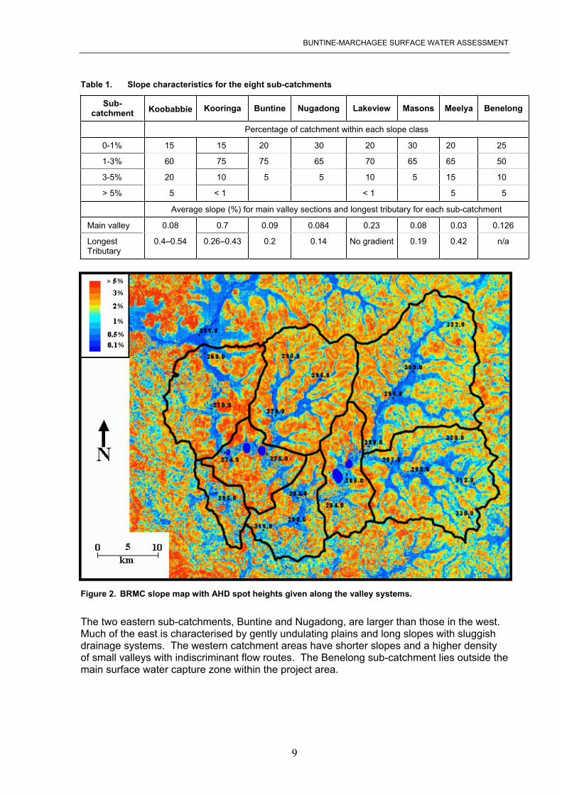
2.3 Slope analysis and sub-catchment delineation The BMRC is located in the northern region of The Zone of Rejuvenated Drainage. Run-off generation and the efficiency of water movement are strongly influenced by local slope and channel gradients. Digital elevation data for the catchment was used to delineate the eight topographically discrete sub-catchments shown in Figure 1. The topographic boundaries of the sub-catchments are shown overlaid on the slope map (Figure 2) with the catchments named after localised features of districts within that catchment.
Average slopes for the sections from the valley floors to the catchment divides for the eight sub-catchments are shown in Table 1. For 50 to 75 per cent of the catchments, average slopes are between 1 and 3 per cent. Slopes tend to be steepest along the ridges and sub-catchment divides with some areas exceeding 3 per cent (Figure 2).
Tributary channel areas are typically less than 0.5 per cent. The main valley system has a very low gradient, falling less than 30 m over 50 km, and is dominated by playa lakes.
BUNTINE-MARCHAGEE SURFACE WATER ASSESSMENT
9
Table 1. Slope characteristics for the eight sub-catchments
Sub-catchment Koobabbie Kooringa Buntine Nugadong Lakeview Masons Meelya Benelong
Percentage of catchment within each slope class
0-1% 15 15 20 30 20 30 20 25
1-3% 60 75 75 65 70 65 65 50
3-5% 20 10 5 5 10 5 15 10
> 5% 5 < 1 < 1 5 5
Average slope (%) for main valley sections and longest tributary for each sub-catchment
Main valley 0.08 0.7 0.09 0.084 0.23 0.08 0.03 0.126
Longest Tributary
0.4–0.54 0.26–0.43 0.2 0.14 No gradient 0.19 0.42 n/a
Figure 2. BRMC slope map with AHD spot heights given along the valley systems.
The two eastern sub-catchments, Buntine and Nugadong, are larger than those in the west. Much of the east is characterised by gently undulating plains and long slopes with sluggish drainage systems. The western catchment areas have shorter slopes and a higher density of small valleys with indiscriminant flow routes. The Benelong sub-catchment lies outside the main surface water capture zone within the project area.

BUNTINE-MARCHAGEE SURFACE WATER ASSESSMENT
10
2.4 Soils mapping and hydrological interpretation
Soil-landscape systems Griffin et al. (2004) completed a soil-landscape mapping survey as part of this project. The key units identified were characterised according to their influence on surface water processes with the soil-landscape mapping hierarchy explained in Schoknecht et al. (2004). Five soil-landscape systems have been identified and represent areas where different soil forming processes dominate. These are: low hills and rises; undulating plains (three categories); alluvial plain.
The five soil-landscape systems identified are shown in Figure 3. These include Inering Hills, Upson Downs, Ballidu, Balgerbine and Wallambin. A full description and assessment is given in Griffin et al. (2004).
Soil units Within the five soil-landscape systems 34 soil units were characterised based on potential hydrological response and are illustrated in Figure 4. The soils have been attributed according to three main categories that reflect the potential to generate surface water flow: capacity to generate run-off; ability to infiltrate; impervious surface (or impervious at saturation).
The attributes for the soil map units were considered to change according to seasonal (summer and winter) rainfall intensity.
Surface water zones Comparative analysis of the soil-landscape dataset and modelled surface water flow has identified five broad categories or surface water zones within the catchment. The zones vary in function as shedding and receiving areas as described by Farmer et al. (2002) with their functionality dependent on location in the catchment (or sub-catchment), rainfall intensity, infiltration capacity and the level of storage capacity and saturation. These zones demonstrate some correlation with the soil-landscape systems shown in Figure 3 and are described as follows (soil systems in brackets):
Zone 1 Valley floors (Wallambin System):
Soils are considered to be at saturation excess due to waterlogging, inundation or salinity. Rainfall or run-on does not infiltrate during an event resulting in inundation or surface flow. These are nominally referred to as receiving areas if water is contained, but may act as shedding areas if the water is able to move down the valley.
Zone 2 South West sandplain (Balgerbine System):
Surface water flow is generally separated from the main valley floor drainage system. Run-off generated accumulates or infiltrates locally. However, some soils may generate run-off from high intensity summer rainfall events. These are also nominal receiving areas.

BUNTINE-MARCHAGEE SURFACE WATER ASSESSMENT
11
Zone 3 Steeper run-off areas (Inering Hills System):
Steeper slopes allow rainfall to run-off. In early winter, low intensity rainfall events may allow colluvial soils (duplex and loams) in the mid and lower slopes to infiltrate unless saturation excess in reached. During summer, high intensity rainfall events may exceed the infiltration capacity of the soils and areas behave as shedding landscapes.
Zone 4 Central narrow valley areas with convex slopes (Upson Downs System):
Most soils (sandy earths, duplexes, loams and granitic) in this group are located on gentle gradients that infiltrate water during rainfall events. Run-off is generated on upper slopes. Valley floor soils are saturated or readily reach saturation excess and act as receiving areas with upper slopes providing shedding landscapes.
Zone 5 SE broad valleys with gentle concave slopes (Ballidu System):
Soils (granitic, duplex and loams) on crests or upper slopes generate run-off due to saturation excess during winter. Soils (sands, sandy duplex) on undulating sandplain infiltrate or accumulate rainfall locally. Soils (alluvial) on flat areas surrounding the valley have the capacity to infiltrate during summer rainfall events but saturate in early winter generating run-off. The zone has the capacity to act as both shedding and receiving landscape and behaviour is dependent on soil condition and rainfall intensity-duration.
Figure 3. Five key soil-landscape systems identified within the BMRC (Griffin et al. 2004).