survey co-ordination regulations 2004file/04-21… · web view · 2014-05-02(c)prescribe forms,...
TRANSCRIPT

Version No. 003
Survey Co-ordination Regulations 2004S.R. No. 21/2004
Version as at17 April 2013
TABLE OF PROVISIONSRegulation Page
PART 1—PRELIMINARY 1
1 Objectives 12 Authorising provision 13 Commencement 14 Definitions 1
PART 2—PERMANENT MARKS 3
5 Permanent marks 36 Establishment of permanent marks 37 Permanent mark sketch plan 48 Removal, replacement or irregularity in position of permanent
marks 69 Registration and numbering of permanent marks 7
PART 3—SURVEYS 8
10 Notice of intention to commence survey 811 Bearings of surveys 812 Connections of surveys to permanent marks 913 Survey equipment 1014 Connections of surveys within or contiguous to proclaimed
survey areas 1015 Plan forms 1116 Classification of surveys and plans 1217 Forms of notification 1318 Numbering and indexing of field notes 1319 Form of central plan register 14
__________________
1
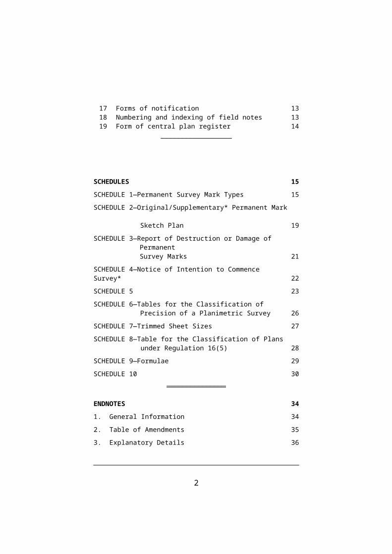
SCHEDULES 15
SCHEDULE 1—Permanent Survey Mark Types 15
SCHEDULE 2—Original/Supplementary* Permanent Mark Sketch Plan 19
SCHEDULE 3—Report of Destruction or Damage of Permanent Survey Marks 21
SCHEDULE 4—Notice of Intention to Commence Survey* 22
SCHEDULE 5 23
SCHEDULE 6—Tables for the Classification of Precision of a Planimetric Survey 26
SCHEDULE 7—Trimmed Sheet Sizes 27
SCHEDULE 8—Table for the Classification of Plans under Regulation 16(5) 28
SCHEDULE 9—Formulae 29
SCHEDULE 10 30
═══════════════
ENDNOTES 34
1. General Information 34
2. Table of Amendments 35
3. Explanatory Details 36
2

Version No. 003
Survey Co-ordination Regulations 2004S.R. No. 21/2004
Version as at17 April 2013
PART 1—PRELIMINARY
1 Objectives
The objectives of these Regulations are to—
(a) provide for standards of measurement and accuracy of certain surveys;
(b) provide for the connection of surveys to existing surveys, standard traverses and permanent marks;
(c) prescribe forms, procedures, standards and other matters relating to surveying and the co-ordination of surveys.
2 Authorising provision
These Regulations are made under section 22 of the Survey Co-ordination Act 1958.
3 Commencement
These Regulations come into operation on 15 March 2004.
4 Definitions
In these Regulations—
Australian Height Datum means the datum of mean sea level as determined by the National Levelling adjustment in 1971 and adopted by the National Mapping Council of Australia at its 29th meeting as the datum to which all vertical control for mapping is to be referred;
1

cadastral survey means a cadastral survey within the meaning of the Surveyors Act 1978;
local traverse means a survey, other than a standard traverse, connecting two or more permanent marks;
Map Grid of Australia 1994 (MGA 1994) means the system of rectangular co-ordinates derived from a Universal Transverse Mercator projection of Geocentric Datum of Australia 1994 (GDA 94) latitudes and longitudes that are based on the datum (GDA) defined in the notice of the Inter-Governmental Committee on Surveying and Mapping published in Commonwealth Government Gazette Number GN 35 of 6 September 1995 at page 3369;
SP1 means version 1.5 of the Standards and Practices for Control Surveys published by the Inter-Governmental Committee on Surveying and Mapping in May 2002 (ICSM Publication No. 1);
standard traverse means a survey defined in terms of the Australian Map Grid or the Map Grid of Australia 1994;
the Act means the Survey Co-ordination Act 1958.
__________________
2
r. 4

PART 2—PERMANENT MARKS
5 Permanent marks
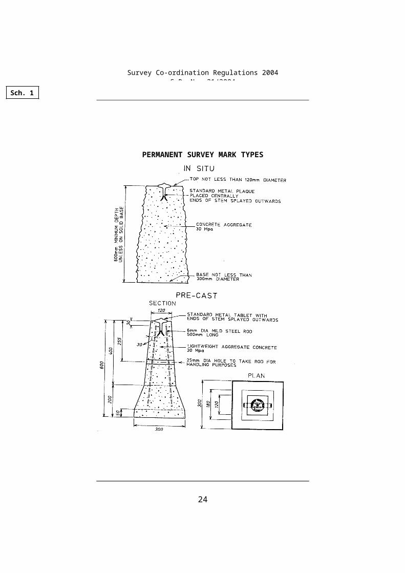
A permanent mark established under the Act must be—
(a) of a durable, permanent and stable construction and material; and
(b) in the form of a monument in Schedule 11.
6 Establishment of permanent marks
(1) A permanent mark established under the Act must be in a place—
(a) where it is least likely to be subject to damage, disturbance or removal or to constitute a hazard; and
(b) to facilitate horizontal and vertical connections to existing and future marks; and
(c) where it is readily identifiable and easy to find; and
(d) that provides the most stable location available.
(2) If a box-cover2 is used to protect a permanent mark, it must be—
(a) constructed of durable and permanent material and in a rigid manner enabling the maximum protection that is practicable to be afforded to the permanent mark; and
(b) set centrally over the permanent mark with the top of the cover flush with the ground or surface on which it is set and the base not less than 50 millimetres above the top of the permanent mark.
r. 5
Survey Co-ordination Regulations 2004S.R. No. 21/2004
3

(3) If a marker post or indicator is used to locate or protect a permanent mark, the marker post or indicator must be placed vertically in the ground where it does not constitute a hazard, not less than 300 millimetres from the centre of the permanent mark and independent of any medium in which the permanent mark is set.
(4) Permanent marks on surveys of 1500 metres or more in length must be placed so that no two marks are more than 1500 metres apart unless the Surveyor-General directs under section 6(1)(b) of the Act the establishment of other intervals.
7 Permanent mark sketch plan
(1) A surveyor or proper officer responsible for the establishment of a permanent mark must ensure that a separate sketch plan for the permanent mark is prepared and forwarded to the Surveyor-General within one month after the establishment of the permanent mark.
(2) A sketch plan must—
(a) be set out in a notice that—
(i) is in the form of Schedule 23; and
(ii) sets out the particulars in Schedule 2; and
(iii) is certified by the surveyor who established the permanent mark—
(A) that the information in the notice is correct; and
(B) that the permanent mark was established on the ground by the surveyor in accordance with these Regulations; and
r. 7
Survey Co-ordination Regulations 2004S.R. No. 21/2004
4

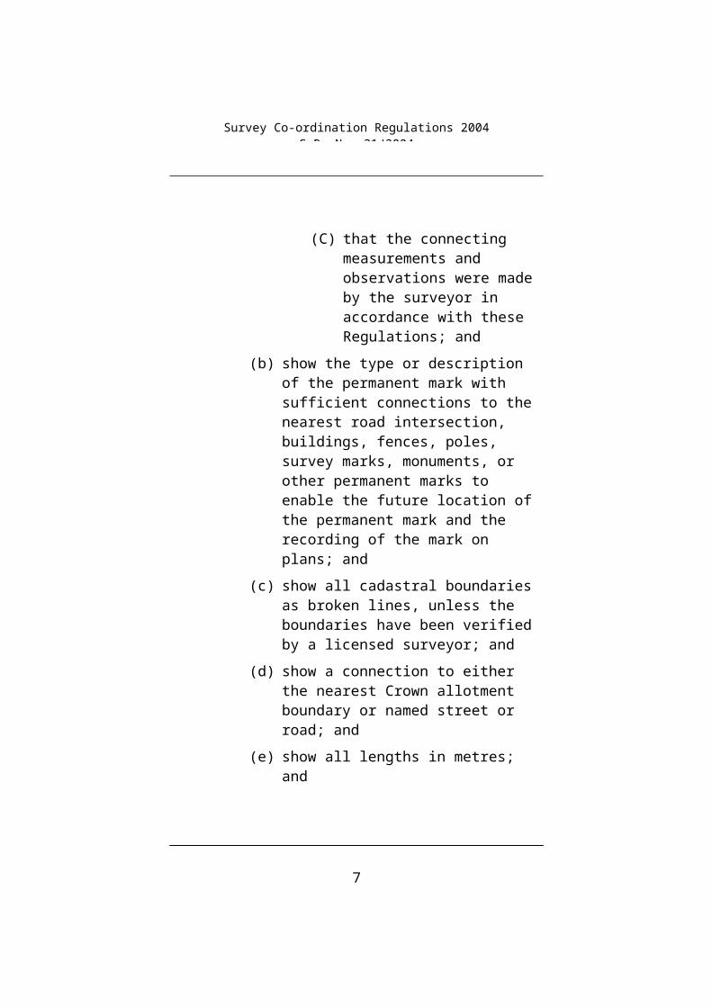
(C) that the connecting measurements and observations were made by the surveyor in accordance with these Regulations; and
(b) show the type or description of the permanent mark with sufficient connections to the nearest road intersection, buildings, fences, poles, survey marks, monuments, or other permanent marks to enable the future location of the permanent mark and the recording of the mark on plans; and
(c) show all cadastral boundaries as broken lines, unless the boundaries have been verified by a licensed surveyor; and
(d) show a connection to either the nearest Crown allotment boundary or named street or road; and
(e) show all lengths in metres; and
(f) indicate the existence of any marker post, indicator or box-cover; and
(g) specify any number or designation by which the permanent mark is known, other than the registration number; and
(h) specify the registration number (if any) for the permanent mark allocated by the Surveyor-General; and
(i) be capable of legible reproduction by photographic or other methods.
(3) A surveyor who for the purposes of the Act obtains additional connections to an existing permanent mark or surrounding features must prepare and forward to the Surveyor-General a supplementary sketch plan in the form of Schedule 24, within one month after obtaining the additional connections.
r. 7
Survey Co-ordination Regulations 2004S.R. No. 21/2004
5

(4) The supplementary sketch plan must be set out in a notice that—
(a) is in the form of Schedule 25; and
(b) sets out the particulars in Schedule 2; and
(c) complies with the requirements of subregulation (2)(b) to (i); and
(d) is certified by the surveyor who made the connecting measurements and observationsthat the information in the notice is correct.
8 Removal, replacement or irregularity in position of permanent marks
(1) For the purposes of the proviso to section 16 of the Act, when a permanent mark is removed the following procedures must be observed—
(a) the removal must be under the supervision of a surveyor; and
(b) the surveyor wherever practicable must notify the Surveyor-General and the establishing authority before the removal; and
(c) the surveyor must relate the permanent mark horizontally and vertically to adjacent monuments and survey marks before the mark is removed and connections must conform to not less than the standard of precision of the survey used for establishing the recorded position of the permanent mark.
(2) The surveyor must immediately establish a new permanent mark to replace the mark removed.
(3) The surveyor must forward to the Surveyor-General within one month after the removal and replacement of a permanent mark—
(a) a notice in the form of Schedule 3; and
r. 8
Survey Co-ordination Regulations 2004S.R. No. 21/2004
6

(b) a sketch plan giving particulars of the relationship between the permanent mark removed and the new permanent mark.
(4) If it is not practicable to establish a new permanent mark upon the removal of a permanent mark, the surveyor must forward to the Surveyor-General—
(a) a notice in the form of Schedule 3 within one month after the removal; and
(b) a sketch plan showing the position of the permanent mark before its removal in relation to adjacent monuments and survey marks.
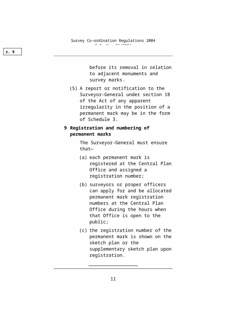
(5) A report or notification to the Surveyor-General under section 18 of the Act of any apparent irregularity in the position of a permanent mark may be in the form of Schedule 3.
9 Registration and numbering of permanent marks
The Surveyor-General must ensure that—
(a) each permanent mark is registered at the Central Plan Office and assigned a registration number;
(b) surveyors or proper officers can apply for and be allocated permanent mark registration numbers at the Central Plan Office during the hours when that Office is open to the public;
(c) the registration number of the permanent mark is shown on the sketch plan or the supplementary sketch plan upon registration.
__________________
r. 9
Survey Co-ordination Regulations 2004S.R. No. 21/2004
7
PART 3—SURVEYS
10 Notice of intention to commence survey
For the purposes of section 5 of the Act, notice of intention to commence a survey or notice that a survey has commenced must be in the form of Schedule 4.
11 Bearings of surveys
(1) A surveyor carrying out a survey for registration under the Act must use the appropriate zone of the Australian Map Grid or the Map Grid of Australia 1994 in column 2 of the table in Schedule 5 for the survey.
(2) Parishes shown in column 1 of the table in Schedule 5 are deemed to lie wholly within the zone indicated in column 2 of the table.
(3) The bearings of a survey classified in Table 1 of Part A of SP1 as Class 3A, 2A, A, B or C must be related either directly or indirectly to the Australian Map Grid or the Map Grid of Australia 1994.
(4) The bearings of a planimetric survey of angular classification 1, 2 or 3 in Table 2 of Schedule 6 must be related either directly or indirectly to the Australian Map Grid or the Map Grid of Australia 1994.
(5) The field notes and the plan of a survey for registration under the Act must indicate the relationship to the Australian Map Grid or Map Grid of Australia 1994 including the zone to which the bearings are referred.
(6) The precision of the relationship to the Australian Map Grid or the Map Grid of Australia 1994 must conform to the standard of precision required by the classification of the survey being related.
r. 10
Survey Co-ordination Regulations 2004S.R. No. 21/2004
8

(7) The field notes or plan of survey must show the derivation and precision of the relationship to the Australian Map Grid or the Map Grid of Australia 1994.
12 Connections of surveys to permanent marks
(1) A connection to a permanent mark must conform to the standard of precision required by the class of survey being connected and contain at least one independent verifying check measurement unless connected in a closed traverse.
(2) If a planimetric survey connects to 2 or more permanent marks—
(a) the connections must be sufficient for the determination of bearing and distance between those marks; and
(b) appropriate bearings and distances must be shown on the field notes and the plan of the survey.
(3) Levelling surveys must be connected either directly or indirectly to a permanent mark that has been assigned a value in accordance with the Australian Height Datum.
(4) The method of connection of a levelling survey must be shown in the field notes and on the plan of the survey.
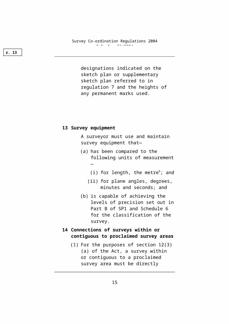
(5) The field notes and the plan of a levelling survey must include the registration numbers or other designations indicated on the sketch plan or supplementary sketch plan referred to in regulation 7 and the heights of any permanent marks used.
r. 12
Survey Co-ordination Regulations 2004S.R. No. 21/2004
9

13 Survey equipment
A surveyor must use and maintain survey equipment that—
(a) has been compared to the following units of measurement—
(i) for length, the metre6; and
(ii) for plane angles, degrees, minutes and seconds; and
(b) is capable of achieving the levels of precision set out in Part B of SP1 and Schedule 6 for the classification of the survey.
14 Connections of surveys within or contiguous to proclaimed survey areas
(1) For the purposes of section 12(3)(a) of the Act, a survey within or contiguous to a proclaimed survey area must be directly connected to at least 2 permanent marks on a standard or local traverse that are—
(a) properly verified as to position at the time of survey; and
(b) at least 200 metres apart; and
(c) within 500 metres of the survey or a greater distance from the survey if the connection to the survey can be made by establishing no more than 3 instrument points from each permanent mark.
(2) For the purposes of an indirect connection to a traverse authorised under section 12(3)(b) of the Act, the survey must be connected to at least 2 survey or permanent marks already connected or proposed to be connected to a standard or local traverse that are—
r. 13
Survey Co-ordination Regulations 2004S.R. No. 21/2004
10

(a) properly verified as to position at the time of survey; and
(b) at least 200 metres apart; and
(c) within 500 metres of the survey or a greater distance from the survey if the connection to the survey can be made by establishing no more than 3 instrument points from each permanent mark.
(3) The co-ordinate value of any new or existing permanent marks on a survey that connects to a local or standard traverse must be expressed in terms of the Australian Map Grid or Map Grid of Australia 1994.
(4) Australian Map Grid or Map Grid of Australia 1994 co-ordinate values for any new permanent marks connected to the survey must only be derived by an adjustment of the survey, and any variation between the adjusted and observed values must conform to the standard of precision required by the classification of the survey.
15 Plan forms
Plans prepared by or on behalf of a department or public authority to be forwarded to the Surveyor-General must—
(a) be drawn using conventional lines, letters, numerals and symbols7; and
(b) display a north point indicating the basis for orientation of the plan which must be either Australian Map Grid Zone 54, Map Grid of Australia 1994 Zone 54, Australian Map Grid Zone 55, Map Grid of Australia 1994 Zone 55, True North or Magnetic North; and
(c) display a scale bar and the scale of the plan expressed as a representative ratio; and
r. 15
Survey Co-ordination Regulations 2004S.R. No. 21/2004
11
(d) so far as is practicable, be drawn in conformity with standard map and plan systems related to the Australian Map Grid or Map Grid of Australia 1994 described in section 1.4 of Part 2 of the Survey Practice Handbook published by the Surveyors Board of Victoria in 1992; and
(e) conform to one of the trimmed sheet sizes listed in Schedule 7.
16 Classification of surveys and plans
(1) For the purposes of section 6(3) of the Act, the prescribed standards of measurement and accuracy are the standards set out in sections 2.2, 2.3 and 2.4, including Tables 11–18, of Part B of SP1 and Schedules 6 and 8.
(2) In a planimetric survey comprising a closed traverse—
(a) the limit of error for each line or angle may conform to a specific classification that is not allotted to the survey unless the total linear and angular misclosure as determined from the appropriate formula in Schedule 9 is within the limit or error of the specific classification; and
(b) if the classification as determined by the formula differs from the specific classification, the classification allotted to the survey must be the lower of the two.
(3) In differential levelling surveys of Class L2A, LA, LB or LC specified in Table 4 of Part A of SP1, the difference between the two level determinations of any one section of the survey or the misclosure of any closed circuit must not exceed the standard of precision required by the classification of the survey.
r. 16
Survey Co-ordination Regulations 2004S.R. No. 21/2004
12

(4) A surveyor must certify on the face of the plan of a control, planimetric or levelling survey or on the field notes or both if applicable, as to the classification of the survey.
(5) A proper officer of a department or public authority must ensure that a plan produced by that department or public authority and not classified under SP1 or Schedule 6, indicates on the face of the plan the classification of the plan using a double letter for graphical precision, a numeral for contour precision or a combination of both if applicable as set out in Schedule 8.
(6) In a survey certified under subregulation (4)—
(a) due allowance must be made for any correction factor found during calibration of survey equipment; and
(b) any corrections must be recorded in the field notes of the survey.
17 Forms of notification
A list of plans or surveys under section 7 of the Act must—
(a) for each survey or plan listed, contain the particulars set out in Schedule 10 that apply to the plan or survey; and
(b) if a plan is in an electronic form, list that plan separately to those in hardcopy form for the same area.
18 Numbering and indexing of field notes
(1) All field notes made for the purpose of any cadastral survey carried out by or on behalf of a department or public authority, a plan of which is recorded or forwarded or set out on any list forwarded to the Surveyor-General under the Act, must be—
r. 17
Survey Co-ordination Regulations 2004S.R. No. 21/2004
13

(a) maintained in good order by the department or public authority; and
(b) numbered and indexed to conform with the numbering or designation on any plan or list forwarded.
(2) Field notes may be in original or abstract form and recorded in handwritten, printed or electronically readable form.
(3) The Surveyor-General may by notice in writing forwarded to the proper officer of the department or public authority concerned, require the proper officer to produce for inspection and examination the field notes referred to in subregulation (1).
19 Form of central plan register
The Central Plan Register must show—
(a) the particulars of each plan and survey that have been forwarded under section 7 of the Act; and
(b) the location of any plan recorded under section 8(1) of the Act.
__________________
r. 19
Survey Co-ordination Regulations 2004S.R. No. 21/2004
14

SCHEDULES
Regulation 5
SCHEDULE 18
PERMANENT SURVEY MARK TYPES
Sch. 1
Survey Co-ordination Regulations 2004S.R. No. 21/2004
15
PERMANENT SURVEY MARK TYPES
Sch. 1
Survey Co-ordination Regulations 2004S.R. No. 21/2004
16

PERMANENT SURVEY MARK TYPES
Sch. 1
Survey Co-ordination Regulations 2004S.R. No. 21/2004
17

PERMANENT SURVEY MARK TYPES
__________________
Sch. 1
Survey Co-ordination Regulations 2004S.R. No. 21/2004
18

SCHEDULE 2Regulation 7
ORIGINAL/SUPPLEMENTARY* PERMANENT MARK SKETCH PLAN9
Survey Co-ordination Act 1958 (section 6(1)(c))
Township ........................................... Parish .............................................
Lengths are in metres Not necessarily to scale
Description of Permanent Mark ................................
Existence of box-cover: Yes/No*. Marker post: Yes/No*. Indicator: Yes/No*.
I certify that the—
information shown on this notice is correct
* permanent mark shown in this notice has been established on the ground by me in accordance with the regulations under the Survey Co-ordination Act 1958.
Name of Surveyor:............................................. Signature .........................†
Date ....../....../.....
† If a Licensed Surveyor the letters LS to be added
† If a Registered Surveyor the letters RS to be added
Company or Agency .........................................
Company or Agency's Reference No. ...........................
Municipality ...............................
Sch. 2
Survey Co-ordination Regulations 2004S.R. No. 21/2004
19

GRID REFERENCE CO-ORDINATES(May be scaled to nearest 100 metres)
Datum: MGA94 / AMG66 * ZONE:EASTING:
NORTHING
AHD RL:
If in Melbourne metropolitan area, include Melway Ref.Map: Grid Ref:
OFFICIAL USE ONLYREGISTRATION NUMBERDate
Rec'dRegistered Surveys connected to this PM
...............................
...............................
...............................
...............................
* Delete as appropriate
__________________
Sch. 2
Survey Co-ordination Regulations 2004S.R. No. 21/2004
20

SCHEDULE 3Regulation 8
REPORT OF DESTRUCTION OR DAMAGE OF PERMANENT SURVEY MARKS
Survey Co-ordination Act 1958 (section 16)
Reg. Number Township Parish
If the information is not available, please describe location as fully as possible for identification at the Central Plan Office.
Remarks .......................................................................................................
......................................................................................................................
......................................................................................................................
Company/Agency .............................. Signature .................................
.......................................................... Date .........................................
__________________
Sch. 3
Survey Co-ordination Regulations 2004S.R. No. 21/2004
21

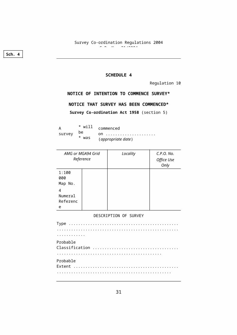
SCHEDULE 4Regulation 10
NOTICE OF INTENTION TO COMMENCE SURVEY*
NOTICE THAT SURVEY HAS BEEN COMMENCED*Survey Co-ordination Act 1958 (section 5)
A survey * will be* was
commenced on .....................(appropriate date)
AMG or MGA94 Grid Reference
Locality C.P.O. No.Office Use
Only
1:100 000Map No.4 Numeral Reference
DESCRIPTION OF SURVEY
Type .............................................................................................................
Probable Classification ................................................................................
Probable Extent ............................................................................................
Other Particulars ..........................................................................................
Department or Authority .............................. Signature ............................. (Proper Officer)
Reference No. ofDepartment or Authority ............................* Strike out whichever not applicable A certificate of the Proper Officer setting out
reasons for late notice must accompany each notice that survey has been commenced.
__________________
Sch. 4
Survey Co-ordination Regulations 2004S.R. No. 21/2004
22

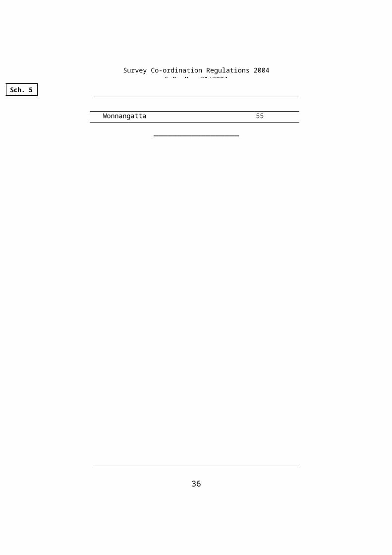
SCHEDULE 510
Regulation 11
Column 1
County or Part of County
Column 2
AMG Zone/ MGA 94 Zone
All Parishes in the counties of:Anglesey 55Benambra 55Bendigo (except Parish of Tarnagulla) 55
Parish of Tarnagulla 54Bogong 55Borung 54Bourke 55Buln Buln 55Croajingolong 55Dalhousie 55Dargo 55Delatite 55Dundas 54Evelyn 55Follett 54Gladstone 54Grant (except the following Parishes in the County of Grant)
55
Parish of Ballarat
Parish of BungalParish of BungareeParish of BuninyongParish of ClarendonParish of Kerrit Bareet 54Parish of KoweingubooraParish of Lal LalParish of Moorabool WestParish of Warrenheip
Grenville 54Gunbower (except the Parish of Benjeroop) 55
Parish of Benjeroop 54Hampden 54Heytesbury 54Kara Kara 54
Sch. 5
Survey Co-ordination Regulations 2004S.R. No. 21/2004
23

Column 1
County or Part of County
Column 2
AMG Zone/ MGA 94 Zone
Karkarooc 54Lawson 54Millewa 54Moira 55Mornington 55Normanby 54Polwarth (except the following Parishes in the County of Polwarth)
54
Parish of Angahook
Parish of BoonahParish of Wensleydale 55Parish of Tutegong
Ripon 54Rodney 55Talbot (except the following Parishes in the County of Talbot)
54
Parish of Baringhup
Parish of BradfordParish of BullarookParish of BullartoParish of BurkeParish of CampbelltownParish of CastlemaineParish of ChewtonParish of ColibanParish of DrummondParish of EdgecombeParish of ElphinstoneParish of FaradayParish of FranklinParish of Fryers 55Parish of GlenlyonParish of GuildfordParish of HarcourtParish of HawkestoneParish of HolcombeParish of MaldonParish of MucklefordParish of NeeremanParish of Ravenswood
Survey Co-ordination Regulations 2004S.R. No. 21/2004
24
Column 1
County or Part of County
Column 2
AMG Zone/ MGA 94 Zone
Parish of Sardon
Parish of StrangewaysParish of Sutton GrangeParish of TarrengowerParish of Walmer 55Parish of WombatParish of Yandoit
Tambo 55Tanjil 55Tatechera 54Villiers 54Weeah 54Wonnangatta 55
__________________
Sch. 5Sch. 5
Survey Co-ordination Regulations 2004S.R. No. 21/2004
25

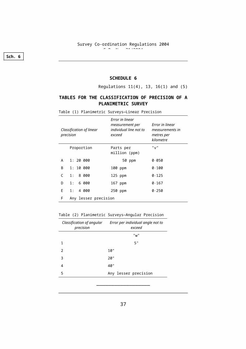
SCHEDULE 6Regulations 11(4), 13, 16(1) and (5)
TABLES FOR THE CLASSIFICATION OF PRECISION OF A PLANIMETRIC SURVEY
Table (1) Planimetric Surveys—Linear Precision
Classification of linear precision
Error in linear measurement per individual line not to exceed
Error in linear measurements in metres per kilometre
Proportion Parts per million (ppm) "v"
A 1: 20 000 50 ppm 0050
B 1: 10 000 100 ppm 0100
C 1: 8 000 125 ppm 0125
D 1: 6 000 167 ppm 0167
E 1: 4 000 250 ppm 0250
F Any lesser precision
Table (2) Planimetric Surveys—Angular Precision
Classification of angular precision
Error per individual angle not to exceed
"w"
1 5"
2 10"
3 20"
4 40"
5 Any lesser precision
__________________
Sch. 6
Survey Co-ordination Regulations 2004S.R. No. 21/2004
26

SCHEDULE 7Regulation 15(e)
TRIMMED SHEET SIZES11
Table 1.1 Dimensions of Sheet
Designation Cut Sheet Dimensions
(mm)
A0 841 1189
A1 594 841
A2 420 594
A3 297 420
A4 210 297
__________________
Sch. 7
Survey Co-ordination Regulations 2004S.R. No. 21/2004
27

SCHEDULE 8Regulation 16(1) and (5)
TABLE FOR THE CLASSIFICATION OF PLANS UNDER REGULATION 16(5)
Classification of Graphical Precision Plotted positional error of any point not to exceed
AA 1 mm
90% of all points shall be correct within one half of the maximum positional error indicated.
BB 2 mm
CC 3 mm
DD Any lesser precision
Classification of Contour Precision Interpolated elevation error of any point not to exceed
1 One contour interval
90% of all interpolated elevations must be correct within one half of the contour interval(s) indicated.
2 One and one half contour intervals
3 Two contour intervals
4 Any lesser precision
__________________
Sch. 8
Survey Co-ordination Regulations 2004S.R. No. 21/2004
28

SCHEDULE 9Regulation 16(2)
FORMULAE
In any closed traverse of a planimetric survey;
(a) the linear misclosure √a2+ b2 is not to exceed—
(i) (vk) metres, where the length of the closed traverse is less than or equal to 4 kilometres;
(ii) (2v √ k)metres, where the length of the closed traverse is greater than 4 kilometres
where—
a is the misclosure in the northings;
b is the misclosure in the eastings;
v is the error in linear measurement in metres per kilometre according to Table 1 of Schedule 6;
k is the length of the closed traverse in kilometres.
(b) the angular misclose is not to exceed w n where—
w is the error per individual angle according to Table 2 of Schedule 6;
n is the total number of angles in the traverse.
__________________
Sch. 9
Survey Co-ordination Regulations 2004S.R. No. 21/2004
29

SCHEDULE 10Regulation 17
Category 1—Cadastral Surveys (as defined in Surveyors Act 1978)
1 Name or identifier of Department or Public Authority
2 Plan or reference number
3 Date of completion of survey
4 Crown description
5 Previous survey reference
6 AMG or MGA94 zone and co-ordinates
7 Details of survey or permanent marks co-ordinated, levelled or updated, including—
type of mark
number or designation of the mark
co-ordinates of the mark
Category 2—Cadastral Plans (Complied plans such as Parish Plans, Base maps, etc.)
1 Name or identifier of Department or Public Authority
2 Plan or reference number
3 Date of compilation
4 Digitised or not digitised
5 Standard map and plan system reference
or
Extent and orientation of plan with AMG or MGA94 zone and co-ordinates
6 Scale.
Sch. 10
Survey Co-ordination Regulations 2004S.R. No. 21/2004
30

Category 3—Control Surveys (Trigonometrical surveys, major control surveys, water and sewerage reticulation surveys, standard and local traverses, etc.)
1 Name or identifier of Department or Public Authority
2 Plan or reference number
3 Date of completion of survey
4 Standard map and plan system reference
or
Extent and orientation of survey with AMG or MGA94 zone and co-ordinates
5 Details of survey or permanent marks co-ordinated, levelled or updated, including—
type of mark
number or designation of the mark
co-ordinates of the mark
Category 4—Aerial Photography (Original photography only)
NOTE—A separate listing required for each run.
1 Name or identifier of Department or Public Authority
2 Project name or reference
3 Date of photography
4 Scale
5 Flying height
6 Film type
7 Camera type
8 Run reference
9 Photo reference
10 AMG or MGA94 zone and co-ordinates for extremities of run.
Sch. 10
Survey Co-ordination Regulations 2004S.R. No. 21/2004
31
Category 5—Topographical Plans (Standard and miscellaneous) Other Plans (Thematic, orthophotomaps and selected mosaics containing information additional to the original photography)
1 Name or identifier of Department or Public Authority
2 Plan or reference number
3 Date of compilation
4 Digitised or not digitised
5 Scale
6 Contour interval if applicable
7 Classification
8 Title
9 Theme or type
10 Standard map and plan system reference or Extent and orientation of plan with AMG or MGA94 and co-ordinates.
Category 6—Longitudinal Surveys (Levelling runs, pipelines and other similar engineering surveys)
1 Name or identifier of Department or Public Authority
2 Plan or reference number
3 Date of completion of survey
4 Classification
5 Theme or title of survey
6 AMG or MGA94 zone and co-ordinates for extremities of survey and major deviations
Survey Co-ordination Regulations 2004S.R. No. 21/2004
32

7 Details of survey or permanent marks co-ordinated, levelled or updated, including—
type of mark
number or designation of the mark
co-ordinates of the mark ═══════════════
Sch. 10Sch. 10
Survey Co-ordination Regulations 2004S.R. No. 21/2004
33

ENDNOTES
1. General InformationThe Survey Co-ordination Regulations 2004, S.R. No. 21/2004 were made on 10 March 2004 by the Governor in Council under section 22 of the Survey Co-ordination Act 1958, No. 6388/1958 and came into operation on 15 March 2004: regulation 3.
The Survey Co-ordination Regulations 2004 will sunset 10 years after the day of making on 10 March 2014 (see section 5 of the Subordinate Legislation Act 1994).
Endnotes
Survey Co-ordination Regulations 2004S.R. No. 21/2004
34

2. Table of AmendmentsThere are no amendments made to the Survey Co-ordination Regulations 2004 by statutory rules, subordinate instruments and Acts.
Endnotes
Survey Co-ordination Regulations 2004S.R. No. 21/2004
35

3. Explanatory Details
Endnotes
Survey Co-ordination Regulations 2004S.R. No. 21/2004
36
1 Reg. 5: See Survey Practice Handbook, www.surveyorsboard.vic.gov.au.2 Reg. 6(2): See note 1.3 Reg. 7(2)(a)(i): See note 1.4 Reg. 7(3): See note 1.5 Reg. 7(4)(a): See note 1.6 Reg. 13(a)(i): See note 1.7 Reg. 15(a): See note 1.8 Sch. 1: See note 1.9 Sch. 2: See note 1.10 Sch. 5: See note 1.11 Sch. 7: See note 1.
——
Table of Applied, Adopted or Incorporated Matter
Note that the following table of applied, adopted or incorporated matter is included in accordance with the requirements of regulation 6 of the Subordinate Legislation Regulations 1994.
Statutory Rule provision
Title of applied, adopted or incorporated document
Matter in applied, adopted or incorporated document
Regulation 11(3)
Standards and Practices for Control Surveys (SP1) version 1.5 published by the Inter-Governmental Committee on Surveying and Mapping in May 2002 (ICSM Publication No. 1)
Table 1 of Part A
Regulation 13(b)
Standards and Practices for Control Surveys (SP1) version 1.5 published by the Inter-Governmental Committee on Surveying and Mapping in May 2002 (ICSM Publication No. 1)
Part B
Statutory Rule provision
Title of applied, adopted or incorporated document
Matter in applied, adopted or incorporated document
Regulation 15(d)
Survey Practice Handbook published by the Surveyors Board of Victoria in 1992
Section 1.4 of Part 2
Regulation 16(1)
Standards and Practices for Control Surveys (SP1) version 1.5 published by the Inter-Governmental Committee on Surveying and Mapping in May 2002 (ICSM Publication No. 1)
Sections 2.2, 2.3 and 2.4, including Tables 11–18, of Part B
Regulation 16(3)
Standards and Practices for Control Surveys (SP1) version 1.5 published by the Inter-Governmental Committee on Surveying and Mapping in May 2002 (ICSM Publication No. 1)
Table 4 of Part A
Regulation 16(5)
Standards and Practices for Control Surveys (SP1) version 1.5 published by the Inter-Governmental Committee on Surveying and Mapping in May 2002 (ICSM Publication No. 1)
Table 1 and Table 4 of Part A