table of contents page - california energy commission · table of contents page ... 8.15-1 8.15.1...
TRANSCRIPT
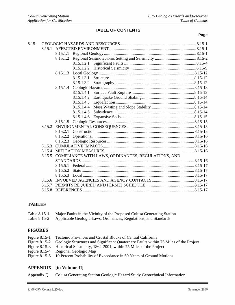
Colusa Generating Station 8.15 Geologic Hazards and Resources Application for Certification Table of Contents
R:\06 CPV Colusa\8_15.doc November 2006
TABLE OF CONTENTS Page
8.15 GEOLOGIC HAZARDS AND RESOURCES........................................................................8.15-1 8.15.1 AFFECTED ENVIRONMENT..................................................................................8.15-1
8.15.1.1 Regional Geology.......................................................................................8.15-1 8.15.1.2 Regional Seismotectonic Setting and Seismicity .......................................8.15-2
8.15.1.2.1 Significant Faults ....................................................................8.15-4 8.15.1.2.2 Historical Seismicity ...............................................................8.15-9
8.15.1.3 Local Geology ..........................................................................................8.15-12 8.15.1.3.1 Structure................................................................................8.15-12 8.15.1.3.2 Stratigraphy...........................................................................8.15-12
8.15.1.4 Geologic Hazards .....................................................................................8.15-13 8.15.1.4.1 Surface Fault Rupture ...........................................................8.15-13 8.15.1.4.2 Earthquake Ground Shaking .................................................8.15-14 8.15.1.4.3 Liquefaction ..........................................................................8.15-14 8.15.1.4.4 Mass Wasting and Slope Stability ........................................8.15-14 8.15.1.4.5 Subsidence ............................................................................8.15-14 8.15.1.4.6 Expansive Soils .....................................................................8.15-15
8.15.1.5 Geologic Resources ..................................................................................8.15-15 8.15.2 ENVIRONMENTAL CONSEQUENCES ...............................................................8.15-15
8.15.2.1 Construction .............................................................................................8.15-15 8.15.2.2 Operations.................................................................................................8.15-16 8.15.2.3 Geologic Resources ..................................................................................8.15-16
8.15.3 CUMULATIVE IMPACTS......................................................................................8.15-16 8.15.4 MITIGATION MEASURES ....................................................................................8.15-16 8.15.5 COMPLIANCE WITH LAWS, ORDINANCES, REGULATIONS, AND
STANDARDS ..........................................................................................................8.15-16 8.15.5.1 Federal ......................................................................................................8.15-17 8.15.5.2 State ..........................................................................................................8.15-17 8.15.5.3 Local .........................................................................................................8.15-17
8.15.6 INVOLVED AGENCIES AND AGENCY CONTACTS........................................8.15-17 8.15.7 PERMITS REQUIRED AND PERMIT SCHEDULE .............................................8.15-17 8.15.8 REFERENCES .........................................................................................................8.15-17
TABLES
Table 8.15-1 Major Faults in the Vicinity of the Proposed Colusa Generating Station Table 8.15-2 Applicable Geologic Laws, Ordinances, Regulations, and Standards
FIGURES Figure 8.15-1 Tectonic Provinces and Crustal Blocks of Central California Figure 8.15-2 Geologic Structures and Significant Quaternary Faults within 75 Miles of the Project Figure 8.15-3 Historical Seismicity, 1864-2001, within 75 Miles of the Project Figure 8.15-4 Regional Geologic Map Figure 8.15-5 10 Percent Probability of Exceedance in 50 Years of Ground Motions
APPENDIX [in Volume II] Appendix Q Colusa Generating Station Geologic Hazard Study Geotechnical Information

Colusa Generating Station Application for Certification 8.15 Geologic Hazards and Resources
R:\06 CPV Colusa\8_15.doc Page 8.15-1 November 2006
8.15 GEOLOGIC HAZARDS AND RESOURCES
This section of the AFC presents information on the geological and tectonic setting of the region and site vicinity. Following this discussion, geologic hazards and resources are described to provide background information on the conditions surrounding the CGS. The discussion of geologic hazards includes surface fault rupture, strong ground shaking, liquefaction, mass wasting/slope stability, subsidence, and expansive soils. Potential impacts of the project on the geologic resources at the site are also addressed. Based on this evaluation, measures are recommended to mitigate potential impacts from the CGS.
The final portion of this section describes laws, ordinances, regulations, and standards (LORS) relevant to geologic impacts of the project as well as the contacts in cognizant regulatory agencies. Required permits are also discussed.
8.15.1 Affected Environment
The CGS is located on the western edge of the Great Valley of California, which is a broad northwest-trending structural basin bounded to the west by the northern Coast Ranges and the San Andreas Fault System and to the east by the foothills of the Sierra Nevada (Figure 8.15-1). The western edge of the Great Valley is essentially the boundary between the Coast Ranges physiographic province and the Great Valley physiographic province. This coincides with a fundamental tectonic boundary that separates regions of differing crustal structure and is referred to as the Coast Ranges-Sierran Block boundary zone (CRSBBZ). The Coast Ranges province is a seismically active region characterized by north-northwest trending mountains and intervening valleys that extend from the Oregon border to the Transverse Ranges of southern California. The ridge-and-valley topographic character of the Coast Ranges province is predominantly controlled by the structural grain of the underlying geological units and subsequent erosion. The broad intermontane basin of the Great Valley is underlain by up to 30,000 feet of marine and terrestrial sediments.
The CGS area is underlain by tilted upper Cretaceous marine sediments partially covered by Pleistocene gravel of the Red Bluff formation. These are unconformably overlain by dissected terraces of the Riverbank formation and coeval alluvial fan and basin deposits (Helley and Harwood, 1985). The proposed plant’s elevation will be about 180 feet above mean sea level (msl). The topography in the immediate site vicinity consists of gently rolling hills, with the valley floor to the east and mountains of the Coast Ranges to the west. The site surface is gently east-sloping and covered by grass with bare soil in areas where cattle congregate.
8.15.1.1 Regional Geology
As shown on Figure 8.15-1, the region of the CGS includes both the eastern edge of the northern Coast Ranges and the western portion of the Great Valley. These regions are geologically distinct in character but are in tectonic contact across the CRSBBZ. The eastern edge of the northern Coast Ranges is defined by the CRSBBZ, which typically is represented by a series of blind and partially concealed thrust faults (Wong et al., 1988; Unruh and Moores, 1992). In this area, rocks of the Mesozoic Great Valley are thrust upon Franciscan basement along the western Sacramento Valley margin, and are covered locally by younger sediments of Pliocene to Pleistocene age.
The Coast Ranges represent northwest-southeast trending structural blocks comprised of a variety of basement lithologies that are juxtaposed by major geologic structures. The modern structural relations between the major lithotectonic belts are the result of over 140 million years of complex deformation along the western margin of the North American lithospheric plate. Stratigraphic relationships indicate that sedimentation in the northern part of the Great Valley forearc basin was continuous between late Jurassic and early Cretaceous. In early to middle Cretaceous, the plate boundary was deformed, causing the ancestral Great Valley forearc basin to be contracted or “telescoped” in a roughly east-west direction

Colusa Generating Station Application for Certification 8.15 Geologic Hazards and Resources
R:\06 CPV Colusa\8_15.doc Page 8.15-2 November 2006
(Ingersoll, 1978; Dickinson and Seely, 1979). The timing of this deformation generally coincides with an episode of deformation in the ancestral Sierra Nevada mountains to the east, and may be associated with a change in the relative motion between the North American plate and the ancestral Farallon plate to the west (Moxon, 1988). From middle to late Cretaceous, sedimentation continued relatively uninterrupted in the Great Valley forearc basin. In latest Cretaceous–early Tertiary, the western margin of the forearc basin was uplifted and tilted eastward, beginning a process of progressive east-directed contraction of the Coast Ranges and western Great Valley that has continued episodically during the Tertiary and Quaternary (Unruh et al., 1991; Ramirez, 1992).
Evolution of the ancestral convergent plate boundary to the modern transpressional plate boundary is the result of two major tectonic processes. First, transform motion between the Pacific and North American plates progressively replaced subduction of the Farallon plate beneath the North American plate following collision of the East Pacific Rise with the Franciscan trench sometime between 29 and 17 million years ago (Ma) (Atwater, 1970). The collision formed two triple junctions (the Mendocino triple junction to the north and the Rivera triple junction to the south) that migrated away from each other along the plate boundary. The triple junctions are joined by a dextral transform fault system that increases in length as the triple junctions move in opposite directions, thus progressively changing the western margin of the North American plate from an oblique subduction zone to a transcurrent fault system (Atwater, 1970). The San Andreas fault and associated right-lateral strike-slip faults in western California currently comprise the transcurrent fault system separating the Pacific and North American lithospheric plates. The trace of the San Andreas fault in the Northern Coast Ranges region formed since approximately 5 Ma, during which time the Mendocino triple junction migrated from a latitude near San Francisco northward to its present location opposite Cape Mendocino in northern California.
The second major process to affect the plate boundary is a change from predominantly transtensional motion to predominantly transpressional motion that occurred regionally in western California during the middle to late Pliocene (Harbert and Cox, 1989). The change is marked by rapid uplift of the Coast Ranges and a major influx of sediment shed from the northern Coast Ranges into the western Great Valley (Page, 1981; Unruh and Moores, 1992). The onset of transpression during the Pliocene probably resulted from: (1) a change in the azimuth of Pacific plate motion to a more northerly direction relative to the North American plate (Page and Engebretson, 1985; Zoback et al., 1987) beginning approximately 3.9 to 3.4 Ma (Harbert and Cox, 1989); (2) westward displacement of the Sierra Nevada block due to Basin and Range extension (Wright, 1976); and/or (3) opening of the Gulf of California around 5 Ma and the resultant change in the rate and distribution of slip along faults of the San Andreas system (Crowell, 1987).
8.15.1.2 Regional Seismotectonic Setting and Seismicity
As described above, the CGS area lies near the west side of the Sacramento Valley and thus may be influenced by both the Coast Ranges and the Sierran block, as well as seismicity associated with the CRSBBZ (Page, 1981). Relative to the San Andreas fault system and the Sierra Nevada Frontal fault system, seismicity in the CRSBBZ is sparse. Nonetheless, the historic record indicates that moderate to large earthquakes have occurred along the physiographic boundary between the Coast Ranges and the Great Valley. The 1983 Coalinga earthquake had a local magnitude (ML) of 6.7 and the two 1892 earthquakes near the towns of Vacaville and Winters had local magnitudes greater than ML 6.5.
The seismic sources that may significantly affect the site include faults within the Northern Coast Ranges province, the CSRBBZ, and the Sierran Block province. Additionally, moderate levels of shaking may occur as a result of earthquakes along faults that comprise the San Andreas fault system. These provinces are discussed in detail in the following sections.
Colusa Generating Station Application for Certification 8.15 Geologic Hazards and Resources
R:\06 CPV Colusa\8_15.doc Page 8.15-3 November 2006
Northern Coast Ranges Province
The Northern Coast Ranges seismotectonic province includes the approximately 60-mile-wide zone of dextral strike-slip deformation that accommodates 75 percent of the total Pacific-North American plate motion in northwestern California (WLA, 1997). The province extends at least as far west as the San Andreas fault, and may extend offshore if active faults are present there that accommodate northwest dextral strike-slip deformation (Williams et al., 1994). The eastern boundary of this province is taken to be the eastern limit of major strike-slip faulting. Based on existing mapping, distribution of seismicity, and satellite-based geodetic studies (WLA, 1997; Williams et al., 1994; Freymueller and Segall, 1994), the system of faults that includes the Green Valley, Cordelia, Hunting Creek, Bartlett Springs faults (Figure 8.15-2) represents the eastern limit of major strike-slip faulting in the northern Coast Ranges. This interpretation is consistent with geodetic studies that show an abrupt flattening of the Pacific/North American velocity field east of the Cordelia fault, and little or no northwest dextral shear strain accumulation in the western Sacramento Valley (Williams et al., 1994; Freymueller and Segall, 1994).
Coast Ranges-Sierran Block Boundary Zone
Wong et al. (1988) described the Coast Ranges-Sierran Block Boundary Zone as a complex region of contractional deformation along the western margin of the Great Valley physiographic province. Quaternary surface deformation in the CRSBBZ is characterized by uplift, folding, and thrust faulting, and thus is distinct from the predominantly strike-slip faulting in the northern Coast Ranges seismotectonic province to the west (WLA, 1997). Wentworth et al. (1984) proposed that crustal shortening in the southern part of this province is accommodated by thrusting of an eastward-tapering tectonic wedge or wedges of relatively ductile Franciscan assemblage rocks beneath the Great Valley group strata and younger deposits along the western edge of the Great Valley. Wong and Ely (1983) inferred that the eastern limit of Quaternary shortening in the CRSBBZ approximately coincides with the western boundary of crystalline rocks of the Sierran basement in the subsurface of the Great Valley. The name for this province adopted by Wong et al. (1988) reflects their interpretation of the role of the Sierran basement in accommodating contractional deformation.
The kinematics of crustal shortening in the CRSBBZ are described in a report prepared for the U.S. Bureau of Reclamation (WLA, 1997) primarily from analysis of published and proprietary seismic reflection profiles. Seismic reflection profiles show a blind, subhorizontal to west-dipping detachment at depths of 2.5 to 4.2 miles or greater beneath the western Sacramento Valley margin at the latitude of the Rumsey Hills. The detachment is interpreted to form the root zone for a series of east-dipping thrust faults exposed in the eastern Coast Ranges (Suppe, 1978; Phipps, 1984) and western Sacramento Valley (Unruh and Moores, 1992). The intersection of the west-dipping detachment and east-dipping backthrusts forms an east-tapering tectonic wedge system, as originally recognized by Wentworth et al. (1984). Stratigraphic and structural relationships suggest that initial uplift and tilting related to tectonic wedging occurred in the early Tertiary, during plate convergence and east-dipping subduction beneath western California (Unruh et al., 1991). Quaternary deformation is accommodated in part by reactivation of the early Tertiary tectonic wedge system (Wentworth and Zoback, 1989; Unruh et al., 1995), possibly in response to increased transpression along the plate margin beginning in late Neogene time (Harbert and Cox, 1989).
Patterns of historical seismicity (Figure 8.15-3) and microearthquakes in the southwestern Sacramento Valley show that the thrust faults associated with the wedge system are currently active (Wong et al., 1988; Unruh and Moores, 1992). Wong and Ely (1983) suggested that the 1892 Winters-Vacaville earthquake sequence (~ML 6.5) may have occurred on a blind thrust fault in the western Sacramento Valley, similar to the 1983 Coalinga earthquake in the western San Joaquin Valley. Unruh et al. (1995) estimated a slip rate of 1 to 3 millimeters per year (mm/yr) for a blind, east-dipping thrust fault underlying the Rumsey Hills anticline that splays upward from the regional detachment (WLA, 1997). Similar slip

Colusa Generating Station Application for Certification 8.15 Geologic Hazards and Resources
R:\06 CPV Colusa\8_15.doc Page 8.15-4 November 2006
rates have been obtained from studies of active thrust faults in the western San Joaquin Valley (Bloch et al., 1993), consistent with average crustal shortening rates for the entire western Great Valley based on cumulative historical moment release (Wakabayashi and Smith, 1994) and satellite-based geodesy (Williams et al., 1994).
Sierran Block Province
The Sierran Block province is bounded on the west by the CRSBBZ (Figure 8.15-1), and on the east by the northern Great Basin province. Although the eastern Great Valley and Sierra Nevada are profoundly different physiographic provinces, the regions are considered to be a single seismotectonic province based on several criteria (WLA, 1997). First, subsurface data from the Sacramento Valley show that crystalline rocks of the Sierra Nevada extend beneath the basin fill sediments at least as far west as the Sacramento River (Harwood and Helley, 1987), indicating that the Sierra Nevada and eastern Great Valley are underlain by the same basement terrane. Second, the Sierran Block seismotectonic province is characterized by relatively uniform east-west tensile stresses, historical normal and strike-slip faulting earthquakes, and generally low levels of seismicity (Zoback and Zoback, 1989). The rate and style of deformation within the Sierra Block province is distinctly different from contractional deformation in the CRSBBZ to the west, and from distributed northwest-southeast extension in the northern Great Basin province to the east.
Finally, geodetic analyses show that no discernible shear strain related to Pacific/North American plate motion is currently accumulating in the Great Valley or in the Sierra Nevada (Williams et al., 1994; Freymueller and Segall, 1994). Based on Very Long Baseline Interferometry (VLBI) geodesy, Argus and Gordon (1991) observed that approximately 25 percent of the Pacific-North American plate motion is accommodated by distributed deformation east of the Sierra Nevada. They proposed that the Sierra Nevada and eastern Great Valley together are behaving as a single “microplate” that is moving northwestward at a rate of approximately 11 mm/yr, subparallel to the relative Pacific-North American plate motion. The VLBI data show that Sierra Nevada-Great Valley “microplate” is not being significantly deformed internally relative to deformation along its boundaries. Based on patterns of Quaternary deformation and the results of geodetic analyses, therefore, it is concluded that it is appropriate to treat the Sierra Nevada block and eastern Great Valley as a single seismotectonic domain (WLA, 1997).
8.15.1.2.1 Significant Faults
The most significant Quaternary faults within 75 miles of the CGS site are shown on Figure 8.15-2, and estimates of the maximum earthquake for each fault are listed in Table 8.15-1. Maximum earthquake magnitude (Mmax) estimates are based on the Working Group on Northern California Earthquake Potential (WGNCEP, 1996) and WLA (1997). Table 8.15-1 also indicates the closest distance from each fault to the CGS.
Figure 8.15-2 illustrates the location of the CGS with respect to the major late-Quaternary faults in the site region. Fault data have been obtained from Bortugno et al. (1991), Jennings (1994), and WLA (1997). The following paragraphs describe the major faults included in Table 8.15-1. Although outside of the 75-mile radius from the site, the San Andreas fault is also described because of its important role, both tectonically and in terms of seismic hazards in northern California.
The San Andreas Fault
The San Andreas fault is an approximately 750-mile-long right lateral strike-slip fault that has been the source of two M > 7.75 historic earthquakes in California (the 1857 Fort Tejon earthquake and the 1906 San Francisco earthquake). Geologic and geodetic data indicate that the slip rate on the San Andreas fault north of San Francisco is approximately 24 mm/yr (Niemi and Hall, 1992), and thus the fault

Colusa Generating Station Application for Certification 8.15 Geologic Hazards and Resources
R:\06 CPV Colusa\8_15.doc Page 8.15-5 November 2006
accommodates a large percentage of the 33 to 36 mm/yr of northwest dextral shear associated with distributed Pacific-North American plate motion in western California. The closest approach of the San Andreas fault to the CGS is 78 miles.
The 1906 earthquake ruptured approximately 280 miles of the San Andreas fault between San Juan Bautista to the south, and Shelter Cove to the north. We assume that the 1906 event is characteristic for this segment of the San Andreas fault. Based on the empirical relationships in Wells and Coppersmith (1994), the Mmax for a 280-mile surface rupture is approximately Mw 7.9. Assuming a 9-mile rupture width, the potential rupture area associated with a 280-mile surface rupture is 2,520 square miles and the corresponding Mmax based on rupture area is moment magnitude (Mw) 7¾. An Mmax of Mw 7.9 reflects a consensus of the earth science community for the San Andreas fault.
The Rodgers Creek Fault
The Rodgers Creek fault is an approximately 40-mile-long, northwest-striking right-lateral strike-slip fault that accommodates part of the distributed Pacific/North American plate motion in northwestern California. The fault is inferred to be active based on geomorphic evidence for Holocene displacement; an association of the fault with seismicity; and paleoseismic data indicating multiple Holocene surface-rupturing events. The southern Rodgers Creek fault also may have been the source of an approximately M 6¼ to M 6½ earthquake in 1898 near the northern end of San Pablo Bay (Toppozada et al., 1992). The approach of the Rodgers Creek fault closest to the CGS is 71 miles.
At present, the available paleoseismic data are not sufficient to constrain potential rupture length(s) of the Rodgers Creek fault. If it is assumed that the entire 40-mile length of the fault ruptures during a single event, the associated Mmax based on rupture length is Mw 7.
The Healdsburg Fault
The Healdsburg fault is an approximately 25-mile-long, northwest-striking, right-lateral strike-slip fault or fault zone that extends from the city of Santa Rosa northward to the town of Healdsburg. The southern Healdsburg fault probably is linked with the northern Rodgers Creek fault in the subsurface beneath the city of Santa Rosa. The Healdsburg fault is considered active based on: (1) geomorphic evidence for late Quaternary activity; (2) the probable link with the active Rodgers Creek fault; (3) an association of the fault with patterns of aligned seismicity; and (4) the possibility that the Healdsburg fault was the source of two moderate-magnitude earthquakes (M 5.6 and M 5.7) that occurred in October 1969 just north of the city of Santa Rosa (Huffman and Armstrong, 1980; Wong, 1991). The closest approach of the Healdsburg fault to the CGS is 59 miles.
The Healdsburg fault is mapped by several geologists as a zone of discontinuous, anastomosing and en echelon traces connected by complex branching and intersection points (Herd and Helley, 1976; Pampeyan, 1979; Huffman and Armstrong, 1980). There is some disagreement among published maps over the length and number of Holocene-active traces, and there are no available paleoseismic studies with which to evaluate fault segmentation and coseismic rupture behavior. If it is assumed that the entire 25-mile length of the fault will rupture in a single event, then the estimated Mmax based on rupture length and rupture area are Mmax 7 and Mw 6¾, respectively.
The Maacama Fault
The Maacama fault is an approximately 84-mile-long, northwest-trending zone of strike-slip faulting that extends from several miles northeast of Santa Rosa to the area around the town of Laytonville. The fault is considered active based on geomorphic and paleoseismic evidence for Holocene surface rupture (Upp, 1982), and an association of the fault with a northwest-trending zone of aligned seismicity. The closest approach of the Maacama fault to the CGS is approximately 50 miles.

Colusa Generating Station Application for Certification 8.15 Geologic Hazards and Resources
R:\06 CPV Colusa\8_15.doc Page 8.15-6 November 2006
The Maacama fault zone consists of discontinuous, subparallel strands locally exhibiting anastomosing and en echelon geometry. Based primarily on variations in the strike of surface traces, Upp (1982) divided the Maacama fault in Mendocino County into four “subzones” ranging in length from less than 0.5 mile to approximately 14 miles. Each subzone consists of numerous shorter “segments” that share a common strike. The subzones are separated by 0.25 to 0.5 mile gaps or stepovers in the main trace of the fault zone (Upp, 1982). Based on the discontinuous and segmented nature of the surface trace, we conclude that it is extremely unlikely the entire 84-mile length of the fault will rupture in a single event. If it is assumed that the maximum rupture length along the fault is equal to the longest segment defined by Upp (1982) (i.e., 14 miles), then the estimated Mmax based on both surface rupture and rupture area is Mw 6½. However, the California Division of Mines and Geology (CDMG, 1999) assigns a length of 49 miles and an Mmax of 7.1. For the purposes of this application, we conservatively adopt this value.
Concord-Green Valley Fault System
The Green Valley fault system is a complex, discontinuous zone of north-northwest-striking faults that includes the Green Valley fault proper and a series of diffuse lineament zones north of the Green Valley fault that appear to accommodate the northward transfer of dextral slip to the Bartlett Springs and/or Maacama faults. The Green Valley fault at the southern end of the Green Valley fault system is considered an active strike-slip fault based on geomorphic and paleoseismic evidence for Holocene activity, and the association with a distinct zone of seismicity. The closest approach of the Green Valley fault to CGS is 70 miles.
North of the apparent termination of the Green Valley fault, we interpret that slip is distributed among at least three distinct zones. These zones are based on the presence of photolineaments that are inferred to be tectonic geomorphic features (WLA, 1997), and locally on the presence of seismicity. The principal zone is the Cedar Roughs-Hunting Creek lineament. This consists of previously mapped faults, including the Cedar Roughs fault; an unnamed fault; the Pope and Putah Creek faults; and the Hunting Creek fault. The Cedar Roughs-Hunting Creek lineament zone is characterized by the most prominent geomorphology of the three zones and is coincident with a distinct band of seismicity extending from the northern end of the Green Valley fault. Locally, paleoseismic evidence suggests that parts of the zone (e.g., the Hunting Creek fault) are Holocene active.
The Green Valley fault, along with the Concord fault south of Suisun Bay, is 33 miles long. There are no published paleoseismic studies with which to assess fault segmentation and rupture behavior. If it is assumed that the entire 33 miles of the Green Valley and Concord faults rupture in a single event, the estimated Mmax based on rupture length and rupture area is Mw 7. We conclude that this is a reasonable value based on the through-going nature and the prominent geomorphic expression of the fault.
Due to the discontinuous nature of the Cedar Roughs-Hunting Creek lineament zone, Mmax values are best approximated based on the potential rupture length and area of the individual elements within the zone. The most prominent faults within the zone, the Cedar Roughs and Hunting Creek faults, are 8 and 11 miles long, respectively. The associated Mmax for these values based on rupture length and rupture area are approximately Mw 6½. WLA (1997) conclude that these are reasonably conservative values. Larger events within the zone would involve longer segments of the fault, an unlikely scenario based on the prominent gaps between the individual elements within the zone. The Snow Flat-Lake Hennessey and Atlas Peak-Foss Valley lineament zones are all 12 miles long. Mmax values based on a 12-mile fault length and rupture area are Mw 6½ .
The Cordelia Fault
The Cordelia fault is an approximately 13-mile-long, north-striking fault that extends north from the town of Cordelia. The fault is well-defined on the alluvial flat north of Suisun Bay near Cordelia, but becomes a broad, diffuse zone in the uplands to the north. We conclude that the Cordelia fault is active based on

Colusa Generating Station Application for Certification 8.15 Geologic Hazards and Resources
R:\06 CPV Colusa\8_15.doc Page 8.15-7 November 2006
paleoseismic evidence from recent trenching studies that document repeated Holocene surface-rupture events (Kieffer et al., 1994). These paleoseismic studies suggest a preliminary recurrence interval of about 1,200 years, with the most recent event occurring between 2,500 and 4,400 years before present (ybp). The fault is 70 miles from the CGS. Assuming a rupture length of 13 miles, the Mmax for the Cordelia fault based on surface-rupture length is Mw 6½.
The Bartlett Springs Fault
The Bartlett Springs fault is a northwest-striking, 68-mile-long zone of discontinuous faults and shears that extends from east of Clear Lake to Round Valley. The fault is a broad, 0.5- to 1.5-mile-wide zone of shearing that locally exhibits evidence of late Quaternary activity. The Bartlett Springs fault appears to be an immature fault system that has not integrated into a through-going fault. It probably developed since the passage of the Mendocino Triple Junction about 4 million years ago. Detailed studies of the Bartlett Springs fault suggest that it is divisible into six structural segments (Geomatrix Consultants, 1986). Of these, evidence for Holocene displacement was observed only on the 11-mile-long Coyote Rocks segment, which traverses the Lake Pillsbury basin, a probable tectonic pull-apart structure. Paleoseismic evidence suggests that multiple Holocene surface-rupture events have occurred on the Coyote Rocks segment. The approach of the Bartlett Springs fault closest to the site is 25 miles.
Based on the discontinuous nature of the Bartlett Springs fault zone (WLA, 1997), and evidence for structural segmentation of the fault zone by Geomatrix (1986), it is unlikely that the entire 68-mile-long length ruptures in a single event. Based on a surface-rupture length of 51 miles, CDMG (1996) has assigned an Mmax of Mw 7.1. However, multiple segment rupture appears unlikely on the Bartlett Springs fault because segment boundaries are well defined, and because the segments adjacent to the Coyote Rocks segment do not display evidence of repeated late Pleistocene and Holocene events (Geomatrix Consultants, 1986). A value of Mw 6½, based upon a rupture length of 11 miles, is preferred.
The Rumsey Hills Blind Thrust Fault
The blind, east-dipping Rumsey Hills thrust fault underlies the west-vergent Rumsey Hills anticline. This structure is 42 miles south of the site at its closest approach. Based on analysis of stratigraphic relationships, geologic structure and subsurface data, Unruh et al. (1995) concluded that the Rumsey Hills anticline was uplifted beginning approximately 0.5 to 1.0 Ma. Based on a restored geologic cross section that relates structural relief on the base of the 3.4 to 1.0 Ma Tehama Formation to slip on the blind thrust, the average late Quaternary slip rate on the Rumsey Hills thrust is estimated to be approximately 1.0 to 3.5 mm/yr (Unruh et al., 1995), with a corresponding shortening rate of approximately 0.9 to 2.6 mm/yr. Based on Unruh et al. (1995), the Rumsey Hills thrust fault is considered active and an independent source because it is associated with a discrete structure within the CRSBBZ (WLA, 1997).
The Mmax for the Rumsey Hills thrust fault is based on potential rupture area because the underlying thrust fault does not extend to the base of the seismogenic crust, and thus estimates based on rupture length may overestimate the Mmax (WLA, 1997). Based on a restored cross section, Unruh et al. (1993) estimated that the maximum rupture width ranges between 5.1 miles and 7.2 miles, depending on whether the rupture propagates to the surface. The lower value is favored because the evidence for surface rupture on the updip extension of the fault is only present locally (WLA, 1997; Loewen, 1992). Using the lower value for the rupture width, and assuming a 15-mile rupture length, the fault has a rupture area of 76 square miles. Based on empirical relations between rupture area and earthquake magnitude, the blind Rumsey Hills thrust fault has an Mmax of Mw 6¼.
Colusa Generating Station Application for Certification 8.15 Geologic Hazards and Resources
R:\06 CPV Colusa\8_15.doc Page 8.15-8 November 2006
Blind, West-Dipping Thrust Ramps beneath the Western Sacramento Valley
Sites-Paskenta Segment
The Sites-Paskenta segment of the blind ramp system is at least 15 miles long and underlies the Sites anticline near the site. The Paskenta segment probably extends as far north as the Paskenta Nose for a maximum length of 24 miles. Geomorphic and paleoseismic data presented in WLA (1997) indicate that the Sites anticline is potentially active.
Based on analysis of a restored cross section, primary rupture will be limited to the structurally simple part of the west-dipping fault below 4 to 5 miles deep (WLA, 1997). This assumption limits the potential rupture width to approximately 8.4 miles and rupture length to 12 miles. The corresponding rupture area is approximately 111 square miles. Based on empirical relationships between rupture area and earthquake magnitude, we estimate that the Mmax for the potentially seismogenic northern part of the Paskenta segment is Mw 6½. Given the very low rates of uplift above the anticline (0.05 to 0.08 mm/yr), the estimated recurrence interval for the Mmax on the Paskenta segment, if active, is at least 5,000 years. This structure is located approximately 3 miles west of the site at depth.
The Corning Fault (Blind)
The Corning fault is a north-striking, steeply east-dipping blind reverse fault that underlies the north-central Sacramento Valley (Harwood and Helley, 1987; Figure 8.15-1). The fault is divided into three informal reaches, each associated with anticlines developed above the fault: (1) a northern reach associated with an unnamed, south-plunging fold that extends approximately 9 miles south of the town of Red Bluff; (2) a central reach associated with the North and South Corning Domes that extends for a combined north-south distance of approximately 12 to 15 miles; and (3) a southern reach associated with the doubly-plunging Greenwood anticline, which is developed along the southern 15- to 18–mile reach of the Corning fault (WLA, 1997). The total length of the Corning fault is approximately 42 miles, although the above segment lengths are used to calculate the earthquake magnitude.
Late Quaternary movement on the central and southern reaches of the Corning fault is demonstrated by folding of Quaternary strata at the Corning Domes and uplift above the Greenwood anticline. We conclude that these reaches are active faults. Based on the structural relief on late Pliocene, middle Pleistocene, and late Pleistocene stratigraphic units, a middle to late Quaternary average slip rate of 0.02 to 0.04 mm/yr is calculated for the central and southern reaches of the fault. Differences in the geomorphic expression of the Corning Domes and the Greenwood anticline suggest the associated reaches of the Corning fault probably are independent rupture segments (WLA, 1997).
The Mmax for the central and southern reaches of the Corning fault are based on potential rupture length and area. If it is assumed that the entire length of each segment ruptures during a single earthquake, the associated Mmax is Mw 6¾. To estimate Mmax using area, the potential rupture width is estimated by assuming: (1) that the Corning fault dips 70° to the east; (2) that rupture may nucleate near the base of the seismogenic crust (approximately 14 miles in the central Sacramento Valley; Hill et al., 1991); and (3) by assuming that rupture does not extend to the upper 1.8 miles of the fault plane because the fault is blind. With these assumptions, the maximum rupture width is approximately 12.2 miles. The corresponding rupture area for the central segment is approximately 171 square miles, and approximately 205 square miles for the southern segment. These rupture areas indicate an Mmax of Mw 6¾ for both reaches. The approach of the southern segment closest to the site is 24 miles.
The Chico Monocline Fault
The Chico Monocline is a northwest trending, southwest-facing flexure located on the northeast side of the Sacramento Valley. The trace of the monocline is approximately 35 miles long and is characterized

Colusa Generating Station Application for Certification 8.15 Geologic Hazards and Resources
R:\06 CPV Colusa\8_15.doc Page 8.15-9 November 2006
by a complex surface pattern of anastomosing fault strands that exhibit both small east-and west-side down displacements. Harwood and Helley (1987) believe the master fault is a late Cenozoic structure that is also a major tectonic boundary between Sierran basement on the east and ophiolitic basement on the west. They suggest that late Cenozoic movement on the Chico monocline fault appears to have been predominantly reverse with the east side up. Unruh (1990) believes the fault has behaved as a normal fault during the late Quaternary and has a steep dip to the southwest. Lomnitz and Bolt (1967) determined a focal mechanism for a 1966 ML 4.6 event located near Chico which exhibits strike-slip faulting with the northwest plane striking parallel to the Chico monocline fault and dipping 65 degrees to the southwest. Considering this, it is possible that the Chico monocline fault is southwestward dipping and has been reactivated in the contemporary stress field to behave as a right lateral strike-slip fault.
Late Cenozoic movement on the Chico monocline fault is indicated by fractures related to the monocline formation that displace a Pleistocene basalt flow. Additionally, the inferred trace of the Chico monocline fault is located approximately 3 miles northeast of a zone of contemporary seismicity that includes the 1966: Chico event. Wong (1992) suggests that a 1940 ML 5.7 event may also have originated on the Chico monocline fault. The project site is located approximately 34 miles to the west of this fault.
The Mmax for the Chico monocline fault is based on its potential rupture length and rupture area. Assuming the entire fault would rupture in a single event, the Mmax based on rupture length is about Mw 7¼. The rupture area for the Chico monocline fault is based on the assumption that the fault dips 65 degrees to the west and extends to the base of the seismogenic zone of the crust. Using these assumptions, the Mmax is also calculated to be Mw 7¼.
The Cleveland Hills Fault
The Cleveland Hills fault was unknown prior to the August 1975 ML 5.7 Oroville earthquake. Based on the surface rupture and the distribution of aftershocks of this event, it was determined that the fault has a surface trace of 4.8 miles, strikes north-south, dips 60 degrees to the west, and extends to a depth of at least 6 miles (Wong, 1992). The focal mechanisms of the mainshock and aftershocks indicated normal faulting behavior.
To determine an Mmax based on rupture surface length for the Cleveland Hills fault, a potential fault rupture length of 4.8 miles is used. Based on this, the Mmax indicated is Mw 6. A potential fault rupture area is determined assuming the fault plane dips 60 degrees to the west and extends from a minimum of 6 miles to a maximum of 14 miles below the ground surface. Using these assumptions, the Mmax based on rupture area ranges from Mw 6 to 6¼. Overall, the most likely Mmax is about Mw 6,: The approach of this fault closest to the project site is 45 miles.
8.15.1.2.2 Historical Seismicity
The most frequent historical seismicity in northern California is largely associated with the San Andreas fault system, although infrequent moderate magnitude earthquakes occur outside of this system. Several of the faults within the San Andreas system have produced large magnitude historical events that caused damage to buildings and structures in the Bay Area and elsewhere in northern California. As a number of the earthquakes occurred before modern instruments were developed, the magnitude and distribution of damage can only be surmised from written historical documents. The earliest accounts of earthquakes in the San Francisco Bay Area were written in the 1800s, frequently from the logs of the Spanish missions. The most significant strong earthquake shaking reported in the project area resulted from the 1892 Winters-Vacaville and 1906 San Francisco earthquakes.
The historical earthquake record for the Sacramento Valley only extends back to the mid-1800s, coinciding with the influx of miners and settlers during the Gold Rush (Wong, 1992). Until adequate seismographic coverage came into existence in northern California in the 1930s, earthquake detection was
Colusa Generating Station Application for Certification 8.15 Geologic Hazards and Resources
R:\06 CPV Colusa\8_15.doc Page 8.15-10 November 2006
generally limited to those events which produced felt or physical effects. Earthquakes as small as Richter magnitude (ML) 3 were probably not completely observed throughout the Sacramento Valley until about 1960. In the 1970s, after the 1975 Oroville earthquake, seismographic coverage in northern California improved significantly. Currently, seismographic coverage provides complete detection of earthquakes as low as ML 2.5 for most portions of the Sacramento Valley.
A historical earthquake catalog for the region within 70 miles of the proposed power plant was compiled from the following data sources: the National Earthquake Information Center’s Preliminary Determination of Epicenters; Stover, Reagor, and Algermission’s U.S. historical catalog; the catalog of the California Division of Mines and Geology, 1735-1974; the catalog of the Decade of North American Geology (DNAG); and the National California Seismic Network and University of California at Berkeley catalogs. The resulting catalog consists of nearly 10,000 earthquakes that occurred in the period from 1864 to 2001. Figure 8.15-3 illustrates historic earthquakes in the site vicinity.
The Sacramento Valley appears to have undergone a moderate level of crustal deformation in the Quaternary. Seismicity is spatially diffuse and broadly distributed throughout the valley and along its margins (Wong, 1992). Areas which have exhibited a moderate level of earthquake activity include the area along the southwestern margin in the Coast Ranges near Lake Berryessa and within the CRSBBZ, source of the 1892 Vacaville-Winters earthquakes; near Williams where three earthquake swarms occurred from 1980 to 1985; in the vicinity of Willows and northward to Corning; in the Sierran foothills, site of the ML 5.7 Oroville earthquake and its numerous aftershocks; in the foothills near Chico; in the stretch of the foothills east of Red Bluff to Redding; and in the Coast Ranges west and northwest of Black Butte Reservoir (Wong, 1992) (Figure 8.15-3). An area of particular seismic quiescence is in the valley around and south of Sacramento.
The first historical earthquake to have reportedly occurred within the Sacramento Valley or along its margins was an event on October 8, 1869, of estimated ML 5, possibly located southwest of the proposed power plant in the Coast Ranges. Since then, approximately 32 earthquakes of ML ≥ 5 or larger have occurred up through 2001 in the site vicinity (Figure 8.15-3).
Sacramento Valley
Historically, the interior of the Sacramento Valley has been relatively quiescent at an ML 3 and greater level. The only active area has been east and northeast of the town of Willows (Figure 8.15-3). This seismicity appears to have continued up to the present day. Significant events near Willows have included a maximum Modified Mercalli (MM) VII event on July 24, 1903 and an ML 4.7 event on April 29, 1968. The only other earthquake of approximate ML 4.5 or larger within the valley was a MM VI event on April 16, 1904 in the northernmost portion of the valley south of Redding (Wong, 1992).
Coast Ranges Sierran Block Boundary Zone
The largest historical earthquakes within or adjacent to the Sacramento Valley are thought to be associated with the CRSBBZ. These were the 1892 Vacaville-Winters earthquakes on April 19 and 21 (Mw 6.5 and 6.2, respectively) and an ML 5½ aftershock on April 30 (Wong and Ely, 1983; Eaton, 1986; Wong et al., 1988; Unruh and Moores, 1992; O’Connell et al., 2001) (Figure 8.15-3). The two largest events in 1892 were felt over a widespread area that extended into Nevada (Dale, 1977). One death, numerous casualties, and extensive damage including several collapsed buildings) were sustained in the sparsely populated epicentral area. Ground deformation such as cracking and landslides was observed, but it is unclear whether surface faulting accompanied these events. The maximum reported intensities were MM IX for both events.
In an analysis of contemporary seismicity of the CRSBBZ, Wong et al. (1988) noted that only in a few cases did earthquakes appear to be associated with known faults. The earthquake swarms south of the site

Colusa Generating Station Application for Certification 8.15 Geologic Hazards and Resources
R:\06 CPV Colusa\8_15.doc Page 8.15-11 November 2006
are occurring within the CRSBBZ (Figure 8.15-3). The majority of the earthquakes occurred within the upper crust at focal depths less than 15 km.
Sierran Foothills
The first known significant earthquake in the northern Sierran foothills adjacent to the Sacramento Valley was the January 7, 1881 earthquake of ML 5, possibly located southeast of Red Bluff (Figure 8.15-3). Historically, the most active area in the foothills has been around the town of Chico. On February 8, 1940, an ML 5.7 earthquake occurred approximately 30 km northeast of Chico (Figure 8.15-3). The event was assigned a maximum intensity of MM VI based on minor damage.
The most significant earthquake in the Sacramento Valley and surrounding region since 1970, has been the August 1, 1975 ML 5.7 Oroville earthquake (Figure 8.15-3). The maximum intensity for the event was MM VII. Ten people were injured and minor to moderate structural damage was incurred principally in the form of broken windows, cracked plaster and ceilings, some fallen chimneys, and damaged buildings. The sequence included 10 foreshocks and aftershocks of ML 4.5 or greater. The distribution of aftershocks indicates that the mainshock was the result of rupture of the previously unknown Cleveland Hills fault. The proximity of the Cleveland Hills fault to Lake Oroville (a reservoir impounded by Oroville Dam), the occurrence of the event soon after the largest fluctuation in reservoir level, and the absence of prior significant seismicity in the area suggest that the 1975 earthquake may be a case of reservoir-induced seismicity (Toppozada and Morrison, 1982).
San Andreas Fault System
The proposed power plant lies approximately 78 miles east of the San Andreas fault (Figure 8.15-2). This portion of the San Andreas fault (North Coast segment) has been seismically quiescent since the 1906 San Francisco Mw 8 earthquake. Most of the contemporary seismicity comes from the Healdsburg-Rodgers Creek-Maacama faults and the Green Valley-Bartlett Springs fault zone which make up major branches of the San Andreas fault system (Hill et al., 1991). These faults take up some of the right-lateral motion of the Pacific and North American plates.
On October 1, 1969, two damaging earthquakes of ML 5.6 and 5.7 occurred near the city of Santa Rosa, followed by at least 200 aftershocks (Wong and Bott, 1995) (Figure 8.15-3). These are the two largest events to occur in this region since the great 1906 San Francisco earthquake and its aftershocks. The epicentral area coincides with a 0.5-mile right step-over from the northwest-striking Rodgers Creek fault to the Healdsburg fault zone and a 3.5-mile right step-over to the Maacama fault.
Linear concentrations of small to moderate earthquakes (ML ≤ 5) are aligned along the Green Valley-Bartlett Springs faults, which make up the easternmost branch of the San Andreas fault system and are closest to the proposed power plant. The dense clusters of epicenters between the two fault branches represent mircroearthquake activity associated with the Geysers geothermal field (Eberhart-Phillips and Oppenheimer, 1984) and the Clear Lake volcanic field, which last erupted about 10 thousand years ago (ka) (Donnelly-Nolan et al., 1981).
Significant Earthquakes
There have been 14 historical earthquakes of M 6.0 or greater in the San Francisco Bay region (Figure 8.15-3). Earthquakes of this magnitude can pose significant ground-shaking hazard to the project area. The following paragraphs discuss a few of these historic earthquakes that are considered of relevance to the CGS site.
April 19 and 21, 1892. This pair of earthquakes occurred within the CRSBBZ on the western side of the Sacramento Valley (Wong et al., 1988; Unruh and Moores, 1992), causing extensive damage in Winters,
Colusa Generating Station Application for Certification 8.15 Geologic Hazards and Resources
R:\06 CPV Colusa\8_15.doc Page 8.15-12 November 2006
Dixon, and Vacaville (Figure 8.15-3). The maximum reported intensities for both events was Modified Mercalli Intensity (MMI) IX and the magnitudes have been estimated at ML 6¾ to 7 and Mw 6½ to 6¾, respectively (Wong et al., 1988). It is not clear whether surface faulting accompanied these events.
March 31, 1898. On March 31, 1898, the San Francisco Bay region experienced an earthquake that appeared to be centered near Mare Island at the north end of San Pablo Bay. A maximum intensity of MM VIII or greater was reported and buildings throughout the Bay Area were damaged. Toppozada et al. (1992) have compared this event with other historical earthquakes and have assigned a ML 6.7.
April 18, 1906. The Great San Francisco earthquake of 1906, Mw 7.9, centered near Olema, was the most destructive earthquake to have occurred in northern California in historical times. Its effects were felt from southern Oregon to south of Los Angeles, and as far east as central Nevada. Damage from shaking was widespread in northern California and was most severe in areas of saturated or loose, young soils.
8.15.1.3 Local Geology
As shown on Figure 8.15-4, the surficial geology of the CGS area is composed of east-tilted upper Cretaceous marine sediments partially covered by Pleistocene gravel of the Red Bluff formation. These are unconformably overlain by dissected terraces of the Riverbank formation and coeval alluvial fan and basin deposits (Helley and Harwood, 1985). The most recent geologic units were formed by the compression of the Coast Ranges block with the Sierran block and the subsequent uplift, tilting, erosion, and redeposition of the Mesozoic and Tertiary rocks and sediments to the east as alluvium and Riverbank terraces.
8.15.1.3.1 Structure
The geological structure of the project area is dominated by the folding and related thrust fault development along the CRSBBZ. The folds have caused eastward tilting and warping of the Cretaceous sediments near the site and have also caused related Quaternary uplift of the alluvium and subsequent formation of the alluvial terraces. The mapped significant structure closest to the CGS is the Sites Anticline and related secondary faults within the anticlinal structure. These are approximately 3.6 miles from the CGS. A small northeast striking fault is located within 1 mile of the site. However, this structure is interpreted as a minor tear fault between thrust ramps and is not considered a seismogenic source (Unruh, 2001).
8.15.1.3.2 Stratigraphy
Within the 2-mile area around the site, the stratigraphy includes, from oldest to youngest, Mesozoic sedimentary rocks, Cenozoic sedimentary rocks, Quaternary sediments, and Holocene sediments. Each of these formations is discussed in more detail below.
Mesozoic Marine Sedimentary Rocks
The oldest rocks in the 2-mile radius are unnamed upper Cretaceous marine sedimentary rocks that include strata assigned by Kirby (1943) to the Yolo, Sites, Funks, Guinda, and Forbes formations (Figure 8.15-4). These rocks contain megafossils of Turonian, probably Coniacian, and Campanian ages (Brown and Rich, 1961) and consist of sandstones and siltstones. The most common unit in the study area is medium to dark-gray, typically thinly bedded, foraminiferal, with thin beds or laminae of calcareous claystone and fine-to medium-grained sandstone, concretionary in part. The youngest and least common unit in this group is a sandstone, light olive gray, that is thinly to massively bedded and arkosic.

Colusa Generating Station Application for Certification 8.15 Geologic Hazards and Resources
R:\06 CPV Colusa\8_15.doc Page 8.15-13 November 2006
Pleistocene Terrestrial Sediments
Red Bluff Formation
This unit consists of a thin veneer of distinctive, highly weathered bright red gravels beveling and overlying the Tehama Formation, which is not reported as present in the project area. Based on exposures in other areas in the Sacramento Valley, Helley and Harwood (1985) interpret the Red Bluff Formation as a sedimentary cover on a pediment surface and suggest it formed in response to a fixed base level caused by impeded or closed drainages of the Sacramento Valley. The Red Bluff pediment is between about 0.45 million and 1 million years old.
Riverbank Formation
This unit consists of a weathered reddish gravel, sand, and silt forming clearly recognizable alluvial terraces and fans (Helley and Harwood, 1985). The lower member of this formation is exposed within the 2-mile area of the CGS. This lower member consists of red semiconsolidated gravel, sand, and silt and comprises the higher of the two Riverbank terraces and remnants of dissected alluvial fans. This terrace is cut and backfilled into the Red Bluff and older alluvial deposits.
Holocene Alluvium and Basin Deposits
These unconsolidated deposits are identified by Helley and Harwood (1985) as being deposited by present day stream and river systems that drain the northern Coast Ranges, the Klamath Mountains, and the Sierra Nevada. The alluvium consists of unweathered gravel, sand, and silt. In the area of the CGS, this unit forms broad alluvial fans of low surface relief. Its thickness varies from a few centimeters to ten meters.
The basin deposits consist of fine-grained silt and clay and provide rich farmland, especially for rice production, in the Sacramento Valley. The dark gray to black deposits are the distal facies of the Holocene alluvium.
Site-Specific Stratigraphy
A geotechnical soil boring program was conducted at the site (Appendix Q), with a field program that consisted of four borings. Three of the borings were drilled to approximately 50 feet and one was drilled to 80 feet. Soil samples were collected in the field and classified by a URS geologist. Using the Unified Soil Classification System (USCS), the soils were divided into two strata: a surficial clay and a silty deposit. The surficial clay ranges in thickness from 2 to 8 feet and is characterized as a medium stiff to very stiff dark brown clay to sandy clay with trace amounts of roots. Based on the field descriptions of the clay, it is interpreted to be a well developed soil that includes and overlies the Red Bluff formation near the tops of the hills. The underlying silty deposit is described as consisting of very stiff to hard, brown, light brown, and brownish yellow silt to sandy silt with varying amounts of clay interbedded with occasional silty sand and lean clay lenses. Based on its field description and the published geologic mapping for the area, this unit is interpreted as poorly indurated and deeply weathered Upper Cretaceous marine siltstone described by Brown and Rich (1961).
8.15.1.4 Geologic Hazards
The following paragraphs discuss potential geologic hazards that may occur at the CGS.
8.15.1.4.1 Surface Fault Rupture
No faults are mapped at the CGS site and there are no faults within the 2-mile radius of the site that are zoned under the Alquist-Priolo Act. The closest fault zone to the site which could produce surface fault
Colusa Generating Station Application for Certification 8.15 Geologic Hazards and Resources
R:\06 CPV Colusa\8_15.doc Page 8.15-14 November 2006
rupture and has demonstrated Holocene activity is the Bartlett Springs fault zone, about 25 miles to the west.
The Alquist-Priolo Special Studies Zone Act requires the California Division of Mines and Geology (CDMG) to designate faults considered active or potentially active, and to establish zones within which studies are required for structures involving human occupancy. Based on the lack of active faulting and the absence of Alquist-Priolo-zoned faults in the CGS area, the hazard from ground rupture is considered negligible.
8.15.1.4.2 Earthquake Ground Shaking
Strong ground shaking due to future seismic events is probably the most significant geologic hazard anticipated at the CGS. The site has experienced at least moderate ground motions in the past and will do so in the future. Based on the CDMG Seismic Hazard Map of California (CDMG, 1999), and shown in Figure 8.15-5, ground motions with a 10 percent probability of being exceeded within the next 50 years are estimated at 0.2 to 0.3 g (CDMG, 1999).
8.15.1.4.3 Liquefaction
Liquefaction is the phenomenon during which loose, saturated, cohesionless soils temporarily lose shear strength during strong ground shaking. Significant factors known to affect the liquefaction potential of soils are the characteristics of the materials such as grain size distribution, relative density, degree of saturation, the initial stresses acting on the soils, and the characteristics of the earthquake, such as the intensity and duration of the ground shaking.
A review of geotechnical borings drilled at the proposed project site (Appendix Q) indicates that the subsurface soils at the site can be divided into a surficial clay and a silty deposit that are described above in Section 8.15.1.3.2. Based on a geotechnical evaluation of the grain size distribution data and in situ density of these deposits, they are too fine-grained or too dense to be subject to liquefaction for moderate to strong ground shaking. Accordingly, the potential for liquefaction at the site is considered negligible.
8.15.1.4.4 Mass Wasting and Slope Stability
The proposed project site is in an area of rolling hills, approximately 3.6 miles east of the range-front of the Sites Anticline. According to the Colusa County General Plan, soils that are subject to movement are shallow, gravelly, and have low water-holding potential. These soil types are located in the Coast Ranges and in the western foothills and were not identified in geotechnical borings on the proposed project site conducted for this report. A map of landslide potential from the Colusa County General Plan shows the area of the proposed project site as being an area of low landslide potential. The lack of significant slopes on or near the site indicates that the hazard from slope instability, both landslides and debris flows, is negligible.
8.15.1.4.5 Subsidence
Subsidence of the land surface can be attributed to natural phenomena, e.g., tectonic deformation, consolidation, hydrocompaction, collapse of underground cavities, oxidation of organic-rich soils, or rapid sedimentation, and also by the activities of man, e.g., the withdrawal of groundwater or hydrocarbons. Most of the physical conditions responsible for areal land subsidence are not known to exist at the CGS. Subsidence caused by groundwater withdrawals is not expected to be a significant problem at the CGS; however, future changes in groundwater pumping or development of hydrocarbon reserves in the region could theoretically impact the site.

Colusa Generating Station Application for Certification 8.15 Geologic Hazards and Resources
R:\06 CPV Colusa\8_15.doc Page 8.15-15 November 2006
8.15.1.4.6 Expansive Soils
The results of the geotechnical soil boring program at the project area indicate that the surficial clay layer at the proposed project site ranges in thickness from 2 to 8 feet and has a high to very high swell potential. This layer should not be considered as a competent foundation layer. The introduction of moisture will cause this clay to swell and exert significant and potentially damaging heave pressures on any medium to light-weight structure placed upon the clay surface.
8.15.1.5 Geologic Resources
There are no aggregate mining operations within 2 miles of the site, no known hydrocarbon resources within a 2-mile radius of the site, and no mines within 2 miles of the site.
8.15.2 Environmental Consequences
Appendix G of the CEQA Guidelines provides examples of impacts that could be considered significant for geology and soils. Based on these examples, a project could result in a significant impact if it would:
• Expose people or structures to potential substantial adverse effects, including the risk of loss, injury, or death involving: – Rupture of a known earthquake fault, as delineated on the most recent Alquist-Priolo
Earthquake Fault Zoning Map issued by the State Geologist for the area or based on other substantial evidence of a known fault,
– Strong seismic ground shaking, – Seismic-related ground failure including liquefaction, or – Landslides.
• Results in substantial soil erosion or the loss of topsoil.
• Be located on a geologic unit or soil that is unstable, or that would become unstable as a result of the project, and potentially result in on- or off-site landslide, lateral spreading, subsidence, liquefaction, or collapse.
• Be located on expansive soil, as defined in Table 18-1-B of the Uniform Building Code, creating substantial risks to life or property.
• Have soils incapable of adequately supporting the use of septic tanks or alternative wastewater disposal systems where sewers are not available for the disposal of wastewater.
Potential impacts of the proposed plant on the geologic environment and potential impacts of the environment on the project can be divided into those involving construction activities and those related to plant operation.
8.15.2.1 Construction
Construction-related impacts to the geologic environment primarily involve terrain modifications including cuts and fills. As illustrated on Figures 3.5-2 and 3.5-3, grading for the power block will require cuts, at an inclination of 2:1 (horizontal to vertical) of up to 12 to 15 feet in the northwest and southeast corners, respectively, and fills on the order of up to 10 feet in the northeast and southwest corners. Construction of the switchyard will require cuts up to 17 feet deep in the west and fills up to about 10 feet deep in the east. Shallower cuts and thinner fills will be required in the temporary construction laydown areas. Site grading is not expected to result in significant adverse impacts to the geologic environment, because all earthwork activities will be conducted using Best Management

Colusa Generating Station Application for Certification 8.15 Geologic Hazards and Resources
R:\06 CPV Colusa\8_15.doc Page 8.15-16 November 2006
Practices (BMPs) to control erosion and siltation during the construction period. These BMPs are described in Section 8.14, Water Resources.
8.15.2.2 Operations
Seismically induced ground shaking presents a moderate hazard to the CGS. In addition, the surficial clay layer of the native soils beneath the plant area has a high to very high potential for swelling with the addition of moisture. These impacts are potentially significant. Liquefaction is not a hazard at the site, and the hazard from slope failure is also considered to be low. No other geologic hazards with the potential to significantly affect the power plant project were identified. With implementation of the mitigation measures proposed in Section 8.15.4, all geologic hazards will be reduced to a less-than-significant level.
No significant impacts on the geologic environment are expected from the operation of the proposed plant.
8.15.2.3 Geologic Resources
No known developable natural resources occur within the vicinity of the CGS. Therefore, no significant impacts on geologic resources would occur as a result of project implementation.
8.15.3 Cumulative Impacts
Considering that there are no known developable natural resources occurring within the vicinity of the proposed project site, no cumulative impacts are anticipated to the geologic environment as a result of proposed activities.
8.15.4 Mitigation Measures
The following sections describe mitigation measures that would be employed to reduce potential significant geologic hazards to acceptable levels.
GEOL-1 Ground Shaking
The power plant may be subjected to moderate earthquake motions in the future. Thus, plant components will be designed and constructed at least to the seismic design requirements for ground shaking specified in the Uniform Building Code for seismic zone 3, and in accordance with the final recommendations of the project geotechnical engineer.
GEOL-2 Expansive Soils
As noted above in Section 8.15.1.4.6, the surficial clay layer at the CGS exhibited expansive properties. The thickness of this clay ranges from 2 to 8 feet and the clay has a high to very high swell potential. This layer should not be considered as a competent foundation layer. The introduction of moisture will cause this clay to swell and exert significant and potentially damaging heave pressures on any medium- to light-weight structure placed upon the clay surface. This clay shall be removed prior to construction of medium- to light-weight structures.
8.15.5 Compliance with Laws, Ordinances, Regulations, and Standards
The proposed project will be constructed and operated in accordance with all laws, ordinances, regulations, and standards (LORS) applicable to geologic hazards and resources. LORS relevant to this project are discussed in the following sections, and listed in Table 8.15-2.

Colusa Generating Station Application for Certification 8.15 Geologic Hazards and Resources
R:\06 CPV Colusa\8_15.doc Page 8.15-17 November 2006
8.15.5.1 Federal
Acceptable design criteria for excavations and structures for static and dynamic loading conditions are specified by the Uniform Building Code (UBC), 1997.
8.15.5.2 State
Given the nature of the project, we understand that the California Building Code (1995) would be superceded by the UBC as discussed above.
8.15.5.3 Local
According to Steve Hackney of the Colusa County Planning and Building Department, no specific local LORS regarding geologic hazards would be applicable to the proposed activities at the site, other than the building permit review process.
8.15.6 Involved Agencies and Agency Contacts
Issue Agency/Address Contact/Title Telephone Geologic Resources California Division of Mines and
Geology, Office of the State Geologist 801 “K” Street Mail Stop 1230 Sacramento, CA 95814
John Parrish, State Geologist
(916) 445-1923
Laws, Ordinances and Regulations
Colusa County Planning and Building Department 220-12th Street Colusa, CA 95932
Steve Hackney, Director
(530) 458-0480
8.15.7 Permits Required and Permit Schedule
Responsible Agency Permit/Approval Schedule Colusa County Department of Public Works
Construction and Grading Permit To be obtained before construction begins.
8.15.8 References
Argus, D.F., and Gordon, R.G. 1991. Current Sierra Nevada-North American motion from Very Long Baseline Interferometry: implications for the kinematics of the western United States: Geology, v. 19, p. 1085-1088.
Atwater, T. 1970. Implications of plate tectonics for the Cenozoic tectonic evolution of western North America: Geological Society of America Bulletin, v. 81, p. 3513-3536.
Bloch, R.B., Von Huene, R., Hart, P.E., and Wentworth, C.M. 1993. Style and magnitude of tectonic shortening normal to the San Andreas fault across the Pyramid Hills and Kettleman Hills South Dome, California: Geological Society of America Bulletin, v. 105, p. 464-478.
Bortugno, E.J., McJunkin, R.D. and Wagner, D.L. 1991. Map showing recency of faulting, San Francisco-San Jose Quadrangle, California. California Division of Mines and Geology. Geologic Map of the San Francisco-San Jose Quadrangle, 1:250,000.

Colusa Generating Station Application for Certification 8.15 Geologic Hazards and Resources
R:\06 CPV Colusa\8_15.doc Page 8.15-18 November 2006
Brown, R.D. Jr., and Rich, E.I. 1961. Geologic map of the Lodoga quadrangle, Glenn and Colusa counties, California: United States Geological Survey Oil and Gas Investigations Map OM-210, scale 1:48,000.
Bryant, W.A. 1982. West Napa fault zone and Soda Creek (East Napa) fault. California Division of Mines and Geology. Fault Evaluation Report FER-129. 10 pp.
CDMG (California Division of Mines and Geology). 1999. Seismic Shaking Hazard Maps of California. M. Petersen, D. Beeby, and others.
Crowell, J.C. 1987. Late Cenozoic basins of onshore southern California: Complexity is the hallmark of their tectonic history, in Ingersoll, R.V., and Ernst, W.G., eds., Cenozoic Basin Development of Coastal California (Rubey Volume VI): Englewood Cliffs, New Jersey, Prentice-Hall, p. 207-241.
Dale, D.C. 1977. California earthquakes of April 19-29, 1892. In Short Contributions to California Geology, California Division of Mines and Geology Special Report 129, p. 9-21.
Dickinson, W.R., and Seely, D.R. 1979. Structure and stratigraphy of forearc regions: American Association of Petroleum Geologists Bulletin, v. 63, p. 2-31.
Donnelly-Nolan, J.M., Hearn, B.C., Jr., Curtis, G.H., and Drake, R.E. 1981. Geochronology and evolution of the Clear Lake volcanics, in McLaughlin, R.J., and Donnelly-Nolan, J.M., eds., Research in the Geysers-Clear Lake geothermal area, northern California: U.S. Geological Survey Professional Paper 1141, p. 47-60.
Eaton, J.P. 1986. Tectonic environment of the 1892 Vacaville-Winters earthquake, and the potential for large earthquakes along the western edge of the Sacramento Valley: United States Geological Survey Open-File Report 86-370, 11 pp.
Eberhart-Phillips, Donna, and Oppenheimer, D.H. 1984. Induced seismicity in the Geysers geothermal area, California: Journal of Geophysical Research, v. 89, no. B2, p. 1191-1207.
Ellsworth, W.L. 1990. Earthquake History, 1769-1989. In R.E. Wallace, ed., The San Andreas Fault System, California: U.S. Geological Survey Professional Paper 1515. p. 153-181.
Freymueller, J.T. and Segall, P. 1994. Distribution and deformation across the Pacific-North American plate boundary, northern California: EOS (Transactions, American Geophysical Union), Fall Meeting Supplement, v. 75, no. 44, p. 163.
Geomatrix Consultants. 1986. Final report: geological assessment of the seismic potential of the Bartlett Springs shear zone for Scott Dam, Lake County, California: prepared for Pacific Gas & Electric Company, San Francisco, California, 51 pp. plus figures.
Hackney, Steve, 2006. Telephone communication between Steve Hackney, Colusa County Planning Department, and Tammy Dorje, URS Corporation. October 10, 2006.
Harbert, W. and Cox, A. 1989. Late Neogene motion of the Pacific plate: Journal of Geophysical Research, v. 94, p. 3052-3064.
Harwood, D.S. and Helley, E.J. 1987. Late Cenozoic tectonism of the Sacramento Valley, California: U.S. Geological Survey Professional Paper 1359, 46 pp.

Colusa Generating Station Application for Certification 8.15 Geologic Hazards and Resources
R:\06 CPV Colusa\8_15.doc Page 8.15-19 November 2006
Helley, E.J. and Graymer, R.W. 1997. Quaternary geology of Contra Costa County, and surrounding parts of Alameda, Marin, Sonoma, Solano, Sacramento, and San Joaquin Counties, California: A digital database. U.S. Geological Survey. Open-File Report 9798.,
Helley, E.J., and Harwood, D.S. 1985. Geologic map of the Late Cenozoic deposits of the Sacramento Valley and Northern Sierran Foothills, California: U.S. Geological Survey Miscellaneous Field Studies Map MF-179, 5 plates.
Herd, D.G., and Helley, E.J. 1976. Faults with Quaternary displacement, northwestern San Francisco Bay region, California: U.S. Geological Survey Miscellaneous Field Investigations Map MF-818.
Hill, D.P., Eaton, J.E., Ellsworth, W.L., Cockerham, R.S., Lester, F.W., and Corbett, E.J. 1991. The seismotectonic fabric of central California. In Slemmons, D.B., Engdahl, E.R., Blackwell, D.D., Schwartz, D.P., and Zoback, M.D., eds., Neotectonics of North America (DNAG Associated volume GSMV-1): Boulder, Colorado, Geological Society of America.
Huffman, M.E. and Armstrong, C.F. 1980. Geology for planning in Sonoma County: California Division of Mines and Geology Special Report 120, 29 pp. plus plates.
Ingersoll, R.V. 1978. Paleogeography and paleotectonics of the late Mesozoic forearc basin of northern and central California, in Howell, D.G., and McDougall, K.A., eds., Mesozoic Paleogeography of the Western United States: Pacific Coast Paleography Symposium 2, Pacific Section, Society of Economic Paleontologists and Mineralogists, p. 471-482.
Jennings, C.W. 1994. Fault activity map of California and adjacent areas. California Division of Mines and Geology. California Geologic Data Map Series, Map No. 6. 1:750,000 scale.
Kieffer, D.S., Lessin, E.E., Fisher, G.R., Clahan, K.B., Wright, R.H., and Wesling, J.R. 1994. Paleoseismic investigation of the Cordelia fault, Fairfield, Solano County, California: Geological Society of America Abstracts with Programs, v. 26, no. 7, Annual Meeting, p. A-207.
Kirby, J.M. 1943. Rumsey Hills area: California Division of Mines and Geology Bulletin 118, p. 601-605.
Lienkaemper, J.J., Borchardt, G. and Lisowski, M. 1991. Historic creep rate and potential for seismic slip along the Hayward fault, California. Journal of Geophysical Research. 96B:18261-18283.
Loewen, B.A. 1992. Deformation of lower Cretaceous through Tertiary strata in the Rumsey Hills-Capay Valley area: implications for late Cenozoic motion of an east-tapering underthrust wedge: M.S. thesis, University of California, Davis, 84 pp.
Lomnitz, C. and Bolt, B.A. 1967. Evidence of crustal structure in California from the Chase 5 explosion and the Chico earthquake of May 24, 1966: Bulletin of the Seismological Society of America, v. 57, p. 1111-1120.
Moxon, I.W. 1988. Sequence stratigraphy of the Great Valley basin in the context of convergent margin tectonics, in Graham, S.A., ed., Studies of the Geology of the San Joaquin Basin: Pacific Section, Society of Economic Paleontologists and Mineralogists, v. 60, p. 3-28.
Niemi, T.M. and Hall, N.T. 1992. Late Holocene slip rate and recurrence of great earthquakes on the San Andreas fault in northern California: Geology, v. 20, p. 195-198.

Colusa Generating Station Application for Certification 8.15 Geologic Hazards and Resources
R:\06 CPV Colusa\8_15.doc Page 8.15-20 November 2006
O’Connell, D.R.H., Unruh, J.R., and Block, L.V. 2001. Source characterization and ground motion modeling of the 1892 Vacaville-Winters earthquake sequence, California: Bulletin of the Seismological Society of America, v. 91 (in press).
Oppenheimer, D.H., Bakun, W.H., and Lindh, A.G. 1990. Slip partitioning of the Calaveras fault, California, and prospects for future earthquakes. Journal of Geophysical Research, v. 95. p. 8483-8498.
Page, B.M. 1981. The southern Coast Ranges, in Ernst, W.G., ed., The Geotectonic Development of California: Rubey Volume VI, Prentice-Hall, Inc., Englewood Cliffs, New Jersey, p. 330-417.
Page, B.M., and Engebretson, D.C. 1985. Correlation between the geologic record and computed plate motions for central California: Tectonics, v. 3, p. 133-155.
Pampeyan, E.H. 1979. Preliminary map showing frequency of faulting in coastal north-central California: U.S. Geological Survey Miscellaneous Field Studies Map MF-1070.
Phipps, S.P. 1984. Mesozoic ophiolitic olistostromes and Cenozoic imbricate thrusting in the northern California Coast Ranges: Ph.D. dissertation, Princeton University, p. 352.
Ramirez, V.R. 1992. Geology and deep structure of the Rumsey Hills area, Sacramento Valley, California, in Erskine, M., Unruh, J., Lettis, W., and Bartow, A., eds., Field Guide to the tectonics of the boundary between the Coast Ranges and Great Valley of California: Guidebook 70, Pacific Section, American Association of Petroleum Geologists, p. 85-94.
Schwartz, D.P., Pantosti, D., Hecker, S., Okomura, K., Budding, K.E. and Powers, T. 1992. Late Holocene behavior and seismogenic potential of the Rodgers Creek fault zone. Sonoma County, California. In Proceedings of the Second Conference on Earthquake Hazards in the Eastern San Francisco Bay Area. Borchardt, G., Hirschfeld, S.E., Lienkaemper, J.J., McClellan, P., Williams, P.L. and Wong, I.G. (eds.). California Department of Conservation, Division of Mines and Geology. p. 393-398.
Simpson, G.D., Lettis, W.R. and Kelson, K.I. 1992. Segmentation model for the northern Calaveras fault, Calaveras Reservoir to Walnut Creek. In Proceedings of the Second Conference on Earthquake Hazards in the Eastern San Francisco Bay Area. Borchardt, G., Hirschfeld, S.E., Lienkaemper, J.J., McClellan, P., Williams, P.L. and Wong, I.G. (eds.). California Department of Conservation, Division of Mines and Geology. p. 253-259.
Sowers, J.M., Noller, J.S. and Unruh, J.R. 1992. Quaternary deformation and blind-thrust faulting on the east flank of the Diablo Range near Tracy, California. In Proceedings of the Second Conference on Earthquake Hazards in the Eastern San Francisco Bay Area. Borchardt, G., Hirschfeld, S.E., Lienkaemper, J.J., McClellan, P., Williams, P.L. and Wong, I.G. (eds.). California Department of Conservation, Division of Mines and Geology. p. 377-383.
Stinson, M.C., Manson, M.W. and Plappert, J.J. 1987. Mineral land classification: Aggregate materials in the San Francisco-Monterey Bay area Part II Classification of aggregate resource areas South San Francisco Bay Production-Consumption Region. California Division of Mines and Geology. Special Report 146, Part 11. 74 pp.
Sullivan, R. and Waters, J. 1980. Mount Diablo coalfield, Contra Costa County, California. California Geology. 33:51-59.

Colusa Generating Station Application for Certification 8.15 Geologic Hazards and Resources
R:\06 CPV Colusa\8_15.doc Page 8.15-21 November 2006
Sullivan, R., Waters, J. and Sullivan, M.D. 1995. Geology and sequence stratigraphy of the Black Diamond Mines Regional Preserve. Northern Californian Geological Society, Guidebook.
Suppe, J. 1978. Cross section of the southern part of the northern California Coast Ranges and the Sacramento Valley, California: Geological Society of America Map MC-28B.
Toppozada, T.R., Bennett, J.H., Hallstrom, C.L., and Youngs, L.G. 1992. 1898 “Mare Island” earthquake at the southern end of the Rodgers Creek fault., in G. Borchardt and others (eds.). Proceedings of the Second Conference on Earthquake Hazards in the Eastern San Francisco Bay Area. California Department of Conservation, Division of Mines and Geology Special Publication 113. p. 385-392.
Toppozada, T.R. and Morrison, P.W. 1982. Earthquakes and lake levels at Oroville, California. California Geology, v. 35, p. 115-118.
Toppozada, T.R., Real, C.R. and Parke, D.L. 1981. Preparation of isoseismial maps and summaries of reported effects of the pre-1900 California earthquakes. California Division of Mines and Geology. Open-File Report 81-11, 181 pp.
Unruh, J.R., William Lettis & Associates. 2001. Personal communication with Jim Hengesh, URS Corporation.
Unruh, J.R. 1990. Stratigraphy and late-Cenozoic deformation in the Oroville area, east-central Sacramento Valley, California. Ph.D. Thesis, University of California at Davis, 272 pp.
Unruh, J.R., Hector, S.T., Williams, P.L. and Rector, J.W. 1997. Transpressional tectonics of the western Sacramento-San Joaquin delta, eastern San Francisco Bay region, California. EOS, Transactions of the American Geophysical Union. v. 78. p. F63 1.
Unruh, J.R., Loewen, B.A., and Moores, E.M. 1995. Progressive arcward contraction of a Mesozoic-Tertiary fore-arc basin, southwestern Sacramento Valley, California: Geological Society of America Bulletin, v. 107, p. 38-53.
Unruh, J.R. and Moores, E.M. 1992. Quaternary blind thrusting in the southwestern Sacramento Valley, California. Tectonics. 11: 192-2033.
Unruh, J.R., Ramirez, V.R., Phipps, S.P., and Moores, E.M. 1991. Tectonic wedging beneath forearc basins: ancient and modern examples from California and the Lesser Antilles: GSA Today, v. 1, p. 185-190.
Unruh, J.R. and Sawyer, T.L. 1997. Assessment of blind seismogenic sources, Livermore Valley, eastern San Francisco Bay region. William Lettis and Associates, Final Report for U.S. Geological Survey National Earthquake Hazards Reduction Program Award Number 1434-95-G-2611. 95 pp.
Unruh, J.R. and Sawyer, T.L. 1995. Late Cenozoic growth of the Mt. Diablo fold-and-thrust belt, central Contra Costa County, California, and implications for transpressional deformation of the northern Diablo Range. American Association of Petroleum Geologists Bulletin. 79:600.
Upp, R.R. 1982. Holocene activity on the Maacama fault, Mendocino County, California: Ph.D. Dissertation, Stanford University, California, 112 pp. plus plates.

Colusa Generating Station Application for Certification 8.15 Geologic Hazards and Resources
R:\06 CPV Colusa\8_15.doc Page 8.15-22 November 2006
Wakabayashi, J. and Smith, D.L. 1994. Evaluation of recurrence intervals, characteristic earthquakes and slip-rates associated with thrusting along the Coast Range-Central Valley geomorphic boundary. Bulletin of the Seismological Society of America. 84:19604 970.
Wallace, R.E. 1990. The San Andreas Fault System, California. U.S. Geological Survey Professional Paper 1515. 283 pp.
Welch, L.E. 1977. Soil Survey of Contra Costa County, California. U.S. Department of Agriculture, Soil Conservation Service. 125 pp.
Wells, D.L. and Coppersmith, K.J. 1994. New empirical relationships among magnitude, rupture length, rupture width, rupture area, and surface displacement. Bulletin of the Seismological Society of America. v. 84. p. 974-1002.
Wentworth, C.M., Blake, M.C. Jr., Jones, D.L., Walter, A.W., and Zoback, M.D. 1984. Tectonic wedging associated with emplacement of the Franciscan assemblage, California Coast Ranges, in Blake, M.C. Jr., ed., Franciscan Geology of Northern California: Pacific Section, Society of Economic Paleontologists and Mineralogists, v. 43, p. 163-173.
Wentworth, C.M., and Zoback, M.D. 1989. The style of late Cenozoic deformation at the eastern front of the California Coast Ranges: Tectonics, v. 8, p. 237-246.
WGNCEP (Working Group on Northern California Earthquake Potential). 1996. Database of potential sources for earthquakes larger than magnitude 6 in northern California. U.S. Geological Survey. Open-File Report 96-705. 53 pp.
WGNCEP (Working Group on California Earthquake Probabilities). 1990. Probabilities of large earthquakes in the San Francisco Bay region, California. U.S. Geological Survey, Circular 1053. 51 pp.
Williams, S.D.P., Svarc, J.L., Lisowski, M., and Prescott, W.H. 1994. GPS measured rates of deformation in the northern San Francisco Bay Region, California, 1990-1993: Geophysical Research Letters, v. 21, p. 1511-1514.
Wills, C.J. 1992. The elusive Antioch fault, in Proceedings of the Second Conference on Earthquake Hazards in the Eastern San Francisco Bay Area. Borchardt, G., Hirschfeld, S.E., Lienkaemper, J.J., McClellan, P., Williams, P.L. and Wong, I.G. (eds.). California Department of Conservation, Division of Mines and Geology. p. 325-33 1.
WLA (William Lettis and Associates). 1997. Seismotectonic evaluation: Stony Gorge and East Park Dams, Orland Project; Coast Ranges, California. Final report prepared for U.S. Department of the Interior, U.S. Bureau of Reclamation.
Wong, I.G. 1991. Contemporary seismicity, active faulting and seismic hazards of the Coast Ranges between San Francisco Bay and Healdsburg, California: Journal of Geophysical Research, v. 96, p. 19,891-19,904.
Wong, Ivan G. 1992. Earthquake activity in the Sacramento Valley, California, and its implications to active geologic structures and contemporary tectonic stresses. In: Structural Geology of the Sacramento Basin, pp. 5-12, Victor B. Chervin and William F. Edmondson, eds. Annual meeting of the Pacific Section of the American Association of Petroleum Geologists, Sacramento, California, April 27, 1992 to May 2, 1992. Bakersfield, California.

Colusa Generating Station Application for Certification 8.15 Geologic Hazards and Resources
R:\06 CPV Colusa\8_15.doc Page 8.15-23 November 2006
Wong, I.G. and Bott, J.D.J. 1995. A new look back at the 1969 Santa Rosa, California, earthquakes. Bulletin of the Seismological Society of America.
Wong, I.G. and Ely, R.W. 1983. Historical seismicity and tectonics of the Coast Ranges-Sierra block boundary: implications to the 1983 Coalinga earthquakes, in Bennet, J., and Sherburne, R., eds., The 1983 Coalinga, California Earthquakes: California Division of Mines and Geology Special Publication 66, p. 89-104.
Wong, I.G., Ely, R.W. and Kollmann, A.C. 1988. Contemporary seismicity and tectonics of the Northern and Central Coast Ranges-Sierran Block Boundary zone, California. Journal of Geophysical Research. 93:7,813-7,833.
Wright, L.A. 1976. Late Cenozoic fault patterns and stress fields in the western Great Basin and westward displacement of the Sierra Nevada block: Geology, v. 4, p. 489-494.
Zoback, M.D., M.L. Zoback, V.S. Mount et al. 1987. New evidence on the state of stress of the San Andreas fault system: Science, v. 238, p. 1105-1111.
Zoback, M.D. and Zoback, M.L. 1989. Tectonic stress field of the continental United States: in Pakiser, L.C., and Mooney, W.D., eds.: Geophysical Framework of the Continental United States: Geological Society of America Memoir 172, p. 523-540.

Colusa Generating Station Application for Certification 8.15 Geologic Hazards and Resources
R:\06 CPV Colusa\8_15.doc Page 8.15-24 November 2006
Table 8.15-1
Major Faults in the Vicinity of the Proposed Colusa Generating Station
Fault Name Fault Segment
Length (mi) Horizontal Distance
to CGS Site (mi) Maximum Magnitude
MW Concord-Green Valley 33 70 6.9 Rodgers Creek 40 71 7.0 San Andreas 280 78 7.9 Coast Range Sierra Block Boundary Zone
21 5 6.75
Healdsburg 25 59 7.0 Maacama 49 50 7.1 Cedar Roughs a 8 50 6.5 Hunting Creeka 11 35 6.5 Lake Hennesseya 12 57 6.5 Cordelia 13 70 6.5 Bartlett Springs 51 25 7.1 Rumsey Hills 12 42 6.25 Sites-Paskenta 12 3 6.5 Corning 18 24 6.75 Chico Monocline 35 34 7.5 Cleveland Hills 5 48 6.5 Note: a Described as part of the Concord-Green Valley Fault Zone
Table 8.15-2 Applicable Geologic Laws, Ordinances, Regulations, and Standards
Laws, Ordinances, Regulations, and Standards Applicability
Administering Agency
AFC Section
Federal Uniform Building Code (UBC) Design criteria for
excavations and structures under static and dynamic loading conditions
Colusa County 8.15.5.1, Appendix B
State California Building Code Superseded by UBC N/A 8.15.5.2 Regional None N/A N/A 8.15.5.3 Local None N/A N/A 8.15.5.3

28067004Novmeber 2006
Colusa Generating StationE&L Westcoast, LLC
Colusa County, California
TECTONIC PROVINCES AND CRUSTAL BLOCKS OF CENTRAL CALIFORNIA
FIGURE 8.15-1
10/23/06 vsa ..\28067004 CPV Colusa\8.15 Geology\8.15-1_tectonic.cdr
N
0 50 100
Scale in Miles
GREAT BASIN
PROVINCE
IR
RA
N
SE
BLO
CK
P
I
CO
AST R
ANG
ES
RO
VNCE
E
Y
GR
AT
VA
LL
E
SI
RA N
EV
A M
NTS
ER
AD
PA
CIF
IC B
AS
IN
PACIFIC OCEAN
NED
VAA
CLI
RA
AFO
NISAN
ND
AS FA
T
A
RE
UL
Coast Ranges-Sierran Block Boundary Zone (CRSBBZ)
ER
SI
RA
NEVA
DA
FRON
ALT
FAU
L
T
SY
ST
EM
N
SALIIAN
LOCK
B
PROJECT SITE
Source:Wong and Ely, 1983
REDDINGSUSANVILLE
UKIAH
WILLOWS
RENO
SACRAMENTO
PATTERSON
MONTEREY
FRESNO
INDEPENDENCE
TONOPAH
COALINGA
SANFRANCISCO
LASSEN PEAK
HoneyLake
ASA
CR
ME
NT
OR
RIV
E
ClearLake
LakeAlmanor
LakeTahoe
MonoLake

28067004November 2006
Colusa Generating StationE&L Westcoast, LLC
Colusa County, California
GEOLOGIC STRUCTURES ANDSIGNIFICANT QUATERNARY FAULTS WITHIN 75 MILES OF THE PROJECT
FIGURE 8.15-2
10/23/06 vsa ..\28067004 CPV Colusa\8.15 Geology\8.15-2_faults.cdr
N
RH
SF-LH
Rumsey Hills Anticline
Snow Flat-Lake Hennesey Lineament Zone
75-Mile Radius
LEGEND
Note:The Rumsey-Hills Anticline, Paskenta Nose, andSites Anticline are blind thrust faults which may be part of the CRSBBZ. The Corning fault is also a blind structure and shown as a line for clarity of presentation.
0 5025
Scale in Miles
PROJECT SITE
WILLIAMS
SANTA ROSASANTA ROSA
SACRAMENTOSACRAMENTO
COLUSA
WILLOWS
CHICO
RED BLUFF
OROVILLE
Pak
na
se
tNose
Co
rnin
g F
au
lt
Ci
co Mo
oclin F
ault
h
n
e
aet
pri
lt one
Brtl
t Sngs Fau
Z
Maacam
a a
lt Zone
Fu
Cdar
Rughs
Faul
es
o
t
Hy
r
aw
ad
Site
s An
ticline
Healdsburg Fault Zone
San Andreas Fault Zone
CordeliaFault
Rodgers CreekFault Zone
PACIFIC OCEAN
Concord-Green ValleyFault Zone
Hunting CreekFault Zone
Cleveland HillsFaultCleveland HillsFault
RHRH
FS-LH
FS-LH
124º
124º
123º
123º
122º
122º
121º
121º
40º40º
39º39º
38º38º
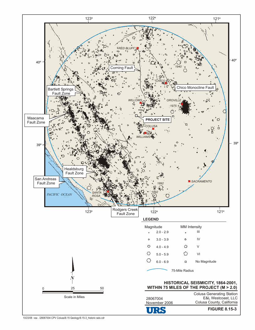
28067004November 2006
Colusa Generating StationE&L Westcoast, LLC
Colusa County, California
HISTORICAL SEISMICITY, 1864-2001, WITHIN 75 MILES OF THE PROJECT (M > 2.0)
FIGURE 8.15-3
N
0 25 50
Scale in Miles
PROJECT SITE
Chico Monocline Fault
Corning Fault
Bartlett Springs Fault Zone
Maacama Fault Zone
Healdsburg Fault Zone
Rodgers Creek Fault Zone
San Andreas Fault Zone
SANTA ROSA
SACRAMENTO
COLUSA
WILLIAMS
OROVILLE
CHICO
RED BLUFF
1940
1975
1892
1892
WILLOWS
PACIFIC OCEAN
Magnitude MM Intensity
No Magnitude
III
IV
V
VI
2.0 - 2.9
3.0 - 3.9
4.0 - 4.9
5.0 - 5.9
6.0 - 6.9
LEGEND
75-Mile Radius
10/23/06 vsa ..\28067004 CPV Colusa\8.15 Geology\8.15-3_historic seis.cdr
123º
123º
122º
122º
121º
121º
39º39º
40º40º

2-Mile Radius
8a
8b
9c9c
9b
9b
9b
9b
9c
9a9c
9c
9b
9c
9c
9c
9c9c
9c
9b 9b
9c
9c
9x
Qrb
Qrb
Qrb
Qb
Qb
9c
9c
Qrb
Qrb
Qrb
QrbQrb
Qrb
Qrb
9c
Qb
Qb
Qb
Qb
Qb
Qrl
Qrl
QrlQrlQa
Qa
Qa
Qa
Qrb
Qrl
Qrl
Qrb
D
U
U
D
D
U
9a9a9a9a
9b9b
AC
AN
LA
CA
NL
CA
NA
LC
AN
AL
TE
HM
AO
LS
A
A–C
UT
EH
MA
OL
SA
A
–C
U
NO
LA
GL
EN
–CU
S
NO
LA
GL
EN
–CU
S
DIRKS ROADDIRKS ROAD
DELEVAN ROADDELEVAN ROAD
DE
LE
VA
N R
OA
DD
EL
EV
AN
R
OA
D
Mc
DE
RM
OT
T R
OA
DM
cD
ER
MO
TT
R
OA
D
11/02/06 vsa ..\28067004 CPV Colusa\8.15 Geology\8.15-4_reg geo.cdr
28067004November 2006
Colusa Generating StationE&L Westcoast, LLC
Colusa County, California
REGIONAL GEOLOGIC MAP
FIGURE 8.15-4
Source: USGS Topographic Maps, 7.5 Minute Series: Logan Ridge, California, 1973 Logandale, California, 1973 Sites, California, 1973 Maxwell, California, 1994
Geologic Map of the Late Cenozoic Deposits of the Sacramento Valley and Northern Sierra Foothills,California, Helley, E.J., And Harwood, S.P. 1985(Map MF-1790)
Geologic Map of the Lodoga Quadrangle, Glenn and Colusa Counties, California, Brown, R.D., and Rich, E.I. 1961 (Map OM-210)
N
0 2000 4000
Scale in Feet1:24,000
LEGEND
D
U
Qa Holocene Alluvium
Qb Holocene basin deposits
Qrl Riverbank formation, lower member, Pleistocene
Qrb Red Bluff formation, Pleistocene
9a Marine sandstone, Upper Cretaceous
9b Interbedded marine sandstone and siltstone, Upper Cretaceous
9x Submarine landslide deposit, Upper Cretaceous
9c Marine siltstone, Upper Cretaceous
8a Shallow marine sandstone, Upper Cretaceous
8b Interbedded marine siltstone and sandstone, Upper Cretaceous
Fault, dashed where approximately located or inferred, not historically active
Relative upthrown side
Relative downthrown side
Indicates general dip direction
2-Mile radius
100-acre Project Site
Plant Layout
Proposed Transmission Line Interconnection
Proposed Water Supply Pipeline
Proposed Natural Gas Pipeline
Proposed New Roadway
Proposed Bridge/Intersection Improvements
Construction Areas
230 kV Transmission Line
PROJECT SITE
PG&E CompressorStation
Teresa Creek BridgeReplacement
IntersectionImprovements
Glenn-Colusa CanalBridge Replacement
ConstructionLaydown Area
ConstructionParking Area
ConstructionOffice

0 10 20
Scale in Miles
28067004November 2006
Colusa Generating StationE&L Westcoast, LLC
Colusa County, California
10 PERCENT PROBABILITY OF EXCEEDANCEIN 50 YEARS OF GROUND MOTIONS
FIGURE 8.15-5
10/23/06 vsa ..\28067004 CPV Colusa\8.15 Geology\8.15-5_probability.cdr
N
LEGEND
>70% g
60% to 70% g
50% to 60% g
40% to 50% g
30% to 40% g
20% to 30% g
10% to 20% g
PROJECT SITE
Source:California Dept of Conservation, Division of Mines and Geology, 1999www.consrv.ca.gov/dmg/rghm/psha/atlas/Ukiah.htm
Note:Acceleration measured as percent of gravity (g).
CORNINGCORNING
ORLANDORLAND
WILLOWSWILLOWS
WILLIAMSWILLIAMS
ARBUCKLEARBUCKLE
COLUSACOLUSA
COVELOCOVELO
LAYTONVILLELAYTONVILLE
FORT BRAGGFORT BRAGG
WILLITSWILLITS
UKIAHUKIAH
GLENN COGLENN CO
LAKE COLAKE CO
MENDOCINO COMENDOCINO CO
TEHAMA COTEHAMA CO
COLUSA COCOLUSA CO
PACIFICOCEANPACIFICOCEAN
5
45
20
99
1101