takli island, k-59 legend - alaska decdec.alaska.gov/spar/ppr/grs/ki/km59takliisland.pdfthis is not...
TRANSCRIPT

This is not intended for navigational use.
Lege
ndMap Photo&
Geo
grap
hic
Res
pons
e St
rate
gies
for
Mai
nla
nd
Kod
iak
Su
bare
a
NUKA Research & Planning Group, LLC.
Soundings in fathoms
June 2008
Takli Island, K-59Center of map at 58˚ 03.5’ N Lat., 154˚ 29.6’ W Lon.
Takli Island viewed from the northeast.
Takli Island viewed from the south.
Free-oil Containment and Recovery, Shallow Water
Exclusion Booming
Passive Recovery - Marine Mammal
Protected-water Boom
FO-S
EX
PR-MM
Takli Island viewed from the southwest.
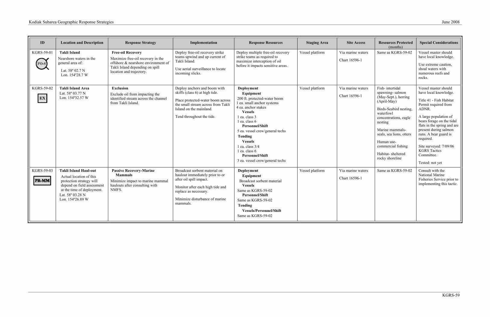
Kodiak Subarea Geographic Response Strategies June 2008
KGRS-59
ID Location and Description Response Strategy Implementation Response Resources Staging Area Site Access Resources Protected(months)
Special Considerations
KGRS-59-01 Takli Island
Nearshore waters in thegeneral area of:
Lat. 58º 02.7 NLon. 154º28.7 W
Free-oil Recovery
Maximize free-oil recovery in theoffshore & nearshore environment ofTakli Island depending on spilllocation and trajectory.
Deploy free-oil recovery striketeams upwind and up current ofTakli Island.
Use aerial surveillance to locateincoming slicks.
Deploy multiple free-oil recoverystrike teams as required tomaximize interception of oilbefore it impacts sensitive areas.
Vessel platform Via marine waters
Chart 16596-1
Same as KGRS-59-02 Vessel master shouldhave local knowledge.
Use extreme caution,shoal waters withnumerous reefs androcks.
KGRS-59-02 Takli Island AreaLat. 58º 03.77 NLon. 154º32.57 W
Exclusion
Exclude oil from impacting theidentified stream across the channelfrom Takli Island.
Deploy anchors and boom withskiffs (class 6) at high tide.
Place protected-water boom acrossthe small stream across from TakliIsland on the mainland.
Tend throughout the tide.
DeploymentEquipment
200 ft. protected-water boom1 ea. small anchor systems4 ea. anchor stakes
Vessels1 ea. class 31 ea. class 6
Personnel/Shift5 ea. vessel crew/general techsTending
Vessels1 ea. class 3/41 ea. class 6
Personnel/Shift3 ea. vessel crew/general techs
Vessel platform Via marine waters
Chart 16596-1
Fish- intertidalspawning- salmon(May-Sept.), herring(April-May)
Birds-Seabird nesting,waterfowlconcentrations, eaglenesting
Marine mammals-seals, sea lions, otters
Human use-commercial fishing
Habitat- shelteredrocky shoreline
Vessel master shouldhave local knowledge.
Title 41 - Fish HabitatPermit required fromADNR.
A large population ofbears forage on the tidalflats in the spring and arepresent during salmonruns. A bear guard isrequired.
Site surveyed: 7/09/06KGRS TacticsCommittee.
Tested: not yet
KGRS-59-03 Takli Island Haul-out
Actual location of thisprotection strategy willdepend on field assessmentat the time of deployment.
Lat. 58º 03.28 NLon. 154º26.89 W
Passive Recovery-MarineMammals
Minimize impact to marine mammalhaulouts after consulting withNMFS.
Broadcast sorbent material onhaulout immediately prior to orafter oil spill impact.
Monitor after each high tide andreplace as necessary.
Minimize disturbance of marinemammals.
DeploymentEquipment
Broadcast sorbent materialVessels
Same as KGRS-59-02Personnel/Shift
Same as KGRS-59-02Tending
Vessels/Personnel/ShiftSame as KGRS-59-02
Vessel platform Via marine waters
Chart 16596-1
Same as KGRS-59-02 Consult with theNational MarineFisheries Service prior toimplementing this tactic.