targeted drainage report
TRANSCRIPT

Targeted Drainage Report
Harbour Pointe Townhomes
City of Mukilteo, Washington
Tax Parcel: 28042100103200
Group Four Job No. 18-4523
May 31, 2019
Revised: August 13, 2019
April 2, 2020, June 28, 2020
Prepared For:
Paris Beta LLC
Prepared By:
Curt Iffrig, P.E.
Lucy Chen Group Four, Inc.
2225 94th Ave NE 1901 Vernon Road, Suite #A
Clyde Hill, WA 98004 Lake Stevens, WA 98258
(206) 928-5013 (425) 408-1152
1

Harbour Pointe Townhomes Targeted Drainage Report April 2, 2020
Group Four, Inc. 2 18-4523
Section I
Project Overview and Executive Summary
Existing Conditions Summary
Mitigation Summary
Upstream Analysis
Downstream Analysis
Section II
MR-1 Targeted Stormwater Site Plan
MR 2-SWPPP
MR 3-Water Pollution Source Control for New Development
MR 4-Preservation of Natural Drainage Systems and Outfalls
MR 5-On-site Storm water Management
MR 6-Runoff Treatment
MR 7- Flow Control
MR 8- Wetland Protection
MR 9- Operation and Maintenance
Appendix
A - Geotechnical report
B - Post Construction Amended Soils
C - WWHM 2012 Output
Figures
Figure 1-Vicinity Map
Figure 2-Predeveloped Site Plan
Figure 3-Proposed Site Plan

Harbour Pointe Townhomes Targeted Drainage Report April 2, 2020
Group Four, Inc. 3 18-4523
Section I
Project Overview and Executive Summary
Name: Harbour Point Townhomes
PFN: Pending
Tax Parcel: 28042100103200
Owner/Applicant:
Paris Beta LLC
Lucy Chen
2225 94th Ave NE
Clyde Hill, WA 98004
206-928-5013
Engineer:
Group Four, Inc.
P.O. Box 1059
Lake Stevens, WA 98258
425-408-1152
This targeted drainage report was prepared as part of a preliminary drainage review for the City
of Mukilteo per the Stormwater Management Manual for Western Washington, 2014
(SWMMWW 2014) and the City of Mukilteo Development Standards 2017.
The applicant proposes to build 31 residential townhomes on a 3.26 ac parcel zoned PCB-S on
Harbour Pl in Mukilteo, WA. The project will disturb approximately 1.78 ac and proposes
approximately 23,000 sf of new roofs, 12,700 sf of new road, and 8,500 sf of driveways, 3,400 sf
of sidewalk and 2,500 sf of parking area.
Proposed impervious surface will be mitigated by an underground detention vault that is 80 ft
long x 30 ft wide and 15 ft deep. Water quality will be provided by a combination wetpool below
the dead storage.

Harbour Pointe Townhomes Targeted Drainage Report April 2, 2020
Group Four, Inc. 4 18-4523
Existing Conditions Summary
The existing site is 3.26 acres in an area zoned Planed Community Business-South (PCB-S).
Approximately 50% of the area is cleared and the remainder is forested. An existing asphalt road
runs along the northeast property boundary. The project site is confined to the north and east of
the property due to steep slopes and wetlands in the south and west. The project site moderately
slopes to the south and west with an average approximate slope in the project area is between 3%
and 10%. See Figure 1 for the Vicinity Map and Figure 2 for the Existing Conditions site plan.
A geotechnical assessment was prepared for the site by Associated Earth Sciences dated
February 8th, 2019. This assessment found the soils on site to be Vashon Lodgement Till which
is not suitable for infiltration. The geotechnical assessment report is in Appendix A.
Mitigation Summary
Presented below is a summary of proposed impervious areas treated solely by on-site storm
water management. See Figure 3 for Proposed Site Plan.
TDA Area, SF BMP Note
Proposed Roofs 23,000 Detention Vault
Proposed Road 12,700 Detention Vault
Proposed Driveways 8,500 Detention Vault
Proposed Sidewalk 3,400 Detention Vault
Proposed Parking 2,500 Detention Vault
Total 50,100
Upstream Analysis
There are no areas upstream that are tributary to the project site. Runoff from the uphill Harbour
Place is collected in an existing storm system. There is not visual evidence of surface runoff
flowing onto project site. See photos below
Harbour Pointe Townhomes Targeted Drainage Report April 2, 2020
Group Four, Inc. 5 18-4523
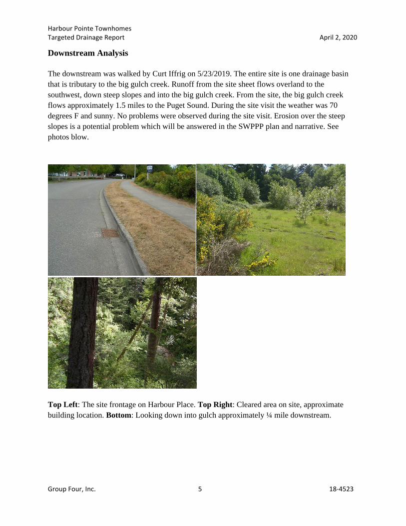
Downstream Analysis
The downstream was walked by Curt Iffrig on 5/23/2019. The entire site is one drainage basin
that is tributary to the big gulch creek. Runoff from the site sheet flows overland to the
southwest, down steep slopes and into the big gulch creek. From the site, the big gulch creek
flows approximately 1.5 miles to the Puget Sound. During the site visit the weather was 70
degrees F and sunny. No problems were observed during the site visit. Erosion over the steep
slopes is a potential problem which will be answered in the SWPPP plan and narrative. See
photos blow.
Top Left: The site frontage on Harbour Place. Top Right: Cleared area on site, approximate
building location. Bottom: Looking down into gulch approximately ¼ mile downstream.

Harbour Pointe Townhomes Targeted Drainage Report April 2, 2020
Group Four, Inc. 6 18-4523
Figure 1: Vicinity Map

Harbour Pointe Townhomes Targeted Drainage Report April 2, 2020
Group Four, Inc. 7 18-4523
Section II: Minimum Requirements
Per the SWMMWW 2014, this project must comply with Minimum Requirements 1 through 9.
MR-1 Targeted Stormwater Site Plan
A Preliminary Targeted Drainage Plan has been prepared per the SWMMWW 2014 and the City
of Mukilteo Development Standards. A full set of civil plans will be submitted for final design
review
MR 2-SWPPP Narrative
A SWPP plan and narrative will be prepared for final design review.
MR 3-Water Pollution Source Control for New Development
Pollution source control is not required for this residential site.
MR 4-Preservation of Natural Drainage Systems and Outfalls The detention vault will discharge to the west at the toe of the steep slope. This will maintain the
site’s natural discharge location. Off-site mitigation is not required for this project.
MR 5-On-site Stormwater Management
On-site stormwater water management will be accomplished by providing on-site stormwater
BMP’s from List #2 where feasible. A compost-amended soil management plan has been
developed utilizing BMP T5.13. The compost amended soil management plan will apply to all
landscape surfaces with an area of approximately 26,900 SF (0.62 Ac). The Snohomish County
Soil Management Plan will be completed for final design and included in Appendix B.
Infiltration is not feasible for this site because a geotechnical study found fine soils unsuitable for
infiltration. Full dispersion is not feasible because of the steep slopes downstream of the site.
Bioretention is not feasible due to the space available and the fine soils.
MR 6-Runoff Treatment
The proposed PGIS is will be treated with the combination wetpool/detention method where a
wetpool constructed below the live storage in the vault. The depth and capacity of this wetpool
will be determined prior to final design. Per the 2014 SWMMWW, “Combined detention and
water quality facilities are very efficient for sites that also have detention requirements.”

Harbour Pointe Townhomes Targeted Drainage Report April 2, 2020
Group Four, Inc. 8 18-4523
MR 7- Flow Control
The flow control requirement per the SWMMWW 2014 is described below;
“Stormwater discharges shall match developed discharge durations to predeveloped durations
for the range of pre-developed discharge rates from 50% of the 2-year peak flow up to the full
50-year peak flow”
Flow control will be provided by an underground detention vault. WWHM 2012 was used to
model the drainage basin and size detention vault to meet the flow control requirement.
Detention Vault
A detention vault will be used to provide flow control for runoff from proposed
impervious and proposed new pervious areas. The vault will be 80 ft long, 30 ft wide and
15 ft deep. The proposed vault is sized to meet the flow control standard per the
Stormwater Management Manual for Western Washington, 2014. (SWMMWW, 2014)
The vault will discharge into the big gulch creek below.
WWHM 2012 was used to model the predeveloped and developed condition, size the
detention vault and demonstrate compliance with the flow control standard. The
predeveloped and developed condition from that report are shown in the table below.
SURFACE SLOPE COVER AREA (ac)
PRE-DEVELOPED
Existing Forest 3-10% Forest 1.78
DEVELOPED
Proposed Roof 0% Roof 0.53
Proposed Road and Frontage 3-10% Road 0.29
Proposed Driveways and Walkways 3-10% Driveways 0.33
Lawn and Landscape 3-10% Lawn 0.63
The vault parameters for WWHM 2012 are shown in the table below. Due to space
requirements the vault proposed is 80 ft long, 30 ft wide and 15 ft deep. The orifice size
modeled below is smaller than the 0.5 in diameter required so a 0.5 in diameter orifice
will be constructed. Final orifice calculations will be produced as the project approaches
final design.

Harbour Pointe Townhomes Targeted Drainage Report April 2, 2020
Group Four, Inc. 9 18-4523
The probability exceedance curve below shows that the vault as designed is in
compliance with the SWMMWW, 2014 flow control standard. See the full WWHM
output in Appendix C.
Model Input Value Note
Vault Type Underground Width 30 ft Design Width
Depth 15 ft Design Depth
Length 80 ft Design Length
Volume 36,281 cf Live Storage Volume
Infiltration
Rate 0 No Infiltration
Riser Height 14 ft
Riser Diameter 18 in Design Diameter
Notch Width 0.011 ft Rectangular Notch
Notch Height 1.019 ft
Orifice 1
Diameter 0.347 in Design Diameter
Orifice 1 Elev. 0 From bottom of live storage

Harbour Pointe Townhomes Targeted Drainage Report April 2, 2020
Group Four, Inc. 10 18-4523
MR 8- Wetland Protection
Runoff being discharged into downstream wetlands will be controlled by the detention vault.
Uncontrolled flows will not be discharged into wetlands. The stream area receiving the
controlled runoff is not a depressional wetland so no additional calculations are required.
MR 9- Operation and Maintenance SCC 30.63A.575 through SCC 30.63A.605
The detention vault and stormwater sytem are to be owned, operated and maintained by the
homeowner’s association according to the standards contained in the SWMMWW, 2014.

Harbour Pointe Townhomes Targeted Drainage Report April 2, 2020
Group Four, Inc. 11 18-4523
Appendices
A - Geotechnical Report
B - Post Construction Amended Soils (To be included for final design)
C - WWHM2012 Output

WWHM2012
PROJECT REPORT
___________________________________________________________________
Project Name: Harbor Point Prelim Revised
Site Name:
Site Address:
City :
Report Date: 4/2/2020
Gage : Everett
Data Start : 1948/10/01
Data End : 2009/09/30
Precip Scale: 0.80
Version Date: 2017/04/14
Version : 4.2.13
___________________________________________________________________
Low Flow Threshold for POC 1 : 50 Percent of the 2 Year
___________________________________________________________________
High Flow Threshold for POC 1: 50 year
___________________________________________________________________
PREDEVELOPED LAND USE
Name : Basin 1
Bypass: No
GroundWater: No
Pervious Land Use acre
C, Forest, Mod 1.78
Pervious Total 1.78
Impervious Land Use acre
Impervious Total 0
Basin Total 1.78
___________________________________________________________________
Element Flows To:
Surface Interflow Groundwater
___________________________________________________________________
MITIGATED LAND USE
Name : Basin 1
Bypass: No
GroundWater: No

Pervious Land Use acre
C, Lawn, Mod .63
Pervious Total 0.63
Impervious Land Use acre
ROADS MOD 0.29
ROOF TOPS FLAT 0.53
DRIVEWAYS MOD 0.33
Impervious Total 1.15
Basin Total 1.78
___________________________________________________________________
Element Flows To:
Surface Interflow Groundwater
Vault 1 Vault 1
___________________________________________________________________
Name : Vault 1
Width : 30 ft.
Length : 80 ft.
Depth: 15 ft.
Discharge Structure
Riser Height: 14 ft.
Riser Diameter: 18 in.
Notch Type: Rectangular
Notch Width: 0.011 ft.
Notch Height: 1.019 ft.
Orifice 1 Diameter: 0.347 in. Elevation: 0 ft.
Element Flows To:
Outlet 1 Outlet 2
___________________________________________________________________
Vault Hydraulic Table Stage(feet) Area(ac.) Volume(ac-ft.) Discharge(cfs) Infilt(cfs)
0.0000 0.055 0.000 0.000 0.000
0.1667 0.055 0.009 0.001 0.000
0.3333 0.055 0.018 0.001 0.000
0.5000 0.055 0.027 0.002 0.000
0.6667 0.055 0.036 0.002 0.000
0.8333 0.055 0.045 0.003 0.000
1.0000 0.055 0.055 0.003 0.000
1.1667 0.055 0.064 0.003 0.000
1.3333 0.055 0.073 0.003 0.000
1.5000 0.055 0.082 0.004 0.000
1.6667 0.055 0.091 0.004 0.000
1.8333 0.055 0.101 0.004 0.000
2.0000 0.055 0.110 0.004 0.000

2.1667 0.055 0.119 0.004 0.000
2.3333 0.055 0.128 0.005 0.000
2.5000 0.055 0.137 0.005 0.000
2.6667 0.055 0.146 0.005 0.000
2.8333 0.055 0.156 0.005 0.000
3.0000 0.055 0.165 0.005 0.000
3.1667 0.055 0.174 0.005 0.000
3.3333 0.055 0.183 0.006 0.000
3.5000 0.055 0.192 0.006 0.000
3.6667 0.055 0.202 0.006 0.000
3.8333 0.055 0.211 0.006 0.000
4.0000 0.055 0.220 0.006 0.000
4.1667 0.055 0.229 0.006 0.000
4.3333 0.055 0.238 0.006 0.000
4.5000 0.055 0.247 0.006 0.000
4.6667 0.055 0.257 0.007 0.000
4.8333 0.055 0.266 0.007 0.000
5.0000 0.055 0.275 0.007 0.000
5.1667 0.055 0.284 0.007 0.000
5.3333 0.055 0.293 0.007 0.000
5.5000 0.055 0.303 0.007 0.000
5.6667 0.055 0.312 0.007 0.000
5.8333 0.055 0.321 0.007 0.000
6.0000 0.055 0.330 0.008 0.000
6.1667 0.055 0.339 0.008 0.000
6.3333 0.055 0.348 0.008 0.000
6.5000 0.055 0.358 0.008 0.000
6.6667 0.055 0.367 0.008 0.000
6.8333 0.055 0.376 0.008 0.000
7.0000 0.055 0.385 0.008 0.000
7.1667 0.055 0.394 0.008 0.000
7.3333 0.055 0.404 0.008 0.000
7.5000 0.055 0.413 0.008 0.000
7.6667 0.055 0.422 0.009 0.000
7.8333 0.055 0.431 0.009 0.000
8.0000 0.055 0.440 0.009 0.000
8.1667 0.055 0.450 0.009 0.000
8.3333 0.055 0.459 0.009 0.000
8.5000 0.055 0.468 0.009 0.000
8.6667 0.055 0.477 0.009 0.000
8.8333 0.055 0.486 0.009 0.000
9.0000 0.055 0.495 0.009 0.000
9.1667 0.055 0.505 0.009 0.000
9.3333 0.055 0.514 0.010 0.000
9.5000 0.055 0.523 0.010 0.000
9.6667 0.055 0.532 0.010 0.000
9.8333 0.055 0.541 0.010 0.000
10.000 0.055 0.551 0.010 0.000
10.167 0.055 0.560 0.010 0.000
10.333 0.055 0.569 0.010 0.000
10.500 0.055 0.578 0.010 0.000
10.667 0.055 0.587 0.010 0.000
10.833 0.055 0.596 0.010 0.000
11.000 0.055 0.606 0.010 0.000
11.167 0.055 0.615 0.010 0.000
11.333 0.055 0.624 0.011 0.000
11.500 0.055 0.633 0.011 0.000

11.667 0.055 0.642 0.011 0.000
11.833 0.055 0.652 0.011 0.000
12.000 0.055 0.661 0.011 0.000
12.167 0.055 0.670 0.011 0.000
12.333 0.055 0.679 0.011 0.000
12.500 0.055 0.688 0.011 0.000
12.667 0.055 0.697 0.011 0.000
12.833 0.055 0.707 0.011 0.000
13.000 0.055 0.716 0.011 0.000
13.167 0.055 0.725 0.014 0.000
13.333 0.055 0.734 0.019 0.000
13.500 0.055 0.743 0.024 0.000
13.667 0.055 0.753 0.030 0.000
13.833 0.055 0.762 0.036 0.000
14.000 0.055 0.771 0.042 0.000
14.167 0.055 0.780 1.116 0.000
14.333 0.055 0.789 2.925 0.000
14.500 0.055 0.798 4.681 0.000
14.667 0.055 0.808 5.797 0.000
14.833 0.055 0.817 6.512 0.000
15.000 0.055 0.826 7.129 0.000
15.167 0.055 0.835 7.697 0.000
15.333 0.000 0.000 8.226 0.000
___________________________________________________________________
___________________________________________________________________
ANALYSIS RESULTS
Stream Protection Duration
___________________________________________________________________
Predeveloped Landuse Totals for POC #1
Total Pervious Area:1.78
Total Impervious Area:0
___________________________________________________________________
Mitigated Landuse Totals for POC #1
Total Pervious Area:0.63
Total Impervious Area:1.15
___________________________________________________________________
Flow Frequency Return Periods for Predeveloped. POC #1
Return Period Flow(cfs)
2 year 0.021917
5 year 0.034279
10 year 0.041973
25 year 0.050939
50 year 0.057053
100 year 0.062702
Flow Frequency Return Periods for Mitigated. POC #1
Return Period Flow(cfs)
2 year 0.009781
5 year 0.016801
10 year 0.023236

25 year 0.033925
50 year 0.044124
100 year 0.056599
___________________________________________________________________
Stream Protection Duration
Annual Peaks for Predeveloped and Mitigated. POC #1
Year Predeveloped Mitigated
1949 0.003 0.007
1950 0.028 0.010
1951 0.021 0.009
1952 0.015 0.008
1953 0.013 0.008
1954 0.038 0.010
1955 0.037 0.039
1956 0.030 0.147
1957 0.035 0.008
1958 0.024 0.010
1959 0.023 0.009
1960 0.021 0.008
1961 0.024 0.010
1962 0.014 0.007
1963 0.018 0.008
1964 0.021 0.008
1965 0.022 0.010
1966 0.012 0.008
1967 0.031 0.009
1968 0.030 0.010
1969 0.016 0.009
1970 0.017 0.009
1971 0.026 0.023
1972 0.024 0.007
1973 0.013 0.009
1974 0.026 0.011
1975 0.018 0.008
1976 0.017 0.010
1977 0.008 0.007
1978 0.016 0.008
1979 0.032 0.007
1980 0.019 0.008
1981 0.016 0.007
1982 0.024 0.010
1983 0.023 0.010
1984 0.021 0.011
1985 0.032 0.017
1986 0.083 0.011
1987 0.028 0.011
1988 0.018 0.009
1989 0.013 0.008
1990 0.023 0.009
1991 0.025 0.010
1992 0.018 0.009
1993 0.012 0.007
1994 0.008 0.009
1995 0.022 0.010
1996 0.050 0.011
1997 0.090 0.145

1998 0.012 0.009
1999 0.023 0.011
2000 0.013 0.010
2001 0.003 0.005
2002 0.022 0.012
2003 0.014 0.007
2004 0.021 0.009
2005 0.018 0.008
2006 0.050 0.035
2007 0.037 0.018
2008 0.049 0.010
2009 0.019 0.009
___________________________________________________________________
Stream Protection Duration
Ranked Annual Peaks for Predeveloped and Mitigated. POC #1
Rank Predeveloped Mitigated
1 0.0904 0.1466
2 0.0832 0.1447
3 0.0498 0.0393
4 0.0495 0.0355
5 0.0487 0.0233
6 0.0380 0.0183
7 0.0375 0.0165
8 0.0374 0.0117
9 0.0347 0.0113
10 0.0321 0.0109
11 0.0320 0.0108
12 0.0310 0.0107
13 0.0304 0.0107
14 0.0303 0.0106
15 0.0278 0.0104
16 0.0276 0.0104
17 0.0259 0.0102
18 0.0256 0.0100
19 0.0250 0.0100
20 0.0242 0.0100
21 0.0239 0.0100
22 0.0238 0.0099
23 0.0238 0.0097
24 0.0232 0.0097
25 0.0232 0.0097
26 0.0230 0.0096
27 0.0229 0.0095
28 0.0223 0.0093
29 0.0219 0.0093
30 0.0218 0.0093
31 0.0214 0.0092
32 0.0210 0.0091
33 0.0209 0.0090
34 0.0207 0.0090
35 0.0206 0.0090
36 0.0187 0.0089
37 0.0186 0.0088
38 0.0185 0.0088
39 0.0184 0.0087
40 0.0184 0.0086

41 0.0181 0.0083
42 0.0176 0.0083
43 0.0174 0.0082
44 0.0170 0.0081
45 0.0164 0.0080
46 0.0161 0.0080
47 0.0160 0.0080
48 0.0152 0.0079
49 0.0142 0.0077
50 0.0140 0.0077
51 0.0132 0.0076
52 0.0130 0.0076
53 0.0130 0.0075
54 0.0126 0.0073
55 0.0125 0.0072
56 0.0118 0.0072
57 0.0115 0.0072
58 0.0080 0.0068
59 0.0079 0.0067
60 0.0032 0.0066
61 0.0028 0.0049
___________________________________________________________________
Stream Protection Duration
POC #1
The Facility PASSED
The Facility PASSED.
Flow(cfs) Predev Mit Percentage Pass/Fail
0.0110 21109 12761 60 Pass
0.0114 19235 5955 30 Pass
0.0119 17554 2620 14 Pass
0.0124 15962 2532 15 Pass
0.0128 14495 2443 16 Pass
0.0133 13278 2357 17 Pass
0.0138 12147 2278 18 Pass
0.0142 11122 2190 19 Pass
0.0147 10177 2099 20 Pass
0.0151 9351 2026 21 Pass
0.0156 8615 1917 22 Pass
0.0161 7931 1801 22 Pass
0.0165 7334 1728 23 Pass
0.0170 6727 1664 24 Pass
0.0175 6220 1612 25 Pass
0.0179 5702 1556 27 Pass
0.0184 5234 1495 28 Pass
0.0189 4791 1446 30 Pass
0.0193 4400 1403 31 Pass
0.0198 4060 1344 33 Pass
0.0203 3749 1286 34 Pass
0.0207 3480 1226 35 Pass
0.0212 3206 1155 36 Pass
0.0217 2950 1078 36 Pass
0.0221 2725 1029 37 Pass
0.0226 2543 982 38 Pass
0.0231 2385 924 38 Pass

0.0235 2250 859 38 Pass
0.0240 2120 803 37 Pass
0.0245 2002 759 37 Pass
0.0249 1904 725 38 Pass
0.0254 1789 704 39 Pass
0.0259 1685 692 41 Pass
0.0263 1590 679 42 Pass
0.0268 1486 667 44 Pass
0.0273 1384 656 47 Pass
0.0277 1321 642 48 Pass
0.0282 1252 631 50 Pass
0.0287 1201 610 50 Pass
0.0291 1158 589 50 Pass
0.0296 1120 567 50 Pass
0.0300 1077 543 50 Pass
0.0305 1032 509 49 Pass
0.0310 993 493 49 Pass
0.0314 965 479 49 Pass
0.0319 928 464 50 Pass
0.0324 895 445 49 Pass
0.0328 857 423 49 Pass
0.0333 822 402 48 Pass
0.0338 791 389 49 Pass
0.0342 758 366 48 Pass
0.0347 732 336 45 Pass
0.0352 707 317 44 Pass
0.0356 683 300 43 Pass
0.0361 664 278 41 Pass
0.0366 645 253 39 Pass
0.0370 626 232 37 Pass
0.0375 607 218 35 Pass
0.0380 584 208 35 Pass
0.0384 567 198 34 Pass
0.0389 556 188 33 Pass
0.0394 541 175 32 Pass
0.0398 526 165 31 Pass
0.0403 515 155 30 Pass
0.0408 505 144 28 Pass
0.0412 495 132 26 Pass
0.0417 483 117 24 Pass
0.0422 471 104 22 Pass
0.0426 459 81 17 Pass
0.0431 443 79 17 Pass
0.0436 428 77 17 Pass
0.0440 417 74 17 Pass
0.0445 405 74 18 Pass
0.0449 388 72 18 Pass
0.0454 371 70 18 Pass
0.0459 355 69 19 Pass
0.0463 339 68 20 Pass
0.0468 325 67 20 Pass
0.0473 318 66 20 Pass
0.0477 307 65 21 Pass
0.0482 302 61 20 Pass
0.0487 291 59 20 Pass
0.0491 287 55 19 Pass
0.0496 279 53 18 Pass

0.0501 274 52 18 Pass
0.0505 268 52 19 Pass
0.0510 265 49 18 Pass
0.0515 262 49 18 Pass
0.0519 257 46 17 Pass
0.0524 253 46 18 Pass
0.0529 245 46 18 Pass
0.0533 242 42 17 Pass
0.0538 236 42 17 Pass
0.0543 231 42 18 Pass
0.0547 226 39 17 Pass
0.0552 224 39 17 Pass
0.0557 222 37 16 Pass
0.0561 220 37 16 Pass
0.0566 217 37 17 Pass
0.0571 211 37 17 Pass
_____________________________________________________
___________________________________________________________________
Water Quality BMP Flow and Volume for POC #1
On-line facility volume: 0.0197 acre-feet
On-line facility target flow: 0.0099 cfs.
Adjusted for 15 min: 0.0099 cfs.
Off-line facility target flow: 0.0068 cfs.
Adjusted for 15 min: 0.0068 cfs.
___________________________________________________________________
LID Report
LID Technique Used for Total Volumn Volumn Infiltration Cumulative
Percent Water Quality Percent Comment
Treatment? Needs Through Volumn Volumn
Volumn Water Quality
Treatment Facility (ac-ft.) Infiltration
Infiltrated Treated
(ac-ft) (ac-ft) Credit
Vault 1 POC N 151.45 N
0.00
Total Volume Infiltrated 151.45 0.00 0.00 0.00
0.00 0% No Treat. Credit
Compliance with LID Standard 8
Duration Analysis Result = Failed
___________________________________________________________________
Perlnd and Implnd Changes
No changes have been made. ___________________________________________________________________
This program and accompanying documentation are provided 'as-is' without warranty of any kind. The
entire risk regarding the performance and results of this program is assumed by End User. Clear Creek
Solutions Inc. and the governmental licensee or sublicensees disclaim all warranties, either expressed
or implied, including but not limited to implied warranties of program and accompanying documentation.
In no event shall Clear Creek Solutions Inc. be liable for any damages whatsoever (including without
limitation to damages for loss of business profits, loss of business information, business
interruption, and the like) arising out of the use of, or inability to use this program even if Clear
Creek Solutions Inc. or their authorized representatives have been advised of the possibility of such
damages. Software Copyright © by : Clear Creek Solutions, Inc. 2005-2020; All Rights Reserved.