technical papers in hydrology 2 - global cryosphere watch
TRANSCRIPT

Technical papers in hydrology 2

In this series:
1 Perennial Ice and S n o w Masses. A Guide for Compilation and Assemblage of Data for a World Inventory.
2 Seasonal S n o w Cover. A Guide for Measurement, Compilation and Assemblage of Data.
3 Variations of Existing Glaciers. A Guide to International Practices for their Measurement.
4 Antarctic Glaciology in the International Hydrological Decade.
5 Combined Heat, Ice and Water Balances at Selected Glacier Basins. A Guide for Compilation and Assemblage of Data for Glacier Mass Balance Measurements.

A contribution to the
International Hydrological
Decade
Seasonal snow cover
A guide for measurement
compilation and assemblage of
data
unesco/iash/wmo

T h e selection and presentation of material and the opinions expressed in this publication are the responsibility of the authors concerned and do not necessarily reflect the views of Unesco. N o r do the designations employed or the presentation of the material imply the expression of any opinion whatsoever on the part of Unesco concerning the legal status of any country or territory, or of its authorities, or concerning the delimitations of the frontiers of any country or territory.
Published in 1970 by the United Nations Educational, Scientific and Cultural Organization Place de Fontenoy, 75 Paris-7e
Printed by Imprimerie-Reliure Marne
© U n e s c o / I A S H / W M O 1970 Printed in France S C . 6 8 / X X I . 2 / A
Preface
The International Hydrological Decade ( IHD) 1965-74 was launched by the General Conference of Unesco at its thirteenth session to promote international co-operation in research and studies and the training of specialists and technicians in scientific hydrology. Its purpose is to enable all countries to m a k e a fuller assessment of their water resources and a more rational use of them as man's demands for water constantly increase in face of developments in population, industry and agriculture. In 1968 national committees for the Decade had been formed in 100 of Unesco's 122 M e m b e r States to carry out national, activities and to contribute to regional and international activities within the programme of the Decade. The implementation of the programme is supervised by a Co-ordinating Council, composed of twenty-one M e m b e r States selected by the General Conference of Unesco, which studies proposals for developments of the programme, recommends projects of interest to all or a large number of countries, assists in the development of national and regional projects and co-ordinates international co-operation.
Promotion of collaboration in developing hydro-logical research techniques, diffusing hydrological data and planning hydrological installations is a major feature of the programme of the I H D , which encompasses all aspects of hydrological studies and research. Hydrological investigations are encouraged at the national, regional and international level to strengthen and to improve the use of natural resources from a local and a global perspective. The programme provides a means for countries well advanced in hydrological research to exchange scientific views and for developing countries to benefit from this exchange of information in elaborating research projects and in implementing recent developments in the planning of hydrological installations.
A s part of Unesco's contribution to the achievement of the objectives of the I H D the General Conference authorized the Director-General to collect, exchange and disseminate information concerning research on scientific hydrology and to facilitate contacts between research workers in this field. T o this end Unesco has initiated two collections of publications, 'Studies and Reports in Hydrology' and 'Technical Papers in Hydrology'.
The collection 'Technical Papers in Hydrology' is intended to provide a means for the exchange of information on hydrological techniques and for the co-ordination of research and data collection.
The acquisition, transmission and processing of data in a manner permitting the intercomparison of results is a prerequisite to efforts to co-ordinate scientific projects within the framework of the I H D . The exchange of information on data collected throughout the world requires standard instruments, techniques, units of measure and terminology in order that data from all areas will be comparable. M u c h work has been done already toward international standardization, but m u c h remains to be done even for simple measurements of basic factors such as precipitation, snow cover, soil moisture, streamflow, sediment transport and ground-water phenomena.
It is hoped that the guides on data collection and compilation in specific areas of hydrology to be published in this collection will provide means whereby hydrologists m a y standardize their records of observations and thus facilitate the study of hydrology on a world-wide basis.

1
2
3
Contents
Foreword
Methods of measurement Observation sites Rate of snowfall and new snow deposit Drifting and blowing snow Snow cover depth and hydrological qualities Areal extent of snow cover
Mapping of snow cover
Programmes for snow measurements
Appendix 1 Definitions Appendix 2 Abstract of the International
Classification for Snow Appendix 3 Suggested symbols for mapping
snow cover features References
11 11 11 14
15 19
21
27
29
33
36 37

Foreword
The Co-ordinating Council of the International Hydrological Decade in its resolution 1-12 considered the world inventory of perennial and annual ice and snow masses to be one of the long-term objectives of the Decade and invited the International Commission of Snow and Ice (ICSI) of the International Association of Scientific Hydrology (IASH) to act as scientific adviser in this activity. ICSI undertook to stimulate, guide and co-ordinate snow measurements which could contribute to the establishment of an over-all picture of the worldwide distribution of seasonal snow cover.
T o achieve the compilation of a world inventory of annual ice and snow masses, it is first necessary to collect information on the methods of measuring and mapping snow-cover data and to propose a programme simple enough to be carried out without elaborate means.
This guide has been prepared by ICSI in a form similar to the publication Perennial Ice and Snow Masses. A Guide for Compilation and Assemblage
of Data for a World Inventory, which has also appeared in the collection 'Technical Papers in Hydrology'. Together, these two guides propose methods for international standardization of data collection concerning both perennial and annual ice and snow masses.
In preparing this document, use was made of materials included in the W M O guides mentioned in the references.
It is hoped that the above-mentioned Technical Papers will aid in establishing methods for an international exchange of information, and lead to a world inventory of ice and snow.
Unesco wishes to express its appreciation of the work carried out under the direction of Dr . M . de Quervain, Chairman of the Division of Seasonal Snow Cover and Avalanches of ICSI, of I A S H , and of the contribution to the work made by officers of ICSI and experts from the World Meteorological Organization.
9

1 Methods of measurement
Observation sites
All measurements related to snow accumulation and ablation are greatly dependent on the characteristics of the site, above all on the exposure to sun and wind and on the frequency and velocity of wind in particular. Within a narrow area a considerable variation in snow properties m a y be observed, and even one and the same site will not always behave identically with respect to its neighbourhood. The selection of a suitable measuring site is therefore the basic problem of all snow measurements. Unfortunately it cannot be solved for all conditions with satisfactory results.
T w o basically different requirements for a site can be defined: 1. A site m a y have to represent 'characteristic' or
'representative' conditions of a specific area, i.e. typical topography and exposure to sun, wind, etc.
2. A site m a y fulfil requirements of a 'standard site', i.e. a location where certain basic instruments and methods can be applied unaffected by disturbing effects.
T o observe snow distribution in a catchment area, sites of type 1 have to be selected, whereas for measurements such as snowfall in the meteorological sense, type 2 is required. The specifications of type 1 cannot be given in general terms. T h e representativeness of a selected site for a whole area has to be proved by detailed investigation for each property in question (snow deposit, ablation, etc.)
For sites of type 2 some general specifications are: area horizontal; open to snowfall and insolation sheltered against strong wind and drifting snow; distant from any objects which could cause an excessive snow deposit.
A n opt imum site of this type is a flat area of
50 to 100 m in diameter and surrounded by sheltering objects of sufficient density to prevent the access of drift (trees, buildings). Their height should be not more than one-eighth of the diameter of the site.
In vast flat areas devoid of trees such conditions are rarely found. If nature does not offer suitable conditions for standard measuring sites, artificial shelters m a y help to improve the situation.
In mountain terrain on the other hand, snow is often blown from high crests over large depressions and valleys, producing an excessive snow deposit which cannot be separated from precipitation.
Rate of snowfall and new snow deposit
The quantity of snow falling in a given time, on a horizontal unit cross section immediately above the ground, i.e. meteorological precipitation, is not necessarily (identical with the quantity deposited on a comparable area of the ground.
T h e relation depends on the angle of precipitation and the inclination of the ground. A slope receives, per unit area of its vertical projection, / times the quantity of a horizontal unit area, where
/ = 1 + tan a . tan. ty sin <p
a = angle of precipitation (a = 0: vertical incidence); 41 = slope angle (+ = 0: horizontal area); 9 = direction of the horizontal component of precipitation with respect to the direction of the slope, i.e. relative wind direction. (<? = 0: direction parallel to a contour line; positive sense of rotation from zero position toward the mountain-side.)
Negative values of/represent particle trajectories leading away from the slope; they are equivalent to zero (Fig. 1).
11

Seasonal snow cover
F I G . 1 Angle of precipitation related to azimuth and angle of slope.
This relation, which does not include drift effects, should be kept in mind when snow measurements are carried out in mountainous terrain. Since the angle of precipitation usually lies within a great range of variation, conversions from measurements on a slope into a horizontal deposit and vice versa are hardly feasible. Representative snowfall measurements have to be m a d e on a horizontal area. If, however, the actual snow deposit on a slope is of interest it has to be measured and clearly specified as such.
Rate of snowfall and new snow deposit are commonly measured by either (a) catching falling snow on its way to the ground with a receiver (precipitation gauge) ; or (b) measuring the amount of n e w snow deposited on open ground.
Instruments of the receiver type measure the water equivalent of snowfall. N e w snow depth should not be measured with receivers. O n open ground an increment of new snow depth can be measured as well as its water equivalent, but not new snow falling in a state of melting or mixed with rain. Therefore a combined outfit for both methods is indispensable. Often new snow measurements carried out on the ground are more reliable than those taken with receivers.
Both methods are affected by wind. It is important that the occurrence of drifting or blowing snow during the observation periods be noted (use the
12
symbol ^>). Furthermore precipitation should be specified as rain, snow, hail, or mixed precipitation.
SNOW GAUGES (RECEIVERS)
Different instruments are used for measuring: momentary values of snowfall (recording types); hourly or daily values (storage types) ; monthly or seasonal values (storage types). All these instruments are also suitable for rain. Because error is m u c h more likely in measurement of snowfall than of rain, in locations with important snowfall, precipitation gauges should be built primarily for snow.
For all instruments and installations of the receiver type the following conditions have to be fulfilled: Opt imum selection of the site (site not affected by
strong winds). Height of receiver located with sufficient elevation
above the local drifting level (at least from 1 to 2 m above the expected m a x i m u m snow-surface level; in open areas blowing snow m a y reach m u c h higher levels).
Orifice of receiver protected against turbulence by a wind shield.
Area of circular orifice at least 200 c m 2 or, if subject to capping by snow or narrowing by ice and not frequently supervised, from 500 to 1,000 c m 2 .
Received precipitation protected against evaporation and from being blown out of gauge before it is measured.
Liquid content protected against freezing. With a wind shield it is intended to produce a smooth undisturbed air current above the orifice in side wind. Extensive investigations have been carried out on this problem without obtaining unanimously recognized final results. Yet, certain types of shields like those proposed by Alter (1937) or Tretyakov (1952) yield a catch which was often found to be close to the average snow deposit on surrounding ground. Other types like the Nipher shield have an acceptable aerodynamic performance, but are affected by snow deposit in calm air. They should in any case not be used in unattended stations. In spite of good aerodynamic qualities in side winds all gauges are noticeably disturbed by up and down, winds. This is a main reason for gauges often giving poor results, despite all precautions. Literature review: Weiss and Wilson (1957).

Methods of measurement
If a snow gauge has to be installed on a slope, the question arises whether the plane of the orifice should be set horizontal or parallel to the slope (Grunow, 1954;Helmers, 1954). The answer depends, as stated above, on the purpose of the gauge 'snow gauges'. In order to get the water equivalent of the snow deposit on a slope, the catch of a tilted receiver (or inclined orifice) is divided by the vertical projection of the orifice on a horizontal area. Measurements taken with inclined receivers (orifices) should be specified as such. A n inclined orifice demands an inclined shield.
Instruments for momentary values of snowfall (snowfall intensity) Recording precipitation gauges, also called nivo-
pluviographs. Weighing types (snow deposited inside container and
weighed). These offer the advantage of immediate reaction and minor loss by evaporation, but are as a rule sensitive to wind gusts. (Grunow, 1963; Rinker, 1938.)
Melting types (Grunow, 1963; Lugiez and D u m a -nie, 1957; Serra, 1954).
Special recording research instruments are in use for measuring the intensity of snowfall, including the size and number of the single particles or their shape. They are based on moving strips absorbing the particles or preserving their shape as replica. (Hindman and Rinker, 1967.)
Instruments for hourly or daily values of snowfall Daily values of liquid and solid precipitation are the most c o m m o n observations. Other intervals with twice-daily or hourly readings m a y be of particular interest, e.g. for snow-clearing or avalanche-warning services.
S n o w gauges for daily (or hourly) use, called nivopluviometers, • consist of cylindrical vessels with a depth of at least three times the diameter of the orifice. Outside they are painted white. In contrast to pure rain gauges (pluviometers), nivopluviometers are not separated inside into two compartments by a funnel. S n o w is kept back in an unmelted state in a glass bucket.
At the measuring time (which should be for daily measurements at the time of the meteorological standard morning observation) the content of the bucket is weighed, preferably in exchanging it with an empty one.
The contents m a y also be melted by heating or by adding an appropriate volume of hot water and measured in a graduated glass. The volume of hot water and jar have to be reduced to the temperature of the melted catch, theoretically to + 4° C . For a hot water temperature of 70° C the reduction is about 2 per cent.
Various sources of error—all resulting in too low a measurement—have to be considered: removal of snow by wind; evaporation of snow and water (the latter during the melting procedure); wetting of the bucket. In weighing the catch some of these errors are avoided.
For preventing the snow from being blown out of the gauge some authors recommend the use of a 'snow cross' in the orifice. This however increases the danger of capping unless special precautions are taken (Grunow, 1964).
Instruments for monthly or seasonal values, called storage gauges or totalizers The operation of these instruments is based on the fact that the sites are visited only at monthly or seasonal intervals.
They are provided with a large orifice (500 to 1,000 c m 2 ) . The container is chosen for the maxim u m expected precipitation and usually has a cross-section several times the area of the orifice. A basic layer of a concentrated solution of calcium chloride covered with a layer of several millimetres of oil (to prevent evaporation) receives the catch and melts solid constituents. The measurements are taken either by a calibrated dipping rod or by draining the full content and measuring its volume or weight. Totalizers recording or transmitting the results have also been constructed. Besides difficulties arising from capping or freezing of the liquid, totalizers are influenced by wind. Whereas in the lee of mountain ridges their catch is excessive, in m a n y other areas they collect less than the surrounding ground. A careful study of the site conditions is especially important for storage gauges.
NEW SNOW DEPOSIT ON OPEN GROUND
Snow board method In a measuring site with specifications as quoted above under 'Observation sites' (if possible of type 2), a board of at least 30 X 30 c m is set flush
13

Seasonal snow cover
with the snow surface at the beginning of the observation day and marked with a thin stick. At the next observation (usually after twenty-four hours) the n e w snow depth is sounded with a calibrated rule d o w n to the board. For taking the water equivalent a cake of snow is cut out vertically with a metal cylinder of k n o w n cross-section (100 to 500 c m 2 ) and weighed.
The specifications of the board are: specific gravity similar to that of settling snow (100-200 k g / m 3 ) ; surface white and of similar roughness as a smooth snow cover; thermal insulation similar to that of snow; water-proof.
Well suited are wooden boards with a rough coating of plastic insulation materials. Tables situated above the level of the snow cover are not recommended.
Probing on a cleared plot Measuring the accumulation on a daily cleared plot is an emergency procedure hampered by the following drawbacks : Melting from below if the ground is not frozen
(including effect of backradiation from a dark ground).
Possible excessive snow catch on the plot due to drift if there is substantial snow cover around the plot.
Obtaining snow sample for taking the water equivalent m a y be troublesome.
New snow depth from total snow depth It is not correct to take the difference of two readings of the total snow depth as n e w snow deposit unless the settling movement of the old surface is taken into account.
Water equivalent of new snow calculated from new snow depth In some places the water equivalent of the n e w snow deposit is not measured but calculated by assuming an average density of new snow of 100 k g / m 3 , which gives 1 c m of snow = 1 m m of water.
Though this procedure m a y be valid for long-term averages it is unreliable for single deposits (range of density from about 30 to 250 k g / m 3 ) . In any case the relation between depth and water equivalent should be established for different climatic regions and various periods during a season.
Water equivalent of new snow measured as increase in the total water equivalent of the snow cover There are methods for continuously recording the water equivalent of the snow cover (see below 'water equivalent of snow cover'). They m a y with certain reservations be used for measuring precipitation.
The reservations are that: rain is recorded as well as snowfall provided the snow pack is not wetted to its retaining capacity; melting losses (runoff) enter the balance; the method based on the total water equivalent m a y not yield a high accuracy for the daily increments.
Drifting and blowing snow
Measurements of snowfall on the ground as well as with snow gauges are often disturbed by drifting and blowing snow. S n o w drift on the other hand is an important factor for the areal distribution of snow. If the wind velocity exceeds about 4 m / s , dry, loose snow is picked up from the ground. Higher velocities are necessary for more compacted surfaces. S n o w m a y drift over long distances from one watershed to another and greatly influence the water régime of both. It is therefore of interest to k n o w the masses being transported under certain drift conditions and the amount of drifted snow deposited in a given area. T o influence snowdrift deposit is one of the few possible h u m a n interventions for controlling snow depth within limited zones.
For the classification of drifting and blowing snow (with or without simultaneous precipitation) refer to the meteorological classification ( W M O , 1956).
MEASUREMENT OF DRIFTING AND BLOWING SNOW
There are no methods and instruments accepted internationally as standard. A number of methods —some still in the experimental stage—are described. They measure the total amount of snow transported through a given area during a certain time or the local density of a drift current. In order to obtain the total transport, à profile has to be measured over the full depth of the drifting layer.
14

Methods of measurement
The accumulating snow drift meter consists of a container with a circular or rectangular orifice directed against the wind. The incoming air is slowed down so that snow particles fall out inside the container. At the outlet, sometimes provided with a gauze filter, the air escapes free of snow. (Mellor, 1965; Melnik, 1965.)
Care should be taken to keep the inflow of air unchanged by the interior resistance. A ventilator has been proposed for this purpose. (Govorukha and Kirpichev, 1961.) After a suitable time of exposure (usually several minutes), the catch is weighed.
Another type makes use of a vertical cylinder with a slot in the mantle line directed towards the wind. At the bottom the snow is collected in a bag. (Shliakov, 1960.)
The snow drift trap consists of a wide tube or rectangular canal set parallel to the wind so that the drifting snow flows through with unchanged velocity. T w o flaps on either side are closed simultaneously and the trapped snow representing the momentary density of the drift current is weighed. T o calculate the mass transport a velocity measurement is required. A s the sampled quantities are small and the density of the drift varies considerably with time and location (streamers), the result of single measurements is not representative for an average mass transport.
Optical drift meters. Snow drift passing through a light beam reduces its intensity by scattering and absorption according to the density of the drift current. The light intensity of a beam directed to a photocell can be continuously recorded and cali-; brated to give the varying density of drift. (Orlov, 1961.)
Radioactive tracing. It should be feasible to measure certain properties of mass transport (mean range of particles, path followed, etc.) by radioactive tracers inserted in a drift current.
DRIFT DEPOSIT
Deposited drift is part of the snow cover. Under certain circumstances it can be identified as such, either by its crystalline structure or by typical formations like cornices or sastrugis. In most cases a sharp separation from snowfall deposit is not possible.
S n o w cover depth and hydrolpgical qualities
GENERAL
Whereas measurements of snowfall and new snow deposit are of primary interest with respect to the precipitation régime of a location, measurements of hydrological snow-cover characteristics deal with the total storage of water on a site in the form of snow. They refer on one hand to the variation of mass by precipitation, runoff and secondary processes like drift, vapour exchange and avalanches, and on the other to the variation of energy, represented by the mass of snow, its temperature or free water content. The local data, combined with observations of the areal extent of the snow cover, yield the storage of a whole area.
N E W S N O W D E P T H A N D W A T E R E Q U I V A L E N T
N e w snow is part of the total snow cover. Its measurement is described above under ' N e w snow deposit on open ground'.
T O T A L S N O W D E P T H
Snow stakes O n a suitable site (see 'Observation sites' above), apart from other installations, a calibrated stake is mounted in a position which can be easily inspected without approaching closely. A n y trespassing should be prevented by a loose wire fence in a surrounding area of about 10 m . The calibration should be in metres, decimetres, half decimetres and centimetres, easily distinguishable from the fence.
The readings are taken by sighting over the undisturbed snow surface to the stake.
If a single stake is considered not to be representative for the site, which is often the case in terrain affected by drifting snow, a network of stakes at irregular intervals is required (e.g. 6 stakes at intervals from 5 to 10 m ) .
Snow courses If the true average snow depth is required over a large area with locally variable snow conditions a great number of observations have to be compiled.
15
Seasonal snow cover
The area in question m a y be a watershed or a part of it, as for example a specific exposure or zone of altitude.
A network of observation sites—a so-called 'snow course'—is established. There are two kinds of arrangement: 1. A number of sites (6, for example) are chosen,
each being representative for certain dominant conditions. O n each site several measuring points (10, for example) are selected.
2. A sufficiently large number (50 to 100, for example), of single measuring points are installed along a path which can easily be followed. The distance between the measuring points depends on the variability of terrain and snow depth and on the length of the whole course, which has to stay within an area of comparable average snowfall régime. Average intervals (distances) between the measuring points of such a linear snow course m a y range in the order of 20 to 200 m .
Often the stakes of a snow course only m a r k the site, whereas snow depth is measured in the surroundings by probing with a calibrated pole. Care should be taken not to disturb the snow cover where repeated measurements are carried out. Usually in a certain number of measuring points snow-depth measurements are combined with measurements of water equivalent (see below, 'Water equivalent of snow cover').
Visual measurement of snow depth from remote positions In inaccessible areas (dangerous slopes, remote locations) snow-depth measurements are often taken with field glasses or telescopes, from stakes which are provided with cross-bars every 50 c m . If the inspection is m a d e from an aircraft a photographic record is recommended. (The stakes should preferably be placed by someone experienced in making areal observations.)
O n slopes, stakes are often pushed into an oblique position by creeping snow or overturned by avalanches. Stakes with a hinge on the ground level, kept in position with strings or wires of suitable strength on the mountain-side, should escape destruction.
Photogrammetric measurement of snow depth Photogrammetric surveys of snow depth have been
tried chiefly in research projects. Terrestrial surveys taken of a mountain slope using a base of the order of 200 m on a counterslope were successful for measuring the snow distribution in spring. The snow surface should be rough and if necessary provided with artificial marks to allow an evaluation in the stereocomparator. A n accuracy in snow depth was achieved of the order of ± 10 c m . (Zingg, 1954 b.)
Air surveys are reported with an accuracy of ± 60 c m . The method is expensive and at the present time hardly suitable for general application.
WATER EQUIVALENT OF SNOW COVER
The water equivalent of the snow pack is the key figure for the hydrological situation of a snow-covered watershed.
Sampling in open pits First a rectangular pit of suitable size, depending on depth (usually about 1.5 X 2 m ) , is dug to the ground. Along one of the walls—preferably on the shady side—a sampling tube of duralumi-nium or steel about 60 c m long and 5-9 c m in diameter (thickness of the wall 1 to 1.5 m m ) and sharpened at one end is pushed vertically d o w n to a metal sheet which is put in the snow from the side at a convenient level.
The net weight of the sample divided by its cross-section is a measure for the water equivalent of the layer (in centimetres H 2 0 if grammes for the weight and square centimetres for the area are used). The procedure is continued d o w n to the ground.
With this troublesome method the highest accuracy is achieved. Difficult layers like ice lenses can easily be avoided by adapting the length of the samples to the stratification. If the water equivalent of single strata is required (for example for identifying precipitation periods) the snow surface is marked with coloured threads on certain dates and before and after snow falls. In the pit the marked levels are easily found and the intermediate layers investigated separately.
The total water equivalent of the snow cover divided by the snow depth results in an average density which in turn m a y be combined with snow-depth values of neighbouring points for calculating an average water equivalent of the area.
Snow-pit studies are worth while, especially if
16
Methods of measurement
other snow characteristics such as are stratification, snow temperature, vertical variation of density, etc., are included in the observation.
S n o w pits should be carefully refilled even if no further snow observations are planned in the same area.
If the sampling is to be repeated periodically, the front of the old pit should be marked with a stake and the front of the new pit moved in the direction of undisturbed snow by several decimetres or by at least one metre if undisturbed temperatures are essential.
Core drilling from the surface This method is widely applied on a routine base for snow survey in various countries (U.S. Dept. of Agriculture, 1940).
The equipment for core drilling consists of: a sampling tube with a toothed cutting head (steel) for clockwise operation; extension tubes (steel, dura-luminium or plastic); handle (turning lever); balance with sample carrier; sounding rod; cleaning equipment, tools, etc.
The inner diameter of the cutting head, i.e. the diameter of the core, ranges between 3.77 c m and 9 c m . The first figure corresponds to a water equivalent of 1 inch per ounce of core and is used with the ' U . S . Federal M o u n t Rose sampler'. For the tubes an inner diameter slightly above that of the cutter is selected. They are calibrated for measuring snow depth and often provided with slots over the whole length for inspecting the length of the core. The method implies the following operations : A sampling point is selected within the area chosen
and prepared during a previous summer (levelled, cleared from brush and rocks, coated with soft soil, etc.)
The position is noted with respect to a reference point (marker) in a sketch.
A preliminary sounding with the sounding rod is m a d e in the vicinity of the sampling point for checking snow depth and snow quality (ice layers).
The sampler is pushed d o w n vertically in a continuous clockwise movement. Push and twist are adjusted to the snow quality. Extensions are added if necessary.
W h e n the ground is reached (recognized from the previous sounding) a plug of soil is picked up.
O n the outside of the tube snow depth is read. The sampler is withdrawn and inspected at the
bottom. The length of the core checked, the soil plug (if any) removed and measured.
The full sampler is weighed (weight of empty tubes assumed to be known) .
The sampler is emptied and prepared for the next sounding. (Inspect the cutting head.) S n o w cores and m u d plugs are deposited outside the observation area.
All readings and observations are immediately noted.
In sampling, various troubles and sources of errors m a y be encountered. The principal ones are: If the snow temperature is below freezing and that
of the sampler above, or vice versa, clogging m a y occur. If the snow temperature is either at or below freezing throughout, the temperature of the sampler can be m a d e to correspond; if not, a sampling in single sections m a y be successful.
Ice or hard snow layers m a y clog the cutter and subsequent layers are (partly) pushed aside. A deficient catch will result in producing too short a core.
In withdrawing the sampler, some of the bottom snow m a y be lost (no traces of soil visible, core too short).
The latter two difficulties are closely related to the width of the tube. Small diameters favour clogging, large ones losing snow.
A diameter of the order of 5 c m combined with á good plugging material on the ground, or better with a mechanical retaining device in the cutter, is probably most suitable.
Another frequent source of difficulties is wind disturbing the weighing operation. Shelters built of snow are a countermeasure. O n a snow course, average density measurements and snow depth measurements are often combined as mentioned above under 'Sampling in open pits'. The average density is assumed to be a property with less local variation than snow depth. Therefore, only a reduced number of water equivalent measurements is necessary compared to snow depth measurements.
Measurement of ground pressure A direct measure of the water equivalent can be obtained by measuring the pressure exerted on the ground by means of electrical pressure plates or hydraulic pressure cushions (pillows). Whenever the pressure is measured in combination with a movement of the measuring surface, boundary
17

Seasonal snow cover
effects are involved. Therefore the pressure area should be of a diameter comparable to that of the snow depth. Pressure pillows are m a d e of artificial rubber or plastic and filled with a nonfreezing liquid (e.g. water + glycol). For the pressure plates, readings are taken with an electrical instrument, for the cushions with a manometer. They can be recorded and if necessary telemetred from remote sites to evaluation centres. Precipitation (new snow deposit and rain as far as stored in the snow pack) will be recorded according to the sensitivity of the system (Beaumont, 1965).
Radioactive absorption G a m m a rays emitted by a radioactive source such as cobalt-60 are absorbed by water or ice according to the water equivalent of a snow layer placed between the source and a receiver. Theoretically a water column of 11 c m reduces the intensity of the radiation by one half. However, an exact calibration of the measuring device is necessary. B y locating a source of suitable intensity on the ground and mounting a receiver (e.g. a Geiger-Mueller counter) on a frame above the expected m a x i m u m snow depth, the water equivalent of the snow pack can be measured. Recording and, if required, telemetering instruments are installed near by. The inverse position with the counter located in the ground is advantageous if the characteristics of the counter used are affected by temperature variations.
For obvious reasons the application of the method is restricted to a few important representative sites and will never fully replace ordinary snow courses. The health hazard has to be considered in handling and exposing radioactive sources. Portable instruments based on radioactive absorption or scattering have been developed for density measurements. They use emissions of cobalt-60, caesium-137 or neutrons. A review on radioactive methods is given in Smith and Willen (1964) ; see also Danfors (1962); Smith, Willen and O w e n s (1965).
SNOW COVER TEMPERATURES
S n o w temperature is an important hydrológical factor with respect to problems of the energy budget of the snow cover. Thermal ablation m a y be greatly delayed by low temperature of the snow pack. In addition the vapour exchange (evaporation and
condensation) with the atmosphere is dependent on the snow surface temperature.
A rough description of the general temperature state in the sense of the following scale can and should always be connected with all snow-depth and water-equivalence measurements if no direct temperature measurements are available :
S n o w cover dry throughout (T < 0°C) , moist throughout (r= 0° C ) or partly dry (or moist), in particular surface dry/moist, ground frozen/wet.
Temperature profiles Only measured temperatures give a quantitative and reliable account of the thermal state of the snow cover. A n accuracy of ± 0.5° C is sufficient for most purposes.
In snow pits temperatures are measured with mercury, alcohol or metal thermometers on the shady side by pushing the thermometer at least 20 c m into the snow. A n advantageous procedure to minimize influences from the air temperature is the simultaneous measurement while excavating the pit.
Without digging a pit, temperatures are taken with temperature probes containing a thermally insulated thermocouple or thermistor at the tip.
Air temperature (about 1.5 m above the snow surface) and ground surface temperature have to be included in the temperature profile.
Snow surface temperature The surface temperature is the result of sensible and latent heat exchange and of the total radiation balance. It m a y vary considerably within a thin layer and at short intervals. Often it is found several degrees below the ambient air temperature. Its measurement needs particular precautions. A fair value is gained by slightly embedding a thermometer in the surface and shading it against direct sun radiation.
There are instruments based on long-wave radiation for measuring surface temperatures which can be applied to snow cover from any distance (Combs, et al, 1965).
For practical purposes (avalanche forecasting, skiing) a surface layer temperature is related to a standard depth of 10 c m .
18

Methods of measurement
A L B E D O
The albedo of the snow surface i.e. its reflectivity for global radiation, is another factor of the energy balance. It varies between 0.99 for pure new snow and about 0.4 for dirty old snow. Measurements are taken immediately above the snow cover, or from aircraft, with photocells directed to the zenith and to the snow cover. A s the back scatter of snow depends somewhat on the direction of the incident light, the apparent albedo is not identical in all directions (Bauer and Dutton, 1962; Liljequist, 1956).
FREE WATER CONTENT
The free water content or the humidity of temperate snow is of interest with respect to thermal as well as mechanical properties of the snow. It is subject to rapid changes according to the production of melt water and the runoff conditions. The quantity of water stored in liquid form by capillary forces is limited by structural parameters of the snow (grain size, grain shape, density). It ranges from 0 to the order of 25 per cent. A rough classification (see Appendix 2) distinguishes: Dry: temperature below 0° C . Slightly moist but no water visible: temperature
at 0° C (snow sticky). Moist but no runoff: water noticeable. W e t : snow saturated, water running off. Very wet: snow flooded with water, slush. A number of methods for measuring free water content, not all suitable for application in the field, have been proposed, a m o n g which are the following:
Calorimetric methods Melting a given quantity of snow with a measured
quantity of hot water and measuring the resulting temperature (Croce, 1944?).
Similar procedure with melting the snow sample by a measured quantity of electrical energy (Hansen and Jellinek, 1957; de Quervain, 1946).
Measuring the negative heat required to freeze a wet-snow sample.
Volume expansion Measuring the volume expansion when freezing a quantity of wet snow (Shoda, 1952).
Dilution of a solution A weak sugar solution of k n o w n concentration is added to a sample of wet snow. The dilution by the free water is measured (Bader, 1948).
Dielectrical measurement The dielectrical constant of wet snow is measured and compared with that of dry snow of equal density (Ambach, 1958).
Measurement by centrifuging (Kuroda, 1954).
Areal extent of snow cover
Most investigations on the areal extent of snow cover imply the use of appropriate topographic contour m a p s .
ESTIMATE FROM GROUND
The snow coverage in tenths is easily estimated for the immediate area surrounding the observer on the ground, in particular for a measuring site but not for a larger surface. The partial coverage of a sun-exposed slope is hardly visible from a position situated on the slope. If the coverage depends on variations of local exposure to sun and wind, the aspect is different in different directions. Only positions of the observer well above the area in question reveal the true picture, (de Quervain and In der G a n d , 1965.)
AIR SURVEY
Quantitative observations should be m a d e from aircraft. Only vertical photographic pictures allow an accurate planimetric evaluation. For a general interpretation of the snow formation in relation to the terrain, photogrammetric pictures are recommended. Under certain circumstances they m a y even be used for a snow-depth measurement (in connexion with photographs of the same terrain bare of snow). See above, 'Photogrammetric measurement of snow depth'.
Simultaneous measurements of areal extent, snow depth and average density in various exposures will contribute indispensable information for evaluating the remaining water storage in an area partially depleted of snow.
19

Seasonal snow cover
T h e flying height has to be adapted to the scale of the area under inspection (usually 1,000 to 3,000 m above ground).
Air survey has become an important tool for tracing avalanches, locating fracture lines and planning the arrangement of protective structures. Inspections during the ablation season offer valuable information on the local variation of snow depth.
Observation from satellites
Satellite pictures will be a useful means for surveying the snow, coverage of whole countries and continents once cloud tops can reliably be distinguished from deposited snow and snow can be identified through clouds. M a n - m a d e pictures using a special filter technique indicate that the former is already possible. Only the rough average contours of the temporary snow line without details will, of course, be recognized. (Barnes and Bowley, 1966.)
BOUNDARY LINES (See Appendix 1, 'Definitions'.)
Snow line F r o m a survey of the areal extent of the snow cover as a first result the temporary snow line is obtained.
Firn line A survey of the firn line, i.e. the snow line at the end of the ablation season, offers certain problems. The two principal ones are: 1. The firn line is not necessarily present at the
same date in different exposures. 2. Since usually only a limited number of inspec
tions can be afforded it is difficult to hit the exact date of the m i n i m u m snow coverage.
For safety reasons a first date should be selected shortly before the earliest k n o w n date for the end of the ablation season. If a second, later survey should fail, the first observation is taken and, if possible, corrected for the remaining ablation. The first survey is preferably carried out at a standard date which would allow comparisons of the situation on a fixed day of different years and areas (for example 1 September).
In periods of receding glaciers the seasonal firn line is disturbed by old firn deposits. O n glaciers
a confusing labyrinth of lines and ribbons of different grey shades m a y render the analysis difficult.
Equilibrium line O n glaciers, accurate equilibrium lines cannot be visually observed. They result from detailed mass balance studies of single sites.
Climatic snow lines (limits) The date ending the seasonal horizontal snow cover (see Appendix 1, 'Definitions') is noted year by year in different locations for a period of at least a decade.
For a given site the long-term average date of the end of the snow cover is by definition the date on which the climatic snow line is located at the site. This only valid for sites situated below the firn line.
For a specific date the position of the climatic snow line is found by interpolating or extrapolating between sites with k n o w n dates of the climatic snow line. (These dates and positions are, of course, related to the observation periods taken into account.)
In flat areas the local variation of the climatic snow line can be expressed by isolines on a m a p with standard dates as parameters.
Climatic firn line (limit) The climatic firn line (limit) is determined by long-term observation of the seasonal firn line on flat plateaux.
Climatic equilibrium line Long-term investigations of the equilibrium line in approximately horizontal exposure yield the climatic equilibrium line.
Another procedure, the classical 'mountain-top method', consists in determining the level of the lowest mountain tops carrying perennial snow (Brückner, 1887; 0strem, 1964,1966; Zingg, 1954a). With respect to a rise and a drop of the seasonal equilibrium conditions a firn deposit reacts in an asymmetric manner (immediate reaction to a drop and delayed reaction to a rise). Therefore at non-stationary conditions the mountain-top method does not reveal the true climatic equilibrium line. In addition there are important topographic effects involved which also m a y obscure the real situation.
20
2 Mapping of snow cover
A single observed or measured snow property forms a multidimensional complex of data, namely a property valid for a given topographic location (with three dimensions and possibly further details like height above ground) and a given time. For representing a set of observations on the two dimensions of a sheet of paper various procedures are possible. Usually some of the observed values have • to be excluded from the graphic plotting and put in the title of the graphs as fixed parameters, as for example the date of a m a p or the location.
Certain observations cannot be readily expressed with numbers or coordinates (example: snow type). In this case graphic symbols as proposed in the International S n o w Classification (ICSI/IASH, 1954; Schaefer, Klein and de Quervain, 1951) and given as an abstract in Appendix 2 are used. A n adaption to areal mapping is suggested in A p pendix 3.
Representation of measurements taken at a single location
The normal representation of single local data as a function of time (day, month, year) does not need any further comment. For the exploitation of various terms mentioned below, please refer to Appendix 1 (Definitions).
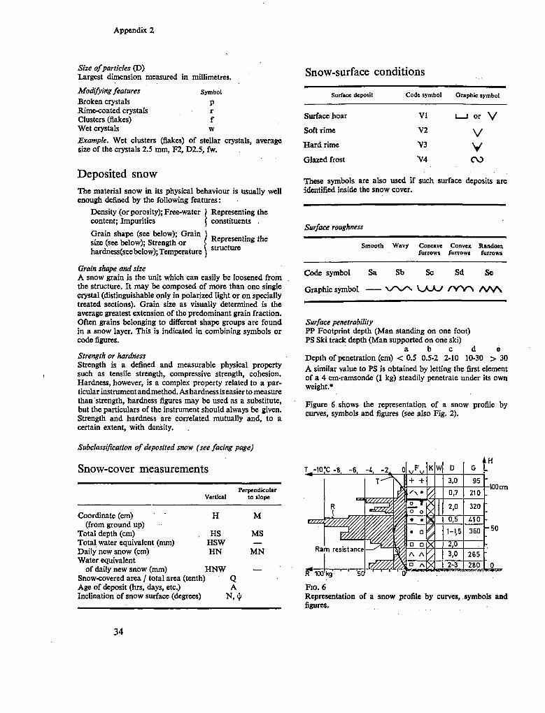
A frequently used representation for multiple local snow measurements which are repeated at certain dates or continuously recorded is the time evolution of snow profiles (Haefeli, Bader, Bücher, 1939; Switzerland, Fed. S n o w and Aval. Res. Inst., 1936/37). X and y axes of the graph are used simultaneously for different items. S n o w depth for example or water equivalent is plotted as function of time in the normal way. For single dates, temperature profiles, density profiles, graphic symbols, etc., are entered, taking the x-axis n o w
for these values as a function of depth. The result is a comprehensive representation of the local development of the snow cover (Fig. 2).
Areal mapping of snow measurements
The first condition of an areal mapping of the snow cover is the existence of an adequate topographic m a p . In mapping snow data over large areas (regions, countries, continents) two principal problems m a y arise: Lack of a sufficiently dense and homogeneous
network of observation points. Adaptation of local variations of the snow proper
ties to the scale of a m a p .
PROBLEM OF INTERPOLATION
If, for example, snow depth has to be m a p p e d in mountainous terrain where usually a great variation with altitude and exposure is encountered, single observation points will not give realistic isolines.
Most representations by isolines involve interpolations which are not necessarily linear and do not even follow the same law between all points. O n a south-exposed slope the variation of the snow depth gradient is probably different from that on north exposure, and between points of opposite exposure no interpolation is possible at all unless the topography is considered. Hence, an investigation or at least a consideration on the variability of a measured quantity with altitude and exposure has to precede any plotting of isolines (Fig. 3).
PROBLEM OF SIMPLIFICATION
Provided the necessary data are available, h o w can an observed detailed local variation be simplified for representation at a scale of 1: 106, for example?
21
I
"3
•tí
a
O
a
CO
I
Í I I 12
"3
a
S a
55 I
I c
o
§ o
fi
111 I

Mapping of snow
cover
.1
1
TJ in
•O
o\
u IS
•••S o
ál
a a
¿J
g£
SS
O
B
* *•
G
S s
g*
i-a
•l'a
il le
a
.
« a
•w
O
a-a
843
&
2 sa
§ R
•5-1
il
23

Seasonal snow cover
F I G . 4 Scheme of snow lines drawn with three different degrees of resolution A , B and C as an example of simplification. (Dotted line : snow patches line.)
The problem is usually solved by stretching an iso-line in such a w a y that the area enclosed by the line remains unchanged. Often—at least in m o u n tainous areas—the topography is arranged in units of similar order of magnitude as well as in subunits (main valleys, side valleys, etc.). Consistent simplification averages throughout units of the same magnitude (Fig. 4).
There are, of course, certain limits for useful simplification. If, for example, on a m a p of the duration of the snow-cover season an important valley station with only little snow is located in the zone of perennial snow of the surrounding m o u n tains, the m a p would be of little practical value.
For certain observations a reduction to a standard level might offer a simplification free of arbitrariness—as is done for air pressure. But for snow data the reduction laws are difficult to establish and altitude effects are often unseparably linked with orographic effects.
MAPPING OF DIRECT OBSERVATIONS AND MEASUREMENTS
A distinction is m a d e between directly measured and observed data and others which are the result of further processing.
Direct observations For a number of direct observations plotting on a m a p is the natural and only feasible w a y of representation.
Examples are: snow lines of specific dates (i.e. transient snow lines); firn lines of specific years.
These observations are either drawn on a m a p when surveyed or transferred to a m a p from photographs by manual or technical means. The remarks concerning simplification of isolines are fully valid, of course, for the snow and firn lines.
Other observations suited for direct entry in a m a p are qualitative features of the snow cover, such as: snow type of the surface layer (new snow, old snow, firn, surface hoar, glaze, etc.); state of the snow surface (dry, wet, soft, hard, breakable, etc.); form of the snow surface (smooth, wavy, furrowed, etc.); special formations (drift deposits, cornices, sastrugi, penitents, avalanches, avalanche deposits, etc.)
There is no other means of marking them on a m a p than by graphic symbols. (See suggestions given in Appendix 3.)
Direct measurements Foremost a m o n g direct measurements are measurements of snow depth and water equivalent m a p ped in the form of isolines. A s the number of available measuring points is usually small compared to the area of interest, summarizing representations only are possible. T o obtain a correct over-all picture of average snow storage, it is important for the checkpoints to be representative of the general meteorological régime and not of particular local conditions. M a p s of this kind, valid for specific dates, are tools for practical application. F r o m contour m a p s of water equivalent, for example, the water storage of an area is calculated by plan-imetric evaluation. M a p s of new snow deposit of single days or snowfall periods are frequently used in avalanche warning systems (Fig. 5).
MAPPING OF PROCESSED SNOW DATA
O f greater general interest and scientific value than m a p s of momentary situations are m a p s of processed data, such as extreme values (maxima, minima), long-term average values, duration of certain conditions, situations at standard dates.
There is an open field for representations of this kind. Specific examples are: Average position of snow line for specific dates over
a climatic period.
24

Mapping of snow
cover
25

Seasonal snow cover
Climatic snow line. Average position of firn line over a decade. Climatic firn line (limit of glaciation). M a x i m u m snow depth or water equivalent of a
specific winter or average m a x i m u m over a climatic period.
Annual value of solid precipitation. Date of beginning and ending of a snow cover. Duration of snow cover. Date of m a x i m u m snow depth. Figure 3 shows, as an example, a representation of relative snow cover days in Switzerland.
26

3 Programmes for snow measurements
Three types of observation standards ( m i n i m u m programmes) are suggested, one for principal stations m a n n e d with trained full-time observers, one for secondary stations with part-time observers and one for u n m a n n e d stations. All stations should be in operation for at least the duration of the s n o w cover season, but the measurement of precipitation should continue on the basis of storage measurements.
Snow cover temperature (temperature profile)
Water equivalent of snow cover
Recommended observations
Monthly (1)
Monthly (1 ; last day)
Stratification of snow (density, structure)
Hardness profile Monthly (1) Monthly (1)
Principal stations (full-time observers) Secondary stations
O n e principal station is established in a representative location of an area which is roughly uniform with respect to the general climatic conditions. (In mountainous terrain such a location m a y not exist.) T h e size of the area depends on the local variation of the conditions. It m a y range from 101 to 10« k m 2 .
O n a site which has to fulfil the requirements specified above under 'Observation sites', 1 and 2 —if necessary on two separated sites—the following observations are taken:
Minimum observations Minimum frequency
weather Precipitation Temperature Wind Humidity Sunshine
Recorded Recorded Recorded Recorded Recorded
snow N e w snow depth (snow board) Daily (1) N e w snow water equivalent Type of surface layer Total snow depth Extent of snow coverage
(surroundings) Snow surface temperature
Daily (1) Daily (1) Daily (1)
Daily (1) Daily (1)
Secondary stations are attached to principal stations and report to them. They are installed according to the variability of the snow conditions within a principal area. Size of the sub-area is from 102
to 10* k m 2 . Sites are selected as specified above under
'Observation sites', 1, i.e. representing the typical conditions of the surrounding area, as a rule o n horizontal ground.
Minimum observations Minimum frequency
N e w snow depth Total snow depth Areal extent of snow cover
(surroundings) Water equivalent of snow
cover Rough snow cover tempera
ture (see above, 'Snow cover temperatures')
Daily (1) Daily (1)
Daily (1)
Monthly (1 ; last day)
Monthly (1) Precipitation (storage gauge) Three monthly (end March,
June, September, December)
Recommended observation
M a x i m u m and minimum Daily (1) temperature
27

Seasonal snow cover
U n m a n n e d stations (inspection tours)
Remote unmanned stations m a y be operated either by inspection trips from principal or secondary stations or by remote control and telemetering systems.
The purpose of unmanned stations is to complete the data of the manned observation network in uninhabited areas. If only one site is chosen in a terrain with variable exposures it should be horizontal. Often, for example in a V-shaped valley, the horizontal exposure is not representative or does not even exist. Then at least two sites of opposite exposures should be selected.
Minimum observations Minimum frequency
Total snow depth \ Water equivalent of snow J
cover / Three monthly (end March, Rough snow cover tempera- > June, September, Decem-
ture 1 ber) Areal extent of snow cover 1 Precipitation (storage gauge) j
Observation of boundary lines
The following observations and mapping scales of boundary lines are suggested.
Minimum observations Minimum frequency
Snow line End of March, June, Septem-(mapping 1:1,000,000) ber, December Firn line (mapping 1:250,000) At end of summer
These lines m a y be surveyed in connexion with the programmes outlined above under 'Principal stations', 'Secondary stations' and ' U n m a n n e d stations', but an air survey will be indispensable in most cases.
28
Appendix 1 Definitions
The definitions of terms are classified under the following headings: Basic definitions of material (snow, firn, ice); Origin and composition of snow cover; Hydrological qualities of snow cover; Vertical dimensions of snow cover or snow layers; Exposure and inclination of snow cover; Variation of snow cover depth and water equivalent with time; Areal extent of snow cover; Areal average and maxim u m of snow depth and water equivalent; Boundary lines.
BASIC DEFINITIONS OF MATERIAL (SNOW, FIRN, ICE)
Snow Falling or deposited atmospheric ice particles formed mainly by sublimation. After deposit, metamorphism (see Meta-morphism, below) and redistribution m a y take place. The characteristic feature of deposited snow, in contrast to ice, is a connected system of air pores.
New snow (as a material). Original shape of crystals as formed in the atmosphere is still recognizable. (New snow depth : see New snow increment, below.) .' Old snow (as a material). Rounded or angular grains.
Firn or névé (a subspecies of snow) S n o w which has existed at least one summer season and is carried over to another winter. It is permeable to air and, if close to melting temperature, to water. (The term 'firn' is occasionally used to denominate a dense material with high bearing strength formed under repeated thawing and refreezing. With respect to the original meaning of the word, to its application in polar areas and to the c o m m o n use of the term 'firn line', the given definition should be preferred.)
Alpine-type firn (melt firn). Formed under conditions of repeated melting and refreezing. Characteristics: large rounded grains, density up to about 820 k g / m s , often strong cohesion. (Alpine firn is also found in low altitudes of polar areas.)
Polar-type firn (dry firn). Formed without appreciable melting. (Polar firn is also found on high mountains in low latitudes.)
Ice (bulk ice, ice layers) In contrast to snow and firn; m o n o - or polycrystalline ice substance without air inclusions or with closed air pores (density above about 820 k g / m a ) .
Snow cover All snow which has accumulated or the ground, including secondary deposits (see Origin and composition of snow cover, below).
Seasonal snow cover. S n o w cover depositedanddisappearing within one year's cycle. ('Seasonal' m a y be omitted if no confusion is to be expected.) O n e m a y distinguish : 1. Regular or winter snow cover. Gradually built up during
a winter season and disappearing in the course of the following ablation season, i.e. between early spring and late autumn.
2. Sporadic snow cover. Appearing any time of the year and lasting for periods of several hours up to several weeks apart from regular snow cover.
ORIGIN A N D COMPOSITION OF S N O W COVER
S n o w cover is the result of one or several of the following processes:
Snowfall Sedimentation of newly formed snow particles ( = snow precipitation) without any drift component. The deposit is new snow (see Snow above and New snow increment below).
Drifting snow Deposited snow is picked up by wind action and transported along the ground below a height of about 2 m to another location.
Blowing snow S a m e mechanism as drifting snow, but suspension higher than about 2 m .
Snowfall and wind action are often simultaneous, so that m a n y fresh snow particles are involved in a current of blowing or drifting snow before having touched the ground. N e w snow deposit and deposit of blowing or drifting snow cannot be separated under these conditions (see New snow increment, below).
The deposit of drifting and blowing snow is often called 'snow drift'.
Rainfall Rain m a y fall into snow cover and be stored there in unfrozen or frozen form. It will be incorporated in the snow cover. (From water-saturated snow cover, rain runs off with a certain delay.)
29

Appendix 1
Formation of surface hoar Layer of crystals growing on the snow surface by sublimation of water vapour (clear sky).
Formation of surface rime Deposit and subsequent freezing of super-cooled cloud (fog) particles.
Avalanches Snow is transported from higher elevations by a gliding, flowing or air-borne movement down to lower areas, and forms scattered or bulky deposits.
Metamorphlsm (or dlagenesls) of snow Transformation of snow by processes such as internal sublimation, melting and refreezing and by pressure effects. Isolated ice layers and ice lenses in the snow cover are considered to be part of it.
HYDROLOGICAL QUALITIES OF S N O W COVER
Density G (g/cm* or kg/m*) Mass of ice per unit volume of snow. Local density of specific layers. Average density of the snow-cover profile.
Free water content W (per cent) Fraction by weight of liquid water contained in wet snow.
Snow temperature T (°C) Temperature of surface, of base or of specific levels. A n average snow cover temperature T should represent the heat content of the snow cover with respect to dry snow of 0° C . Definition:
HS HS
T = JG(z).T(z)dz if G(z)dz = o b
HS = B^J'G(z)T(z)dz.
b
Albedo (per cent) Ratio of reflected to incoming global radiation.
VERTICAL DIMENSIONS OF S N O W COVER OR S N O W LAYERS
The terms 'depth', 'thickness' and 'water equivalent' as defined in the following paragraphs for the whole snow cover m a y also be applied to single snow layers.
Snow (cover) depth (= total snow depth) HS (cm) Vertical thickness of snow cover from surface to ground. It should clearly be indicated whether snow depth is given for a single point and a specific date or as the areal or time average of a number of measurements. Unless otherwise specified snow depth is related to a single location on a horizontal area.
O n névé fields and glaciers the base of the seasonal snow cover is represented by the level of the preceding ablation surface.
Thickness of snow cover MS (cm) Measurement of snow cover at right angles to the slope (to be given with slope angle).
Water equivalent of snow cover H W (mm H20) Vertical depth of a water layer which would be obtained by melting the snow cover on a given area.
{HW = 10. H S . — ; Gw density of water.)
EXPOSURE AND INCLINATION OF S N O W COVER
Azimuth of the line of dip (usually given as general direction, e.g. N . , N E . , S S W . , etc.) and slope angle (degrees or tangent in per cent).
VARIATION OF S N O W COVER DEPTH A N D W A T E R EQUIVALENT WITH TIME
The variation of snow cover depth and water equivalent at a given location are the result of a number of partly simultaneous processes. The single components are accumulation, settling and ablation. A number of definitions are related to them.
New snow Increment HN (cm) Depth of new snow deposited within a given interval, maxim u m of one day. Without other specifications the new snow increment is related to a horizontal area and a period of twenty-four hours ending with the time of the standard morning observation (usually between 7 and 9 a .m.) . Increments for periods of more than one day should be given as sums of daily increments and characterized as new snow sum. Owing to settling, the actual depth of several days' deposit will be smaller than the new snow sum of the same period.
Surface hoar is included in a new snow measurement, but specified as such if possible.
In principle snow drift should be excluded from a new snow increment. Whether this can be achieved depends on the local conditions and the measuring technique.
Water equivalent of new snow HNW (mm H t O ) Water equivalent of a new snow increment (according to New snow Increment, above).
Rate of snowfall (or new snow deposit) AHN/ At (cm/h) N e w snow increment divided by the time interval. It depends on the selected time interval because of continuous settling. The analogous figure for the water equivalent, AHNW/ At is identical with the rate or intensity of precipitation (including vapour exchange), providing H N W is measured on horizontal ground or precipitation is falling vertically (see Chapter 1 above, 'Rate of snow fall and new snow deposit').
Settling of snow cover J ¡HS. AHS/At day (-1) Decrease of snow depth without change of water equivalent due to metamorphic processes and densification under the snow's own weight. Depends on type of snow, snow depth, temperature and on the selected time interval. (Densification under external forces = compaction.)
30
Appendix 1
Ablation of snow cover Reduction of the water equivalent by melting (including runoff), evaporation, wind and avalanches.
Maximum, minimum andaverage values of new snow increment and snow depth at a given location
Average daily snowfall or new snow deposit of a defined period. S u m of daily new snow increments divided by all days of the period.
Average dally new snow Increment of a defined period. S u m of daily new snow increments divided by number of days with new snow deposit.
Maximum (minimum) snow depth. Single value related to a defined period (month, year, winter season, decade, etc.). , Average snow depth of a defined period. S u m of daily measurements divided by number of all days of period (including days without snow on ground).
Average depth of snow cover of a defined period. S u m of daily measurements divided by number of days with snow on ground.
Extreme snow depth is used in avalanche protection work for potential m a x i m u m snow depth to be expected within thirty to fifty years.
Maximum, minimum andaverage values of water equivalent of new snow and snow cover Corresponding definitions to above.
Duration of snowfall and snow cover Number of snowfall days. N u m b e r of days with snowfall
within a given period (snow cover not necessarily being formed).
Snowfall season. Period between the first and the last day with snowfall within the cycle of a hydrological year usually given by dates. (Only used where there is a marked interruption in summer.)
Number of snow cover days. N u m b e r of days with a regular and/or sporadic snow cover within a given period. (There m a y be days without snow cover in between.)
Snow cover season. Period between the first and the last day with regular and/or sporadic snow cover (coverage at least 50 per cent) within the cycle of a hydrological year, usually given by dates. (Only used where there is a marked interruption in summer.)
Duration of the winter snow cover. Dates limiting uninterrupted regular snow coverage. For a specific uniform area (observation site), an areal coverage of > 50 per cent is considered as presence of snow cover (see Areal extent of snow cover, below).
AREAL EXTENT OF SNOW COVER
A variation of the areal extent is the result of a variation of snow deposit and ablation with time and location. It is caused by meteorological and topographical factors, and in mountainous terrain also by avalanches. A s the scale of the phenomena m a y vary from several metres up to continental dimensions, a description has to imply the definition of the area in question (observation site, catchment area, district,
country, continent). Unless otherwise specified, only seasonal snow cover is considered. Hence, on glaciers and perennial snow-fields, snow-free ground is represented either by glacier ice or by an old firn surface. The ratio Q of the snow-covered area is given in tenths or per cent.
Closed snow cover Complete coverage of an area by snow without snow-free patches: coverage 100 per cent. Single steep slopes where no snow is deposited are exempted. In forests the whole ground is covered except the area of the trunks.
Snow cover perforated S n o w cover forms a coherent area with isolated patches free of snow. (Coverage mostly > 50 per cent.)
Snow deposit in patches S n o w cover reduced to single isolated patches, including residues of snow drifts and avalanche deposits (coverage mostly < 50 per cent).
Area free of (seasonal) snow Bare ground, bare glacier or old névé surface.
AREAL AVERAGE A N D M A X I M U M OF S N O W DEPTH A N D W A T E R EQUIVALENT
Areal average snow depth S n o w depth which yields the volume of snow when mul tiplied by the area in question. It is obtained either by taking an appropriate number of measurements for different deposit zones, or by taking the weighed average of a series of single measurements in different zones. (The same figure m a y be measured in one site which has proved to be representative for the area.) See 'Observation sites' in Chapter 1 above.
Areal maximum snow depth Local m a x i m u m snow depth in a given area. (Of particular interest with respect to technical snow problems.)
Areal average water equivalent of snow Value which yields the volume of water stored above ground if multiplied by the area in question. (Corresponding procedure to Areal average snow depth, above.)
Areal maximum water equivalent Analogous to Areal maximum snow depth, above. (Of hardly any use.)
B O U N D A R Y LINES
Snow line (also called transient line) Momentary line delimiting an area with closed snow cover against an area free of snow. If, as is often the case, these areas are separated by a zone of perforated snow cover and snow patches, the snow line is drawn within a belt of about 50 per cent coverage. The details to be followed depend on the scale of the area and the problem to be treated.
A line of snow patches m a y be defined as an enveloping line limiting a zone of snow patches against the absolutely bare ground (see Fig. 4).
31

Appendix 1
Firn line Line limiting a seasonal (regular) snow deposit which is. carried over as firn to the next winter. It is identical with the snow line at the end of the ablation season. (With this definition a firn area several years old would not necessarily be limited by the 'firn line' in a later year. It is therefore recommended that the proper year be attributed to a firn line, e.g. the '1967 firn line'; but, the 'line of the 1962 firn* as seen in 1965 is not identical with the '1962 firn line' nor with the '1965 firn line'.) The altitude of the firn line m a y vary considerably with topography and exposure.
Equilibrium line Line of equal accumulation and ablation of a given balance year (as established at the end of the s u m m e r season). O n bare ground the equilibrium line is identical with the firn line. O n glaciers the firn line m a y be different owing to the formation of superimposed ice (i.e. frozen melt water) and the glacier movement . Superimposed ice which is no longer considered to be firn brings the firn line above the equilibrium line. This holds particularly for glaciers in high latitudes. Glacier movement causes a lowering of the firn line, occasionally well below the equilibrium line.
Average ... lines The lines as defined under Snow line, Firn line and Equilibrium line above are related to certain dates or years. Their average position (altitude) can be established over longer periods, e.g. average snow line of 1 M a y for period 1956-66; average firn or equilibrium line for period 1956-66 (with variable reference dates of the single years in question).
Climatic lines Climatic snow, firn or equilibrium lines are average lines or levels related to climatic periods (ten, thirty years, etc.) and calculated for or observed on horizontal areas. They are governed by general climatic factors (energy and mass balance without implication of small-scale topographic effects and allow global comparisons. T h e climatic equilibrium line in particular is an indicator of potential perennial glacieization.
Remark Avalanches m a y change to a considerable extent the natural influence of climatic factors on snow-, firn- and equilibrium lines.
32
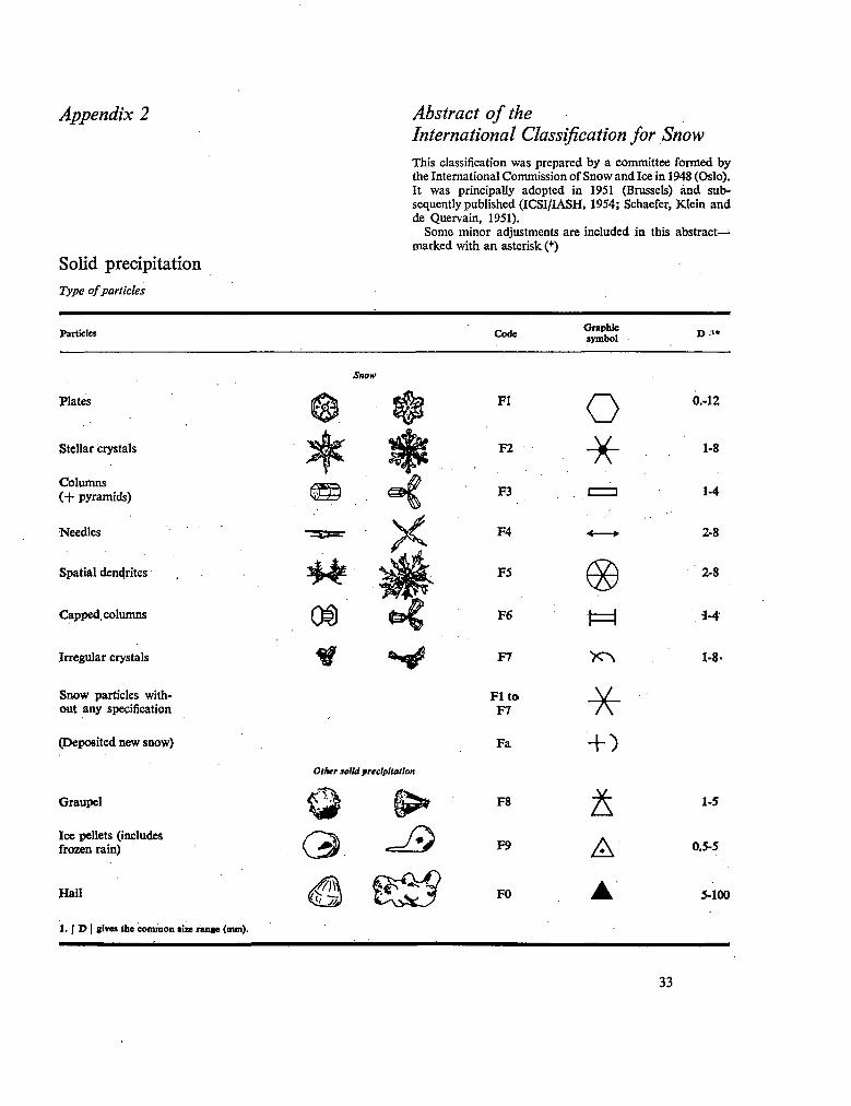
Appendix 2
Solid precipitation
Type of particles
Abstract of the International Classification for Snow
This classification was prepared by a committee formed by the International Commission of S n o w and Ice in 1948 (Oslo). It was principally adopted in 1951 (Brussels) and subsequently published (ICSI/IASH, 1954; Schaefer, Klein and de Quervain, 1951).
S o m e minor adjustments are included in this abstract-marked with an asterisk (*)
Particles Code Graphic symbol D-«
Plates
Stellar crystals
Columns ( + pyramids)
Needles
Spatial dendrites
Capped, columns
Irregular crystals
S n o w particles without any specification
(Deposited new snow)
Graupel
Ice pellets (includes frozen rain)
Hail
1. ) D | gives the common size range (nun).
Snow
4k Of)
Other solid precipitation
3 -®
Fl
F2
F3
F4
F5
F6
F7
Fito F7
Fa
F8
F9
FO
O - *
•* •
® M
ñ A A
0.-12
1-8
1-4
2-8
2-8
i-4
1-8-
1-5
0.5-5
5-100
33
Appendix 2
Size of particles (D) Largest dimension measured in millimetres.
Modifying features Symbol Broken crystals p Rime-coated crystals r Clusters (flakes) f W e t crystals w Example. W e t clusters (flakes) of stellar crystals, average size of the crystals 2.5 m m , F 2 , D 2 . 5 , fw.
Deposited snow
The material snow in its physical behaviour is usually well enough defined by the following features :
Density (or porosity); Free-water ) Representing the content; Impurities ( constituents .
Grain shape (see below); Grain size (see below); Strength or j hardness(see below); Temperature
Snow-surface conditions
Representing the structure
Grain shape and size A snow grain is the unit which can easily be loosened from the structure. It m a y be composed of more than one single crystal (distinguishable only in polarized light or on specially treated sections). Grain size as visually determined is the average greatest extension of the predominant grain fraction. Often grains belonging to different shape groups are found in a snow layer. This is indicated in combining symbols or code figures.
Strength or hardness Strength is a defined and measurable physical property such as tensile strength, compressive strength, cohesion. Hardness, however, is a complex property related to a particular instrument and method. A s hardness is easier to measure than strength, hardness figures m a y be used as a substitute, but the particulars of the instrument should always be given. Strength and hardness are correlated mutually and, to a certain extent, with density.
Surface deposit
Surface hoar
Soft rime
H a r d rime
Glazed frost
Code symbol
VI
V2
~V3
V4
Graphic symbol
1 1 or V
V V cv>
These symbols are also used if such surface deposits are identified inside the snow cover.
Surface roughness
Smooth
Code symbol
Graphic symbol
Sa
W a v y Concave furrows
Convex furrows
Sb Sc Sd
V ^ S ^ N KJ^XJ / V \ ^
R a n d o m furrows
Se
A A A
Surface penetrability P P Footprint depth ( M a n standing on one foot) P S Ski track depth ( M a n supported on one ski)
a b c d e Depth of penetration (cm) < 0.5 0.5-2 2-10 10-30 > 30 A similar value to P S is obtained by letting the first element of a 4 cm-ramsonde (1 kg) steadily penetrate under its o w n weight.*
Figure 6 shows the representation of a snow profile by curves, symbols and figures (see also Fig. 2).
Subclassification of deposited snow (see facing page)
Snow-cover measurements
Vertical Perpendicular
to slope
Coordinate (cm) (from ground up)
Total depth (cm) Total water equivalent ( m m ) Daily new snow (cm) Water equivalent
of daily new snow ( m m ) Snow-covered area / total area Age of deposit (hrs, days, etc.)
H
HS HSW HN
H N W (tenth)
Inclination of snow surface (degrees)
Q A
M
MS —
M N
—
•100 c m
R 100 kg 501
Fio. 6 Representation of a snow profile by curves, symbols and figures.
34
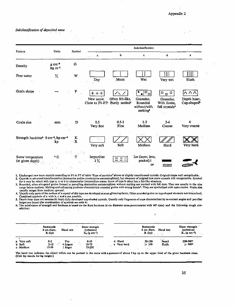
Appendix 2
Subclassification of deposited snow
Subclassification Feature Units Symbol
Density
Free waler
gern - ' kg m - 3
% W Dry Moist W e t Very wet . Slush
Grain shape + +• + / \ / • O a aa A A A N e w snow. Often felt-like. Granular. Granular. Depth hoar.
Close to F 1 - F 7 1 Partly settled2 R o u n d e d With facets, Cup-shaped s
without/with full crystals4-melting1
Grain size
Strength hardness«
m m
9 cm- 1 , kp enr2
kp K R
0.5 Very fine
0.5-1 Fine
/ /
1-2 Medium
XX
2-4 Coarse
w
4 Very coarse
Very soft Soft Medium Hard Very hard
Snow temperature (at given depth) .
•C Impurities J%
Ice (layer, lens, pocket) i
or V/W/s.
1. Unchanged new snow crystals according to Fl to F 7 or table 'Type of particles' above or slightly transformed crystals. Original shape well recognizable. 2. Crystals in advanced transformation (destructive and/or constructive metamorphism), but elements of original new snow crystals still recognizable. Symbol
for b m a y be mixed with type a, c or d to characterize intermediate states. Snow of type b often has a felt-like structure. 3. Rounded, often elongated grains formed in prevailing destructive metamorphism without melting are marked with full dots. They are usually in the size
range below medium. Melting and »freezing produces characteristic rounded grains with strong bonds*. They are symbolized with open circles. Grain size usually ranges from medium upward.
4 . Usually only parts of the surface of a crystal of this type are developed as even glittering facets. Often rounded grains or cup-shaped elements are intermixed. Combined symbols of a with b, c and e are possible.
5. Depth hoar does not necessarily imply fully developed cup-shaded crystals. Usually only fragments of cups characterized by re-entrant angles and peculiar ledges are found (for combination of symbols see note 4).
6. The subdivision of strength and hardness is based on the R a m hardness (4 c m diameter conc-penetrometer with 60° apex) and the following rough correlation:
Ramsonde 4 c m diam.
R(kp) H a n d test
Shear strength (cohesion)
K . (g c m - 1 )
Ramsonde 4 c m diam. . R (kp)
Hand test Shear strength'
(cohesion) K . (g c m - 1 )
a Very soft b Soft c Medium
0-2 2-15 •
15-50
Fist 4 fingers 1 finger
0-10 10-75 75-250
d Hard e Very hard
50-100 > 100
Pencil Knife
250-500» >500*
The hand test indicates the object which can be pushed in the snow with a pressure of about S kp up to the upper limit of the given hardness class. (Unit kp stands for kg weight.)
35

Appendix 3 Suggested symbols for mapping
snow cover features
The graphic symbols given in the International Snow Classification (ISC), 1951, are mainly applied for the representation of snow profiles. They are only partly suited for areal m a p ping. O n the basis of the international classification, it is suggested that the following symbols be used for m a p s : § Identical with ISC 1951 * Derived from ISC 1951
Material of surface layer
§ N e w snow (fluffy type). + +
* Old snow (granular type).
© © * Firn.
'Ice.
¿t¡¡- Bare ground.
V V § Surface hoar, surface rime.
W r O § Glaze, icy surface.
State of snow surface
ô Ù
§ Dry (no symbol).
Moist or wet.
-L _L Soft (pedestrian penetrating more , than 20 c m ) .
Hard (unbreakable to pedestrian).
Form of snow surface
— — § Smooth (alternative: no symbol).
*vx / w § W a v y (ripples).
u j to § Furrows concave (sun cups).
n\ m
AA AA
§ Furrows convex (rain or melt groves).
§ Furrows randomly shaped (sas-trugi).
Special formations
AAA
^ = ^
A A
• Drift deposit, cornice (with prevailing wind direction).
Snow barkhan.
* Penitents.
A Slab avalanche.
Loose snow avalanche.
Avalanche path.
X X Hard (breakable to pedestrian). l \ Avalanche deposit.
36

References
A L T E R , J. C . 1937. Shielded storage precipitation gauges. Month. Weather Rev. 65, p. 262-65.
A M B A C H , W . 1958. Zur Bestimmung des Schmelzwassergehaltes des Schnees durch elektrische Messung. Z. f. Gletscherkunde, vol. 4, p. 1-8.
B A D E R , H . 1948. Theory of non calorimetric methods for the determination of the liquid water content of wet snow. Schweiz. Mineral. Petrogr. Mitt., vol. 28, p. 344-61.
B A R N E S , J. R . ; B O W L E Y , C . J. 1966. Snow cover distribution as mapped from satellite photography. Aracon geophys. Div., 107 p. (Final Report Cont. no. Cwb-11269.)
B A U E R , K . G . ; D U T T O N , J. A . 1962. Albedo variations measured from an airplane over several types of surfaces. / . geophys. Res., vol., 67, no. 6, p. 2367-76.
B E A U M O N T , R . T . 1965. M t . H o o d Pressure Pillow Snow Gauge. / . appl. Meteor., vol. V , no. 4, p. 626-31.
B R Ü C K N E R , E . 1887. Die H ö h e der Schneelinie und ihre Bestimmung. Meteorol. Zs., 4. Jg., no. 31-32.
C O M B S , A . C ; W E I C K M A N N , H . K . ; et al. 1965. Application
of infrared radiometry to meteorology. / . appl. Meteor. vol. 4, April, p. 253-62.
C R O C E , K . 1944? Verfahren zur Bestimmung der Schneefeuchtigkeit. Forschungsarbeiten aus dem Strassenwesen, H . 6, p. 26-28.
D A N F O R S , E . 1962. Application of the neutron scattering method for measuring snow density. Geogr. Annal., vol. 44, H . 3/4, p. 409-11.
G O V O R U K H A , L . S.; K I R P I C H E V , E . F . 1961. First results of drifting snow observations with the drifting snow meter •Cyclone'. Inform. Bull. Sov. Antarkt. Eksp. N o . 26.
G R U N O W , J. 1954. Die Niederschlagsmessung mit hangparallelen Auffangflächen. Methode, Erfahrungen, Folgerungen. Congress IUGG Rome, I A S H vol. I, p. 322-34.
. 1963. Zur Registrierung winterlicher Niederschläge. Meteor. Rundschau, vol. 16, p. 1-5.
. 1964. Wirksamkeit des Schneekreuzes bei Niederschlagssammlern. Meteor. Rundschau, vol. 17, p. 175-77.
H A E F E L I , R . ; B A D E R , H . ; B U C H E R , E . 1939. Das Zeitprofil,
eine graphische Darstellung der Entwicklung der Schneedecke. In: Der Schnee und seine Metamorphose. Beiträge zur Geologie der Schweiz. Geotechn. Serie Hydrologie, 3. Zürich, Geotechnische K o m m , der Schweiz., Naturforsch. Ges. Zürich. Trans.: SIPRE Techn. Translations.
H A N S E N . B . L . ; JELLINEK, H . H . G . 1957. A portable adia-batic calorimeter. SIPRE tech. Rept., no. 49.
H E L M E R S , A . E . 1954. Precipitation measurement on wind swept slopes. Trans. Am. geophys. Un., vol. 35, no. 3, p. 471-74.
H I N D M A N , E . E . , Il; R I N K E R , R . L . 1967. Continuous
snowfall replicator. / . appl. Meteor., vol. 6, no. 1, p. 126-33.
I N T E R N A T I O N A L C O M M I S S I O N O F S N O W A N D ICE (IASH). 1954.
The International Classification for Snow. Assoc. Coiran. on Soil and Snow Mech., Nat. Res. Council of Canada. (Tech. Memorandum no. 31.)
K U R O D A , M . 1954. Measurement of water content of snow. Congress IUGG, Rome, I A S H vol. IV, p. 38-41.
LILIEQUIST, G . H . 1956. Energy exchange of an Antarctic snow field. Short wave radiation. Scient. Results, vol. II, pt. 1 A . Oslo, Norsk Polarinst. (Norw.-Brit.-Swed. Antarct. Exped. 1949-52.)
L U G I E Z , F . ; D U M A N I E , A . 1957. Mesure des precipitations. Congress IUGG, Toronto, I A S H vol. I, p. 485-94.
M E L L O R , M . 1965. Blowing snow. Cold regions science and engineering. Pt. II, sect. A3c. Hanover, N . H . , Cold Regions Research and Engineering Laboratory, November.
M E L N I K , D . M . 1965. Drift measuring instruments and observations. Data of glaciological studies. IGY Chronicle, Discussions no. 11 M . , p. 181-87.
O R L O V , N . 1.1961. N e w method of measuring blowing snow. Moskva, Akad. Nauk SSSR, Inst. Geogr. (Rot' snezhnogo pokrova v prirodnykh protsessakh.)
0STREM, G . 1964. Ice-cored moraines in Scandinavia. Geogr. Annal, vol. 46, no. 3, p. 282-337.
. 1966. The height of the glaciation limit in southern British Columbia and Alberta. Geogr. Annal., vol. 48, no. 3, p. 126-38.
Q U E R V A I N , M . de. 1946. Zur Bestimmung des Wassergehalts von Nass-Schnee. Verhl. Schweiz. Naturf. Ges., no. 94.
; I N D E R G A N D , H . R . 1965. Distribution of snow deposit in a test area for alpine reforestation. Internat. Sympos. Forest Hydrol. Pa., Penn. State Univ., p. 233-39.
R I N K E R , L . E . 1938. The Stevens seasonal snow/rain recorder. Trans Am. Geophys. U n . , p. 718-20.
S C H A E F E R , V . J.; K L E I N , G . J.; Q U E R V A I N , M . R . de. 1951.
Entwurf einer internationalen Schneeklassifikation. Congress IUGG, Brussels, 1951, I A S H , vol. I, p. 129-41.
S E R R A , L . 1954. U n nouveau type de pluviomètre pour l'enregistrement des précipitations en haute montagne. Congress IUGG, Rome, I A S H vol. I, p. 277.
S H L I A K O V , V . I. 1960. Methods of making drifting snow measurements in the Antarctic. Inform. Bull. Sov. Antarkt. Eksp. No. 20, p. 26-28,
S H O D A , M . 1952. Methods of measuring snow water content. Seppyo (Japan.), vol. 13, p. 103-24.
S M I T H , J. I.; W I L L E N , D . W . 1964. Radio snow gauges. A
37

References
review of the literature. Isotopes and radiation techrt., vol. 2, no 1, p. 41-49.
; ; O W E N S , M . S. 1965. Measurement of snow pack profiles with radioactive isotopes. Weatherwise, no. 18, p. 247-51.
SWITZERLAND. FEDERAL S N O W A N D AVALANCHE RESEARCH INSTITUTE, 1936/1937 onwards. Schnee und Lawinen in den Schweizeralpen. Bern, Federal Printing Centre. (Annual Reports, Fed. Snow and Aval. Res. Inst., Weissfluhjoch/ Davos.)
T R E T Y A K O V , V . D . 1952. Measurement of precipitation. Trudy Glavnoi Geofiz. Observatorii No. 34, p. 30-40.
U . S . D E P A R T M E N T O F A G R I C U L T U R E . 1940. Snow surveying. (Miscell. Publ. no. 380.)
W E I S S , L . ; W I L S O N , W . T . 1957. Precipitation gauge shields. Congress IUGG, Toronto, L A S H vol. I, p. 462-84.
W O R L D M E T E O R O L O G I C A L O R G A N I Z A T I O N . 1954. Guide to meteorological instruments and observing practices. ( W M O no. 8, TP3.)
. 1956. International cloud atlas.
. 1965. Guide to hydrometeorological practices. Z I N G G , T . 1954a. Die Bestimmung der klimatischen Schnee
grenze auf klimatischer Grundlage. Angew. Pflanzensoziologie Bd. 11,-p. 848-54. Weissfluhjoch, Snow and Aval. Res. Inst. (Eidg. Inst. Schnee- u. Lawinenforschung) Mitt. No. 12.
. 19546. Die Bestimmungen der Schneehöhenverteilung auf photogrammetrischem Wege. Congress IUGG, Rome, I A S H vol. IV, p. 33-37.
38

[A.2497] $3 ; 18/-2. (£0.90)(stg.); 12 F