technical supporting document for maintenance dredging
TRANSCRIPT
REPORT
Maintenance Dredging Strategy for
Great Barrier Reef World Heritage
Area Ports: Technical Supporting
Document
Client: Dept. of Transport and Main Roads
Reference: M&APA1184R001F07
Revision: 07/Final
Date: 23 September 2016

23 September 2016
Maintenance Dredging Strategy: TSD M&APA1184R001F07 i
HASKONING AUSTRALIA PTY LTD.
Unit 2
55-57 Township Drive
QLD 4220 Burleigh Heads
Australia
Maritime & Aviation
Trade register number: ACN153656252
royalhaskoningdhv.com
E
W
Document title: Maintenance Dredging Strategy for Great Barrier Reef World Heritage Area
Ports: Technical Supporting Document
Document short title: Maintenance Dredging Strategy: TSD
Reference: M&APA1184R001F07
Revision: 07/Final
Date: 23 September 2016
Project name: TMR Maintenance Dredging Strategy
Project number: PA1184
Author(s): Richard Mocke, Greg Britton, Matt Potter, Andy Symonds, James Donald, Daniel
Spooner and Adam Cohen
Drafted by: As above
Checked by: Andy Symonds / Matt Potter
Date / initials: AS 19/09/16 / MP 23/90/2016
Approved by: Greg Britton
Date / initials: GB 23/09/16
Classification
Project related
Disclaimer
No part of these specifications/printed matter may be reproduced and/or published by print, photocopy, microfilm or by
any other means, without the prior written permission of Haskoning Australia PTY Ltd.; nor may they be used, without
such permission, for any purposes other than that for which they were produced. Haskoning Australia PTY Ltd.
accepts no responsibility or liability for these specifications/printed matter to any party other than the persons by
whom it was commissioned and as concluded under that Appointment. The quality management system of Haskoning
Australia PTY Ltd. has been certified in accordance with ISO 9001, ISO 14001 and OHSAS 18001.
23 September 2016
Maintenance Dredging Strategy: TSD M&APA1184R001F07 ii
Table of Contents
1 Introduction 7
1.1 Context 7
1.2 Reef 2050 8
1.3 Reef 2050 (WQA16) 8
1.4 Purpose of this report 9
1.5 Maintenance Dredging 9
1.5.1 Background 9
1.5.2 Navigational Requirement 9
1.5.3 Economic, Social and Community Need 10
1.5.4 Environmental Sustainability 11
1.6 Maintenance Dredging at Ports within the GBRWHA 11
2 Sediment Transport Processes 15
2.1 Introduction 15
2.2 Wave Climate 15
2.3 Currents 17
2.4 Rainfall and River Discharges 19
2.5 Tropical Cyclones and Storms 24
2.6 Overview of Sedimentation Processes at GBR Ports 26
2.7 Summary 32
3 Legislative Requirements 33
3.1 Introduction 33
3.2 Commonwealth Legislation 33
3.2.1 Environment Protection (Sea Dumping) Act 1981 33
3.3 Queensland State Legislation 36
3.3.1 Transport Infrastructure Act 1994 37
3.3.2 Sustainable Planning Act 2009 37
3.3.3 Marine Parks Act 2004 37
3.3.4 Coastal Protection and Management Act 1995 37
3.3.5 Environmental Protection Act 1994 38
3.3.6 Fisheries Act 1994 38
3.4 Best Practice Guidelines 38
3.5 Summary 39
4 Maintenance Dredging 40
4.1 Introduction 40
23 September 2016
Maintenance Dredging Strategy: TSD M&APA1184R001F07 iii
4.2 Dredging Equipment & Operational Approaches 40
4.2.1 Trailing Suction Hopper Dredger 40
4.2.2 Smaller Dredgers 48
4.2.3 Bed Levelling 48
4.3 Existing Strategies to Minimise Maintenance Dredging 49
4.4 Measures of Maintenance Dredging Quantities 50
4.4.1 In-situ Volume 50
4.4.2 Wet In-hopper Volume 50
4.4.3 Dry Weight 51
4.4.4 Summary 51
4.5 Historic Maintenance Volumes 52
4.5.1 Comparison with Natural Sediment Transport 58
4.5.2 Variability in Maintenance Dredging Requirements 60
4.5.3 Historic Material Placement 66
4.6 Future Maintenance Dredging Requirements 68
4.6.1 Future Port Expansion Works 68
4.6.2 Future Maintenance Dredging Estimations 70
4.6.3 Management or Engineering Maintenance Dredging Reduction Options 73
4.7 Summary 74
5 Beneficial Reuse and On-land Disposal of Dredge material 77
5.1 Introduction 77
5.2 Dredged Sediment Characteristics 78
5.3 Opportunities and Constraints 79
5.4 Review of International and National Best Practice 83
5.4.1 International Practice 83
5.4.3 Australian Practice 95
5.5 Potential Capacity Requirements of Land Disposal 96
5.6 Beneficial Reuse and On-land Disposal Options for GBR Ports 98
5.7 Beneficial Reuse and On-land Disposal Environmental Impacts 100
5.8 Summary 112
6 Environmental Values 113
6.1 Introduction 113
6.2 Key Marine Habitats and Communities 113
6.2.1 Seagrass 113
6.2.2 Coral Reefs and Rocky Reef Communities 114
6.2.3 Marine Turtles 117
6.2.4 Dugongs 117
6.2.5 Cetaceans 117
6.2.6 Benthic Infauna and Epifauna 118
23 September 2016
Maintenance Dredging Strategy: TSD M&APA1184R001F07 iv
6.3 Summary 118
7 Environmental Monitoring for Maintenance Dredging 120
7.1 Introduction 120
7.2 Turbidity & Total Suspended Solids 120
7.2.1 Active Dredging and Disposal Monitoring 120
7.2.2 Turbidity Monitoring and Environmental Values 122
7.3 Predictive Modelling 126
7.4 Dredge Material Resuspension and Deposition 127
7.5 Photosynthetically Available Radiation (Light) 127
7.6 Nutrients 129
7.7 Contaminants 129
7.8 Summary 130
8 Maintenance Dredging – Preliminary Analysis of Risks 132
8.1 Background 132
8.2 Risk Assessment Outcomes 132
8.2.1 Key Environmental Values 132
8.2.2 Heritage, Biodiversity & Coastal Processes 133
8.3 Conclusion 133
9 Establishment of Risk-based Monitoring Programs 136
9.1 Risk Based Monitoring 136
9.2 Future Innovation 137
10 Summary and Key Findings 139
10.1 Introduction 139
10.2 Sediment Transport Processes 139
10.3 Legislative Requirements 139
10.4 Maintenance Dredging 140
10.5 Beneficial Reuse and On-land Disposal of Dredge material 140
10.6 Environmental Values 141
10.7 Environmental Monitoring of Maintenance Dredging 141
10.8 Maintenance Dredging – Preliminary Analysis of Risks 142
10.9 Establishment of Risk-based Monitoring Programs 142
11 References 144
23 September 2016
Maintenance Dredging Strategy: TSD M&APA1184R001F07 v
Appendices
Appendix A Acronyms
Appendix B Coastal Processes Summary
Appendix C Port Specific Sediment Sampling
Appendix D Environmental Review and Risk Assessment
Table of Tables
Table 1: Key relevant terms, abbreviations and acronyms used in report ...................................................................... 7
Table 2: Reef 2050 actions relevant to maintenance dredging ...................................................................................... 8
Table 3: Summary of Ports within the GBRWHA. ......................................................................................................... 13
Table 4: Tidal planes at each Port within the GBRWHA. .............................................................................................. 17
Table 5: Pre and post European mean annual discharge for 10 major rivers discharging into the GBR Lagoon.......... 20
Table 6: Tropical cyclone average return interval (ARI) for each of the ports within the GBRWHA. ............................. 24
Table 7: Summary table showing relative importance of processes supplying sediment to the ports in the GBRWHA.28
Table 8: Current maintenance dredging sea dumping permits for ports within the GBRMP. ........................................ 34
Table 9: TSHD Brisbane Specifications ........................................................................................................................ 41
Table 10: TSHD Brisbane number of days undertaking maintenance dredging in each port. ....................................... 45
Table 11: Comparison of Similar TSHDs ...................................................................................................................... 47
Table 12: Historic maintenance dredging quantities dredged by the TSHD Brisbane at the Port of Cairns ................. 52
Table 13: Historic in-situ maintenance dredging volumes at the ports located within the GRBWHA. .......................... 54
Table 14: Estimated sedimentation rates from 2004 to 2014 at the recognised Queensland Ports which require
maintenance dredging. ................................................................................................................................................. 54
Table 15: Details of the existing offshore material placement sites at ports within the GBRWHA where regular
maintenance dredging has been required. .................................................................................................................... 66
Table 16: Historic in-situ maintenance dredging volumes and the distribution of sediment that was placed at sea and
land at the Port of Townsville. ....................................................................................................................................... 67
Table 17: Port expansion projects proposed over the next 10 years. .......................................................................... 69
Table 18: Predicted requirement for future maintenance dredging volumes ................................................................ 72
Table 19: Outline of strategies to reduce future maintenance dredging requirements. ................................................ 73
Table 20: Summary of maintenance dredged sediment characteristics at selected ports ........................................... 79
Table 21: Suitability of dredge material sediment types for beneficial reuse applications ............................................ 84
Table 22: Estimated land area requirements for land disposal over 5 year and 10 year planning horizons ................ 97
Table 23: Summary of port-specific options for beneficial reuse or on-land disposal .................................................. 98
Table 24: Potential environmental impacts and mitigation/management measures associated with disposal ........... 101
Table 25: Comparative Unit Rates for Different Dredge material Disposal Options ................................................... 110
Table 26: Critical threshold of seagrasses for light availability ................................................................................... 128
Table 27: Summary of preliminary risk assessment outcomes of maintenance dredging and material placement. ... 135
Table 29: Port of Cooktown key coastal processes. .................................................................................................. 159
23 September 2016
Maintenance Dredging Strategy: TSD M&APA1184R001F07 vi
Table 30: Port of Cairns key coastal processes. ........................................................................................................ 159
Table 31: Port of Townsville key coastal processes. ................................................................................................. 161
Table 32: Port of Abbot Point key coastal processes. ................................................................................................ 162
Table 33: Port of Mackay key coastal processes. ...................................................................................................... 164
Table 34: Hay Point key coastal processes. .............................................................................................................. 165
Table 35: Port Alma key coastal processes. .............................................................................................................. 166
Table 36: Port of Gladstone key coastal processes. .................................................................................................. 167
List of Figures
Figure 1: Typical shipping channel showing relative depths ......................................................................................... 10
Figure 2: Queensland Ports Map .................................................................................................................................. 12
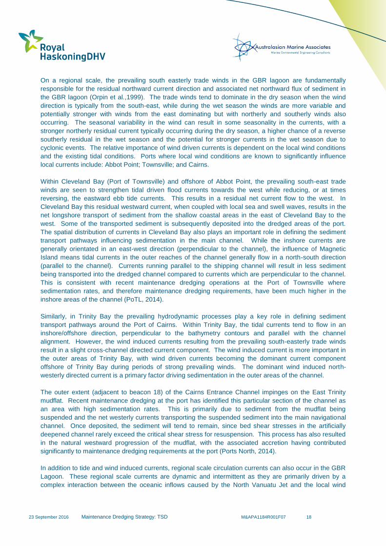
Figure 3: Queensland Ports nearby to the major rivers discharging into the GBR. ....................................................... 21
Figure 4: MODIS Aqua Images of: a flood plume from the Burdekin River, with the brown plume representing high
TSS and the green plume low TSS and resuspension from a high energy wind and wave during the dry season ....... 23
Figure 5: Measured water level and near-bed current speed and direction at 33 to 35 m LAT during TC Dylan. ......... 25
Figure 6: Aerial photographs illustrating natural TSS in Trinity Bay. ............................................................................ 29
Figure 7: Comparison of River Discharge against Distance to Port and Maintenance Dredging Requirements ........... 31
Figure 8. Maritime zones in Australian waters .............................................................................................................. 34
Figure 9. Commonwealth legislative framework and permitting requirements for dredging works ................................ 35
Figure 10: Technical drawing of the TSHD Brisbane. .................................................................................................. 42
Figure 11: Brage R THSD based in Newcastle and owned by RN Dredging. ............................................................... 47
Figure 12: Historic maintenance dredging at the Port of Cairns along with the in-situ volume required to achieve the
target depth and the corresponding permit details over the period. .............................................................................. 57
Figure 13: Monthly average Southern Oscillation Index values from 2004 to 2014 and annual variability in
sedimentation volumes from 2004 to 2014 at Gladstone, Townsville and Cairns. ........................................................ 63
Figure 14: Monthly average Southern Oscillation Index values from 2004 to 2014, monthly maximum wave heights at
Townsville and the annual in-situ volume sedimentation at the Port of Townsville ....................................................... 64
Figure 15: Map showing the areas of the Port of Gladstone requiring maintenance dredging due to sedimentation ... 65
Figure 16: Great Barrier Reef region along the Queensland Coast ........................................................................... 116
Figure 17. Aerial images during maintenance dredging and disposal activities in Cairns 2015 .................................. 124
Figure 18. Offshore monitoring at site SGM1 East Banks Disposal Site, Gladstone. ................................................. 125
Figure 19. Key steps towards developing a long-term strategic plan for sediment management in GBR ports. ......... 138
Figure 20: Extent of Maintenance Dredging Areas within the Port of Gladstone ....................................................... 169
Figure 21: 2012 Sediment Sampling Locations in Port of Gladstone ......................................................................... 170
Figure 22: 2014 Sediment Sampling Locations in Port of Gladstone ......................................................................... 171
Figure 23: Extent of Maintenance Dredging Areas within Hay Point Port .................................................................. 172
Figure 24: Extent of Maintenance Dredging Areas within Mackay Port ..................................................................... 173
Figure 25: Extent of Maintenance Dredging Areas within the Port of Townsville ...................................................... 175
Figure 26: Extent of Maintenance Dredging Areas within the Port of Cairns ............................................................. 178
23 September 2016
Maintenance Dredging Strategy: TSD M&APA1184R001F07 1
Executive Summary
As the world’s most extensive coral reef ecosystem, the Great Barrier Reef (GBR) is a globally
outstanding and significant entity. Environmental values include the marine habitats, which need to be
protected and maintained within the Great Barrier Reef World Heritage Area (GBRWHA), as well as the
key marine flora and fauna communities, which inhabit these environments. Reef 2050 is a key
component of the Australian and Queensland Government’s response to the recommendations of the
UNESCO World Heritage Committee for the continued World Heritage listing of the GBR. It addresses the
findings of the Great Barrier Reef Marine Park Authority’s (GBRMPA) Outlook Report 2014 and builds on
the comprehensive strategic assessment of the World Heritage Area and adjacent coastal zone.
Reef 2050 contains several actions relating to the management of maintenance dredge material. The
Department of Transport and Main Roads (TMR) has been tasked with completion of action WQA16, for
which the main deliverable is the development of a State-wide coordinated maintenance dredging strategy
which:
Identifies each port’s historical dredging volumes and likely future requirements and limits;
Identifies appropriate environmental windows to avoid coral spawning, seagrass recruitment, turtle
breeding and weather events;
examines opportunities for the beneficial reuse of dredge material or on-land disposal from
maintenance activities; and
establishes requirements for risk-based monitoring programs.
This Technical Supporting Document provides technical support for the overall Strategy by dealing with
each of the points noted above. This document focusses on the GBRWHA ports, but recognises the
influence of maintenance dredging at other Queensland ports that are not adjacent to the GBRWHA but
are also part of the annual maintenance dredging campaign by the TSHD Brisbane. The document,
therefore, considers historical maintenance dredging volumes and likely future requirements at all
recognised Queensland Ports. The development of this report has included: a comprehensive review of a
significant body of relevant documentation; data analysis and interpretation; and a number of discussions,
meetings and workshops with various government and non-government stakeholders.
The Strategy relates exclusively to maintenance dredging, as opposed to capital dredging. Maintenance
dredging is a vital component of port operations as the depths of some channels, berths and swing basins
may reduce over time due to natural sedimentation processes. Consequently, dredging is required to
maintain designated depths to ensure ships can efficiently access port infrastructure and ports have an
obligation under the QLD Transport Infrastructure Act to provide safe access to their facilities.
Maintenance dredging has been carried out at ports within the GBRWHA since the ports were established,
with most dredge material being deposited in approved offshore placement areas. The vast majority of
maintenance dredging involves the removal and disposal of uncontaminated silts.
Queensland ports located within the GBRWHA reside in a variety of different coastal environments and
are subject to variability in local metocean conditions. As a result of these variabilities, each port
encounters varying rates of sedimentation which is typically driven by a number of key coastal processes.
For the majority of the GBR inner-shelf region (and, in turn, the GBR ports), sediment transport and
sedimentation during typical conditions is primarily a result of wave and current induced sediment
resuspension.
In this study, cyclone induced waves and currents have been found to play an important role in the supply
of sediment to the inner shelf through the erosion and advection of sediments from the mid-shelf. Hence,
and contrary to general perceptions, catchment runoff is not the sole source of sediment supply to the
inner shelf of the GBR Lagoon. There is a significant body of evidence indicating that at the majority of
23 September 2016
Maintenance Dredging Strategy: TSD M&APA1184R001F07 2
GBR ports, catchment runoff plays a low to negligible role in either feeding or driving sedimentation
processes at these ports. GBR ports are either located too far from the major river systems or are located
adjacent to rivers with relatively negligible sediment discharge (with the exception of Port Alma which has
a relatively modest maintenance dredging requirement due to the scale of the port).
Any direct contributions from catchment runoff sediment loads will, in most coastal areas of the inner shelf,
be overwhelmed by the magnitude of natural wind, wave and current-driven resuspension as the primary
contributors towards elevating levels of turbidity. Consequently, whilst reducing catchment sediment runoff
would have significant benefit generally, it will not significantly alleviate the volume, frequency and overall
need for maintenance dredging at the vast majority of GBR ports over the duration of the Strategy.
The above statement does not apply to a number of non-GBR ports, such as Brisbane and Bundaberg
where catchment runoff plays a much more significant role in driving sedimentation processes.
Applications for approval of ocean disposal of maintenance dredge material are subject to rigorous studies
justifying why sea disposal is the most appropriate solution from an environmental, social and economic
perspective. The relevant determining authority considers sea dumping applications and decides whether
to grant the approval. If approval is granted, it is typically subject to conditions, which may include an
approved environmental management plan, environmental site supervision and monitoring of water
quality, and other factors throughout the dredging campaign.
The determining authority has the ability to grant long-term permits for the sea disposal of maintenance
dredge material at each of the ports. Applications for long term maintenance dredging permits are
favoured by port operators as they provide for an efficient approvals process and allow for certainty
around future maintenance dredging requirements and, therefore, the efficient operation of the ports. It is
noted that long-term maintenance dredging permits need to be site-specific and designed carefully in
order to be functionally viable.
The maintenance dredging volumes over the last 10 years can be used as an indicator of the likely range
and frequency of future maintenance dredging requirements at the ports. However, for a number of
reasons, including the variability of processes that drive sedimentation, it is not possible to use the historic
volumes alone to accurately predict the future requirements. As such, it is suggested that future volume
estimates should take all reasonable factors into account and, even so, flexibility should be retained due to
the risk of extreme situations, such as the occurrence of cyclones as well as long term climatic variations
(e.g. La Niña effects).
There are a number of proposed capital dredging projects, which have the potential to increase future
maintenance dredging at certain ports. However, due to limitations imposed on future capital dredging and
a focus on mainly deepening of existing previously dredged areas, the overall increase in maintenance
dredging is expected to be relatively minor and unlikely to change the typical frequency of maintenance
dredging. The ports have proactively adopted a number of strategies to minimise maintenance dredging
due to the high costs and approval requirements for dredging activities. There are limited options that
GBR ports can adopt to try and reduce future maintenance dredging requirements given that the natural
processes driving the need for maintenance dredging and sediment availability are not expected to alter
significantly in the future.
A review of maintenance dredge material disposal opportunities to land has determined that significant
constraints exist in comparison to the current practice of unconfined sea disposal. These constraints
primarily relate to: the predominance of silts and clays within the maintenance dredging areas (which
possess poor engineering qualities that limits the potential for reuse); the reoccurring large volumes of
dredge material involved; direct and indirect impacts to the coastal environment; the general unavailability
of large areas of nearby land for placement and dewatering of dredged sediment; the additional
23 September 2016
Maintenance Dredging Strategy: TSD M&APA1184R001F07 3
requirements necessary to obtain permits for land disposal (compared to sea disposal); and the economic
and environmental impacts of additional processing and management requirements.
The arguments for preferential disposal of material from maintenance dredging on-land and for the
selection of non-dispersive oceanic sites when material is placed at sea appear to be driven by the
general view that disposal of maintenance dredge material at sea at dispersive sites is significantly
increasing ambient levels of suspended material and the discontinuation of these practices will result in a
reduced potential for environmental harm to the GBR ecosystem. Maintenance dredging volumes make
up a negligible percentage of the overall sediment supply in the GBR Inner Lagoon. Materials from
maintenance dredging are natural materials existing within the active sediment system and should not be
considered as ‘spoil’, but rather be considered an integral part of the natural ecological system. Hence, the
consequence of net removal of natural material from the active sediment system to be placed on land
needs to be carefully considered, particularly where this material may otherwise provide net environmental
benefit.
One beneficial reuse option that should be considered in the management of maintenance dredge
material is to retain the material within the active natural system and, where possible, to mimic natural
processes through strategic placement that benefits the natural environment (sustainable relocation). This
option is consistent with worldwide dredging best practice (i.e. PIANC’s Working with Nature approach).
There are some legislative and regulatory challenges associated with such an approach. However, these
obstacles have been overcome elsewhere with significant environmental and operational benefits.
Maintenance dredging activities have the potential to increase suspended sediment concentrations in the
water column that in turn can reduce the productivity of pelagic and benthic primary producer
communities. When prioritising the timing and management of maintenance dredging activities, port
managers should assess the potential risks to these communities, the environmental windows (i.e. times
where the communities are most susceptible) and any major storm or cyclone events that have preceded
maintenance dredging.
From available measured data (not modelling) it can be confirmed that the plume intensities and extents
during maintenance dredging and disposal are relatively low and localised, and often dissipate within
hours of the dredging and/or disposal activities. Importantly, the environmental monitoring centred on
detecting any potential environmental harm at sensitive receptor locations (e.g. seagrass meadows) has
confirmed that key thresholds for maintaining health have not been breached by maintenance dredging
activities.
The preliminary risk assessment has indicated that when the likelihood and consequences of various
impacts were combined, maintenance dredging and disposal in Queensland’s ports is unlikely to increase
risk to key marine fauna or flora, or the habitats that support their life cycles. The risk level across the
ports was Low. The only Medium risk identified during maintenance dredging for flora and key habitats
(coral) was at the Port of Townsville. This Medium risk has been identified previously and management
measures are in place to mitigate harm.
The risk assessment was supported by a range of targeted monitoring programs, centred on the same
dredge plant (the TSHD Brisbane), which provided a firm foundation for informing the risk assessment
across all GBR ports. Importantly, maintenance dredging and disposal plume intensity and extent at the
ports that require frequent, and larger scale volumes, has been a key focus of scientific assessments. The
outcomes of this work have demonstrated that maintenance dredging does not result in persistent
environmental harm, and plumes travelled up to 1.5km and dissipated to background concentrations
within two hours after cessation of the dredging or disposal activity. Based on the scientific observations,
the actions of maintenance dredging and disposal are not considered a stressor of primary importance for
conserving key flora and fauna species, and are not a threat to broader heritage and biodiversity.
23 September 2016
Maintenance Dredging Strategy: TSD M&APA1184R001F07 4
However, it remains prudent for Queensland Ports to thoroughly assess the risks in relation to their
maintenance dredging programs annually and take into consideration social and environmental processes
of relevance.
With respect to addressing the Reef 2050 WQA16 actions, the following observations made in this report
are particularly relevant:
Identifies each port’s historical dredging volumes and likely future requirements and limits;
Historical maintenance dredging volumes provide a record of past maintenance dredging volumes and
frequency at the ports but cannot be used to completely predict future requirements. A detailed
understanding of coastal processes, the key drivers behind sedimentation, and the source of the sediment
which deposits at the ports is important in understanding and explaining the historic and ongoing
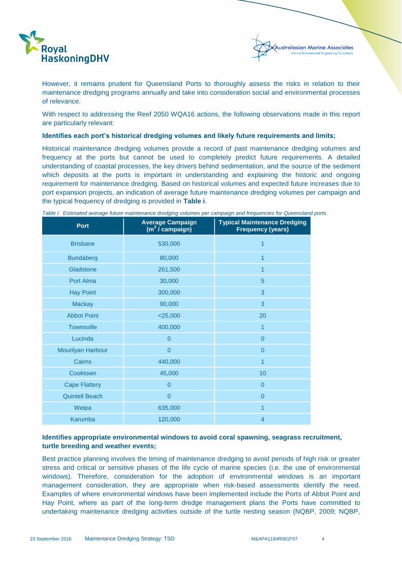
requirement for maintenance dredging. Based on historical volumes and expected future increases due to
port expansion projects, an indication of average future maintenance dredging volumes per campaign and
the typical frequency of dredging is provided in Table i.
Table i: Estimated average future maintenance dredging volumes per campaign and frequencies for Queensland ports.
Port Average Campaign
(m3 / campaign)
Typical Maintenance Dredging Frequency (years)
Brisbane 530,000 1
Bundaberg 80,000 1
Gladstone 261,500
1
Port Alma 30,000
5
Hay Point 300,000
3
Mackay 90,000 3
Abbot Point <25,000 20
Townsville 400,000 1
Lucinda 0 0
Mourilyan Harbour 0 0
Cairns 440,000 1
Cooktown 45,000
10
Cape Flattery 0 0
Quintell Beach 0 0
Weipa 635,000 1
Karumba 120,000 4
Identifies appropriate environmental windows to avoid coral spawning, seagrass recruitment,
turtle breeding and weather events;
Best practice planning involves the timing of maintenance dredging to avoid periods of high risk or greater
stress and critical or sensitive phases of the life cycle of marine species (i.e. the use of environmental
windows). Therefore, consideration for the adoption of environmental windows is an important
management consideration, they are appropriate when risk-based assessments identify the need.
Examples of where environmental windows have been implemented include the Ports of Abbot Point and
Hay Point, where as part of the long-term dredge management plans the Ports have committed to
undertaking maintenance dredging activities outside of the turtle nesting season (NQBP, 2009; NQBP,
23 September 2016
Maintenance Dredging Strategy: TSD M&APA1184R001F07 5
2010). If adopted, it is essential that those environmental windows be of an appropriate spatial and
temporal scale to minimise the potential for ecological harm, but not unnecessarily constrain dredging
activities.
Environmental windows should not be considered synonymous with periods of no dredging (albeit that
there may be occasions when dredging may not be permitted within part of or all of the environmental
window period as determined by the risk based approach) but rather a period during which environmental
communities are most susceptible.
Environmental windows should be implemented when there is quantifiable and/ or perceived risk,
recognising that in many instances stakeholder concerns and precautionary approaches are an important
consideration, particularly in relation to species of high conservation value. If dredging is, however,
required within an environmental window and a risk has been identified, then appropriate impact mitigation
strategies should be adopted.
Examines opportunities for the beneficial reuse of dredge material or on-land disposal from
maintenance activities; and
Opportunities for on-land disposal of dredge material are generally constrained and can lead to an
increased risk of environmental harm. Development of port and regional sediment distribution maps, and
sediment budgets, would assist with an understanding of sediment movement pathways and deposition
areas for different sediment types and would facilitate options for beneficial reuse of maintenance dredge
material within the natural marine environment. Opportunities for environmental rehabilitation within the
GBRWHA are very limited due to the high conservation value of coastal fringe land and lack of degraded
ecosystems providing opportunities for restoration.
Establishes requirements for risk-based monitoring programs
The National Assessment Guidelines for Dredging (DEWHA, 2009) sets out the framework for sediment
quality assessment and permitting of unconfined ocean disposal of dredge material (NAGD, 2009). These
guidelines are actively used by GBR ports, and form the basis of their approvals process. Each port in
Queensland is committed to a tailored environmental risk management approach as an essential part of
the planning and implementing of maintenance dredging. This process is guided by, and recorded within,
the port management bodies Environmental Management Systems (EMS) that logs all environmental
aspects, hazard and/or risk to the environment. A key component of this process is to define risk-based
monitoring programs, management responses and opportunities for improvement (i.e. in accordance with
ISO 14000). This management approach is considered world’s best practice and ensures potential
impacts on the environment are minimised and regulatory compliance is achieved.
The risk-based monitoring programs developed by Queensland Ports are reviewed annually, and provide
a basis to assess risks associated with future maintenance dredging and the need for adaptive
management during dredging. A series of management actions are then identified and incorporated into a
maintenance dredging Environmental Management Plan (EMP).
This process is a fundamental component of the adaptive management approach for ensuring risk-based
management of Queensland Ports is proactive and founded on the most current scientific understanding
of each port marine ecosystem.
Queensland Ports will continue to lead and contribute to the development of environmental and coastal
process based scientific investigations and monitoring programs. Queensland Ports have identified the
need to understand the sediment dynamics within their region as a prerequisite to allow adaptive long-
term environmental management, supporting sustainable development and minimising environmental
harm to the ports and surrounding areas. The outcomes of such works help to inform how natural
environmental variables behave, and how they interact/influence environmental values. Importantly, the
23 September 2016
Maintenance Dredging Strategy: TSD M&APA1184R001F07 6
outcomes of these programs will feed into the Queensland Ports annual risk assessments, helping to
refine risk ratings and the risk-based monitoring that is required to ensure the environmental values are
maintained into the future.
Cumulative impacts of the proposed maintenance dredging program are also taken into consideration by
each of the ports in Queensland. This is particularly important if major natural perturbations occur (i.e.
cyclones, flooding, etc). Cumulative impacts may also be of relevance when port development and
channel upgrades are being executed, and each port needs to place these activities in context with the
occurrence of the proposed maintenance dredging and the likelihood of interacting with sensitive
environmental values.
23 September 2016
Maintenance Dredging Strategy: TSD M&APA1184R001F07 7
1 Introduction
1.1 Context
In March 2015 the Australian and Queensland Governments jointly released the Reef 2050 Long-Term
Sustainability Plan (Reef 2050) for the Great Barrier Reef World Heritage Area (GBRWHA). This
document provides the overarching framework for protecting and managing the Great Barrier Reef (GBR)
from 2015 to 2050.
Reef 2050 is a key component of the Australian Government’s response to the recommendations of the
UNESCO World Heritage Committee for the continued World Heritage listing of the GBR. It addresses the
findings of the Great Barrier Reef Marine Park Authority’s (GBRMPA) Outlook Report 2014 and builds on
the comprehensive strategic assessment of the World Heritage Area and adjacent coastal zone. Reef
2050 focusses on actions intended to address key threats and directly boost the health and resilience of
the GBR.
A list of key relevant terms, abbreviations and acronyms used in this report are shown in Table 1. A more
comprehensive listing is provided in Appendix A.
Table 1: Key relevant terms, abbreviations and acronyms used in report
Term, abbreviation or acronym
Meaning
AMSA Australian Maritime Safety Authority
Capital dredging The removal of natural seabed to establish or increase depth and/or width of shipping channels, swing basins and berth pockets.
EHP Department of Environment and Heritage Protection
GBR Great Barrier Reef
GBRMPA Great Barrier Reef Marine Park Authority
GBRWHA Great Barrier Reef World Heritage Area
GPC Gladstone Ports Corporation Limited
Maintenance dredging Removal of sediments that accumulate in existing channels, swing basins and berths to enable ongoing use of the ports.
NQBP North Queensland Bulk Ports Corporation Limited
Ports North Far North Queensland Ports Corporation Limited
PoTL Port of Townsville Limited
QPA Queensland Ports Association
Reef 2050 Reef 2050 Long-Term Sustainability Plan
TMR Department of Transport and Main Roads
TSHD Trailing Suction Hopper Dredge
WHC World Heritage Committee of UNESCO
23 September 2016
Maintenance Dredging Strategy: TSD M&APA1184R001F07 8
1.2 Reef 2050
Reef 2050 contains a number of actions relating to ‘reducing the impact of ports and dredging’. These
actions have already had an impact on several proposed Queensland port dredging projects as Reef 2050
includes a directive to ban sea-based disposal of capital dredge material within the GBRWHA and to
mandate the beneficial reuse or on-land disposal of port-related capital dredged material where it is
environmentally safe to do so. This has since been enshrined in the Sustainable Ports Development Act
2015 (Qld) which further limits capital dredging to nominated priority ports.
In addition to restrictions placed on the disposal of capital dredge material, Reef 2050 also contains
several actions relating to the management of maintenance dredge material. These are listed in Table 2.
Table 2: Reef 2050 actions relevant to maintenance dredging
Reef 2050 Action Reference Description
WQA15
Develop and implement a dredging management strategy that includes:
an examination and, where appropriate, a potential pilot program to evaluate different treatment and re-use options for managing dredge material
measures to address dredging-related impacts on Reef water quality and ecosystem health
a ‘code of practice’ for port-related dredging activities
WQA16
Develop a State-wide coordinated maintenance dredging strategy which:
Identifies each port’s historical dredging volumes and likely future requirements and limits
Identifies appropriate environmental windows to avoid coral spawning, seagrass recruitment, turtle breeding and weather events
examines opportunities for the beneficial reuse of dredge material or on-land disposal from maintenance activities
establishes requirements for risk-based monitoring programs
WQA17 Understand the port sediment characteristics and risks at the four major ports and how they interact and contribute to broader catchment contributions within the World Heritage Area.
1.3 Reef 2050 (WQA16)
The Department of Transport and Main Roads (TMR) has been tasked with completion of action WQA16,
for which the main deliverable is the preparation of an overarching Maintenance Dredging Strategy to
inform the management and maintenance dredging at Queensland Ports (TMR, 2015a). This document,
therefore, focusses on the ports located within the GBRWHA, but also recognises the influence of
maintenance dredging at other Queensland ports that are not adjacent to the GBRWHA but are part of the
annual maintenance dredging campaign by the Trailer Suction Hopper Dredge (TSHD) Brisbane, which
undertakes the vast majority of maintenance dredging operations at all Queensland ports. The document,
therefore, considers historical maintenance dredging volumes and likely future requirements at all
recognised Queensland Ports.
The Reef 2050 Action WQA15 will be addressed as part of supplementary works while WQA17 will be
addressed by individual ports and relevant agencies, with TMR as the current nominated lead.
23 September 2016
Maintenance Dredging Strategy: TSD M&APA1184R001F07 9
1.4 Purpose of this report
The purpose of this report is to provide a comprehensive review of all relevant technical issues and
available scientific data associated with maintenance dredging activities within the GBRWHA, in order to
address the Reef 2050 WQA16 actions relevant to maintenance dredging. The observations of the report
will be used to inform the overarching Maintenance Dredging Strategy for GBRWHA Ports, which is being
prepared by TMR.
1.5 Maintenance Dredging
1.5.1 Background
Maintenance dredging involves the removal of natural sediment (e.g. clay, silt and sand) that has settled
within berthing pockets, swing basins and shipping channels as a result of natural sedimentary processes.
Maintenance dredging is commonly undertaken using either hydraulic (e.g. suction) or mechanical (e.g.
digging, grab) methods to remove the sediment, which is then either placed in a hopper/barge for sea
disposal and/or pumped ashore. The nature of removal is generally determined through a consideration
of: the nature of the materials to be dredged; availability of suitable plant; availability and location of
suitable disposal areas; the environmental conditions at the location (e.g. swell); and potential
environmental impacts.
Due to maintenance dredging materials being generally loose in nature (recently deposited sediments),
hydraulic dredging using a Trailing Suction Hopper Dredge (TSHD) is generally used for the majority of
maintenance dredging operations, apart from areas where access is limited, in which case a backhoe,
grab or cutter suction type dredger may be utilised.
1.5.2 Navigational Requirement
The physical dimensions of the berth, basins and channels are determined by: the type, size, draft and
frequency of design vessel(s) accessing the ports; meteorological/oceanographic (metocean) conditions at
the ports; as well as a number of physical characteristics (such as nature of seabed, aids to navigation,
channel side slopes, etc.). The minimum dimensions of the channel (both horizontal and vertical) are
determined through a detailed assessment of empirical recommendations (e.g. PIANC, 2014) and detailed
design and modelling (hydrodynamic, underkeel clearance (UKC) and vessel simulation). The primary
objective is to provide the most efficient channel dimensions for the vessels which are expected to visit the
port. The channel, basin and berth horizontal dimensions and vertical “declared depths” are determined
through this process and signed off by the statutory authority (normally by the Regional Harbour Master).
Ports undertake regular bathymetric surveys to ensure declared depths are current.
Natural sedimentary processes tend to reduce both the horizontal and vertical dimensions of the channels,
basins and berths. Where there is evidence that the declared dimensions and depths of a dredged area
have been reduced, the Harbour Master will apply vessel depth and/or operating restrictions to ensure that
navigational and berthing safety is maintained at all times.
Natural sedimentation between maintenance campaigns is accommodated through allowing additional
“insurance depths” below the declared depth with greater allowances where greater levels of
sedimentation have been experienced, refer Figure 1. Interception methods may also be used to deflect
and/or trap sediments prior to entering the shipping channels (groynes, insurance trenches, etc.). It is
important to note that these insurance depths, interception methods and other similar methods do not
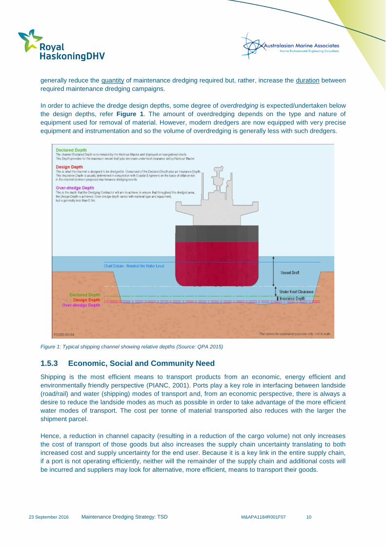
23 September 2016
Maintenance Dredging Strategy: TSD M&APA1184R001F07 10
generally reduce the quantity of maintenance dredging required but, rather, increase the duration between
required maintenance dredging campaigns.
In order to achieve the dredge design depths, some degree of overdredging is expected/undertaken below
the design depths, refer Figure 1. The amount of overdredging depends on the type and nature of
equipment used for removal of material. However, modern dredgers are now equipped with very precise
equipment and instrumentation and so the volume of overdredging is generally less with such dredgers.
Figure 1: Typical shipping channel showing relative depths (Source: QPA 2015)
1.5.3 Economic, Social and Community Need
Shipping is the most efficient means to transport products from an economic, energy efficient and
environmentally friendly perspective (PIANC, 2001). Ports play a key role in interfacing between landside
(road/rail) and water (shipping) modes of transport and, from an economic perspective, there is always a
desire to reduce the landside modes as much as possible in order to take advantage of the more efficient
water modes of transport. The cost per tonne of material transported also reduces with the larger the
shipment parcel.
Hence, a reduction in channel capacity (resulting in a reduction of the cargo volume) not only increases
the cost of transport of those goods but also increases the supply chain uncertainty translating to both
increased cost and supply uncertainty for the end user. Because it is a key link in the entire supply chain,
if a port is not operating efficiently, neither will the remainder of the supply chain and additional costs will
be incurred and suppliers may look for alternative, more efficient, means to transport their goods.
23 September 2016
Maintenance Dredging Strategy: TSD M&APA1184R001F07 11
However, alternative means may not always be available or practical. Suppliers who have invested heavily
in considerable infrastructure (e.g. factories, wharf facilities) will continue to operate inefficiently, if need
be, in order to sustain their business. This may involve using less (economic, energy and environmental)
efficient means of transport (e.g. trucks) to transport their product (e.g. to market or to alternative more
distant port facilities). There is also considerable pressure on governments to assist and subsidise
inefficient ports in order for them to compete with more efficient ports, especially if those inefficient ports
are supporting vulnerable regional communities.
An efficient port, on the other hand, will sustain not only itself but also the community and surrounding
regions (AECOM, 2013), with less dependence on additional financial support. Ports play a key role in the
direct and indirect prosperity of their community and maintenance dredging plays a key role in maintaining
that efficiency.
Ports also need to be very mindful of changes in the economic climate in which they operate and be able
to respond to such changes. These changes are generally outside their control, such as changes in
shipping types and global market demands. Often this may result in a need to deepen and/or reconfigure
their navigation and infrastructure assets in response to such changes which may lead to both capital and
additional associated maintenance dredging requirements. Failure to do so, once again, leads to port
inefficiency, along with the associated economic and social (and environmental) impacts associated with
such inefficiency, as well as a reliance on less efficient, older ships.
1.5.4 Environmental Sustainability
Ports need to develop and operate in an environmentally sustainable way and they also need to manage
their maintenance dredging activities in a similar manner. This is not only reducing or avoiding any direct
or indirect impacts on the environment associated with dredging and disposal operations but also: (1)
ensuring that any required maintenance dredging operations are undertaken as efficiently as possible to
avoid excessive vessel emissions; and (2) recognising that maintenance dredge material is not simply
spoil but rather an integral part of the natural environment and care needs to be taken to avoid any long
term impacts on the environment.
Where material has entered the berths, basins and channels through natural sedimentary processes and
intercepted the natural transport of sediment, removing this material from the system has the potential to
lead to longer term impacts, such as erosion of down-drift natural assets (beaches, wetlands, mangroves,
etc.). Maintenance dredging, therefore, needs to be considered and undertaken in a manner to ensure
long term environmental sustainability.
The action associated with maintenance dredging and material disposal can introduce environmental
stressors that have the potential to impact upon environmental values. To ensure a sustainable approach
is achieved, sufficiently robust risk assessments are required to identify priority risks and facilitate the
development of appropriate management/mitigation strategies.
These aspects will be dealt with in greater detail in the body of this report.
1.6 Maintenance Dredging at Ports within the GBRWHA
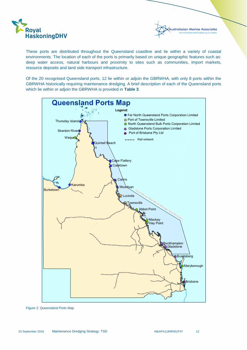
Queensland has 20 recognised ports comprising of 15 trading ports, two community ports and three
smaller non-trading ports, refer Figure 2.
23 September 2016
Maintenance Dredging Strategy: TSD M&APA1184R001F07 12
These ports are distributed throughout the Queensland coastline and lie within a variety of coastal
environments. The location of each of the ports is primarily based on unique geographic features such as:
deep water access, natural harbours and proximity to sites such as communities, import markets,
resource deposits and land side transport infrastructure.
Of the 20 recognised Queensland ports, 12 lie within or adjoin the GBRWHA, with only 8 ports within the
GBRWHA historically requiring maintenance dredging. A brief description of each of the Queensland ports
which lie within or adjoin the GBRWHA is provided in Table 3.
Figure 2: Queensland Ports Map

23 September 2016
Maintenance Dredging Strategy: TSD M&APA1184R001F07 13
Table 3: Summary of Ports within the GBRWHA.
Port Established Primary Purpose
Approximate
Channel
Length
Maintained
Channel Depth
(below LAT)
Number
of
Berths
Maintained
Depth of Berths
(below LAT)
Average Depths
Adjacent to Maintained
Areas (below LAT)
Maintenance
Dredging
Requirement
Port of
Gladstone 1863
Queensland’s largest multi commodity Port
with over 30 products handled. 40 km 12.5 m - 16.3 m +20 6 m – 18.8 m
varies considerably,
0 m – 14 m Annually
Port Alma 1884 Multi cargo port handling: ammonium nitrate,
explosives, general cargo, salt and tallow. - - 3 9.2 m 6 m – 7 m
Episodic
(5 years)
Hay Point (Hay
Point and
Dalrymple Bay
Terminals)
1971 Coal export terminal. 11 km 14.7 m 7 16.6 m – 19.6 m 12 m – 15 m Regular
(2-4 years)
Port of Mackay 1939 Multi cargo port with the main exports being
sugar and grain. - - 4 10.6 m – 12.5 m 8 – 9 m (Outside of Harbour)
Regular
(3 years)
Abbot Point 1984 Coal export terminal. 4 km 17 m 2 19 m - 19.5 m 15 m – 17 m Infrequent
(20 years)
Port of
Townsville 1864
Multi cargo port including the export of
minerals and key import hub for North
Queensland.
11 km 11.7 m 11 10.7 m – 12.2 m 4 m - 11 m Annually
Lucinda 1958 Primarily a sugar export terminal, however
does handle small amounts of general cargo. - - 1 13.6 m 13 m - 14 m Not Required
Mourilyan 1883 Export of sugar, molasses and timber. 1 km 9.6 1 10.1 m 6 m – 10 m Not Required
Port of Cairns 1887
Multi cargo port including: bulk and general
cargo, defence, cruise shipping, fishing and
tourism.
11 km 8.3 12 6 m – 10.5 m 0 m – 8 m Annually
Cooktown Not Available Non-commercial trading Port. 800 m 3.1 1 4 m 0 m - 4 m Infrequently
Cape Flattery 1967 Silica sand export terminal. - - 1 14.1 m 17 m – 12 m Not Required
Quintell Beach Not Available Community port which handles general
cargo. - - 1 Barge Landing 1 m - 3 m Not Required

23 September 2016
Maintenance Dredging Strategy: TSD M&APA1184R001F07 14
Historically, ports have developed around natural embayments, estuaries and harbours where safe refuge
was provided to passing vessels. Modern container/cargo ports require not only suitable berth and
navigation facilities but also large land backed areas to provide for efficient storage and handling of
shipping products. Hence, many of these ports have been developed alongside river banks and
embayments, such as Port Alma and Gladstone, both of which are within the GBRWHA. As a result,
significant capital dredging operations may be required to deepen and widen the ports in response to
global shipping trends and developing trades at the ports. Ports with long shipping channels through
relatively shallow natural depths, such as Cairns and Townsville, are particularly subject to high levels of
sedimentation due to natural sediment transport and coastal storm events.
Bulk ports (liquid/solid) have greater flexibility in that cargos can be stored ashore and piped/conveyed
to/from the wharf to be loaded/unloaded onto/from the vessel. This means that the wharf facility can be
located some distance offshore (should the prevailing metocean conditions permit loading/unloading
operations) in deeper water which, in turn, reduces both initial capital and subsequent maintenance
dredging requirements. A number of ports within the GBRWHA, such as Hay Point and Abbot Point, have
been developed along these lines.
As noted in Table 3, a number of ports within the GBRWHA have either not historically required
maintenance dredging or have required very infrequent maintenance dredging. This is because they are
either: located in a non-depositional environment; in an area where resuspension of fines exceeds
deposition rates; they have access to naturally deep waters; or they only service shallower draft vessels
that can use natural channels for navigation to and from the port facilities.
Maintenance dredging in ports within the GBRWHA is undertaken on an annual basis at most of the
larger, historically developed ports and less frequently at ports such as Hay Point and Abbot Point, for the
reasons noted above. Since 2001, the majority of the maintenance dredging volume has been handled by
the TSHD Brisbane (with grab dredgers also used by some ports to perform maintenance dredging to
complement the TSHD Brisbane works), which is owned and operated by the Port of Brisbane Pty Ltd,
with the vast majority of material relocated to approved offshore disposal sites.
The TSHD Brisbane travels up and down the Queensland coast to undertake the maintenance dredging
each year. The schedule typically involves travelling up to Weipa (yearly) or Karumba (every second
year) from Brisbane and then travelling back with maintenance dredging of the other ports being
undertaken on route either on the way north or when returning south. The schedule for the TSHD
Brisbane is confirmed each year following the wet season when any increased maintenance dredging
requirements from extreme events such as tropical cyclones or floods are known. Further analysis of
TSHD Brisbane schedule has been provided in Section 4.2.1.

23 September 2016
Maintenance Dredging Strategy: TSD M&APA1184R001F07 15
2 Sediment Transport Processes
2.1 Introduction
Natural metocean processes can result in the transport and deposition of natural sediment (e.g. sand, silts
and clays) within the coastal environment. These processes drive the need for maintenance dredging
activities at ports as they result in sediment being deposited in the port’s artificially deepened channels,
aprons, basins and berths.
In the coastal waters of the GBR region, it is widely recognised that variations in turbidity is strongly
related to resuspension by wind, currents and waves (Larcombe et al., 1995; Wolanski et al., 2005; and
Fabricius et al., 2013). Orpin et al. (1999) noted that sediment advection driven through flood waters
discharged from local estuaries and rivers and low frequency high energy storm and cyclone events can
also be responsible for regional scale sediment transport within the GBR region.
Queensland ports within the GBRWHA are spread over a distance of approximately 1,500 km along the
east coast of Queensland and, therefore, lie within a variety of coastal environments. The extensive
distribution of the ports results in the ports being subject to variability in local metocean conditions. This
can result in the relative influence of each of the above mentioned primary coastal processes varying
significantly between each port.
Understanding the relative influence of each of the key processes on sedimentation is very important in
both understanding the historical maintenance dredging activities and estimating future maintenance
dredging requirements. This section provides a regional scale understanding on the processes driving
sedimentation at the ports and outlines the relative importance and variability of the processes at each
port. A detailed description of the key coastal processes influencing sedimentation at each of the GBR
ports has been included in Appendix B.
2.2 Wave Climate
Local wave conditions can play an important role in the resuspension of bed sediments, as demonstrated
by Fabricius et al. (2013) who found that wave height and period were strong predictors of turbidity levels
within the GBR Lagoon. Waves can act to suspend/mobilise sediment from the seabed and the local
currents then drive the advection of the suspended sediments. The amount of resuspension of the bed
sediment resulting from waves is related to the critical bed shear stress, which is controlled by the
characteristics of the bed sediment, and the bed shear stress exerted by the waves. The bed shear stress
imposed by waves is caused by the oscillatory wave induced currents reaching the seabed and this is
dependent on the wave conditions and local water depth. Bed shear stresses due to waves are typically
capable of resuspending sediment in the relatively shallow coastal fringe areas. Wave induced bed shear
stresses resulting from both locally generated wind waves and longer period swell waves are fundamental
in the natural suspension of seabed sediments in the GBR, with wave driven sedimentation being more
prevalent at some ports than others.
Waves can result in both the long-shore and cross-shore transport of sediment. This is dependent on: the
morphology; alignment of the coastline; and prevailing direction of waves. In addition, under the
simultaneous presence of even a weak current, sediment mobilised by wave action can also be subject to
a net transport due to the current. Sediment mobilised by wave action can, therefore, be transported
either by waves or by the dominant currents with some of this sediment ending up in the artificially
deepened areas of the ports. Within these dredged (deepened) areas, the wave and current induced bed
23 September 2016
Maintenance Dredging Strategy: TSD M&APA1184R001F07 16
shear stresses are relatively low compared to the adjacent areas. This results in these deeper areas
acting as sediment sinks with increased sedimentation and less potential for resuspension compared to
the adjacent natural areas. The sedimentation rate is dependent on the metocean conditions, the
sediment transport rates, settling velocity of the sediment and the ‘trapping efficiency’ of the dredged
areas. Typically, the deeper and wider the dredged area, the more efficient they are as a sediment trap
and, therefore, the higher the sedimentation rates. Sedimentation resulting from wave action is especially
significant at the Port of Townsville and the Port of Cairns where navigational channels have been
dredged through the relatively shallow bathymetry in Cleveland and Trinity Bays respectively.
In shallow coastal areas, typical wave conditions can contribute significantly to the resuspension and
resultant transport of bed sediments as longshore drift. Higher wave generated bed shear stresses occur
in shallower areas which results in the potential for increased sediment transport and therefore higher
rates of sedimentation closer to the shoreline where longshore drift dominates. This occurs at the Port of
Townsville where sedimentation rates have been found to be higher in the landward sections of the main
navigational channel due to the higher wave resuspension rates in the shallower areas closer to the
shoreline.
Similarly, areas of intertidal mudflats are particularly susceptible to wave induced sediment resuspension
due to the shallow water depths in these areas. Even relatively small, locally generated wind waves have
the potential to suspended fine grain sediments from these mudflats for further mobilisation by local
currents. This process is particularly prevalent at intertidal mudflat areas surrounding the Ports of Cairns,
Townsville and Gladstone.
The wave climate within the greater GBR lagoon can be broadly described as predominantly locally
generated sea waves typically with short peak periods of less than 6 seconds and mean significant wave
heights of less than 0.7 m (Orpin et al.,1999). The dominant wave direction is from the south east due to
the prevailing south to south east trade winds which dominate in the region. Within the GBR Lagoon
higher energy wave conditions generally occur during the summer months as a result of stronger wind
speeds and possible cyclone occurrence during these months. Due to the presence of the extensive
areas of outer reef throughout the majority of the GBRWHA (excluding Gladstone and Port Alma, but
these ports are mainly located in sheltered locations), ports within the GBRWHA are typically sheltered
from long period ocean swell waves from the Coral Sea. Some of the ports are subject to swell events but
these events generally only occur during significant storm events or when particular ports are susceptible
to longer fetch windows between sections of reef.
The discontinuous nature of the outer reef can allow for some longer period ocean swell waves to
propagate through the reef system. For example, the outer navigational channel of Gladstone Port sees
southerly swell conditions as a result of the gap in the reef between Sandy Cape and the Capricorn
Bunker group of reefs (BMT WBM, 2014a). Similarly, the Ports of Mackay and Hay Point experience more
frequent swell conditions than its northern neighbour Abbot Point Port, as Abbot Point is shielded from
longer period swell waves from the south east as a result of sheltering effects from the Whitsundays Island
group (Orpin et al.,1999). Although swell waves are not generally the dominant wave component in the
region, swell waves can still play an important role in the mobilisation of bed sediments. For example,
studies undertaken by Jing and Ridd (1996) found that swell waves are the dominant generator of bed
shear stresses, and in turn sediment resuspension, in Cleveland Bay (PoTL, 2014).
Cyclone and storm induced wave events, often experienced during the summer months, can also have a
significant impact on sedimentation at the majority of ports within the GBRWHA. The influence of these
extreme events is further discussed in Section 2.5.
23 September 2016
Maintenance Dredging Strategy: TSD M&APA1184R001F07 17
2.3 Currents
Currents and waves provide the mechanism by which sediments are resuspended and delivered to
sedimentation zones. The characteristics of marine currents throughout the GBR are highly variable with
astronomical tides and prevailing wind conditions primarily driving the local current conditions.
As shown in Table 4, the astronomical tides vary throughout the GBR region. Mackay and Hay Pont
experience the largest tidal range of the ports (tidal range of approximately 7m) due to local tidal
amplification at Broad Sound, while Cape Flattery experiences the smallest (tidal range of approximately
3m). Astronomical tides are a key indicator of the local tidal currents, and therefore the sedimentation
resulting from tidal currents can be expected to vary depending on the local tidal range. Areas with larger
tidal ranges often experience significantly higher tidal currents during spring tides which results in higher
bed shear stresses, which in turn can potentially result in more regular resuspension, transport and
deposition of bed sediment.
Table 4: Tidal planes at each Port within the GBRWHA.
Port Highest Astronomical Tide
above LAT (MSQ 2015)
Port of Gladstone 4.8 m
Port Alma 5.9 m
Port of Hay Point 7.1 m
Port of Mackay 6.6 m
Port of Abbot Point 3.6 m
Port of Lucinda 3.9 m
Port of Townsville 4.1 m
Mourilyan Harbour 3.5 m
Port of Cairns 3.5 m
Port of Cooktown 3.2 m
Cape Flattery 3.1 m
Additionally, regional and local wind conditions can also be an important driver to the local current
conditions. Winds exert a frictional drag on the surface of the ocean which transfers momentum to the
surface water and subsequently to the water column below. Due to the Earth’s rotation there is a
deflection in the water movement relative to the wind direction, this is known as the Coriolis Effect and in
the Southern Hemisphere it results in a deflection to the left of the wind direction. The deflection results in
an Ekman spiral forming, whereby each successive deeper layer of water moves to the left creating a
spiral effect down to approximately 100m depth where the influence of winds cease. The net current
direction is 90 degrees to the left of the wind direction; this is known as the Ekman transport direction
(Knauss, 1997). However, typically in shallow water, such as where the ports in the GBRWHA are
located, the angle between the horizontal wind direction and the surface water current direction is small
(typically less than 15 degrees).
23 September 2016
Maintenance Dredging Strategy: TSD M&APA1184R001F07 18
On a regional scale, the prevailing south easterly trade winds in the GBR lagoon are fundamentally
responsible for the residual northward current direction and associated net northward flux of sediment in
the GBR lagoon (Orpin et al.,1999). The trade winds tend to dominate in the dry season when the wind
direction is typically from the south-east, while during the wet season the winds are more variable and
potentially stronger with winds from the east dominating but with northerly and southerly winds also
occurring. The seasonal variability in the wind can result in some seasonality in the currents, with a
stronger northerly residual current typically occurring during the dry season, a higher chance of a reverse
southerly residual in the wet season and the potential for stronger currents in the wet season due to
cyclonic events. The relative importance of wind driven currents is dependent on the local wind conditions
and the existing tidal conditions. Ports where local wind conditions are known to significantly influence
local currents include: Abbot Point; Townsville; and Cairns.
Within Cleveland Bay (Port of Townsville) and offshore of Abbot Point, the prevailing south-east trade
winds are seen to strengthen tidal driven flood currents towards the west while reducing, or at times
reversing, the eastward ebb tide currents. This results in a residual net current flow to the west. In
Cleveland Bay this residual westward current, when coupled with local sea and swell waves, results in the
net longshore transport of sediment from the shallow coastal areas in the east of Cleveland Bay to the
west. Some of the transported sediment is subsequently deposited into the dredged areas of the port.
The spatial distribution of currents in Cleveland Bay also plays an important role in defining the sediment
transport pathways influencing sedimentation in the main channel. While the inshore currents are
generally orientated in an east-west direction (perpendicular to the channel), the influence of Magnetic
Island means tidal currents in the outer reaches of the channel generally flow in a north-south direction
(parallel to the channel). Currents running parallel to the shipping channel will result in less sediment
being transported into the dredged channel compared to currents which are perpendicular to the channel.
This is consistent with recent maintenance dredging operations at the Port of Townsville where
sedimentation rates, and therefore maintenance dredging requirements, have been much higher in the
inshore areas of the channel (PoTL, 2014).
Similarly, in Trinity Bay the prevailing hydrodynamic processes play a key role in defining sediment
transport pathways around the Port of Cairns. Within Trinity Bay, the tidal currents tend to flow in an
inshore/offshore direction, perpendicular to the bathymetry contours and parallel with the channel
alignment. However, the wind induced currents resulting from the prevailing south-easterly trade winds
result in a slight cross-channel directed current component. The wind induced current is more important in
the outer areas of Trinity Bay, with wind driven currents becoming the dominant current component
offshore of Trinity Bay during periods of strong prevailing winds. The dominant wind induced north-
westerly directed current is a primary factor driving sedimentation in the outer areas of the channel.
The outer extent (adjacent to beacon 18) of the Cairns Entrance Channel impinges on the East Trinity
mudflat. Recent maintenance dredging at the port has identified this particular section of the channel as
an area with high sedimentation rates. This is primarily due to sediment from the mudflat being
suspended and the net westerly currents transporting the suspended sediment into the main navigational
channel. Once deposited, the sediment will tend to remain, since bed shear stresses in the artificially
deepened channel rarely exceed the critical shear stress for resuspension. This process has also resulted
in the natural westward progression of the mudflat, with the associated accretion having contributed
significantly to maintenance dredging requirements at the port (Ports North, 2014).
In addition to tide and wind induced currents, regional scale circulation currents can also occur in the GBR
Lagoon. These regional scale currents are dynamic and intermittent as they are primarily driven by a
complex interaction between the oceanic inflows caused by the North Vanuatu Jet and the local wind

23 September 2016
Maintenance Dredging Strategy: TSD M&APA1184R001F07 19
driven circulation (Andutta et al., 2013). Although these regional scale ocean circulation processes can
intermittently influence sediment transport processes in the GBR Lagoon and therefore at the ports, their
impacts are considered minor relative to tidal and wind induced currents. For this reason, while regional
scale ocean circulation currents do have the potential to influence where sediment is transported they are
not expected to be critical drivers influencing sedimentation at the ports within the GBRWHA.
2.4 Rainfall and River Discharges
For the vast majority of the GBRWHA, the meteorological climate can be characterised as a tropical
monsoonal climate with distinct wet and dry seasons. The wet season occurs between December and
March when a significant proportion of the annual rainfall occurs. During the wet season, cyclones and
periods of high rainfall can result in large volumes of sediment being input into the waters of the GBR via
local river systems and their associated catchment areas. Such events result in rivers delivering the
majority of their annual sediment load within days or weeks. Sediment output from rivers during these
events is a key process responsible for the delivery of new terrigenous sediments to the GBR Lagoon.
The buoyant fresh water plumes discharged from the rivers during high rainfall events act to transport
suspended sediments locally within the GBR inner-shelf. There is some debate over the distance that the
turbid flood plumes discharged from rivers during high rainfall events can transport sediment within the
GBR Lagoon, with distances ranging from tens to hundreds of kilometres (Brodie et al., 2010; Orpin &
Ridd, 2012; Fabricius et al., 2014). An example plume from a 1 in 5 year flood event in the Burdekin River
is shown in Figure 4, the sediment from this plume was reported to have been transported up to 50km
along the coastline from the river mouth (Orpin & Ridd, 2012). Once sediment settles out from these flood
plumes, currents and waves will then act as the primary driver responsible for the advection of these
sediments regionally throughout the GBR inner-shelf.
The degree to which river discharges directly influence sedimentation rates at each port depends on the
location of the ports relative to the river and creek mouths and the sediment load of the associated
system. Figure 3 depicts the location of each port with respect to the major rivers discharging into the
GBR Lagoon. Table 5 details the mean annual total suspended solids discharged from 10 major rivers
into the GBR Lagoon, as estimated by Kroon et al. (2012). Table 5 also indicates the closest nearby port
and its distance from the river mouth. In addition to the major rivers, smaller local rivers and creeks which
discharge directly into port areas can also influence sedimentation rates at the ports. An example includes
the Boyne and Calliope Rivers which discharge directly into the Port of Gladstone.
At a number of ports within the GBRWHA, river sediment supply can directly influence sedimentation
within the ports, but at most ports it is considered, on average, to result in less sedimentation than wave
and current driven mechanisms.

23 September 2016
Maintenance Dredging Strategy: TSD M&APA1184R001F07 20
Table 5: Pre and post European mean annual discharge for 10 major rivers discharging into the GBR Lagoon (Kroon et al., 2012).
River Nearby Ports Estimated Mean Annual
TSS Discharge (t)
Estimated Mean Annual
Pre- European
Discharge (t)
Barron Port of Cairns
(6 km to the south) 100,000 25,000
N&S Johnstone Mourilyan
(10 km to the south) 320,000 41,000
Tully Mourilyan
(50 km to the north) 92,000 24,000
Herbert Lucinda
(6 km to the east) 380,000 110,000
Haughton Port of Townsville
(40 km to the north) 300,000 29,000
Burdekin
Abbot Point
(55 km to the south)
Port of Townsville
(90 km to the north)
4,000,000 480,000
Pioneer
Port of Mackay
(6 km to the north)
Hay Point
(16 km to the south)
52,000 50,000
Plane Hay Point
(14 km to the south) 550,000 54,000
Fitzroy
Port Alma
(adjacent)
Port of Gladstone
(50 km to the south)
3,400,000 1,100,000
Burnett Port of Gladstone
(135 km to the north) 1,400,000 99,000
Total 10,594,000 2,012,000
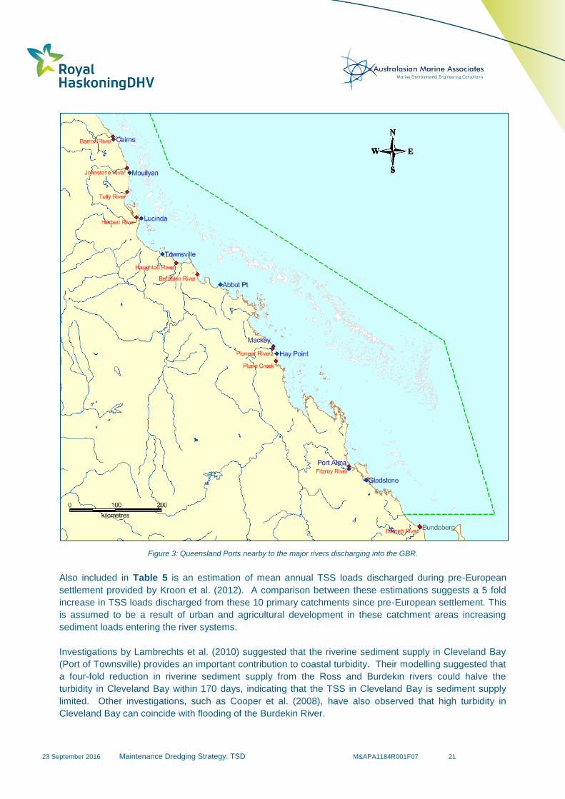
23 September 2016
Maintenance Dredging Strategy: TSD M&APA1184R001F07 21
Figure 3: Queensland Ports nearby to the major rivers discharging into the GBR.
Also included in Table 5 is an estimation of mean annual TSS loads discharged during pre-European
settlement provided by Kroon et al. (2012). A comparison between these estimations suggests a 5 fold
increase in TSS loads discharged from these 10 primary catchments since pre-European settlement. This
is assumed to be a result of urban and agricultural development in these catchment areas increasing
sediment loads entering the river systems.
Investigations by Lambrechts et al. (2010) suggested that the riverine sediment supply in Cleveland Bay
(Port of Townsville) provides an important contribution to coastal turbidity. Their modelling suggested that
a four-fold reduction in riverine sediment supply from the Ross and Burdekin rivers could halve the
turbidity in Cleveland Bay within 170 days, indicating that the TSS in Cleveland Bay is sediment supply
limited. Other investigations, such as Cooper et al. (2008), have also observed that high turbidity in
Cleveland Bay can coincide with flooding of the Burdekin River.

23 September 2016
Maintenance Dredging Strategy: TSD M&APA1184R001F07 22
However, reappraisal of the data by Orpin and Ridd (2012) showed that the timing of the high turbidity
events in Cleveland Bay coincided with periods of strong winds and the plume from the Burdekin River did
not result in high turbidity in Cleveland Bay (Figure 4 (overleaf, top)). They concluded that TSS
concentrations in this area are controlled primarily by wind and wave driven resuspension of the muddy
seabed (as shown in Figure 4 (overleaf, bottom)) rather than the input of fine grained sediment from the
Burdekin River, as other research by Larcombe and Wolfe (1999) had also shown.
Within the GBR Lagoon, events with strong winds and large waves often coincide with high rainfall and
increased river discharges. As highlighted by Orpin and Ridd (2012) this has resulted in some confusion
as to the relative importance of river loads with regard to the water quality of the inner shelf of the GBR
Lagoon. Although plumes resulting from the rivers which discharge into the GBR Lagoon can result in
high turbidity plumes, they found that these tend to be relatively localised in nature (e.g. within 50km of the
mouth) and do not result in increased turbidity across the entire inner shelf. Widespread resuspension of
bed material within the inner shelf occurs primarily as a result of wind and wave conditions, as shown for
the Cleveland Bay area in Figure 4 (overleaf, bottom).

23 September 2016
Maintenance Dredging Strategy: TSD M&APA1184R001F07 23
Figure 4: MODIS Aqua Images of: a flood plume from the Burdekin River, with the brown plume representing high TSS and the
green plume low TSS (at Horseshoe Bay TSS was less than 5 NTU) (top): and resuspension from a high energy wind and wave
during the dry season (at Horseshoe Bay TSS was 30 NTU) (bottom). Source: Orpin and Ridd (2012).
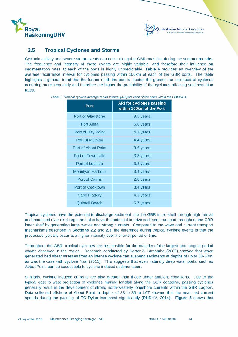
23 September 2016
Maintenance Dredging Strategy: TSD M&APA1184R001F07 24
2.5 Tropical Cyclones and Storms
Cyclonic activity and severe storm events can occur along the GBR coastline during the summer months.
The frequency and intensity of these events are highly variable, and therefore their influence on
sedimentation rates at each of the ports is highly unpredictable. Table 6 provides an overview of the
average recurrence interval for cyclones passing within 100km of each of the GBR ports. The table
highlights a general trend that the further north the port is located the greater the likelihood of cyclones
occurring more frequently and therefore the higher the probability of the cyclones affecting sedimentation
rates.
Table 6: Tropical cyclone average return interval (ARI) for each of the ports within the GBRWHA.
Port ARI for cyclones passing
within 100km of the Port.
Port of Gladstone 8.5 years
Port Alma 6.8 years
Port of Hay Point 4.1 years
Port of Mackay 4.4 years
Port of Abbot Point 3.6 years
Port of Townsville 3.3 years
Port of Lucinda 3.8 years
Mourilyan Harbour 3.4 years
Port of Cairns 2.8 years
Port of Cooktown 3.4 years
Cape Flattery 4.1 years
Quintell Beach 5.7 years
Tropical cyclones have the potential to discharge sediment into the GBR inner-shelf through high rainfall
and increased river discharge, and also have the potential to drive sediment transport throughout the GBR
inner shelf by generating large waves and strong currents. Compared to the wave and current transport
mechanisms described in Sections 2.2 and 2.3, the difference during tropical cyclone events is that the
processes typically occur at a higher intensity over a shorter period of time.
Throughout the GBR, tropical cyclones are responsible for the majority of the largest and longest period
waves observed in the region. Research conducted by Carter & Larcombe (2009) showed that wave
generated bed shear stresses from an intense cyclone can suspend sediments at depths of up to 30-60m,
as was the case with cyclone Yasi (2011). This suggests that even naturally deep water ports, such as
Abbot Point, can be susceptible to cyclone induced sedimentation.
Similarly, cyclone induced currents are also greater than those under ambient conditions. Due to the
typical east to west projection of cyclones making landfall along the GBR coastline, passing cyclones
generally result in the development of strong north-westerly longshore currents within the GBR Lagoon.
Data collected offshore of Abbot Point in depths of 33 to 35 m LAT showed that the near bed current
speeds during the passing of TC Dylan increased significantly (RHDHV, 2014). Figure 5 shows that
23 September 2016
Maintenance Dredging Strategy: TSD M&APA1184R001F07 25
during this event, the peak near-bed current speeds increased from 0.2m/s up to 0.9m/s and during this
time the currents were predominantly unidirectional to the west and north-west.
The peak significant wave height at this location during the event was 3.7m and the peak wave period was
6 seconds (RHDHV, 2014). The measurements showed significant resuspension of the existing bed
material during the event. Based on the measured data this is considered to be primarily a result of the
wind induced currents as opposed to the wave activity.
Figure 5: Measured water level and near-bed current speed and direction at 33 to 35 m LAT during TC Dylan (from RHDHV (2014)).
During cyclone events, storm-induced currents and waves can be capable of mobilising the upper few
metres of bed sediment near to ports (Orpin et al., 1999). These high intensity sedimentation events can
govern the need for maintenance dredging at ports. For example, the port maintenance dredging
requirements at the Port of Cooktown have historically been purely driven by cyclone induced
sedimentation of the channels and berths. The port has required infrequent maintenance dredging over
the last 20 years as a direct result of sedimentation from tropical cyclones travelling within 50km of the
port (TMR, 2015b).
Not only are cyclones responsible for mobilising and transporting large quantities of existing fine grained
bed sediment, they are also primarily responsible for the transport of sand sized and coarser sediment
throughout the inner shelf. The critical bed shear stresses required to mobilise these heavier materials
are typically not realised under ambient wave and current conditions and so they can only be transported
during high energy cyclonic conditions.
Cyclone induced waves and currents are also important in the supply of new sediment to the inner-shelf of
the GBR through the erosion and advection of sediments from the mid-shelf of the GBR. The inner-shelf of
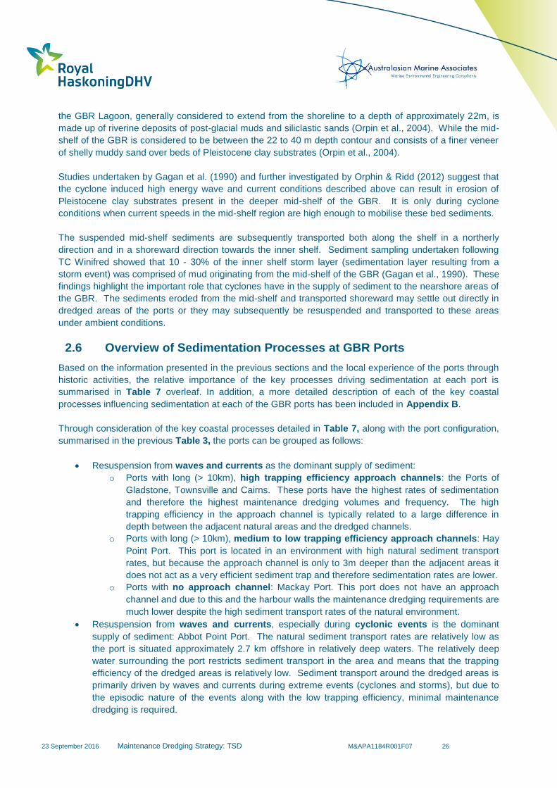
23 September 2016
Maintenance Dredging Strategy: TSD M&APA1184R001F07 26
the GBR Lagoon, generally considered to extend from the shoreline to a depth of approximately 22m, is
made up of riverine deposits of post-glacial muds and siliclastic sands (Orpin et al., 2004). While the mid-
shelf of the GBR is considered to be between the 22 to 40 m depth contour and consists of a finer veneer
of shelly muddy sand over beds of Pleistocene clay substrates (Orpin et al., 2004).
Studies undertaken by Gagan et al. (1990) and further investigated by Orphin & Ridd (2012) suggest that
the cyclone induced high energy wave and current conditions described above can result in erosion of
Pleistocene clay substrates present in the deeper mid-shelf of the GBR. It is only during cyclone
conditions when current speeds in the mid-shelf region are high enough to mobilise these bed sediments.
The suspended mid-shelf sediments are subsequently transported both along the shelf in a northerly
direction and in a shoreward direction towards the inner shelf. Sediment sampling undertaken following
TC Winifred showed that 10 - 30% of the inner shelf storm layer (sedimentation layer resulting from a
storm event) was comprised of mud originating from the mid-shelf of the GBR (Gagan et al., 1990). These
findings highlight the important role that cyclones have in the supply of sediment to the nearshore areas of
the GBR. The sediments eroded from the mid-shelf and transported shoreward may settle out directly in
dredged areas of the ports or they may subsequently be resuspended and transported to these areas
under ambient conditions.
2.6 Overview of Sedimentation Processes at GBR Ports
Based on the information presented in the previous sections and the local experience of the ports through
historic activities, the relative importance of the key processes driving sedimentation at each port is
summarised in Table 7 overleaf. In addition, a more detailed description of each of the key coastal
processes influencing sedimentation at each of the GBR ports has been included in Appendix B.
Through consideration of the key coastal processes detailed in Table 7, along with the port configuration,
summarised in the previous Table 3, the ports can be grouped as follows:
Resuspension from waves and currents as the dominant supply of sediment:
o Ports with long (> 10km), high trapping efficiency approach channels: the Ports of
Gladstone, Townsville and Cairns. These ports have the highest rates of sedimentation
and therefore the highest maintenance dredging volumes and frequency. The high
trapping efficiency in the approach channel is typically related to a large difference in
depth between the adjacent natural areas and the dredged channels.
o Ports with long (> 10km), medium to low trapping efficiency approach channels: Hay
Point Port. This port is located in an environment with high natural sediment transport
rates, but because the approach channel is only to 3m deeper than the adjacent areas it
does not act as a very efficient sediment trap and therefore sedimentation rates are lower.
o Ports with no approach channel: Mackay Port. This port does not have an approach
channel and due to this and the harbour walls the maintenance dredging requirements are
much lower despite the high sediment transport rates of the natural environment.
Resuspension from waves and currents, especially during cyclonic events is the dominant
supply of sediment: Abbot Point Port. The natural sediment transport rates are relatively low as
the port is situated approximately 2.7 km offshore in relatively deep waters. The relatively deep
water surrounding the port restricts sediment transport in the area and means that the trapping
efficiency of the dredged areas is relatively low. Sediment transport around the dredged areas is
primarily driven by waves and currents during extreme events (cyclones and storms), but due to
the episodic nature of the events along with the low trapping efficiency, minimal maintenance
dredging is required.

23 September 2016
Maintenance Dredging Strategy: TSD M&APA1184R001F07 27
Cyclonic events provide the dominant supply of sediment: Port of Cooktown. Sedimentation at
the Port of Cooktown is typically instigated by cyclones travelling nearby to the port generating
flooding and relatively large waves and high currents. It is generally only under these extreme
processes that notable volumes of sediment are mobilised into the port’s channels and berths.
The Ports of Cairns and Townsville both consist of long navigational channels which traverse relatively
shallow coastal embayments. As a result, both tidal currents and locally generated wind waves can
suspend natural bed sediment in the relatively shallow bays, while tidal and wind induced currents drive
the advection of the suspended sediment. Figure 6 shows two aerial photographs of Trinity Bay (Port of
Cairns) under both calm conditions (Photograph 1) and during a south easterly wind event of 15 knots
(Photograph 2). The aerial photographs highlight the natural variability in TSS resulting from the
metocean conditions.
Table 7 also presents background measured TSS concentrations at each of the ports within the GBRWHA
which require maintenance dredging. The TSS concentration is a result of the setting of the port, the
dominant metocean processes, as well the composition of the bed sediment in the area adjacent to the
ports. The table shows that background TSS concentrations vary considerably between the ports. In
addition, the data shows that in some cases the TSS concentrations vary spatially and seasonally (e.g. the
Port of Gladstone) while at others there is little variability (e.g. the Port of Abbot Point). As detailed in the
previous sections, some seasonal variability exists in the river discharge, waves and currents. The ports
which show a greater seasonal variability are those located in estuarine environments which would be
more influenced by river discharges, while the more exposed open coastal ports exhibit less seasonal
variability in TSS concentrations. It can be broadly inferred that the higher the background TSS
concentration the higher the potential rate of sedimentation.
Table 7 also details the relative importance that storm and cyclonic events have on sedimentation at each
port. These episodic events result in increased wave energy and currents and often significant flood
discharges from adjacent rivers. Under these conditions, short lived, high intensity sedimentation can
occur in any dredged areas. These events can influence all of the ports within the GBRWHA and the
episodic and unpredictable nature of these events can lead to extreme variability in maintenance dredging
requirements.
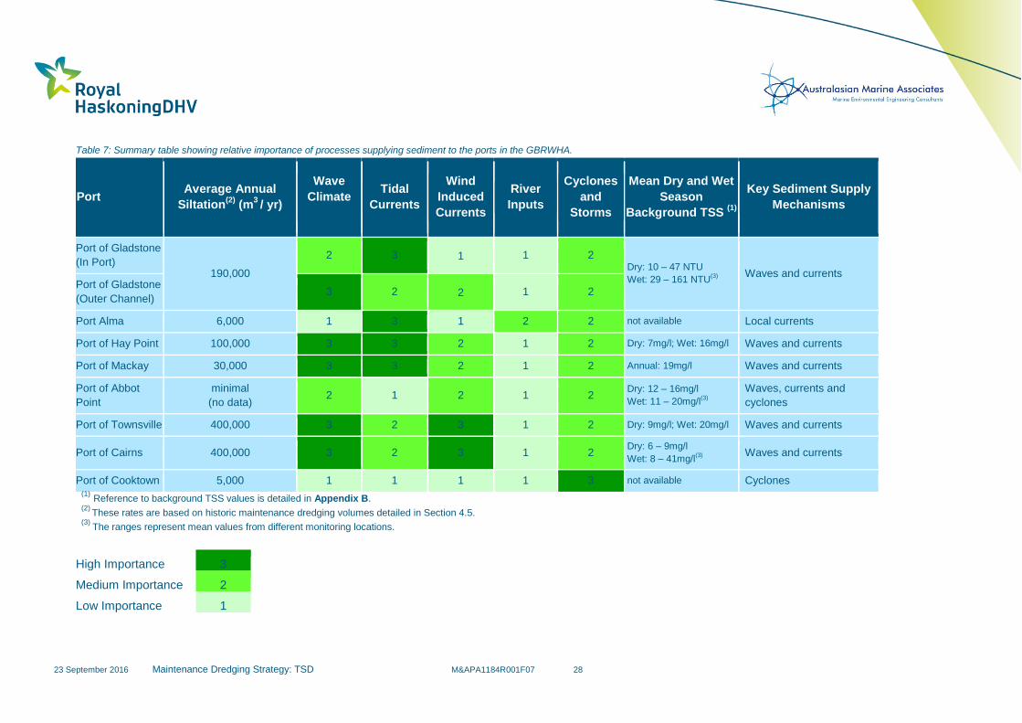
23 September 2016
Maintenance Dredging Strategy: TSD M&APA1184R001F07 28
Table 7: Summary table showing relative importance of processes supplying sediment to the ports in the GBRWHA.
Port Average Annual
Siltation(2)
(m3 / yr)
Wave
Climate
Tidal
Currents
Wind
Induced
Currents
River
Inputs
Cyclones
and
Storms
Mean Dry and Wet
Season
Background TSS (1)
Key Sediment Supply
Mechanisms
Port of Gladstone
(In Port) 190,000
2 3 1 1 2 Dry: 10 – 47 NTU
Wet: 29 – 161 NTU(3)
Waves and currents
Port of Gladstone
(Outer Channel) 3 2 2 1 2
Port Alma 6,000 1 3 1 2 2 not available Local currents
Port of Hay Point 100,000 3 3 2 1 2 Dry: 7mg/l; Wet: 16mg/l Waves and currents
Port of Mackay 30,000 3 3 2 1 2 Annual: 19mg/l Waves and currents
Port of Abbot
Point
minimal
(no data) 2 1 2 1 2
Dry: 12 – 16mg/l
Wet: 11 – 20mg/l(3)
Waves, currents and
cyclones
Port of Townsville 400,000 3 2 3 1 2 Dry: 9mg/l; Wet: 20mg/l Waves and currents
Port of Cairns 400,000 3 2 3 1 2 Dry: 6 – 9mg/l
Wet: 8 – 41mg/l(3)
Waves and currents
Port of Cooktown 5,000 1 1 1 1 3 not available Cyclones (1)
Reference to background TSS values is detailed in Appendix B. (2)
These rates are based on historic maintenance dredging volumes detailed in Section 4.5. (3)
The ranges represent mean values from different monitoring locations.
High Importance 3
Medium Importance 2
Low Importance 1
23 September 2016
Maintenance Dredging Strategy: TSD M&APA1184R001F07 29
Photograph 1: Taken during an ebbing spring tide on a day with light winds and little wave activity. The photograph illustrates natural turbidity in Trinity Bay (31 August 2015).
Photograph 2: Also taken during an ebbing tide, however on a day where there 15 knot south-easterly winds were present. The photograph illustrates the naturally high turbidity (40 NTU at beacon 10 at the time of the photograph) resulting from wave induced sediment resuspension. The photograph also illustrates the, by comparison, clean ebb tide waters flowing out of the main channel.
Figure 6: Aerial photographs illustrating natural TSS in Trinity Bay. (Vico, 2015, pers. comm., 6 November)
23 September 2016 MAINTENANCE DREDGING STRATEGY: TSD M&APA1184R001F07 30
There has been some uncertainty as to what proportion of sediment resuspended by waves and currents
is derived from recent sediment input from fluvial sources and how much is already naturally present in the
system (McCook et al., 2015). In order to further investigate the river inputs and impacts on dredging
operations, Figure 7 (overleaf) has been prepared combining:
1. Estimated Mean Annual TSS Discharge (t) in Table 5;
2. Distance to port in Table 5; and
3. Average Annual Maintenance Dredging Requirement in Table 7 (in tonnes/yr =0.7 times m3/yr).
For example, the Port of Townsville is located some 90km north of the Burdekin River (x-axis) which is
has been estimated (Table 5) to have an annual sediment discharge of 4Mtpa (y-axis). The Port of
Townsville requires, on average, the dredging of around 280,000 tpa (=400,000 m3/yr using a 0.7
conversion factor). In this way, each of the ports located near the major discharge rivers can be plotted.
Given the net northerly flux direction of sediment in the GBR, as previously noted in Section 2.3, should
river inputs be a significant factor in channel sedimentation, it would be expected that ports with high
sedimentation rates would lie adjacent to or immediately north of rivers with high discharges (and vice
versa).
However, the plot shows quite different outcomes, namely:
Most ports are located at or near rivers that have relatively low suspended sediment loads,
including those ports with very high sedimentation rates;
Most ports are not located between 50km south of and nearly 100km north of rivers that have
relatively high suspended sediment loads
The single port located within the above range (Port Alma) is located adjacent to a river that has a
relatively high suspended sediment load (3.4Mtpa), but has a relatively low (7,000 tpa)
maintenance dredging requirement partially due to its scale and configuration.
It has been shown by Fabricius et al. (2014) that river discharges influence water clarity in areas of the
inner and mid-shelf of the central GBR. The authors also found that in the naturally more turbid coastal
area of the inner-shelf, where the ports are located, the influence of river discharges on water clarity (and
therefore TSS concentrations) was weaker. As such, any benefits gained through a reduction in
suspended sediment contributions from the catchments will, in the coastal area of the inner-shelf, be
minimal, or insignificant, in comparison to the contributions driven by natural wave and current-induced
resuspension.
It can, therefore, be determined that efforts made to reduce sediment loads discharged into the GBR,
although beneficial for a number of reasons (see below), may not help to significantly alleviate the volume,
frequency and overall need for maintenance dredging at the vast majority of GBR ports.
It is noted that any decrease in catchment sediment runoff does have the potential to improve water
quality, reduce sedimentation, and reduce the input of nutrients from runoff in the areas of the GBR
Lagoon adjacent to the river mouths (important initiatives in their own right), however, this is not expected
to significantly reduce the volume or frequency of maintenance dredging required.
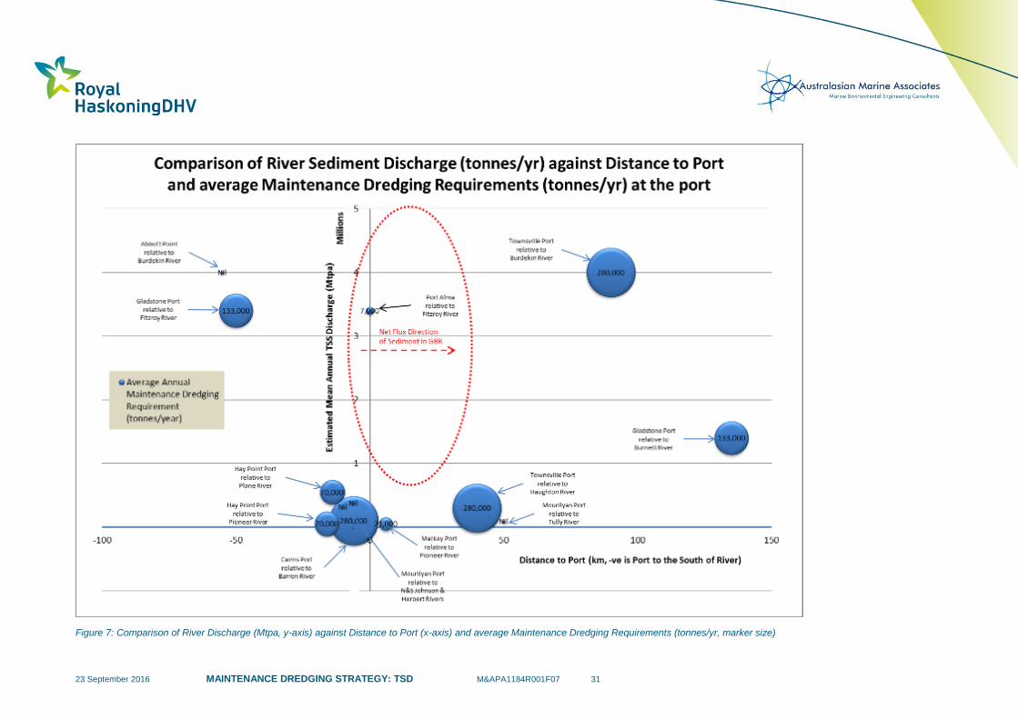
23 September 2016 MAINTENANCE DREDGING STRATEGY: TSD M&APA1184R001F07 31
Figure 7: Comparison of River Discharge (Mtpa, y-axis) against Distance to Port (x-axis) and average Maintenance Dredging Requirements (tonnes/yr, marker size)
23 September 2016 MAINTENANCE DREDGING STRATEGY: TSD M&APA1184R001F07 32
2.7 Summary
Queensland ports located within the GBRWHA reside in a variety of coastal environments and are subject
to variability in local metocean conditions. As a result of these variabilities, each port sees varying rates of
sedimentation which is typically driven by a number of key coastal processes. For the majority of the GBR
inner-shelf region and in turn the GBR ports, sediment transport and sedimentation during typical
conditions is primarily a result of wave and current induced resuspension.
The configuration and orientation of each port relative to the natural sediment transport pathways also
plays a key role in the sedimentation which occurs in the artificially deepened areas. Wave and current
induced bed shear stresses are fundamental in the natural resuspension of sediment on the bed in the
shallow nearshore waters of the GBR inner-shelf. Lower bed shear stresses occur in the artificially
deepened areas of the ports, which results in sedimentation occurring in these areas. Compared to the
adjacent natural areas, the bed shear stresses from waves and currents in the artificially deepened areas
are less likely to resuspend any deposited sediment. It is generally the case that the deeper and wider the
dredged area, the higher its ‘trapping efficiency’. It is therefore a combination of the metocean conditions
and port configuration which essentially controls the sedimentation rates at each port.
Cyclones also play an important role in the input of new sediment to the inner shelf of the GBR Lagoon
through: river flooding, seabed erosion from the mid-shelf, and reef breakage (Larcombe & Carter, 2004).
In particular, cyclone induced waves and currents play an important role in the supply of sediment to the
inner shelf through the erosion and advection of sediments away from the mid-shelf.
A detailed understanding of coastal processes, the key drivers behind sedimentation, and the source of
the sediment which deposits at the ports is important in explaining the need for both current and future
maintenance dredging. Future long term maintenance dredge management plans would benefit from a
detailed description of the local processes which drive sediment transport, which will help to relate the
maintenance dredging to the natural processes and explain the natural processes which result in
sedimentation within the ports.
23 September 2016 MAINTENANCE DREDGING STRATEGY: TSD M&APA1184R001F07 33
3 Legislative Requirements
3.1 Introduction
Legislative requirements play an important function in the management of maintenance dredging
operations at all ports. Dredging activities at ports within the GBRWHA are managed under both State and
Commonwealth legislation. The application of the State and Commonwealth legislation varies depending
on specific legislative requirements applicable at each port. The legislative context around existing
maintenance dredging and disposal practices at ports within the GBRWHA is further detailed in Sections
3.2 and 3.3.
3.2 Commonwealth Legislation
There are three key Commonwealth Acts applicable to the loading and placement of dredge material in
Australian waters, these are:
Environment Protection (Sea Dumping) Act 1981;
Environment Protection and Biodiversity Conservation Act 1999 (the EPBC Act); and,
Great Barrier Reef Marine Park Act 1975.
A description of each of these acts and their applicability to maintenance dredging activities at ports within
the GBRWHA is described in the following subsections.
3.2.1 Environment Protection (Sea Dumping) Act 1981
The Environmental Protection (Sea Dumping) Act 1981, commonly known as the Sea Dumping Act
regulates the loading and placement of wastes and other matter at sea. The Act was implemented in order
to fulfil Australia’s international responsibilities under the London Convention of 1972 and has been
amended to include the 1996 Protocol to the Convention on the Prevention of Marine Pollution by
Dumping of Wastes and Other Matter, 1972 (the London Protocol).
The aims of the London Protocol are to protect and preserve the marine environment from all sources of
pollution and to prevent, reduce and eliminate pollution by controlling the dumping of wastes and other
materials at sea. Annex 1 of the London Protocol lists the types of materials that may be considered for
ocean disposal (dredged material being one of these), with dumping of these materials requiring a permit
which must be issued in accordance with the provisions of Annex 2. The International Maritime
Organisation (IMO), as administrators of the London Protocol have developed guidelines which are
intended for use by national authorities responsible for regulating sea dumping and evaluating applications
for disposing of wastes in a manner consistent with the provisions of the London Convention 1972 or the
1996 Protocol. These processes are reflected in Australia’s regulatory framework and guidelines
implemented here in Australia. Australia, as a party to the Protocol, reports annually to the IMO on all
permitted and emergency sea dumping activities in Australian waters.
The Sea Dumping Act applies to all Australian waters, from the low water mark out to the limits of the
Exclusive Economic Zone (Figure 8) and as a result, permits are required for any sea disposal activities in
these areas. The Act is currently administered by the Department of the Environment (DoE) or the
GBRMPA if loading or disposal is to take place within the GBRMP. A review of the maintenance dredging
sea dumping permits currently approved for ports within the GBRWHA is provided in Table 8.

23 September 2016 MAINTENANCE DREDGING STRATEGY: TSD M&APA1184R001F07 34
Table 8: Current maintenance dredging sea dumping permits for ports within the GBRMP.
Port Current Length of Sea
Dumping Permit (years)
Port of Gladstone 2 years 8 months
(2015-2018)
Port Alma -
Port of Hay Point -
Port of Mackay 10 (2012 – 2022)
Port of Abbot Point -
Port of Townsville 1 (2015/16)
Port of Cairns 10 (2010 – 2020)
Port of Cooktown -
Figure 8. Maritime zones in Australian waters (NAGD, 2009)
The National Assessment Guidelines for Dredging (NAGD, 2009) sets out the framework for the
environmental impact assessment and permitting of the ocean disposal of dredge material. The intention
of the NAGD is to provide greater certainty about the assessment and permitting process behind dredging
approval applications. Not a legislative act itself, the NAGD provides guidance for all dredging activities
undertaken in Australian Waters. The framework set out in the NAGD includes guidance on all Australian
legislation applicable to dredging applications. This framework has been presented in Figure 9.
While the NAGD provides for the continued case-by-case assessment of individual dredging proposals, it
also considers the long term management of on-going maintenance dredging activities. The NAGD
identifies that a determining authority will grant long-term permits for maintenance dredging on the
following basis:

23 September 2016 MAINTENANCE DREDGING STRATEGY: TSD M&APA1184R001F07 35
1. An assessment of the applicant’s ability to meet their obligations under the Sea Dumping Act and
any permit granted;
2. Establishment of a Technical Advisory and Consultative Committee (TACC) for long-term
management; and
3. Development and implementation by the applicant of a satisfactory long term Environmental
Management Plan (EMP) for loading and dumping activities, which provides for sampling and
analysis to support future permit applications.
Applications for long term maintenance dredging approvals are favourable for port operators as they
provide long term certainty regarding future maintenance dredging activities.
Figure 9. Commonwealth legislative framework and permitting requirements for dredging works (NAGD, 2009).
Great Barrier Reef Marine Park Act 1975
The primary objective of the Great Barrier Reef Marine Park Act 1975 (GBRMP Act) is to provide for the
long term protection and conservation of the environment, biodiversity and heritage values of the Great
Barrier Reef Region. As previously mentioned, where the loading and or placement of dredge material is
to take place within the boundaries of the GBRMP, the Commonwealth delegates authority to GBRMPA to
regulate the Sea Dumping Act.

23 September 2016 MAINTENANCE DREDGING STRATEGY: TSD M&APA1184R001F07 36
The Great Barrier Reef Marine Park Act 1975 establishes a framework for the establishment, control,
management and development of the GBRMP and as such GBRMPA must assess any project that has
the potential to impact on the marine park. State marine park legislation (Queensland Marine Parks Act
2004) is also combined into the Commonwealth permit where boundaries overlap. As many ports within
the GBR either fall within, share borders with or have Dredge Material Placement Areas (DMPAs) within
the GRBMP, maintenance dredging approvals (sea dumping) are often assessed by GBRMPA under this
Act.
Environment Protection and Biodiversity Conservation Act 1999
The Environment Protection and Biodiversity Conservation Act 1999 (EPBC Act) regulates actions that
have, will have or are likely to have, a significant impact on matters of national environmental significance.
An activity, or action, requires assessment and approval under Part 9 of the EPBC Act, only if it is likely to
have a significant impact on one or more of the following matters of national environmental significance:
World Heritage Properties;
Ramsar wetlands;
Listed threatened species and ecological communities;
Listed migratory species;
The environment of the Commonwealth marine areas;
National heritage places;
Nuclear actions; and,
Actions on Commonwealth land or involving a Commonwealth agency.
During the assessment for a dredging permit application under the Sea Dumping Act, the determining
authority (DoE or GBRMPA) must also consider advice from the Commonwealth Environment Minister (or
delegate), if the action is likely to have a significant impact on ‘the environment’. The EPBC Act is more
applicable to capital dredging developments than maintenance dredging works as it is considered less
likely that any matters of national environmental significance would be significantly impacted by ongoing
maintenance dredging activities. This is confirmed by the DoE significant impact guidelines 1.1, which
states:
“Dredging to maintain existing navigational channels would not normally be expected to have a
significant impact on the environment where the activity is undertaken as part of normal
operations and the disposal of spoil does not have a significant impact.” (Commonwealth of
Australia 2013)
However, the proponent of a dredging campaign should consider whether the dredging or disposal
activities are likely to have a significant impact on the environment and prepare a separate EPBC referral
if necessary.
3.3 Queensland State Legislation
Additionally to Commonwealth legislative requirements, the Queensland Government provides regulations
under the State’s own legislation for maintenance dredging works that occur within State Waters. Waters
that lie within the constitutional limits of the State varies depending on the coastal features at any one
location, however it essentially covers coastal waters up to three nautical miles off the Queensland
coastline (Figure 8). There are a number of Queensland legislative acts which relate to maintenance
dredging activities in State Waters, these include:
Transport Infrastructure Act 1994
Marine Parks Act 2004;
23 September 2016 MAINTENANCE DREDGING STRATEGY: TSD M&APA1184R001F07 37
Sustainable Planning Act 2009;
Coastal Protection and Management Act 1995;
Environmental Protection Act 1994; and
Fisheries Act 1994.
As all ports within the GBRWHA also reside within Queensland state waters, Queensland State legislative
acts are applicable to all GBRWHA port maintenance dredging operations. These legislative requirements
are further discussed in the following sections.
3.3.1 Transport Infrastructure Act 1994
The primary objective of the Transport Infrastructure Act 1994 is to allow for and encourage effective
integrated planning and efficient management of a system of transport infrastructure. Section 275 of the
Act requires ports to establish, manage and operate efficient port facilities and services which include the
provision of safe navigational channels. Therefore, all maintenance dredging activities are a legislative
requirement in accordance with each port’s obligation under the Transport Infrastructure Act 1994. The
Act is administered by the Department of Transport and Main Roads.
3.3.2 Sustainable Planning Act 2009
The Sustainable Planning Act 2009 (Planning Act) is the principle legislation guiding planning and
development in Queensland. The purpose of the act is to ensure environmental sustainability is achieved
by providing an overarching framework for Queensland development and planning approvals. Works
undertaken within port limits may require development approval under the Planning Act and the
associated Integrated Development Assessment System (IDAS). IDAS is the state process for assessing
and deciding on development in the state.
Works to maintain structures developed under an approved development permit are excluded from
assessable development and do not require further development approval. In the case of maintenance
dredging, a development approval would have been required at an earlier stage to facilitate the creation of
the first ‘structure’ being the dredged channel. This would have been required as part of a capital dredging
campaign. Once the original channel is dredged, the proponent does not need an additional development
approval under the SP Act to undertake maintenance dredging.
3.3.3 Marine Parks Act 2004
The primary purpose of the Marine Parks Act 2004 is to provide for the conservation of Queensland’s
marine environment by regulating and controlling activities undertaken within the areas declared as
Marine Parks, which includes the GBRMP. The state marine park legislation (Marine Parks Act 2004) is
combined into the Commonwealth Act (Great Barrier Reef Marine Park Act 1975) where boundaries
overlap.
3.3.4 Coastal Protection and Management Act 1995
The Coastal Protection and Management Act 1995 is the principal legislation governing development in
the Queensland coastal zone, with the regulatory mechanisms administered under the Planning Act. The
Coastal Act specifies areas of the coastal zone as: coastal waters (s9 Coastal Act – Queensland waters
to the limit of the Highest Astronomical Tide (HAT)), and all areas to the landward side of coastal waters in
which there are physical features, ecological or natural processes that affect, or potentially affect, the
coast or coastal resources (s11 Coastal Act). Under this Act, works within State Waters, including
dredging, reclamation and the disposal of dredge material at sea, constitute ‘tidal works’ or ‘operational
works’ in the coastal zone.

23 September 2016 MAINTENANCE DREDGING STRATEGY: TSD M&APA1184R001F07 38
Additionally, for maintenance dredging activities where material is brought ashore for sale, used for
reclamation above the high water mark, removed for dewatering or other environmental purposes
involving a land-based disposal site, the works will also need to be assessed under the Coastal Act for the
allocation of Quarry Material.
3.3.5 Environmental Protection Act 1994
The primary objective of the Environmental Protection Act 1994 (EP Act) is to protect Queensland’s
environment while allowing for development that improves the total quality of life and maintains the
ecological processes on which life depends. The Act requires Ports to obtain or hold all the relevant
environmental approvals, permits or licences from the Department of Environment and Heritage Protection
(DEHP), in accordance with this Act and other state regulations. The key approval or environmental
authority (EA) granted by the DEHP for maintenance dredging works relates to the Environmentally
Relevant Activity (ERA) of extractive and screening activities, otherwise known as ERA 16.
3.3.6 Fisheries Act 1994
The primary objective of the Fisheries Act 1994 is to provide a framework for the management,
conservation and enhancement of the State’s fisheries resources and fish species. Under this Act, marine
and tidal plants, including seagrasses, mangroves, marine algae and saltmarsh, may not be removed or
damaged without a permit. The Act also prohibits work in a declared fish habitat area (FHA) without
approval. Permits are assessed and approved under the IDAS framework. With respect to maintenance
dredging activities, ports may need to gain approval for dredging works which will result in the damage or
removal of marine plants or if dredging and or placement is to occur within a declared FHA.
3.4 Best Practice Guidelines
Additionally to legislative requirements, there also exists a number of standards and guidelines relevant to
the management and monitoring of dredge activities in the GBRMP. Although not legislative requirements
themselves, these standards and guidelines provide best practice guidance on associated maintenance
dredging activities. These guidelines include:
NAGD: As previously described in Section 3.2.1, the NAGD is the principle guideline which sets
out the framework for the environmental impact assessment and permitting of the ocean disposal
of dredge material;
Queensland Acid Sulfate Soil (ASS) Technical Manual (DSITIA, 2014): These guidelines offer
technical and procedural advice to avoid environmental harm and to assist in achieving best
practice management of ASS. The guidelines include considerations and guidance on
maintenance dredging activities which may disturb ASS;
Environmental Protection (Water) Policy 2009 (EPP Water 2009): The EPP water is subordinate
legislation under the EP Act and provides a framework for identifying environmental values (EVs)
of waterways and establishing corresponding water quality objectives (WQOs) to protect the
identified EVs. It is important to note that WQO derived from the EPP (water) are not intended to
be applied as mandatory standards nor intended to be used for short term compliance issues
associated with dredging projects.
Queensland Water Quality Guidelines 2009 (QWQG): The QWQG provide guideline water quality
values that are specifically tailored to Queensland regions and water types. The guidelines further
provide processes/frameworks for deriving and applying these local guidelines. The QWQG
provide a mechanism for recognising and protecting local Queensland waters and are not
mandatory legislative standards;
Water Quality Guidelines for the Great Barrier Reef Marine Park, 2010 (WQGGBRMP): The
WQGGBRMP describe the concentrations and trigger values for sediment, nutrients and
23 September 2016 MAINTENANCE DREDGING STRATEGY: TSD M&APA1184R001F07 39
pesticides that have been established as necessary for the protection and maintenance of marine
species and ecosystem health of the Great Barrier Reef. It is important to note that the guidelines
ultimately provide environmentally-based values for water quality contaminants, based upon a
compilation of currently-available scientific information, which, if breached, will trigger
management actions, and are not for use as single point compliance triggers as part of a dredging
project;
National Environment Protection (Assessment of Site Contamination) Measure 1999 (the ‘NEPM’)
and amendment 16 May 2013. These guidelines establish a nationally consistent approach to the
assessment of site contamination. They aim to provide adequate protection of human health and
the environment. The guidelines can be applicable to maintenance dredging campaigns for the
assessment of dredge material for beneficial reuse on land and,
ANZECC/ARMCANZ (2000) Guidelines for Fresh and Marine Water Quality: The
ANZECC/ARMCANZ water quality guidelines provide a guide for setting water quality objectives
required to sustain current or likely future, environmental values for waters in Australia and New
Zealand. The guidelines can be used where regional guidelines (QWQG/WQGGBRMP) are not
adequate or available, for example, when assessing toxicants such as metals. Similar to the
QWQG, the guidelines were not intended to be applied as mandatory standards nor intended to
be used for short term compliance issues associated with dredging projects.
As the above mentioned guidelines do not constitute legislative requirements, adherence to these
guidelines does not guarantee maintenance dredging approval.
3.5 Summary
In summary, all dredging activities in Queensland are managed under both State and Commonwealth
legislation, giving rise to the multiple layers of approvals required for maintenance dredging works at GBR
ports. Of all the legislative acts applicable to maintenance dredging works, approval for a sea disposal
permit is generally considered as the central approval governing maintenance dredging authorisation. The
primary reason for this is that the timeframes at which sea dumping permits are granted lapse, unlike EAs.
Furthermore, there has been a recent trend for these permits to be granted for shorter intervals, resulting
in the ports being continually required to gain sea dumping approval.
Submissions for ocean disposal approval are supported by studies justifying why ocean disposal is the
most effective solution to dredge material disposal. Submissions are required to consider alternatives to
ocean disposal which includes assessment of environmental, social and economic impacts. The
determining authority (GRBMPA or DoE) considers the application and decides whether to grant the
approval. Approval is generally subject to conditions which are appended to the permit and specify:
approved activity; location and volume of the material to be dredged and location of the disposal site(s);
loading and disposal methods and measures to mitigate impacts; environmental monitoring; and reporting
(NAGD, 2009).
As detailed in the NAGD, the determining authority has the ability to grant long-term permits for
maintenance dredging requirements at each of the ports. Applications for long term maintenance dredging
approvals are favoured by port operators as they provide for an efficient approvals process and allow for
certainty around future maintenance dredging requirements.

23 September 2016 MAINTENANCE DREDGING STRATEGY: TSD M&APA1184R001F07 40
4 Maintenance Dredging
4.1 Introduction
The maintenance dredging requirements vary considerably between Queensland Ports. As detailed in
Section 2, this is dependent on both the coastal setting and the port configuration. It is therefore important
to understand the maintenance dredging which has been undertaken historically in order to assist in
predicting future maintenance dredging requirements and identify any approaches to minimise or optimise
future maintenance dredging.
This section addresses the historical and likely future maintenance dredging requirements at all
recognised Queensland Ports, as these requirements influence the future availability of the TSHD
Brisbane. This section provides details on:
existing maintenance dredging practices at the ports, including the dredging equipment,
operational approaches and any existing strategies adopted to minimise maintenance dredging;
historical dredging volumes at the ports over the last 10 years and details of the variability in these
and the associated causes;
the likely future maintenance dredging requirement at each port in Queensland. This includes
details of any projects which could influence the future requirements and the extent of the
increase; and
any potential management or engineering options which could be considered at the ports to
reduce future sedimentation levels.
4.2 Dredging Equipment & Operational Approaches
The majority of maintenance dredging in Queensland has historically been undertaken using a trailing
suction hopper dredger (TSHD), although small grab, backhoe and cutter suction dredgers (CSD) are also
used. The larger volumes of material are removed by the TSHD, while smaller volumes are removed by
the CSD and grab dredgers. Bed levelling is also undertaken at some ports as an operational approach to
reduce maintenance dredging frequency.
4.2.1 Trailing Suction Hopper Dredger
TSHD dredgers have typically undertaken the majority of the maintenance dredging at Queensland Ports
as they are the most suitable type of dredger. They have high production rates, can operate in offshore
areas and heavily trafficked areas, have a hopper allowing offshore placement, and are well suited to
dredging soft unconsolidated sediment typically associated with maintenance material.
The TSHD Brisbane was specifically designed for the maintenance dredging of Queensland Ports and has
been the equipment of choice of the Queensland ports to undertake the maintenance dredging programs
since it was commissioned in 2000. Whilst it is noted that future maintenance dredging could be
undertaken by other TSHDs with similar equipment features, as the dredging has primarily been
undertaken by the TSHD Brisbane since 2000, the following sections are primarily focused on this vessel.
Technical Aspects
The TSHD Brisbane is a trailing suction hopper dredger built in Cairns in 2000 by North Queensland
Engineers & Agents (NQEA) and commissioned in 2000. The TSHD Brisbane is owned and operated by
the Port of Brisbane Pty Ltd (POBPL). The technical specifications of the Brisbane are provided in Table
9 and design drawings are shown in Figure 10.
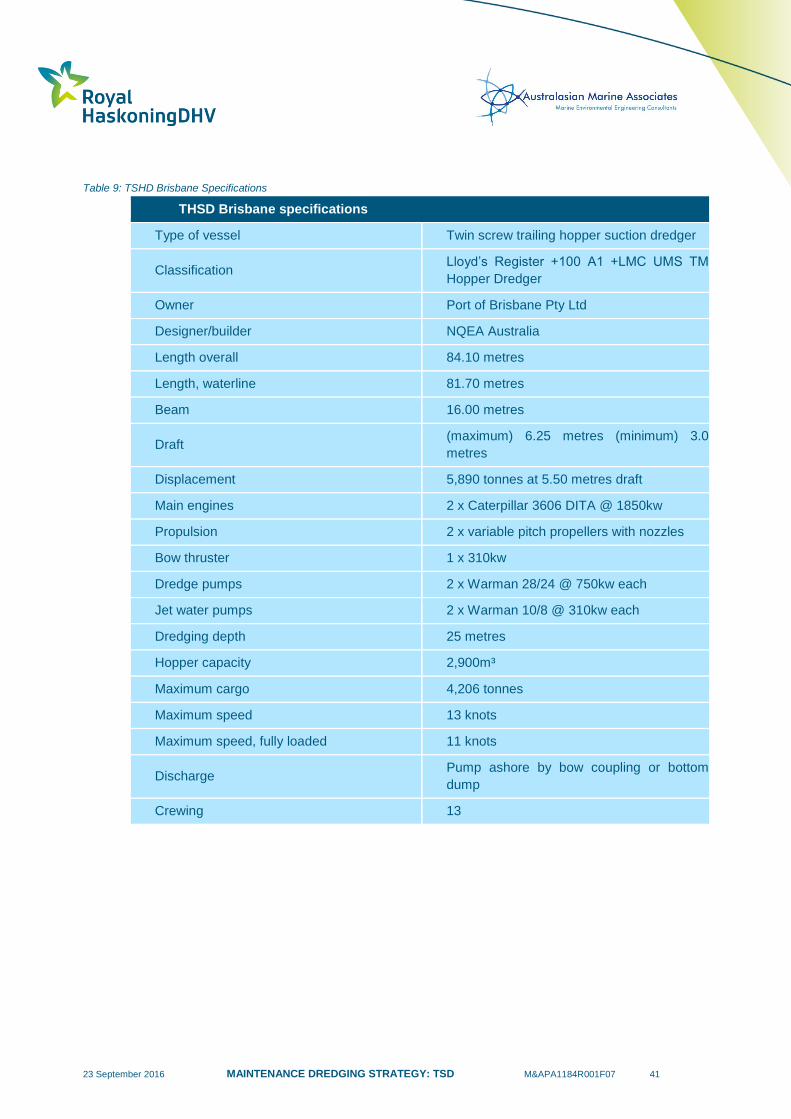
23 September 2016 MAINTENANCE DREDGING STRATEGY: TSD M&APA1184R001F07 41
Table 9: TSHD Brisbane Specifications
THSD Brisbane specifications
Type of vessel Twin screw trailing hopper suction dredger
Classification Lloyd’s Register +100 A1 +LMC UMS TM
Hopper Dredger
Owner Port of Brisbane Pty Ltd
Designer/builder NQEA Australia
Length overall 84.10 metres
Length, waterline 81.70 metres
Beam 16.00 metres
Draft (maximum) 6.25 metres (minimum) 3.0
metres
Displacement 5,890 tonnes at 5.50 metres draft
Main engines 2 x Caterpillar 3606 DITA @ 1850kw
Propulsion 2 x variable pitch propellers with nozzles
Bow thruster 1 x 310kw
Dredge pumps 2 x Warman 28/24 @ 750kw each
Jet water pumps 2 x Warman 10/8 @ 310kw each
Dredging depth 25 metres
Hopper capacity 2,900m³
Maximum cargo 4,206 tonnes
Maximum speed 13 knots
Maximum speed, fully loaded 11 knots
Discharge Pump ashore by bow coupling or bottom
dump
Crewing 13
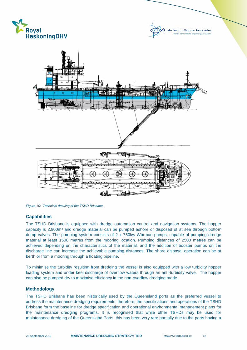
23 September 2016 MAINTENANCE DREDGING STRATEGY: TSD M&APA1184R001F07 42
Figure 10: Technical drawing of the TSHD Brisbane.
Capabilities
The TSHD Brisbane is equipped with dredge automation control and navigation systems. The hopper
capacity is 2,900m³ and dredge material can be pumped ashore or disposed of at sea through bottom
dump valves. The pumping system consists of 2 x 750kw Warman pumps, capable of pumping dredge
material at least 1500 metres from the mooring location. Pumping distances of 2500 metres can be
achieved depending on the characteristics of the material, and the addition of booster pumps on the
discharge line can increase the achievable pumping distances. The shore disposal operation can be at
berth or from a mooring through a floating pipeline.
To minimise the turbidity resulting from dredging the vessel is also equipped with a low turbidity hopper
loading system and under keel discharge of overflow waters through an anti-turbidity valve. The hopper
can also be pumped dry to maximise efficiency in the non-overflow dredging mode.
Methodology
The TSHD Brisbane has been historically used by the Queensland ports as the preferred vessel to
address the maintenance dredging requirements, therefore, the specifications and operations of the TSHD
Brisbane form the baseline for dredge specification and operational environmental management plans for
the maintenance dredging programs. It is recognised that while other TSHDs may be used for
maintenance dredging of the Queensland Ports, this has been very rare partially due to the ports having a

23 September 2016 MAINTENANCE DREDGING STRATEGY: TSD M&APA1184R001F07 43
long term contract with the Port of Brisbane Pty Ltd. The following methodology describes the typical
Queensland maintenance dredging operations.
The dredge material is removed through two suction heads, which are lowered into position to the seabed
level on either side of the vessel. As the vessel slowly moves at around 1 – 3 knots, the water and
sediment mix is drawn through the heads and transported into a central collection hopper. Each
excavation run takes approximately 1 hour to complete, depending on the material characteristics. Once
the hopper capacity is reached the TSHD Brisbane travels to the material placement site, where it
discharges the sediment before returning to the dredging area and completing the dredge cycle. The
suction heads are fitted with high-pressure water jets which can be used to agitate consolidated sediment;
however, the unconsolidated nature of the maintenance dredging material rarely requires this procedure.
The sediment concentration delivered to the hopper of the TSHD Brisbane is typically in the order of 10 –
30 % solids by volume. The water volumes are managed using the central column weir, which is used to
dispose the excess water from the hopper and maximise dredge material capacity. The weir allows excess
water to overflow to discharge whilst the majority of the sediment remains in the hopper. The overflow
takes place as the hopper nears full capacity, towards the end of the typical one hour dredging duration.
The vessel travels to the designated disposal ground once the hopper is full to release the dredge
material. The sediments are discharged below keel level to minimise turbidity generation. The placement
of sediments is logged using satellite navigation and standard bridge equipment. The release is tracked
electronically using plot marks at the start of the placement process (when the hopper is open and
discharge starts), and at the end of the process (when the hopper closed and discharge ceases). The
discharge process tracking ensures that the dredge material is placed within the designated discharge
area boundary. The discharge process usually takes between ten and twenty minutes from the time the
hopper is open and discharge starts. The data collected during the discharge operations is stored and
made available to the relevant government agencies in order to comply with the conditions specified in
disposal permits.
Environmental Mitigation Measures
The TSHD Brisbane was designed with mechanisms to mitigate the environmental impacts caused by the
dredging operations. These mechanisms are equivalent to the features installed in the latest TSHD
models used around the world and ensure environmental harm is minimised during the dredging works.
Since the commissioning of the TSHD Brisbane it has been updated regularly to incorporate the latest
environmental advances in dredging technology, ensuring the TSHD Brisbane operates at the same level
as the most recent built TSHDs. The environmental impact mitigation features are described below:
Central weir discharge system (green valve or anti turbidity function): this system works by
controlling discharge from the dredger to limit the turbidity of overflow waters entering the
receiving environment. The TSHD Brisbane has 5 equally spaced conical valves in the floor of the
hopper which when opened allow the material to fall to the seabed when discharging. The middle
valve (DV3) is surrounded by a set of 6 cylindrical rings stacked on top of each other to form a
weir of adjustable height. When dredging light material such as silts only the top ring is lifted to
create the largest possible hopper capacity and settling time for the material. When the hopper
reaches point of overflow DV3 is partially opened to allow excess water to escape. The aperture
of DV3 is regulated to maintain a water column within the circular weir stack and thereby minimise
the entrapment of air in the overflow water. This reduces the amount of air bubbles which can act
to carry material to the water surface and generate excessive plumes.
Below keel discharge point: the discharge of sediment from the hopper occurs at keel level in
order to prevent unnecessary turbidity and dispersal of fine sediments.

23 September 2016 MAINTENANCE DREDGING STRATEGY: TSD M&APA1184R001F07 44
Turtle deflection devices: a flexible chain deflector is attached to the dragheads to prevent the
entrainment of sea turtles during dredging operations. The device design has been evolving for
the last twenty years and its efficiency confirmed by several research projects.
Low wash hull design: by minimizing the size of wash waves created by the vessel movement, the
low wash hull design reduces agitation on the water surface, minimizing the interference with the
sediments suspended in the water column during discharge. This design can also reduce fuel
consumption and damage to riverbank environments.
Electronic positioning system: the TSHD Brisbane is equipped with a global positioning system
which is used during the operations. The positioning data is used during the discharge operations
to identify the beginning and end of the material placement locations and provide evidence to the
regulators to ensure compliance with the material placement boundaries. The GPS data also
assists the contractor and clients to identify the areas of origin of the sediment for each cycle and
overflow operations location.
Environmental Management Plan (EMP): The Port of Brisbane Pty Ltd. (PBPL) maintain a Dredge
Management Plan which addresses standard operational procedures to minimise environmental
impact. Separate EMP’s are also developed by PBPL for each specific port/ project is undertakes
dredge works. This EMP addresses matters specific to the project including local regulations,
sensitivities and specific permit conditions. It is submitted for review and approval by the principal
prior to commencement of the work.
Any other TSHDs undertaking maintenance dredging works in the future at the ports within the GBRWHA
should have similar state-of-the-art systems in order to minimise environmental impacts and have
confidence in the basis of any environmental risk assessment.
Dredger Schedule
The Port of Brisbane has long term contracts in place with all the ports which currently utilise the TSHD
Brisbane for their maintenance dredging requirements. At present this includes five of the ports located
within the GBR area, Gladstone, Port Alma, Mackay, Townsville and Cairns. Since the commissioning of
the TSHD Brisbane in 2000, the contracts in general roll over to 4 year extensions at the end of each term.
The TSHD Brisbane also provides services for the ports of Melbourne, Bundaberg, Karumba, Weipa and
Brisbane. A summary of the time the TSHD Brisbane has spent undertaking maintenance dredging at
each port since 2011 is provided in Table 10. It is important to note that reporting on dredging by
calendar year can be misleading as the timing of the dredging will vary from year to year and this can
result in some years appearing to have a greater requirement for dredging while others have no
requirement for dredging. For example, if the dredging is typically undertaken in November or December
each year and then for one year it is delayed until January the table indicates that there was no
maintenance dredging required that year which was not the case.
The schedule of the TSHD Brisbane is based on the dredging requirements of the serviced ports. The
southernmost port serviced by the TSHD Brisbane is the Port of Melbourne, which is normally dredged in
the first half of the year. The dredger spends an average of 53 days in Brisbane every year to address the
dredging requirements for the Port of Brisbane.
The ports located north of Brisbane are generally dredged in sequence in order to minimise mobilisation
costs. A typical year for the TSHD Brisbane starts with a vessel maintenance period in Brisbane, followed
by a period of dredging in Brisbane and Melbourne before heading north. The furthest destination visited
by the TSHD Brisbane is Karumba, however, dredging there is only required every third year. The second
furthest port dredged by the TSHD Brisbane is Weipa, where maintenance dredging happens every year
and the works take approximately 28 days to be completed. Other Queensland ports are visited during the
trip, with stops every year in Gladstone (29 days average), Townsville (48 days average) and Cairns (25

23 September 2016 MAINTENANCE DREDGING STRATEGY: TSD M&APA1184R001F07 45
days average). Visits to Port Alma, Mackay and Hay Point are also included in the schedule in some
years, as required.
Some ports can be visited twice during the same trip (on the way up to Weipa/Karumba and when
returning to Brisbane), depending on the progress of the works, the maintenance dredging requirement,
meteorological conditions and environmental windows. The TSHD Brisbane normally stops in Bundaberg
during the trip, increasing the time spent there during years when floods have brought in more sediments
than usual during the wet season (e.g. 2011 and 2013). It is also useful to note that, depending on the
occurrence of cyclones and floods during the wet season, the maintenance dredging requirements can
vary at any of the ports. Typically the TSHD Brisbane spends approximately 24 weeks per year servicing
the ports located within the GBRWHA.
The most efficient manner for the dredger to address the existing maintenance dredging requirements is
to travel to the ports on the western side of Cape York and have sequential stops at the other ports on the
way up or way back, minimising travel time and reducing mobilisation costs. Periods when no dredging is
allowed under the dredging permits can result in the dredger schedule having to be adapted and, in some
cases, can result in increased travel for the dredger. When travel time is minimised, so are emissions due
to minimisation of fuel consumption, which in turn minimises the environmental footprint of the dredging
activity.
The planning phase of the maintenance dredging works performed by the TSHD Brisbane is heavily
dependent on the permits obtained by the ports to execute the necessary works. When long term permits
are issued to the ports, the preparation of the maintenance dredging schedule can be done with
confidence and in advance, making the most of opportunistic windows and providing a chance for medium
to long term plans which can be adapted as the works evolve, optimising the usage and time of the TSHD
Brisbane. Short term permits, on the other hand, prevent the client ports and the Port of Brisbane from
developing a long term strategy.
Table 10: TSHD Brisbane number of days undertaking maintenance dredging in each port.
Port 2011 2012 2013 2014 2015 Total Average
Melbourne 0 32 0 42 86 160 32
Brisbane 1152 107
2 126
2 51 33 432 86.4
Gladstone 38 18.7 0 90.71 17.3 164.7 32.9
Point Alma 2.4 0 0 0 0 2.4 0.5
Bundaberg 27.4 0 48.5 6.7 7.5 90.1 18.0
Mackay 0 0 6 0 0 6 1.2
Townsville 48 81 30 39 43 241 48.2
Cairns 22 21 27 25 29.6 124.6 24.9
Karumba 19.6 0 0 13.9 0 33.5 6.7
Weipa 26 31 32 28 24 141 28.2 1 In 2014 additional dredging was required following the Western Basin Dredging and Disposal Project as significant volumes of
material were left in the channel following the capital works. This additional dredging has therefore influenced the average number of
days of maintenance dredging per year, the long term average is expected to be closer to 29 days. 2 Includes maintenance dredging of flood induced sedimentation.

23 September 2016 MAINTENANCE DREDGING STRATEGY: TSD M&APA1184R001F07 46
The current agreements in place keep the TSHD Brisbane busy during the whole year, maximizing its
utilisation and ensuring it is economically viable. The location of the ports allow the mobilization costs to
be shared between them as the TSHD Brisbane travels along the Queensland coast, providing a cost
competitive solution for the maintenance dredging requirements.
Future Scheduling
The TSHD Brisbane size and production rates are currently adequate to address the needs of the ports in
Queensland. At present additional work is sourced to fill the schedule of the TSHD Brisbane, such as the
dredging in Melbourne, indicating that it has sufficient capacity to accommodate the future maintenance
dredging requirements of the ports in Queensland. However, if a different vessel is required in the future
for any reason it should be ensured that the vessel continues to have state-of-the-art environmental
mitigation measures.
There are a number of ways the future maintenance dredging scheduling of the Queensland ports could
be further optimised, therefore reducing environmental impact through vessel emissions:
if the ports were granted long term permits for the maintenance dredging operations. Longer term
permits give certainty to the ports that the maintenance dredging works needed can take place
for a number of years, therefore allowing the schedule to be prepared in advance, reducing
insecurity and increasing efficiency; and
ensuring that any no-dredge periods and environmental windows imposed on the maintenance
dredging permits are necessary and do result in reduced environmental impact and management
of environmental risks.
Alternative vessels
In the future, if required, there are other TSHDs available in Australia with the characteristics necessary to
perform the maintenance dredging for the Queensland Ports. The proposed dredge vessel should be
considered as part of the risk assessment process to identify the confidence that can be placed in any
potential impacts depending on the availability of previous monitoring data.
Rohde Nielsen Dredging has an office in Newcastle where some of its equipment is based.
The Brage R is a TSHD with a loading capacity of 2,150m³ (Figure 11). It has bottom doors used
for offshore disposal and can also pump ashore. This dredger has carried out maintenance
dredging in Dampier and Davenport in 2015 and in New Zealand in 2016; and
The Balder R is a Split Trailing Suction Hopper Dredger (STSHD) with a loading capacity of
6,000m³, the split means it can open the ship longitudinally in two parts and dispose the load. It
also has pump ashore capabilities and is equipped with multi beam survey system and a dynamic
position system. The Balder R has commitments scheduled until July 2016.
Both vessels are equipped with central weir discharge systems (green valves).

23 September 2016 MAINTENANCE DREDGING STRATEGY: TSD M&APA1184R001F07 47
Figure 11: Brage R THSD based in Newcastle and owned by RN Dredging.
Table 11 presents a summary of TSHDs currently available locally and internationally. All of them are
equipped and designed with similar devices to the TSHD Brisbane to reduce environmental impacts
during the dredging works.
Table 11: Comparison of Similar TSHDs
Dredger Owner
Country
of
Origin
Length
overall
(m)
Beam
(m)
Draft
(m)
Dredging
depth (m)
Hopper
capacity
(m³)
Max speed
loaded
(knots)
Brisbane Port of
Brisbane Australia 84.1 16.0
6.2 max
3 min 25 2,900 11
Brage R Rohde
Nielsen Australia 89.9 13.6
5.7 max
2.1min 30 2,150 7.5
Balder R Rohde
Nielsen Australia 111.3 19.4
7 max
3.7 min 35/54 6,000 14
River Bee WA Dredging Australia 80.0 13.8 5.6 max
4.5 min 20 1,895 8.8
Volvox
Olympia Van Oord Holland 96.6 19.9 7.2 32 4,871 12.5
Jade River DI Bahrain 100.4 16.4 7.3 31 3,281 11.9
Alvar
Nunez
Cabeca de
vaca
Jan de Nul Argentina 93.3 19.8 5 26.5 3,400 11.5

23 September 2016 MAINTENANCE DREDGING STRATEGY: TSD M&APA1184R001F07 48
4.2.2 Smaller Dredgers
In shallow areas, or in areas with limited accessibility/manoeuvrability, it is often necessary for the ports to
use small dredgers. In these cases it is not possible for the TSHD Brisbane to undertake the dredging so
the ports will either use a small CSD (cutter suction dredger) or a grab or backhoe dredger. If required,
these dredgers are able to operate all year round to maintain design depths in inner port areas. Typically
these smaller dredgers remove relatively small volumes of sediment compared to the larger TSHD.
Cutter Suction Dredger
CSD are not frequently used for maintenance dredging. CSD are not mobile and so they are better suited
to dredging restricted areas (e.g. shallow) with relatively large volumes (i.e. capital dredging). Material
dredged by a CSD is usually pumped onshore as slurry where it can either be stored or used for
reclamation. Material can also be pumped to offshore areas, but due to limits on the distance the vessels
can pump, this is uncommon.
The Port of Townsville is the only port in the GBRWHA which regularly uses a CSD for maintenance
dredging purposes. The Ross River is regularly dredged (on average every 2 years) using a CSD and
occasionally the Ross Creek is also dredged. Historically, the material from the dredging has been
pumped onshore and placed in a reclamation area. A CSD was also used for maintenance dredging at
Cooktown in 2015. The majority of the sediment was pumped onshore and placed in a reclamation area,
while the remainder was pumped to an offshore placement site. A small CSD was also used to dredge a
marina at the Port of Gladstone twice over the last 25 years, the sediment was pumped onshore.
Grab & Backhoe Dredger
For minor dredging work where small volumes need to be removed or in locations with limited
accessibility/manoeuvrability, small grab or backhoe dredgers are often used. The dredged sediment is
loaded into barges where it can either be transported to an offshore placement site or discharged to land if
the barge has a slurry pump.
In cases where sediment has been identified as having elevated levels of contaminants, as defined in the
NAGD guidelines, grab and backhoe dredgers are typically used in order to minimise sediment release
into the water column during dredging. Over the last 10 years no sediment removed by maintenance
dredging at any of the ports within the GBRWHA has been identified as contaminated based on the NAGD
guidelines. At the Port of Townsville, sediment in some of the berths of the Inner harbour have exceeded
the screening levels as defined in the NAGD guidelines, but have then passed the Phase III testing and so
were considered suitable for ocean disposal. The PoTL has historically adopted a precautionary approach
by placing this sediment onshore.
This type of dredger has historically been regularly used at Mackay Port, the Port of Townsville and the
Port of Cairns.
4.2.3 Bed Levelling
Bed levelling can be an important operation to assist in maintaining declared depths without requiring
additional maintenance dredging. The operation involves lowering a heavy metal bar to a set depth (e.g.
the channel design depth) and then dragging the bar across the seabed. This removes any high points
and redistributes the material to surrounding lower areas. This represents a very efficient way of removing
high points in aprons and channels which can otherwise result in a reduction in the declared depth of the
channel, berth or swing basin. This operation has historically been adopted in the Port of Gladstone, Hay
Point Port, Mackay Port, Port of Townsville, Port of Mourilyan, Port of Karumba and Port of Cairns.
23 September 2016 MAINTENANCE DREDGING STRATEGY: TSD M&APA1184R001F07 49
4.3 Existing Strategies to Minimise Maintenance Dredging
The London Protocol details that appropriate measures to prevent, reduce and where practical eliminate
the relocation of dredge material should be taken by the ports. Ports therefore aim to reduce their
maintenance dredging requirements as much as possible and will only undertake dredging when
necessary. It is also worth noting that maintenance dredging is considered an expensive and
inconvenient requirement for many ports.
Optimising the original design of dredged channels, basins, aprons and berths relative to the natural
sediment transport and sedimentation processes represents an opportunity to minimise future
maintenance dredging volumes. However, these areas have already been created at most ports within
the GBRWHA and there are limited opportunities to further reduce future maintenance dredging
requirements through the configuration of existing dredged areas. The design of any future proposed
capital dredging works should be considered in terms of the future maintenance dredging requirements
and optimised wherever possible.
Ports within Queensland currently undertake a number of strategies to help minimise maintenance
dredging activities:
Hydrographic survey. Repeat hydrographic surveys ensure that maintenance dredging is focused
on the areas where sedimentation has occurred and that maintenance dredging is only
undertaken when and where it is required. It is common practise for ports to vary the areas where
maintenance dredging is carried out from campaign to campaign depending on the sedimentation.
Surveys are typically undertaken at those ports which require frequent maintenance dredging at
the end of the wet season each year, to identify the maintenance dredging requirements following
the period of the year when the highest rates of sedimentation occur.
Bed levelling. Bed levelling is undertaken at a number of ports in Queensland to help reduce the
requirement and frequency of maintenance dredging. Bed levelling can be used to level out high
points in a channel, berth, basin or apron and, therefore, help to reduce the frequency of
maintenance dredging.
Local interception strategies. Some of the ports either utilise existing deep areas or have created
insurance trenches adjacent to berths and channels. Bed levelling can then be used to move
sediment from the berths and channels and into the adjacent deep areas. Although this approach
does not specifically reduce maintenance dredging volumes (as the material still needs to be
dredged) it can be used to reduce the dredging frequency at locations which are subject to higher
sedimentation rates. Use of insurance trenches results in improved dredging efficiency (hence
reduced costs),
Tidal windows. Using tidal windows involves vessels navigating shallower areas during higher
stages of the tide to ensure sufficient under keel clearance. This has been occurring at the Port of
Hay Point where maintenance dredging has recently not been permitted (due to approval and
legal issues). This approach has resulted in operational inefficiencies and has the potential to
result in safety and environmental implications (i.e. if a fully laden vessel breaks down in a shallow
area and there is insufficient time for tugs to move the vessel prior to low water).
Dynamic under keel clearance systems (DUKCS). Implementation of a dynamic under keel
clearance system can help to promote safe navigation and improved overall efficiency of the port
and has the potential of allowing for reduced bed levels in channels. Therefore it can potentially
reduce the frequency of maintenance dredging but ultimately dredging is still required in the ports.
The system can be beneficial in environments which are: exposed to waves; large tidal range;
and/or where there are long navigation channels. In addition, the associated near-real time and
forecast data streams associated with the DUKCS can be of direct application in operational
management of dredging activities by characterising the temporal and spatial variabilities of zones

23 September 2016 MAINTENANCE DREDGING STRATEGY: TSD M&APA1184R001F07 50
of impact during dredging campaigns. The Ports of Hay Point and Weipa use a dynamic under
keel clearance system.
Catchment Management. The port authorities who operate the ports within the GBRWHA are
members of various taskforces, committees and associations that implement measures to improve
the management of sediment in catchments and, therefore, reduce the land based sediment
inputs to the GBR lagoon (albeit that river inputs are considered to play an insignificant role in the
sedimentation of the vast majority of GBR ports, as detailed in Section 2.6).
Port Management. Ports will typically manage their infrastructure and operations to minimise the
requirement for future maintenance dredging including working with port tenants and customers.
In addition, the ports regularly review proven overseas technologies in terms of their benefits and risks
with a view to trying to reduce future maintenance dredging requirements (e.g. fluidisation of silts for tidal
current removal, silt deflection techniques, etc.).
4.4 Measures of Maintenance Dredging Quantities
There are a number of different measures which are adopted to describe dredged quantities. These are
described in more detail in the following sections.
4.4.1 In-situ Volume
The in-situ volume represents the material actually removed by the dredging. It is calculated based on pre
and post dredging campaign hydrographic surveys. The in-situ volume of material required to be removed
by maintenance dredging to reach the target depths can be calculated prior to dredging. The in-situ
volume is the only parameter which can be established both before and after dredging.
The measure can have limitations associated with the timing of the hydrographic surveys relative to the
dredging campaign. This is particularly an issue when maintenance dredging is carried out through
multiple campaigns in a year, as sedimentation can occur between the campaigns. The accuracy of the
hydrographic survey can also be influenced by the type and density of the sediments being dredged,
although modern survey vessels should be able to achieve accurate surveys when the expected
properties of the bed material are known prior to the survey. It is noted that, for navigational safety, the
frequency set for the sounding equipment is prescribed to detect a density of fluid/solid mix that may affect
ship manoeuvring and this may be as little as 1.1 tonnes per cubic metre. Hence the volume measures
may include some volume of water however this would be expected to be insignificant in the case of
dredged volume determinations made by pre dredge and post dredge survey differences.
This measure is considered to provide an accurate measure of the amount of sediment dredged from port
areas and it can also provide an accurate estimate of the amount of sediment required to be removed
prior to dredging being undertaken.
4.4.2 Wet In-hopper Volume
The wet in-hopper volume is the mixture of sediment and water, which is contained within the dredge
vessel hopper. The volume is measured at the dredge vessel based on an acoustic measurement of the
hopper load, the volume typically includes a significant volume of water which is sucked into the hopper
along with the sediment. The relative proportions of sediment and water can be highly variable depending
on the properties of the sediment being dredged, the type of dredging (e.g. bulk dredging for depth
compared to spot dredging high points) and the dredging methodology (e.g. overflow duration). As a
result, prior to dredging it is not possible to accurately predict the wet in-hopper volume required to reach
the target depths.

23 September 2016 MAINTENANCE DREDGING STRATEGY: TSD M&APA1184R001F07 51
This measure is not considered to provide as accurate a measure of the amount of sediment dredged
from port areas as the in-situ volumes.
4.4.3 Dry Weight
The dry weight (also known as dry tonnage) is the dry mass of the dredged sediment. The weight is
calculated at the dredge vessel by measuring the wet mass, using pressure gauges on the hull to
determine the vessel draft and calculating the seawater displaced. The dry weight of the sediment in the
hopper can then be calculated by using established material specific gravities (e.g. 2.63 to 2.67 for clays,
silts and sands) for the material dredged. Despite the assumptions made about the sediment specific
gravity, variations from the calculated values for different sediment types are considered to be minimal.
The dry weight (or tonnage) is considered to provide an accurate measure of the actual amount of
sediment dredged. It is not influenced by the properties of the in-situ sediment (e.g. consolidation) or the
dredging methodology (e.g. overflow duration).
4.4.4 Summary
Table 12 details the historic maintenance dredging undertaken by the TSHD Brisbane at the Port of
Cairns. The table includes the three measures of dredging quantities detailed above along with
conversions to multiply the in-situ volume to calculate either wet in-hopper volume or dry weight. The
conversion factors are ratios calculated by dividing the wet volume or dry weight by the in-situ volume.
There is significant variability in the measures with the wet in-hopper volumes on average being 2.3 times
higher than the in-situ volume while an average conversion factor 0.72 is required to convert from in-situ
volume to dry weight in tonnes. The conversion factors also vary from year to year depending on the
sediment properties, the type of dredging and the dredging methodology, with conversions to wet in-
hopper varying from 1.55 to 3.69 and to dry weight varying from 0.52 to 1.13. In some cases recorded
figures towards the extremes of these ranges can be explained and eliminated as uncharacteristic for the
purposes of determining long term averages, however significant variability still remains.
Owing to the considerable variability in the conversions over time, it is not possible to accurately present
all of these dredging quantity measures for all of the ports as requested in the brief. As such, this report
presents historic dredge volumes using in-situ volume, as this measure is thought to be most suitable and
it is also the measure which most ports adopt when reporting on maintenance dredging.
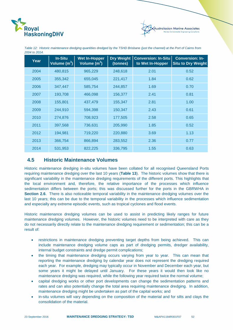
23 September 2016 MAINTENANCE DREDGING STRATEGY: TSD M&APA1184R001F07 52
Table 12: Historic maintenance dredging quantities dredged by the TSHD Brisbane (just the channel) at the Port of Cairns from
2004 to 2014.
Year In-Situ
Volume (m3)
Wet In-Hopper
Volume (m3)
Dry Weight
(tonnes)
Conversion: In-Situ
to Wet In-Hopper
Conversion: In-
Situ to Dry Weight
2004 480,815 965,229 248,618 2.01 0.52
2005 355,342 655,045 221,417 1.84 0.62
2006 347,447 585,754 244,857 1.69 0.70
2007 193,708 466,098 156,377 2.41 0.81
2008 155,801 437,479 155,347 2.81 1.00
2009 244,910 594,398 150,347 2.43 0.61
2010 274,876 708,923 177,505 2.58 0.65
2011 397,568 736,631 205,990 1.85 0.52
2012 194,981 719,220 220,880 3.69 1.13
2013 366,754 866,894 283,552 2.36 0.77
2014 531,953 822,225 336,795 1.55 0.63
4.5 Historic Maintenance Volumes
Historic maintenance dredging in-situ volumes have been collated for all recognised Queensland Ports
requiring maintenance dredging over the last 10 years (Table 13). The historic volumes show that there is
significant variability in the maintenance dredging requirements of the different ports. This highlights that
the local environment and, therefore, the relative importance of the processes which influence
sedimentation differs between the ports; this was discussed further for the ports in the GBRWHA in
Section 2.6. There is also noticeable temporal variability in the maintenance dredging volumes over the
last 10 years; this can be due to the temporal variability in the processes which influence sedimentation
and especially any extreme episodic events, such as tropical cyclones and flood events.
Historic maintenance dredging volumes can be used to assist in predicting likely ranges for future
maintenance dredging volumes. However, the historic volumes need to be interpreted with care as they
do not necessarily directly relate to the maintenance dredging requirement or sedimentation; this can be a
result of:
restrictions in maintenance dredging preventing target depths from being achieved. This can
include maintenance dredging volume caps as part of dredging permits, dredger availability,
internal budget constraints and dredge permit complications;
the timing that maintenance dredging occurs varying from year to year. This can mean that
reporting the maintenance dredging by calendar year does not represent the dredging required
each year. For example, dredging may typically occur in November and December each year, but
some years it might be delayed until January. For these years it would then look like no
maintenance dredging was required, while the following year required twice the normal volume;
capital dredging works or other port developments can change the sedimentation patterns and
rates and can also potentially change the total area requiring maintenance dredging. In addition,
maintenance dredging might be undertaken as part of the capital works; and
in-situ volumes will vary depending on the composition of the material and for silts and clays the
consolidation of the material.
23 September 2016 MAINTENANCE DREDGING STRATEGY: TSD M&APA1184R001F07 53
Details of how the historic maintenance dredge volumes have related to sedimentation rates is provided in
the following sections for each of the recognised Queensland Ports requiring maintenance dredging. Ports
located outside of the GBRWHA have also been considered below, as the historic requirements are
essential in the determination of future state wide maintenance dredging requirements.
Port of Brisbane
The historic maintenance dredging volumes at the Port of Brisbane typically provide a good representation
of the sedimentation rates at the port; these are detailed in Table 14. Maintenance dredging at the port is
carried out annually between Fisherman Island and the Hamilton Reach of the Brisbane River to remove
naturally deposited sediments that have accumulated within the navigation channels. The increase in
volumes dredged in 2011 and 2012 were a direct result of the 2011 Brisbane flood event, with two years
of maintenance dredging required to restore depths in the dredged areas of the port. The increase in
volume in 2013 was a result of flooding associated with TC Oswald in 2013. The volumes dredged
between 2011 and 2013 highlight the variability in maintenance dredging volumes associated with
significant flood events.
Bundaberg
The historic dredge volumes at the Port of Bundaberg provide a reasonable representation of the
sedimentation rates at the port; these are detailed in Table 14. Since the Port of Bundaberg is located on
the Burnett River, sedimentation at the port is primarily driven by fluvial processes. As a result,
maintenance dredging volumes are variable, subject to the occurrence of flooding events. The increased
volumes dredged in 2011 and 2013 correspond to significant flood events that resulted in increased
volumes of fluvial sediments being deposited into the dredged areas of the port. Following both of these
events, the port has yet to return to the declared depth of 9.5 m LAT, as it was prior to 2011. GPC
envisages extended maintenance dredging campaigns until 2020 will be required to return the port to
original pre 2011 declared depths.
Port of Gladstone
The historic volumes at Gladstone can be considered to generally provide a reasonable representation of
the sedimentation which occurs. Based on these the historic sedimentation rates at Gladstone are
presented in Table 14. However, there have been a number of years when the timing of the dredging has
meant that the volumes indicate no maintenance dredging in one year and a relatively high requirement
the following year. The dredging tends to be undertaken by the TSHD Brisbane in November or
December each year (GPC, 2014), but the dredger was not available at the end of 2010 and so the
dredging was undertaken at the start of 2011 and then the dredger was available at the end of 2011,
resulting in two maintenance dredging campaigns in 2011. This also occurred in 2013 and 2014, with the
added complication that towards the end of 2013, an extensive capital dredging program was completed
and for the 2014 campaign, GPC took over the maintenance dredging of Jacobs Channel.
When Jacobs Channel was handed over to GPC at the end of 2013 following the capital dredging, the
channel was found to require significant volumes of sediment to be removed to achieve the design depths,
further increasing the maintenance required in 2014. Recent surveys indicate that the maintenance
requirement for this area has started to stabilise and it will not continue to result in such a significant
increase in maintenance dredging into the future. On this basis, it is likely that the additional dredging
required in 2014 was not infill (due to natural sedimentation) but, rather, more likely due to capital dredge
batter slopes finding their natural equilibrium.
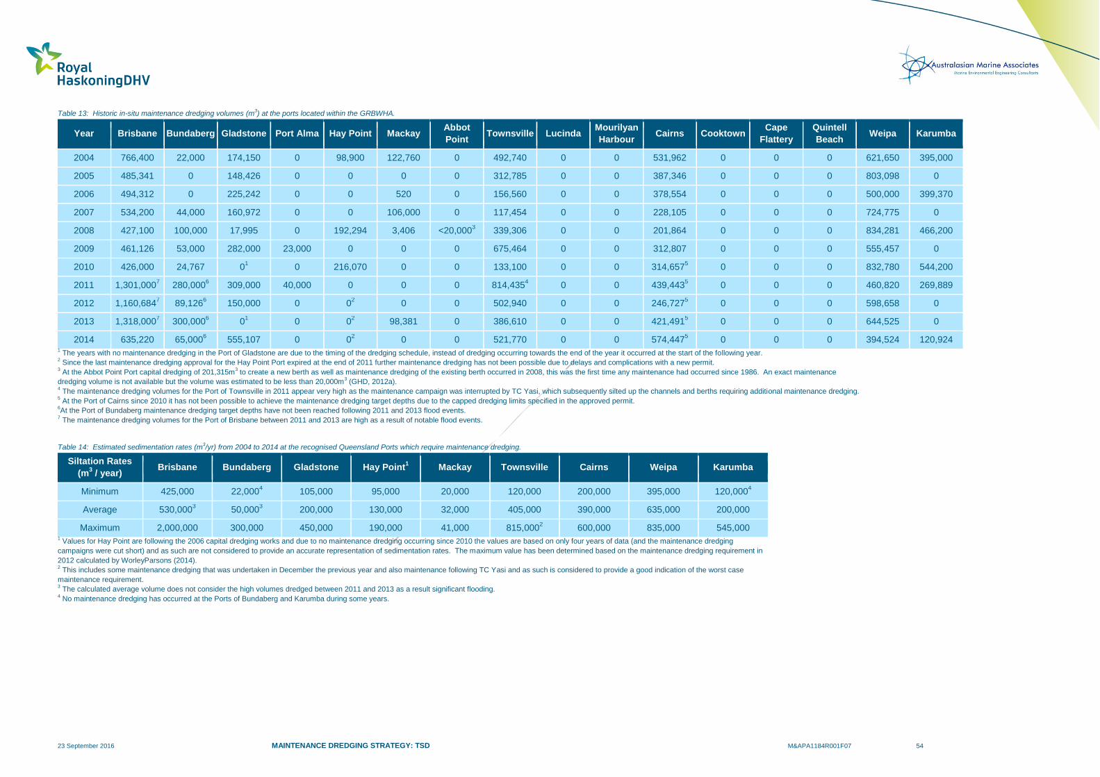
23 September 2016 MAINTENANCE DREDGING STRATEGY: TSD M&APA1184R001F07 54
Table 13: Historic in-situ maintenance dredging volumes (m3) at the ports located within the GRBWHA.
Year Brisbane Bundaberg Gladstone Port Alma Hay Point Mackay Abbot
Point Townsville Lucinda
Mourilyan
Harbour Cairns Cooktown
Cape
Flattery
Quintell
Beach Weipa Karumba
2004 766,400 22,000 174,150 0 98,900 122,760 0 492,740 0 0 531,962 0 0 0 621,650 395,000
2005 485,341 0 148,426 0 0 0 0 312,785 0 0 387,346 0 0 0 803,098 0
2006 494,312 0 225,242 0 0 520 0 156,560 0 0 378,554 0 0 0 500,000 399,370
2007 534,200 44,000 160,972 0 0 106,000 0 117,454 0 0 228,105 0 0 0 724,775 0
2008 427,100 100,000 17,995 0 192,294 3,406 <20,0003 339,306 0 0 201,864 0 0 0 834,281 466,200
2009 461,126 53,000 282,000 23,000 0 0 0 675,464 0 0 312,807 0 0 0 555,457 0
2010 426,000 24,767 01
0 216,070 0 0 133,100 0 0 314,6575
0 0 0 832,780 544,200
2011 1,301,0007 280,000
6 309,000 40,000 0 0 0 814,435
4 0 0 439,443
5 0 0 0 460,820 269,889
2012 1,160,6847 89,126
6 150,000 0 0
2 0 0 502,940 0 0 246,727
5 0 0 0 598,658 0
2013 1,318,0007 300,000
6 0
1 0 0
2 98,381 0 386,610 0 0 421,491
5 0 0 0 644,525 0
2014 635,220 65,0006 555,107 0 0
2 0 0 521,770 0 0 574,447
5 0 0 0 394,524 120,924
1 The years with no maintenance dredging in the Port of Gladstone are due to the timing of the dredging schedule, instead of dredging occurring towards the end of the year it occurred at the start of the following year.
2 Since the last maintenance dredging approval for the Hay Point Port expired at the end of 2011 further maintenance dredging has not been possible due to delays and complications with a new permit.
3 At the Abbot Point Port capital dredging of 201,315m
3 to create a new berth as well as maintenance dredging of the existing berth occurred in 2008, this was the first time any maintenance had occurred since 1986. An exact maintenance
dredging volume is not available but the volume was estimated to be less than 20,000m3 (GHD, 2012a).
4 The maintenance dredging volumes for the Port of Townsville in 2011 appear very high as the maintenance campaign was interrupted by TC Yasi, which subsequently silted up the channels and berths requiring additional maintenance dredging.
5 At the Port of Cairns since 2010 it has not been possible to achieve the maintenance dredging target depths due to the capped dredging limits specified in the approved permit.
6At the Port of Bundaberg maintenance dredging target depths have not been reached following 2011 and 2013 flood events.
7 The maintenance dredging volumes for the Port of Brisbane between 2011 and 2013 are high as a result of notable flood events.
Table 14: Estimated sedimentation rates (m3/yr) from 2004 to 2014 at the recognised Queensland Ports which require maintenance dredging.
Siltation Rates
(m3 / year)
Brisbane Bundaberg Gladstone Hay Point1
Mackay Townsville Cairns Weipa Karumba
Minimum 425,000 22,0004 105,000 95,000 20,000 120,000 200,000 395,000 120,000
4
Average 530,0003 50,000
3 200,000 130,000 32,000 405,000 390,000 635,000 200,000
Maximum 2,000,000 300,000 450,000 190,000 41,000 815,0002 600,000 835,000 545,000
1 Values for Hay Point are following the 2006 capital dredging works and due to no maintenance dredging occurring since 2010 the values are based on only four years of data (and the maintenance dredging
campaigns were cut short) and as such are not considered to provide an accurate representation of sedimentation rates. The maximum value has been determined based on the maintenance dredging requirement in
2012 calculated by WorleyParsons (2014). 2 This includes some maintenance dredging that was undertaken in December the previous year and also maintenance following TC Yasi and as such is considered to provide a good indication of the worst case
maintenance requirement. 3 The calculated average volume does not consider the high volumes dredged between 2011 and 2013 as a result significant flooding.
4 No maintenance dredging has occurred at the Ports of Bundaberg and Karumba during some years.

23 September 2016 MAINTENANCE DREDGING STRATEGY: TSD M&APA1184R001F07 55
Port Alma
The port is located adjacent to the Fitzroy delta within the channels of Raglan and Casuarina Creeks. It is
located within a natural deep section of the creeks and as such its historic maintenance requirements
have been low, only requiring irregular maintenance dredging due to natural sedimentation and sediment
movements in the creeks. As such, the historic maintenance volumes are considered to provide a good
indication of sedimentation rates and their temporal variability.
Mackay Port
The historic dredge volumes at Mackay Port can be used to provide a reasonable indication of the
sedimentation rates at Mackay Port; these are shown in Table 14. The volumes dredged each year are
highly variable as some years only the small grab dredger is used (e.g. 2006 and 2008) while during other
years both the small grab dredger and the TSHD Brisbane are used (e.g. 2004) (NQBP, 2011).
Abbot Point Port
In 2008, dredging of 201,315m3 was undertaken to create a new berth and to maintain depths at the
existing berth. The majority of the volume was for the capital works, with an estimated volume of less than
20,000m3 being for the maintenance dredging of the existing berth. This was the first time any
maintenance had occurred since 1986 at Abbot Point Port. This shows that the natural sedimentation
rates at Abbot Point are very low.
Port of Townsville
The historic dredge volumes from the Port of Townsville provide a reasonable representation of the
sedimentation rates; these are detailed in Table 14. However, the volumes in 2010 and 2011 do not
provide such a clear representation of annual sedimentation rates as the main dredging campaign for
2010 commenced in December but continued in 2011 and PoTL include their dredging volumes based on
when the campaign was finished. In addition, the campaign had to be stopped mid-way through due to
TC Yasi which significantly increased the maintenance requirements. As such, the dredging which
occurred prior to TC Yasi effectively had to be redone as the cyclone resulted in very high sedimentation.
Port of Lucinda
There has not been any maintenance dredging at the Port of Lucinda between 2004 and 2014. This is
because the jetty extends to sufficiently deep water so that dredging has not been required, while the
wharf located adjacent to the shore is not operational and the barge ramp sedimentation is not sufficient to
require dredging. The lack of maintenance dredging does not mean that there has not been any
sedimentation, rather that the vessel terminal is located in sufficiently deep water that any sedimentation
has not influenced the navigability of the area.
Port of Mourilyan
The Port of Mourilyan has not required any maintenance dredging between 2004 and 2014. Even though
the port is located at the mouth of the Moresby River, no net sedimentation has been observed over this
period. Bed levelling has been required primarily in the swing basin as a combination of tidal currents and
vessel propellers are thought to regularly resuspend and redistribute the bed sediment.
Port of Cairns
From 2004 to 2009, the historic maintenance dredge volumes provide a good representation of the
sedimentation rates as the dredging was able to achieve the target depths. These years were relatively
mild in weather conditions and did not include any high sedimentation events. However, since 2010 when
23 September 2016 MAINTENANCE DREDGING STRATEGY: TSD M&APA1184R001F07 56
more severe weather conditions were experienced the maintenance dredging volumes have not been able
to reach the target depths and so they provide an underestimation of the sedimentation rates.
In 2010, the existing 5 year maintenance dredging permit, which allowed dredging of 350,000 dry tonnes
per year, expired and a new approval was sought. In the Long Term Management Plan prepared as part
of the approval process for a new 10 year permit a wet in-hopper volume of 550,000m3 per year was
specified as the ongoing maintenance volume along with an additional 1,100,000m3 as cyclone
contingency for two years (WorleyParsons, 2010a). The 10 year permit was approved in 2010 and it was
subsequently identified by Ports North that a mistake had been made when calculating the wet in-hopper
volumes and as a result an artificially low annual maintenance dredging limit had been implemented. The
error resulted from the conversion from dry tonnes to wet in-hopper volume, as a conversion factor from
the previous dredger, the Sir Thomas Hiley, was used instead of the TSHD Brisbane. As the Hiley
operated in continuous overflow mode is was able to achieve a greater hopper density than the TSHD
Brisbane. In 2013 a variation to the permit was approved, this allowed the dry tonnes values specified in
the permit to be adopted rather than the in-hopper wet volumes.
Figure 12 shows the historic maintenance dredging undertaken by the TSHD Brisbane along with the in-
situ volume of material requiring dredging for the target depths to be achieved. The difference between
the in-situ volume to target depth prior to dredging and the in-situ volume removed since 2010 represents
the shortfall in dredging volumes. From 2010 to 2014, the maintenance dredging undertaken has been
90,000 to 250,000m3 per year below what is required to achieve the target depths (despite the cyclone
contingency having been used over this period). Despite the change in the permit in 2013, along with the
remaining cyclone contingency included in the permit being used, the in-situ volume required to reach the
target depths has continued to increase (Figure 12). As such, re-declaration of the channel with a
reduced depth has occurred resulting in shipping inefficiencies due to a need to short load sugar ships by
several thousand tonnes, a reduced load capability for fuel imports and reduced hours of visits by cruise
ships reliant on tides for entry and exit. This has also caused inefficiencies in both survey and dredging
programs with a resulting need for additional monitoring surveys and split dredging campaigns to facilitate
the seasonality in the trades at the port (sugar and cruise). At some stage a larger than normal dredging
campaign will be required to catch up and re-instate the required depths and up to this point there will be
increases in the generation of turbidity from vessel wash due to the reduced channel depths.
A summary of the historic sedimentation calculated for the Port of Cairns is provided in Table 14.
Port of Cooktown
The Port of Cooktown has not required any maintenance dredging between 2004 and 2014. Even though
the port is located at the mouth of the Endeavour River, no net sedimentation has been observed over this
period. Maintenance dredging has been required on two occasions since capital dredging in 1997, which
was undertaken to initiate commercial management of the harbour by Cook Shire Council. In 2015, a total
of 44,141m3 was removed following TC Nathan and in 1999 a total of 26,000m
3 was removed after the
channel silted up due to a cyclone. This demonstrates that the sedimentation at the Port of Cooktown is
driven by extreme cyclonic events and ambient sedimentation rates are negligible.
Port of Cape Flattery
There has not been any historic maintenance dredging required at the Port of Cape Flattery, due to the
relatively deep water at the berth locations. The lack of maintenance dredging does not mean that there
has not been any sedimentation; rather that the berth locations are located in sufficiently deep water that
any sedimentation has not influenced the navigability of the area.
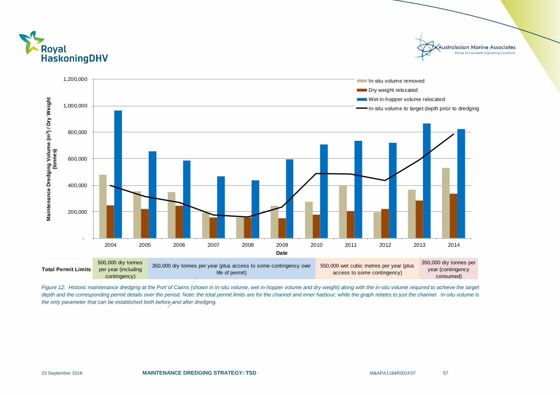
23 September 2016 MAINTENANCE DREDGING STRATEGY: TSD M&APA1184R001F07 57
Figure 12: Historic maintenance dredging at the Port of Cairns (shown in in-situ volume, wet in-hopper volume and dry weight) along with the in-situ volume required to achieve the target
depth and the corresponding permit details over the period. Note: the total permit limits are for the channel and inner harbour, while the graph relates to just the channel. In-situ volume is
the only parameter that can be established both before and after dredging.
Total Permit Limits
500,000 dry tonnes
per year (including
contingency)
350,000 dry tonnes per year (plus access to some contingency over
life of permit)
550,000 wet cubic metres per year (plus
access to some contingency)
350,000 dry tonnes per
year (contingency
consumed)
-
200,000
400,000
600,000
800,000
1,000,000
1,200,000
2004 2005 2006 2007 2008 2009 2010 2011 2012 2013 2014
Ma
inte
na
nce
Dre
dg
ing
Vo
lum
e (m
3)
/ D
ry W
eig
ht
(to
nn
es)
Date
In-situ volume removed
Dry weight relocated
Wet in-hopper volume relocated
In-situ volume to target depth prior to dredging

23 September 2016 MAINTENANCE DREDGING STRATEGY: TSD M&APA1184R001F07 58
Port of Quintell Beach
This is no reported historic maintenance dredging at the Port of Quintell Beach. The port consists of a
barge ramp located on a sandy foreshore and as such it is likely that sediment will have been cleared from
the ramp and placed adjacent to it historically but that the scale of this work did not constitute dredging.
As such, the lack of any historical maintenance dredging does not mean that there has not been any
sedimentation in this area, but that rather the natural sedimentation at the port is relatively low and is
accommodated by minor ramp clearance works.
Port of Weipa
The historic maintenance dredging volumes at the Port of Weipa can be used to provide a very good
indication of the sedimentation rates, as shown in Table 14. Maintenance dredging volumes increased
slightly since capital dredging works were undertaken in 2006, which included widening of the main
navigational channel. Since 2006, maintenance requirements have remained relatively constant with the
exception of years coinciding with cyclones and prolonged wet seasons which have had higher
requirements. For example, the largest maintenance dredging requirement of 2008 was influenced by the
passing of TC Helen which resulted in notable flooding and the erosion of local beaches. Capital dredging
works were also undertaken at the port in 2012 which involved a 2.4 km extension of the existing channel;
however a review of historical dredge volumes suggests that this did not result in any notable increase in
average maintenance dredging requirements (Ports and Coastal Environmental, 2013).
Port of Karumba
The historic maintenance dredging volumes at the Port of Karumba reflect the varying requirements of the
port and as such do not provide a good representation of sedimentation, which is estimated based on the
available information in Table 14. Between 2004 and 2011 dredging was undertaken bi-annually with
channel depths returned to design depths to accommodate vessels facilitating the export of zinc
concentrate. The higher volumes dredged in 2010 and 2011 were due to prolonged wet seasons
depositing increased volumes of sediment at the port and navigational channels. As a result of recent
mine closures, the ports maintenance dredging requirements have reduced substantially as the port now
primarily accommodates for the export of cattle and the local commercial fishing industry. Ports North
foresees limited to no future maintenance dredging requirements at the port in the foreseeable future.
4.5.1 Comparison with Natural Sediment Transport
It is important to consider the historical maintenance dredging volumes relative to the natural sediment
budget to put the activity into the context of the natural environment. This is particularly important within
the GBRWHA to allow an understanding of the relative influence of maintenance dredging in this area. As
discussed in Section 2, sediment can be input into the inner-shelf region of the GBR through river
discharges and cyclonic activity. Resuspension and transport of sediment within the inner-shelf of the
GBR is dominated by wave and wind induced currents. As such, the natural input of sediment to the
inner-shelf of the GBR and the natural resuspension of sediment is compared relative to the contributions
from maintenance dredging.
A comparison of the input of sediment to the GBRWHA from terrestrial run-off to the predicted total future
maintenance dredging volumes at the ports located within the GBRWHA found that the maintenance
dredging was 5-10% of the catchment input (McCook et al., 2015). However, it was also noted that the
comparison was for broad context only and the dredge amounts released into the ecosystem will only be a
proportion of the total maintenance dredging volumes. Due to a lack of available quantitative data it is not
possible to provide a comparison with the input of sediment due to cyclonic activity.
23 September 2016 MAINTENANCE DREDGING STRATEGY: TSD M&APA1184R001F07 59
To put the maintenance dredging volumes into context with the natural sediment transport, it is necessary
to compare the mass of sediment from maintenance dredging with the mass of sediment naturally
resuspended in the area of the ports. It is very difficult to accurately quantify the amount of sediment
resuspended by waves and wind induced currents and there is limited existing information available.
Lambrechts et al. (2010) calculated the fluxes of fine sediment for Cleveland Bay, finding that 34,500
tonnes/yr was transported around Cape Cleveland from the Burdekin River and 25,900 tonnes/yr came
from the Ross River and Alligator Creek. They also noted that TSS of 50mg/l typically occur within
Cleveland Bay during periods of high energy wind and waves and that this can reach up to 200mg/l in
some areas, this agrees with previous water quality monitoring by Cooper et al. (2008).
Investigations by Orpin et al. (1999) found that high energy wind and waves occur for approximately 40
days per year in Townsville and during these events sediment can be resuspended in water depths of up
to around 15m. Aerial photography showing the spatial extent of resuspension from a high energy wind
and wave event was presented by Orpin and Ridd (2012), this shows that the plume encompasses
Cleveland Bay and it extends offshore to the approximate location of the 15m depth contour (Figure 4).
Using the information detailed above it is possible to provide a broad estimate of the quantity of sediment
resuspended by wind and wave action in Cleveland Bay. The following assumptions have been made:
The area of Cleveland Bay to the 15m offshore depth contour is 300km2, an average depth of
7.5m has been used to calculate the volume of water in the bay; and
A depth averaged TSS of 50mg/l throughout the bay. This has been assumed to represent a
peak value and so even though the temporal variability in resuspension through an event is not
considered it is still possible to estimate the total volume of sediment resuspended by the event.
Based on these assumptions, approximately 112,500 tonnes is estimated to be resuspended by a single
high energy wind and wave event in Cleveland Bay.
Based on the finding by Orpin et al. (1999) that these events occur for approximately 40 days per year, the
total quantity of sediment resuspended by high energy wind and wave events in Cleveland Bay is
estimated to be in the order of 4,500,000 tonnes/yr. This can be compared with the annual maintenance
dredging by using an approximate conversion factor of 0.7 to convert from in-situ volume to dry tonnes as
noted by McCook et al. (2015). Based on this factor the average annual maintenance dredging at the Port
of Townsville is 280,000 tonnes and, of this, it can be assumed that up to 15% could be suspended during
the dredging and disposal activity (rather than being transported into the hopper of the dredger), resulting
in approximately 42,500 tonnes of material per annum being resuspended due to maintenance dredging.
This shows that the amount of sediment resuspended by a single high energy wind and wave event in
Cleveland Bay (which occur approximately 40 days per year) is more than double the amount
resuspended by the annual maintenance dredging. In addition, the total volume of material resuspended
by high energy wind and wave event in Cleveland Bay per year is more than 100 times greater than the
amount resuspended each year by maintenance dredging.
Numerical modelling and measured data have been used at the Port of Cairns to quantify the amount of
sediment naturally resuspended within Trinity Bay during a strong wind event. The results predicted that
approximately 1.2 Million tonnes of sediment is naturally resuspended within Trinity Bay (BMT WBM,
2014a and 2014b). When compared to the estimated annual quantity of sediment suspended by
maintenance dredging of 41,000 tonnes, it shows that the amount of sediment suspended by maintenance
dredging is relatively small compared to the sediment resuspended by natural processes in Trinity Bay.
23 September 2016 MAINTENANCE DREDGING STRATEGY: TSD M&APA1184R001F07 60
It is also important to consider that the quantity of sediment resuspended by an extreme event such as a
tropical cyclone would be much higher than the amounts detailed in these examples. Based on the
available data Carter et al (2009) and Larcombe and Ridd (2015) estimated that 140Mm3 (100 million
tonnes) was suspended by TC Winifred (1986) and 500Mm3 (350 million tonnes) was suspended by TC
Yasi (2011), respectively. It is important to note that these should only be considered rough estimates due
to the significant uncertainties associated with predicting sediment suspended by extreme events.
4.5.2 Variability in Maintenance Dredging Requirements
As noted in the previous section, as well as there being significant variability in maintenance dredging
requirements between the different ports due to the different locations and processes, there is also
significant variability in the requirements from year to year. In addition, spatial variability in the
maintenance dredging requirements also occurs at each port with different rates of sedimentation
occurring at the different areas of the ports such as in the channels and berths.
The temporal patterns in historic maintenance dredging volumes can be influenced by seasonal and
annual climatic variability. This includes the El Nino Southern Oscillation (ENSO) which can influence the
relative importance of different processes. For example, the large flood events in 2010 which resulted in
increased maintenance dredging at the Ports of Brisbane and Bundaberg occurred during a strong La
Niña event which is typically associated with increased rainfall. In addition, strong La Niña events can
also be associated with increased wind energy (and therefore increased current and wave energy) along
with an increased risk of cyclones compared to the other phases of the ENSO.
The relative importance of these processes on the maintenance dredging requirements will vary between
the ports depending on the location, configuration and the dominant sedimentation processes at the ports.
Although the ENSO can influence the maintenance dredging requirements at the ports where annual
maintenance dredging is required, the processes which control the sedimentation are much more
complicated and do not correlate to just the ENSO (Figure 13). The plots show no clear correlation
between maintenance dredging volumes and the ENSO at the Ports of Gladstone and Cairns, while at the
Port of Townsville a correlation is evident with the maintenance dredging requirement being at its highest
in the years immediately after strong La Niña events (positive SOI) in 2009 and 2011. These years also
correlate to the largest wave heights which have been recorded at the Port of Townsville wave buoy
(Figure 14), with a maximum wave height (Hmax) of 10.1m recorded in February 2011 during TC Yasi and
a Hmax of 6.6m recorded in January 2009 (likely to be related to a number of tropical lows which occurred
around this time). This also highlights that the occurrence of extreme events, such as tropical cyclones,
can result in significant changes in maintenance dredging requirements at the ports.
The risk of these events occurring is influenced by the ENSO. For example, the risk of tropical cyclones
and flood events increase during La Nina phases of the ENSO, but there is a risk that these events could
occur during any year (and could occur multiple times in one year, in consecutive years or not at all for a
number of years) and it is not possible to accurately predict when and where the events will occur. This
highlights why the maintenance dredging requirements of the ports vary temporally from year to year and
why the individual ports do not exhibit the same temporal variability. This highlights that port specific
investigations are required to fully understand the drivers which result in the temporal variability in
maintenance dredging at each port.
Spatial variability in maintenance dredging requirements occurs at all ports due to variability in the port
configuration, natural environment and associated processes and therefore the sedimentation patterns.
Sedimentation tends to occur in dredged areas such as berths, aprons, basins and channels as the
artificially deeper areas are subject to lower energy (both from currents and waves) than the adjacent
23 September 2016 MAINTENANCE DREDGING STRATEGY: TSD M&APA1184R001F07 61
naturally higher areas. As a result, the deeper areas act as sediment sinks with increased sedimentation
and less potential for resuspension than the adjacent natural areas.
The sedimentation rate is controlled by the coastal processes, the sediment transport rates and the
‘trapping efficiency’ of the dredged area, with deeper and wider channels increasing the efficiency and
resulting in higher sedimentation rates. The orientation of the dredged area relative to the dominant
current and wave directions can also influence the sedimentation rates. Sedimentation can also occur as
adjacent shallow shoals and intertidal flats prograde and gradually encroach on adjacent dredged areas.
Ports typically have a good understanding of the spatial variability in sedimentation around the ports from
historic bathymetric surveys as well as previous maintenance dredging campaigns. As an example, the
spatial variability in historic sedimentation and maintenance dredging is shown in Figure 15 for the Port of
Gladstone. The plot highlights how the majority of the dredged channels do not require regular
maintenance dredging, it is only specific areas which are prone to regular sedimentation which require
annual maintenance dredging.
As a result of the spatial variability in sedimentation rates, it is common for maintenance dredging
campaigns to target different areas as the maintenance dredging frequency will differ spatially. For
example, sections of the channel may be subject to high rates of sedimentation and require annual
maintenance dredging, while other areas of the channel may have lower rates of sedimentation and only
require maintenance dredging every few years and other areas could be self-cleaning or eroding and
never require maintenance dredging.
Based on the historic maintenance dredging volumes, the local environment and port configuration the
Queensland Ports can be classified by maintenance dredging frequency to better relate the ports to the
dominant processes and their interaction with the dredged areas which result in sedimentation:
Frequent Maintenance Dredging (annual dredging): Annual maintenance dredging is required
at the Ports of Brisbane, Bundaberg, Gladstone, Townsville, Cairns and Weipa. Natural
processes result in high sediment transport rates in the vicinity of the ports which, combined with
the port configuration, result in regular sedimentation and therefore maintenance dredging is
required annually to maintain design depths. Sedimentation at the Ports of Brisbane and
Bundaberg is primarily caused by fluvial processes. The sedimentation at the Ports of Gladstone,
Townsville, Cairns and Weipa is primarily caused by regular sediment transport from the
resuspension of natural bed sediment by waves and currents, combined with possible input of
sediment from adjacent riverine sources. The sedimentation rates at all the ports can be
significantly increased by episodic extreme events such as tropical cyclones and large floods.
Regular Maintenance Dredging (dredging every two to five years): Regular maintenance
dredging is required at Hay Point Port and Mackay Port. These areas experience relatively high
rates of natural sediment transport but the dredged areas are not as effective sediment traps as
the ports which require annual maintenance dredging potentially due to the port configuration, the
adjacent natural environment (or both) or lower natural sediment transport rates. Regular
sedimentation does occur but at a rate which typically only requires maintenance dredging every
two to five years. However, the areas can also be influenced by extreme events which can
significantly increase the sedimentation rates and potentially result in the maintenance dredging
frequency being increased.
Episodic Maintenance Dredging due to extreme events: Episodic maintenance dredging is
required at the Port of Cooktown. The sedimentation associated with maintenance dredging at
this port results from episodic extreme tropical cyclone events. It is not possible to predict the
frequency of these events, they could occur in consecutive years or only every few decades.
23 September 2016 MAINTENANCE DREDGING STRATEGY: TSD M&APA1184R001F07 62
Infrequent Maintenance Dredging due to low sedimentation rates: Infrequent maintenance
dredging is required at Port Alma, Abbot Point Port and the Port of Karumba. The natural
processes at Port Alma limit sedimentation, with only coarser material accumulating over time.
The natural processes at Abbot Point result in low sediment transport rates in the vicinity of the
port, which combined with the naturally deep water where the port is located, results in very low
sedimentation rates and infrequent maintenance dredging. Over the last thirty years
maintenance dredging has been undertaken once, when the maintenance work was undertaken
as part of a capital dredging campaign. Over this period a number of tropical cyclones have
affected the area but these have not resulted in the requirement for maintenance dredging. A
reduction in the required declared depth at Karumba has meant that there is expected to be
limited to no maintenance dredging requirement in the foreseeable future.
No Maintenance Dredging: No Maintenance dredging is required at the Ports of Maryborough,
Lucinda, Mourilyan, Cape Flattery, Quintell Beach, Thursday Island, Skardon River and
Burketown. The configurations of these ports have meant that maintenance dredging is not
required regardless of the natural sedimentation rates. At the Port of Lucinda and the Port of
Cape Flattery this is because the berths are located in deep water, while at the Port of Quintell
Beach it is because the port only consists of a barge ramp which does not require an access
channel. There has not been any requirement for historic maintenance dredging at the Port of
Mourilyan, but if a large flood event occurred there is the possibility that future maintenance
dredging could be required.
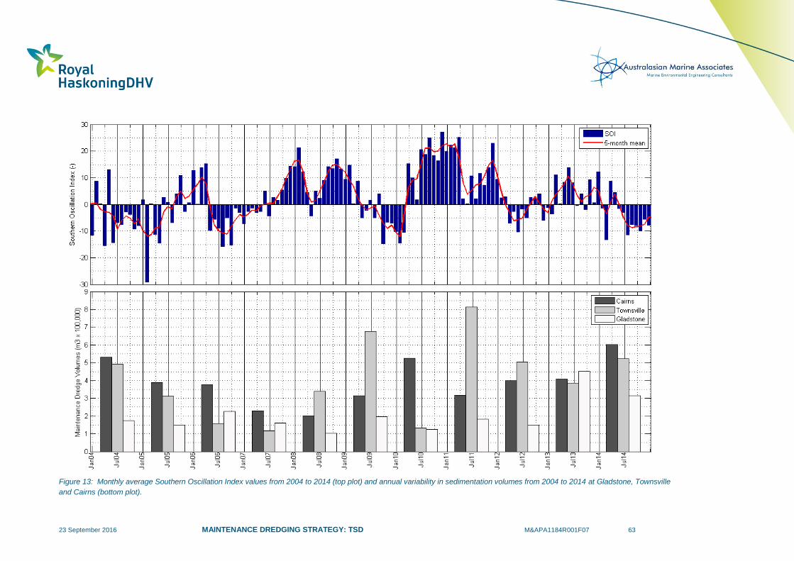
23 September 2016 MAINTENANCE DREDGING STRATEGY: TSD M&APA1184R001F07 63
Figure 13: Monthly average Southern Oscillation Index values from 2004 to 2014 (top plot) and annual variability in sedimentation volumes from 2004 to 2014 at Gladstone, Townsville
and Cairns (bottom plot).

23 September 2016 MAINTENANCE DREDGING STRATEGY: TSD M&APA1184R001F07 64
Figure 14: Monthly average Southern Oscillation Index values from 2004 to 2014 (top plot), monthly maximum wave heights at Townsville (middle plot) and the annual in-situ volume
sedimentation at the Port of Townsville (bottom plot).

23 September 2016 MAINTENANCE DREDGING STRATEGY: TSD M&APA1184R001F07 65
Figure 15: Map showing the areas of the Port of Gladstone which require maintenance dredging due to sedimentation (red lines).

23 September 2016 MAINTENANCE DREDGING STRATEGY: TSD M&APA1184R001F07 66
4.5.3 Historic Material Placement
Historically the majority of sediment dredged during maintenance campaigns at the ports within the
GBRWHA has been placed in offshore material placement sites, with only small quantities being placed
on land. The only ports where significant on land placement has occurred are the Port of Townsville and
the Port of Cooktown.
At Sea Placement
Offshore placement of dredge material has been the primary relocation approach adopted at all the ports
where regular maintenance dredging has been required. Details of the material placement sites are
provided in Table 15, this shows that the existing sites are both retentive and dispersive in character.
It is important to note that, in some cases, it is not possible to choose the character of the material
placement site. For example, due to the large tidal range and resultant strong tidal currents at Hay Point
and Mackay Ports, the majority of the area surrounding the ports is dispersive and it would be very difficult
to identify a retentive site in the area. There can be positives and negatives associated with both
characters of placement site and the applicability of the character needs to be assessed on a case by
case basis. The important requirement in all cases is to have a sound knowledge of the fate of the dredge
material when placed in the offshore material placement site.
Table 15: Details of the existing offshore material placement sites at ports within the GBRWHA where regular maintenance dredging
has been required.
Port Location Description
Gladstone within Port Limits Predominantly Retentive. Coarse material remains but
silts and clays are winnowed out (BMT WBM, 2012a).
Hay Point within GBRMP
Predominantly Retentive. Approximately 65% of the
sediment from historic capital and maintenance dredging
has remained at the site (RHDHV, 2016).
Mackay within Port Limits Highly Dispersive. Approximately 70% of material
effectively mobilised in 8 week (SKM, 2005).
Townsville within Port Limits Dispersive. Tracer studies showed that sediment erodes
during moderate wave events (ETS, 2012).
Cairns within GBRMP1
Retentive. A retentive site was chosen and regular
sedimentation has been observed (WorleyParsons,
2010a). 1 the Port of Cairns placement site was originally located outside the GBRMP, but the park boundaries were expanded in 2001 by
GBRMPA and have included the site ever since.
On Land Placement
Details of the on land placement of sediment at the Port of Townsville and the Port of Cooktown are
provided below.
Port of Townsville
At the Port of Townsville a portion of the sediment from maintenance dredging has regularly been placed
on land in reclamation areas (Table 16). There have been two main reasons for the material to be placed
on land:

23 September 2016 MAINTENANCE DREDGING STRATEGY: TSD M&APA1184R001F07 67
Contaminant risk: in the Inner Harbour area there have been two areas of the berths where the
NAGD screening levels for the upper 95% confidence limit of mean contaminant concentrations in
the sediment have been exceeded (PoTL, 2013). This material has typically been dredged by a
mechanical grab dredge and placed in a barge with a slurry pump allowing it to discharge to land;
and
Dredging method and location: typically the maintenance dredging of the Ross River (and to a
lesser extent the Ross Creek) has made up the majority of the sediment placed on land (PoTL,
2013). The material has been defined as suitable for at sea disposal based on the NAGD
guidelines. However, these areas are not accessible by the TSHD Brisbane as they are too
shallow and as a result the areas have been dredged by a small cutter suction dredger (CSD)
which can pump directly to the reclamation area. In addition, the material has a higher sand
content than most of the other maintenance dredging material and it therefore has better
engineering properties. Some spot dredging has also been undertaken using PoTL’s grab
dredger in areas that are inaccessible to a TSHD or a CSD and these small volumes have
typically been placed on land.
Table 16: Historic in-situ maintenance dredging volumes (m3) and the distribution of sediment that was placed at sea and land at the
Port of Townsville.
Year Total Dredging
(m3)
Total Sea Placement
(m3)
Total Land Placement
(m3)
2004 492,740 489,240 3,500
2005 312,785 300,785 12,000
2006 156,560 151,000 5,560
2007 117,454 117,454 0
2008 339,306 338,050 1,256
2009 675,464 612,284 63,180
2010 133,100 55,300 77,800
2011 814,435 809,135 5,300
2012 502,940 424,950 77,990
2013 386,610 369,684 16,926
2014 521,770 516,060 5,710
Port of Cooktown
Out of the 44,141m3 of sediment removed during maintenance dredging in 2015, approximately 30,000m
3
was placed on land and the remainder was placed at sea (Voisey, 2015, pers. comm., 22 October). The
on land material was placed in a foreshore reclamation site and filled the site to capacity. As the
requirement for maintenance dredging at the Port of Cooktown is driven by high energy tropical cyclones,
the material which accumulates is predominantly made up of sand and as such is suitable for on land
beneficial reuse.

23 September 2016 MAINTENANCE DREDGING STRATEGY: TSD M&APA1184R001F07 68
4.6 Future Maintenance Dredging Requirements
The historic maintenance dredging volumes detailed in Section 4.5 can be used to provide an indication
of the future requirements and the historic natural variability at the ports. The volume of sediment which
accumulates in dredged areas of the ports and requires removal through maintenance dredging cannot be
directly reduced by the ports as they are caused by the preceding metocean conditions and associated
natural sediment transport rates. However, the volumes can be influenced by future changes to the port
such as future capital dredging or port expansions. The impacts of these types of projects on
maintenance dredging requirements is typically addressed as part of the project approvals process and
future predictions should therefore be understood prior to approval of the project.
The predicted future sea level rise due to climate change has the potential to progressively decrease
maintenance dredge volumes into the future. However, without detailed numerical modelling it is not
possible to quantify these reductions and so they have not been included in the future maintenance
dredging volumes detailed in Section 4.6.2.
4.6.1 Future Port Expansion Works
Details of any proposed future port expansion projects which could influence the maintenance dredging
requirements are detailed in Table 17. The table shows that the ports with expansion projects proposed
over the next 10 years are the Port of Gladstone, Abbot Point Port, Port of Townsville and Port of Cairns.
The influence of the proposed port expansion works on future maintenance dredging requirements is a
key component of the approval process for future projects and should be detailed in the approval
documentation for these projects. Details of how these proposed projects are expected to influence future
maintenance dredging requirements are as follows:
Port of Gladstone: the maintenance dredging requirement is not predicted to be significantly
increased by works in the Clinton Channel. The additional depth of the channel could increase
the trapping efficiency of the channel, but as the existing maintenance dredging requirements for
this area are low any increases will be minor. The Gatcombe and Golding Cutting Channel
Duplication works will have the potential to increase the total future maintenance dredging
requirements. As the channel will be adjacent to an existing channel and the sedimentation in
that area is a result of longshore sediment transport the Channel Duplication works are not
predicted to result in a significant increase in maintenance dredging requirement. The current
maintenance contribution of the channels to be duplicated accounts for approximately12% of the
total maintenance dredging requirement and, as suc,h an increase of 6% is considered realistic.
In addition, it has been identified by GPC (2015) that following the Western Basin capital dredging
the maintenance dredging requirement was expected to increase by 185,000m3 in 2014/15 and
then 140,000m3 in 2015/16 and gradually reduce until 2017/18 when it reaches a constant
ongoing increased requirement of 60,000m3. The gradual reduction in volumes over time is due
to the predicted natural stabilising of the sea bed and batter slopes of the channel following the
capital dredging.
Abbot Point Port: based on the negligible historic maintenance dredging requirement at Abbot
Point Port, it is not expected that the proposed capital dredging will result in significant increases
in maintenance dredging.
Port of Townsville: the Berth 12 capital dredging has been predicted to result in an increase in
maintenance dredging of 250,000m3 over five years (PoTL, 2013). The additional berths and
Outer Harbour reclamation associated with the Port Expansion Project is predicted to result in a
25% reduction in existing maintenance requirements as it will restrict sedimentation in the Inner
Harbour (BMT WBM, 2012e). The proposed capital dredging of the Platypus and Sea Channels

23 September 2016 MAINTENANCE DREDGING STRATEGY: TSD M&APA1184R001F07 69
has been predicted to result in an increase in maintenance dredging of 100,000m3 of sediment
over 5 years.
Port of Cairns: the port had pursued an EIS for a major channel expansion project which included
4.4Mm3 of capital dredging. However, since the offshore placement of capital dredge material in
the GBRMP was banned, the scale of the project was not deemed feasible for land based
placement of the material. As a result the port is looking to identify a feasible project with
significantly less capital dredging than the previous proposed expansion. The proposed channel
expansion is expected to result in limited additional maintenance dredging as the proposed
expansion areas are generally located in areas of the channel which are currently self-cleaning.
The proposed minor inner port developments are expected to result in a small increase in the
maintenance dredging volumes. For both of the proposed projects an increase in the
maintenance dredging requirement of 10% has been assumed.
In addition to the above existing ports, Rio Tinto is currently in the process of developing a bauxite mine
located to the south of Weipa. This development will include the construction of a new port facility on the
Gulf of Carpentaria coastline. The proposed Amrun port development will involve the capital dredging of
approximately 230,000m3
for a berth pocket and departure area and is expected to require maintenance
dredging on an annual or bi-annual basis. The first bauxite exports are expected in 2019.
Table 17: Port expansion projects proposed over the next 10 years.
Port Future Expansion
Works Details
Brisbane No
The Port of Brisbane currently holds a permit for the progressive
dredging of spitfire channel, however, this will not have any effect
on the future maintenance dredging requirements at the port.
Bundaberg No -
Gladstone Yes
1) Works in Clinton Channel. The channel would have
approximately the same footprint but would be deepened.
2) Gatcombe and Golding Cutting Channel Duplication Project.
This would involve the creation of a new channel. Estimated
capital dredging of 12Mm3.
Port Alma No -
Hay Point No -
Mackay No -
Abbot Point Yes
1) Terminal 0 and Terminal 3 Expansion. The creation of new
berths and extension of the apron. Estimated capital dredging
of 1.7Mm3.
Townsville Yes
1) Berth 12. The creation of a new berth on the northern side of
the existing reclamation, this project has been approved but it
has not commenced to date.
2) Port Expansion Project. The creation of six additional berths
and a 100ha land reclamation to create a new outer harbour.
Also minor deepening and modifications to the approach
channels. Estimated capital dredging of 10Mm3.
Lucinda No -
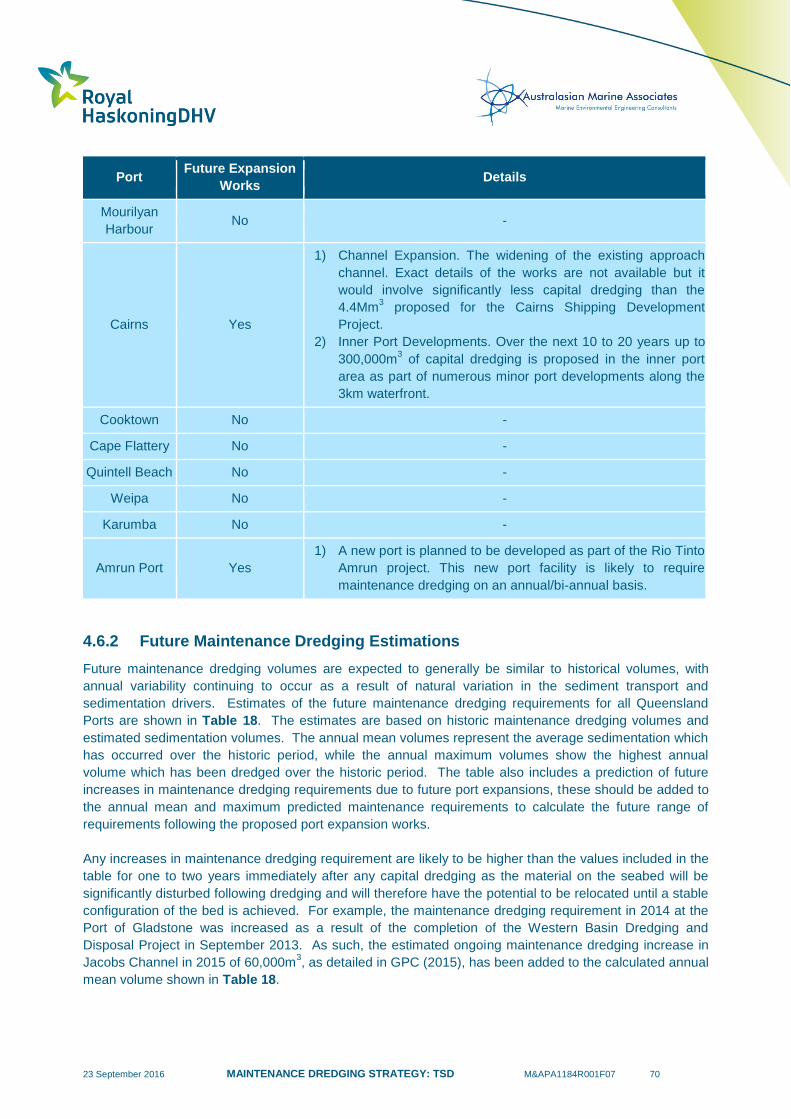
23 September 2016 MAINTENANCE DREDGING STRATEGY: TSD M&APA1184R001F07 70
Port Future Expansion
Works Details
Mourilyan
Harbour No -
Cairns Yes
1) Channel Expansion. The widening of the existing approach
channel. Exact details of the works are not available but it
would involve significantly less capital dredging than the
4.4Mm3 proposed for the Cairns Shipping Development
Project.
2) Inner Port Developments. Over the next 10 to 20 years up to
300,000m3 of capital dredging is proposed in the inner port
area as part of numerous minor port developments along the
3km waterfront.
Cooktown No -
Cape Flattery No -
Quintell Beach No -
Weipa No -
Karumba No -
Amrun Port Yes
1) A new port is planned to be developed as part of the Rio Tinto
Amrun project. This new port facility is likely to require
maintenance dredging on an annual/bi-annual basis.
4.6.2 Future Maintenance Dredging Estimations
Future maintenance dredging volumes are expected to generally be similar to historical volumes, with
annual variability continuing to occur as a result of natural variation in the sediment transport and
sedimentation drivers. Estimates of the future maintenance dredging requirements for all Queensland
Ports are shown in Table 18. The estimates are based on historic maintenance dredging volumes and
estimated sedimentation volumes. The annual mean volumes represent the average sedimentation which
has occurred over the historic period, while the annual maximum volumes show the highest annual
volume which has been dredged over the historic period. The table also includes a prediction of future
increases in maintenance dredging requirements due to future port expansions, these should be added to
the annual mean and maximum predicted maintenance requirements to calculate the future range of
requirements following the proposed port expansion works.
Any increases in maintenance dredging requirement are likely to be higher than the values included in the
table for one to two years immediately after any capital dredging as the material on the seabed will be
significantly disturbed following dredging and will therefore have the potential to be relocated until a stable
configuration of the bed is achieved. For example, the maintenance dredging requirement in 2014 at the
Port of Gladstone was increased as a result of the completion of the Western Basin Dredging and
Disposal Project in September 2013. As such, the estimated ongoing maintenance dredging increase in
Jacobs Channel in 2015 of 60,000m3, as detailed in GPC (2015), has been added to the calculated annual
mean volume shown in Table 18.

23 September 2016 MAINTENANCE DREDGING STRATEGY: TSD M&APA1184R001F07 71
The estimates presented in Table 18 assume that the current level of sediment supply and sediment
transport continue into the future. As detailed in Section 2.6, the inner shelf area of the GBR Lagoon is
not considered to be sediment-supply limited and, therefore, any change in riverine sediment supply
(increases or decreases) is likely to be masked by natural resuspension processes as this is the dominant
driver for elevated TSS. Therefore, any future reductions in sediment loads input from river systems are
not expected to have a measurable change to maintenance dredging requirements at the majority of the
ports over the next 10 to 20 years. The exception to this are ports located close to the mouths of large
rivers, such as Port Alma, although as the maintenance dredging at the port is related to extreme flood
events it is unlikely that future maintenance dredging requirements will be significantly reduced.
The historic maintenance dredging records show that annual variability in volumes regularly occurs. This
is a result of variability in the natural processes which influence sediment transport and sedimentation.
The occurrence of extreme events such as tropical cyclones and large floods can significantly influence
the sedimentation rates. It is generally as a result of these events that the maximum maintenance
dredging volumes are required. Due to the unpredictable nature of these extreme events, in terms of their
intensity, frequency and spatial influence, it is not possible to reliably estimate future maintenance
dredging volumes and their variability.
Historically, maintenance dredging has had a volume limit applied, which has typically been based on the
historic annual average volume, and a cyclone/flood contingency volume also included to allow extra
volume to be dredged in years when these extreme events occur. Based on the natural variability in
sedimentation rates and the resulting variability in maintenance dredging requirements, adopting an
annual maintenance dredging volume limit based on historic annual average volumes is not considered to
be an appropriate management approach. As maintenance dredging requirements are primarily controlled
by the natural processes, it is not possible to accurately predict future requirements. Therefore, continuing
to adopt annual maintenance dredging limits could result in shipping inefficiencies, safety risks and
potential increases in suspended sediment due to propeller wash as a result of channel, apron and berth
depths reducing as has occurred at the Port of Cairns (see Section 4.5). In addition, the exact timing of
the dredging is often dictated by the availability of the TSHD Brisbane. In some cases, resultant delays in
the dredging can cause the dredging to occur in a different calendar year (e.g. if dredging is delayed from
December to January) which, if an annual limit is imposed, could limit or prevent subsequent scheduled
dredging at the end of the calendar year. This would cause additional unnecessary complications and
restrictions on the schedule of the TSHD Brisbane.
Historic maintenance dredging volumes demonstrate the natural variability of sedimentation and it is
expected that future maintenance dredging volumes will be just as variable. Hence, from a coastal
processes perspective approvals based on mean annual dredge volumes are not an appropriate method
to manage maintenance dredging for the GBR ports.
Due to the natural variability in the coastal processes a more appropriate approach would be to allow
maintenance dredging to return the channels, aprons and berths to an agreed (e.g. design + insurance)
depth and to use pre and post maintenance dredging surveys to demonstrate that these dredge depths
had not been exceeded, within an agreed dredging tolerance. Insurance (or sedimentation) depths should
also be determined with consideration of both historical areas of dredging as well as any changes that
may affect sedimentation rates, to ensure that sedimentation of any part of the channel and basins does
not result in a reduction in the declared depth of the entire navigational area.
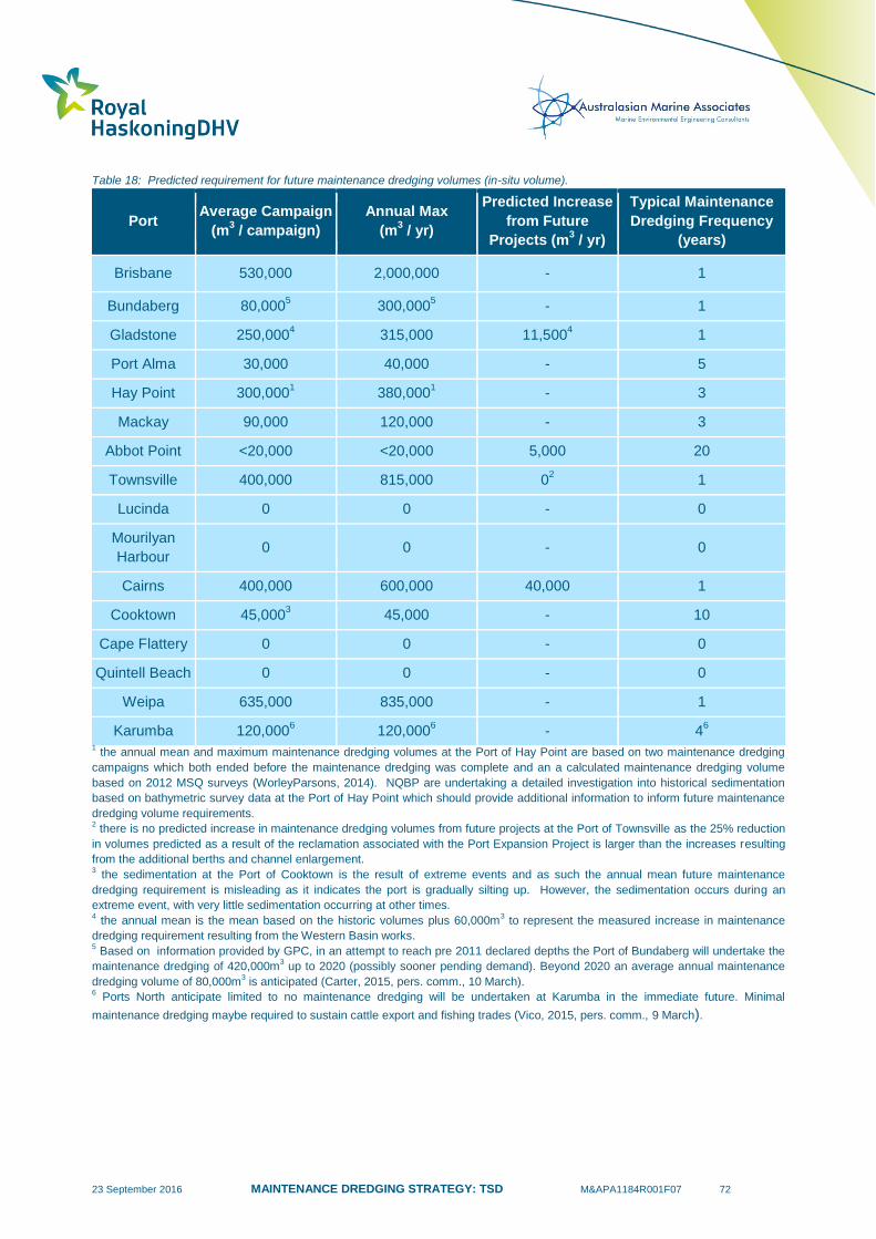
23 September 2016 MAINTENANCE DREDGING STRATEGY: TSD M&APA1184R001F07 72
Table 18: Predicted requirement for future maintenance dredging volumes (in-situ volume).
Port Average Campaign
(m3 / campaign)
Annual Max
(m3 / yr)
Predicted Increase
from Future
Projects (m3 / yr)
Typical Maintenance
Dredging Frequency
(years)
Brisbane 530,000 2,000,000 - 1
Bundaberg 80,0005 300,000
5 - 1
Gladstone 250,0004
315,000 11,5004 1
Port Alma 30,000
40,000 - 5
Hay Point 300,0001
380,0001
- 3
Mackay 90,000 120,000 - 3
Abbot Point <20,000 <20,000 5,000 20
Townsville 400,000 815,000 02 1
Lucinda 0 0 - 0
Mourilyan
Harbour 0 0 - 0
Cairns 400,000 600,000 40,000 1
Cooktown 45,0003
45,000 - 10
Cape Flattery 0 0 - 0
Quintell Beach 0 0 - 0
Weipa 635,000 835,000 - 1
Karumba 120,0006 120,000
6 - 4
6
1 the annual mean and maximum maintenance dredging volumes at the Port of Hay Point are based on two maintenance dredging
campaigns which both ended before the maintenance dredging was complete and an a calculated maintenance dredging volume
based on 2012 MSQ surveys (WorleyParsons, 2014). NQBP are undertaking a detailed investigation into historical sedimentation
based on bathymetric survey data at the Port of Hay Point which should provide additional information to inform future maintenance
dredging volume requirements. 2 there is no predicted increase in maintenance dredging volumes from future projects at the Port of Townsville as the 25% reduction
in volumes predicted as a result of the reclamation associated with the Port Expansion Project is larger than the increases resulting
from the additional berths and channel enlargement. 3 the sedimentation at the Port of Cooktown is the result of extreme events and as such the annual mean future maintenance
dredging requirement is misleading as it indicates the port is gradually silting up. However, the sedimentation occurs during an
extreme event, with very little sedimentation occurring at other times. 4 the annual mean is the mean based on the historic volumes plus 60,000m
3 to represent the measured increase in maintenance
dredging requirement resulting from the Western Basin works. 5 Based on information provided by GPC, in an attempt to reach pre 2011 declared depths the Port of Bundaberg will undertake the
maintenance dredging of 420,000m3 up to 2020 (possibly sooner pending demand). Beyond 2020 an average annual maintenance
dredging volume of 80,000m3 is anticipated (Carter, 2015, pers. comm., 10 March).
6 Ports North anticipate limited to no maintenance dredging will be undertaken at Karumba in the immediate future. Minimal
maintenance dredging maybe required to sustain cattle export and fishing trades (Vico, 2015, pers. comm., 9 March).
23 September 2016 MAINTENANCE DREDGING STRATEGY: TSD M&APA1184R001F07 73
4.6.3 Management or Engineering Maintenance Dredging Reduction Options
Both PIANC and the USACE have produced documents providing guidelines for the best practise
approaches to minimising harbour and channel sedimentation (USACE, 2003; PIANC, 2008a). Both
guidelines note that port specific investigations are required to assess the applicability of the approaches
on a case by case basis as the suitability is dependent on the port configuration, sediment type, natural
environment and processes.
A summary of the approaches which the guidelines recommend is provided in Table 19.
Table 19: Outline of strategies to reduce future maintenance dredging requirements.
Strategy Approach Example
Keep Sediment Out
Stabilise sediment sources Reduce sediment input through better
catchment management.
Diverting sediment-laden
flows Diverting river inputs away from port.
Trapping sediment before it
enters port Sediment traps and insurance trenches.
Blocking sediment entry Pneumatic barrier, silt screen, barrier curtain.
Keep Sediment Moving
Structural solutions to train
natural flows
Training walls/dikes to divert flow and prevent
local deposition of sediment.
Devices to increase bed
shear stresses
Hydraulic jets, vortex foil arrays, mechanical
agitators (e.g. spider dredging system).
Methods to reduce sediment
flocculation
Adopting designs which reduce turbulence
(e.g. solid wharf walls instead of piling
supported wharfs).
Keep Sediment Navigable
Adopt a ‘nautical depth’
navigation approach which
includes fluid mud
Nautical depth is the distance from the water
surface to a given wet density, typically in the
range of 1100 to 1300 kg/m3.
As detailed in Section 4.3, the ports already adopt a number of the approaches detailed in Table 19 to try
and reduce their maintenance dredging volumes. A number of the approaches detailed in Table 19 which
the ports do not currently adopt could be considered in the future as possible approaches to further reduce
maintenance dredging:
Keep Sediment Moving
o Training structures: these are used worldwide to help prevent deposition and help keep
sediment in suspension. The structures could include transverse training walls and
specialised training structures such as curved deflector walls. This approach could be
applicable in a range of environments but a detailed understanding of the existing tidal
currents and sediment transport pathways would be required to determine if the approach
would be suitable.
o Increase bed shear stresses: this approach aims to minimise the time that deposited
material remains on the bed by artificially increasing the bed shear stress and therefore
promoting resuspension. The bed material can be agitated by a variety of ways, including
hydraulic jets, vortex foil arrays and mechanical agitators. The material would typically be
resuspended during a certain stage of the tide to allow the tidal currents to remove the
23 September 2016 MAINTENANCE DREDGING STRATEGY: TSD M&APA1184R001F07 74
sediment from the area. This approach is aimed at replicating the natural resuspension
which would occur if the dredged areas were not present; as such it does result in a local
increase in turbidity. The approach is only applicable in berths and harbours; it would not
be feasible in aprons or channels.
Keep Sediment Navigable: extensive testing in Rotterdam and Antwerp harbours demonstrated
that vessels can safely navigate through layers of fluid mud more than 1.8m thick when the wet
density is less than 1200kg/m3 (Johnson et al., 2010). Based on this the seabed is described on
navigation charts as being where the wet density is more than 1200kg/m3. This approach could
be applicable in some areas of the ports within the GBRWHA where the sedimentation is
predominantly fine silt and clays (typically only localised areas of any port). In areas where the
deposited sediment is made up of coarser material this approach is not applicable. However, this
approach will disturb the fluid mud deposits and result in localised turbidity plumes. Monitoring of
pilot studies would be required to determine if the frequency and intensity of these plumes pose a
greater risk to local environmental values compared to the plumes resulting from periodic
maintenance dredging.
Detailed site specific investigations would be required to determine if any of these approaches could be
beneficial at any of the ports in Queensland. As part of these investigations, indicative costs, timings and
any potential impacts should be outlined to assess the relative feasibility of the options. Due to the site
specific nature of the Keep Sediment Moving options and their relative scale it is not possible to provide
costs or timings at this stage.
Detailed site specific investigations would be required for the Keep Sediment Navigable option, but if this
approach to navigation was deemed feasible and did not result in increased environmental impacts
compared to maintenance dredging then the option would not have any additional costs as it is just a
change in the navigational approach.
These options have already been considered by a number of ports as part of previous approvals
applications and will continue to be reviewed as part of any future applications. If any are deemed
appropriate from a cost, timing, environment and safety perspective then they may be adopted.
4.7 Summary
Based on the existing requirements of the maintenance dredging in Queensland, and specifically the
GBRWHA, the TSHD Brisbane is well suited as it is based locally and therefore well placed to respond to
post cyclone restoration if necessary. The vessel has been subject to regular improvement since it was
built in 2000 and as such it has state of the art environmental mitigation measures, including a green valve
to minimise turbidity plumes while operating in overflow mode, which are similar to other modern TSHD
vessels. If the maintenance dredging requirements of the ports in Queensland increase significantly in the
future (this is further discussed in Section 4.6) then a larger TSHD which is capable of dredging at a
faster rate could be beneficial over the TSHD Brisbane, to ensure the vessel can meet the dredging
requirements.
There has been significant inter-annual variability in the historical maintenance dredging requirements at
the majority of the ports within the GBRWHA which require regular maintenance dredging. The variability
is driven by the metocean conditions and the occurrence of extreme events such as cyclones and in some
cases flood events and as such it is not possible for the ports to control or accurately predict their future
maintenance dredging requirements. The frequency of maintenance dredging at the different Queensland
Ports are as follows:
Frequent (annual): at six ports, the Ports of Brisbane, Bundaberg, Gladstone, Townsville, Cairns
and Weipa;
23 September 2016 MAINTENANCE DREDGING STRATEGY: TSD M&APA1184R001F07 75
Regular (2 – 5 years): at two ports, the Port of Hay Point and Mackay;
Episodic (extreme events): at one port, Port of Cooktown;
Irregular (>5 years): at three ports Port Alma, Abbot Point Port and Karumba; and
No maintenance dredging: at eight ports, Ports of Maryborough, Lucinda, Mourilyan, Cape
Flattery, Quintell Beach, Thursday Island, Skardon River and Burketown.
The maintenance dredging volumes over the last 10 years should be used as an indicator of the likely
range and frequency of future maintenance dredging requirements at the ports. However, it is not
possible to use the historic volumes alone to accurately predict the future requirements and so it is not
considered realistic to adopt them to define future maintenance dredging limits. It is also important to
understand how the volumes relate to sedimentation in order to estimate future requirements, as in some
cases the annual volumes can be misleading. There are a number of proposed capital dredging projects
which have the potential to increase future maintenance dredging at the ports. The predicted increases in
future maintenance requirements range from 10% at the Port of Cairns to a predicted reduction due to
associated reclamation works at the Port of Townsville.
Historically, the majority of sediment dredged during maintenance activities has been placed at offshore
placement sites, with only a small amount placed in reclamations at the Ports of Townsville and
Cooktown. The offshore placement sites which have been used at the ports to date have been a mix of
retentive and dispersive sites.
The ports are proactive and already adopt a number of strategies to try to minimise maintenance dredging
requirements. There are limited additional options which could be adopted in the ports in the GBRWHA to
try to reduce future maintenance dredging requirements. Details of a few possibilities which could be
applicable at some locations have been provided. Detailed site specific investigations would be required
and possible trialling prior to the implementation of these options since if they were wrongly adopted, they
could potentially increase the maintenance dredging requirements or result in adverse environmental
impacts.
Based on the results of this section the following observations are made:
in-situ volumes would be the most suitable standard measure to describe maintenance dredging
quantities in the future. This volume can be accurately measured before and after the dredging
and can be used to provide an accurate measure of maintenance dredging. However, in some
cases, such as when determining volumes for long channels which require limited maintenance
dredging, it may be more applicable to adopt the in hopper volume;
measures to incorporate environmental windows into the maintenance dredging schedule should
be implemented in situations where there is significant potential to reduce environmental impacts;
it is important to have an understanding of the sediment transport processes at the ports which
have a regular maintenance requirement to put the maintenance dredging into context with the
natural environment. This should consider all significant sediment sources and historic changes in
bathymetry and shoreline position;
the prevailing metocean conditions control the maintenance dredging volumes and these cannot
be controlled or predicted by the ports. Historical volumes can be used to indicate the likely
volumes and dredging frequency required for the ports to maintain design depths but cannot be
used to completely predict future requirements;
future maintenance dredging volume estimates need to take into account the spatial and temporal
variability in sedimentation rates at the ports and, even so, flexibility should be retained so that
applications for adjustments to volumes can be considered in the event of extreme situations,
such as the occurrence of cyclones; and

23 September 2016 MAINTENANCE DREDGING STRATEGY: TSD M&APA1184R001F07 76
the existing approvals process includes assessment of changes (future maintenance dredging
requirements) resulting from proposed development projects, which is considered a suitably
robust approach to understand any increases in future maintenance dredging.
23 September 2016 MAINTENANCE DREDGING STRATEGY: TSD M&APA1184R001F07 77
5 Beneficial Reuse and On-land Disposal of Dredge material
5.1 Introduction
Beneficial reuse can be defined as using dredge material for a purpose that provides social, economic or
environmental benefits (or a combination of these). That is, the dredge material is managed as a valuable
resource rather than a product destined for disposal. Beneficial reuse can involve the placement of
dredge material on-land and in the aquatic zone (i.e. underwater or in intertidal areas). Consideration of
beneficial reuse in the Queensland context to date has been focused on applications that provided
economic benefits such as on-land processing and industry reuse or land reclamation.
It is important to note that the on-land placement of dredge material does not always constitute beneficial
reuse. On-land disposal of dredge material can be defined as the placement of material on-land in a way
that does not provide any wider benefit other than finding a destination for long-term or permanent storage
of the material. Examples of on-land disposal include placement of dredge material within a licenced
landfill site or a purpose-built confined disposal facility (e.g. large bunded area established for dewatering,
settling and permanent containment of dredge material). It should be noted that on-land disposal
generally involves bringing ashore significant quantities of maintenance dredge material (primarily fine
sediments) for storage, which can result in the receiving lands being sterilised for decades and the
requirement for costly ground improvement measures to be implemented to enable future land use.
It should be noted that sea disposal of dredge material under certain conditions can be considered as
beneficial reuse. This could be due to environmental benefits derived from:
sustaining natural processes of sediment supply and movement by returning sediments into the
active coastal system (e.g. dispersive placement sites);
strategic placement in specific seabed areas to benefit nearby foreshore areas by using natural
sediment transport processes to rework and redistribute the material (e.g. to progressively build
up intertidal mudflats or sand reserves on beaches); and,
creation of topographic relief with dredge material placed on the seabed to establish aquatic
habitat.
As such, current practices which involve the disposal of maintenance dredge material at dispersive
offshore DMPA’s1 may therefore be viewed as beneficial reuse provided that the dispersion of placed
dredge material is not having an adverse effect on the surrounding natural environment.
Recent legislative requirements banning the offshore disposal of capital dredge material in the GBRWHA
has placed focus on the consideration of opportunities for maintenance dredge material to also be
disposed of on-land. When considering this, it is important to keep in mind that capital dredging involves
the removal of deep, hemmed sediments from the seabed, whereas a significant proportion of
maintenance dredging material will occur within the dynamic sediment zone.
Maintenance dredge material should not be considered as ‘spoil’, but rather be considered an integral part
of the natural sediment system. Therefore, the consequences of the net removal of natural material from
the active sediment system need to be assessed in detail when considering the on-land disposal of
1 DMPA refers to a Dredge Material Placement Area and, in the context of this report, is exclusively referring to an offshore disposal
location. Whilst an onshore disposal site could also, technically, be referred to as an onshore DMPA, this is not common practice and, hence, when an onshore disposal site is discussed, it is noted as such.
23 September 2016 MAINTENANCE DREDGING STRATEGY: TSD M&APA1184R001F07 78
maintenance dredge material, particularly where this material may otherwise provide net environmental
benefit.
The following sections evaluate the potential for beneficial reuse of maintenance dredge material within
ports adjoining the GBRWHA, including both on land and at sea options. In addressing this, the sections
include:
a review of dredge material sediment properties at each port;
a review of constraints and opportunities applicable to beneficial reuse in the GBRWHA;
a review of international best practice and current Australian practices;
a review of on-land disposal limitations for GBR Ports;
an assessment of both on-land and aquatic beneficial reuse opportunities at GBR ports; and,
an appraisal of environmental impacts associated with different disposal options.
5.2 Dredged Sediment Characteristics
The opportunity for beneficial reuse of maintenance dredge material is highly dependent on the sediment
properties of the materials dredged. This includes the engineering properties of the sediment as well as
the presence of any contaminants/toxins or acid sulfate soils (ASS).
The sediment characteristics of maintenance dredge material found within selected ports where regular
maintenance dredging has occurred is summarised in this section, with further details provided in
Appendix C. This includes physical, geochemical and acid sulfate soils properties, and is based on a
review of relevant documents including Long Term Dredging Management Plans, Sediment SAP
(Sampling and Analysis Program) Implementation Reports and Sea Dumping Permit Applications
available from each of these ports. The data presented in the sediment SAP’s provides the best current
available information on the properties of the sediments that may be dredged within port areas.
A high level summary of the sediment characteristics within the above ports is provided in Table 20. This
indicates that most ports have areas where sandy material (typically with a significant clay/silt content)
exists within maintained navigation areas. However, this information needs to be interpreted with care as it
includes sediment data from the entire port footprint, and is not limited to typical maintenance dredging
areas that are susceptible to sedimentation. Typically, when the results from the sediment sampling are
considered in relation to the areas where historic sedimentation has occurred, the areas where
sedimentation has occurred are predominantly made up of fine sediments (silts and clays) with only small
amounts of coarser material. Furthermore, where sandy sediments exist it may not be possible to
efficiently selectively dredge these areas or to separate the sand from any fine grained material also
present in the sediment.
23 September 2016 MAINTENANCE DREDGING STRATEGY: TSD M&APA1184R001F07 79
Table 20: Summary of maintenance dredged sediment characteristics at selected ports
Port Sand/Gravel1 Clay/Silt Suitable for Unconfined Sea Disposal PASS Identified
Port of Gladstone Yes Yes Yes, all areas. Yes
Hay Point Port Yes Yes Yes, subject to current GBRMPA review. Unknown
Mackay Port No Yes Yes, all areas. Yes
Port of Townsville Yes Yes
Yes, except some berth areas within the
Inner Harbour due to elevated levels of
heavy metals (Copper and Nickel)2, and
within the Marine Precinct and Ross
Creek due to assumed high levels of
contaminants (not tested).
Yes
Port of Cairns Yes Yes Yes, all areas. Yes 1 Typically this only represents a relatively minor percentage of overall maintenance dredge volumes.
2 Elutriate testing determined that contaminants were predominantly bound to particulate matter and so would have been suitable for
unconfined sea disposal, but PoTL adopted a precautionary approach and placed this material on land.
All of the ports have areas where soft clay/silt material exists. When tested, this fine material is often
characterised as potential acid sulfate soil (PASS). Based on the results of sampling and testing regularly
undertaken by ports, maintenance dredge material is generally considered to be uncontaminated and
suitable for unconfined sea disposal in accordance with the NAGD. Some exceptions exist in localised
areas, typically adjacent to berths, where elevated levels of TBT and heavy metals have resulted in the
material being considered unsuitable for unconfined sea disposal.
Given that variability is evident in the composition of sediments that exist in port areas, it is considered
that it would be beneficial to develop port and regional sediment distribution maps. This information would
benefit the understanding of sediment transport and deposition processes suggested in Section 4.7 and
could potentially allow for planning of maintenance dredging activities to facilitate implementation of
customised beneficial reuse and disposal outcomes in specific port areas. Mapping of sediment
distribution can be achieved by targeted sediment sampling programs or by geophysical investigation
techniques. The value of these sediment distribution maps will vary between each port as intermixing of
different material pathways at different times can result in thin/irregular layers of opportunistic materials.
These thin layers of usable material can be difficult to map and furthermore be difficult and inefficient to
extract with typical dredging equipment.
5.3 Opportunities and Constraints
The consideration of alternatives to sea disposal is a requirement of the application process under the
Environment Protection (Sea Dumping) Act 1981. As such, the identification of opportunities and
constraints for beneficial reuse of dredge material is included in Sea Dumping Permit Applications and is
also typically contained within Long Term Monitoring and Management Plans and Sampling and Analysis
Plan Implementation Reports that document the assessment process for the disposal of maintenance
dredging material.
Through the detailed review of dredged sediment characteristics provided in the previous section, the
following realistic opportunities and constraints may apply to the management of dredge material in
GBRWHA ports.

23 September 2016 MAINTENANCE DREDGING STRATEGY: TSD M&APA1184R001F07 80
Opportunities
existing sites that have been approved or established for land reclamation activities (e.g. existing
bunded areas);
sandy maintenance dredging material that has suitable engineering properties for use as fill in port
development;
small-scale reclamation along developed waterfront areas to create foreshore parks;
creation or restoration of coastal habitats with dredge material (e.g. bird roosting areas, intertidal
areas, wetlands); and,
returning dredged sediments back to the active coastal/estuary system (e.g.
downstream/downdrift placement of materials, beach nourishment).
It is important to note that these particular opportunities may not all prove to be viable at this point in time.
However, under changes in factors such as: environmental values, port development requirements or
advancements in material processing technology, these opportunities may become credible options in the
future and should be continually reassessed.
Constraints
Sediment characteristics:
o silts and clays that have poor engineering properties for use as fill in port development
and have limited application for agricultural reuse due to fine grain size and salinity;
o geochemical properties of maintenance dredge material (i.e. comparison against
applicable best practice guidelines for sediment and elutriate water quality, refer
Section 3.4);
o maintenance dredge material that is PASS would acidify once exposed to air unless
neutralised with additives such as agricultural lime; and,
o maintenance dredge material that is PASS and is exposed to oxygenated waters can also
acidify.
Environmental issues:
o land reclamation over intertidal and sub-tidal coastal lands can result in habitat loss and
the requirement for compensatory measures such as payment of compensation fees,
provision of offsets (e.g. creation of compensatory habitat elsewhere), monitoring and
research programs, and provision of public facilities;
o land reclamation of coastal lands can reduce public access to habitats (e.g. mudflats and
mangroves), potentially affect recreational fishing and reduce the aesthetic appeal of the
waterfront;
o potential impacts of the disposal of saline dredging waters into terrestrial and freshwater
environments (e.g. groundwater interaction);
o mobility of elevated turbidity plumes created during subaqueous disposal activities and
proximity to sensitive environmental areas;
o turtle nesting areas on beaches;
o high environmental values of shoreline areas surrounding ports (World Heritage Area);
o limited availability of degraded habitats requiring restoration in close proximity to port
areas;
o requirement for a unique regulatory process as the current approvals process would
constrain the opportunity for coastal habitat creation/regeneration within both the
GBRWHA and the GBRMP;

23 September 2016 MAINTENANCE DREDGING STRATEGY: TSD M&APA1184R001F07 81
o trialling of new disposal methods which focus on keeping the material active in the
sediment system through disposal in the aquatic zone will require a comprehensive
approval assessment and significant collaboration with regulatory authorities; and,
o complete life cycle (long term) impacts resulting from the on-land relocation of dredged
material (e.g. additional greenhouse gas emissions, resource consumption, and adverse
human health impacts).
Coastal/estuary processes:
o fate of material resuspended from dispersive subaqueous disposal areas;
o compatibility of dredged sediments with the grain size distribution of natural beach sands
(i.e. beach nourishment applications);
o impacts of removing sediments from the active coastal system and placement in non-
dispersive subaqueous disposal areas or within on-land disposal and reclamation areas;
and,
o ecological connectivity between the catchments and the reef (coastal ecosystems,
including the terrestrial-side of the coastal fringe in the form of wetlands, play a critical role
in the long-term health and sustainability of the reef through improving water quality,
providing nurseries for juvenile stages of keystone reef fish species, and a suite of other
contributing functions and processes. By utilising coastal lands for land-based disposal of
dredge material, these areas could suffer further losses.).
Land availability:
o restrictions on clearing vegetation onshore under the Vegetation Management Act 1999;
o on-land disposal can result in sterilisation of valuable industrial and agricultural land for
extended periods of time;
o existence of conservation areas, national parks, state parks, marine parks and heritage
sites;
o existing and planned future land use (e.g. industrial, commercial and residential
development);
o steepness of local land topography;
o large quantities of maintenance dredge material that needs to be managed; and,
o availability of extensive land areas required for creation of settlement ponds and drying of
dredge material in close proximity to ports.
Operational constraints:
o operational limitations of the TSHD Brisbane to pump maintenance dredge material into
reclamation areas (e.g. pumping distance limitations, availability of wharf facilities for tie
up);
o high mobilisation/demobilisation costs and uncertain availability associated with using
dredgers other than the TSHD Brisbane;
o unfavourable climate for evaporative drying of dredge material disposed on-land;
o availability and proximity of drainage channels, creeks, rivers or waterbodies for discharge
of turbid and saline return water during on-land sediment dewatering activities and
potential environmental impacts;
o remote location of ports and logistical challenges and required infrastructure associated
with transporting material to developed areas for beneficial reuse applications; and,
o proximity of existing landfill sites and sustainability issues associated with disposal of
dredge material within landfill sites with finite capacity for receipt of material.
23 September 2016 MAINTENANCE DREDGING STRATEGY: TSD M&APA1184R001F07 82
Economic constraints:
o costs of on-land disposal or reclamation are often significantly higher than sea disposal;
o limited demand within local industry (e.g. high value of regional agricultural soils and
adequate supply from existing extractive industries) and poor price competitiveness of
products created from processed dredge material;
o high cost of ground improvement measures associated with land reclamation with fine
grained material (e.g. surcharging, wick drains); and,
o high cost of protecting land reclamation areas from storm surge and cyclonic activity (e.g.
rock protection).
In summary, the nature of the dredged sediments results in greater constraints than opportunities. These
constraints particularly relate to the ability to develop beneficial reuse opportunities that may have direct
economic benefit, such as being able to commercialise (i.e. sell on) the material and/or use it for land/port
reclamation activities which could further enhance economic growth.
The relatively poor physical properties of the dredge material limit its applicability for reuse applications
without significant improvement involving on-land processing. In addition, the significant volume of fine
materials dredged at the ports on a regular basis would present significant logistical challenges related to
identification of suitable locations for disposal and the large areas required to manage the material on-land
(refer Section 5.5). Hence, on-land disposal is likely to be a difficult, expensive and unsustainable
process for maintenance dredged materials.

23 September 2016 MAINTENANCE DREDGING STRATEGY: TSD M&APA1184R001F07 83
5.4 Review of International and National Best Practice
5.4.1 International Practice
Beneficial reuse and on-land disposal of dredge material is practiced worldwide, with guidance and case
studies documented in a number of publications. This international guidance material has been prepared
by large industry bodies including Construction Industry Research and Information Association (CIRIA),
Permanent International Association of Navigational Congresses (PIANC), U.S. Army Corps of Engineers
(USACE) and International Association of Dredging Companies (IADC). These organisations have been
promoting the consideration of beneficial uses for dredge material over several decades. A selection of
relevant guidance documents include:
Beneficial Uses of Dredge material (USACE, 1987);
Beneficial Uses of Dredge material: A Practical Guide (PIANC, 1992);
Dredge material Management Guide (PIANC, 1997);
Summary of Available Guidance and Best Practices for Determining Suitability of Dredge material
for Beneficial Uses (USACE, 2007a); and,
Dredge material as a Resource: Options and Constraints (PIANC, 2009a).
A recent international focus has been on ‘Working with Nature’ principles. The ‘Working with Nature’
concept was developed by PIANC (2008b) and calls for the consideration of project objectives firstly from
the perspective of the natural system rather than from the perspective of technical design. This approach
necessitates an in-depth understanding of the natural environment, including the natural processes that
support ecosystems and maintain the physical environment. In the context of dredge material disposal,
this could involve using natural processes to dictate where material moves and deposits to provide
positive environmental outcomes. There are a number of examples where this approach has been
applied successfully in European ports, particularly in the United Kingdom and The Netherlands.
A similar philosophy is promoted as ‘Building with Nature’ by IADC (2010) and as ‘Engineering with
Nature’ by USACE. USACE has a dedicated Engineering with Nature program, which has supported
numerous dredge material disposal projects involving restoration and rehabilitation of degraded
environmental habitats. In the United States, USACE is responsible for the maintenance of federal
navigation channels and is able to use available research and project funding to implement and monitor
beneficial reuse schemes in collaboration with the US Environmental Protection Agency (USEPA).
Beneficial reuse applications can be considered within three categories that comprise: Engineered and
Product Uses; Agricultural and Related Uses; and Environmental Enhancement (SKM, 2013). The
feasibility of dredge material reuse options is highly dependent on the physical and geochemical
properties of the material. As outlined previously, maintenance dredge material within the main ports
adjoining the GBRWHA typically consists of soft silts and clays, some areas of sand containing a
significant fines content, and is generally uncontaminated. Table 21 has been adapted from USACE
(2007a) and summarises potentially suitable reuse applications for dredge material according to sediment
type.

23 September 2016 MAINTENANCE DREDGING STRATEGY: TSD M&APA1184R001F07 84
Table 21: Suitability of dredge material sediment types for beneficial reuse applications
Beneficial Reuse Application Dredge material Sediment Type
Silt / Soft Clay Sand & Gravel
Engineered and Product Uses
Land creation PS PS
Land improvement PS PS
Berm creation NS PS
Shore protection NS PS
Replacement fill NS PS
Beach nourishment NS PS
Capping NS PS
Construction materials PS PS
Agricultural and Related Uses
Aquaculture PS NS
Topsoil PS NS
Environmental Enhancement
Wildlife habitats PS PS
Fisheries improvement PS PS
Wetland restoration PS NS
Sustainable Relocation PS PS
PS = Potentially Suitable
NS = Not suitable
Example applications are outlined below for each beneficial reuse category. When reviewing international
practices, it is important to note that the GBRWHA is not directly comparable to most other international
settings where on-land disposal or beneficial reuse practices have been adopted. Most coastal fringe land
in the GBRWHA has relatively high conservation value and there is a lack of degraded ecosystems
providing opportunities for restoration or rehabilitation. As such, practices involving the placement of
dredge material onshore are generally not suitable options for GBR ports.
23 September 2016 MAINTENANCE DREDGING STRATEGY: TSD M&APA1184R001F07 85
Engineered and Product Uses
Engineered and product uses include a wide range of applications that make use of dredge material as a
resource in construction for commercial, industrial or project-specific engineering purposes. Examples of
these uses include:
Land creation – Filling, raising and protecting an area which is otherwise periodically or
permanently submerged, otherwise known as land reclamation. This practice involves significant
economic investment (generally above the expenditure that would be considered appropriate for
maintenance dredging works) and therefore is only viable when coupled with larger port
development projects.
Land improvement – Filling of land that is not currently adequate for a planned use or that
requires raising of existing levels for the purpose of flood mitigation or to create elevated land in
low-lying areas for recreational, residential, commercial, or industrial use.
Berm creation – The creation of offshore berms to modify nearshore wave climate and improve
shoreline stability.
Shore protection – A typical application is beach nourishment, where sandy material that is
compatible with the natural beach sand is placed to restore retreating shoreline areas, provide
additional protection of foreshore development or assets from storm erosion events, maintain
continuity of sediment supply, create new beach areas or to improve recreational amenity (e.g.
increased beach width). In some cases, the construction of breakwater structures and shipping
channel dredging associated with port development can be the cause of foreshore erosion due to
disruption of sediment transport pathways or modification of wave and current patterns.
Replacement fill – Replacement of weak soils or contaminated soils, or filling of holes in the
landscape from mining to improve the amenity of land. Sandy material is typically used for these
applications as fine grained material (soft silts and clays) does not have suitable strength
properties for most end-use requirements.
Capping – Placement of a continuous layer of clean sediment over contaminated material that
needs to be isolated. This may be required at confined disposal facilities (bunded areas) that
have been established for storage of contaminated material on-land or below water.
Construction materials – Dredge material can be used in a range of construction products
including concrete aggregates, backfill material, production of bituminous mixtures and mortar,
construction of impermeable layers, and as raw material for manufacture of cement, bricks, rip
rap, blocks, and tile. All of these applications will require significant on-land processing of the
material to achieve the desired end product, which may include dewatering, drying, stabilisation
with cement or blending with other additives, mechanical screening to achieve required grading,
salinity management, contamination treatment and ceramic processes.

23 September 2016 MAINTENANCE DREDGING STRATEGY: TSD M&APA1184R001F07 86
Case Study: Pasir Panjang Terminal Land Reclamation, Singapore (Loh et al, 2011)
To satisfy the demand for container port facilities the Government of Singapore decided to expand the
Pasir Panang Terminal. This required the creation of 200ha of land reclamation over naturally deep
waters ranging from 20m to 30m below chart datum to create areas for landside infrastructure and 14 new
berths to accommodate Ultra Large Container Ships (ULCS). The Maritime and Port Authority of
Singapore (MPA) had the objective of sustainable port development that reduced reliance on sand as
engineering fill material, which had also become more difficult and expensive to obtain.
The reclamation was established within a containment area created by a caisson wharf line and a
landward geobund created from geotextile tubes filled with dredge material. Sand was placed in critical
areas of the reclamation design including a sand key below the caisson wall, caisson infill and backfill and
for capping of the land reclamation area. Approximately 45% of the reclamation volume comprised soft
clays and silts from maintenance and capital dredging of the port fairways, and a proportion of land-based
excavation material from major underground road and rail projects.
Dredged and excavated soft silts and clays were placed directly into the reclamation area and significant
primary and residual settlements of over 2m were accelerated by using Prefabricated Vertical Drains
(PVD) and surcharge preloading. Slurry clay infill within the reclamation area was avoided by using Grab
or clam shell dredgers to dredge clayey materials. A pilot testing area was established within a geobund
enclosure at an early stage in the project to test the performance of the proposed PVD grid spacing and
surcharge load.
Cement Mix Soil (CMS) was also used to fill the geotextile tubes used to construct geobunds around the
perimeter of the site. Dredged clayey material was blended with Portland Blast Furnace slag Cement
(PBFC) within a cement mix barge and pumped directly into geotextile tubes. Each geotextile tube as 5m
to 6m in diameter and 25m long, and was either bottom dumped onto the seabed with a modified hopper
barge of lowered into the sea using a purpose-built barge. CMS was also pumped to fill between the
geotextile tubes as part of geobund construction.
23 September 2016 MAINTENANCE DREDGING STRATEGY: TSD M&APA1184R001F07 87
Agriculture and Related Uses
Beneficial reuse of dredge material for agricultural and related uses includes its use in topsoil for
agriculture, and aquaculture activities in dredge material containment areas.
Dredge material that contains a mixture of sand, silt, clay and organic matter can be used to improve the
soil structure for agriculture. The most productive properties of topsoil for a particular application can also
be achieved by blending dredge material with other soil and the addition of reusable organic materials,
such as sewage sludge or manure. Significant on-land processing of dredge material is required before it
can be used as productive topsoil. This includes placement within large containment areas for dewatering
and drying in thin layers (0.5m to 1.0m), blending with other soils and organic additives, and transport and
mechanical spreading in thin layers over the area to be top soiled. A major limitation of dredge material
from marine and estuarine environments is its inherent salt content (salinity), as practically no agricultural
species can grow in salty soils and few in brackish soils. As such, seeding and planting would need to be
delayed until a sufficient period of drainage and natural desalination (i.e. rainfall). The presence of PASS
within dredge material is also likely to be problematic for agricultural applications due to the effect of
oxidisation on the acidity of these soils.
On-land dredge material containment facilities have been used around the world for aquaculture as they
share many common design characteristics, including perimeter bunds to retain water, construction on
relatively impervious soils and hydraulic control structures for discharge and drainage. Demand for on-
land aquaculture impoundments is driven by local and regional factors including decline of commercial
fisheries, expansion of aquaculture industries resulting in a shortage of suitable sites, and limitation of
aquaculture development in otherwise suitable locations due to lack of access, legal constraints,
competing land uses and high land costs. In both of the above applications, dredged sediment used in the
production of products for human consumption would need to be uncontaminated or contain only very low
levels of contaminants.

23 September 2016 MAINTENANCE DREDGING STRATEGY: TSD M&APA1184R001F07 88
Case Study: ‘Mud to Parks’ Project, Chicago, United States (Great Lakes Commission, 2013)
The Peoria Lakes are located within the Illinois River and receive sedimentation from an upstream
drainage area containing some of Illinois’ richest agricultural land. This sedimentation had reduced the
volume of the lakes by 77 percent and was adversely affecting navigation and recreational boating activity.
Although the sediment dredged from Peoria Lakes comprised rich agricultural soils, the demand for local
deposition as topsoil was limited due to the abundance of fertile farm land in the surrounding areas of
central Illinois.
However, a beneficial reuse application for the material was identified in Chicago following the closure of
the Chicago South Works plant by US Steel, which left a 573 acre site at the mouth of Calumet River
covered largely with slag. The site was approved for redevelopment and the muddy sediment dredged
from the Peoria Lakes was barged up the river to Lake Michigan and to the South Works site as part of a
project named ‘Mud to Parks’. The mud was offloaded from the barges, trucked on to the site and spread
over the slag. The sediment was then left to dry and subsequently graded to the desired park profile.
Following commencement of the project in 2004, 25 acres of the site was covered with dredge material
and within a year the former brownfield site was blanketed with native grasses and plants.
This practice is not viable for ports within the GBRWHA as maintenance dredge material is saline and
practically no agricultural species can grow in salty soils and only few in brackish soils.

23 September 2016 MAINTENANCE DREDGING STRATEGY: TSD M&APA1184R001F07 89
Environmental Enhancement
The use of dredge material for environmental enhancement has been widely practiced worldwide,
particularly in the United States and United Kingdom where the long history of industrial activity and port
development has resulted in substantial modification and degradation of coastal and estuarine
environments.
The identification of opportunities for environmental enhancement is site-specific and a critical success
factor in such projects is the early and continued collaboration with permit agencies, local interest groups
and environmental protection agencies. In addition to the initial identification of opportunities, these
stakeholder groups can provide valuable input into the design of dredge material placement strategies,
long-term management plans and field monitoring programs.
Examples of environmental enhancement include:
Wetland restoration or creation – Dredge material can be used to stabilise eroding natural
wetland shorelines, nourish or create intertidal mudflat areas, or nourish subsiding wetlands.
These applications are best suited to fine grained sediments (silts and clays, and silty sand),
which can be placed directly by pipeline or indirectly by using natural processes to gradually
redistribute material from subtidal areas to intertidal areas (i.e. trickle charge or sustainable
relocation). Dewatered dredge material can also be used to construct protective wind and wave
barriers to allow native vegetation to regrow in wetland areas.
Thin layer placement – There are a number of case studies in United States which have involved
‘thin layer placement’ of dredge materials on coastal wetlands that have deteriorated due to
sediment depletion, subsidence and sea level rise. This technique involves deposition of thin
layers of sediment by spraying a dredged sediment slurry under high pressure over the wetland
surface. This method improves the recovery of natural wetland vegetation and benthic organisms,
and prevents smothering of existing vegetation.
Wildlife habitats – A common example is the creation of bird nesting islands with dredge
material. This involves the creation of artificial islands by placement of dredge material in a
suitable location and at sufficient elevation and topography to provide substrate for establishment
of vegetation and support bird nesting.
Fisheries improvement – Improvements to fisheries habitat can be provided by seabed relief
created by mounding of dredge material, which has a similar effect to creation of artificial reefs.
Fish habitat can also be created by placement of dredge material to restore former seabed levels
in deep artificial depressions (e.g. borrow pits) that have developed a stagnant anoxic (i.e.
depleted of dissolved oxygen) zone that does not support aquatic life. Improvement of fish habitat
could also be provided by using dredged sediment to create new sediment platforms to act as
substrate for establishment of seagrass meadows. However, the approvals for this application,
involving unconfined shallow water disposal of dredge material, would require assessment of
impacts associated with the loss of existing habitat and are likely to be complex and lengthy.
Habitat creation has previously been proposed for beneficial reuse of sediments from capital
dredging projects at Sandringham Bay (near Hay Point) and the approvals process had a 5 year
lead time.
Sustainable Relocation – The introduction of dredge material into aquatic systems to maintain
and/or supplement sediment supply, in order to sustain the natural processes within the system
(PIANC, 2009a). This can be achieved through deliberate overflow during dredger loading,
discharge into the water column at selected sites, or the placement of the dredge material on the
bed of the aquatic system. Existing hydrodynamic processes (e.g. waves and currents) are used
to redistribute the placed material within the natural system.

23 September 2016 MAINTENANCE DREDGING STRATEGY: TSD M&APA1184R001F07 90
Case Study: Harwich Haven, United Kingdom (RHDHV, 2007)
The Harwich Haven is formed by the confluence of the estuaries of the River Orwell and River Stour and
has a long maritime history with significant development of port facilities at Felixstowe and Harwich.
There are a number of sites designated for their nature conservation significance within the Orwell and
Stour estuaries and both estuaries are designated as Sites of Special Scientific Interest (SSSI) under UK
legislation, Special Protection Area (SPA) under European legislation and are a Ramsar wetland site.
The environment studies undertaken for the 1998 to 2000 deepening of the approach channel into the
Harwich Haven identified that the effect of the deepening on tidal propagation would result in a reduced
exposure of intertidal areas. In addition, the trapping of muddy material within the deepened shipping
channel that would have otherwise been transported further into the estuary system and deposited on to
intertidal areas, was predicted to increase the rate of intertidal erosion.
In order to mitigate the predicted impacts of sediment trapping, a number of different ‘sediment
replacement’ approaches were implemented during maintenance dredging of the channel including:
Subtidal placement of fine material – placement of dredged fine sediments on to the seabed to act as
a feed of material into the estuary system;
Water column recharge – discharge of maintenance dredge material from the dredger at defined
placement locations within the estuary system that are adjacent to intertidal areas; placements are
made under specific tidal conditions that encourage material to disperse over intertidal areas; and,
Increased overflow during maintenance dredging – increasing of overflow above the normal rate to
return fine material within the estuary system.
Following trial placements and monitoring the most effective strategy was considered to rely heavily on
water column recharge at a number of licenced sites for placement of maintenance dredge material. This
water column recharge has been ongoing since the completion of the approach channel deepening
project. In addition, compensatory measures for the predicted effect on intertidal areas comprised the
creation of an intertidal area at Trimley Marshes through managed realignment of a seawall and
placement of maintenance dredged silt within the site (see photograph, below left). This realignment site
has been demonstrated through monitoring to have developed a high ecological value, and now forms
part of the designated site (SSSI, SPA and Ramsar site). As part of subsequent projects within the
estuary system, degraded/eroded intertidal areas in the lower Orwell estuary have been improved through
the placement of dredged clay and gravel at around the mean low water mark to form bunds along the
estuary foreshore and backfilling with maintenance dredged mud.
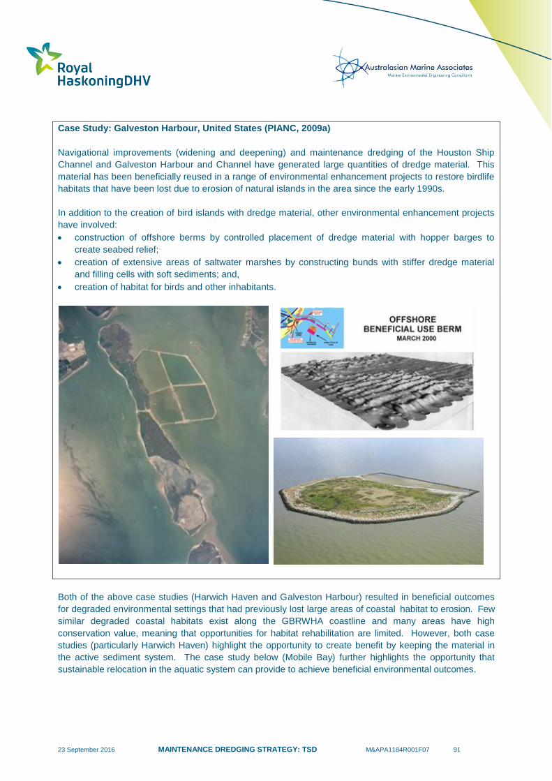
23 September 2016 MAINTENANCE DREDGING STRATEGY: TSD M&APA1184R001F07 91
Case Study: Galveston Harbour, United States (PIANC, 2009a)
Navigational improvements (widening and deepening) and maintenance dredging of the Houston Ship
Channel and Galveston Harbour and Channel have generated large quantities of dredge material. This
material has been beneficially reused in a range of environmental enhancement projects to restore birdlife
habitats that have been lost due to erosion of natural islands in the area since the early 1990s.
In addition to the creation of bird islands with dredge material, other environmental enhancement projects
have involved:
construction of offshore berms by controlled placement of dredge material with hopper barges to
create seabed relief;
creation of extensive areas of saltwater marshes by constructing bunds with stiffer dredge material
and filling cells with soft sediments; and,
creation of habitat for birds and other inhabitants.
Both of the above case studies (Harwich Haven and Galveston Harbour) resulted in beneficial outcomes
for degraded environmental settings that had previously lost large areas of coastal habitat to erosion. Few
similar degraded coastal habitats exist along the GBRWHA coastline and many areas have high
conservation value, meaning that opportunities for habitat rehabilitation are limited. However, both case
studies (particularly Harwich Haven) highlight the opportunity to create benefit by keeping the material in
the active sediment system. The case study below (Mobile Bay) further highlights the opportunity that
sustainable relocation in the aquatic system can provide to achieve beneficial environmental outcomes.
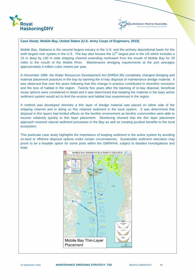
23 September 2016 MAINTENANCE DREDGING STRATEGY: TSD M&APA1184R001F07 92
Case Study: Mobile Bay, United States (U.S. Army Corps of Engineers, 2015)
Mobile Bay, Alabama is the second largest estuary in the U.S. and the primary depositional basin for the
sixth largest river system in the U.S. The bay also houses the 12th largest port in the US which includes a
15 m deep by 130 m wide shipping channel extending northward from the mouth of Mobile Bay for 29
miles to the mouth of the Mobile River. Maintenance dredging requirements at the port averages
approximately 4 million cubic metres per year.
In November 1986, the Water Resources Development Act (WRDA 86) completely changed dredging and
material placement practices in the bay by banning the in-bay disposal of maintenance dredge material. It
was observed that over the years following that this change in practice contributed to shoreline recession
and the loss of habitat in the region. Twenty five years after the banning of in-bay disposal, beneficial
reuse options were considered in detail and it was determined that keeping the material in the bays active
sediment system would act to limit the erosion and habitat loss experienced in the region.
A method was developed whereby a thin layer of dredge material was placed on either side of the
shipping channel and in doing so this retained sediment in the local system. It was determined that
disposal in thin layers had limited effects on the benthic environment as benthic communities were able to
recover relatively quickly to thin layer placement. Monitoring showed that the thin layer placement
approach restored natural sediment processes in the Bay as well as creating positive benefits to the local
ecosystem.
This particular case study highlights the importance of keeping sediment in the active system by avoiding
on-land or offshore disposal options under certain circumstances. Sustainable sediment relocation may
prove to be a feasible option for some ports within the GBRWHA, subject to detailed investigations and
trials.

23 September 2016 MAINTENANCE DREDGING STRATEGY: TSD M&APA1184R001F07 93
On-land Disposal
On-land disposal options include placement within a Confined Disposal Facility (CDF) or disposal within a
licenced landfill. CDFs comprise bunded containment areas that are purpose-built for dredge material
disposal and can be located in open waters (island CDFs), nearshore sites or on-land. The function of
CDFs is to receive dredge material, facilitate drainage of excess water (dewatering) and long term storage
of dredge material. CDFs can be constructed as a system of several different containment cells that are
linked by hydraulic control structures to facilitate dewatering processes and rotation of dredge material
discharge. Design features of CDFs can include impermeable lining, return water treatment, leachate
drainage provisions, internal bunding, ground improvement measures and capping material.
On-land CDFs are common in the United States where they are used to store dredge material from inland
waterways in areas where underwater disposal is impractical, and are referred to as ‘upland’ CDFs. In
many cases worldwide, CDFs have been constructed to isolate contaminated dredged sediment that is not
suitable for sea disposal. Placement of dredge material within CDFs is generally considered to be a non-
beneficial disposal option, unless ground improvement measures and/or capping are used to facilitate
future use of land that would otherwise be sterilised.
Disposal of dredge material to licenced landfill sites is not a sustainable option for large quantities of
material that would occupy valuable space reserved for other waste. As such, landfills are generally only
used as a destination for small quantities of contaminated dredge material. Disposal to landfills typically
requires the dredge material to be in a ‘spadable’ physical condition (i.e. capable of being handled and
stockpiled by common earthmoving equipment). To achieve this, dewatering of the dredge material is
required by the construction of settlement ponds and drying areas, or by the use of mechanical dewatering
techniques (e.g. mesh screens, hydrocyclones, centrifuges) and the blending of additives (e.g. cement,
absorbent polymers) to take up excess water content. Treatment of the dredge material to neutralise acid
sulfate soils may also be required. Due to the significant processing and rehandling of the dredge material
required, disposal to landfill is a high cost operation and usually only practiced for management of
contaminated sediments.
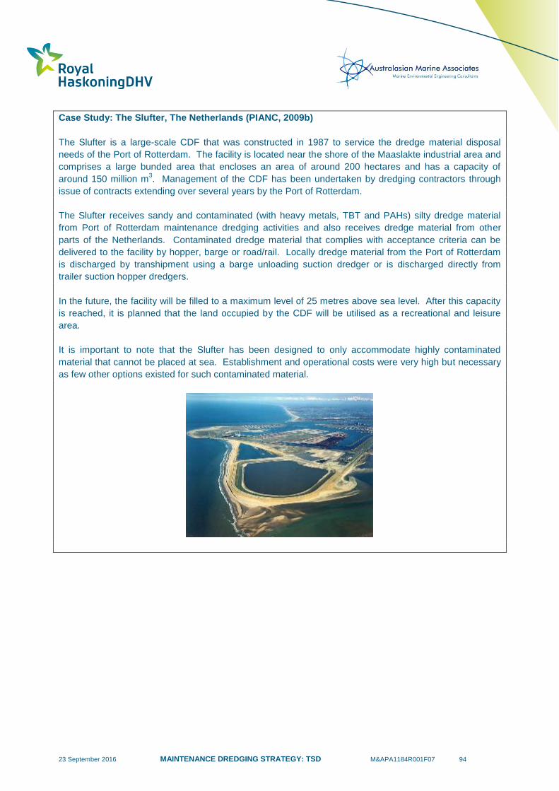
23 September 2016 MAINTENANCE DREDGING STRATEGY: TSD M&APA1184R001F07 94
Case Study: The Slufter, The Netherlands (PIANC, 2009b)
The Slufter is a large-scale CDF that was constructed in 1987 to service the dredge material disposal
needs of the Port of Rotterdam. The facility is located near the shore of the Maaslakte industrial area and
comprises a large bunded area that encloses an area of around 200 hectares and has a capacity of
around 150 million m3. Management of the CDF has been undertaken by dredging contractors through
issue of contracts extending over several years by the Port of Rotterdam.
The Slufter receives sandy and contaminated (with heavy metals, TBT and PAHs) silty dredge material
from Port of Rotterdam maintenance dredging activities and also receives dredge material from other
parts of the Netherlands. Contaminated dredge material that complies with acceptance criteria can be
delivered to the facility by hopper, barge or road/rail. Locally dredge material from the Port of Rotterdam
is discharged by transhipment using a barge unloading suction dredger or is discharged directly from
trailer suction hopper dredgers.
In the future, the facility will be filled to a maximum level of 25 metres above sea level. After this capacity
is reached, it is planned that the land occupied by the CDF will be utilised as a recreational and leisure
area.
It is important to note that the Slufter has been designed to only accommodate highly contaminated
material that cannot be placed at sea. Establishment and operational costs were very high but necessary
as few other options existed for such contaminated material.
23 September 2016 MAINTENANCE DREDGING STRATEGY: TSD M&APA1184R001F07 95
5.4.3 Australian Practice
In the Australian context, unconfined sea disposal is a widely practiced disposal method for maintenance
dredge material. This is due to a number of factors including: close proximity of many ports to the open
sea; sediments being clean or containing low levels of contaminants in accordance with the NAGD; poor
properties of soft sediments (silt and clays) for beneficial reuse; limited availability of land areas for on-
land disposal; and economic benefits. Maintenance dredge material has typically been placed in both
non-dispersive and dispersive DMPAs, with a well-established example of the latter being the DMPA used
by the Port of Newcastle, NSW.
The Port of Newcastle DMPA has been used for over a century for offshore dredge material placement
and has been the subject of numerous studies to develop and verify a conceptual model for far field
dispersion of dredge material, and to monitor environmental characteristics of the seabed. Investigations
have been completed both within the DMPA boundary and surrounding areas and have included
extensive sediment sampling and physical and chemical testing, sampling of benthic communities, remote
operated vehicle (ROV) video surveys, hydrographic surveys and sidescan sonar imagery. These studies
have determined that the mud fraction within the dredged sediments disperses from the DMPA in a south-
easterly direction before settling in water depths of 60 to 100 metres. The studies have not indicated
adverse environmental impacts from ongoing placement activities. ROV investigations determined that
the placement of dredged rock from capital dredging activities had, in fact, resulted in environmental
enhancement by providing habitat for sponges, moss animals and filamentous algae. Juvenile snapper
were also observed in the vicinity of the rocks and boulders. The Port of Newcastle currently holds a 10
year sea disposal permit for maintenance dredge material.
The Port of Newcastle’s DMPA is highly dispersive as a result of its location on the continental shelf where
there is considerable wave energy at the seabed. It is an example of sustainable relocation where
material is placed with the knowledge it will be shifted by natural processes which is acceptable because
the fate and consequences of the material movement are well understood.
Confined sea disposal has been used by several ports as a method to isolate contaminated sediments.
This practice involves ‘clean’ capping material being dredged as part of the maintenance dredging
campaign for placement on top of the disposed contaminated dredge material. Examples of this include
disposal of dredge material within underwater bunded areas constructed within the inner harbour of Port
Kembla, and the establishment of a large confined disposal facility within Port Phillip Bay, Victoria to
receive dredge material from the Port of Melbourne Channel Deepening Project and ongoing maintenance
dredge material.
Engineered and product uses have been limited to the creation of land reclamation areas. This is typically
associated with port development, where capital dredging undertaken for navigation access yields sand,
stiff clay and rock materials that have suitable engineering properties for incorporation into land
reclamation. However, there are some cases where muddy maintenance dredge material has been
placed into large bunded areas that have been established with a long-term view of future land use. An
example of this approach includes the creation of reclaimed land areas at Fishermans Island by the Port
of Brisbane, where ground improvement measures such as surcharging and wick drains are being utilised
to progressively create and release land for industrial use. Land reclamation works at Fishermans Island
also rely heavily on capital dredging of large volumes of clean sand from Moreton Bay for use as surcharge
material to enable ground improvement works to be feasible. This surcharge material is typically 1.5 to 2.5
metres thick with a portion of this surface material being left on the surface following ground improvement.
The restricted ability to undertake capital dredging of sands for surcharging works is a significant limitation
in undertaking such land reclamation activities at GBR ports.

23 September 2016 MAINTENANCE DREDGING STRATEGY: TSD M&APA1184R001F07 96
Beach nourishment has been implemented opportunistically by ports that are situated on the open coast
or have entrances that are maintained by engineered structures (e.g. breakwaters) and interrupt the
transport of marine sediments. An example of this is the periodic placement of sandy maintenance
dredge material accumulating within the entrance breakwaters at the Port of Newcastle in the nearshore
zone of Stockton Beach. Stockton Beach is located to the north of the harbour entrance and is nourished
with the natural movement of the deposited sand onshore by wave action. This activity has been found to
be more economical than unconfined sea disposal further offshore and increases sand reserves to combat
storm erosion on Stockton Beach.
In comparison to the United States and Europe, the use of maintenance dredge material for environmental
enhancement has not been widely practiced in Australia. This is due to lack of degraded ecosystems
providing opportunities for restoration or rehabilitation and the establishment of designated unconfined sea
disposal sites at most major ports. In addition, some ports are located in areas that have high
conservation and environmental values where there is a concern that placement of dredge material within
these ecosystems may not be beneficial. While European ports are also often located in sensitive
environments covered by national and international nature conservation designations, the use of
maintenance dredged silts to improve intertidal mudflats or restore eroded areas saltmarsh areas is often
considered beneficial and preferable to offshore disposal, particularly in the UK and the Netherlands.
Many of these initiatives tend only to require a modest amount of dredge material in the context of the
maintenance dredging commitment for a particular port or harbour area.
On-land disposal or landfill disposal is considered to be uneconomic by most GBR ports that manage
significant quantities of maintenance dredge material. In cases where on-land disposal has been
implemented, it has typically involved small quantities of dredge material, management of contaminated
sediments, and/or the opportunistic use of existing containment structures (e.g. associated with land
reclamation from capital dredging projects).
5.5 Potential Capacity Requirements of Land Disposal
As discussed in Section 5.3, one of the major constraints for implementation of beneficial reuse and on-
land disposal options is the availability of suitable land for placement and/or processing of dredge
material. In many cases, although permanent on-land disposal of material may not be proposed,
dewatering, drying and treatment of dredge material is required before dredge material can be used in
beneficial reuse applications. Sites for dewatering and drying of dredge material that is hydraulically
pumped onshore comprise large bunded areas that are constructed over available land with the following
characteristics:
relatively flat land;
close to existing drainage, creeks or waterbodies that can receive saline return water with a
suspended sediment load;
distant from areas subject to coastal erosion or storm surge;
have limited adverse effects on environmental values of the area;
within a reasonable distance from the dredging site to enable pumping of dredge material;
secured by fencing to address public safety issues associated with large areas of soft sediments
in the process of drying; and,
ideally located close to the final beneficial reuse site to minimise transport logistics and associated
costs.
Research undertaken by the Port of Brisbane (Fishermans Island reclamation area) and other ports (RMC,
2012) has determined that dredge material placed into drying areas in layers 1 to 1.5 metres thick will
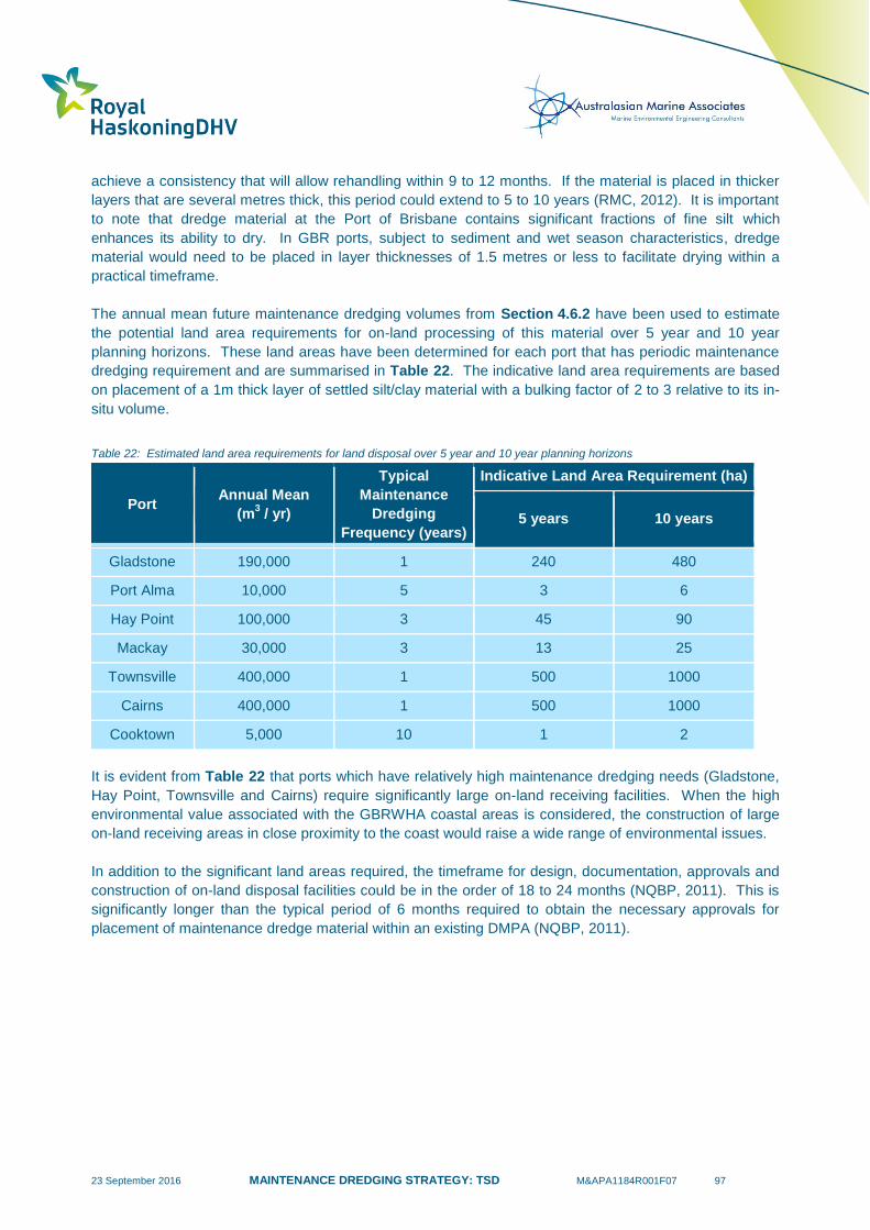
23 September 2016 MAINTENANCE DREDGING STRATEGY: TSD M&APA1184R001F07 97
achieve a consistency that will allow rehandling within 9 to 12 months. If the material is placed in thicker
layers that are several metres thick, this period could extend to 5 to 10 years (RMC, 2012). It is important
to note that dredge material at the Port of Brisbane contains significant fractions of fine silt which
enhances its ability to dry. In GBR ports, subject to sediment and wet season characteristics, dredge
material would need to be placed in layer thicknesses of 1.5 metres or less to facilitate drying within a
practical timeframe.
The annual mean future maintenance dredging volumes from Section 4.6.2 have been used to estimate
the potential land area requirements for on-land processing of this material over 5 year and 10 year
planning horizons. These land areas have been determined for each port that has periodic maintenance
dredging requirement and are summarised in Table 22. The indicative land area requirements are based
on placement of a 1m thick layer of settled silt/clay material with a bulking factor of 2 to 3 relative to its in-
situ volume.
Table 22: Estimated land area requirements for land disposal over 5 year and 10 year planning horizons
Port Annual Mean
(m3 / yr)
Typical
Maintenance
Dredging
Frequency (years)
Indicative Land Area Requirement (ha)
5 years 10 years
Gladstone 190,000 1 240 480
Port Alma 10,000
5 3 6
Hay Point 100,000
3
45 90
Mackay 30,000 3 13 25
Townsville 400,000 1 500 1000
Cairns 400,000 1 500 1000
Cooktown 5,000
10 1 2
It is evident from Table 22 that ports which have relatively high maintenance dredging needs (Gladstone,
Hay Point, Townsville and Cairns) require significantly large on-land receiving facilities. When the high
environmental value associated with the GBRWHA coastal areas is considered, the construction of large
on-land receiving areas in close proximity to the coast would raise a wide range of environmental issues.
In addition to the significant land areas required, the timeframe for design, documentation, approvals and
construction of on-land disposal facilities could be in the order of 18 to 24 months (NQBP, 2011). This is
significantly longer than the typical period of 6 months required to obtain the necessary approvals for
placement of maintenance dredge material within an existing DMPA (NQBP, 2011).
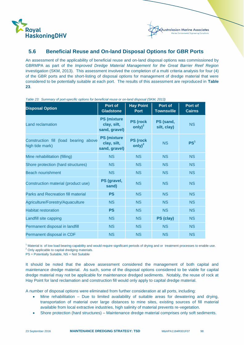
23 September 2016 MAINTENANCE DREDGING STRATEGY: TSD M&APA1184R001F07 98
5.6 Beneficial Reuse and On-land Disposal Options for GBR Ports
An assessment of the applicability of beneficial reuse and on-land disposal options was commissioned by
GBRMPA as part of the Improved Dredge Material Management for the Great Barrier Reef Region
investigation (SKM, 2013). This assessment involved the completion of a multi criteria analysis for four (4)
of the GBR ports and the short-listing of disposal options for management of dredge material that were
considered to be potentially suitable at each port. The results of this assessment are reproduced in Table
23.
Table 23: Summary of port-specific options for beneficial reuse or on-land disposal (SKM, 2013)
Disposal Option Port of
Gladstone
Hay Point
Port
Port of
Townsville
Port of
Cairns
Land reclamation
PS (mixture
clay, silt,
sand, gravel)
PS (rock
only)2
PS (sand,
silt, clay) NS
Construction fill (load bearing above
high tide mark)
PS (mixture
clay, silt,
sand, gravel)
PS (rock
only)2
NS PS1
Mine rehabilitation (filling) NS NS NS NS
Shore protection (hard structures) NS NS NS NS
Beach nourishment NS NS NS NS
Construction material (product use) PS (gravel,
sand) NS NS NS
Parks and Recreation fill material PS NS NS NS
Agriculture/Forestry/Aquaculture NS NS NS NS
Habitat restoration PS NS NS NS
Landfill site capping NS NS PS (clay) NS
Permanent disposal in landfill NS NS NS NS
Permanent disposal in CDF NS NS NS NS
1 Material is of low load bearing capability and would require significant periods of drying and or treatment processes to enable use.
2 Only applicable to capital dredging materials.
PS = Potentially Suitable, NS = Not Suitable
It should be noted that the above assessment considered the management of both capital and
maintenance dredge material. As such, some of the disposal options considered to be viable for capital
dredge material may not be applicable for maintenance dredged sediments. Notably, the reuse of rock at
Hay Point for land reclamation and construction fill would only apply to capital dredge material.
A number of disposal options were eliminated from further consideration at all ports, including:
Mine rehabilitation – Due to limited availability of suitable areas for dewatering and drying,
transportation of material over large distances to mine sites, existing sources of fill material
available from local extractive industries, high salinity of material prevents re-vegetation.
Shore protection (hard structures) – Maintenance dredge material comprises only soft sediments.
23 September 2016 MAINTENANCE DREDGING STRATEGY: TSD M&APA1184R001F07 99
Beach nourishment – Maintenance dredge material consists of a high proportion of silts and clays,
which are not suitable for nourishment of sandy beaches.
Agriculture/Forestry/Aquaculture – Due to high salt content, need for dewatering and processing,
and insufficient demand.
Permanent disposal in landfill – Due to limited availability of suitable areas for dewatering and
drying, logistics of transportation of material to landfill sites, limited landfill capacity and priority
storage for other waste materials rather than clean sediments.
Permanent disposal in CDF – Due to limited availability of land for construction of large permanent
containment areas and high environmental and industrial value of surrounding land areas.
The remaining disposal options were considered to be potentially suitable for some ports (refer Table 23)
subject to site specific technical feasibility, environmental assessment and detailed cost-benefit
evaluation. These included;
Land reclamation;
Construction fill (load bearing above high tide mark);
Construction material (product use);
Parks and recreation fill material;
Habitat restoration; and,
Landfill site capping.
It is important to note that the above listed options are not potentially suitable at all GBR ports and as such
need to be considered in the context of Table 23. If an option is listed as being potentially suitable in
Table 23 this does not necessarily imply it is a viable option either, as detailed site specific assessment of
technical, economic or environmental factors may limit its feasibility at a particular port. For example, the
Improved Dredge Material Management for the Great Barrier Reef Region investigation concluded that at
the Port of Cairns the only option that could feasibly be considered for land-based uses of dredge material
was its use as construction fill (SKM, 2013). However, due to the low load bearing capability and the
potential for ASS, significant periods of drying and/or treatment processes would be required to enable this
use. Further investigations by Ports North (2014) noted that quarry resources and cut to fill operations in
the Cairns region currently adequately meet demand for fill material and are less expensive than
processed dredge material. This demonstrates a case when a beneficial reuse option was considered to
be potentially suitable but was not found to be viable.
The above is reiterated in the findings of the SKM (2013) report which states that beneficial reuse or land
disposal at the ports listed in Table 23 is unlikely to be viable as a strategy for overall management of
dredge material in the long term. Nevertheless, it is important that site specific on-land disposal and
beneficial reuse options continue to be reassessed through applications for sea dumping permits, as
changes to environmental, technological and economic factors may render previously unsuitable practices
suitable or even viable in the future.
Based on the above review of maintenance dredged sediment characteristics and best practice, it is
considered that the concept of ‘sustainable relocation’ as an environmental enhancement measure (refer
Section 5.4.1) should be further considered as a potentially feasible disposal option for GBR Ports. As
discussed, the approach of sustainable relocation of dredge material aims to maintain existing sediment
supply within the natural system as the accumulated maintenance dredge material is part of the natural
sediment system. Therefore, any adverse effects caused by the removal of naturally active sediment
needs to be a key consideration for any on-land disposal practises, offshore disposal or disposal occurring
at non-dispersive DMPAs.
23 September 2016 MAINTENANCE DREDGING STRATEGY: TSD M&APA1184R001F07 100
For sustainable relocation practices to be considered as a progressive beneficial reuse option for
maintenance dredging at GBR ports, port/region specific investigations will need to be undertaken. These
investigations will likely need to involve detailed environmental assessments, numerical modelling
investigations, community consultations and potential trial campaigns. It is also understood there may be
some significant legislative and regulatory challenges to overcome. However, these obstacles have been
overcome elsewhere in the world (including other environmentally valuable areas) and have resulted in
successful applications with significant demonstrated environmental and operational benefits.
5.7 Beneficial Reuse and On-land Disposal Environmental Impacts
There are additional potential environmental impacts associated with different disposal options, many of
which are project-specific and require site based risk assessment of impacts and development of
appropriate mitigation and management measures. A high level overview of potential environmental
impacts under various categories, including water quality, ecological, social, physical environment, and
air/noise/odour impacts, is provided in Table 24. The table also provides high level guidance on possible
mitigation and management measures to address different impacts. It is evident that in comparison to the
potential environmental impacts within the aquatic zone that may be associated with sea disposal, there
are also a significant number of potential environmental impacts associated with beneficial reuse and on-
land disposal options.
As part of an independent synthesis of the current knowledge of the effects of dredging, a number of
potential impacts and challenges involved in disposing of dredge material on-land or in reclamations were
identified as follows (McCook et al., 2015):
Loss of coastal habitats due to the large areas required to process dredged sediment;
Run-off of seawater from the dredge material, which may contain large amounts of fine sediment,
into freshwater and coastal ecosystems; and,
Potential acid sulfate soils, with associated risks of production of sulphuric acid and the release of
quantities of potentially toxic metals such as iron and aluminium.
As such, the environmental impacts associated with beneficial reuse and on-land disposal options often
influence both the terrestrial and aquatic environment, whilst the potential impacts of sea disposal are
typically limited to the aquatic environment.
In addition to the environmental impacts presented in Table 24, it is important that impacts which may not
immediately occur are still considered (e.g. net removal of sediment from the active sediment system or
greenhouse gas emissions associated with material handling). Current dredge material placement
decisions largely focus on local and immediate environmental effects from the sediment itself. For
example, concerns for the GBRWHA are primarily focused on the immediate effects dredge material has
on corals, seagrasses and other marine life. Concentrating on immediate environmental effects can result
in wider long term effects arising from transportation and placement activities of dredge material onshore
not being adequately considered. These wider affects can have implications on climate change, resource
consumption, and environmental and human health.
Studies undertaken by Bates (2014) assess the complete lifecycle for dredged sediment placement
strategies to account for this wider range of impacts and over longer time horizons. Findings from these
works suggested that cases dealing with on-land placement options of uncontaminated sediments may be
the most environmentally burdensome alternative (per ton of placed material) due to the additional
emissions associated with additional handling of material.
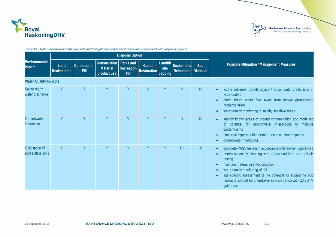
23 September 2016 MAINTENANCE DREDGING STRATEGY: TSD M&APA1184R001F07 101
Table 24: Potential environmental impacts and mitigation/management measures associated with disposal options
Environmental
Impact
Disposal Option
Possible Mitigation / Management Measures Land
Reclamation
Construction
Fill
Construction
Material
(product use)
Parks and
Recreation
Fill
Habitat
Restoration
Landfill
site
capping
Sustainable
Relocation
Sea
Disposal
Water Quality Impacts
Saline return
water discharge
Y Y Y Y N Y N N locate settlement ponds adjacent to salt water creek, river or
waterbodies
direct return water flow away from known groundwater
recharge areas
water quality monitoring in salinity sensitive areas
Groundwater
interaction
Y Y Y Y Y Y N N identify known areas of ground contamination and modelling
of potential for groundwater interactions to mobilise
contaminants
construct impermeable membranes in settlement ponds
groundwater monitoring
Oxidisation of
acid sulfate soils
Y Y Y Y Y Y U1 U1 complete PASS testing in accordance with relevant guidelines
neutralisation by blending with agricultural lime and soil pH
testing
maintain material in a wet condition
water quality monitoring of pH
site specific assessment of the potential for submarine acid
formation should be undertaken in accordance with QASSTM
guidance.
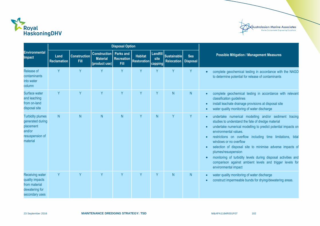
23 September 2016 MAINTENANCE DREDGING STRATEGY: TSD M&APA1184R001F07 102
Environmental
Impact
Disposal Option
Possible Mitigation / Management Measures Land
Reclamation
Construction
Fill
Construction
Material
(product use)
Parks and
Recreation
Fill
Habitat
Restoration
Landfill
site
capping
Sustainable
Relocation
Sea
Disposal
Release of
contaminants
into water
column
Y Y Y Y Y Y Y Y complete geochemical testing in accordance with the NAGD
to determine potential for release of contaminants
Surface water
and leaching
from on-land
disposal site
Y Y Y Y Y Y N N complete geochemical testing in accordance with relevant
classification guidelines
install leachate drainage provisions at disposal site
water quality monitoring of water discharge
Turbidity plumes
generated during
placement
and/or
resuspension of
material
N N N N Y N Y Y undertake numerical modelling and/or sediment tracing
studies to understand the fate of dredge material
undertake numerical modelling to predict potential impacts on
environmental values.
restrictions on overflow including time limitations, tidal
windows or no overflow
selection of disposal site to minimise adverse impacts of
plumes/resuspension
monitoring of turbidity levels during disposal activities and
comparison against ambient levels and trigger levels for
environmental impact
Receiving water
quality impacts
from material
dewatering for
secondary uses
Y Y Y Y Y Y N N water quality monitoring of water discharge
construct impermeable bunds for drying/dewatering areas.

23 September 2016 MAINTENANCE DREDGING STRATEGY: TSD M&APA1184R001F07 103
Environmental
Impact
Disposal Option
Possible Mitigation / Management Measures Land
Reclamation
Construction
Fill
Construction
Material
(product use)
Parks and
Recreation
Fill
Habitat
Restoration
Landfill
site
capping
Sustainable
Relocation
Sea
Disposal
Ecological Impacts
Loss of terrestrial
habitat
(land clearing)
Y Y Y Y N Y N N selection of dredge material processing, reclamation and
disposal sites with low ecological value
provision of compensatory habitat
site restoration and revegetation following completion of
disposal activities
Loss of intertidal
habitat
Y N N N N N N N selection of dredge material processing, reclamation and
disposal sites with low ecological value
provision of compensatory habitat
site restoration and revegetation following completion of
disposal activities
Loss of subtidal
habitat
Y N N N Y N N Y selection of dredge material processing, reclamation and
disposal sites with low ecological value
provision of compensatory habitat
placement of dredge material in areas of similar sediment
composition
placement of dredge material in thin layers to minimise
smothering and enhance the rate of vegetation recovery
monitoring of habitat loss/mortality
monitoring of recovery following disposal activities
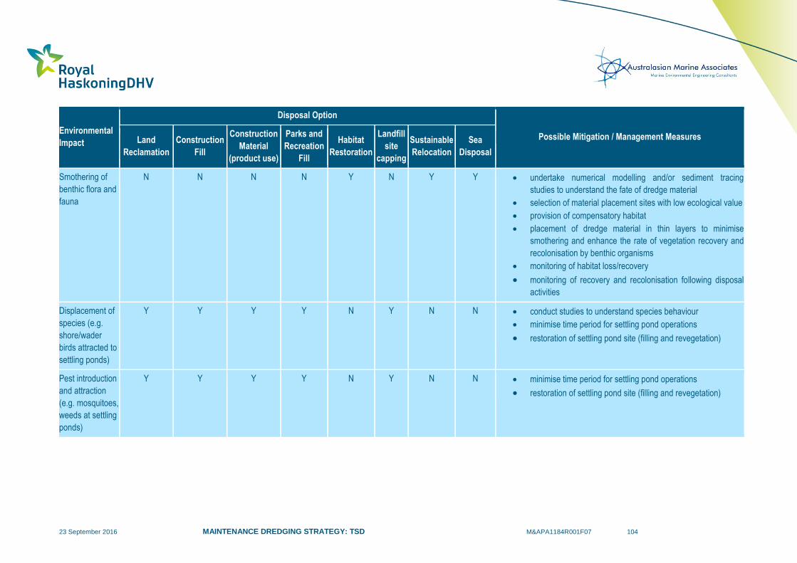
23 September 2016 MAINTENANCE DREDGING STRATEGY: TSD M&APA1184R001F07 104
Environmental
Impact
Disposal Option
Possible Mitigation / Management Measures Land
Reclamation
Construction
Fill
Construction
Material
(product use)
Parks and
Recreation
Fill
Habitat
Restoration
Landfill
site
capping
Sustainable
Relocation
Sea
Disposal
Smothering of
benthic flora and
fauna
N N N N Y N Y Y undertake numerical modelling and/or sediment tracing
studies to understand the fate of dredge material
selection of material placement sites with low ecological value
provision of compensatory habitat
placement of dredge material in thin layers to minimise
smothering and enhance the rate of vegetation recovery and
recolonisation by benthic organisms
monitoring of habitat loss/recovery
monitoring of recovery and recolonisation following disposal
activities
Displacement of
species (e.g.
shore/wader
birds attracted to
settling ponds)
Y Y Y Y N Y N N conduct studies to understand species behaviour
minimise time period for settling pond operations
restoration of settling pond site (filling and revegetation)
Pest introduction
and attraction
(e.g. mosquitoes,
weeds at settling
ponds)
Y Y Y Y N Y N N minimise time period for settling pond operations
restoration of settling pond site (filling and revegetation)
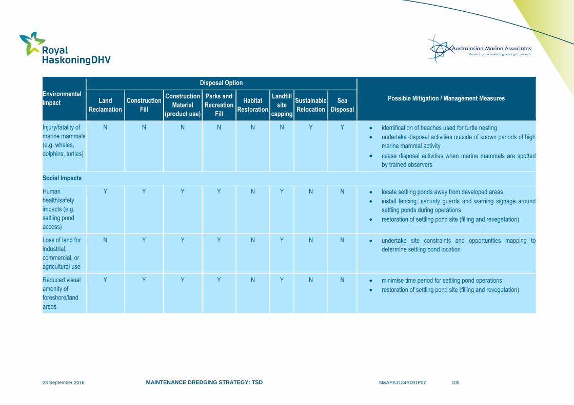
23 September 2016 MAINTENANCE DREDGING STRATEGY: TSD M&APA1184R001F07 105
Environmental
Impact
Disposal Option
Possible Mitigation / Management Measures Land
Reclamation
Construction
Fill
Construction
Material
(product use)
Parks and
Recreation
Fill
Habitat
Restoration
Landfill
site
capping
Sustainable
Relocation
Sea
Disposal
Injury/fatality of
marine mammals
(e.g. whales,
dolphins, turtles)
N N N N N N Y Y identification of beaches used for turtle nesting
undertake disposal activities outside of known periods of high
marine mammal activity
cease disposal activities when marine mammals are spotted
by trained observers
Social Impacts
Human
health/safety
impacts (e.g.
settling pond
access)
Y Y Y Y N Y N N locate settling ponds away from developed areas
install fencing, security guards and warning signage around
settling ponds during operations
restoration of settling pond site (filling and revegetation)
Loss of land for
industrial,
commercial, or
agricultural use
N Y Y Y N Y N N undertake site constraints and opportunities mapping to
determine settling pond location
Reduced visual
amenity of
foreshore/land
areas
Y Y Y Y N Y N N minimise time period for settling pond operations
restoration of settling pond site (filling and revegetation)

23 September 2016 MAINTENANCE DREDGING STRATEGY: TSD M&APA1184R001F07 106
Environmental
Impact
Disposal Option
Possible Mitigation / Management Measures Land
Reclamation
Construction
Fill
Construction
Material
(product use)
Parks and
Recreation
Fill
Habitat
Restoration
Landfill
site
capping
Sustainable
Relocation
Sea
Disposal
Impacts on
recreational or
commercial
activities (e.g.
fishing)
Y N N N N N N Y undertake site constraints and opportunities mapping to
determine settling pond location
undertake site constraints and opportunities mapping to
determine sea disposal location
consult with local stakeholder groups to understand nature of
activities
Impacts on
cultural heritage
(indigenous/non-
indigenous)
Y Y Y Y Y Y Y Y undertake site constraints and opportunities mapping to
determine settling pond location
undertake site constraints and opportunities mapping to
determine sea disposal location
consult with local stakeholder groups to understand potential
cultural heritage significance impacts
Increased
vehicular traffic
N Y Y Y N Y N N develop and designate specific haulage routes to minimise
impacts on local traffic
Physical Environment Impacts
Alteration of
coastal/estuarine
processes
Y N N N Y N N Y complete coastal/estuarine processes studies
undertake numerical modelling of hydrodynamic and sediment
transport processes to determine the extent of potential
impacts
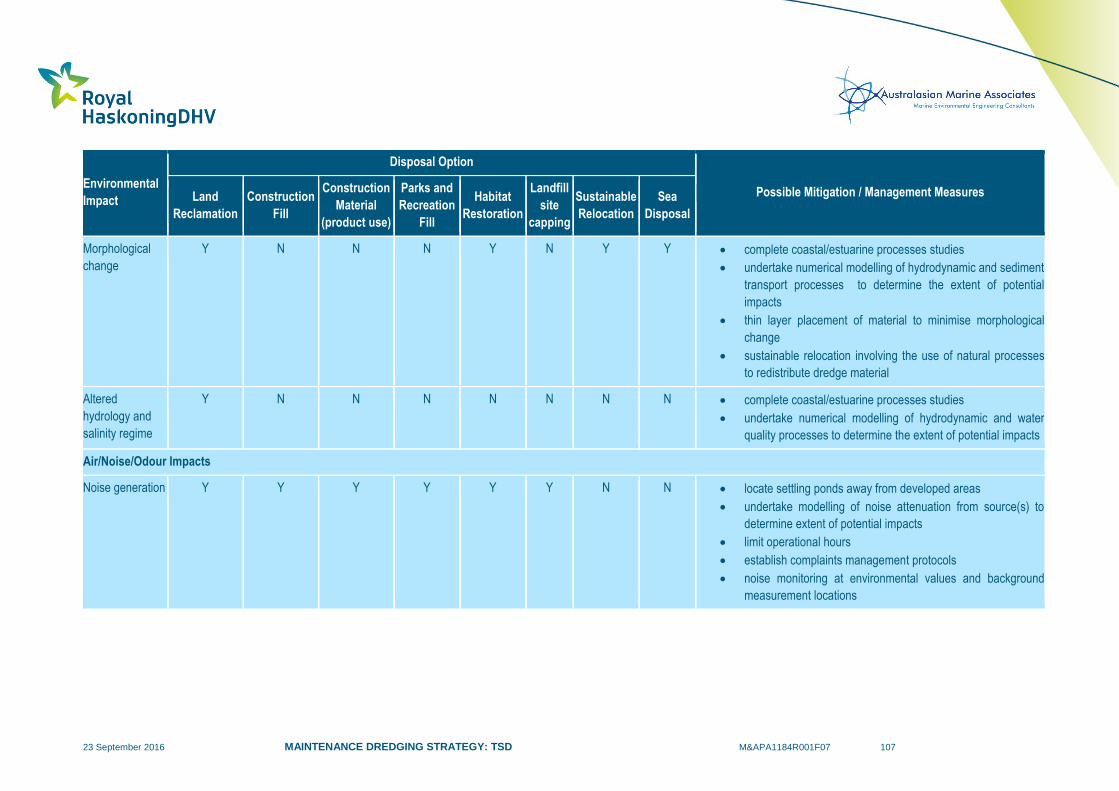
23 September 2016 MAINTENANCE DREDGING STRATEGY: TSD M&APA1184R001F07 107
Environmental
Impact
Disposal Option
Possible Mitigation / Management Measures Land
Reclamation
Construction
Fill
Construction
Material
(product use)
Parks and
Recreation
Fill
Habitat
Restoration
Landfill
site
capping
Sustainable
Relocation
Sea
Disposal
Morphological
change
Y N N N Y N Y Y complete coastal/estuarine processes studies
undertake numerical modelling of hydrodynamic and sediment
transport processes to determine the extent of potential
impacts
thin layer placement of material to minimise morphological
change
sustainable relocation involving the use of natural processes
to redistribute dredge material
Altered
hydrology and
salinity regime
Y N N N N N N N complete coastal/estuarine processes studies
undertake numerical modelling of hydrodynamic and water
quality processes to determine the extent of potential impacts
Air/Noise/Odour Impacts
Noise generation Y Y Y Y Y Y N N locate settling ponds away from developed areas
undertake modelling of noise attenuation from source(s) to
determine extent of potential impacts
limit operational hours
establish complaints management protocols
noise monitoring at environmental values and background
measurement locations
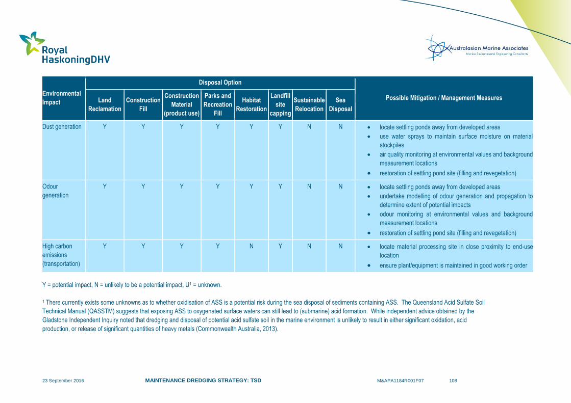
23 September 2016 MAINTENANCE DREDGING STRATEGY: TSD M&APA1184R001F07 108
Environmental
Impact
Disposal Option
Possible Mitigation / Management Measures Land
Reclamation
Construction
Fill
Construction
Material
(product use)
Parks and
Recreation
Fill
Habitat
Restoration
Landfill
site
capping
Sustainable
Relocation
Sea
Disposal
Dust generation Y Y Y Y Y Y N N locate settling ponds away from developed areas
use water sprays to maintain surface moisture on material
stockpiles
air quality monitoring at environmental values and background
measurement locations
restoration of settling pond site (filling and revegetation)
Odour
generation
Y Y Y Y Y Y N N locate settling ponds away from developed areas
undertake modelling of odour generation and propagation to
determine extent of potential impacts
odour monitoring at environmental values and background
measurement locations
restoration of settling pond site (filling and revegetation)
High carbon
emissions
(transportation)
Y Y Y Y N Y N N locate material processing site in close proximity to end-use
location
ensure plant/equipment is maintained in good working order
Y = potential impact, N = unlikely to be a potential impact, U1 = unknown.
1 There currently exists some unknowns as to whether oxidisation of ASS is a potential risk during the sea disposal of sediments containing ASS. The Queensland Acid Sulfate Soil
Technical Manual (QASSTM) suggests that exposing ASS to oxygenated surface waters can still lead to (submarine) acid formation. While independent advice obtained by the
Gladstone Independent Inquiry noted that dredging and disposal of potential acid sulfate soil in the marine environment is unlikely to result in either significant oxidation, acid
production, or release of significant quantities of heavy metals (Commonwealth Australia, 2013).
23 September 2016 MAINTENANCE DREDGING STRATEGY: TSD M&APA1184R001F07 109
An overall consideration is that all on-land disposal techniques: require significant areas of land; are
visually intrusive; and can take an extended length of time to complete, particularly if the material has poor
physical properties and requires a significant amount of reworking effort and ground improvement
measures. These are sizeable operations to undertake and would significantly impair the visual amenity
at the processing and disposal site for long periods of time. In addition, the ongoing nature of
maintenance dredging activities at some ports may require such on-land disposal facilities to operate on a
near-continuous basis. As such, maintenance dredge material is typically managed in a different manner
to capital dredge material as the latter tends to be: dredged in once-off campaigns; often involves removal
of deeper in-situ materials which may be more suitable for this purpose; and of a known quantity
(maintenance dredging volumes can vary considerably from year to year).
The costs of different disposal options are also project-specific and can be influenced by a range of factors
including sediment type, geochemical properties (e.g. contamination, PASS), pumping/transport distance,
dredging equipment used, quantity of dredging, prevailing environmental conditions, degree of material
processing required (e.g. dewatering, drying, blending with additives, separation), and construction of
supporting infrastructure (e.g. reclamation bunds, containment areas). An appraisal of the range of unit
rates that could be applied to different disposal activities has previously been undertaken by GBRMPA
(SKM, 2013) as part of the Improved Dredge Material Management for the Great Barrier Reef Region
study.
This information has been reviewed in conjunction with data obtained from other cost assessments
completed by ports, typically for the purposes of environmental assessment documentation, applications
for sea dumping permits or long term monitoring and management plans for dredge material
management. The unit rates obtained from these sources have been compiled and adjusted to 2015
dollars using variations observed in the Non-residential Building Price Index for Queensland. Comparative
unit rates are summarised in Table 25 and demonstrate that in comparison to sea disposal, the costs of
on-land disposal would be several times higher. This is mainly due to the additional costs of processing
the material to achieve a suitable state for its end use and construction of associated containment
structures (e.g. bunded areas). This presents economic justification for ports to select sea disposal or
sustainable sediment relocation as their preferred dredge material management practices.
A recent case study for comparison of land placement and sea disposal costs is provided within the Cairns
Shipping Development Project EIS (Ports North, 2014). This concluded that the costs of land placement
of capital dredge material, comprising mainly marine mud and silt, would range from $306M to $545M.
The costs of sea disposal at the existing DMPA were estimated to be $60M, subject to approved overflow
conditions and type of dredge used. In this case, the cost of land placement was 5 to 9 times higher than
sea disposal.

23 September 2016 MAINTENANCE DREDGING STRATEGY: TSD M&APA1184R001F07 110
Table 25: Comparative Unit Rates for Different Dredge material Disposal Options
Cost Item
Disposal Option
Land
Reclamation Construction Fill
Construction
Material
(product use)
Parks and
Recreation Fill
Habitat
Restoration
Landfill site
capping
Sustainable
Relocation Sea Disposal
Site Clearance N/A
$3,200 to
$4,800/ha
$3,200 to
$4,800/ha
$3,200 to
$4,800/ha N/A
$3,200 to
$4,800/ha N/A N/A
Transport1
Pump/pipeline transport to on-land disposal site $4.4 to $8/cum $4.4 to $8/cum $4.4 to $8/cum $4.4 to $8/cum N/A $4.4 to $8/cum N/A N/A
Hopper transport and offshore disposal N/A N/A N/A N/A N/A N/A N/A
$2.7 to
$3.7/cum
Small CSD pumping to underwater placement area N/A N/A N/A N/A $4.3/cum N/A $4.3/cum N/A
On-road transport by truck N/A
$0.0085 to
$0.35/cum/km
$0.0085 to
$0.35/cum/km
$0.0085 to
$0.35/cum/km N/A
$0.0085 to
$0.35/cum/km N/A N/A
Processing Costs
Dewatering (land farming, evaporation, natural/artificial
compaction, geobags etc.) $7 to $112/cum $7 to $112/cum $7 to $112/cum $7 to $112/cum N/A $7 to $112/cum N/A N/A
Stabilisation of PASS2 $33 to $169/cum $33 to $169/cum $33 to $169/cum $33 to $169/cum N/A $33 to $169/cum N/A N/A
Separation2 (settling ponds, sieves, hydrocylones etc.) $7 to $27/cum $7 to $27/cum $7 to $27/cum $7 to $27/cum N/A $7 to $27/cum N/A N/A

23 September 2016 MAINTENANCE DREDGING STRATEGY: TSD M&APA1184R001F07 111
Cost Item
Disposal Option
Land
Reclamation Construction Fill
Construction
Material
(product use)
Parks and
Recreation Fill
Habitat
Restoration
Landfill site
capping
Sustainable
Relocation Sea Disposal
Other infrastructure costs
Land reclamation site construction $7.5 to $13/cum N/A N/A N/A N/A N/A N/A N/A
On-land containment area N/A $9.3/cum $9.3/cum $9.3/cum N/A $9.3/cum N/A
Bunded facility for artificial habitat N/A N/A N/A N/A
$69 to
$213/cum3 N/A N/A N/A
Sand dispersion/shaping N/A N/A N/A N/A $11.4/cum N/A $11.4/cum N/A
1 Unit rates are for transport/disposal only and exclude dredging costs. 2 If required. 3 Rate per cubic metre of bund material.

23 September 2016 MAINTENANCE DREDGING STRATEGY: TSD M&APA1184R001F07 112
5.8 Summary
This review of opportunities for beneficial reuse and on-land disposal of maintenance dredge material has
determined that significant constraints exist for options requiring dewatering of dredge material. These
constraints are primarily related to: the predominance of silts and clays within the maintenance dredging
areas (poor engineering qualities for reuse); the volume of material involved; coastal environmental
impacts; the unavailability of large areas of nearby land for dewatering of the sediments; additional
permitting processes (separate to sea disposal); and the economic impacts of additional processing and
management required.
A review of maintenance dredged sediment characteristics indicated that some ports that require regular
maintenance dredging have some limited areas of predominantly sandy sediment which may provide
greater opportunities for beneficial reuse than silts and clays. It is considered that the development of port
and regional sediment distribution maps would assist with understanding sediment movement pathways
and deposition areas for different sediment types at each port. This could potentially allow for planning of
customised beneficial reuse and disposal outcomes for each specific port area. The value of these
sediment distribution maps will vary between each port as intermixing of different material pathways at
different times can result in thin/irregular layers of opportunistic materials. These thin layers of usable
material can be difficult to map and, furthermore, be difficult and inefficient to extract with typical dredging
equipment.
A review of international best practice identified a wide range of beneficial reuse applications, many of
which are not widely practiced in Australia or particularly feasible for GBR ports. Previous studies
commissioned by GBRMPA as part of the Improved Dredge Material Management for the Great Barrier
Reef Region investigation (SKM, 2013) investigated on-land beneficial reuse disposal options for GBR
ports that have the largest maintenance dredging requirements (Gladstone, Hay Point Townsville and
Cairns). From this detailed assessment only a limited number of options were identified as being
potentially suitable for some specific ports. If options are listed as being potentially suitable this does not
necessarily imply they are viable options, as detailed site specific assessment of technical, economic or
environmental factors may limit their feasibility at a particular port. Nevertheless, it is important that site
specific on-land disposal and beneficial reuse options continue to be reassessed through applications for
sea dumping permits, as changes to environmental, technological and economic factors may render
previously unsuitable practices suitable or even viable in the future.
Based on the review of maintenance dredged sediment characteristics, it is considered that the concept of
‘sustainable relocation’ as an environmental enhancement measure (refer Section 5.4.1) should be
further considered as a potentially feasible disposal option for GBR Ports. Sustainable relocation should
be considered for maintenance dredge material in order to retain the material in the active natural system.
This is in keeping with best practice worldwide (e.g. PIANC’s Working with Nature approach). For this
practice to be considered at GBR ports, port/region specific investigations will need to be undertaken.
These investigations will likely need to involve detailed environmental assessments, numerical modelling
investigations, community consultations and potential trial campaigns.
It is also understood there may be some legislative and regulatory challenges with such practices.
However, these obstacles have been overcome elsewhere in the world (including other environmentally
valuable areas) and have resulted in successful applications with significant demonstrated environmental
and operational benefits.
23 September 2016 MAINTENANCE DREDGING STRATEGY: TSD M&APA1184R001F07 113
6 Environmental Values
6.1 Introduction
This section describes the marine environmental values that occur within the vicinity of the Ports that
operate within the GBRWHA, which may be influenced by maintenance dredging activities. Environmental
values (EVs) are defined as particular values or uses of the environment that are important for a healthy
ecosystem or for public benefit, welfare, safety or health and that require protection from the effects of
pollution, waste discharges and deposits (ANZECC/ARMCANZ, 2000). In Queensland, EVs are
described as the qualities that make water suitable for supporting aquatic ecosystems and human use
(DEHP, 2015).
6.2 Key Marine Habitats and Communities
A site-specific description of the distribution and temporal trends for each environmental value at each of
the Ports has been tabulated and summarised in Appendix D. Only ports within the broader GBRWHA
region with a history of maintenance dredging, or a likely future need for maintenance dredging, have
been considered. These ports include: the Port of Gladstone, Port Alma, Hay Point, Mackay, Abbot Point,
Townsville, Cairns and Cooktown. The ports with no history of maintenance dredging and no future need
include: Quintell, Cape Flattery, Mourilyan and Lucinda.
Environmental values include the marine habitats that need to be protected and maintained within the
GBRWHA to maintain a healthy ecosystem, as well as the marine flora and fauna communities, which
inhabit these environments. This section defines the key marine habitats and communities and provides a
short discussion on how maintenance dredging may influence these EVs, where applicable.
Environmental windows are also described in this section and are discussed in detail in Appendix D.
6.2.1 Seagrass
Seagrass meadows are found intertidally, within the coastal environments that support port infrastructure,
as well as subtidally, adjacent to shipping channels and offshore disposal grounds. Seagrass meadows
play a vital role in the community ecology of the nearshore zone, providing refuge habitat for a range of
juvenile life stages (including many recreationally and commercially important species) and a resource for
grazers that range from invertebrates to dugongs. Seagrass meadows can also occur as dense meadows
that help stabilise the seabed and influence overall intertidal zone stability.
A total of 10 seagrass species have been recorded across the Ports within the GBRWHA. There has
been significant temporal fluctuation in seagrass biomass reported; however the species that dominate
these sandy seabed environments have remained relatively consistent. The seagrass meadows in the
Port of Gladstone are dominated by Zostera capricorni, which occurs within the intertidal and shallow
subtidal areas and Halophila ovalis, which occurs subtidally (McCorrmick et al., 2012). Two distinct
habitats (coastal and offshore) have been reported at Hay Point and Mackay Ports over the years, where
the offshore seagrass meadows were dominated by light Halophila decipiens, while the coastal meadows
comprised H. ovalis and Halodule uninervis (NQBP, 2011; Rasheed et al., (2011). H. uninervis also
dominated the coastal meadows at Abbot Point (McKenna and Rasheed, 2013).
Following the La Niña-related events of 2010/11 and severe TC Yasi in February 2011, total seagrass
meadow area and mean above-ground biomass in a number of the major Ports declined to the lowest
recorded values since annual monitoring began in 2001 (Rasheed et al., 2013; McKenna and Rasheed,
2013). By 2012, there was considerable loss of Z. capricorni from Cairns Harbour and Trinity Inlet
23 September 2016 MAINTENANCE DREDGING STRATEGY: TSD M&APA1184R001F07 114
(PIANC, 1997). Seagrass recovery however, was recorded at Abbot Point and Gladstone (McCormick et
al., 2013; Rasheed et al., 2014).
At seasonal scales, seagrass meadows in near shore waters of the Great Barrier Reef region, typically
display a seasonal growth cycle in intertidal and shallow subtidal seagrass meadows (Waycott et al. 2005;
Unsworth et al. 2009), with higher percentage cover of seagrass in late spring-summer than winter (Ports
North, 2014). The ‘growing’ season occurs during these warmer months of the year and this is when
seagrass meadows have the greatest capacity to grow and store nutrients. The spring and summer
months are likely to be the most sensitive time of year, compared to the senescent period, when seagrass
lays relatively dormant during autumn and winter.
The action of maintenance dredging and dredge material disposal activities has the potential to introduce
additional suspended sediment into the water column. The presence of additional suspended sediment in
the water column can cause an increase in light attenuation and reduce the available light for seagrass
photosynthesis and growth. These mobilised sediments eventually settle out from the water column and
can contribute to the process of sedimentation, which also presents a potential risk to seagrass.
The seagrass growing season during spring and summer is the environmental window, which needs to be
considered by the Ports during their risk assessments for scheduling and managing maintenance dredging
activities. Seagrass may also be more sensitive immediately after major storm events and tropical cyclone
activities. Appendix D provides further commentary on the potential risks to seagrass from maintenance
dredging activities.
6.2.2 Coral Reefs and Rocky Reef Communities
The port facilities along the Queensland coast largely operate within the GBRWHA or adjacent to the
GBRMP. The GBR is considered to be the largest living thing on Earth and is visible from outer space.
The 2,300 km long ecosystem comprises thousands of reefs and hundreds of islands made of over 600
types of hard and soft coral, with a total area of ~344,400 km2.
The GBR is home to numerous species of tropical fish, molluscs and starfish, plus turtles, dolphins and
sharks. The reef can be divided into three primary regions, the Tropical North Island, Whitsunday Islands
and Southern Reef Islands. The GBR creates a natural barrier sheltering the Queensland coastline from
ocean wave energy, and the area between the reef and the mainland is known as the inner GBR lagoon.
The inner lagoon, within 5 nautical miles of the coast, is where the Queensland ports undertake
maintenance dredging and dredge material disposal. This is an important distinction, as there is no
maintenance dredge material disposal on coral reefs.
The closest intact nearshore coral reef communities reported within the vicinity of the Ports in the
GBRWHA occur adjacent to Port of Mackay and Port of Hay Point. Fringing coral reefs at Slade Islet,
Round Top Island, Flat Top Island and Victor Islet contain similar species diversity and coverage. Notable
species include Porites colonies, Montipora and Acropora corals (NQBP, 2011). Hard coral cover on these
Islands and Inlets is however, generally lower than other fringing reefs in the GBR region and hence they
are not considered regionally significant (Trimarchi and Keane, 2007 in NQBP, 2009).
Hard and soft corals have also been recorded within Mackay Harbour along the seawalls, which provide
hard substrate for colonisation (NQBP, 2011). The fringing reefs on the intertidal and subtidal platforms
and inshore rocky shoals in the Port of Hay Point also support sediment tolerant hard corals (URS, 2000
in NQBP, 2009).

23 September 2016 MAINTENANCE DREDGING STRATEGY: TSD M&APA1184R001F07 115
There are reef communities along the eastern side of Facing Island, along the open coastline from the
Port of Gladstone (Sea Research, 2013). These reefs have recently been monitored and the overall coral
cover is low (< 20%); however an increasing trend between 2011 and 2013 was observed (i.e. 7.8 to
15.3%).
At the Port of Townsville, reef habitats in Cleveland Bay include shallow fringing reefs and rocky shores
around Magnetic Island; the well-developed reef platform of Middle Reef; and smaller, less developed reef
areas between the mainland and Magnetic Island (e.g. Virago Shoal) (AECOM & BMT WBM, 2012).
Further afield from the Port of Cairns, Double Island (Double Island and Haycock Reefs: GBR Gazetteer
number 16-047 and 16-048) contains a narrow fringing reef to the north and an extensive reef platform to
the south and has a total mapped area of 185 ha. This represents the largest reef in the broader area
(Ports North, 2014). The only other reefs and rocky shores mapped by the GBRMPA Gazetteer include
the reefs south of the Port of Cairns. i.e. Rocky Island Reef and an associated unnamed fringing reef in
Mission Bay (Ports North, 2014).
On an inter-annual time scale, seasonal reductions in coral cover usually occur during the austral summer
months. During summer months severe monsoonal weather conditions can cause stress to inshore
ecosystems through reduced salinity, increased turbidity and elevated nutrient loads. The inner-shelf
(where all dredging occurs) is naturally turbid with wave action frequently suspending muddy seabed
sediments, producing environmental conditions different from the out-shelf ‘blue-water’ reefs. Inner-shelf
reefs are adapted to highly turbid conditions (Larcombe and Ridd, 2015).
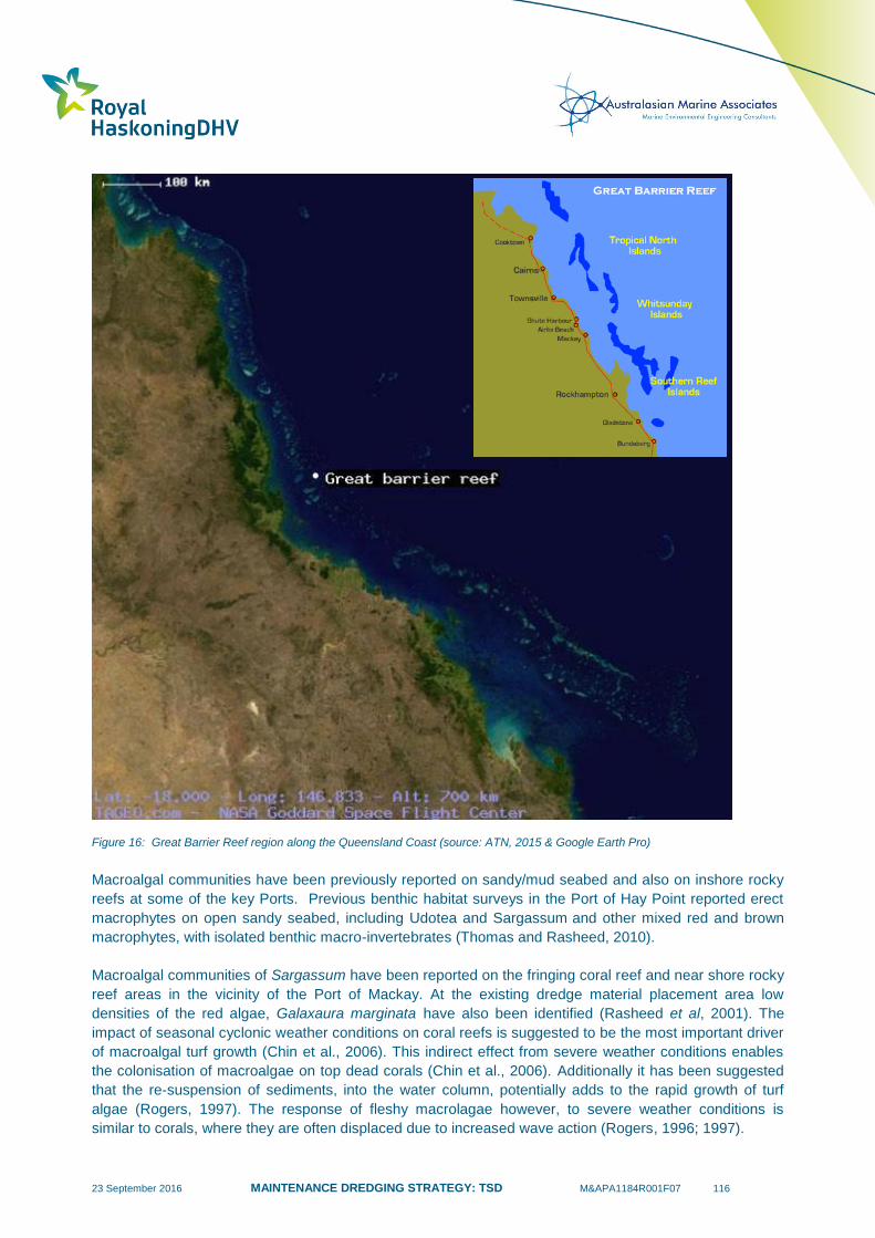
23 September 2016 MAINTENANCE DREDGING STRATEGY: TSD M&APA1184R001F07 116
Figure 16: Great Barrier Reef region along the Queensland Coast (source: ATN, 2015 & Google Earth Pro)
Macroalgal communities have been previously reported on sandy/mud seabed and also on inshore rocky
reefs at some of the key Ports. Previous benthic habitat surveys in the Port of Hay Point reported erect
macrophytes on open sandy seabed, including Udotea and Sargassum and other mixed red and brown
macrophytes, with isolated benthic macro-invertebrates (Thomas and Rasheed, 2010).
Macroalgal communities of Sargassum have been reported on the fringing coral reef and near shore rocky
reef areas in the vicinity of the Port of Mackay. At the existing dredge material placement area low
densities of the red algae, Galaxaura marginata have also been identified (Rasheed et al, 2001). The
impact of seasonal cyclonic weather conditions on coral reefs is suggested to be the most important driver
of macroalgal turf growth (Chin et al., 2006). This indirect effect from severe weather conditions enables
the colonisation of macroalgae on top dead corals (Chin et al., 2006). Additionally it has been suggested
that the re-suspension of sediments, into the water column, potentially adds to the rapid growth of turf
algae (Rogers, 1997). The response of fleshy macrolagae however, to severe weather conditions is
similar to corals, where they are often displaced due to increased wave action (Rogers, 1996; 1997).
23 September 2016 MAINTENANCE DREDGING STRATEGY: TSD M&APA1184R001F07 117
The presence of additional suspended sediment in the water column from maintenance dredging activities
has the potential like seagrass, to influence coral and macroalgal growth rates, through increased light
attenuation, sedimentation and smothering. The environmental window for corals is during the spawning
season. The time of year that corals spawn depends on their location, where on the inshore reefs, corals
usually start spawning one to six nights after the first full moon in October, whereas those in the outer
reefs spawn during November or December.
The spawning season between October and December is the environmental window, which needs to be
considered by the Ports during their risk assessments for scheduling and managing maintenance dredging
activities. Macroalgal communities and coral reefs, like seagrass may also be more sensitive immediately
after major tropical cyclone activities. Appendix D provides further commentary on the potential risks to
macroalgae and corals from maintenance dredging activities.
6.2.3 Marine Turtles
Marine turtles have been previously recorded within port limits in the majority of Queensland Ports within
the GBRWHA. Six species of sea turtles are known to occur in the Port of Gladstone region (Limpus et.
al., 2013a). These species have also been recorded utilising the offshore, intertidal, estuarine and
shoreline habitats in the Hay Point area. These species primarily use the near shore marine environments
surrounding the Ports as a feeding ground, as well as a transit area between other parts of the
Queensland coast and the GBR (Ports North, 2014).
Turtle nesting varies between regions. For example, turtle nesting on beaches within the Hay Point area
occurs between October and February, with the hatchlings emerging from January to March (NQBP,
2009) and turtle-nesting season in Mackay occurs from the middle of October to early January, with
hatchling emergence continuing until April (Limpus et al., 2013). Green turtles are historically the most
common marine turtle species reported, but in recent years, since TC Yasi in 2007, there has been
increased strandings and mortality for this species (Ports North, 2014).
The biggest potential risk to turtles is from vessel strike and being entrained in the trailing suction hopper
drag head during maintenance dredging activities. The turtle-nesting season, which generally occurs
between October and February, is the environmental window that needs to be considered by the port
managers during their risk assessment. Appendix D provides further commentary on the potential risks
to sea turtles from maintenance dredging activities.
6.2.4 Dugongs
Dugongs can be common in Trinity Bay, Cairns; however it is thought that current population numbers are
low due to the reduction in the extent and condition of local seagrass meadows (Ports North, 2014).
Dugongs in the Port of Abbot Point have been recorded primarily foraging within habitat associated with
extensive seagrass meadows consisting of H. uninervis and H. spinulosa (GHD, 2009a). Dugongs and
their feeding trails are commonly noted in the seagrass meadows of Port of Gladstone (i.e. Wiggins Island
and Pelican Banks) and in Cleveland Bay, Townsville. The main risk to dugongs is from vessel strike.
There is no evidence to date that maintenance dredging vessel strike has impacted dugongs at any of the
ports within the GBRWHA. Appendix D provides further commentary on the potential risks to dugongs
from maintenance dredging activities.
6.2.5 Cetaceans
The two threatened dolphin species likely to occur within the vicinity of the Ports within the GBRWHA
include the Snubfin, Orcaella heinsohnri and Indo-Pacific humpback dolphins, Sousa chinensis. These
23 September 2016 MAINTENANCE DREDGING STRATEGY: TSD M&APA1184R001F07 118
species have been previously recorded in the Port of Cairns (Ports North, 2014) and throughout Cleveland
Bay in Townsville (BMT WBM, 2012d). The Keppel Bay region, in close proximity to the Port Alma, is
known as an important habitat for the Snubfin dolphin (Cagnazzi, 2013). The main risk to cetaceans is
from vessel strike. There is no evidence to date that maintenance dredging vessel strike has impacted
marine megafauna at any of the ports within the GBRWHA. Appendix D provides further commentary on
the potential risks to cetaceans from maintenance dredging activities.
6.2.6 Benthic Infauna and Epifauna
Benthic infauna is defined as the organisms that live within the seabed, most commonly within the first
150-200 mm from the seabed surface and epifauna occurs on the seabed. i.e. sea stars. These organisms
are highly diverse and facilitate a key part of the nearshore marine food chain, supporting higher trophic
levels (i.e. fish and crustaceans). The species abundance and diversity is heavily influenced by the
sediment grain size (Currie and Small, 2002), which provides the physical medium in which the infauna
move through and forage for food. Furthermore, there have been strong correlations for infauna
population dynamics and regional rainfall, freshwater inflow, nutrient and chlorophyll a concentrations.
These relationships supported the hypothesis that changes in total abundance are mostly the result of
long-term climatic cycles including El Niño events (Currie and Small, 2002).
Traditionally, ports along the Queensland coast have examined the benthic infauna community
composition before and after offshore disposal activities. These data have demonstrated that the benthic
infauna communities often have a strong capacity to recolonise the disposal sites following disposal
activities.
6.3 Summary
As the world’s most extensive coral reef ecosystem, the Great Barrier Reef (GBR) is a globally
outstanding and significant entity. Environmental values include the marine habitats, which need to be
protected and maintained within the GBRWHA, as well as the key marine flora and fauna communities,
which inhabit these environments.
The marine habitats that occur within the vicinity of maintenance dredging and dredge material disposal
activities are located within the GBR Inner Lagoon. These habitats include seagrass meadows, coastal
embayments, intertidal and subtidal reefs and sandy seabed communities.
Seagrass meadows are found intertidally around nearshore port infrastructure, as well as subtidally,
adjacent to shipping channels and offshore disposal sites. Rocky reef and coral reef communities occur on
intertidal rocky foreshores, as fringing reefs along the coastline, as well as around Islands and Inlets on
the inner reef. Macroalgal communities dominate some of these near shore rocky reef environments.
Maintenance dredging activities have the potential to influence suspended sediment concentrations in the
water column, which in turn can influence the primary productivity of these benthic primary producer
communities. Port managers during their risk assessments for prioritising the timing and management of
maintenance dredging activities should consider the potential risks to these communities, the
environmental windows (i.e. times where the communities are most susceptible) and any major storm or
cyclone events that have preceded maintenance dredging.
The sandy seabed communities dominated by benthic epifauna and infauna communities provide the
lower trophic levels of marine food chains and are critical to marine ecosystem function. These
communities have the potential to be smothered from dredge material disposal activities.
23 September 2016 MAINTENANCE DREDGING STRATEGY: TSD M&APA1184R001F07 119
The higher order trophic levels, including the marine megafauna, such as sea turtles, dugongs and
cetaceans also play an important role in marine ecosystem functioning and have the potential to be
influenced by maintenance dredging activities, by entrainment in the trailer suction drag head (i.e. turtles)
and from vessel strike. The environmental window, which is the turtle-nesting season, is the most
sensitive time when turtles may be influenced from dredging activities.
Further risk assessment discussion is provided in Appendix D, which may assist the Ports with identifying
the key risks and making these critical decisions regarding the scheduling of maintenance dredging.
Section 7 provides a summary of the available scientifically derived data for maintenance dredging and
disposal activities in Queensland ports, which aids in providing an understanding of how changes in water
quality and incident light levels influence key ecosystem processes and importantly, the environmental
values described here.
23 September 2016 MAINTENANCE DREDGING STRATEGY: TSD M&APA1184R001F07 120
7 Environmental Monitoring for Maintenance Dredging
7.1 Introduction
In recent years, there has been more emphasis placed on collecting quantitative field data for
maintenance dredging and disposal activities and the following sections provide a summary of these field-
based measurements. This quantitative data helps to define the extent of maintenance dredging related
impacts and provide the necessary data to allow an adaptive management approach to dredging works
and the risk assessment process. This section introduces potential impacts associated with changes in
water quality, light and suspended solid concentrations from maintenance dredging and presents a
summary of the available environmental monitoring data that focus on this activity. This data contributes to
the quantitative basis for the risk assessment presented in Section 8 of this report.
7.2 Turbidity & Total Suspended Solids
The action of dredging and disposal introduces suspended solids into the water column, changing the
water clarity, which can reduce the amount of light on the seabed and influence sedimentation rates.
Suspended solids are introduced into the water column as a result of:
Direct disturbance of the seabed from dredging and during overflow of sediment-laden waters
from the dredge hopper;
Dredge propeller wash and wake disturbance of the seabed which can mobilise suspended solids;
Placement of dredge material at the dredge material placement area; and
Remobilisation of sediment deposited on the seabed following disposal and during onshore
dewatering activities.
Turbidity is an optical measure of water clarity, commonly measured in Nephelometric Turbidity Units
(NTU) and is used as a surrogate for total suspended solids (TSS), which is a quantitative measure of the
amount of solid material in suspension (commonly inorganic dry mass in mg/L). Turbidity levels and TSS
concentrations are commonly the focus of monitoring programs, to understand the potential risks to the
marine environment. The followings sections describe how these parameters are integrated into field
based monitoring, how the results are used and the outcomes from a range of historic monitoring
activities.
7.2.1 Active Dredging and Disposal Monitoring
Many Queensland Ports have undertaken a series of targeted monitoring programs, to provide an
understanding of the fate of suspended solids in the water column during maintenance dredging activities
(BMT WBM, 2011; BMT WBM, 2013; BMT WBM, 2014f; BMT WBM, 2014g; BMT WBM, 2014h; BMT
WBM, 2010, JCU, 2015). In many cases the in-situ measurements were performed using boat mounted,
downward facing Acoustic Doppler Current Profiler (ADCP) instrumentation, which was used to undertake
transects through the dredge plumes. In addition, discrete TSS water sampling and in-situ water quality
logging (at sensitive receptors) was undertaken to aid in the interpretation of ADCP backscatter
throughout the water column.
The plume-monitoring activities were undertaken whilst the TSHD Brisbane completed maintenance
dredging and disposal activities in the Port of Gladstone, Port of Cairns, Port of Townsville and Port of
Cooktown. During the execution of these environmental monitoring programs, spring tides and medium to
strong winds played a key role in influencing the observed TSS levels. In some instances, the TSS

23 September 2016 MAINTENANCE DREDGING STRATEGY: TSD M&APA1184R001F07 121
generated by the maintenance dredging was undetectable over natural background levels, but this was
not the case during all of the plume monitoring events.
The plumes that were detected were generally transient and dissipated to background concentrations
mostly within two hours after cessation of the dredging or placement activities (BMT WBM, 2011; BMT
WBM, 2014e). There were instances of maintenance dredging related turbidity which extended beyond
the immediate dredge area into areas with known sensitive receivers (e.g. seagrass in Gladstone and reef
in Townsville); however the intensity and duration of the maintenance dredging related turbidity was low
and short lived (hours to days) (BMT WBM, 2014e; BMT WBM, 2013). Other notable observations made
during the maintenance dredging plume monitoring included:
Gladstone:
Dredge plume TSS concentrations during neap tides remained below 100 mg/L and were
therefore, within the limits of concentrations typically observed within the inner Gladstone Harbour
during spring tide conditions;
Dredge plumes moved between 0.5 and 1.5 km from the dredging location before reaching
background turbidity levels after approximately two hours. The plumes were generally parallel to
the channel and advected along the channel; and
At East Banks Disposal Site disposal plumes were distinguishable from background up to
approximately 1.5 km from the release location.
Cairns:
It was primarily the surface component of the dredging plume created by the hopper overflow,
which was available for advection by the tidal currents beyond (east or west of) the channel
alignment;
On the ebb tide, the surface component of the dredge plume was advected west of the channel
alignment up to a maximum distance of 650-700m from the channel;
Conversely, on the flooding tide the surface plume was displaced to the east side of the channel,
though the distance was shorter, being a maximum of 150-200m from the channel;
Initial plume turbidity of up to 160 NTU was measured in the centre of the placement plume at
depth and up to 100 NTU near the water surface. Within approximately 35 minutes, the turbidity
within the placement plume had reduced to less than 25 NTU; and
See Figure 17 for further visual insight into the natural turbidity versus maintenance dredging
related additions.
Townsville:
Strong ENE winds occurred during the dredge campaign, which resulted in natural re-suspension
of sediment throughout Cleveland Bay;
Short term spikes in turbidity and light attenuation occurred during the maintenance dredging
campaign (except 23/24 September) along the east coast of Magnetic Island and nearshore sites.
These turbidity spikes were likely driven by natural re-suspension of bed sediments, with some
contribution from plumes generated by dredging; and
The observed change in turbidity due to dredging at sensitive receptor locations was well within
the range of natural variability during the monitoring period.
Cooktown:
During the 2014/15 maintenance dredging works automated water quality monitoring equipment
was deployed, capable of autonomously measuring sediment deposition, turbidity, temperature,
water depth, RMS water depth and light (PAR);
23 September 2016 MAINTENANCE DREDGING STRATEGY: TSD M&APA1184R001F07 122
One site was located adjacent to the Port of Cooktown channel (WQ3) and the other further afield
offshore (2km). Importantly, during the extended intermittent dredging works (i.e. due to weather
delays) the primary driver for observed changes in water quality conditions was related to natural
weather event, and in particular Tropical Cyclone Marcia (18-20th February 2015) and TC Nathan
(10-24th March 2015); and
The monitoring data generated during the 12 month period was very useful for placing the
dredging works in context with natural events and highlights the insignificant nature of the
maintenance dredging and the significance of weather (cyclone) events on suspended solids
concentrations.
7.2.2 Turbidity Monitoring and Environmental Values
In addition to the maintenance dredging and plume fate monitoring activities, a range of targeted
environmental monitoring programs have been implemented which have focussed on measuring water
quality parameters within areas containing environmental values (i.e. seagrass meadows and corals)
(BMT WBM, 2011; BMT WBM, 2013; BMT WBM, 2014f; BMT WBM, 2014g; BMT WBM, 2014h). In many
of these programs, continuous measurement of turbidity (i.e. measured every 5-10 minutes) was a key
requirement. Having access to continuous measurements of turbidity within a seagrass meadow provides
valuable empirical data for assessing the influence of the maintenance dredging works, including before,
during and after the event (including understanding long term TSS trends).
Continuous turbidity measurements at predetermined sensitive receiver locations (i.e. seagrass meadows
in Gladstone and Cairns) demonstrated that the maintenance dredging activities had little influence on
turbidity at these locations (BMT WBM, 2011; GPC, 2014). The monitoring program in the Port of
Gladstone supported previous findings that changes in turbidity in the Port of Gladstone are largely driven
by tidal range, with wind and wave action also making significant contributions. The effects of
maintenance dredging on turbidity levels were not discernible from these key drivers and were likely to be
very small or very localised such that impacts were not detected within the monitored seagrass meadows
(GPC, 2014). A similar trend was observed at the offshore disposal site, where turbidity levels were largely
unrelated to disposal activities and more closely linked to tidal currents (spring/neap cycles) (GPC, 2015).
An illustration of this trend is provided in Figure 18.
Consistent with the observations from Gladstone, continuous turbidity measurements from two water
quality instruments placed adjacent to the seagrass communities within the Port of Cairns demonstrated
there was no increase in turbidity, which could be correlated with the maintenance dredging operations
within the port (BMT WBM, 2014).
Continuous turbidity monitoring during the 2012/13 maintenance dredging campaigns at known
environmental values in Cleveland Bay, Townsville (i.e. reef communities), demonstrated that spikes in
turbidity may be linked to maintenance dredging activities (BMT WBM, 2013). It should be acknowledged
that the 2012/13 maintenance dredging campaign was undertaken in parallel with capital dredging works
and that during high winds the TSHD Brisbane was specifically targeting maintenance dredging because
of its more sheltered location. In summary BMT WBM (2013) made the following key observations from
the data:
The turbidity regime during the dredging period (capital and maintenance) is generally similar to
the non-dredging period (i.e. after 28 Nov 2012).
The three Magnetic Island sites displayed a similar pattern, where spikes in turbidity occurred
during periods of maintenance dredging in October 2012, but not in September 2012.
It was noted that the turbidity spikes were likely driven by natural resuspension events during
higher wind periods.
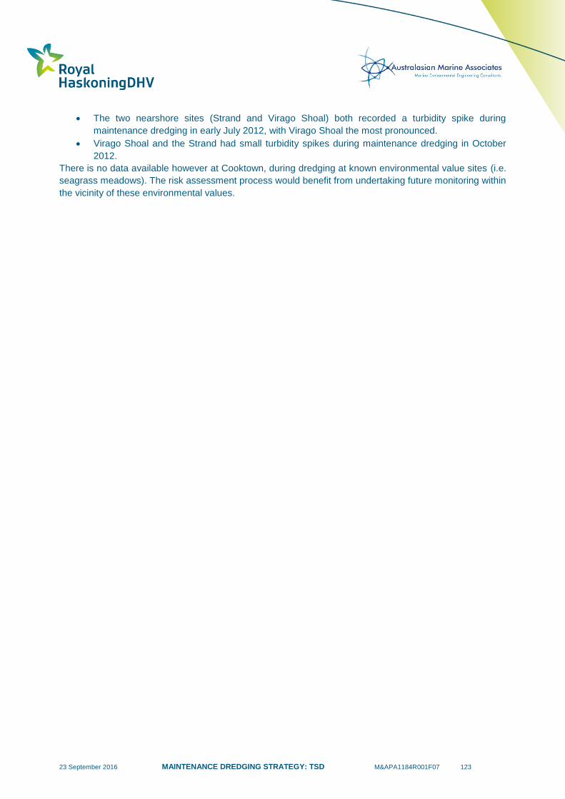
23 September 2016 MAINTENANCE DREDGING STRATEGY: TSD M&APA1184R001F07 123
The two nearshore sites (Strand and Virago Shoal) both recorded a turbidity spike during
maintenance dredging in early July 2012, with Virago Shoal the most pronounced.
Virago Shoal and the Strand had small turbidity spikes during maintenance dredging in October
2012.
There is no data available however at Cooktown, during dredging at known environmental value sites (i.e.
seagrass meadows). The risk assessment process would benefit from undertaking future monitoring within
the vicinity of these environmental values.
23 September 2016 MAINTENANCE DREDGING STRATEGY: TSD M&APA1184R001F07 124
Figure 17. Aerial images during maintenance dredging and disposal activities in Cairns 2015 (source: Robert Gesink). Top: dredging
from Beacon C15 to Beacon C11 at the Port of Cairns, tide was flooding and wind speeds was 28km/hr (15kts). Bottom:
maintenance dredge material disposal at Port of Cairns on 23 March 2015.
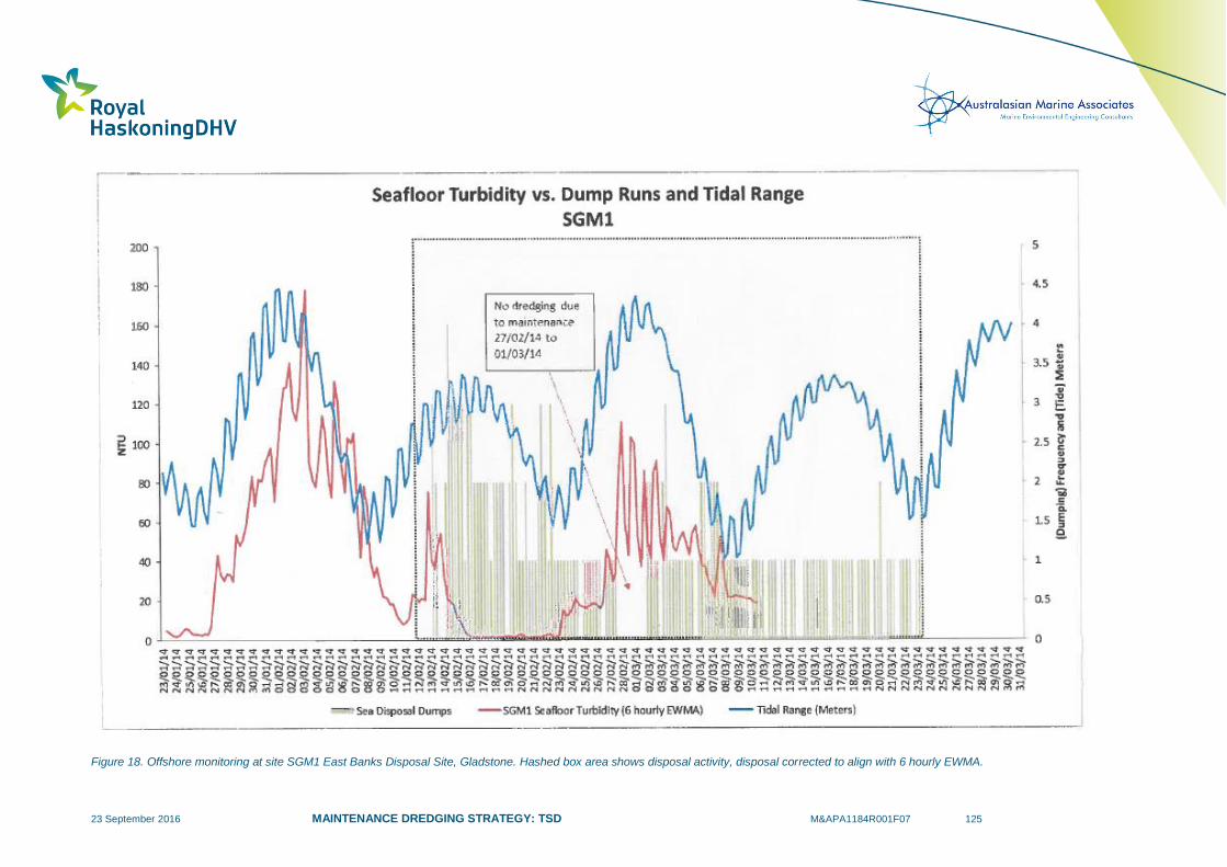
23 September 2016 MAINTENANCE DREDGING STRATEGY: TSD M&APA1184R001F07 125
Figure 18. Offshore monitoring at site SGM1 East Banks Disposal Site, Gladstone. Hashed box area shows disposal activity, disposal corrected to align with 6 hourly EWMA.
23 September 2016 MAINTENANCE DREDGING STRATEGY: TSD M&APA1184R001F07 126
7.3 Predictive Modelling
The data generated from the BMT WBM dredging and disposal plume intensity and extent monitoring
events provided a useful basis for calibrating and updating the assumptions within the numerical models.
The modelling suite, once suitably calibrated using field data, offers insight into the likely plume behaviour
both during maintenance dredging and disposal activities. Dredging programs when active are used to
inform and improve material source term in models or terms to validate model predictions. Other ways
modelling outputs can be improved include gathering additional sediment grain size data, especially in the
particle size classes <75 µm (very fine sands, silt and clay) and gathering site data on local current and
tidal conditions, to improve model accuracy.
This verification work has been undertaken at the Port of Townsville (BMT WBM, 2013) and the Port of
Gladstone (BMT WBM, 2014c) and the following sections provide a summary of the insights gained. The
modelling outputs were used to inform water quality assessments and ecological assessments (both acute
and chronic) of potential impacts. The following provide a summary of key model observations:
Townsville:
An assessment of modelled turbidity and sediment deposition, together with water quality
monitoring data was compared against preliminary impact thresholds, which suggested that it was
highly unlikely that mortality to environmental values (seagrass and corals) would occur. This was
primarily because of the short duration of the campaign (five weeks), and the short duration and
intensity of dredge plumes and the low rates of sediment deposition;
The observed change in turbidity due to dredging at environmental value locations was well within
the range of natural variability during the monitoring period;
During the period when the water quality monitoring was carried out, including the 2012
maintenance dredging campaign, there was seagrass expansion (not contraction) throughout
Cleveland Bay;
Given the short duration (typically up to five weeks) of maintenance dredging campaigns, the
short term nature of dredge plumes and the tolerance of biota to short term increases in turbidity,
it was not expected that total mortality thresholds would be exceeded during maintenance
dredging at areas containing environmental values;
Based on worse case modelling results, it was predicted that low intensity turbid plumes resulting
from dredging could last for several days under windy conditions at locations containing seagrass
meadows (i.e. the Strand and Cape Pallarenda). Based on a comparison of modelling results to
preliminary impact thresholds (derived from biological tolerance data), it was predicted that stress
(e.g. reduced growth, loss of carbohydrate) could occur under windy conditions to sensitive
seagrass species (Halophila ovalis). This would particularly be the case if seagrass was in poor
condition in the period leading up to dredging.
Gladstone:
Based on model outputs and field validation, most environmental values surrounding the channel
will not be affected by plumes. The modelling projected possible low light due to turbid plumes
may result in some reduction in cover at seagrass meadows surrounding the Passage Islands
during some model simulations (maintenance dredging of 400,000m3 and 320,000m
3).
These simulations had longer continuous dredging of the inner harbour channels than the other
simulations. This was not observed during the 2014 – 2015 dredging campaign. Instead,
measurement of the plume during this campaign indicated that the plume from maintenance
dredging in Jacobs Channel may have travelled southward along the shoreline of Curtis Island
corresponding with previously mapped meadows. The plume in this area was discernible above
background for 2 hours.

23 September 2016 MAINTENANCE DREDGING STRATEGY: TSD M&APA1184R001F07 127
Due to the short duration of dredge plumes (measured in hours compared to seagrass light
requirements being measured over a period of 14 days) adverse impacts to seagrasses are
unlikely in the event that plumes do coincide with these environmental values; and
As a worst-case and unmitigated scenario, any impacts to seagrass would be expected to
manifest as a reduction in cover rather than complete meadow loss, given the relatively short
duration of plumes associated with the largest modelled campaign of 400,000m3 (up to several
weeks). To date, plume influence at the Passage Island seagrasses has not been detected by
water quality monitoring during maintenance dredging campaigns.
7.4 Dredge Material Resuspension and Deposition
Dredge material disposed of at the approved disposal locations along the Queensland GBRWHA are
subject to different metocean processes and therefore, differing potential for bed shear stress to result in
resuspension and deposition of disposed material (see Section 4.5.3). Loss of sediment from the
approved disposal sites has the potential to increase turbidity and reduce BPAR and potentially impact
upon nearby environmental values. Calibrated hydrodynamic modelling has been used to gain insights
into this process (BMT WBM, 2013; BMT WBM, 2014c). The following provides a summary of the key
model observations made by BMT WBM:
Townsville:
Modelling was carried out to predict sediment resuspension over a 12-month period, to determine
potential long-term impacts of dredge material placement. The modelled change in the 95th
percentile turbidity from background (i.e. the turbidity value exceeded 5% of the time, or 18 days
in the year) was less than 2 NTU, while the modelled change in the 50th percentile turbidity
(representing changes in turbidity for 50% of the time) was less than 0.05 NTU throughout the
model domain.
This very small change to ambient turbidity is highly unlikely to cause measurable changes to
biota or ecosystems. In terms of sediment deposition, the change in the 95th percentile deposition
rate and the 50th percentile deposition rate would be less than 1 mg/cm
2/day and less than 0.01
mg/cm2/day respectively throughout the entire model domain; and
These small changes to sedimentation rates are also very small compared to background
variability (e.g. 2.9-7.4 mg/cm2/day recorded at Middle Reef; Browne et al. 2012) and are highly
unlikely to cause adverse effects to environmental values.
Gladstone:
The results indicate that TSS generated by re-suspension of placed sediments would typically be
low (<15 mg/l) outside the DMPA, even during the extreme events modelled. It should be noted
that natural re-suspension from weather events such as tropical cyclones and gale force winds,
which drive these patterns, would also result in extensive natural re-suspension of bed sediments;
Sediment deposition from re-suspended maintenance dredging material was generally predicted
to be in the fractions of millimetres. The predicted levels of sediment deposition were very low in
the context of potential impacts, and would be insignificant relative to natural background
sediment deposition levels.
7.5 Photosynthetically Available Radiation (Light)
The previous sections discussed monitoring of turbidity, TSS and sedimentation and considered the
impacts to marine environmental values (i.e. seagrass meadows). The amount of light reaching the
seabed also influences the primary productivity of these benthic communities. In recent years, there has
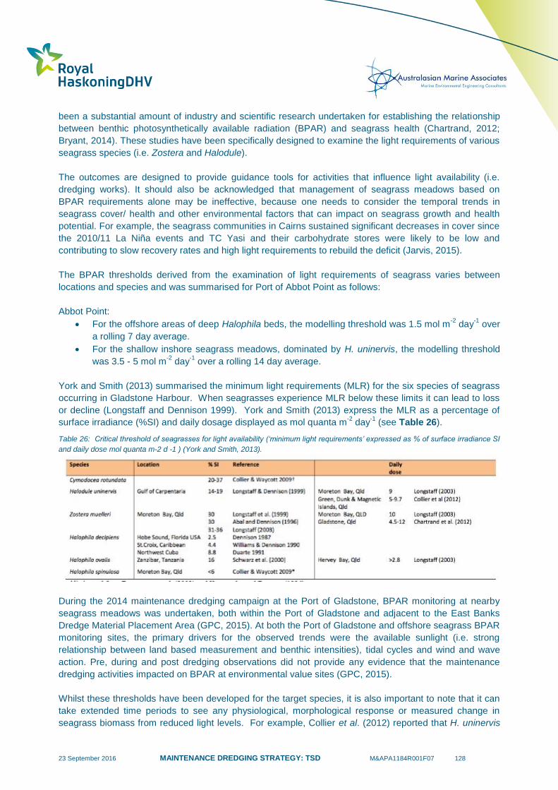
23 September 2016 MAINTENANCE DREDGING STRATEGY: TSD M&APA1184R001F07 128
been a substantial amount of industry and scientific research undertaken for establishing the relationship
between benthic photosynthetically available radiation (BPAR) and seagrass health (Chartrand, 2012;
Bryant, 2014). These studies have been specifically designed to examine the light requirements of various
seagrass species (i.e. Zostera and Halodule).
The outcomes are designed to provide guidance tools for activities that influence light availability (i.e.
dredging works). It should also be acknowledged that management of seagrass meadows based on
BPAR requirements alone may be ineffective, because one needs to consider the temporal trends in
seagrass cover/ health and other environmental factors that can impact on seagrass growth and health
potential. For example, the seagrass communities in Cairns sustained significant decreases in cover since
the 2010/11 La Niña events and TC Yasi and their carbohydrate stores were likely to be low and
contributing to slow recovery rates and high light requirements to rebuild the deficit (Jarvis, 2015).
The BPAR thresholds derived from the examination of light requirements of seagrass varies between
locations and species and was summarised for Port of Abbot Point as follows:
Abbot Point:
For the offshore areas of deep Halophila beds, the modelling threshold was 1.5 mol m-2
day-1
over
a rolling 7 day average.
For the shallow inshore seagrass meadows, dominated by H. uninervis, the modelling threshold
was 3.5 - 5 mol m-2
day-1
over a rolling 14 day average.
York and Smith (2013) summarised the minimum light requirements (MLR) for the six species of seagrass
occurring in Gladstone Harbour. When seagrasses experience MLR below these limits it can lead to loss
or decline (Longstaff and Dennison 1999). York and Smith (2013) express the MLR as a percentage of
surface irradiance (%SI) and daily dosage displayed as mol quanta m-2
day-1
(see Table 26).
Table 26: Critical threshold of seagrasses for light availability (‘minimum light requirements’ expressed as % of surface irradiance SI
and daily dose mol quanta m-2 d -1 ) (York and Smith, 2013).
During the 2014 maintenance dredging campaign at the Port of Gladstone, BPAR monitoring at nearby
seagrass meadows was undertaken, both within the Port of Gladstone and adjacent to the East Banks
Dredge Material Placement Area (GPC, 2015). At both the Port of Gladstone and offshore seagrass BPAR
monitoring sites, the primary drivers for the observed trends were the available sunlight (i.e. strong
relationship between land based measurement and benthic intensities), tidal cycles and wind and wave
action. Pre, during and post dredging observations did not provide any evidence that the maintenance
dredging activities impacted on BPAR at environmental value sites (GPC, 2015).
Whilst these thresholds have been developed for the target species, it is also important to note that it can
take extended time periods to see any physiological, morphological response or measured change in
seagrass biomass from reduced light levels. For example, Collier et al. (2012) reported that H. uninervis
23 September 2016 MAINTENANCE DREDGING STRATEGY: TSD M&APA1184R001F07 129
took 46 days to show a significantly reduced leaf size, leaf thickness in the lowest light treatment
investigated and Longstaff (2003) and Longstaff and Dennison (1999) reported H. uninervis took more
than three months for seagrass mortality to occur following light deprivation. This is in contrast with many
of the maintenance dredging campaigns in Queensland, which generally take between 7 and 53 days on
average to complete (see Table 10) and the dredge is also working for only short periods of time in one
place. Monitoring programs if and when implemented should be designed to account for an organisms
physiological response. i.e. monitoring of seagrass needs to occur before, during and after dredging to
understand long term temporal changes in seagrass health.
7.6 Nutrients
A review of the potential for the release of nutrients during dredging and dredge material disposal at sites
in the GBRWHA, to determine the likelihood of any adverse impacts on aquatic ecosystem health was
recently undertaken by CSIRO (Batley et. al., 2015). Some of the key findings from this review included:
Dissolved ammonium was shown to be released in measurably high concentrations during
disturbance of sediments (around the dredge), together with total phosphorus (mostly
orthophosphate), while there was typically a reduction in nitrate and nitrite;
Resuspension by tidal motion results in detectable releases of all species, which are enhanced by
the greater disturbance of dredging. Greatest releases are expected during capital dredging
compared to maintenance dredging;
Measured nutrient concentrations in Queensland estuarine sediments and associated pore waters
were not as high as those reported for estuaries undergoing dredging in the US, where findings
were that they were unlikely to result in eutrophication or algal blooms at disposal sites or in open
coastal areas; and
Measured ammonium concentrations at the dredging and disposal sites are likely to exceed
default water quality guideline values (within the vicinity of these activities), based on the 80th
percentile of reference site data for Queensland near-shore waters. These guideline values
however, are not intended to be protective against algal blooms. Ammonia concentrations were
well below guideline values for toxicity.
More broadly, nutrient releases from dredging operations and placement of dredge material at sea are
negligible and are one to two orders of magnitude lower than riverine fluxes (Larcombe and Ridd, 2015).
7.7 Contaminants
Prior to the execution of maintenance dredging programs, characterisation of the proposed dredge
material is required (NAGD, 2009). A key component of this work is developing a list of contaminants of
potential concern. Broadly, the sediments targeted for maintenance dredging across the ports do not
contain elevated concentrations of contaminants of concern; however there have been several instances
where exceedances of a NAGD (2009) screening level has been recorded (i.e. 95% Upper Confidence
Limit of data exceeds screening level) (See Section 5.2.1 for further detail). Instances of Copper, Arsenic,
Nickel, Chromium, Lead and Tributyltin (TBT) have been observed in some of the ports; however these
are often associated with specific locations and are not widespread (See Appendix D).
In all instances, the port corporations have followed the NAGD (2009) requirements to further examine the
bioavailability of any exceedances. This has involved elutriate testing and/or weak acid extractions to
determine the fraction of the contaminant that is of biological relevance to the marine organisms. In most
cases, the biologically available fractions did not exceed the NAGD (2009) or ANZECC/ARMCANZ
triggers and therefore, the maintenance dredge material was considered suitable for unconfined disposal
23 September 2016 MAINTENANCE DREDGING STRATEGY: TSD M&APA1184R001F07 130
at sea. In some instances (i.e. Townsville), a precautionary approach was adopted and onshore disposal
had occurred (i.e. due to copper contamination).
During the 2014 Port of Gladstone maintenance dredging and disposal program for example, a targeted
metals and TBT water quality sampling program was completed. This was not a requirement of the
permitting process, but rather a due diligence exercise to provide additional data on maintenance dredging
and its potential impacts on the Port of Gladstone ecosystem.
The data demonstrated observable increases in total concentrations for a few metals/metalloids during
dredging, compared to baseline. Dissolved metal and metalloid concentrations however, were below
ANZECC/ARMCANZ (2000) toxicity trigger levels (TTVs) during both baseline and dredging conditions. It
should be noted that increases in metal concentrations during suspension of seabed sediment is not
unexpected, as a number of metals are ubiquitous within soils. More importantly, all total and dissolved
metals/metalloids during both baseline monitoring and during dredging were either below the Limit of
Reporting (LOR) or ANZECC/ARMCANZ (2000) TTVs (GPC, 2014).
7.8 Summary
The scientific knowledge of maintenance dredging and disposal within Queensland ports is growing.
There have been numerous studies which have focused on the suspended sediment plumes generated by
the TSHD Brisbane, and importantly, the fate of these plumes2 and their potential to influence the key
environmental values previously described.
There are also recent efforts to enhance hydrodynamic modelling outputs for maintenance dredging and
disposal activities, by conducting field-based validation measurements. These models can, and have,
provided a valuable tool for assessing maintenance dredging options and the potential for plumes to
interact with the key environmental values. From the available measured data (not modelling), it can be
confirmed that the plume intensities and extents during maintenance dredging and disposal are relatively
low and localised and often dissipate within hours of the dredging and/or disposal activities.
Importantly, the environmental monitoring has shifted towards field based monitoring for detecting any
potential environmental harm within seagrass meadows and this monitoring has confirmed that key
thresholds for maintaining health have not been breached. When considering the need and type of
monitoring undertaken in the future, the individual Ports risk assessment will be informed by considering
the frequency and duration of maintenance dredging, the potential for the plumes to interact with key
environmental values (i.e. seagrass, coral and rocky reef communities), the types of parameters
monitored (i.e. turbidity, TSS and BPAR), when there is an interaction and potentially quantifiable risk and
the acceptable endpoints (i.e. physiological, morphological, or biomass change).
The adherence to the requirements stipulated in the NAGD (2009) contaminant screening and
bioavailability assessment process, and in some cases applications of the precautionary principle (i.e.
some berth location in the Port of Townsville), help ensure that unacceptable concentrations of biologically
available contaminants are not introduced to the marine environment.
The scientific assessment of nutrient dynamics during dredging and dredge material disposal has
indicated that biologically available forms of nutrients (e.g. ammonia) can be released; however the
intermittent nature of maintenance dredging is unlikely to lead to changes in nutrient cycling and
2 It is important to note that the work executed by BMT WBM simulated the extent of resuspension based on bed shear stress and
particle size distribution of the dredge material. They did not simulate the entire quantity of material being resuspended as it was not considered realistic or scientifically feasible.
23 September 2016 MAINTENANCE DREDGING STRATEGY: TSD M&APA1184R001F07 131
eutrophication, particularly when catchment based locations are taken into consideration. It should also be
acknowledged that port channels are not constrained and the accumulation of any nutrients would
disperse during tidal flushing.
The available scientific field measurements focusing on dredging and disposal activities does vary across
the Queensland ports, with some ports having a much more detailed understanding of maintenance
dredging and ecosystem response. However, it would be acknowledged that the ports with the greatest
need, largest volumes, and most frequent visits have invested the most time and resources for
understanding maintenance dredging related risk to the environment. There is, however, opportunities for
further field based measurements, where there is a paucity of data, to help inform risk-based monitoring
and ultimately sustainable port operations. Section 8 presents the outcomes of a preliminary risk
assessment, which was supported by the quantitative data presented in this report.
23 September 2016 MAINTENANCE DREDGING STRATEGY: TSD M&APA1184R001F07 132
8 Maintenance Dredging – Preliminary Analysis of Risks
8.1 Background
The preliminary risk assessment undertaken has adopted the risk assessment methodology used in the
Great Barrier Reef Strategic Assessment (GBRMPA, 2014; Great Barrier Reef Region Strategic
Assessment: Strategic assessment report, GBRMPA, Townsville, Chapter 10, page 10-9), see Appendix
D. This approach is consistent with the Australian Standard for Risk Assessment (AS/NZS ISO
31000:2009). It is important to acknowledge that the GBRMPA (2014) strategic assessment report ranked
both capital and maintenance dredging activities together, and therefore rankings in that report cannot be
compared to this assessment which only ranks maintenance dredging and maintenance material
placement actions.
The risk assessment draws on scientifically based information and data generated by the ports of the GBR
region. Key information reviewed include the frequency, scale (volume) and durations (day or weeks) of
maintenance dredging, distribution and abundance of sensitive receptors, hydrodynamic model
simulations and quantitative scientifically derived monitoring data that specifically focuses on the action of
maintenance dredging and disposal operations.
8.2 Risk Assessment Outcomes
8.2.1 Key Environmental Values
Risk assessments focus on the key flora and fauna that are protected under Commonwealth and State
legislation. These flora and fauna represent a key component of the World Heritage Values of the Great
Barrier Reef Ecosystem, and are inextricably linked to indigenous values. They are located within the
inner GBR lagoon coastline and have the potential to be influenced by the actions of maintenance
dredging, disposal and vessel movements. Table 27 provides a summary of the risk assessment
outcomes, and further detail on the fauna and flora species and risk assessment approach can be found
within Appendix D.
Importantly, the outcome from the risk assessment determined that marine flora and fauna are at Low risk
from maintenance dredging and placement of maintenance dredge material. The only Medium risk
identified was at the Ports of Townsville during maintenance dredging for flora and key habitats (coral).
This Medium risk has been identified previously and management measures are already in place to
mitigate harm. Overall, the findings of the risk assessment confirm that the action of maintenance
dredging and disposal in Queensland’s ports is not likely to introduce a significant impact to key marine
fauna or flora, and the habitats that support their life cycles.
The risk assessment also identified the level of confidence in the data, based on that which was available,
to support the risk assessment. It was observed during the process of assessing the available information
that the ports with the greatest need for maintenance dredging (i.e. Gladstone, Townsville and Cairns)
have invested the most resources and time to establish the extent of maintenance dredging related risks
(i.e. targeted measurements of maintenance dredging and disposal plume intensity and extent, combined
with ecological and water quality parameter monitoring during maintenance dredging actions).
These data go beyond supporting the activity-based risk assessments, as the plume behaviours during
these maintenance dredging and disposal related activities were largely confined to the shipping channels,
and were short lived. These findings lend support to the assessment process for the other ports, because
23 September 2016 MAINTENANCE DREDGING STRATEGY: TSD M&APA1184R001F07 133
the same dredge is used for all maintenance dredging works. It does not negate however, the need for
site-specific plume intensity and extent measurements by the other ports, where limited field-based
monitoring data is available. Queensland ports are proactively looking at opportunities to invest in site-
specific maintenance dredging plume intensity and extent monitoring programs to fill knowledge gaps and
enhance the confidence of risk assessments outcomes.
Several of the northern Queensland port facilities (e.g. Abbot Point, Hay Point, Mackay) have invested in
predictive modelling of plume intensity and extent, field based ecological monitoring to detect dredging
impacts, and in some cases larger scale capital works related plume intensity and extent monitoring
programs. These programs are not entirely targeted at the action of maintenance dredging, but have
provided valuable insight into the plume behaviours and condition of environmental values in these ports.
Some smaller ports (i.e. Port Alma) have very little scientifically based data for supporting a risk
assessment of maintenance dredging actions; however, the infrequent nature (once every 10 years), short
duration (days) and the relatively low volumes (10’s of thousands of m3) are not likely to create significant
impacts on the local environmental values. Further discussion on the risks to environmental values and
the confidence in the data available at the various Ports is provided in Appendix D.
8.2.2 Heritage, Biodiversity & Coastal Processes
The description of maintenance dredging was defined earlier in this report, as follows:
‘Maintenance dredging involves the removal of natural sediment (e.g. clay, silt and sand) that has
settled within berthing pockets, swing basins and shipping channels as a result of mostly natural
sedimentary processes.’
Maintenance dredging involves the disturbance of the seabed in areas that have been previously subject
to approvals in accordance with various State and Federal legislation. This is in contrast with capital
dredging which requires new work approvals. During the process of securing the required capital works
approvals (i.e. EIS) a detailed assessment of impacts on heritage, biodiversity and coastal processes is
undertaken. Subject to sufficiently assessing the risks and following the development of mitigations
measures, approvals are then issued.
The maintenance dredging of an approved channel each year does not introduce additional risks to
heritage, biodiversity and coastal processes, over and above the original capital works and maintenance
dredging approvals. The process of reinstating the declared depths is precisely in line with the original
approval for the capital works programs for establishing the port facilities. Based on the outcomes of the
environmental values risk assessment completed in Appendix D, maintenance dredging does not result in
a significant impact to the local environmental values, and therefore broader scale impacts on GBR
biodiversity values are considered highly unlikely.
8.3 Conclusion
The preliminary risk assessment has determined that the likelihood of an impact to the port specific
environmental values varied across the ports, from unlikely to likely, which was heavily influenced by the
historic frequency and scale of the maintenance dredging and material disposal actions. The risk
assessment determined that the consequence of maintenance dredging and disposal to broader scale
environmental values is insignificant to minor:
Minor - Impact is, or would be, not discernible at a wider level. Impact would not impair the overall
condition of the value, including sensitive populations or communities, over a wider level; and
23 September 2016 MAINTENANCE DREDGING STRATEGY: TSD M&APA1184R001F07 134
Insignificant - No impact or if impact is, or would be, present then only to the extent that it has no
discernible effect on the overall condition of the value.
Overall, when the likelihood and consequences were combined the finding of the risk assessment suggest
that the action of maintenance dredging and disposal in Queensland’s ports is not likely to introduce a
significant impact to key marine fauna or flora, and the habitats that support their life cycles.
The risk assessment considered a range of targeted monitoring programs and was based on the same
dredge vessel, the Brisbane, which provided a firm foundation for informing the risk assessment across all
GBR ports. Importantly, monitoring of disposal plume intensity and extent at the ports that require
frequent, larger volume dredging has been a key focus. The outcomes of this work have demonstrated
that maintenance dredging does not introduce persistent environmental harm and plumes do not travel far
and generally dissipate quickly.
Based on the historic field observations, the actions of maintenance dredging and disposal are not
considered to pose a significant risk (i.e. in the vast majority of cases risk is low), and are therefore not a
threat to broader heritage, biodiversity and coastal processes. The adoption of environmental windows
should not be mandatory, as in many instances they would not contribute to mitigating environmental
harm to sensitive receptors (i.e. overall risk is low).
It should be acknowledged that satisfactory environmental due diligence involves planning the timing of
maintenance dredging to avoid periods of high risk or greater stress and critical or sensitive phases of the
life cycle of marine species (i.e. the use of environmental windows). Therefore, consideration for the
adoption of environmental windows is an important management consideration, they are appropriate when
risk-based assessments identify the need. Examples of where environmental windows have been
implemented include the Port of Abbot Point and Hay Point, where as part of the long-term dredge
management plans they have committed to undertaking maintenance dredging activities outside of the
turtle nesting season (NQBP, 2009; NQBP, 2010). If adopted, it is essential that those environmental
windows be of an appropriate spatial and temporal scale to minimise the potential for ecological harm, but
not unnecessarily constrain dredging activities.
Environmental windows should be implemented when there is quantifiable and/ or perceived risk,
recognising that in many instances stakeholder concerns and precautionary approaches are an important
consideration, particularly in relation to species of high conservation value. Further discussion on the port
risk-based monitoring approach is provided in the next chapter of this report.

23 September 2016 MAINTENANCE DREDGING STRATEGY: TSD M&APA1184R001F07 135
Table 27: Summary of preliminary risk assessment outcomes (likelihood, consequences = risk) of maintenance dredging and material placement.
Sensitive
Receptor Activity Flora & Key Habitats Fauna Confidence
Likelihood Consequences Risk Likelihood Consequences Risk Confidence
Gladstone Dredging Unlikely Minor Low Possible Minor Low High
Placement at Sea Unlikely Minor Low Likely Insignificant Low High
Alma Dredging Unlikely Insignificant Low Unlikely Insignificant Low Medium
Placement at Sea Unlikely Insignificant Low Unlikely Insignificant Low Medium
Hay Point Dredging Possible Minor Low Possible Minor Low Medium
Placement at Sea Possible Minor Low Possible Minor Low Medium
Mackay Dredging Possible Insignificant Low Possible Insignificant Low Medium
Placement at Sea Possible Insignificant Low Possible Insignificant Low Medium
Abbot Point Dredging Possible Minor Low Unlikely Minor Low Medium
Placement at Sea Possible Minor Low Possible Insignificant Low Medium
Townsville Dredging Likely Minor Medium (Coral) Possible Minor Low High
Placement at Sea Likely Minor Medium (Coral) Likely Insignificant Low High
Cairns Dredging Unlikely Insignificant Low Unlikely Insignificant Low High
Placement at Sea Unlikely Insignificant Low Likely Insignificant Low High
Cooktown Dredging Possible Insignificant Low Unlikely Insignificant Low Medium
Placement at Sea Possible Insignificant Low Unlikely Insignificant Low Medium

23 September 2016 MAINTENANCE DREDGING STRATEGY: TSD M&APA1184R001F07 136
9 Establishment of Risk-based Monitoring Programs
9.1 Risk Based Monitoring
The National Assessment Guidelines for Dredging sets out the framework for the environmental impact
assessment and permitting of the ocean disposal of dredge material (NAGD, 2009). These guidelines are
actively used by GBR ports, and form the basis of their approvals process. The initial steps for
establishing risk based monitoring includes:
Defining the physical and biological environment that the Port exists in (sediment transport
processes, monitoring data, background conditions, etc.);
Determining environmental values to be protected (sensitive ecological receptors);
Determining level of protection;
Identifying environmental concerns (stakeholder management);
Determining major natural and anthropogenic factors affecting the ecosystem; and
Determining ‘management goals’ and specific objectives.
Once these initial steps are complete, GBR ports:
Define the channels and areas that require maintenance and calculate volumes;
Assess disposal options and define preferred option;
Define the methods and timing of maintenance dredging and disposal – This includes
consideration of environmental windows and cumulative impacts;
Define the likely duration and frequency of maintenance dredging campaigns;
Scope an appropriate sediment sampling and analysis plan (SAP) to characterise dredge material
contamination status (considering past programs to refine approach); and
Assess suitability of material for disposal option based on the NADG (2009) assessment process.
Once the material has been defined as either i) clean and fit for unconfirmed offshore disposal site or ii)
contaminated and must not be disposed offshore, each port in Queensland is committed to a tailored
environmental risk management approach as an essential part of the planning and implementing of
maintenance dredging. This process is guided by, and recorded within, the port management bodies
Environmental Management Systems (EMS) that logs all environmental aspects, hazard and/or risk to the
environment. A key component of this process is to define risk-based monitoring programs, management
responses and opportunities for improvement (i.e. in accordance with ISO 14000). This management
approach is considered world’s best practice and ensures potential impacts on the environment are
minimised and regulatory compliance is achieved.
Cumulative impacts of the proposed maintenance dredging program are also taken into considerations by
each of the ports in Queensland. This is particularly important if major natural perturbations occur (i.e.
cyclones, flooding, etc). Cumulative impacts may also be of relevance when port development and
channel upgrades are being executed, and each port needs to place these activities in context with the
temporal occurrence of the proposed maintenance dredging and the likelihood of interacting with sensitive
environmental values.
It is important to acknowledge that each port occupies a different environmental setting, with different
coastal processes and distribution and abundance of environmental values. Differences are not limited to
spatial areas, with all ports experiencing variable sediment transport regime, loads and ecological cycles.
Therefore, in many cases environmental risks associated with maintenance dredging are unique to each

23 September 2016 MAINTENANCE DREDGING STRATEGY: TSD M&APA1184R001F07 137
port and tailored risk-based assessments to establish monitoring programs are necessary. Broadly, a risk-
based monitoring program is tailored for maintenance dredging at each port by considering:
The key environmental values and environmental windows, where applicable (e.g. seagrass
growing season, etc.);
Port-specific monitoring traditionally undertaken for managing these environmental values that
may be influenced by dredging (e.g. long term seagrass monitoring);
Predictive modelling for examining potential impacts to the environmental values identified;
Results of continuous monitoring during dredging and at-sea disposal (e.g. monitoring of
turbidity,TSS and BPAR);
Occurrence of major natural perturbation, including flood event and tropical cyclones. When these
types of events occur, they have the potential to physically damage marine ecosystems and
introduce prolonged periods of stress (e.g. reduced benthic light). Cumulative impacts of the
proposed maintenance dredging program need to be placed in context with these types of
occurrences; and
Historical review of sediment contamination status.
These monitoring programs provide a basis to assess risks associated with future maintenance dredging
and the need for adaptive management during dredging. Additional to the results of the risk-based
monitoring, the risk assessment also takes account of approval conditions, the need for environmental
windows and stakeholder and government agency input. A series of management actions are then
identified and incorporated into a maintenance dredging Environmental Management Plan (EMP). The
EMP is also supported by various other management plans and procedures to ensure all environmental
risks are sufficiently managed and risk-based monitoring is complete, for example:
Long Term Monitoring and Management Plan for Sea Disposal;
Maintenance Dredging Environmental Monitoring Procedure;
Dredge (TSHD Brisbane) Contractors Environmental Management Plan; and
Land-based Placement Environmental Monitoring Procedure.
9.2 Future Innovation
Queensland Ports have made a significant contribution to the development of environmental and coastal
process based scientific investigations and monitoring programs. In recent years they have identified the
need to understand the sediment dynamics within their region as a prerequisite to allow adaptive long-
term environmental management, supporting sustainable development and minimising environmental
harm to the port and surrounding areas.
The outcomes of such works will help to inform how natural environmental variables behave, and how
they interact/influence environmental values. Importantly, the outcomes of these programs will feed into
the Queensland Ports annual risk assessments, helping to refining risk rating and the monitoring that is
required to ensure the environmental values are maintained into the future.
This process is a fundamental component of the adaptive management approach for ensuring risk-based
management of Queensland Ports is proactive and founded on the most current scientific understanding
of each port marine ecosystem. Indicative steps for developing a more strategic long term plan for
sediment management in GBR ports is illustrated in Figure 19.

23 September 2016 MAINTENANCE DREDGING STRATEGY: TSD M&APA1184R001F07 138
Figure 19. Key steps towards developing a long-term strategic plan for sediment management in GBR ports.
As part of an independent synthesis of the current knowledge of the effects of dredging, detailed in
McCook et al. (2015), it was noted that a more open framework for data sharing should be adopted in the
future. This would allow the information to be more readily available to the public and research
communities, providing further data to the research community, which could help to improve our
understanding of the GBRWHA such as the long-term sediment dynamics.

23 September 2016 MAINTENANCE DREDGING STRATEGY: TSD M&APA1184R001F07 139
10 Summary and Key Findings
10.1 Introduction
Maintenance dredging is a vital component of port operations as the depths of channels, berths and swing
basins may reduce over time due to natural sedimentation processes and dredging is therefore required to
maintain designated depths to ensure ships can safely and efficiently access port infrastructure.
Maintenance dredging has been carried out at ports within the GBRWHA since the ports were established
with most dredge material being deposited in approved offshore placement areas.
Of the 20 recognised Queensland ports, 12 lie within or adjoin the GBRWHA. Of those, only 8 require
some level of maintenance dredging, ranging from annually to very infrequently (10 years+). Since 2001,
the majority of the maintenance dredging volume has been handled by the TSHD Brisbane which travels
up and down the Queensland coast to undertake the maintenance dredging each year.
10.2 Sediment Transport Processes
Queensland ports located within the GBRWHA reside in a variety of coastal environments and are subject
to variability in local metocean conditions. As a result of these variabilities, each port sees varying rates of
sedimentation which is typically driven by a number of key coastal processes. For the majority of the GBR
inner-shelf region and in turn the GBR ports, sediment transport and sedimentation during typical
conditions is primarily a result of wave and current induced resuspension, with currents then driving the
advection of the suspended sediments.
Cyclones also play an important role in the input of new sediment to the inner shelf of the GBR Lagoon
through: river flooding, seabed erosion in the mid-shelf and reef breakage (Larcombe & Carter, 2004). In
particular, cyclone induced waves and currents play an important role in the supply of sediment to the
inner shelf through the erosion and advection of sediments away from the mid-shelf. This demonstrates
that catchment runoff is not the sole source of sediment to the inner shelf of the GBR Lagoon.
At the vast majority of ports, catchment runoff plays a low to negligible role in driving sedimentation
processes. Ports are either located too far from the major river systems or adjacent to rivers with relatively
negligible suspended sediment discharge (with the exception of Port Alma). Any reduction in catchment
sediment runoff will, in most areas of the inner shelf, be overwhelmed by the natural wave and current
resuspension as the primary driver for elevated TSS. Since it is these elevated TSS events which lead to
the sedimentation of dredged areas, it can therefore be determined that efforts made to reduce sediment
loads discharged into the GBR, although important for many reasons, will have limited to negligible effects
on the future requirement for maintenance dredging at the majority of the GBR ports.
10.3 Legislative Requirements
Legislative requirements play an important function in the management of maintenance dredging
operations at all ports. Dredging activities at ports within the GBRWHA are managed under both State and
Commonwealth legislation. The application of these State and Commonwealth legislations vary depending
on specific legislative parameters applicable at each port.
Submissions for ocean disposal approval are subject to rigorous studies justifying why ocean disposal is
the most effective solution to dredge material disposal through the consideration of both environmental
and economic reasoning. The determining authority (DoE or GRBMPA) considers the application and
decides whether to grant the approval. If approval is granted it can be subject to any number of conditions,

23 September 2016 MAINTENANCE DREDGING STRATEGY: TSD M&APA1184R001F07 140
which may include an approved environmental management plan, environmental site supervision and
monitoring of water quality, and other factors throughout the dredging campaign.
The determining authority has the ability to grant long-term permits for maintenance dredging
requirements at each of the ports. Applications for long term maintenance dredging permits are favoured
by port operators as they provide for an efficient approvals process and allow for certainty around future
maintenance dredging requirements and therefore the safe operation of the ports.
10.4 Maintenance Dredging
Based on the existing requirements of the maintenance dredging in Queensland, and specifically the
GBRWHA, the TSHD Brisbane is well suited. The vessel has been subject to regular improvement since
it was built in 2000 and as such it has state of the art environmental mitigation measures, including a
green valve to minimise turbidity plumes while operating in overflow mode, which are similar to the other
TSHD vessels available nationally and internationally.
There has been significant inter-annual variability in the historical maintenance dredging requirements at
the majority of the ports within the GBRWHA, which require regular maintenance dredging. The variability
is driven by the local metocean conditions and the occurrence of extreme events such as cyclones and (in
some limited cases) flood events and, as such, it is not possible for the ports to control or accurately
predict their future maintenance dredging requirements.
The maintenance dredging volumes over the last 10 years can be used as an indicator of the likely range
and frequency of future maintenance dredging requirements at the ports. However, for a number of
reasons, including the variability of processes that drive sedimentation, it is not possible to use the historic
volumes alone to completely predict the future requirements. As such, they should not be used to
necessarily pre-determine future maintenance dredging volume limits. Future volume estimates should
take all reasonable factors into account and, even so, flexibility should be retained so that applications for
adjustments to volumes can be considered in the event of extreme situations, such as the occurrence of
cyclones.
The ports are proactive and already adopt a number of strategies to try and minimise maintenance
dredging requirements. Given their natural setting, there are limited additional options which could be
adopted in the ports in the GBRWHA to try and reduce future maintenance dredging requirements.
10.5 Beneficial Reuse and On-land Disposal of Dredge material
A review of opportunities for on-land disposal of maintenance dredge material has determined that
significant constraints exist for options requiring dewatering of dredge material. These constraints are
primarily related to: the predominance of silts and clays within the maintenance dredging areas (poor
engineering qualities for reuse); the volume of material involved; coastal environmental impacts; the
unavailability of large areas of nearby land for dewatering of the sediments; additional permitting
processes (separate to sea disposal); and the economic impacts of additional processing and
management required.
Based on the review of maintenance dredged investigations and associated sediment characteristics, it is
considered that the concept of ‘sustainable relocation’ as an environmental enhancement measure should
be further considered as a potentially feasible disposal option for GBR Ports. Sustainable relocation
should be considered for maintenance dredge material in order to retain the material in the active natural
system. For this practice to be considered at GBR ports, port/region specific investigations will need to be
undertaken. These investigations will likely need to involve detailed environmental assessments,
23 September 2016 MAINTENANCE DREDGING STRATEGY: TSD M&APA1184R001F07 141
numerical modelling, community consultations and potential trial campaigns. It is also understood there
may be some legislative and regulatory challenges with such practices. However, these obstacles have
been overcome elsewhere in the world (including other environmentally valuable areas) and have resulted
in successful applications with significant demonstrated environmental and operational benefits.
10.6 Environmental Values
Environmental values (EVs) are defined as particular values or uses of the environment that are important
for a healthy ecosystem or for public benefit, welfare, safety or health and that require protection from the
effects of pollution, waste discharges and deposits (ANZECC/ARMCANZ, 2000). In Queensland, EVs are
described as the qualities that make water suitable for supporting aquatic ecosystems and human use
(DEHP, 2015)
The marine habitats that occur within the vicinity of maintenance dredging and dredge material disposal
activities are located within the GBR inner Lagoon. These habitats include seagrass meadows, coastal
embayments, intertidal and subtidal reefs and sandy seabed communities.
Seagrass meadows are found intertidally around nearshore port infrastructure, as well as subtidally,
adjacent to shipping channels and offshore disposal sites. Rocky reef and coral reef communities occur
on intertidal rocky foreshores, as fringing reefs along the coastline, as well as around Islands and Inlets on
the inner reef. Macroalgal communities dominate some of these near shore rocky reef environments.
Maintenance dredging activities have the potential to influence suspended sediment concentrations in the
water column, which in turn can influence the primary productivity of these benthic primary producer
communities. Port managers during their risk assessments for prioritising the timing and management of
maintenance dredging activities should consider the potential risks to these communities, the
environmental windows (i.e. times where the communities are most susceptible) and any major storm or
cyclone events that have preceded maintenance dredging.
The sandy seabed communities dominated by benthic epifauna and infauna communities provide the
lower trophic levels of marine food chains and are critical to marine ecosystem function. These
communities have the potential to be smothered from dredge material disposal activities.
The higher order trophic levels, including the marine megafauna, such as sea turtles, dugongs and
cetaceans also play an important role in marine ecosystem functioning and have the potential to be
influenced by maintenance dredging activities, by entrainment in the trailer suction drag head (i.e. turtles)
and from vessel strike. The environmental window, which is the turtle-nesting season, is the most
sensitive time when turtles may be influenced from dredging activities.
10.7 Environmental Monitoring of Maintenance Dredging
The scientific knowledge of maintenance dredging and disposal within Queensland ports is growing. There
have been numerous studies focusing on the suspended sediment plumes generated by the TSHD
Brisbane, and importantly the fate of these plumes and their potential to influence sensitive receptors.
There are also efforts to enhance hydrodynamic modelling for application to maintenance dredging and
disposal via investment in field based measurements that can be used to enhance the reliability of the
model outputs. These models can, and have, provided a valuable tool for assessing maintenance
dredging options and the potential for plumes to interact with sensitive receivers.
From available measured data (not modelling) it can be confirmed that the plume intensities and extents
during maintenance dredging and disposal are relatively low and localised, and often dissipate within

23 September 2016 MAINTENANCE DREDGING STRATEGY: TSD M&APA1184R001F07 142
hours of the dredging and/or disposal activities. Importantly, the environmental monitoring centred on
detecting any potential environmental harm at sensitive receptor locations (i.e. seagrass meadows) has
confirmed that key thresholds for maintaining health have not been breached by maintenance dredging
activities. The adherence to the requirements stipulated in the NAGD (2009) contaminant screening and
bioavailability assessment process, and in some cases applications of the precautionary principle (i.e.
some berth locations in the Port of Townsville), help ensure that unacceptable concentrations of
biologically available contaminants are not introduced to the marine environment.
The scientific assessment of nutrient dynamics during dredging and dredge material disposal has
indicated that biologically available forms of nutrients (i.e. ammonia) can be released, however the
intermittent nature of maintenance dredging is unlikely to lead to changes in nutrient cycling and
eutrophication, particularly when catchment based locations are taken into consideration. It should also be
acknowledged that port channels are not constrained and the accumulation of any nutrients will disperse
during tidal flushing.
It should be acknowledged, however, that the existing knowledge base of maintenance dredging and
disposal impacts does vary across the Queensland ports, with some ports having a much more detailed
understanding of maintenance dredging (typically, the ports with the greatest dredging requirements).
10.8 Maintenance Dredging – Preliminary Analysis of Risks
The preliminary risk assessment has established that the action of maintenance dredging and disposal in
many of Queensland’s ports is not likely to introduce a significant impact to key marine fauna, and the
habitats that support their life cycles. This statement, however, cannot be issued with the same level of
confidence across all ports because the degree of scientifically based information to support this
statement is not consistent. In many cases, however, the action of maintenance dredging and disposal
does not introduce persistent environmental harm, and plumes do not travel far and dissipate quickly.
Based on scientific observations, actions of maintenance dredging and disposal are not considered
stressors of primary importance for conserving key flora and fauna species. Environmental windows
associated with the dredging permits which prohibit dredging activities can also restrict the ability of the
TSHD Brisbane to visit the ports in the most efficient way, creating inefficiencies to the process as the
vessel may not be able to continue its usual sequence of works and have to adapt its schedule to the
environmental window. When travel time is minimised, so are emissions due to minimisation of fuel
consumption, which in turn minimises the environmental footprint of the dredging activity.
However, consideration for the need and adoption of environmental windows during periods of greater
susceptibility is, and will continue, to be considered during the annual port specific risk assessment
process. A key component to sustainable port practise is a thorough annual assessment of risk. This is
particularly important if major natural perturbations, including flood events and tropical cyclones, occur.
When these types of events occur, they have the potential to physically damage marine ecosystems and
introduce prolonged periods of stress (e.g. reduced benthic light). During these times, sensitive receptors
can experience reduced spatial coverage, energy reserve losses, and overall reduced health. Ports are
acutely aware of these ecosystem responses and their annual risk assessment is informed by their
occurrence. In line with best management practice cumulative impacts of the maintenance dredging
program for that year are assessed.
10.9 Establishment of Risk-based Monitoring Programs
Consistent with the National Assessment Guidelines for Dredging, and port specific legislative permitting
requirements, all Queensland Ports scientifically examine the contamination status and physical nature of
23 September 2016 MAINTENANCE DREDGING STRATEGY: TSD M&APA1184R001F07 143
the proposed maintenance dredge material. Once the material has been defined as either i) clean and fit
for unconfirmed offshore disposal site or ii) contaminated and must not be disposed offshore, each port in
Queensland is committed to a tailored environmental risk management approach as an essential part of
the planning and implementing of maintenance dredging. This process is guided by, and recorded within,
the ports management bodies Environmental Management Systems (EMS) that logs all environmental
aspects, hazard and/or risk to the environment. A key component of this process is to define risk-based
monitoring programs, management responses and opportunities for improvement (i.e. in accordance with
ISO 14000). This management approach is considered global best practice and ensures potential impacts
on the environment are minimised and regulatory compliance is achieved.
It is important to acknowledge that each port occupies a different environmental setting, with different
coastal processes and distribution and abundance of environmental values. Differences are not limited to
spatial areas, with all ports experiencing variable sediment transport regimes, loads and ecological cycles.
Therefore, in many cases environmental risks associated with maintenance dredging are unique to each
port and tailored risk-based assessments to establish monitoring programs are necessary. Broadly, a risk-
based monitoring program is tailored for maintenance dredging at each port by considering:
The key environmental values and environmental windows, where applicable (i.e. seagrass
growing season);
Port-specific monitoring requirements traditionally undertaken for managing these environmental
values that may be influenced by dredging (e.g. long term seagrass monitoring);
Predictive modelling for examining potential impacts to the environmental values identified;
Results of continuous monitoring during dredging and at-sea disposal (e.g. water quality
monitoring of turbidity and TSS);
Occurrence of major natural perturbation, including flood event and tropical cyclones. When
these types of events occur, they have the potential to physically damage marine ecosystems
and introduce prolonged periods of stress (e.g. reduced benthic light); and
Historical review of sediment contamination status.
A series of management actions are then identified and incorporated into a maintenance dredging
Environmental Management Plan (EMP). The EMP is also supported by various other management plans
and procedures to ensure all environmental risks are sufficiently managed and risk-based monitoring is
complete, for example:
• Long Term Monitoring and Management Plan for Sea Disposal;
• Maintenance Dredging Environmental Monitoring Procedure;
• Dredge (TSHD Brisbane) Contractors Environmental Management Plan; and
• Land-based Placement Environmental Monitoring Procedure.
23 September 2016 MAINTENANCE DREDGING STRATEGY: TSD M&APA1184R001F07 144
11 References
AECOM (2013). Townsville Port: Vital Support for North Queensland, White Paper. Report prepared for
Port of Townsville Limited by AECOM Australia Pty Ltd, 18-Dec-2013.
Andutta, Fernando P. , Ridd, Peter V., and Wolanski, E. (2013). The age and the flushing time of the
Great Barrier Reef Waters. Continental Shelf Research, 53. pp. 11-19.
ANZECC (2000). Australian and New Zealand Guidelines for Fresh and Marine Water Quality. Australian
and New Zealand Environment Conservation Council and Agriculture and Resource Management Council
of Australia and New Zealand, Canberra, ACT.
Bates et al. (2014). Life Cycle assessment for dredged sediment placement strategies. US Army Corps of
Engineers.
Batley GE, Simpson SL, Revill AT and Ford PW (2015). Nutrient release during dredging and dredged
sediment disposal. CSIRO Oceans and Atmosphere Flagship Report, 36 pp.
BMT WBM (2011). Dredge Plume Measurements at Port of Cairns August 2011. Prepared for Port of
Cairns.
BMT WBM Pty Ltd (2012a). Port of Gladstone Offshore Disposal Monitoring Program. Prepared for
Gladstone Ports Corporation.
BMT WBM (2012b). Port of Townsville – Port Expansion EIS. Appendix H Coastal Process Report.
Prepared for Port of Townsville.
BMT WBM (2012c). Port of Gladstone Maintenance Dredging – SAP Implementation Report. Prepared for
Gladstone Ports Corporation, August 2012.
BMT WBM (2012d) Port of Townsville – Port Expansion EIS. Appendix K2 Marine Ecology Baseline
Report. Prepared for Port of Townsville.
BMT WBM (2012e). Port of Townsville – Port Expansion EIS. Appendix H1 Hydrodynamic and Advection-
Dispersion Modelling Technical Report. Prepared for Port of Townsville.
BMT WBM (2013a). Assessment of Maintenance Dredging Impacts in Cleveland Bay. Prepared for Port of
Townsville.
BMT WBM (2013b). Central Queensland corals and associated benthos: Monitoring review and gap
analysis. Prepared for Gladstone Ports Corporation and Ecosystem Research Monitoring Program – Tier
1 Report.
BMT WBM (2014a). Modelling and Assessment of the Port of Gladstone Maintenance Dredging and Sea
Disposal to Inform Sea Dumping Permit Applications. Prepared for Gladstone Ports Corporation.
BMT WBM, (2014b). Cairns Shipping Development Project, EIS Coastal Processes. Prepared for Ports
North.

23 September 2016 MAINTENANCE DREDGING STRATEGY: TSD M&APA1184R001F07 145
BMT WBM (2014c). Cairns Shipping Development Project, Model Development and Calibration Report.
Prepared for Ports North.
BMT WBM (2014d). Western Basin Dredging and Disposal Footprint Sediment Sampling and Analysis
Plan. Prepared for Gladstone Ports Corporation, May 2014.
BMT WBM (2014e). Maintenance Dredging of the Western Basin Dredging and Disposal Project Footprint
– Sediment Quality Report. Prepared for Gladstone Ports Corporation, August 2014.
BMT WBM (2014f). Monitoring of Maintenance Dredging Plumes – Gladstone Harbour. Prepared for
Gladstone Ports Corporation, July 2014.
BMT WBM (2014g). Monitoring of Maintenance Dredging Plumes – Gladstone Harbour (July 2014).
Prepared for Gladstone Ports Corporation, August 2014.
BMT WBM (2014h). Modelling and assessment of the Port of Gladstone maintenance dredging and sea
disposal to inform sea dumping permit applications. Prepared for Gladstone Ports Corporation, August
2014.
Browne, N.K., Smithers, S., Perry C., 2010. Geomorphology and community structure of Middle Reef,
central Great Barrier Reef, Australia: an inner-shelf turbid zone reef subject to episodic mortality events.
Coral Reefs 29, 683-689.
BoM, Tropical Cyclones in Queensland. Available from: < Bom.gov.au >. [1 December 2015].
Bryant, CV, Davies, JD, Jarvis, JC, Tol, S and Rasheed, MA. (2014). Seagrasses in Port Curtis and
Rodds Bay (2013). Annual Long Term Monitoring, Biannual Western Basin Surveys & Updated Baseline
Survey. Centre for Tropical Water & Aquatic Ecosystem Research (TropWATER) Publication 14/23,
James Cook University, Cairns, 71 pp.
Cagnazzi D. (2013). Review of Coastal Dolphins in central Queensland, particularly Port Curtis and Port
Alma region. Gladstone Port Corporation. 53pp.
Carter, G. (2015). Telephone discussion with A. Symonds detailing historic maintenance dredging at the
Port of Gladstone, 23 October.
Carter, G. (2016). Email correspondence with A. Symonds detailing historic maintenance dredging at the
Port of Bundaberg, 9 March.
Carter, R. M., Larcombe, P., Dye, J. E., Gagan, M. K., & Johnson, D. P. (2009). Long-shelf sediment
transport and storm-bed formation by Cyclone Winifred, central Great Barrier Reef, Australia. Marine
Geology, 267(3), 101-113.
Chartrand, KM, McCormack, CV & Rasheed, MA (2011). Port Curtis and Rodds Bay seagrass monitoring
program, November 2010, DEEDI Publication. Fisheries Queensland, Cairns, 57 pp.
Chartrand, KM, Ralph, PJ, Petrou, K & Rasheed, MA (2012). Development of a Light-Based Seagrass
Management Approach for the Gladstone Western Basin Dredging Program, DAFF Publication. Fisheries
Queensland, Cairns, 126 pp.
23 September 2016 MAINTENANCE DREDGING STRATEGY: TSD M&APA1184R001F07 146
Chin A, Davidson J, and Diaz-Pulido G (2006). Initial survey of the impact of Tropical Cyclone Larry on
reefs and islands in the Central Great Barrier Reef. GBRMPA, Townsville.
Choi C.-Y., Moffitt D.J., Fuller, R.A., Skilleter, G., Rogers, D., Coleman, J. & Klaassen M (2015). Annual
Report: Migratory Shorebird Monitoring – Understanding Ecological Impact (CA12000284). Report
produced for the Ecosystem Research and Monitoring Program Advisory Panel as part of Gladstone Ports
Corporation’s Ecosystem Research and Monitoring Program. 76 pp.
Coastal Protection and Management Act 1995 (Qld) (Austl.). Queensland Government, Brisbane, QLD.
Commonwealth of Australia (2013). Independent Review of the Port of Gladstone – Report on Findings.
Canberra, ACT.
Commonwealth of Australia (2013). Matters of National Environmental Significance, Significant impact
guidelines 1.1. Canberra, ACT.
Cooper, T. F., Ridd, P. V., Ulstrup, K. E., Humphrey, C., Slivkoff, M., & Fabricius, K. E. (2008). Temporal
dynamics in coral bioindicators for water quality on coastal coral reefs of the Great Barrier Reef. Marine
and Freshwater Research, 59(8), 703-716.
Cooper, T.F., Ridd, P.V., Ulstrup, K.E., Humphrey, C.A., Slivkoff, M.M. & Fabricius, K.E. (2008). Temporal
dynamics in coral bioindicators for water quality on coastal coral reefs of the Great Barrier Reef. Marine
and Freshwater Research. 59: 703-716.
Currie, DR & Small, KJ (2002). Port Curtis portwide macrobenthos study, research dataset. Centre for
Environmental Management, Central Queensland University, Gladstone, Queensland,
http://hdl.cqu.edu.au/10018/60241
Dear, S-E., Ahern, C. R., O'Brien, L. E., Dobos, S. K., McElnea, A. E., Moore, N. G. & Watling, K. M.,
(2014). Queensland Acid Sulfate Soil Technical Manual: Soil Management Guidelines. Brisbane:
Department of Science, Information Technology, Innovation and the Arts, Queensland Government.
Department of Environment and Heritage (2002). National Ocean Dispersal Giuidlines for Dredge Material
(NODGDM). Commonwealth of Australia, Canberra, ACT.
Department of Environment and Heritage Protection (2009). Queensland Water Quality Guidelines,
Version 3, ISBN 978-0- 9806986-0-2.
ETS Worldwide Ltd, (2012). Sediment Dynamics Assessment, Port of Townsville & Cleveland Bay:
Nearshore Sediment Transport Assessment. Final report, June 2012.
Environment Protection (Sea Dumping) Act 1981 (Austl.). Commonwealth of Australia, Canberra, ACT.
Environmental Protection Act 1994 (Qld) (Austl.). Queensland Government, Brisbane, QLD.
Environment Protection and Biodiversity Conservation Act 1999 (Austl.). Commonwealth of Australia,
Canberra, ACT.
Fisheries Act 1994 (Qld) (Austl.). Queensland Government, Brisbane, QLD.
23 September 2016 MAINTENANCE DREDGING STRATEGY: TSD M&APA1184R001F07 147
Gagan, M. K., Chivas, A. R., & Herczeg, A. L. (1990). Shelf-wide erosion, deposition, and suspended
sediment transport during Cyclone Winifred, central Great Barrier Reef, Australia. Journal of Sedimentary
Research, 60(3). Chapter 7 Coastal Environment.
GBRMPA (2009). Environmental Assessment and Management Risk Management Framework. Great
Barrier Reef Marine Park Authority. Accessed 1 November 2015.
http://www.gbrmpa.gov.au/__data/assets/pdf_file/0008/4949/gbrmpa_EAMRiskManagementFramework.p
df.
GBRMPA (2009). Environmental Assessment and Management Risk Management Framework. Great
Barrier Reef Marine Park Authority. Accessed 1 November 2015.
http://www.gbrmpa.gov.au/__data/assets/pdf_file/0008/4949/gbrmpa_EAMRiskManagementFramework.p
df.
Geochemical Assessments (2013). Sampling and Analytical Plan: Port of Townsville Limited - 2012
Maintenance Dredging Assessment. Prepared for Port of Townsville Limited, January 2013.
GHD (2009a). Report for Western Basin Dredging and Disposal Project – Marine Ecology Assessment.
Report prepared for Gladstone Ports Corporation.
GHD, (2009b). North Queensland Bulk Ports Corporation Limited, Report on Proposed Abbot Point Multi
Cargo Facility, Hydrodynamic and Sediment Transport Modelling. Report prepared for NQBP.
GHD (2009c). Western Basin Dredging and Disposal Project – Environmental Impact Statement. Report
prepared for Gladstone Ports Corporation.
GHD (2012a). Abbot Point, Terminal 0, Terminal 2 and Terminal 3 Capital Dredging Project. Public
Environment Report, December 2012.
GHD (2012b). Abbot Point Cumulative Impact Assessment, Technical Report Marine Water Quality, Final,
August 2012.
GPC (2014a). Long Term Monitoring and Management Plan for permit under the Environment Protection
(Sea Dumping) Act 1981 to dispose of dredge material at sea. Maintenance Dredging. 14 August 2014.
GPC (2014b). Review of Marine Environment Investigations in the Port of Gladstone. Draft, Version 1,
June 2014.
GPC (2015). Long Term Monitoring and Management Plan for permit under the Environment Protection
(Sea Dumping) Act 1981 to dispose of dredge material at sea. Maintenance Dredging. 14 August 2015.
Great Barrier Reef Marine Park Act 1975 (Austl.). Commonwealth of Australia, Canberra, ACT.
Great Barrier Reef Marine Park Authority (2009). Water quality guidelines for the Great Barrier Reef
Marine Park 2010 [electronic resource]. Great Barrier Reef Marine Park Authority.
Great Barrier Reef Marine Park Authority (2014) Great Barrier Reef Region Strategic Assessment:
Strategic assessment report, GBRMPA, Townsville.
Great Lakes Commission (2013). Beneficial Use of Dredge material in the Great Lakes, March 2013.
23 September 2016 MAINTENANCE DREDGING STRATEGY: TSD M&APA1184R001F07 148
Hilliard, R. W., Walker, S., Hoskins, N., & Raaymakers, S. (1997). Ballast water Risk Assessment - 12
Queensland Ports: Stage 1B Report - Environmental descriptions of the recieval ports (EcoPorts
Monograph Series No. 10). Ports Corporation of Queensland,Brisbane,109 pp.
IADC (2010).Facts About Building with Nature. An Information Update from the IDAC-Number 3.
Jarvis, JC, Rasheed, MA, & Sankey, T (2014). Seagrass Habitat of Cairns Harbour and Trinity inlet:
Annual and Quarterly Monitoring Report 2014.
JCU (2015). Port of Cooktown. Data Report: Marine Geophysics Laboratory Nephelometer
Oceanographic Instrumentation 05/07/2014 – 08/07/2015. Marine Geophysics Laboratory, College of
Science, Technology and Engineering, James Cook University, Townsville. Transport Main Roads 2014 –
2015.
Jing, L., & Ridd, P. V. (1996). Wave-current bottom shear stresses and sediment resuspension in
Cleveland Bay, Australia. Coastal Engineering, 29(1), 169-186.
Johnson, H.N., McAnally, W.H. & Ortega-Achury, S. (2010). Sedimentation Management Alternatives for
the Port of Pascagoula. Prepared for the Mississippi Department of Transportation.
Joo, Marianna, et al. (2012). Estimates of sediment and nutrient loads in 10 major catchments draining to
the Great Barrier Reef during 2006–2009. Marine pollution bulletin 65.4 (2012): 150-166.
Knauss, J.A., (1997). Introduction to Physical Oceanography – 2nd Edition. Prentice-Hall, New Jersey.
309pp.
Kroon, F. J., Kuhnert, P. M., Henderson, B. L., Wilkinson, S. N., Kinsey-Henderson, A., Abbott, B., ... &
Turner, R. D. (2012). River loads of suspended solids, nitrogen, phosphorus and herbicides delivered to
the Great Barrier Reef lagoon. Marine pollution bulletin, 65(4), 167-181.
Lambrechts, J., Humphrey, C., McKinna, L., Gourge, O., Fabricius, K. E., Mehta, A. J., ... & Wolanski, E.
(2010). Importance of wave-induced bed liquefaction in the fine sediment budget of Cleveland Bay, Great
Barrier Reef. Estuarine, Coastal and Shelf Science, 89(2), 154-162.
Larcombe,P.J.,Wolfe,K.W. (1999). Increased sediment supply to the Great Barrier Reef will not increase
sediment accumulation at most coral reefs. Coral Reefs 18,163–169.
Larcombe, P., & Carter, R. M. (2004). Cyclone pumping, sediment partitioning and the development of the
Great Barrier Reef shelf system: a review.Quaternary Science Reviews, 23(1), 107-135.
Limpus C.J., Parmenter C.J. and Chaloupka M. (2013). Monitoring of Coastal Sea Turtles: Gap Analysis
1. Loggerhead turtles, Caretta caretta, in the Port Curtis and Port Alma Region. Report produced for the
Ecosystem Research and Monitoring Program Advisory Panel as part of Gladstone Ports Corporation’s
Ecosystem Research and Monitoring Program.
Loh, C.K., Khoo, E., Lee, S., Lam, P.W., Seah, K.H., Loh, Y.H., Leung, C.F. (2011). Reuse and Treatment
of Dredged and Excavated Material as Reclamation Fill for the Construction of a Container Port in
Singapore. Prepared for International Maritime-Port Technology and Development Conference (MTEC
2011).
23 September 2016 MAINTENANCE DREDGING STRATEGY: TSD M&APA1184R001F07 149
Longstaff, B.J., Dennison, W.C., 1999. Seagrass survival during pulsed turbidity events: the effects of light
deprivation on the seagrasses Halodule pinifolia and Halophila ovalis. Aquat. Bot. 65, 101–121.
Longstaff, B.J. 2003, Investigations into the light requirements of seagrass in Northeast Australia,
Department of Botany, University of Queensland, Brisbane.
Marine Park Act 2004 (Qld) (Austl.). Queensland Government, Brisbane, QLD.
Maritime Safety Queensland, (2015). Queensland Tide Tables Standard Port Tide Times. 2015.
McCook, L.J.; Schaffelke, B.; Apte, S.C.; Brinkman, R.; Brodie, J.; Erftemeijer, P.; Eyre, B.; Hoogerwerf,
F.; Irvine, I.; Jones, R.; King, B.; Marsh, H.; Masini, R.; Morton, R.; Pitcher, R.; Rasheed, M.; Sheaves, M.;
Symonds, A.; Warne, M.St.J. (2015). Synthesis of current knowledge of the biophysical impacts of
dredging and disposal on the Great Barrier Reef. Report of an Independent Panel of Experts, Great
Barrier Reef Marine Park Authority, Townsville.
McCormack, C, Rasheed, M, Davies, J, Carter, A, Sankey, T & Tol, S. (2013). Long Term Seagrass
Monitoring in the Port Curtis Western Basin: Quarterly Seagrass Assessments & Permanent Transect
Monitoring Progress Report November 2009 to November 2012. Centre for Tropical Water & Aquatic
Ecosystem Research (TropWATER) Publication, James Cook University, Cairns, 88 pp.
McKenna SA, Rasheed MA (2012). Port of Townsville Long-term Seagrass Monitoring, October 2011
DEEDI Publication. Fisheries Queensland, Cairns, 33pp.
National Assessment Guidelines for Dredging (2009). The Commonwealth of Australia, Canberra.
North Queensland Bulk Ports Corporation (2009). Port of Hay Point, Environmental Management Plan.
NQBP (2011). Long Term Dredge Management Plan: Mackay Port 2012-2022, 8 December 2011.
Orpin A, Brunskill GJ, Zagorskis IE and Woolfe KJ (2004). Patterns of mixed siliciclastic-carbonate
sedimentation adjacent to a large dry-tropics river on the central Great Barrier Reef shelf, Australia.
Australian Journal of Earth Sciences. 51: 665-683.
Orpin A. R., Ridd P. V., Stewart L. K. (1999). Assessment of the relative importance of major sediment‐
transport mechanisms in the central Great Barrier Reef lagoon. Australian Journal of Earth Sciences. 1999
46(6). 883-896.
Orpin, A. R., & Ridd, P. V. (2012). Exposure of inshore corals to suspended sediments due to wave-
resuspension and river plumes in the central Great Barrier Reef: A reappraisal. Continental Shelf
Research, 47, 55-67.
Trimarchi, S., and Keane, J. (2007). Port of Hay Point Apron Area and Departure Path Capital Dredging
Project: Environmental Review. Ports Corporation of Queensland.
PIANC (1992). Beneficial Uses of Dredge material, A Practical Guide. Permanent International
Association of Navigation Congresses, PIANC Working Group, 19.
PIANC (1997). Dredge material management guide, written by: EnviCom Special Edition

23 September 2016 MAINTENANCE DREDGING STRATEGY: TSD M&APA1184R001F07 150
PIANC (2008a). Minimising Harbour Siltation. Report No. 102-2008. World Association for Waterborne
Transport Infrastructure, Brussels, Be.
PIANC (2008b). PIANC Position Paper: ‘Working with Nature’, October 2008 (revised January 2011).
PIANC (2009a). Dredge material as a resource, written by: EnviCom Working Group 104.
PIANC (2009b). Long term management of Confined disposal facilities for dredge material, written by:
EnviCom Working Group 109.
PIANC (2001). Dredging the environmental facts - where to find what you need to know, written by:
EnviCom Working Group DTEF.
PIANC (2014). Harbour Approach Channels – Design Guidelines, written by: MarCom Working Group
121.
Port of Townsville (2013). Port of Townsville Long Term Dredging and Disposal Management Plan.
February 2013.
Ports and Coastal Environmental Pty Ltd (2012). Port of Hay Point: Maintenance Dredging SAP. Prepared
for North Queensland Bulk Ports Corporation Limited, 7 March 2012.
Ports and Coastal Environmental Pty Ltd (2013), Port of Hay Point: Sediment Characterisation Report –
2013. Prepared for North Queensland Bulk Ports Corporation Limited, September 2013.
Ports and Coastal Environmental, 2013. Port of Weipa - Long Term Environmental Management Plan.
Prepared for North Queensland Bulk Ports Corporation.
Ports North (2014). Cairns Shipping Development Environmental Impact Statement, November 2014.
PoTL (2013). Long Term Dredging and Disposal Management Plan, February 2013.
PoTL (2014). Port Expansion Project: Environmental Impact Statement, March 2013.
QPA (2015). Maintenance Dredging by Queensland Ports. Report prepared for Queensland Port
Authority, September 2015.
Queensland Transport Infrastructure Act 1994 (Qld) (Austl.). Queensland Government, Brisbane, QLD.
Rasheed M.A., and McKenna S.A. (2013). Seagrass habitat of Cairns harbour and trinity inlet: Annual
Monitoring and Updated Baseline Survey- 2012.
Rasheed, M. A., Thomas, R., & Roder, C. A. (2001). Port of Mackay Seagrass, Algae and Macro-
invertebrate Communities: February 2001. CRC Reef Research Centre.
Rasheed, MA (1999). Recovery of experimentally created gaps within a tropical Zostera capricorni
(Aschers.) seagrass meadow, Queensland Australia. Journal of Experimental Marine Biology and
Ecology, vol. 235, pp. 183-200.
23 September 2016 MAINTENANCE DREDGING STRATEGY: TSD M&APA1184R001F07 151
Rasheed, MA (2004). Recovery and succession in a multi-species tropical seagrass meadow following
experimental disturbance: the role of sexual and asexual reproduction. Journal of Experimental Marine
Biology and Ecology, vol. 310, pp. 13-45.
Rasheed, MA, Reason, CL, McCormack, CV, Chartrand, KM & Carter, AB (2012). Port Curtis and Rodds
Bay seagrass monitoring program, November 2011, DAFF Publication. Fisheries Queensland, Cairns, 54
pp.
Rayment, G. E., N. Reilly, and E. K. Best (1993). A preliminary assessment of sediment and nutrient
exports from Queensland coastal catchments. Brisbane: Queensland Department of Environment and
Heritage.
RHDHV (2007). A winning formula for port development in a sensitive environment, prepared for Port
Technology International, Edition 31, 2007.
RHDHV, (2014). Abbot Point DSAP Assessment – Numerical Modelling Report. Prepared for North
Queensland Bulk Ports Corporation.
RHDHV (2016). Hay Point Disposal Site Analysis. Prepared for North Queensland Bulk Ports Corporation,
March 2016.
RMC Pty Ltd (2012). Dudgeon Point Coal Terminals Project – Dredge material Reuse Review. Prepared
for North Queensland Bulk Ports Corporation, May 2012.
Sawynok, B. (2014). Looking into the Crystal Bowl – Barramundi Fitzroy River and Gladstone Review of
Season 2014 and Prediction for 2015.
SKM (2013). Improved Dredge material Management for the Great Barrier Reef Region: Appendix A –
Literature Review and Cost Analysis of Land-based Dredge Material Re-use and Disposal Options.
Prepared for Great Barrier Reef Marine Park Authority, 15 July 2013.
SKM, (2005). Port of Mackay Maintenance Dredging (2004), Spoil Ground Monitoring Study. Report
prepared for Mackay Port Authority by SKM, October 2005.
Sobtzick, S., Grech, A., Coles, R., Cagnazzi, D. and Marsh, H. (2013). Status of the dugong population in
the Gladstone area. A Report for Gladstone Ports Corporation Limited for Project CA 120017: Monitoring
of Dugongs, Centre for Tropical Water & Aquatic Ecosystem Research (TropWATER) Publication, James
Cook University, Townsville, 37 pp.
Sustainable Planning Act 2010 (Qld) (Austl.). Queensland Government, Brisbane, QLD.
Sweatman HPA, Cheal AJ, Coleman GJ, Emslie MJ, Johns K, Jonker M, Miller IR and Osborne K (2008).
Long-term Monitoring of the Great Barrier reef, Status Report. 8. Australian Institute of Marine Science.
369 p.
Thomas, R, Unsworth, RKF & Rasheed, MA 2010, ‘Seagrass of Port Curtis and Rodds Bay and long term
seagrass monitoring, November 2009’, DEEDI Publication. Fisheries Queensland, Cairns, 61 pp.
Thomas, R., & Rasheed, M. A. (2011). Port of Hay Point Seagrass, Algae and Benthic Macro-invertebrate
Survey October 2010. DEEDI, Cairns.
23 September 2016 MAINTENANCE DREDGING STRATEGY: TSD M&APA1184R001F07 152
TMR (2015a). Project Brief, TMR FAPRFQ1004, Development of a maintenance Dredging Strategy,
Engineering Consultant Scheme. ECS Project brief issued by Department of Transport and Main Roads,
10 August 2015.
TMR, (2015b). Environmental Management Plan (Dredging) Port of Cooktown.
Unsworth, RKF, McKenna, SA & Rasheed, MA 2010, ‘Seasonal dynamics, productivity and resilience of
seagrass at the Port of Abbot Point: 2008 – 2010,’ DEEDI Publication. Fisheries Queensland, Cairns, 68
pp.
USACE, J. (1987). Beneficial uses of dredge material. EM 1110-2-5026.
USACE, U. Army Corps of Engineers (2003). Coastal Engineering Manual, Part. V. Coastal and
Hydraulics Lab., US Army Engineer Research and Development Center, Vicksburg, Mississippi, USA.
USACE (2007a). Summary of Available Guidance and Best Practices for Determining Suitability of Dredge
material for Beneficial Uses, November 2007.
USACE (2007b). Thin Layer Placement of Dredge material on Coastal Wetlands: A Review of the
Technical and Scientific Literature, December 2007.
Vico (2015). Email to A. Symonds Providing Oblique Aerial Photography at the Port of Cairns, 6
November
Vico (2016). Email to A. Symonds discussing dredging requirements at Karumba, 9 March.
Voisey, C. (2015). Email to A. Symonds detailing historic maintenance dredging at the Port of Cooktown,
22 October.
Waycott, M., Longstaff, B. J., & Mellors, J. (2005). Seagrass population dynamics and water quality in the
Great Barrier Reef region: A review and future research directions. Marine Pollution Bulletin, 51(1), 343-
350.
Wesche, S., T, Lucas., D, Mayer., D. Waltisbuhl and R, Quinn (2012). Gladstone Harbour Fish Health
Investigation 2011–2012. Department of Agriculture, Fisheries and Forestry.
WorleyParsons (2010a). Cairns Port Long Term Management Plan: Dredging and Dredge Spoil
Management. Prepared for Far North Queensland Ports Corporation, 8 June 2010.
WorleyParsons (2010b). Mackay Harbour and Spoil Ground: 2009 Sediment Characterisation Report.
Prepared for North Queensland Bulk Ports Corporation Limited, March 2010.
WorleyParsons, (2014). Environmental Management Plan, Port of Hay Point Maintenance Dredging.
Report prepared for NQBP by WorleyParsons, December 2014.
York, PH & Smith TM (2013) Research, monitoring and management of seagrass ecosystems adjacent to
port developments in central Queensland: Literature Review and Gap analysis. Deakin University, Waurn
Ponds, Victoria.
23 September 2016 MAINTENANCE DREDGING STRATEGY: TSD M&APA1184R001F07 153
Further Reading
AECOM & BMT WBM (2012). Port of Townsville – Port Expansion EIS. Prepared for Port of Townsville.
Aurecon Pty Ltd (2010). Western Basin Project Application for a permit under the Environment Protection
(sea Dumping) Act 1981 to dispose of dredge material to sea. Rev 3, Aurecon Australia Pty Ltd, Brisbane.
C&R Consulting (2007). Townsville ocean terminal nature conservation report: baseline study of impacts
of the Townsville ocean terminal on ecological characteristics of Cleveland Bay. Technical Appendix to the
Townsville Ocean Terminal Project - Environmental Impact Statement (Final). City Pacific Limited,
Townsville.
Cruz Motta. J. J. (2000). Effects of the Dumping of Dredge material of Townsville Port on the Soft-Bottom
benthic Community of Cleveland Bay. James Cook University - Department of Marine Biology.
DERM (2011). Copy of Regional Ecosystem Map—version 6.1 data certified under the Vegetation
Management Act 1999.
http://www.derm.qld.gov.au/wildlifeecosystems/biodiversity/regional_ecosystems/introduction_and_status/
regional_ecosystem_data/index.php.
GHD (2009). Townsville Marine Precinct Project Environment Impact Statement. Report prepared for Port
of Townsville Corporation.
GHD (2011). Port of Townsville Limited Report for Port Expansion - Marine Megafauna. August 2011.
Report prepared for Port of Townsville Corporation.
GHD (2008). Long Term Dredging and Disposal Management Plan Report. Report prepared for
Townsville Port Authority, April 2008.
Hamann M., Shimada T. and Limpus C.J. (2015). Annual report on the interesting habitat use by flatback
turtles off the Curtis Island coast – 2013-2014 nesting season. Report produced for the Ecosystem
Research and Monitoring Program Advisory Panel as part of Gladstone Ports Corporation’s Ecosystem
Research and Monitoring Program.
Higgins, P. J. & Davies, S. J. J. F. (1996). Handbook of Australian, New Zealand and Antarctic Birds, Vol.
3: Snipe to Pigeons. Oxford University Press, Melbourne.
Jones, C. D. Moran, F. Gilbert, D. Richardson (2013). Central Queensland corals and associated benthos:
Monitoring review and gap analysis. Prepared for Gladstone Ports Corporation and Ecosystem Research
Monitoring Program – Tier 1 Report.
Marchant, S. & Higgins, P. J. (1993). Handbook of Australian, New Zealand and Antarctic Birds, Vol 2.
Raptors to Lapwings. Melbourne: Oxford University Press.
McKenzie, LJ (1994). Seasonal changes in biomass and shoot characteristics of a Zostera capricorni
Aschers. dominant meadow in Cairns Harbour, Northern Queensland. Australian Journal of Marine and
Freshwater Research, vol. 45, pp. 1337-1352.
Mellors, JE, Marsh, H & Coles, RG (1993). Intra-annual changes in seagrass standing crop, Green Island,
North Queensland. Australian Journal of Marine Freshwater Research, vol. 44, pp. 33-41.
23 September 2016 MAINTENANCE DREDGING STRATEGY: TSD M&APA1184R001F07 154
Parra G.J., Corkeron P.J., and Marsh H. (2006). Population sizes, site fidelity and residence patterns of
Australian snubfin and Indo-Pacific humpback dolphins: Implications for conservation. Biological
Conservation 129 pp. 167-180
Parra G.J., Schick R., and Corkeron P.J. (2006). Spatial distribution and environmental correlates of
Australian snubfin and Indo-Pacific humpback dolphins. Ecography 29 pp. 396-406, 2006.
Rasheed, M.A. and Taylor, H.A. (2008). Port of Townsville Seagrass Baseline Survey Report.
Department of primary Industries Information Series PR08-4014: 45pp.
Sea Research (2013). Changes in benthic communities on the fringing coral reefs around Facing Island,
August 2013. Prepared for Gladstone Port Corporation.
Sheppard, J. (2007). The Spatial Ecology of Dugongs: Applications to Conservation Management,
Unpublished PhD thesis, James Cook University.
SKM (2013). Mangrove & Saltmarsh Monitoring: Literature Review. Prepared for Gladstone Port
Corporation.
USACE (2002). Potential Methods for Reducing Shoaling in Harbours and Navigation Channels.
ERDC/CHL CHETN-XIV-6.
Wildlife Unlimited. (2015). Gladstone Ports Corporation Report for Migratory Shorebird Monitoring, Port
Curtis and the Curtis Coast Annual Summer Survey – 2015. Bairnsdale, Victoria.
Wolanski, E., Fabricius, K. E., Cooper, T. F., & Humphrey, C. (2008). Wet season fine sediment dynamics
on the inner shelf of the Great Barrier Reef. Estuarine, Coastal and Shelf Science, 77(4), 755-762.

23 September 2016 MAINTENANCE DREDGING STRATEGY: TSD M&APA1184R001F07 155
Appendix A Acronyms
Acronym Acronym description
ADCP Acoustic Doppler Current Profiler
AMA Australasian Marine Associates (the “Consultant”)
AMCS Australian Marine Conservation Society
AMSA Australian Maritime Safety Authority
ANC Acid Neutralising Capacity
ANZECC Australian and New Zealand Environment Conservation Council
ARMCANZ Agriculture and Resource Management Council of Australia and New Zealand
As Arsenic
ASS Acid Sulfate Soil
BoM Bureau of Meteorology
BPAR Benthic Photosynthetically Available Radiation
BTEX Benzene, Toluene, Ethylbenzene and Xylenes
CAMBA China-Australia Migratory Bird Agreement
Cd Cadmium
CDF Confined Disposal Facility
CFB Commercial Fishing Base
CIRIA Construction Industry Research and Information Association
CoPC Contaminants of Potential Concern
Cr Chromium
CSD Cutter Suction Dredge
Cu Copper
DBCT Dalrymple Bay Coal Terminal
DEWHA Department of the Environment, Water, Heritage and the Arts
DMPA Dredge Material Placement Area
DoE Department of Environment
DSITI Department of Science, Information, Technology and Innovation
EHP Department of Environment and Heritage Protection
23 September 2016 MAINTENANCE DREDGING STRATEGY: TSD M&APA1184R001F07 156
EMP Environmental Management Plan
ENSO El Nino Southern Oscillation
FHA Fish Habitat Area
GBR Great Barrier Reef
GBRMPA Great Barrier Reef Marine Park Authority
GBRWHA Great Barrier Reef World Heritage Area
GPC Gladstone Ports Corporation Limited
HAT Highest Astronomical Tide
HKA Haskoning Australia
HM Harbour Master
Hmax Highest Maximum Wave Height
HPCT Hay Point Coal Terminal
IADC International Association of Dredging Companies
IDAS Integrated Development Assessment System
JAMBA Japan-Australia Migratory Bird Agreement
Kts Knots
LAT Lowest Astronomical Tide
LNG Liquefied Natural Gas
LOR Limit of Reporting
LTSMP Long Term Sediment Monitoring Program
MCU Material Change of Use
MPA Maritime and Port Authority
MSQ Maritime Safety Queensland
NAGD National Assessment Guidelines for Dredging
NEPM National Environment Protection Measure
NQBP North Queensland Bulk Ports Corporation Limited
NQEA North Queensland Engineers and Agents
NTU Nephelometric Turbidity Units
PAH Polycyclic Aromatic Hydrocarbons
PAR Photosynthetically Available Radiation

23 September 2016 MAINTENANCE DREDGING STRATEGY: TSD M&APA1184R001F07 157
PASS Potential Acid Sulfate Soil
Pb Lead
PBLP Port of Brisbane Pty. Ltd.
PBFC Portland Blast Furnace slag Cement
PIANC Permanent International Association of Navigational Congresses
PLC Programmable Logic Controller
Ports North Far North Queensland Ports Corporation Limited
PoTL Port of Townsville Limited
PVD Prefabricated Vertical Drain
QPA Queensland Ports Association
QWQG Queensland Water Quality Guidelines
Reef 2050 Reef 2050 Long-Term Sustainability Plan
RHDHV Royal HaskoningDHV (the “Consultant”)
ROV Remote Operated Vehicle
SOI Southern Oscillation Index
SPA Special Protection Area
SSSI Sites of Special Scientific Interest
STSHD Split Trailer Suction Hopper Dredge
TACC Technical Advisory and Consultative Committee
TBT Tributyltin
TMR Department of Transport and Main Roads (the “Client”)
TPH Total Petroleum Hydrocarbon
TSHD Trailing Suction Hopper Dredger
TSS Total Suspended Solids
TTV Toxicity Trigger Levels
UKC Under Keel Clearance
ULCS Ultra Large Container Ships
WBDDP Western Basin Dredging and Disposal Project
WHC World Heritage Committee of UNESCO
WQGGBRMP Water Quality Guidelines Great Barrier Reef Marine Park

23 September 2016 MAINTENANCE DREDGING STRATEGY: TSD M&APA1184R001F07 158
WWF World Wildlife Fund
Zn Zinc
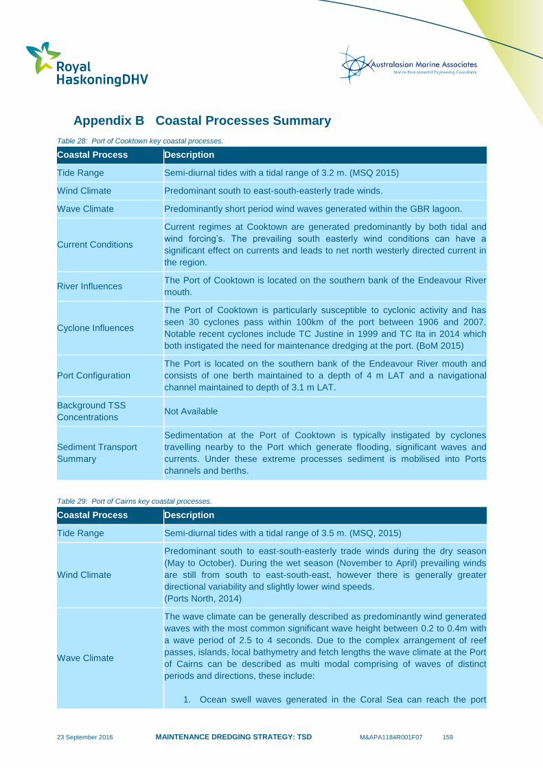
23 September 2016 MAINTENANCE DREDGING STRATEGY: TSD M&APA1184R001F07 159
Appendix B Coastal Processes Summary
Table 28: Port of Cooktown key coastal processes.
Coastal Process Description
Tide Range Semi-diurnal tides with a tidal range of 3.2 m. (MSQ 2015)
Wind Climate Predominant south to east-south-easterly trade winds.
Wave Climate Predominantly short period wind waves generated within the GBR lagoon.
Current Conditions
Current regimes at Cooktown are generated predominantly by both tidal and
wind forcing’s. The prevailing south easterly wind conditions can have a
significant effect on currents and leads to net north westerly directed current in
the region.
River Influences The Port of Cooktown is located on the southern bank of the Endeavour River
mouth.
Cyclone Influences
The Port of Cooktown is particularly susceptible to cyclonic activity and has
seen 30 cyclones pass within 100km of the port between 1906 and 2007.
Notable recent cyclones include TC Justine in 1999 and TC Ita in 2014 which
both instigated the need for maintenance dredging at the port. (BoM 2015)
Port Configuration
The Port is located on the southern bank of the Endeavour River mouth and
consists of one berth maintained to a depth of 4 m LAT and a navigational
channel maintained to depth of 3.1 m LAT.
Background TSS
Concentrations Not Available
Sediment Transport
Summary
Sedimentation at the Port of Cooktown is typically instigated by cyclones
travelling nearby to the Port which generate flooding, significant waves and
currents. Under these extreme processes sediment is mobilised into Ports
channels and berths.
Table 29: Port of Cairns key coastal processes.
Coastal Process Description
Tide Range Semi-diurnal tides with a tidal range of 3.5 m. (MSQ, 2015)
Wind Climate
Predominant south to east-south-easterly trade winds during the dry season
(May to October). During the wet season (November to April) prevailing winds
are still from south to east-south-east, however there is generally greater
directional variability and slightly lower wind speeds.
(Ports North, 2014)
Wave Climate
The wave climate can be generally described as predominantly wind generated
waves with the most common significant wave height between 0.2 to 0.4m with
a wave period of 2.5 to 4 seconds. Due to the complex arrangement of reef
passes, islands, local bathymetry and fetch lengths the wave climate at the Port
of Cairns can be described as multi modal comprising of waves of distinct
periods and directions, these include:
1. Ocean swell waves generated in the Coral Sea can reach the port

23 September 2016 MAINTENANCE DREDGING STRATEGY: TSD M&APA1184R001F07 160
through passages in the outer reef. These passages allow for the
limited penetration of significantly attenuated swell waves. Reef
passages affecting swell conditions at the port include the Trinity
opening to the north-east of Cairns and Grafton Passage to the east.
2. Cape Grafton provides significant shelter to the Port from the
prevailing south easterly wind waves generated within in the GBR
Lagoon. These waves do still however influence wave conditions in
Trinity Bay as they refract around Cape Grafton.
3. Short period wind waves generated from local winds within Trinity Bay.
(Ports North, 2014)
Current Conditions
Current regimes in Trinity Bay are generated predominantly by astronomical
tides and local winds. Within Trinity Bay astronomical tides represent the
dominant current component. The tidal currents tend to flow in an
inshore/offshore direction, perpendicular to the bathymetry contours and along
the channel alignment. However, wind induced currents resulting from the
prevailing south-easterly trade winds do result in a slight net cross-channel
directed current component. This wind induced current component becomes
more predominant in the outer areas of Trinity Bay. (Ports North, 2014)
River Influences
The Port of Cairns is situated 7 km to the south of the Barron River mouth
which is the major source of sediment for Trinity Bay. Discharges from the
Barron River are typically associated with flooding events caused by tropical
cyclones and extreme rainfall events and contain a high discharge of fine
(muddy) sediment from the catchment. The sediment is transported into the
sea where it forms a substantial proportion of the seabed sediment in the bay
(Ports North, 2014).
Cyclone Influences
The Port of Cairns is particularly susceptible to cyclonic activity and has seen
36 cyclones pass within 100km of the port between 1906 and 2007. Notable
recent cyclones include TC Yasi in 2011 and TC Larry in 2006. (BoM, 2015)
Port Configuration
The Port of Cairns is located within Trinity Bay and Trinity Inlet. The harbour
areas within the Inlet consist of a number of berths and swing basin with a
maintained depth of 8.3m below LAT. The main navigational channel (Entrance
Channel) also has a maintained depth of 8.3 m below LAT and traverses the
relatively shallow Trinity Bay in a north-north-east orientation. The Entrance
Channel represents an area of high trapping efficiency as areas adjacent to the
channel are relatively shallow (0 – 2 m below LAT for the majority of the
channel length).
Background TSS
Concentrations
Previous water quality monitoring undertaken within the port can be
summarised as:
1. Within Trinity Inlet the mean TSS concentration is 9 mg/l in the dry
season and 41 mg/l in the wet season.
2. Within Trinity Bay the mean TSS concentration is 6 mg/l in the dry
season and 8 mg/l in the wet season.
(Ports North, 2014)
Sediment Transport
Summary
Key processes driving sedimentation in the Port of Cairns dredged areas can
be summarised as:
1. Wave and current influences are the primary drivers responsible for
mobilising and transporting sediment into dredged areas. The

23 September 2016 MAINTENANCE DREDGING STRATEGY: TSD M&APA1184R001F07 161
orientation and shallow surrounding bathymetry of the Entrance
Channel results in the channel being an effective sediment trap.
2. The Barron River is primarily responsible for depositing muddy (25% to
70% mud component) sediment within Trinity Bay. Resultant flood
plumes can result in some direct sedimentation in the dredged areas.
3. The relatively high frequency of cyclones can result in high intensity
sedimentations events, potentially causing significant annual variability
in the maintenance dredging requirements.
Table 30: Port of Townsville key coastal processes.
Coastal Process Description
Tide Range Semi-diurnal tides with a tidal range of 4.11 m. (MSQ, 2015)
Wind Climate
The local wind climate is governed by south easterly trade winds. However,
sea breezes and wet season winds do result in winds from the north east at
times. (PoTL, 2013)
Wave Climate
The wave climate can be generally described as primarily ‘sea waves’
generated by local winds within Cleveland Bay. The wave climate can be
further summarised as:
1. Cape Cleveland provides significant shelter to the port from the
prevailing south easterly wind waves generated in the GBR Lagoon.
However, these waves still influence wave conditions in Cleveland Bay
with the more developed (longer period waves) refracting around Cape
Cleveland and propagating shoreward towards the port.
2. Local sea waves generated by winds blowing across the open waters
of Cleveland Bay, as well as those across West Channel between
Magnetic Island and the mainland are a common occurrence in the
Bay.
(PoTL 2013)
Current Conditions
Current regimes in Cleveland Bay are generated predominantly by astronomical
tides and local winds. Peak current speeds generally range from 0.3 to 0.6 m/s
during spring tides or prolonged wind events. The prevailing south easterly
wind conditions can have a significant effect on currents and at times can result
in the amplification of the flood tide towards the west and the reduction or even
reversing of the eastward ebb tide. This results in a net westerly directed
current in the shoreward extents of Cleveland Bay. (PoTL 2013)
In Cleveland Bay local features also influence the spatial variation in currents
throughout the Port area. While inshore currents are generally orientated in an
east-west direction (perpendicular to the channel), the influence of Magnetic
Island means tidal currents in the outer reaches of the navigational channel
generally flow in a north-south direction (parallel to the channel). (PoTL 2013)
River Influences
The Ross River located immediately to the south west of the port was once the
primary sediment source to Cleveland Bay until the construction of weirs and
the Ross River dam essentially eliminated the transport of coarser sediments to
the Bay. The Port of Townsville is located about 50 km north of the Burdekin
River, and is also about halfway between the Burdekin and Herbert Rivers
which provide the dominant sediment supply to the central GBR region

23 September 2016 MAINTENANCE DREDGING STRATEGY: TSD M&APA1184R001F07 162
(Rayment, Reilly, & Best 1993). The source of the ongoing accumulation of fine
sediments in Cleveland Bay is understood to predominantly originate from the
Burdekin River (PoTL 2013), although much of this sediment will have been
periodically resuspended and transported by waves and currents before it
reaches Cleveland Bay.
Cyclone Influences
The Port of Townsville is susceptible to cyclonic activity and has seen 31
cyclones pass within 100km of the port between 1906 and 2007. A notable
recent cyclone was TC Yasi in 2011 (BoM, 2015).
Port Configuration
The port is located within Cleveland Bay with the harbour areas located on the
Ross Creek. Dredged areas within the harbour have a declared depth of 11.7 m
below LAT. The main navigational channel (Platypus and Sea Channels) also
has a maintained depth of 11.7 m below LAT and traverses the relatively
shallow Cleveland Bay in a north-north-easterly orientation. The shoreward
extents of the navigation channel represent an area of high trapping efficiency
as areas adjacent to the dredged channel are relatively shallow (3 – 10m below
LAT depths for approximately 90% of the channel length).
Background TSS
Concentrations
Previous water quality monitoring undertaken within the port can be
summarised as:
1. Mean TSS concentration within Cleveland Bay of 10 mg/l (POTL 2004
– 2011).
2. Mean wet season TSS concentration within Cleveland Bay of 20 mg/l
(WBM Jan 09 – Feb 09).
3. Mean dry season TSS concentration within Cleveland Bay of 9 mg/l
(WBM Sep 08 – May 09).
4. 80 NTU (160 mg/l) measured at Horseshoe Bay during TC Larry
(expected to be higher inside Cleveland Bay), (Cooper et al. 2008).
Sediment Transport
Summary
Key processes driving sedimentation in the Port of Townsville can be
summarised as:
1. Residual currents in a westerly direction along with local sea and swell
waves can result in the net longshore transport of sediment from the
shallow eastern coastal areas of Cleveland Bay to the west, with some
of the material being deposited in the dredged areas of the port.
2. Limited river fine sediment inputs are provided by the Ross River and
Ross Creek. Any fine sediment discharged from the major Burdekin
River catchment to the south will typically not directly influence
sedimentation within Cleveland Bay, rather the material will be
reworked by waves and currents before it reaches the bay.
3. The relatively high frequency of cyclones can result in short lived, high
intensity sedimentations events, potentially causing significant annual
variability in the maintenance dredging requirements.
Table 31: Port of Abbot Point key coastal processes.
Coastal Process Description
Tide Range Semi-diurnal tides with a tidal range of 3.6 m (MSQ, 2015).
Wind Climate South east trade winds blow throughout the year but tend to be more persistent
during winter months while north to north easterly winds occur predominantly in
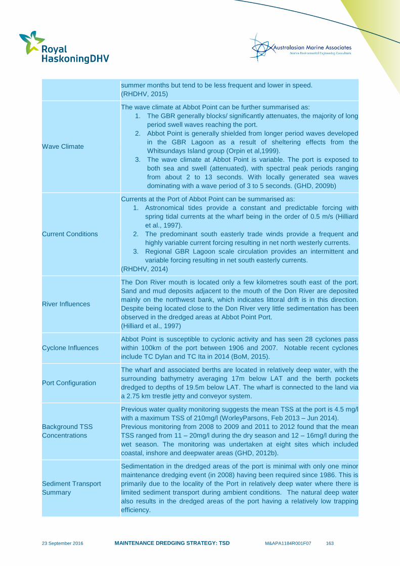
23 September 2016 MAINTENANCE DREDGING STRATEGY: TSD M&APA1184R001F07 163
summer months but tend to be less frequent and lower in speed.
(RHDHV, 2015)
Wave Climate
The wave climate at Abbot Point can be further summarised as:
1. The GBR generally blocks/ significantly attenuates, the majority of long
period swell waves reaching the port.
2. Abbot Point is generally shielded from longer period waves developed
in the GBR Lagoon as a result of sheltering effects from the
Whitsundays Island group (Orpin et al,1999).
3. The wave climate at Abbot Point is variable. The port is exposed to
both sea and swell (attenuated), with spectral peak periods ranging
from about 2 to 13 seconds. With locally generated sea waves
dominating with a wave period of 3 to 5 seconds. (GHD, 2009b)
Current Conditions
Currents at the Port of Abbot Point can be summarised as:
1. Astronomical tides provide a constant and predictable forcing with
spring tidal currents at the wharf being in the order of 0.5 m/s (Hilliard
et al., 1997).
2. The predominant south easterly trade winds provide a frequent and
highly variable current forcing resulting in net north westerly currents.
3. Regional GBR Lagoon scale circulation provides an intermittent and
variable forcing resulting in net south easterly currents.
(RHDHV, 2014)
River Influences
The Don River mouth is located only a few kilometres south east of the port.
Sand and mud deposits adjacent to the mouth of the Don River are deposited
mainly on the northwest bank, which indicates littoral drift is in this direction.
Despite being located close to the Don River very little sedimentation has been
observed in the dredged areas at Abbot Point Port.
(Hilliard et al., 1997)
Cyclone Influences
Abbot Point is susceptible to cyclonic activity and has seen 28 cyclones pass
within 100km of the port between 1906 and 2007. Notable recent cyclones
include TC Dylan and TC Ita in 2014 (BoM, 2015).
Port Configuration
The wharf and associated berths are located in relatively deep water, with the
surrounding bathymetry averaging 17m below LAT and the berth pockets
dredged to depths of 19.5m below LAT. The wharf is connected to the land via
a 2.75 km trestle jetty and conveyor system.
Background TSS
Concentrations
Previous water quality monitoring suggests the mean TSS at the port is 4.5 mg/l
with a maximum TSS of 210mg/l (WorleyParsons, Feb 2013 – Jun 2014).
Previous monitoring from 2008 to 2009 and 2011 to 2012 found that the mean
TSS ranged from 11 – 20mg/l during the dry season and 12 – 16mg/l during the
wet season. The monitoring was undertaken at eight sites which included
coastal, inshore and deepwater areas (GHD, 2012b).
Sediment Transport
Summary
Sedimentation in the dredged areas of the port is minimal with only one minor
maintenance dredging event (in 2008) having been required since 1986. This is
primarily due to the locality of the Port in relatively deep water where there is
limited sediment transport during ambient conditions. The natural deep water
also results in the dredged areas of the port having a relatively low trapping
efficiency.
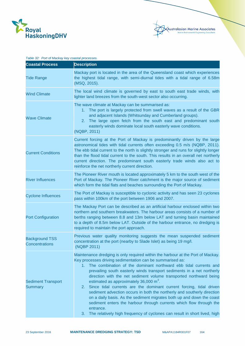
23 September 2016 MAINTENANCE DREDGING STRATEGY: TSD M&APA1184R001F07 164
Table 32: Port of Mackay key coastal processes.
Coastal Process Description
Tide Range
Mackay port is located in the area of the Queensland coast which experiences
the highest tidal range, with semi-diurnal tides with a tidal range of 6.58m
(MSQ, 2015).
Wind Climate The local wind climate is governed by east to south east trade winds, with
lighter land breezes from the south-west sector also occurring.
Wave Climate
The wave climate at Mackay can be summarised as:
1. The port is largely protected from swell waves as a result of the GBR
and adjacent Islands (Whitsunday and Cumberland groups).
2. The large open fetch from the south east and predominant south
easterly winds dominate local south easterly wave conditions.
(NQBP, 2011)
Current Conditions
Current forcing at the Port of Mackay is predominantly driven by the large
astronomical tides with tidal currents often exceeding 0.5 m/s (NQBP, 2011).
The ebb tidal current to the north is slightly stronger and runs for slightly longer
than the flood tidal current to the south. This results in an overall net northerly
current direction. The predominant south easterly trade winds also act to
reinforce the net northerly current direction.
River Influences
The Pioneer River mouth is located approximately 5 km to the south west of the
Port of Mackay. The Pioneer River catchment is the major source of sediment
which form the tidal flats and beaches surrounding the Port of Mackay.
Cyclone Influences The Port of Mackay is susceptible to cyclonic activity and has seen 23 cyclones
pass within 100km of the port between 1906 and 2007.
Port Configuration
The Mackay Port can be described as an artificial harbour enclosed within two
northern and southern breakwaters. The harbour areas consists of a number of
berths ranging between 8.8 and 13m below LAT and turning basin maintained
to a depth of 8.5m below LAT. Outside of the harbour entrance, no dredging is
required to maintain the port approach.
Background TSS
Concentrations
Previous water quality monitoring suggests the mean suspended sediment
concentration at the port (nearby to Slade Islet) as being 19 mg/l.
(NQBP 2011)
Sediment Transport
Summary
Maintenance dredging is only required within the harbour at the Port of Mackay.
Key processes driving sedimentation can be summarised as:
1. The combination of the dominant northward ebb tidal currents and
prevailing south easterly winds transport sediments in a net northerly
direction with the net sediment volume transported northward being
estimated as approximately 36,000 m3.
2. Since tidal currents are the dominant current forcing, tidal driven
sediment advection occurs in both the northerly and southerly direction
on a daily basis. As the sediment migrates both up and down the coast
sediment enters the harbour through currents which flow through the
entrance.
3. The relatively high frequency of cyclones can result in short lived, high
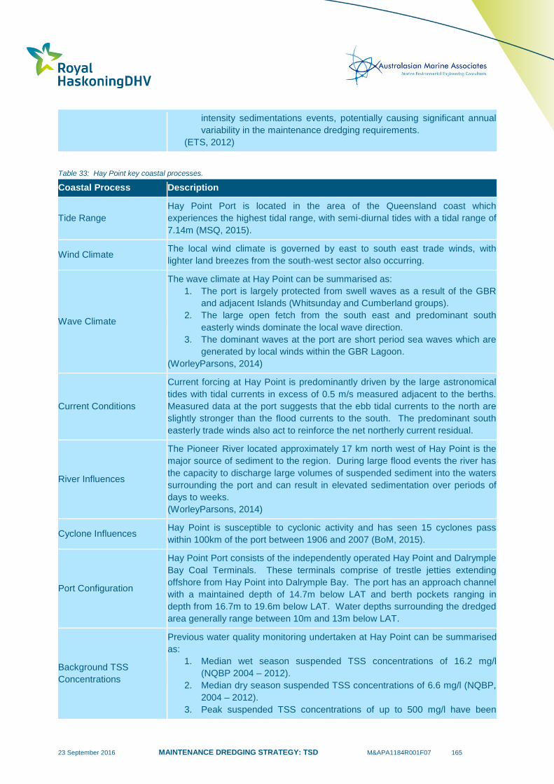
23 September 2016 MAINTENANCE DREDGING STRATEGY: TSD M&APA1184R001F07 165
intensity sedimentations events, potentially causing significant annual
variability in the maintenance dredging requirements.
(ETS, 2012)
Table 33: Hay Point key coastal processes.
Coastal Process Description
Tide Range
Hay Point Port is located in the area of the Queensland coast which
experiences the highest tidal range, with semi-diurnal tides with a tidal range of
7.14m (MSQ, 2015).
Wind Climate The local wind climate is governed by east to south east trade winds, with
lighter land breezes from the south-west sector also occurring.
Wave Climate
The wave climate at Hay Point can be summarised as:
1. The port is largely protected from swell waves as a result of the GBR
and adjacent Islands (Whitsunday and Cumberland groups).
2. The large open fetch from the south east and predominant south
easterly winds dominate the local wave direction.
3. The dominant waves at the port are short period sea waves which are
generated by local winds within the GBR Lagoon.
(WorleyParsons, 2014)
Current Conditions
Current forcing at Hay Point is predominantly driven by the large astronomical
tides with tidal currents in excess of 0.5 m/s measured adjacent to the berths.
Measured data at the port suggests that the ebb tidal currents to the north are
slightly stronger than the flood currents to the south. The predominant south
easterly trade winds also act to reinforce the net northerly current residual.
River Influences
The Pioneer River located approximately 17 km north west of Hay Point is the
major source of sediment to the region. During large flood events the river has
the capacity to discharge large volumes of suspended sediment into the waters
surrounding the port and can result in elevated sedimentation over periods of
days to weeks.
(WorleyParsons, 2014)
Cyclone Influences Hay Point is susceptible to cyclonic activity and has seen 15 cyclones pass
within 100km of the port between 1906 and 2007 (BoM, 2015).
Port Configuration
Hay Point Port consists of the independently operated Hay Point and Dalrymple
Bay Coal Terminals. These terminals comprise of trestle jetties extending
offshore from Hay Point into Dalrymple Bay. The port has an approach channel
with a maintained depth of 14.7m below LAT and berth pockets ranging in
depth from 16.7m to 19.6m below LAT. Water depths surrounding the dredged
area generally range between 10m and 13m below LAT.
Background TSS
Concentrations
Previous water quality monitoring undertaken at Hay Point can be summarised
as:
1. Median wet season suspended TSS concentrations of 16.2 mg/l
(NQBP 2004 – 2012).
2. Median dry season suspended TSS concentrations of 6.6 mg/l (NQBP,
2004 – 2012).
3. Peak suspended TSS concentrations of up to 500 mg/l have been
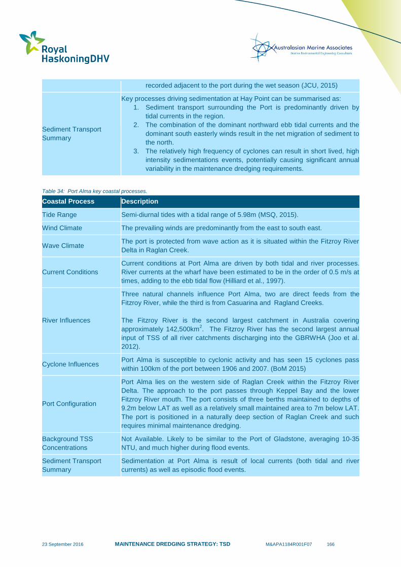
23 September 2016 MAINTENANCE DREDGING STRATEGY: TSD M&APA1184R001F07 166
recorded adjacent to the port during the wet season (JCU, 2015)
Sediment Transport
Summary
Key processes driving sedimentation at Hay Point can be summarised as:
1. Sediment transport surrounding the Port is predominantly driven by
tidal currents in the region.
2. The combination of the dominant northward ebb tidal currents and the
dominant south easterly winds result in the net migration of sediment to
the north.
3. The relatively high frequency of cyclones can result in short lived, high
intensity sedimentations events, potentially causing significant annual
variability in the maintenance dredging requirements.
Table 34: Port Alma key coastal processes.
Coastal Process Description
Tide Range Semi-diurnal tides with a tidal range of 5.98m (MSQ, 2015).
Wind Climate The prevailing winds are predominantly from the east to south east.
Wave Climate The port is protected from wave action as it is situated within the Fitzroy River
Delta in Raglan Creek.
Current Conditions
Current conditions at Port Alma are driven by both tidal and river processes.
River currents at the wharf have been estimated to be in the order of 0.5 m/s at
times, adding to the ebb tidal flow (Hilliard et al., 1997).
River Influences
Three natural channels influence Port Alma, two are direct feeds from the
Fitzroy River, while the third is from Casuarina and Ragland Creeks.
The Fitzroy River is the second largest catchment in Australia covering
approximately 142,500km2. The Fitzroy River has the second largest annual
input of TSS of all river catchments discharging into the GBRWHA (Joo et al.
2012).
Cyclone Influences Port Alma is susceptible to cyclonic activity and has seen 15 cyclones pass
within 100km of the port between 1906 and 2007. (BoM 2015)
Port Configuration
Port Alma lies on the western side of Raglan Creek within the Fitzroy River
Delta. The approach to the port passes through Keppel Bay and the lower
Fitzroy River mouth. The port consists of three berths maintained to depths of
9.2m below LAT as well as a relatively small maintained area to 7m below LAT.
The port is positioned in a naturally deep section of Raglan Creek and such
requires minimal maintenance dredging.
Background TSS
Concentrations
Not Available. Likely to be similar to the Port of Gladstone, averaging 10-35
NTU, and much higher during flood events.
Sediment Transport
Summary
Sedimentation at Port Alma is result of local currents (both tidal and river
currents) as well as episodic flood events.
23 September 2016 MAINTENANCE DREDGING STRATEGY: TSD M&APA1184R001F07 167
Table 35: Port of Gladstone key coastal processes.
Coastal Process Description
Tide Range
Gladstone experiences semi-diurnal tides with a tidal range of approximately
4.9m (MSQ, 2015). It should be noted that the narrowing embayment of Port of
Gladstone leads to a funnelling effect with larger tides experienced at the
upstream extents (i.e. Fisherman’s Landing).
Wind Climate
The local wind climate can be summarised as south easterly winds in the
morning which generally swing more east and north-east and become slightly
stronger in the afternoon (GHD, 2009b).
Wave Climate
The Port of Gladstone sees a spatially varying wave climate as a result of the
sheltering effects of Facing Island and Curtis Island. The wave climate at the
Port of Gladstone can be summarised as:
1. Within the Port of Gladstone the sheltering effects of Facing Island and
Curtis Island means the wave climate is dominated by locally generated
sea waves influenced by local wind conditions.
2. Outside of the Port of Gladstone, both sea and swell conditions are
more prominent. Developed swell waves are a common occurrence
resulting from southerly swell refracting towards the Port through an
opening in the reef and Islands.
(BMT WBM, 2013)
Current Conditions
Currents within the Port are primarily driven by astronomical tides. Tides
propagate into the Port of Gladstone via the North Channel, South Channel and
The Narrow which leads to complex tidal flows throughout the port. The large
tidal prism and the amplification effect of the embayment results in high current
speeds throughout the port. Current speeds in excess of 2m/s have been
measured within the Port of Gladstone. Within the Port depth-averaged tidal
velocities are strongest during the flood tide.
(GHD, 2009b)
River Influences
A number of local rivers and tributaries discharge directly into the Port of
Gladstone. These include the Calliope River, Boyne River and Raglan Creek.
Discharge from these systems varies throughout the year with the highest
volumes experienced during the wet season when an estimated 75 – 90 % of
yearly discharge occurs.
(GHD, 2009b)
Cyclone Influences
Port of Gladstone is susceptible to cyclonic activity and has seen 12 cyclones
pass within 100km of the port between 1906 and 2007. Notable recent cyclones
include:
TC Hamish in 2009 passed along the coastline of Gladstone and
resulted in the temporary closure of the Port.
TC Yasi and TC Oswald (2011 and 2013) resulted in significant flood
events in the region.
(GPC, 2014a)
Port Configuration
The Port of Gladstone is Queensland’s largest multi-cargo port and comprises
of multiple dredged channels, berths and basins. There is approximately 40km
of shipping channels (with an averaged maintained depth of 16m below LAT)
stretching from the Fairway Buoy to Fisherman’s Island. The depths adjacent to
23 September 2016 MAINTENANCE DREDGING STRATEGY: TSD M&APA1184R001F07 168
the ports dredged areas range significantly throughout the port. A recent
capital works project (Western Basin Dredging) has been recently completed to
accommodate new Gas export facilities in the port.
(GPC, 2014a)
Background
Turbidity/TSS
Concentrations
Turbidity/total suspended solid concentrations in Port Cutis are primarily driven
by tidal resuspension and freshwater inflows. Previous water quality monitoring
undertaken at the port can be summarised as:
1. Average turbidity levels in the Port of Gladstone are between 10-35
NTUs.
2. During heavy rain and floods turbidity measurements in the port can
rise to over 250 NTUs.
3. Outside of the Harbour turbidity measurements average 5 NTUs.
(GPC, 2014a)
A review of previous marine investigations found that the mean turbidity at a
number of sites around the Port of Gladstone ranged from 10 – 47 NTU during
the dry season and 29 – 161 NTU during the wet season (GPC, 2014b).
Sediment Transport
Summary
Key processes driving sedimentation at the Port of Gladstone can be
summarised as:
1. The principal drivers of sediment movement are the tidal currents and
locally generated wind waves.
2. The highest amounts of resuspension and in turn sedimentation occur
during spring tides when tidal currents are at their strongest.
3. Both temporal and spatially varying currents throughout the Port of
Gladstone results in marked variation in the spatial distribution of
suspended sediments throughout the port.
4. Within the inner harbour, locally generated wind waves can act to
mobilise fine sediments from the shallower intertidal areas of the Port
from which the prevailing currents transport the sediment into deeper
maintained dredged areas.
5. Outside the harbour the presence of longer period swell waves are an
important process for sediment transport. The longer period waves are
effective in mobilising bed sediments allowing prevailing tidal and wind-
induced currents to transport the mobilised sediment.
6. The local rivers and tributaries can supply large volumes of suspended
sediment during episodic flood events.
7. Cyclonic conditions resulting in extreme wave and current conditions
can drive infrequent, short duration, high intensity sedimentation
events, potentially causing significant annual variability in the
maintenance dredging requirements.
(GPC, 2014a; GHD, 2009b)
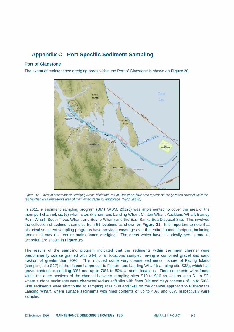
23 September 2016 MAINTENANCE DREDGING STRATEGY: TSD M&APA1184R001F07 169
Appendix C Port Specific Sediment Sampling
Port of Gladstone
The extent of maintenance dredging areas within the Port of Gladstone is shown on Figure 20.
Figure 20: Extent of Maintenance Dredging Areas within the Port of Gladstone, blue area represents the gazetted channel while the
red hatched area represents area of maintained depth for anchorage. (GPC, 2014b)
In 2012, a sediment sampling program (BMT WBM, 2012c) was implemented to cover the area of the
main port channel, six (6) wharf sites (Fishermans Landing Wharf, Clinton Wharf, Auckland Wharf, Barney
Point Wharf, South Trees Wharf, and Boyne Wharf) and the East Banks Sea Disposal Site. This involved
the collection of sediment samples from 51 locations as shown on Figure 21. It is important to note that
historical sediment sampling programs have provided coverage over the entire channel footprint, including
areas that may not require maintenance dredging. The areas which have historically been prone to
accretion are shown in Figure 15.
The results of the sampling program indicated that the sediments within the main channel were
predominantly coarse grained with 54% of all locations sampled having a combined gravel and sand
fraction of greater than 90%. This included some very coarse sediments inshore of Facing Island
(sampling site S17) to the channel approach to Fishermans Landing Wharf (sampling site S38), which had
gravel contents exceeding 30% and up to 70% to 80% at some locations. Finer sediments were found
within the outer sections of the channel between sampling sites S10 to S16 as well as sites S1 to S3,
where surface sediments were characterised as soft silts with fines (silt and clay) contents of up to 50%.
Fine sediments were also found at sampling sites S39 and S41 on the channel approach to Fishermans
Landing Wharf, where surface sediments with fines contents of up to 40% and 60% respectively were
sampled.

23 September 2016 MAINTENANCE DREDGING STRATEGY: TSD M&APA1184R001F07 170
Predominantly coarse grained sediments were sampled at Fishermans Landing Wharf, Clinton Wharf,
Barney Point Wharf and Boyne Wharf, with combined gravel and sand contents between 73% and 86%.
Sediments at Auckland Wharf and South Trees Wharf were silts and clays with fines contents of 93% and
50% respectively.
Figure 21: 2012 Sediment Sampling Locations in Port of Gladstone (BMT WBM, 2012c)
In 2014, sampling of new maintenance dredging areas created by the Western Basin Dredging and
Disposal Project (WBDDP) was undertaken (BMT WBM, 2014d). This investigation comprised 17
sampling locations (refer Figure 22) and found that sediments:
in the northern part of the WBDDP area (Jacobs Channel) were characterised by high proportions
of silts and clays (often greater than 90% silts and clays);
in the southern part of the WBDDP area (Clinton Channel) were generally characterised by
coarser sediments (greater than 90% sand and gravel); and,
at the Tug Base at RG Tanna coal terminal were characterised by fine sediments (greater than
90% silts and clays at all sampling locations).
When the results of the sediment sampling are considered in relation to the areas where historic
sedimentation has occurred the sediment accumulating predominantly comprise fine sediments (silts and
clays) with some sands. Although identified in previous sampling campaigns, GPC have advised that
gravels have not been found to accumulate in areas where maintenance dredging has been required.
Maintenance dredging sediments within the Port of Gladstone have consistently been found to not exceed
NAGD screening levels and suitable for disposal at sea in accordance with the NAGD (BMT WBM,
2014e). While past studies have found occasional exceedances in arsenic and tributyltin (TBT), elutriate
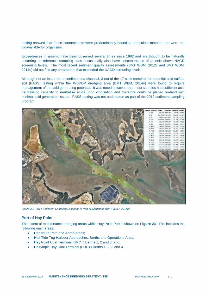
23 September 2016 MAINTENANCE DREDGING STRATEGY: TSD M&APA1184R001F07 171
testing showed that these contaminants were predominantly bound to particulate material and were not
bioavailable for organisms.
Exceedances in arsenic have been observed several times since 1992 and are thought to be naturally
occurring as reference sampling sites occasionally also have concentrations of arsenic above NAGD
screening levels. The most recent sediment quality assessments (BMT WBM, 2012c and BMT WBM,
2014e) did not find any parameters that exceeded the NAGD screening levels.
Although not an issue for unconfined sea disposal, 3 out of the 17 sites sampled for potential acid sulfate
soil (PASS) testing within the WBDDP dredging area (BMT WBM, 2014e) were found to require
management of the acid generating potential. It was noted however, that most samples had sufficient acid
neutralising capacity to neutralise acids upon oxidisation and therefore could be placed on-land with
minimal acid generation issues. PASS testing was not undertaken as part of the 2012 sediment sampling
program.
Figure 22: 2014 Sediment Sampling Locations in Port of Gladstone (BMT WBM, 2014e)
Port of Hay Point
The extent of maintenance dredging areas within Hay Point Port is shown on Figure 23. This includes the
following main areas:
Departure Path and Apron areas;
Half Tide Tug Harbour Approaches, Berths and Operations Areas;
Hay Point Coal Terminal (HPCT) Berths 1, 2 and 3; and,
Dalrymple Bay Coal Terminal (DBCT) Berths 1, 2, 3 and 4.

23 September 2016 MAINTENANCE DREDGING STRATEGY: TSD M&APA1184R001F07 172
Figure 23: Extent of Maintenance Dredging Areas within Hay Point Port (Ports and Coastal Pty Ltd, 2012)
The most recent sediment sampling program was completed in 2012 (Ports and Coastal Environmental
Pty Ltd, 2012) and comprised sampling at the above maintenance dredging areas in accordance with
NAGD requirements.
The 2012 investigation determined that the following distribution of sediment types existed within
maintenance dredging areas:
sediments within DBCT Berths 3 and 4 comprised silty clays with an average of around 80%
clay/silt content and 20% sand/gravel content;
sediments within HPCT Berth 1 comprised clayey sands with an average of around 80%
sand/gravel content and 20% clay/silt content;
sediments within HPCT Berth 2 comprised silty clays and clayey sands with an average of around
50% sand/gravel content and 50% clay/silt content;
sediments within the Apron Area comprised silty clays and clayey sands with an average of
around 50% sand/gravel content and 50% clay/silt content;
sediments within the Departure Path comprised clayey sands with an average of around 80%
sand/gravel content and 20% clay/silt content; and,
sediments with the Half Tide Tug Harbour Approaches and Berths comprised silty clays with an
average of around 80% clay/silt content and 20% sand/gravel content.
The sediment samples obtained from the 2012 investigation were tested for the following analytes: TBT,
heavy metals, hydrocarbons and polycyclic aromatic hydrocarbons (PAHs). The following is a summary of
the geochemical properties of sediments:
sediments within the Half Tide Tug Harbour Approaches and Berths satisfied NAGD screening
criteria with the exception of arsenic, however when considering the approach channel and berth
area as a single dredge unit, it was found to be below the NAGD limit and considered to be
suitable for unconfined sea disposal. Sediments of the Central Queensland coast are known to
contain naturally elevated arsenic due to the mineralogy of adjacent catchments;
sediments within HPCT Berths 1 and 2 exceeded NAGD screening criteria for TBT (Berth 1 and
2), and arsenic, copper, lead and zinc (Berth 2), and it was concluded that the sediment was not
suitable for unconfined sea disposal in accordance with the NAGD;

23 September 2016 MAINTENANCE DREDGING STRATEGY: TSD M&APA1184R001F07 173
at the time of sampling HPCT Berth 3 was under construction and was not included within the
2012 investigation;
past sampling (2010) within DBCT Berth 1 and 2 identified potentially elevated concentrations of
TBT, however recent investigations undertaken in 2015 concluded that TBT concentrations within
these berths are below the NAGD screening levels, these findings are currently being reviewed by
GBRMPA to confirm the materials are suitable for at-sea disposal; and,
sediments within DBCT Berth 3 and 4, Apron Area and Departure Path satisfied NAGD screening
criteria for all analytes and were considered to be suitable for unconfined sea disposal in
accordance with the NAGD.
Mackay Port
The extent of maintenance dredging areas within Mackay Port is shown on Figure 24.
Figure 24: Extent of Maintenance Dredging Areas within Mackay Port (NQBP, 2011)

23 September 2016 MAINTENANCE DREDGING STRATEGY: TSD M&APA1184R001F07 174
The most recent available sediment sampling program was completed in 2009 and involved the separate
assessment of the ‘channel and swing basin’ and ‘berth pockets’ maintenance dredging areas. The 2009
investigation (WorleyParsons, 2010a) determined that sediments within the channel and swing basin
comprised sandy clays and silty clays with an average of 38% clay, 36% silt and 23% sand content. Two
samples located near the northern breakwater and the entrance to the harbour were characterised as
clayey sands and had a higher sand content (65% sand) in comparison to the remainder of the
maintenance dredging area. Field assessment of sediments indicated that the berth pockets were
dominated by clays and silts with very little sand (similar to the channel and swing basin areas).
Sediments within the Tug Berth were noted to have a high sand content in comparison to other berth
areas due to the frequent passage of tug traffic.
Based on the results of previous sediment sampling and testing and historical industrial activities, Primary
Contaminants of Potential Concern (CoPCs) within maintenance dredged sediments include TBT, heavy
metals (arsenic, chromium, copper, lead, mercury, nickel and zinc) and polycyclic aromatic hydrocarbons
(PAHs). The results of the 2009 sediment assessment determined that contamination levels were below
relevant screening levels with the exception of TBT detected within the berth pockets. Further elutriate
and pore water analysis at elevated TBT locations determined that water quality would be unlikely to be
impacted at the offshore disposal site and that TBT is also unlikely to be bioavailable to benthic infauna at
the disposal site. As such, it was concluded that the maintenance dredged sediment from all areas was
suitable for unconfined sea disposal in accordance with the NAGD.
The 2009 sediment assessment included acid sulfate soils testing of surface sediments at 4 sites within
the berth pockets. The test results indicated that potential acid sulfate soils (PASS) existed at all
locations. However, the sediment contained sufficient Acid Neutralising Capacity (ANC) such that liming
would not be required if the material was disposed of on-land. It was noted that sampling of deeper
sediments was required to definitively assess the maintenance dredging areas for PASS.
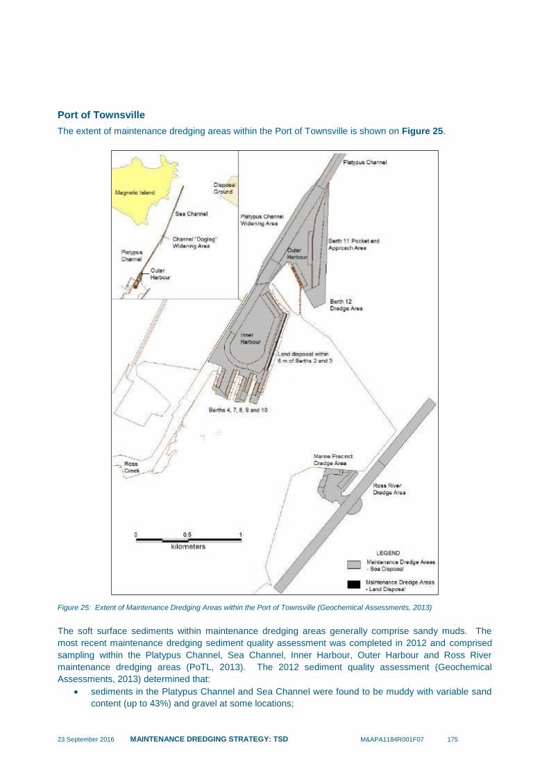
23 September 2016 MAINTENANCE DREDGING STRATEGY: TSD M&APA1184R001F07 175
Port of Townsville
The extent of maintenance dredging areas within the Port of Townsville is shown on Figure 25.
Figure 25: Extent of Maintenance Dredging Areas within the Port of Townsville (Geochemical Assessments, 2013)
The soft surface sediments within maintenance dredging areas generally comprise sandy muds. The
most recent maintenance dredging sediment quality assessment was completed in 2012 and comprised
sampling within the Platypus Channel, Sea Channel, Inner Harbour, Outer Harbour and Ross River
maintenance dredging areas (PoTL, 2013). The 2012 sediment quality assessment (Geochemical
Assessments, 2013) determined that:
sediments in the Platypus Channel and Sea Channel were found to be muddy with variable sand
content (up to 43%) and gravel at some locations;
23 September 2016 MAINTENANCE DREDGING STRATEGY: TSD M&APA1184R001F07 176
sediments in the Inner Harbour area were found to be silts and clays with trace to minor amounts
of sand;
silts and clays were found in deep water areas of the Outer Harbour (greater than 10 metres),
whilst fine sand was found in shallow water areas;
sediment in the Ross River comprised coarse sand that accumulates in prominent sand banks
and fine grained muddy sediments (i.e. greater than 90% fines content) that exist within deeper
sections of the Ross River channel; and,
greater than 50% of the fines content in the 15 samples analysed consisted of clay material (i.e.
grain size less than 4 microns).
Ross Creek and the Marine Precinct were excluded from the 2012 sampling program as these areas are
infrequently dredged and maintenance dredging was not planned in these areas at the time. However, it
was reported that sediments within Ross Creek comprised silts and muds and that muddy sands exist
within the Marine Precinct (PoTL, 2013).
PoTL has been implementing a comprehensive “surveillance” sediment sampling program involving 247
sites throughout the port that are sampled quarterly. The Long Term Sediment Monitoring Program
(LTSMP) has been in place since 1994 and is supplemented by more detailed sampling of areas subject
to maintenance dredging consistent with the NAGD.
Based on the results of previous sediment sampling and testing and historical industrial activities, Primary
Contaminants of Potential Concern (CoPCs) within maintenance dredged sediments include Arsenic (As),
Cadmium (Cd), Chromium (Cr), Copper (Cu), Lead (Pb), Zinc (Zn) and TBT.
Levels of contamination are highest within the Inner Harbour, where concentrations of Cu and Ni have
exceeded NAGD screening levels. However, subsequent elutriate testing undertaken as part of the 2012
sampling campaign for maintenance dredging sediment quality assessment determined that these
contaminants were predominantly bound to particulate material and are not bioavailable for organisms at
unacceptable concentrations in accordance with the NAGD. It was concluded that these sediments were
suitable for unconfined sea disposal.
However, the 2012 assessment of Inner Harbour sediment excluded two small areas, which included a 6
metre strip along the quay line of Berths 2 and 3 and the southern area between Berths 7 and 8. Some of
these areas have been influenced by product loading/unloading spillage as indicated by the historical
results of quarterly collection and analysis of surface samples from these areas as part of the LTSMP
undertaken by PoTL. The LTSMP has shown that contamination levels of Cu, Ni, Pb and Zn and in these
areas are sufficiently high to trigger ecotoxicity testing within the NAGD testing hierarchy. As such, PoTL
and port users have adopted a precautionary approach by placing material from these areas on-land. The
LTSMP has also identified sediments containing relatively high concentrations of Cu south of Berth 4.
The 2012 sampling campaign determined that the concentrations of trace metals in maintenance dredging
areas beyond the Inner Harbour did not exceed NAGD screening levels. It was concluded that sediment
in the Outer Harbour, Platypus Channel, Sea Channel and Ross River was classified as suitable for
unconfined sea disposal.
Previous sampling in the Marine Precinct area was undertaken prior to its development in 2011, which
indicated that sediment quality was relatively good with negligible exceedances of NAGD screening levels
(PoTL, 2013). However, it is considered that contaminants released by refuelling, abrasive blasting,
painting and minor transfer of hazardous goods (e.g. batteries) associated with its current use as a
commercial maritime facility have the potential to accumulate with the muddy sands within the Marine

23 September 2016 MAINTENANCE DREDGING STRATEGY: TSD M&APA1184R001F07 177
Precinct under its low energy conditions. Due to the absence of current sediment quality data since
development of the area and shallow water depth making the area inaccessible for operation of a TSHD,
PoTL maintenance dredging strategies have allocated this material for disposal on-land.
The sediments within Ross Creek are known to have been subject to industrial and stormwater discharges
over a long period of time as the area is infrequently dredged. In the absence of current sediment quality
data, PoTL maintenance dredging strategies have assumed that this material is unsuitable for unconfined
sea disposal and would be disposed on-land.
In light of the above, PoTL has proposed that future testing of sediments in the Marine Precinct and Ross
Creek should include PAHs (Polycyclic Aromatic Hydrocarbons), TPH (Total Petroleum Hydrocarbon),
BTEX (benzene, toluene, ethylbenzene and xylenes) and organochlorine pesticide residues in addition to
the primary CoPCs.
Potential acid sulfate soils (PASS) have been identified at the port. Although not an issue for unconfined
sea disposal, sediment disposed of this material to land may require management of the acid generating
potential.
Port of Cairns
The extent of maintenance dredging areas within the Port of Cairns is shown on Figure 26. The port is
divided into several dredging management areas that comprise:
Outer Channel;
Inner Port (including the Inner Channel, main wharves and swing basins);
Navy Base;
Marlin Marina;
Commercial Fishing Base 1 (CFB1); and,
Commercial Fishing Base 2 (CFB2).
It is important to note that the majority (approximately 90%) of maintenance dredge material volume is
removed from the Outer Channel, in comparison to the other areas of the port.
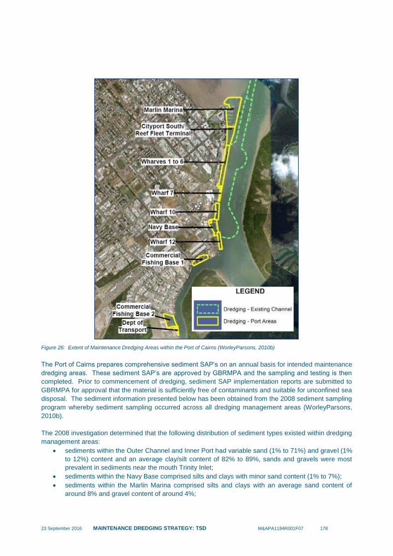
23 September 2016 MAINTENANCE DREDGING STRATEGY: TSD M&APA1184R001F07 178
Figure 26: Extent of Maintenance Dredging Areas within the Port of Cairns (WorleyParsons, 2010b)
The Port of Cairns prepares comprehensive sediment SAP’s on an annual basis for intended maintenance
dredging areas. These sediment SAP’s are approved by GBRMPA and the sampling and testing is then
completed. Prior to commencement of dredging, sediment SAP implementation reports are submitted to
GBRMPA for approval that the material is sufficiently free of contaminants and suitable for unconfined sea
disposal. The sediment information presented below has been obtained from the 2008 sediment sampling
program whereby sediment sampling occurred across all dredging management areas (WorleyParsons,
2010b).
The 2008 investigation determined that the following distribution of sediment types existed within dredging
management areas:
sediments within the Outer Channel and Inner Port had variable sand (1% to 71%) and gravel (1%
to 12%) content and an average clay/silt content of 82% to 89%, sands and gravels were most
prevalent in sediments near the mouth Trinity Inlet;
sediments within the Navy Base comprised silts and clays with minor sand content (1% to 7%);
sediments within the Marlin Marina comprised silts and clays with an average sand content of
around 8% and gravel content of around 4%;

23 September 2016 MAINTENANCE DREDGING STRATEGY: TSD M&APA1184R001F07 179
sediments within Commercial Fishing Base 1 comprised silts and clays with minor sand content
(2%); and,
sediments within Commercial Fishing Base 2 comprised silts and clays with minor sand content
(8%).
An extensive program of sediment contamination assessment has been implemented by the operators of
Port of Cairns since 1995 (BMT WBM, 2014b). Sediments within the Port of Cairns are typically
uncontaminated, with the majority of contaminant substances not exceeding NAGD screening levels at 95
per cent UCL (BMT WBM, 2014b).
The few exceptions involve arsenic, tributylin (TBT), copper and diuron (WorleyParsons 2010b). Additional
testing has been undertaken during the implementation of past Sampling and Analysis Plans (SAPs) and
levels present in elutriate and porewater tests have indicated that no significant impact to water quality or
benthic communities was likely (BMT WBM, 2014b). Similar to other parts of Eastern Australia, arsenic is
naturally elevated in the Cairns region due to the presence of natural mineralisation in metamorphic rocks.
As such, arsenic has exceeded the NAGD screening level in most Port of Cairns dredge areas except
Marlin Marina within the past five years (BMT WBM, 2014b). Any exceedances have tended to be
marginal over the screening level and further testing using DAE and elutriate analysis has indicated that
impacts to water quality and benthic communities are highly unlikely. Therefore, the local arsenic
screening level has been increased by the Determining Authority from 20 mg/kg to 30 mg/kg
(WorleyParsons 2010b).
For all studies undertaken between 1995 and 2013, dredge material has been considered suitable for
unconfined sea placement on the basis of contaminant levels (BMT WBM, 2014b). Further sediment
quality testing was undertaken as part of the sediment SAP developed for the Cairns Shipping
Development Project (BMT WBM, 2014b). The findings of the sediment SAP have confirmed that the
dredge material is considered suitable for unconfined sea placement. Sampling was undertaken in
accordance with the NAGD, and details are provided in BMT WBM, 2014b. The sediment investigation
also identified PASS within the top 1 metre of soft sediments (silts and clays) in the Inner Port and Outer
Channel.
23 September 2016 MAINTENANCE DREDGING STRATEGY: TSD M&APA1184R001F07 180
Appendix D Environmental Review and Risk Assessment
REPORT APPENDIX –
ENVIRONMENTAL REVIEW & RISK
ASSESSMENT
Maintenance Dredging Strategy
Client: Dept. of Transport and Main Roads
Reference: M&WPA1184R002F03
Revision: 03/Final
Date: 23 September 2016
23 September 2016 MAINTENANCE DREDGING STRATEGY - APPENDIX M&APA1184R002F03 i
HASKONING AUSTRALIA PTY LTD.
Unit 2
55-57 Township Drive
QLD 4220 Burleigh Heads
Australia
Maritime & Aviation
Trade register number: ACN153656252
royalhaskoningdhv.com
E
W
Document title: Maintenance Dredging Strategy – Environmental Review & Risk Assessment
Appendix
Document short title: Environmental Review & Risk Assessment Appendix
Reference: M&WPA1184R002F03
Revision: 03/Final
Date: 23 September 2016
Project name: TMR Maintenance Dredging Strategy
Project number: PA1184
Author(s): Daniel Spooner, Adam Cohen, Andrei Souto, Sam Williams
Drafted by: As above
Checked by:
Date / initials:
Approved by:
Date / initials:
Classification
Open
Disclaimer
No part of these specifications/printed matter may be reproduced and/or published by print, photocopy, microfilm or by
any other means, without the prior written permission of Haskoning Australia PTY Ltd.; nor may they be used, without
such permission, for any purposes other than that for which they were produced. Haskoning Australia PTY Ltd.
accepts no responsibility or liability for these specifications/printed matter to any party other than the persons by
whom it was commissioned and as concluded under that Appointment. The quality management system of Haskoning
Australia PTY Ltd. has been certified in accordance with ISO 9001, ISO 14001 and OHSAS 18001.

23 September 2016 MAINTENANCE DREDGING STRATEGY - APPENDIX M&APA1184R002F03 2
Table of Contents
1 Environmental Review and Risk Assessment of Maintenance
Dredging 3
1.1 Port of Gladstone 3
1.1.1 Environmental Values 4
1.2 Port Alma 14
1.2.1 Environmental Values 14
1.3 Port of Hay Point 17
1.3.1 Environmental Values 18
1.4 Port of Mackay 21
1.4.1 Environmental Values 23
1.5 Port of Abbot Point 24
1.5.1 Environmental Values 27
1.6 Port of Townsville 29
1.6.1 Environmental Values 30
1.7 Port of Cairns 38
1.7.1 Environmental Values 40
1.8 Port of Cooktown 44
1.8.1 Environmental Values 45
2 Risk Assessment Approach & Assessment Outcomes 48
2.1 Risk Assessment Summary Tables 49
3 References 59
23 September 2016 MAINTENANCE DREDGING STRATEGY - APPENDIX M&APA1184R002F03 3
1 Environmental Review and Risk Assessment of Maintenance
Dredging
This Appendix provides supporting information for the Maintenance Dredging Strategy commissioned by
the Queensland Department of Transport and Main Roads. The strategy focuses on the existing
Queensland port facilities adjoining the GBRWHA between Gladstone in central Queensland to Quintell
Beach in northern Queensland (i.e. Gladstone, Port Alma, Hay Point, Mackay, Abbot Point, Townsville,
Lucinda, Mourilyan, Cairns, Cooktown, Quintell Beach and Cape Flattery). A review of historical
maintenance dredging activities for these ports demonstrated that the needs vary, from annually to no
specific need at all. The ports that have no history, or a likely need for maintenance dredging into the
future, include Quintell, Cape Flattery, Mourilyan and Lucinda. For the purposes of this environmental
review and risk assessment only ports with a history of maintenance dredging, or a likely need into the
future, will be considered.
The following sections introduce the ecological setting of each relevant port, and the extent of the known
environmental values that have the potential to be impacted by maintenance dredging related activities.
Consistent with the approach presented in the GBRMPA (2009) Risk Framework; a preliminary analysis of
the environmental – ecosystem level risks posed by maintenance dredging is presented. This assessment
draws on the available information to describe the nature and extent of the maintenance dredging in each
port and the potential for these activities to impact environmental values.
1.1 Port of Gladstone
The Port of Gladstone is located in Port of Gladstone, which contains a mosaic of marine and coastal
wetlands that include mangrove, seagrass, saltmarsh, rocky and sandy shore, open water and sub-tidal
benthic habitats. The Port of Gladstone has recently experienced substantial growth, with the
establishment of the Liquefied Natural Gas (LNG) industries on Curtis Island. The scale of the
development, and the requirement to dredge new channels to facilitate the shipping access, triggered the
need for an Environmental Impact Statement (GHD, 2009a; GHD, 2009b), suitable environmental
permitting conditions which included the establishment of the Ecosystem Research and Monitoring
Program (ERMP). The scientific outputs drawn together from the EIS and ERMP provide the foundation
for understanding the nature and current status of the marine ecology in Port of Gladstone.
The material targeted during maintenance dredging in the Port of Gladstone channels has consistently
been found to be uncontaminated (BMT WBM, 2014a). While past studies have found occasional
exceedances in arsenic and TBT, elutriate testing showed that these concentrations would not result in
water column impacts. Exceedances in arsenic have been observed several times since 1992 and are
thought to be naturally occurring as reference sites occasionally also have concentrations of arsenic
above screening levels. The most recent sediment quality assessments (BMT WBM, 2012a; BMT WBM,
2014b) did not find any parameters that exceeded the ANZECC (2000), NODGDM (2002) or the NAGD
(2009) screening levels.
More recently the Port of Gladstone has invested time and resources to enhance their understanding of
maintenance dredging and disposal operations. This work has centred on three key areas, including:
Targeted monitoring of the plume intensity and extent when the TSHD Brisbane is dredging and
also during disposal activities;
Continuous monitoring of turbidity and benthic light (BPAR) at key environmental value locations
(seagrass meadows); and
23 September 2016 MAINTENANCE DREDGING STRATEGY - APPENDIX M&APA1184R002F03 4
Hydrodynamic modelling of various maintenance dredging scenarios to ascertain the potential for
plumes to interact with environmental values.
1.1.1 Environmental Values
Table 1 provides a list of the environmental values in Port of Gladstone, including a summary of their
known distribution and temporal trends.
Table 1. Summary of environmental value distribution and temporal trends in the Port of Gladstone area.
Environmental
Value Distribution Temporal Trends – Environmental Windows
HABITATS
Seagrass
Meadows
Six species of seagrass have been
identified in Port of Gladstone by the
Department of Agriculture Forestry and
Fisheries DAFF (formerly DEEDI),
namely: Zostera muelleri, Halodule
uninervis, Cymodocea serrulata,
Halophila spinulosa, Halophila ovalis,
and Halophila decipiens. More
generally, the intertidal seagrass
communities in Port of Gladstone are
Zostera capricorni and the deepwater
meadows (>5 m deep) are typically
sparser than coastal meadows and are
typically dominated by Halophila
species. (McCormack et al., 2013).
Long term monitoring of this seagrass
species in Port of Gladstone has
identified several key meadows, with
Pelican Banks comprising the most
dense and annually persistent cover
(Figure 1).
Bi-annual surveys of seagrass distribution have shown
that seagrasses in the Gladstone region are generally
at their peak in distribution and abundance during the
late spring/early summer and decline (senesce) during
the winter months (Chartrand et al., 2011, Chartrand et
al. 2012, Rasheed et al. 2012) consistent with
seagrasses in other tropical and subtropical areas of
Queensland (Mellors et al. 1993; McKenzie 1994;
Rasheed 1999; 2004). Flood events have been
demonstrated to have a significant impact on seagrass
meadows in Port of Gladstone, in some cases
reducing cover to zero (Chartrand et al., 2012).
Coral Reefs
The GBRMPA Gazetteer maps nineteen
reefs within Port of Gladstone, most of
which are intertidal rocky shores or
shallow subtidal reefs (BMT WBM,
2013) (Figure 2). The reefs include
fringing, platform, and headland reefs,
as well as rubble fields. Of the
unsurveyed reefs, Seal Rocks is the
most likely to support significant reef
communities given its size and position
(BMT WBM, 2013)
There is limited temporal data for coral reef
communities in the inner harbour area. The reef
communities along the eastern side of Facing Island
have been monitored during 2011 to 2013 (Sea
Research, 2013). The coral cover along Facing Island
is low (< 20%), however an increasing trend between
2011 and 2013 was observed (i.e. 7.8 to 15.3%).
FAUNA
Sea Turtles
Six species of sea turtles are known to
occur in the Port of Gladstone region.
Loggerhead turtle (Caretta caretta)
occurs in the region, (Limpus et al.,
2013a). Green turtle (Chelonia mydas)
are common in the region (Limpus et
al., 2013b). Hawksbill turtle
Loggerhead turtle (C. caretta) population has been
declining since 1970’s, the closest nesting site is
Heron Island (>60 km east of Gladstone) during Dec –
Feb (Limpus et al., 2013a). Green turtle (C. mydas)
populations are increasing, the closest primary nesting
site is Wreck Island and North West Island (>60km
east of Gladstone). However, nesting is possible in

23 September 2016 MAINTENANCE DREDGING STRATEGY - APPENDIX M&APA1184R002F03 5
(Eretmochelys imbricate) are
occasionally sighted (Limpus et al.,
2013c). Olive ridley turtle (Lepidochelys
olivacea) are rarely seen in the region
(Limpus et al., 2013d). Flatback turtle
(Natator depressus) are common in the
region, especially during nesting season
(Limpus et al., 2013e). Leatherback
turtle (Dermochelys coreacea) are
occasionally sighted (Limpus et al.,
2013f).
Port of Gladstone (Limpus et al., 2013b). Hawksbill
turtle (E. imbricate) populations are declining, the
closest nesting beach in Milman Island in northern
QLD (>1500 km north of Gladstone) (Limpus et al.,
2013c). Olive ridley turtle (L. olivacea) population
dynamics in the region are unknown, there are no
known nesting beaches in the GBR region (Limpus et
al., 2013d). Flatback turtle (N. depressus) populations
are stable, however the trends vary with location, there
is a known nesting site on the southern shoreline of
Curtis Island. Recent tagging data has also
demonstrated the interesting behaviour of the females
that use this nesting site (Figure 3 and Figure 4).
Leatherback turtle (D. coreacea) populations are in
decline both within the region and more broadly, the
closest nesting site is Wreck Rock (> 60km south of
Gladstone) (Limpus et al., 2013f).
Dugongs
Port of Gladstone provides important
habitat for a relatively small population
of dugongs (Dugong dugon) (Sobtzick
et al., 2013). Animals are sighted in
varying locations, showing a wide use of
the area (Sobtzick et al., 2013). Density
estimates have been generated for the
region (Figure 5).
Sobtzick et al. (2013) found that a long-term decline in
dugong abundance was present at a regional scale
along the urban coast. This contrasted with shorter-
term fluctuation at local scales due to animal
movements. However, the specific population numbers
and dynamics through time for the Port of Gladstone
population are unknown.
Cetaceans
Indo-Pacific humpback dolphins (Sousa
chinensis) are the primary dolphin
species that inhabits Port of Gladstone.
They have been observed through the
area engaged in various activities
(Figure 6) (Cagnazzi, 2013). Overall,
abundance estimates indicate that less
than 200 humpback dolphins inhabit the
Capricorn-Curtis coast region.
Humpback dolphins (S. chinensis) are resident in Port
of Gladstone, using the habitat all year (Cagnazzi,
2013). Population estimates suggest that there is an
overall decline in numbers (Cagnazzi, 2013).
Benthic fauna and
epifauna
Currie and Small (2002) investigated
changes in macroinvertebrates at 30
sites in Port of Gladstone, twice yearly,
over 6 years between 1995 and 2001.
Gradients in abundance and species
richness were principally driven by
depth and sediment grain size, with
extremely fine or extremely coarse
sediments having the lowest richness
and abundance. Bivalve molluscs,
ascidians, polychaetes and pistol
shrimp (Alpheus sp.) were among the
most important taxa defining the
difference between intertidal and
subtidal sediments.
From the work that Currie and Small (2002)
completed, richness and abundance were positively
correlated with turbidity measurements made 4 months
previously. They suggested that high turbidity
promotes recruitment and growth of benthic organisms
in Port of Gladstone. Strong correlations between
regional rainfall, freshwater inflow, nutrient and
chlorophyll a concentrations, also supported the
hypothesis that changes in total abundance were
mostly the result of long-term climatic cycles including
El Niño events (Currie and Small, 2002). Long-term,
broad-scale changes in macroinvertebrate
communities were also observed in the offshore
monitoring program (BMT WBM 2012b), including a
strong seasonal pattern, where richness and
abundance were higher during winter and spring and
lower in summer and autumn. In this case, the largest
declines in abundance and richness were observed
after extremely large rainfall associated with tropical
cyclone Yasi. Thus, it appears that increasing rainfall

23 September 2016 MAINTENANCE DREDGING STRATEGY - APPENDIX M&APA1184R002F03 6
(and associated environmental changes) stimulate
macroinvertebrate communities to a point, but extreme
rainfall events and associated turbidity can be
detrimental.
The benthic communities of the sea disposal site have
been examined during a number of surveys between
1992 and 2011. The site has been characterised as
sparsely populated with all of the studies finding that,
even prior to disposal events, both species abundance
and species richness is generally lower in the sea
disposal site compared to the surrounding area
(Aurecon, 2010). More broadly, benthic fauna regions
have been defined based on substrate type (Figure 7).
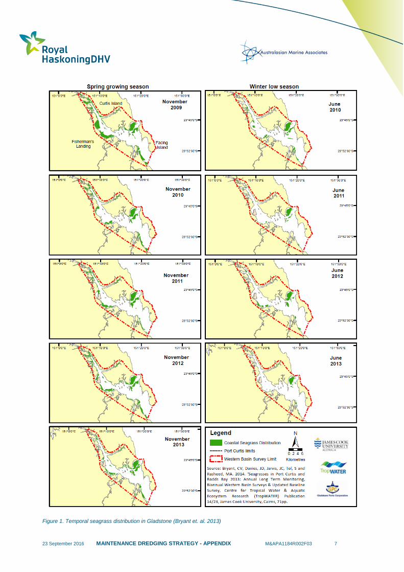
23 September 2016 MAINTENANCE DREDGING STRATEGY - APPENDIX M&APA1184R002F03 7
Figure 1. Temporal seagrass distribution in Gladstone (Bryant et. al. 2013)
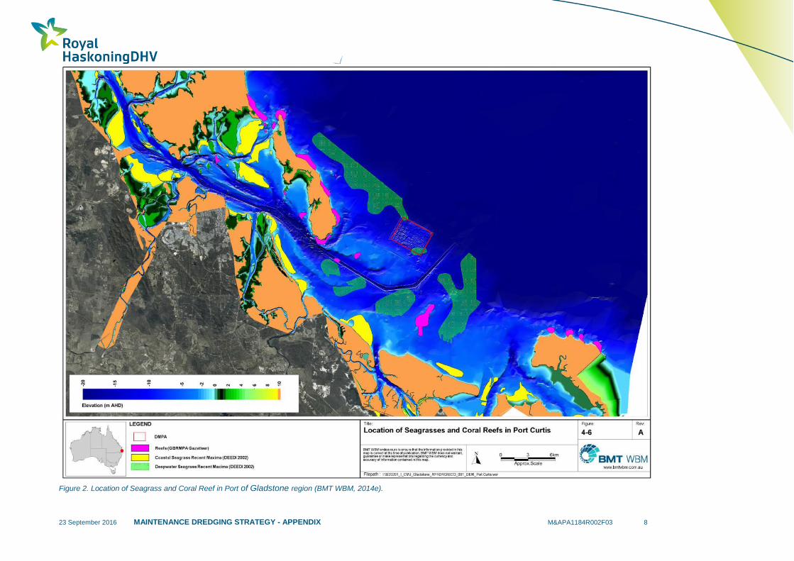
23 September 2016 MAINTENANCE DREDGING STRATEGY - APPENDIX M&APA1184R002F03 8
Figure 2. Location of Seagrass and Coral Reef in Port of Gladstone region (BMT WBM, 2014e).

23 September 2016 MAINTENANCE DREDGING STRATEGY - APPENDIX M&APA1184R002F03 9
Figure 3. Migration routes and destinations for eleven female flatback turtles tracked from their nesting beach at Curtis Island in
November 2013 (Hamman et. al., 2015)

23 September 2016 MAINTENANCE DREDGING STRATEGY - APPENDIX M&APA1184R002F03 10
Figure 4. GPS Location points for eight flatback turtles tracked during their interesting period between November to December 2013.
Each of the turtles was tagged after nesting on South End beach of Curtis Island (Hamman et. al, 2015)
The Hamman et. al. (2015) study reported that seven of the eight turtles spent time within the waters of the Port of Gladstone. Three had 50% core use areas in the middle harbour region of the Port, and another four turtles used habitat within the limits of the Port of Gladstone, but outside of the middle harbour. Overall, approximately 20% of all habitat used by the seven turtles was located within the Port of Gladstone limits. Turtles spent 91% of their time in water depths less than 25 m, 41% of time in water depths between 15 and 20 m and 11% of their time in water <2 m deep. A comparison of home range area and bathymetry indicates that the turtles spent most of their time on the bottom.
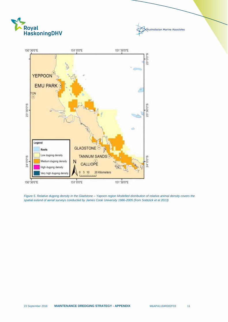
23 September 2016 MAINTENANCE DREDGING STRATEGY - APPENDIX M&APA1184R002F03 11
Figure 5. Relative dugong density in the Gladstone – Yapoon region Modelled distribution of relative animal density covers the
spatial extend of aerial surveys conducted by James Cook University 1986-2005 (from Sobtzick et al 2013)

23 September 2016 MAINTENANCE DREDGING STRATEGY - APPENDIX M&APA1184R002F03 12
Figure 6. Sightings of humpback dolphin schools in the Curtis region showed in relation to the group size (dot size) and behavioural
types (dot colours) (Cagnazzi, 2013).
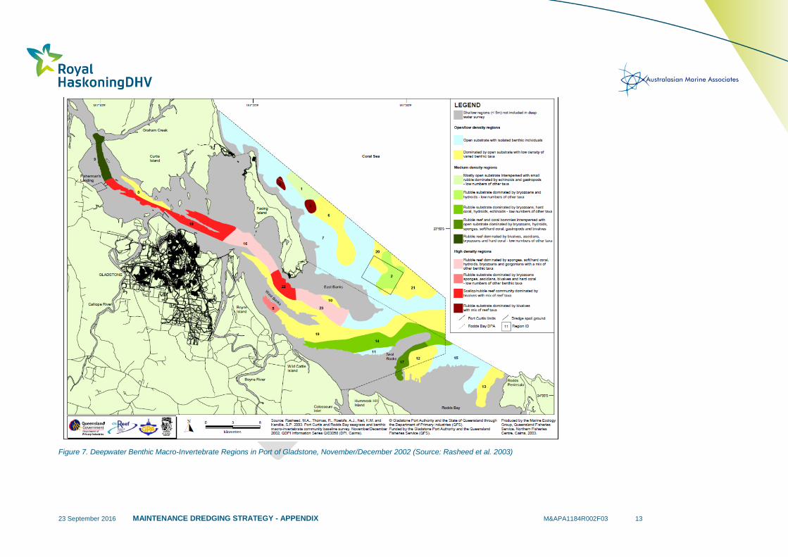
23 September 2016 MAINTENANCE DREDGING STRATEGY - APPENDIX M&APA1184R002F03 13
Figure 7. Deepwater Benthic Macro-Invertebrate Regions in Port of Gladstone, November/December 2002 (Source: Rasheed et al. 2003)

23 September 2016 MAINTENANCE DREDGING STRATEGY - APPENDIX M&APA1184R002F03 14
1.2 Port Alma
The Port of Rockhampton is located in lower reaches of the Fitzroy River Delta (Queensland’s largest
catchment) and experience pulsed disturbances associated with quasi-annual flooding (BMT WBM,
2015a). The Fitzroy River has a major influence on the coastal processes (erosion and deposition) and
ultimately the biological environments. Historically, there has been little need for maintenance dredging i.e.
2000, 2009 and most recently in 2011. The 2009 and 2011 maintenance dredging campaigns have taken
less than a week to conduct where dredged volumes consisted of 23,000 m2 and 40,000 m
2 of material,
respectively (BMT WBM, 2015a). Based on these small scale sporadic requirements there has been little
environmental characterisation for the purpose of assessing the impact of maintenance dredging on the
receiving environment. Recently, however, BMT WBM (2015a) was commissioned by GPC to deliver a
receiving environment monitoring program for the Port of Alma, and the information collated by BMT WBM
has been used to generate a summary for the environmental values.
As part of the BMT WBM work, maintenance dredging plume intensity and extent was assessed and
provided insight into the potential for plumes to interact with sensitive receptors. The primary objective of
their works was to design a monitoring program that seeks to understand the intensity and extent of
potential impacts related to maintenance dredging at Port of Rockhampton, in order to protect the
environmental values of the surrounding environment (BMT WBM, 2015a).
1.2.1 Environmental Values
Table 2 provides a list of the key environmental values in Port Alma, including a summary of their known
distribution and temporal trends.
Table 2. Summary of environmental value distribution and temporal trends in the Port of Rockhampton area.
Environmental
Values Distribution
Temporal Trends – Environmental
Windows
HABITATS
Seagrass
Meadows
Historical mapping and monitoring of seagrasses in
the Port Alma area, including outside the mouth of
the Fitzroy River, did not detect large areas of
seagrass habitat (York and Smith, 2013) and
seagrass has not been observed in the Port Alma
area in recent monitoring (M. Rasheed, James Cook
University pers. comm. from BMT WBM, 2015a)
NA
Coral Reefs
The closest significant coral reef communities to
Port Alma are located at Peak Island which are
approximately 25 km north-east of the port facilities
(BMT WBM, 2013). Extensive coral reef
communities can be found in the northern parts of
Keppel Bay, with occasional corals and soft corals
found on hard substrates such as rock shelves,
around the northern tip of Curtis Island (BMT WBM
unpublished). The north western tip of Curtis Island
is 10km from the approved offshore disposal area.
NA
FAUNA
Sea Turtles
Six species of sea turtles are known to occur in the
Port of Gladstone region. Loggerhead turtle (C.
caretta) occurs in the region, (Limpus et. al., 2013a).
NA
23 September 2016 MAINTENANCE DREDGING STRATEGY - APPENDIX M&APA1184R002F03 15
Green turtle (C. mydas) are common in the region
(Limpus et. al., 2013b). Hawksbill turtle (E.
imbricate) are occasionally sighted (Limpus et. al.,
2013c). Olive ridley turtle (L. olivacea) are rarely
seen in the region (Limpus et. al., 2013d). Flatback
turtle (N. depressus) are common in the region,
especially during nesting season (Limpus et. al.,
2013e). Leatherback turtle (D. coreacea) are
occasionally sighted (Limpus et. al., 2013f).
Dugongs
Marsh et al., (2007) has modelled the relative
density of dugongs across the Great Barrier Reef
World Heritage Area (GBRWHA). The model outputs
indicate that dugong management units within the
Port Alma region, are of medium conservation value.
This is of particular relevance along the north
western coastline of Curtis Island and the remaining
areas including the Fitzroy River delta and Fitzroy
estuary are of low conservation value (GHD 2009a).
The lower Fitzroy estuary accommodates a low
number of dugongs due to the turbid waters limiting
seagrass habitat.
NA
Cetaceans
Three species of inshore dolphins have been
recorded inhabiting Port of Gladstone and Port Alma
and include Australian snubfin (Orcaella heinsohni),
Indo-Pacific humpback (Sousa chinensis chinensis)
and the inshore bottlenose dolphin (Cagnazzi 2013).
The Fitzroy estuary supports the three inshore
dolphin species, all of which are reported to be
found in small groups (Cagnazzi 2013). All three
dolphins are listed as migratory under the EPBC Act
and the snubfin and Indo-Pacific humpback dolphins
are listed as ‘near threatened’ under the Queensland
NC Act.
NA
Benthic fauna and
epifauna
In 2015, a pilot study to examine the benthic
community within and immediately adjacent to the
maintenance dredge area and the Dredge Material
Placement Area (DMPA) was commissioned by
GPC (BMT WBM, 2015b). A total of 2874 individuals
were recorded in the study, comprising 144 taxa
from 87 families, 13 classes and 11 phyla. The most
abundant group were the polychaete worms (42% of
individuals), followed by malacostracan crustaceans
(27% of individuals), acorn worms (11% of
individuals), nemertean worms (5% of individuals),
ostracod seed shrimps (3% of individuals) and
gastropod molluscs (2% of individuals). Benthic
communities within the study area were
characterised by having the following attributes:
Comprised exclusively of marine/estuarine
species, with no freshwater species
recorded
Comprised exclusively of small
opportunistic and/or mobile taxa
NA
23 September 2016 MAINTENANCE DREDGING STRATEGY - APPENDIX M&APA1184R002F03 16
Abundance dominated by a few taxa
A large proportion of uncommon taxa (93%
of taxa were recorded in one or two
samples).
23 September 2016 MAINTENANCE DREDGING STRATEGY - APPENDIX M&APA1184R002F03 17
1.3 Port of Hay Point
An EIS was undertaken for the Port of Hay Point in 2005, as part of the development of the Apron Area
and Departure Path Capital Dredging. This EIS reported on the surrounding cultural heritage values,
dredge material geochemical characteristics, hydrodynamics and water quality conditions and coral reef
communities. Routine seagrass, algae and benthic infauna and coral reef surveys have also been
undertaken over the past decade (Thomas and Rasheed, 2011; Thomas et al., 2011; WorleyParsons,
2010) in areas adjacent to the Port of Hay Point.
The coastal environment surrounding the Port of Hay Point consists of wetlands, mangroves and
saltmarsh communities. The Sandringham Bay-Bakers Creek Aggregation is located north of the
terminals. These coastal wetlands are listed on the Directory of Important Wetlands of Australia and
encompass an area of 7,367 hectares. Seagrass meadows and macroalgal communities are present
immediately offshore of the Port of Hay Point, within Port limits. Fringing reefs are also located subtidally
along the foreshore, within Dalrymple Bay and also north and south of the Port limits, on Flat Top Island
and Round Top Islands (to the north) and Victor Islet (to the south) (Figure 8) (NQBP, 2009).
Sediment quality was previously investigated as part of the Hay Point EIS and the 95% Upper Confidence
Limits (UCLs) of the contaminants of interest were below the relevant screening levels and therefore, the
sediments were considered non-toxic and suitable for unconfined ocean disposal (GHD, 2005). Nutrient
levels in the sediments were reported at low concentrations, compared with concentrations reported in
estuary sediments at Shoalwater Bay (GHD, 2005). Sediment at the Port of Hay Point was categorised as
silts and fine sands of variable thickness (1-30 cm) underlain by stiff clay.
The most recent survey undertaken for maintenance dredging was in 2012, which reported that, with the
exception of HPCT Berths 1 and 2, the chemical nature of all dredge areas nominated met the National
Assessment Guidelines for Dredging (Commonwealth of Australia, 2009) screening levels for unconfined
ocean disposal of maintenance dredge material (Ports and Coastal Environmental, 2013).
The waters of Hay Point contain low turbidity, particularly during the winter months; however high turbidity
is experienced during storm events (GHD 2005). NQBP is required to undertake water quality monitoring
during dredging campaigns, which measure turbidity, light and sediment deposition. More recently, NQBP
engaged James Cook University to undertake an extensive ambient marine water quality monitoring
program. Loggers will be installed to monitor water quality 24/7 and a complete water quality analysis
program will be undertaken on a quarterly basis with at least two survey events conducted prior to the
commencement of dredging (NQBP, 2014).
Detailed impact monitoring will be undertaken for a period of four to six weeks around the actual dredging
campaign, which provides detailed daily records. The water monitoring will continue for a period of 12
months after dredging is completed. There are 14 locations proposed for ambient monitoring and 25
locations where impact monitoring is proposed. James Cook University is also advising NQBP on the
selection of three monitoring locations in the southern Whitsundays. NQBP also undertake a social impact
study to cover fishing (commercial and recreational), diving and tourism (NQBP, 2014). With regards to
inshore water quality, in a study conducted in 2000, water quality at Grendon and Sandfly Creeks and in

23 September 2016 MAINTENANCE DREDGING STRATEGY - APPENDIX M&APA1184R002F03 18
Lake Barfield was found to meet the ANZECC (2000) water quality guidelines.
Figure 8. Port of Hay Point Marine Habitat Map (NQBP, 2009).
1.3.1 Environmental Values
Table 3 provides a list of the key sensitive receptors and communities previously reported at the Port of
Hay Point, including a summary of known distribution and seasonal and temporal trends.
Table 3. Summary of environmental values distribution and temporal trends in the Port of Hay Point area.
Environmental
Values Distribution
Temporal Trends – Environmental
Windows
HABITATS
Seagrass Meadows
The most recent seagrass survey of the
Port of Hay Point was conducted in 2011
(NQBP, 2011a). Two distinct seagrass
habitats (coastal and offshore) were
surveyed and two seagrass species
(representing two families) were observed
Halophila decipiens and Halodule uninervis.
The offshore seagrass area was described
There was a marked decline in offshore seagrass
meadows in 2011, compared to previous years.
These large seagrass declines were reflected
throughout much of the urbanised east coast of
Queensland (Thomas et al., 2011).
The seagrass surveys undertaken in July 2004,
December 2005, October 2009, October 2010 and
23 September 2016 MAINTENANCE DREDGING STRATEGY - APPENDIX M&APA1184R002F03 19
by light Halophila decipiens while the
coastal meadows comprised Halophila
ovalis and Halodule uninervis.
November 2011 (Rasheed et al. 2004b; Chartrand
et al. 2008; Thomas and Rasheed 2011) reported
that offshore seagrasses at the Port of Hay Point
were naturally highly variable with peak
abundances and distribution occurring in winter
and spring before seasonal declines over summer.
Seagrasses were absent from the survey
area between December and June of each year
(Chartrand et al. 2008).
Coral Reefs
Hard coral cover on the Islands and Inlet
immediately north and south of the Port
limits is generally lower than other fringing
reefs in the GBR region and hence they
were considered to be not regionally
significant (Trimarchi and Keane 2007 in
NQBP, 2009). The fringing reefs on the
intertidal and subtidal platforms and inshore
rocky shoals support sediment tolerant hard
corals (URS 2000 in NQBP, 2009a).
NA
Macroalgal Beds
The macroalgal community was reported at
very low per cent coverage (≤1%) in the
Port of Hay Point survey area. The only
functional group identified was erect
macrophytic algae. Whilst not all species
were identified, the most common types of
erect macrophytes present were species of
Udotea, Sargassum and other mixed red
and brown macrophytes. These algae
generally occurred on open sand/mud
sediment with isolated benthic macro-
invertebrates (Thomas and Rasheed,
2011).
The macroalgal community in 2010 was
substantially reduced, compared to the baseline
survey conducted in 2004 (Thomas and Rasheed,
2011). In 2004, low density macro-algae
communities covered 80% of the survey area and
were represented by species from four functional
groups; however in 2010, macro-algae only formed
10% of the survey area and were represented by
species from only one functional group, namely
erect macrophytes (Thomas and Rasheed, 2011).
FAUNA
Sea Turtles
Six species of turtles have been recorded
utilising the offshore, intertidal, estuarine
and shoreline habitats in the Hay Point
area, these are Flatback (N. depressus),
Green (C. mydas), Loggerhead (C. caretta),
Leatherback (D. coriacea), Hawksbill (E.
imbricate) and Olive Ridley
(L. olivacea) (NQBP, 2009a).
Turtle nesting occurs between October and
February, with the hatchlings emerging from
January–March (NQBP, 2009a).
Dugongs
Small populations of dugong have been
reported near Port Newry (north) and Ince
Bay (20 km south), with areas of Llewellyn
Bay and Ince Bay having been declared
Dugong Protection Areas (DPA) under the
Nature Conservation Act (NC Act) and the
Fisheries Act 1994 (NQBP, 2009a).
NA
Cetaceans
Seven species of dolphins and five species
of whales potentially occur in waters around
Hay Point (NQBP, 2009a).
The Spotted Bottlenose Dolphin (Stenella
attenuate) is considered likely to occur within the
area and Humpback Whales (Megaptera
novaeangliae) are present offshore from the Port
23 September 2016 MAINTENANCE DREDGING STRATEGY - APPENDIX M&APA1184R002F03 20
between June and August (NQBP, 2009a).
Benthic fauna and
epifauna
The nearshore sandy seabed region was
dominated by open substrate with isolated
benthic individuals including polychaete
worms, gastropods and bivalves. The
habitat forming benthic macro-invertebrate
communities in the survey area were typical
of those found in other deep water (>10m)
areas between the Great Barrier Reef and
mainland coast that have been surveyed
(Rasheed et al. 2001; 2003; 2004; 2005 in
Thomas and Rasheed (2011).
Benthic macro-invertebrate communities found in
2010 were similar to those found in 2004 and were
typical of the types of communities commonly
described in deep water (>10 m) areas between
the Great Barrier Reef and mainland coast
(Thomas and Rasheed, 2011).

23 September 2016 MAINTENANCE DREDGING STRATEGY - APPENDIX M&APA1184R002F03 21
1.4 Port of Mackay
The Port of Mackay coastal environment contains a complex array of coastal dune vegetation, freshwater
wetlands, estuarine plant communities and rocky outcrops (Figure 9). Fields for agriculture and coal
mining, as well as an established marina that accesses the main harbour channel, dominate the activities
operating from the Port of Mackay.
The key habitats described in previous studies include seagrass meadows, mangroves and sub-tidal and
intertidal soft sand and mud substrates (NQBP 2011). Sediment quality investigations have been
undertaken at the Port of Mackay since 1993.
The results of the 2009 sediment assessment determined that contamination levels were below relevant
screening levels with the exception of TBT detected within the berth pockets. Further elutriate and pore
water analysis at elevated TBT locations determined that water quality would be unlikely to be impacted at
the offshore disposal site and that TBT is also unlikely to be bioavailable to benthic infauna at the disposal
site. As such, it was concluded that the maintenance-dredged sediment from all areas was suitable for
unconfined sea disposal in accordance with the NAGD. Sediments within the Channel and Swing Basin
Dredge Area were dominated by even portions of clay (38%) and silt (36%), with sand making up
approximately 23%.
The Mackay Port Authority commenced a regular program of water quality monitoring in 1998, as part of
its commitments under their adopted Environmental Management Plan (Aurecon, 2009a). The program
noted periodic elevations in various metals and nutrient analyses within the harbour basin. It was
suggested that no significant issues related to water quality were identified, due to tidal range and high
flow within the harbour. Additional water quality data was collected in 2009 from the offshore disposal
ground (WorleyParsons, 2009), which defined all metals apart from Zinc as non-detectable. For nutrients
analysis, nitrate was the only component obtained from the disposal ground with reported levels (mean
concentration of 0.032 mg/L) not compliant to the assessed water quality criteria.
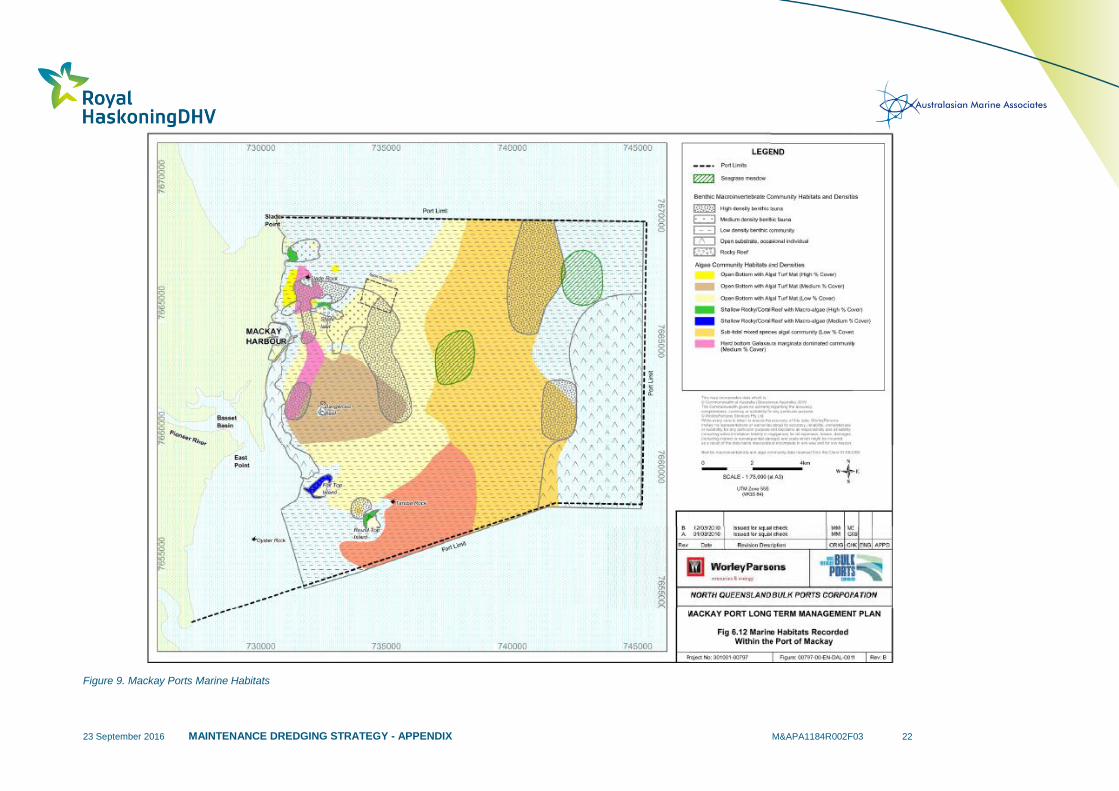
23 September 2016 MAINTENANCE DREDGING STRATEGY - APPENDIX M&APA1184R002F03 22
Figure 9. Mackay Ports Marine Habitats

23 September 2016 MAINTENANCE DREDGING STRATEGY - APPENDIX M&APA1184R002F03 23
1.4.1 Environmental Values
Table 4 provides a list of the key sensitive receptors in Port of Mackay, including a summary of their
known distribution and temporal trends.
Table 4. Summary of environmental value distribution and temporal trends in the Port of Mackay area.
Environmental
Values Distribution
Temporal Trends – Environmental
Windows
HABITATS
Seagrass Meadows
The seagrass communities were first
identified at Flat Top and Round Top
Islands by Coles et al. (1987), which were
suggested to be present in low densities
(NQBP, 2011b). Rasheed et al., (2011)
observed additional deeper meadows at
locations 3 km south east and 8 km east of
the spoil ground. The offshore meadows
were characterised by Halophila decipiens,
while the more coastal community adjacent
to round top island was found to be
dominated by Halodule uninervis (wide)/
Halophila ovalis (Rasheed et al., 2011).
Seagrass surveys have been intermittently
conducted throughout the Mackay region since
1987. Inter-annual variability in seagrass
abundance was noted at the second meadow
identified by Coles et al., (1987) which was located
at the northwest of Flat Top Island. This meadow
was not present in the February 2001 surveys with
the seasonal and inter-annual variability typical of
tropical regions suggested to be driving the
absence (Rasheed et al., 2001).
Coral Reefs
Coral reef habitat has been mapped in
several locations in the Port of Mackay
area. (NQBP 2011). Fringing coral reefs at
Slade Islet, Round Top Island, Flat Top
Island and Victor Islet all exhibit similar
species diversity and coverage. Notable
species at the aforementioned locations
include Porites colonies, Macroalgae,
Montipora and Acropora corals. Hard and
soft corals have also been recorded within
Mackay Harbour along the seawalls, which
provide hard substrate for colonisation
(NQBP 2011b).
There is limited temporal data for coral reef
communities in the Mackay Port region.
Investigations into the impact of dredging works
has documented some temporal stability at Slade
Islet and Slade Rock (the two closest reefs to the
disposal ground) with little impact reported at these
sites during the 2006 capital dredging works or
2008 maintenance dredging program (NQBP
2011b). Victor Islet was observed to have a
reduction in coral cover after 2006 activities,
however no further reductions were identified in
2008.
Macroalgal Beds
Microalgae communities of Sargassum
have been sparsely observed on the
fringing coral reef and nearshore rocky reef
areas in the vicinity of the Port of Mackay.
At the existing spoil disposal ground, low
densities of maginata have also been
identified (Rasheed et al, 2001).
NA
FAUNA
Sea Turtles
Four species of turtles that have been
recorded utilise the area of Mackay as
foraging grounds, these are Flatback (N.
depressus), Green (C. mydas), Loggerhead
(C. caretta), Leatherback (D. coriacea), Olive
Ridley (L. olivacea) and Hawksbill (E.
imbricate) (Limpus et al., 2013).
Turtle nesting season in Mackay occurs from the
middle of October to early January with hatchling
emergence continuing until April.
23 September 2016 MAINTENANCE DREDGING STRATEGY - APPENDIX M&APA1184R002F03 24
Dugongs
There are a number of Dugong Protection
Areas in the Mackay region – Ince Bay,
Newry region, Llewellyn Bay, Repulse Bay
and Sand Bay. These areas are remote from
the spoil ground. Seagrass is absent from the
spoil ground and the areas directly
surrounding it (Rasheed et al., 2001) and as
such it does not constitute dugong foraging
habitat.
NA
Cetaceans
The Indo-Pacific Humpback Dolphin (Sousa
chinensis), the Australian
Snubfin Dolphin (Orcaella heinsohni) are
known to occur within the Port limits
(Corkeron et al., 1997; Hale et al., 1998). The
inshore (Tursiops aduncus) and offshore
(Tursiops truncatus) forms of the Bottlenose
Dolphin are also likely to occur in the
surrounding estuaries and shallow offshore
waters (Hale et al.,1998).
NA
Benthic fauna and
epifauna
NQBP (2011b) identified that the dominant
taxa within and adjacent to the offshore spoil
ground were polychaete worms, although
ascidians (sea squirts) were also abundant at
the spoil ground.
Tanaid and amphipod crustaceans were also
amongst the most abundant taxa identified.
Many taxa were represented by less than five
individuals (NQBP, 2011b).
NA
1.5 Port of Abbot Point
Extensive environmental survey work has been performed at the Port of Abbot Point over the past
decade, with the most recent work undertaken for the Abbot Point Growth Gateway Project Environmental
Impact Statement (WorleyParsons, 2015). The port is located within the Great Barrier Reef World Heritage
Area (GBRWHA), which encompasses the waters to the low water mark along the coastline in the region.
The existing spoil ground is within the Marine Park and is also within Port limits and has been in use since
1982.
Middle Island and Thomas Island National Parks are located within Port limits and Gloucester Island
National Park is located on the Port limit boundary. There is one listed Fish Habitat Area (FHA) within the
Port of Abbot Point, Edgecumbe Bay FHA and a Dugong Sanctuary extends over most of Edgecumbe
Bay and Port Denison. There are two wetlands of national importance located within the Port of Abbot
Point, namely the Caley Valley Wetland Aggregation and Edgecumbe Bay Wetland. WorleyParsons
(2015) describe the key environmental values of the surrounding marine environment, which include
seagrass, soft bottom habitats, beaches and estuarine areas and these are illustrated in Figure 10 and
Figure 11.
The most recent water quality monitoring at Abbot Point was between February 2013 and June 2014
(WorleyParsons, 2014), which provided an up to date understanding regarding baseline marine water
quality conditions. Wet seasons compared to dry seasons were characterised by higher sea

23 September 2016 MAINTENANCE DREDGING STRATEGY - APPENDIX M&APA1184R002F03 25
temperatures, lower pH and DO and higher suspended solid concentrations (measured as turbidity). Sites
located closest to freshwater inputs from local creeks and rivers exhibited the largest changes in salinities
in the wet season. These sites also experienced the lowest pH values and largest ranges of DO
concentrations (WorleyParsons, 2014).
Daily benthic light availability (photosynthetically active radiation, PAR) was higher in the wet season
compared to the dry season. The increases in turbidity observed during the wet season which reduce
PAR on the seabed, were offset by the longer days and more intense sunlight available to benthic
organisms in this season (WorleyParsons, 2014).
The sediment properties of dredge material in the Port of Abbot Point have been analysed since 2004 for
capital and maintenance dredging projects relating to the Port. The most recent sediment investigation
was undertaken for Abbot Point T0, T2 and T3 capital dredging in 2012 (GHD 2012). Sediment samples
were collected at 69 locations within the dredge footprint.
All TPHs, BTEX, pesticides (OCPs and OPPs), PCBs and total cyanide had concentrations less than the
NAGD screening levels and the laboratory practical quantitation limits (PQL), indicating no anthropogenic
sources of these contaminants within the dredging footprint (GHD 2012). All metal concentrations had
95% UCLs less than the NAGD screening levels and NEPM (1999) EILs and HIL A Guidelines (where
applicable).
The sediments were found to be relatively homogenous in the 0 to 0.5 m depth interval, with less sand
recorded in the T0 dredging footprint than in the T2 and T3 footprints. As depth increases to the deepest
intervals between 3 and 4.5 m, clay and silt content increased and sand content decreased. Across the
dredging footprint, sand (0.06-2 mm) was the predominant sediment type (54%), with high percentages of
silt (2µm) and clay (<2µm) recorded (19% and 20% respectively) (GHD, 2012).
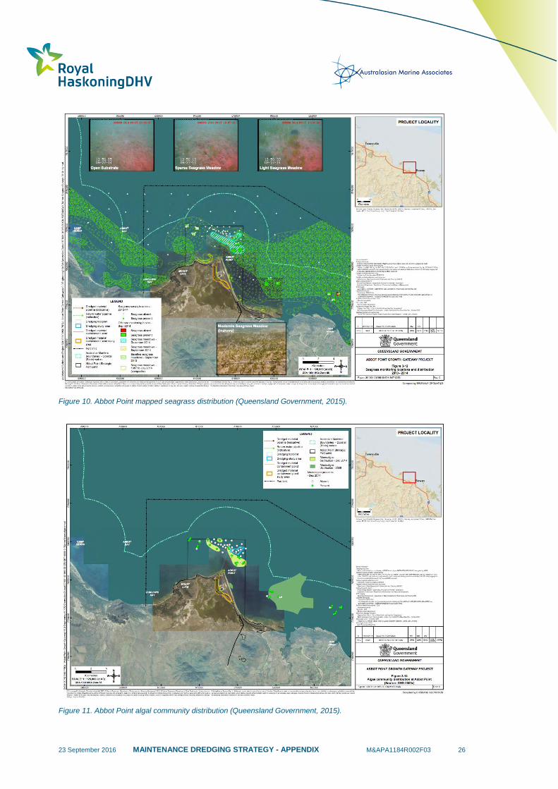
23 September 2016 MAINTENANCE DREDGING STRATEGY - APPENDIX M&APA1184R002F03 26
Figure 10. Abbot Point mapped seagrass distribution (Queensland Government, 2015).
Figure 11. Abbot Point algal community distribution (Queensland Government, 2015).

23 September 2016 MAINTENANCE DREDGING STRATEGY - APPENDIX M&APA1184R002F03 27
1.5.1 Environmental Values
Table 5 provides a list of the key sensitive receptors and communities previously reported at the Port of
Abbot Point, including a summary of known distribution and seasonal and temporal trends.
Table 5. Summary of environmental value distribution and temporal trends in the Port of Abbot Point area.
Environmental
Values Distribution
Temporal Trends – Environmental
Windows
HABITATS
Seagrass Meadows
Seven seagrass species have been
identified within the Abbot Point region
between February/March 2008 and
September 2012 (McKenna and Rasheed,
2013). These include:
Halophila decipien, Halophila ovalis,
Halophila spinulosa, Halodule uninervis
Cymodocea serrulata, Cymodocea
rotundata, Zostera capricorni.
Coastal meadows in the Abbot Point area
generally consisted of isolated, aggregated
patches of seagrass dominated
by Halodule uninervis, although one
meadow was dominated
by Zostera capricorni (McKenna and
Rasheed, 2013).
Prior to the La Niña related events of 2010/11 and
severe Tropical Cyclone (TC) Yasi in February
2011, there was a broad seasonal pattern at Abbot
Point for seagrass biomass and distribution to be at
a minimum at the end of the wet season and a
maximum in late spring/early summer. This trend is
consistent with observations of seagrasses
throughout Queensland (McKenna and Rasheed,
2013).
Following the summer of 2010/11, significant
losses in density and distribution of seagrasses at
both coastal and offshore monitoring sites were
observed. There is evidence of seagrass recovery
at some of the deep water monitoring sites;
however the coastal inshore meadows have not
undergone any significant recovery (McKenna and
Rasheed, 2013).
Coral Reefs
Cnidarians (soft and hard corals, jelly fish,
anemones and hydrozoans) have been
recorded throughout the Abbot Point area
in very low densities (<10% coverage when
recorded) (GHD, 2009a). Extensive hard
and soft coral communities were reported
growing on rocky outcrops surrounding
Nares Rock and Camp Island. The most
extensive coral communities were found
offshore at Holbourne Island (GHD, 2009d).
A similar species composition was recorded
at sandy inshore locations that are
consistent with the project area habitat
(GHD, 2009d). These areas supported soft
corals, sea pens, sub-massive corals,
massive corals and mushroom corals. All
corals observed were very small in size
(<1 cm to 30 cm), often occurring as a
single coral and were very sparsely
distributed across the project area (less
than one coral per ha) (GHD, 2009d).
NA
Macroalgal Beds
Macroalgal communities at Abbot Point
have been identified as widespread, but
patchy in distribution and typically with low
Findings indicate temporal variability in the
presence of macroalgal species, with a shift in
species composition observed between the 2005
23 September 2016 MAINTENANCE DREDGING STRATEGY - APPENDIX M&APA1184R002F03 28
percentage cover. During surveys within
the Port limits, GHD (2009e) detected algae
in association with small patches of hard
substrate, which were scattered across the
area. Macroalgae recorded included (GHD,
2009e):
Nine green algae
(phylum Chlorophyta);
Four brown algae
(phylum Phaeophyta); and
Seven red algae (phylum Rhodophyta).
The most commonly occurring algae were
Chondria spp., Peyssonnelia spp.,
Chaetomorphaspp., Acetabularia
spp., Laurencia spp. and a red filamentous
alga (GHD, 2009e).
and 2009 surveys (GHD, 2009e).
FAUNA
Sea Turtles
A 12-month study (GHD 2009d) indicated
the most frequently observed turtles within
the Port of Abbot Point were the green
(Chelonia mydas) and the flatback (Natator
depressus) turtles.
Turtles have been recorded in the area, with
numbers peaking in the nesting period (November
– February) (GHD 2009d). It is likely that the green
turtle inhabits this area all year round, with varying
abundance. The flatback turtle is likely to be a
resident during the nesting period, as it generally
feeds in the pelagic zone. GHD (2009d) reported
the highest number of turtles in December. This
month also recorded the highest species diversity.
Dugongs
Dugongs have been recorded in moderate
numbers during boat-based surveys,
primarily foraging within habitat associated
with extensive seagrass meadow consisting
of Halodule uninervis and Halophila
spinulosa (GHD, 2008).
NA
Cetaceans
Some of the whales recorded in September
2008 in GHD (2008) appeared to use Abbot
Point as a resting and possible calf feeding
area, as whales were observed in the same
location for a few hours. These
observations suggest the deep water and
the protected coastline of Abbot Point acts
as an important refuge environment for
some whales. Others were observed to
swim past the area (GHD 2008).
Humpback whales were recorded in September
2008 (GHD 2008) and incidentally sighted in
August 2008, which corresponds with expected
seasonal migration patterns for breeding and
calving.
Benthic fauna and
epifauna
GHD (2009e) reported sedentary benthic
macroinvertebrates during surveys of the
Port limits. Ascidians were the most
abundant, followed by echinoderms,
molluscs, polychaetes and small
crustaceans, concentrated around isolated
patches of rubble and rock.
WorleyParsons (2014) reported that the dominant
benthic invertebrate species from Abbot Point
changed since the JCU survey 25 years ago;
however the spatial findings of the earlier work is
consistent with recent studies, which demonstrates
that the patchy distribution of low diversity benthic
communities at Abbot Point is a persistent
condition of this area.
23 September 2016 MAINTENANCE DREDGING STRATEGY - APPENDIX M&APA1184R002F03 29
1.6 Port of Townsville
An EIS was completed for the Port of Townsville in 2012 to examine the opportunity to expand the existing
Port (AECOM & BMT WBM, 2012). This EIS examined the marine ecology and described the existing
marine flora, fauna and biodiversity values of environments in close proximity to the Port and the wider
Cleveland Bay region. Seagrass, mangroves, saltmarsh, benthic algae, together with corals, represent
benthic primary producer habitat (BPPH).
The Port of Townsville is adjacent to areas that contain matters of national environmental significance,
including World Heritage Properties – specifically Great Barrier Reef World Heritage Area (GBRWHA),
wetland of international importance – specifically Bowling Green Bay Ramsar site, Great Barrier Reef
Marine Park – which includes most of Cleveland Bay, Commonwealth Marine Areas – which includes
areas offshore of Cleveland Bay (BMT, 2012b).
Sediment quality was previously investigated as part of the Long Term Dredging and Disposal
Management Plan and the 95% Upper Confidence Limits (UCLs) of most contaminants of interest were
below the relevant screening levels (Port of Townsville, 2013). The exclusions were Cu and Ni in the Inner
Harbour, where the 95% UCL of mean Cu and Ni concentrations exceeded NAGD Screening Levels.
Phase III testing of these sediments indicated that the portion of total contaminants which are available to
biota in sediment proposed for dredging, are present at less than the NAGD Screening Levels. Elutriate
testing demonstrated that contaminants are predominantly bound to particulate material and only a small
fraction of each contaminant would be released during dredging and disposal of the material. Toxicity
assessments under Phase IV of the NAGD Dredge Spoil Assessment Framework for Ocean Disposal
were not triggered. In the outer harbour there was an isolated detection of TBT exceeding the NADG
trigger value, however 95% UCL was below the trigger. Overall all sediment were classified as acceptable
for unconfined ocean disposal.
The more recent sediment quality observations summarised above are also consistent with the historical
observation generated as part of the Port of Townsville Long Term Sediment Management Plan (Port of
Townsville). Historical exceedances of Cu, Ni and Cr have been observed in the Inner Harbour (Berths 2,
7 and 8), and Port of Townsville and the relevant port users have adopted a precautionary approach by
placing material from these areas on land.
Naturally high suspended sediment and turbidity can occur in Cleveland Bay due to its shallowness and
the muddy nature of the central bay sediment facies and the wind regime and ensuing waves and swells
(AECOM & BMT WBM, 2012). The suspended sediment concentrations vary spatially, with more turbid
conditions in the Inner Harbour, compared to the Outer Harbour area. Generally, higher TSS
concentrations are associated with strong winds and lower concentrations with calm conditions.
Specifically, monitoring data has showed a correlation with sustained easterly wind and strong northerly
winds >30 km/hr with an increased median turbidity at all sites monitored (AECOM & BMT WBM, 2012).
Under suitable conditions low TSS can exist in the bay, and a natural range in the order of 4 to 30 mg/L
can be expected.
In 2013, an assessment to provide supporting information to determine whether or not a referral is
required under the Environment Protection and Biodiversity Conservation Act 1999, with respect to
maintenance dredging activities, was completed (BMT WBM, 2013). This assessment was requested as
part of an information request made by the Department of Sustainability, Environment, Water, Population
and Communities, as part of its assessment of an application for a long term maintenance dredging and
placement permit, under the Sea Dumping Act. The BMT WBM (2013) scope of work included
assessment of water quality data and hydrodynamic modelling. There is no evidence to suggest that
dredge-generated sediment plumes and subsequent deposition from the 2012 maintenance dredging
23 September 2016 MAINTENANCE DREDGING STRATEGY - APPENDIX M&APA1184R002F03 30
campaign caused significant impacts to the GBRWHA, Natural Heritage Place, or GBRMP, or the values
that underpin these matters of national environmental significance.
1.6.1 Environmental Values
Table 6 provides a list of the key sensitive receptors and communities previously reported at the Port of
Abbot Point, including a summary of known distribution and seasonal and temporal trends.
Table 6. Summary of environmental values distribution and temporal trends in the Port of Townsville area.
Sensitive
Receptor Distribution
Temporal Trends – Environmental
Windows
HABITATS
Seagrass
Meadows
A range of studies has investigated the seagrass
communities of Cleveland Bay. To date, eight
species of seagrass have been recorded in
Cleveland Bay (Rasheed and Taylor 2008),
namely Zostera muelleri, Halodule uninervis,
Syringodium isoetifolium, Cymodocea serrulata,
Halophila spinulosa, Halophila ovalis, Halophila
decipiens and Thalassia hemprichii. (Figure 12).
Cleveland Bay contains some of the most
extensive and diverse seagrass meadows in north
Queensland. Seagrass meadows in Cleveland Bay
have high ecological significance in the context of
providing habitat for a range of species of fisheries
significance, and the provision of food resources
for the threatened dugong and green turtle.
Monitoring studies indicate that the
distribution, extent and density of seagrass
assemblages within Cleveland Bay can
show great variation over a range of
temporal scales (particularly seasonally and
inter-annually) in response to variations in a
range of environmental factors (Rasheed
and Taylor 2008; McKenna and Rasheed
2012). In particular, it is thought that high
suspended sediment concentrations
resulting from wave driven bed sediment
remobilisation (together with runoff) are key
drivers of temporal change in seagrass
meadows. Seagrass growing season is
similar to other QLD regions, with maximum
growth rates in the warmer months (October
to March) and senescence during the cooler
months (April to September).
Coral Reefs
Based on mapping from the GBRMPA
Gazetteer, the total area of reef habitat within
Cleveland Bay is approximately 987 hectares
(Figure 13 & Figure 14). Reef habitats in
Cleveland Bay include shallow fringing reefs and
rocky shores around Magnetic Island; the well
developed reef platform of Middle Reef; and
smaller, less developed reef areas between the
mainland and Magnetic Island (e.g. Virago Shoal)
(AECOM & BMT WBM, 2012).
There is extensive temporal data assessing
the changes on coral cover and conditions
(i.e. Middle Reef, Magnetic Island). The
coral communities respond to high turbidity -
which controls the composition and
structure of corals communities, freshwater
inundation and runoff - low salinity, together
with high levels of nutrients and turbidity,
can lead to stress and mortality of corals,
and bleaching - typically occurs in response
to high water temperatures, and appears to
represent a key agent of change at Middle
Reef (BMT, 2012b). Coral spawning occurs
during the warmer months of the year
between November and March (AECOM &
BMT WBM, 2012).
FAUNA
Sea Turtles
Six species of marine turtle are known to use
Cleveland Bay as a feeding ground including
loggerhead turtle (Caretta caretta), green turtle
(Chelonia mydas), hawksbill turtle (Eretmochelys
imbricate), olive ridley turtle (Lepidochelys
Cleveland Bay is not an important turtle
breeding area, with most turtles in the Bay
believed to have originated from rookeries
elsewhere on the central and north
Queensland coast and islands, or in other

23 September 2016 MAINTENANCE DREDGING STRATEGY - APPENDIX M&APA1184R002F03 31
olivacea), flatback turtle (Natator depressus),
leatherback turtle (Dermochelys coreacea). These
species have been recorded in offshore, nearshore
and intertidal habitats within Cleveland Bay (BMT
WBM, 2012b). Green turtles are the most
abundant turtle species within Cleveland Bay,
which based on surveys undertaken in 2000
(Preen 2000), accounted for over 90% of the total
abundance in the Bay.
countries (BMT WBM, 2012b). The
exceptions to this are flatback and green
turtles. Low density nesting for these
species has been reported on a number of
sandy beaches adjacent to the study area
and surrounds, including Magnetic, Herald
and Rattlesnake Islands, the Strand and
AIMS beach (GHD 2009f). In terms of
habitat use, there is little scientific data
available. The Townsville region was
identified as a hot-spot for strandings
in 2011, with 262 marine turtle stranding’s
compared to 35 (2008), 44 (2009) and 93
(2010) turtles in the period 2008 to 2010
(BMT WBM, 2012).
Dugongs
Dugongs are abundant in Cleveland Bay and the
Bay is thought to be an important dugong habitat
at a regional scale (Sheppard 2007). Aerial survey
data collected in 2008, 2010 and 2011 was
modelled by James Cook University to determine
relative density of dugong habitat use in Cleveland
Bay (GHD, 2011). Whilst dugongs are most
abundant around dense seagrass meadows, it is
apparent that they move throughout Cleveland
Bay, as they move between feeding sites
(seagrass meadows) (Figure 15).
Food resource availability is thought to be a key control on dugong populations. The loss of seagrass meadows has been implicated as the major cause of dugong strandings in the region (BMT WBM, 2012). Dugong stranding reports for the GBR increased from an annual average of 63 per annum in the period 2008-2010 (BMT WBM, 2012b).
It is apparent that dugong population resilience was markedly reduced because of the 2011 floods (BMT
WBM, 2012b). Dugongs also breed in
Cleveland Bay. While dugongs breed year
round, mating and calving tend to peak in
spring and summer, particularly at high
latitudes (BMT WBM, 2012).
Cetaceans
Australian snubfin dolphins (Orcaella heinsohni)
and Indo-Pacific humpback dolphins (Sousa
chinensis) are common in nearshore environments
throughout Cleveland Bay, and are likely to
regularly feed in the Port area. The estimate for
the Australian snubfin dolphin “sub-population” in
2002 in Cleveland Bay was 63 individuals (95%
confidence interval = 51-88) (Parra et al. 2006a,b).
These dolphins are opportunistic feeders, and the
area near the entrance of the Townsville Harbour
has been identified as an important habitat (Figure
16). Humpback whales (Megaptera novaeangliae)
are not commonly present in the waters of
Cleveland Bay, however they have been observed
(BMT WBM, 2012b).
There is no quantitative understanding of
dolphin and whale population trends in
Cleveland Bay.
Benthic fauna and
epifauna
Sparse and patchy epibenthic communities
occurred throughout the study area and surrounds
examined in the EIS (AECOM & BMT WBM,
2012), and were comprised of occasional
hydrozoan and soft coral colonies to completely
bare substrates. The community structure within
the disposal ground has been studied in more
detail as part of the sea disposal permitting
process.
Temporal survey of benthic fauna across
the region is not available. However,
surveys of benthic macroinvertebrates and
epibenthic fauna (e.g. GHD 2008b) show
that the current disposal ground has been
recolonised between dredging campaigns.
Furthermore the species composition is
similar to that present in sediment adjacent
to the disposal ground. Cruz Motta (2000)
23 September 2016 MAINTENANCE DREDGING STRATEGY - APPENDIX M&APA1184R002F03 32
Fifteen Phyla from 103 families and 207 species
were recorded in Cruz Motta’s (2000) research.
The fifteen Phyla were as follows: Annelida;
Ectoprocta; Chaetognata; Foraminifera;
Chelicerata; Mollusca; Chordata; Phoronida;
Cnidaria; Platyhelmintes; Crustacea; Porifera;
Echinodermata; Sipunculida and Echiura;
found that the current disposal ground could
be recolonised in less than three months
from disposal of dredge material.
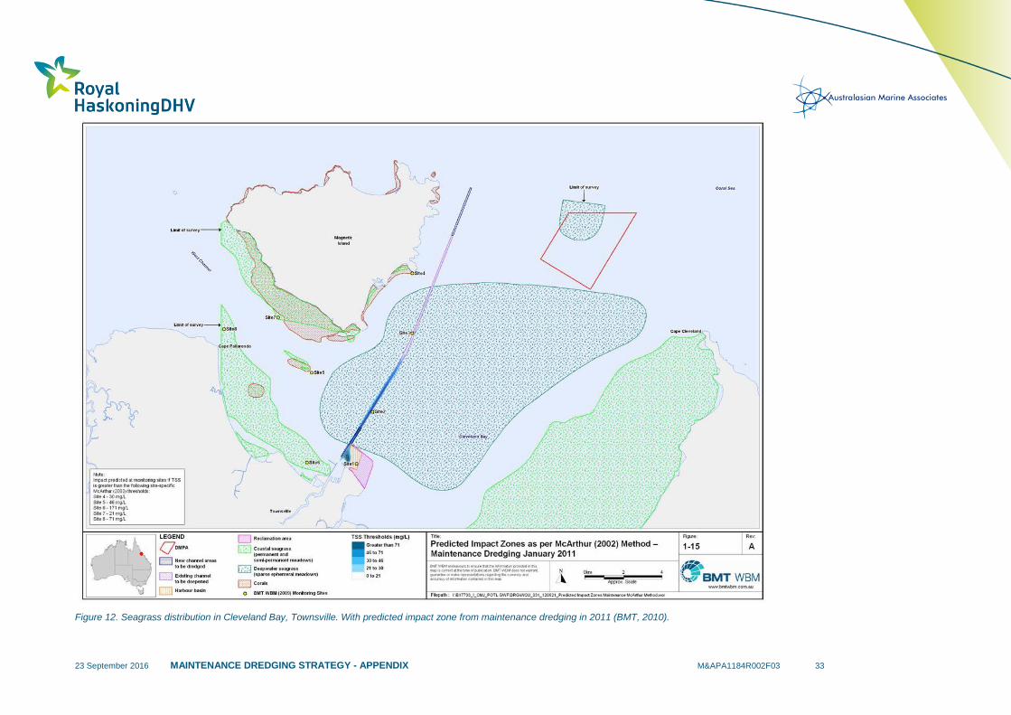
23 September 2016 MAINTENANCE DREDGING STRATEGY - APPENDIX M&APA1184R002F03 33
Figure 12. Seagrass distribution in Cleveland Bay, Townsville. With predicted impact zone from maintenance dredging in 2011 (BMT, 2010).
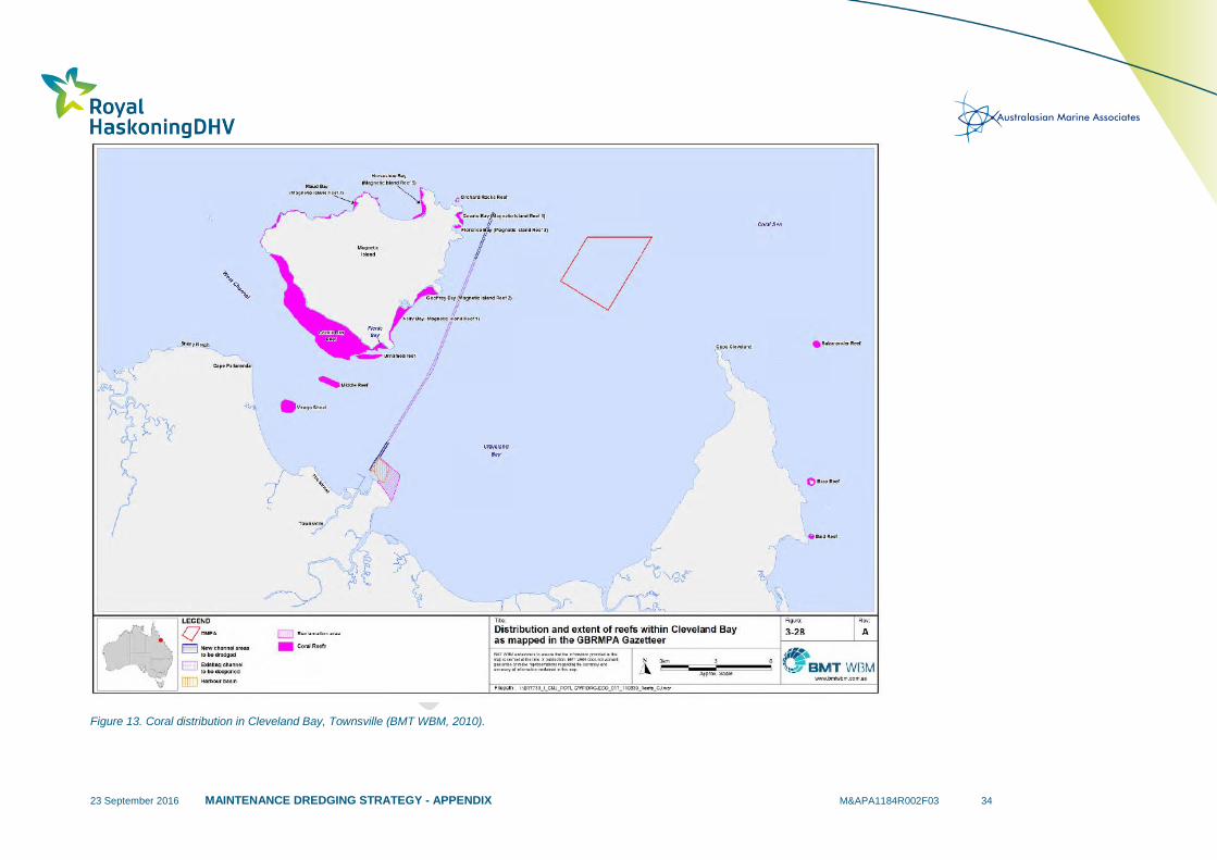
23 September 2016 MAINTENANCE DREDGING STRATEGY - APPENDIX M&APA1184R002F03 34
Figure 13. Coral distribution in Cleveland Bay, Townsville (BMT WBM, 2010).
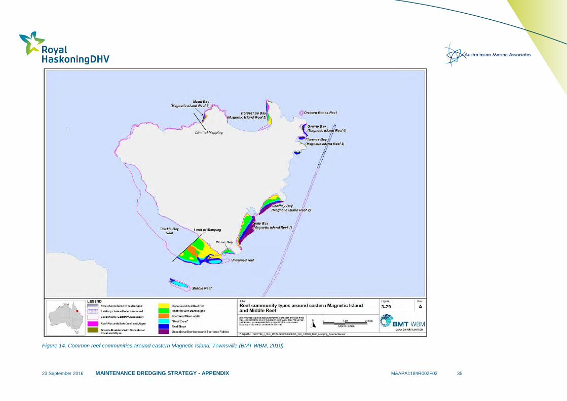
23 September 2016 MAINTENANCE DREDGING STRATEGY - APPENDIX M&APA1184R002F03 35
Figure 14. Common reef communities around eastern Magnetic Island, Townsville (BMT WBM, 2010)
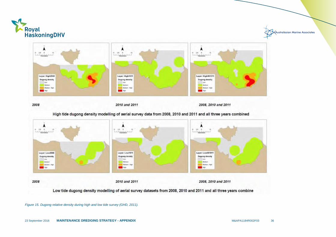
23 September 2016 MAINTENANCE DREDGING STRATEGY - APPENDIX M&APA1184R002F03 36
Figure 15. Dugong relative density during high and low tide survey (GHD, 2011).
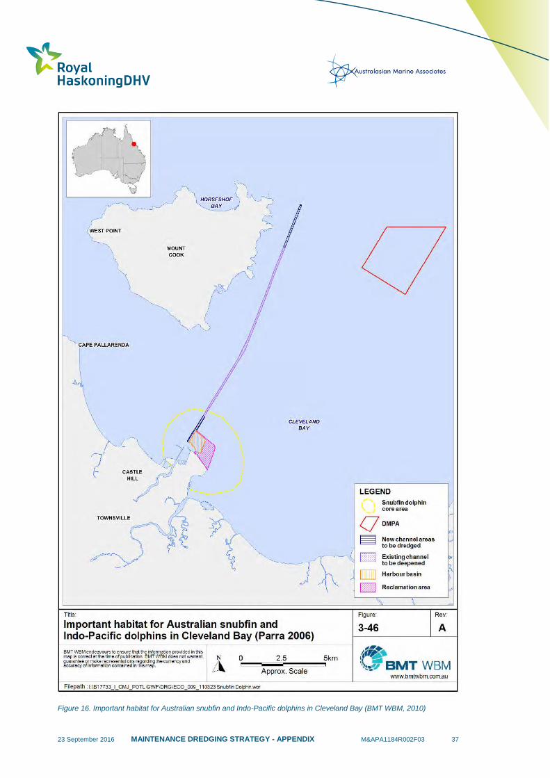
23 September 2016 MAINTENANCE DREDGING STRATEGY - APPENDIX M&APA1184R002F03 37
Figure 16. Important habitat for Australian snubfin and Indo-Pacific dolphins in Cleveland Bay (BMT WBM, 2010)
23 September 2016 MAINTENANCE DREDGING STRATEGY - APPENDIX M&APA1184R002F03 38
1.7 Port of Cairns
A significant amount of environmental data has been collected over the past decade in the Port of Cairns
and most recently an Environmental Impact Assessment (EIS) was conducted for the Cairns Shipping
Development Project (Ports North, 2014). Annual seagrass monitoring has also been undertaken in
Cairns Harbour and Trinity Inlet since 2001, following a baseline assessment of the marine habitat within
the Port limits. The most recent survey was for the Cairns Harbour and Trinity Inlet annual seagrass
monitoring program and baseline survey work for the EIS, conducted between October 2012 and January
2013 (Rasheed et al., 2013).
WorleyParsons (2010) describe the key habitats adjacent to Port of Cairns operations, dredging, and
disposal activities, as comprising seagrass meadows, mangrove communities and subtidal and intertidal
soft sediment and mud substrates (Figure 17). Carter et al. (2002) documents the nearest fringing reefs to
the Port of Cairns as occurring at Green Island, which is approximately 35 km offshore of the Port of
Cairns.
Turbidity data from the inner port area since 2001 has recorded a mean surface turbidity of 18 NTU,
increasing with depth to approximately 30 NTU and maximum turbidities were recorded between 200-300
NTU, with a peak of 700 NTU. Sediment sampling from within the inner harbour completed between 2001
and 2008 confirms an overall compliance to median zinc, chromium and cadmium guideline
concentrations set out in ANZECC/ARMCANZ, 2000. Concentrations of copper, lead and TBT however,
remain above guideline criteria. These findings are indicative of pollutants often associated with port
operations and vessel repair facilities (WorleyParsons, 2010).
The Port North EIS reported the Inner Port sediments as generally characterised by high proportions of silt
(mean 46.8%) and clay (mean 36.9%) and the Outer Channel sediments were characterised by high
proportions of silt (mean 54.8%) and clay (mean 33.9%) (Ports North, 2014). Sandy and gravelly
sediments contributed 10.1% and 1.3% on average, respectively. The geochemical characteristics of the
sediments in both Inner Port and Outer Channel subareas were found to be suitable for ocean disposal in
accordance with the NAGD (Ports North, 2014).
Ports North undertakes pest species surveys in the marine park annually for target marine pest species,
given the history of detections within the port and difficulty and uncertainty of identifying perceived resident
populations (WorleyParsons, 2010). In addition, spoil ground sled tows in 2014 and 2019 are documented
in the Cairns Ports Long Terms Dredge Management Plan as required when pest species are reported in
sediments. Ports North also undertake turbidity monitoring around the TSHD, under various tidal states
during the dredging program, and target dredging in the vicinity of significant seagrass beds adjacent to
the channel (WorleyParsons, 2010). In addition to the annual seagrass monitoring, as part of recent
enhancements to the monitoring program, benthic light and temperature assessments were implemented
in March 2013 at four locations in Cairns Harbour (Rasheed et al., 2013).

23 September 2016 MAINTENANCE DREDGING STRATEGY - APPENDIX M&APA1184R002F03 39
Figure 17. Port of Cairns Marine Habitat
23 September 2016 MAINTENANCE DREDGING STRATEGY - APPENDIX M&APA1184R002F03 40
1.7.1 Environmental Values
Table 7 provides a list of the key sensitive receptors and communities previously reported at the Port of
Cairns, including a summary of known distribution and seasonal and temporal trends.
Table 7. Summary of environmental values distribution and temporal trends in the Port of Cairns area.
Environmental
Values Distribution
Temporal Trends – Environmental
Windows
HABITATS
Seagrass Meadows
A total of seven seagrass species have been
recorded in Cairns Harbour and Trinity Inlet
across all surveys (1984, 1988, 1993, 2001-
2012), four of which were identified in 2012,
namely Halodule uninervis, Zostera capricorni,
Halophila decipiens, H. ovalis (Rasheed et al.,
2013).
Following the La Niña-related events of
2010/11 and severe TC Yasi in February
2011, total seagrass meadow area and mean
above-ground biomass in Cairns Harbour and
Trinity Inlet has declined to the lowest
recorded values since annual monitoring
began in 2001 (Figure 18) (Rasheed et al.,
2013).
The species composition of Cairns Harbour
and Trinity Inlet meadows has also remained
largely consistent across all baseline surveys.
By 2012, however, there was a considerable
loss of Zostera capricorni from Cairns
Harbour and Trinity Inlet (Rasheed et al.,
2013).
At seasonal scales, seagrass meadows in
nearshore waters of the Great Barrier Reef
region typically display a seasonal growth
cycle in intertidal and shallow subtidal
seagrass meadows (Waycott et al. 2005;
Unsworth et al. 2009), with higher percentage
cover of seagrass in late spring-summer than
winter (Ports North, 2014).
Coral Reefs
No low-lying rocky reef or fringing coral reefs
were found to be present in the harbour.
Exposed rock substrate comprised entirely of
massive boulders and rocky shore outcrops
within the intertidal zone. Autotrophic species
(i.e. hard corals) were poorly developed in the
harbour and were primarily comprised of small,
isolated colonies (Ports North, 2014).
Further afield, Double Island (Double Island and
Haycock Reefs: GBR Gazetteer number 16-047
and 16-048) contains a narrow fringing reef to
the north and an extensive reef platform to the
south, and has a total mapped area of 185 ha.
This represents the largest reef in the broader
area (Ports North, 2014).
NA

23 September 2016 MAINTENANCE DREDGING STRATEGY - APPENDIX M&APA1184R002F03 41
The only reefs and rocky shores mapped by the
GBRMPA Gazetteer south of the Port of Cairns
are Rocky Island Reef and an associated
unnamed fringing reef in Mission Bay (Ports
North, 2014).
Macroalgal Beds
The rocky shores surrounding False Cape
provide a more substantial subtidal habitat than
East Trinity, with continuous rocky shores along
a steeper shoreline profile. A variety of
macroalgal species including Halimeda
and Sargassum dominated the lower intertidal
area, with much of it covered in a thick turf of
algae, encrusting sponges and bryozoans.
NA
FAUNA
Sea Turtles
Marine turtles have been recorded in offshore,
near-shore and intertidal habitats within the Port
of Cairns. These species primarily use the area
as a feeding ground, as well as a transit area
between other parts of the Queensland coast
and the Great Barrier Reef (Ports North, 2014).
Low density nesting occurs across the region,
including Green and Flatback turtles (Limpus
2008).
Green turtles are historically the most
common marine turtle species in the study
area, but in recent years, since Tropical
Cyclone Yasi in 2007, there has been
increased strandings and mortality for this
species (Ports North, 2014).
Dugongs
Ports North (2014) report the targeted surveys by
Marsh and Saalfeld (1990) which confirmed that
the dugongs recorded in the Cairns area were
sighted close to inshore seagrass beds.
While dugongs can be common in Trinity Bay, it
is thought that current population numbers are
low due to the reduction in the extent and
condition of local seagrass meadows (Ports
North, 2014).
NA
Cetaceans
The two threatened dolphin species likely to
occur within the vicinity of the Port of Cairns,
include the Snub fin, Orcaella heinsohnri and
Indo-Pacific humpback dolphins, Sousa
chinensis.
The Indo-Pacific humpback dolphin is
occasionally recorded from the Cairns area in
low numbers on the StrandNet database, with a
total of four strandings from 2008 to 2010. Indo-
Pacific Humpback dolphins have also recently
been sighted in the project area, including two
individuals at the marina in Trinity Inlet in
November 2013 and two individuals swimming in
shallow waters off Ellis Beach in September
2013 (Ports North, 2014).
Large numbers of whales are sighted
off Cairns each winter (Ports North, 2014).
23 September 2016 MAINTENANCE DREDGING STRATEGY - APPENDIX M&APA1184R002F03 42
The waters surrounding Cairns were reported to
have moderate environmental suitability for
humpback whales, compared to the highly
suitable waters offshore from Mackay (Ports
North, 2014).
Benthic infauna
and epifauna
Ports North (2014) report epibenthic
communities were sparse and patchy throughout
the Port of Cairns. In total, 11 fauna taxa were
recorded consisting of 64 animals, without
seagrass or macroalgae.
The inner channel community was dominated by
polychaetes (glycerids, maldanids, and
capitellids) and tellnid bivalves, the outer channel
was characterised by tellnids and amphipod
crustaceans (Ports North, 2014).
The coastal sites were characterised by large
numbers of marine worms (spionids, orbininids,
nemerteans) and amphipods, inshore sites were
dominated by amphipods, mid-shore sites by
amphipods and sea pens, while the offshore
sites had large numbers of crustaceans (tanaids,
amphipods, callianassids ghost shrimp) and
maldanid polychaetes (Ports North, 2014).
All of the infauna community trends observed
were reasonably consistent between wet and
dry seasons, albeit with greater variation
between sites in the wet season than during
the dry season (Ports North, 2014).
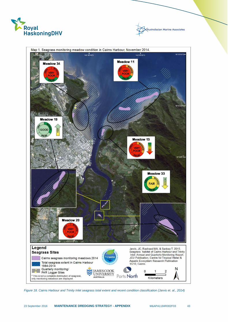
23 September 2016 MAINTENANCE DREDGING STRATEGY - APPENDIX M&APA1184R002F03 43
Figure 18. Cairns Harbour and Trinity Inlet seagrass total extent and recent condition classification (Jarvis et. al., 2014)
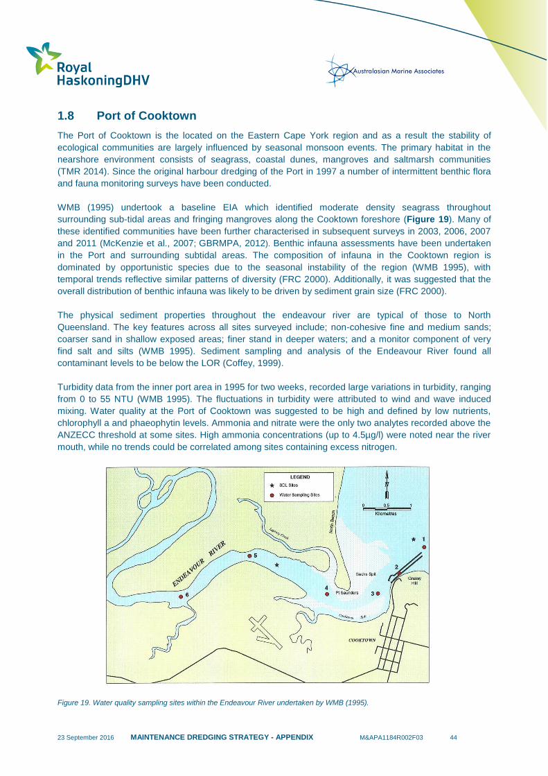
23 September 2016 MAINTENANCE DREDGING STRATEGY - APPENDIX M&APA1184R002F03 44
1.8 Port of Cooktown
The Port of Cooktown is the located on the Eastern Cape York region and as a result the stability of
ecological communities are largely influenced by seasonal monsoon events. The primary habitat in the
nearshore environment consists of seagrass, coastal dunes, mangroves and saltmarsh communities
(TMR 2014). Since the original harbour dredging of the Port in 1997 a number of intermittent benthic flora
and fauna monitoring surveys have been conducted.
WMB (1995) undertook a baseline EIA which identified moderate density seagrass throughout
surrounding sub-tidal areas and fringing mangroves along the Cooktown foreshore (Figure 19). Many of
these identified communities have been further characterised in subsequent surveys in 2003, 2006, 2007
and 2011 (McKenzie et al., 2007; GBRMPA, 2012). Benthic infauna assessments have been undertaken
in the Port and surrounding subtidal areas. The composition of infauna in the Cooktown region is
dominated by opportunistic species due to the seasonal instability of the region (WMB 1995), with
temporal trends reflective similar patterns of diversity (FRC 2000). Additionally, it was suggested that the
overall distribution of benthic infauna was likely to be driven by sediment grain size (FRC 2000).
The physical sediment properties throughout the endeavour river are typical of those to North
Queensland. The key features across all sites surveyed include; non-cohesive fine and medium sands;
coarser sand in shallow exposed areas; finer stand in deeper waters; and a monitor component of very
find salt and silts (WMB 1995). Sediment sampling and analysis of the Endeavour River found all
contaminant levels to be below the LOR (Coffey, 1999).
Turbidity data from the inner port area in 1995 for two weeks, recorded large variations in turbidity, ranging
from 0 to 55 NTU (WMB 1995). The fluctuations in turbidity were attributed to wind and wave induced
mixing. Water quality at the Port of Cooktown was suggested to be high and defined by low nutrients,
chlorophyll a and phaeophytin levels. Ammonia and nitrate were the only two analytes recorded above the
ANZECC threshold at some sites. High ammonia concentrations (up to 4.5µg/l) were noted near the river
mouth, while no trends could be correlated among sites containing excess nitrogen.
Figure 19. Water quality sampling sites within the Endeavour River undertaken by WMB (1995).

23 September 2016 MAINTENANCE DREDGING STRATEGY - APPENDIX M&APA1184R002F03 45
1.8.1 Environmental Values
Table 8 provides a list of the environmental values and communities previously reported at the Port of
Cooktown, including a summary of known distribution and seasonal and temporal trends.
Table 8. Environmental Values for the Port of Cooktown.
Environmental
Values Distribution
Temporal Trends – Environmental
Windows
HABITATS
Seagrass Meadows
Cooktown is composed of two different intertidal
communities of seagrass located near archer point.
The primary community is dominated by H. univervis/
H. ovalis with Cymodocea/T. hemprichii and the
second composed of H. univervis/H. ovalis with C.
rotundata (McKenzie et al., 2007; GBRMPA, 2012). In
2005 a seagrass survey of the Endeavour River
identified spare patches of H. ovalis in Chinamans
creek and dense patches on the northern intertidal
banks of the river (McKenzie and Yoshida, 2014).
Zostera capricorni was also observed on the exposed
banks and narrow intertidal banks known as Sash’s
Spit (McKenzie and Yoshida, 2014), on the southern
banks of the endeavour river since 1985. There is no
consistent monitoring north of Cooktown, but aerial
surveys in the Princess Charlotte Bay region supports
other evidence that seagrass in the northern Great
Barrier Reef is stable (GBRMPA, 2012). BMT WBM
(2010) presented a summary of key environmental
values and a water quality monitoring program as part
of a long term Dredge Strategy (Figure 20). Seagrass
communities observed by GHD (2006) in the north-
eastern corner of the DMPA were found to be of
moderate density, composed of Zostera capricorni
and Halodule uninervis in an area of approximately
10m2 (BMT WBM, 2010).
Since 2003 seasonal variability has
been observed within the H. uninervis
and H. ovalis beds south of Cooktown
ranging from 20% in winter to 35% in
spring. Annual declines have also been
noted in assemblages between 2003
and 2006 surveys as well as between
2009 and 2011, although the decadal
trend is suggested to be relatively stable
(McKenzie et al., 2007; GBRMPA,
2012).
Coral Reefs
Cooktown has a number of inshore reefs (starting
~15km from the Cooktown) which are primarily
composed of hard coral (40.4%) and algae (41.5%),
with a ~5% soft corals. The dominant coral
assemblages are Acroporidae, Favidae,
Pocilloporidae and Poritidae (Sweatman et al., 2008).
There appears to be no long-term trends
with most fluctuations driven by
increases or decreases in in the
abundance of hard coral (Sweatman et
al., 2008).
Macroalgal Beds NA
Macroalgae generally increases in
spring/early summer, but has remained
well below the GBR long-term average
for reef habitat since 2006 (McKenzie
and Yoshida, 2014).
FAUNA
Sea Turtles
Loggerhead, Green, Flatback and Hawksbill turtles
are known to inhibit the area (Garcon et al., 2010).
The Hawksbill is regularly found in the Howick reef
NA
23 September 2016 MAINTENANCE DREDGING STRATEGY - APPENDIX M&APA1184R002F03 46
group to the north of Cooktown (Bell et al., 2012).
Dugongs
The World Heritage Area has been subdivided into
two parts: north of Cooktown and south of Cooktown.
North of Cooktown, surveys were carried out in 1984,
1985, 1990 and 1995, suggesting that Cooktown may
represent a population break (Env 2015). The
extensive seagrass meadows north of Cooktown and
lack of anthropogenic influences in the region are
suggested to allow dugong populations to persist in
strong numbers (Marsh et al., 1995).
Dugong numbers have declined
significantly in recent years possibly as
a consequence to both natural and
human-induced changes to the health
and ecology of seagrass beds. From
1984 to 1995 the northern dugong
population was stable, with the minimum
population estimate from 1995 being
8190 (+/- standard error of 1172)
dugongs (Marsh et al., 1995; Env 2015).
Cetaceans
A number of inshore dolphins are have been recorded
in the Cooktown area including; Australian snubfin
(Orcaella heinsohni), Indo-Pacific humpback (Sousa
chinensis) and Bottlenose dolphin (Tursiops truncates
/ aduncus) (Fisheries Queensland, 2011). The dwarf
minke whale, Balaenoptera acutorostrat is a migratory
whale species that is also known to frequent the
offshore area off Cooktown, particularly Lizard Island
(Britles et al., 2008; 2014).
Swim-with-whale operators in the area
have undertaken ongoing monitoring of
B. acutorostrat populations. The Ribbon
9/10 reefs north of Cooktown account
for the majority of sightings for the
species along the east coast of Australia
(Britles et al., 2008; 2014). The number
of encounters increased by 90% from
2003 to 2008, which are likely a
reflection of increased visitation and
knowledge on occurrence (Britles et al.,
2008; 2014).
Benthic infauna
and epifauna
The Port of Cooktown is characterised by unstable,
highly turbid waters that is driven by the seasonal
monsoon rains that are reflective of benthic fauna
identified (FRC 2000, WMB 1996). Benthic fauna
investigations undertaken by FRC (2000) identified a
lack of sponges and soft coral. The benthic infauna
surrounding the Port of Cooktown and spoil ground is
dominated by opportunistic species such as
polychaete’s and amphipods (FRC 2000; WMB 1996).
There appears to be no noticeable
qualitative changes between historic
infauna investigations (FRC 2000, WMB
1996).
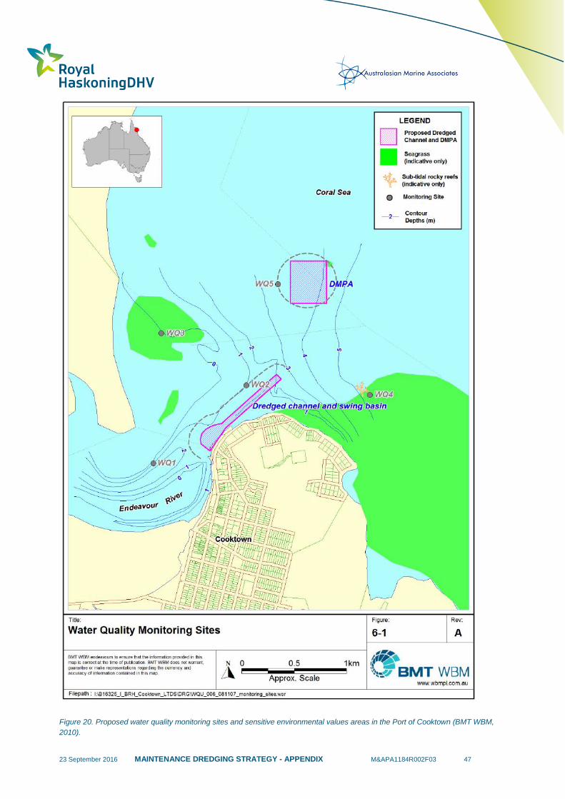
23 September 2016 MAINTENANCE DREDGING STRATEGY - APPENDIX M&APA1184R002F03 47
Figure 20. Proposed water quality monitoring sites and sensitive environmental values areas in the Port of Cooktown (BMT WBM,
2010).

23 September 2016 MAINTENANCE DREDGING STRATEGY - APPENDIX M&APA1184R002F03 48
2 Risk Assessment Approach & Assessment Outcomes
The basis of the environment – ecosystem level risk assessment approach in this report comes from the
Great Barrier Reef Marine Park Authority 2014, Great Barrier Reef Region Strategic Assessment:
Strategic assessment report, GBRMPA, Townsville (GBRMPA, 2014).
The risk assessment approach will adopt the following:
Consequence description and definition (GBRMPA, 2014):
Note: Recovery periods are indicative of major capital dredging programs, and not maintenance dredging.
Likelihood description and frequency (GBRMPA, 2014):
Consistent with the GBRMPA (2014) approach, the assessment of likelihood is based on the likelihood of
the consequences of an event occurring at each Port. For example, if maintenance dredging occurs one
or more times a year and there is the potential for an impact to occur (i.e. from historic turbidity monitoring
or predictive plume modelling) during maintenance dredging, then the likelihood of this impact is
determined to be ‘Likely’. Alternatively, if maintenance dredging occurs infrequently (i.e. > annually), and
there is low potential for an impact to occur (i.e. from historic turbidity monitoring or predictive plume
modelling) then the likelihood of an impact is determined to be ‘Unlikely’.

23 September 2016 MAINTENANCE DREDGING STRATEGY - APPENDIX M&APA1184R002F03 49
The assessment of consequences is based on available technical data for the dredging works. For
example, where predictive modelling or field based monitoring demonstrated no interaction between
plumes and environmental values then the consequence was determined to be insignificant.
In many cases field based measurements of maintenance dredging plume intensity and extent are
available, and the status of environmental values are well understood. The volume of scientifically derived
information however, varies across the ports and therefore, the level of confidence applied to the risk
grades also varies. The table below provides guidance on the confidence levels for the risk grades. For
the purpose of this risk assessment only environmental values that have the potential to be influenced by
maintenance dredging and disposal plumes, and dredge movements, will be included in the assessment.
These include: seagrass, coral, macro algal beds, sea turtle, dugong, cetaceans and benthic infauna
communities.
Hazard Risk Grades (GBRMPA, 2014):
Confidence Score Grades:
Confidence Level Data Availability
Low No water quality monitoring during maintenance dredging/disposal available, environmental
values not well understood and are largely unknown.
Medium
Water quality monitoring during active dredging/disposal is available and ideally focuses on
measuring the plume intensity and extent. Other data on water quality observations during
other dredging works may be available to inform the assessment, however it’s not
representative of maintenance dredging (i.e. TSHD Brisbane), modelling may have been
completed that is representative of maintenance dredging and disposal however no field
validation has been executed, environmental values are well understood (mapped)
High
Targeted maintenance dredging/disposal plume intensity and extent monitoring available,
environmental values well understood (mapped), if plume interaction is likely monitoring has
been established to inform management.
2.1 Risk Assessment Summary Tables
Tables 9 to Table 16 provide a summary of the preliminary risk assessment outcomes for the
environmental values from each relevant port. The risk assessment addresses risks from maintenance
dredging and dredge material placement activities to environmental values that have the greatest potential
to be influenced by these activities. These include; seagrass, coral, macro algal beds, sea turtle, dugong,
cetaceans and benthic infauna communities. These key environmental values have been considered in
each port; however the summary tables to support the risk assessment focus on the environmental values
of most relevance to each port. For example, of most relevance to the Port of Gladstone are the potential
impacts of maintenance dredging activities to adjacent seagrass meadows.
23 September 2016 MAINTENANCE DREDGING STRATEGY - APPENDIX M&APA1184R002F03 50
For the purposes of the risk assessment, the environmental values have been grouped into two different
threat categories, namely (1) maintenance dredging leading to a loss of important marine flora and key
habitat; and (2) maintenance dredging leading to a loss of important marine fauna. This threat
characterisation approach was adopted, as the key flora and habitats primarily consisted of benthic
primary producers (namely, seagrasses, corals and macroalgal communities), whereas the important
fauna primarily relate to marine megafauna.
Benthic infauna and epifauna communities have also been discussed under the important fauna threat
category, as this community consists primarily of invertebrate fauna. Loss of important marine flora and
fauna was considered the endpoint as this is traditionally monitored and can be quantitatively defined (i.e.
loss of seagrass meadow cover, biomass and areal extent). In the case of fauna it is mortality (loss) of
individuals from a defined population i.e. vessel strike and smoothing of sediment infauna communities.
The outcomes of this preliminary risk assessment are summarised in Table 27, in the Technical
Supporting Document and Table 6 in the Concise Summary Document.
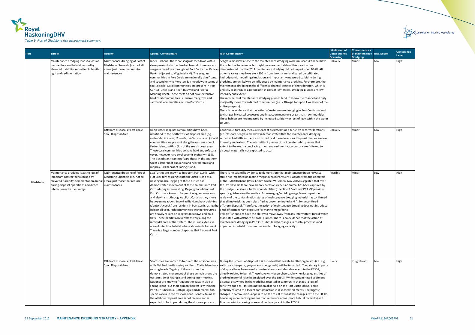
23 September 2016 MAINTENANCE DREDGING STRATEGY - APPENDIX M&APA1184R002F03 51
Table 9. Port of Gladstone risk assessment summary.
Port Threat Activity Spatial Commentary Risk Commentary
Likelihood of
Consequence
Occurring
Consequences
of Maintenance
Dredging
Risk ScoreConfidence
Level
Maintenance dredging of Port of
Gladstone Channels (i.e. not all
areas, just those that require
maintenance)
Inner Harbour - there are seagrass meadows within
close proximity to the Jacobs Channel. There are also
seagrass meadows throughout Port Curtis (i.e. Pelican
Banks, adjacent to Wiggin Island). The seagrass
communities in Port Curtis are regionally significant,
and second only to Moreton Bay meadows in terms of
spatial scale. Coral communities are present in Port
Curtis (Turtle Island Reef, Bushy Island Reef &
Manning Reef). These reefs do not have extensive
hard coral communities Extensive mangrove and
saltmarsh communities exist in Port Curtis.
Seagrass meadows close to the maintenance dredging works in Jacobs Channel have
the potential to be impacted. Light measurement data at this location has
demonstrated that the 2014 maintenance dredging did not impact upon BPAR. All
other seagrass meadows are > 100 m from the channel and based on calibrated
hydrodynamic modelling simulation and importantly measured turbidity during
dredging, are unlikely to be influenced by maintenance dredging. Furthermore, the
maintenance dredging in the difference channel areas is of short duration, which is
unlikely to introduce a period of > 14 days of light stress. Dredging plumes are low
intensity and extent.
The intermittent maintenance dredging plumes tend to follow the channel and only
marginally move towards reef communities (i.e. > 10 mg/L for up to 1 week out of the
entire program).
There is no evidence that the action of maintenance dredging in Port Curtis has lead
to changes in coastal processes and impact on mangrove or saltmarsh communities.
These habitat are not impacted by increased turbidity or loss of light within the water
column.
Unlikely Minor Low High
Offshore disposal at East Banks
Spoil Disposal Area.
Deep water seagrass communities have been
identified to the north west of disposal area (eg.
Halophila decipiens, H. ovalis, and H. spinulosa ). Coral
communities are present along the eastern side of
Facing Island, within 6km of the sea disposal area.
These coral communities do have hard and soft coral
cover, however hard coral cover is typically < 15 %.
The closed significant reefs are those in the southern
Great Barrier Reef bunker island near Heron Island
(approx. 60 km east of Facing Island.
Continuous turbidity measurements at predetermined sensitive receiver locations
(i.e. offshore seagrass meadows) demonstrated that the maintenance dredging
activities had little influence on turbidity at these locations. Disposal plumes are low
intensity and extent. The intermittent plumes do not create turbid plumes that
extent to the reefs along Facing Island and sedimentation on coral reefs linked to
disposal material is not expected to occur.
Unlikely Minor Low High
Maintenance dredging of Port of
Gladstone Channels (i.e. not all
areas, just those that require
maintenance)
Sea Turtles are known to frequent Port Curtis, with
Flat Back turtles using southern Curtis Island as a
nesting beach. Tagging of these turtles has
demonstrated movement of these animals into Port
Curtis during inter-nesting. Dugong populations of
Port Curtis are know to frequent seagrass meadows
and also transit throughout Port Curtis as they move
between meadows. Indo-Pacific Humpback dolphins
(Sousa chinensis ) are resident in Port Curtis, using the
habitat all year. Fish communities within Port Curtis
are heavily reliant on seagrass meadows and mud
flats. These habitats occur extensively along the
intertidal area of the system. There is an extensive
area of intertidal habitat where shorebirds frequent.
There is a large number of species that frequent Port
Curtis.
There is no scientific evidence to demonstrate that maintenance dredging vessel
strike has impacted on marine mega fauna in Port Curtis. Advice from the operators
of the TSHD Brisbane (Pers. Comm Michel Willemen, Nov 2015) suggested that over
the last 10 years there have been 5 occasions when an animal has been captured by
the dredge (i.e. Green Turtle or unidentified). Section 4.5 of the GPC EMP provides
specific guidance on the method for managing/avoiding mega fauna impacts. A
review of the contamination status of maintenance dredging material has confirmed
that all material has been classified as uncontaminated and fit for unconfined
offshore disposal. Therefore, the action of maintenance dredging does not introduce
a risk of contaminant exposure for marine megafauna.
Pelagic fish species have the ability to move away from any intermittent turbid water
associated with offshore disposal plumes. There is no evidence that the action of
maintenance dredging in Port Curtis has lead to changes in coastal processes and
impact on intertidal communities and bird foraging capacity.
Possible Minor Low High
Offshore disposal at East Banks
Spoil Disposal Area.
Sea Turtles are known to frequent the offshore area,
with Flat Back turtles using southern Curtis Island as a
nesting beach. Tagging of these turtles has
demonstrated movement of these animals along the
eastern side of Facing Island during inter-nesting.
Dudongs are know to frequent the eastern side of
Facing Island, but their primary habitat is within the
Port Curtis harbour. Both pelagic and demersal fish
species occur in the offshore zone. Benthic fauna at
the offshore disposal area is not diverse and is
expected to be impact during the disposal process.
During the process of disposal it is expected that sessile benthic organisms (i.e. e.g.
soft corals, sea pens, gorgonians, sponges etc) will be impacted. The primary impacts
of disposal have been a reduction in richness and abundance within the EBSDS,
directly related to burial. These have only been observable when large quantities of
dredged material have been placed over the EBSDS. While contaminated sediment
disposal elsewhere in the world has resulted in community changes (a loss of
sensitive species), this has not been observed on the Port Curtis EBSDS, and is
probably related to a lack of contamination in disposed sediments. The biggest
changes in communities appear to be the result of substrate changes, with the EBSDS
becoming more heterogeneous than reference areas (more habitat diversity) and
fine material increasing in areas directly adjacent to the EBSDS.
Likely Insignificant Low High
Maintenance dredging leads to loss of
marine flora and habitat caused by
elevated turbidity, reduction in benthic
light and sedimentation
Maintenance dredging leads to loss of
important coastal fauna caused by
elevated turbidity, sedimentation, burial
during disposal operations and direct
interaction with the dredge.
Gladstone

23 September 2016 MAINTENANCE DREDGING STRATEGY - APPENDIX M&APA1184R002F03 52
Table 10. Port Alma risk assessment summary.
Port Threat Activity Spatial Commentary Risk Commentary
Likelihood of
Consequence
Occurring
Consequences
of Maintenance
Dredging
Risk ScoreConfidence
Level
Maintenance dredging of Port of
Rockhampton Channels (i.e. not all
areas, just those that require
maintenance)
There is no known seagrass meadows in close
proximity to the Port of Rockhampton Channels or
offshore disposal area. There are no coral
communities in close proximity to the Port of
Rockhampton channel maintenance area (i.e. inner
port channel). Extensive mangrove and saltmarsh
communities exist adjacent to the inner Port of
Rockhampton channel.
Unlikely Insignificant Low Medium
Offshore disposal at approved disposal
area.
There is no known seagrass meadows in close
proximity to the Port of Rockhampton offshore
disposal area. The offshore disposal site is 20 km
away from any significant reef communities.
Extensive mangrove and saltmarsh communities
exist adjacent to the offshore disposal area.
Unlikely Insignificant Low Medium
Maintenance dredging of Port of
Rockhampton Channels (i.e. not all
areas, just those that require
maintenance)
Sea Turtles are known to frequent Port of
Rockhampton. Peak Island at the northern limit of
Port Alma represents a key breeding habitat for
flatback turtles. Peak island is approximately 20 km
north east of the inner channels of the Port of
Rockhampton. The lower Fitzroy estuary
accommodates a low number of dugongs due to the
turbid waters limiting seagrass habitat. Three
species of inshore dolphins have been recorded
inhabiting Port Curtis and Port Alma and include
Australian snubfin (Orcaella heinsohni ), Indo-
Pacific humpback (Sousa chinensis chinensis ) and
the inshore bottlenose dolphin (Tursiops
Delphinidae ).
Unlikely Insignificant Low Medium
Offshore disposal at approved disposal
area.
The offshore disposal area for the Port of
Rockhampton is located < 5 km from the inner
harbour. Therefore, the species described above
are also of relevance to the disposal site
Unlikely Insignificant Low Medium
Maintenance dredging leads to loss of
marine flora and habitat caused by
elevated turbidity, reduction in benthic
light and sedimentation
Maintenance dredging leads to loss of
important coastal fauna caused by
elevated turbidity, sedimentation, burial
during disposal operations and direct
interaction with the dredge.
Alma
The Port is located in the lower Fitzroy River Delta system,
which is a turbid depositional zones. The small scale nature
of the maintenance dredging and disposal required in the
Port of Rockhampton (i.e. days and small volumes) is not
likely to results in persistent plumes. However, preliminary
modelling has shows that turbid plumes could extend some
distance (measured in kilometres) from the loading and
placement sites. These plume are not likely to impact key
flora and fauna, but have the potential to impact upon
benthic fauna communities. A monitoring program aim at
detecting these changes has been initiated by GPC. It should
be acknowledged that any impact to benthic infauna in the
vicinity of the dredging and disposal area is not likely to be
significant based on the small scale nature of the
maintenance dredging and disposal required in the Port of
Rockhampton (i.e. days and small volumes). In fact,
scientifically based differentiation of natural stressors (e.g.
sediment resuspension and high flow river events) will
prove challenging to distinguish from maintenance dredging
and disposal impacts. There has been no recorded instances
of fauna strike or hopper capture in Port Alma.

23 September 2016 MAINTENANCE DREDGING STRATEGY - APPENDIX M&APA1184R002F03 53
Table 11. Port of Hay Point risk assessment summary.
Port Threat Activity Spatial Commentary Risk Commentary
Likelihood of
Consequence
Occurring
Consequences
of Maintenance
Dredging
Risk ScoreConfidence
Level
Dredging of Port of Port of Hay Point
(i.e. not all areas, just those that
require maintenance)
The most recent seagrass survey of the Port of Hay Point
was conducted in 2011 (NQBP, 2011). Two distinct
seagrass habitats (coastal and offshore) were surveyed
and two seagrass species (representing two families)
were observed Halophila decipiens and Halodule
uninervis .
The coastal meadows comprised Halophila ovalis and
Halodule uninervis . The fringing reefs on the intertidal
and subtidal platforms and inshore rocky shoals support
sediment tolerant hard corals (URS 2000 in NQBP, 2009).
There are minor stands of mostly Avicennia mangroves
on the eastern and southern sides of Hay Point (NQBP,
2009).
Possible Minor Low Medium
Offshore disposal at Hay Point Disposal
Area.
The offshore seagrass area was described by light
Halophila decipiens (NQBP, 2011). Hard coral cover
occurs on the Islands and Inlet immediately north and
south of the Port Limits.
Possible Minor Low Medium
Dredging of Port of Port of Hay Point
(i.e. not all areas, just those that
require maintenance)
Six species of turtles have been recorded utilising the
offshore, intertidal, estuarine and shoreline habitats in
the Hay Point area, these are Flatback (Natator
depressus ), Green (Chelonia mydas ), Loggerhead
(Caretta caretta ), Leatherback (Dermochelys coriacea ),
Hawksbill (Eretmochelys imbricate ) and Olive Ridley
(Lepidochelys olivacea ) (NQBP, 2009). Small populations
of dugong have been reported near Port Newry (north)
and Ince Bay (20 km south), with areas of Llewellyn Bay
and Ince Bay having been declared Dugong Protection
Areas (DPA) under the Nature Conservation Act (NC Act)
and the Fisheries Act 1994 (NQBP, 2009).
Marine turtles and marine mammals are mobile and can
generally avoid impacted areas for the duration of
dredging activities. NQBP requires a turtle exclusion
device to be fitted to the drag head on the dredger to
reduce the risk of turtles being injured during dredging.
Other turtle protection measures include conducting the
campaign outside the normal nesting period of mid
October to March (NQBP, 2009).
Possible Minor Low Medium
Offshore disposal at Hay Point Disposal
Area.
The nearshore sandy seabed region was dominated by
open substrate with isolated benthic individuals
including polychaete worms, gastropods and bivalves
(Rasheed et al. 2001; 2003; 2004; 2005 in Thomas and
Rasheed (2010).
The nature of the benthic habitat at the spoil ground will
change during and after dredging. Previous studies
indicate that the spoil ground’s ability to support a benthic
fauna community will not alter, although the community
composition may initially not be the same (NQBP, 2009).
Possible Minor Low Medium
Results of maintenance dredging model simulations
indicate that the plumes are short term and disperse
within hours of dredging and spoil disposal (NQBP, 2009).
Water quality monitoring is undertaken before, during and
after dredging campaigns at Port of Hay Point. Overall,
dredging does contribute to increased turbidity in the port
waters; however, impacts are relatively short term and
depend on prevailing wind and wave conditions.
Specifically, during dredging, there is likely to be an
observable impact on the water quality at Victor Islet and
Round Top Island (NQBP, 2009). NQBP monitors coral
communities at Round Top Island, Victor Islet and Slade
Islet (reference) before, during and after significant
dredging works. Whilst turbidity increases during
dredging, the fringing reefs surrounding the inshore
islands are not significantly affected by sediment
resuspended during dredging activities (WorleyParsons,
2008; WorleyParsons, 2009).
Maintenance dredging leads to loss of
marine flora and habitat caused by
elevated turbidity, reduction in benthic
light and sedimentation
Maintenance dredging leads to loss of
important marine fauna caused by
elevated turbidity, sedimentation, burial
during disposal operations and direct
interaction with the dredge.
Hay Point

23 September 2016 MAINTENANCE DREDGING STRATEGY - APPENDIX M&APA1184R002F03 54
Table 12. Port of Mackay risk assessment summary.
Port Threat Activity Spatial Commentary Risk Commentary
Likelihood of
Consequence
Occurring
Consequences
of Maintenance
Dredging
Risk ScoreConfidence
Level
Dredging of Port of Mackay Channels
(i.e. not all areas, just those that
require maintenance)
The seagrass communities were first
identified at Flat Top and Round Top Islands
by Coles et al . (1987), which were present in
low densities. The coastal seagrass meadows
adjacent to Round Top island were found to
be dominated by Halodule uninervis (wide)/
Halophila ovalis . Hard and soft corals have
been recorded within Mackay Harbour along
the seawalls, which provide hard substrate for
colonisation. Fringing coral reefs at Slade Islet,
Round Top Island, Flat Top Island and Victor
Islet all exhibit similar species diversity and
coverage. Notable species at the
aforementioned locations include Porites
colonies, Macroalgae, Montipora and Acropora
corals.
Turbidity and TSS monitoring has not been previously
undertaken during active dredging within the Port of
Mackay or during disposal operations at the spoil ground.
Whilst seagrass meadows are present within Mackay Port
limits, routine maintenance dredging, disposal and day-to-
day port operations are considered unlikely to impact on
these sensitive receptors due to the distance from these
operations (NQBP, 2011).
Possible Insignificant Low Medium
Offshore disposal at Port of Mackay
Disposal Area.
Rasheed et al., (2011) observed seagrass
meadows at locations 3km south east and 8
km east of the spoil ground. The offshore
meadows were characterised by Halophila
decipiens (Rasheed et al ., (2011). At the
existing spoil disposal ground low densities of
the macroalgae, Galaxaura marginata have
also been identified (Rasheed et al, 2001).
Seagrass meadows are located approximately 3 km from
the spoil ground. There is limited temporal data for coral
reef communities in the Mackay port region.
Investigations into the impact of dredging works has
documented some temporal stability at Slade Islet and
Slade Rock (the two closest reefs to the disposal ground)
with little impact reported at these sites during the 2006
capital dredging works or 2008 maintenance dredging
program (NQBP 2011b). Victor Islet was observed to have a
reduction in coral cover after 2006 activities, however no
further reductions were identified in 2008.
Possible Insignificant Low Medium
Dredging of Port of Mackay Channels
(i.e. not all areas, just those that
require maintenance)
Four species of turtles have been recorded
utilize the area of Mackay as foraging grounds,
these are Flatback (Natator depressus ), Green
(Chelonia mydas ), Loggerhead (Caretta
caretta ), Leatherback (Dermochelys coriacea ),
Olive Ridley (Lepidochelys olivacea ) and
Hawksbill (Eretmochelys imbricate ) (Limpus et
al., 2013).
Since 2005 only one turtle strike has been reported by the
operators of the Brisbane in the Port of Mackay.
Possible Insignificant Low Medium
Offshore disposal at Port of Mackay
Disposal Area.
NQBP (2012) identified that the dominant
benthic infauna taxa within and adjacent to
the offshore spoil ground were polychaete
worms, although ascidians (sea squirts) were
also abundant at the spoil ground. There are a
number of Dugong Protection Areas in the
Mackay region – Ince Bay, Newry region,
Llewellyn Bay, Repulse Bay and Sand Bay.
These areas are remote from the spoil ground.
Monitoring was undertaken at the offshore disposal
ground to assess the benthic infauna assemblages, with
the express objective of identifying impacts within and
adjacent to the spoil ground from spoil placement or
sediment remobilisation. No clear impacts on the overall
structure of the macrobenthic infauna assemblage from
disposal at the spoil ground were evident (NQBP, 2011).
Possible Insignificant Low Medium
Maintenance dredging leads to loss of
important marine flora and habitat
caused by elevated turbidity, reduction
in benthic light and sedimentation.
Maintenance dredging leads to loss of
important marine fauna caused by
elevated turbidity, sedimentation, burial
during disposal operations and direct
interaction with the dredge.
Mackay

23 September 2016 MAINTENANCE DREDGING STRATEGY - APPENDIX M&APA1184R002F03 55
Table 13. Port of Abbot Point risk assessment summary.
Port Threat Activity Spatial Commentary Risk Commentary
Likelihood of
Consequence
Occurring
Consequences
of Maintenance
Dredging
Risk ScoreConfidence
Level
Dredging of Abbot Point (i.e. not all
areas, just those that require
maintenance)
Seven seagrass species have been identified within the
Abbot Point region between February/March 2008and
September 2012 (McKenna and Rasheed, 2013). These
include:
Halophila decipien, Halophila ovalis, Halophila
spinulosa, Halodule uninervis, Cymodocea serrulata,
Cymodocea rotundata, Zostera capricorni . Coastal
meadows in the Abbot Point area generally consisted
of isolated to aggregated patches of seagrass
dominated by Halodule uninervis , although one
meadow was dominated by Zostera capricorni
(McKenna and Rasheed, 2013). Mangroves are present
in the tidal creek lines to the west of the Caley Valley
wetland. GHD (2009c) state that samphire forbland (i.e.
bare mud-flats on Quaternary estuarine deposits.
Mainly saltpans and mudflats with clumps of saltbush)
is widespread across the majority of the interior of the
Caley Valley Wetland.
Hydrodynamic modelling predictions of the port indicate
that turbid plumes generated by dredging and spoil
disposal are likely to migrate over seagrass meadows
located within the port limits. However, the concentration
and reduction in light penetration caused by the increased
turbidity will be of relatively short duration and within the
natural range of turbidity. Results of model simulations
indicate that the plumes are short term and disperse
within hours of dredging and spoil disposal. The peak
concentrations of turbidity predicted can be within the
order of those recorded during high wind and wave
induced mobilisation (NQBP, 2010).
Unlikely Minor Low Medium
Offshore disposal at Abbot Point. Macroalgal communities at Abbot Point have been
identified as widespread, but patchy in distribution and
typically with low percentage cover. During surveys
within the port limits, GHD (2009b) detected algae in
association with small patches of hard substrate, which
were scattered across the area. Macroalgae recorded
included (GHD, 2009b):
• Nine green algae (phylum Chlorophyta);
• Four brown algae (phylum Phaeophyta); and
• Seven red algae (phylum Rhodophyta).
Jarvis (2015) identified light thresholds for managing
impacts from dredging activities. For the offshore areas of
deep water Halophila species the modelling threshold
was 1.5 mol m-2 day-1 over a rolling 7 day average (Jarvis,
2015). No water quality (turbidity) or light based
monitoring has been undertaken at Abbot Point during
any previous maintenance dredging campaign.
Unlikely Minor Low Medium
Dredging of Abbot Point (i.e. not all
areas, just those that require
maintenance)
A 12-month study by GHD (2009d) indicated the most
frequently observed turtles within the Port of Abbot
Point were the green (Chelonia mydas) and the
flatback (Natator depressus ) turtles.
Marine turtles and marine mammals are mobile and can
generally avoid impacted areas for the duration of
dredging activities. NQBP requires a turtle exclusion
device to be fitted to the drag head on the dredger to
reduce the risk of turtles being injured during dredging.
Other turtle protection measures include conducting the
campaigns outside the normal nesting period of mid
October to March (NQBP, 2010).
Possible Minor Low Medium
Offshore disposal at Abbot Point. GHD (2009b) reported sedentary benthic
macroinvertebrates during surveys of the Port Limits.
Ascidians were the most abundant, followed by
echinoderms, molluscs, polychaetes and small
crustaceans, concentrated around isolated patches of
rubble and rock.
Although the abundance of benthic fauna at the spoil
ground would temporarily decrease post dredging, the
area affected by the material relocation is relatively small
in the context of the total area of habitat available in the
immediate surrounds. The nature of the benthic habitat at
the spoil ground will change during and after dredging.
Previous studies indicate that the spoil ground’s ability to
support a benthic fauna community will not alter,
although the community composition may initially not be
the same (NQBP, 2010).
Possible Insignificant Low Medium
Maintenance dredging leads to loss of
important marine flora and habitat
caused by elevated turbidity, reduction
in benthic light and sedimentation.
Maintenance dredging leads to loss of
important marine fauna caused by
elevated turbidity, sedimentation, burial
during disposal operations and direct
interaction with the dredge.
Abbot Point

23 September 2016 MAINTENANCE DREDGING STRATEGY - APPENDIX M&APA1184R002F03 56
Table 14. Port of Townsville risk assessment summary
Port Threat Activity Spatial Commentary Risk Commentary
Likelihood of
Consequence
Occurring
Consequences
of
Maintenance
Dredging
Risk ScoreConfidence
Level
Dredging of Port of Townsville
Channels (i.e. not all areas, just those
that require maintenance).
Cleveland Bay is subject to natural sediment resuspension event that create
turbidity within the water column. The natural event have been observed during
targeted maintenance dredging works. The observed change in turbidity due to
dredging at sensitive receptor locations was well within the range of natural
variability during the monitoring period. Predictive Hydrodynamic modelling,
together with water quality monitoring data, against preliminary impact thresholds,
suggest that it is highly unlikely that mortality to sensitive ecological receptors
(seagrass and corals) would occur. This is primarily because of the short duration of
the campaign (five weeks), and the short duration and intensity of dredge plumes,
and the low intensity of sediment deposition. However, it has been acknowledged
that based on worse case modelling results, it is predicted that low intensity turbid
plumes resulting from dredging could last for several days under windy conditions at
locations containing seagrass meadows (i.e. the Strand and Cape Pallarenda). Stress
(e.g. reduced growth, loss of carbohydrate) could occur under windy conditions to
sensitive seagrass species (Halophila ovalis ). This would particularly be the case if
seagrass was in poor condition in the period leading up to dredging. The interpreted
impact zones indicate that coral communities and nearshore seagrass meadows in
Cleveland Bay are not expected to be adversely impacted from the maintenance
dredging of Platypus Channel and the Outer Harbour. The results indicate that some
deepwater seagrass meadows near the Platypus Channel may be impacted.
However, recent surveys have found no marine plants at sample sites in the vicinity
of the Platypus and Sea Channels (GHD 2011).
Likely - There is
the potential for
an impact to occur
during
maintenance
dredging and
therefore, the
likelihood of this
impact is
determined to be
Likely.
Minor Medium -
Townsville currently
has a
comprehensive
ambient and
targeted water
quality monitoring
dredging, where
these risks are
recognised and
managed.
High
Offshore disposal at Spoil Disposal
Area.
Modelling was carried out to predict sediment resuspension over a 12 month period
to determine potential long-term impacts of dredged material placement. The
modelled change in the 95th percentile turbidity from background (i.e. the turbidity
value exceeded 5% of the time, or 18 days in the year) was less than 2 NTU, while
the modelled change in the 50th percentile turbidity (representing changes in
turbidity for 50% of the time) was less than 0.05 NTU throughout the model domain.
There is an interaction between benthic communities and turbid plumes generated
from offshore disposal activities associated with maintenance dredging.
Likely - There is
the potential for
an impact to occur
during
maintenance
dredging and
therefore, the
likelihood of this
impact is
determined to be
Likely.
Minor Medium -
Townsville currently
has a
comprehensive
ambient and
targeted water
quality monitoring
dredging, where
these risks are
recognised and
managed.
High
Dredging of Port of Townsville
Channels (i.e. not all areas, just those
that require maintenance)
There is no scientific evidence to demonstrate that maintenance dredging vessel strike has
impacted on marine mega fauna. Advice from the operators of the TSHD Brisbane (Pers.
Comm Michel Willemen, Nov 2015) suggested that over the last 10 years there have been 3
occasions when an animal has been captured by the dredge (i.e. Green Turtle or
unidentified). Section 7 of the PoT EMP provides specific guidance on the method for
managing/avoiding mega fauna impacts. A review of the contamination status of
maintenance dredging material has confirmed that all material has been classified as
uncontaminated and fit for unconfined offshore disposal. Therefore, the action of
maintenance dredging does not introduce a risk of contaminant exposure for marine
megafauna.
Pelagic fish species have the ability to move away from any intermittent turbid water
associated with offshore disposal plumes.
There is no evidence that the action of maintenance dredging in Port of Townsville has lead
to changes in coastal processes and impact on intertidal communities and bird foraging
capacity.
Possible Minor Low High
Offshore disposal at Spoil Disposal
Area.
Modelling was carried out to predict sediment resuspension over a 12 month period
to determine potential long-term impacts of dredged material placement. The
modelled change in the 95th percentile turbidity from background (i.e. the turbidity
value exceeded 5% of the time, or 18 days in the year) was less than 2 NTU, while
the modelled change in the 50th percentile turbidity (representing changes in
turbidity for 50% of the time) was less than 0.05 NTU throughout the model domain.
This very small change to ambient turbidity is highly unlikely to cause measurable
changes to biota.
Possible Minor Low High
Cleveland Bay contains some of the most extensive and
diverse seagrass meadows in north Queensland. Seagrass
meadows in Cleveland Bay have high ecological
significance in the context of providing habitat for a range
of species of fisheries significance, and the provision of
food resources for the threatened dugong and green turtle.
The Port of Townsville Channel is adjacent to known deep
water seagrass meadows (ephemeral and sparse) and close
to coast seagrasses (semi-permanent/permanent). Reef
habitats in Cleveland Bay include shallow fringing reefs and
rocky shores around Magnetic Island; the well-developed
reef platform of Middle Reef; and smaller, less developed
reef areas between the mainland and Magnetic Island.
Large areas of mangrove and saltmarsh communities occur
to the south of the Outer Harbour Project area along Ross
Creek, Ross River, and the eastern shoreline of Cleveland
Bay.
The offshore disposal area for the Port of Townsville is
located in an area know to support deepwater seagrass
meadows (empheral and sparse).
Sea Turtle are known to frequent the waters of Cleveland
Bay. Green turtles are the most abundant turtle species
(~90% of sightings). Dugongs are abundant in Cleveland
Bay and the Bay is thought to be an important dugong
habitat at a regional scale. Australian snubfin dolphins
(Orcaella heinsohni) and Indo-Pacific humpback dolphins
(Sousa chinensis) are common in nearshore environments
throughout Cleveland Bay, and are likely to regularly feed
in the port area. There have been 253 fish species recorded
from Cleveland Bay and the Ross River and Creek,
representing a number of important commercial and
recreational species. The wetland and mudflat habitats
associated with Ross River, parts of Magnetic Island
National Park, Bowling Green Bay National Park and
Townsville Town Common Conservation Park provide
foraging and roosting habitat for migratory shorebirds. The
benthic fauna are sparse and patchy in Cleveland Bay and
contain large areas of completely bare substrate.
Maintenance dredging leads to loss of
marine flora and habitat caused by
elevated turbidity, reduction in benthic
light and sedimentation
Maintenance dredging leads to loss of
important coastal fauna caused by
elevated turbidity, sedimentation, burial
during disposal operations and direct
interaction with the dredge.
Townsville
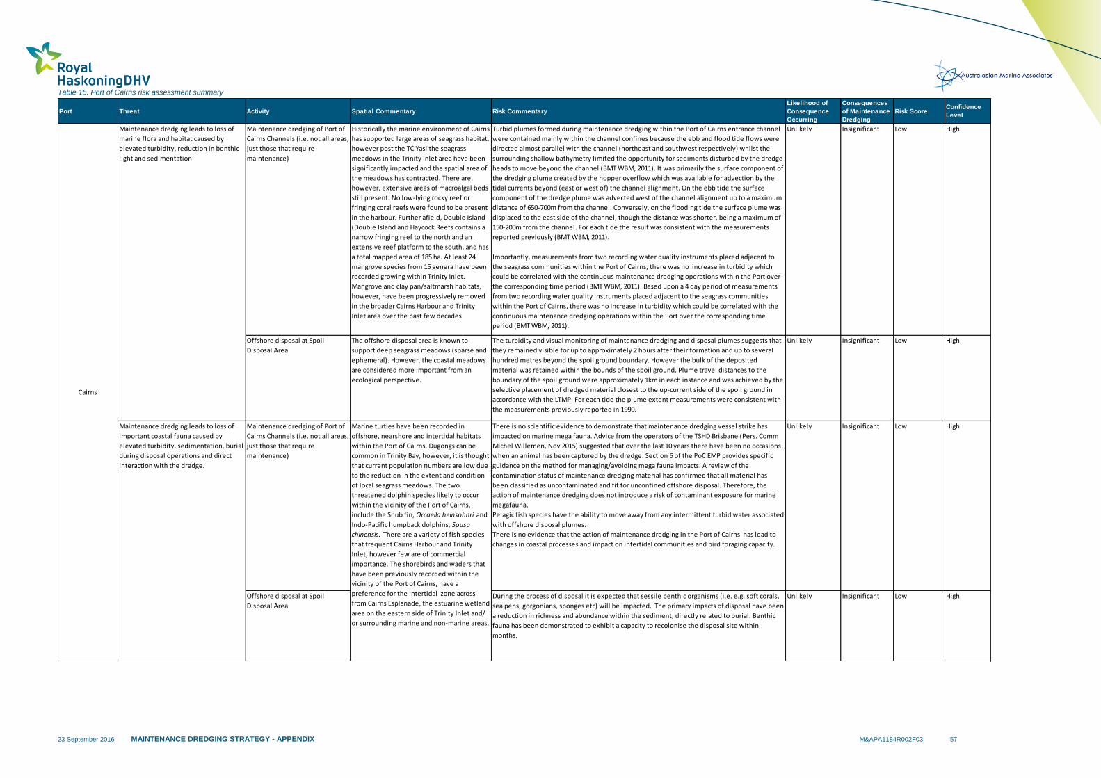
23 September 2016 MAINTENANCE DREDGING STRATEGY - APPENDIX M&APA1184R002F03 57
Table 15. Port of Cairns risk assessment summary
Port Threat Activity Spatial Commentary Risk Commentary
Likelihood of
Consequence
Occurring
Consequences
of Maintenance
Dredging
Risk ScoreConfidence
Level
Maintenance dredging of Port of
Cairns Channels (i.e. not all areas,
just those that require
maintenance)
Historically the marine environment of Cairns
has supported large areas of seagrass habitat,
however post the TC Yasi the seagrass
meadows in the Trinity Inlet area have been
significantly impacted and the spatial area of
the meadows has contracted. There are,
however, extensive areas of macroalgal beds
still present. No low-lying rocky reef or
fringing coral reefs were found to be present
in the harbour. Further afield, Double Island
(Double Island and Haycock Reefs contains a
narrow fringing reef to the north and an
extensive reef platform to the south, and has
a total mapped area of 185 ha. At least 24
mangrove species from 15 genera have been
recorded growing within Trinity Inlet.
Mangrove and clay pan/saltmarsh habitats,
however, have been progressively removed
in the broader Cairns Harbour and Trinity
Inlet area over the past few decades
Turbid plumes formed during maintenance dredging within the Port of Cairns entrance channel
were contained mainly within the channel confines because the ebb and flood tide flows were
directed almost parallel with the channel (northeast and southwest respectively) whilst the
surrounding shallow bathymetry limited the opportunity for sediments disturbed by the dredge
heads to move beyond the channel (BMT WBM, 2011). It was primarily the surface component of
the dredging plume created by the hopper overflow which was available for advection by the
tidal currents beyond (east or west of) the channel alignment. On the ebb tide the surface
component of the dredge plume was advected west of the channel alignment up to a maximum
distance of 650-700m from the channel. Conversely, on the flooding tide the surface plume was
displaced to the east side of the channel, though the distance was shorter, being a maximum of
150-200m from the channel. For each tide the result was consistent with the measurements
reported previously (BMT WBM, 2011).
Importantly, measurements from two recording water quality instruments placed adjacent to
the seagrass communities within the Port of Cairns, there was no increase in turbidity which
could be correlated with the continuous maintenance dredging operations within the Port over
the corresponding time period (BMT WBM, 2011). Based upon a 4 day period of measurements
from two recording water quality instruments placed adjacent to the seagrass communities
within the Port of Cairns, there was no increase in turbidity which could be correlated with the
continuous maintenance dredging operations within the Port over the corresponding time
period (BMT WBM, 2011).
Unlikely Insignificant Low High
Offshore disposal at Spoil
Disposal Area.
The offshore disposal area is known to
support deep seagrass meadows (sparse and
ephemeral). However, the coastal meadows
are considered more important from an
ecological perspective.
The turbidity and visual monitoring of maintenance dredging and disposal plumes suggests that
they remained visible for up to approximately 2 hours after their formation and up to several
hundred metres beyond the spoil ground boundary. However the bulk of the deposited
material was retained within the bounds of the spoil ground. Plume travel distances to the
boundary of the spoil ground were approximately 1km in each instance and was achieved by the
selective placement of dredged material closest to the up-current side of the spoil ground in
accordance with the LTMP. For each tide the plume extent measurements were consistent with
the measurements previously reported in 1990.
Unlikely Insignificant Low High
Maintenance dredging of Port of
Cairns Channels (i.e. not all areas,
just those that require
maintenance)
There is no scientific evidence to demonstrate that maintenance dredging vessel strike has
impacted on marine mega fauna. Advice from the operators of the TSHD Brisbane (Pers. Comm
Michel Willemen, Nov 2015) suggested that over the last 10 years there have been no occasions
when an animal has been captured by the dredge. Section 6 of the PoC EMP provides specific
guidance on the method for managing/avoiding mega fauna impacts. A review of the
contamination status of maintenance dredging material has confirmed that all material has
been classified as uncontaminated and fit for unconfined offshore disposal. Therefore, the
action of maintenance dredging does not introduce a risk of contaminant exposure for marine
megafauna.
Pelagic fish species have the ability to move away from any intermittent turbid water associated
with offshore disposal plumes.
There is no evidence that the action of maintenance dredging in the Port of Cairns has lead to
changes in coastal processes and impact on intertidal communities and bird foraging capacity.
Unlikely Insignificant Low High
Offshore disposal at Spoil
Disposal Area.
During the process of disposal it is expected that sessile benthic organisms (i.e. e.g. soft corals,
sea pens, gorgonians, sponges etc) will be impacted. The primary impacts of disposal have been
a reduction in richness and abundance within the sediment, directly related to burial. Benthic
fauna has been demonstrated to exhibit a capacity to recolonise the disposal site within
months.
Unlikely Insignificant Low High
Marine turtles have been recorded in
offshore, nearshore and intertidal habitats
within the Port of Cairns. Dugongs can be
common in Trinity Bay, however, it is thought
that current population numbers are low due
to the reduction in the extent and condition
of local seagrass meadows. The two
threatened dolphin species likely to occur
within the vicinity of the Port of Cairns,
include the Snub fin, Orcaella heinsohnri and
Indo-Pacific humpback dolphins, Sousa
chinensis. There are a variety of fish species
that frequent Cairns Harbour and Trinity
Inlet, however few are of commercial
importance. The shorebirds and waders that
have been previously recorded within the
vicinity of the Port of Cairns, have a
preference for the intertidal zone across
from Cairns Esplanade, the estuarine wetland
area on the eastern side of Trinity Inlet and/
or surrounding marine and non-marine areas.
Maintenance dredging leads to loss of
marine flora and habitat caused by
elevated turbidity, reduction in benthic
light and sedimentation
Maintenance dredging leads to loss of
important coastal fauna caused by
elevated turbidity, sedimentation, burial
during disposal operations and direct
interaction with the dredge.
Cairns
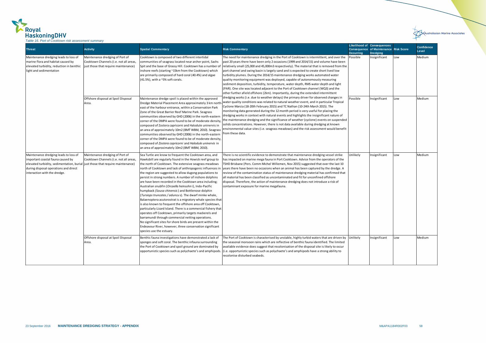
23 September 2016 MAINTENANCE DREDGING STRATEGY - APPENDIX M&APA1184R002F03 58
Table 16. Port of Cooktown risk assessment summary
Threat Activity Spatial Commentary Risk Commentary
Likelihood of
Consequence
Occurring
Consequences
of Maintenance
Dredging
Risk ScoreConfidence
Level
Maintenance dredging of Port of
Cooktown Channels (i.e. not all areas,
just those that require maintenance)
Cooktown is composed of two different intertidal
communities of seagrass located near archer point, Sachs
Spit and the base of Grassy Hill. Cooktown has a number of
inshore reefs (starting ~15km from the Cooktown) which
are primarily composed of hard coral (40.4%) and algae
(41.5%), with a ~5% soft corals.
Possible Insignificant Low Medium
Offshore disposal at Spoil Disposal
Area.
Maintenance dredge spoil is placed within the approved
Dredge Material Placement Area approximately 3 km north-
east of the harbour entrance, within a Conservation Park
Zone of the Great Barrier Reef Marine Park. Seagrass
communities observed by GHD (2006) in the north-eastern
corner of the DMPA were found to be of moderate density,
composed of Zostera capricorni and Halodule uninervis in
an area of approximately 10m2 (BMT WBM, 2010). Seagrass
communities observed by GHD (2006) in the north-eastern
corner of the DMPA were found to be of moderate density,
composed of Zostera capricorni and Halodule uninervis in
an area of approximately 10m2 (BMT WBM, 2010).
Possible Insignificant Low Medium
Maintenance dredging of Port of
Cooktown Channels (i.e. not all areas,
just those that require maintenance)
Sea Turtle are know to frequent the Cooktown area, and
Hawksbill are regularly found in the Howick reef group to
the north of Cooktown. The extensive seagrass meadows
north of Cooktown and lack of anthropogenic influences in
the region are suggested to allow dugong populations to
persist in strong numbers. A number of inshore dolphins
are have been recorded in the Cooktown area including;
Australian snubfin (Orcaella heinsohn i), Indo-Pacific
humpback (Sousa chinensis ) and Bottlenose dolphin
(Tursiops truncates / aduncu s). The dwarf minke whale,
Balaenoptera acutorostrat is a migratory whale species that
is also known to frequent the offshore area off Cooktown,
particularly Lizard Island. There is a commercial fishery that
operates off Cooktown, primarily targets mackerels and
barramundi through commercial netting operations.
No significant sites for shore birds are present within the
Endeavour River, however, three conservation significant
species use the estuary.
There is no scientific evidence to demonstrate that maintenance dredging vessel strike
has impacted on marine mega fauna in Port Cooktown. Advice from the operators of the
TSHD Brisbane (Pers. Comm Michel Willemen, Nov 2015) suggested that over the last 10
years there have been no occasions when an animal has been captured by the dredge. A
review of the contamination status of maintenance dredging material has confirmed that
all material has been classified as uncontaminated and fit for unconfined offshore
disposal. Therefore, the action of maintenance dredging does not introduce a risk of
contaminant exposure for marine megafauna.
Unlikely Insignificant Low Medium
Offshore disposal at Spoil Disposal
Area.
Benthic fauna investigations have demonstrated a lack of
sponges and soft coral. The benthic infauna surrounding
the Port of Cooktown and spoil ground are dominated by
opportunistic species such as polychaete’s and amphipods.
The Port of Cooktown is characterised by unstable, highly turbid waters that are driven by
the seasonal monsoon rains which are reflective of benthic fauna identified. The limited
available evidence does suggest that recolonisation of the disposal site is likely to occur
(i.e. opportunistic species such as polychaete’s and amphipods have a strong ability to
recolonise disturbed seabeds.
Unlikely Insignificant Low Medium
The need for maintenance dredging in the Port of Cooktown is intermittent, and over the
past 20 years there have been only 2 occasions (1999 and 2014/15) and volume have been
relatively small (25,000 and 45,000m3 respectively). The material that is removed from the
port channel and swing basin is largely sand and is expected to create short lived low
turbidity plumes. During the 2014/15 maintenance dredging works automated water
quality monitoring equipment was deployed, capable of autonomously measuring
sediment deposition, turbidity, temperature, water depth, RMS water depth and light
(PAR). One site was located adjacent to the Port of Cooktown channel (WQ3) and the
other further afield offshore (2km). Importantly, during the extended intermittent
dredging works (i.e. due to weather delays) the primary driver for observed changes in
water quality conditions was related to natural weather event, and in particular Tropical
Cyclone Marcia (18-20th February 2015) and TC Nathan (10-24th March 2015). The
monitoring data generated during the 12 month period is very useful for placing the
dredging works in context with natural events and highlights the insignificant nature of
the maintenance dredging and the significance of weather (cyclone) events on suspended
solids concentrations. However, there is not data available during dredging at known
environmental value sites (i.e. seagrass meadows) and the risk assessment would benefit
from these data.
Maintenance dredging leads to loss of
marine flora and habitat caused by
elevated turbidity, reduction in benthic
light and sedimentation
Maintenance dredging leads to loss of
important coastal fauna caused by
elevated turbidity, sedimentation, burial
during disposal operations and direct
interaction with the dredge.
23 September 2016 MAINTENANCE DREDGING STRATEGY - APPENDIX M&APA1184R002F03 59
3 References
AECOM & BMT WBM (2012) Port of Townsville – Port Expansion EIS.
ANZECC (2000), Australian and New Zealand Guidelines for Fresh and Marine Water Quality. Australian and New Zealand Environment Conservation Council and Agriculture and Resource Management Council of Australia and New Zealand, Canberra, ACT.
Aurecon Pty Ltd (2010), Western Basin Project Application for a permit under the Environment Protection (sea Dumping) Act 1981 to dispose of dredge material to sea, Rev 3, Aurecon Australia Pty Ltd, Brisbane.
Bell I, Schwarzkopf L, Manicom C (2012) High survivorship of an annually decreasing aggregation of hawksbill turtles, Eretmochelys imbricata, found foraging in the northern Great Barrier Reef. Aquatic Conservation: Marine and Freshwater Ecosystems 22: 673-682.
BMT WBM (2010) Long Term Dredge Strategy: Port of Cooktown. Final Report Feb 2010. Prepared for Queensland Transport.
BMT WBM (2011) Dredge Plume Measurements at Port of Cairns August 2011. Prepared for Ports North.
BMT WBM (2012a) Port of Gladstone Maintenance Dredging– SAP Implementation Report. August 2012
BMT WBM (2012b) Port of Townsville – Port Expansion EIS. Appendix K2 Marine Ecology Baseline Report
BMT WBM Pty Ltd (2012c) Port of Gladstone Offshore Disposal Monitoring Program, BMT WBM Pty Ltd, Brisbane.
BMT WBM (2013) Central Queensland corals and associated benthos: Monitoring review and gap analysis. Prepared for Gladstone Ports Corporation and Ecosystem Research Monitoring Program – Tier 1 Report.
BMT WBM (2014) Modelling and Assessment of the Port of Gladstone Maintenance Dredging and Sea Disposal to Inform Sea Dumping Permit Applications. Prepared for Gladstone Ports Corporation.
BMT WBM (2014a) Western Basin Dredging and Disposal Footprint Sediment Sampling and Analysis Plan, May 2014.
BMT WBM (2014b) Maintenance Dredging of the Western Basin Dredging and Disposal Footprint – Sediment Quality Report, August 2014.
BMT WBM (2015a) Port Alma Receiving Environment Monitoring Program Design Report. Prepared for Gladstone Port Corporation.
BMT WBM (2015b) BMT WBM – Port Alma Benthic Fauna Pilot Monitoring Program. Prepared for Gladstone Port Corporation.
Birtles, A., Arnold, P., Curnock, M., Salmon, S., Mangott, A., Sobtzick, S., & Rumney, J. (2008). Code of practice for dwarf minke whale interactions in the Great Barrier Reef World Heritage Area.
Birtles, A., Valentine, P., Curnock, M., Mangott, A., & Marsh, H. (2014). Dwarf minke whale tourism monitoring program (2003--2008). Great Barrier Reef Marine Park Authority. Research publication no. 112
23 September 2016 MAINTENANCE DREDGING STRATEGY - APPENDIX M&APA1184R002F03 60
Bryant, CV, Davies, JD, Jarvis, JC, Tol, S and Rasheed, MA. 2014. ‘Seagrasses in Port Curtis and Rodds Bay (2013) Annual Long Term Monitoring, Biannual Western Basin Surveys & Updated Baseline Survey’, Centre for Tropical Water & Aquatic Ecosystem Research (TropWATER) Publication 14/23, James Cook University, Cairns, 71 pp
Cagnazzi D. 2013. Review of Coastal Dolphins in central Queensland, particularly Port Curtis and Port Alma region. Gladstone Port Corporation. 53pp.
Carter R.M., Larcombe, P., Liu, K., Dickens, J., Heron, M.L., Prytz, A., Purdon, R., and Ridd, P.V., 2002. The Environmental Sedimentology of Trinity Bay, Far North Queensland.
Chartrand, K.M., Rasheed, M.A. and Sankey, T.L. (2008). Deep water seagrass dynamics inHay Point - Measuring variability and monitoring impacts of capital dredging. Final. Report to the Ports Corporation of Queensland. DPI&F Publication PR08-4082 (DPI&F, Cairns), 43 pp.
Chartrand, KM, McCormack, CV & Rasheed, MA (2011) ‘Port Curtis and Rodds Bay seagrass monitoring program, November 2010’, DEEDI Publication. Fisheries Queensland, Cairns, 57 pp.
Chartrand, KM, Ralph, PJ, Petrou, K & Rasheed, MA 2012, ‘Development of a Light-Based Seagrass Management Approach for the Gladstone Western Basin Dredging Program’, DAFF Publication. Fisheries Queensland, Cairns, 126 pp.
Choi C.-Y., Moffitt D.J., Fuller, R.A., Skilleter, G., Rogers, D., Coleman, J. & Klaassen M (2015). Annual Report: Migratory Shorebird Monitoring – Understanding Ecological Impact (CA12000284). Report produced for the Ecosystem Research and Monitoring Program Advisory Panel as part of Gladstone Ports Corporation’s Ecosystem Research and Monitoring Program. 76 pp.
Clemens, R., Oldland, J., Berry, L., & Purnell, C., (2009). Shorebirds 2020 Migratory Shorebird Population Monitoring Project.
Coffey (1999). Sediment sampling and analysis; Endeavour River, Cooktown. Commissioned by Queensland Department of Transport.
Commonwealth of Australia, 2002, National Ocean Disposal Guidelines for Dredged Material, Canberra.
Coles RG, Mellors JE, Bibby JM, Squire BA. 1987. Seagrass beds and juvenile prawn and fish nursery grounds - Bowen to Water Park Point. Queensland Department of Primary Industries Information Series QI87021 (Queensland Government: Brisbane). 54pp.
Coles, R. G., Lee Long, W. J., Watson, R. A., and Derbyshire, K. J. (1993). Distribution of sea- grasses, and their fish and penaeid prawn communities, in Cairns Harbour, a tropical estuary, northern Queensland, Australia. In 'Tropical Seagrass Ecosystems; Structure and Dynamics in the Indo-West Pacific'. Australian Journal of Marine and Freshwater Research 44, 193-210.
Currie, DR, Connolly, RM (2006) Distribution and assemblage composition of demersal fish in shallow, nearshore waters of Port Curtis Intertidal wetlands of Port Curtis: Ecological patterns and processes, and their implications’ (Eds. RM Connolly, DR Currie, KF Danaher, M. Dunning, A. Melzer, JR Platten, D. Shearer, PJ Stratford, PR Teasdale & M. Vandergragt) pp 81-94
Currie, DR & Small, KJ 2002, Port Curtis portwide macrobenthos study, research dataset, Centre for Environmental Management, Central Queensland University, Gladstone, Queensland, http://hdl.cqu.edu.au/10018/60241

23 September 2016 MAINTENANCE DREDGING STRATEGY - APPENDIX M&APA1184R002F03 61
C&R Consulting (2007) Townsville ocean terminal nature conservation report: baseline study of impacts of the Townsville ocean terminal on ecological characteristics of Cleveland Bay. Technical Appendix to the Townsville Ocean Terminal Project - Environmental Impact Statement (Final). City Pacific Limited, Townsville.
Cruz Motta. J. J. (2000). Effects of the Dumping of Dredged Material of Townsville Port on the Soft-Bottom benthic Community of Cleveland Bay. James Cook University - Department of Marine Biology.
Department of the Environment (2015)- Dugong fact sheet: https://www.environment.gov.au/system/files/pages/e94eb941-2ff5-4a29-89a3-891059be4e47/files/co02marinemammals.doc.
Department of National Parks, Recreation, Sport and Racing (2014) Fisheries Resources of Balaclava Island, Fitzroy River: Central Queensland. Report produced for the Ecosystem Research and Monitoring Program Advisory Panel as part of Gladstone Ports Corporation’s Ecosystem Research and Monitoring Program. 60 pp.
Department of Transport and Main Roads (2015). Environmental Management Plan (Dredging): Port of Cooktown. Version 7.1
DERM (2011) Copy of Regional Ecosystem Map—version 6.1 data certified under the Vegetation Management Act 1999. http://www.derm.qld.gov.au/wildlifeecosystems/ biodiversity/regional_ecosystems/introduction_and_status/regional_ecosystem_data/ind ex.php.
Duke N. C., Lawn P. T., Roelfsema C. M., Zahmel K. N., Pedersen D. K., Harris C., Steggles N., Tack C. (2003). Assessing Historical Change in Coastal Environments- Port Curtis, Fitzroy River Estuary and Moreton Bay Regions. Report prepared for the CRC for Coastal Zone Estuary and Waterway Management. Marine Botany Group, Centre for Marine Studies, The University of Queensland, Brisbane.
Duke, N. C., Bell, A. M., Pederson, D. K., Roelfsema, C. M., & Nash, S. B. (2005). Herbicides implicated as the cause of severe mangrove dieback in the Mackay region, NE Australia: consequences for marine plant habitats of the GBR World Heritage Area. Marine Pollution Bulletin, 51(1), 308-324.
Fisheries Queensland (2011). Assessment of the conservation benefits of net fishing closures north of Cooktown and in important habitats for dugong, inshore dolphins, sawfish and speartooth shark. Wildlife Trade Operation Condition 12
Fisheries Queensland (2011b). Fishery observation in the East Coast Inshore Fin Fish Fishery.
Fisheries Queensland (2012). Assessment of the East Coast Inshore Fin Fish Fishery.
Garcon JS, Grech A, Moloney J, Hamann M (2010) Relative Exposure Index: an important factor in sea turtle nesting distribution. Aquatic Conservation: Marine and Freshwater Ecosystems 20: 140-149.
GAWB (2008). Gladstone – Fitzroy Pipeline Project Environmental Impact Statement – Chapter 8 Aquatic Flora and Fauna. Gladstone Area Water Board, Queensland.
GBRMPA (2009). Environmental Assessment and Management Risk Management Framework. Great Barrier Reef Marine Park Authority. Accessed 1 November 2015. http://www.gbrmpa.gov.au/__data/assets/pdf_file/0008/4949/gbrmpa_EAMRiskManagementFramework.pdf
Great Barrier Reef Marine Park Authority (2012) A vulnerability assessment for the Great Barrier Reef: Seagrass. Townsville: Great Barrier Reef Marine Park Authority.

23 September 2016 MAINTENANCE DREDGING STRATEGY - APPENDIX M&APA1184R002F03 62
GHD (2005) Port of Hay Point Apron Areas and Departure Path Capital Dredging Supplement to the Draft Environmental Impact Statement – September.
GHD. (2008). Benthic Baseline Assessment Report: Baseline Environmental Monitoring for Port of Abbot Point. Abbot Point Multi Cargo Facility Environmental Impact Statement.
GHD. (2008b). Long Term Dredging and Disposal Management Plan Report. Report prepared for Townsville Port Authority, April 2008.
GHD (2009a). Report for Western Basin Dredging and Disposal Project – Marine Ecology Assessment. Report prepared for Gladstone Ports Corporation.
GHD (2009b). Western Basin Dredging and Disposal Project – Environmental Impact Statement. Chapter 7 Coastal Environment.
GHD. (2009c). Marine Ecology Benthic Survey Report: Proposed Abbot Point Multi Cargo Facility Environmental Impact Assessment. Mackay: North Queensland Bulk Ports Corporation.
GHD. (2009d). Abbot Point Coal Terminal X110 Expansion Infrastructure Development Project Voluntary Environmental Assessment. Mackay: North Queensland Bulk Ports Corporation.
GHD. (2009e). Report for Proposed Abbot Point Multi Cargo Facility: Terrestrial and Aquatic Ecological Assessment. Mackay: North Queensland Bulk Ports Corporation.
GHD (2009f) Townsville Marine Precinct Project Environment Impact Statement. Report prepared for Port of Townsville Corporation.
GHD (2011) Port of Townsville Limited Report for Port Expansion - Marine Megafauna. August 2011. Report prepared for Port of Townsville Corporation.
GPC (2014) Long Term Monitoring and Management Plan for permit under the Environmental Protection (Sea Dumping) Act 1981 to disposal dredge spoil at sea – Maintenance Dredging. Gladstone Port Corporation.
Gladstone Ports Corporation (2013). Migratory Shorebird Monitoring Review. Consultancy Agreement CA0120022.
Eberhard R. (2012). Fitzroy River Estuary development proposals – A review of issues. Fitzroy Basin Association Incorporated. Queensland.
FRC Coastal Resource & Environmental (2000). Study of Seagrass, Benthic and Epibenthic Communities, Cooktown: Monitoring of Spoil Disposal. Commissioned by Queensland Transport.
Hamann M., Shimada T. and Limpus C.J. (2015) Annual report on the internesting habitat use by flatback turtles off the Curtis Island coast – 2013-2014 nesting season. Report produced for the Ecosystem Research and Monitoring Program Advisory Panel as part of Gladstone Ports Corporation’s Ecosystem Research and Monitoring Program.
Hale, P., Long, S., & Tapsall, A. (1998). Distribution and conservation of delphinids in Moreton Bay. In I. R. Tibbetts, N. J. Hall, & W. D. Dennison (Eds.), Moreton Bay and catchment (pp. 477-486). Brisbane: School of Bay and catchment (pp. 477-486). Brisbane: School of Bay and catchment Marine Science, University of Queensland.
Harding, S., Milton, D. (2003) Mackay Shorebird Project Final Report, Queensland Wader Study Group.
Higgins, P. J. & Davies, S. J. J. F. 1996. Handbook of Australian, New Zealand and Antarctic Birds, Vol. 3: Snipe to Pigeons. Oxford University Press, Melbourne.

23 September 2016 MAINTENANCE DREDGING STRATEGY - APPENDIX M&APA1184R002F03 63
IMEMS (2013). Migratory Shorebirds Monitoring Review. Report prepared for Gladstone Ports Corporation.
Jarvis, JC, Rasheed, MA, & Sankey, T (2014). Seagrass Habitat of Cairns Harbour and Trinity inlet: Annual and Quarterly Monitoring Report 2014
JCU (2015) Data Report: Marine Geophysics Laboratory Nephelometer Oceanographic Instrumentation 05/07/2014 – 08/07/2015. Prepared by James Cook University Marine Geophysics Laboratory College of Science, Technology and Engineering.
Limpus C.J., Parmenter C.J. and Chaloupka M. (2013a). Monitoring of Coastal Sea Turtles: Gap Analysis 1. Loggerhead turtles, Caretta caretta, in the Port Curtis and Port Alma Region. Report produced for the Ecosystem Research and Monitoring Program
Limpus C.J., Parmenter C.J. and Chaloupka M. (2013b). Monitoring of Coastal Sea Turtles: Gap Analysis 2. Green turtles, Chelonia mydas, in the Port Curtis and Port Alma Region. Report produced for the Ecosystem Research and Monitoring Program Advisory Panel as part of Gladstone Ports Corporation’s Ecosystem Research and Monitoring Program.
Limpus C.J., Parmenter C.J. and Chaloupka M. (2013c). Monitoring of Coastal Sea Turtles: Gap Analysis 3. Hawksbill turtle, Eretmochelys imbricata, in the Port Curtis and Port Alma Region. Report produced for the Ecosystem Research and Monitoring Program Advisory Panel as part of Gladstone Ports Corporation’s Ecosystem Research and Monitoring Program.
Limpus C.J., Parmenter C.J. and Chaloupka M. (2013d). Monitoring of Coastal Sea Turtles: Gap Analysis 4. Olive ridley turtle, Lepidochelys olivacea, in the Port Curtis and Port Alma Region. Report produced for the Ecosystem Research and Monitoring Program Advisory Panel as part of Gladstone Ports Corporation’s Ecosystem Research and Monitoring Program.
Limpus C.J., Parmenter C.J. and Chaloupka M. (2013e). Monitoring of Coastal Sea Turtles: Gap Analysis 6. Leatherback turtles, Dermochelys coreacea, in the Port Curtis and Port Alma Region. Report produced for the Ecosystem Research and Monitoring Program Advisory Panel as part of Gladstone Ports Corporation’s Ecosystem Research and Monitoring Program.
Limpus C.J., Parmenter C.J. and Chaloupka M. (2013f). Monitoring of Coastal Sea Turtles: Gap Analysis 5. Flatback turtles, Natator depressus, in the Port Curtis and Port Alma Region. Report produced for the Ecosystem Research and Monitoring Program Advisory Panel as part of Gladstone Ports Corporation’s Ecosystem Research and Monitoring Program.
Marchant, S. & Higgins, P. J. 1993. Handbook of Australian, New Zealand and Antarctic Birds, Vol 2. Raptors to Lapwings. Melbourne: Oxford University Press.
Marsh, H., Corkerton, P., Lawler, I. R., Preen, A., & Lanyon, J. (1996). The status of the dugong in the southern Great Barrier Reef Marine Park. Great Barrier Reef Marine Park Authority.

23 September 2016 MAINTENANCE DREDGING STRATEGY - APPENDIX M&APA1184R002F03 64
Marsh, H., Hodgson, A., Lawler, I., Grech, A., & Delean, S. (2007). Condition, status and trends and projected futures of the dugong in the Northern Great Barrier Reef and Torres Strait; including identification and evaluation of the key threats and evaluation of available management options to improve its status. James Cook University, QLD, Australia.
McKenzie, LJ 1994, ‘Seasonal changes in biomass and shoot characteristics of a Zostera capricorni Aschers. dominant meadow in Cairns Harbour, Northern Queensland’, Australian Journal of Marine and Freshwater Research, vol. 45, pp. 1337-1352.
McKenna SA, Rasheed MA (2012) ‘Port of Townsville Long-term Seagrass Monitoring, October 2011’ DEEDI Publication. Fisheries Queensland, Cairns, 33pp.
McKenzie, L.J., Mellors, J. and Waycott, M. 2007, Great Barrier Reef Water Quality Protection Plan Marine Monitoring Program: intertidal seagrass annual report for the sampling period 1 September 2006 - 31 May 2007, Department of Primary Industries and Fisheries, Cairns, viewed 27/04/2012, <http://www.rrrc.org.au/intranet/downloads/MMP-Intertidal-Seagrass-Report-0607.pdf>.
McKenzie, L.J., Yoshida, R. 2014, Seagrass-Watch: Proceedings of a workshop for monitoring seagrass habitat in Cape York Peninsula Queensland. Yuka-Baja-Muliku Ranger Base, Archer Point, Queensland, 24-25 July 2014.
McCormack, C, Rasheed, M, Davies, J, Carter, A, Sankey, T & Tol, S. (2013) ‘Long Term Seagrass Monitoring in the Port Curtis Western Basin: Quarterly Seagrass Assessments & Permanent Transect Monitoring Progress Report November 2009 to November 2012’, Centre for Tropical Water & Aquatic Ecosystem Research (TropWATER) Publication, James Cook University, Cairns, 88 pp.
Mellors, JE, Marsh, H & Coles, RG 1993, ‘Intra-annual changes in seagrass standing crop, Green Island, North Queensland’, Australian Journal of Marine Freshwater Research, vol. 44, pp. 33-41.
North Queensland Bulk Ports corporation (2009a). Port of Hay Point, Environmental Management Plan.
North Queensland Bulk Ports corporation (2009b). Port of Mackay, Land Use Plan.
North Queensland Bulk Ports corporation (2011). Long Term Dredge Management Plan Mackay Port 2012-2022.
National Assessment Guidelines for Dredging (2009). The Commonwealth of Australia, Canberra.
Parra G.J., Corkeron P.J., and Marsh H. (2006a) Population sizes, site fidelity and residence patterns of Australian snubfin and Indo-Pacific humpback dolphins: Implications for conservation. BiologicalConservation 129 pp. 167-180
Parra G.J., Schick R., and Corkeron P.J. (2006b) Spatial distribution and environmental correlates of Australian snubfin and Indo-Pacific humpback dolphins. Ecography 29 pp. 396-406, 2006.
Ports and Coastal Environmental (2013). Port of Hay Point – Sediment Characterisation Report - September.
Ports North (2014). Cairns Shipping Development Project, Environmental Impact Assessment
Port of Townsville (2013). Port of Townsville Long Term Dredging and Disposal Management Plan. February 2013.

23 September 2016 MAINTENANCE DREDGING STRATEGY - APPENDIX M&APA1184R002F03 65
Rasheed, MA (1999), ‘Recovery of experimentally created gaps within a tropical Zostera capricorni (Aschers.) seagrass meadow, Queensland Australia’, Journal of Experimental Marine Biology and Ecology, vol. 235, pp. 183-200.
Rasheed, M. A., Thomas, R., & Roder, C. A. (2001). Port of Mackay Seagrass, Algae and Macro-invertebrate Communities: February 2001. CRC Reef Research Centre.
Rasheed, MA (2003), Port Curtis and Rodds bay seagrass and benthic macro-invertebrate community baseline survey November/December 2002
Rasheed, MA (2004), ‘Recovery and succession in a multi-species tropical seagrass meadow following experimental disturbance: the role of sexual and asexual reproduction’, Journal of Experimental Marine Biology and Ecology, vol. 310, pp. 13-45.
Rasheed M.A., and McKenna S.A. (2013). Seagrass habitat of Cairns harbour and trinity inlet: Annual Monitoring and Updated Baseline Survey- 2012
Rasheed, M.A., Thomas, R. and McKenna, S.A. (2004b). Port of Hay Point seagrass, algae and benthic macro-invertebrate community survey - July 2004. DPI&F Information Series QI04084 (DPI&F, Cairns), 27 pp.
Rasheed, M.A. and Taylor, H.A. (2008) Port of Townsville Seagrass Baseline Survey Report. Department of primary Industries Information Series PR08-4014: 45pp.
Rasheed, MA, Reason, CL, McCormack, CV, Chartrand, KM & Carter, AB 2012, ‘Port Curtis and Rodds Bay seagrass monitoring program, November 2011’, DAFF Publication. Fisheries Queensland, Cairns, 54 pp.
McKenna, SA & Rasheed, MA 2013 Port of Abbot Point Long-Term Seagrass Monitoring: Annual Report 2011-2012
Sawynok, B. (2014) Looking into the Crystal Bowl – Barramundi Fitzroy River and Gladstone Review of Season 2014 and Prediction for 2015.
Sea Research (2013) Changes in benthic communities on the fringing coral reefs around Facing Island, August 2013. Prepare for Gladstone Port Corporation.
Sheaves, M., Johnson, R., Mattone, C., (2014), Balaclava Island 2014 Fish Survey - Report prepared for the Department of National Parks Recreation Sport and Racing, 13pp.
Sheppard, J. (2007) The Spatial Ecology of Dugongs: Applications to Conservation Management, Unpublished PhD thesis, James Cook University.
SKM (2013) Mangrove & Saltmarsh Monitoring: Literature Review. Prepared for Gladstone Port Corporation.
Sobtzick, S., Grech, A., Coles, R., Cagnazzi, D. and Marsh, H. (2013) Status of the dugong population in the Gladstone area. A Report for Gladstone Ports Corporation Limited for Project CA 120017: Monitoring of Dugongs, Centre for Tropical Water & Aquatic Ecosystem Research (TropWATER) Publication, James Cook University, Townsville, 37 pp.
Stokes D., Bucher D. (2012). Mangrove Monitoring Gladstone Port March 2012 – Report prepared for Gladstone Ports Corporation. School of Environmental Science and Management. Southern Cross University.
Hay Point and Dudgeon Point Seagrass, Algae and Benthic macro-invertebrate Survey-Interim Seagrass Distribution Report-October 2010

23 September 2016 MAINTENANCE DREDGING STRATEGY - APPENDIX M&APA1184R002F03 66
Sweatman HPA, Cheal AJ, Coleman GJ, Emslie MJ, Johns K, Jonker M, Miller IR and Osborne K (2008) Long-term Monitoring of the Great Barrier reef, Status Report. 8. Australian Institute of Marine Science. 369 p.
Thomas, R., & Rasheed, M. A. (2011). Port of Hay Point Seagrass, Algae and Benthic Macro-invertebrate Survey October 2010. DEEDI, Cairns.
Thomas, R., Leith, M., & Rasheed, M. (2011). Port of Hay Point Seagrass Survey November 2011.
Trimarchi, S., and Keane, J. (2007). Port of Hay Point Apron Area and Departure Path Capital Dredging Project: Environmental Review. Ports Corporation of Queensland.
Waycott, M., Longstaff, B. J., & Mellors, J. (2005). Seagrass population dynamics and water quality in the Great Barrier Reef region: A review and future research directions. Marine Pollution Bulletin, 51(1), 343-350.
WBM (1995). Final impact Assessment Study Dredging of the Harbour at Cooktown. Commissioned by Queensland Transport.
Wesche, S., T, Lucas., D, Mayer., D. Waltisbuhl and R, Quinn (2012). Gladstone Harbour Fish Health Investigation 2011–2012. Department of Agriculture, Fisheries and Forestry.
Wildlife Unlimited. 2015. Gladstone Ports Corporation Report for Migratory Shorebird Monitoring, Port Curtis and the Curtis Coast Annual Summer Survey – 2015. Bairnsdale, Victoria.
WorleyParsons (2010). Cairns Port Long Term Management Plan Dredging and Dredge Spoil Management – May.
WorleyParsons (2015). Abbot Point Growth Gateway Project, Environmental Impact Statement
York, P.H., Smith, T.M., (2013) Research, monitoring and management of seagrass ecosystems adjacent to port developments in central Queensland: Literature Review and Gap analysis. Deakin University, Waurn Ponds, Victoria