tectonic implications of erosional and depositional … geological survey donald c. haney, state...
TRANSCRIPT

Kentucky Geological SurveyDonald C. Haney, State Geologist and Director
University of Kentucky, Lexington
Bulletin 5 Series XI, 1999
Garland R. Dever Jr.
Tectonic Implicationsof Erosional and Depositional Features
in Upper Meramecianand Lower Chesterian (Mississippian) Rocksof South-Central and East-Central Kentucky

DISCLAIMER
The Kentucky Geological Survey provides online versions of its publications as a public service. Publications are provided asAdobe PDF (portable document format) files. Hard-copy versions are available for purchase by contacting the Survey at:
Kentucky Geological SurveyPublication Sales Office228 Mining and Mineral Resources BuildingUniversity of KentuckyLexington, Kentucky 40506-0107
Phone: 606-257-5500Fax: 606-257-1147
Selected KGS reports published before 1999 have been scanned and converted to PDF format. Scanned documents may notretain the formatting of the original publication. In addition, color may have been added to some documents to clarify illustra-tions; in these cases, the color does not appear in the original printed copy of the publication. Every effort has been made toensure the integrity of the text. KGS maps and charts are supplied either whole or in part and some are too large to be printedon most plotters. Open-file reports are reproduced from the best available copy provided by the author, and have not under-gone KGS technical or editorial review.
The Kentucky Geological Survey disclaims all warranties, representations, or endorsements, expressed or implied, with regardto the information accessed from, or via, this server or the Internet.

Kentucky Geological SurveyDonald C. Haney, State Geologist and Director
University of Kentucky, Lexington
Tectonic Implications of Erosional andDepositional Features in Upper Meramecian
and Lower Chesterian (Mississippian)Rocks of South-Central and East-Central
Kentucky
Garland R. Dever Jr.
Series XI, 1999Bulletin 5

UNIVERSITY OF KENTUCKYCharles T. Wethington Jr., PresidentFitzgerald Bramwell, Vice President for Research and Gradu-
ate StudiesJack Supplee, Director, Administrative Affairs, Research and
Graduate Studies
KENTUCKY GEOLOGICAL SURVEY ADVISORYBOARDJacqueline Swigart, Chair, LouisvilleHenry M. Morgan, Vice Chair, UticaWilliam W. Bowdy, Fort ThomasSteve Cawood, FrankfortHugh B. Gabbard, WinchesterKenneth Gibson, MadisonvilleRon D. Gilkerson, LexingtonMark E. Gormley, VersaillesRosanne Kruzich, LouisvilleW.A. Mossbarger, LexingtonJohn F. Tate, BonnymanDavid A. Zegeer, LexingtonRalph N. Thomas, Emeritus Member, OwensboroGeorge H. Warren Jr., Emeritus Member, Owensboro
KENTUCKY GEOLOGICAL SURVEYDonald C. Haney, State Geologist and DirectorJohn D. Kiefer, Assistant State Geologist for AdministrationJames C. Cobb, Assistant State Geologist for Research
ADMINISTRATIVE DIVISIONPersonnel and Finance Section:James L. Hamilton, Administrative Staff Officer IIJackie Silvers, Administrative Staff Officer I
Clerical Section:Jody L. Cruse, Staff Support Associate IIKammy McCleery-Malloy, Office AssistantJuanita G. Smith, Office Assistant, Henderson office
Office of Communications and Technology Transfer:Carol L. Ruthven, ManagerMargaret Luther Smath, Geologic Editor IIIDouglas W. Reynolds Jr., Geologist II, Communications Co-
ordinator for the Kentucky Board of Registration for Pro-fessional Geologists
Terry D. Hounshell, Chief Cartographic IllustratorMichael L. Murphy, Graphic Design TechnicianCollie Rulo, Graphic Design TechnicianShirley Davis Dawson, Staff Support Associate II
Well Sample and Core Library:Patrick J. Gooding, ManagerRobert R. Daniel, Senior Laboratory Technician
Office of Geologic Information:Bart Davidson, ManagerRichard A. Smath, Geologist II, ESIC CoordinatorKevin J. Wente, Geologist IWilliam A. Briscoe III, Publication Sales SupervisorRoger S. Banks, Account Clerk ILuanne Davis, Staff Support Associate IITheola L. Evans, Staff Support Associate I
Computer and Laboratory Services Section:Steven Cordiviola, HeadRichard E. Sergeant, Geologist IVJoseph B. Dixon, Information Technology Manager IJames M. McElhone, Information Systems Technical Support
Specialist IVHenry E. Francis, Scientist IIKaren Cisler, Scientist IJason S. Backus, Research AnalystRonald B. Gearles, Research AnalystC. Lee Helms, Research AnalystSteven R. Mock, Research AnalystMark F. Thompson, Research Analyst
GEOLOGICAL DIVISIONCoal and Minerals Section:Donald R. Chesnut Jr., HeadGarland R. Dever Jr., Geologist VCortland F. Eble, Geologist VGerald A. Weisenfluh, Geologist VDavid A. Williams, Geologist V, Henderson officeStephen F. Greb, Geologist IVWilliam M. Andrews Jr., Geologist IIErnest E. Thacker, Geologist I
Geologic Mapping and Hydrocarbon Resources Section:James A. Drahovzal, HeadWarren H. Anderson, Geologist IVDavid C. Harris, Geologist IVBrandon C. Nuttall, Geologist IVThomas N. Sparks, Geologist IIIDouglas C. Curl, Geologist IIJohn B. Hickman, Geologist IISteven L. Martin, Geologist IIJason A. Patton, Geologist IIAnna E. Watson, Geologist IXin-Yue Yang, Post-Doctoral ScholarR. Shawn Duncan, Geological TechnicianChristopher P. Hettinger, Geological TechnicianMichael P. Solis, Geological Technician
Water Resources Section:James S. Dinger, HeadDaniel I. Carey, Hydrologist VDavid R. Wunsch, Hydrogeologist VPhilip G. Conrad, Hydrogeologist IVJames C. Currens, Hydrogeologist IVR. Stephen Fisher, Hydrogeologist IVJohn F. Stickney, Hydrogeologist IVRobert M. Williams, Hydrogeologist IVAlex W. Fogle, Hydrologist IIIRobert E. Andrews, Hydrogeologist IIE. Glynn Beck, Hydrogeologist II, Henderson officeDennis H. Cumbie, Hydrogeologist IICarlos M. Galcerán Jr., Hydrogeologist IIC. Douglas R. Graham, Hydrogeologist IIPhilip K. Fields, Geological Technician, Henderson officeGregory L. Secrist, Geological TechnicianSteven E. Webb, Geological Technician
Geologic Hazards:Edward W. Woolery, Geologist IV

CONTENTSPage
Abstract ........................................................................................................................................................................................ 1Introduction .................................................................................................................................................................................. 1Structural Setting ......................................................................................................................................................................... 2
Rome Trough ........................................................................................................................................................................... 2Greenwood Anomaly ............................................................................................................................................................... 8Cincinnati Arch ..................................................................................................................................................................... 10Waverly Arch ......................................................................................................................................................................... 13Migratory Lithospheric Flexural Features ............................................................................................................................ 14
Stratigraphic and Lithologic Framework .................................................................................................................................. 15Pre-St. Louis Units of Mississippian Age ............................................................................................................................. 15St. Louis Limestone and Correlative Rocks of the Slade Formation ................................................................................... 16
Bronston Member ............................................................................................................................................................. 16Big Sinking Bed ................................................................................................................................................................ 19Burnside Member ............................................................................................................................................................. 21
Monteagle Limestone and Correlative Rocks of the Slade Formation ................................................................................. 23Ste. Genevieve Member .................................................................................................................................................... 23Warix Run Member .......................................................................................................................................................... 27Mill Knob Member ........................................................................................................................................................... 28Cave Branch Bed .............................................................................................................................................................. 30
Evidence for Structural Activity ................................................................................................................................................ 30Greenwood Anomaly and Grenville Front ............................................................................................................................. 30
Local Subaerial Exposure of the St. Louis ........................................................................................................................ 31Local Depositional Thinning of Lower Ste. Genevieve Sediments .................................................................................. 31Widespread Erosion During Early Ste. Genevieve Time ................................................................................................ 31Thickness Variations in Mississippian Units Across the Greenwood Anomaly ............................................................. 32Local Thickening of Mississippian Rocks in the Subsurface .......................................................................................... 32
Locust Branch Fault of the Irvine-Paint Creek Fault System............................................................................................... 37Thinning of the Renfro Member of the Slade .................................................................................................................. 37Erosion of the Burnside Member ..................................................................................................................................... 38Contorted Bedding in the Big Sinking Bed ..................................................................................................................... 38
Glencairn Fault of the Irvine-Paint Creek Fault System ...................................................................................................... 40Tectonic Implications of Structural Activity ......................................................................................................................... 42
Summary .................................................................................................................................................................................... 45Stratigraphic Units and Relationships .................................................................................................................................. 45
Ringgold Bed .................................................................................................................................................................... 45Big Sinking Bed ............................................................................................................................................................... 45False Lost River Bed......................................................................................................................................................... 45Intra-Ste. Genevieve Erosional Unconformity .................................................................................................................. 46Upper Ste. Genevieve Paleosols ....................................................................................................................................... 46Warix Run Member .......................................................................................................................................................... 46
Structural Activity ................................................................................................................................................................. 46Greenwood Anomaly and Grenville Front ....................................................................................................................... 46Locust Branch Fault of Irvine-Paint Creek Fault System ................................................................................................ 46Glencairn Fault of Irvine-Paint Creek Fault System ......................................................................................................... 46Tectonic Implications of Structural Activity ..................................................................................................................... 46
Acknowledgments ...................................................................................................................................................................... 47References Cited ......................................................................................................................................................................... 48Appendix A: List of Sections ..................................................................................................................................................... 60
iii

FIGURESPage
1. Map of central and eastern Kentucky, showing study area and the outcrop of Mississippian carbonate rocksassigned to the St. Louis, Monteagle, and Bangor Limestones, Slade Formation, and Newman Limestone ................. 2
2. Chart showing stratigraphic nomenclature used for the study interval and by recent workers for Mississippiancarbonate rocks and adjacent units of south-central and east-central Kentucky .......................................................... 3
3. Map showing locations of measured and reconnaissance sections in and adjacent to the study area ......................... 44. Map of Rome Trough in eastern and central Kentucky ................................................................................................ 55. Gravity map showing part of Greenwood Anomaly, surface faults, Amerada Hess wells with top-of-basement
elevations, and line of cross section shown in Figures 26 through 29 ......................................................................... 66. Bouguer gravity map of eastern and central Kentucky ................................................................................................. 77. Total magnetic intensity map of eastern and central Kentucky .................................................................................... 98. Map showing approximate axis of Cincinnati Arch, axes of Waverly Arch, and axes of west-migrating arch-like
feature ........................................................................................................................................................................... 119. Symbol explanation and section identification for Figures 10, 18, and 34 ................................................................ 16
10. Southwest–northeast cross section showing principal lithologies of St. Louis Limestone, Salem and WarsawFormations, and Muldraugh Member of Borden Formation in south-central Kentucky and of correlative rocks inRenfro and Burnside members of Slade Formation in east-central Kentucky ........................................................... 17
11. Isopach map of St. Louis Limestone and correlative rocks of Slade Formation in study area .................................. 1812. Photograph of dolomite in Bronston member ............................................................................................................. 1913. Map showing areal distribution of Big Sinking bed of Slade Formation in east-central Kentucky, its equivalent
in St. Louis Limestone of south-central Kentucky, and occurrence of contorted bedding ......................................... 2014. Photograph of contorted bedding in Big Sinking bed ................................................................................................. 2015. Photograph of contorted-bedded limestone of Big Sinking bed overlying dolomite of Renfro Member ................... 2116. Map showing distribution of Burnside member and its relationship with Ste. Genevieve member .......................... 2117. Photograph of contact between planar-bedded, cherty, micrograined to very fine-grained limestone of St. Louis
Limestone and overlying cross-laminated, very fine- to coarse-grained calcarenite of Ste. Genevieve member ofMonteagle Limestone................................................................................................................................................... 22
18. Southwest–northeast cross section showing principal lithologies of Ste. Genevieve, Warix Run, and Mill Knobmembers of Monteagle Limestone and Slade Formation ............................................................................................ 24
19. Isopach map of Ste. Genevieve member of Monteagle Limestone and Slade Formation in study area .................... 2520. Map showing areal distribution of basal lithologic sequence in Ste. Genevieve member of Monteagle Limestone
and Slade Formation, and relationship with succeeding Ste. Genevieve sediments deposited after anintraformational episode of erosion ............................................................................................................................. 25
21. Photograph of pedogenic breccia in upper part of Lost River Chert Bed in Ste. Genevieve member of MonteagleLimestone ..................................................................................................................................................................... 26
22. Isopach map of Warix Run member of Slade Formation and Monteagle Limestone in study area ........................... 2823. Isopach map of Mill Knob member of Monteagle Limestone and Slade Formation in study area............................ 2924. Photograph of pedogenic breccia at top of Mill Knob Member of Slade Formation.................................................. 3025. Map showing relationship in south-central Kentucky between Greenwood Anomaly and Grenville Front, and
(1) area of pre-Ste. Genevieve exposure of St. Louis, (2) area of thinning in lower Ste. Genevieve, (3) westernlimit of intra-Ste. Genevieve erosion, (4) line of cross section shown in Figures 26 through 29, and (5) area ofthickening in subsurface Mississippian units .............................................................................................................. 32
26. East–west cross section showing carbonate rocks of St. Louis and Monteagle Limestones, and correlative rocksof Slade Formation in Pulaski County, off the western flank of the Greenwood Anomaly onto the anomaly .......... 33
27. Cross section showing faulting on flank and crest of Greenwood Anomaly, inferred from thickness variations inpost-Chattanooga Mississippian rocks after deposition of St. Louis and correlative rocks of the Slade ................... 34
28. Cross section showing faulting on flank and crest of Greenwood Anomaly, inferred from thickness variations inpost-Chattanooga Mississippian rocks after deposition of Ste. Genevieve member of Monteagle and Slade ........... 35
29. Cross section showing faulting on flank and crest of Greenwood Anomaly, inferred from thickness variations inpost-Chattanooga Mississippian rocks after deposition of Mill Knob member of Monteagle and Slade .................. 36
30. Northeast–southwest cross section across study area showing general relationship between Mississippiancarbonate sequence and terrigenous-detrital rocks of Borden .................................................................................... 37
iv

FIGURESPage
31. Isopach map of terrigenous-detrital rocks of Borden in Pulaski and Rockcastle Counties ........................................ 3832. Isopach map of Big Lime-Borden unit in subsurface over eastern part of Greenwood Anomaly .............................. 3933. Map showing relationship between projected trend of Locust Branch Fault and (1) absence of Burnside Member and
(2) site of sphalerite and galena mineralization in Renfro Member ............................................................................. 4034. Southwest–northeast cross section showing thinning in lower part of Mississippian carbonate sequence across
projected trend of Locust Branch Fault ....................................................................................................................... 4135. Map showing areal relationship between projected trend of Locust Branch Fault and (1) contorted bedding in Big
Sinking bed and (2) site of sphalerite and galena mineralization in Renfro Member .................................................. 4236. Northwest–southeast cross section showing absence of upper acrocyathid coral zone along border of upthrown
side of Glencairn Fault ................................................................................................................................................ 4337. North–south cross section showing absence of upper acrocyathid coral zone along border of upthrown side of
Glencairn Fault ............................................................................................................................................................ 4438. Interpretive north–south cross section showing erosional surface developed on St. Louis Member after
Mississippian reactivation along Glencairn Fault ...................................................................................................... 4539. Footwall uplift that accompanies the tilt block/half graben produced during extensional tectonism ....................... 46
v

vi
MISSION STATEMENTThe Kentucky Geological Survey at the University of Kentucky is a State-
mandated organization whose mission is the collection, preservation, anddissemination of information about mineral and water resources and thegeology of the Commonwealth. KGS has conducted research on the geologyand mineral resources of Kentucky for more than 150 years, and has developedextensive public databases for oil and natural gas, coal, water, and industrialminerals that are used by thousands of citizens each year. The Survey’s effortshave resulted in topographic and geologic map coverage for Kentucky thathas not been matched by any other state in the Nation.
One of the major goals of the Kentucky Geological Survey is to makethe results of basic and applied research easily accessible to the public. This isaccomplished through the publication of both technical and nontechnicalreports and maps, as well as providing information through open-file reportsand public databases.
© 1999Kentucky Geological Survey, University of Kentucky
For further information contact:Manager, Office of Communications and Technology Transfer
Kentucky Geological Survey228 Mining and Mineral Resources Building
University of KentuckyLexington, KY 40506-0107
ISSN 0075-5559

1
INTRODUCTIONTectonic influence on patterns of sediment thickness and
distribution is widely recognized in the geologic record.During the Acadian Orogeny, for example, continental col-lision and convergence along the eastern margin of NorthAmerica produced uplifted terrains that were a source forterrigenous sediments of the Devonian Catskill Delta(Ettensohn, 1985). In the Black Warrior Basin of Alabama,fault movement influenced peat accumulation by modifyingthe topography of Pennsylvanian swamps (Weisenfluh andFerm, 1984). Normal faulting contemporaneous with depo-sition, or growth faulting, in the Gulf Coast region has re-sulted in a thickening of Cenozoic sediments on the down-thrown sides of faults (Hardin and Hardin, 1961).
Growth faulting dominated Paleozoic tectonic activity inthe Rome Trough, a linear graben-like structure in the sub-surface of eastern and central Kentucky and West Virginia.Units ranging in age from Cambrian to Pennsylvanianthicken on the downthrown sides of faults (Ammerman andKeller, 1979).
Investigations in the Mississippian outcrop belt of north-eastern and northern east-central Kentucky have shown thatfault movement along the northern boundary of the RomeTrough in Mississippian time not only resulted in deposi-tional thickening, but also caused upward displacement,which was followed by extensive erosion of carbonate sedi-ments (Dever, 1973, 1977; Ettensohn, 1975, 1977). Upliftalong the Waverly Arch in the same area also affected sedi-ment distribution and thickness.
Tectonic Implications of Erosional and DepositionalFeatures in Upper Meramecian and Lower Chesterian
(Mississippian) Rocks of South-Central andEast-Central Kentucky
Garland R. Dever Jr.
ABSTRACTErosional and depositional features in upper Meramecian and lower Chesterian (Mississippian) carbon-
ate rocks of south-central and east-central Kentucky suggest the influence of coeval structural activity. Thestudy area, which extends from Pulaski County northeastward into Powell County, is underlain by (1) theGreenwood Anomaly, a large north-trending gravity anomaly, which probably represents part of a Precam-brian rift system, and (2) the western part of the Rome Trough, an east-trending graben-like structure, whichrepresents a Late Precambrian to Cambrian continental rift zone. The study focused on the St. Louis Lime-stone and lower Monteagle Limestone of south-central Kentucky and correlative carbonate rocks of theSlade Formation in east-central Kentucky.
Several lines of evidence suggest Mississippian reactivation of rift-related faults associated with the Green-wood Anomaly and the Grenville Front, which extends along the west side of the anomaly: (1) local sub-aerial exposure of St. Louis sediments, (2) local depositional thinning of lower Monteagle sediments, (3)relatively widespread erosion during early Monteagle time, and (4) thickness variation in Mississippianunits across the anomaly.
In east-central Kentucky, erosional and depositional features suggest Mississippian movement along theLocust Branch and Glencairn Faults of the Irvine-Paint Creek Fault System in the interior of the RomeTrough during deposition of the Slade Formation. Reactivation along the projected trend of the LocustBranch Fault in Estill and Jackson Counties apparently resulted in (1) abrupt thinning of the Renfro Mem-ber, (2) penecontemporaneous soft-sediment deformation of Big Sinking bed deposits, and (3) extensiveerosion of the Burnside member. Movement along the Glencairn Fault in Powell and Wolfe Counties isindicated by more pronounced erosion of the Burnside member along the border of the upthrown side.
Mississippian reactivation of faults apparently was caused by migration of lithospheric bulges throughthe area. Based on recent investigations that relate Mississippian depositional sequence to lithospheric flex-ure, passage of an east-migrating, relaxation-phase, Acadian bulge and a north-migrating Ouachita bulgeseems to have been contemporaneous with the fault movements and may explain evidence of fault reactiva-tion and its consequences on Mississippian carbonate deposition in the area.

2
Subsurface studies in the region have found additionalevidence for tectonic influence during Mississippian deposi-tion. In the subsurface of eastern Kentucky, Mississippiancarbonate units thin across the axis of the Waverly Arch andacross the southern axis of the Paint Creek Uplift; shallow-water carbonate lithologies are concentrated in the axial ar-eas (Pear, 1980; MacQuown and Pear, 1983). Mississippiancarbonate facies in the subsurface of north-central Tennes-see were influenced by shoals occurring over the Greenwoodand Wartburg gravity anomalies (Spalding, 1982). Further-more, several Mississippian formations thicken away fromthe Greenwood Anomaly.
Geologic processes in orogenic belts along the easternand southern margins of North America affected Mississip-pian deposition in eastern and south-central Kentucky(Ettensohn and Chesnut, 1989; Ettensohn, 1990, 1992d,1993). Loading and unloading in the orogenic belts and theformation and migration of associated lithospheric flexuralfeatures resulted in deposition of sequences of both terrig-enous-detrital and carbonate sediments across the region.
This publication reports the effects of Mississippian struc-tural activity in south-central and east-central Kentucky, anarea underlain by the Greenwood Anomaly and the westernpart of the Rome Trough. The project investigated relation-
ships between structural and geophysical features in the areaand variations in the thickness, areal distribution, and li-thology of Upper Mississippian carbonate units.
The study was conducted in the belt of Mississippian rockscropping out along the western border of the AppalachianPlateau in Kentucky, concentrating in the area extending fromPulaski County northeastward into Powell County (Fig. 1).The investigation focused on carbonate rocks in the St. LouisLimestone and lower Monteagle Limestone of south-centralKentucky and correlative rocks of the Slade Formation ineast-central Kentucky (Fig. 2). Thickness, distribution, andlithology of carbonate units were determined by measuringand describing roadcut, quarry, and outcrop sections (Fig. 3,App. A).
STRUCTURAL SETTINGThe study area is on the eastern flank of the Cincinnati
Arch and on the western border of the Appalachian Basin. Itis underlain by the Rome Trough, a graben-like structure(Fig. 4). The southwestern part of the study area extendsacross the Greenwood Anomaly, a major gravity anomaly(Figs. 5–6). Previous subsurface and surface investigationshave reported evidence indicating or suggesting the influ-
ence of Rome Trough faults, the CincinnatiArch, the Waverly Arch, the GreenwoodAnomaly, and migratory lithospheric flexuralfeatures on Paleozoic units in and near thestudy area.
Rome TroughThe Rome Trough is a linear, asymmetri-
cal, graben-like structure in the subsurface ofeastern and central Kentucky and West Vir-ginia. It is bounded on the north by the Ken-tucky River Fault System, on the west by theLexington Fault System, and on the south bythe Rockcastle River-Warfield Fault (Fig. 4)(Ammerman and Keller, 1979; Webb, 1980;Sutton, 1981; Cable, 1984; Maynor, 1984;Black, 1989).
The trough represents a Late Precambrianto Cambrian continental rift zone (Ammermanand Keller, 1979; Webb, 1980; Thomas, 1991;Ettensohn and Pashin, 1992a) that mainlyformed contemporaneously with CambrianIapetan rifting (mid-ocean-ridge spreading)(Thomas, 1991; Goodmann, 1992). It has beeninterpreted to be part of a major graben or riftsystem extending from the Mississippi ValleyGraben east-northeastward through the RoughCreek Graben and Rome Trough across Ken-tucky, West Virginia, and Pennsylvania, into
Slade Formation
Bangor Limestone,Hartselle Formation,Monteagle Limestone,St. Louis Limestone
ELLIOTTROWAN
MENIFEE
MONTGOMERY MORGAN
POWELL
LEE
MADISON
ESTILL
GREENUP
CARTER
LEWIS
BATH
WOLFE
CUMBERLAND
JACKSONROCKCASTLE
LINCOLN
CASEY
PULASKI
McCREARY
WAYNE
CLINTON
GARRARD
RUSSELL
T E N N E S S E E
VIRGINIA
INDIANA
OHIO
WESTVIRGINIA
0
0 40 Miles
50 Kilometers
SCALE
KENTUCKY
AppalachianPlateauSTUDY
AREA
NewmanLimestone
Lexington
Location Map
83°85° 84°
38°
37°
EXPLANATION
N
Figure 1. Central and eastern Kentucky, showing study area and theoutcrop of Mississippian carbonate rocks assigned to the St. Louis,Monteagle, and Bangor Limestones, Slade Formation, and NewmanLimestone.
Structural Setting

3
south-central New York (Harris, 1978; Webb, 1980;Shumaker, 1986; Drahovzal, 1990; Thomas, 1991).
Ettensohn and Pashin (1992a) noted that the fault pat-terns in the Rome Trough of eastern Kentucky (dominantlydown-to-the-south displacement) and Rough Creek Grabenof western Kentucky (dominantly down-to-the-north dis-placement) have opposite fault polarity and, using East Af-rican Rift terminology (Rosendahl, 1987), representnonoverlapping, opposing, half-graben systems. Ettensohnand Pashin (1992a) interpreted short, curvilinear faults as-sociated with the intervening Jessamine Dome as being trans-fer faults of an isolation accommodation zone, which ac-commodates graben systems of opposite polarity.
Walker and others (1991, 1992) reported that structuralmapping of the Rome Trough in eastern Kentucky and WestVirginia suggested that Cambrian extension resulted in aseries of half grabens of alternating polarity and variable
displacement. The half grabens are bounded in the dip di-rection by west–southwest-trending normal faults that arelaterally continuous only on the order of tens of kilometers.Along strike, the Rome Trough is laterally segmented bynorth–south-trending faults, commonly expressed as flex-ures in younger rocks, which show evidence of significantstrike-slip displacement.
Surface faults in the study area mainly are interior faultsof the Rome Trough and, at least in part, extend downwardinto the Precambrian basement (see Webb, 1980, Fig. 21).Complex patterns of basement faulting in the trough areshown on maps and cross sections by Goble (1972), Harris(1975), Webb (1980), Silberman (1981), Black (1986a, 1989),and Drahovzal and others (1992). Major basement faults,which apparently formed initially during Late Proterozoictime, were reactivated during the Paleozoic (Black, 1986a).
McFarlan andWalker (1956)
Common Mapping Units ofU.S. Geological Survey (1960–1978)
Ettensohn andothers (1984b)
Dever and Moody(in prep.) Study Interval
South-CentralKentucky
East-CentralKentucky
South-Central andEast-Central Kentucky
East-CentralKentucky
South-CentralKentucky
East-CentralKentucky
South-Central andEast-Central Kentucky
PE
NN
SY
LVA
NIA
NS
YS
TE
MM
ISS
ISS
IPP
IAN
Breathitt and Lee Formations
PenningtonFormation
PenningtonFormation
ParagonFormation
Glen Dean Limestone Bangor Limestone
HardinsburgSandstone
(Pencil Cave)
Poppin RockMember
HartselleFormation
Uppermember
KidderLimestoneMember
Maddox BranchMember
Ramey CreekMember
Tygarts CreekMember
RosslynMember
Cave BranchBed
Mill KnobMember
Haney Limestone
Reelsville-BeechCreek Limestone
Sample Sandstone
Beaver BendLimestone
MooretownSandstone
Paoli Limestone
Ste. GenevieveLimestone Ste. Genevieve
LimestoneMember
Ste. GenevieveLimestoneMember
Warix RunMember
Ste. GenevieveMember
Mon
teag
le L
imes
tone
New
man
Lim
esto
neB
orde
n F
orm
atio
n
Sla
de F
orm
atio
n
Nada
Mem
ber
St.
Loui
s Ls
.B
rons
ton
mem
ber
Bro
nsto
nm
embe
r
St.
Loui
s Ls
.M
onte
agle
Lim
esto
ne
Sla
de F
orm
atio
n
Ren
fro
Mem
ber
Ste
. Gen
evie
veM
embe
r
Ste
. Gen
evie
vem
embe
r
Bor
den
Fm
.
Lost RiverChert Bed
Lost RiverChert Bed
Warix Runmember
Warix RunMember
Mill Knobmember
Mill KnobMember
Cave Branch bed Cave Branch Bed
Burnside member Burnside member
BigSinking bed
BigSinking bed
Ringgold bedRinggold bed
RenfroMember
RenfroMember
WildieMbr.
Nancy MemberNancy
Member
HallsGap Mbr.
HallsGap Mbr.
MuldraughMember
FortPayneFm.
Science HillSs. Mbr.
Salem and WarsawFormations
St. LouisLimestone Mbr.
St. Louis Member
St. LouisLimestone
St. LouisLimestone
Burnsidemember
BigSinking
bed
Ringgoldbed
Figure 2. Stratigraphic nomenclature used for the study interval and by recent workers for Mississippian carbonaterocks and adjacent units of south-central and east-central Kentucky. Lost River Chert Bed after McGrain (1969).
Structural Setting

4
The Rome Trough was formed mainly by Cambrian fault-ing, which may have been partly controlled by Precambrianzones of weakness or faults (Ammerman and Keller, 1979).Greatest subsidence occurred during Cambrian time(Thomas, 1960; Woodward, 1961; McGuire and Howell,1963; Webb, 1969, 1980; Avila, 1971; Silberman, 1972;Cable, 1984; Cable and Beardsley, 1984; Thomas, 1991).Post-Cambrian growth faulting of decreased magnitude, com-pared to the Cambrian, occurred intermittently along bound-ing and interior faults, resulting in the thickening of Paleo-zoic sediments on the downthrown sides. Thickening hasbeen reported for units in the Ordovician (Silberman, 1972;Black and Haney, 1975; Harris, 1978; Price, 1981; Cable,1984; Cable and Beardsley, 1984; Maynor, 1984; Ettensohnand others, 1986; Jacobs, 1986; Ettensohn, 1992q), Silurian(Miles, 1972; Watson, 1983; Maynor, 1984; Lenhart, 1985),Silurian–Devonian (Weaver and McGuire, 1973; Scott, 1978;Currie, 1981; Currie and MacQuown, 1984; Maynor, 1984),Devonian (Scott, 1978; Dillman, 1980; Dillman andEttensohn, 1980; Lenhart, 1985; Ettensohn and others,
1988b; Barnett and Ettensohn, 1992a, 1992b; Ettensohn,1992c; Pashin and Ettensohn, 1992b), Mississippian(MacGill, 1973; Ettensohn, 1977, 1992p), and Pennsylva-nian (Haney and others, 1975; Horne and Ferm, 1978;Sergeant, 1979; Sergeant and Haney, 1980; Haney and oth-ers, 1985; Chesnut, 1988).
Patterns in Ordovician lithofacies of central Kentuckysuggest synsedimentary movement on the Kentucky Riverand Irvine-Paint Creek Fault Systems (Mackey, 1972;Cressman, 1973; Borella and Osborne, 1978; Weir and oth-ers, 1984; Ettensohn, 1992e, h, l, q). Greater thicknesses ofSilurian rocks on the downthrown sides of northwest-trend-ing faults in east-central Kentucky, observed by Jillson (1964),Simmons (1966), and Black (1975), may reflect growth fault-ing as well as the effects of pre-Middle Devonian uplift anderosion. Configuration of a fan-shaped body formed by theFarmers Member of the Borden Formation (Mississippian)in northeastern Kentucky was affected by the Kentucky Riverand Irvine-Paint Creek Fault Systems (Lierman and others,1992). The areal distribution and thickness of Pennsylva-
KY.
Location Map
N
0 10 20 30 40 50 Km
0 10 20 30 MiScale
Madison Estill
Powell
Wolfe
Lee
Jackson
Rockcastle
Lincoln
Casey
Pulaski
Russell
Wayne
Measured section
EXPLANATION
84°85°38°
37°Reconnaissance section
Outcrop boundary of St. Louis–Bangorformations and Slade Formation
Garrard
12
34
5678
9
10111213
14
151617 181920
2122
23
242526
27
2829
303132
3334 35
36 373839
4041
42 4344 45
48
474649
50 515253
54 555657
5859
60
6261
63
646566
67
68 6970
7172
737475 76
77
7879
8081
82
838485
86
8788
89 90
91
9493
9596
97
98 99100
101
102
103
104
105106
107108 109
110111112
113
114 115116
92
Figure 3. Locations of measured and reconnaissance sections in and adjacent to the study area, which extends fromPulaski County northeastward into Powell County.
Structural Setting

5
nian and Mississippian sandstones in northeastern Kentuckywere influenced by the fault system along the northern bound-ary of the trough (Short, 1978).
Paleozoic episodes of uplift, accompanied by erosionaland depositional thinning, and folding, also occurred alongbounding and interior faults of the Rome Trough. Evidencefor uplift has been found in deposits of pre-Middle Devo-nian age (Simmons, 1966; Black, 1986a), and of the Devo-nian (Harris, 1978; Dillman, 1980; Lenhart, 1985; Ettensohnand others, 1988b; Ettensohn and Bayan, 1990; Barnett andEttensohn, 1992a, b; Ettensohn, 1992c), Mississippian(Dever, 1977; Ettensohn, 1977, 1992i, Ettensohn and Pep-
pers, 1979), and Pennsylvanian (Chesnut,1988, 1991; Ettensohn and others, 1992).
Deformed crossbedding in Mississippiancalcarenites of east-central and northeast-ern Kentucky may reflect seismically in-duced gravity sliding resulting from con-temporary tectonism (Woodward, 1983).The Upper Pennsylvanian Monongahelaand Conemaugh Formations, the youngestPaleozoic sedimentary rocks in the RomeTrough of Kentucky, are folded above con-cealed faults of the Kentucky River FaultSystem in northeastern Kentucky (seeSpencer, 1964).
Basement faults along the northernboundary of the trough provided a pathwayfor the intrusion of a Permian kimberlite(Fig. 4) (Silberman, 1972; Bolivar, 1982;Calandra, 1986). Radiometric age determi-nations for the kimberlite yielded an EarlyPermian age of 269 Ma (Zartman and oth-ers, 1967); paleomagnetic data indicated aLate Permian to Early Triassic age (Harvey,1980).
In the complex structural terrain alongthe southern boundary of the Rome Trough,Paleozoic units thin across uplifts (PerryCounty, Pike County, and Rockcastle RiverUplifts) and thicken in adjoiningembayments, partly in response to growthfaulting. Thickness variations occur in unitsof the Cambrian (Ammerman, 1976;Weaver and McGuire, 1977; Ammermanand Keller, 1979; Webb, 1980; Sutton,1981; Cable, 1984), Silurian (Currie, 1981;Currie and MacQuown, 1984; Maynor,1984), Devonian (Dillman, 1980; Currie,1981; Nicholson, 1983; Maynor, 1984;Ettensohn and others, 1988b), Mississip-pian (Pear, 1980; Hetherington, 1981;MacQuown and Pear, 1983; Maynor, 1984),
and Pennsylvanian (Chesnut, 1988). Both facies and thick-ness patterns in the Stoney Fork Member of the BreathittFormation (Pennsylvanian) suggest synsedimentary tectonicactivity on the Perry County Uplift (Ping, 1978).
Recognition of post-Paleozoic tectonic activity in the RomeTrough has been limited by the common absence of post-Paleozoic deposits in central and eastern Kentucky. How-ever, in central Kentucky, Tertiary(?) and Quaternary high-level fluvial deposits and Quaternary alluvium locally reston surface faults of the Kentucky River and Lexington FaultSystems. Local faulting and folding in the high-level fluvialdeposits above faults of the Kentucky River Fault Systemindicate that displacement has occurred less than 5 Ma and
CINC
INN
AT
IA
RC
H
LE
XIN
GTO
NFA
ULTSY
STEM
KENTUCKY RIVER FAULT SYSTEM
IRVINE - PAINT CREEK
MT. VERNON
SOMERSET
DELMER F
AULT
PINEMOUNTAIN OVERTHRUST
FAULT
ROCKCASTLE
RIVER - WARFIELD FAULTFAULT SYSTEM
ROME
TROUGH
VIRGINIA
OHIO
WESTVIRGINIA
STUDYAREA
N
0 30 Mi
40 Km0SCALE
Location Map
AppalachianPlateau
83°85° 84°
38°
37°
39°
82°
Rome Trough
Outcrop belt of Mississippiancarbonates
Surface fault; tick on downthrown side
Concealed fault; tick on downthrown side
Overthrust fault; sawteeth on upper plate
Strike�slip fault; arrows indicate direction ofrelative movement
Kimberlite
TENNESSEE
Figure 4. The Rome Trough in eastern and central Kentucky (modifiedfrom Dever, 1986). Surface faults from compilation by Roger B Potts.Concealed faults compiled from Ammerman and Keller (1979), Webb(1980), Sutton (1981), Maynor (1984), and data reported by Dever andothers (1984). Study area outlined by dotted line.
Structural Setting

6
Figure 5. Part of Greenwood Anomaly, surface faults, Amerada Hess wells with top-of-basement elevations, andline of cross section shown in Figures 26 through 29 (from Dever, 1990). Gravity contours from Ammerman (1976).Surface faults adapted from McDowell and others (1981) and Schlanger (1965).
Surface fault; ball on downthrown side
Inferred fault
Amerada Hess well
Line of section
Gravity contour interval 10 milligals
Structural Setting

7
Figure 6. Bouguer gravity for eastern and central Kentucky (from Keller and others, 1980), showing GreenwoodAnomaly and projected trend of Grenville Front (from Keller and others, 1982). Modified from Dever (1990).
-50
-75
GREENWOODANOMALY
0G
REN
VILL
E
FRO
NT
MT. VERNON
CORBIN
SOMERSET
LEXINGTON
Structural Setting

8
probably less than 1 Ma ago (VanArsdale, 1986; VanArsdaleand Sergeant, 1987). Along the Lexington Fault System, afluvial cobble was found embedded and crushed in the planeof a surface fault (Black, 1986b). Instrument-determined andestimated epicenters for several historic (1854–1987) earth-quakes were within the boundaries of the Rome Trough (Sto-ver and others, 1979; Braile and others, 1983; Mueller, 1987).
In addition to multiple episodes of recurrent movementon faults of the Rome Trough, multiple components of faultmovement (normal, reverse, left-lateral, right-lateral,scissorlike, and combinations of movement) have been iden-tified along the Kentucky River and Lexington Fault Sys-tems, where they are exposed in Ordovician rocks of centralKentucky (Haney, 1974; Black and Haney, 1975; Phillipsand Haney, 1976; Black and others, 1979; Gustafson, 1986).Several lines of evidence indicate right-lateral movement onthe Kentucky River Fault System along the northern bound-ary of the Rome Trough: (1) patterns in subsidiary faults andfolds (Heyl, 1972; Black, 1986b; Gustafson, 1986), (2) off-set gravity and magnetic anomalies (Heyl, 1972; Lidiak andZietz, 1976), (3) offset of the Grenville Front (Heyl, 1972;Lidiak and Zietz, 1976; Denison and others, 1984), (4) off-set of the Waverly Arch (Ettensohn, 1975), and (5) offsetmineral veins (Black, 1986b).
However, Black and others (1976, 1979) have disputedthe occurrence of 80 km of right-lateral displacement be-tween basement gravity anomalies in central and northeast-ern Kentucky that was suggested by Heyl (1972). Black andothers (1976, 1979) reported that no large-scale lateral move-ment has occurred along either the Kentucky River FaultSystem or the Irvine-Paint Creek Fault System since em-placement of a Precambrian igneous mass, which is the sourceof the central Kentucky anomaly, because both fault systemscross, but do not offset, the anomaly.
Left-lateral displacement along the Lexington Fault Sys-tem, which forms the western boundary of the Rome Trough,is indicated by fault, lineament, and joint patterns, and bythe apparent offset of dolomite belts (Black and Haney, 1975;Black and others, 1979). Fault segments of the Irvine-PaintCreek Fault System in the interior of the trough are offset,suggesting lateral movement along northwest-trending con-cealed faults (Black and others, 1979). Lineament patternsindicate left-lateral offset of the Kentucky River and Irvine-Paint Creek Fault Systems, and the Warfield Fault in north-eastern and eastern Kentucky (Black, 1986a, b).
The location of the southwestern boundary of the RomeTrough, beneath the southern part of the study area, is un-certain, partly because of masking by the strong gravity sig-nature of the Greenwood Anomaly (Ammerman, 1976;Ammerman and Keller, 1979). The trough may be boundedby a west- or west–southwest-trending extension of the Rock-castle River-Warfield Fault (Ammerman, 1976; Keller andothers, 1981); or, either the Rome Trough or an embaymentof the trough may extend southward into Tennessee (Weaver
and McGuire, 1977; Sutton, 1981; Cable, 1984). A south-western extension of the Rome Trough cutting across theGreenwood Anomaly is suggested by the presence of lowervelocity basement in the center of the anomaly in PulaskiCounty (Preziosi, 1985).
Results from drilling the Amerada Hess No. 1 Daultonand No. 1 Edwards wells, two basement tests in central Pu-laski County, showed that the top of the Precambrian base-ment is downthrown 688 m to the east or southeast, and 637m of thickening occurs in the Cambrian Maynardsville-Conasauga-Rome interval on the downthrown side (Fig. 5).A northeast- or north-trending basement fault has been pro-jected between the two wells (Weaver and McGuire, 1977;Silberman, 1981; Sutton, 1981), and was interpreted byWeaver and McGuire (1977) and Silberman (1981) as a west-ern bounding fault of the Rome Trough in south-centralKentucky. The northeast-trending Delmer Fault may be asurface expression of this basement faulting (Figs. 4–5).Magnetic gradients and offset margins of magnetic anoma-lies in eastern Pulaski County and adjacent counties wereinferred by Black (1989) to reflect the presence of two north-east-trending, right-lateral basement faults, the Burnside andAlpine Lineaments, which parallel the trend of the DelmerFault. A subparallel fault, indicated by a sharp declivity ineast–west magnetic and gravity surveys, occurs along thePulaski-Laurel County line (Greb and others, 1990). Penn-sylvanian movement on the fault is suggested by the pres-ence of mass-flow deposits and deformed bedding (ball-and-pillow structures) on the downthrown (east) side (Greb andChesnut, 1989, 1990a, b; Greb and others, 1990).
Greenwood AnomalyThe Greenwood Anomaly is a large linear gravity anomaly
that extends northward from Tennessee into central Ken-tucky (Fig. 6) (Watkins, 1963; Bryan, 1975; Ammerman,1976; Keller and others, 1980). The gravity anomaly coin-cides with a series of high-amplitude magnetic anomalies(Fig. 7) (Lidiak and Zietz, 1976; Johnson and others,1980a, b; Mayhew and others, 1982; Zietz and Bond, 1984).Based on gravity, magnetic, seismic, and lithologic data, thesource of the geophysical anomaly commonly has been in-terpreted to be a body of mafic igneous rocks, representingthe core of a Proterozoic (Keweenawan) rift zone (Bryan,1975; Keller and others, 1975, 1981, 1982; Mayhew andothers, 1982; Owens and others, 1984; Preziosi, 1985). Innorth-central Tennessee, the Greenwood Anomaly influencedfacies and thickness patterns in Mississippian units (Spalding,1982).
The anomaly is part of the East Continent Gravity High(Bryan, 1975), a series of gravity-magnetic anomalies, partlyoffset, that are considered to represent a Keweenawan riftsystem extending northward across Tennessee, Kentucky,Ohio, and Indiana, into Michigan (McGuire and Howell,1963; Rudman and others, 1965; Lyons, 1970; Heyl, 1972;
Structural Setting

9
Figure 7. Total magnetic intensity for eastern and central Kentucky (from Johnson and others, 1980a), showingrelationship between magnetic anomalies and Greenwood gravity anomaly, which is outlined by –30 milligal contour(from Dever, 1990).
-30 MG FROM GRAVITY MAP
MT. VERNON
CORBIN
SOMERSET
Structural Setting

10
Mayhew and others, 1982; Keller and others, 1982, 1983;Owens and others, 1984). The East Continent Gravity Highand the adjacent East Continent Rift Basin, a Precambrianfault-bounded, sedimentary basin, are interpreted to be anextension of the Midcontinent Rift System, or MidcontinentGravity High, a similar geophysical feature that also is con-sidered to be a Keweenawan rift system (Drahovzal and oth-ers, 1992). The Midcontinent Rift System extends from Kan-sas northeastward through Nebraska, Iowa, Minnesota, andWisconsin, across the Lake Superior region, and into south-eastern Michigan. In Kentucky, the East Continent Rift Ba-sin, which is filled with Proterozoic sediments and volcanicrocks, extends along the west side of the East Continent Grav-ity High (Drahovzal and others, 1992).
The Grenville Front, the western boundary of the Proter-ozoic metamorphic Grenville Province, has been projectedsouthward from Canada into Kentucky, and commonly isshown as extending southward along the western border ofthe Greenwood Anomaly in south-central Kentucky (Fig. 6)(Lidiak and Zietz, 1976; Keller and others, 1981, 1982;Mayhew and others, 1982; Gordon and Hempton, 1986;Drahovzal and others, 1992). Recent investigation has shownthat the Grenville Front is a structural contact between al-lochthonous Grenville Province metamorphic rocks to theeast and East Continent Rift Basin sedimentary and igneousrocks to the west (Drahovzal and others, 1992). In Kentuckyand southern Ohio, the Grenville allochthon was thrust acrossrocks of the East Continent Gravity High and onto depositsof the East Continent Rift Basin, as a result of continent-continent collision during the Grenville Orogeny. Seismiclines in Kentucky and Ohio show that extensive strike-slipfaulting occurred along and near the Grenville Front duringthe Late Proterozoic and that Proterozoic faults were reacti-vated during the Paleozoic (Drahovzal and others, 1992).
A model for forming the extensional features of the Mid-continent Rift System and East Continent Gravity High inthe dominantly compressive tectonic setting of the Grenvillecontinent-continent collision was proposed by Gordon andHempton (1986), but, based on structural relationships andage determinations, Drahovzal and others (1992) have con-cluded that the East Continent Rift Basin and East Conti-nent Gravity High predate the Grenville Orogeny and thatthese rift features were subsequently overridden by alloch-thonous Grenville rocks. The Grenville Province, dated at0.9 to 1.0 Ga, is younger than the Midcontinent Rift Systemand East Continent Rift Basin, dated at 1.0 to 1.2 Ga, andthe East Continent Gravity High, dated at 1.2 to 1.3 Ga (Dra-hovzal and others, 1992; Drahovzal and Harris, 1993).
Projection of the Grenville Front through central Ken-tucky along the western border of the Greenwood Anomalywas questioned by Black (1989) because metamorphic rocksdated as old as 0.95 Ga are present 160 km to the west inKentucky, Tennessee, and Ohio. He also suggested that theunaltered extrusive rocks west of the commonly projected
position of the Grenville Front appear to be coeval with simi-lar unaltered igneous rocks that overlie Grenvillemetamorphics in the east. Other workers have projected theGrenville Front southward across far western Kentucky nearPaducah (Rudman and others, 1965) and through south-cen-tral and west-central Kentucky near Bowling Green (Bayleyand Muehlberger, 1968).
Cincinnati ArchThe Cincinnati Arch is a broad anticlinal structure that
extends northeastward from central Tennessee through cen-tral Kentucky toward Cincinnati, Ohio (Fig. 8). In northernKentucky (McFarlan, 1943) or Ohio (McDowell, 1986), itsplits into the Kankakee and Findlay Arches, which extendacross Indiana and Ohio, respectively. Principal features onthe Cincinnati Arch are the Jessamine Dome (or LexingtonDome) of central Kentucky, Cumberland Saddle of south-central Kentucky, and Nashville Dome of central Tennessee.
The arch was a positive structural feature as early as Sil-urian time, but the presence of an earlier Ordovician arch inKentucky has been questioned (McDowell, 1986). McFarlan(1943) cautioned that indications of Ordovician upwarpingin central Kentucky did not necessarily imply the beginningof the Jessamine Dome. Mappers with the U.S. GeologicalSurvey-Kentucky Geological Survey cooperative mappingprogram (1960–78) reported that lithofacies and thicknesstrends in Ordovician units of central Kentucky show no in-fluence of the Cincinnati Arch (Wolcott and others, 1972;Cressman, 1973; Weir and others, 1984). Results from otherstudies of Ordovician units in central and south-central Ken-tucky, however, suggest that the Jessamine Dome and Cin-cinnati Arch, or their precursors, were present in Ordovi-cian time. In central Kentucky, the distribution of Ordovi-cian shoal deposits (versus deeper water facies) indicates thepresence of an uplifted area approximately coincident withthe Jessamine Dome (Borella and Osborne, 1978;Grossnickle, 1985; Ettensohn and others, 1986; Ettensohn,1992e, h, l). Lithofacies trends in uppermost Ordovicianrocks, shown by Weir and others (1984), parallel the presentaxis of the arch, and together with deepening trends awayfrom the axis suggest development of a continuous Cincin-nati Arch (Ettensohn, 1992e, r; Ettensohn and Pashin,1992a). An Ordovician arch in south-central Kentucky isindicated by thickness and facies variations in Lower, Middle,and Upper Ordovician units across an axis essentially coin-cident with the present Cincinnati Arch (McGuire andHowell, 1963; Mackey, 1972; Jacobs, 1983; Anderson, 1989,1991).
An Early Silurian arch is indicated by eastward deposi-tional thickening of Silurian strata (McDowell, 1983, 1986)and is suggested by depositional and diagenetic features inthe Lower Silurian Brassfield Formation (Gordon andEttensohn, 1984). The arch increasingly influenced sedimen-tation during Middle and Late Silurian time, gradually lim-
Structural Setting

11
iting westward movement of terrigenous-detrital sedimentsand later forming a barrier to open-marine circulation, re-sulting in evaporite deposition in eastern Kentucky (Free-man, 1951; Currie, 1981). This uplift and basin isolationmore recently have been attributed to lithospheric flexure inresponse to the Salinic disturbance (Ettensohn, 1992f, 1994).
Pre-Middle Devonian emergence resulted in extensiveerosion of Silurian and Upper Ordovician units along theCincinnati Arch; Middle and Upper Devonian carbonaterocks and black shales deposited during subsequent trans-gression generally rest on progressively older Silurian andOrdovician rocks toward the axis of the arch (McFarlan,1943; Freeman, 1951; Kepferle, 1986). Progressive onlap ofthe arch by units of the Devonian black shale sequence andtheir thinning toward the axis indicate that the arch was apositive, but submerged feature during Late Devonian time(Dillman, 1980; Ettensohn and others, 1988b). Only theyoungest units of the black shale sequence crossed the arch(Dillman, 1980). Devonian black shale is preserved in a gra-ben near the apex of the Jessamine Dome and crest of thearch in central Kentucky (McFarlan, 1943; Wolcott andCressman, 1971). Devonian subsidence on the arch was re-lated to migratory lithospheric flexure in response to Acadiantectonism (Ettensohn and others, 1988b; Ettensohn, 1992m).
During Mississippian time, the Cincinnati Arch was al-ternately submergent and emergent (Pryor and Sable, 1974;
Sable, 1979; Sable and Dever, 1990). An anomalous ru-bidium-strontium age for authigenic glauconite from theLower Silurian Belfast Member of the Brassfield Formationin south-central Ohio has been attributed to Mississippianuplift on the arch (Laskowski and others, 1980). The glau-conite yielded a rubidium-strontium isochron age of 337 + 27Ma, 20 to 25 percent younger than the depositional age ofthe Belfast. Laskowski and others (1980) suggested that up-lift produced fluid movement through the deposits, resultingin isotopic equilibration of the glauconite’s strontium withthat in the fluid.
Pepper and others (1954) suggested that the arch was apositive feature during earliest Mississippian(Kinderhookian) time, with emerging lowlands that may havebeen a source for small amounts of sediment during deposi-tion of the Bedford Shale and Berea Sandstone on the eastside of the arch (Pepper and others, 1954; Elam, 1981) andduring Rockford Limestone deposition west of the arch (Pryorand Sable, 1974; Sable, 1979). Pashin and Ettensohn (1992b),however, have concluded that sediments for the Bedford-Berea sequence were derived entirely from the east, fromboth the Appalachian orogen and from Catskill sedimentsthat were eroded and reworked during a eustatic lowstand.The Cincinnati Arch was a positive, but mainly submerged,feature in late Kinderhookian time, as indicated by thinning
KY
Location Map
OhioOhio
WWestestVVirginiairginia
VVirginiairginia
TTennesseeennessee
Arch
D1
D2D3
D4
A
B
C
Study
Are
a
MapArea
85° 84° 83° 82°
39°
38°
37°
(Cable and Beardsley, 1984)
Cambrian�Ordovician(Woodward, 1961)
Mississippian�Pennsylvanian(Ettensohn, 1975,1980)
Waverly ArchA
B
C Mississippian�Pennsylvanian(Englund, 1972; Englundand others, 1981)
Westward-MigratingArch-Like Feature
D1
D2
D3
D4
Cambrian (Copper Ridge)
Ordovician (Beekmantown)
Ordovician (Lower Chazy)
Ordovician (Black River)(D4 coincides with Cincinnati Arch)
St. Louis�Bangor andSlade Outcrop Belt
Cin
cinn
ati
0
0
10 30 50 km
10 20 30 miScale
N
Figure 8. Approximate axis of Cincinnati Arch (adapted from McFarlan, 1943; Wolcott and others, 1972; Weir andothers, 1984), axes of Waverly Arch (A–C) (Woodward, 1961; Ettensohn, 1975, 1980; Englund, 1972; Englund andothers, 1981), and axes of west-migrating arch-like feature (D1–D4) (Cable and Beardsley, 1984).
Structural Setting

12
of the Sunbury Shale and its southern equivalent toward andonto the arch (Ettensohn and Elam, 1985).
In Osagian time, the arch was submerged and apparentlycovered by distal sediments of a west-prograding deltaic se-quence, the clays and silts of the Borden Formation. A gra-ben in central Kentucky, near the apex of the Jessamine Domeand crest of the arch, contains 33 m of Borden shale andsiltstone (McFarlan, 1943; Wolcott and Cressman, 1971).Two turbidite deposits occur in the Borden east of the arch:the Farmers Member (Moore and Clarke, 1970) and the bedslocally known as “Rockcastle freestone” in the Wildie Mem-ber (Weir, 1970). A third turbidite is present west of the arch,the Kenwood Siltstone Member (Kepferle, 1977).Paleocurrent directions, generally west in the eastern tur-bidites and west–southwest in the Kenwood, show no influ-ence of an arch in central Kentucky and indicate the pres-ence of a west- to west–southwest-trending paleoslope acrossthe region (Moore and Clarke, 1970; Kepferle, 1977). TheCincinnati Arch was interpreted to have been an emergentsource for Osagian sandy detrital sediment (Walker, 1962)and red mudstones (Sable, 1970), but these deposits prob-ably were derived from more distant source areas (Pryor andSable, 1974; Sable and Dever, 1990).
Meramecian deposits in the Eastern Interior Basin ofwestern Kentucky commonly thin eastward, suggesting thatthe Cincinnati Arch was a positive feature during Mississip-pian time (Sable, 1979; Sable and Dever, 1990). In middleMeramecian time, uplift of the Cincinnati Arch and otherpositive structures, combined with regression, restricted cir-culation in the Eastern Interior Basin, resulting in evaporitedeposition in the St. Louis (Craig and Varnes, 1979; De Wittand others, 1979). Subsequent transgression during deposi-tion of upper St. Louis limestones probably inundated thearch (Sable, 1979). Paleocurrent patterns in the northernAppalachian Basin, based on crossbedding in late Merame-cian (and early Chesterian[?]) limestones, indicate the pres-ence of an elongate embayment that probably was constrictedon the west by emergence or shoaling of the Cincinnati Archin Ohio and north-central Kentucky (Woodward, 1983).
In Late Mississippian (Chesterian) time, the northern partof the Cincinnati Arch is considered to have been an emer-gent lowland or shoal, which contributed little sediment, butformed a partial barrier between the Appalachian and East-ern Interior Basins, and influenced the Michigan River drain-age (Swann, 1963; Pryor and Sable, 1974; Craig and Varnes,1979; Sable, 1979; Sable and Dever, 1990). Depositionalthinning and erosion of Upper Mississippian units in north-eastern Kentucky in part reflect Late Mississippian uplift onthe arch (Ettensohn, 1975). Erosion of older Mississippianrocks on the east flank of the Cincinnati Arch was suggestedas a probable source for the quartz sand and pebbles in theCarter Caves Sandstone (Chesterian) of northeastern Ken-tucky (Englund and Windolph, 1971), but petrographic andpaleocurrent data indicate a sedimentary source to the east
and north (Martin, 1975). The Cumberland Saddle in south-central Kentucky was submerged during much or all of Mera-mecian and Chesterian time and may have served as a pas-sageway for the westward transport of detrital sediments(Sable, 1979; Sable and Dever, 1990).
Basal Pennsylvanian deposits in both west-central andeastern Kentucky rest on progressively older Mississippianunits toward the axis of the Cincinnati Arch, indicating up-lift and erosion along the arch in Late Mississippian to EarlyPennsylvanian time (Englund and others, 1981; Englund andRandall, 1981; Sable and Dever, 1990). Beveling of Missis-sippian rocks in northeastern Kentucky, however, may mainlyreflect penecontemporaneous uplift on the Waverly Arch(Englund, 1972). Apparent southward stream deflection andradial streams in an inferred Late Mississippian–Early Penn-sylvanian drainage system across Kentucky suggest that theJessamine Dome was a positive feature (Rice, 1984; Riceand Schwietering, 1988). Influence of the Cincinnati Archduring Pennsylvanian time is indicated by eastward thin-ning of Pennsylvanian strata in the Eastern Interior Basin ofwestern Kentucky (Rice and others, 1979), and by westwardthinning of Pennsylvanian rocks in the Appalachian Basinof eastern Kentucky (Tankard, 1986; Chesnut, 1991). Presentstructural relief on the arch mainly resulted from latest Pa-leozoic or post-Paleozoic movement (McDowell, 1986).
Based on models for lithospheric flexural response to geo-logic processes in orogenic belts, outlined in a following sec-tion, several recent workers have suggested that episodes ofPaleozoic uplift on the Cincinnati Arch were related to move-ment of peripheral bulges across the region during the Or-dovician (Beaumont and others, 1988; Ettensohn and Pashin,1992a), Devonian (Quinlan and Beaumont, 1984; Beaumontand others, 1988; Barnett and others, 1989; Ettensohn andPashin, 1992a), Mississippian (Quinlan and Beaumont, 1984;Tankard, 1986; Chesnut, 1991), and Pennsylvanian (Tankard,1986; Chesnut, 1991, 1992; Ettensohn and Pashin, 1992a).The formation and movement of a peripheral bulge are re-lated to deformational loading in an orogen and to lithos-pheric relaxation after active loading ceased.
According to Quinlan and Beaumont (1984), the Cincin-nati Arch was formed by flexural interaction between theAppalachian and Illinois Basins. In Late Ordovician time,an Appalachian Basin bulge, associated with the TaconicOrogeny, had migrated far enough west to interact construc-tively with an Illinois Basin bulge, producing the arch(Quinlan and Beaumont, 1984; Ettensohn and Pashin,1992a). Subsequent phases of bulge interaction in responseto the Acadian and Alleghenian Orogenies enhanced upliftof the arch. Domes along the Cincinnati Arch may reflectregions of maximum constructive bulge interference (Quinlanand Beaumont, 1984), but Ettensohn and Pashin (1992a)have suggested that the domes may represent isolated fault-bounded structures where stress was localized and uplift wasfocused.
Structural Setting

13
The East Continent Rift Basin generally coincides withthe axis of the Cincinnati Arch across central Kentucky. Thiscoincidence suggests that the basin and its associated faultsinfluenced the location of the arch (Drahovzal and others,1992).
Waverly ArchWoodward (1961) reported that depositional and erosional
thinning of early Paleozoic formations indicated the pres-ence of a broad, low, concealed arch, which he named theWaverly Arch, extending from north-central Ohio southwardinto eastern Kentucky (Fig. 8). The arch was described as anaxis of low and persistent relief or an axis of resistance tosubsidence from Middle Cambrian through Early Ordovi-cian time. Principal episodes of uplift and erosion occurredafter deposition of the Lower Ordovician BeekmantownDolomite of the Knox Group and the Middle OrdovicianBlack River Limestone (Woodward, 1961; McGuire andHowell, 1963). The Cambrian basal sandstone in northeast-ern Kentucky thins across the arch (Goble, 1972).
According to Calvert (1974), use of the erosional surfaceat the top of the Knox as a datum by Woodward (1961) re-sulted in the mistaken identification of a nonexistent WaverlyArch. Isopach and structure maps prepared by Calvert (1974)for Cambrian and Ordovician units in the subsurface of Ohioshowed no evidence for the arch. In a later study of UpperCambrian and Lower Ordovician units in the subsurface ofeastern Kentucky and adjacent states, Cable and Beardsley(1984) mapped a west-migrating arch-like feature, whichrepresented areas of less active subsidence (Fig. 8). The lo-cation of the arch-like feature in Early OrdovicianBeekmantown time corresponded to the position of theWaverly Arch of Woodward (1961).
The Silurian Clinton Sandstone, a reservoir for naturalgas in northeastern Kentucky, thins westward toward theWaverly Arch; the western limit of Clinton natural gas pro-duction in Boyd and Lawrence Counties, Ky., and in Ohioparallels the axis of the arch (Watson, 1983). During depo-sition of Middle Silurian–Lower Devonian “Corniferous” car-bonate and sandstone units in eastern Kentucky, a north–south-trending hinge line in the vicinity of the Waverly Archseparated a western shelf from an eastern subsiding basin(Currie, 1981; Currie and MacQuown, 1984). The hinge line,as plotted by Currie (1981), is a north–south-trending belt,about 13 to 14 km wide, with the axis of the Waverly Arch ofWoodward (1961) as its eastern border.
Isopach mapping of Upper Devonian black shales in east-ern Kentucky indicated the presence of a north–south-trend-ing hinge line, extending from western Lewis County south-ward to eastern Bell County, that separated relatively thinblack shales on a platform near the Cincinnati Arch from anarea of abruptly thickening black shales to the east (Dillman,1980; Dillman and Ettensohn, 1980). The Upper Devonianhinge line is about 13 to 16 km west of the Middle Silurian–
Lower Devonian hinge line identified by Currie (1981); itsrelationship, if any, to the Waverly Arch is not clear. Localthinning of the Devonian black shale along the east flank ofthe Waverly Arch in northeastern Kentucky may representprecursory movement along the trend of the arch prior torenewed uplift in Mississippian time (Scott, 1978).
Development of a steep break in slope between an easternshelf and western basin that affected sedimentation and fa-cies patterns during deposition of the Upper DevonianBedford Shale-Berea Sandstone sequence was related byPashin and Ettensohn (1987, 1992a, b) to syndepositionalmovement on a basement fault mapped in northeastern Ken-tucky by Goble (1972). Pashin and Ettensohn (1987) desig-nated the fault as the Waverly Arch Basement Fault becauseits trend generally coincides with the position of the WaverlyArch. It may have controlled the location of the arch (Pashinand Ettensohn, 1987; Ettensohn, 1992k, p). The fault alsoinfluenced the thickness of the Henley Bed of the FarmersMember of the Borden Formation (Mississippian) (Masonand Lierman, 1992), and controlled the eastern boundary ofa fan-shaped body formed by the Farmers Member in north-eastern Kentucky (Lierman and others, 1992).
Vertical movement along the Paint Creek Uplift resultedin pronounced thinning of Lower Mississippian rocks acrossits axis in northeastern Kentucky; recurrent movement alongthe parallel and proximal Waverly Arch of Woodward (1961)was suggested as a dominant force in Early Mississippiandevelopment of the Paint Creek structure (Dohm, 1963).Uplift on the Waverly Arch during deposition of the LowerMississippian Borden Formation was also suggested as hav-ing caused (1) cessation of deeper water sedimentation bydiversion of the distributary system, (2) local exposure ofthe Cowbell Member to erosion, and (3) formation of a plat-form upon which succeeding shallow-water sediments weredeposited (Kearby, 1971).
Deposition of the St. Louis Member of the Slade Forma-tion across northeastern and east-central Kentucky was in-terrupted by Middle Mississippian uplift along the WaverlyArch, resulting in subaerial exposure of the carbonate sedi-ments (Dever, 1973). The succeeding Ste. Genevieve, WarixRun, and Mill Knob Members in east-central Kentucky(northernmost part of present study area) show progressiveeasterly overlapping and depositional thinning toward theaxis of the arch, indicating that the Waverly Arch remaineda positive feature after the uplift.
Topographic highs along the crest of the arch in north-eastern Kentucky were sites of high-energy environmentsduring deposition of Carboniferous carbonate and terrig-enous-clastic sediments (Horne and Ferm, 1978). In the sub-surface of eastern Kentucky, Mississippian carbonate unitsthin across the axis of the Waverly Arch of Woodward (1961),with shallow-water carbonate lithologies concentrated in theaxial area (Pear, 1980; MacQuown and Pear, 1983).
Structural Setting

14
Isopach mapping of Upper Mississippian units in north-eastern and east-central Kentucky indicated that the Missis-sippian axis of the Waverly Arch was 11.7 to 13.3 km westof the Cambrian–Ordovician axis identified by Woodward(1961), with right-lateral offset of the arch along the Ken-tucky River Fault System (Ettensohn, 1975, 1980) (Fig. 8).The apparent absence of synsedimentary effects suggests apost-Mississippian age for the right-lateral movement(Ettensohn, 1975). Tankard (1986) attributed the offset toreactivation of basement faults during Alleghenian compres-sion, and also concluded that uplift and development ofunconformities on the arch during Mississippian time werecaused by eastward migration of a peripheral bulge in re-sponse to lithospheric relaxation, a process outlined in thefollowing section. Ettensohn (1992p) suggested that upliftand erosion in the region of the arch after Ste. Genevievedeposition may represent flexural response to Ouachita tec-tonism along the southern margin of the continent.
Following Middle Mississippian uplift, the arch remaineda positive and partly emergent feature, influencing the pat-tern of Late Mississippian depositional environments andthe thickness and distribution of units; uplift was renewedin Late Mississippian time and continued intermittently intoPennsylvanian time, resulting in erosional disconformitiesand influencing the deposition and diagenesis of both Mis-sissippian and Pennsylvanian units in northeastern Kentucky(Ettensohn, 1975, 1977, 1980, 1981, 1992j, k, n, p; Martin,1975; Short, 1978; Ettensohn and Dever, 1979a–c; Rice,1984; Tankard, 1986; Ettensohn and Cecil, 1992). The lin-ear Carter Caves Sandstone (Mississippian), for example,was deposited as a tidal-channel sand, paralleling the arch.
Erosion associated with Late Mississippian to Early Penn-sylvanian uplift on the Waverly Arch resulted in basal Penn-sylvanian deposits of eastern Kentucky resting on older Mis-sissippian units toward the axis of the arch (Englund, 1972;Englund and others, 1981; Englund and Randall, 1981;Ettensohn, 1992k, p). According to Englund (1972), distri-bution patterns of rock units indicate that the arch extendssouthwestward across eastern Kentucky into northern Ten-nessee, approximately paralleling the Cincinnati Arch(Englund and others, 1981, Fig. 6) (Fig. 8).
Migratory Lithospheric Flexural FeaturesRecent studies indicate that Paleozoic deposition and
structural features in Kentucky were affected by bulges andbasins migrating across the region in response to loadingand unloading in orogenic belts along the eastern and south-ern margins of North America. Models for lithospheric flex-ural response to geologic processes in orogenic belts, includ-ing the resultant formation and migrations of a foreland ba-sin and peripheral bulge, have been presented by Quinlanand Beaumont (1984) and Beaumont and others (1988), andsummarized by Ettensohn and Chesnut (1989) and Ettensohn(1990, 1991, 1992o, 1993, 1994).
The following outline of the lithospheric flexural modelsof Quinlan and Beaumont (1984) and Beaumont and others(1988) is adapted from the summaries by Ettensohn andChesnut (1989) and Ettensohn (1990, 1991, 1993).Deformational loading in an orogen produces a downwarpedflexural foreland basin immediately cratonward of the oro-gen and a peripheral bulge on the cratonward margin of theforeland basin. As orogeny proceeds and the thrust load mi-grates cratonward, the foreland basin and peripheral bulgemigrate away from the load. When orogeny and thrustingcease, lithospheric relaxation causes the peripheral bulge tobe uplifted and to migrate back toward the orogen, while theforeland basin narrows and deepens. Erosional unloading inthe orogen results in rebound of the orogen, progressive up-lift adjacent to the unloaded area, and formation of an “anti-peripheral bulge” that deepens and migrates toward theformer load.
In response to loading and unloading in the Taconic,Salinic, Acadian, Ouachita, and Alleghenian orogens, litho-spheric flexure in Kentucky influenced sedimentation dur-ing the Ordovician (Ettensohn, 1991, 1992b, e, g, l, q;Goodmann, 1992; Schumacher, 1992), Silurian (Ettensohn,1992f, r, 1994; Ettensohn and Pashin, 1992b; Goodmann,1992; Mason and others, 1992a, b), Devonian (Ettensohnand others, 1988b; Barnett and others, 1989; Barnett andEttensohn, 1992a, b; Ettensohn, 1992a, c, m, 1994;Goodmann, 1992; Lierman and others, 1992), Mississippian(Tankard, 1986; Ettensohn and others, 1988b; Ettensohn andChesnut, 1989; Ettensohn, 1990, 1992a, d, p, 1993, 1994;Ettensohn and others, 1992; Lierman and others, 1992), andPennsylvanian (Tankard, 1986; Ettensohn and Chesnut,1989; Chesnut, 1991; Chesnut and others, 1992a, b;Goodmann, 1992; Ettensohn, 1994). Flexural response togeologic processes in the orogenic belts also affected struc-tural features in Kentucky during the Paleozoic and causeduplift of the Cincinnati Arch (Quinlan and Beaumont, 1984;Tankard, 1986; Beaumont and others, 1988; Barnett and oth-ers, 1989; Chesnut, 1991, 1992; Ettensohn and Pashin,1992a), uplift of the Waverly Arch (Tankard, 1986;Ettensohn, 1992p), reactivation of faults (Tankard, 1986;Barnett and others, 1989; Ettensohn and Chesnut, 1989;Barnett and Ettensohn, 1992a, b; Ettensohn, 1992c, d, e, l,p, q, 1994; Ettensohn and others, 1992; Ettensohn andPashin, 1992a, b), and development of unconformities(Quinlan and Beaumont, 1984; Tankard, 1986; Beaumontand others, 1988; Barnett and others, 1989; Ettensohn andChesnut, 1989; Chesnut, 1991, 1992; Ettensohn, 1991,1992c, f, p, 1993, 1994; Ettensohn and others, 1992;Goodmann, 1992; Mason and others, 1992a).
In eastern and south-central Kentucky, deposition of Mis-sissippian rocks, the focus of this study, was influenced bylithospheric flexural structures (Ettensohn and Chesnut,1989; Ettensohn, 1990, 1993). Deformational loading dur-ing the last phase of the Acadian Orogeny along the eastern
Structural Setting

15
margin of North America was accompanied by deposition ofterrigenous-detrital sediments (Borden and Grainger For-mations) in a foreland basin cratonward of the orogen. Asactive loading ceased, lithospheric relaxation caused migra-tion of the peripheral bulge back toward the orogen. East-ward bulge migration toward the Acadian orogen and nearlycoeval northward bulge migration from the Ouachita oro-gen together produced shallow-water environments suitablefor carbonate deposition (Muldraugh Member of Borden For-mation, Salem and Warsaw Formations, St. Louis Limestone,Monteagle Limestone, Slade Formation, and lower memberof Newman Limestone). Erosional unloading and reboundin the eastern orogen resulted in renewed deposition of ter-rigenous-detrital sediments (upper member of Newman Lime-stone, Paragon Formation, and Pennington Formation).
STRATIGRAPHIC AND LITHOLOGIC
FRAMEWORKThe St. Louis and Monteagle Limestones and correlative
rocks in the Slade Formation, the focus of this study, are partof a major sequence of carbonate rocks that were depositedacross a large part of the eastern United States during Mis-sissippian time. In the Appalachian Basin of eastern Ken-tucky, carbonate deposition occurred between Early and LateMississippian episodes of terrigenous-detrital sedimentation.
Pre-St. Louis Units of Mississippian AgeEarly Mississippian sedimentation in Kentucky was domi-
nated by the deposition of terrigenous-detrital sediments,principally clays and silts of the Borden Formation and thecorrelative Grainger Formation of eastern Kentucky. Deep-water prodelta clays of the basal Borden coarsen upward intodelta-front silts (Peterson and Kepferle, 1970; Kearby, 1971).These sediments were the distal marine edge of a west-prograding detrital wedge associated with the final stages ofthe Acadian Orogeny along the eastern margin of NorthAmerica (Kepferle, 1977; Ettensohn, 1985; Ettensohn andChesnut, 1989). In the study area, the Borden overlies black,organic-rich shales of the Chattanooga Shale of Devonianand Mississippian age (Ettensohn and Elam, 1985), whichaccumulated in the anaerobic bottom layer of a restrictedinland sea (Ettensohn and Barron, 1983; Ettensohn, 1992a).
The deltaic deposits, as much as 200 m thick in easternKentucky, progressively thin southwestward and westwardinto the central part of the State, where they abruptly thinacross the Borden Delta Front, a southwest-facing foresetslope about 2 to 12 km wide (Peterson and Kepferle, 1970).The belt of abrupt thinning trends southeast across centraland southeastern Kentucky, passing through southwesternPulaski County (Lewis and Potter, 1978). Except for a thinaccumulation of prodelta clays, commonly less than 10 mthick, starved-basin conditions existed southwest of the front.
Following a sharp decrease in detrital sedimentation, athin, widespread glauconitic unit, the Floyds Knob Bed, ac-cumulated across the platform formed by the deltaic wedge,on the slope of the delta front, and in the basin (Sedimenta-tion Seminar, 1972; Whitehead, 1984). The hiatus repre-sented by the Floyds Knob Bed marks a change from terrig-enous-detrital sedimentation to carbonate deposition in lateEarly Mississippian time. Development of these shallow-water environments across the region suitable for carbonatedeposition was influenced by peripheral bulges migratingeast toward the Acadian orogen and north from the Ouachitaorogen (Ettensohn and Chesnut, 1989; Ettensohn, 1990,1992d, 1993).
Deposition of carbonate sediments continued into LateMississippian time, resulting in the accumulation of as muchas 145 m of limestone and dolomite on the platform beforethe renewal of terrigenous-detrital sedimentation.
In south-central Kentucky, basal deposits of the carbon-ate sequence, assigned to the Muldraugh Member of theBorden, mainly consist of dolomite and bioclastic limestone,which have been interpreted to represent, respectively,supratidal-peritidal and subtidal sediments (Klein, 1974;Hannan, 1975; Benson, 1976). Chert occurs in lenses andbeds, replacing bioclastic limestone. Small geodes are rela-tively common.
Muldraugh sediments originating on the Borden platformin part were transported to the platform margin, onto theforeset slope, and into the basin, forming clinoform depositsand building a southwest-prograding carbonate platform(Sedimentation Seminar, 1972; Klein, 1974; Hannan, 1975;Benson, 1976). Progradation of the platform contributed toinfilling of the previously sediment-starved basin in south-central Kentucky. The Muldraugh deposits abruptly thickento the southwest across the Borden Delta Front, from 11 to18 m on the platform to more than 90 m in the basin south-west of the front, where rocks correlative with the Muldraughare assigned to the Fort Payne Formation.
The Salem and Warsaw Formations, treated as a singlemapping unit by the U.S. Geological Survey (see Lewis andTaylor, 1975), overlie the Muldraugh and Fort Payne in south-central Kentucky. The unit, 12 to 27 m thick, consists ofshallow, subtidal, crossbedded, bioclastic calcarenite;peritidal, argillaceous dolomite; subtidal, fossiliferous shale;and intertidal-subtidal, quartzose sandstone (Benson, 1976).It contains geodes, from 5 to 60 cm in diameter, and chert.The sandstone is the Science Hill Sandstone Member, a shal-low-marine deltaic deposit derived from an eastern sourcearea (Lewis and Taylor, 1975, 1979). The Science Hill con-tains distinctive quartz granules and pebbles, and reaches athickness of more than 13 m in the outcrop of northern Pu-laski County and eastern Casey County.
The Muldraugh and Salem-Warsaw thin northeastward,and in east-central Kentucky correlative rocks, composedprincipally of dolomite, are included in the basal part of the
Stratigraphic and Lithologic Framework

16
Renfro Member of the Slade Formation (Figs. 9–10) (Deverand others, 1979b; Dever and Moody, 1979a; Lewis and Tay-lor, 1979; Ettensohn and others, 1984b). In central Rock-castle County, Muldraugh and Salem-Warsaw correlativesconsist of 8.2 to 9.4 m of dolomite, shale, sandstone, andbioclastic calcarenite, with chert and geodes (section 74—Renfro Valley South; section 75—Lake Linville). Cherty andgeodiferous dolomite, 1.5 to 5 m thick, is present in the basalRenfro at least as far north as southeastern Madison County(section 83—Bighill), northwestern Jackson County (section87—Owsley Fork), and western Estill County (Stockdale,1939; Moser, 1960; Greene, 1968).
St. Louis Limestone and Correlative Rocks of theSlade Formation
The St. Louis Limestone of south-central Kentucky is di-vided into two members; they are, in ascending order, theBronston member and Burnside member (Dever and Moody,in preparation). The Bronston is composed of dolomite andlimestone; the Burnside is mainly limestone (Fig. 10). TheSt. Louis and correlative rocks in the Slade Formation ofeast-central Kentucky generally thin northeastward acrossthe study area (Fig. 11).
During the U.S. Geological Survey-Kentucky GeologicalSurvey cooperative mapping program (1960–78), carbonaterocks in east-central Kentucky that are correlative with theSt. Louis Limestone of south-central Kentucky were assignedin part to the Renfro Member of the Borden Formation andin part to the St. Louis Limestone Member of the NewmanLimestone (Fig. 2) (Hatch, 1964; Cohee and West, 1965;Weir and others, 1966; Dever and others, 1979b; Dever andMoody, 1979a). This division of St. Louis-correlative rockswas retained in the Slade Formation, which was establishedin east-central and northeastern Kentucky by Ettensohn andothers (1984b) (Fig. 2). They assigned Bronston-correlativedolomite and limestone to the Renfro Member of the Sladeand Burnside-correlative limestone was designated as theSt. Louis Member of the Slade.
To facilitate the discussion of this study, rocks of the St.Louis Member of the Slade in east-central Kentucky areherein informally redesignated as the Burnside member ofthe Slade Formation (Fig. 2). This may prevent any confu-sion that might arise from using “St. Louis” both for a for-mation in south-central Kentucky and for a restricted inter-val of rocks in east-central Kentucky that is correlative withonly part of the formation. The nomenclature for the dolo-mite-dominated Renfro Member is retained because in partsof east-central Kentucky, Bronston-correlative dolomites arenot readily distinguished from dolomitic correlatives of theMuldraugh and Salem-Warsaw occurring in the basal Renfro.
Bronston Member. The Bronston member of the St. Louisand correlative rocks in the Renfro Member of the Slade thinnortheastward across the study area, from a thickness of 21 to23 m in southern and western Pulaski County to a thicknessof 6.0 to 10.5 m in Powell County (Fig. 10). The unit is mainlycomposed of very finely crystalline dolomite, commonly inalternating intervals of burrowed (mainly subhorizontal bur-rows) and finely laminated dolomite. The dolomite is silty,slightly argillaceous, generally unfossiliferous, partly brecci-ated, and thick to thin bedded (Fig. 12). In fresh exposures, itis very light gray to olive gray and greenish gray, but weath-ers to yellowish-gray, yellowish- to grayish-orange, and yel-lowish-brown colors. Intervals of sandy dolomite andcalcarenite, up to 2.7 m thick, occur in the lower to middleRenfro in parts of Estill, Jackson, and Lee Counties (Eyl, 1927;Eyl and Hudnall, 1927).
Glauconite
Calcarenite
Sandy calcarenite
Argillaceouscalcarenite
Dolomite
Silty dolomite
Argillaceousdolomite
Shale
Sandy shale
Sandstone
Crossbedding
Nodular bedding
Contorted bedding
Chert
Contorted chert
Chert clasts
Quartz bodies
Geodes
Calcrete
Breccia
Acrocyathidcorals
Fossils (shown only inRenfro)
Covered interval
Calcilutite
BH 83—BighillBI 20—BurnsideBQ 110—Bowen QuarryLL 75—Lake LinvilleMP 113—Mountain ParkwayRVS 74—Renfro Valley SouthSCC 93—Station Camp CreekSS 37—Somerset Stone QuarryTB 73—Town BranchTR 100—Tipton RidgeWB 25—Waitsboro
SECTION IDENTIFICATION
Figure 9. Symbol explanation and section identificationfor Figures 10, 18, and 34.
Stratigraphic and Lithologic Framework

17
SWBI
WBLL
RVS BH SCC TR MP
NE
Bur
nsid
em
embe
r
Big
Sin
king
bed
Borden Fm.
NadaMbr.
WildieMbr.
Mul
drau
ghM
embe
r
Bor
den
For
mat
ion
Sal
em a
ndW
arsa
wF
orm
atio
nsR
ingg
old
bed
Bro
nsto
nm
embe
r
St.
Loui
s Li
mes
tone
Big
Sin
king
equi
vale
ntB
urns
ide
mem
ber
30
10
m ft
20
10
5
00
MadisonEstill
Powell
Pulaski
Rockcastle Jackson
BIWB
MP
LOCATION MAP
NancyMbr.
43 m
tota
lth
ickn
ess
Ren
fro
Mem
ber S
lade
For
mat
ion
Nada Member
Figure 10. Southwest–northeast cross section showing principal lithologies of St. Louis Limestone, Salem andWarsaw Formations, and Muldraugh Member of Borden Formation in south-central Kentucky and of correlativerocks in Renfro and Burnside members of Slade Formation in east-central Kentucky. Glauconite symbol belowMuldraugh and Renfro Members represents Floyds Knob Bed. See Figure 9 for symbol explanation and sectionidentification. Datum is top of Ringgold bed.
Stratigraphic and Lithologic Framework

18
As many as six limestone units, from 5 cm to 4 m thick,are present in the Bronston and correlative rocks of the Renfro(Fig. 10). Most of the limestones apparently were relativelywidespread, but dolomitization and dissolution have obscuredtheir original thickness and areal extent in parts of the area.
The Ringgold bed (Dever and Moody, in preparation) inthe lower Bronston is the most widespread limestone unit,extending across the entire study area (Fig. 10). In south-central Kentucky, where it is as much as 2.7 m thick, theRinggold is composed of medium-olive-gray to dark-olive-gray, very fine- to very coarse-grained, bioclastic calcaren-ite, with nodules and discontinuous stringers of chert. Theunit is very thin to thick bedded, with interbedded greenish-gray shale and argillaceous partings. Fossils are abundant inthe Ringgold of Pulaski and Rockcastle Counties, and in-clude brachiopods, bryozoans, echinoids, solitary corals, co-lonial corals (Acrocyathus proliferus and Syringopora), gas-tropods, blastoids, and pelecypods. Horizontal burrows com-monly cover bedding planes. The top limestone bed in west-ern and southern Pulaski County contains abundant algaloncolites. In the northern part of the study area, where the
Ringgold is up to 1.2 m thick, the limestone is lighter in colorand varies from calcilutite with scattered bioclastic grains tobioclastic calcarenite. It is highly burrowed, sparsely fossilif-erous, and very thin to medium bedded, with interbedded shaleand argillaceous partings.
Three thin limestones, 5 cm to 0.5 m thick, composed ofdark-yellowish-brown and light-olive-gray to olive-gray,sparsely fossiliferous calcilutite and bioclastic calcarenite,are present near the middle of the Bronston and in the cor-relative interval of the Renfro. The limestone beds commonlyare scalloped and thinned by solution, resulting in local re-moval of the limestone units (Fig. 10). Each limestone isoverlain by an interval of brecciated dolomite, from 2 cm to0.9 m thick, composed of dolomite clasts in a very finelycrystalline, dolomitic matrix, with irregular and nodularbodies of quartz in the lower part of the brecciated intervals(Fig. 12). The quartz bodies contain celestite, anhydrite laths,and rare gypsum ghosts. One to two additional intervals ofdolomite breccia and quartz bodies, but without evidence ofan underlying limestone, are present in this part of theBronston and Renfro. Brecciated dolomite with quartz bod-
KY.
Location Map
N
Madison Estill
Powell
Wolfe
Lee
JacksonRockcastle
Lincoln
Casey
Pulaski
Russell
Wayne
84°85°38°
37°Control point
Isopach intervals 1 m and 5 m
EXPLANATION
Garrard
1112
13
14
1512 11
9
20
25
30
0 10 20 30 40 50 Km
0 10 20 30 MiScale
10
10
Figure 11. Thickness of St. Louis Limestone and correlative rocks of Slade Formation in study area.
Stratigraphic and Lithologic Framework

19
ies occurs in the Renfro as far to the northeast as Estill County(section 95—Drip Rock).
The breccias and quartz are considered to have formedduring dissolution and replacement of evaporites (Dever andothers, 1978). These vanished evaporites would be correla-tive with subsurface deposits of gypsum and anhydrite in theSt. Louis of west-central and western Kentucky, southwest-ern Indiana, and south-central Illinois (McGregor, 1954;Saxby and Lamar, 1957; McGrain and Helton, 1964). Lime-stones underlying the breccias may correspond to the lime-stones in cyclic evaporite deposits of the St. Louis in south-western Indiana, described by Jorgensen and Carr (1973).
One to two limestones are present in the upper 2 to 6 m ofthe Bronston and Renfro, from Pulaski County northeast-ward into Estill and Lee Counties. The limestones, 5 cm to 4m thick, are composed of light-olive-gray to olive-gray andlight-gray calcilutite and bioclastic calcarenite (in part con-taining micrite-enveloped bioclastic grains and sparse ooids),locally with nodules and thin beds of chert. In contrast to theunderlying limestones associated with the dolomite breccias,which are only sparsely fossiliferous, the upper limestonescommonly are fossiliferous, containing crinoid plates, bra-chiopods, bryozoans, and colonies of Syringopora andAcrocyathus proliferus.
The Big Sinking Bed. The Big Sinking bed (Dever andMoody, in preparation) is a distinct limestone unit, as muchas 3 m thick, that is present at or near the top of the RenfroMember of the Slade in parts of east-central Kentucky (Figs.10 and 13). A Big Sinking equivalent, up to 1.8 m thick, also
occurs at or near the top of the Bronston member of the St.Louis in parts of south-central Kentucky. Big Sinking lime-stone is mainly composed of well-sorted, finely laminated,very fine-grained, bioclastic, pelletal calcarenite. These char-acteristics distinguish it from the relatively poorly sorted,coarser grained, bioclastic calcarenite in the lower part of theoverlying Burnside.
In more detail, the Big Sinking and its equivalent princi-pally consist of very light-olive-gray to light-olive-gray, veryfine-grained, bioclastic, pelletal calcarenite, with calcilutiteoccurring locally in the basal part of the unit. The calcaren-ite, commonly finely laminated, is mainly composed ofmicritic pellets (slightly elongate to round) with bioclasts,including fragmented and whole ostracodes and calcareoussponge spicules. Carbonate particles mainly range fromcoarse silt to very fine and fine sand. The unit contains de-trital quartz silt and very fine- to fine-grained quartz sand. Itis sparsely fossiliferous (brachiopods, bryozoans, gastropods,and crinoid plates), but orthotetid and productoid brachio-pods are locally abundant. Light-brown to reddish-brown andlight-gray to light-olive-gray chert occurs in discontinuousstringers (in part with relict laminae), irregular bodies, nod-ules, and, locally, in beds as much as 0.4 m thick. Discrete,elongate bodies of dolomite, up to 0.5 m thick, are presentlocally (section 57—Mount Pleasant Church). The limestoneis thin to thick bedded, with very thin to thin interbeds ofgreenish-gray shale, mainly in the lower part.
Contorted bedding is a prominent feature of the Big Sink-ing bed in the northeastern part of the study area (parts of
Stratigraphic and Lithologic Framework
Figure 12. Dolomite in Bronston member of St. Louis Limestone (from Sable and Dever, 1990). Christopher Deverpoints to zone of nodular quartz associated with dissolution and replacements of evaporites. Section 20—BurnsideIsland, Pulaski County.

20
Jackson, Estill, Lee, and Powell counties) andin equivalent rocks to the south in PulaskiCounty (Figs. 13–15). The contorted beddinghad been noted by previous workers in thenortheastern counties, who mainly identified therocks as St. Louis limestone (Butts, 1922;McFarlan and Walker, 1956; Rice, 1972; Haney,1976; Black, 1977, 1978; Haney and Rice,1978). Curvilinear patterns of deformed lami-nae and chert stringers outline bodies of rolled-up sediment. Original laminae in the calcareniteand chert, though highly contorted, commonlyare preserved, an indication of deformation byplastic flow during subaqueous movement(Dott, 1963). Bedding in the Big Sinking rangesfrom totally deformed to wholly planar, butmore commonly it is only partly deformed, theinterval of contorted bedding being either un-derlain by, overlain by, or within undeformedplanar-bedded Big Sinking limestone.
Partial to complete dolomitization of BigSinking limestone is common. At several lo-calities, relict chert stringers and curvilinearstructures in the dolomite are the only evidencefor the presence of the unit (Fig. 10). The ap-
KY.
Location Map
N
MadisonEstill
Powell
Wolfe
Lee
JacksonRockcastle
Lincoln
Casey
Pulaski
Russell
Wayne
Present
EXPLANATION
84°85° 38°
37°
Absent
Bedding partly tocompletely contorted
Garrard
Big Sinking bed and equivalent
0 10 20 30 40 50 Km
0 10 20 30 MiScale
Figure 13. Areal distribution of Big Sinking bed of Slade Formation ineast-central Kentucky, its equivalent in St. Louis Limestone of south-central Kentucky, and occurrence of contorted bedding.
Stratigraphic and Lithologic Framework
Figure 14. Contorted bedding in Big Sinking bed, section 92—Pond School, Jackson County.

21
parent absence of the Big Sinking in parts ofthe study area may be the result of masking bydolomitization.
The contact between the Big Sinking bedand overlying limestone or dolomite commonlyis sharp. Locally in Powell, Pulaski, and Rock-castle Counties, Big Sinking and Burnsidelimestones intertongue through intervals lessthan 1 m thick. The Burnside is absent in partsof Estill, Jackson, and Lee Counties, and Ste.Genevieve calcarenite rests on the Big Sink-ing bed (Fig. 16). In the area where theBurnside is absent, pedogenic features (micriticcalcrete, brecciated limestone, and melaniza-tion, or darkening, of the limestone) occur atthe top of the Big Sinking bed (Fig. 10). Thesefeatures in other units of the Slade Formationhave been interpreted to represent the C hori-zon of an erosionally truncated caliche paleo-sol (Ettensohn and others, 1984a, 1988a).
Burnside Member. The Burnside memberof the St. Louis and Slade formations, 0.7 to9.0 m thick, consists of cherty, fossiliferouslimestones. The lower part is composed of verylight-olive-gray to medium-olive-gray, very
Stratigraphic and Lithologic Framework
N
0 10 20 30 40 50 Km
0 10 20 30 MiScale
Conformable
Erosional unconformityPre-Ste. Genevievesubaerial exposureBurnside absent
Burnside member: Relation withSte. Genevieve member
85° 84°38°
37°
EXPLANATION
KY.
Location MapMadison Estill
Powell
Wolfe
Lee
JacksonRockcastle
Lincoln
Casey
Pulaski
Russell
Wayne
Garrard
Figure 16. Distribution of Burnside member and its relationship withSte. Genevieve member.
Figure 15. Contorted-bedded limestone of Big Sinking bed overlying dolomite of Renfro Member, viewed from base ofvertical outcrop. Section 104—Hatton Hollow, Lee County.

22
fine- to very coarse-grained, bioclastic calcarenite, locally withinterbeds and lenses of calcilutite. The upper part mainly con-sists of light-olive-gray to dark-olive-gray and dark-brown-ish-gray to dusky-yellowish-brown calcilutite and calcisiltite,with interbeds and lenses of bioclastic calcarenite. Burnsidelimestones are thin to thick bedded, with very thin to thininterbeds of greenish-gray shale, more commonly in the lowerpart. Discrete bodies of very finely crystalline dolomite, up to1.5 m thick, occur locally in the member.
In the northern part of the study area, a distinctive subunit,0.4 to 1.8 m thick, consisting of interbedded calcarenite,calcilutite, and greenish-gray argillaceous limestone, occursnear the middle of the Burnside. Limestone in the subunit isthin to medium bedded, with interbedded shale.
Broken and whole fossils are abundant in the Burnsideand include corals, brachiopods, bryozoans, crinoids, echi-noids, and gastropods. Colonies of acrocyathid andsyringoporid corals (Acrocyathus proliferus, A. floriformis,and Syringopora sp.), partly in growth position, are the mostprominent fossils. The corals occur concentrated in zonesand as scattered, isolated colonies, both in the lower cal-carenite and upper calcilutite. In earlier geologic reports, A.proliferus and A. floriformis commonly were identified, re-spectively, as “Lithostrotion” proliferum and Lithostro-tionella castelnaui (see Sando, 1983).
Chert in the form of nodules, irregular bodies, and dis-continuous beds and stringers is common to abundant, oc-curring both scattered through the member and concentratedin intervals as much as 1 m thick. In the southern part of thestudy area, the chert is mainly dark colored (dark gray tograyish black and olive gray to olive black), but in the north-ern part of the area, it commonly is red, brown, light-col-ored, and green (moderate red, pale reddish brown to darkreddish brown, moderate reddish brown, light brown to mod-erate brown, very light gray to yellowish gray, and dark green-ish gray). A limestone containing abundant nodules and ir-regular bodies of chert at the top of the Burnside on weath-ering yields a bedded chert, up to 0.3 m thick, in parts ofPulaski and Rockcastle Counties.
The lithologic contact between the Burnside and the over-lying Ste. Genevieve member of the Monteagle and Sladeformations is sharp, but apparently conformable in much ofthe southern part of the study area (Fig. 16). Planar-bedded,cherty, micrograined to very fine-grained limestone of theBurnside is overlain by cross-laminated, very fine- to coarse-grained calcarenite of the basal Ste. Genevieve (Fig. 17).Exposure and erosion of the Burnside, however, occurredlocally in Pulaski County prior to Ste. Genevieve deposition.Remnants of a caliche paleosol cap the Burnside in part ofsouthern Pulaski County (Fig. 16). Small-scale erosion insouthern and eastern parts of the county resulted in 0.8 to1.2 m of erosional relief on the top of the member, but nopedogenic features have been recognized at these sites (sec-tion 19—Burnside South, section 46—Pulaski Quarry).
The thickness of the Burnside, where conformable withthe Ste. Genevieve, averages about 6 m, commonly rangingfrom 5.9 to 7.0 m. The member thickens to 9 m in westernPulaski County. An episode of intra-Ste. Genevieve erosion,described in a following section on the Ste. Genevieve mem-ber, cut down through the lower Ste. Genevieve into the up-per Burnside in parts of Pulaski and Rockcastle Counties(Fig. 16). The eroded Burnside ranges from 4.0 to 5.6 m inthickness.
Northeast of central Rockcastle County, remnants of acaliche paleosol, described by Ettensohn and others (1984a,1988a), cap the Burnside throughout its outcrop belt acrossthe northern part of the study area and also northeast of thestudy area, throughout the Burnside outcrop belt across north-ern east-central and northeastern Kentucky (Fig. 10). Sub-aerial exposure of Burnside carbonate sediments in this re-gion has been attributed to Mississippian uplift along the
Stratigraphic and Lithologic Framework
Figure 17. Contact (at base of hammer) between planar-bedded, cherty, micrograined to very fine-grainedlimestone of St. Louis Limestone and overlying cross-laminated, very fine- to coarse-grained calcarenite ofSte. Genevieve member of Monteagle Limestone.Section 39—Sugar Hill, Pulaski County.

23
Waverly Arch (Dever, 1973). The Burnside in the northernpart of the study area ranges from 0.7 to 5.2 m in thickness,and is unconformably overlain by the Ste. Genevieve Mem-ber and, locally, by the Warix Run Member of the Slade (sec-tion 87—Owsley Fork). Thinning of the Burnside memberacross this part of the study area resulted from subaerial ero-sion. Dolomitization of basal limestones in the member lo-cally has resulted in thinner sections of limestone (Moody,1982; Dever, 1986). Local fossiliferous dolomite in the up-permost Renfro apparently represents dolomitized Burnsidelimestone (Fig. 10). The Burnside, as noted in the previousBig Sinking section, is absent in parts of Estill, Jackson, andLee Counties (Fig. 16).
Monteagle Limestone and Correlative Rocks ofthe Slade Formation
The Monteagle Limestone of south-central Kentucky, 44to 76 m thick in Pulaski County, consists of, in ascendingorder, the Ste. Genevieve Limestone Member and the Kid-der Limestone Member (Lewis, 1971) (Fig. 2). The Ste.Genevieve and Kidder are composed of bioclastic and ooliticcalcarenite, and calcilutite, with lesser amounts of dolomiteand shale.
In south-central Kentucky, the study interval includes allof the Ste. Genevieve Limestone Member, but only part ofthe Kidder Limestone Member of the Monteagle Limestone.Correlative rocks of the study interval in east-central Ken-tucky are assigned, in ascending order, to the Ste. GenevieveMember, Warix Run Member, Mill Knob Member, and CaveBranch Bed of the Slade Formation. To facilitate discussion,Monteagle rocks included in the study interval herein areinformally designated as the Ste. Genevieve member, WarixRun member, Mill Knob member, and Cave Branch bed ofthe Monteagle Limestone (Fig. 2).
Caliche paleosols are common features in the carbonate-dominated Ste. Genevieve, Warix Run, and Mill Knob mem-bers of the Monteagle and Slade, occurring at multiple posi-tions in each member (Fig. 18). Several are widespread; oth-ers have very limited areal extent. Most of the paleosols havebeen truncated and commonly only the C horizon is pre-served (Ettensohn and others, 1988a). Pedogenic featuresinclude (1) melanization of the limestone, (2) laminar micriticcalcrete, in part silicified, and (3) brecciated calcilutite, inpart dolomitized. Subaerial exposure of the carbonate sedi-ments resulted from several causes: (1) tectonic uplift, (2)shoaling of calcareous sand bodies, (3) progradation ofsupratidal deposits, and (4) eustasy (Ettensohn and others,1988a, 1992).
Ste. Genevieve Member. The Ste. Genevieve member ofthe Monteagle and Slade ranges from 0.3 to 23.9 m in thick-ness. It generally thins northeastward across the study area,from an average thickness of 14.6 m in Pulaski County to anaverage thickness of 3.0 m in Powell and Wolfe Counties
(Fig. 19). The member is less than 1 m thick across parts ofEstill and Lee Counties, and is absent locally in northwest-ern Jackson County (section 87—Owsley Fork).
Initial Ste. Genevieve deposition in south-central Ken-tucky produced a widespread, relatively uniform sequenceof carbonate sediments, as much as 8.2 m thick, which cur-rently extends along the outcrop belt from Clinton Countynortheastward into Rockcastle County. Principal lithologiesof the sequence, in ascending order, are (1) cross-laminatedbioclastic calcarenite, (2) calcilutite (locally absent), (3) bio-clastic calcarenite with numerous fossils, and (4) calcareniteand calcilutite containing thin beds of chert. The thicknessof individual subunits is varied.
The basal cross-laminated calcarenite, up to 3.6 m thick,is light olive gray, very fine to coarse grained, bioclastic (com-monly with micrite-enveloped grains), and sparsely oolitic,with very thin chert stringers in the lower meter. Alternat-ing concentrations of very fine to fine grains and medium tocoarse grains form the laminae (Fig. 17). The second sub-unit, as much as 1.9 m thick, but absent locally, is composedof light-olive-gray to medium-olive-gray calcilutite contain-ing varied amounts of very fine to coarse bioclastic grains.The third subunit, up to 2 m thick, consists of light-olive-gray to medium-olive-gray, very fine- to very coarse-grained,bioclastic calcarenite (in part with micrite-enveloped grains),which contains abundant broken and fewer whole fossils,including brachiopods, crinoids, bryozoans, echinoids, soli-tary corals, gastropods, and colonial corals (Syringopora sp.).Silicified brachiopods and irregular bodies of dark-coloredchert are common.
The upper subunit, as much as 2.6 m thick, is composedof light-olive-gray to medium-light-olive-gray, very fine- tomedium-grained, bioclastic calcarenite and calcilutite, whichcommonly are unfossiliferous. Rare fossils include echinoids,crinoids, brachiopods, and bryozoans. The limestone con-tains numerous beds of chert, ranging from 2.5 to 30.5 cmin thickness. The chert is light olive gray to light gray, withmedium-gray to dark-gray mottling. Upon weathering, thesubunit yields a bedded chert, up to 1.5 m thick, whichMcGrain (1969) identified as the equivalent of the Lost RiverChert of west-central Kentucky and southern Indiana. TheIndiana rock-unit name, Lost River Chert Bed (Shaver andothers, 1986), is herein adopted for the chert-bearing lime-stone unit in Kentucky (Dever, 1990).
The lower three subunits in the basal sequence are abnor-mally thin in part of south-central Pulaski County (Fig. 20).There they have a total thickness of 0.7 to 2.0 m where theyare overlain by the Lost River Chert Bed (section 24—HoundHollow, section 29—Rush Branch Church, section 30—Alcalde). Elsewhere in Pulaski County, both to the northand south, total thickness of the three subunits, where over-lain by the Lost River, is 3.9 to 4.1 m.
The basal lithologic sequence of the Ste. Genevieve isconformable with overlying deposits of the member in the
Stratigraphic and Lithologic Framework
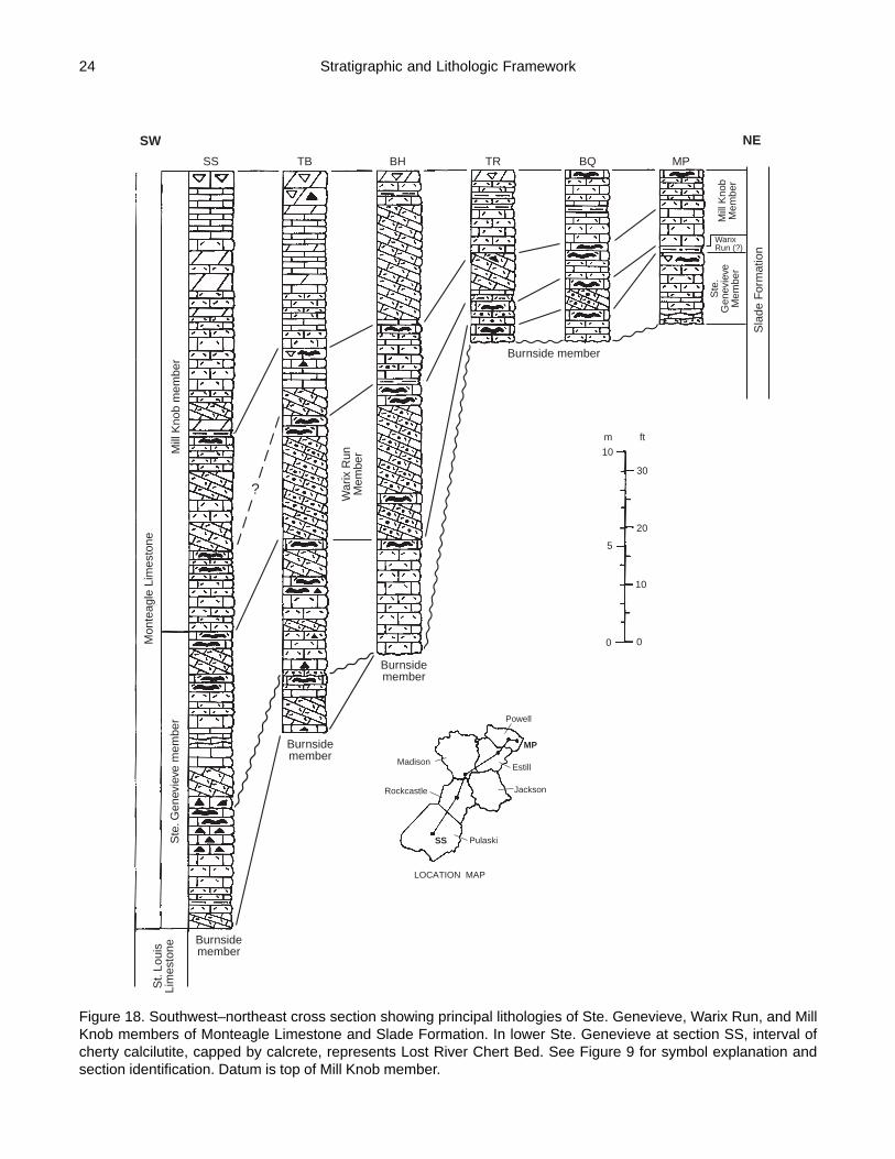
24
Sla
de F
orm
atio
n
Burnside member
Mill
Kno
bM
embe
r
WarixRun (?)
Ste
.G
enev
ieve
Mem
ber
MadisonEstill
Powell
Pulaski
Rockcastle Jackson
SS
MP
Burnsidemember
St.
Loui
sLi
mes
tone
Burnsidemember
Burnsidemember
Ste
. Gen
evie
ve m
embe
r
Mon
teag
le L
imes
tone
Mill
Kno
b m
embe
r
War
ix R
unM
embe
r
SW
SS TB BH TR BQ MP
NE
?30
10
m ft
20
10
5
00
LOCATION MAP
Figure 18. Southwest–northeast cross section showing principal lithologies of Ste. Genevieve, Warix Run, and MillKnob members of Monteagle Limestone and Slade Formation. In lower Ste. Genevieve at section SS, interval ofcherty calcilutite, capped by calcrete, represents Lost River Chert Bed. See Figure 9 for symbol explanation andsection identification. Datum is top of Mill Knob member.
Stratigraphic and Lithologic Framework

25
westernmost part of the study area (parts of Pulaski and CaseyCounties) and in the outcrop belt to the southwest (ClintonCounty and parts of Wayne County) (Fig. 20). Across the studyarea to the east and northeast, sedimentationwas interrupted after deposition of the LostRiver Chert Bed, resulting in (1) exposure ofthe Lost River bed, (2) extensive erosion ofthe basal Ste. Genevieve deposits and upperpart of the underlying Burnside member of theSt. Louis, and (3) development of a calichesoil on the erosional surface (Figs. 18, 20–21).
A conglomerate, 2.5 cm to 3.4 m thick, restson the erosional surface in the lower Ste.Genevieve and upper Burnside of Pulaski,Rockcastle, Casey, and Lincoln Counties, andnortheastern Wayne County, as noted by Butts(1922), McFarlan and Walker (1956), Lewis(1971), Malott and McGrain (1977), andLewis and Potter (1978), and on U.S. Geo-logical Survey geologic quadrangle maps cov-ering the area. The conglomerate consists ofabundant angular to subrounded chert clastsand a lesser amount of subangular tosubrounded limestone clasts (principallycalcilutite) in a calcarenitic matrix composedof very fine to coarse, bioclastic (commonlymicrite-enveloped grains) and oolitic grains.Clasts also include fossils (bryozoans, brachio-pods, and acrocyathid corallites) and calcrete.
Locally, the matrix is argillaceous and dolo-mitic.
Chert and limestone clasts in the conglom-erate are partly sorted by size, and commonlyare concentrated into subhorizontal layers andlaminae. The unit contains varied amounts ofdetrital quartz sand. Locally, thin, discontinu-ous stringers and small patches of pedogenicmicritic calcrete are present in the conglomer-ate.
Succeeding Ste. Genevieve sediments, de-posited after the intraformational episode oferosion, principally consist of calcarenite, withlesser amounts of calcilutite (Fig. 18). The cal-carenite is light olive gray, very fine to verycoarse grained, bioclastic (commonly micrite-enveloped grains), oolitic, peloidal, sparselyfossiliferous (crinoids, brachiopods, bryozoans,blastoids, gastropods, and solitary and colo-nial corals), commonly crossbedded, and partlycross-laminated. Bodies of fine- to very coarse-grained, crinoidal calcarenite, up to 0.6 m thick,occur locally in the member.
Insoluble residues from post-Lost Riverlimestones, principally calcarenites, at two sites in Pulaskiand Rockcastle Counties were studied by Ford (1956) (sec-tion 36—Colyer Quarry, section 72—Mount Vernon Quarry).
KY.
Location Map
N
0 10 20 30 40 50 Km
0 10 20 30 MiScale
Madison Estill
Powell
Wolfe
Lee
Jackson
Rockcastle
Lincoln
Casey
Pulaski
Russell
Wayne
84°85° 38°
37°
Control point
Isopach intervals 1 m and 5 m
EXPLANATION
Garrard
320
123
4
5
3 342
5
1015
20
5
10
Figure 19. Thickness of Ste. Genevieve member of MonteagleLimestone and Slade Formation in study area.
0 10 20 30 40 50 Km
0 10 20 30 MiScale
N
Ste. Genevieve basal sequence: Relationwith succeeding Ste. Genevieve sediments.
Conformable
Erosional unconformity
Basal sequence absent
Basal sequence abnormally thin
Madison Estill
Powell
Wolfe
Lee
JacksonRockcastle
Lincoln
Casey
Pulaski
Russell
Wayne
EXPLANATION
84°85° 38°
37°
Garrard
KY.
Location Map
Figure 20. Areal distribution of basal lithologic sequence in Ste.Genevieve member of Monteagle Limestone and Slade Formation, andits relationship with succeeding Ste. Genevieve sediments depositedafter an intraformational episode of erosion.
Stratigraphic and Lithologic Framework

26
Ste. Genevieve residues included (1) varied amounts of veryfine to fine, subangular to subrounded quartz grains, (2) fewcoarser, frosted quartz grains, (3) few very fine, well-roundedzircon grains, (4) very sparse amounts of very fine-grainedtourmaline and silt-size rutile, both well-rounded, and (5) rarevery fine to fine, subangular to subrounded feldspar grains.
Intervals of planar-bedded, light-olive-gray to medium-olive-gray calcilutite, as much as 1.2 m thick, are interlayeredwith the bioclastic and oolitic calcarenite. The calcilutitecontains varied amounts of very fine to coarse bioclasticgrains. Birdseye calcilutite is rare, but, where present, com-monly grades upward into brecciated calcilutite.
In Pulaski, Rockcastle, and Casey Counties, a widespreadcalcilutite facies, 0.3 to 8.0 m thick, distinguished by its thinto medium, wavy and irregular bedding, occurs at or nearthe base of the sedimentary sequence overlying the erosionalsurface that was cut into the lower Ste. Genevieve and upperBurnside. The facies contains scattered brachiopods and bryo-zoans. Bodies of light-gray to very light-olive-gray, very finelycrystalline dolomite occur in the lower part of the wavy-bed-ded calcilutite in northeastern Pulaski County and southwest-ern Rockcastle County (section 57—Mount Pleasant Church,section 64—Friendship South). The dolomite bodies, up to1.6 m thick, have an irregular domal shape with a flat base.
Contacts with the enclosing limestone range from sharp toapparently gradational.
Dolomite is only sparsely present elsewhere in the Ste.Genevieve. Light-gray to very light-olive-gray, very finelycrystalline to microcrystalline dolomite, in part with relictbioclastic grains, mainly occurs in beds 0.2 to 0.9 m thick. Amassive bed, up to 3.5 m thick, with scattered brachiopodsin the lower part, occurs near the middle of the member inwestern Pulaski County (section 13—Siever Knob, section14—Green River Knob).
Two widespread paleosols are present in the uppermostSte. Genevieve of Pulaski and Rockcastle Counties (Fig. 18).The upper one caps the member. The thickness of the inter-val between the tops of the two paleosols commonly rangesfrom 1.2 to 3.3 m in Pulaski County and from 1.2 to 1.9 m inRockcastle County. These paleosols may be correlative withtwo paleosols in the uppermost Ste. Genevieve of west-cen-tral Kentucky on the west side of the Cincinnati Arch (Deverand others, 1979a).
Rocks of the basal lithologic sequence (cross-laminatedcalcarenite, calcilutite, bioclastic calcarenite, and Lost RiverChert Bed) in the Ste. Genevieve of Pulaski, Casey, Lincoln,and Rockcastle Counties, are absent in the study area north-east of central Rockcastle County (Figs. 18 and 20). The
Stratigraphic and Lithologic Framework
Figure 21. Pedogenic breccia (limestone and chert) in upper part of Lost River Chert Bed in Ste. Genevieve memberof Monteagle Limestone. Subhorizontal stringer of micritic calcrete is at pickhead of hammer. Section 37—SomersetStone Co. Quarry, Pulaski County.

27
post-Lost River erosional surface, cut into the lower Ste.Genevieve and upper Burnside in the southwestern coun-ties, apparently coincides with an erosional surface cut intothe Burnside across the outcrop belt to the northeast. A con-glomerate, 2.5 to 30.0 cm thick, containing abundant clastsof Burnside chert, limestone, and silicified fossil fragments,with varied amounts of detrital quartz silt and sand, com-monly is present at the base of the Ste. Genevieve in thenortheastern counties.
The Ste. Genevieve northeast of Rockcastle County, as inthe post-Lost River interval of Pulaski, Rockcastle, and CaseyCounties, mainly consists of calcarenite, with lesser amountsof calcilutite (Fig. 18). The calcarenite is very light olivegray to medium olive gray, very fine to very coarse grained,bioclastic (commonly micrite-enveloped grains), oolitic,peloidal, locally cherty, rarely fossiliferous (crinoids, bryo-zoans, and solitary corals), commonly crossbedded, and partlycross-laminated.
Calcilutite, light olive gray to olive gray and in part withvaried amounts of bioclastic grains, is present in the north-eastern counties in (1) thin to medium, wavy to irregularbeds, similar to the wavy-bedded calcilutite facies of Pulaski,Rockcastle, and Casey Counties, (2) very thin to mediumbeds interlayered with calcarenite, and (3) medium to thickbeds at the top of the Ste. Genevieve. The wavy-bedded fa-cies, 0.2 to 2.9 m thick, occurs discontinuously in the basaland middle parts of the member. Locally, in Lee and WolfeCounties, the Ste. Genevieve, 0.5 and 2.9 m thick, is mainlyto entirely composed of calcilutite (section 105—Big Sink-ing Creek, section 116—Middle Fork).
Remnants of a caliche paleosol, described by Ettensohnand others (1984a, 1988a), cap the Ste. Genevieve in thenortheastern counties of the study area. In contrast with thepresence of multiple paleosols in the member to the south-west, the capping paleosol commonly is the only one in theSte. Genevieve of the northeastern counties (Fig. 18). Lo-cally, in northern Jackson County, a second paleosol occurs2.1 and 2.7 m below the top of the member (section 88—Cane Branch, section 93—Station Camp Creek).
Means of vectors for Ste. Genevieve crossbedding in south-central Kentucky mainly trend northwest (Woodward, 1983).In the outcrop belt north of central Pulaski County, cross-bedding is principally oriented to the northeast. Data reportedfor the Ste. Genevieve in east-central and northeastern Ken-tucky include measurements of both Ste. Genevieve andWarix Run crossbeds (S.C. Woodward, oral commun., 1982).
The traditional boundary between the Chesterian andMeramecian Series in Kentucky is marked by a change incrinoid fauna. Late Meramecian strata are characterized bythe presence of Platycrinites penicillus, and Early Cheste-rian rocks by species of Talarocrinus (Swann, 1963). Calyxcups of Talarocrinus sp. are relatively common in the MillKnob member of the Monteagle in Pulaski County, but arerare in the outcrop belt to the northeast (see King, 1950;
Stokley and Walker, 1953; McFarlan and Walker, 1956).Spiny, elliptical stem plates of Platycrinites penicillus occurin the Ste. Genevieve of Pulaski, Rockcastle, and JacksonCounties, but are present to the northeast only rarely (Dever,1973). Specimens of P. penicillus also have been found inthe St. Louis Limestone and Salem and Warsaw Formationsof Pulaski County (Dever and Moody, 1979b). The colonialcoral, Schoenophyllum aggregatum (Lithostrotionharmodites or Siphonodendron aff. S. genevievensis of ear-lier reports), a form restricted to the Ste. Genevieve in Ken-tucky, is present in the Ste. Genevieve across Pulaski County,occurring both in calcarenite and calcilutite.
The boundary between the Chesterian and MeramecianSeries was redefined at the contact between the Ste. Genevieveand St. Louis limestones in the type Mississippian region byMaples and Waters (1987), mainly based on foraminiferazones. In this study, following the current usage of the Ken-tucky Geological Survey, the Ste. Genevieve is retained inthe Meramecian Series.
Neither Platycrinites penicillus nor Talarocrinus sp. hasbeen found in the Warix Run member, which intervenes be-tween the Ste. Genevieve and Mill Knob in much of the studyarea. Its possible Meramecian or Chesterian age has not beenresolved (Dever, 1973), but lithologic relationships in north-eastern Kentucky suggest a possible Chesterian age(Ettensohn and others, 1984b).
Warix Run Member. The Warix Run Member of the Sladeprincipally consists of crossbedded quartzose calcarenite, withlesser amounts of calcilutite. In northeastern and northerneast-central Kentucky, the Warix Run accumulated in lowareas on a post-Ste. Genevieve erosional surface developedon the upthrown side of the Kentucky River Fault System(Dever, 1973; Ettensohn and others, 1984b). It commonlyreaches its maximum thickness, as much as 31 m, near themiddle of the erosional lows, and thins and pinches out alongthe margins, forming a series of isolated bodies in the presentoutcrop. To the southwest, in the area of this study, the WarixRun is a widespread unit, resting unconformably on the Ste.Genevieve and, locally in western Jackson County (section87—Owsley Fork), on the Burnside. It ranges from 0.1 to13.2 m in thickness and is absent locally in southeasternPowell County (section 107—Stump Cave Branch) (Fig. 22).
The distinctive, dominant lithology of the Warix Run, acrossbedded quartzose calcarenite, has not been recognizedin the Monteagle of central and western Pulaski County (Figs.18 and 22). Speculative correlation of a paleosol in the lowerMill Knob member of the Monteagle in central PulaskiCounty with a paleosol capping the Warix Run Member ofthe Slade in northeastern Pulaski County and RockcastleCounty, as shown in Figure 18, suggests that the nonquartzosecalcarenite, dolomite, and calcilutite in the lowermost MillKnob of central Pulaski County might be correlative with
Stratigraphic and Lithologic Framework

28
Warix Run quartzose calcarenite to the northeast, but thispossible correlation remains to be resolved.
Warix Run calcarenite is very light olive gray to mediumlight olive gray, very fine to very coarse grained, bioclastic(in part micrite-enveloped grains), peloidal, oolitic, rarelycherty, rarely fossiliferous (crinoids and brachiopods), andcommonly crossbedded and cross-laminated. It contains var-ied amounts of detrital quartz silt and very fine- to very coarse-grained quartz sand. Commonly, detrital quartz, particularlythe coarser fraction, is more abundant in the lower part ofthe member and decreases upward. Quartz silt and very fine-grained sand are concentrated in finer grained laminae ofthe calcarenite and along very thin argillaceous partings. Thelower part of the unit locally contains intervals of greenish-gray, argillaceous calcarenite, up to 0.4 m thick. Clasts ofmelanized limestone, calcrete, and chert occur in the basalpart of the member.
The Warix Run locally contains intervals of calcilutitethat occur variously in lower, middle, and upper parts of themember. They generally are less than 1 m thick, but acalcilutite body in central Rockcastle County reaches a thick-ness of 3.7 m (section 72—Mount Vernon Quarry). WarixRun calcilutite is light olive gray to yellowish brown, locallycontains bioclastic grains, and is rarely fossiliferous (gastro-pods). Intervals of birdseye calcilutite, present in Rockcastleand Pulaski Counties, are brecciated in the upper part. Rarebodies of dolomite occur within calcilutite at the top of themember in northeastern Pulaski County (section 54—Sunnyside Church South).
Remnants of caliche paleosol cap the WarixRun across the study area and occur in the lowerpart of the unit in northeastern Pulaski Countyand southeastern Madison County (section 57—Mount Pleasant Church, section 83—Bighill)(Fig. 18). They principally consist of melanizedcalcarenite or calcilutite with stringers and smallcircular bodies of calcrete, which, in part, aresilicified. In the northeastern part of the studyarea (parts of Powell, Wolfe, Estill, Lee, andJackson Counties), the melanized, calcrete-bearing limestone is overlain by 5 to 20 cm ofgreenish-gray, silty and sandy shale, contain-ing both clasts and stringers of calcrete andmelanized limestone, and lenses and nodulesof light-colored calcilutite and calcarenite. Itlocally grades into argillaceous, sandycalcarenite, containing clasts of melanizedlimestone and calcrete (Fig. 18). The shale andargillaceous limestone may represent a leachedunit in the caliche profile. Locally, in easternPowell County, 15 cm of the silty and sandyshale apparently constitute the entire Warix Run(section 113—Mountain Parkway) (Fig. 18).
Warix Run crossbedding in east-central and northeasternKentucky was measured as part of a study of Ste. Genevievepaleocurrents (Woodward, 1983; S.C. Woodward, oral com-mun., 1982). In that part of the outcrop belt, both Warix Runand Ste. Genevieve crossbeds are mainly oriented to the north-east.
Mill Knob Member. The Mill Knob member of theMonteagle and Slade ranges from 2.9 to 33.4 m in thick-ness. It thins northeastward across the study area, from anaverage thickness of 23.7 m in Pulaski County to an averagethickness of 4.8 m in Powell and Wolfe Counties (Fig. 23).
Carbonate rocks of the Mill Knob were deposited in twomajor sequences composed of calcarenite with interbeds ofcalcilutite and dolomite. Each sequence commonly is cappedby calcilutite and a paleosol, but in parts of the area theyhave been partly to completely replaced by dolomite, mainlythose capping the upper sequence (Fig. 18).
The two sequences thin to the northeast across the area,paralleling the thinning trend of the Mill Knob member (Fig.18). The thickness of the lower sequence ranges from at least13.1 to 1.8 m. The upper sequence ranges from at least 15.5to 1.8 m in thickness. Sequence thicknesses were not deter-mined for the thickest Mill Knob section in the study areabecause of discontinuous exposures (section 19—BurnsideSouth).
Calcarenite, the principal lithology of the Mill Knob, isvery light olive gray to medium olive gray, very fine to verycoarse grained, bioclastic (commonly micrite-envelopedgrains), with lesser amounts of ooids and peloids. It is partly
KY.
Location Map
N
0 10 20 30 40 50 Km
0 10 20 30 MiScale
Madison Estill
Powell
Wolfe
Lee
JacksonRockcastle
Lincoln
Casey
Pulaski
Russell
Wayne
84°85° 38°
37°
Garrard
0
105
5 43
2
2
3
4 5
1
0
5
Control point
Isopach intervals 1 m and 5 m
EXPLANATION
10
Figure 22. Thickness of Warix Run member of Slade Formation andMonteagle Limestone in study area.
Stratigraphic and Lithologic Framework

29
crossbedded and cross-laminated. Fining-upward cycles arerelatively common in the calcarenites of Jackson, Estill, Pow-ell, and Wolfe Counties. Calcarenite of the uppermost cyclein the northeastern counties fines upward into calcisiltiteand calcilutite capping the upper sequence. Coarsening-up-ward calcarenites occur locally in Pulaski and Powell Coun-ties. Calcarenite grades laterally into dolomite in parts ofPulaski, Rockcastle, and Jackson Counties, and it locallycontains bodies of dolomite, which have sharp lithologiccontacts between the dolomite and limestone. Carbonatemicrofacies in the Mill Knob of east-central Kentucky weredescribed by Szymanski (1975) as mainly consisting ofbiosparites, oosparites, pelsparites, and biomicrites, gener-ally capped by micrite and brecciated micrite. Themicrofacies, except for the capping micrites, were found tobe highly varied in their lateral distribution and to fine up-ward toward the top of the member.
Calcilutite and dolomite, in addition to capping the twosequences, are interlayered with the calcarenite of each se-quence, and form the basal unit in parts of the study area.They are more abundant in the upper sequence.
The calcilutite is light olive gray to olive gray and green-ish gray, and in part contains varied amounts of very fine tocoarse bioclastic grains. Birdseye texture occurs locally. Thethickness of calcilutite interlayers ranges from 2 cm to 1.5m. In the northeastern part of the study area, calcilutite, rang-ing from 1 cm to 2 m in thickness, commonly is present at thebase of the Mill Knob.
The dolomite is very light olive gray to medium olive gray,yellowish gray, and greenish gray, microcrystalline to very
finely crystalline. The interlayers of dolomite,which range from 0.1 to 2.2 m in thickness, inpart contain varied amounts of bioclastic grainsand, rarely, birdseye texture. The upper se-quence in Pulaski County locally also containsfinely laminated dolomite, in part with slightlywavy laminations, and a basal bed of dolomite,0.6 to 1.5 m thick.
Chert in the Mill Knob is more common inthe northern part of the study area. The occur-rences mainly are associated with paleosols.
Calcilutite and a paleosol, with a combinedthickness of 0.2 to 2.1 m, commonly cap thelower sequence (Fig. 18). The calcilutite lo-cally contains varied amounts of bioclasticgrains and interlayers of calcarenite andcalcisiltite. Birdseye texture is rarely present.Pedogenic features include brecciatedcalcilutite, calcrete, and melanization. Verylight-olive-gray to medium-olive-graycalcilutite darkens upward into pale-yellowish-brown to dusky-yellowish-brown colors. Tepeestructures and vadoids occur locally in the pa-leosol. In parts of Jackson County, brecciated
dolomite, 0.6 to 0.7 m thick, caps the lower sequence (section92—Pond School, section 93—Station Camp Creek). Pe-dogenic features are absent in the calcilutite of eastern Powelland Wolfe Counties, which locally contains gastropods (sec-tion 113—Mountain Parkway) (Fig. 18). At several sites inEstill, Lee, and Powell Counties, the calcilutite and paleosolthat would mark the top of the lower sequence apparently areabsent. Pedogenic calcrete occurs in calcarenite in the lowerpart of the Mill Knob in parts of Pulaski, Estill, and JacksonCounties.
The upper sequence also commonly is capped by calcilutiteand a paleosol, but in parts of the study area they are partlyto completely replaced by dolomite (Fig. 18). Thickness ofthe interval of calcilutite, dolomite, and paleosol ranges from0.1 to 3.6 m. The calcilutite locally contains varied amountsof bioclastic grains. Fossils and birdseye texture are rarelypresent. In the northeastern part of the study area, calcisiltiteand very fine-grained calcarenite are interlaminated with thecalcilutite. Pedogenic features in the paleosol capping theupper sequence are similar to those in the paleosol at the topof the lower sequence (Fig. 24). Locally in Jackson, Lee, andPulaski Counties, two paleosols occur in the upper 1 to 2 mof the upper sequence (section 93—Station Camp Creek,section 104—Hatton Hollow, section 56—Plato-Vanhook).
Mill Knob limestones commonly are only sparsely fossil-iferous. Fossils include crinoids, brachiopods, bryozoans,gastropods, blastoids, solitary corals, echinoids, and a colo-nial coral resembling “Campophyllum gasperense.” Theyare more common in calcarenites than in calcilutites, andoccur both as scattered specimens and in roughly layered
KY.
Location Map
N
0 10 20 30 40 50 Km
0 10 20 30 MiScale
Madison Estill
Powell
Wolfe
Lee
JacksonRockcastle
Lincoln
Casey
PulaskiRussell
Wayne
84°85° 38°
37°
Garrard
4
5
5
678
6 7
9
10
15
15
20
25
30
4
Control point
Isopach intervals 1 m and 5 m
EXPLANATION
10
3
Figure 23. Thickness of Mill Knob member of Monteagle Limestoneand Slade Formation in study area.
Stratigraphic and Lithologic Framework

30
concentrations, the latter principally in calcarenites. In Pu-laski County, calcarenites contain layered concentrations ofTalarocrinus calyx cups. Agassizocrinus, a Chesteriancrinoid, occurs in the Mill Knob of Rockcastle County (F.R.Ettensohn, oral commun., 1995). Dolomites are unfossilif-erous, except for rare occurrences of brachiopods and gas-tropods.
Very thin greenish-gray shales and argillaceous partingsare interlayered with calcarenite and calcilutite of the uppersequence in the northeastern part of the study area (Fig. 18).Lesser amounts of shale occur in the lower sequence. In-soluble residues from Mill Knob limestones, apparentlymainly calcarenites, at two sites in Pulaski and RockcastleCounties include (1) varied amounts of very fine to fine,subangular to subrounded quartz grains, (2) very few coarser,frosted quartz grains, (3) few very fine, well-rounded zircongrains, (4) very sparse amounts of silt-size tourmaline andrutile, both well rounded, and (5) one silt-size, rounded gar-net (Ford, 1956) (section 36—Colyer Quarry, section 72—Mount Vernon Quarry).
Cave Branch Bed. The Cave Branch bed of the Monteagleand Slade is a widespread shale that overlies the Mill Knobacross the study area, except where removed bypostdepositional erosion. It ranges from about 1 cm to 1 m
in thickness. The shale generally is greenish gray to dark green-ish gray and contains detrital quartz (principally silt to veryfine sand). In Powell County, grayish-red shale occurs locallyin the upper part (section 110—Bowen Quarry) and locallynear the middle of the unit (Ky. Highway 15 roadcut parallel-ing and immediately south of section 113—Mountain Park-way) (Dever, 1973).
EVIDENCE FOR STRUCTURAL ACTIVITYStructural activity in south-central and east-central Ken-
tucky suggests the influence of regional tectonism duringMississippian time. Evidence for structural activity is asso-ciated with several features in the study area, which are, fromsouth to north, (1) the Greenwood Anomaly and GrenvilleFront, (2) Locust Branch Fault of the Irvine-Paint Creek FaultSystem, and (3) Glencairn Fault of the Irvine-Paint CreekFault System.
Greenwood Anomaly and Grenville FrontThe Greenwood Anomaly, as noted in a previous section,
is a large linear gravity anomaly, which coincides with aseries of high-amplitude magnetic anomalies. A body of ma-fic igneous rocks, representing the core of a Proterozoic (Ke-weenawan) rift zone, is considered to be the source of the
Evidence for Structural Activity
Figure 24. Pedogenic breccia (calcilutite) at top of Mill Knob Member of Slade Formation. Section 73—Town Branch,Rockcastle County.

31
geophysical anomaly (Keller and others, 1982; Mayhew andothers, 1982; Owens and others, 1984). Intrarift areas gen-erally are complexly faulted terrains, as exemplified by theUpper Rhine Rift (De Sitter, 1964), Rio Grande Rift (Brownand others, 1980), and East African Rift (Rosendahl, 1987).
During the Grenville Orogeny, later in the Proterozoic,metamorphic rocks of the Grenville Province were thrustwestward across the Keweenawan rift (Drahovzal and oth-ers, 1992). The Grenville Front, which is the western bound-ary of the Grenville allochthon, extends along the west sideof the Greenwood Anomaly. Seismic lines in Kentucky andOhio show that extensive strike-slip faulting occurred alongand near the Grenville Front during the Late Proterozoicand that Proterozoic faults were reactivated during the Pa-leozoic (Drahovzal and others, 1992).
Keweenawan rifts in the central United States apparentlyhave affected Paleozoic and younger sedimentary deposits(King and Zietz, 1971; Spalding, 1982). The GreenwoodAnomaly is part of the East Continent Gravity High, a seriesof gravity-magnetic anomalies considered to represent aKeweenawan rift system extending north from Tennesseeacross Kentucky and Ohio (Keller and others, 1982). TheEast Continent Gravity High has been interpreted to be anextension of the Midcontinent Gravity High, also consid-ered to be a Keweenawan rift system extending from easternKansas into Michigan (Keller and others, 1982, 1983; Dra-hovzal and others, 1992). Faults or zones of weakness alongthe margin of the Midcontinent Gravity High apparentlycontrolled later, largely vertical movement in the overlyingPaleozoic and younger sedimentary rocks (King and Zietz,1971). In north-central Tennessee, the Greenwood Anomalyinfluenced facies and thickness patterns in Mississippianunits (Spalding, 1982).
In a nonrift structural setting, deep structures associatedwith positive magnetic and gravity anomalies may have af-fected sea-floor topography and Mississippian carbonatedeposition in southwestern Kansas (Parham and Sutterlin,1993). A St. Louis oolite shoal, the source of oil in the IngallsField, developed at a site above coincident positive magneticand gravity anomalies.
In the subsurface of eastern Kentucky, the Mississippian“Big Lime” generally is thinner above positive gravity fea-tures, and thicker above negative features (Pear, 1980). The“Big Lime” is a drillers’ term for a subsurface carbonateunit, which is correlative with the Renfro through RameyCreek Members of the Slade Formation.
Several lines of evidence suggest that fault movementoccurred near the crest and on the margin of the GreenwoodAnomaly and along the Grenville Front in Kentucky duringMississippian time: (1) local subaerial exposure of the St.Louis, (2) local depositional thinning of lower Ste. Genevievesediments, (3) relatively widespread erosion during early Ste.Genevieve time, (4) thickness variations in Mississippianunits across the anomaly, as shown by the east–west cross
section, and, possibly, (5) local thickening of Mississippianrocks in the subsurface east of the present outcrop belt (Fig.25). Mississippian fault movement may have been caused byreactivation of rift-related faults of the Greenwood Anomaly,both interior and bounding faults, and faults associated withthe Grenville Front.
Local Subaerial Exposure of the St. Louis. Pre-Ste.Genevieve exposure of St. Louis sediments in south-centralKentucky occurred locally near the crest of the GreenwoodAnomaly (Figs. 16 and 25). The Burnside member of the St.Louis is capped by remnants of a caliche paleosol (withcalcrete, melanization, and brecciation) in southern PulaskiCounty (section 15—Garland Road, section 16—MayfieldBranch, section 17—Cedar Sinking Creek). Cross-laminatedcalcarenite of the basal Ste. Genevieve overlies the Burnsidepaleosol. Subaerial exposure of the St. Louis sediments andsubsequent development of a caliche soil resulted from localuplift, and may be related to movement on a fault block as-sociated with the Greenwood Anomaly.
Local Depositional Thinning of Lower Ste. GenevieveSediments. Lower Ste. Genevieve deposits are abnormallythin locally on the crest of the Greenwood Anomaly (Figs.20 and 25). The lower three subunits in the basal sequenceof the Ste. Genevieve have a total thickness of 0.7 to 2.0 m atthree sites in south-central Pulaski County (section 24—Hound Hollow, section 29—Rush Branch Church, section30—Alcalde). Elsewhere in Pulaski County, both to the northand south, total thickness of the three subunits is 3.9 to 4.1m.
Thinning in the basal sequence apparently was caused bydepositional thinning across a local area of uplift, associatedwith movement on a fault block. At each of the three sites,the lower subunits are overlain by rocks of the Lost RiverChert Bed, indicating that thinning did not result from theintra-Ste. Genevieve episode of erosion described below.
Widespread Erosion During Early Ste. Genevieve Time.Sedimentation in part of south-central Kentucky was inter-rupted after deposition of the Lost River Chert Bed in theSte. Genevieve member, resulting in (1) exposure of the LostRiver bed, (2) extensive erosion of the basal Ste. Genevievedeposits and upper part of the underlying St. Louis, and (3)development of a caliche soil on the erosional surface (Figs.20 and 25). Ste. Genevieve deposition was not interrupted inthe westernmost part of the study area (parts of Pulaski andCasey Counties) and in the outcrop belt to the southwest(Clinton County and parts of Wayne County). There, the basallithologic sequence of the Ste. Genevieve, capped by the LostRiver bed, is conformable with overlying deposits of the mem-ber.
The area of erosion coincides with the position of theGreenwood Anomaly, suggesting uplift over the anomaly (Fig.25). The western boundary of the eroded area generally par-
Evidence for Structural Activity
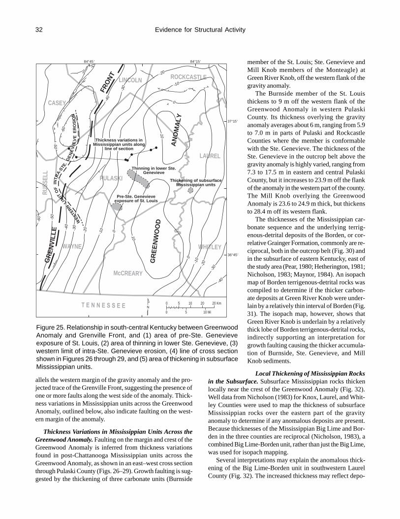
32
allels the western margin of the gravity anomaly and the pro-jected trace of the Grenville Front, suggesting the presence ofone or more faults along the west side of the anomaly. Thick-ness variations in Mississippian units across the GreenwoodAnomaly, outlined below, also indicate faulting on the west-ern margin of the anomaly.
Thickness Variations in Mississippian Units Across theGreenwood Anomaly. Faulting on the margin and crest of theGreenwood Anomaly is inferred from thickness variationsfound in post-Chattanooga Mississippian units across theGreenwood Anomaly, as shown in an east–west cross sectionthrough Pulaski County (Figs. 26–29). Growth faulting is sug-gested by the thickening of three carbonate units (Burnside
member of the St. Louis; Ste. Genevieve andMill Knob members of the Monteagle) atGreen River Knob, off the western flank of thegravity anomaly.
The Burnside member of the St. Louisthickens to 9 m off the western flank of theGreenwood Anomaly in western PulaskiCounty. Its thickness overlying the gravityanomaly averages about 6 m, ranging from 5.9to 7.0 m in parts of Pulaski and RockcastleCounties where the member is conformablewith the Ste. Genevieve. The thickness of theSte. Genevieve in the outcrop belt above thegravity anomaly is highly varied, ranging from7.3 to 17.5 m in eastern and central PulaskiCounty, but it increases to 23.9 m off the flankof the anomaly in the western part of the county.The Mill Knob overlying the GreenwoodAnomaly is 23.6 to 24.9 m thick, but thickensto 28.4 m off its western flank.
The thicknesses of the Mississippian car-bonate sequence and the underlying terrig-enous-detrital deposits of the Borden, or cor-relative Grainger Formation, commonly are re-ciprocal, both in the outcrop belt (Fig. 30) andin the subsurface of eastern Kentucky, east ofthe study area (Pear, 1980; Hetherington, 1981;Nicholson, 1983; Maynor, 1984). An isopachmap of Borden terrigenous-detrital rocks wascompiled to determine if the thicker carbon-ate deposits at Green River Knob were under-lain by a relatively thin interval of Borden (Fig.31). The isopach map, however, shows thatGreen River Knob is underlain by a relativelythick lobe of Borden terrigenous-detrital rocks,indirectly supporting an interpretation forgrowth faulting causing the thicker accumula-tion of Burnside, Ste. Genevieve, and MillKnob sediments.
Local Thickening of Mississippian Rocksin the Subsurface. Subsurface Mississippian rocks thickenlocally near the crest of the Greenwood Anomaly (Fig. 32).Well data from Nicholson (1983) for Knox, Laurel, and Whit-ley Counties were used to map the thickness of subsurfaceMississippian rocks over the eastern part of the gravityanomaly to determine if any anomalous deposits are present.Because thicknesses of the Mississippian Big Lime and Bor-den in the three counties are reciprocal (Nicholson, 1983), acombined Big Lime-Borden unit, rather than just the Big Lime,was used for isopach mapping.
Several interpretations may explain the anomalous thick-ening of the Big Lime-Borden unit in southwestern LaurelCounty (Fig. 32). The increased thickness may reflect depo-
Evidence for Structural Activity
ROCKCASTLE
LAUREL
LINCOLN
CASEY
RUSS
ELL
PULASKI
WHITLEY
McCREARY
WAYNE
T E N N E S S E E
37°15'
36°45'
84°45' 84°15'
Thickness variations inMississippian units along
line of section
Thinning in lower Ste.Genevieve
Thickening of subsurfaceMississippian units
Pre-Ste. Genevieveexposure of St. Louis
WES
TERN
LIM
ITO
FIN
TRA-
STE.
GE
NE
VIE
VE
ER
OS
ION
FRO
NT
AN
OM
ALY
GR
EE
NW
OO
D
GR
EN
VIL
LE
N0
0
5
5
10
10 Mi
20 20 Km
-100
-20
-30
-40
10
0-10-20-30
-40
-50
-60
10
0
-10
-20
-30
-60
-50
-40
Figure 25. Relationship in south-central Kentucky between GreenwoodAnomaly and Grenville Front, and (1) area of pre-Ste. Genevieveexposure of St. Louis, (2) area of thinning in lower Ste. Genevieve, (3)western limit of intra-Ste. Genevieve erosion, (4) line of cross sectionshown in Figures 26 through 29, and (5) area of thickening in subsurfaceMississippian units.

33
Mill
Kno
b an
d W
arix
Run
mem
bers
Bur
nsid
e an
dR
enfr
o m
embe
rs
Ste
. Gen
evie
ve m
embe
rMon
teag
le L
imes
tone
Bro
nsto
n m
embe
r
St.
Loui
s Li
mes
tone
Bur
nsid
em
embe
r
Figure 26. East–west cross section showing carbonate rocks of St. Louis and Monteagle Limestones, and correlativerocks of Slade Formation in Pulaski County, off the western flank of the Greenwood Anomaly onto the anomaly(modified from Dever, 1990). Intra-Ste. Genevieve erosional unconformity indicated by wavy line. Datum is top ofMill Knob member. Line of section shown in Figures 5, 25, 27–29, and 31.
Evidence for Structural Activity
m ft

34
PULASKICO.
WestGRK SK SS GS SH KSP SB
East
Bu
rnsi
de
and
Ren
fro
mem
bers
200
160
120
80
60
40
20
0 0
40
m ft
Greenwood Anomaly
Datum is top of St. Louis Limestone
Figure 27. Faulting on flank and crest of Greenwood Anomaly, inferred from thickness variations in post-ChattanoogaMississippian rocks after deposition of St. Louis and correlative rocks of the Slade (modified from Dever, 1990).Line of section also shown in Figures 5, 25, and 31.
Evidence for Structural Activity

35
WestGRK SK SS GS SH KSP SB
East
Bu
rnsi
de
and
Ren
fro
mem
bers
St.
Gen
evie
vem
emb
er
Datum is top of Ste. Genevievemember
200
160
120
80
60
40
20
0 0
40
m ft
Greenwood Anomaly
PULASKICO.
Figure 28. Faulting on flank and crest of Greenwood Anomaly, inferred from thickness variations in post-ChattanoogaMississippian rocks after deposition of Ste. Genevieve member of Monteagle and Slade (modified from Dever,1990). Symbols in Ste. Genevieve same as in Figure 26. Line of section also shown in Figures 5, 25, and 31.
Evidence for Structural Activity

36
WestGRK SS GS SH KSP SB
East
Bu
rnsi
de
and
Ren
fro
mem
bers
St.
Gen
evie
vem
emb
erM
ill K
no
b a
nd
War
ix R
un m
brs.
Datum is top of Mill Knob member
200
160
120
80
60
40
20
0 0
40
m ft
Greenwood Anomaly
PULASKICO.
Figure 29. Faulting on flank and crest of Greenwood Anomaly, inferred from thickness variations in post-ChattanoogaMississippian rocks after deposition of Mill Knob member of Monteagle and Slade (modified from Dever, 1990).Symbols in Ste. Genevieve, Warix Run, and Mill Knob same as in Figure 26. Line of section also shown in Figures 5,25, and 31.
Evidence for Structural Activity

37
sition in a downfaulted block associated with the GreenwoodAnomaly. The site is also on the downthrown side of the pro-jected trace of the subsurface Rockcastle River-Warfield Fault,and thickening may have resulted from growth faulting dur-ing Big Lime-Borden deposition. Greater thicknesses of car-bonate sediments may accumulate on positive areas or posi-tive linear trends (e.g., edges of fault blocks), depending uponfactors such as water depth (Wilson, 1975).
Locust Branch Fault of the Irvine-Paint Creek FaultSystem
The Irvine-Paint Creek Fault System in the interior of theRome Trough apparently was formed initially during the LateProterozoic (Fig. 4) (Black, 1986a). Reactivation during thePaleozoic is indicated by thickening of Paleozoic units on thedownthrown side during the Cambrian (Webb, 1980), Silurian(Miles, 1972; Lenhart, 1985), Silurian–Devonian (Weaver and
McGuire, 1973), Devonian (Dillman, 1980;Lenhart, 1985; Ettensohn, 1992c), and Pennsyl-vanian (Horne and Ferm, 1978; Haney and oth-ers, 1985).
The Locust Branch Fault branches off to thesoutheast from the main fault system in south-western Estill County (Figs. 4 and 33) (Rice,1972). It is exposed at the surface in the valleyof Locust Branch and was mapped for a distanceof 2.4 km by Rice (1972). Displacement alongthe southeast-striking fault is downthrown to thesouthwest. The Locust Branch Fault divergesfrom the main fault system at the point wherethe general trend of the major fault systemchanges from east to northeast.
Lateral offsets in the Irvine-Paint Creek FaultSystem suggest the presence of northwest-trend-ing, buried faults (Figs. 4 and 33) (Black andothers, 1979). The northwest–southeast-trendingLocust Branch Fault may be a surface expres-sion of one of these zones of weakness. North-west-trending surface faults, subparallel to thetrend of the Locust Branch Fault, also are presentnorth of the Irvine-Paint Creek system (Figs. 4and 33).
Several lines of evidence suggest that mul-tiple movements occurred along the projectedtrend of the Locust Branch Fault during Missis-sippian time: (1) thinning of the Renfro Mem-ber of the Slade, (2) erosion of the Burnsidemember of the Slade, and possibly, (3) contortedbedding in the Big Sinking bed of the Slade.Sphalerite and galena in the Renfro of northernJackson County (section 89—Rock Lick Creek)apparently were deposited from hydrothermalfluids that moved upward through a fault or frac-ture along the projected Locust Branch Faulttrend.
Thinning of the Renfro Member of the Slade. The RenfroMember of the Slade thins abruptly across northern JacksonCounty in the vicinity of the projected trend of the LocustBranch Fault (Fig. 34). The unit is thinner on the upthrownside of the projected fault. West of the projected fault trend,in northwestern Jackson County and adjacent southeasternMadison County, the thickness of the Renfro ranges from 16.7to 17.5 m (section 83—Bighill, section 87—Owsley Fork).Along and east of the projected trend, in north-central andnortheastern Jackson County and southern Estill County, thick-nesses range from 6.3 to 9.7 m (section 88—Cane Branch,section 89—Rock Lick Creek, section 90—Cavanaugh Creek,section 93—Station Camp Creek, section 95—Driprock). Theabrupt westward thickening of the Renfro was also noted byMacGill (1973), who suggested that basement-controlledgrowth faults were a possible explanation.
Bangor LimestoneHartselle FormationPoppin Rock MemberMaddox Br. Member
KidderLimestoneMember
Ramey Creek MemberTygarts Creek Member
Ste. Genevieve
Limestone Member
Mill Knob Member
Warix Run Member
Ste. Genevieve Member
Mon
teag
le L
imes
tone
Sla
de F
orm
atio
n
St. Louis Limestone
Burnside member
Renfro Member
Salem-Warsaw Fms.
Muldraugh Member
NadaMember
Cowbell Member
Halls GapMember
NancyMember
NancyMember
Chattanooga Shale
Paragon Formation
SW NEPulaski Madison Powell
M Ft100
50
0
300
200
100
0
Powell
Madison
Pulaski
Bor
den
For
mat
ion
Bor
den
For
mat
ion
Cave Branch Bed
Figure 30. Northeast–southwest cross section across study area showinggeneral relationship between Mississippian carbonate sequence andterrigenous-detrital rocks of Borden (shaded). Datum is Cave Branch Bed.
Evidence for Structural Activity
m ft

38
The change in thickness apparently mainly involves thelower part of the Renfro (Fig. 34). In the vicinity of the pro-jected trend of the Locust Branch Fault, Renfro rocks cor-relative with the Muldraugh Member of the Borden and Sa-lem and Warsaw Formations of south-central Kentucky arerestricted to the downthrown side of the trend. Geodes andchert, lithologic constituents characteristic of the Muldraughand Salem and Warsaw, commonly are absent from the Renfronortheast of the fault trend. Intertonguing of lower Renfrocarbonate rocks (Muldraugh and Salem and Warsaw correla-tives) with shale of the Nada Member of the Borden in thevicinity of the projected fault trend was not noted during fieldstudies, but further investigation may be warranted.
Erosion of the Burnside Member. The Burnside memberof the Slade and Monteagle is present across the length of theSlade-Monteagle outcrop belt, with the exception of (1) partsof northeastern Kentucky and (2) an area in east-central Ken-tucky. In northeastern Kentucky, the Burnside was eroded fromparts of the area on the upthrown side of the Kentucky River
Fault System, following post-Ste. Genevieveuplift along the fault system (Dever, 1973,1977). In east-central Kentucky, the Burnsideis absent from an area encompassing parts ofEstill, Jackson, and Lee Counties, along andon the upthrown side of the projected trend ofthe Locust Branch Fault (Figs. 33–34).
Erosional removal of the Burnside in east-central Kentucky followed pre-Ste. Genevieveuplift along the Locust Branch Fault trend. Thecontact between the Burnside and overlying Ste.Genevieve in the adjacent part of the outcropbelt is an erosional unconformity, with remnantsof a caliche paleosol capping the Burnside(Figs. 16, 34). In the area where the Burnsideis absent, Ste. Genevieve calcarenite rests onthe Big Sinking bed, which is capped by apaleosol. Erosional remnants of Burnside, 1.1to 1.5 m thick, containing pedogenic features(micritic calcrete and melanization), are presentlocally (section 91—South Fork, section 92—Pond School).
Contorted Bedding in the Big Sinking Bed.Contorted bedding is a prominent feature in theBig Sinking bed of the Slade along and on thenortheast (upthrown) side of the projected Lo-cust Branch Fault trend (Fig. 35). The areal dis-tribution of contorted bedding suggests that in-place sediment deformation was probably trig-gered by recurrent seismic activity along theLocust Branch trend. The specific reactivationthat resulted in Big Sinking deformation prob-ably represented a major episode of movementand attendant seismicity on the fault. Earlieractivity along the trend, which affected Renfro
deposition, was relatively slow growth-fault movement. Up-lift accompanying later (post-Big Sinking) movement wasfollowed by erosional removal of the Burnside.
The Big Sinking is mainly a very fine-grained, bioclastic,pelletal calcarenite. Carbonate particles principally range fromcoarse silt to very fine to fine sand. The limestone is finelylaminated and commonly contains stringers of laminated chert.In the interval of contorted bedding, curvilinear patterns ofdeformed laminae and chert stringers outline bodies of rolled-up sediment (Figs. 14–15). Original laminae in the calcareniteand chert, though highly contorted, commonly are preserved,indicating that the sediment was semilithified and was de-formed by plastic flow during subaqueous movement (Dott,1963).
Bedding in the Big Sinking ranges from totally deformedto wholly planar, but more commonly it is only partly de-formed. In sections where it is partly deformed, only one in-terval of contorted bedding is present, suggesting that only
ROCKCASTLE
PULASKI
110100
908070
60
8090
60
5040
30
5040
3020
70
GRK
SKSS
GS
SH KSP
SB
84°45' 84°15'
37°30'
37°00'
0
0
5
5
10
10 mi
10 20 km
SCALE
N
Figure 31. Thickness of terrigenous-detrital rocks of Borden in Pulaskiand Rockcastle Counties. Contour interval=10 m. Line of cross sectionshown in Figures 26 through 29.
Evidence for Structural Activity

39
one episode of fault movement occurred or that only one epi-sode was sufficiently strong to trigger sediment movement.
In the northeastern part of the study area, Big Sinking lime-stone along the Irvine-Paint Creek Fault System generally isplanar bedded. At one site, south of the Glencairn Fault, con-torted bedding occurs locally in the basal 0.3 to 0.7 m of theunit; laterally along the same roadcut, the entire unit, 0.9 to1.2 m thick, is planar bedded (section 108—Rogers Chapel).
Contorted bedding also occurs in the Big Sinking equiva-lent of Pulaski County in the outcrop above the GreenwoodAnomaly (Fig. 13). This suggests that the uplift exposingBurnside sediments, noted above, was not the earliest Mera-mecian structural activity in south-central Kentucky.
The possible presence of a zone of faulting and fracturingextending southeastward from the Locust Branch Faultmapped by Rice (1972) is supported by the occurrence ofepigenetic sphalerite and galena in northern Jackson County(section 89—Rock Lick Creek) (Fig. 33). In the Central Ken-tucky Mineral District, about 35 km northwest of Rock LickCreek, structural control of the ore is related to faults andfractures (Jolly and Heyl, 1964). The central Kentucky de-posits (barite, calcite, fluorite, galena, and sphalerite) aremainly veins associated with faults and fractures (Robinson,1931; Jolly and Heyl, 1964; Anderson and others, 1982). Smalldeposits of galena, sphalerite, and calcite have been recog-
LAUREL
KNOX
BELL
WHITLEY
McCREARY
OWSLEY
CLAY
JACKSONROCKCASTLE
LINCOLN
CASEY
RUSSELL
WAYNE
PULASKI
T E N N E S S E E 0
0
5 10 15 20 km
5 10 mi
ROCKCASTLERIVER-
WARFIELDFAULT
(subsurface)
ROCKCASTLE
RIVER UPLIFT
PINEMOUNTAIN
OVERTHRUST FAULT
N
Well control
170
180
160 150 150 160
170
150
190
170
160
-40
-40
-60
-50
-50 -40 -30
-20
-10
10
010
0-1
0-2
0-3
0
-40
-50
-60
84°45' 84°00'
37°00'
36°45'
37°15'
Figure 32. Thickness of Big Lime-Borden unit (dashed line) in subsurface over eastern part of Greenwood Anomaly.Contour interval=10 m. Subsurface data adapted from Nicholson (1983). Rockcastle River-Warfield Fault andRockcastle River Uplift from Sutton (1981) and Maynor (1984).
Evidence for Structural Activity

40
nized along the Irvine-Paint Creek Fault System in JohnsonCounty, about 100 km northeast of Rock Lick Creek (Jillson,1928). Barite and calcite occur along and near faults associ-ated with the Irvine-Paint Creek system in eastern LincolnCounty, about 45 km to the west (Robinson, 1931; Weir, 1971;Anderson and others, 1982).
Mineralization at the Rock Lick Creek section is exposedin the base of a vertical, bulldozed-cut face of a prospect(locally known as the “Platinum Mine”) in the Renfro Mem-ber of the Slade. The mineralized interval is 1.2 m thick. Inthe upper part, calcite, sphalerite, and galena are scatteredthrough the very finely crystalline, dolomitic matrix of a brec-cia composed of fragmented micrograined limestone. Thelower part of the interval is a massive, saccharoidal dolo-mite with numerous vertical to inclined, 0.6- to 1.2-cm-wideveinlets, bearing calcite, sphalerite, and galena.
At Rock Lick Creek, the Renfro is 7.8 m thick. The 1.2-m-thick mineralized zone occurs 2.6 m below the top of themember, which is overlain by cherty limestone of the Big Sink-ing bed. Dolomite crops out discontinuously on the slope be-low the base of the prospect. The Renfro is underlain by shaleof the Nada Member of the Borden.
Glencairn Fault of the Irvine-Paint Creek FaultSystem
Mississippian movement along the Glencairn Fault of theIrvine-Paint Creek Fault System, 35 km northeast of the Lo-cust Branch Fault trend, is indicated by differential erosion ofthe Burnside Member of the Slade. Erosional thinning of theBurnside is more pronounced adjacent to the Glencairn Fault,along the border of the upthrown (north) side, suggesting pre-Ste. Genevieve upward displacement on the fault. As noted inthe previous section on the Locust Branch Fault, earlier Pa-
leozoic movement along the Irvine-PaintCreek Fault System had resulted in the thick-ening of units on the downthrown side duringthe Cambrian (Webb, 1980), Silurian (Miles,1972; Lenhart, 1985), Silurian–Devonian(Weaver and McGuire, 1973), and Devonian(Dillman, 1980; Lenhart, 1985; Ettensohn,1992c).
The contact between limestone of theBurnside and dolomite of the underlyingRenfro Member in the area is marked by asharp but slightly wavy to very irregular sur-face, and a thin clay parting along the surfaceseparates limestone from dolomite (Figs. 36–37). The surface has been interpreted to be aminor unconformity between supratidal andsubtidal deposits, in which narrow depressionsin the surface represent littoral surge channels(Dever, 1973). Irregularity of the surface, how-ever, is now believed to have been caused byirregular dolomitization of basal Burnside
limestones, because relict chert, fossils, sedimentary struc-tures, and pockets of limestone characteristic of the Burnsideare found in the uppermost dolomite of the Renfro (Moody,1982).
Because the irregular dolomitization of the Burnside hasresulted in substantial variations in thickness of the two mem-bers, key beds within them are important in establishing pri-mary depositional thickness of the rock units (Figs. 36–37).In the Burnside, the most important key beds are two zonesof acrocyathid corals, containing Acrocyathus proliferus andA. floriformis. The principal key bed in the Renfro is theRinggold bed (0.6 to 1.5 m thick) in the lower part of themember. It consists of thin- to medium-bedded, bioclasticcalcarenite, with interbedded shale. Another key bed is aresistant dolomite (0.3 to 0.5 m thick) that occurs 0.3 to 0.6m above the Ringgold (Figs. 36–37).
Prior to the fault movement, Mississippian uplift alongthe Waverly Arch had interrupted Burnside deposition, re-sulting in widespread exposure of the sediments across north-eastern and east-central Kentucky (Dever, 1973, 1977). Acaliche soil developed on the surface of the sediments(Ettensohn and others, 1984a, 1988a).
Mississippian movement on the Glencairn Fault occurredafter Burnside deposits were exposed to erosion and beforeSte. Genevieve deposition. The pattern of erosion indicatesupward displacement on the north side of the fault, and sug-gests that the movement was accompanied by slight north-ward tilting (Fig. 38).
Only 0.1 to 1.5 m of Burnside limestone remains abovethe lower acrocyathid coral zone of the Burnside in sectionsalong the border of the upthrown side of the fault (section109—High Rock, section 114—Natural Bridge Park, sec-tion 115—Mill Creek Mine) (Figs. 36–37). Northward on
Evidence for Structural Activity
MADISON
JACKSONROCKCASTLE
GA
RR
AR
D
ESTILL
POWELL
LEE
WOLFE
83°45'
37°30'
84°15'
37°45'
IRVINE PAINTCREEK
FAULT SYSTEM
LOCUST BR. TREND
sphalerite,galena
Burnside member absentin shaded area
0
0
5
5 mi
10 km
N
Location Map
KY
Figure 33. Areal relationship between projected trend of Locust BranchFault and (1) absence of Burnside member and (2) site of sphaleriteand galena mineralization in Renfro Member.

41
Borden Fm.
Ren
fro
Mem
ber
Bur
nsid
em
embe
r
Sla
de F
orm
atio
n
Big
Sin
king
bed
Nada Member
LO
CU
ST
BR
AN
CH
FAU
LT T
RE
ND
NadaMbr.
WildieMbr.
43 m
tota
lth
ickn
ess
Sal
em a
nd W
arsa
wF
orm
atio
ns
Bor
den
For
mat
ion
Mul
drau
ghM
embe
r
NancyMember
Bur
nsid
em
embe
rR
ingg
old
bed
Bro
nsto
nm
embe
r
St.
Loui
s Li
mes
tone
Big
Sin
king
equi
vale
nt
fault trend
SWBI
WBLL
RVS BH SCC TR MP
NE
30
10
m ft
20
10
5
00
MadisonEstill
Powell
Pulaski
Rockcastle Jackson
BIWB
MP
LOCATION MAP
Figure 34. Southwest–northeast cross section showing thinning in lower part of Mississippian carbonate sequenceacross projected trend of Locust Branch Fault (modified from Figure 10). See Figure 9 for symbol explanation andsection identification.
Evidence for Structural Activity

42
the upthrown block, away from the fault, 2.1 to 4.0 m of lime-stone are present above the lower coral zone (section 110—Bowen Quarry, section 113—Mountain Parkway). Compa-rable thicknesses of limestone, 2.4 to 3.5 m, are preserved onthe downthrown side of the fault (section 107—Stump CaveBranch, section 116—Middle Fork).
The upper zone of acrocyathid corals in the member ap-parently was continuous across the area at the time ofBurnside deposition, but, after fault movement it was re-moved by erosion along the border of the upthrown side.The upper coral zone is preserved only on the downthrownside of the fault and in sections on the upthrown block thatare some distance away from the fault (Figs. 36–38).
The caliche soil that developed on the Burnside duringsubaerial exposure was partly eroded across the entire area,but deepest erosion was along the Glencairn Fault. The up-per 0.3 to 0.9 m of the Burnside on the downthrown side ofthe fault and in sections some distance away from it on theupthrown block contains pedogenic features such as mela-nized limestone, calcrete, and brecciated limestone. Only 2to 20 cm of similarly altered limestone (melanized and lo-cally slightly brecciated) remains in the sections along theborder of the upthrown side.
The occurrence of uplift and erosion contrasts with thedominance of extensional growth faulting and depositionalthickening of units along the Irvine-Paint Creek Fault Systemthrough most of Paleozoic time. Dever (1986) suggested thatthe uplift indicated a change from tensile to compressive stresson the fault system.
A simpler explanation for the uplift is the concept of a tiltblock/half graben commonly produced during extensionaltectonism, which is accompanied by footwall uplift (Leeder
and Gawthorpe, 1987) (Fig. 39). Maximumfootwall displacement, associated with normalfaulting and tilting along the Glencairn Fault,would have been along the border of the northblock, where maximum erosion of theBurnside subsequently occurred.
Tectonic Implications of StructuralActivity
The evidence for structural activity acrosssouth-central and east-central Kentucky dur-ing Mississippian time suggests the influenceof regional tectonism. Reactivation of faultsin the study area along the western border ofthe Appalachian Basin, however, occurredduring a period of apparent tectonic quies-cence, between major phases of Acadian andAlleghenian orogeny along the eastern conti-nental margin.
Recent interpretations of the Mississippiansequence in the Appalachian Basin, based onlithospheric flexural models of Quinlan and
Beaumont (1984) and Beaumont and others (1988), show thattectonic activity would have continued across the region afterthe major phase of Acadian orogeny subsided (Ettensohn andChesnut, 1989; Ettensohn, 1990, 1993; Ettensohn and Pashin,1993). The flexural models were outlined previously in thestructural setting chapter.
The following elements of the lithospheric flexural mod-els, summarized from Ettensohn and Chesnut (1989) andEttensohn (1990, 1993), are particularly pertinent to thisstudy. Deformational loading during the last phase of theAcadian Orogeny along the eastern margin of North Americaproduced a downwarped flexural foreland basin immediatelycratonward of the orogen and a peripheral bulge on thecratonward margin of the foreland basin. As orogeny pro-ceeded and the thrust load migrated cratonward, the forelandbasin and peripheral bulge migrated away from the load.The deformational loading was accompanied by depositionof terrigenous-detrital sediments of the Borden and GraingerFormations in the foreland basin.
When orogeny and thrusting ceased, lithospheric relaxationcaused the peripheral bulge to be uplifted and the basin nar-rowed and deepened. Eastward bulge migration toward theAcadian orogen produced shallow-water environments suit-able for carbonate deposition, including sediments of the St.Louis, Monteagle, and Slade.
The study area also would have been affected by a periph-eral bulge migrating northward from the Ouachita orogen(Ettensohn, 1993). Along the southern margin of NorthAmerica, an arc-continent collision at the Alabama Promon-tory is indicated by the sandstone composition of a south-west-derived Mississippian and Pennsylvanian clastic wedgein Alabama (Mack and others, 1983; Thomas, 1985). Based
Evidence for Structural Activity
MADISON
JACKSONROCKCASTLE
GA
RR
AR
D
ESTILL
POWELL
LEE
WOLFE
83°45'
37°30'
84°15'
37°45'
PAINT
CREEK
FAULT SYSTEM
LOCUST BR. TRENDsphalerite,galena
Big Sinking bed present
0
0
5
5 mi
10 km
N
Location Map
KY
Contorted bedding
IRVINE
Figure 35. Areal relationship between projected trend of Locust BranchFault and (1) contorted bedding in Big Sinking bed and (2) site ofsphalerite and galena mineralization in Renfro Member.

43
km
mi
m
ft
Figure 36. Northwest–southeast cross section showing absence of upper acrocyathid coral zone along border ofupthrown side of Glencairn Fault (from Dever, 1986). Datum is top of Mill Knob Member. St. Louis Member includesBurnside member and Big Sinking bed of this study.
Evidence for Structural Activity

44
km
mi
m
ft
Figure 37. North–south cross section showing absence of upper acrocyathid coral zone along border of upthrownside of Glencairn Fault (from Dever, 1986). Datum is top of Mill Knob Member. St. Louis Member includes Burnsidemember and Big Sinking bed of this study.
Evidence for Structural Activity

45
on the age of the oldest sediments, the source area and oro-genesis were initiated by late Meramecian time (Mack andothers, 1983).
Bulge migration through the study area during Mississip-pian time apparently reactivated faults, which apparently re-sulted in the erosional and depositional features found in theSt. Louis, Monteagle, and Slade. Local unconformities inKentucky, Ohio, and West Virginia have been attributed to
reactivation of basement struc-tures by the migrating Acadianbulge (Ettensohn and Chesnut,1989). The time of passage by theeast-migrating, relaxation-phase,Acadian bulge and north-migrat-ing Ouachita bulge through thestudy area, as determined byEttensohn and Chesnut (1989)and Ettensohn (1993), respec-tively, would have been penecon-temporaneous with Meramecianand early Chesterian fault reacti-vation in south-central and east-central Kentucky.
SUMMARYStratigraphic Units andRelationships
Ringgold Bed. Composed oflimestone interbedded with shale,the Ringgold is a useful strati-graphic marker within the dolo-mite-dominated Bronston mem-ber of the St. Louis and RenfroMember of the Slade. It appar-ently was deposited across theentire study area.
Big Sinking Bed. Previousworkers generally assigned BigSinking rocks, principally lime-stone that is commonly cherty, tothe St. Louis Limestone, St. LouisLimestone Member of the New-man, or St. Louis Member of theSlade (=Burnside member of thisstudy). The well-sorted, finelylaminated, very fine-grained,bioclastic, pelletal calcarenite ofthe Big Sinking is lithologicallydistinct from the relatively poorlysorted, coarser grained, bioclasticcalcarenite in the lower part of theoverlying Burnside.
False Lost River Bed. A limestone containing abundantnodules and irregular bodies of chert at the top of the Burnsidemember of the St. Louis and Slade yields a bedded chert uponweathering, as much as 0.3 m thick, in parts of Pulaski andRockcastle Counties. The bed of Burnside chert closely re-sembles and is easily mistaken for the Lost River Chert Bedin the lower part of the overlying Ste. Genevieve. The pres-ence of basal Ste. Genevieve lithologies (in ascending order,
Summary
Figure 38. Interpretive north–south cross section showing erosional surface developedon St. Louis Member after Mississippian reactivation along Glencairn Fault (fromDever, 1986). Constructed using columnar sections shown in Figure 37. St. LouisMember includes Burnside member and Big Sinking bed of this study.

46
cross-laminated calcarenite, calcilutite, and fossiliferous bio-clastic calcarenite) below the Lost River bed distinguishes itfrom the Burnside bed.
Intra-Ste. Genevieve Erosional Unconformity. A Ste.Genevieve conglomerate, 2.5 cm to 3.4 m thick, composed ofchert and limestone clasts in a calcarenitic matrix, rests on anerosional surface cut into the lower Ste. Genevieve and upperBurnside of Pulaski, Rockcastle, Casey, and Lincoln Coun-ties, and northeastern Wayne County. The conglomerate restson the Burnside in many exposures, and earlier workers suchas Butts (1922) and McFarlan and Walker (1956) consideredit to indicate the presence of a pre-Ste. Genevieve, or inter-Ste. Genevieve–St. Louis, unconformity. However, the un-conformity took place during Ste. Genevieve time becausethe conglomerate also rests on lower Ste. Genevieve rocks asyoung as the Lost River Chert Bed.
Upper Ste. Genevieve Paleosols. Two widespreadpaleosols are present in the uppermost Ste. Genevieve ofPulaski and Rockcastle Counties. The upper paleosol capsthe Ste. Genevieve member. In Pulaski County, Platycrinitespenicillus, a Meramecian crinoid, occurs between the twopaleosols, supporting their assignment to the Ste. Genevieve.These paleosols may be correlative with two paleosols in theuppermost Ste. Genevieve of west-central Kentucky on thewest side of the Cincinnati Arch.
Warix Run Member. The Warix Run Member of the Slade,mainly crossbedded quartzose calcarenite, is a widespreadunit in the Slade outcrop belt, extending from northeasternKentucky southwestward into northeastern Pulaski County.Its distinctive lithology as yet has not been recognized in theMonteagle of central and western Pulaski County.
Speculative correlation of the paleosol capping the WarixRun in northeastern Pulaski County with a paleosol in thelower Mill Knob member of the Monteagle in central Pu-laski County suggests that the nonquartzose calcarenite, do-lomite, and calcilutite in the lowermost Mill Knob of centralPulaski County might be correlative with Warix Run quart-zose calcarenite to the northeast. This possible correlationremains to be resolved.
Structural ActivityEvidence for structural activity during Meramecian and
early Chesterian time is associated with several features inthe study area.
Greenwood Anomaly and Grenville Front. Previous in-vestigations have considered the Greenwood Anomaly to bepart of a Proterozoic rift, and the Grenville Front has beenidentified as the western margin of the Grenville allochthon.Mississippian structural activity indicates reactivation of rift-related faults associated with the Greenwood Anomaly, bothinterior and bounding faults, and faults associated with theGrenville Front, which parallels the western border of theGreenwood Anomaly in south-central Kentucky.
Subaerial exposure of Burnside sediments and depositionalthinning of lower Ste. Genevieve sediments apparently re-sulted from local uplifts produced by reactivation of rift-re-lated faults. Broader uplift later interrupted Ste. Genevievedeposition across the Greenwood Anomaly and was followedby development of an extensive erosional surface cut intolower Ste. Genevieve and upper Burnside deposits. Faultingalso is indicated by thickness variations in Mississippian unitsacross the Greenwood Anomaly and Grenville Front, includ-ing growth faulting off the western flank of the anomaly andfront. Local thickening of subsurface Mississippian rocksnear the crest of the Greenwood Anomaly may reflect depo-sition in a rift-related downfaulted block or downward move-ment on the subsurface Rockcastle River-Warfield Fault.
Locust Branch Fault of Irvine-Paint Creek Fault Sys-tem. Meramecian reactivation along the projected southeast-ward trend of the Locust Branch Fault in east-central Ken-tucky affected three successive members of the Slade. Upliftcaused abrupt northeastward thinning in the lower part ofthe Renfro. Next, fault activity probably triggered movementand deformation of carbonate sediments in the Big Sinkingbed. Renewed uplift was followed by extensive erosion ofthe Burnside on the upthrown side. The occurrence of epige-netic sphalerite and galena in the Renfro of northern Jack-son County supports the projection of a zone of faulting andfracturing southeastward from the Locust Branch Fault.
Glencairn Fault of Irvine-Paint Creek Fault System.Meramecian movement along the Glencairn Fault in east-cen-tral Kentucky was followed by differential erosion of theBurnside. Erosional thinning is most pronounced adjacentto the fault, along the border of the upthrown (north) side.Tilting of the northern block during normal faulting causeduplift along the border of the block.
Tectonic Implications of Structural Activity. Recent in-vestigations of the Mississippian sequence in the Appala-chian Basin, based on lithospheric flexural models, concludethat the sedimentary sequence reflects the formation and mi-gration of foreland basins and peripheral bulges. Bulge mi-gration apparently reactivated faults in the study area. Based
Summary
Faul
t
Footwall Scarp
FOOTWALLHANGING WALL
Figure 39. Footwall uplift that accompanies the tilt block/half graben produced during extensional tectonism(modified from Leeder and Gawthorpe, 1987). Reprintedwith permission of the Geological Society PublishingHouse.

47
on the recent studies, passage of an east-migrating, relaxation-phase, Acadian bulge and a north-migrating Ouachita bulgethrough the area seems to have been contemporaneous withthe Meramecian and early Chesterian fault movements in thearea and is the likely cause of these movements.
ACKNOWLEDGMENTSThe writer gratefully acknowledges the assistance provided
by many persons during the study. This report originally wassubmitted as a dissertation to The Graduate School of the Uni-versity of Kentucky in 1995. Frank R. Ettensohn (chairman),John C. Ferm, Bruce R. Moore, Lyle V.A. Sendlein, and KotF. Unrug served on the advisory committee. Special thanks
Acknowledgments
are extended to William C. MacQuown, William H. Blackburn,Daniel R. Reedy, Kieran O’Hara, Richard E. Sergeant, andBart Davidson.
Richard Q. Lewis Sr., Alfred R. Taylor, Donald C. Haney,Charles L. Rice, Harry P. Hoge, and Preston McGrain sharedtheir knowledge of carbonate rocks in the study area. Jack R.Moody, Warren H. Anderson, Lance S. Barron, ChristopherW. Dever, and Karen C. Dever assisted in field investigations.Gary L. Kuhnhenn furnished pertinent Eastern Kentucky Uni-versity theses. Margaret L. Smath and Gwenda K. Rulo helpedin preparing the original manuscript. The writer also wishesto acknowledge the assistance provided by quarry operatorsand numerous landowners.

48
REFERENCES CITEDAmmerman, M.L., 1976, A gravity and tectonic study of the
Rome Trough: Lexington, University of Kentucky, M.S.Thesis, 70 p.
Ammerman, M.L., and Keller, G.R., 1979, Delineation ofRome Trough in eastern Kentucky by gravity and deepdrilling data: American Association of Petroleum Geolo-gists Bulletin, v. 63, no. 3, p. 341–353.
Anderson, W.H., 1989, Controls on mineralization and hy-drocarbon accumulation in the Cambro-Ordovician Mas-cot Dolomite of the Knox Group in south-central Ken-tucky: Lexington, University of Kentucky, M.S. Thesis,93 p.
Anderson, W.H., 1991, Mineralization and hydrocarbonemplacement in the Cambrian–Ordovician Mascot Dolo-mite of the Knox Group in south-central Kentucky: Ken-tucky Geological Survey, ser. 11, Report of Investigations4, 31 p.
Anderson, W.H., Trace, R.D., and McGrain, Preston, 1982,Barite deposits of Kentucky: Kentucky Geological Sur-vey, ser. 11, Bulletin 1, 56 p.
Avila, John, 1971, Possibility of growth faults in the pre-Knox interval (Montevallo Supergroup) in the IllinoisBasin, in Proceedings of Symposium on Future PetroleumPotential of NPC Region 9 (Illinois Basin, CincinnatiArch, and Northern Part of Mississippi Embayment): Il-linois State Geological Survey Illinois Petroleum 95, p.50–57.
Barnett, S.F., and Ettensohn, F.R., 1992a, Portwood Mem-ber of the New Albany Shale and the Boyle Dolostone, inEttensohn, F.R., ed., Changing interpretations of Ken-tucky geology—Layer-cake, facies, flexure, and eustacy:Ohio Geological Survey Miscellaneous Report 5, p. 42–44.
Barnett, S.F., and Ettensohn, F.R., 1992b, The CarpenterFork Graben and its implications, in Ettensohn, F.R., ed.,Changing interpretations of Kentucky geology—Layer-cake, facies, flexure, and eustacy: Ohio Geological Sur-vey Miscellaneous Report 5, p. 44–55.
Barnett, S.F., Ettensohn, F.R., and Mellon, Charles, 1989,Tectonic and flexural significance of Middle Devoniangraben-fill sequence in New Albany Shale, central Ken-tucky [abs.]: American Association of Petroleum Geolo-gists Bulletin, v. 73, no. 8, p. 1027.
Bayley, R.W., and Muehlberger, W.R., comps., 1968, Base-ment rock map of the United States, exclusive of Alaskaand Hawaii: U.S. Geological Survey, scale 1:2,500,000,2 sheets.
Beaumont, Christopher, Quinlan, Garry, and Hamilton,Juliet, 1988, Orogeny and stratigraphy: Numerical mod-els of the Paleozoic in the Eastern Interior of NorthAmerica: Tectonics, v. 7, no. 3, p. 389–416.
Benson, D.J., 1976, Lithofacies and depositional environ-ments of Osagean-Meramecian platform carbonates,southern Indiana, central and eastern Kentucky: Cincin-nati, Ohio, University of Cincinnati, Ph.D. Thesis, 215p.
Black, D.F.B., 1975, Geologic map of the Hedges quadrangle,east-central Kentucky: U.S. Geological Survey GeologicQuadrangle Map GQ-1235, scale 1:24,000.
Black, D.F.B., 1977, Geologic map of the Heidelberg quad-rangle, east-central Kentucky: U.S. Geological SurveyGeologic Quadrangle Map GQ-1340, scale 1:24,000.
Black, D.F.B., 1978, Geologic map of the Zachariah quad-rangle, east-central Kentucky: U.S. Geological SurveyGeologic Quadrangle Map GQ-1452, scale 1:24,000.
Black, D.F.B., 1986a, Basement faulting in Kentucky, inAldrich, M.J., Jr., and Laughlin, A.W., eds., Proceedingsof the Sixth International Conference on Basement Tec-tonics, Santa Fe, N. Mex., USA, September 16–20, 1985:Salt Lake City, Utah, International Basement TectonicsAssociation, no. 6, p. 125–139.
Black, D.F.B., 1986b, Oil in dolomitized limestone reser-voirs in Kentucky, in Aldrich, M.J., Jr., and Laughlin,A.W., eds., Proceedings of the Sixth International Con-ference on Basement Tectonics, Santa Fe, N. Mex., USA,September 16–20, 1985: Salt Lake City, Utah, Interna-tional Basement Tectonics Association, no. 6, p. 140–152.
Black, D.F.B., 1989, Tectonic evolution in central and east-ern Kentucky: A multidisciplinary study of surface andsubsurface structure: U.S. Geological Survey Open-FileReport 89-106, 151 p.
Black, D.F.B., and Haney, D.C., 1975, Selected structuralfeatures and associated dolostone occurrences in the vi-cinity of the Kentucky River Fault System (Road log forGeological Society of Kentucky 1975 field conference):Kentucky Geological Survey, ser. 10, 27 p.
Black, D.F.B., Keller, G.R., and Johnson, R.W., 1976, Anintegrated geological and geophysical study of a part ofcentral Kentucky: Regional tectonic implications [abs.]:Geological Society of America Abstracts with Programs,v. 8, no. 2, p. 135.
Black, D.F.B., Keller, G.R., and Johnson, R.W., Jr., 1979,Basement control of exposed geological features in cen-tral Kentucky as inferred from tectonic, aeromagnetic,and gravity data, in Podwysocki, M.H., and Earle, J.L.,eds., Proceedings of the Second International Conferenceon Basement Tectonics, Newark, Del., July 13–17, 1976:Denver, Colo., Basement Tectonics Committee, p. 1–9.
Bolivar, S.L., 1982, Kimberlite of Elliott County, Kentucky:Kentucky Geological Survey, ser. 11, Thesis Series 2, 37p.
Borella, P.E., and Osborne, R.H., 1978, Late Middle andearly Late Ordovician history of the Cincinnati Arch Prov-ince, central Kentucky to central Tennessee: GeologicalSociety of America Bulletin, v. 89, no. 10, p. 1559–1573.
References Cited

49
Braile, L.W., Hinze, W.J., Sexton, J.L., Keller, G.R., andLidiak, E.G., 1983, Seismicity and tectonics of the Mid-continent United States, in Hinze, W.J., Braile, L.W.,Keller, G.R., and Lidiak, E.G., Geophysical-geologicalstudies of possible extensions of the New Madrid FaultZone. Annual report for 1982: U.S. Nuclear RegulatoryCommission, NUREG/CR-3174, v. 1, p. 73–87.
Brown, L.D., Chapin, C.E., Sanford, A.R., Kaufman, S., andOliver, J., 1980, Deep structure of the Rio Grande Riftfrom seismic reflection profiling: Journal of GeophysicalResearch, v. 85, no. B9, p. 4773–4800.
Bryan, B.K., Jr., 1975, The Greenwood Anomaly of the Cum-berland Plateau: A test application of GRAVMAP, a sys-tem of computer programs for reducing and automaticcontouring land gravity data: Knoxville, University ofTennessee, M.S. Thesis, 118 p.
Butts, Charles, 1922, The Mississippian Series of easternKentucky: Kentucky Geological Survey, ser. 6, v. 7, 188p.
Cable, M.S., 1984, Aspects of subsurface Cambrian and EarlyOrdovician lithostratigraphy and structure, eastern Ken-tucky, western West Virginia, and Ohio: Columbia, Uni-versity of South Carolina, Ph.D. Dissertation, 90 p.
Cable, M.S., and Beardsley, R.W., 1984, Structural controlson Late Cambrian and Early Ordovician carbonate sedi-mentation in eastern Kentucky: American Journal of Sci-ence, v. 284, no. 7, p. 797–823.
Calandra, J.D., 1986, A ground magnetic survey of kimberliteintrusives in Elliott County, Kentucky: Huntington, W.Va.,Marshall University, M.P.S. Thesis, 161 p.
Calvert, W.L., 1974, Sub-Trenton structure of Ohio, withviews on isopach maps and stratigraphic sections as ba-sis for structural myths in Ohio, Illinois, New York, Penn-sylvania, West Virginia, and Michigan: American Asso-ciation of Petroleum Geologists Bulletin, v. 58, no. 6, p.957–972.
Chesnut, D.R., Jr., 1988, Stratigraphic analysis of the Car-boniferous rocks of the central Appalachian Basin: Lex-ington, University of Kentucky, Ph.D. Dissertation, 297p.
Chesnut, D.R., Jr., 1991, Timing of Alleghanian tectonicsdetermined by central Appalachian foreland basin analy-sis: Southeastern Geology, v. 31, no. 4, p. 203–221.
Chesnut, D.R., Jr., 1992, General Pennsylvanian paleogeo-graphic, paleoclimatic, and tectonic framework for east-ern Kentucky, in Ettensohn, F.R., ed., Changing inter-pretations of Kentucky geology—Layer-cake, facies, flex-ure, and eustacy: Ohio Geological Survey MiscellaneousReport 5, p. 100, 103–106.
Chesnut, D.R., Jr., Greb, S.F., and Eble, C.F., 1992a, BreathittFormation and coal-forming environments, in Ettensohn,F.R., ed., Changing interpretations of Kentucky geology—Layer-cake, facies, flexure, and eustacy: Ohio GeologicalSurvey Miscellaneous Report 5, p. 119–120.
Chesnut, D.R., Jr., Greb, S.F., and Ettensohn, F.R., 1992b,Lee Formation and the Mississippian–Pennsylvanian con-tact, in Ettensohn, F.R., ed., Changing interpretations ofKentucky geology—Layer-cake, facies, flexure, andeustacy: Ohio Geological Survey Miscellaneous Report5, p. 113, 116–118.
Cohee, G.V., and West, W.S., 1965, Changes in stratigraphicnomenclature by the U.S. Geological Survey, 1964: U.S.Geological Survey Bulletin 1224-A, 77 p.
Craig, L.C., and Varnes, K.L., 1979, History of the Missis-sippian System—An interpretive summary, in Craig, L.C.,Connor, C.W., and others, Paleotectonic investigationsof the Mississippian System in the United States: U.S.Geological Survey Professional Paper 1010, pt. 2, p. 371–406.
Cressman, E.R., 1973, Lithostratigraphy and depositionalenvironments of the Lexington Limestone (Ordovician)of central Kentucky: U.S. Geological Survey ProfessionalPaper 768, 61 p.
Currie, M.T., 1981, Subsurface stratigraphy and depositionalenvironments of the “Corniferous” (Silurian–Devonian)of eastern Kentucky: Lexington, University of Kentucky,M.S. Thesis, 108 p.
Currie, M.T., and MacQuown, W.C., 1984, Subsurfacestratigraphy of the Corniferous (Silurian–Devonian) ofeastern Kentucky, in Luther, M.K., ed., Proceedings ofthe technical sessions, Kentucky Oil and Gas Associa-tion 45th annual meeting, June 10–12, 1981: KentuckyGeological Survey, ser. 11, Special Publication 11, p. 1–21.
Denison, R.E., Lidiak, E.G., Bickford, M.E., andKisvarsanyi, E.B., 1984, Geology and geochronology ofPrecambrian rocks in the Central Interior Region of theUnited States, in Harrison, J.E., and Peterman, Z.E., eds.,Correlation of Precambrian rocks of the United States andMexico: U.S. Geological Survey Professional Paper 1241-C, 20 p.
De Sitter, L.U., 1964, Structural geology (2d ed.): New York,McGraw-Hill, 551 p.
Dever, G.R., Jr., 1973, Stratigraphic relationships in the lowerand middle Newman Limestone (Mississippian), east-cen-tral and northeastern Kentucky: Lexington, University ofKentucky, M.S. Thesis, 121 p.; 1980, Kentucky Geologi-cal Survey, ser. 11, Thesis Series 1, 49 p.
Dever, G.R., Jr., 1977, The lower Newman Limestone: Strati-graphic evidence for Late Mississippian tectonic activity,in Dever, G.R., Jr., Hoge, H.P., Hester, N.C., andEttensohn, F.R., Stratigraphic evidence for late Paleozoictectonism in northeastern Kentucky (Guidebook and roadlog for field trip held in conjunction with the fifth annualmeeting of the eastern section of the American Associa-tion of Petroleum Geologists and the 1977 field confer-ence of the Geological Society of Kentucky): KentuckyGeological Survey, ser. 10, p. 8–18.
References Cited

50
Dever, G.R., Jr., 1986, Mississippian reactivation along theIrvine-Paint Creek Fault System in the Rome Trough, east-central Kentucky: Southeastern Geology, v. 27, no. 2, p.95–105.
Dever, G.R., Jr., 1990, Tectonically influenced depositionand erosion in Mississippian limestones of south-centralKentucky, in Dever, G.R., Jr., Greb, S.F., Moody, J.R.,Chesnut, D.R., Jr., Kepferle, R.C., and Sergeant, R.E.,Tectonic implications of depositional and erosional fea-tures in Carboniferous rocks of south-central Kentucky(Guidebook and road log for Geological Society of Ken-tucky 1990 field conference): Kentucky Geological Sur-vey, ser. 11, p. 1–18.
Dever, G.R., Jr., Ellsworth, G.W., Jr., and Sumartojo, Jojok,1978, Evidence for deposition of evaporites in the St. LouisLimestone (Mississippian) of eastern Kentucky [abs.]:Geological Society of America Abstracts with Programs,v. 10, no. 4, p. 167.
Dever, G.R., Jr., Ettensohn, F.R., and Haney, D.C., 1984,Relationship between the Kentucky River Fault Systemand Paleozoic sedimentation in eastern Kentucky [abs.]:Geological Society of America Abstracts with Programs,v. 16, no. 3, p. 133.
Dever, G.R., Jr., McGrain, Preston, Ellsworth, G.W., Jr., andMoody, J.R., 1979a, Features in the upper Ste. GenevieveLimestone of west-central Kentucky, in Ettensohn, F.R.,and Dever, G.R., Jr., eds., Carboniferous geology fromthe Appalachian Basin to the Illinois Basin through east-ern Ohio and Kentucky (Field trip no. 4, Ninth Interna-tional Congress of Carboniferous Stratigraphy and Geol-ogy): Lexington, University of Kentucky, p. 261–263.
Dever, G.R., Jr., McGrain, Preston, and Moody, J.R., 1979b,St. Louis Limestone of eastern Kentucky, in Ettensohn,F.R., and Dever, G.R., Jr., eds., Carboniferous geologyfrom the Appalachian Basin to the Illinois Basin througheastern Ohio and Kentucky (Field trip no. 4, Ninth Inter-national Congress of Carboniferous Stratigraphy andGeology): Lexington, University of Kentucky, p. 171–174.
Dever, G.R., Jr., and Moody, J.R., 1979a, Review of the litho-stratigraphy of the Renfro Member of the Borden Forma-tion (Mississippian), east-central Kentucky [abs.]: Geo-logical Society of America Abstracts with Programs, v.11, no. 4, p. 176–177.
Dever, G.R., Jr., and Moody, J.R., 1979b, Salem and War-saw Formations in south-central Kentucky, in Ettensohn,F.R., and Dever, G.R., Jr., eds., Carboniferous geologyfrom the Appalachian Basin to the Illinois Basin througheastern Ohio and Kentucky (Field trip no. 4, Ninth Inter-national Congress of Carboniferous Stratigraphy andGeology): Lexington, University of Kentucky, p. 202–206.
Dever, G.R., Jr., and Moody, J.R., in preparation, Bronstonand Burnside members—Subdivision of the St. LouisLimestone in south-central Kentucky: Kentucky Geologi-cal Survey, ser. 11, Information Circular.
De Witt, Wallace, Jr., Sable, E.G., and Cohee, G.V., 1979,Evaporite deposits in Mississippian rocks of the easternUnited States, in Craig, L.C., Connor, C.W., and others,Paleotectonic investigations of the Mississippian Systemin the United States: U.S. Geological Survey ProfessionalPaper 1010, pt. 2, p. 431–439.
Dillman, S.B., 1980, Subsurface geology of the Upper De-vonian–Lower Mississippian black-shale sequence in east-ern Kentucky: Lexington, University of Kentucky, M.S.Thesis, 72 p.
Dillman, S.B., and Ettensohn, F.R., 1980, Isopach map ofthe Devonian black-shale sequence (New Albany-Chat-tanooga-Ohio Shale) in eastern Kentucky: U.S. Depart-ment of Energy, Morgantown Energy Technology Cen-ter, METC/EGSP Series 515, scale 1:370,000.
Dohm, F.P., 1963, The Lower Mississippian of the northernPaint Creek Uplift: Lexington, University of Kentucky,M.S. Thesis, 106 p.
Dott, R.H., Jr., 1963, Dynamics of subaqueous gravity depo-sitional processes: American Association of PetroleumGeologists Bulletin, v. 47, no. 1, p. 104–128.
Drahovzal, J.A., 1990, Precambrian and Cambrian basinsin eastern North America [abs.]: Kentucky Oil and GasAssociation 54th annual meeting, May 16–18, 1990, Lou-isville, Ky., Abstracts of the Technical Sessions,unpaginated.
Drahovzal, J.A., and Harris, D.C., 1993, A billion-years-oldsedimentary basin discovered in central North America:University of Kentucky Institute for Mining and Miner-als Research Highlights, v. 12, no. 2, p. 1–2.
Drahovzal, J.A., Harris, D.C., Wickstrom, L.H., Walker, Dan,Baranoski, M.T., Keith, B.D., and Furer, L.C., 1992, TheEast Continent Rift Basin: A new discovery: KentuckyGeological Survey, ser. 11, Special Publication 18, 25 p.
Elam, T.D., 1981, Stratigraphy and paleoenvironmental as-pects of the Bedford-Berea sequence and the SunburyShale in eastern and south-central Kentucky: Lexington,University of Kentucky, M.S. Thesis, 155 p.
Englund, K.J., 1972, Central Appalachian tectonics as indi-cated by structural features in Carboniferous rocks [abs.]:American Association of Petroleum Geologists Bulletin,v. 56, no. 10, p. 2108.
Englund, K.J., Henry, T.W., and Cecil, C.B., 1981, UpperMississippian and Lower Pennsylvanian depositional en-vironments, southwestern Virginia and southern WestVirginia, in Roberts, T.G., ed., GSA Cincinnati ‘81, Fieldtrip guidebooks, v. 1: Stratigraphy, sedimentology: Ameri-can Geological Institute, p. 171–175.
Englund, K.J., and Randall, A.H., III, 1981, Stratigraphy ofthe Upper Mississippian and Lower Pennsylvanian Se-ries in the east-central Appalachians, in Roberts, T.G.,ed., GSA Cincinnati ‘81, Field trip guidebooks, v. 1:Stratigraphy, sedimentology: American Geological Insti-tute, p. 154–158.
References Cited

51
Englund, K.J., and Windolph, J.F., Jr., 1971, Geology of theCarter Caves Sandstone (Mississippian) in northeasternKentucky, in Geological Survey research 1971: U.S. Geo-logical Survey Professional Paper 750-D, p. D99–D104.
Ettensohn, F.R., 1975, Stratigraphic and paleoenvironmentalaspects of Upper Mississippian rocks (upper NewmanGroup), east-central Kentucky: Urbana, University of Il-linois, Ph.D. Thesis, 320 p.
Ettensohn, F.R., 1977, Effects of synsedimentary tectonicactivity on the upper Newman Limestone and PenningtonFormation, in Dever, G.R., Jr., Hoge, H.P., Hester, N.C.,and Ettensohn, F.R., Stratigraphic evidence for late Pa-leozoic tectonism in northeastern Kentucky (Guidebookand road log for field trip held in conjunction with thefifth annual meeting of the eastern section of the Ameri-can Association of Petroleum Geologists and the 1977field conference of the Geological Society of Kentucky):Kentucky Geological Survey, ser. 10, p. 18–29.
Ettensohn, F.R., 1980, An alternative to the barrier-shore-line model for deposition of Mississippian and Pennsyl-vanian rocks in northeastern Kentucky: Geological Soci-ety of America Bulletin, v. 91, no. 3, pt. 1, p. 130–135;pt. 2, p. 934–1056.
Ettensohn, F.R., 1981, Mississippian–Pennsylvanian bound-ary in northeastern Kentucky, in Roberts, T.G., ed., GSACincinnati ‘81, Field trip guidebooks, v. 1: Stratigraphy,sedimentology: American Geological Institute, p. 195–257.
Ettensohn, F.R., 1985, The Catskill Delta complex and theAcadian Orogeny: A model, in Woodrow, D.L., and Sevon,W.D., eds., The Catskill Delta: Geological Society ofAmerica Special Paper 201, p. 39–49.
Ettensohn, F.R., 1990, The Mississippian System in theAppalachian Basin: A flexural relaxation response fol-lowing the Acadian Orogeny [abs.]: Geological Societyof America Abstracts with Programs, v. 22, no. 4, p. 13.
Ettensohn, F.R., 1991, Flexural interpretation of relation-ships between Ordovician tectonism and stratigraphicsequences, central and southern Appalachians, U.S.A.,in Barnes, C.R., and Williams, S.H., eds., Advances inOrdovician geology: Geological Survey of Canada Paper90-9, p. 213–224.
Ettensohn, F.R., 1992a, Controls on the origin of the Devo-nian–Mississippian oil and gas shales, east-central UnitedStates: Fuel, v. 71, no. 12, p. 1487–1492.
Ettensohn, F.R., 1992b, Fairview-Kope contact and impli-cations, in Ettensohn, F.R., ed., Changing interpretationsof Kentucky geology—Layer-cake, facies, flexure, andeustacy: Ohio Geological Survey Miscellaneous Report5, p. 23–24.
Ettensohn, F.R., 1992c, General Devonian paleogeographicand tectonic framework for Kentucky, in Ettensohn, F.R.,ed., Changing interpretations of Kentucky geology—
Layer-cake, facies, flexure, and eustacy: Ohio GeologicalSurvey Miscellaneous Report 5, p. 32–40.
Ettensohn, F.R., 1992d, General Mississippian paleogeo-graphic and tectonic framework for Kentucky, inEttensohn, F.R., ed., Changing interpretations of Ken-tucky geology—Layer-cake, facies, flexure, and eustacy:Ohio Geological Survey Miscellaneous Report 5, p. 40–42.
Ettensohn, F.R., 1992e, General Ordovician paleogeographicand tectonic framework for Kentucky, in Ettensohn, F.R.,ed., Changing interpretations of Kentucky geology—Layer-cake, facies, flexure, and eustacy: Ohio GeologicalSurvey Miscellaneous Report 5, p. 19–21.
Ettensohn, F.R., 1992f, General Silurian paleogeographicand tectonic framework for Kentucky, in Ettensohn, F.R.,ed., Changing interpretations of Kentucky geology—Layer-cake, facies, flexure, and eustacy: Ohio GeologicalSurvey Miscellaneous Report 5, p. 149–150.
Ettensohn, F.R., 1992g, Kentucky River Fault System andthe Camp Nelson Limestone, in Ettensohn, F.R., ed.,Changing interpretations of Kentucky geology—Layer-cake, facies, flexure, and eustacy: Ohio Geological Sur-vey Miscellaneous Report 5, p. 29, 31.
Ettensohn, F.R., 1992h, Kentucky River Fault Zone, the Lex-ington Limestone and the Clays Ferry Formation nearthe southeastern margin of the Tanglewood buildup, inEttensohn, F.R., ed., Changing interpretations of Ken-tucky geology—Layer-cake, facies, flexure, and eustacy:Ohio Geological Survey Miscellaneous Report 5, p. 66–68.
Ettensohn, F.R., 1992i, Mississippian parts of the section atFrenchburg, Ky.: Structural influence along the KentuckyRiver Fault Zone, in Cecil, C.B., and Eble, C.F.,Paleoclimate controls on Carboniferous sedimentation andcyclic stratigraphy in the Appalachian Basin: U.S. Geo-logical Survey Open-File Report 92-546, p. 87–90.
Ettensohn, F.R., 1992j, Near the apex of the Waverly Archapical island, in Ettensohn, F.R., ed., Changing interpre-tations of Kentucky geology—Layer-cake, facies, flexure,and eustacy: Ohio Geological Survey Miscellaneous Re-port 5, p. 107–111.
Ettensohn, F.R., 1992k, Paleosols and restricted Slade car-bonates west of the Waverly Arch apical island, inEttensohn, F.R., ed., Changing interpretations of Kentuckygeology—Layer-cake, facies, flexure, and eustacy: OhioGeological Survey Miscellaneous Report 5, p. 88–102.
Ettensohn, F.R., 1992l, Regressive facies in the upper Lex-ington Limestone: Tanglewood-Millersburg relationships,in Ettensohn, F.R., ed., Changing interpretations of Ken-tucky geology—Layer-cake, facies, flexure, and eustacy:Ohio Geological Survey Miscellaneous Report 5, p. 62–66.
Ettensohn, F.R., 1992m, Silurian–Devonian contact and trans-gressive black shales at the base of the Ohio Shale, in
References Cited

52
Ettensohn, F.R., ed., Changing interpretations of Kentuckygeology—Layer-cake, facies, flexure, and eustacy: OhioGeological Survey Miscellaneous Report 5, p. 74–76.
Ettensohn, F.R., 1992n, Slade and Paragon formations westof the Waverly Arch, in Ettensohn, F.R., ed., Changinginterpretations of Kentucky geology—Layer-cake, facies,flexure, and eustacy: Ohio Geological Survey Miscella-neous Report 5, p. 113–115.
Ettensohn, F.R., 1992o, Some basic flexural models, inEttensohn, F.R., ed., Changing interpretations of Ken-tucky geology—Layer-cake, facies, flexure, and eustacy:Ohio Geological Survey Miscellaneous Report 5, p. 9–13.
Ettensohn, F.R., 1992p, The Mississippian–Pennsylvaniansystemic boundary on the Waverly Arch apical island, inCecil, C.B., and Eble, C.F., Paleoclimate controls on Car-boniferous sedimentation and cyclic stratigraphy in theAppalachian Basin: U.S. Geological Survey Open-FileReport 92-546, p. 76–81.
Ettensohn, F.R., 1992q, The Strodes Creek Member of theLexington Limestone: An example of probablesynsedimentary structural influence, in Ettensohn, F.R.,ed., Changing interpretations of Kentucky geology—Layer-cake, facies, flexure, and eustacy: Ohio GeologicalSurvey Miscellaneous Report 5, p. 71–73.
Ettensohn, F.R., 1992r, Upper Ordovician–Lower Silurianrocks at Cabin Creek, northeastern Kentucky, inEttensohn, F.R., ed., Changing interpretations of Ken-tucky geology—Layer-cake, facies, flexure, and eustacy:Ohio Geological Survey Miscellaneous Report 5, p. 159–165.
Ettensohn, F.R., 1993, Possible flexural controls on the ori-gins of extensive, ooid-rich, carbonate environments inthe Mississippian of the United States, in Keith, B.D.,and Zuppann, C.W., eds., Mississippian oolites and re-cent analogs: American Association of Petroleum Geolo-gists Studies in Geology 35, p. 13–30.
Ettensohn, F.R., 1994, Tectonic control on formation andcyclicity of major Appalachian unconformities and asso-ciated stratigraphic sequences, in Dennison, J.M., andEttensohn, F.R., eds., Tectonic and eustatic controls onsedimentary cycles: Society of Economic Paleontologistsand Mineralogists Concepts in Sedimentology and Pale-ontology, v. 4, p. 217–242.
Ettensohn, F.R., Amig, B.C., Pashin, J.C., Greb, S.F., Harris,M.Q., Black, J.C., Cantrell, D.J., Smith, C.A., McMahan,T.M., Axon, A.G., and McHargue, G.J., 1986, Paleoecol-ogy and paleoenvironments of the bryozoan-rich SulphurWell Member, Lexington Limestone (Middle Ordovician),central Kentucky: Southeastern Geology, v. 26, no. 4, p.199–219.
Ettensohn, F.R., and Barron, L.S., 1983, A tectonic-climaticapproach to the deposition of the Devonian–Mississip-pian black-shale sequence of North America, in Proceed-
ings, 1982 Eastern Oil Shale Symposium: Lexington, Uni-versity of Kentucky Institute for Mining and Minerals Re-search, p. 5–37.
Ettensohn, F.R., and Bayan, M.R., 1990, Occurrence andsignificance of a zoned halloysite (10A) and allophanedeposit below Devonian black shales in central Kentucky:Southeastern Geology, v. 31, no. 1, p. 1–25.
Ettensohn, F.R., and Cecil, C.B., 1992, The Olive Hill ClayBed of Crider (1913) on the Waverly Arch apical island,in Cecil, C.B., and Eble, C.F., Paleoclimate controls onCarboniferous sedimentation and cyclic stratigraphy inthe Appalachian Basin: U.S. Geological Survey Open-File Report 92-546, p. 81–85.
Ettensohn, F.R., and Chesnut, D.R., Jr., 1989, Nature andprobable origin of the Mississippian–Pennsylvanian un-conformity in the eastern United States, in Yugan, Jin,and Chun, Li, eds., Compte Rendu, Onzième CongrèsInternational de Stratigraphie et du Géologie duCarbonifère: Nanjing, Nanjing University Press, v. 4, p.145–159.
Ettensohn, F.R., Chesnut, D.R., Jr., Eble, C.F., Pashin, J.C.,and Barnett, S.F., 1992, The Slade and Paragon Forma-tions and Pennsylvanian slumping, in Ettensohn, F.R., ed.,Changing interpretations of Kentucky geology—Layer-cake, facies, flexure, and eustacy: Ohio Geological Sur-vey Miscellaneous Report 5, p. 56–60.
Ettensohn, F.R., and Dever, G.R., Jr., 1979a, The NewmanLimestone on the east side of the Waverly Arch, inEttensohn, F.R., and Dever, G.R., Jr., eds., Carboniferousgeology from the Appalachian Basin to the Illinois Basinthrough eastern Ohio and Kentucky (Field trip no. 4, NinthInternational Congress of Carboniferous Stratigraphy andGeology): Lexington, University of Kentucky, p. 96–107.
Ettensohn, F.R., and Dever, G.R., Jr., 1979b, The NewmanLimestone west of the Waverly Arch, in Ettensohn, F.R.,and Dever, G.R., Jr., eds., Carboniferous geology fromthe Appalachian Basin to the Illinois Basin through east-ern Ohio and Kentucky (Field trip no. 4, Ninth Interna-tional Congress of Carboniferous Stratigraphy and Geol-ogy): Lexington, University of Kentucky, p. 119–124.
Ettensohn, F.R., and Dever, G.R., Jr., 1979c, The WaverlyArch Apical Island, in Ettensohn, F.R., and Dever, G.R.,Jr., eds., Carboniferous geology from the AppalachianBasin to the Illinois Basin through eastern Ohio and Ken-tucky (Field trip no. 4, Ninth International Congress ofCarboniferous Stratigraphy and Geology): Lexington,University of Kentucky, p. 108–112.
Ettensohn, F.R., Dever, G.R., Jr., and Grow, J.S., 1984a, Fos-sil soils and subaerial crusts in the Mississippian of east-ern Kentucky, in Rast, Nicholas, and Hay, H.B., eds., Fieldtrip guides for Geological Society of America AnnualMeeting, Southeastern and North-Central Sections, Lex-ington, Ky., April 4–6, 1984: Lexington, University of
References Cited

53
Kentucky Department of Geology and Kentucky Geologi-cal Survey, p. 84–105.
Ettensohn, F.R., Dever, G.R., Jr., and Grow, J.S., 1988a, Apaleosol interpretation for profiles exhibiting subaerialexposure “crusts” from the Mississippian of the Appala-chian Basin, in Reinhardt, Juergen, and Sigleo, W.R., eds.,Paleosols and weathering through geologic time: Prin-ciples and applications: Geological Society of AmericaSpecial Paper 216, p. 49–79.
Ettensohn, F.R., and Elam, T.D., 1985, Defining the natureand location of a Late Devonian–Early Mississippianpycnocline in eastern Kentucky: Geological Society ofAmerica Bulletin, v. 96, no. 10, p. 1313–1321.
Ettensohn, F.R., Miller, M.L., Dillman, S.B., Elam, T.D.,Geller, K.L., Swager, D.R., Markowitz, G., Woock, R.D.,and Barron, L.S., 1988b, Characterization and implica-tions of the Devonian–Mississippian black shale sequence,eastern and central Kentucky, U.S.A.: Pycnoclines, trans-gression, regression, and tectonism, in McMillan, N.J.,Embry, A.F., and Glass, D.J., eds., Devonian of the world,Proceedings of the Second International Symposium onthe Devonian System, Calgary, Canada: Canadian Soci-ety of Petroleum Geologists Memoir 14, v. 2, p. 323–345.
Ettensohn, F.R., and Pashin, J.C., 1992a, A brief structuralframework of Kentucky, in Ettensohn, F.R., ed., Chang-ing interpretations of Kentucky geology—Layer-cake,facies, flexure, and eustacy: Ohio Geological Survey Mis-cellaneous Report 5, p. 6–9.
Ettensohn, F.R., and Pashin, J.C., 1992b, Some thoughts onthe nature of Bisher deposition, in Ettensohn, F.R., ed.,Changing interpretations of Kentucky geology—Layer-cake, facies, flexure, and eustacy: Ohio Geological Sur-vey Miscellaneous Report 5, p. 158–159.
Ettensohn, F.R., and Pashin, J.C., 1993, Mississippian stratig-raphy of the Black Warrior Basin and adjacent parts ofthe Appalachian Basin: Evidence for flexural interactionbetween two foreland basins, in Pashin, J.C., ed., Newperspectives on the Mississippian System of Alabama: Aguidebook for the 30th annual field trip of the AlabamaGeological Society, November 11–13, 1993: AlabamaGeological Society, p. 29–40.
Ettensohn, F.R., and Peppers, R.A., 1979, Palynology andbiostratigraphy of Pennington shales and coals (Cheste-rian) at selected sites in northeastern Kentucky: Journalof Paleontology, v. 53, no. 2, p. 453–474.
Ettensohn, F.R., Rice, C.L., Dever, G.R., Jr., and Chesnut,D.R., 1984b, Slade and Paragon Formations—New strati-graphic nomenclature for Mississippian rocks along theCumberland Escarpment in Kentucky: U.S. GeologicalSurvey Bulletin 1605-B, 37 p.
Eyl, W.C., 1927, Map of the areal and structural geology ofLee County, Kentucky: Kentucky Geological Survey, ser.6, scale 1:63,360.
Eyl, W.C., and Hudnall, J.S., 1927, Areal and structural geo-logic map of Jackson County, Kentucky: Kentucky Geo-logical Survey, ser. 6, scale 1:62,500; reprinted 1949,Kentucky Geological Survey, ser. 9.
Ford, L.M., 1956, The insoluble residues of the Ste.Genevieve, Renault, and Paint Creek formations at Mt.Vernon, Somerset, and Monticello, Kentucky: Lexington,University of Kentucky, M.S. Thesis, 30 p.
Freeman, L.B., 1951, Regional aspects of Silurian and De-vonian subsurface stratigraphy in Kentucky: AmericanAssociation of Petroleum Geologists Bulletin, v. 35, no.1, p. 1–61.
Goble, R.S., 1972, The pre-Knox sequence and its relationto the Precambrian subsurface topography in eastern Ken-tucky: Richmond, Eastern Kentucky University, M.S.Thesis, 59 p.
Goodmann, P.T., 1992, A brief Paleozoic subsidence historyof the autochthonous Appalachian Basin in Kentucky, inEttensohn, F.R., ed., Changing interpretations of Ken-tucky geology—Layer-cake, facies, flexure, and eustacy:Ohio Geological Survey Miscellaneous Report 5, p. 12,14–19.
Gordon, L.A., and Ettensohn, F.R., 1984, Stratigraphy, depo-sitional environments, and regional dolomitization of theBrassfield Formation (Llandoverian) in east-central Ken-tucky: Southeastern Geology, v. 25, no. 2, p. 101–115.
Gordon, M.B., and Hempton, M.R., 1986, Collision-inducedrifting: The Grenville Orogeny and the Keweenawan Riftof North America: Tectonophysics, v. 127, nos. 1–2, p.1–25.
Greb, S.F., and Chesnut, D.R., Jr., 1989, Geology of LowerPennsylvanian strata along the western outcrop belt ofthe Eastern Kentucky Coal Field, in Cobb, J.C., coord.,Geology of the Lower Pennsylvanian in Kentucky, Indi-ana, and Illinois: Illinois Basin Consortium, Illinois Ba-sin Studies 1, p. 3–26.
Greb, S.F., and Chesnut, D.R., Jr., 1990a, Pine Creek East:Sedimentological evidence for a seismic event in theLower Pennsylvanian of the Eastern Kentucky Coal Field(ball-and-pillow structures), in Dever, G.R., Jr., Greb, S.F.,Moody, J.R., Chesnut, D.R., Jr., Kepferle, R.C., and Ser-geant, R.E., Tectonic implications of depositional anderosional features in Carboniferous rocks of south-cen-tral Kentucky (Guidebook and road log for GeologicalSociety of Kentucky 1990 field conference): KentuckyGeological Survey, ser. 11, p. 35.
Greb, S.F., and Chesnut, D.R., Jr., 1990b, Rockcastle RiverEast: Sedimentological evidence for a seismic event inthe Lower Pennsylvanian of the Eastern Kentucky CoalField (Poison Honey beds), in Dever, G.R., Jr., Greb, S.F.,Moody, J.R., Chesnut, D.R., Jr., Kepferle, R.C., and Ser-geant, R.E., Tectonic implications of depositional anderosional features in Carboniferous rocks of south-cen-tral Kentucky (Guidebook and road log for Geological
References Cited
54
Society of Kentucky 1990 field conference): KentuckyGeological Survey, ser. 11, p. 31–35.
Greb, S.F., Chesnut, D.R., Jr., Davidson, O.B., andRodriguez, Rene, 1990, An anomalous mass-flow depositin the Lee Formation (Pennsylvanian), Eastern KentuckyCoal Field: Southeastern Geology, v. 31, no. 2, p. 79–91.
Greene, R.C., 1968, Geologic map of the Panola quadrangle,Estill and Madison Counties, Kentucky: U.S. GeologicalSurvey Geologic Quadrangle Map GQ-686, scale1:24,000.
Grossnickle, E.A., 1985, Tempestites and depositional in-terpretations of the Middle Ordovician Curdsville Lime-stone of central Kentucky: Lexington, University of Ken-tucky, M.S. Thesis, 107 p.
Gustafson, T.J., 1986, The structural geology of theBoonesboro limestone mine, Madison County, Kentucky:Richmond, Eastern Kentucky University, M.S. Thesis, 84p.
Haney, D.C., 1974, Recurrent movement along the KentuckyRiver Fault System [abs.]: Geological Society of AmericaAbstracts with Programs, v. 6, no. 4, p. 359–360.
Haney, D.C., 1976, Geologic map of the Cobhill quadrangle,east-central Kentucky: U.S. Geological Survey GeologicQuadrangle Map GQ-1347, scale 1:24,000.
Haney, D.C., Cobb, J.C., Chesnut, D.R., and Currens, J.C.,1985, Structural controls on environments of deposition,coal quality, and resources in the Appalachian Basin inKentucky: Compte Rendu, Dixième Congrès Internationalde Stratigraphie et du Géologie du Carbonifère, v. 2, p.69–78.
Haney, D.C., Hester, Norman, and Hoge, Harry, 1975, Evi-dence for fault-controlled deposition of Pennsylvaniansediments in central eastern Kentucky [abs. ]: GeologicalSociety of America Abstracts with Programs, v. 7, no. 4,p. 495–496.
Haney, D.C., and Rice, C.L., 1978, Geologic map of theLeighton quadrangle, east-central Kentucky: U.S. Geo-logical Survey Geologic Quadrangle Map GQ-1495, scale1:24,000.
Hannan, A.E., 1975, A sedimentary and petrographic studyof the Fort Payne Formation, Lower Mississippian (Os-age), in south-central Kentucky: Cincinnati, Ohio, Uni-versity of Cincinnati, M.S. Thesis, 111 p.
Hardin, F.R., and Hardin, G.C., Jr., 1961, Contemporane-ous normal faults of Gulf Coast and their relation to flex-ures: American Association of Petroleum Geologists Bul-letin, v. 45, no. 2, p. 238–248.
Harris, L.D., 1975, Oil and gas data from the Lower Ordovi-cian and Cambrian rocks of the Appalachian Basin: U.S.Geological Survey Miscellaneous Investigations SeriesMap I-917-D, scale 1:2,500,000.
Harris, L.D., 1978, The Eastern Interior aulacogen and itsrelation to Devonian shale-gas production, in Preprints,Second Eastern Gas Shales Symposium: U.S. Department
of Energy, Morgantown Energy Technology Center,METC/SP-78/6, v. 2, p. 55–72.
Harvey, C.M., 1980, A low altitude aeromagnetic survey ofa peridotite intrusion in Elliott County, Kentucky: Co-lumbus, Ohio State University, M.S. Thesis, 161 p.
Hatch, N.L., Jr., 1964, Geology of the Shopville quadrangle,Kentucky: U.S. Geological Survey Geologic QuadrangleMap GQ-282, scale 1:24,000.
Hetherington, P.A., 1981, Stratigraphic relationships anddepositional controls of the Mississippian (Meramecianand lower Chesterian) “Big Lime” in southeastern Ken-tucky—A subsurface petroliferous equivalent of the lowerand middle Newman Group: Lexington, University ofKentucky, M.S. Thesis, 135 p.
Heyl, A.V., 1972, The 38th Parallel Lineament and its rela-tionship to ore deposits: Economic Geology, v. 67, no. 7,p. 879–894.
Horne, J.C., and Ferm, J.C., 1978, Carboniferous deposi-tional environments: Eastern Kentucky and southern WestVirginia: Columbia, Department of Geology, Universityof South Carolina, 151 p.
Jacobs, G.W., 1983, The subsurface structure, lithology, andstratigraphy of the Middle and Upper Ordovician rocksin the Cumberland Saddle area of south-central Kentucky:Lexington, University of Kentucky, M.S. Thesis, 143 p.
Jacobs, G.W., 1986, Characterization and origin of the Gar-rard Siltstone (Upper Ordovician), central and easternKentucky: Lexington, University of Kentucky, Ph.D. Dis-sertation, 160 p.
Jillson, W.R., 1928, The geology and mineral resources ofKentucky: Kentucky Geological Survey, ser. 6, v. 17, 409p.
Jillson, W.R., 1964, Discovery of mid-Paleozoic faulting ineastern-central Kentucky: Frankfort, Ky., Roberts Print-ing Co., 13 p.
Johnson, R.W., Jr., Haygood, C., Hildenbrand, T.G., Hinze,W.J., and Kunselman, P.M., 1980a, Aeromagnetic mapof the east-central Midcontinent of the United States: U.S.Nuclear Regulatory Commission NUREG/CR-1662, 12p.
Johnson, R.W., Jr., Haygood, C., and Kunselman, P.M.,1980b, Residual total intensity aeromagnetic map of Ken-tucky: Central sheet: Kentucky Geological Survey, ser.11, scale 1:250,000.
Jolly, J.L., and Heyl, A.V., 1964, Mineral paragenesis andzoning in the Central Kentucky Mineral District: Eco-nomic Geology, v. 59, no. 4, p. 596–624.
Jorgensen, D.B., and Carr, D.D., 1973, Influence of cyclicdeposition, structural features, and hydrologic controlson evaporite deposits in the St. Louis Limestone in south-western Indiana, in Proceedings, Eighth Forum on Geol-ogy of Industrial Minerals, Iowa City, Iowa, April 12–14,1972: Iowa Geological Survey Public Information Circu-lar 5, p. 43–65.
References Cited

55
Kearby, J.K., 1971, The Cowbell Member of the Borden For-mation (Lower Mississippian) of northeastern Kentucky:A delta front deposit: Lexington, University of Kentucky,M.S. Thesis, 89 p.
Keller, G.R., Ammerman, M.L., and Bland, A.E., 1981, Ageophysical and tectonic study of east-central Kentuckywith emphasis on the Rome Trough, in Luther, M.K., ed.,Proceedings of the technical sessions, Kentucky Oil andGas Association 39th and 40th annual meetings, 1975and 1976: Kentucky Geological Survey, ser. 11, SpecialPublication 4, p. 41–48.
Keller, G.R., Bland, A.E., and Greenberg, J.K., 1982, Evi-dence for a major Late Precambrian tectonic event (rift-ing?) in the eastern Midcontinent region, United States:Tectonics, v. 1, no. 2, p. 213–223.
Keller, G.R., Bryan, B.K., Bland, A.E., and Greenberg, J.K.,1975, Possible Precambrian rifting in the southeasternUnited States [abs.]: American Geophysical Union Trans-actions, v. 56, no. 9, p. 602.
Keller, G.R., Lidiak, E.G., Hinze, W.J., and Braile, L.W.,1983, The role of rifting in the tectonic development ofthe Midcontinent, U.S.A., in Morgan, Paul, and Baker,B.H., eds., Processes of continental rifting: Tectonophys-ics, v. 94, nos. 1–4, p. 391–412.
Keller, G.R., Russell, D.R., Hinze, W.J., Reed, J.E., andGeraci, P.J., 1980, Bouguer gravity anomaly map of theeast-central Midcontinent of the United States: U.S.Nuclear Regulatory Commission NUREG/CR-1663, 12p.
Kepferle, R.C., 1977, Stratigraphy, petrology, and deposi-tional environment of the Kenwood Siltstone Member,Borden Formation (Mississippian), Kentucky and Indi-ana: U.S. Geological Survey Professional Paper 1007, 49p.
Kepferle, R.C., 1986, Devonian System, in McDowell, R.C.,ed., The geology of Kentucky—A text to accompany the“Geologic Map of Kentucky”: U.S. Geological SurveyProfessional Paper 1151-H, p. H15–H19.
King, E.R., and Zietz, Isidore, 1971, Aeromagnetic study ofthe Midcontinent Gravity High of central United States:Geological Society of America Bulletin, v. 82, no. 8, p.2187–2207.
King, W.R., Jr., 1950, The Lower Chester limestones inMadison, Rockcastle, and Pulaski Counties, Kentucky:Lexington, University of Kentucky, M.S. Thesis, 37 p.
Klein, H.M., 1974, The Beaver Creek Limestone sedimentgravity flow fan deposits, Fort Payne Formation, LowerMississippian (Osagean), south-central Kentucky, U.S.A.:Cincinnati, Ohio, University of Cincinnati, M.S. Thesis,121 p.
Laskowski, T.E., Fluegeman, R.H., and Grant, N.K., 1980,Rb-Sr glauconite systematics and the uplift of the Cin-cinnati Arch: Geology, v. 8, no. 8, p. 368–370.
Leeder, M.R., and Gawthorpe, R.L., 1987, Sedimentary mod-els for extensional tilt-block/half-graben basins, in Cow-ard, M.P., Dewey, J.F., and Hancock, P.L., eds., Continen-tal extensional tectonics: Geological Society Special Pub-lication 28, p. 139–152.
Lenhart, S.W., 1985, Structural and paleogeographic con-trol of Devonian carbonate lithostratigraphy on and adja-cent to the Cincinnati Arch in south-central Kentucky:Lexington, University of Kentucky, Ph.D. Dissertation,188 p.
Lewis, R.Q., Sr., 1971, The Monteagle Limestone of south-central Kentucky: U.S. Geological Survey Bulletin 1324-E, 10 p.
Lewis, R.Q., Sr., and Potter, P.E., 1978, Surface rocks in thewestern Lake Cumberland area, Clinton, Russell, andWayne Counties, Kentucky (Guidebook and road log forGeological Society of Kentucky 1978 field conference):Kentucky Geological Survey, ser. 11, 41 p.
Lewis, R.Q., Sr., and Taylor, A.R., 1975, The Science HillSandstone Member of the Warsaw Formation, south-cen-tral Kentucky, in Cohee, G.V., and Wright, W.B., Changesin stratigraphic nomenclature by the U.S. Geological Sur-vey, 1974: U.S. Geological Survey Bulletin 1405-A, p.A28–A30.
Lewis, R.Q., Sr., and Taylor, A.R., 1979, The Science HillSandstone Member of the Warsaw Formation and its re-lation to other clastic units in south-central Kentucky:U.S. Geological Survey Bulletin 1435-D, 15 p.
Lidiak, E.G., and Zietz, Isidore, 1976, Interpretation of aero-magnetic anomalies between latitudes 37°N and 38°N inthe eastern and central United States: Geological Societyof America Special Paper 167, 37 p.
Lierman, R.T., Mason, C.E., Pashin, J.C., and Ettensohn,F.R., 1992, Cleveland Shale-through-lower Borden se-quence (Devonian–Mississippian) and implications, inEttensohn, F.R., ed., Changing interpretations of Ken-tucky geology—Layer-cake, facies, flexure, and eustacy:Ohio Geological Survey Miscellaneous Report 5, p. 77–84.
Lyons, P.R., 1970, Continental and oceanic geophysics, inJohnson, Helgi, and Smith, B.L., eds., The megatectonicsof continents and oceans: New Brunswick, N.J., RutgersUniversity Press, p. 147–166.
MacGill, P.L., 1973, The stratigraphy and sedimentary pe-trology of the Renfro Member of the Borden Formation:Richmond, Eastern Kentucky University, M.S. Thesis, 52p.
Mack, G.H., Thomas, W.A., and Horsey, C.A., 1983, Com-position of Carboniferous sandstones and tectonic frame-work of southern Appalachian-Ouachita orogen: Journalof Sedimentary Petrology, v. 59, no. 3, p. 931–946.
Mackey, R.T., 1972, Lithostratigraphy and depositional en-vironment of the Perryville Limestone and related mem-bers of the lower Lexington Limestone (Ordovician) of
References Cited

56
south-central Kentucky: Lexington, University of Ken-tucky, M.S. Thesis, 94 p.
MacQuown, W.C., and Pear, J.L., 1983, Regional and localgeologic factors control Big Lime stratigraphy and ex-ploration for petroleum in eastern Kentucky, in Luther,M.K., ed., Proceedings of the technical sessions, Ken-tucky Oil and Gas Association 44th annual meeting, June11–13, 1980: Kentucky Geological Survey, ser. 11, Spe-cial Publication 9, p. 1–20.
Malott, C.A., and McGrain, Preston, 1977, A geologic pro-file of Sloans Valley, Pulaski County, Kentucky: KentuckyGeological Survey, ser. 10, Report of Investigations 20,11 p.
Maples, C.G., and Waters, J.A., 1987, Redefinition of theMeramecian/Chesterian boundary (Mississippian): Geol-ogy, v. 15, no. 7, p. 647–651.
Martin, R.V., 1975, Petrology of the Carter Caves Sandstone,Mississippian, northeastern Kentucky: Cincinnati, Ohio,University of Cincinnati, M.S. Thesis, 66 p.
Mason, C.E., and Lierman, R.T., 1992, Henley Bed (Farm-ers Member) of the Borden Formation (Lower Mississip-pian) along Kentucky state route 546 in northern Ken-tucky, in Ettensohn, F.R., ed., Changing interpretationsof Kentucky geology—Layer-cake, facies, flexure, andeustacy: Ohio Geological Survey Miscellaneous Report5, p. 135–138.
Mason, C.E., Lierman, R.T., Ettensohn, F.R., and Pashin,J.C., 1992a, Sandbelt lithofacies of the Bisher Dolostone,the Crab Orchard Shale, the upper Olentangy Shale, andthe Huron Member of the Ohio Shale in northeasternKentucky, in Ettensohn, F.R., ed., Changing interpreta-tions of Kentucky geology—Layer-cake, facies, flexure,and eustacy: Ohio Geological Survey Miscellaneous Re-port 5, p. 156–158.
Mason, C.E., Lierman, R.T., Ettensohn, F.R., and Pashin,J.C., 1992b, Tempestite lithofacies of the Bisher Dolo-stone and the Crab Orchard Shale (Middle Silurian) alongKentucky state highway 546, northeastern Kentucky,Charters section, in Ettensohn, F.R., ed., Changing inter-pretations of Kentucky geology—Layer-cake, facies, flex-ure, and eustacy: Ohio Geological Survey MiscellaneousReport 5, p. 153–155.
Mayhew, M.A., Thomas H.H., and Wasilewski, P.J., 1982,Satellite and surface geophysical expression of anoma-lous crustal structure in Kentucky and Tennessee: Earthand Planetary Science Letters, v. 58, no. 3, p. 395–405.
Maynor, G.K., 1984, Middle Paleozoic subsurface geologyof the Rockcastle River Uplift area, southeastern Ken-tucky: Lexington, University of Kentucky, M.S. Thesis,126 p.
McDowell, R.C., 1983, Stratigraphy of the Silurian outcropbelt on the east side of the Cincinnati Arch in Kentucky,with revisions in the nomenclature: U.S. Geological Sur-vey Professional Paper 1151-F, 27 p.
McDowell, R.C., 1986, Structural geology, in McDowell,R.C., ed., The geology of Kentucky—A text to accom-pany the “Geologic Map of Kentucky”: U.S. GeologicalSurvey Professional Paper 1151-H, p. H53–H59.
McDowell, R.C., Grabowski, G.J., Jr., and Moore, S.L., 1981,Geologic map of Kentucky: U.S. Geological Survey, scale1:250,000, 4 sheets.
McFarlan, A.C., 1943, Geology of Kentucky: Lexington,University of Kentucky, 531 p.
McFarlan, A.C., and Walker, F.H., 1956, Some old Chesterproblems—Correlations along the eastern belt of outcrop:Kentucky Geological Survey, ser. 9, Bulletin 20, 36 p.
McGrain, Preston, 1969, Extension of Lost River Chert acrossparts of Kentucky: American Association of PetroleumGeologists Bulletin, v. 53, no. 7, p. 1506–1507.
McGrain, Preston, and Helton, W.L., 1964, Gypsum andanhydrite in the St. Louis Limestone in northwesternKentucky: Kentucky Geological Survey, ser. 10, Infor-mation Circular 13, 26 p.
McGregor, D.J., 1954, Gypsum and anhydrite deposits insouthwestern Indiana: Indiana Geological Survey Reportof Progress 8, 24 p.
McGuire, W.H., and Howell, Paul, 1963, Oil and gas possi-bilities of the Cambrian and Lower Ordovician in Ken-tucky: Lexington, Ky., Spindletop Research Center, [241]p.
Miles, P.M., 1972, Notes on “Corniferous” production ineastern Kentucky, in Hutcheson, D.W., ed., Proceedingsof the technical sessions, Kentucky Oil and Gas Associa-tion 34th and 35th annual meetings, 1970 and 1971: Ken-tucky Geological Survey, ser. 10, Special Publication 21,p. 46–49.
Moody, J.R., 1982, Dolomite bodies in the St. Louis Lime-stone Member of the Newman Limestone (Mississippian)of east-central Kentucky: Richmond, Eastern KentuckyUniversity, M.S. Thesis, 82 p.
Moore, B.R., and Clarke, M.K., 1970, The significance of aturbidite sequence in the Borden Formation (Mississip-pian) of eastern Kentucky and southern Ohio, in Lajoie,J., ed., Flysch sedimentology in North America: Geologi-cal Association of Canada Special Paper 7, p. 211–218.
Moser, P.H., 1960, Geology of a portion of southeasternMadison County, Kentucky: Lexington, University ofKentucky, M.S. Thesis, 50 p.
Mueller, Lee, 1987, Residents of Morgan, Wolfe didn’t feeltremor: Lexington, Ky., Lexington Herald-Leader, v. 5,no. 131 (Bluegrass Final; May 13, 1987), p. C1.
Nicholson, T.J., 1983, Geology and the accumulation of hy-drocarbons in the “Big Lime” and Borden Group (Mis-sissippian) and pre-Chattanooga (Silurian–Devonian) ofKnox, Laurel, and Whitley Counties, Kentucky: Lexing-ton, University of Kentucky, M.S. Thesis, 188 p.
Owens, T.J., Zandt, George, and Taylor, S.R., 1984, Seismicevidence for an ancient rift beneath the Cumberland Pla-
References Cited

57
teau, Tennessee: A detailed analysis of broadbandteleseismic P waveforms: Journal of Geophysical Re-search, v. 89, no. B9, p. 7783–7795.
Parham, K.D., and Sutterlin, P.G., 1993, Oolite shoals ofthe Mississippian St. Louis Formation, Gray County,Kansas: A guide for oil and gas exploration, in Keith,B.D., and Zuppann, C.W., eds., Mississippian oolites andmodern analogs: American Association of PetroleumGeologists Studies in Geology 35, p. 185–197.
Pashin, J.C., and Ettensohn, F.R., 1987, An epeiric shelf-to-basin transition: Bedford-Berea sequence, northeasternKentucky and south-central Ohio: American Journal ofScience, v. 287, no. 9, p. 893–926.
Pashin, J.C., and Ettensohn, F.R., 1992a, Berea turbiditefeeder channel near Walnut Grove Church, in Ettensohn,F.R., ed., Changing interpretations of Kentucky geology—Layer-cake, facies, flexure, and eustacy: Ohio GeologicalSurvey Miscellaneous Report 5, p. 145–149.
Pashin, J.C., and Ettensohn, F.R., 1992b, Lowstand deposi-tion in a foreland basin: Bedford-Berea sequence (UpperDevonian), eastern Kentucky and West Virginia, inEttensohn, F.R., ed., Changing interpretations of Ken-tucky geology—Layer-cake, facies, flexure, and eustacy:Ohio Geological Survey Miscellaneous Report 5, p. 123–134.
Pear, J.L., 1980, Factors controlling stratigraphic variationwithin the Mississippian “Big Lime” of eastern Ken-tucky—A petroliferous subsurface equivalent of the lowerNewman Group (Meramecian, Lower Chesterian): Lex-ington, University of Kentucky, M.S. Thesis, 98 p.
Pepper, J.F., De Witt, Wallace, Jr., and Demarest, D.F., 1954,Geology of the Bedford Shale and Berea Sandstone in theAppalachian Basin: U.S. Geological Survey ProfessionalPaper 259, 111 p.
Peterson, W.L., and Kepferle, R.C., 1970, Deltaic depositsof the Borden Formation in central Kentucky, in Geo-logical Survey research, 1970: U.S. Geological SurveyProfessional Paper 700-D, p. D49–D54.
Phillips, D.T., II, and Haney, D.C., 1976, Deformational his-tory of the Kentucky River Fault System [abs.]: Geologi-cal Society of America Abstracts with Programs, v. 8, no.2, p. 244–245.
Ping, R.G., 1978, Stratigraphic and structural relationshipsof the Stoney Fork Member of the Breathitt Formation insoutheastern Kentucky: Lexington, University of Ken-tucky, M.S. Thesis, 125 p.
Preziosi, G.J., 1985, Velocity structure of the Precambrianbasement in southeastern and south-central Kentuckydetermined from seismic refraction profiling: Lexington,University of Kentucky, M.S. Thesis, 135 p.
Price, M.L., 1981, A regional study of the St. Peter Sand-stone in eastern Kentucky, in Luther, M.K., ed., Proceed-ings of the technical sessions, Kentucky Oil and Gas As-sociation 38th annual meeting, June 6–7, 1974: Kentucky
Geological Survey, ser. 11, Special Publication 3, p. 1–19.Pryor, W.A., and Sable, E.G., 1974, Carboniferous of the
Eastern Interior Basin, in Briggs, Garrett, ed., Carbonif-erous of the southeastern United States: Geological Soci-ety of America Special Paper 148, p. 281–313.
Quinlan, G.M., and Beaumont, Christopher, 1984, Appala-chian thrusting, lithospheric flexure, and the Paleozoicstratigraphy of the Eastern Interior of North America:Canadian Journal of Earth Sciences, v. 21, no. 9, p. 973–996.
Rice, C.L., 1972, Geologic map of the Alcorn quadrangle,east-central Kentucky: U.S. Geological Survey GeologicQuadrangle Map GQ-963, scale, 1:24,000.
Rice, C.L., 1984, Sandstone units of the Lee Formation andrelated strata in eastern Kentucky: U.S. Geological Sur-vey Professional Paper 1151-G, 53 p.
Rice, C.L., Sable, E.G., Dever, G.R., Jr., and Kehn, T.M.,1979, The Mississippian and Pennsylvanian (Carbonif-erous) Systems in the United States—Kentucky: U.S. Geo-logical Survey Professional Paper 1110-F, 32 p.
Rice, C.L., and Schwietering, J.F., 1988, Fluvial depositionin the central Appalachians during the Early Pennsylva-nian: U.S. Geological Survey Bulletin 1839-B, p. B1–B10.
Robinson, L.C., 1931, The vein deposits of central Kentucky:Kentucky Geological Survey, ser. 6, v. 41, p. 3–127.
Rosendahl, B.R., 1987, Architecture of continental rifts withspecial reference to East Africa: Annual Review of Earthand Planetary Sciences, v. 15, p. 445–503.
Rudman, A.J., Summerson, C.H., and Hinze, W.J., 1965,Geology of basement in midwestern United States: Ameri-can Association of Petroleum Geologists Bulletin, v. 49,no. 7, p. 894–904.
Sable, E.G., 1970, Source areas of Lower Mississippian redbeds in eastern Midcontinent, in Geological Survey re-search, 1970: U.S. Geological Survey Professional Paper700-D, p. D88–D91.
Sable, E.G., 1979, Eastern Interior Basin region, in Craig,L.C., and Connor, C.W., coords., Paleotectonic investi-gations of the Mississippian System in the United States:U.S. Geological Survey Professional Paper 1010, pt. 1, p.59–106.
Sable, E.G., and Dever, G.R., Jr., 1990, Mississippian rocksin Kentucky: U.S. Geological Survey Professional Paper1503, 125 p.
Sando, W.J., 1983, Revision of Lithostrotionella (Coelenter-ata, Rugosa) from the Carboniferous and Permian: U.S.Geological Survey Professional Paper 1247, 52 p.
Saxby, D.B., and Lamar, J.E., 1957, Gypsum and anhydritein Illinois: Illinois State Geological Survey Circular 226,26 p.
Schlanger, S.O., 1965, Geology of the Maretburg quadrangle,Kentucky: U.S. Geological Survey Geologic QuadrangleMap GQ-338, scale 1:24,000.
References Cited

58
Schumacher, G.A., 1992, Lithostratigraphy, cyclic sedimen-tation, and event stratigraphy of the Maysville, Kentucky,area, in Ettensohn, F.R., ed., Changing interpretations ofKentucky geology—Layer-cake, facies, flexure, andeustacy: Ohio Geological Survey Miscellaneous Report5, p. 165–172.
Scott, L.P., IV, 1978, Tectonic history of the Kentucky RiverFault System in eastern Kentucky during the Silurian andDevonian: Richmond, Eastern Kentucky University, M.S.Thesis, 64 p.
Sedimentation Seminar, 1972, Sedimentology of the Missis-sippian Knifley Sandstone and Cane Valley Limestone ofsouth-central Kentucky: Kentucky Geological Survey, ser.10, Report of Investigations 13, 30 p.
Sergeant, R.E., 1979, Stratigraphic correlations of selectedAlleghenian coals of the Princess Reserve District, Ken-tucky: Richmond, Eastern Kentucky University, M.S.Thesis, 103 p.
Sergeant, R.E., and Haney, D.C., 1980, Stratigraphic evi-dence for late Paleozoic reactivation of subsurface tec-tonic elements in northeastern Kentucky [abs.]: Geologi-cal Society of America Abstracts with Programs, v. 12,no. 4, p. 208.
Shaver, R.H., Ault, C.H., Burger, A.M., Carr, D.D., Droste,J.B., Eggert, D.L., Gray, H.H., Harper, Denver,Hasenmueller, N.R., Hasenmueller, W.A., Horowitz, A.S.,Hutchison, H.C., Keith, B.D., Keller, S.J., Patton, J.B.,Rexroad, C.B., and Wier, C.E., 1986, Compendium ofPaleozoic rock-unit stratigraphy in Indiana—A revision:Indiana Geological Survey Bulletin 59, 203 p.
Short, M.R., 1978, Petrology of the Pennington and Lee For-mations of northeastern Kentucky and the Sharon Con-glomerate of southeastern Ohio: Cincinnati, Ohio, Uni-versity of Cincinnati, Ph.D. Dissertation, 219 p.
Shumaker, R.C., 1986, Structural development of Paleozoiccontinental basins of eastern North America, in Aldrich,M.J., Jr., and Laughlin, A.W., eds., Proceedings of theSixth International Conference on Basement Tectonics,Santa Fe, N. Mex., USA, September 16–20, 1985: SaltLake City, Utah, International Basement Tectonics Asso-ciation, no. 6, p. 82–95.
Silberman, J.D., 1972, Cambro-Ordovician structural andstratigraphic relationships of a portion of the RomeTrough, in Hutcheson, D.W., ed., Proceedings of the tech-nical sessions, Kentucky Oil and Gas Association 34thand 35th annual meetings, 1970 and 1971: KentuckyGeological Survey, ser. 10, Special Publication 21, p. 35–45.
Silberman, J.D., 1981, Exploration along the northwesternmargin of the Rome Trough, in Luther, M.K., ed., Pro-ceedings of the technical sessions, Kentucky Oil and GasAssociation 38th annual meeting, June 6–7, 1974: Ken-tucky Geological Survey, ser. 11, Special Publication 3,p. 20–30.
Simmons, G.C., 1966, Pre-Middle Devonian and post-MiddleDevonian faulting and the Silurian–Devonian unconfor-mity near Richmond, Kentucky, in Geological Survey re-search, 1966: U.S. Geological Survey Professional Paper550-C, p. C17–C19.
Spalding, T.D., 1982, Subsurface stratigraphy and deposi-tional environments of the Middle Mississippian St. LouisFormation, Monteagle Limestone, and adjacent forma-tions in north-central Tennessee: Lexington, Universityof Kentucky, M.S. Thesis, 162 p.
Spencer, F.D., 1964, Geology of the Boltsfork quadrangleand part of the Burnaugh quadrangle, Kentucky: U.S.Geological Survey Geologic Quadrangle Map GQ-316,scale 1:24,000.
Stockdale, P.B., 1939, Lower Mississippian rocks of the east-central interior: Geological Society of America SpecialPaper 22, 248 p.
Stokley, J.A., and Walker, F.H., 1953, Industrial limestonesof Kentucky no. 3: Kentucky Geological Survey, ser. 9,Report of Investigations 8, 62 p.
Stover, C.W., Reagor, B.G., and Algermissen, S.T., 1979,Seismicity map of the state of Kentucky: U.S. GeologicalSurvey Miscellaneous Field Studies Map MF-1144, scale1:1,000,000.
Sutton, E.M., 1981, Deep exploration in eastern Kentuckyby the SCLAW Group during the early seventies, in Luther,M.K., ed., Proceedings of the technical sessions, Ken-tucky Oil and Gas Association 38th annual meeting, June6–7, 1974: Kentucky Geological Survey, ser. 11, SpecialPublication 3, p. 31–44.
Swann, D.H., 1963, Classification of Genevievian and Ches-terian (Late Mississippian) rocks of Illinois: Illinois StateGeological Survey Report of Investigations 216, 91 p.
Szymanski, W.N., 1975, Petrology of the Paoli-Beaver Bendand Reelsville-Beech Creek Limestone members of theNewman Limestone (Upper Mississippian) in east-cen-tral Kentucky: Richmond, Eastern Kentucky University,M.S. Thesis, 101 p.
Tankard, A.J., 1986, Depositional response to foreland de-formation in the Carboniferous of eastern Kentucky:American Association of Petroleum Geologists Bulletin,v. 70, no. 7, p. 853–868.
Thomas, G.R., 1960, Geology of recent deep drilling in east-ern Kentucky, in McGrain, Preston, and Crawford, T.J.,eds., Proceedings of the technical session, Kentucky Oiland Gas Association 24th annual meeting, June 3, 1960:Kentucky Geological Survey, ser. 10, Special Publication3, p. 10–28.
Thomas, W.A., 1985, The Appalachian-Ouachita connec-tion: Paleozoic orogenic belt at the southern margin ofNorth America: Annual Review of Earth and PlanetarySciences, v. 13, p. 175–199.
Thomas, W.A., 1991, The Appalachian-Ouachita rifted mar-gin of southeastern North America: Geological Society
References Cited

59
of America Bulletin, v. 103, no. 3, p. 415–431.VanArsdale, R.B., 1986, Quaternary displacement on faults
within the Kentucky River Fault System of east-centralKentucky: Geological Society of America Bulletin, v. 97,no. 11, p. 1382–1392.
VanArsdale, R.B., and Sergeant, R.E., 1987, Post-Pliocenedisplacement on faults within the Kentucky River FaultSystem of east-central Kentucky: U.S. Nuclear Regula-tory Commission NUREG/CR-4685, 36 p.
Walker, Dan, Hamilton-Smith, Terence, and Drahovzal, J.A.,1991, The Rome Trough and evolution of the Iapeteanmargin [abs.]: American Association of Petroleum Ge-ologists Bulletin, v. 75, no. 8, p. 1391.
Walker, Dan, Hamilton-Smith, Terence, Noger, M.C., andDrahovzal, J.A., 1992, Structure and stratigraphy of theRome Trough [abs.]: American Association of PetroleumGeologists Bulletin, v. 76, no. 8, p. 1288–1289.
Walker, K.R., 1962, Lithofacies map of Lower Mississip-pian clastics of eastern and east-central United States:American Association of Petroleum Geologists Bulletin,v. 46, no. 1, p. 105–111.
Watkins, J.S., 1963, Simple Bouguer gravity map of Ken-tucky: U.S. Geological Survey Geophysical InvestigationsMap GP-421, scale 1:500,000.
Watson, W.A., Jr., 1983, Boyd County Clinton gas field, inLuther, M.K., ed., Proceedings of the technical sessions,Kentucky Oil and Gas Association 43rd annual meeting,June 13–15, 1979: Kentucky Geological Survey, ser. 11,Special Publication 7, p. 31–43.
Weaver, O.D., and McGuire, W.H., 1973, Hunton explora-tion offers multiple objectives in eastern Kentucky: Oiland Gas Journal, v. 71, no. 5, p. 139–145.
Weaver, O.D., and McGuire, W.H., 1977, Cambro-Ordovi-cian potential of the Rome Trough of eastern Kentucky:Oil and Gas Journal, v. 75, no. 47, p. 250–255.
Webb, E.J., 1969, Geologic history of the Cambrian Systemin the Appalachian Basin, in Rose, W.D., ed., Proceed-ings of the technical sessions, Kentucky Oil and Gas As-sociation 33rd annual meeting, June 5–6, 1969: KentuckyGeological Survey, ser. 10, Special Publication 18, p. 7–15.
Webb, E.J., 1980, Cambrian sedimentation and structuralevolution of the Rome Trough in Kentucky: Cincinnati,Ohio, University of Cincinnati, Ph.D. Dissertation, 98 p.
Weir, G.W., 1970, Borden Formation (Mississippian) insoutheast-central Kentucky, in Guidebook for field trips,18th annual meeting, Southeastern Section, GeologicalSociety of America: Kentucky Geological Survey, ser. 10,p. 29–48.
Weir, G.W., 1971, Geologic map of the Lancaster quadrangle,Lincoln and Garrard Counties, Kentucky: U.S. Geologi-
cal Survey Geologic Quadrangle Map GQ-888, scale1:24,000.
Weir, G.W., Gualtieri, J.L., and Schlanger, S.O., 1966, Bor-den Formation (Mississippian) in south- and southeast-central Kentucky: U.S. Geological Survey Bulletin 1224-F, 38 p.
Weir, G.W., Peterson, W.L., and Swadley, W C, 1984, Litho-stratigraphy of Upper Ordovician strata exposed in Ken-tucky: U.S. Geological Survey Professional Paper 1151-E, 121 p.
Weisenfluh, G.A., and Ferm, J.C., 1984, Geologic controlson deposition of the Pratt seam, Black Warrior Basin,Alabama, U.S.A., in Rahmani, R.A., and Flores, R.M.,eds., Sedimentology of coal and coal-bearing sequences:International Association of Sedimentologists SpecialPublication 7, p. 317–330.
Whitehead, N.H., III, 1984, Paleogeography and depositionalenvironments of the Lower Mississippian of the east-cen-tral United States, in Nassichuk, W.W., ed., Paleogeogra-phy and paleotectonics: Compte Rendu, NeuvièmeCongrès International de Stratigraphie et du Géologie duCarbonifère, v. 3, pt. 2, p. 280–290.
Wilson, J.L., 1975, Carbonate facies in geologic history: NewYork, Springer-Verlag, 471 p.
Wolcott, D.E., and Cressman, E.R., 1971, Geologic map ofthe Bryantsville quadrangle, central Kentucky: U.S. Geo-logical Survey Geologic Quadrangle Map GQ-945, scale1:24,000.
Wolcott, D.E., Cressman, E.R., and Connor, J.J., 1972,Trend-surface analysis of the thickness of the High BridgeGroup (Middle Ordovician) of central Kentucky and itsbearing on the nature of the post-Knox unconformity, inGeological Survey research, 1972: U.S. Geological Sur-vey Professional Paper 800-B, p. B25–B33.
Woodward, H.P., 1961, Preliminary subsurface study of south-eastern Appalachian Interior Plateau: American Associa-tion of Petroleum Geologists Bulletin, v. 45, no. 10, p.1634–1655.
Woodward, S.C., 1983, Paleocurrents of the MississippianSte. Genevieve Limestone and equivalents in the easternUnited States: Cincinnati, Ohio, University of Cincinnati,M.S. Thesis, 276 p.
Zartman, R.E., Brock, M.R., Heyl, A.V., and Thomas, H.H.,1967, K-Ar and Rb-Sr ages of some alkalic intrusive rocksfrom central and eastern United States: American Jour-nal of Science, v. 265, no. 10, p. 848–870.
Zietz, Isidore, and Bond, Kevin, 1984, Aeromagnetic mapof Tennessee and Kentucky: In color: U.S. GeologicalSurvey Geophysical Investigations Map GP-959, scale1:1,000,000.
References Cited

60
APPENDIX A: L IST OF SECTIONSFORMAT:CountySection number and name.Geographic location (English units).Type of section—measured or reconnaissance.7.5-minute quadrangle. Carter coordinate location.Formation (member, bed).
WAYNE COUNTY1. Eastview. Roadcuts along Ky. Highway 90, 1.7
mi northeast of junction with Ky. Highway 90Business and Ky. Highway 1275 in Monticello.Measured section. Mill Springs quadrangle.3,000�FNL x 1,500�FEL, 15-E-57. St. Louis(Burnside), Monteagle (Ste. Genevieve, LostRiver).
2. Gap of the Ridge. Roadcuts along Ky. Highway90, northeast and southwest of road junction ingap, 4.2 mi northeast of junction with Ky. High-way 90 Business and Ky. Highway 1275 inMonticello. Reconnaissance section. Mill Springsquadrangle. 100�FSL x 1,250�FEL, 3-E-57.Monteagle (Ste. Genevieve, Mill Knob, CaveBranch).
3. Touristville. Roadcuts along north side of Ky.Highway 90, 0.2 mi west of Touristville (MillSprings Christian Church). Reconnaissance sec-tion. Mill Springs quadrangle. 2,400�FNL x2,250�FWL, 21-F-57. Monteagle (Ste. Genevieve,Lost River).
4. Meadow Creek. Outcrops in pasture and at edgeof woods along Ky. Highway 1619, 1.1 mi (air-line) south of junction with Ky. Highway 90. Re-connaissance section. Frazer quadrangle.850�FNL x 150�FEL, 24-F-58. St. Louis(Burnside), Monteagle (Ste. Genevieve).
5. Tuttle Church South. Outcrops along Ky. High-way 1619, 0.3 mi (airline) southeast of junctionwith Ky. Highway 90. Reconnaissance section.Frazer quadrangle. 2,450�FNL x 900�FWL, 18-F-58. St. Louis (Burnside), Monteagle (Ste.Genevieve, Lost River).
6. Tuttle Church. Outcrops along Ky. Highway 1619,200 ft southeast of junction with Ky. Highway90. Reconnaissance section. Frazer quadrangle.1,200�FNL x 50�FWL, 18-F-58. Monteagle (Ste.Genevieve, Lost River).
7. Rankin Knob. Outcrops on knob, 0.4 mi (airline)southeast of Ky. Highway 761. Reconnaissance
section. Mill Springs quadrangle. 200�FSL x2,400�FWL, 7-F-57. St. Louis (Burnside),Monteagle (Ste. Genevieve).
8. Cub Creek Hill. Outcrops along farm road andslope on east side of hill, 0.3 mi (airline) west ofDry Branch embayment of Lake Cumberland. Re-connaissance section. Mill Springs quadrangle.1,000�FNL x 1,550�FEL, 9-F-56. St. Louis(Burnside), Monteagle (Ste. Genevieve).
PULASKI COUNTY9. Hill Knob. Outcrops along trail on west slope of
knob, 1.1 mi (airline) east of Vinnie. Reconnais-sance section. Faubush quadrangle. 2,900�FSL x200�FEL, 22-G-56. Monteagle (Ste. Genevieve,Lost River).
10. Barker Knob. Outcrops in draw between BarkerKnob and Old Brown Knob, and in pasture onsouth side of Barker Knob, 0.7 mi (airline) south-west of Faubush. Reconnaissance section.Faubush quadrangle. 2,250�FNL x 1,400�FEL,10-G-56. St. Louis (Burnside), Monteagle (Ste.Genevieve, Lost River).
11. Rainwater Knob. Outcrops above Faubush Roadon west slope of knob, 1.3 mi (airline) north ofFaubush. Reconnaissance section. Faubush quad-rangle. 100�FSL x 900�FEL, 25-H-57. St. Louis(Burnside), Monteagle (Ste. Genevieve).
12. Berkett Hollow. Roadcuts along south side ofCumberland Parkway at milepost 77.3, 1.1 miwest of Ky. Highway 80 overpass. Reconnaissancesection. Faubush quadrangle. 2,600�FNL x900�FEL, 25-H-57. St. Louis (Bronston,Ringgold).
13. Siever Knob. Abandoned Ed Kramer and SonQuarry. Northeast side of Ky. Highway 80, 5.2mi northwest of Nancy post office. Measured sec-tion. Faubush quadrangle. 150�FNL x1,400�FWL, 17-H-57. St. Louis (Bronston,Burnside), Monteagle (Ste. Genevieve).
14. Green River Knob. Abandoned American Con-crete Stone Co. quarry. West side of Ky. Highway837, 1.2 mi north of junction with Ky. Highway80. Measured section. Mintonville quadrangle.600�FNL x 500�FWL, 10-H-56. St. Louis(Bronston, Ringgold, Burnside), Monteagle (Ste.Genevieve, Mill Knob, Cave Branch).
15. Garland Road. Cuts and outcrops at boat ramp onCox Bend, at west end of Garland Road. Recon-naissance section. Burnside quadrangle. 500�FNL
Appendix A
61
x 1,800�FWL, 22-F-59. St. Louis (Bronston, BigSinking equivalent, Burnside), Monteagle (Ste.Genevieve).
16. Mayfield Branch. Outcrops in bed and along banksof stream, 2 mi south of Quinton via Echo PointRoad. Reconnaissance section. Burnside quad-rangle. 350�FSL x 1,450�FEL, 18-F-59. St. Louis(Burnside), Monteagle (Ste. Genevieve).
17. Cedar Sinking Creek. Outcrops in bed and alongbanks of stream, 1.3 mi south of Quinton via EchoPoint Road. Reconnaissance section. Frazer andBurnside quadrangles. 900�FSL x 2,200�FWL,18-F-59. St. Louis (Bronston, Big Sinking equiva-lent, Burnside), Monteagle (Ste. Genevieve).
18. Quinton Substation. Outcrops on west side of Ky.Highway 790, 1.7 mi south of Bronston post of-fice. Reconnaissance section. Burnside quad-rangle. 450�FNL x 1,200�FWL, 12-F-59.Monteagle (Ste. Genevieve).
19. Burnside South. Roadcut along east side of U.S.Highway 27 and outcrops on hillside aboveroadcut, 0.9 mi south of Burnside post office.Measured section. Burnside quadrangle.1,750�FNL x 1,700�FWL, 10-F-59. St. Louis(Bronston, Big Sinking equivalent, Burnside),Monteagle (Ste. Genevieve, Mill Knob).
20. Burnside Island. Roadcut along west side of en-trance road and outcrops on hillside below road,east side of General Burnside Island State Park.Measured section. Burnside quadrangle.2,350�FNL x 450�FWL, 10-F-59. Salem and War-saw, St. Louis (Bronston, Ringgold, Big Sinkingequivalent, Burnside), Monteagle (Ste.Genevieve).
21. Bronston South. Roadcut along east side of Ky.Highway 790, 0.7 mi south of Bronston post of-fice. Reconnaissance section. Burnside quad-rangle. 2,200�FNL x 100�FEL, 8-F-59. Monteagle(Ste. Genevieve).
22. Burnside North. Roadcuts along Ky. Highway 90,0.1 mi southwest of junction with U.S. Highway27. Reconnaissance section. Burnside quadrangle.450�FNL x 1,600�FWL, 2-F-59. Monteagle (Ste.Genevieve, Mill Knob).
23. Buck Creek Boat Dock. Roadcuts and outcropson west side of boat dock road, 2.9 mi southeastof junction of Ky. Highways 769 and 1643, viaKy. Highway 769. Reconnaissance section. Hailquadrangle. 1,650�FNL x 1,050�FWL, 5-F-61. St.
Louis (Bronston, Big Sinking equivalent,Burnside), Monteagle (Ste. Genevieve, Lost River,Mill Knob).
24. Hound Hollow. Outcrops and cuts along unim-proved road at mouth of hollow, 1.6 mi (airline)southeast of Buck Creek Church. Reconnaissancesection. Dykes quadrangle. 2,700�FSL x1,700�FWL, 24-G-61. St. Louis (Burnside),Monteagle (Ste. Genevieve, Lost River).
25. Waitsboro. Roadcuts along road to Waitsboro Rec-reation Area, 0.1 mi west of U.S. Highway 27,and outcrops east of pumping station along northshore of Lake Cumberland. Reconnaissance sec-tion. Delmer quadrangle. 600�FNL x 600�FWL,23-G-59. Borden (Muldraugh), Salem and War-saw, St. Louis (Bronston, Ringgold).
26. Wait Knob. Outcrops along east side of BourbonRoad, 0.5 mi north of junction with Ky. Highway1642. Reconnaissance section. Delmer quad-rangle. 2,050�FSL x 2,500�FEL, 14-G-59. St.Louis (Burnside), Monteagle (Ste. Genevieve,Lost River).
27. Dry Branch. Roadcuts and outcrops along Ky.Highway 1247, 1.9 mi northeast of junction withU.S. Highway 27. Reconnaissance section.Somerset quadrangle. 2,100�FSL x 1,650�FWL,20-G-59. St. Louis (Burnside), Monteagle (Ste.Genevieve).
28. Sinking Creek. Roadcuts along Ky. Highway 1642,0.2 mi south of junction with Ky. Highway 1247.Reconnaissance section. Somerset quadrangle.2,300�FNL x 200�FEL, 12-G-59. St. Louis(Bronston, Big Sinking equivalent, Burnside).
29. Rush Branch Church. Outcrops and roadcutsalong Ky. Highway 769, north of church, 3.3 misouth of junction with Ky. Highway 80. Measuredsection. Somerset quadrangle. 2,850�FNL x950�FWL, 7-G-60. St. Louis (Burnside),Monteagle (Ste. Genevieve, Lost River).
30. Alcalde. Roadcuts along west side of Ky. High-way 769, 0.5 mi north of Alcalde Post Office.Measured section. Somerset quadrangle.1,300�FSL x 350�FWL, 8-G-60. St. Louis(Burnside), Monteagle (Ste. Genevieve, LostRiver).
31. Clay Hill Church. Outcrops along south side andin bed of Pitman Creek, 0.3 mi south of church.Reconnaissance section. Somerset quadrangle.
Appendix A

62
650�FNL x 1,950�FEL, 9-G-60. St. Louis(Burnside), Monteagle (Ste. Genevieve).
32. Blaze Valley. Outcrops along secondary road onnorth side of valley, 1.0 mi (airline) north of Ruth.Reconnaissance section. Somerset quadrangle.2,300�FSL x 2,200�FWL, 22-H-60. Monteagle(Ste. Genevieve).
33. Fishing Creek. Roadcuts along Cumberland Park-way, mileposts 86 to 85.2, 2.6 mi west of junc-tion with U.S. Highway 27 in Somerset. Mea-sured section. Delmer quadrangle. 300�FNL x1,400�FEL, 21-H-58. Borden (Nancy,Muldraugh), Salem and Warsaw, St. Louis(Bronston, Ringgold).
34. Denham Knob. Roadcut and outcrops along southside of Cumberland Parkway, milepost 86.8, 1.8mi west of junction with U.S. Highway 27 in Som-erset. Reconnaissance section. Delmer quad-rangle. 2,100�FNL x 400�FEL, 25-H-59. St. Louis(Burnside), Monteagle (Ste. Genevieve, LostRiver).
35. Hale Knob. Outcrops along Hale Knob Road, 0.2mi south of Ky. Highway 80. Reconnaissance sec-tion. Delmer quadrangle. 1,600�FSL x 550�FWL,23-H-59. Monteagle (Ste. Genevieve, Lost River).
36. Colyer Quarry. Abandoned Strunk ConstructionCo. quarry on north side of Ky. Highway 80, 1.3mi east of junction with U.S. Highway 27 in Som-erset. Reconnaissance section. Somerset quad-rangle. 700�FSL x 300�FWL, 20-H-59. Monteagle(Ste. Genevieve, Mill Knob, Cave Branch).
37. Somerset Stone Co. Quarry. Active quarry onnorth side of Ky. Highway 80; Ross Street en-trance to quarry, 2.7 mi east of junction of Ky.Highway 80 and U.S. Highway 27 in Somerset.Measured section. Somerset quadrangle.2,500�FSL x 700�FWL, 16-H-60. St. Louis(Burnside), Monteagle (Ste. Genevieve, LostRiver, Mill Knob, Cave Branch).
38. Garner School. Roadcuts along Ky. Highway 80,2.9 mi east of junction with U.S. Highway 27 inSomerset. Measured section. Somerset quad-rangle. 2,000�FSL x 2,100�FEL, 16-H-60. St.Louis (Burnside), Monteagle (Ste. Genevieve,Mill Knob).
39. Sugar Hill. Roadcuts along Ky. Highway 80, 4.6to 5.3 mi east of junction with U.S. Highway 27in Somerset. Measured section. Bobtown andSomerset quadrangles. 2,400�FNL x 1,200�FEL,
14-H-60. St. Louis (Burnside), Monteagle (Ste.Genevieve, Mill Knob).
40. Big Knob. Roadcuts along south side of Ky. High-way 80, 0.2 to 0.7 mi west of junction with Ky.Highway 1317 at Barnesburg. Reconnaissancesection. Bobtown quadrangle. 2,900�FSL x1,600�FEL, 8-H-60. Monteagle (Ste. Genevieve,Mill Knob).
41. Nelson Knob. Outcrops on north slope of knob,1.5 mi (airline) southwest of Norwood. Recon-naissance section. Science Hill quadrangle.1,950�FNL x 2,150�FEL, 6-H-59. Monteagle (Ste.Genevieve).
42. Norwood. Outcrops on east side of hill, 0.4 mi(airline) west of Norwood. Reconnaissance sec-tion. Science Hill quadrangle. 400�FSL x1,800�FEL, 4-H-59. St. Louis (Burnside),Monteagle (Ste. Genevieve).
43. Holtzclaw Knob. Abandoned quarry on south sideof knob; north side of Norwood Road, 0.6 mi eastof junction with U.S. Highway 27. Reconnais-sance section. Bobtown quadrangle. 2,800�FNLx 1,000�FEL, 3-H-59. Monteagle (Ste. Genevieve,Mill Knob).
44. Mount Zion South. Outcrops on hilltop, 0.6 mi(airline) southeast of Mount Zion. Reconnaissancesection. Science Hill quadrangle. 2,400�FNL x600�FEL, 21-I-58. St. Louis (Burnside),Monteagle (Ste. Genevieve).
45. Dungan Knob. Outcrops in pasture on south sideof knob, 1 mi north of Science Hill (intersectionof Ky. Highways 635 and 1247). Reconnaissancesection. Science Hill quadrangle. 2,350�FSL x850�FEL, 17-I-59. St. Louis (Burnside),Monteagle (Ste. Genevieve, Lost River).
46. The Kentucky Stone Co. Pulaski Quarry. Activequarry on west side of Ky. Highway 1003, 0.7 misouth of junction with Ky. Highway 80. Measuredsection. Shopville quadrangle. 2,200�FNL x400�FWL, 8-H-61. Slade (Renfro, Burnside, Ste.Genevieve, Lost River, Warix Run, Mill Knob,Cave Branch).
47. Stab. Outcrops along east side of Buck Creek, be-neath Ky. Highway 80 bridge, and roadcuts alongKy. Highway 80 from Buck Creek bridge east-ward to junction with Ky. Highway 1675. Mea-sured section. Shopville quadrangle. 800�FSL x1,200�FEL, 2-H-61 Slade (Burnside, Ste.Genevieve, Warix Run, Mill Knob, Cave Branch).
Appendix A
63
48. Elmo Greer & Sons Price Valley Quarry. Activequarry on north side of Ky. Highway 80, 1.3 mieast of junction with Ky. Highway 1675. Recon-naissance section. Shopville quadrangle.2,400�FNL x 200�FWL, 5-H-62. Slade (WarixRun, Mill Knob, Cave Branch).
49. Shopville. Roadcut along north side of Ky. High-way 80, 1.6 mi east of junction with Ky. High-way 461 at Shopville post office. Reconnaissancesection. Shopville quadrangle. 2,300�FSL x1,300�FEL, 4-H-61. Slade (Burnside, Ste.Genevieve).
50. Flat Lick Creek. Roadcuts along Ky. Highway461, north of bridge across stream, 0.5 mi north-east of junction with Ky. Highway 80 at Shopvillepost office. Reconnaissance section. Shopvillequadrangle. 700�FNL x 1,500�FWL, 5-H-61.Slade (Renfro, Ringgold).
51. Flat Lick Knob. Roadcuts along Ky. Highway 461,2.1 mi northeast of junction with Ky. Highway80 at Shopville post office. Reconnaissance sec-tion. Shopville quadrangle. 50�FNL x 2,300�FEL,24-I-61. Slade (Renfro, Burnside, Ste. Genevieve).
52. Valley Oak. Roadcuts along east side of Ky. High-way 461, 2.8 mi northeast of junction with Ky.Highway 80 at Shopville post office. Reconnais-sance section. Shopville quadrangle. 2,000�FNLx 400�FEL, 17-I-61. Slade (Renfro, Big Sinkingequivalent, Burnside).
53. Leroys School. Roadcuts along Ky. Highway 461,0.7 mi northeast of Buck Creek bridge. Recon-naissance section. Shopville quadrangle. 500�FSLx 600�FEL, 8-I-61. Slade (Burnside, Ste.Genevieve).
54. Sunnyside Church South. Roadcuts along Ky.Highway 461, northeast of south junction withSunnyside Church Road. Reconnaissance section.Shopville quadrangle. 3,050�FNL x 1,850�FWL,9-I-61. Slade (Warix Run, Mill Knob).
55. Fanny Knob. Roadcuts along Ky. Highway 461,0.4 mi northeast of south junction with SunnysideChurch Road. Reconnaissance section. Shopvillequadrangle. 1,000�FNL x 1,150�FEL, 9-I-61.Slade (Mill Knob, Cave Branch).
56. Plato-Vanhook. Roadcuts along Ky. Highway 461,north of junction with Plato-Vanhook Road. Re-connaissance section. Shopville quadrangle.1,600�FNL x 650�FWL, 1-I-61. Slade (Mill Knob,Cave Branch).
57. Mount Pleasant Church. Roadcuts along Ky. High-way 461, 0.4 mi south of Pulaski-Rockcastlecounty line. Measured section. Maretburg quad-rangle. 2,400�FSL x 1,350�FWL, 21-J-61. Slade(Renfro, Big Sinking equivalent, Burnside, Ste.Genevieve, Warix Run, Mill Knob).
58. Warren Knob. Outcrops on east side of knob, 0.5mi west of Clarence. Reconnaissance section.Woodstock quadrangle. 2,500�FNL x 200�FWL,14-J-60. Slade (Burnside, Ste. Genevieve).
CASEY COUNTY59. Elliott Knob. Outcrops on east slope of knob, 1.3
mi (airline) south of Lawhorn Hill. Reconnais-sance section. Yosemite quadrangle. 900�FNL x2,100�FWL, 19-J-56. Monteagle (Ste. Genevieve,Lost River).
60. Casey Stone Co. Bethelridge Mine. Portal of ac-tive mine and outcrops on Rocky Knob above por-tal; northeast side of Ky. Highway 70, 1.0 minortheast of Bethelridge post office. Measuredsection. Mintonville quadrangle. 1,050�FNL x650�FEL, 2-I-57. St. Louis (Bronston, Burnside),Monteagle (Ste. Genevieve).
61. Brown Ridge. Outcrops in fields on upper part ofridge, 0.3 mi (airline) west of Brown Cemetery.Reconnaissance section. Eubank quadrangle.2,400�FNL x 300�FWL, 25-J-58. St. Louis(Burnside), Monteagle (Ste. Genevieve, LostRiver).
62. McClure Knob. Outcrops in pasture along south-east side of Ky. Highway 837, northwest ofMcClure Knob, 0.3 mi (airline) southwest ofMount Olive. Reconnaissance section. Yosemitequadrangle. 2,300�FNL x 550�FEL, 19-J-57. St.Louis (Burnside), Monteagle (Ste. Genevieve,Lost River).
LINCOLN COUNTY63. Powell Church. Float on hill, 0.5 mi southwest of
Powell Church. Reconnaissance section. Eubankquadrangle. 1,100�FNL x 1,700�FEL, 14-J-59.Monteagle (Ste. Genevieve, Lost River).
ROCKCASTLE COUNTY64. Friendship South. Roadcuts along Ky. Highway
461, 0.4 mi north of Pulaski-Rockcastle countyline. Reconnaissance section. Maretburg quad-rangle. 1,500�FSL x 2,500�FWL, 20-J-61. Slade(Renfro, Big Sinking equivalent, Burnside, Ste.Genevieve).
Appendix A

64
65. Level Green School. Roadcut along southeast sideof Ky. Highway 461, 1.4 mi north of Pulaski-Rockcastle county line. Reconnaissance section.Maretburg quadrangle. 700�FSL x 1,400�FEL, 11-J-61. Slade (Renfro, Big Sinking equivalent,Burnside, Ste. Genevieve).
66. Pinnacle Knob. Roadcuts along Ky. Highway 461,1.9 mi north of Pulaski-Rockcastle county line.Reconnaissance section. Maretburg quadrangle.2,000�FSL x 300�FWL, 15-J-62. Slade (Renfro,Ringgold, Big Sinking equivalent, Burnside, Ste.Genevieve, Warix Run).
67. Browne Fork. Roadcuts along Ky. Highway 461,2.5 mi northeast of Pulaski-Rockcastle countyline. Reconnaissance section. Maretburg quad-rangle. 2,000�FNL x 1,600�FEL, 15-J-62. Slade(Renfro, Big Sinking equivalent, Burnside, Ste.Genevieve).
68. Skegg Creek. Roadcut along northwest side ofKy. Highway 461, 3.1 mi northeast of Pulaski-Rockcastle county line. Reconnaissance section.Maretburg quadrangle. 200�FNL x 1,000�FWL,14-J-62. Slade (Renfro, Big Sinking equivalent,Burnside, Ste. Genevieve).
69. Jones Creek. Roadcut along west side of Ky. High-way 461, 3.9 mi northeast of Pulaski-Rockcastlecounty line. Reconnaissance section. Maretburgquadrangle. 2,700�FSL x 1,400�FEL, 7-J-62.Slade (Renfro, Big Sinking equivalent, Burnside,Ste. Genevieve).
70. Wabd North. Roadcuts along Ky. Highway 461,1.6 mi south of intersection with U.S. Highway150. Measured section. Maretburg quadrangle.1,400�FNL x 350�FWL, 3-J-62 Slade. (Renfro,Burnside, Ste. Genevieve, Lost River, Warix Run).
71. Mount Vernon West. Outcrops on north side ofU.S. Highway 150 and railroad, and roadcut alongsouth side of U.S. Highway 150, 0.3 mi west ofjunction with Ky. Highway 2549. Measured sec-tion. Mount Vernon quadrangle. 50�FSL x400�FWL, 19-K-62. Slade (Burnside, Ste.Genevieve).
72. The Kentucky Stone Co. Mount Vernon Quarry.Inactive quarry on north side of U.S. Highway150, 0.4 mi west of junction with U.S. Highway25 in Mount Vernon. Measured section. MountVernon quadrangle. 800�FSL x 500�FEL, 19-K-62. Slade (Ste. Genevieve, Warix Run, Mill Knob,Cave Branch).
73. Town Branch. Roadcuts along Interstate Highway75, mileposts 60.6 to 61.1, and outcrops on hill-side northwest of roadcuts along northbound lanes,0.7 mi southeast of interchange with U.S. High-way 25 (Renfro Valley). Measured section. MountVernon quadrangle. 100�FSL x 1,100�FWL, 14-K-63. Slade (Burnside, Ste. Genevieve, WarixRun, Mill Knob, Cave Branch).
74. Renfro Valley South. Roadcuts along InterstateHighway 75 and exit ramp at southeast side ofinterchange with U.S. Highway 25 (Renfro Val-ley). Measured section. Wildie and Mount Vernonquadrangles. 2,700�FNL x 2,000�FWL, 15-K-63.Borden (Wildie), Slade (Renfro, Science Hill,Ringgold, Burnside, Ste. Genevieve, Lost River).
75. Lake Linville. Roadcuts along west side of Inter-state Highway 75 and outcrops on hillside abovenorthern roadcut, 0.3 mi north of Lake Linville.Measured section. Wildie quadrangle. 1,900�FNLx 1,300�FEL, 10-K-62. Slade (Renfro, ScienceHill, Ringgold, Burnside, Ste. Genevieve, WarixRun, Mill Knob).
76. Renfro Valley North. Roadcuts along west side ofU.S. Highway 25, 0.9 mi north of Renfro Valley.Reconnaissance section. Wildie quadrangle.1,900�FSL x 700�FEL, 1-K-62. Slade (Renfro,Ringgold, Burnside, Ste. Genevieve).
77. Sigmon Cemetery. Roadcuts along U.S. Highway25, 2.8 mi north of Renfro Valley. Measured sec-tion. Wildie quadrangle. 1,400�FNL x 500�FWL,25-L-63. Borden (Wildie), Slade (Renfro,Ringgold, Burnside, Ste. Genevieve).
78. Mullins. Abandoned quarry at Mullins, 2.5 minortheast of U.S. Highway 25 via Mullins Sta-tion Road. Reconnaissance section. Livingstonquadrangle. 1,300�FNL x 1,850�FWL, 24-K-64.Slade (Renfro, Burnside, Ste. Genevieve, WarixRun, Mill Knob).
79. Orlando. Roadcuts and outcrops along Ky. High-way 1004, 1.1 mi east of bridge across RoundstoneCreek at Orlando. Reconnaissance section. MountVernon quadrangle. 2,600�FSL x 1,750�FEL, 11-K-63. Slade (Renfro, Big Sinking equivalent,Burnside, Ste. Genevieve).
80. Corinth Church. Roadcuts and outcrops alongHalcomb Road, 0.3 mi south of Corinth Church(north Corinth Church). Reconnaissance section.Johnetta quadrangle. 800�FSL x 2,600�FWL, 2-K-64. Slade (Burnside, Ste. Genevieve).
Appendix A

65
81. Dry Fork. Roadcuts and outcrops along Ky. High-way 1797, 1.4 mi northwest of Owen AllenSchool. Reconnaissance section. Johnetta quad-rangle. 2,800�FSL x 1,100�FWL, 23-L-64. Slade(Burnside, Ste. Genevieve).
82. Morrill. Roadcuts and outcrops along HammondsFork Road, 0.5 mi south of junction with U.S.Highway 421. Measured section. Bighill quad-rangle. 100�FSL x 1,800�FEL, 19-M-64. Slade(Renfro, Burnside, Ste. Genevieve, Warix Run,Mill Knob).
MADISON COUNTY83. Bighill. Roadcuts along west side of U.S. High-
way 421, 2.3 mi south of Bighill. Measured sec-tion. Bighill quadrangle. 1,800�FNL x1,650�FWL, 19-M-64. Slade (Renfro, Ringgold,Big Sinking, Burnside, Ste. Genevieve, WarixRun, Mill Knob).
84. Tilday Mountain. Outcrops along trail leading upwest slope of mountain, 2.3 mi (airline) north-east of Bighill. Measured section. Bighill quad-rangle. 500�FSL x 700�FEL, 1-M-64. Slade(Renfro, Ringgold, Burnside, Ste. Genevieve,Warix Run, Mill Knob).
85. Wolf Gap Mountain. Outcrops on north and westslopes of mountain, 0.1 mi east of Wolf Gap. Mea-sured section. Bighill quadrangle. 400�FNL x600�FWL, 16-N-65. Slade (Renfro, Burnside, Ste.Genevieve, Warix Run, Mill Knob).
JACKSON COUNTY86. Little Clover Creek. Outcrops on hillside along
east side of stream, east of Ky. Highway 1955bridge. Measured section. Johnetta quadrangle.700�FNL x 2,150�FEL, 24-L-65. Slade (Burnside,Ste. Genevieve, Warix Run, Mill Knob).
87. Owsley Fork. Outcrops and cuts along unim-proved roads and stream banks in upper reachesof Owsley Fork, 1.1 mi (airline) west of KerbyKnob. Measured section. Bighill quadrangle.2,450�FSL x 50�FEL, 17-M-65. Borden (Nada),Slade (Renfro, Burnside, Ste. Genevieve, WarixRun, Mill Knob).
88. Cane Branch. Outcrops along bulldozed road de-scending from upland into unnamed hollow, andat mouth of hollow on east side of Cane Branch,1.0 mi (airline) south of Alcorn. Measured sec-tion. Alcorn quadrangle. 1,100�FNL x 700�FEL,14-M-66. Slade (Renfro, Big Sinking, Ste.Genevieve, Warix Run, Mill Knob).
89. Rock Lick Creek. Bulldozed prospect (“PlatinumMine”) and outcrops on north side of creek, 0.3mi (airline) west of Big Hollow. Measured sec-tion. Alcorn quadrangle. 2,800�FNL x 600�FEL,13-M-66. Borden (Nada), Slade (Renfro, BigSinking, Ste. Genevieve).
90. Cavanaugh Creek. Outcrops along unimprovedroad on east side of stream, 0.6 mi (airline) north-west of Wind Cave post office. Reconnaissancesection. Leighton quadrangle. 3,050�FSL x1,400�FWL, 18-M-67. Borden (Nada), Slade(Renfro, Big Sinking, Ste. Genevieve, coveredinterval, Mill Knob).
91. South Fork. Outcrops in upper part of unnamedhollow on north side of South Fork of StationCamp Creek, 1.1 mi (airline) northwest of Ky.Highway 89 bridge. Reconnaissance section.Leighton quadrangle. 300�FNL x 700�FEL, 6-M-67. Slade (Big Sinking, Burnside, Ste.Genevieve).
92. Pond School. Roadcuts, outcrops, and abandonedM.A. Walker and Co. quarry along north side ofKy. Highway 89, 2.7 mi south of Estill-Jacksoncounty line. Measured section. Leighton quad-rangle. 2,500�FSL x 1,100�FWL, 8-M-67. Slade(Renfro, Big Sinking, Burnside, Ste. Genevieve,Warix Run, Mill Knob).
93. Station Camp Creek. Roadcuts along east side ofKy. Highway 1209, 10 mi south of junction withKy. Highway 89. Measured section. Leightonquadrangle. 2,800�FSL x 450�FWL, 15-M-68.Borden (Nada), Slade (Renfro, Ringgold, BigSinking, Ste. Genevieve, Warix Run, Mill Knob).
94. War Fork. Outcrops along banks and in bed ofstream, north of mouth of Big Buck Lick. Mea-sured section. McKee quadrangle. 1,900�FSL x1,400�FWL, 5-L-68. Slade (Renfro, Big Sinking,Ste. Genevieve, Warix Run, Mill Knob).
ESTILL COUNTY95. Drip Rock. Roadcuts along southeast side of Ky.
Highway 89, 2.0 mi south of bridge across Sta-tion Camp Creek. Measured section. Leightonquadrangle. 900�FNL x 700�FWL, 23-N-67.Borden (Nada), Slade (Renfro, Ringgold, BigSinking, Ste. Genevieve, Warix Run, Mill Knob,Cave Branch).
96. Zion Mountain. Outcrops along trails on north-east side of mountain, 1.4 mi (airline) south ofNoland. Measured section. Panola quadrangle.
Appendix A

66
2,050�FNL x 1,700�FEL, 14-N-66. Slade (Renfro,Burnside, Ste. Genevieve, Warix Run, Mill Knob).
97. Big Round Mountain. Outcrops on west and northslopes of mountain, 0.7 mi (airline) west ofNoland. Measured section. Panola quadrangle.300�FNL x 50�FEL, 6-N-66. Slade (Renfro,Burnside, Ste. Genevieve, Warix Run, Mill Knob).
98. Grindstone Hollow. Outcrops on west slope athead of hollow, 1.4 mi (airline) northeast of NorthIrvine. Measured section. Irvine quadrangle.3,000�FSL x 2,250�FWL, 8-O-67. Slade(Burnside, Ste. Genevieve, Warix Run, MillKnob).
99. Sweet Lick Branch. Outcrops along south side ofunimproved road on ridge at head of hollow, 0.9mi northeast of Rawlins Cemetery. Measured sec-tion. Irvine quadrangle. 2,200�FNL x 600�FWL,9-O-67. Slade (Burnside, Ste. Genevieve, WarixRun, Mill Knob).
100. Tipton Ridge. Roadcuts along south side of Ky.Highway 52, 4.1 mi northeast of junction withKy. Highway 1571 in Ravenna. Measured sec-tion. Irvine quadrangle. 2,800�FSL x 2,150�FEL,14-O-68. Slade (Renfro, Ringgold, Big Sinking,Burnside, Ste. Genevieve, Warix Run, Mill Knob,Cave Branch).
101. Furnace Fork. Roadcuts along west side of Ky.Highway 52, 1.0 mi (airline) northwest of junc-tion with Ky. Highway 975. Measured section.Cobhill quadrangle. 400�FSL x 700�FEL, 13-O-68. Slade (Renfro, Ringgold, Burnside, Ste.Genevieve, Warix Run, Mill Knob, Cave Branch).
102. Furnace South. Outcrops along north side of un-improved road leading from Furnace into valleyof Furnace Fork, 0.4 mi (airline) southwest of Fur-nace. Reconnaissance section. Stanton quad-rangle. 2,950�FSL x 650�FEL, 21-P-68. Slade(Renfro, Burnside, Ste. Genevieve).
LEE COUNTY103. The Kentucky Stone Co. Yellow Rock Mine. Face
of former open-pit quarry with portals of activemine, 6.9 mi south of Ky. Highway 52, via Ky.Highway 399 and Yellow Rock Road. Measuredsection. Heidelberg quadrangle. 2,900�FSL x1,600�FEL, 4-M-69. Slade (Renfro, Big Sinking,Ste. Genevieve, Warix Run, Mill Knob, CaveBranch).
104. Hatton Hollow. Outcrops, roadcuts, and aban-doned quarry along northeast side of Ky. High-
way 52, 0.1 mi southeast of bridge across Big Sink-ing Creek. Measured section. Cobhill quadrangle.1,100�FSL x 1,000�FWL, 9-N-69. Borden (Nada),Slade (Renfro, Ringgold, Big Sinking, Burnside,Ste. Genevieve, Warix Run, Mill Knob).
105. Big Sinking Creek. Outcrops along north side ofstream, 1.4 mi (airline) northeast of Ky. High-way 52 bridge across Big Sinking Creek. Mea-sured section. Cobhill quadrangle. 600�FNL x1,100�FWL, 10-N-69. Slade (Renfro, Ringgold,Big Sinking, Burnside, Ste. Genevieve, WarixRun, Mill Knob, Cave Branch).
106. Billey Fork. Outcrops along banks and in bed ofstream, 2.2 mi (airline) west of Standing Rock.Measured section. Zachariah quadrangle.550�FNL x 450�FWL, 15-O-70. Slade (Renfro,Big Sinking, Burnside, Ste. Genevieve).
POWELL COUNTY107. Stump Cave Branch. Roadcuts along west side of
Ky. Highway 1639 and outcrops along east sideof stream, 4.3 mi south of junction with Ky. High-way 1057. Measured section. Zachariah quad-rangle. 300�FNL x 1,850�FEL, 5-O-70. Borden(Nada), Slade (Renfro, Ringgold, Big Sinking,Burnside, Ste. Genevieve, Mill Knob).
108. Rogers Chapel. Roadcuts and outcrops alongnorth side of Ky. Highway 1057, 0.4 mi (airline)north of Rogers Chapel. Reconnaissance section.Stanton quadrangle. 2,000�FNL x 700�FWL, 19-P-69. Slade (Renfro, Big Sinking, Burnside, Ste.Genevieve).
109. High Rock. Roadcuts and outcrops along northside of Ky. Highway 1057, 0.2 mi southwest ofjunction with Ky. Highway 3354 at High Rock.Measured section. Stanton quadrangle. 300�FSLx 1,550�FWL, 12-P-69. Slade (Renfro, Big Sink-ing, Burnside, Ste. Genevieve, Warix Run, MillKnob).
110. Natural Bridge Stone Co. Bowen Quarry. On ridgealong east side of Hall Branch; entrance to quarryyard, 1.0 mi southeast of Bowen via Ky. High-way 15. Measured section. Stanton quadrangle.900�FNL x 850�FWL, 9-P-69. Slade (Renfro,Burnside, Ste. Genevieve, Warix Run, Mill Knob,Cave Branch).
111. Stanton South. Abandoned Works Progress Ad-ministration quarry and roadcuts on southwestside of Ky. Highway 213, 1.2 mi (airline) south-east of interchange with Mountain Parkway in
Appendix A

67
Stanton. Reconnaissance section. Stanton quad-rangle. 900�FNL x 2,000�FEL, 1-P-68. Borden(Nada), Slade (Renfro, Ringgold, Burnside, Ste.Genevieve, Warix Run, Mill Knob, Cave Branch).
112. Baker Quarry. Abandoned quarry on ridge onsouth side of Mountain Parkway, 1.3 mi (airline)southeast of interchange with Ky. Highway 213in Stanton. Measured section. Stanton quad-rangle. 900�FSL x 400�FEL, 21-Q-68. Slade(Burnside, Ste. Genevieve, Warix Run, Mill Knob,Cave Branch).
113. Mountain Parkway. Roadcuts and outcrops alongnorth side of Mountain Parkway, mileposts 34.2to 34.6, 1.4 mi east of interchange with Ky. High-way 11 at Slade. Measured section. Slade quad-rangle. 1,300�FNL x 1,800�FWL, 11-P-70.Borden (Nada), Slade (Renfro, Ringgold,Burnside, Ste. Genevieve, Warix Run?, MillKnob, Cave Branch).
114. Natural Bridge State Park. Roadcut and outcropsalong Ky. Highway 11, 2.9 mi southeast of junc-
tion with Ky. Highway 15 at Slade. Measured sec-tion. Slade quadrangle. 2,950�FSL x 2,300�FWL,20-P-70. Borden (Nada), Slade (Renfro, Ringgold,Big Sinking, Burnside, Ste. Genevieve).
WOLFE COUNTY115. Mill Creek Stone Co. Mill Creek Mine. Mine por-
tals and outcrops on east side of Ky. Highway 11,4.5 mi southeast of junction with Ky. Highway15 at Slade. Measured section. Slade quadrangle.2,500�FNL x 700�FEL, 21-P-70. Borden (Nada),Slade (Renfro, Ringgold, Big Sinking, Burnside,Ste. Genevieve, Warix Run, Mill Knob, CaveBranch).
116. Middle Fork. Roadcuts along Ky. Highway 11 andoutcrops along stream, 5.4 mi southeast of junc-tion with Ky. Highway 15 at Slade. Measured sec-tion. Zachariah quadrangle. 1,200�FNL x1,400�FWL, 5-O-71. Slade (Renfro, Big Sinking,Burnside, Ste. Genevieve, Warix Run, Mill Knob,Cave Branch).
Appendix A

Selected Structural Geology Publications Available fromthe Kentucky Geological SurveyKGS Bulletin 1 (ser. 11): Barite deposits of Kentucky, by W.H. Anderson, R.D., Trace, and P. McGrain, 1982,
56 p. $6.00
KGS Bulletin 3 (ser. 11): Stratigraphic and structural framework of the Carboniferous rocks of the centralAppalachian Basin in Kentucky, by D.R. Chesnut Jr., 1992, 42 p., 8 plates. $12.00
KGS Information Circular 54 (ser. 11): Cambrian hydrocarbon potential indicated in Kentucky’s RomeTrough, by D.C. Harris and J.A. Drahovzal, 1996, 11 p. $3.00
KGS Map and Chart Series 5 (ser. 11): Structure on top of the Middle Ordovician High Bridge/Black RiverGroups in the tristate area of northern Kentucky, southwestern Ohio, and southeastern Indiana, by P.E.Potter, 1993, 1 sheet. $3.00
KGS Map and Chart Series 8 (ser. 11): Preliminary map of the structure of the Precambrian surface in easternKentucky, by J.A. Drahovzal and M.C. Noger, 1995, 9 p. plus 1 sheet $12.00
KGS Report of Investigations 14 (ser. 10): Preliminary report of the oil and gas possibilities between Pine andCumberland Mountains, southeastern Kentucky, by A.J. Froelich, 1973, 12 p. $2.00
KGS Report of Investigations 4 (ser. 11): Mineralization and hydrocarbon emplacement in the Cambrian–Ordovician Mascot Dolomite of the Knox Group in south-central Kentucky, by W.H. Anderson, 1991, 31p. $6.00
KGS Special Publication 14 (ser. 11): The great Central Mississippi Valley earthquakes of 1811–1812, by R.Street and O. Nuttli, 1990, 14 p. $3.00
KGS Special Publication 18 (ser. 11): The East Continent Rift Basin: A new discovery, by J.A. Drahovzal andothers, 1992, 25 p. $4.00
KGS Thesis Series 1 (ser. 11): Stratigraphic relationships in the lower and middle Newman Limestone (Mis-sissippian), east-central and northeastern Kentucky, by G.R. Dever Jr., 1980, 49 p. $5.00
KGS Map (ser. 10): Structural geology, Bouguer gravity, and aeromagnetic intensity for a portion of centralKentucky, by D.F.B. Black and others, 1977, scale 1:48,000, 4 sheets $2.50 per sheet
U.S. Geological Survey Geologic Quadrangle Maps. Consult KGS “List of Publications” for specific loca-tions and prices.
Geological Society of Kentucky Guidebook: Selected structural features and associated dolostone occurrencein the vicinity of the Kentucky River Fault System, by D.F.B. Black and D.C. Haney, 1975, 27 p. $2.50
Geological Society of Kentucky Guidebook: Stratigraphic evidence for late Paleozoic tectonism in northeast-ern Kentucky, by G.R. Dever Jr. and others, 1977, 80 p. $4.00
For information on obtaining copies of this publication and other Kentucky Geological Survey maps andpublications, call:Publication Sales Office(606) 257-3896View the KGS World Wide Web site at www.uky.edu/kgs