terelj hotel, mongolia - un-ggim
TRANSCRIPT

1
“National Spatial Data Infrastructure”
International workshop
9th June, 2015
Terelj Hotel, Mongolia
“Formation of NSDI policy and
legal framework in Mongolia”
Khurelshagai Ayurzana, Director General,
Administration of Land Affairs, Geodesy and Cartography,
Mongolia
1st session: NSDI policy, planning and the legal framework
“National Spatial Data Infrastructure”
International workshop
9th June, 2015
Terelj Hotel, Mongolia
Content
• Introduction
• Initiation of NSDI development in Mongolia
• Formation of NSDI policy and legal framework in Mongolia– Existing policy, Mid-term strategic planning,
formulating NSDI act
• Current activities towards NSDI
• Next steps

2
“National Spatial Data Infrastructure”
International workshop
9th June, 2015
Terelj Hotel, Mongolia
ALAGAC StructureDirector General
Public
adm
inis
trat
ion a
nd
coo
per
atio
n d
epar
tmen
t
Fin
ance
and m
onit
ori
ng
dep
artm
ent
Geo
des
y a
nd c
arto
gra
phic
dep
artm
ent
Engin
eeri
ng R
esea
rch a
nd
mo
nit
ori
ng d
epar
tmen
t
Lan
d a
dm
inis
trat
ion d
epar
tmen
t
Urb
an p
lannin
g d
epar
tmen
t
Cad
aste
r dep
artm
ent
Geo
spati
al
info
rmati
on
an
d
tech
nolo
gy d
epart
men
t
Dat
a ce
nte
r
Ulaanbaatar city including 9 Districts, and 21 aimags’ land departments
Deputy Director
Introduction
“National Spatial Data Infrastructure”
International workshop
9th June, 2015
Terelj Hotel, Mongolia
ALAGAC task
Organizational SDI
GEODESY
Engineering research
Land use planning
Urban planning
Cadaster
supportsNational
development
C o o p e r a t i o n
Introduction
NSDI

3
“National Spatial Data Infrastructure”
International workshop
9th June, 2015
Terelj Hotel, Mongolia
Data usage in …
National
development
Pasture management
Mining
Urban development
Defense
Nature conservatory
…
“National Spatial Data Infrastructure”
International workshop
9th June, 2015
Terelj Hotel, Mongolia
Data
Data
Data
Data
Data
…
NSDI demand in Mongolia
Duplication of data
Lack of data sharing
No standardization among organizations
Inefficient use of Government budget
Up-to-date
Work efficient
and earn more
Initiation of NSDI development

4
“National Spatial Data Infrastructure”
International workshop
9th June, 2015
Terelj Hotel, Mongolia
• Recognized the
importance of SDI since
2004
• Started to establish
database by digitizing
existing maps and
collecting fundamental
data and consider
NSDI
“National Spatial Data Infrastructure”
International workshop
9th June, 2015
Terelj Hotel, Mongolia
Geospatial information trend
Spatial data Information Spatially-enabled
Knowledge
DB
GIS
NSDI
• ALAGAC aims to achieve:
• Collection and acquisition of
fundamental geospatial data
• Establish fundamental data
framework in accordance with
geospatial standards
• Share, disseminate and make
accessible geospatial data
through SDI to support effective
and efficient use of GI

5
“National Spatial Data Infrastructure”
International workshop
9th June, 2015
Terelj Hotel, Mongolia
Formation of NSDI policy and legal framework
• National Integrated Development Policy based on Mongolian Millennium Development Goals;
• Establishing Addressing system;– “...to establish geographical position-based addressing system in Mongolia...”
• Governmental Order on National Program of Establishing Unified Registry Information System in Mongolia;– “Integrated administration of registration system should be supported by GIS-based spatial
information databases” • to endorse and make use of GIS-related standards.
• to establish multipurpose spatial data information systems and incorporate one with another.
• to enhance the coordination between projects, programs and activities related to the establishment of national spatial data infrastructure, preparation of the base/fundamental databases and development of technology and software.
• to improve the land cadastre registration systems and spatial data infrastructure.
• National Satellite Program of Mongolia;
• Action Plan of Mongolian Government, 2012-2016.
• Prime Minister’s Order No:95 for establishing working group for data sharing/2013/
Existing policy framework on geospatial information
“National Spatial Data Infrastructure”
International workshop
9th June, 2015
Terelj Hotel, Mongolia
Policy - Mid-term strategic planning - NSDI Act
Reflect NSDI in
government policies
and regulatory
documents
NSDI Strategic plan NSDI Act
6
“National Spatial Data Infrastructure”
International workshop
9th June, 2015
Terelj Hotel, Mongolia
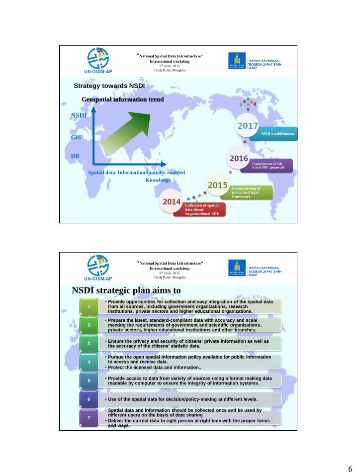
Collection of spatial data theme /organizational SDI/
Strengthening of policy and legal framework
Establishment of SDI /Local SDI/ geoportals
NSDI establishment
Strategy towards NSDI
Geospatial information trend
Spatial data InformationSpatially-enabled
Knowledge
DB
GIS
NSDI
“National Spatial Data Infrastructure”
International workshop
9th June, 2015
Terelj Hotel, Mongolia
NSDI strategic plan aims to• Provide opportunities for collection and easy integration of the spatial data
from all sources, including government organizations, research institutions, private sectors and higher educational organizations.
1
• Prepare the latest, standard-compliant data with accuracy and scale meeting the requirements of government and scientific organizations, private sectors, higher educational institutions and other branches.
2
• Ensure the privacy and security of citizens' private information as well as the accuracy of the citizens’ statistic data.
3
• Pursue the open spatial information policy available for public information to access and receive data.
• Protect the licensed data and information..4
• Provide access to data from variety of sources using a format making data readable by computer to ensure the integrity of information systems.
5
• Use of the spatial data for decision/policy-making at different levels.6
• Spatial data and information should be collected once and be used by different users on the basis of data sharing
• Deliver the correct data to right person at right time with the proper forms and ways.
7

7
“National Spatial Data Infrastructure”
International workshop
9th June, 2015
Terelj Hotel, Mongolia
• Based on the National Programs and strategic
plan
– NSDI Act has been drafted since 2013
• Learning the experiences of other countries’ acts
such as Korea, Indonesia, Japan, INSPIRE, China
etc.
– Challenges that encountered
• Other organizations have not realized importance of
SDI
• Insufficient awareness in decision/policy making
levels
– Effectively and efficiently establish the NSDI
– Guarantee availability and access to Geospatial
information
– Provision of cooperation, coordination, and
integration among various stakeholders and
users
– Encourage the use of Geospatial Information
for planning, development and management as
well as industrial promotion
Draft NSDI Act concepts
Geospatial data providerAdministrativeUser
Policy
Standard
Technolog
y
Human
Capacity
Geodetic
control
Aerial and
satellite
images
Maps
Cadastre
Geograp
hic
names
Boundar
y
Geologic
Elevation
model
зураг
Hydrolgra
phy
Environm
ental
Transport
ation
Vegetati
on
Geospatial
Informatio
n system
Innovati
on
Econo
micSocial
COOPERATION
Since 2014, realizations have increased in all levels of
users/decision makers, NGO, institutions and
academic/higher educational organizations
“National Spatial Data Infrastructure”
International workshop
9th June, 2015
Terelj Hotel, Mongolia
• ALAGAC aims to achieve
• Collection and acquisition of
fundamental geospatial data
• Establish fundamental data
framework in accordance with
geospatial standards
• Share, disseminate and make
accessible geospatial data
through SDI to support effective
and efficient use of GI
Current activities towards NSDI
DataProduction
Cartography WorkflowData
Validation

8
“National Spatial Data Infrastructure”
International workshop
9th June, 2015
Terelj Hotel, Mongolia
Geospatial standards
• Geospatial data type
• Standards for geospatial database design
• Basic technical standards for digital
topographic maps
o Topographic database design and
definition of the attributes
o Basic standards for digital maps
o Data quality control
Standardization
Automation Centralization Repeatability
“National Spatial Data Infrastructure”
International workshop
9th June, 2015
Terelj Hotel, Mongolia
Example, Database design
97 layers
Example: 1:25000 mapPrevious digital topo maps
~361 layers
~40 annotations

9
“National Spatial Data Infrastructure”
International workshop
9th June, 2015
Terelj Hotel, Mongolia
• ALAGAC aims to achieve
• Collection and acquisition of
fundamental geospatial data
• Establish fundamental data
framework in accordance with
geospatial standards
• Share, disseminate and make
accessible geospatial data
through SDI to support effective
and efficient use of GI
Share Manage Produce
Collect
“National Spatial Data Infrastructure”
International workshop
9th June, 2015
Terelj Hotel, Mongolia
www.geoportal.mn
Support government
activity to make
decision on urban
development

10
“National Spatial Data Infrastructure”
International workshop
9th June, 2015
Terelj Hotel, Mongolia
Address system
Basic geoportal for
data availability 3D city model
2D geoportal
“National Spatial Data Infrastructure”
International workshop
9th June, 2015
Terelj Hotel, Mongolia
21 aimags’ sub systemALAGAC’s central DB
VPN Connection
11
“National Spatial Data Infrastructure”
International workshop
9th June, 2015
Terelj Hotel, Mongolia
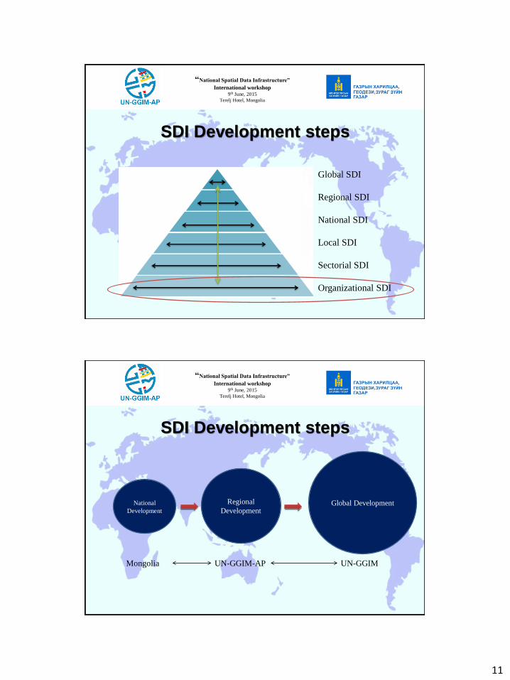
SDI Development steps
Global SDI
Regional SDI
National SDI
Local SDI
Sectorial SDI
Organizational SDI
“National Spatial Data Infrastructure”
International workshop
9th June, 2015
Terelj Hotel, Mongolia
National
Development
Regional
DevelopmentGlobal Development
UN-GGIM-AP UN-GGIMMongolia
SDI Development steps

12
“National Spatial Data Infrastructure”
International workshop
9th June, 2015
Terelj Hotel, Mongolia
Next steps
• We Realized
“The value of the data is in its use.”
“working together is a key to success”
“sharing is earning”
• Now make actions together
• Collect once, use multiple
• Benefit from GI
“understanding is first step”
“capacity building is leverage to NSDI”
“National Spatial Data Infrastructure”
International workshop
9th June, 2015
Terelj Hotel, Mongolia
THANK YOU FOR YOUR
ATTENTION