terms of references (tor)environmentclearance.nic.in/writereaddata/online/tor/0_0...2 terms of...
TRANSCRIPT
1
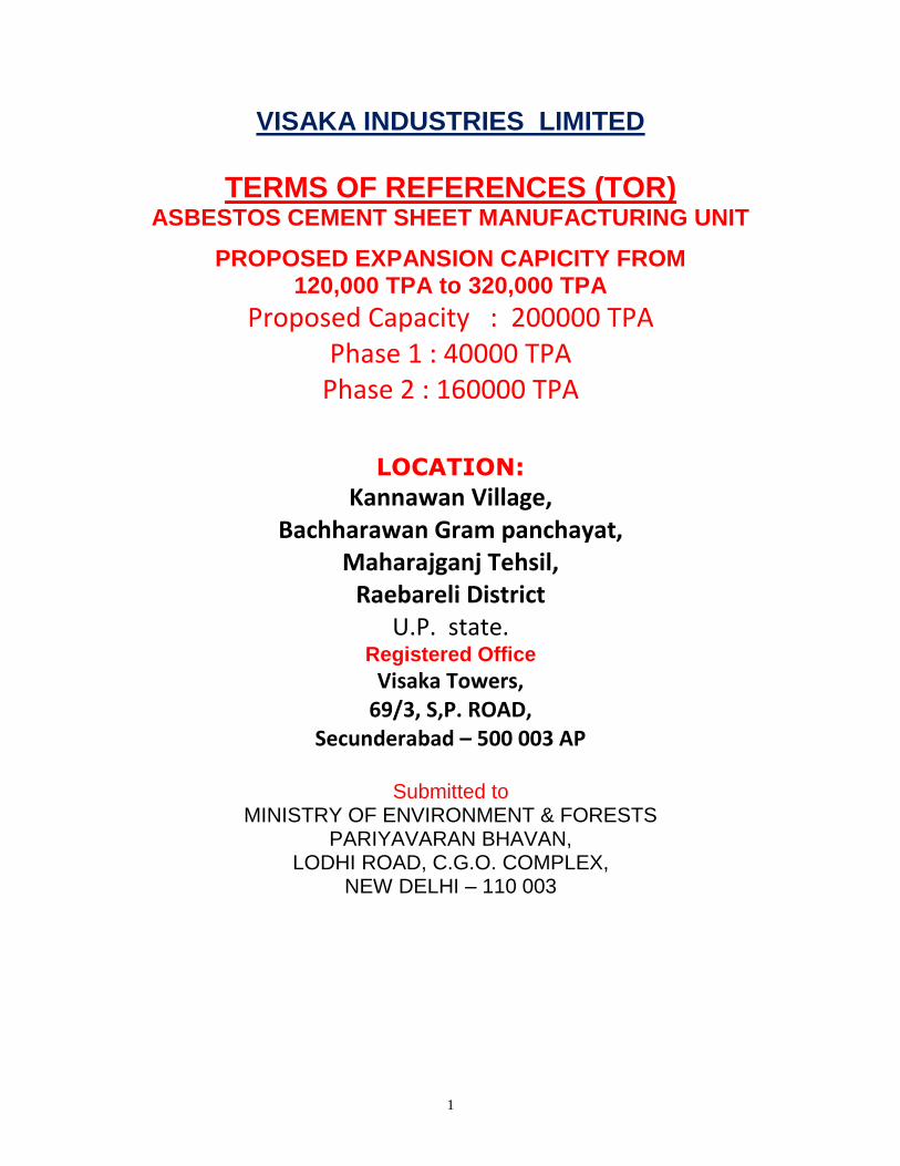
VISAKA INDUSTRIES LIMITED
TERMS OF REFERENCES (TOR)
ASBESTOS CEMENT SHEET MANUFACTURING UNIT
PROPOSED EXPANSION CAPICITY FROM 120,000 TPA to 320,000 TPA
Proposed Capacity : 200000 TPA Phase 1 : 40000 TPA
Phase 2 : 160000 TPA
LOCATION:
Kannawan Village, Bachharawan Gram panchayat,
Maharajganj Tehsil, Raebareli District
U.P. state. Registered Office
Visaka Towers, 69/3, S,P. ROAD,
Secunderabad – 500 003 AP
Submitted to
MINISTRY OF ENVIRONMENT & FORESTS PARIYAVARAN BHAVAN,
LODHI ROAD, C.G.O. COMPLEX, NEW DELHI – 110 003
2
TERMS OF REFERENCES (TOR)
BY THE PROPONENT- VIL LIMITED ,
1.0 INTRODUCTION:
Location Kannawan Village,
Bachharawan Gram panchayat, Maharajganj Tehsil,
Raebareli District U.P. state. .
Size of the project : Manufacturing of Asbestos Cement
Sheets and Accessories Capacity from
120,000 TPA to 320,000 TPA
The expansion in productivity:
No Additional land
No Additional Building for Phase -1
Additional Equipment
Increase size of the Sheet
Improved vacuum systems
Improved waste recycling
ADVANTAGES TO THE PROJECT:
There is a positive impact on the environment due to the usage of fly ash of about 27%
in the product which is a waste material of a nearby Thermal power station. The
land is declared as industrial area by the government itself after a thorough study by
expertise.
2.0 UTILITIES
POWER
Connected maximum demand of 750 KVA which is under HT limits. The required power
connection is obtained from APSEB. However, D.G sets of 2 X 500 KVA are installed.
No Additional DG Sets required.

3
MANPOWER
The regular manpower required for Existing administration, and production purposes
around 50. Additional manpower (both regular and contract basis) for expansion will be
up to 50.
WATER
Water requirement for Existing is 140 KLD, Proposed Phase -1 expansion will be 60 KLD.
Proposed Phase -2 expansion will be 200 KLD. Total water requirement for both existing
and proposed will be 400 KLD (per day) for process + administrative purposes. It will
be met by Existing bore wells within the project site.
3.0 SITE
The expansion Project will be implemented with in the VIL premises which is at 3.5
Kms from Bachharawan Gram panchayat, Tehsil Maharajganj, and District Rae-bareli.
State High way No.36 is coonecting Lucknow to Rae-Bareli The company has
proposed to go for expansion operations in the existing premises of VIL. No
Additional Land is required.
PLANT AREA SPLIT UP
Total Area 10.0 Hectares
Plant facility 1.6 hectares
Storage 0.8 hectares
Approach roads 0.4 hectares
Green belt 6.0 hectares

4
RM CONSUMPTION in TPM WATER CONSYUMPTION in KLD
EXISTING PROPOSED PROPOSED
Existing Phase 1 Phase 2 Phase 1 Phase 2
Cement 4050 TPM 1320 TPM 5282 TPM Process 110 KLD 35 KLD 150 KLD
Fly ash 2925 TPM 0872 TPM 3487 TPM Cure & cool 005 KLD 05 KLD 010 KLD
Chrysotile +
other fibre
0810 TPM 0290 TPM 1159 TPM Domestic 015 KLD 15 KLD 020 KLD
Pulp 0063 TPM 0031 TPM 0123 TPM Gardening 010 KLD 10 KLD 015 KLD
Total 7848 TPM 2513 TPM 10051 TPM Total 140 KLD 65 KLD 195 KLD
Main reasons for initially selecting the site is that land is in existing premises of
VIL. after a thorough study of negative/positive impact studies due to the major
development in the area.
Easy to receive and importing material. Good transportation is possible as the
site is situated near the highway. Man power availability. Nearer to raw material
and market. Getting additional raw material for additional production capacity is
also not a constraint. Sufficient raw material is available. Utilizing more Fly ash
from the nearby Thermal Power Station as a major part of the raw material.
As for transportation of goods, there is already existing black topped roads from
the State High way No 36 to the project site.
4.0 DESCRIPTION OF ENVIRONMENT
Khannawan village is a geographical part of Bachhranwan GP, Maharajganj
Tehsil and Rae-Bareli District in Uttar Pradesh. The average annual rainfall is
700-900 mm. The maximum and minimum temperatures of the region are 45˚C
and 2.5˚C. Area falls under semi- arid zone category. The area of interest for
the REIA studies is 10 Km radius with Project site as its center.

5
SITE LOCATION MAP WITH GOOGLE EARTH IMAGE PROJECT SITE
6
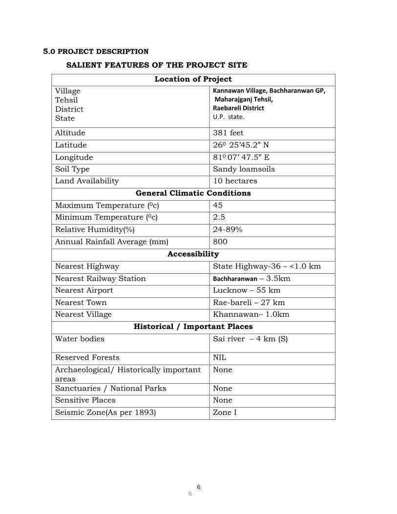
5.0 PROJECT DESCRIPTION
SALIENT FEATURES OF THE PROJECT SITE
Location of Project
Village
Tehsil District State
Kannawan Village, Bachharanwan GP, Maharajganj Tehsil, Raebareli District U.P. state.
Altitude 381 feet
Latitude 260 25’45.2” N
Longitude 810 07’ 47.5” E
Soil Type Sandy loamsoils
Land Availability 10 hectares
General Climatic Conditions
Maximum Temperature (0c) 45
Minimum Temperature (0c) 2.5
Relative Humidity(%) 24-89%
Annual Rainfall Average (mm) 800
Accessibility
Nearest Highway State Highway-36 – <1.0 km
Nearest Railway Station Bachharanwan – 3.5km
Nearest Airport Lucknow – 55 km
Nearest Town Rae-bareli – 27 km
Nearest Village Khannawan– 1.0km
Historical / Important Places
Water bodies Sai river – 4 km (S)
Reserved Forests NIL
Archaeological/ Historically important
areas
None
Sanctuaries / National Parks None
Sensitive Places None
Seismic Zone(As per 1893) Zone I
6

7
RAW MATERIALS
The raw materials required are Asbestos fibre & other fibres (8 to 9%), Binders cement & flyash
materials (45 to 47% and 27% respectively).
5.1. RAW MATERIALS- SOURCE
Raw
Material
Source
Cement Nearby sources
Fly ash Nearby Power station
Fibre Fully Imported from Canada, Brazil,Russia
Pulp Local
Water Existing Bore wells of VIL LTD
As for transportation of goods, there is already existing black topped roads.
As for transportation of goods, there is already existing black topped roads from
the State High way No 36 to the project site. This is quite adequate for the
possible truck movement envisaged.
MANUFACTURING PROCESS OF A.C. PRODUCT
Asbestos Fiber of different grades are imported, mainly from Canada, Russia,
Zimbabwe etc, and received in pressure packed condition in impermeable bags
in palletized form. The fibre pallets are transported to the factory in closed
containers through the trailer trucks. These palletized fiber bags are unloaded in
fiber go-downs with the help of fork lifts. Fiber bag pallets are conveyed to the
fiber feeding section by means of fork lifts. The fiber bags shall be slit open in
closed automatic bag opening device. The empty bags shall be lifted by a hooking
device attached within the bag opening device and carried to the attached bag
shredder unit and the fiber after passing through the lump breaker shall be
collected in the attached blender where some water shall be added to maintain
the process in wet condition.. When all the bags in one charge empties the fiber
8
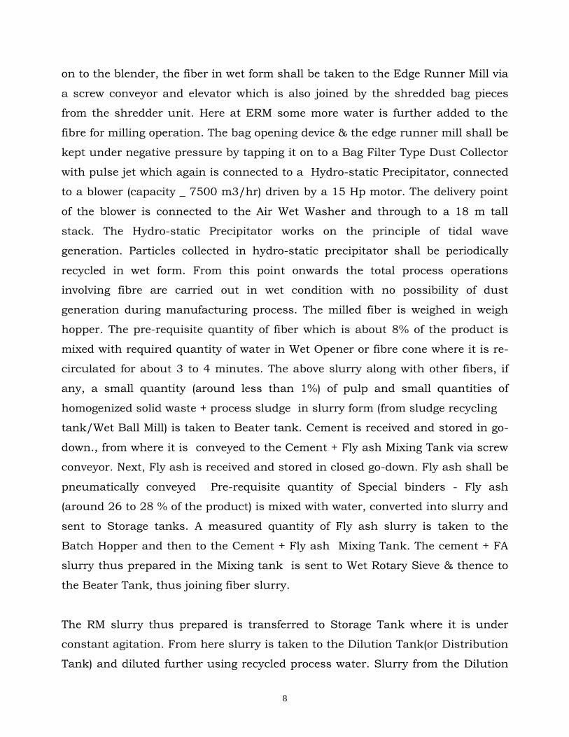
on to the blender, the fiber in wet form shall be taken to the Edge Runner Mill via
a screw conveyor and elevator which is also joined by the shredded bag pieces
from the shredder unit. Here at ERM some more water is further added to the
fibre for milling operation. The bag opening device & the edge runner mill shall be
kept under negative pressure by tapping it on to a Bag Filter Type Dust Collector
with pulse jet which again is connected to a Hydro-static Precipitator, connected
to a blower (capacity _ 7500 m3/hr) driven by a 15 Hp motor. The delivery point
of the blower is connected to the Air Wet Washer and through to a 18 m tall
stack. The Hydro-static Precipitator works on the principle of tidal wave
generation. Particles collected in hydro-static precipitator shall be periodically
recycled in wet form. From this point onwards the total process operations
involving fibre are carried out in wet condition with no possibility of dust
generation during manufacturing process. The milled fiber is weighed in weigh
hopper. The pre-requisite quantity of fiber which is about 8% of the product is
mixed with required quantity of water in Wet Opener or fibre cone where it is re-
circulated for about 3 to 4 minutes. The above slurry along with other fibers, if
any, a small quantity (around less than 1%) of pulp and small quantities of
homogenized solid waste + process sludge in slurry form (from sludge recycling
tank/Wet Ball Mill) is taken to Beater tank. Cement is received and stored in go-
down., from where it is conveyed to the Cement + Fly ash Mixing Tank via screw
conveyor. Next, Fly ash is received and stored in closed go-down. Fly ash shall be
pneumatically conveyed Pre-requisite quantity of Special binders - Fly ash
(around 26 to 28 % of the product) is mixed with water, converted into slurry and
sent to Storage tanks. A measured quantity of Fly ash slurry is taken to the
Batch Hopper and then to the Cement + Fly ash Mixing Tank. The cement + FA
slurry thus prepared in the Mixing tank is sent to Wet Rotary Sieve & thence to
the Beater Tank, thus joining fiber slurry.
The RM slurry thus prepared is transferred to Storage Tank where it is under
constant agitation. From here slurry is taken to the Dilution Tank(or Distribution
Tank) and diluted further using recycled process water. Slurry from the Dilution
9
Tank is taken to the sheet forming machine consisting of an assembly of 5 vats
placed in series and with rotating sieve cylinders placed one in each of 5 vats.
The sieve cylinders are fitted at its periphery, with the wire mesh of specific size
(mostly 40 mesh on top surface and 5 mesh on bottom surface). An end-less felt
made of synthetic woven fabric runs tangentially atop the sieve cylinders. The
slurry through the sieve cylinders gets filtered out. The differential hydrostatic
pressure thus created between the sieve cylinder and Vat causes an asbestos
cement film to be formed and picked up by the sieve cylinder which in turn gets
transferred to the moving felt. The gradually thickening slurry due to filtration is
constantly diluted in the vats. The excess water in film is dehydrated by vacuum
system. The wet film from the felt is then transferred on to the rotating sheet
forming drum.
After the required thickness is achieved the wet sheet is cut by automatic cutter
fixed on the sheet forming drum. The formed sheet is then trimmed widthwise
with long cutters to the required width. The length of the sheet varies as per the
market requirement from 1.5 M to 3 M. after cutting to the required length the
sheet is transferred on to the profiling machine (Corrugator) by vacuum sucking.
The formed sheets are stacked in between the steel moulds ( templates) which
will be air cured for about 12 hrs in a closed chamber. After the air curing the
sheets are separated out from the templates in destacker machine. The
templates are cleaned and lubricated and sent back to profiling machine. The
sheets then are inspected on-line, stacked on steel pallets and water cured for a
minimum of 12 days before being finally inspected and then dispatched.

10
6.0 PROPOSED SCOPE OF WORK FOR EIA STUDY:
OBJECTIVE:
Preparation of REIA/EMP Studies is a pre-requisite as per EIA-2006
Notification. The proposed Project expansion envisages setting up of
200,000 TPA ASBESTOS CEMENT SHEET PLANT in two phases of Phase -1
40000 TPA and Phase-2 160,000 TPA. EIA and EMP will be prepared to
address these developmental activities.
The EIA study includes determination of baseline conditions surrounding to
the proposed developmental facilities, assessment of the impacts on the
environment due to the operation of the proposed expansion Project and
making recommendations on the preventive measures to be taken, to
minimize the impact on the environment to acceptable levels. The field data
around proposed project will be collected within 10 Kms radius of Project
Site.
6.1 COMPONENTS OF THE EIA STUDY:
The component of the EIA study includes:
Determination of baseline conditions using primary data generation and
secondary data available from existing reports and studies and historical
data from government published reports
Detailed description of all elements of the project activities during the pre-
construction, construction and operational phases. The elements analyzed
and included the infrastructures of the project including drainage features,
roads, waste collection, disposal and management and utility requirements.
Identifying the sources of pollution and assessing the impacts on the
environment due to proposed project. Analysis and assessment of designs to

11
ensure environmental soundness, sustainability and regulatory compliance
of the designs are studied.
Preparation of EIA and EMP documents with recommendations on
preventive and mitigative measures for limiting the impact on environment
to the desired level during various stages of project. Development of a
suitable post study-monitoring program to comply with various
environmental regulations also done; and
Risk Assessment (RA) describing the probable risks and preventive &
precautionary measures to be followed in the event of emergency situations
such as accidents, fire, oil spills, etc.
7.0 BASELINE ENVIRONMENTAL DATA GENERATION:
Field assessments of the physical, ecological, and socioeconomic aspects of the
site and surrounding environs of the development facilities shall be conducted.
These assessments shall be used to determine the potential impacts of the
proposed expansion project. The survey includes a photo-inventory of the
physical and biological features of the site and environs, and the areas viewed
with respect to the suitability of the proposed facility.
The data generation will include:
Physical: Climate, air and noise quality, geology, topography,
groundwater/surface water hydrology and quality and hazard vulnerability.
Ecological: Terrestrial and aquatic communities; presence of rare, threatened,
and endangered species.
Socioeconomic: Demography, regional setting, location assessment, and land
uses.
12
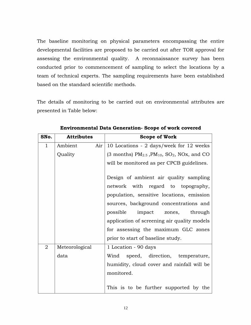
The baseline monitoring on physical parameters encompassing the entire
developmental facilities are proposed to be carried out after TOR approval for
assessing the environmental quality. A reconnaissance survey has been
conducted prior to commencement of sampling to select the locations by a
team of technical experts. The sampling requirements have been established
based on the standard scientific methods.
The details of monitoring to be carried out on environmental attributes are
presented in Table below:
Environmental Data Generation- Scope of work covered
SNo. Attributes Scope of Work
1 Ambient Air
Quality
10 Locations - 2 days/week for 12 weeks
(3 months) PM2.5 ,PM10, SO2, NOx, and CO
will be monitored as per CPCB guidelines.
Design of ambient air quality sampling
network with regard to topography,
population, sensitive locations, emission
sources, background concentrations and
possible impact zones, through
application of screening air quality models
for assessing the maximum GLC zones
prior to start of baseline study.
2 Meteorological
data
1 Location - 90 days
Wind speed, direction, temperature,
humidity, cloud cover and rainfall will be
monitored.
This is to be further supported by the
13
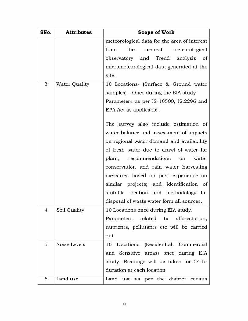
SNo. Attributes Scope of Work
meteorological data for the area of interest
from the nearest meteorological
observatory and Trend analysis of
micrometeorological data generated at the
site.
3 Water Quality 10 Locations- (Surface & Ground water
samples) – Once during the EIA study
Parameters as per IS-10500, IS:2296 and
EPA Act as applicable .
The survey also include estimation of
water balance and assessment of impacts
on regional water demand and availability
of fresh water due to drawl of water for
plant, recommendations on water
conservation and rain water harvesting
measures based on past experience on
similar projects; and identification of
suitable location and methodology for
disposal of waste water form all sources.
4 Soil Quality 10 Locations once during EIA study.
Parameters related to afforestation,
nutrients, pollutants etc will be carried
out.
5 Noise Levels 10 Locations (Residential, Commercial
and Sensitive areas) once during EIA
study. Readings will be taken for 24-hr
duration at each location
6 Land use Land use as per the district census

14
SNo. Attributes Scope of Work
handbooks as well as with the help of
satellite imagery will be presented in 10-
km radius study area.
7 Solid waste Characterization of all the solid wastes
generated from the plant operations and
its disposal including impacts due to
disposal.
8 Geology and
Hydro-geological
aspects
These aspects will be covered for 10-km
radius study area for proposed project
site. The data will be compiled from the
secondary sources only.
9 Socio-Economic
and Health
aspects
Socio-economic and health aspects will be
covered for 10-km radius study area
based on the Census documents and NIC
database.
10 Ecological studies
(Terrestrial and
Aquatic)
Flora and fauna will be studied in 10-km
radius study area. These studies will be
based on primary as well as secondary
sources.
The survey also includes assessment of
the species diversity, density, abundance
etc. in the study area and formulation of
ecological indexes, assessment of likely
changes on flora and fauna due to the
project related activities, suggestions for
conservation and protection of flora and
fauna in the study area.
15
LEGISLATION AND REGULATORY CONSIDERATIONS:
Government policies, legislation and regulations relevant to the proposal
have been identified. Local plans and policies will also be evaluated. Project
characteristics will be analyzed to ensure compliance with these policies,
legislation and regulations. Appropriate recommendations will be provided to
ensure regulatory compliance.
8.0 IDENTIFICATION OF SOURCES OF POLLUTION AND IMPACT
ASSESSMENT:
8.1 Sources of Pollution in the Project Area
This includes the following:
Identifying the sources of pollution of air, water, land, noise and solid
and hazardous wastes;
Quantifying the emissions from the pollution generating sources; and
Quantification of solid and HW wastes and likely disposal methods will be
suggested.
The proposed expansion project may have some impacts on the environment
during construction, drilling and commercial production. The parameters
likely to be affected are air quality, water quality, soil quality; noise levels,
etc. on account of gaseous emissions, liquid effluent discharges, resultant
particulates, generation of solid wastes, etc will be discussed.
The major pollution potential sources in the project are as under:
a) Construction Phase (If any)
Approach road construction
Laying pipelines
Transport of men and material
Construction of sheds & Buildings
16
b) Development Phase
Land acquisition and site preparation
Disposal of construction waste
Sewage from campsites
Site restoration
c) Regular Operational Phase
Transporting raw material
Produce-water disposal
Domestic wastewater disposal
Disposal of solid waste
Transport of men and material
Storage of materials
Fire / Explosion
d) Decommissioning Phase
Transport of men and material
Decommissioning of processing units
Transport and disposal of waste
Restoration of site
There are various qualitative as well as quantitative methods of conducting
EIA studies, each having its own merits and demerits. We intend to use the
best logical tool to assess the impact of the project.
The baseline data generated from the above studies will be analyzed and
compared with applicable standards prescribed by the CPCB and MOEF. By
this means, the impact whether positive or negative will be assessed and the
environmental attributes requiring special attention for mitigating the

17
negative impact, if any, will be identified. Also the areas, which fulfill the
prescribed environmental norms and not requiring further improvements,
will be specified. Both short-term and long term impacts particularly on
sensitive targets such as habitat of endangered species of wildlife, crops,
historically/culturally important sites/monuments, and centers with
concentrated population in the study area will be established.
Mitigation measures to reduce adverse impacts will be suggested. The
potential impacts due to the project could be as follows:
Change in land use due to the proposed project
Potential impact on soil and groundwater due to waste handling,
transportation and disposal
Air quality and noise level impacts due to project activities.
Potential impacts due to the Vehicular movement and emissions;
Storage of materials
Impact on socio-economic environment due to increased direct and indirect
employment generation, and social welfare activities in the nearby villages
The above impact assessment and proposed mitigative measures are
described below
Impact on Land Use
Impact Assessment
The land use impacts due to proposed project will be identified in terms of
local land use planning efforts. The change in land use pattern of project site
will also be identified. This includes visual impact, impact on forest, impact
due to industrial growth and growth due to socio-economic factors.

18
Mitigation Measures
The mitigation measures will be addressed towards restoration of land
disturbed by the proposed project activities to the extent possible.
Impact on Demography and Socio-Economics
Impact Assessment
On the basis of the compiled information and the proposed employment and
other benefits to the people of the study area as well as others, the likely
socio-economic impacts of proposed project in post-project scenarios for
demography, facilities and services, agricultural sector, civic infrastructure
and basic amenities, industrial sector, economic status and health status of
people, etc will be assessed.
Mitigation Measures
Strategies to mitigate the negative impacts of the project will be developed
for areas where negative impacts are projected to occur. The potential
actions considered will include both policy and planning actions. The roles
of different bodies in mitigation measures will be identified.
Impact on Soil
Impact Assessment
Impacts on soil characteristics include destruction of soil profile, changes in
soil productivity, increased erosion and subsequent loss of agricultural soils
and land use changes. Details of solid and hazardous wastes likely to be
generated from the operations and their treatment and disposal mechanism
19
vis-à-vis the proposed treatment facilities in the project will be assessed and
mitigation measures will be suggested accordingly.
Mitigation Measures
Based on analysis, mitigation measures will be proposed which will avoid,
minimize or compensate for significant adverse impact on soil
characteristics.
Impact on Water Quality
We propose to address the impacts due to water requirement, Impacts due
to the domestic sewage, treatment and disposal will also be addressed.
Mitigation Measures
Considering the dependence of the people in the area on ground water as
sources for drinking purposes, the prevailing quality and extent of
contamination due to the proposed project activities, the mitigation
measures will include and the treatment required for meeting the effluent
discharge standards specified under the Environment Protection Rules and
PCB will be addressed. The disposal arrangements will be conceptually
indicated.
Impact on Meteorology
Impact Assessment
The climatologically factors, which play an important role in the
environmental analysis of the process of transportation, dilution and
dispersion of pollutants, will be analyzed. Meteorological data will be
collected to ascertain wind roses, atmospheric stability conditions and
prevalence of inversion levels around the project site. This will enable to

20
define the atmospheric conditions likely to prevail in the study area and use
it as a basis for air quality modeling studies.
Impact on Ambient air Quality
Impact Assessment
Emission inventory will be carried in the study area. A computer based
internationally recognized mathematical air quality model (ISCST3) suitable
for the region would be used to predict the concentration of SO2, NOx &
SPM due to the operation of the proposed plant. The results will be
presented for short-term (24-hourly) concentrations in and around the
project site. The dispersion model results will be included in the report using
isopleths or other graphical methods, over laying a land use map of the
surrounding area. The predicted air quality results will be compared with
existing regulations.
Mitigation Measures
Potential mitigation measures include the control measures at the source
level and providing adequate stack heights. The measures to control the
fugitive dust emissions such green belt development and sprinkling will be
suggested.
Impact on Noise
Impact Assessment
Sources of noise and its impact on the environment will be addressed. The
noise level at varying distances for multi-sources will be predicted using
Noise model. A comparison of measured noise (Leq) at monitoring locations

21
to that of predicted noise levels (Leq) will be made and mitigatory measures
will be recommended to conform to regulatory ambient air noise standards.
Baseline noise levels in different zones like industrial, residential and
sensitive areas like hospitals, wild life habitation etc will be monitored. The
potential noise level exposure will be determined and evaluate for acceptable
limits of exposure.
Mitigation Measures
The potential mitigation measures will be addressed to reduce noise levels
by control at source, provision of greenery to absorb noise during its
propagation, isolation of high noise generating sources, use of protective
measures especially in high noise areas.
Impact on Ecology
Impacts on terrestrial species especially during dry season will be assessed
particularly those which are sensitive to the pollution. Recommendations
will be made to mitigate such adverse impacts as soil erosion and habitat
loss.
9.0 ENVIRONMENT MANAGEMENT PLAN
The Environment Management Plan (EMP) includes all the mitigatory
measures proposed under each significant environmental attribute. For each
potential negative impact identified, recommendations will be presented for
22
avoidance, minimization or mitigation of impacts along with costs associated
with potential mitigation. Further, a suitable green belt development plan for
the project site will be included in the EMP report.
The EMP will addresses the following:
Identify and summarize all anticipated significant adverse environmental
impacts:
Identify and summarize all mitigation measures, including the type of
impact to which it relates and the conditions under which it is required;
Define a set of policies and objectives for environmental performance and
continual enhancement of performance;
Wastewater and produced water handling, treatment and disposal;
Solid and hazardous waste handling and disposal;
Green belt development plan;
Recommend monitoring and reporting procedures including the
parameters to monitored, methods to be used, sampling locations,
frequency of measurements, detection limits and definition of thresholds
that will signal the need for corrective actions;
Recommend capacity development and training requirements for
implementation of EMP; and
Recommend an organizational structure for effective implementation of
the EMP;
An environmental monitoring and management plan have developed for the
sensitive elements of the environment that may require monitoring during
construction and production phase of the proposed project. Recommendations
have made on the institutional arrangements that will be necessary to ensure
effective monitoring and management.
A detailed management and monitoring program has developed to reduce the
effects of potential negative environmental impacts. The EMP also reflects
statutory requirements, M/s. VIL LIMITED