territorial expansion and primary state formation - proceedings of
TRANSCRIPT
Territorial expansion and primary state formationCharles S. Spencer1
Division of Anthropology, American Museum of Natural History, New York, NY 10024-5192
This contribution is part of the special series of Inaugural Articles by members of the National Academy of Sciences elected in 2007.
Contributed by Charles S. Spencer, February 26, 2010 (sent for review January 12, 2010)
A major research problem in anthropology is the origin of the stateand its bureaucratic form of governance. Of particular importancefor evaluating theories of state origins are cases of primary stateformation, whereby a first-generation state evolves without con-tact with any preexisting states. A general model of this process,the territorial-expansion model, is presented and assessed witharchaeological data from six areas where primary states emergedin antiquity: Mesoamerica, Peru, Egypt, Mesopotamia, the IndusValley, and China. In each case, the evidence shows a closecorrespondence in time between the first appearance of stateinstitutions and the earliest expansion of the state’s political-economic control to regions lying more than a day’s round-tripfrom the capital. Although additional research will add detail andclarity to the empirical record, the results to date are consistentwith the territorial-expansionmodel, which argues that the successof such long-distance expansion not only demanded the bureaucra-tization of central authority but also helped provide the resourcesnecessary to underwrite this administrative transformation.
archaic states | comparative archaeology | political evolution
The state and its bureaucratic governing style are pervasive intoday’s world, and yet people have not lived in state societies
for most of humanity’s time on this planet; it is not surprisingthat the origin of the state has long been a major topic ofresearch in anthropology (1–8). Here I present a general modelof the origin of the state, which I call the territorial-expansionmodel, and apply it to six cases of primary state formation, aprocess by which a first-generation state evolves in pristinefashion, without contact with any preexisting states. All six casesoccurred before detailed written records were kept and are thusknown primarily through archaeology.
Defining the StateEarly influential theorists of the state include Engels (9), Mosca(10), Michels (11), and particularly Weber (12), who definedthree fundamental types of authority: charismatic, traditional,and rational, the last of which he associated with the bureau-cratic state. For Weber, the essence of bureaucratic governancewas a hierarchy of administrative offices occupied by full-timespecialists with differentiated functions. During the 1960s and1970s, a general framework reminiscent of Weber’s was pro-moted by anthropologists such as Service (13), Fried (14), andFlannery (15). They asserted that sociopolitical evolution hadproceeded through a series of general stages: egalitarian society,rank society (or chiefdom), and state. Flannery argued that asalient trend in this evolutionary process was an increase in thecomplexity of information processing and decision making.In egalitarian societies, political authority is uncentralized, and
there is no permanent, institutionalized inequality among fun-damental social units such as families and villages. Leadershiptends to be ephemeral, and the individual leaders that emergedo so because they exhibit unusual personal characteristics, likeintelligence or bravery, that attract followers, along the lines ofWeber’s charismatic mode of authority. Leadership status isachieved, not ascribed at birth. Effective decision making oftenrequires key members of constituent social units to cometogether in periodic aggregations that take the form of com-
munal feasts, dance societies, village festivals, war parties, ritualfraternities, and the like (16, 17).In rank societies or chiefdoms, authority is permanently cen-
tralized in the office of chief, which exists apart from the personwho occupies it and upon his death must be filled by someoneof similarly elite descent (15); high status is largely inherited, asin Weber’s traditional form of authority. Decisions can be mademore quickly in a chiefdom than they can in uncentralizedsocieties, although chiefly authority is usually much moreexpensive to maintain. Chiefs support themselves and their ret-inues through the mobilization of surplus resources within theirdomain and the management of this political economy is a keytouchstone of chiefly success (18). Separate chiefdoms frequentlyinteract with one another through raiding and/or exchange, but itis uncommon for chiefdoms to engage in the conquest and long-term control of distant territories (19). Yet, chiefs often partic-ipate in networks of prestige-good exchange with elites in distantpolities, obtaining exotic items that symbolize and reinforce theirhigher status (19, 20).The difference between chiefdoms and states has been of
particular concern to Wright (8). Wright defined the chiefdom asa society with centralized but not internally specialized authority;he defined the state as a society with a centralized and alsointernally specialized administrative organization, consistentwith the Weberian concept of the rational bureaucracy. Chieflyauthority is thus centralized but nonbureaucratic, a design thatsees linguistic expression in the relatively few terms employed todesignate elite decision-makers in ethnographically and ethno-historically documented chiefdoms. By contrast, even relativelysmall states exhibit a plethora of named administrative posts (19).From Wright’s perspective, the origins of bureaucracy can be
found in those cases where chiefdoms evolved into the firstpristine states through the process of primary state formation.There have been few examples of primary state formationworldwide, probably no more than six: in Mesoamerica, Peru,Egypt, Mesopotamia, the Indus River Valley, and China (7).These cases are a valuable resource for comparative analysis andthe testing of general models of primary state formation,including the territorial-expansion model that I will now discuss.
Territorial-Expansion Model of Primary State FormationFor Wright (8), the different administrative principles that definechiefdoms and states are necessarily associated with corre-spondingly distinct optimal regulatory strategies. Because centralauthority in a chiefdom is not permanently divided into multiplespecialized parcels, any delegation of chiefly authority approachestotal delegation, a situation ripe with potential for insub-ordination, insurrection, or fission. Thus, the optimal strategy fora chief is to avoid delegating authority, which means he has torule his entire domain from the center. As a consequence, there isa spatial limit to the territory size that a chief can effectivelycontrol. In a preindustrial context, this limit lies about one-halfday of travel from the chiefly center, some 25–30 km by foot; a
Author contributions: C.S.S. designed research, performed research, and wrote the paper.
The author declares no conflict of interest.1E-mail: [email protected].
www.pnas.org/cgi/doi/10.1073/pnas.1002470107 PNAS | April 20, 2010 | vol. 107 | no. 16 | 7119–7126
ANTH
ROPO
LOGY
INAUGURA
LART
ICLE
chief, or a chief’s representative, could go from the center to theperiphery of the domain and back in 1 day (19–21).In a state, the central decision-making process is divisible into
separate functions that are performed by a variety of admin-istrative specialists, usually organized into a hierarchy, the upperechelons of which set policy, whereas the lower are assignedspecific tasks. As a consequence, the state is able to engage in theeffective delegation of partial authority (21). A state ruler candispatch subordinates to locations near and far from the statecapital to manage local affairs, and, if the authority of the dis-patched official has been defined narrowly enough, this can bedone with little risk of insurrection. The ability to delegate partialauthority to subordinates gives a state the potential to intrude intolocal affairs and finance itself with a variety of extractive tech-niques. Moreover, the delegation of partial authority allows thestate to expand its political-economic territory well beyond thespatial limits associated with chiefly decision-making principles.Wright (8) has argued that the optimal regulatory strategy for astate ruler is to engage wholeheartedly in such delegation, todivide and segment authority as much as possible so as to mini-mize the likelihood of insurrection by subordinates. In discussingthe evolutionary transition from chiefdom to state, I (19) sug-gested that if a chief seeks to implement a new strategy of internaladministrative specialization, the chances of success will beenhanced if the shift is made quickly and extensively. This willhelp ensure that the new parcels of authority are defined narrowlyenough so that no dispatched administrative assistant in the neworder enjoys sufficiently broad authority to foment a successfulinsurrection. From this perspective, we would expect an evolu-tionary transition from chiefdom to state to be marked by aqualitative shift in administrative principles and associated opti-mal regulatory strategies, representing a profoundly transforma-tional process of change (21).It is not my view that chiefdoms will inevitably evolve into
states; nor do I see them as static. Rather, I note that chief-doms are prone to repeated cycles of political growth, markedby an increase in the power and resources (both human andnonhuman) controlled by the chief, followed by a period ofdecline (22). The growth portion of this cycle is financed byincreasing resource mobilization, which is ultimately limited bythe territorial constraints on regulatory efficacy that result fromthe centralized but not internally specialized nature of chieflydecision making.Previously, I proposed a mathematical model that shows how
a polity can reach a critical threshold when chiefly politicalgrowth approaches these limits, at which point a new strategy forresource mobilization must be devised or the downward portionof the chiefly cycle will ensue (23). One way to avoid a declinewould be for the polity that has reached this threshold to enlargethe political-economic territory well beyond the spatial limits ofchiefly regulatory efficacy. Political control could be extendedinto the territories of adjacent polities, a strategy that would beespecially feasible if those adjacent polities were smaller andweaker than the aggressor (24). Of course, such an attempt atexpansion could fail; its success would require a major change inthe regulatory principles and strategies of the expanding polity.Among the most important of the new strategies would be thedelegation of partial authority to subordinate administrators whowould be stationed in the newly annexed territories to maintaincontrol and manage the extraction and transfer of resources. Thepolitical viability of this strategy of delegation requires theimplementation of a new principle of administrative organ-ization, one emphasizing the internal specialization of the centraldecision-making process. In short, the success of the territorial-expansion strategy is linked to the onset of bureaucratic gover-nance and the state. Although the nascent state will be moreexpensive to sustain than the antecedent chiefdom, the newresources gained through successful territorial expansion will do
much to defray the costs of the administrative transformation.The growth and proliferation of bureaucratic governance willcontinue as more and more resources are harnessed, leading tofurther delegation of authority, more territorial expansion, andstill more resource extraction—a positive-feedback process thatreinforces the rise of a state government qualitatively andquantitatively more complex and powerful than the chiefdomthat preceded it (23).When we apply the territorial-expansion model to the empir-
ical record of primary state formation, we should expect to find aclose correspondence in time between the appearance of stateinstitutions and a dramatic expansion of political-economic ter-ritory. This expectation, it should be noted, runs counter to theconventional idea that the territorial expansion of state control isa phenomenon that typically occurs well after the initial for-mation of the state, during what is sometimes called an “impe-rial” phase of development. In contrast, this model makesterritorial expansion an essential, integral part of the process ofprimary state formation itself (23, 24).
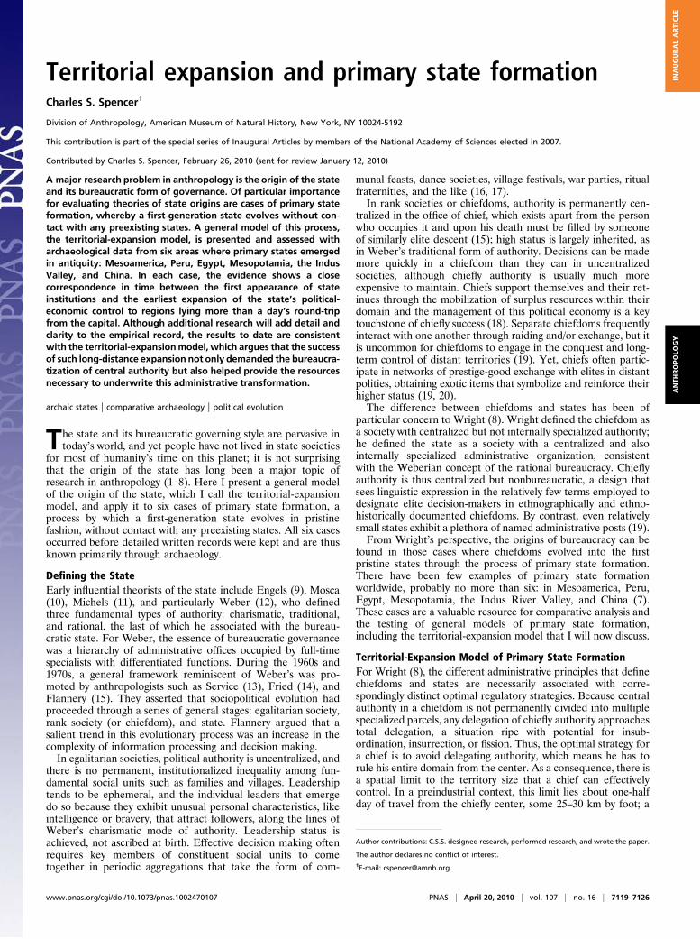
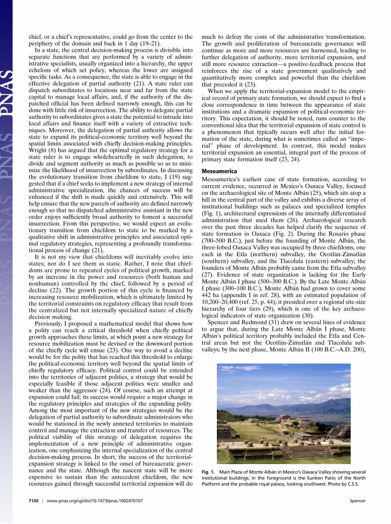
MesoamericaMesoamerica’s earliest case of state formation, according tocurrent evidence, occurred in Mexico’s Oaxaca Valley, focusedon the archaeological site of Monte Albán (25), which sits atop ahill in the central part of the valley and exhibits a diverse array ofinstitutional buildings such as palaces and specialized temples(Fig. 1), architectural expressions of the internally differentiatedadministration that used them (26). Archaeological researchover the past three decades has helped clarify the sequence ofstate formation in Oaxaca (Fig. 2). During the Rosario phase(700–500 B.C.), just before the founding of Monte Albán, thethree-lobed Oaxaca Valley was occupied by three chiefdoms, oneeach in the Etla (northern) subvalley, the Ocotlán-Zimatlán(southern) subvalley, and the Tlacolula (eastern) subvalley; thefounders of Monte Albán probably came from the Etla subvalley(27). Evidence of state organization is lacking for the EarlyMonte Albán I phase (500–300 B.C.). By the Late Monte AlbánI phase (300–100 B.C.), Monte Albán had grown to cover some442 ha (appendix I in ref. 28), with an estimated population of10,200–20,400 (ref. 25, p. 44); it presided over a regional site-sizehierarchy of four tiers (29), which is one of the key archaeo-logical indicators of state organization (30).Spencer and Redmond (31) drew on several lines of evidence
to argue that, during the Late Monte Albán I phase, MonteAlbán’s political territory probably included the Etla and Cen-tral areas but not the Ocotlán-Zimatlán and Tlacolula sub-valleys; by the next phase, Monte Albán II (100 B.C.–A.D. 200),
Fig. 1. Main Plaza of Monte Albán inMexico’s Oaxaca Valley showing severalinstitutional buildings; in the foreground is the Sunken Patio of the NorthPlatform and the probable royal palace, looking southwest. Photo by C.S.S.
7120 | www.pnas.org/cgi/doi/10.1073/pnas.1002470107 Spencer
Monte Albán extended its control over the entire Oaxaca Val-ley. This interpretation is supported by changes in the dis-tribution of a particular kind of pottery, crema ware, the claybody of which came from a single source near Monte Albán(32); other contemporaneous wares were made from morewidely available clays. Using ceramic data collected on regionalsurvey by Kowalewski et al. (28), I carried out an analysis(Fig. 3) that showed that Late Monte Albán I phase sites in theEtla-Central subvalley had significantly higher frequencies ofcrema sherds than contemporaneous sites in the Tlacolula orOcotlán-Zimatlán subvalleys (Kruskal-Wallis statistic = 17.954;P < 0.001). By contrast, Monte Albán II phase sites in all threesubvalleys had relatively more similar frequencies of cremasherds (Kruskal-Wallis statistic = 4.829; P = 0.089). Duringthe Late Monte Albán I phase, polities in the Ocotlán-Zimatlánand Tlacolula subvalleys evidently pursued various strategies ofresistance, including population nucleation, construction offortifications, increasingly hierarchical political organization,and a continuation of local traditions of public construction, allof which signaled their independence from Monte Albán. Thisindependence elicited a reduced participation in the kinds ofexchange that would have brought crema wares to the southernand eastern subvalleys during Late Monte Albán I times. Bythe Monte Albán II phase, however, their resistance was over-come as Monte Albán brought the entire Oaxaca Valley into itsdomain (33).Royal palaces and standardized multiroom temples are also
recognized as important features of state organization that canbe detected archaeologically (34). The earliest royal palace thusfar excavated in Oaxaca was built around 300 B.C., at the onsetof the Late Monte Albán I phase, as shown by associated radi-ocarbon dates and ceramics (35). Although this find was madenear Tilcajete at the El Palenque site, the capital of an inde-pendent secondary state in the Ocotlán-Zimatlán subvalley, it ispossible that the remains of a comparable palace lie beneathMonte Albán’s North Platform, the likely location of the LateClassic (ca. A.D. 600) royal palace (36). Also dating to the LateMonte Albán I phase are Oaxaca’s earliest excavated templeswith multiple rooms (37), considered to be evidence of a spe-cialized priesthood (34). Again, these discoveries were made atthe El Palenque site, but it is likely that contemporaneous multi-room temples will be excavated in future fieldwork at MonteAlbán, since such temples dating to the succeeding Monte AlbánII phase have already been recovered there. Because MonteAlbán continued to be occupied for several centuries after A.D.200, it has been difficult for excavators to recover Late MonteAlbán I and Monte Albán II buildings beneath the massive later
constructions; the application of architectural tunneling mightprove fruitful in this regard.During the Early Monte Albán I phase, the newly founded
center of Monte Albán probably controlled little more than theEtla-Central zone of the Oaxaca Valley (38). Then, in the LateMonte Albán I phase, Monte Albán succeeded in annexing atleast two extravalley regions to the north and southwest that laymore than a 2-day round trip from the capital—even though itstill did not dominate the Tlacolula and Ocotlán-Zimatlán sub-valleys to the east and south (Fig. 4). One of the annexedextravalley regions was the Cañada de Cuicatlán, a canyon some80 km north of Monte Albán. The evidence of its conquestincludes an inscription at Monte Albán interpreted as referringto the conquest of the Cañada (39); a major settlement patterndisruption in the Cañada around 300 B.C., including the aban-donment of all pre-300 B.C. settlements, accompanied byburning and other evidence of violence; the establishment of newvillages on higher ground overlooking the previously occupiedzones, which were converted into irrigated fields; the con-struction of a large military outpost at the northern end of theconquered region; the appearance of a ceramic boundary northof this outpost, with ceramics in the Cañada south of the
Phase
Tiers in
Settlement
Hierarchy
Palace Multiroom
Temple
Long
Distance
Conquests
Valley-wide
Integration
AD 200
100 BC
300 BC
500 BC
700 BC
MA II
Late MA I
Early MA I
Rosario
4
3
3
4 YES No
NoNo
YES
No
YES YES YES YES
YES
No No
No
No No
Fig. 2. Five categories of archaeological evidence pertaining to politicalcomplexity in Oaxaca for four phases spanning the time of primary stateformation.
SUBVALLEY
E O T
A
Tota
l Cre
ma
Sh
erd
s
100
90
80
70
60
50
40
30
20
10
0
E O T
SUBVALLEY
B
Tota
l Cre
ma
Sh
erd
s
70
60
50
40
30
20
10
0
Fig. 3. Distribution of crema sherds at sites in the Etla-Central (E), Ocotlán-Zimatlán (O), and Tlacolula (T) subvalleys of the Oaxaca Valley. Based onsurface collection data of the Valley of Oaxaca Settlement Pattern Project(appendix VI of ref. 28). (A) Total of 48 sites listed as Late Monte Albán I(300–100 B.C.) “central places” by Kowalewski et al. (table 6.4 of ref. 28), ofwhich 22 were in Etla-Central, 12 in Ocotlán-Zimatlán, 14 in Tlacolula; totalsherds for 10 crema pottery types of the Late Monte Albán I phase (appendixII of ref. 25). (B) Total of 40 sites listed as Monte Albán II (100 B.C.–A.D. 200)“central places” by Kowalewski et al. (table 7.4 of ref. 28), of which 20 werein Etla-Central, 8 in Ocotlán-Zimatlán, 12 in Tlacolula; total sherds for 9crema pottery types of the Monte Albán II phase (appendix II of ref. 25).Analysis by C.S.S., assisted by A. Maziarski.
Spencer PNAS | April 20, 2010 | vol. 107 | no. 16 | 7121
ANTH
ROPO
LOGY
INAUGURA
LART
ICLE

boundary showing much stronger stylistic ties to the ceramics ofMonte Albán than to regions north of the boundary; dramaticchanges in patterns of residence, ceremonial behavior, andeconomic activities at village sites in the conquered Cañada,including evidence of stepped-up agricultural production, prob-ably in response to tribute demands, and the erection of a skullrack as a symbol of terror (40). Radiocarbon analyses indicatethat the conquest of the Cañada began about 300 B.C., at thebeginning of the Late Monte Albán I phase, and persisted untilabout A.D. 200, the end of the Monte Albán II phase (41).Balkansky (42) has argued that the Sola Valley, about 75 km
southwest of Monte Albán, was also brought under MonteAlbán’s control by the Late Monte Albán I phase, as evidencedby a dramatic shift in settlement patterns; it was the Sola Valley’sstrategic location on a major route to the Pacific coast thatprobably attracted Monte Albán’s interest (43). Settlement pat-tern shifts also may reflect Monte Albán’s impact in the northernPeñoles region, some 50 km west of Monte Albán, in the LateMonte Albán I phase (44). Marcus and Flannery (ref. 27, pp.196–207) propose that the territory dominated by Monte Albáncontinued to grow through the Monte Albán II phase (Fig. 4),although additional research will be required in several regionsto clarify the nature of their relationships to Monte Albán.It is reasonable to conclude that the earliest evidence of state
organization is concurrent with the earliest evidence of theexpansion of the territory dominated by Monte Albán to regionslying well beyond a 1-day round trip from the capital, consistentwith the territorial-expansion model (38). Moreover, this patternof territorial expansion was markedly asymmetric. Monte Albánevidently extended its control first to the north, west, andsouthwest, into regions that had relatively small and weakpolities. More powerful rivals in the subvalleys and extravalleyregions to the south and east were apparently able to mount aneffective resistance and were bypassed at first, although even-tually they too fell under Monte Albán’s sway (32).
PeruThe setting for primary state formation in Peru was most likelythe arid north coast (Fig. 5). The well-researched Moche state
emerged by ca. A.D. 200–400 in the Moche Valley and quicklyextended its control over several coastal valleys (45–47), inapparent concordance with the territorial-expansion model (43).Yet, there is tantalizing evidence of an even earlier case of stateformation during the Gallinazo period (ca. 100 B.C.–A.D. 200)in the Virú Valley, 35 km south of Moche (48, 49). Willey (50)recorded 94 Gallinazo sites in Virú. Although he did not sys-tematically record all site sizes, he did define a dozen site typesthat undoubtedly reflect a complex, multitiered settlementhierarchy (ref. 50, p. 177). The probable political capital was theGallinazo Group, a concentration of 30 mound sites (or huacas)scattered over 500 ha in the lower valley. The largest site of thegroup is Huaca Gallinazo, a 6.5-ha complex of adobe mounds,the tallest reaching 25 m above the surrounding terrain. Bennett(51) carried out excavations in the Gallinazo Group and repor-ted a dense “honeycomb” pattern of habitation; he estimatedthat the entire site group must have contained 30,000 rooms. Inaddition to this striking demographic aggregation at the Galli-nazo Group, several other Gallinazo sites appear to have hadspecialized functions. Among them are Huaca San Juan, whichsits at the optimal take-off point for irrigation canals and wasprobably involved with managing the distribution of water, andfour “Castillo Fortification Complexes,” such as Castillo deTomaval, which are located on rocky eminences and appear tohave functioned as military garrisons (50). Excavations wereconducted by Millaire at Huaca Santa Clara, which he inter-preted as a medium-sized administrative site in the Virú-Galli-nazo state system (ref. 52, p. 152). These excavations yieldedsamples of Gallinazo period ceramics, including the distinctiveGallinazo Negative type (decorated with negative or “resist”painting) and a series of radiocarbon dates, the earliest of whichhas a 2-Sigma calibrated range that extends from the middle ofthe second century B.C. to nearly the end of the second centuryA.D. (figure 9.4 of ref. 52). More recent investigations by Mill-aire at the Huaca Gallinazo (V-59) component of the GallinazoGroup have provided further evidence of the group’s urbannature, with a total estimated population of 14,440 to 28,880,consistent with its likely role as a regional political capital (49).In addition, Millaire’s excavations yielded a series of radiocarbondates, the earliest of which has a 2-Sigma calibrated rangeextending from the middle of the first century B.C. through themiddle of the second century A.D (49). Overall, the picture thatemerges from Virú for Gallinazo times is one of centralization atthe Gallinazo Group plus the appearance of specialized sub-sidiary centers of administration; the data are consistent with the
SOSOLA
PEÑOLES
OCELOTEPEC
CHILTEPECTUTUTEPEC
MonteNegro
NOCHIXTLÁN
VALLEY
50 km
NEJAPA
MIAHUATLÁN
CAÑADA DE CUICATLÁN
VALLEY OF OAXACA
Monte Albán
SOLA
Tlacolula
Ocotlán-Zimatlán
Etla
Pacific Ocean
N
EJUTLA
Tilcajete
Fig. 4. Proposed territorial extent of the Monte Albán polity: during theLate Monte Albán I phase (300–100 B.C.), solid bold line; expanding in theMonte Albán II phase (100 B.C.–A.D. 200), dashed bold line; redrawn byJ. Steffey from Spencer et al. (figure 13 of ref. 32).
0 50 100
N
Huaca Prieta
Pampa Cruz
Gallinazo Group
Cerro Oreja
Huaca San Juan
Ocean
Jequetepeque
Castillo de Tomaval
Chicama
Moche
Virú
Chao
Santa
Fig. 5. Virú, Moche, and Chicama Valleys on the north coast of Peru,showing the Gallinazo Group of Virú and other key sites (by J. Steffey).
7122 | www.pnas.org/cgi/doi/10.1073/pnas.1002470107 Spencer

formation of a primary state in the early years of the Gallinazoperiod (48, 49).There is some evidence, at this point more suggestive than
definitive, that the early Virú-Gallinazo state sought to expandits territory northward to the Moche and Chicama Valleys.Billman (45) noted that the Gallinazo period in the MocheValley was a time of population dislocation and warfare; largeareas of the valley were abandoned and there was an increase insites in defensible locations and with fortifications. Populationbecame more aggregated, as the eight site clusters of the pre-vious phase were replaced by two during the Gallinazo period:one cluster was focused on Cerro Oreja in the valley neckupstream, possibly to protect the key take-off points for irriga-tion canals; the other was situated 24 km away at Pampa Cruz onthe shore, far enough from the Cerro Oreja cluster that the twoclusters were probably not part of the same polity. Billmansuggested that the Cerro Oreja polity coalesced to resist invadingwar parties that might have come from the highlands and/or theVirú Valley; he was uncertain about Pampa Cruz’s relationshipto the Virú-Gallinazo polity, which he acknowledged was thelargest and most powerful on the entire north coast before theMoche state (ref. 45, p. 263).In the Chicama Valley, some 80 km north of Virú, population
also became aggregated during the Gallinazo period and some ofthe inland sites were fortified (45). By contrast, Huaca Prieta wasa nonfortified site on a low ridge between the beach and theirrigated floodplain. Here, excavations reported by Bird andHyslop (53) showed that earlier deposits were overlain by aGallinazo occupation in Test Pit HP1, which included a facilitywith a concentration of clay-lined pits and a large jar (figures 13–14 of ref. 53), associated with 571 maize cobs whose kernels hadbeen removed (54). The HP1 facility shows similarities tofacilities documented ethnographically and archaeologically forthe production of maize beer or chicha (55–57). Although chichawas produced and consumed in a variety of contexts in theancient Andes, scholars have long recognized the special role ofchicha production and consumption in the political economy ofAndean states (56, 57). At Huaca Prieta, the proposed chichaproduction facility was associated with numerous sherds ofGallinazo Negative (53), in quantities that actually rival thoseexcavated in the Virú sites, as reported by Strong and Evans (ref.58, p. 216). Among the contributors in a recent volume on theGallinazo period edited by Millaire and Morlion (59), there waswidespread agreement that the presence at a given site of Gal-linazo Negative pottery is more likely than the other ceramictypes of this period to reflect a close relationship between thatsite and the Virú-Gallinazo polity. In 2008, I arranged for AMSradiocarbon dating of six of the maize cobs associated with theproposed Huaca Prieta chicha-brewing facility and the GallinazoNegative pottery. The cobs and ceramics are stored at theAmerican Museum of Natural History. The resulting datesspanned much of the Gallinazo period: the 2-Sigma calibratedrange for the earliest date (Beta-246472) was 90 B.C.–A.D. 80;for the latest date (Beta-241934) the 2-Sigma range was A.D. 140–380.A reasonable, although admittedly tentative, hypothesis is that
a Virú-Gallinazo outpost was established at Huaca Prieta by thefirst century B.C., in the early years of the Gallinazo period. Thefull extent of this occupation is inadequately known and deservesfurther investigation. Moreover, the Pampa Cruz site on theMoche coast should also be checked for Gallinazo Negativeceramics, which might indicate a Virú-Gallinazo presence at thiscoastal site, in contrast to the inland Cerro Oreja site thatappears to have resisted foreign incursions. It is possible that, asin the Oaxaca case, variable relationships of resistance andaffiliation resulted in an asymmetric, nonuniform pattern ofterritorial growth of the Virú-Gallinazo state.
EgyptDuring the Naqada I period (ca. 3700–3400 B.C.) the Upper Nilearea (Fig. 6) had at least three rival chiefdoms, one of which wasat Hierakonpolis (60). In the following Naqada II period (3400–3200 B.C.), Hierakonpolis emerged as an urban center and thecapital of a large southern Egyptian state (61). Population grewand became highly aggregated, possibly for political and defen-sive reasons. The capital saw much construction at this time,including a large cobblestone construction thought to be a pal-ace, a specialized temple complex with a large oval courtyard,and a thick mudbrick town wall. Also dating to this period wereseveral large rectangular mudbrick-lined tombs; one of them,interpreted as belonging to an early king, has painted muralswith themes that suggest “warfare and conquest, the beginningsof a state religion, foreign contacts, and a pharaonic type royalregalia” (ref. 61, p. 184).Concurrent with these developments, Hierakonpolis expan-
ded its political control over much of Upper Egypt (60). Thisunified territory is marked by the distribution of distinctiveNaqada II pottery, which extends from Hierakonpolis north-ward to Naqada and Abydos, lying some 80 km and 140 km,respectively, from the early state capital (62)—perhaps repre-senting another example of asymmetric territorial growth in thecontext of primary state formation. Egypt’s first state then wenton to subjugate the Delta by 3100 B.C., at which point thecapital was shifted from Hierakonpolis downstream to Memphisunder King Narmer, whose accomplishment was heralded on afamous stone palette that shows the king wearing the crown ofLower Egypt on one side and the crown of Upper Egypt on theother (60, 61). In sum, there can be little doubt that territorialexpansion played a central role in the story of primary stateformation in ancient Egypt.
MesopotamiaMesopotamia’s earliest state was the Uruk state, which emergedaround 3500 B.C. with its capital at the site of Uruk, an occu-
N
0 110 220km
Hierakonpolis
Naqada
Abydos
UPPER EGYPT
LOWER EGYPT
FAYUM
OASIS
DELTA
LOWER NUBIA
RedSea
SINAI
Fig. 6. The Upper Nile, showing Hierakonpolis and other sites; redrawn byJ. Steffey from Algaze (figure 4 of ref. 63).
Spencer PNAS | April 20, 2010 | vol. 107 | no. 16 | 7123
ANTH
ROPO
LOGY
INAUGURA
LART
ICLE
pation of 200 ha with several large temples and administrativebuildings (Fig. 7). Algaze (63, 64) has argued cogently that theappearance of a state administration at Uruk was linked to anaggressive strategy of territorial expansion. In his view, an earlystage of this expansion involved the annexation of polities in thesouthwestern Iranian plains east of the Mesopotamian alluvium.One of these plains was Susiana, some 250 km east of the Urukcapital; archaeological research in Susiana has documented theappearance of state organization by the Middle Uruk period(3500–3300 B.C.), evidenced by a four-tier regional settlementhierarchy plus specialized administrative facilities at key sites, allassociated with typical Uruk ceramics (65). Public buildingsassociated with administrative artifacts such as ceramic seals andbullae (counters) were excavated at Susa, the largest Uruk siteon the Susiana plain (66). Algaze notes that Uruk outposts werealso established even farther afield, well to the north in the Syro-Mesopotamian plains. Some of these outposts were true urbancenters with carefully planned residential and administrativesectors, associated with a material culture so identical to that ofthe Uruk capital that at least some of the inhabitants of theoutposts must have been colonists (63). Recent research hasbeen refining the model of Uruk expansion (64, 67), but Algaze’soriginal message remains largely intact: the expansion of politi-cal-economic territory to distant regions was an integral part ofthe process of primary state formation in the Uruk case.
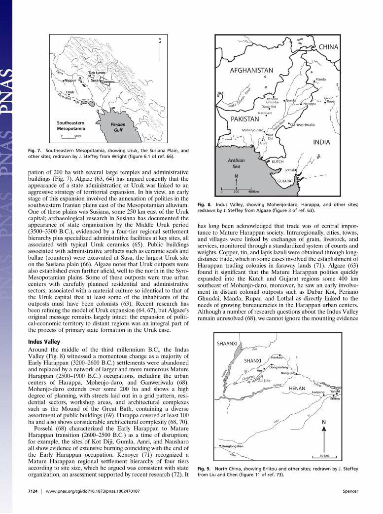
Indus ValleyAround the middle of the third millennium B.C., the IndusValley (Fig. 8) witnessed a momentous change as a majority ofEarly Harappan (3200–2600 B.C.) settlements were abandonedand replaced by a network of larger and more numerous MatureHarappan (2500–1900 B.C.) occupations, including the urbancenters of Harappa, Mohenjo-daro, and Ganweriwala (68).Mohenjo-daro extends over some 200 ha and shows a highdegree of planning, with streets laid out in a grid pattern, resi-dential sectors, workshop areas, and architectural complexessuch as the Mound of the Great Bath, containing a diverseassortment of public buildings (69). Harappa covered at least 100ha and also shows considerable architectural complexity (68, 70).Possehl (68) characterized the Early Harappan to Mature
Harappan transition (2600–2500 B.C.) as a time of disruption;for example, the sites of Kot Diji, Gumla, Amri, and Nausharoall show evidence of extensive burning coinciding with the end ofthe Early Harappan occupation. Kenoyer (71) recognized aMature Harappan regional settlement hierarchy of four tiersaccording to site size, which he argued was consistent with stateorganization, an assessment supported by recent research (72). It
has long been acknowledged that trade was of central impor-tance to Mature Harappan society. Intraregionally, cities, towns,and villages were linked by exchanges of grain, livestock, andservices, monitored through a standardized system of counts andweights. Copper, tin, and lapis lazuli were obtained through long-distance trade, which in some cases involved the establishment ofHarappan trading colonies in faraway lands (71). Algaze (63)found it significant that the Mature Harappan polities quicklyexpanded into the Kutch and Gujarat regions some 400 kmsoutheast of Mohenjo-daro; moreover, he saw an early involve-ment in distant colonial outposts such as Dabar Kot, PerianoGhundai, Manda, Rupar, and Lothal as directly linked to theneeds of growing bureaucracies in the Harappan urban centers.Although a number of research questions about the Indus Valleyremain unresolved (68), we cannot ignore the mounting evidence
N
0 100km
SoutheasternMesopotamia
Euphrates
Uruk
Nippur
Ur
PersianGulf
Tigris Deh Luran
SusianaSusa
Fig. 7. Southeastern Mesopotamia, showing Uruk, the Susiana Plain, andother sites; redrawn by J. Steffey from Wright (figure 6.1 of ref. 66).
ArabianSea
N
0 200 400km
CHINA
AFGHANISTAN
PAKISTAN
INDIA
KUTCH
GUJARAT
Rud-I Hilman
River
PerianoGhundai Gumla
Dabar Kot
Nausharo
Mohenjo-daro
KotDiji
Amri
Lothal
Ganweriwala
Manda
RuparHarappa
Indus River
Fig. 8. Indus Valley, showing Mohenjo-daro, Harappa, and other sites;redrawn by J. Steffey from Algaze (figure 3 of ref. 63).
Donglongshan
HENAN
SHANXI
SHAANXI
N
Luoyang
50 km
Yanshi
Erlitou
LuoYi
Dan
YellowYellow
QinglongYello
w Su
Fen
Salt Lake
Hankou
AnyiDongxiafeng
Nanguan
Fig. 9. North China, showing Erlitou and other sites; redrawn by J. Steffeyfrom Liu and Chen (figure 11 of ref. 73).
7124 | www.pnas.org/cgi/doi/10.1073/pnas.1002470107 Spencer
that the transition from the Early Harappan to Mature Har-appan witnessed not only the rise of a primary state but also therapid political-economic expansion of the Mature Harappanstate to territories far from the core.
ChinaChina’s first state was mostly likely the Erlitou state (1800–1500B.C.), whose capital was the 300-ha site of Erlitou (73) in theYiluo Basin, near the junction of the Yi and Luo Rivers (Fig. 9).The Erlitou regional settlement pattern exhibits centralization,evidenced by a concave rank-size curve, as well as hierarchy, seenin a four-tier distribution of site sizes; by contrast, the precedingLongshan period was a time of competing chiefdoms, with noregional polity exhibiting more than a three-tiered hierarchy ofsite sizes and the overall pattern of settlement showing a convexrank-size curve (74).Excavations at Erlitou have documented the growth and
development of the site (73). A sizable but still preurban regionalcenter was established in phase I (1900–1800 B.C.). The settle-ment grew in phase II (1800–1700 B.C.), reaching urban pro-portions in phase III (1700–1600 B.C.). By the end of phase IV(1600–1500 B.C.), the Erlitou state had gone into decline. Thereis evidence that an internally differentiated administrationappeared at the site in phase III, most notably in the form ofwhat has been called the “palatial zone,” where archaeologistsfound two palaces built on rammed-earth foundations. Thelarger, Palace no. 1, had a large courtyard and walls with roofedgalleries; it covered 1 ha and sat on a rammed-earth and stonefoundation more than 3 m thick. Palace no. 2 had a rammed-earth foundation covering 0.1 ha on which sat an enclosedcompound consisting of a three-room building, a tomb, and wallswith attached galleries. Other impressive constructions in theErlitou palatial zone may represent specialized temple struc-tures. In addition, archaeologists found areas of specialized craftactivities at the site, including a bronze foundry near the palatialzone that was used for casting tools, weapons, and ritual vessels.Also located were workshops dedicated to the production ofbone objects and pottery. The estimated population of theErlitou site during phase III is 18,000–30,000.Phase III is also when the Erlitou state started a process of
territorial expansion (73). Nearly 100 km northwest of Erlitou,centered on Nanguan in the Yuanqu basin of southern Shanxi,archaeologists found 15 sites with material culture showingstrong similarities with that of the core area of the Erlitou state.In addition, some 150 km northwest of Erlitou, in the YunchengBasin of southern Shanxi, Erlitou material was found at a clusterof seven sites centered on Dongxiafeng. Noting the differencesbetween the Erlitou material culture and that of the precedingLongshan occupation, Liu and Chen (73) argue that thesesouthern Shanxi sites represent colonization by Erlitou peoplefrom the core area in Yiluo. A major goal of this colonization
was probably to exploit the copper deposits that are native to theZhongtiao Mountains of southern Shanxi. At both Dongxiafengand Nanguan, archaeologists found areas of ceramic productionand bronze casting, dating to Erlitou phase III. Surrounding thecraft production areas were ditches that contained burials withfew grave goods, thought to represent low-status craftsmen. Liuand Chen suggest that craft production at these southern Shanxisites was controlled by the Erlitou state.Another distant site with Erlitou material culture is Don-
glongshan, 250 km west-southwest of the Erlitou core area.Donglongshan sits on a terrace overlooking the DanRiver, not farfrom deposits of copper, lead, and tin. Occupation at Donglong-shan began in the Longshan period and continued with local stylespredominating into the period of Erlitou phases I and II. Then, inErlitou phase III, the ceramic assemblage at Donglongshanchanged abruptly to a style like that of the Erlitou core area in theYiluo Basin. Liu andChen (73) note that Donglonghsan lies at thejunction of the water route connecting the Yangzi River to theYellow River Valley; they suggest that the site’s strategic locationand the proximity of rich ore deposits were important reasons whythe Erlitou state appears to have colonized this region in phaseIII. In sum, the data from China reveal a close correspondence intime between the emergence of a primary state with its capital inthe Erlitou core region and the expansion of the Erlitou state intoregions 100–250 km from the capital.
ConclusionThe world’s six primary states were the products of independentcultural traditions. They have not received equivalent amounts ofresearch attention to date. Nor did my summaries of all six caseshave the same degree of detail that I presented for Oaxaca.Nevertheless, a common theme can be discerned: the emergenceof each primary state was concurrent with the expansion of itspolitical-economic control to areas that lay well beyond thehome region. Although the empirical record will surely beenhanced by continuing and future archaeological research, it isfair to say that the current data are consistent with the territorial-expansion model of primary state formation. The successfulannexation of distant areas, those farther than a 1-day round tripfrom the capital, required the leadership of an expanding polityto develop internal administrative specialization and the con-comitant capacity to delegate partial authority to functionaries atdistant outposts—in short, it had to bureaucratize—even as themobilization of new resources through tribute exaction orexchange helped to finance the administrative transformation.All of this allowed for the further delegation of partial authorityand a greater capacity for territorial expansion.
ACKNOWLEDGMENTS. I thank Elsa Redmond, Joyce Marcus, and StephenPlog for their helpful commentary on this paper. My Oaxaca fieldwork hasbeen supported by the National Science Foundation.
1. Carneiro RL (1970) A theory of the origin of the state. Science 169:733–738.2. Cohen R, Service ER, eds (1978) Origins of the State: The Anthropology of Political
Evolution (Institute for the Study of Human Issues, Philadelphia).3. Claessen HJM, Skalník P, eds (1978) The Early State (Mouton, The Hague).4. Feinman GM, Marcus J, eds (1998) Archaic States (School of Am Res, Santa Fe, NM).5. Grinin LE, Carneiro RL, Bondarenko DM, Kradin NN, Korotayev AV, eds (2004) The
Early State, Its Alternatives and Analogues (Uchitel, Volgograd).6. Jones GD, Kautz RR, eds (1981) The Transition to Statehood in the New World
(Cambridge Univ Press, Cambridge. UK).7. Service ER (1975) Origins of the State and Civilization: The Process of Cultural
Evolution (Norton, New York).8. Wright HT (1977) Recent research on the origin of the state. Annu Rev Anthropol 6:
379–397.9. Engels F (1972) Origins of the Family, Private Property, and the State (International
Publishers, New York).10. Mosca G (1939) The Ruling Class (McGraw-Hill, New York).11. Michels R (1962) Political Parties (Collier, New York).12. Weber M (1997) The Theory of Social and Economic Organization, trans Henderson
AM, Parsons T (The Free Press, New York).
13. Service ER (1971) Primitive Social Organization (Random House, New York), 2nd Ed.14. Fried M (1967) The Evolution of Political Society (Random House, New York).15. Flannery KV (1972) The cultural evolution of civilizations. Annu Rev Ecol Syst 3:
399–426.16. Ford RI (1968) An ecological analysis involving the population of San Juan Pueblo,
New Mexico. PhD dissertation (Univ of Michigan, University Microfilms International,
Ann Arbor, MI).17. Rappaport RA (1984) Pigs for the Ancestors: Ritual in the Ecology of a New Guinea
People (Yale Univ Press, New Haven, CT).18. Kirch PV (1984) The Evolution of Polynesian Chiefdoms (Cambridge Univ Press,
Cambridge, UK).19. Spencer CS (1987) Chiefdoms in the Americas, eds Drennan RD, Uribe CA (University
Press of Am, Lanham, MD), pp 369–389.20. HelmsMW (1979)Ancient Panama: Chiefs in Search of Power (Univ of Texas Press, Austin).21. Spencer CS (1990) On the tempo and mode of state formation: Neoevolutionism
reconsidered. J Anthropol Archaeol 9:1–30.22. Anderson DG (1994) The Savannah River Chiefdoms: Political Change in the Late
Prehistoric Southeast (Univ of Alabama Press, Tuscaloosa, AL).
Spencer PNAS | April 20, 2010 | vol. 107 | no. 16 | 7125
ANTH
ROPO
LOGY
INAUGURA
LART
ICLE
23. Spencer CS (1998) A mathematical model of primary state formation. Cult Dyn 10:5–20.
24. Marcus J (1992) Dynamic cycles of Mesoamerican states: Political fluctuations inMesoamerica. National Geographic Research & Exploration 8:392–411.
25. Blanton RE (1978) Monte Albán: Settlement Patterns at the Ancient Zapotec Capital(Academic, New York).
26. Flannery KV, Marcus J (1976) Cultural Continuity and Change: Essays in Honor ofJames Bennett Griffin, ed Cleland C (Academic Press, New York), pp 205–221.
27. Marcus J, Flannery KV (1996) Zapotec Civilization (Thames & Hudson, New York).28. Kowalewski SA, Feinman GM, Finsten L, Blanton RE, Nicholas LM (1989) Monte
Albán’s Hinterland, Part II (Museum of Anthropol, Univ of Michigan, Ann Arbor, MI).29. Spencer CS, Redmond EM (2004) Primary state formation in Mesoamerica. Annu Rev
Anthropol 33:173–199.30. Wright HT, Johnson GA (1975) Population, exchange, and early state formation in
Southwestern Iran. Am Anthropol 77:267–289.31. Spencer CS, Redmond EM (2001) Multilevel selection and political evolution in the
Valley of Oaxaca, 500–100 B.C. J Anthropol Archaeol 20:196–229.32. Spencer CS, Redmond EM, Elson CM (2008) Ceramic microtypology and the territorial
expansion of the early Monte Albán state in Oaxaca, Mexico. J Field Archaeol 33:321–341.
33. Spencer CS, Redmond EM (2006) Intermediate Elites in Pre-Columbian States andEmpires, eds Elson EM, Covey RA (Univ of Arizona Press, Tucson, AZ), pp 21–43.
34. Flannery KV (1998) Archaic States, eds Feinman GM, Marcus J (School of Am Res,Santa Fe, NM), pp 15–57.
35. Spencer CS, Redmond EM (2004) A Late Monte Albán I Phase (300–100 B.C.) palace inthe Valley of Oaxaca. Lat Am Antiq 15:441–455.
36. Flannery KV (1983) The Cloud People: Divergent Evolution of the Zapotec and MixtecCivilizations, eds Flannery KV, Marcus J (Academic, New York), pp 132–136.
37. Redmond EM, Spencer CS (2008) Rituals of sanctification and the development ofstandardized temples in Oaxaca, Mexico. Camb Archaeol J 18:230–266.
38. Spencer CS (2007) Latin American Indigenous Warfare and Ritual Violence, edsChacon RJ, Mendoza RG (Univ of Arizona Press, Tucson, AZ), pp 55–72.
39. Marcus J (1976) The Origins of Religious Art and Iconography in PreclassicMesoamerica, ed Nicholson HB (Univ of California Latin American Center, LosAngeles), pp 123–139.
40. Spencer CS, Redmond EM (1997) Archaeology of the Cañada de Cuicatlán, Oaxaca(Am Museum of Nat Hist, New York).
41. Spencer CS, Redmond EM (2001) The chronology of conquest: Implications of newradiocarbon analyses from the Cañada de Cuicatlán, Oaxaca. Lat AmAntiq 12:182–202.
42. Balkansky AK (2002) The Sola Valley and the Monte Albán State: A Study of ZapotecExpansion (Museum of Anthropol, Univ of Michigan, Ann Arbor, MI).
43. Sherman RJ, Balkansky AK, Spencer CS, Nicholls BD Expansionary dynamics of thenascent Monte Albán state. J Anthropol Archaeol, in press.
44. Finsten L (1996) Pre-Columbian World Systems, eds Peregrine PN, Feinman GM(Prehistory Press, Madison, WI), pp 77–95.
45. Billman BR (1996) The evolution of prehistoric political organizations in the MocheValley, Peru. PhD dissertation (Univ of California Santa Barbara, University MicrofilmsInternational, Ann Arbor, MI).
46. Bawden G (1996) The Moche (Blackwell, Cambridge, UK).47. Moseley ME (2001) The Incas and Their Ancestors: The Archaeology of Peru (Thames &
Hudson, London).48. Fogel HP (1993) Settlements in time: A study of social and political development
during the Gallinazo occupation of the north coast of Perú. PhD dissertation (YaleUniv, University Microfilms International, Ann Arbor, MI).
49. Millaire J-F (2010) Primary state formation in the Virú Valley, north coast of Peru. ProcNatl Acad Sci USA 107:6186–6191.
50. Willey GR (1953) Prehistoric Settlement Patterns in the Virú Valley, Perú (SmithsonianInst, Washington, DC).
51. Bennett WC (1950) The Gallinazo Group, Viru Valley, Peru (Yale Univ Press, NewHaven, CT).
52. Millaire J-F (2009) Gallinazo: An Early Cultural Tradition on the Peruvian North Coast,eds Millaire J-F, Morlion M (Cotsen Inst, Los Angeles), pp 149–165.
53. Bird J, Hyslop J (1985) The Preceramic Excavations at the Huaca Prieta, ChicamaValley, Peru (Am Museum of Nat Hist, New York).
54. Bird RM, Bird JB (1980) Gallinazo maize from the Chicama Valley, Peru. Am Antiq 45:325–332.
55. Hayashida FM (2008) Ancient beer and modern brewers: Ethnoarchaeologicalobservations of chicha production in two regions of the north coast of Peru. J AnthropolArchaeol 27:161–174.
56. Morris C (1979) Fermented Food Beverages in Nutrition, eds Gastineau CF, Darby WJ,Turner TB (Academic, New York), pp 21–34.
57. Marcus J (2009) Andean Civilization: A Tribute to Michael E. Moseley, eds Marcus J,Williams PR (Cotsen Inst, Univ of California, Los Angeles), pp 303–324.
58. Strong WD, Evans C (1952) Cultural Stratigraphy in the Virú Valley, Northern Peru:The Formative and Florescent Epochs (Columbia Univ Press, New York).
59. Millaire J-F, Morlion M, eds (2009) Gallinazo: An Early Cultural Tradition on thePeruvian North Coast (Cotsen Institute, Univ of California, Los Angeles).
60. Marcus J (2008) The archaeological evidence for social evolution. Annu Rev Anthropol37:251–266.
61. Hoffman MA, Hamroush HA, Allen RO (1986) A model of urban development for theHierakonpolis region from Predynastic through Old Kingdom times. J Am Res CentEgypt 23:175–187.
62. Bard KA (1994) The Egyptian Predynastic: A review of the evidence. J Field Archaeol21:265–288.
63. Algaze G (1993) Expansionary dynamics of some early pristine states. Am Anthropol95:304–333.
64. Algaze G (2004) The Uruk World System: The Dynamics of Expansion of an EarlyMesopotamian Civilization (Univ of Chicago Press, Chicago), 2nd Ed.
65. Johnson GA (1973) Local Exchange and Early State Development in Southwestern Iran(Museum of Anthropol, Univ of Michigan, Ann Arbor, MI).
66. Wright HT (1998) Archaic States, eds Feinman GM, Marcus J (School of Am Res, SantaFe, NM), pp 173–197.
67. Rothman MS, ed (2001) Uruk Mesopotamia and Its Neighbors: Cross-CulturalInteractions in the Era of State Formation (School of Am Res, NM, Santa Fe, NM).
68. Possehl GL (1998) Archaic States, eds Feinman GM, Marcus J (School of Am Res, SantaFe, NM), pp 261–291.
69. Wheeler REM (1968) The Indus Civilization (Univ of Cambridge Press, Cambridge, UK),3rd Ed.
70. Kenoyer JM (2008) The Ancient City: New Perspectives in Urbanism in the Old andNew World, eds Marcus J, Sabloff JA (School for Adv Res Press, Santa Fe, NM), pp183–208.
71. Kenoyer JM (1991) The Indus Valley Tradition of Pakistan and Western India. J WorldPrehist 5:331–385.
72. Lawler A (2008) Boring no more, a trade-savvy Indus emerges. Science 320:1276–1281.73. Liu L, Chen X (2003) Early State Formation in Early China (Duckworth, London).74. Liu L (1996) Settlement patterns, chiefdom variability, and the development of early
states in North China. J Anthropol Archaeol 15:237–288.
7126 | www.pnas.org/cgi/doi/10.1073/pnas.1002470107 Spencer