tertiary arc-magmatism of the sierra madre del sur, …rmolina/documents/moran-etal-1999.pdf · and...
TRANSCRIPT

Tertiary arc-magmatism of the Sierra Madre del Sur, Mexico,and its transition to the volcanic activity of the Trans-Mexican
Volcanic Belt
D.J. Mora n-Zentenoa,*, G. Tolsona, R.G. Martõ nez-Serranob, B. Martinya, P. Schaafb,G. Silva-Romoc, C. Macõ as-Romoa, L. Alba-Aldavea, M.S. Herna ndez-Bernala,
G.N. SolõÂ s-Pichardoa
aInstituto de GeologõÂa, Universidad Nacional AutoÂnoma de MeÂxico, Cd. Universitaria, Mexico, D.F., 04510bInstituto de GeofõÂsica, Universidad Nacional AutoÂnoma de MeÂxico, Cd. Universitaria, Mexico, D.F., 04510
cFacultad de IngenierõÂa, DivisioÂn de Ciencias de la Tierra, Universidad Nacional AutoÂnoma de MeÂxico, Cd. Universitaria, Mexico, D.F., 04510
Abstract
The Tertiary magmatic rocks of the Sierra Madre del Sur (SMS) are broadly distributed south of the Trans-Mexican VolcanicBelt (TMVB) and extend to the southern continental margin of Mexico. They represent magmatic activity that originated at atime characterized by signi®cant changes in the plate interactions in this region as a result of the formation of the Caribbean
plate and the southeastward displacement of the Chortis block along the continental margin of southwestern Mexico. Thechange from SMS magmatism to an E±W trending TMVB volcanism in Miocene time re¯ects the tectonic evolution ofsouthwestern Mexico during these episodes of plate tectonic rearrangement.
The distribution and petrographic characteristics of the magmatic rocks of the SMS de®ne two belts of NW orientation. The®rst is represented by the nearly continuous coastal plutonic belt (CPB), which consists of batholiths and stocks ofpredominantly felsic composition. The second belt is inland of the ®rst and consists of discontinuously distributed volcanic ®elds
with piles of andesitic to rhyolitic ¯ows, as well as epiclastic and pyroclastic materials. These two belts were emplaced along acontinental crust segment constituted by a mosaic of basements with recognizable petrologic and isotopic di�erences. Thesebasements originated during di�erent tectono-thermal events developed from the Proterozoic to the Mesozoic.
Major and trace element data of the SMS magmatic rocks de®ne a clear sub-alkaline tendency. Variations in the generalgeochemical behavior and in the Sr and Nd isotopic ratios indicate di�erent degrees of magmatic di�erentiation and/or crustalcontamination. These variations, specially in the inland Oligocene volcanic regions of Guerrero and Oaxaca states, seem to havebeen controlled by the particular tectonic setting at the time of magmatism. In northwestern Oaxaca greater extension related to
transtensional tectonics produced less di�erentiated volcanic rocks with an apparently lower degree of crustal contaminationthan those of northeastern Guerrero.The geochronologic data produced by us up to now, in addition to those previously reported, indicate that the Tertiary
magmatic rocks of the SMS range in age from Paleocene to Miocene. The general geochronologic patterns indicate asoutheastward decrease in the age of igneous activity, rather than a gradual northeastward migration of the locus of magmatismtoward the present-day TMVB. SMS magmatic rocks exposed to the west of the 1008W meridian are dominantly Late
Cretaceous to Eocene, while those to the east range from Oligocene to Miocene, also following a southeastward age-decreasingtrend. Paleocene and Eocene magmatic rocks of the western region of the SMS seem to keep a general NNW trend similar tothat of the Tertiary magmatic rocks of the Sierra Madre Occidental (SMO). In the eastern region of the SMS the Oligocene
magmatic rocks show a trend that roughly de®nes an ESE orientation. The change in the trend of arc magmatism may be thee�ect of the landward migration of the trench, for a given longitude, as a result of the displacement of the Chortis block. The
Journal of South American Earth Sciences 12 (1999) 513±535
0895-9811/99/$ - see front matter # 1999 Published by Elsevier Science Ltd. All rights reserved.
PII: S0895-9811(99 )00036 -X
* Corresponding author. Tel: +5-616-0557; fax: +5-550-6644.
E-mail address: [email protected] (D.J. Mora n-Zenteno).

transtensional tectonic regime developed in Oligocene time in NW Oaxaca probably accentuated this trend by facilitating
magma generation and ascent in these northerly regions.The geochronologic data of the SMS, in conjunction with those of the TMVB, suggest that there is a spatial and temporal
magmatic gap in south central Mexico between 97 and 1008W longitude during late Oligocene and middle Miocene time (24±16
Ma). This magmatic gap is interpreted in terms of a combination of the relatively rapid change in the subducted slab geometryafter the passage of the Chortis block from a moderate to a shallow angle and the time needed for the mantle wedge to maturesu�ciently to produce magmas. # 1999 Published by Elsevier Science Ltd. All rights reserved.
Resumen
Las rocas magma ticas terciarias de la Sierra Madre del Sur (SMS) se encuentran ampliamente distribuidas al sur de la Faja
Volca nica Transmexicana (FVTM) y se extienden hasta la margen continental del sur de Me xico. La actividad magma tica quedio origen a estas rocas se desarrollo en un tiempo caracterizado por cambios signi®cativos en las interacciones de las placastecto nicas en esta regio n, lo que resulto de la formacio n de la placa del Caribe y el desplazamiento al sureste del bloque de
Chortis a lo largo de la margen suroccidental de Me xico. El cambio del magmatismo de la SMS al volcanismo con orientacio nE±W de la FVTM, en el Mioceno, re¯eja la evolucio n tecto nica del suroeste de Me xico durante estos episodios detransformacio n en la con®guracio n de las placas tecto nicas.La distribucio n y las caracterõ sticas petrogra ®cas de las rocas magma ticas de la SMS de®nen dos cinturones con orientacio n al
NW. El primero de ellos esta representado por un cinturo n casi continuo de plutones ubicados a lo largo de la costa (CPB), elcual consiste principalmente de batolitos y troncos de composicio n dominantemente fe lsica. El segundo cinturo n se encuentrahacia el interior del continente y consiste de campos volca nicos discontinuamente distribuidos que incluyen secuencias con
derrames de andesita a riolita, asõ como materiales epicla sticos y pirocla sticos. Estos dos cinturones fueron emplazados en unsegmento de corteza continental constituido por un mosaico de basamentos con diferencias petrolo gicas e isoto picasreconocibles. Estos basamentos se originaron en diferentes eventos tectono-te rmicos desarrollados entre el Proterozoico y el
Mesozoico.Los datos de elementos mayores y traza de las rocas magma ticas terciarias de la SMS de®nen una tendencia claramente
subalcalina. Las variaciones en el comportamiento geoquõÂmico general, asõ como en las razones isoto picas de Sr y Nd, indican
diferentes grados de diferenciacio n magma tica y/o contaminacio n cortical. Estas variaciones, especialmente en las regionesvolca nicas del Oligoceno del interior de los estados de Guerrero y Oaxaca, parecen haber sido controladas por el ambientetecto nico particular en el tiempo del magmatismo. En el noroeste de Oaxaca, la mayor extensio n asociada a la tecto nicatranstensional produjo rocas volca nicas menos diferenciadas con un aparente menor grado de contaminacio n cortical que
aquellas del noreste de Guerrero.Los datos geocronolo gicos producidos por nosotros hasta ahora, asõ como a aquellos previamente reportados por otros
autores, indican que las rocas magma ticas de la SMS varõ an en edad del Paleoceno al Mioceno. Los patrones geocronolo gicos
generales indican una edad decreciente del magmatismo hacia el sureste, ma s que una migracio n gradual del eje del magmatismohacia el norte, hasta la posicio n de la FVTM. Las rocas magma ticas de la SMS expuestas al oeste del meridiano 1008W, tienendominantemente edades entre el Creta cico Tardõ o y el Eoceno, mientras que aque llas ubicadas al este varõ an entre el Oligoceno
y el Eoceno, mostrando tambie n un patro n decreciente hacia el sureste en sus edades. Las rocas magma ticas del Paleoceno y elEoceno de la regio n occidental de la SMS parecen guardar la tendencia general hacia el NNW que tienen las rocas magma ticasde la Sierra Madre Occidental (SMO). En la regio n oriental de la SMS las rocas magma ticas del Oligoceno muestran unatendencia en su distribucio n con una orientacio n cercana al ESE. El cambio en la orientacio n del magmatismo puede ser el
efecto de la migracio n de la trinchera hacia el interior del continente, para una longitud dada, como resultado deldesplazamiento del bloque de Chortis. El desarrollo de la tecto nica extensional en el Oligoceno en el NW de Oaxacaprobablemente acentuo esta orientacio n, al facilitar la generacio n y acenso de magma en estas regiones septentrionales.
Los datos geocronolo gicos de la SMS, en combinacio n con aquellos de la FVTM, sugieren que existio un `gap' temporal en elmagmatismo para un intervalo entre el Oligoceno tardõ o y el Mioceno medio (24±16 Ma), entre los 978 y 1008W. Este `gap'magma tico es interpretado en te rminos de una combinacio n entre el cambio relativamente ra pido en la geometrõ a de la placa
subducida de un a ngulo moderado a un a ngulo bajo, despue s del paso del bloque de Chortis, y el tiempo necesario para que lacunÄ a del manto madurara su®cientemente para producir magma. # 1999 Published by Elsevier Science Ltd. All rights reserved.
1. Introduction
The oblique orientation of the Trans-MexicanVolcanic Belt (TMVB) with respect to the Acapulco(Middle America) Trench is a relatively unusual fea-ture of the circum-Paci®c that has been related to the
regional variations in the kinematic interactionsamong the North America, Cocos and Rivera plates(Fig. 1, inset) (Urrutia-Fucugauchi and Del Castillo-Garcõ a, 1977; Sua rez et al., 1990; Pardo and Sua rez,1995). Geochronological evidence indicates thatTMVB activity started at about 16 Ma before the pre-
D.J. MoraÂn-Zenteno et al. / Journal of South American Earth Sciences 12 (1999) 513±535514

sent and evolved to E±W trending ma®c to intermedi-ate volcanism that is active to this day (Ferrari et al.,1994).
Northwest of the TMVB, the volcanic arc productsrelated to the convergent limit between the Farallonplate and the North America plate form the NNWtrending Sierra Madre Occidental (SMO) provinceconstituted by andesitic to rhyolitic sequences rangingin age from Paleocene to middle Miocene. The tran-sition of volcanic activity from the SMO to the TMVBin western Mexico occurred without interruption,whereas in some areas of the northern part of the cen-tral and eastern sectors of the TMVB, a volcanic hia-tus has been recognized between 26 and 16 Ma(Ferrari et al., 1994).
The aerial distribution, as well as the structural andgeochronologic characteristics of the Tertiary arc-mag-matic rocks of the Sierra Madre del Sur (SMS), suggesta di�erent tectonic scenario for pre-middle Miocene
time with respect to the present-day arc-trench con®gur-ation. The Tertiary magmatic rocks of the SMS consti-tute a broad province of intrusive and extrusive rocksthat extends from the State of Michoaca n to the Isthmusof Tehuantepec (Fig. 1). The southernmost outcrops ofthe younger volcanic rocks of the TMVB de®ne thenorthern limit of the SMS. To the south, the igneousproducts of the SMS extend to the southwestern conti-nental margin of Mexico (Bellon et al., 1982). The distri-bution and petrologic characteristics of the Tertiarymagmatic rocks of the SMS de®ne two di�erent NWtrending belts (Fig. 1). The ®rst, the CPB, is representedby a conspicuous chain of batholiths along with smallerintrusives that outcrop along the southwestern continen-tal margin of Mexico and indicate relatively rapid upliftsince the Oligocene (Mora n-Zenteno et al., 1996). Theother is represented by a series of relatively isolated vol-canic ®elds that are distributed between the CPB and theTMVB. This paired con®guration of the Tertiary mag-
Fig. 1. Geologic map of southern Mexico showing the distribution of Cenozoic magmatic rocks with selected dates or age ranges, as well as the
location of transects shown in Fig. 6. The methods and uncertainties associated with these dates are presented in Table 2. The inset shows the
distribution of Tertiary magmatic provinces in Mexico and the present-day plate tectonic features (SMO=Sierra Madre Occidental, IVF=Inland
volcanic ®elds of the SMS, CPB=Coastal plutonic belt of the SMS, TMVB=Trans-Mexican Volcanic Belt) (States: J=Jalisco, M=Michoaca n,
G=Guerrero, O=Oaxaca, C=Chiapas; MC=Mexico City; IT=Isthmus of Tehuantepec).
D.J. MoraÂn-Zenteno et al. / Journal of South American Earth Sciences 12 (1999) 513±535 515
matic rocks of the SMS portrays not only the exposureof di�erent crustal levels but also some di�erences inpetrological characteristics and tectonic relationships.
The SMS magmatic rocks play a crucial role towardthe understanding of the regional geologic frameworkof south central Mexico. They originated at a timecharacterized by signi®cant changes in the plate tec-tonic interactions around the Paci®c margin ofsouthern Mexico (Ross and Scotese, 1988;Mammerickx and Klitgord, 1982). The stratigraphicdetails, geochemical characteristics and particular tec-tonic relationships of the SMS Tertiary volcanicsequences are essential to an understanding of thetransition to the present day trench-arc con®guration,because they are the result of the changes whichbrought about this transition. In spite of this, studieson regional geochronological or geochemical patternsare relatively scarce (Guerrero-Garcõ a, 1975; Schaaf;1990; Mora n-Zenteno, 1992; Ferrusquõ a-Villafrancaand McDowell, 1991; Herrmann et al., 1994; Schaaf etal., 1995; Martõ nez-Serrano et al., 1997; Martiny et al.,1997; Mora n-Zenteno et al., in press).
In this paper we discuss our geochronological andgeochemical database, as well as data previouslyreported by other authors in order to evaluate theirsigni®cance in the interpretation of the regionalchanges in the magmatic patterns and their possible re-lationships with the plate tectonic interactions and thedeformation of the continental crust.
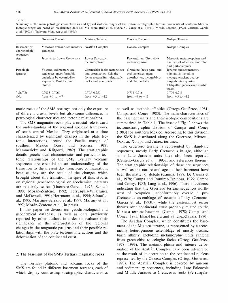
2. The basement of the SMS Tertiary magmatic rocks
The Tertiary plutonic and volcanic rocks of theSMS are found in di�erent basement terranes, each ofwhich display contrasting stratigraphic characteristics
as well as tectonic a�nities (Ortega-Gutie rrez, 1981;
Campa and Coney, 1983). The main characteristics of
the basement units and their isotopic compositions are
summarized in Table 1. The inset of Fig. 2 shows the
tectonostratigraphic division of Campa and Coney
(1983) for southern Mexico. According to this division,
the SMS is distributed along the Guerrero, Mixteca,
Oaxaca, Xolapa and Jua rez terranes.
The Guerrero terrane is represented by island-arc
sequences, mostly Early Cretaceous in age, although
some Late Jurassic units have also been reported
(Centeno-GarcõÂ a et al., 1993a, and references therein).
The stratigraphic relationships of these arc sequences
as well as the nature and age of their basement have
been the matter of debate (Campa, 1978; De Cserna et
al., 1978; Campa and RamõÂ rez-Espinosa, 1979; Campa
and Coney, 1983; Lang et al., 1996). There is evidence
indicating that the Guerrero terrane sequences north-
west of Acapulco unconformably overlie a pre-
Cretaceous assemblage of oceanic a�nity (Centeno-
GarcõÂ a et al., 1993b), while the easternmost sector
thrusts over continental crust probably related to the
Mixteca terrane basement (Campa, 1978; Campa and
Coney, 1983; Elõ as-Herrera and Sa nchez-Zavala, 1990).
The Acatla n Complex, which constitutes the base-
ment of the Mixteca terrane, is represented by a tecto-
nically heterogeneous assemblage of mostly oceanic
basin a�nity, including metamorphic units ranging
from greenschist to eclogite facies (Ortega-Gutie rrez,
1978, 1993). The metamorphism and intense defor-
mation of the Acatla n Complex have been interpreted
as the result of its accretion to the continental nucleus
represented by the Oaxaca Complex (Ortega-Gutie rrez,
1993). The Acatla n Complex is covered by igneous
and sedimentary sequences, including Late Paleozoic
and Middle Jurassic to Cretaceous rocks (FerrusquõÂ a-
Table 1
Summary of the main petrologic characteristics and typical isotopic ranges of the tectono-stratigraphic terrane basements of southern Mexico.
Isotopic ranges are based on recalculated data (30 Ma) from Ruiz et al. (1988a,b), YanÄ ez et al. (1991), Mora n-Zenteno (1992), Centeno-Garcõ a
et al. (1993b), Talavera-Mendoza et al. (1995)
Guerrero Terrane Mixteca Terrane Oaxaca Terrane Xolapa Terrane
Basement or
characteristic
sequences
Mesozoic volcano-sedimentary
sequences
Acatla n Complex Oaxaca Complex Xolapa Complex
Age Jurassic to Lower Cretaceous Lower Paleozoic
metamorphism
Precambrian (Grenville)
metamorphism
Mesozoic metamorphism and
anatexis of older metamorphic
and plutonic units
Petrologic
features
Volcano-sedimentary arc
sequences unconformably
underlain by oceanic-like
sequences. Post tectonic
plutons
Greenschist facies metapelites
and greenstones. Eclogite
facies metapelites, ultrama®c
rocks and granitoids
Granulite facies para- and
orthogneisses, meta-
anorthosites, metagabbros
and charnockites
Igneous and sedimentary
migmatites including
metagraywackes, quartz-
amphibolites, quartz-
feldspathic gneisses andmarble
lenses87Sr/86Sr 0.7035±0.7060 0.705±0.750 0.704±0.716 0.704±0.715
eNd from +1 to +7 from +3 to ÿ12 from ÿ9 to ÿ13 from +3 to ÿ12
D.J. MoraÂn-Zenteno et al. / Journal of South American Earth Sciences 12 (1999) 513±535516

Villafranca, 1976; Mora n-Zenteno et al., 1993 andreferences therein).
The metamorphic basement of the Oaxaca terrane isrepresented by a Grenvillian age (900±1110 Ma) gran-ulite facies complex with ma®c and felsic ortho-gneisses, paragneisses as well as meta-anorthosites andcharnockites (Ortega-Gutie rrez, 1981, 1993). The post-metamorphic cover includes sedimentary sequences ofthe Tremadocian, Mississippian±Permian andJurassic±Cretaceous time intervals (Pantoja-Alor,1970; Schlaepfer, 1970).
The Xolapa terrane is composed of a lithologicallyheterogeneous mid-crustal amphibolite-facies assem-blage consisting of metagraywackes, quartz-amphibo-lites, quartz-feldspathic gneisses and marble lenses(Ortega-Gutie rrez, 1981; Corona-Cha vez, 1997;Tolson, 1998). A characteristic feature of this assem-blage is the occurrence of migmatites indicating di�er-ent degrees of anatexis and subsolidus di�erentiation.The timing of metamorphism of the Xolapa terrane isnot yet clear, since ages between Lower Cretaceousand Eocene have been reported (Mora n-Zenteno,1992; Herrmann, 1994).
The Jua rez terrane consists of Mesozoic sequencesof marine and continental sedimentary and volcano-
genic strata intensively deformed and thrusted with ageneral vergence to the east (Carfantan, 1986;Barbosa, 1994). The western margin of the Jua rez ter-rane north of the city of Oaxaca is de®ned by a west-dipping, NNW trending polygenic mylonitic shearzone which was reactivated in Middle Jurassic andTertiary times (Alaniz-A lvarez et al., 1996).
Information about the deep structure and lateralvariations of the lower crust in southern Mexico is lim-ited, but the general arrangement and tectonic historyportrayed by the exposed basement units suggest thatgradually younger fragments of continental crust wereaggregated around the Oaxaca Complex duringPaleozoic and Mesozoic times (Ortega-Gutie rrez,1993).
From an isotopic point of view, the basement rocksof the Guerrero terrane are quite primitive comparedto those of the Acatla n, Oaxaca and Xolapa complexes(Table 1). Typical 87Sr/86Sr and eNd values for theigneous rocks of the Guerrero terrane sequences (recal-culated to 30 Ma, i.e. the time of magmatism) rangefrom 0.7035 to 0.7060 and +1.0 to +7.0, respectively(Centeno-Garcõ a et al., 1993b; Talavera-Mendoza etal., 1995). The other terranes exhibit di�erent ten-dencies toward more evolved 87Sr/86Sr isotopic ratios
Fig. 2. Map of southwestern Mexico showing di�erent deformation domains and indicating their age. Where the age is not constrained it is indi-
cated by a question mark. Active features are indicated with an age of 0 Ma. For references to the timing of deformation see text. The inset
shows the distribution of tectonostratigraphic terranes after Campa and Coney (1983) as well as the Sierra Madre Oriental, the Sierra Madre
Occidental and the Trans-Mexican Volcanic Belt. Abbreviations used in the inset are, G=Guerrero terrane, J=Jua rez terrane, Ma=Maya ter-
rane, Mi=Mixteca terrane, O=Oaxaca terrane, SM=Sierra Madre terrane, SMO=Sierra Madre Occidental, TMVB=Trans-Mexican Volcanic
Belt, X=Xolapa terrane.
D.J. MoraÂn-Zenteno et al. / Journal of South American Earth Sciences 12 (1999) 513±535 517

and negative eNd values (YanÄ ez et al., 1991; RuõÂ z etal., 1988a,b), probably as a result of the in¯uence ofthe Oaxacan Grenville basement nucleus.
3. Cenozoic structural and tectonic setting of the SMS
The plate tectonic setting and evolution of southernMexico during the Tertiary is complex. From the earlyTertiary and until 29 Ma the Farallon plate was con-sumed beneath southern Mexico. Subduction of theGuadalupe plate, formed by fragmentation of theFarallon plate, occurred during the period between 29and 12.5 Ma. Since 12.5 Ma the Cocos and Riveraplates have been overridden by North America alongthe Acapulco Trench (Mammerickx and Klitgord,1982). It is uncertain whether or not these majorchanges in plate architecture and kinematics played arole in the determination of the patterns of magmatismassociated with subduction in southern Mexico and inthe development of the complex geometry of the defor-mation domains. In Oligocene to Miocene time the re-arrangement of the oceanic plates did not producesigni®cant variations in the age of oceanic crust beingsubducted, but rather slight variations in the conver-gence vectors.
At present, the Rivera and Cocos plates are beingsubducted along the Paci®c margin of Mexico and thesouthern limit of the North America plate is the left-lateral Polochic-Motagua transform fault zone innorthern Guatemala and Belize which extends towardthe east into the Caribbean Sea (Fig. 1 inset). TheCocos±Caribbean±North America triple junction is abroad zone of subsidence o� the coast of Salina Cruzde®ned by shallow normal fault seismicity (Guzma n-Speziale et al., 1989).
The conspicuous obliquity of the present-day volca-nic arc to the Acapulco Trench has been explained bya lateral decrease in the dip angle of the subductedCocos plate in such a way that the 100 km depth con-tour line is roughly parallel to the southern margin ofthe TMVB (Pardo and Sua rez, 1995). The angle ofsubduction of the Rivera plate at the western end ofthe TMVB and of the Cocos plate to the east of theIsthmus of Tehuantepec is about 458 (Pardo andSua rez, 1995; Ponce et al., 1992). The notably shallowCocos plate trajectory beneath southern Mexico isthus responsible for the obliquity of the TMVB withrespect to the trench. Since the angle of subductiona�ects the spatial distribution of magmatism withrespect to the trench (e.g. Urrutia-Fucugauchi andMorton-Bermea, 1997), it seems logical to try to usethe timing and distribution of magmatism in thisregion to trace the evolution of the subduction geome-try of the Cocos plate with time.
The truncated Paci®c continental margin of south-
west Mexico in combination with the presence ofmylonitic shear zones with a component of left-lateralmotion along the coast (Fig. 2) have been attributedby some workers to the eastward motion of theChortis block toward its present position in CentralAmerica during Neogene time (Ratschbacher et al.,1991; Herrmann et al., 1994; Schaaf et al., 1995).Comparative stratigraphy and the absence of similarmylonite zones to the northwest of Zihuatanejosuggest that the initial position of the Chortis blockwas no further west than Zihuatanejo (Schaaf et al.,1995). The amount of displacement predicted by thispaleoposition (600 km) is less than that calculated byRosencrantz and Sclater (1986) using ocean ¯oorbathymetry and magnetic anomaly data (1000 km).This discrepancy can be explained by E±W extensionof the Chortis block, as suggested by prominent N±Strending grabens (Schaaf et al., 1995) in Guatemalaand Belize. The displacement of Chortis along thecoast of Mexico brought rocks previously fairly distantfrom the continental margin to lie directly on thenewly formed trench. Mora n-Zenteno et al. (1996) andTolson (1998) have discussed in detail some of the geo-metric consequences of the eastward passage ofChortis, among which are the progressive exhumationof mid-crustal rocks and subduction erosion of uppermantle lithosphere along the newly formed continentalmargin. This o�shore passage of the Chortis blockduring the Oligocene is thus also a distinctly character-istic tectonic event that a�ected the magmatic and de-formation patterns of southern Mexico as well as theirtiming.
The timing and kinematics of Cenozoic regional de-formation in southern Mexico are still far from clear.We have summarized the available data in Fig. 2,including the ages of the structures where these areconstrained. There is general agreement that at leastthe central TMVB is undergoing present day N±S di-rected extension along E±W trending faults as a pos-sible result of gravitational collapse (Suter et al., 1992;Ferrari et al., 1994; Suter et al., 1995a,b). The avail-able data suggest that this extensional regime has beenactive since the late Miocene (Suter et al., 1995a).There is also a general consensus regarding the de®-nition of the fault-bounded Jalisco block at the west-ern end of the TMVB (Fig. 2) during the Miocene butdetails of its past and present kinematics and its inter-action with the Rivera plate are still debated (Barrieret al., 1990; Bandy et al., 1995; Quintero-Legorreta,1995; Ferrari, 1995; Rosas-Elguera et al., 1996).
Studies focusing on Cenozoic deformation inlandfrom the Paci®c and south of the TMVB are stillscarce but several are underway. Jansma and Lang(1997) have reported the presence of a NNW±SSEtrending graben structure in the Arcelia region ofMichoaca n and Guerrero states (Fig. 2) which they as-
D.J. MoraÂn-Zenteno et al. / Journal of South American Earth Sciences 12 (1999) 513±535518

sociate with Basin and Range extension, citing evi-dence for its activity prior to 32 Ma. Studies byMora n-Zenteno et al. (in press) in the Taxco regionhave recently indicated the presence of a NNE trend-ing system of sub-vertical right-lateral faults which cutignimbrites of 38±36 Ma but whose upper age limit isstill uncertain. Further to the east, in the southern partof the State of Puebla and the northwest part of theState of Oaxaca, we have identi®ed a region in whichN±S trending en echelon left-lateral transfer faultsbound down-thrown blocks with lacustrine sediment®lls interbedded with volcanic rocks of Oligocene age.The NW-trending Oaxaca fault (Fig. 2) exhibits acomplex history of displacement beginning in thePaleozoic followed by left-lateral motion in theJurassic (Nieto-Samaniego et al., 1995). Its most recentactivity has been described as normal fault motionwith the down-thrown block to the west and the strati-graphic and geochronologic studies carried out byFerrusquõ a-Villafranca et al. (1988) have left implicitthat the latest activity occurred during Miocene time.However, research centered directly on the fault, itskinematics, and timing has failed to provide conclusiveevidence regarding the age of its most recent normalmovement (Centeno-Garcõ a, 1988; Alaniz-A lvarez etal., 1996). To the south of the Oaxaca fault, we haverecognized E±W oriented graben structures for whichan early to middle Miocene age can be inferred on thebasis of K±Ar dates of pyroclastic material from thebasin ®ll (Ferrusquõ a-Villafranca, 1992).
Several studies have recognized the presence ofmylonitic shear-zones along the Paci®c coast of south-western Mexico (Fig. 2) (Ratschbacher et al., 1991;Mora n-Zenteno, 1992; Meschede et al., 1997; Corona-Cha vez, 1997; Tolson, 1998). Geochronological datahave constrained in detail the timing of crystal-plasticdeformation of two of these shear-zones, suggesting ayounging trend toward the southeast along the coast.The mylonite zones in the Zihuatanejo and Juchatengoregions have been studied from a structural point ofview by Meschede et al. (1997), but details of the tim-ing of deformation are lacking. The Tierra Coloradaintrusive, which clearly truncates the Tierra Coloradamylonite zone (Riller et al., 1992), has yielded concor-dant U±Pb zircon ages between 35.2 and 34.3 Ma(Herrmann et al., 1994), setting a minimum age for theshear-zone in this region, at least for crystal-plastic de-formation. In the vicinity of Huatulco, Oaxaca, Tolsonet al. (1993) and Tolson (1998) have shown that the 29Ma (Rb±Sr whole-rock and U±Pb zircon ages ofHerrmann et al., 1994) Huatulco granodiorite isa�ected by crystal-plastic mylonitic processes along theChacalapa shear-zone and that these mylonites aretruncated by granodioritic dikes which yielded a23.721.2 Ma K±Ar age using hornblende separates.It is important to emphasize that not only is there a
di�erence in the ages of the two shear-zones, but alsoa di�erence in the kinematic details. As shown in Fig.2, the Tierra Colorada shear-zone is a normal-left-lat-eral oblique shear zone, with a moderate dip to thenortheast (Mora n-Zenteno, 1992), while the Chacalapashear-zone is a sub-vertical anastomosing shear-zonewith strictly left-lateral kinematic indicators (Tolson,1998). In addition, in the region between Puerto A ngeland Salina Cruz, Delgado-Argote and Carballido-Sa nchez (1990) and Tolson (1998) have documentedthe presence of active left-lateral faults with E±W andNE±SW trends.
Meschede et al. (1997) published fault-slip analysisdata from southern Mexico to which they appliedinversion techniques in order to determine the stress®eld. They used crosscutting and overprinting relation-ships to determine relative ages for their data andfurther subdivided them using kinematic compatibilityarguments. They compared the stress tensor orien-tations resulting from the stress inversion to the avail-able data for Cenozoic stage poles for the Farallonplate (and its derivatives) with respect to NorthAmerica. On the basis of this comparison, Meschedeet al. (1997) concluded that there was an e�ectivestress transmission across the North American plateboundary and that the stress ®eld in southern Mexicoprior to 25 Ma had s2 in a sub-vertical orientationand s1 with a northeasterly trend roughly parallel tothe motion vector of the oceanic plate (with respect toNorth America). Their data indicate that, since 25 Ma,the stress ®eld has a vertical maximum stress orien-tation and that s3 is perpendicular to the regionaltrend of topography throughout their study area insouthern part of the State of Oaxaca.
The distribution and characteristics of the major tec-tonic features described above are not necessarily fullycompatible with the stress-®eld evolution described byMeschede et al. (1997), but the discrepancies may beexplained by shear-zone reactivation and mechanicalheterogeneity of the continental crust in southernMexico.
4. Geochronological, petrographic and geochemicalfeatures of Tertiary igneous rocks of the SMS
Although the geochronology and geochemistry ofthe plutonic rocks of the SMS have been studied withsome detail in certain parts of southwestern Mexico(Guerrero-Garcõ a, 1975; Pantoja-Alor, 1983, 1992;Schaaf, 1990; Delgado-Argote et al., 1992; Mora n-Zenteno, 1992; Herrmann et al., 1994; Schaaf et al.,1995; Herna ndez-Bernal and Mora n-Zenteno, 1996;Calva-Guerra, 1996; Correa-Mora, 1997), the dataavailable for the volcanic rocks are more limited.However, recent work on the Tertiary volcanic
D.J. MoraÂn-Zenteno et al. / Journal of South American Earth Sciences 12 (1999) 513±535 519

Table
2a
Geochronologic
data
forTertiary
igneousrocksoftheSMS,mainly
oftheinlandregion,complementary
tothose
presentedbySchaafet
al.(1995)forthecoastalplutonic
belt.(a)Table
includ-
ingdatesobtained
byusandreported
inpublished
papersorin
theses
forwhichcomplete
inform
ationisavailable
Locality
Longitude(W
)Latitude(N
)Sample
no.
Rock
typeorform
ation
AgeMa
Materialdated
Method
Reference
f
Michoaca n
Tzitzio
100856'
19836'
Mx-88-17
Ignim
brite
33.4
21.7
Sanidine
K±Ar
7
Me xico
MataRedonda
100809'240a
19808'120a
AM-11
Rhyolitictu�
33.6
20.9
K-feldspara
K±Ar
13
Cerro
ElPenÄon
100807'070a
19803'380a
AT-2
Rhyolite
31.6
20.8
K-feldspara
K±Ar
13
ArroyoElCastillo
100806'000a
19801'100a
M-01
Lamprophyre
46.6
21.2
Biotite
aK±Ar
13
Guerrero
Teteladel
RõÂ o
100805'a
17858'a
CFE-2
Basalt
42.3
21.4
WR
eK±Ar
2
Xaltianguis
99850.43'
17809.95'
FC19a,b,c
Granodiorite
todiorite
282
1.5
3pt.WR
isochron
Rb±Sr
12
Taxco
99838'550
18837'500
TX-21
Ignim
brite
32.4
20.8
Biotite
K±Ar
15
Taxco
99838'150
18834'300
TX-10
Rhyolite
31.6
21.2
Plagioclase
K±Ar
15
Taxco
99837.4'
18833.4'
M48-51
Rhyolitictu�
492
3WR
K±Ar
5
Taxco
99837'170
18833'500
TX-25
Vitrophyre
31.9
20.8
WR
K±Ar
15
Taxco
99836'b
18834'b
n.r.d
Rhyolite
36.9,35.5
21.3
K-feldspar,WR
K±Ar
3
Taxco
99836'150
18835'500
TX-16
Vitrophyre
32.4
20.9
WR
K±Ar
15
Taxco
99832'450
18834'150
TX-4
Vitrophyre
38.2
21.0
WR
K±Ar
15
SanJuanTetelcingoarea
99831'a
17856'a
n.r.
Tu�
662
2.3
Biotite
K±Ar
4
SanJuanTetelcingoarea
99831'a
17856'a
CFE-1
Basalt
52.4
21.8
WR
K±Ar
2
SierradeAlquitra n
99829'230a
17826'250a
ALV96
Ignim
brite,Alquitra n
Fm.
24.0
20.8
Volcanic
glass
K±Ar
11
SierradeAlquitra n
99828'400a
17819'540a
AOV96
Ignim
brite,Alquitra n
Fm.
22.5
20.6
Volcanic
glass
K±Ar
11
CoxcaclaÂn
99827'300a
18829'450a
BV-21
Granodiorite
32.2
20.7
Biotite-W
RRb±Sr
14
SanMarcos
99824'410a
16846'440a
DM941b
Granodiorite
33.5
20.7
Biotite-W
RRb±Sr
14
Buenavista
99824'050
18817'000
BV-17
Dacititc
lava
30.5
21.1
Plagioclase
K±Ar
15
Buenavista
99823'350
18817'000
BV-12
Daciticlava
24.8
21.3
Hornblende
K±Ar
15
Quetzalapa
99811'150
18821'000
SOL-5
Daciticignim
brite
31.9
20.8
Biotite
K±Ar
15
CruzGrande
99807'300
16843'130
DM94b
Granodiorite
35.7
20.7
Biotite-W
RRb±Sr
14
DSDPLeg
66site
493
98855.53'
16822.87'
493-59-1
Diorite
36.4,34.5
22
WR
K±Ar
6
DSDPLeg
66site
493
98855.53'
16822.87'
493-59-2
Diorite
352
2WR
K±Ar
6
Oaxaca
Zacatepec
97859.06'b
16846.16'b
JG73-16A
Granodiorite
252
1Biotite-W
RRb±Sr
8
Sta.Ma.Zacatepec
97858'250
16853'270
CON-53
Granite
25.5
20.7
Biotite
K±Ar
16
Chila
97852'080b
17857'330b
SIC
HIL
A-1
Andesitic
laccolith
302
1WR
K±Ar
10
LagunadeGuadalupe
97851'230
17811'190
CON-59B
Silicic
tu�
34.8
21.4
Hornblende
K±Ar
16
ZapotitlaÂnPalm
as
97848'290b
17853'230b
SVZA-3
Basalt
322
1WR
K±Ar
10
ZapotitlaÂnPalm
as
97848'290b
17853'230b
SVZA-1
Basalt
312
1WR
K±Ar
10
ZapotitlaÂnPalm
as
97848'290b
17853'230b
SVZA-4
Basaltic
andesite
302
1WR
K±Ar
10
ZapotitlaÂnPalm
as
97848'290b
17853'230b
SVZA-2
Basaltic
andesite
292
1WR
K±Ar
10
Huajuapan
97847'170
17849'470
CON-8A
Andesitic
stock
33.6
21.4
Hornblende
K±Ar
16
Huajuapan
97847'150b
17849'340b
SIL
C-1
Basaltic
andesiteintrusion
312
1WR
K±Ar
10
NorthofHuajuapan
97841'460
18804'510
CON-75
Rhyodacitictu�
31.4
20.8
Biotite
K±Ar
16
NorthofHuajuapan
97840'520
18802'360
CON-91
Andesitic
dike
34.2
21.4
Hornblende
K±Ar
16
Tlaxiaco
97836'440
17821'400
CON-101
Rhyolitictu�
32.9
20.9
Biotite
K±Ar
16
Tamazulapan
97834.08'b
17842.82'b
FV69-180
Tu�,LlanodeLobosFm.
26.2
20.5
Biotite
K±Ar
1
D.J. MoraÂn-Zenteno et al. / Journal of South American Earth Sciences 12 (1999) 513±535520

sequences in northwestern Oaxaca and northeasternGuerrero by some of the authors of this paper and byFerrusquõÂ a-Villafranca (1992) has provided infor-mation on the nature of these sequences and regionalpetrological and geochemical variations have beennoted.
The methods used and the materials dated in geo-chronologic studies of the magmatic rocks of the SMSare diverse. Our analysis was based on our own geo-chronologic data as well as on dates published in theliterature or presented in theses that we considered re-liable. In the evaluation of dates published by otherauthors, we took into consideration their general com-patibility with stratigraphic observations and the suit-ability of the method applied with respect the materialdated. The dating methods used for plutonic rocks areindicative of di�erent stages in the crystallization-cool-ing process. For intrusive units dated with di�erentmethods we gave preference in our regional analysis tothose data that better approximate the crystallizationage. Nonetheless, when only one method was applied,we assumed in most cases that cooling occurred in atime interval short enough that it did not signi®cantlydistort the regional geochronological patterns. Thisassumption was based on the fact that most Tertiaryplutons of coastal Oaxaca and Guerrero on whichdi�erent geochronologic methods were applied dis-played U±Pb, K±Ar and Rb±Sr mineral ages that indi-cate a relatively high cooling rate related to a rapiduplift of the continental margin (Mora n-Zenteno et al.,1996). A ®rst compilation of isotopic ages of thesouthwestern continental margin of Mexico hasalready been presented by Schaaf et al. (1995). In thispaper we present a complementary list of dates com-piled for the volcanic rocks and related intrusive unitsof the inland areas (Tables 2a and b). Table 2a liststhose dates for which complete information has beengiven, including the locality, analytical uncertainties, aswell as material and rock unit dated. Table 2b includesthose dates for which complete information has notbeen published. Major and trace element compositionsas well as isotopic data discussed in this paper are pre-sented in more detail elsewhere (Schaaf, 1990;Herna ndez-Bernal and Mora n-Zenteno, 1996; Mora n-Zenteno et al., in press; Martiny et al., in press). Theanalytical details and related uncertainties of the dataare discussed in the cited papers.
A description of the petrology, geochronology andgeochemistry of the coastal plutonic belt as well as thevolcanic rocks in four selected areas is summarizedbelow.
4.1. Coastal plutonic belt
The composition of the plutons along the coastalmargin generally varies from dioritic to graniticE
.ofTamazulapan
97825'b
17834.78'b
FV60-182
YucudaacAndesite
28.9
20.6
WR
K±Ar
1
Yanhuitla n
97823'360
17834'050
CON-7
Daciticlaccolith
40.5
21.7
Hornblende
K±Ar
16
Huitzo-Etla
96851.72'b
17815.49b
FV69-185
Tu�,SuchilquitongoFm.
17.4,16.5
20.3
Biotite
K±Ar
1
Huatulco
96828'a
15850'a
H230
Granite
25.2
20.5
cBiotite-W
RRb±Sr
9
Huatulco
96809'a
15847'a
H113
Granite
25.1
20.5
cBiotite-W
RRb±Sr
9
Huatulco
96807'a
15846'a
H247
Granite
26.7
20.5
cBiotite-W
RRb±Sr
9
Xadani
96802'a
15856'a
H250
Tonalite
20.4
20.4
cBiotite-W
RRb±Sr
9
Ayuta
95852'
15853'
H239
Granite
20.9
20.4
Biotite-W
RRb±Sr
17
JuaÂrez
95827'
16825'
H234
Tonalite
13.6
20.3
Biotite-W
RRb±Sr
17
JuaÂrez
95826'
16820'
H235
Quartzdiorite
14.9
20.3
Biotite-W
RRb±Sr
17
Bomba
95824'
16802'
H029
Granite
16.6
20.3
Biottie-W
RRb±Sr
17
aPersonalcommunicationbyauthor(s).
bCoordinatestaken
from
maporfrom
inform
ationin
originalreference.
cAgereported
previouslyin
Schaafet
al.(1995)andcorrectedin
thepresentstudy.
dn.r.=
notreported.
eWR=whole
rock.
f1.FerrusquõÂ a-V
illafranca
(1976);
2.DeCserna(1981);
3.DeCsernaand
Fries
(1981);
4.Ortega-G
utie rrez(1980);
5.Linaresand
Urrutia-Fucugauchi(1981);
6.Bellon
etal.
(1982);
7.
PasquareÁet
al.
(1991);
8.Guerrero-G
arcõÂ a
and
Herrero-Bervera(1993);
9.Schaafet
al.(1995);
10.Galina-H
idalgo
(1996);
11.HernaÂndez-TrevinÄo
etal.
(1996);
12.Correa-M
ora
(1997);13.
ChaÂvez-A
guirre
andMendoza-Flores(1998);14.Alba-A
ldaveet
al.(1998);15.Mora n-Zentenoet
al.(inpress);16.Martinyet
al.(inpress);17.SolõÂs-Pichardo,PhD
thesis(inprep.).
D.J. MoraÂn-Zenteno et al. / Journal of South American Earth Sciences 12 (1999) 513±535 521

although more ma®c units have been observed. TheirSiO2 content typically varies from 56 to 74 wt% andin a TAS diagram (Na2O+K2O vs SiO2), these plu-tons show a sub-alkalic trend (Fig. 3a). They are light-REE enriched (LaN/LuN between 4 and 20) and ingeneral display a ¯at pattern for heavy-REE (Fig. 4b).These geochemical features are typical of fractionalcrystallization processes in mantle derived magmas.The plutonic rocks from the Acapulco and Xaltianguisintrusives show a negative Eu anomaly (Fig. 4a) thatmay be explained by plagioclase fractionation(Negendank et al., 1987).
The isotopic age data of the SMS (Table 2 of thispaper and Table 1 of Schaaf et al., 1995) show thatthe Tertiary intrusive rocks of the CPB in the regionbetween the states of Michoaca n and Oaxaca show alarge variation in age, ranging from early Paleocene(6321 Ma hornblende K±Ar; Pantoja-Alor, 1983) inAquila, Michoaca n, near Punta San Telmo, to middleMiocene (13.620.3 Ma whole-rock-biotite Rb±Sr) in
the Isthmus of Tehuantepec area (Table 2a). To thenorthwest, the older Puerto Vallarta and Manzanillobatholiths were emplaced in the Cretaceous.Crystallization ages for the Puerto Vallarta region aregiven by U±Pb zircon dating in granodiorites(10326.5 and 10123.4 Ma) and two Rb±Sr whole-rock isochrons in granitoids (9924 and 9123 Ma).For granitoids in the Manzanillo area, a Rb±Sr whole-rock isochron yielded 6923 Ma (Schaaf et al., 1995).
The ages of the Michoac n and Guerrero coastal plu-tons are similar to those obtained for inland intrusiveslocated in south central Michoaca n. The Santa Elenaand La Huacana plutons yielded ages of 66.121.5 Ma(K±Ar) and 4224 Ma (Rb±Sr isochron), respectively(Pantoja-Alor, 1986; Schaaf et al., 1995). Other plu-tons (La Verde, Inguara n, San Isidro) give biotite,hornblende and sericite K±Ar age determinations of35.620.8 to 31.820.7 Ma for granodiorites and re-lated mineralization (Damon et al., 1983). These agesare somewhat anomalous in the regional context,
Table 2b
(b) List of dates for which complete information is not available
Locality Rock type
or formation
Age Ma Material
dated
Method Referenced
Jalisco
Techalutla Granodioritea 6922 Hornblendea K±Ar 7
Tamazula Batholith 5321 K-feldspara K±Ar 7
MichoacaÂn
Punta San Telmo Granodioritea 5526 Hornblendea K±Ar 7
Ziquira n Porphyritic diorite 34.328 Hornblendea K±Ar 3
Guerrero
Highway between Cd. Altamirano and Zihuatanejo,
km 30
Andesite 61.221.3 Plagioclasea K±Ar 3
Between Cd. Altamirano and Zihuatanejo Dike 46.525% n.r.b K±Ar 5
Highway between Cd. Altamirano and Zihuatanejo,
km 70
Porphyritic diorite 46.221.1 Plagioclasea K±Ar 3
Between Cd. Altamirano-Zihuatanejo Andesites 43-4622 n.r. K±Ar 6
Highway between Cd. Altamirano and Zihuatanejo,
km 67
Andesitic dike 42.921 Plagioclasea K±Ar 3
10 km W of Cd. Altamirano Diorite 36.628 WRa,c K±Ar 3
Between Cd. Altamirano and Zihuatanejo Dikes 33-4522 n.r. K±Ar 6
San Juan Tetelcingo area Basalt, Tetelcingo Formation 68.822.4 WR K±Ar 2
7 km E of Balsas railroad station Granodiorite 66.121.5 Hornblendea K±Ar 3
Vallecitos de Zaragoza granitoid Diorite to quartz monzonite 3625 n.r. Rb±Sr 6
Poliutla Rhyolitic ignimbrite 42.321 Plagioclasea K±Ar 3
El Ocotito, sample JG74-01 Quartz monzodiorite 3822 Biotite-WR Rb±Sr 1
Acapulco Granite 5020.5 Biotite-WR Rb±Sr 8
Km 91.9 Highway Chilpancingo to Acapulco,
sample JG73-24
Quartz monzonite 32.723 Biotite-WR Rb±Sr 1
Oaxaca
Suchilquitongo-Etla Tu�, Suchilquitongo Formation 20.6, 19.320.3 n.r. K±Ar 4
Tlacolutla-Mitla-Matatla n area Tu� 16.0ÿ15.3220.8 n.r. K±Ar 4
Nejapa area Tu� 17.4ÿ15.020.8 n.r. K±Ar 4
a Personal communication by author(s).b n.r.=not reported.c WR=whole rock.d 1. Guerrero-Garcõ a (1975); 2. Ortega-Gutie rrez (1980); 3. Pantoja-Alor (1986); 4. Ferrusquõ a-Villafranca and McDowell (1991); 5. Kratzeisen
et al. (1991); 6. Frank et al. (1992); 7. Pantoja-Alor (1992); 8. Guerrero-GarcõÂ a and Herrero-Bervera (1993).
D.J. MoraÂn-Zenteno et al. / Journal of South American Earth Sciences 12 (1999) 513±535522

which may suggest a local, post-intrusive thermalevent.
Tertiary coastal plutons of the Guerrero terranebetween Zihuatanejo and Acapulco were emplaced inlate Eocene to Oligocene time (Fig. 1). A Rb±Srwhole-rock isochron yielded an age of 36.525 Ma forthe granitoids of the Zihuatanejo area (Schaaf et al.,1995). The granitic batholith exposed in the Petatla n
area, southeast of Zihuatanejo, yielded hornblende andbiotite K±Ar ages ranging from 40.720.9 to37.421.5 Ma (Delgado-Argote et al., 1992; Schaaf etal., 1995; Stein et al., 1994). In this same general area,the ultrama®c rocks of El Tamarindo and Loma Bayaare related to Cretaceous magmatism and have beenstudied in detail by Delgado-Argote et al. (1992).
Farther to the southeast, a U±Pb zircon crystalliza-
Fig. 3. Chemical classi®cation of Tertiary magmatic rocks of the Sierra Madre del Sur, Mexico. (a) Samples of the coastal plutonic belt (TAS
diagram after Wilson, 1989); data of the Xaltianguis pluton after Correa-Mora (1997). (b) Samples of the inland Tertiary volcanic sequences
(TAS diagram after Le Maitre et al., 1989). Note that in the northwestern Oaxaca region basaltic andesite and andesitic compositions are domi-
nant. The three samples of rhyolitic composition correspond to minor pyroclastic units. Volcanic rocks of Guerrero and Morelos regions range
from andesites to rhyolites but most of them fall in the dacite and rhyolite ®elds. The data plotted are in Martiny et al. (in press) and Mora n-
Zenteno et al. (in press).
D.J. MoraÂn-Zenteno et al. / Journal of South American Earth Sciences 12 (1999) 513±535 523

tion age of 35 Ma was obtained for a granodiorite SEof Atoyac (Herrmann et al., 1994). The TierraColorada, Xaltianguis, San Marcos and Cruz Grandegranodioritic plutons give biotite Rb±Sr ages rangingfrom 35 to 26 Ma (Schaaf et al., 1995; Alba-Aldave etal., 1998). In addition to these dates, U±Pb zircon agesare reported for the intrusives of Tierra Colorada (34.3Ma), San Marcos (31 Ma) and Cruz Grande (32 Ma)(Herrmann et al., 1994).
The Acapulco granite displays notably older coolingages than other plutonic rocks in the region (43.420.9Rb±Sr biotite-whole-rock; Schaaf, 1990; 5020.5 Ma
(Guerrero-GarcõÂ a and Herrero-Bervera, 1993).Furthermore, the Acapulco intrusive is remarkable inthat it includes a granite with pseudorapakivi textureand a two pyroxene-bearing syenite facies. Fayaliteand ¯uorite have also been reported as accessories andsome samples have trace-element distributions thatplot in the ``within-plate-granites'' ®eld of Pearce et al.(1984).
Farther to the east, between Acapulco andHuatulco, there are younger intrusive rocks. The U±Pb ages obtained by Herrmann et al. (1994) fromPinotepa Nacional to Huatulco range from 30 to 27
Fig. 4. Chondrite-normalized REE patterns of Tertiary magmatic rocks of the Sierra Madre del Sur (chondrite values of Nakamura, 1974). (a)
Coastal plutonic belt; note the Eu anomaly in the intrusives of Xaltianguis and Acapulco. (b) Inland Tertiary volcanic sequences of northeastern
Guerrero and western Oaxaca.
D.J. MoraÂn-Zenteno et al. / Journal of South American Earth Sciences 12 (1999) 513±535524

Ma. The K±Ar dates from hornblende concentratesreported by Herna ndez-Bernal and Mora n-Zenteno(1996) for the Rio Verde batholith, east of PinotepaNacional, are 29.9 and 27.7 Ma. K±Ar biotite determi-nations of rocks exposed to the north and east ofPinotepa Nacional yielded 27.7 to 23.5 Ma(Herna ndez-Bernal and Mora n-Zenteno, 1996;Martiny et al., in press). Between Puerto A ngel andSalina Cruz, K±Ar and Rb±Sr age determinationsfrom biotite concentrates obtained by Solõ s-Pichardorange from 2720.5 to 13.620.3 Ma (Schaaf et al.,1995; Table 2a, this paper). O�shore of PinotepaNacional the dioritic rocks cut by Leg 66 of the DSDPyielded whole-rock ages of 34.522 to 36.421.8 Ma(Bellon et al., 1982).
The plutons between Punta San Telmo and the areawest of Acapulco, with a few exceptions, typicallyshow initial 87Sr/86Sr ratios between 0.7035 and 0.7049and eNd values from +5.7 to +3.1. Initial 87Sr/86Srratios of the La Verde, Inguara n and San Isidro inlandplutons range from 0.7039 and 0.7055 (Damon et al.,1983). In the Acapulco region, the Oligocene intrusiveshave slightly higher initial 87Sr/86Sr ratios of 0.7041±0.7050, and lower initial eNd of +2.9 and +1.6(Schaaf, 1990; Correa-Mora, 1997). Between Acapulcoand Huatulco the initial 87Sr/86Sr ratios of the plutonicrocks range from 0.7040 to 0.7054; eNd values are gen-erally lower than to the west of Acapulco, and rangefrom +3.5 to ÿ3.0; (Mora n-Zenteno, 1992;Herrmann, 1994; Herna ndez-Bernal and Mora n-Zenteno, 1996; Martiny et al., 1997).
4.2. Inland volcanic ®elds
The volcanic sequences of the Sierra Madre del Surare not as well studied as those of the CPB and thedata presented below were obtained from two transectsperpendicular to the coast. The volcanic units consistof intermediate- to high-K, sub-alkalic rhyolites tobasaltic andesites, with SiO2 content between 53 and76 wt% (Fig. 3b). Chondrite normalized REE patternsdisplay typical magmatic arc behavior, with LREEenrichment relative to HREE (LaN/LuN between 5 and14; Fig. 4b). Eu anomalies in the volcanic rocks of theTaxco area (Eu/Eu�0 0.4) are probably related to crys-tal fractionation of plagioclase. In the area ofBuenavista, Huautla and northwestern Oaxaca, thevolcanic rocks do not display a signi®cant Euanomaly.
Initial 87Sr/86Sr ratios of andesites and basaltic ande-sites from northwestern Oaxaca range from 0.7042 to0.7046, and eNd values, from 0 to +2.6 (Martiny etal., in press). Dacites and rhyolites of similar age fromthe Taxco area show evidence of either a greaterdegree of crustal contamination or more evolvedsource rocks since their initial 87Sr/86Sr ratios range
from 0.7051 to 0.7063 (Mora n-Zenteno et al., inpress). This inference is corroborated by the lead isoto-pic data reported by Martiny et al. (1997). Pb isotoperatios of the Tertiary magmatic rocks from westernOaxaca show a narrow range [(206Pb/204Pb)=18.669±18.749; (207Pb/204Pb)=15.587±15.623; (208Pb/204Pb)=38.442±38.588] whereas the more acidic volcanic rocksfrom northeastern Guerrero are slightly more radio-genic [(206Pb/204Pb)=18.745±19.000; (207Pb/204Pb)=15.599±15.651; (208Pb/204Pb)=38.557±38.818].
4.2.1. Western GuerreroIn the southwestern part of the State of Guerrero,
the Tertiary volcanic rocks of the Sierra Madre delSur have been dated in the Zihuatanejo-Vallecitos area(Pantoja-Alor, 1986; Frank et al., 1992; Kratzeisen etal., 1991). Between Zihuatanejo and Cd. Altamiranothe most widespread unit is a 1500 m thick series ofhigh-K, and pyroxene-bearing porphyritic basalticandesite to dacitic lava ¯ows, and intermediate to felsictu�s and ignimbrites (Kratzeisen et al., 1991). Thissequence is cut by numerous andesitic to dacitic dikesof varying dimensions trending NE±SW and NW±SE.The time range for these igneous sequences is given byK±Ar age determinations and varies from 46 to 43 Mafor the andesites and from 45 to 33 Ma for the dikes(Kratzeisen et al., 1991). Given the scarcity of datafrom this region, and their broad range, it is not poss-ible to con®rm if these constitute a single event of 12million year duration or two separate events. In theCd. Altamirano area, dikes and tu�s were dated at46.2±42.3 using K±Ar (Pantoja-Alor, 1986). The onlyother Oligocene volcanic rocks in the general regionare exposed in the Mil Cumbres, Michoaca n, areawhere a sanidine K±Ar age of 33.421.7 Ma has beenreported (PasquareÁ et al., 1991).
4.2.2. Northeastern GuerreroThe Oligocene volcanic rocks in northeastern
Guerrero are distributed in three main areas: Taxco,Buenavista-Quetzalapa and Huautla. Other Tertiaryvolcanic rocks of Oligocene age have been reported inthe Tejupilco area, State of Mexico, and include exten-sive sequences of ignimbrites forming the Sierra de laGoleta, Sierra de Nanchititla and the Mesa delNaranjo. Similar rocks have also been reported in theTenancingo-Ixtapan de la Sal, State of Mexico, area(De Cserna, 1982; Garcõ a-Palomo, 1997). The volcanicsection in the Taxco area consists of rhyolitic ignim-brites, vitrophyres, ¯ow and ash fall tu�s, forming asequence up to 800 m thick. K±Ar dates in volcanicglass, plagioclase and biotite show that the age of thelower part of the sequence ranges from 38.2 to 35.5Ma (De Cserna and Fries, 1981; Mora n-Zenteno et al.,in press), whereas that of the upper part, from 32.4 to
D.J. MoraÂn-Zenteno et al. / Journal of South American Earth Sciences 12 (1999) 513±535 525
31.6 Ma (Mora n-Zenteno et al., in press). These resultssuggest that the Taxco sequence originated from twodistinct volcanic events.
The Buenavista±Quetzalapa range, 30 km southeastof Taxco, is formed by a series of dacitic ignimbritesand lava ¯ows with a maximum total thickness ofabout 900 m. A 31.921.1 Ma biotite K±Ar age wasobtained for the lower part of the sequence, rep-resented by dacitic ignimbrites of the TilzapotlaFormation, whereas the upper part, represented bydacites of the Buenavista Formation, yielded a plagio-clase K±Ar age of 30.521.1 Ma (Mora n-Zenteno etal., in press) (Table 2a). These rocks are related to acaldera about 20 km in diameter, which originatedduring the early stage of volcanic activity and under-went later resurgent activity.
4.2.3. Northwestern OaxacaIn the Huajuapan±Tamazulapan±Yanhuitla n region,
the volcanic sequences are dominated by andesite andbasaltic andesite lavas that overlie a sequence of epi-clastic beds and some silicic ash fall and ash ¯ow tu�s(Fig. 3b). Farther south in the Tlaxiaco region, theTertiary volcanic rocks range from felsic to intermedi-ate pyroclastic and epiclastic deposits. The maximumthickness of the Tertiary volcanic sequences in thisregion is about 500 m. Throughout northwesternOaxaca, numerous dacitic and andesitic hypabyssalintrusives (stocks and dikes) are emplaced at di�erentlevels of the volcanic sequence (Martõ nez-Serrano etal., 1996). In some areas the volcanic rocks are inter-layered with lacustrine deposits, which have been inter-preted as accumulated in fault-bounded tectonic basins(Martiny et al., 1995). The time range for the volcan-ism in northwestern Oaxaca is 34.8±31.4 Ma (Table2a) based on biotite and hornblende K±Ar ages of thetu�s and hypabyssal rocks (Martiny et al., 1997).These dates are relatively consistent with the whole-rock K±Ar ages (32±29 Ma) for hypabyssal rocks andlavas in the Huajuapan area (Galina-Hidalgo, 1996).In the Tamazulapan±Yanhuitla n area, Ferrusquõ a-Villafranca and McDowell (1991) obtained a youngerwhole rock K±Ar age of 28.9 Ma for an andesitic lavaand a biotite age of 26.2 Ma for a tu�. Up to now, inthis region only one Eocene K±Ar hornblende age of40.521.7 Ma (Table 2a) has been obtained for a lac-colith associated with the Yanhuitla n Formation thatseems to represent the earliest manifestations ofTertiary magmatism in this region.
4.2.4. Central and southeastern OaxacaThis region covers a broad area including NW of
the city of Oaxaca, Tlacolula-Mitla and Nejapa withvariations in the age and composition of volcanic pro-ducts. In general, the volcanic sequences are consti-tuted by siliceous tu�s, volcaniclastic deposits,
rhyolitic to andesitic lava ¯ows interbedded with lacus-trine deposits and intruded by rhyolitic to latitic hypa-byssal rocks (FerrusquõÂ a-Villafranca and McDowell,1991). Pyroclastic deposits are more abundant thanlava ¯ows in this region. The K±Ar age determinationsof central and southeastern Oaxaca range from 20.6near the city of Oaxaca to 15.0 Ma in Nejapa(FerrusquõÂ a-Villafranca and McDowell, 1991).
5. Geochronologic patterns
The geochronological database of the SMS mag-matic rocks (Table 2 and Schaaf et al., 1995) indicatesthat arc-magmatism was active, with di�erent spatialdistributions, from Paleocene to middle Miocenetimes. Fig. 5 shows the distribution of arc magmaticrocks for four di�erent times. There is a recognizabletendency of the older magmatic rocks to dominate inthe westernmost region of the SMS. This behavior wasidenti®ed by Schaaf et al. (1995) for the plutonic rocksalong the continental margin between Puerto Vallataand Acapulco. Fig. 6a shows a plot of ages versus dis-tance from Puerto Vallarta. The ages of intrusiverocks along the coastal segment between PuertoVallarta and Zihuatanejo range from 100 to nearly 35Ma. From Zihuatanejo to the Huatulco region there isalso a decreasing age trend in the extinction of mag-matism but with a higher rate of migration. Schaaf etal. (1995) calculated a rate of 1.2 cm/a for the ®rst seg-ment and 7.7 cm/a for the second. Based only on U±Pb zircon ages of di�erent plutons from the Acapulcoregion to Huatulco, Herrmann et al. (1994) calculateda decreasing age rate of 5.59 cm/a.
The Late Cretaceous±Paleocene magmatism is rep-resented by the Puerto Vallarta, Manzanillo and SanTelmo plutons (Fig. 1) (Schaaf, 1990; KoÈ hler et al.,1988; Schaaf et al., 1995). Paleocene to Eocene mag-matic rocks, including the inland volcanic areas, liemainly to the west of 1008W meridian, distributedfrom the coastal margin to a distance up to 300 kmfrom the present-day trench (Fig. 5a). Eocene magma-tism dominates in the Zihuatanejo region and inlandfrom it, including the extensive outcrops of andesitesof the Balsas River basin in the Presa del In®ernilloregion (Kratzeisen et al., 1991; Delgado-Argote et al.,1992; Pantoja-Alor, 1983). In the inland region ofMichoaca n and western Guerrero, there are also sev-eral calc-alkaline plutonic rocks for which Eocene ageshave been reported (Pantoja-Alor, 1983; Alba-Aldaveet al., 1996). The relatively scarce basaltic ¯ows inter-calated in the continental sequences of the BalsasFormation are indicative of isolated Eocene volcanismthat extends toward the east to the eastern part of theState of Guerrero (De Cserna, 1981). In addition tothe basaltic intercalations of the Balsas Formation,
D.J. MoraÂn-Zenteno et al. / Journal of South American Earth Sciences 12 (1999) 513±535526

Fig.5.DistributionoftheTertiary
magmaticarc
rocksoftheSierraMadre
del
Suratdi�erenttimes
(a)Paleocene±Eocene;
(b)Oligoceneand(c)middle
Miocene±Plio-Q
uaternary.
D.J. MoraÂn-Zenteno et al. / Journal of South American Earth Sciences 12 (1999) 513±535 527

east of 1008W longitude, few localities of magmaticrocks have been reported with Eocene ages (MartõÂ nez-Serrano et al., 1997).
The early Oligocene magmatic rocks (36±30 Ma) aredistributed mostly in the eastern half of the SMS andde®ne a broad zone that extends eastward from the
Zihuatanejo and Taxco±Tejupilco regions (Alba-Aldave et al., 1996) to west central Oaxaca, includingsouthern Puebla and the Huajuapan±Tlaxiaco region(Fig. 5b) (Martiny et al., 1996). In the Acapulco±Taxco sector Oligocene magmatism was in general coe-val, indicating the occurrence of an arc of at least
Fig. 6. (a) Graph of pluton ages vs distance from Puerto Vallarta along the coast. Only data from the coastal plutonic belt are plotted. (b)
Graph of age vs distance inland from the Acapulco Trench along section A±A '. (c) Graph of age vs distance inland from the Acapulco Trench
along section B±B '. Section lines for (b) and (c) are shown on Fig. 1. For A±A ' and B±B ' sections age uncertainties are indicated.
D.J. MoraÂn-Zenteno et al. / Journal of South American Earth Sciences 12 (1999) 513±535528

200 km wide (Fig. 6b). In northwestern Oaxaca theOligocene rocks tend to be slightly older in the inlandvolcanic zones (Huajuapan±Tamazulapan±Yanhuitla n)with respect the plutonic rocks of the coastal zone(Fig. 6c), however the K±Ar ages from 29.6 to 25.9(Table 2a) reported by Ferrusquõ a-Villafranca (1976)for the inland sequences give indications of coevalmagmatism in both regions at some time after 30 Ma.Late Oligocene arc-magmatic rocks (30±23 Ma) aremainly distributed along the coastal region fromAcapulco to Huatulco and correspond mostly to felsicbatholiths (Herrmann et al., 1994; Herna ndez-Bernaland Mora n-Zenteno, 1996). Early and middle Miocenerocks are distributed in the region between the city ofOaxaca and the Isthmus of Tehuantepec (Fig. 5c)mainly within elongated, E±W trending tectonic basinslocated inland of the Puerto A ngel-Salina Cruz sector.In this region it is evident that volcanism in the inlandregions was active after the cessation of Oligocene plu-tonism in the Huatulco region.
6. Discussion and conclusions
The petrologic and geochemical variations of theTertiary magmatic rocks along the SMS indicate di�er-ent degrees of magmatic di�erentiation and crustalcontamination. The factors that controlled these vari-ations are not completely understood. There is nostraightforward correlation between the degree of con-tamination by older crust, as inferred from the Sr andNd isotopic data, and the age of the oldest crust in thedi�erent terranes of the tectonic mosaic in southernMexico. In spite of this, there is a tendency for theTertiary and Late Cretaceous magmatic units,emplaced in the Guerrero terrane (i.e. Manzanillo,Petatla n-Papanoa, Punta San Telmo), to display thelowest 87Sr/86Sr ratios and the highest eNd values(Schaaf et al., 1995). Other intrusives in the Guerreroterrane have 87Sr/86Sr and eNd values similar to thoseof the eastern SMS where older crustal componentsseem to have played a greater role in the magmaticevolution.
The SiO2 and alkali content of the SMS magmaticrocks, in conjunction with the rare earth element abun-dances and isotopic data, show some variations thatmay be the result of di�erent degrees of crystal frac-tionation. If we assume that the degree of fractionationis related to the rate of ascent of magmas to the uppercrust (Burkart and Self, 1985; Glazner and Ussler,1989) and that the rate of ascent will be controlled bythe stress regime and the particular deformation con-ditions at the time of magma emplacement (Apperson,1991; Takada, 1994), we can use the geochemical char-acter of the igneous rocks to make a ®rst order guessat the state of stress of the crust during magmatism.
The early Oligocene volcanic rocks of the Taxco±
Tilzapotla area in northeastern Guerrero have in gen-eral a higher SiO2 concentration than coeval volcanic
rocks of northwestern Oaxaca (Fig. 3b). This higher
SiO2 content, particularly for the rhyolitic rocks of theTaxco range, could be caused by a greater degree of
crystal fractionation (plagioclase), as inferred from the
Eu anomaly displayed by the REE chondrite-normal-
ized diagrams. In addition to this, the Sr, Nd and Pbisotopic data (Martiny et al., 1997) indicate that, for
the Taxco±Buenavista volcanic rocks, there is a greater
in¯uence of old crustal components or more evolved
source rocks than for the northwestern Oaxaca volca-nic zone. The tectonic and stratigraphic features in
both areas indicate that western Oaxaca underwent left
lateral transtension that produced pull-apart basins ofN±S orientation at the time of the volcanism. For the
Taxco±Tilzapotla area there are no such indications of
major extensional features contemporary with the
silicic magmatism. The high rate of extension in north-western Oaxaca during early Oligocene time seems to
have favored not only a greater volume of volcanism
but also lower degrees of di�erentiation and crustalcontamination, particularly for the upper andesitic
sequences (Martiny et al., in press).
In the CPB of Oaxaca and eastern Guerrero the in-¯uence of the tectonic setting in the geochemical vari-
ations of the plutonic rocks is less evident. They were
emplaced during a period of transtensional tectonics
related to the Chortis block displacement. The beha-vior of major and trace elements of the plutonic rocks
as well as their isotopic compositions indicate vari-
ations in the degree of magmatic di�erentiation andcrustal contamination. The causes of these variations
for rocks emplaced in the same general tectonic setting
remain elusive.
The geochronological patterns described re¯ect in a
general way the transition from a zone in¯uenced by
the subduction of the Farallon plate in western
Mexico to a more complex plate tectonic scenario insouthern Mexico. The magmatic rocks of the late
Paleocene±Eocene time interval, mainly distributed
from Manzanillo to Zihuatanejo and inland up to the
01008W meridian, seem to de®ne the southern exten-sion of coeval magmatic rocks of the Lower Volcanic
Complex of the SMO (Clark et al., 1982; Montigny et
al., 1987; Aguirre-DõÂ az and McDowell, 1991). Thisfact suggests that the continuation of the magmatic arc
to the south of Michoaca n and western Guerrero was
probably removed laterally with the Chortis block.
The scarcity of geochronological data in the Chortisblock and the extensive cover of Quaternary volcanic
sequences prevent us from con®rming this interpret-
ation at present. The volcanic members of the BalsasFormation in eastern Guerrero and other isolated
D.J. MoraÂn-Zenteno et al. / Journal of South American Earth Sciences 12 (1999) 513±535 529

Eocene localities in western Oaxaca were distant mani-festations of magmatic arc activity.
The southeastern migration of the trench±trench±transform triple junction that accompanied the displa-cement of the Chortis block produced a gradualextinction of the magmatism since Eocene time as canbe observed in the age decreasing trend along the con-tinental margin southeast of Zihuatanejo (Herrmann etal., 1994; Schaaf et al., 1995). The decreasing age trendin the segment northwest of Zihuatanejo does notseem to be directly related to the displacement of theChortis block, at least not during the latest history of
displacement when the Caribbean plate was formed.The lack of correlative stratigraphic features along thiscontinental margin and the northern limit of theChortis block do not support a paleo-position of theChortis block o� the coast of Jalisco, Colima andnorthwestern Michoaca n (Schaaf et al., 1995). In ad-dition, no evidence has been found indicating Tertiaryleft lateral shear zones that could suggest a continu-ation of the kinematic conditions similar to those ofthe Zihuatanejo±Huatulco sector. Schaaf et al. (1995)interpreted this decreasing trend as the product of aprior eastward migration of magmatism (Late
Fig. 7. Cartoon showing the evolution of the continental margin geometry since the early Oligocene and associated igneous products.
Abbreviations are: Ac=Acapulco, MC=Mexico City, Mz=Manzanillo, PA=Puerto AÂ ngel, Zt=Zihuatanejo.
D.J. MoraÂn-Zenteno et al. / Journal of South American Earth Sciences 12 (1999) 513±535530

Cretaceous±Eocene) followed by episodes of tectonicerosion of the continental margin. Lateral removal ofcontinental slices, by oblique subduction, prior to thedisplacement of the Chortis block and possible subduc-tion erosion processes could have played a role in thetectonic truncation of this margin.
The distribution of the Oligocene magmatic rocksindicates not only an eastward migration of the mag-matism, but also a change toward an ESE trend (Fig.5b). There are no indications that the ESE orientationin the distribution of the early and late Oligocenerocks from Guerrero to Oaxaca (Fig. 5b) could be theresponse of a change in the subducted slab geometry.According to the reconstruction of the convergencevectors of the Farallon plate with respect to NorthAmerica (Schaaf et al., 1995), the orientation of thearc at this time corresponds neither with a period ofsigni®cant increase of the convergence rate, nor with amajor change in the convergence direction. The ageconstraints of the shear zones in the continental mar-gin and the paleogeographic reconstructions based onthe ocean ¯oor magnetic data of the Cayman Trough(Rosencrantz and Sclater, 1986; Ross and Scotese,1988; Pindell and Barrett, 1990) indicate that a signi®-cant segment of the Chortis block was still o�shore ofsouthern Oaxaca. Given the geometry of the northwest-ern part of the Chortis block, its displacement towardthe ESE (Fig. 7a) produced a gradual northeastwardmigration of the trench. This migration probablycaused the arc magmatism to reach the inland regionsas far as northeastern Guerrero and northwesternOaxaca. In northwestern Oaxaca (Huajuapan±Tlaxiacoregion), the occurrence of very active N±S transten-sional tectonics could have favored the development ofthe intermediate volcanism that gave the arc its rela-tively broad con®guration. The largest volume of mag-matism in late Oligocene time (<30 Ma) wasconcentrated along the present-day continental marginof eastern Guerrero and Oaxaca (Fig. 7b). This distri-bution seems to have been determined by the NW±SEshear zones associated with the transtensional tectonicsat the boundary between southern Mexico and theChortis block (Herrmann et al., 1994; Tolson, 1998).Herrmann et al. (1994) suggested that the heating andfracturing produced by extension facilitated themagma ascent during the eastward displacement of theChortis block. Magmatism in the inland regionbetween the city of Oaxaca and Nejapa continueduntil early and middle Miocene times, whereas lateOligocene plutonic rocks are predominant along thecoastal area. This suggests a decrease in the displace-ment rate of the Chortis block at this time that lead toa more gradual northward migration of the magma-tism.
The removal of the Chortis block has been largelyinvoked as the cause of the initiation of arc-magma-
tism farther north in the TMVB as a consequence ofthe gradual development of the Acapulco Trench atthe truncated margin of southwestern Mexico (e.g.Demant, 1978; Ratschbacher et al., 1991; Schaaf et al.,1995). Since the earliest manifestations of magmaticactivity of the eastern and central TMVB are as old asmiddle Miocene (016 Ma; Ferrari et al., 1994 andreferences therein), a 010 Ma magmatic gap followingthe extinction of the late Oligocene magmatism can berecognized for a broad region between 100 and 978W(Fig. 7c).
In addition to the emplacement of the arc magma-tism in the present day oblique position of the TMVB,the present-day geometry of the subducted slabbeneath the eastern sector of the SMS (Pardo andSua rez, 1995) is suggestive of a shallowing of the sub-duction angle between the late Oligocene and themiddle Miocene (Fig. 7c). The relative rapid change ofplate inclination and the time required for the mantlewedge beneath the TMVB to achieve the metasomaticconditions necessary to produce arc-volcanism are themost probable causes of the magmatic gap. The gra-dual transition of SMO magmatism to the volcanic ac-tivity of the western TMVB occurred in a di�erentscenario. The subducted slab of the present-day Riveraplate seems to have remained at its present angle sinceits formation by the fragmentation of the Guadalupeplate at 12.5 Ma.
Acknowledgements
Di�erent phases of this research were funded by theConsejo Nacional de Ciencia y Tecnologõ a(CONACyT) (project 3361 T9309) and PAPPIT-DGAPA (grant IN102794) at the UniversidadNacional Auto noma de Me xico (UNAM). We thankJuan Julio Morales Contreras and Faustino Jua rez forlaboratory support at UNAM, Teodoro Herna ndez-TrevinÄ o for assistance in the ®eld and Margarita-Reyes-Salas for petrographic analyses.
References
Aguirre-DõÂ az, G.J., McDowell, F.W., 1991. The volcanic section at
Nazas, Durango, Mexico, and the possibility of widespread
Eocene volcanism within the Sierra Madre Occidental. Journal of
Geophysical Research 96, 13,373±13,388.
Alaniz-AÂ lvarez, S.A., van der Heyden, P., Nieto-Samaniego, A.F.,
Ortega-Gutie rrez, F., 1996. Radiometric and kinematic evidence
for Middle Jurassic strike-slip faulting in southern Mexico related
to the opening of the Gulf of Mexico. Geology 24, 443±446.
Alba-Aldave, L.A., Reyes-Salas, M., Mora n-Zenteno, D., Angeles-
GarcõÂ a, S., Corona-Esquivel, R., 1996. GeoquõÂmica de las rocas
volca nicas terciarias de la regio n de Taxco-Huautla. Memoria del
VII Congreso Nacional de GeoquõÂmica, San Luis PostosõÂ . Actas
INAGEQ 2, 39±44.
D.J. MoraÂn-Zenteno et al. / Journal of South American Earth Sciences 12 (1999) 513±535 531

Alba-Aldave, L., Herna ndez-Bernal, S., Mora n-Zenteno, D.J.,
Angeles-Garcõ a, S., 1998. Edades Rb/Sr de rocas pluto nicas del
Estado de Guerrero, Me xico. In: Primera Reunion Nacional de
Ciencias de la Tierra, Me xico, D. F. Abstracts with Programs,
145.
Apperson, K.D., 1991. Stress ®elds of the overriding plate at conver-
gent margins and beneath active volcanic arcs. Science 254, 670±
678.
Bandy, W., Mortera-Gutie rrez, C., Urrutia-Fucugauchi, J., Hilde,
T.W.C., 1995. The subducted Rivera-Cocos plate boundary:
Where is it, what is it, and what is its relationship to the Colima
rift? . Geophysical Research Letters 22, 3075±3078.
Barbosa, R., 1994. Regionalgeologische Erkundungen entlang der
GEOLIMEX-Traverse in SuÈ dmexiko, unter besonderer
BeruÈ cksichtigung der Sierra de Jua rez, Oaxaca. Unpublished PhD
Thesis. UniversitaÈ t Clausthal, 105 pp.
Barrier, E., Bourgois, J., Michaud, F., 1990. Le systeÁ me de rift actifs
du point triple de Jalisco: vers un proto-golfe de Jalisco. Comptes
Rendus de l'Acade mie des Sciences de Paris 310, 1513±1520.
Bellon, H., Maury, R.C., Stephan, J.F., 1982. Dioritic basement, site
493: Petrology, geochemistry, and geodynamics. Initial reports of
the Deep Sea Drilling Project, LXVI, National Science
Foundation, National Ocean Sediment Coring Program, pp. 723±
730.
Burkart, B., Self, S., 1985. Extension and rotation of crustal blocks
in northern Central America and e�ect on the volcanic arc.
Geology 13, 22±26.
Calva-Guerra, R., 1996. Naturaleza petrolo gica y geoquõÂmica del
intrusivo de Acapulco, Edo. de Guerrero. Unpublished under-
graduate Thesis. Universidad Nacional Auto noma de Me xico,
Facultad de Ingenierõ a, Me xico D. F., 84 pp.
Campa, M.F., 1978. La evolucio n tecto nica de Tierra Caliente,
Guerrero. Boletõ n de la Sociedad Geolo gica Mexicana 39, 52±64.
Campa, M.F., Ramõ rez-Espinosa, J., 1979. La evolucio n geolo gica y
la metaloge nesis del noroccidente de Guerrero. Universidad
Auto noma de Guerrero. Serie Te cnica Cientõ ®ca 1, 100.
Campa, M.F., Coney, P.J., 1983. Tectono-stratigraphic terranes and
mineral resource distributions in Mexico. Canadian Journal of
Earth Sciences 20, 1040±1051.
Carfantan, J.Ch., 1986. Du systeme cordillerain Nord-ame ricain au
domaine CaraõÈ be. Universit de Savoie. Unpublished PhD Thesis,
558 pp.
Centeno-Garcõ a, E., 1988. Evolucio n estructural de la falla de
Oaxaca durante el Cenozoico. Unpublished M. Sc. Thesis.
Universidad Nacional Auto noma de Me xico, Facultad de
Ciencias, Me xico D. F. 156 pp.
Centeno-Garcõ a, E., Garcõ a, J.L., Guerrero-Sua stegui, M., Ramõ rez-
Espinosa, J., Salinas-Prieto, J.C., Talavera-Mendoza, O., 1993a.
Geology of the southern part of the Guerrero terrane, Ciudad
Altamirano-Teloloapan area. In: Ortega-Gutie rrez, F., Centeno-
Garcõ a, E., Mora an-Zenteno, D.J., Go mez-Cabellero, A. (Eds.),
Terrane geology of southern Mexico, Guidebook of ®eld trip B,
pp. 22±33 First Circum-Paci®c and Circum-Atlantic Terrane
Conference, Guanajuato, Mexico, Universidad Nacional
Auto noma de Me xico, Instituto de Geologõ a.
Centeno-GarcõÂ a, E., Ruiz, J., Coney, P.J., Patchett, P.J., Ortega-
Gutie rrez, F., 1993b. Guerrero terrane of Mexico: Its role in the
Southern Cordillera from new geochemical data. Geology 21,
419±422.
Cha vez-Aguirre, J.M., Mendoza-Flores, A., 1998. Dataciones de
rocas õ gneas y metamo r®cas de la regio n de Valle de Bravo,
Estado de Me xico. In: Primera Reunion Nacional de Ciencias de
la Tierra, Me xico, D. F., Abstracts with Programs, 144.
Clark, K.F., Foster, C.T., Damon, P.E., 1982. Cenozoic mineral
deposits and subduction-related magmatic arcs in Mexico.
Bulletin of the Geological Society of America 93, 533±544.
Corona-Cha vez, P., 1997. Deformazione, metamor®smo e mecca-
nismi di segregazione migmatitica nel complesso plutonico-meta-
mor®co del Terreno Xolapa, Messico. Unpublished PhD Thesis.
Universita Degli Studi di Milano, 78 pp.
Correa-Mora, F., 1997. Estudio petrolo gico y geoquõÂmico del com-
plejo intrusivo de Xaltianguis, Guerrero, Me xico. Unpublished
undergraduate Thesis. Universidad Nacional Auto noma de
Me xico, Facultad de Ingenierõ a, 44 pp.
Damon, P.E., Sha®qullah, M., Clark, K.F., 1983. Geochronology of
the porphyry copper deposits and related mineralization of
Mexico. Canadian Journal of Earth Sciences 20, 1052±1071.
De Cserna, Z., 1981. GeologõÂ a regional y sismicidad. In: Maycotte,
J.I. (Ed.), Geologõ a y geotecnia del proyecto hidroele ctrico El
Caracol, Guerrero, pp. 23±41 Comisio n Federal de Electricidad,
Me xico, D. F.
De Cserna, Z., 1982. Hoja Tejupilco 14Q-g(9), GeologõÂ a de los
Estados de Guerrero, Me xico y Michoac n. Universidad Nacional
Auto noma de Me xico, Instituto de Geologõ a, Carta Geolo gica de
Me xico, serie 1:100,000 (Map with text), 28 pp.
De Cserna, Z., Fries, C. Jr, 1981. Hoja Taxco 14Q-h(7), GeologõÂ a de
los Estados de Guerrero, Me xico and Morelos. Universidad
Nacional Auto noma de Me xico, Instituto de Geologõ ica, Carta
Geolo gica de Me xico, serie 1:100,000 (Map with text), 47 pp.
De Cserna, Z., Palacios-Nieto, M., Pantoja-Alor, J., 1978.
Relaciones de facies de las rocas creta cicas en el noroeste de
Guerrero y en a reas colindantes de Me xico y Michoaca n.
Universidad Nacional Auto noma de Me xico, Instituto de
GeologõÂ a. Revista 2, 8±18.
Delgado-Argote, L.A., Carballido-Sa nchez, E.A., 1990. Ana lisis tec-
to nico del sistema transpresivo neoge nico entre Macuspana,
Tabasco, y Puerto AÂ ngel, Oaxaca. Universidad Nacional
Auto noma de Me xco, Instituto de Geologõ a. Revista 9, 21±32.
Delgado-Argote, L.A., Lo pez-Martõ nez, M., York, D., Hall, C.M.,
1992. Geologic framework and geochronology of ultrama®c com-
plexes of southern Mexico. Canadian Journal of Earth Sciences
29, 1590±1604.
Demant, A., 1978. Caracterõ sticas del Eje Neovolca nico
Transmexicano y sus problemas de interpretacio n. Universidad
Nacional Auto noma de Me xco, Instituto de Geologõ a. Revista 2,
172±187.
Elõ as-Herrera, M., Sa nchez-Zavala, J.L., 1990. Tectonic implications
of a mylonitic granite in the lower structural levels of the Tierra
Caliente complex (Guerrerro terrane), southern Mexico.
Universidad Nacional Auto noma de Me xco, Instituto de
GeologõÂ a. Revista 9, 113±125.
Ferrari, L., 1995. Miocene shearing along the northern boundary of
the Jalisco block and the opening of the southern Gulf of
California. Geology 23, 751±754.
Ferrari, L., GardunÄ o, V.H., PasquareÁ , G., Tibaldi, A., 1994.
Volcanic and tectonic evolution of central Mexico: Oligocene to
Present. GeofõÂ sica Internacional 33, 91±105.
Ferrusquõ a-Villafranca, I., 1976. Estudios geolo gico-paleontolo gicos
en la regio n Mixteca, Parte 1: Geologõ a del a rea Tamazulapan-
Teposcolula-Yanhuitla n, Mixteca Alta, Estado de Oaxaca,
Me xico. Universidad Nacional Auto noma de Me xico, Instituto
de GeologõÂ a. BoletõÂ n 97, 160.
Ferrusquõ a-Villafranca, I., 1992. Contribucio n al conocimiento del
Cenozoico en el sureste de Me xico y de su relevancia en el enten-
dimiento de la evolucio n regional. In: Actas de las sesiones
cientõ ®cas del III Congreso Geolo gico de EspanÄ a y VIII Congreso
Latinoamericano de GeologõÂ a, vol. 4, pp. 40±44.
FerrusquõÂ a-Villafranca, I., McDowell, F.W., MartõÂ nez, E., Barrios,
H., GarcõÂ a, F., 1988. Time constraints on formation of continen-
tal Tertiary basins in the State of Oaxaca, Mexico: Denver. In:
Geological Society of America, Annual meeting, Abstracts with
Programs, 20 (7) A59.
FerrusquõÂ a-Villafranca, I., McDowell, F.W., 1991. The Cenozoic
sequence of selected areas in southeastern Mexico; its bearing in
D.J. MoraÂn-Zenteno et al. / Journal of South American Earth Sciences 12 (1999) 513±535532

understand regional basin development there. In: Convencio n
Sobre la Evolucio n Geolo gica de Me xico y Primer Congreso
Mexicano de Mineralogõ a, Pachuca, Hgo., Me xico. Memoria, pp.
45±50.
Frank, M.M., Kratzeisen, M.J., Negendank, J.F.W., BoÈ hnel, H.,
1992. Geologõ a y tecto nica en el Terreno Guerrero (Me xico-Sur).
In: Actas de las sesiones cientõ ®cas del III Congreso Geolo gico de
EspanÄ a y VIII Congreso Latinoamericano de GeologõÂ a 4, 290±
293.
Galina-Hidalgo, S.M., 1996. GeocronologõÂ a y paleomagnetismo de
rocas intrusivas y volca nicas del a rea de Huajuapan de Leo n,
Oaxaca. Unpublished Masters Thesis. Universidad Nacional
Auto noma de Me xico, Facultad de Ingenierõ a, Me xico, D. F.,
101 pp.
Garcõ a-Palomo, A., 1997. Evolucio n estructural en las inmediaciones
del Volca n Nevado de Toluca, Edo. de Me xico. MSc Thesis.
Universidad Nacional Auto noma de Me xico, UACPyP, Me xico
D. F., 146 pp.
Glazner, A.F., Ussler III, W., 1989. Crustal extension, crustal den-
sity, and the evolution of Cenozoic magmatism in the Basin and
Range of the western United States. Journal of Geophysical
Research 94 (B6), 7952±7960.
Guerrero-GarcõÂ a, J.C., 1975. Contributions to paleomagnetism and
Rb-Sr geochronology. Unpublished PhD Thesis. University of
Texas at Dallas, 131 pp.
Guerrero-GarcõÂ a, J.C., Herrero-Bervera, E., 1993. Timing of breakup
and sense of motion along the Paci®c margin of southwestrn
Mexico. In: Ortega-Gutie rrez, Coney, P.J., Centeno-Garcõ a,
Go mez-Caballero (Eds.), Proceedings, First Circum-Paci®c and
Circum-Atlantic Terrane Conference, Guanajuato, Mexico,
Universidad Nacional Auto noma de Me xico, Instituto de
GeologõÂ a, pp. 58±60.
Guzma n-Speziale, M., Pennington, W.D., Matumoto, T., 1989. The
triple junction of the North America, Cocos, and Caribbean
plates: seismicity and tectonics. Tectonics 8, 981±997.
Herrmann, U.R., 1994. The origin of a terrane: U-Pb zircon sys-
tematics, geochemistry and tectonics of the Xolapa complex
(southern Mexico). TuÈ binger Geowissenschaftliche Arbeiten A17,
92.
Herrmann, U.R., Nelson, B.K., Ratschbacher, L., 1994. The origin
of a terrane: U/Pb zircon geochronology and tectonic evolution
of the Xolapa complex (southern Mexico). Tectonics 13, 455±474.
Herna ndez-Bernal, M.S., Mora n-Zenteno, D.J., 1996. Origin of the
RõÂ o Verde batholith, southern Mexico, as inferred from its geo-
chemical characteristics. International Geology Review 38, 361±
373.
Herna ndez-TrevinÄ o, T., Cabral-Cano, E., Mora n-Zenteno, D.,
Schaaf, P., 1996. GeoquõÂmica y geocronologõÂ a de las rocas mag-
ma ticas de la regio n de Tierra Colorada-Sierra de Alquitra n,
Estado de Guerrero, y su signi®cado tecto nico. Unip n Geofõ sica
Mexicana, Puerto Vallarta, Jalisco, Annual meeting, Abstracts
with Programs, GEOS, pp. 203±204.
Jansma, P.E., Lang, H.R., 1997. The Arcelia graben: New evidence
for Oligocene Basin and Range extension in southern Mexico.
Geology 25, 455±458.
KoÈ hler, H., Schaaf, P., MuÈ ller-Sohnius, D., Emmermann, R.,
Negendank, J.F.W., Tobschall, H.J., 1988. Geochronological and
geochemical investigations on plutonic rocks from the Complex
of Puerto Vallarta, Sierra Madre del Sur. GeofõÂ sica Internacional
27, 519±542.
Kratzeisen, M.J., Frank, M.M., Negendank, J.F.W., BoÈ hnel, H.,
Terrell, D., 1991. The continental margin of Southern Mexico Ð
tectonic evolution during the Tertiary. Zentralblatt fuÈ r Geologie
und PalaÈ ontologie Teil I (6), 1545±1555.
Lang, H.R., Barros, J.A., Cabral-Cano, E., Draper, G., Harrison,
C.G.A., Jansma, P.E., Johnson, C.A., 1996. Terrane deletion in
northern Guerrero state. GeofõÂ sica Internacional 35, 349±359.
Le Maitre, R.W., Bateman, P., Dudek, A., Keller, J., Lameyre Le
Bas, M.J., Sabine, P.A., Schmid, R., Sorensen, H., Streckeisen,
A., Woolley, A.R., Zanettin, B., 1989. A classi®cation of igneous
rocks and glossary of terms. Blackwell, Oxford, 193 pp.
Linares, E., Urrutia-Fucugauchi, J., 1981. K-Ar age of the Riolita
Tilzapotla volcanic activity, Guerrero State, Mexico and its strati-
graphic implications. Isochron/West 32, 5±6.
Mammerickx, J., Klitgord, K.D., 1982. Northern East Paci®c Rise:
Evolution from 25 m.y. B.P. to the present. Journal of
Geophysical Research 87 (B8), 6751±6759.
Martõ nez-Serrano, R.G., Macõ as-Romo, C., Martiny, B., Mora n-
Zenteno, D.J., Grajales-Nishimura, M., Silva-Romo, G., 1996.
GeocronologõÂ a y caracterõÂ sticas geoquõÂmicas de la Provincia
Volca nica Terciaria del sur de Me xico, transecto Huajuapan de
Leo n-Pinotepa Nacional, Oax,. Unio n Geofõ sica Mexicana,
Puerto Vallarta, Jalisco, Annual meeting, Abstracts with
Programs. GEOS, p. 204.
Martõ nez-Serrano, R.G., Mora n-Zenteno, D.J., Martiny, B., Macõ as-
Romo, C., 1997. Geochemistry and geochronology of the
Tertiary Volcanic Province of southern Mexico, Abstract
Supplement, European Union of Geosciences, Strasbourg,
France. Terra Nova 9 (1), 475.
Martiny, B., Martõ nez-Serrano, R.G., Mora n-Zenteno, D.J., Macõ as-
Romo, C., 1995. Geochemistry and tectonics of the Oaxaca
Volcanic Province. Unio n Geofõ sica Mexicana, Puerto Vallarta,
Jalisco. Annual meeting, Abstracts with Programs. GEOS 15,
110±111.
Martiny, B., Mora n-Zenteno, D.J., Macõ as-Romo, C., Martõ nez-
Serrano, R.G., Schaaf, P., 1996. Geochemistry and petrogenesis
of the Tertiary volcanic rocks of western Oaxaca, southern
Mexico: Denver. In: Geological Society of America, Annual
meeting, Abstracts with Programs, 28 (7), A484.
Martiny, B., MartõÂ nez-Serrano, R., Ayuso, R.A., MacõÂ as-Romo, C.,
Mora n-Zenteno, D.J., Alba-Aldave, L., 1997. Pb isotope geo-
chemistry of Tertiary igneous rocks and continental crustal com-
plexes, southern Mexico. American Geophysical Union, Fall
meeting, Transactions, San Francisco, CA. In: EOS, vol. 78, p.
F844.
Martiny, B., Martõ nez-Serrano, R.G., Mora n-Zenteno, D.J., Macõ as-
Romo, C., Ayuso, R.A., in press. In: Ferrari, L., Stock, J.,
Urrutia-Fucugauchi, J., (Ed.), Post-Laramide magmatism and tec-
tonics in Mexico and plate interaction. Tectonophysics .
Meschede, M., Frisch, W., Herrmann, U.R., Ratschbacher, L., 1997.
Stress transmission across an active plate boundary: an example
from southern Mexico. Tectonophysics 266, 81±100.
Montigny, R., Demant, A., Delpretti, P., Piguet, P., Cocheme , J.,
1987. Chronologie K-Ar des se quences volcaniques tertiaires du
Nord de la Sierra Madre Occidentale (Mexique). Comptes
Rendus de l'Acade mie des Sciences de Paris 304, 987±992.
Mora n-Zenteno, D.J., 1992. Investigaciones isoto picas de Rb-Sr y
Sm-Nd en rocas cristalinas de la regio n de Tierra Colorada-
Acapulco-Cruz Grande, Estado de Guerrero. Unpublished PhD
Thesis. Universidad Nacional Auto noma de Me xico, UACPyP,
Me xico D.F., 186 pp.
Mora n-Zenteno, D.J., Caballero-Miranda, C.I., Silva-Romo, G.,
Ortega-Guerrero, B., Gonza lez-Torres, E., 1993. Jurassic-
Cretaceous paleogeographic evolution of the northern Mixteca
Terrane, southern Mexico. GeofõÂ sica Internacional 32, 453±473.
Mora n-Zenteno, D.J., Corona-Cha vez, P., Tolson, G., 1996. Uplift
and subduction erosion in southwestern Mexico since the
Oligocene: pluton geobarometry constraints. Earth and Planetary
Science Letters 141, 51±65.
Mora n-Zenteno, D.J., Alba-Aldave, L.A., Martõ nez-Serrano, R.G.,
Reyes-Salas, M.A., Corona-Esquivel, R., Angeles-GarcõÂ a, S., in
press. Stratigraphy, geochemistry and tectonic signi®cance of the
Tertiary volcanic sequences of the Taxco-Quetzalapa region,
D.J. MoraÂn-Zenteno et al. / Journal of South American Earth Sciences 12 (1999) 513±535 533
southern Mexico. Universidad Nacional Auto noma de Me xico,
Instituto de Geologõ a, Revista Mexicana de Ciencias Geolo gicas.
Nakamura, N., 1974. Determination of REE, Ba, Fe, Mg, Na and K
in carbonaceous and ordinary chondrites. Geochimica et
Cosmochimica Acta 38, 757±775.
Negendank, J.F.W., Emmermann, R., Nun, N., Schulz-Dobrick, B.,
Tobschall, H., Krawczyk, R., 1987. The Granitoid Complexes of
Acapulco, Xaltianguis and Ocotito (Sierra Madre del Sur,
Mexico). Zentralblatt fuÈ r Geologie und PalaÈ ontologie Teil I (7/8),
705±718.
Nieto-Samaniego, A.F., Alaniz-A lvarez, S.A., Ortega-Gutie rrez, F.,
1995. Estructura interna de la Falla de Oaxaca (Me xico) e in¯u-
encia de las anisotropõ as litolo gicas durante su actividad
Cenozoica. Universidad Nacional Auto noma de Me xico, Instituto
de Geologõ a. Revista Mexicana de Ciencias Geolo gicas 12, 1±8.
Ortega-Gutie rrez, F., 1978. Estratigrafõ a del Complejo Acatla n en la
Mixteca Baja, estados de Puebla y Oaxaca. Universidad Nacional
Auto noma de Me xico, Instituto de Geologõ a. Revista 2, 112±131.
Ortega-Gutie rrez, F., 1980. Rocas volca nicas del Maestrichtiano en
el a rea de San Juan Tetelcingo, Estado de Guerrero. Libro guõ a
de la excursio n geolo gica a la parte cental de la Cuenca del alto
Rõ o Balsas, estados de Guerrero y Puebla, Sociedad Geolo gica
Mexicana, pp. 34±38.
Ortega-Gutie rrez, F., 1981. Metamorphic belts of southern Mexico
and their tectonic signi®cance. GeofõÂ sica Internacional 20, 177±
202.
Ortega-Gutie rrez, F., 1993. Tectonostratigraphic analysis and signi®-
cance of the Paleozoic Acatla n Complex of Southern Mexico. In:
Ortega-Gutie rrez, F., Centeno-Garcõ a, D., Mora n-Zento, J.,
Go mez-Cabellero, A. (Eds.), Terrane geology of southern
Mexico, Guidebook of ®eld trip B, pp. 67±84 First Circum-
Paci®c and Circum-Atlantic Terrane Conference, Guanajuato,
Mexico, Universidad Nacional Auto noma de Me xico, Instituto
de GeologõÂ a.
Pantoja-Alor, J., 1970. Rocas sedimentarias paleozoicas de la regio n
centro-septentrional de Oaxaca. In: Segura, L.R., RodrõÂ guez±
Torres (Eds.), Libro-Guõ a de la Excursio n Me xico-Oaxaca.
Sociedad Geolo gica Mexicana, pp. 67±84.
Pantoja-Alor, J., 1983. Geocronometrõ a del magmatismo Creta cico-
Terciario de la Sierra Madre del Sur. BoletõÂ n de la Sociedad
Geolo gica Mexicana 44, 1±20.
Pantoja-Alor, J., 1986 Siete edades geocronome tricas Cenozoicas de
la cuenca media del Rõ o Balsas. Universidad Nacional Auto noma
de Me xico, Instituto de Geologõ a, Me xico, D. F., Primer
Simposio Geologõ a Regional de Me xico 60±61.
Pantoja-Alor, J., 1992. El evento magma tico ``Balsas'' (Paleo geno)
de la Sierra Madre del Sur. In: Actas de las sesiones cientõÂ ®cas
del III Congreso Geolo gico de EspanÄ a y VIII Congreso
Latinoamericano de GeologõÂ a, vol. 4, pp. 221±225.
Pardo, M., Sua rez, G., 1995. Shape of the subducted Rivera and
Cocos plates in southern Mexico: Seismic and tectonic impli-
cations. Journal of Geophysical Research 100 (B7), 12,357±
12,373.
PasquareÁ , G., Ferrari, L., GardunÄ o, V.H., Tibaldi, A., Vezzoli, L.,
1991. Geology of the central sector of the Mexican Volcanic Belt,
states of Guanajuato and Michoacan, Mexico. Geological Society
of America Map and Chart Series MCH072, 20.
Pearce, J.A., Harris, N.B.W., Tindle, A.G., 1984. Trace element dis-
crimination diagrams for the tectonic interpretation of granitic
rocks. Journal of Petrology 25, 956±983.
Pindell, J.L., Barrett, S.F., 1990. Geological evolution of the
Caribbean region; A Plate-tectonic perspective. In: Dengo, G.,
Case, J.E. (Eds.), The Caribbean region. The Geology of North
America, vol. H, pp. 405±432, Geological Society of America.
Ponce, L., Gaulon, R., Sua rez, G., Lomas, E., 1992. Geometry and
state of stress of the downgoing Cocos plate in the Isthmus of
Tehuantepec, Mexico. Geophysical Research Letters 19, 773±776.
Quintero-Legorreta, O., 1995. Les frontieÁ res aÁ terre du bloc de
Jalisco, (Mexique). E tude ne otectonique et structurale de la frac-
turation et reconstruction des pale ocontraintes. Unpublished PhD
Thesis. Universite Pierre et Marie Curie Paris VI, 257 pp.
Ratschbacher, L., Riller, U., Meschede, M., Herrmann, U., Frisch,
W., 1991. Second look at suspect terranes in southern Mexico.
Geology 19, 1233±1236.
Riller, U., Ratschbacher, L., Frisch, W., 1992. Left-lateral transten-
sion along the Tierra Colorada deformation zone, northern mar-
gin of the Xolapa magmatic arc of southern Mexico. Journal of
South American Earth Sciences 5, 237±249.
Rosas-Elguera, J., Ferrari, L., GardunÄ o-Monroy, V.H., Urrutia-
Fucugauchi, J., 1996. Continental boundaries of the Jalisco block
and their in¯uence in the Pliocene-Quaternary kinematics of wes-
tern Mexico. Geology 24, 921±924.
Rosencrantz, E., Sclater, J.G., 1986. Depth and age in the Cayman
Trough. Earth and Planetary Science Letters 79, 133±144.
Ross, M.I., Scotese, C.R., 1988. A hierarchical tectonic model of the
Gulf of Mexico and Caribbean region. Tectonophysics 155, 139±
168.
Ruõ z, J., Patchett, P.J., Ortega-Gutie rrez, F., 1988a. Proterozoic and
Phanerozoic basement terranes of Mexico from Nd isotopic stu-
dies. Bulletin of the Geological Society of America 100, 274±281.
RuõÂ z, J., Patchett, P.J., Arculus, R.J., 1988b. Nd-Sr isotope compo-
sition of lower crustal xenoliths Ð Evidence for the origin of
mid-Tertiary felsic volcanics in Mexico. Contributions to
Mineralogy and Petrology 99, 36±43.
Schaaf, P., 1990. Isotopengeochemische Untersuchungen an granitoi-
den Gesteinen eines aktiven Kontinentalrandes. Alter und
Herkunft der Tiefengesteinskomplexe an der Pazi®kkuÈ ste
Mexikos zwischen Puerto Vallarta und Acapulco. Unpublished
PhD Thesis. FakultaÈ t fur Geowissenschaften der Ludwig-
Maximilians UniversitaÈ t, MuÈ nchen, 202 pp.
Schaaf, P., Mora n-Zenteno, D.J., Herna ndez-Bernal, M.S., Solõ s-
Pichardo, G., Tolson, G., KoÈ hler, H., 1995. Paleogene continen-
tal margin truncation in southwestern Mexico: Geochronological
evidence. Tectonics 14, 1339±1350.
Schlaepfer, C.J., 1970. Geologõ a terciaria del a rea de Yanhuitla n-
Nochixtla n, Oaxaca. In: Segura, L.R., Rodrõ guez-Torres, R.
(Eds.), Libro-Guõ a de la Excursio n Me xico-Oaxaca. Sociedad
Geolo gica Mexicana, pp. 85±96.
Stein, G., Lapierre, H., Monod, O., Zimmermann, J.L., Vidal, R.,
1994. Petrology of some Mexican Mesozoic-Cenozoic plutons:
Sources and tectonic environments. Journal of South American
Earth Sciences 7, 1±7.
Sua rez, G., Monfret, T., Wittlinger, G., David, C., 1990. Geometry
of subduction and depth of the seismogenic zone in the Guerrero
Gap, Mexico. Nature 345, 336±338.
Suter, M., Quintero-Legorreta, O., Johnson, C.A., 1992. Active
faults and state of stress in the central part of the Trans-Mexican
Volcanic Belt, Mexico: 1. the Venta de Bravo fault. Journal of
Geophysical Research 97, 11,983±11,993.
Suter, M., Carrillo-Martõ nez, M., Lo pez-Martõ nez, M., Farrar, E.,
1995a. The Aljibes half-graben Ð Active extension at the bound-
ary between the trans-Mexican volcanic belt and the Basin and
Range Province, Mexico. Bulletin of the Geological Society of
America 107, 627±641.
Suter, M., Quintero-Legorreta, O., Lo pez-Martõ nez, M., Aguirre-
DõÂ az, G., Farrar, E., 1995b. The Acambay graben: Active intra-
arc extension in the trans-Mexican volcanic belt, Mexico.
Tectonics 14, 1245±1262.
Takada, A., 1994. The in¯uence of regional stress and magmatic
input on styles of monogenetic and polygenetic volcanism.
Journal of Geophysical Research 99 (B7), 13,563±13,573.
Talavera-Mendoza, O., Ramõ rez-Espinosa, J., Guerrero-Sua stegui,
M., 1995. Petrology and geochemistry of the Teloloapan subter-
D.J. MoraÂn-Zenteno et al. / Journal of South American Earth Sciences 12 (1999) 513±535534

rane: a Lower Cretaceous evolved intra-oceanic island-arc.
GeofõÂ sica Internacional 34, 3±22.
Tolson, G., 1998. Deformacio n, exhumacio n y neotecto nica de la
margen continental de Oaxaca: Datos estructurales, petrolo gicos
y geotermobarome tricos. Unpublished PhD Thesis. Universidad
Nacional Auto noma de Me xico, UACPyP Me xico, D.F., 98 pp.
Tolson, G., Solõ s-Pichardo, G., Mora n-Zenteno, D., Victoria-
Morales, A., Herna ndez-TrevinÄ o, J.T., 1993. Naturaleza petrogra -
®ca y estructural de las rocas cristalinas en la zona de contacto
entre los terrenos Xolapa y Oaxaca, regio n de Santa Marõ a
Huatulco, Oaxaca. In: Delgado-Argote, L.A., MartõÂ n-Barajas, A.
(Eds.), Contribuciones a la Tecto nica del Occidente de Me xico.
Unio n Geofõ sica Mexicana, pp. 327±349 Monografõ a No. 1.
Urrutia-Fucugauchi, J., Del Castillo-GarcõÂ a, L., 1977. Un modelo
del Eje Volca nico Mexicano. Boletõ n de la Sociedad Geolo gica
Mexicana 38, 18±28.
Urrutia-Fucugauchi, J., Morton-Bermea, O., 1997. Long-term evol-
ution of subduction zones and the development of wide magmatic
arcs. GeofõÂ sica Internacional 36, 87±110.
Wilson, M., 1989. Igneous petrogenesis, a global tectonic approach.
Unwin Hyman, London, 466 pp.
YanÄ ez, P., Ruiz, J., Patchett, P.J., Ortega-Gutie rrez, F., Gehrels,
G.E., 1991. Isotopic studies of the Acatlan Complex,
southern Mexico: Implications for Paleozoic North American
tectonics. Bulletin of the Geological Society of America 103, 817±
828.
D.J. MoraÂn-Zenteno et al. / Journal of South American Earth Sciences 12 (1999) 513±535 535