thatta report 2014
TRANSCRIPT


DIMENSIONSGENDER
CLIMATECHANGE
Climate Change, Energy and Women:
A Case Study of Coastal Community in Sindh
OF

COPYRIGHTSCopyright © Shirkat Gah 2014
Edited by Sadia IrshadDesigned by Madiha ZafarPrinted by Printing Professionals Published by Shirkat Gah - WomenÊs Resource Centre P.O. Box. 5192, Lahore - Pakistan
E-mail: Lahore: [email protected] Karachi: [email protected] Peshawar: [email protected] www.shirkatgah.org
This publication has been made possible through the generous support of Heinrich Böll Stiftung (HBS).
2

ACKNOWLEDGEMENTSWe would like to thank Shirkat GahÊs team comprising of Mr. Tahir Hasnain,
Mr. Ghous Bux Pirzado, Ms. Sana Fazal, Ms. Shabana Khatti and Mr. Yameen Gabol for the extensive work they took up during field visits, analysis and compilation of the report and
to Ms Sadia Irshad for contribution in report analysis. Thanks are due to Ms. Hameeda Kaleem of Shirkat Gah for her facilitation during the PRA training and
to Mr Nasir for his contribution in retrieval of reports and documents.
Special thanks are due to members of our Partner organization Delta Development Organization (DDO) in Taluka Thatta, Mr. Mohammad Shafi Murghur, Mr. Rahim Bux,
Ms. Makhaan and Ms. Assi for their support and research, and to Mr. Muhammad Riaz, Chief Meteorologist, Pakistan Meteorological Department for providing weather data at
District level.
Special thanks to Ms Farida Shaheed, Ms Saira Bano and Ms. Tabinda Sharoosh for their continuous guidance and support throughout the research.
We are thankful to Heinrich Böll StiftungÊs financial assistance for the research study.
Special thanks to all the women and men from Taluka Kharo Chan for participating in the research and sharing their experiences.
3

ACRONYMS & ABBREVIATIONS
BHU Basic Health UnitCBOs Community Based OrganizationsCCCP Capacity on Climate Change Adaptation in Coastal Areas of PakistanCD/GD Civil Dispensary/Government DispensaryCNIC Computerized National Identity CardsCSOs Civil Society OrganizationsDDO Delta Development OrganizationFCS Fishermen Cooperative SocietyFFC Federal Flood CommissionFGDs Focus Group DiscussionsGDP Gross Domestic ProductGIS Geographic Information SystemGOs Governmental OrganizationsGovt GovernmentHBS Heinrich BoellStiftungHH HouseholdKm KilometerLBOD Left Bank Outfall DrainLHV Lady Health VisitorMCHC Mother & Child Health Care CenterMm MilimeterNRSP National Rural Support ProgrammeNGO Non Governmental OrganizationPDI Participatory Development InitiativesPKR Pakistani RupeesPPP Pakistan PeopleÊs PartyPML-N Pakistan Muslim League-NawazPRA Participatory Rural AppraisalRBOD Right Bank Outfall DrainRHC Rural Health CentreSAFWCO Sindh Agricultural and Forestry Workers Coordinating OrganizationSG Shirkat GahSPDC Social Policy and Development CentreSq mi Square MileSRS Satellite Remote Sensing TechniquesSUPARCO Space and Upper Atmosphere Research CommissionUC Union CouncilUNDP United Nations Development ProgrammeWHO World Health OrganizationWWF Worldwide Fund for Nature
4

GLOSSARY OF LOCAL TERMS USED
LOCAL TERM MEANING
Deh A little bigger than a village. Equivalent to a Mauza in Punjab. Several Goths or villages constitute a Deh.
Goth The smallest unit of settlement which can be equated with village.
Parro Mohalla a sub-village unit
Sokhi Bandar A small sea port of Kharo Chan that was abandoned during 1960s due to construction of Sukkur barrage and shortage of freshwater in the Indus delta
Sindhoodarya River Indus
Maalmatta Livestock or other key belongings of a household
Gaah Grass
Mai Women
Chatai Local mats made with pan ( a local reed) also used for making the roof of mud (kacha) houses
Hari Tenant or peasant
Abadgar Small scale land owner
Kamdar The supervisor or manager to the landlord who supervises the tenants and make decisions in his absence.
Katcho A piece of land along the river with fertile silt deposits. Traditionally an un-allocated land, used on a first come first basis
Pakko Cemented or made from bricks. The areas having bunds (embankments)
Kharif Summer cropping season
Rabi Winter cropping season
Seth Wealthy or influential owner.
Taluka Administrative tier below the district
Zamindar Landlord
Waram Seashore like cloud in the month of July
Lahar Sea shore tide
5

*GLOSSARY OF LOCAL TERMS USED
LOCAL TERM MEANING
Waam Deep
Bello Forest
Kekiro Crab
Pakhi Bird
Kaathi Dry branch of tree
Lanna Bush used as fodder by camels and used as firewood
Ber Berrie in Urdu, Ziziphus Mauritiana
Lai Tamarix used as fuel wood
Kirrir Capparis deciduas used as fuel wood
Nim Neem tree Azadirachta Indica
Burr Peepal tree Ficusre religocia
Tali Shisham Dalberigo Sisso
Gidamiri Imili Tamarindus Indica
Doonh Smoke
Dama Asthma
Dhand Shallow water lakes/ponds formed in a depression.
Karri sai Hepatitis
Lath Wooden rod used in tribal violence
Waah Water course
Babur Babul tree Accica Nilotica
Nar Depth size (length from one arm to other arm) in Sea to observe the location of fish catch
Patti Share of all the labors in catching fish
Nakhuo Team leader of boat or driver of the boat
Horrho Boat
Jar Underground
6

LOCAL TERM MEANING
Jar jopani Underground water
Kharo Salty or saltish
Selhaaro Strong wind on beaches during the month of July that erodes land
Bhaan Fertilizer
Pan Piper Betel
Koonj Demoiselle crane (Beautiful Siberian bird with long neck and long legs)
Jheengo Prawn
Bhitt Mound of Sand/Riverine mud or dust
Batti Candle or lamp or lantern used for lightening
Bhart Embroidery
Jand Chakki (hand operated flour machine)
Wadera Jageerdar
Paat Big plate to eat food together by group of five or six persons OR a plate to blend wheat flour before cooking bread
Devi Mesquite
7

TABLE OF CONTENTS
Acknowledgment ........................................................................................3
Acronyms ...................................................................................................4
Glossary ...................................................................................................5
CHAPTER 1 INTRODUCTION .....................................................................10
1.1. Context 121.2. Research Objectives ........................................................................131.3 Research Methodology and Processes ................................................141.4 Limitations and Challenges ...............................................................151.5 Structure of the Report ......................................................................16
CHAPTER 2 LOCALE OF THE STUDY ............................................................18
2.1. Profile of the Study Area ...................................................................202.2 Weather Patterns ............................................................................242.3 Climatic Disasters ............................................................................27
CHAPTER 3: REVIEW OF LITERATURE ...........................................................30
3.1. Climate Change and its Impacts ........................................................323.2. Climate Change Policies for Coastal and Marine Ecosystems ..................343.3. Review of related Work done in the Study Area ....................................35
CHAPTER 4 MAJOR STUDY FINDINGS .........................................................40
4.1: Overview of the selected villages .......................................................424.2 Livelihood Patterns ..........................................................................50
CHAPTER 5 IMPACT OF CHANGE ..............................................................54
5.1. Climate Change for Coastal Communities of Kharo Chan ......................555.2 Changing weather and its impacts ....................................................565.3 Changing Livelihood Patterns ............................................................595.4 Effect on the Lives of Women ............................................................675.5 Adaptation strategies by local communities ..........................................70
CHAPTER 6 CONCLUSION AND RECOMMENDATIONS ..............................72
6.1 Conclusion ....................................................................................746.2 Recommendations ...........................................................................75
Annexures ................................................................................................78Bibliography ............................................................................................82
8

TABLE OF TABLES
Table- 1 : Top Ten Countries on the basis of Climate Change Vulnerability Ranking in 2012 ..................................................................12
Table 2 : District Deprivation Level ........................................................21
Table 3 : Administrative Division of District Kharo Chan ............................22
Table 4 : Annual Rainfall Potential and Available Water for Storage ............24
Table 5 : Major Natural Disasters hitting Thatta .......................................27
Table 6 : Tropical Cyclones data near the coast of Pakistan .......................28
Table 7: Agricultural land affected by salt-water intrusion in District Thatta in 2002 ....................................................................29
Table 8 : Different means of income generation for women in the selected sites ......................................................................51
Table 9 : Total time women spend in water and fuel wood collection ..........52
Table 10: Climate Change Impacts on various Sectors in Kharo Chan ..........58
Table11(a) : WomenÊs perception on causes and effects of different changes over the years .....................................................................64
Table 11(b ) : Men perception on causes and effects of different changes over the years .....................................................................65
Table 12 : Issues women face as a result of Climate change and Environmental degradation ....................................................68
TABLE OF FIGURES
Figure- 1. Study Area Location map .......................................................20
Figure 2 : Change in Temperature Pattern of Indus Delta from 1961- 1990 ...25
Figure 3: Temperature Projections for Kharo Chan ....................................25
Figure 4: Change in Precipitation Pattern of Indus Delta from 1961- 1990 ...26
Figure 5: Precipitation Projections for Kharo Chan ...................................26
Figure 6 : Impact of changing climate on women ....................................69
9

INTRODUCTION01

Girls carrying pots for water collection

1.1 Context
WorldÊs climate is changing rapidly as a result of both natural and anthropogenic activities. Climate change a serious and known threat now, is having negative and devastating impacts on all sectors and ecological zones. Pakistan is among the countries most affected by climate change worldwide. Despite being blessed with wide range of ecological zones Pakistan has been ranked at the top of a list of countries hit worst by weather extremes in 2012 by German watch, a climate and development organization. Its status as an agro-based economy with around three quarters of population living in rural areas made it extremely vulnerable to the effects of climate change. Different climatic zones require separate unique strategies to deal with climate change and energy issues,
requiring separate analysis and hence, policies are needed accordingly in order to reap tangible results.
The key nexus between natural resources, environment and women needs to be addressed in national and international policy-making as well as by the social sector. Shirkat Gah responded to the situation caused after floods in 2010/2011 and besides providing humanitarian assistance to the flood affected communities, conducted action research on implications of climate change on women separately in riverine belt and the mountainous forest areas during 2010, 2011 and 2012. In view of Shirkat GahÊs long standing research experience and community based work with coastal communities, Shirkat Gah decided to examine climate change impacts on
1Ministry of Climate Change, Pakistan (2012): „Pakistan Environmental Newsletter‰. World Environment Day Special - June 2012.
RankingCountry2010 (2009)
Country CRI Score Death Toll
Death Per100,000inhabitants
Absolutelosses (in million US$)
LossesPer unitGDP in %
Human Develop-mentIndex
1 (68) Pakistan 3.50 1,891 1.10 25,316 5.42 145
2 (53) Guatemala 6.33 229 1.59 1,969 2.80 131
3 (100) Colombia 8.00 320 0.70 7,544 1.73 87
4 (75) Russia 11.00 56,165 39.30 5,537 0.25 66
5 (65) Honduras 14.67 139 1.73 220 0.65 121
6 (88) Oman 17.00 24 0.81 1,314 1.73 89
7 (14) Poland 17.83 151 0.40 4,745 0.66 39
8 (93) Portugal 19.67 47 0.44 1,749 0.71 41
9 (23) China 23.50 2,889 0.22 33,395 0.33 101
10 (38) Tajikistan 24.17 27 0.35 262 1.77 127
Table- 1 : Top Ten Countries on the basis of Climate Change Vulnerability Ranking in 20121
12

coastal zone communities. Hence, current research study was conducted in coastal areas of Thatta District with the generous support from Heinrich Boell Stiftung (HBS) Pakistan. Shirkat Gah conducted this study at Kharo Chan Taluka of Thatta District. It investigated climate change and energy situation in Indus delta and the coastal areas and their implications on the lives and livelihood of local communities with special focus on women.
Livelihood and the energy needs of the local community in coastal areas are highly dependent on climate. Kharo Chan is one of the climate hit coastal areas of Pakistan which has lost most of its agriculture, grazing pastures, livestock, biodiversity and the overall vegetative cover (trees and shrubs). As a consequence of decreased agricultural activity, local communities are forced to depend on remaining trees and wild-shrubs for domestic fuel energy. There is extensive degradation of mangrove forests as a result of commercial logging and cutting for fuel purposes as well as for feeding the animals. According to PDI report, the phenomenon has threatened the lives and livelihood of the local communities. The local communities are now exposed to the threats of cyclones as a result of the reduced mangrove forest cover. Similarly, fish and shrimp catch has also decreased with the degradation of the mangrove habitat of those natural livelihood resources2.
In this backdrop, the study has captured vulnerabilities of women towards climate change and energy issues at the local level
with reference to the resources that fall within the ambit of their roles (management of resources like water, fuel and fodder, livestock, agriculture and livelihood). It further probed the coping strategies that women may adopt to build their resilience in the face of climate change. The study highlighted the climate change adaptation measures for coastal communities including energy efficiency and use of alternate energy sources. The study has generated evidence on nexus between women and nature towards the inclusion of women and their needs and perspectives in adaptation and mitigation strategies.
1.2. Research Objectives
Women community members in coastal areas of District Thatta suffer negatively from climate change. The study was planned for Kharo Chan coastal area to engage local community (women/men) and produce evidence to meet the need for interventions addressing the linkage between climate change, energy, livelihood and women which are absent in Pakistan. It is anticipated that the new knowledge on matters related to women, climate change and energy will help ensure that women and their specific needs are included in measures related to their roles in agricultural production, fishing or household management e.g. water conservation; livestock care, fuel, fodder, etc.
In the backdrop of this, the study has three broad objectives.
2„Community based Natural Resource Management in Kharo Chan, District Thatta‰, (2010), Participatory Development Initiatives (PDI).
Chapter01 INTRODUCTION
13

Generate evidence on linkages between climate change and energy in coastal areas and impact on local women and their livelihood strategies
Highlight womenÊs roles so that adaptation strategies and mitigation measures are factored, their perspective and needs addressed.
Third, suggest local solutions and give recommendations for policy changes.
1.3 Research Methodology and Processes
A four pronged methodology was employed during the course of study, the main components of the research methodology are as under:
Selection of the Study Area Before the Research Team could gather field data for further research and analysis, initially villages were selected in Kharo Chan coastal area. Villages were selected on the basis of diverse ecological positioning and dissimilar livelihoods arrangements. After the meeting with team members of community partner Delta Development Organization (DDO) and selection of the villages, the Research Team was facilitated to visit and carry out Transit Walk in the selected villages. Objective of these visits was to observe the villages in a glance and confirm the village selection. A preliminary field visit was made and the project team met with local community based organizations (CBOs), media persons and other social activists
for project orientation and initial situation analysis.
Secondary data collection this involved data and information collection from available secondary sources like official reports and surveys, NGO and newspaper reports; and interviews with relevant departments. The desk review focused on climate change, energy use and womenÊs vulnerability in the coastal area (Kharo Chan) of District Thatta. Some reports and specific data were collected from related government offices in Thatta and Karachi by visiting their offices. Reported data available on-line was searched and their links were saved for reference.
Field Research The study was conducted in four villages of Kharo Chan Taluka of Thatta District3.
PRA (Participatory Rural Appraisal) research techniques were employed to engage with the local community. As a first step, a field team was put together. DDO designated four staff members (two female, two male) for the field research with the SG staff team (two female, two male). Fluency in Sindhi and experience of PRA were the criteria for selecting the team. Research team got in-depth training in PRA Research Techniques with reference to the specific focus of this study. The training was conducted in Karachi by Shirkat Gah trainer with in-depth briefing on climate change and livelihood by the SGÊs Environment and Livelihood Unit team. The training covered basic PRA philosophy, logic and types of the research, codes and ethics for researchers.
3Ali Patni Goth, Haji Ali BuxMurghur Goth, Haji ManjhiOtho Goth and Allahdino Patel Goth
14

The trainer explained a number of PRA tools i.e. Social Map, Seasonal Map, Decade Matrix, Causes & Effects, Timeline, FGDs, Wealth Ranking, Venn Diagram, Transit Walk, Impact Diagram, and Web Exercise. Field guidelines were developed and research questions were drawn up for social and institutional mapping. The schedule for the field work was charted out and team members were designated their roles, timelines and places of activity. In the second phase two research teams with four male and four female members each (including four staff members of DDO for facilitation) were formed. FGDs were conducted separately for males and females to generate information on livelihood patterns, natural resource use, perceptions on climate change and strategies used to cope with the change . A total of 8 FGDs (4 each with male and female) were conducted in four villages between June and July 2011 (2 in Ali Patni Goth; 2 in Haji ManjhiOtho Goth; 2 in Haji Ali BuxMurghur Goth; and 2 in Allahdino Patel Goth). Two sessions of Causes & Effects (one each for male and female) and similarly, two sessions of Decade Matrix were conducted in each village. Seventeen Case Studies and In-depth Interviews were recorded in four villages (4 in Ali Patni Goth; 4 in Haji ManjhiOtho Goth; 4 in Haji Ali Bux Murghur Goth; and 5 in Allahdino Patel Goth).
PRA activities were conducted with both - male and female community members, in the selected villages with each group comprised of 15 to 20 community
members. In each village, the male and female research team members spent three full days to complete six PRA activities.
Some of the PRA methods used in the field included Transit Walk; Social Mapping; Decade Matrix; Causes & Effects; Focused Group Discussions (FGDs); Case Studies; and In-depth Interviews. These methods helped to record the changing trends with respect to climate change and its impact on life and livelihood of the local communities. The study focused on finding out the vulnerabilities of the local population to climate change and the coping strategies which the communities are currently exercising or those which could be adopted to minimize the effects of climatic changes. Through Cause and Effects exercise with communities, the study also probed the major problems, their root causes, and the effect of climate change and also assessed the coping capacities of local communities to recommend a way forward to halt the impact of climate change phenomenon on socio economic conditions of the local population particularly of women.
1.4 Limitations and Challenges
The research was conducted with proper planning and team coordination. Field strategy was developed along with field partner DDO. Despite this, the Research Team encountered few limitations and challenges during the course of study.
The initial problem faced by the Team
Chapter01 INTRODUCTION
15

was that two very important villages (Kharo Chan City and Ishaq Solangi Goth) were selected near sea side located on the other side of creek. Initial visit was made by the team through motor boats. It was anticipated that field visits will be completed well before monsoon rains and the tidal surges. Since local weather had become totally unpredictable, a high-tide pattern started to develop and all the boat service got terminated for many days. As a consequence, two new villages were selected instead of Kharo Chan City and Ishaq Solangi Goth. Efforts were made that the new selected villages fulfill the selection criteria.
During the desk research, soon after the field data documentation in reporting formats, the Research Team faced with the dilemma of non-availability of Kharo Chan specific data. Pakistan Meteorological Department and the Federal Bureau of Statistics had given data up to the Thatta District level only. The Research Team struggled a lot to come-up with presentable data that was collected through reports of prior work done by some GOs and NGOs.
Lastly, the female members of the DDO who were trained in the PRA workshop to facilitate the female research team were not able to give time during the field visits. Both of them were relatives (same family members) who encountered some emergency at home. The female research team however carried out their field activity very
productively even without the presence of local female facilitators.
1.5 Structure of the Report
The research report has been divided into the following six main chapters:
The first chapter is introductory in nature which narrates context; research goal and objectives; research methodology and processes; limitations and challenges; and structure of the research report.
The Second chapter presents locale of the study and the existing situation in the study area. The current weather patterns and recorded impacts of climate change.
The third chapter reviews literature on climate change and its impacts on Pakistan in general and particularly for the coastal communities. Related work of other organizations, on-going or in the past, has been highlighted and their summarized conclusions have been presented. The section also discusses climate change policies for coastal area development in Pakistan.
The fourth chapter briefs on the villages selected for the study, types of resources and infrastructure present. It gives an overview on the livelihood pattern of the selected villages.
The fifth chapter covers findings from the Selected Sites; and major impacts of climate change and environmental degradation as reported by the local
16

community. The chapter briefs on results of the PRA activities and community responses on climate change events and the strategies they use to cope with negative impacts of climate change.
The sixth chapter is based on conclusion and recommendations. It summarizes the extent of climate change and its impacts on local community with special focus on women and highlights recommendations.
Chapter01 INTRODUCTION
17

LOCAL OF STUDY02

Coastal habitat at Kharo Chan, Thatta
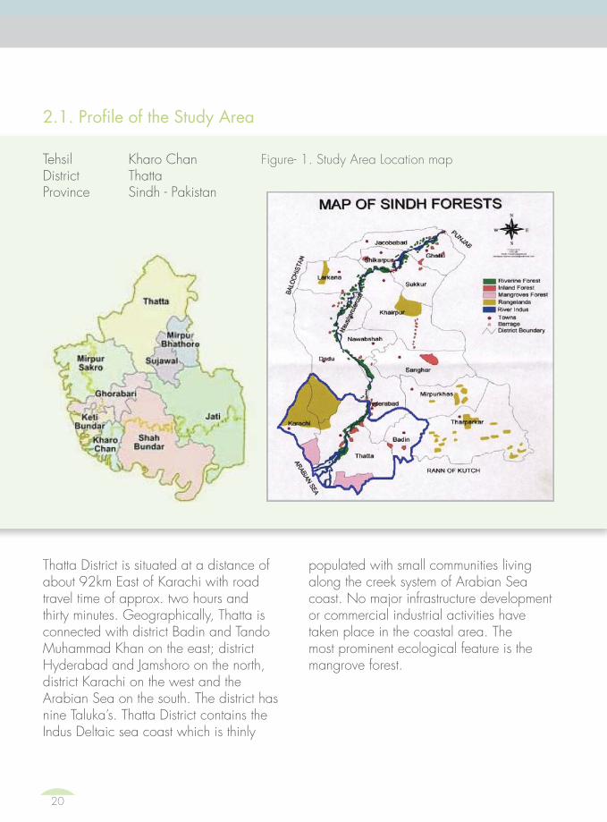
Thatta District is situated at a distance of about 92km East of Karachi with road travel time of approx. two hours and thirty minutes. Geographically, Thatta is connected with district Badin and Tando Muhammad Khan on the east; district Hyderabad and Jamshoro on the north, district Karachi on the west and the Arabian Sea on the south. The district has nine TalukaÊs. Thatta District contains the Indus Deltaic sea coast which is thinly
2.1. Profile of the Study Area
populated with small communities living along the creek system of Arabian Sea coast. No major infrastructure development or commercial industrial activities have taken place in the coastal area. The most prominent ecological feature is the mangrove forest.
Tehsil Kharo Chan Figure- 1. Study Area Location mapDistrict ThattaProvince Sindh - Pakistan
20

Table 2 : District Deprivation Level of the District
(Source: Pakistan Development Review)4
The total population of the district is 1.570 Million calculated by projecting an annual increase of 2.8% on 1998 population of 1,096,494 souls5.
Taluka Kharo Chan: Kharo Chan Taluka of the Thatta District falls on the main deltaic area along with the Pakistan coastline, situated at a distance of about 212 kilometers East of Karachi and 120 kilometers North of Thatta city. Covering a total area of 57,459 ha (574 sq. km) has four major creeks namely Kharo Chan, Sangri, WathayWali, and NaagWali6. The population of TalukaKharo Chan and adjacent creeks is about 30,500 located on both sides of Indus river.
District
Provincial Rank Order
National Rank Order Deprivation Index(1-100)
1= Least Deprived 1= Least Deprived
16 = Most Deprives 100 for rural overall and 95 for urban) = Most Deprived
Thatta Overallranking order
15 78 60.44
Urban 14 55 38.16
Rural 15 76 69.64
4‰Mapping the Social Deprivation of Pakistan‰, the research report 52, Pakistan Development Review, pp 16-18, retrieved from http://www.spdc-pak.com/publications/Research%20Reports/RR52.pdf5Sindh contingency plan 2011, Retrieved from https://portals.iucn.org/library/efiles/edocs/PDF-2003-001.pdf6Pre and Post Flood Ecological Assessment of Kharo Chan, Thatta District, (2011), WWF Pakistan, retrieved fromhttp://www.dss-foreverindus.org/Docs/Flood_Change_Analysis_Kharo_Chan_Report.pdf
Chapter02 LOCALE OF STUDY
21

Table 3 : Administrative Division of District Kharo Chan7
population reports the taste of drinking water to be sweet while 42% reports it to be brackish. There are no filtration plants. Eight percent of the population has toilet facilities inside houses while 93 percent in open places .
Fifty eight percent have kaccha houses (mud made) and forty two have houses either cemented or mud (kaccha/pacca). There are no playgrounds for both male and female in the Taluka.
Agriculture and livestock: Of the 12 rural mauzaÊs, wheat is major crop in 10 mauzaÊs, rice in 7, sugarcane in 4, maize in 8, pulses in 1, orchards in 3 and vegetables in 1010. The major source of irrigation are canals and tube wells while very less utilize water from floods and torrents.
Kharo Chan is a very deprived Taluka (Tehsil) in Sindh Province with no urban or semi-urban area across the Taluka. The people of Kharo Chan live below the poverty line. The major sources of livelihood are fishing, agriculture and livestock8.
Kharo Chan comprises of major dense pockets of mangrove forests of the Indus Delta. A area rich in biodiversity, the mangroves are the main habitat for fish, invertebrates and other fauna. Other vegetation types are Tamarix spp., saltbushes, soan grass, mixed terrestrial biomass that mainly includes Prosopis spp. and marine algae. It is an important flyover for migratory birds. During the winter season, thousands of waterfowl stay here for feeding and breeding9.
Infrastructure: Out of the 12 rural populated mauzaÊs, there are 103 number of settlements. The main source of drinking water in the 12 mauzaÊs is canal and river (92%), handpumps (17%) and other sources (1%). Fifty eight percent of the
KnungoCircles/Super-visory Tapas
PatwarCircles/Tapas
Number of Dehs
Total Rural Urban Partlyurban
Forest Unpopu-lated
Kharo Chan Taluka
1 4 41 12 - - 6 23
7 Mouza Statistics of Sindh 2008, Agriculture Census Organization, Government of Pakistan.8„Community based Natural Resource Management in Kharo Chan, District Thatta‰, (2010), Participatory Development Initiatives (PDI).
22

Kharo Chan, a Tehsil of Thatta, is a place of katcha homes; huts made of wood, chitai and dry straw. There is hardly any pakka or cemented home or building.
Kharo Chan has population of about 29,000 people living in about 200 villages; there is no urban area.
Kharo Chan city (Tehsil Headquarter) itself is a poor village, currently an island that has no electricity. It is even poorer/deprived than some of its other inland villages such as Sajjanwari Goth.
Kharo Chan does not have any government office except few schools and a single BHU.
Only two villages have electricity but on the whole there is no electricity throughout the Kharo Chan Taluka.
Government officials of Kharo Chan have offices in Thatta, Sakro and Bagan City. Currently, Bagan City is serving as a Taluka Headquarter of Kharo Chan where its policemen and officials of Revenue Department are based. However, the Bagan City itself falls in the GhorrabariTaluka of Thatta. Hence, Kharo Chan is perhaps the only Taluka of Pakistan which has its administrative headquarters in another Taluka.
Kharo Chan has only one girls primary school building; the school is however in-operative due to lack of local female teacher. Few girls go to high school located in Baghan of Ghara Bari Taluka.
There are 40 primary boyÊs schools; 01 middle and 01 high school where girls are also enrolled.
On the positive side, Kharo Chan has almost zero crime rate.
Box-2.1: Amazing realities of Kharo Chan11
Chapter02 LOCALE OF STUDY
9„Pre and Post Flood Ecological Assessment of Kharo Chan, Thatta District‰, (2011), WWF Pakistan.10Mouza Statistics of Sindh 2008, Agriculture Census Organization, Government of Pakistan. pp 4,7,108,113, 235 11These facts were recorded during preliminary situation analysis.
23

2.2 Weather Patterns
The climate of Kharo Chan is arid subtropical with mean annual rainfall of 100-200mm in the monsoon season12.
The graph shows that after 2030, there is a sharp rise in temperature at a rate of 0.5C per decade until 2070. The WWF report highlights, in general, 4C (degree Celsius) rise in temperature is expected over the deltaic plains by the end of this century.
The ground realities reveal that rains are currently unpredictable and the intensity of rains associated with severe thunderstorm, hurricane and tropical storms has increased overtime that usually causes flash flooding, runoff, soil erosion and land fall. After rains, it leads to standing water across villages and decay of vegetation on soil. Apart from this calamity, the data of precipitation patterns in the area reveals that overall rains are decreasing gradually. Figure 4 shows the decreasing patterns of precipitation in the area. According to a report, decrease in precipitation leads to salinity of coastal
Kharo Chan community has witnessed severe shifts in weather patterns over last three decades and the intensity of climate change is on increase. The major changes in weather patterns include shifts in surface temperature, precipitation and wind speed. The incidents of climatic disasters have also increased over the time that includes cyclones, floods, heavy rains, tidal surges, and sea intrusion.
Data from the meteorological department reveals that the mean surface temperature of the delta area is gradually increasing. Figure two shows the increasing temperature patterns in the area.
To understand the future temperature pattern of the deltaic region, WWF Pakistan has developed projections on yearly and 10-yearly basis. The average projected temperature increase from 2011-2099 for Kharo Chan area is illustrated in Figure 3.
Districts Area in(thousand
acres)
AnnualAverage
Rainfall (m)
Annual AverageRunoff Potential
(mm)
Available Water for Storage in
Million Acre feet (MAF)
Thatta 4,287 192 90.6 1.274
12 Mouza Statistics of Sindh 2008, Agriculture Census Organization, Government of Pakistan.
Table 4 : Annual Rainfall Potential and Available Water for Storage
24

Figure 2 : Change in Temperature Pattern of Indus Delta from 1961- 199013
Figure 3: Temperature Projections for Kharo Chan14
Chapter02 LOCALE OF STUDY
13‰Delta Wide Hazard Mapping A Case Study of Keti Bunder, Kharo Chan and Jiwani‰, (2012), WWF Pakistan.14‰Climate Data and Modeling Analysis of the Indus Ecoregion‰, (2012), WWF Pakistan.15 Alam, R.Q (2011): Salinization of Inland Water System of Coastal Areas of Bangladesh due to Climate Change. Proceedings of the International Conference on Environmental Technology & Construction Engineering for Sustainable Development ICETCESD-2011, March 10-12, 2011, SUST, Sylhet, Bangladesh
waters15. Droughts reduce fresh water inflow into the Indus Delta and creeks, resulting in increased level of salinity in creeks enabling salt water to mix beyond upstream.
Temperature (Celsius)27
26
26
25
25
24
24
231961 1962 1963 1964 1965 1966 1967 1968 1969 1970 1971 1972 1973 1974 1975 1976 1977 1978 1979 1980 1981 1982 1983 1984 1985 1986 1987 1988 1989 1990
DecadesFuture-Baseline
5
4
3
2
1
0
2011
-20
2021
-30
2031
-40
2041
-50
2051
-60
2061
-70
2071
-80
2081
-90
2091
-99
Tem
pera
ture
(C
o )
25

According to WWF PakistanÂs projections on yearly and 10-yearly basis after 2030, there is a steady decline in precipitation until 2099. The average increase in precipitation from 2011-2099 for Kharo Chan area is illustrated below in Figure-5.
Figure 5: Precipitation Projections for Kharo Chan17
Decades
Future-Baseline
160
140
120
100
80
60
40
20
0
2011-20 2021-30 2031-40 2041-50 2051-60 2061-70 2071-80 2081-90 2091-99
Prec
ipita
tion
(mm
)
Figure 4: Change in Precipitation Pattern of Indus Delta from 1961- 199016
300
250
200
150
100
50
01961 1962 1963 1964 1965 1966 1967 1968 1969 1970 1971 1972 1973 1974 1975 1976 1977 1978 1979 1980 1981 1982 1983 1984 1985 1986 1987 1988 1989 1990
Precipitation (mm)
26

2.3 Climatic Disasters
Through Indus Delta and Kharo Chan area, the flood water culminates in the Arabian Sea. The community of Kharo Chan has suffered many losses during 2010 floods alone. According to SPDCÊs study on „The
socio-economic impact of floods in district Thatta: A gendered analysis‰, 73 percent of the dehs in the only UC of Kharo Chan were affected. Out of the total 41 dehs, 30dehs were affected by the flood18.
Chapter02 LOCALE OF STUDY
Table 5 : Major Natural Disasters hitting Thatta19
Type of Disaster Year Severity Areas most affected
Cyclone 1964 Medium KetiBUnder, Shah BUnder and KharoCHan
Heavy Rainfall 1973 High District Thatta
Flood 1976 Medium Thatta, Sujawal, KahroChan, Shah Band, Jati
Heavy rainfall 1994 High Whole district
Hurricane 1993 Category-1 Hurricane Thatta and Badin districts
Cyclone A2 1999 High Ketibunder, Shah Bunder, Kharochan, Jati
Earth quake 2001 Low Thatta, Sakro, KharoChan
Flood 2003 Medium Whole district
Tsunami 2005 High KetiBUnder, Shah BUnder, KHaroChan, Jati
16 ‰Delta Wide Hazard Mapping A Case Study of Keti Bunder, Kharo Chan and Jiwani‰, (2012), WWF Pakistan.17 ‰Climate Data and Modeling Analysis of the Indus Ecoregion‰, (2012), WWF Pakistan.18‰Socio-Economic Impact of Floods in District Thatta - A Gendered Analysis‰, (2012), Social Policy and Development Centre (SPDC).19Disaster Risk Management Plan District Thatta Government of Sindh, District Disaster Management Authority 2008, page No 29, Retrieved from http://www.ndma.gov.pk/ex/Documents/DRM_Plan/THATTA%20pLAN.pdf.
27

On the other hand, the local community is increasingly vulnerable to cyclones which occur almost every year now. Tropical cyclones are passing through a most destructive weather phenomena and the changing climates are likely to make cyclones more frequent and violent21. Along with thunderstorms and high sea tides, tropical cyclones produce strong winds and flooding rain which cause numerous damages to human lives and infrastructure. Traditionally, three decades ago, the major tropical cyclone seasons
Cyclone Date Area Casualties/Affectees Remarks
Cyclone Phet June 2010 Karachi 2 million affectees Deadliest Cyclone in the Historyof Pakistan
Cyclone Yemyin 21-26 June, 2007 Karachi, Pasni and Ormara
700 causalities2 million affectees
Third deadliest Cyclone in the history of Pak
Cyclone TC 01A 21-29 May, 2001 Thatta -- --
Cyclone TC 02A1999 (Category 3)
20 May 1999 Thatta & Karachi 6200 causalities Strongest and most pow-erfulcyclone in history of Pakistan
1993 Pak-IndoCyclone(Category1)
1993 Thatta, Badin 609 causalities Caused flooding and landfall inKarachi and displaced 200,000 in Thatta and Badin
1965 KarachiCyclone
15 December, 1965
Karachi coast 10,000 causalities Deadliest Tropical Storm in the History
1964 IndusValley cyclone
12 June 1964 TharparkarHyderabad
450 causalities Caused landfall in Tharparkerand Hyderabad and left 400,000 homeless
were pre-monsoon (April-June) and post-monsoon (October-November) in the Arabian Sea22. The current data, shown in Tables 5 & 6, reveals that this schedule has become more intense and erratic.
The severity of floods (magnitude, duration, and extent of flooding) has increased overtime. The 2010 floods caused by unprecedented Monsoon23 rainfall that had resulted in disastrous impacts on the countryÊs economy and the society. According to a media report, the floods in 2010 took 1,985 lives and inundated
Table 6 : Tropical Cyclones data near the coast of Pakistan20
20„Water Shortage in Sindh: Causes and Solutions‰, SZABIST Institute of Science & Technology, Karachi, 2002.21Seminar report on „Water Shortage in Sindh: Causes and Solutions‰, SZABIST Institute of Science & Technology, Karachi, 2002.22SAARC Meteorological Research Center (1998): Metrological Report for SAARC Countries.
28

17, 553 villages over 160,000-square kilometer area, affecting 21 million people25. Hence, 2010 floods can be tagged as one of the worst natural disasters in the country considering the number of people affected.
According to WWF-P reports, Kharo Chan over the last 10-15 years has lost more than 117,823 fertile hectares of land (290,000 acres) to erosion. The estimated rate of soil erosion at Kharo Chan is around 61 meters (200 feet) annually.
Erratic pattern of Monsoon rains in the Indus Delta has resulted in degradation of rangeland (grasslands, shrublands, woodlands, wetlands) and further deterioration of the already degraded
Chapter02 LOCALE OF STUDY
Taluka Total number of Dehs
Dehs affected by the water shortage
Dehs affected by the seawater
Affected area (acres)
Mirpur Sakro 90 17 21 60,178
Ghora Bari 59 8 2 31,490
Kharo Chan 41 9 21 117,823
Keti Bunder 42 1 28 113,959
Jati 132 10 1 226,663
Shah Bunder 92 31 12 590,443
cultivable agricultural land. According to data shown in Table 7, more than 117,823 acres of land has been affected from salt-water intrusion from sea.
Table 7: Agricultural land affected by salt-water intrusion in District Thatta in 200224
23In case of South Asia, monsoon is used to refer to the rainy phase in which big seasonal winds blow from the Bay of Bengal and Arabian Sea in the southwest bringing heavy rainfall to the area.24„Water Shortage in Sindh: Causes and Solutions‰, SZABIST Institute of Science & Technology, Karachi, 2002.25Sabir Shah (2013): Major Natural Disasters that Hit Pakistan News article appeared in The News International 25-09-2013.
29

REVIEW OF LITERATURE
03

Case study on fishing at village Allah Dino Patel, Kharo Chan, Thatta

3.1. Climate Change and its Impacts
The worldwide climate however has changed rapidly since early 1900s due to persistent man-made changes in the composition of the atmosphere or in land use26.
Box-3.1: What is Climate Change?27
Climate change refers to a change in the average state of the climate and/or the variability of its properties. Climate is usually defined as the „average weather‰ in a place. It includes patterns of temperature, precipitation (rain or snow), humidity, wind and seasons. Climate patterns play a fundamental role in shaping natural ecosystems, and the human economies and cultures that depend on them. But the climate is rapidly changing with disruptive impacts due to more or fewer extreme weather events. Climate change is caused by factors that include oceanic processes (such as oceanic circulation), biotic processes, variations in solar radiation received by Earth, plate tectonics and volcanic eruptions, and human-induced alterations of the natural world; these latter effects are currently causing global warming, and „climate change‰ is often used to describe human-specific impacts.
Since so many systems are tied to climate, a change in climate can affect many related aspects of where and how people, plants and animals live, such as food production, availability and use of water, and health risks. For example, a change in the usual timing of rains or temperatures can affect when plants bloom and bear fruit, when insects hatch or when streams are at their fullest. This can affect historically synchronized pollination of crops, food for migrating birds, spawning of fish, water supplies for drinking and irrigation, forest health, and more.
States and the societies around the globe need to reduce human-caused greenhouse gas emissions to avoid worsening climate impacts and reduce the risk of creating changes beyond our ability to respond and adapt.
26Climate Change - On-line link: http://www.logelproject.org/climate-change27http://www.ecy.wa.gov/climatechange/whatis.htm
32

The effects of climate change and global warming have direct consequences on the natural environment especially on agriculture, livelihood and human welfare. According to Rayner&Malone (2001)28, the majority of adverse effects of climate change are experienced by poor and low-income communities around the world. Poor people have a higher chance of experiencing the ill-effects of climate change due to higher exposure and vulnerability.
Climate change is not gender neutral; it affects women more. WomenÊs limited access to resources and decision making processes increases their vulnerability to climate change. The worsening climate conditions are increasing womenÊs hardships by making it harder for them to provide food and water for their families. It is estimated that of the poor who are far more vulnerable to climate change, 70% are women.
Box-3.2: Defining Climate Change for Coastal Communities of Pakistan29
The coastal belt of Pakistan stretches an impressive 1050km of which 250km fall in the Sindh Province and the remaining in Baluchistan. The coastline is mostly bare desert with unique landforms such as sandy beaches, mud flats, rocky cliffs, headlands, bays, deltas, etc. and form not only an important biome for various ecosystems and biodiversity, but also an important source of sustenance and livelihood for the coastal communities residing here, as well as being a hub of economic activity due to the sea ports. The coastal areas of Pakistan are home to mangrove forests, various species of marine and freshwater and andramous fish including crustaceans. With fishing being the most important source of livelihood within the radius of the coastal belt, followed by agriculture (predominantly betel leaves, Chico fruit and bananas, as well as vegetable growing). Communities in the coastal belt are therefore directly reliant upon natural resources for their sustenance.
These coastal communities are directly at risk from threats induced by climate change because of their geographic location as well as vulnerability due to poverty and reliance on an increasingly degrading natural resource base. As well as sea level rise, coastal erosion, diminishing freshwater supplies, loss of fish species and biodiversity, natural disasters such as cyclones and flooding, and deforestation of mangroves, the problems faced by coastal communities in Pakistan also face crop degradation due to water logging and salination, wind erosion of land and sea intrusion. The rich marine environment in the area is subjected to great pressure through over- extraction of resources, enhanced pollution and
Chapter03 REVIEW OF LITERATURE
28Rayner, S.; E.L. Malone (2001): „Climate Change, Poverty, and Intragernerational Equity: The National Level‰ - International Journal of Global Environment Issues. 1 I (2): 175 202.29LEAD Pakistan (2012): LEAD Update on Environment # 298 December 2012.
33

Recent devastating heavy rains and floods during 2010 and 2011 have caused severe economic and human losses. The 2010 Pakistan floods began in late July 2010, resulting from heavy monsoon rains in the Khyber Pakhtunkhwa, Sindh, Punjab and Balochistan regions of Pakistan, which affected the Indus River basin. Approximately one-fifth of PakistanÊs total land area was underwater, approximately 796,095 square km (307,374 sq mi) and the floods directly affected about 20 million people, mostly by destruction of property, livelihood and infrastructure, with a death toll of close to 2,00030. It has sensitized many civil society organizations to measure impacts of climate change on humans and build resilience of the communities against changing weather patterns and resultant natural disasters i.e. floods, drought, cyclones, earthquake, etc.
3.2. Climate Change Policies for Coastal and Marine Ecosystems
Pakistan has recently launched its first „National Climate Change Policy-2012‰. The Policy was announced by the Ministry of Climate Change in Islamabad on 26th February 201331. The policy provides a framework for coping with the threats of climate change through adaptation and mitigation measures. To safeguard the Coastal areas and Marine ecosystem from the likely climate change impacts, the Government of Pakistan has promised the following policy measures32:
a. Ensure building natural barriers; plantation and regeneration of mangroves, coastal palm and other trees suitable to the area to control sand and soil erosion and to minimize the disastrous impacts of cyclones and tsunamis;
physical alterations in coastal ecosystems. All of these issues are either directly or indirectly related to accelerated climate change due to anthropogenic activity, and little or no effort by governments or national/international organizations to address this root problem rather than focusing on the ÂsymptomsÊ of this problem such as decreasing livelihood. Although the federal government of Pakistan has in 2012 approved the ÂClimate Change PolicyÊ, there is little evidence of its impacts having trickled down to these rural communities, and even less evidence of it doing so in the near future.
30Singapore Red Cross (2010): „Pakistan Floods: The Deluge of Disaster Facts & Figures as of 15 September 2010‰.31On-line link: http://tribune.com.pk/story/513157/paradigm-shift-pakistan-launches-first-national-climate-change-policy/32Government of Pakistan, Ministry of Climate Change (2012) National Climate Change Policy - http://202.83.164.28/moclc/default.aspx
34

b. Construct barriers near the low lying coastal human clusters to safeguard against rising sea level and cyclones;
c. Develop salinity tolerant crop cultivated in coastal areas;
d. Maintain optimal river water flow for continuation of sediment and nutrient transfer to the marine ecosystem and to reduce intrusion of saline sea water into coastal regions;
e. Reduce and control solid and liquid pollution and waste disposal in the bay areas;
f. Assess potential climate change threats to the fishing sector and develop appropriate adaptation measures including the promotion of aquaculture;
g. Maintain marine ecosystems and fish habitats for healthy fisheries sector.
The critics however doubt the implementation aspect of the policies. According to a Dawn news story Published on 01 Jul 2013, the climate change experts said that the Climate Change Policy fails to provide a strategic framework for the institutional arrangements for implementation of the climate change policies in Pakistan33. Dr.Pervaiz Amir, an environmental expert and member of the Prime MinisterÊs Task Force on Climate Change, there is no cooperation between the centre and the provinces to deal with the menace as the environment ministry
has been devolved to the provinces after the 18th Constitutional Amendment. The Daily Dawn story says that Pakistan has not only dissolved its Federal Ministry of Environment but also slashed its development budget by more than 60 percent. The Government allocated a total of PKR 58.8 million to combat climate change in the Public Sector Development Program for 2013-14 as compared to PKR 168.1 million allocated to the climate change ministry in 2012-13. The ministry has now been transformed into a division. According to Dr. QamaruzZaman Chaudhry, a lead author of the National Climate Change Policy and an expert on climate change, Pakistan may face isolation in the international community if it doesnÊt take effective measures to cope with changing weather patterns.
3.3. Review of related Work done in the Study Area
WWF Pakistan has conducted „Pre and Post Flood Ecological Assessment of Kharo Chan, Thatta District‰ during 2011 in which space borne data and satellite Remote Sensing Techniques have been used to assess the ecological impacts of floods at a selected site, Kharo Chan, District Thatta; to assess impacts on land cover, pre and post flood SPOT-5 satellite images dated 26th march and 23rd September and 28th September, 2010 of the study area were used for pre and post
Chapter03 REVIEW OF LITERATURE
33Saeed, Amir (2013): Climate change: PakistanÊs anti-climactic response. News story appeared in the Daily Dawn on 01 July 2013
35

flood assessment34. Detailed field survey data has been integrated with the satellite images and topographical data in a GIS environment to highlight the overall change caused by the floods.The report was produced under the joint initiative of Planet Action, SUPARCO and WWF Pakistan for the ecological impact assessment of the 2010 floods in Pakistan.
WWF Pakistan has also conducted „Socioeconomic Baselines: Kharo Chan, KetiBunder, and Jiwani‰ during 2012 under its project on „Building Capacity on Climate Change Adaptation in Coastal Areas of Pakistan (CCAP)‰35. The baseline study focuses on the impacts of climate change on the livelihood of coastal communities, community priorities and challenges, climate change and the poverty-environment nexus and its relationship to environment and climate related household decisions. Important findings include identification of existing adaptation strategies. The baseline greatly assists in identifying vulnerable communities and where the increased adaptive capacity is most needed.
In another study report on „Delta Wide Hazard Mapping A Case Study of Keti Bunder, Kharo Chan and Jiwani‰, WWF Pakistan used Remote Sensing and
Geographic Information System (GIS) as a tool for natural hazard mapping and mitigation. The study discusses the land cover/land use changes (forest change, land erosion and intensity of various natural hazards through using satellite images and geospatial technology36.
Mr. Mohammad Tahir Qureshi, in his paper on Restoration of Mangroves in Pakistan37, says that the climate of the Kharo Chan area is arid subtropical with a mean annual rainfall of 100-200mm which mainly takes place in the monsoon season. The soil of the deltaic swamps mainly comprises of river borne clays, silt and sometimes loam. In some places there is sand that is either blown over or deposited by the river.
According to Qureshi, Kharo Chan comprises of major dense pockets of mangrove forests of the Indus Delta. The mangroves are the main habitat for fish, invertebrates and other fauna.Other vegetation types are Tamarix spp., saltbushes, soan grass, mixed terrestrial biomass that mainly includes Prosopis spp. and marine algae. The area is very rich in terms of biodiversity. It is an important flyover of migratory birds. During the winter season, thousands of waterfowl stay here for feeding and breeding.
34WWF Pakistan (2011): Pre and Post Flood Ecological Assessment of Kharo Chan, Thatta District - Report published in 201235WWF Pakistan (2012): Socioeconomic Baselines: Kharo Chan, Keti Bunder, and Jiwani Report published in 201236WWF Pakistan (2012): Delta Wide Hazard Mapping A Case Study of Keti Bunder, Kharo Chan and Jiwani.37Qureshi, M.T. (1996): Restoration of Mangroves in Pakistan: paper published in the book on Restoration of Mangrove Ecosystems: edited by Colin Field (Ed.) in 1996.
36

In his other paper on „Conflicting Interests in the Use of Mangrove Resources in Pakistan‰38, Mr. Qureshi highlights the conflicts among the mangrove resources users that occur due to absence of government policy for the utilization of mangrove resources and coastal land-use plans. As a consequence, large areas of mangroves were cleared for construction of ports and harbors, human settlements, and for industries. The paper laments that these problems have led to severe destruction of mangrove ecosystem in Pakistan, where approximately 37 percent of the mangroves have been destroyed or converted to other types of land uses, resulting in several ecological and economical losses.
Shirkat Gah conducted „Socio-Economic Baseline Study‰ for the Indus for All Programme of WWF-Pakistan .The study also included socio-economic assessment of the coastal community of Thatta39.The study was accomplished in four priority areas i.e. Keti Bunder, Keenjhar, Pai forest and Chotiari during 2007. A central concern of the study was to assess the extent of dependence of local populations on the natural resources of the areas.
In another study on „Promoting Sustainable
Livelihood for Coastal Fisher folks‰ in 2000, Shirkat Gah analyzed livelihood related issues of the coastal fisher folks of Sindh and identified tangible policy options to promote sustainable livelihood for the coastal fisherfolks. The objective of the study was to set an agenda for future advocacy by the CSOs40.
Shirkat Gah also completed a project on „Participatory Sustainable Management of Coastal Wetlands‰ from 2006-09 in partnership with UNDP41. Objective of the programme was to involve coastal communities in conservation of mangroves wetlands so that it provides better nursing ground to fish and shrimp, which is a major source of livelihood of local communities. Community based wetland conservation model was developed to motivate line agencies to work with local communities to benefit from their indigenous knowledge. The community based model set ground for future interventions in the conservation area. Capacity building of local CBOs was included to develop long term human capital within the community as the trained and motivated CBOs can bring numerous other benefits to local communities such as improved health, education, drinking water etc.
Chapter03 REVIEW OF LITERATURE
38Qureshi, M.T. (2004): Conflicting Interests in the Use of Mangrove Resources in Pakistan: paper published in the book on Mangrove Management and Conservation: Present and Future edited by Marta Vannucci in 2004.39Shirkat Gah (2007): Socio-Economic Baseline Study. Study conducted for Indus for All Programme of WWF-Pakistan and was published in 2007.40Shirkat Gah (2000): Promoting Sustainable Livelihood for Coastal Fisherfolks. Study published in 2000. 41Shirkat Gah (2010): Participatory Sustainable Management of Coastal Wetlands Project lost for 2006-09 and the Project Report was finalized by 2010.
37

Social Policy and Development Centre (SPDC) conducted a study on „A Gendered Analysis of Socio-Economic Impact of Floods in District Thatta‰ in 201242. The purpose of the research was to analyze the socio-economic bearings of the floods by gender in the flood affected talukas of district Thatta including Kharo Chan. The study looked into the nature and extent of the impact of floods on the social fabric by comparing various indicators related to education, health and household structure. It analyzed the post-flood stress symptoms on both men and women. The study considerably helped in building a better and proper understanding of the changed workload of women and men such as increased/decreased responsibilities in the domestic sphere, paid workplace, and the community.
National Rural Support Programme (NRSP) has recently launched its community based disaster risk management project „Tahafuz‰ in order to build the capacity of vulnerable societies so they can better face disasters. The project covers the disaster prone districts of Thatta, Badin, Umerkot and Tharparkar in Sindh. The project team is working with households in these districts to build their resilience with focus on capacity building. NRSP has mobilized the
local people to form 232 village disaster management committees and their capacity was built through trainings. The project provided two types of trainings · disaster risk assessment and planning for disasters. In the case of floods, the committees made evacuation plans (for the coastal areas of Badin and Thatta) and in the case of fire (in the desert areas of Umerkot, Tharparkar) they came up with protocols43.
Participatory Development Initiatives (PDI) has recently completed its project in Kharo Chan (Thatta District) on „Community based Natural Resource Management‰ from October 15, 2009- September 15, 2010. Objectives of the project included introducing community based management of mangrove forests and fisheries management in and around Mal and Kanher Creeks, Kharo Chan. The project contributed to biodiversity and livelihood sustainability by introducing community based natural resource management in Kharo Chan district Thatta44.
PDI under its other project on „Improving Fish Catch and Market Standards in Kharo Chan District Thatta‰ supported by Government of Sindh has formed PakistanÊs first local Fishermen Cooperative Society [FCS]‰ during 2012 aiming to work for social, economic and livelihood betterment
42Social Policy and Development Centre (2012): Socio-Economic Impact of Floods in District Thatta- A Gendered Analysis. Research report published in 2012.43National Rural Support Programme (2013): Community based disaster risk management project, Tahafuz - http://www.dawn.com/news/1043021/from-victims-to-saviours44Participatory Development Initiatives (2010): Community based Natural Resource Management in Kharo Chan, District Thatta Project report published in 2010.
38

Chapter03 REVIEW OF LITERATURE
of the fishing communities in the area45.PDI organized a grand event „Launching Ceremony of Kharo Chan Fishermen Cooperative Society‰ at Kharo Chan Port in District Thatta. This event invited people from different walk of life i.e. Elected Representatives, Government Officials, Civil Society Personalities, Media & Press Representatives, Social Activists, NGO Representatives and local notables.
Sindh Agricultural and Forestry Workers Coordinating Organization (SAFWCO) conducted a project on „Environmental Up Gradation through Community Participation in Kharo Chan, Thatta District‰ in 2005. The project aimed at providing fuel efficient products that contribute towards the reduction of fuel cost and deforestation in the area for sustainable healthy environment. It involved installation of fuel efficient stoves, lamps, and geysers and bio-gas plants in 15 selected villages in Kharo Chan. The SAFWCO organized trainings for the awareness of local artisans, community activists, CBOs, local government departments and relevant professionals in technical, social and economic aspects of the project.
45Participatory Development Initiatives (2010): Improving Fish Catch and Market Standards in Kharo Chan District Thatta Project report published in 2012.
39

MAJOR STUDY FINDINGS
04


with diverse agricultural and livestock activity. Most people are land owners and they cultivate crops on their own land.
4.1.1 Ali Patni
Ali Patni is almost 20km away from Bagan City46, the village existed since 1918, although one of participant during FGD reported that the village is 200 years old and was recorded in 1918 during the British regime. The main entrance of the village is towards East, Bagan City is towards North and the seashore is towards South. At the entrance of the village, there is a hut used as „Otaaq‰ or a common village place and a collapsed primary school building.
When asked for the reason behind the collapsed school building, the village people responded, that the school was constructed in year 2000 and was functional till heavy rains in 2010, which destroyed it. They complained that substandard construction material was used for the school building.
It has 57 households with population of aprrox 399 people. Currently, all the community members are poor and they live in three „Parras‰ (Mohallahs or sub-villages). Ali Parra has 35 households and lies towards North-West side of the village centre. Bachal Parra has 12 households
4.1: Overview of the selected villages
The study was conducted in Taluka Kharo Chan located near the coastal belt of the Thatta District. Based on a selection criterion, four villages out of the study area (Kharo Chan) were selected to conduct the participatory qualitative research using PRAs and FGDÊs.
Villages were selected on the basis of diverse ecological and livelihood patterns. For instance, Haji Manjhi Otho Goth is situated near the seashore where currently the fishing community is struggling hard to survive on the face of livelihood pressure as well as the climate related disasters. The Allah Dino Patel Goth is located at a creek on Indus Delta and most people are engaged in freshwater and sea fishing. The village has some barani agricultural land and people grow short-term crops and vegetables during rainy season. Ali Patni Goth, on the other hand, is away from creeks and people mostly depend on agricultural activity. Most people are however very poor and work as farm laborers in surrounding villages. Ecologically Ali Patni Goth was an agricultural area but due to lack of fresh river water, agriculture and livestock activity has almost been abandoned. Haji Bux Murghur Goth is relatively a well off village
46Bagan City is the closest semi-urban area for Kharo Chan community from where they purchase ration/utilities/health facilities and is the only passage that connects them with Thatta and Karachi City. Bagan City falls in the Gorabari Taluka of Thatta District and is bordered with Kharo Chan.
42

and it is located towards West side and Arab Parra, based on 10 households, lies on the East side of the village centre.
The village land is saline and not cultivable. Fishing and cultivation of pan (in surrounding villages) are the major sources of income. Women of the village are engaged in picking chillies and tomatoes. They do not have any livestock and buy dairy products from the nearby village. There is only one hand pump in the village, from where women collect drinking water
for their own family. There is no electricity in the village. Wild bushes (mainly Devi plant) are used as fuel wood for cooking food.
Currently, there is no educational facility in the village and only four boys attend primary school in surrounding villages. Indo-Shakh irrigation canal passes along North-West side of the village. The canal does not receive regular freshwater from the main Indus tributary Canal „Kalri Bagharr Circle‰47. The only working water hand pump is located in Ali Parra while
Chapter04 MAJOR STUDY FINDINGS
47Kalri Bagharr Circle canal is the main irrigation canal that originates from Kotri Barrage in Jamshoro District.
43

the other one in Arab Parra is currently inoperative due to brackish water. There is only one proper washroom in Ali Parra which was constructed by an NGO during floods-humanitarian-aid. Usually women members of the Ali Parra use this washroom. Rest of the community members defecate in open fields surrounding the village.
Every Parra has its own community head, which jointly takes care of welfare of the village and settle disputes. The village community is influenced by a Peer (Murshid) who is also considered respectable. Normally, people vote as per guidance of the Murshid. Only one member of the community is employed in Government service as „Baeldar‰ in the Irrigation Department.
For health facilities, the community members go to Bagan city which is 20km away from the village. Normally, community members face diseases such as asthma, anemia, hepatitis, diarrhea, eye infection and problems related to skin and kidney. Locally, there are four female untrained birth attendants or „Dai‰ to take care of child births.
4.1.2 Ali Bux Murghur
Ali Bux Murghur is almost 12km away from Bagan City. The village exists since 1965; the Murghur clan in fact migrated from another village located in Sokhi Bunder which was uninhabited due to land degradation as a result of Indus Water Treaty between India and Pakistan.
Geographically the village is located towards West, Bagan City is towards North and the seashore is towards South. Currently, the community members live in five „Parras‰ (Mohallahs or sub-villages). Mughur Parra has 17 households and lies towards North side of the village centre. Ghota Parra has 22 households and it is located towards South-West side. Angaro-GharÊra Parra has 7 households and lies towards South side of the village. Mallah Parra has 7 households and lies towards South-East side of the village. Khaskheli Parra, based on 7 households, lies on the South-West side of the village.
The village has approximately 60 households with population of 420 people. The community, especially the women of this village took active part in the recent elections. Comparatively, the situation of this village was better than other villages. A private tuition centre has recently been opened for both boys and girls of the community where the medium of education is English.
Community has livestock including buffalos, goats and cows and most of the work is done by the women.
Indo-Shakh irrigation canal passes along East side of the village. The canal receives fresh water from the main Indus distributary canal „Kalri Bagharr Circle‰. There are 11 hand pumps in the village. Villagers mostly get drinking water from Mughur Parra as according to them the quality of water is relatively better due to the passing by irrigation canal. There are proper
44

washrooms in Murghur Parra as compared to other parts of the village.
The village has just gotten electricity. Earlier only one household was using solar energy panel which was installed by an NGO. Due to low voltage, solar energy was only being used to light a bulb and charge mobile phones.
Wild bushes (mainly Devi plant) is used as fuel wood. SAWFCO (a Hyderabad based NGO) had initiated the construction
of a Biogas plant in this village but it had failed before its completion because of a technical fault made by the mason.
So far, members of the Murghur tribe are land-owners and are well-off. Folks from Khaskheli, Ghoto and Malah tribes are poor tenants and work as laborer in the lands owned by Murghur tribe.
An Otaaq, Eid Gah, a Mosque and a graveyard are located in the middle of the village, close to Murghur Parra. The only
Boys Middle School building is located at the West side of the village, close to Murghur Parra where boys and girls attend classes together.
The soil in the village is mainly fertile and is fit for cultivation where wheat, rice, cotton and vegetables are cultivated. Other crops include betel (pan), water melons, banana and papaya. The village also has tree of Babul, Tali, Coconut, etc. Most members of the Khaskheli, Ghoto and Malah tribes living in Ghota Parra, Angaro-GharÊra Parra, Mallah Parra
Chapter04 MAJOR STUDY FINDINGS
45

and Khaskheli Parra work as agriculture laborers in the village. Women harvest vegetables/crops and the men are involved in tilling, cultivation, irrigation, plant protection and harvesting services. During season, women also harvest wheat and rice and are also involved in cotton picking. Some men from the Khaskheli, Ghoto and Malah tribes are engaged as laborer on fishing boats whereas few of the Murghur members are also involved in fishing as boat owners. Some of them now sell firewood in neighboring villages at the rate of 70 rupees per mound.
There are two influencial persons, in the village who serve as the main community leaders. One is linked to a political party and has also been appointed as UC Nazim. The other is a social activist who helps NGOÊs work in the village as well as for the whole Kharo Chan area. In case of a dispute between the two or in other major decisions, there is a religious leader of the community who resolves the matters.
Few members of the Murghur tribe are in government service, 5 in Education Department (1 Teacher, 4 lower staff), 1 in Health Department and 1 in Pakistan Army. Few men are also engaged in private services including NGOs. As regards the literacy in males, 12 are Matriculate, 7 Intermediate, 5 B.A. and only 1 M.A. Among females, 12 have primary education, 4 till secondary level, while 28 female students are studying in primary and secondary schools.
There is one Basic Health Unit made and driven by an NGO „SEWA Pak‰.
A Dispenser is performing his duty daily. For major health facilities, the community members go to Bagan city which is 12km away from the village. Normally, community members face diseases such as asthma, cancer, anemia, hepatitis, tuberculosis, diarrhea, eye infection and problems related to skin. Locally, there are three female untrained birth attendants or „Dai‰ to take care of child births.
4.1.3 Haji Manjhi Otho
Haji Manjhi is almost 25km away from Bagan city. The main entrance of the village is towards West, Bagan City is towards North. All the community members are poor and they live in seven „Parras‰ (Mohallahs or sub-villages). Ali Mohammad Parra has 15 households and lies towards the North side of the village centre. Arab Otho Parra has 25 households and it is located towards the North-East side. Jumman Parra, based on 8 households, lies on the North-West side of the village centre. Haji Umar Parra has 30 households and it is located towards East side. Haji Siddique Parra has 25 households and it is located towards the North-East side. Ghulam Parra has 5 households and it is located towards South side. Haji Usman Parra has 15 households and it is located towards South side of the village.
According to the community, it has 123 households with a population of 861. At the entrance of the village there is Government boyÊs primary school which is functional with the active services of the
46

teacher resident of this village. Majority of the community male members are engaged in fishing activities but some of them do agricultural labor, one is a government teacher and another is a dispenser in Sajanwari rural health centre. Land of the village is saline and not cultivatable. Women are mostly engaged in collecting firewood and drinking water from distance of 2km. There is no hand pump in the village due to absence of underground water. In spare time women are involved in stitching, embroidery and making pakora for sale on Goth level including chocolates and biscuits on their little shops existing in their homes. There is no electricity in Goth. Wild bushes (mainly Devi plant) are used as fuel wood for cooking food and women collect wood for the household.
A Mosque, a boyÊs primary school and a graveyard are located at the entrance and centre of the village. There are two grocery shops, 1 in Ali Mohammad Parra and other 1 in Arab Otho Parra. Only 40 boys are enrolled in the school while schooling
of girls is discouraged because the teacher is from a different cast. A local religious cleric however teaches Quran to girls and boys. Only few boys go to Sajjanwari Goth to attend high school. While there are no literate women in the village; only 10-12 men are Matriculate.
Indo-Shakh irrigation canal passes along East side of the village at a distance of 3km from village centre. The canal does
Chapter04 MAJOR STUDY FINDINGS
47

not receive regular freshwater from the main Indus tributary Canal „Kalri Bagharr Circle‰. Two water hand pumps are operative, one of which has brackish water. Women have to travel 2-3km to fetch 10-20 liter water from these hand pumps. There are only 9 pakka (cemented) homes that have proper washroom facility; 6 in Usman Parra, 2 in Ghulam Parra and 1 in Arab Otho Parra. Six other washrooms have been constructed by an NGO in Arab Parra. Rest of the community members defecate in open fields surrounding the village.
Community members, men and women, in Haji Manjhi Goth are also engaged in livestock activity. On the whole, 30 KG milk is sold daily apart from self-consumption and the income in this regard is consumed on feed and fodder for livestock and home. Rearing of poultry birds is common and they are consumed locally.
Every Parra has its own community head. The community leaders jointly take care of welfare of the village and settle disputes. Only three members of the community are employed in Government service as „Medical Dispenser‰ in the Health Department.
For health facilities, the community members go to BHU in Sajjanwari Goth which is 5km away from the village. Normally, community members face diseases such as high BP, asthma, hepatitis, diarrhea, cancer, eye infection and problems related to skin and kidney.
Locally, there are three female untrained birth attendants or „Dai‰ to take care of child births.
4.1.4 Allahdino Patel
Allah dino patel village is almost 28km away from Bagan City. The village is located close to Sajanwari Goth to its North at a distance of 1.5km. The main entrance of the village is towards North. Bagan City is also located towards the North and the seashore is towards South. Currently, most of the community members are poor and they live in four „Parras‰ (Mohallahs or sub-villages). Allahdino Patel Parra has 30 households and lies towards South-West side of the village centre. Bachal Parra towards South-East side has 13 households. Hajji Parra, based on 10 households, lies on the South side of the village centre. Punnon Parra has 11 households and it is located towards far South-East side.
It has 64 households with population 500, from the way of Sajanwari city at the entrance of the village, there is a Allahdino Patel Parra hidden within the bushes of Devi plants. A historical place in the memory of Saint Dastageer (Abdul Qadir Jeelani) is located at the South Side of the village on the bank of Indus river, where people from different villages and areas gather annually. There is no girls and boys primary school in the village, however it was shared that only two boys belonging to Mallah tribe go to Sajanwari city for getting education. Hence, literacy rate in both men and women is zero.
48

The village settlements have been shifting away from creek due to encroachment of sea. The community has so far suffered displacement 4 times in the last 30 years and their previous lands (4 villages) are now totally under water.
The village is situated almost at the bank of creek which is located towards South of a sacred place of a saint. There is a large pond at the end of Indo-Shakh canal near Bachal Parra. East and North-East sides have agricultural fields while towards North-West side there are uncultivated shrubs of Devi plants.
Indo-Shakh irrigation canal passes along East and South side of the village. Being at the tail, the village receives less water throughout the year. There are three water hand pumps; only one is operative and two others give brackish water. Women have to fetch water from these hand pumps. Community lives in huts made of mud and reed plants with no washrooms. Only one household in Allahdino Patel Parra has a washroom. The community members defecate in open fields surrounding the village.
The soil of the village is saline but still cultivable to some extent where wheat,
betel (pan), vegetables and melons are cultivated. All the land in owned by Memons from Sajanwari Goth. Hence, the community members (both men/women) are involved in agricultural labour and fishing. Chemical pesticides and fertilizers are used in agriculture. Women harvest vegetables and the men are
Chapter04 MAJOR STUDY FINDINGS
49

involved in tilling, cultivation, irrigation, plant protection and harvesting services. During season, women also harvest wheat and betel (pan).
Not a single member of the community is employed in Government service. For health facilities, the community members go to BHU in Sajjanwari Goth which is 1.5km away from the village. Most common diseases reported by community members are Malaria, BP, TB, asthma, hepatitis, diarrhea, eye infection and problems related to skin. Night blindness in children is common and has increased over the last two years. Locally, there is one female untrained birth attendant or „Dai‰ to take care of child births.
4.2 Livelihood Patterns
Livelihood Pattern of the villages is somewhat similar with little difference. The list of selected villages is given below:
In all villages, soil is saline and not cultivable except few acres of land. In village Ali Patni near the Arab Parra rice and grass is cultivated while wheat, betel (pan) and vegetables are cultivated in
village Haji Manjhi Otho. Hence, most members of the community (both men/women) work as agricultural laborers in the surrounding villages. Women harvest vegetables and the men are involved in tilling, cultivation, plant protection and harvesting. During cropping season, women also harvest wheat and rice and are involved in cotton picking. Some men from village Ali Patni are engaged as laborers on fishing boats of Seths from other villages. Majority of the population of Ali Bux Murghur Goth is engaged in agriculture which comprises of vegetables (like chillies, tomatoes, lady finger);crops (wheat, rice) and fruits (bananas, coconut). Fishing has been the main occupation of villagers of Allah Dino Patel village for centuries. The community has migrated four times during thirty years due to land degradation. Some of the fishing community members of this village are also engaged in agriculture labour on temporary basis. There are 3 persons who do have small motor boats and fish-nets. Two other have small boats for small scale fishing. Men also sometimes go for fuel wood collection. Men collecting fuel wood ( devi bushes) sell these (one mound = Rs 70) while women collect for household need.
4.2.1 Women roles and responsibilities
Women play a major role in both domestic and out door activities. They along with being linked to different household chores, work in field on daily wages and make rally and mats, do stitching and embroidery
1. Ali Patni Goth Agriculture, Fishing, Laborers (agriculture), Services
2. Haji Ali Bux Murghur Goth
Agriculture, Laborers, Seth (fishing boat owner), Services
3. Haji Manjhi Otho Goth
Sea-side Fishing, Laborers (agriculture/fishing), Service
4. Allah Dino Patel Goth
Freshwater/sea Fishing, Laborers (fishing/agriculture)
50

Chapter04 MAJOR STUDY FINDINGS
for domestic use. Collecting water for both domestic purposes and for animals and collection of fuel wood is the responsibility of women. They also support their families by doing stitching and embroidery. These women also take care of livestock feed, milking and cleaning livestock waste. Inspite of all this they however are not empowered to be involved in sale/purchase and handle finances.
According to the participating women of village Ali Patani, they use to collect drinking water and firewood only for domestic use but now have to also collect
additional water for livestock besides the routine household chores. Women of this village are also involved in local sewing, stitching, embroidery, and making mats; however the mats work does not provide modest income. Similar to other villages women of Ali Bux Murghur village carryout livestock farming and they also support their family by doing traditional embroidery, stitching cloths and weaving of Chettai (local floor mat). Women however get much discounted pay against their livelihood services.
Table 8 : Different means of income generation for women in the selected sites
VillageHandi crafts Agriculture
Stitching Embroidery Ralli Mat Vegetable pick-ing (2 Rs/kg for chillies and lady fingers)
Sugarcane(12 Rs/mond)
Cotton5Rs/kg)
Allah Dino Patel
100 Rs (smaller mat), 200 Rs (bigger mat)
100-150 Rs/day for 5 hours job in vegeta-ble picking i.e. tomato, chili, and cucumber
Ali Bux Murgurh
150-200 Rs/suit
Rs 300- 600 /ralli
100-150 Rs
250 Rs/day for 5 hours in picking Chillies and 150 Rs/day for other vegetable har-vesting.
360 Rs /day for peeling 30 monds
150 Rs/ day ( 25 Kg).
Ali Patni 250 Rs/suit 800 Rs/ rally/ month
150 Rs/day for 5 hours work in field
75-100 Rs/day (pick 15-20 Kg)
Haji Man-jhi Otho
200-250 Rs/ suit
100 Rs/shawl
200 Rs/ 7 days
50 Rs/mat
100-150 Rs/day for 5 hours in chillies and tomatoes
51

Women belonging to village Allah Dino Patel catch shrimps/prawns from nearby creek/river for domestic use (2 kg / 2 hours catch) by using Kurrhi (local net). Women also mend torn fish-nets and take care of fish/crabs caught by the fishermen for domestic needs. According to the participating women, the women from Murghur Parra of Ali Bux Murghur follow pardda and mostly work at home.
Women make 4 trips per day (two in the morning and two in evening) for collecting water for domestic purposes (drinking,
cooking). Women from village Ali Bux Murgh also collect water for livestock. Water for drinking and cooking comes from taps while that for washing clothes from canals such as Darsi canal located 1/2km from Haji manjhi Otho and from Indo Shak near Village Ali Patani.
In agriculture women mostly work on daily wages in tomatoes, lady finger, rice, cotton and chilli fields. Vegetable picking is seasonal, embroidery and stitching is mostly done in free time.
Table 9 : Total time women spend in water and fuel wood collection
Activity Total trips made Total travelled distance Collected/day
Water collection4 /day ( 2 morning and evening and one extra for bathing once a week)
km to 2km 3-4 hours
80 liters/ day (20 liters/trip and 20 extra once a week)
Wood collection One trip/day km 1km 4 hours 15-20 Kg
52

Chapter04 MAJOR STUDY FINDINGS
Women at Haji Manjhi Otho village going for water collection
53

IMPACT OF CHANGE
05

Condition of water collecting area

up which is saline, brackish and not fit for agriculture and the other vegetation.
• Recurrent natural disasters i.e. floods and cyclones have increased over the time. According to the local community, the area was hit two times by floods during 2010 that had badly affected local agriculture, livestock and human resources. The community members also shared that almost 8 cyclones have hit the area since 1993.
5.2 Changing weather and its impacts
The local community in Kharo Chan and the Indus Delta are currently exposed to several challenges. Climatically, Kharo Chan is located in arid zone. Being closer to the sea, it has been negatively affected by different forms of disaster occuring in the coastal belt. According to local community, climate changes started in 1983 and have been linked to rangeland depletion, loss of biodiversity, reduction in agricultural and fishing livelihood, shortage of fodder and food crops, depletion of energy resources, reduction in potable water, losses to livestock and threat of out-migration of communities.
Since 1983, incidents of natural disaster
5.1 Climate Change for Coastal Communities of Kharo Chan
Kharo Chan is a well-known deltaic coastal city of Sindh-Pakistan that has been facing climatic changes in many ways. During the course of study, it was found that there are four main causes of environmental degradation and climate vulnerability of the local community in Kharo Chan.
• The climate change has exposed communities to extreme weathers i.e. rise in temperature in summer, unpredictable and unprecedented rain fall, high wind speed, etc.
• The normal flow of freshwater in the Indus Delta has been disturbed; it has considerably reduced over the years. Drought in the past, construction of various dams on river Indus and the Sindh Taas Agreement or Indus Waters Treaty48 with India are the main causes of shortage of freshwater in river Indus and the Indus delta.
• Sea intrusion has increased overtime due to sea rise caused by global warming and declining mangrove forests. A large amount of cultivable land has now been seized by the sea and as a result, groundwater level of the remaining coastal land has gone
48The River Indus comprises three western rivers the Indus, the Jhelum and Chenab and three eastern rivers - the Sutlej, the Beas and the Ravi. The Indus Waters Treaty is a water-sharing treaty between Pakistan and India, brokered by the World Bank on September 19, 1960. According to this treaty, Ravi, Beas and Sutlej, which constitute the eastern rivers, are allocated for exclusive use by India before they enter Pakistan.Similarly, Pakistan has exclusive use of the western rivers Jhelum, Chenab and Indus but with some stipulations for development of projects on these rivers in India.
56

i.e. cyclones, flood, heavy rain, etc. have increased, affecting the local community in many ways. Frequency of natural disasters have increased over the last 20 years. Community has faced sever cyclones in 1993 and 1999, and floods in 1994, 2003 and 2010.
Traditionally, livelihood of the local population was dependent on fishing and agriculture. Forests, including mangroves, have always been providing them the fuel wood. Community has revealed that 60 years back, Kharo Chan was a prosperous coastal area having trade activities (through Arabian Sea), widespread and productive agriculture (including crops and vegetables) and vegetation (including many fruit trees, mangrove forests and different shrubs/bushes/trees). Livestock and poultry farming were also abundant. Availability and management of fuel wood had never been a problem for the community. Over the years, however, many former settlements in the Indus Delta have now been abandoned as a result of lack of freshwater and the intruding Arabian Sea.
The local community confirmed impacts of climate change on soil texture, land use; biodiversity, agriculture, fishing, livelihood means, local economy, energy resources, health, and drinking water. It has been witnessed that the incidents of climatic disasters such as floods and cyclones have increased overtime and hence, the uncertainty and threat to life of the local community has also intensified. People are currently poor and vulnerable to climate
change and resulting natural disasters.
According to the local community, the extreme weather patterns have increased summer months along with high temperatures and increase in intensity of lightning. Due to high temperature, work hours have reduced; community members cannot work for long hours in the field. Duration of winter months have reduced to 2 months as compared to 4-5 months in past. Temperature remains low during the months of December and January.
Rains are now unpredictable and the intensity is high due to which community has suffered losses. For instance, rains continued for four months in 1994 and for 48 hours in 2003 and as a result, crops were destroyed, livestock died, and people suffered economic loss. According to participants during FGD, 30 years back, there were no rains during winter season and main rain months were May, June and July. Now, rain months have changed and are not helpful for agriculture as it now rains a lot during the months of August and September. During 2004, community faced drought with no rainfall. Because of the unpredictable weather now communityÊs traditional weather calculation methods have also failed.
If one travels across Kharo Chan, there are only vast saline and barren lands without any vegetation. Droughts and other manmade developments (dams/barrages) has reduced fresh water inflow into the creeks of Indus Delta and as a result it
Chapter05 IMPACT OF CHANGE
57

Sector Impact
Biodiversity Climate change had serious impacts on coastal and marine biodiversity. Local traditional flora and fauna have extincted over the years. This includes reduction in species or the population of birds, wildlife and uncultivated plants, agricultural crops, fruit trees and pet animals. Climate change also affected the marine biodiversity.
Forest Higher temperatures, reducing freshwater flow in Indus delta, sea intrusion and commercial logging of forest trees has eliminated inland forests and threatened mangroves. Drought stress and higher temperatures hamper tree growth and remaining forest cover is also threatened due to projected climatic changes.
Sea Rise / Sea Intrusion
Sea level rise poses an immediate threat to the poor communities of Kharo Chan. A study by WWF-Pakistan shows that sea water intrusion in the past 30 years has encroached over 1km inland and this is occurring more rapidly in recent years49. According to the WWF report, Pakistan has been listed among the ten countries most vulnerable to the impacts of rising sea levels. Intrusion of seawater from the Arabian Sea into the creeks of Indus Delta has been attributed to lack of normal flow of freshwater in the river, sea rise and reduction of mangroves that prevent sea intrusion. Currently, water in creeks is salty and the groundwater level of costal lands has gone up which is brackish and not fit for cultivation or any other vegetation.
Disasters The incidence of natural disasters i.e. floods and cyclones have increased over the time that had badly affected the agriculture, livestock and human resources. The land has been eroded due to prolonged standing rain-water and sea intrusion (high groundwater level). Soil erosion and landfall have also engulfed lot of fertile land along with the Indus Delta. Similarly, due to number cyclones since 1993; the water has seized the area from 20 miles from the seashore which has damaged agriculture and the human settlements.
Drinking Water
30 years back, the local community used to drink water derived from dug-well that was sweet and healthy. Later well-water became brackish and community members started using hand-pumps along with distributary irrigation canals. Currently, only few hand-pumps are under use. Now, whenever there is less or no water flow in the canal, the taste of water starts changing and the community members suffer many health problems.
Food With steady decline in the agricultural activity, access to safe and adequate food is becoming a huge and growing problem. Livestock, dairy farming and poultry farming have drastically reduced. Fruit trees, honey and other food sources have also abandoned. 30 years back, local Community also enjoyed number of uncultivated food plants after rains i.e. mushroom, chibbarr, sangraal, boon-pharr, etc.
Health People were much healthier prior to 30 years. Besides other health problems, they are now weak and become exhausted while burden of their work has also increased. Kharo Chan is devoid of health facilities, having only two BHUs where the male Dispenser treats all patients. Normally, community members face diseases such as high BP, asthma, hepatitis, diarrhea, cancer, eye infection and problems related to skin and kidney. Locally, there are female untrained birth attendants or „Dai‰ to take care of child births. Women are currently food inse-cure and water borne diseases are common. Use of alcohol, cigarettes, pan and Gutka has also increased recently along with socio-economic tensions.
Irrigation Water
Currently, local agriculture depends on water derived from distributary irrigation canals. In-do-Shakh canal passes along with many villages. The canal however does not receive regular water from the main Indus tributary Canal „KalriBagharr Circle‰ and the villages at the tail of canal suffer water shortages. Officially the off time of canal water is four months but practically the canal receives water for four months a year.
Local economy Climate change has reduced livelihood and income of the local community. 30 years back, there was more prosperity in the area due to plenty of fishing and agricultural activities. Some out-migration, especially among fishing communities, has been recorded who migrated due to economic pressures. Currently, Kharo Chan Taluka, as a whole, is rural area with widespread poverty and deprivation.
Table 10: Climate Change Impacts on various Sectors in Kharo Chan
58

has raised salinity levels, and enabled seawater to mix farther upstream. On the other hand, sea rise and deforestation of mangroves has increased sea intrusion50.
5.3 Changing Livelihood Patterns
5.3.1 Impact on Agriculture
Agriculture activity in Kharo Chan is climate sensitive and depends largely on Monsoon rains and availability of freshwater in the river. Agriculture requires timely rains aligned with crop growth and maturity along with a dry season during crop harvesting and threshing. Over the time, however, climatic changes have altered the schedule of precipitation. Local community revealed that rains are currently less, abrupt and erratic which have failed their crop harvests time and again.
Local rain-fed agricultural activities have consequently been reduced to a large extent and the remaining agriculture depends largely on supply of irrigation water through various distributary irrigation canals originating from Kotri Barrage in Jamshoro District. Due to drought at times, the canals however do not receive
regular water and the farmers suffer water shortages. In view of elevated surface temperatures, the irrigation water is further reduced due to currently higher evapotranspiration of water.
Thirty years back, local lands were fertile where a number of crops were grown and fruit orchards were common. According to the local community, the visible effects on agriculture were observed in 1998 when the Banana cultivation started to decrease. After which, yield of wheat and rice have also decreased.
Changing patterns of weather shifted the cultivation and harvesting seasons of different crops and vegetables. „Cucumber was cultivated in May and June while now it is cultivated in the months of June and July‰, the community reported.
FGDÊs from all villages revealed that sesame seeds, millet and fodder (Heeran and Urd) were cultivated in past. Community also enjoyed a number of uncultivated food plants after rains i.e. mushroom, chibbarr, sangraal, boon-pharr, etc. Now the rains come with severe storm and pose many damages to agriculture e.g, rains in 2003 destroyed agriculture and community suffered economic loss.
Chapter05 IMPACT OF CHANGE
49WWF Pakistan (2012): Delta Wide Hazard Mapping A Case Study of Keti Bunder, Kharo Chan and Jiwani Report published in December 2012.50Seawater intrusion is the movement of saline water into freshwater aquifers, which can lead to contamination of drinking water sources, salinization of coastal land and other consequences. Because saltwater has a higher mineral content than freshwater, it is denser and has a higher water pressure. As a result, saltwater can push inland beneath the freshwater in creeks. Seawater intrusion is caused by decreases of freshwater in groundwater levels or by rises in seawater levels. Sea intrusion can also be worsened by extreme events like hurricane storm surges. In Pakistan, main causes of sea intrusion include sea level rise and lack of regular flow of fresh water in river creeks.
59

FGDÊs from village Haji Manjhi Otho reports that different cereal crops such as rice, wheat, barley, maize and sorghum were common besides seasame seeds, peas and pulses (mahar). All were aligned with rains. Currently, the crops are linked with availability of irrigation water from the Indo-Shakh canal. Initially, banana, papaya and number of vegetables were cultivated by means of canal water but due to irregular inflow of water in the canal, currently short-term crops i.e. cucumber, tomato, chillies, betel (pan) are grown in the village.
In village Allah Dino Patel agriculture was dependent on three sources of irrigation water i.e. river, rain and the Indo-Sakh canal. River water was used for growing peas and pulses (mung and mahr). Canal water was used for cucumber, tomato, chillies. Rain water was used for growing sesame seed, maize, wheat and peas. Crops such as banana, mango, papaya and olives were common in past. Currently, short-term crops i.e. pan (betel), vegetables, melons are grown with low productivity. Wheat crop depends on availability of water in Indo-Sakh canal and if there is no water inflow, wheat is sometimes not harvested.
All this showing that temperature plays an important role in growth, maturity and overall production of crops. Increase in the maximum and minimum temperature has resulted in shorter winters and longer summers having direct effects on agricultural processes and production. As a consequence, farmers currently grow
short-term crops such as vegetables, melons, betel (pan), etc. Banana cultivation and its production has also reduced as its pollination has been affected due to early end of winter and high spring temperatures.
Currently, a large amount of cultivable land has now been seized by the sea. Level of groundwater of coastal land has gone up which contains salty water that is not fit for local vegetation. Soil texture is degrading and more land is being converted into waste land over the time. Hence, land available for cultivation is squeezing.
Over the time, incidence of insect pests has increased (due to high temperature and low rains) and as a consequence, use of agro-chemicals (pesticides/fertilizers) is on the rise since 1993. Participants from village Ali Bux Murgh reported the use of pesticides for the first time during 1994 on Banana crop. Use of agro-chemicals has already raised health problems of the community and cost of agricultural production has also gone up.
5.3.2 Impact on Fishing Activity
Local fishing community shared that there used to be a lot of fish in the river creeks and Arabian Sea in the past. Kharo Chan area was famous for both fresh water as well as the marine fish. Major fresh water fish in the creeks was „Palla‰ (Tenualo sailisha) and the sea catch included fish, shrimps, and crabs. Now the overall freshwater/sea fish catch has drastically reduced.
60

There are four main factors that have contributed to reduction of fishing activity in the area; 1) reduced freshwater inflow in river, 2) surface temperature escalation 3) extended and erratic rainfall 4)Use of illegal nets
Lesser and insufficient amount of river water inflow in the Indus Delta has affected fish population in creeks and the mangroves (the breeding places for fish/shrimp) in coastal wetlands. According to IUCN study, it requires 27-35 MAF fresh water to maintain deltaic ecology. Water inflow from Indus has been reduced from 150 MAF in 1890s to merely 10 MAF in 1990s. Consequently, Palla fish catch has drastically reduced. The fishing community reported that in the past, Palla fish comprised of 70-80 percent of the total catch that has now reduced to 10-15 percent. Palla fish was abundant when sea water mixed with river water during four month (April, May, June and July)
The fishermen revealed that there used to be a lot of fish in the sea in the past and mostly they used to catch fish on seashore instead of going deep into sea. As fish was readily available in river, women used to catch fish from creeks by spreading their dupattaÊs in water.
Now, as a result of sea level rise and escalation in the surface temperature, fish do not come at the seashore and the fishermen are currently forced to go deep into the sea. Older women pointed that fish now do not come to sea banks because of increase in temperature.„ They have now
moved to the middle, into deep sea‰ said an old women. Because of this, men have to go deep into sea for fishing. Hence, the fishing has not only become more expensive and risky, the catch of the fish has also drastically reduced. The fishing community reported that they used to catch 300 to 400 kilograms fish/shrimps per fishing trip which has now reduced to only 8 to 10 kilograms. Men during FGDÊs reported that as fish has moved into deep sea, those having no boats, take loans from contractors and stay for many days in the sea to catch fish, but do not get enough catch to return the loan.
Rising temperatures have also affected the freshness of the fish and this requires fishermen to use ice for fish preservation. Likewise, heavy rainfall also affects fishing activities as the fishermen find it difficult to go out into the sea.
Fishing is also closely linked with the tidal pattern in the sea. This pattern has also been changed drastically in recent years. High tide seasons are now unpredictable and days with high tide have gone up. „ The intensity of tides today is as strong as cyclones in past‰ commented a man during FGDÊs. The tides rises to 20- 25 ft in the months of June and July. In this situation, the fishermen cannot go for fishing till the tidal pattern is not normalized. Apart from this, the violent tidal patterns coupled with heavy rains sometimes inundate the coastal and low lying areas. Inundation in turn causes displacement of the community as well.
Chapter05 IMPACT OF CHANGE
61

Local community during FGDÊs have reported the use of illegal nets, locally called Bolo-Guge and Katri nets to be a major cause of decline in fish catch of the area. Locally, few influential fishermen or investors (Thekedars) are using illegal fish-nets (Boolo, Gujjo, Katro) in greed to multiply their fish catch at any cost. Local fishermen are severely suffering from „corporate fishing‰ allowed by the Government in which foreign companies get licenses for their trawlers for deep sea fishing in the Arabian Sea. These companies make use of dirty practices such as spilling oil or oil spray or throwing the fish waste or dead fish that pollute seawater and repel fish to come towards banks. They also use illegal nets through
which young fish is also captured leading to extermination of marine species.
5.3.3 Impact on water Resources
Changing weather patterns, sea water intrusion and lack of fresh water downstream have resulted in decrease in water resources in the area.
Indus river received regular flow of water three decades ago but the canal receives very less and irregular water now that has badly affected local soils and the agriculture activity and available water resources in the area. „Underground water was not salty and fresh water could even be found at 30 feet depth (30 years ago),
Hand pump at Haji Manjhi Otho Village
62

but currently the brackish water is found at depth of 5-6 feet‰, reported the community.
Local population used to drink well-water (locally called „Jur‰) that was sweet and healthy. Later well-water became brackish and community members started using hand-pumps. Addition of brakish and saline water is also resulting in different water borne diseases.
5.3.4 Impact on Energy Resources
Kharo Chan Taluka is deprived of electricity; (only two villages have got electricity connection with supply to only selected households); Ali BuxMurghur Goth got connected to the National Grid during the course of this study ( 2013). There is no other source of energy except fuel wood that is being used for cooking and heating purposes during cold winter months. Almost 75 percent of the local population obtain fuel wood from locally available natural resources.
Currently, the mesquite (Devi)51 plant (a local wild-shrub) is mainly used as source of firewood for cooking despite the fact that the local perception is that smoke from Devi wood is unhealthy which causes eye infections and asthma.
Thirty years back, the local community used to derive firewood from diverse sources. Inland and mangrove forests were abundant and the availability of firewood had never been a problem. Different plants
were utilized as fuel wood and for making huts. Mangrove forest were present at an area of approximately 270,00 acres during 1980s. Number of wild-bushes such as Layi, Kirarr, and Biber were famous as energy sources for cooking and heating. As a matter of fact, livestock activity was also remarkable in the past and the local community was also using dried dung-cakes for cooking. The presence of livestock was linked to the presence of fodder.
In the past, local community used fuel based lamps (lantern) for lightening homes. Due to rise in fuel prices and declining economic conditions, local community has now abandoned use of kerosene oil and they use battery cell charged LED emergency lights for the purpose of lightening homes. The emergency light has three cells costing Rs 30 which lasts for 4-5 days. Community men go to Bagan city or Sajjanwari Goth for their mobile phone charging where they pay 15 rupees for each recharge.
The other fact with regards to Devi plant, which is currently the only source for fuel wood, is that it is also reducing across Kharo Chan due to overwhelming salinization of coastal lands caused by underground seawater intrusion. Hence, the local community is going to face severe shortage of fuel wood for cooking in future.
The community members revealed that, in the past, few NGOs had installed
Chapter05 IMPACT OF CHANGE
51Devi or Mesquite (ProsopisJuliflora) is an invasive tree species that has proliferated itself since last three decades in coastal areas of Sindh.
63

Villages Parameters Causes Effects
Ali Patni Climate Change and Changing Weather Patterns
Number of trees decreased leading to high intensity of summer tempera-ture.Less freshwater in Indus Delta (Because of less river water in Delta land get infertile)Unpredictable rainPollution of Poultry farms Use of pesticides in agriculture.
There will be high intensity of temperature in summer as well as winterLivelihood activity will remain lessPoverty is likely to increaseDiseases will increase (it will also increase because of poor economic conditions)Disasters will occur because of fewer trees Disasters destroy belongings of local com-munityLand gets infertile because of uncertain weather patternRain is unpredictable, most of the time it rains after a long gap and crops are de-stroyed, or it rains heavily and the crops are destroyed due to standing water.Frequency of disasters especially floods and cyclones have increased; salinity increasedWorkload on women has increased; women travel long distance to fetch drinking water and collect fuel wood.
Ali Bux Murghur Agriculture Crisis
Sea intrusionFloodsCrop diseasesUse of pesticidesIntense weather (severe summer & winter temperatures)Shortage of irrigation waterSalty water undergroundLow quality of seeds.
Poverty is on increaseMalnutrition itÊs difficult to manage food requirements of children due to PovertyDebt circle as a result of taking loans to reduce poverty and fulfill their needsSale of livestock and gold to pay the loansIncreased tensions, if someone is not able to pay the loanBecause of tensions, diseases are increasingIn case of diseases, people are not being able to do their work, which is leading to increase tensions, low economic status and poverty.
Haji Manjhi Otho
Energy Sources
Intense wood cuttingSome People use wood to make coal - coal is sold in the cities.Commercial logging and Wood sellingSalty water (many trees have deplet-ed because of saline water)Wood is also used in the construc-tion of homesFuel wood is on decrease because of the shortage of sweet waterFloods, cyclones and strong winds are further affecting vegetative coverSalinity (high groundwater level and salts on the surface of land) increased.
According to the female participants some people store firewood in the kitchen and risk of fire has increased due to this. Once, fire in a home destroyed every thingIncrease poverty and tensions; this lead toward the mutual misunderstandings and minor dispute in the familyTo meet the need of firewood, women have to travel a lot for wood cutting; sometimes they are wounded because of shrub thorns or due to wood cutting axeIncreased workload of womenDue to heavy work, diseases have increased as well as the expenses on the treatment; transportation and doctorÊs fees are now out of their pocketsIncreased natural disasters; cyclones, heavy rain, floods, earthquake, etc.
Table 11a: WomenÊs perception on causes and effects of different changes over the years
64

Chapter05 IMPACT OF CHANGE
Allahdino Patel
Fishing Crisis Shortage of fresh river waterSalty water has eliminated freshwa-ter fish such as PallaUse of banned fishing nets (Boolo, Gujjo, Katro)Natural disasters (cyclones)High cost of material (fuel, fishing nets)Tidal surges (high tides)Sea intrusion that has reduced fresh water fish catch due to salinization of water
Decreased livelihood activitiesDifficult to manage the food requirementsIncreased tensionsDiseases increasedExpenses increased due to expensive health treatment and high fees of doctors and high cost of transport faresTensions will increase besides increasing the poverty ratePractice of taking loans has increasedIt will be difficult to return the loan in future which will increase tensions further (fights between the groups and legal cases are also likely to increase)Expenses increased due to high fees of lawyers
Villages Parameters Causes Effects
Ali Patni Changing Pattern of Surface Tem-perature
Destruction of riverine and man-grove forestShortage of freshwater in River Indus due to drought and construction of upstream dams. Deterioration of Indus DeltaExperiments of Atomic bomb during 1998.
Destroying agriculture and fishing. Decrease in biodiversity (Livestock and birds) are decreasingUse of drugs (intoxicants) has increased in both men and women (gutka, alcohol, cigarettes)Migration and depression increasing Upsurge in diseases is expectedSocial and economic pressures will increase.
Table 11b: MenÊs perception on causes and effect of different changes over the years
FGD with women and men groups at Allah Dino Patel village
65

Ali Bux Murghur
Fertilizer and Pesticide Use
Applied to increase incomeAnd fertility of land.
Monoculture, continues cultivation of crops no resting phase for soilsDue to shortage of water due to dams & barragesTo increase the economic value of agriculture business Land becoming infertile Infertility of soil is increasing Increase in diseases Land degradation Rise in differences among the family and relativesCrimes rates increases.
Haji Manjhi Otho
Water Crisis Dug Wells have abandoned due to salty waterShortage of fresh water from River IndusConstruction of Dams and Barrages upstream of river IndusShortage of rainfallLack of forestsRule of feudal lords at the national level who support DamsFeudal lords and politicians have no interest in poor.
Women find less time for stitching and embroideryMortality rate and miscarriages have in-creased and women are getting weaker. Increase in conflicts and tribal disputes . There is low agricultural activity affecting agricultural laborers increasing economic pressure, unemployment, out migration and poverty. Women will suffer more being away from their relativesAgricultural laborers suffer the most burdenMigration is likely to start; Heart diseases increased; so has the deaths due to heart attack.
Allahdino Patel
Sea Intrusion Shortage of rainfallDeforestation of mangrovesShortage of River Indus waterConstruction of Dams and BarragesRule of Land lordsPolitical leaders (Rulers of the state)Greediness of rulers to amass money who acquired all resources of the stateFaulty international relations/agree-mentsPeople have no share in power.
Agriculture destroyed, shortage of fishIncrease in unemployment and migration Practice of taking Loans and debt crisis increasedDisputes increasedMore feeling of insecurityIncreased court/legal casesSale of property increasedMigration is likely to increaseShortage of fish productionIncreased workloadIncreased tensionsDecreased resourcesBegging is likely to increase.
66

wind turbines and solar panels in different villages but at the moment, all of them are inoperative due to lack of technical know how of the communities and maintenance problems.
5.4 Effect on the Lives of Women
The community responses during the course of study revealed that climate change is putting forth more impacts on women as compared to men. Almost 30 years back, women were healthier than now and were living with better daily routine, nutritious diet and the enjoyment of life. Their roles and responsibilities were simple and easily manageable. Currently, women have become weak due to increased in food insecurity and are facing many health problems. Women become easily tired but still continue working since burden of their work has increased manifold. Disease such as diarrhea, malaria, hepatitis, cancer, problem related to kidney, respiration, skin and eye infection are common among women.
As mentioned earlier, climate change has reduced land fertility as well as the agricultural productivity and as a consequence, abandoned many crops and fruits; and also changed cropping patterns besides added use of chemical pesticides and fertilizers. The pesticides use has resulted in skin and eye infections in women. Loss of forest and reduction in fishing activity has increased womenÊs workload and economic pressure.
Escalating temperatures and economic pressures have increased the domination of men over women besides frequent incidents of violence (physical assault). Temperature increase has made it difficult for women to work in fields.
Bringing water for domestic uses such as drinking, washing, bathing and for livestock is the responsibility of women. With decrease in water downstream and because of high temperatures and sea water intrusion, the distance to fetch water has increased and the quality of water deteriorated. There are only few hand pumps, clean water is rarely available for washing cloths and bathing for which women have to make extra trips. Women from village Haji Manjhi Otho reported increase in health issues (in some cases miscarriages) in pregnant women walking longer distance to collect water because of heavy load they carry. With less clean water hand pumps, women have to wait for their turn which takes a lot of time. „Water cannot be stored as it develops bad taste after some hours and we have to bring fresh water every day‰, commented a women during FGD. Women reported non availability of time and fuel wood to purify drinking water by heating. In addition to all this the increase in temperature is increasing womenÊs hardships. They have to carry extra water bottles while collecting water and fuel wood.
With diminishing forest and trees, only Devi bush is available to be used as fuel wood. Mostly, women walk km to 2km consuming 4-5 hours daily. „Devi
Chapter05 IMPACT OF CHANGE
67

plant is not only very difficult to cut but its thorns (Kanta) are poisonous causing skin allergies‰, reported a woman. Cutting of devi also poses the risks of snake bites. Women reported the smoke from burning devi branches causing eye infections and asthma. Local women also reported to be disabled because of the Devi plant.
Decrease in livestock population from degradation of rangeland has resulted in decrease in milk and butter. During FGDÊs women from village Ali Bux Murghur reported selling home made butter to shopkeepers in exchange to either money or food items. Women from Ali Patani village in past sold milk and butter, and made gold jewelry from the savings. Livestock was also sold in case of emergency. With degradation of
Issues Solution (Temporary and permanent)
Restrictions Peoples’ interventions
Increase in summer temperatures making it diffi cult to work
Awareness and capacity building to cope with increasing temperature.
Poverty, lack of financial crises and non-activities government offices.
Cannot work for long hours in in field. Looking into other means of income generation.
Women have to make extra trips because of scarcity and polluted water.
Build womenÊs capacity to clean water at Household level.Construction of water supply system from Sajhan wari where underground water is sweat.
Lack of awareness on means of water purifica-tion.
No available option, drink the polluted water Women make daily trips as water cannot be stored for longer period.
Increase in diseases in women
Provision of heath facility near the village
PovertyLack of commitment form government
Using traditional means
Table 12 : Issues women face as a result of Climate change & Environment degradation
rangelande those having livestock now have to purchase fodder. Decreasing livestock also means unavailability of dung cakes for fuel wood.
Women used to work in agricultural fields and also went for fishing or caught fish near houses. But with sea intrusion and lack of fish, agriculture has been degraded and very less fish catch is available. Use of pan and gutka also increased recently along with socio-economic tensions.
Fish drying is an important livelihood activity which entails women and brings a major portion of their income. Extended and erratic rainfall affects the drying of fish. Similarly, the escalated in surface temperatures also make it difficult for women to work in the hot sun as they have
68

Chapter05 IMPACT OF CHANGE
Figure 6 : Impact Of Changing Climate On Women
CLIMATE CHANGE• High temperature• Insuffient rains• Drought• Abnormal monsoon• Erratic & heavy rains
causing floods• Violent cyclones• Sea level rise• Elongated summer• Shortening winter• Huge fog during winter
IMPACTS ON WOMEN
• Mounting workload• Elongated work hours• Less socilialization• Reduced emotional
wellbeing• Deteriorating health• Undernourishment• Stress/Anxiety/Frustration• Loss of control over natural
resources• No more family farming• No more family fishing• Economic pressures• More domination of men• Unrest/Conflicts at home• Violence/Torture/Social
restrictions• Suicide/Life threats• Work as laborer ,paid fees• Collecting water & fuel
wood became difficult, time consuming and insecure.
• Burden of natural disasters & out-migration
• Forced/early marriages• Issues of RH & SRHR
WAY FORWARD• Women deserve to be part of the policy making• government should prioritize women-loaning & women skills development to boost livelihood
diversity• CBOs prioritize environment & facilitate women• Women follow adaptation measures• Women should learn efficient use of energy resources & purify/filter water for drinking• Women must unite, take collective actions and build pressures plus take take support from
CBOs
• Ceasing agriculture• Escalating pest probs• Food insecurity• Shortage of water• Loss of biodiversity• Depletion of land/forests• Ceasing fishing activity• Shrinking livelihood• Falling energy sources• Economic pressures• Conflicts/violence• Wars/life insecurity
IMPACT
69

to walk long distances to dry their fish. 30 years back, women from the coastal fishing communities were equally involved in fishing activities but currently they have lost their share due to introduction of deep sea fishing and loss of fish/shrimps in river/beaches/creeks. There is no more „family fishing‰. Only few women catch crabs.
During disasters women are responsible for securing belongings and vital assets, preserving wood during rains and cyclones, fixing and taking care of huts so that they are not damaged.
As per community responses during the course of study, table 6 presents womenÊs changed daily workload, hardships, roles and responsibilities.
5.5 Adaptation strategies by local communities
The community members have also gone through many adaptations in order to adjust to the changing weather patterns and frequent natural disasters. These local adaptation practices, recorded during the course of study, are listed below:
Fishermen started labour work with investors (Seths or Thekedar) in their fishing boats.
Land owners started labour work in agriculture in surrounding villages.
Agrarian communities also started fishing (as a labourer) due to limiting agriculture activity over the time.
Local population started using cell
charges LED lights instead of fuel lamps for lightening.
Installation of hand pumps for drinking water instead of dug wells.
Local population started selling fuel wood in nereby villages and Bagan city.
Few solar panel installed by individuals are used for lightening and mobile phone charging.
Few people use gas cylinders for gas lamps for lightening only.
Fishermen cut/collect wood and sell it during the months when they do not go for fishing or during the days when sea-tides are high.
In view of future projections of weather patterns and climatic disasters, the community members must learn climatic changes in terms of their modes of livelihood and be prepared for sustainable adaptations to cope with climatic impacts. In fact, the climate challenge is huge and the local community have to be united for collective actions and show solidarity with each other.
70

Chapter05 IMPACT OF CHANGE
Hand pump at Haji Manjhi Otho Village
71

CONCLUSION & RECOMMENDATIONS
06

Hand pump at Haji Manjhi Otho Village

Conclusion and Recommendationsand are a threat to local livelihood.
Impact on women have rather been more severe. These include managing household and management of resources like water, fuel and fodder, livestock, agriculture and livelihood. Increasing water severity and rising sea levels has resulted in change in livelihood patterns. Most of the agricultural area has become saline and communities are shifting to fishing but with limited catch. Women, on one hand have to collect more water and wood by traveling to farther areas while diminishing livelihood means is increasing womenÊs workload and deteriorating health. Because of limited agricultural and livestock activity, women are facing added food and nutritional problems and their vulnerability to food has multiplied as they are the last ones who eat food in the family. Extreme weather events results in less working hours. With enviornmental degradation, women have lost control over natural resources increasing economic burden making them more vulnerable. Water deficiency, increase in salinity, water logging and changing cropping patterns has resulted in increase in food insecurity affecting women of all four villages.
The coastal communities of Kharo Chan and Indus Delta are likely to continue to face variety of challenges in the wake of climate change. Some of the consequences could be:
• Unprecedented rains or lack of rains at times
6.1 Conclusion
The study clearly shows that the local livelihood and energy sources of the local community in coastal areas are highly dependent on natural and physical climate. As a result of massive deviation in weather patterns and anthropogenic activities the local community has suffered many losses in terms of lives, health, livelihood, natural resources, economy, energy resources and connectivity with the rest of the country.
Kharo Chan being located in coastal belt with less infrastructure is a highly vulnerable climate hit coastal area in Pakistan where the local communities have become vulnerable, economically poor, physically week and food insecure. Kharo Chan currently has no other energy source except the fuel wood for cooking and heating which is being derived from local vegetation. Due to alarming rate of soil salinity and degradation, the energy resources are limiting gradually. Increase in fuel prices and declining economic conditions, the local community have now abandoned use of kerosene oil and instead use battery cell charged LED emergency lights for the purpose of lightening homes. Community men go to Bagan city or Sajjanwari Goth for their mobile phone charging where they pay 15 rupees for each recharge. Local practices such as use of illegal fishing nets (Boolo, Gujjo, Katro) and pesticide use were identified for aggravating the problem
Chapter06 CONCLUSION & RECOMMENDATIONS
74
• More frequent and more violent cyclones coupled with heavy rains, thunderstorms, hurricanes
• Threat of Tsunamis
• Alarming rise in sea level
• Sea intrusion, erosion of beaches, submergence of islands and flooding and inundation of wetlands and lowlands
• Increased intrusion of sea water into the Indus deltaic region
• Salinization of ground and surface waters
• Change in sea water temperature due to acidification
• Heat induced drying of deltaic areas
• Loss of mangroves and associated biodiversity in the area
• Relocation/extinction of marine fish and mammals from Kharo Chan
• Salinization of cultivable land in the Indus delta which has become saline and unusable
• Retention of freshwater flows due to drought and manmade development on the Indus River
• loss of livelihood means and drinking water
• Severe shortage of fuel wood
• Added burden of workload on women on account of food, health and labor
• Marginalization and out migration of coastal communities; women will have to suffer additional hardships and tensions due to out migration.
6.2 Recommendations
To mitigate the challenges due to climate change, serious measures have to be taken at national, provincial and local level. Pakistan needs to link all its development activities with climate change; otherwise the development activities may not reap the desirable results.
1. Government should invest in the local infrastructure and develop institutions to provide health and female education facilities at the local level so that illiteracy among women is reduced and their health is protected.
2. The local community must be provided loans on soft terms and conditions so that they can invest in their livelihood activities in a productive way. Women can play great role in steering small enterprises and should be given the priority in this regard.
3. A national framework should be formed focusing on building womenÊs capacity to cope with food insecurity in all sensitive and vulnerable ecological zones of Pakistan by the Climate
75

change ministry, GOP and other NGOÊs.
4. Livelihood opportunities for the local communities especially for women.
5. Ensure building natural barriers; plantation and regeneration of mangroves and other trees suitable to the area to control soil erosion and to minimize the disastrous impacts of cyclones and tsunamis;
6. Construct barriers near the low lying coastal human settlements to safeguard against rising sea level and cyclones;
7. Develop salinity tolerant crops for coastal agriculture;
8. Maintain optimal river water flow for continuation of sediment and nutrient transfer to the marine ecosystem and to reduce intrusion of saline sea water into coastal regions; Regular flow of distributary irrigation canals i.e. Indo-Sakh Canal in Kharo Chan
9. Reducing man-made problems i.e. illegal fishing nets, use of pesticides, etc.
10. Shortage of drinking water for local population is a serious problem and needs to be resolved on priority basis to make communityÊs life a bit easier.
11. Disaster relief and mitigation measures need to be taken up on war footings. Cyclones, sea storms and tsunamis will now be more frequent than ever before because of the global climate change.
There is need that Elevated Emergency Platforms on the entire coastline are built at appropriate locations for timely rescue and relief operations.
12. Provincial or District Government should provide early warning system and mechanism in the area to safeguard lives and vital assets of the local community and include women in committes and disaster planning.
For energy resources: In view of alarming situation with regards to energy resources in Kharo Chan, following options can be employed to reduce the threat of shortage of fuel wood for cooking and availability of energy for home lightening and mobile phone charging:
Cultivation of saline-water-resistant trees and shrubs across Kharo Chan area.
Use of fuel efficient stoves to get more energy by using less fuel wood.
Use of wind or solar energy for cooking, home lightening and mobile phone charging.
76

Chapter06 CONCLUSIONS & RECOMMENDATIONS
Cause & Effects with women group, Allah Dino Patel village
77

ANNEXURES
Details of Participatory Rural Appraisal Tools
Tools Village Date Team Total Participants
Social Mapping Ali Patni 23-06-2013 Female 13
Ali Patni 23-06-2013 Male 15
Haji Manjhi Otho 27-06-2013 Female 12
Haji Manjhi Otho 27-06-2013 Male 15
Haji Ali Bux Murgurh 03-07-2013 Female 11
Haji Ali Bux Murgurh 03-07-2013 Male 12
Allah Dino Patel 07-07-2013 Female 12
Allah Dino Patel 07-07-2013 Male 13
Decade Matrix Ali Patni 23-06-2013 Female 15
Ali Patni 23-06-2013 Male 17
Haji Manjhi Otho 27-06-2013 Female 12
Haji Manjhi Otho 27-06-2013 Male 16
Haji Ali Bux Murgurh 03-07-2013 Female 20
Haji Ali Bux Murgurh 03-07-2013 Male 12
Allah Dino Patel 07-07-2013 Female 11
Allah Dino Patel 07-07-2013 Male 18
Cause & Effect Ali Patni 24-06-2013 Female 13
Ali Patni 24-06-2013 Male 22
Haji Manjhi Otho 28-06-2013 Female 13
Haji Manjhi Otho 28-06-2013 Male 16

Haji Ali Bux Murgurh 04-07-2013 Female 07
Haji Ali Bux Murgurh 04-07-2013 Male 15
Allah Dino Patel 08-07-2013 Female 12
Allah Dino Patel 08-07-2013 Male 15
FGD’s Ali Patni 24-06-2013 Female 13
Ali Patni 24-06-2013 Male 22
Haji Manjhi Otho 28-06-2013 Female 16
Haji Manjhi Otho 28-06-2013 Male 12
Haji Ali Bux Murgurh 04-07-2013 Female 12
Haji Ali Bux Murgurh 04-07-2013 Male 17
Allah Dino Patel 08-07-2013 Female 11
Allah Dino Patel 08-07-2013 Male 17
Detail of Case Studies Detail of In-depth Interviews
Village Date Team
Ali Patni 25-06-2013 Female
Ali Patni 25-06-2013 Male
Haji Manjhi Otho 29-06-2013 Female
Haji Manjhi Otho 29-06-2013 Male
Haji Ali Bux Murgurh 05-07-2013 Female
Haji Ali Bux Murgurh 05-07-2013 Male
Allah Dino Patel 09-07-2013 Female
Allah Dino Patel 09-07-2013 Male
Village Date Team
Ali Patni 25-06-2013 Female
Ali Patni 25-06-2013 Male
Haji Manjhi Otho 29-06-2013 Female
Haji Manjhi Otho 29-06-2013 Male
Haji Ali Bux Murgurh 05-07-2013 Female
Haji Ali Bux Murgurh 05-07-2013 Male
Allah Dino Patel 09-07-2013 Female
Allah Dino Patel 09-07-2013 Male

CASE STUDY
Women Who Inspire Us – Story of Aami Bibi
Women in Kharo Chan first time got their CNICs and exercised their right to vote during in elections 2013.
Soon after the elections on 11 May 2013, the Environment & Livelihood Programme team of Shirkat Gah visited Kharo Chan for a planned research study on Climate Change Implications on Local Women. The research team was informed through its CBO partner Delta Development Organization (DDO) that for the first time women in Kharo Chan got their CNICs and voted in large numbers in current elections.Kharo Chan is amazing. ItÊs a very poor and deprived Taluka of District Thatta which is devoid of any urban area. Kharo Chan has bulk of illiterate masses and conservative attitude towards women. Most of the women were not registered with NADRA and have remained deprived of Computerized National Identity Cards (CNIC).
Despite these amazing and hostile facts of Kharo Chan, it was good news to hear that women in Kharo Chan got their CNICs and use their voting rights in current elections. As per our observation, the main drive behind this local level enthusiasm was the fact that three famous female politicians were contesting elections and local women were quite charged during these elections.
If women tend to contest elections, they can mobilize local women very well and male members of the community/household do not resist. Only in two months of elections campaign, local women got a new life and confidence.
We met with Ms. Aami Bibi who is a social worker and she had played key role in mobilizing local women in current elections to exercise their right to vote. Our CBO partner DDO also provided full support to Aami Bibi for the womenÊs right to CNICs and vote.
Aami Bibi (42 years old) is a widow, breadwinner and a leader of its household. She is an active political worker of PPP. Aami Bibi is involved in a very unique livelihood activity which impressed us a lot. She sells cloth and other products related to sewing, embroidery, handicrafts through making door-to-door visits in villages and thatÊs the reason she has got good social contact with community people. We were surprised to know that she carries bundle of cloth on her head and travels alone 1-2 kilometers on foot. At home she, along with her young daughters, is practicing kitchen gardening
80

and they do not purchase vegetables, poultry meat and eggs from market. As mentioned before, Kharo Chan has very low rate of female education. Till today there is no single primary school for girls; girls are enrolled in boyÊs schools. Aami Bibi herself is not educated but she is struggling hard to provide education to her younger sister. Her sister succeeded in receiving matric & inter-level education in a boyÊs higher secondary school and she is currently doing LHV course in Karachi so that she could provide medical support to the local women of Kharo Chan. LetÊs show solidarity with Ms. Aami BibiÊs struggle for women rights.
----- Photos of Aami Bibi and other women are not being displayed due to lack of their permission.
81

BIBLOGRAPHY
Useful resources on the subject, other than the references mention earlier in each chapter.
1. Action Aid. 2003. Degradation of Indus Delta and Its Impact on Local Communities. PFF and Action Aid Pakistan, Islamabad.
2. Agricultural Census 2000. Pakistan Report. Government of Pakistan. Agriculture Census Organization, Statistics Division, Lahore, Pakistan, published in 2003.
3. Brohi, S. 2004: Degradation of Indus Delta and Its Impact on Local Communities: Action Aid and Pakistan Fisherfolk Forum.
4. Center for Information and Research-SZABIST. 2000. Sustainable Livelihood of Fisher - Folk Communities in Sindh. Center for Information and Research, Shaheed Zulfiqar Ali Bhutto Institute of Science and Technology, Karachi.
5. Center for Information and Research-SZABIST. 2003. Indus Flow Downstream Kotri: Need or Wastage? Center for Information and Research, SZABIST, Karachi.
6. Center for Information and Research-SZABIST. 2004. Study on Knowledge, Attitudes and Practices of Fisherfolk Communities about Fisheries and mangrove Resources- KetiBunder, District Thatta, Sindh, Pakistan.
7. Ejaz, A. 2012. Climate Change and Livelihood; Coastal Communities of Pakistan. Tech. Rpt. SDPI, Pakistan.
8. Gohar, A. M. and Nayyer, A. Z. 2010. Identification of Climate Changes in the Lower Indus Basin Sindh Pakistan. Journal of Basic and Applied Sciences Vol. 6, No. 2, 81-86.
9. Govt. of Pakistan. 2005. Requirements of Freshwater Downstream Kotri and for Sea Water Intrusion. Studies 1 and 2 undertaken by International Consultants. Government of Sindh, Karachi.
10. Govt. of Sindh. 2004. Concept Clearance Papers for Ravages of See Intrusion in Thatta and Badin Districts. Irrigation and Power Department, Karachi.
11. Haider, K. W., G. Rasul and M. Afzaal, 2008. A Study on Tropical Cyclones of the Arabian Sea in June 2007 and Their Connection with Sea Surface Temperature. Pakistan Journal of Meteorology, Vol. 4 No. 8. pp. 37-48.

12. IUCN Pakistan, 2005. Mangroves of Pakistan - Status and Management. Karachi: International Union for Conservation of Nature Pakistan.
13. IUCN Pakistan, 2003. Indus Delta, Pakistan: Economic Costs of Reduction in Freshwater Flows. Karachi: International Union for Conservation of Nature.
14. IUCN Pakistan, 2003. Mangroves: Status and Management - Pakistan Component. Karachi: Asian Development Bank and International Union for Conservation of Nature - Pakistan.
15. Lashari, B. 2003. Disastrous Effects of Left Bank Outfall Drainage- LBOD: A Mega Failure. Action- Aid Pakistan, Islamabad.
16. Memon, A. A. 2005. Devastation of the Indus River Delta. Proceedings, World Water & Environmental Resources Congress 2005,American Society of Civil Engineers, Environmental and Water Resources Institute, Anchorage, Alaska, May 14-19, 2005.
17. Memon, J. A., and Thapa, G. B., 2011. The Indus Irrigation System, Natural Resources, and Community Occupational Quality in the Delta Region of Pakistan. Environmental Management, 47(2), 173-187.
18. Memon, N. 2011. Climate Change and Natural Disasters in Pakistan. Tech. Rpt. Strengthening Participatory Organization.
19. Neuman, W. L. 1997. Social Research Methods: Qualitative and Quantitative Approaches. Allyn and Bacon, Boston.
20. PFF. 2003. Indus Delta- Past and Present. Proceedings of the Seminar Held at Thatta: 1st May, 2003. Pakistan Fisher Folk Forum Karachi.
21. Qureshi, T. M. 1999. Neglected Coastal Ecosystem of Indus Delta. Paper presented at the National Seminar on mangrove ecosystem dynamics of the Indus Delta, Karachi.
22. Salman, A. 2010. The Challenge of Sustainable Well-Being: Development and Climate Change Adaptation in Vulnerable Areas (Coastal and Mountainous) in Pakistan. South Asia Network of Economic Research Institutes. No. 10-09.

BIBLIOGRAPHY CONTINUED
23. SFD and SUPARCO. 2009. Mapping Mangrove Forest Resources of Indus Deltaic Region Using Satellite Remote Sensing & GIs Techniques. Coastal Forest Division of Sindh & SUPARCO. Karachi.
24. Shah, A. A., Kasawani, I., and Kamar-u-Zaman, J. 2007. Degradation of Indus Delta Mangroves in Pakistan. International Journal of Geology, 1(3), 27-34.
25. Shaikh, M. A. 2001. Report on Agriculture in Sindh: Issues and Options. CIR SZABIST, Karachi.
26. Whiteside, M. and Tunio, S. 2006. Tackling Poverty in Pakistan Coastal Communities through Sustainable Livelihood Project. WWF- P, Karachi.
27. WWF. 2007. Change Analysis of Mangrove Forest for Selected Project Sites of Indus delta and Makran Coast. WWF Pakistan, Karachi.
84
