the altai flood - inside minesinside.mines.edu/userfiles/file/geology/altaiflood_red.pdf · the...
TRANSCRIPT
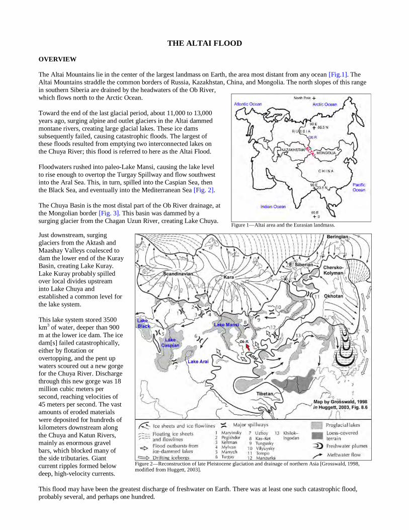
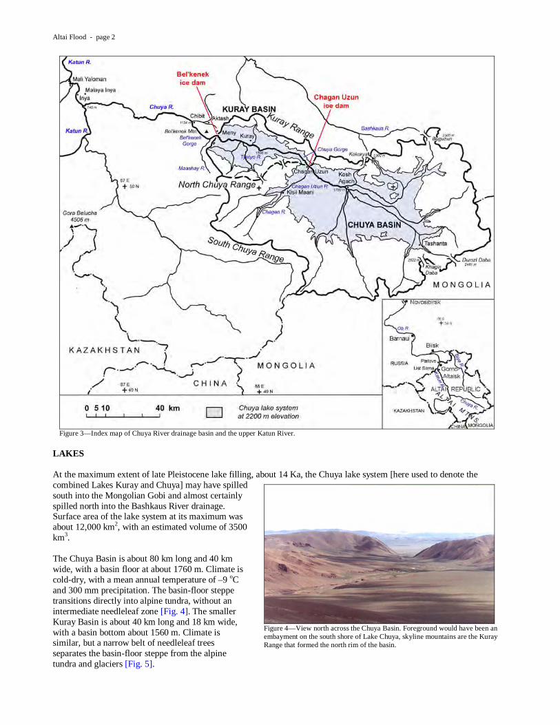
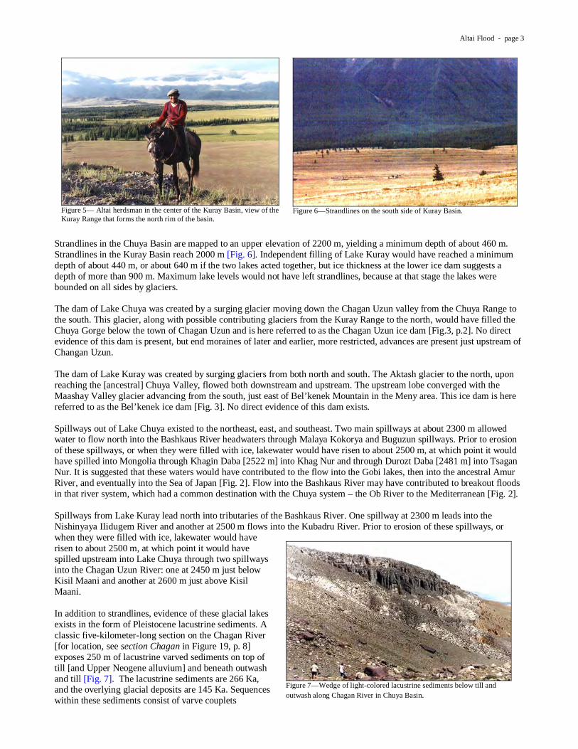
THE ALTAI FLOOD OVERVIEW The Altai Mountains lie in the center of the largest landmass on Earth, the area most distant from any ocean [Fig.1]. The Altai Mountains straddle the common borders of Russia, Kazakhstan, China, and Mongolia. The north slopes of this range in southern Siberia are drained by the headwaters of the Ob River, which flows north to the Arctic Ocean. Toward the end of the last glacial period, about 11,000 to 13,000 years ago, surging alpine and outlet glaciers in the Altai dammed montane rivers, creating large glacial lakes. These ice dams subsequently failed, causing catastrophic floods. The largest of these floods resulted from emptying two interconnected lakes on the Chuya River; this flood is referred to here as the Altai Flood. Floodwaters rushed into paleo-Lake Mansi, causing the lake level to rise enough to overtop the Turgay Spillway and flow southwest into the Aral Sea. This, in turn, spilled into the Caspian Sea, then the Black Sea, and eventually into the Mediterranean Sea [Fig. 2]. The Chuya Basin is the most distal part of the Ob River drainage, at the Mongolian border [Fig. 3]. This basin was dammed by a surging glacier from the Chagan Uzun River, creating Lake Chuya.
Just downstream, surging glaciers from the Aktash and Maashay Valleys coalesced to dam the lower end of the Kuray Basin, creating Lake Kuray. Lake Kuray probably spilled over local divides upstream into Lake Chuya and established a common level for the lake system. This lake system stored 3500 km3 of water, deeper than 900 m at the lower ice dam. The ice dam[s] failed catastrophically, either by flotation or overtopping, and the pent up waters scoured out a new gorge for the Chuya River. Discharge through this new gorge was 18 million cubic meters per second, reaching velocities of 45 meters per second. The vast amounts of eroded materials were deposited for hundreds of kilometers downstream along the Chuya and Katun Rivers, mainly as enormous gravel bars, which blocked many of the side tributaries. Giant current ripples formed below deep, high-velocity currents. This flood may have been the greatest discharge of freshwater on Earth. There was at least one such catastrophic flood, probably several, and perhaps one hundred.
Figure 1—Altai area and the Eurasian landmass.
Figure 2—Reconstruction of late Pleistocene glaciation and drainage of northern Asia [Grosswald, 1998, modified from Huggett, 2003].
Altai Flood - page 2
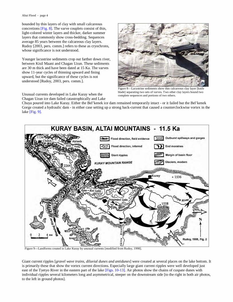
LAKES At the maximum extent of late Pleistocene lake filling, about 14 Ka, the Chuya lake system [here used to denote the combined Lakes Kuray and Chuya] may have spilled south into the Mongolian Gobi and almost certainly spilled north into the Bashkaus River drainage. Surface area of the lake system at its maximum was about 12,000 km2, with an estimated volume of 3500 km3. The Chuya Basin is about 80 km long and 40 km wide, with a basin floor at about 1760 m. Climate is cold-dry, with a mean annual temperature of –9 oC and 300 mm precipitation. The basin-floor steppe transitions directly into alpine tundra, without an intermediate needleleaf zone [Fig. 4]. The smaller Kuray Basin is about 40 km long and 18 km wide, with a basin bottom about 1560 m. Climate is similar, but a narrow belt of needleleaf trees separates the basin-floor steppe from the alpine tundra and glaciers [Fig. 5].
Figure 3—Index map of Chuya River drainage basin and the upper Katun River.
Figure 4—View north across the Chuya Basin. Foreground would have been an embayment on the south shore of Lake Chuya, skyline mountains are the Kuray Range that formed the north rim of the basin.
Altai Flood - page 3
Strandlines in the Chuya Basin are mapped to an upper elevation of 2200 m, yielding a minimum depth of about 460 m. Strandlines in the Kuray Basin reach 2000 m [Fig. 6]. Independent filling of Lake Kuray would have reached a minimum depth of about 440 m, or about 640 m if the two lakes acted together, but ice thickness at the lower ice dam suggests a depth of more than 900 m. Maximum lake levels would not have left strandlines, because at that stage the lakes were bounded on all sides by glaciers. The dam of Lake Chuya was created by a surging glacier moving down the Chagan Uzun valley from the Chuya Range to the south. This glacier, along with possible contributing glaciers from the Kuray Range to the north, would have filled the Chuya Gorge below the town of Chagan Uzun and is here referred to as the Chagan Uzun ice dam [Fig.3, p.2]. No direct evidence of this dam is present, but end moraines of later and earlier, more restricted, advances are present just upstream of Changan Uzun. The dam of Lake Kuray was created by surging glaciers from both north and south. The Aktash glacier to the north, upon reaching the [ancestral] Chuya Valley, flowed both downstream and upstream. The upstream lobe converged with the Maashay Valley glacier advancing from the south, just east of Bel’kenek Mountain in the Meny area. This ice dam is here referred to as the Bel’kenek ice dam [Fig. 3]. No direct evidence of this dam exists. Spillways out of Lake Chuya existed to the northeast, east, and southeast. Two main spillways at about 2300 m allowed water to flow north into the Bashkaus River headwaters through Malaya Kokorya and Buguzun spillways. Prior to erosion of these spillways, or when they were filled with ice, lakewater would have risen to about 2500 m, at which point it would have spilled into Mongolia through Khagin Daba [2522 m] into Khag Nur and through Durozt Daba [2481 m] into Tsagan Nur. It is suggested that these waters would have contributed to the flow into the Gobi lakes, then into the ancestral Amur River, and eventually into the Sea of Japan [Fig. 2]. Flow into the Bashkaus River may have contributed to breakout floods in that river system, which had a common destination with the Chuya system – the Ob River to the Mediterranean [Fig. 2]. Spillways from Lake Kuray lead north into tributaries of the Bashkaus River. One spillway at 2300 m leads into the Nishinyaya Ilidugem River and another at 2500 m flows into the Kubadru River. Prior to erosion of these spillways, or when they were filled with ice, lakewater would have risen to about 2500 m, at which point it would have spilled upstream into Lake Chuya through two spillways into the Chagan Uzun River: one at 2450 m just below Kisil Maani and another at 2600 m just above Kisil Maani. In addition to strandlines, evidence of these glacial lakes exists in the form of Pleistocene lacustrine sediments. A classic five-kilometer-long section on the Chagan River [for location, see section Chagan in Figure 19, p. 8] exposes 250 m of lacustrine varved sediments on top of till [and Upper Neogene alluvium] and beneath outwash and till [Fig. 7]. The lacustrine sediments are 266 Ka, and the overlying glacial deposits are 145 Ka. Sequences within these sediments consist of varve couplets
Figure 5— Altai herdsman in the center of the Kuray Basin, view of the Kuray Range that forms the north rim of the basin.
Figure 6—Strandlines on the south side of Kuray Basin.
Figure 7—Wedge of light-colored lacustrine sediments below till and outwash along Chagan River in Chuya Basin.
Altai Flood - page 4
bounded by thin layers of clay with small calcareous concretions [Fig. 8]. The varve couplets consist of thin, light-colored winter layers and thicker, darker summer layers that commonly show cross-bedding. Sequences average 85 years between the calcareous clay layers. Rudoy [2003, pers. comm.] refers to these as cryochrons, whose significance is not understood. Younger lacustrine sediments crop out farther down river, between Kisil Maani and Chagan Uzun. These sediments are 30 m thick and have been dated at 15 Ka. The varves show 11-year cycles of thinning upward and fining upward, but the significance of these cycles is not understood [Rudoy, 2003, pers. comm.]. Unusual currents developed in Lake Kuray when the Chagan Uzun ice dam failed catastrophically and Lake Chuya poured into Lake Kuray. Either the Bel’kenek ice dam remained temporarily intact - or it failed but the Bel’kenek Gorge created a hydraulic dam - in either case setting up a strong back-current that caused a counterclockwise vortex in the lake [Fig. 9].
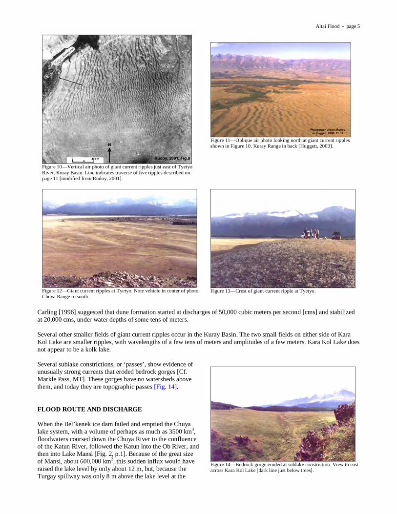
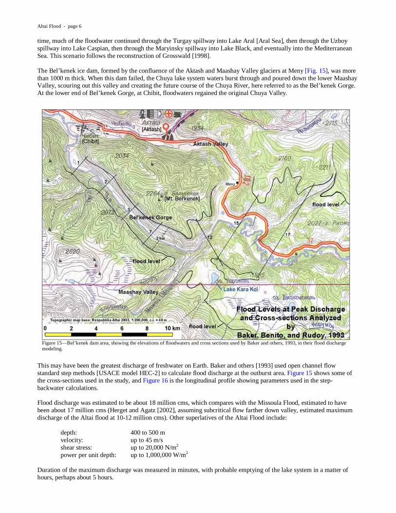
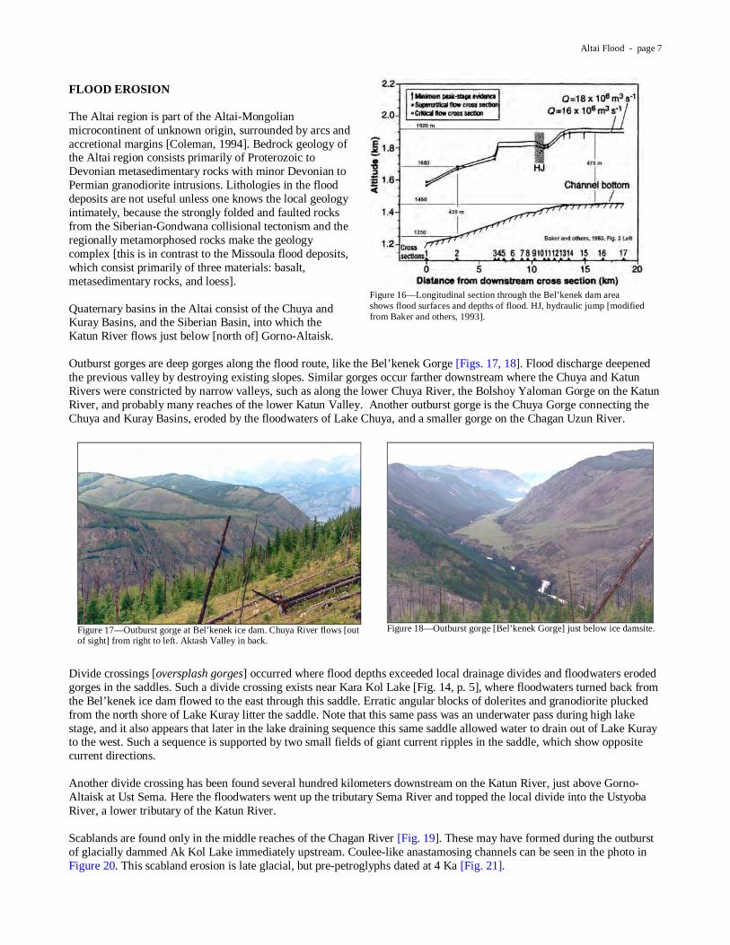
Giant current ripples [gravel wave trains, diluvial dunes and antidunes] were created at several places on the lake bottom. It is primarily these that show the vortex current directions. Especially large giant current ripples were well developed just east of the Tyetyo River in the eastern part of the lake [Figs. 10-13]. Air photos show the chains of cuspate dunes with individual ripples several kilometers long and asymmetrical, steeper on the downstream side [to the right in both air photos, to the left in ground photos].
Figure 8—Lacustrine sediments show thin calcareous clay layer [knife blade] separating two sets of varves. Two other clay layers bound two complete sequences and portions of two others.
Figure 9—Landforms created in Lake Kuray by unusual currents [modified from Rudoy, 1998].
Altai Flood - page 5
Carling [1996] suggested that dune formation started at discharges of 50,000 cubic meters per second [cms] and stabilized at 20,000 cms, under water depths of some tens of meters. Several other smaller fields of giant current ripples occur in the Kuray Basin. The two small fields on either side of Kara Kol Lake are smaller ripples, with wavelengths of a few tens of meters and amplitudes of a few meters. Kara Kol Lake does not appear to be a kolk lake. Several sublake constrictions, or ‘passes’, show evidence of unusually strong currents that eroded bedrock gorges [Cf. Markle Pass, MT]. These gorges have no watersheds above them, and today they are topographic passes [Fig. 14]. FLOOD ROUTE AND DISCHARGE When the Bel’kenek ice dam failed and emptied the Chuya lake system, with a volume of perhaps as much as 3500 km3, floodwaters coursed down the Chuya River to the confluence of the Katun River, followed the Katun into the Ob River, and then into Lake Mansi [Fig. 2, p.1]. Because of the great size of Mansi, about 600,000 km2, this sudden influx would have raised the lake level by only about 12 m, but, because the Turgay spillway was only 8 m above the lake level at the
Figure 10—Vertical air photo of giant current ripples just east of Tyetyo River, Kuray Basin. Line indicates traverse of five ripples described on page 11 [modified from Rudoy, 2001].
Figure 11—Oblique air photo looking north at giant current ripples shown in Figure 10. Kuray Range in back [Huggett, 2003].
Figure 12—Giant current ripples at Tyetyo. Note vehicle in center of photo. Chuya Range to south
Figure 13—Crest of giant current ripple at Tyetyo.
Figure 14—Bedrock gorge eroded at sublake constriction. View to east across Kara Kol Lake [dark line just below trees].
Altai Flood - page 6
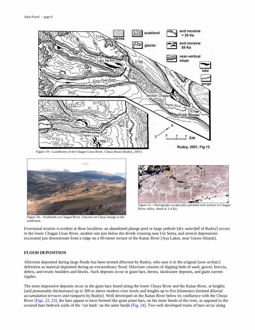
time, much of the floodwater continued through the Turgay spillway into Lake Aral [Aral Sea], then through the Uzboy spillway into Lake Caspian, then through the Maryinsky spillway into Lake Black, and eventually into the Mediterranean Sea. This scenario follows the reconstruction of Grosswald [1998]. The Bel’kenek ice dam, formed by the confluence of the Aktash and Maashay Valley glaciers at Meny [Fig. 15], was more than 1000 m thick. When this dam failed, the Chuya lake system waters burst through and poured down the lower Maashay Valley, scouring out this valley and creating the future course of the Chuya River, here referred to as the Bel’kenek Gorge. At the lower end of Bel’kenek Gorge, at Chibit, floodwaters regained the original Chuya Valley.
This may have been the greatest discharge of freshwater on Earth. Baker and others [1993] used open channel flow standard step methods [USACE model HEC-2] to calculate flood discharge at the outburst area. Figure 15 shows some of the cross-sections used in the study, and Figure 16 is the longitudinal profile showing parameters used in the step-backwater calculations. Flood discharge was estimated to be about 18 million cms, which compares with the Missoula Flood, estimated to have been about 17 million cms (Herget and Agatz [2002], assuming subcritical flow farther down valley, estimated maximum discharge of the Altai flood at 10-12 million cms). Other superlatives of the Altai Flood include: depth: 400 to 500 m velocity: up to 45 m/s shear stress: up to 20,000 N/m2 power per unit depth: up to 1,000,000 W/m2 Duration of the maximum discharge was measured in minutes, with probable emptying of the lake system in a matter of hours, perhaps about 5 hours.
Figure 15—Bel’kenek dam area, showing the elevations of floodwaters and cross sections used by Baker and others, 1993, in their flood discharge modeling.
Altai Flood - page 7
FLOOD EROSION The Altai region is part of the Altai-Mongolian microcontinent of unknown origin, surrounded by arcs and accretional margins [Coleman, 1994]. Bedrock geology of the Altai region consists primarily of Proterozoic to Devonian metasedimentary rocks with minor Devonian to Permian granodiorite intrusions. Lithologies in the flood deposits are not useful unless one knows the local geology intimately, because the strongly folded and faulted rocks from the Siberian-Gondwana collisional tectonism and the regionally metamorphosed rocks make the geology complex [this is in contrast to the Missoula flood deposits, which consist primarily of three materials: basalt, metasedimentary rocks, and loess]. Quaternary basins in the Altai consist of the Chuya and Kuray Basins, and the Siberian Basin, into which the Katun River flows just below [north of] Gorno-Altaisk. Outburst gorges are deep gorges along the flood route, like the Bel’kenek Gorge [Figs. 17, 18]. Flood discharge deepened the previous valley by destroying existing slopes. Similar gorges occur farther downstream where the Chuya and Katun Rivers were constricted by narrow valleys, such as along the lower Chuya River, the Bolshoy Yaloman Gorge on the Katun River, and probably many reaches of the lower Katun Valley. Another outburst gorge is the Chuya Gorge connecting the Chuya and Kuray Basins, eroded by the floodwaters of Lake Chuya, and a smaller gorge on the Chagan Uzun River.
Divide crossings [oversplash gorges] occurred where flood depths exceeded local drainage divides and floodwaters eroded gorges in the saddles. Such a divide crossing exists near Kara Kol Lake [Fig. 14, p. 5], where floodwaters turned back from the Bel’kenek ice dam flowed to the east through this saddle. Erratic angular blocks of dolerites and granodiorite plucked from the north shore of Lake Kuray litter the saddle. Note that this same pass was an underwater pass during high lake stage, and it also appears that later in the lake draining sequence this same saddle allowed water to drain out of Lake Kuray to the west. Such a sequence is supported by two small fields of giant current ripples in the saddle, which show opposite current directions. Another divide crossing has been found several hundred kilometers downstream on the Katun River, just above Gorno-Altaisk at Ust Sema. Here the floodwaters went up the tributary Sema River and topped the local divide into the Ustyoba River, a lower tributary of the Katun River. Scablands are found only in the middle reaches of the Chagan River [Fig. 19]. These may have formed during the outburst of glacially dammed Ak Kol Lake immediately upstream. Coulee-like anastamosing channels can be seen in the photo in Figure 20. This scabland erosion is late glacial, but pre-petroglyphs dated at 4 Ka [Fig. 21].
Figure 16—Longitudinal section through the Bel’kenek dam area shows flood surfaces and depths of flood. HJ, hydraulic jump [modified from Baker and others, 1993].
Figure 17—Outburst gorge at Bel’kenek ice dam. Chuya River flows [out of sight] from right to left. Aktash Valley in back.
Figure 18—Outburst gorge [Bel’kenek Gorge] just below ice damsite.
Altai Flood - page 8
Evorsional erosion is evident at three localities: an abandoned plunge pool or large pothole [dry waterfall of Rudoy] occurs in the lower Chagan Uzun River, another one just below the divide crossing near Ust Sema, and several depressions excavated just downstream from a ridge on a 60-meter terrace of the Katun River [Aya Lakes, near Gorno-Altaisk]. FLOOD DEPOSITION Alluvium deposited during large floods has been termed diluvium by Rudoy, who uses it in the original [now archaic] definition as material deposited during an extraordinary flood. Diluvium consists of dipping beds of sand, gravel, breccia, debris, and erratic boulders and blocks. Such deposits occur in giant bars, berms, slackwater deposits, and giant current ripples. The most impressive deposits occur in the giant bars found along the lower Chuya River and the Katun River, at heights [and presumably thicknesses] up to 300 m above modern river levels and lengths up to five kilometers [termed diluvial accumulation terraces and ramparts by Rudoy]. Well developed on the Katun River below its confluence with the Chuya River [Figs. 22, 23], the bars appear to have formed like giant point bars, on the inner bends of the river, as opposed to the scoured bare bedrock walls of the ‘cut bank’ on the outer bends [Fig. 24]. Two well developed trains of bars occur along
Figure 19—Landforms of the Chagan Uzun River, Chuya Basin [Rudoy, 2001].
Figure 20—Scablands on Chagan River. Glaciers on Chuya Range to the southwest.
Figure 21—Petroglyphs on glacially polished rock surface in Chagan River valley, dated at 3-4 Ka.

Altai Flood - page 9
this reach, the upper at about 240 m above modern river level and the lower at about 100 m [Fig. 25]. These bars diminish in height and thickness downstream to about 60 m near Gorno-Altaisk.
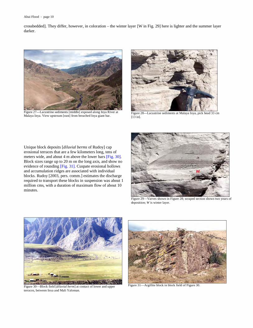
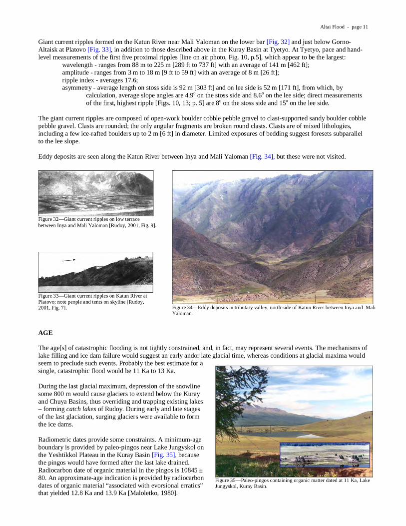
Giant bar deposits consist of foreset beds of open-work sand, breccia, and erratic blocks up to several meters in diameter. The dominant angularity of clasts and the floating blocks attest to transport mainly by suspension; the floating blocks do not deform the underlying sediments like dropstones. Where well exposed, multiple sequences of foreset breccias 8-10 m thick separated by subhorizontal normal alluvium are seen, typically seven to nine sets [Fig. 26]. Rudoy suggests the high terraces are probably the work of several floods. Where the high terraces blocked tributary mouths, slackwater deposits are exposed on the tributary sides of the giant bars. These deposits dip and thin upstream, showing the current direction to be up the tributary from the main channel. In the well exposed section on the Mali Yaloman tributary, sediments are sandy fine breccia, with cross-bedding that indicates current direction to the south [up-tributary]. Lithologies are present in the deposits that do not crop out in the Mali Yaloman watershed. Where the high terraces blocked tributary mouths, like the Inya River and Mali Yaloman River, they also created lakes in the tributary valleys [Cf. Spirit Lake, WA]. Figure 27 looks up the Inya River from the breached bar at Inya. Light-colored sediments in the middle of the photo are lacustrine varved sediments, shown in Figures 28 and 29. These varve couplets are like traditional varves in that the winter layer is fine silt and clay, and the summer layer is coarser sand [here shown
Figure 22—Flood deposits along the Chuya and Katun Rivers [modified from Rudoy and Baker, 1996].
Figure 23—Vertical air photo of giant bar between Inya and Mali Yaloman [Rudoy, 2001].
Figure 24—Giant bar formed on inner bend of Katun River between Inya and Mali Yaloman, scoured valley wall opposite.
Figure 25—Giant bar on Katun River at Inya, breached by tributary Inya River. High terrace is 240 m above modern river.
Figure 26—Giant bar deposit exposed in streamcut of Mali Yaloman tributary, Alexei Rudoy at sequence boundary.
Altai Flood - page 10
crossbedded]. They differ, however, in coloration – the winter layer [W in Fig. 29] here is lighter and the summer layer darker.
Unique block deposits [diluvial berms of Rudoy] cap erosional terraces that are a few kilometers long, tens of meters wide, and about 4 m above the lower bars [Fig. 30]. Block sizes range up to 20 m on the long axis, and show no evidence of rounding [Fig. 31]. Cuspate erosional hollows and accumulation ridges are associated with individual blocks. Rudoy [2003, pers. comm.] estimates the discharge required to transport these blocks in suspension was about 1 million cms, with a duration of maximum flow of about 10 minutes.
Figure 27—Lacustrine sediments [middle] exposed along Inya River at Malaya Inya. View upstream [east] from breached Inya giant bar.
Figure 28—Lacustrine sediments at Malaya Inya, pick head 33 cm [13 in].
Figure 29—Varves shown in Figure 28; scraped section shows two years of deposition; W is winter layer.
Figure 30—Block field [diluvial berm] at contact of lower and upper terraces, between Inya and Mali Yaloman.
Figure 31—Argillite block in block field of Figure 30.
Altai Flood - page 11
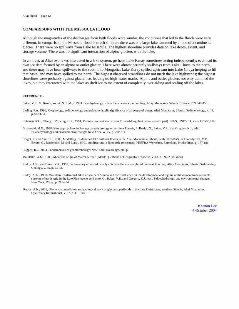
Giant current ripples formed on the Katun River near Mali Yaloman on the lower bar [Fig. 32] and just below Gorno-Altaisk at Platovo [Fig. 33], in addition to those described above in the Kuray Basin at Tyetyo. At Tyetyo, pace and hand-level measurements of the first five proximal ripples [line on air photo, Fig. 10, p.5], which appear to be the largest:
wavelength - ranges from 88 m to 225 m [289 ft to 737 ft] with an average of 141 m [462 ft]; amplitude - ranges from 3 m to 18 m [9 ft to 59 ft] with an average of 8 m [26 ft]; ripple index - averages 17.6; asymmetry - average length on stoss side is 92 m [303 ft] and on lee side is 52 m [171 ft], from which, by
calculation, average slope angles are 4.9o on the stoss side and 8.6o on the lee side; direct measurements of the first, highest ripple [Figs. 10, 13; p. 5] are 8o on the stoss side and 15o on the lee side.
The giant current ripples are composed of open-work boulder cobble pebble gravel to clast-supported sandy boulder cobble pebble gravel. Clasts are rounded; the only angular fragments are broken round clasts. Clasts are of mixed lithologies, including a few ice-rafted boulders up to 2 m [6 ft] in diameter. Limited exposures of bedding suggest foresets subparallel to the lee slope. Eddy deposits are seen along the Katun River between Inya and Mali Yaloman [Fig. 34], but these were not visited.
AGE The age[s] of catastrophic flooding is not tightly constrained, and, in fact, may represent several events. The mechanisms of lake filling and ice dam failure would suggest an early andor late glacial time, whereas conditions at glacial maxima would seem to preclude such events. Probably the best estimate for a single, catastrophic flood would be 11 Ka to 13 Ka. During the last glacial maximum, depression of the snowline some 800 m would cause glaciers to extend below the Kuray and Chuya Basins, thus overriding and trapping existing lakes – forming catch lakes of Rudoy. During early and late stages of the last glaciation, surging glaciers were available to form the ice dams. Radiometric dates provide some constraints. A minimum-age boundary is provided by paleo-pingos near Lake Jungyskol on the Yeshtikkol Plateau in the Kuray Basin [Fig. 35], because the pingos would have formed after the last lake drained. Radiocarbon date of organic material in the pingos is 10845 ± 80. An approximate-age indication is provided by radiocarbon dates of organic material “associated with evorsional erratics” that yielded 12.8 Ka and 13.9 Ka [Maloletko, 1980].
Figure 32—Giant current ripples on low terrace between Inya and Mali Yaloman [Rudoy, 2001, Fig. 9].
Figure 34—Eddy deposits in tributary valley, north side of Katun River between Inya and Mali Yaloman.
Figure 33—Giant current ripples on Katun River at Platovo; note people and tents on skyline [Rudoy, 2001, Fig. 7].
Figure 35—Paleo-pingos containing organic matter dated at 11 Ka, Lake Jungyskol, Kuray Basin.
Altai Flood - page 12
COMPARISONS WITH THE MISSOULA FLOOD Although the magnitudes of the discharges from both floods were similar, the conditions that led to the floods were very different. In comparison, the Missoula flood is much simpler; there was one large lake dammed by a lobe of a continental glacier. There were no spillways from Lake Missoula. The highest shoreline provides data on lake depth, extent, and storage volume. There was no significant interaction of alpine glaciers with the lake. In contrast, at Altai two lakes interacted in a lake system, perhaps Lake Kuray sometimes acting independently; each had its own ice dam formed by an alpine or outlet glacier. There were almost certainly spillways from Lake Chuya to the north, and there may have been spillways to the south into Mongolia; Lake Kuray spilled upstream into Lake Chuya helping to fill that basin, and may have spilled to the north. The highest observed strandlines do not mark the lake highstands; the highest shorelines were probably against glacial ice, leaving no high-water marks. Alpine and outlet glaciers not only dammed the lakes, but they interacted with the lakes as shelf ice to the extent of completely over-riding and sealing off the lakes. REFERENCES Baker, V.R., G. Benito, and A. N. Rudoy. 1993. Paleohydrology of late Pleistocene superflooding, Altay Mountains, Siberia: Science, 259:348-350. Carling, P.A. 1996, Morphology, sedimentology and palaeohydraulic significance of large gravel dunes, Altai Mountains, Siberia: Sedimentology, v. 43,
p. 647-664. Coleman, R.G., Chang, E.Z., Ying, D.X., 1994, Tectonic transect map across Russia-Mongolia-China (western part): IUGS, UNESCO, scale 1:2,500,000: Grosswald, M.G., 1998, New approach to the ice age paleohydrology of northern Eurasia, in Benito, G., Baker, V.R., and Gregory, K.J., eds.,
Palaeohydrology and environmental change: New York, Wiley, p. 200-214. Herget, J., and Agatz, H., 2003, Modelling ice-dammed lake outburst floods in the Altai Mountains (Siberia) with HEC-RAS, in Thorndycraft, V.R.,
Benito, G., Barriendos, M. and Llasat, M.C., Applications in flood risk assessment: PHEFRA Workshop, Barcelona, Prodeedings, p. 177-181. Huggett, R.J., 2003, Fundamentals of geomorphology: New York, Routledge, 386 p. Maloletko, A.M., 1980, About the origin of Maima terrace (Altai): Questions of Geography of Siberia, v. 13, p. 89-92 [Russian]. Rudoy, A.N., and Baker, V.R., 1993, Sedimentary effects of cataclysmic late Pleistocene glacial outburst flooding, Altay Mountains, Siberia: Sedimentary
Geology, v. 85, p. 53-62.
Rudoy, A. N., 1998, Mountain ice-dammed lakes of southern Siberia and their influence on the development and regime of the intracontinental runoff systems of north Asia in the Late Pleistocene, in Benito, G., Baker, V.R., and Gregory, K.J., eds., Palaeohydrology and environmental change: New York, Wiley, p. 215-234.
Rudoy, A.N., 2001, Glacier-dammed lakes and geological work of glacial superfloods in the Late Pleistocene, southern Siberia, Altai Mountains:
Quaternary International, v. 87, p. 119-140.
Keenan Lee 4 October 2004