the anatomy of a long-lived fault system—structural and
TRANSCRIPT

113 NEW MEXICO BUREAU OF GEOLOGY & MINERAL RESOURCES, BULLETIN 160, 2004
The anatomy of a longlived fault system—structural andthermochronologic evidence for Laramide to
Quaternary activity on the Tijeras fault, New Mexico John C. Abbott1, Laurel B. Goodwin2, Shari A. Kelley3,
Stephen R. Maynard4, and William C. McIntosh5
1Science Applications International Corporation, 360 Bay Street, Suite 200, Augusta, GA, 30901 2Department of Geology and Geophysics, University of Wisconsin, Madison, WI 53706
3Department of Earth and Environmental Science, New Mexico Institute of Mining and Technology, Socorro, NM 87801 4Consulting Geologist, 4015 Carlisle NE, Suite E, Albuquerque, NM 87107
5New Mexico Bureau of Geology and Mineral Resources, New Mexico Institute of Mining and Technology, Socorro, NM 87801
Abstract Many previous workers have recognized that the Tijeras–Cañoncito fault system is a longlived fault system. The number, timing, and kinematics of different deformation events, however, have been difficult to resolve due to a lack of piercing points and stratigraphic limitations. We propose a method for resolving the kinematics and minimum number of faulting events and use fission track and 40Ar/39Ar dating techniques together with geologic constraints to evaluate the timing of these events.Our approach is to use minor faults as a record of strain in the damage zone of the Tijeras fault and toassume that strain is compatible with fault slip. Thus, for example, the absence of evidence for crustal thickening in the damage zone is taken to indicate that the fault did not experience reverse motion.
This work indicates that faultzone structural elements largely record dextral strikeslip motion witha component of northsidedown normal motion. This is the earliest faulting event, which thermochronologic and geologic constraints indicate initiated during the Laramide orogeny. The fault may have been reactivated during the transition in stress states between the Laramide orogeny andRio Grande rifting and was definitely active during extension associated with the Rio Grande rift.Reactivation involved leftlateral strikeslip motion and, at least locally, further northsidedown normal movement.
Introduction
The history of faulting in New Mexico is, in large part, a history of reactivation. Elucidating the details of this history—in particular, seeing through the overprint of younger deformational events to determine the sense and magnitude ofmotion on older faults—is an ongoing challenge, critical tounderstanding the tectonic evolution of the southwesternUnited States. More specifically, if we consider the Rio Grande rift, two important points become evident. First, themajor faults that accommodated extension within the northtrending rift do not all strike north; northeast and northweststriking faults played a significant role in rift formation (Cordell 1978; Ramberg et al. 1978). Second, many ofthese faults or fault systems appear to record older deformation (e.g., Beck and Chapin 1994). In this paper, we explore the history of one such fault, the northeaststriking Tijeras fault, part of the Tijeras–Cañoncito fault system, from the earliest activity recorded by structures within the system to the present. This fault system was demonstrably active during rifting (e.g., Lisenbee et al. 1979; Abbott and Goodwin 1995; GRAM/William Lettis & Associates 1995; Kelson et al. 1999) and also has been a major element in most recent models for Laramide deformation in New Mexico (Cather 1999;Erslev 2001, and references therein). Until now, however, there has been no systematic investigation of kinematic datain the fault zone. In this paper we present new fault slickenside data, fissiontrack and 40Ar/39Ar ages of units cut by thefault, and descriptions of structural and sedimentological relationships that are key to understanding the deformational history of the fault system. These data, integratedwith previous observations, demonstrate that both the largescale geometry and internal structure of the fault system were established during the Late Cretaceous–early Tertiary Laramide orogeny. The fault system was reactivated in Oligocene time during a transition between Laramidetectonism and rifting and has accommodated extension inthe Rio Grande rift into the Quaternary. There is no evidence
for older deformation. Our work provides a context from which to view the many northeasttrending fault systems ofNew Mexico. In addition it suggests an approach to evaluating faultzone kinematics in a longlived fault system.
Previous studies—the Tijeras–Cañoncito fault system
Faultzone geometry
The Tijeras–Cañoncito fault system (cf. Lisenbee et al. 1979)comprises a number of northeaststriking, subvertical faults,including the Tijeras, Gutierrez, San Lazarus, Los Angeles, and Lamy faults (Fig. 1). The system is regionally extensive; it has been mapped for more than 80 km, from Kirtland Air Force Base in the southwest (approximately 16 km southeast of Albuquerque) to the Cañoncito area in the northeast (roughly 20 km southeast of Santa Fe; Kelley 1954; Lisenbeeet al. 1979). Russell and Snelson (1990, 1994) and May andRussell (1994) hypothesized that the existing Tijeras–Cañoncito fault system was utilized during Rio Grande riftextension as the Tijeras accommodation zone, which theysuggest extends into the rift to the southwest. Recent studies, however, demonstrate that the Tijeras fault is connectedto a northstriking splay of the Hubbell Spring normal faultzone on the eastern margin of the rift, and does not appearto be part of an accommodation zone related to rifting(Grauch 1999; Grauch et al. 1999; Maldonado et al. 1999). A leftstepping jog in the rift margin at this point shows up in aeromagnetic data, in which Precambrian granitic rocks north of the fault constitute a magnetic high; this geometrysuggests that the Tijeras fault may have accommodated leftlateral slip during riftrelated extension (Grauch 1999). Incontrast, rightlateral separation of isostatic gravity anomalies across both the Tijeras fault and its inferred, alongstrike extension on the west side of the Rio Grande rift (cf.Heywood 1992; Grauch et al. 1999) suggests that much ofthe fault system is buried by riftrelated sediments and is no longer active. On the northeast end near Cañoncito, the faultsystem appears to link with the northstriking Picuris–
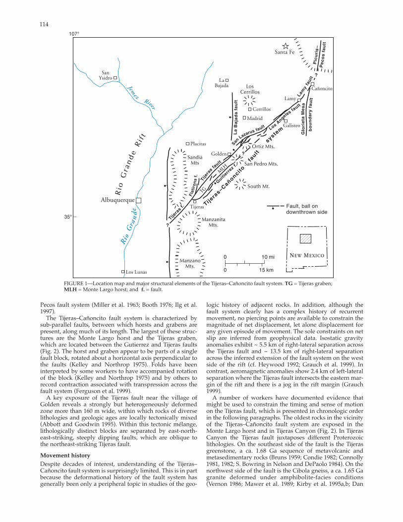
114
FIGURE 1—Location map and major structural elements of the Tijeras–Cañoncito fault system. TG = Tijeras graben; MLH = Monte Largo horst; and f. = fault.
Pecos fault system (Miller et al. 1963; Booth 1976; Ilg et al.1997).
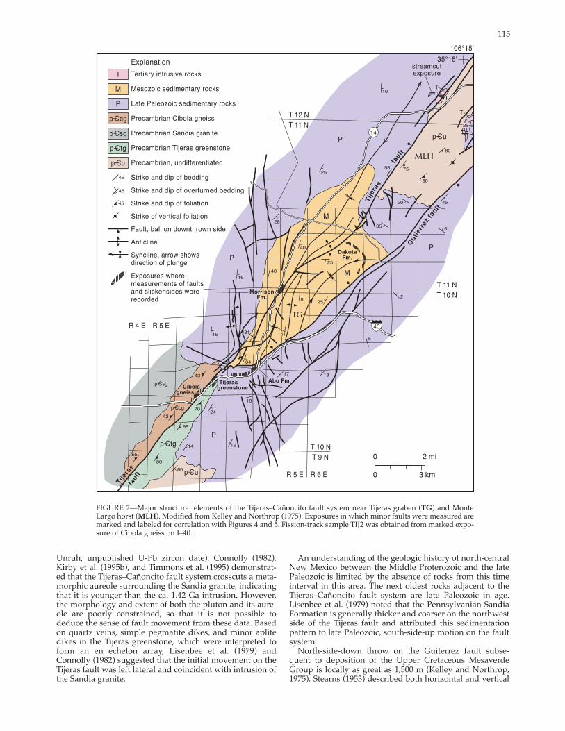
The Tijeras–Cañoncito fault system is characterized bysubparallel faults, between which horsts and grabens are present, along much of its length. The largest of these structures are the Monte Largo horst and the Tijeras graben, which are located between the Gutierrez and Tijeras faults(Fig. 2). The horst and graben appear to be parts of a singlefault block, rotated about a horizontal axis perpendicular tothe faults (Kelley and Northrop 1975). Folds have been interpreted by some workers to have accompanied rotation of the block (Kelley and Northrop 1975) and by others to record contraction associated with transpression across the fault system (Ferguson et al. 1999).
A key exposure of the Tijeras fault near the village of Golden reveals a strongly but heterogeneously deformed zone more than 160 m wide, within which rocks of diverse lithologies and geologic ages are locally tectonically mixed(Abbott and Goodwin 1995). Within this tectonic mélange,lithologically distinct blocks are separated by eastnortheaststriking, steeply dipping faults, which are oblique to the northeaststriking Tijeras fault.
Movement history
Despite decades of interest, understanding of the Tijeras–Cañoncito fault system is surprisingly limited. This is in partbecause the deformational history of the fault system hasgenerally been only a peripheral topic in studies of the geo
logic history of adjacent rocks. In addition, although thefault system clearly has a complex history of recurrent movement, no piercing points are available to constrain the magnitude of net displacement, let alone displacement forany given episode of movement. The sole constraints on netslip are inferred from geophysical data. Isostatic gravityanomalies exhibit ~ 5.5 km of rightlateral separation across the Tijeras fault and ~ 13.5 km of rightlateral separation across the inferred extension of the fault system on the westside of the rift (cf. Heywood 1992; Grauch et al. 1999). Incontrast, aeromagnetic anomalies show 2.4 km of leftlateralseparation where the Tijeras fault intersects the eastern margin of the rift and there is a jog in the rift margin (Grauch 1999).
A number of workers have documented evidence that might be used to constrain the timing and sense of motionon the Tijeras fault, which is presented in chronologic order in the following paragraphs. The oldest rocks in the vicinity of the Tijeras–Cañoncito fault system are exposed in the Monte Largo horst and in Tijeras Canyon (Fig. 2). In Tijeras Canyon the Tijeras fault juxtaposes different Proterozoic lithologies. On the southeast side of the fault is the Tijeras greenstone, a ca. 1.68 Ga sequence of metavolcanic andmetasedimentary rocks (Bruns 1959; Condie 1982; Connolly1981, 1982; S. Bowring in Nelson and DePaolo 1984). On thenorthwest side of the fault is the Cibola gneiss, a ca. 1.65 Gagranite deformed under amphibolitefacies conditions(Vernon 1986; Mawer et al. 1989; Kirby et al. 1995a,b; Dan
115
FIGURE 2—Major structural elements of the Tijeras–Cañoncito fault system near Tijeras graben (TG) and MonteLargo horst (MLH). Modified from Kelley and Northrop (1975). Exposures in which minor faults were measured are marked and labeled for correlation with Figures 4 and 5. Fissiontrack sample TIJ2 was obtained from marked exposure of Cibola gneiss on I–40.
Unruh, unpublished UPb zircon date). Connolly (1982), Kirby et al. (1995b), and Timmons et al. (1995) demonstrated that the Tijeras–Cañoncito fault system crosscuts a metamorphic aureole surrounding the Sandia granite, indicatingthat it is younger than the ca. 1.42 Ga intrusion. However, the morphology and extent of both the pluton and its aureole are poorly constrained, so that it is not possible todeduce the sense of fault movement from these data. Based on quartz veins, simple pegmatite dikes, and minor aplitedikes in the Tijeras greenstone, which were interpreted to form an en echelon array, Lisenbee et al. (1979) andConnolly (1982) suggested that the initial movement on theTijeras fault was left lateral and coincident with intrusion of the Sandia granite.
An understanding of the geologic history of northcentralNew Mexico between the Middle Proterozoic and the late Paleozoic is limited by the absence of rocks from this time interval in this area. The next oldest rocks adjacent to the Tijeras–Cañoncito fault system are late Paleozoic in age.Lisenbee et al. (1979) noted that the Pennsylvanian SandiaFormation is generally thicker and coarser on the northwestside of the Tijeras fault and attributed this sedimentationpattern to late Paleozoic, southsideup motion on the fault system.
Northsidedown throw on the Guiterrez fault subsequent to deposition of the Upper Cretaceous Mesaverde Group is locally as great as 1,500 m (Kelley and Northrop,1975). Stearns (1953) described both horizontal and vertical

116
separations across the fault system in Cretaceous and Tertiary rocks near Galisteo Creek. Several workers (Kelley and Northrop 1975; Lisenbee et al. 1979; Chapin and Cather1981) interpreted folds oblique to the fault system to record rightlateral strikeslip motion in the Tertiary. Abbott and Goodwin (1995) interpreted minor faults within a tectonic mélange in the Tijeras fault zone as Riedel shears that record rightlateral strikeslip movement based on their orientationwith respect to the main fault (cf. Tchalenko 1970). Ferguson et al. (1999) interpreted structures in the Tijeras–Cañoncito fault system, including the Tijeras and Gutierrez faults, as recording dextral transpression in Laramide time. Ferguson (1999) subsequently suggested that only the Gutierrez fault was active during the Laramide orogeny, and that the Tijerasfault initiated in the Miocene as a leftlateral strikeslip fault.Pronounced stratigraphic thickening and highly variablepaleocurrent directions in the strata of the PaleogeneGalisteo Basin immediately adjacent to the Tijeras–Cañoncito fault system indicate that the fault system wasactive in the Paleogene and controlled subsidence and sedimentation to the northwest (Cather 1992; Abbott et al. 1995).Because the southeast block was not emergent, the maximum displacement magnitude of the Paleogene dipslipcomponent on the Tijeras–Cañoncito fault system is constrained to approximately the thickness of the strata of theGalisteo Basin (approximately 1,300 m, northwestsidedown; Abbott et al. 1995).
A period of widespread volcanic and igneous activity followed the Laramide orogeny (Stearns 1953; Cather 1989). A shallow intrusive center, the San Pedro–Ortiz porphyry belt, was emplaced in and around the Tijeras–Cañoncito faultsystem in the Oligocene (Bachman and Mehnert 1978;Woodward 1984; Kay 1986; Maynard et al. 1990; Maynard et al. 1991; Sauer 1999). Mineral deposits in the OrtizMountains are localized along the Tijeras–Cañoncito fault system, and a genetic relationship between faulting andmineralization has been demonstrated by a number ofworkers (Woodward 1984; Kay 1986; Maynard et al. 1990; Maynard et al. 1991). Maynard et al. (1990) showed that intrusion and mineralization were broadly contemporaneous with faulting, and that a KAr date on hornblende from an igneous intrusive on the west side of the Ortiz Mountains constrains the timing of midTertiary movement on this portion of the Tijeras–Cañoncito fault system to 30–34 Ma (early Oligocene).
Ferguson et al. (1999) described and mapped highangle,north to northweststriking faults with small leftlateralseparations and eaststriking apparently dextral faults adjacent to the Tijeras fault. They interpreted these structures as synthetic and antithetic Riedel shears, respectively, and proposed that they record reactivation of the fault during midTertiary leftlateral strikeslip. However, synthetic Riedelshears typically form at a low angle, and antithetic shears ata high angle, to the primary fault surface (Riedel 1929;Tchalenko 1970), exactly the opposite of the relationship described above. This fault pattern therefore requires additional explanation. Ferguson (1999) subsequently suggested that the Tijeras fault initiated as a midTertiary leftlateral strikeslip structure that overprinted the Gutierrez fault and associated structures.
In Tijeras Canyon the Tijeras fault juxtaposes Proterozoic Tijeras greenstone and colluvium (Lisenbee et al. 1979) of probable Pleistocene age (B. Harrison and D. Love, personal comm. 1994). Separation on this fault is northwestsidedown. Near the village of Golden (Fig. 1) Quaternary activity on the Tijeras fault is illustrated by relationships betweenfaulting and sedimentation (Abbott and Goodwin 1995). A streamcut exposes a strand of the Tijeras fault that incorporated Quaternary carbonaterich mottled clay and pebbly
gravel into the fault zone, but is overlain by Quaternaryimbricated gravel. The southeastsidedown separation ofthis fault is opposite that of both the previously described Quaternary fault in Tijeras Canyon (Lisenbee et al. 1979) and a strand of the Tijeras fault just a kilometer to the north, probably reflecting significant lateral motion (Kelson et al. 1999). Abbott and Goodwin (1995) suggested that Neogenemotion on the Tijeras fault was leftlateral based on minorfault kinematics; Kelson et al. (1999) agreed, citing 30 m of leftlateral deflection of an unnamed arroyo. Previous workers have also suggested that the Tijeras–Cañoncito fault system served as a transfer fault during riftrelated extension. Transfer faults typically exhibit variations in magnitude andsense of motion along strike; Lisenbee and Woodward (1995) proposed that the sense of slip changes along strikewithin the Tijeras–Cañoncito fault system. Southwest of thenormal La Bajada fault (Fig. 1), they suggested that netextension is greater on the southeast side of the fault system, resulting in left slip. To the northeast, they suggested that extension is greater on the northwest side of the fault system, resulting in right slip. Machette et al. (1998) noted that there is no documented evidence of Quaternary activity onthe Tijeras–Cañoncito fault system northeast of the LaBajada fault.
Additional evidence for Quaternary activity on theTijeras–Cañoncito fault system is found in the Holocene sediments of the Rio Grande rift. Gibbons (1990) suggested thatthe drainage system from Tijeras Canyon was disrupted by Holocene interaction between the Tijeras and HubbellSpring faults, and Machette (1982) surveyed Holocenescarps that may be southwestern continuations of the Tijeras fault. It is not known whether there has been any surface rupture on the fault system in historical time, though several earthquakes have been recorded near or on the Tijeras fault in the past several decades (Sanford et al. 1991). The largest one (M.M. VI) occurred on November 6, 1947, near Tijeras and Cedar Crest (Kelley and Northrop 1975).
In summary most workers agree that structures associated with the Tijeras–Cañoncito fault system record at least one episode of leftlateral strikeslip and that activity on thefault continued into the Quaternary. The timing of initiation of faulting, however, is debated, as is the timing, significance, and location within the fault system of rightlateralstrikeslip motion. The length of the fault system and thewidth and magnitude of deformation within the Tijeras fault zone, however, all suggest significant displacement onthe fault system, consistent with the offset gravity anomalies. Principles and methods of faultzone kinematic analysis
As mentioned above, there are no piercing points to constrain net slip on the Tijeras–Cañoncito fault system. Thedeformation history of the system must therefore be inferred from the character, orientation, and distribution of major and minor structures in the fault zone, stratigraphicseparation, and sedimentologic data. Previous work on the San Andreas fault system suggests an approach to optimizing the information obtained from subsidiary faults andfolds, which we have employed in this study. The background required to understand this approach is provided in the following paragraphs.
Faults are typically surrounded by zones of damage, within which minor structures overprint regional structures. The width of a damage zone is determined by the density offaultzone structures, which decreases with distance from a given fault; damagezone width may vary depending onwhich structures are used to define it. For example thewidth of the damage zone around the Punchbowl fault (a strand of the San Andreas fault system) defined by the

117
extent of faultrelated microfractures is more than triple that defined by macroscopic shear fractures and minor faults (Wilson 1999). In this paper, we consider the damage zone around the Tijeras fault as defined by the distribution of macroscopic minor faults and fractures, but also consider fractures in outcrops outside the damage zone proper (outcrops studied are shown in Fig. 2).
Patterns of deformation in the vicinity of the San Andreas fault reflect deformation partitioning (see reviews by Teyssier et al. 1995 and Tavernelli 1998). The fault itself accommodatesrightlateral strikeslip motion, butstructures to the southwest and northeast record faultperpendicular shortening. Minor fault data collected westof the San Andreas fault (Tavarnelli 1998) and within the damage zone ofthe Punchbowl fault, a dormant strand of the San Andreas that accommodated approximately 20 km of rightlateral strikeslip before exhumation (Fig. 3;Chester and Logan 1987), record this partitioning. Structures within the northern Salinian block, west of the San Andreas fault, include folds that typically trend subparallel to the faultand plunge shallowly to moderatelynorthwest or (less commonly) southeast, and northweststriking thrust faults that dip both southwest andnortheast (Fig. 3A; Tavarnelli 1998).The data shown in Figure 3A are typical of 127 faults studied; most of these data were apparently collected more than 1 km from the major faults of the San Andreas system. They record shortening at nearly right angles to theSan Andreas fault. The inferred maximum principal stress would also be at a high angle to the fault.
In contrast the Punchbowl damagezone defined by the distribution ofmacroscopic minor faults and frac
FIGURE 3—Lower hemisphere, equal area net plots of minor faults associated with the San Andreas fault system. Figures have been rotated to facilitate comparison with data from the Tijeras fault. (A) Faults from Bodega Head, Salinian block, west of the San Andreas Fault, showing representative orientations of thrust faults (dashed lines) and slickenside striae (solid circles with tails indicating slip directions). The trace of the San Andreas fault is shown as a solid line. After Tavernelli (1998). (B) Poles to minor faults within the damagezone of the Punchbowl fault; key indicates fault type. Punchbowl fault trace is shown assolid line. Dashed lines separate fields of dextral and sinistral strikeslip faults. Red square is the Punchbowl fault Baxis inferred from minor faults and folds. Red ellipse is the inferred slip direction; red circle is the inferred maximum principal stress orientation. Note that this is a dominantly dextral strikeslip fault with a reverse component of movement. Modified from Chester and Logan (1987). (C) Differences in change of shape of area of damage zone (initial unfaulted square shown in center) produced by minor thrust faults parallel to the main slip surface (left) and dextral strikeslip faults oblique to the main slip surface (right). See text for further explanation.
tures, which varies in width but extends roughly 30 m from the main fault, is dominated by minor dextral strikeslipfaults that strike oblique to the main fault (Fig. 3B). The orientation and slip sense of the latter faults indicates that theymay have originated as Riedel shears (cf. Riedel 1929).Similar damagezone fault patterns are exhibited by a number of faults in the San Andreas system (e.g., Ghisetti 2000).Ghisetti (2000) noted that smallscale faults with similar orientations and mechanisms to adjacent master faults are rare. Given typical patterns of shear fractures associated with faults (e.g., Riedel 1929; Tchalenko 1970), one might anticipate this lack of correspondence. The fault patterns andassociated strain in damage zones should, however, vary in a consistent and predictable fashion with the shear sense of the master fault.
The Punchbowl fault is located in a bend in the San Andreas fault system, so it has accommodated a component of reverse slip in addition to dextral shear. The fault dipssteeply to the southwest, rather than vertically, and vertical separation records the reverse component of movement.The fault Baxis (the intermediate principal strain axis) has
been determined from fold and minor fault data, and the slip direction on the Punchbowl fault has been inferred from that axis (Fig. 3B; Chester and Logan 1987). Fold axes usedin this evaluation were determined from folded strata up to 1 km from the fault. The inferred maximum principal stress is oriented at a high angle to the fault plane, as in the previous example. Previous workers have suggested that this stress orientation reflects the mechanically weak nature of the fault zone (e.g., Mount and Suppe 1987; Zoback et al.1987).
The inferred orientation of the maximum principal stress is therefore close to perpendicular to the San Andreas fault both within and outside the damage zone in the areas studied. Patterns of structures, however, are distinctly different and record different strain in the two areas. These differences are illustrated in Figure 3C. If we consider an initial cubic volume of rock, illustrated in two dimensions as a square, the shape change associated with deformationshown in 3A will be distinctly different from that in 3B. Conjugate thrust faults will produce shortening roughlyperpendicular to the fault, accompanied by vertical exten

118
sion. The strikes of the thrust faults will all be similar. Incontrast, a damage zone dominated by strikeslip faults willresult in shortening at a high angle to the main fault andsubhorizontal extension nearly parallel to fault strike. In thecase of the Punchbowl fault, the structures in the damagezone, vertical separation, and folds up to 1 km from the faultcollectively record slip sense on the main fault. The minorfaults record dextral shear on the main fault, vertical separation records the reverse component of slip, and the fold axesand faults can be used to determine the orientation of theslip vector, as described above. Slip sense along the SanAndreas fault cannot, however, be inferred from the maximum principal stress orientation.
These data also suggest a mechanism for evaluatingdeformation partitioning. If there is significant strain partitioning, structures outside the fault zone will record different strain than those within the damage zone, but theinferred maximum principal stress orientation will be thesame in both areas.
The approach taken in this study is to evaluate structures
within the damage zone of the Tijeras fault and in otherstructural locations within the fault system in order to constrain faultzone kinematics by the method suggestedabove. We integrate the results of this study with thermochronologic and other geologic data in order to constrainthe kinematic history of the system, then compare ourresults with Erslev’s (2001) regional study of stress orientations in northern New Mexico to evaluate the possibility ofstrain partitioning.
The kinematic history of theTijeras–Cañoncito fault system
Minor faults The orientations of 289 minor faults were measured fromoutcrops shown in Figure 2, which were chosen for boththeir locations and quality of exposures, in units rangingfrom Proterozoic to Quaternary in age (Figs. 4, 5). Of these,189 have slickensides with slickenlines. The sense of slipwas determined from secondary fractures or slickenfibers
FIGURE 4—Minor fault and slickenline data from the Tijeras fault.From left to right, areas are located from southwest to northeastalong the fault; exact locations shown on Figure 2. The Goldenstreamcut exposure includes rocks of Precambrian, Pennsylvanian,Permian, and Oligocene age as well as Quaternary surficialdeposits. Top row: Equal area, lower hemisphere projection of polesto minor faults. Dominant component of slip (e.g., dipslip or strikeslip) and, where it can be determined, sense of slip on each slicken
side are indicated. Center row: Poles to faults contoured in multiples of uniform distribution (m.u.d.). White is less than one m.u.d.,each subsequent contour represents an increase in one m.u.d. Thedata are plotted and contoured using the program and method ofStarkey (1977). Bottom row: Pitches of slickenlines from slickensidesurfaces. Each petal is 10°. Note that the scale varies from left toright.

119
on 48 of these slickensides, using criteria described by Petit(1987). The measured faults are grouped by geographic location, which also generally corresponds to grouping by geologic age of the unit cut by the faults (Fig. 2). Measurements were taken from the damage zone adjacent to the Tijeras fault, within the Tijeras graben, and from an area adjacent tothe eaststriking fault that bounds the southern end of thegraben. Several distinct populations of slickensides are evident, few of which are parallel to the fault system (~ 045°, 90°). Slickenlines vary in pitch from 0° (pure strikeslip) to 90° (pure dipslip). The relative amounts of strikeslip anddipslip motion, however, vary with position in the faultsystem. The patterns exhibited by the minor faults are striking in their consistency. Eastnortheaststriking faults dominate the population along the Tijeras fault, where the majority of slickenlines on faults that border the Tijeras fault record dominantly strikeslip movement (Fig. 4). In contrast,faults from the other two regions are largely dipslip structures (Fig. 5). Details of the minor fault record from each of the three portions of the fault system are discussed in the following sections. Additional information regarding the orientation of bedding and other structures at each site, character of mineralization of each fracture, etc., can be found in Abbott (1995). Damage zone of the Tijeras fault The largest population of minor faults strikes eastnortheast,dips subvertically, and has slickenlines that vary in pitchwith position in the fault system. In most exposures adjacent to the Tijeras fault, slickenlines typically pitch much less than 45° (Figs. 4, 6A). Northwest of the Tijeras graben (in the Jurassic Morrison Formation), however, there is also a significant population of slickenlines that pitches between 40° and 60° (Fig. 4). Eastnortheaststriking faults that cut theMorrison Formation record variable components of rightlateral strikeslip and normal, downtothenorth movement. Some of these faults are dominantly strikeslip whereas others are dominantly normal (Fig. 4). Twenty slickensides measured adjacent to the Tijeras fault record rightlateral motion; of these, five have a significant normal component of movement and one records a significant reverse component of slip. A single slickenside records normal movement with a leftlateral component. Most of thesefaults cut rocks Cretaceous and older in age; however, in the streamcut exposure near Golden, six faults of this orientation cut an Oligocene porphyry, and one juxtaposes the porphyry and Quaternary(?) sediments. In sec. 15 T10N R5Edetailed mapping has demonstrated rightlateral separationof steeply dipping Mesozoic strata across mapscale, eastnortheaststriking, highangle faults (Fig. 7).
A second population, composed of subvertical, northweststriking faults oriented roughly perpendicular to the fault system, is evident throughout the area (Fig. 4). Slickenlines on all of these faults record a component of strikeslip motion, although three are dominantly dipslipfaults. Four slickenside surfaces in this population exhibitsecondary fractures that record rightlateral strikeslip motion, two of which record a significant component of normal movement. Conversely, secondary fractures on one slickenside, and slickenfibers on another slickenside in the Tijeras greenstone, both record leftlateral strikeslip movement. The pitch of slickenlines on both of these is less thanor equal to 5°.
North and northnortheaststriking subvertical faults are evident in all of the exposures along the Tijeras fault (Figs. 4, 5). In most cases, these are high to lowangle dipslip faults,but the sense of slip cannot be determined. However, two slickensides located in the Morrison Formation record rightlateral strikeslip motion. Both are relatively lowangle
FIGURE 5—Minor fault and slickenline data from the vicinity of the Tijeras graben. Faults in the Abo Formation were measured adjacent to the southwest margin of the graben; faults in the Dakota Sandstone were examined within the graben. Locations of areas studied shown in Figure 2. Top row: Equal area, lower hemisphere projection of poles to minor faults. Dominant component of slip(e.g., dipslip or strikeslip) and, where it can be determined, sense of slip on each slickenside are indicated. Center row: Poles to faults contoured as in Figure 4. Bottom row: Pitches of slickenlines from slickenside surfaces. Each petal is 10°. Note that the scale varies from left to right.
faults, which dip between 40° and 53° W. In the Cibola gneiss and the Morrison Formation, faults that strike northeast to northnortheast and dip steeply to moderately to thesoutheast and eastsoutheast have slickenlines that generally record a dominant component of dipslip motion, thoughsome pitch between 20° and 30°. Kinematic indicators on two of the latter record dominantly rightlateral strikeslip motion; one records dominantly leftlateral strikeslipmotion. Each of these records a measurable component ofnormal movement. Secondary fractures on two dipslip slickensides record normal displacement. Two northeaststriking, northwestdipping faults with slickensides in theCibola gneiss are notable because they are the only two measured slickensides in the fault system that record a dominant component of reverse motion. Southwestern margin of the Tijeras graben
Near the southwestern margin of the Tijeras graben (Fig. 5,

120
A B FIGURE 6—A: Eastnortheaststriking fault slickenside in the Tijeras greenstone with well developed horizontal slickenside striae indicating strikeslip motion. 15cm ruler for scale. B: Two fault surfaces in the Abo Formation of similar orientation that record different kinematic histories. The fault on the right has well developed subhorizontal slickenside striae, indicating strikeslip movement. The fault on the left has well developed downdip slickenside striae, indicating dipslip motion. Faults strike eastnortheast.
Permian Abo Formation), slickenlines on eastnortheaststriking slickensides record dominantly dipslip motion, though strikeslip faults are locally evident (Fig. 6B). Four ofthe five faults in this population with kinematic indicatorsrecord normal displacement; one records dominantly leftlateral motion with a reverse component.
The pitch of slickenlines on northweststriking faultsvaries from 60° to 80°. Slickenfibers and/or secondary fractures on three of these slickensides record a dominant component of normal motion. A third population of north andnorthnortheaststriking subvertical faults includes fourslickensides that also record normal movement. Within the Tijeras graben
Within the Tijeras graben, steeply dipping minor faults inthe Dakota Sandstone exhibit the same strike populations asfaults elsewhere in the system (Figs. 4, 5). Most of these faults are dipslip structures, although six are dominantlystrikeslip faults and one northstriking slickenside exhibitssecondary fractures that record leftlateral strikeslip motion.
Discussion—analysis of minor faults
A critical concern in analyzing minor faults and shear fractures from the damage zone of a larger fault is the possibility of rotation of faultbounded blocks. Rotation of faults and fractures will result in a wide variety of orientations that do not reflect either stress or strain. An apparently random array of fault orientations therefore is characteristic of areas of significant block rotation. Minor faults from both the
damage zone of the Tijeras fault and the Tijeras graben, however, exhibit strikingly regular patterns (Figs. 4,5), suggesting that the faults did not experience substantial rotation subsequent to formation. We therefore conclude that these faults provide an accurate record of the deformation history. As explained earlier, minor faults in the damagezone should generally be oriented differently than the adjacent main fault, and normal, reverse, and both left and rightlateral strikeslip faults may be present in a given fault zone regardless of the sense of slip of the main fault (cf.Ghisetti 2000). Despite this variability, the minor fault population will provide information about the kinematic history of the main fault in the orientations of the different fault types and slickenlines, as well as in the shortening andextension directions they record (e.g., Fig. 3).
The maximum shortening and extension (strain) directions were determined for each minor fault using FaultKin v. 3.8.3 (Allmendinger et al. 1992), which uses a fault plane,lineation, and slip sense to create a faultplane solution. Theprincipal shortening and extension directions are estimated by bisecting the angle between the nodal planes of the faultplane solution (Marrett and Allmendinger 1990). It is important to note that: 1) these calculations do not constrain themagnitude of strain and 2) unlike estimations of stress orientations, these calculations do not require assumptions about either the mechanical properties or the deformational history of the rocks. The principal strain orientations for the most recent movement on a given fault can be determinedwhether or not it is a reactivated surface.
The principal strain directions, determined from all but

121
FIGURE 7— Simplified geologic map of the northeastern part of the Tijeras 7.5’ quadrangle near the southwesternend of Tijeras graben. Note rightlateral separations and deflection of steeply dipping Mesozoic sedimentary rocksacross eastnortheaststriking faults (Karlstrom et al. 1994).
122
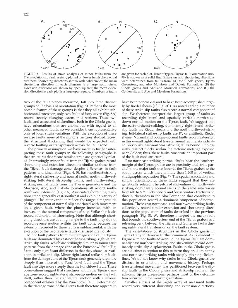
FIGURE 8—Results of strain analyses of minor faults from the Tijeras–Cañoncito fault system, plotted on lower hemisphere equal area nets. Shortening directions shown with solid circles; the mean shortening direction in each diagram is a large solid circle. Extension directions are shown by open squares; the mean extension direction in each plot is a large open square. Numbers of faults
two of the fault planes measured, fall into three distinct groups on the basis of orientation (Fig. 8). Perhaps the most notable feature of these groups is that they all exhibit subhorizontal extension; only two faults of fortyseven (Fig. 8A)record steeply plunging extension directions. These two faults and associated slickenlines, both in the Cibola gneiss,have orientations that are anomalous with regard to all other measured faults, so we consider them representative only of local strain variations. With the exception of these reverse faults, none of the minor structures studied record the structural thickening that would be expected with reverse faulting or transpression across the fault zone.
The primary assumption we have made in further interpreting these fault groups in the following paragraphs is that structures that record similar strain are genetically related. Interestingly, minor faults from the Tijeras graben record shortening and extension directions similar to those from the Tijeras fault damage zone, despite differences in fault patterns and kinematics (Figs. 4, 5). Eastnortheaststrikingrightlateral strikeslip and normal faults, northnorthweststriking leftlateral strikeslip faults, and northwesterlystriking normal faults from the Tijeras greenstone and the Morrison, Abo, and Dakota formations all record southsouthwest extension (Fig. 8A). Associated shortening directions trend generally eastsoutheast and exhibit a variety ofplunges. The latter variation reflects the range in magnitudeof the component of normal slip associated with movementon a given fault, where the plunge increases with an increase in the normal component of slip. Strikeslip faults record subhorizontal shortening. Note that although shortening directions are at a high angle to the fault they do not record reverse motion within the fault zone, because the extension recorded by these faults is subhorizontal, with theexception of the two reverse faults discussed previously.
Minor fault patterns from the damage zone of the Tijeras fault are dominated by eastnortheaststriking, rightlateralstrikeslip faults, which are strikingly similar to minor fault patterns from the damage zone of the Punchbowl fault (Fig.3); the only significant difference is that they show less variation in strike and dip. Minor rightlateral strikeslip faultsfrom the damage zone of the Tijeras fault generally dip more steeply than those of the Punchbowl fault, and the Tijeras fault also dips more steeply than the Punchbowl fault. Theseobservations suggest that structures within the Tijeras damage zone record rightlateral strikeslip motion on the faultitself, rather than the rightlateral motion with a reverse component exhibited by the Punchbowl fault. Deformationin the damage zone of the Tijeras fault therefore appears to
are given for each plot. Trace of typical Tijeras fault orientation (045,90) is shown as a solid line. Extension and shortening directions were determined from faults from: (A) the Cibola gneiss, Tijeras Greenstone, and Abo, Morrison, and Dakota Formations, (B) theCibola gneiss and Abo and Morrison Formations, and (C) theGolden site and Abo and Morrison Formations.
have been noncoaxial and to have been accomplished largely by Riedel shears (cf. Fig. 3C). As noted earlier, a number of these strikeslip faults also record a normal component of slip. We therefore interpret this largest group of faults as recording rightlateral and spatially variable northsidedown normal motion on the Tijeras fault. We suggest thatthe eastnortheaststriking, dominantly rightlateral strikeslip faults are Riedel shears and the northnorthweststriking, leftlateral strikeslip faults are R’, or antithetic Riedel shears. Normal and obliquenormal faults record extension in this overall rightlateral transtensional regime. As indicated previously, eastnortheaststriking faults bound lithologically distinct blocks within the tectonic mélange exposednear Golden; thus, these faults constitute an important partof the faultzone structure.
Eastnortheaststriking normal faults near the southernmargin of the Tijeras graben are in proximity and strike parallel to the major fault that bounds the Tijeras graben to the south, across which there is more than 1,200 m of vertical stratigraphic separation (Fig. 7). The spatial association andsimilar orientation of these faults suggest that they are genetically related. The pitch of slickenlines on northweststriking dominantly normal faults in the same area varies from 60° to 80°. Slickenfibers and/or secondary fractures on three slickensides in the Abo Formation that contribute to this population record a dominant component of normalmotion. These eastnortheast and northweststriking faultscollectively record similar extension and shortening directions to the population of faults described in the previous paragraph (Fig. 8). We therefore interpret the major faultthat bounds the southwestern end of the Tijeras graben as a releasing bend between the Tijeras and Guiterrez faults during rightlateral transtension on the fault system.
The orientations of structures in the Cibola gneiss in Tijeras Canyon deserve further comment. As is evident in Figure 4, minor faults adjacent to the Tijeras fault are dominantly eastnortheaststriking, and slickenlines record dominantly strikeslip displacement. Faults in the Cibola gneissare a distinct exception to this pattern; they are dominantlyeastnortheaststriking faults with steeply pitching slickenlines. We do not know why faults in the Cibola gneiss are distinct in orientation and movement history. Perhapstranstensional movement was partitioned between the dipslip faults in the Cibola gneiss and strikeslip faults in theadjacent Tijeras greenstone; perhaps most of the deformation occurred in the weaker greenstone.
Smaller subsets of the larger array of measured faults record very different shortening and extension directions.

123
Some of the faults measured in the Morrison and Abo formations, as well as the fault zone exposure near Golden, record northerly shorteningand easterly subhorizontal extension(Fig. 8B). These faults include broadly northstriking dominantly normal faults, northnortheast striking leftlateral strikeslip faults, and northweststriking rightlateral faults. Thelatter two fault types are properly oriented for slip as R and R’ shears,respectively, during leftlateral strikeslip motion on the Tijeras– Cañoncitofault system (Fig. 8B). This leftlateralstrikeslip movement may have beenassociated with normal motion as well; there is a significant variation in theplunge of shortening directions recorded by these faults.
Northeaststriking normal faults inthe Abo and Morrison formations and a single northeaststriking, southeastdipping, rightlateral normal fault inthe Cibola gneiss record subvertical shortening and roughly northwesterlysubhorizontal extension (Fig. 8C). Thelatter minor faults are interpreted as recording extension across the fault system.
In summary, minor faults provide a record of (a) transtension: dominantlyrightlateral strikeslip with locallyvariable amounts of northsidedown normal motion, (b) leftlateral strikeslip, and (c) extension across the Tijeras–Cañoncito fault system. Theydo not provide any indication of thetiming of these events. To evaluate timing, we consider additional geologic evidence and thermochronologic data.
Evidence for the timing of movement on the Tijeras–Cañoncito
fault system
Principles and methods of fissiontrack analysis
The principles behind fissiontrackanalysis, a powerful tool for evaluatingthe differential cooling history across fault zones, are described in detail by
FIGURE 9—Sample localities for fissiontrack analysis in the Golden exposure. Map area is enlarged from upper right part of Figure 2, and uses the same symbols and patterns as Figure 2.
Kelley and Chapin (2004 this volume, see especially theirfig. 2). Fissiontrack analysis of apatite is routinely used in constraining the thermal history of rocks between ~ 60 °C and 110 °C. In zircon, fission tracks are stable to much higher temperatures: ~170–390 °C (Yamada et al. 1995). Fissiontrack analysis of rocks from both sides of a fault zone can constrain the timing of cooling due to differential uplift and erosion of the fault blocks and therefore the timing of substantial vertical displacement on the fault zone (Kelley andChapin 2004 this volume). They do not constrain the timingor magnitude of strikeslip movement because the two faultblocks will not have significantly different thermal histories as a result of horizontal displacement.
Apatite and zircon fissiontrack (AFT and ZFT) ages were determined for several rocks proximal to the Tijeras fault zone (Figs. 2 , 9; Table 1 ) in an attempt to constrain the tim
ing of vertical displacement. We chose a portion of the faultwith significant stratigraphic separation for the analysis.The contact between Proterozoic basement and overlyingPennsylvanian strata exhibits 600–800 m of downtothenorthwest separation across the Tijeras fault on the northwestern margin of the Monte Largo horst.
Samples were collected south of the village of Golden on a traverse across the Tijeras fault zone into the Monte Largohorst (Fig. 9). The units sampled on the traverse includeProterozoic Sandia granite and Cibola gneiss, Permian Abo siltstone, porphyritic intrusive rock of suspected Oligocene age (resembling porphyritic rocks exposed in the nearby Oligocene San Pedro–Ortiz porphyry belt), and a Quaternary deposit that was incorporated into the faultzone (Table 1). In addition, samples from the Cibola gneisson the north side of I–40 (and the fault) and from the Tijeras

124
TABLE 1—Apatite and zircon fissiontrack data for Tijeras fault samples. ρρs = spontaneous track density; ρρi = induced track density (reportedinduced track density is twice the measured density; ρρd = track density in muscovite detector covering Corning glass CN5 (12.5 ppm U) and CN6 (1.05 ppm U; reported value determined from interpolation of values for detectors covering standards at the top and bottom of the reactor packages (fluence gradient correction)); number in parenthesis is the number of tracks counted for ages and fluence calibration or the number of track measured for lengths). s.e. = standard error; P(χχ)2 = Chisquared probability; N.D. = no data. λf = 1.551 X 10¹⁰yr1, g = 0.5, zeta = 5,516 ± 300 for apatite, 452 ± 56 for zircon. Spectral peak ages calculated from Hurford et al. (1984); mean track lengths not corrected for length bias (Laslett et al.,1982). Sample Lithology Latitude Phase Number ρρs ρρi ρρd Central Spectral P(χχ)2 Uranium Mean track Standard (elevation) Longitude of grains x 105 x 106 x 104 age (Ma) peak ages % content length deviation
dated t/cm2 t/cm2 t/cm2 (± 1 s.e) Ma ppm µm (± 1 s.e.) track length (µm)
94ML01 (2,134 m)
Sandia granite
35°11.41’ 106°15.51’
apatite 20 0.65 (48)
1.63 9.71 (604) (4,100)
94ML02 (2,027 m)
Sandia granite
35°13.21’ 106°16.11’
apatite 20 2.50 5.40 10.05 (145) (1,566) (4,100)
94ML03 (1,988 m)
Abo 35°13.69’ sandstone 106°15.77’
apatite
zircon
20
16
0.96 2.05 10.13 (26) (278) (4,100)
163.40 7.61 21.08 (1,349) (314) (4,334)
PORPH (1,988 m)
Dacite 35°13.66’ porphyry 106°15.40’
apatite
zircon
20
20
0.79 (38)
37.79
1.95 11.96 (469) (4,100)11.30 21.11
(820) (1,226) (4,334) 94ML04 (1,988 m)
Cibola gneiss
35°13.63’ 106°15.69’
apatite 20 1.90 3.94 9.41 (129) (1,340) (4,100)
94ML05 (1,988 m)
Sante Fe 35°13.62’ sandstone 106° 15.66’
apatite
zircon
20
25
3.18 2.87 9.77 (145) (655) (4,100)48.85 8.75 21.14
(1,679)(1,504) (4,334) 94TIJ02 (1,841 m)
Cibola gneiss
35°04.08’ 106°25.25’
apatite 20 1.75 (66)
4.96 11.91 (936) (4,100)
95TC01 Tijeras not greenstone available
apatite 35 0.09 (18)
0.27 10.40 (252) (3,825)
greenstone south of I–40 (and the fault; Fig. 2, Table 1) inTijeras Canyon were analyzed.
The fissiontrack analysis methods used in this study are fully described in Kelley et al. (1992) and are briefly summarized here. Apatite and zircon were separated from the samples using standard heavyliquid and magnetic separationtechniques. Apatite grains were mounted in epoxy, polishedto expose the grains, and etched for 25 seconds in a 5 Msolution of nitric acid to reveal the fission tracks. Zircons were mounted in FEP Teflon tape, polished, and etched for6 (samples ML03 and ML05) to 8 (PORPH) hrs in NaOH/KOH at 240 °C. Some of the zircon grains in the Quaternarydeposit in the fault zone (ML05) were underetched after 6 hrs. Consequently, a second mount of the sample was prepared and etched for 9 hrs to reveal tracks in the youngestgrains; the individual detrital zircon grain ages includeanalysis of both the 6 hr and 9 hr mounts. Tracks parallel tothe caxes of the dated zircons were well etched in all mounts. Zircons from the Proterozoic rocks were etched for 1 hr and found to be metamict. The grain mounts were then covered with muscovite detectors and sent to the Texas A&M Nuclear Science Center for irradiation. The neutron flux was calibrated with Durango apatite and Fish Canyonzircon age standards and Corning Glasses CN5 and CN6using the zeta method (Hurford and Green 1983). A zeta value of 5,516 ± 300 was determined using the CN6 glassand the accepted age of 31.4 ± 0.5 for Durango apatite(Green 1985). A zeta value of 452 ± 56 was determined usingCN5 glass and the accepted age of 27.8 ± 0.7 Ma for Fish Canyon zircon. Individual grain ages were calculated usingthe methods of Hurford and Green (1983), and the Chisquared statistic (Galbraith 1981) was applied to determinewhether the individual ages belong to a single population.Mixed ages caused by differences in sedimentary provenance for zircon and apatite or by partial annealing ofapatite with variable chemical composition are indicated when the ages do not pass the Chisquared statistic at the 5% probability level. If the individualgrain ages passed the
21.4 ± 3.3 19 99 17 N.D. N.D.
24.9 ± 2.4 22 97 58 13.5 ± 0.5 2.2 (65)
25.1 ± 5.2 21 95 22 N.D. N.D.
204.5 ± 17.3 188 15 451 N.D. N.D.
26.4 ± 4.6 22 99 17 12.2 ± 2.1 3.8
31.9 ± 2.0 31 90 678 (13)N.D. N.D.
25.9 ± 2.6 22 94 42 13.2 ± 0.7 0.7 (21)
56.8 ± 8.4 22, 68 <1 31 N.D. N.D
50.0 ± 8.8 3, 27, 47, 95 <1 522 N.D. N.D.
23.0 ± 3.1 20 99 44 12.1 ± 1.9 3.3 (11)
20.1 ± 5.0 20 92 3 N.D. N.D.
Chisquared test, the pooled age was computed using themethods of Galbraith and Laslett (1985). If the sample failedthe Chisquared test, the central age, a weighted mean ageestimate that eliminates a bias toward grains with highermean track densities, was calculated as outlined byGalbraith and Laslett (1993). The pooled age and central age are identical for Chisquared probabilities > 85%.
Two graphical techniques are often employed to evaluatethe ages and relative importance of multiple dated grainpopulations. The first involves calculating the probabilitydensity function for the grains (Hurford et al. 1984). The probability distributions for all the grains are summed to give a weighted spectrum of the population. The age spectrum, which is usually scaled to and superimposed on thegrain age histogram, indicates the probability that a certainnumber of grains in a sample will have ages within a givenage interval. Peaks on the age spectrum are referred to as ‘spectral peak’ ages (Table 1). Multiple grain age populations can also be analyzed using radial plot diagrams(Galbraith 1988), which allow comparison of measurements with different standard errors. The variation of the singlegrain ages around the mean are plotted as y = (zi – z)/s.e.i, where zi is the individual grain age, z is the mean age, and s.e.i is the standard error of the single grain age, versus x =1/s.e.; a measure of the precision of each grain age. The fissiontrack age is given by the slope of a straight line from the origin through the data points. The age scale is shownradially around the edge of the plot. Because young grainshave precise grain ages, these grains are easily identifiedbecause they plot to the right on the diagram. If the grainsall belong to a single age population, the points should liewithin y = ± 2, which corresponds to lying within ± 2 s.e. Scatter outside y = ± 2 indicates that multiple populations are present. The ages and relative mixing proportions of thepopulations can be estimated from clustering of the data onthe diagram.
Confined tracklength distributions in the apatitegrainmounts that were etched with the age mounts were deter

125
mined using a microscope fitted with a100X dry lens, a drawing tube, and adigitizing tablet. Horizontal, welletched, confined tracks (tracks completely enclosed within the crystal) ingrains with prismatic faces were measured. The orientations of the tracks with respect to the caxis were also determined.
Timetemperature estimates were derived from the apatite age and tracklength data using the model of Ketchum et al. (1999). This inversionmodel is used to determine timetemperature paths that fit the observedage and length data. The modelaccounts for the influence of variable apatite composition on track annealing. The tendency to measure longtracks rather than short tracks due to observational bias is corrected usingthe methods of Laslett et al. (1982). Fission track results
The AFT ages of the bedrock units on both sides of the Tijeras fault zone inthe vicinity of Golden and in Tijeras Canyon are similar (Table 1). Samplesof Sandia granite within (ML01) andnear the northeastern margin (ML02) of the Monte Largo horst, porphyritic intrusive rock (PORPH) and Cibolagneiss (ML04) within the fault zone,and Abo siltstone on the northwest fault block (ML03), all from the transect near Golden, as well as Cibola gneiss (TIJ2) and Tijeras greenstone (TC1) from Tijeras Canyon, have AFT ages between 21.4 ± 3.3 and 26.4 ± 4.6 Ma (late Oligocene to early Miocene;Table 1; Fig. 10). The mean tracklengths for samples containing more than 20 confined tracks are 13.2–13.5 µm. These results are comparable to previously published AFT data for the Sandia Mountains (Kelley and Duncan1984, 1986; Kelley et al. 1992) and suggest regional denudation in the earlyMiocene (Kelley and Chapin 1995).
In contrast, zircon fissiontrack (ZFT) dates on the samples vary wide FIGURE 10—Comparison of fissiontrack ages in and adjacent to the Tijeras fault near
ly (Table 1). The ZFT age of the por Golden. Error bars represent 1 standard error. Open circles represent AFT ages; solid circles
phyritic intrusive rock is 31.9 ± 2.0 Ma. represent ZFT ages. The rock has a porphyritic texture defined by 15 mm phenocrysts of altered hornblende and plagioclase in an aphanitic matrix. Alteration is sufficiently extensive that 40Ar/39Ar dating is not possible. The porphyritic texture and aphanitic matrix suggest rapid cooling and crystallization,probably related to emplacement at shallow crustal levels. The ZFT age records the time since cooling below the closure temperature of zircon; because cooling is expected tooccur rapidly following shallow intrusion, the ZFT age is taken as an approximate emplacement and crystallizationage. The ZFT age is younger than hornblende 40Ar/39Ar ages of 34.5 ± 0.2 Ma and 35.02 ± 0.13 Ma obtained on a porphyry dike and a plug, respectively, located ~ 4 km westnorthwest of this exposure (Ferguson et al. 1999). The relationship between these intrusive bodies and the one we have studied is not clear. The ZFT date on the porphyritic
intrusive rock in the Golden exposure falls within the range of 40Ar/39Ar ages exhibited by porphyritic intrusive rocks of the Ortiz Mountains, documented in the following section,that outcrop along the Tijeras fault to the northeast. These ages are similarly interpreted as approximate emplacement ages and are consistent with our interpretation of the ZFT date as an approximate emplacement age. The porphyritic intrusive rock is intensely fractured and contains anastomosing gougelined faults (Abbott and Goodwin 1995);therefore some deformation within the Tijeras fault zone postdates intrusion (32 ± 2 Ma) at this site. The intrusive rock is locally faulted against Quaternary surficial deposits;however, this fault is overlain by younger, undeformed and imbricated Quaternary gravel deposits (Abbott andGoodwin 1995).
AFT ages of rocks adjacent to the porphyritic intrusive

126
Ma (2 s.e.). Clearly, this date does not reflect the age(s) of the source rocks, as it is younger than the depositional ageof the siltstone. As more than half of the individual grain ages are youngerthan the stratigraphic age (Fig. 11), the apparent ZFT ages record partial annealing (temperatures > 170 °C; Hurford 1986) after Permian time.
AFT and ZFT ages were determined for detrital grains from Quaternary(?)sand (ML05) incorporated into theeastern margin of the Tijeras fault zone in order to establish the provenance of the deposit. The ZFT ages will constrain the maximum age of this unit,especially if some of the detrital zircon came from Pliocene to Quaternary volcanic centers in the Jemez Mountains. The individual grain ages for bothapatite and zircon from the Quaternary deposit fail the Chisquared test and central ages are reported for this sample (Table 1). The deformedQuaternary deposit contains grainsthat have ZFT ages ranging from late Paleozoic to Pliocene (Fig. 11). A largefraction of the dated grains are Paleogene in age and some probably were incorporated from the porphyritic intrusive rock, which is in fault contact with the deposit. Three grains with ZFT ages between 3.2 ± 1.0 and 4.3 ± 2.0 Ma were likely derived from a Pliocene volcanic source to the northwest (e.g., Bachman and Mehnert1978). AFT dates on individual grainsin the sample are also highly variable, ranging from 17.5 ± 7.4 to 124.0 ± 34.0 Ma (Fig. 11). Several grains in thedeformed surficial deposit have AFT dates that are Mesozoic in age. These Mesozoic AFT ages (clustering around
FIGURE 11—Apatite and zircon fissiontrack age histograms and probability density func 68 Ma; Fig. 11; Table 1) are dissimilar to tions (solid curves) for Abo siltstone (94ML03) and deformed Quaternary surficial deposit the AFT ages in Proterozoic bedrock (94ML05) shown on the left side of the diagram. Peak ages in Table 1. Radial plots for the samples from both this area and the same samples shown on the right side of the diagram. Radial plots are defined in the text; Sandia Mountains to the west (from z = mean age (coincides with y = 0) and s.e. = standard error. The fissiontrack ages are shown around the edges of the radial plots. The gray region corresponds to the 2 σ error in 21.7 ± 2.3 to 16.3 ± 1.8 Ma; House et al. the mean age and the red area shows the stratigraphic ages of the sedimentary rocks. 2003). Most of the grains with
Mesozoic AFT ages in the deformed
rock are similar to AFT ages of the intrusion and samples in Tijeras Canyon approximately 20 km away (Table 1; Fig. 2), and are comparable (within error) to the AFT ages from the northwest side of the Sandia Mountains (16 to 22 Ma) andthe Pedernal Hills to the east (22–33 Ma; Kelley and Duncan1984, 1986; Kelley and Chapin 1995). The similarity of AFT ages over most of the High Plains of northeastern NewMexico indicates that the AFT ages record regional cooling. The porphyritic intrusive rock therefore was emplaced before the time of regional cooling below the closure temperature of apatite.
The individual grain ages of zircons from the Permian Abo siltstone west of the Tijeras fault zone fail the Chisquared test, indicating multiple age populations withinthis siltstone. Consequently, a central age, which is a weighted mean age, is reported for this sample (Table 1). The central fissiontrack age for the zircon in the Permian Abo siltstone, however, is Middle Triassic–Middle Jurassic: 205 ± 30
Quaternary deposit are round to subround and thus presumably were derived from Mesozoic sedimentary rocks exposed on the west side of the SandiaMountains. These Mesozoic ages may reflect the cooling of the sedimentary section above Proterozoic basement duringLaramide deformation, subsequent to burial duringCretaceous time. Sampling of Mesozoic sedimentary rocks west of the Sandia Mountains is needed to evaluate this hypothesis. The ages of the youngest dated apatite (17 Ma)and zircon (3–4 Ma) populations are older than the inferred stratigraphic age of the surficial deposit (Fig. 11), so temperatures in the fault zone in the Quaternary were not high enough to totally reset the fissiontrack ages. The youngestZFT ages indicate that the maximum age of the deposit isPliocene.
127
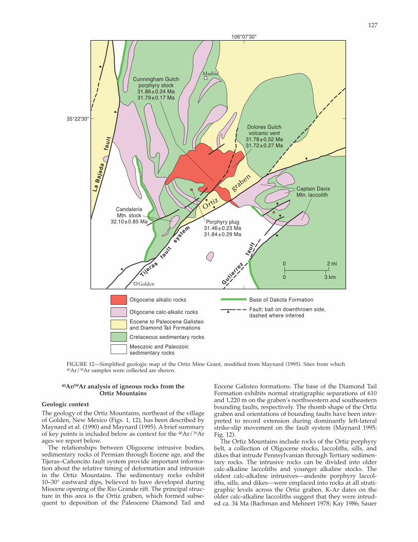
FIGURE 12—Simplified geologic map of the Ortiz Mine Grant, modified from Maynard (1995). Sites from which 40Ar/39Ar samples were collected are shown.
40Ar/39Ar analysis of igneous rocks from the Ortiz Mountains
Geologic context The geology of the Ortiz Mountains, northeast of the villageof Golden, New Mexico (Figs. 1, 12), has been described byMaynard et al. (1990) and Maynard (1995). A brief summaryof key points is included below as context for the 40Ar/39Ar ages we report below.
The relationships between Oligocene intrusive bodies, sedimentary rocks of Permian through Eocene age, and the Tijeras–Cañoncito fault system provide important information about the relative timing of deformation and intrusion in the Ortiz Mountains. The sedimentary rocks exhibit 10–30° eastward dips, believed to have developed duringMiocene opening of the Rio Grande rift. The principal structure in this area is the Ortiz graben, which formed subsequent to deposition of the Paleocene Diamond Tail and
Eocene Galisteo formations. The base of the Diamond Tail Formation exhibits normal stratigraphic separations of 610and 1,220 m on the graben’s northwestern and southeasternbounding faults, respectively. The rhomb shape of the Ortizgraben and orientations of bounding faults have been interpreted to record extension during dominantly leftlateralstrikeslip movement on the fault system (Maynard 1995; Fig. 12).
The Ortiz Mountains include rocks of the Ortiz porphyrybelt, a collection of Oligocene stocks, laccoliths, sills, anddikes that intrude Pennsylvanian through Tertiary sedimentary rocks. The intrusive rocks can be divided into older calcalkaline laccoliths and younger alkaline stocks. Theoldest calcalkaline intrusives—andesite porphyry laccoliths, sills, and dikes—were emplaced into rocks at all stratigraphic levels across the Ortiz graben. KAr dates on theolder calcalkaline laccoliths suggest that they were intruded ca. 34 Ma (Bachman and Mehnert 1978; Kay 1986; Sauer

128
FIGURE 13—Results of 40Ar/39Ar dating of Kfeldspar separatesfrom the Ortiz Mine Grant. (A–J) Age spectra and inverse isochron diagrams for incrementally heated samples. All of the 40Ar/36Ar isochrons intercepts are significantly elevated relative to atmospheric argon (40Ar/36Ar = 295.5) indicating homogeneous trapped excess
1999). Most of these bodies are concordant with bedding and are locally cut by strands of the Tijeras–Cañoncito faultsystem, exhibiting leftlateral separation, like the sedimentary rocks they intrude. The distribution of sills in the Cretaceous section on the Ortiz Mine Grant shows one laccolithic center in the western part of the Ortiz Mountainsnorth of the Tijeras fault and another at Captain DavisMountain south of the Tijeras fault. A similar magnitude of leftlateral separation, roughly 5 km, is exhibited by the base of the ~ 30° easttilted Cretaceous Dakota Formation.
40Ar components. The circles depicting data points are larger than the actual error elipses. (K–L) Ageprobability distribution diagrams (Deino and Potts 1992) for samples analyzed by singlecrystal laserfusion.
However, if the Miocene rotation mentioned above is removed, this separation can be interpreted to record northwestsidedown normal displacement, which could havebeen accompanied by leftlateral strikeslip movement.
The younger suite of intrusive rocks cut both the older intrusive bodies and the fault. Only the oldest units of theyounger alkaline suite exhibit displacement, and the magnitude of separation is much less than that exhibited by theolder calcalkaline intrusive rocks. Thus the timing of the most recent movement on this portion of the fault system is

129
FIGURE 13 continued.
constrained by the ages of the youngest igneous rocks in the Ortiz Mountains.
40Ar/39Ar methods and results
To provide a minimum age of formation of the Ortiz grabenand northwestsidedown normal displacement (and possible leftlateral strikeslip motion) of the older rocks of the Ortiz porphyry belt, we obtained 40Ar/39Ar dates on Kfeldspars from a variety of igneous rocks in the Ortiz Mountains. Kfeldspar separates from seven of intrusive
and extrusive igneous rocks within the Ortiz porphyry belt were prepared and analyzed at the New Mexico Geochronology Research Laboratory in Socorro, New Mexico. Kfeldspar separates were prepared by standard separation techniques, then were irradiated at the Texas A&M reactor in two irradiation packages. Neutron flux was monitored using Fish Canyon Tuff sanidine (27.84 Ma;Deino and Potts 1990, equivalent to Mmhb1 at 520.4 Ma,Samson and Alexander 1987). Samples were analyzed at the New Mexico Geochronology Research Laboratory. Monitor
130
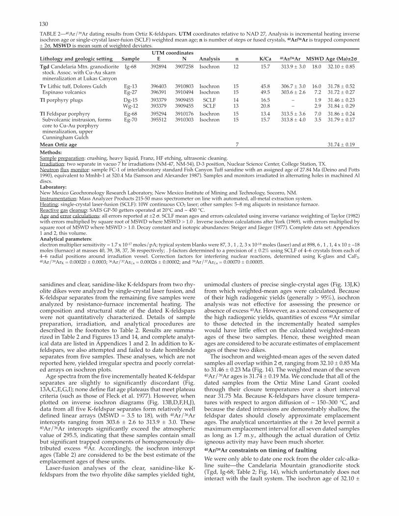
TABLE 2—40Ar/39Ar dating results from Ortiz Kfeldspars. UTM coordinates relative to NAD 27, Analysis is incremental heating inverseisochron age or singlecrystal laserfuion (SCLF) weighted mean age; n is number of steps or fused crystals, 40Ar/36Ar is trapped component± 2σ, MSWD is mean sum of weighted deviates.
UTM coordinates Lithology and geologic setting Sample E N Analysis n K/Ca 40Ar/36Ar MSWD Age (Ma)±2σσTgd Candelaria Mtn. granodiorite
stock. Assoc. with CuAu skarn mineralization at Lukas Canyon
Tv Lithic tuff, Dolores Gulch Espinaso volcanics
Tl porphyry plugs
Tl Feldspar porphyrySubvolcanic instrusion, forms core to CuAu porphyrymineralization, upperCunningham Gulch
Mean Ortiz age
Methods:
Ig68 392894 3907258 Isochron 12 15.7 313.9 ± 3.0 18.0 32.10 ± 0.85
Eg13 396403 3910803 Isochron 15 45.8 306.7 ± 3.0 16.0 31.78 ± 0.52 Eg27 396391 3910494 Isochron 15 49.5 303.6 ± 2.6 7.2 31.72 ± 0.27
Dg15 393379 3909455 SCLF 14 16.5 – 1.9 31.46 ± 0.23 Wg12 393379 3909455 SCLF 13 20.8 – 2.9 31.84 ± 0.29
Eg68 395294 3910176 Isochron 15 13.4 313.5 ± 3.6 7.0 31.86 ± 0.24 Eg70 395512 3910303 Isochron 15 15.7 313.8 ± 4.0 3.5 31.79 ± 0.17
7 31.74 ± 0.19
Sample preparation: crushing, heavy liquid, Franz, HF etching, ultrasonic cleaning.Irradiation: two separate in vacuo 7 hr irradiations (NM47, NM54), D3 position, Nuclear Science Center, College Station, TX.Neutron flux monitor: sample FC1 of interlaboratory standard Fish Canyon Tuff sanidine with an assigned age of 27.84 Ma (Deino and Potts1990), equivalent to Mmhb1 at 520.4 Ma (Samson and Alexander 1987). Samples and monitors irradiated in alternating holes in machined Aldiscs.Laboratory: New Mexico Geochronology Research Laboratory, New Mexico Institute of Mining and Technology, Socorro, NM. Instrumentation: Mass Analyzer Products 21550 mass spectrometer on line with automated, allmetal extraction system.Heating: singlecrystal laserfusion (SCLF): 10W continuous CO2 laser; other samples: 5–8 mg aliquots in resistance furnace. Reactive gas cleanup: SAES GP50 getters operated at 20°C and ~ 450 °C.Age and error calculations: all errors reported at ±2 σ. SCLF mean ages and errors calculated using inverse variance weighting of Taylor (1982)with errors multiplied by square root of MSWD where MSWD > 1.0 . Inverse isochron calculations after York (1969), with errors multiplied bysquare root of MSWD where MSWD > 1.0. Decay constant and isotopic abundances: Steiger and Jaeger (1977). Complete data set: Appendices1 and 2, this volume.Analytical parameters: electron multiplier sensitivity = 1.7 x 10¹⁷ moles/pA; typical system blanks were 87, 3 , 1 , 2, 3 x 10¹⁸ moles (laser) and at 898, 6 , 1 , 1, 4 x 10 ± –18moles (furnace) at masses 40, 39, 38, 37, 36 respectively; . Jfactors determined to a precision of ± 0.2% using SCLF of 4–6 crystals from each of4–6 radial positions around irradiation vessel. Correction factors for interfering nuclear reactions, determined using Kglass and CaF2,40Ar/39ArK = 0.00020 ± 0.0003; 36Ar/37ArCa = 0.00026 ± 0.00002; and 39Ar/37ArCa = 0.00070 ± 0.00005.
sanidines and clear, sanidinelike Kfeldspars from two rhyolite dikes were analyzed by singlecrystal laser fusion, andKfeldspar separates from the remaining five samples were analyzed by resistancefurnace incremental heating. Thecomposition and structural state of the dated Kfeldspars were not quantitatively characterized. Details of sample preparation, irradiation, and analytical procedures are described in the footnotes to Table 2. Results are summarized in Table 2 and Figures 13 and 14, and complete analytical data are listed in Appendices 1 and 2. In addition to Kfeldspars, we also attempted and failed to date hornblendeseparates from five samples. These analyses, which are not reported here, yielded irregular spectra and poorly correlated arrays on isochron plots.
Age spectra from the five incrementally heated Kfeldspar separates are slightly to significantly discordant (Fig.13A,C,E,G,I); none define flat age plateaus that meet plateaucriteria (such as those of Fleck et al. 1977). However, when plotted on inverse isochron diagrams (Fig. 13B,D,F,H,J),data from all five Kfeldspar separates form relatively welldefined linear arrays (MSWD = 3.5 to 18), with 40Ar/36Ar intercepts ranging from 303.6 ± 2.6 to 313.9 ± 3.0. These 40Ar/36Ar intercepts significantly exceed the atmosphericvalue of 295.5, indicating that these samples contain smallbut significant trapped components of homogeneously distributed excess 40Ar. Accordingly, the isochron interceptages (Table 2) are considered to be the best estimate of the emplacement ages of these units.
Laserfusion analyses of the clear, sanidinelike Kfeldspars from the two rhyolite dike samples yielded tight,
unimodal clusters of precise singlecrystal ages (Fig. 13J,K)from which weightedmean ages were calculated. Because of their high radiogenic yields (generally > 95%), isochron analysis was not effective for assessing the presence or absence of excess 40Ar. However, as a second consequence ofthe high radiogenic yields, quantities of excess 40Ar similar to those detected in the incrementally heated sampleswould have little effect on the calculated weightedmeanages of these two samples. Hence, these weighted mean ages are considered to be accurate estimates of emplacementages of these two dikes.
The isochron and weightedmean ages of the seven datedsamples all overlap within 2 σ, ranging from 32.10 ± 0.85 Ma to 31.46 ± 0.23 Ma (Fig. 14). The weighted mean of the seven40Ar/39Ar ages is 31.74 ± 0.19 Ma. We conclude that all of the dated samples from the Ortiz Mine Land Grant cooled through their closure temperatures over a short interval near 31.75 Ma. Because Kfeldspars have closure temperatures with respect to argon diffusion of ~ 150–300 °C, and because the dated intrusions are demonstrably shallow, the feldspar dates should closely approximate emplacementages. The analytical uncertainties at the ± 2σ level permit amaximum emplacement interval for all seven dated samplesas long as 1.7 m.y., although the actual duration of Ortizigneous activity may have been much shorter. 40Ar/39Ar constraints on timing of faulting
We were only able to date one rock from the older calcalkaline suite—the Candelaria Mountain granodiorite stock(Tgd, Ig68; Table 2; Fig. 14), which unfortunately does notinteract with the fault system. The isochron age of 32.10 ±

131
0.85 Ma is the oldest date obtained, but the large uncertainty makes it indistinguishable from the ages of the younger rocks.
The Golden fault strand of the fault system terminates inthe lithic tuff of Dolores Gulch (Tv, isochron ages of 31.78 ± 0.52 Ma and 31.72 ± 0.27 Ma, Table 2; Fig. 14) and a varietyof feldspar porphyry bodies (Tl, singlecrystal laserfusion ages of 31.46 ± 0.23 Ma and 31.84 ± 0.29 Ma and isochron ages of 31.86 ± 0.24 Ma and 31.79 ± 0.17 Ma, Table 2; Fig. 14).
Collectively, these data indicate that: 1) the fault in this area was essentially in its present configuration by ca. 32Ma; 2) northwestsidedown normal motion and possibleassociated leftlateral movement occurred in the Oligoceneon this section of the fault (postdating deposition and lithification of the Eocene Galisteo Formation, and predating the final stages of ca. 32 Ma intrusion and volcanism); and 3) there has been no movement of significance on the fault system northeast of Golden subsequent to ca. 32 Ma. The latterconclusion is consistent with previous assertions that Quaternary movement on the TijerasCañoncito fault system was restricted to the southwestern portion of the faultsystem (Machette et al. 1998). Additional timing constraints
As mentioned earlier previous workers have considered whether or not the Tijeras fault was active in Precambrian time (e.g., Lisenbee et al. 1979; Connolly 1982). To address this issue, we have evaluated two possibilities: 1) the fault isa reactivated Precambrian ductile shear zone, and 2) thefault initiated in the Precambrian as a brittle structure. To consider the first of these options, we note the marked discordance between the orientation of the Tijeras fault and the orientations of the main Precambrian foliations on either side of the fault (Fig. 2). The foliation in the Tijeras greenstone strikes subparallel to locally oblique to the Tijerasfault, but dips moderately to the southeast. The foliation inthe gneiss also strikes subparallel to the fault, but it dipsmoderately to the northwest. We have observed no significant strain gradient in the Cibola gneiss, and there is an absence of intensely sheared rocks in outcrop or as breccia clasts along the trace of the fault. The absence of both a faultparallel foliation and an increase in strain magnitude with proximity to the fault argue against a ductile precursor to the Tijeras fault.
Lisenbee et al. (1979) and Connolly (1982) suggested thatan apparent en echelon pattern of dikes and veins in the Tijeras greenstone indicated that sinistral strikeslip faultingwas synchronous with intrusion of the Sandia granite. We have observed, however, that these pegmatite and aplitedikes and veins invariably lie within the plane of the foliation, so their orientation in three dimensions is controlled at least in part by the existing mechanical anisotropy and is not consistent with sinistral shear. The dikes and veins appearto be en echelon only because they are intruded along the foliation in the Tijeras greenstone, which is itself oblique to the Tijeras fault. In addition, minor fault patterns in Precambrian rocks are identical to those in younger rocks (Figs. 4, 5), indicating that the Precambrian units do not preserve evidence of brittle deformation that predated deposition of the younger rocks in the area.
Lisenbee et al. (1979) believed the differences in the Pennsylvanian Sandia Formation across the fault were due to syndepositional Pennsylvanian motion on the Tijerasfault, with the northwest side down. Our work indicates that on the southeast side of the Tijeras fault, thePennsylvanian Sandia Formation is composed of roughly equal proportions of conglomerate, sandstone, and mudstone. The base of the formation is a matrixsupportedsandy conglomerate about 1 m thick with rounded quartzite
FIGURE 14—Ageprobability distribution diagram summarizing 40Ar/36Ar ages of Kfeldspar separates from the Ortiz Mine Grant. All seven age determinations overlap at 2 σ; the weighted mean ageis 31.74 ± 0.19 Ma.
clasts up to 8 cm in diameter. On the northwest side of the fault, the basal conglomerate is 1–25 m thick, and the formation is dominated by sand and conglomerate, with lesseramounts of mudstone. Clasts in the conglomerate on thenorthwest fault block are generally similar in size to thoseon the southeast fault block, although locally there are boulders up to 1 m in diameter immediately adjacent to a ridgeof Proterozoic quartzite that evidently was a topographichigh in Pennsylvanian time. An alternative explanation forthese observations is that different facies were juxtaposedsubsequent to deposition by strikeslip motion on the fault.This interpretation is further supported by the fact that theSandia Formation on the northwest fault block is highlyvariable in lithology and thickness, demonstrating laterallyabrupt facies changes within the formation.
Discussion and conclusions
Timing of deformation events
To evaluate timing, we begin with evidence for theyoungest motion on the fault system, and work toward an evaluation of the oldest deformation. Quaternary movement on the Tijeras fault has been documented by a number of previous workers (Lisenbee et al. 1979; Abbott and Goodwin 1995; Lisenbee and Woodward 1995; Machette et al. 1998; Kelson et al. 1999). Machette et al. (1998) noted anabsence of evidence for Quaternary motion northeast ofGolden. This is consistent with our 40Ar/39Ar data, which indicate that slip on the TijerasCañoncito fault system in this area ceased by ca. 32 Ma, the age of igneous rocks that truncate strands of the fault system. In contrast fission trackdata indicate that a highly brecciated porphyritic intrusive rock at the Golden site is similar in age to rocks of the Ortiz belt, ca. 32 Ma. This leads us to speculate that Quaternarymotion on the Tijeras fault has largely accommodated extension on the La Bajada fault by movement of the southwestern segment of the Tijeras fault, a possibility first suggestedby Kelley and Northrop (1975).
Kelson et al. (1999) presented geomorphic evidence thatQuaternary motion on the Tijeras fault was leftlateral strikeslip. These data are consistent with the Tijeras faultacting as a transfer fault to accommodate extension on theLa Bajada fault. Ferguson (1999) suggested that the Tijeras

132
fault actually initiated in the Miocene as a transfer fault andhas only been active as a leftlateral strikeslip fault. He suggested that folds that previous workers interpreted as recording rightlateral strikeslip motion were developed during movement on the Gutierrez fault. We do not agree with this interpretation for three reasons. First, fission track data indicate that uplift of the Monte Largo horst across the Tijeras fault was accomplished before the late Oligocene. Second, the 40Ar/39Ar data we have presented provide unequivocal evidence that the Tijeras fault was active ca. 32Ma, so that faulting initiated well before the Miocene. Third, we have presented evidence for rightlateral strikeslipmotion that was collected from the damage zone of the Tijeras fault.
Our minor fault data are consistent with leftlateral strikeslip on the Tijeras–Cañoncito fault system during westnorthwest–eastsoutheast riftrelated extension (Fig. 8C).Leftlateral slip associated with rifting is also consistentwith 2.4 km of leftlateral separation of rangeboundingfaults where the fault system intersects the rift (Fig. 1;Grauch et al. 1999). We therefore propose that at least some of the leftlateral slip recorded by the fault system occurred during latest Oligocene to Quaternary development of theRio Grande rift. Some constraints on the timing of thisdeformation may be offered by the location of the hinge lineeast of the Sandia–Manzanita uplift, where late Paleozoic rocks were tilted eastward to accommodate uplift of the mountain blocks. Where this rough hinge line intersects the Tijeras–Cañoncito fault system, Paleozoic rocks are exposed virtually continuously across the fault (Fig. 2). A marked discontinuity in exposure would be expected if 1) significantdipslip motion had occurred along this portion of the fault either before or after uplift or if 2) substantial strikeslipmotion postdated uplift, dated by AFT ages at 16–22 Ma (House et al. 2003). Although the hinge line is not sufficiently sharp to offer a true piercing point, these observationssuggest that, at this location, fault motion was largely strikeslip, and much of the separation recorded by rangebounding faults may have been accomplished before uplift of the Sandia and Manzanita mountains 16–22 Ma. Tectonic implications of thermochronologic data
Comparable AFT dates on both sides of the Tijeras fault (Fig. 10; Table 1) preclude substantial differential vertical displacement in the late Oligocene and early Miocene.Therefore, development of the Monte Largo horst/Tijeras graben fault block occurred either before or after this time. We explore each of these possibilities below, and conclude that vertical displacement occurred before the late Oligocene.
If uplift of the horst predated the time of cooling below theclosure temperature of apatite, rocks of the same elevation on either side of the fault would have similar AFT ages (Fig. 15; Laramide uplift path). The effect of current topographic elevation differences on the AFT dates is probably small because all of the samples were taken within a narrow range of topographic elevations (Table 1). The largest difference in elevation is about 146 m, which will have a negligible effect on AFT ages for denudation rates observed elsewhere along the Rio Grande rift/High Plains margin (Kelley and Chapin 1995).
If uplift of the horst postdated the time of cooling below theclosure temperature of apatite, rocks of equal stratigraphic position on either side of the fault would have similar AFT ages (Fig. 15; Neogene uplift path). The granites on thesoutheast fault block (ML01, ML02) are about 700 m stratigraphically lower than the Abo siltstone (ML03) on thenorthwest fault block. The magnitude of the effect of stratigraphic position cannot be determined exactly because the
denudation rate for this area during the time of cooling is unknown. However, an estimate of the effect may be calculated by assuming a denudation rate. We begin by considering cooling rates calculated from track length data. Confined track lengths are a sensitive record of thermal history (Gleadow et al. 1986). A range of track lengths developsin any sample because each track forms at a different time and partially anneals to a different extent during the thermal history of a sample. A sample with a simple, rapid cooling history will have a narrow, unimodal distribution of track lengths, whereas a slower, simple cooling history will yield a broader, unimodal track length distribution with themode skewed toward longer tracks. More complex thermal histories produce more complex distributions (Gleadow et al. 1986; Wagner and Van den Haute 1992).
Confined track lengths measured in apatite from samples ML02 and ML04 are presented in Figure 16. The timetemperature paths that best fit the age and track length data forsample ML02 in the Monte Largo horst using the model of Ketchum et al. (1999) are illustrated in Figure 17. Two models were run: one that did not include any geological constraints (Fig. 17A), and one that allowed for cooling duringLaramide deformation and heating during Oligocene intrusive activity (Fig. 17B). Note that the fissiontrack data are insensitive to the thermal history before approximately 30 Ma, but more tightly constrain the post30 Ma cooling history. The relatively slow, simple cooling history derived from modeling of the AFT data from the Monte Largo horst (Fig.17A) suggests that the horst did not experience rapid exhumation in the Neogene. Based on the average cooling rate of3.5 °C/Ma determined for ML02 and assuming a reasonable range of geothermal gradients (25–35 °C/km) for the RioGrande rift/High Plains boundary (Reiter et al. 1975), weestimate denudation rates that range from 100–140 m/m.y. If the Monte Largo horst were uplifted after the time of cooling below the closure temperature of apatite at denudation rates of 100–140 m/m.y, then the Abo siltstone (ML03) might record a date that is 5–7 m.y. older than that of Proterozoic rocks on the southeast fault block that are equal in present elevation:
(700 m) x (1 m.y./100 to 140 m) = 7 to 5 m.y. The effect of stratigraphic position would thus decrease,
rather than increase, the uniformity of AFT ages across the fault zone (Fig. 15). Because the AFT ages are uniform across the Tijeras fault, denudation of the horst most likely predated the late Oligocene. Formation of the Tijeras graben/Monte Largo horst fault block must have postdated deposition of the Upper Cretaceous strata because Upper Cretaceous strata are faulted in the Tijeras graben. Therefore, the likely timing of this differential uplift is constrained between the Late Cretaceous and the middle Oligocene. This timing predates the earliest phase of riftdeformation (latest Oligocene to early Miocene; Chapin andCather 1994).
A variety of geologic data mentioned previously further constrain the timing of this prerift deformation: 1) Faults from each of the three groups shown in Figure 8 cut rocks that range from Precambrian to Cretaceous in age. Thus all of the deformation recorded is postCretaceous in age. 2) Northsidedown movement on the Tijeras–Cañoncito fault system controlled subsidence of the Paleogene Galisteobasin (Abbott et al. 1995). 3) Rightlateral separation of gravity anomalies is not associated with displacement alongyounger riftrelated faults, as is leftlateral separation of aeromagnetic anomalies (compare Heywood 1992 withGrauch 1999 and Grauch et al. 1999). We therefore interpret rightlateral transtension on the Tijeras fault to be Late Cretaceous to early Tertiary, or Laramide, in age.

133
FIGURE 15—Schematic illustration of the effect of the timing of uplift of the Monte Largo horst on fissiontrack dates. If uplift preceded cooling below the fissiontrack closure temperature (left path), rocks of equal elevation oneither side of the fault would have similar fissiontrack ages. If uplift postdated cooling below the fissiontrack closure temperature (right path), rocks of equal stratigraphic position on either side of the fault would have similar fissiontrack ages. Laramide uplift (left path) best fits the measured fissiontrack ages.
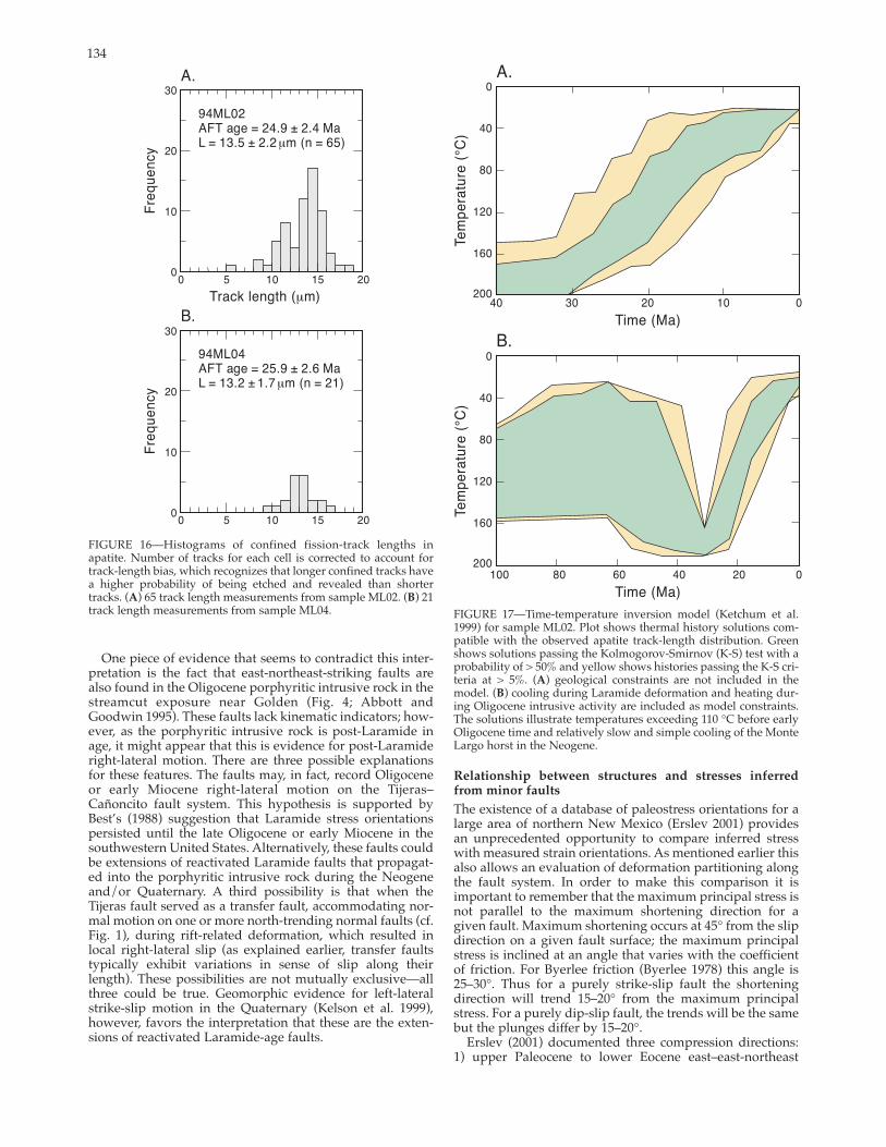
134
track length measurements from sample ML04.
One piece of evidence that seems to contradict this interpretation is the fact that eastnortheaststriking faults are also found in the Oligocene porphyritic intrusive rock in the streamcut exposure near Golden (Fig. 4; Abbott and Goodwin 1995). These faults lack kinematic indicators; however, as the porphyritic intrusive rock is postLaramide inage, it might appear that this is evidence for postLaramiderightlateral motion. There are three possible explanations for these features. The faults may, in fact, record Oligoceneor early Miocene rightlateral motion on the Tijeras–Cañoncito fault system. This hypothesis is supported byBest’s (1988) suggestion that Laramide stress orientations persisted until the late Oligocene or early Miocene in thesouthwestern United States. Alternatively, these faults could be extensions of reactivated Laramide faults that propagated into the porphyritic intrusive rock during the Neogene and/or Quaternary. A third possibility is that when the Tijeras fault served as a transfer fault, accommodating normal motion on one or more northtrending normal faults (cf. Fig. 1), during riftrelated deformation, which resulted in local rightlateral slip (as explained earlier, transfer faults typically exhibit variations in sense of slip along theirlength). These possibilities are not mutually exclusive—all three could be true. Geomorphic evidence for leftlateralstrikeslip motion in the Quaternary (Kelson et al. 1999),however, favors the interpretation that these are the extensions of reactivated Laramideage faults.
FIGURE 16—Histograms of confined fissiontrack lengths in
tracks. (A B) 21
apatite. Number of tracks for each cell is corrected to account for tracklength bias, which recognizes that longer confined tracks have a higher probability of being etched and revealed than shorter
) 65 track length measurements from sample ML02. (FIGURE 17—Timetemperature inversion model (Ketchum et al.1999) for sample ML02. Plot shows thermal history solutions compatible with the observed apatite tracklength distribution. Green shows solutions passing the KolmogorovSmirnov (KS) test with a probability of > 50% and yellow shows histories passing the KS criteria at > 5%. (A) geological constraints are not included in the model. (B) cooling during Laramide deformation and heating during Oligocene intrusive activity are included as model constraints. The solutions illustrate temperatures exceeding 110 °C before early Oligocene time and relatively slow and simple cooling of the Monte Largo horst in the Neogene.
Relationship between structures and stresses inferred from minor faults
The existence of a database of paleostress orientations for a large area of northern New Mexico (Erslev 2001) provides an unprecedented opportunity to compare inferred stress with measured strain orientations. As mentioned earlier this also allows an evaluation of deformation partitioning alongthe fault system. In order to make this comparison it is important to remember that the maximum principal stress is not parallel to the maximum shortening direction for a given fault. Maximum shortening occurs at 45° from the slip direction on a given fault surface; the maximum principal stress is inclined at an angle that varies with the coefficient of friction. For Byerlee friction (Byerlee 1978) this angle is25–30°. Thus for a purely strikeslip fault the shortening direction will trend 15–20° from the maximum principal stress. For a purely dipslip fault, the trends will be the same but the plunges differ by 15–20°.
Erslev (2001) documented three compression directions: 1) upper Paleocene to lower Eocene east–eastnortheast
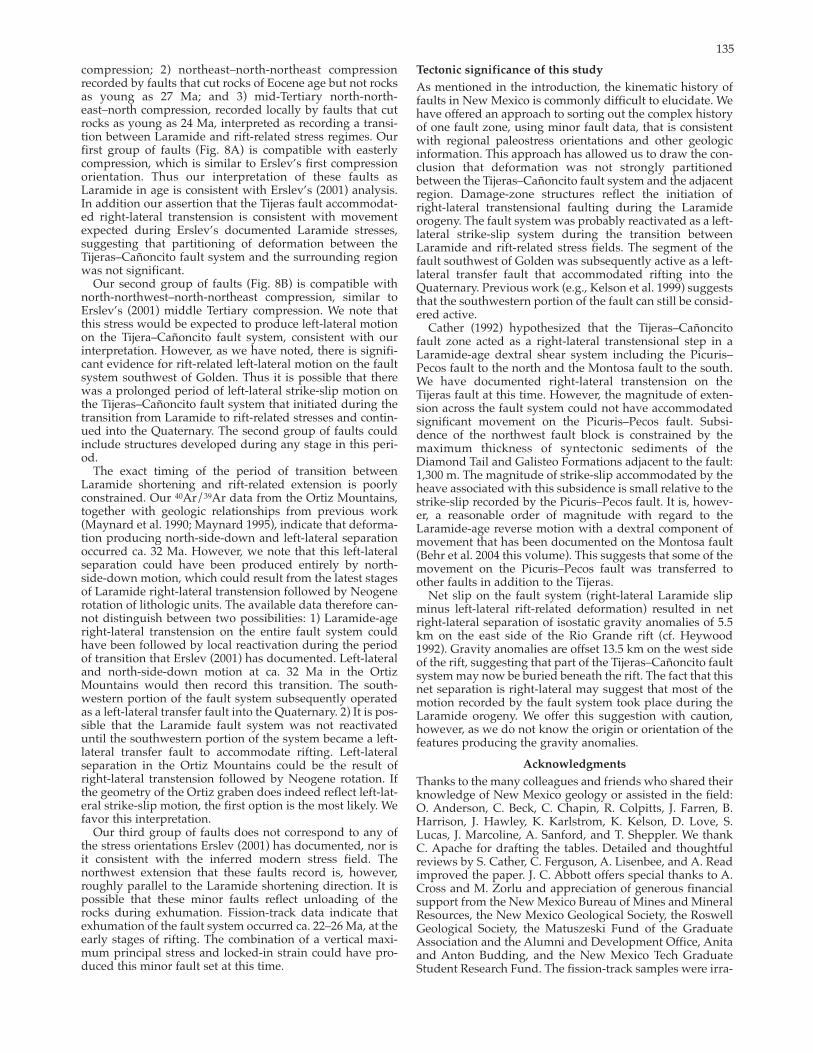
135
compression; 2) northeast–northnortheast compression recorded by faults that cut rocks of Eocene age but not rocks as young as 27 Ma; and 3) midTertiary northnortheast–north compression, recorded locally by faults that cut rocks as young as 24 Ma, interpreted as recording a transition between Laramide and riftrelated stress regimes. Our first group of faults (Fig. 8A) is compatible with easterly compression, which is similar to Erslev’s first compression orientation. Thus our interpretation of these faults as Laramide in age is consistent with Erslev’s (2001) analysis.In addition our assertion that the Tijeras fault accommodated rightlateral transtension is consistent with movementexpected during Erslev’s documented Laramide stresses, suggesting that partitioning of deformation between theTijeras–Cañoncito fault system and the surrounding region was not significant.
Our second group of faults (Fig. 8B) is compatible withnorthnorthwest–northnortheast compression, similar to Erslev’s (2001) middle Tertiary compression. We note that this stress would be expected to produce leftlateral motion on the Tijera–Cañoncito fault system, consistent with our interpretation. However, as we have noted, there is significant evidence for riftrelated leftlateral motion on the fault system southwest of Golden. Thus it is possible that there was a prolonged period of leftlateral strikeslip motion on the Tijeras–Cañoncito fault system that initiated during thetransition from Laramide to riftrelated stresses and continued into the Quaternary. The second group of faults could include structures developed during any stage in this period.
The exact timing of the period of transition betweenLaramide shortening and riftrelated extension is poorly constrained. Our 40Ar/39Ar data from the Ortiz Mountains, together with geologic relationships from previous work (Maynard et al. 1990; Maynard 1995), indicate that deformation producing northsidedown and leftlateral separation occurred ca. 32 Ma. However, we note that this leftlateral separation could have been produced entirely by northsidedown motion, which could result from the latest stagesof Laramide rightlateral transtension followed by Neogenerotation of lithologic units. The available data therefore cannot distinguish between two possibilities: 1) Laramideagerightlateral transtension on the entire fault system could have been followed by local reactivation during the periodof transition that Erslev (2001) has documented. Leftlateraland northsidedown motion at ca. 32 Ma in the Ortiz Mountains would then record this transition. The southwestern portion of the fault system subsequently operatedas a leftlateral transfer fault into the Quaternary. 2) It is possible that the Laramide fault system was not reactivated until the southwestern portion of the system became a leftlateral transfer fault to accommodate rifting. Leftlateralseparation in the Ortiz Mountains could be the result of rightlateral transtension followed by Neogene rotation. If the geometry of the Ortiz graben does indeed reflect leftlateral strikeslip motion, the first option is the most likely. We favor this interpretation.
Our third group of faults does not correspond to any of the stress orientations Erslev (2001) has documented, nor isit consistent with the inferred modern stress field. The northwest extension that these faults record is, however, roughly parallel to the Laramide shortening direction. It is possible that these minor faults reflect unloading of the rocks during exhumation. Fissiontrack data indicate thatexhumation of the fault system occurred ca. 22–26 Ma, at the early stages of rifting. The combination of a vertical maximum principal stress and lockedin strain could have produced this minor fault set at this time.
Tectonic significance of this study
As mentioned in the introduction, the kinematic history offaults in New Mexico is commonly difficult to elucidate. We have offered an approach to sorting out the complex historyof one fault zone, using minor fault data, that is consistentwith regional paleostress orientations and other geologic information. This approach has allowed us to draw the conclusion that deformation was not strongly partitioned between the Tijeras–Cañoncito fault system and the adjacent region. Damagezone structures reflect the initiation of rightlateral transtensional faulting during the Laramideorogeny. The fault system was probably reactivated as a leftlateral strikeslip system during the transition betweenLaramide and riftrelated stress fields. The segment of thefault southwest of Golden was subsequently active as a leftlateral transfer fault that accommodated rifting into theQuaternary. Previous work (e.g., Kelson et al. 1999) suggeststhat the southwestern portion of the fault can still be considered active.
Cather (1992) hypothesized that the Tijeras–Cañoncitofault zone acted as a rightlateral transtensional step in aLaramideage dextral shear system including the Picuris–Pecos fault to the north and the Montosa fault to the south. We have documented rightlateral transtension on the Tijeras fault at this time. However, the magnitude of extension across the fault system could not have accommodatedsignificant movement on the Picuris–Pecos fault. Subsidence of the northwest fault block is constrained by themaximum thickness of syntectonic sediments of theDiamond Tail and Galisteo Formations adjacent to the fault:1,300 m. The magnitude of strikeslip accommodated by theheave associated with this subsidence is small relative to the strikeslip recorded by the Picuris–Pecos fault. It is, however, a reasonable order of magnitude with regard to the Laramideage reverse motion with a dextral component ofmovement that has been documented on the Montosa fault (Behr et al. 2004 this volume). This suggests that some of themovement on the Picuris–Pecos fault was transferred to other faults in addition to the Tijeras.
Net slip on the fault system (rightlateral Laramide slipminus leftlateral riftrelated deformation) resulted in net rightlateral separation of isostatic gravity anomalies of 5.5km on the east side of the Rio Grande rift (cf. Heywood1992). Gravity anomalies are offset 13.5 km on the west side of the rift, suggesting that part of the Tijeras–Cañoncito faultsystem may now be buried beneath the rift. The fact that thisnet separation is rightlateral may suggest that most of themotion recorded by the fault system took place during the Laramide orogeny. We offer this suggestion with caution, however, as we do not know the origin or orientation of the features producing the gravity anomalies.
Acknowledgments
Thanks to the many colleagues and friends who shared their knowledge of New Mexico geology or assisted in the field:O. Anderson, C. Beck, C. Chapin, R. Colpitts, J. Farren, B. Harrison, J. Hawley, K. Karlstrom, K. Kelson, D. Love, S. Lucas, J. Marcoline, A. Sanford, and T. Sheppler. We thank C. Apache for drafting the tables. Detailed and thoughtfulreviews by S. Cather, C. Ferguson, A. Lisenbee, and A. Read improved the paper. J. C. Abbott offers special thanks to A. Cross and M. Zorlu and appreciation of generous financial support from the New Mexico Bureau of Mines and Mineral Resources, the New Mexico Geological Society, the Roswell Geological Society, the Matuszeski Fund of the Graduate Association and the Alumni and Development Office, Anita and Anton Budding, and the New Mexico Tech Graduate Student Research Fund. The fissiontrack samples were irra

136
diated at the Texas A&M Nuclear Science Center under the DOE reactor share program. This paper formed a major part of JCA’s M.S. thesis.
References Abbott, J. C., 1995, Constraints on the deformational history of the
Tijeras Cañoncito fault system, northcentral New Mexico:Unpublished M.S. thesis, New Mexico Institute of Mining andTechnology, 161 pp.
Abbott, J. C., and Goodwin, L. B., 1995, A spectacular exposure of the Tijeras fault, with evidence for Quaternary motion; in Bauer, P. W., Kues, B. S., Dunbar, N. W., Karlstrom, K. E., and Harrison, B. (eds.), Geology of the Santa Fe Region: New Mexico GeologicalSociety, Guidebook 46, pp. 117–125.
Abbott, J. C., Cather, S. M., and Goodwin, L. B., 1995, Paleogene synorogenic sedimentation in the Galisteo basin related to the Tijeras–Cañoncito fault system; in Bauer, P. W., Kues, B. S., Dunbar, N. W., Karlstrom, K. E., and Harrison, B. (eds.), Geologyof the Santa Fe Region: New Mexico Geological Society, Guidebook 46, pp. 271–278.
Allmendinger, R. W., Marrett, R. A., and Cladouhos, T., 1992, FaultKin. Available through http://www.geo.cornell.edu/geology/faculty/RWA/RWA.html, accessed Feb. 10, 2004.
Bachman, G. O., and Mehnert, H. H., 1978, New KAr dates and the late Pliocene to Holocene geomorphic history of the central RioGrande region, New Mexico: Geological Society of America, Bulletin, v. 89, no. 2, pp. 283–292.
Beck, W. C., and Chapin, C. E., 1994, Structural and tectonic evolution of the Joyita Hills, central New Mexico—implications of basement control on Rio Grande rift; in Keller, G. R., and Cather, S. M. (eds.), Basins of the Rio Grande rift—structure, stratigraphy, and tectonic setting: Geological Society of America, Special Paper 291, pp. 187–205.
Behr, R. A., Goodwin, L. B., and Kelley, S. A., 2004 this volume, Structural and thermochronological constraints on the movementhistory of the Montosa fault, New Mexico; in Cather, S. M, McIntosh, W. C., and Kelley, S. A. (eds.) Tectonics, geochronology, and volcanism in the Southern Rocky Mountains and Rio Granderift: New Mexico Bureau of Geology and Mineral Resources, Bulletin 160, pp. 139–160.
Best, M. G., 1988, Early Miocene change in direction of least principal stress, southwestern United States—conflicting inferences from dikes and metamorphic coredetachment fault terranes: Tectonics, v. 8, no. 2, pp. 249–259.
Booth, F. O., 1976, Geology of the Galisteo Creek area, Lamy to Cañoncito, Santa Fe County, New Mexico: Unpublished M.S. thesis, Colorado School of Mines, 122 pp.
Bruns, J. J., 1959, Petrology of the Tijeras Greenstone, Bernalillo County, New Mexico: Unpublished M.S. thesis, University ofNew Mexico, 119 pp.
Byerlee, J. D., 1978, Friction of rock: Pure and Applied Geophysics, v. 116, no. 45, pp. 615–626.
Cather, S. M., 1989, Post Laramide tectonic and volcanic transition in westcentral New Mexico; in Anderson, O. J., Lucas, S. G., Love, D. W., and Cather, S. M. (eds.), Southeastern Colorado Plateau:New Mexico Geological Society, Guidebook 40, pp. 91–97.
Cather, S. M., 1992, Suggested revisions to the Tertiary tectonic history of northcentral New Mexico; in Lucas, S. G., Kues, B. S., Williamson, T. E., and Hunt, A. P. (eds.), San Juan Basin IV: New Mexico Geological Society, Guidebook 43, pp. 109–122.
Cather, S. M., 1999, Implications of Jurassic, Cretaceous, and Proterozoic piercing lines for Laramide obliqueslip faulting inNew Mexico and rotation of the Colorado Plateau: Geological Society of America, Bulletin, v. 111, no. 6, pp. 849–868.
Chapin, C. E., and Cather, S. M., 1981, Eocene tectonics and sedimentation in the Colorado Plateau–Rocky Mountain area: Arizona Geological Society, Digest, v. 14, pp. 173–198.
Chapin, C. E., and Cather, S. M., 1994, Tectonic setting of the axialbasins of the northern and central Rio Grande rift; in Keller, G. R., and Cather, S. M. (eds.), Basins of the Rio Grande rift—structure, stratigraphy, and tectonic setting: Geological Society of America, Special Paper 291, pp. 5–25.
Chester, F. M. and Logan, J. M., 1987, Composite planar fabric ofgouge from the Punchbowl fault, California: Journal of Structural Geology, v. 9, no. 56, pp. 621–634.
Condie, K. C., 1982, Platetectonics model for Proterozoic continen
tal accretion in the southwestern United States: Geology, v. 10, no. 1, pp. 37–42.
Connolly, J. R., 1981, Geology of the Precambrian rocks of Tijeras Canyon, Bernalillo County, New Mexico: Unpublished M.S. thesis, University of New Mexico, 147 pp.
Connolly, J. R., 1982, Structure and metamorphism in the Precambrian Cibola gneiss and Tijeras greenstone, Bernalillo County, New Mexico; in Wells, S. G., Grambling, J. A., and Callender, J. F. (eds.), Albuquerque country II: New Mexico Geological Society, Guidebook 33, pp. 197–202.
Cordell, L., 1978, Regional geophysical setting of the Rio Granderift: Geological Society of America, Bulletin, v. 89, pp. 1073–1090.
Deino, A. and Potts, R., 1990, Singlecrystal 40Ar/39Ar dating of theOlorgesailie Formation, Southern Kenya rift: Journal ofGeophysical Research, v. 95, pp. 8453–8470.
Deino, A., and Potts, R., 1992, Ageprobability spectra for examination of singlecrystal 40Ar/39Ar dating results—examples from Olorgesailie, Southern Kenya rift: Quaternary International, v. 13/14, pp. 47–53.
Erslev, E. A., 2001, Multistage, multidirectional Tertiary shortening and compression in northcentral New Mexico: Geological Society of America, Bulletin, v. 113, no. 1, pp. 63–74.
Ferguson, C. A., 1999, Structural geometry, kinematics, and timing of deformation and magmatism in the Tijeras foldbelt—implications for Laramide through midTertiary tectonic evolution of thesouthern Rockies (abs.): Geological Society of America, Abstracts with Programs, v.3 1, p. A187.
Ferguson, C. A., Timmons, J. M., Pazzaglia, F. J., Karlstrom, K. E., Osburn, G. R., and Bauer, P. W., 1999, Geology of Sandia Parkquadrangle, Bernalillo and Sandoval Counties, New Mexico: NewMexico Bureau of Mines and Mineral Resources, Openfile Geologic Map OFGM 1, scale 1:24,000.
Fleck, R. J., Sutter, J. F., and Elliot, D. H., 1977, Interpretation of discordant 40Ar/39Ar age spectra of Mesozoic tholeiites from Antarctica: Geochimica et Cosmochimica Acta, v. 41, no. 4, pp. 15–32.
Galbraith, R .F., 1981, On statistical models for fission track counts: Mathematical Geology, v. 13, pp. 471–478.
Galbraith, R. F., 1988, Graphical display of estimates having differing standard errors: Technometrics, v. 30, no. 3, pp. 271–281.
Galbraith, R. F., and Laslett, G. M., 1985, Some remarks on statistical estimation in fissiontrack dating: Nuclear Tracks, v. 10, no. 3, pp. 361–363.
Galbraith, R. F., and Laslett, G. M., 1993, Statistical models for mixed fission track ages: Nuclear Tracks and Radiation Measurement, v. 21, no. 4, pp. 459–470.
Ghisetti, F., 2000, Slip partitioning and deformation cycles close tomajor faults in southern California—evidence from smallscale faults: Tectonics v. 19, no 1, pp. 25–43.
Gibbons, J. F., 1990, Tectonic disruption of Tijeras Canyon drainage (abs.): New Mexico Geology, v. 12, no. 4, p. 93.
Gleadow, A. J. W., Duddy, I. R., Green, P. F., and Hegarty, K. A., 1986, Fission track lengths in the apatite annealing zone and the interpretation of mixed ages: Earth and Planetary Science Letters, v. 78, no. 23, pp. 245–254.
GRAM, Inc. and William Lettis & Associates, Inc., 1995, Conceptualgeological model of the Sandia National Laboratories andKirtland Air Force Base: Technical Report submitted to the Sitewide Hydrologic Characterization Project, Organization 7584, Environmental Restoration Project, Sandia Laboratories, Albuquerque, New Mexico, 2 volumes, various pagination.
Grauch, V. J. S., 1999, Principal features of highresolution aeromagnetic data collected near Albuquerque, New Mexico; in Pazzaglia,F. J., and Lucas, S. G. (eds.), Albuquerque geology: New Mexico Geological Society, Guidebook 50, pp. 115–119.
Grauch, V. J. S., Gillespie, C. L., and Keller, G. R., 1999, Discussion of new gravity maps for the Albuquerque basin area; in Pazzaglia,F. J., and Lucas, S. G. (eds.), Albuquerque geology: New Mexico Geological Society, Guidebook 50, pp. 119–124.
Green, P. F., 1985, A comparison of zeta calibration baselines in zircon, sphene, and apatite: Chemical Geology, Isotope Geoscience Section, v. 58, pp. 1–22.
Heywood, C. E., 1992, Isostatic residual gravity anomalies of NewMexico: U.S. Geological Survey, Water Resources Investigations Report WRI914065, 27 pp.
House, M. A., Kelley, S. A., and Roy, M., 2003, Refining the footwall

137
cooling history of a rift flank uplift, Rio Grande rift, New Mexico:Tectonics, v. 22, no 5, 18 pp.
Hurford, A. J., 1986, Cooling and uplift patterns in the LepontineAlps, south central Switzerland and an age of vertical movementon the Insubric fault line: Contributions to Mineralogy andPetrology, v. 92, no. 4, pp. 413–427.
Hurford, A. J., and Green, P. F., 1983, The zeta age calibration of fissiontrack dating: Isotope Geoscience, v. 1, no. 4, pp. 285–317.
Hurford, A. J., Fitch, F. J., and Clarke, A., 1984, Resolution of the age structure of the detrital zircon populations of two Lower Cretaceous sandstones from the Weald of England by fission track dating: Geological Magazine, v. 121, no. 4, pp. 269–296.
Ilg, B., Bauer, P. W., Ralser, S., Rogers, J., and Kelley, S., 1997, Geology of the Glorieta 7.5min quadrangle, Santa Fe County, New Mexico: New Mexico Bureau of Mines and Mineral Resources, Openfile Geologic Map OGFM11, scale 1:12,000.
Karlstrom, K. E., Connell, S. D., Ferguson, C. A., Read, A. S., Osburn, G., Kirbey, E., Abbott, J. C., Hitchcock, C., Kelson, K. I., Noller, J., Sawyer, T., Ralser, S., Love, D. W., Nyman, M., and Bauer, P. W., 1994, Geology of the Tijeras 7.5min quadrangle, Bernalillo County, New Mexico: New Mexico Bureau of Geology and Mineral Resurces, Openfile Geologic Map OFGM 4, scale 1:24,000.
Kay, B. D., 1986, Vein and breccia gold mineralization and associated igneous rocks at the Ortiz mine, New Mexico, U.S.A.: Unpublished M.S. thesis, Colorado School of Mines, 179 pp.
Kelley, S. A., and Chapin, C. E., 1995, Apatite fissiontrack thermochronology of southern Rocky Mountains–Rio Grande rift–western High Plains provinces; in Bauer, P. W., Kues, B. S., Dunbar, N. W., Karlstrom, K. E., and Harrison, B. (eds.), Geology of the Santa Fe region: New Mexico Geological Society, Guidebook 46, pp. 87–96.
Kelley, S. A., and Chapin, C. E., 2004 this volume, Denudational history and internal structure of the Front Range and Wet Mountains, Colorado, based on apatite fissiontrack thermochronology; in Cather, S. M., McIntosh, W. C., and Kelley, S. A. (eds.), Tectonics, geochronology, and volcanism in the Southern Rocky Mountains and Rio Grande rift: New Mexico Bureau of Geology and Mineral Resources, Bulletin 160, pp. 41–78.
Kelley, S. A., and I. J. Duncan, 1984, Tectonic history of the northern Rio Grande rift derived from apatite fissiontrack geochronology; in Baldridge, W. S., Dickerson, P. W., Riecker, R. E., and Zidek, J. (eds.), Rio Grande rift, northern New Mexico: New MexicoGeological Society, Guidebook 35, pp. 67– 73.
Kelley, S. A., and Duncan, I. J., 1986, Late Cretaceous to middle Tertiary tectonic history of the northern Rio Grande rift: Journal ofGeophysical Research, v. 91, no. 6B, pp. 6246–6262.
Kelley, S. A., Chapin, C. E., and Corrigan, J., 1992, Late Mesozoic toCenozoic cooling histories of the flanks of the northern and central Rio Grande rift, Colorado and New Mexico: New Mexico Bureau of Mines and Mineral Resources Bulletin 145, 40 pp.
Kelley, V. C., 1954, Tectonic map of a part of the upper Rio Grande area, New Mexico: U.S. Geological Survey, Oil and Gas Investigation Map OM157, scale 1:190,080.
Kelley, V. C., and Northrop, S. A., 1975, Geology of Sandia Mountains and vicinity, New Mexico: New Mexico Bureau of Mines and Mineral Resources, Memoir 29, 136 pp.
Kelson, K. I., Hitchcock, C. S., and Harrison, J. B. J., 1999, Paleoseismology of the Tijeras fault near Golden, New Mexico: in Pazzaglia, F. J., and Lucas, S. G. (eds.), Albuquerque geology: New Mexico Geological Society, Guidebook 50, pp. 201–209.
Ketchum, R. A., Donelick, R. A, and Carlson, W. D., 1999, Variabilityof apatite fissiontrack annealing kinetics, III. extrapolation togeological time scales: American Mineralogist, v. 84, pp. 1235–1255.
Kirby, E., Karlstrom, K. E., Andronicos, C. L., and Dallmeyer, R. D., 1995a, Tectonic setting of the Sandia pluton—an orogenic 1.4 Ga granite in New Mexico: Tectonics, v. 14, no. 1, pp. 185–201.
Kirby, E., Karlstrom, K. E., and Andronicos, C. L., 1995b, Structural and thermal setting during emplacement of the Sandia pluton; in Bauer, P. W., Kues, B. S., Dunbar, N. W., Karlstrom, K. E., and Harrison, B. (eds.), Geology of the Santa Fe region: New Mexico Geological Society, Guidebook 46, pp. 219–226.
Laslett, G. M., Kendall, W. S., Gleadow, A. J. W., and Duddy, I. R., 1982, Bias in measurement of fissiontrack length distribution: Nuclear Tracks, v. 6, no. 23, pp. 79–85.
Lisenbee, A. L. and Woodward, L. E., 1995, Tijeras–Cañoncitoaccommodation zone, Rio Grande rift, New Mexico (abs.):Geological Society of America, Abstracts with Programs, Rocky Mountain Section, v. 27, no. 4, p. 43.
Lisenbee, A. L., Woodward, L. A., and Connolly, J. R., 1979, Tijeras–Cañoncito fault system—a major zone of recurrent movement in northcentral New Mexico; in Ingersoll, R. V., Woodward, L. A. and James, H. L. (eds.), Santa Fe country: New MexicoGeological Society, Guidebook 30, pp. 89–99.
Machette, M. N., 1982, Quaternary and Pliocene faults in the LaJencia and southern part of the Albuquerque–Belen Basins, New Mexico—evidence of fault history from fault scarp morphology and Quaternary geology; in Wells, S. G., Grambling, J. A., and Callender, J. F. (eds.), Albuquerque country II: New Mexico Geological Society, Guidebook 33, pp. 161–169.
Machette, M. N., Personius, S. F., Kelson, K. I, Dart, R. L., and Haller, K. M., 1998, Map and data for Quaternary faults in New Mexico:U.S. Geological Survey, Openfile Report 98521, 1 plate, scale 1:750,000 scale.
Maldonado, F., Connell, S. D., Love, D. W., Grauch, V. J. S ., Slate, J. L., McIntosh, W. C., Jackson, P. B., and Byers, F. M., Jr., 1999, Neogene geology of the Isleta Reservation and vicinity, Albuquerque Basin, New Mexico; in Pazzaglia, F. J., and Lucas, S. G. (eds.) Albuquerque geology: New Mexico Geological Society, Guidebook 50, pp. 175–188.
Marrett, R., and Allmendinger, R. W., 1990, Kinematic analysis of fault slipdata: Journal of Structural Geology, v.12, no. 43, pp. 973–986.
Mawer, C. K., Grambling, J. A., and Vernon, R. H., 1989, Syntectonic nature of the 1.45 Ga Sandia pluton, New Mexico (abs.):Geological Society of America, Abstracts with Programs, v. 21, no. 6, p. 215.
May, S. J., and Russell, L. R., 1994, Thickness of the synrift Santa FeGroup in the Albuquerque Basin and its relation to structural style; in Keller, G. R., and Cather, S. M. (eds.), Basins of the Rio Grande rift—structure, stratigraphy, and tectonic setting: Geological Society of America, Special Paper 291, pp. 113–123.
Maynard, S. R., 1995, Gold mineralization associated with midTertiary magmatism and tectonism, Ortiz Mountains, Santa FeCounty, New Mexico; in Bauer, P. W., Kues, B. S., Dunbar, N. W., Karlstrom, K. E, and Harrison, B. (eds.), Geology of the Santa Fe region: New Mexico Geological Society, Guidebook 46, pp. 161–166.
Maynard, S. R., Nelsen, C. J., Martin, K. W., and Schutz, J. L., 1990, Geology and gold mineralization of the Ortiz Mountains, SantaFe County, New Mexico: Mining Engineering, v. 42, no. 8, pp. 1007–1011.
Maynard, S. R., Woodward, L. A., and Giles, D. L., 1991, Tectonics, intrusive rocks, and mineralization of the San Pedro–Ortiz porphyry belt, northcentral New Mexico: New Mexico Bureau of Mines and Mineral Resources, Bulletin 137, pp. 57–69.
Miller, J. P., Montgomery, A., and Sutherland, P. K., 1963, Geology of part of the southern Sangre de Cristo Mountains, New Mexico: New Mexico Bureau of Mines and Mineral Resources, Memoir 11, 106 pp.
Mount, V. S and Suppe, J., 1987, Presentday stress orientations adjacent to active strikeslip faults—California and Sumatra:Journal of Geophysical Research, v. 97, no. 8, pp. 11,995–12,013.
Nelson, B. K. and DePaolo, D. J., 1984, Origin of Precambrian metavolcanic rocks from New Mexico, Colorado, and Wyoming, and the isotopic evolution of Proterozoic mantle (abs.): Geological Society of America, Abstracts with Programs, v. 16, no. 4, pp. 249.
Petit, J. P., 1987, Criteria for the sense of movement on fault surfaces in brittle rocks: Journal of Structural Geology, v. 9, no. 56, pp. 597–608.
Ramberg, I. B., Cook, F. A., and Smithson, S. B., 1978, Structure of the Rio Grande rift in southern New Mexico and West Texas based on gravity interpretation: Geological Society of America, Bulletin, v. 89, no. 1, pp. 107–123.
Reiter, M., Edwards, C. L., Hartman, H., Weidman, C., 1975, Terrestrial heat flow along the Rio Grande rift, New Mexico andsouthern Colorado: Geological Society of America, Bulletin, v. 86, no. 6, pp. 811–818.
Riedel, W., 1929, Zur Mechanik geologischer Brucherrscheinungen: Centralbl. F. Mineral. Geol. U. Pal. 1929 B, pp. 354–368.
Russell, L. R., and Snelson, S., 1990, Structural style and tectonic
138
evolution of the Albuquerque Basin segment of the Rio Granderift, in Pinet, B., and Bois, C. (eds.), The potential of deep seismicprofiling for hydrocarbon exploration: Editions Technip, Paris, pp. 175–207.
Russell, L. R., and Snelson, S., 1994, Structure and tectonics of the Albuquerque Basin segment of the Rio Grande rift—insights from seismic reflection data; in Keller, G. R., and Cather, S. M. (eds.), Basins of the Rio Grande rift—structure, stratigraphy, and tectonic setting: Geological Society of America, Special Paper 291, pp. 83–112.
Samson, S. D., and, Alexander, E. C., Jr., 1987. Calibration of the interlaboratory 40Ar/39Ar dating standard, Mmhb1: Chemical Geology, v. 66, no. 12, pp. 27–34.
Sanford, A. R., Jaksha, L. H., and Cash, D. J., 1991, Seismicity of theRio Grande rift in New Mexico; in Slemmons, D. B., Engdahl, E.R., Zoback, M. D., and Blackwell, D. D. (eds.), Neotectonics ofNorth America: Geological Society of America, Decade Map, v. 1, pp. 229–244.
Sauer, R. R., 1999, Petrochemistry and geochronology of plutons relative to tectonics in the San Pedro–Ortiz porphyry belt, NewMexico: Unpublished M.S. thesis, University of Colorado, 115 pp.
Starkey, J., 1977, The contouring of orientation data represented in spherical projection: Canadian Journal of Earth Sciences, v. 14, no. 2, p. 268–277.
Stearns, C. E., 1953, Tertiary geology of the Galisteo–Tonque area, northcentral New Mexico: Geological Society of America, Bulletin, v. 64, no. 4, pp. 459–508.
Steiger, R. H., and Jäger, E., 1977, Subcommission on geochronology—convention on the use of decay constants in geo and cosmochronology: Earth and Planetary Science Letters, v. 36, pp. 359–362.
Tavarnelli, E., 1998, Tectonic evolution of the northern Salient Block, California. USA—Paleogene to Recent shortening in a transformfaultbounded continental fragment; in Holdsworth, R. E., Strachan, R. A., and Dewey, J. F. (eds), Continental transpressional and transtensional tectonics: Geological Society, London, Special Publications, v. 135, pp. 107–118.
Taylor, J. R., 1982. An introduction to error analysis—the study of
uncertainties in physical measurements. University Science Books, Mill Valley, Calif., 270 pp.
Tchalenko, J. S., 1970, Similarities between shear zones of different magnitudes: Geological Society of America, Bulletin, v. 81, no. 6, pp. 1625–1640.
Teyssier, C., Tikoff, B., and Markley, M., 1995, Oblique plate motionand continental tectonics: Geology, v. 23, no. 5, pp. 447–450.
Timmons, J. M., Karlstrom, K. E., and Kirby, E., 1995, Geology of the Monte Largo Hills area, New Mexico—structural and metamorphic study of the eastern aureole of the Sandia Pluton; in Bauer, P. W., Kues, B. S., Dunbar, N. W., Karlstrom, K. W., and Harrison, B. (eds.), Geology of the Santa Fe region: New Mexico Geological Society, Guidebook 46, pp. 227–232.
Vernon, R. H., 1986, Kfeldspar megacrysts in granites—phenocrysts, not porphyroblasts: Earth Science Reviews, v. 23, no. 1, pp. 1–63.
Wagner, G. and van den Haute, P., 1992, Fission track dating: Kluwer Academic Publishers, Dordrecht, The Netherlands, 285 pp.
Wilson, J. E., 1999, Microfracture fabric of the Punchbowl fault zone, San Andreas system, California: Unpublished M.S. Thesis, Texas A&M University, 125 pp.
Woodward, L. A., 1984, Basement control of Tertiary intrusions and associated mineral deposits along Tijeras–Cañoncito fault system, New Mexico: Geology, v. 12, no. 9, pp. 531–533.
Yamada, R., Tagami, T., Nishimura, S., and Ito, H., 1995, Annealing kinetics of fission tracks in zircon—an experimental study: Chemical Geology, Isotope Geoscience Section, v. 122, no. 14, pp. 249–258.
York, D., 1969. Least squares fitting of a straight line with correlated errors: Earth and Planetary Science Letters, v. 5, no. 5, pp. 320–324.
Zoback, M. D., Zoback, M. L., Mount, V. S, Suppe, J., Eaton, J. P., Healy, J. H., Oppenheimer, D., Reasenberg, P., Jones, L., Raleigh, C. B., Wong, I. G., Scotti, O., and Wentworth, C., 1987, New evidence on the state of stress of the San Andreas fault system: Science, v. 238, pp.1105–1111.