the changing world of geodesy and surveying · the changing world of geodesy and surveying k.p....
TRANSCRIPT

The Changing World of Geodesy and Surveying
K.P. SchwarzDepartment of Geomatics Engineering
The University of CalgaryCalgary, Alberta, Canada T2N 1N4E-mail: [email protected]
Summary
Change in the field of geodesy and surveying has been rapid during the past twenty-five years.It was driven by major advances in space geodesy resulting in new measurement systems.These systems have had a profound effect on the practice of geodesy and surveying and it islikely that their impact will become even broader and more pronounced during the nextdecade. Four major trends that developed over the past twenty-five years are briefly discussedin this paper and their impact on the major tasks of geodesy - the representation of the Earth'ssurface and its gravity field - are evaluated. The paper concludes with an outlook on a possibleintegration of geodetic techniques and data into an Earth Observing System that will moreaccurately describe the evolution of the Earth in time and space.
1. Twenty-five Years in Retrospective
Understanding change requires interpretation of the present in terms of the past. In this firstchapter some developments of the past 25 years are interpreted as technological trends in thefield of geodesy and surveying. Trends express continuity over a given time period. They offertherefore a limited amount of predictability which is dependent on the linearity of the observedphenomenon. Looking at the state of geodesy and surveying in 1974, few of the developmentsmentioned below were predictable in terms of the trends dominant during the period 1949-1974. The development was not linear and, only in hindsight, are we able to see some of thetrends. This should be kept in mind when talking about ‘The Changing World of Geodesy andSurveying’. Understanding change does not mean that the future can be predicted byextrapolating the past. Understanding change can, however, prepare us for the future. GoloMann’s remark that “those who do not know the past will not get a handle on the future”should serve as a reminder and an antidote against too much blue-eyed optimism.
What then are some of the major changes in our field at the end of this century? Disregardinggeneral technological trends, such as the still rapid development of computer technology, thetrend towards miniaturization of sensors and systems, and the rapid emergence of complexinformation systems, there are a number of specific developments which are changing theworld of geodesy and surveying as we have known it. Four of them will be discussed here:
• The implementation of a time-varying reference frame of unprecedented accuracy which forthe first time, allows the measurement of global and regional changes of the Earth and theirmodeling in space and time.
• The capability to operate the measurement systems directly in the reference frame usingsatellite orbits as the link and thus eliminating the need for networks and dense groundcontrol point monumentation.

• The capability to solve the vertical datum problem by a combination of satellite and airbornegravimetry.
• The increasing trend towards integrated kinematic measurement systems with high data ratesand the resulting changes in automated data acquisition, modeling and algorithmdevelopment.
Before discussing these trends in more detail, conventional approaches to solving the task ofgeodesy will be briefly reviewed in order to provide a framework for the rest of the paper.
2. Views on How to Solve the Task of Geodesy
More than 100 years ago, Helmert defined geodesy as the science of measuring and mappingthe Earth’s surface. Although methods have considerably changed since then, the definition isstill useful if one adds the temporal variations of the Earth to the definition. Figure 1 illustratesthe change in measurement systems and techniques that has taken place in the past 25 yearsand that is still in progress. Especially the development of kinematic techniques of mapping theEarth surface and gravity field are remarkable and will be discussed further in chapter 6.Helmert’s seemingly simple definition has been interpreted in rather different ways by thegroups involved in surveying and mapping. Part of this difference came about because ofdifferences in the surface itself. Those who measured the ocean surface - by far the largest partof the Earth’s surface - obviously faced different problems than those who measured the landsurface. However, even among those who measured on land, there were vast differences inconcept and approach. Figures 2 to 4 indicate some of these differences.
Figure 2 illustrates the view of the surveyor/geodesist who typically considers themeasurement of the Earth’s surface as a point positioning problem. The accuratedetermination and monumentation of points on the surface of the Earth is therefore seen as themajor task. In order to express these points in a consistent coordinate system over larger partsof the Earth’s surface, networks are established and the datum problem must be solved. Oncethis has been done, the network points can be used for point densification in local areas. Theresulting representation of the surface by a more or less regular cluster of points is consideredas sufficient. Mapping is done as pointwise mapping. In a way, the concept behind thisapproach is that the higher the point accuracy, the better the mapping. This is true forpointwise mapping, but obviously not for surface mapping. Simple interpolation betweennetwork points will for instance create large errors in a topographic map. Thus, the accuracyof the surface representation will not be uniform. In addition, although networks may stretchover a large part of the Earth’s surface, they are globally disconnected when established byconventional procedures. This means that the datum problem cannot be solved withoutextraterrestrial measurements. This method has therefore to be supplemented by othertechniques in order to solve the task of geodesy as defined by Helmert.
Figure 3 illustrates the view of the photogrammetrist who considers the measurement of theEarth’s surface as an imaging problem. It is solved by deriving a model of the surface fromdigital or photographic images. In this case, patches of the Earth’s surface are actuallymeasured and mapped in accordance with Helmert’s definition. The concept behind thismethod is that the surface of the Earth can be presented by pixels measured in projectedimages. The smaller the pixel size and the more uniform the geometry, the better the mapping.In this case, the accuracy is more or less uniform across the image and interpolation of specificimage features is possible with high accuracy, once the image has been properlygeoreferenced. This is done by solving the datum problem using geodetic ground control in

the survey area. Comparing the view of the surveyor/geodesist with that of thephotogrammetrist shows that they are essentially complementary. The surveyor/geodesistprovides highly accurate point positions in an adopted reference system which then can beused by the photogrammetrist to georeference measurements and solve the datum problem forthe precise local maps derived from images.
Figure 1: Measuring the Earth’s Surface by Static and Kinematic Systems
Figure 2: Point Positioning – The Surveyor’s View
The surface of the Earthis defined by pointmeasurements.
The higher the accuracyof point determination,the better the mapping.
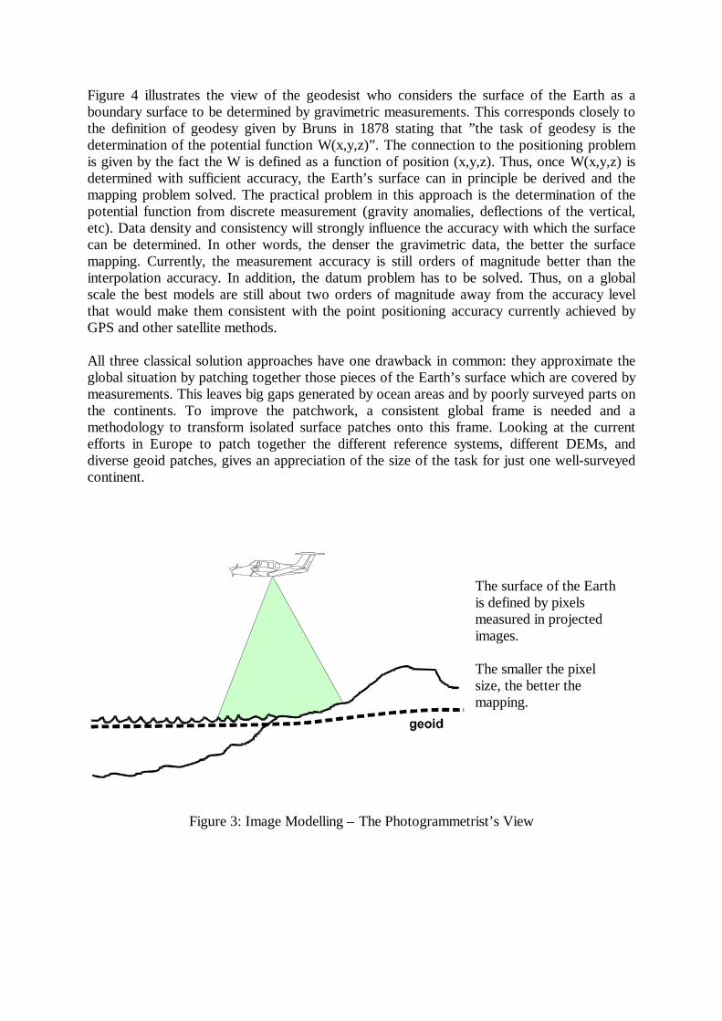
Figure 4 illustrates the view of the geodesist who considers the surface of the Earth as aboundary surface to be determined by gravimetric measurements. This corresponds closely tothe definition of geodesy given by Bruns in 1878 stating that ”the task of geodesy is thedetermination of the potential function W(x,y,z)”. The connection to the positioning problemis given by the fact the W is defined as a function of position (x,y,z). Thus, once W(x,y,z) isdetermined with sufficient accuracy, the Earth’s surface can in principle be derived and themapping problem solved. The practical problem in this approach is the determination of thepotential function from discrete measurement (gravity anomalies, deflections of the vertical,etc). Data density and consistency will strongly influence the accuracy with which the surfacecan be determined. In other words, the denser the gravimetric data, the better the surfacemapping. Currently, the measurement accuracy is still orders of magnitude better than theinterpolation accuracy. In addition, the datum problem has to be solved. Thus, on a globalscale the best models are still about two orders of magnitude away from the accuracy levelthat would make them consistent with the point positioning accuracy currently achieved byGPS and other satellite methods.
All three classical solution approaches have one drawback in common: they approximate theglobal situation by patching together those pieces of the Earth’s surface which are covered bymeasurements. This leaves big gaps generated by ocean areas and by poorly surveyed parts onthe continents. To improve the patchwork, a consistent global frame is needed and amethodology to transform isolated surface patches onto this frame. Looking at the currentefforts in Europe to patch together the different reference systems, different DEMs, anddiverse geoid patches, gives an appreciation of the size of the task for just one well-surveyedcontinent.
Figure 3: Image Modelling – The Photogrammetrist’s View
The surface of the Earthis defined by pixelsmeasured in projectedimages.
The smaller the pixelsize, the better themapping.

Figure 4: Boundary Surface Determination – The Geodesist’s View
3. Reference Frames and the Solution of the Datum Problem
One of the advantages of applying space methods to geodesy is the establishment of a highlyaccurate reference frame for positioning. The centre of mass of the Earth, as well as thedirection of the axes of the conventional terrestrial frame can be established with an accuracythat, in a relative sense, is at the part per billion level and is thus superior to most practicallyapplied positioning techniques. Comparing this to the best available global frame 25 years agoshows that reference frame implementation has been improved by more than two orders ofmagnitude. For much of the following discussion, the detailed technical background can befound in the proceedings of the recent IGGOS (1998) symposium.
A Conventional Terrestrial Reference Frame (CTRF) is implemented by tying the framedefinition to the positions of fundamental observing stations which are continuously measured.The measurements are either made with respect to satellites or with respect to extraterrestrialsources. If only one technique is used for the determination of the coordinates, small biasesmay remain in the frame definition. Comparing independently determined conventionalreference frames offers therefore a means to detect and eliminate such biases. Suchcomparisons have been made by the International Earth Rotation Service (IERS), establishedby the IAG, and have shown that the origins of these different reference frames agree at thelevel of a few centimeters and that the directions of the axes agree at the level of a fewmilliarcseconds. Thus the stability of current global reference frames is such that time changesin the coordinates of the fundamental stations have to be taken into account. The IERS hastherefore added a plate tectonic motion model to its ITRF94 reference frame, making it a four-dimensional frame. It is planned to extend this model to include regional motions, onceestimates of sufficient accuracy are available; for an overview see Blewitt et al (1997).Twenty-five years ago that would have been impossible because the existing reference framesdid not have the accuracy nor the stability to reliably determine such small motions bymeasurement.
The surface of the Earthis defined by agravimetric boundaryvalue problem.
The denser the gravitymeasurements, the betterthe mapping.
Besides the ITRF94 which uses a combination of observational techniques to determine thereference frame, there are a number of reference frames which make use of one observationaltechnique only. The best known is the WGS84 which is based on the GPS tracking stationnetwork and uses observations to GPS satellites only. The IGS network operated by theInternational Geodesy and Geodynamics Service, established by the IAG, is another GPS-based reference frame with a much larger tracking station network, almost 200 stations bynow. It will be used to measure and model regional motions. Similar reference systems existfor satellite laser techniques and VLBI. Each of these techniques has its own set of trackingstations to define the reference frame. Each of these reference frames can be considered as animplementation of the underlying reference system. Figure 5 illustrates in a schematic way theweakness of implementing a reference frame by only one type of measurements using GPS asan example. The GPS tracking network is indicated by three widely spaced stations on thesurface of the Earth (triangle). Each of these stations can be determined by rangemeasurements to at least four satellites, indicated by the heavy lines between one of thenetwork stations and five of the satellites. The underlying assumption of this approach is thatthe satellite positions at the time of measurement are precisely known. This is not the case andtherefore the range measurements are also used to improve the satellite orbits. This can bedone reliably if the positions of the tracking stations are accurately known. Thus, one ends upwith a typical bootstrap procedure: To improve orbits, accurate positions of tracking stationsare needed - to get tracking station coordinates, precise orbits are needed. This problem issolved in an iterative way by matching the accuracy of tracking station coordinates with theaccuracy of orbit determination. The results are excellent because of the measurementprecision and the continuous observation schedule. However, because of the bootstrappingoperation, small systematic errors in scale and orientation may remain in a reference framederived in this way. It is therefore important to compare and improve reference frames derivedfrom only one technique.
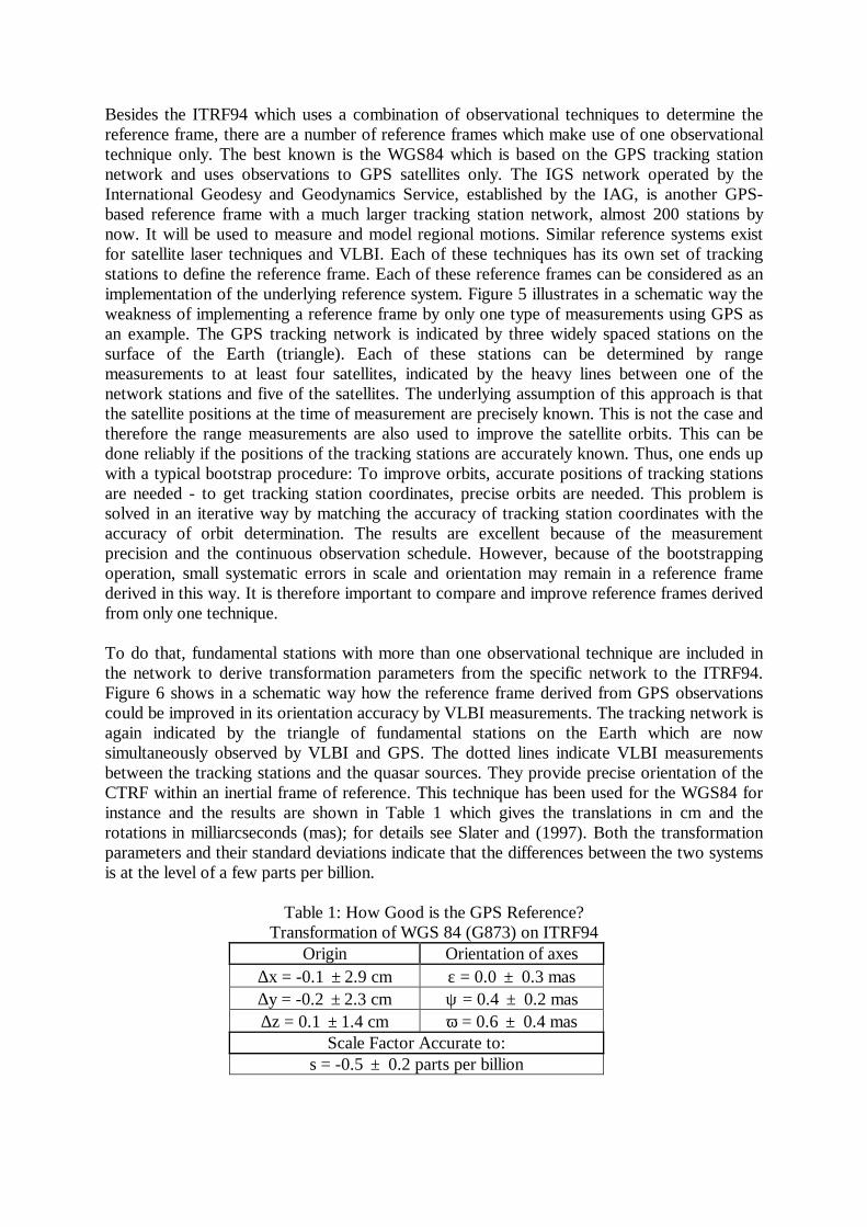
To do that, fundamental stations with more than one observational technique are included inthe network to derive transformation parameters from the specific network to the ITRF94.Figure 6 shows in a schematic way how the reference frame derived from GPS observationscould be improved in its orientation accuracy by VLBI measurements. The tracking network isagain indicated by the triangle of fundamental stations on the Earth which are nowsimultaneously observed by VLBI and GPS. The dotted lines indicate VLBI measurementsbetween the tracking stations and the quasar sources. They provide precise orientation of theCTRF within an inertial frame of reference. This technique has been used for the WGS84 forinstance and the results are shown in Table 1 which gives the translations in cm and therotations in milliarcseconds (mas); for details see Slater and (1997). Both the transformationparameters and their standard deviations indicate that the differences between the two systemsis at the level of a few parts per billion.
Table 1: How Good is the GPS Reference?Transformation of WGS 84 (G873) on ITRF94
Origin Orientation of axes∆x = -0.1 ±2.9 cm ε = 0.0 ± 0.3 mas∆y = -0.2 ±2.3 cm ψ = 0.4 ± 0.2 mas∆z = 0.1 ±1.4 cm ω = 0.6 ± 0.4 mas
Scale Factor Accurate to:s = -0.5 ± 0.2 parts per billion

With a reference system of this accuracy and stability, the datum problem for positioning canbe considered as solved for all practical requirements. The only remaining problem is thetransformation of the existing network information onto this global reference frame. As theongoing EUREF and REUN campaigns in Europe show, this is not a trivial task. While theglobal reference frame is a consistent three-dimensional coordinate system, this cannot be saidfor the reference systems used in the conventional network approach. Horizontal and verticalnetworks are essentially disconnected. They have few or no overlapping points and are basedon different datums and are therefore not consistent. To transform the vertical networkinformation to the global reference frame, the geoid is needed with high global accuracy. Thiswill be further discussed in chapter 5. To transform the horizontal network information to theglobal reference frame, network distortions have to be eliminated first, before the relativelysimple geometric transformation can be applied. Network distortions are due to a variety ofcauses, such as the observational procedure, the insufficient knowledge of the geoid used forreductions, and geodynamic changes of the Earth’s surface during the long time periods overwhich networks were established. Whether these transformations can be determined with anaccuracy sufficient to reliably transform existing networks into the global reference, will beanswered by the ongoing investigations. If the answer is positive, an enormous amount ofvaluable observational material will be preserved for scientific investigations. Even in this case,however, their practical value as ground control will be very limited due to reasons discussedin chapter 4.
Figure 5: The GPS Bootstrap Operation: Tracking Stations vs. Orbits
4. Positioning in the Age of GPS - Satellites Replace Ground Control
Although GPS is now extensively used for a broad spectrum of survey tasks, it is widely seenas a highly accurate relative positioning method. Interstation vectors are the output ofdifferential GPS methods and, in this sense, GPS is viewed as a sophisticated replacement of atotal station for longer distances. In this scenario, a dense network of ground control points isstill needed to tie the output of the receiver to the existing network. What is lost in this viewof GPS positioning is the fact that the receiver output is directly connected to the global

reference system by way of satellites. In principle, it should therefore be possible to determineglobally referenced positions without access to networks or dense ground control.
Figure 6: Connecting GPS to VLBI
This means that in the long run networks and monumented control will lose their importancebecause it will be possible to establish accurate global positions within a relatively shortobservation period. Part of this future is already with us in both static and kinematicpositioning. Currently, the accuracy of the results is not good enough for all applications. Tomake it the standard method for most applications, it will be necessary to improve theavailability of precise orbits, to better model or eliminate atmospheric effects, to improve theclock technology, and to further advance real-time algorithm development. Many of theseimprovements are discussed in the NAPA/NRC (1995) report where specificrecommendations are given. Further details can be found in the technical literature. As anexample likely developments in the area of orbital modeling will be briefly discussed in thefollowing.
A major difference between GPS and traditional positioning methods is the replacement ofground control by sky control. Instead of tying into monumented control points one links intosatellites which, in their orbital positions, carry accurate reference system information withthem. This is possible because satellites are tied by measurement to the ground trackingstations which define the reference system. The accuracy of the orbital information depends onits age and on the density of the tracking network. The age of the orbit information isimportant because the broadcast ephemeris is predicted for a 36 hour period, computed fromprevious satellite observations. Their accuracy gets poorer with time which means that theaccuracy of the reference information stored in the satellites deteriorates with time. This willaffect real-time results, but not post-mission processing which can make use of orbitalinformation that was derived from measurements during the observation period. Whilebroadcast ephemeris may contain errors of up to 2m, post-mission orbits are typically betterthan 0.2m. The accuracy of broadcast ephemeris could be considerably improved byshortening the prediction period. Studies have shown that this is not a computational problemany more. The information could be available with relatively short time lags. The remaining

problem is efficient data distribution. It may be possible to upload the orbital information at ahigher rate than the current 12 hour rate. Otherwise, some way of automatically updating thereceivers would be needed.Another way of improving the long-term prediction accuracy is the use of GPS crosslinks, i.e.of direct measurements between GPS satellites. Figure 7 shows this concept in a schematicalway. Instead of using only measurements from the Earth to the satellites for orbitdetermination, measurements between satellites could be used to create a kinematic networkon the GPS-satellite envelope. While Earth-satellite observations are optimal in fixing theradial orbit component, between-satellite observations would strengthen the along-track andacross-track components. Thus, the ground tracking network would be supplemented by a skytracking network. Technically, the capability for crosslink measurements is available in theBlock IIR GPS satellites and can be activated, once enough of these satellites are in orbit. It isinteresting to note that in such an approach the separate orbital planes, resulting from thegravity field model employed, are tied together by geometric measurements, essentiallydefining a potential surface at satellite altitude.
Figure 7: Skynet from GPS Crosslinks
The current trend towards the development of wide-area networks or active control networksis an intermediate step between relative positioning which requires dense ground control pointinformation (DGPS), and absolute positioning which is based on satellite orbits only and doesnot require ground control for the measurement process. Compared to conventional controlnetworks, the station distribution of wide-area networks is much sparser. These stationstransmit orbit information and atmospheric corrections for the area covered by the network toimprove real-time static and kinematic positioning. All active stations are at the same timepermanent tracking stations and are tied into a global reference frame, such as the IGS. Theycan therefore be considered as a high-accuracy regional representation of the global referenceframe. To which extent this accuracy can be transferred to the receivers operating within sucha wide-area network depends largely on the station spacing, the accuracy of the transmittedinformation, the measurement mode (static or dynamic) and the operational proceduresapplied. It is likely that such networks will be operated for a considerable time to come. They
will also prepare the way for precise absolute GPS positioning by improving orbital andatmospheric modeling techniques and pioneering data transmission to large numbers of users.
The emphasis in this chapter has been on possible developments in GPS positioning. It shouldnot be misunderstood as an advertisement for GPS as a panacea for all positioning ills. GPS,as all other positioning methods, has advantages and drawbacks. Some of the advantages havebeen discussed above. Limitations are ‘line-of-sight’ problems between satellite and receiverwhich will be especially serious in urban centres, forested areas, and in steep mountainousterrain. Thus, other methods will not only continue to exist, but will be more economical andmore effective in numerous situations. It will be the task of the practitioner to select the rightpositioning tools for a given task.
5. Towards a Solution of the Vertical Datum Problem - The Decade of GravitySatellites
As outlined in chapters 2 and 3, the reference surfaces in the conventional approach are notconsistent. Horizontal coordinates refer to the ellipsoid, while height coordinates refer to thegeoid. This is somewhat surprising because the measurement systems, theodolites and levels,both refer to the local astronomic frame and, thus, the geoid should be the surface of choice. Itwas not used as a reference for horizontal coordinates, however, because measurements couldbe reduced to the ellipsoid by deriving deflections of the vertical from astronomicobservations. Since computations were much simpler on the ellipsoid, the methodology wasnot changed, even when a global representation of the geoid became available. On the otherhand, in leveling the line of sight is essentially parallel to the equipotential surface and thusalmost parallel to the geoid. Therefore, the height differences are very close to orthometricheight differences which are defined with respect to the surface of the geoid. To transformsuch height differences into ellipsoidal height differences, the geoidal undulations along theleveling line must be known. This is usually not the case and it is the main reason why twodifferent reference surfaces came about.
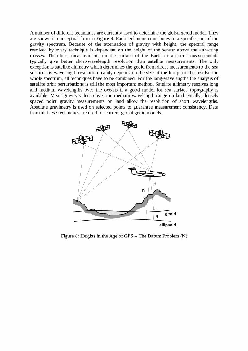
When GPS was introduced as a three-dimensional positioning system, all three coordinatesbecame available in a consistent reference frame which could be either Cartesian or curvilinear.Usually an ellipsoid was chosen as the curvilinear reference surface and, thus, a directcomparison between the GPS-derived coordinates and the conventional horizontal coordinateswas possible. It was not possible, however for ellipsoidal heights and orthometric heights. Totransform one height system into the other, an accurate geoid representation was needed in themeasurement area. The situation is shown in Figure 8 where, in first approximation, theorthometric height H is the difference of the ellipsoidal height h and the geoidal undulation N.To transform the GPS-derived height into an orthometric height of equal accuracy, the geoidrepresentation had to be accurate to a few centimeters. This is still not the case in many partsof the world. On a global scale the height transformation problem remains therefore anunsolved problem. The best global geoid models are not better than 1-2 m in areas with poorgravity coverage and between 0.3 an 0.5m in areas with good gravity coverage. Thus, theCTRF can be defined with an accuracy of a few centimeters by GPS, it cannot be transformed,however, with the same accuracy into a global reference frame with an orthometric heightsystem. To solve the vertical datum problem, the geoid must be globally known with anaccuracy of a few centimeters. In that case, the CTRF will be consistent independent of theheight system used.
A number of different techniques are currently used to determine the global geoid model. Theyare shown in conceptual form in Figure 9. Each technique contributes to a specific part of thegravity spectrum. Because of the attenuation of gravity with height, the spectral rangeresolved by every technique is dependent on the height of the sensor above the attractingmasses. Therefore, measurements on the surface of the Earth or airborne measurementstypically give better short-wavelength resolution than satellite measurements. The onlyexception is satellite altimetry which determines the geoid from direct measurements to the seasurface. Its wavelength resolution mainly depends on the size of the footprint. To resolve thewhole spectrum, all techniques have to be combined. For the long-wavelengths the analysis ofsatellite orbit perturbations is still the most important method. Satellite altimetry resolves longand medium wavelengths over the oceans if a good model for sea surface topography isavailable. Mean gravity values cover the medium wavelength range on land. Finally, denselyspaced point gravity measurements on land allow the resolution of short wavelengths.Absolute gravimetry is used on selected points to guarantee measurement consistency. Datafrom all these techniques are used for current global geoid models.
Figure 8: Heights in the Age of GPS – The Datum Problem (N)
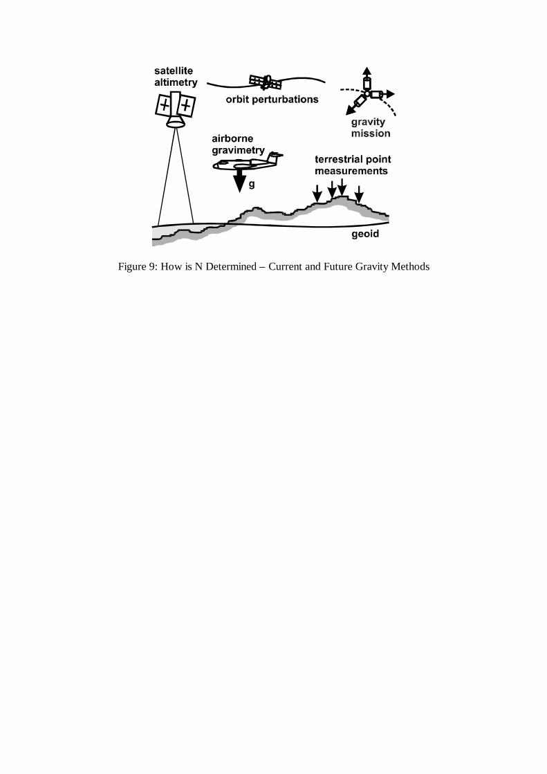
Figure 9: How is N Determined – Current and Future Gravity Methods

To improve current geoid models, new measurement techniques are needed. The mostpromising ones are airborne gravimetry and gravity satellite missions. The first is a local orregional technique, the second a global technique. In airborne gravimetry the accelerationoutput of DGPS and INS is differenced, resulting in filtered gravity along flight profiles. Thismethod covers areas of up to 1000 km by 1000 km with gravity profiles and thus resolves halfwavelengths between 8 km and 500 km. Dedicated gravity satellite missions use low-orbitingsatellites to resolve the gravity spectrum to half wavelengths of about 80 km in the best caseand about 300 km in the worst case. The two methods are therefore complementary withairborne methods covering the high frequency spectrum which cannot be resolved by satellitemethods and part of the medium frequency spectrum where satellite methods are weak, andsatellite methods covering the long and medium spectral ranges.
Currently three specific gravity satellite missions have been proposed, two of which are in anadvanced stage, see Ilk (1998) for details. They are shown in schematic form in Figure 10. Thefirst is the microsatellite CHAMP which will be launched this year by Germany and which willoperate in a high-low mode. This means that the low-orbiting CHAMP satellite will be trackedby GPS satellites, thus eliminating one major error source, namely atmospheric effects. Theperturbation analysis of the CHAMP satellite orbit will be supported by the output of anaccelerometer triad on the satellite which will allow a better separation of non-gravitationalforces. It is expected that this mission will improve the current global solutions by betterdecorrelating the medium wavelengths. It will not add decisively, however, in terms ofminimum wavelength resolution. The second planned mission is GRACE, which will belaunched in 2002 by the USA and will use a satellite-to-satellite tracking technique to resolvethe gravity field spectrum. The distance between two low-orbiting satellites will be monitoredby an interferometric microwave link. Variations in the measured range will be used to detecttemporal variations in the gravity field spectrum and to improve its minimum resolution to halfwavelengths of about 150 km. The third mission GOCE is planned by ESA and is scheduled tobe launched in 2005. It will use satellite gradiometry to directly measure gravity gradients overa very short base in the satellite. The minimum wavelength resolution could be as low as 80km. If all three missions go ahead, the complete gravity spectrum to half wavelengths of about80 km and its major temporal variations will be determined. The combined solution wouldprovide a much better global resolution of the gravity field and especially of the geoid than iscurrently available. The next decade would then rightfully be called the decade of gravitysatellites.
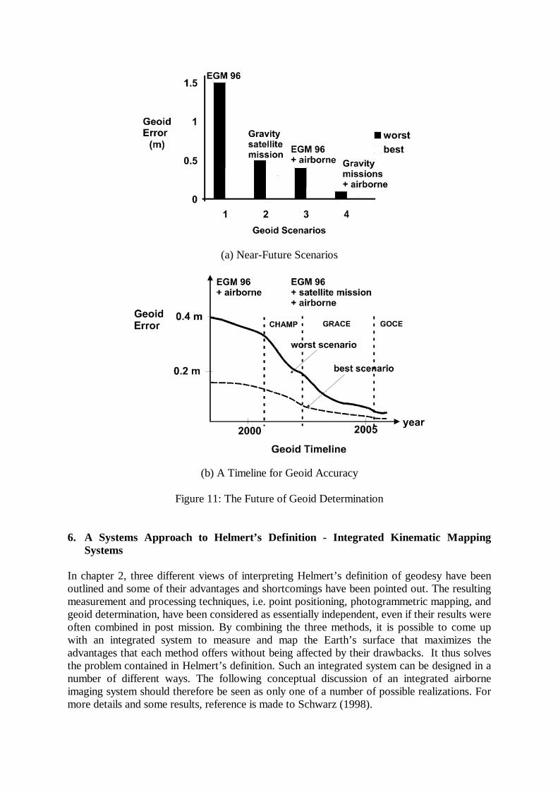
Figure 11 shows the impact of the two new measurement techniques, airborne gravimetry andsatellite gravimetry, on the accuracy of global geoid determination. Figure 11a compares fourpossible scenarios where the dark column indicates the worst case in each scenario and thewhite column the best case in each scenario. Starting with the currently best global model, theEGM 96, global standard deviations range from about 0.4 m to 1.5 m. As mentioned beforethese differences are mainly due to the differences in gravity coverage in different parts of theworld. The second scenario shows the impact of the gravity satellite missions only. The rangeof values is much smaller now, between 0.35 m and 0.5 m, and is mainly due to the differencebetween the optimistic and the more guarded predictions. The accuracy in this case is more orless uniform over the globe. It would not be sufficient, however, to give the geoidtransformation with centimeter accuracy. The third scenario shows the combination of thecurrent global model with airborne gravimetry. It gives slightly better results than the previousscenario and has the advantage that it could be implemented right now. The differencebetween the best and the worst scenario is again due to the difference in EGM 96 accuracy indifferent parts of the world. The final scenario is the combination of airborne and satellitegravimetry which clearly gives the best results and achieves the accuracy required for height

transformation. This means that the required accuracy in the geoid representation will mostlikely be reached in the next five to seven years, but only in areas where airborne gravity hasbeen obtained or consistent ground gravity coverage is available.
Figure 11b gives best (dotted) and worst (solid) accuracy projections for the next six yearsassuming that the planned satellite missions are on schedule. Some improvements of thecurrent global models can be expected around the middle of 2000 when the CHAMP data areintegrated into the global solution. After that, improvements will be mainly due to thematuring of airborne gravimetry, until GRACE data come on line in about 2003. This willresult in major improvements in geoid accuracy because of the better wavelength resolution.GOCE data will add to the high and medium frequency spectrum and, together with airbornegravity data, finally provide the accuracy required in the height transformation.
Figure 10: The Decade of Gravity Satellites
Orbit perturbation analysis
GPS tracking of satellite inhigh-low mode
CHAMP (GER) - 1999
Satellite-to-satellite tracking
Interferometric microwave linkbetween two low satellites
GRACE (US) - 2002
Satellite gradiometry
Direct measurement ofgravity gradients
GOCE (EU) - 2005
(a) Near-Future Scenarios
(b) A Timeline for Geoid Accuracy
Figure 11: The Future of Geoid Determination
6. A Systems Approach to Helmert’s Definition - Integrated Kinematic MappingSystems
In chapter 2, three different views of interpreting Helmert’s definition of geodesy have beenoutlined and some of their advantages and shortcomings have been pointed out. The resultingmeasurement and processing techniques, i.e. point positioning, photogrammetric mapping, andgeoid determination, have been considered as essentially independent, even if their results wereoften combined in post mission. By combining the three methods, it is possible to come upwith an integrated system to measure and map the Earth’s surface that maximizes theadvantages that each method offers without being affected by their drawbacks. It thus solvesthe problem contained in Helmert’s definition. Such an integrated system can be designed in anumber of different ways. The following conceptual discussion of an integrated airborneimaging system should therefore be seen as only one of a number of possible realizations. Formore details and some results, reference is made to Schwarz (1998).

There are a number of theoretical and practical reasons why such an integration isadvantageous. First of all, a highly accurate global reference frame now exists which can beaccessed everywhere by using a GPS receiver as the measurement tool. Since GPS receiverswork in kinematic mode, there is no reason to separate the positioning process from theimaging process. By operating in DGPS kinematic mode, with one receiver on the aircraft andone on the ground, there is no need to first establish control positions on the ground whichthen have to be identified in the images.
Instead, the perspective centre of the photogrammetric camera is determined by DGPS at themoment of exposure. This provides the first three parameters of exterior orientation in anaccurate global reference frame (WGS 84). The other three parameters describing theorientation of the camera at the moment of exposure can be obtained by integrating an InertialMeasuring Unit (IMU) with DGPS and the camera. This has two major advantages. First, it isnow possible to give each individual image its full set of exterior orientation parameters whichmeans that any two images with overlapping image content can be directly used for mappingpart of the Earth ‘s surface in a consistent coordinate frame. Thus, there is in principle no needfor designing photogrammetric blocks and corresponding adjustment procedures to solve theproblem. Second, such a system could also solve the vertical datum problem in an elegant waywithout the need for additional instrumentation. By differencing the output of the IMU and theDGPS, gravity at flight level can be determined from which a relative local geoid can bederived at ground level. By combining it with global information, as described in chapter 5, thetransformation problem between ellipsoidal and orthometric heights can be solved. Thus, allmeasurements that are needed to map the Earth's surface in a consistent global frame can betaken from the same airborne platform. This will not only result in a much more homogeneousdata acquisition process, but will also produce a much more efficient data processingprocedure.
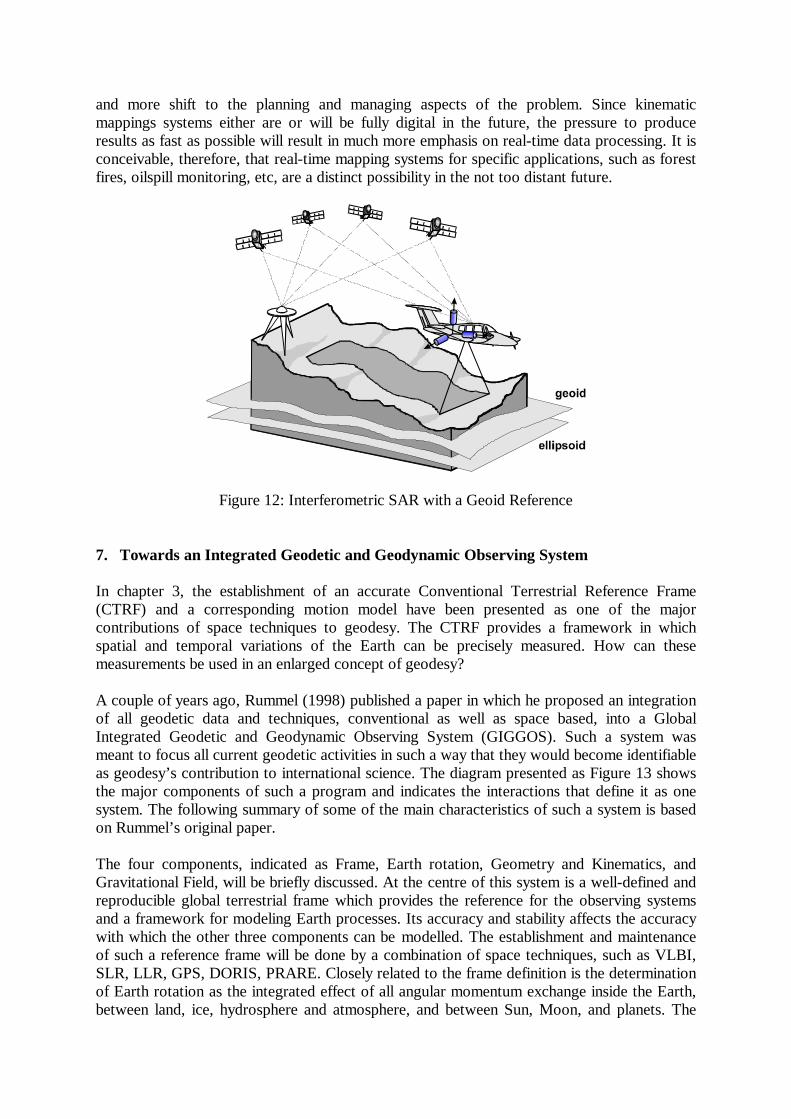
It has been mentioned already that an integrated kinematic mapping system is not restricted tophotogrammetric techniques, nor to an airborne platform. Digital cameras have been used witha land vehicle-based system, and effective use of airborne geoid determination has been madein deriving orthometric DEMs by interferometric SAR. Figure 12 illustrates the latterapplication. Other systems use laser scanners, sometimes in conjunction with digital cameras,to solve the surface mapping problem.
In all these systems, the data acquisition and processing procedures are remarkably differentfrom conventional methods. Because of the emphasis on point positioning and the type ofequipment available for implementing it, conventional survey methods have always been sparsedata techniques requiring considerable observational skill and attention to procedure. Sincesparse data problems are best solved by least squares adjustment, this became the dominant,and in many cases the only, estimation method used in geodesy. All of this hardly applies tothe new measurement systems. Instead of sparse data, redundancies in static positioning areenormous and data compression techniques are much more important in imaging than sparsedata techniques. Bandpass filtering, wavelet methods and multi-scale estimation seem to offermuch better solutions to these problems than least squares. Because of the large number ofredundancies, not all of the data will be stored in the future and efficient and reliable methodsof real-time data processing will replace current procedures. Similarly, observational skillshave already now been largely eliminated from the measurement process and given way toautomated procedures of real-time data checking. Because of the limited amount ofautomation currently implemented, much still depends on the knowledge of the systemoperator about the measurement process. It can be expected, however, that more of thisknow-how will be built into the software and human decision making and expertise will more
and more shift to the planning and managing aspects of the problem. Since kinematicmappings systems either are or will be fully digital in the future, the pressure to produceresults as fast as possible will result in much more emphasis on real-time data processing. It isconceivable, therefore, that real-time mapping systems for specific applications, such as forestfires, oilspill monitoring, etc, are a distinct possibility in the not too distant future.
Figure 12: Interferometric SAR with a Geoid Reference
7. Towards an Integrated Geodetic and Geodynamic Observing System
In chapter 3, the establishment of an accurate Conventional Terrestrial Reference Frame(CTRF) and a corresponding motion model have been presented as one of the majorcontributions of space techniques to geodesy. The CTRF provides a framework in whichspatial and temporal variations of the Earth can be precisely measured. How can thesemeasurements be used in an enlarged concept of geodesy?
A couple of years ago, Rummel (1998) published a paper in which he proposed an integrationof all geodetic data and techniques, conventional as well as space based, into a GlobalIntegrated Geodetic and Geodynamic Observing System (GIGGOS). Such a system wasmeant to focus all current geodetic activities in such a way that they would become identifiableas geodesy’s contribution to international science. The diagram presented as Figure 13 showsthe major components of such a program and indicates the interactions that define it as onesystem. The following summary of some of the main characteristics of such a system is basedon Rummel’s original paper.
The four components, indicated as Frame, Earth rotation, Geometry and Kinematics, andGravitational Field, will be briefly discussed. At the centre of this system is a well-defined andreproducible global terrestrial frame which provides the reference for the observing systemsand a framework for modeling Earth processes. Its accuracy and stability affects the accuracywith which the other three components can be modelled. The establishment and maintenanceof such a reference frame will be done by a combination of space techniques, such as VLBI,SLR, LLR, GPS, DORIS, PRARE. Closely related to the frame definition is the determinationof Earth rotation as the integrated effect of all angular momentum exchange inside the Earth,between land, ice, hydrosphere and atmosphere, and between Sun, Moon, and planets. The
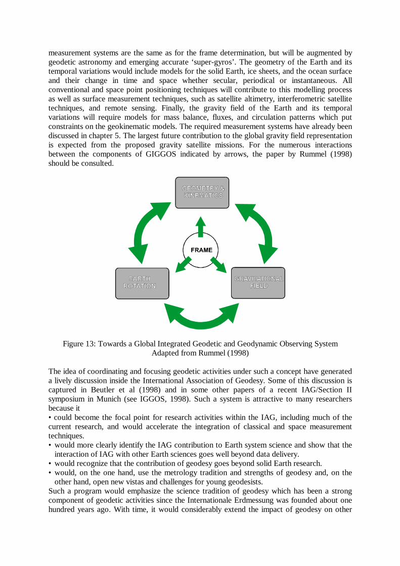
measurement systems are the same as for the frame determination, but will be augmented bygeodetic astronomy and emerging accurate ‘super-gyros’. The geometry of the Earth and itstemporal variations would include models for the solid Earth, ice sheets, and the ocean surfaceand their change in time and space whether secular, periodical or instantaneous. Allconventional and space point positioning techniques will contribute to this modelling processas well as surface measurement techniques, such as satellite altimetry, interferometric satellitetechniques, and remote sensing. Finally, the gravity field of the Earth and its temporalvariations will require models for mass balance, fluxes, and circulation patterns which putconstraints on the geokinematic models. The required measurement systems have already beendiscussed in chapter 5. The largest future contribution to the global gravity field representationis expected from the proposed gravity satellite missions. For the numerous interactionsbetween the components of GIGGOS indicated by arrows, the paper by Rummel (1998)should be consulted.
Figure 13: Towards a Global Integrated Geodetic and Geodynamic Observing SystemAdapted from Rummel (1998)
The idea of coordinating and focusing geodetic activities under such a concept have generateda lively discussion inside the International Association of Geodesy. Some of this discussion iscaptured in Beutler et al (1998) and in some other papers of a recent IAG/Section IIsymposium in Munich (see IGGOS, 1998). Such a system is attractive to many researchersbecause it• could become the focal point for research activities within the IAG, including much of thecurrent research, and would accelerate the integration of classical and space measurementtechniques.• would more clearly identify the IAG contribution to Earth system science and show that the
interaction of IAG with other Earth sciences goes well beyond data delivery.• would recognize that the contribution of geodesy goes beyond solid Earth research.• would, on the one hand, use the metrology tradition and strengths of geodesy and, on the
other hand, open new vistas and challenges for young geodesists.Such a program would emphasize the science tradition of geodesy which has been a strongcomponent of geodetic activities since the Internationale Erdmessung was founded about onehundred years ago. With time, it would considerably extend the impact of geodesy on other

branches of the Earth sciences and accelerate the cooperation between national agenciescontributing to such an enlarged concept of geodesy. The engineering tradition of geodesywhich also has strong roots in IAG would not be enhanced in the same way. This does notmean that its influence would dwindle. As indicated in the previous section, there are manychallenging tasks in accurately representing the Earth’s surface and its temporal change forlocal applications. These applications will continue and will profit from a better understandingof the processes that are at the root of change. In the long term, they will be needed todescribe the fine structure of the Earth’s temporal variations.
Acknowledgements
The author would like to thank Jean-Marie Becker for the invitation to present this talk,proposing a topic that provided room to roam and ramble. Thanks are also due to A. Bruton,M. Mostafa, and J. Skaloud for actively participating in the design of the figures.
References
Beutler, G. , H. Drewes, C. Reigber, R. Rummel (1998): Space Techniques and TheirCoordination within IAG at Present and in Future. Int. Symp. of IAG-Section II “Towards anIntegrated Global Geodetic Observing System (IGGOS)”, October 5-9, 1998, Munich,Germany. Proceedings to be published by Springer Verlag.
Blewitt, G., C. Boucher, P.B.H. Davis, M.B. Heflin, T.A. Herring, J. Kouba (1997): ITRFdensification and Continuous Realization by the IGS. Proc. IAG Symposia Volume 118:Advances in Positioning and Reference Frames, F.K. Brunner (editor), September 3-9, 1997,Rio de Janeiro, Brazil; published by Springer in 1998.
IGGOS (1998): Int. Symp. of IAG-Section II “Towards an Integrated Global GeodeticObserving System (IGGOS)”, October 5-9, 1998, Munich, Germany. Proceedings to bepublished by Springer Verlag.
Ilk, K.H. (1998): Envisaging a New Era of Gravity Field Research. Int. Symp. of IAG-Section II “Towards an Integrated Global Geodetic Observing System (IGGOS)”, October 5-9, 1998, Munich, Germany. Proceedings to be published by Springer Verlag.
NAPA/NRC (1995): The Global Positioning System- Charting the Future. The NationalAcademy of Sciences, Washington, DC.
Rummel, R. (1998): A Global Integrated Geodetic and Geodynamic Observing System.CSTG Bulletin, Munich 1998.
Schwarz, K.P. (1998): Mobile Multi-Sensor Systems - Modelling and Estimation. Proc. ofthe Int. Symp. on "Geodesy for Geotechnical and Structural Engineering", April 20-22, 1998,Eisenstadt, Austria.
Slater, J.A. and S. Malys (1997): WGS 84 - Past, Present and Future. Proc. IAG SymposiaVolume 118: Advances in Positioning and Reference Frames, F.K. Brunner (editor),September 3-9, 1997, Rio de Janeiro, Brazil; published by Springer in 1998.